Annular solar eclipse of 07/12/-0447
| Day of week: | Saturday |
| Maximum duration of eclipse: | 05m31s |
| Maximum width of eclipse path: | 166 km |
| Saros cycle: | 58 |
| Coverage: | 95.5% |
| Magnitude: | 0.9546 |
| Gamma: | 0.0214 |
Wo kann man die Sonnenfinsternis vom 07/12/-0447 sehen?
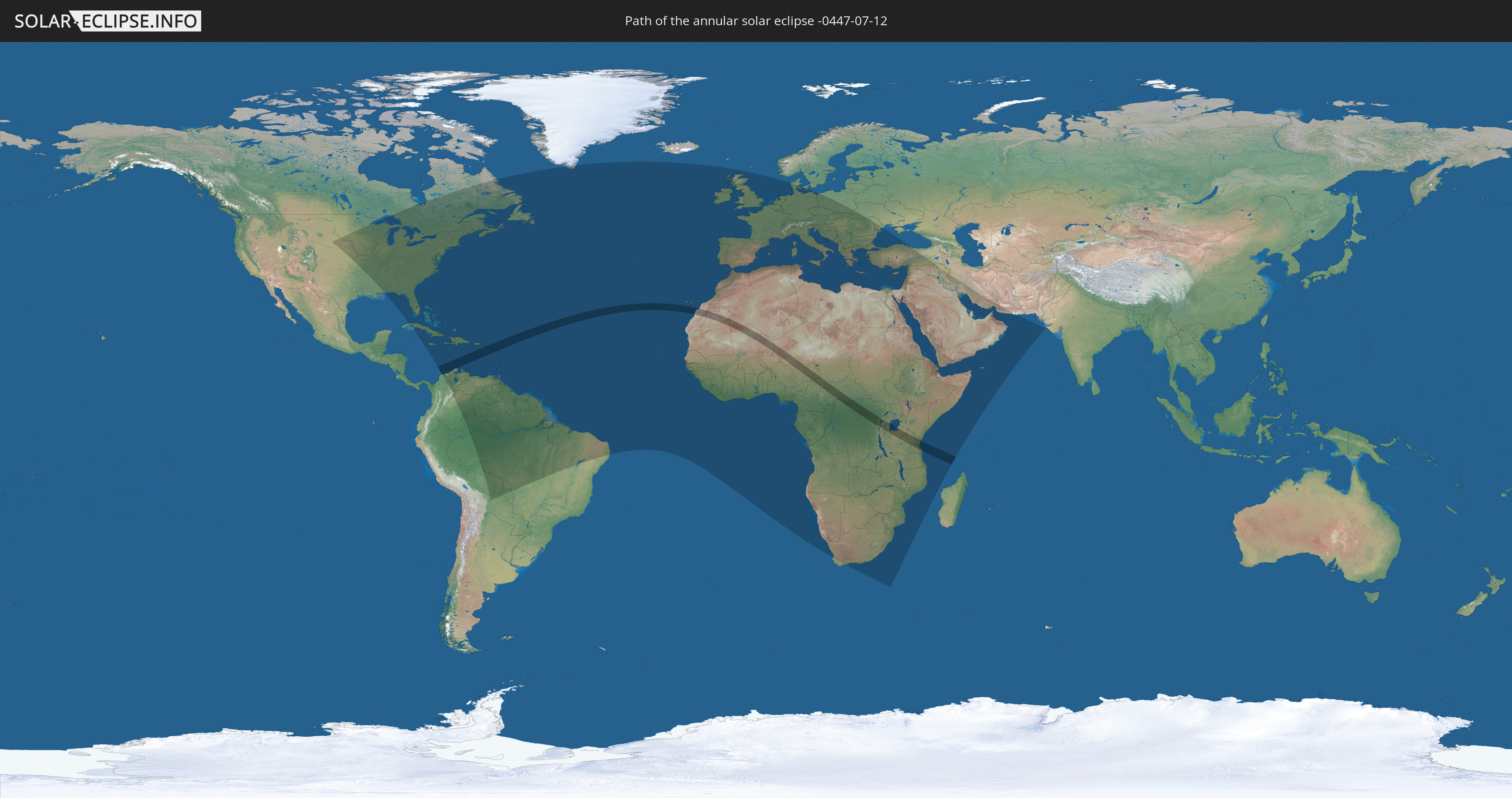
Die Sonnenfinsternis am 07/12/-0447 kann man in 148 Ländern als partielle Sonnenfinsternis beobachten.
Der Finsternispfad verläuft durch 20 Länder. Nur in diesen Ländern ist sie als annular Sonnenfinsternis zu sehen.
In den folgenden Ländern ist die Sonnenfinsternis annular zu sehen
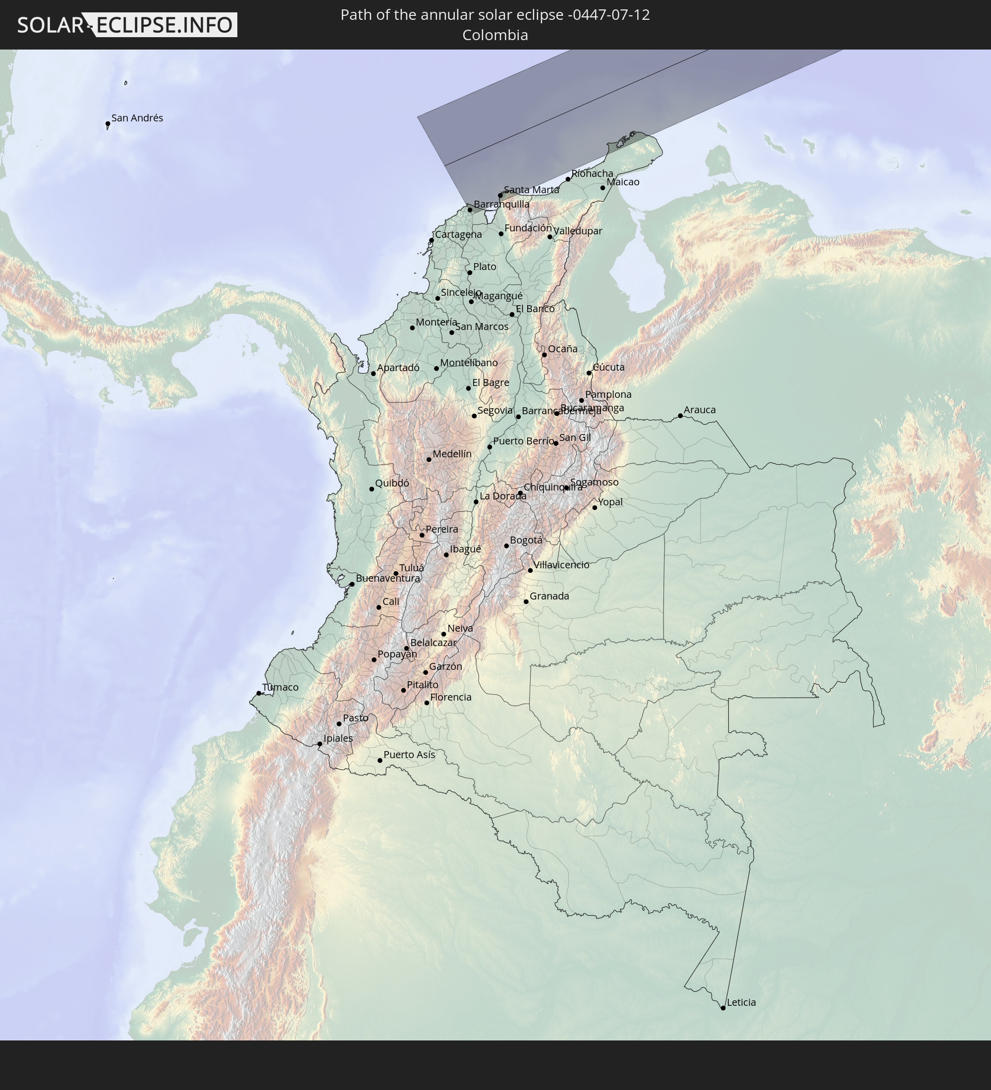 Colombia
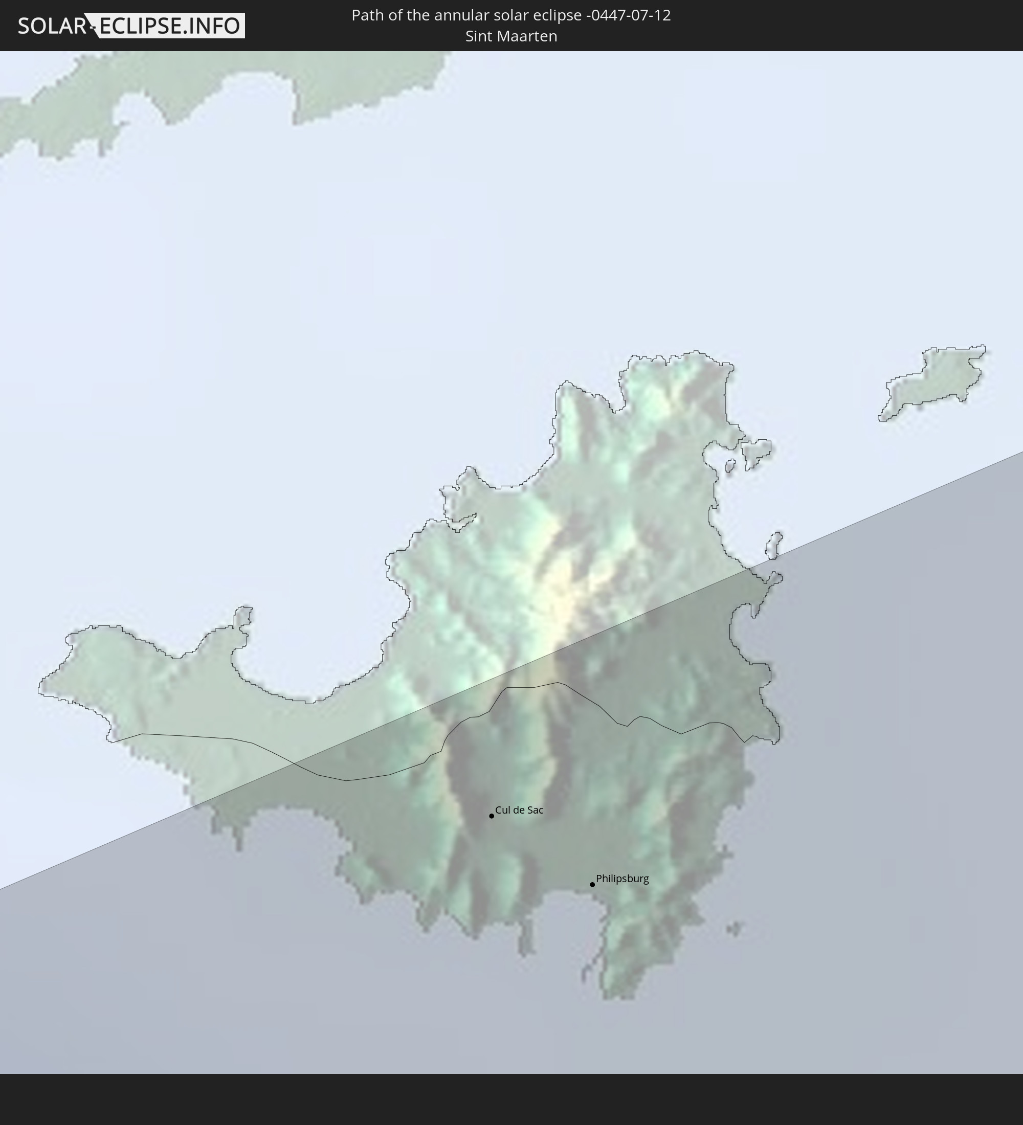 Sint Maarten
 Collectivity of Saint Martin
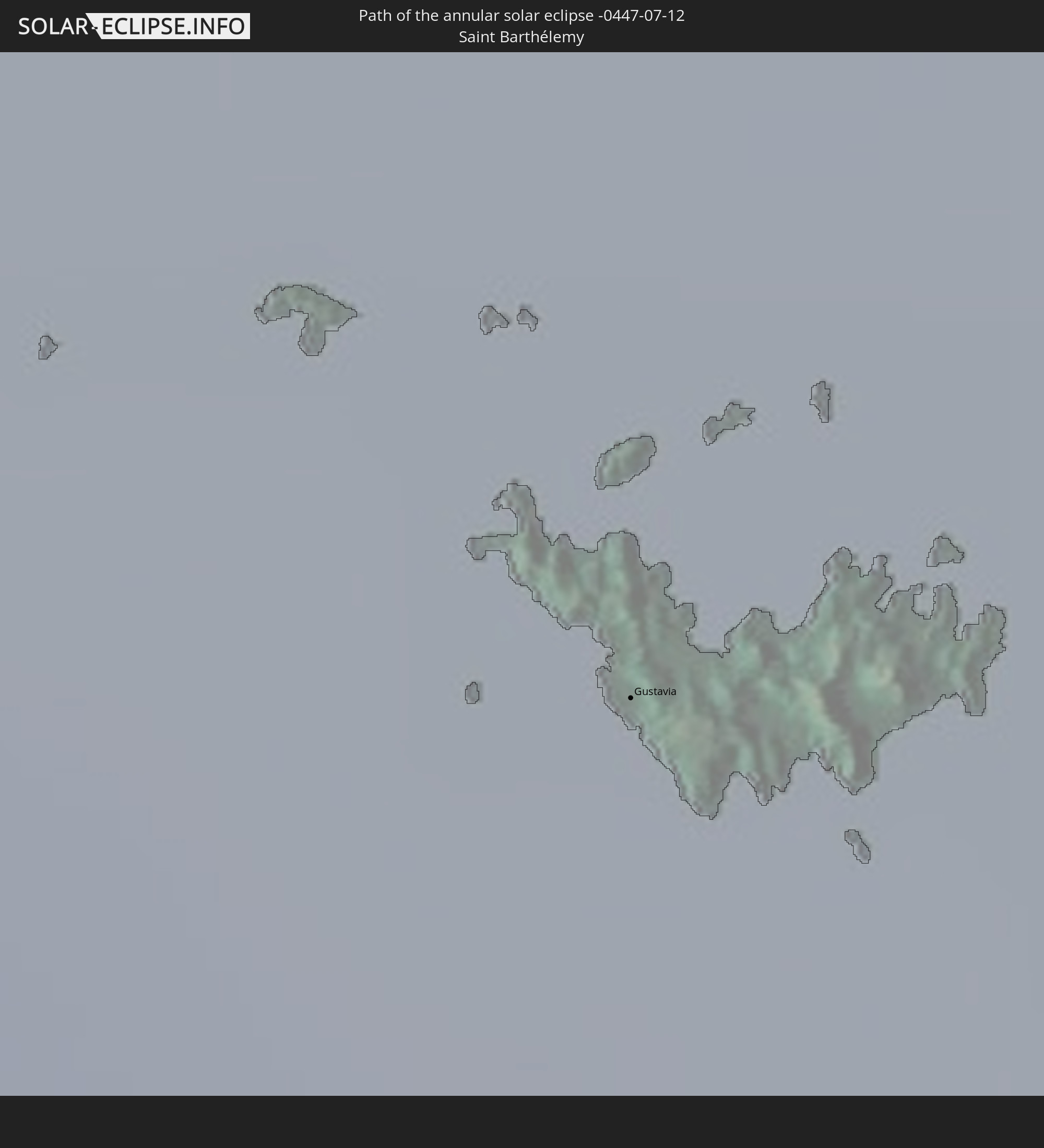 Saint Barthélemy
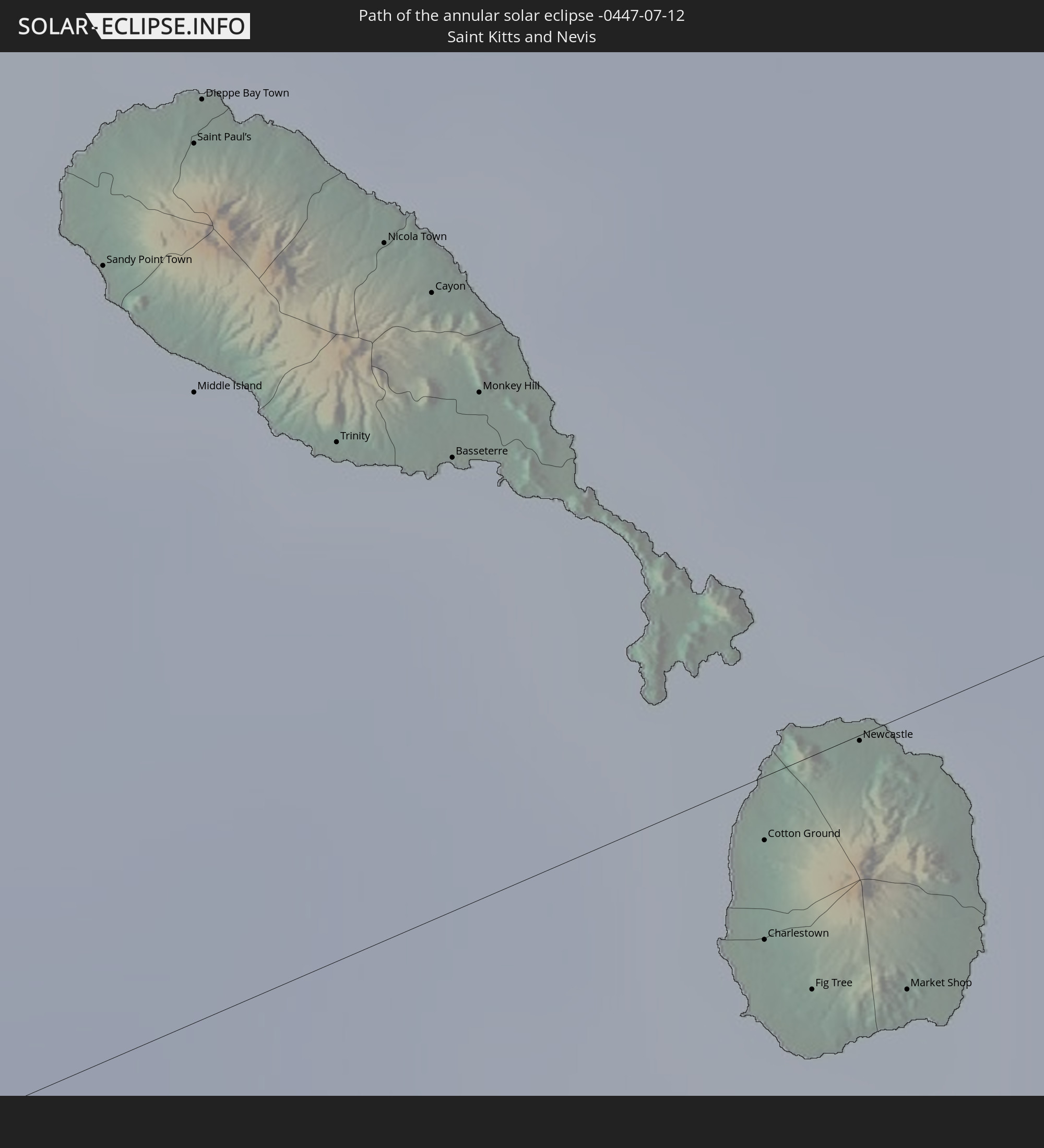 Saint Kitts and Nevis
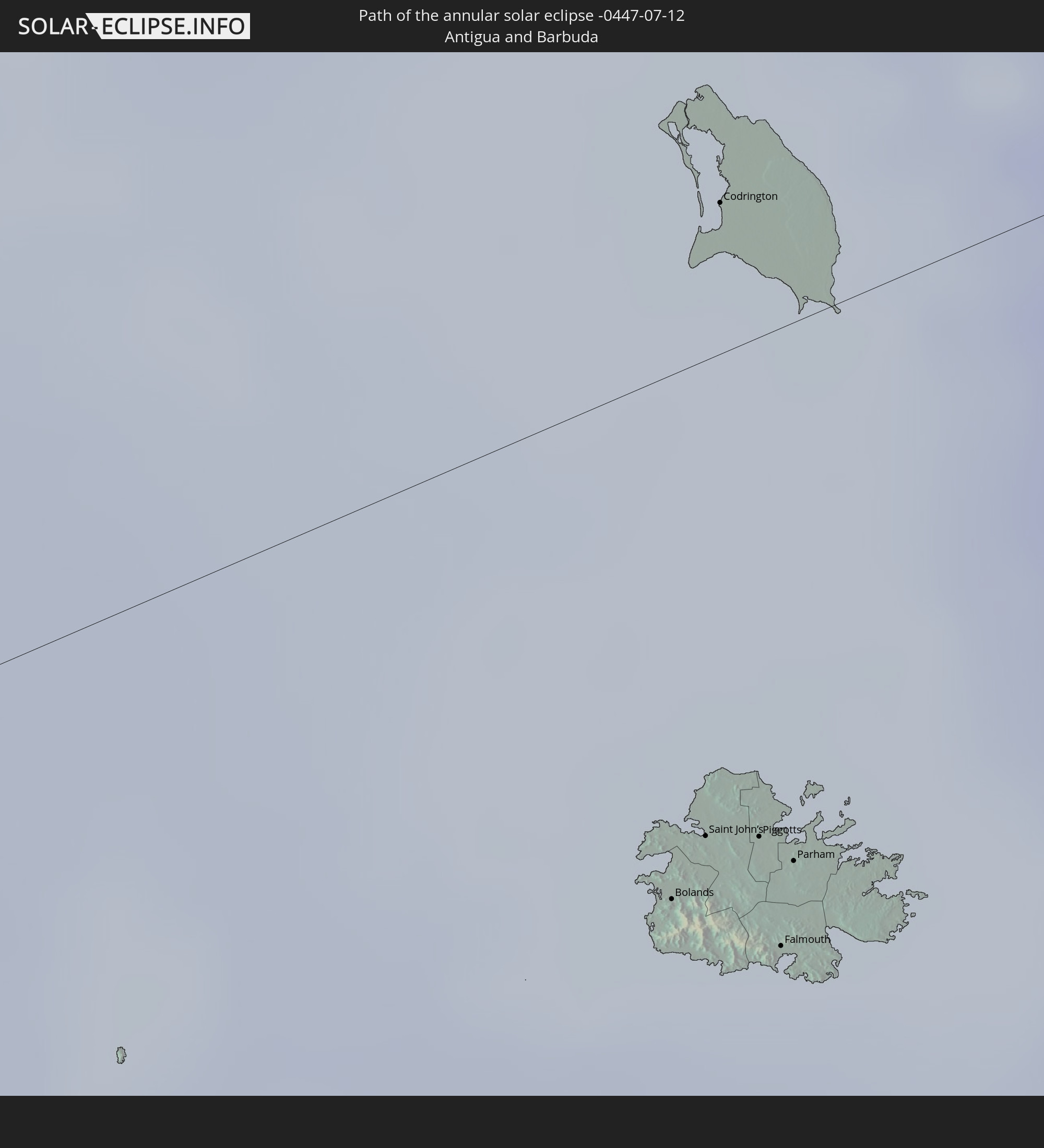 Antigua and Barbuda
 Montserrat
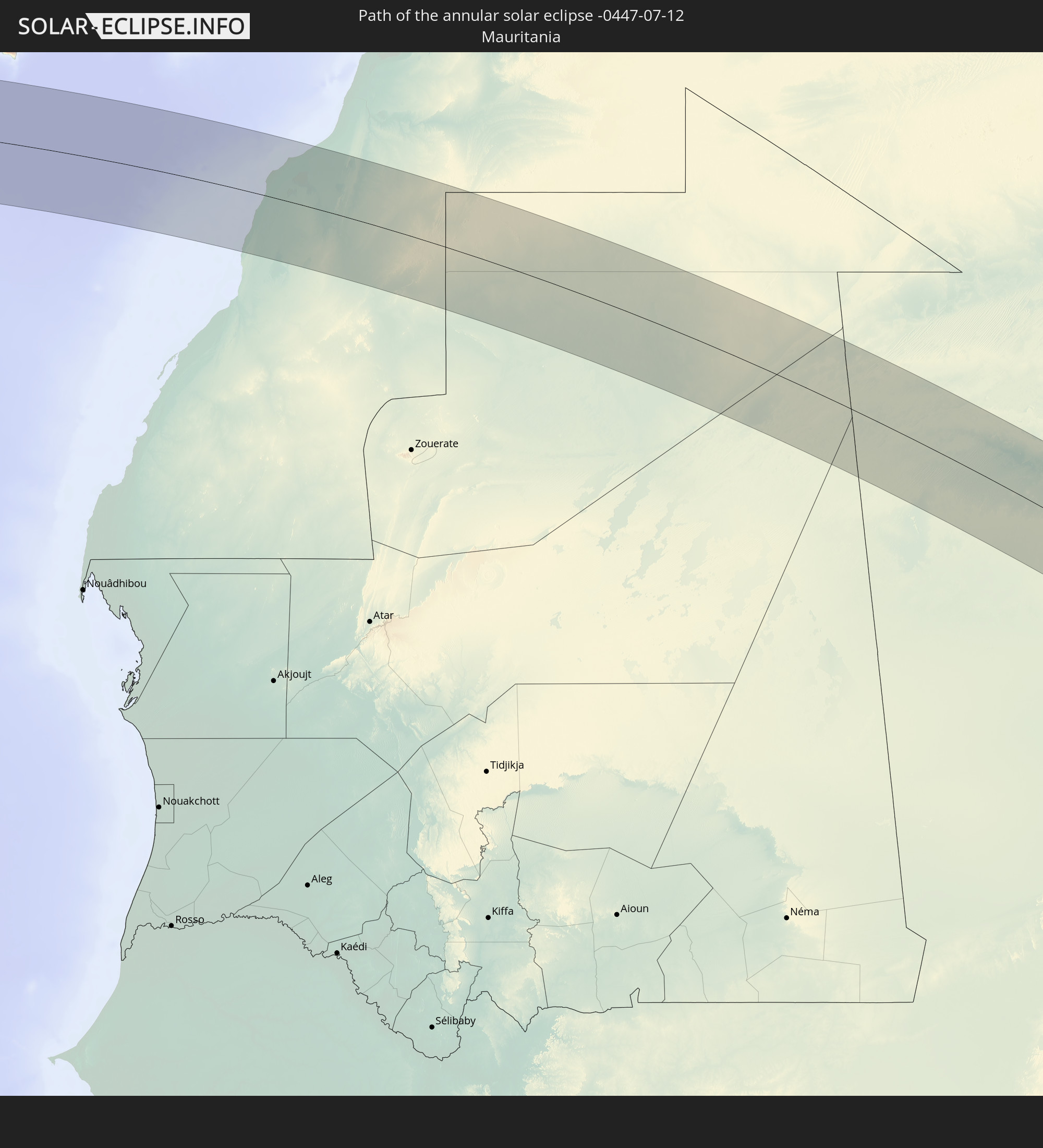 Mauritania
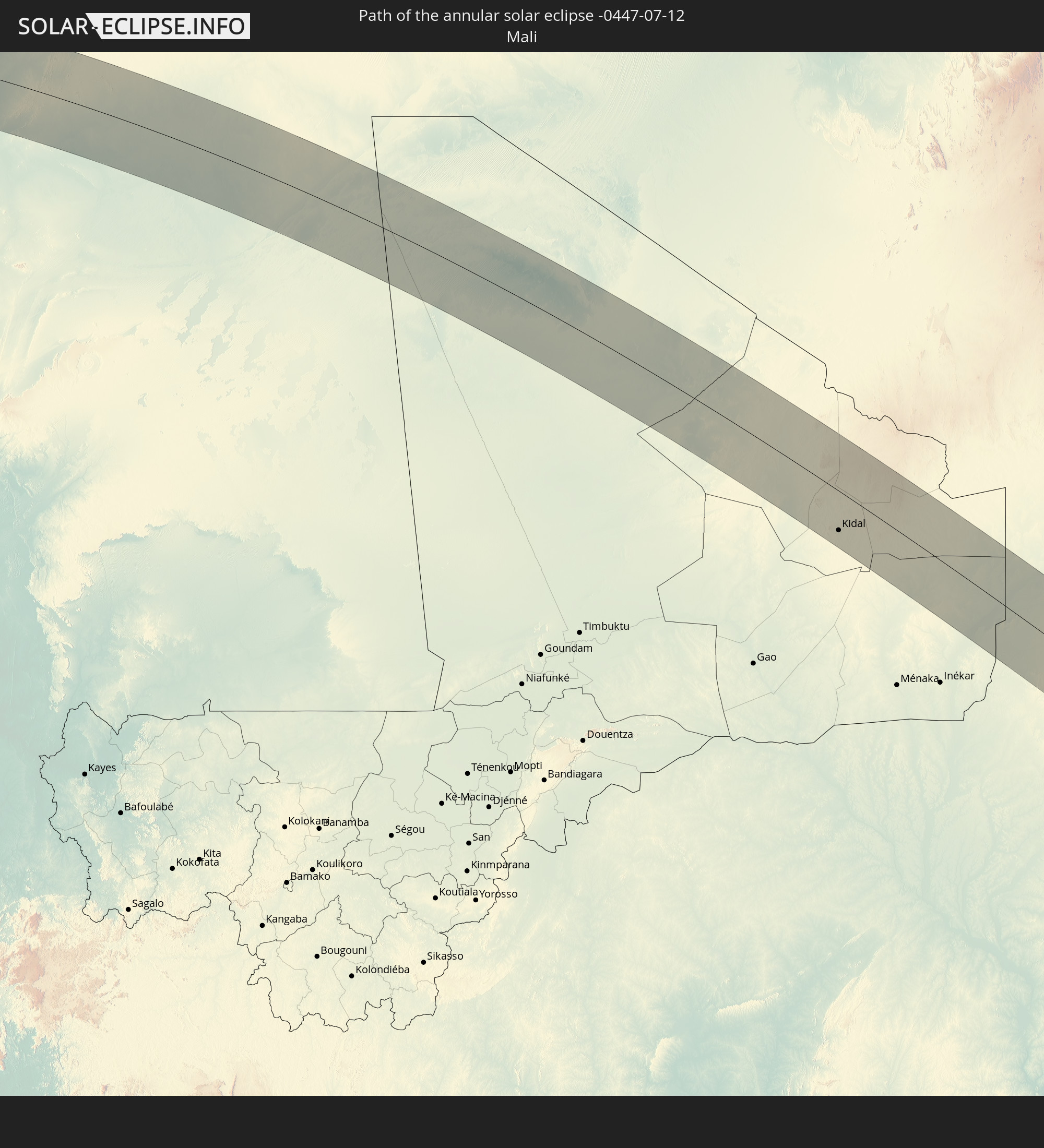 Mali
Mali
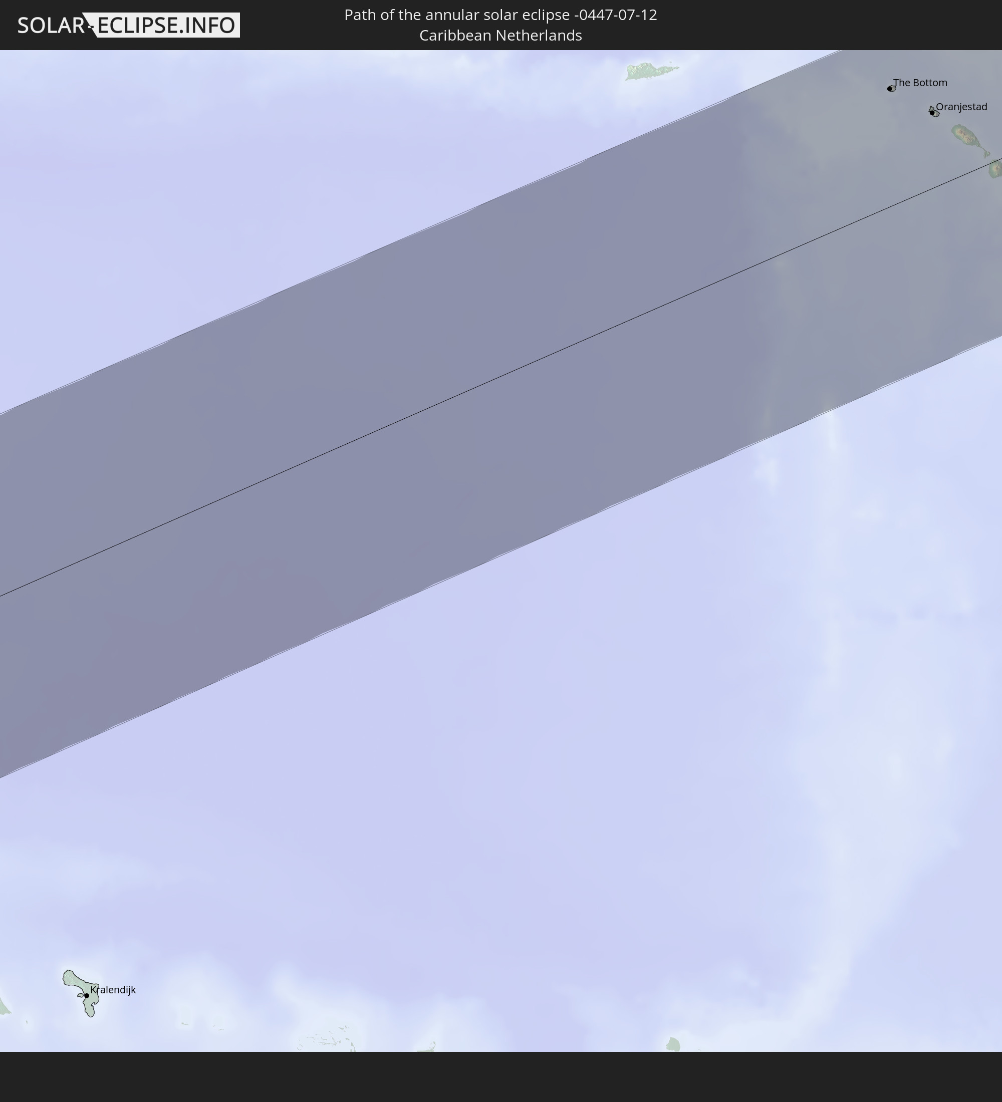 Caribbean Netherlands
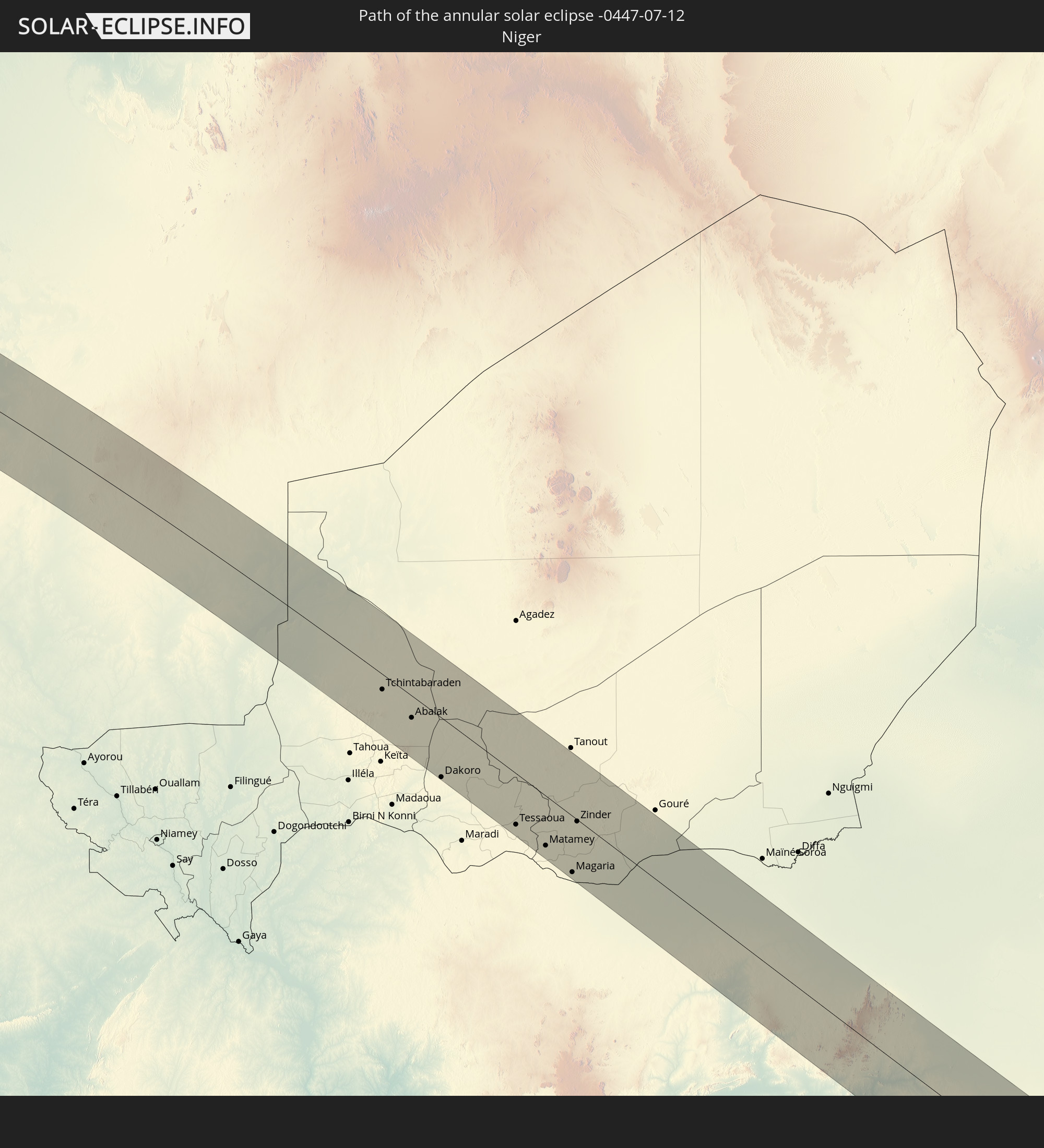 Niger
Niger
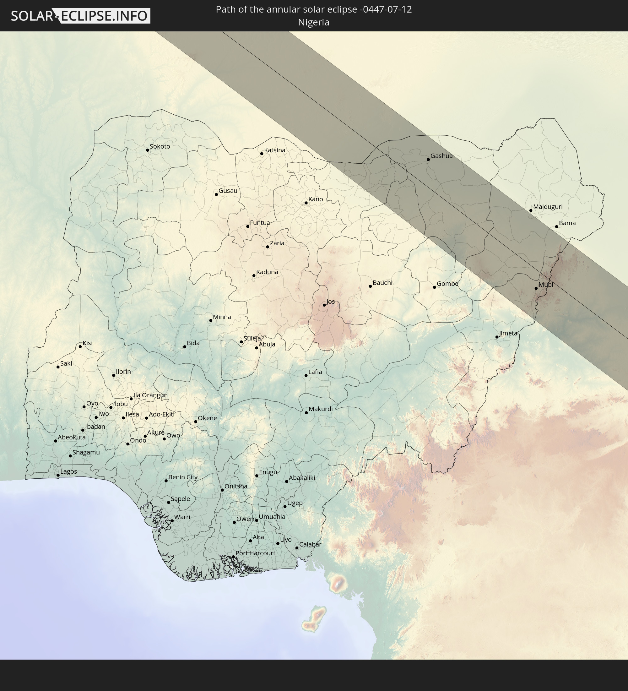 Nigeria
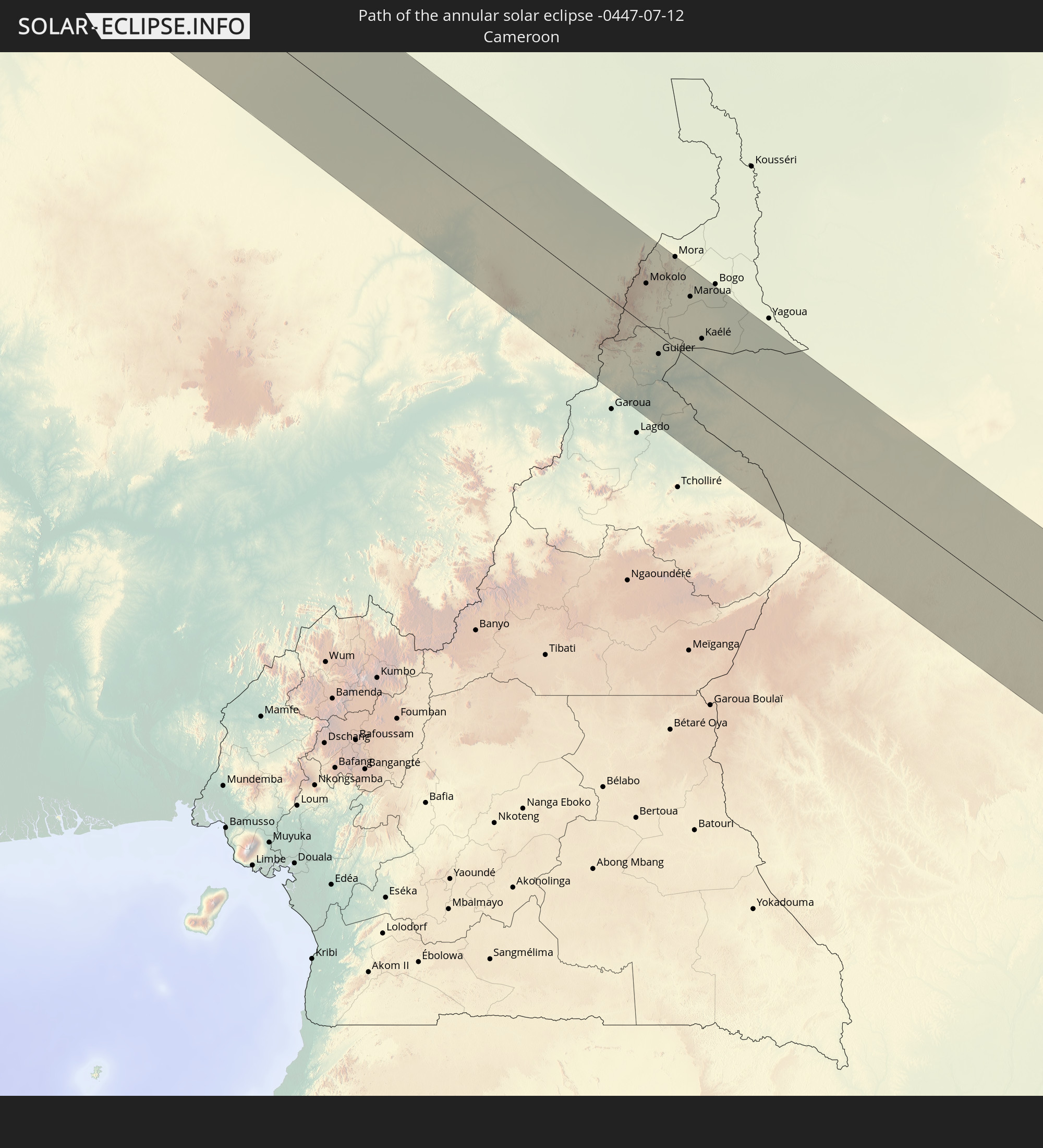 Cameroon
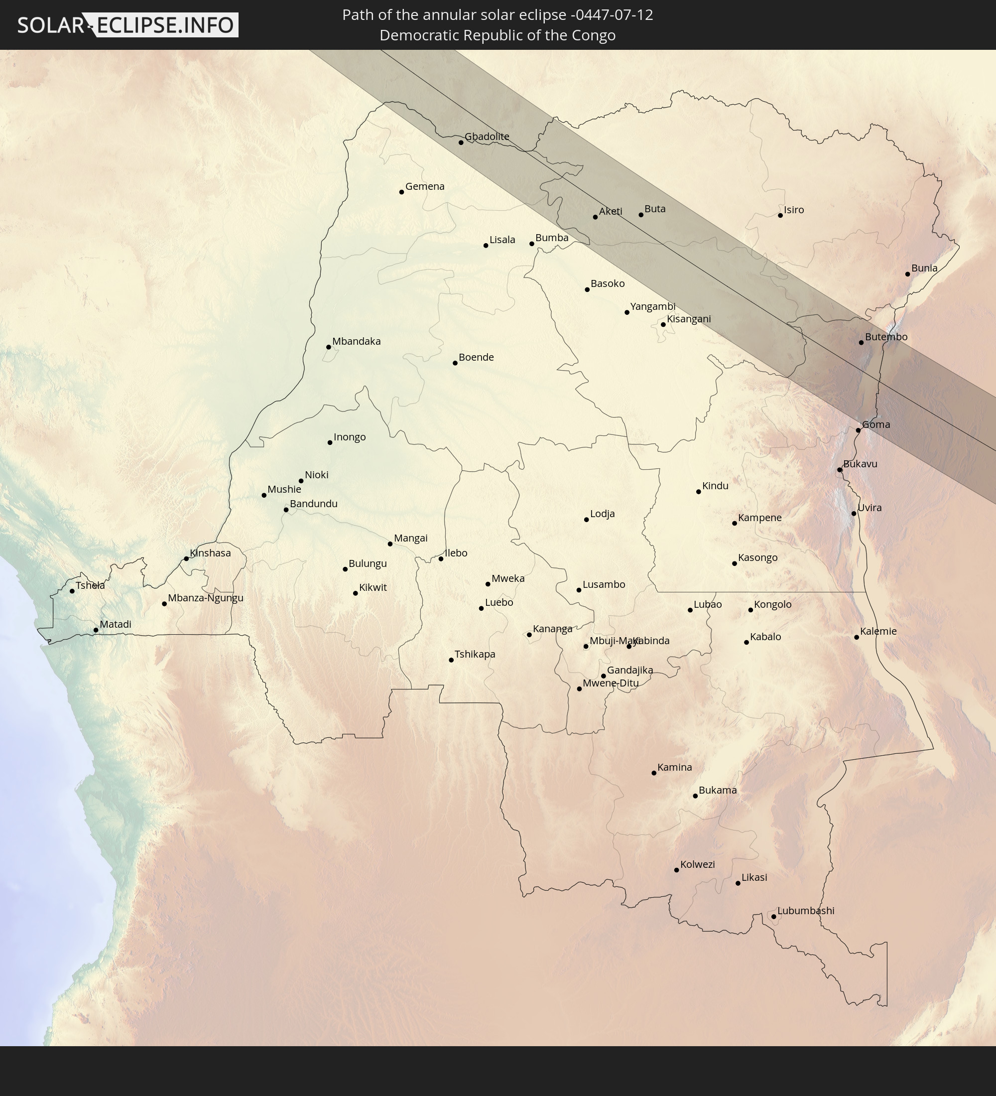 Democratic Republic of the Congo
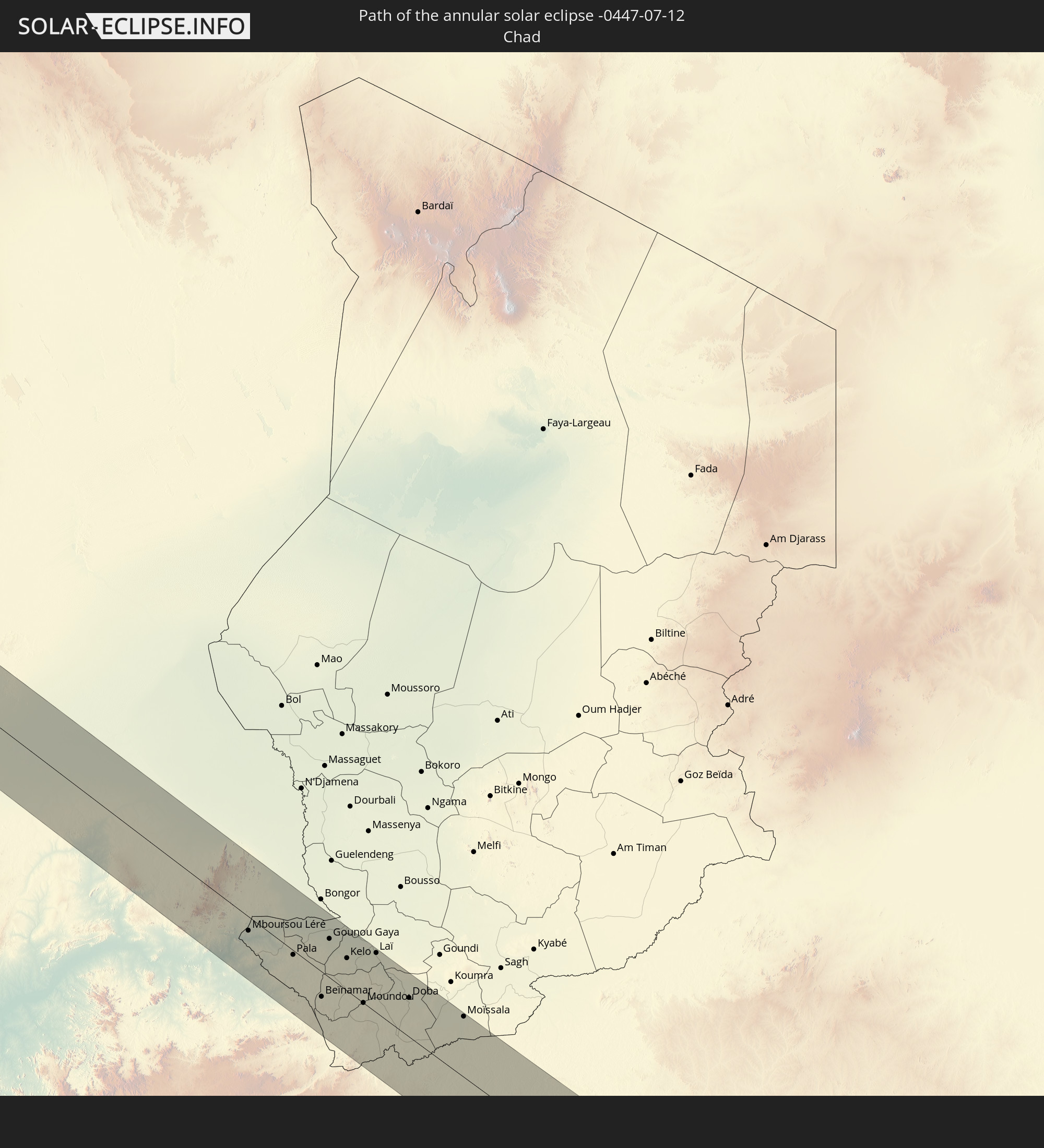 Chad
Chad
 Central African Republic
 Rwanda
 Tanzania
 Uganda
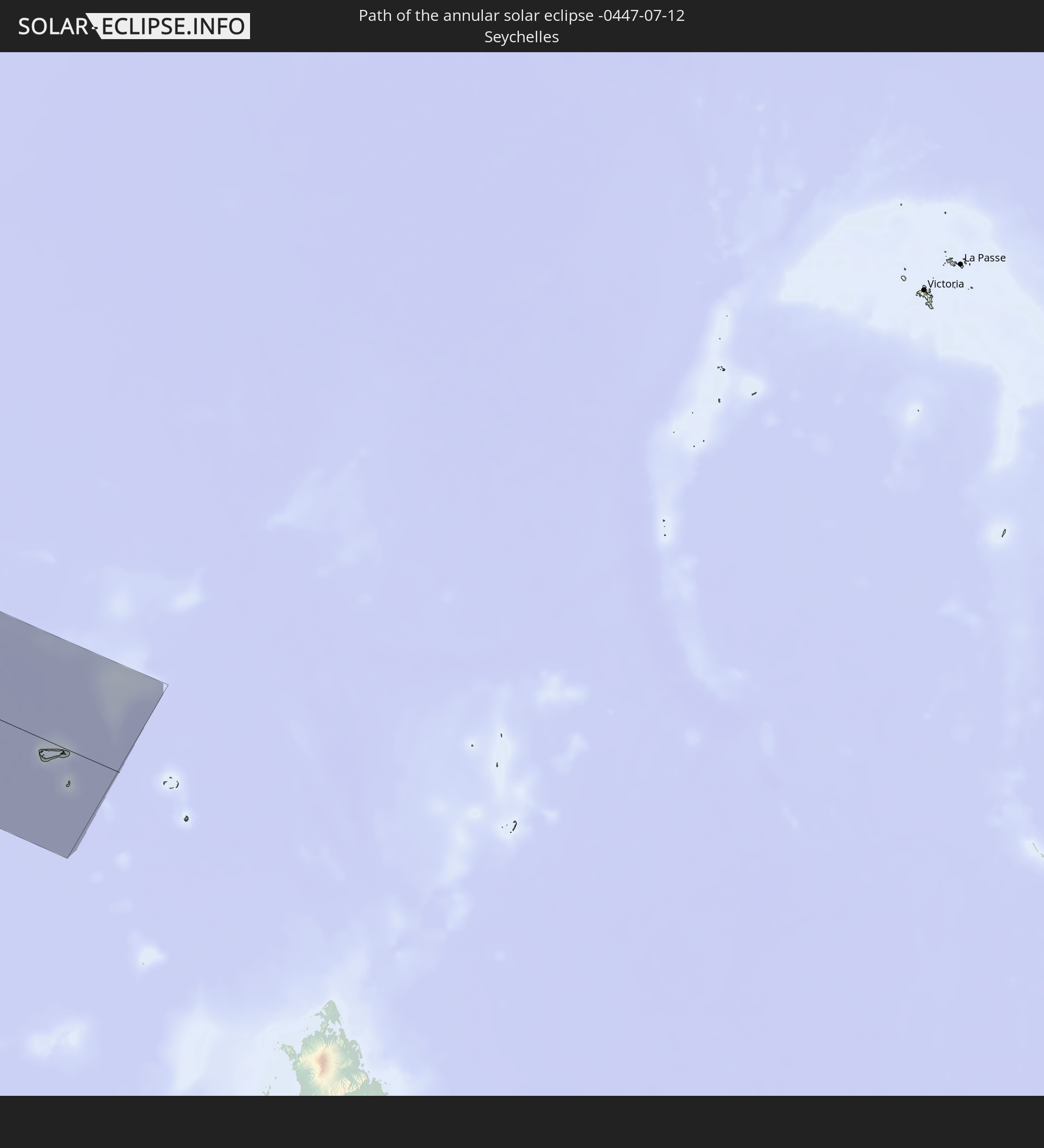 Seychelles
In den folgenden Ländern ist die Sonnenfinsternis partiell zu sehen
 United States
 United States Minor Outlying Islands
 Canada
 Greenland
 Cuba
Cuba
 Colombia
 Cayman Islands
 The Bahamas
 Jamaica
 Haiti
Haiti
 Brazil
 Venezuela
 Turks and Caicos Islands
 Dominican Republic
 Aruba
Aruba
 Bolivia
 Puerto Rico
 United States Virgin Islands
 Bermuda
 British Virgin Islands
 Anguilla
 Collectivity of Saint Martin
 Saint Barthélemy
 Saint Kitts and Nevis
 Antigua and Barbuda
 Montserrat
 Trinidad and Tobago
 Guadeloupe
 Grenada
 Dominica
 Saint Vincent and the Grenadines
 Guyana
 Martinique
 Saint Lucia
 Barbados
 Suriname
 Saint Pierre and Miquelon
 French Guiana
 Portugal
 Cabo Verde
 Spain
Spain
 Senegal
 Mauritania
 The Gambia
 Guinea-Bissau
 Guinea
 Saint Helena, Ascension and Tristan da Cunha
 Sierra Leone
 Morocco
 Mali
Mali
 Liberia
 Republic of Ireland
 Algeria
 United Kingdom
 Ivory Coast
 Burkina Faso
 Gibraltar
 France
 Isle of Man
 Ghana
Ghana
 Guernsey
 Jersey
 Togo
Togo
 Niger
Niger
 Benin
Benin
 Andorra
 Belgium
 Nigeria
 Netherlands
 Equatorial Guinea
 Luxembourg
 Germany
 Switzerland
 São Tomé and Príncipe
 Italy
Italy
 Monaco
 Tunisia
 Denmark
 Cameroon
 Gabon
Gabon
 Libya
Libya
 Liechtenstein
 Austria
 Republic of the Congo
 Angola
 Namibia
 Czechia
 Democratic Republic of the Congo
 San Marino
 Vatican City
 Slovenia
 Chad
Chad
 Croatia
 Poland
 Malta
Malta
 Central African Republic
 Bosnia and Herzegovina
 Hungary
 South Africa
 Slovakia
 Montenegro
 Serbia
 Albania
 Greece
 Botswana
 Romania
 Republic of Macedonia
 Sudan
Sudan
 Zambia
 Ukraine
 Bulgaria
 Egypt
Egypt
 Zimbabwe
 Turkey
 Moldova
 Lesotho
 Rwanda
 Burundi
 Tanzania
 Uganda
 Mozambique
 Swaziland
 Cyprus
 Malawi
 Ethiopia
 Kenya
Kenya
 State of Palestine
 Israel
 Saudi Arabia
 Jordan
 Lebanon
 Syria
Syria
 Eritrea
 Iraq
Iraq
 French Southern and Antarctic Lands
 Somalia
 Djibouti
 Yemen
Yemen
 Comoros
 Iran
Iran
 Mayotte
 Seychelles
 Kuwait
 Bahrain
 Qatar
Qatar
 United Arab Emirates
 Oman
Oman
 Pakistan
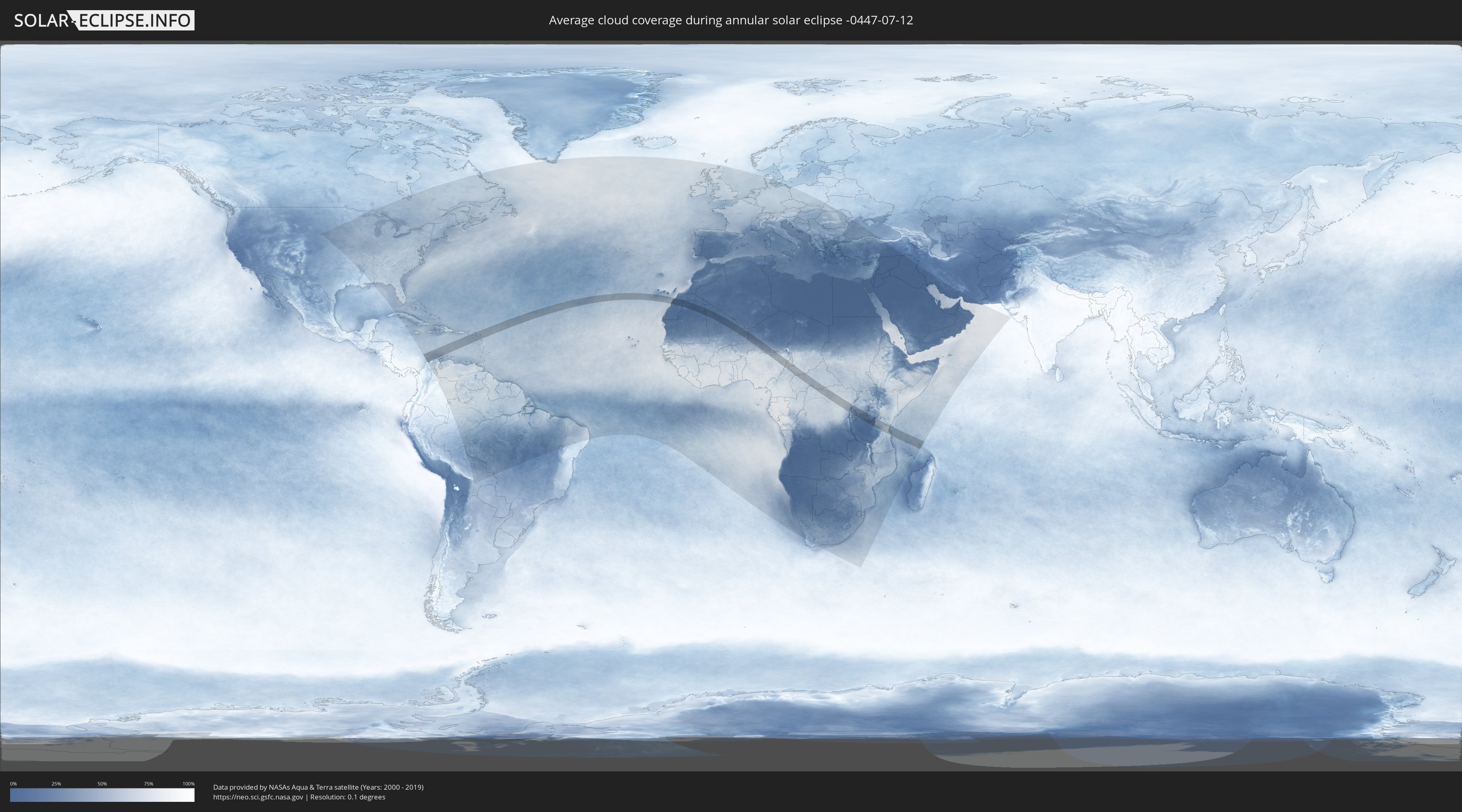
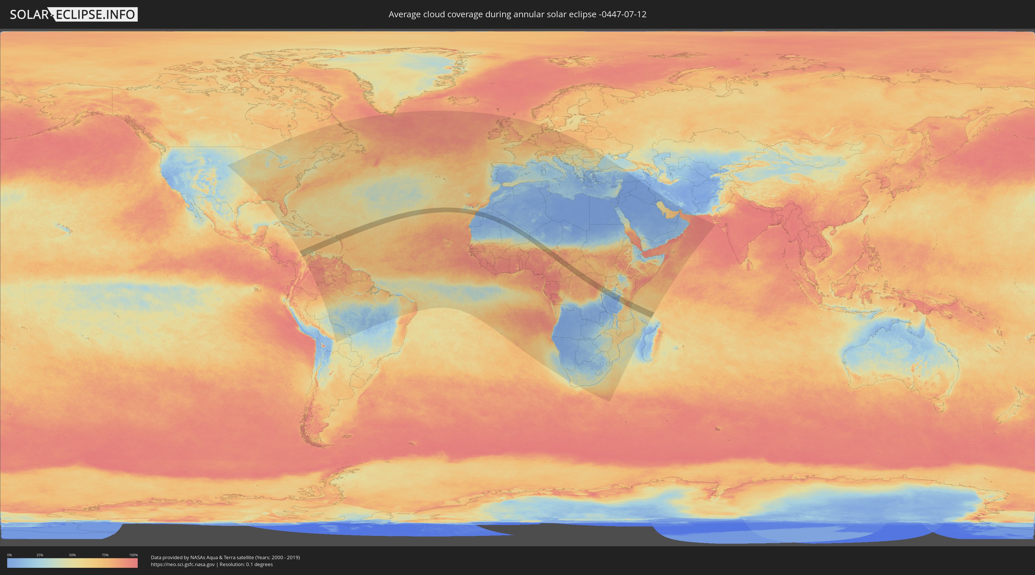
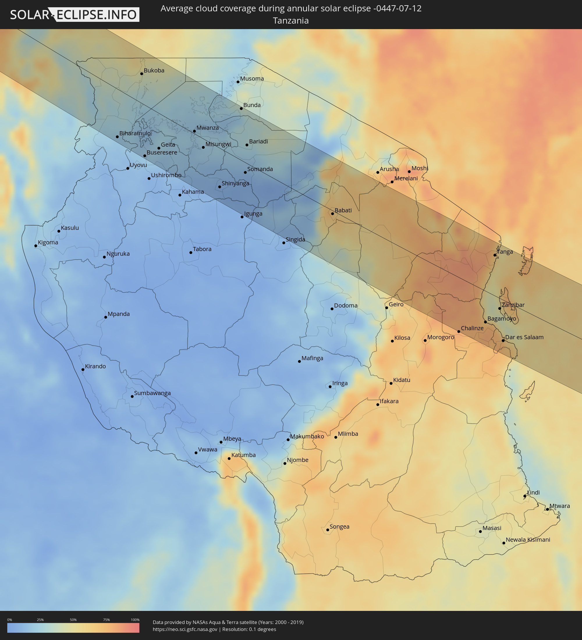
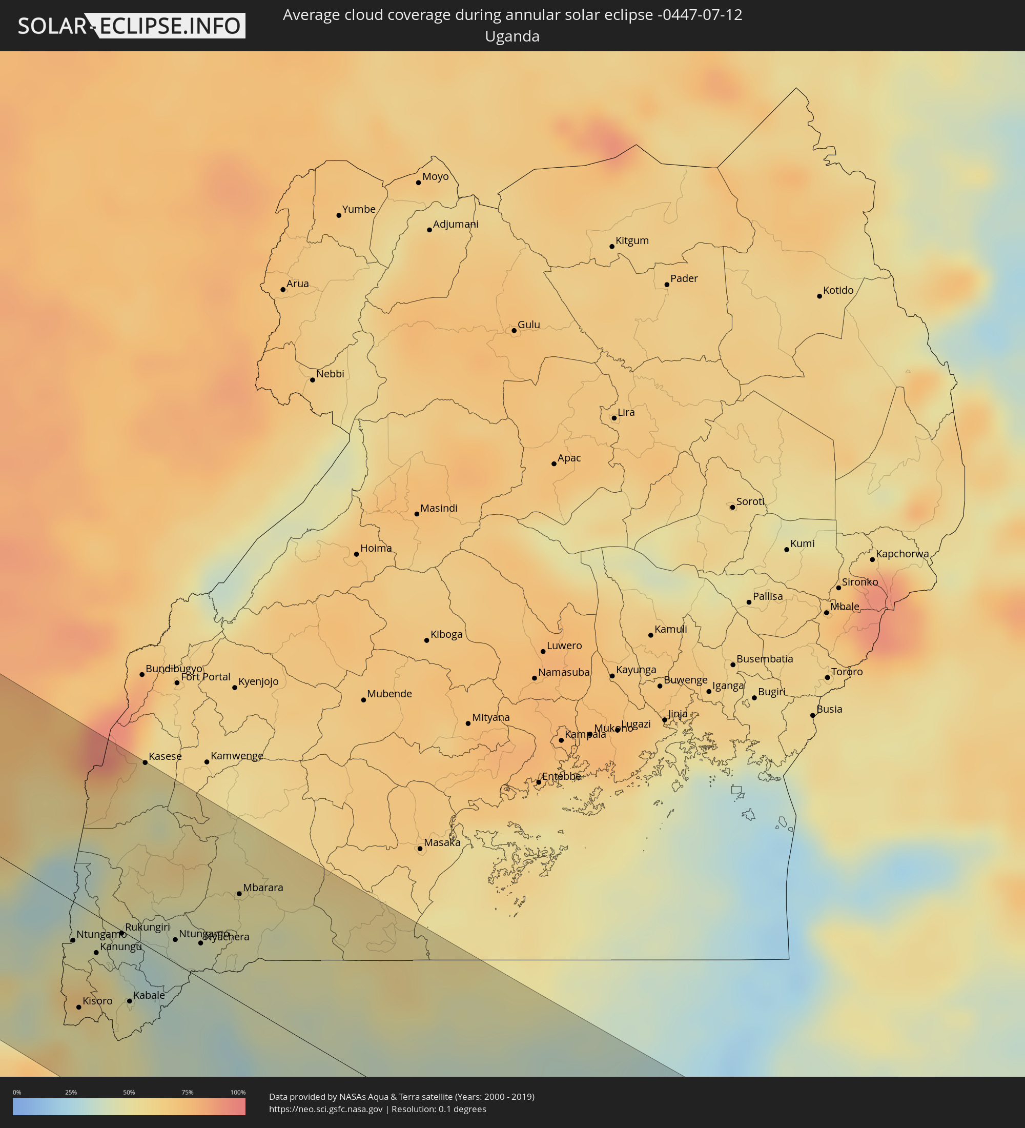
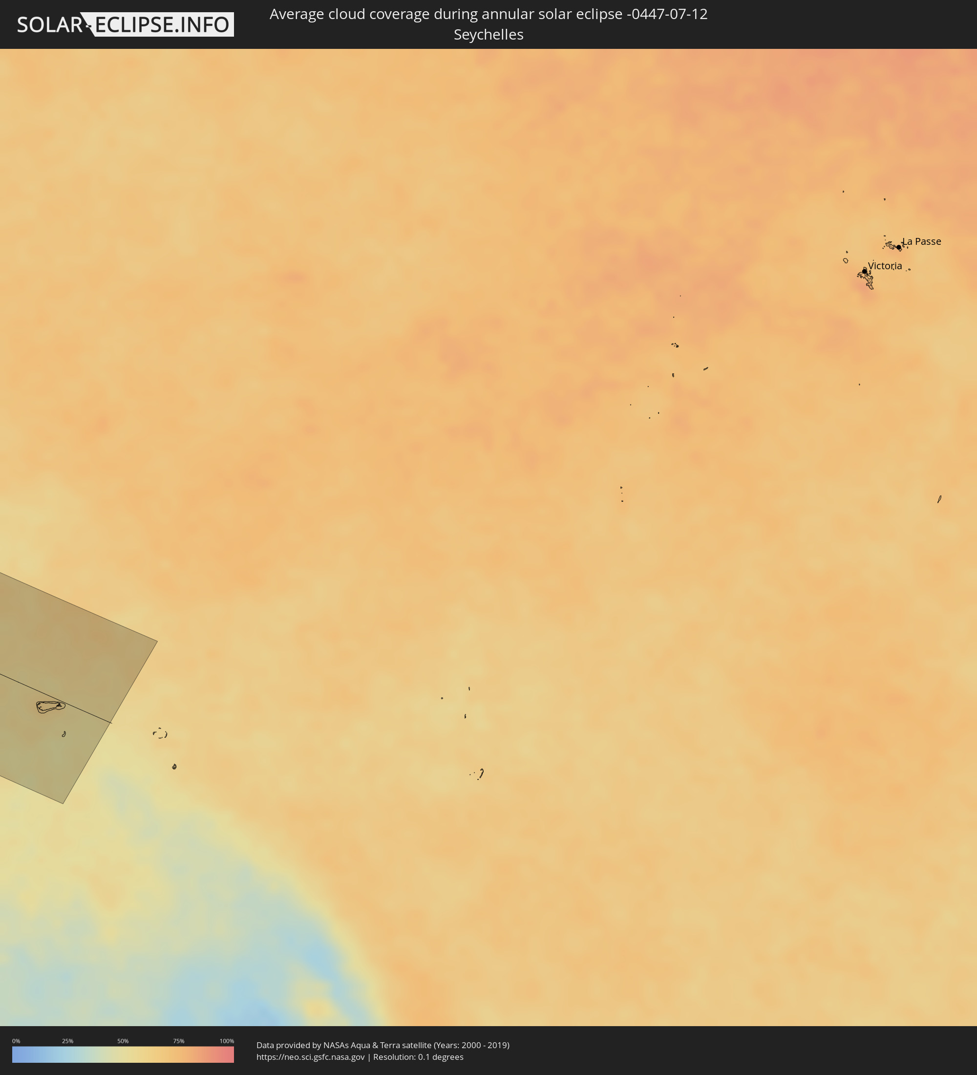
How will be the weather during the annular solar eclipse on 07/12/-0447?
Where is the best place to see the annular solar eclipse of 07/12/-0447?
The following maps show the average cloud coverage for the day of the annular solar eclipse.
With the help of these maps, it is possible to find the place along the eclipse path, which has the best
chance of a cloudless sky.
Nevertheless, you should consider local circumstances and inform about the weather of your chosen
observation site.
The data is provided by NASAs satellites
AQUA and TERRA.
The cloud maps are averaged over a period of 19 years (2000 - 2019).
Detailed country maps
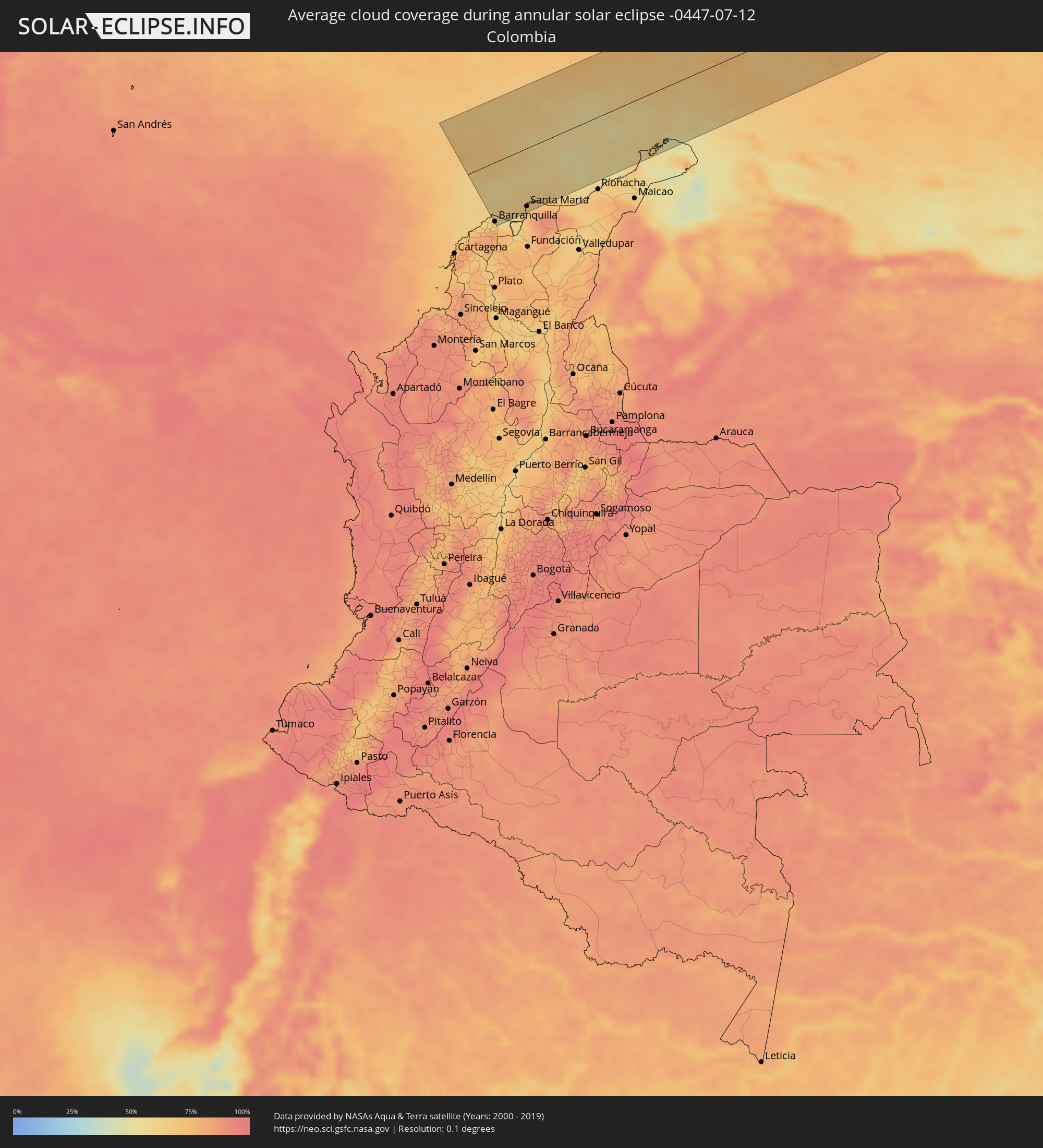 Colombia
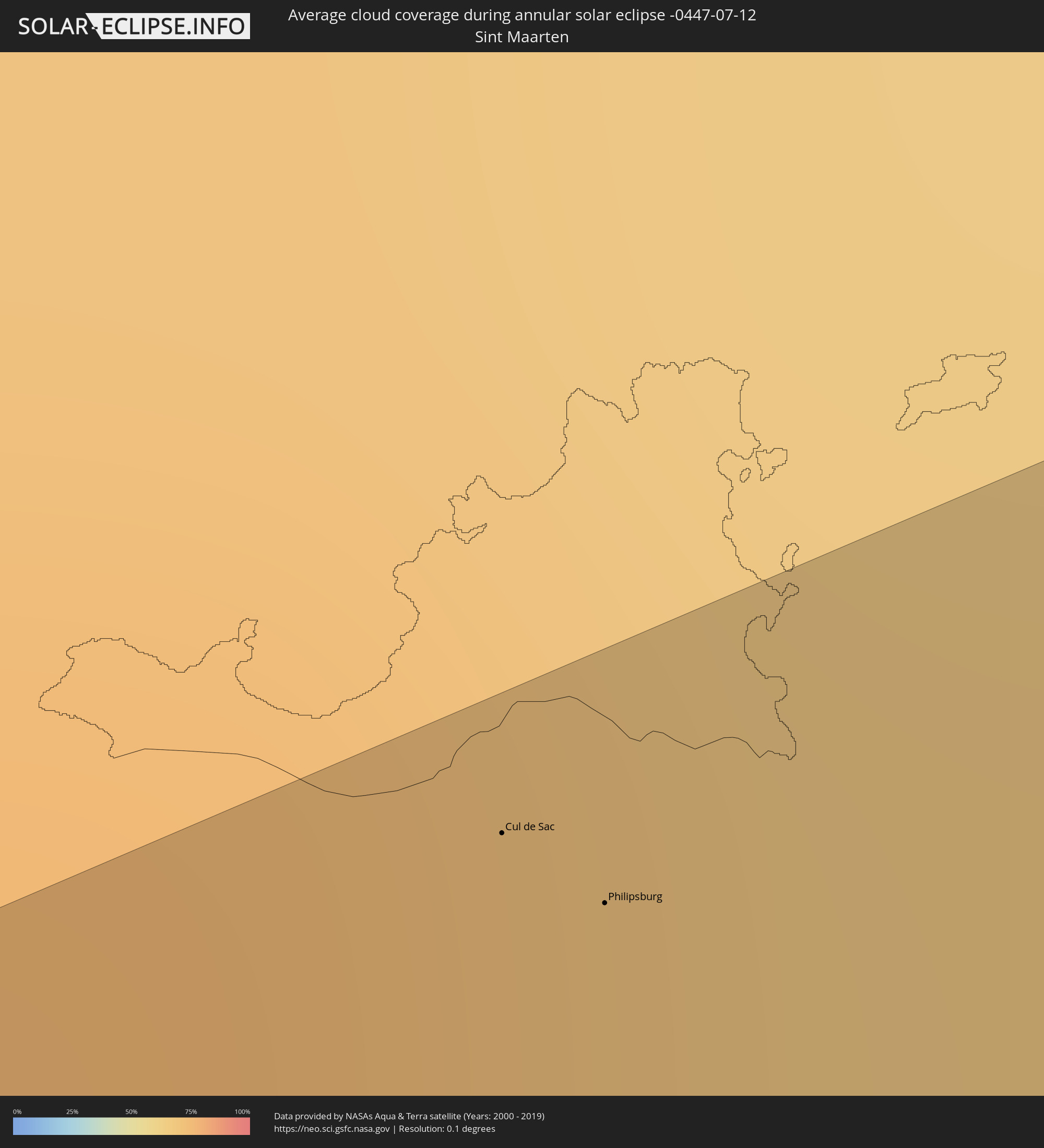 Sint Maarten
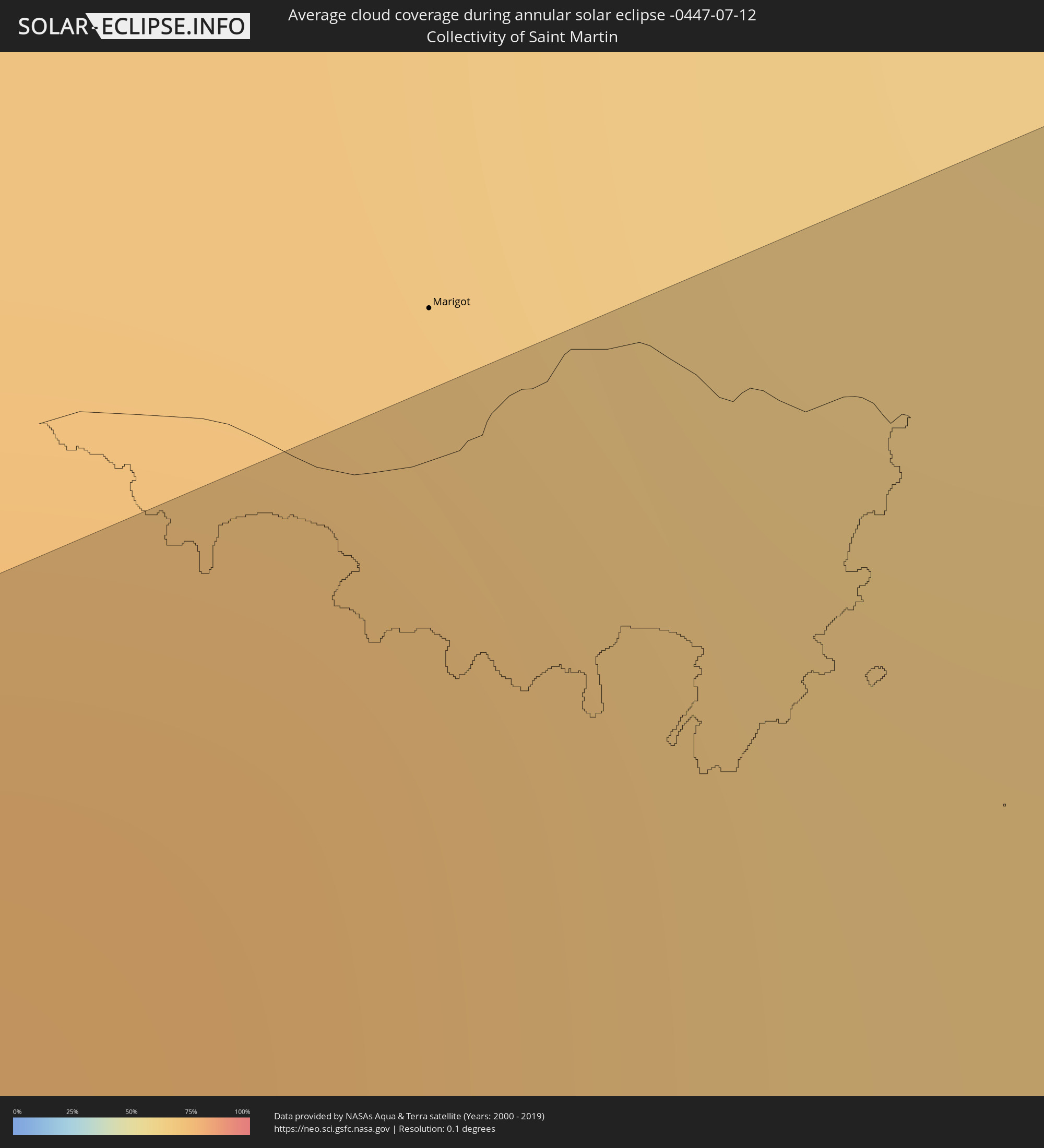 Collectivity of Saint Martin
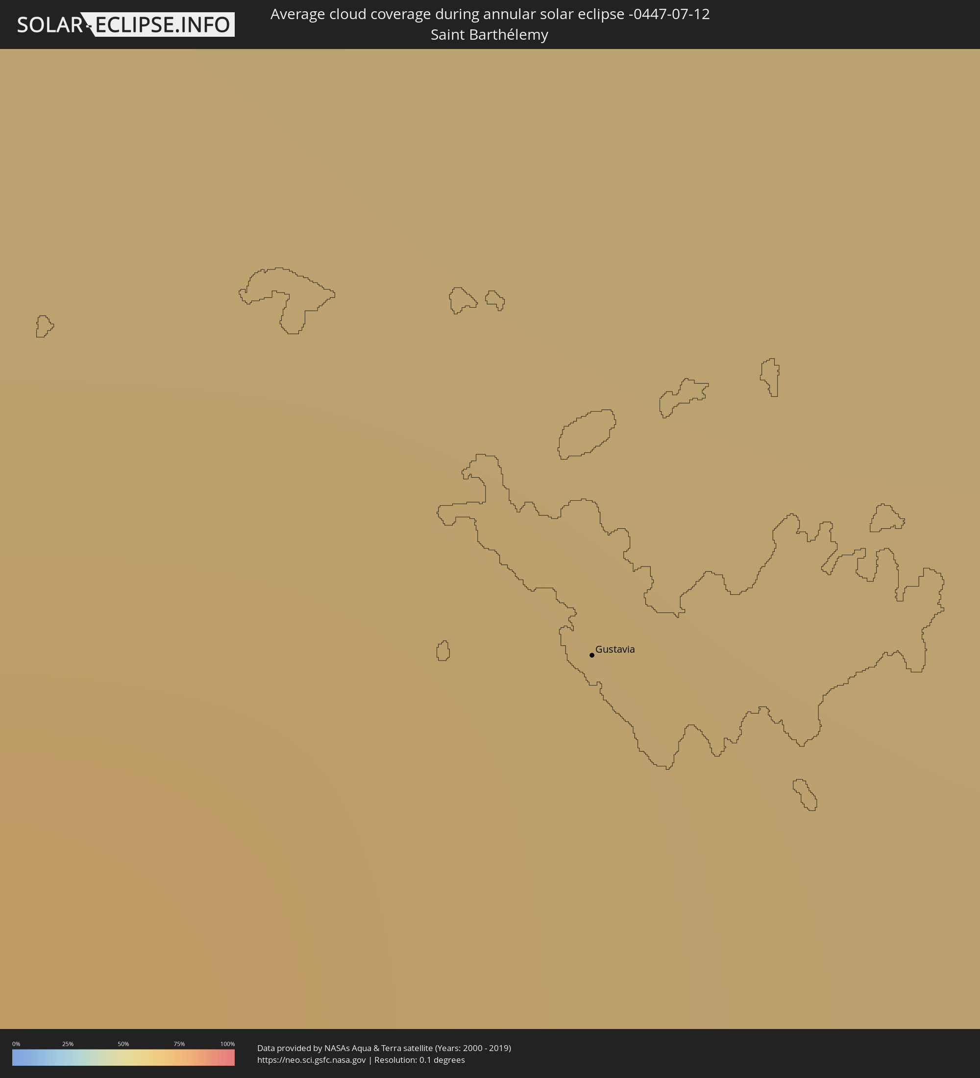 Saint Barthélemy
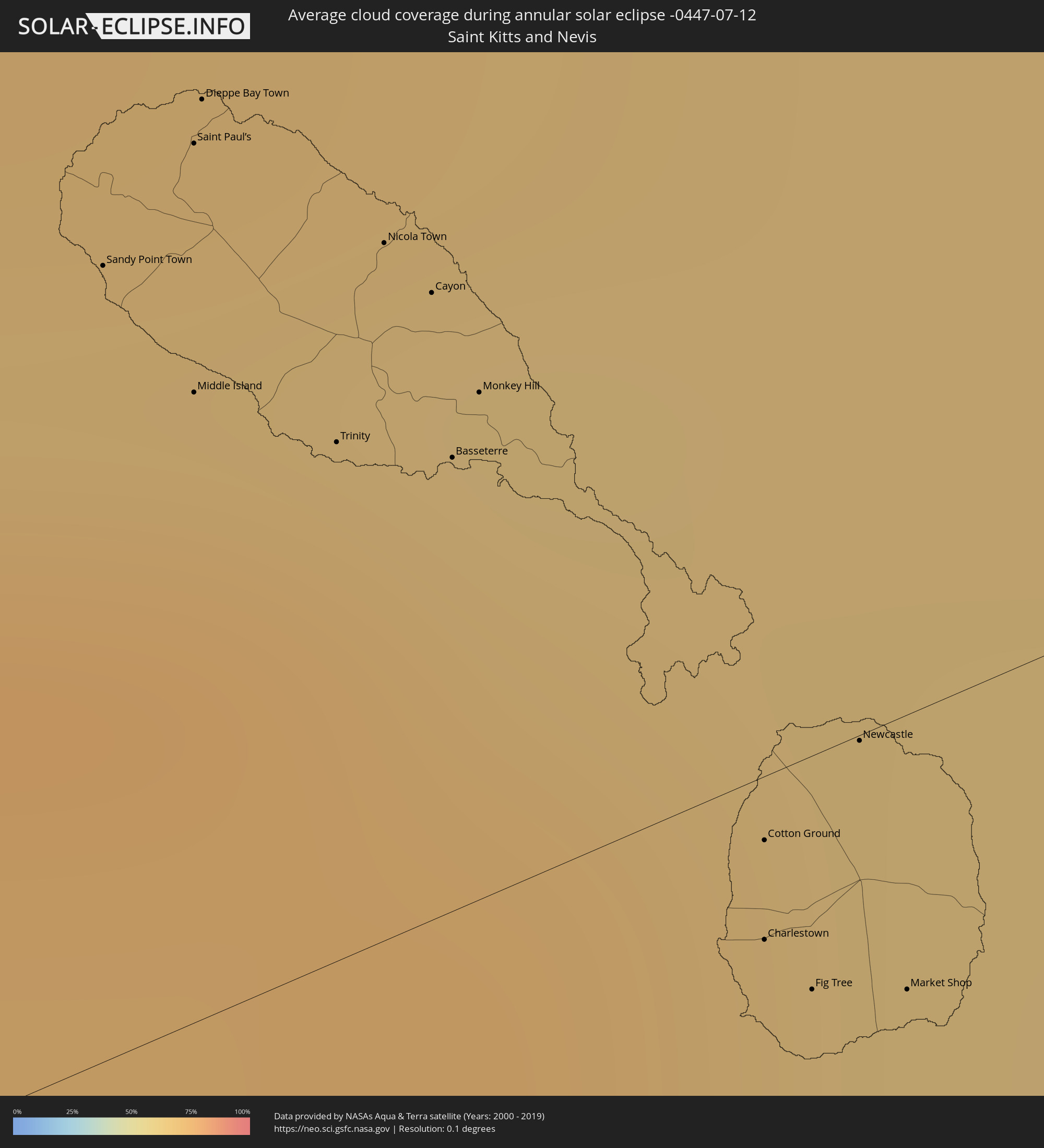 Saint Kitts and Nevis
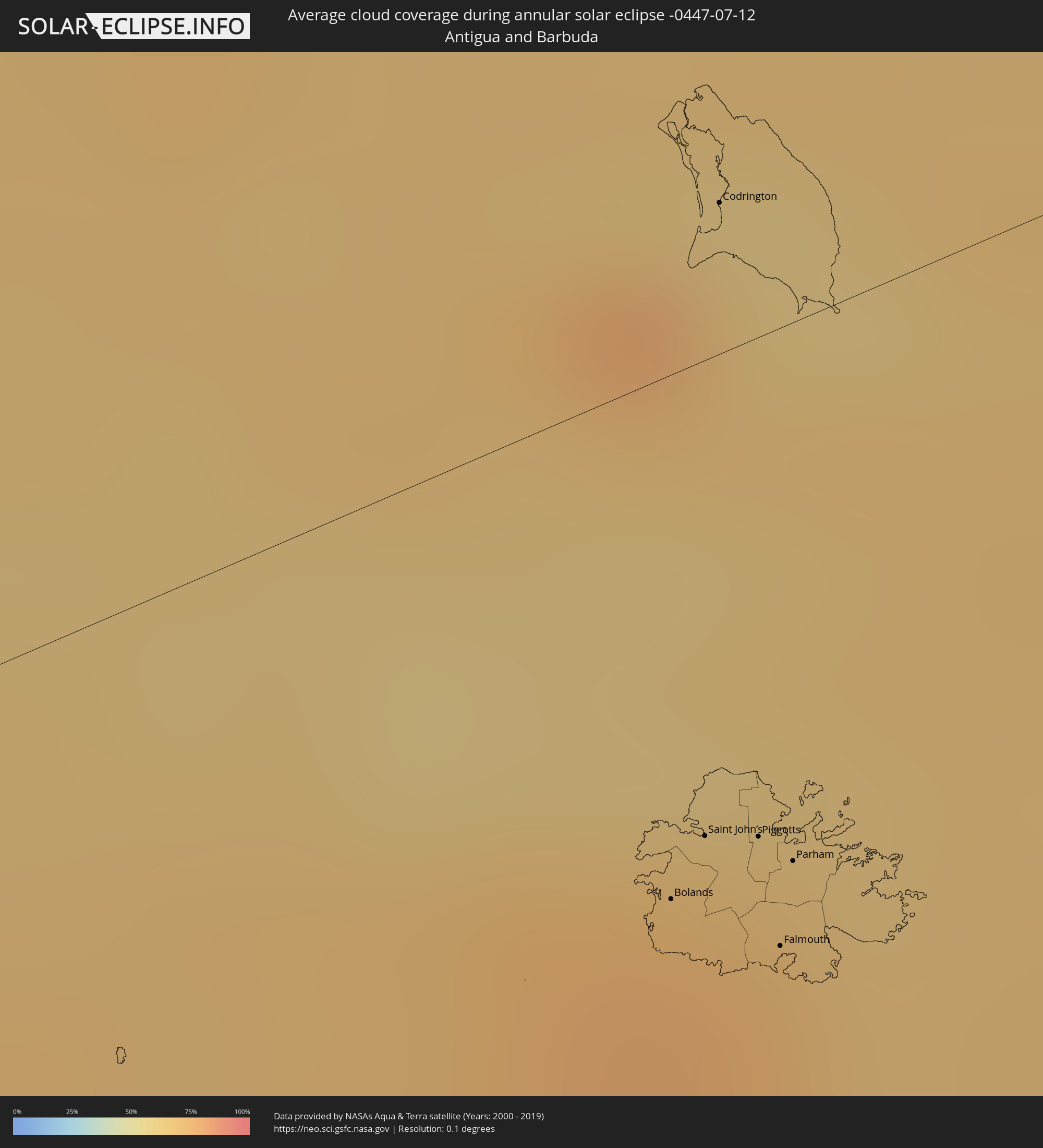 Antigua and Barbuda
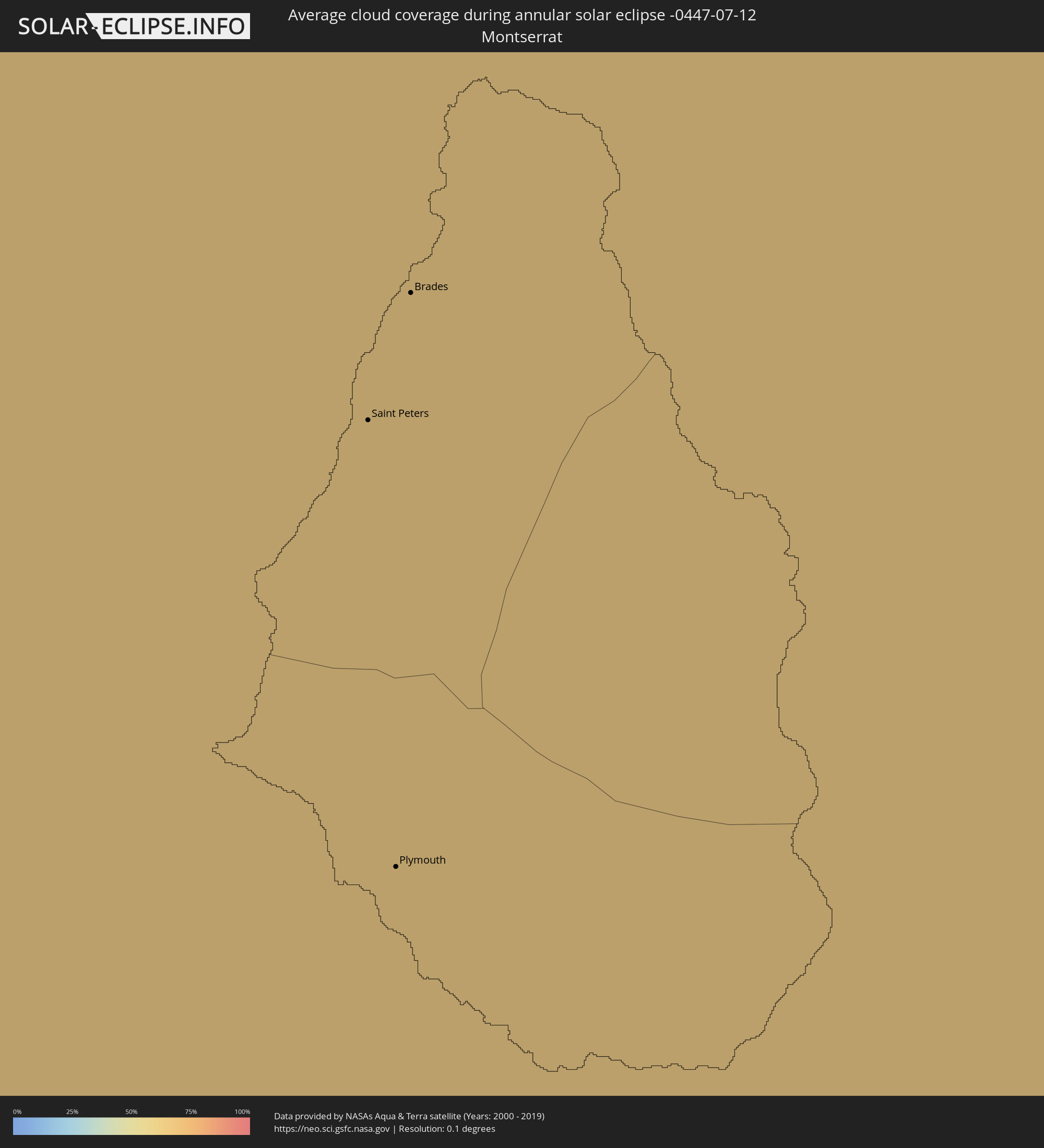 Montserrat
 Mauritania
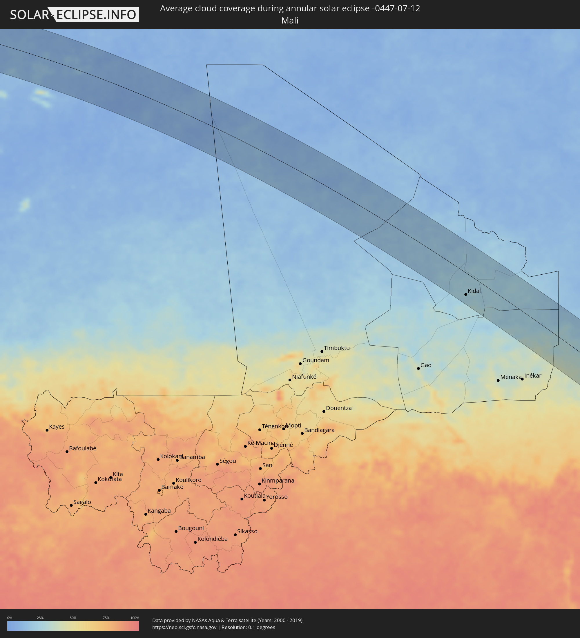 Mali
Mali
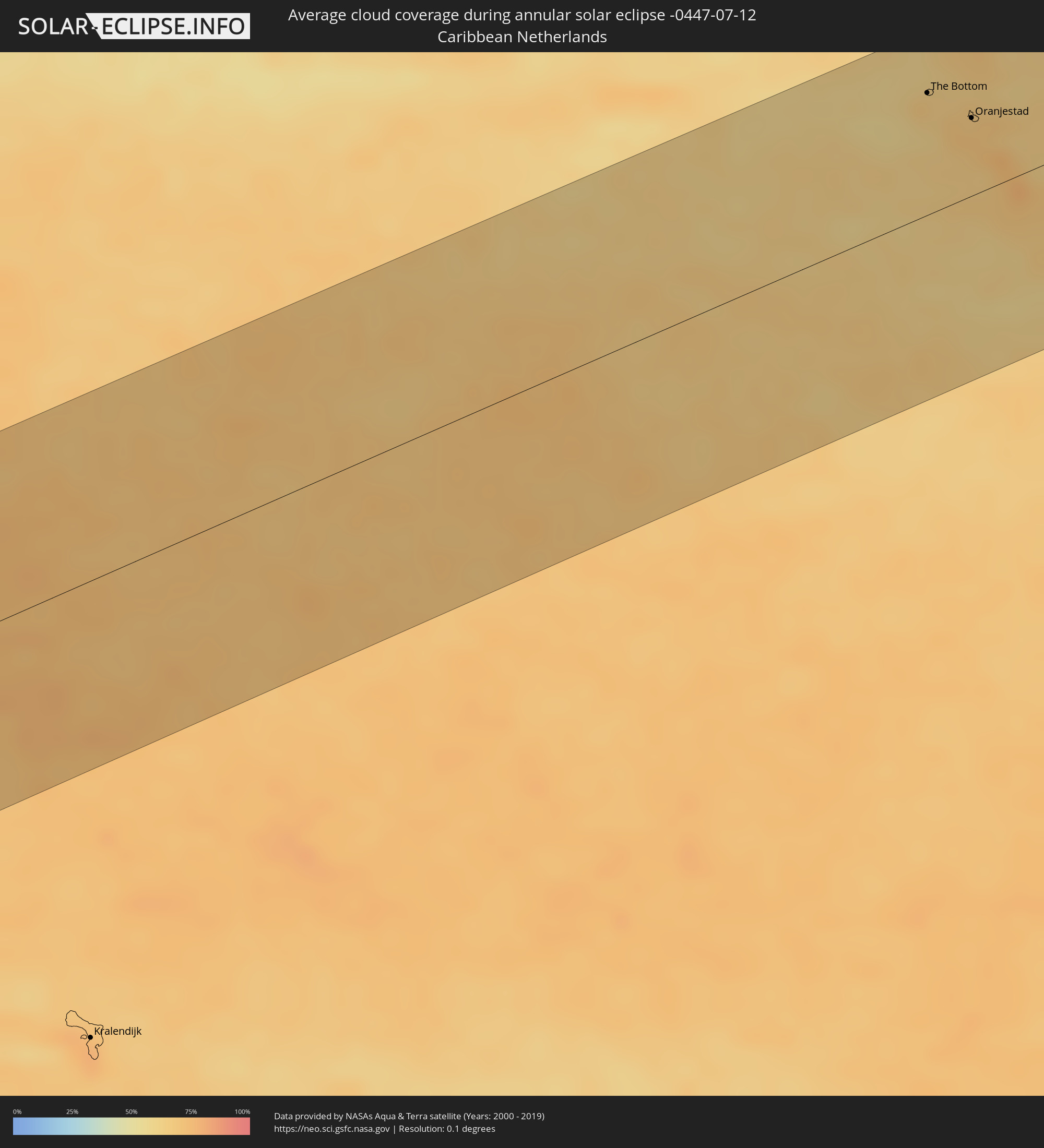 Caribbean Netherlands
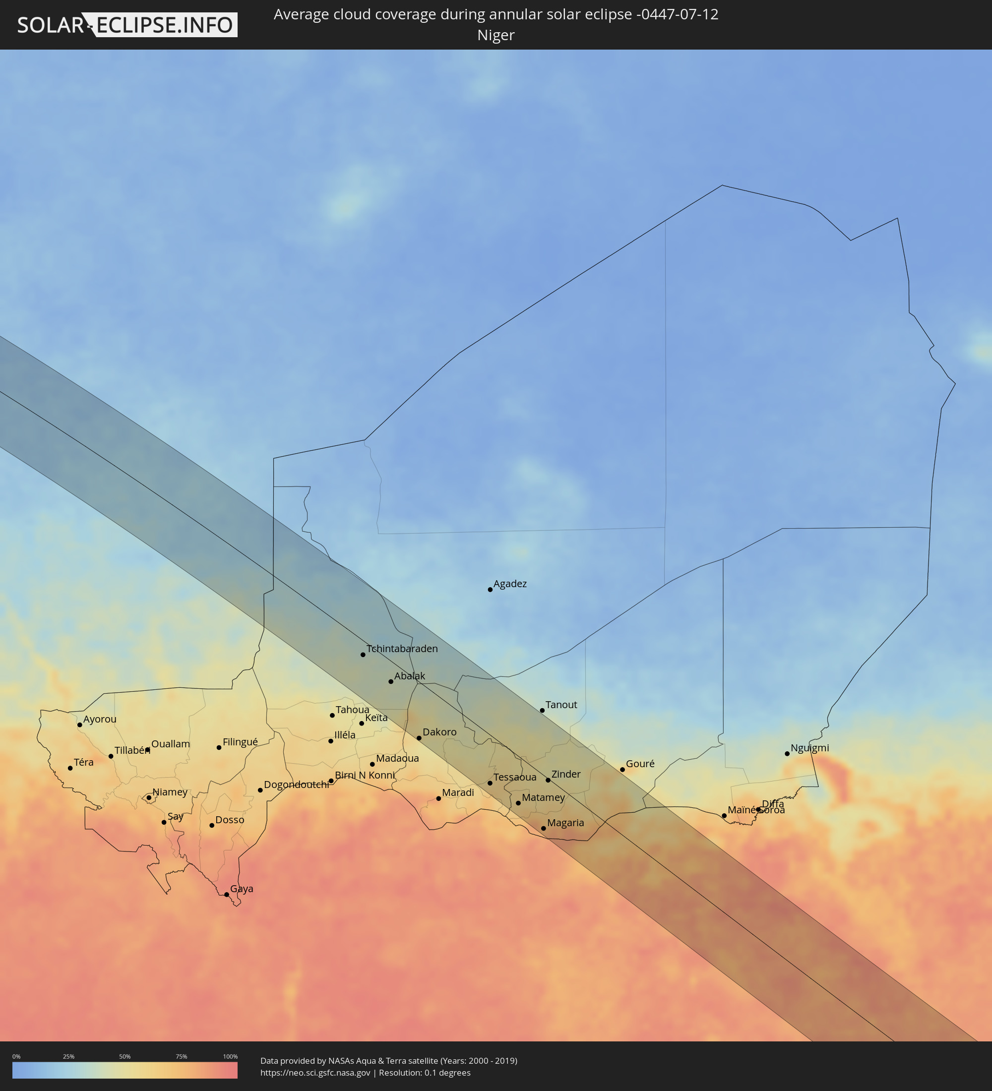 Niger
Niger
 Nigeria
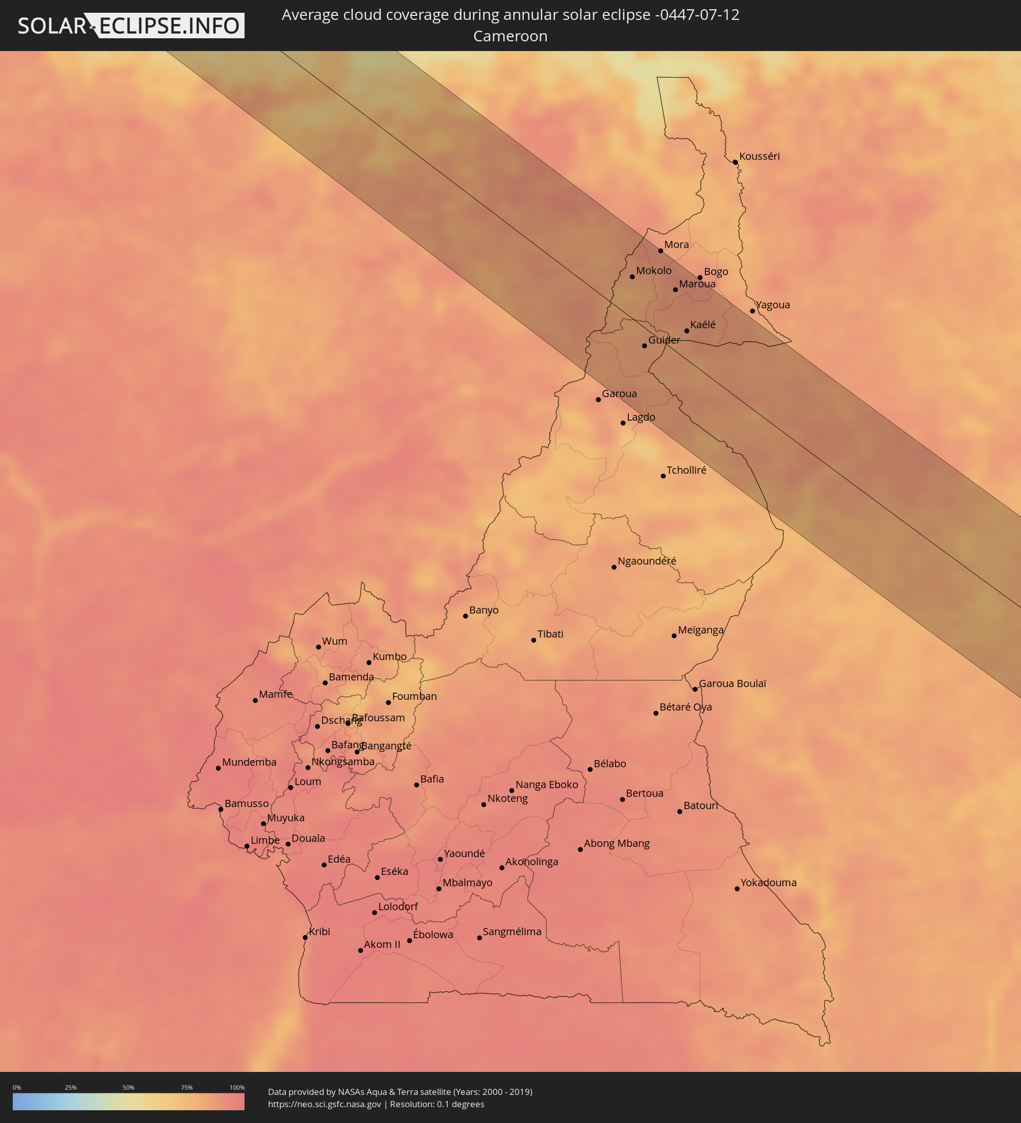 Cameroon
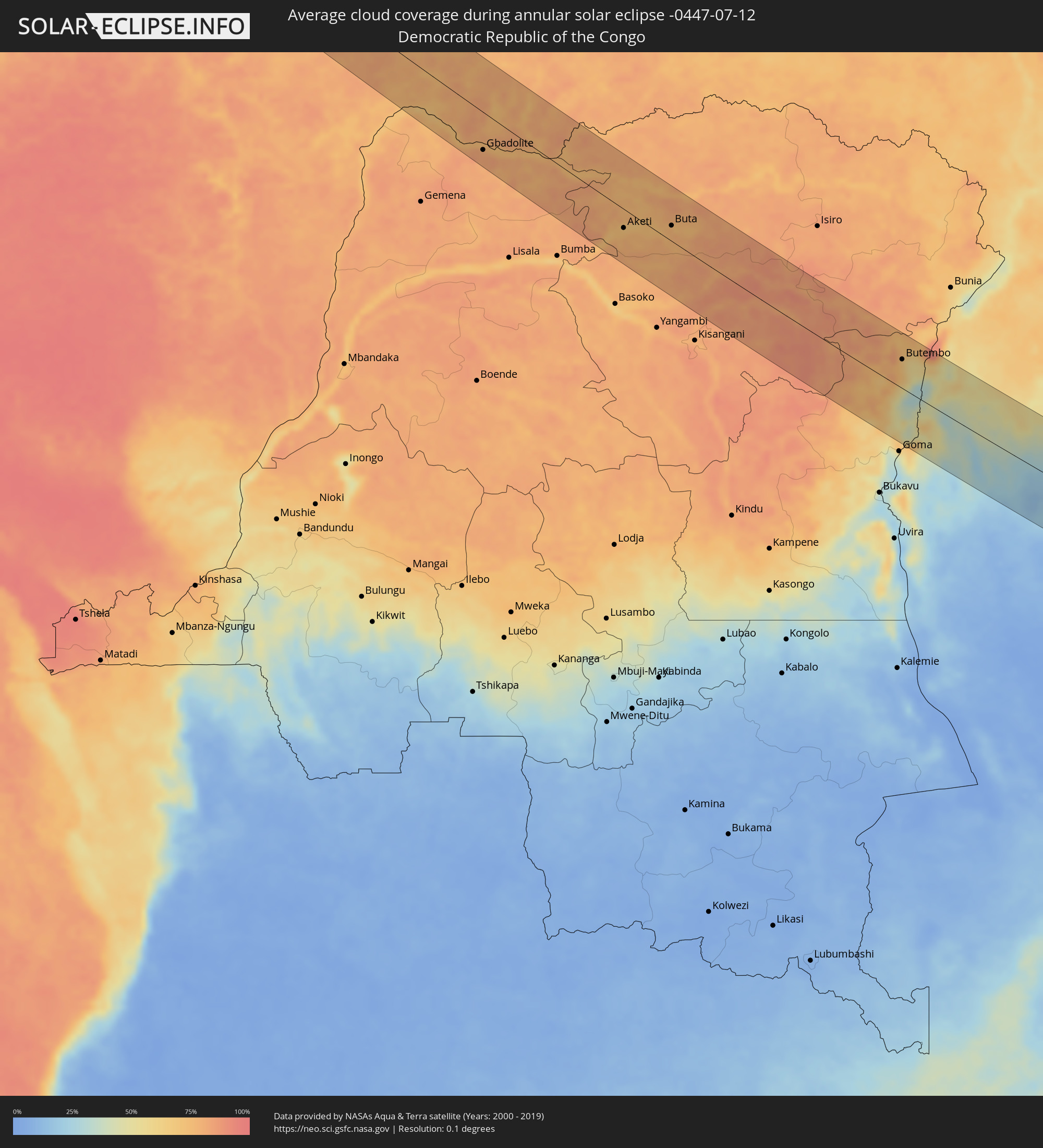 Democratic Republic of the Congo
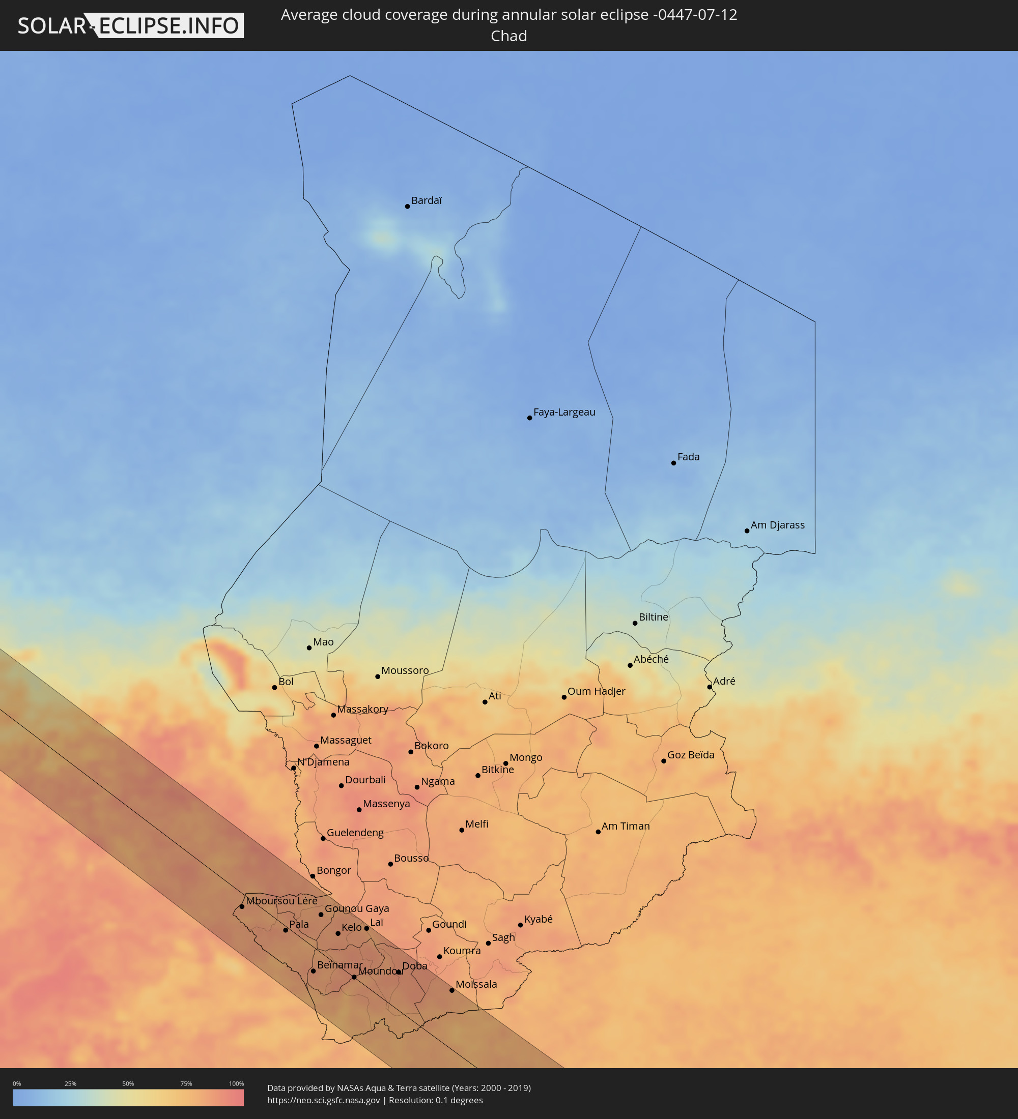 Chad
Chad
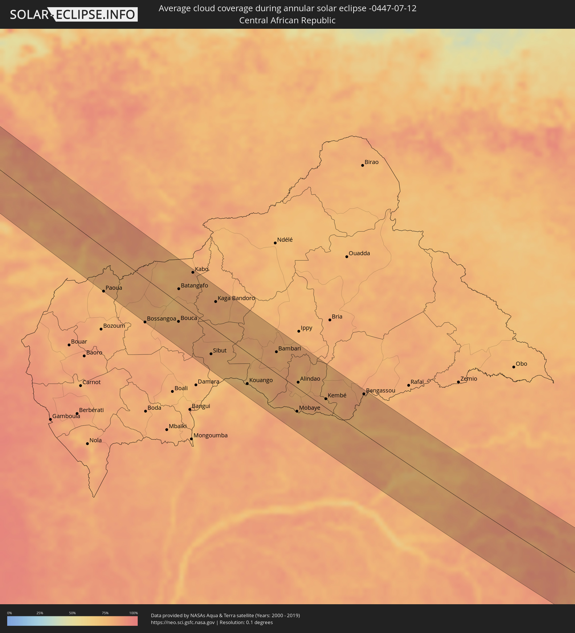 Central African Republic
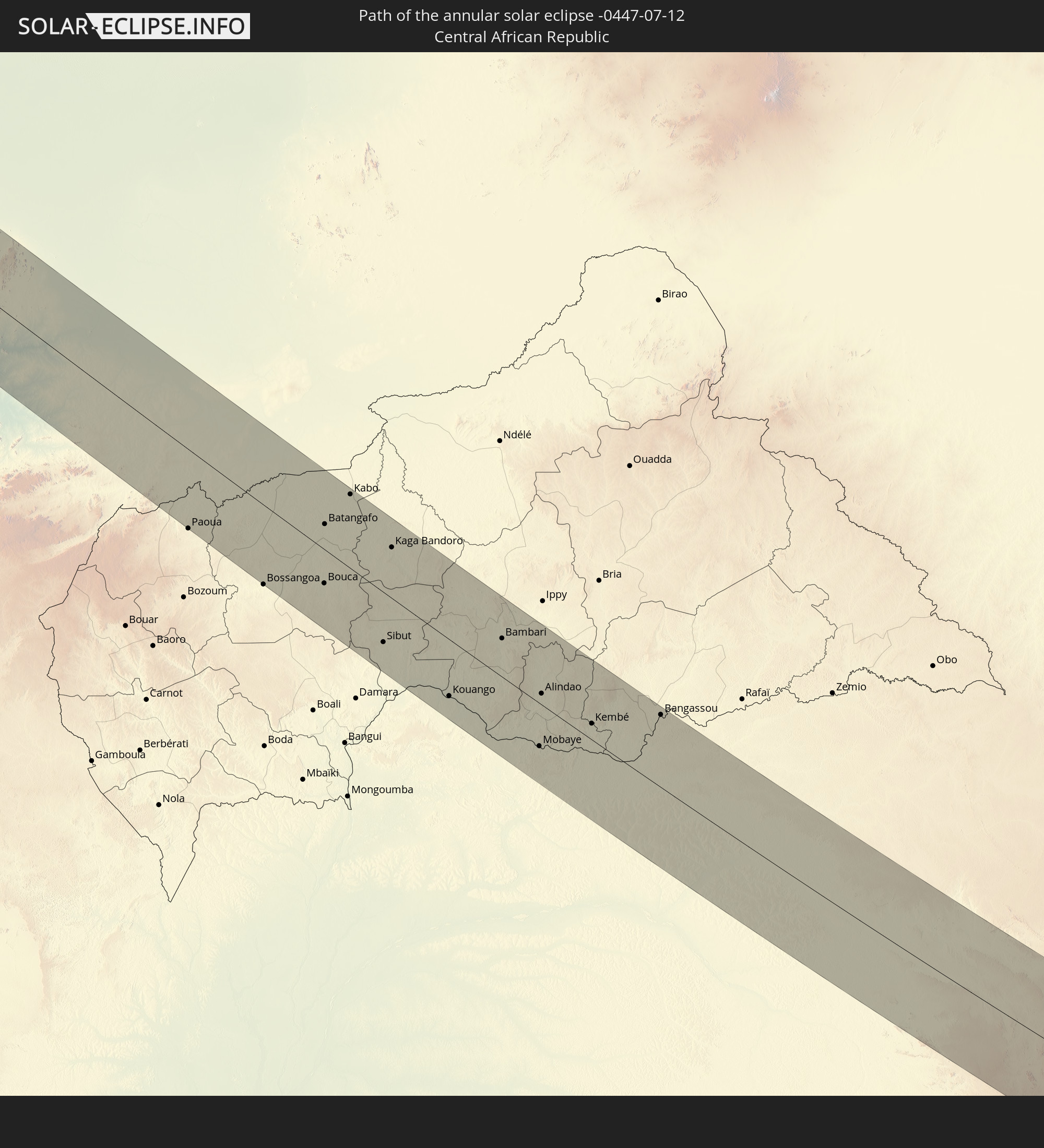
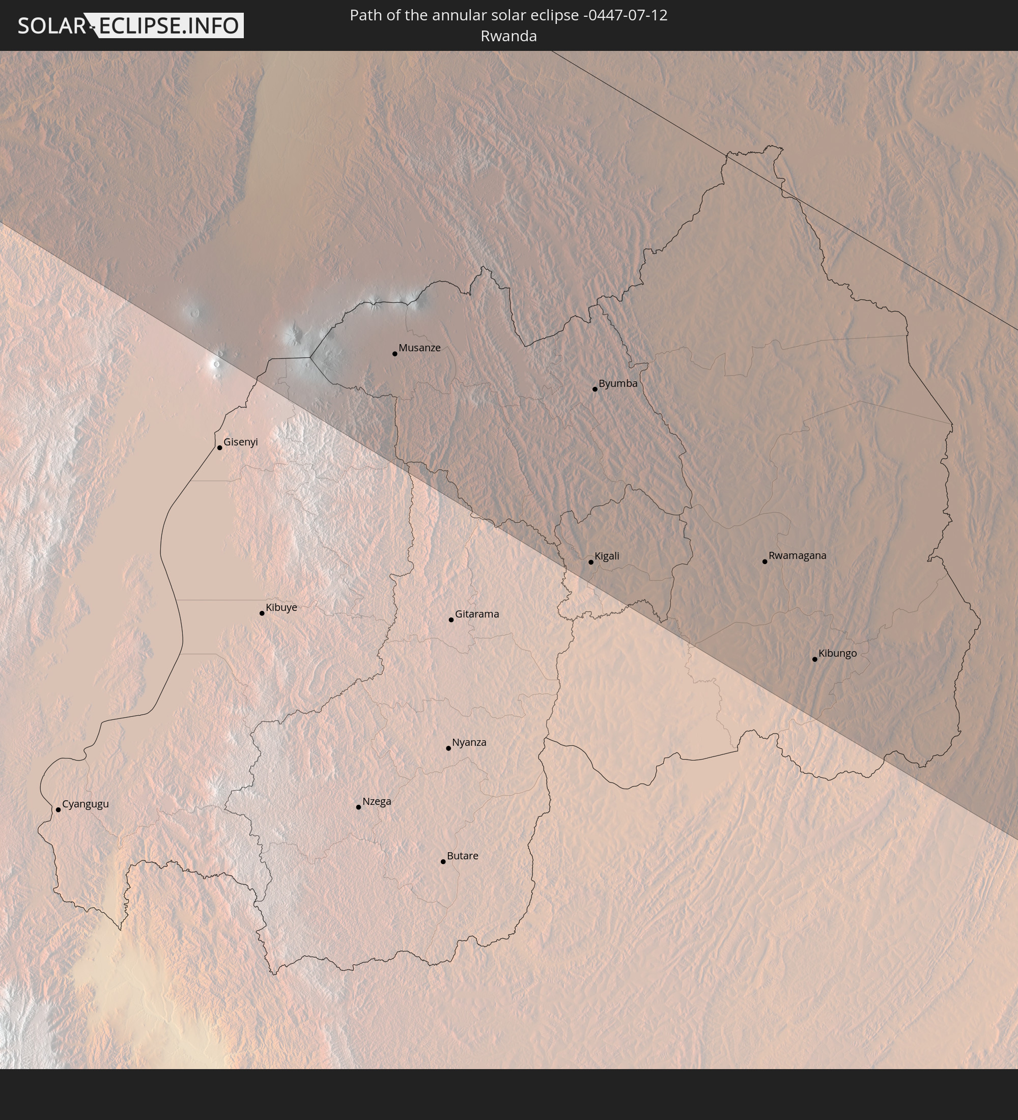
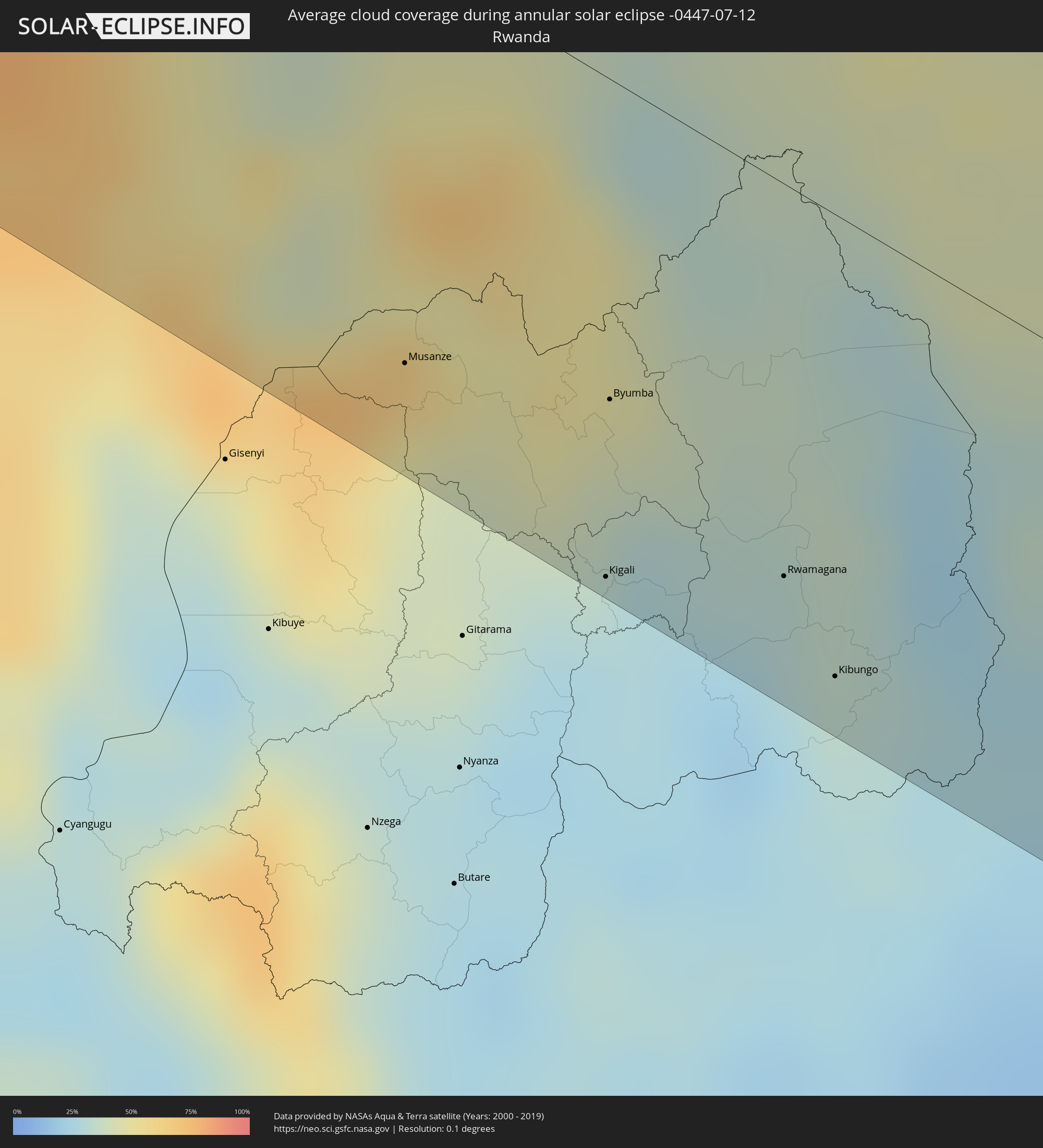 Rwanda
 Tanzania
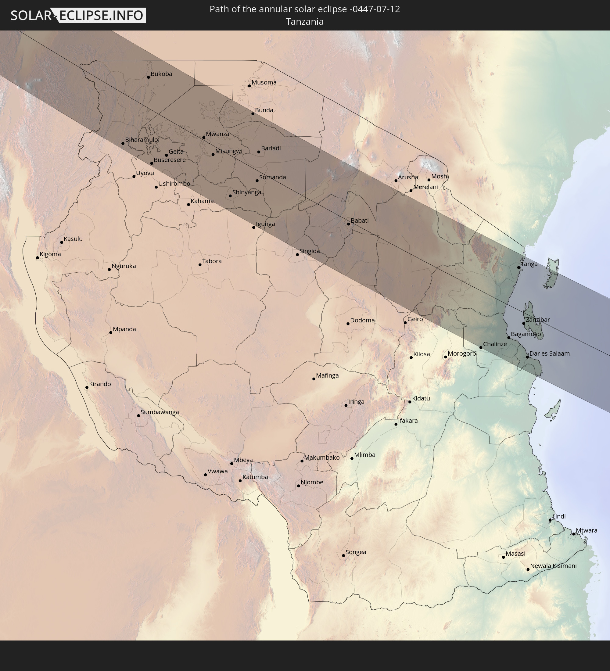
 Uganda
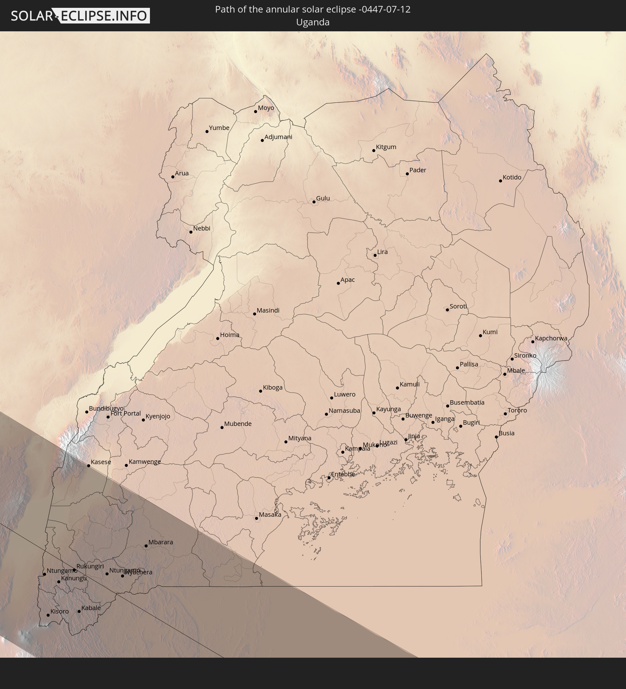
 Seychelles
Cities inside the path of the eclipse
The following table shows all locations with a population of more than 5,000 inside the eclipse path. Cities which have more than 100,000 inhabitants are marked bold. A click at the locations opens a detailed map.
| City | Type | Eclipse duration | Local time of max. eclipse | Distance to central line | Ø Cloud coverage |
|
Barranquilla, Atlántico
|
annular | - | 05:43:49 UTC-04:56 | 108 km | 77% |
|
Soledad, Atlántico
|
annular | - | 05:43:47 UTC-04:56 | 113 km | 81% |
|
Santa Marta, Magdalena
|
annular | - | 05:43:50 UTC-04:56 | 105 km | 75% |
 The Bottom, Saba
|
annular | - | 06:08:21 UTC-04:35 | 71 km | 64% |
 Cul de Sac
|
annular | - | 06:08:41 UTC-04:35 | 106 km | 67% |
|
Philipsburg
|
annular | - | 06:08:41 UTC-04:35 | 104 km | 68% |
|
Oranjestad, Sint Eustatius
|
annular | - | 06:08:21 UTC-04:35 | 46 km | 70% |
|
Gustavia
|
annular | - | 06:38:22 UTC-04:06 | 82 km | 65% |
|
Sandy Point Town, Saint Anne Sandy Point
|
annular | - | 06:38:01 UTC-04:06 | 27 km | 75% |
|
Saint Paul’s, Saint Paul Capesterre
|
annular | - | 06:38:04 UTC-04:06 | 30 km | 75% |
|
Middle Island, Saint Thomas Middle Island
|
annular | - | 06:38:00 UTC-04:06 | 22 km | 72% |
|
Dieppe Bay Town, Saint John Capesterre
|
annular | - | 06:38:04 UTC-04:06 | 31 km | 75% |
|
Trinity, Trinity Palmetto Point
|
annular | - | 06:38:01 UTC-04:06 | 18 km | 72% |
|
Nicola Town, Christ Church Nichola Town
|
annular | - | 06:38:04 UTC-04:06 | 24 km | 75% |
|
Cayon, Saint Mary Cayon
|
annular | - | 06:38:03 UTC-04:06 | 21 km | 67% |
|
Basseterre, Saint George Basseterre
|
annular | - | 06:38:01 UTC-04:06 | 16 km | 72% |
|
Monkey Hill, Saint Peter Basseterre
|
annular | - | 06:38:02 UTC-04:06 | 17 km | 72% |
|
Charlestown, Saint Paul Charlestown
|
annular | - | 06:37:57 UTC-04:06 | 6 km | 68% |
|
Fig Tree, Saint John Figtree
|
annular | - | 06:37:57 UTC-04:06 | 8 km | 68% |
|
Newcastle, Saint James Windwa
|
annular | - | 06:38:00 UTC-04:06 | 1 km | 70% |
|
Saint Peters, Saint Peter
|
annular | - | 06:37:52 UTC-04:06 | 59 km | 74% |
|
Plymouth, Saint Anthony
|
annular | - | 06:37:49 UTC-04:06 | 66 km | 70% |
|
Brades, Saint Peter
|
annular | - | 06:37:53 UTC-04:06 | 58 km | 74% |
|
Bolands, Saint Mary
|
annular | - | 06:38:10 UTC-04:06 | 44 km | 77% |
|
Saint John’s, Saint John
|
annular | - | 06:38:12 UTC-04:06 | 40 km | 75% |
|
Codrington, Barbuda
|
annular | - | 06:38:33 UTC-04:06 | 13 km | 67% |
|
Piggotts, Saint George
|
annular | - | 06:38:13 UTC-04:06 | 42 km | 75% |
|
Falmouth, Saint Paul
|
annular | - | 06:38:10 UTC-04:06 | 52 km | 69% |
|
Parham, Saint Peter
|
annular | - | 06:38:13 UTC-04:06 | 45 km | 75% |
|
Gueltat Zemmour, Laâyoune-Boujdour-Sakia El Hamra
|
annular | - | 11:34:04 UTC-00:52 | 29 km | 12% |
|
Kidal, Kidal
|
annular | - | 13:02:41 UTC-00:16 | 59 km | 24% |
|
Tchintabaraden, Tahoua
|
annular | - | 13:47:30 UTC+00:13 | 22 km | 37% |
|
Abalak, Tahoua
|
annular | - | 13:49:22 UTC+00:13 | 31 km | 40% |
|
Dakoro, Maradi
|
annular | - | 13:52:08 UTC+00:13 | 84 km | 50% |
|
Mayahi, Maradi
|
annular | - | 13:54:59 UTC+00:13 | 75 km | 57% |
|
Tessaoua, Maradi
|
annular | - | 13:55:58 UTC+00:13 | 72 km | 62% |
|
Matamey, Zinder
|
annular | - | 13:57:30 UTC+00:13 | 70 km | 63% |
|
Magaria, Zinder
|
annular | - | 13:59:06 UTC+00:13 | 79 km | 78% |
|
Zinder, Zinder
|
annular | - | 13:57:46 UTC+00:13 | 3 km | 53% |
|
Mirriah, Zinder
|
annular | - | 13:58:15 UTC+00:13 | 1 km | 55% |
|
Gumel, Jigawa
|
annular | - | 14:00:38 UTC+00:13 | 81 km | 80% |
|
Hadejia, Jigawa
|
annular | - | 14:02:07 UTC+00:13 | 54 km | 76% |
|
Nguru, Yobe
|
annular | - | 14:02:05 UTC+00:13 | 11 km | 68% |
|
Gashua, Yobe
|
annular | - | 14:03:05 UTC+00:13 | 49 km | 66% |
|
Potiskum, Yobe
|
annular | - | 14:05:12 UTC+00:13 | 51 km | 82% |
|
Nafada, Gombe
|
annular | - | 14:06:41 UTC+00:13 | 89 km | 87% |
|
Daura, Yobe
|
annular | - | 14:06:01 UTC+00:13 | 43 km | 86% |
|
Damaturu, Yobe
|
annular | - | 14:06:35 UTC+00:13 | 10 km | 89% |
|
Biu, Borno
|
annular | - | 14:08:54 UTC+00:13 | 75 km | 80% |
|
Gombi, Adamawa
|
annular | - | 14:10:29 UTC+00:13 | 78 km | 87% |
|
Damboa, Borno
|
annular | - | 14:08:51 UTC+00:13 | 11 km | 85% |
|
Mubi, Adamawa
|
annular | - | 14:11:07 UTC+00:13 | 34 km | 86% |
|
Mokolo, Far North
|
annular | - | 14:11:07 UTC+00:13 | 43 km | 78% |
|
Guider, North
|
annular | - | 14:12:40 UTC+00:13 | 19 km | 85% |
|
Mora, Far North
|
annular | - | 14:11:07 UTC+00:13 | 92 km | 82% |
|
Mboursou Léré, Mayo-Kebbi Ouest
|
annular | - | 14:59:52 UTC+01:00 | 21 km | 83% |
|
Maroua, Far North
|
annular | - | 14:12:07 UTC+00:13 | 64 km | 87% |
|
Mindif, Far North
|
annular | - | 14:12:37 UTC+00:13 | 54 km | 85% |
|
Kaélé, Far North
|
annular | - | 14:13:06 UTC+00:13 | 30 km | 85% |
|
Pala, Mayo-Kebbi Ouest
|
annular | - | 15:01:33 UTC+01:00 | 6 km | 85% |
|
Beïnamar, Logone Occidental
|
annular | - | 15:03:18 UTC+01:00 | 37 km | 83% |
|
Gounou Gaya, Mayo-Kebbi Est
|
annular | - | 15:01:57 UTC+01:00 | 57 km | 83% |
|
Kelo, Tandjilé
|
annular | - | 15:02:51 UTC+01:00 | 48 km | 86% |
|
Moundou, Logone Occidental
|
annular | - | 15:04:23 UTC+01:00 | 0 km | 81% |
|
Béré, Tandjilé
|
annular | - | 15:03:18 UTC+01:00 | 72 km | 85% |
|
Laï, Tandjilé
|
annular | - | 15:03:22 UTC+01:00 | 88 km | 80% |
|
Benoy, Logone Occidental
|
annular | - | 15:04:02 UTC+01:00 | 53 km | 87% |
|
Paoua, Ouham-Pendé
|
annular | - | 14:20:14 UTC+00:13 | 95 km | 77% |
|
Bébédja, Logone Oriental
|
annular | - | 15:04:49 UTC+01:00 | 42 km | 87% |
|
Doba, Logone Oriental
|
annular | - | 15:05:13 UTC+01:00 | 58 km | 86% |
|
Bossangoa, Ouham
|
annular | - | 14:22:33 UTC+00:13 | 96 km | 79% |
|
Moïssala, Mandoul
|
annular | - | 15:06:48 UTC+01:00 | 90 km | 81% |
|
Bouca, Ouham
|
annular | - | 14:23:28 UTC+00:13 | 41 km | 79% |
|
Batangafo, Ouham
|
annular | - | 14:22:19 UTC+00:13 | 31 km | 79% |
|
Kabo, Ouham
|
annular | - | 14:22:08 UTC+00:13 | 89 km | 81% |
|
Sibut, Kémo
|
annular | - | 14:25:26 UTC+00:13 | 61 km | 77% |
|
Kaga Bandoro, Nana-Grébizi
|
annular | - | 14:23:46 UTC+00:13 | 62 km | 82% |
|
Bambari, Ouaka
|
annular | - | 14:27:00 UTC+00:13 | 47 km | 76% |
|
Gbadolite, Équateur
|
annular | - | 14:29:17 UTC+00:13 | 68 km | 81% |
|
Mobaye, Basse-Kotto
|
annular | - | 14:29:23 UTC+00:13 | 53 km | 78% |
|
Alindao, Basse-Kotto
|
annular | - | 14:28:30 UTC+00:13 | 14 km | 74% |
|
Kembé, Basse-Kotto
|
annular | - | 14:29:39 UTC+00:13 | 20 km | 77% |
|
Bangassou, Mbomou
|
annular | - | 14:30:18 UTC+00:13 | 90 km | 78% |
|
Bondo, Orientale
|
annular | - | 16:28:55 UTC+02:10 | 59 km | 74% |
|
Aketi, Orientale
|
annular | - | 16:30:17 UTC+02:10 | 34 km | 75% |
|
Buta, Orientale
|
annular | - | 16:30:57 UTC+02:10 | 28 km | 77% |
|
Butembo, Nord Kivu
|
annular | - | 16:36:32 UTC+02:10 | 54 km | 67% |
|
Beni, Nord Kivu
|
annular | - | 16:36:17 UTC+02:10 | 98 km | 74% |
|
Musanze, Northern Province
|
annular | - | 16:38:15 UTC+02:10 | 82 km | 51% |
|
Ntungamo, Western Region
|
annular | - | 16:54:37 UTC+02:27 | 22 km | 57% |
|
Kisoro, Western Region
|
annular | - | 16:55:00 UTC+02:27 | 59 km | 51% |
|
Kanungu, Western Region
|
annular | - | 16:54:45 UTC+02:27 | 21 km | 63% |
|
Rukungiri, Western Region
|
annular | - | 16:54:43 UTC+02:27 | 2 km | 44% |
|
Kabale, Western Region
|
annular | - | 16:55:07 UTC+02:27 | 38 km | 50% |
|
Kilembe, Western Region
|
annular | - | 16:53:46 UTC+02:27 | 101 km | 67% |
|
Kigali, Kigali
|
annular | - | 16:38:50 UTC+02:10 | 101 km | 28% |
|
Byumba, Northern Province
|
annular | - | 16:38:30 UTC+02:10 | 64 km | 37% |
|
Kasese, Western Region
|
annular | - | 16:53:49 UTC+02:27 | 104 km | 56% |
|
Ntungamo, Western Region
|
annular | - | 16:54:54 UTC+02:27 | 13 km | 36% |
|
Nyachera, Western Region
|
annular | - | 16:54:59 UTC+02:27 | 20 km | 38% |
|
Rwamagana, Eastern Province
|
annular | - | 16:39:00 UTC+02:10 | 79 km | 31% |
|
Kibungo, Eastern Province
|
annular | - | 16:39:13 UTC+02:10 | 93 km | 30% |
|
Bwizibwera, Western Region
|
annular | - | 16:54:47 UTC+02:27 | 62 km | 47% |
|
Mbarara, Western Region
|
annular | - | 16:54:48 UTC+02:27 | 62 km | 47% |
|
Byakabanda, Central Region
|
annular | - | 16:55:15 UTC+02:27 | 92 km | 54% |
|
Bukoba, Kagera
|
annular | - | 16:55:56 UTC+02:27 | 58 km | 40% |
|
Buseresere, Geita
|
annular | - | 16:57:23 UTC+02:27 | 101 km | 18% |
|
Geita, Geita
|
annular | - | 16:57:22 UTC+02:27 | 70 km | 17% |
|
Mwanza, Mwanza
|
annular | - | 16:57:19 UTC+02:27 | 5 km | 21% |
|
Misungwi, Mwanza
|
annular | - | 16:57:39 UTC+02:27 | 17 km | 19% |
|
Shinyanga, Shinyanga
|
annular | - | 16:58:23 UTC+02:27 | 78 km | 6% |
|
Bunda, Mara
|
annular | - | 16:57:14 UTC+02:27 | 103 km | 28% |
|
Babati, Manyara
|
annular | - | 16:59:22 UTC+02:27 | 7 km | 67% |
|
Bagamoyo, Pwani
|
annular | - | 17:01:15 UTC+02:27 | 64 km | 76% |
|
Tanga, Tanga
|
annular | - | 17:00:25 UTC+02:27 | 82 km | 59% |
|
Zanzibar, Zanzibar Urban/West
|
annular | - | 17:01:06 UTC+02:27 | 21 km | 43% |
|
Dar es Salaam, Dar es Salaam
|
annular | - | 17:01:29 UTC+02:27 | 83 km | 67% |