Total solar eclipse of 02/24/-0570
| Day of week: | Monday |
| Maximum duration of eclipse: | 03m04s |
| Maximum width of eclipse path: | 106 km |
| Saros cycle: | 50 |
| Coverage: | 100% |
| Magnitude: | 1.0313 |
| Gamma: | 0.0115 |
Wo kann man die Sonnenfinsternis vom 02/24/-0570 sehen?
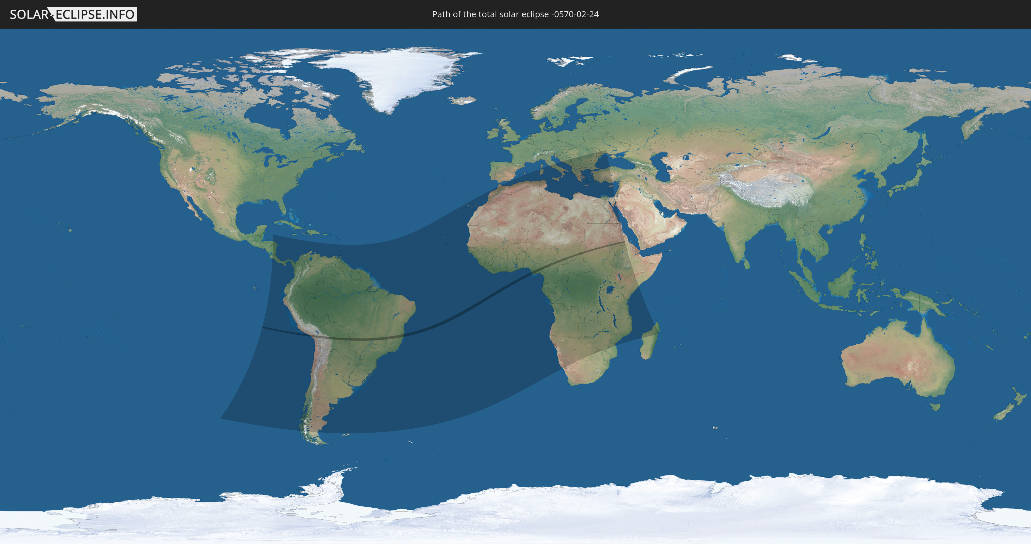
Die Sonnenfinsternis am 02/24/-0570 kann man in 98 Ländern als partielle Sonnenfinsternis beobachten.
Der Finsternispfad verläuft durch 9 Länder. Nur in diesen Ländern ist sie als total Sonnenfinsternis zu sehen.
In den folgenden Ländern ist die Sonnenfinsternis total zu sehen
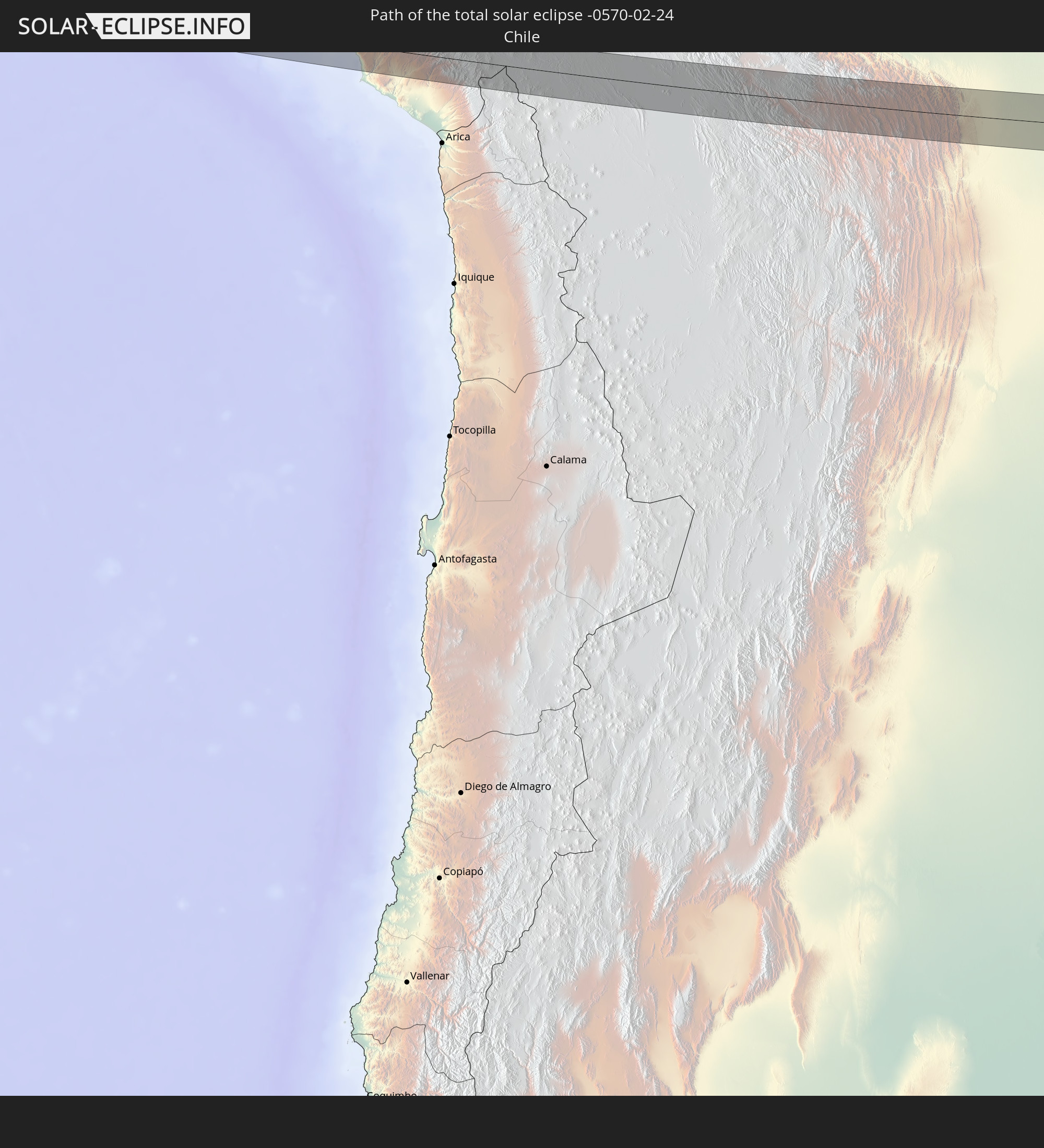 Chile
Chile
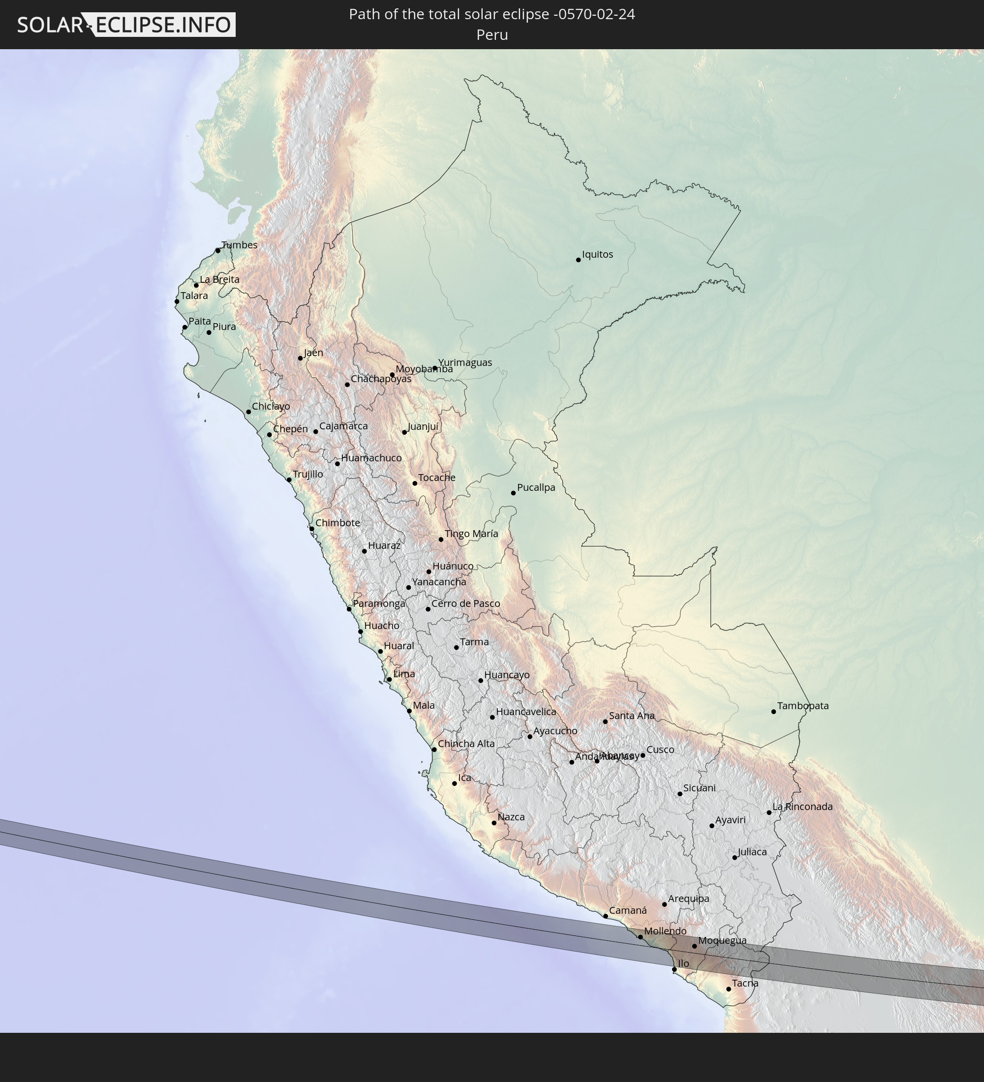 Peru
Peru
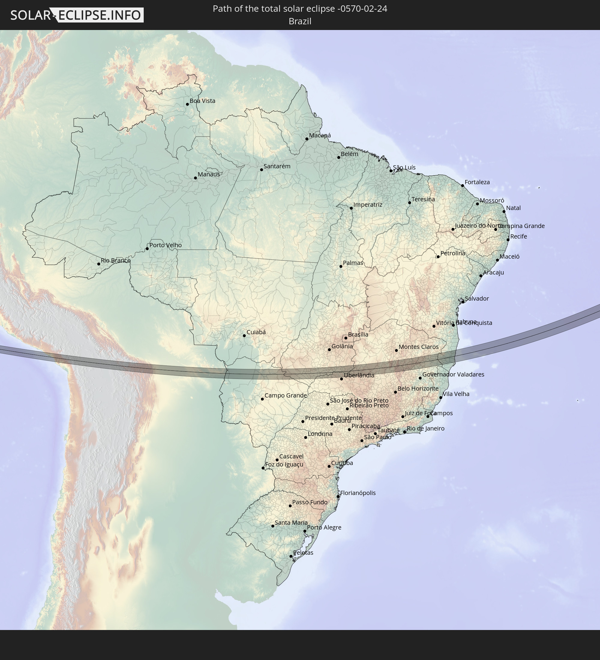 Brazil
 Bolivia
 Nigeria
 Cameroon
 Chad
Chad
 Sudan
Sudan
 Eritrea
In den folgenden Ländern ist die Sonnenfinsternis partiell zu sehen
 Chile
Chile
 Ecuador
 Honduras
 Nicaragua
 Costa Rica
 Panama
 Colombia
 Peru
Peru
 Brazil
 Argentina
 Venezuela
 Aruba
Aruba
 Bolivia
 Paraguay
 Trinidad and Tobago
 Grenada
 Saint Vincent and the Grenadines
 Falkland Islands
 Guyana
 Martinique
 Saint Lucia
 Barbados
 Uruguay
 Suriname
 French Guiana
 Cabo Verde
 Spain
Spain
 Senegal
 Mauritania
 The Gambia
 Guinea-Bissau
 Guinea
 Saint Helena, Ascension and Tristan da Cunha
 Sierra Leone
 Morocco
 Mali
Mali
 Liberia
 Algeria
 Ivory Coast
 Burkina Faso
 Ghana
Ghana
 Togo
Togo
 Niger
Niger
 Benin
Benin
 Nigeria
 Equatorial Guinea
 São Tomé and Príncipe
 Italy
Italy
 Tunisia
 Cameroon
 Gabon
Gabon
 Libya
Libya
 Republic of the Congo
 Angola
 Namibia
 Democratic Republic of the Congo
 Vatican City
 Chad
Chad
 Croatia
 Malta
Malta
 Central African Republic
 Bosnia and Herzegovina
 South Africa
 Montenegro
 Serbia
 Albania
 Greece
 Botswana
 Romania
 Republic of Macedonia
 Sudan
Sudan
 Zambia
 Ukraine
 Bulgaria
 Egypt
Egypt
 Zimbabwe
 Turkey
 Moldova
 Rwanda
 Burundi
 Tanzania
 Uganda
 Mozambique
 Cyprus
 Malawi
 Ethiopia
 Kenya
Kenya
 State of Palestine
 Israel
 Saudi Arabia
 Jordan
 Eritrea
 French Southern and Antarctic Lands
 Somalia
 Madagascar
 Comoros
 Mayotte
 Seychelles
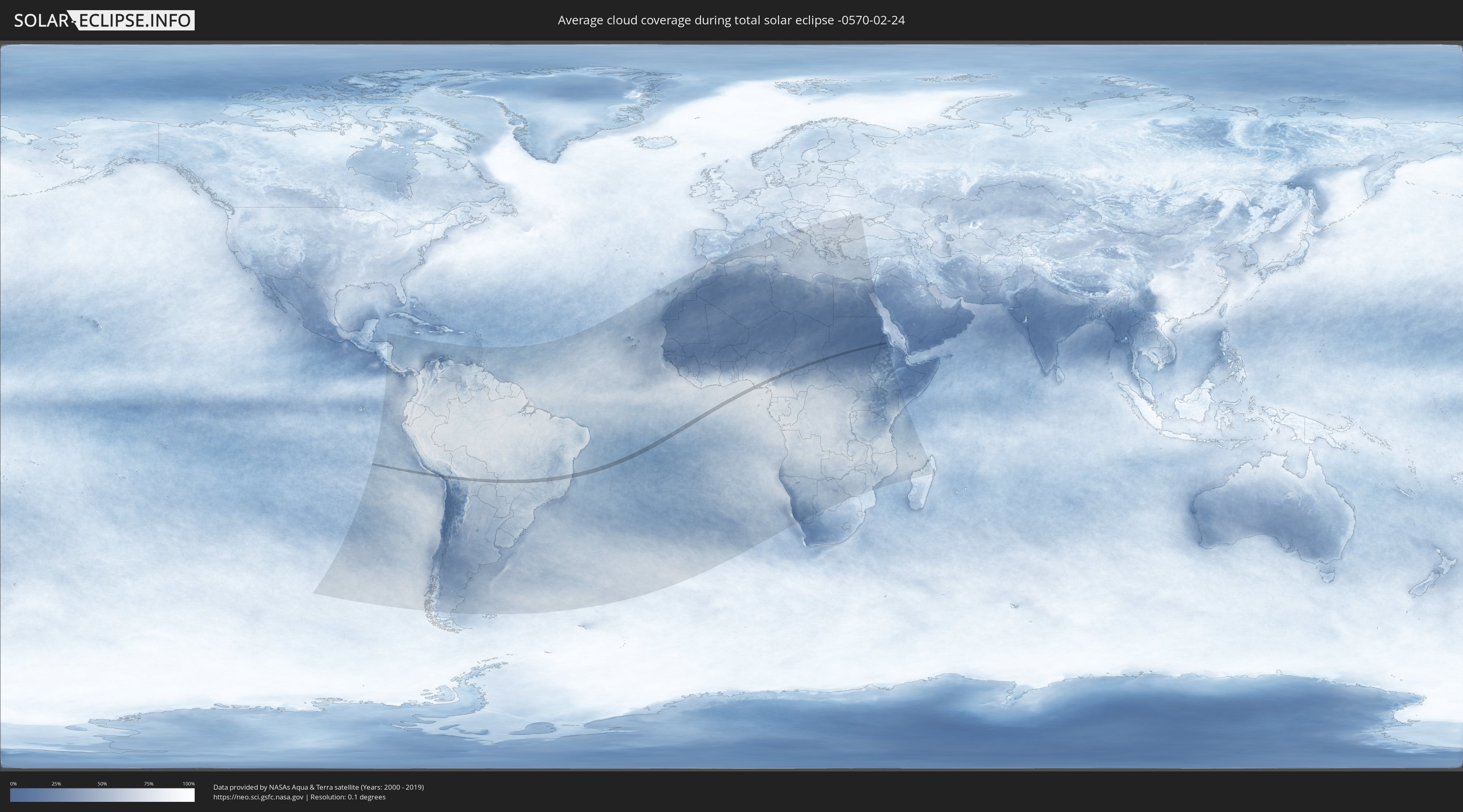
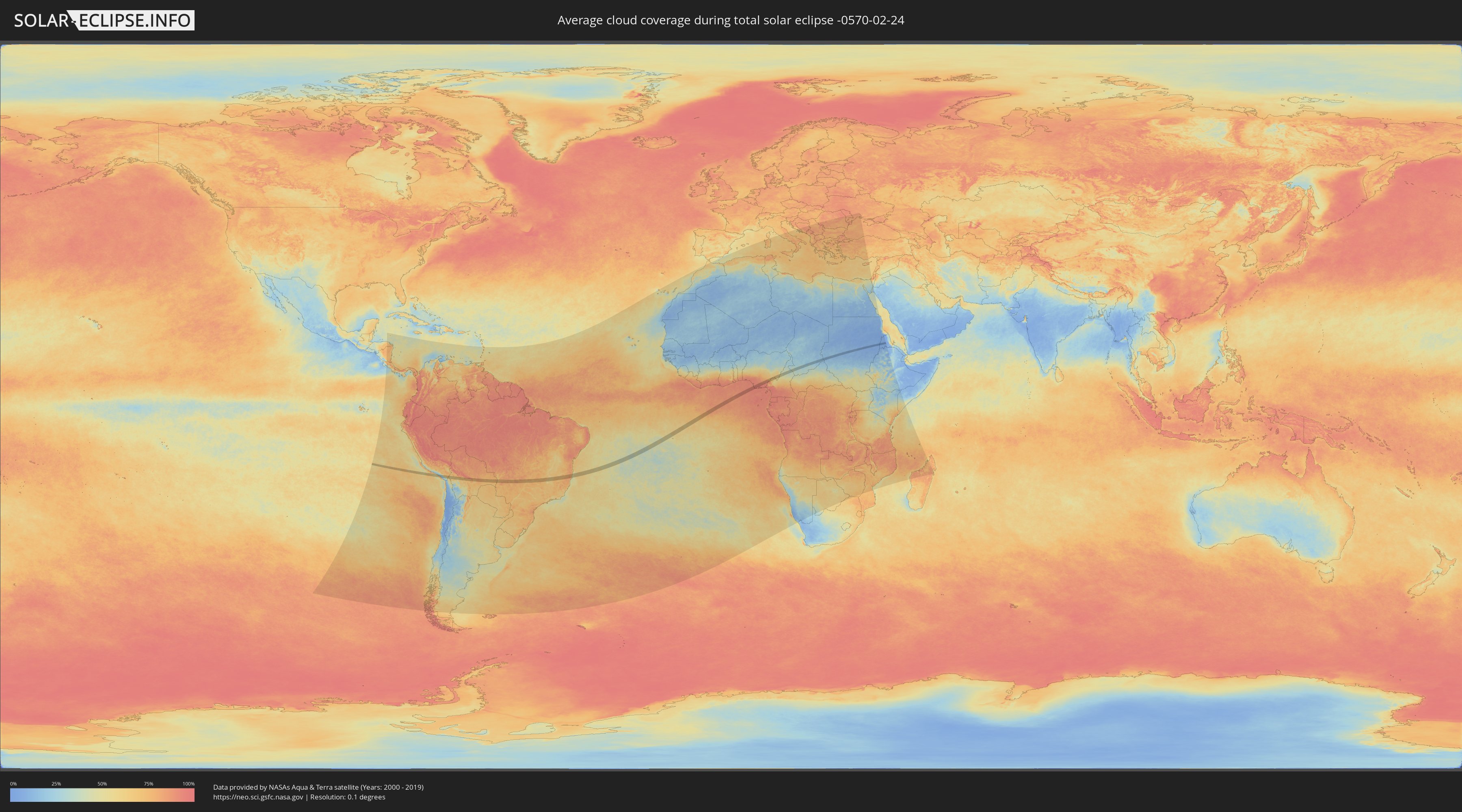
How will be the weather during the total solar eclipse on 02/24/-0570?
Where is the best place to see the total solar eclipse of 02/24/-0570?
The following maps show the average cloud coverage for the day of the total solar eclipse.
With the help of these maps, it is possible to find the place along the eclipse path, which has the best
chance of a cloudless sky.
Nevertheless, you should consider local circumstances and inform about the weather of your chosen
observation site.
The data is provided by NASAs satellites
AQUA and TERRA.
The cloud maps are averaged over a period of 19 years (2000 - 2019).
Detailed country maps
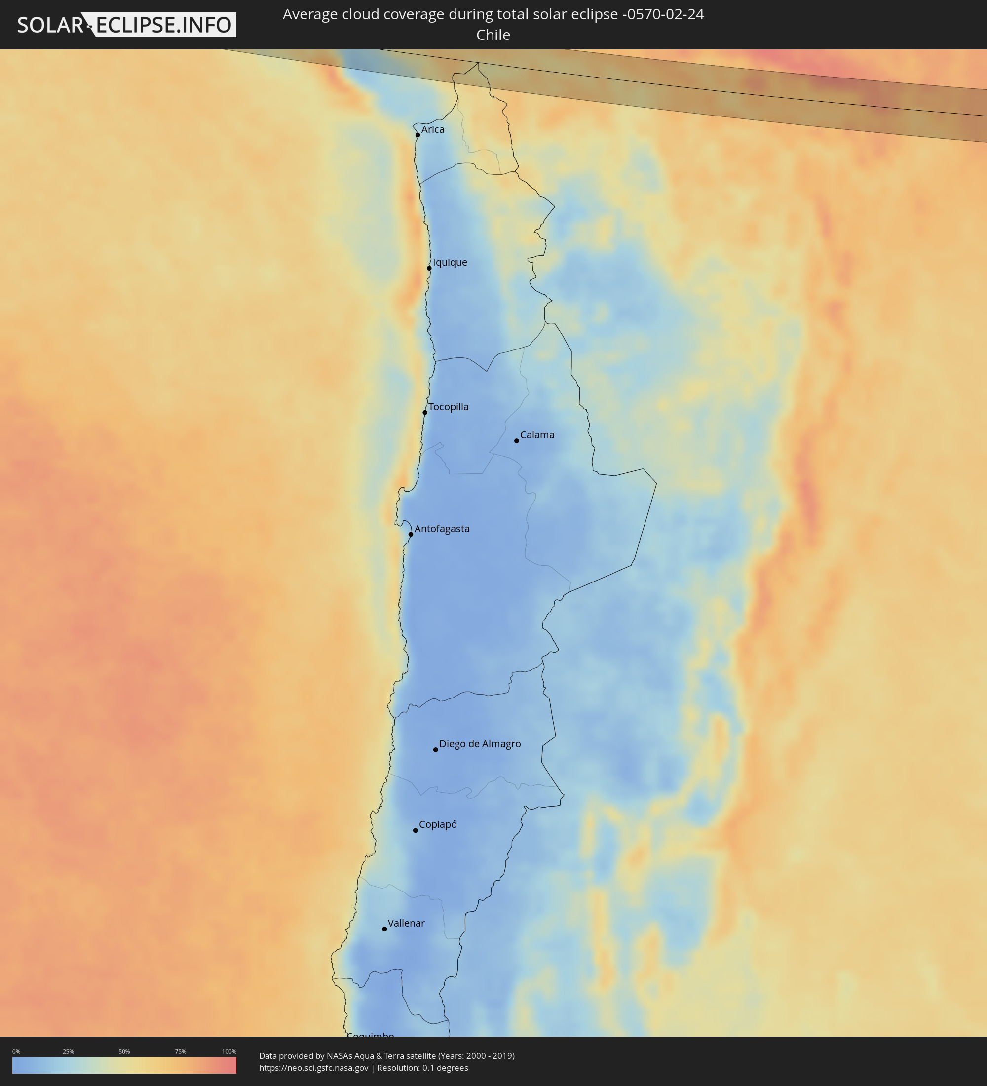 Chile
Chile
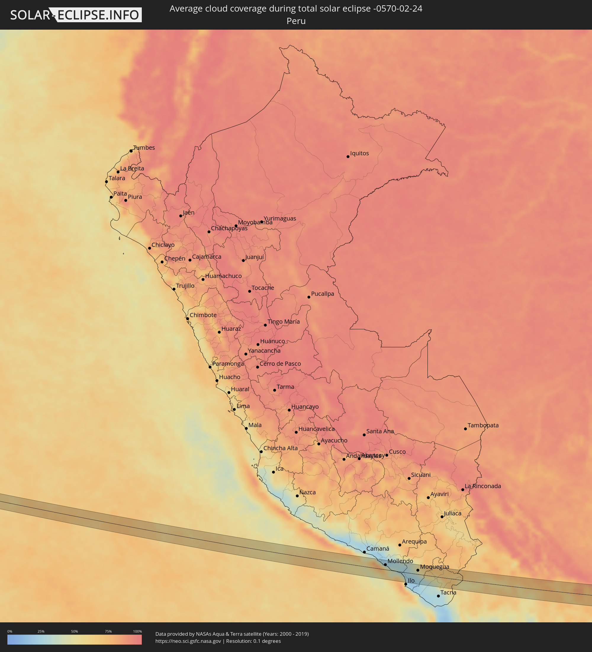 Peru
Peru
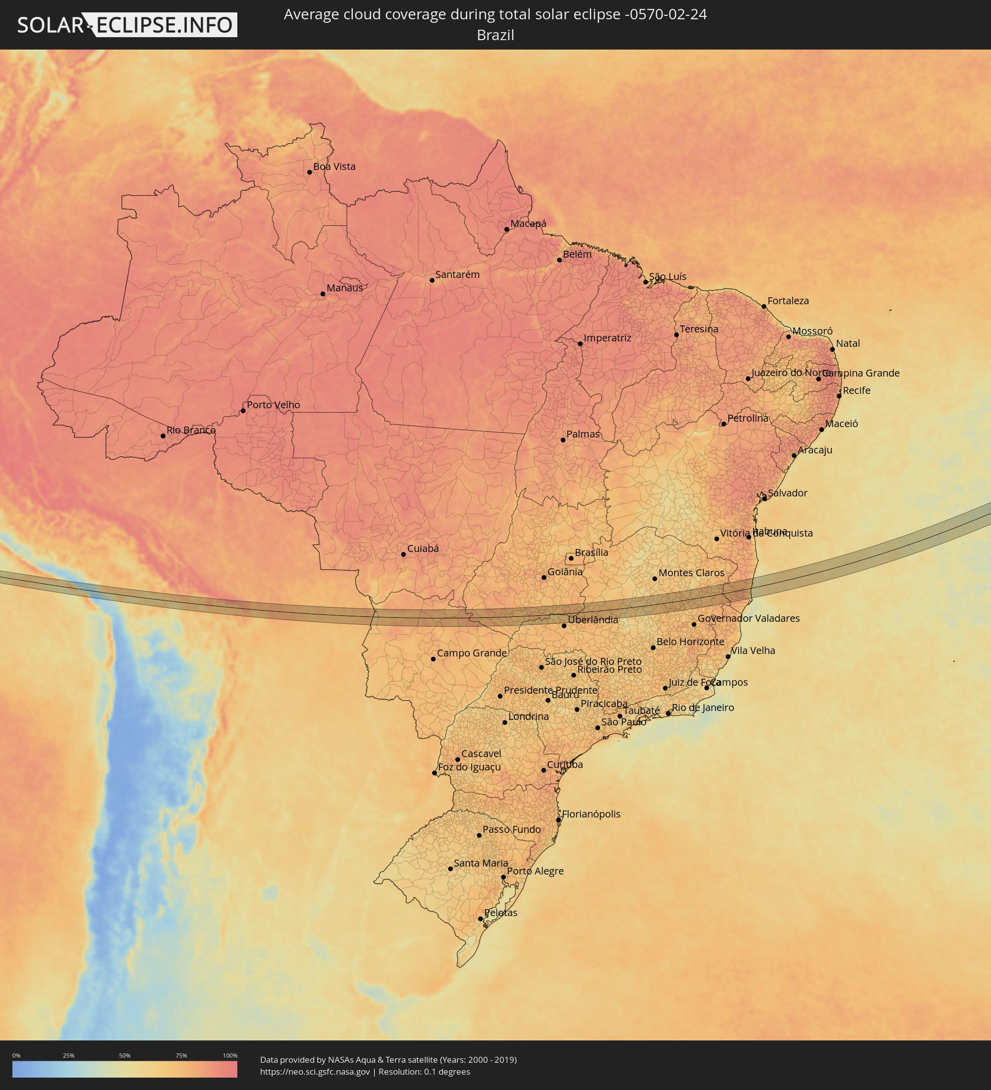 Brazil
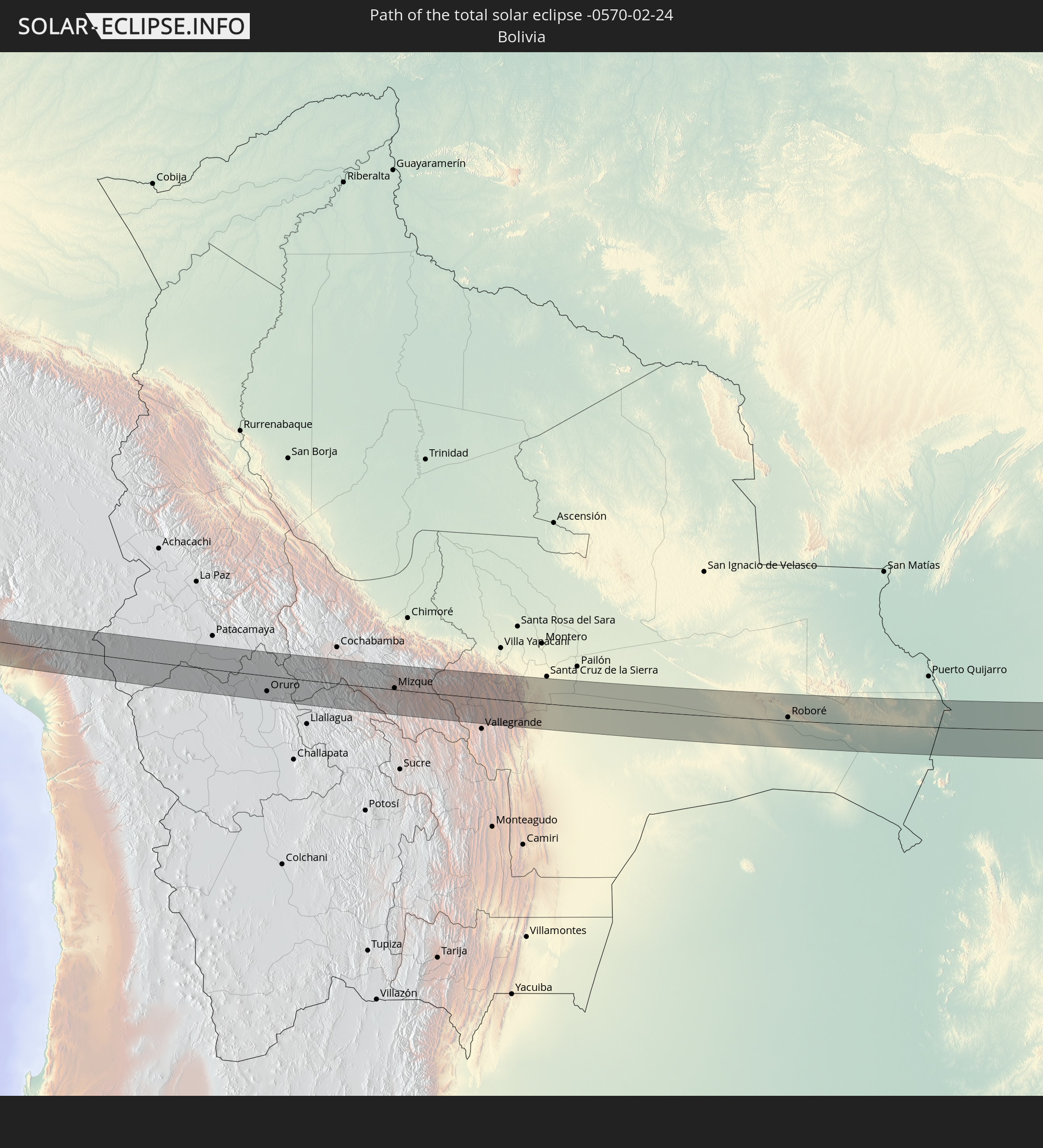
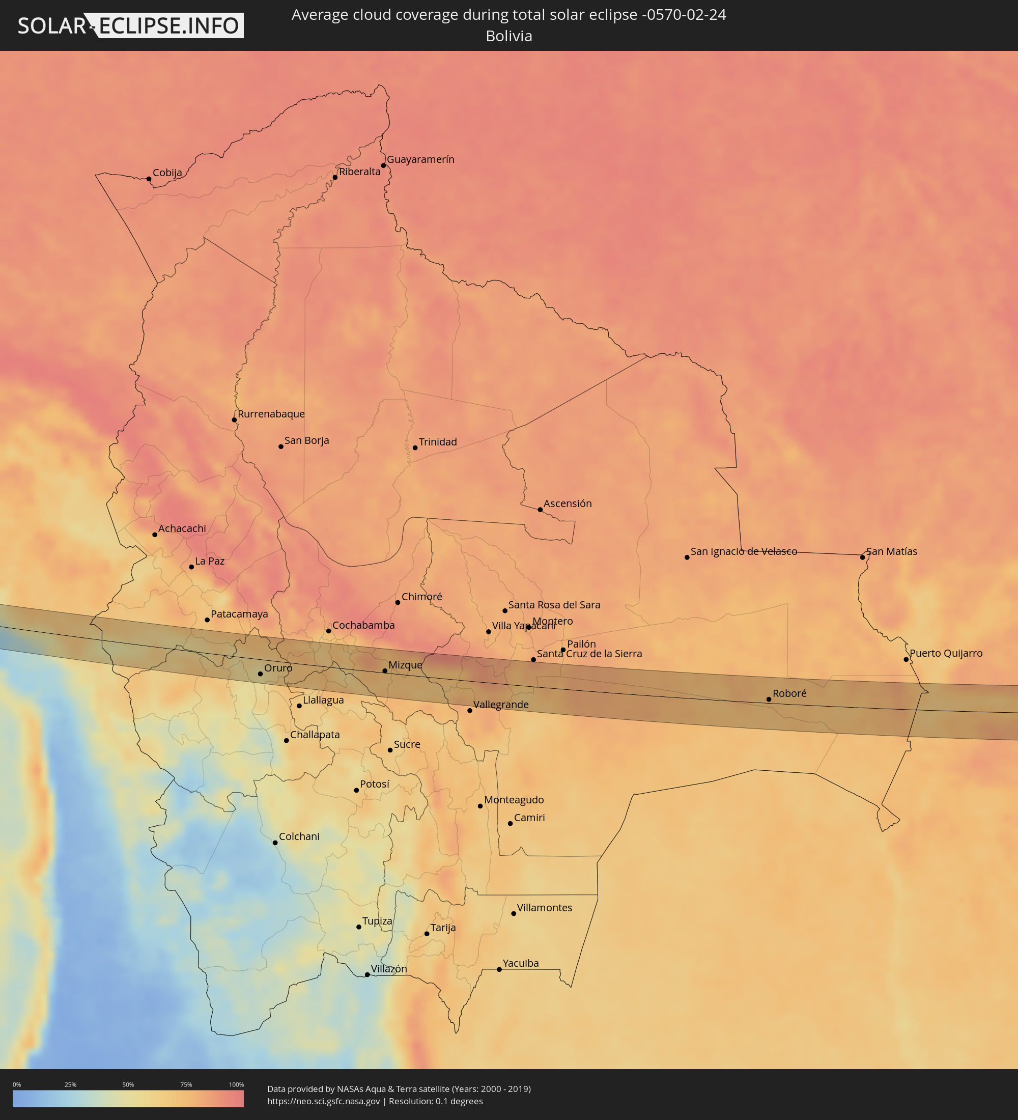 Bolivia
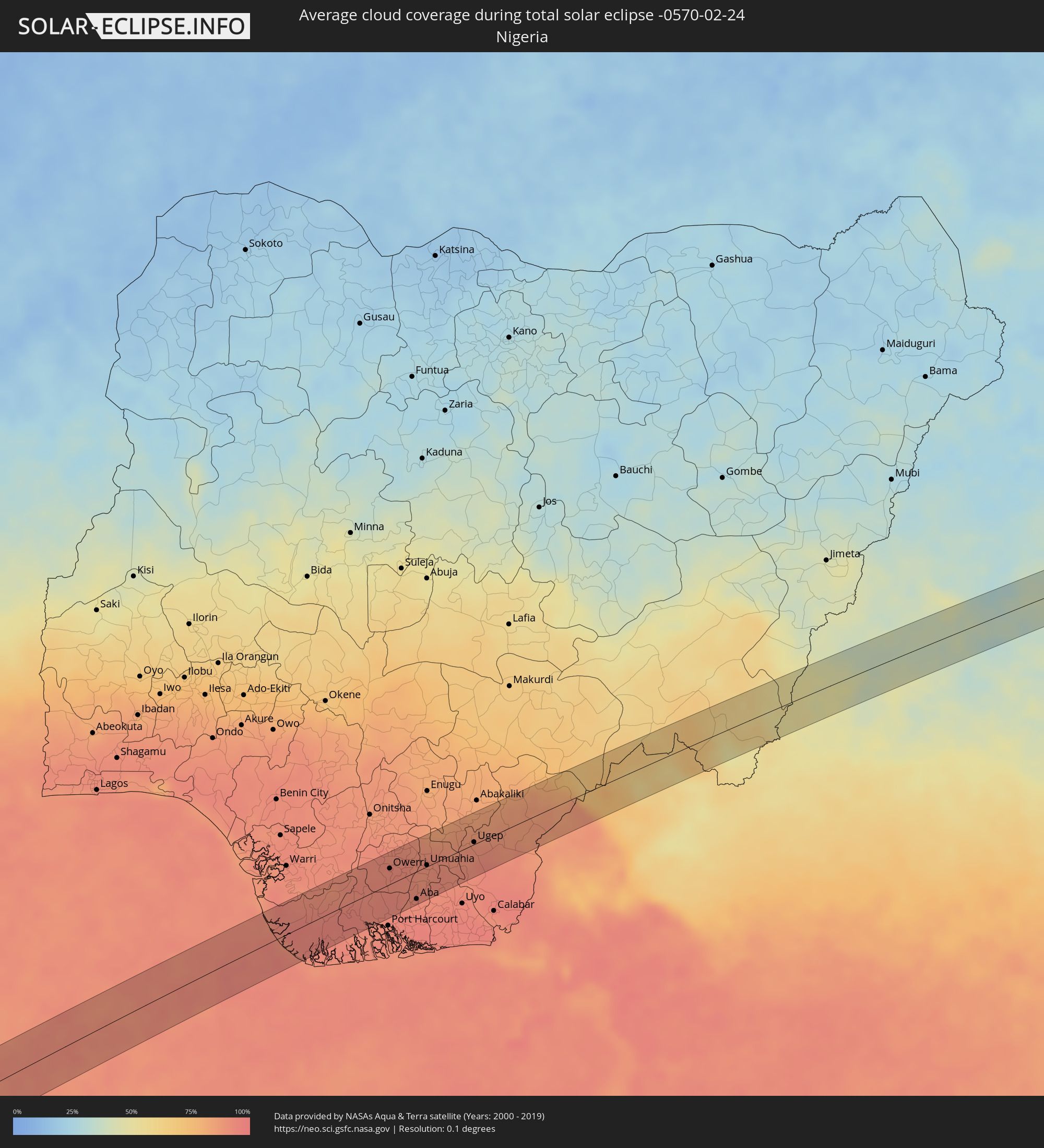 Nigeria
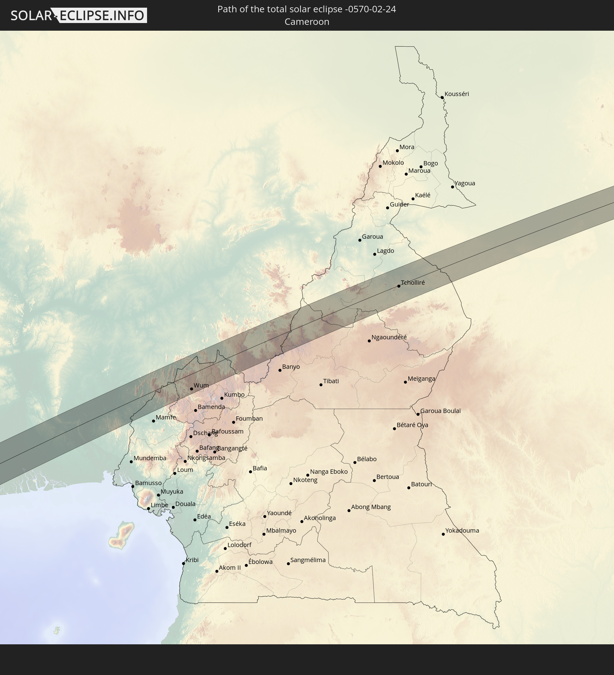
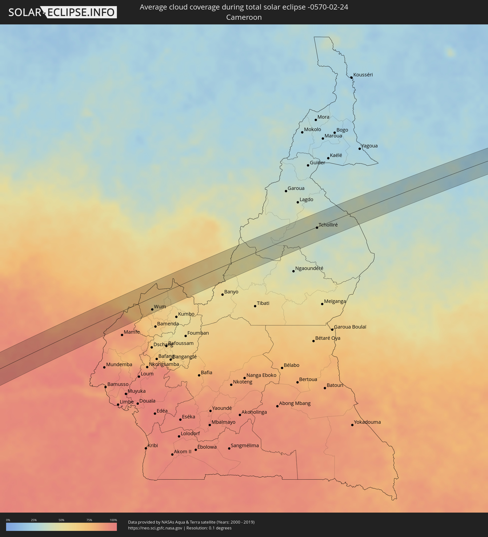 Cameroon
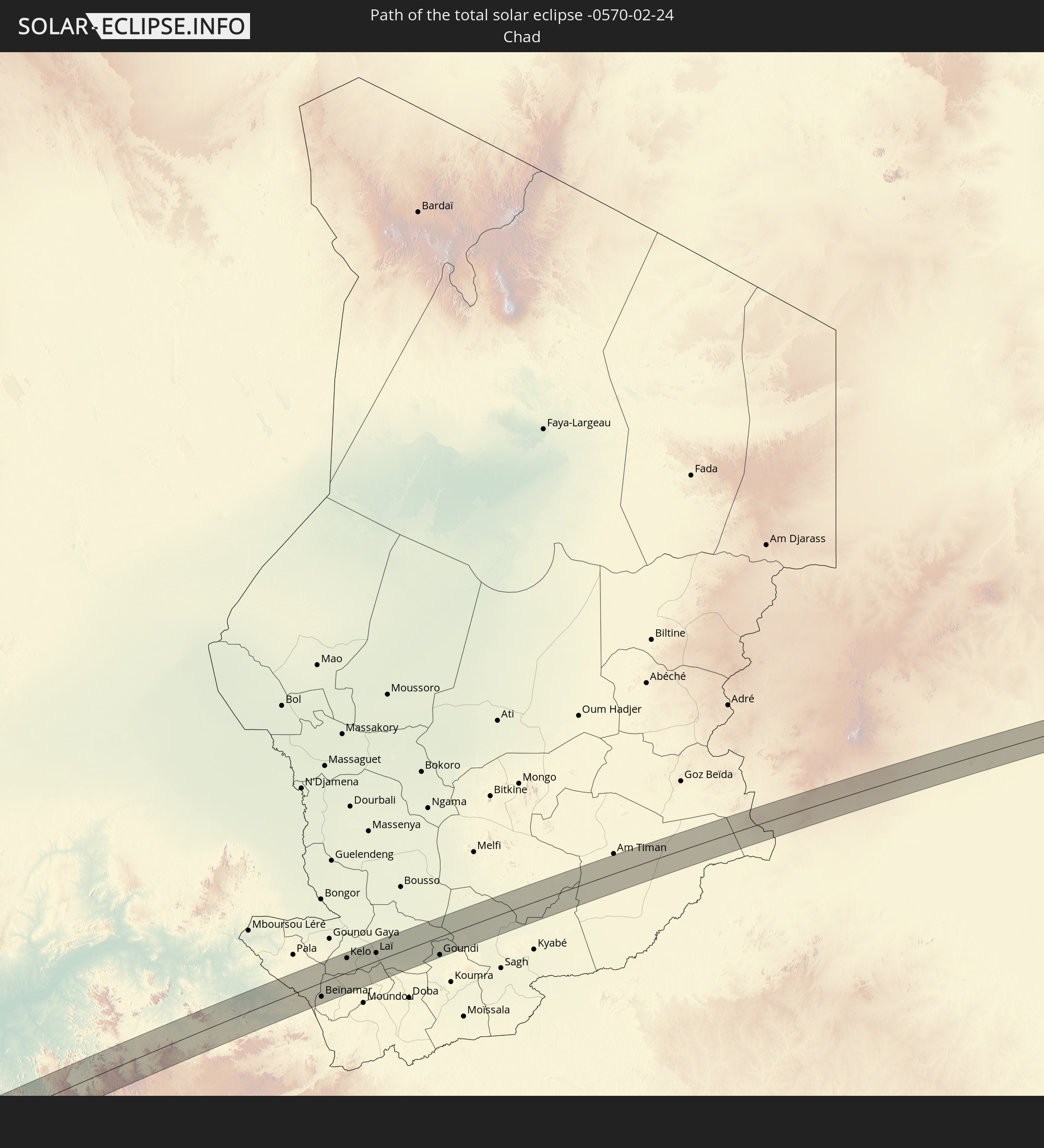
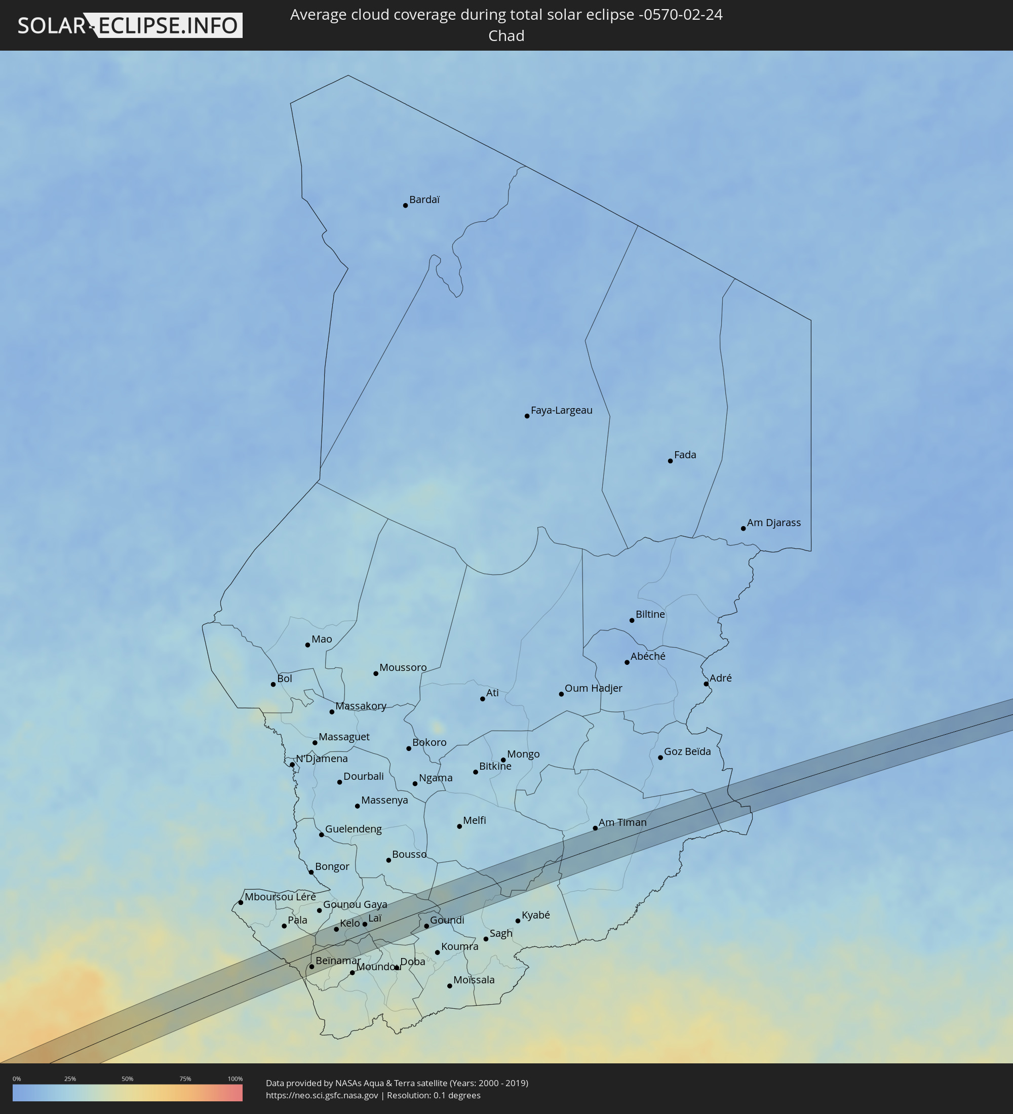 Chad
Chad
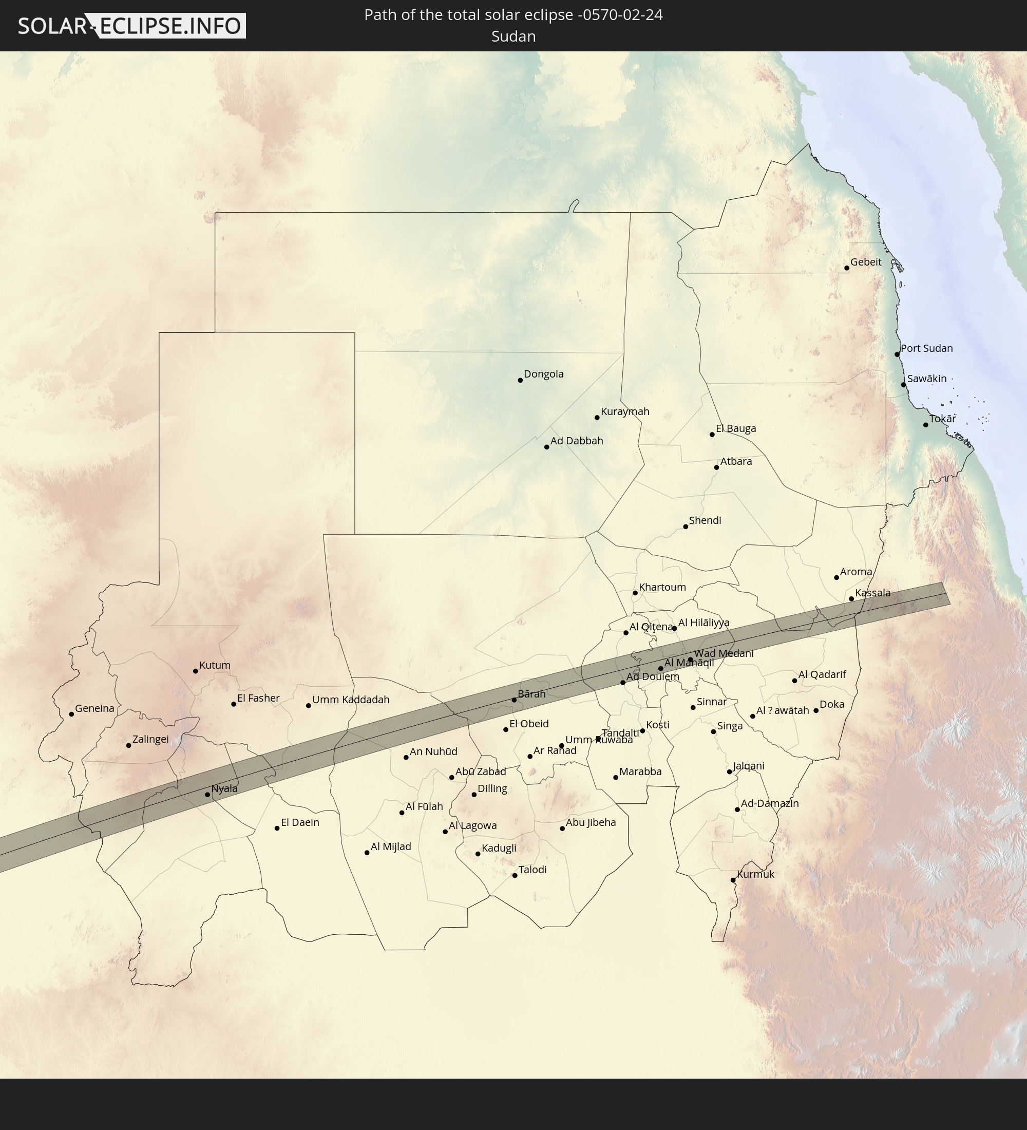
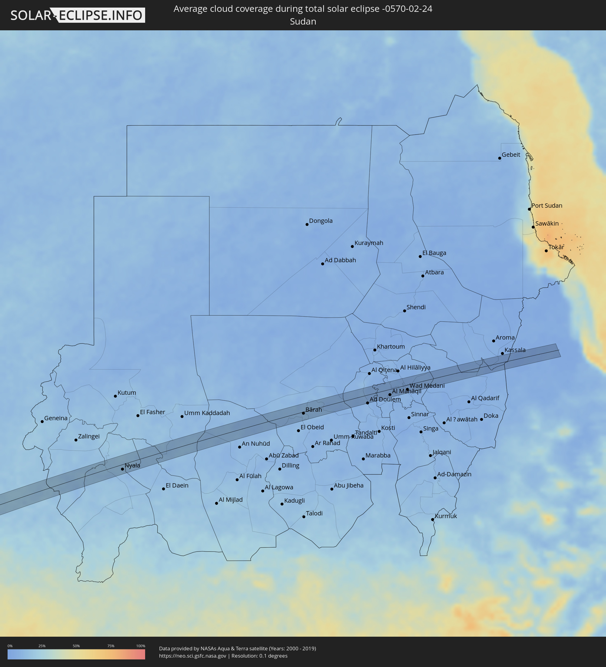 Sudan
Sudan
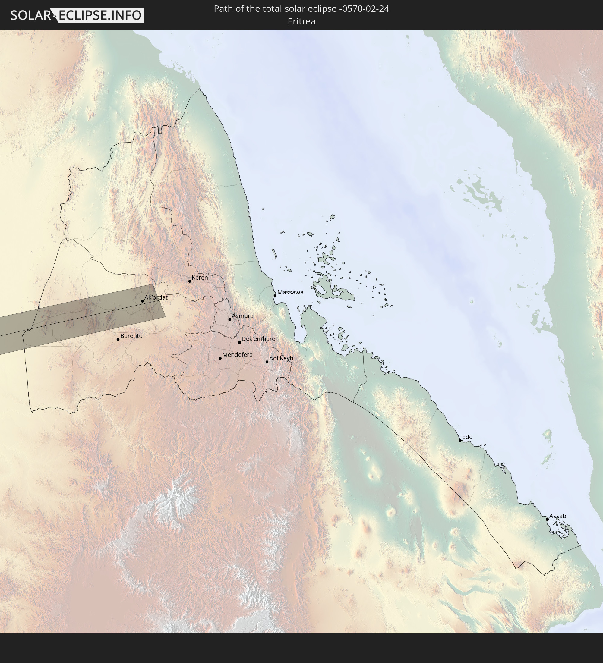
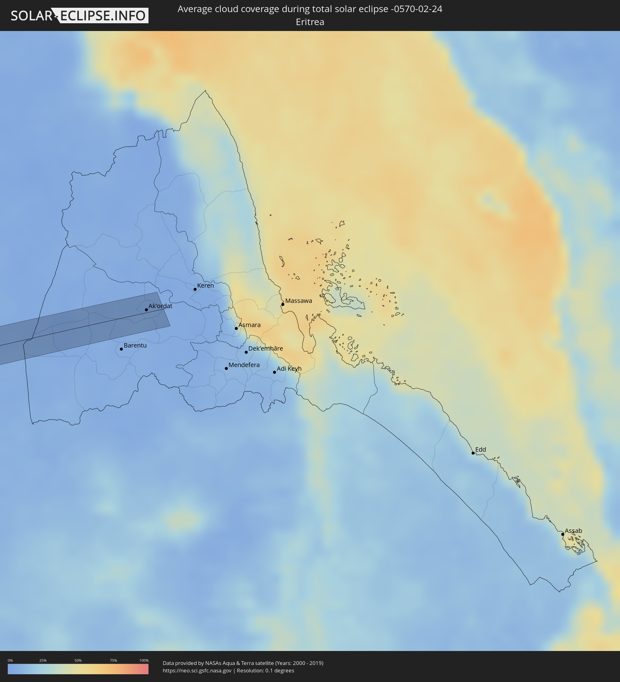 Eritrea
Cities inside the path of the eclipse
The following table shows all locations with a population of more than 5,000 inside the eclipse path. Cities which have more than 100,000 inhabitants are marked bold. A click at the locations opens a detailed map.
| City | Type | Eclipse duration | Local time of max. eclipse | Distance to central line | Ø Cloud coverage |
|
Mollendo, Arequipa
|
total | - | 06:55:15 UTC-05:08 | 16 km | 48% |
|
Punta de Bombón, Arequipa
|
total | - | 06:55:24 UTC-05:08 | 3 km | 40% |
|
Cocachacra, Arequipa
|
total | - | 06:55:25 UTC-05:08 | 13 km | 43% |
|
Moquegua, Moquegua
|
total | - | 06:55:56 UTC-05:08 | 13 km | 39% |
|
Torata, Moquegua
|
total | - | 06:55:58 UTC-05:08 | 28 km | 56% |
|
Ilabaya, Tacna
|
total | - | 06:56:15 UTC-05:08 | 5 km | 42% |
|
Oruro, Oruro
|
total | - | 07:34:48 UTC-04:32 | 23 km | 53% |
|
Capinota, Cochabamba
|
total | - | 07:35:30 UTC-04:32 | 18 km | 67% |
|
Tarata, Cochabamba
|
total | - | 07:35:41 UTC-04:32 | 32 km | 69% |
|
Cliza, Cochabamba
|
total | - | 07:35:46 UTC-04:32 | 35 km | 66% |
|
Mizque, Cochabamba
|
total | - | 07:36:20 UTC-04:32 | 2 km | 70% |
|
Aiquile, Cochabamba
|
total | - | 07:36:31 UTC-04:32 | 25 km | 75% |
|
Santiago del Torno, Santa Cruz
|
total | - | 07:38:12 UTC-04:32 | 16 km | 70% |
|
Roboré, Santa Cruz
|
total | - | 07:42:13 UTC-04:32 | 5 km | 71% |
|
Coxim, Mato Grosso do Sul
|
total | - | 08:43:03 UTC-03:38 | 2 km | 74% |
|
Quirinópolis, Goiás
|
total | - | 09:21:59 UTC-03:06 | 0 km | 75% |
|
Capinópolis, Minas Gerais
|
total | - | 09:23:30 UTC-03:06 | 31 km | 73% |
|
Goiatuba, Goiás
|
total | - | 09:24:00 UTC-03:06 | 43 km | 77% |
|
Itumbiara, Goiás
|
total | - | 09:24:11 UTC-03:06 | 4 km | 68% |
|
Tupaciguara, Minas Gerais
|
total | - | 09:25:05 UTC-03:06 | 26 km | 73% |
|
Araguari, Minas Gerais
|
total | - | 09:26:02 UTC-03:06 | 36 km | 71% |
|
Catalão, Goiás
|
total | - | 09:26:35 UTC-03:06 | 16 km | 76% |
|
Coromandel, Minas Gerais
|
total | - | 09:27:57 UTC-03:06 | 25 km | 74% |
|
Vazante, Minas Gerais
|
total | - | 09:28:38 UTC-03:06 | 26 km | 70% |
|
Patos de Minas, Minas Gerais
|
total | - | 09:29:15 UTC-03:06 | 43 km | 73% |
|
Presidente Olegário, Minas Gerais
|
total | - | 09:29:29 UTC-03:06 | 26 km | 74% |
|
João Pinheiro, Minas Gerais
|
total | - | 09:30:10 UTC-03:06 | 46 km | 71% |
|
Várzea da Palma, Minas Gerais
|
total | - | 09:33:11 UTC-03:06 | 45 km | 65% |
|
Corinto, Minas Gerais
|
total | - | 09:33:30 UTC-03:06 | 45 km | 61% |
|
Diamantina, Minas Gerais
|
total | - | 09:35:21 UTC-03:06 | 42 km | 71% |
|
Itamarandiba, Minas Gerais
|
total | - | 09:37:07 UTC-03:06 | 10 km | 75% |
|
Capelinha, Minas Gerais
|
total | - | 09:37:57 UTC-03:06 | 3 km | 74% |
|
Itambacuri, Minas Gerais
|
total | - | 09:39:39 UTC-03:06 | 49 km | 72% |
|
Teófilo Otoni, Minas Gerais
|
total | - | 09:40:08 UTC-03:06 | 33 km | 71% |
|
Carlos Chagas, Minas Gerais
|
total | - | 09:41:54 UTC-03:06 | 29 km | 76% |
|
Itanhém, Bahia
|
total | - | 10:15:40 UTC-02:34 | 21 km | 73% |
|
Medeiros Neto, Bahia
|
total | - | 10:15:49 UTC-02:34 | 4 km | 77% |
|
Itamaraju, Bahia
|
total | - | 10:17:39 UTC-02:34 | 19 km | 78% |
|
Prado, Bahia
|
total | - | 10:18:13 UTC-02:34 | 21 km | 55% |
|
Bomadi, Delta
|
total | - | 15:22:03 UTC+00:13 | 41 km | 90% |
|
Amassoma, Bayelsa
|
total | - | 15:22:07 UTC+00:13 | 13 km | 93% |
|
Patani, Delta
|
total | - | 15:22:27 UTC+00:13 | 35 km | 90% |
|
Yenagoa, Bayelsa
|
total | - | 15:22:17 UTC+00:13 | 1 km | 94% |
|
Ahoada, Rivers
|
total | - | 15:22:54 UTC+00:13 | 2 km | 93% |
|
Omoku, Rivers
|
total | - | 15:23:09 UTC+00:13 | 24 km | 92% |
|
Degema Hulk, Rivers
|
total | - | 15:22:44 UTC+00:13 | 39 km | 93% |
|
Elele, Rivers
|
total | - | 15:23:08 UTC+00:13 | 8 km | 93% |
|
Owerri, Imo
|
total | - | 15:23:45 UTC+00:13 | 20 km | 92% |
|
Orodo, Imo
|
total | - | 15:23:52 UTC+00:13 | 33 km | 92% |
|
Iho, Imo
|
total | - | 15:23:55 UTC+00:13 | 26 km | 91% |
|
Okigwe, Imo
|
total | - | 15:24:27 UTC+00:13 | 39 km | 88% |
|
Aba, Abia
|
total | - | 15:23:49 UTC+00:13 | 34 km | 92% |
|
Umuahia, Abia
|
total | - | 15:24:21 UTC+00:13 | 2 km | 90% |
|
Bende, Abia
|
total | - | 15:24:33 UTC+00:13 | 1 km | 91% |
|
Ake-Eze, Enugu
|
total | - | 15:24:55 UTC+00:13 | 33 km | 86% |
|
Ohafia-Ifigh, Abia
|
total | - | 15:24:49 UTC+00:13 | 4 km | 90% |
|
Amaigbo, Abia
|
total | - | 15:25:00 UTC+00:13 | 12 km | 87% |
|
Arochukwu, Abia
|
total | - | 15:24:44 UTC+00:13 | 32 km | 91% |
|
Afikpo, Ebonyi
|
total | - | 15:25:12 UTC+00:13 | 18 km | 87% |
|
Ugep, Cross River
|
total | - | 15:25:18 UTC+00:13 | 3 km | 89% |
|
Obubra, Cross River
|
total | - | 15:25:50 UTC+00:13 | 18 km | 85% |
|
Ikom, Cross River
|
total | - | 15:26:10 UTC+00:13 | 11 km | 85% |
|
Obudu, Cross River
|
total | - | 15:27:16 UTC+00:13 | 39 km | 71% |
|
Wum, North-West
|
total | - | 15:28:02 UTC+00:13 | 31 km | 63% |
|
Baissa, Taraba
|
total | - | 15:29:17 UTC+00:13 | 30 km | 68% |
|
Kontcha, Adamaoua
|
total | - | 15:31:26 UTC+00:13 | 35 km | 48% |
|
Tcholliré, North
|
total | - | 15:33:30 UTC+00:13 | 2 km | 38% |
|
Rey Bouba, North
|
total | - | 15:33:41 UTC+00:13 | 25 km | 39% |
|
Beïnamar, Logone Occidental
|
total | - | 16:21:18 UTC+01:00 | 24 km | 38% |
|
Kelo, Tandjilé
|
total | - | 16:22:02 UTC+01:00 | 25 km | 30% |
|
Béré, Tandjilé
|
total | - | 16:22:18 UTC+01:00 | 12 km | 29% |
|
Laï, Tandjilé
|
total | - | 16:22:28 UTC+01:00 | 14 km | 31% |
|
Benoy, Logone Occidental
|
total | - | 16:22:14 UTC+01:00 | 30 km | 31% |
|
Goundi, Mandoul
|
total | - | 16:23:14 UTC+01:00 | 31 km | 30% |
|
Nyala, Southern Darfur
|
total | - | 17:38:37 UTC+02:10 | 16 km | 12% |
|
Bārah, North Kordofan
|
total | - | 17:40:48 UTC+02:10 | 6 km | 12% |
|
Al Kiremit al ‘Arakiyyīn, Al Jazīrah
|
total | - | 17:41:22 UTC+02:10 | 6 km | 7% |
|
Al Manāqil, Al Jazīrah
|
total | - | 17:41:21 UTC+02:10 | 18 km | 7% |
|
Al Masallamiyya, Al Jazīrah
|
total | - | 17:41:28 UTC+02:10 | 8 km | 6% |
|
Wad Medani, Al Jazīrah
|
total | - | 17:41:27 UTC+02:10 | 15 km | 7% |
|
Ak’ordat, Gash-Barka
|
total | - | 17:58:58 UTC+02:27 | 13 km | 3% |