Total solar eclipse of 07/13/-0884
| Day of week: | Wednesday |
| Maximum duration of eclipse: | 05m33s |
| Maximum width of eclipse path: | 265 km |
| Saros cycle: | 51 |
| Coverage: | 100% |
| Magnitude: | 1.0743 |
| Gamma: | 0.4117 |
Wo kann man die Sonnenfinsternis vom 07/13/-0884 sehen?
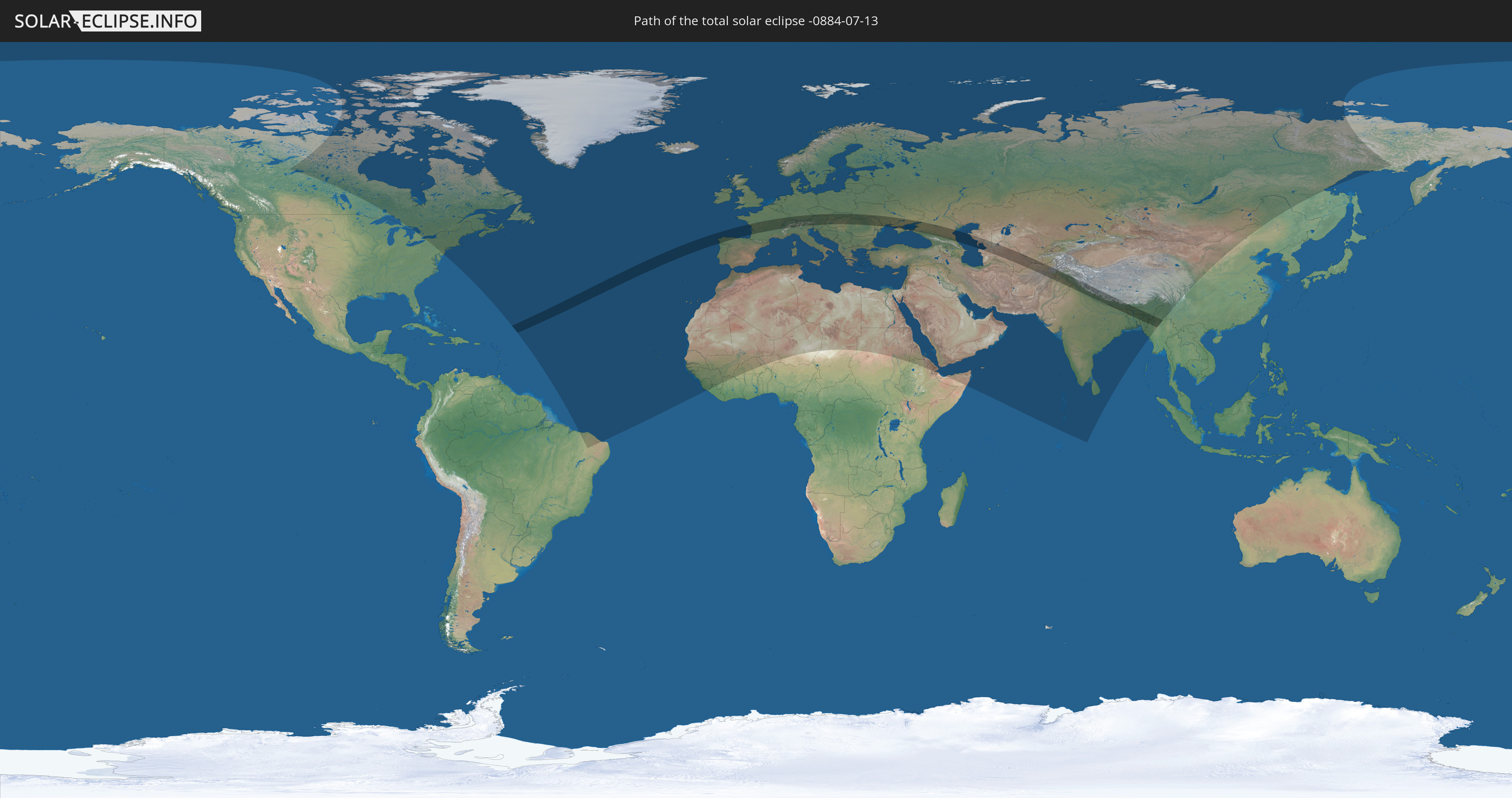
Die Sonnenfinsternis am 07/13/-0884 kann man in 115 Ländern als partielle Sonnenfinsternis beobachten.
Der Finsternispfad verläuft durch 29 Länder. Nur in diesen Ländern ist sie als total Sonnenfinsternis zu sehen.
In den folgenden Ländern ist die Sonnenfinsternis total zu sehen
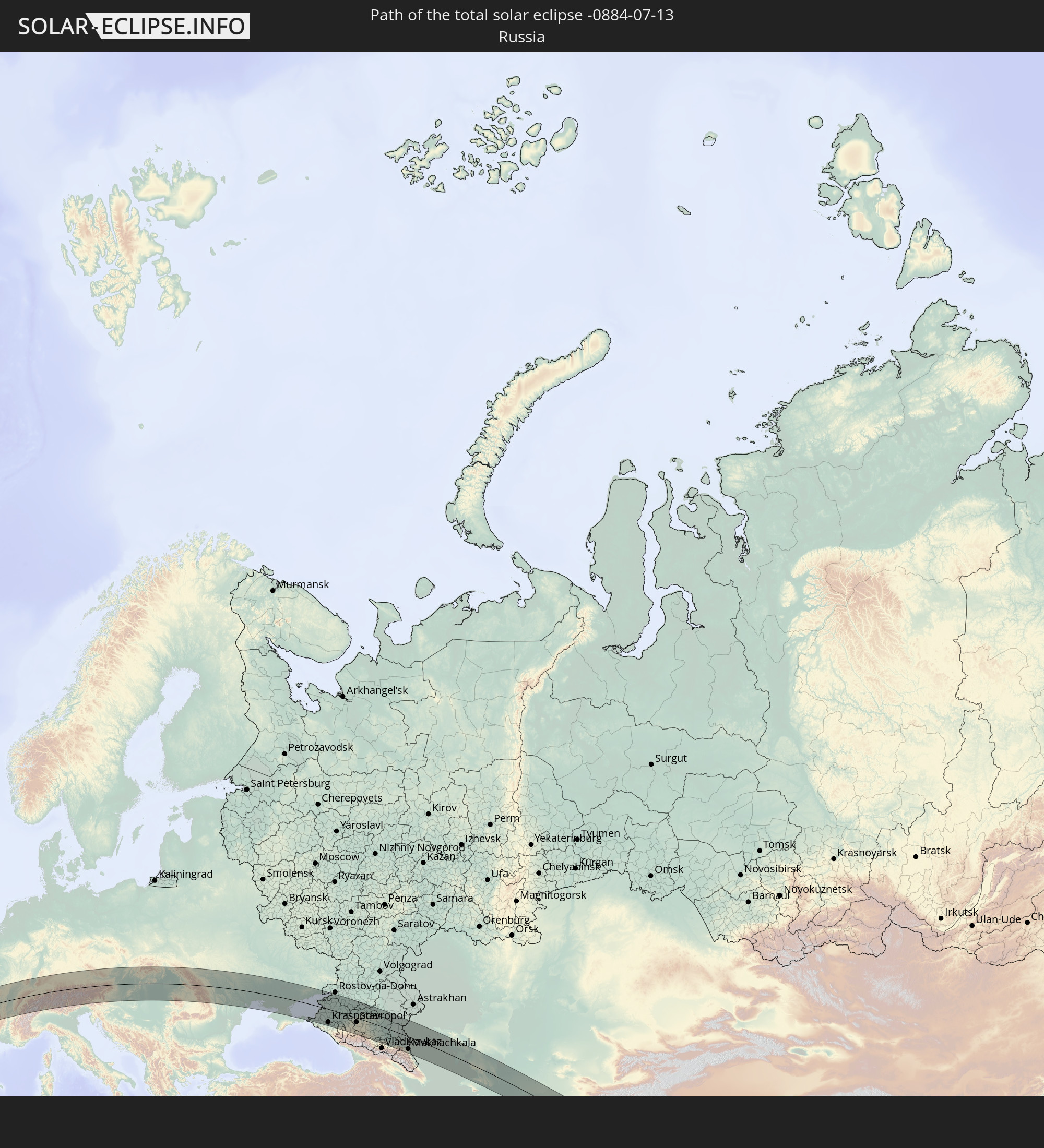 Russia
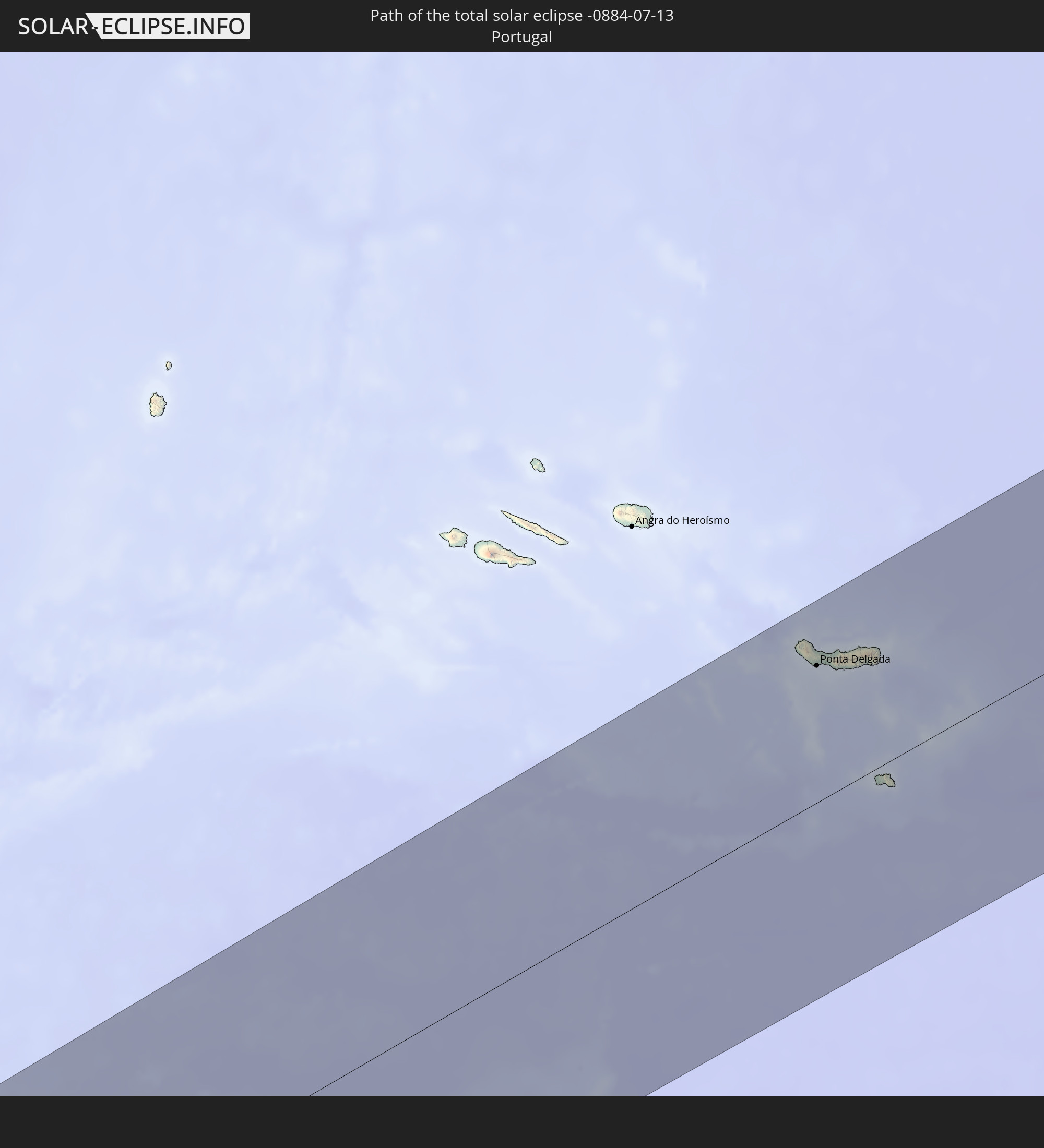 Portugal
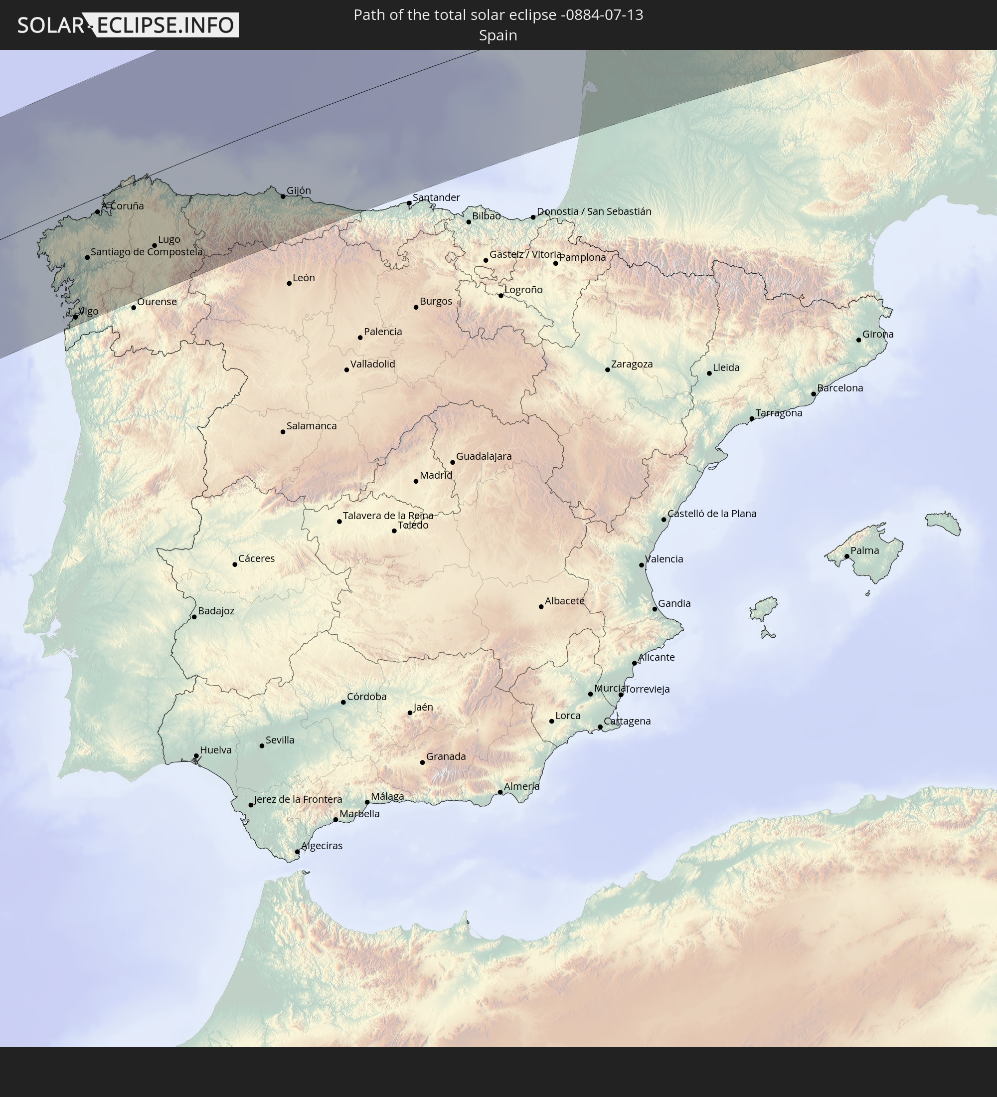 Spain
Spain
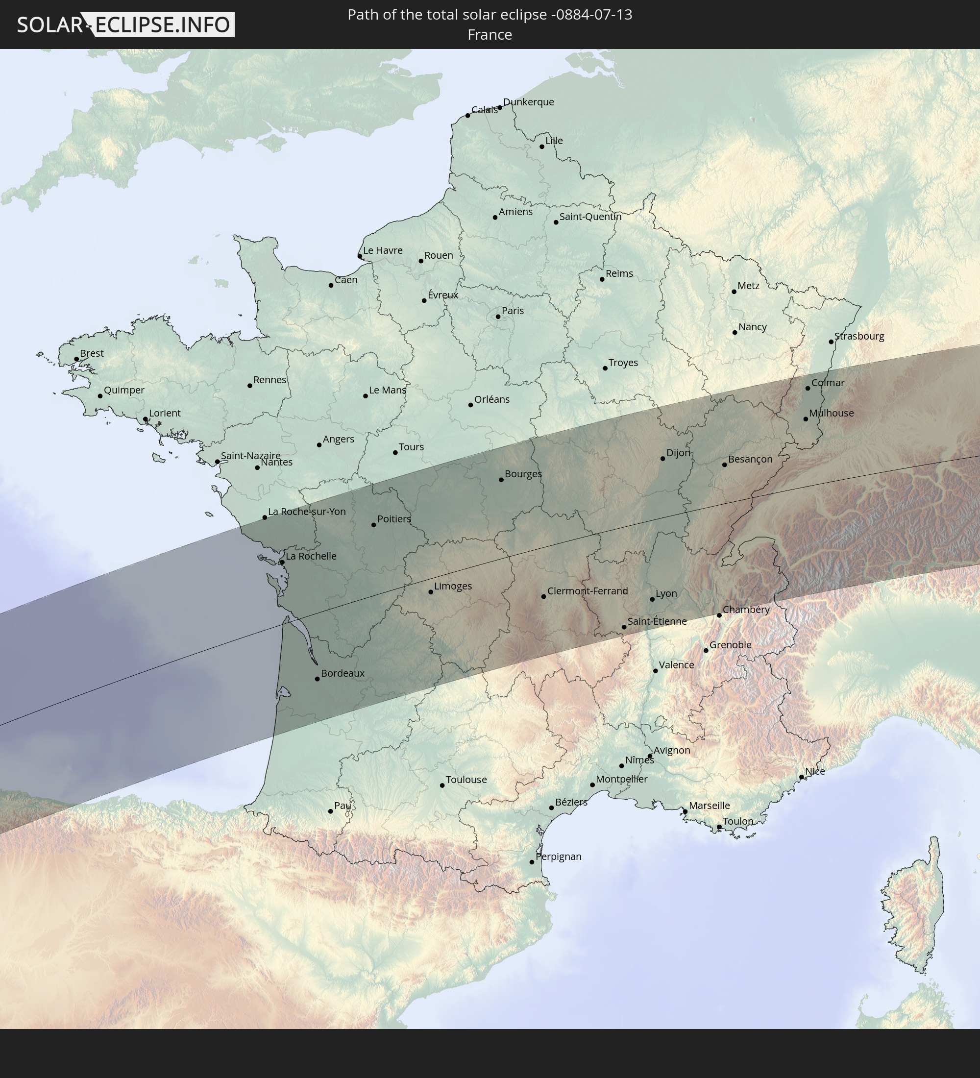 France
 Germany
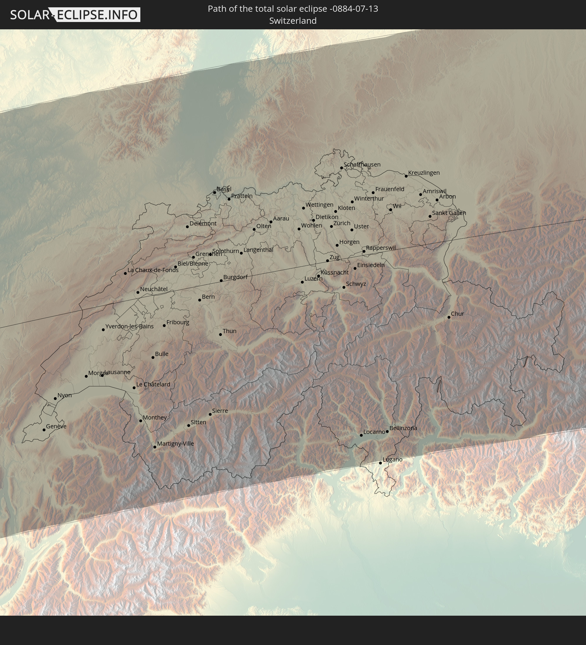 Switzerland
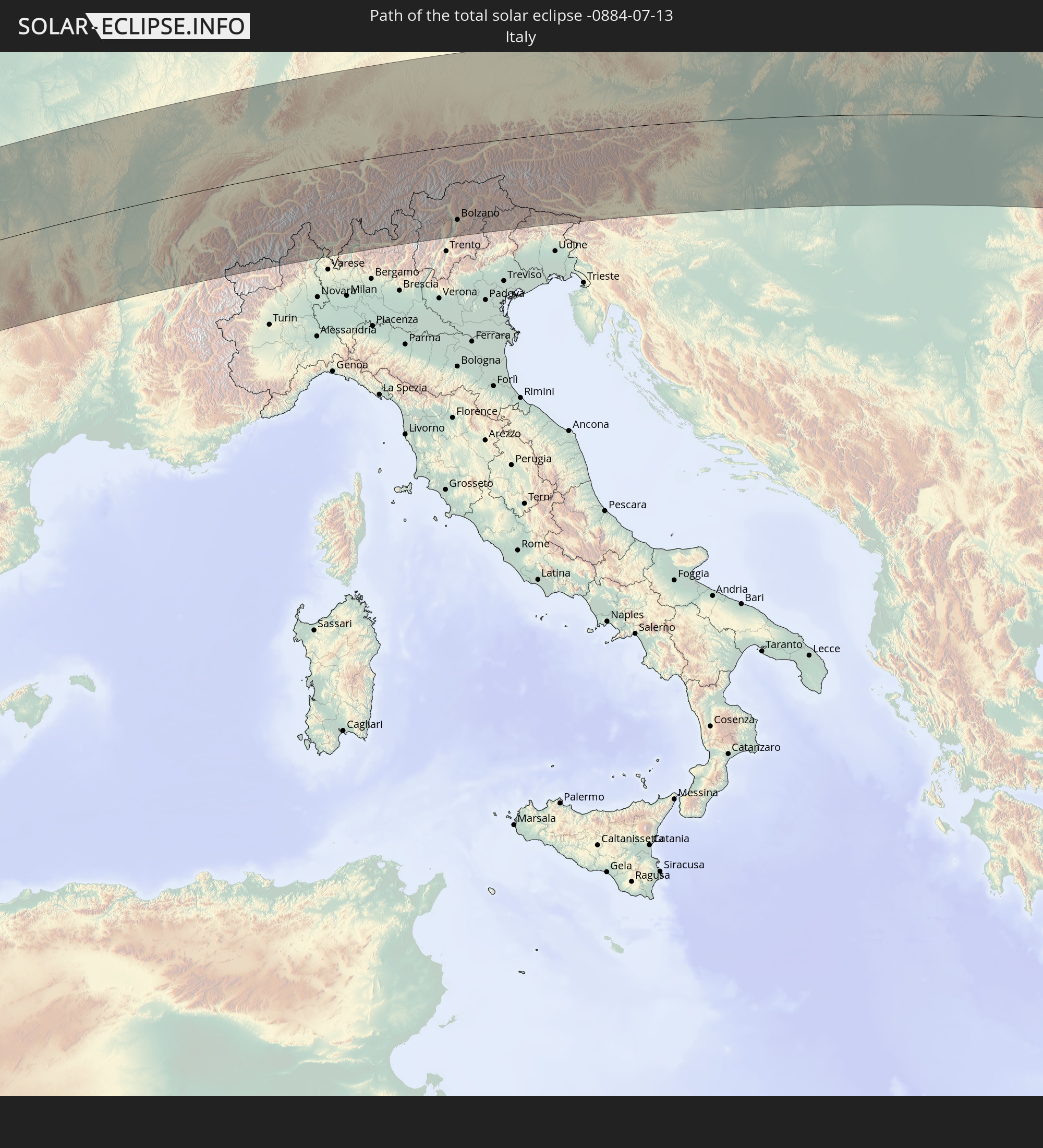 Italy
Italy
 Liechtenstein
 Austria
 Czechia
 Slovenia
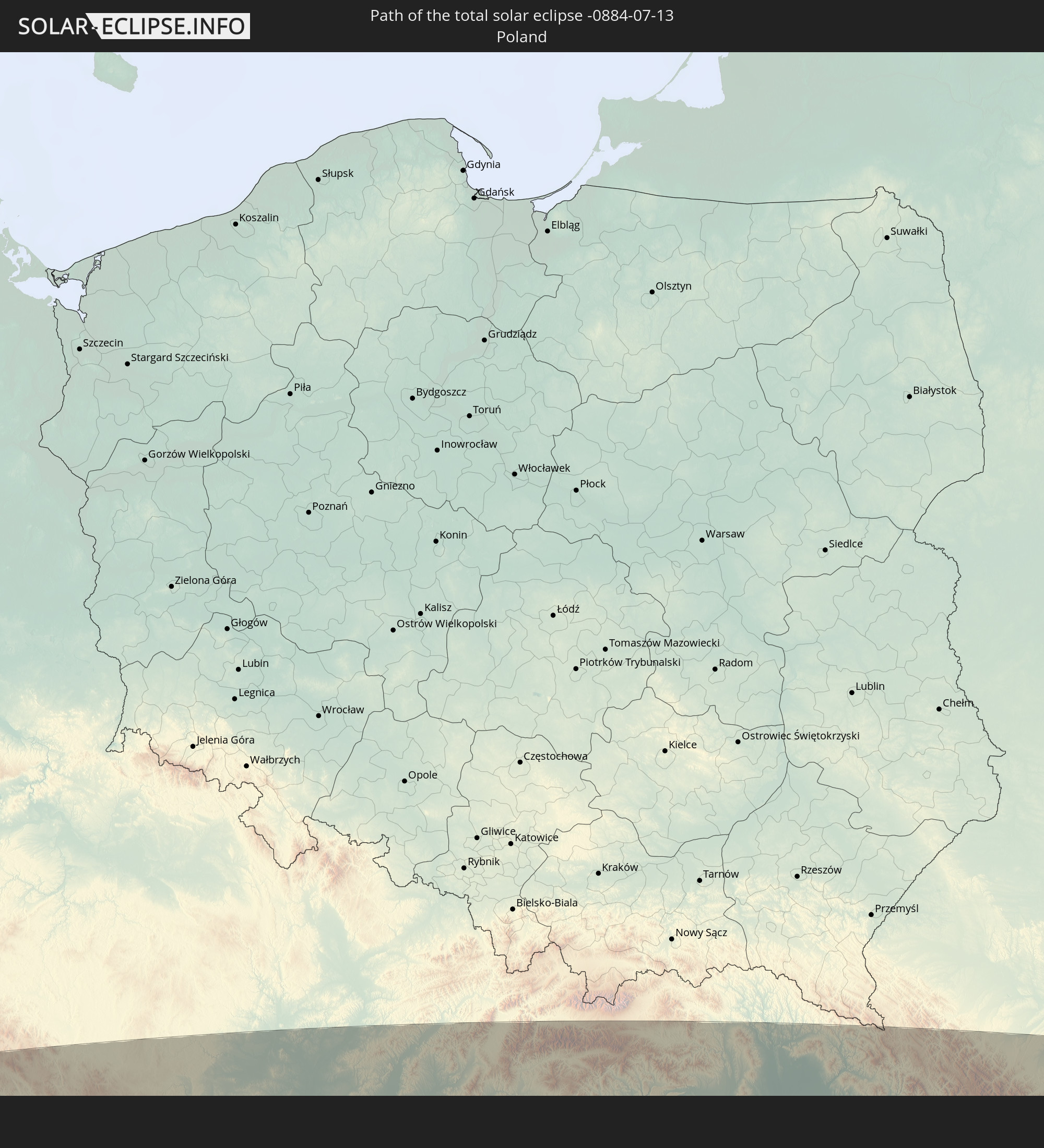 Poland
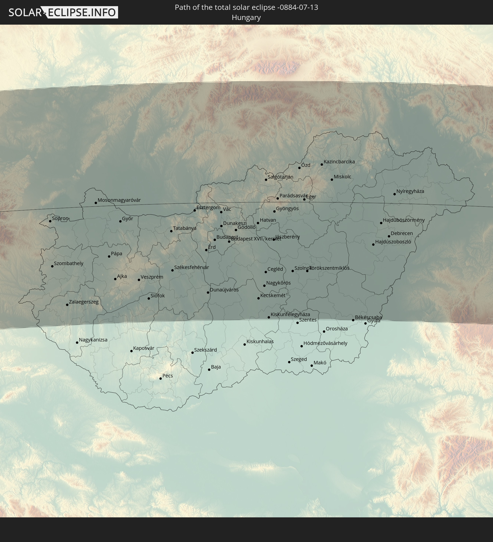 Hungary
 Slovakia
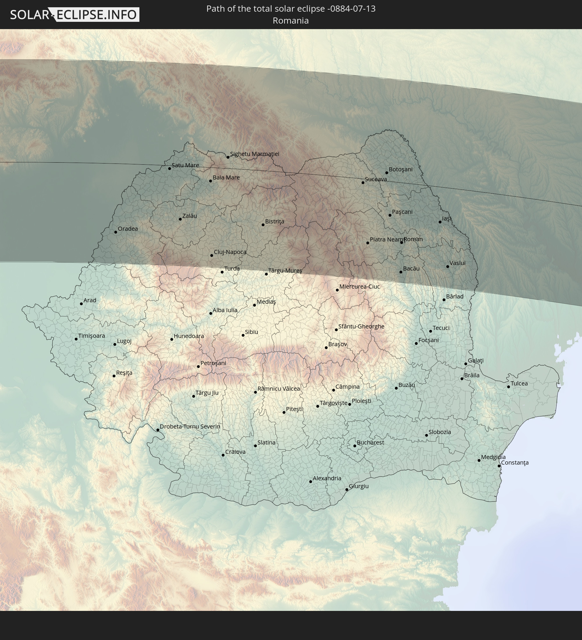 Romania
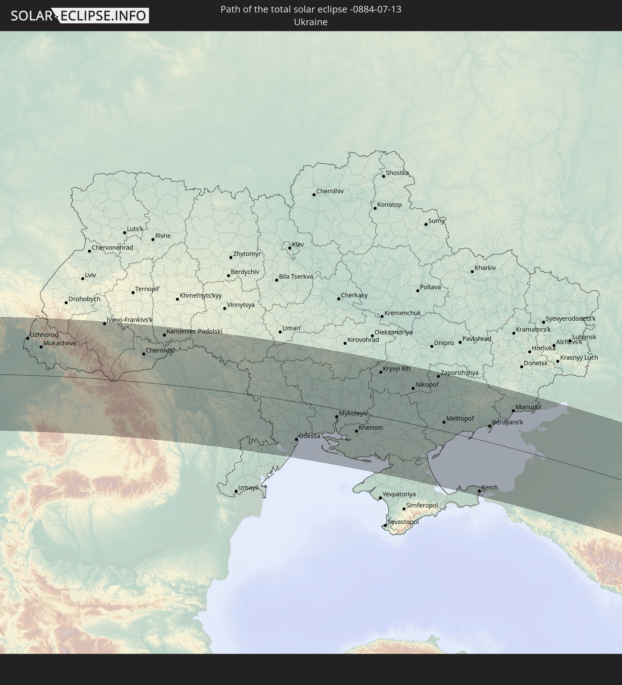 Ukraine
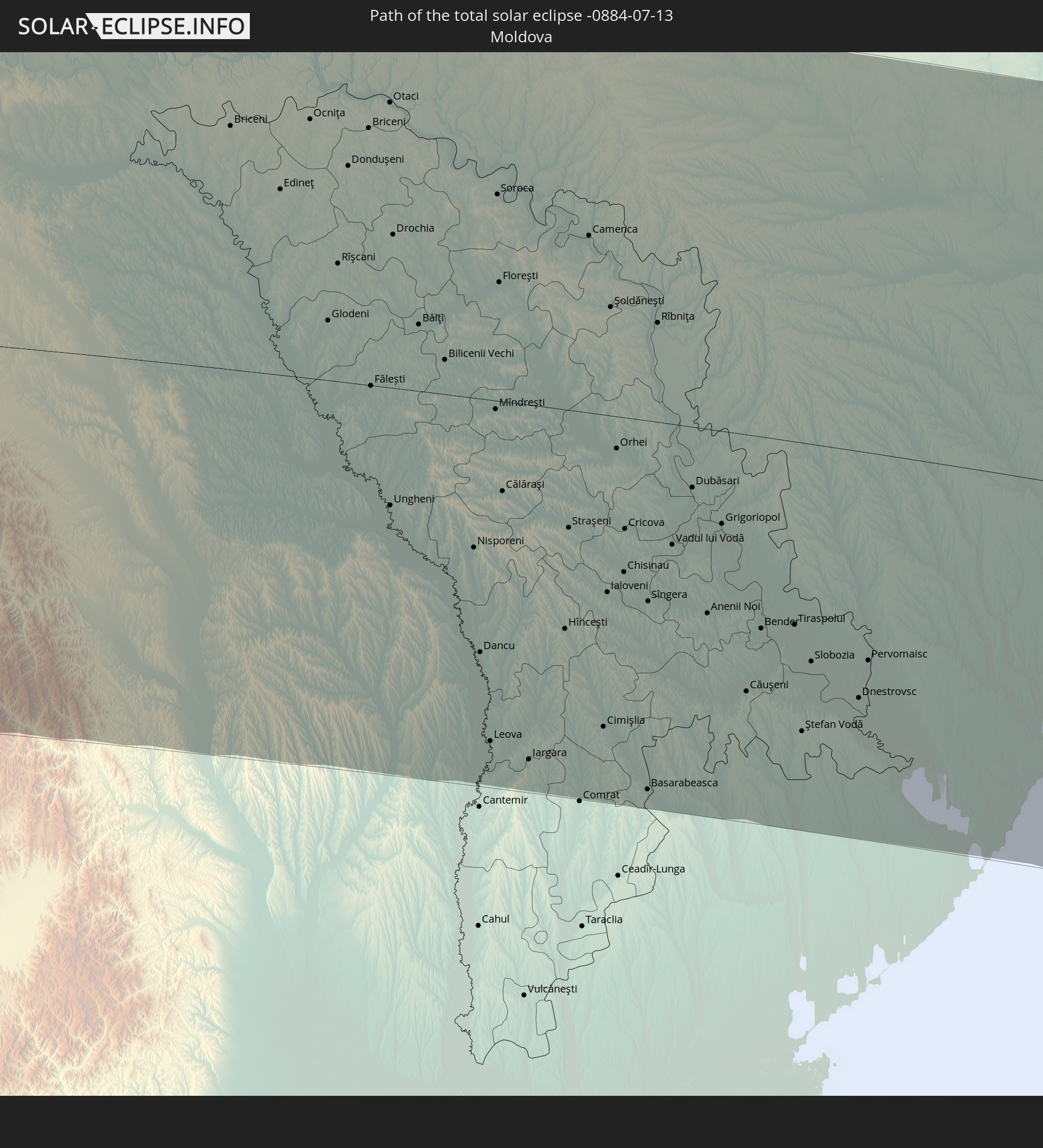 Moldova
 Kazakhstan
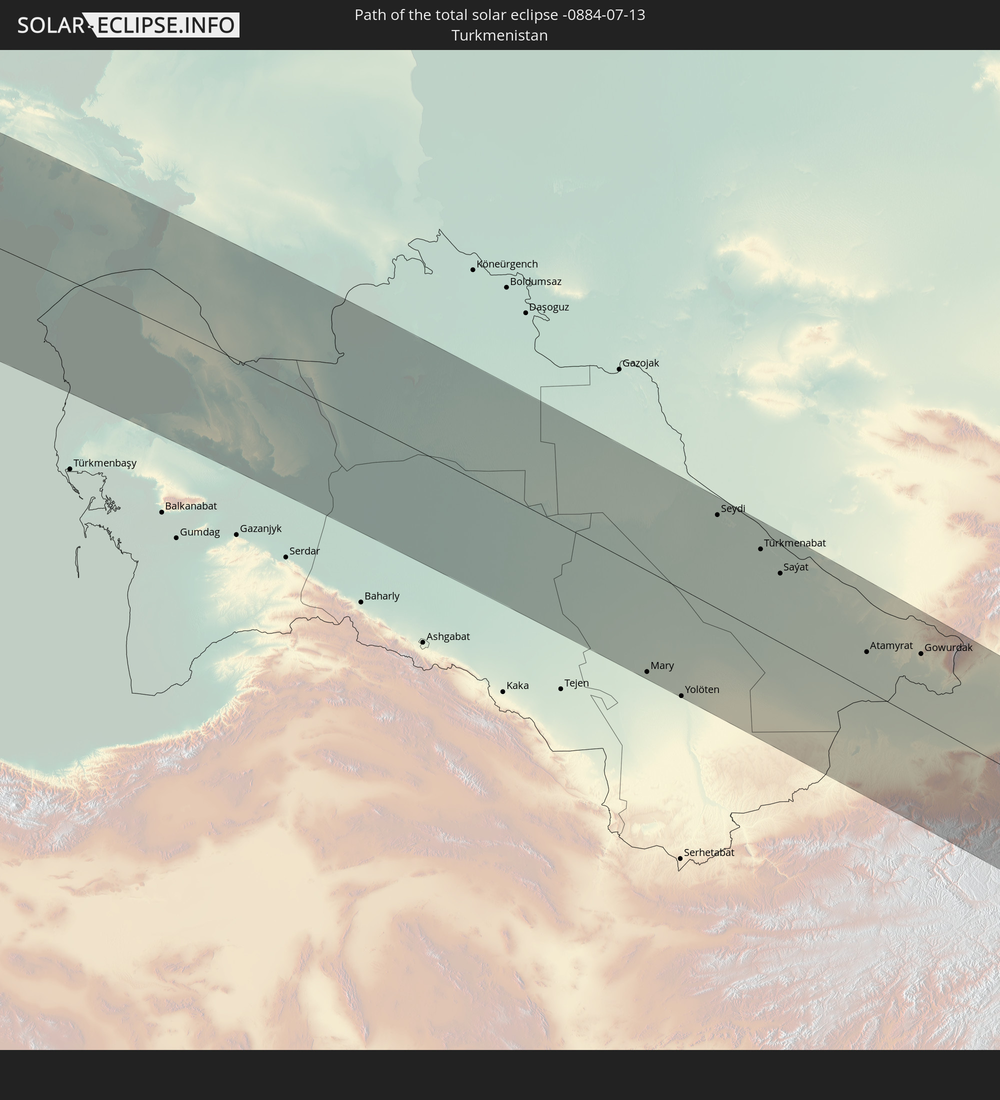 Turkmenistan
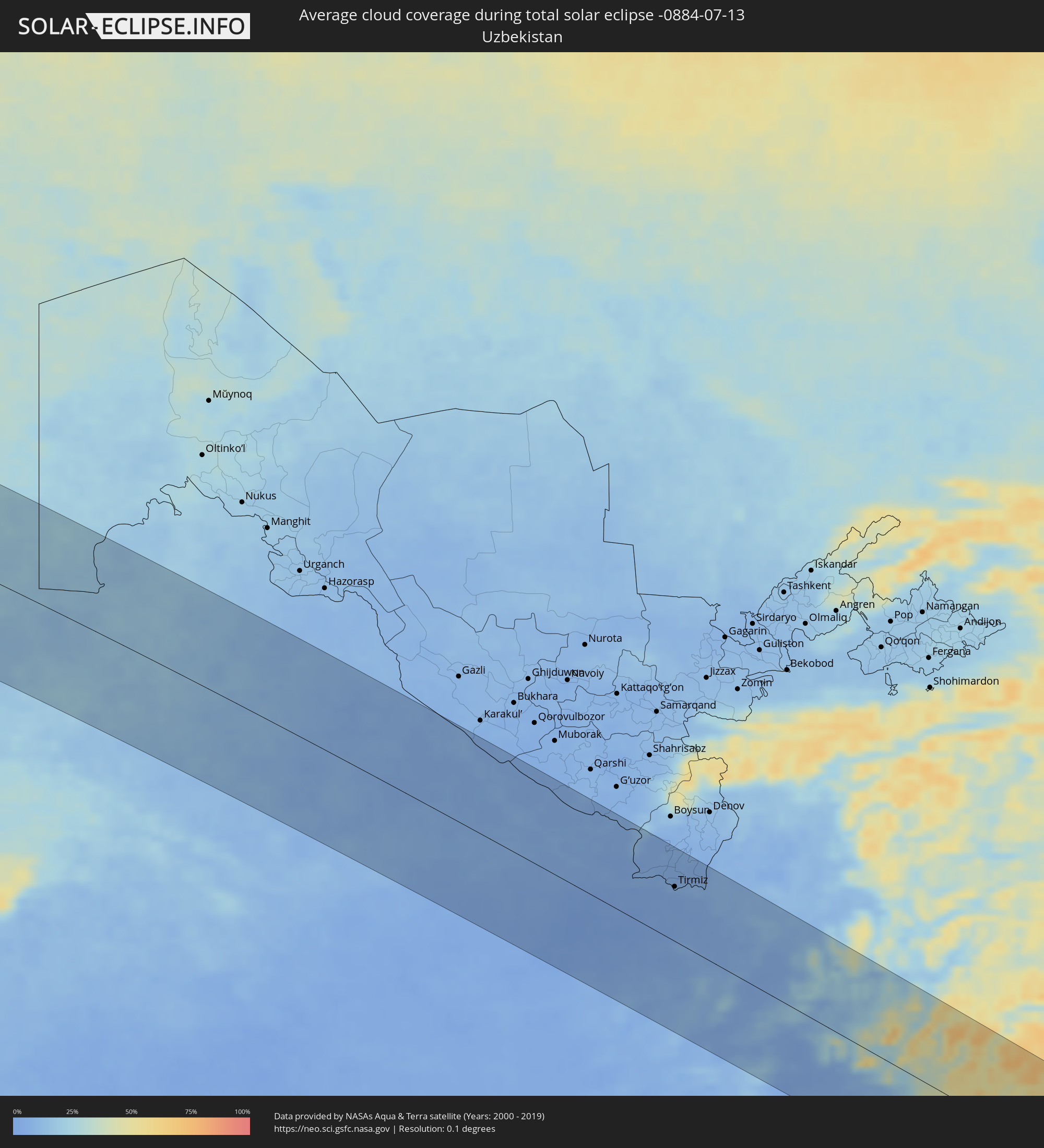
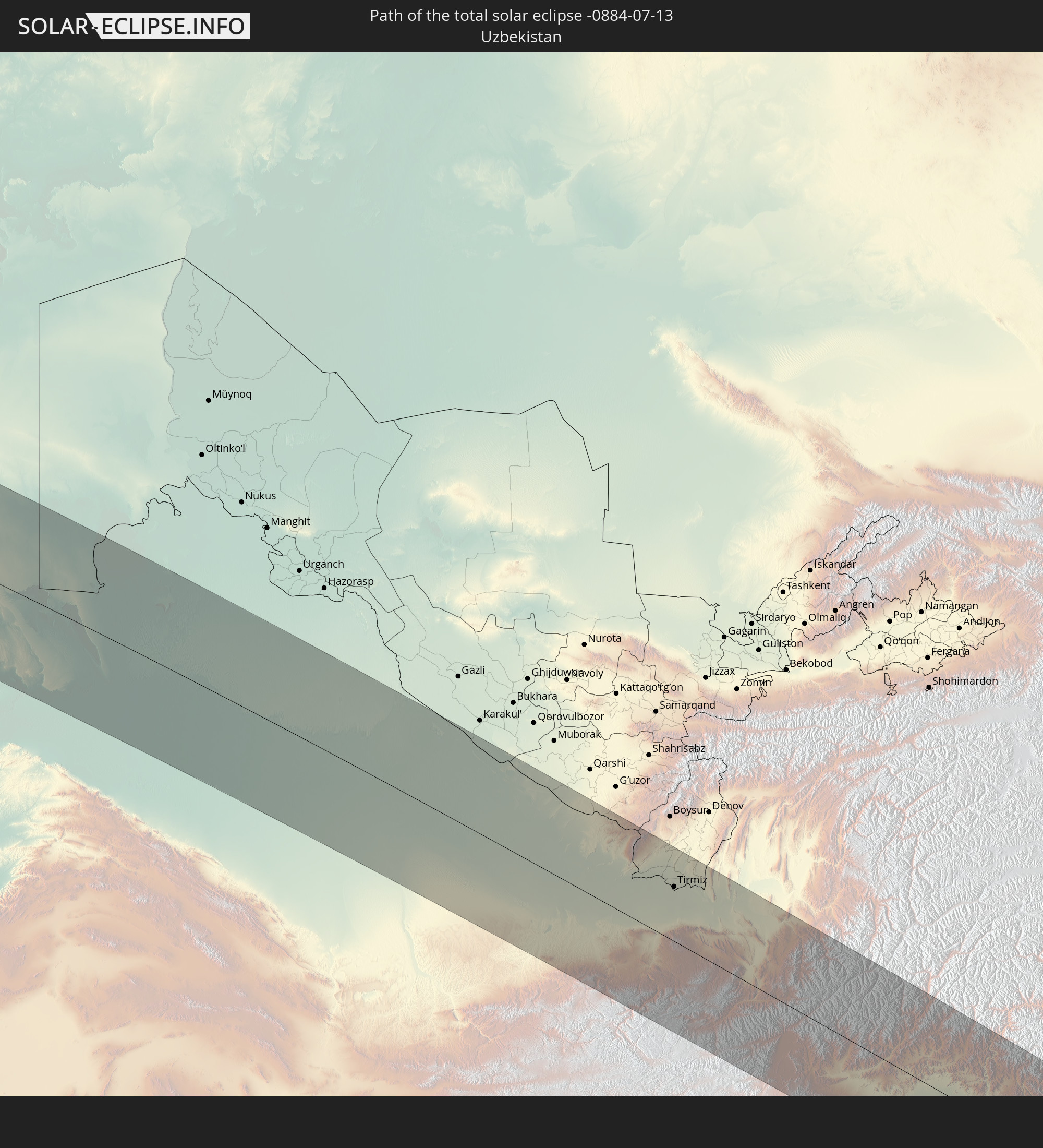 Uzbekistan
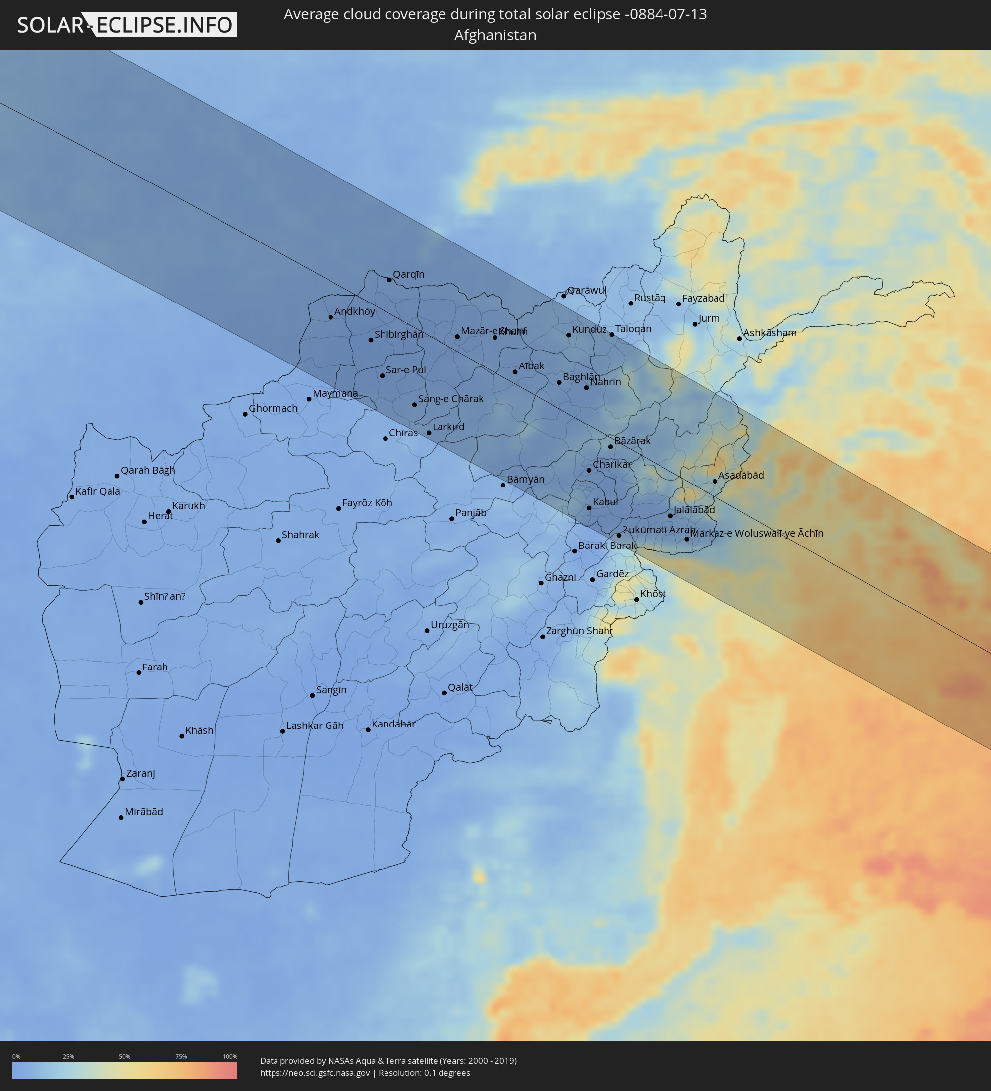
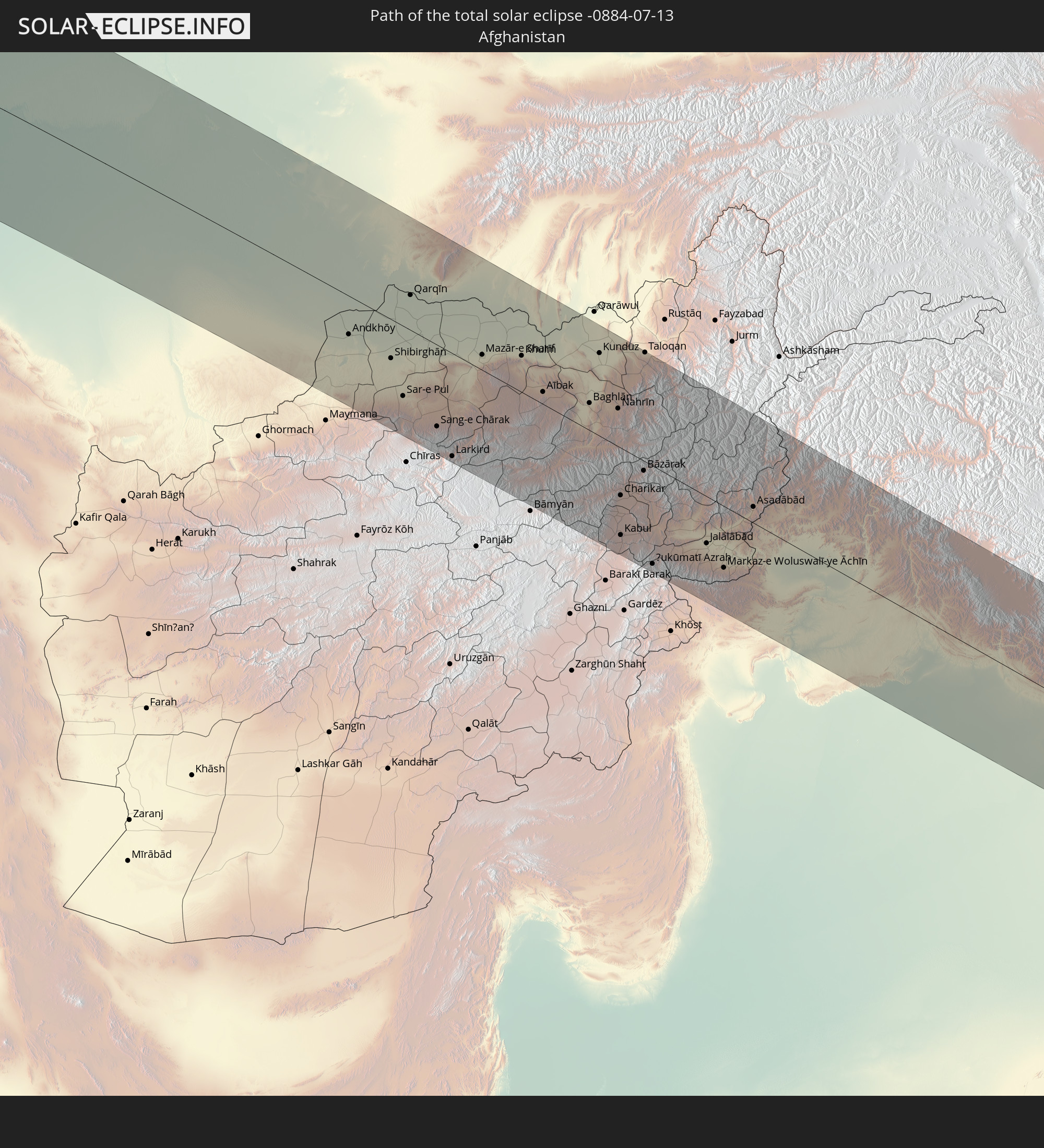 Afghanistan
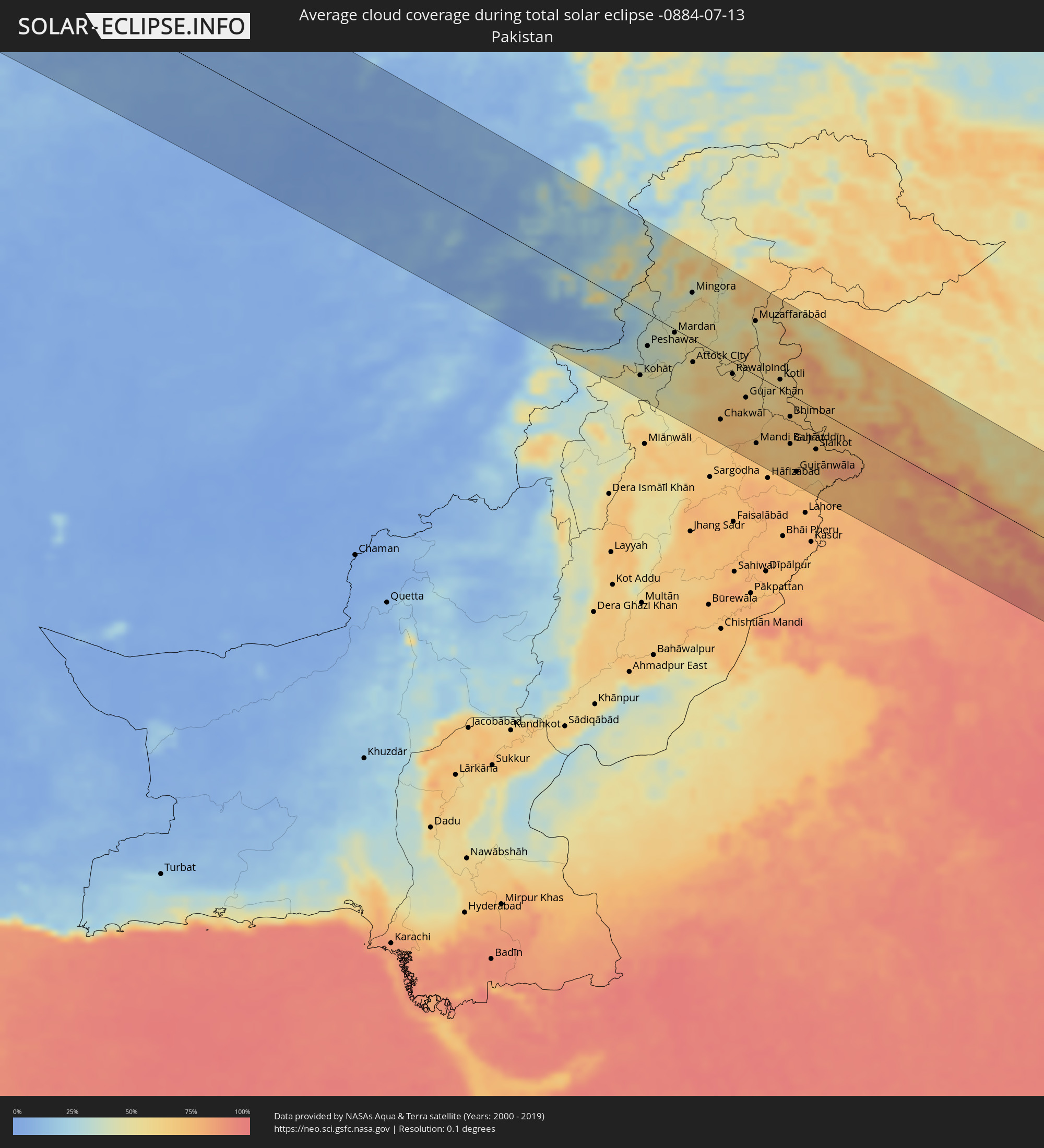
 Pakistan
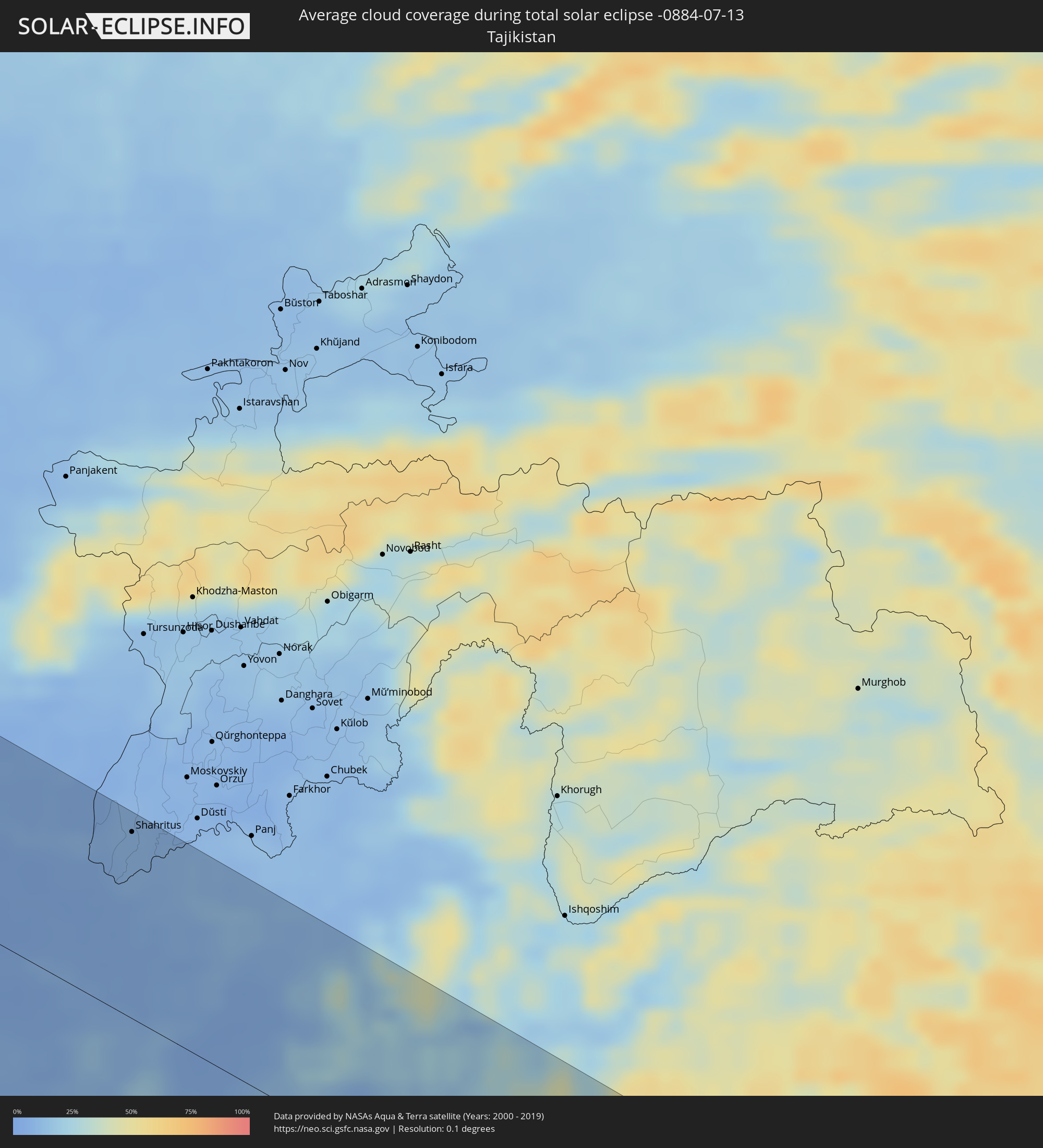
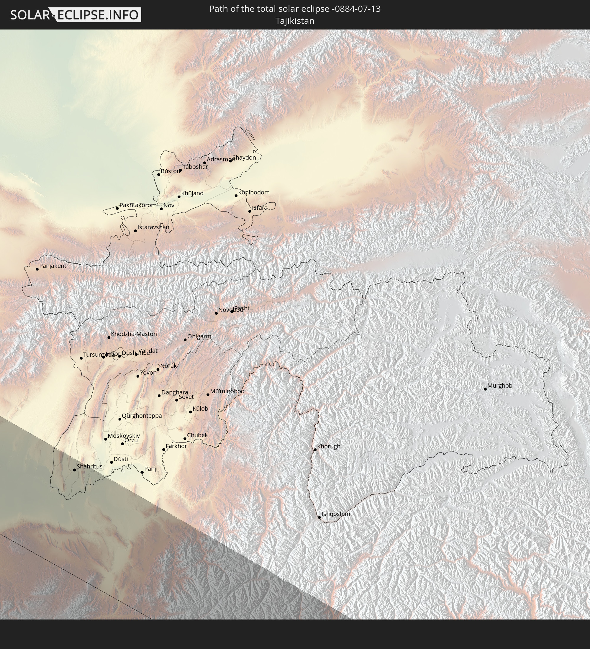 Tajikistan
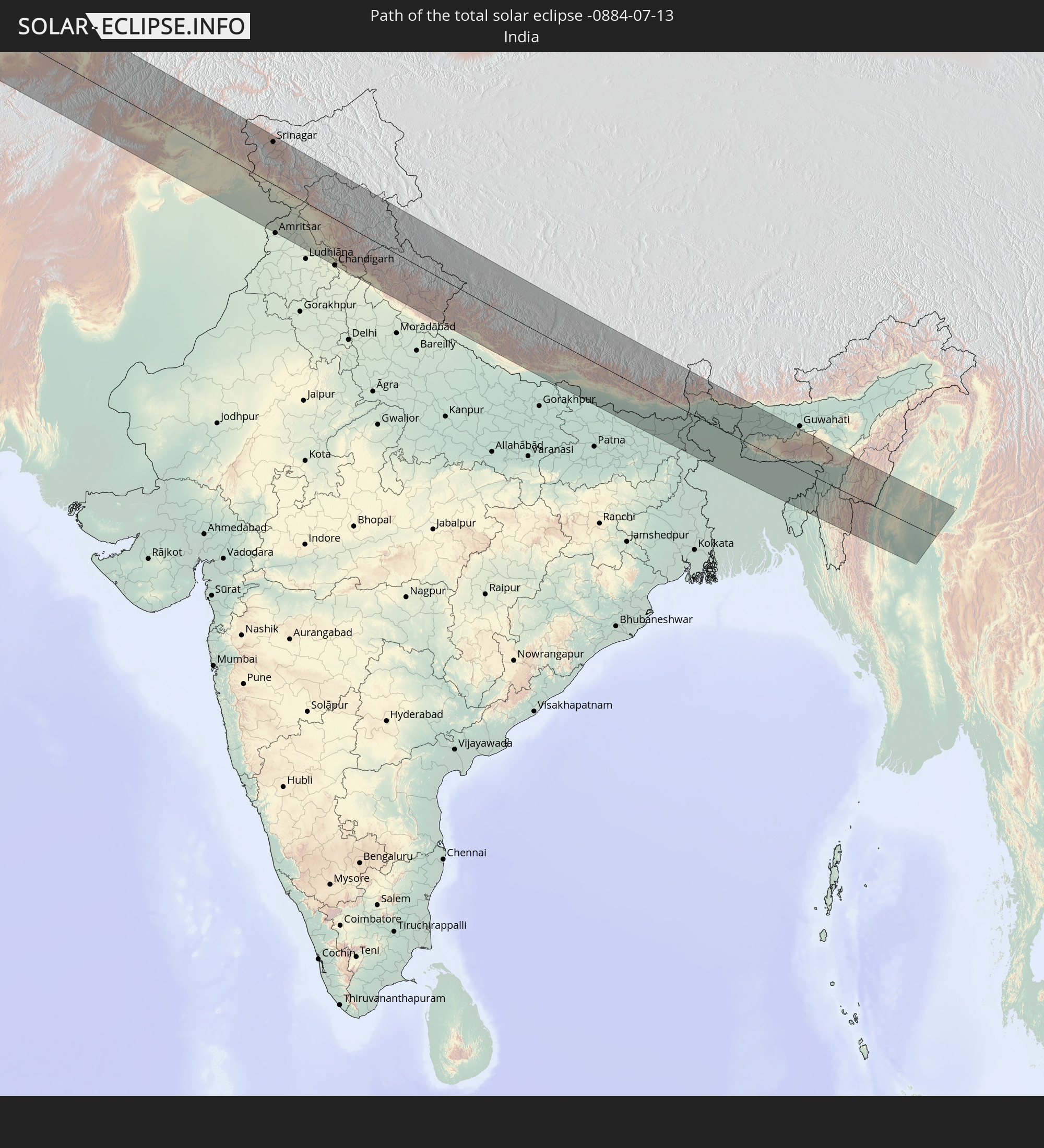 India
India
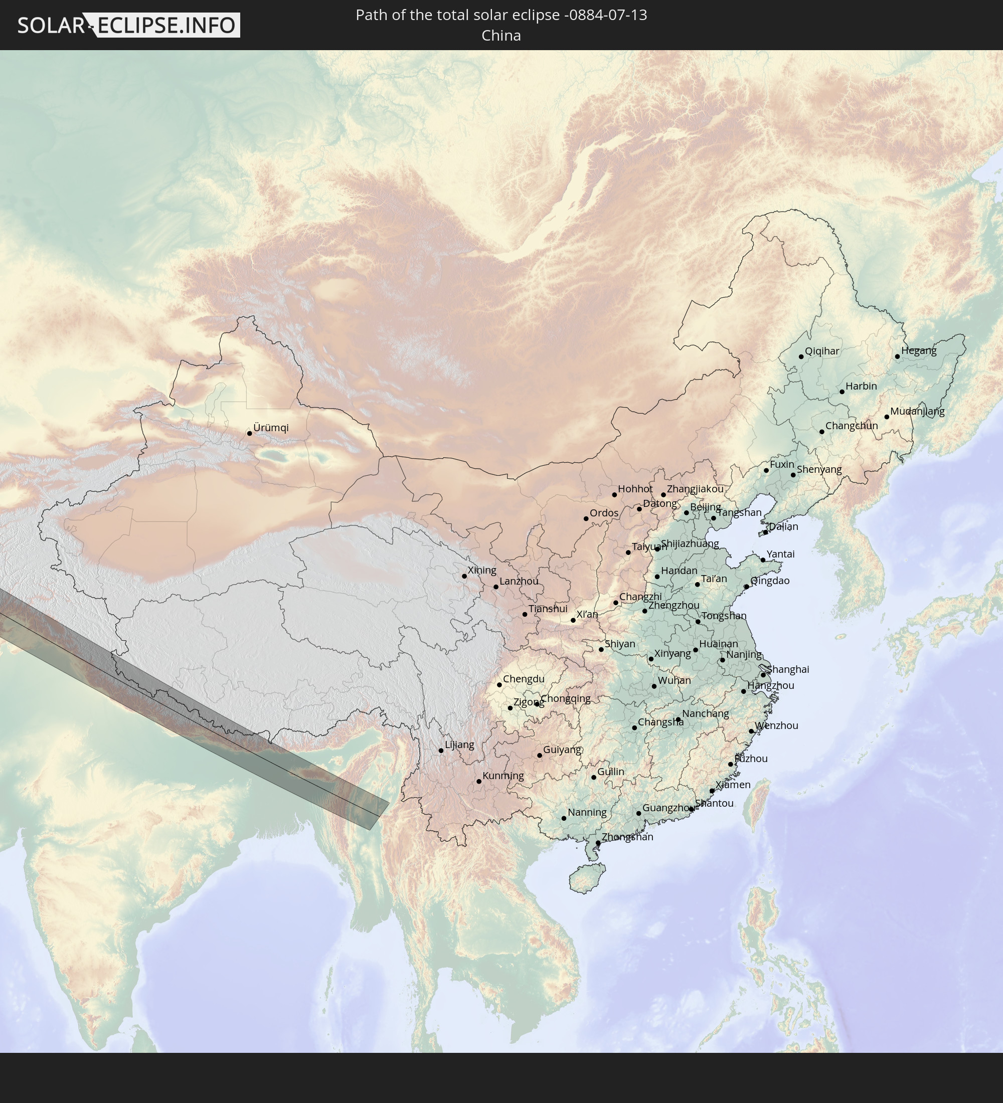 China
China
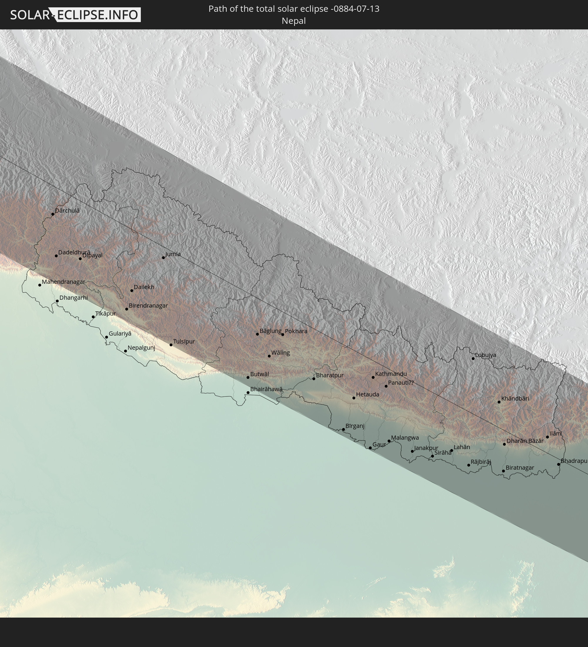 Nepal
Nepal
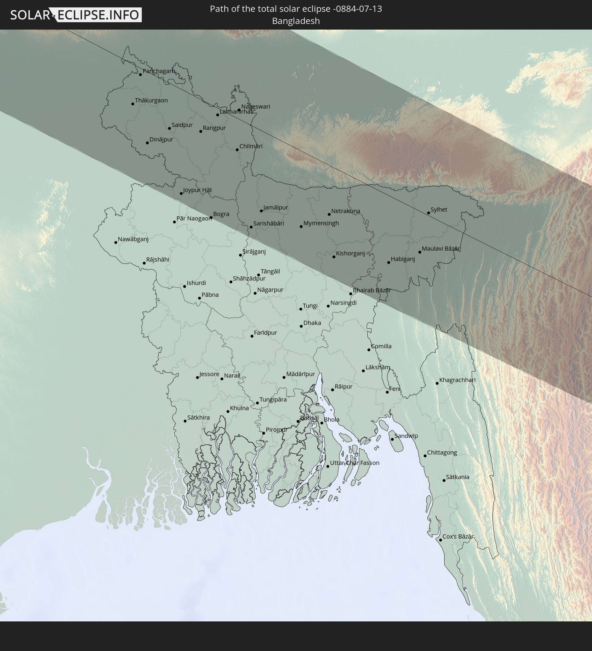 Bangladesh
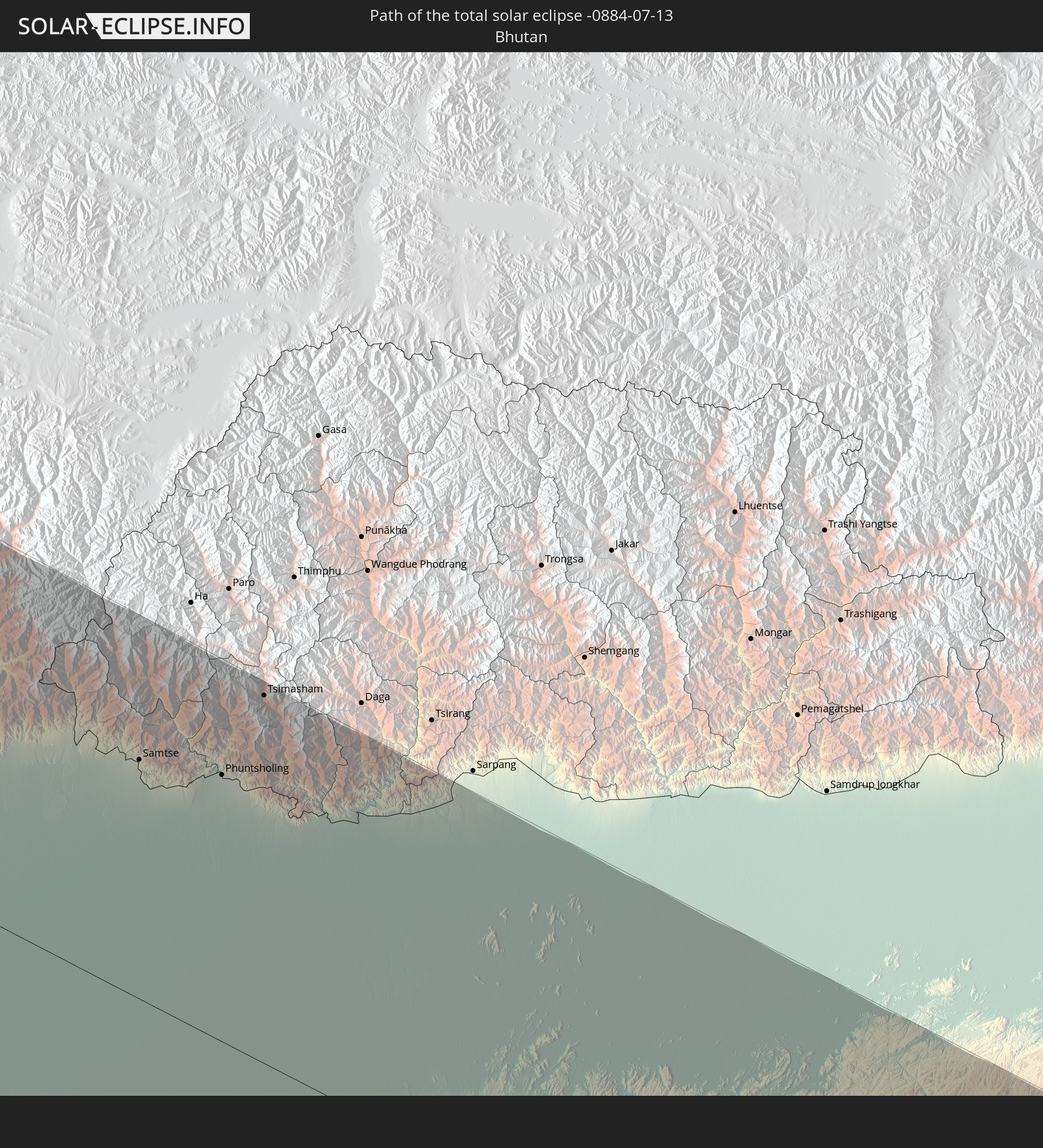 Bhutan
 Myanmar
In den folgenden Ländern ist die Sonnenfinsternis partiell zu sehen
 Russia
 United States
 Canada
 Greenland
 Brazil
 Bermuda
 Saint Pierre and Miquelon
 Portugal
 Cabo Verde
 Iceland
 Spain
Spain
 Senegal
 Mauritania
 The Gambia
 Guinea-Bissau
 Guinea
 Sierra Leone
 Morocco
 Mali
Mali
 Liberia
 Republic of Ireland
 Svalbard and Jan Mayen
 Algeria
 United Kingdom
 Ivory Coast
 Faroe Islands
 Burkina Faso
 Gibraltar
 France
 Isle of Man
 Guernsey
 Jersey
 Niger
Niger
 Andorra
 Belgium
 Netherlands
 Norway
 Luxembourg
 Germany
 Switzerland
 Italy
Italy
 Monaco
 Tunisia
 Denmark
 Libya
Libya
 Liechtenstein
 Austria
 Sweden
 Czechia
 San Marino
 Vatican City
 Slovenia
 Chad
Chad
 Croatia
 Poland
 Malta
Malta
 Bosnia and Herzegovina
 Hungary
 Slovakia
 Montenegro
 Serbia
 Albania
 Åland Islands
 Greece
 Romania
 Republic of Macedonia
 Finland
 Lithuania
 Latvia
 Estonia
 Sudan
Sudan
 Ukraine
 Bulgaria
 Belarus
 Egypt
Egypt
 Turkey
 Moldova
 Cyprus
 Ethiopia
 State of Palestine
 Israel
 Saudi Arabia
 Jordan
 Lebanon
 Syria
Syria
 Eritrea
 Iraq
Iraq
 Georgia
 Somalia
 Djibouti
 Yemen
Yemen
 Armenia
 Iran
Iran
 Azerbaijan
 Kazakhstan
 Kuwait
 Bahrain
 Qatar
Qatar
 United Arab Emirates
 Oman
Oman
 Turkmenistan
 Uzbekistan
 Afghanistan
 Pakistan
 Tajikistan
 India
India
 Kyrgyzstan
 Maldives
 China
China
 Sri Lanka
 Nepal
Nepal
 Mongolia
 Bangladesh
 Bhutan
 Myanmar
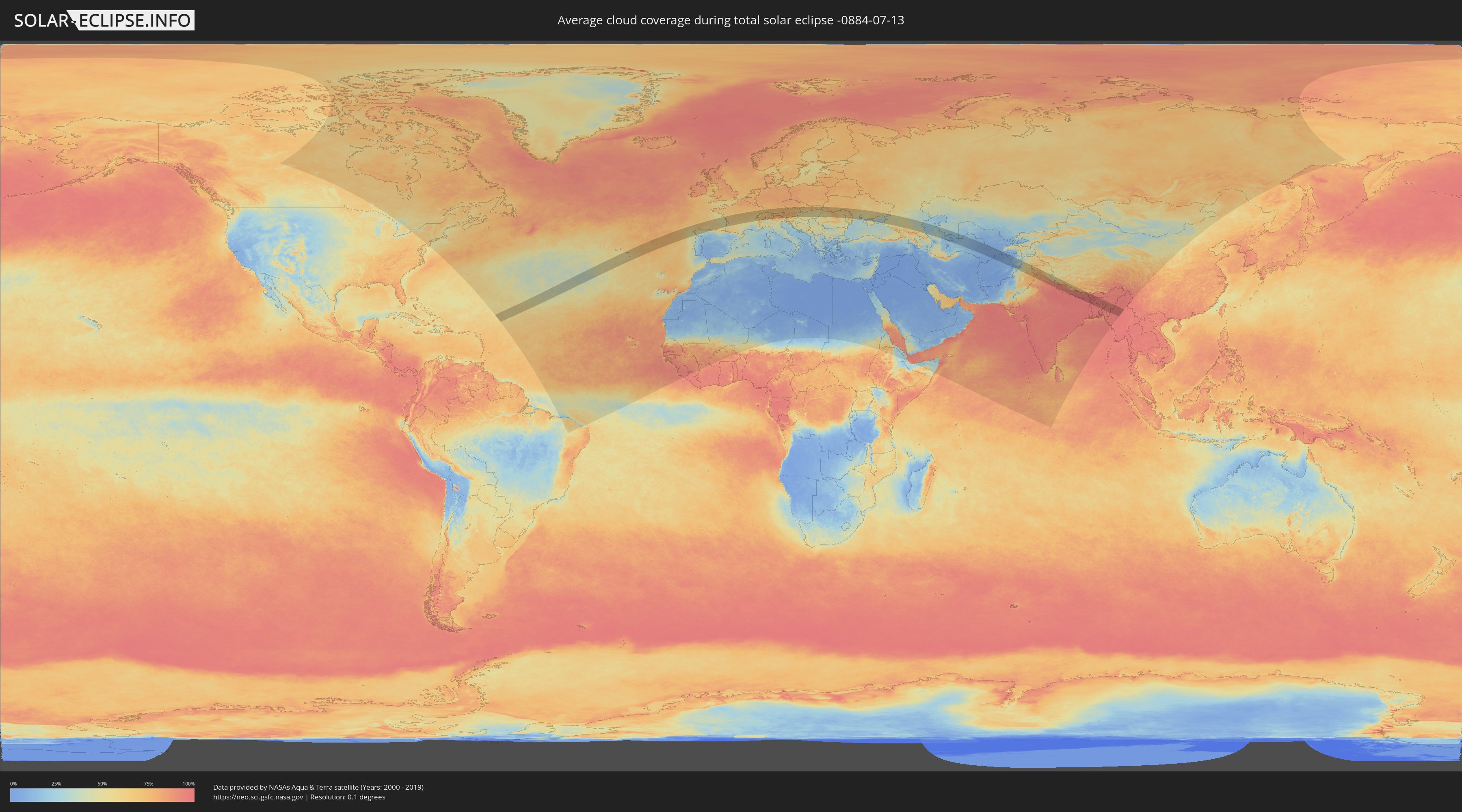
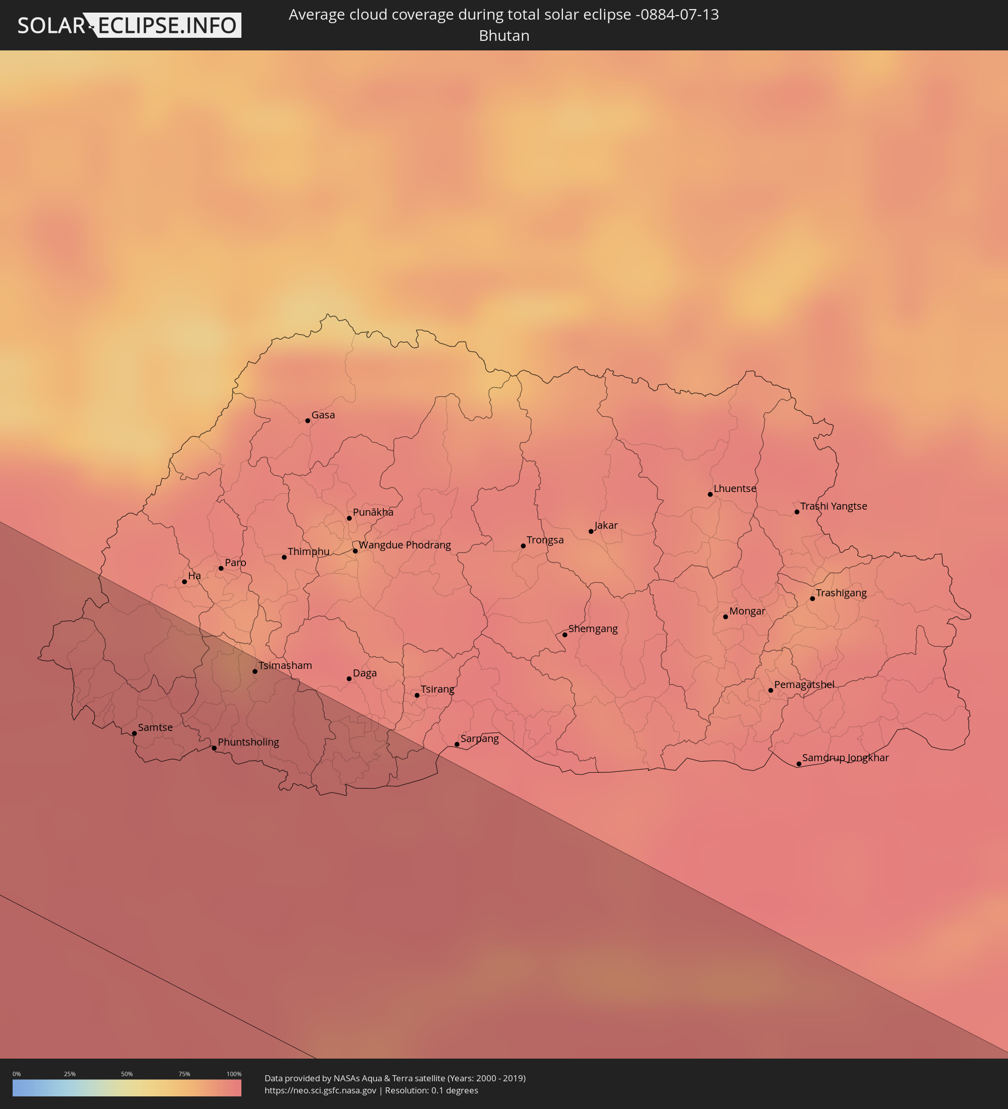
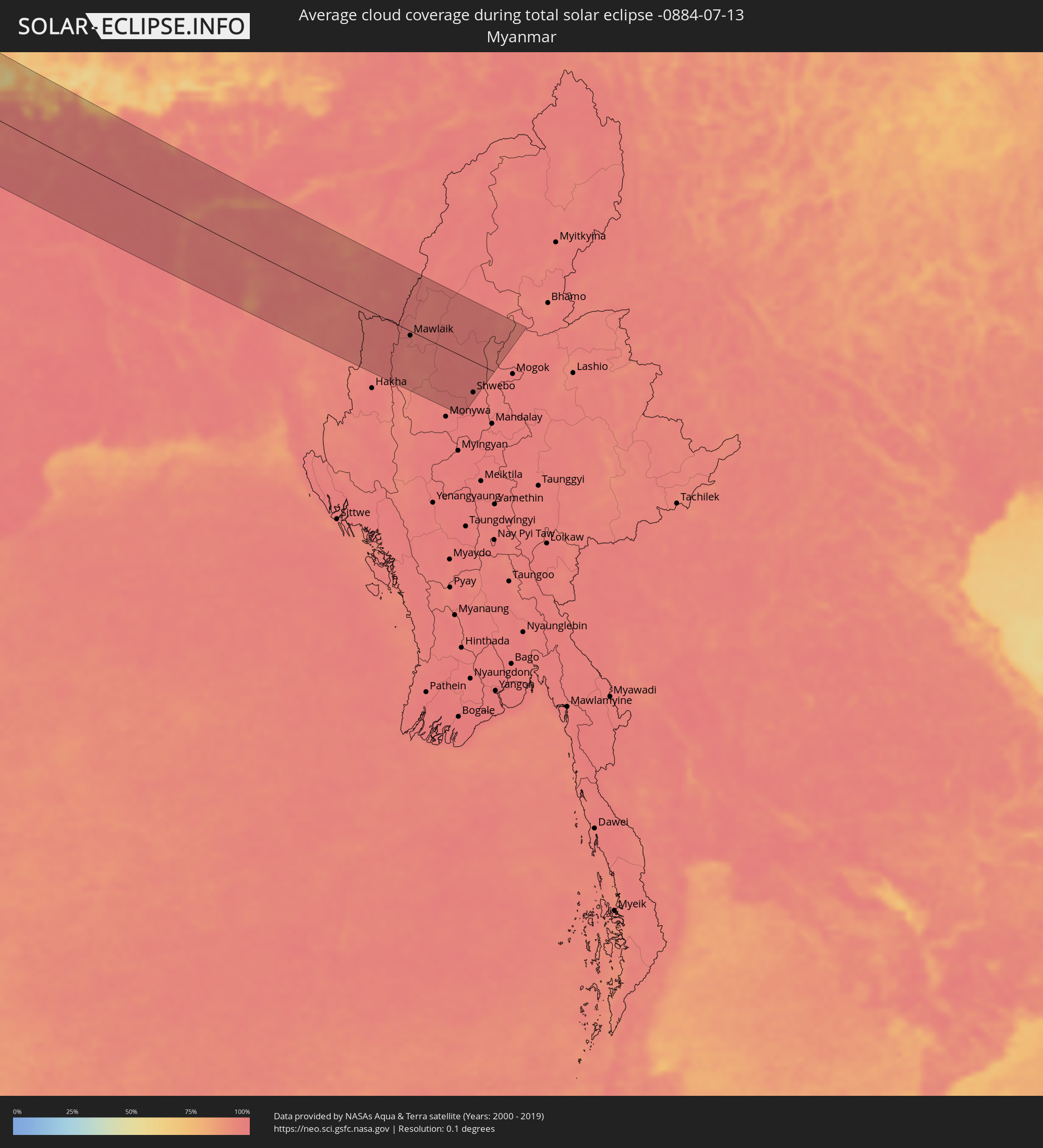
How will be the weather during the total solar eclipse on 07/13/-0884?
Where is the best place to see the total solar eclipse of 07/13/-0884?
The following maps show the average cloud coverage for the day of the total solar eclipse.
With the help of these maps, it is possible to find the place along the eclipse path, which has the best
chance of a cloudless sky.
Nevertheless, you should consider local circumstances and inform about the weather of your chosen
observation site.
The data is provided by NASAs satellites
AQUA and TERRA.
The cloud maps are averaged over a period of 19 years (2000 - 2019).
Detailed country maps
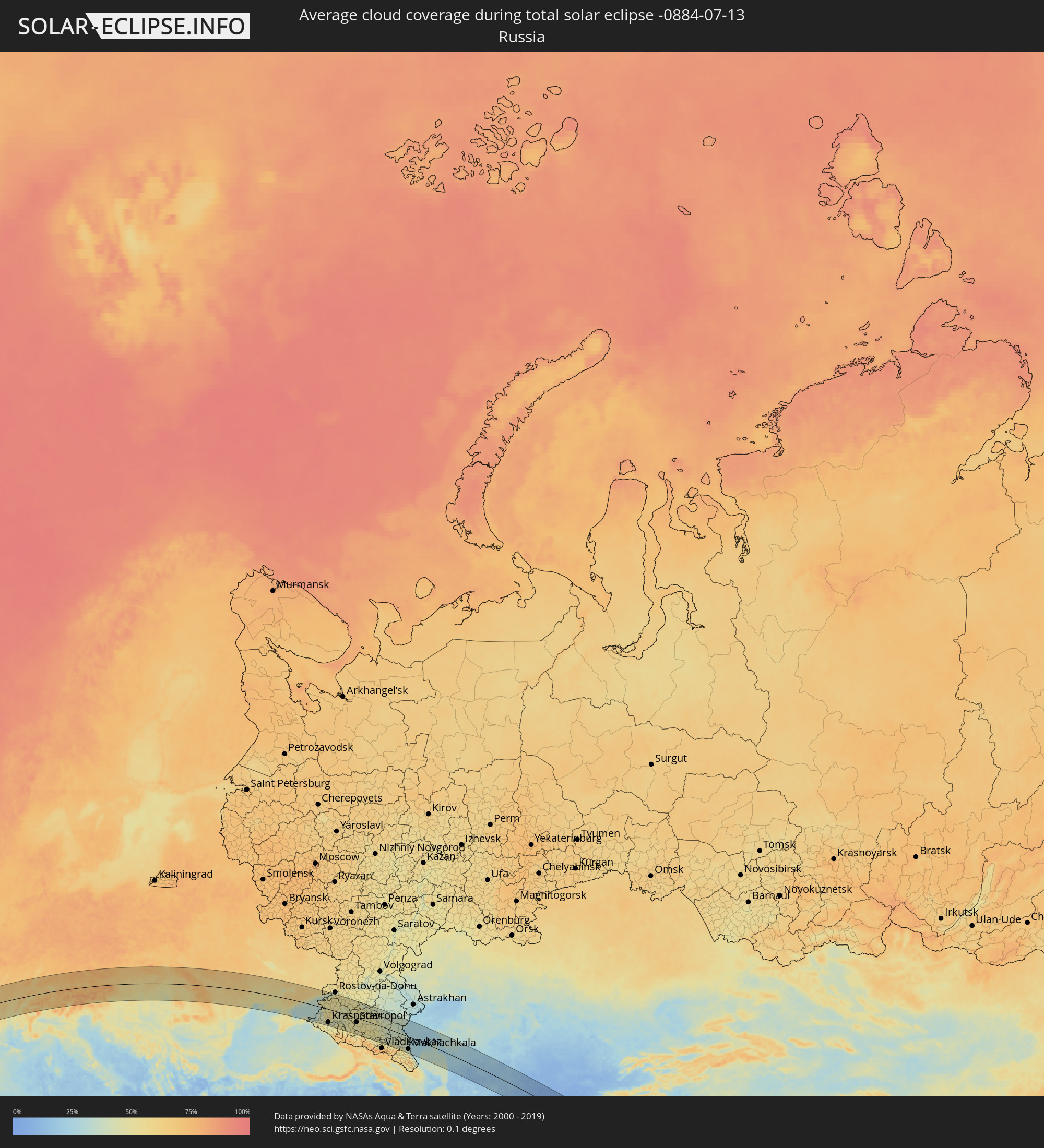 Russia
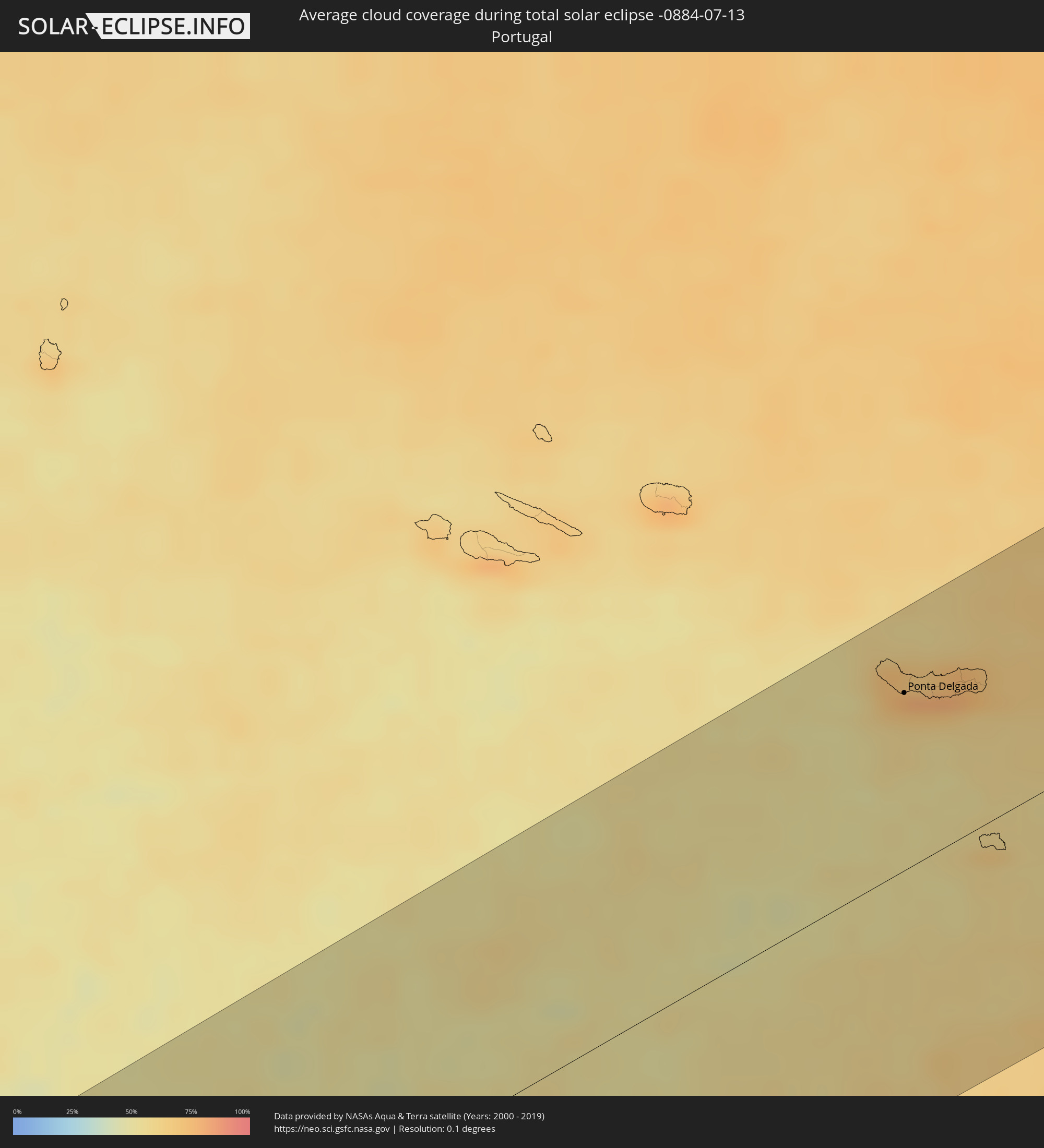 Portugal
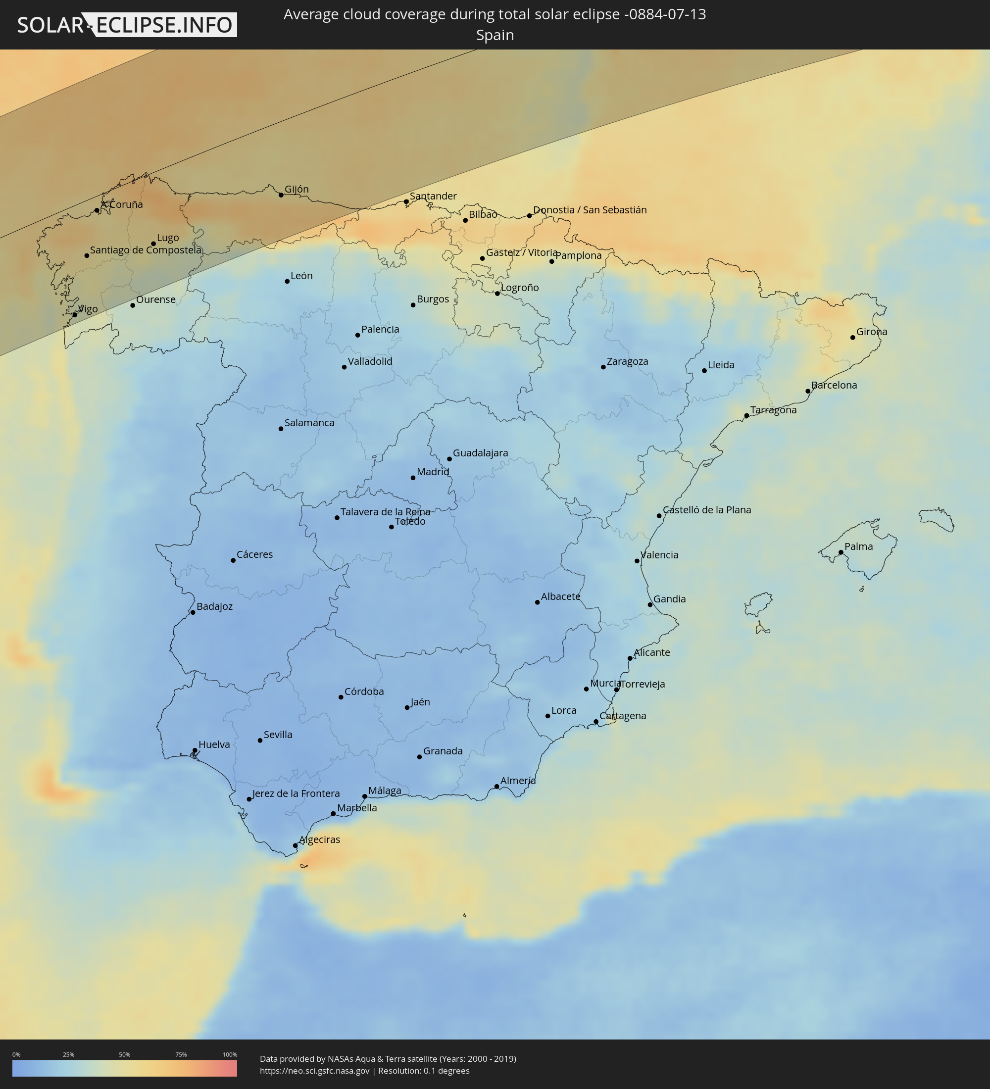 Spain
Spain
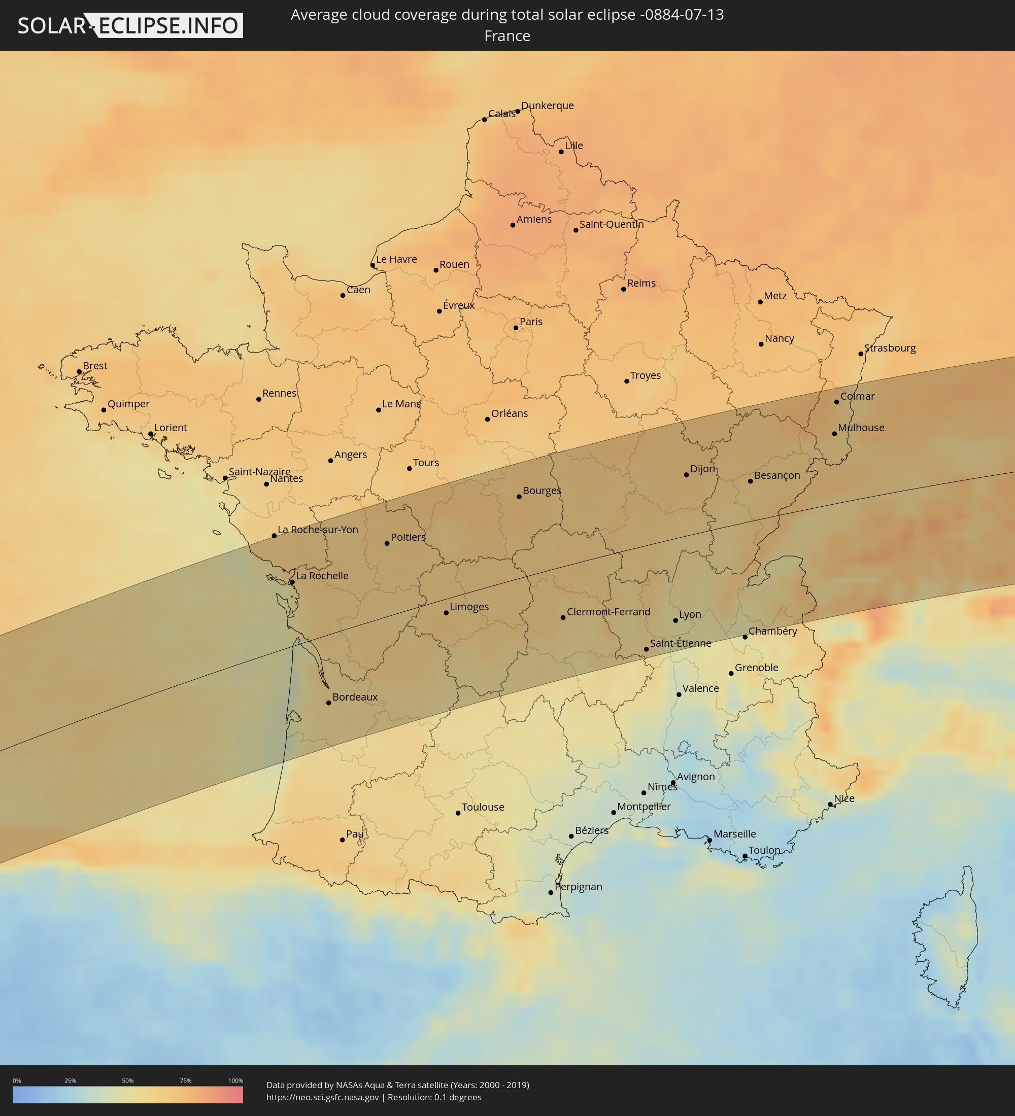 France
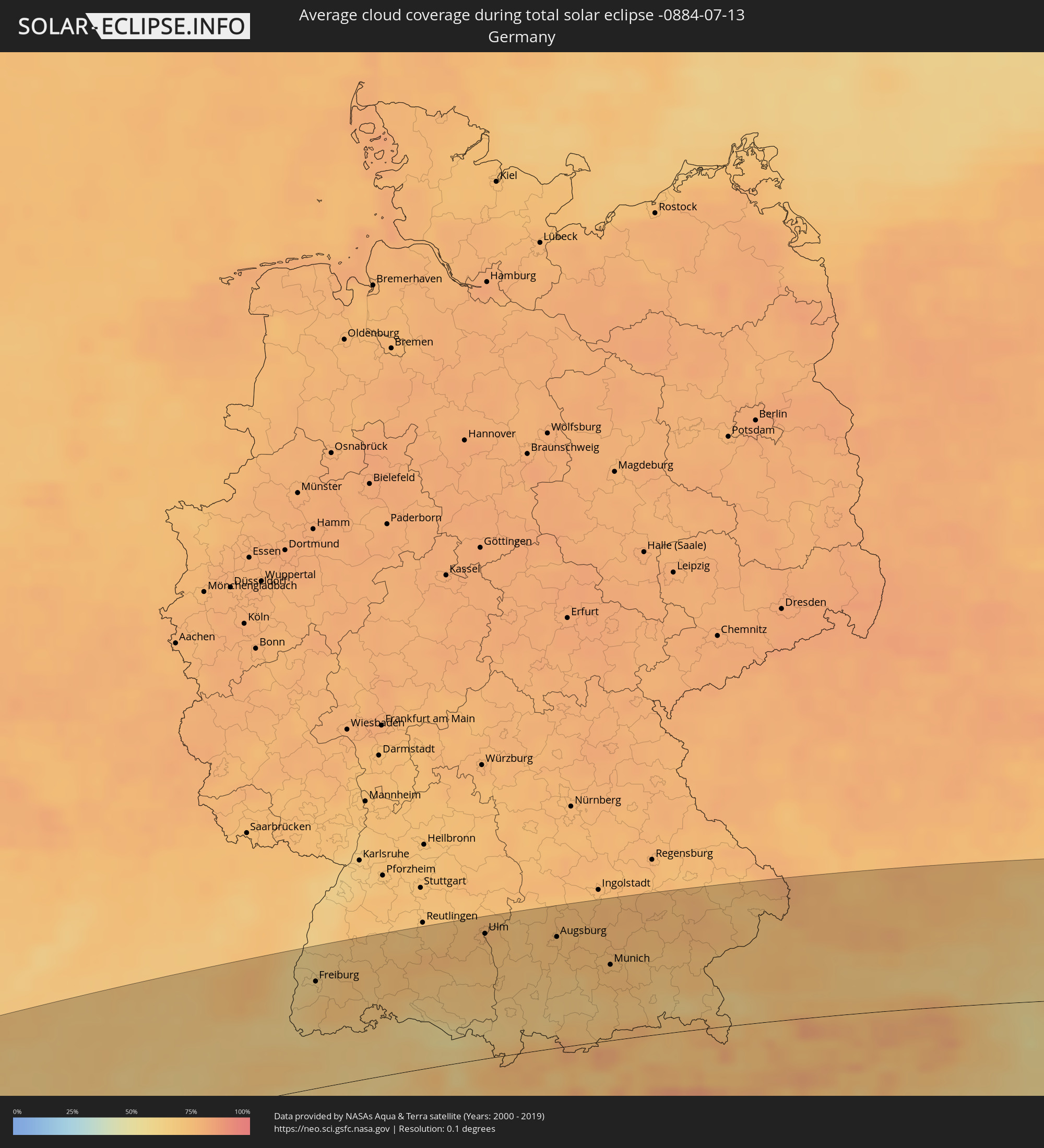 Germany
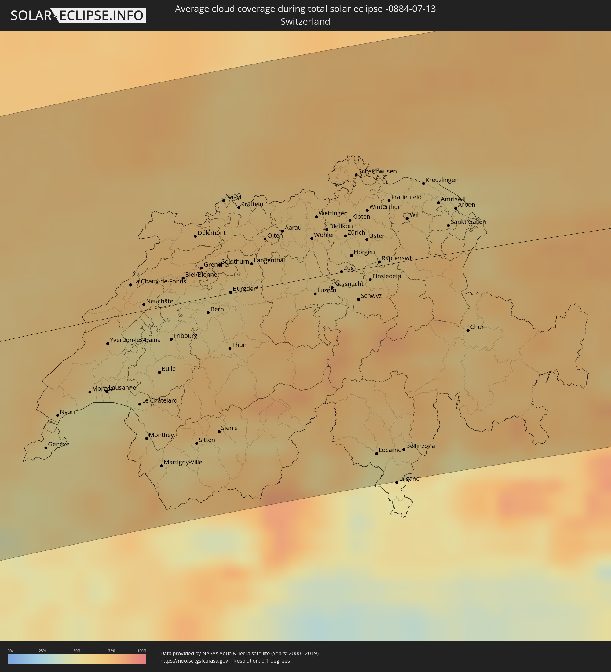 Switzerland
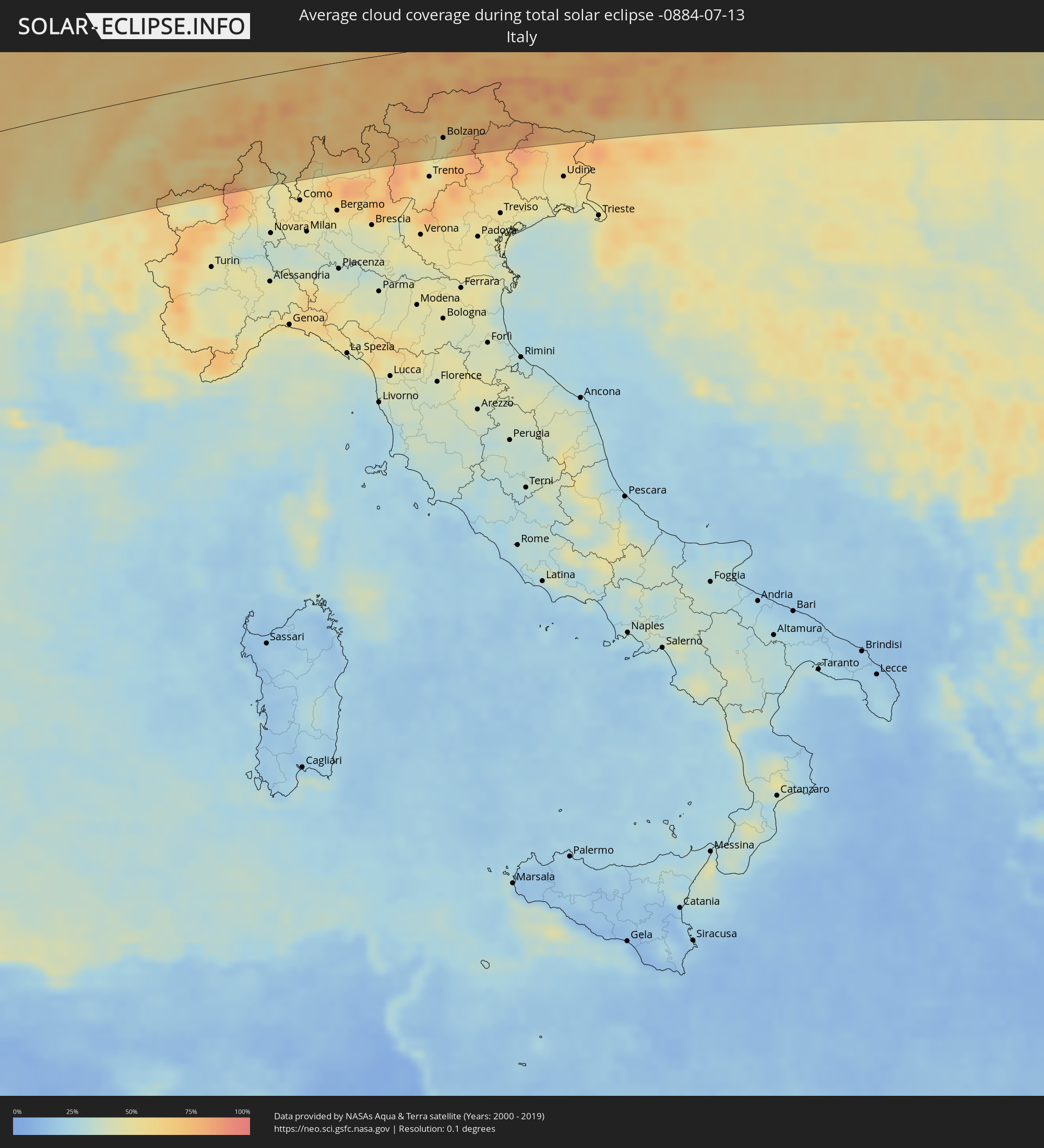 Italy
Italy
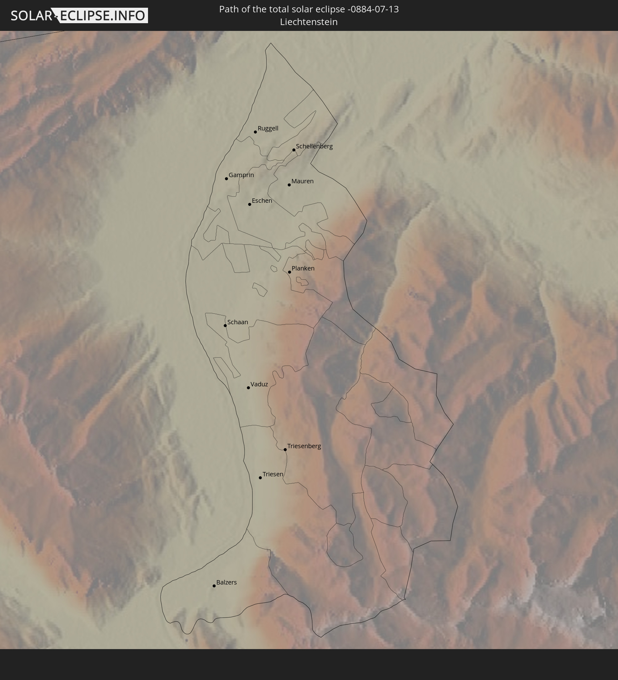
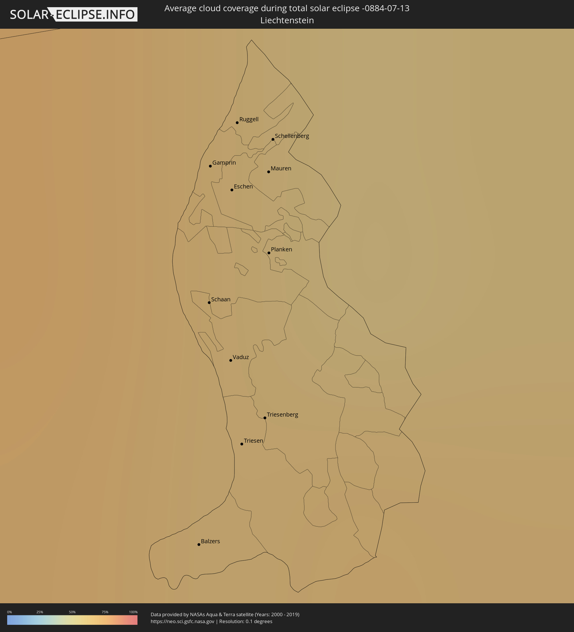 Liechtenstein
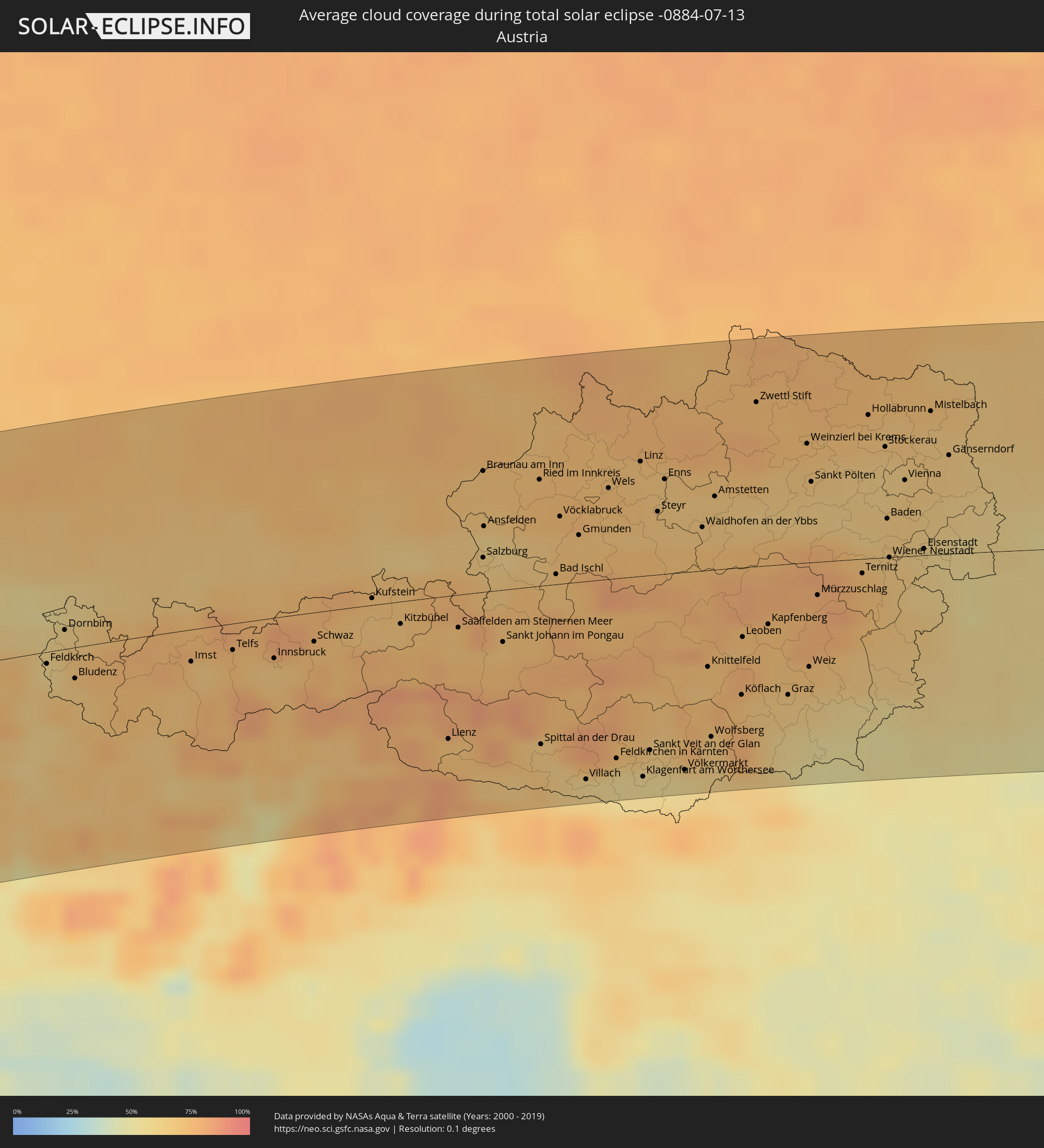 Austria
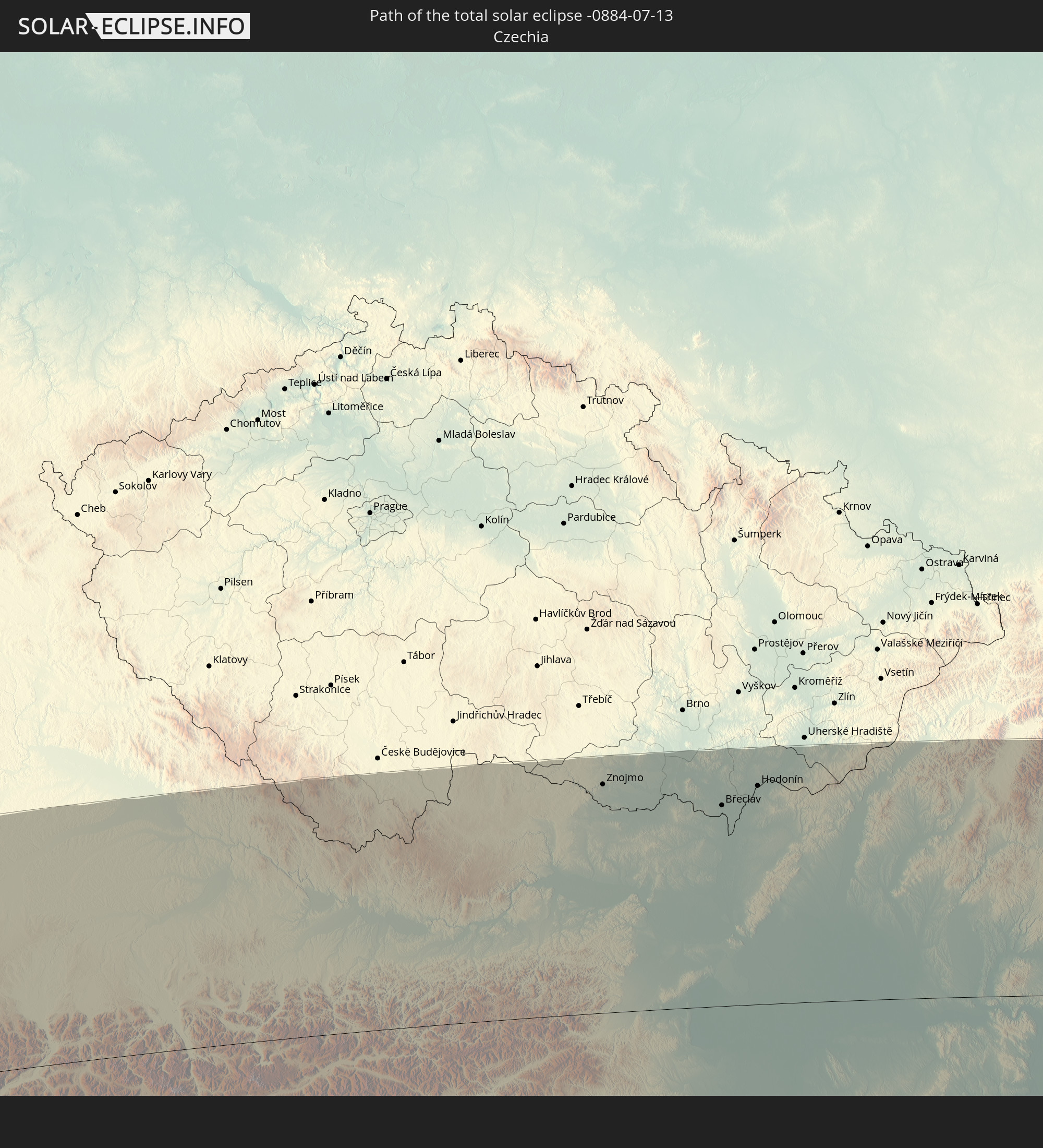
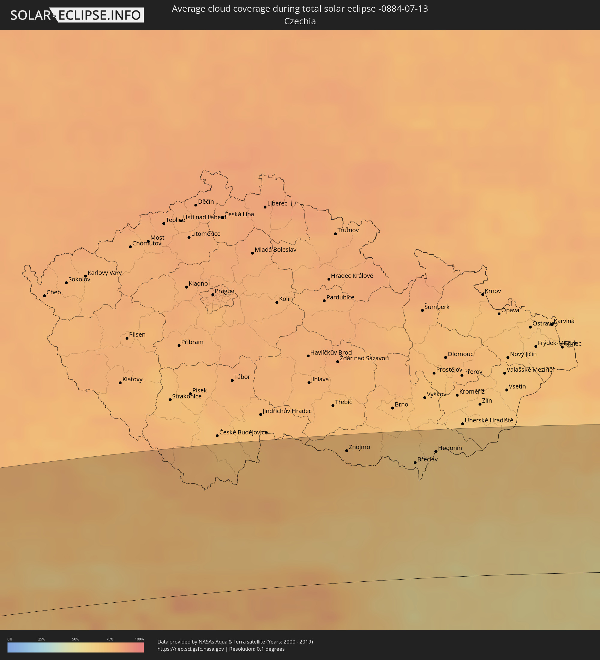 Czechia
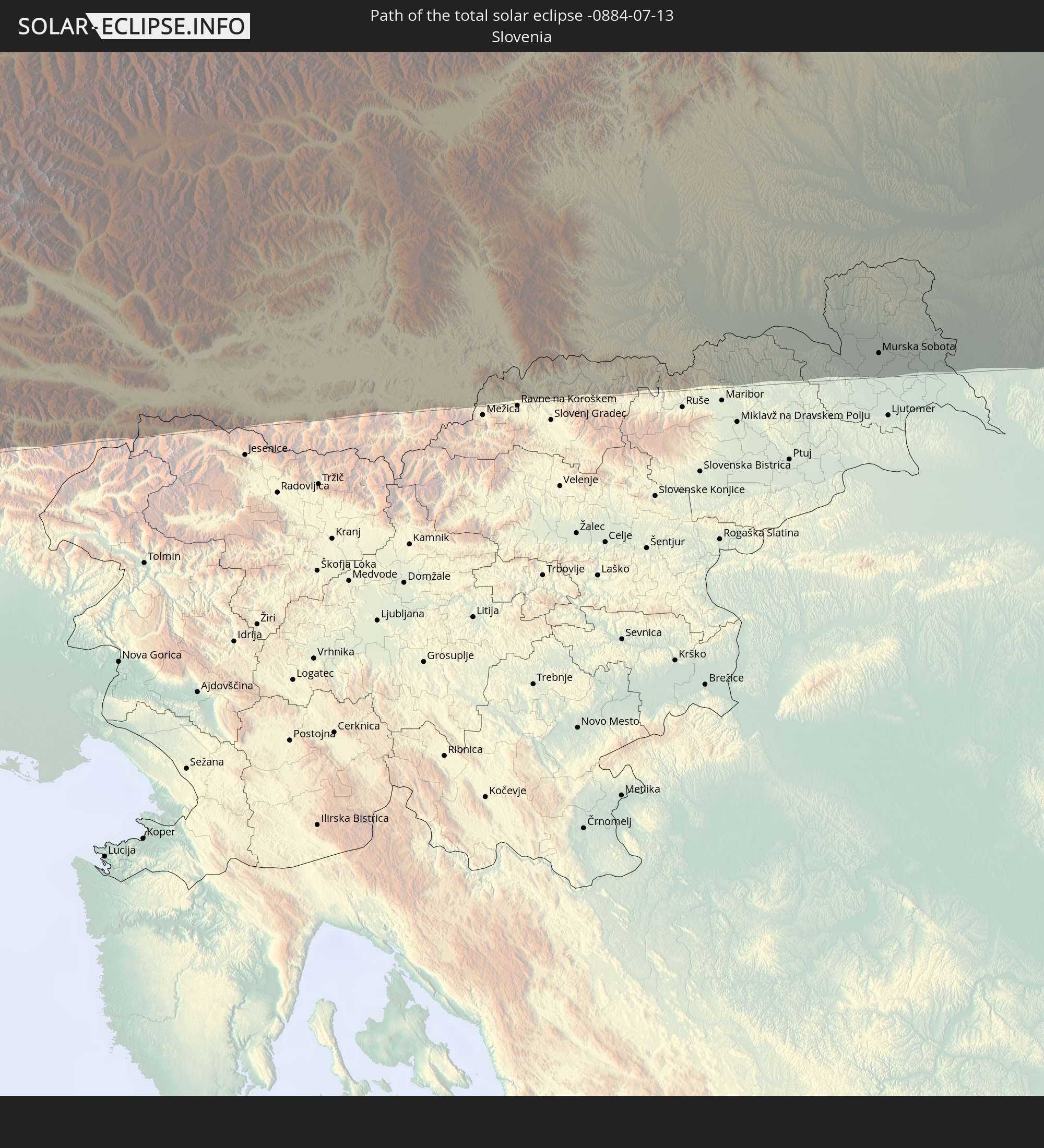
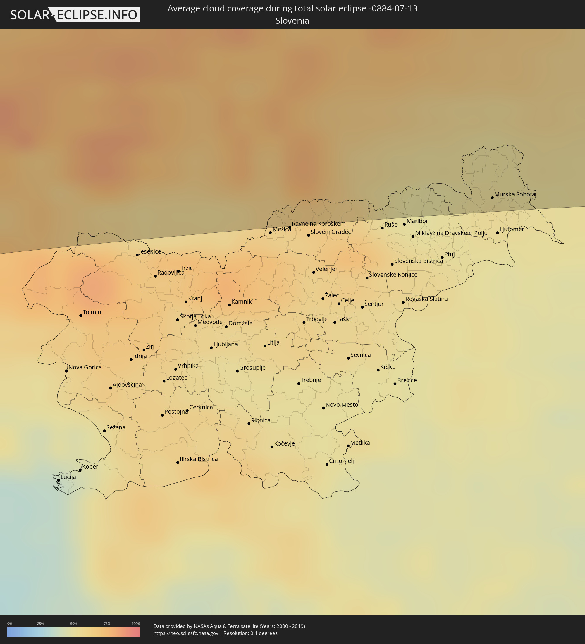 Slovenia
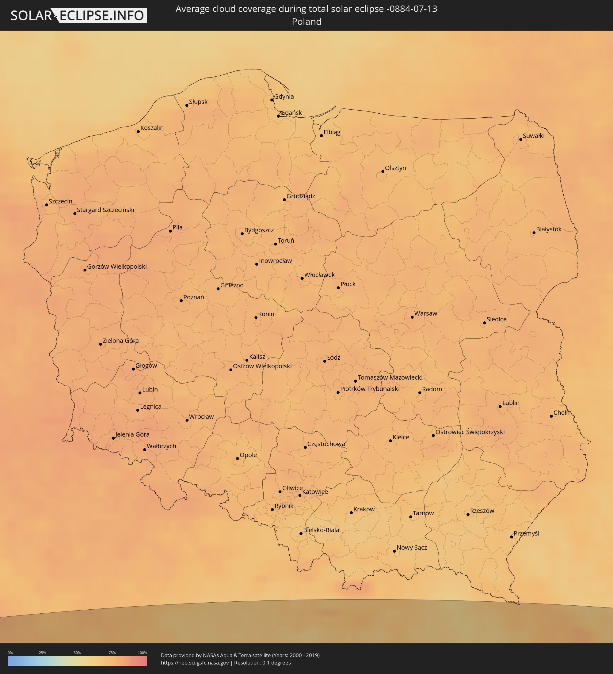 Poland
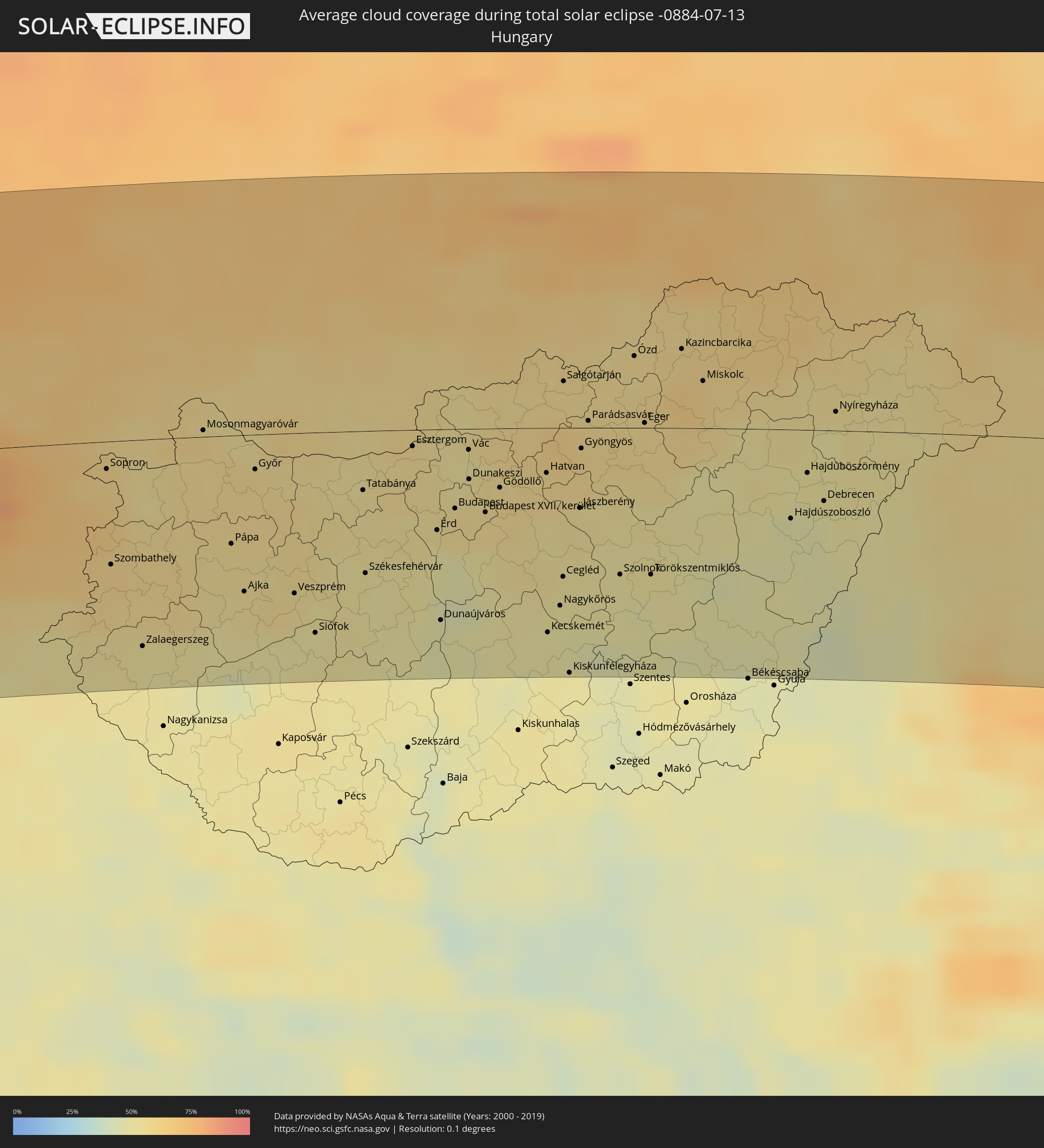 Hungary
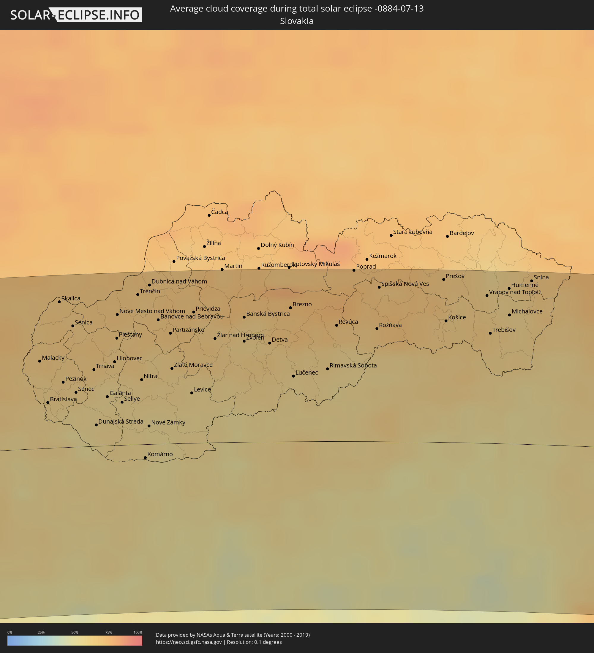 Slovakia
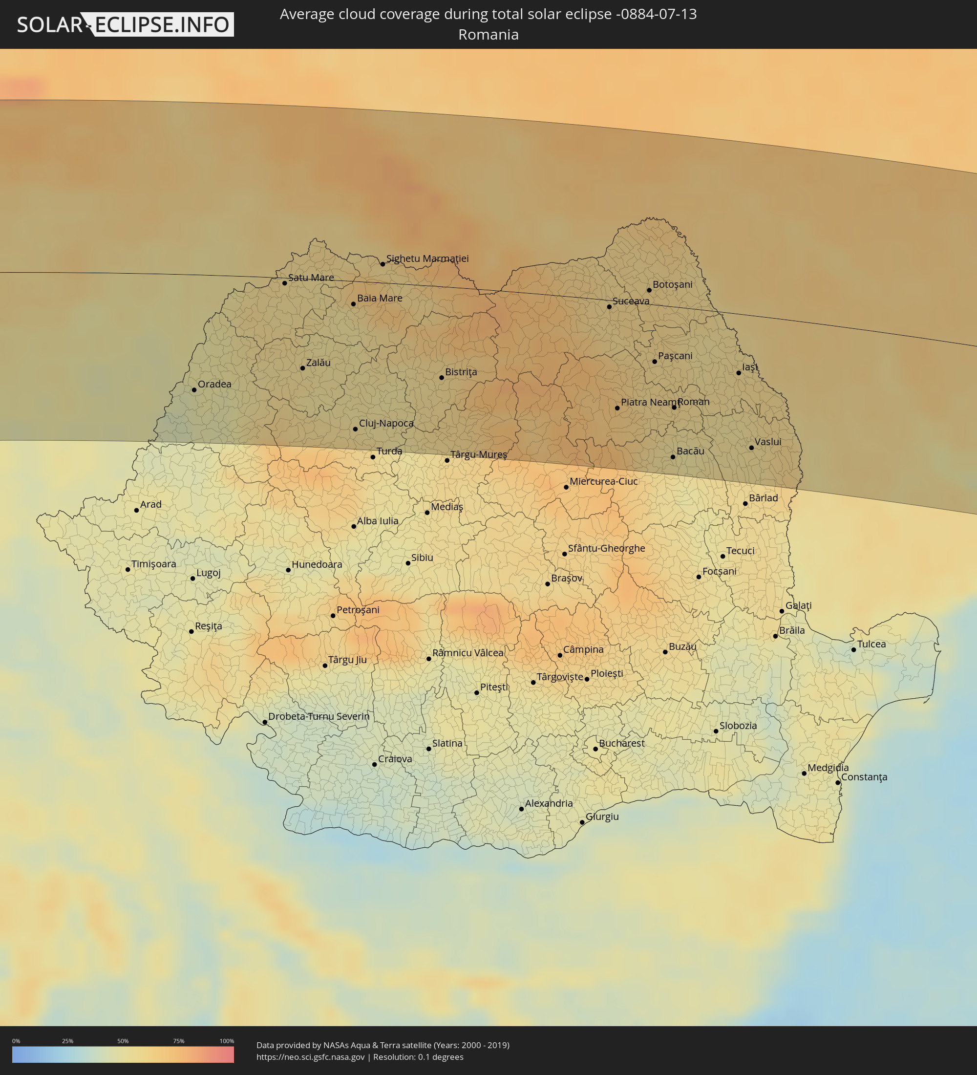 Romania
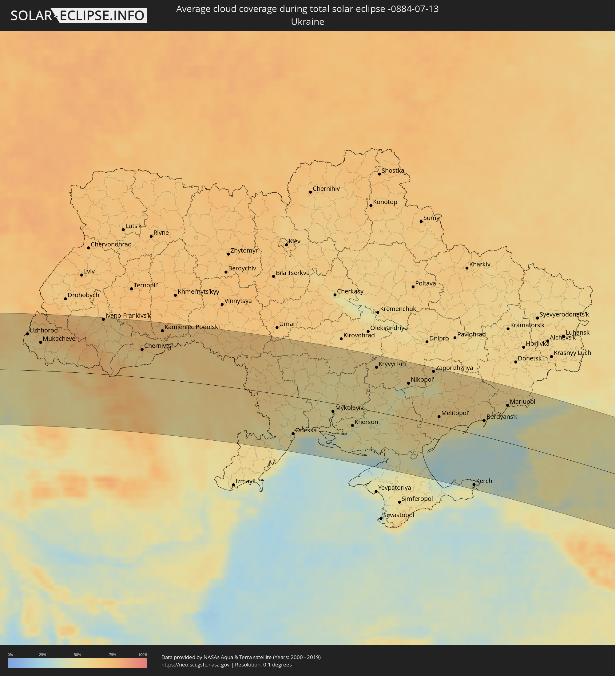 Ukraine
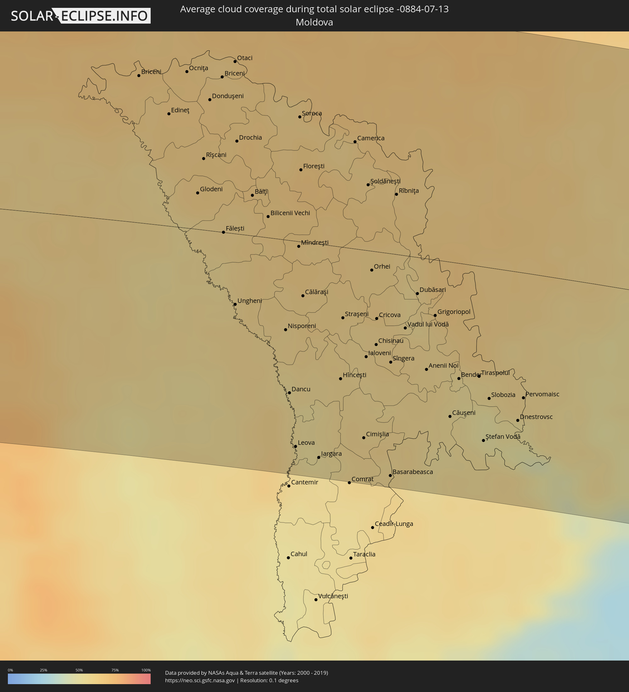 Moldova
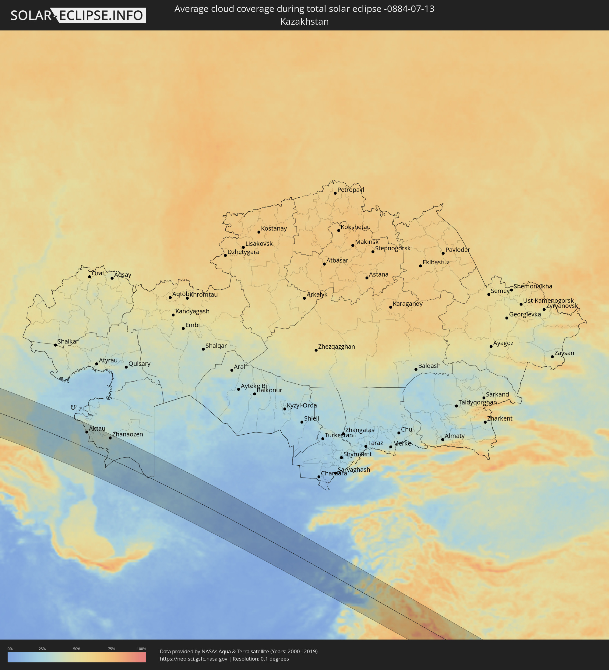 Kazakhstan
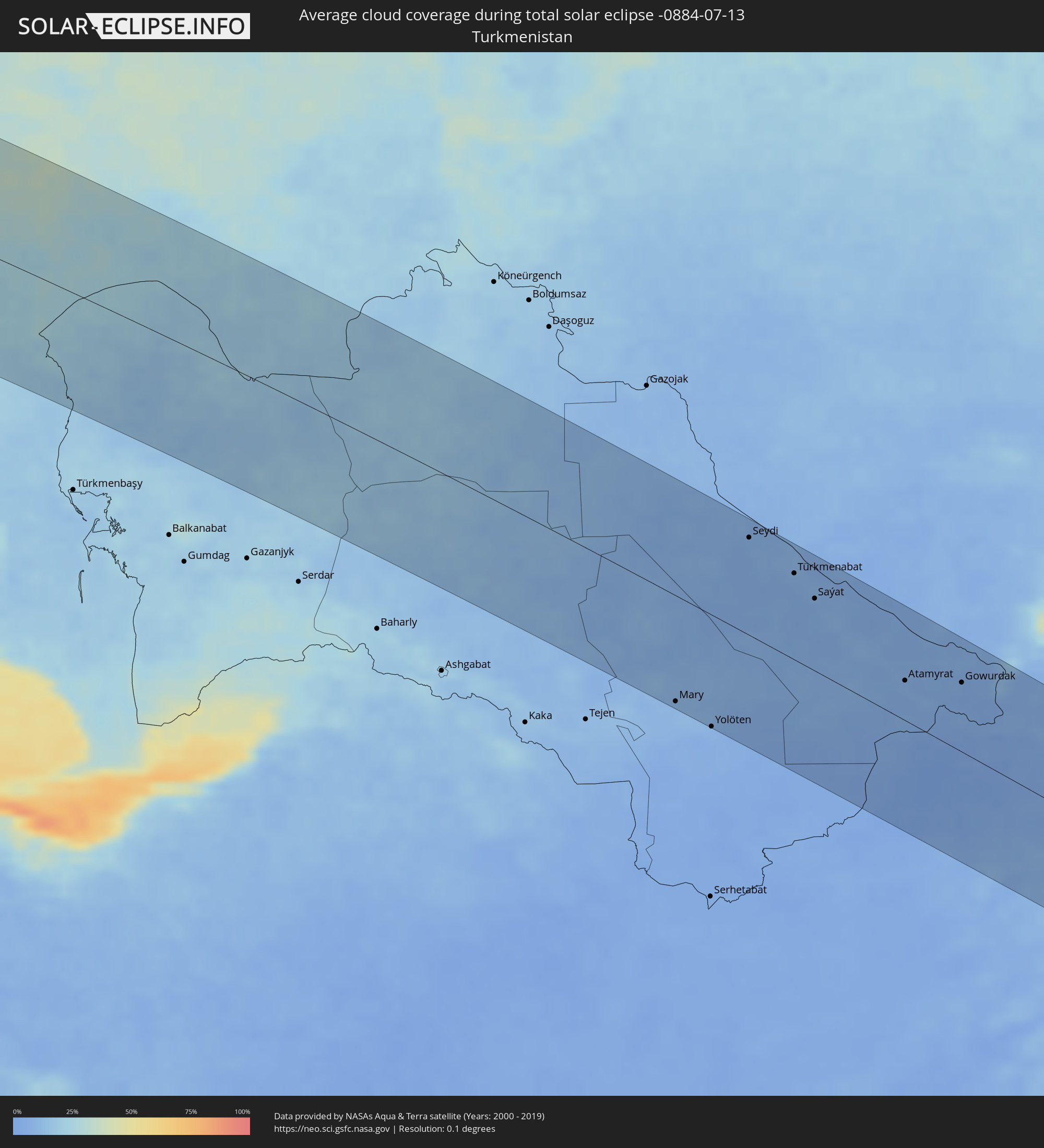 Turkmenistan
 Uzbekistan
 Afghanistan
 Pakistan
 Tajikistan
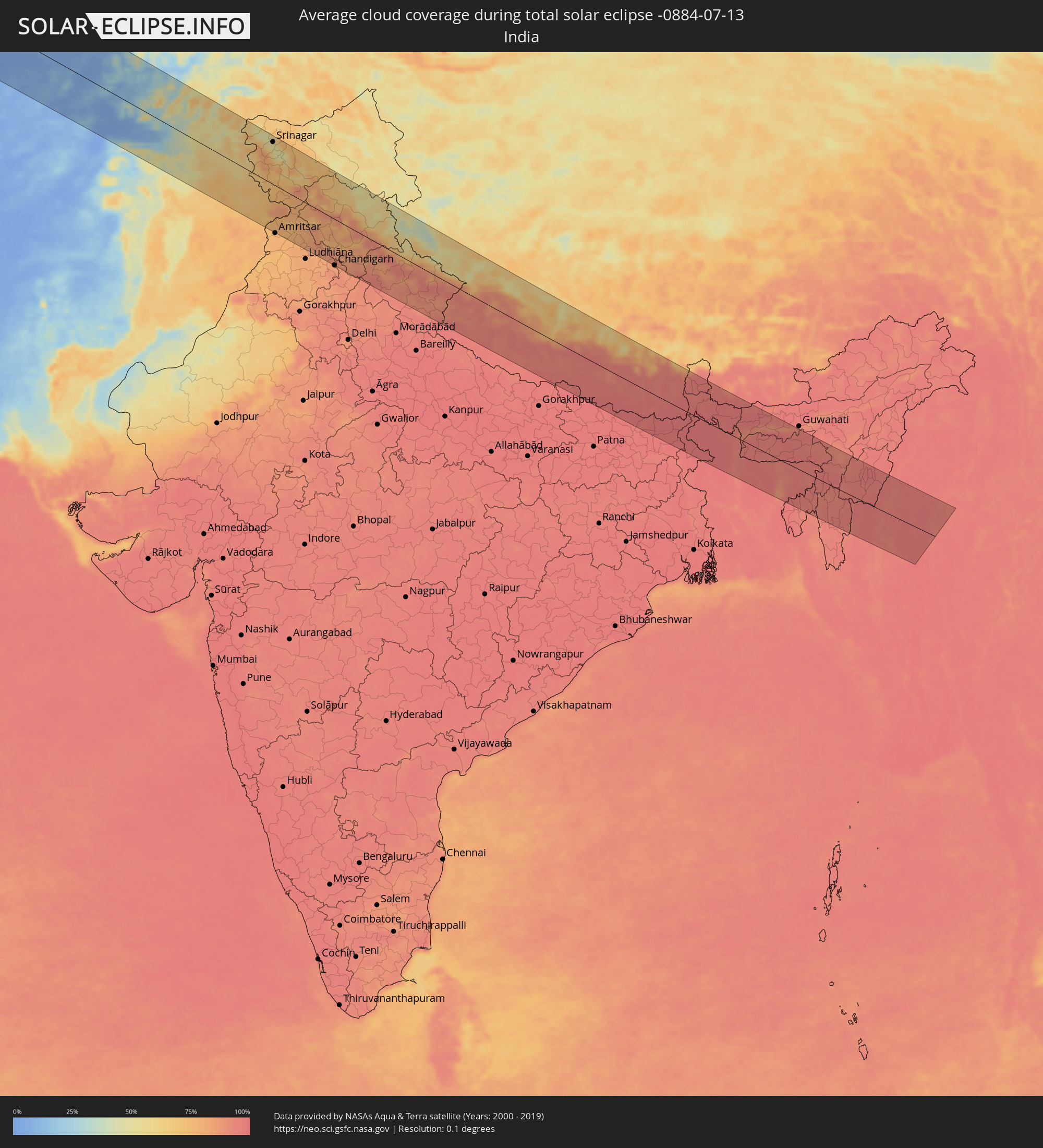 India
India
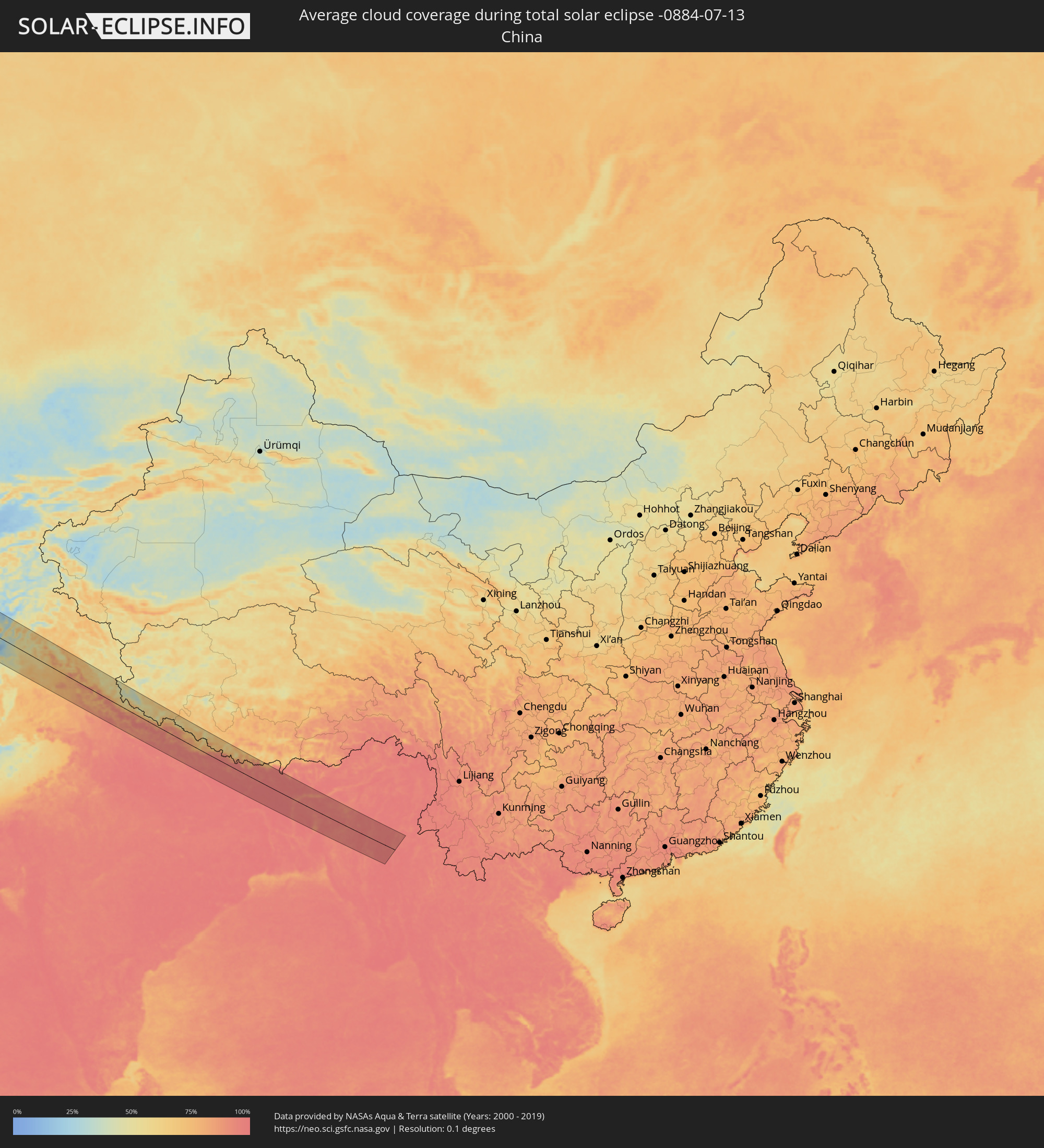 China
China
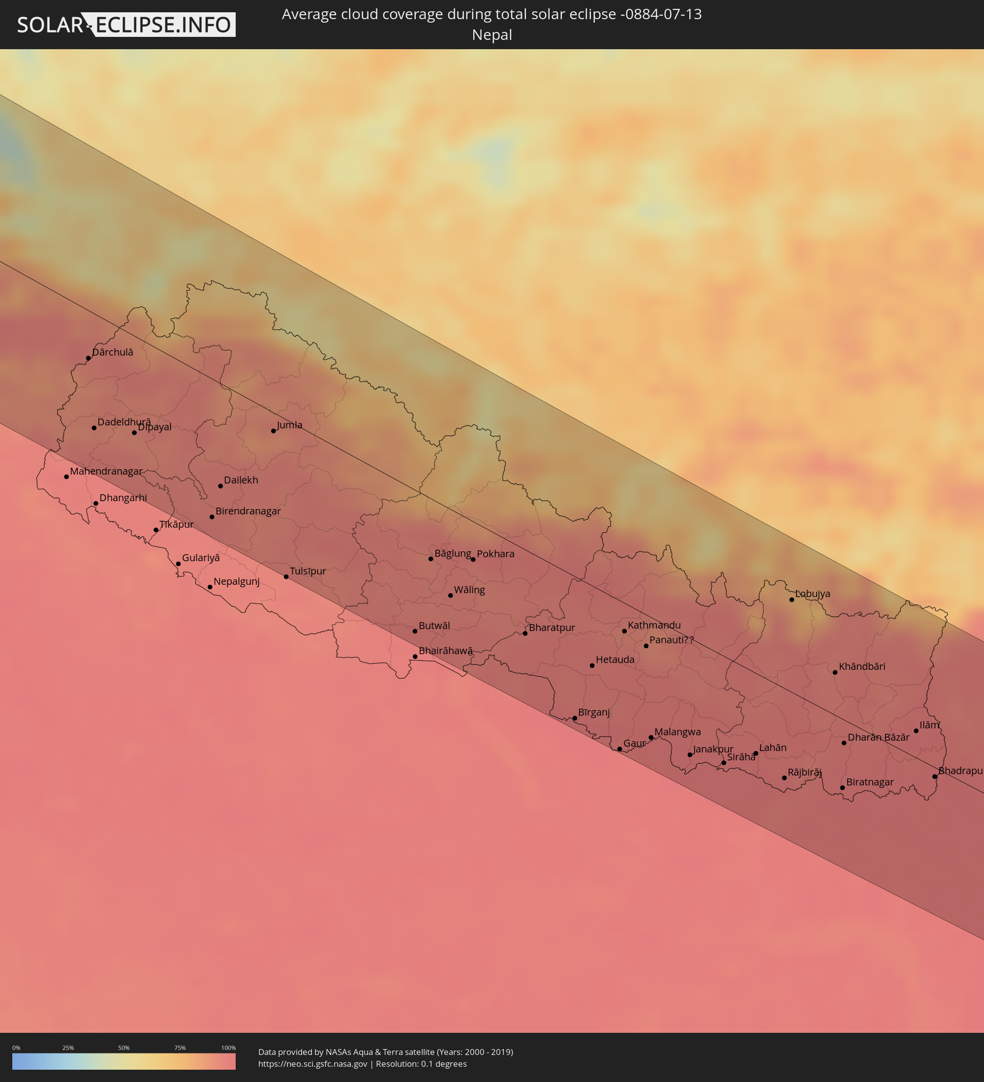 Nepal
Nepal
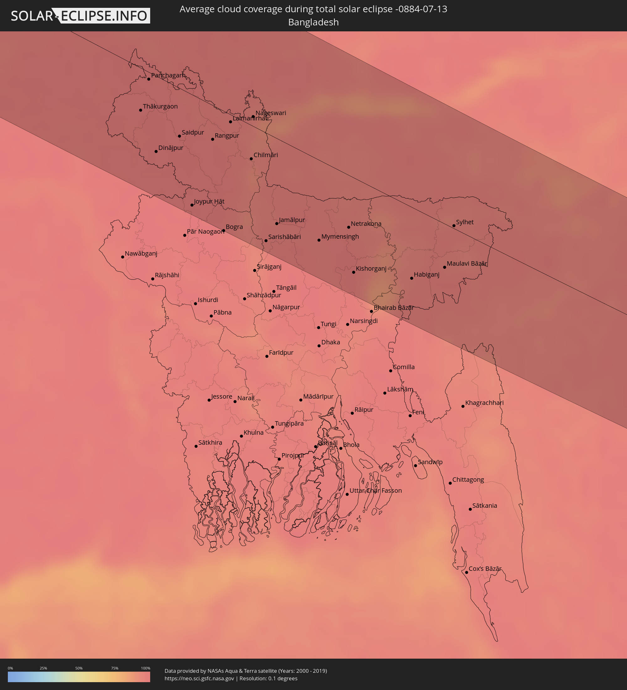 Bangladesh
 Bhutan
 Myanmar
Cities inside the path of the eclipse
The following table shows all locations with a population of more than 5,000 inside the eclipse path. Cities which have more than 100,000 inhabitants are marked bold. A click at the locations opens a detailed map.
| City | Type | Eclipse duration | Local time of max. eclipse | Distance to central line | Ø Cloud coverage |
|
Arrifes, Azores
|
total | - | 07:36:50 UTC-01:54 | 93 km | 75% |
|
Ponta Delgada, Azores
|
total | - | 07:36:49 UTC-01:54 | 88 km | 66% |
|
Rosto de Cão, Azores
|
total | - | 07:36:51 UTC-01:54 | 89 km | 75% |
|
Rabo de Peixe, Azores
|
total | - | 07:36:58 UTC-01:54 | 91 km | 78% |
|
Vila Franca do Campo, Azores
|
total | - | 07:36:57 UTC-01:54 | 76 km | 67% |
|
Vigo, Galicia
|
total | - | 09:54:18 UTC+00:00 | 123 km | 42% |
|
Pontevedra, Galicia
|
total | - | 09:54:39 UTC+00:00 | 105 km | 42% |
|
Santiago de Compostela, Galicia
|
total | - | 09:55:22 UTC+00:00 | 62 km | 51% |
|
A Coruña, Galicia
|
total | - | 09:56:11 UTC+00:00 | 17 km | 53% |
|
Lugo, Galicia
|
total | - | 09:56:49 UTC+00:00 | 80 km | 47% |
|
Avilés, Asturias
|
total | - | 09:59:42 UTC+00:00 | 73 km | 60% |
|
Oviedo, Asturias
|
total | - | 09:59:34 UTC+00:00 | 96 km | 66% |
|
Gijón, Asturias
|
total | - | 10:00:02 UTC+00:00 | 83 km | 64% |
|
Bordeaux, Nouvelle-Aquitaine
|
total | - | 10:18:15 UTC+00:09 | 81 km | 55% |
|
Limoges, Nouvelle-Aquitaine
|
total | - | 10:22:04 UTC+00:09 | 17 km | 64% |
|
Clermont-Ferrand, Auvergne-Rhône-Alpes
|
total | - | 10:24:53 UTC+00:09 | 61 km | 59% |
|
Saint-Étienne, Auvergne-Rhône-Alpes
|
total | - | 10:26:42 UTC+00:09 | 123 km | 57% |
|
Lyon, Auvergne-Rhône-Alpes
|
total | - | 10:27:42 UTC+00:09 | 97 km | 50% |
|
Dijon, Bourgogne-Franche-Comté
|
total | - | 10:29:14 UTC+00:09 | 70 km | 67% |
|
Besançon, Bourgogne-Franche-Comté
|
total | - | 10:30:46 UTC+00:09 | 46 km | 60% |
|
Genève, Geneva
|
total | - | 11:20:51 UTC+01:00 | 70 km | 53% |
|
Lausanne, Vaud
|
total | - | 11:21:53 UTC+01:00 | 44 km | 47% |
|
Mulhouse, Grand-Est
|
total | - | 10:33:14 UTC+00:09 | 80 km | 64% |
|
Bern, Bern
|
total | - | 11:23:32 UTC+01:00 | 9 km | 59% |
|
Basel, Basel-City
|
total | - | 11:24:08 UTC+01:00 | 56 km | 62% |
|
Freiburg, Baden-Württemberg
|
total | - | 11:24:52 UTC+01:00 | 100 km | 67% |
|
Domodossola, Piedmont
|
total | - | 11:24:24 UTC+01:00 | 112 km | 58% |
|
Luzern, Lucerne
|
total | - | 11:25:01 UTC+01:00 | 10 km | 62% |
|
Villingen-Schwenningen, Baden-Württemberg
|
total | - | 11:25:57 UTC+01:00 | 98 km | 71% |
|
Zürich, Zurich
|
total | - | 11:25:37 UTC+01:00 | 21 km | 60% |
|
Winterthur, Zurich
|
total | - | 11:25:59 UTC+01:00 | 34 km | 63% |
|
Luino, Lombardy
|
total | - | 11:25:06 UTC+01:00 | 131 km | 47% |
|
Konstanz, Baden-Württemberg
|
total | - | 11:26:49 UTC+01:00 | 45 km | 57% |
|
Sankt Gallen, Saint Gallen
|
total | - | 11:27:01 UTC+01:00 | 17 km | 67% |
|
Schaan, Schaan
|
total | - | 11:27:05 UTC+01:00 | 13 km | 65% |
|
Gamprin, Gamprin
|
total | - | 11:27:07 UTC+01:00 | 7 km | 65% |
|
Eschen, Eschen
|
total | - | 11:27:08 UTC+01:00 | 9 km | 65% |
|
Ruggell, Ruggell
|
total | - | 11:27:09 UTC+01:00 | 6 km | 65% |
|
Triesenberg, Triesenberg
|
total | - | 11:27:07 UTC+01:00 | 19 km | 64% |
|
Mauren, Mauren
|
total | - | 11:27:11 UTC+01:00 | 8 km | 65% |
|
Planken, Planken
|
total | - | 11:27:10 UTC+01:00 | 12 km | 65% |
|
Schellenberg, Schellenberg
|
total | - | 11:27:11 UTC+01:00 | 7 km | 65% |
|
Morbegno, Lombardy
|
total | - | 11:26:37 UTC+01:00 | 127 km | 70% |
|
Sondrio, Lombardy
|
total | - | 11:27:09 UTC+01:00 | 127 km | 60% |
|
Ulm, Baden-Württemberg
|
total | - | 11:28:34 UTC+01:00 | 116 km | 72% |
|
Kempten (Allgäu), Bavaria
|
total | - | 11:28:44 UTC+01:00 | 39 km | 64% |
|
Augsburg, Bavaria
|
total | - | 11:30:01 UTC+01:00 | 104 km | 74% |
|
Merano, Trentino-Alto Adige
|
total | - | 11:29:38 UTC+01:00 | 87 km | 62% |
|
Bolzano, Trentino-Alto Adige
|
total | - | 11:29:52 UTC+01:00 | 108 km | 51% |
|
Innsbruck, Tyrol
|
total | - | 11:30:19 UTC+01:00 | 24 km | 68% |
|
Munich, Bavaria
|
total | - | 11:31:02 UTC+01:00 | 71 km | 74% |
|
Bressanone, Trentino-Alto Adige
|
total | - | 11:30:31 UTC+01:00 | 87 km | 65% |
|
Brunico, Trentino-Alto Adige
|
total | - | 11:31:02 UTC+01:00 | 80 km | 69% |
|
Landshut, Bavaria
|
total | - | 11:32:10 UTC+01:00 | 109 km | 75% |
|
Salzburg, Salzburg
|
total | - | 11:33:21 UTC+01:00 | 20 km | 69% |
|
Villach, Carinthia
|
total | - | 11:34:20 UTC+01:00 | 118 km | 62% |
|
Wels, Upper Austria
|
total | - | 11:35:09 UTC+01:00 | 53 km | 74% |
|
Linz, Upper Austria
|
total | - | 11:35:37 UTC+01:00 | 67 km | 70% |
|
Klagenfurt am Wörthersee, Carinthia
|
total | - | 11:35:08 UTC+01:00 | 119 km | 58% |
|
Český Krumlov, Jihočeský
|
total | - | 11:35:49 UTC+01:00 | 123 km | 76% |
|
Prevalje, Prevalje
|
total | - | 11:36:12 UTC+01:00 | 132 km | 69% |
|
Radlje ob Dravi, Radlje ob Dravi
|
total | - | 11:36:46 UTC+01:00 | 127 km | 65% |
|
Graz, Styria
|
total | - | 11:37:17 UTC+01:00 | 78 km | 64% |
|
Šentilj v Slov. Goricah, Šentilj
|
total | - | 11:37:32 UTC+01:00 | 121 km | 51% |
|
Benedikt, Benedikt
|
total | - | 11:37:57 UTC+01:00 | 131 km | 52% |
|
Znojmo, South Moravian
|
total | - | 11:38:41 UTC+01:00 | 118 km | 75% |
|
Grad, Grad
|
total | - | 11:38:22 UTC+01:00 | 111 km | 52% |
|
Murska Sobota, Murska Sobota
|
total | - | 11:38:27 UTC+01:00 | 126 km | 53% |
|
Šalovci, Šalovci
|
total | - | 11:38:43 UTC+01:00 | 109 km | 52% |
|
Vienna, Vienna
|
total | - | 11:39:07 UTC+01:00 | 45 km | 66% |
|
Kobilje, Kobilje
|
total | - | 11:38:52 UTC+01:00 | 125 km | 52% |
|
Szombathely, Vas
|
total | - | 11:39:22 UTC+01:00 | 65 km | 60% |
|
Mikulov, South Moravian
|
total | - | 11:39:40 UTC+01:00 | 110 km | 69% |
|
Břeclav, South Moravian
|
total | - | 11:40:04 UTC+01:00 | 104 km | 65% |
|
Bratislava, Bratislavský
|
total | - | 11:40:21 UTC+01:00 | 35 km | 59% |
|
Kyjov, South Moravian
|
total | - | 11:40:30 UTC+01:00 | 131 km | 69% |
|
Hodonín, South Moravian
|
total | - | 11:40:29 UTC+01:00 | 113 km | 66% |
|
Veselí nad Moravou, South Moravian
|
total | - | 11:40:55 UTC+01:00 | 124 km | 68% |
|
Trnava, Trnavský
|
total | - | 11:41:12 UTC+01:00 | 59 km | 65% |
|
Győr, Győr-Moson-Sopron
|
total | - | 11:41:12 UTC+01:00 | 18 km | 58% |
|
Uherský Brod, Zlín
|
total | - | 11:41:22 UTC+01:00 | 131 km | 67% |
|
Trenčín, Trenčiansky
|
total | - | 11:42:01 UTC+01:00 | 115 km | 67% |
|
Nitra, Nitriansky
|
total | - | 11:42:02 UTC+01:00 | 50 km | 60% |
|
Székesfehérvár, Fejér
|
total | - | 11:42:30 UTC+01:00 | 75 km | 52% |
|
Budapest, Budapest
|
total | - | 11:43:38 UTC+01:00 | 42 km | 55% |
|
Banská Bystrica, Banskobystrický
|
total | - | 11:43:51 UTC+01:00 | 96 km | 62% |
|
Kecskemét, Bács-Kiskun
|
total | - | 11:44:46 UTC+01:00 | 108 km | 50% |
|
Poprad, Prešovský
|
total | - | 11:45:46 UTC+01:00 | 132 km | 71% |
|
Miskolc, Borsod-Abaúj-Zemplén
|
total | - | 11:46:38 UTC+01:00 | 25 km | 59% |
|
Prešov, Prešovský
|
total | - | 11:47:19 UTC+01:00 | 125 km | 67% |
|
Košice, Košický
|
total | - | 11:47:23 UTC+01:00 | 94 km | 64% |
|
Debrecen, Hajdú-Bihar
|
total | - | 11:48:09 UTC+01:00 | 37 km | 48% |
|
Nyíregyháza, Szabolcs-Szatmár-Bereg
|
total | - | 11:48:14 UTC+01:00 | 10 km | 52% |
|
Oradea, Bihor
|
total | - | 12:33:06 UTC+01:44 | 91 km | 47% |
|
Satu Mare, Satu Mare
|
total | - | 12:34:38 UTC+01:44 | 5 km | 55% |
|
Baia Mare, Satu Mare
|
total | - | 12:35:53 UTC+01:44 | 18 km | 58% |
|
Cluj-Napoca, Cluj
|
total | - | 12:36:08 UTC+01:44 | 117 km | 58% |
|
Ivano-Frankivs’k, Ivano-Frankivsk
|
total | - | 12:55:08 UTC+02:02 | 128 km | 67% |
|
Chernivtsi, Chernivtsi
|
total | - | 12:57:22 UTC+02:02 | 65 km | 64% |
|
Suceava, Suceava
|
total | - | 12:40:27 UTC+01:44 | 6 km | 59% |
|
Botoşani, Botoşani
|
total | - | 12:41:07 UTC+01:44 | 10 km | 61% |
|
Bacău, Bacău
|
total | - | 12:42:01 UTC+01:44 | 119 km | 55% |
|
Iaşi, Iaşi
|
total | - | 12:42:56 UTC+01:44 | 46 km | 59% |
|
Ungheni, Ungheni
|
total | - | 12:53:51 UTC+01:55 | 40 km | 59% |
|
Bălţi, Bălţi
|
total | - | 12:53:49 UTC+01:55 | 22 km | 62% |
|
Soroca, Raionul Soroca
|
total | - | 12:54:13 UTC+01:55 | 69 km | 61% |
|
Orhei, Orhei
|
total | - | 12:55:30 UTC+01:55 | 11 km | 61% |
|
Chisinau, Chişinău
|
total | - | 12:55:45 UTC+01:55 | 52 km | 60% |
|
Rîbniţa, Stînga Nistrului
|
total | - | 12:55:36 UTC+01:55 | 33 km | 63% |
|
Dubăsari, Teleneşti
|
total | - | 12:56:08 UTC+01:55 | 20 km | 59% |
|
Tiraspolul, Stînga Nistrului
|
total | - | 12:57:08 UTC+01:55 | 62 km | 51% |
|
Odessa, Odessa
|
total | - | 13:06:16 UTC+02:02 | 89 km | 49% |
|
Mykolayiv, Mykolaiv
|
total | - | 13:08:02 UTC+02:02 | 19 km | 48% |
|
Kherson, Kherson
|
total | - | 13:09:16 UTC+02:02 | 44 km | 47% |
|
Kryvyi Rih, Dnipropetrovsk
|
total | - | 13:09:34 UTC+02:02 | 104 km | 58% |
|
Zaporizhzhya, Zaporizhia
|
total | - | 13:12:24 UTC+02:02 | 123 km | 56% |
|
Mariupol, Donetsk
|
total | - | 13:16:33 UTC+02:02 | 87 km | 53% |
|
Taganrog, Rostov Oblast
|
total | - | 13:46:37 UTC+02:30 | 129 km | 43% |
|
Krasnodar, Krasnodarskiy
|
total | - | 13:48:54 UTC+02:30 | 103 km | 39% |
|
Maykop, Adygeya
|
total | - | 13:51:02 UTC+02:30 | 125 km | 52% |
|
Armavir, Krasnodarskiy
|
total | - | 13:52:08 UTC+02:30 | 61 km | 47% |
|
Stavropol’, Stavropol'skiy
|
total | - | 13:53:17 UTC+02:30 | 34 km | 49% |
|
Pyatigorsk, Stavropol'skiy
|
total | - | 13:55:56 UTC+02:30 | 112 km | 50% |
|
Groznyy, Chechnya
|
total | - | 14:00:24 UTC+02:30 | 117 km | 53% |
|
Makhachkala, Dagestan
|
total | - | 14:03:10 UTC+02:30 | 99 km | 38% |
|
Aktau, Mangghystaū
|
total | - | 15:01:46 UTC+03:25 | 86 km | 29% |
|
Yeraliyev, Mangghystaū
|
total | - | 15:02:58 UTC+03:25 | 55 km | 32% |
|
Zhetibay, Mangghystaū
|
total | - | 15:02:51 UTC+03:25 | 110 km | 33% |
|
Zhanaozen, Mangghystaū
|
total | - | 15:04:01 UTC+03:25 | 111 km | 30% |
|
Mary, Mary
|
total | - | 15:48:15 UTC+03:53 | 120 km | 9% |
|
Bayramaly, Mary
|
total | - | 15:48:27 UTC+03:53 | 104 km | 8% |
|
Yolöten, Mary
|
total | - | 15:49:02 UTC+03:53 | 127 km | 7% |
|
Seydi, Mary
|
total | - | 15:46:24 UTC+03:53 | 109 km | 6% |
|
Türkmenabat, Lebap
|
total | - | 15:47:26 UTC+03:53 | 97 km | 7% |
|
Saýat, Lebap
|
total | - | 15:48:03 UTC+03:53 | 81 km | 6% |
|
Atamyrat, Lebap
|
total | - | 15:50:13 UTC+03:53 | 45 km | 5% |
|
Gowurdak, Lebap
|
total | - | 15:50:46 UTC+03:53 | 79 km | 4% |
|
Balkh, Balkh
|
total | - | 15:59:10 UTC+04:00 | 13 km | 4% |
|
Mazār-e Sharīf, Balkh
|
total | - | 15:59:20 UTC+04:00 | 18 km | 3% |
|
Tirmiz, Surxondaryo
|
total | - | 16:26:37 UTC+04:27 | 75 km | 5% |
|
Shahritus, Khatlon
|
total | - | 16:34:20 UTC+04:35 | 116 km | 9% |
|
Baghlān, Baghlan
|
total | - | 16:00:57 UTC+04:00 | 32 km | 6% |
|
Kunduz, Kunduz
|
total | - | 16:00:13 UTC+04:00 | 96 km | 12% |
|
Khanabad, Kunduz
|
total | - | 16:00:25 UTC+04:00 | 103 km | 11% |
|
Kabul, Kabul
|
total | - | 16:03:18 UTC+04:00 | 103 km | 3% |
|
Bāzārak, Panjshir
|
total | - | 16:02:26 UTC+04:00 | 12 km | 8% |
|
Jalālābād, Nangarhar
|
total | - | 16:04:00 UTC+04:00 | 56 km | 7% |
|
Peshawar, Khyber Pakhtunkhwa
|
total | - | 16:33:12 UTC+04:28 | 45 km | 36% |
|
Rawalpindi, Punjab
|
total | - | 16:34:15 UTC+04:28 | 17 km | 61% |
|
Muzaffarābād, Azad Kashmir
|
total | - | 16:33:25 UTC+04:28 | 76 km | 48% |
|
Kotli, Azad Kashmir
|
total | - | 16:34:38 UTC+04:28 | 13 km | 60% |
|
Bhimbar, Azad Kashmir
|
total | - | 16:35:22 UTC+04:28 | 31 km | 71% |
|
Gujrāt, Punjab
|
total | - | 16:35:52 UTC+04:28 | 70 km | 67% |
|
Gujrānwāla, Punjab
|
total | - | 16:36:24 UTC+04:28 | 105 km | 73% |
|
Sialkot, Punjab
|
total | - | 16:36:05 UTC+04:28 | 57 km | 73% |
|
Srinagar, Kashmir
|
total | - | 17:27:09 UTC+05:21 | 110 km | 52% |
|
Jammu, Kashmir
|
total | - | 17:28:51 UTC+05:21 | 18 km | 74% |
|
Jalandhar, Punjab
|
total | - | 17:30:45 UTC+05:21 | 122 km | 82% |
|
Chandigarh, Chandigarh
|
total | - | 17:31:42 UTC+05:21 | 123 km | 86% |
|
Dehra Dūn, Uttarakhand
|
total | - | 17:32:24 UTC+05:21 | 105 km | 94% |
|
Burang, Tibet Autonomous Region
|
total | - | 20:11:37 UTC+08:00 | 38 km | 62% |
|
Butwāl, Western Region
|
total | - | 17:55:45 UTC+05:41 | 109 km | 97% |
|
Pokhara, Western Region
|
total | - | 17:55:08 UTC+05:41 | 30 km | 93% |
|
Bharatpur, Central Region
|
total | - | 17:55:44 UTC+05:41 | 65 km | 97% |
|
Bīrganj, Central Region
|
total | - | 17:56:23 UTC+05:41 | 111 km | 98% |
|
Kathmandu, Central Region
|
total | - | 17:55:39 UTC+05:41 | 22 km | 95% |
|
Janakpur, Central Region
|
total | - | 17:56:36 UTC+05:41 | 91 km | 98% |
|
Biratnagar, Eastern Region
|
total | - | 17:56:43 UTC+05:41 | 54 km | 98% |
|
Dharān Bāzār, Eastern Region
|
total | - | 17:56:21 UTC+05:41 | 18 km | 96% |
|
Shiliguri, West Bengal
|
total | - | 17:36:12 UTC+05:21 | 24 km | 98% |
|
Dinājpur, Rangpur Division
|
total | - | 18:09:22 UTC+05:53 | 73 km | 98% |
|
Saidpur, Rājshāhi
|
total | - | 18:09:11 UTC+05:53 | 46 km | 98% |
|
Samtse, Samchi
|
total | - | 18:13:20 UTC+05:58 | 74 km | 98% |
|
Rangpur, Rangpur Division
|
total | - | 18:09:09 UTC+05:53 | 33 km | 98% |
|
Phuntsholing, Chukha District
|
total | - | 17:35:54 UTC+05:21 | 82 km | 98% |
|
Tsimasham, Chukha District
|
total | - | 18:13:04 UTC+05:58 | 114 km | 97% |
|
Jamālpur, Dhaka
|
total | - | 18:09:47 UTC+05:53 | 83 km | 97% |
|
Mymensingh, Dhaka
|
total | - | 18:09:50 UTC+05:53 | 78 km | 97% |
|
Kishorganj, Dhaka
|
total | - | 18:10:02 UTC+05:53 | 93 km | 98% |
|
Habiganj, Sylhet
|
total | - | 18:09:56 UTC+05:53 | 70 km | 97% |
|
Sylhet, Sylhet
|
total | - | 18:09:21 UTC+05:53 | 3 km | 97% |
|
Aizawl, Mizoram
|
total | - | 17:38:00 UTC+05:21 | 76 km | 94% |
|
Imphal, Manipur
|
total | - | 17:36:42 UTC+05:21 | 87 km | 97% |
|
Mawlaik, Sagain
|
total | - | 18:41:11 UTC+06:24 | 9 km | 94% |
|
Shwebo, Sagain
|
total | - | 18:41:38 UTC+06:24 | 59 km | 97% |