Total solar eclipse of 12/04/-1041
| Day of week: | Sunday |
| Maximum duration of eclipse: | 03m23s |
| Maximum width of eclipse path: | 129 km |
| Saros cycle: | 35 |
| Coverage: | 100% |
| Magnitude: | 1.038 |
| Gamma: | -0.1597 |
Wo kann man die Sonnenfinsternis vom 12/04/-1041 sehen?
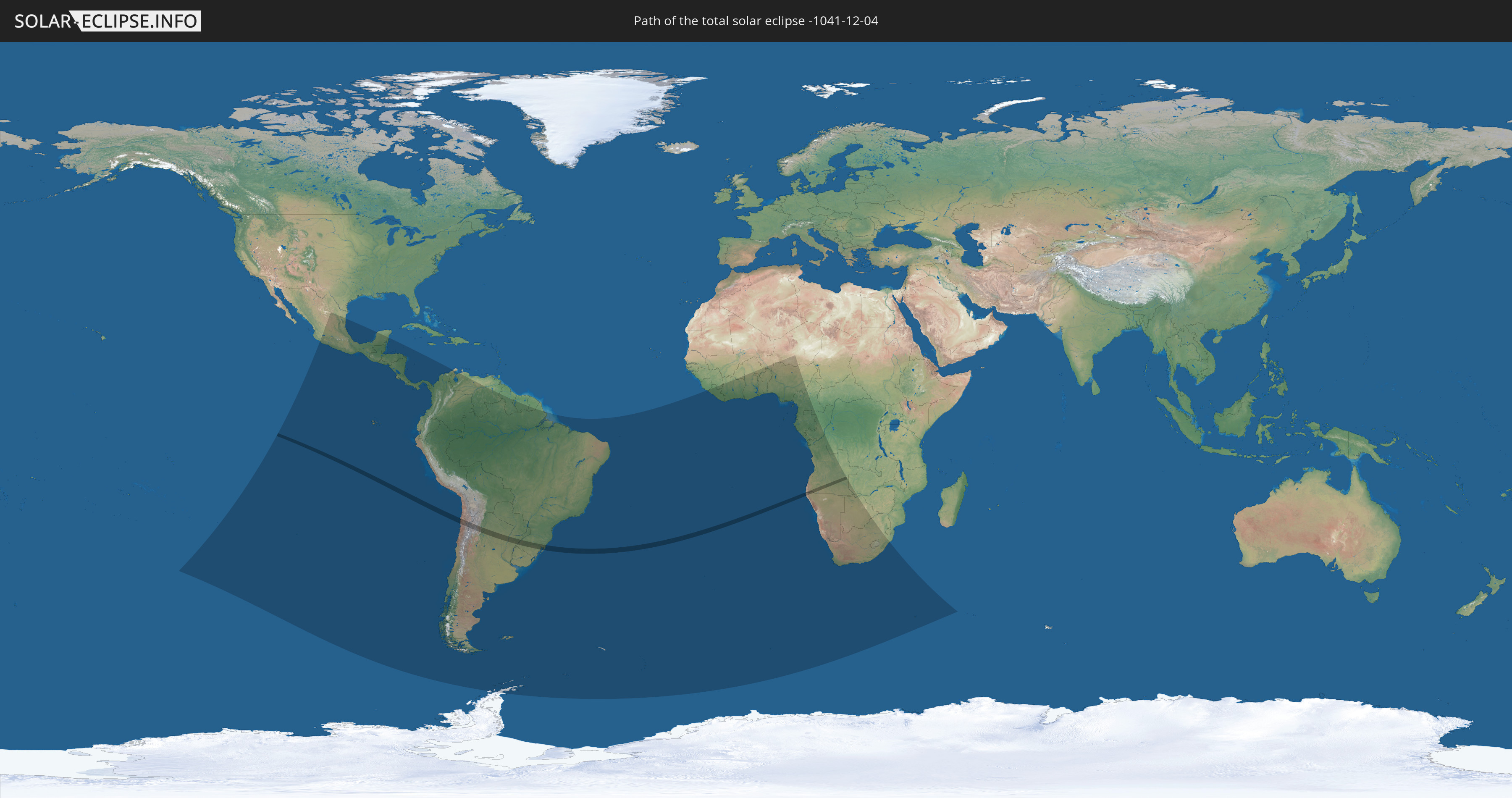
Die Sonnenfinsternis am 12/04/-1041 kann man in 49 Ländern als partielle Sonnenfinsternis beobachten.
Der Finsternispfad verläuft durch 5 Länder. Nur in diesen Ländern ist sie als total Sonnenfinsternis zu sehen.
In den folgenden Ländern ist die Sonnenfinsternis total zu sehen
 Chile
Chile
 Brazil
 Argentina
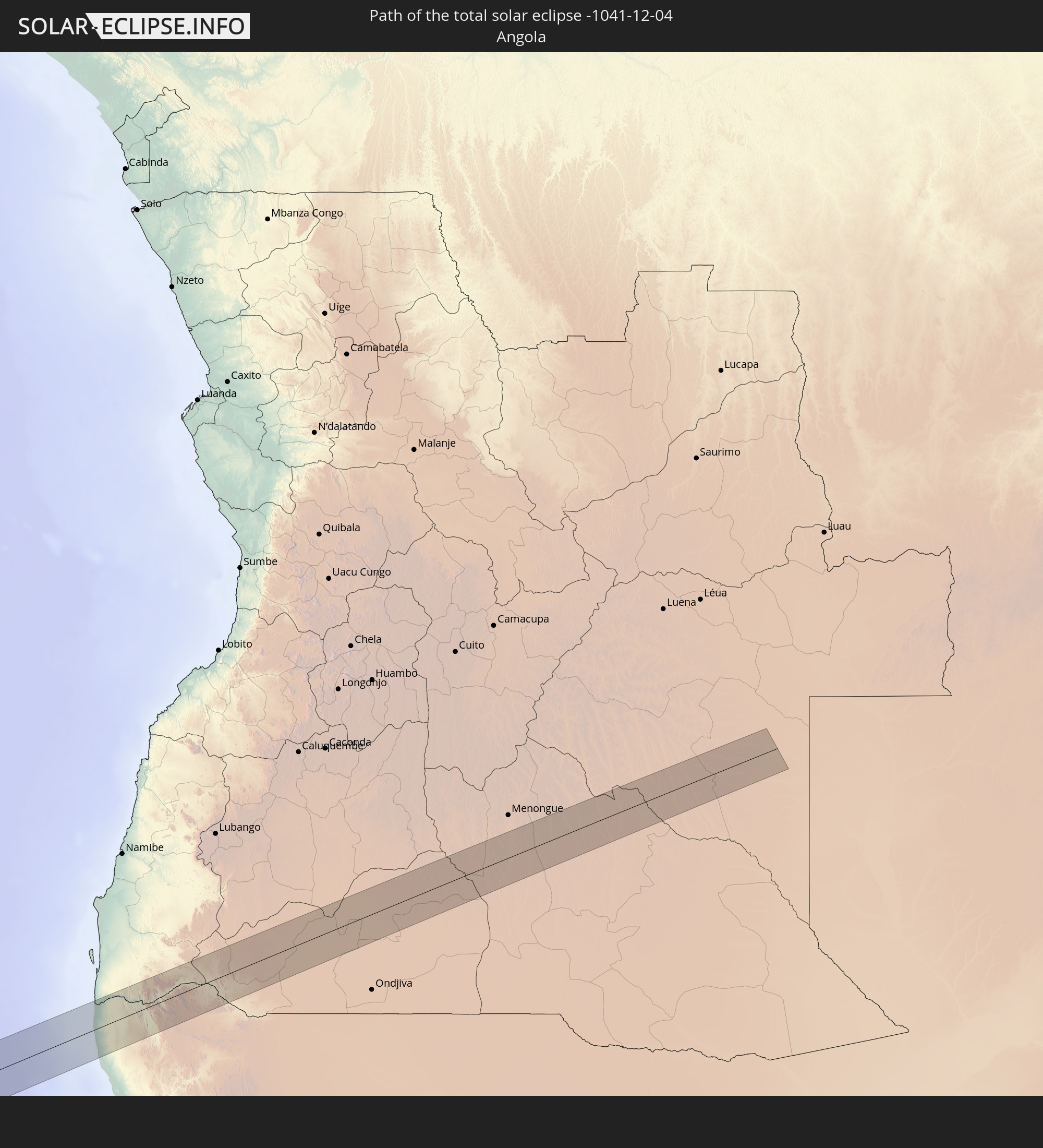 Angola
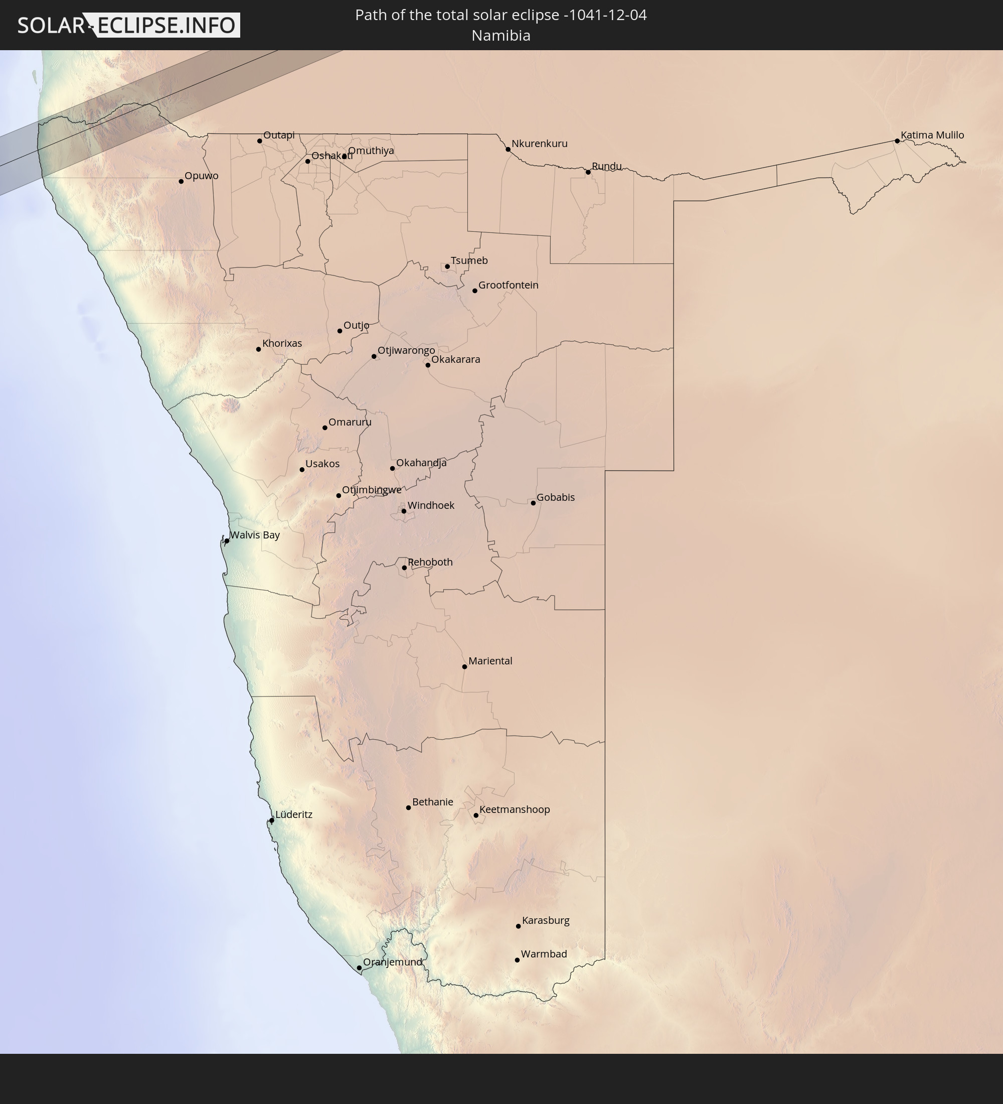 Namibia
In den folgenden Ländern ist die Sonnenfinsternis partiell zu sehen
 Antarctica
 Pitcairn Islands
 Mexico
 Chile
Chile
 Guatemala
 Ecuador
 El Salvador
 Honduras
 Belize
 Nicaragua
 Costa Rica
 Panama
 Colombia
 Peru
Peru
 Brazil
 Argentina
 Venezuela
 Bolivia
 Paraguay
 Falkland Islands
 Guyana
 Uruguay
 Suriname
 French Guiana
 South Georgia and the South Sandwich Islands
 Guinea
 Saint Helena, Ascension and Tristan da Cunha
 Sierra Leone
 Liberia
 Ivory Coast
 Burkina Faso
 Ghana
Ghana
 Togo
Togo
 Niger
Niger
 Benin
Benin
 Nigeria
 Bouvet Island
 Equatorial Guinea
 São Tomé and Príncipe
 Cameroon
 Gabon
Gabon
 Republic of the Congo
 Angola
 Namibia
 Democratic Republic of the Congo
 South Africa
 Botswana
 Zambia
 Lesotho
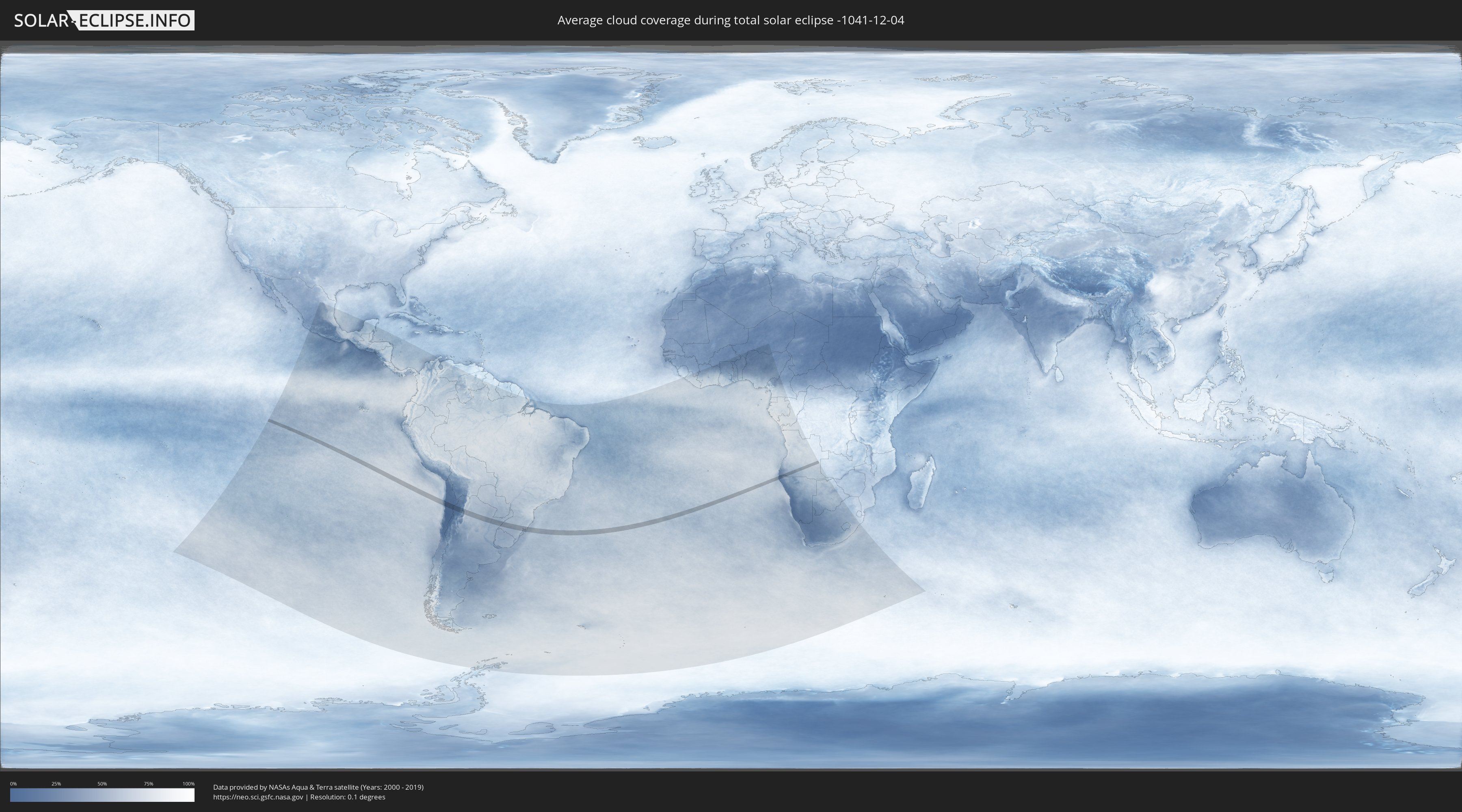
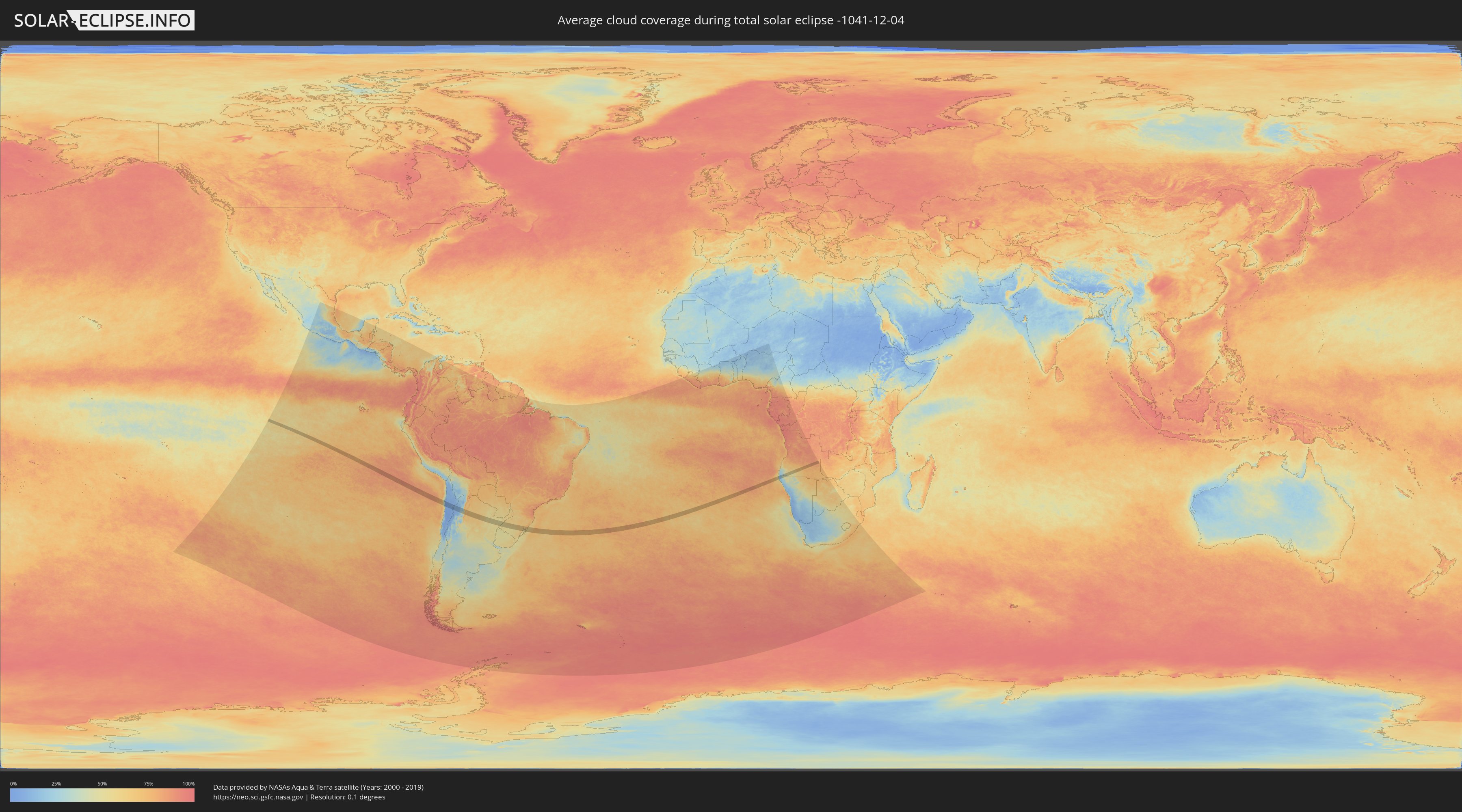
How will be the weather during the total solar eclipse on 12/04/-1041?
Where is the best place to see the total solar eclipse of 12/04/-1041?
The following maps show the average cloud coverage for the day of the total solar eclipse.
With the help of these maps, it is possible to find the place along the eclipse path, which has the best
chance of a cloudless sky.
Nevertheless, you should consider local circumstances and inform about the weather of your chosen
observation site.
The data is provided by NASAs satellites
AQUA and TERRA.
The cloud maps are averaged over a period of 19 years (2000 - 2019).
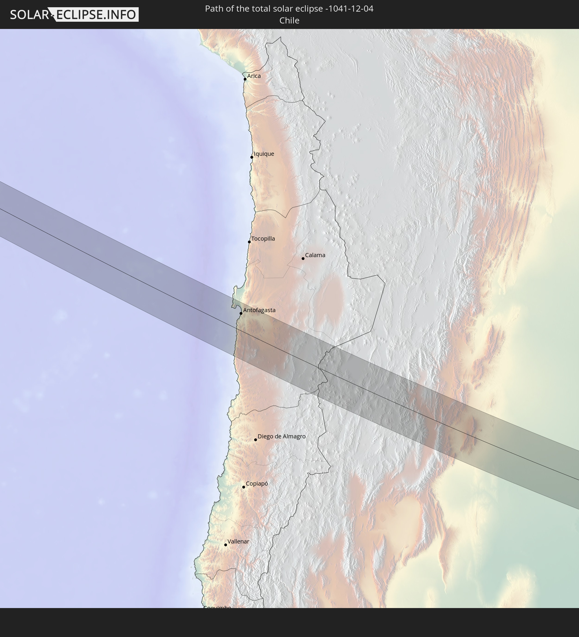
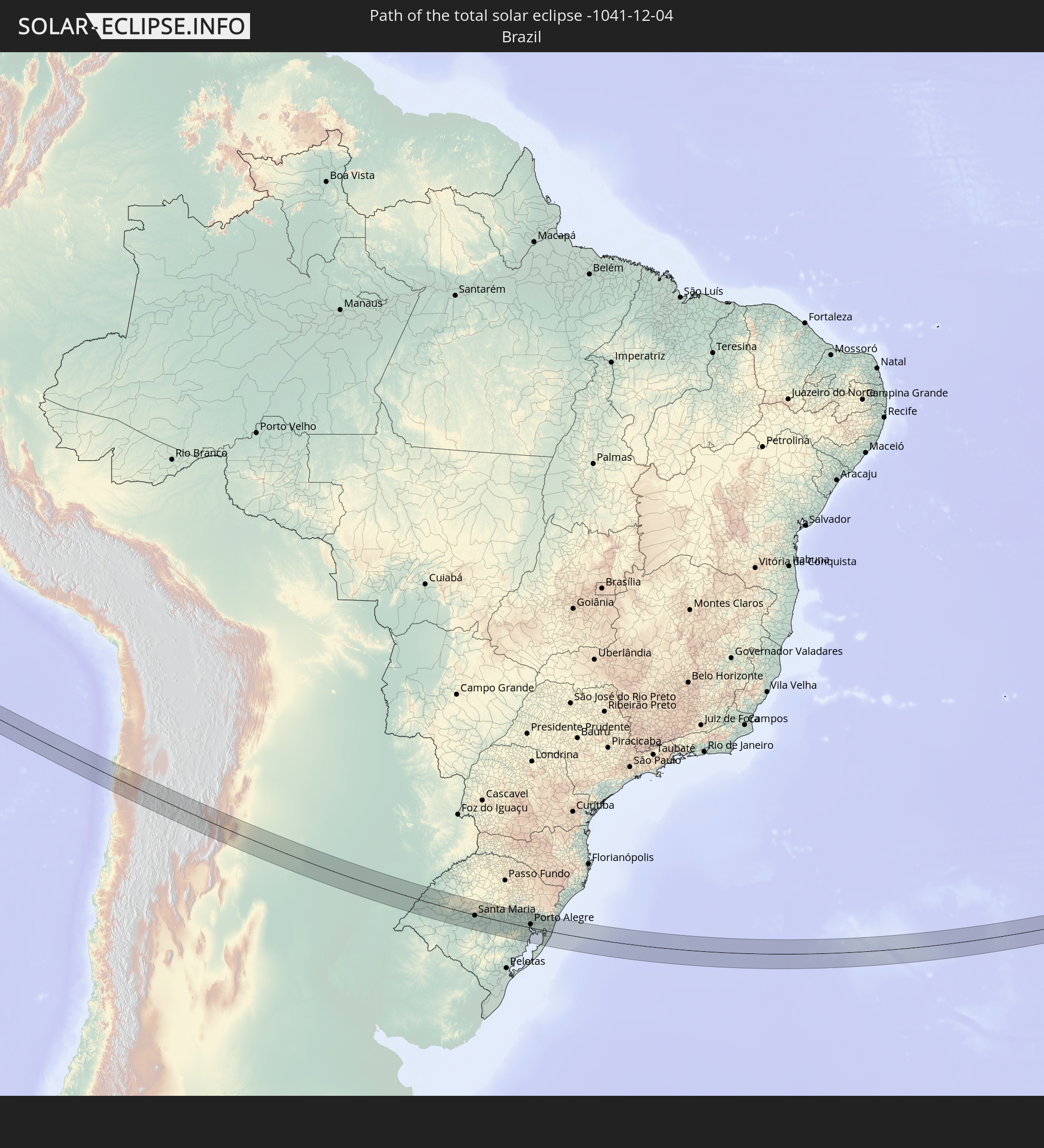
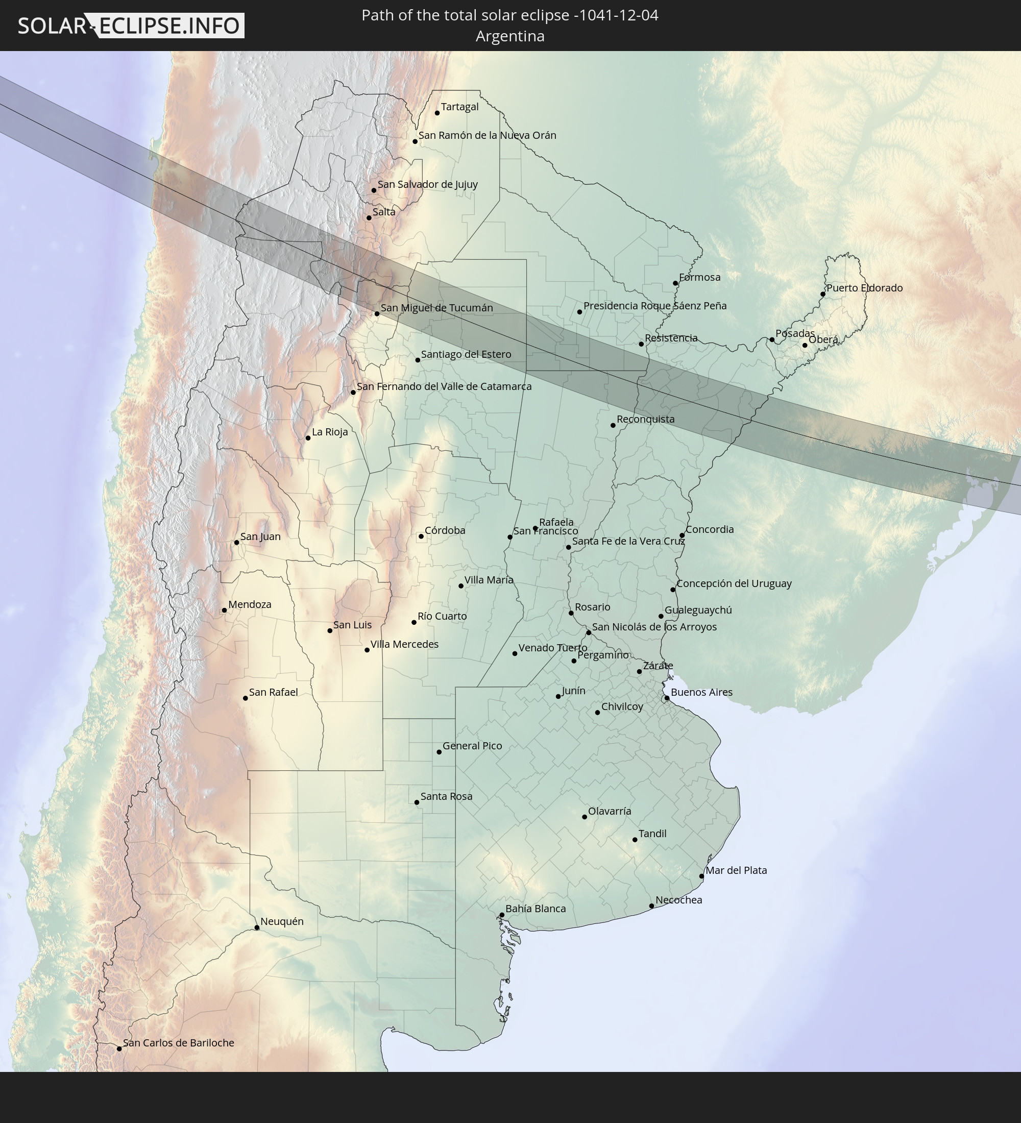
Detailed country maps
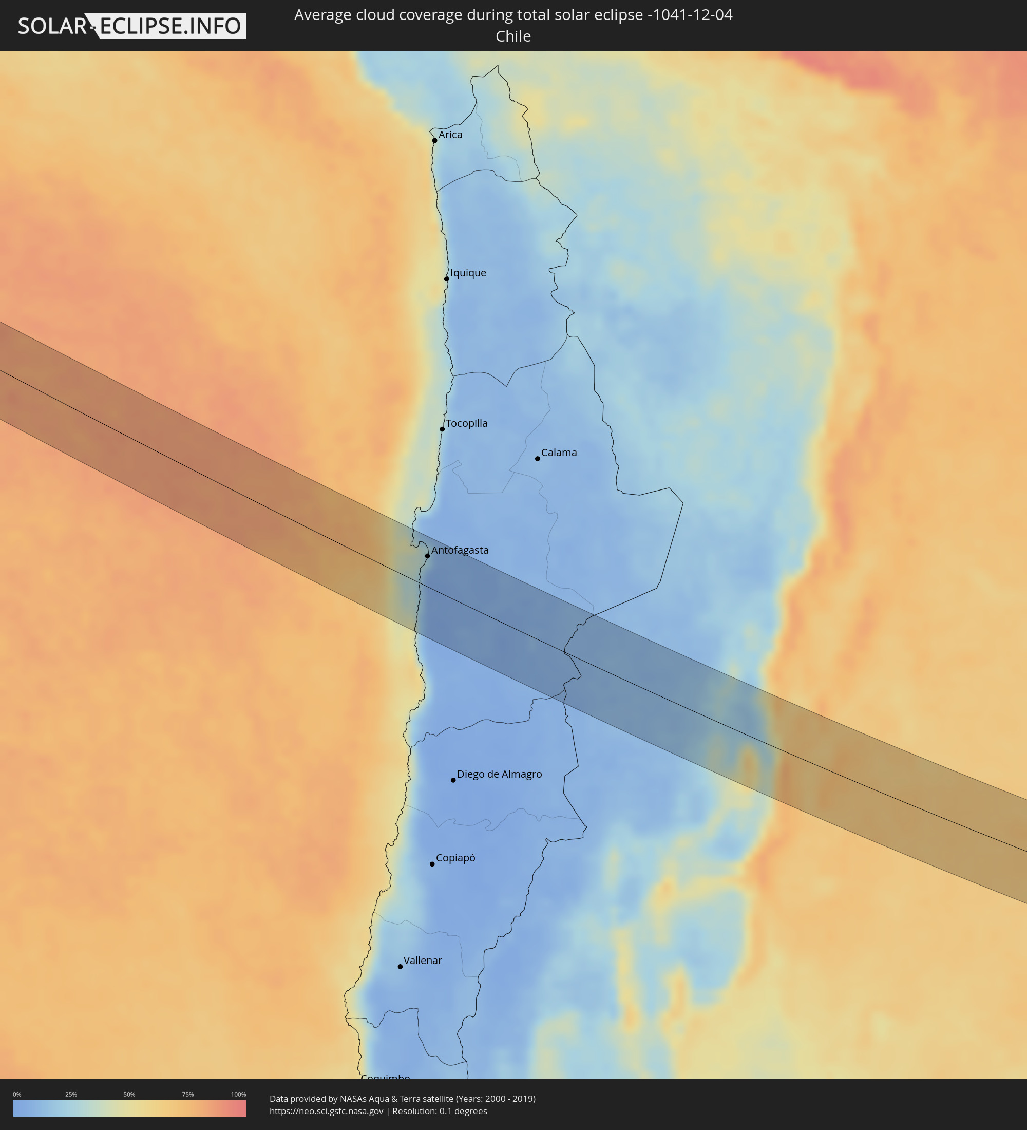 Chile
Chile
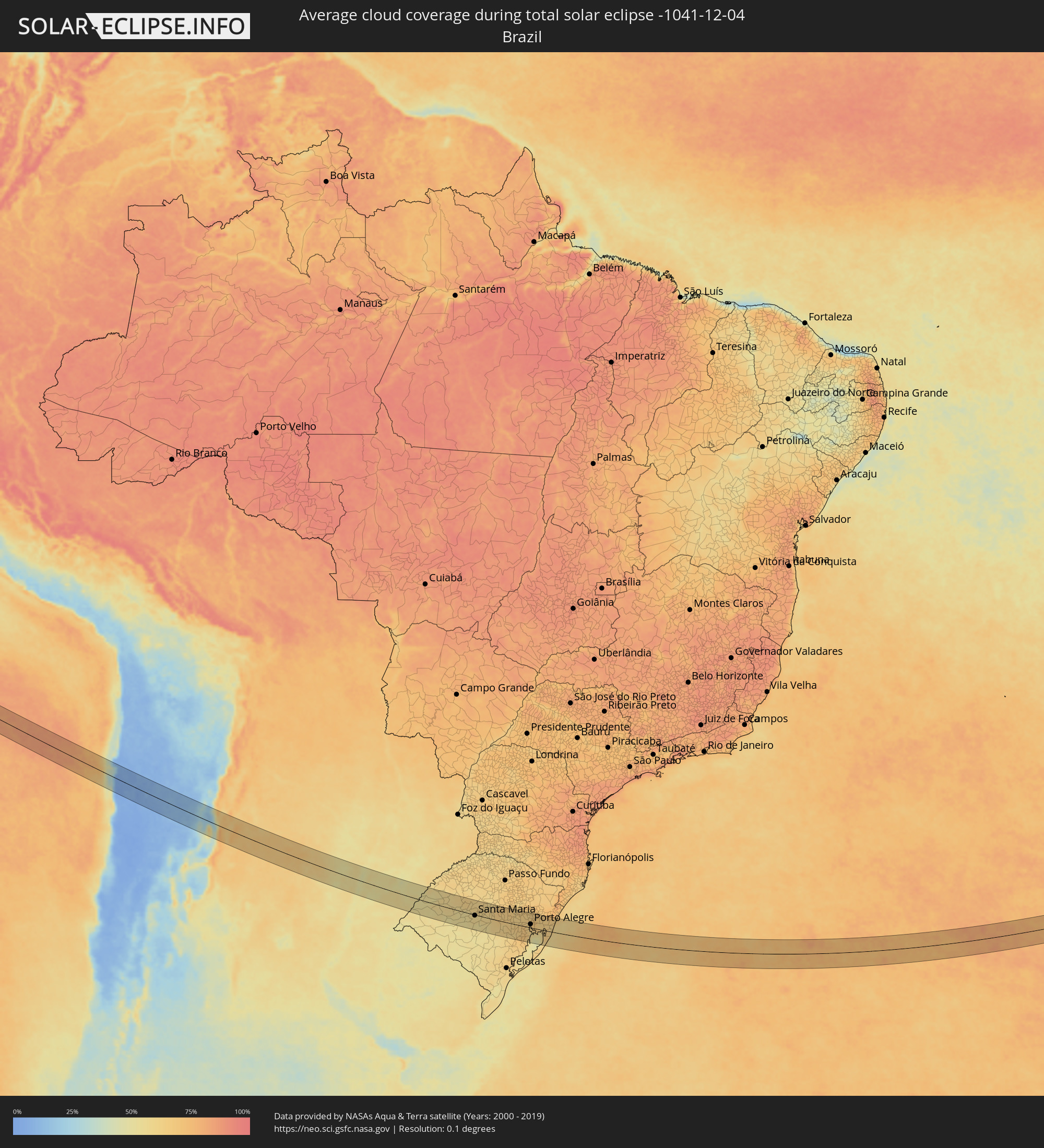 Brazil
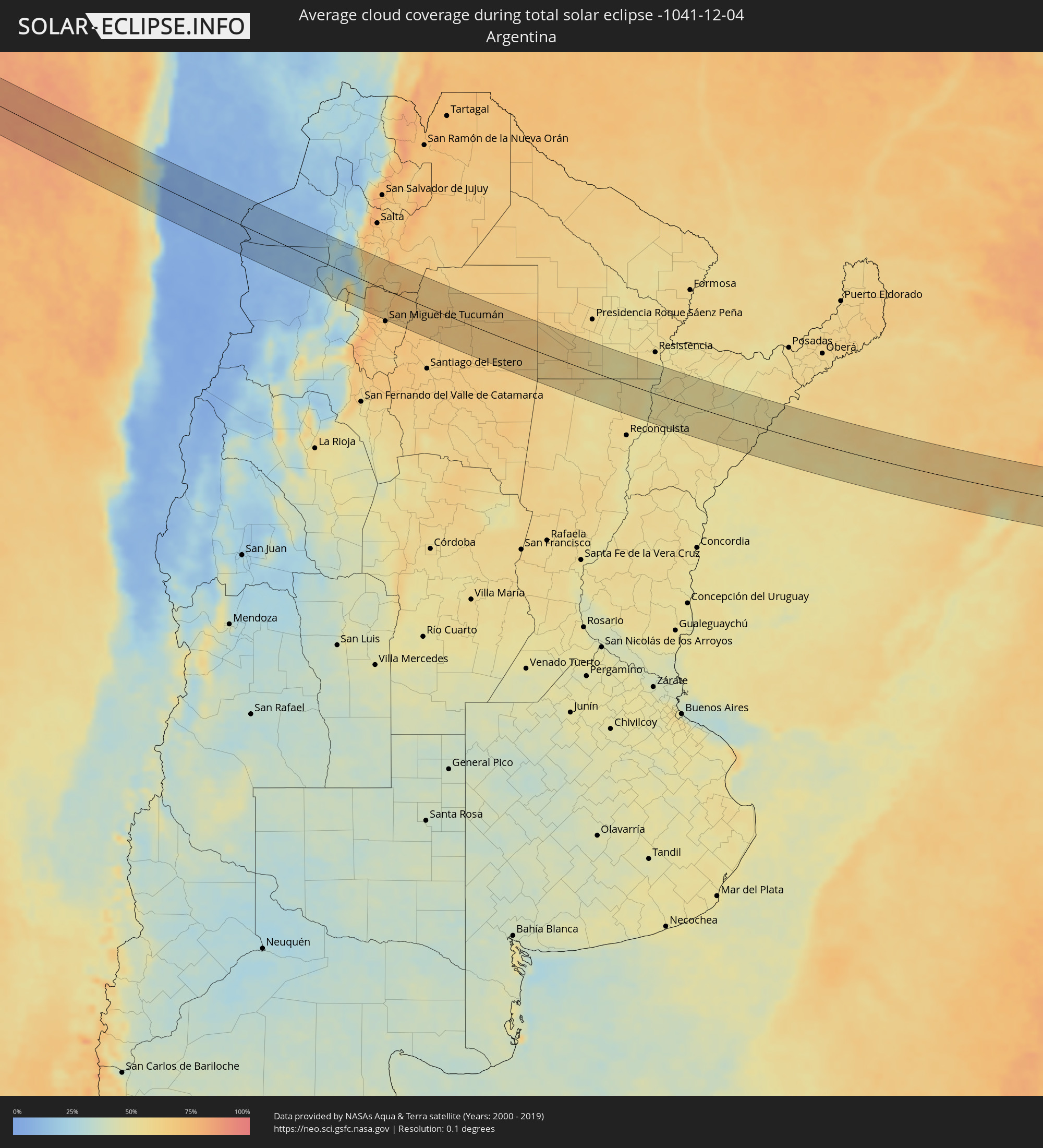 Argentina
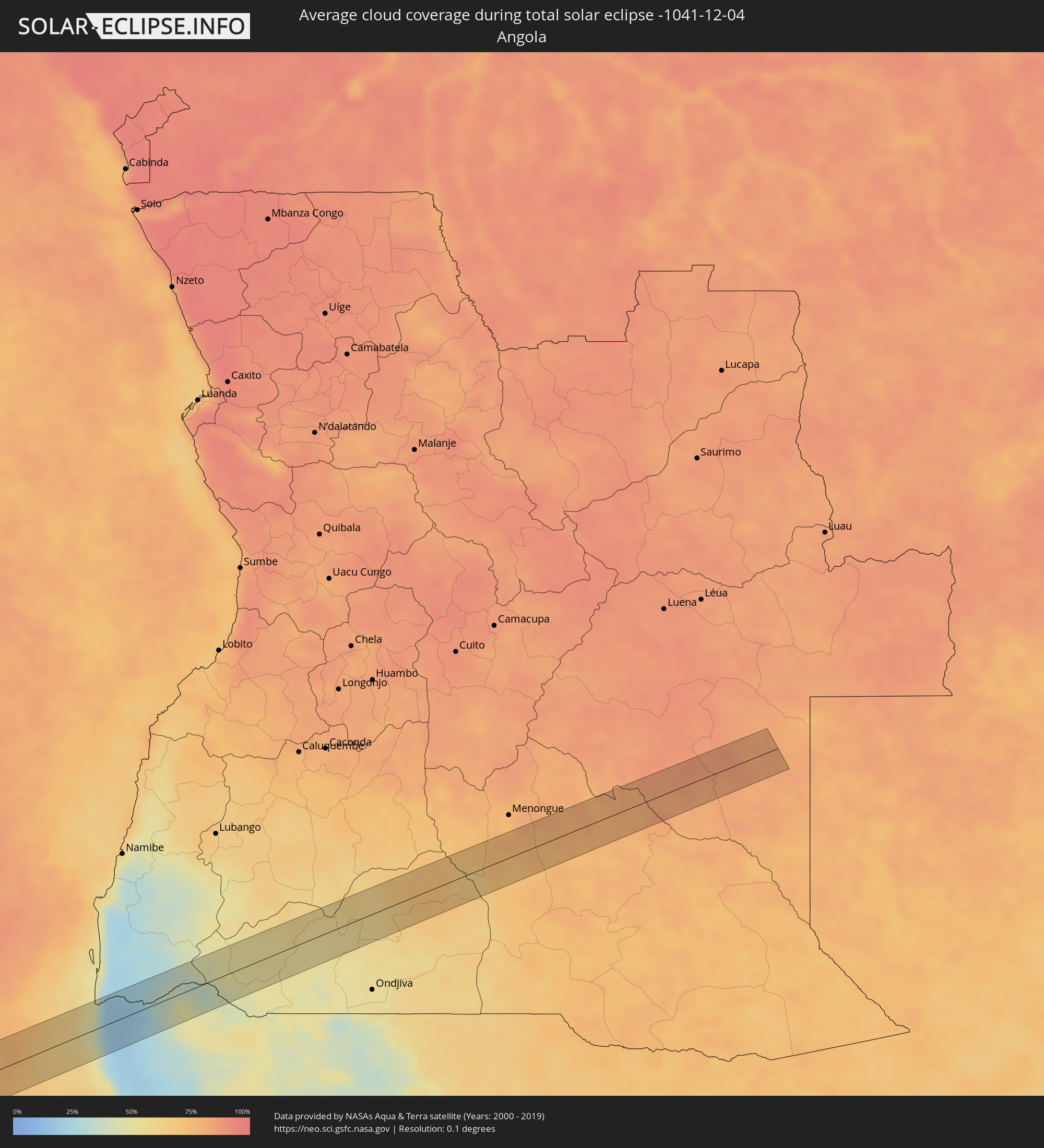 Angola
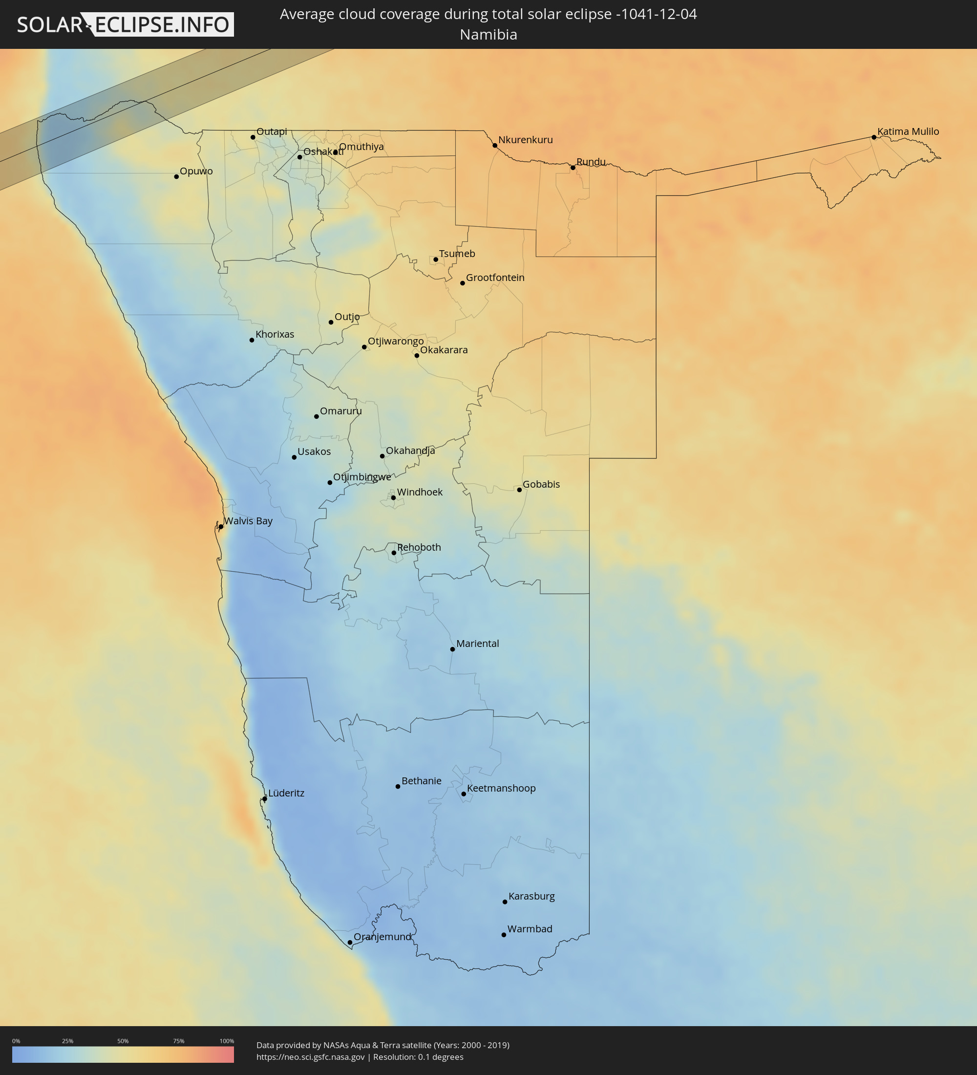 Namibia
Cities inside the path of the eclipse
The following table shows all locations with a population of more than 5,000 inside the eclipse path. Cities which have more than 100,000 inhabitants are marked bold. A click at the locations opens a detailed map.
| City | Type | Eclipse duration | Local time of max. eclipse | Distance to central line | Ø Cloud coverage |
|
Antofagasta, Antofagasta
|
total | - | 09:30:09 UTC-04:42 | 37 km | 11% |
|
Cafayate, Salta Province
|
total | - | 10:07:30 UTC-04:16 | 20 km | 53% |
|
Trancas, Tucumán Province
|
total | - | 10:09:04 UTC-04:16 | 7 km | 63% |
|
Tafí Viejo, Tucumán Province
|
total | - | 10:09:45 UTC-04:16 | 59 km | 68% |
|
Alderetes, Tucumán Province
|
total | - | 10:10:06 UTC-04:16 | 63 km | 66% |
|
Campo Gallo, Santiago del Estero Province
|
total | - | 10:14:36 UTC-04:16 | 48 km | 66% |
|
Quimilí, Santiago del Estero Province
|
total | - | 10:16:45 UTC-04:16 | 45 km | 64% |
|
Hermoso Campo, Chaco Province
|
total | - | 10:19:03 UTC-04:16 | 4 km | 62% |
|
General Pinedo, Chaco Province
|
total | - | 10:18:52 UTC-04:16 | 28 km | 62% |
|
Charata, Chaco Province
|
total | - | 10:18:58 UTC-04:16 | 42 km | 64% |
|
Santa Sylvina, Chaco Province
|
total | - | 10:19:46 UTC-04:16 | 21 km | 62% |
|
Las Breñas, Chaco Province
|
total | - | 10:19:04 UTC-04:16 | 59 km | 62% |
|
Coronel Du Graty, Chaco Province
|
total | - | 10:20:05 UTC-04:16 | 3 km | 62% |
|
Villa Ángela, Chaco Province
|
total | - | 10:20:25 UTC-04:16 | 21 km | 59% |
|
San Bernardo, Chaco Province
|
total | - | 10:20:07 UTC-04:16 | 51 km | 57% |
|
Villa Berthet, Chaco Province
|
total | - | 10:20:48 UTC-04:16 | 60 km | 55% |
|
Villa Ocampo, Santa Fe Province
|
total | - | 10:24:28 UTC-04:16 | 30 km | 54% |
|
Las Toscas, Santa Fe Province
|
total | - | 10:24:33 UTC-04:16 | 13 km | 52% |
|
San Lorenzo, Corrientes Province
|
total | - | 10:25:28 UTC-04:16 | 26 km | 53% |
|
Saladas, Corrientes Province
|
total | - | 10:25:55 UTC-04:16 | 17 km | 52% |
|
Mburucuyá, Corrientes Province
|
total | - | 10:26:38 UTC-04:16 | 52 km | 52% |
|
Santa Rosa, Corrientes Province
|
total | - | 10:27:06 UTC-04:16 | 32 km | 51% |
|
Mercedes, Corrientes Province
|
total | - | 10:28:06 UTC-04:16 | 64 km | 56% |
|
La Cruz, Corrientes Province
|
total | - | 10:31:27 UTC-04:16 | 22 km | 52% |
|
Itaqui, Rio Grande do Sul
|
total | - | 11:41:57 UTC-03:06 | 14 km | 52% |
|
Alvear, Corrientes Province
|
total | - | 10:31:36 UTC-04:16 | 11 km | 52% |
|
Santo Tomé, Corrientes Province
|
total | - | 10:32:20 UTC-04:16 | 61 km | 57% |
|
São Borja, Rio Grande do Sul
|
total | - | 11:42:51 UTC-03:06 | 51 km | 57% |
|
Alegrete, Rio Grande do Sul
|
total | - | 11:44:20 UTC-03:06 | 64 km | 54% |
|
São Francisco de Assis, Rio Grande do Sul
|
total | - | 11:45:44 UTC-03:06 | 22 km | 52% |
|
Santiago, Rio Grande do Sul
|
total | - | 11:46:04 UTC-03:06 | 24 km | 58% |
|
Cacequi, Rio Grande do Sul
|
total | - | 11:46:44 UTC-03:06 | 50 km | 53% |
|
São Pedro do Sul, Rio Grande do Sul
|
total | - | 11:48:06 UTC-03:06 | 5 km | 55% |
|
Tupanciretã, Rio Grande do Sul
|
total | - | 11:48:31 UTC-03:06 | 61 km | 59% |
|
Santa Maria, Rio Grande do Sul
|
total | - | 11:49:03 UTC-03:06 | 3 km | 57% |
|
Júlio de Castilhos, Rio Grande do Sul
|
total | - | 11:49:01 UTC-03:06 | 49 km | 59% |
|
São Sepé, Rio Grande do Sul
|
total | - | 11:50:00 UTC-03:06 | 49 km | 55% |
|
Cachoeira do Sul, Rio Grande do Sul
|
total | - | 11:51:34 UTC-03:06 | 21 km | 61% |
|
Candelária, Rio Grande do Sul
|
total | - | 11:51:33 UTC-03:06 | 22 km | 64% |
|
Santa Cruz do Sul, Rio Grande do Sul
|
total | - | 11:52:30 UTC-03:06 | 24 km | 64% |
|
Rio Pardo, Rio Grande do Sul
|
total | - | 11:52:48 UTC-03:06 | 4 km | 62% |
|
Venâncio Aires, Rio Grande do Sul
|
total | - | 11:53:00 UTC-03:06 | 41 km | 65% |
|
Butiá, Rio Grande do Sul
|
total | - | 11:53:55 UTC-03:06 | 9 km | 64% |
|
Lajeado, Rio Grande do Sul
|
total | - | 11:53:29 UTC-03:06 | 62 km | 62% |
|
Taquari, Rio Grande do Sul
|
total | - | 11:53:57 UTC-03:06 | 27 km | 62% |
|
Arroio dos Ratos, Rio Grande do Sul
|
total | - | 11:54:28 UTC-03:06 | 0 km | 65% |
|
São Jerônimo, Rio Grande do Sul
|
total | - | 11:54:25 UTC-03:06 | 13 km | 64% |
|
Triunfo, Rio Grande do Sul
|
total | - | 11:54:25 UTC-03:06 | 15 km | 61% |
|
Charqueadas, Rio Grande do Sul
|
total | - | 11:54:39 UTC-03:06 | 15 km | 66% |
|
Montenegro, Rio Grande do Sul
|
total | - | 11:54:54 UTC-03:06 | 48 km | 64% |
|
Tapes, Rio Grande do Sul
|
total | - | 11:55:40 UTC-03:06 | 58 km | 61% |
|
São Sebastião do Caí, Rio Grande do Sul
|
total | - | 11:55:03 UTC-03:06 | 61 km | 61% |
|
Guaíba, Rio Grande do Sul
|
total | - | 11:55:30 UTC-03:06 | 4 km | 62% |
|
Portão, Rio Grande do Sul
|
total | - | 11:55:27 UTC-03:06 | 51 km | 66% |
|
Porto Alegre, Rio Grande do Sul
|
total | - | 11:55:41 UTC-03:06 | 15 km | 68% |
|
Canoas, Rio Grande do Sul
|
total | - | 11:55:44 UTC-03:06 | 28 km | 67% |
|
Esteio, Rio Grande do Sul
|
total | - | 11:55:43 UTC-03:06 | 34 km | 67% |
|
Estância Velha, Rio Grande do Sul
|
total | - | 11:55:36 UTC-03:06 | 58 km | 63% |
|
Ivoti, Rio Grande do Sul
|
total | - | 11:55:35 UTC-03:06 | 64 km | 63% |
|
Sapucaia, Rio Grande do Sul
|
total | - | 11:55:46 UTC-03:06 | 38 km | 68% |
|
São Leopoldo, Rio Grande do Sul
|
total | - | 11:55:44 UTC-03:06 | 46 km | 69% |
|
Novo Hamburgo, Rio Grande do Sul
|
total | - | 11:55:43 UTC-03:06 | 55 km | 66% |
|
Cachoeirinha, Rio Grande do Sul
|
total | - | 11:55:59 UTC-03:06 | 26 km | 70% |
|
Viamão, Rio Grande do Sul
|
total | - | 11:56:14 UTC-03:06 | 14 km | 66% |
|
Sapiranga, Rio Grande do Sul
|
total | - | 11:56:01 UTC-03:06 | 62 km | 65% |
|
Gravataí, Rio Grande do Sul
|
total | - | 11:56:14 UTC-03:06 | 29 km | 68% |
|
Palmares do Sul, Rio Grande do Sul
|
total | - | 11:57:38 UTC-03:06 | 4 km | 65% |
|
Osório, Rio Grande do Sul
|
total | - | 11:58:01 UTC-03:06 | 49 km | 64% |
|
Cidreira, Rio Grande do Sul
|
total | - | 11:58:21 UTC-03:06 | 18 km | 61% |
|
Tramandaí, Rio Grande do Sul
|
total | - | 11:58:25 UTC-03:06 | 41 km | 62% |