Total solar eclipse of 07/31/-1062
| Day of week: | Tuesday |
| Maximum duration of eclipse: | 03m56s |
| Maximum width of eclipse path: | 152 km |
| Saros cycle: | 38 |
| Coverage: | 100% |
| Magnitude: | 1.0452 |
| Gamma: | 0.1509 |
Wo kann man die Sonnenfinsternis vom 07/31/-1062 sehen?
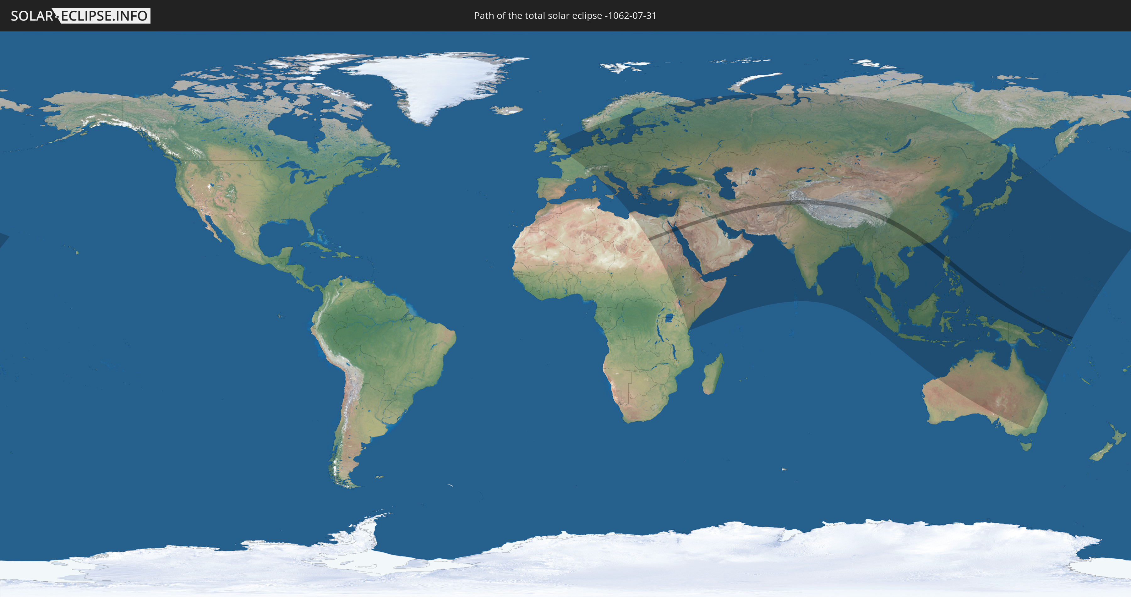
Die Sonnenfinsternis am 07/31/-1062 kann man in 109 Ländern als partielle Sonnenfinsternis beobachten.
Der Finsternispfad verläuft durch 15 Länder. Nur in diesen Ländern ist sie als total Sonnenfinsternis zu sehen.
In den folgenden Ländern ist die Sonnenfinsternis total zu sehen
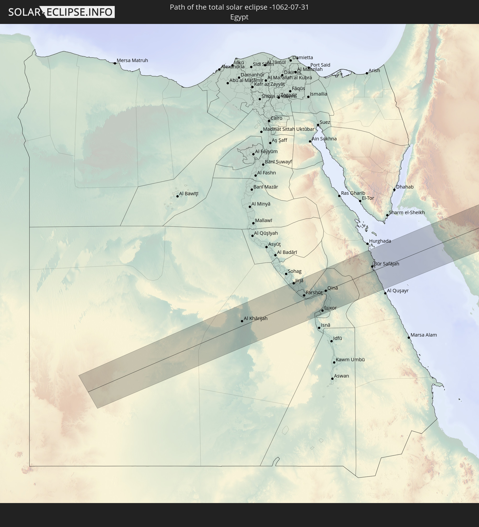 Egypt
Egypt
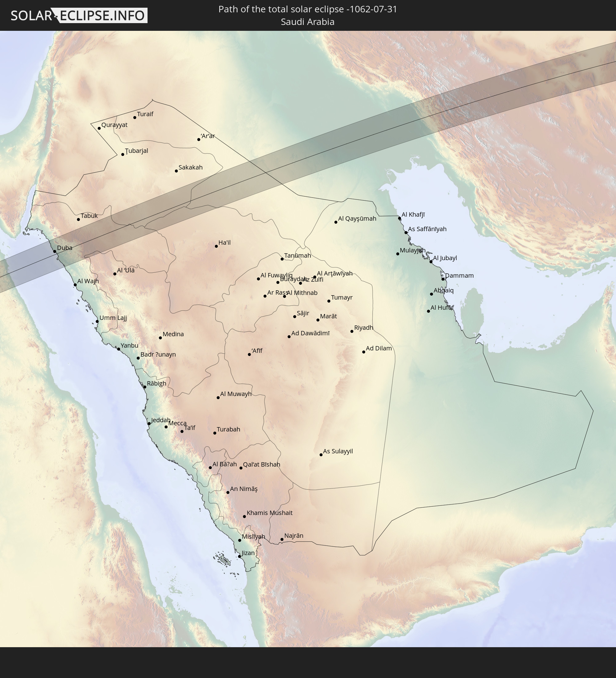 Saudi Arabia
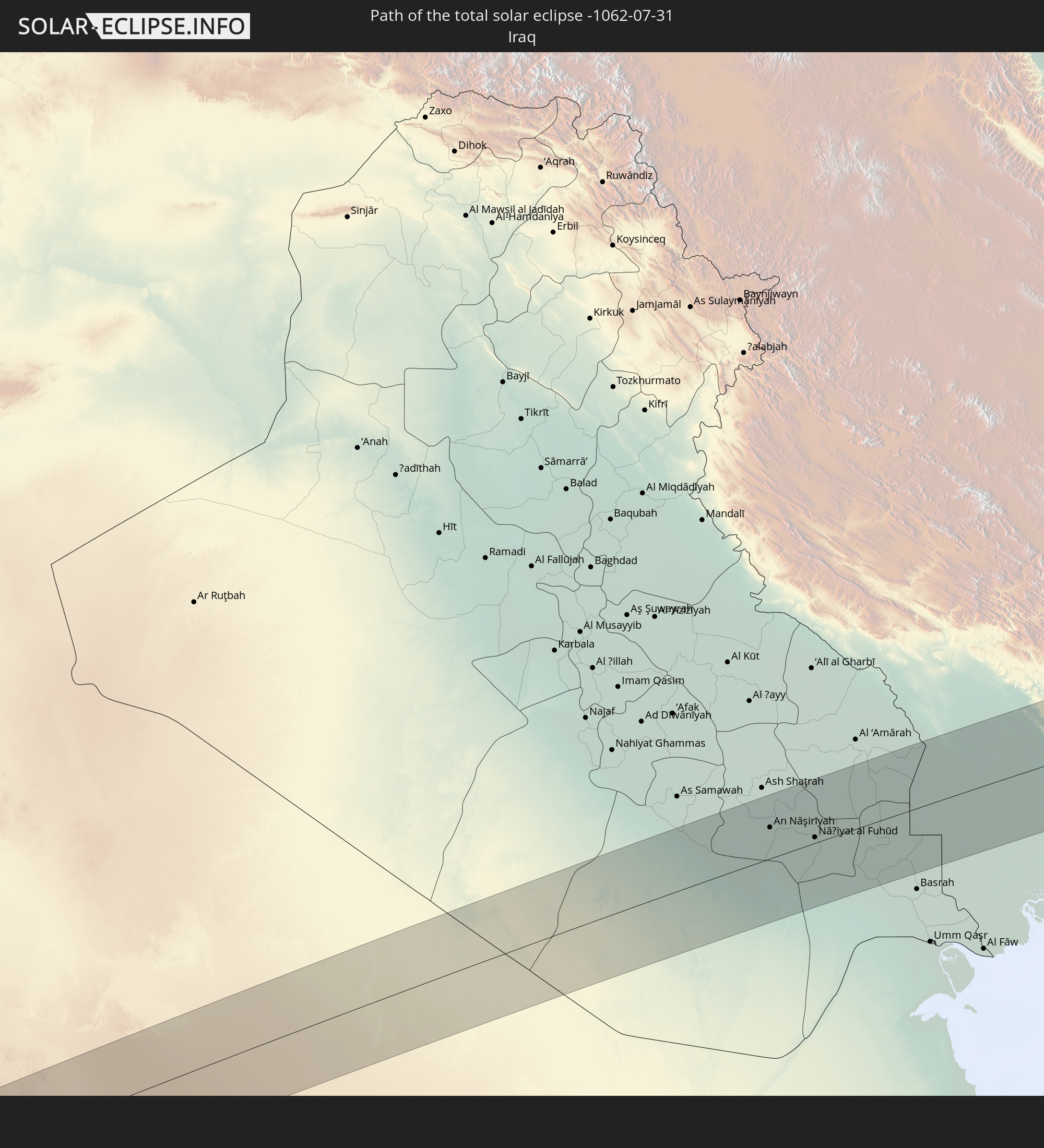 Iraq
Iraq
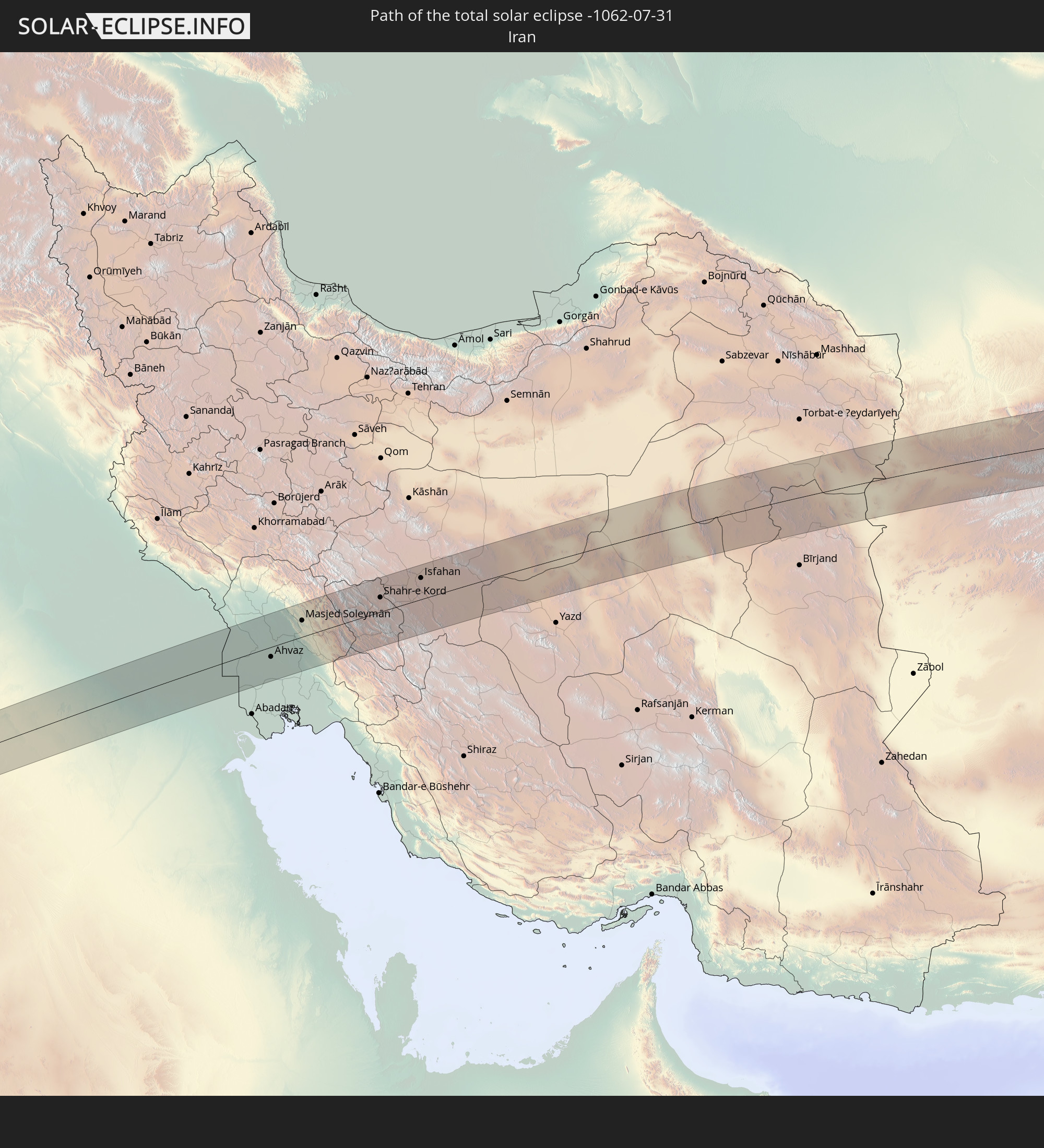 Iran
Iran
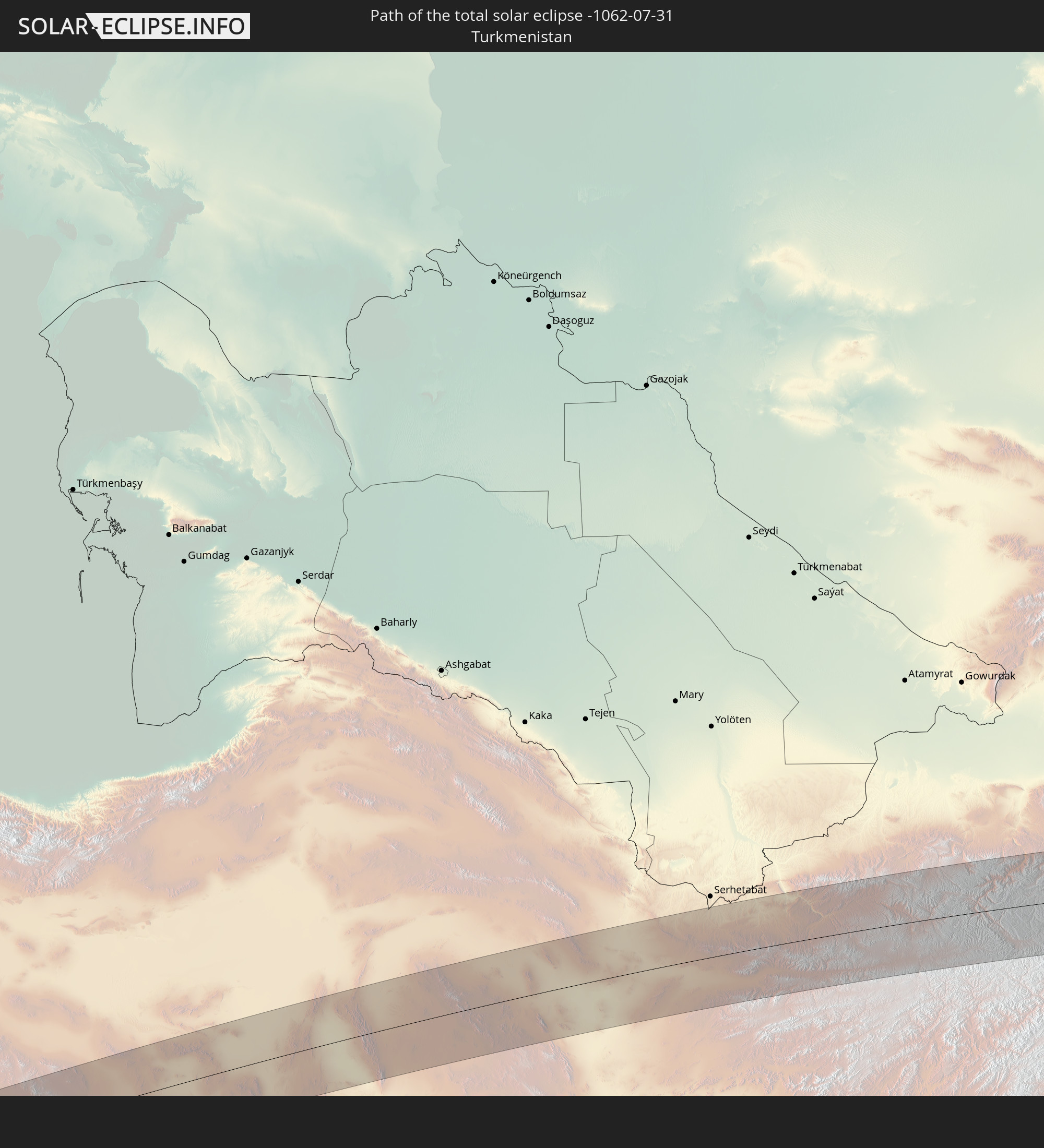 Turkmenistan
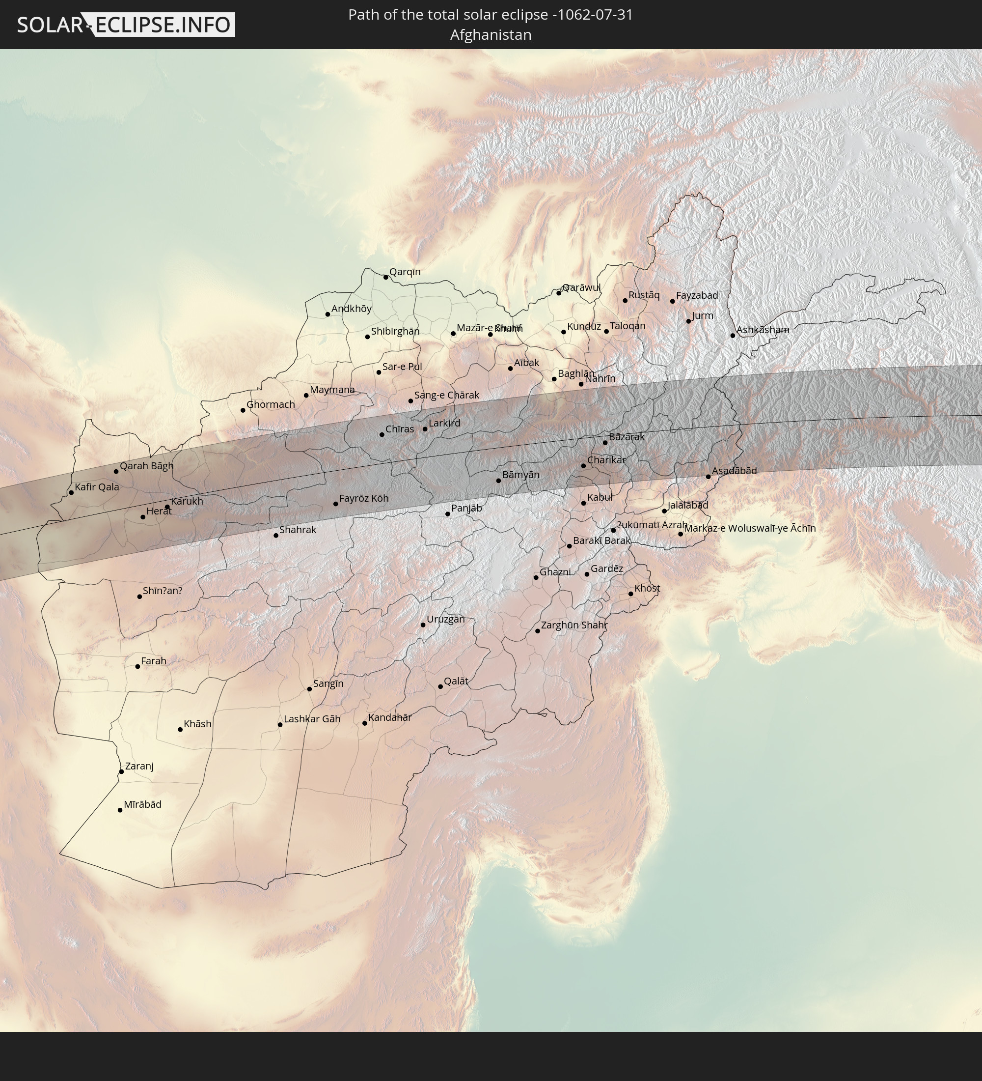 Afghanistan
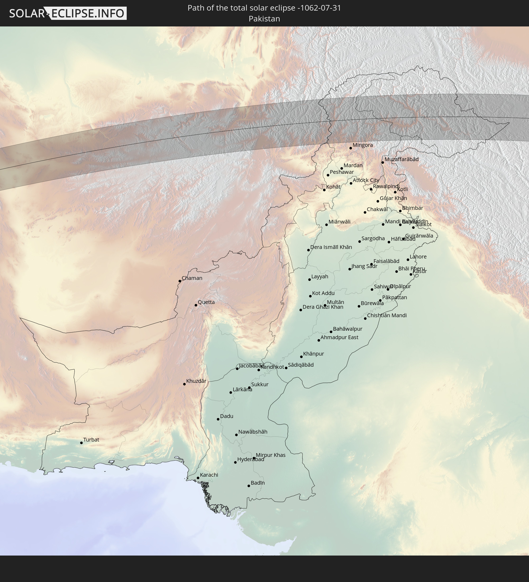 Pakistan
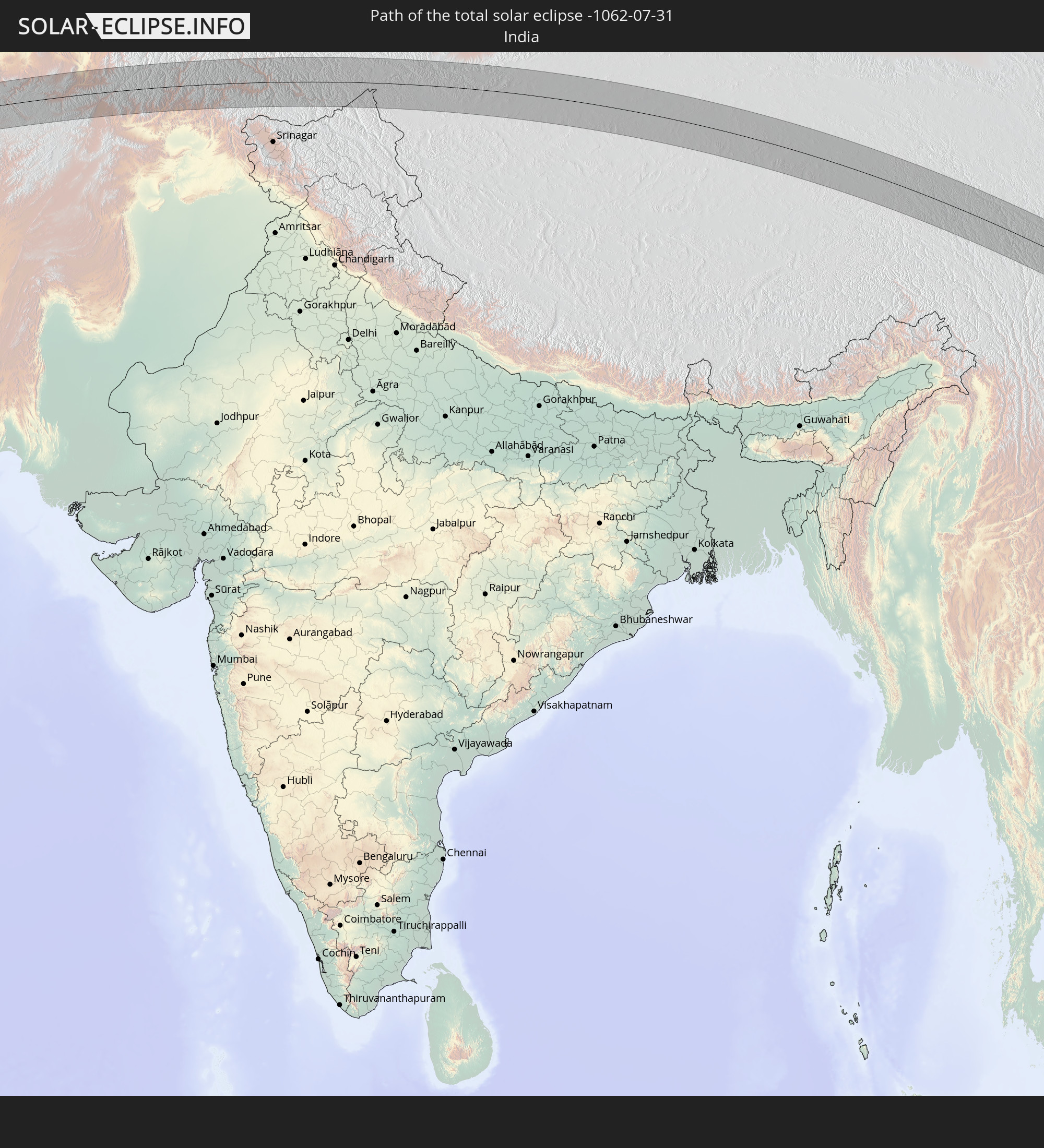 India
India
 China
China
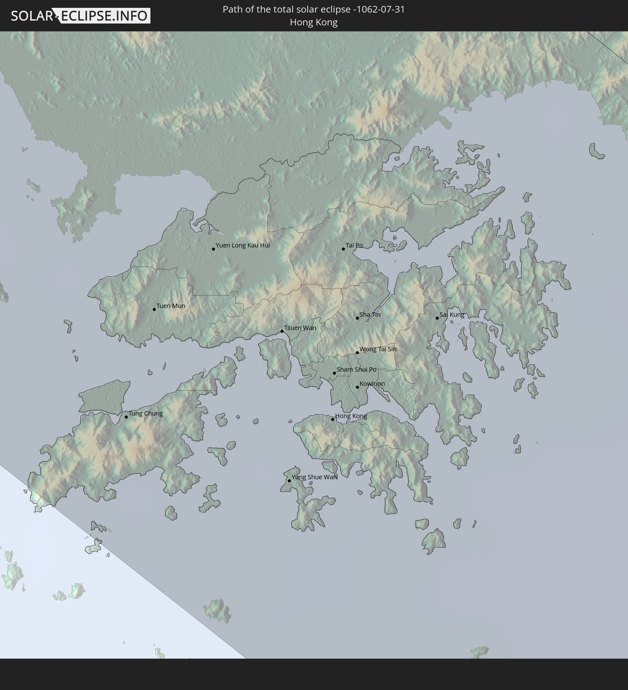 Hong Kong
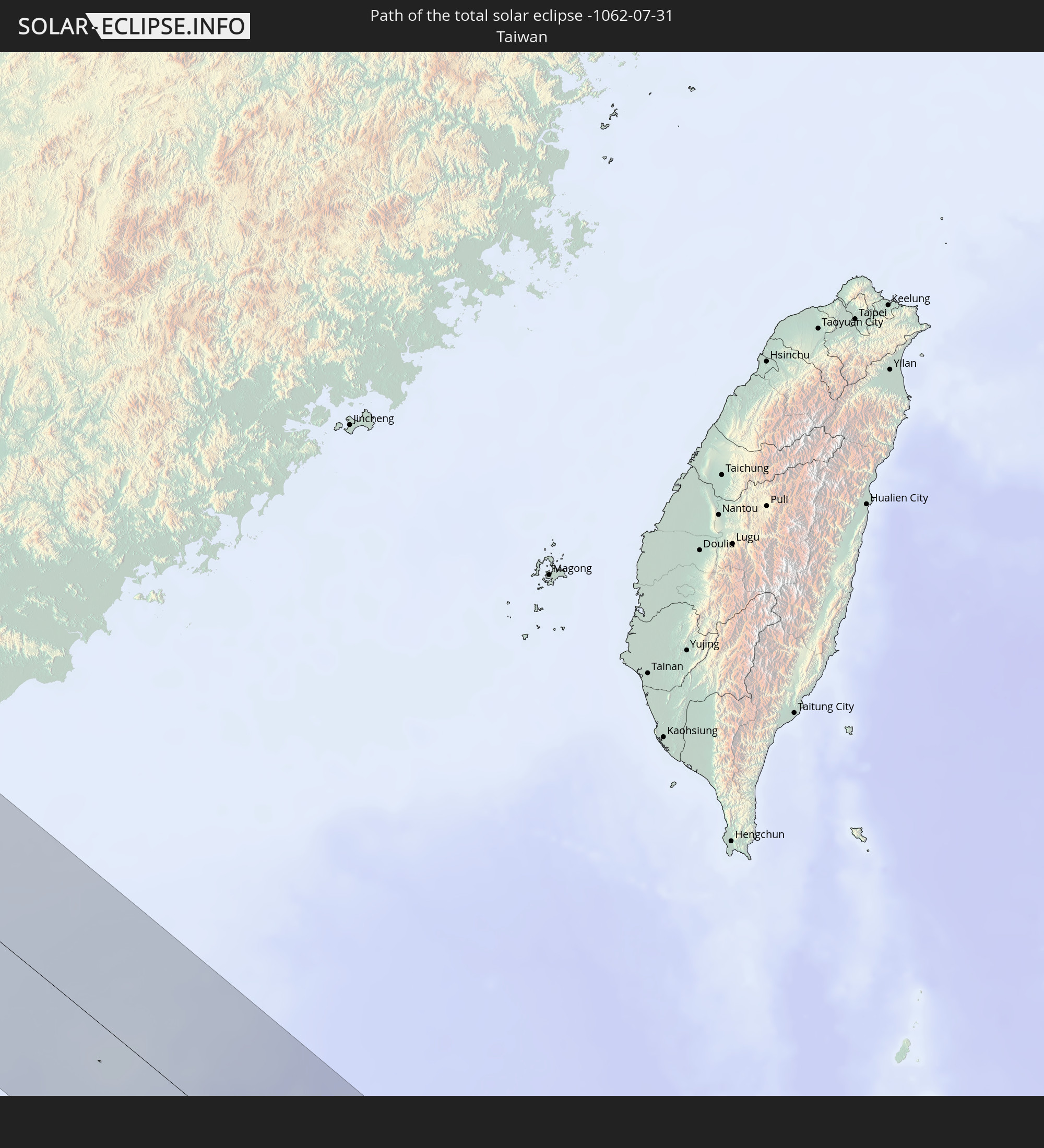 Taiwan
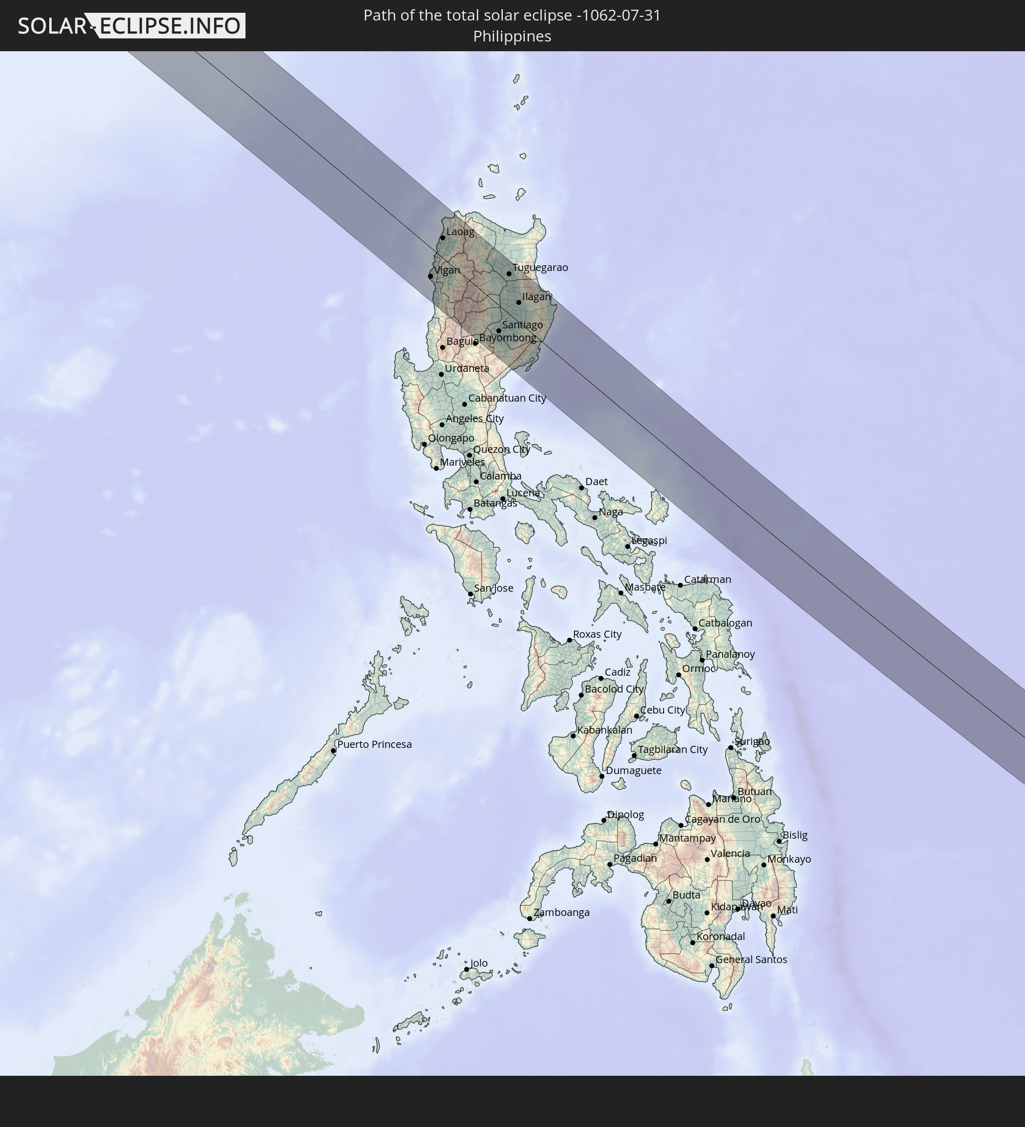 Philippines
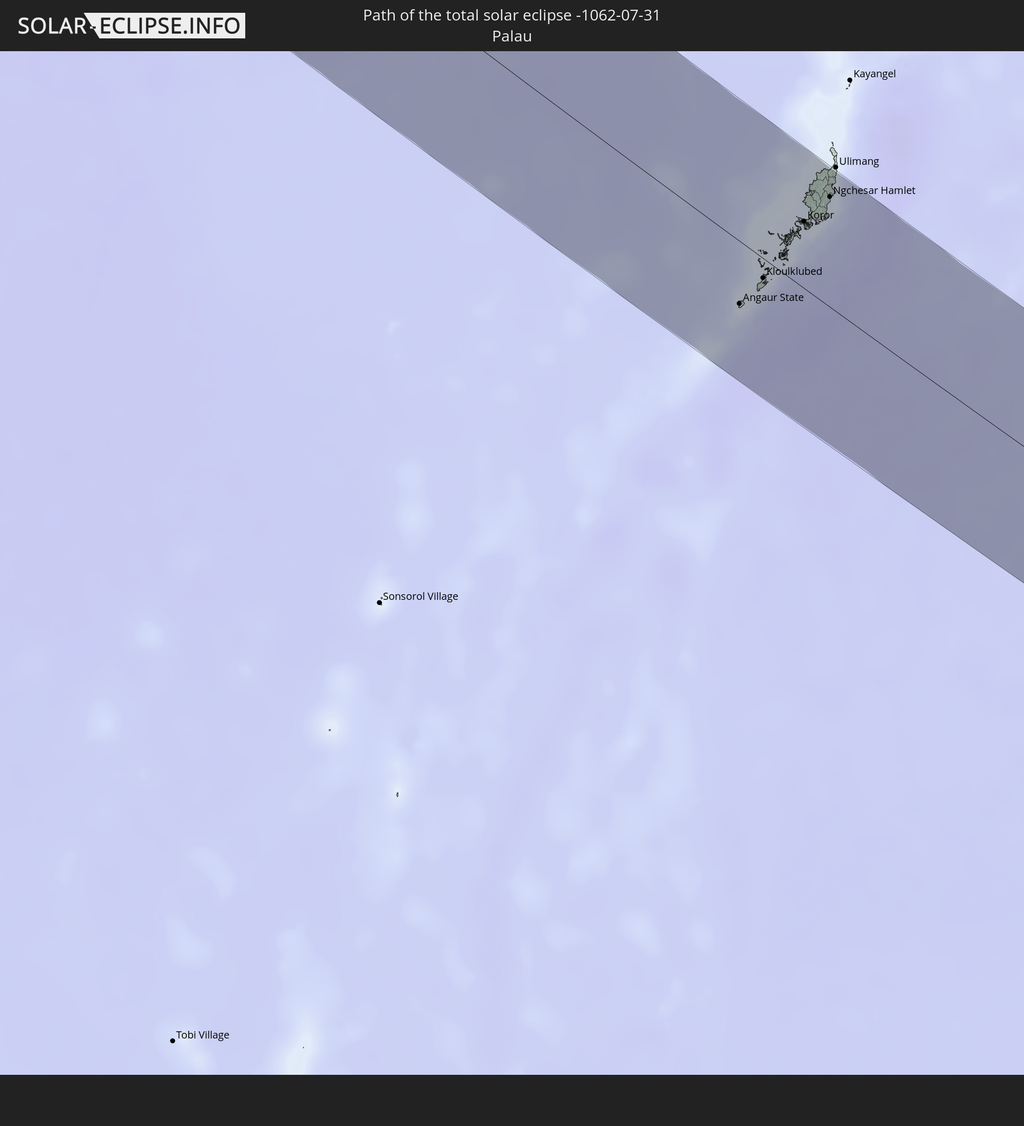 Palau
Palau
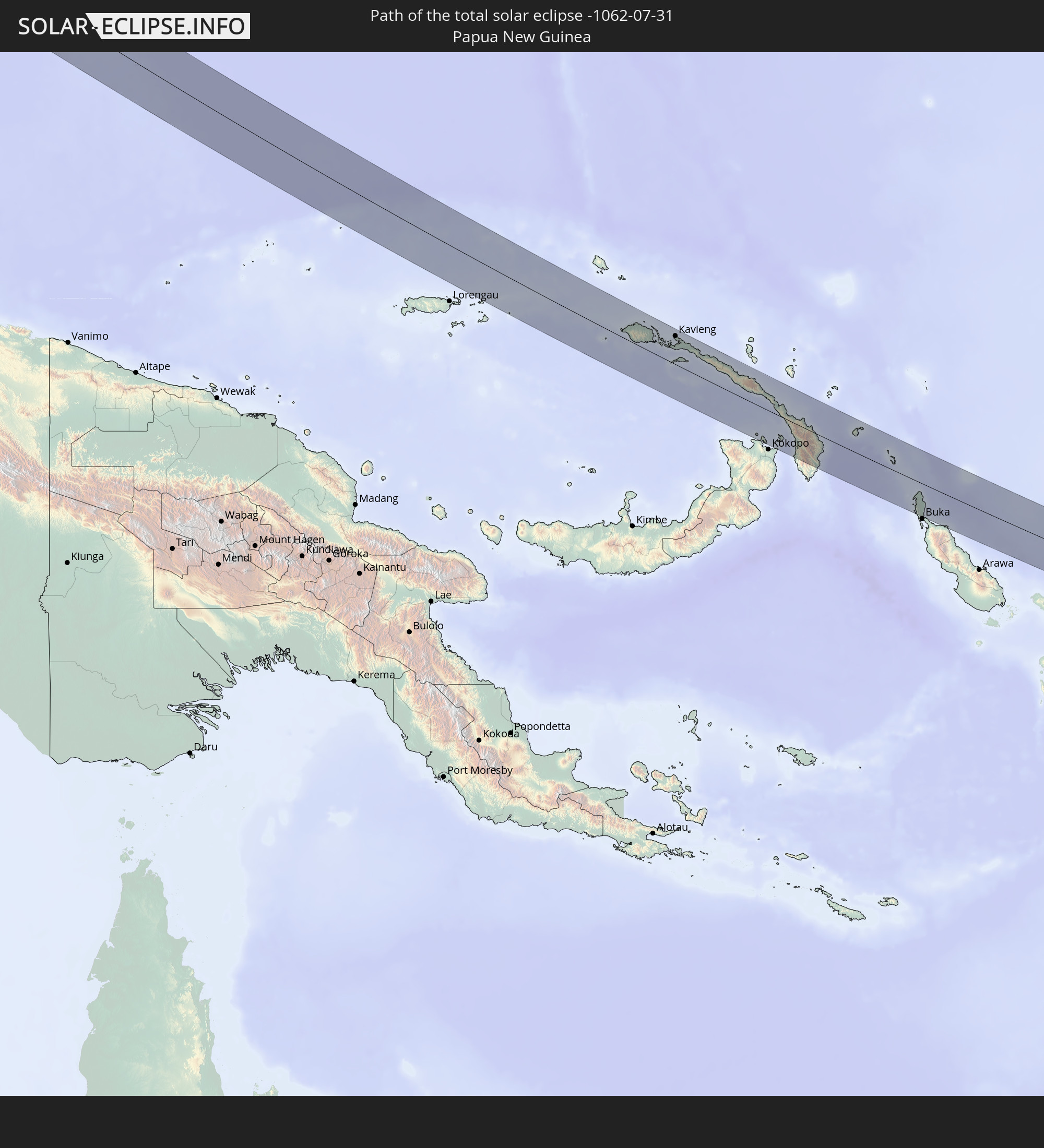 Papua New Guinea
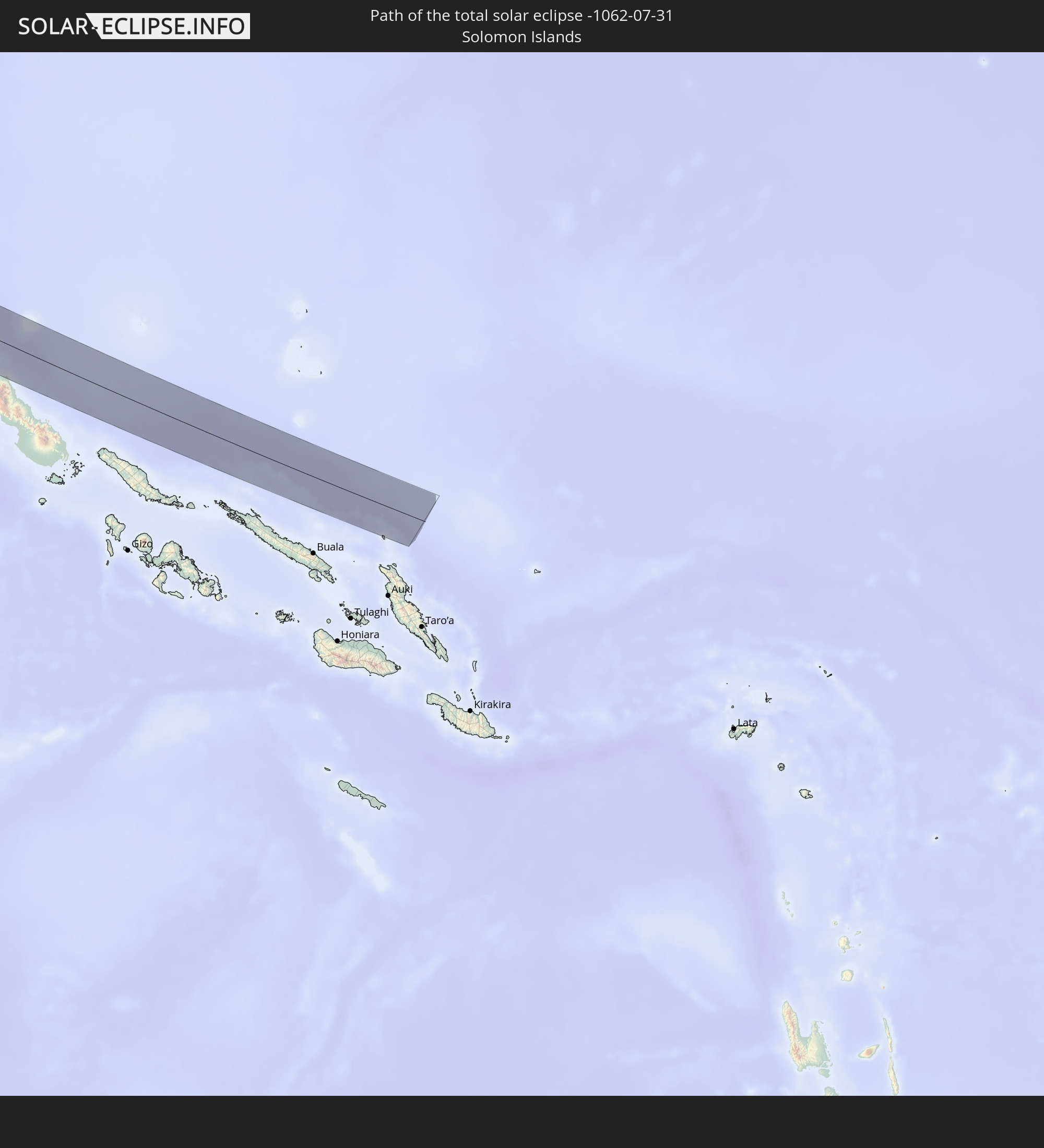 Solomon Islands
In den folgenden Ländern ist die Sonnenfinsternis partiell zu sehen
 Russia
 United States Minor Outlying Islands
 United Kingdom
 France
 Isle of Man
 Belgium
 Netherlands
 Norway
 Luxembourg
 Germany
 Switzerland
 Italy
Italy
 Denmark
 Libya
Libya
 Liechtenstein
 Austria
 Sweden
 Czechia
 San Marino
 Vatican City
 Slovenia
 Croatia
 Poland
 Bosnia and Herzegovina
 Hungary
 Slovakia
 Montenegro
 Serbia
 Albania
 Åland Islands
 Greece
 Romania
 Republic of Macedonia
 Finland
 Lithuania
 Latvia
 Estonia
 Sudan
Sudan
 Ukraine
 Bulgaria
 Belarus
 Egypt
Egypt
 Turkey
 Moldova
 Tanzania
 Cyprus
 Ethiopia
 Kenya
Kenya
 State of Palestine
 Israel
 Saudi Arabia
 Jordan
 Lebanon
 Syria
Syria
 Eritrea
 Iraq
Iraq
 Georgia
 Somalia
 Djibouti
 Yemen
Yemen
 Armenia
 Iran
Iran
 Azerbaijan
 Kazakhstan
 Kuwait
 Bahrain
 Qatar
Qatar
 United Arab Emirates
 Oman
Oman
 Turkmenistan
 Uzbekistan
 Afghanistan
 Pakistan
 Tajikistan
 India
India
 Kyrgyzstan
 Maldives
 China
China
 Sri Lanka
 Nepal
Nepal
 Mongolia
 Bangladesh
 Bhutan
 Myanmar
 Indonesia
 Thailand
 Malaysia
 Laos
Laos
 Vietnam
 Cambodia
 Singapore
 Christmas Island
 Australia
 Macau
Macau
 Hong Kong
 Brunei
 Taiwan
 Philippines
 Japan
Japan
 East Timor
 North Korea
 South Korea
 Palau
Palau
 Federated States of Micronesia
 Papua New Guinea
 Guam
Guam
 Northern Mariana Islands
 Solomon Islands
 Marshall Islands
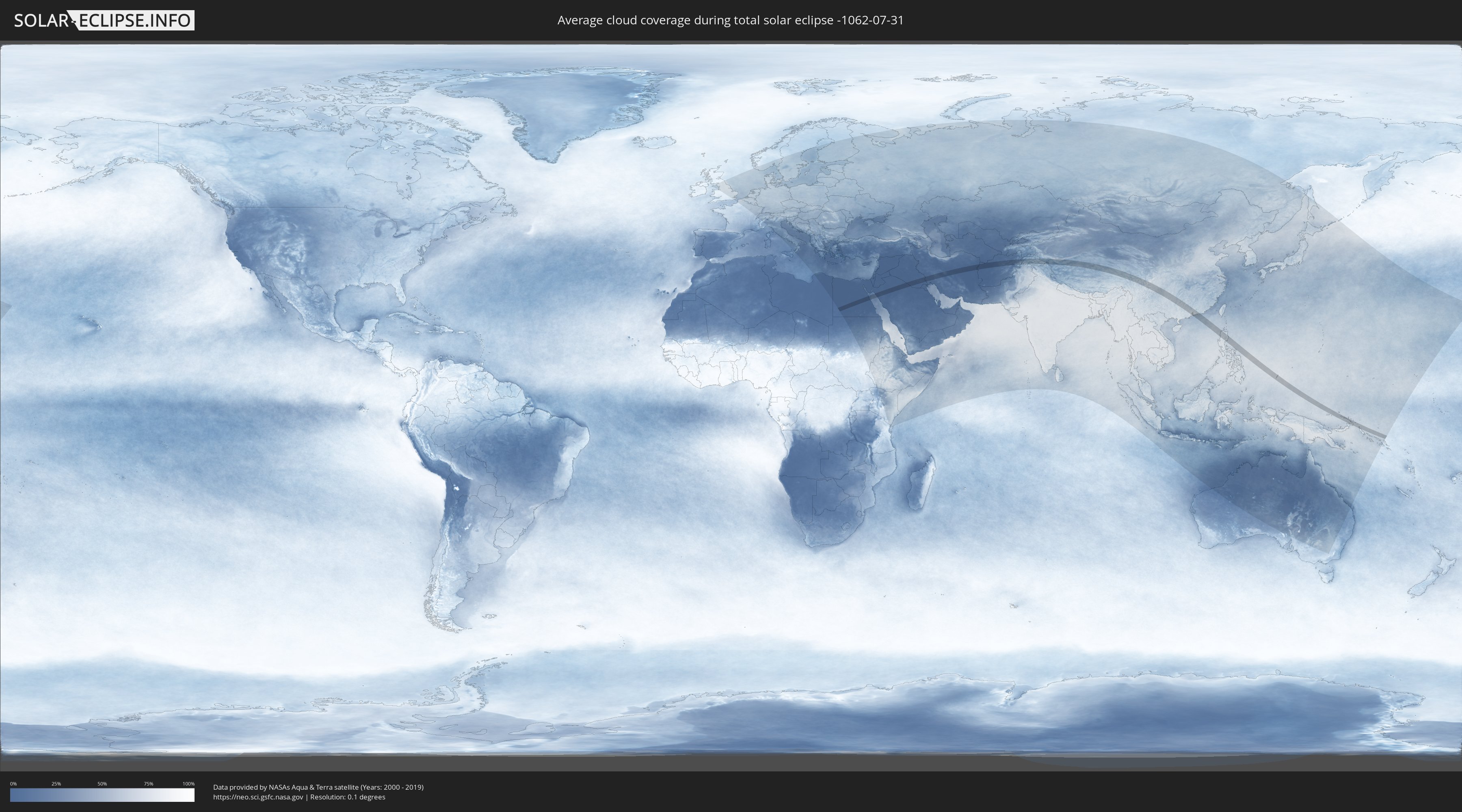
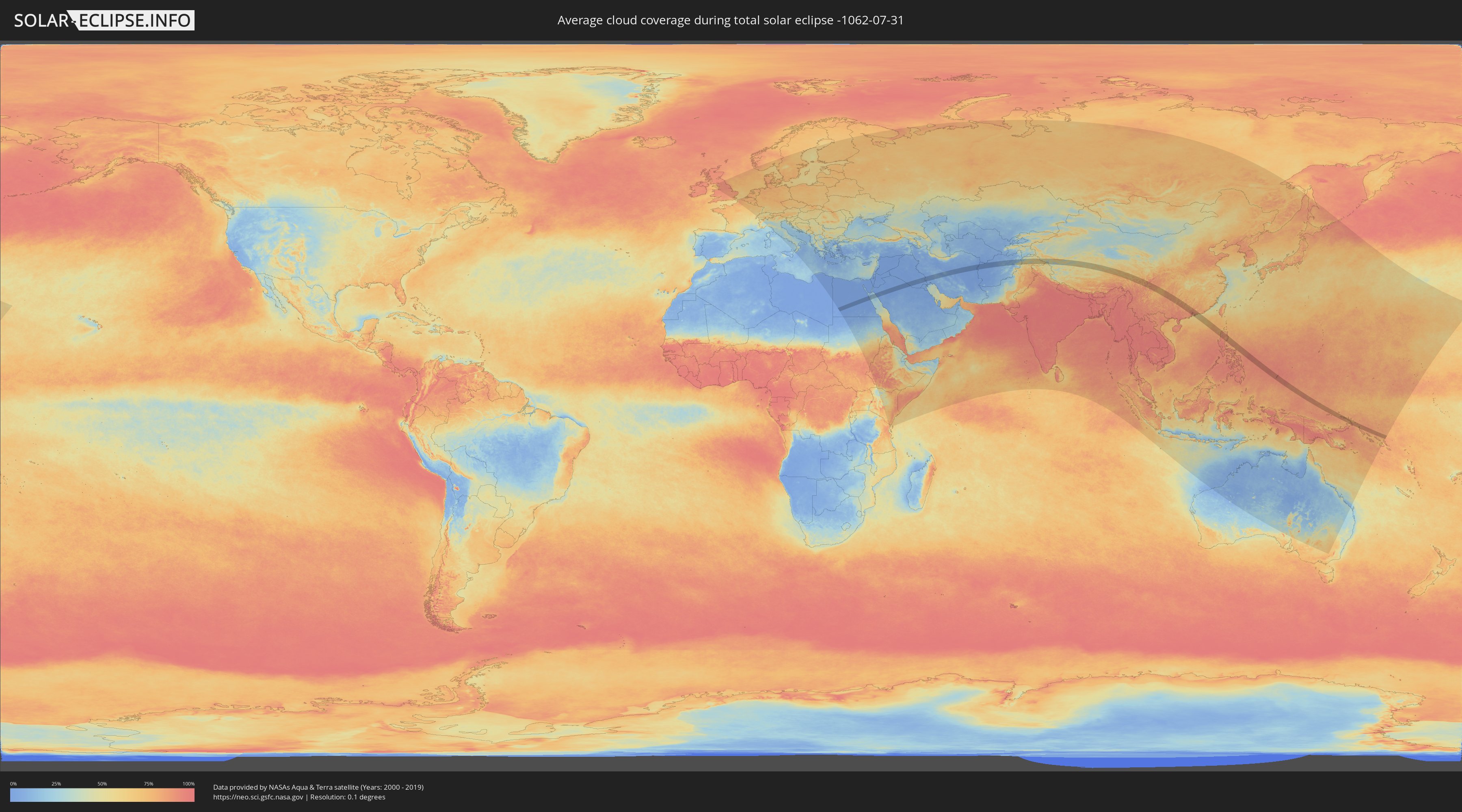
How will be the weather during the total solar eclipse on 07/31/-1062?
Where is the best place to see the total solar eclipse of 07/31/-1062?
The following maps show the average cloud coverage for the day of the total solar eclipse.
With the help of these maps, it is possible to find the place along the eclipse path, which has the best
chance of a cloudless sky.
Nevertheless, you should consider local circumstances and inform about the weather of your chosen
observation site.
The data is provided by NASAs satellites
AQUA and TERRA.
The cloud maps are averaged over a period of 19 years (2000 - 2019).
Detailed country maps
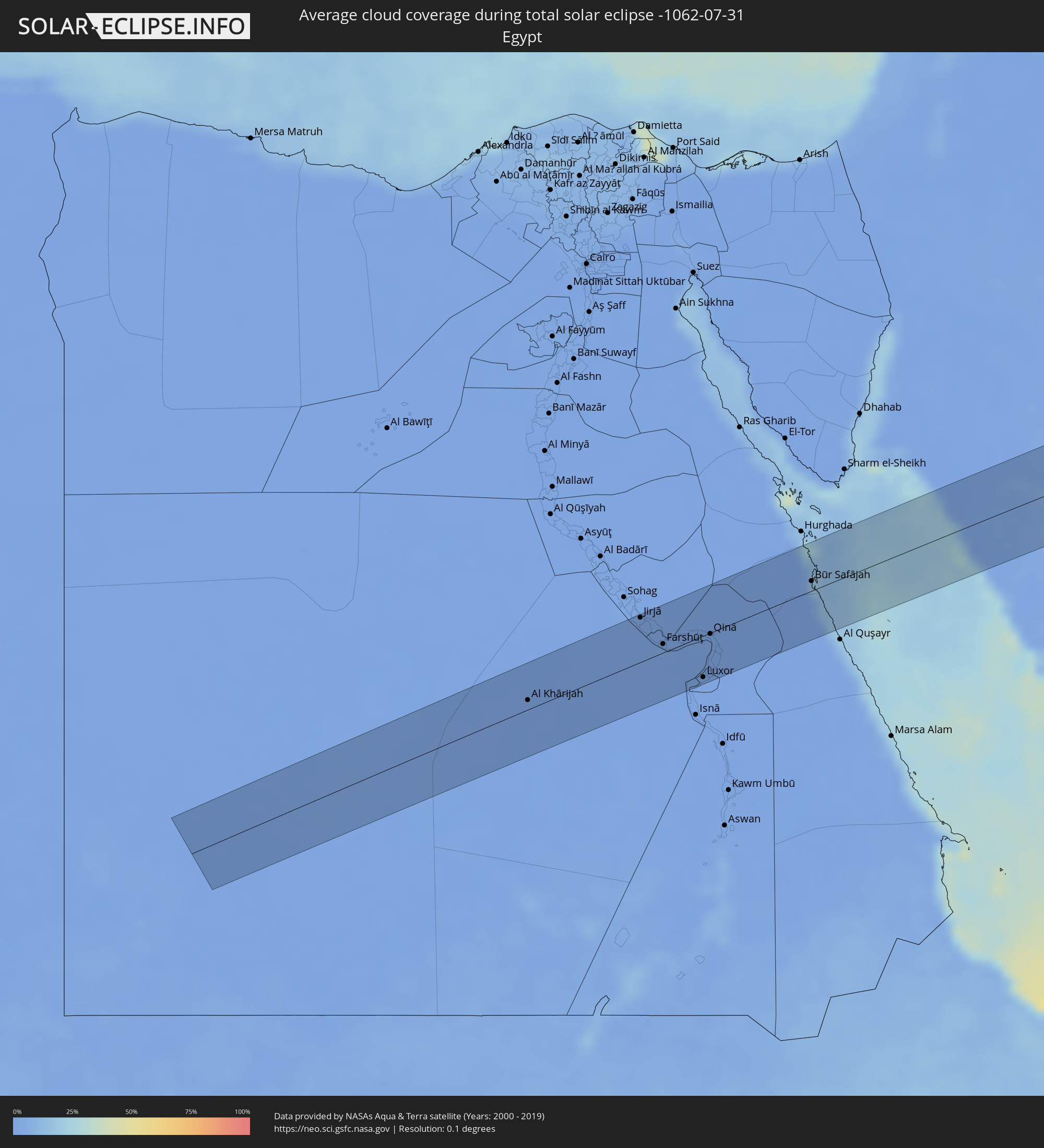 Egypt
Egypt
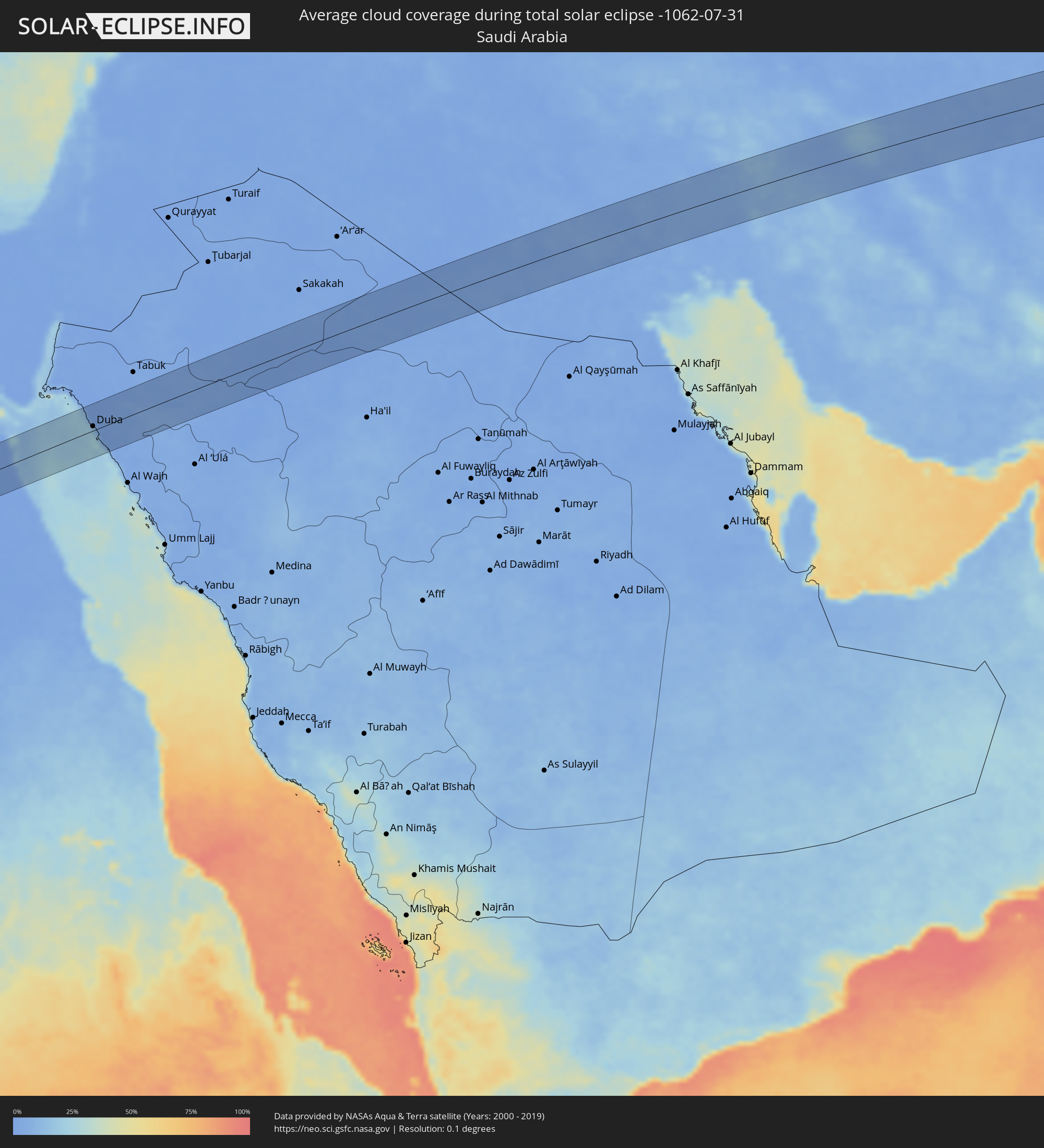 Saudi Arabia
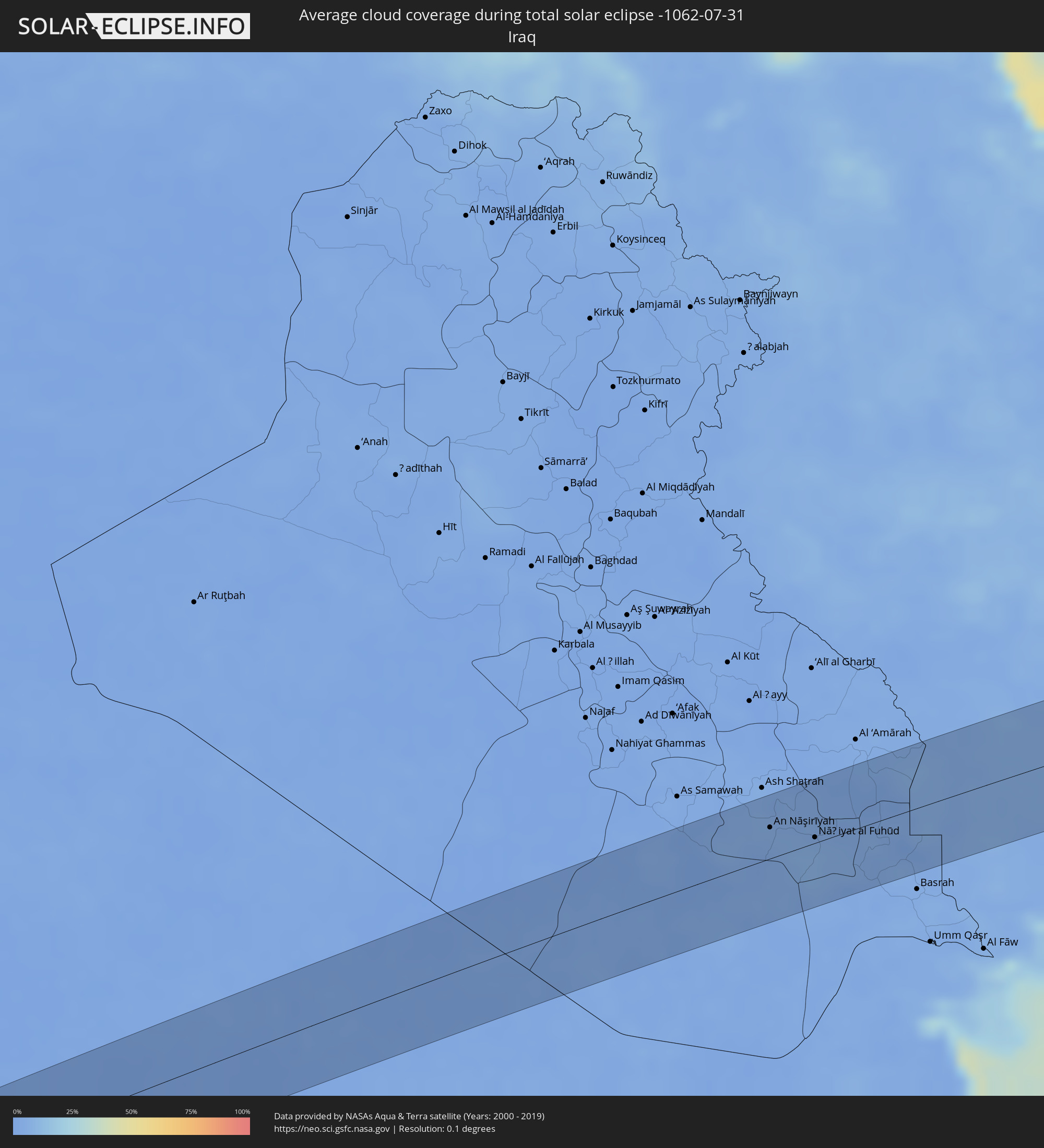 Iraq
Iraq
 Iran
Iran
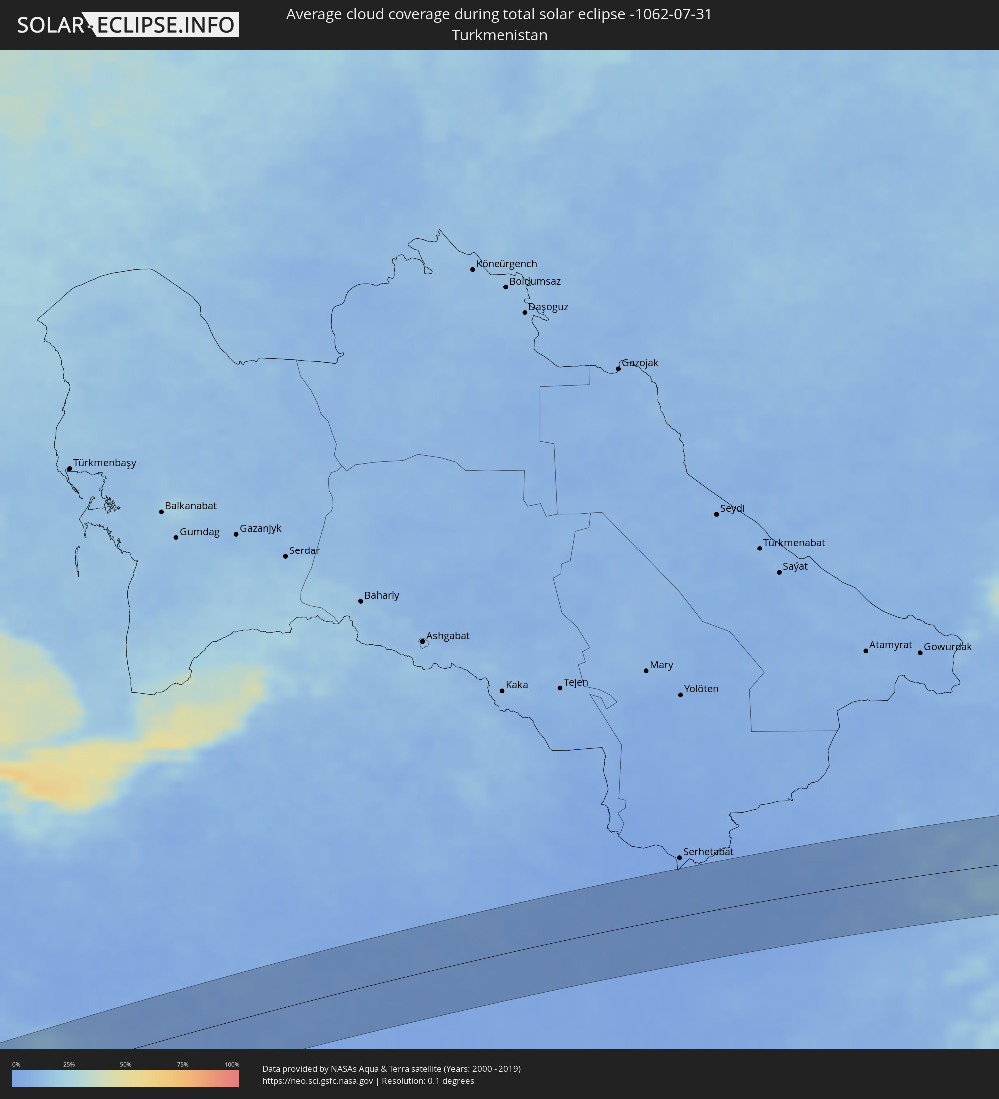 Turkmenistan
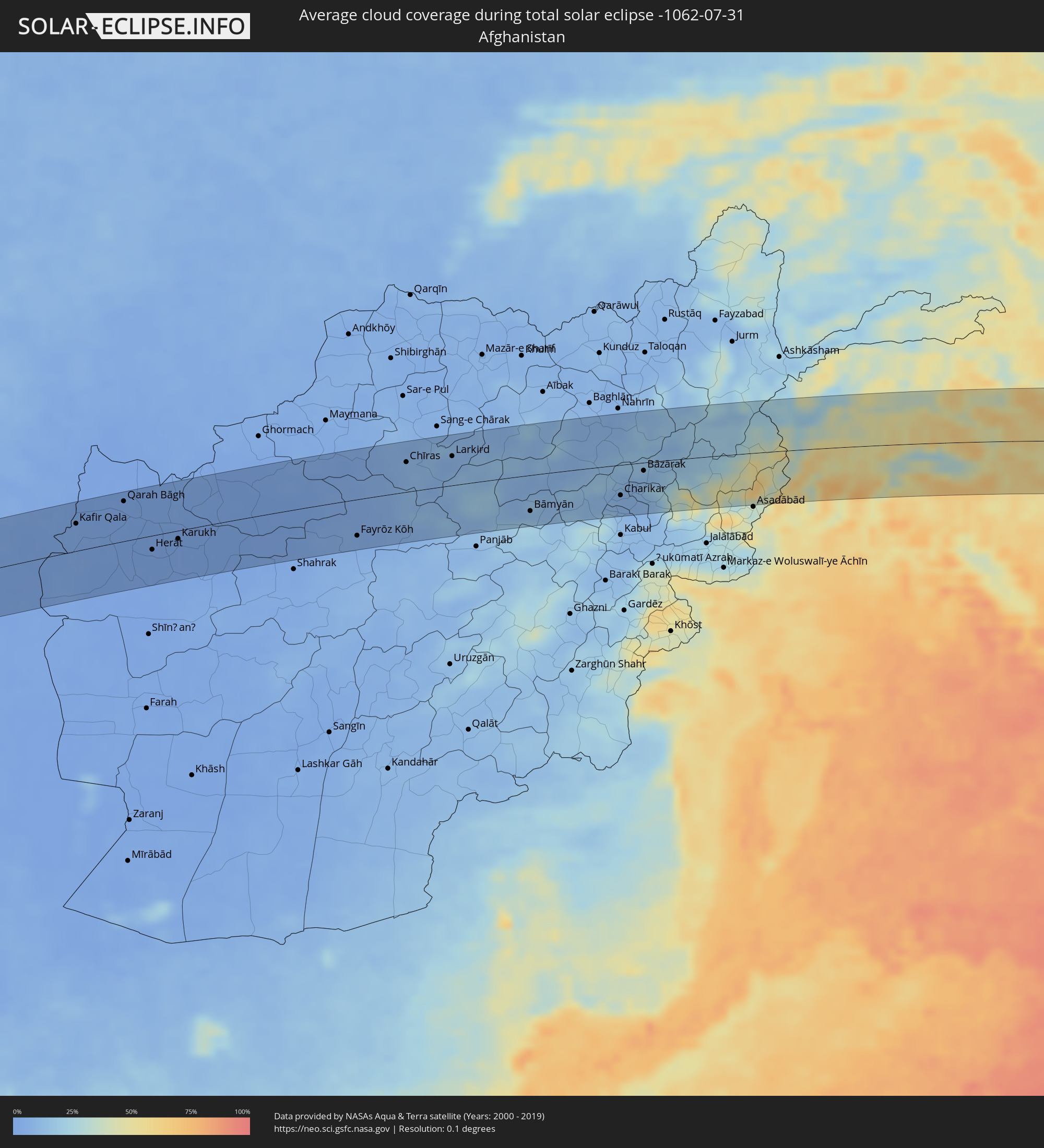 Afghanistan
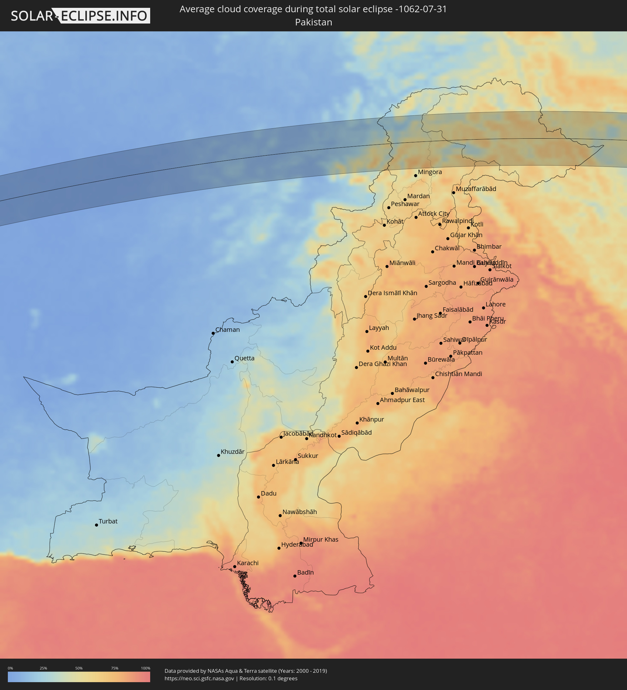 Pakistan
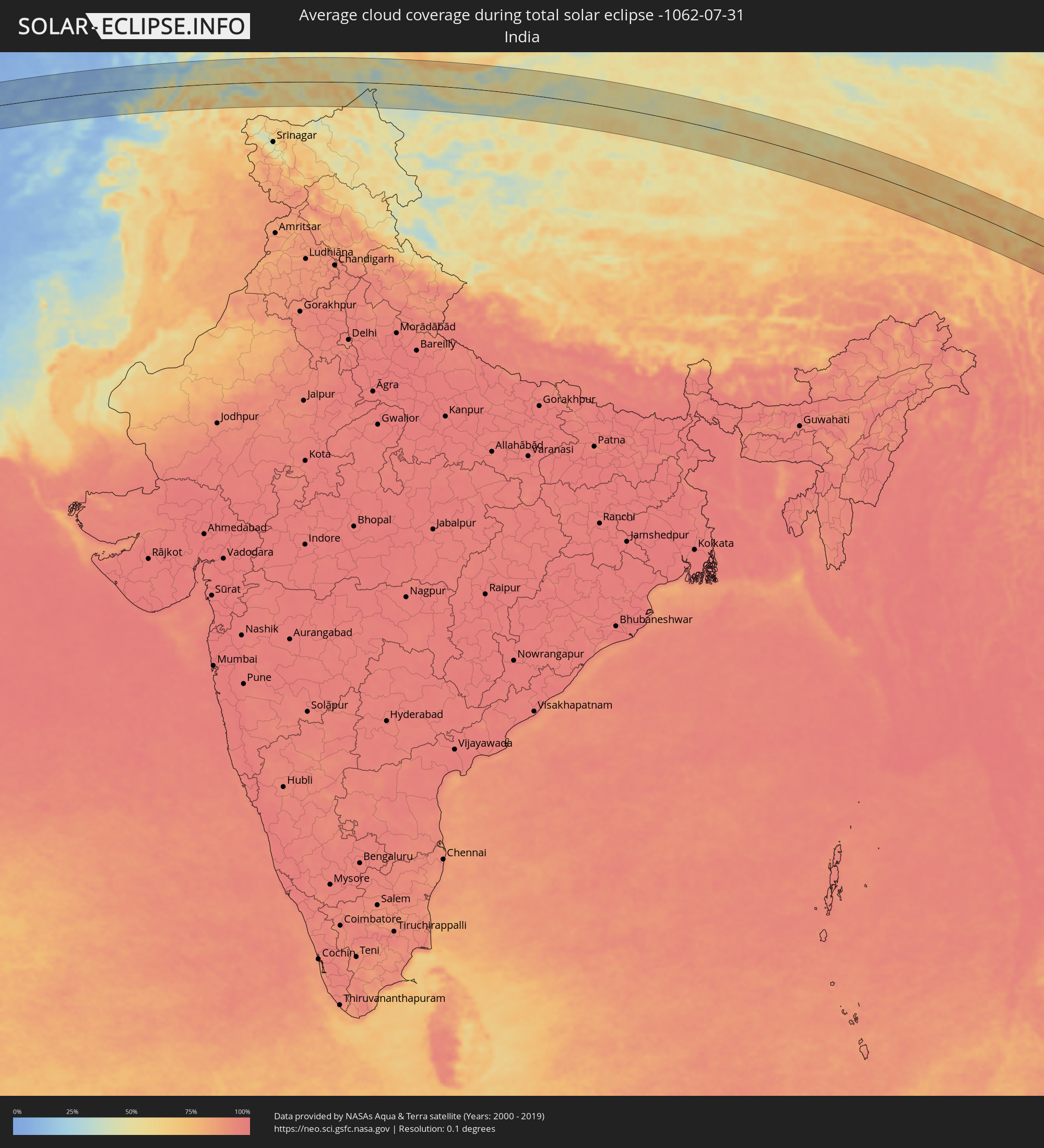 India
India
 China
China
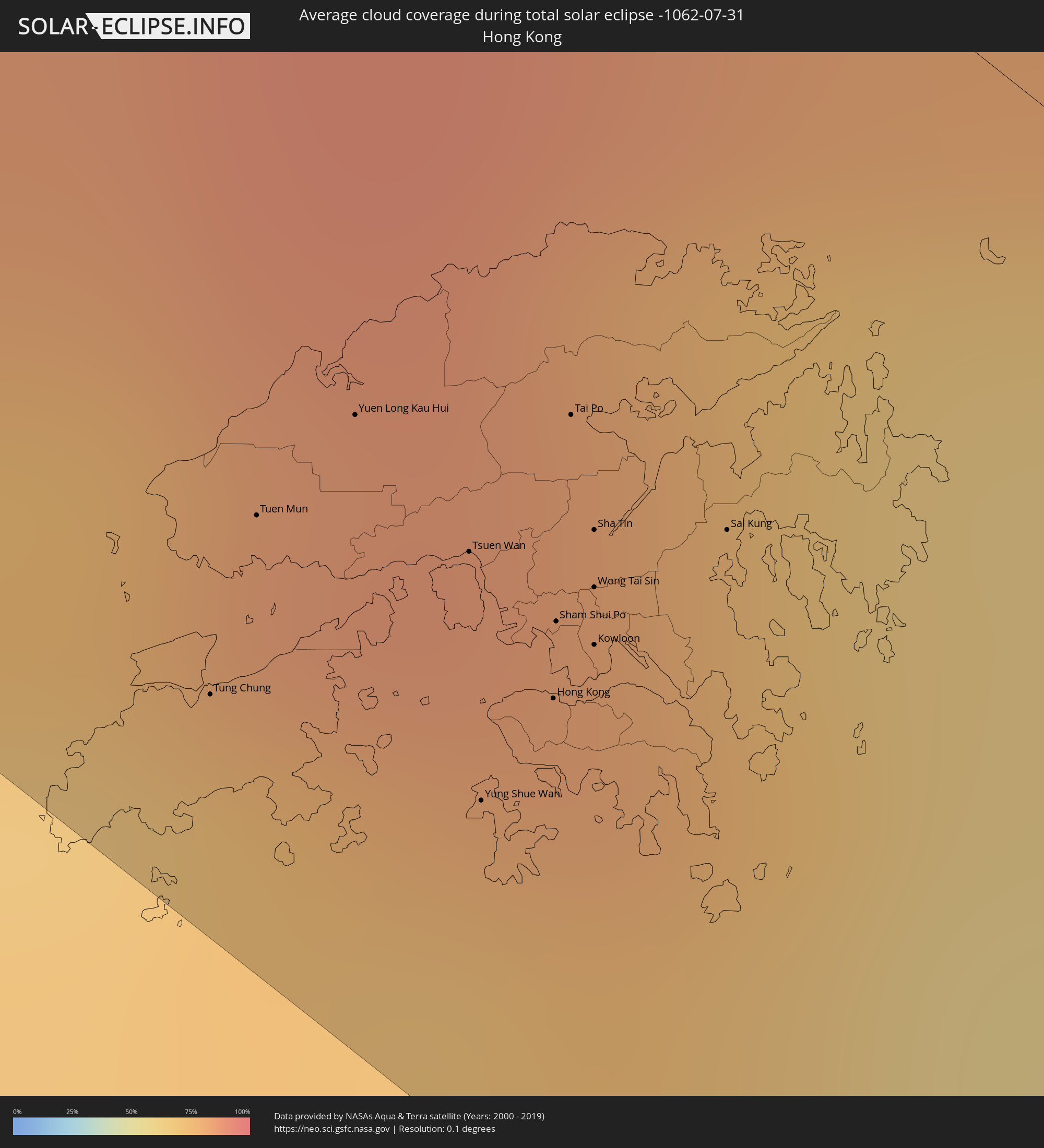 Hong Kong
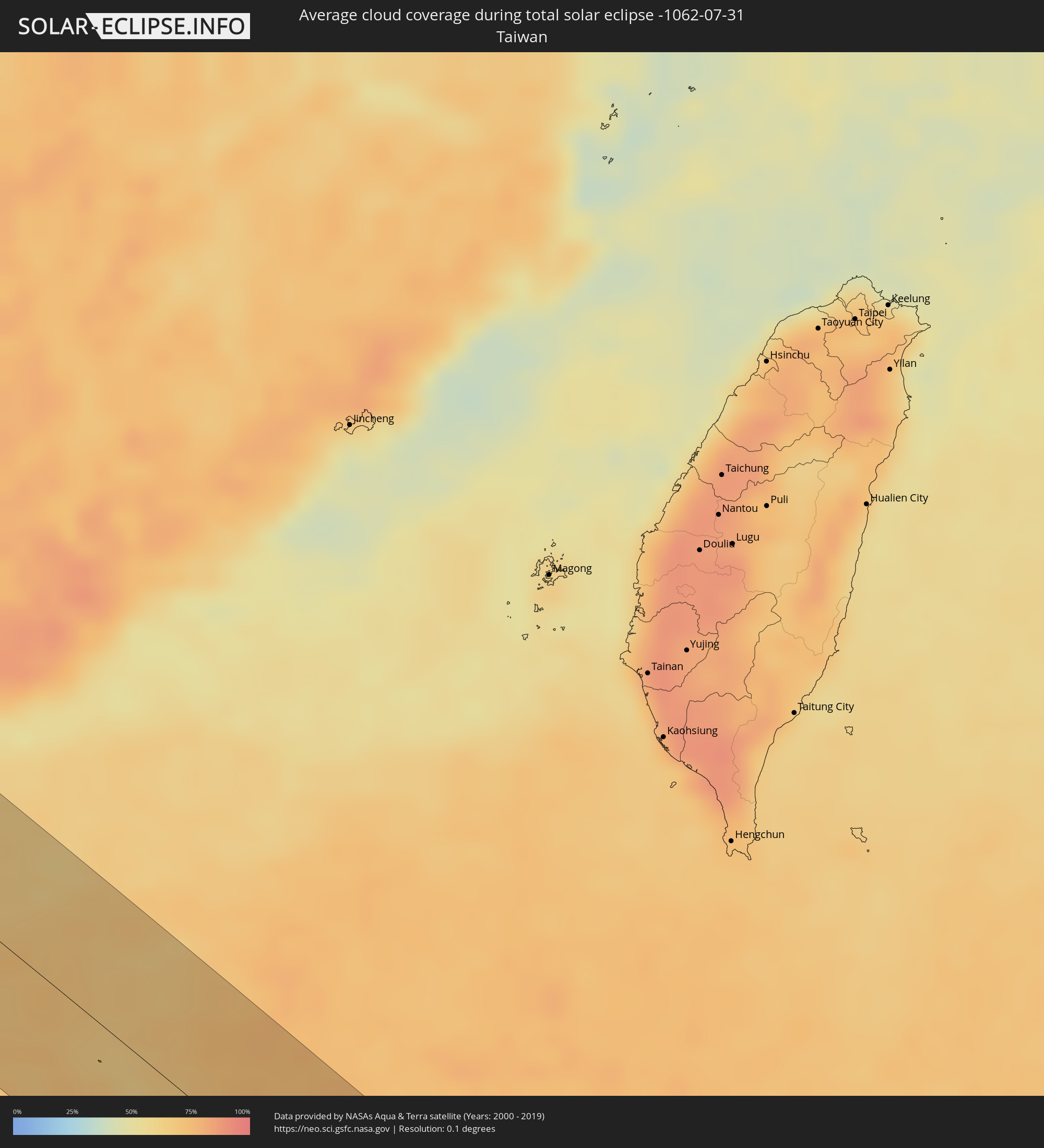 Taiwan
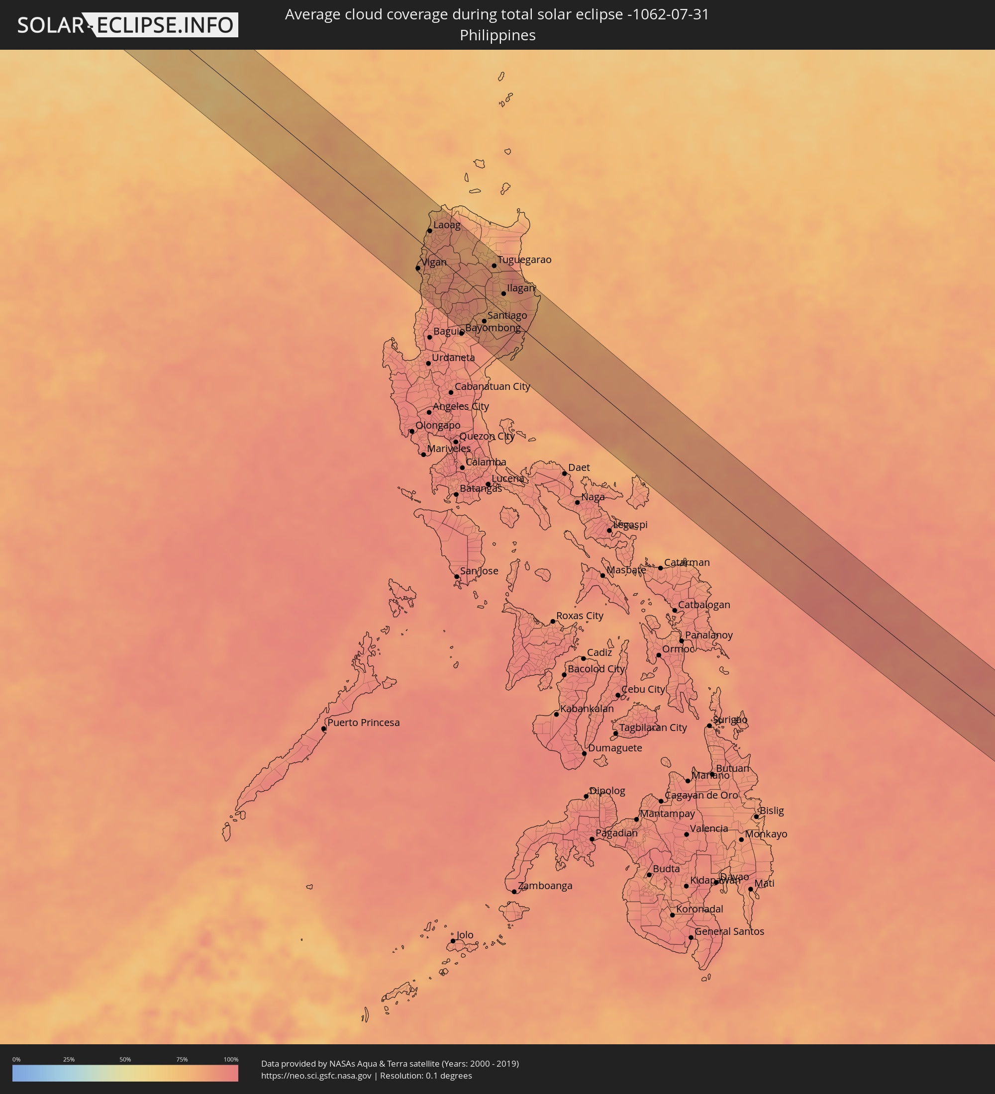 Philippines
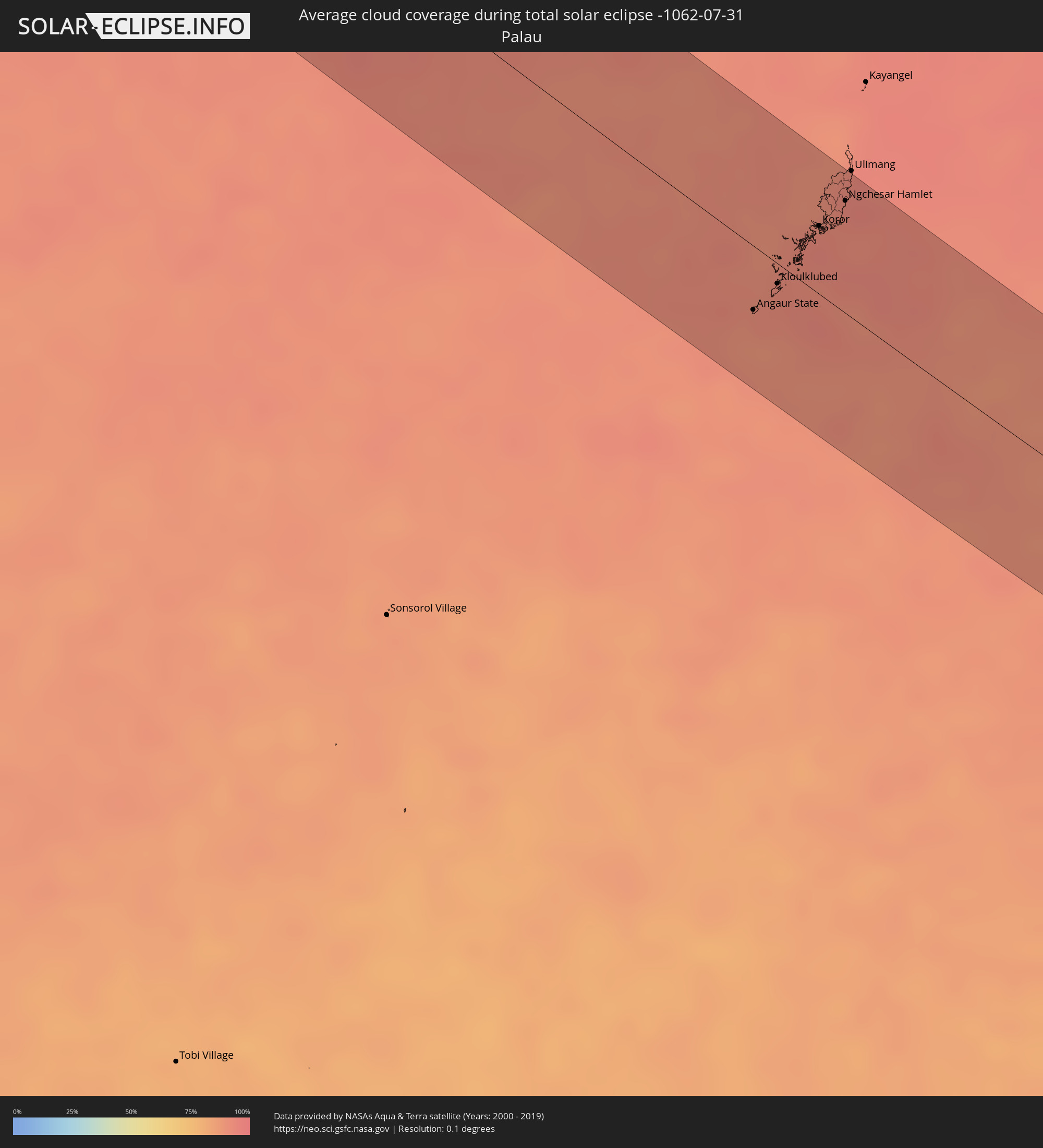 Palau
Palau
 Papua New Guinea
 Solomon Islands
Cities inside the path of the eclipse
The following table shows all locations with a population of more than 5,000 inside the eclipse path. Cities which have more than 100,000 inhabitants are marked bold. A click at the locations opens a detailed map.
| City | Type | Eclipse duration | Local time of max. eclipse | Distance to central line | Ø Cloud coverage |
|
Al Khārijah, New Valley
|
total | - | 05:36:38 UTC+02:00 | 10 km | 1% |
|
Jirjā, Sohag
|
total | - | 05:37:04 UTC+02:00 | 49 km | 1% |
|
Al Balyanā, Sohag
|
total | - | 05:37:00 UTC+02:00 | 34 km | 1% |
|
Farshūţ, Qena
|
total | - | 05:36:53 UTC+02:00 | 9 km | 2% |
|
Naj‘ Ḩammādī, Qena
|
total | - | 05:36:53 UTC+02:00 | 6 km | 1% |
|
Dishnā, Qena
|
total | - | 05:36:55 UTC+02:00 | 5 km | 0% |
|
Luxor, Luxor
|
total | - | 05:36:40 UTC+02:00 | 46 km | 1% |
|
Qinā, Qena
|
total | - | 05:36:56 UTC+02:00 | 1 km | 1% |
|
Kousa, Qena
|
total | - | 05:36:48 UTC+02:00 | 28 km | 1% |
|
Būr Safājah, Red Sea
|
total | - | 05:37:17 UTC+02:00 | 11 km | 2% |
|
Duba, Tabuk
|
total | - | 06:44:38 UTC+03:06 | 9 km | 14% |
|
An Nāşirīyah, Dhi Qar
|
total | - | 06:40:41 UTC+02:57 | 29 km | 5% |
|
Nāḩiyat al Fuhūd, Dhi Qar
|
total | - | 06:40:50 UTC+02:57 | 5 km | 5% |
|
Sūsangerd, Khuzestan
|
total | - | 07:10:09 UTC+03:25 | 23 km | 3% |
|
Ahvaz, Khuzestan
|
total | - | 07:10:14 UTC+03:25 | 18 km | 4% |
|
Shūshtar, Khuzestan
|
total | - | 07:10:52 UTC+03:25 | 55 km | 5% |
|
Masjed Soleymān, Khuzestan
|
total | - | 07:11:02 UTC+03:25 | 29 km | 5% |
|
Rāmhormoz, Khuzestan
|
total | - | 07:10:44 UTC+03:25 | 49 km | 4% |
|
Shahr-e Kord, Chahār Maḩāll va Bakhtīārī
|
total | - | 07:12:16 UTC+03:25 | 26 km | 8% |
|
Borūjen, Chahār Maḩāll va Bakhtīārī
|
total | - | 07:12:17 UTC+03:25 | 24 km | 9% |
|
Najafābād, Isfahan
|
total | - | 07:12:50 UTC+03:25 | 45 km | 4% |
|
Falāvarjān, Isfahan
|
total | - | 07:12:52 UTC+03:25 | 32 km | 4% |
|
Kelīshād va Sūdarjān, Isfahan
|
total | - | 07:12:52 UTC+03:25 | 31 km | 4% |
|
Dorcheh Pīāz, Isfahan
|
total | - | 07:12:56 UTC+03:25 | 37 km | 3% |
|
Rehnān, Isfahan
|
total | - | 07:13:01 UTC+03:25 | 43 km | 3% |
|
Isfahan, Isfahan
|
total | - | 07:13:03 UTC+03:25 | 38 km | 3% |
|
Shāhreẕā, Isfahan
|
total | - | 07:12:44 UTC+03:25 | 33 km | 6% |
|
Ardakān, Yazd
|
total | - | 07:14:29 UTC+03:25 | 61 km | 3% |
|
Tabas, Yazd
|
total | - | 07:17:50 UTC+03:25 | 7 km | 2% |
|
Gonābād, Razavi Khorasan
|
total | - | 07:20:00 UTC+03:25 | 50 km | 2% |
|
Qā’en, Khorāsān-e Jonūbī
|
total | - | 07:20:03 UTC+03:25 | 28 km | 1% |
|
Tāybād, Razavi Khorasan
|
total | - | 07:22:22 UTC+03:25 | 50 km | 1% |
|
Kafir Qala, Herat
|
total | - | 07:56:54 UTC+04:00 | 37 km | 1% |
|
Kuhsān, Herat
|
total | - | 07:57:02 UTC+04:00 | 33 km | 1% |
|
Zindah Jān, Herat
|
total | - | 07:57:25 UTC+04:00 | 11 km | 1% |
|
Qarah Bāgh, Herat
|
total | - | 07:57:51 UTC+04:00 | 53 km | 1% |
|
Chahār Burj, Herat
|
total | - | 07:57:51 UTC+04:00 | 30 km | 0% |
|
Herāt, Herat
|
total | - | 07:57:55 UTC+04:00 | 19 km | 0% |
|
Karukh, Herat
|
total | - | 07:58:27 UTC+04:00 | 11 km | 1% |
|
Qala i Naw, Badghis
|
total | - | 07:59:24 UTC+04:00 | 35 km | 1% |
|
Fayrōz Kōh, Ghowr
|
total | - | 08:01:40 UTC+04:00 | 49 km | 4% |
|
Qal‘ah-ye Shahr, Sar-e Pol
|
total | - | 08:02:41 UTC+04:00 | 60 km | 5% |
|
Chīras, Sar-e Pol
|
total | - | 08:03:08 UTC+04:00 | 40 km | 8% |
|
Larkird, Sar-e Pol
|
total | - | 08:04:03 UTC+04:00 | 39 km | 7% |
|
Bāmyān, Bamyan
|
total | - | 08:05:15 UTC+04:00 | 48 km | 16% |
|
Pul-e Khumrī, Baghlan
|
total | - | 08:07:03 UTC+04:00 | 67 km | 7% |
|
Charikar, Parwan
|
total | - | 08:07:14 UTC+04:00 | 41 km | 7% |
|
Jabal os Saraj, Parwan
|
total | - | 08:07:23 UTC+04:00 | 30 km | 7% |
|
Sidqābād, Kapisa
|
total | - | 08:07:30 UTC+04:00 | 42 km | 8% |
|
Bāzārak, Panjshir
|
total | - | 08:07:52 UTC+04:00 | 11 km | 9% |
|
Āsmār, Kunar
|
total | - | 08:10:30 UTC+04:00 | 56 km | 49% |
|
Upper Dir, Khyber Pakhtunkhwa
|
total | - | 08:39:34 UTC+04:28 | 40 km | 43% |
|
Tāl, Khyber Pakhtunkhwa
|
total | - | 08:40:15 UTC+04:28 | 12 km | 50% |
|
Gilgit, Gilgit-Baltistan
|
total | - | 08:43:43 UTC+04:28 | 29 km | 60% |
|
Leshan, Sichuan
|
total | - | 13:21:54 UTC+08:00 | 22 km | 83% |
|
Yibin, Sichuan
|
total | - | 13:24:57 UTC+08:00 | 12 km | 80% |
|
Zigong, Sichuan
|
total | - | 13:24:25 UTC+08:00 | 50 km | 83% |
|
Zunyi, Guizhou
|
total | - | 13:31:32 UTC+08:00 | 5 km | 82% |
|
Guilin, Guangxi Zhuang Autonomous Region
|
total | - | 13:42:31 UTC+08:00 | 23 km | 85% |
|
Yangshuo, Guangxi Zhuang Autonomous Region
|
total | - | 13:43:48 UTC+08:00 | 56 km | 83% |
|
Sanshui, Guangdong
|
total | - | 13:51:20 UTC+08:00 | 54 km | 88% |
|
Qingyuan, Guangdong
|
total | - | 13:50:38 UTC+08:00 | 3 km | 85% |
|
Foshan, Guangdong
|
total | - | 13:52:01 UTC+08:00 | 50 km | 89% |
|
Guangzhou, Guangdong
|
total | - | 13:52:05 UTC+08:00 | 35 km | 89% |
|
Daliang, Guangdong
|
total | - | 13:52:34 UTC+08:00 | 59 km | 90% |
|
Shiqiao, Guangdong
|
total | - | 13:52:35 UTC+08:00 | 43 km | 89% |
|
Humen, Guangdong
|
total | - | 13:53:24 UTC+08:00 | 34 km | 79% |
|
Dongguan, Guangdong
|
total | - | 13:53:11 UTC+08:00 | 12 km | 88% |
|
Licheng, Guangdong
|
total | - | 13:52:50 UTC+08:00 | 17 km | 87% |
|
Tung Chung, Islands
|
total | - | 13:31:32 UTC+07:36 | 63 km | 69% |
|
Tuen Mun, Tuen Mun
|
total | - | 13:31:25 UTC+07:36 | 52 km | 74% |
|
Yuen Long Kau Hui, Yuen Long
|
total | - | 13:31:25 UTC+07:36 | 43 km | 82% |
|
Shenzhen, Guangdong
|
total | - | 13:54:37 UTC+08:00 | 33 km | 85% |
|
Tsuen Wan, Tsuen Wan
|
total | - | 13:31:42 UTC+07:36 | 46 km | 79% |
|
Yung Shue Wan
|
total | - | 13:31:58 UTC+07:36 | 58 km | 63% |
|
Hong Kong, Central and Western
|
total | - | 13:31:56 UTC+07:36 | 50 km | 74% |
|
Central, Central and Western
|
total | - | 13:31:57 UTC+07:36 | 50 km | 74% |
|
Sham Shui Po, Sham Shui Po
|
total | - | 13:31:52 UTC+07:36 | 46 km | 74% |
|
Tai Po, Tai Po
|
total | - | 13:31:40 UTC+07:36 | 35 km | 81% |
|
Wan Chai, Wanchai
|
total | - | 13:31:59 UTC+07:36 | 49 km | 74% |
|
Kowloon, Kowloon City
|
total | - | 13:31:56 UTC+07:36 | 45 km | 74% |
|
Sha Tin, Sha Tin
|
total | - | 13:31:49 UTC+07:36 | 39 km | 80% |
|
Wong Tai Sin, Wong Tai Sin
|
total | - | 13:31:52 UTC+07:36 | 42 km | 80% |
|
Sai Kung, Sai Kung
|
total | - | 13:31:58 UTC+07:36 | 34 km | 73% |
|
Huizhou, Guangdong
|
total | - | 13:54:14 UTC+08:00 | 39 km | 86% |
|
Danshui, Guangdong
|
total | - | 13:54:53 UTC+08:00 | 15 km | 84% |
|
Shanwei, Guangdong
|
total | - | 13:56:30 UTC+08:00 | 70 km | 64% |
|
Vigan, Ilocos
|
total | - | 14:13:59 UTC+08:00 | 40 km | 80% |
|
Candon, Ilocos
|
total | - | 14:14:45 UTC+08:00 | 68 km | 85% |
|
Batac City, Ilocos
|
total | - | 14:13:25 UTC+08:00 | 13 km | 86% |
|
Laoag, Ilocos
|
total | - | 14:13:13 UTC+08:00 | 27 km | 84% |
|
Mankayan, Cordillera
|
total | - | 14:15:49 UTC+08:00 | 73 km | 88% |
|
Bontoc, Cordillera
|
total | - | 14:15:43 UTC+08:00 | 41 km | 87% |
|
Pasil, Cordillera
|
total | - | 14:15:25 UTC+08:00 | 5 km | 85% |
|
Diadi, Cagayan Valley
|
total | - | 14:16:53 UTC+08:00 | 45 km | 84% |
|
Tabuk, Cordillera
|
total | - | 14:15:45 UTC+08:00 | 26 km | 87% |
|
Santiago, Cagayan Valley
|
total | - | 14:17:13 UTC+08:00 | 36 km | 85% |
|
San Mateo, Cagayan Valley
|
total | - | 14:16:57 UTC+08:00 | 16 km | 78% |
|
Quezon, Cagayan Valley
|
total | - | 14:16:14 UTC+08:00 | 22 km | 85% |
|
Roxas, Cagayan Valley
|
total | - | 14:16:35 UTC+08:00 | 6 km | 80% |
|
Maddela, Cagayan Valley
|
total | - | 14:18:01 UTC+08:00 | 56 km | 85% |
|
Alicia, Cagayan Valley
|
total | - | 14:17:17 UTC+08:00 | 18 km | 77% |
|
Tuguegarao, Cagayan Valley
|
total | - | 14:15:52 UTC+08:00 | 55 km | 82% |
|
Cabagan, Cagayan Valley
|
total | - | 14:16:16 UTC+08:00 | 42 km | 80% |
|
Ilagan, Cagayan Valley
|
total | - | 14:16:55 UTC+08:00 | 27 km | 77% |
|
San Mariano, Cagayan Valley
|
total | - | 14:17:22 UTC+08:00 | 21 km | 83% |
|
Angaur State, Angaur
|
total | - | 15:45:44 UTC+09:00 | 30 km | 90% |
|
Kloulklubed, Peleliu
|
total | - | 15:45:39 UTC+09:00 | 9 km | 92% |
|
Koror, Koror
|
total | - | 15:45:25 UTC+09:00 | 32 km | 94% |
|
Ngchemiangel, Aimeliik
|
total | - | 15:45:17 UTC+09:00 | 41 km | 93% |
|
Koror Town, Koror
|
total | - | 15:45:25 UTC+09:00 | 32 km | 94% |
|
Ngereklmadel, Ngatpang
|
total | - | 15:45:14 UTC+09:00 | 46 km | 91% |
|
Ngetkib, Airai
|
total | - | 15:45:25 UTC+09:00 | 37 km | 93% |
|
Imeong Hamlet, Ngaremlengui
|
total | - | 15:45:13 UTC+09:00 | 52 km | 91% |
|
Ngardmau, Ngardmau
|
total | - | 15:45:08 UTC+09:00 | 62 km | 93% |
|
Ngchesar Hamlet, Ngchesar
|
total | - | 15:45:21 UTC+09:00 | 52 km | 93% |
|
Melekeok, Melekeok
|
total | - | 15:45:19 UTC+09:00 | 56 km | 93% |
|
Ngerkeai, Ngiwal
|
total | - | 15:45:16 UTC+09:00 | 62 km | 93% |
|
Melekeok Village, Melekeok
|
total | - | 15:45:20 UTC+09:00 | 56 km | 93% |
|
Kavieng, New Ireland
|
total | - | 17:02:11 UTC+10:00 | 44 km | 86% |
|
Rabaul, East New Britain
|
total | - | 17:03:27 UTC+10:00 | 51 km | 73% |