Total solar eclipse of 02/10/-1285
| Day of week: | Tuesday |
| Maximum duration of eclipse: | 03m56s |
| Maximum width of eclipse path: | 285 km |
| Saros cycle: | 39 |
| Coverage: | 100% |
| Magnitude: | 1.0488 |
| Gamma: | 0.8283 |
Wo kann man die Sonnenfinsternis vom 02/10/-1285 sehen?
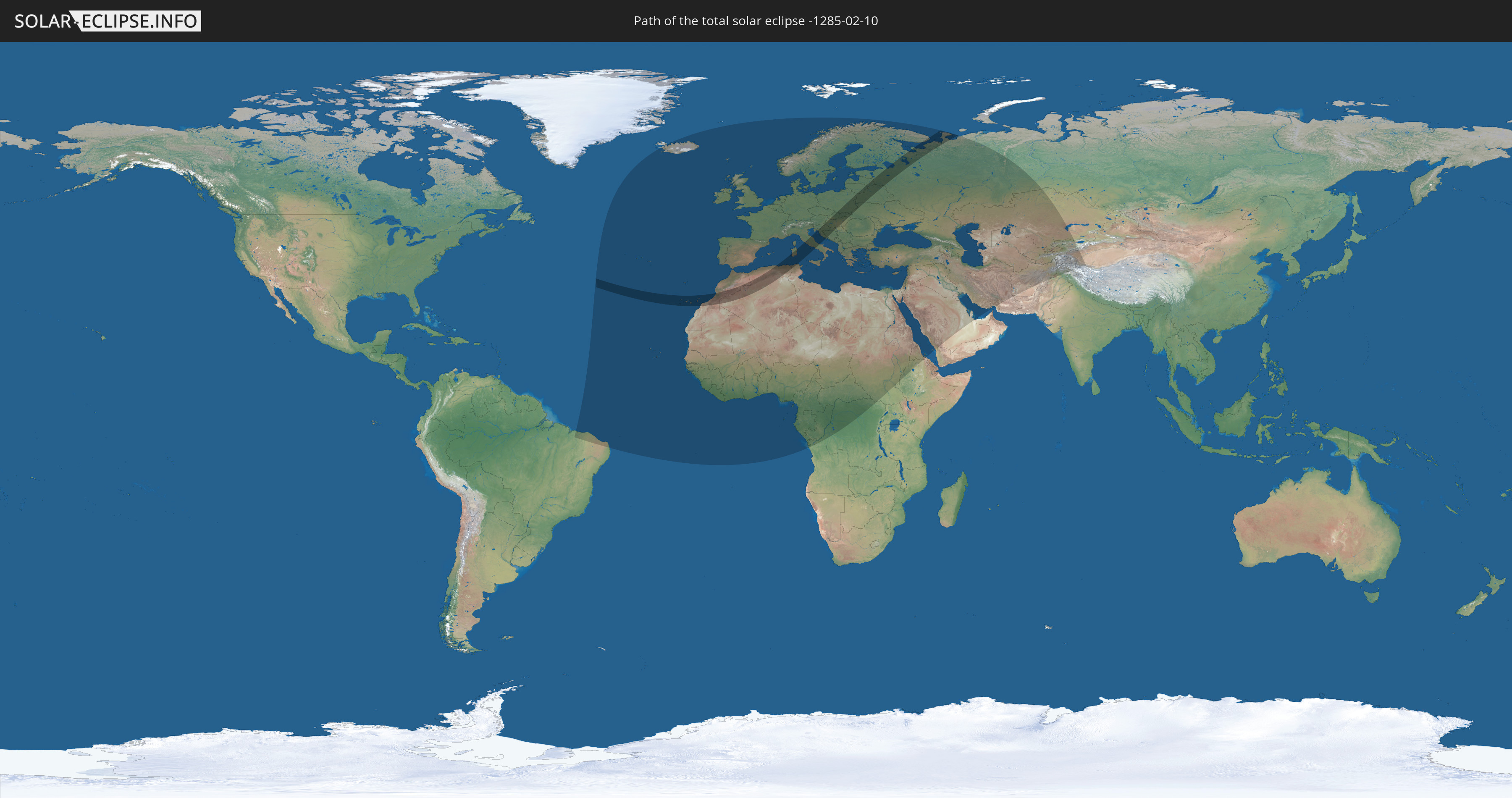
Die Sonnenfinsternis am 02/10/-1285 kann man in 111 Ländern als partielle Sonnenfinsternis beobachten.
Der Finsternispfad verläuft durch 18 Länder. Nur in diesen Ländern ist sie als total Sonnenfinsternis zu sehen.
In den folgenden Ländern ist die Sonnenfinsternis total zu sehen
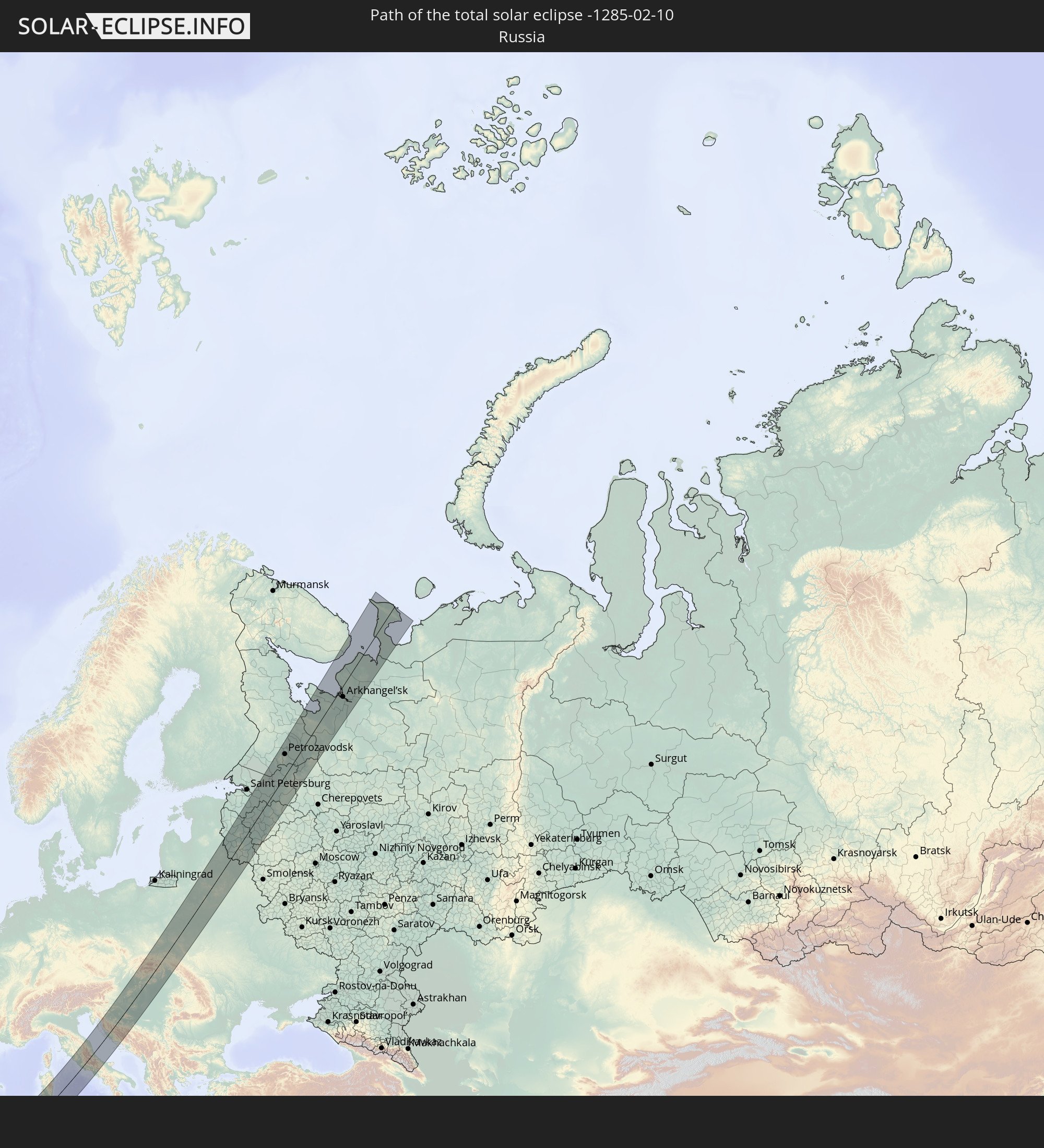 Russia
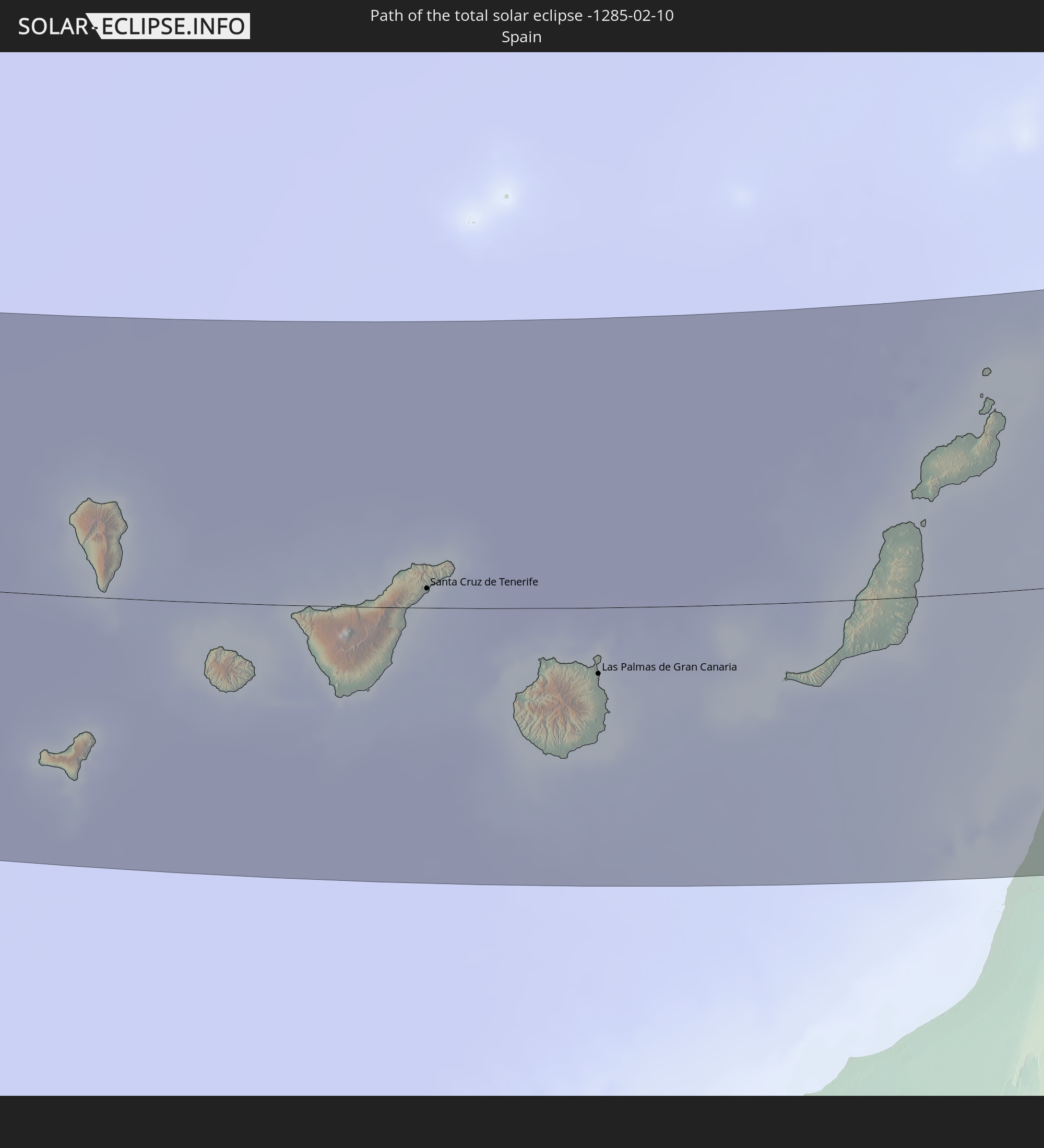 Spain
Spain
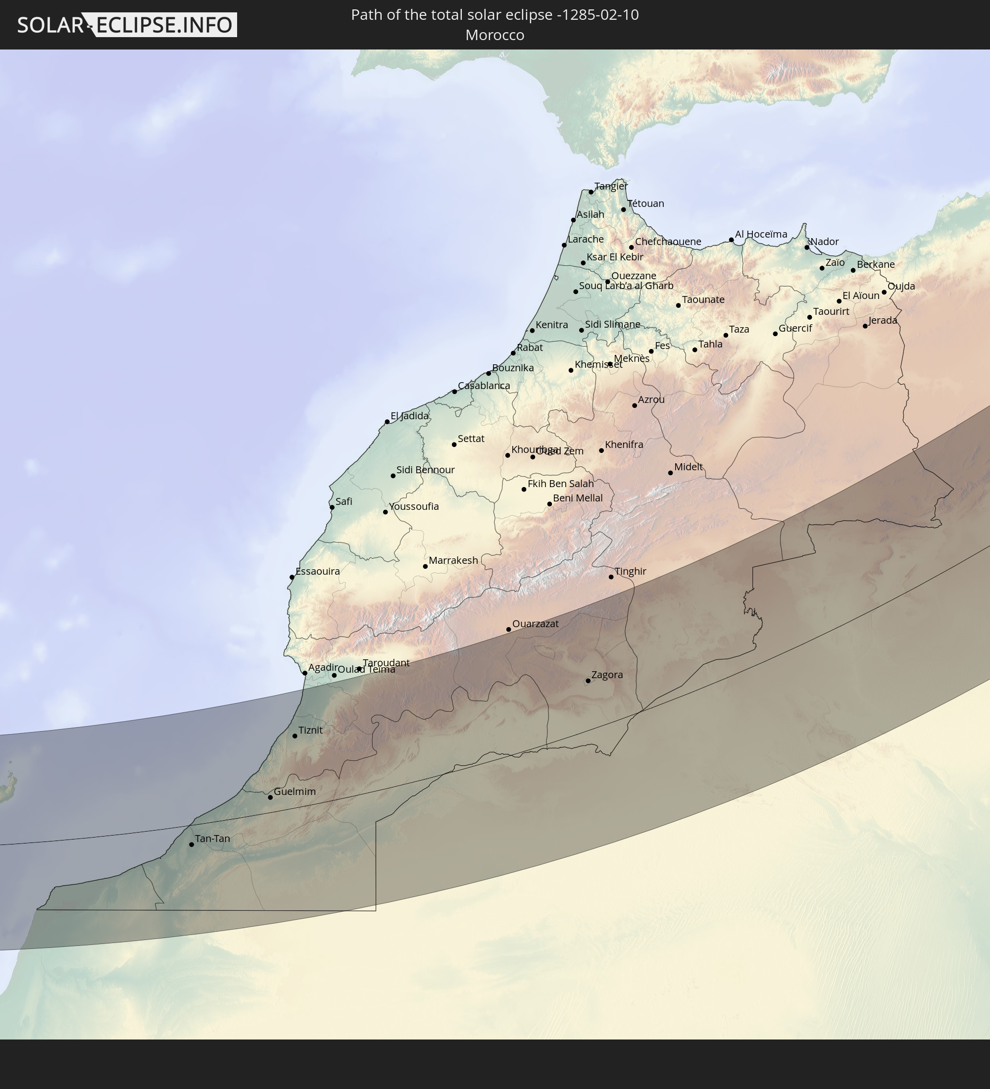 Morocco
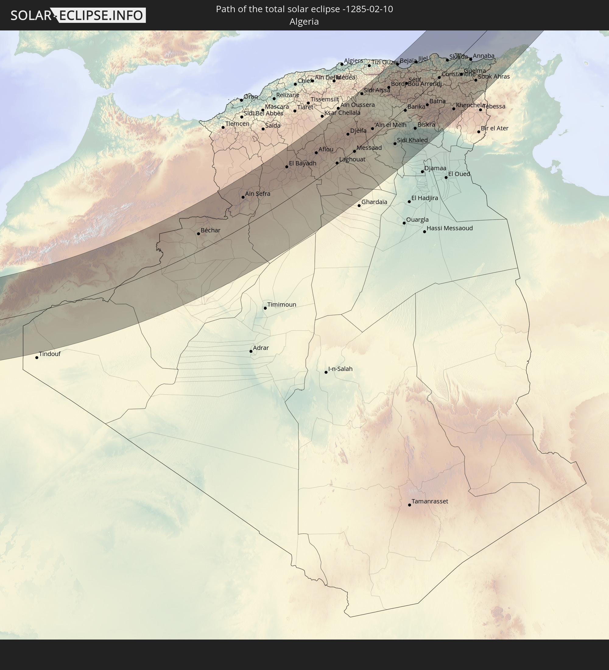 Algeria
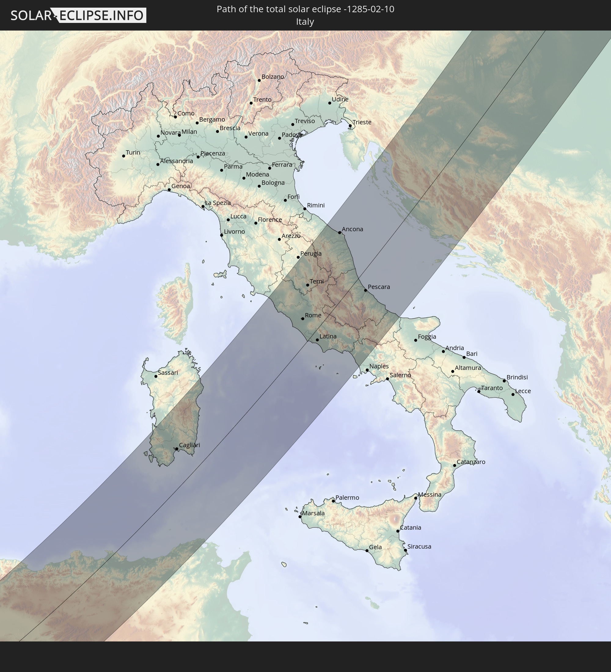 Italy
Italy
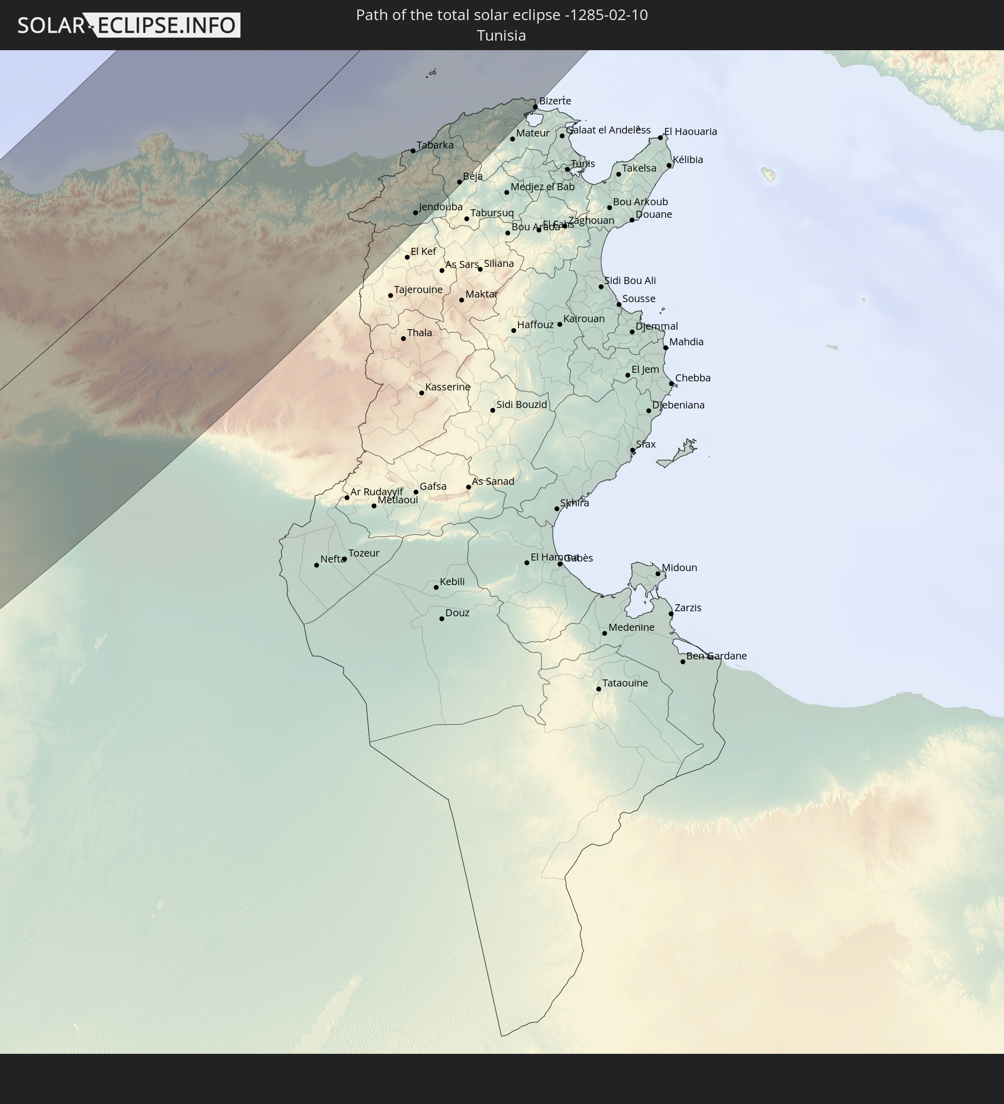 Tunisia
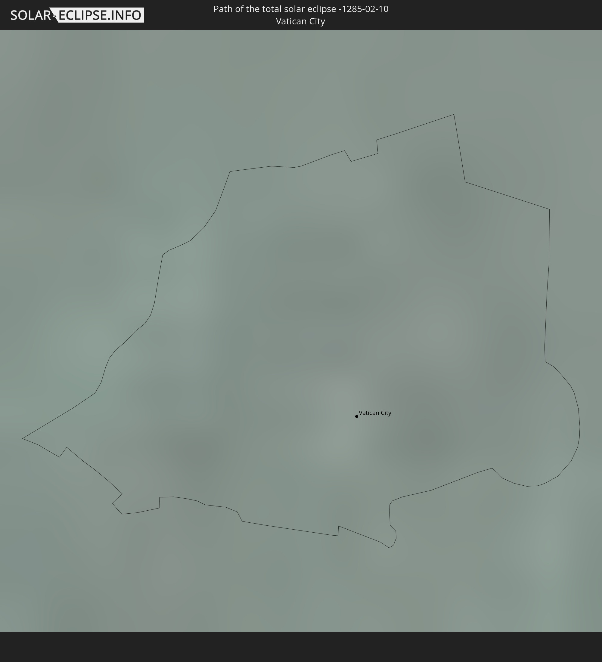 Vatican City
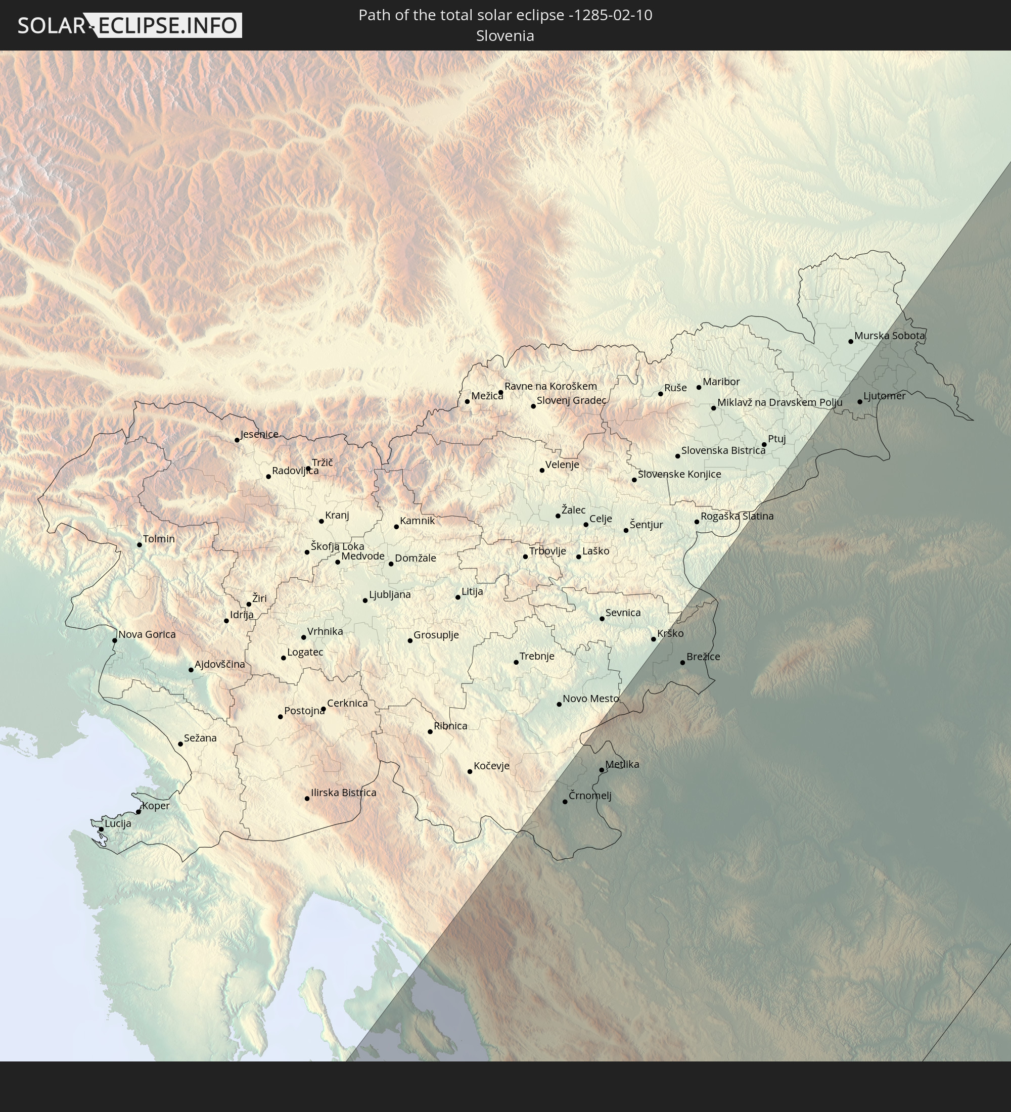 Slovenia
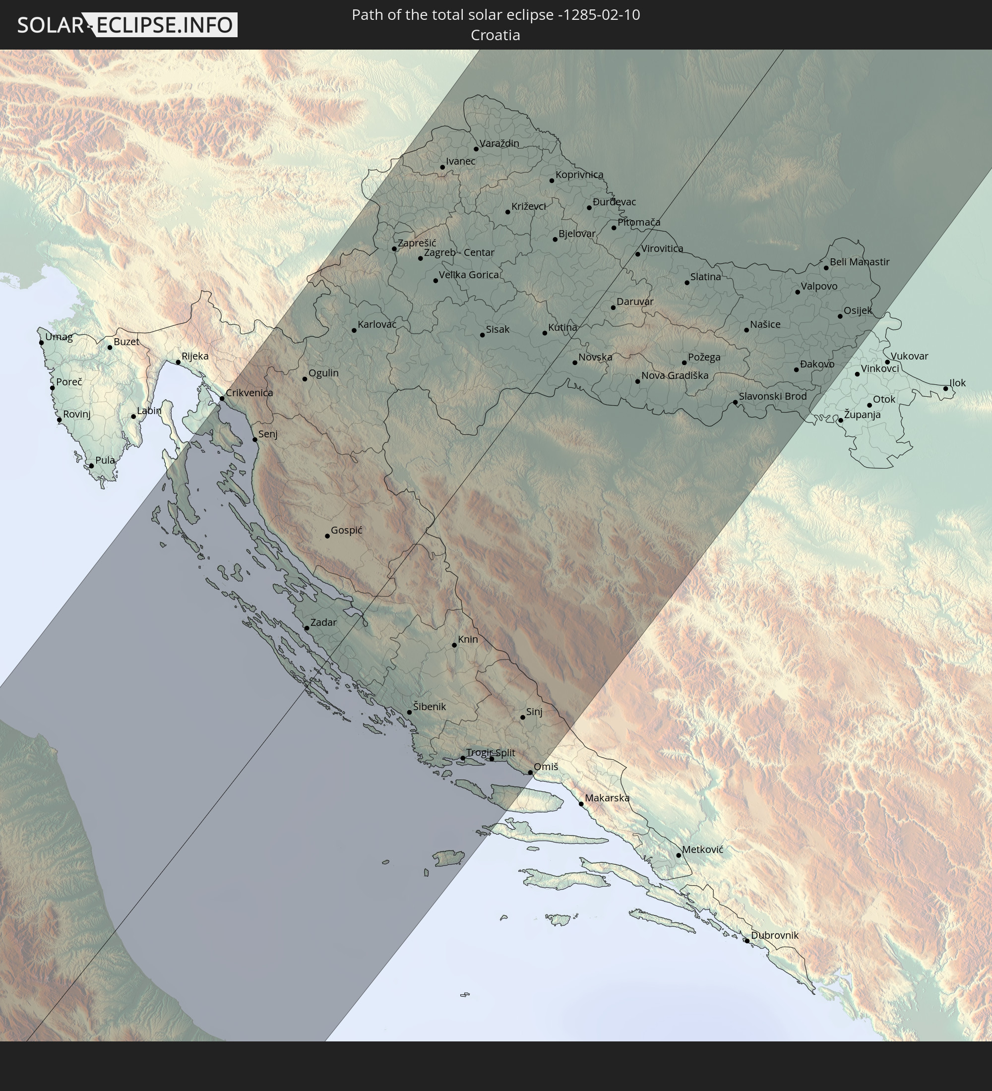 Croatia
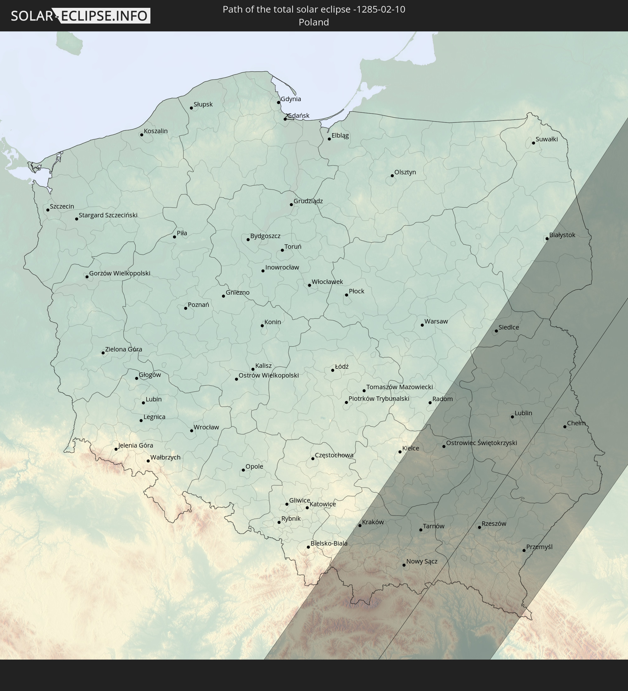 Poland
 Bosnia and Herzegovina
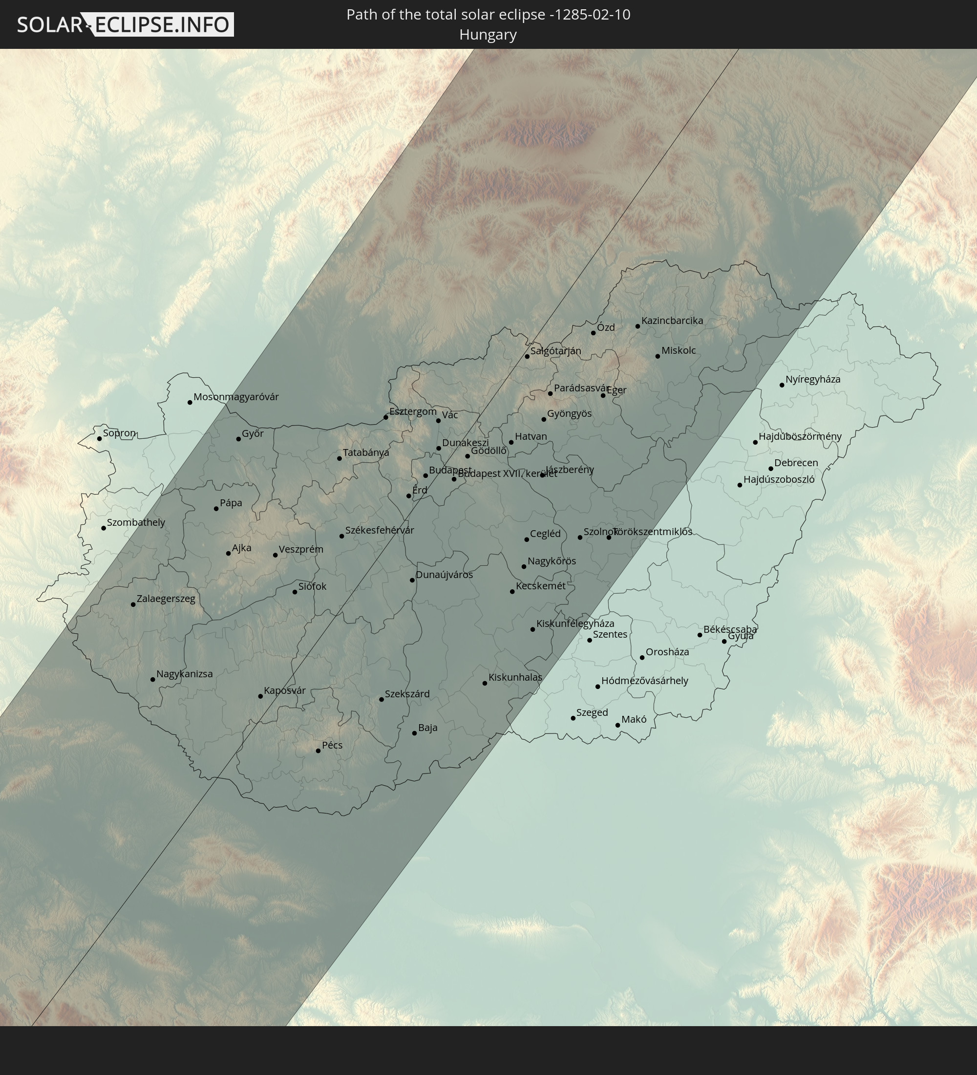 Hungary
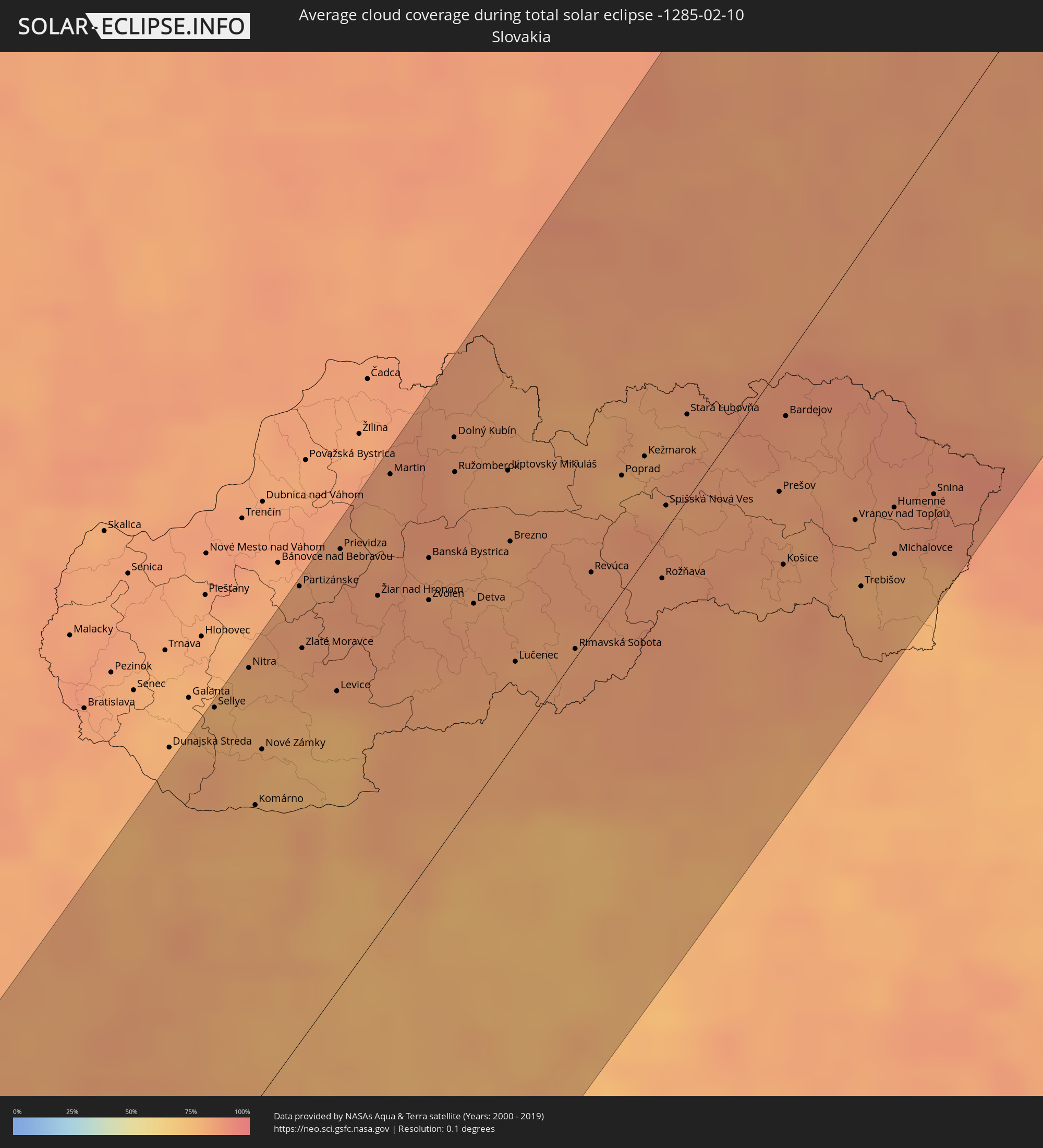
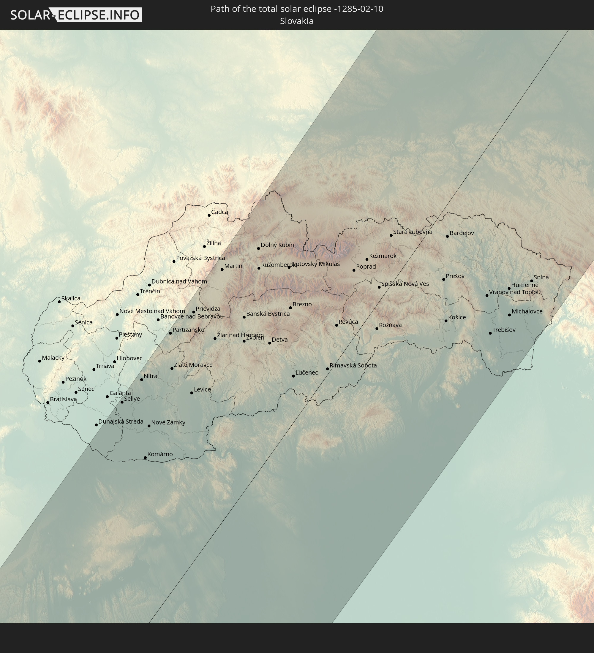 Slovakia
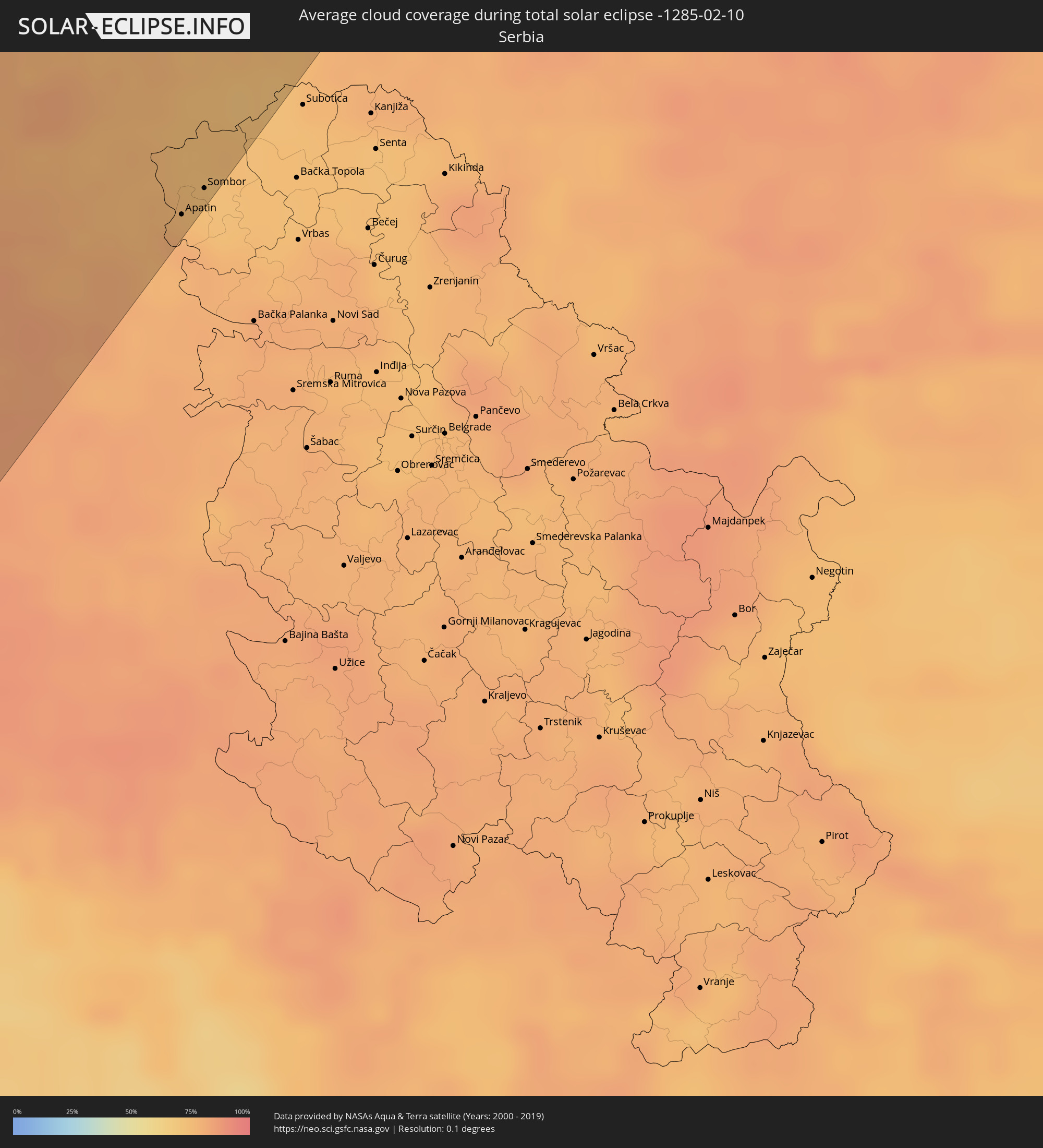
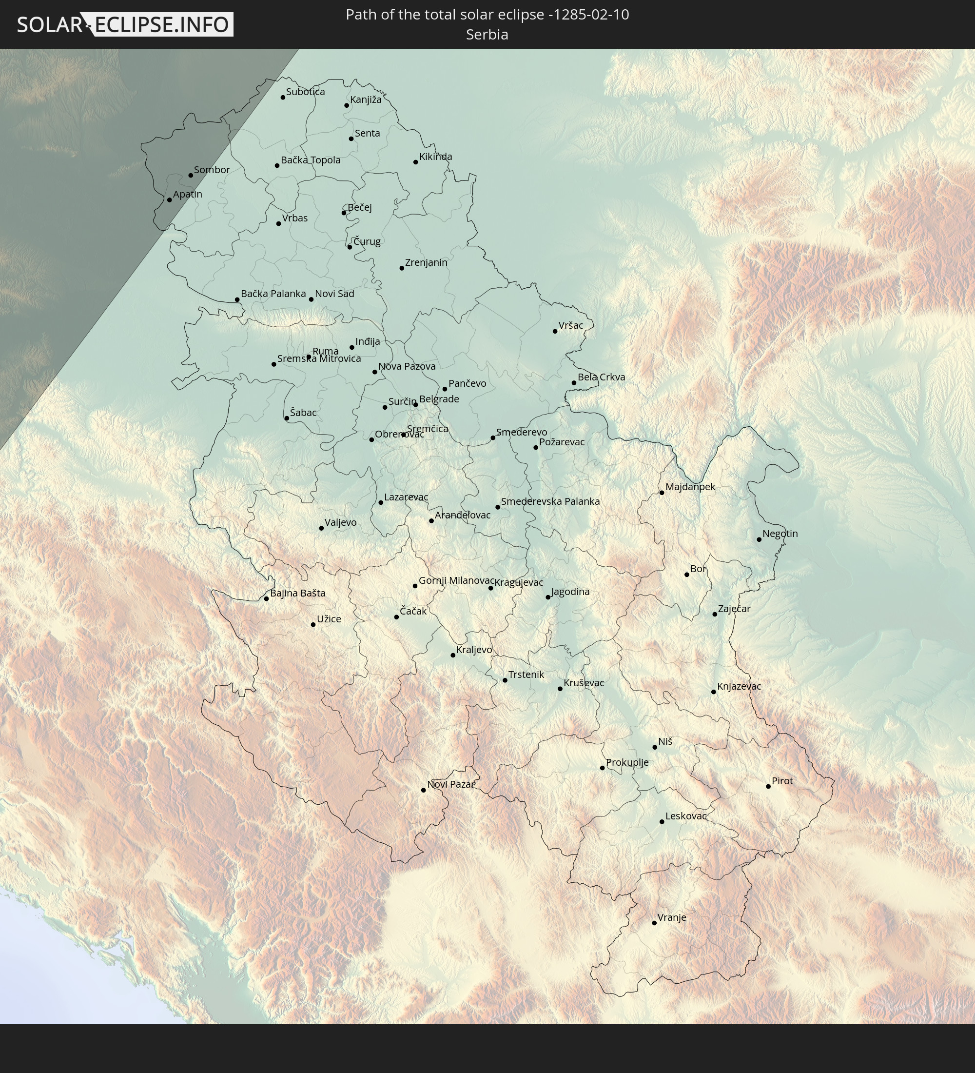 Serbia
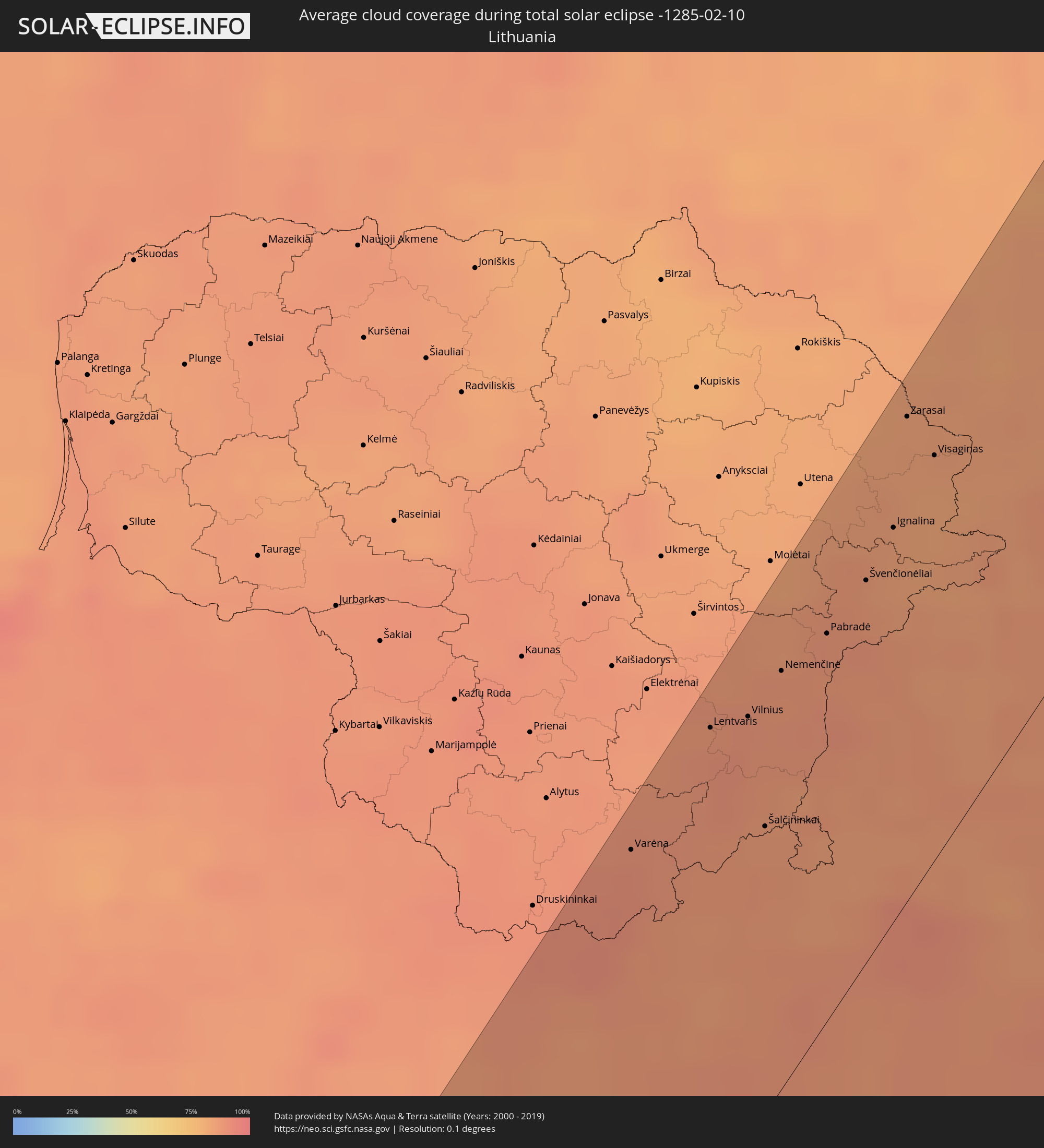
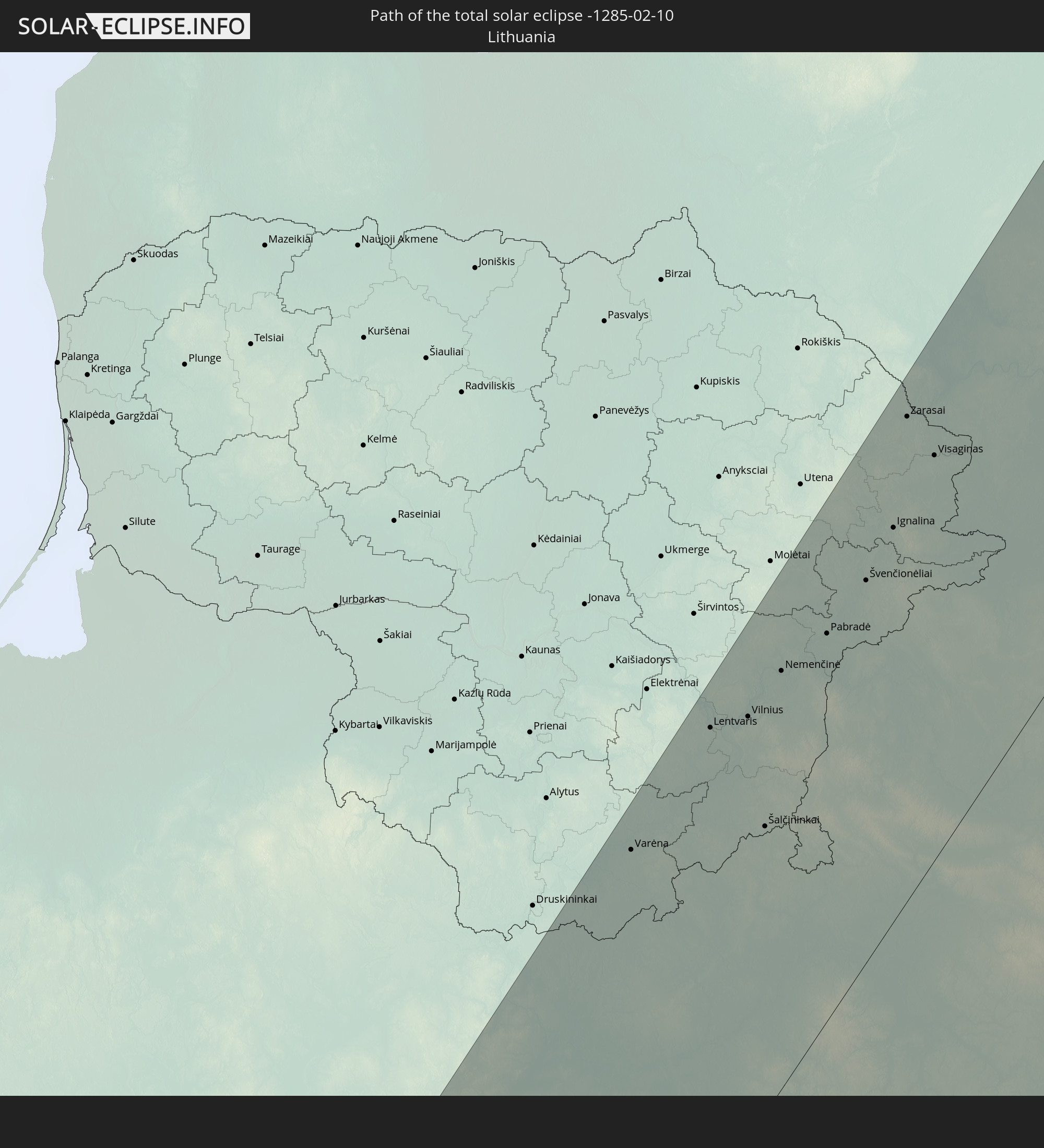 Lithuania
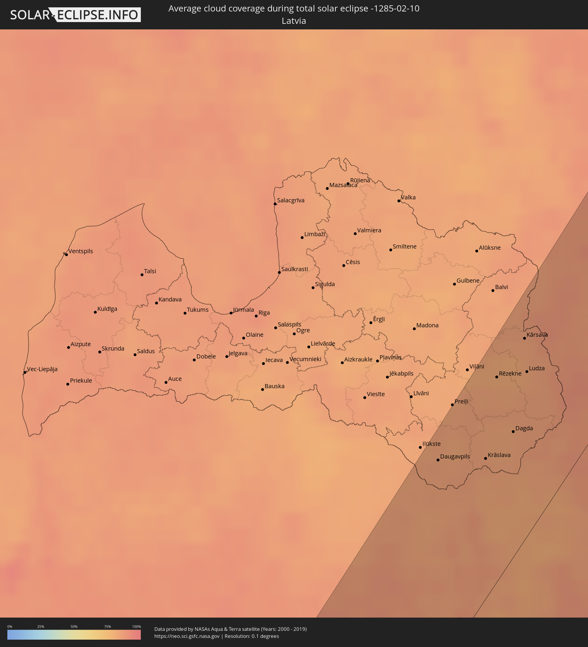
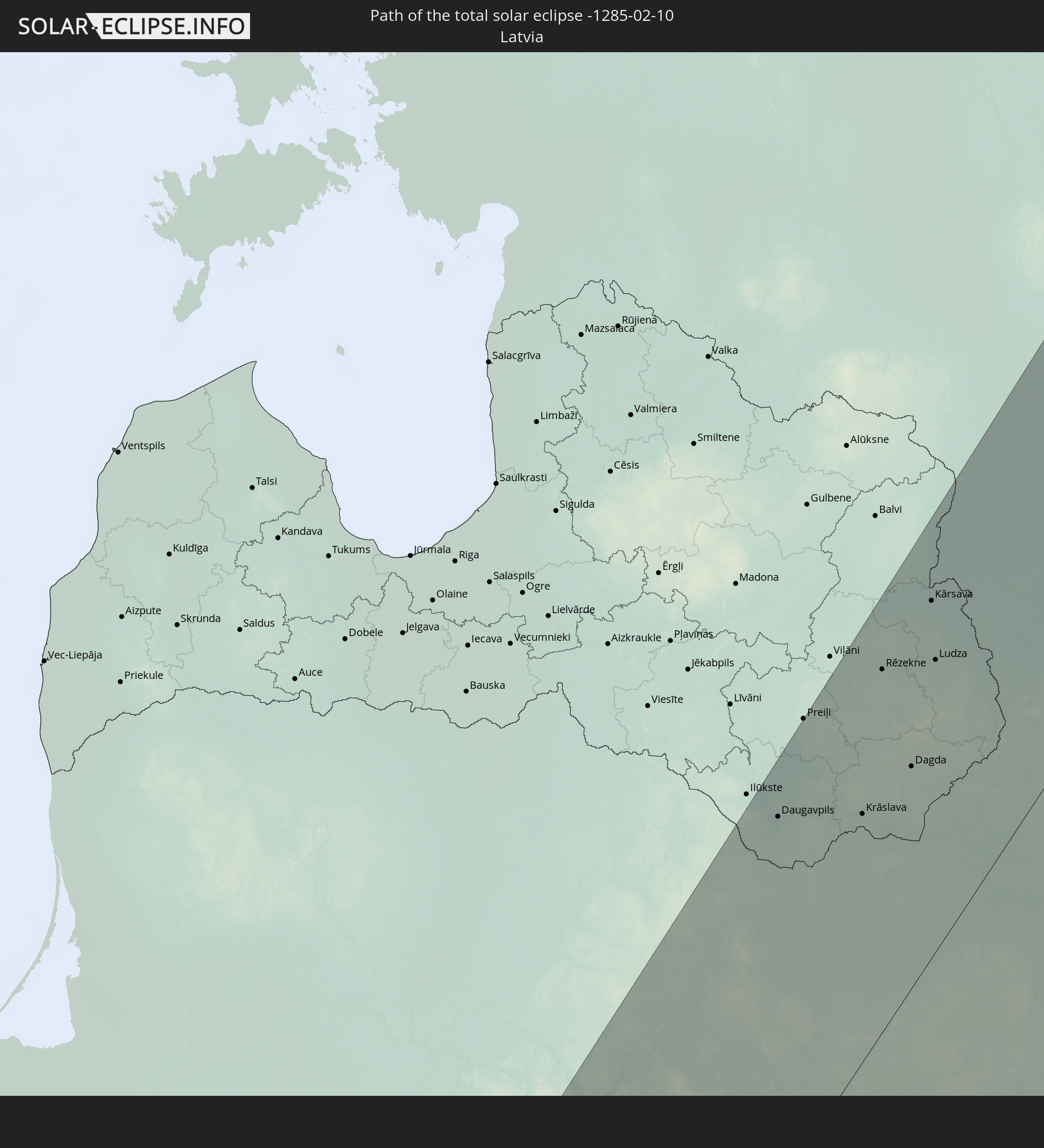 Latvia
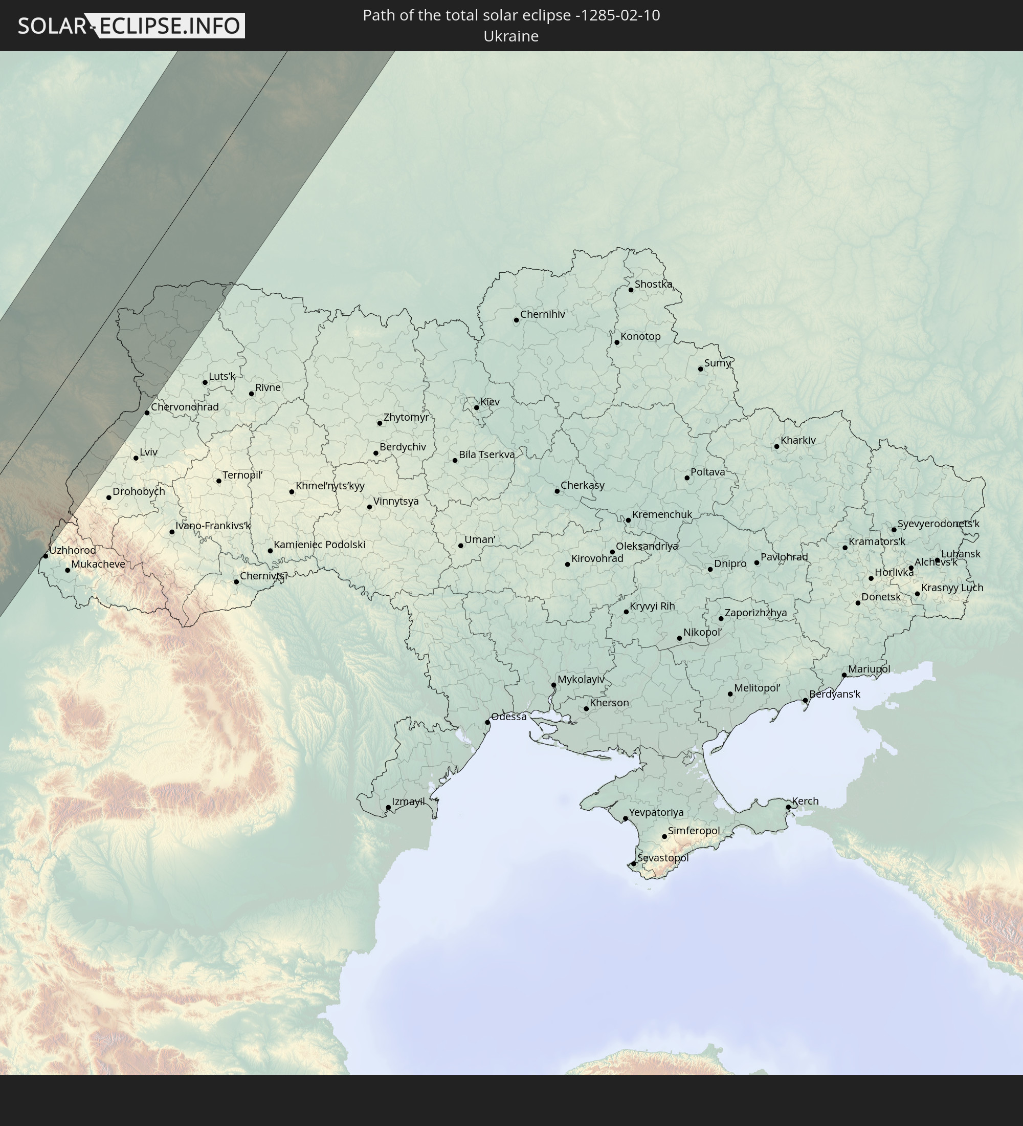 Ukraine
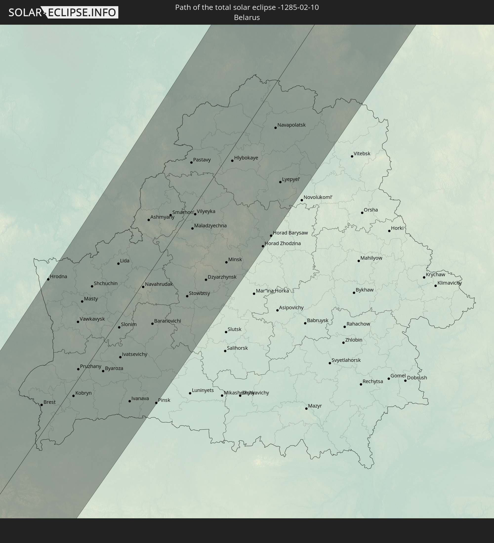 Belarus
In den folgenden Ländern ist die Sonnenfinsternis partiell zu sehen
 Russia
 Brazil
 Portugal
 Cabo Verde
 Iceland
 Spain
Spain
 Senegal
 Mauritania
 The Gambia
 Guinea-Bissau
 Guinea
 Saint Helena, Ascension and Tristan da Cunha
 Sierra Leone
 Morocco
 Mali
Mali
 Liberia
 Republic of Ireland
 Algeria
 United Kingdom
 Ivory Coast
 Faroe Islands
 Burkina Faso
 Gibraltar
 France
 Isle of Man
 Ghana
Ghana
 Guernsey
 Jersey
 Togo
Togo
 Niger
Niger
 Benin
Benin
 Andorra
 Belgium
 Nigeria
 Netherlands
 Norway
 Equatorial Guinea
 Luxembourg
 Germany
 Switzerland
 São Tomé and Príncipe
 Italy
Italy
 Monaco
 Tunisia
 Denmark
 Cameroon
 Gabon
Gabon
 Libya
Libya
 Liechtenstein
 Austria
 Sweden
 Republic of the Congo
 Angola
 Czechia
 Democratic Republic of the Congo
 San Marino
 Vatican City
 Slovenia
 Chad
Chad
 Croatia
 Poland
 Malta
Malta
 Central African Republic
 Bosnia and Herzegovina
 Hungary
 Slovakia
 Montenegro
 Serbia
 Albania
 Åland Islands
 Greece
 Romania
 Republic of Macedonia
 Finland
 Lithuania
 Latvia
 Estonia
 Sudan
Sudan
 Ukraine
 Bulgaria
 Belarus
 Egypt
Egypt
 Turkey
 Moldova
 Cyprus
 Ethiopia
 State of Palestine
 Israel
 Saudi Arabia
 Jordan
 Lebanon
 Syria
Syria
 Eritrea
 Iraq
Iraq
 Georgia
 Yemen
Yemen
 Armenia
 Iran
Iran
 Azerbaijan
 Kazakhstan
 Kuwait
 Bahrain
 Qatar
Qatar
 United Arab Emirates
 Turkmenistan
 Uzbekistan
 Afghanistan
 Pakistan
 Tajikistan
 Kyrgyzstan
 China
China
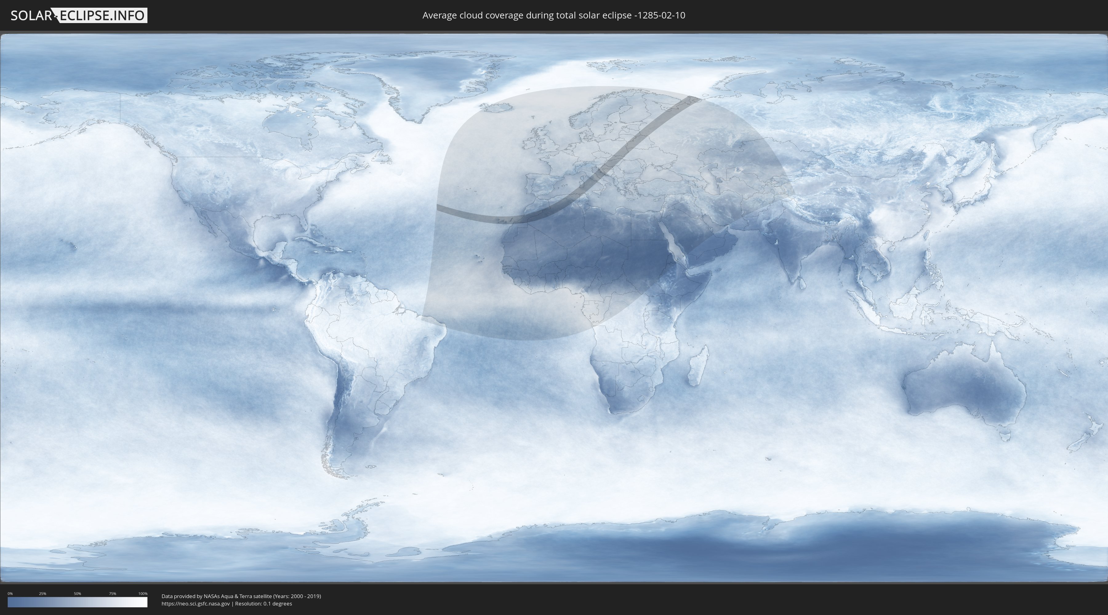
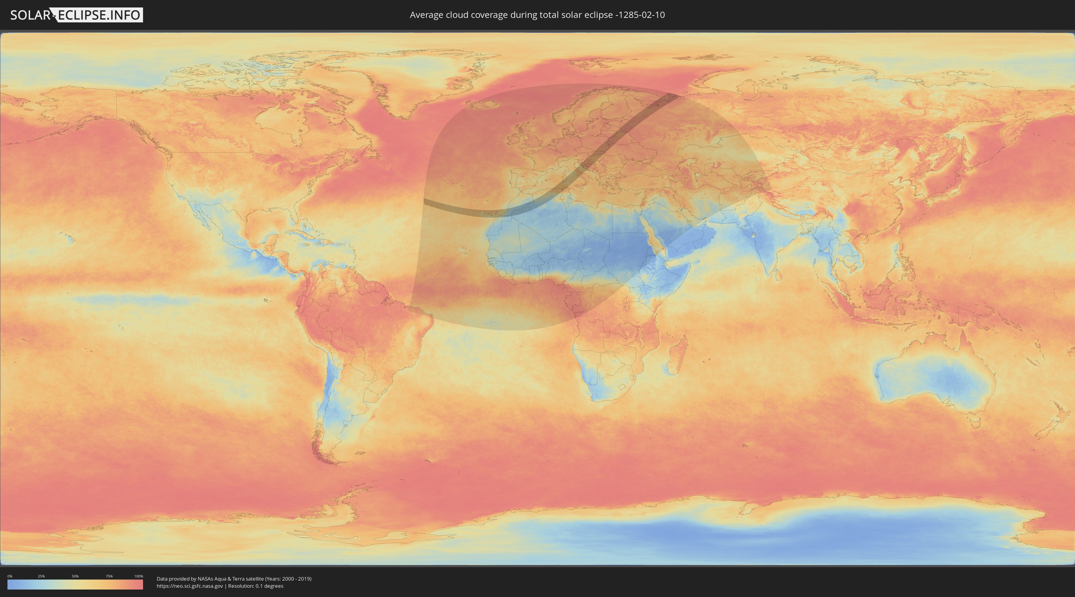
How will be the weather during the total solar eclipse on 02/10/-1285?
Where is the best place to see the total solar eclipse of 02/10/-1285?
The following maps show the average cloud coverage for the day of the total solar eclipse.
With the help of these maps, it is possible to find the place along the eclipse path, which has the best
chance of a cloudless sky.
Nevertheless, you should consider local circumstances and inform about the weather of your chosen
observation site.
The data is provided by NASAs satellites
AQUA and TERRA.
The cloud maps are averaged over a period of 19 years (2000 - 2019).
Detailed country maps
 Russia
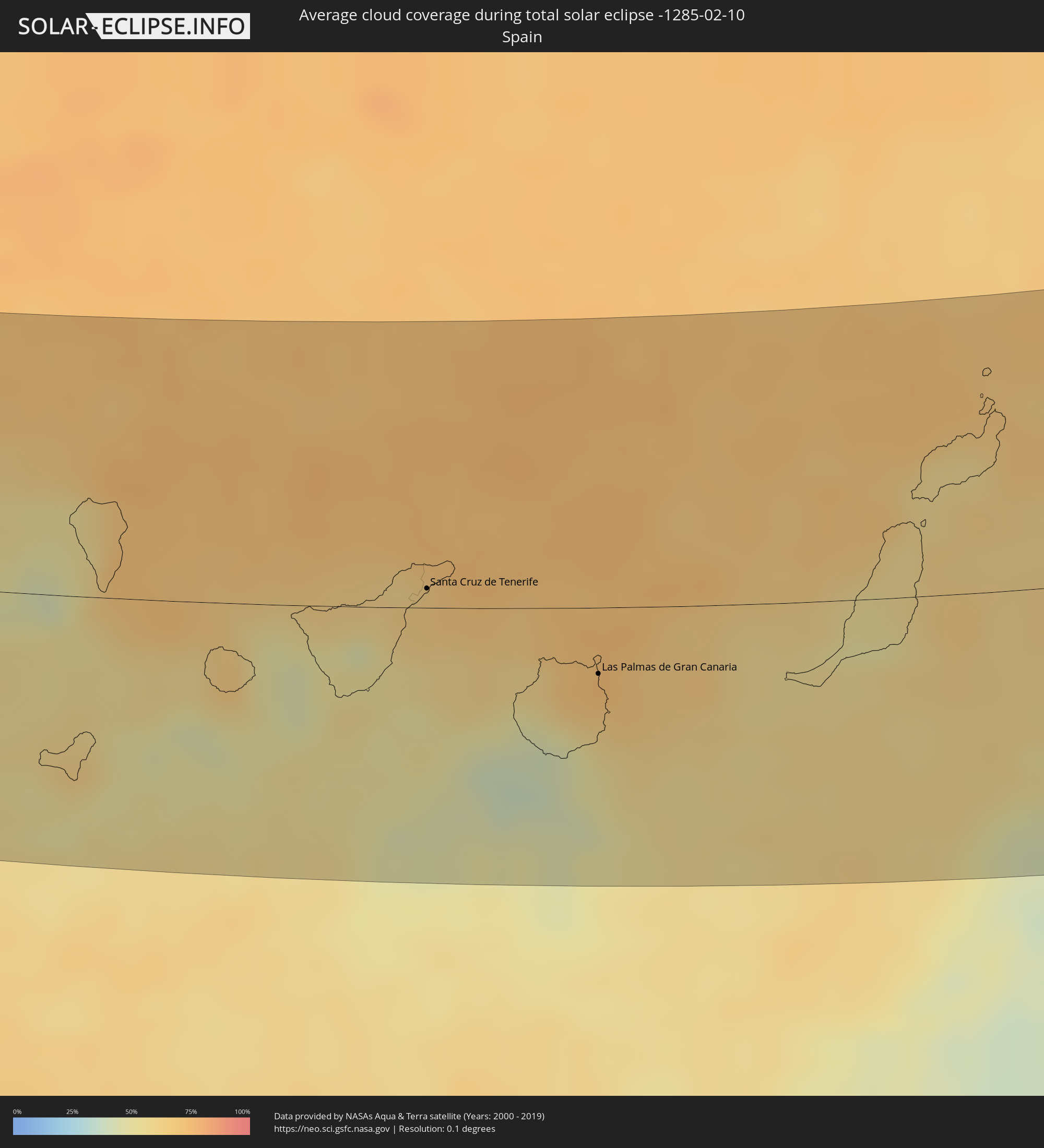 Spain
Spain
 Morocco
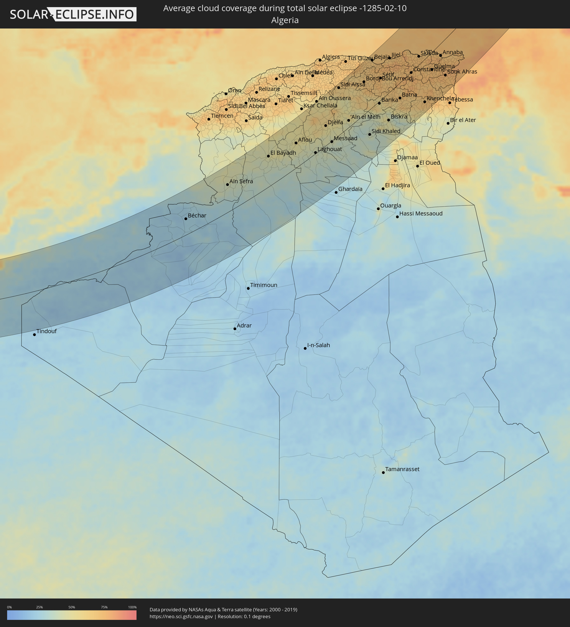 Algeria
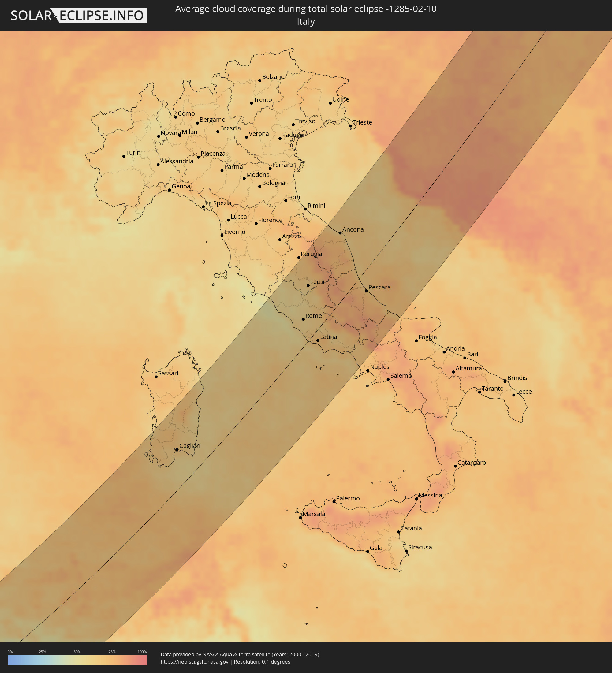 Italy
Italy
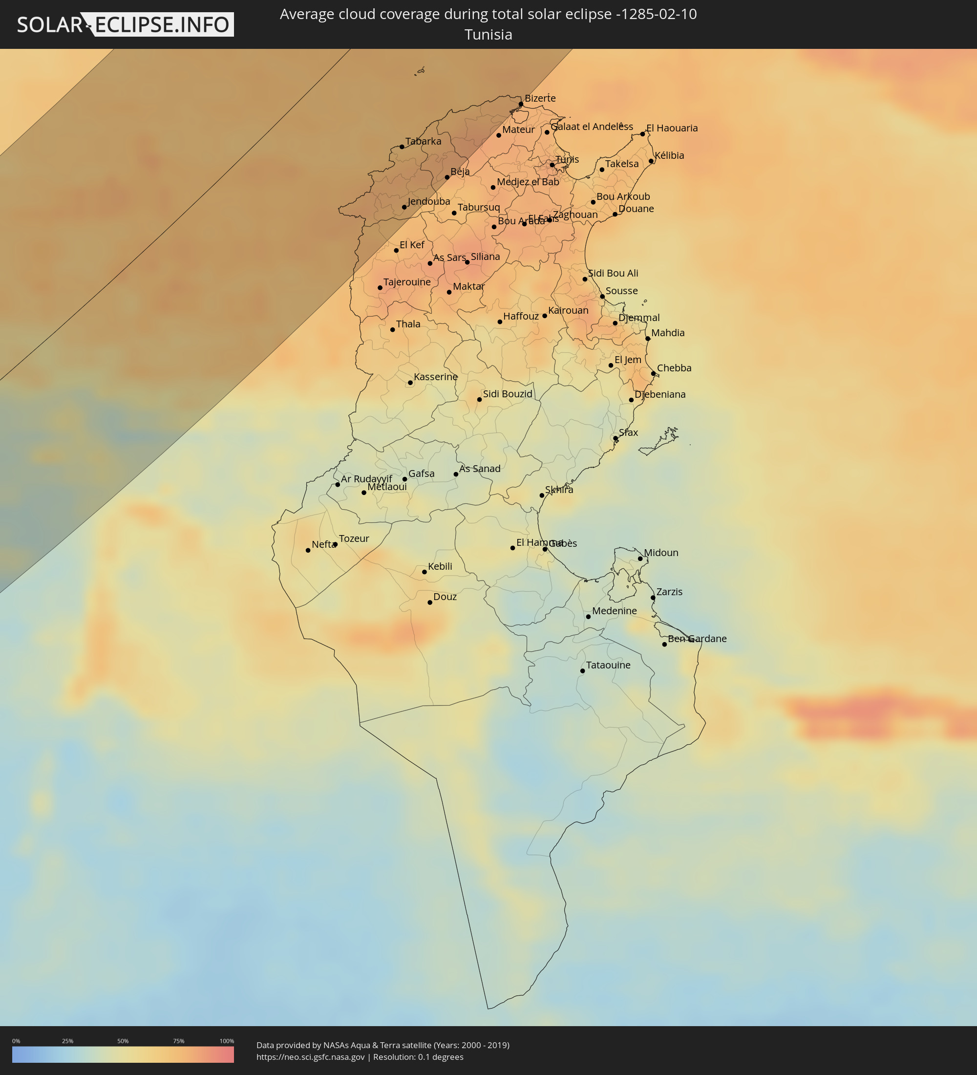 Tunisia
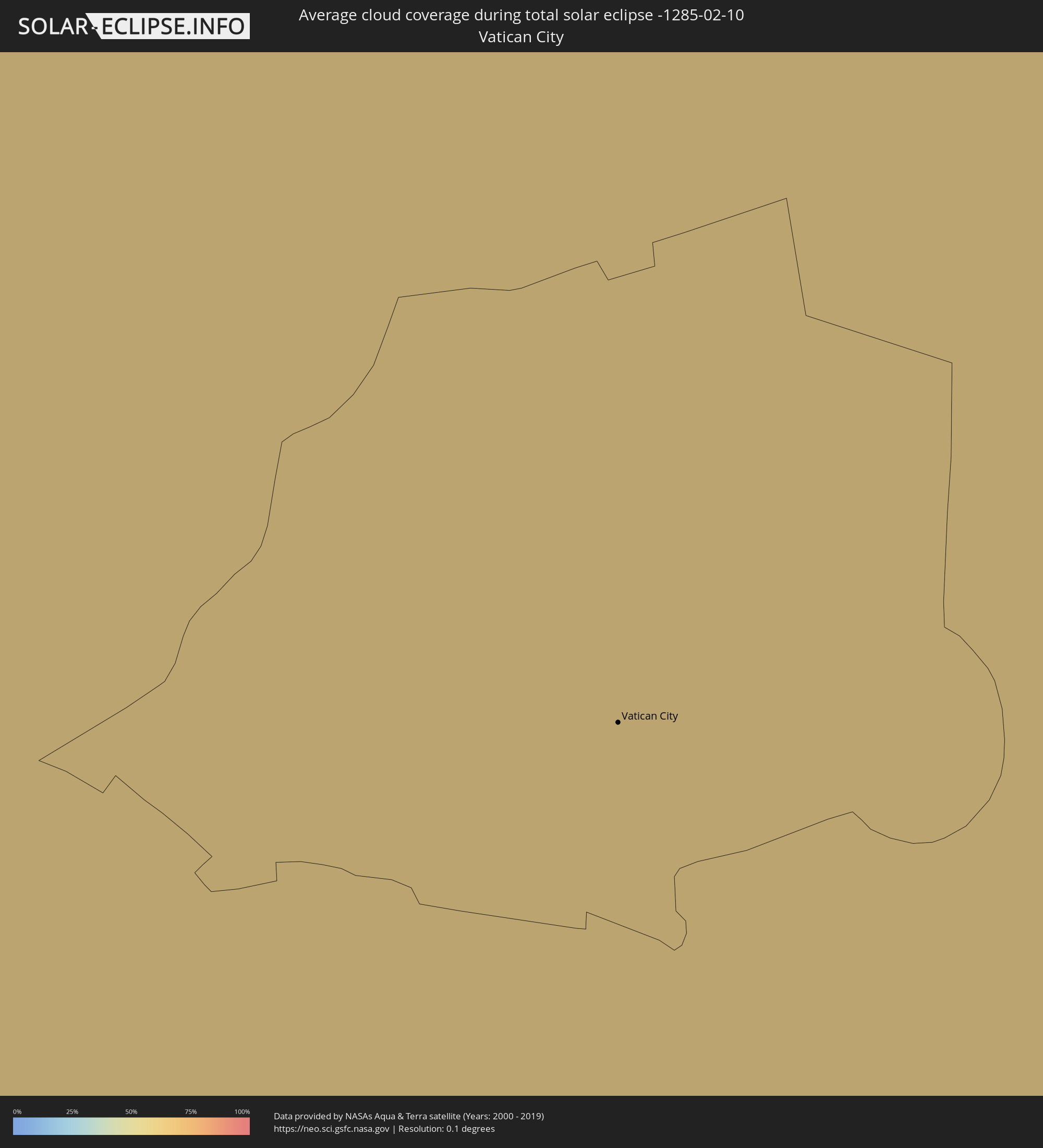 Vatican City
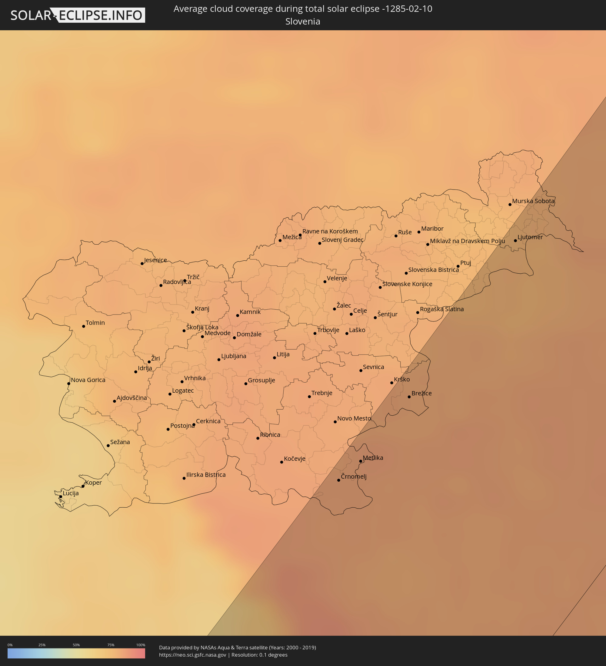 Slovenia
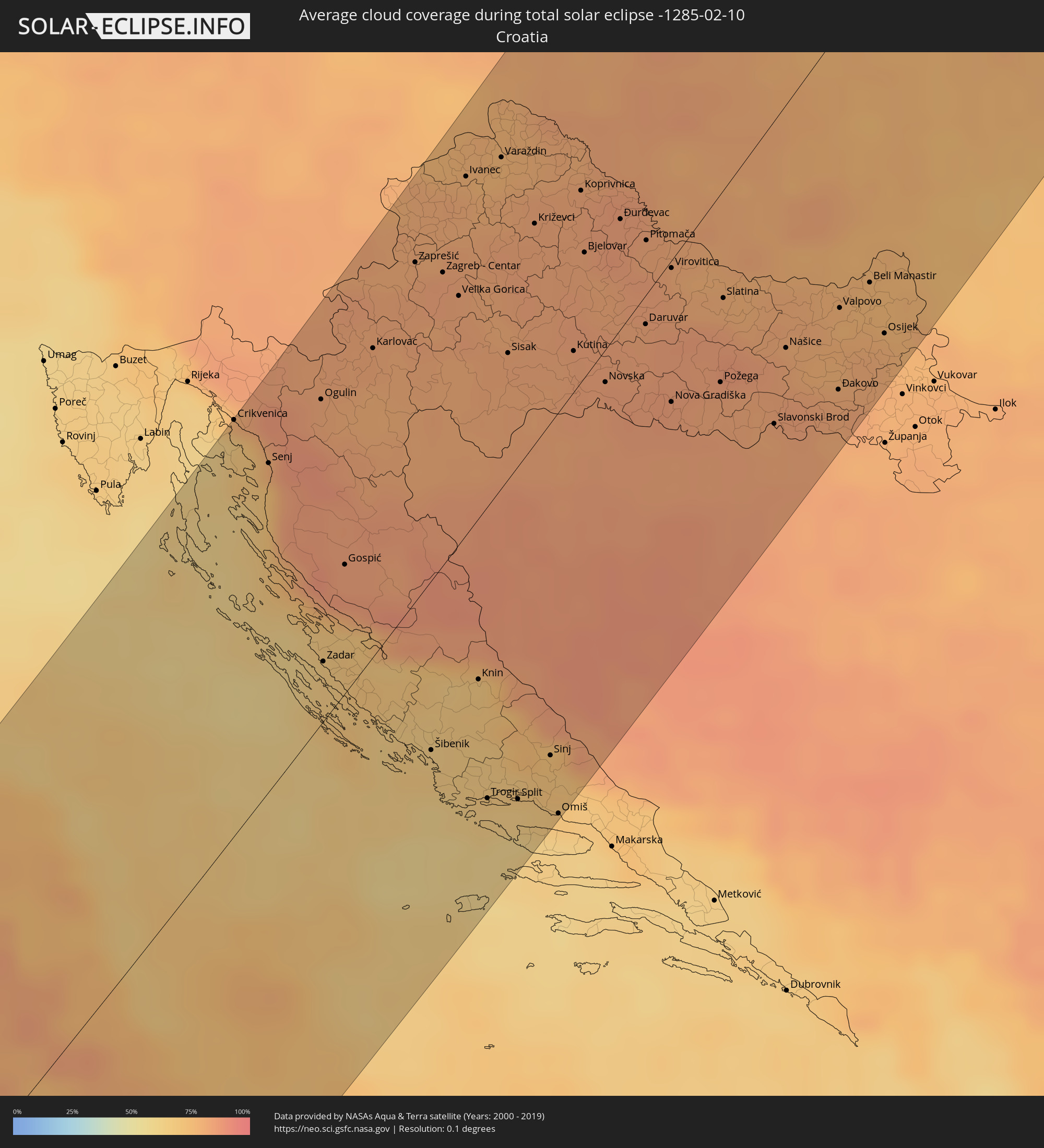 Croatia
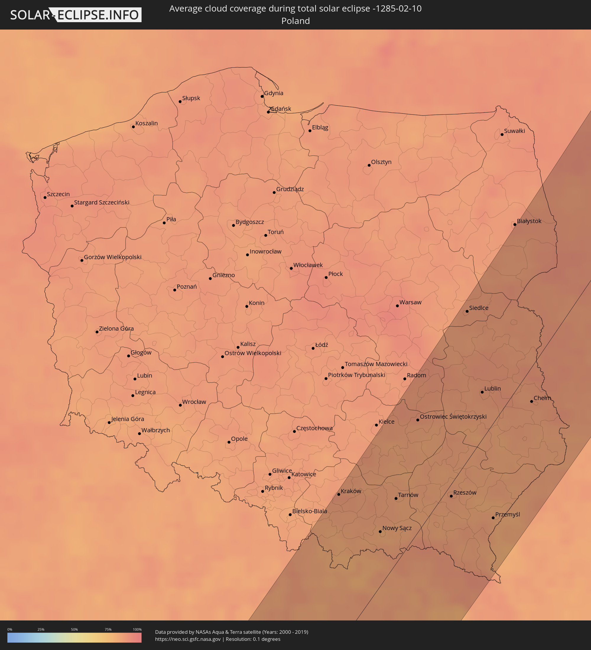 Poland
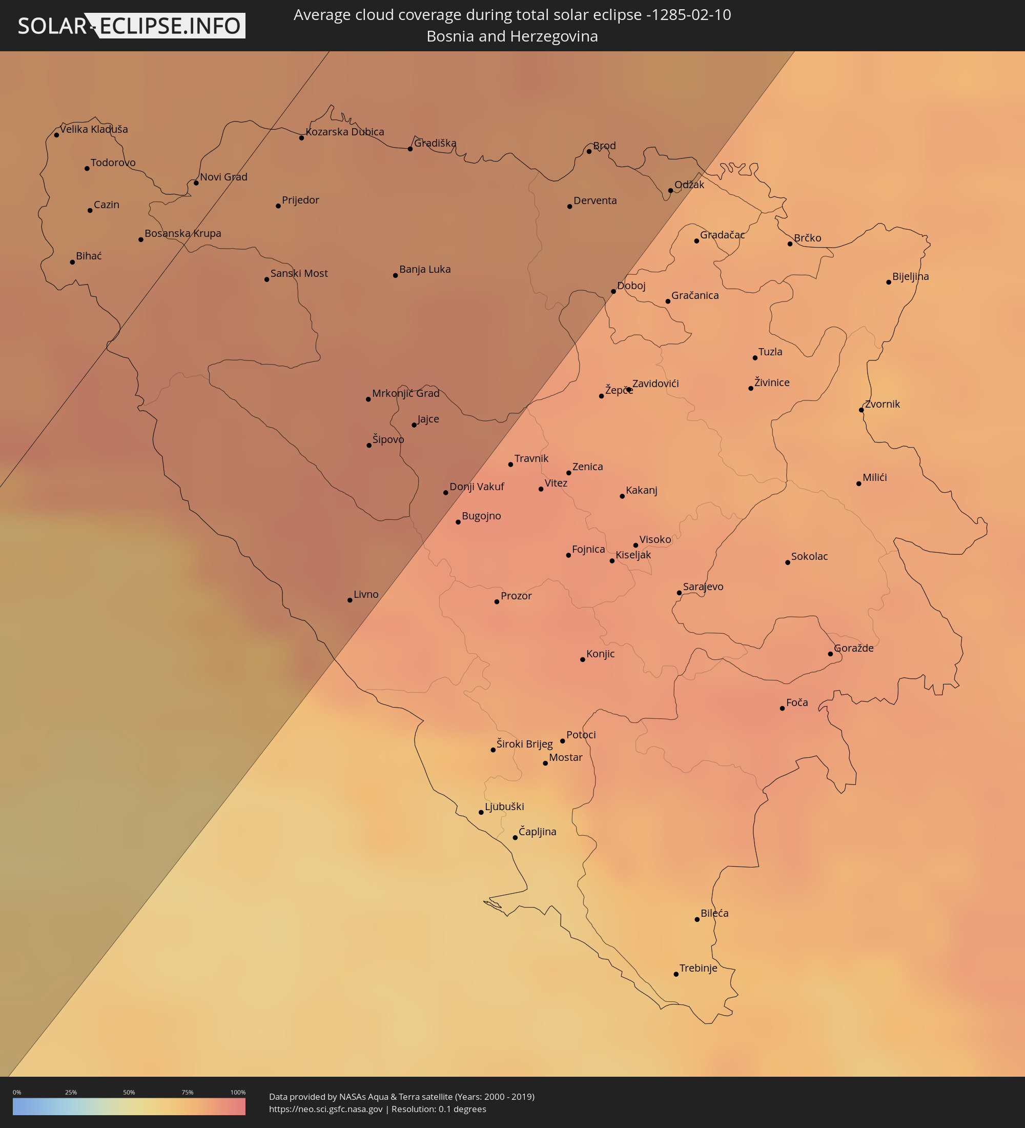 Bosnia and Herzegovina
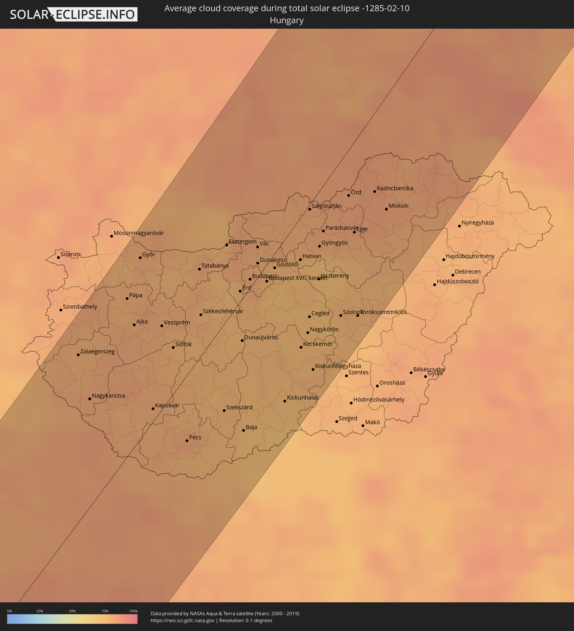 Hungary
 Slovakia
 Serbia
 Lithuania
 Latvia
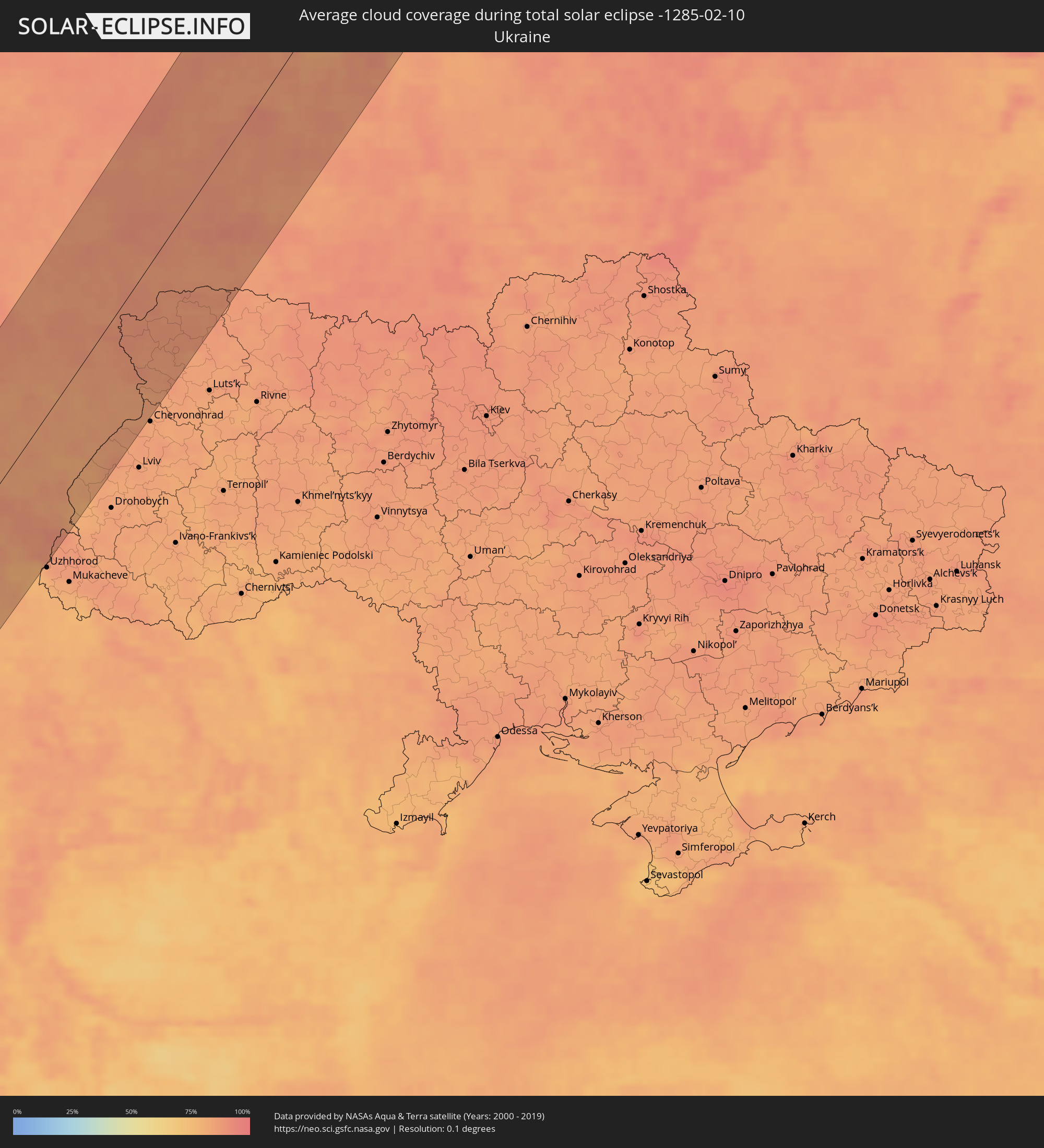 Ukraine
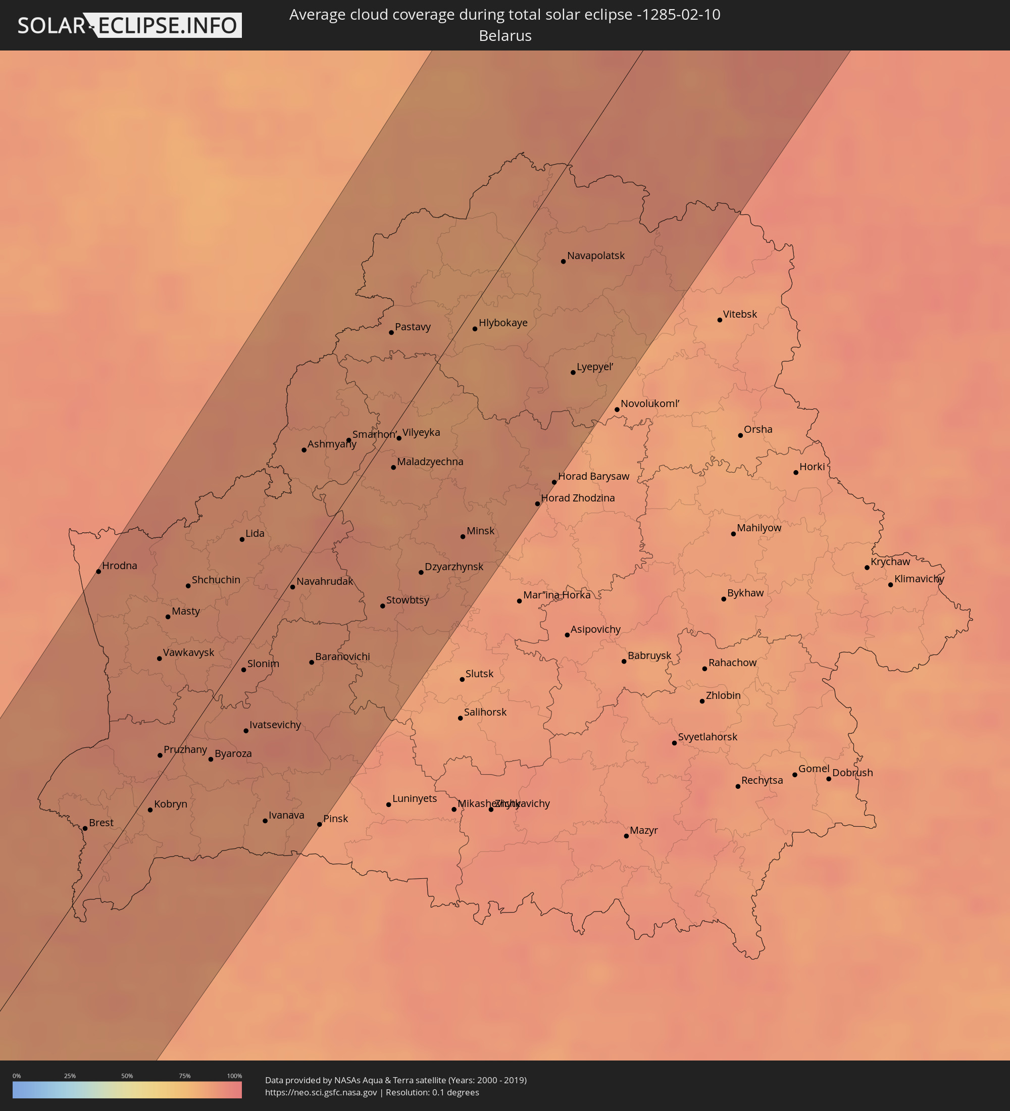 Belarus
Cities inside the path of the eclipse
The following table shows all locations with a population of more than 5,000 inside the eclipse path. Cities which have more than 100,000 inhabitants are marked bold. A click at the locations opens a detailed map.
| City | Type | Eclipse duration | Local time of max. eclipse | Distance to central line | Ø Cloud coverage |
|
Icod de los Vinos, Canary Islands
|
total | - | 08:52:04 UTC-01:01 | 2 km | 58% |
|
Arona, Canary Islands
|
total | - | 08:51:42 UTC-01:01 | 32 km | 56% |
|
La Orotava, Canary Islands
|
total | - | 08:52:22 UTC-01:01 | 0 km | 58% |
|
Candelaria, Canary Islands
|
total | - | 08:52:31 UTC-01:01 | 4 km | 63% |
|
Santa Cruz de Tenerife, Canary Islands
|
total | - | 08:52:51 UTC-01:01 | 9 km | 65% |
|
Mogán, Canary Islands
|
total | - | 08:52:44 UTC-01:01 | 56 km | 41% |
|
Gáldar, Canary Islands
|
total | - | 08:53:14 UTC-01:01 | 26 km | 55% |
|
Maspalomas, Canary Islands
|
total | - | 08:52:44 UTC-01:01 | 69 km | 44% |
|
Santa Lucía, Canary Islands
|
total | - | 08:53:02 UTC-01:01 | 53 km | 50% |
|
Las Palmas de Gran Canaria, Canary Islands
|
total | - | 08:53:30 UTC-01:01 | 32 km | 67% |
|
Puerto del Rosario, Canary Islands
|
total | - | 08:56:25 UTC-01:01 | 8 km | 59% |
|
Arrecife, Canary Islands
|
total | - | 08:57:36 UTC-01:01 | 57 km | 62% |
|
Tarfaya, Laâyoune-Boujdour-Sakia El Hamra
|
total | - | 09:28:16 UTC-00:30 | 61 km | 53% |
|
Tan-Tan, Guelmim-Es Smara
|
total | - | 09:31:56 UTC-00:30 | 26 km | 43% |
|
Sidi Ifni, Souss-Massa-Drâa
|
total | - | 09:34:55 UTC-00:30 | 63 km | 41% |
|
Guelmim, Guelmim-Es Smara
|
total | - | 09:34:30 UTC-00:30 | 18 km | 30% |
|
Tiznit, Souss-Massa-Drâa
|
total | - | 09:36:08 UTC-00:30 | 90 km | 27% |
|
Zagora, Souss-Massa-Drâa
|
total | - | 09:43:57 UTC-00:30 | 59 km | 25% |
|
Mhamid, Souss-Massa-Drâa
|
total | - | 09:43:24 UTC-00:30 | 1 km | 22% |
|
Béchar, Béchar
|
total | - | 10:32:18 UTC+00:09 | 53 km | 24% |
|
Figuig (Centre), Oriental
|
total | - | 09:55:13 UTC-00:30 | 56 km | 29% |
|
Djelfa, Djelfa
|
total | - | 10:47:06 UTC+00:09 | 56 km | 52% |
|
Bordj Bou Arreridj, Bordj Bou Arréridj
|
total | - | 10:51:45 UTC+00:09 | 87 km | 67% |
|
Bejaïa, Béjaïa
|
total | - | 10:53:12 UTC+00:09 | 123 km | 66% |
|
Sétif, Sétif
|
total | - | 10:53:08 UTC+00:09 | 57 km | 72% |
|
Biskra, Biskra
|
total | - | 10:52:05 UTC+00:09 | 73 km | 48% |
|
Jijel, Jijel
|
total | - | 10:54:34 UTC+00:09 | 87 km | 71% |
|
Batna, Batna
|
total | - | 10:53:49 UTC+00:09 | 41 km | 65% |
|
Constantine, Constantine
|
total | - | 10:55:38 UTC+00:09 | 2 km | 74% |
|
Skikda, Skikda
|
total | - | 10:56:47 UTC+00:09 | 21 km | 72% |
|
Annaba, Annaba
|
total | - | 10:58:25 UTC+00:09 | 31 km | 74% |
|
Souk Ahras, Souk Ahras
|
total | - | 10:58:04 UTC+00:09 | 91 km | 74% |
|
Sakiet Sidi Youssef, Kef
|
total | - | 10:58:45 UTC+00:09 | 121 km | 76% |
|
Tabarka, Jundūbah
|
total | - | 11:00:20 UTC+00:09 | 88 km | 75% |
|
Jendouba, Jundūbah
|
total | - | 10:59:52 UTC+00:09 | 126 km | 75% |
|
Cagliari, Sardinia
|
total | - | 11:54:05 UTC+01:00 | 64 km | 61% |
|
Béja, Bājah
|
total | - | 11:00:53 UTC+00:09 | 133 km | 73% |
|
Sejenane, Banzart
|
total | - | 11:01:21 UTC+00:09 | 111 km | 79% |
|
Civitavecchia, Latium
|
total | - | 12:01:28 UTC+01:00 | 99 km | 50% |
|
Viterbo, Latium
|
total | - | 12:02:16 UTC+01:00 | 102 km | 57% |
|
Acilia-Castel Fusano-Ostia Antica, Latium
|
total | - | 12:02:06 UTC+01:00 | 41 km | 58% |
|
Vatican City
|
total | - | 12:02:25 UTC+01:00 | 43 km | 61% |
|
Rome, Latium
|
total | - | 12:02:31 UTC+01:00 | 39 km | 61% |
|
Terni, Umbria
|
total | - | 12:03:17 UTC+01:00 | 77 km | 62% |
|
Foligno, Umbria
|
total | - | 12:03:42 UTC+01:00 | 101 km | 72% |
|
Guidonia Montecelio, Latium
|
total | - | 12:02:57 UTC+01:00 | 32 km | 62% |
|
Velletri, Latium
|
total | - | 12:02:47 UTC+01:00 | 7 km | 68% |
|
Latina, Latium
|
total | - | 12:02:49 UTC+01:00 | 17 km | 69% |
|
Ancona, The Marches
|
total | - | 12:05:31 UTC+01:00 | 93 km | 71% |
|
Pescara, Abruzzo
|
total | - | 12:05:48 UTC+01:00 | 30 km | 72% |
|
Črnomelj, Črnomelj
|
total | - | 12:09:33 UTC+01:00 | 118 km | 82% |
|
Zadar, Zadarska
|
total | - | 12:08:41 UTC+01:00 | 18 km | 65% |
|
Kostanjevica na Krki, Kostanjevica na Krki
|
total | - | 12:10:04 UTC+01:00 | 121 km | 84% |
|
Karlovac, Karlovačka
|
total | - | 12:10:03 UTC+01:00 | 90 km | 82% |
|
Brežice, Brežice
|
total | - | 12:10:22 UTC+01:00 | 115 km | 80% |
|
Velika Kladuša, Federation of Bosnia and Herzegovina
|
total | - | 12:10:15 UTC+01:00 | 54 km | 80% |
|
Bihać, Federation of Bosnia and Herzegovina
|
total | - | 12:10:07 UTC+01:00 | 25 km | 84% |
|
Šibenik, Šibensko-Kniniska
|
total | - | 12:09:28 UTC+01:00 | 51 km | 67% |
|
Cazin, Federation of Bosnia and Herzegovina
|
total | - | 12:10:20 UTC+01:00 | 31 km | 82% |
|
Zagreb - Centar, City of Zagreb
|
total | - | 12:10:54 UTC+01:00 | 84 km | 83% |
|
Cirkulane, Cirkulane
|
total | - | 12:11:14 UTC+01:00 | 118 km | 78% |
|
Gorišnica, Gorišnica
|
total | - | 12:11:18 UTC+01:00 | 121 km | 76% |
|
Sveti Tomaž, Sveti Tomaž
|
total | - | 12:11:27 UTC+01:00 | 122 km | 77% |
|
Bosanska Krupa, Federation of Bosnia and Herzegovina
|
total | - | 12:10:36 UTC+01:00 | 12 km | 85% |
|
Ljutomer, Ljutomer
|
total | - | 12:11:38 UTC+01:00 | 117 km | 78% |
|
Središče ob Dravi, Središče ob Dravi
|
total | - | 12:11:41 UTC+01:00 | 104 km | 77% |
|
Varaždin, Varaždinska
|
total | - | 12:11:44 UTC+01:00 | 94 km | 77% |
|
Velika Polana, Velika Polana
|
total | - | 12:11:54 UTC+01:00 | 111 km | 77% |
|
Dobrovnik, Dobrovnik-Dobronak
|
total | - | 12:11:57 UTC+01:00 | 116 km | 78% |
|
Sisak, Sisačko-Moslavačka
|
total | - | 12:11:18 UTC+01:00 | 36 km | 82% |
|
Kobilje, Kobilje
|
total | - | 12:12:02 UTC+01:00 | 115 km | 78% |
|
Split, Splitsko-Dalmatinska
|
total | - | 12:10:10 UTC+01:00 | 100 km | 64% |
|
Lendava, Lendava-Lendva
|
total | - | 12:12:03 UTC+01:00 | 104 km | 80% |
|
Sanski Most, Federation of Bosnia and Herzegovina
|
total | - | 12:11:20 UTC+01:00 | 28 km | 84% |
|
Prijedor, Republic of Srspka
|
total | - | 12:11:32 UTC+01:00 | 17 km | 84% |
|
Koprivnica, Koprivničko-Križevačka
|
total | - | 12:12:23 UTC+01:00 | 54 km | 82% |
|
Bjelovar, Bjelovarsko-Bilogorska
|
total | - | 12:12:16 UTC+01:00 | 36 km | 82% |
|
Livno, Federation of Bosnia and Herzegovina
|
total | - | 12:11:17 UTC+01:00 | 114 km | 83% |
|
Mrkonjić Grad, Republic of Srspka
|
total | - | 12:11:46 UTC+01:00 | 78 km | 88% |
|
Šipovo, Republic of Srspka
|
total | - | 12:11:41 UTC+01:00 | 88 km | 87% |
|
Banja Luka, Republic of Srspka
|
total | - | 12:12:09 UTC+01:00 | 61 km | 85% |
|
Gradiška, Republic of Srspka
|
total | - | 12:12:27 UTC+01:00 | 40 km | 83% |
|
Győr, Győr-Moson-Sopron
|
total | - | 12:14:21 UTC+01:00 | 103 km | 80% |
|
Požega, Požeško-Slavonska
|
total | - | 12:13:13 UTC+01:00 | 54 km | 82% |
|
Kaposvár, Somogy
|
total | - | 12:13:56 UTC+01:00 | 7 km | 81% |
|
Veszprém, Veszprém
|
total | - | 12:14:28 UTC+01:00 | 48 km | 80% |
|
Slavonski Brod, Slavonski Brod-Posavina
|
total | - | 12:13:37 UTC+01:00 | 86 km | 81% |
|
Nitra, Nitriansky
|
total | - | 12:15:17 UTC+01:00 | 115 km | 79% |
|
Nové Zámky, Nitriansky
|
total | - | 12:15:15 UTC+01:00 | 90 km | 78% |
|
Pécs, Baranya
|
total | - | 12:14:26 UTC+01:00 | 38 km | 81% |
|
Odžak, Federation of Bosnia and Herzegovina
|
total | - | 12:14:00 UTC+01:00 | 115 km | 82% |
|
Tatabánya, Komárom-Esztergom
|
total | - | 12:15:24 UTC+01:00 | 50 km | 80% |
|
Székesfehérvár, Fejér
|
total | - | 12:15:14 UTC+01:00 | 23 km | 80% |
|
Levice, Nitriansky
|
total | - | 12:15:59 UTC+01:00 | 77 km | 77% |
|
Prievidza, Nitriansky
|
total | - | 12:16:14 UTC+01:00 | 111 km | 82% |
|
Osijek, Osječko-Baranjska
|
total | - | 12:14:51 UTC+01:00 | 102 km | 78% |
|
Martin, Žilinský
|
total | - | 12:16:46 UTC+01:00 | 112 km | 83% |
|
Apatin, Vojvodina
|
total | - | 12:15:20 UTC+01:00 | 112 km | 77% |
|
Budapest, Budapest
|
total | - | 12:16:17 UTC+01:00 | 5 km | 79% |
|
Prigrevica
|
total | - | 12:15:30 UTC+01:00 | 119 km | 75% |
|
Sombor, Vojvodina
|
total | - | 12:15:35 UTC+01:00 | 113 km | 73% |
|
Zvolen, Banskobystrický
|
total | - | 12:16:53 UTC+01:00 | 67 km | 83% |
|
Banská Bystrica, Banskobystrický
|
total | - | 12:16:57 UTC+01:00 | 77 km | 82% |
|
Stanišić
|
total | - | 12:15:45 UTC+01:00 | 106 km | 72% |
|
Budapest XVII. kerület, Budapest
|
total | - | 12:16:35 UTC+01:00 | 10 km | 75% |
|
Kecskemét, Bács-Kiskun
|
total | - | 12:16:57 UTC+01:00 | 74 km | 75% |
|
Kraków, Lesser Poland Voivodeship
|
total | - | 12:42:29 UTC+01:24 | 114 km | 88% |
|
Parádsasvár, Heves
|
total | - | 12:17:46 UTC+01:00 | 25 km | 82% |
|
Szolnok, Jász-Nagykun-Szolnok
|
total | - | 12:17:48 UTC+01:00 | 87 km | 77% |
|
Poprad, Prešovský
|
total | - | 12:18:38 UTC+01:00 | 29 km | 78% |
|
Spišská Nová Ves, Košický
|
total | - | 12:18:57 UTC+01:00 | 6 km | 83% |
|
Nowy Sącz, Lesser Poland Voivodeship
|
total | - | 12:43:21 UTC+01:24 | 41 km | 81% |
|
Miskolc, Borsod-Abaúj-Zemplén
|
total | - | 12:18:58 UTC+01:00 | 62 km | 82% |
|
Tarnów, Lesser Poland Voivodeship
|
total | - | 12:43:51 UTC+01:24 | 48 km | 83% |
|
Prešov, Prešovský
|
total | - | 12:19:53 UTC+01:00 | 31 km | 83% |
|
Košice, Košický
|
total | - | 12:19:49 UTC+01:00 | 51 km | 82% |
|
Ostrowiec Świętokrzyski, Świętokrzyskie
|
total | - | 12:44:37 UTC+01:24 | 82 km | 83% |
|
Mielec, Subcarpathian Voivodeship
|
total | - | 12:44:30 UTC+01:24 | 40 km | 83% |
|
Michalovce, Košický
|
total | - | 12:20:43 UTC+01:00 | 87 km | 81% |
|
Rzeszów, Subcarpathian Voivodeship
|
total | - | 12:45:11 UTC+01:24 | 9 km | 85% |
|
Stalowa Wola, Subcarpathian Voivodeship
|
total | - | 12:45:23 UTC+01:24 | 22 km | 84% |
|
Siedlce, Masovian Voivodeship
|
total | - | 12:46:01 UTC+01:24 | 106 km | 86% |
|
Velykyi Bereznyi, Zakarpattia
|
total | - | 13:23:33 UTC+02:02 | 111 km | 86% |
|
Lublin, Lublin Voivodeship
|
total | - | 12:46:11 UTC+01:24 | 34 km | 86% |
|
Przemyśl, Subcarpathian Voivodeship
|
total | - | 12:46:07 UTC+01:24 | 71 km | 82% |
|
Mostys'ka, Lviv
|
total | - | 13:24:41 UTC+02:02 | 93 km | 81% |
|
Sambir, Lviv
|
total | - | 13:24:41 UTC+02:02 | 113 km | 80% |
|
Zamość, Lublin Voivodeship
|
total | - | 12:46:56 UTC+01:24 | 39 km | 83% |
|
Sudova Vyshnya, Lviv
|
total | - | 13:24:58 UTC+02:02 | 106 km | 83% |
|
Chełm, Lublin Voivodeship
|
total | - | 12:47:17 UTC+01:24 | 25 km | 85% |
|
Novoyavorivs'k, Lviv
|
total | - | 13:25:15 UTC+02:02 | 109 km | 84% |
|
Rava-Rus’ka, Lviv
|
total | - | 13:25:23 UTC+02:02 | 92 km | 83% |
|
Brest, Brest
|
total | - | 13:13:42 UTC+01:50 | 22 km | 87% |
|
Hrodna, Grodnenskaya
|
total | - | 13:14:02 UTC+01:50 | 112 km | 88% |
|
Lyuboml’, Volyn
|
total | - | 13:26:04 UTC+02:02 | 52 km | 87% |
|
Novovolyns’k, Volyn
|
total | - | 13:26:09 UTC+02:02 | 92 km | 83% |
|
Volodymyr-Volyns’kyy, Volyn
|
total | - | 13:26:22 UTC+02:02 | 93 km | 84% |
|
Kobryn, Brest
|
total | - | 13:14:31 UTC+01:50 | 8 km | 85% |
|
Vawkavysk, Grodnenskaya
|
total | - | 13:14:43 UTC+01:50 | 45 km | 87% |
|
Ratne, Volyn
|
total | - | 13:26:44 UTC+02:02 | 52 km | 85% |
|
Varėna, Alytus County
|
total | - | 12:48:55 UTC+01:24 | 103 km | 89% |
|
Kovel’, Volyn
|
total | - | 13:26:53 UTC+02:02 | 91 km | 86% |
|
Kamin’-Kashyrs’kyy, Volyn
|
total | - | 13:27:14 UTC+02:02 | 80 km | 87% |
|
Lentvaris, Vilnius County
|
total | - | 12:49:28 UTC+01:24 | 103 km | 87% |
|
Grigiškės
|
total | - | 12:49:30 UTC+01:24 | 103 km | 87% |
|
Vilnius, Vilnius County
|
total | - | 12:49:43 UTC+01:24 | 93 km | 88% |
|
Lida, Grodnenskaya
|
total | - | 13:15:44 UTC+01:50 | 43 km | 86% |
|
Rasos, Vilnius County
|
total | - | 12:49:45 UTC+01:24 | 90 km | 88% |
|
Slonim, Grodnenskaya
|
total | - | 13:15:43 UTC+01:50 | 7 km | 88% |
|
Šalčininkai
|
total | - | 12:49:50 UTC+01:24 | 64 km | 86% |
|
Nemenčinė, Vilnius County
|
total | - | 12:49:57 UTC+01:24 | 91 km | 87% |
|
Pabradė, Vilnius County
|
total | - | 12:50:15 UTC+01:24 | 84 km | 87% |
|
Švenčionėliai
|
total | - | 12:50:30 UTC+01:24 | 83 km | 85% |
|
Baranovichi, Brest
|
total | - | 13:16:31 UTC+01:50 | 43 km | 85% |
|
Ignalina
|
total | - | 12:50:40 UTC+01:24 | 85 km | 83% |
|
Zarasai, Utena County
|
total | - | 12:50:45 UTC+01:24 | 103 km | 83% |
|
Visaginas, Utena County
|
total | - | 12:50:56 UTC+01:24 | 86 km | 83% |
|
Daugavpils, Daugavpils municipality
|
total | - | 13:03:36 UTC+01:36 | 97 km | 84% |
|
Preiļi, Preiļu Rajons
|
total | - | 13:03:46 UTC+01:36 | 112 km | 83% |
|
Riebiņi, Riebiņu
|
total | - | 13:03:50 UTC+01:36 | 111 km | 83% |
|
Maladzyechna, Minsk
|
total | - | 13:17:27 UTC+01:50 | 15 km | 86% |
|
Aglona, Aglona
|
total | - | 13:04:05 UTC+01:36 | 87 km | 84% |
|
Krāslava, Krāslavas Rajons
|
total | - | 13:04:16 UTC+01:36 | 65 km | 84% |
|
Rēzekne, Rēzekne
|
total | - | 13:04:21 UTC+01:36 | 93 km | 82% |
|
Dagda, Dagda
|
total | - | 13:04:37 UTC+01:36 | 57 km | 83% |
|
Minsk, Minsk City
|
total | - | 13:18:15 UTC+01:50 | 80 km | 87% |
|
Baltinava, Baltinava
|
total | - | 13:04:38 UTC+01:36 | 102 km | 85% |
|
Kārsava, Karsava
|
total | - | 13:04:42 UTC+01:36 | 91 km | 83% |
|
Ludza, Ludzas Rajons
|
total | - | 13:04:45 UTC+01:36 | 75 km | 83% |
|
Cibla, Cibla
|
total | - | 13:04:55 UTC+01:36 | 67 km | 84% |
|
Zilupe, Zilupes
|
total | - | 13:05:11 UTC+01:36 | 45 km | 86% |
|
Horad Zhodzina, Minsk
|
total | - | 13:19:04 UTC+01:50 | 108 km | 87% |
|
Horad Barysaw, Minsk
|
total | - | 13:19:15 UTC+01:50 | 109 km | 87% |
|
Navapolatsk, Vitebsk
|
total | - | 13:19:13 UTC+01:50 | 33 km | 85% |
|
Luga, Leningradskaya Oblast'
|
total | - | 14:00:07 UTC+02:30 | 98 km | 86% |
|
Velikiye Luki, Pskov
|
total | - | 14:01:19 UTC+02:30 | 83 km | 89% |
|
Tosno, Leningradskaya Oblast'
|
total | - | 14:00:50 UTC+02:30 | 95 km | 86% |
|
Velikiy Novgorod, Novgorod
|
total | - | 14:01:29 UTC+02:30 | 15 km | 84% |
|
Kirishi, Leningradskaya Oblast'
|
total | - | 14:01:52 UTC+02:30 | 35 km | 89% |
|
Volkhov, Leningradskaya Oblast'
|
total | - | 14:01:59 UTC+02:30 | 48 km | 89% |
|
Tikhvin, Leningradskaya Oblast'
|
total | - | 14:03:06 UTC+02:30 | 25 km | 87% |
|
Kondopoga, Republic of Karelia
|
total | - | 14:02:37 UTC+02:30 | 95 km | 85% |
|
Petrozavodsk, Republic of Karelia
|
total | - | 14:02:53 UTC+02:30 | 66 km | 83% |
|
Severodvinsk, Arkhangelskaya
|
total | - | 14:05:14 UTC+02:30 | 1 km | 88% |
|
Arkhangel’sk, Arkhangelskaya
|
total | - | 14:05:43 UTC+02:30 | 31 km | 90% |
|
Novodvinsk, Arkhangelskaya
|
total | - | 14:05:58 UTC+02:30 | 49 km | 87% |