Annular solar eclipse of 02/09/-1388
| Day of week: | Friday |
| Maximum duration of eclipse: | 08m44s |
| Maximum width of eclipse path: | 261 km |
| Saros cycle: | 18 |
| Coverage: | 93.7% |
| Magnitude: | 0.9365 |
| Gamma: | 0.4267 |
Wo kann man die Sonnenfinsternis vom 02/09/-1388 sehen?
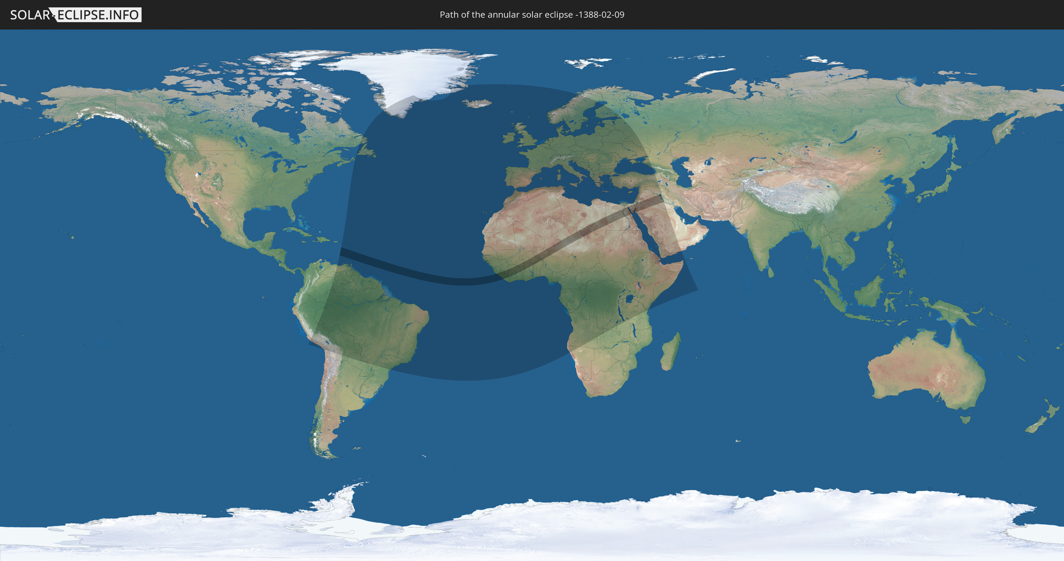
Die Sonnenfinsternis am 02/09/-1388 kann man in 132 Ländern als partielle Sonnenfinsternis beobachten.
Der Finsternispfad verläuft durch 22 Länder. Nur in diesen Ländern ist sie als annular Sonnenfinsternis zu sehen.
In den folgenden Ländern ist die Sonnenfinsternis annular zu sehen
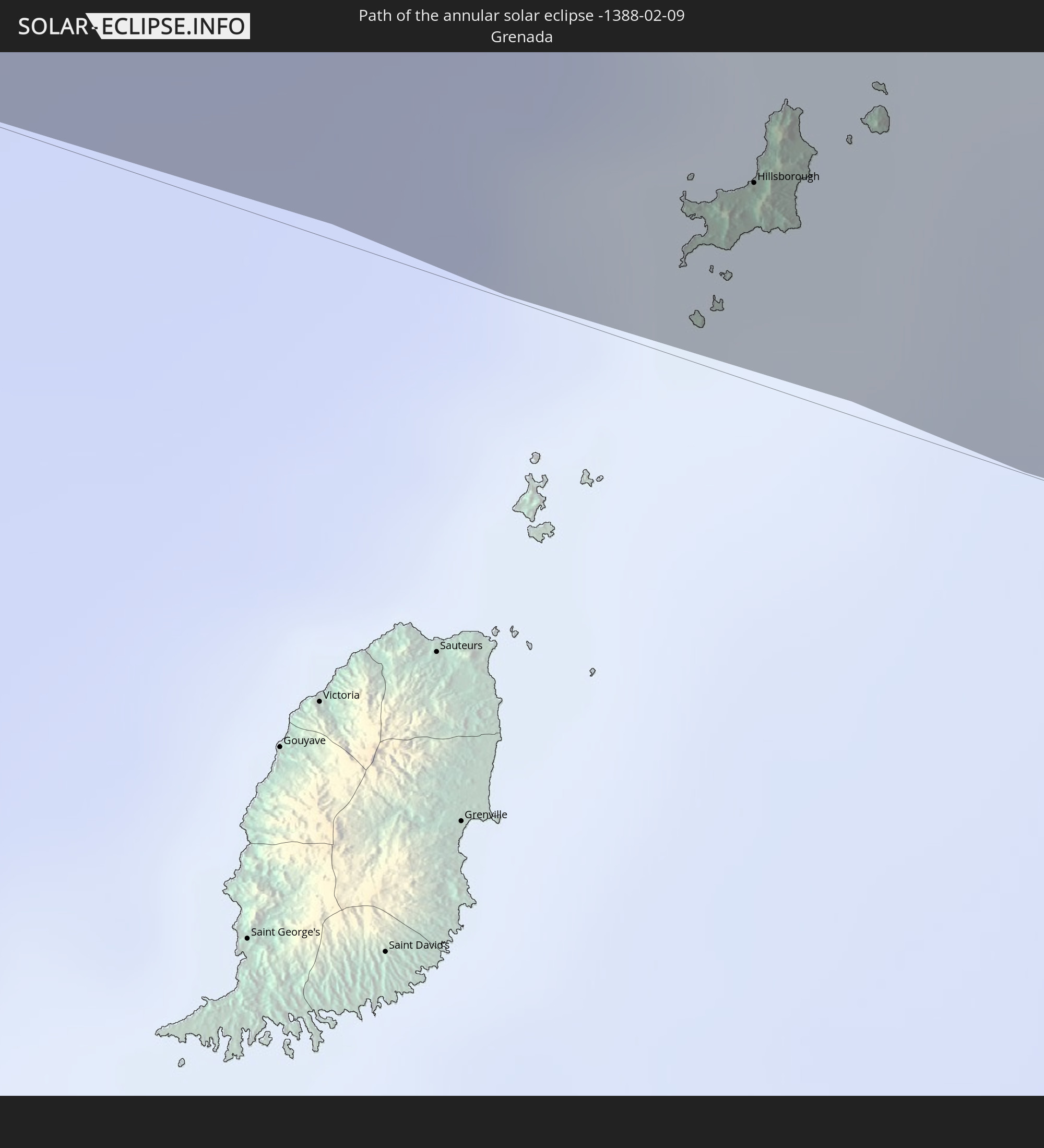 Grenada
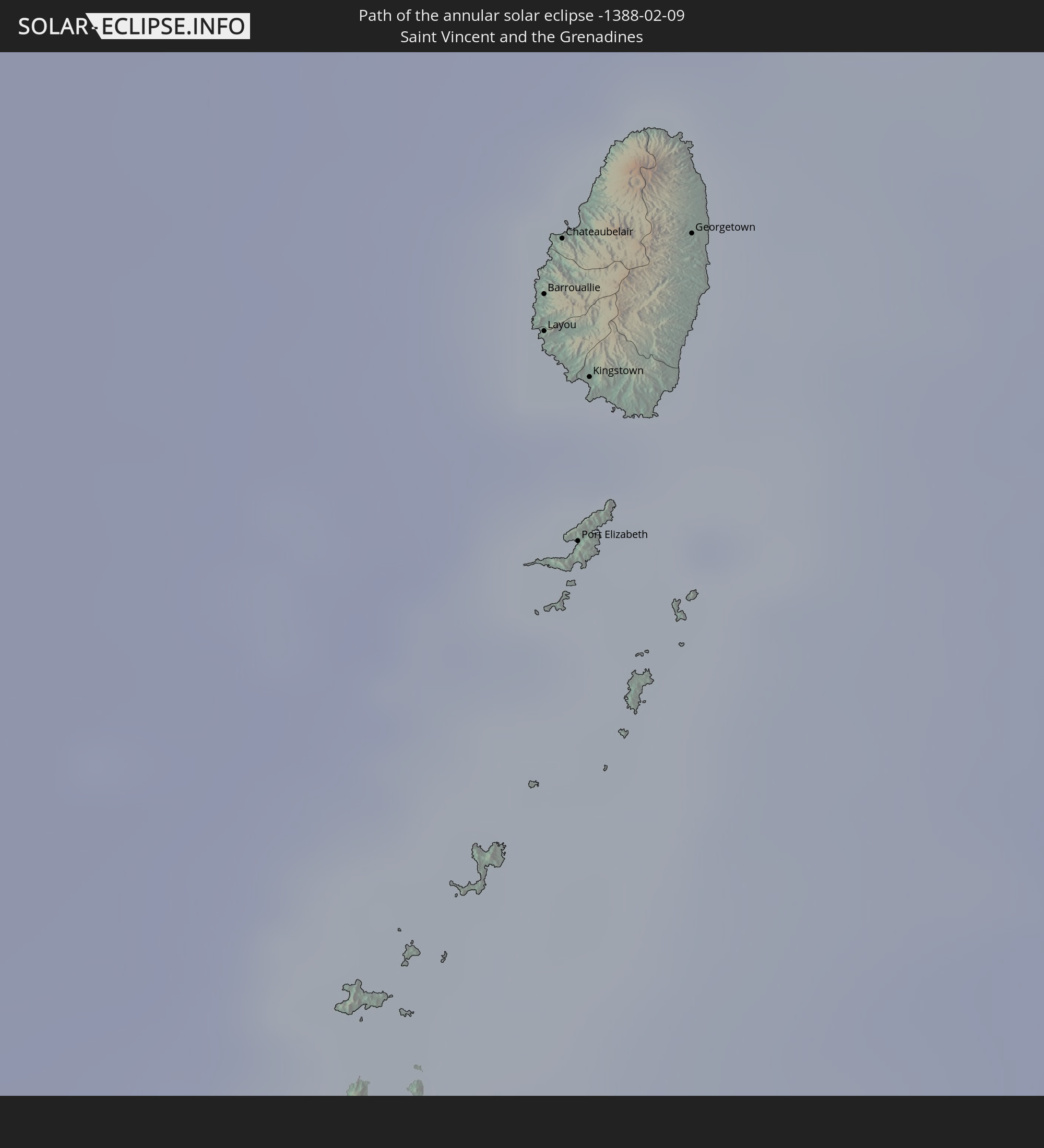 Saint Vincent and the Grenadines
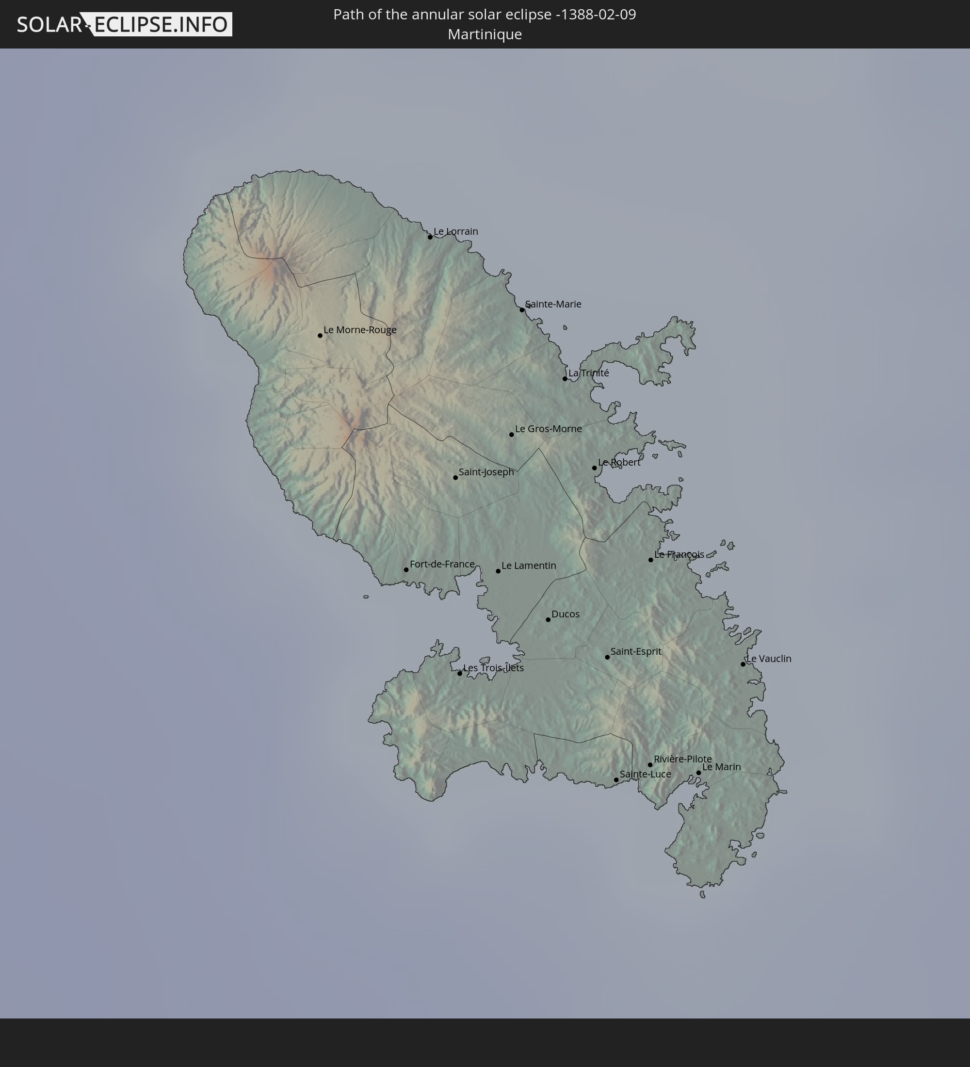 Martinique
 Saint Lucia
 Barbados
 Guinea
 Sierra Leone
 Liberia
 Ivory Coast
 Burkina Faso
 Ghana
Ghana
 Togo
Togo
 Niger
Niger
 Benin
Benin
 Nigeria
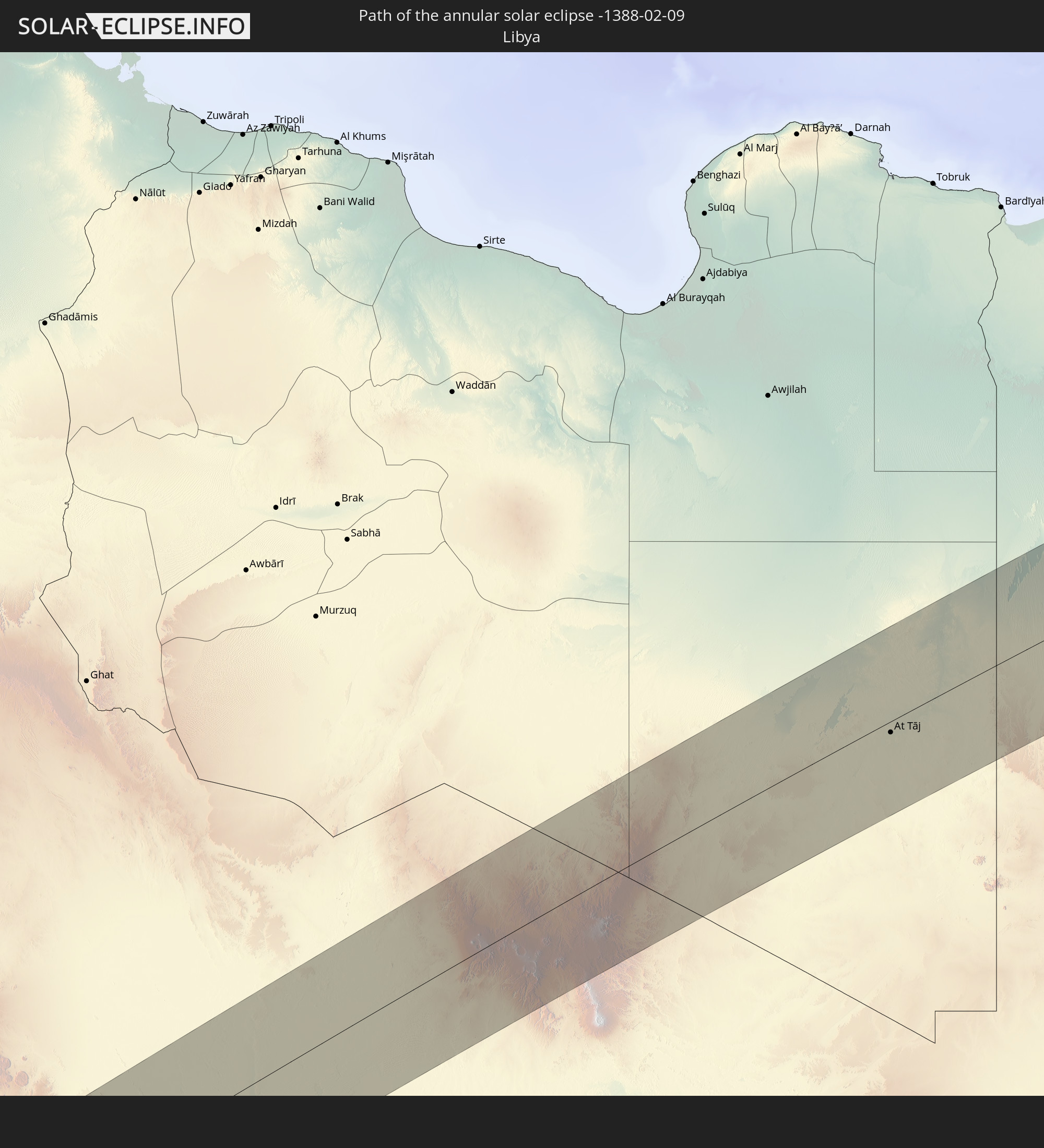 Libya
Libya
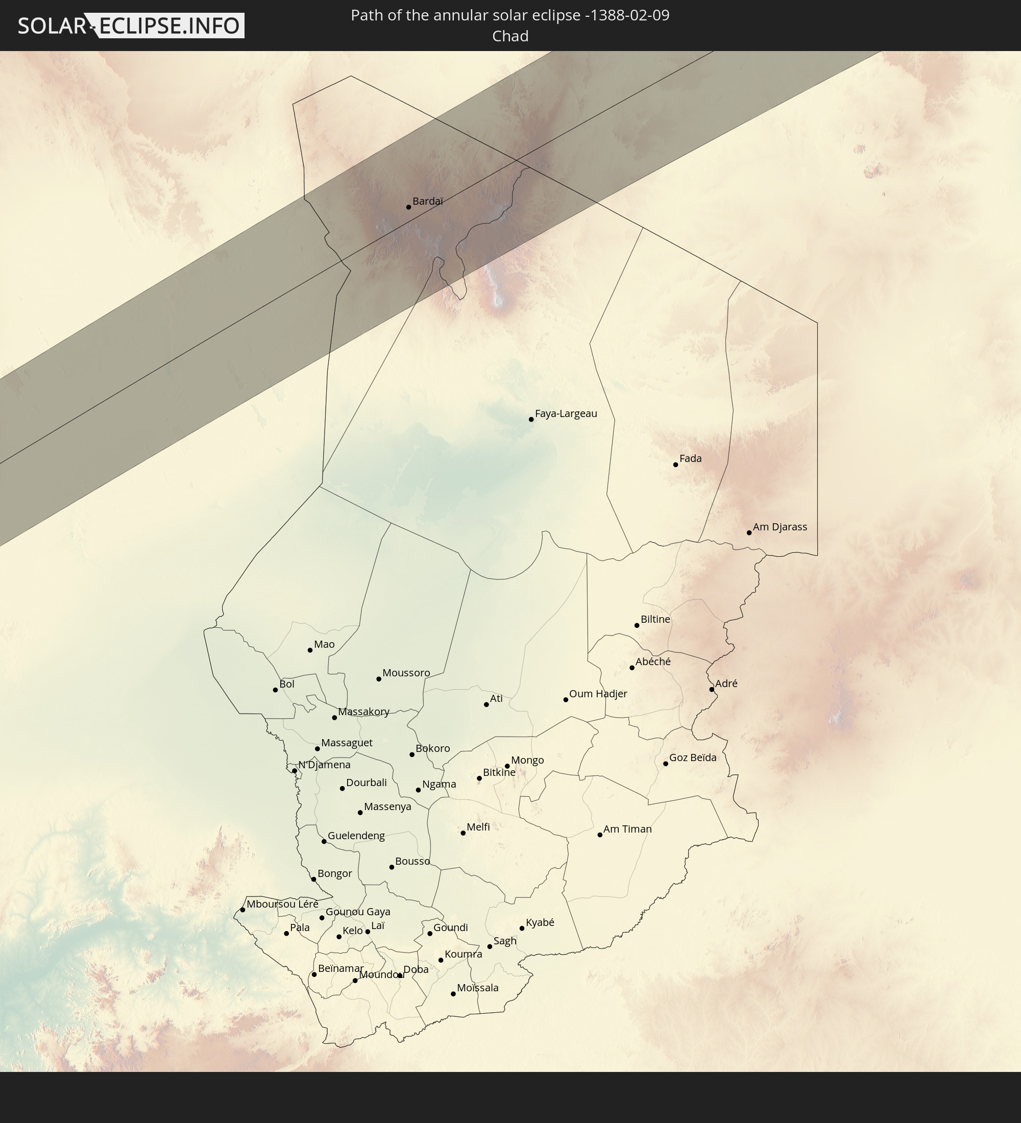 Chad
Chad
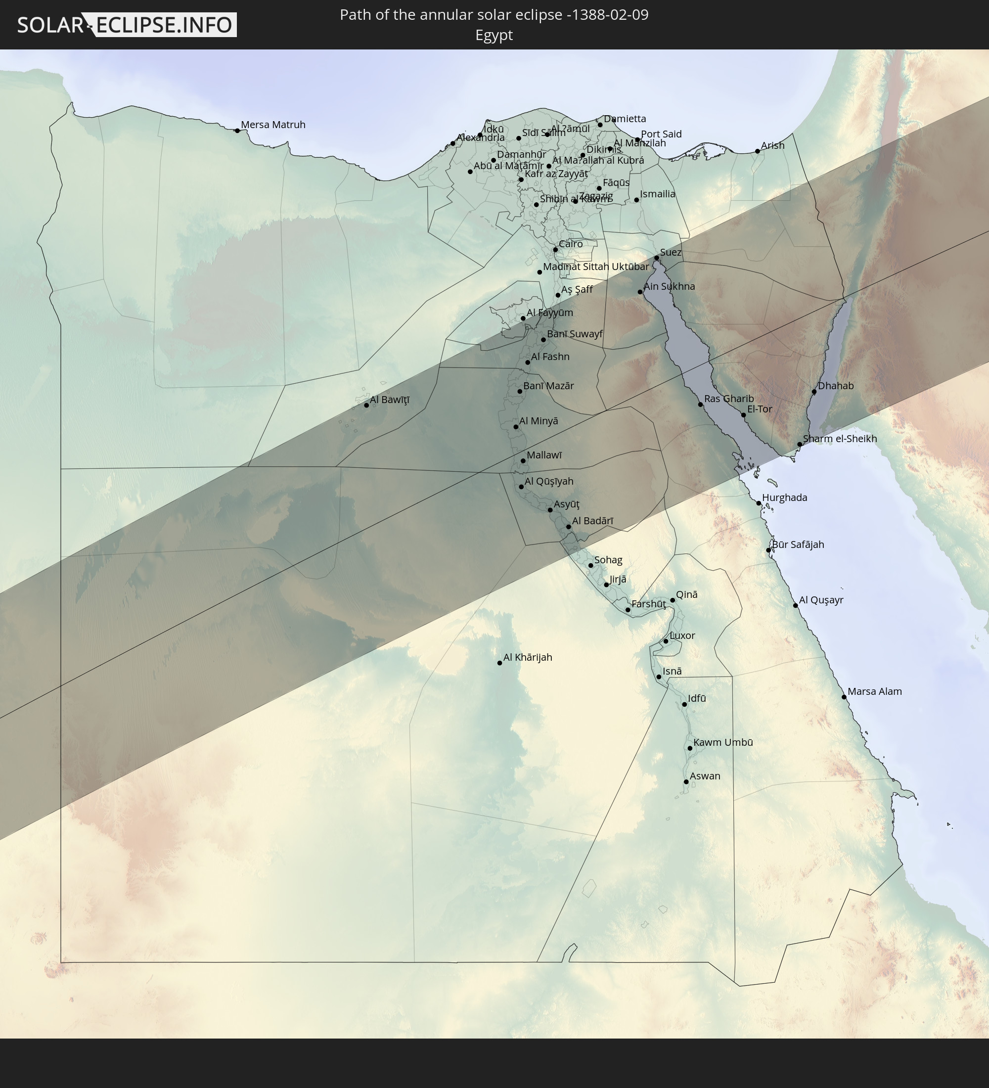 Egypt
Egypt
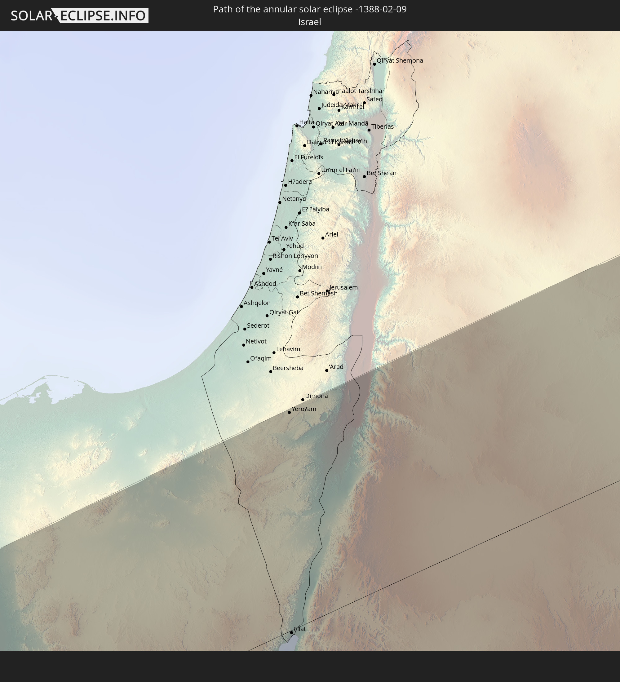 Israel
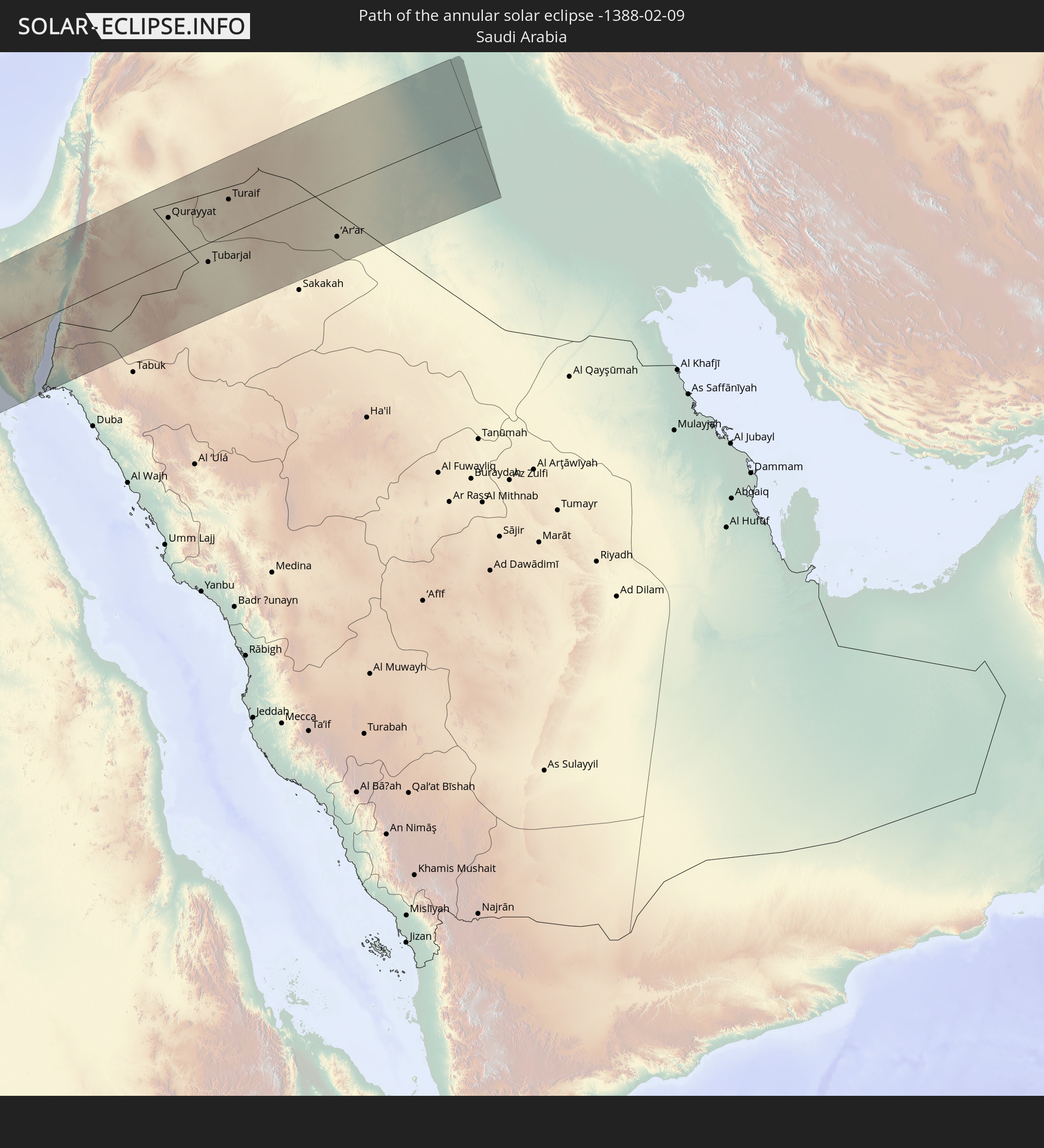 Saudi Arabia
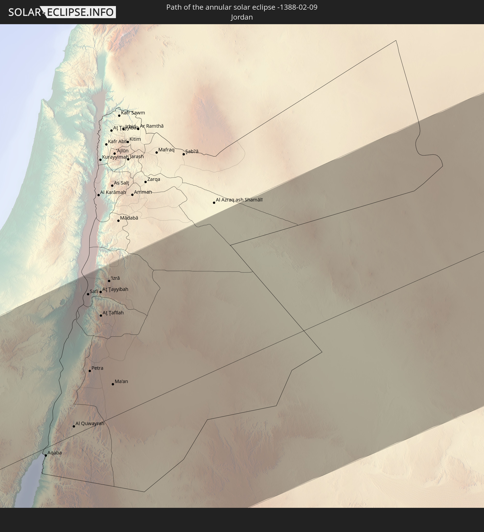 Jordan
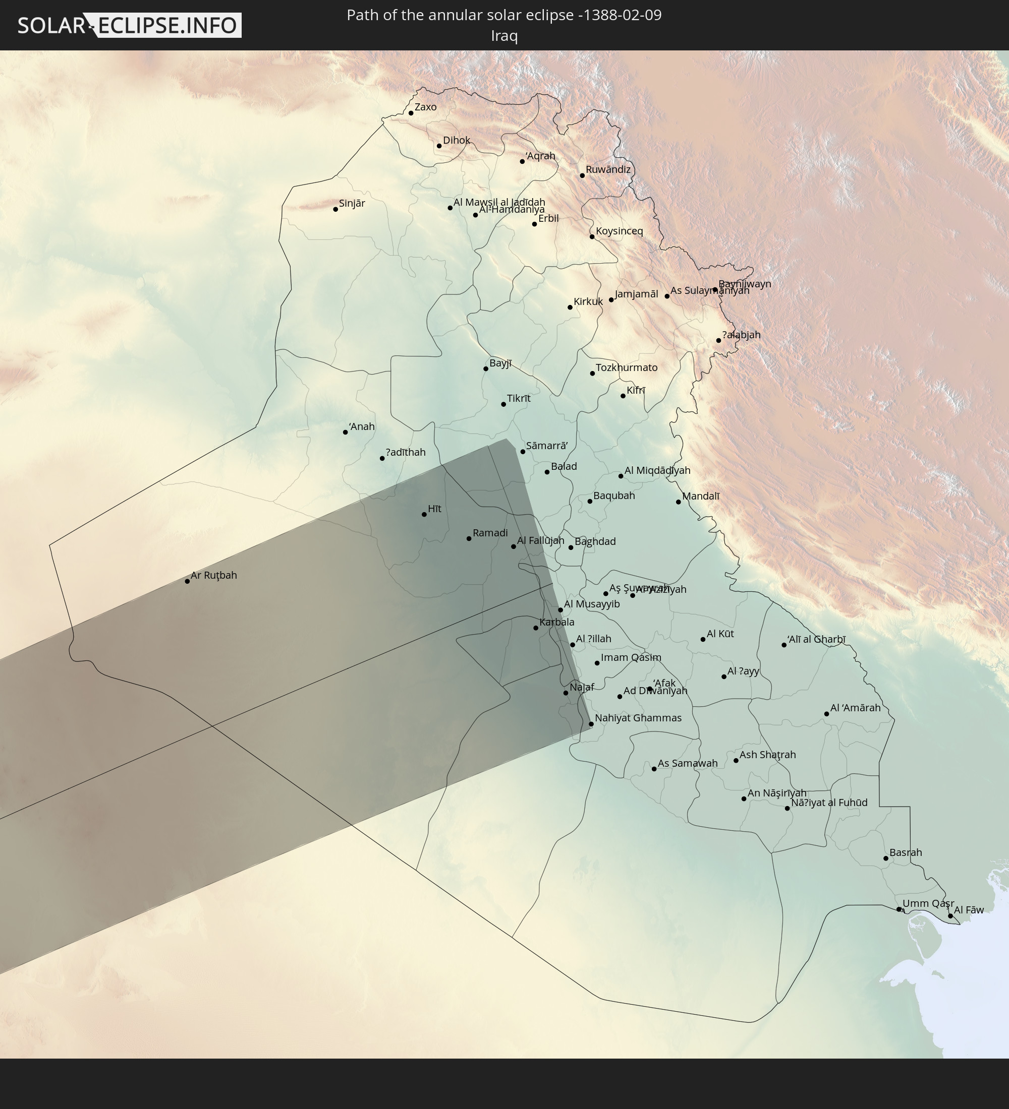 Iraq
Iraq
In den folgenden Ländern ist die Sonnenfinsternis partiell zu sehen
 Russia
 Canada
 Chile
Chile
 Greenland
 Colombia
 Peru
Peru
 Brazil
 Venezuela
 Bolivia
 Anguilla
 Collectivity of Saint Martin
 Saint Barthélemy
 Saint Kitts and Nevis
 Paraguay
 Antigua and Barbuda
 Montserrat
 Trinidad and Tobago
 Guadeloupe
 Grenada
 Dominica
 Saint Vincent and the Grenadines
 Guyana
 Martinique
 Saint Lucia
 Barbados
 Suriname
 Saint Pierre and Miquelon
 French Guiana
 Portugal
 Cabo Verde
 Iceland
 Spain
Spain
 Senegal
 Mauritania
 The Gambia
 Guinea-Bissau
 Guinea
 Saint Helena, Ascension and Tristan da Cunha
 Sierra Leone
 Morocco
 Mali
Mali
 Liberia
 Republic of Ireland
 Svalbard and Jan Mayen
 Algeria
 United Kingdom
 Ivory Coast
 Faroe Islands
 Burkina Faso
 Gibraltar
 France
 Isle of Man
 Ghana
Ghana
 Guernsey
 Jersey
 Togo
Togo
 Niger
Niger
 Benin
Benin
 Andorra
 Belgium
 Nigeria
 Netherlands
 Norway
 Equatorial Guinea
 Luxembourg
 Germany
 Switzerland
 São Tomé and Príncipe
 Italy
Italy
 Monaco
 Tunisia
 Denmark
 Cameroon
 Gabon
Gabon
 Libya
Libya
 Liechtenstein
 Austria
 Sweden
 Republic of the Congo
 Angola
 Namibia
 Czechia
 Democratic Republic of the Congo
 San Marino
 Vatican City
 Slovenia
 Chad
Chad
 Croatia
 Poland
 Malta
Malta
 Central African Republic
 Bosnia and Herzegovina
 Hungary
 Slovakia
 Montenegro
 Serbia
 Albania
 Åland Islands
 Greece
 Romania
 Republic of Macedonia
 Finland
 Lithuania
 Latvia
 Estonia
 Sudan
Sudan
 Zambia
 Ukraine
 Bulgaria
 Belarus
 Egypt
Egypt
 Turkey
 Moldova
 Rwanda
 Burundi
 Tanzania
 Uganda
 Cyprus
 Ethiopia
 Kenya
Kenya
 State of Palestine
 Israel
 Saudi Arabia
 Jordan
 Lebanon
 Syria
Syria
 Eritrea
 Iraq
Iraq
 Georgia
 Somalia
 Djibouti
 Yemen
Yemen
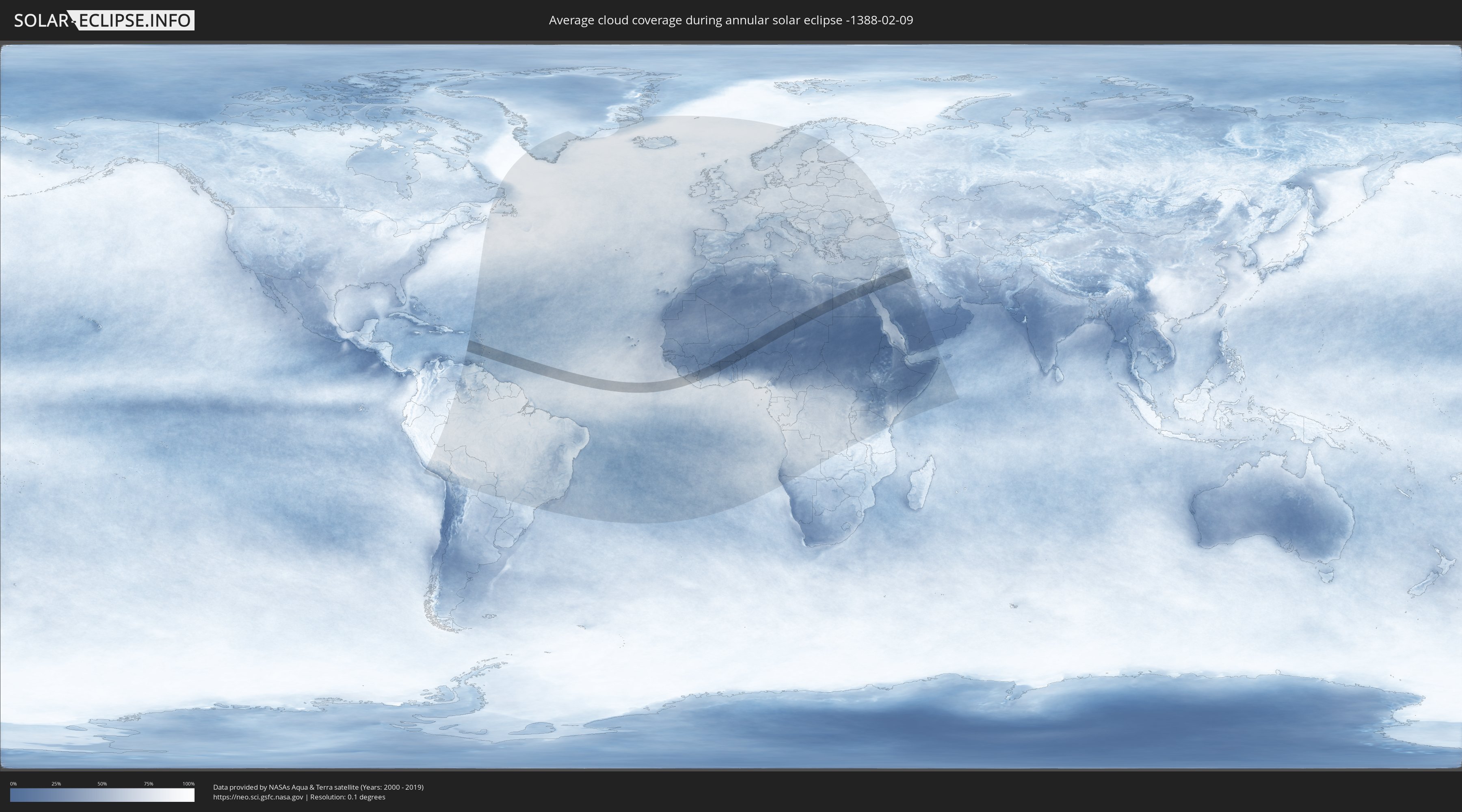
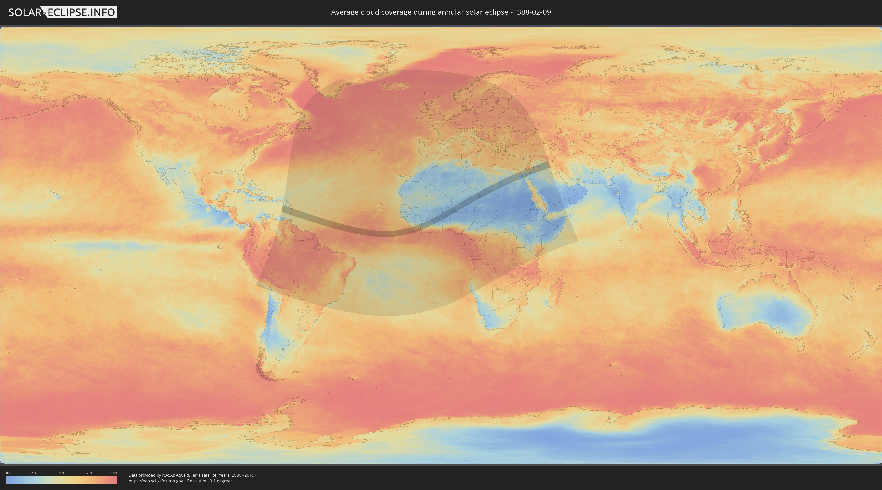
How will be the weather during the annular solar eclipse on 02/09/-1388?
Where is the best place to see the annular solar eclipse of 02/09/-1388?
The following maps show the average cloud coverage for the day of the annular solar eclipse.
With the help of these maps, it is possible to find the place along the eclipse path, which has the best
chance of a cloudless sky.
Nevertheless, you should consider local circumstances and inform about the weather of your chosen
observation site.
The data is provided by NASAs satellites
AQUA and TERRA.
The cloud maps are averaged over a period of 19 years (2000 - 2019).
Detailed country maps
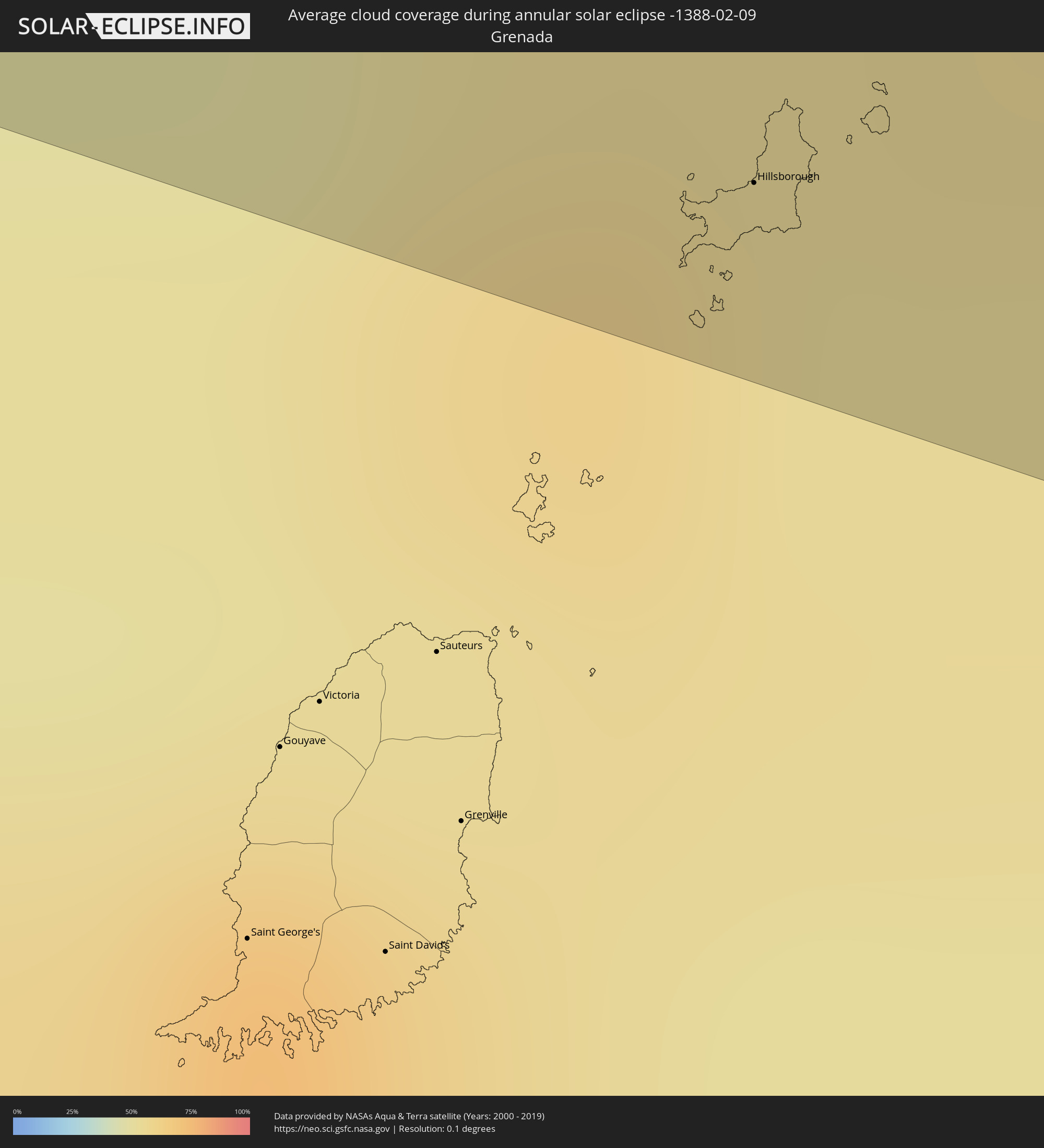 Grenada
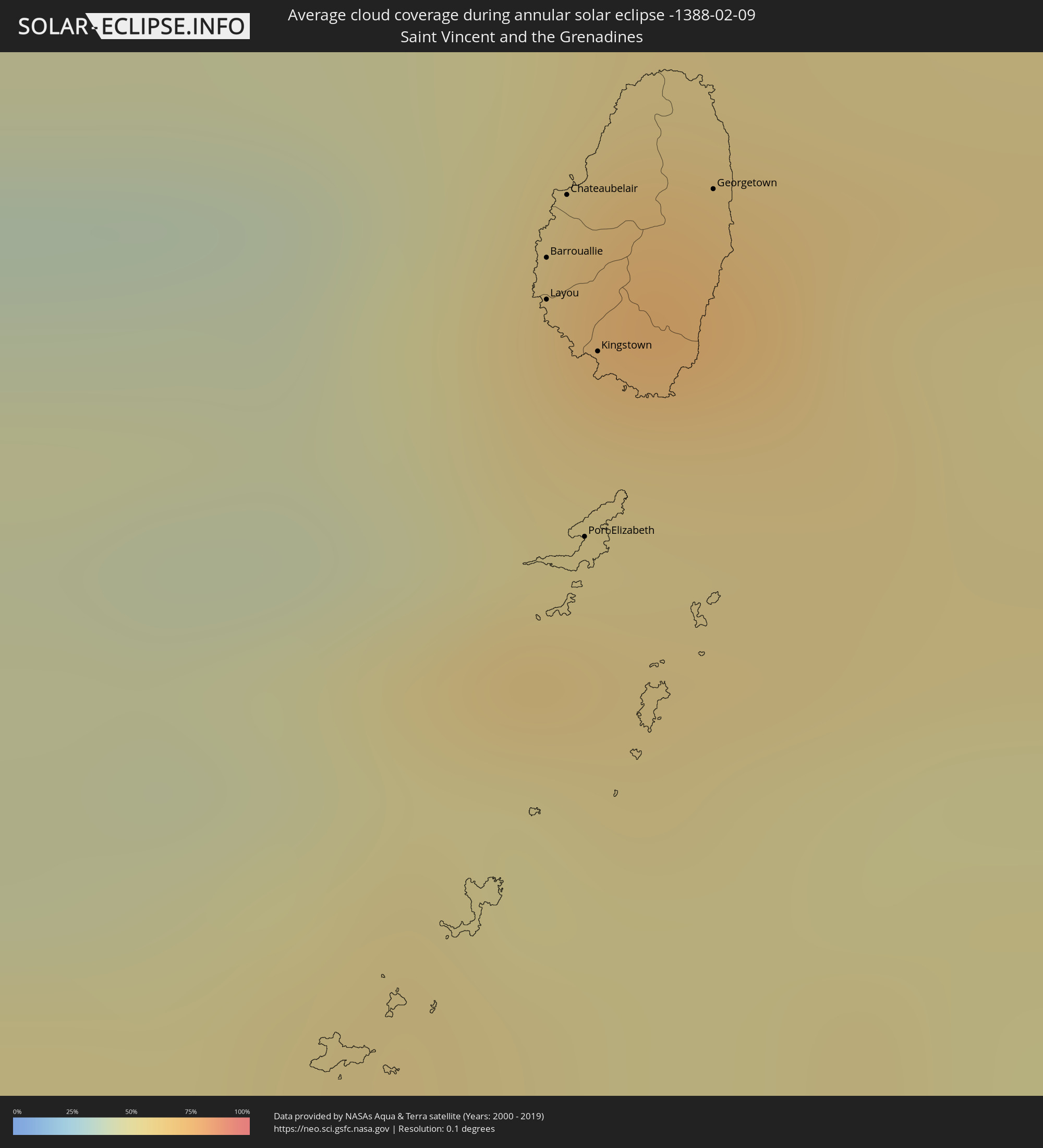 Saint Vincent and the Grenadines
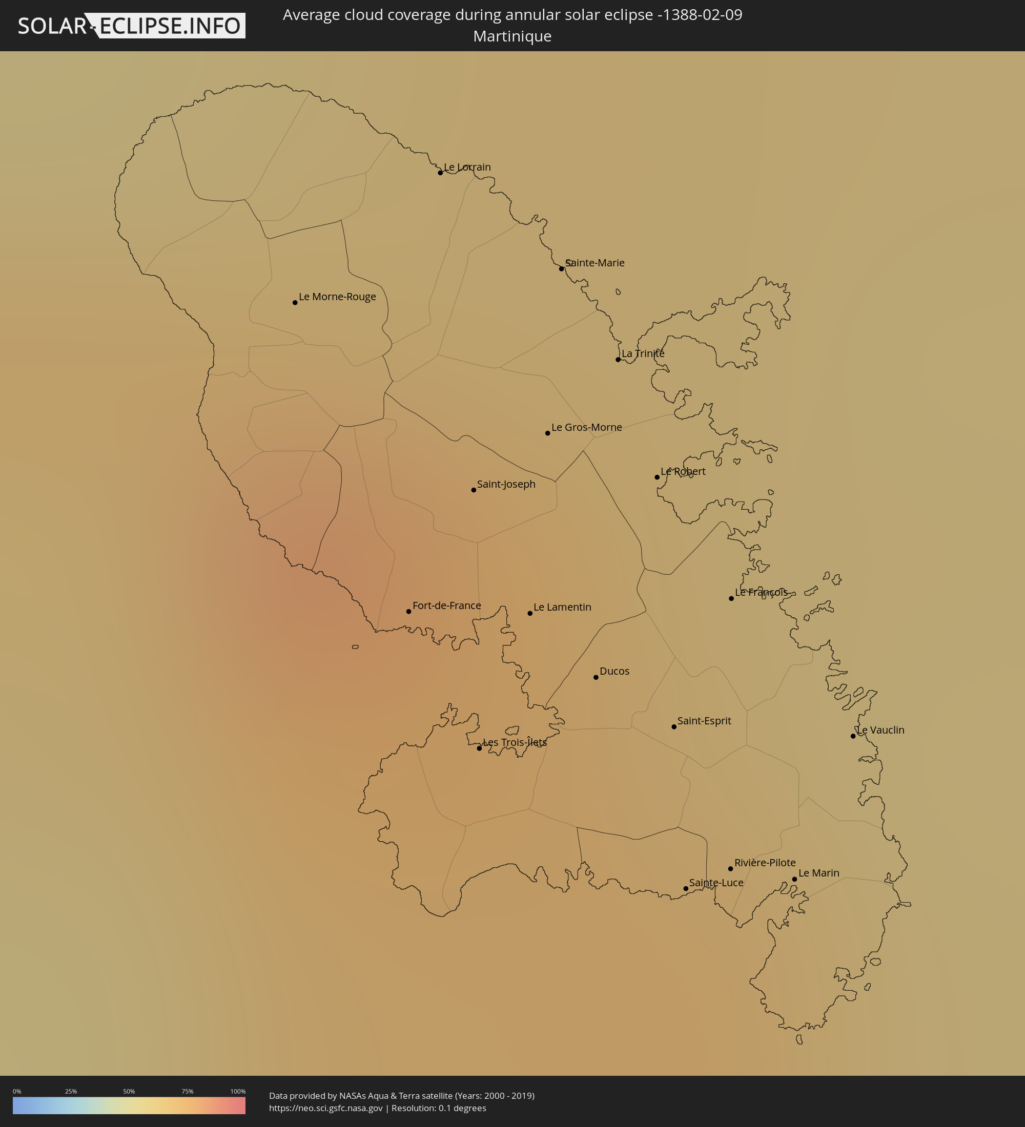 Martinique
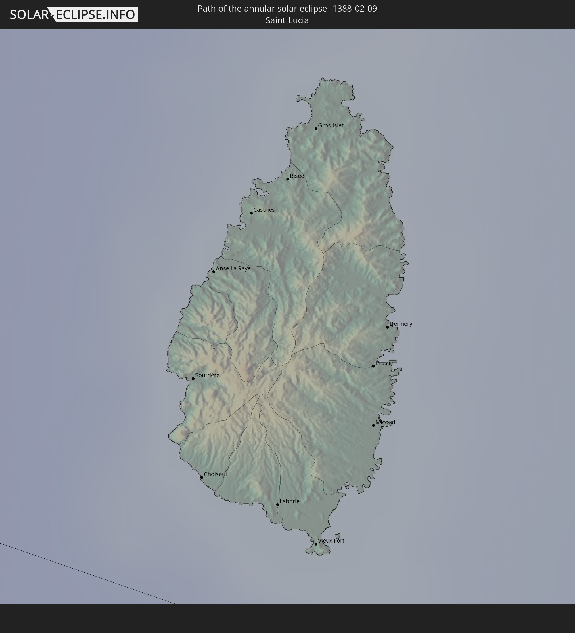
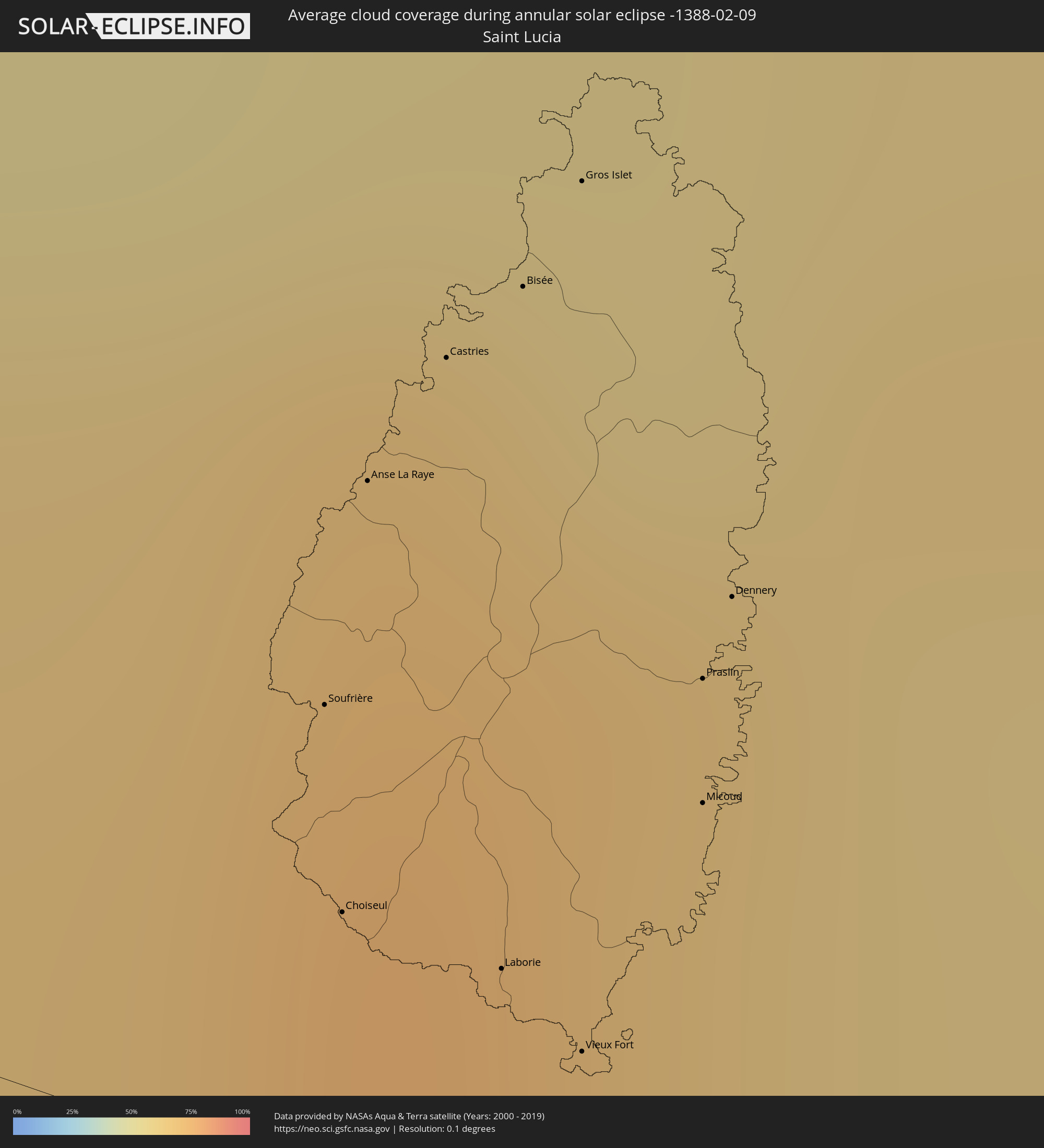 Saint Lucia
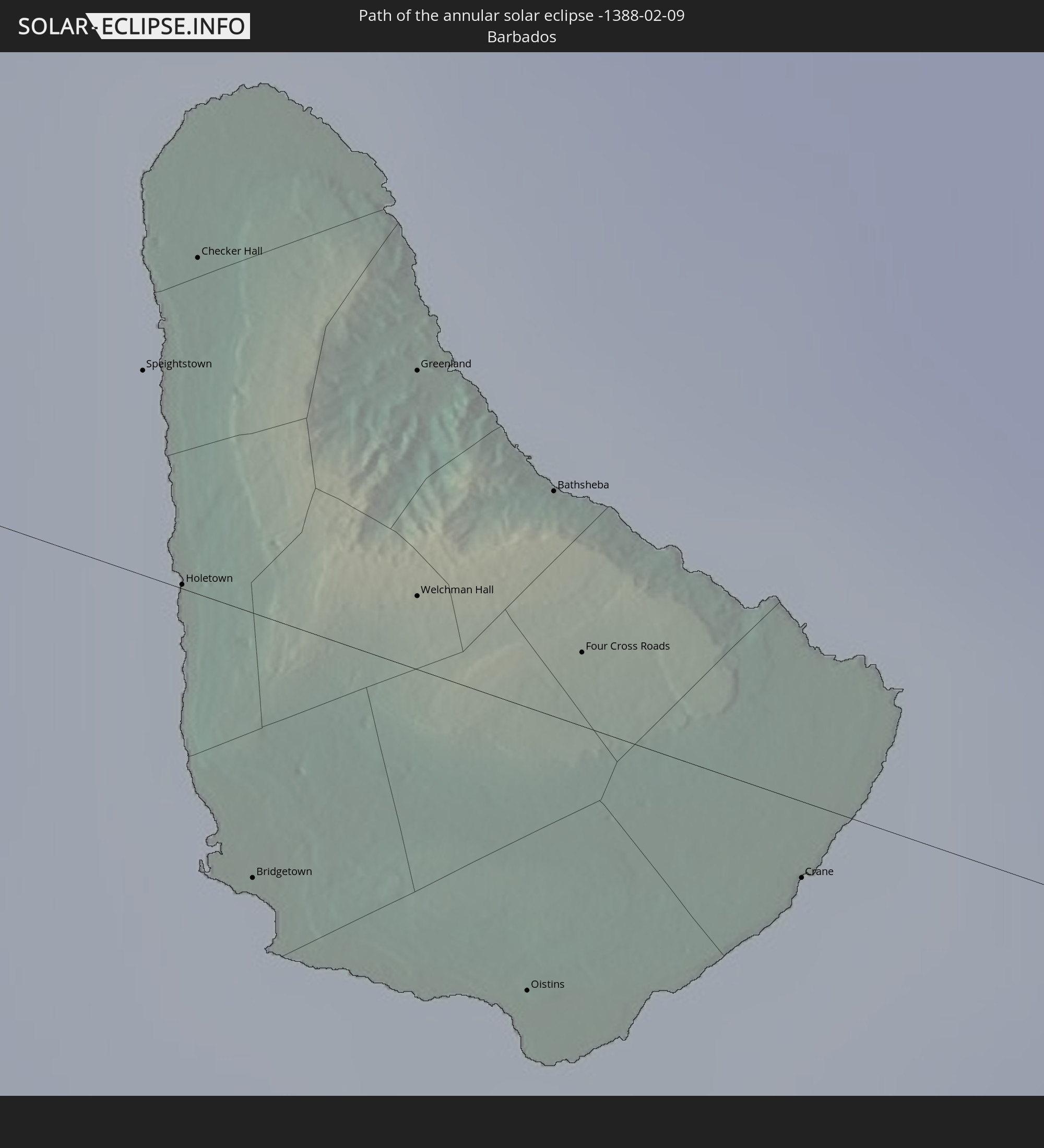
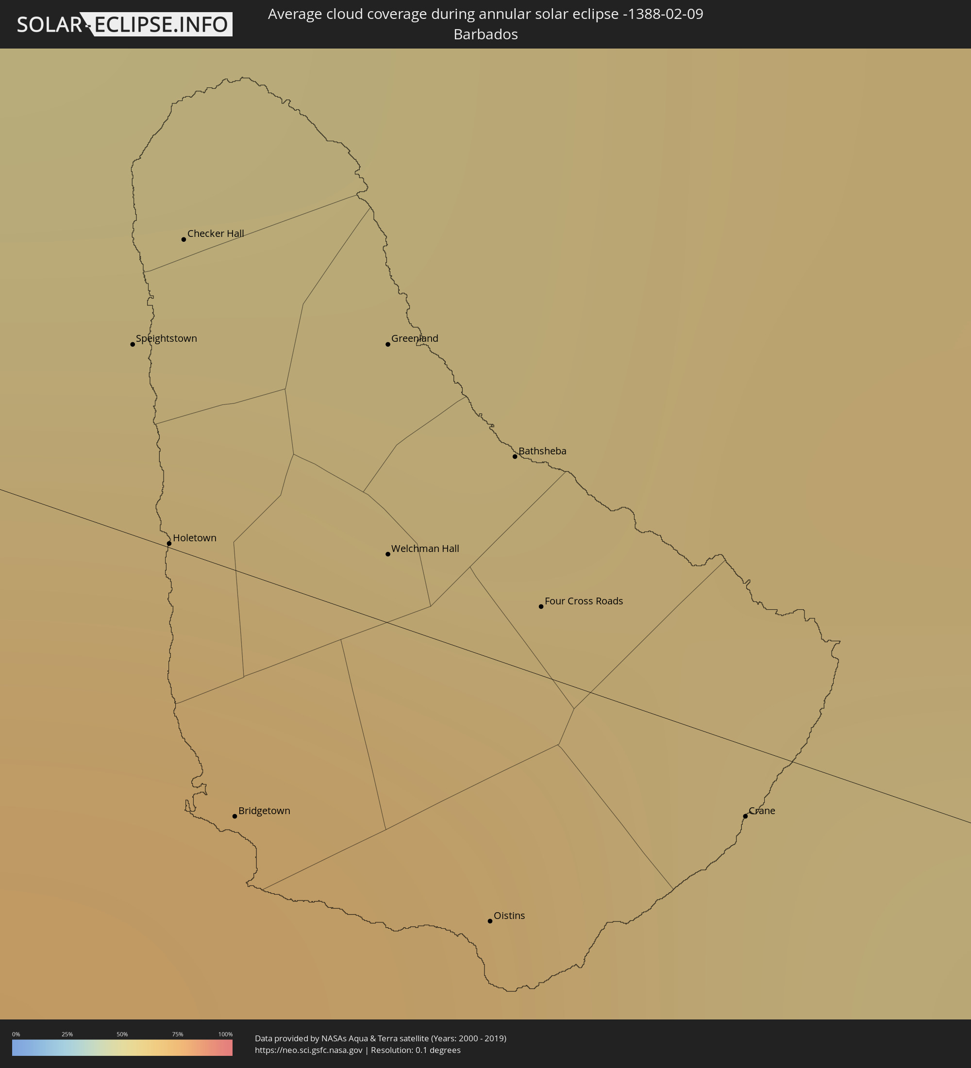 Barbados
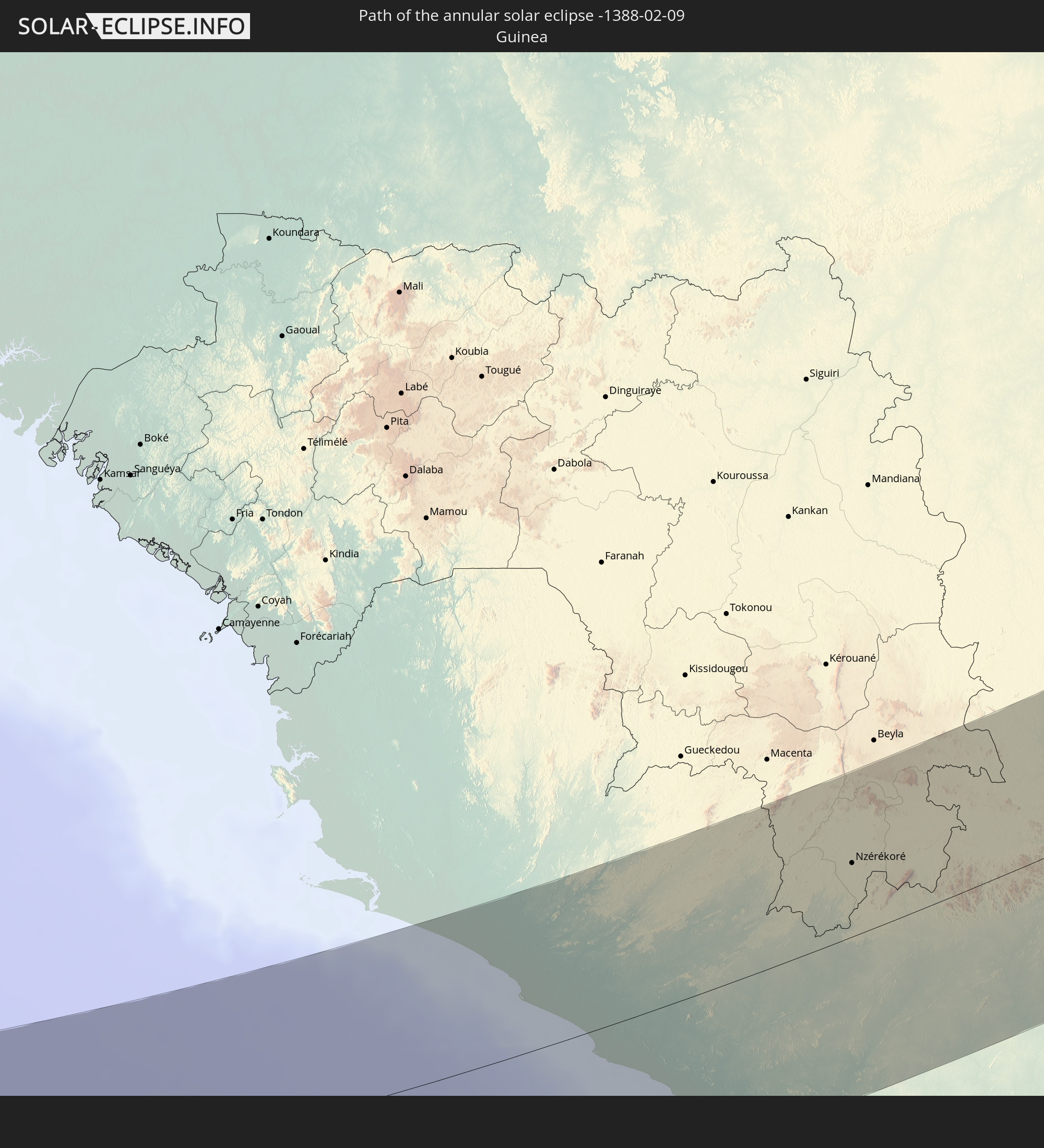
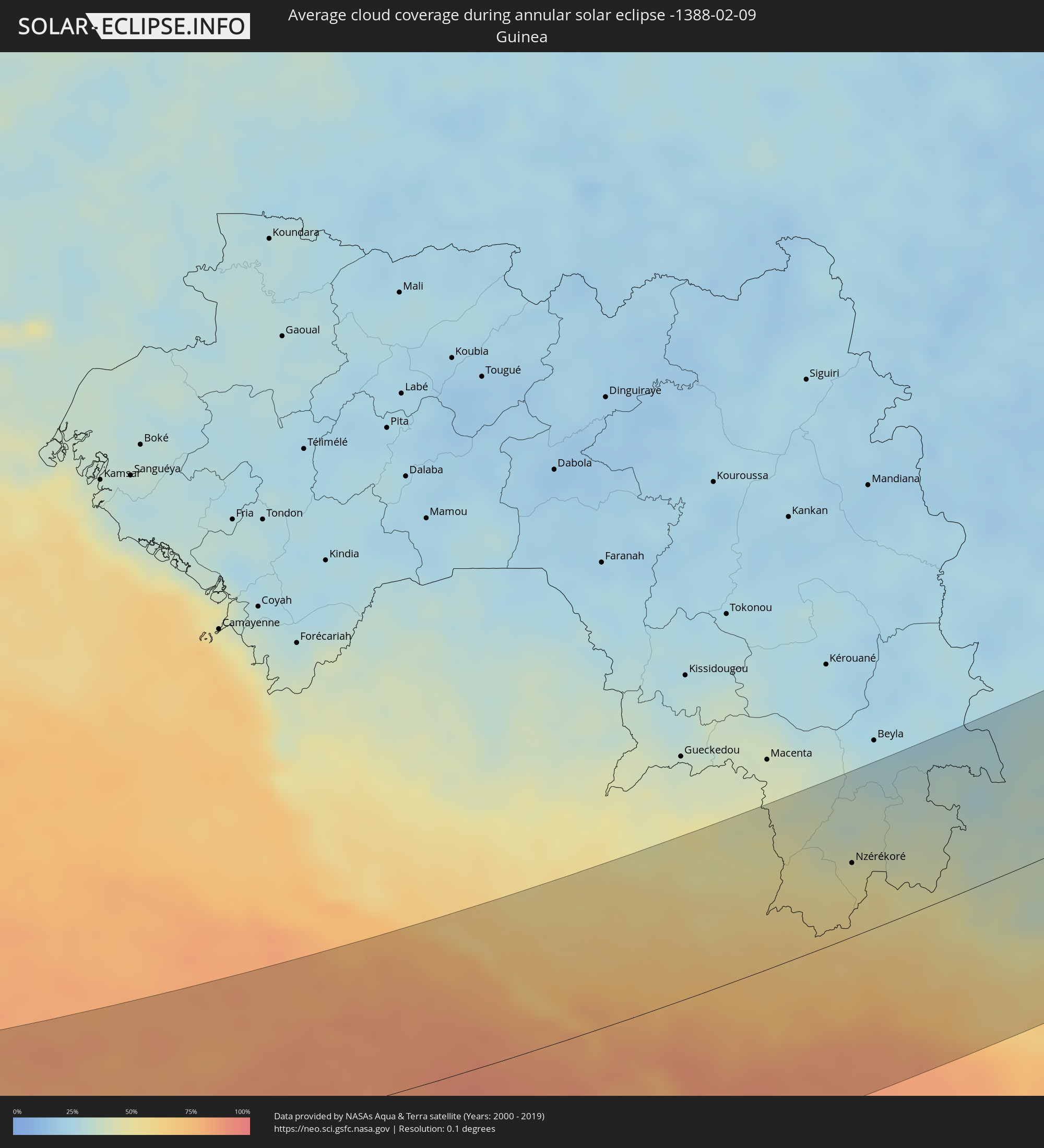 Guinea
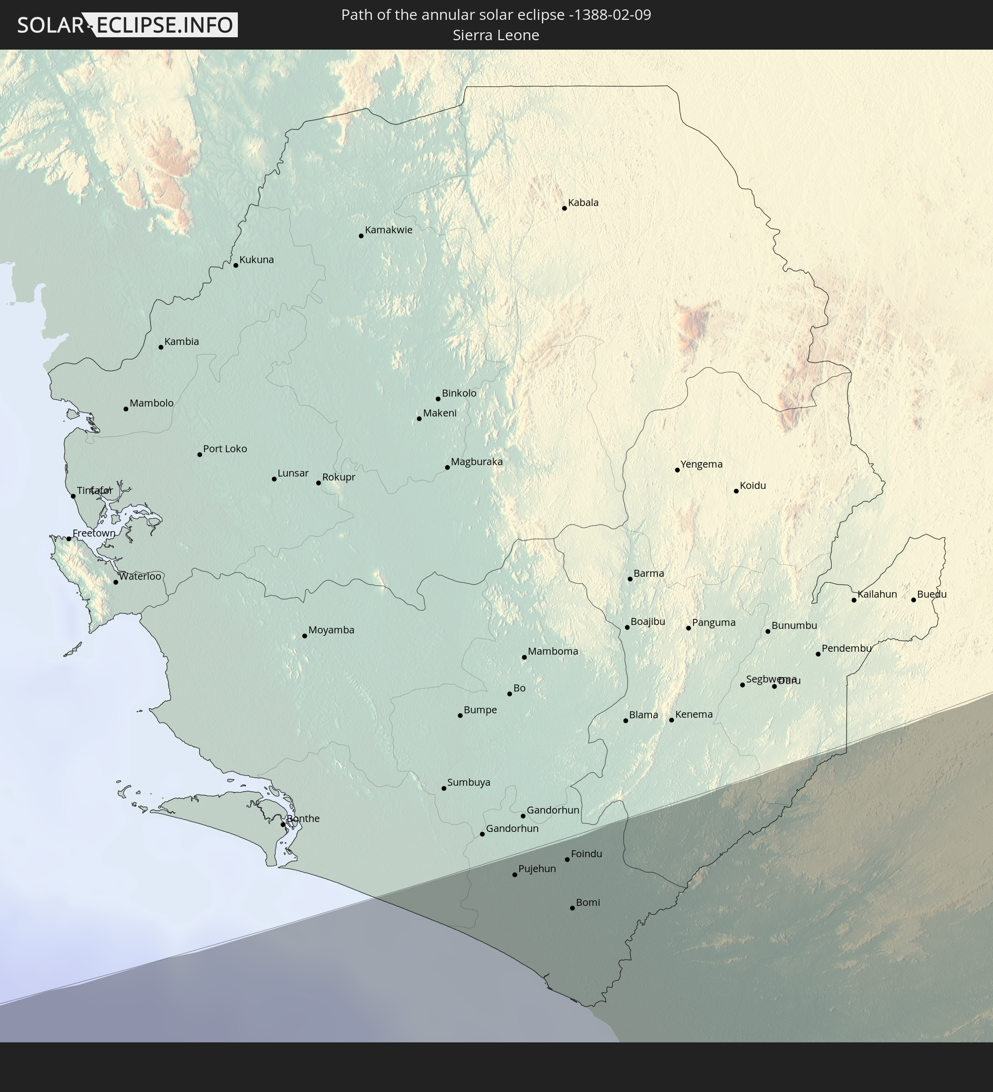
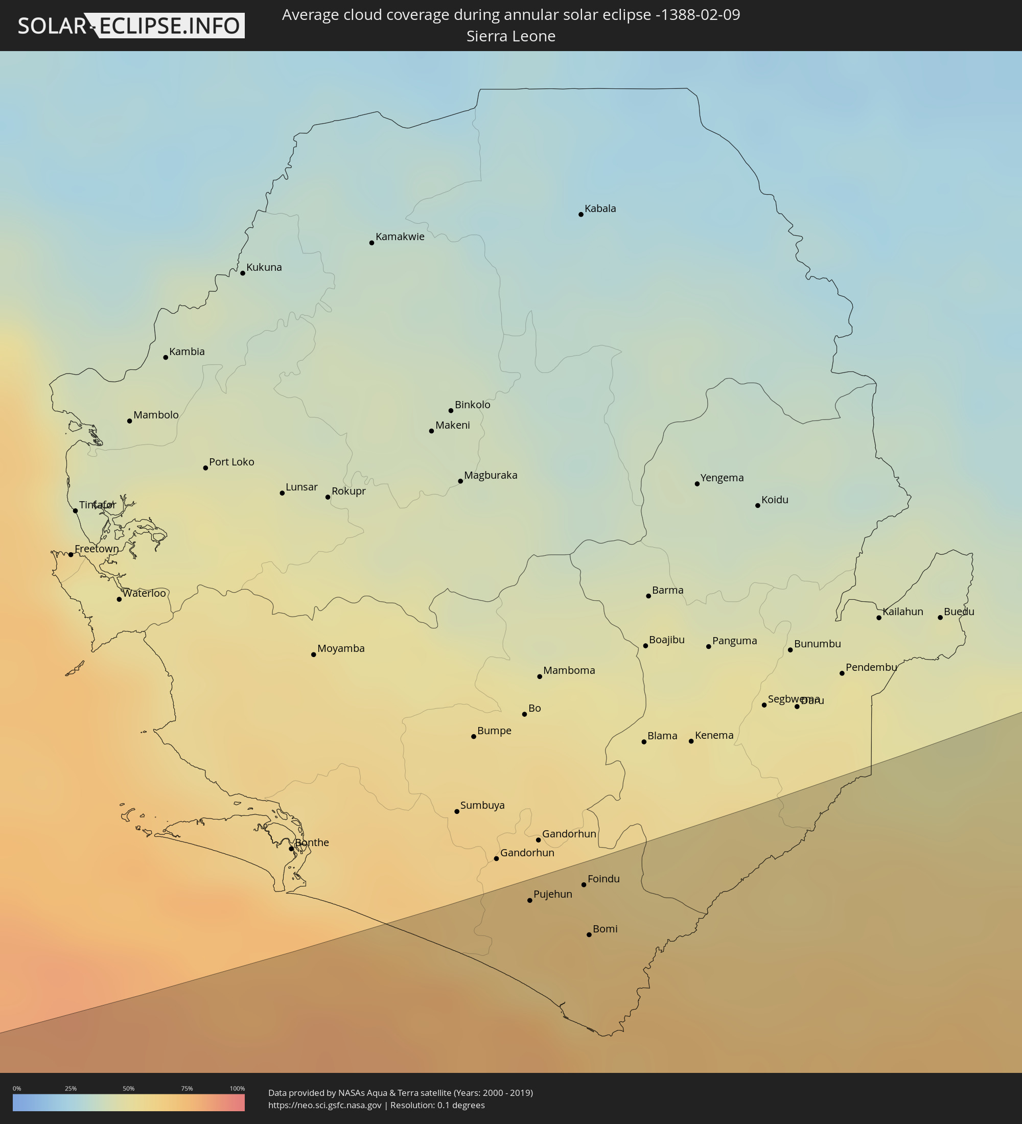 Sierra Leone
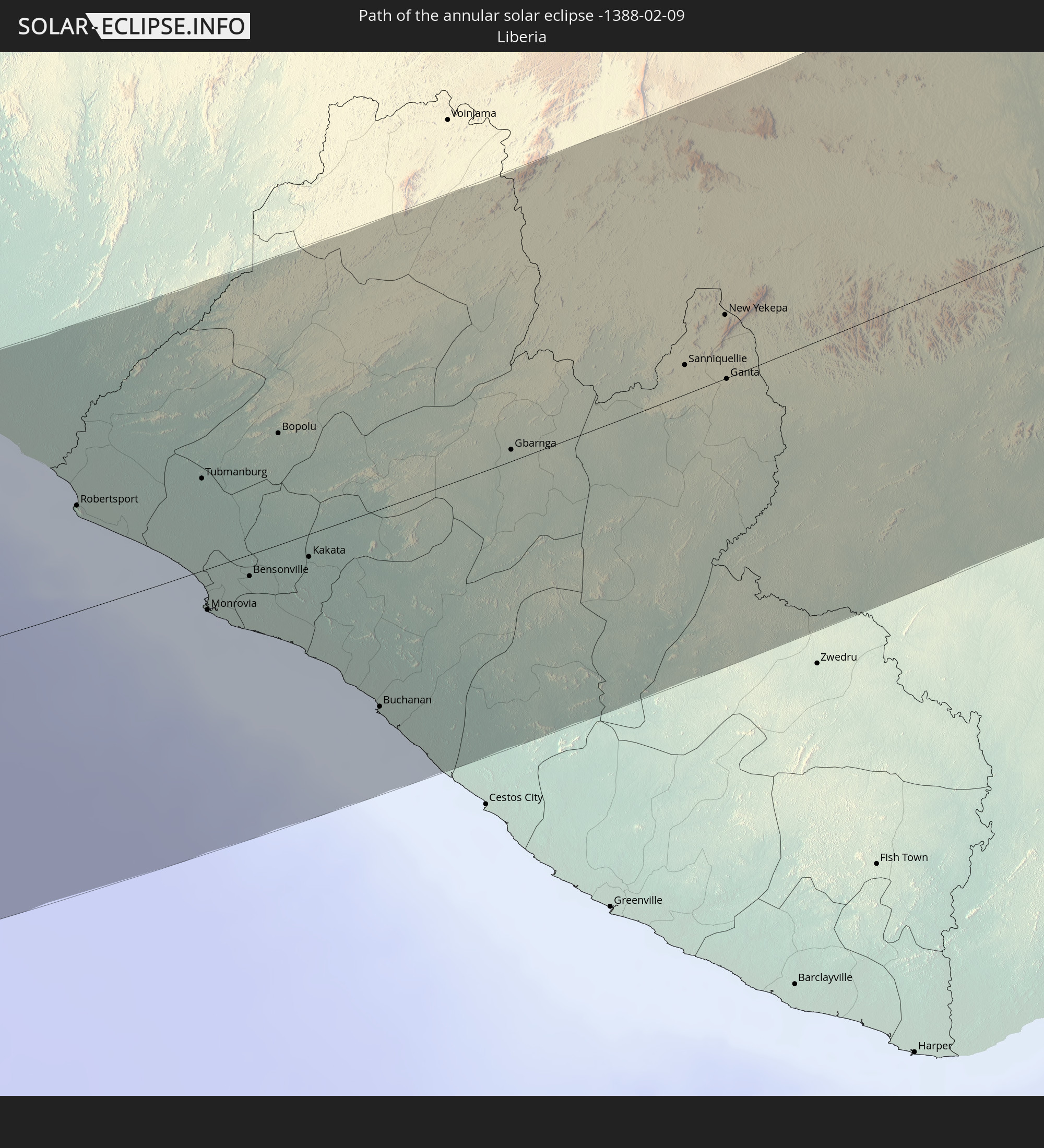
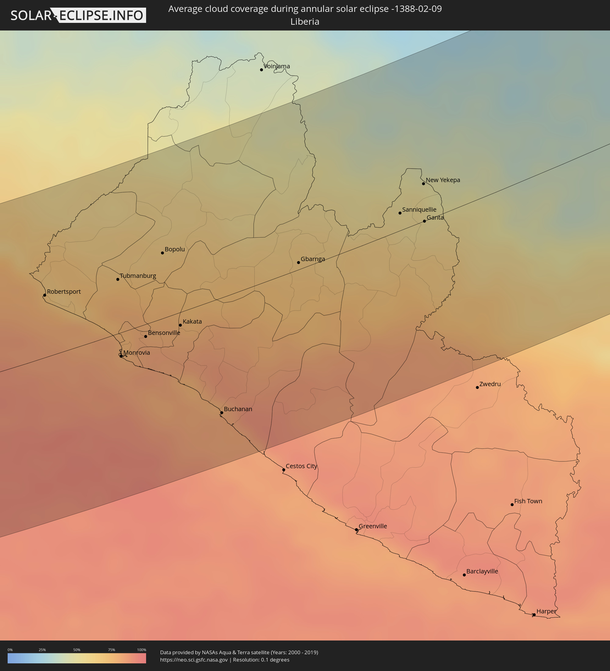 Liberia
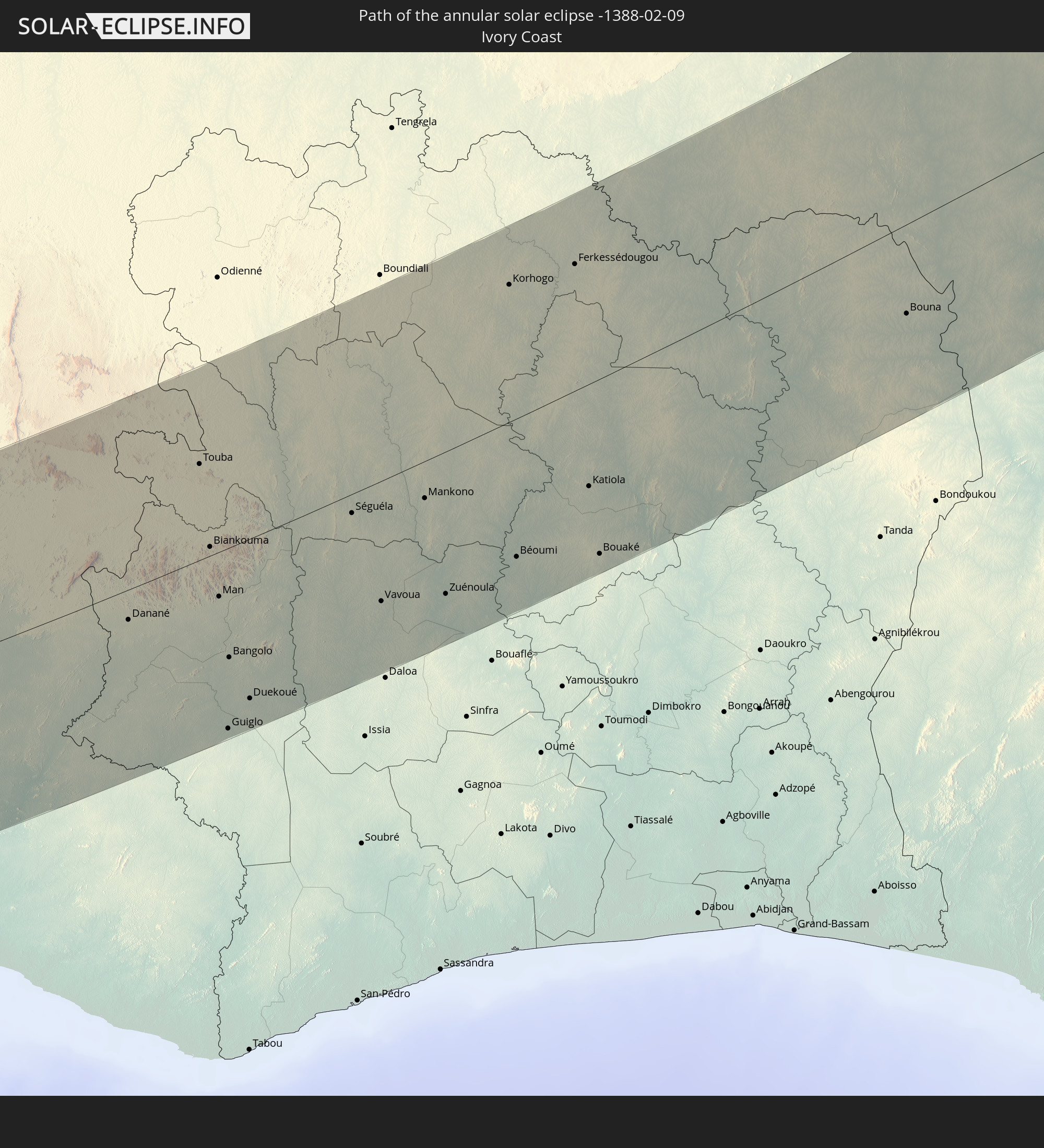
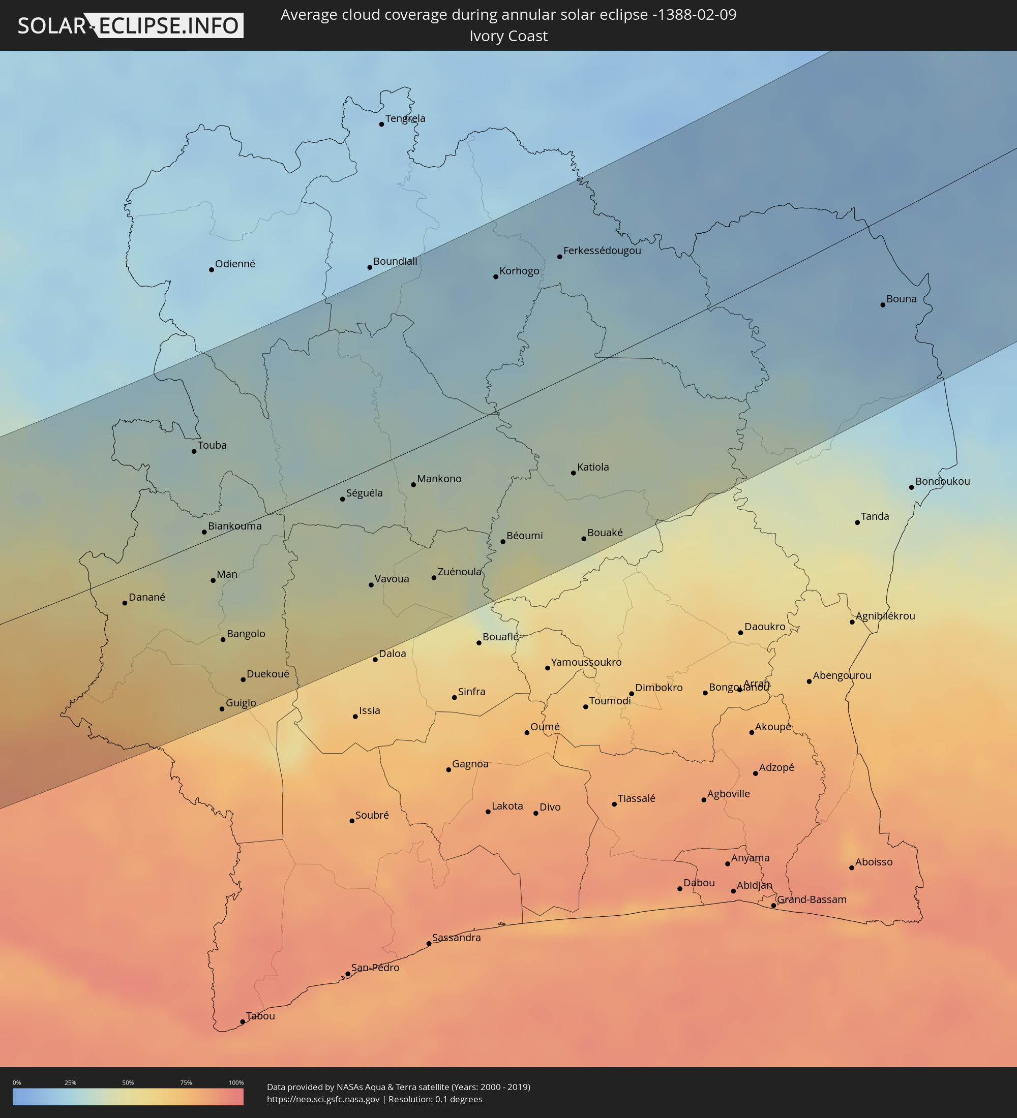 Ivory Coast
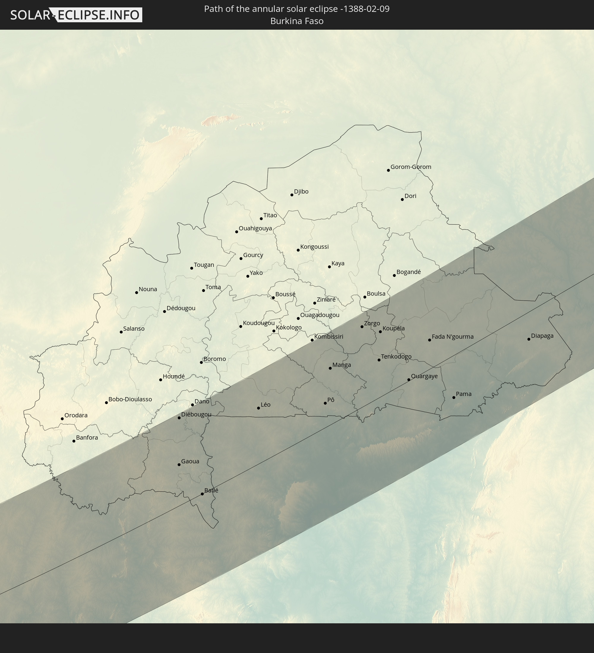
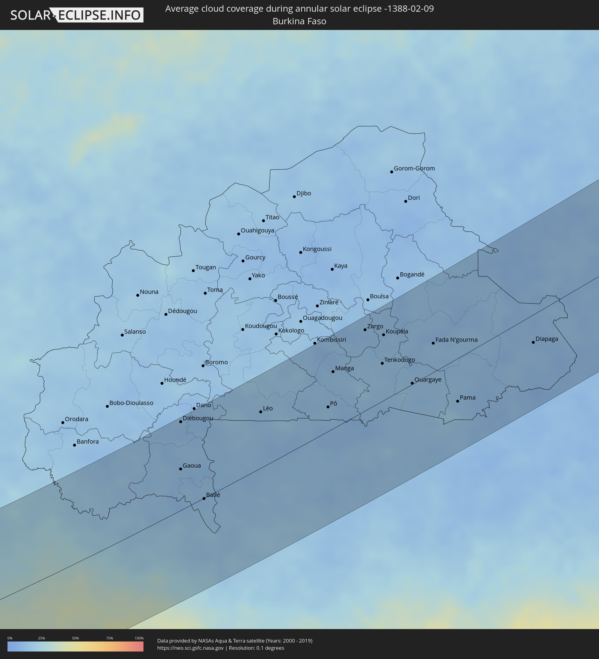 Burkina Faso
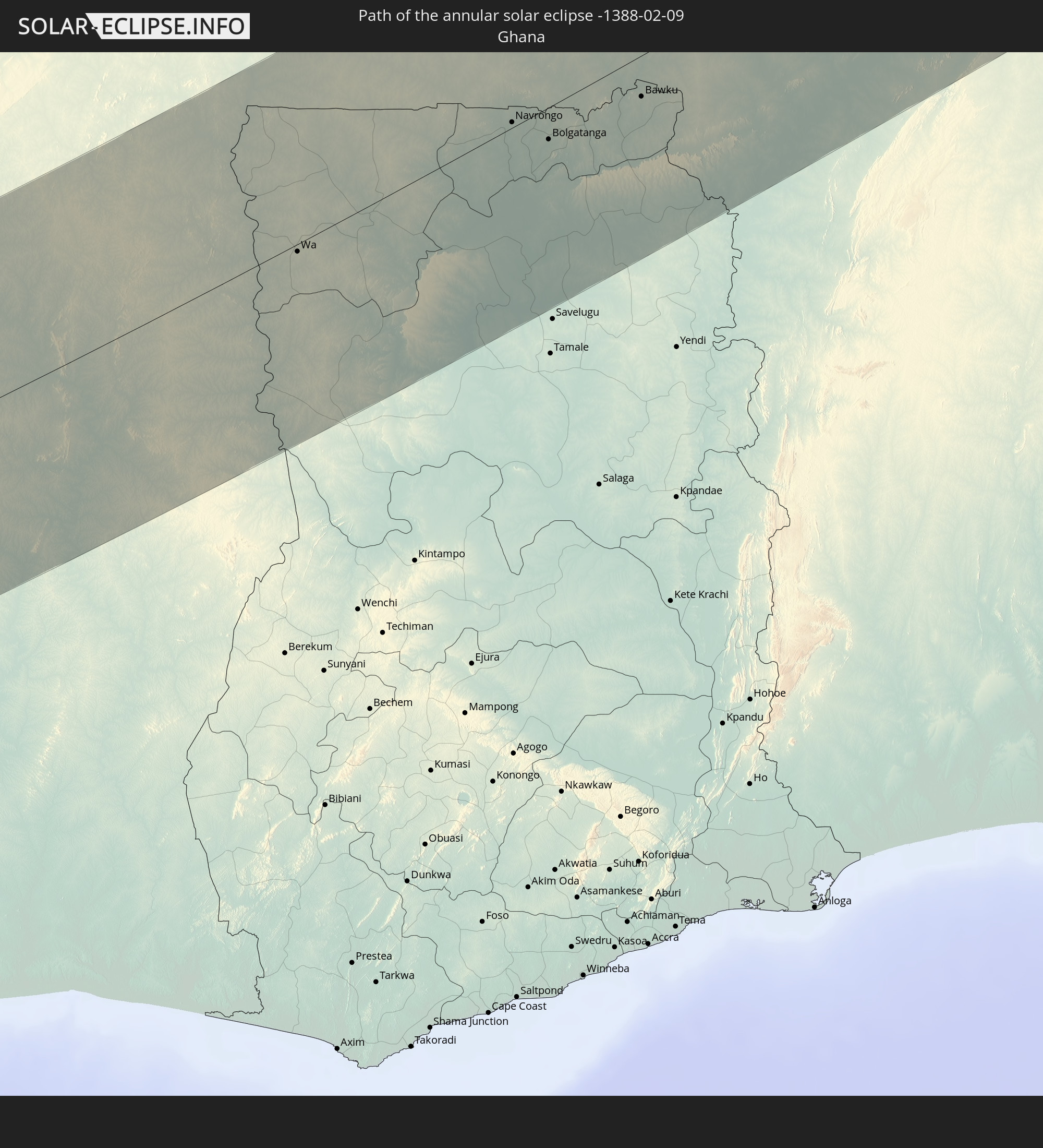
 Ghana
Ghana
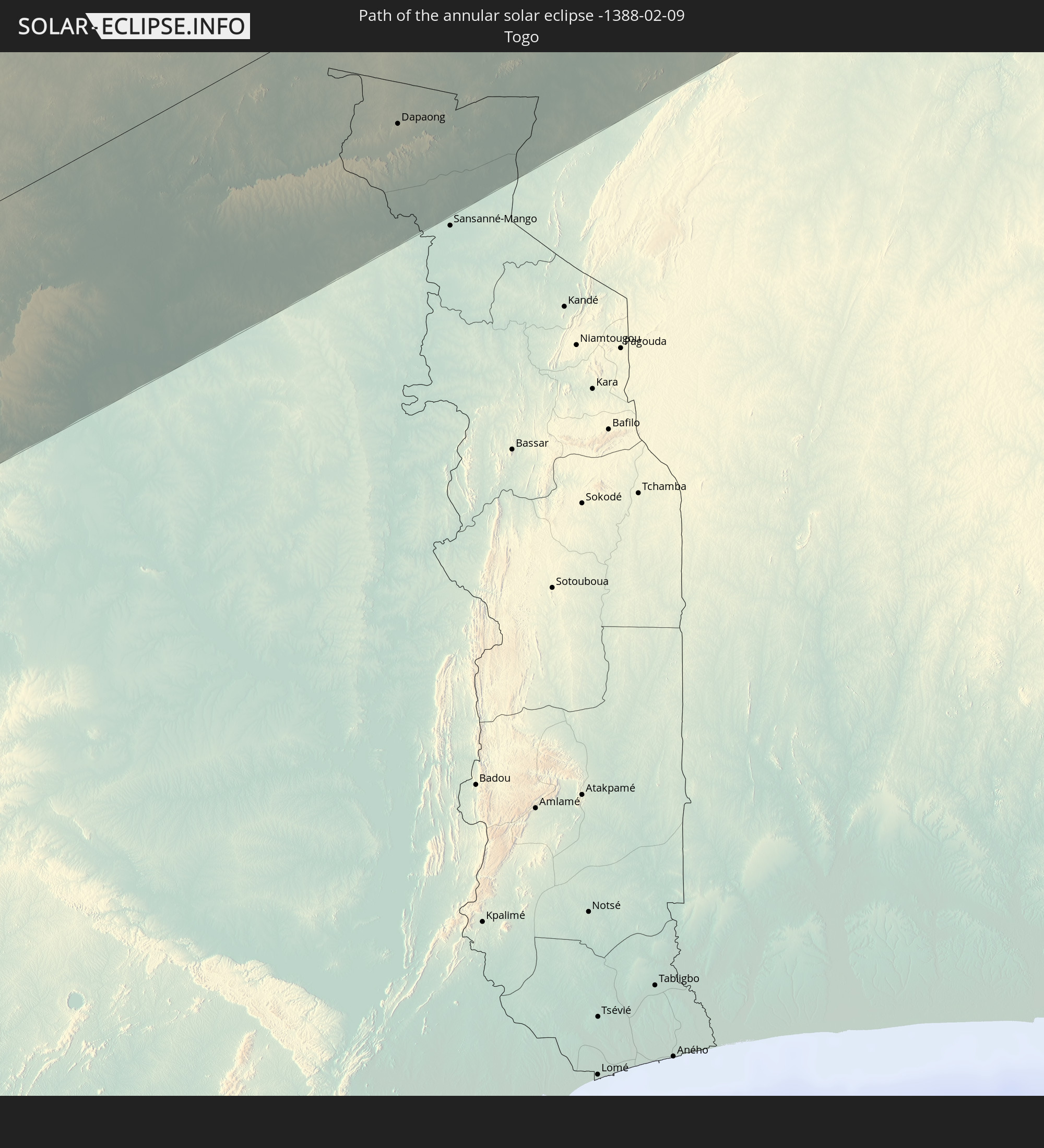
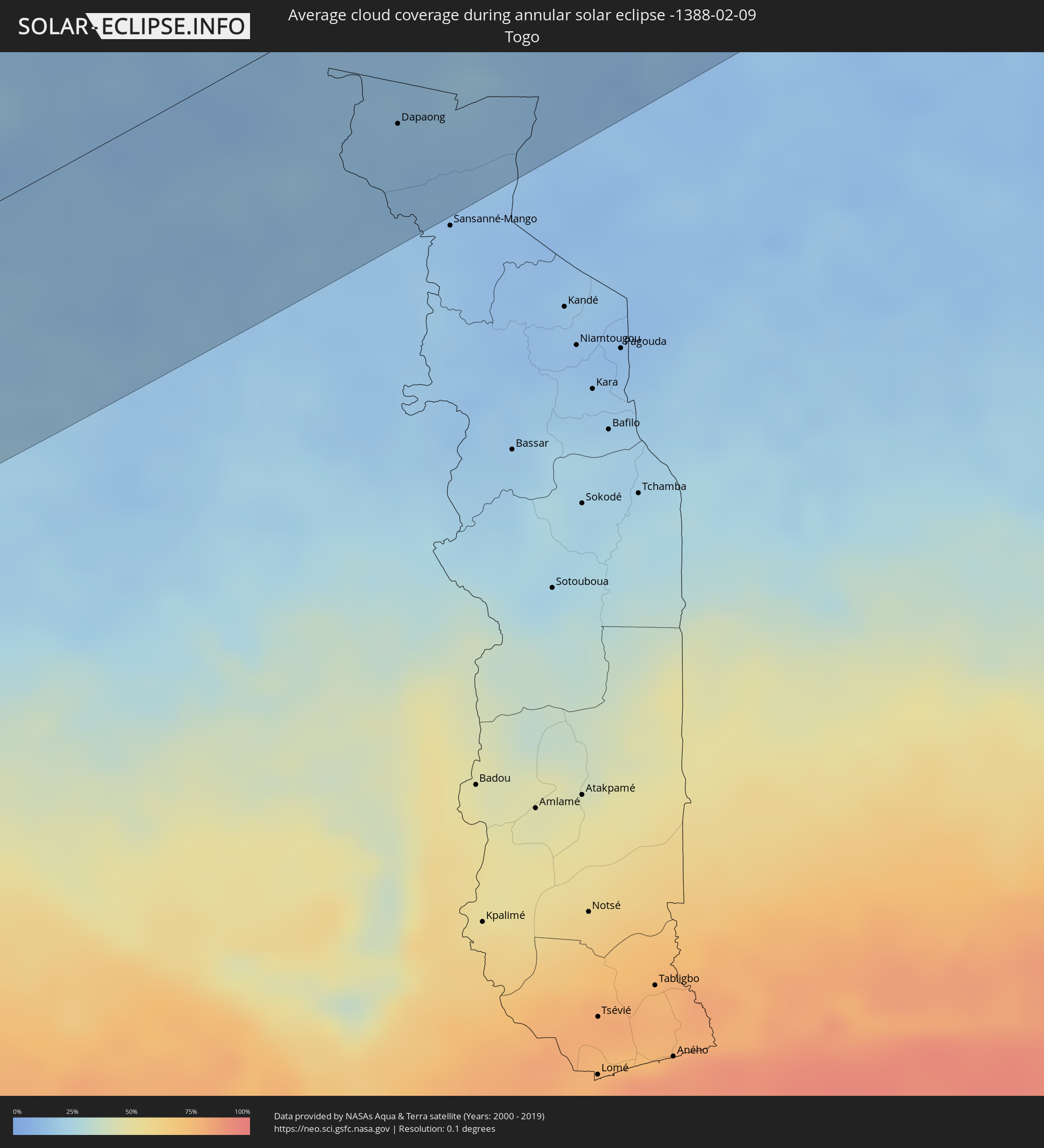 Togo
Togo
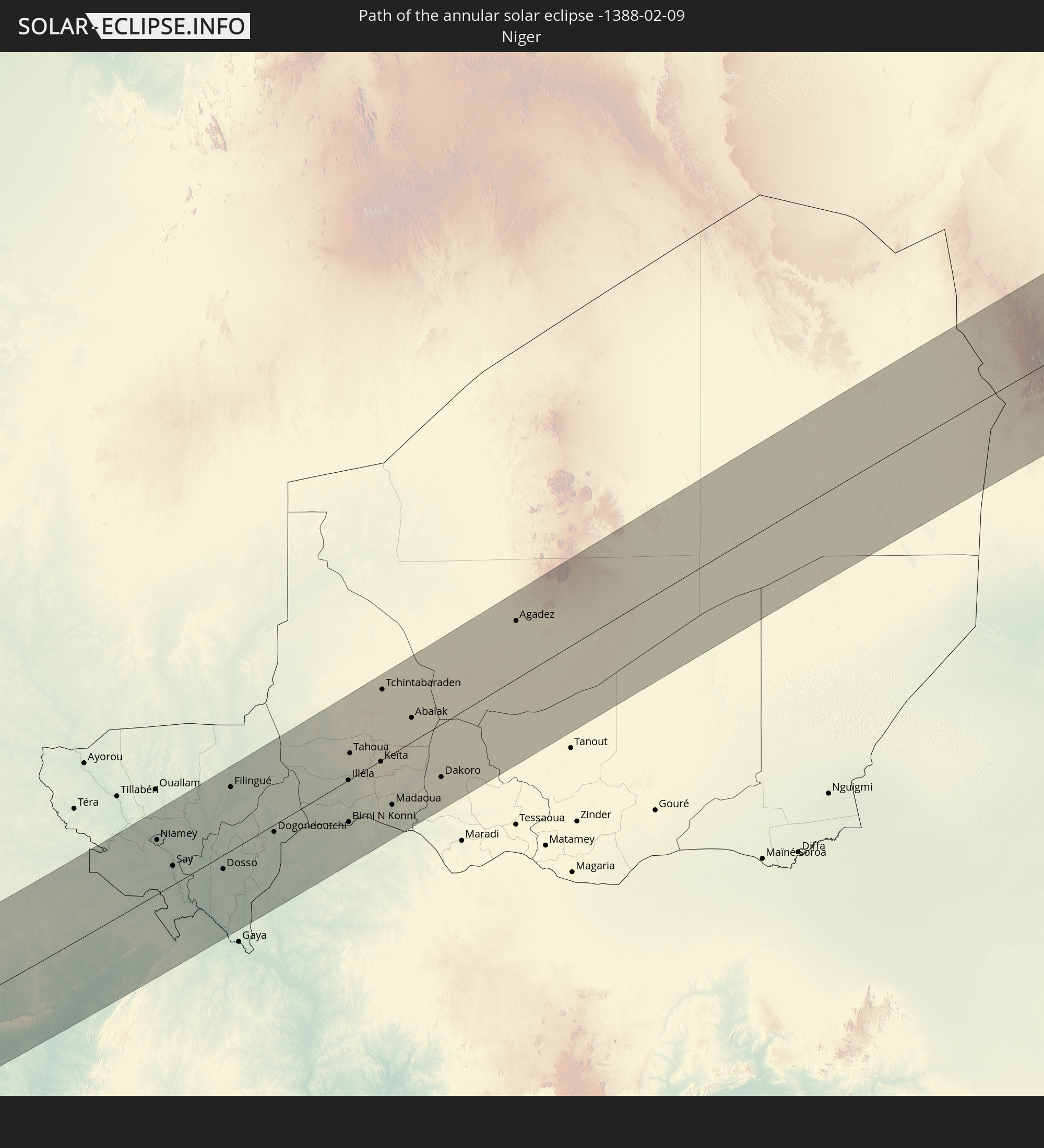
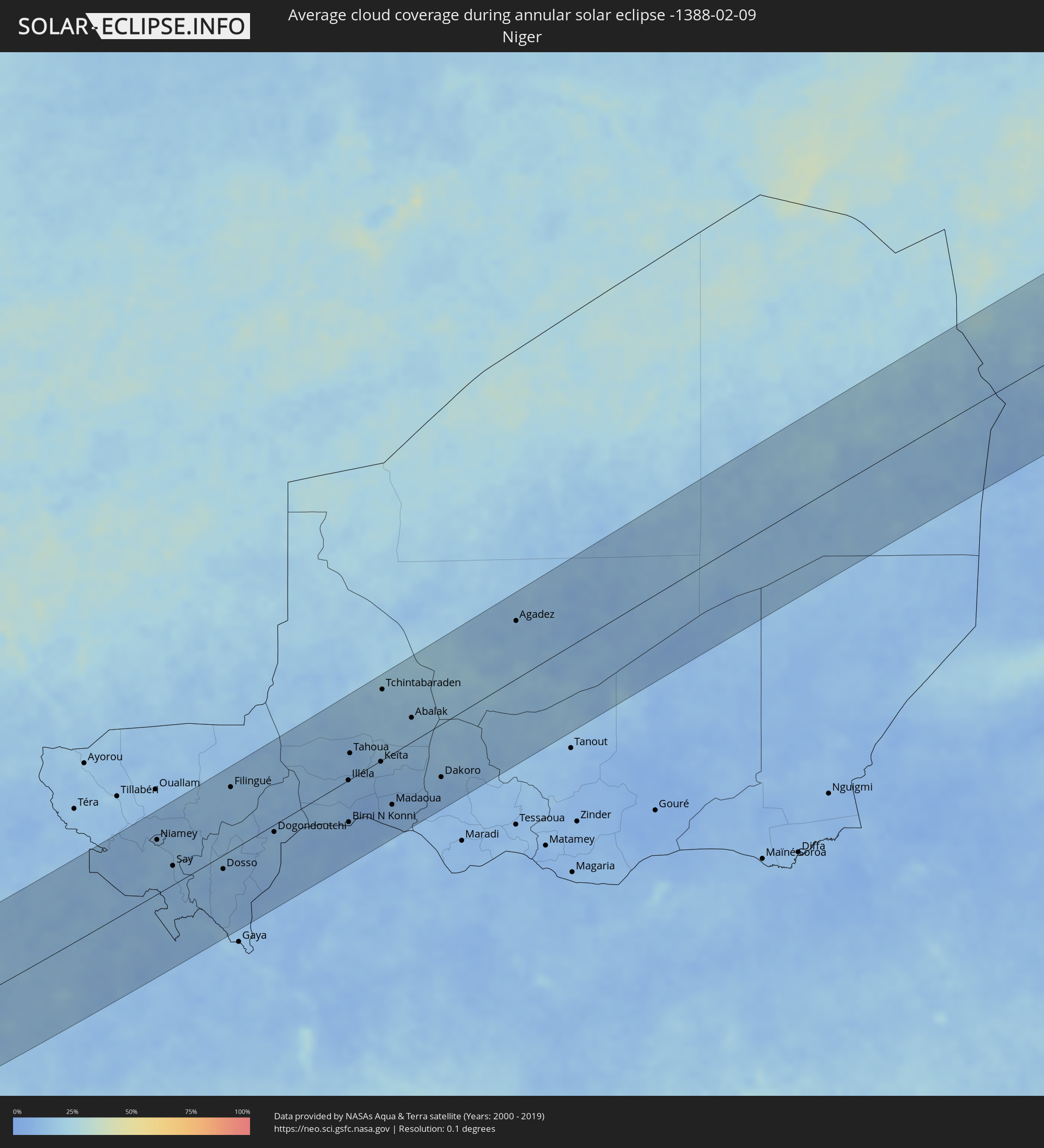 Niger
Niger
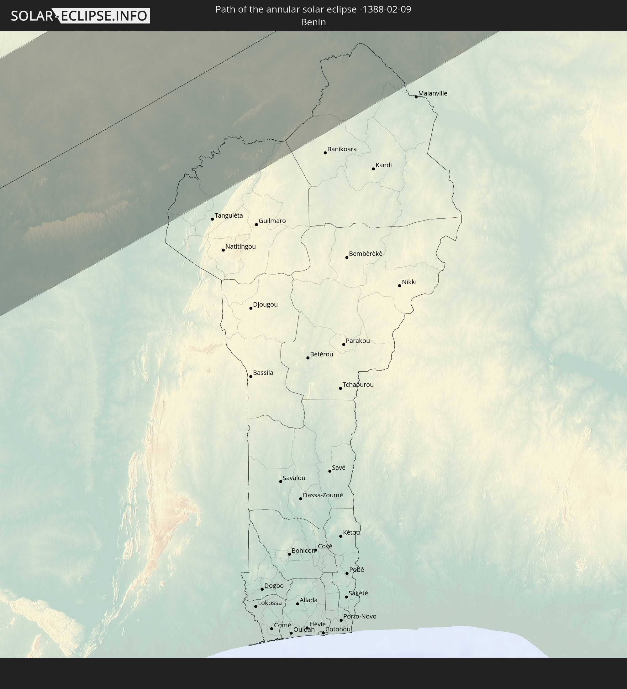
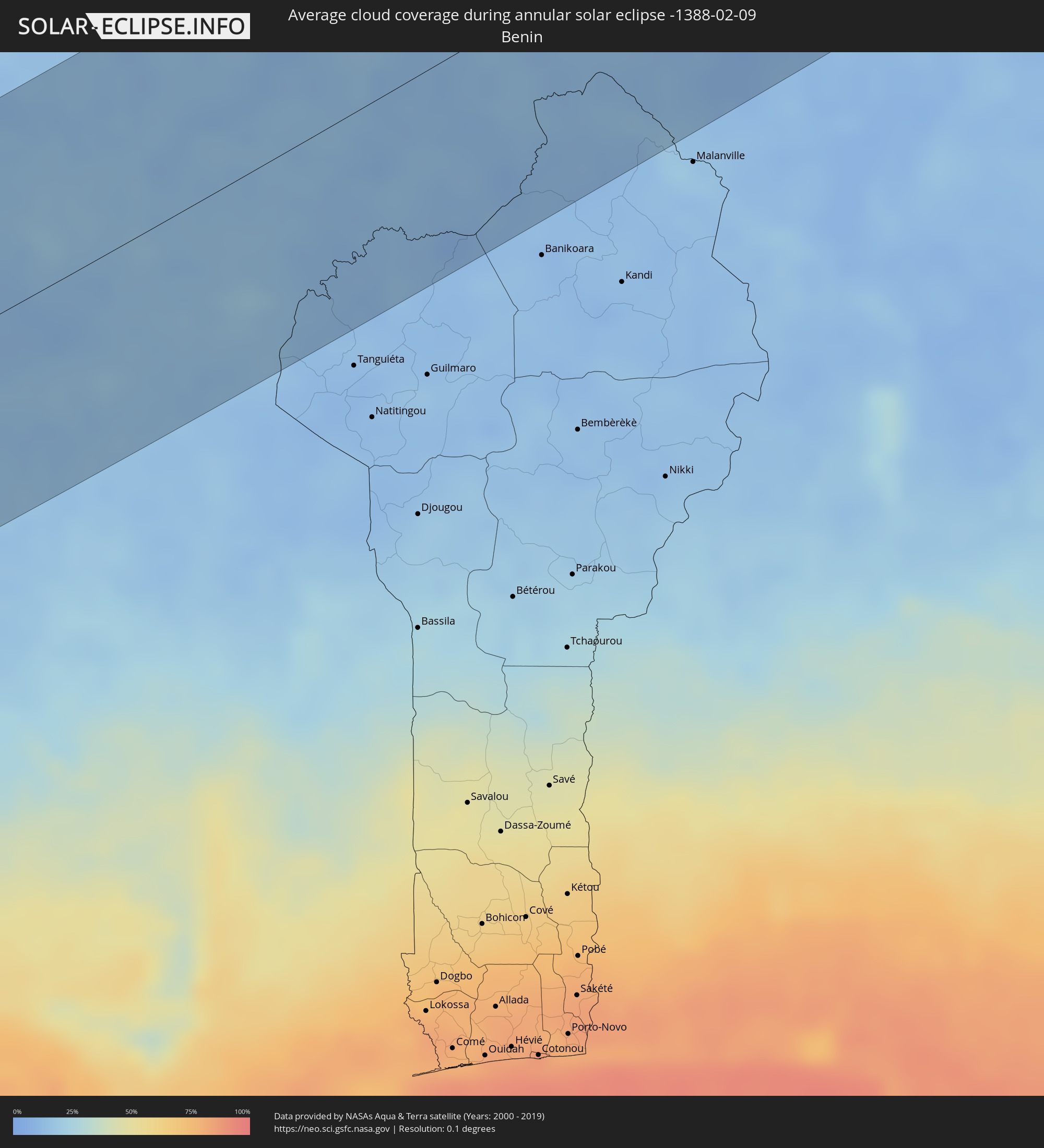 Benin
Benin
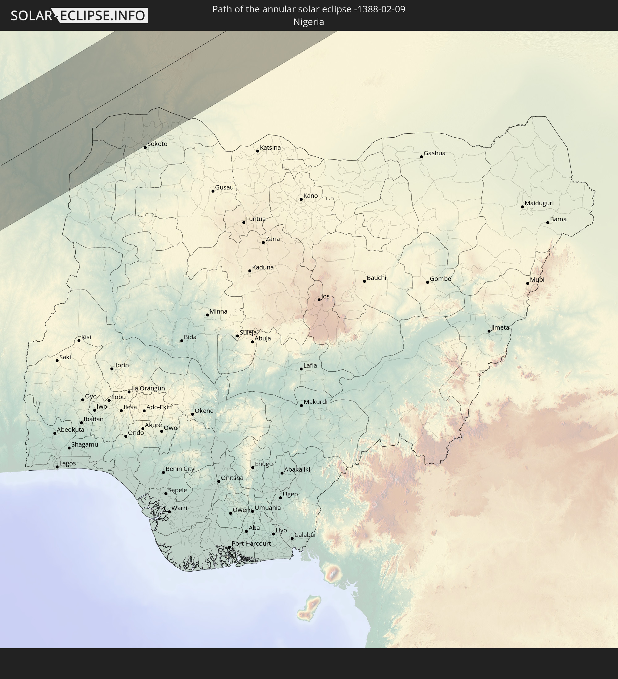
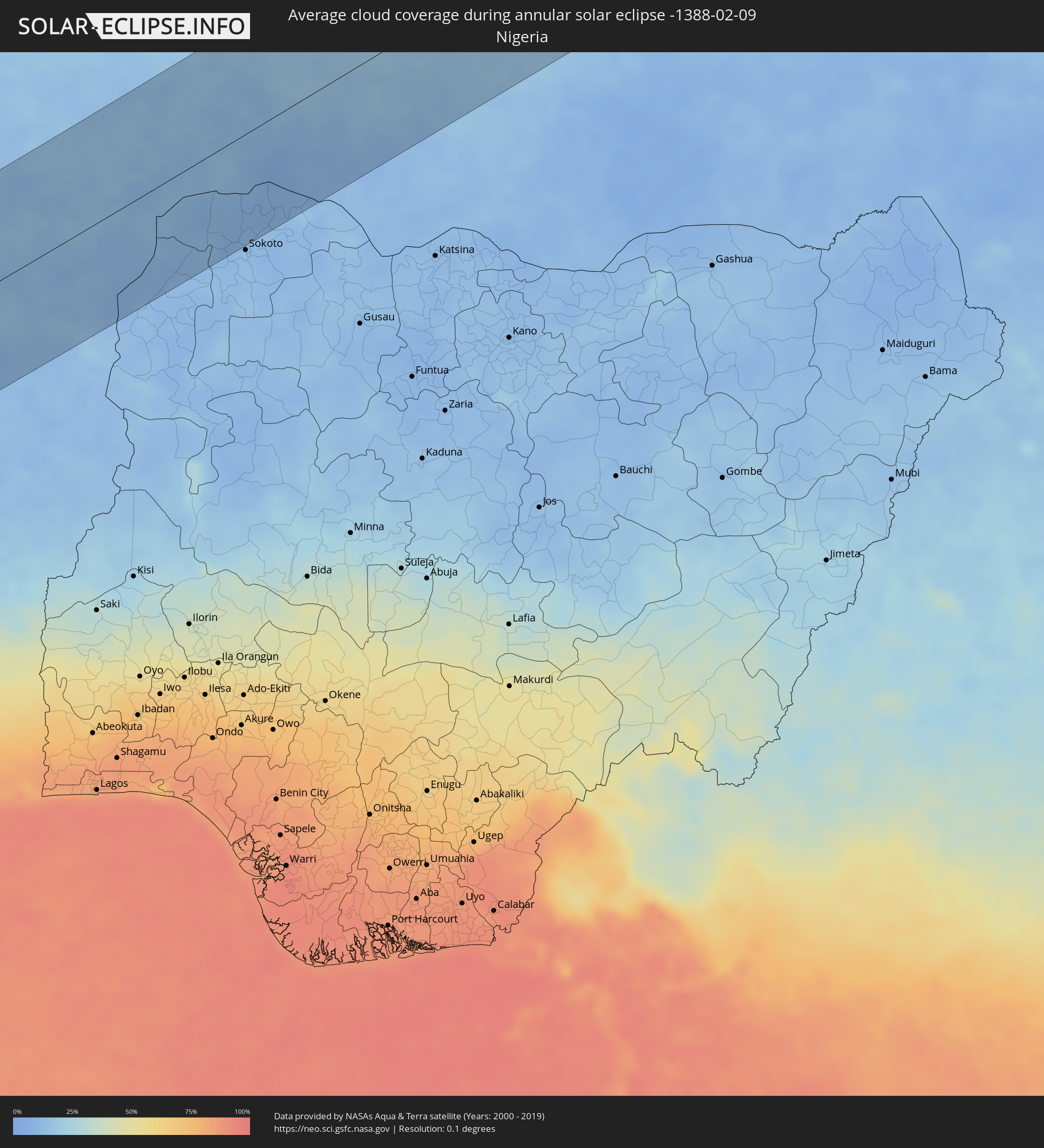 Nigeria
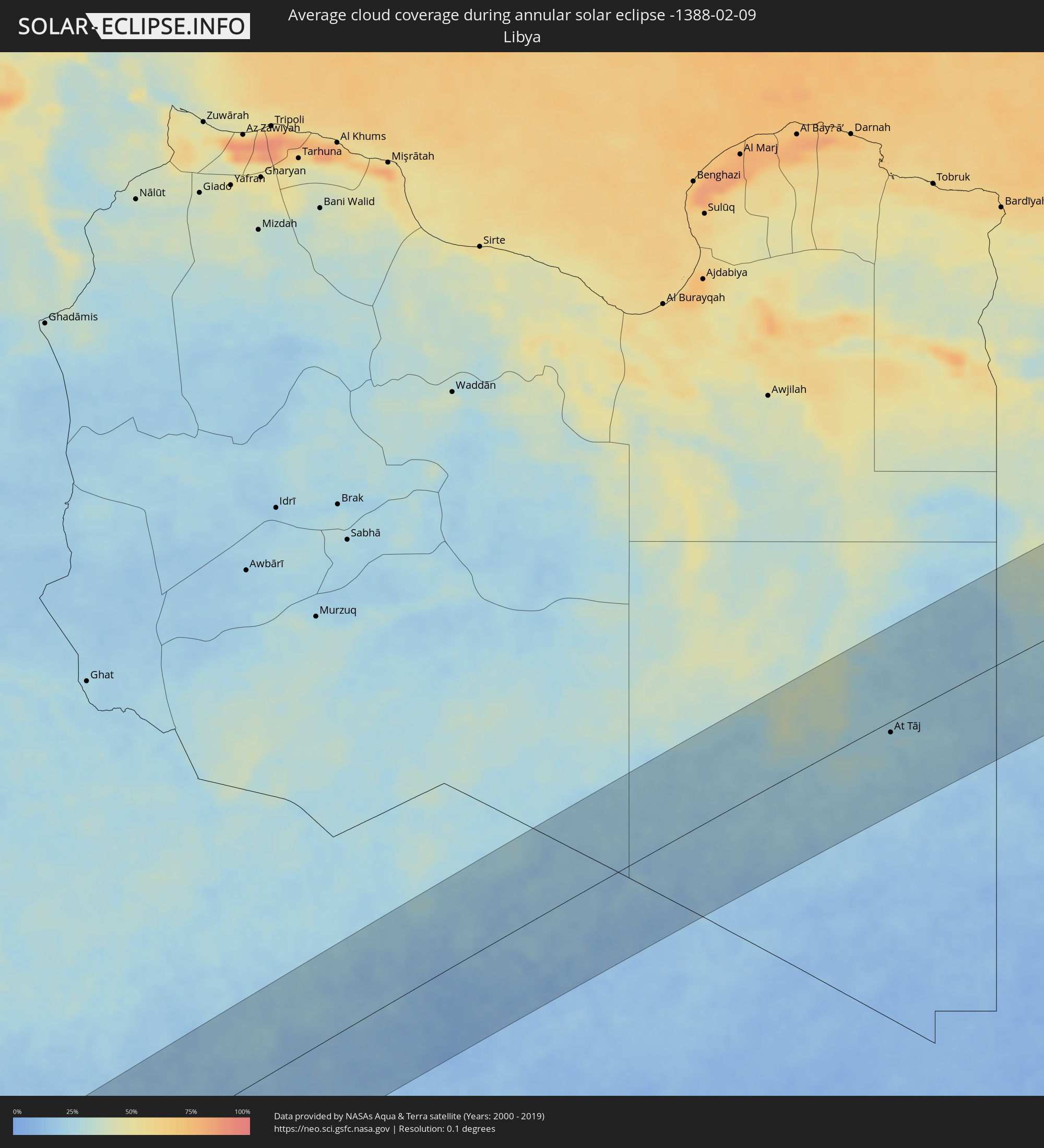 Libya
Libya
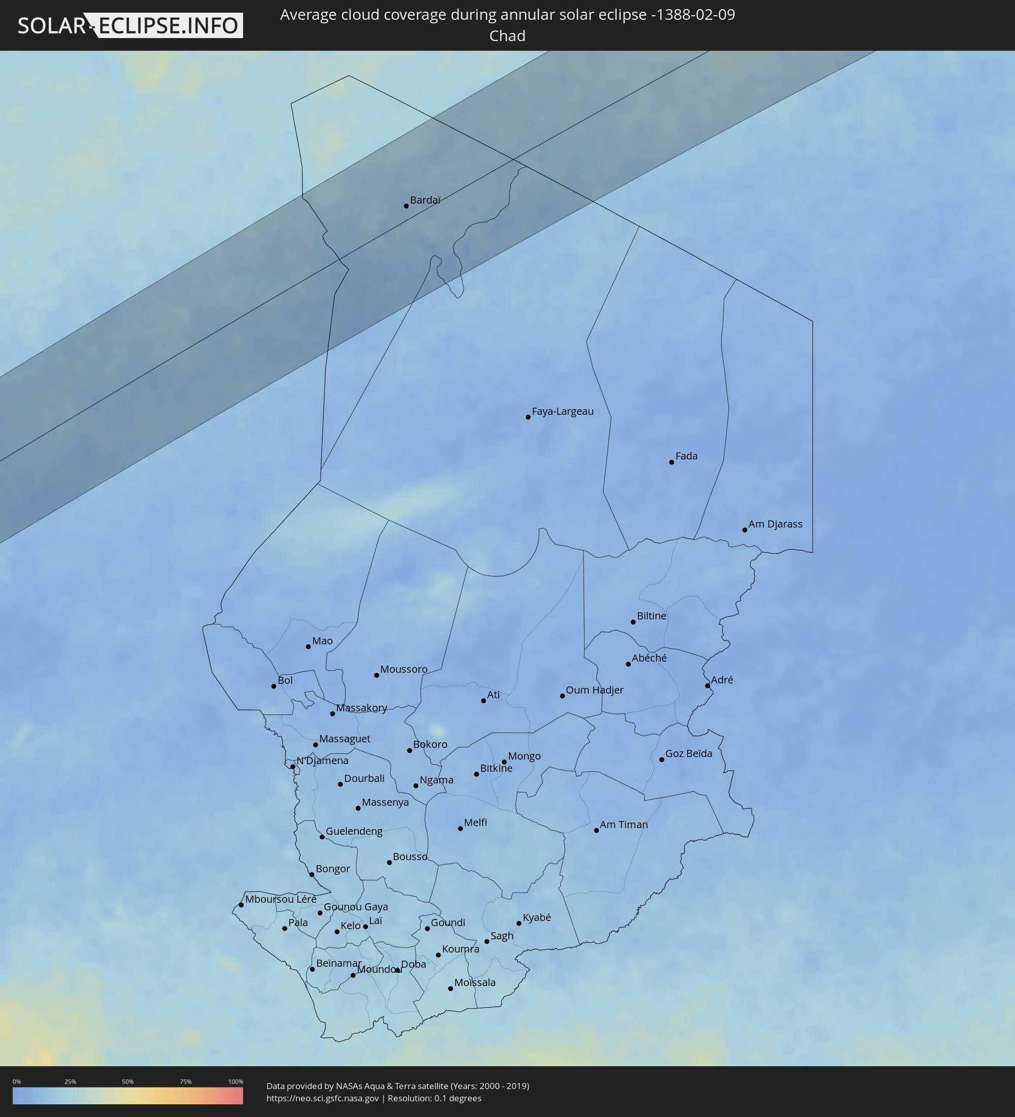 Chad
Chad
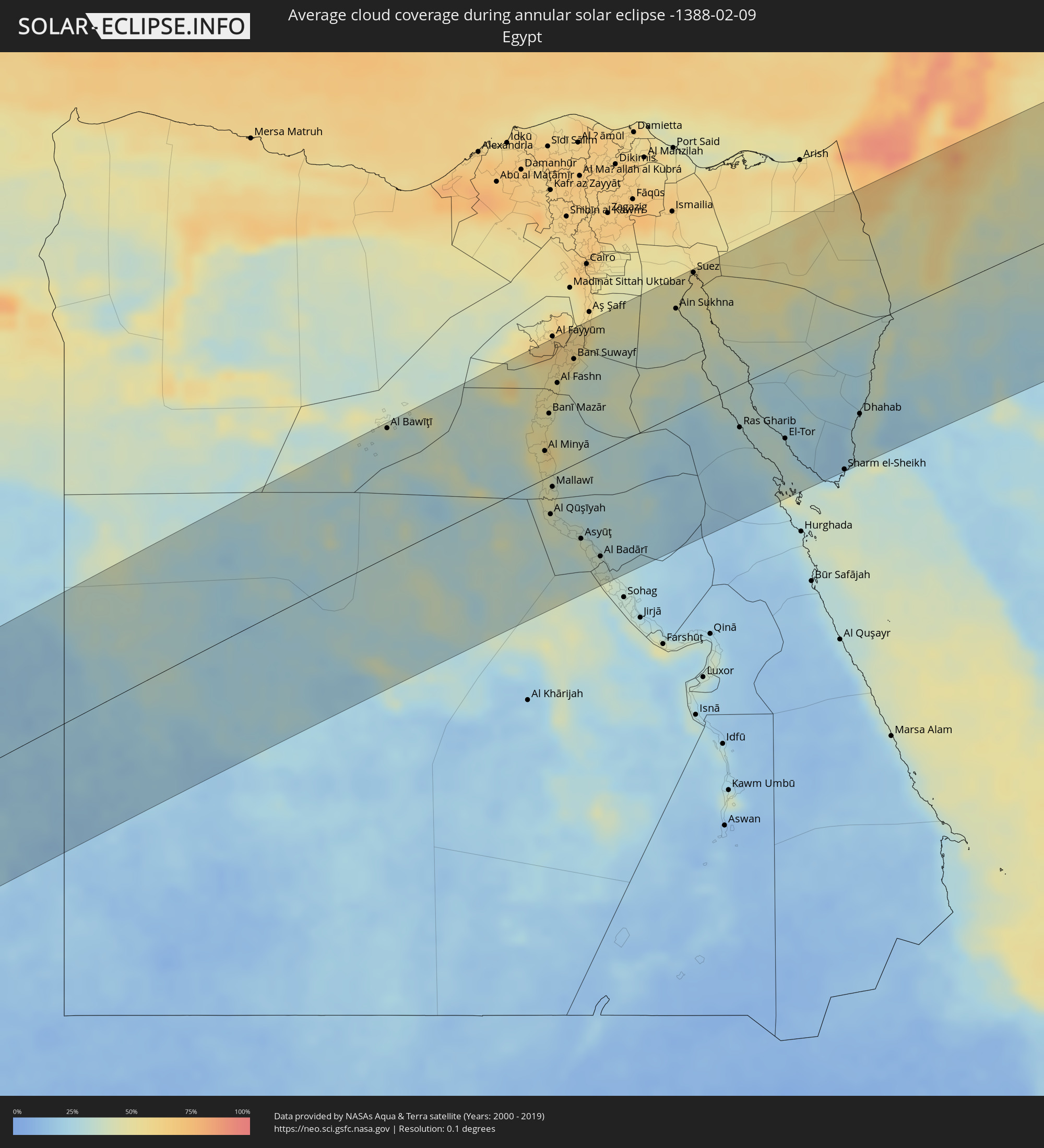 Egypt
Egypt
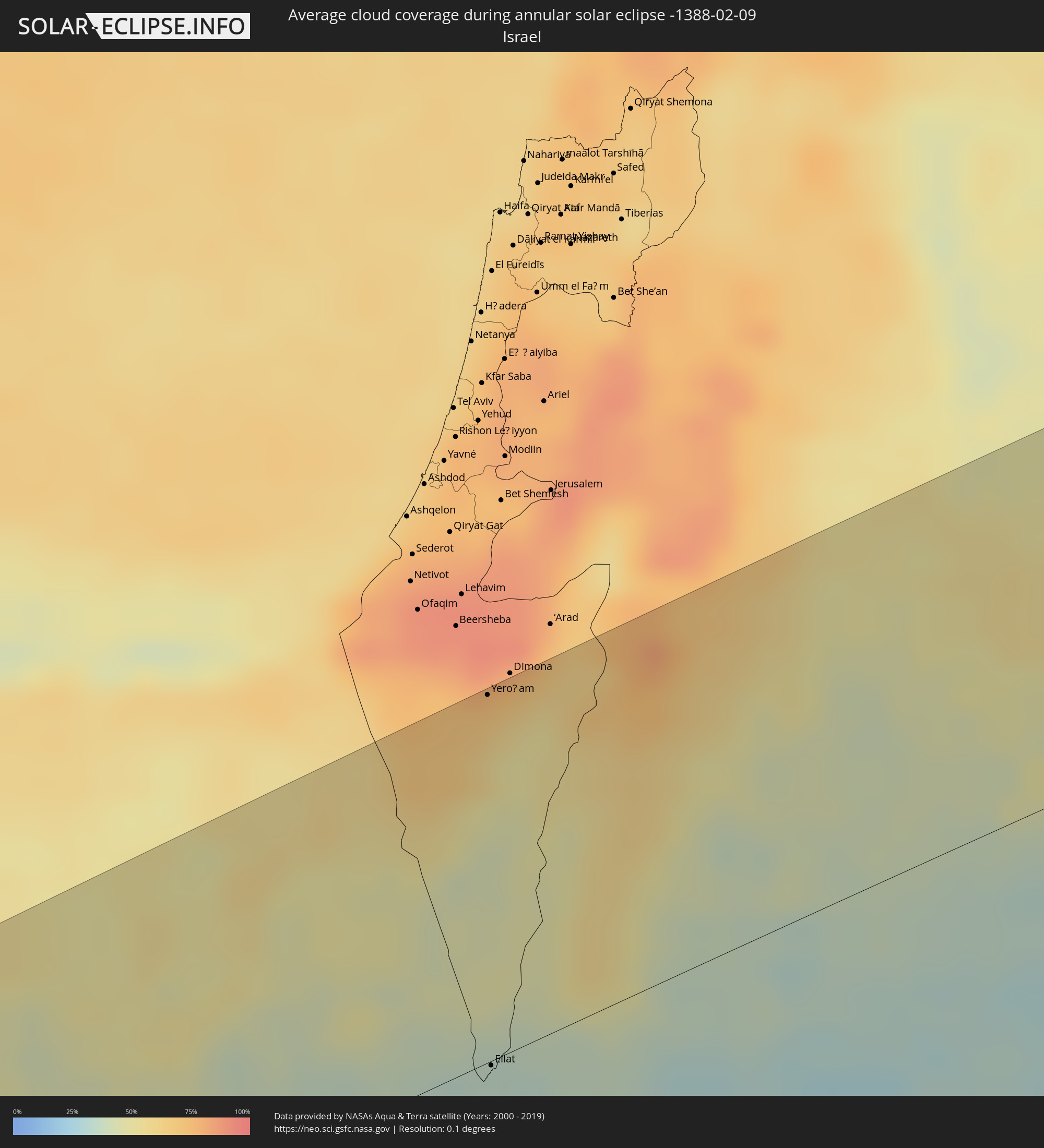 Israel
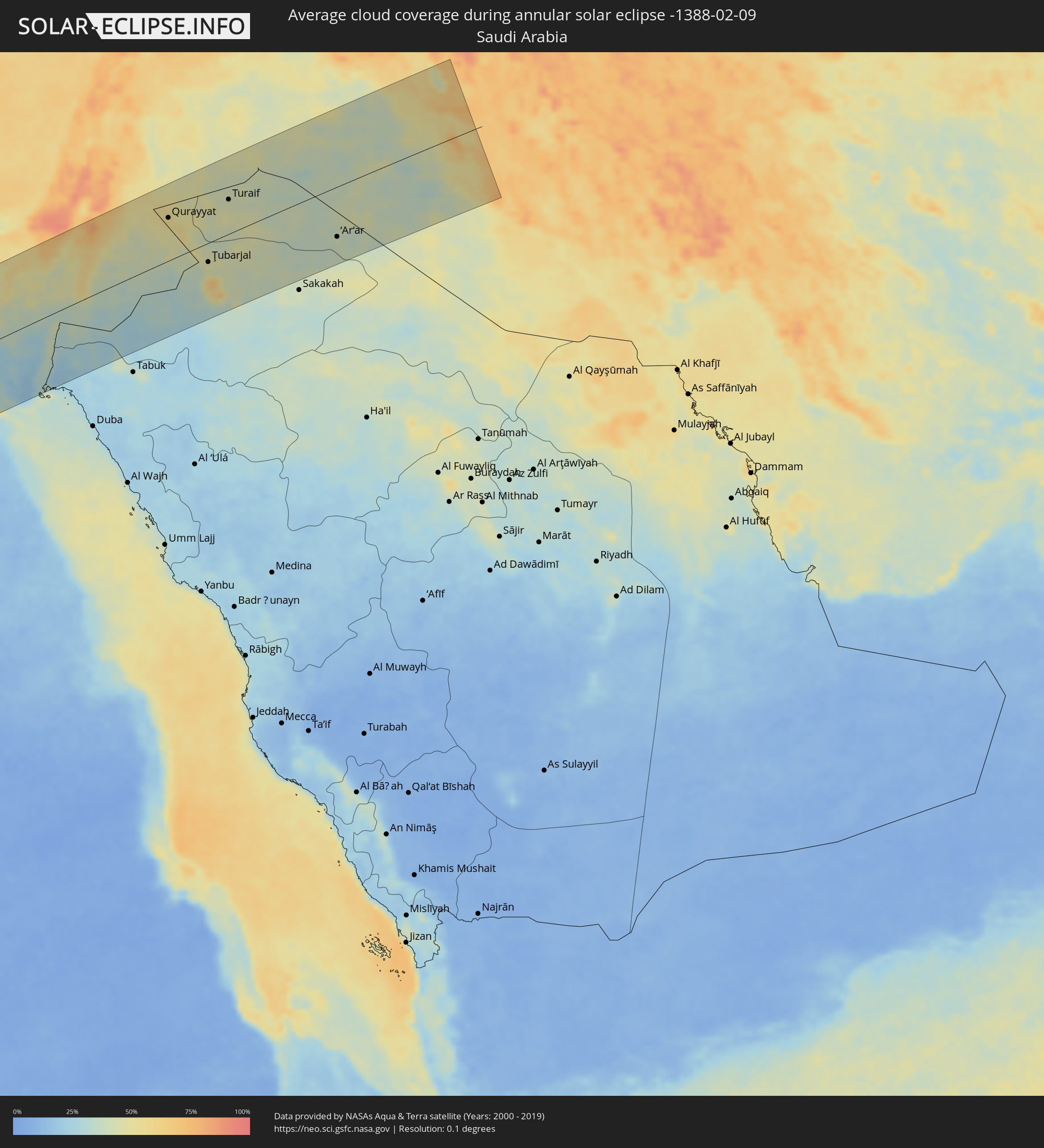 Saudi Arabia
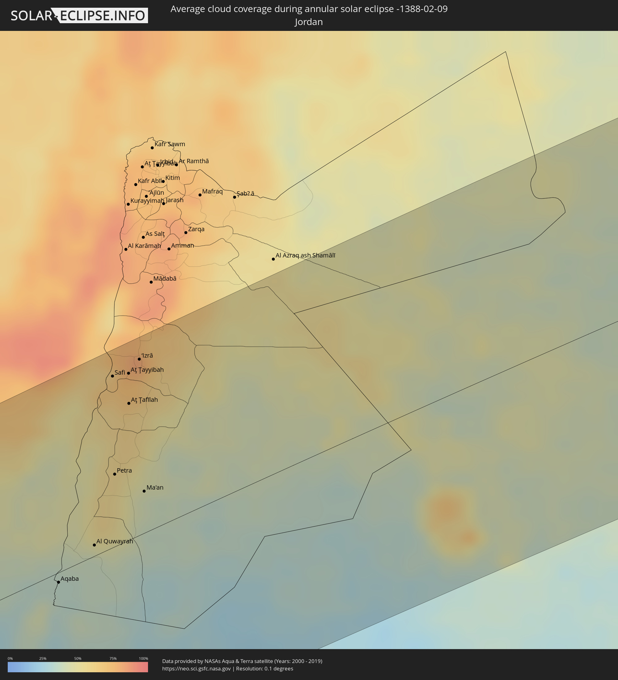 Jordan
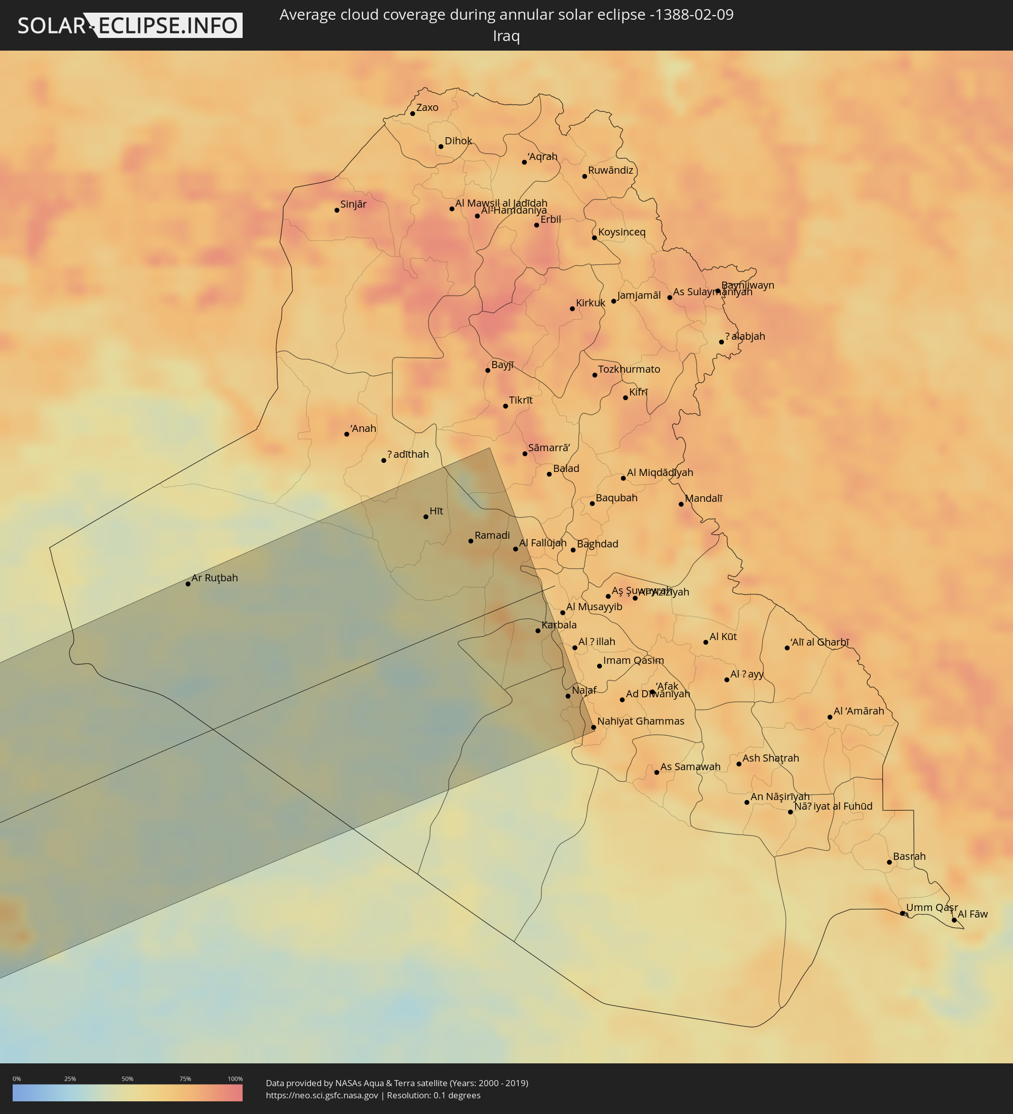 Iraq
Iraq
Cities inside the path of the eclipse
The following table shows all locations with a population of more than 5,000 inside the eclipse path. Cities which have more than 100,000 inhabitants are marked bold. A click at the locations opens a detailed map.
| City | Type | Eclipse duration | Local time of max. eclipse | Distance to central line | Ø Cloud coverage |
|
Hillsborough, Carriacou and Petite Martinique
|
annular | - | 06:52:39 UTC-04:06 | 138 km | 59% |
|
Layou, Saint Andrew
|
annular | - | 06:53:05 UTC-04:06 | 56 km | 56% |
|
Barrouallie, Saint Patrick
|
annular | - | 06:53:06 UTC-04:06 | 52 km | 56% |
|
Chateaubelair, Saint David
|
annular | - | 06:53:08 UTC-04:06 | 47 km | 59% |
|
Port Elizabeth, Grenadines
|
annular | - | 06:52:59 UTC-04:06 | 75 km | 58% |
|
Kingstown Park, Saint George
|
annular | - | 06:53:04 UTC-04:06 | 59 km | 61% |
|
Kingstown, Saint George
|
annular | - | 06:53:04 UTC-04:06 | 59 km | 61% |
|
Georgetown, Charlotte
|
annular | - | 06:53:10 UTC-04:06 | 42 km | 68% |
|
Fort-de-France, Martinique
|
annular | - | 06:55:40 UTC-04:04 | 99 km | 68% |
|
Le Lorrain, Martinique
|
annular | - | 06:55:48 UTC-04:04 | 123 km | 80% |
|
Soufrière, Soufrière
|
annular | - | 06:53:30 UTC-04:06 | 21 km | 67% |
|
Choiseul, Choiseul Quarter
|
annular | - | 06:53:28 UTC-04:06 | 12 km | 67% |
|
Anse La Raye, Anse-la-Raye
|
annular | - | 06:53:34 UTC-04:06 | 31 km | 75% |
|
Les Trois-Îlets, Martinique
|
annular | - | 06:55:38 UTC-04:04 | 93 km | 69% |
|
Castries, Castries Quarter
|
annular | - | 06:53:36 UTC-04:06 | 37 km | 71% |
|
Le Gros-Morne, Martinique
|
annular | - | 06:55:45 UTC-04:04 | 111 km | 72% |
|
Laborie, Laborie Quarter
|
annular | - | 06:53:28 UTC-04:06 | 12 km | 67% |
|
Gros Islet, Gros-Islet
|
annular | - | 06:53:40 UTC-04:06 | 46 km | 66% |
|
Vieux Fort, Vieux-Fort
|
annular | - | 06:53:28 UTC-04:06 | 10 km | 57% |
|
Le Robert, Martinique
|
annular | - | 06:55:45 UTC-04:04 | 111 km | 64% |
|
Saint-Esprit, Martinique
|
annular | - | 06:55:41 UTC-04:04 | 98 km | 69% |
|
Sainte-Luce, Martinique
|
annular | - | 06:55:38 UTC-04:04 | 89 km | 69% |
|
Rivière-Pilote, Martinique
|
annular | - | 06:55:39 UTC-04:04 | 91 km | 69% |
|
Micoud, Micoud Quarter
|
annular | - | 06:53:32 UTC-04:06 | 22 km | 62% |
|
Praslin, Praslin
|
annular | - | 06:53:34 UTC-04:06 | 27 km | 66% |
|
Dennery, Dennery Quarter
|
annular | - | 06:53:35 UTC-04:06 | 31 km | 66% |
|
Le Marin, Martinique
|
annular | - | 06:55:39 UTC-04:04 | 92 km | 69% |
|
Le Vauclin, Martinique
|
annular | - | 06:55:43 UTC-04:04 | 101 km | 62% |
|
Speightstown, Saint Peter
|
annular | - | 07:01:18 UTC-03:58 | 6 km | 67% |
|
Holetown, Saint James
|
annular | - | 07:01:16 UTC-03:58 | 0 km | 70% |
|
Checker Hall, Saint Lucy
|
annular | - | 07:01:19 UTC-03:58 | 10 km | 61% |
|
Bridgetown, Saint Michael
|
annular | - | 07:01:14 UTC-03:58 | 8 km | 65% |
|
Welchman Hall, Saint Thomas
|
annular | - | 07:01:18 UTC-03:58 | 2 km | 70% |
|
Greenland, Saint Andrew
|
annular | - | 07:01:20 UTC-03:58 | 9 km | 61% |
|
Oistins, Christ Church
|
annular | - | 07:01:15 UTC-03:58 | 9 km | 62% |
|
Bathsheba, Saint Joseph
|
annular | - | 07:01:20 UTC-03:58 | 7 km | 66% |
|
Four Cross Roads, Saint John
|
annular | - | 07:01:18 UTC-03:58 | 2 km | 66% |
|
Crane, Saint Philip
|
annular | - | 07:01:18 UTC-03:58 | 2 km | 62% |
|
Pujehun, Southern Province
|
annular | - | 12:26:50 UTC-00:16 | 125 km | 65% |
|
Foindu, Southern Province
|
annular | - | 12:27:35 UTC-00:16 | 124 km | 63% |
|
Bomi, Southern Province
|
annular | - | 12:27:28 UTC-00:16 | 106 km | 67% |
|
Robertsport, Grand Cape Mount
|
annular | - | 12:00:31 UTC-00:43 | 49 km | 72% |
|
Tubmanburg, Bomi
|
annular | - | 12:02:48 UTC-00:43 | 42 km | 73% |
|
Monrovia, Montserrado
|
annular | - | 12:02:13 UTC-00:43 | 19 km | 81% |
|
Bensonville, Montserrado
|
annular | - | 12:03:07 UTC-00:43 | 10 km | 83% |
|
Kakata, Margibi
|
annular | - | 12:04:13 UTC-00:43 | 10 km | 79% |
|
Buchanan, Grand Bassa
|
annular | - | 12:04:39 UTC-00:43 | 90 km | 82% |
|
Gbarnga, Bong
|
annular | - | 12:08:12 UTC-00:43 | 5 km | 68% |
|
Nzérékoré, Nzerekore
|
annular | - | 12:38:38 UTC-00:16 | 58 km | 45% |
|
Sanniquellie, Nimba
|
annular | - | 12:11:33 UTC-00:43 | 13 km | 55% |
|
New Yekepa, Nimba
|
annular | - | 12:12:29 UTC-00:43 | 28 km | 49% |
|
Ganta, Nimba
|
annular | - | 12:12:11 UTC-00:43 | 1 km | 56% |
|
Danané, Montagnes
|
annular | - | 12:40:33 UTC-00:16 | 20 km | 55% |
|
Man, Montagnes
|
annular | - | 12:43:01 UTC-00:16 | 30 km | 41% |
|
Guiglo, Montagnes
|
annular | - | 12:42:10 UTC-00:16 | 122 km | 65% |
|
Duekoué, Montagnes
|
annular | - | 12:42:57 UTC-00:16 | 108 km | 62% |
|
Séguéla, Woroba
|
annular | - | 12:46:58 UTC-00:16 | 13 km | 36% |
|
Zuénoula, Sassandra-Marahoué
|
annular | - | 12:48:36 UTC-00:16 | 95 km | 48% |
|
Korhogo, Savanes
|
annular | - | 12:52:36 UTC-00:16 | 90 km | 23% |
|
Ferkessédougou, Savanes
|
annular | - | 12:54:19 UTC-00:16 | 83 km | 26% |
|
Katiola, Vallée du Bandama
|
annular | - | 12:52:54 UTC-00:16 | 67 km | 38% |
|
Bouaké, Vallée du Bandama
|
annular | - | 12:52:36 UTC-00:16 | 115 km | 43% |
|
Gaoua, Sud-Ouest
|
annular | - | 13:01:56 UTC-00:16 | 57 km | 13% |
|
Wa, Upper West
|
annular | - | 13:19:27 UTC-00:00 | 5 km | 13% |
|
Léo, Centre-Ouest
|
annular | - | 13:06:40 UTC-00:16 | 77 km | 15% |
|
Pô, Centre-Sud
|
annular | - | 13:09:52 UTC-00:16 | 33 km | 15% |
|
Navrongo, Upper East
|
annular | - | 13:25:00 UTC-00:00 | 3 km | 12% |
|
Manga, Centre-Sud
|
annular | - | 13:10:38 UTC-00:16 | 77 km | 14% |
|
Bolgatanga, Upper East
|
annular | - | 13:25:39 UTC-00:00 | 20 km | 12% |
|
Zorgo, Plateau-Central
|
annular | - | 13:12:42 UTC-00:16 | 110 km | 14% |
|
Garango, Centre-Est
|
annular | - | 13:12:25 UTC-00:16 | 63 km | 16% |
|
Tenkodogo, Centre-Est
|
annular | - | 13:12:58 UTC-00:16 | 51 km | 15% |
|
Koupéla, Centre-Est
|
annular | - | 13:13:27 UTC-00:16 | 89 km | 13% |
|
Bawku, Upper East
|
annular | - | 13:27:52 UTC-00:00 | 26 km | 15% |
|
Dapaong, Savanes
|
annular | - | 13:13:46 UTC-00:16 | 69 km | 15% |
|
Fada N'gourma, Est
|
annular | - | 13:15:30 UTC-00:16 | 39 km | 16% |
|
Diapaga, Est
|
annular | - | 13:19:45 UTC-00:16 | 38 km | 14% |
|
Niamey, Niamey
|
annular | - | 13:51:48 UTC+00:13 | 83 km | 14% |
|
Dosso, Dosso
|
annular | - | 13:54:24 UTC+00:13 | 21 km | 10% |
|
Kangiwa, Kebbi
|
annular | - | 13:55:38 UTC+00:13 | 103 km | 10% |
|
Dogondoutchi, Dosso
|
annular | - | 13:57:12 UTC+00:13 | 11 km | 14% |
|
Gulma, Kebbi
|
annular | - | 13:57:09 UTC+00:13 | 125 km | 10% |
|
Argungu, Kebbi
|
annular | - | 13:57:42 UTC+00:13 | 124 km | 11% |
|
Binji, Sokoto
|
annular | - | 13:59:08 UTC+00:13 | 100 km | 10% |
|
Gwadabawa, Sokoto
|
annular | - | 14:00:06 UTC+00:13 | 105 km | 9% |
|
Illéla, Tahoua
|
annular | - | 14:01:03 UTC+00:13 | 0 km | 10% |
|
Birni N Konni, Tahoua
|
annular | - | 14:00:31 UTC+00:13 | 64 km | 9% |
|
Tahoua, Tahoua
|
annular | - | 14:01:28 UTC+00:13 | 39 km | 12% |
|
Illela, Sokoto
|
annular | - | 14:00:35 UTC+00:13 | 73 km | 9% |
|
Wurno, Sokoto
|
annular | - | 14:00:31 UTC+00:13 | 122 km | 13% |
|
Goronyo, Sokoto
|
annular | - | 14:01:17 UTC+00:13 | 121 km | 10% |
|
Madaoua, Tahoua
|
annular | - | 14:02:32 UTC+00:13 | 77 km | 11% |
|
Abalak, Tahoua
|
annular | - | 14:04:24 UTC+00:13 | 37 km | 17% |
|
Dakoro, Maradi
|
annular | - | 14:04:51 UTC+00:13 | 80 km | 11% |
|
Agadez, Agadez
|
annular | - | 14:09:26 UTC+00:13 | 86 km | 12% |
|
Bardaï, Tibesti
|
annular | - | 15:14:35 UTC+01:00 | 21 km | 15% |
|
At Tāj, Al Kufrah
|
annular | - | 15:15:29 UTC+00:52 | 16 km | 26% |
|
Al Jawf, Al Kufrah
|
annular | - | 15:15:29 UTC+00:52 | 17 km | 26% |
|
Samālūţ, Minya
|
annular | - | 16:28:39 UTC+02:00 | 51 km | 52% |
|
Al Minyā, Minya
|
annular | - | 16:28:44 UTC+02:00 | 29 km | 54% |
|
Al Qūşīyah, Asyut
|
annular | - | 16:28:58 UTC+02:00 | 41 km | 39% |
|
Mallawī, Minya
|
annular | - | 16:28:55 UTC+02:00 | 13 km | 47% |
|
Manfalūţ, Asyut
|
annular | - | 16:29:07 UTC+02:00 | 60 km | 35% |
|
Banī Suwayf, Beni Suweif
|
annular | - | 16:28:40 UTC+02:00 | 111 km | 55% |
|
Asyūţ, Asyut
|
annular | - | 16:29:18 UTC+02:00 | 82 km | 38% |
|
Abū Tīj, Asyut
|
annular | - | 16:29:25 UTC+02:00 | 102 km | 35% |
|
Ţahţā, Sohag
|
annular | - | 16:29:37 UTC+02:00 | 137 km | 41% |
|
Suez, Suez
|
annular | - | 16:29:16 UTC+02:00 | 140 km | 53% |
|
Yeroẖam, Southern District
|
annular | - | 16:50:51 UTC+02:20 | 143 km | 69% |
|
Eilat, Southern District
|
annular | - | 16:51:28 UTC+02:20 | 2 km | 35% |
|
Aqaba, Aqaba
|
annular | - | 16:54:35 UTC+02:23 | 7 km | 36% |
|
Al Quwayrah, Ma’an
|
annular | - | 16:54:38 UTC+02:23 | 8 km | 38% |
|
Safi, Karak
|
annular | - | 16:54:10 UTC+02:23 | 127 km | 67% |
|
Petra, Ma’an
|
annular | - | 16:54:30 UTC+02:23 | 54 km | 56% |
|
Aţ Ţafīlah, Tafielah
|
annular | - | 16:54:20 UTC+02:23 | 101 km | 61% |
|
‘Izrā, Karak
|
annular | - | 16:54:14 UTC+02:23 | 130 km | 78% |
|
Al Mazār al Janūbī, Karak
|
annular | - | 16:54:16 UTC+02:23 | 121 km | 72% |
|
Qīr Moāv, Ma’an
|
annular | - | 16:54:13 UTC+02:23 | 132 km | 78% |
|
Ma'an, Ma’an
|
annular | - | 16:54:40 UTC+02:23 | 31 km | 43% |
|
Karak City, Karak
|
annular | - | 16:54:15 UTC+02:23 | 128 km | 71% |
|
Qurayyat, Al Jawf
|
annular | - | 17:38:02 UTC+03:06 | 82 km | 54% |
|
Ţubarjal, Al Jawf
|
annular | - | 17:38:47 UTC+03:06 | 37 km | 46% |
|
Turaif, Northern Borders
|
annular | - | 17:38:24 UTC+03:06 | 65 km | 42% |
|
Ar Ruţbah, Anbar
|
annular | - | 17:28:58 UTC+02:57 | 143 km | 45% |
|
‘Ar‘ar, Northern Borders
|
annular | - | 17:39:32 UTC+03:06 | 96 km | 40% |
|
Hīt, Anbar
|
annular | - | 17:29:20 UTC+02:57 | 112 km | 53% |
|
Ramadi, Anbar
|
annular | - | 17:29:34 UTC+02:57 | 72 km | 63% |
|
Al Fallūjah, Anbar
|
annular | - | 17:29:43 UTC+02:57 | 48 km | 68% |
|
Karbala, Karbalāʼ
|
annular | - | 17:30:11 UTC+02:57 | 38 km | 58% |
|
Al Hindīyah, Karbalāʼ
|
annular | - | 17:30:15 UTC+02:57 | 51 km | 66% |
|
Najaf, An Najaf
|
annular | - | 17:30:34 UTC+02:57 | 109 km | 64% |
|
Kufa, An Najaf
|
annular | - | 17:30:34 UTC+02:57 | 109 km | 69% |
|
Al Mishkhāb, An Najaf
|
annular | - | 17:30:42 UTC+02:57 | 137 km | 74% |