Total solar eclipse of 04/11/-1391
| Day of week: | Sunday |
| Maximum duration of eclipse: | 06m31s |
| Maximum width of eclipse path: | 237 km |
| Saros cycle: | 26 |
| Coverage: | 100% |
| Magnitude: | 1.0729 |
| Gamma: | -0.0681 |
Wo kann man die Sonnenfinsternis vom 04/11/-1391 sehen?
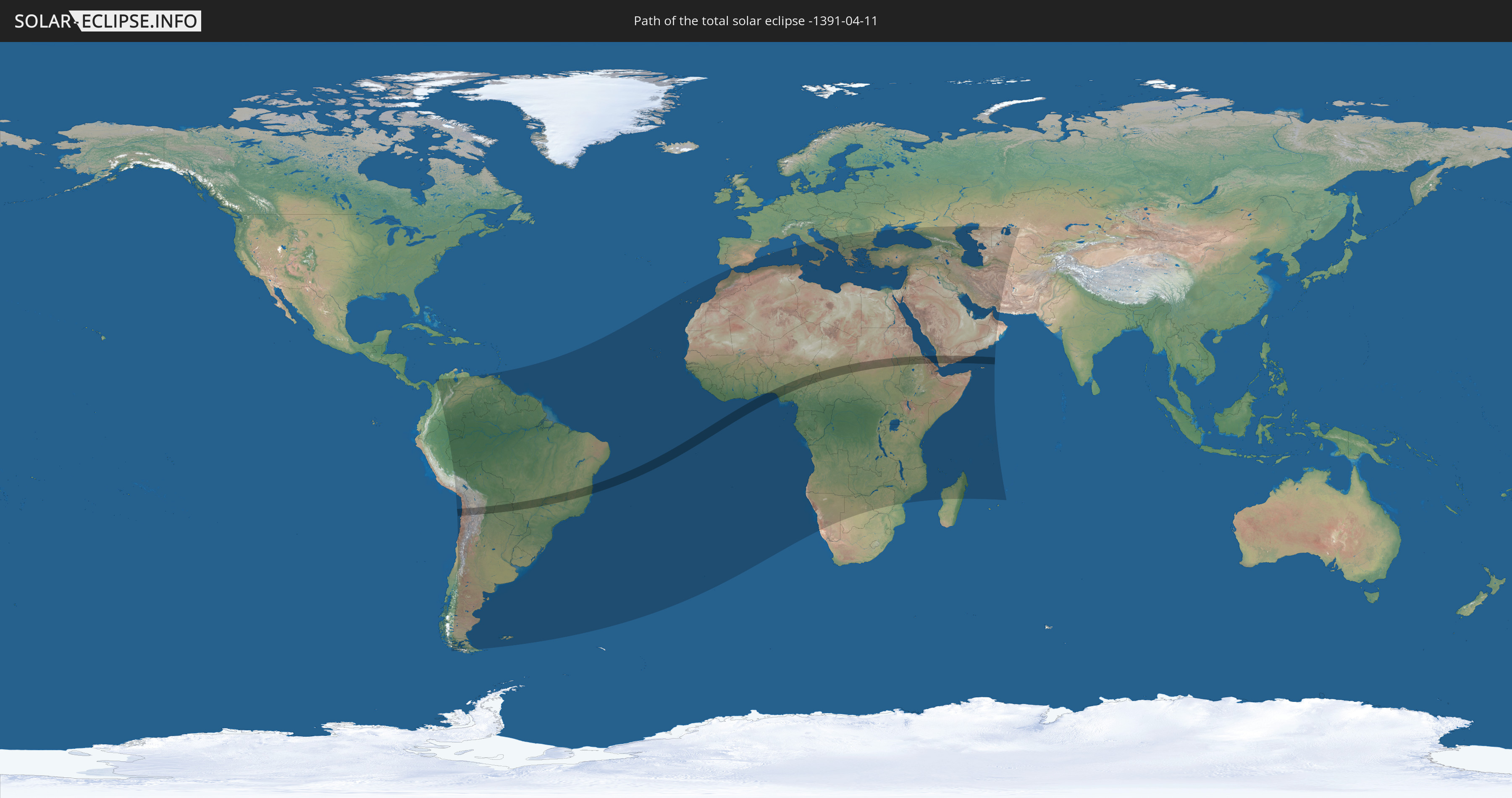
Die Sonnenfinsternis am 04/11/-1391 kann man in 107 Ländern als partielle Sonnenfinsternis beobachten.
Der Finsternispfad verläuft durch 13 Länder. Nur in diesen Ländern ist sie als total Sonnenfinsternis zu sehen.
In den folgenden Ländern ist die Sonnenfinsternis total zu sehen
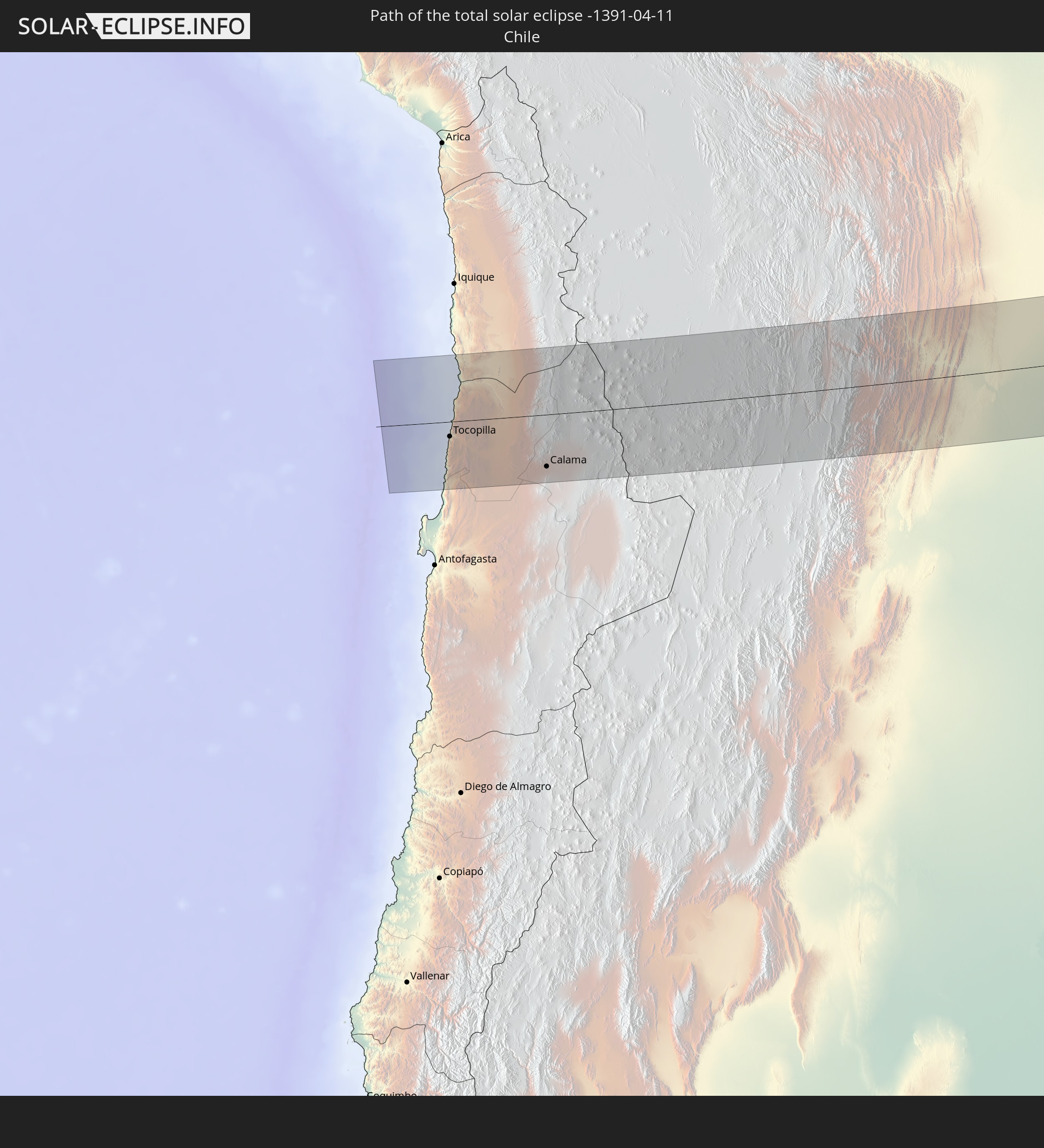 Chile
Chile
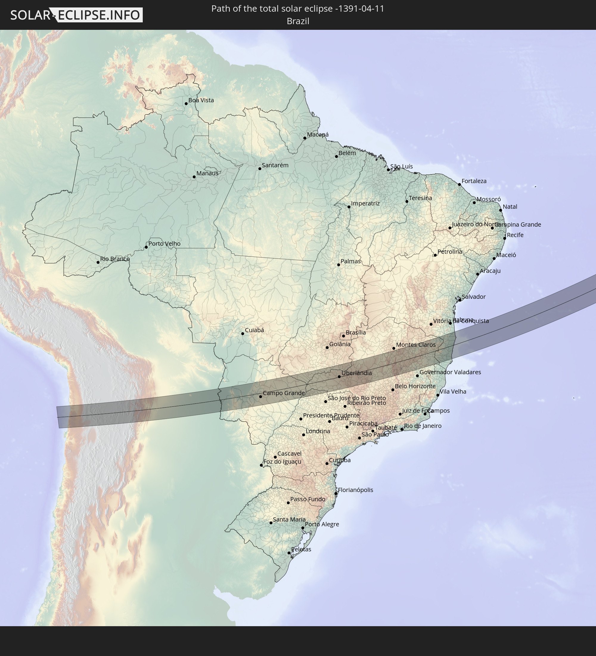 Brazil
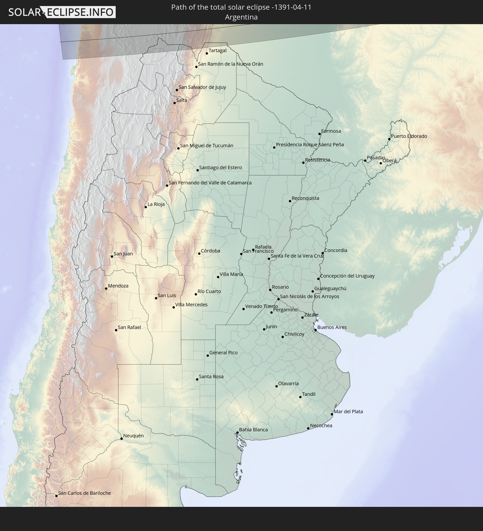 Argentina
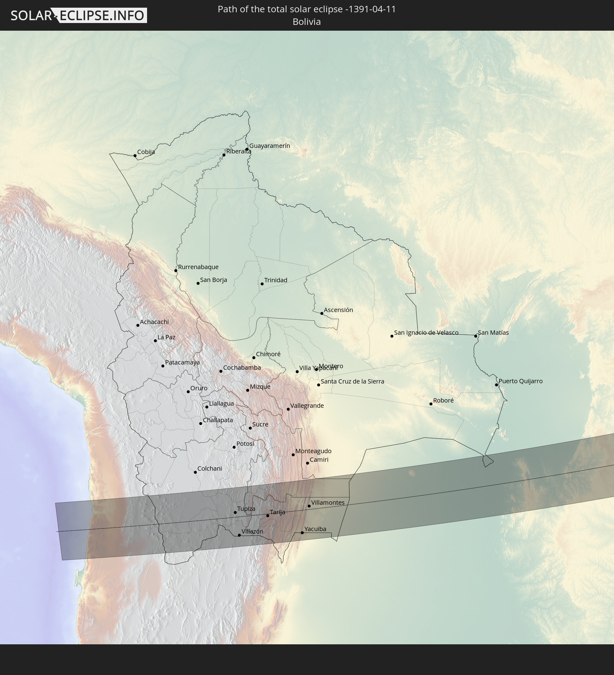 Bolivia
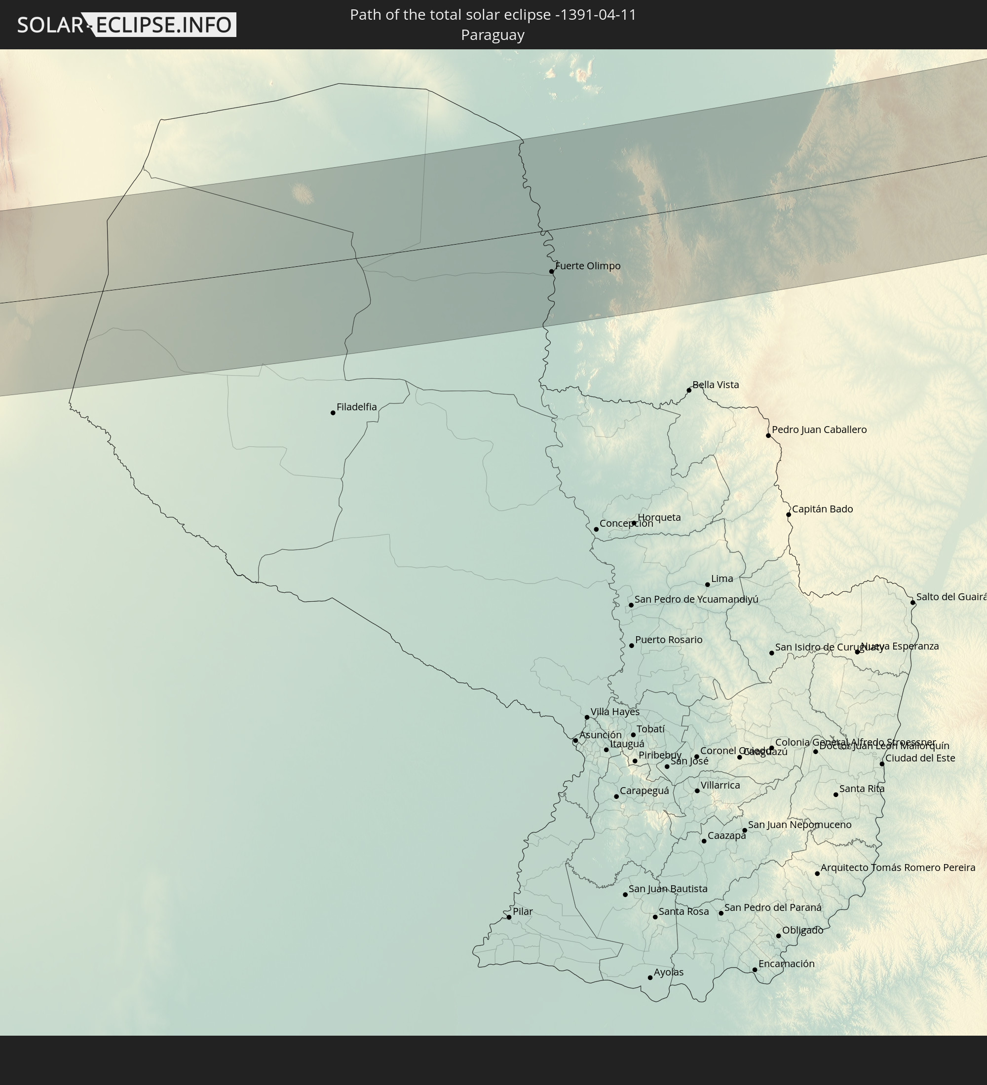 Paraguay
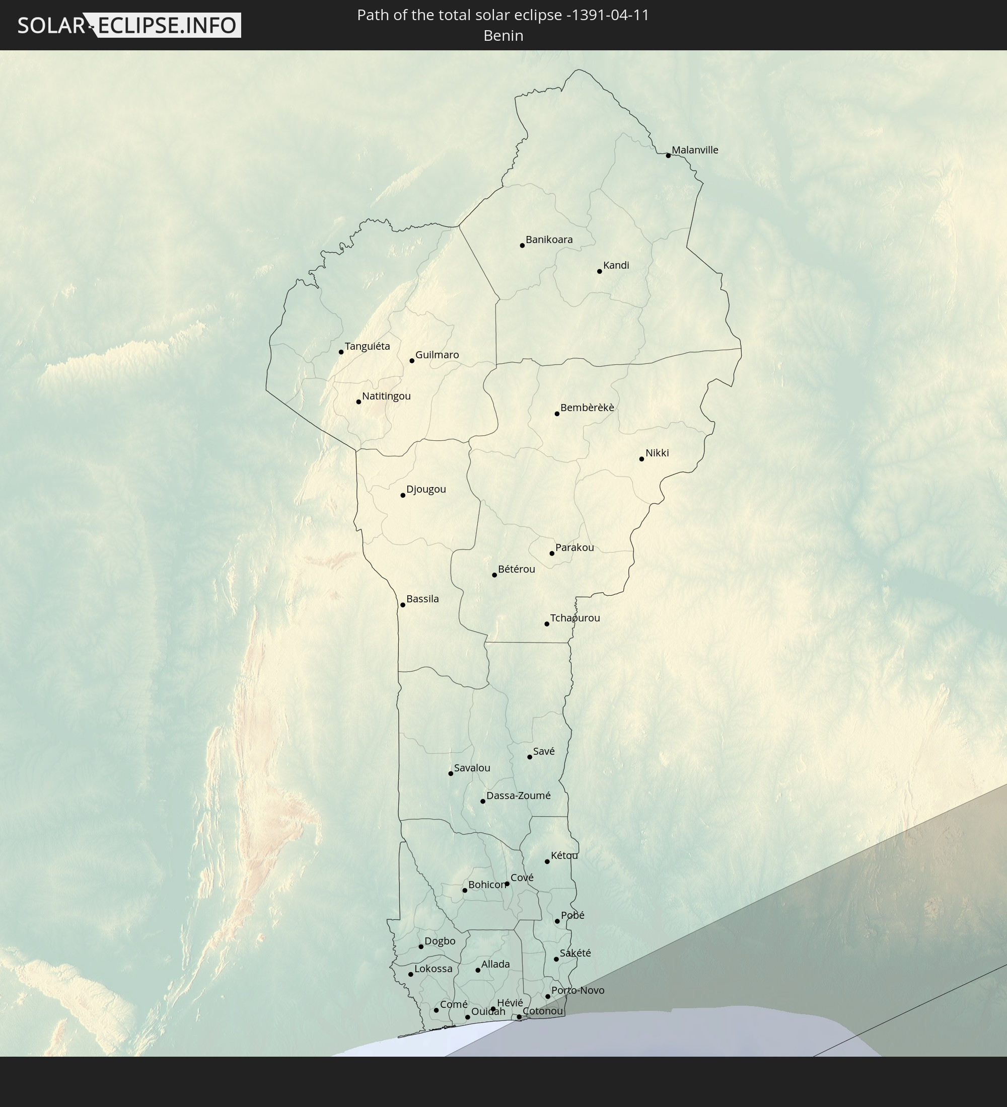 Benin
Benin
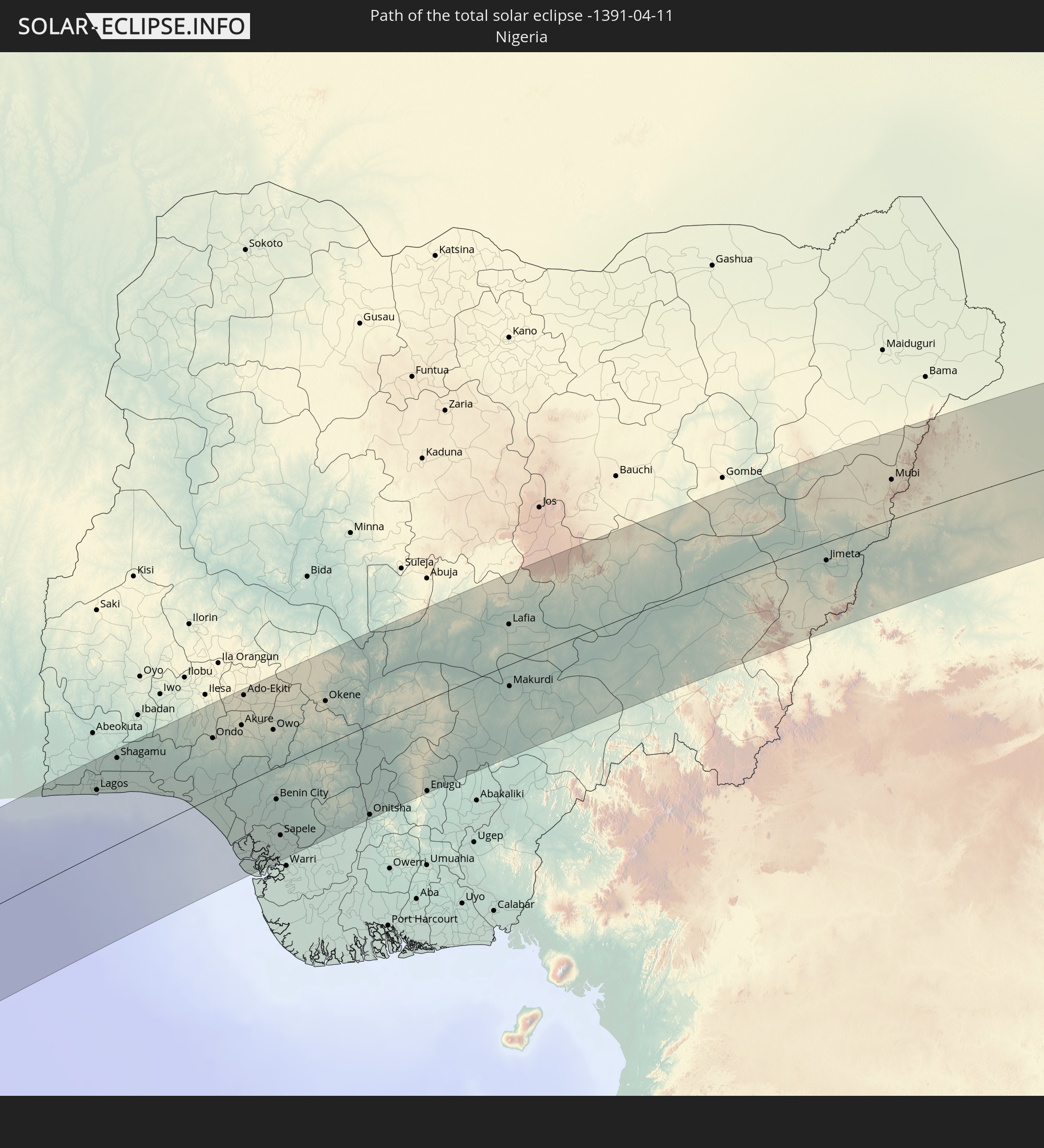 Nigeria
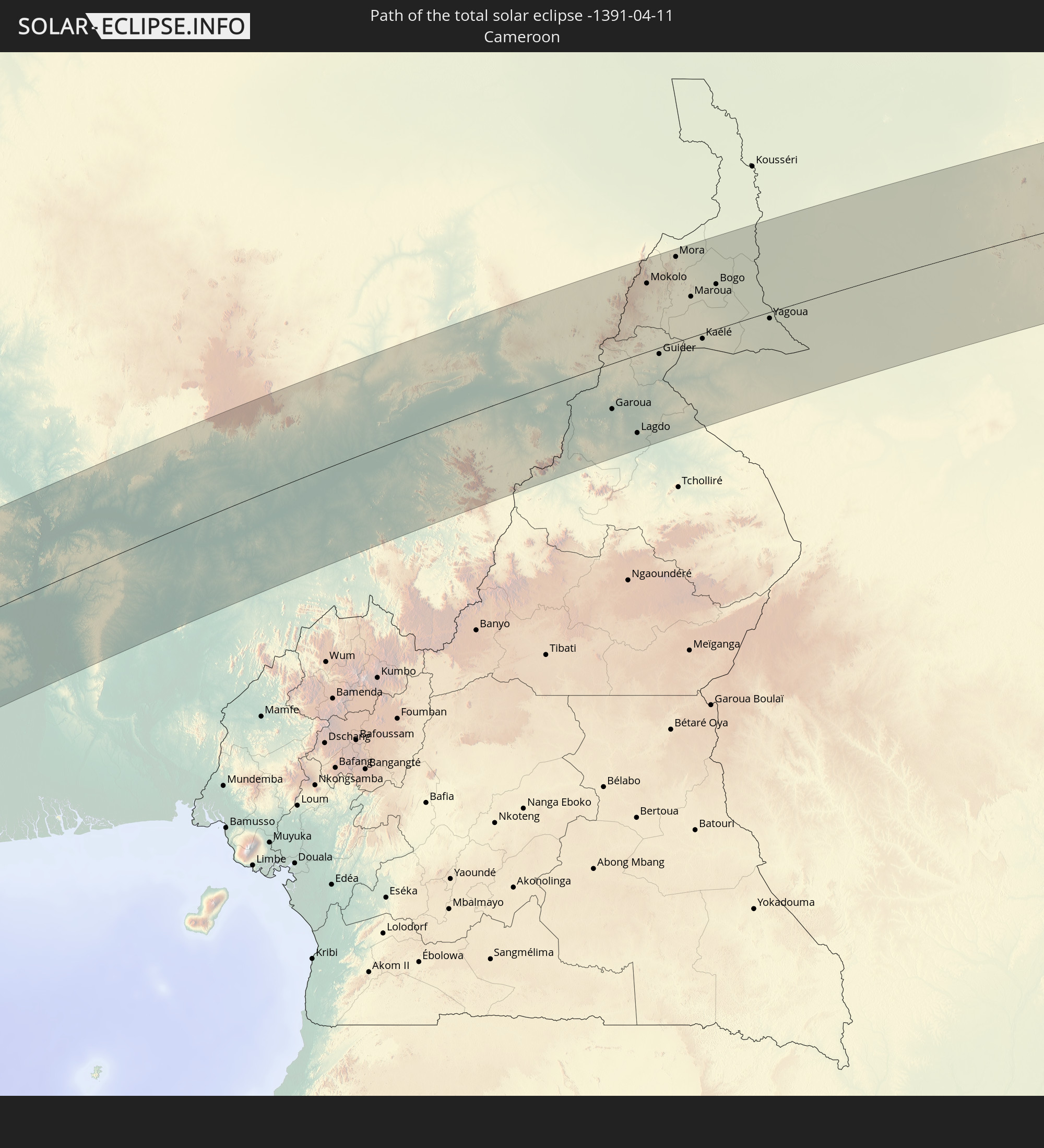 Cameroon
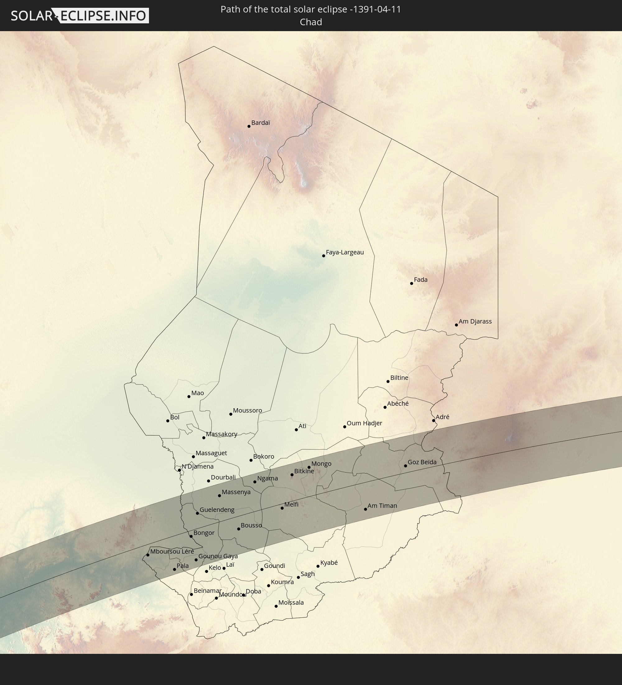 Chad
Chad
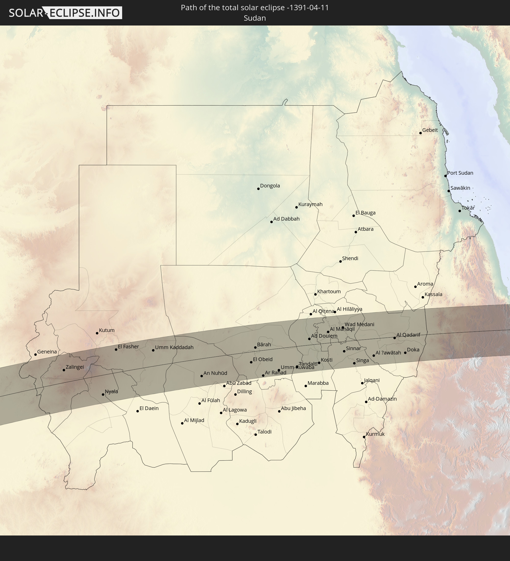 Sudan
Sudan
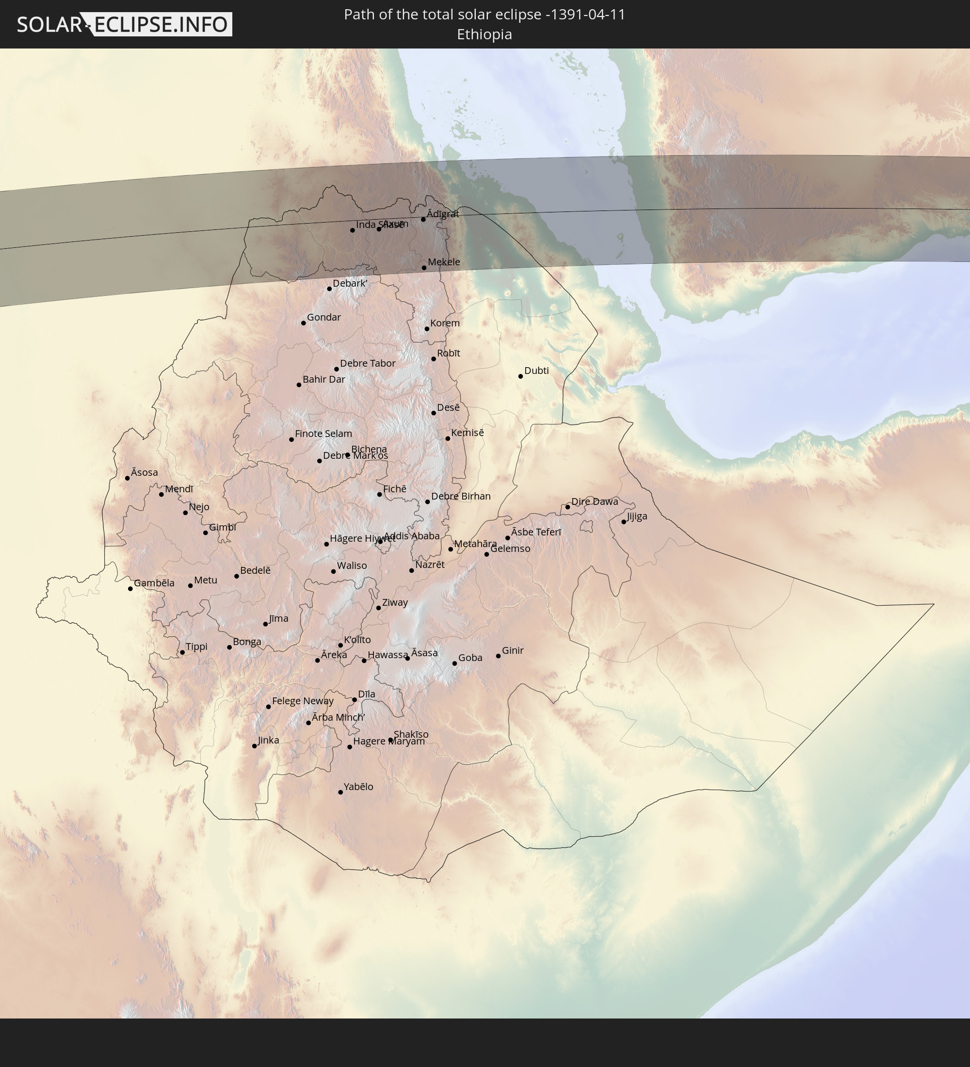 Ethiopia
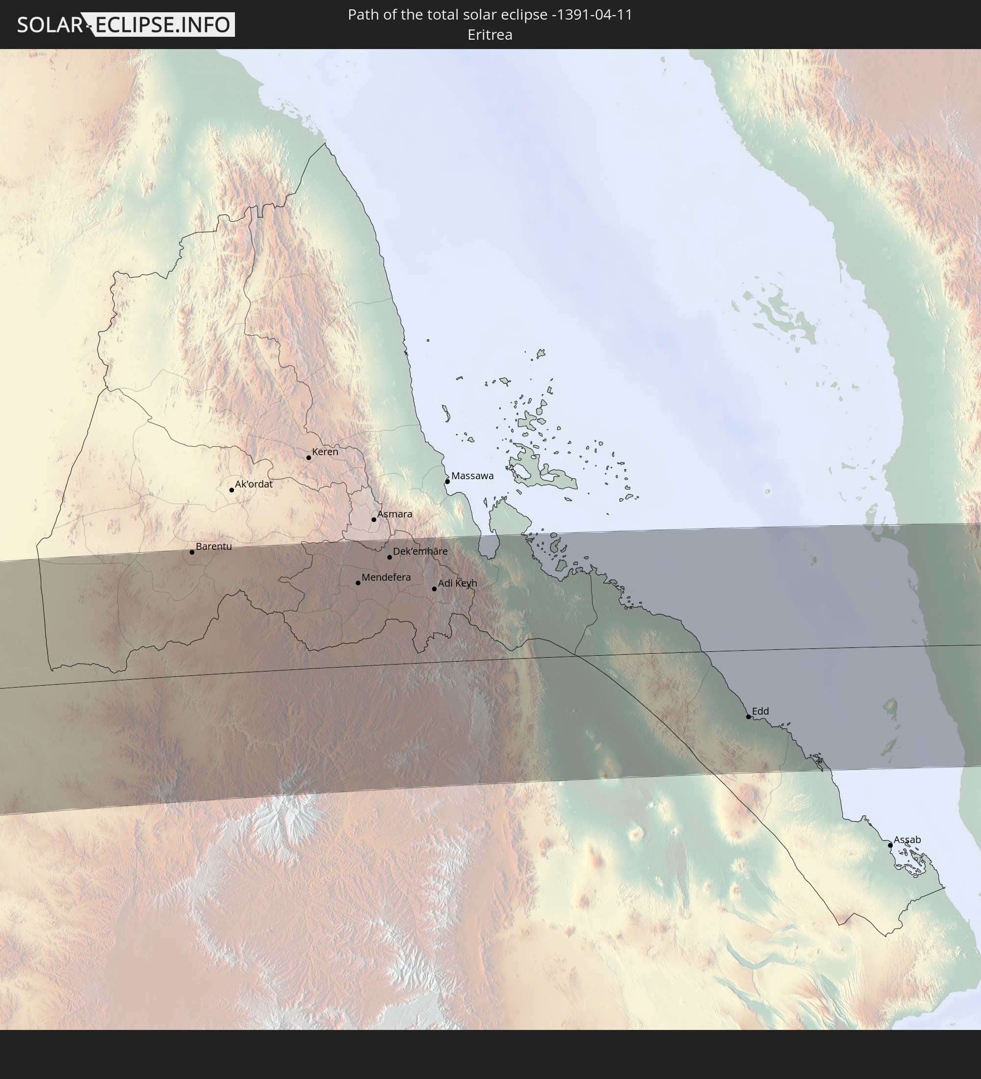 Eritrea
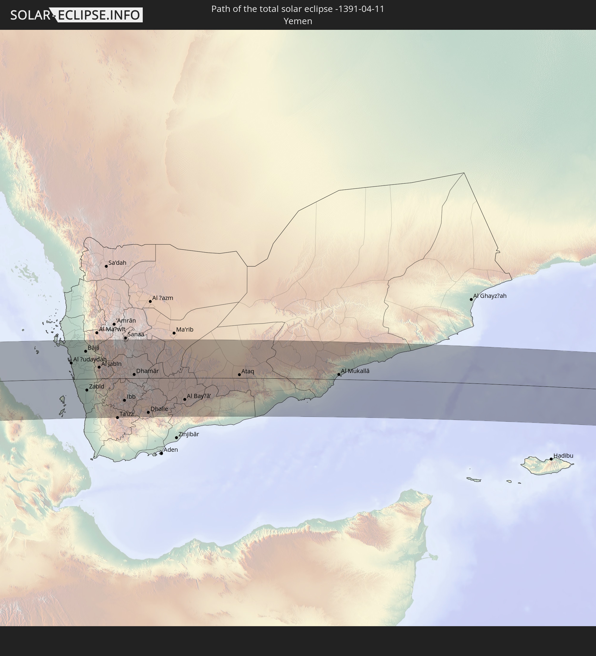 Yemen
Yemen
In den folgenden Ländern ist die Sonnenfinsternis partiell zu sehen
 Russia
 Chile
Chile
 Colombia
 Peru
Peru
 Brazil
 Argentina
 Venezuela
 Bolivia
 Paraguay
 Trinidad and Tobago
 Falkland Islands
 Guyana
 Uruguay
 Suriname
 French Guiana
 Portugal
 Cabo Verde
 Spain
Spain
 Senegal
 Mauritania
 The Gambia
 Guinea-Bissau
 Guinea
 Saint Helena, Ascension and Tristan da Cunha
 Sierra Leone
 Morocco
 Mali
Mali
 Liberia
 Algeria
 Ivory Coast
 Burkina Faso
 Gibraltar
 France
 Ghana
Ghana
 Togo
Togo
 Niger
Niger
 Benin
Benin
 Nigeria
 Equatorial Guinea
 São Tomé and Príncipe
 Italy
Italy
 Tunisia
 Cameroon
 Gabon
Gabon
 Libya
Libya
 Republic of the Congo
 Angola
 Namibia
 Democratic Republic of the Congo
 Vatican City
 Chad
Chad
 Croatia
 Malta
Malta
 Central African Republic
 Bosnia and Herzegovina
 Montenegro
 Serbia
 Albania
 Greece
 Botswana
 Romania
 Republic of Macedonia
 Sudan
Sudan
 Zambia
 Ukraine
 Bulgaria
 Egypt
Egypt
 Zimbabwe
 Turkey
 Rwanda
 Burundi
 Tanzania
 Uganda
 Mozambique
 Cyprus
 Malawi
 Ethiopia
 Kenya
Kenya
 State of Palestine
 Israel
 Saudi Arabia
 Jordan
 Lebanon
 Syria
Syria
 Eritrea
 Iraq
Iraq
 Georgia
 French Southern and Antarctic Lands
 Somalia
 Djibouti
 Yemen
Yemen
 Madagascar
 Comoros
 Armenia
 Iran
Iran
 Azerbaijan
 Mayotte
 Seychelles
 Kazakhstan
 Kuwait
 Bahrain
 Qatar
Qatar
 United Arab Emirates
 Oman
Oman
 Turkmenistan
 Uzbekistan
 Mauritius
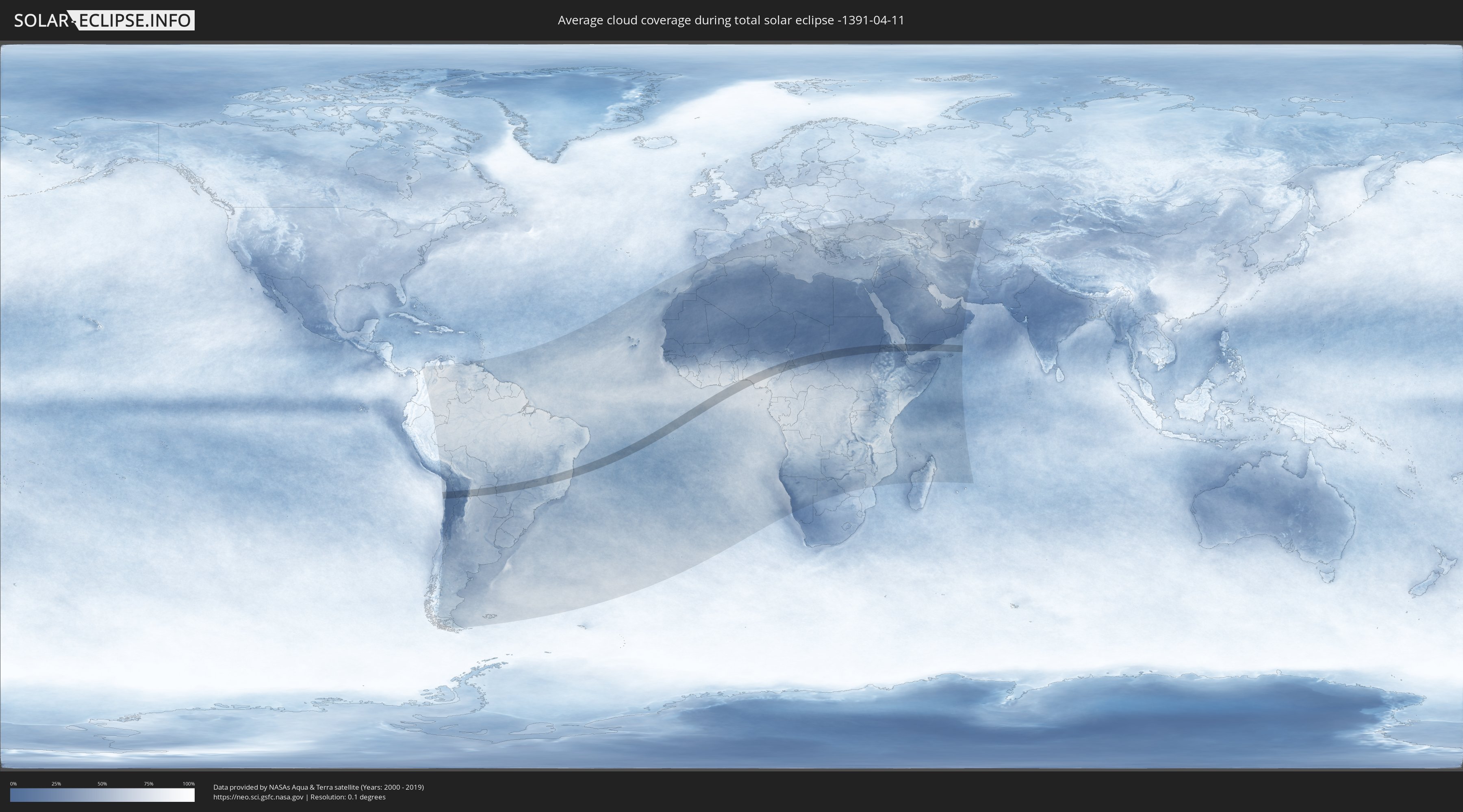
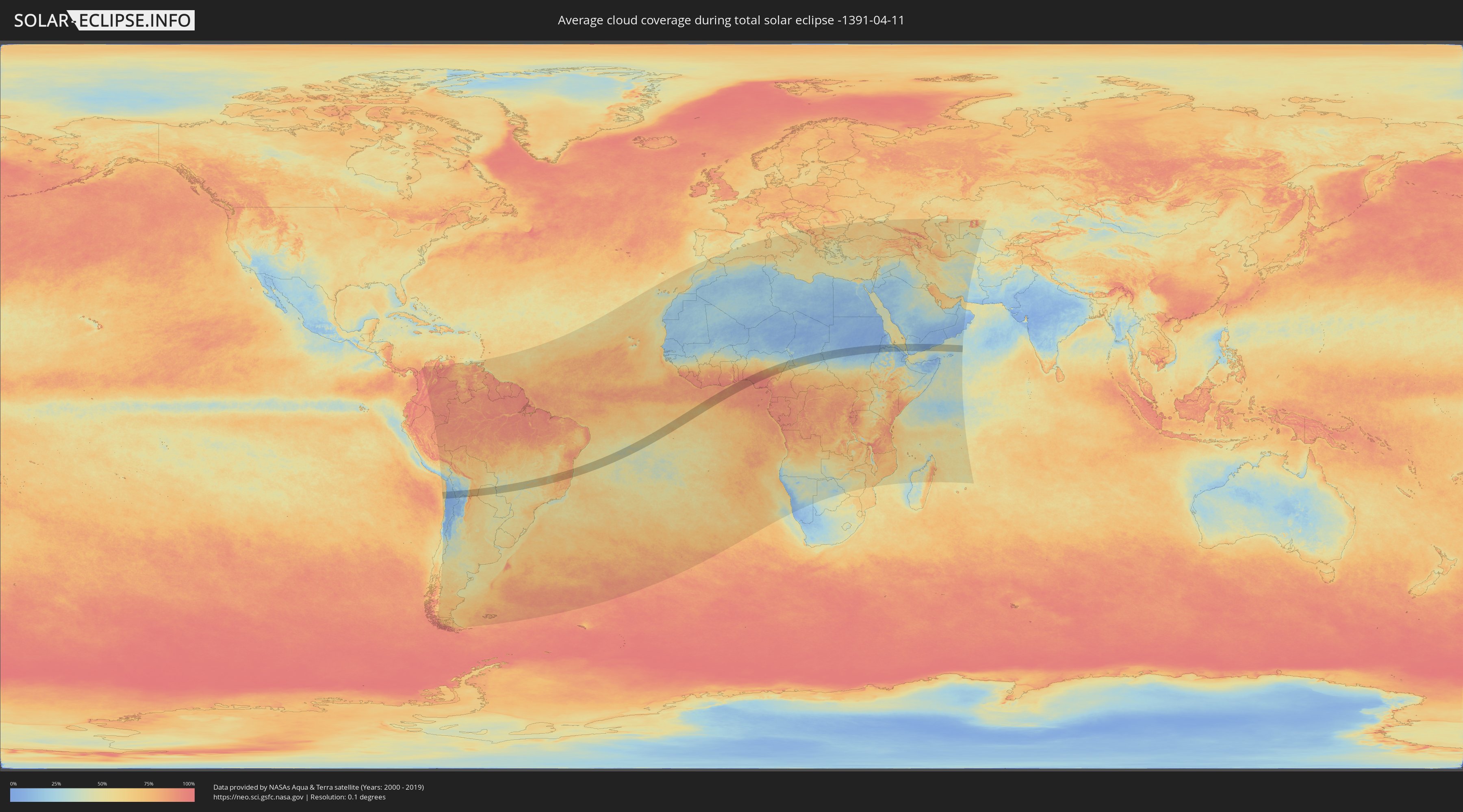
How will be the weather during the total solar eclipse on 04/11/-1391?
Where is the best place to see the total solar eclipse of 04/11/-1391?
The following maps show the average cloud coverage for the day of the total solar eclipse.
With the help of these maps, it is possible to find the place along the eclipse path, which has the best
chance of a cloudless sky.
Nevertheless, you should consider local circumstances and inform about the weather of your chosen
observation site.
The data is provided by NASAs satellites
AQUA and TERRA.
The cloud maps are averaged over a period of 19 years (2000 - 2019).
Detailed country maps
 Chile
Chile
 Brazil
 Argentina
 Bolivia
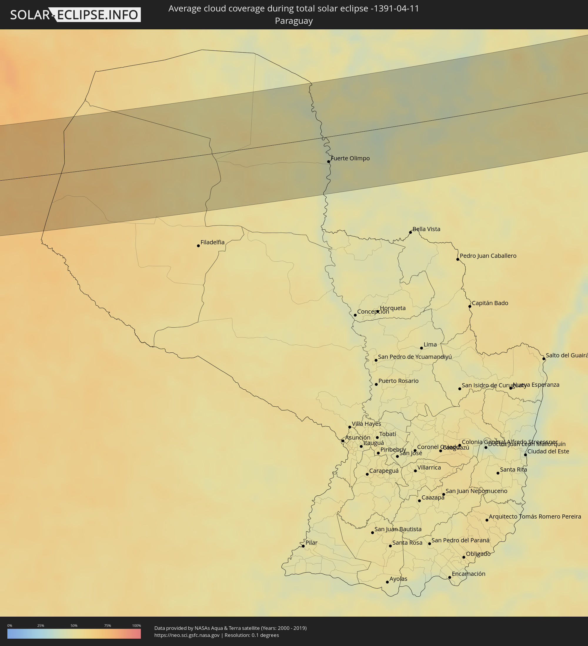 Paraguay
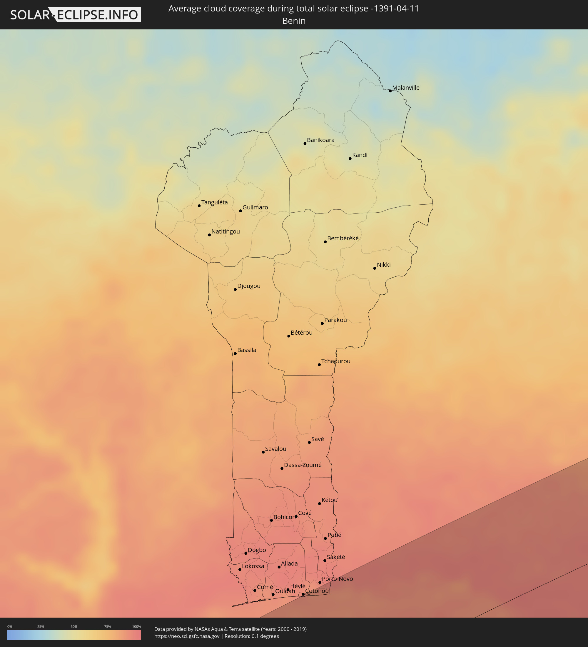 Benin
Benin
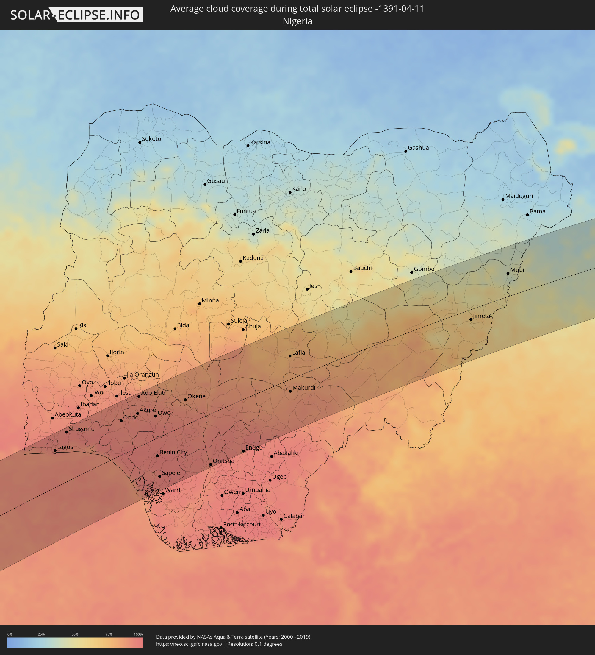 Nigeria
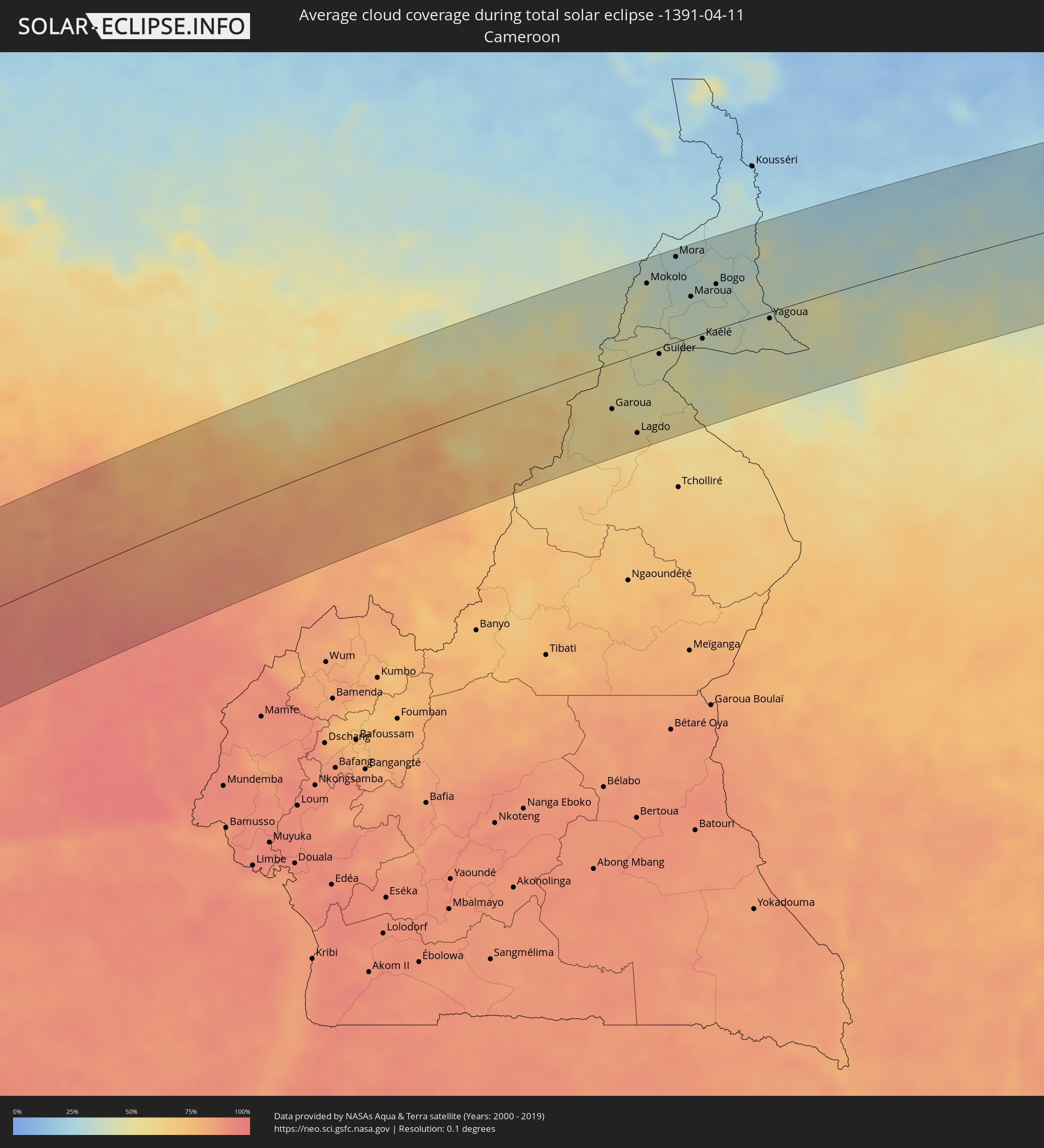 Cameroon
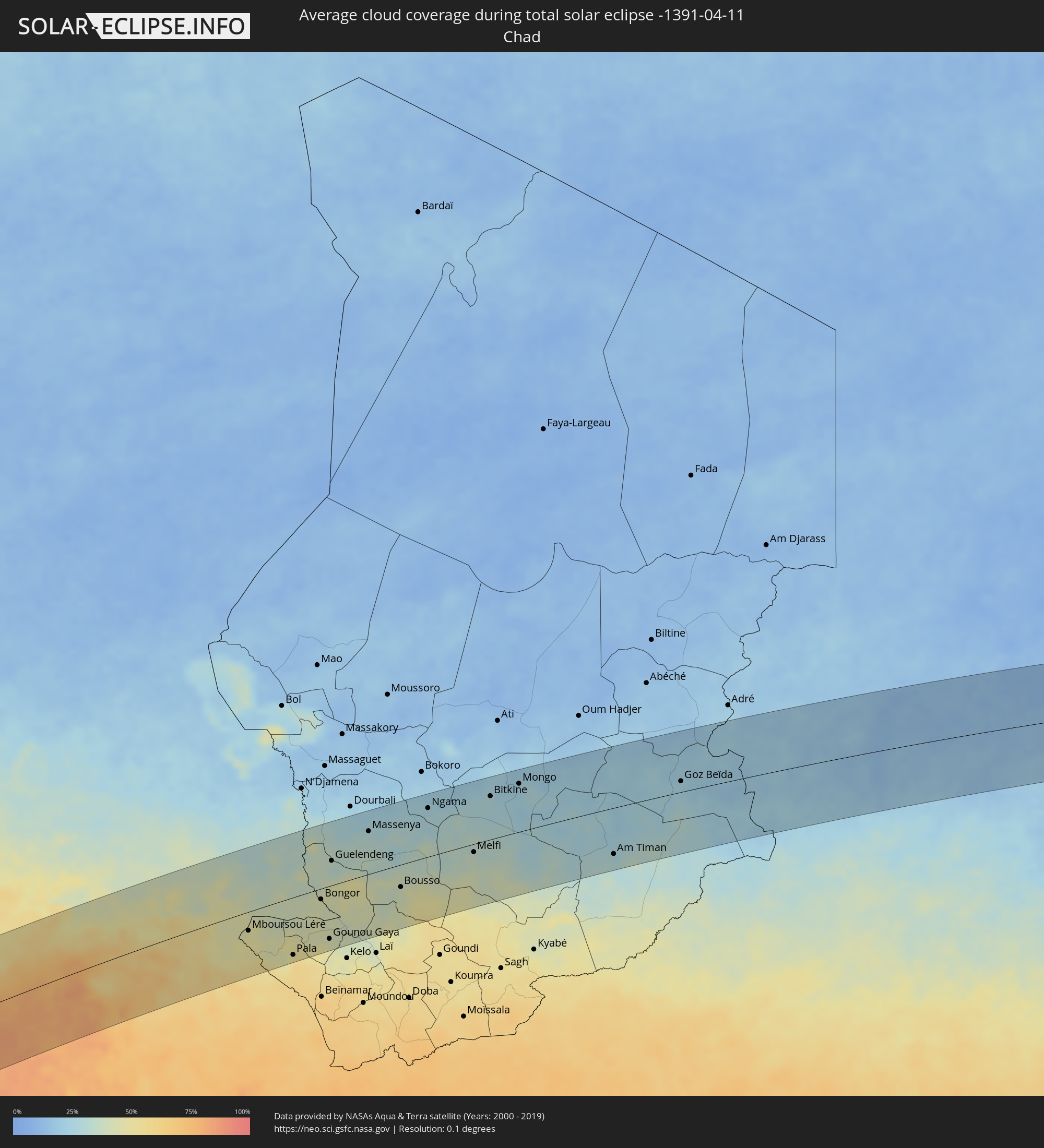 Chad
Chad
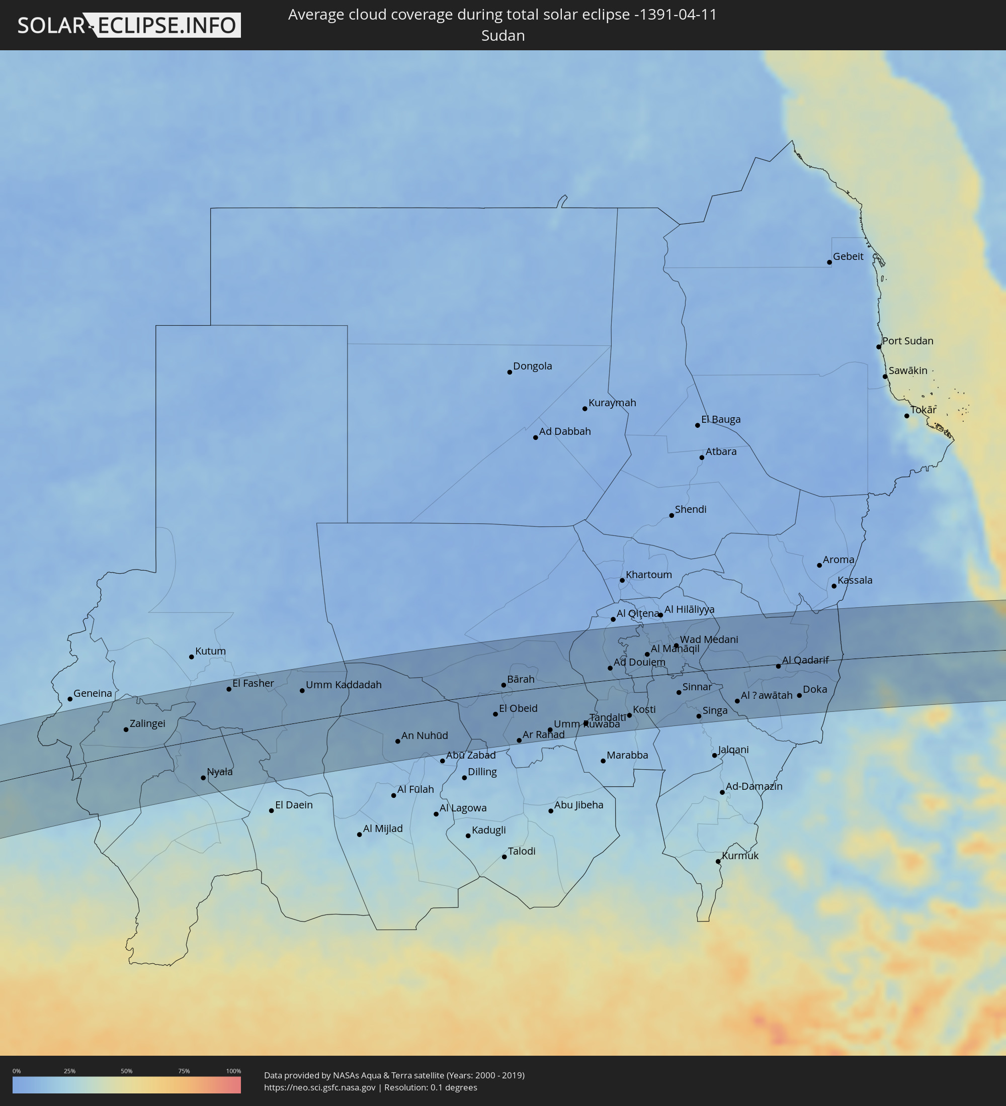 Sudan
Sudan
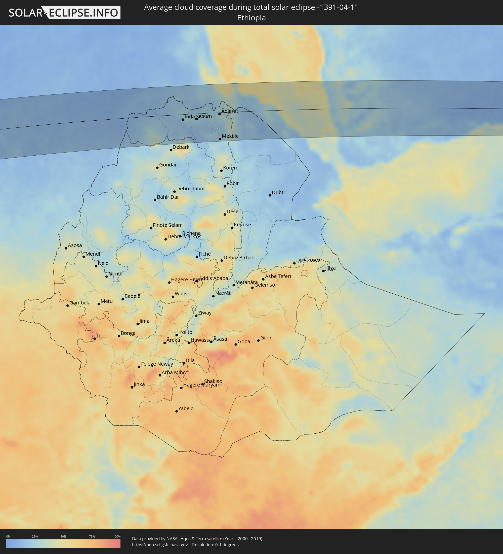 Ethiopia
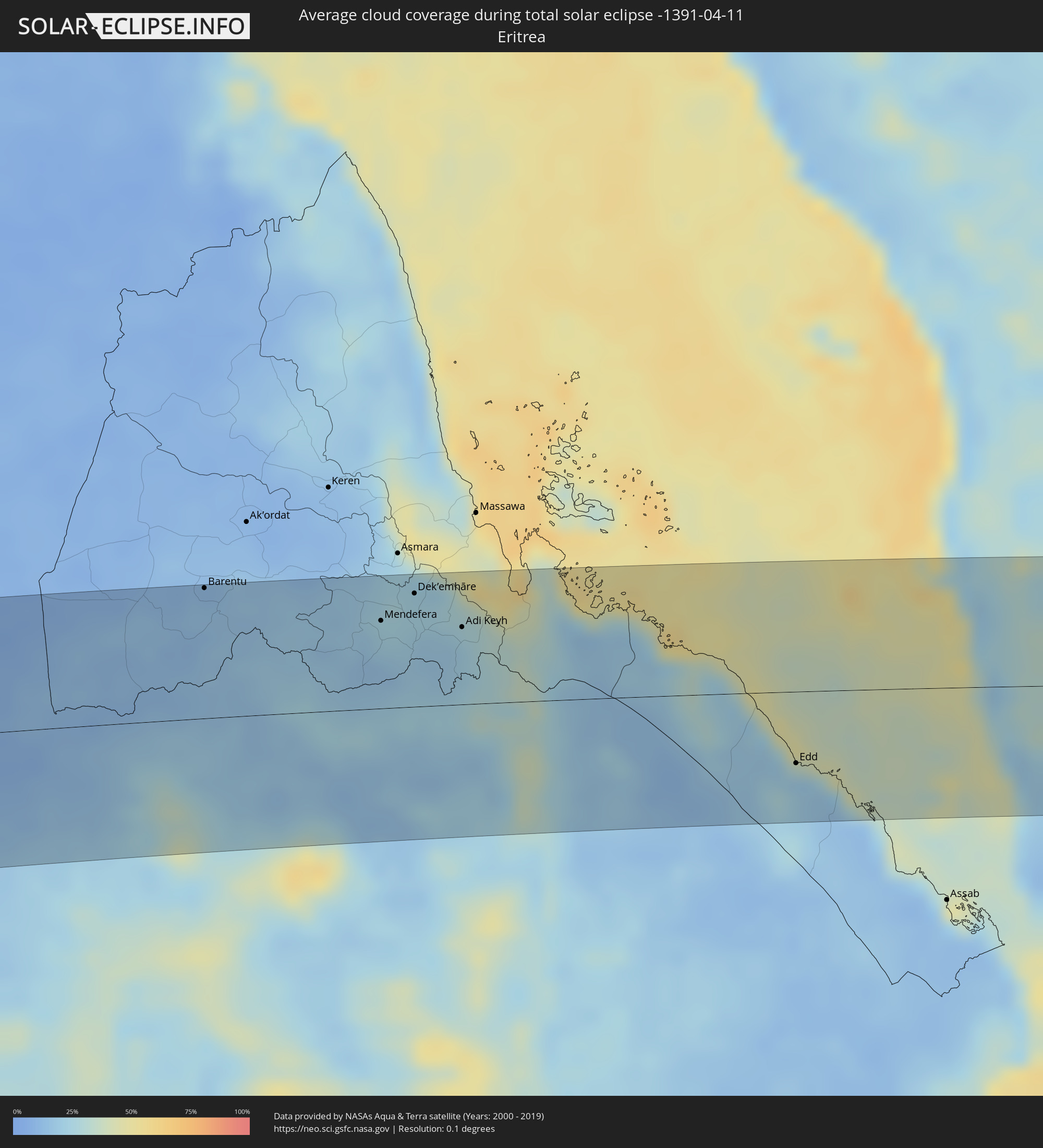 Eritrea
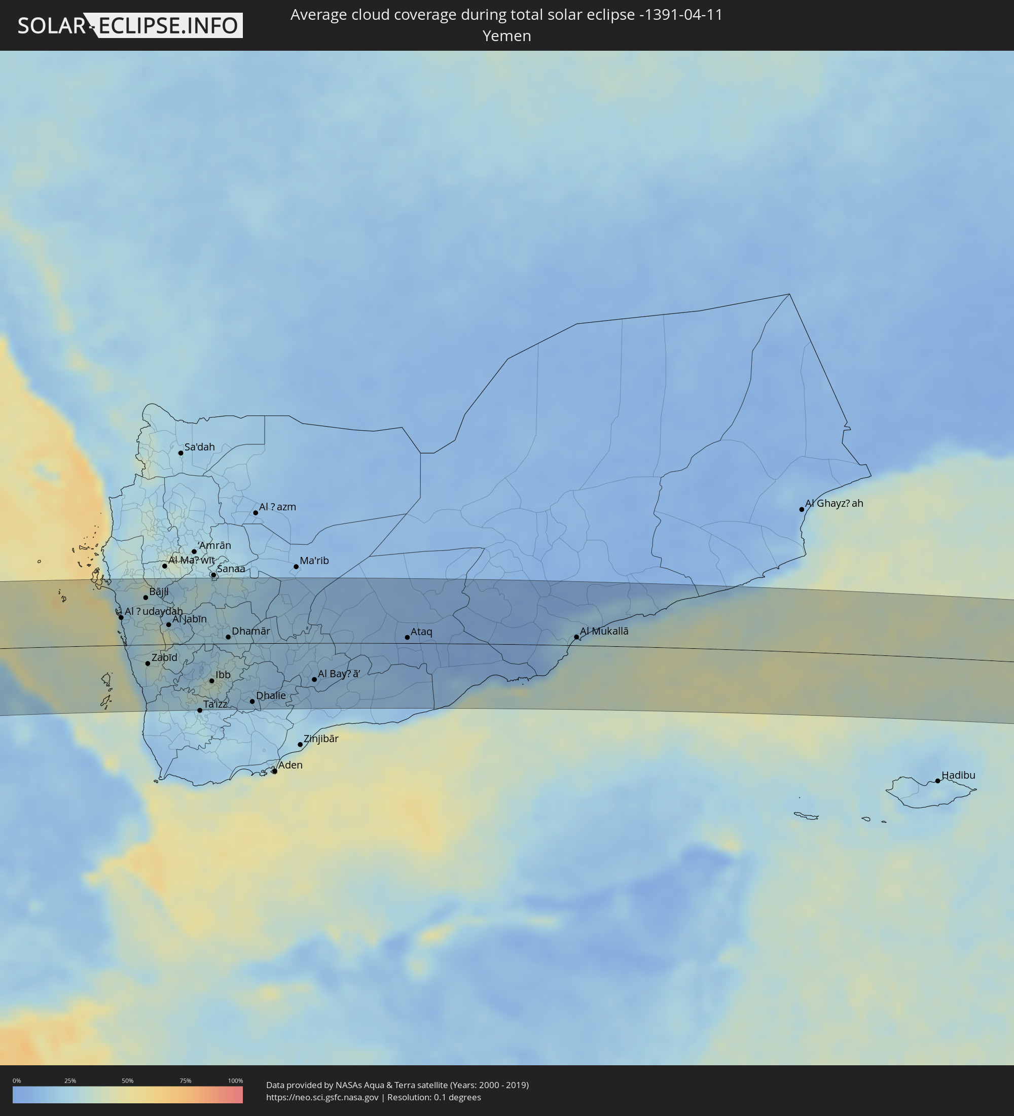 Yemen
Yemen
Cities inside the path of the eclipse
The following table shows all locations with a population of more than 5,000 inside the eclipse path. Cities which have more than 100,000 inhabitants are marked bold. A click at the locations opens a detailed map.
| City | Type | Eclipse duration | Local time of max. eclipse | Distance to central line | Ø Cloud coverage |
|
Tocopilla, Antofagasta
|
total | - | 06:10:40 UTC-04:42 | 20 km | 23% |
|
Calama, Antofagasta
|
total | - | 06:10:45 UTC-04:42 | 70 km | 7% |
|
Tupiza, Potosí
|
total | - | 06:21:13 UTC-04:32 | 13 km | 19% |
|
Villazón, Potosí
|
total | - | 06:21:16 UTC-04:32 | 59 km | 14% |
|
La Quiaca, Jujuy Province
|
total | - | 06:37:04 UTC-04:16 | 61 km | 14% |
|
Tarija, Tarija
|
total | - | 06:21:24 UTC-04:32 | 7 km | 41% |
|
Yacuiba, Tarija
|
total | - | 06:21:38 UTC-04:32 | 72 km | 73% |
|
Villamontes, Tarija
|
total | - | 06:21:40 UTC-04:32 | 9 km | 68% |
|
Fuerte Olimpo, Alto Paraguay
|
total | - | 07:05:24 UTC-03:50 | 43 km | 42% |
|
Campo Grande, Mato Grosso do Sul
|
total | - | 07:19:11 UTC-03:38 | 32 km | 53% |
|
Jales, São Paulo
|
total | - | 07:53:42 UTC-03:06 | 95 km | 52% |
|
Ituiutaba, Minas Gerais
|
total | - | 07:54:43 UTC-03:06 | 22 km | 53% |
|
Itumbiara, Goiás
|
total | - | 07:55:02 UTC-03:06 | 76 km | 44% |
|
Uberlândia, Minas Gerais
|
total | - | 07:55:39 UTC-03:06 | 0 km | 56% |
|
Araguari, Minas Gerais
|
total | - | 07:55:47 UTC-03:06 | 27 km | 52% |
|
Catalão, Goiás
|
total | - | 07:56:06 UTC-03:06 | 73 km | 54% |
|
Uberaba, Minas Gerais
|
total | - | 07:55:44 UTC-03:06 | 98 km | 55% |
|
Monte Carmelo, Minas Gerais
|
total | - | 07:56:19 UTC-03:06 | 2 km | 59% |
|
Patrocínio, Minas Gerais
|
total | - | 07:56:42 UTC-03:06 | 34 km | 59% |
|
Patos de Minas, Minas Gerais
|
total | - | 07:57:12 UTC-03:06 | 7 km | 62% |
|
Pirapora, Minas Gerais
|
total | - | 07:59:01 UTC-03:06 | 84 km | 53% |
|
Curvelo, Minas Gerais
|
total | - | 07:59:03 UTC-03:06 | 82 km | 62% |
|
Teófilo Otoni, Minas Gerais
|
total | - | 08:02:21 UTC-03:06 | 70 km | 77% |
|
Nanuque, Minas Gerais
|
total | - | 08:03:38 UTC-03:06 | 104 km | 79% |
|
Itamaraju, Bahia
|
total | - | 08:37:25 UTC-02:34 | 45 km | 82% |
|
Porto Seguro, Bahia
|
total | - | 08:38:16 UTC-02:34 | 2 km | 65% |
|
Ikeja, Lagos
|
total | - | 13:26:57 UTC+00:13 | 96 km | 93% |
|
Lagos, Lagos
|
total | - | 13:26:53 UTC+00:13 | 79 km | 92% |
|
Ebute Ikorodu, Lagos
|
total | - | 13:27:19 UTC+00:13 | 89 km | 91% |
|
Shagamu, Ogun
|
total | - | 13:28:01 UTC+00:13 | 106 km | 95% |
|
Ijebu-Ode, Ogun
|
total | - | 13:28:37 UTC+00:13 | 90 km | 95% |
|
Ondo, Ondo
|
total | - | 13:31:09 UTC+00:13 | 73 km | 92% |
|
Akure, Ondo
|
total | - | 13:32:11 UTC+00:13 | 73 km | 92% |
|
Ado-Ekiti, Ekiti
|
total | - | 13:32:43 UTC+00:13 | 109 km | 91% |
|
Ise-Ekiti, Ekiti
|
total | - | 13:32:59 UTC+00:13 | 83 km | 92% |
|
Owo, Ondo
|
total | - | 13:33:02 UTC+00:13 | 49 km | 92% |
|
Benin City, Edo
|
total | - | 13:32:03 UTC+00:13 | 40 km | 97% |
|
Okene, Kogi
|
total | - | 13:34:58 UTC+00:13 | 55 km | 85% |
|
Onitsha, Anambra
|
total | - | 13:34:31 UTC+00:13 | 112 km | 92% |
|
Enugu, Enugu
|
total | - | 13:36:31 UTC+00:13 | 115 km | 94% |
|
Makurdi, Benue
|
total | - | 13:40:20 UTC+00:13 | 27 km | 85% |
|
Jimeta, Adamawa
|
total | - | 13:50:17 UTC+00:13 | 23 km | 60% |
|
Mubi, Adamawa
|
total | - | 13:52:49 UTC+00:13 | 51 km | 38% |
|
Garoua, North
|
total | - | 13:52:10 UTC+00:13 | 55 km | 59% |
|
Pitoa, North
|
total | - | 13:52:27 UTC+00:13 | 50 km | 52% |
|
Lagdo, North
|
total | - | 13:52:29 UTC+00:13 | 95 km | 62% |
|
Mokolo, Far North
|
total | - | 13:54:16 UTC+00:13 | 83 km | 41% |
|
Guider, North
|
total | - | 13:53:49 UTC+00:13 | 8 km | 45% |
|
Mora, Far North
|
total | - | 13:55:10 UTC+00:13 | 103 km | 34% |
|
Mboursou Léré, Mayo-Kebbi Ouest
|
total | - | 14:40:41 UTC+01:00 | 33 km | 47% |
|
Maroua, Far North
|
total | - | 13:55:06 UTC+00:13 | 49 km | 36% |
|
Mindif, Far North
|
total | - | 13:55:10 UTC+00:13 | 25 km | 36% |
|
Kaélé, Far North
|
total | - | 13:54:56 UTC+00:13 | 6 km | 39% |
|
Bogo, Far North
|
total | - | 13:55:46 UTC+00:13 | 54 km | 37% |
|
Pala, Mayo-Kebbi Ouest
|
total | - | 14:41:45 UTC+01:00 | 101 km | 52% |
|
Yagoua, Far North
|
total | - | 13:56:36 UTC+00:13 | 8 km | 42% |
|
Bongor, Mayo-Kebbi Est
|
total | - | 14:43:25 UTC+01:00 | 19 km | 41% |
|
Gounou Gaya, Mayo-Kebbi Est
|
total | - | 14:43:07 UTC+01:00 | 93 km | 44% |
|
Guelendeng, Mayo-Kebbi Est
|
total | - | 14:44:16 UTC+01:00 | 43 km | 32% |
|
Massenya, Chari-Baguirmi
|
total | - | 14:45:47 UTC+01:00 | 75 km | 31% |
|
Bousso, Chari-Baguirmi
|
total | - | 14:46:00 UTC+01:00 | 39 km | 41% |
|
Ngama, Chari-Baguirmi
|
total | - | 14:47:48 UTC+01:00 | 86 km | 27% |
|
Melfi, Guéra
|
total | - | 14:48:35 UTC+01:00 | 14 km | 36% |
|
Bitkine, Guéra
|
total | - | 14:49:43 UTC+01:00 | 76 km | 28% |
|
Mongo, Guéra
|
total | - | 14:50:38 UTC+01:00 | 85 km | 25% |
|
Am Timan, Salamat
|
total | - | 14:52:25 UTC+01:00 | 82 km | 29% |
|
Goz Beïda, Sila
|
total | - | 14:54:55 UTC+01:00 | 19 km | 24% |
|
Zalingei, Central Darfur
|
total | - | 16:08:12 UTC+02:10 | 47 km | 17% |
|
El Fasher, Northern Darfur
|
total | - | 16:11:03 UTC+02:10 | 87 km | 12% |
|
An Nuhūd, West Kordofan State
|
total | - | 16:14:22 UTC+02:10 | 69 km | 13% |
|
El Obeid, North Kordofan
|
total | - | 16:16:31 UTC+02:10 | 42 km | 10% |
|
Ar Rahad, North Kordofan
|
total | - | 16:16:47 UTC+02:10 | 99 km | 13% |
|
Umm Ruwaba, North Kordofan
|
total | - | 16:17:26 UTC+02:10 | 86 km | 12% |
|
Tandaltī, White Nile
|
total | - | 16:18:07 UTC+02:10 | 82 km | 13% |
|
Ad Douiem, White Nile
|
total | - | 16:18:52 UTC+02:10 | 22 km | 13% |
|
Kosti, White Nile
|
total | - | 16:18:56 UTC+02:10 | 75 km | 13% |
|
Al Manāqil, Al Jazīrah
|
total | - | 16:19:34 UTC+02:10 | 42 km | 12% |
|
Al Hasaheisa, Al Jazīrah
|
total | - | 16:19:59 UTC+02:10 | 94 km | 10% |
|
Wad Medani, Al Jazīrah
|
total | - | 16:20:05 UTC+02:10 | 53 km | 11% |
|
Sinnar, Sinnār
|
total | - | 16:19:53 UTC+02:10 | 40 km | 12% |
|
Maiurno, Sinnār
|
total | - | 16:19:55 UTC+02:10 | 57 km | 12% |
|
As Sūkī, Sinnār
|
total | - | 16:20:05 UTC+02:10 | 71 km | 13% |
|
Singa, Sinnār
|
total | - | 16:20:04 UTC+02:10 | 90 km | 12% |
|
Al Qadarif, Al Qaḑārif
|
total | - | 16:21:32 UTC+02:10 | 5 km | 8% |
|
Barentu, Gash-Barka
|
total | - | 16:40:33 UTC+02:27 | 97 km | 13% |
|
Inda Silasē, Tigray
|
total | - | 16:40:49 UTC+02:27 | 19 km | 17% |
|
Axum, Tigray
|
total | - | 16:41:07 UTC+02:27 | 19 km | 21% |
|
Mendefera, Debub
|
total | - | 16:41:19 UTC+02:27 | 65 km | 22% |
|
Dek’emhāre, Debub
|
total | - | 16:41:30 UTC+02:27 | 84 km | 24% |
|
Adi Keyh, Debub
|
total | - | 16:41:40 UTC+02:27 | 58 km | 22% |
|
Ādīgrat, Tigray
|
total | - | 16:41:37 UTC+02:27 | 6 km | 32% |
|
Mekele, Tigray
|
total | - | 16:41:27 UTC+02:27 | 93 km | 23% |
|
Edd, Southern Red Sea
|
total | - | 16:42:50 UTC+02:27 | 54 km | 20% |
|
Al Ḩudaydah, Muḩāfaz̧at al Ḩudaydah
|
total | - | 17:23:13 UTC+03:06 | 40 km | 25% |
|
Bājil, Muḩāfaz̧at al Ḩudaydah
|
total | - | 17:23:24 UTC+03:06 | 68 km | 30% |
|
Zabīd, Muḩāfaz̧at al Ḩudaydah
|
total | - | 17:23:17 UTC+03:06 | 28 km | 27% |
|
Bayt al Faqīh, Muḩāfaz̧at al Ḩudaydah
|
total | - | 17:23:20 UTC+03:06 | 8 km | 29% |
|
Al Jabīn, Raymah
|
total | - | 17:23:30 UTC+03:06 | 28 km | 43% |
|
Dhī as Sufāl, Ibb
|
total | - | 17:23:35 UTC+03:06 | 70 km | 23% |
|
Ibb, Ibb
|
total | - | 17:23:38 UTC+03:06 | 55 km | 33% |
|
Saḩar, Sanaa
|
total | - | 17:23:53 UTC+03:06 | 95 km | 23% |
|
Sayyān, Sanaa
|
total | - | 17:23:52 UTC+03:06 | 79 km | 22% |
|
Yarīm, Ibb
|
total | - | 17:23:46 UTC+03:06 | 18 km | 29% |
|
Dhamār, Dhamār
|
total | - | 17:23:49 UTC+03:06 | 9 km | 24% |
|
Dhalie, Aḑ Ḑāli‘
|
total | - | 17:23:50 UTC+03:06 | 86 km | 19% |
|
Al Bayḑā’, Al Bayḑāʼ
|
total | - | 17:24:13 UTC+03:06 | 54 km | 14% |
|
Jawf al Maqbābah, Abyan
|
total | - | 17:24:17 UTC+03:06 | 71 km | 15% |
|
Ataq, Shabwah
|
total | - | 17:24:44 UTC+03:06 | 8 km | 9% |
|
Al Mukallā, Muḩāfaz̧at Ḩaḑramawt
|
total | - | 17:25:24 UTC+03:06 | 11 km | 32% |