Total solar eclipse of 06/11/-1459
| Day of week: | Friday |
| Maximum duration of eclipse: | 04m34s |
| Maximum width of eclipse path: | 244 km |
| Saros cycle: | 33 |
| Coverage: | 100% |
| Magnitude: | 1.0638 |
| Gamma: | 0.5183 |
Wo kann man die Sonnenfinsternis vom 06/11/-1459 sehen?
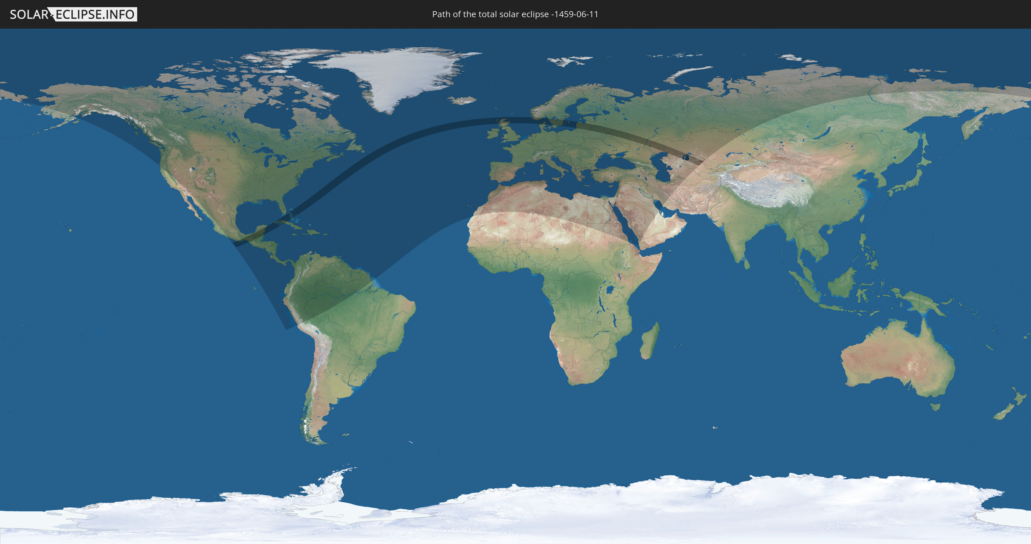
Die Sonnenfinsternis am 06/11/-1459 kann man in 124 Ländern als partielle Sonnenfinsternis beobachten.
Der Finsternispfad verläuft durch 15 Länder. Nur in diesen Ländern ist sie als total Sonnenfinsternis zu sehen.
In den folgenden Ländern ist die Sonnenfinsternis total zu sehen
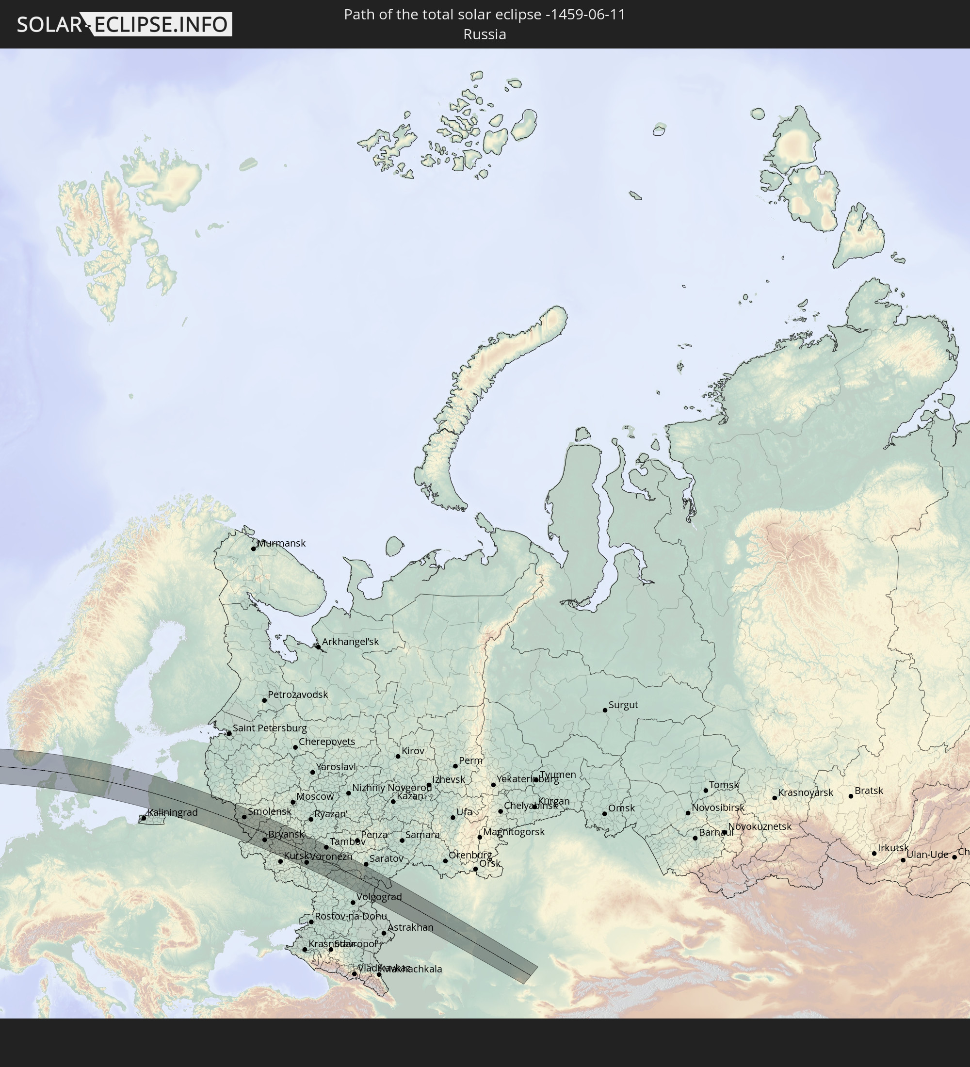 Russia
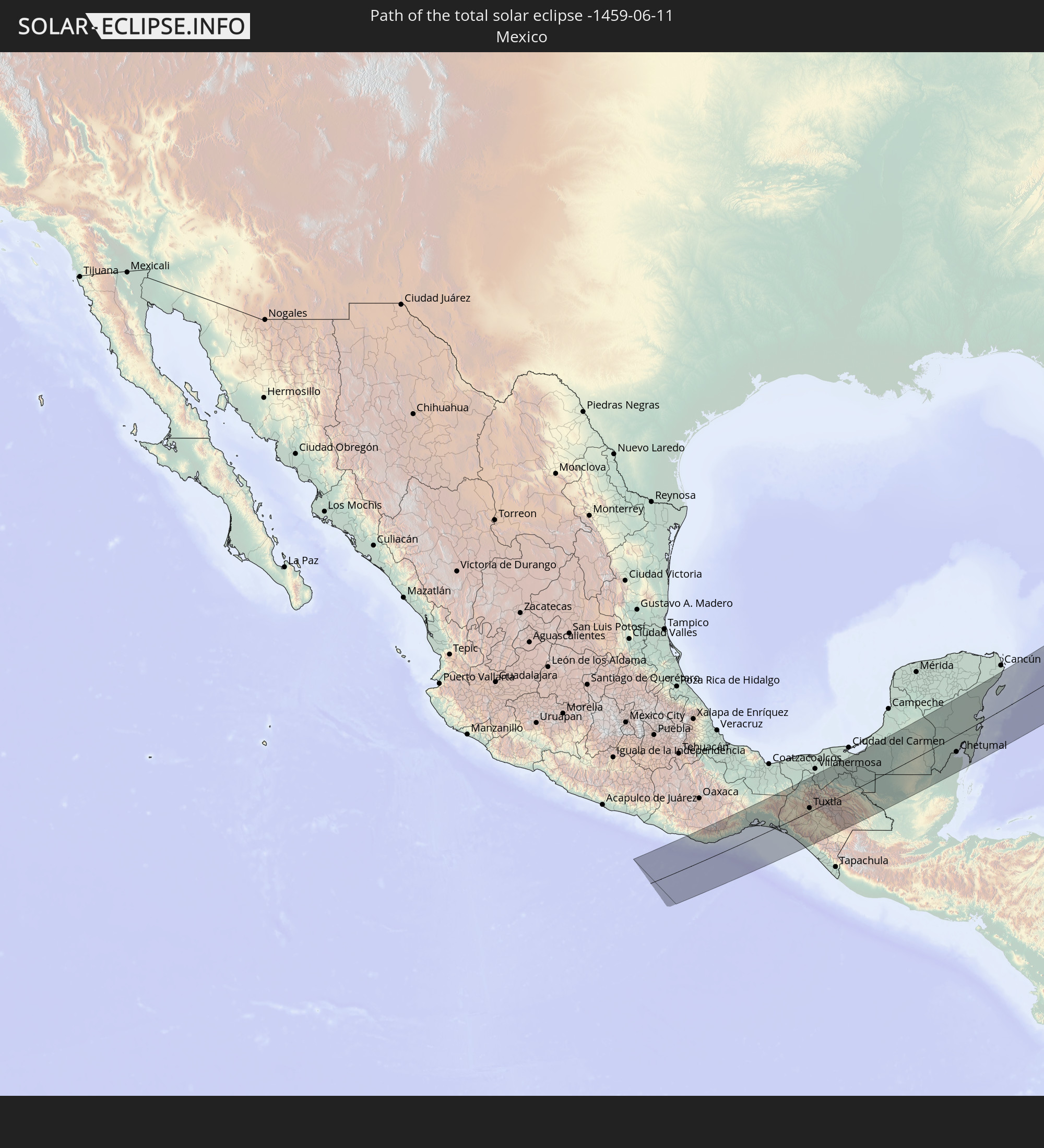 Mexico
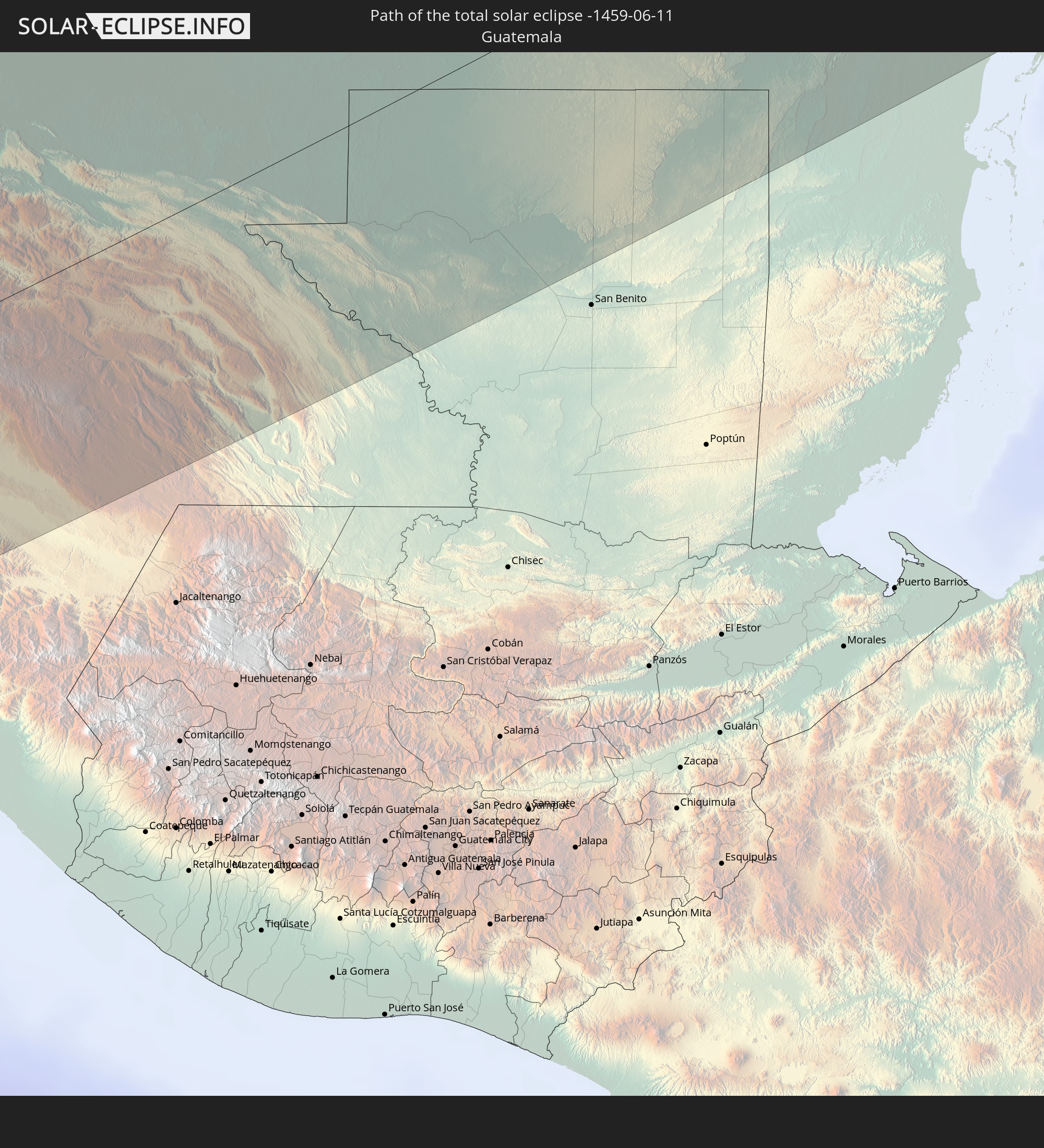 Guatemala
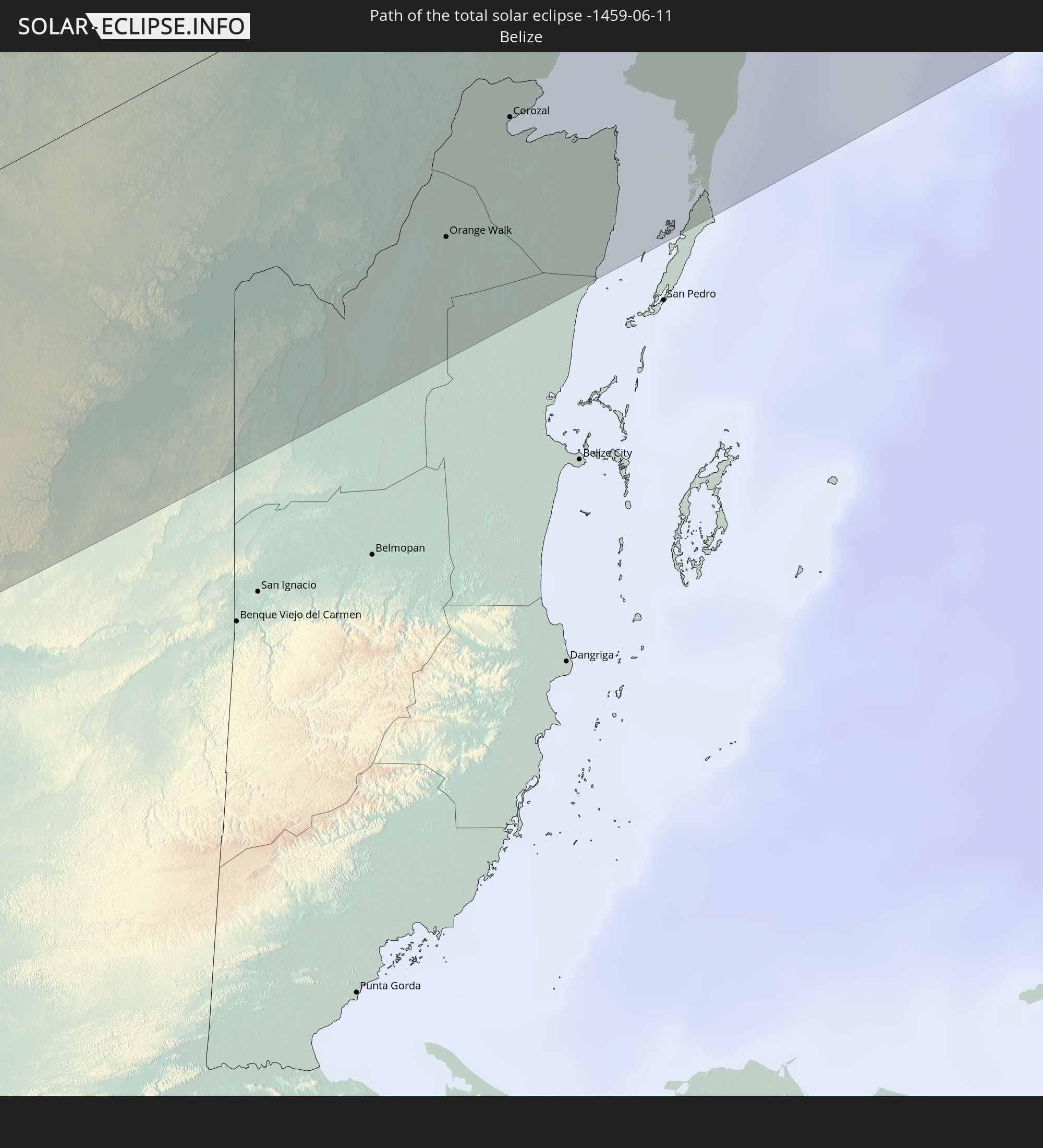 Belize
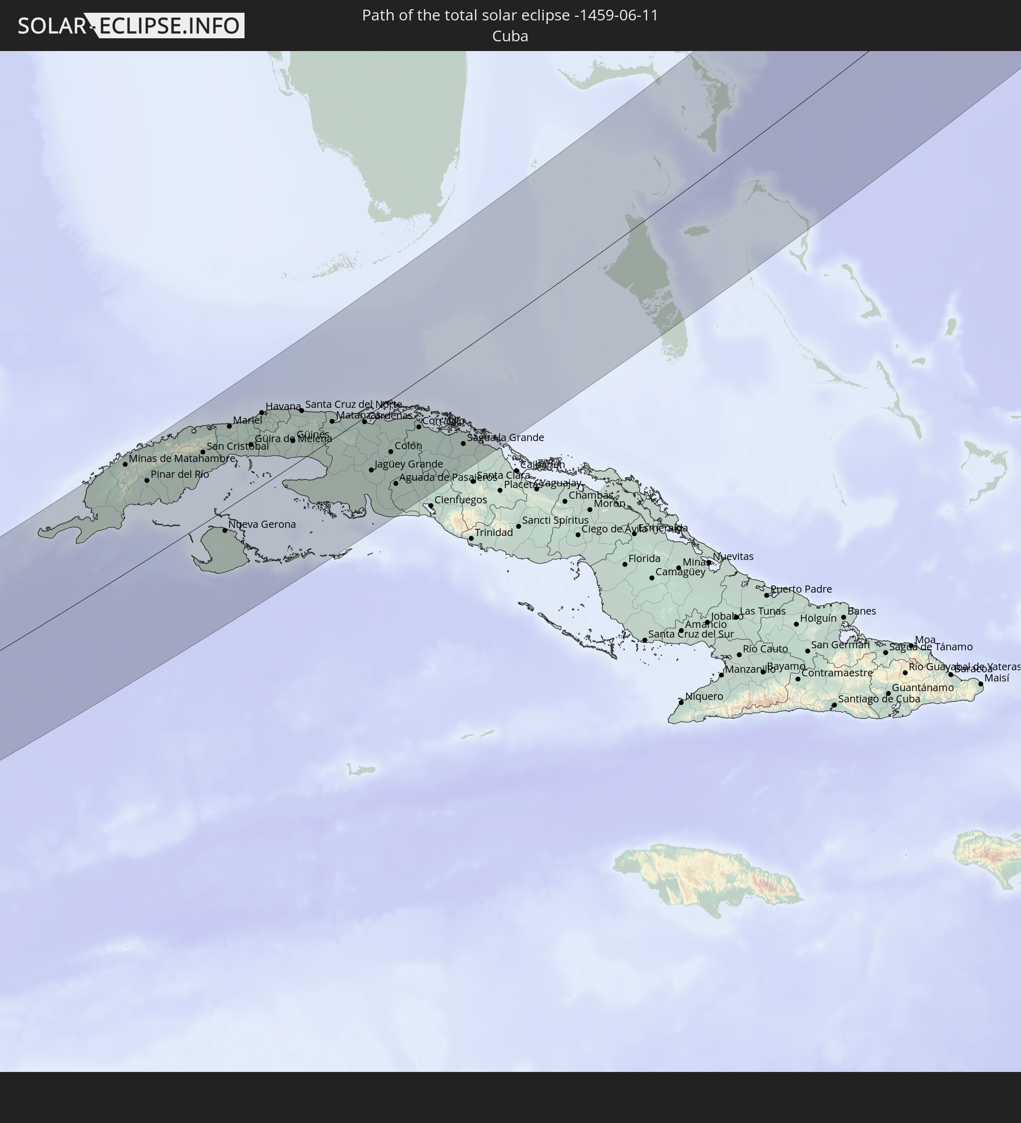 Cuba
Cuba
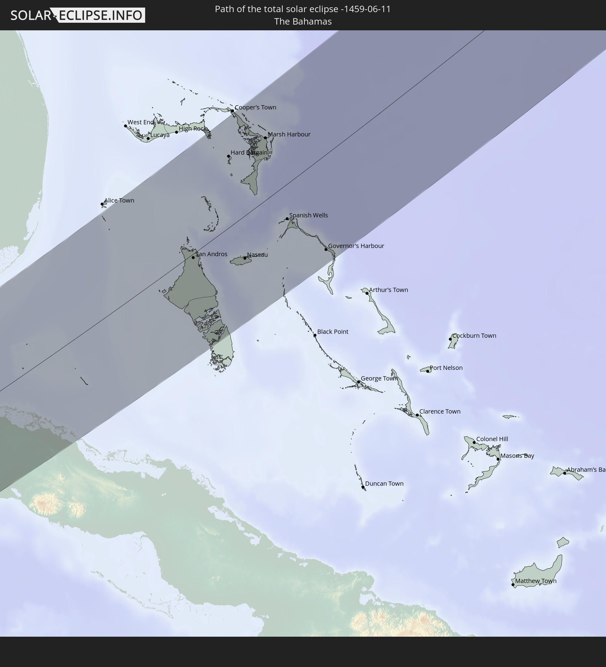 The Bahamas
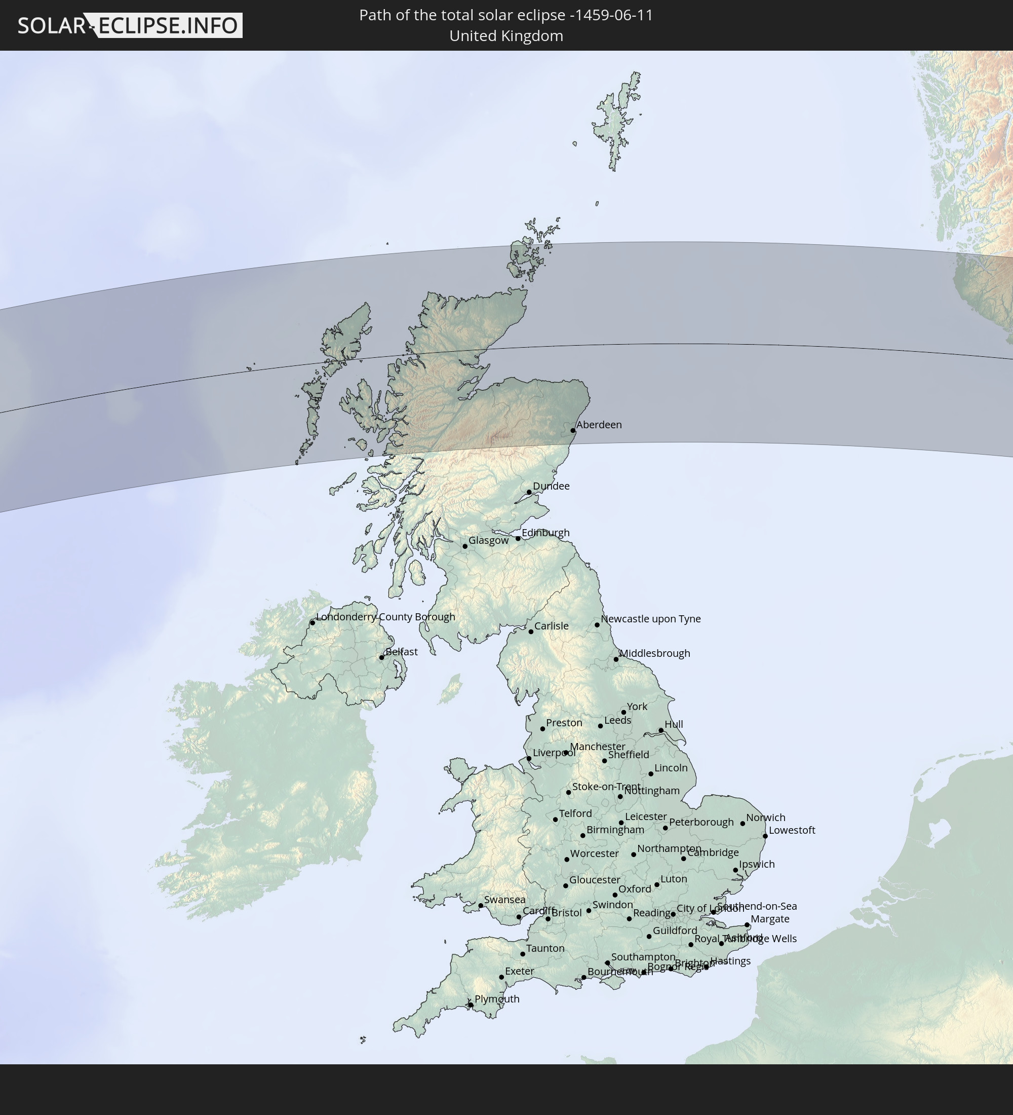 United Kingdom
 Norway
 Denmark
 Sweden
 Lithuania
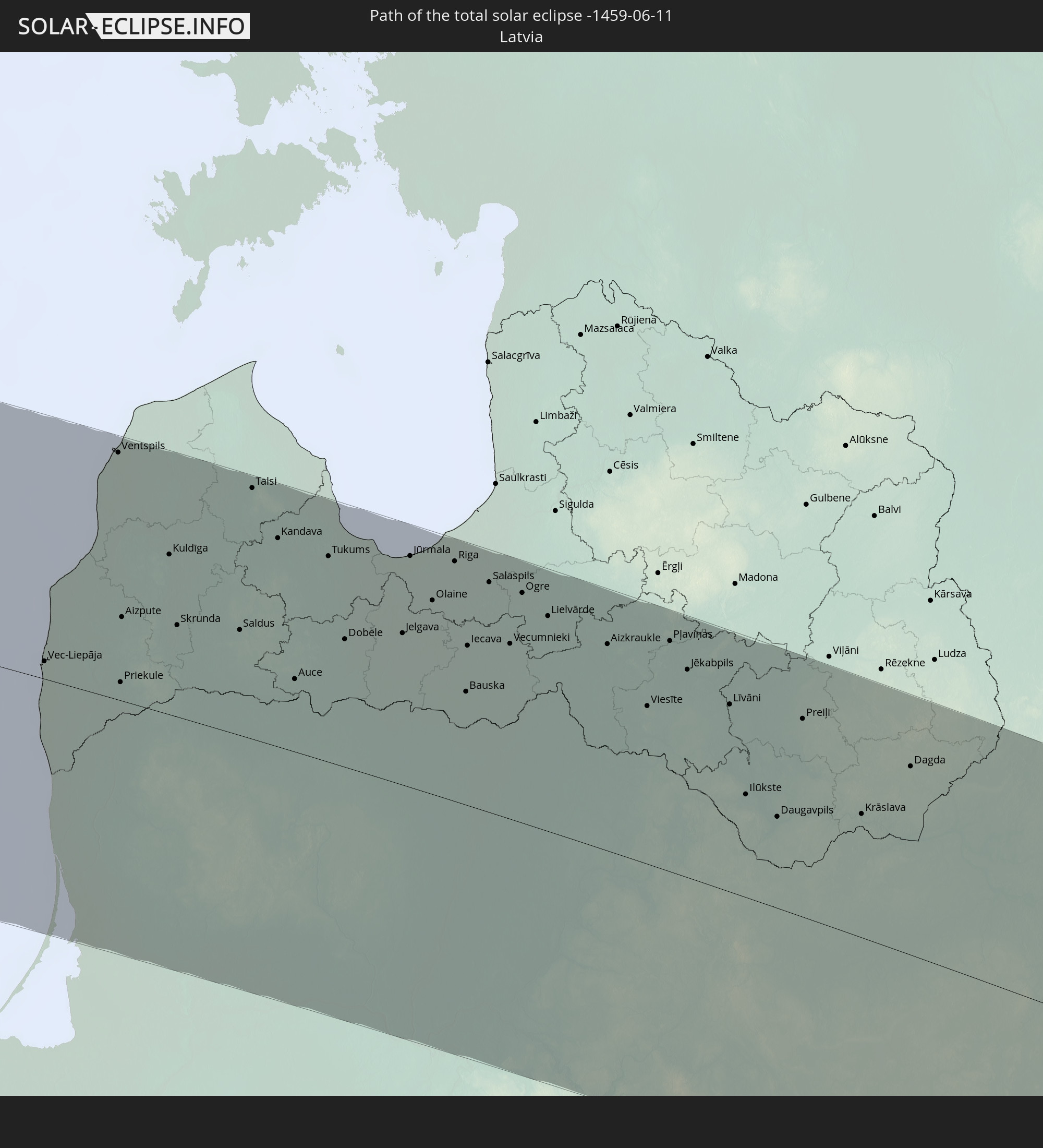 Latvia
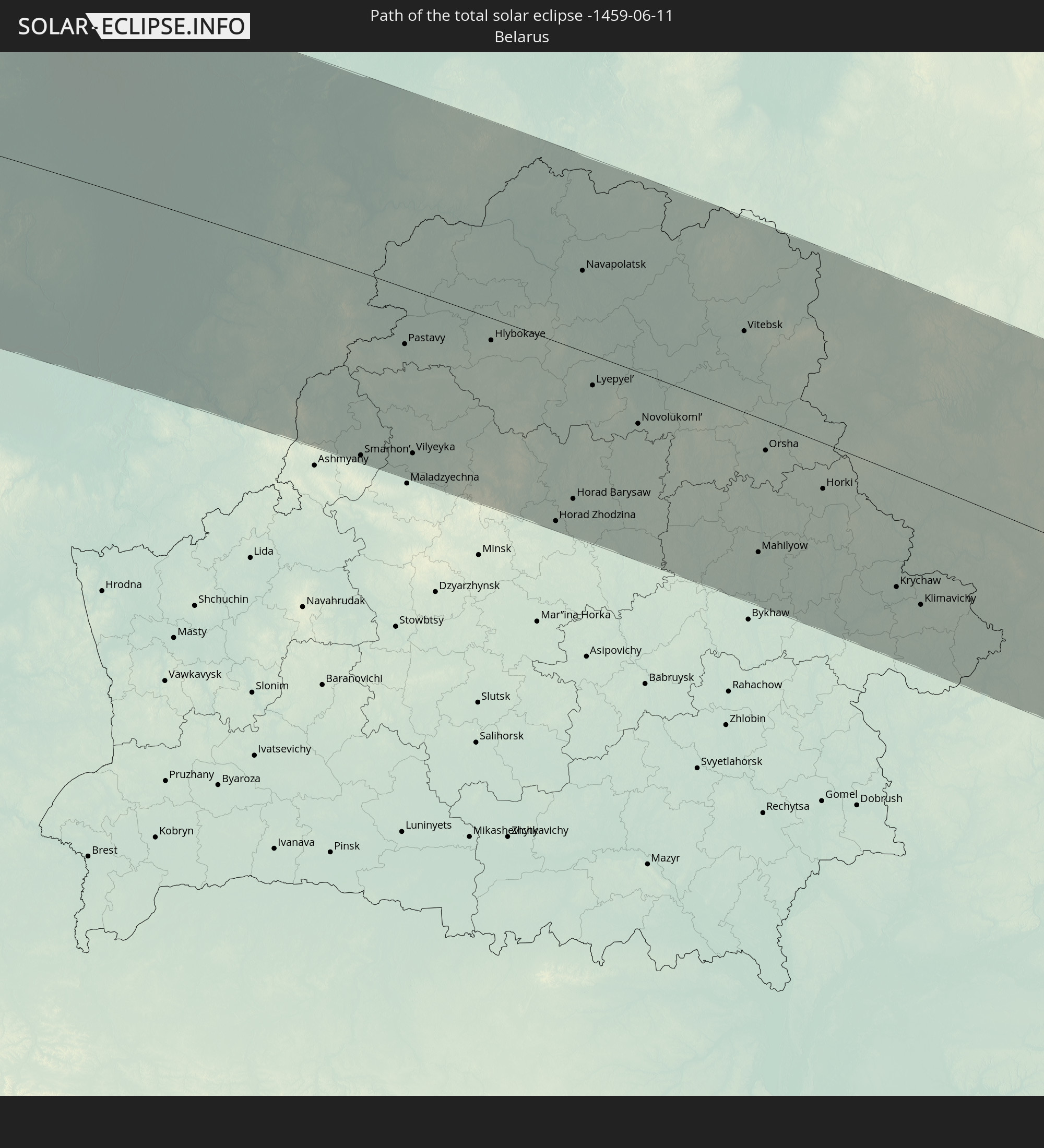 Belarus
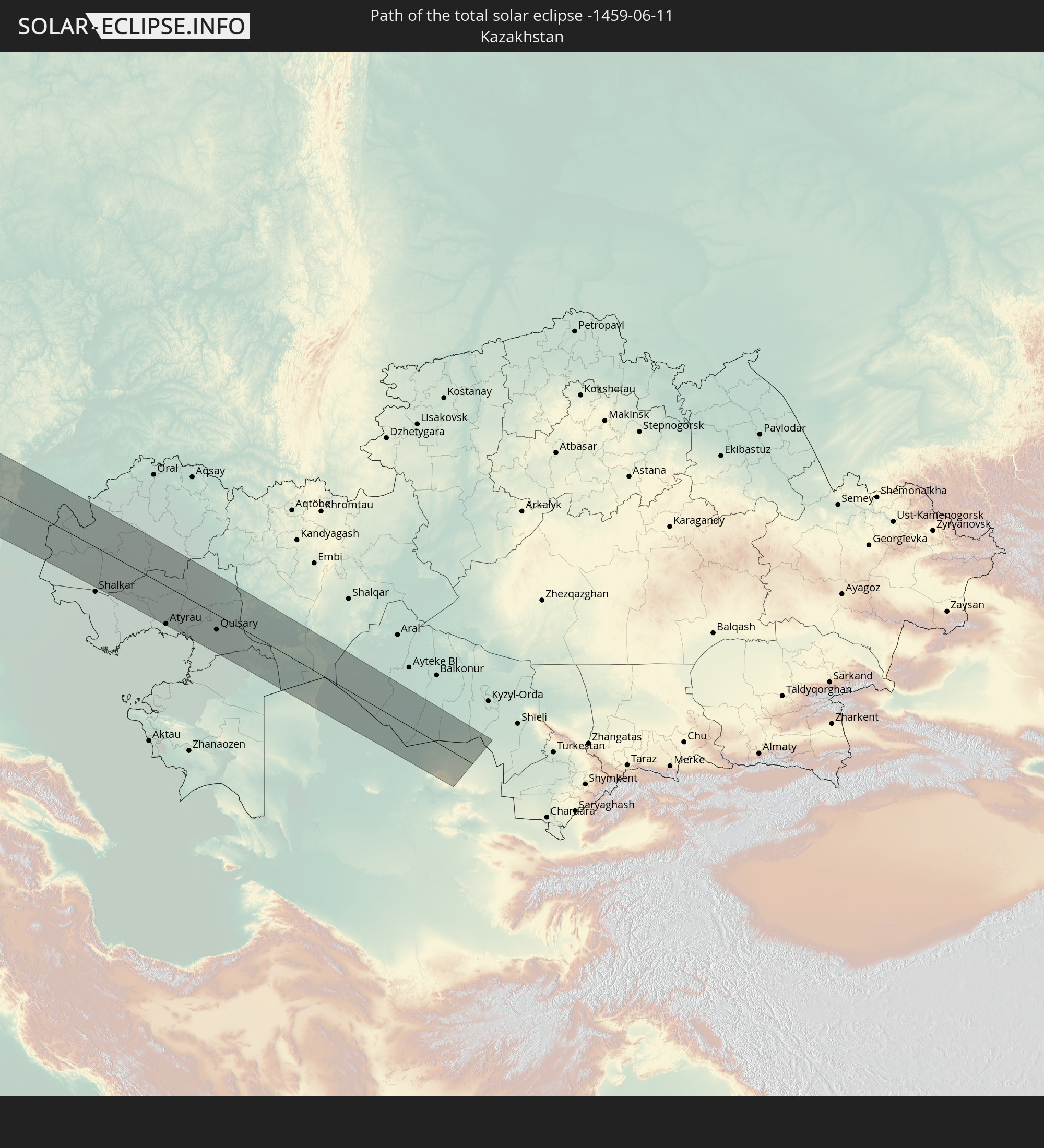 Kazakhstan
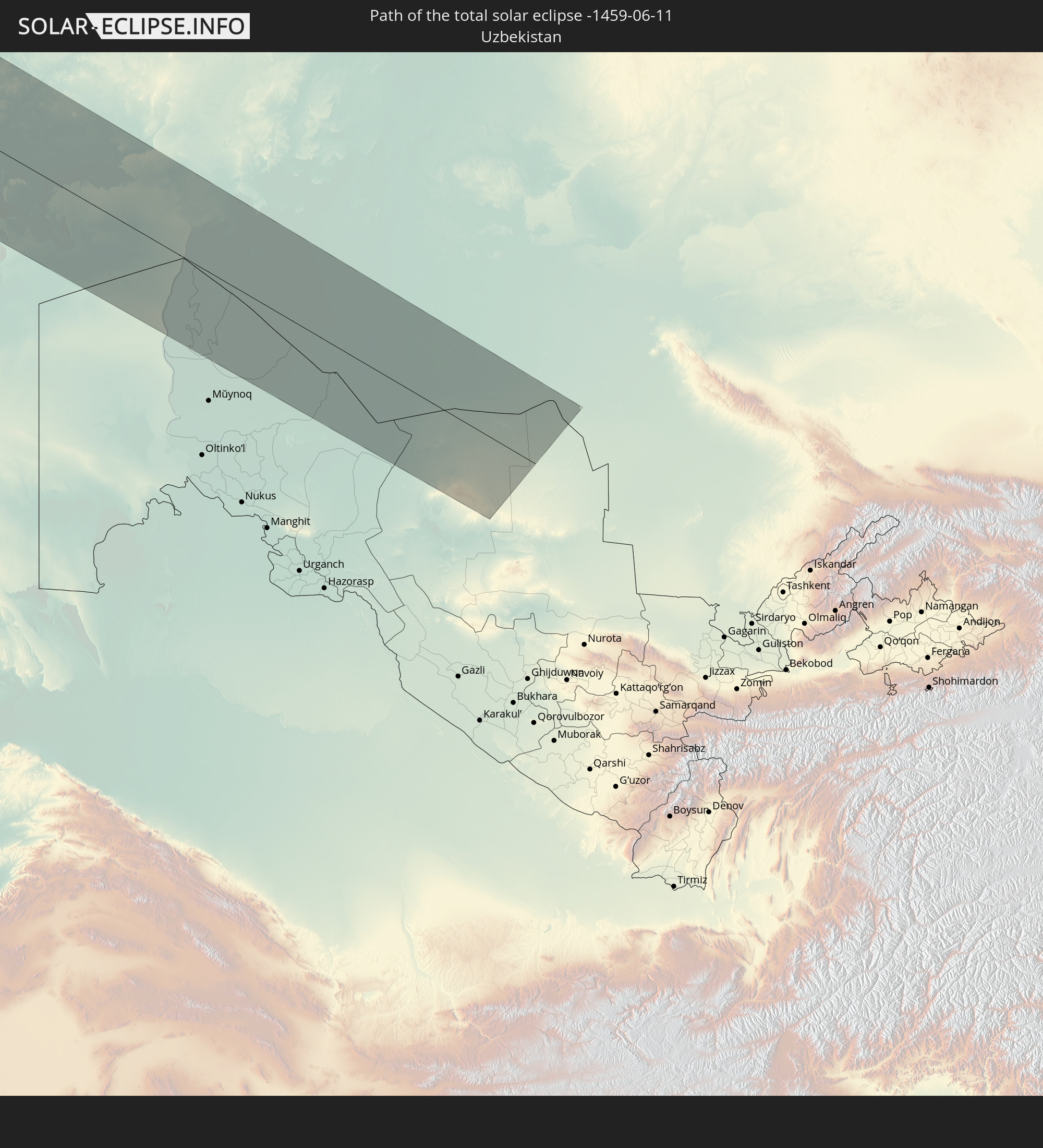 Uzbekistan
In den folgenden Ländern ist die Sonnenfinsternis partiell zu sehen
 Russia
 United States
 United States Minor Outlying Islands
 Canada
 Mexico
 Greenland
 Guatemala
 Ecuador
 El Salvador
 Honduras
 Belize
 Nicaragua
 Costa Rica
 Cuba
Cuba
 Panama
 Colombia
 Cayman Islands
 Peru
Peru
 The Bahamas
 Jamaica
 Haiti
Haiti
 Brazil
 Venezuela
 Turks and Caicos Islands
 Dominican Republic
 Aruba
Aruba
 Puerto Rico
 United States Virgin Islands
 Bermuda
 British Virgin Islands
 Anguilla
 Collectivity of Saint Martin
 Saint Barthélemy
 Saint Kitts and Nevis
 Antigua and Barbuda
 Montserrat
 Trinidad and Tobago
 Guadeloupe
 Grenada
 Dominica
 Saint Vincent and the Grenadines
 Guyana
 Martinique
 Saint Lucia
 Barbados
 Suriname
 Saint Pierre and Miquelon
 French Guiana
 Portugal
 Iceland
 Spain
Spain
 Mauritania
 Morocco
 Republic of Ireland
 Svalbard and Jan Mayen
 Algeria
 United Kingdom
 Faroe Islands
 Gibraltar
 France
 Isle of Man
 Guernsey
 Jersey
 Andorra
 Belgium
 Netherlands
 Norway
 Luxembourg
 Germany
 Switzerland
 Italy
Italy
 Monaco
 Tunisia
 Denmark
 Libya
Libya
 Liechtenstein
 Austria
 Sweden
 Czechia
 San Marino
 Vatican City
 Slovenia
 Croatia
 Poland
 Malta
Malta
 Bosnia and Herzegovina
 Hungary
 Slovakia
 Montenegro
 Serbia
 Albania
 Åland Islands
 Greece
 Romania
 Republic of Macedonia
 Finland
 Lithuania
 Latvia
 Estonia
 Sudan
Sudan
 Ukraine
 Bulgaria
 Belarus
 Egypt
Egypt
 Turkey
 Moldova
 Cyprus
 State of Palestine
 Israel
 Saudi Arabia
 Jordan
 Lebanon
 Syria
Syria
 Eritrea
 Iraq
Iraq
 Georgia
 Yemen
Yemen
 Armenia
 Iran
Iran
 Azerbaijan
 Kazakhstan
 Kuwait
 Turkmenistan
 Uzbekistan
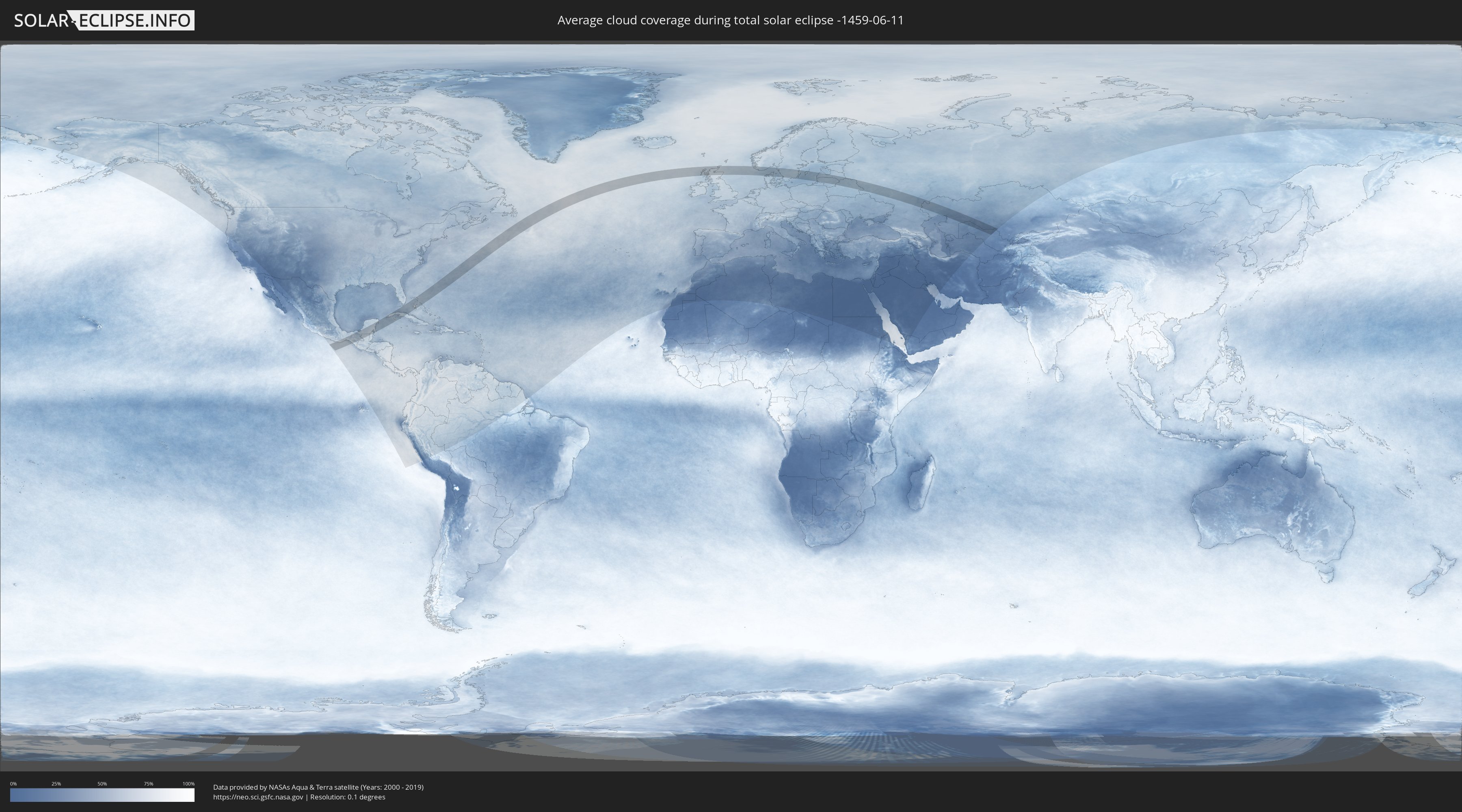
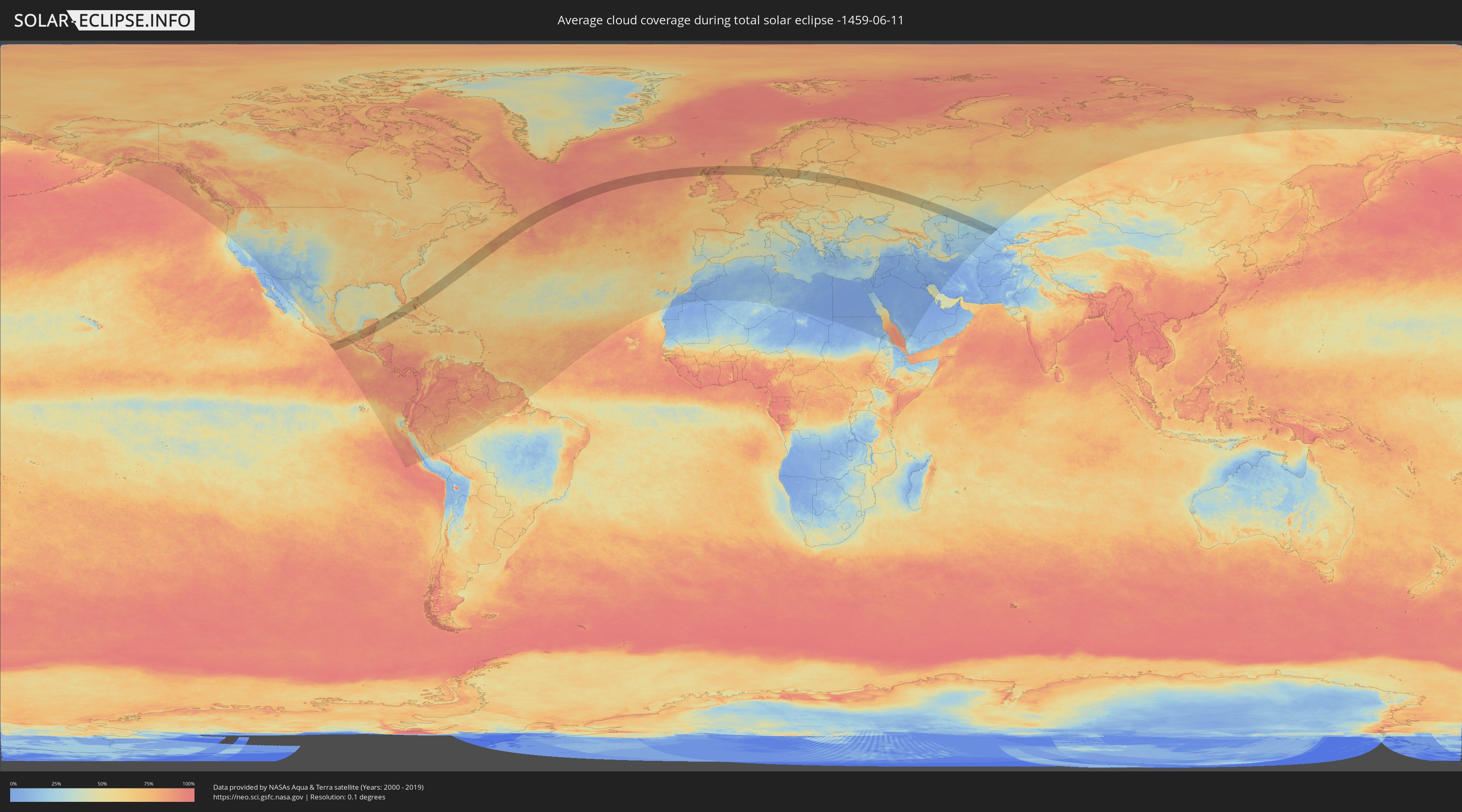
How will be the weather during the total solar eclipse on 06/11/-1459?
Where is the best place to see the total solar eclipse of 06/11/-1459?
The following maps show the average cloud coverage for the day of the total solar eclipse.
With the help of these maps, it is possible to find the place along the eclipse path, which has the best
chance of a cloudless sky.
Nevertheless, you should consider local circumstances and inform about the weather of your chosen
observation site.
The data is provided by NASAs satellites
AQUA and TERRA.
The cloud maps are averaged over a period of 19 years (2000 - 2019).
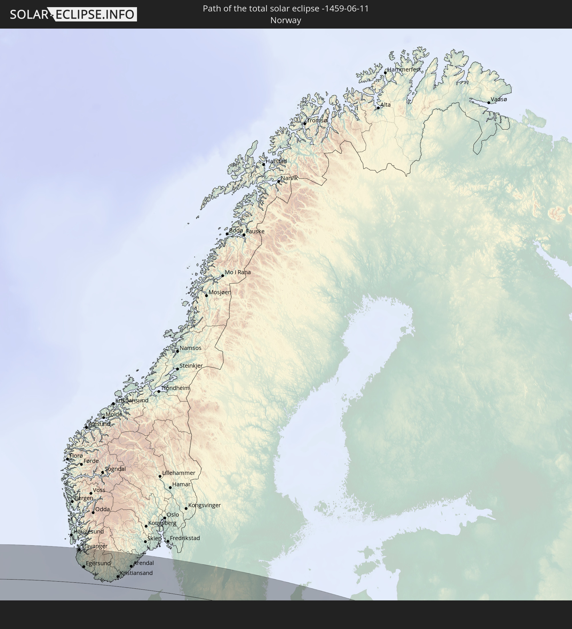
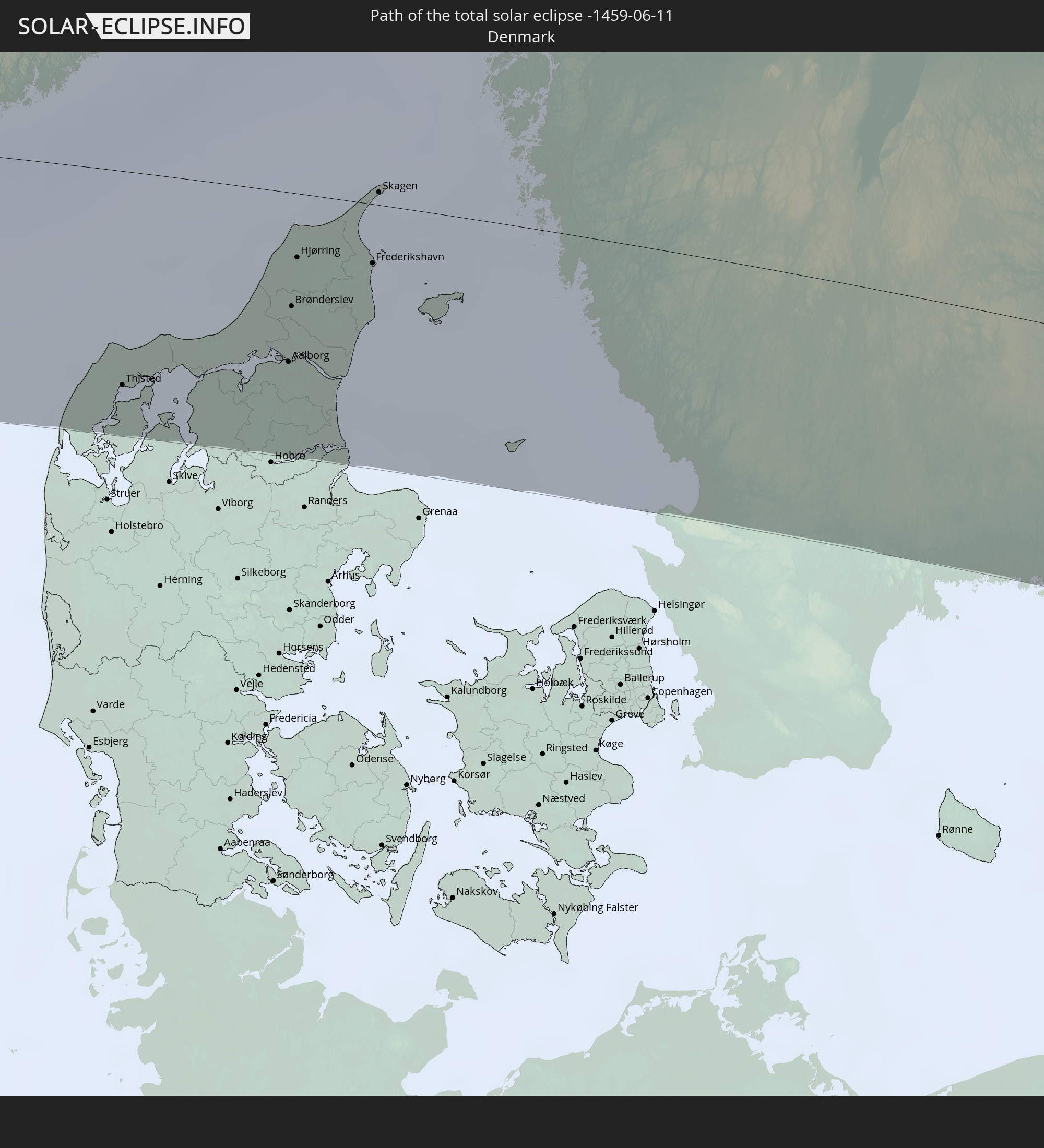
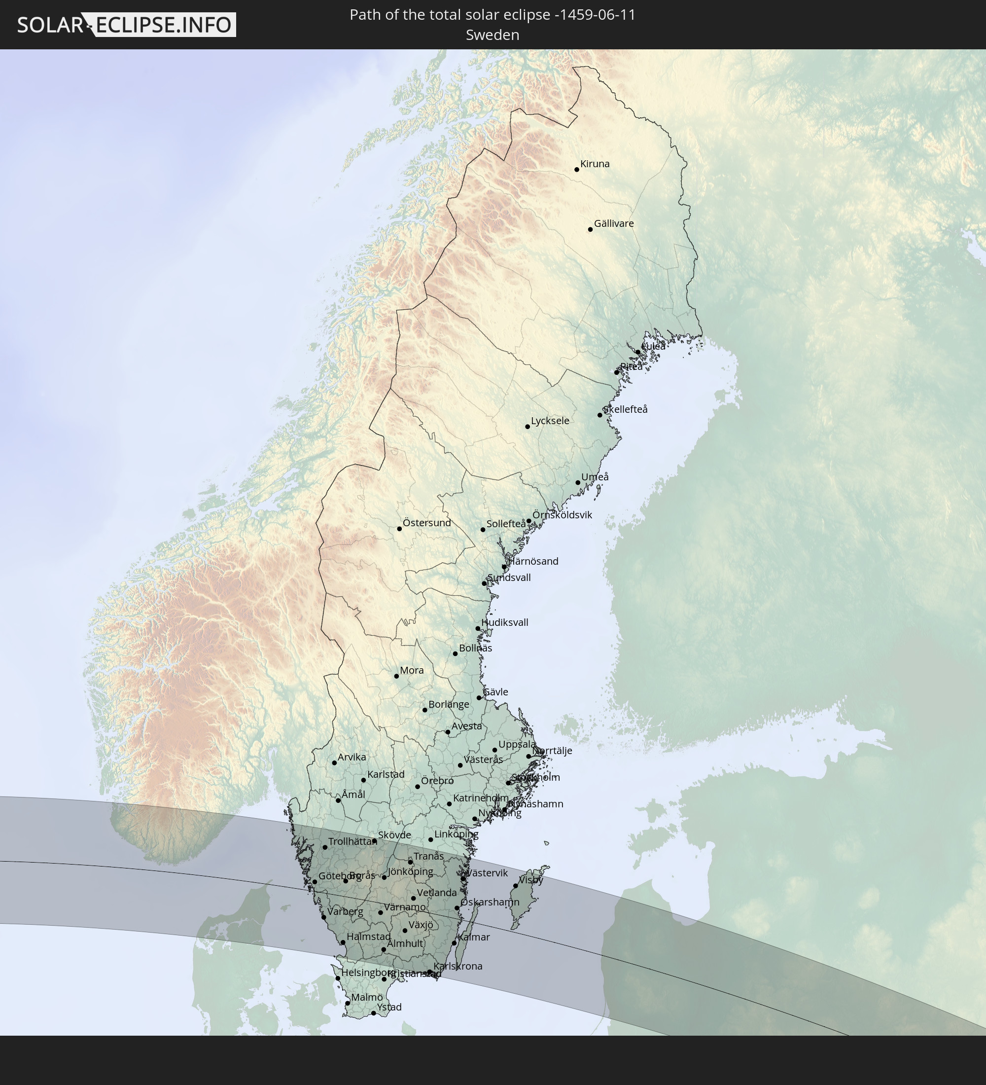
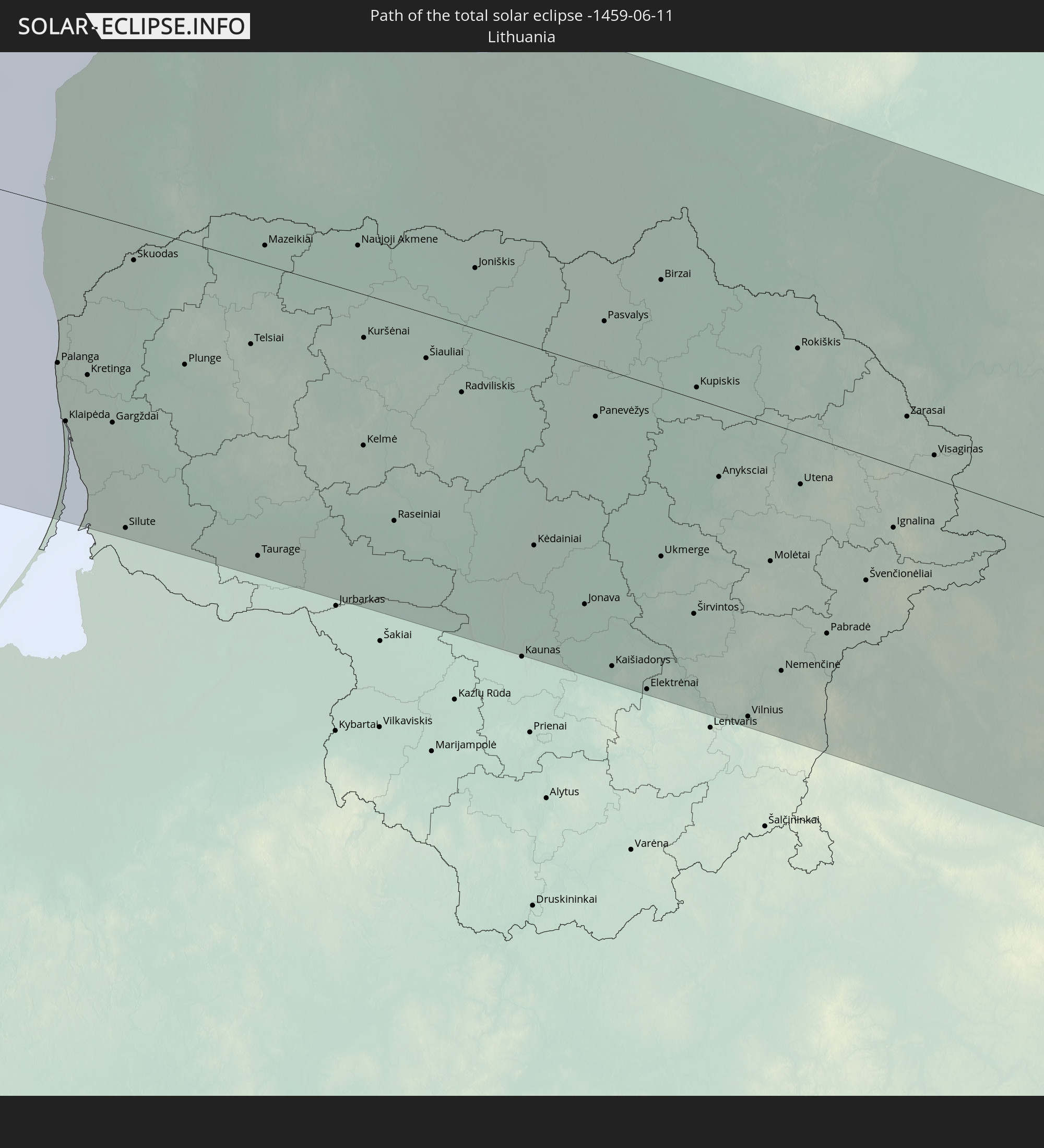
Detailed country maps
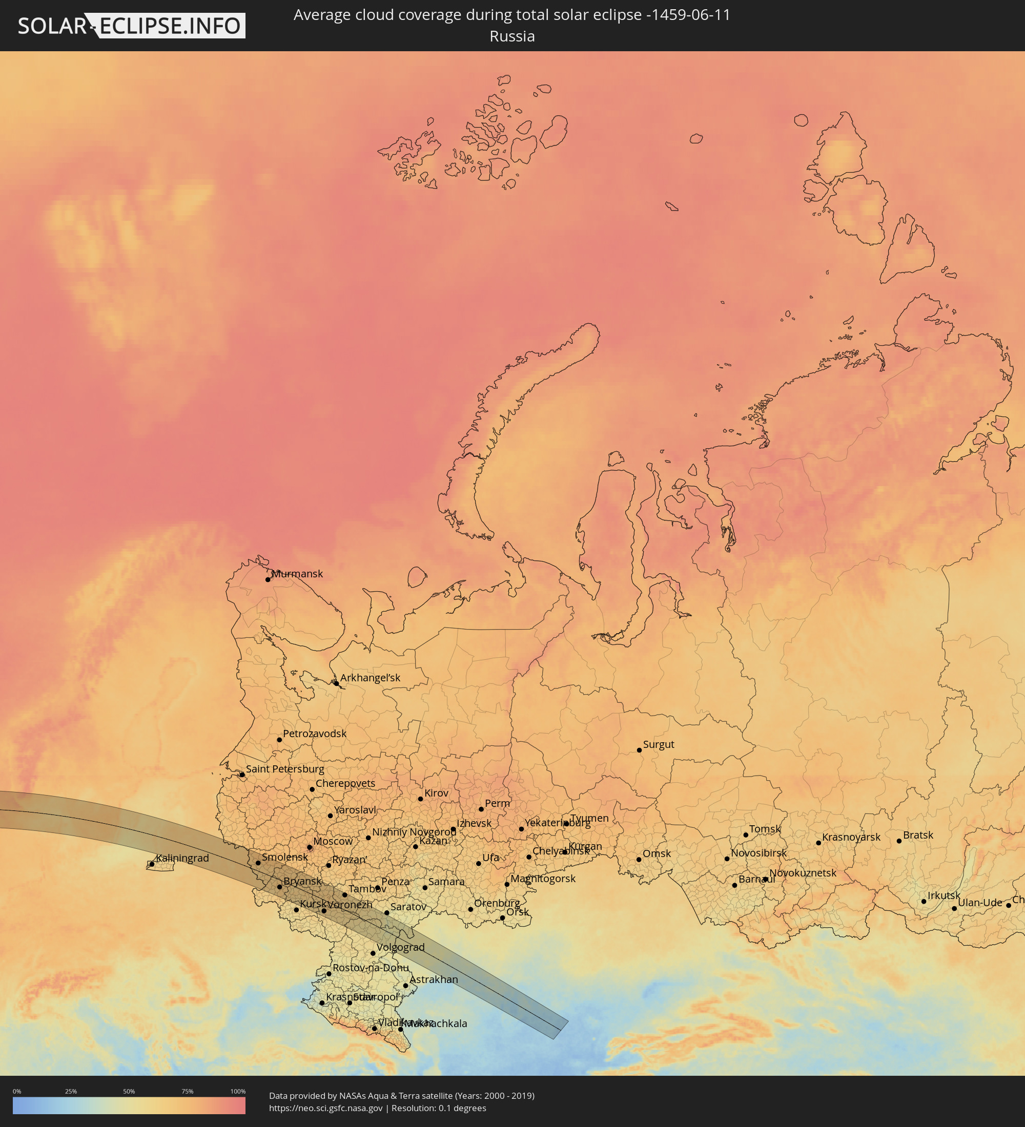 Russia
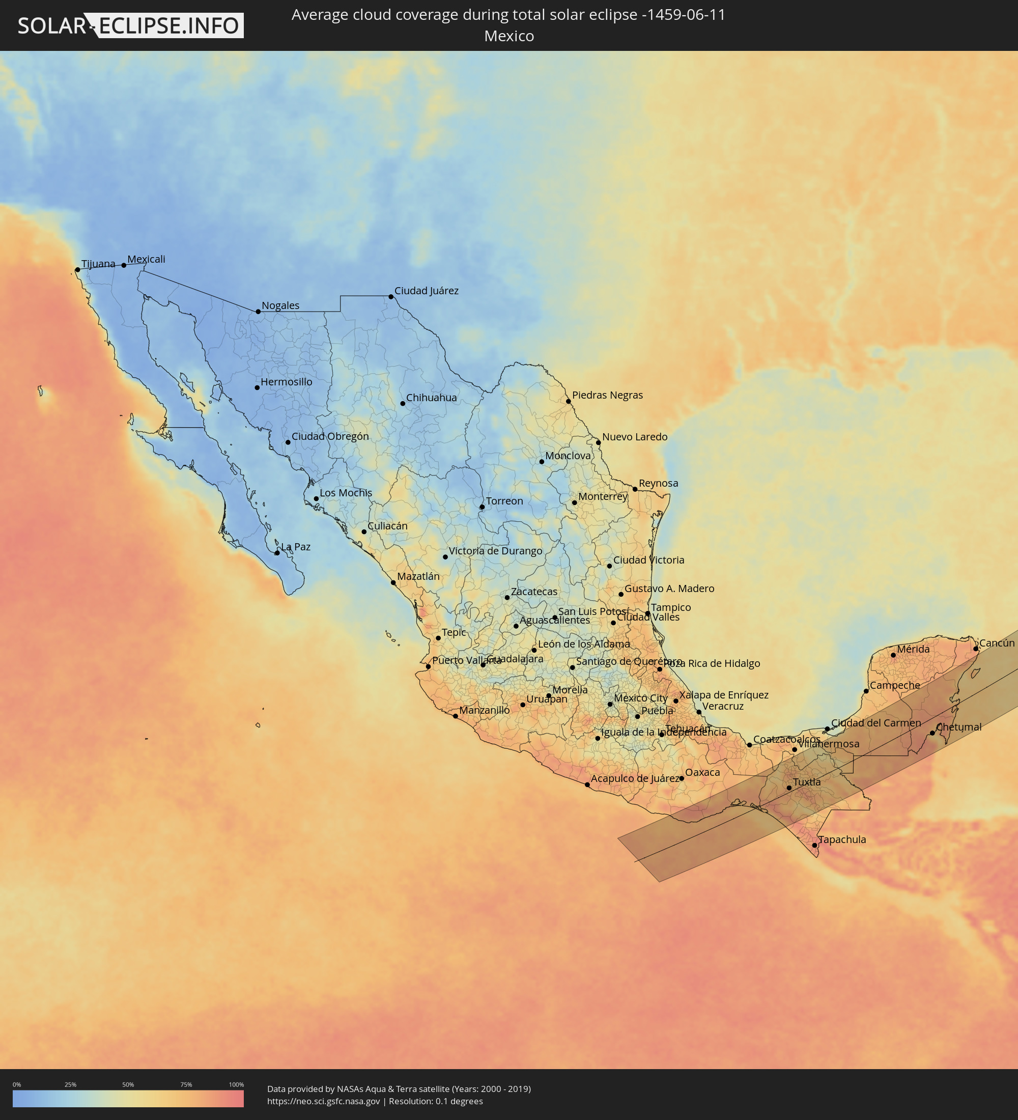 Mexico
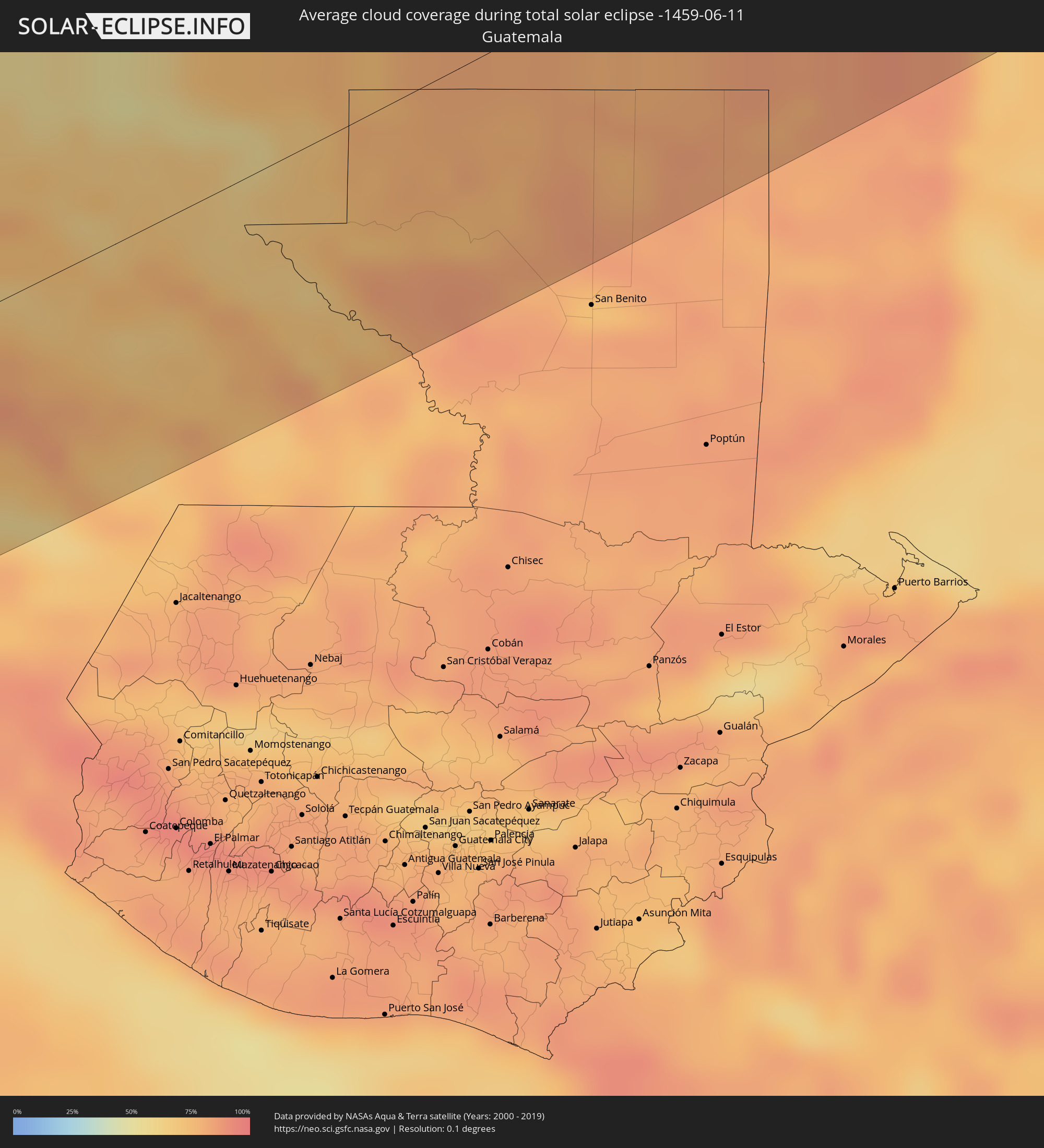 Guatemala
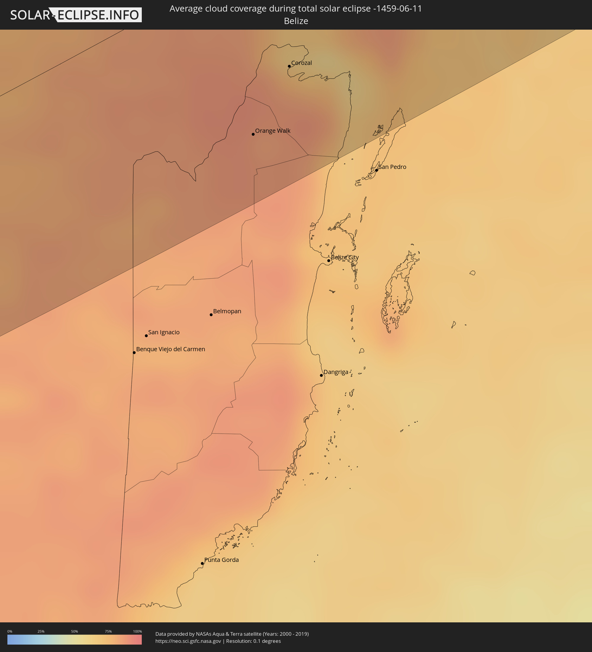 Belize
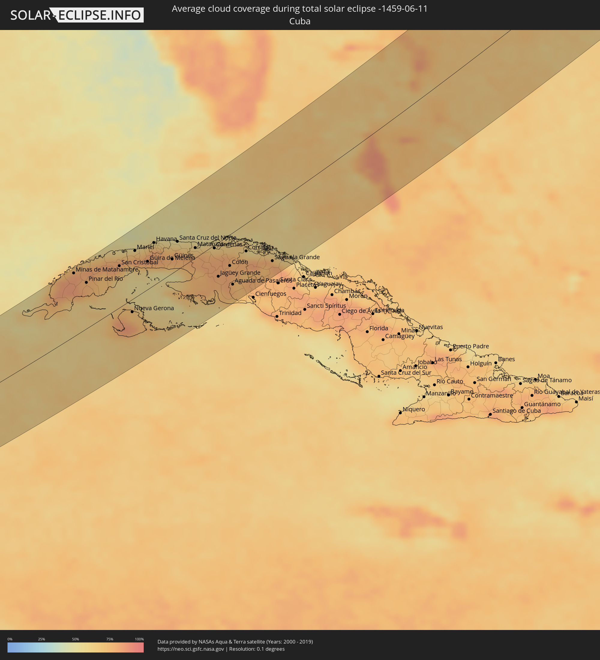 Cuba
Cuba
 The Bahamas
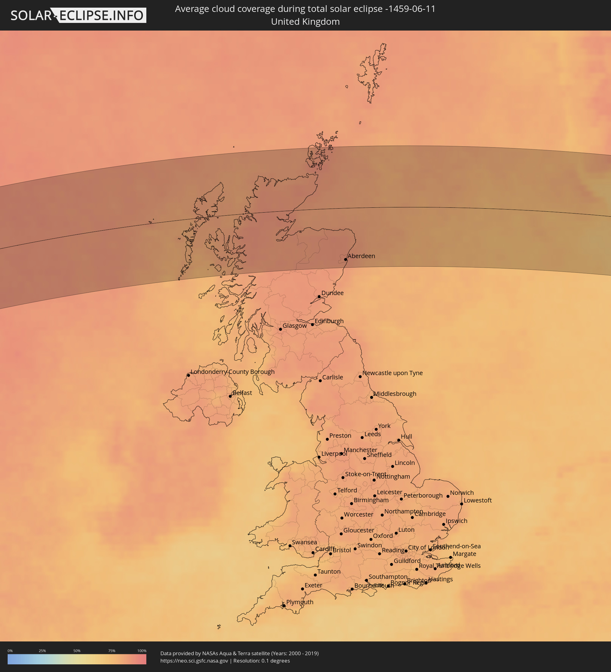 United Kingdom
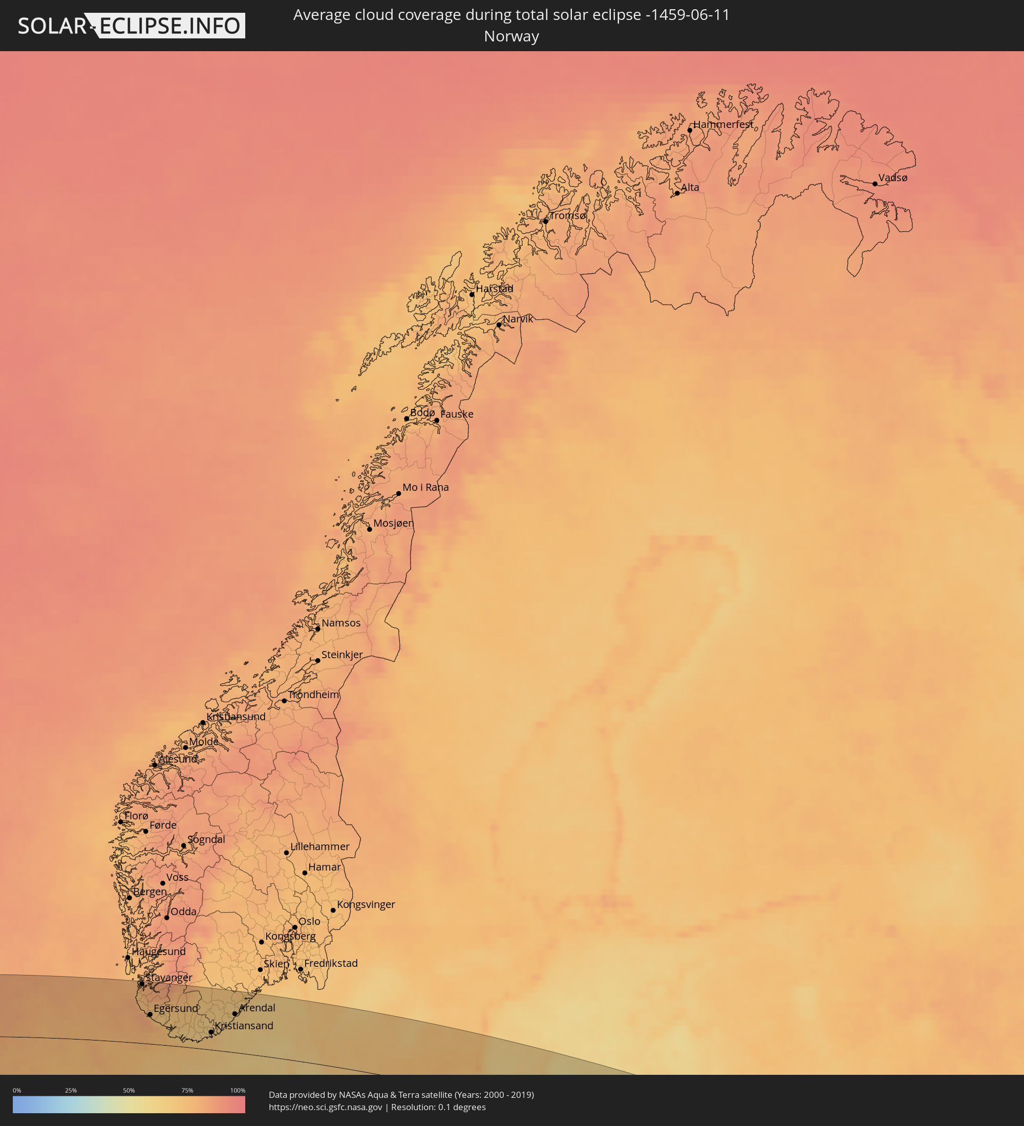 Norway
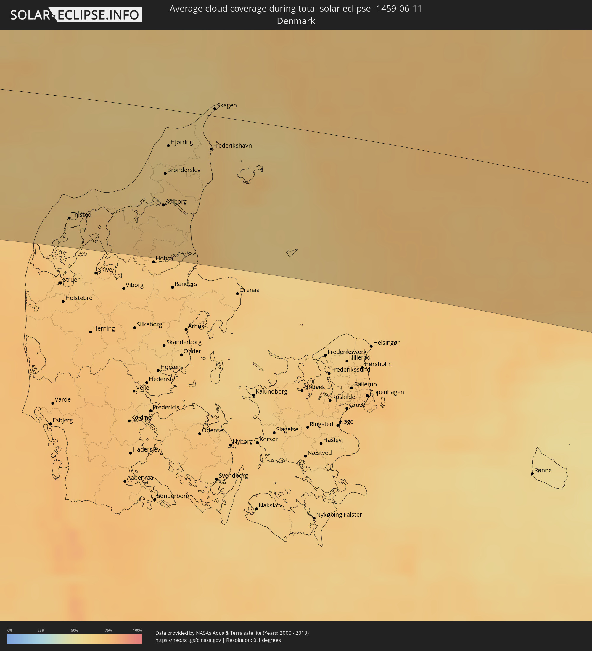 Denmark
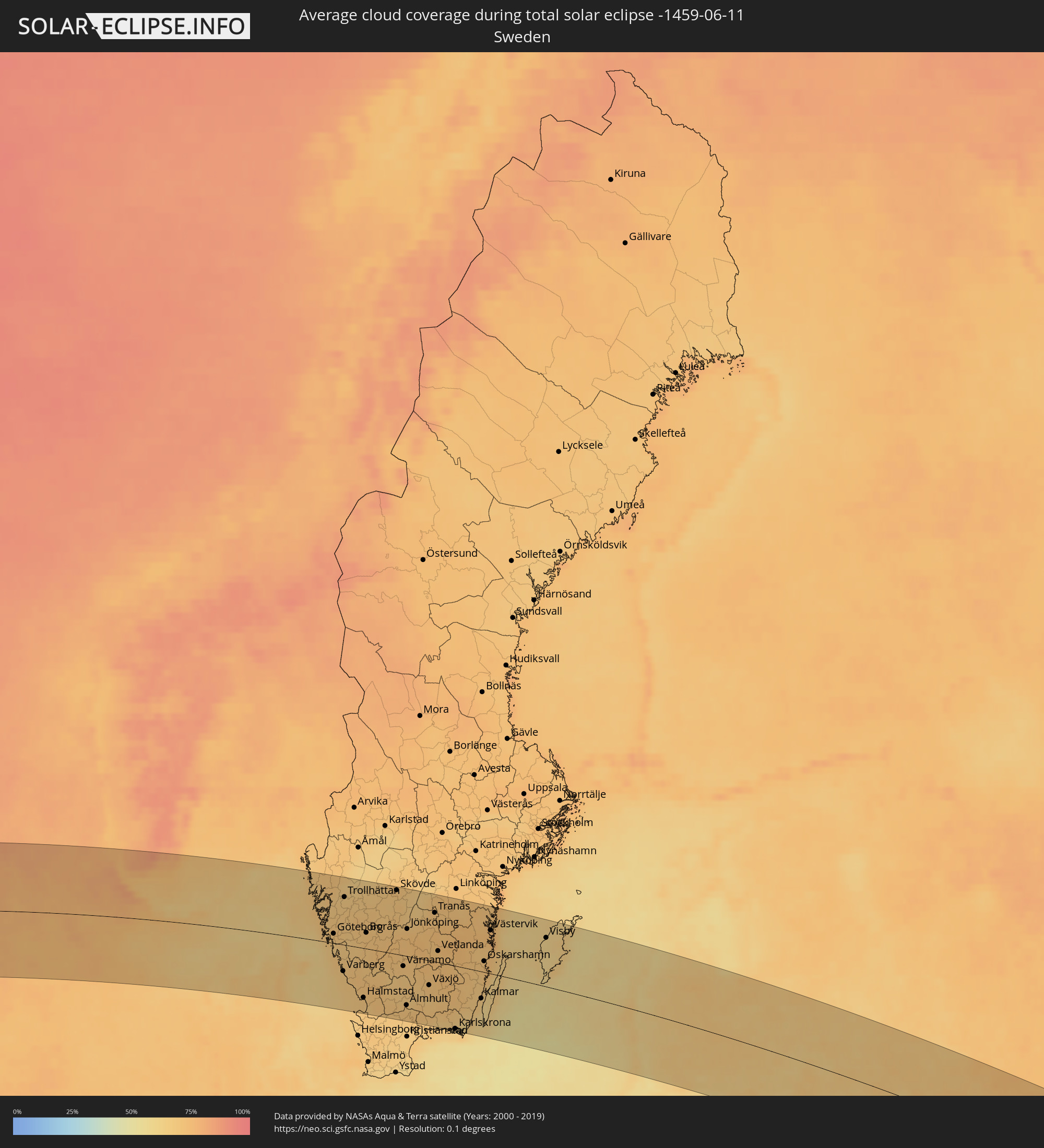 Sweden
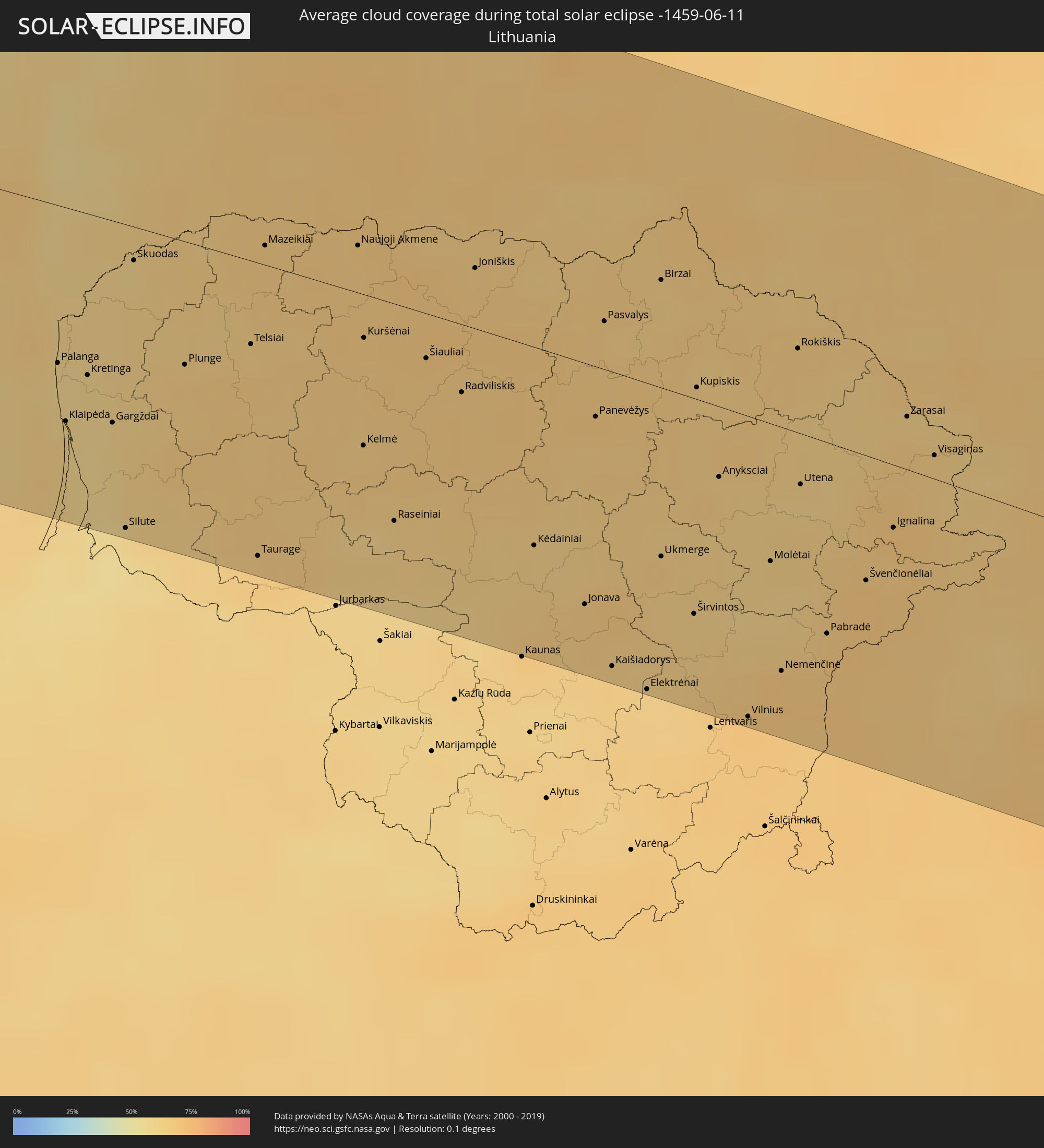 Lithuania
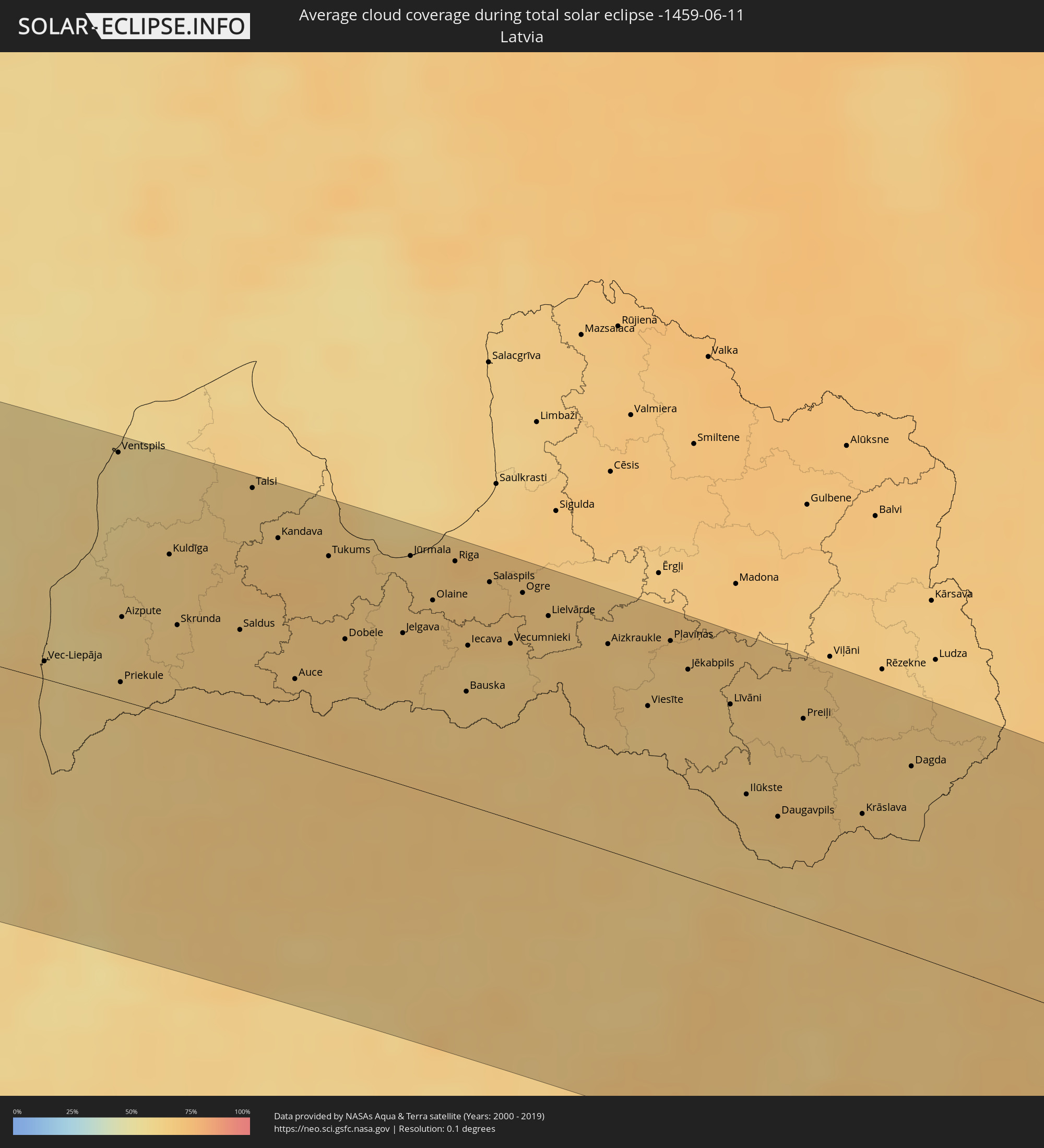 Latvia
 Belarus
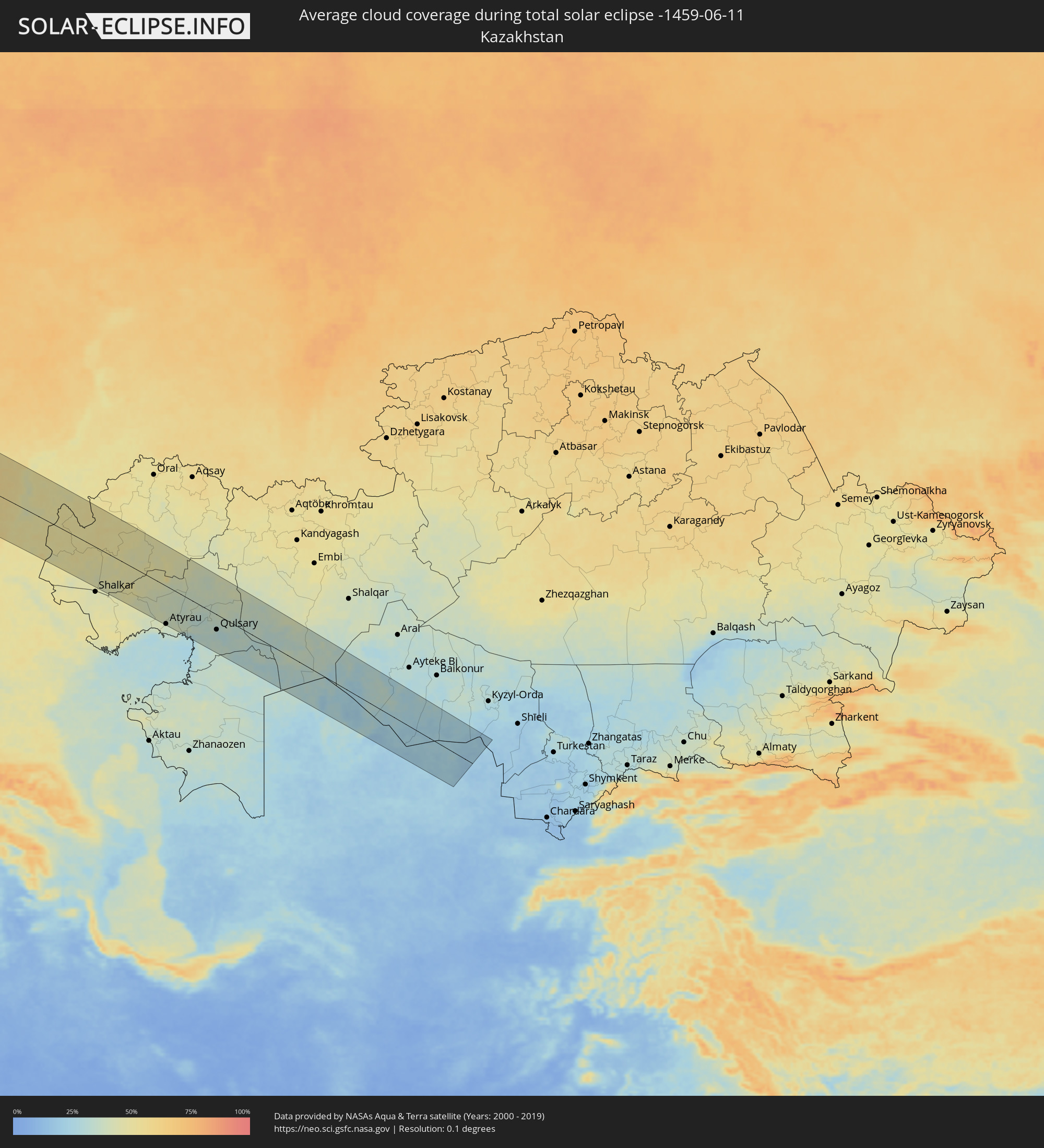 Kazakhstan
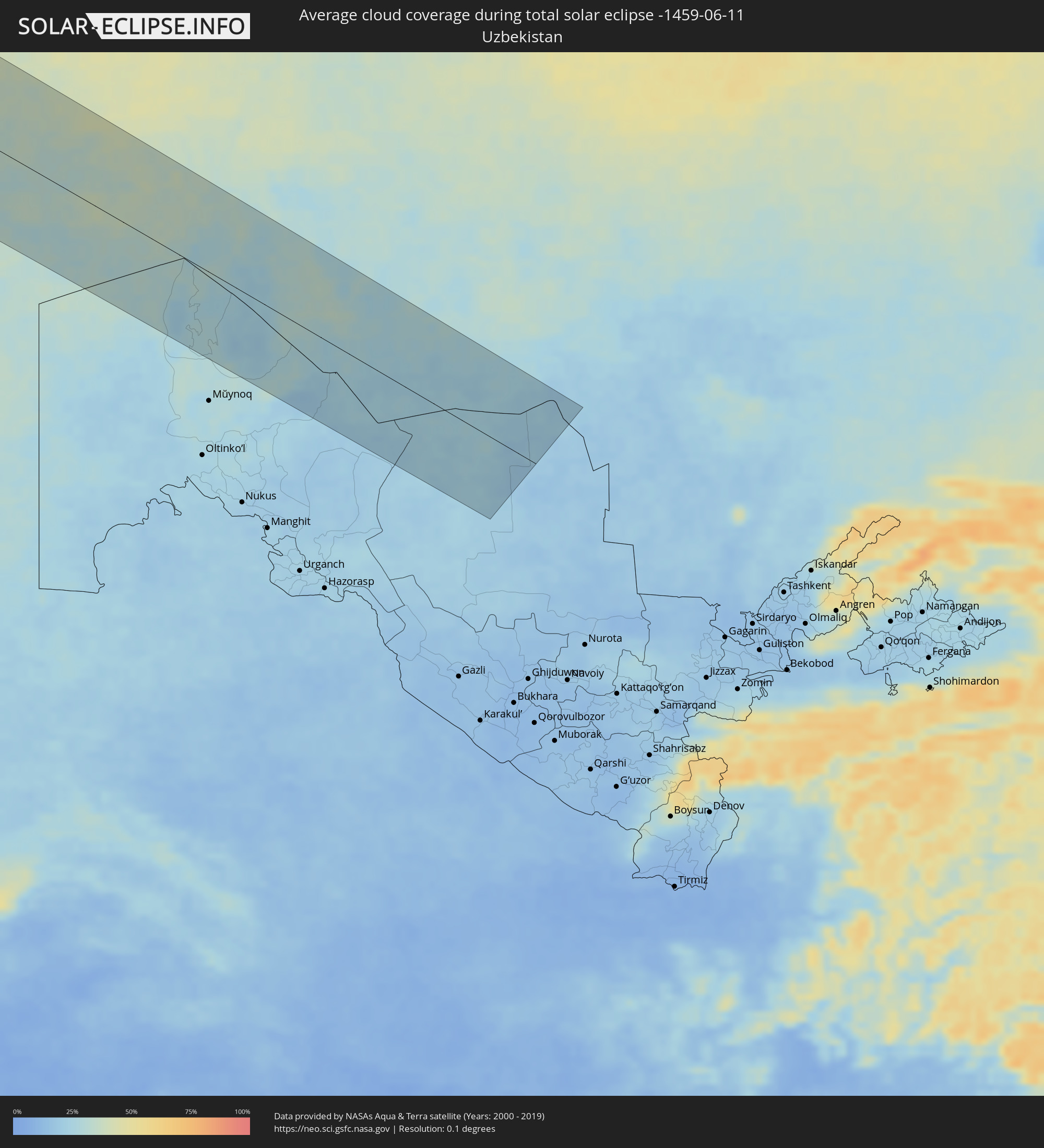 Uzbekistan
Cities inside the path of the eclipse
The following table shows all locations with a population of more than 5,000 inside the eclipse path. Cities which have more than 100,000 inhabitants are marked bold. A click at the locations opens a detailed map.
| City | Type | Eclipse duration | Local time of max. eclipse | Distance to central line | Ø Cloud coverage |
|
Santo Domingo Tehuantepec, Oaxaca
|
total | - | 05:24:19 UTC-06:36 | 64 km | 82% |
|
Salina Cruz, Oaxaca
|
total | - | 05:24:09 UTC-06:36 | 48 km | 80% |
|
Juchitán de Zaragoza, Oaxaca
|
total | - | 05:24:22 UTC-06:36 | 71 km | 73% |
|
Tonalá, Chiapas
|
total | - | 05:23:38 UTC-06:36 | 31 km | 77% |
|
Cintalapa de Figueroa, Chiapas
|
total | - | 05:24:15 UTC-06:36 | 33 km | 78% |
|
Ocozocoautla de Espinosa, Chiapas
|
total | - | 05:24:14 UTC-06:36 | 35 km | 76% |
|
Tuxtla, Chiapas
|
total | - | 05:24:10 UTC-06:36 | 14 km | 78% |
|
San Cristóbal de las Casas, Chiapas
|
total | - | 05:24:01 UTC-06:36 | 27 km | 86% |
|
Macuspana, Tabasco
|
total | - | 05:25:08 UTC-06:36 | 91 km | 69% |
|
Comitán, Chiapas
|
total | - | 05:23:22 UTC-06:36 | 86 km | 76% |
|
Palenque, Chiapas
|
total | - | 05:24:42 UTC-06:36 | 38 km | 68% |
|
Las Margaritas, Chiapas
|
total | - | 05:23:24 UTC-06:36 | 89 km | 69% |
|
Tenosique de Pino Suárez, Tabasco
|
total | - | 05:24:32 UTC-06:36 | 11 km | 66% |
|
Orange Walk, Orange Walk
|
total | - | 06:08:30 UTC-05:52 | 79 km | 88% |
|
Corozal, Corozal
|
total | - | 06:08:50 UTC-05:52 | 60 km | 77% |
|
Chetumal, Quintana Roo
|
total | - | 06:14:42 UTC-05:47 | 50 km | 64% |
|
Playa del Carmen, Quintana Roo
|
total | - | 06:17:06 UTC-05:47 | 93 km | 70% |
|
San Miguel de Cozumel, Quintana Roo
|
total | - | 06:16:56 UTC-05:47 | 73 km | 74% |
|
Pinar del Río, Pinar del Río
|
total | - | 06:36:44 UTC-05:29 | 82 km | 79% |
|
Consolación del Sur, Pinar del Río
|
total | - | 06:36:51 UTC-05:29 | 77 km | 76% |
|
San Cristobal, Artemisa
|
total | - | 06:37:08 UTC-05:29 | 74 km | 79% |
|
Artemisa, Artemisa
|
total | - | 06:37:17 UTC-05:29 | 64 km | 72% |
|
Güira de Melena, Artemisa
|
total | - | 06:37:16 UTC-05:29 | 55 km | 74% |
|
Havana, La Habana
|
total | - | 06:37:44 UTC-05:29 | 71 km | 79% |
|
Arroyo Naranjo, La Habana
|
total | - | 06:37:34 UTC-05:29 | 56 km | 79% |
|
San José de las Lajas, Mayabeque
|
total | - | 06:37:30 UTC-05:29 | 43 km | 79% |
|
Güines, Mayabeque
|
total | - | 06:37:21 UTC-05:29 | 26 km | 71% |
|
Matanzas, Matanzas
|
total | - | 06:37:39 UTC-05:29 | 17 km | 75% |
|
Cárdenas, Matanzas
|
total | - | 06:37:40 UTC-05:29 | 5 km | 77% |
|
Jovellanos, Matanzas
|
total | - | 06:37:21 UTC-05:29 | 27 km | 80% |
|
Jagüey Grande, Matanzas
|
total | - | 06:36:59 UTC-05:29 | 56 km | 78% |
|
Colón, Matanzas
|
total | - | 06:37:16 UTC-05:29 | 51 km | 80% |
|
Corralillo, Villa Clara
|
total | - | 06:37:39 UTC-05:29 | 46 km | 68% |
|
Sagua la Grande, Villa Clara
|
total | - | 06:37:27 UTC-05:29 | 92 km | 77% |
|
San Andros, North Andros
|
total | - | 07:01:03 UTC-05:09 | 11 km | 83% |
|
Hard Bargain, Moore’s Island
|
total | - | 07:03:00 UTC-05:09 | 78 km | 67% |
|
Nassau, New Providence
|
total | - | 07:01:11 UTC-05:09 | 50 km | 80% |
|
Marsh Harbour, Central Abaco
|
total | - | 07:03:27 UTC-05:09 | 70 km | 83% |
|
Spanish Wells, Spanish Wells
|
total | - | 07:02:02 UTC-05:09 | 39 km | 77% |
|
Governor’s Harbour, Central Eleuthera
|
total | - | 12:11:05 UTC+00:00 | 104 km | 68% |
|
Isle of Lewis, Scotland
|
total | - | 14:12:21 UTC+00:00 | 34 km | 83% |
|
Isle of Skye, Scotland
|
total | - | 14:12:50 UTC+00:00 | 63 km | 84% |
|
Inverness, Scotland
|
total | - | 14:15:01 UTC+00:00 | 60 km | 87% |
|
Nairn, Scotland
|
total | - | 14:15:20 UTC+00:00 | 49 km | 87% |
|
Forres, Scotland
|
total | - | 14:15:36 UTC+00:00 | 48 km | 87% |
|
Thurso, Scotland
|
total | - | 14:15:11 UTC+00:00 | 62 km | 86% |
|
Elgin, Scotland
|
total | - | 14:15:54 UTC+00:00 | 44 km | 88% |
|
Wick, Scotland
|
total | - | 14:15:43 UTC+00:00 | 44 km | 88% |
|
Buckie, Scotland
|
total | - | 14:16:16 UTC+00:00 | 41 km | 85% |
|
Orkney, Scotland
|
total | - | 14:15:33 UTC+00:00 | 105 km | 88% |
|
Kirkwall, Scotland
|
total | - | 14:15:33 UTC+00:00 | 105 km | 88% |
|
Inverurie, Scotland
|
total | - | 14:17:06 UTC+00:00 | 86 km | 88% |
|
Aberdeen, Scotland
|
total | - | 14:17:29 UTC+00:00 | 103 km | 86% |
|
Ellon, Scotland
|
total | - | 14:17:23 UTC+00:00 | 78 km | 88% |
|
Fraserburgh, Scotland
|
total | - | 14:17:15 UTC+00:00 | 42 km | 85% |
|
Peterhead, Scotland
|
total | - | 14:17:35 UTC+00:00 | 63 km | 85% |
|
Tananger, Rogaland
|
total | - | 15:23:36 UTC+01:00 | 107 km | 75% |
|
Bryne, Rogaland
|
total | - | 15:23:50 UTC+01:00 | 85 km | 76% |
|
Stavanger, Rogaland
|
total | - | 15:23:42 UTC+01:00 | 112 km | 76% |
|
Sandnes, Rogaland
|
total | - | 15:23:49 UTC+01:00 | 99 km | 75% |
|
Hommersåk, Rogaland
|
total | - | 15:23:51 UTC+01:00 | 108 km | 80% |
|
Egersund, Rogaland
|
total | - | 15:24:24 UTC+01:00 | 56 km | 73% |
|
Flekkefjord, Vest-Agder
|
total | - | 15:25:06 UTC+01:00 | 42 km | 67% |
|
Mandal, Vest-Agder
|
total | - | 15:26:02 UTC+01:00 | 17 km | 70% |
|
Søgne, Vest-Agder
|
total | - | 15:26:16 UTC+01:00 | 29 km | 69% |
|
Vennesla, Vest-Agder
|
total | - | 15:26:15 UTC+01:00 | 47 km | 64% |
|
Kristiansand, Vest-Agder
|
total | - | 15:26:23 UTC+01:00 | 33 km | 70% |
|
Lillesand, Aust-Agder
|
total | - | 15:26:37 UTC+01:00 | 49 km | 65% |
|
Grimstad, Aust-Agder
|
total | - | 15:26:42 UTC+01:00 | 59 km | 66% |
|
Thisted, North Denmark
|
total | - | 15:28:07 UTC+01:00 | 94 km | 65% |
|
Arendal, Aust-Agder
|
total | - | 15:26:44 UTC+01:00 | 74 km | 66% |
|
Nykøbing Mors, North Denmark
|
total | - | 15:28:24 UTC+01:00 | 111 km | 67% |
|
Aars, North Denmark
|
total | - | 15:28:58 UTC+01:00 | 105 km | 69% |
|
Støvring, North Denmark
|
total | - | 15:29:10 UTC+01:00 | 93 km | 67% |
|
Aalborg, North Denmark
|
total | - | 15:29:04 UTC+01:00 | 74 km | 68% |
|
Nørresundby, North Denmark
|
total | - | 15:29:05 UTC+01:00 | 74 km | 68% |
|
Brønderslev, North Denmark
|
total | - | 15:28:52 UTC+01:00 | 50 km | 65% |
|
Hirtshals, North Denmark
|
total | - | 15:28:34 UTC+01:00 | 14 km | 62% |
|
Hjørring, North Denmark
|
total | - | 15:28:43 UTC+01:00 | 28 km | 62% |
|
Hadsund, North Denmark
|
total | - | 15:29:34 UTC+01:00 | 110 km | 68% |
|
Sæby, North Denmark
|
total | - | 15:29:17 UTC+01:00 | 38 km | 67% |
|
Frederikshavn, North Denmark
|
total | - | 15:29:11 UTC+01:00 | 26 km | 65% |
|
Skagen, North Denmark
|
total | - | 15:28:57 UTC+01:00 | 7 km | 65% |
|
Uddevalla, Västra Götaland
|
total | - | 15:29:22 UTC+01:00 | 88 km | 69% |
|
Göteborg, Västra Götaland
|
total | - | 15:30:03 UTC+01:00 | 17 km | 69% |
|
Kungälv, Västra Götaland
|
total | - | 15:29:53 UTC+01:00 | 35 km | 70% |
|
Varberg, Halland
|
total | - | 15:30:54 UTC+01:00 | 47 km | 67% |
|
Trollhättan, Västra Götaland
|
total | - | 15:29:42 UTC+01:00 | 83 km | 66% |
|
Alingsås, Västra Götaland
|
total | - | 15:30:15 UTC+01:00 | 47 km | 69% |
|
Halmstad, Halland
|
total | - | 15:31:50 UTC+01:00 | 88 km | 69% |
|
Borås, Västra Götaland
|
total | - | 15:30:47 UTC+01:00 | 29 km | 70% |
|
Lidköping, Västra Götaland
|
total | - | 15:30:06 UTC+01:00 | 117 km | 65% |
|
Skövde, Västra Götaland
|
total | - | 15:30:43 UTC+01:00 | 111 km | 71% |
|
Jönköping, Jönköping
|
total | - | 15:31:37 UTC+01:00 | 48 km | 71% |
|
Växjö, Kronoberg
|
total | - | 15:33:06 UTC+01:00 | 44 km | 71% |
|
Karlskrona, Blekinge
|
total | - | 15:34:28 UTC+01:00 | 112 km | 65% |
|
Kalmar, Kalmar
|
total | - | 15:34:27 UTC+01:00 | 48 km | 66% |
|
Västervik, Kalmar
|
total | - | 15:33:23 UTC+01:00 | 76 km | 72% |
|
Visby, Gotland
|
total | - | 15:34:37 UTC+01:00 | 85 km | 60% |
|
Vec-Liepāja, Liepāja
|
total | - | 16:14:12 UTC+01:36 | 8 km | 62% |
|
Klaipėda, Klaipėda County
|
total | - | 16:02:41 UTC+01:24 | 78 km | 63% |
|
Kretinga, Klaipėda County
|
total | - | 16:02:34 UTC+01:24 | 59 km | 61% |
|
Silute, Klaipėda County
|
total | - | 16:03:21 UTC+01:24 | 111 km | 56% |
|
Ventspils, Ventspils
|
total | - | 16:13:28 UTC+01:36 | 109 km | 56% |
|
Plunge, Telšiai County
|
total | - | 16:02:53 UTC+01:24 | 45 km | 65% |
|
Kuldīga, Kuldīgas Rajons
|
total | - | 16:14:12 UTC+01:36 | 71 km | 64% |
|
Telsiai, Telšiai County
|
total | - | 16:03:02 UTC+01:24 | 31 km | 65% |
|
Taurage, Tauragė County
|
total | - | 16:03:57 UTC+01:24 | 108 km | 66% |
|
Mazeikiai, Telšiai County
|
total | - | 16:02:40 UTC+01:24 | 15 km | 67% |
|
Saldus, Saldus Rajons
|
total | - | 16:14:53 UTC+01:36 | 49 km | 65% |
|
Talsi, Talsu Rajons
|
total | - | 16:14:13 UTC+01:36 | 111 km | 65% |
|
Tukums, Tukuma Rajons
|
total | - | 16:14:53 UTC+01:36 | 92 km | 68% |
|
Dobele, Dobeles Rajons
|
total | - | 16:15:22 UTC+01:36 | 57 km | 67% |
|
Šiauliai, Šiauliai County
|
total | - | 16:03:41 UTC+01:24 | 18 km | 67% |
|
Jelgava, Jelgava
|
total | - | 16:15:34 UTC+01:36 | 68 km | 67% |
|
Jūrmala, Jūrmala
|
total | - | 16:15:12 UTC+01:36 | 103 km | 65% |
|
Olaine, Olaine
|
total | - | 16:15:31 UTC+01:36 | 86 km | 67% |
|
Dainava (Kaunas), Kaunas County
|
total | - | 16:05:19 UTC+01:24 | 112 km | 65% |
|
Kėdainiai, Kaunas County
|
total | - | 16:04:51 UTC+01:24 | 74 km | 64% |
|
Riga, Riga
|
total | - | 16:15:24 UTC+01:36 | 106 km | 67% |
|
Jonava, Kaunas County
|
total | - | 16:05:17 UTC+01:24 | 90 km | 67% |
|
Panevėžys, Panevėžys
|
total | - | 16:04:30 UTC+01:24 | 19 km | 65% |
|
Salaspils, Salaspils
|
total | - | 16:15:39 UTC+01:36 | 102 km | 67% |
|
Ogre, Ogre
|
total | - | 16:15:50 UTC+01:36 | 102 km | 68% |
|
Ukmerge, Vilnius County
|
total | - | 16:05:19 UTC+01:24 | 62 km | 65% |
|
Vilnius, Vilnius County
|
total | - | 16:06:18 UTC+01:24 | 111 km | 70% |
|
Utena, Utena County
|
total | - | 16:05:26 UTC+01:24 | 23 km | 63% |
|
Jēkabpils, Jēkabpils Municipality
|
total | - | 16:16:51 UTC+01:36 | 92 km | 65% |
|
Smarhon’, Grodnenskaya
|
total | - | 16:33:08 UTC+01:50 | 110 km | 67% |
|
Visaginas, Utena County
|
total | - | 16:05:43 UTC+01:24 | 12 km | 65% |
|
Daugavpils, Daugavpils municipality
|
total | - | 16:17:58 UTC+01:36 | 42 km | 67% |
|
Pastavy, Vitebsk
|
total | - | 16:32:32 UTC+01:50 | 34 km | 64% |
|
Vilyeyka, Minsk
|
total | - | 16:33:22 UTC+01:50 | 98 km | 69% |
|
Krāslava, Krāslavas Rajons
|
total | - | 16:18:15 UTC+01:36 | 56 km | 67% |
|
Hlybokaye, Vitebsk
|
total | - | 16:32:54 UTC+01:50 | 21 km | 65% |
|
Horad Zhodzina, Minsk
|
total | - | 16:34:31 UTC+01:50 | 108 km | 67% |
|
Horad Barysaw, Minsk
|
total | - | 16:34:26 UTC+01:50 | 91 km | 68% |
|
Navapolatsk, Vitebsk
|
total | - | 16:32:48 UTC+01:50 | 48 km | 69% |
|
Lyepyel’, Vitebsk
|
total | - | 16:33:41 UTC+01:50 | 23 km | 63% |
|
Novolukoml’
|
total | - | 16:34:09 UTC+01:50 | 31 km | 62% |
|
Vitebsk, Vitebsk
|
total | - | 16:33:54 UTC+01:50 | 48 km | 70% |
|
Shklow, Mogilev
|
total | - | 16:35:12 UTC+01:50 | 52 km | 68% |
|
Mahilyow, Mogilev
|
total | - | 16:35:36 UTC+01:50 | 82 km | 71% |
|
Orsha, Vitebsk
|
total | - | 16:34:52 UTC+01:50 | 18 km | 70% |
|
Horki, Mogilev
|
total | - | 16:35:23 UTC+01:50 | 29 km | 69% |
|
Krychaw, Mogilev
|
total | - | 16:36:24 UTC+01:50 | 70 km | 68% |
|
Klimavichy, Mogilev
|
total | - | 16:36:37 UTC+01:50 | 75 km | 66% |
|
Smolensk, Smolensk
|
total | - | 17:15:24 UTC+02:30 | 52 km | 72% |
|
Yartsevo, Smolensk
|
total | - | 17:15:16 UTC+02:30 | 95 km | 73% |
|
Roslavl’, Smolensk
|
total | - | 17:16:46 UTC+02:30 | 16 km | 67% |
|
Bryansk, Brjansk
|
total | - | 17:18:10 UTC+02:30 | 51 km | 69% |
|
Orël, Orjol
|
total | - | 17:19:02 UTC+02:30 | 37 km | 67% |
|
Mtsensk, Orjol
|
total | - | 17:18:45 UTC+02:30 | 12 km | 65% |
|
Shchëkino, Tula
|
total | - | 17:18:02 UTC+02:30 | 113 km | 65% |
|
Livny, Orjol
|
total | - | 17:20:06 UTC+02:30 | 46 km | 63% |
|
Yelets, Lipetsk
|
total | - | 17:20:02 UTC+02:30 | 0 km | 64% |
|
Voronezh, Voronezj
|
total | - | 17:21:24 UTC+02:30 | 77 km | 69% |
|
Lipetsk, Lipetsk
|
total | - | 17:20:17 UTC+02:30 | 30 km | 74% |
|
Michurinsk, Tambov
|
total | - | 17:20:04 UTC+02:30 | 86 km | 66% |
|
Tambov, Tambov
|
total | - | 17:20:25 UTC+02:30 | 99 km | 66% |
|
Borisoglebsk, Voronezj
|
total | - | 17:22:14 UTC+02:30 | 25 km | 61% |
|
Balashov, Saratov
|
total | - | 18:12:11 UTC+03:20 | 33 km | 59% |
|
Kamyshin, Volgograd
|
total | - | 17:24:06 UTC+02:30 | 40 km | 50% |
|
Zhänibek, Batys Qazaqstan
|
total | - | 18:20:04 UTC+03:25 | 60 km | 49% |
|
Zhumysker
|
total | - | 18:20:08 UTC+03:25 | 30 km | 51% |
|
Dzhangala
|
total | - | 18:20:13 UTC+03:25 | 44 km | 45% |
|
Makhambet, Atyraū
|
total | - | 18:21:54 UTC+03:25 | 62 km | 39% |
|
Īnderbor, Atyraū
|
total | - | 18:20:53 UTC+03:25 | 31 km | 49% |
|
Atyrau, Atyraū
|
total | - | 18:22:29 UTC+03:25 | 105 km | 37% |
|
Dossor, Atyraū
|
total | - | 18:21:54 UTC+03:25 | 28 km | 36% |
|
Maqat, Atyraū
|
total | - | 18:21:43 UTC+03:25 | 16 km | 36% |
|
Qulsary, Atyraū
|
total | - | 18:22:23 UTC+03:25 | 46 km | 30% |