Hybrid solar eclipse of 08/09/-1611
| Day of week: | Tuesday |
| Maximum duration of eclipse: | 01m01s |
| Maximum width of eclipse path: | 44 km |
| Saros cycle: | 29 |
| Coverage: | 100% |
| Magnitude: | 1.0115 |
| Gamma: | 0.4152 |
Wo kann man die Sonnenfinsternis vom 08/09/-1611 sehen?
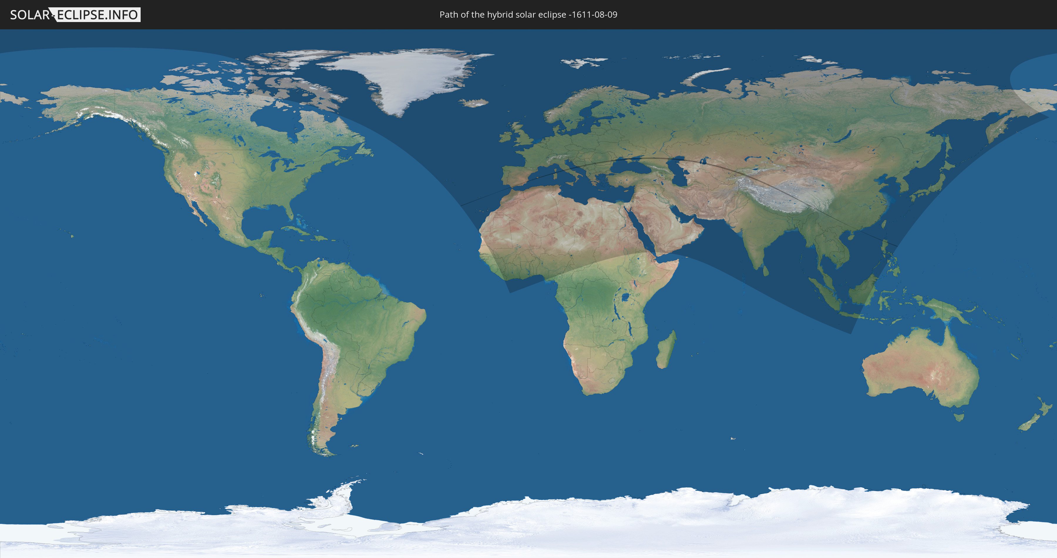
Die Sonnenfinsternis am 08/09/-1611 kann man in 127 Ländern als partielle Sonnenfinsternis beobachten.
Der Finsternispfad verläuft durch 16 Länder. Nur in diesen Ländern ist sie als hybrid Sonnenfinsternis zu sehen.
In den folgenden Ländern ist die Sonnenfinsternis hybrid zu sehen
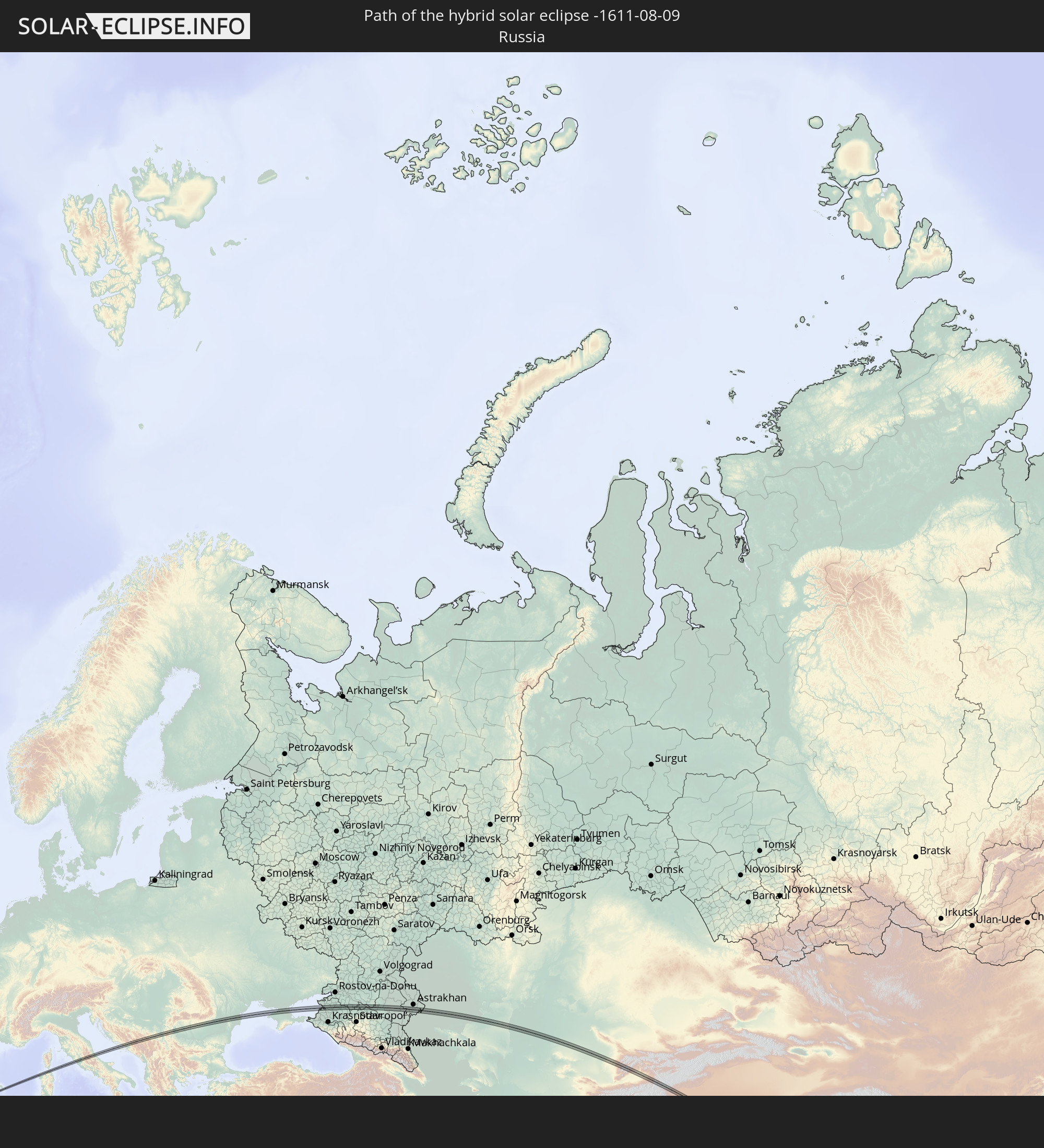 Russia
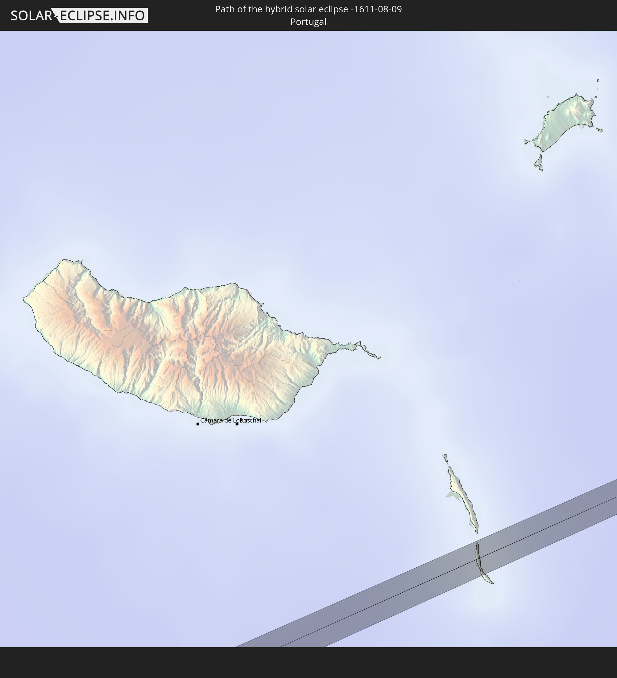 Portugal
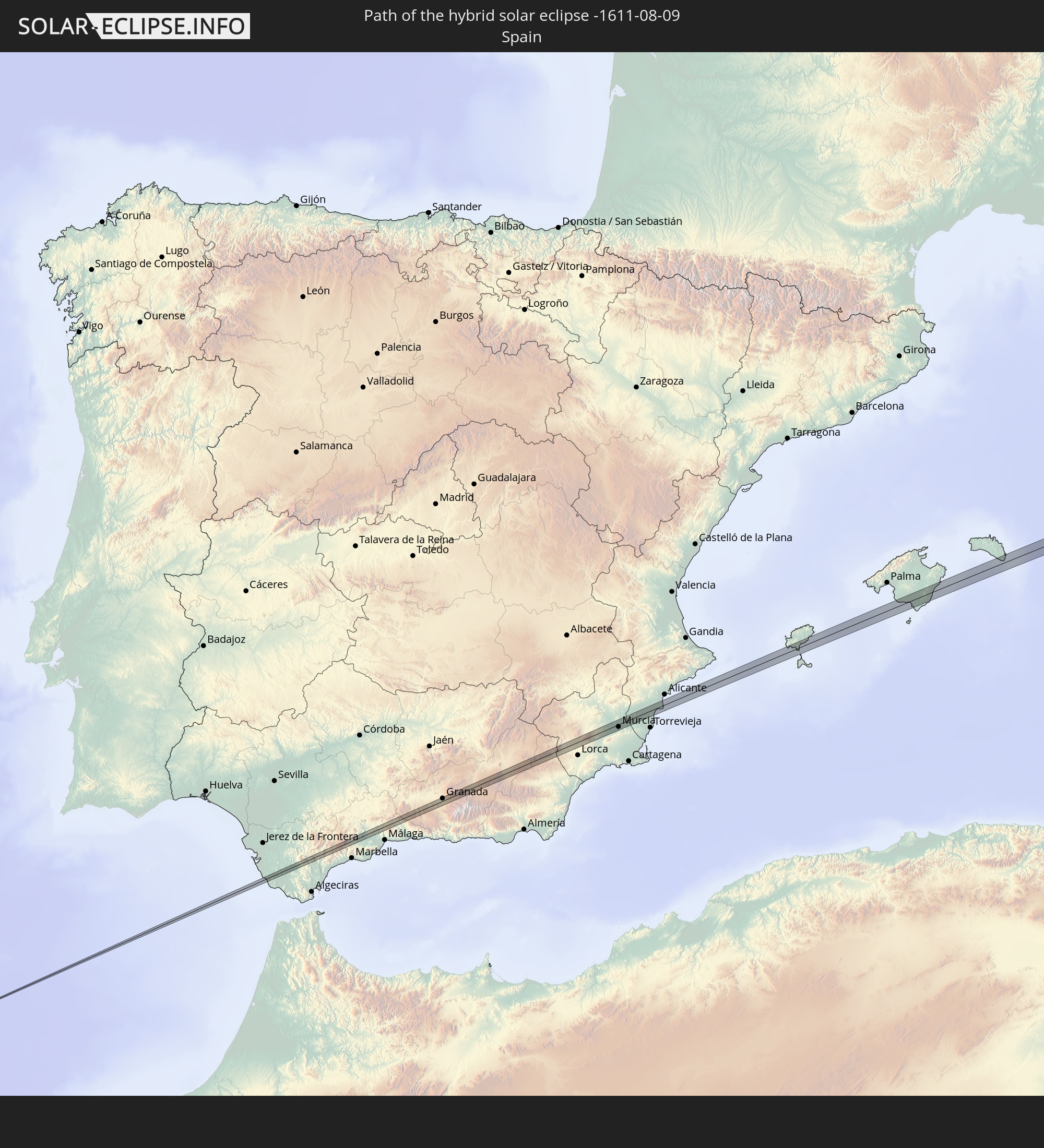 Spain
Spain
 France
 Italy
Italy
 Croatia
 Bosnia and Herzegovina
 Montenegro
 Serbia
 Romania
 Ukraine
 Kazakhstan
 Uzbekistan
 Kyrgyzstan
 China
China
 Philippines
In den folgenden Ländern ist die Sonnenfinsternis partiell zu sehen
 Russia
 Canada
 Greenland
 Portugal
 Iceland
 Spain
Spain
 Senegal
 Mauritania
 Guinea
 Morocco
 Mali
Mali
 Liberia
 Republic of Ireland
 Svalbard and Jan Mayen
 Algeria
 United Kingdom
 Ivory Coast
 Faroe Islands
 Burkina Faso
 Gibraltar
 France
 Isle of Man
 Ghana
Ghana
 Guernsey
 Jersey
 Togo
Togo
 Niger
Niger
 Benin
Benin
 Andorra
 Belgium
 Nigeria
 Netherlands
 Norway
 Luxembourg
 Germany
 Switzerland
 Italy
Italy
 Monaco
 Tunisia
 Denmark
 Cameroon
 Libya
Libya
 Liechtenstein
 Austria
 Sweden
 Czechia
 San Marino
 Vatican City
 Slovenia
 Chad
Chad
 Croatia
 Poland
 Malta
Malta
 Central African Republic
 Bosnia and Herzegovina
 Hungary
 Slovakia
 Montenegro
 Serbia
 Albania
 Åland Islands
 Greece
 Romania
 Republic of Macedonia
 Finland
 Lithuania
 Latvia
 Estonia
 Sudan
Sudan
 Ukraine
 Bulgaria
 Belarus
 Egypt
Egypt
 Turkey
 Moldova
 Cyprus
 Ethiopia
 State of Palestine
 Israel
 Saudi Arabia
 Jordan
 Lebanon
 Syria
Syria
 Eritrea
 Iraq
Iraq
 Georgia
 Yemen
Yemen
 Armenia
 Iran
Iran
 Azerbaijan
 Kazakhstan
 Kuwait
 Bahrain
 Qatar
Qatar
 United Arab Emirates
 Oman
Oman
 Turkmenistan
 Uzbekistan
 Afghanistan
 Pakistan
 Tajikistan
 India
India
 Kyrgyzstan
 Maldives
 China
China
 Sri Lanka
 Nepal
Nepal
 Mongolia
 Bangladesh
 Bhutan
 Myanmar
 Indonesia
 Thailand
 Malaysia
 Laos
Laos
 Vietnam
 Cambodia
 Singapore
 Christmas Island
 Macau
Macau
 Hong Kong
 Brunei
 Taiwan
 Philippines
 Japan
Japan
 North Korea
 South Korea
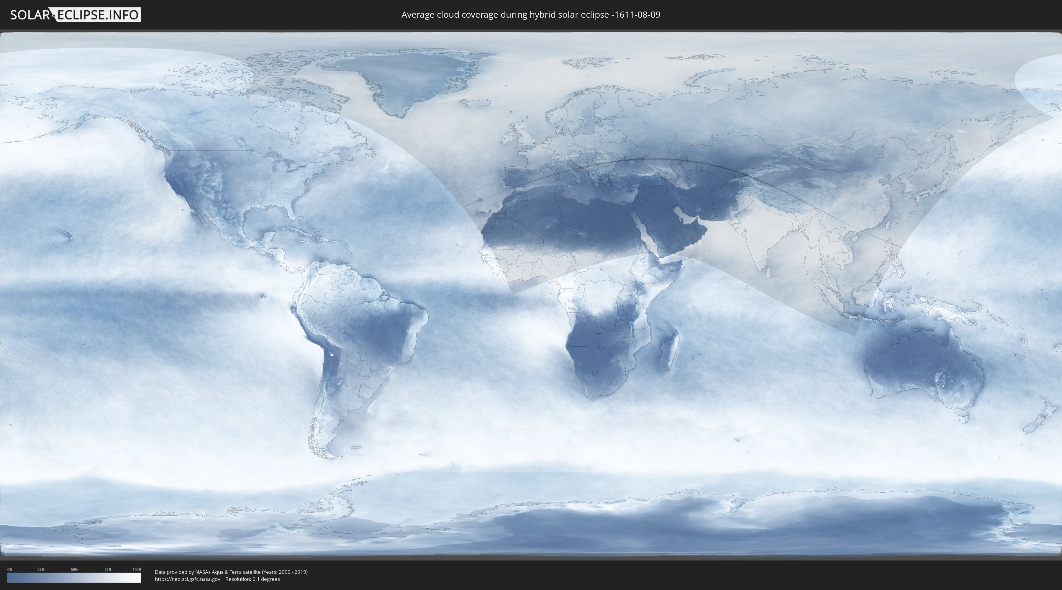
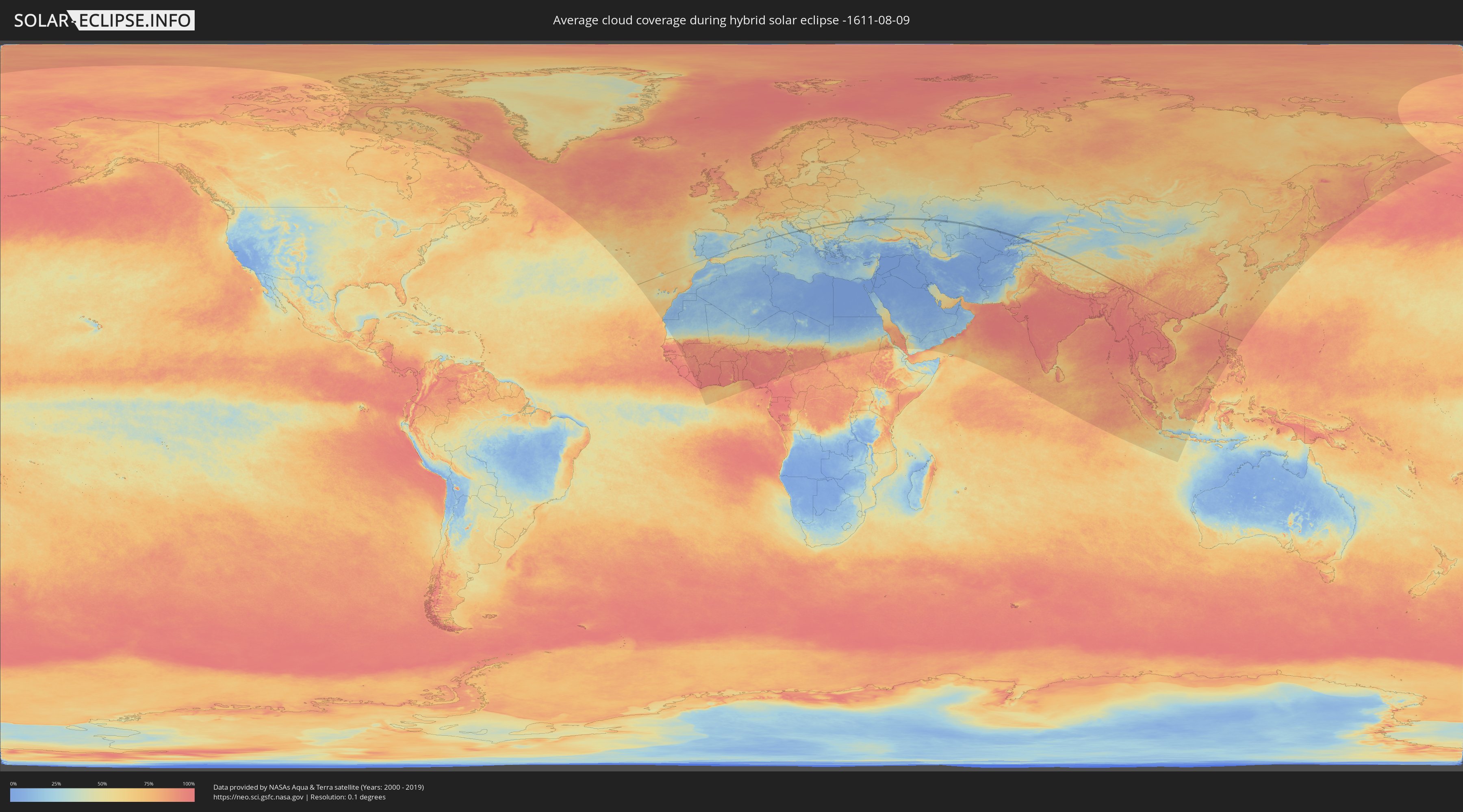
How will be the weather during the hybrid solar eclipse on 08/09/-1611?
Where is the best place to see the hybrid solar eclipse of 08/09/-1611?
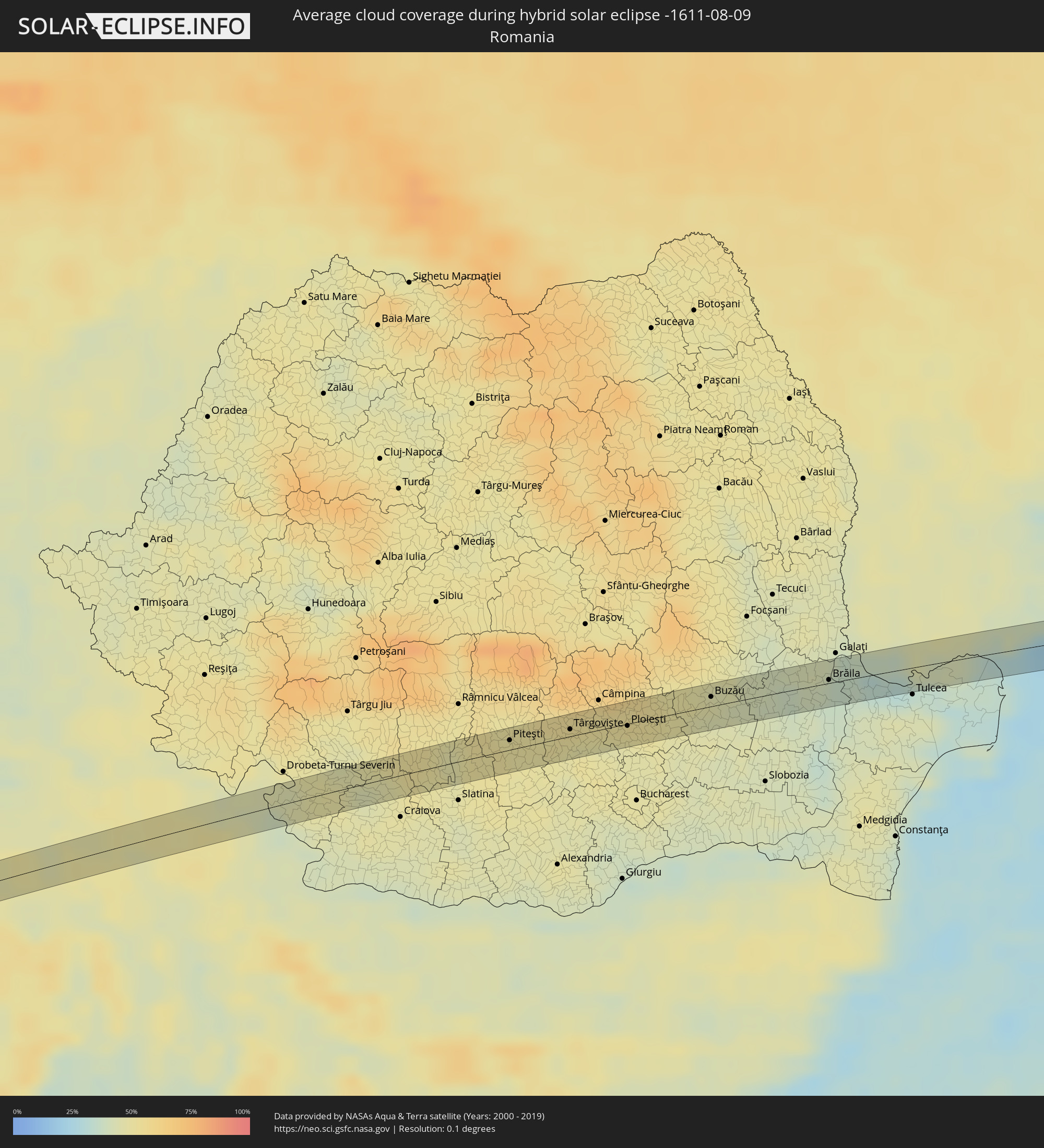
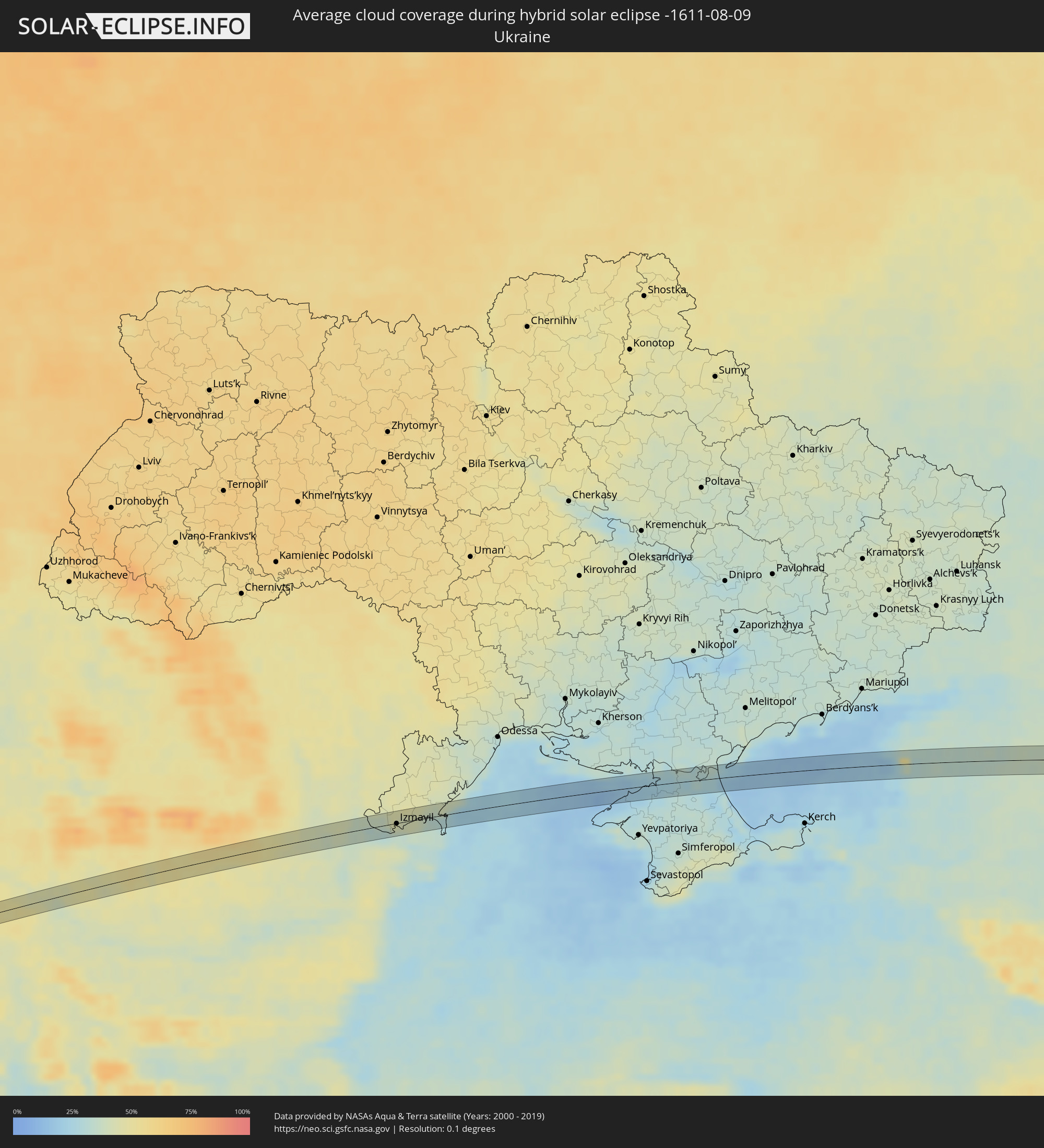
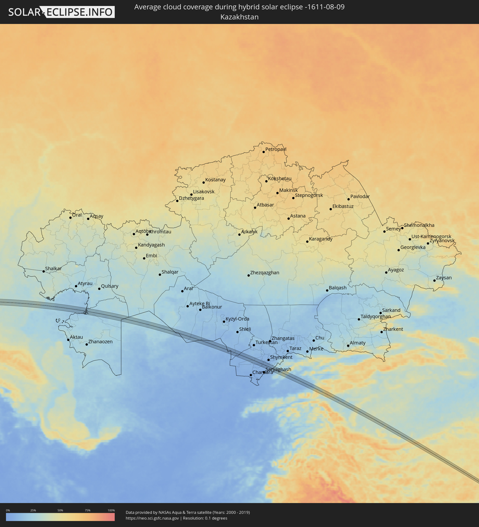
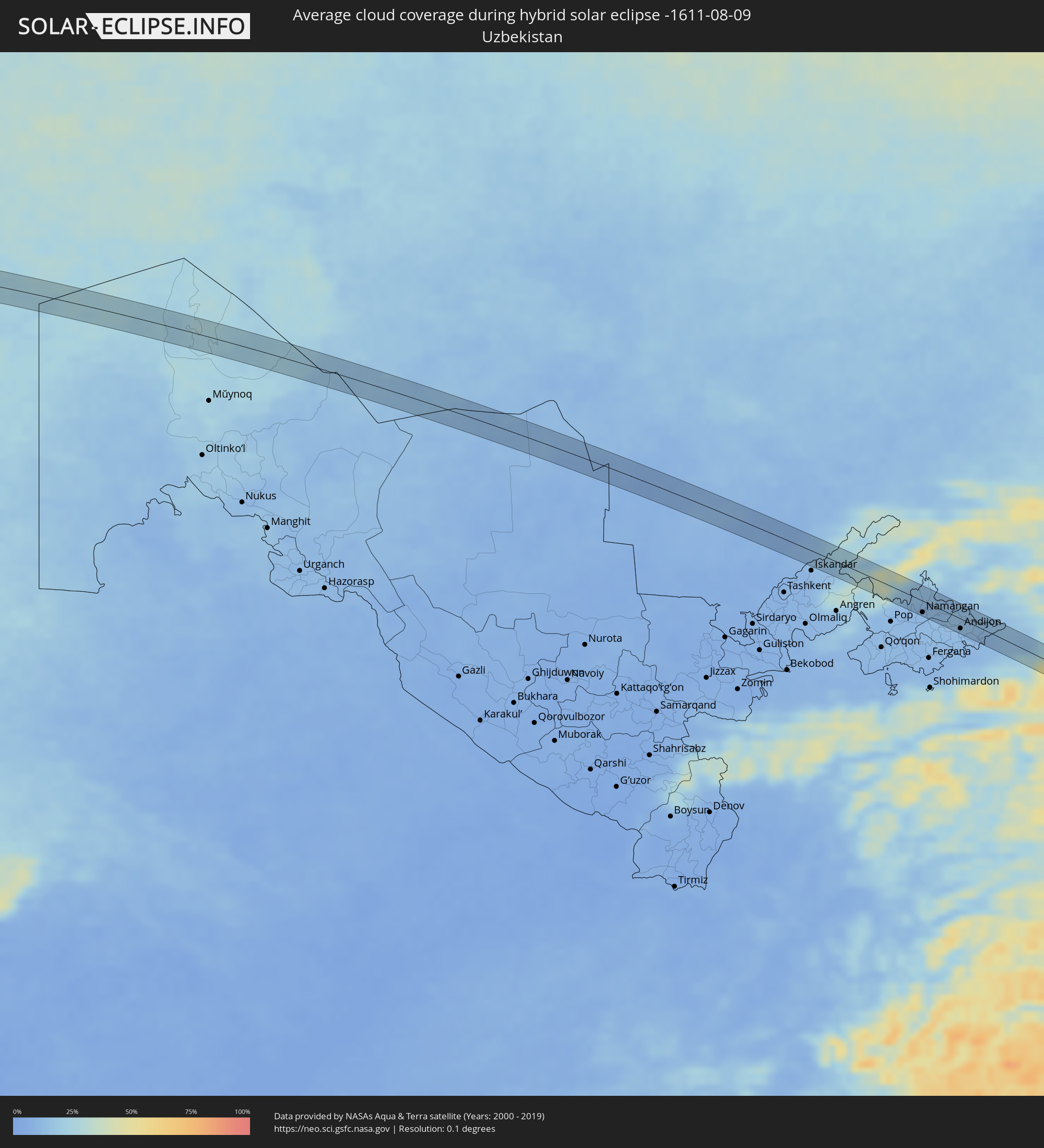
The following maps show the average cloud coverage for the day of the hybrid solar eclipse.
With the help of these maps, it is possible to find the place along the eclipse path, which has the best
chance of a cloudless sky.
Nevertheless, you should consider local circumstances and inform about the weather of your chosen
observation site.
The data is provided by NASAs satellites
AQUA and TERRA.
The cloud maps are averaged over a period of 19 years (2000 - 2019).
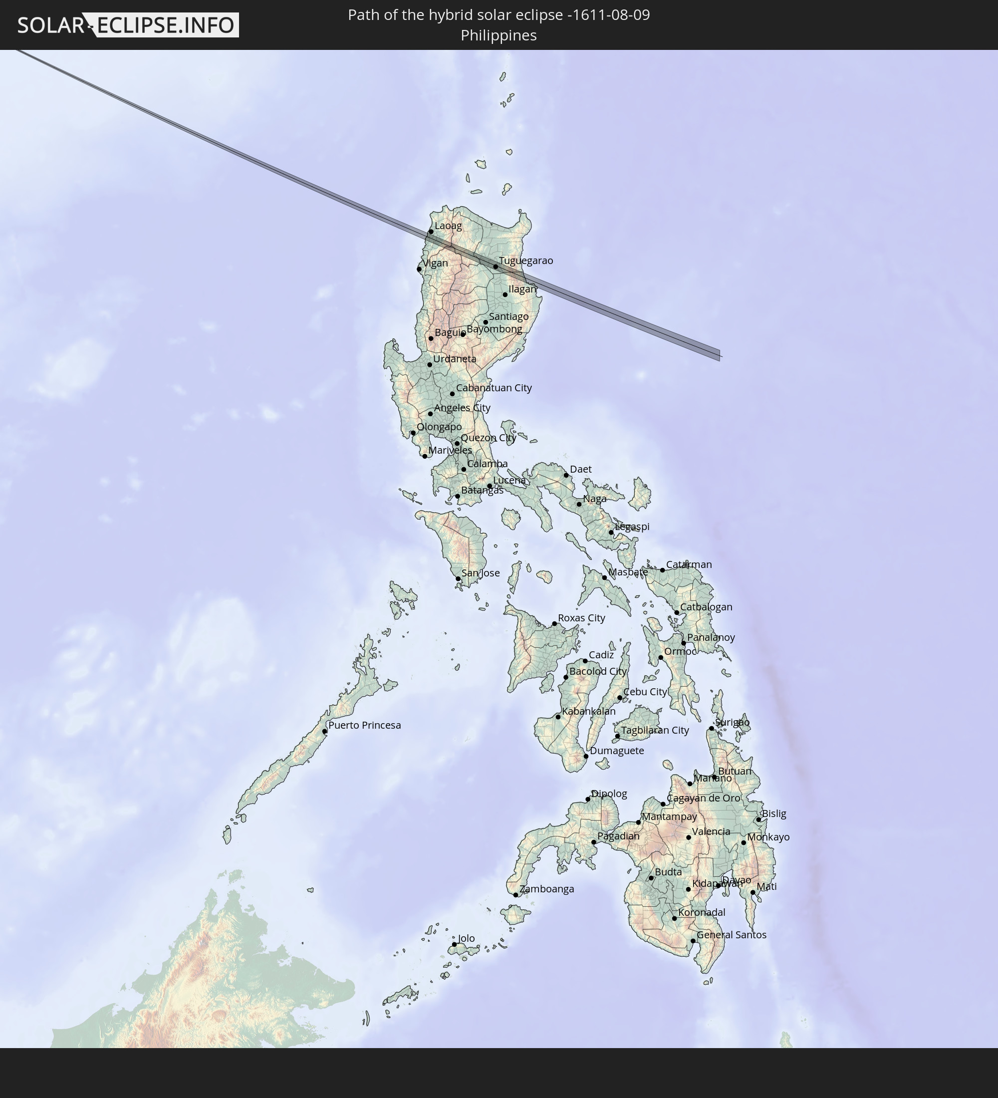
Detailed country maps
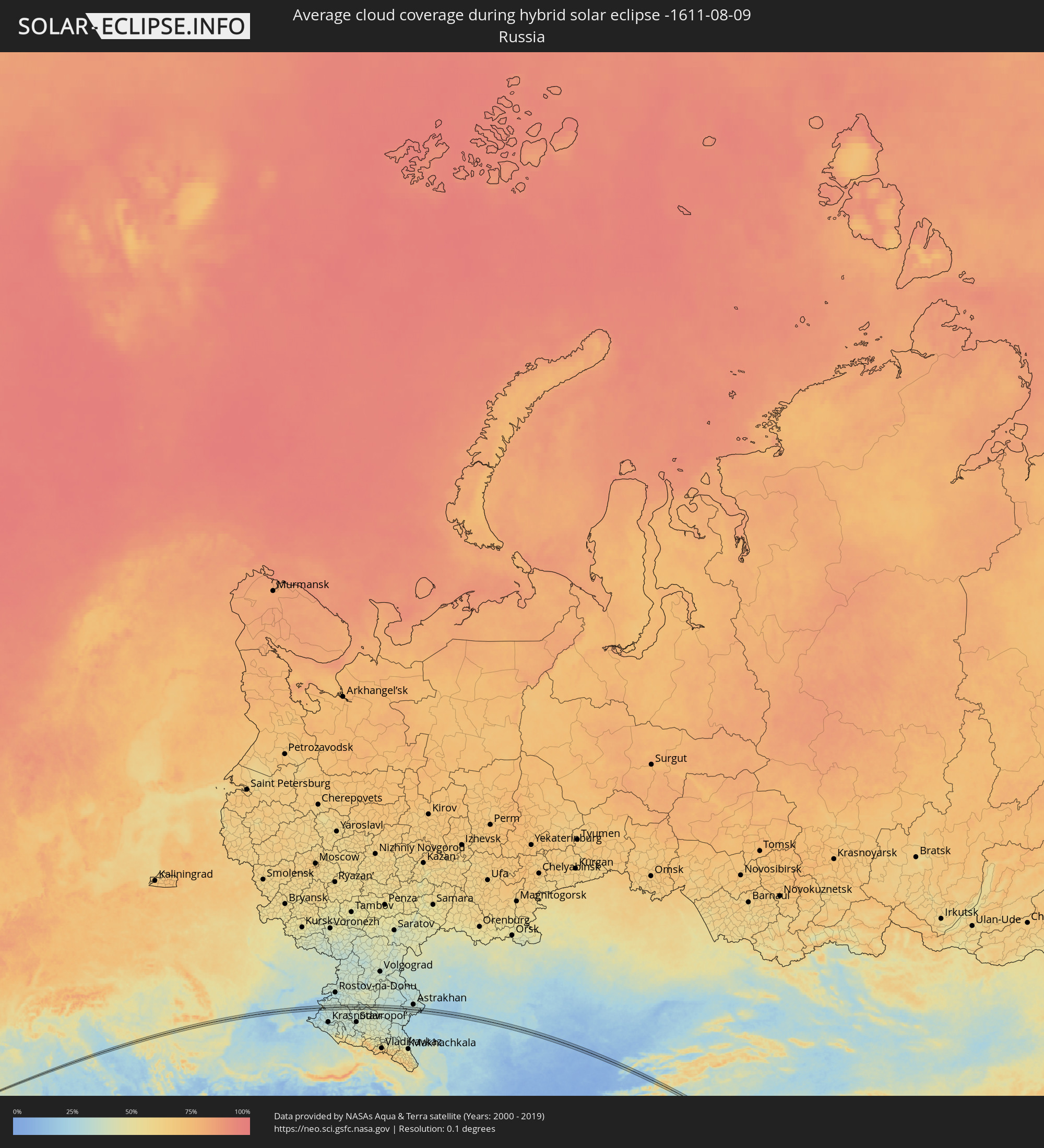 Russia
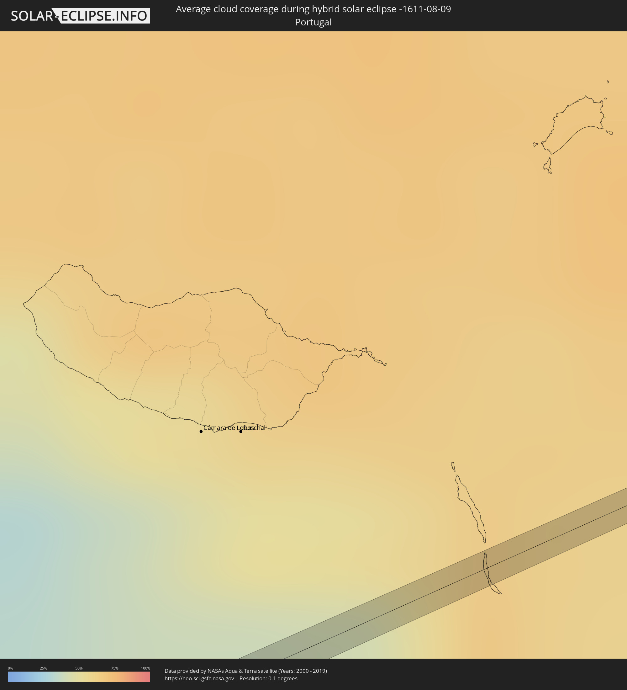 Portugal
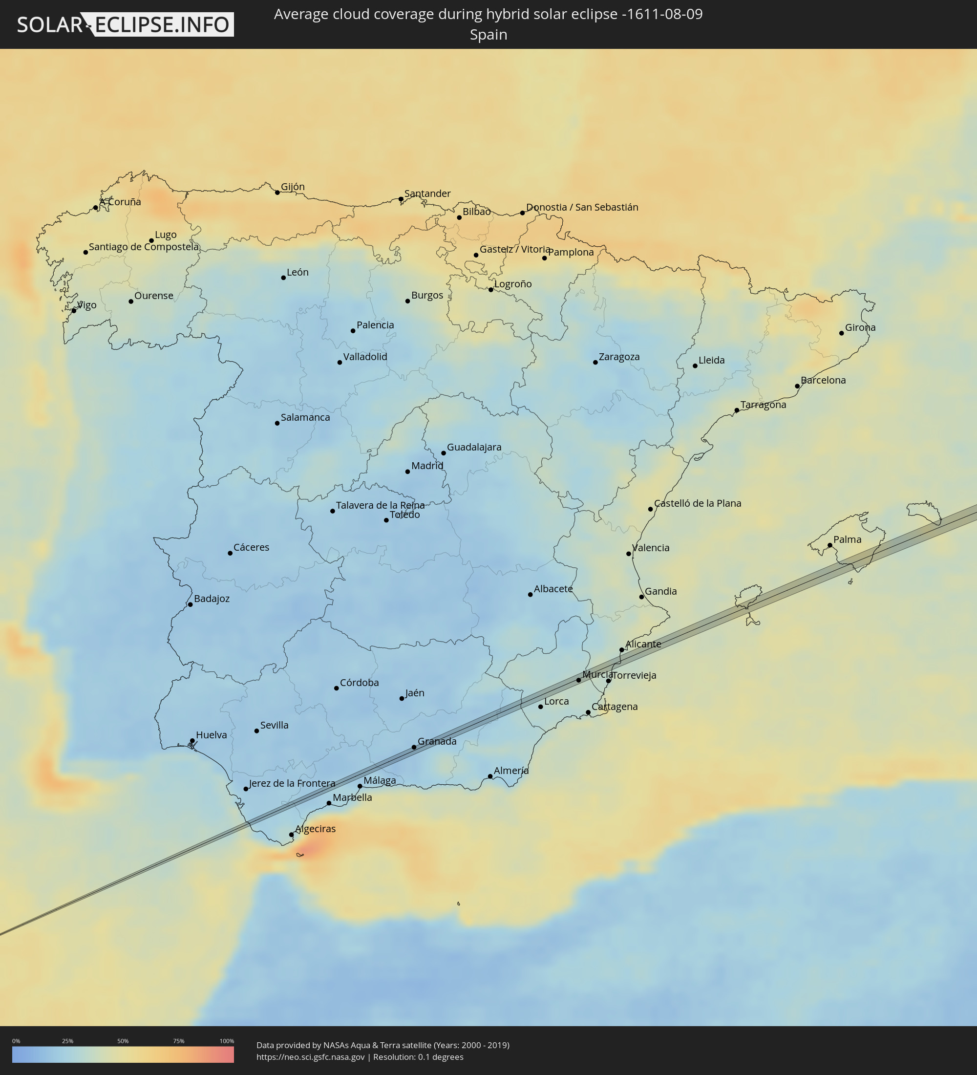 Spain
Spain
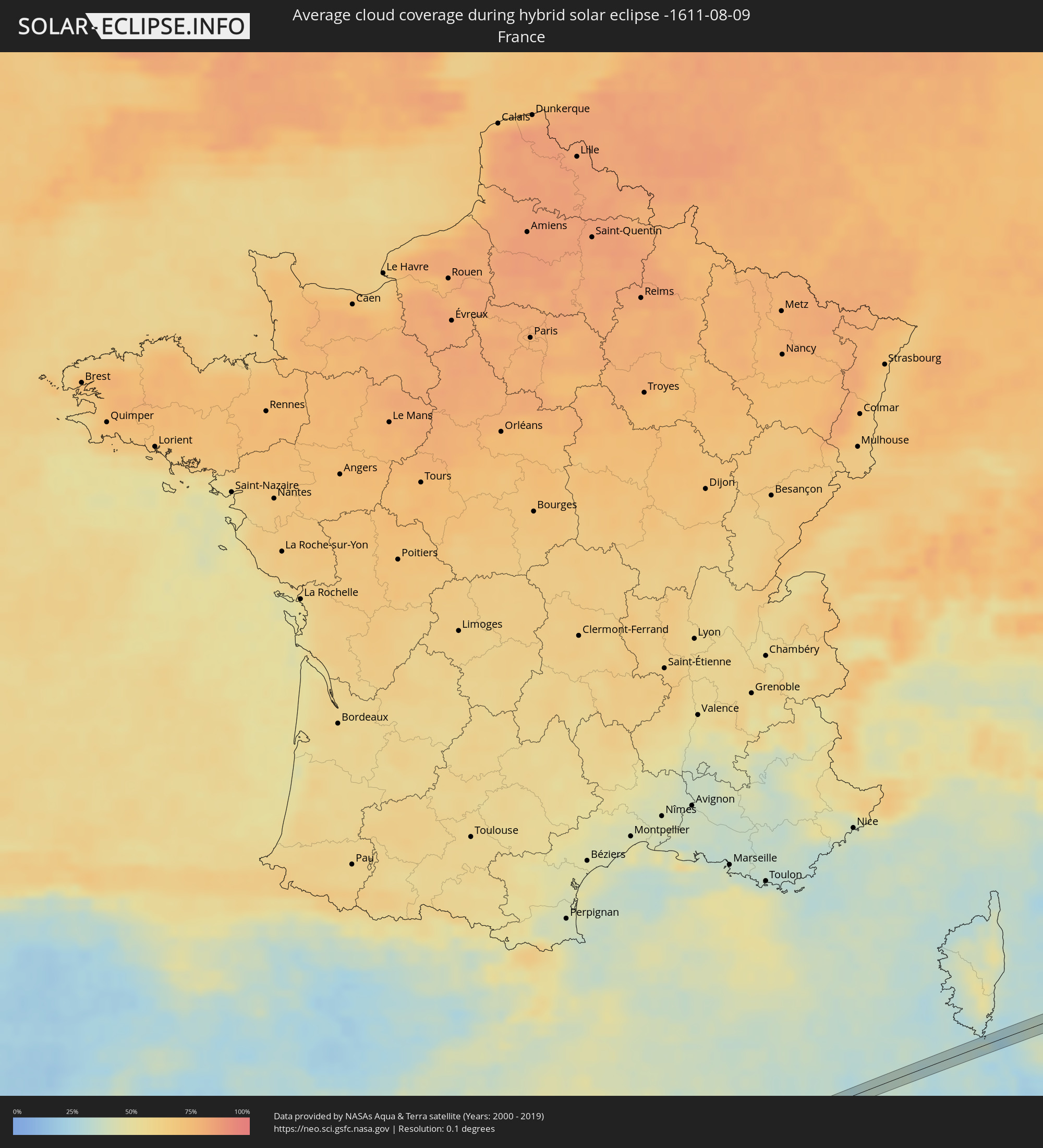 France
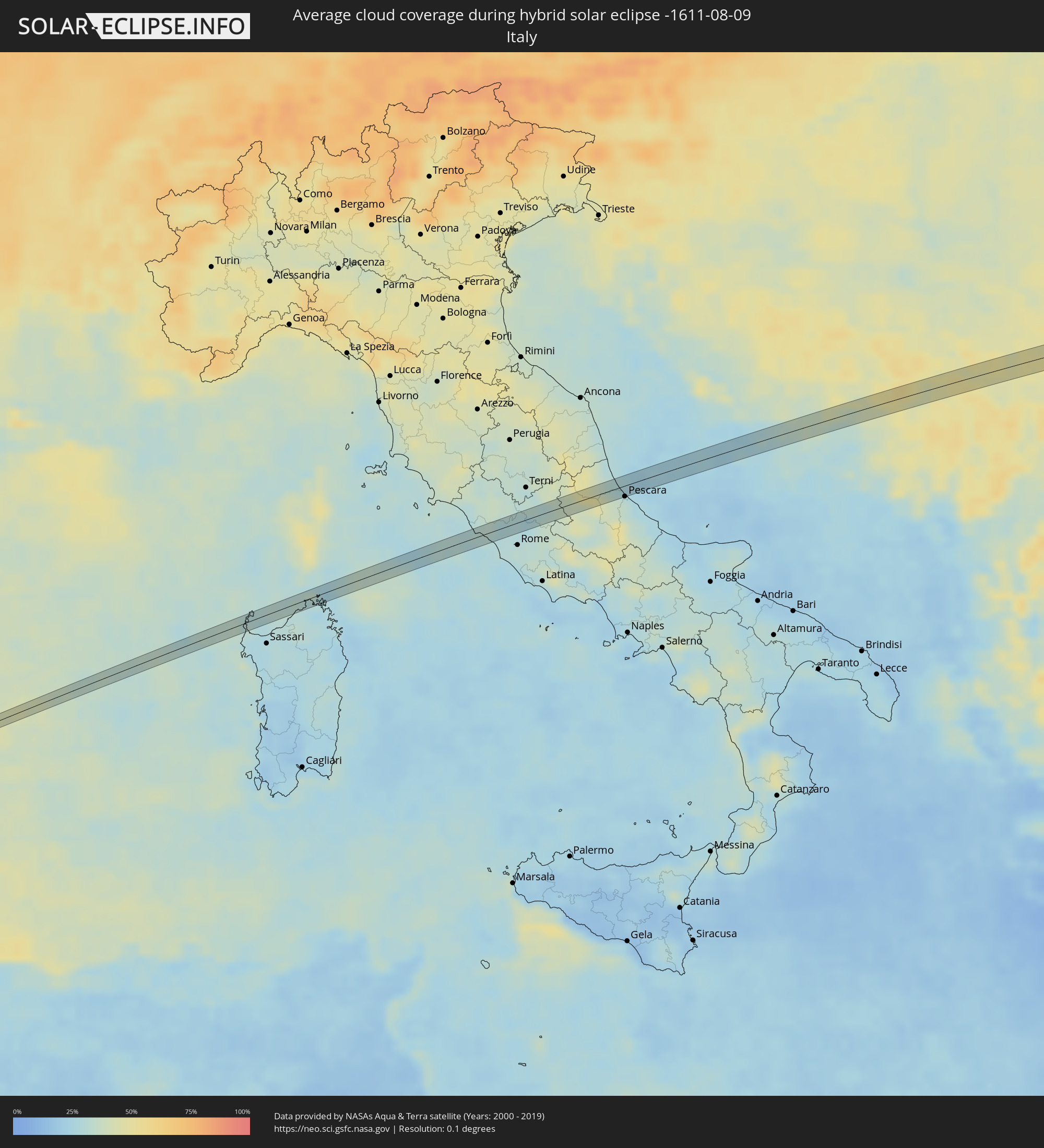 Italy
Italy
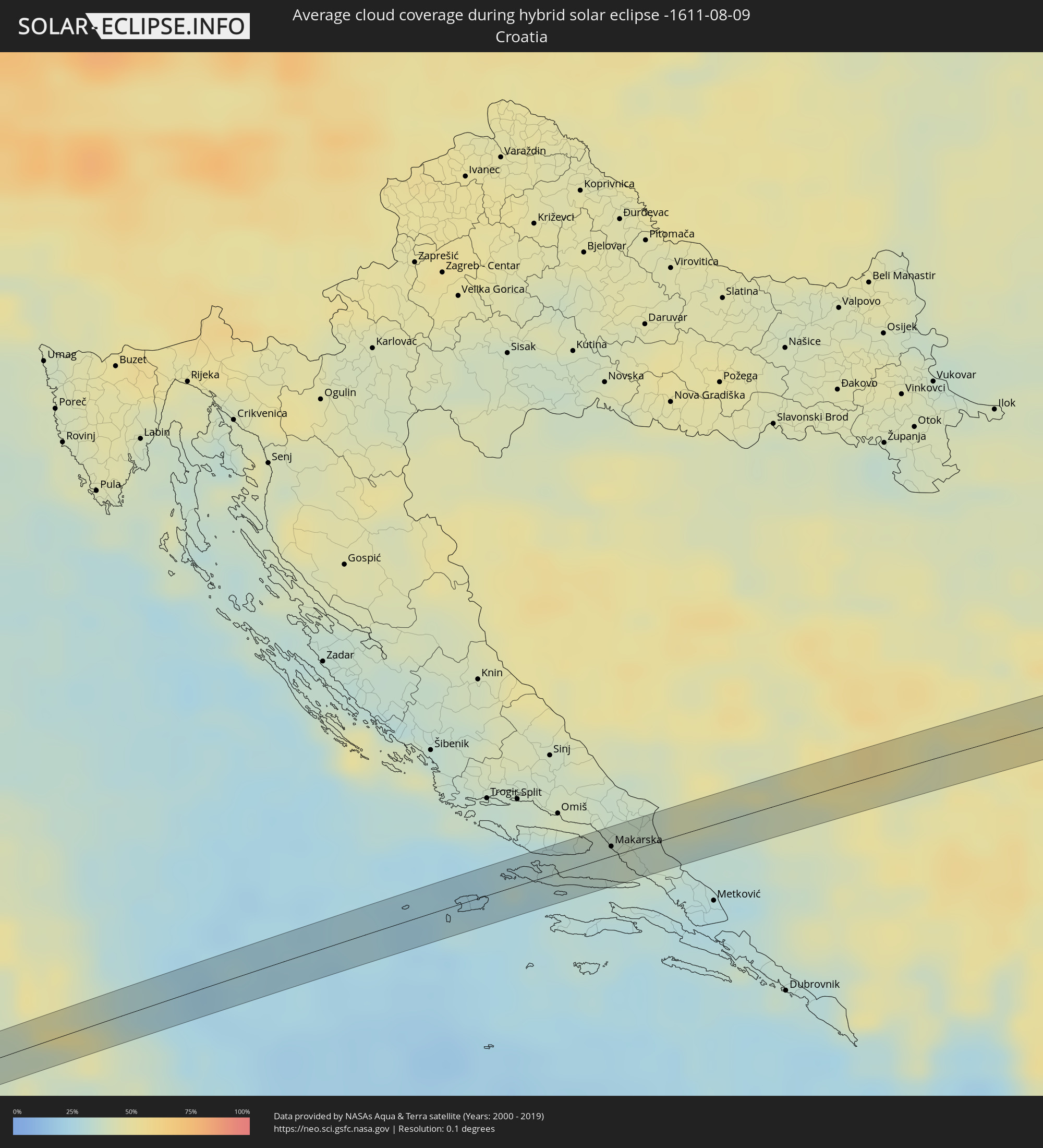 Croatia
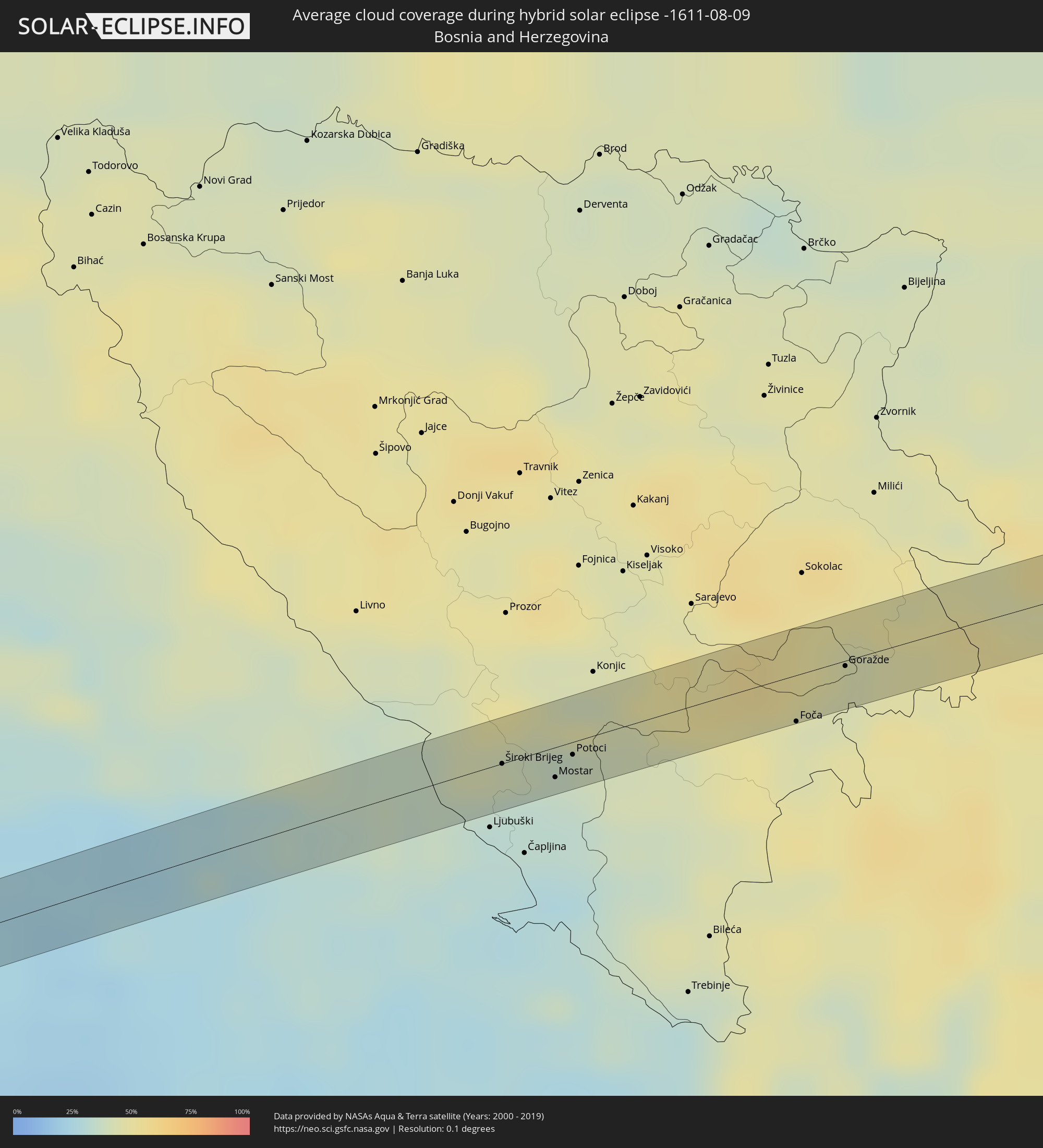 Bosnia and Herzegovina
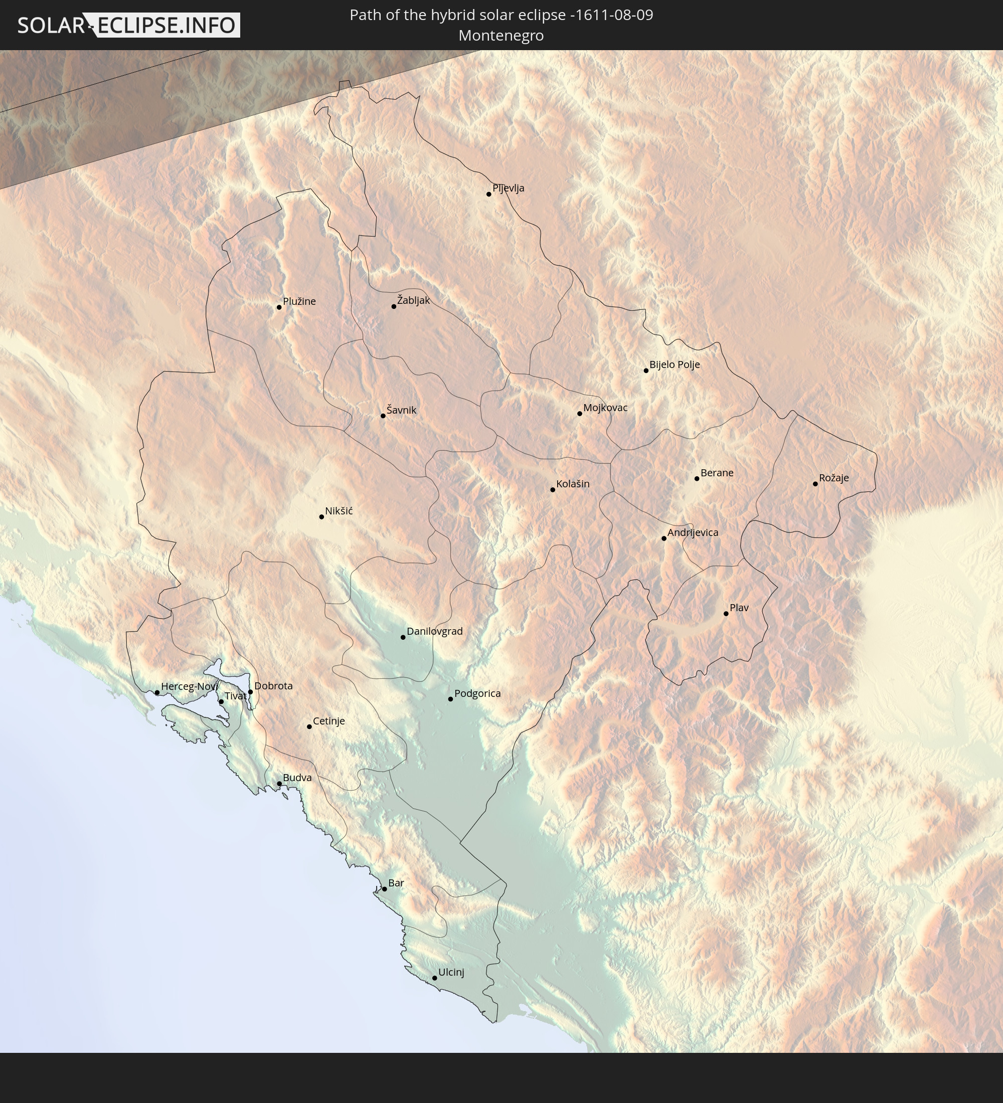
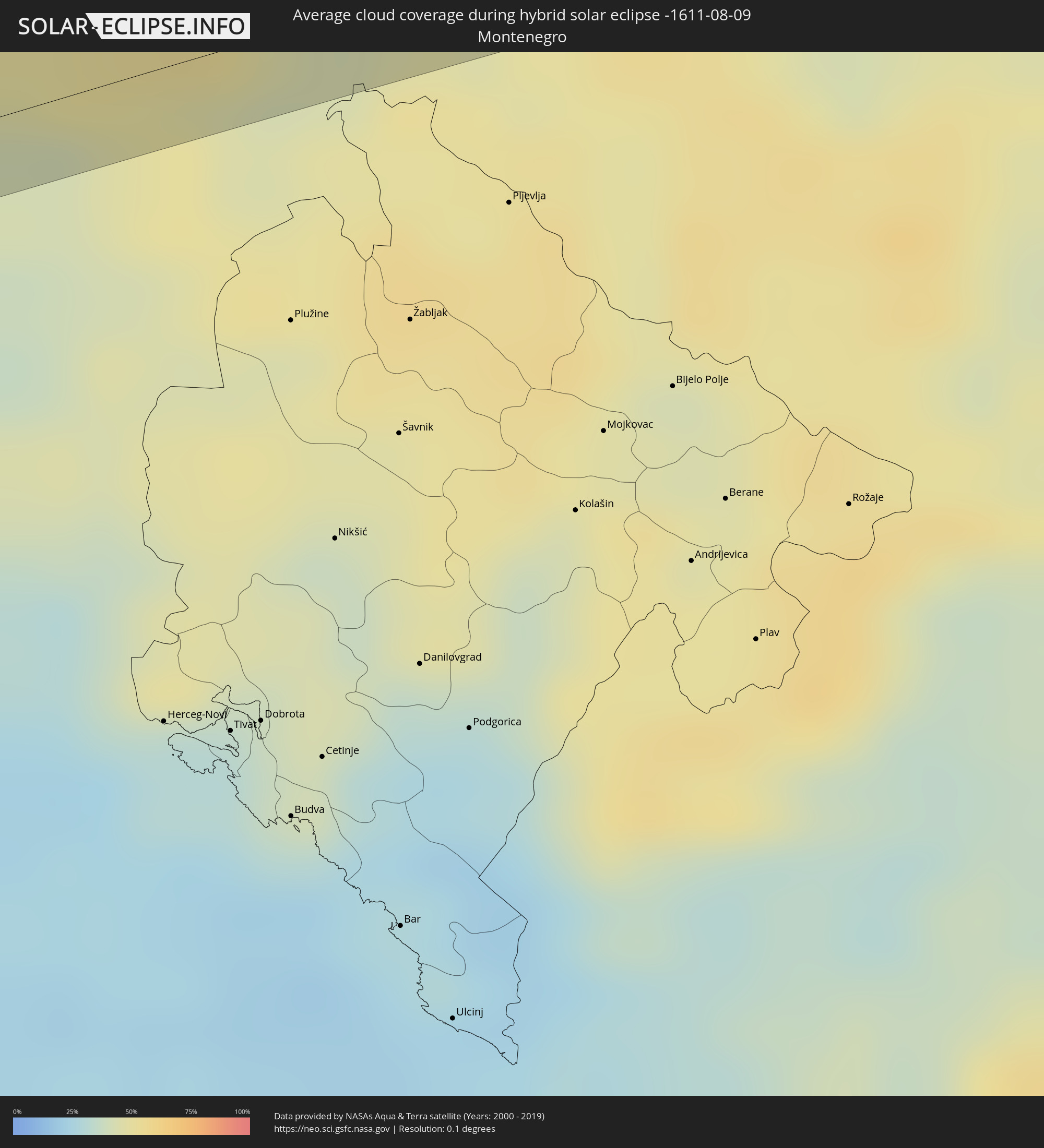 Montenegro
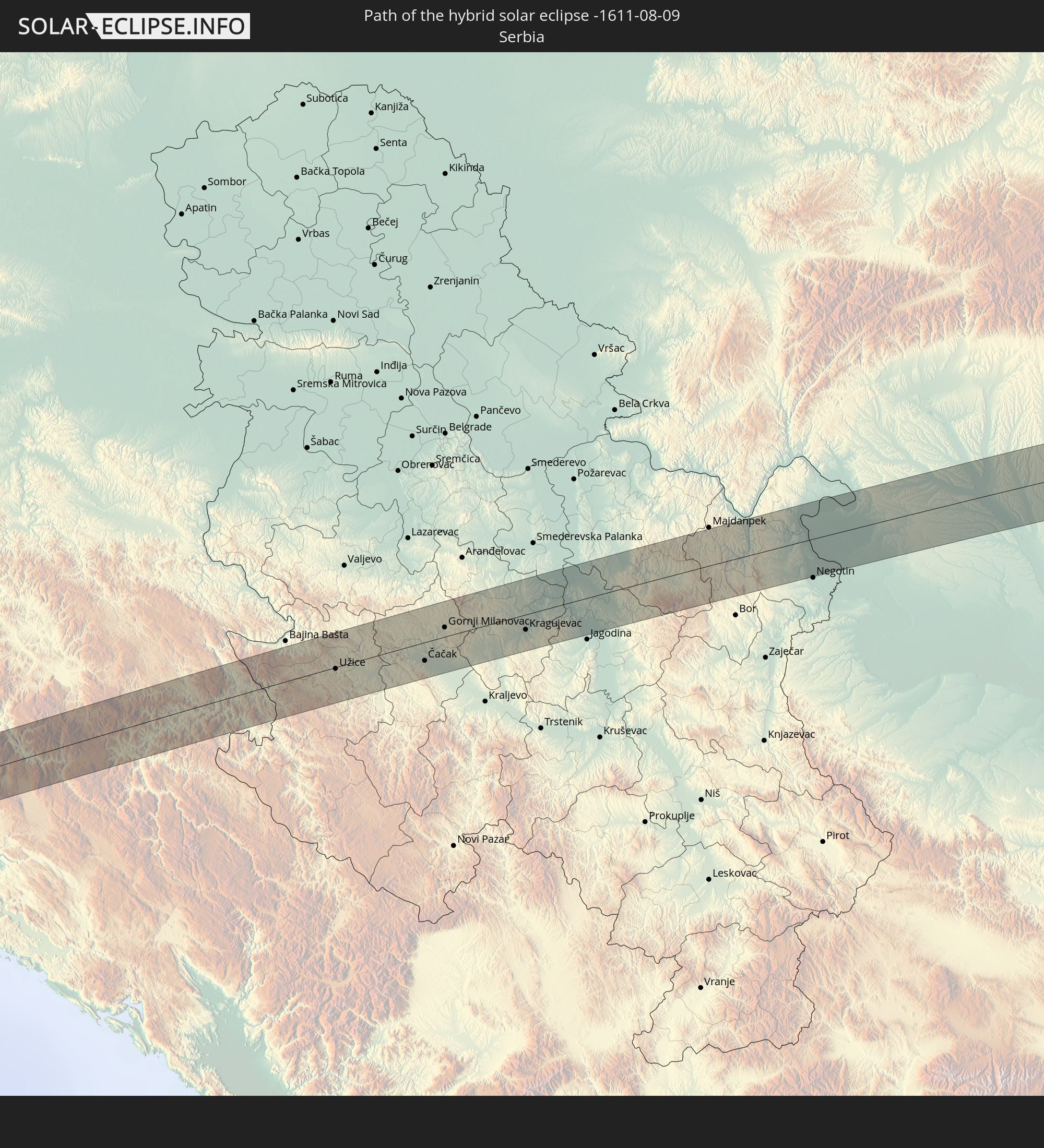
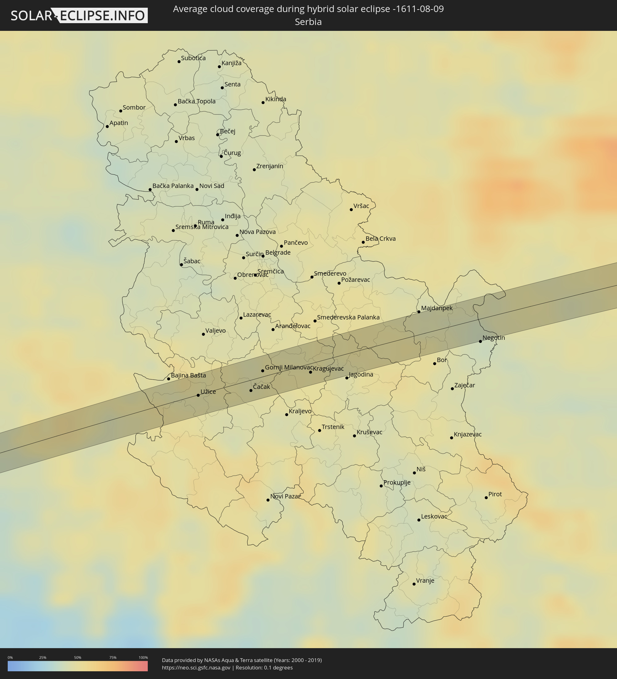 Serbia
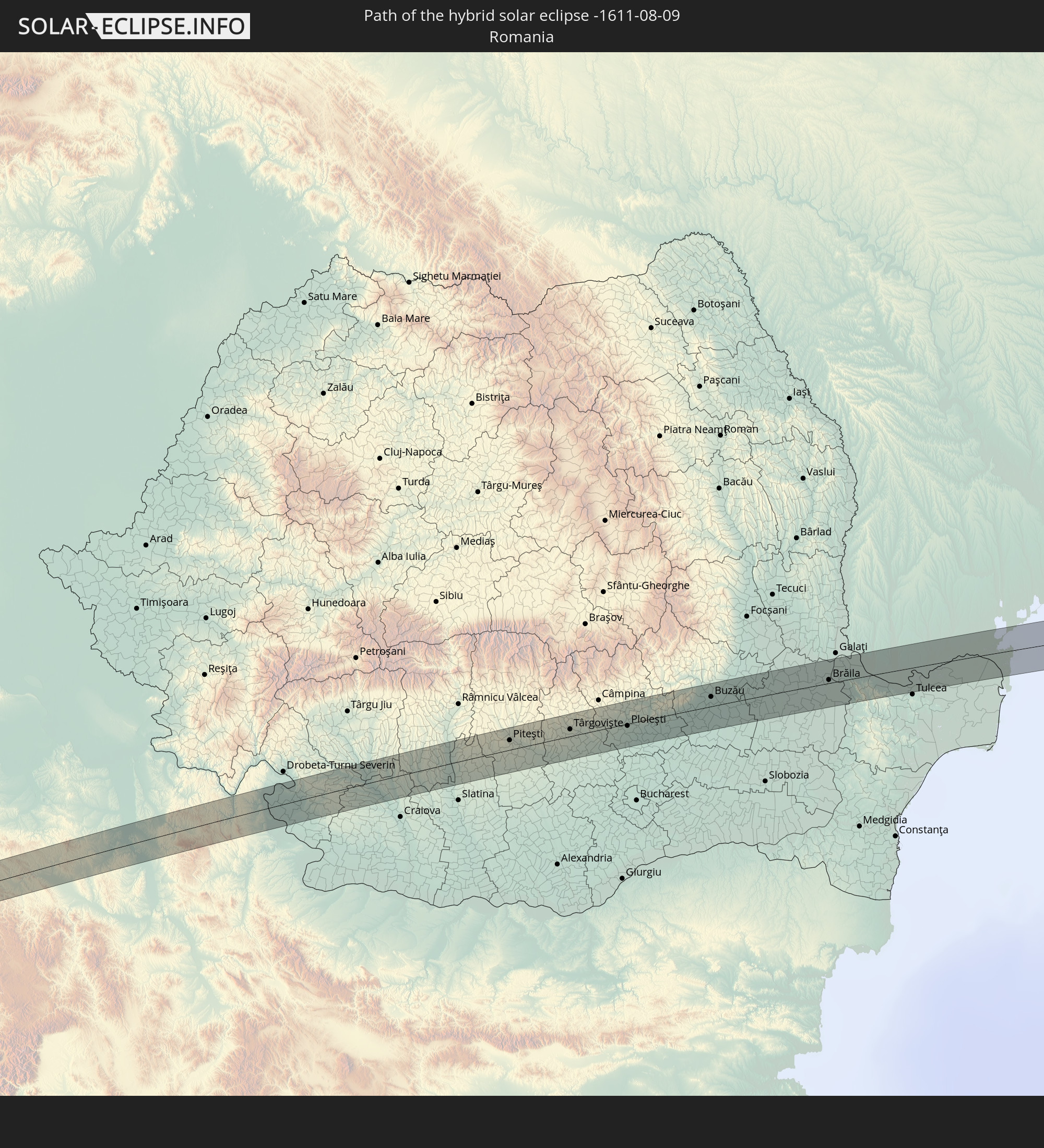
 Romania
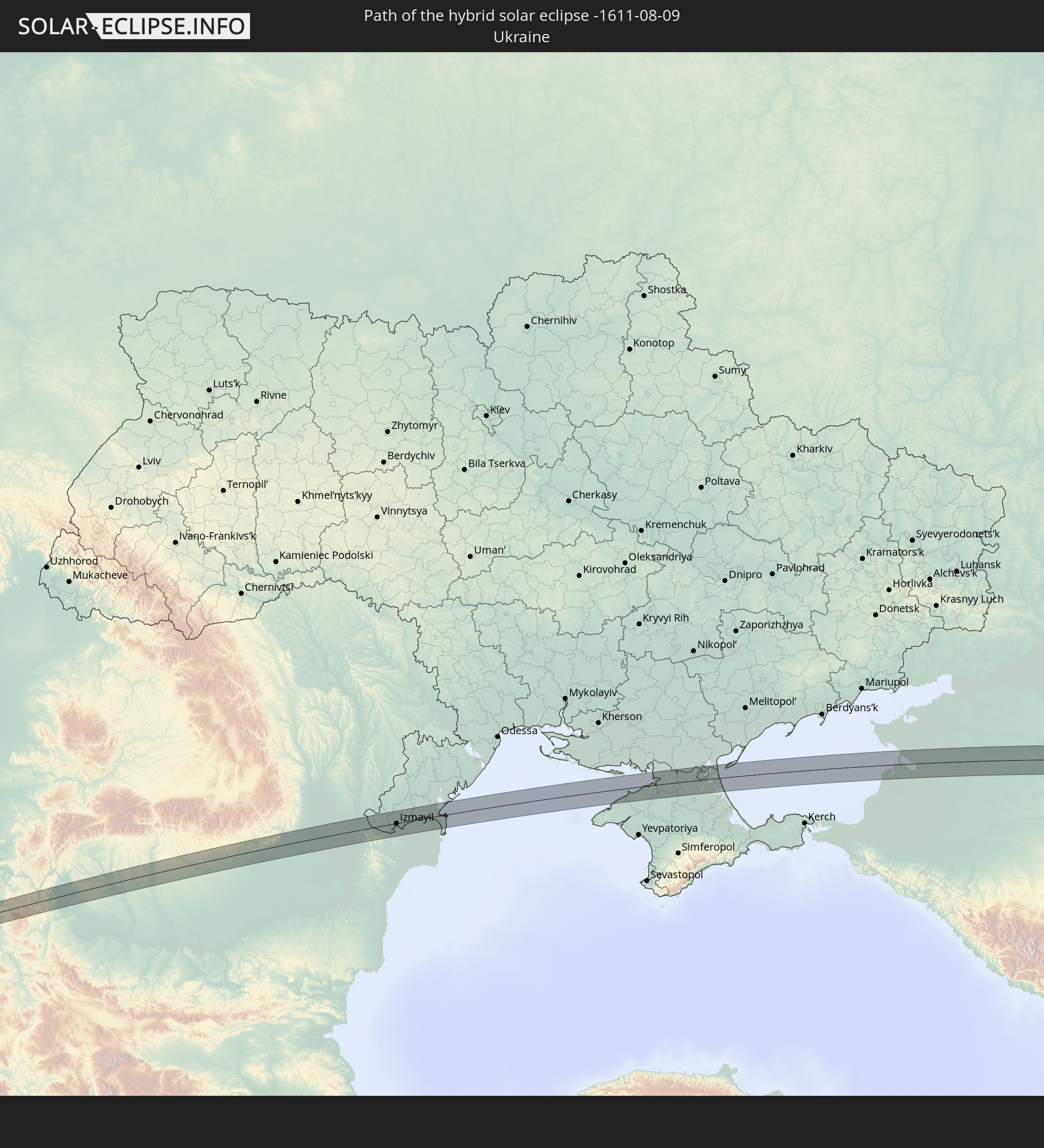
 Ukraine
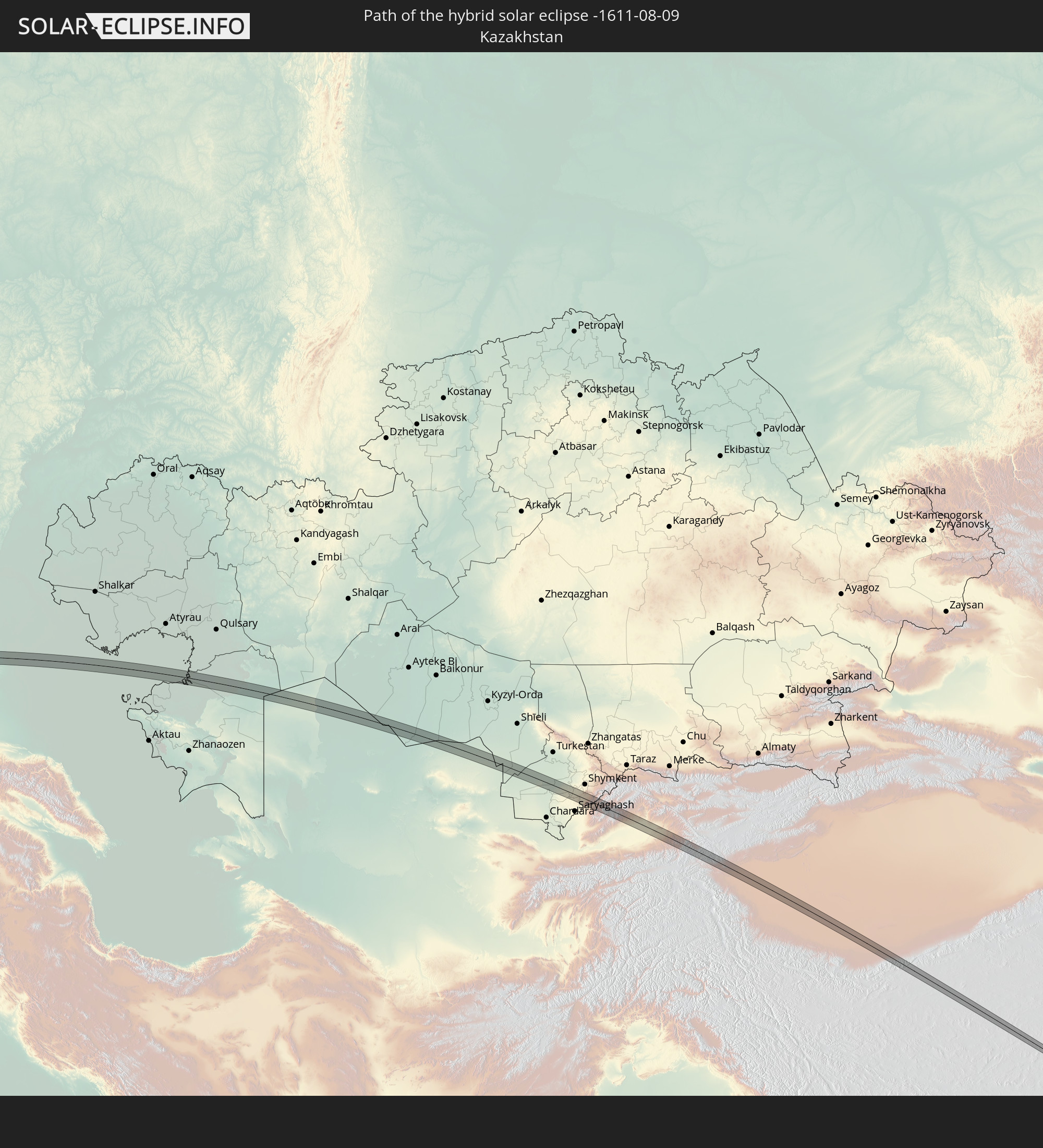
 Kazakhstan
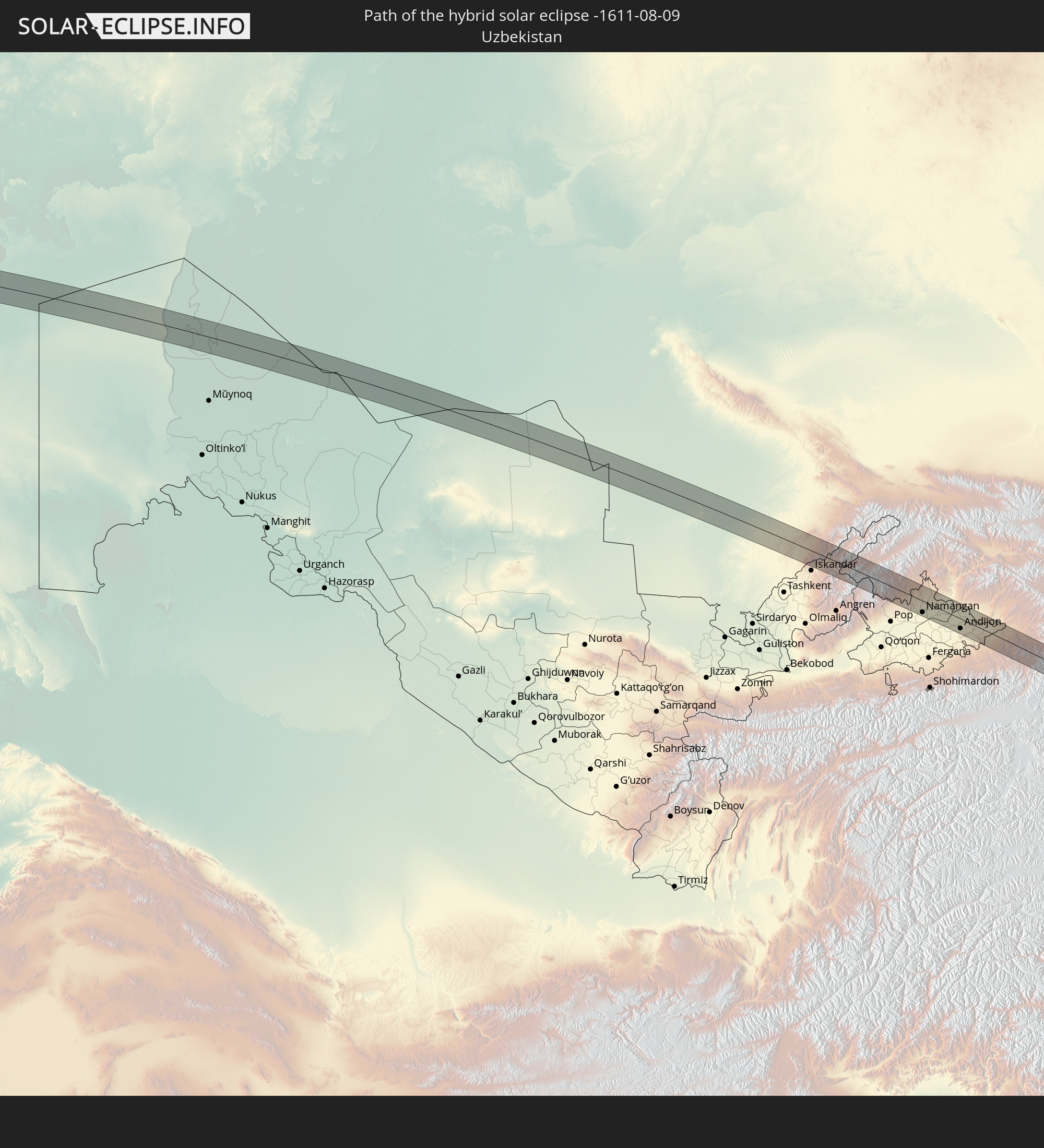
 Uzbekistan
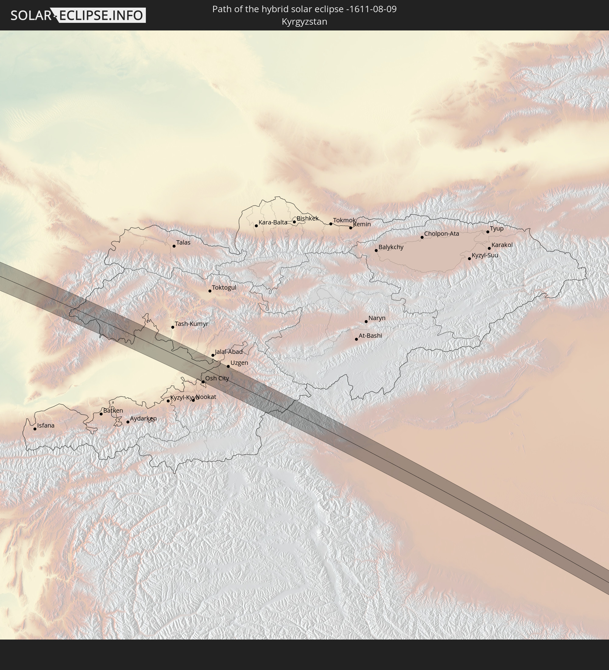
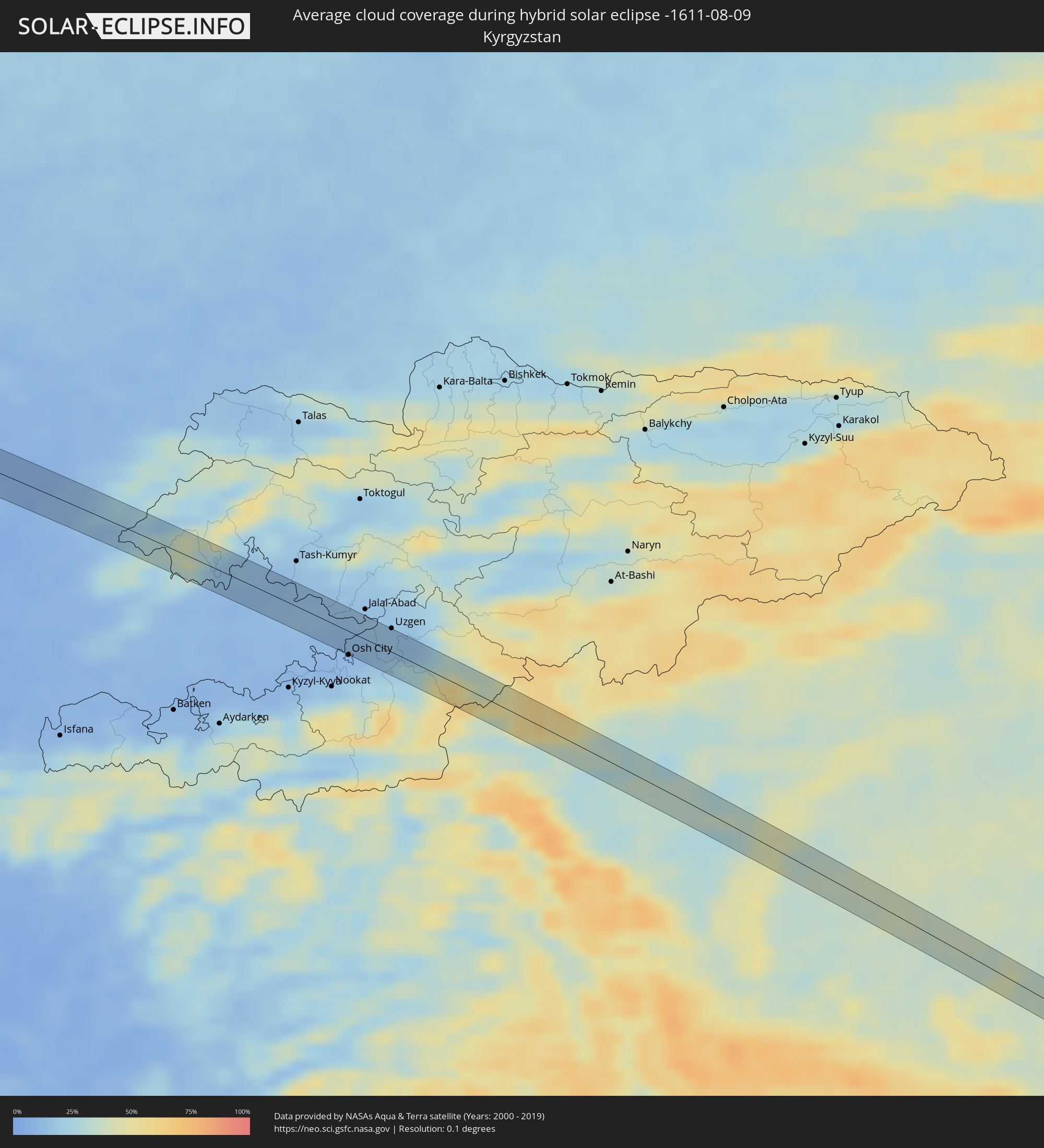 Kyrgyzstan
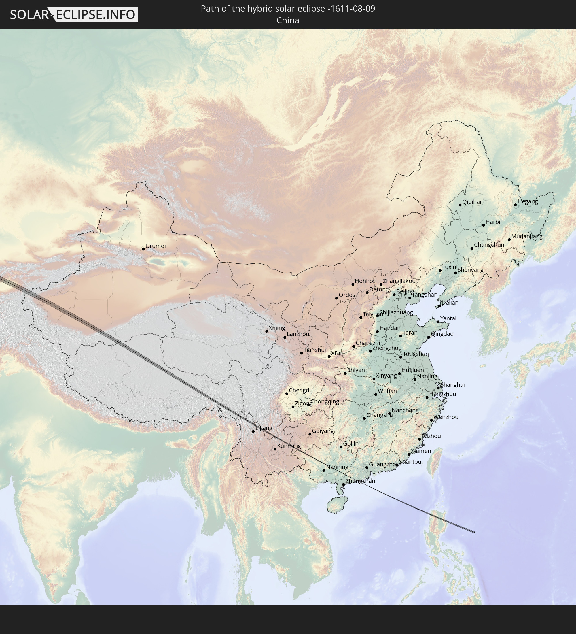
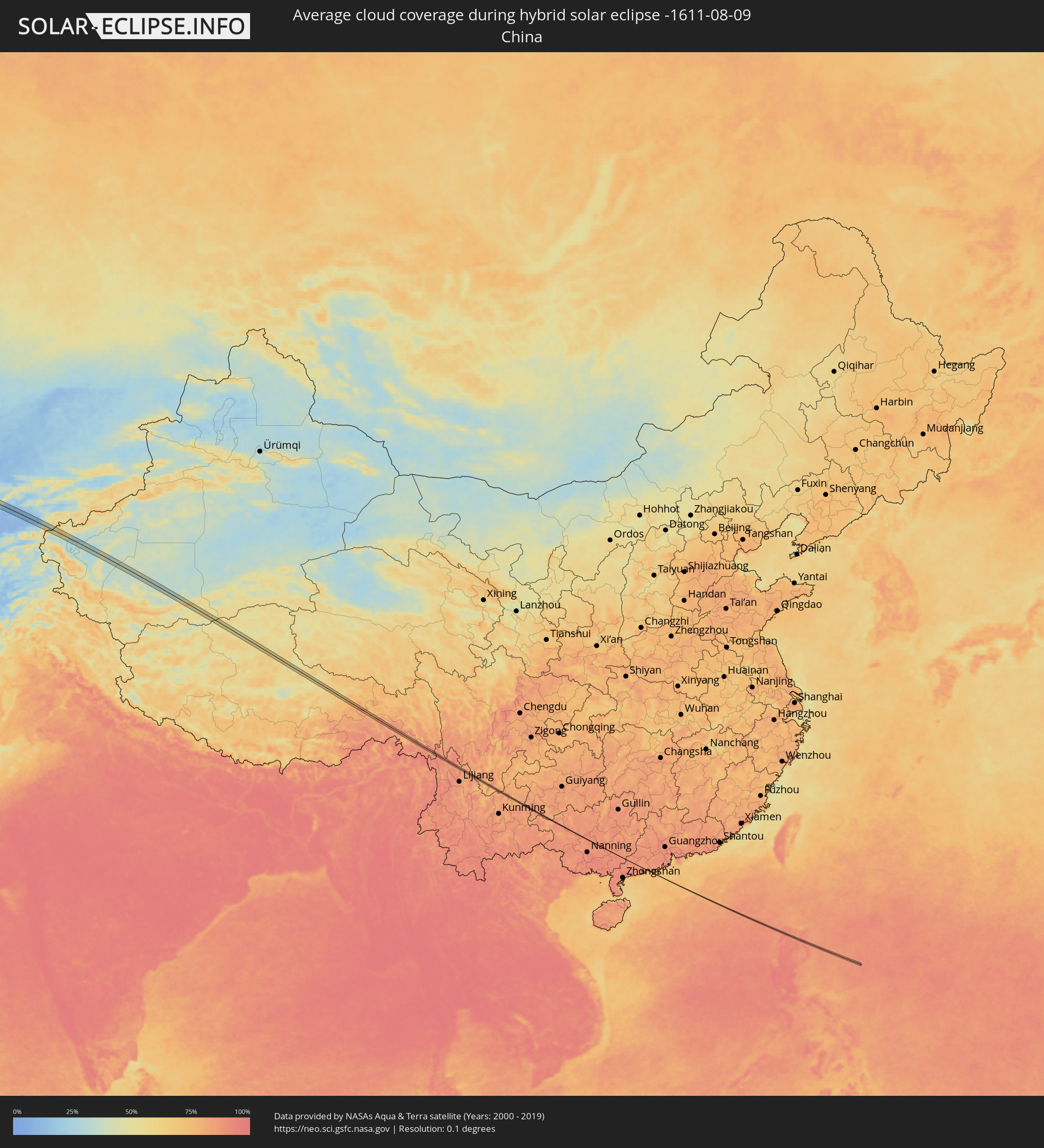 China
China
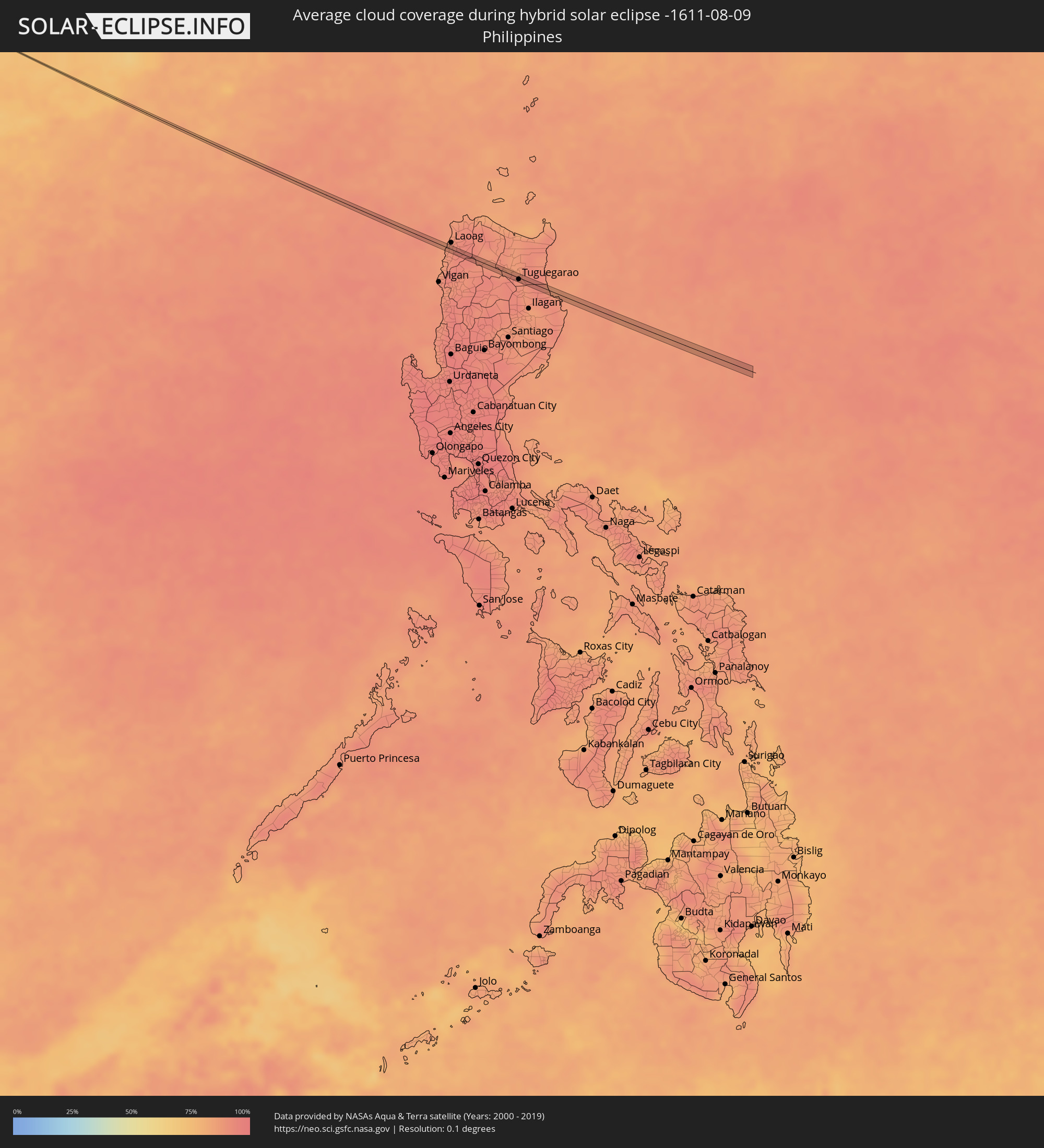 Philippines
Cities inside the path of the eclipse
The following table shows all locations with a population of more than 5,000 inside the eclipse path. Cities which have more than 100,000 inhabitants are marked bold. A click at the locations opens a detailed map.
| City | Type | Eclipse duration | Local time of max. eclipse | Distance to central line | Ø Cloud coverage |
|
Conil de la Frontera, Andalusia
|
total | - | 06:51:24 UTC+00:00 | 1 km | 35% |
|
Pizarra, Andalusia
|
total | - | 06:52:15 UTC+00:00 | 1 km | 26% |
|
Granada, Andalusia
|
total | - | 06:53:01 UTC+00:00 | 3 km | 18% |
|
Guadix, Andalusia
|
total | - | 06:53:17 UTC+00:00 | 2 km | 24% |
|
Baza, Andalusia
|
total | - | 06:53:37 UTC+00:00 | 4 km | 22% |
|
Velez Rubio, Andalusia
|
total | - | 06:54:01 UTC+00:00 | 4 km | 27% |
|
Murcia, Murcia
|
total | - | 06:54:44 UTC+00:00 | 3 km | 35% |
|
Beniel, Murcia
|
total | - | 06:54:51 UTC+00:00 | 1 km | 33% |
|
Orihuela, Valencia
|
total | - | 06:54:55 UTC+00:00 | 1 km | 34% |
|
Redován, Valencia
|
total | - | 06:54:58 UTC+00:00 | 3 km | 34% |
|
Dolores, Valencia
|
total | - | 06:55:03 UTC+00:00 | 0 km | 34% |
|
Santa Pola, Valencia
|
total | - | 06:55:11 UTC+00:00 | 1 km | 39% |
|
Ibiza, Balearic Islands
|
total | - | 06:56:53 UTC+00:00 | 4 km | 45% |
|
Campos, Balearic Islands
|
total | - | 06:58:17 UTC+00:00 | 5 km | 40% |
|
Felanitx, Balearic Islands
|
total | - | 06:58:24 UTC+00:00 | 5 km | 42% |
|
Porto Cristo, Balearic Islands
|
total | - | 06:58:34 UTC+00:00 | 6 km | 42% |
|
La Maddalena, Sardinia
|
total | - | 08:04:29 UTC+01:00 | 10 km | 24% |
|
Santa Marinella, Latium
|
total | - | 08:07:26 UTC+01:00 | 6 km | 30% |
|
Marina di Cerveteri, Latium
|
total | - | 08:07:32 UTC+01:00 | 6 km | 30% |
|
Ladispoli, Latium
|
total | - | 08:07:31 UTC+01:00 | 9 km | 30% |
|
Manziana, Latium
|
total | - | 08:07:47 UTC+01:00 | 8 km | 30% |
|
Anguillara Sabazia, Latium
|
total | - | 08:07:51 UTC+01:00 | 2 km | 29% |
|
Cesano, Latium
|
total | - | 08:07:53 UTC+01:00 | 4 km | 29% |
|
Campagnano di Roma, Latium
|
total | - | 08:08:00 UTC+01:00 | 2 km | 29% |
|
Rignano Flaminio, Latium
|
total | - | 08:08:11 UTC+01:00 | 6 km | 29% |
|
Morlupo, Latium
|
total | - | 08:08:08 UTC+01:00 | 0 km | 29% |
|
Riano, Latium
|
total | - | 08:08:04 UTC+01:00 | 6 km | 28% |
|
Fiano Romano, Latium
|
total | - | 08:08:13 UTC+01:00 | 2 km | 27% |
|
L'Aquila, Abruzzo
|
total | - | 08:09:09 UTC+01:00 | 3 km | 38% |
|
Penne, Abruzzo
|
total | - | 08:09:46 UTC+01:00 | 6 km | 41% |
|
Atri, Abruzzo
|
total | - | 08:09:58 UTC+01:00 | 5 km | 32% |
|
Montesilvano Marina, Abruzzo
|
total | - | 08:10:02 UTC+01:00 | 6 km | 34% |
|
Makarska, Splitsko-Dalmatinska
|
total | - | 08:13:47 UTC+01:00 | 5 km | 35% |
|
Široki Brijeg, Federation of Bosnia and Herzegovina
|
total | - | 08:14:29 UTC+01:00 | 0 km | 34% |
|
Rodoč, Federation of Bosnia and Herzegovina
|
total | - | 08:14:37 UTC+01:00 | 12 km | 32% |
|
Mostar, Federation of Bosnia and Herzegovina
|
total | - | 08:14:40 UTC+01:00 | 9 km | 32% |
|
Potoci, Federation of Bosnia and Herzegovina
|
total | - | 08:14:49 UTC+01:00 | 4 km | 36% |
|
Foča, Republic of Srspka
|
total | - | 08:15:54 UTC+01:00 | 14 km | 44% |
|
Goražde, Federation of Bosnia and Herzegovina
|
total | - | 08:16:19 UTC+01:00 | 2 km | 43% |
|
Višegrad, Republic of Srspka
|
total | - | 08:16:48 UTC+01:00 | 4 km | 47% |
|
Užice, Central Serbia
|
total | - | 08:17:30 UTC+01:00 | 1 km | 47% |
|
Čačak, Central Serbia
|
total | - | 08:18:07 UTC+01:00 | 8 km | 46% |
|
Gornji Milanovac, Central Serbia
|
total | - | 08:18:24 UTC+01:00 | 4 km | 48% |
|
Kragujevac, Central Serbia
|
total | - | 08:18:55 UTC+01:00 | 7 km | 49% |
|
Lapovo, Central Serbia
|
total | - | 08:19:19 UTC+01:00 | 8 km | 46% |
|
Strehaia, Mehedinţi
|
total | - | 09:06:45 UTC+01:44 | 12 km | 48% |
|
Filiaşi, Dolj
|
total | - | 09:07:05 UTC+01:44 | 1 km | 44% |
|
Drăgăşani, Vâlcea
|
total | - | 09:08:08 UTC+01:44 | 4 km | 46% |
|
Piteşti, Argeş
|
total | - | 09:09:08 UTC+01:44 | 7 km | 50% |
|
Costeşti, Argeş
|
total | - | 09:08:57 UTC+01:44 | 13 km | 48% |
|
Topoloveni, Argeş
|
total | - | 09:09:23 UTC+01:44 | 0 km | 48% |
|
Găeşti, Dâmboviţa
|
total | - | 09:09:35 UTC+01:44 | 15 km | 46% |
|
Târgovişte, Dâmboviţa
|
total | - | 09:09:59 UTC+01:44 | 5 km | 47% |
|
Moreni, Dâmboviţa
|
total | - | 09:10:18 UTC+01:44 | 8 km | 49% |
|
Băicoi, Prahova
|
total | - | 09:10:38 UTC+01:44 | 10 km | 49% |
|
Ploieşti, Prahova
|
total | - | 09:10:46 UTC+01:44 | 2 km | 49% |
|
Urlaţi, Prahova
|
total | - | 09:11:05 UTC+01:44 | 1 km | 50% |
|
Mizil, Prahova
|
total | - | 09:11:25 UTC+01:44 | 1 km | 46% |
|
Buzău, Buzău
|
total | - | 09:12:05 UTC+01:44 | 7 km | 46% |
|
Ianca, Brăila
|
total | - | 09:12:55 UTC+01:44 | 4 km | 40% |
|
Brăila, Brăila
|
total | - | 09:13:48 UTC+01:44 | 2 km | 37% |
|
Ozerne, Odessa
|
total | - | 09:32:35 UTC+02:02 | 7 km | 35% |
|
Izmayil, Odessa
|
total | - | 09:32:46 UTC+02:02 | 1 km | 34% |
|
Kiliya, Odessa
|
total | - | 09:33:29 UTC+02:02 | 5 km | 40% |
|
Shevchenkove, Odessa
|
total | - | 09:33:41 UTC+02:02 | 15 km | 43% |
|
Vylkove, Odessa
|
total | - | 09:33:54 UTC+02:02 | 5 km | 32% |
|
Razdol’noye, Republic of Crimea
|
total | - | 09:54:06 UTC+02:16 | 8 km | 23% |
|
Krasnoperekops’k, Republic of Crimea
|
total | - | 09:54:45 UTC+02:16 | 10 km | 25% |
|
Pervomayskoye, Republic of Crimea
|
total | - | 09:54:39 UTC+02:16 | 17 km | 30% |
|
Primorsko-Akhtarsk, Krasnodarskiy
|
total | - | 10:16:20 UTC+02:30 | 8 km | 24% |
|
Novominskaya, Krasnodarskiy
|
total | - | 10:17:50 UTC+02:30 | 19 km | 33% |
|
Kanevskaya, Krasnodarskiy
|
total | - | 10:17:43 UTC+02:30 | 7 km | 33% |
|
Staroderevyankovskaya, Krasnodarskiy
|
total | - | 10:17:45 UTC+02:30 | 2 km | 33% |
|
Chelbasskaya, Krasnodarskiy
|
total | - | 10:18:23 UTC+02:30 | 20 km | 32% |
|
Leningradskaya, Krasnodarskiy
|
total | - | 10:18:35 UTC+02:30 | 18 km | 33% |
|
Pavlovskaya, Krasnodarskiy
|
total | - | 10:19:11 UTC+02:30 | 3 km | 34% |
|
Krylovskaya, Krasnodarskiy
|
total | - | 10:19:36 UTC+02:30 | 16 km | 34% |
|
Belaya Glina, Krasnodarskiy
|
total | - | 10:21:04 UTC+02:30 | 12 km | 37% |
|
Peschanokopskoye, Rostov Oblast
|
total | - | 10:21:30 UTC+02:30 | 1 km | 37% |
|
Gorodovikovsk, Kalmykiya
|
total | - | 10:22:59 UTC+02:30 | 11 km | 36% |
|
Gorodoviki, Kalmykiya
|
total | - | 10:23:04 UTC+02:30 | 6 km | 37% |
|
Elista, Kalmykiya
|
total | - | 10:27:18 UTC+02:30 | 17 km | 36% |
|
Yashkul’, Kalmykiya
|
total | - | 10:29:17 UTC+02:30 | 5 km | 32% |
|
Ikryanoye, Astrakhan
|
total | - | 11:23:49 UTC+03:20 | 10 km | 29% |
|
Kamyzyak, Astrakhan
|
total | - | 11:24:28 UTC+03:20 | 14 km | 30% |
|
Beyneu, Mangghystaū
|
total | - | 11:43:32 UTC+03:25 | 10 km | 23% |
|
Leninskoye, Ongtüstik Qazaqstan
|
total | - | 13:10:32 UTC+04:21 | 17 km | 9% |
|
Kosonsoy, Namangan
|
total | - | 13:21:04 UTC+04:27 | 6 km | 13% |
|
Namangan, Namangan
|
total | - | 13:21:38 UTC+04:27 | 15 km | 11% |
|
Yangiqo‘rg‘on, Namangan
|
total | - | 13:21:29 UTC+04:27 | 6 km | 12% |
|
Chortoq, Namangan
|
total | - | 13:21:48 UTC+04:27 | 3 km | 11% |
|
Uychi, Namangan
|
total | - | 13:21:58 UTC+04:27 | 2 km | 12% |
|
Uchqŭrghon Shahri, Namangan
|
total | - | 13:22:11 UTC+04:27 | 11 km | 12% |
|
Haqqulobod, Namangan
|
total | - | 13:22:32 UTC+04:27 | 8 km | 13% |
|
Andijon, Andijon
|
total | - | 13:23:07 UTC+04:27 | 13 km | 12% |
|
Xo‘jaobod, Andijon
|
total | - | 13:23:38 UTC+04:27 | 17 km | 10% |
|
Qo‘rg‘ontepa, Andijon
|
total | - | 13:23:54 UTC+04:27 | 3 km | 10% |
|
Kara Suu, Osh
|
total | - | 13:54:38 UTC+04:58 | 2 km | 11% |
|
Kashgar, Xinjiang Uyghur Autonomous Region
|
total | - | 17:03:14 UTC+08:00 | 6 km | 34% |
|
Shangri-La, Yunnan
|
total | - | 17:48:03 UTC+08:00 | 8 km | 87% |
|
Batac City, Ilocos
|
annular | - | 18:03:34 UTC+08:00 | 5 km | 91% |
|
Dingras, Ilocos
|
annular | - | 18:03:30 UTC+08:00 | 5 km | 93% |
|
Piat, Cagayan Valley
|
annular | - | 18:03:39 UTC+08:00 | 5 km | 91% |
|
Bauan, Cagayan Valley
|
annular | - | 18:03:40 UTC+08:00 | 7 km | 90% |
|
Solana, Cagayan Valley
|
annular | - | 18:03:44 UTC+08:00 | 0 km | 90% |
|
Atulayan, Cagayan Valley
|
annular | - | 18:03:43 UTC+08:00 | 1 km | 90% |
|
Nattapian, Cagayan Valley
|
annular | - | 18:03:43 UTC+08:00 | 3 km | 90% |
|
Tuguegarao, Cagayan Valley
|
annular | - | 18:03:46 UTC+08:00 | 3 km | 91% |