Total solar eclipse of 05/30/-1645
| Day of week: | Sunday |
| Maximum duration of eclipse: | 05m33s |
| Maximum width of eclipse path: | 244 km |
| Saros cycle: | 11 |
| Coverage: | 100% |
| Magnitude: | 1.0619 |
| Gamma: | -0.5683 |
Wo kann man die Sonnenfinsternis vom 05/30/-1645 sehen?
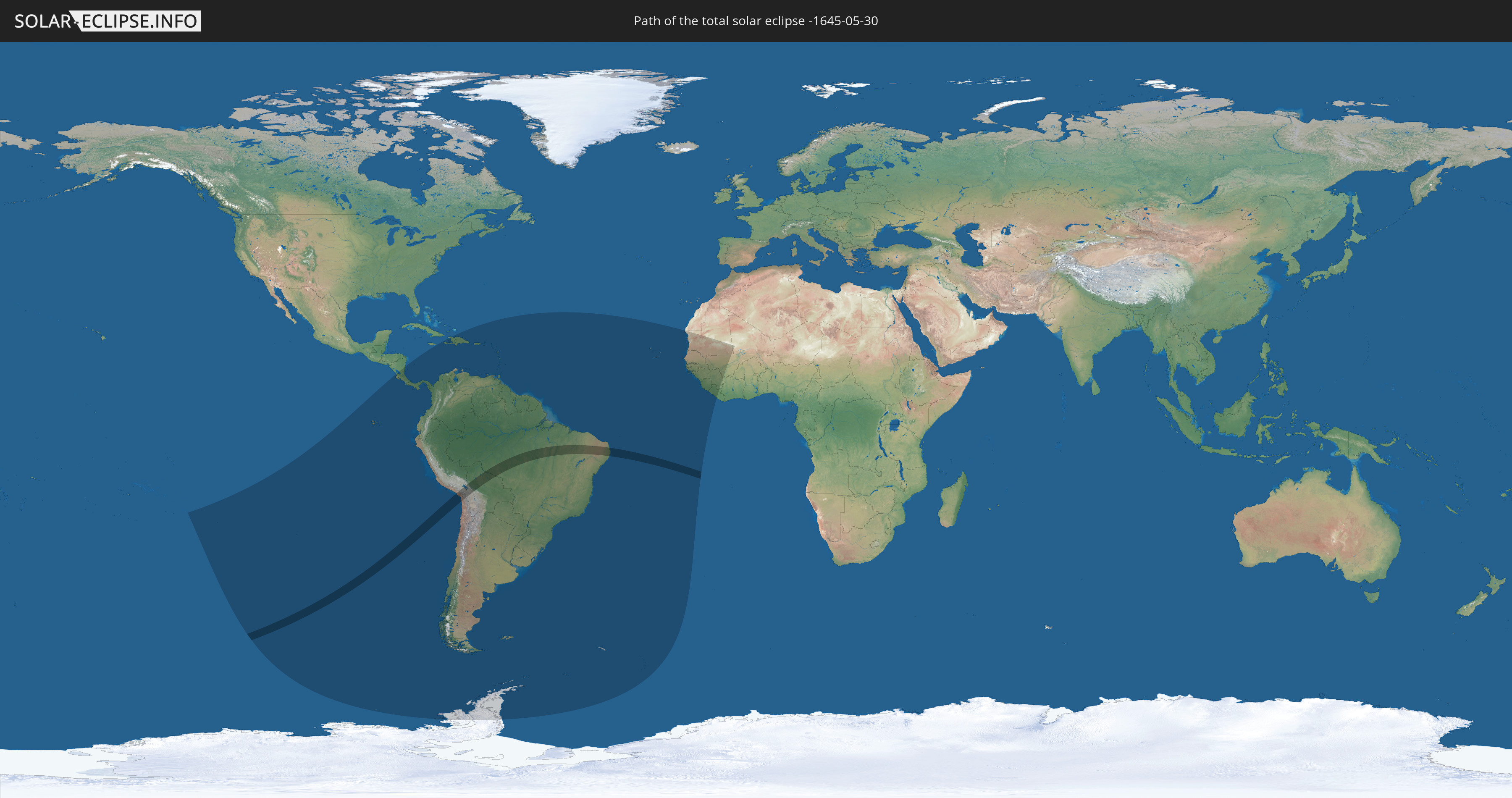
Die Sonnenfinsternis am 05/30/-1645 kann man in 54 Ländern als partielle Sonnenfinsternis beobachten.
Der Finsternispfad verläuft durch 4 Länder. Nur in diesen Ländern ist sie als total Sonnenfinsternis zu sehen.
In den folgenden Ländern ist die Sonnenfinsternis total zu sehen
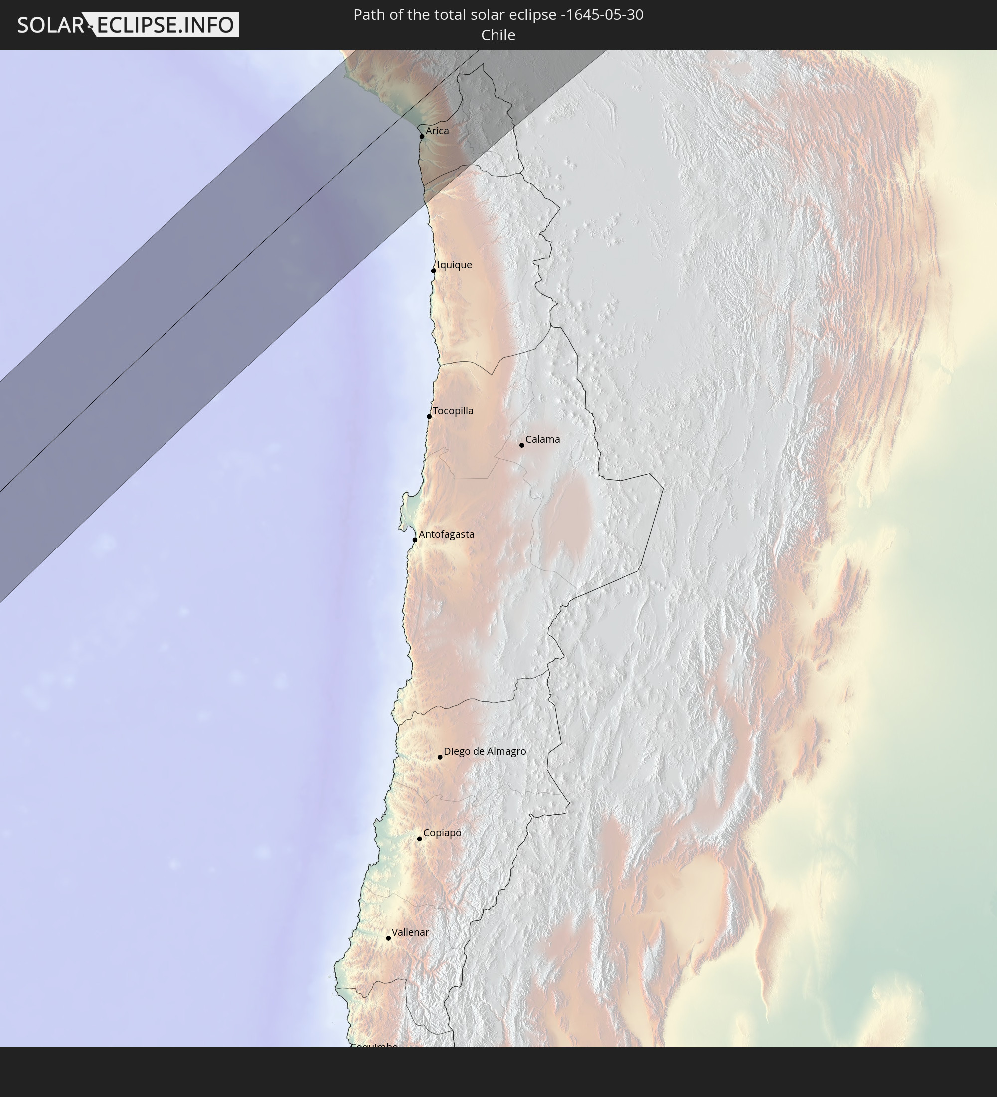 Chile
Chile
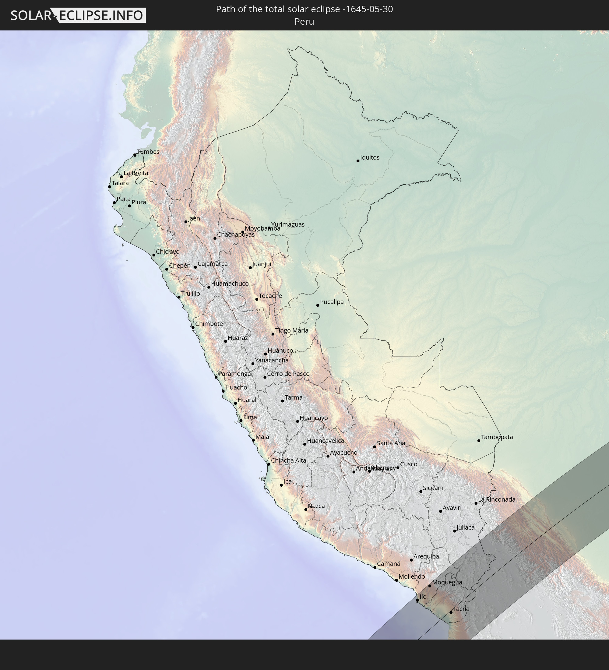 Peru
Peru
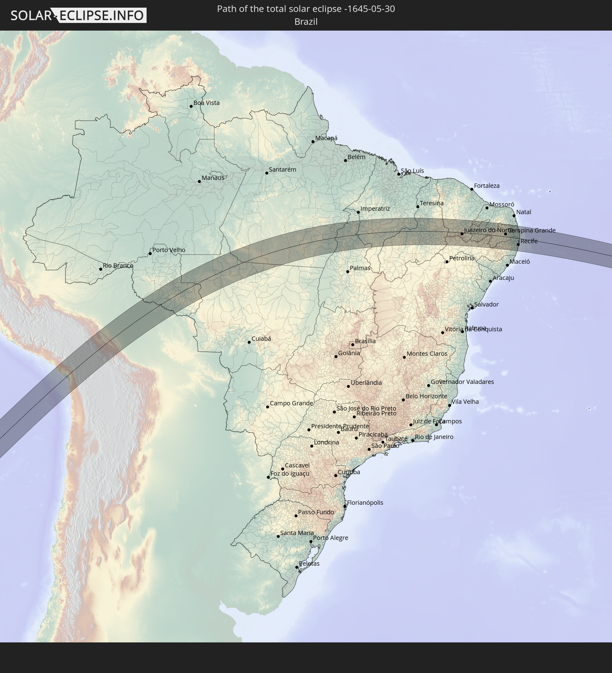 Brazil
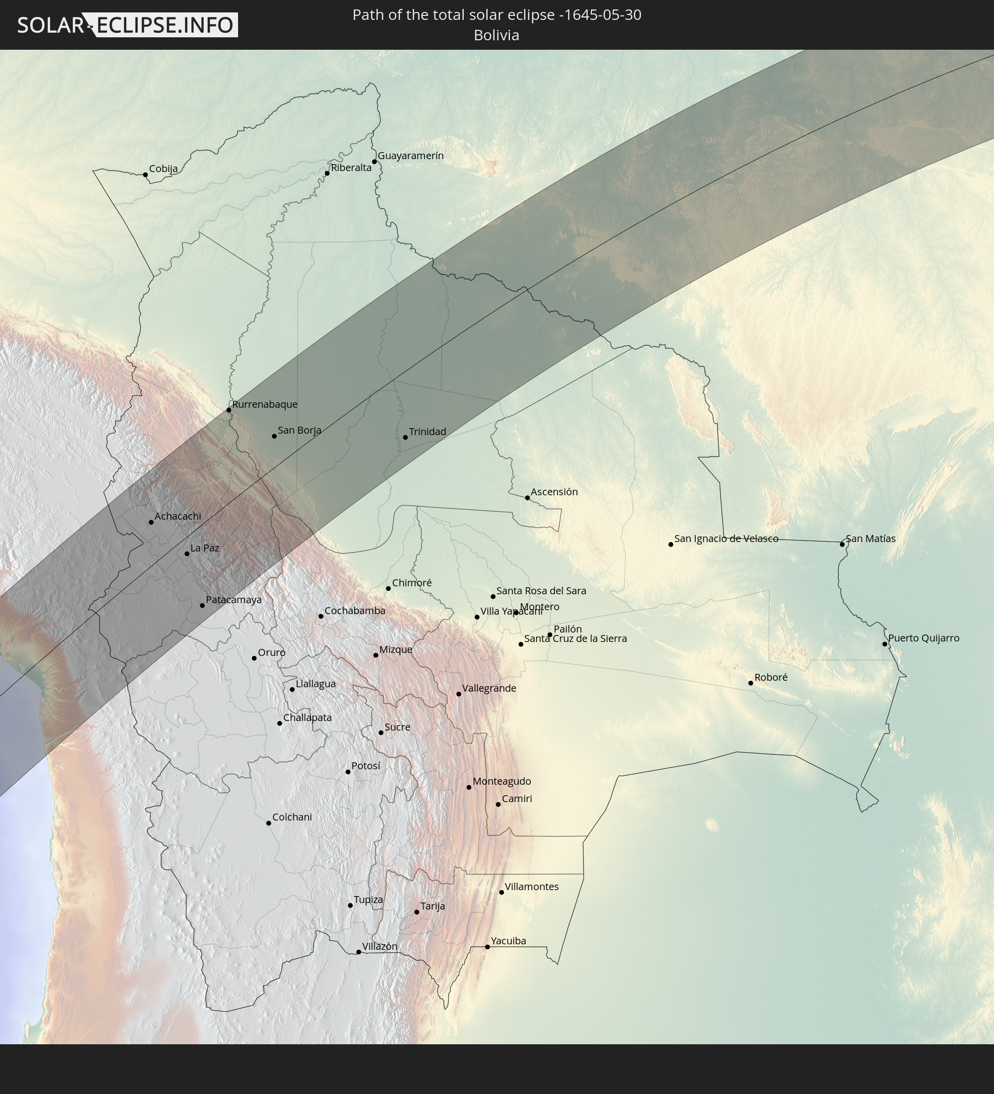 Bolivia
In den folgenden Ländern ist die Sonnenfinsternis partiell zu sehen
 Antarctica
 United States Minor Outlying Islands
 French Polynesia
 Pitcairn Islands
 Chile
Chile
 Ecuador
 Nicaragua
 Costa Rica
 Panama
 Colombia
 Peru
Peru
 Jamaica
 Haiti
Haiti
 Brazil
 Argentina
 Venezuela
 Dominican Republic
 Aruba
Aruba
 Bolivia
 Puerto Rico
 United States Virgin Islands
 British Virgin Islands
 Anguilla
 Collectivity of Saint Martin
 Saint Barthélemy
 Saint Kitts and Nevis
 Paraguay
 Antigua and Barbuda
 Montserrat
 Trinidad and Tobago
 Guadeloupe
 Grenada
 Dominica
 Saint Vincent and the Grenadines
 Falkland Islands
 Guyana
 Martinique
 Saint Lucia
 Barbados
 Uruguay
 Suriname
 French Guiana
 South Georgia and the South Sandwich Islands
 Cabo Verde
 Senegal
 Mauritania
 The Gambia
 Guinea-Bissau
 Guinea
 Saint Helena, Ascension and Tristan da Cunha
 Sierra Leone
 Mali
Mali
 Liberia
 Ivory Coast
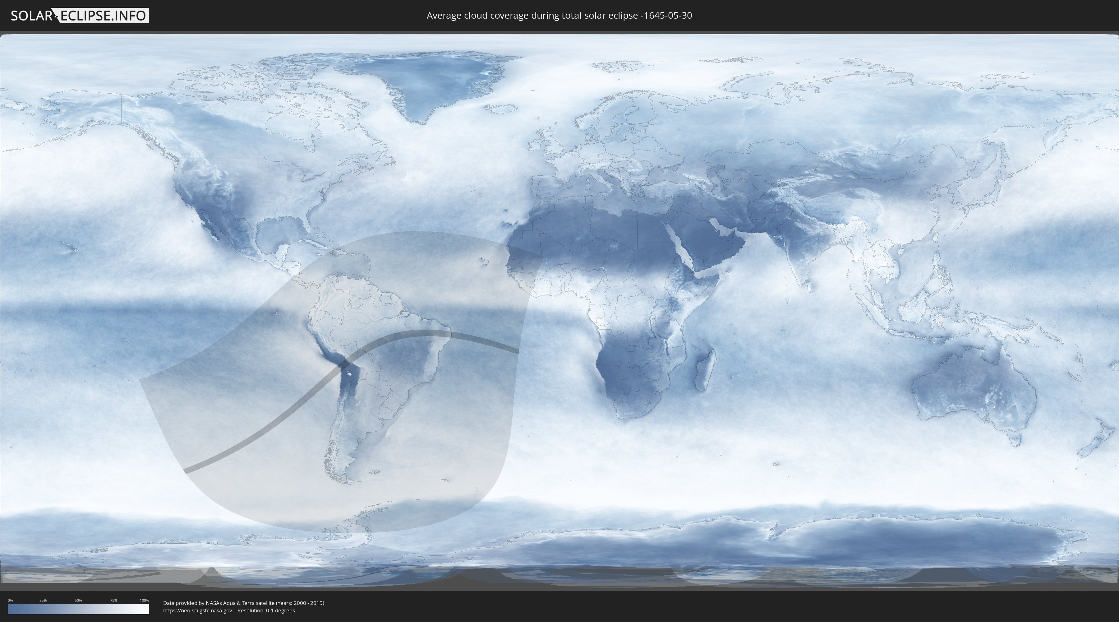
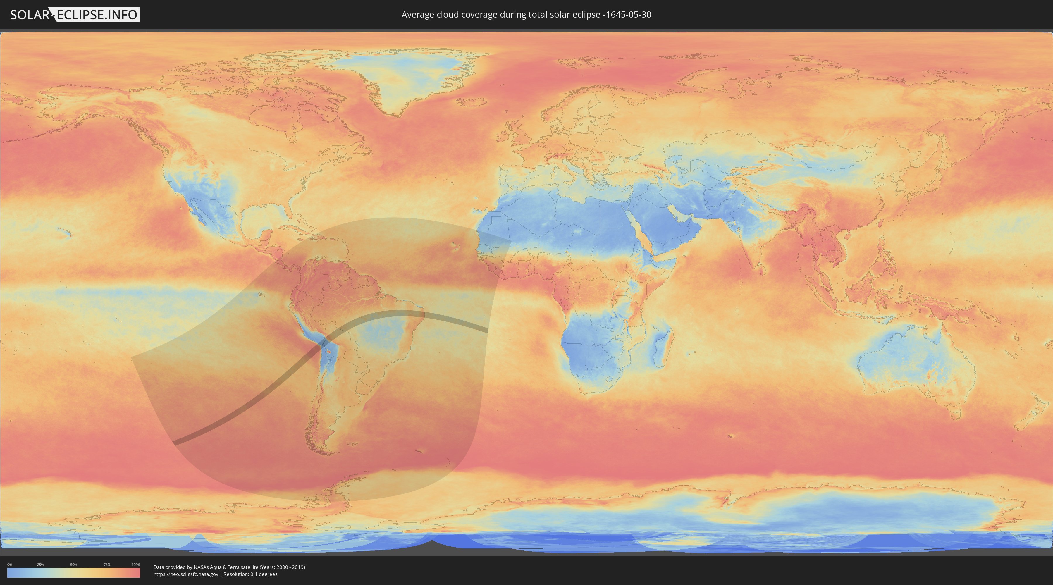
How will be the weather during the total solar eclipse on 05/30/-1645?
Where is the best place to see the total solar eclipse of 05/30/-1645?
The following maps show the average cloud coverage for the day of the total solar eclipse.
With the help of these maps, it is possible to find the place along the eclipse path, which has the best
chance of a cloudless sky.
Nevertheless, you should consider local circumstances and inform about the weather of your chosen
observation site.
The data is provided by NASAs satellites
AQUA and TERRA.
The cloud maps are averaged over a period of 19 years (2000 - 2019).
Detailed country maps
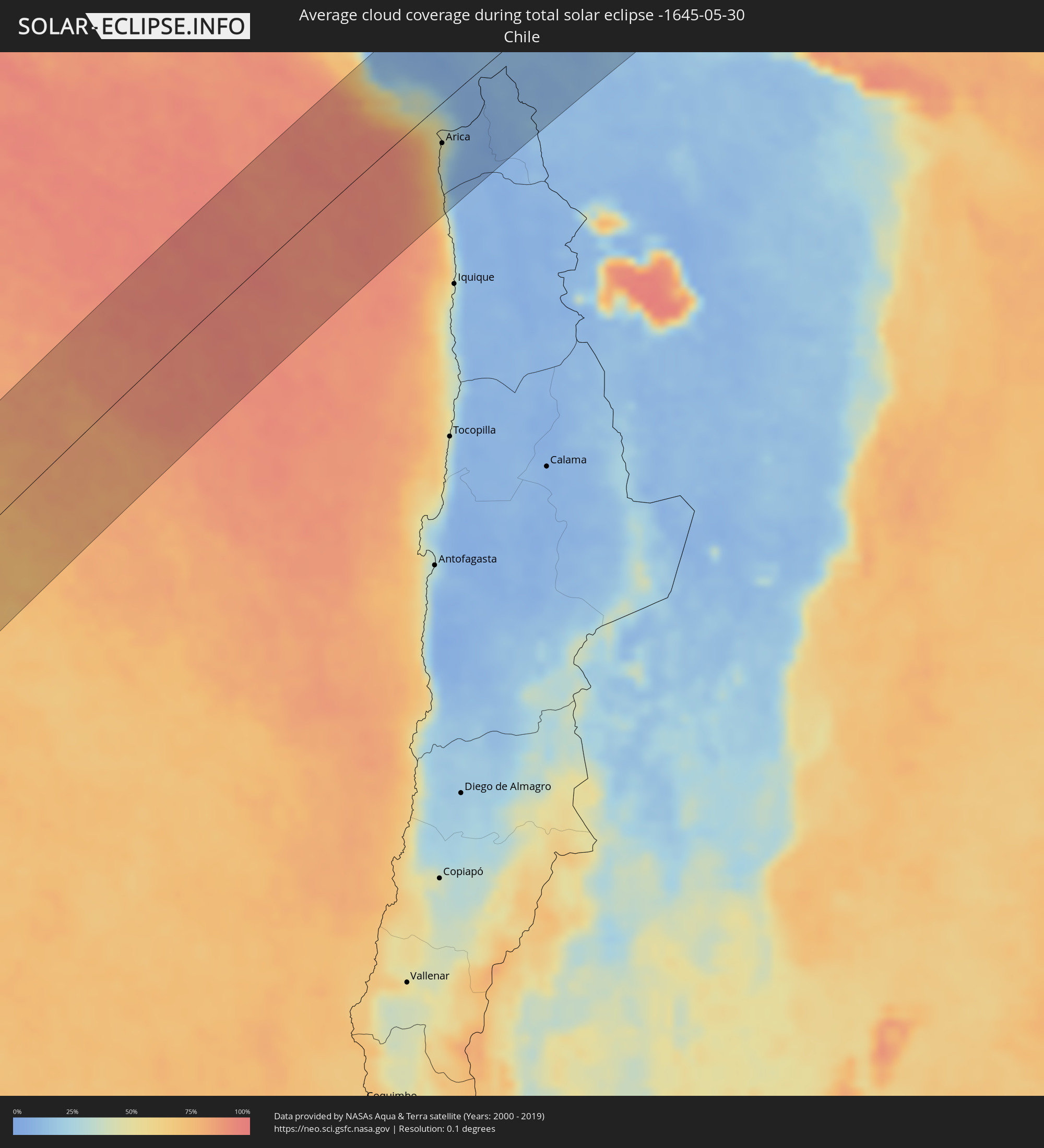 Chile
Chile
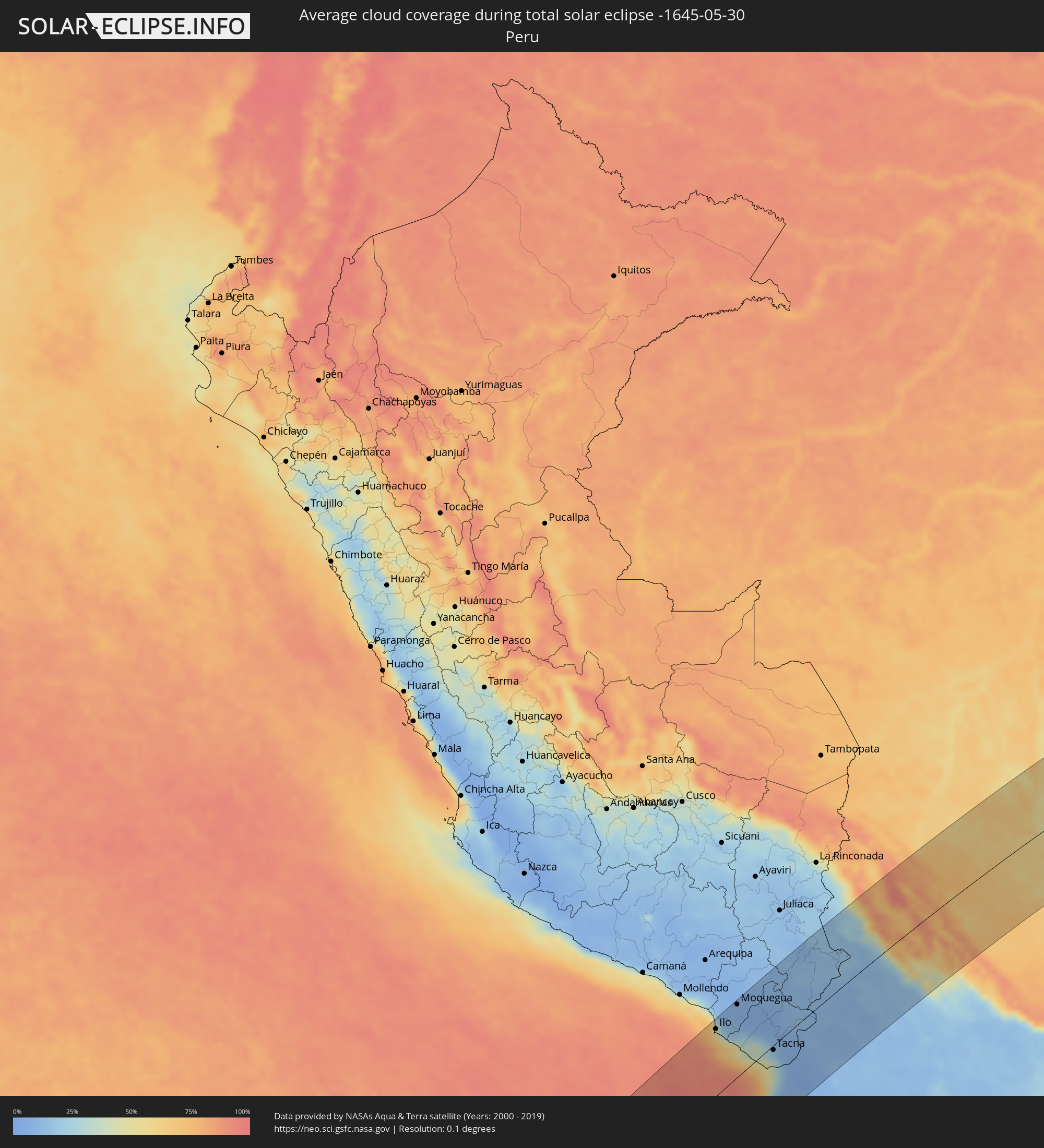 Peru
Peru
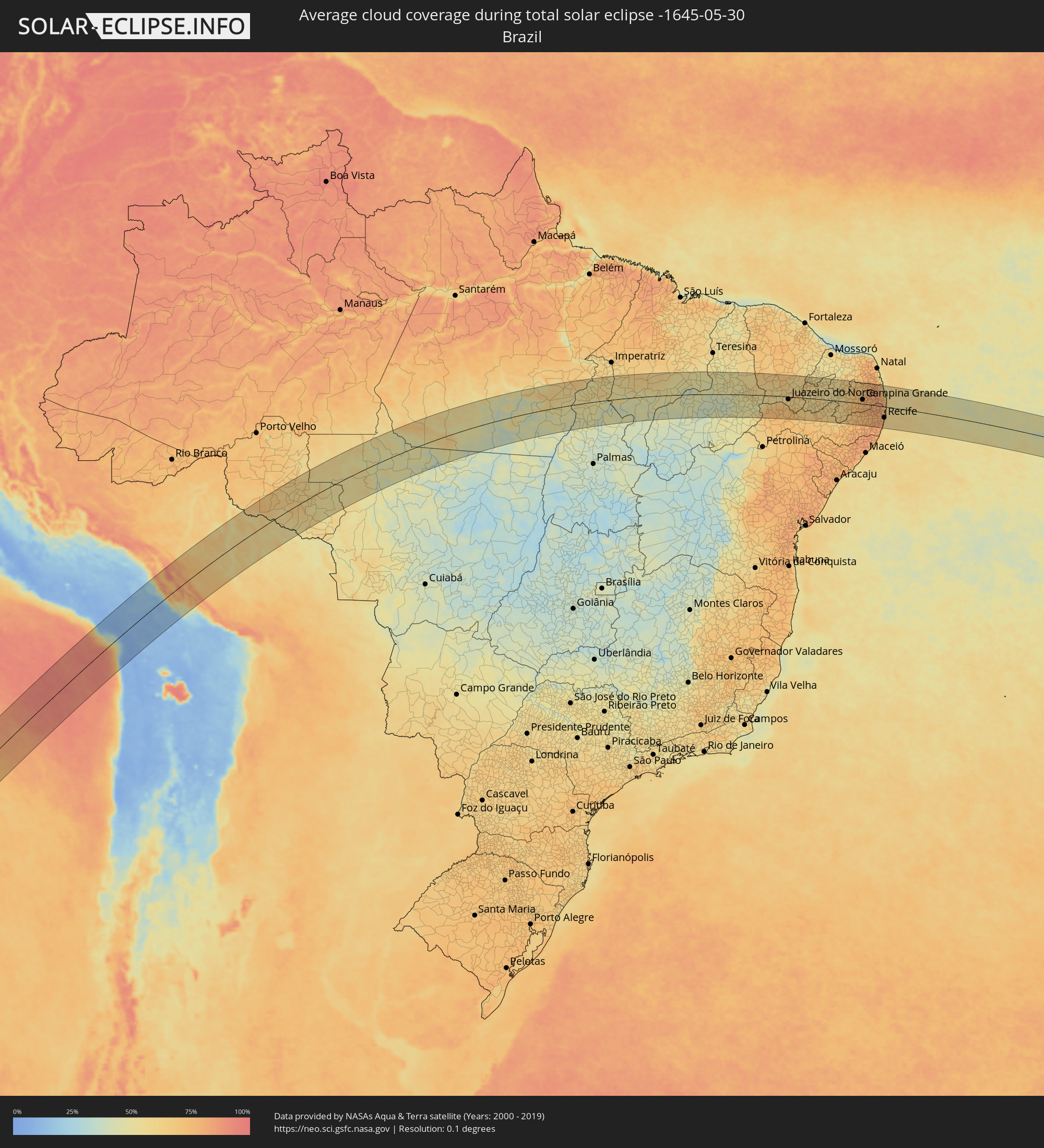 Brazil
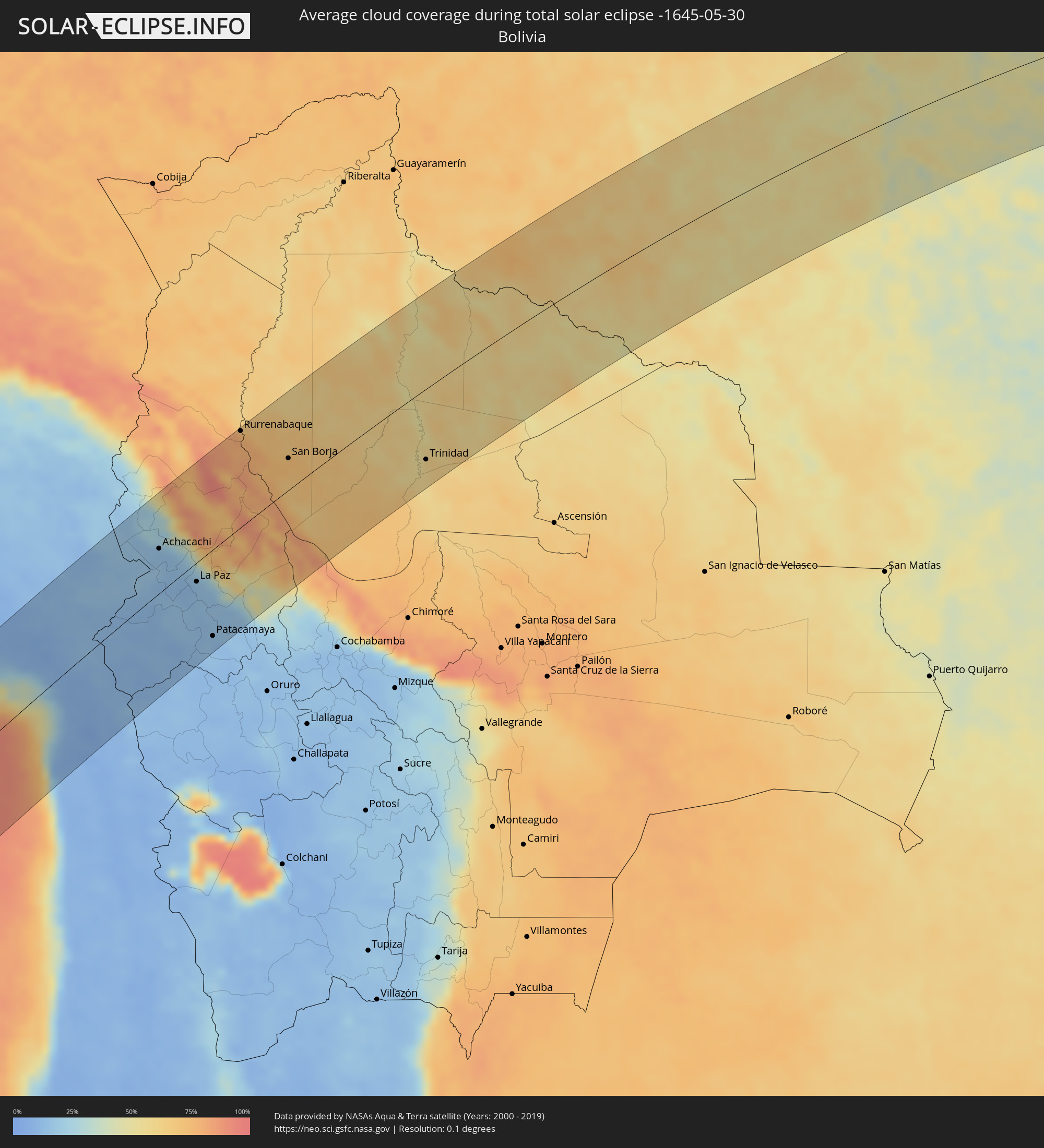 Bolivia
Cities inside the path of the eclipse
The following table shows all locations with a population of more than 5,000 inside the eclipse path. Cities which have more than 100,000 inhabitants are marked bold. A click at the locations opens a detailed map.
| City | Type | Eclipse duration | Local time of max. eclipse | Distance to central line | Ø Cloud coverage |
|
Ilo, Moquegua
|
total | - | 11:29:25 UTC-05:08 | 100 km | 40% |
|
Pacocha, Moquegua
|
total | - | 11:29:30 UTC-05:08 | 105 km | 40% |
|
Moquegua, Moquegua
|
total | - | 11:30:58 UTC-05:08 | 109 km | 8% |
|
Torata, Moquegua
|
total | - | 11:31:21 UTC-05:08 | 113 km | 8% |
|
Ilabaya, Tacna
|
total | - | 11:31:38 UTC-05:08 | 61 km | 8% |
|
Arica, Arica y Parinacota
|
total | - | 11:56:30 UTC-04:42 | 42 km | 41% |
|
Tacna, Tacna
|
total | - | 11:31:25 UTC-05:08 | 7 km | 32% |
|
Ilave, Puno
|
total | - | 11:35:33 UTC-05:08 | 116 km | 10% |
|
Juli, Puno
|
total | - | 11:35:52 UTC-05:08 | 90 km | 12% |
|
Yunguyo, Puno
|
total | - | 11:36:42 UTC-05:08 | 62 km | 14% |
|
Desaguadero, Puno
|
total | - | 12:12:21 UTC-04:32 | 32 km | 12% |
|
San Pedro, La Paz
|
total | - | 12:13:17 UTC-04:32 | 48 km | 16% |
|
Achacachi, La Paz
|
total | - | 12:13:58 UTC-04:32 | 52 km | 14% |
|
La Paz, La Paz
|
total | - | 12:14:36 UTC-04:32 | 22 km | 12% |
|
Patacamaya, La Paz
|
total | - | 12:14:05 UTC-04:32 | 101 km | 13% |
|
Rurrenabaque, El Beni
|
total | - | 12:19:10 UTC-04:32 | 116 km | 74% |
|
Reyes, El Beni
|
total | - | 12:19:52 UTC-04:32 | 116 km | 68% |
|
San Borja, El Beni
|
total | - | 12:20:17 UTC-04:32 | 38 km | 72% |
|
Trinidad, El Beni
|
total | - | 12:25:08 UTC-04:32 | 88 km | 61% |
|
Pôsto Fiscal Rolim de Moura, Rondônia
|
total | - | 13:04:26 UTC-04:02 | 84 km | 50% |
|
Ji Paraná, Rondônia
|
total | - | 13:08:39 UTC-04:02 | 108 km | 59% |
|
Cacoal, Rondônia
|
total | - | 13:09:05 UTC-04:02 | 27 km | 61% |
|
Pimenta Bueno, Rondônia
|
total | - | 13:09:23 UTC-04:02 | 9 km | 55% |
|
Conceição do Araguaia, Pará
|
total | - | 14:32:12 UTC-03:13 | 87 km | 39% |
|
Araguaína, Tocantins
|
total | - | 15:15:46 UTC-02:34 | 14 km | 53% |
|
Santa Luzia, Maranhão
|
total | - | 15:17:19 UTC-02:34 | 48 km | 43% |
|
Balsas, Maranhão
|
total | - | 15:19:52 UTC-02:34 | 48 km | 47% |
|
Colinas, Maranhão
|
total | - | 15:25:03 UTC-02:34 | 109 km | 53% |
|
Floriano, Piauí
|
total | - | 15:26:30 UTC-02:34 | 24 km | 44% |
|
Picos, Piauí
|
total | - | 15:28:56 UTC-02:34 | 9 km | 53% |
|
Araripina, Pernambuco
|
total | - | 15:44:27 UTC-02:19 | 61 km | 66% |
|
Ouricuri, Pernambuco
|
total | - | 15:44:49 UTC-02:19 | 93 km | 74% |
|
Acopiara, Ceará
|
total | - | 15:33:16 UTC-02:34 | 110 km | 69% |
|
Juazeiro do Norte, Ceará
|
total | - | 15:32:22 UTC-02:34 | 13 km | 61% |
|
Iguatu, Ceará
|
total | - | 15:33:15 UTC-02:34 | 82 km | 62% |
|
Salgueiro, Pernambuco
|
total | - | 15:46:11 UTC-02:19 | 107 km | 70% |
|
Brejo Santo, Ceará
|
total | - | 15:32:36 UTC-02:34 | 42 km | 66% |
|
Icó, Ceará
|
total | - | 15:33:53 UTC-02:34 | 81 km | 57% |
|
Cajazeiras, Paraíba
|
total | - | 15:33:52 UTC-02:34 | 29 km | 57% |
|
Serra Talhada, Pernambuco
|
total | - | 15:47:33 UTC-02:19 | 91 km | 67% |
|
Sousa, Paraíba
|
total | - | 15:34:30 UTC-02:34 | 46 km | 56% |
|
São Bento, Paraíba
|
total | - | 15:35:41 UTC-02:34 | 104 km | 56% |
|
Afogados da Ingazeira, Pernambuco
|
total | - | 15:48:48 UTC-02:19 | 58 km | 61% |
|
Patos, Paraíba
|
total | - | 15:35:39 UTC-02:34 | 27 km | 54% |
|
Caicó, Rio Grande do Norte
|
total | - | 15:36:28 UTC-02:34 | 91 km | 59% |
|
Belo Jardim, Pernambuco
|
total | - | 15:50:00 UTC-02:19 | 108 km | 75% |
|
Brejo da Madre de Deus, Pernambuco
|
total | - | 15:50:16 UTC-02:19 | 87 km | 69% |
|
Santa Cruz do Capibaribe, Pernambuco
|
total | - | 15:50:41 UTC-02:19 | 64 km | 75% |
|
Toritama, Pernambuco
|
total | - | 15:50:51 UTC-02:19 | 67 km | 74% |
|
Caruaru, Pernambuco
|
total | - | 15:50:41 UTC-02:19 | 97 km | 77% |
|
Campina Grande, Paraíba
|
total | - | 15:37:27 UTC-02:34 | 21 km | 77% |
|
Bezerros, Pernambuco
|
total | - | 15:50:59 UTC-02:19 | 89 km | 77% |
|
Surubim, Pernambuco
|
total | - | 15:51:26 UTC-02:19 | 44 km | 76% |
|
Gravatá, Pernambuco
|
total | - | 15:51:20 UTC-02:19 | 82 km | 74% |
|
Guarabira, Paraíba
|
total | - | 15:38:20 UTC-02:34 | 68 km | 81% |
|
Limoeiro, Pernambuco
|
total | - | 15:51:49 UTC-02:19 | 44 km | 77% |
|
Timbaúba, Pernambuco
|
total | - | 15:52:21 UTC-02:19 | 1 km | 83% |
|
Vitória de Santo Antão, Pernambuco
|
total | - | 15:51:48 UTC-02:19 | 69 km | 80% |
|
Carpina, Pernambuco
|
total | - | 15:52:06 UTC-02:19 | 39 km | 77% |
|
Escada, Pernambuco
|
total | - | 15:51:39 UTC-02:19 | 94 km | 81% |
|
Mamanguape, Paraíba
|
total | - | 15:38:50 UTC-02:34 | 75 km | 78% |
|
Ipojuca, Pernambuco
|
total | - | 15:51:50 UTC-02:19 | 96 km | 79% |
|
São Lourenço da Mata, Pernambuco
|
total | - | 15:52:17 UTC-02:19 | 52 km | 79% |
|
Goiana, Pernambuco
|
total | - | 15:52:43 UTC-02:19 | 3 km | 77% |
|
Jaboatão, Pernambuco
|
total | - | 15:52:08 UTC-02:19 | 71 km | 73% |
|
Igarassu, Pernambuco
|
total | - | 15:52:35 UTC-02:19 | 32 km | 70% |
|
Recife, Pernambuco
|
total | - | 15:52:25 UTC-02:19 | 55 km | 67% |
|
João Pessoa, Paraíba
|
total | - | 15:38:55 UTC-02:34 | 48 km | 73% |
|
Cabedelo, Paraíba
|
total | - | 15:39:05 UTC-02:34 | 64 km | 54% |