Total solar eclipse of 02/14/-1649
| Day of week: | Tuesday |
| Maximum duration of eclipse: | 03m51s |
| Maximum width of eclipse path: | 261 km |
| Saros cycle: | 4 |
| Coverage: | 100% |
| Magnitude: | 1.0456 |
| Gamma: | 0.8141 |
Wo kann man die Sonnenfinsternis vom 02/14/-1649 sehen?
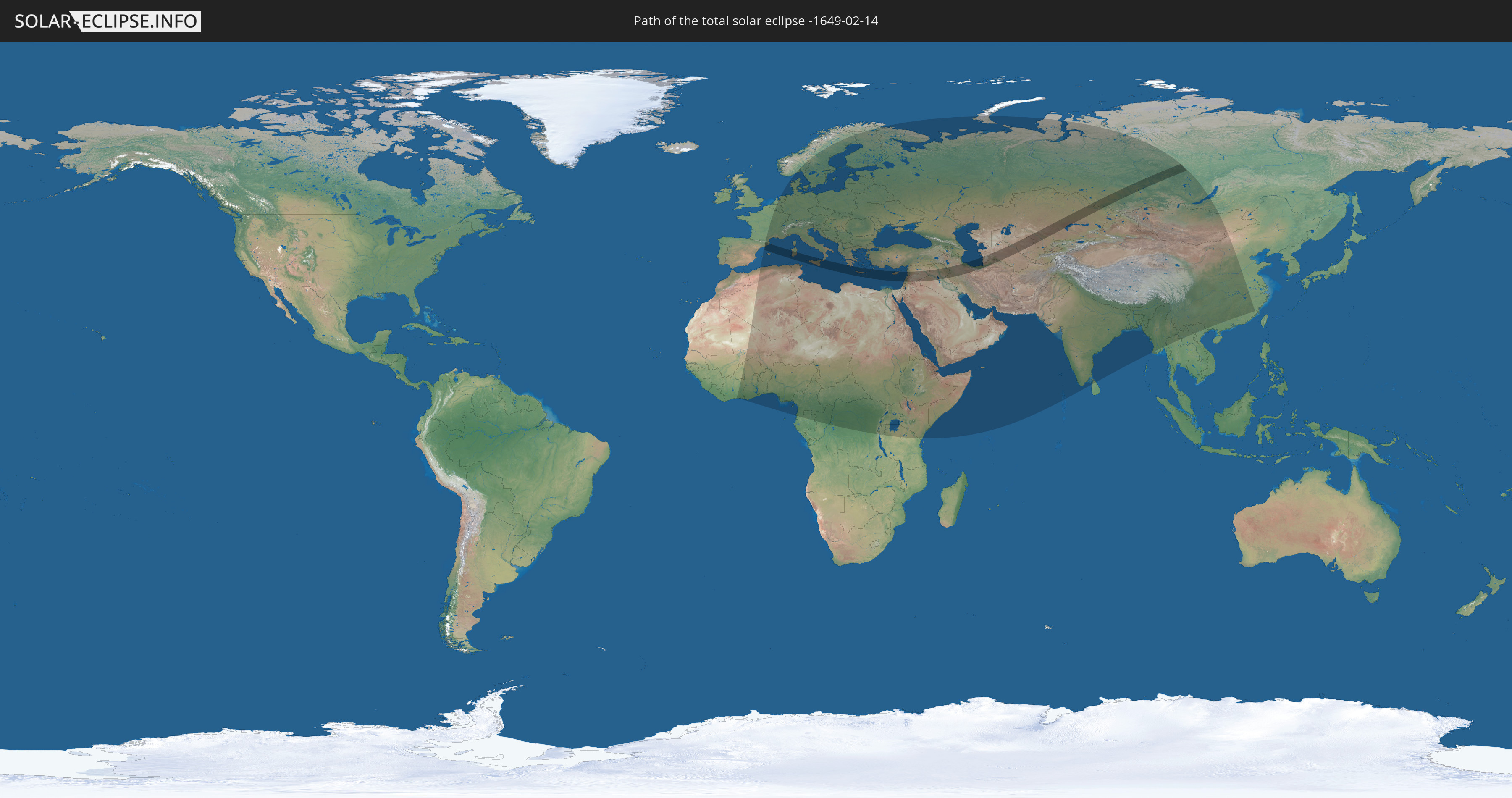
Die Sonnenfinsternis am 02/14/-1649 kann man in 107 Ländern als partielle Sonnenfinsternis beobachten.
Der Finsternispfad verläuft durch 14 Länder. Nur in diesen Ländern ist sie als total Sonnenfinsternis zu sehen.
In den folgenden Ländern ist die Sonnenfinsternis total zu sehen
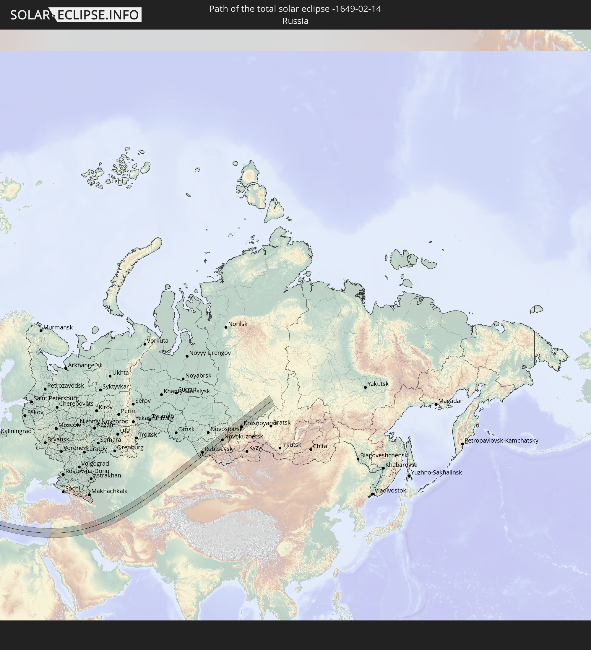 Russia
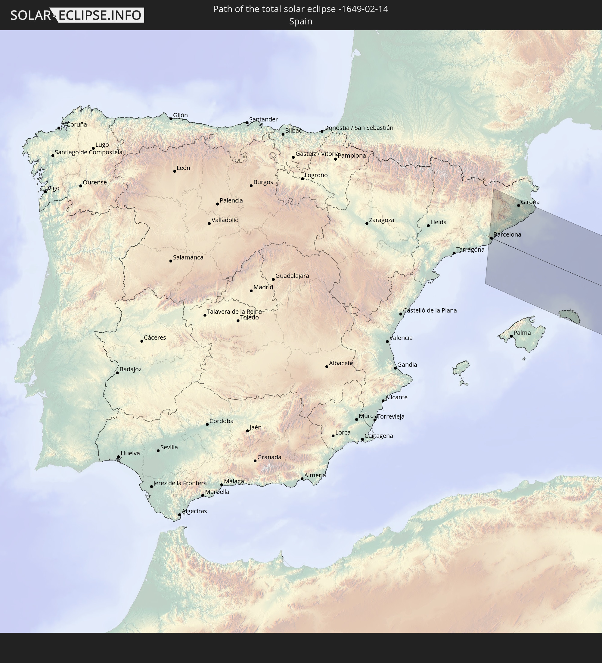 Spain
Spain
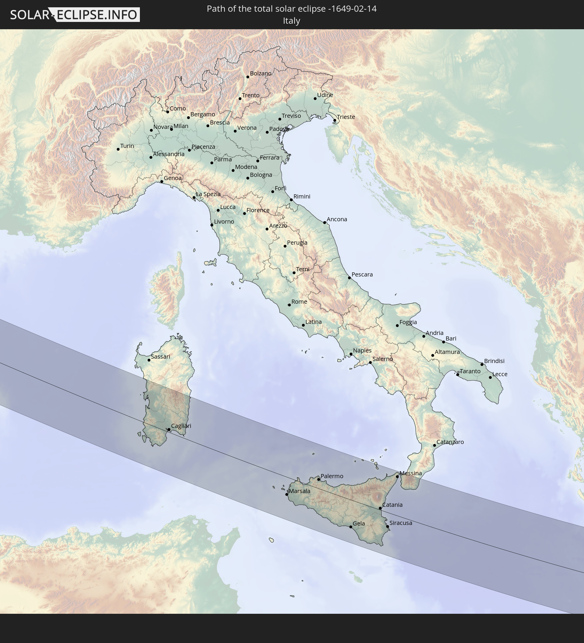 Italy
Italy
 Greece
 Cyprus
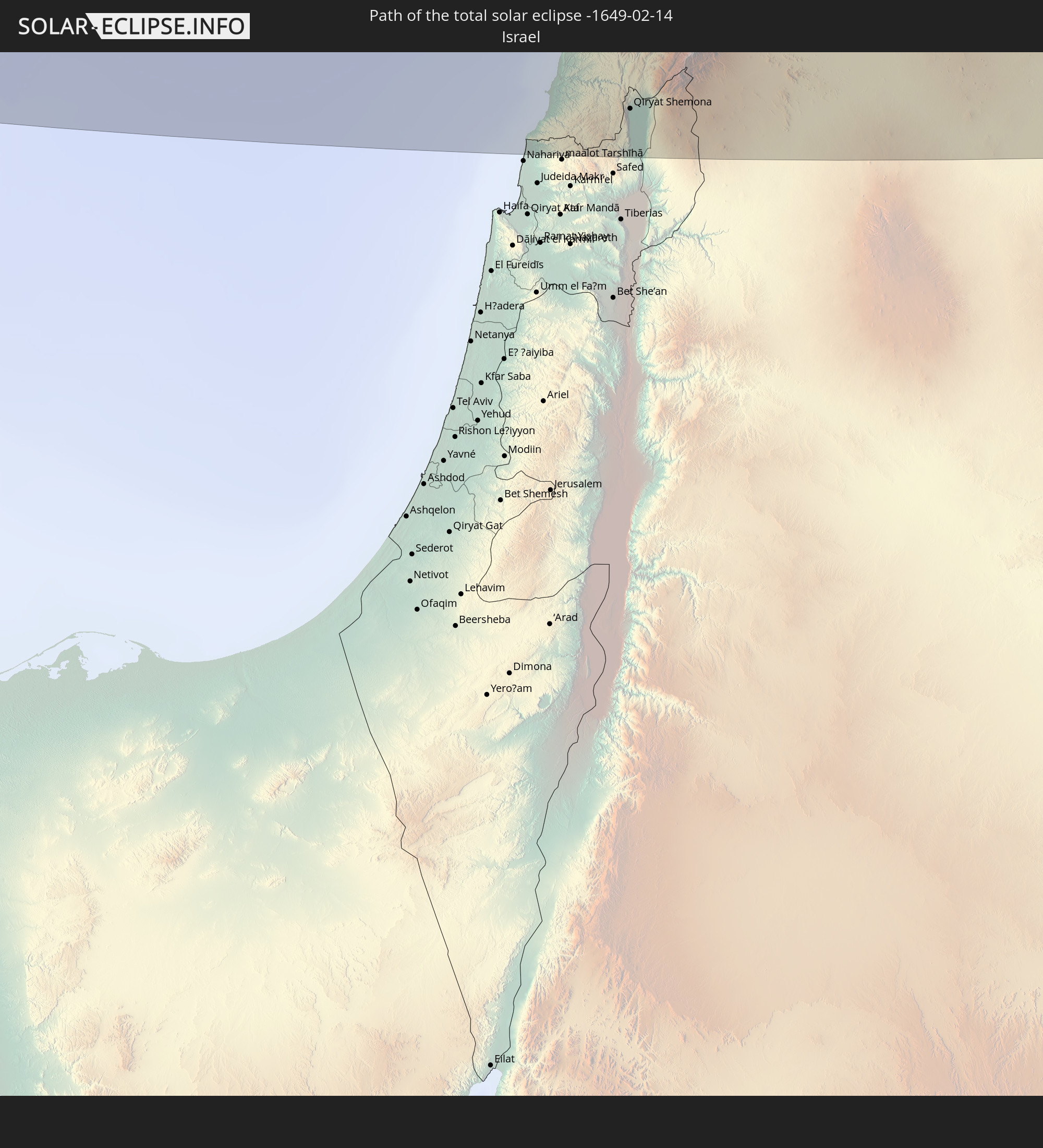 Israel
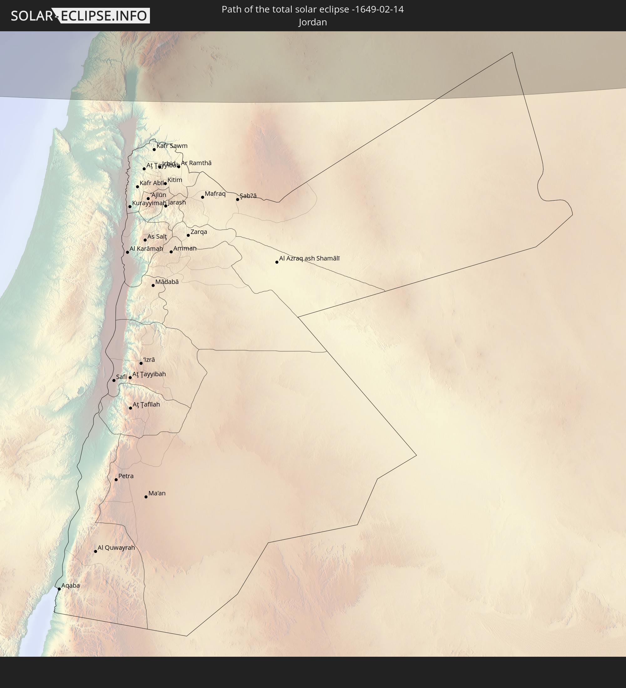 Jordan
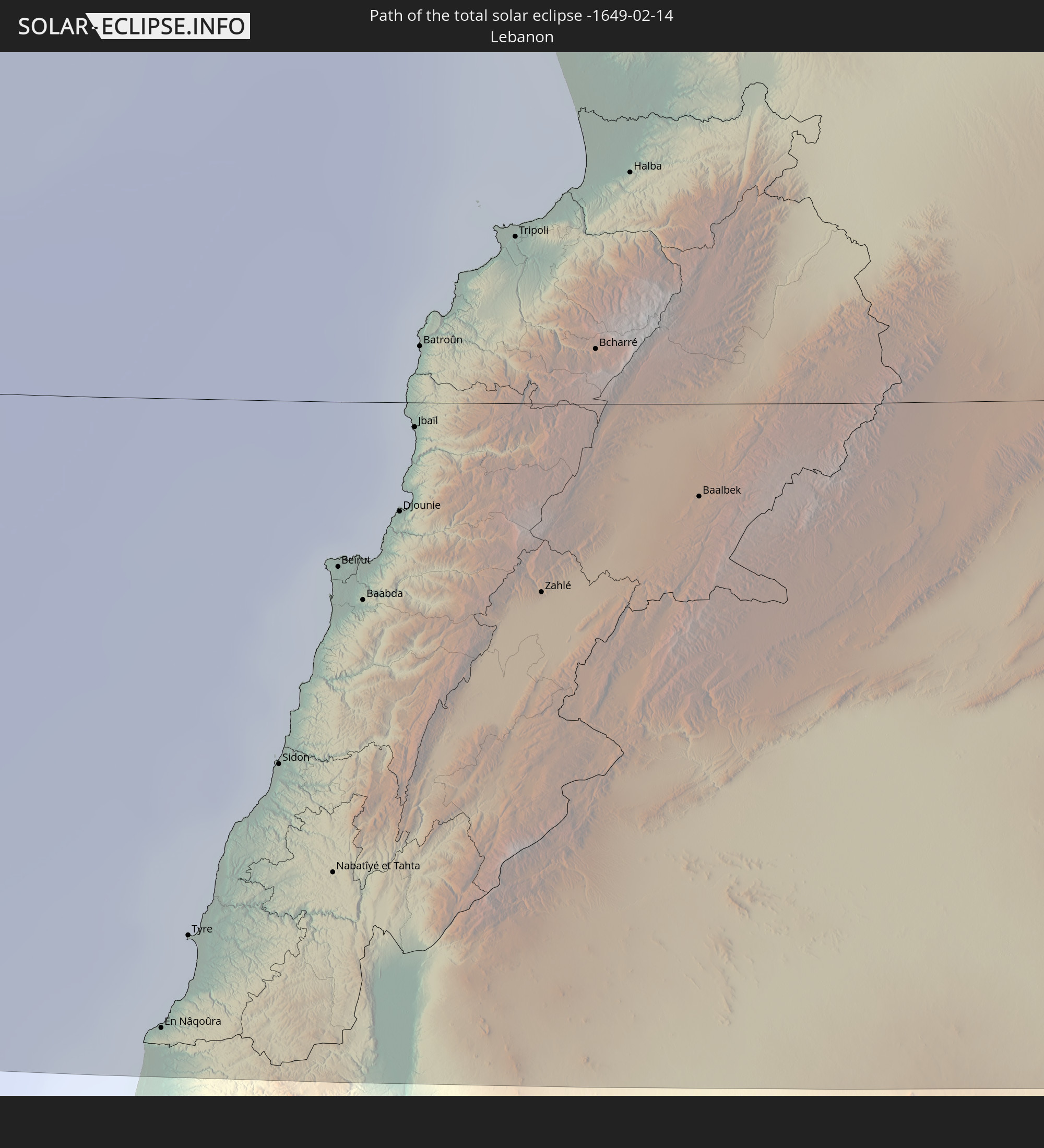 Lebanon
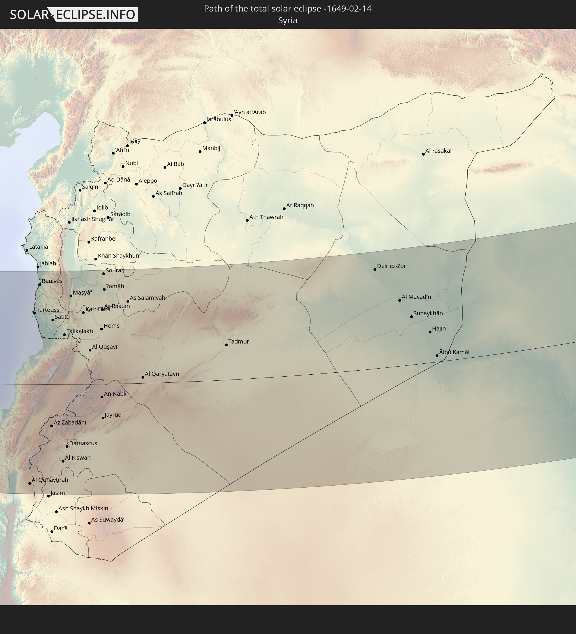 Syria
Syria
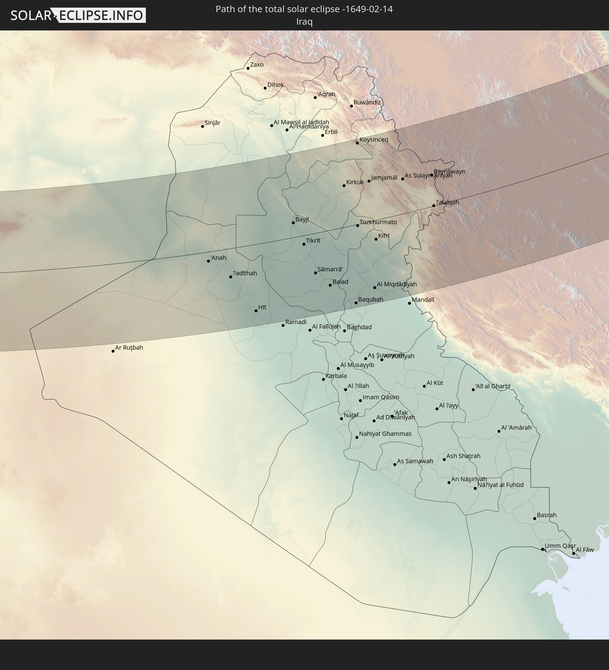 Iraq
Iraq
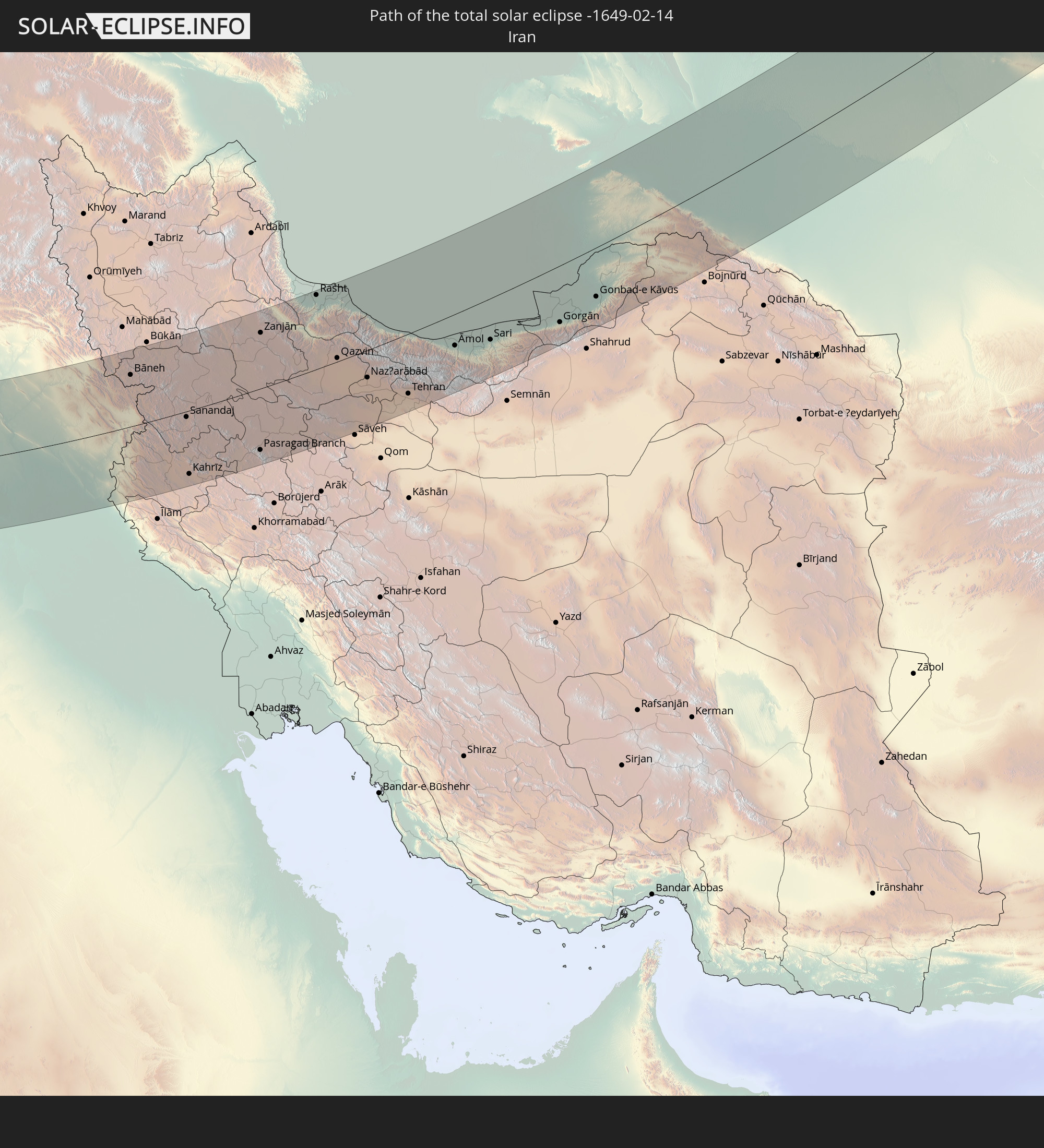 Iran
Iran
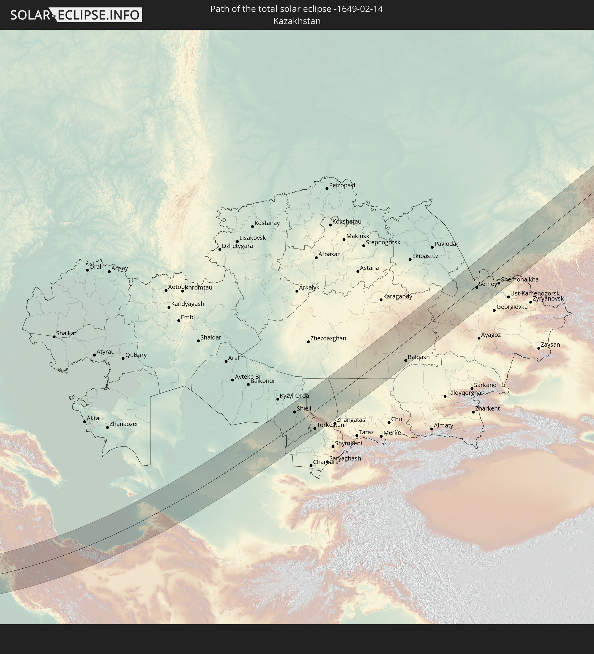 Kazakhstan
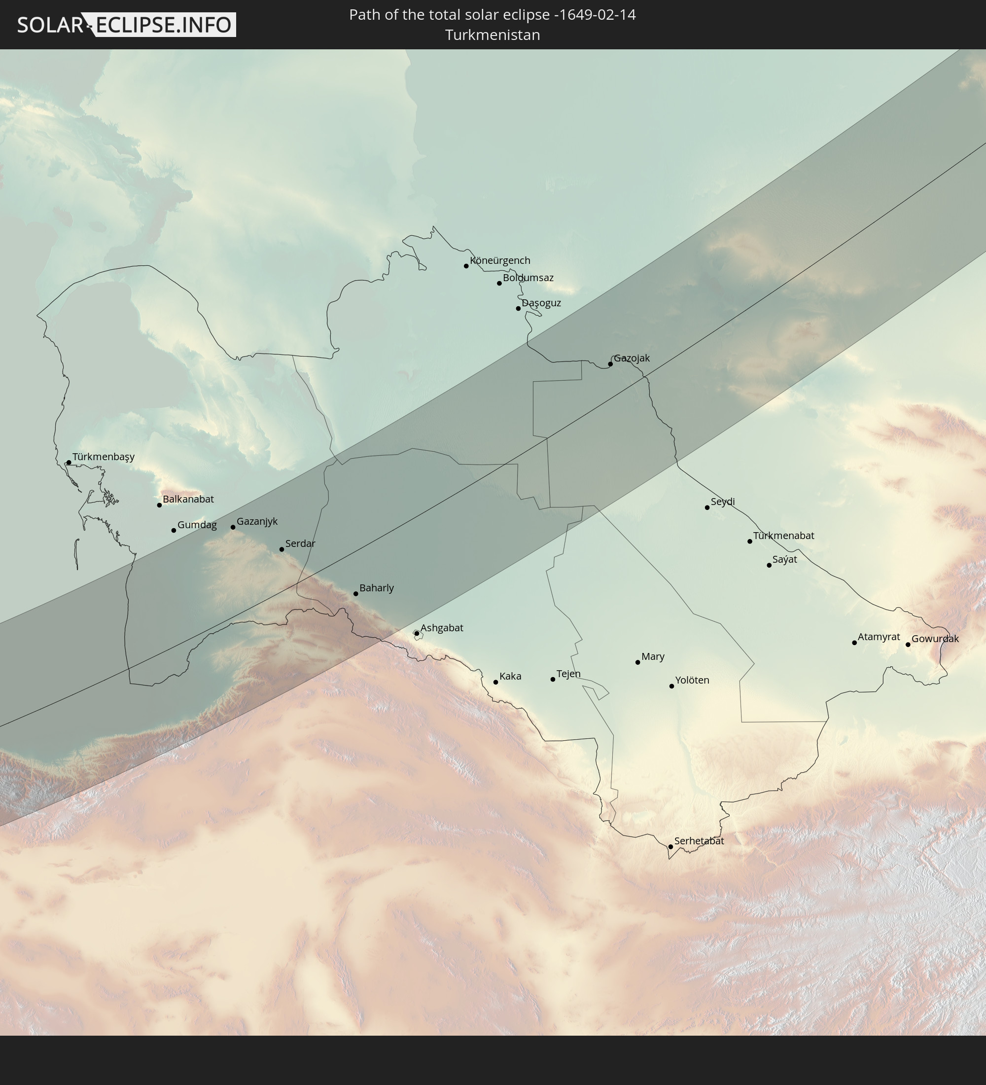 Turkmenistan
 Uzbekistan
In den folgenden Ländern ist die Sonnenfinsternis partiell zu sehen
 Russia
 Spain
Spain
 Mali
Mali
 Algeria
 Ivory Coast
 Burkina Faso
 France
 Ghana
Ghana
 Togo
Togo
 Niger
Niger
 Benin
Benin
 Belgium
 Nigeria
 Netherlands
 Norway
 Equatorial Guinea
 Luxembourg
 Germany
 Switzerland
 Italy
Italy
 Monaco
 Tunisia
 Denmark
 Cameroon
 Gabon
Gabon
 Libya
Libya
 Liechtenstein
 Austria
 Sweden
 Republic of the Congo
 Czechia
 Democratic Republic of the Congo
 San Marino
 Vatican City
 Slovenia
 Chad
Chad
 Croatia
 Poland
 Malta
Malta
 Central African Republic
 Bosnia and Herzegovina
 Hungary
 Slovakia
 Montenegro
 Serbia
 Albania
 Åland Islands
 Greece
 Romania
 Republic of Macedonia
 Finland
 Lithuania
 Latvia
 Estonia
 Sudan
Sudan
 Ukraine
 Bulgaria
 Belarus
 Egypt
Egypt
 Turkey
 Moldova
 Rwanda
 Burundi
 Tanzania
 Uganda
 Cyprus
 Ethiopia
 Kenya
Kenya
 State of Palestine
 Israel
 Saudi Arabia
 Jordan
 Lebanon
 Syria
Syria
 Eritrea
 Iraq
Iraq
 Georgia
 Somalia
 Djibouti
 Yemen
Yemen
 Armenia
 Iran
Iran
 Azerbaijan
 Kazakhstan
 Kuwait
 Bahrain
 Qatar
Qatar
 United Arab Emirates
 Oman
Oman
 Turkmenistan
 Uzbekistan
 Afghanistan
 Pakistan
 Tajikistan
 India
India
 Kyrgyzstan
 Maldives
 China
China
 Sri Lanka
 Nepal
Nepal
 Mongolia
 Bangladesh
 Bhutan
 Myanmar
 Thailand
 Laos
Laos
 Vietnam
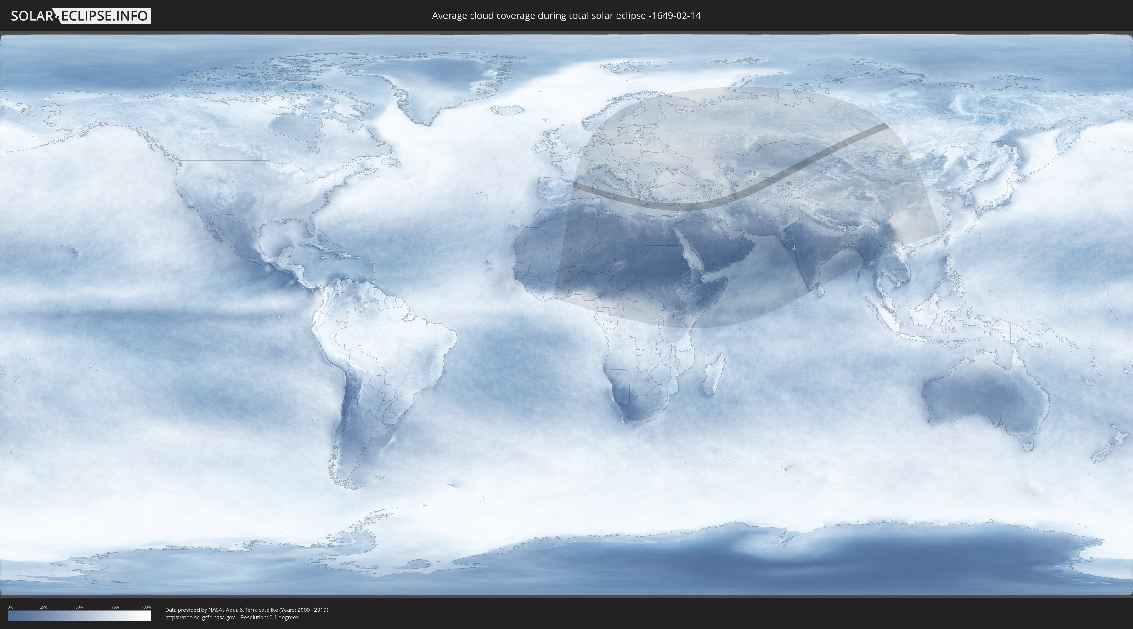
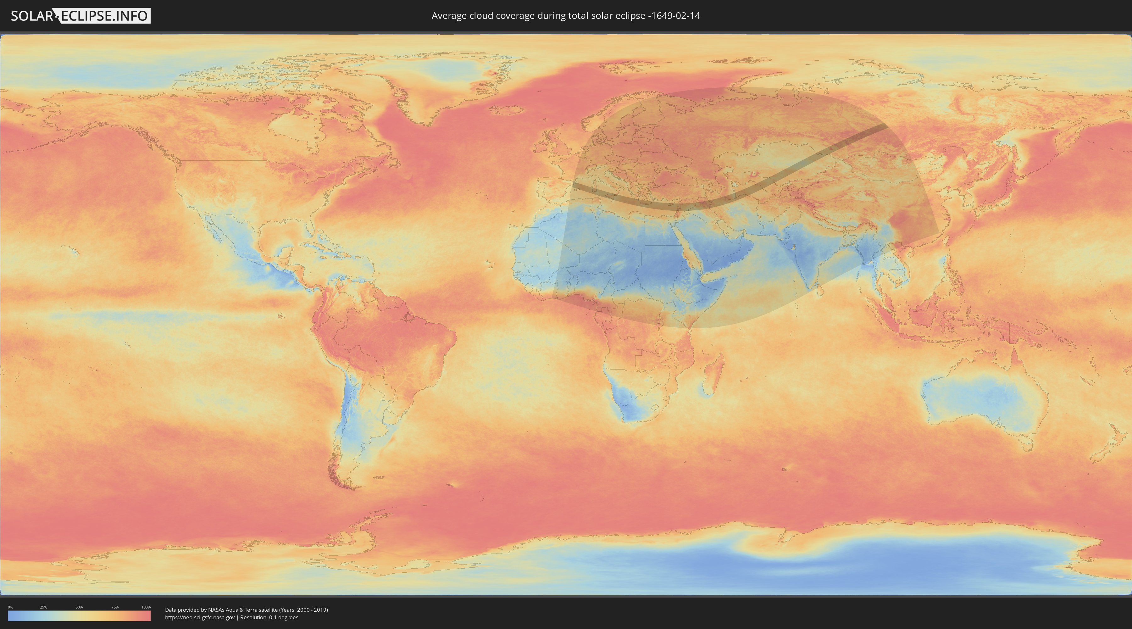
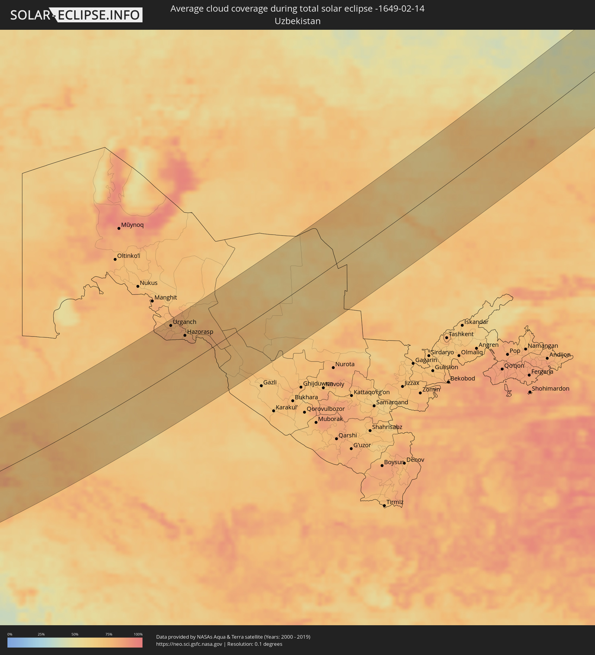
How will be the weather during the total solar eclipse on 02/14/-1649?
Where is the best place to see the total solar eclipse of 02/14/-1649?
The following maps show the average cloud coverage for the day of the total solar eclipse.
With the help of these maps, it is possible to find the place along the eclipse path, which has the best
chance of a cloudless sky.
Nevertheless, you should consider local circumstances and inform about the weather of your chosen
observation site.
The data is provided by NASAs satellites
AQUA and TERRA.
The cloud maps are averaged over a period of 19 years (2000 - 2019).
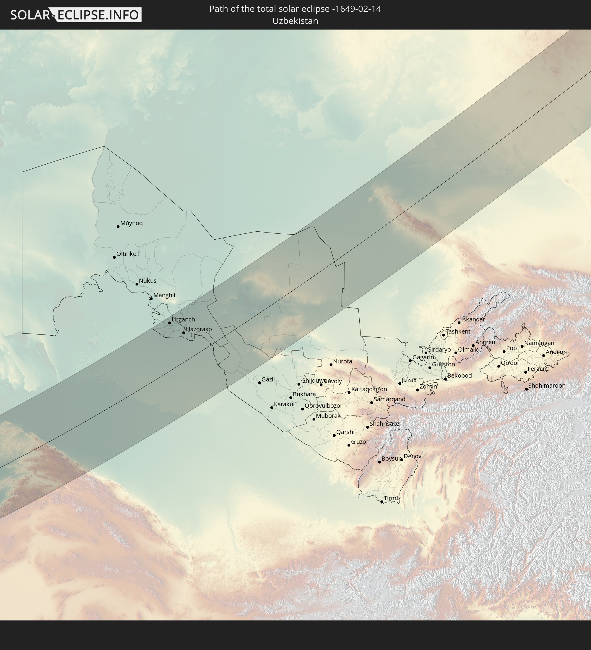
Detailed country maps
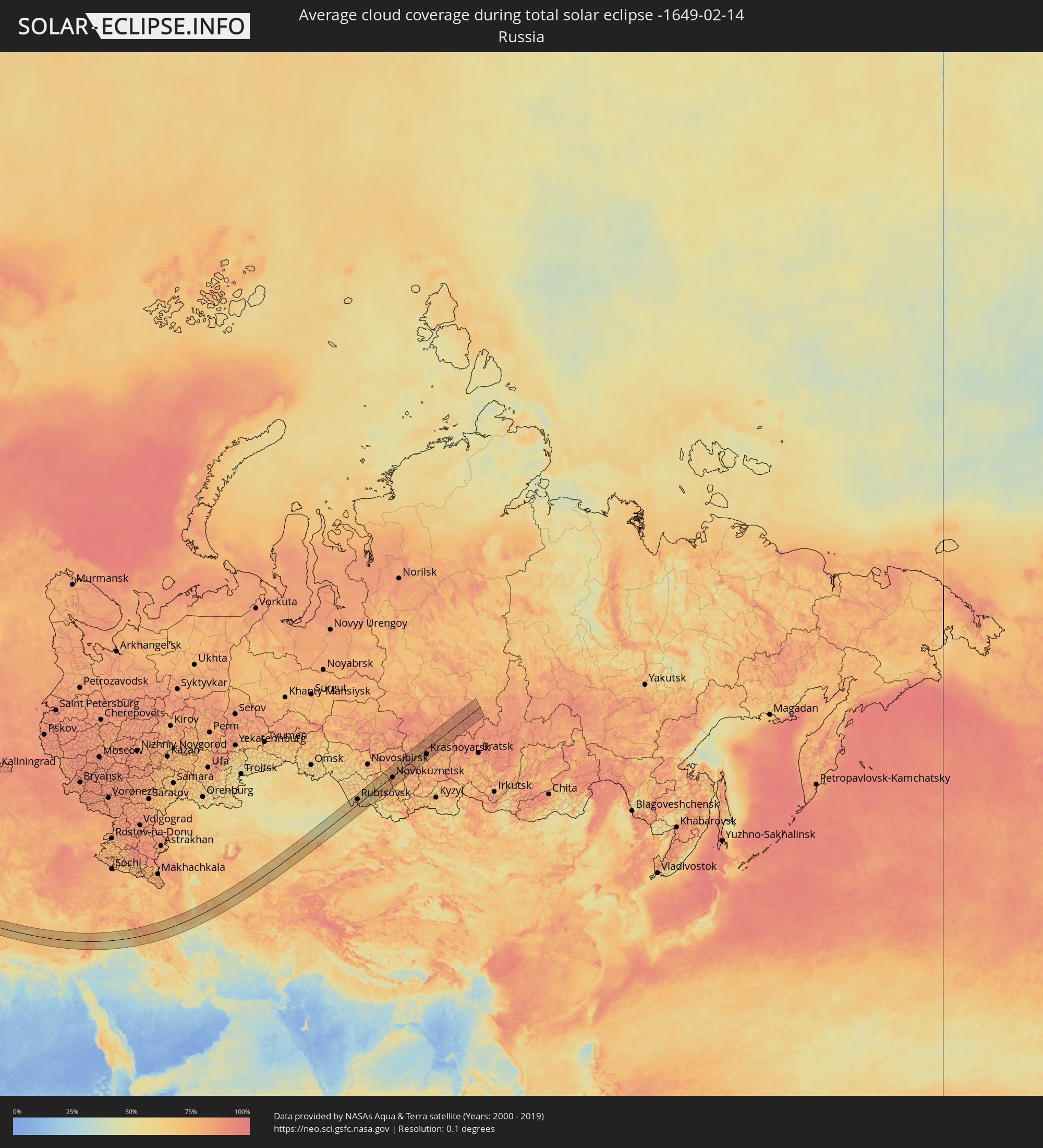 Russia
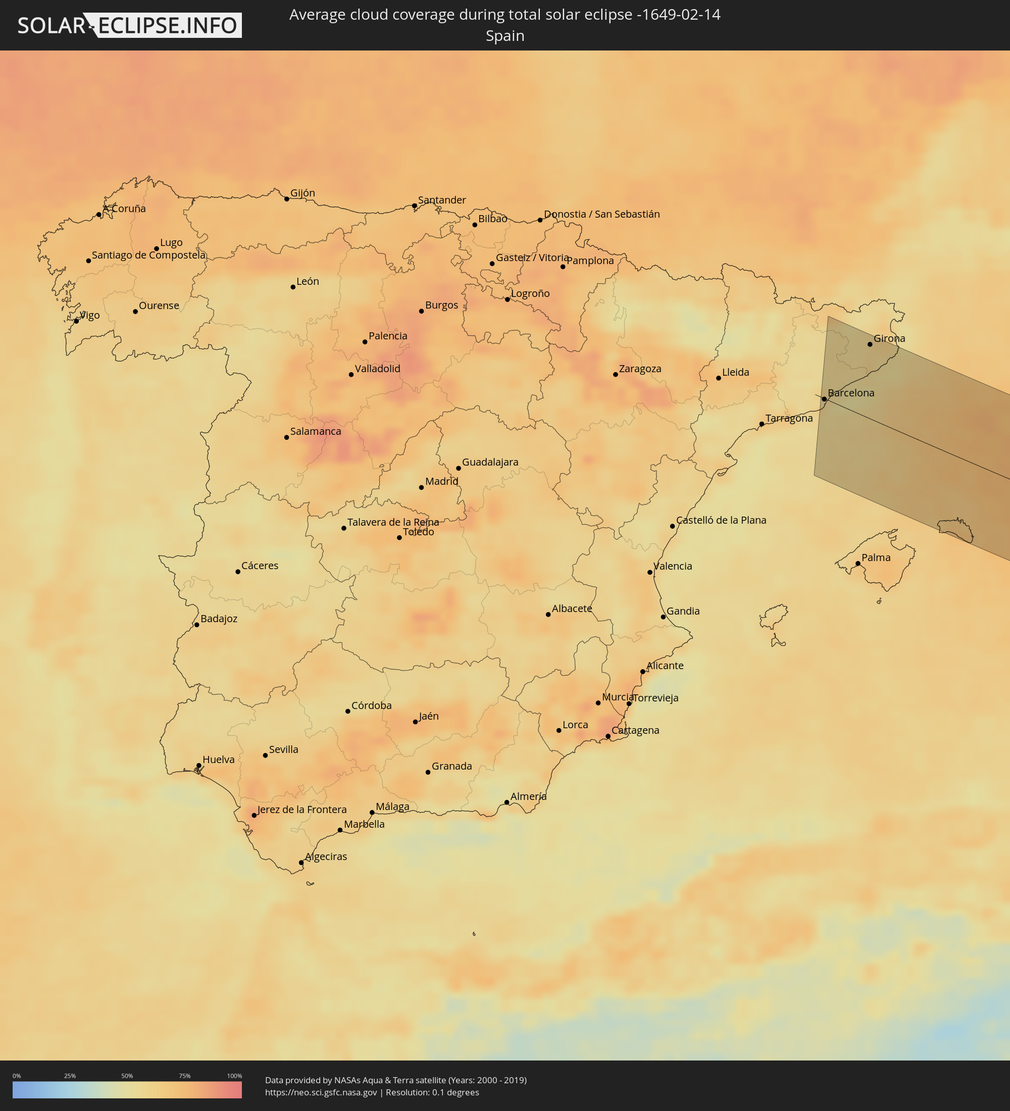 Spain
Spain
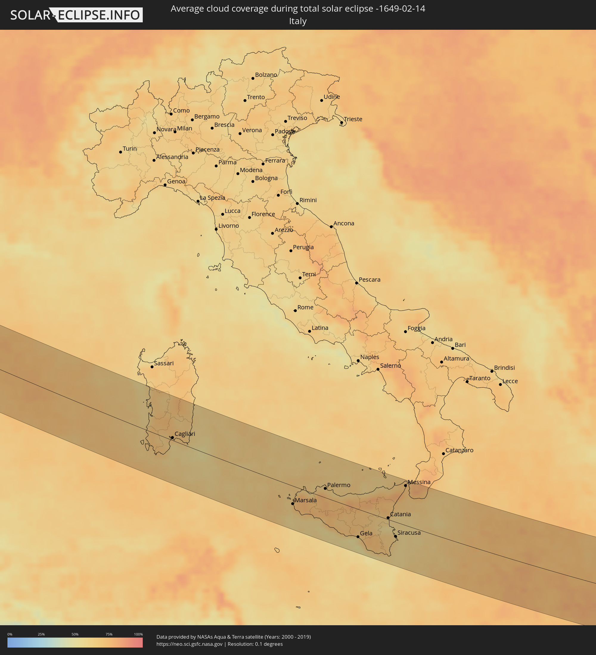 Italy
Italy
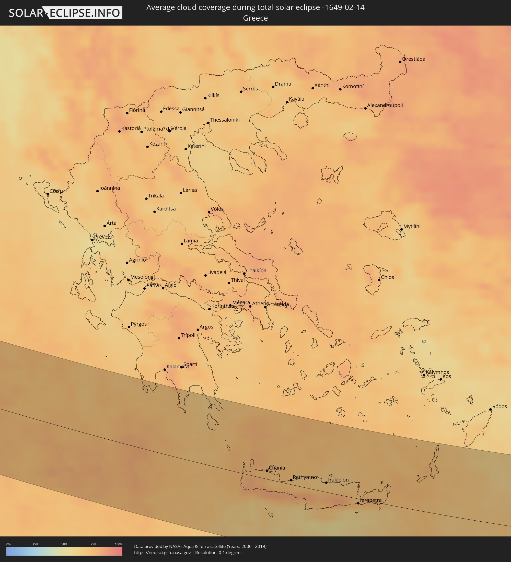 Greece
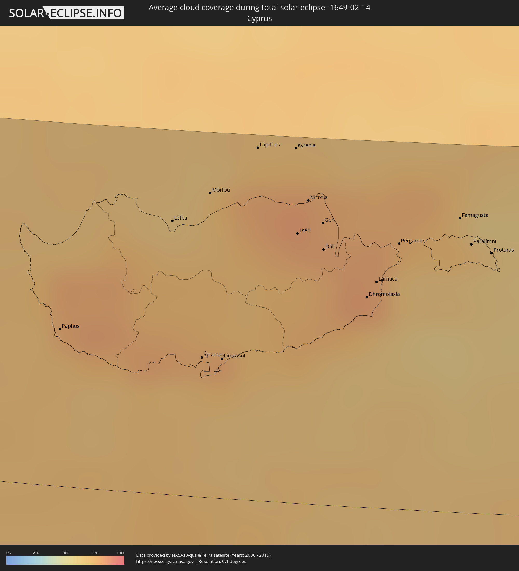 Cyprus
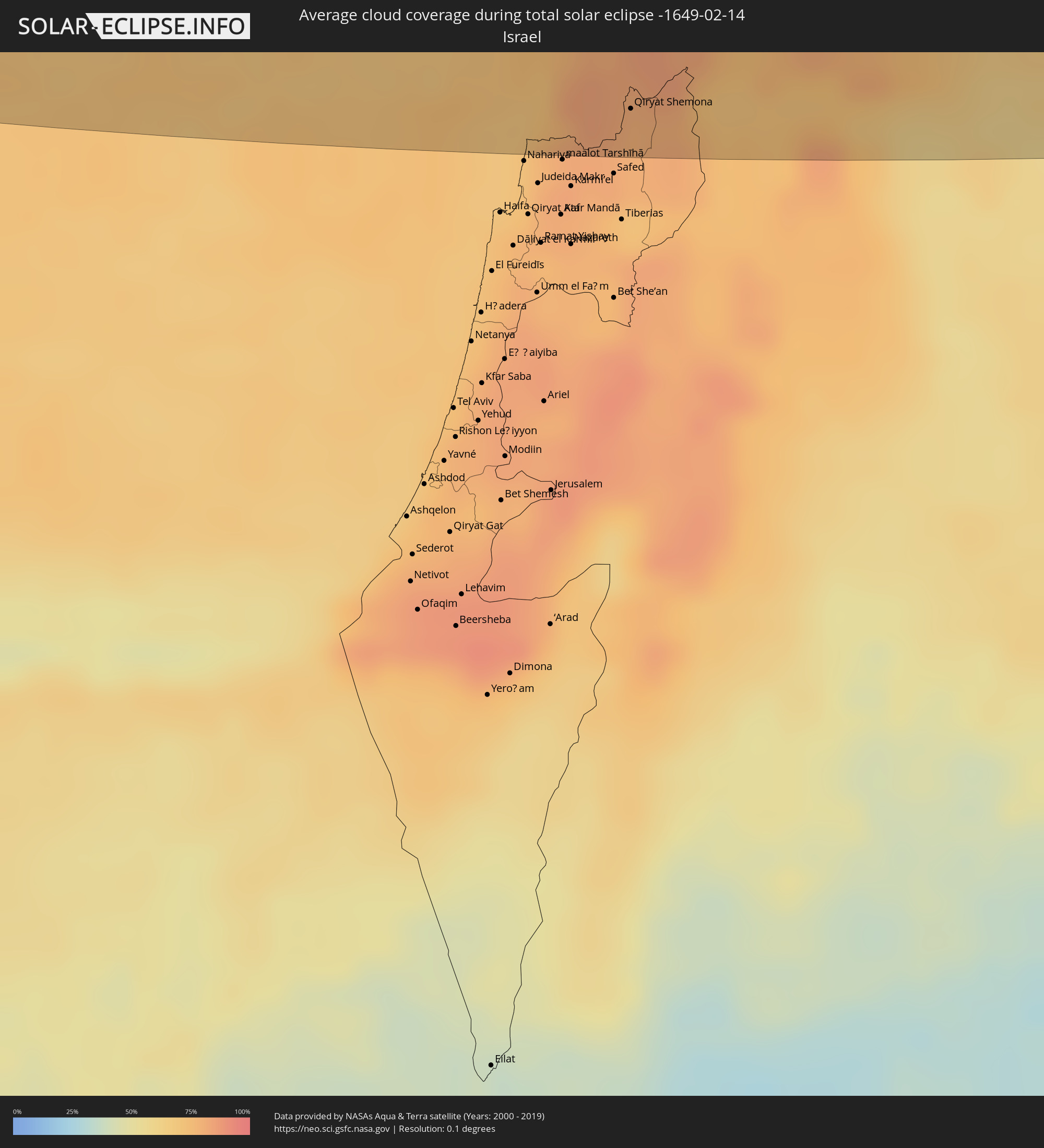 Israel
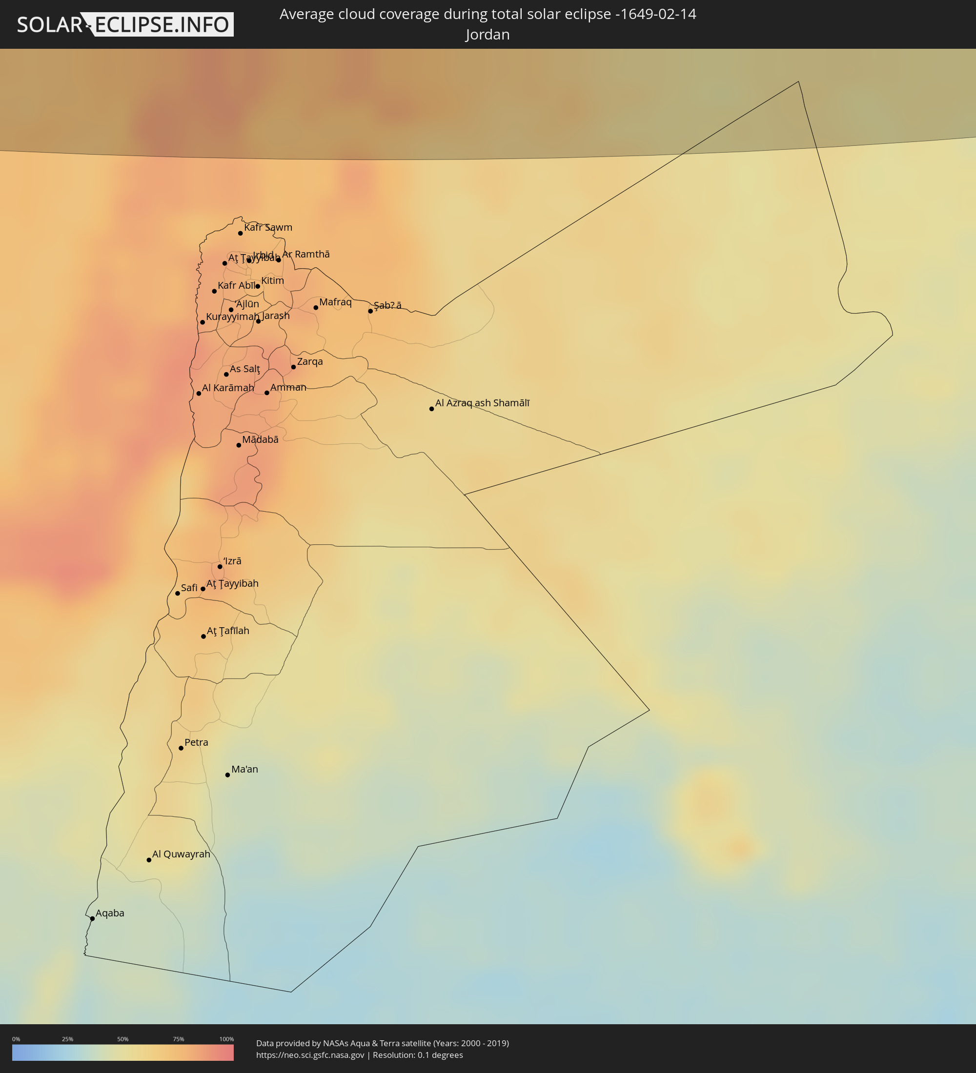 Jordan
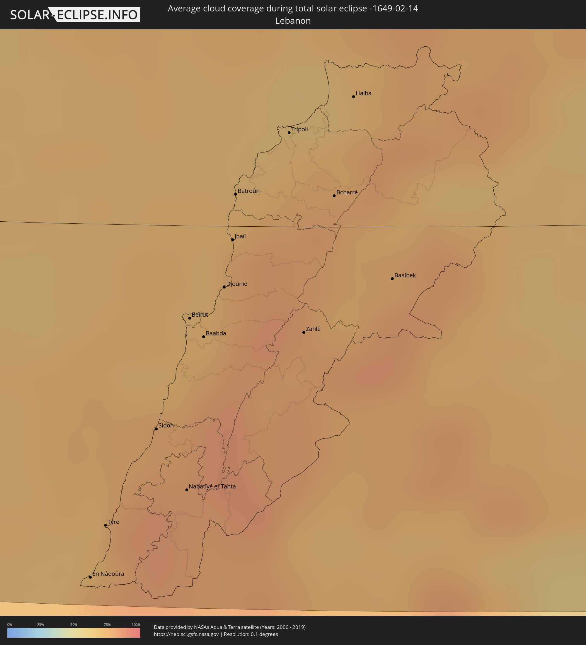 Lebanon
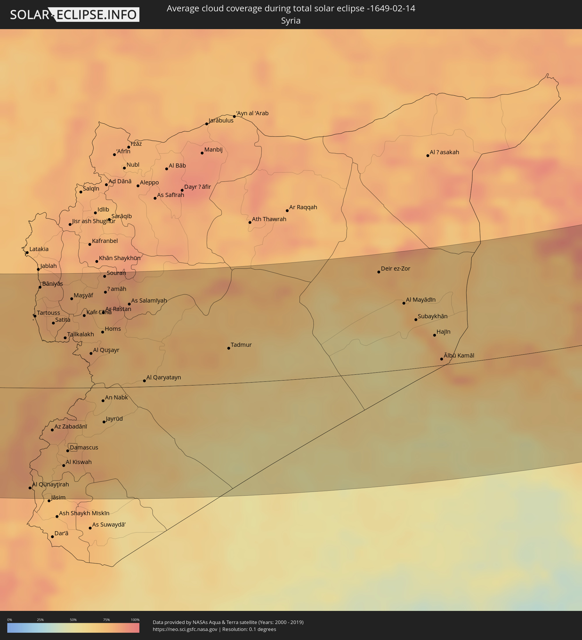 Syria
Syria
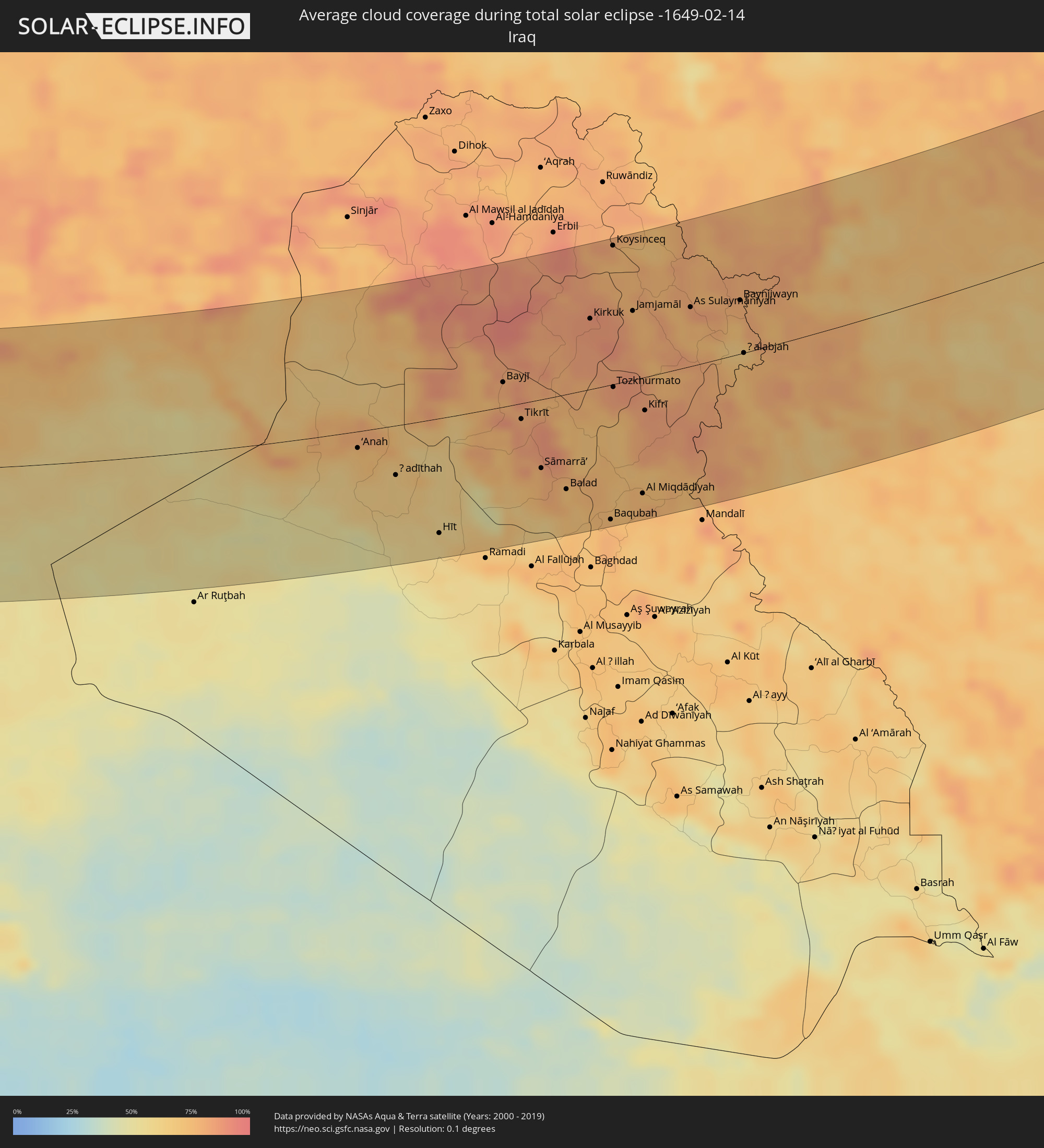 Iraq
Iraq
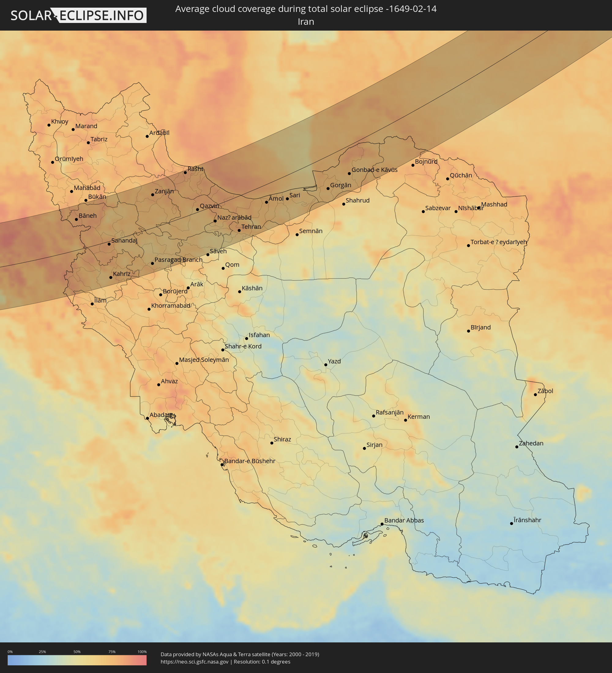 Iran
Iran
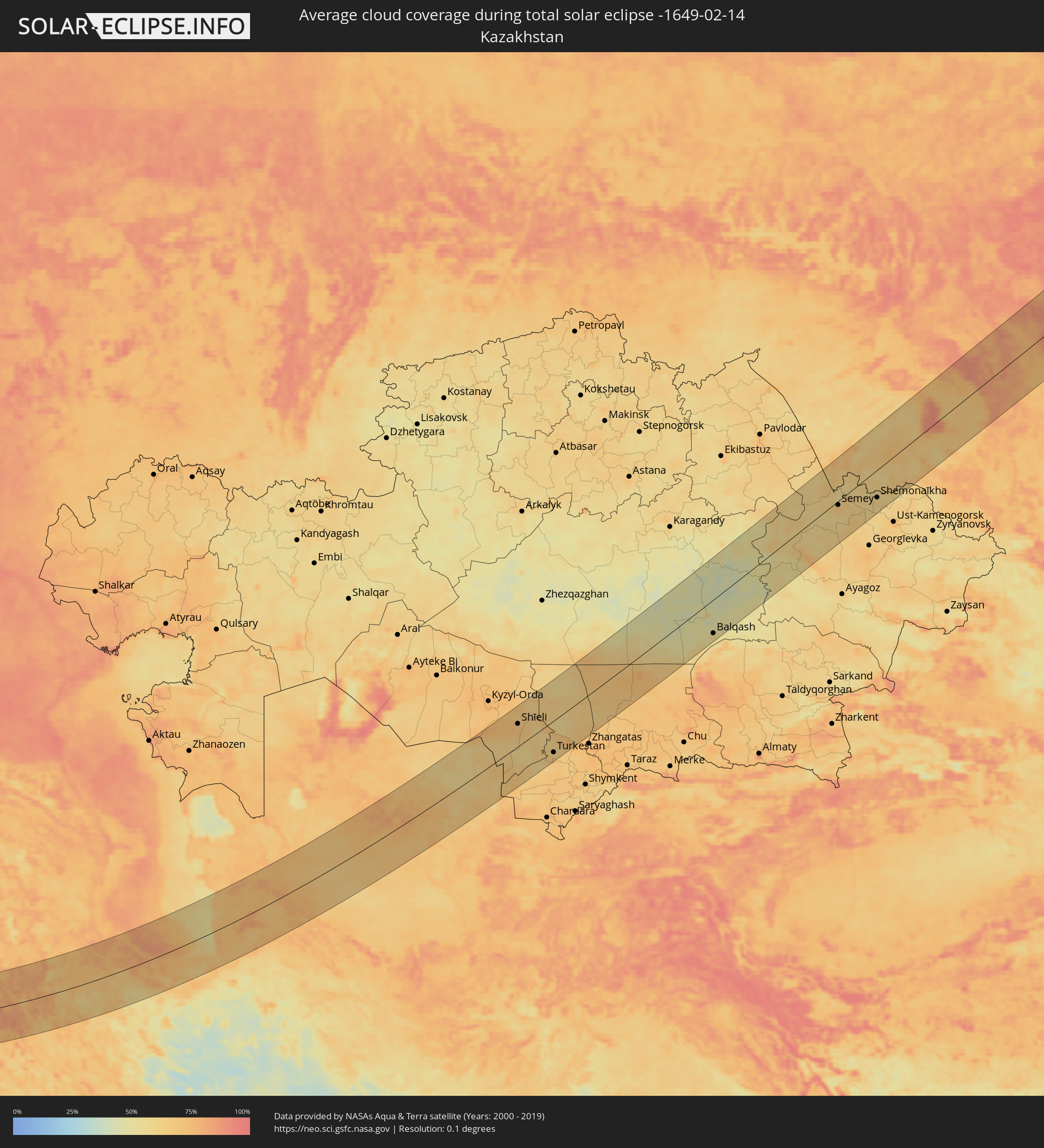 Kazakhstan
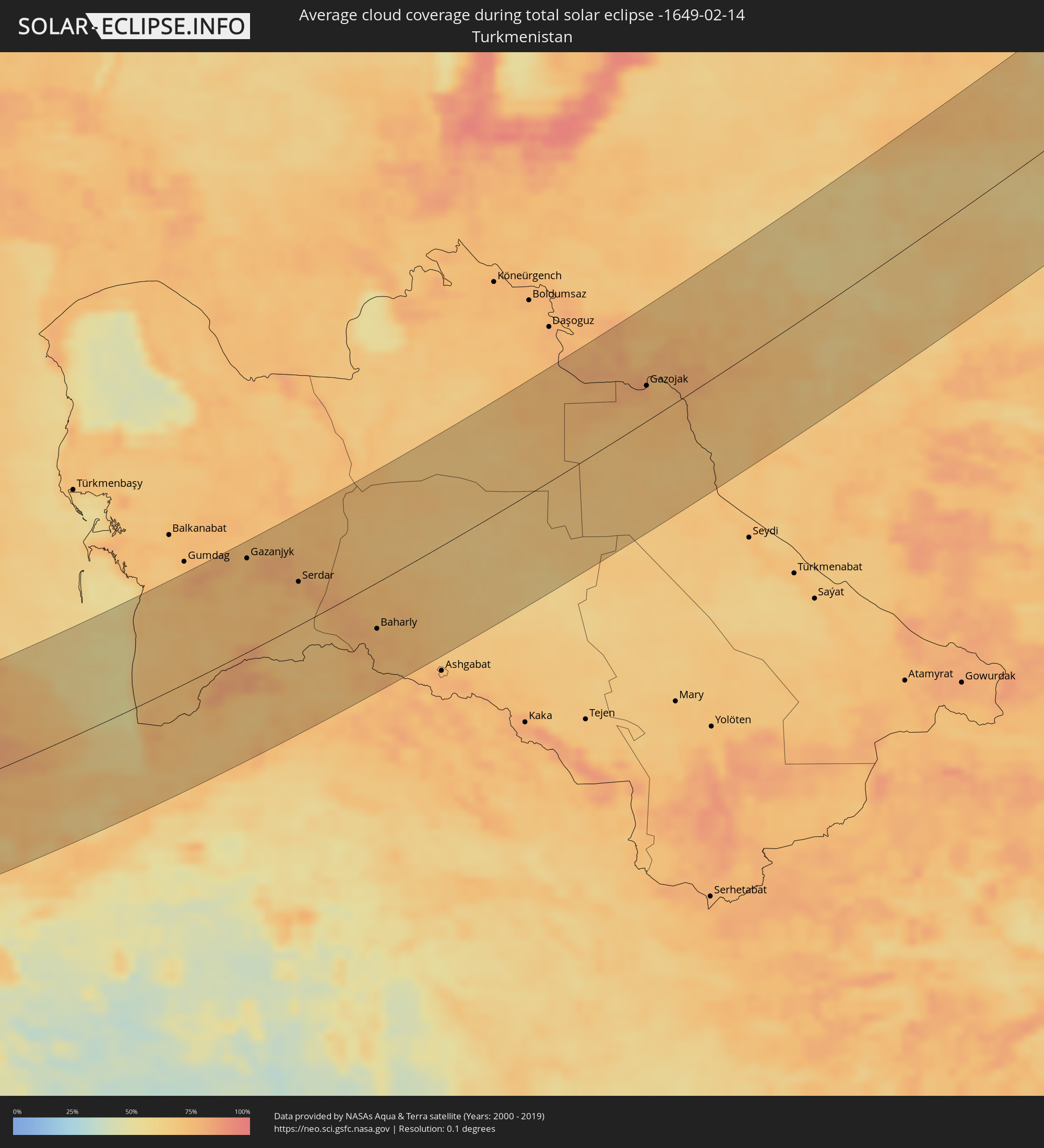 Turkmenistan
 Uzbekistan
Cities inside the path of the eclipse
The following table shows all locations with a population of more than 5,000 inside the eclipse path. Cities which have more than 100,000 inhabitants are marked bold. A click at the locations opens a detailed map.
| City | Type | Eclipse duration | Local time of max. eclipse | Distance to central line | Ø Cloud coverage |
|
Barcelona, Catalonia
|
total | - | 07:16:59 UTC+00:00 | 1 km | 55% |
|
Mollet del Vallès, Catalonia
|
total | - | 07:17:13 UTC+00:00 | 16 km | 57% |
|
Bigues i Riells, Catalonia
|
total | - | 07:17:26 UTC+00:00 | 31 km | 56% |
|
Vic, Catalonia
|
total | - | 07:17:48 UTC+00:00 | 57 km | 58% |
|
L'Ametlla del Vallès, Catalonia
|
total | - | 07:17:26 UTC+00:00 | 31 km | 57% |
|
la Garriga, Catalonia
|
total | - | 07:17:28 UTC+00:00 | 33 km | 57% |
|
Mataró, Catalonia
|
total | - | 07:17:20 UTC+00:00 | 24 km | 51% |
|
Sant Celoni, Catalonia
|
total | - | 07:17:34 UTC+00:00 | 41 km | 55% |
|
Olot, Catalonia
|
total | - | 07:18:16 UTC+00:00 | 91 km | 56% |
|
Santa Coloma de Farners, Catalonia
|
total | - | 07:17:54 UTC+00:00 | 65 km | 58% |
|
Blanes, Catalonia
|
total | - | 07:17:42 UTC+00:00 | 49 km | 57% |
|
Girona, Catalonia
|
total | - | 07:18:09 UTC+00:00 | 82 km | 60% |
|
Sant Feliu de Guíxols, Catalonia
|
total | - | 07:17:58 UTC+00:00 | 69 km | 55% |
|
Palafrugell, Catalonia
|
total | - | 07:18:14 UTC+00:00 | 87 km | 55% |
|
Ciutadella, Balearic Islands
|
total | - | 07:15:53 UTC+00:00 | 86 km | 65% |
|
Maó, Balearic Islands
|
total | - | 07:15:57 UTC+00:00 | 84 km | 68% |
|
Cagliari, Sardinia
|
total | - | 08:18:05 UTC+01:00 | 6 km | 60% |
|
Marsala, Sicily
|
total | - | 08:18:42 UTC+01:00 | 41 km | 63% |
|
Trapani, Sicily
|
total | - | 08:19:05 UTC+01:00 | 15 km | 66% |
|
Mazara del Vallo, Sicily
|
total | - | 08:18:38 UTC+01:00 | 52 km | 65% |
|
Alcamo, Sicily
|
total | - | 08:19:23 UTC+01:00 | 7 km | 72% |
|
Palermo, Sicily
|
total | - | 08:19:55 UTC+01:00 | 21 km | 77% |
|
Bagheria, Sicily
|
total | - | 08:20:00 UTC+01:00 | 20 km | 67% |
|
Caltanissetta, Sicily
|
total | - | 08:19:42 UTC+01:00 | 26 km | 71% |
|
Gela, Sicily
|
total | - | 08:19:19 UTC+01:00 | 64 km | 55% |
|
Vittoria, Sicily
|
total | - | 08:19:25 UTC+01:00 | 69 km | 72% |
|
Ragusa, Sicily
|
total | - | 08:19:34 UTC+01:00 | 66 km | 71% |
|
Paternò, Sicily
|
total | - | 08:20:35 UTC+01:00 | 7 km | 64% |
|
Catania, Sicily
|
total | - | 08:20:39 UTC+01:00 | 4 km | 60% |
|
Acireale, Sicily
|
total | - | 08:20:54 UTC+01:00 | 19 km | 62% |
|
Siracusa, Sicily
|
total | - | 08:20:18 UTC+01:00 | 34 km | 61% |
|
Messina, Sicily
|
total | - | 08:22:03 UTC+01:00 | 91 km | 71% |
|
Mourniés, Crete
|
total | - | 09:03:09 UTC+01:34 | 10 km | 78% |
|
Chaniá, Crete
|
total | - | 09:03:12 UTC+01:34 | 14 km | 78% |
|
Soúda, Crete
|
total | - | 09:03:14 UTC+01:34 | 12 km | 74% |
|
Rethymno, Crete
|
total | - | 09:03:38 UTC+01:34 | 7 km | 74% |
|
Tympáki, Crete
|
total | - | 09:03:40 UTC+01:34 | 19 km | 66% |
|
Moíres, Crete
|
total | - | 09:03:47 UTC+01:34 | 20 km | 71% |
|
Gázi, Crete
|
total | - | 09:04:24 UTC+01:34 | 14 km | 76% |
|
Irákleion, Crete
|
total | - | 09:04:31 UTC+01:34 | 15 km | 76% |
|
Néa Alikarnassós, Crete
|
total | - | 09:04:33 UTC+01:34 | 17 km | 78% |
|
Ágios Nikólaos, Crete
|
total | - | 09:05:09 UTC+01:34 | 11 km | 72% |
|
Ierápetra, Crete
|
total | - | 09:04:58 UTC+01:34 | 8 km | 61% |
|
Sitia, Crete
|
total | - | 09:05:44 UTC+01:34 | 20 km | 76% |
|
Paphos, Pafos
|
total | - | 09:53:56 UTC+02:13 | 54 km | 71% |
|
Léfka, Nicosia
|
total | - | 09:55:05 UTC+02:13 | 95 km | 69% |
|
Ýpsonas, Limassol
|
total | - | 09:54:47 UTC+02:13 | 48 km | 73% |
|
Mórfou, Nicosia
|
total | - | 09:55:26 UTC+02:13 | 105 km | 71% |
|
Limassol, Limassol
|
total | - | 09:54:55 UTC+02:13 | 48 km | 73% |
|
Kyrenia, Keryneia
|
total | - | 09:56:10 UTC+02:13 | 122 km | 80% |
|
Tséri, Nicosia
|
total | - | 09:55:52 UTC+02:13 | 93 km | 79% |
|
Nicosia, Nicosia
|
total | - | 09:56:04 UTC+02:13 | 105 km | 79% |
|
Géri, Nicosia
|
total | - | 09:56:05 UTC+02:13 | 97 km | 80% |
|
Dáli, Nicosia
|
total | - | 09:55:59 UTC+02:13 | 88 km | 77% |
|
Aradíppou, Larnaka
|
total | - | 09:56:13 UTC+02:13 | 81 km | 79% |
|
Larnaca, Larnaka
|
total | - | 09:56:14 UTC+02:13 | 78 km | 69% |
|
Pérgamos, Larnaka
|
total | - | 09:56:31 UTC+02:13 | 92 km | 69% |
|
Famagusta, Ammochostos
|
total | - | 09:57:02 UTC+02:13 | 102 km | 73% |
|
Paralímni, Ammochostos
|
total | - | 09:57:01 UTC+02:13 | 93 km | 64% |
|
Protaras, Ammochostos
|
total | - | 09:57:07 UTC+02:13 | 90 km | 62% |
|
En Nâqoûra, South Governorate
|
total | - | 09:43:31 UTC+02:00 | 117 km | 71% |
|
Shelomi, Northern District
|
total | - | 10:04:08 UTC+02:20 | 122 km | 71% |
|
Tyre, South Governorate
|
total | - | 09:43:47 UTC+02:00 | 100 km | 72% |
|
Sidon, South Governorate
|
total | - | 09:44:27 UTC+02:00 | 67 km | 77% |
|
Habboûch, Nabatîyé
|
total | - | 09:44:29 UTC+02:00 | 84 km | 82% |
|
Ra’s Bayrūt, Beyrouth
|
total | - | 09:45:02 UTC+02:00 | 29 km | 72% |
|
Nabatîyé et Tahta, Nabatîyé
|
total | - | 09:44:27 UTC+02:00 | 87 km | 82% |
|
Beirut, Beyrouth
|
total | - | 09:45:03 UTC+02:00 | 31 km | 72% |
|
Baabda, Mont-Liban
|
total | - | 09:45:05 UTC+02:00 | 37 km | 72% |
|
Qiryat Shemona, Northern District
|
total | - | 10:05:06 UTC+02:20 | 106 km | 79% |
|
Djounie, Mont-Liban
|
total | - | 09:45:23 UTC+02:00 | 20 km | 72% |
|
Jbaïl, Mont-Liban
|
total | - | 09:45:36 UTC+02:00 | 5 km | 71% |
|
Batroûn, Liban-Nord
|
total | - | 09:45:46 UTC+02:00 | 10 km | 71% |
|
Al Qunayţirah, Quneitra
|
total | - | 10:10:02 UTC+02:25 | 115 km | 80% |
|
Tripoli, Liban-Nord
|
total | - | 09:46:20 UTC+02:00 | 31 km | 71% |
|
Tartouss, Tartus
|
total | - | 10:12:06 UTC+02:25 | 81 km | 73% |
|
Zahlé, Béqaa
|
total | - | 09:45:46 UTC+02:00 | 35 km | 78% |
|
Bāniyās, Tartus
|
total | - | 10:12:33 UTC+02:25 | 114 km | 75% |
|
Bcharré, Liban-Nord
|
total | - | 09:46:26 UTC+02:00 | 10 km | 77% |
|
Halba, Aakkâr
|
total | - | 09:46:53 UTC+02:00 | 43 km | 75% |
|
Baalbek, Baalbek-Hermel
|
total | - | 09:46:33 UTC+02:00 | 17 km | 79% |
|
Damascus, Dimashq
|
total | - | 10:11:21 UTC+02:25 | 72 km | 77% |
|
Maşyāf, Hama
|
total | - | 10:13:10 UTC+02:25 | 101 km | 80% |
|
Al Quşayr, Homs
|
total | - | 10:13:00 UTC+02:25 | 39 km | 76% |
|
Homs, Homs
|
total | - | 10:13:31 UTC+02:25 | 63 km | 78% |
|
An Nabk, Rif-dimashq
|
total | - | 10:12:46 UTC+02:25 | 15 km | 68% |
|
Ar Rastan, Homs
|
total | - | 10:13:46 UTC+02:25 | 85 km | 74% |
|
Jayrūd, Rif-dimashq
|
total | - | 10:12:33 UTC+02:25 | 40 km | 70% |
|
Ḩamāh, Hama
|
total | - | 10:14:02 UTC+02:25 | 108 km | 85% |
|
As Salamīyah, Hama
|
total | - | 10:14:28 UTC+02:25 | 94 km | 80% |
|
Tadmur, Homs
|
total | - | 10:16:24 UTC+02:25 | 40 km | 71% |
|
Deir ez-Zor, Deir ez-Zor
|
total | - | 10:20:57 UTC+02:25 | 112 km | 70% |
|
Al Mayādīn, Deir ez-Zor
|
total | - | 10:21:16 UTC+02:25 | 74 km | 74% |
|
Ālbū Kamāl, Deir ez-Zor
|
total | - | 10:21:39 UTC+02:25 | 7 km | 75% |
|
Ḩadīthah, Anbar
|
total | - | 10:56:49 UTC+02:57 | 47 km | 63% |
|
Hīt, Anbar
|
total | - | 10:57:18 UTC+02:57 | 108 km | 59% |
|
Bayjī, Salah ad Din Governorate
|
total | - | 10:59:57 UTC+02:57 | 23 km | 77% |
|
Tikrīt, Salah ad Din Governorate
|
total | - | 11:00:03 UTC+02:57 | 15 km | 83% |
|
Sāmarrā’, Salah ad Din Governorate
|
total | - | 11:00:07 UTC+02:57 | 64 km | 79% |
|
Balad, Salah ad Din Governorate
|
total | - | 11:00:31 UTC+02:57 | 89 km | 76% |
|
Kirkuk, At Taʼmīm
|
total | - | 11:02:23 UTC+02:57 | 65 km | 86% |
|
Baqubah, Diyālá
|
total | - | 11:01:16 UTC+02:57 | 126 km | 76% |
|
Koysinceq, Arbīl
|
total | - | 11:03:26 UTC+02:57 | 127 km | 79% |
|
Tozkhurmato, Salah ad Din Governorate
|
total | - | 11:02:22 UTC+02:57 | 3 km | 84% |
|
Jamjamāl, As Sulaymānīyah
|
total | - | 11:03:23 UTC+02:57 | 63 km | 79% |
|
Al Miqdādīyah, Diyālá
|
total | - | 11:02:12 UTC+02:57 | 108 km | 77% |
|
Kifrī, Diyālá
|
total | - | 11:02:54 UTC+02:57 | 31 km | 85% |
|
As Sulaymānīyah, As Sulaymānīyah
|
total | - | 11:04:42 UTC+02:57 | 54 km | 81% |
|
Bāneh, Kordestān
|
total | - | 11:34:12 UTC+03:25 | 90 km | 80% |
|
Baynjiwayn, As Sulaymānīyah
|
total | - | 11:05:52 UTC+02:57 | 49 km | 78% |
|
Ḩalabjah, As Sulaymānīyah
|
total | - | 11:05:34 UTC+02:57 | 0 km | 73% |
|
Saqqez, Kordestān
|
total | - | 11:35:15 UTC+03:25 | 108 km | 80% |
|
Sanandaj, Kordestān
|
total | - | 11:36:02 UTC+03:25 | 10 km | 77% |
|
Kahrīz, Kermānshāh
|
total | - | 11:35:23 UTC+03:25 | 111 km | 74% |
|
Pasragad Branch, Hamadān
|
total | - | 11:38:51 UTC+03:25 | 106 km | 75% |
|
Zanjān, Zanjan
|
total | - | 11:40:21 UTC+03:25 | 95 km | 79% |
|
Rasht, Gīlān
|
total | - | 11:43:12 UTC+03:25 | 124 km | 81% |
|
Qazvin, Qazvīn
|
total | - | 11:43:23 UTC+03:25 | 6 km | 66% |
|
Naz̧arābād, Alborz
|
total | - | 11:44:29 UTC+03:25 | 46 km | 69% |
|
Karaj, Alborz
|
total | - | 11:45:14 UTC+03:25 | 71 km | 65% |
|
Tehran, Tehrān
|
total | - | 11:46:06 UTC+03:25 | 99 km | 65% |
|
Āmol, Māzandarān
|
total | - | 11:48:39 UTC+03:25 | 51 km | 75% |
|
Bābol, Māzandarān
|
total | - | 11:49:25 UTC+03:25 | 55 km | 71% |
|
Sari, Māzandarān
|
total | - | 11:50:16 UTC+03:25 | 67 km | 69% |
|
Gorgān, Golestān
|
total | - | 11:53:26 UTC+03:25 | 90 km | 67% |
|
Gonbad-e Kāvūs, Golestān
|
total | - | 11:55:13 UTC+03:25 | 77 km | 69% |
|
Gazanjyk, Balkan
|
total | - | 12:24:44 UTC+03:53 | 106 km | 74% |
|
Serdar, Balkan
|
total | - | 12:26:11 UTC+03:53 | 49 km | 75% |
|
Baharly, Ahal
|
total | - | 12:28:21 UTC+03:53 | 52 km | 77% |
|
Abadan, Ahal
|
total | - | 12:29:47 UTC+03:53 | 121 km | 76% |
|
Qŭshkŭpir, Xorazm
|
total | - | 13:09:30 UTC+04:27 | 117 km | 78% |
|
Khiwa, Xorazm
|
total | - | 13:09:30 UTC+04:27 | 102 km | 79% |
|
Urganch, Xorazm
|
total | - | 13:10:03 UTC+04:27 | 106 km | 79% |
|
Beruniy, Karakalpakstan
|
total | - | 13:10:18 UTC+04:27 | 113 km | 78% |
|
Novyy Turtkul’, Karakalpakstan
|
total | - | 13:10:47 UTC+04:27 | 88 km | 81% |
|
Hazorasp, Xorazm
|
total | - | 13:10:50 UTC+04:27 | 64 km | 79% |
|
Gazojak, Lebap
|
total | - | 12:37:05 UTC+03:53 | 37 km | 78% |
|
Shīeli, Qyzylorda
|
total | - | 13:15:08 UTC+04:21 | 63 km | 71% |
|
Yanykurgan, Qyzylorda
|
total | - | 13:16:00 UTC+04:21 | 15 km | 66% |
|
Turkestan, Ongtüstik Qazaqstan
|
total | - | 13:17:43 UTC+04:21 | 87 km | 62% |
|
Kentau, Ongtüstik Qazaqstan
|
total | - | 13:18:07 UTC+04:21 | 79 km | 61% |
|
Kantagi, Ongtüstik Qazaqstan
|
total | - | 13:18:15 UTC+04:21 | 82 km | 64% |
|
Ashchysay, Ongtüstik Qazaqstan
|
total | - | 13:18:45 UTC+04:21 | 94 km | 70% |
|
Chulakkurgan, Ongtüstik Qazaqstan
|
total | - | 13:19:11 UTC+04:21 | 88 km | 68% |
|
Priozersk
|
total | - | 13:25:30 UTC+04:21 | 97 km | 66% |
|
Balqash, Qaraghandy
|
total | - | 13:26:59 UTC+04:21 | 85 km | 54% |
|
Kūrchatov, Pavlodar
|
total | - | 13:29:28 UTC+04:21 | 96 km | 62% |
|
Qaraūyl, East Kazakhstan
|
total | - | 13:31:22 UTC+04:21 | 94 km | 74% |
|
Semey, East Kazakhstan
|
total | - | 13:31:39 UTC+04:21 | 9 km | 69% |
|
Borodūlīkha, East Kazakhstan
|
total | - | 13:32:11 UTC+04:21 | 13 km | 67% |
|
Rubtsovsk, Altai Krai
|
total | - | 15:21:31 UTC+06:11 | 44 km | 67% |
|
Zhezkent, East Kazakhstan
|
total | - | 13:32:31 UTC+04:21 | 13 km | 59% |
|
Ūst’-Talovka, East Kazakhstan
|
total | - | 13:33:18 UTC+04:21 | 68 km | 61% |
|
Shemonaīkha, East Kazakhstan
|
total | - | 13:33:19 UTC+04:21 | 64 km | 64% |
|
Barnaul, Altai Krai
|
total | - | 15:22:46 UTC+06:11 | 93 km | 76% |
|
Zarinsk, Altai Krai
|
total | - | 15:23:36 UTC+06:11 | 73 km | 74% |
|
Biysk, Altai Krai
|
total | - | 15:24:48 UTC+06:11 | 39 km | 73% |
|
Belovo, Kemerovo
|
total | - | 15:24:14 UTC+06:11 | 79 km | 84% |
|
Prokop’yevsk, Kemerovo
|
total | - | 15:25:03 UTC+06:11 | 17 km | 84% |
|
Novokuznetsk, Kemerovo
|
total | - | 15:25:31 UTC+06:11 | 12 km | 84% |
|
Osinniki, Kemerovo
|
total | - | 15:25:51 UTC+06:11 | 34 km | 80% |
|
Myski, Kemerovo
|
total | - | 15:26:10 UTC+06:11 | 44 km | 81% |
|
Mezhdurechensk, Kemerovo
|
total | - | 15:26:24 UTC+06:11 | 56 km | 77% |
|
Sharypovo, Krasnoyarskiy
|
total | - | 15:25:39 UTC+06:11 | 58 km | 81% |
|
Nazarovo, Krasnoyarskiy
|
total | - | 15:26:08 UTC+06:11 | 51 km | 80% |
|
Achinsk, Krasnoyarskiy
|
total | - | 15:25:57 UTC+06:11 | 70 km | 89% |
|
Krasnoyarsk, Krasnoyarskiy
|
total | - | 15:27:56 UTC+06:11 | 44 km | 87% |
|
Sosnovoborsk, Krasnoyarskiy
|
total | - | 15:28:09 UTC+06:11 | 53 km | 86% |
|
Zheleznogorsk, Krasnoyarskiy
|
total | - | 15:28:09 UTC+06:11 | 49 km | 89% |