Annular solar eclipse of 04/11/0153
| Day of week: | Wednesday |
| Maximum duration of eclipse: | 06m24s |
| Maximum width of eclipse path: | 202 km |
| Saros cycle: | 70 |
| Coverage: | 94.7% |
| Magnitude: | 0.947 |
| Gamma: | 0.2599 |
Wo kann man die Sonnenfinsternis vom 04/11/0153 sehen?
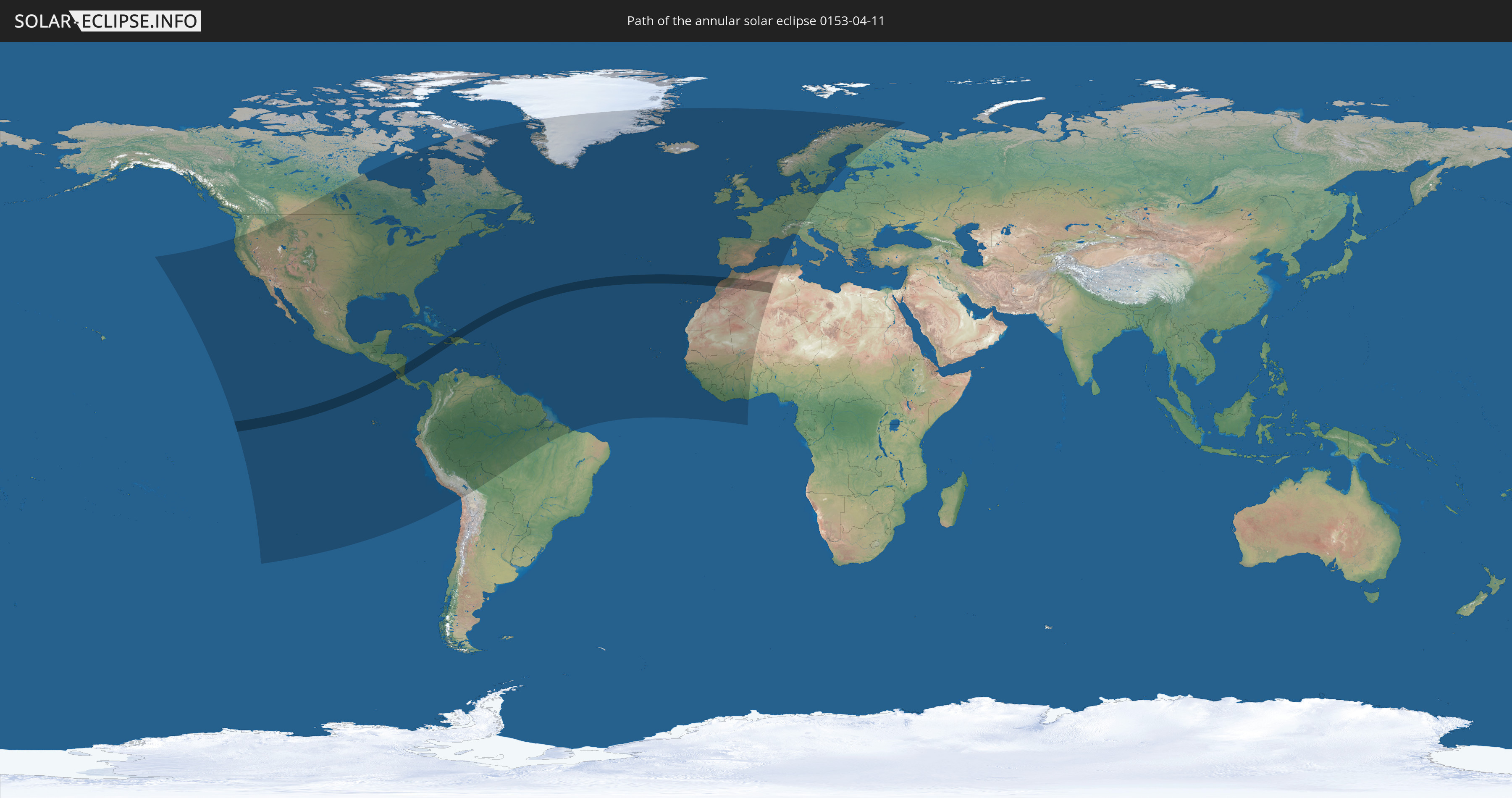
Die Sonnenfinsternis am 04/11/0153 kann man in 93 Ländern als partielle Sonnenfinsternis beobachten.
Der Finsternispfad verläuft durch 10 Länder. Nur in diesen Ländern ist sie als annular Sonnenfinsternis zu sehen.
In den folgenden Ländern ist die Sonnenfinsternis annular zu sehen
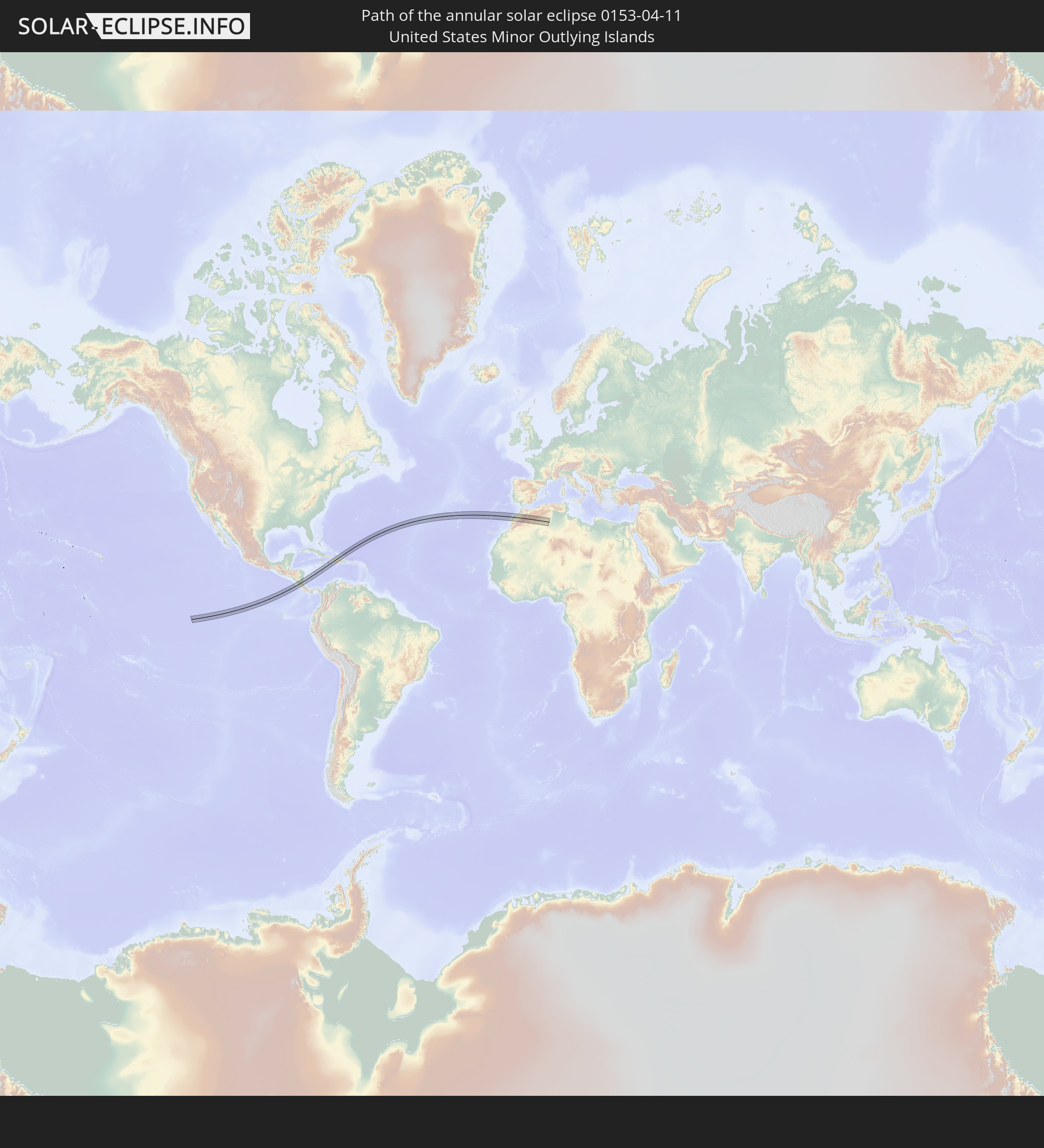 United States Minor Outlying Islands
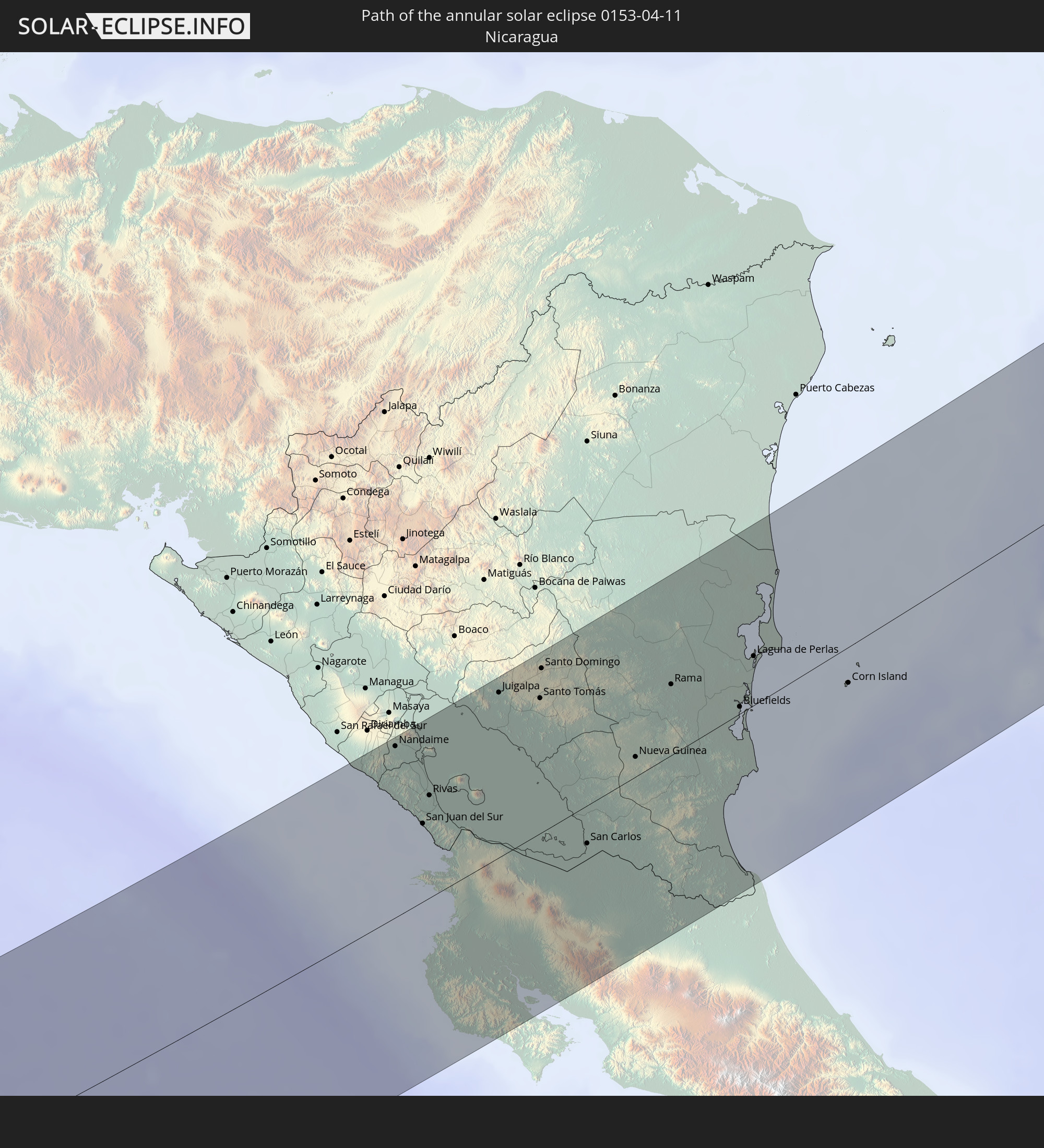 Nicaragua
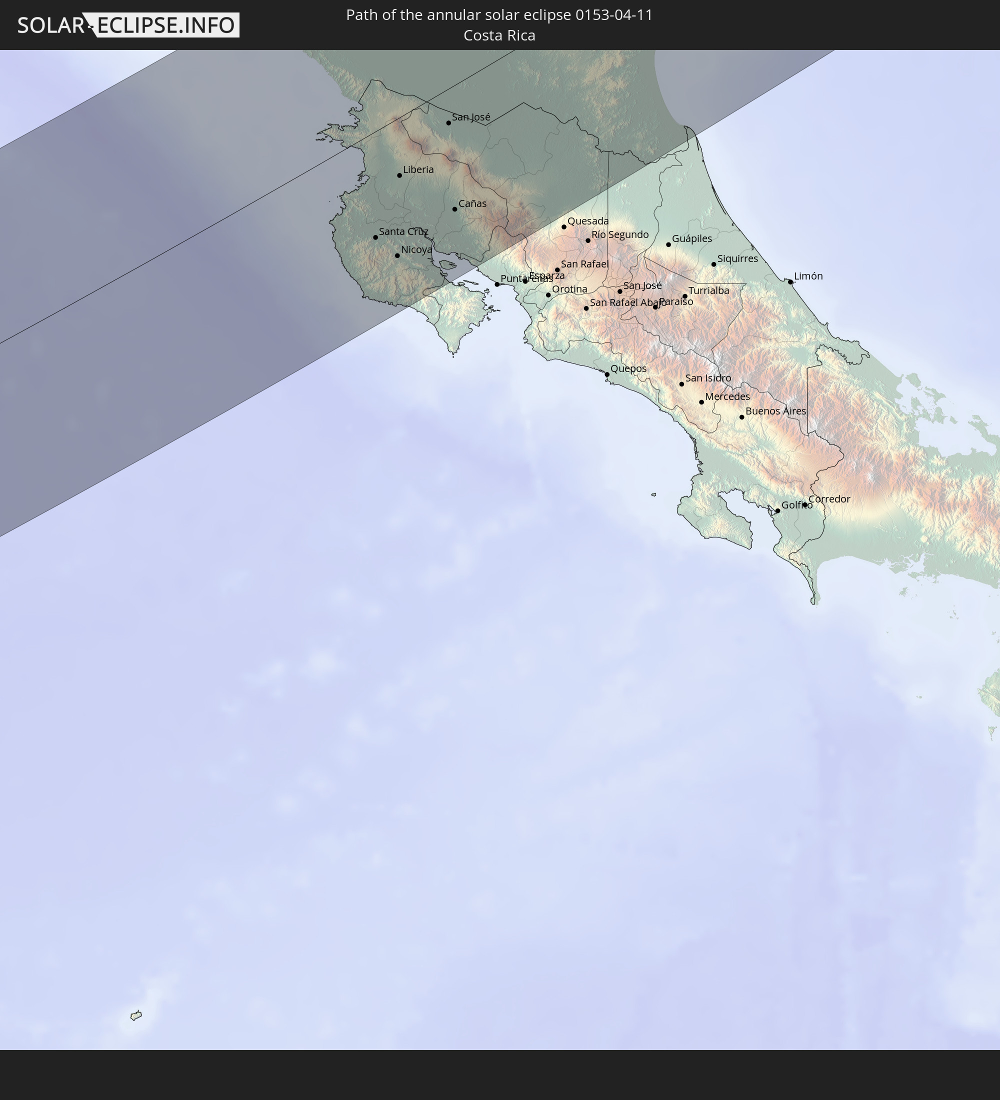 Costa Rica
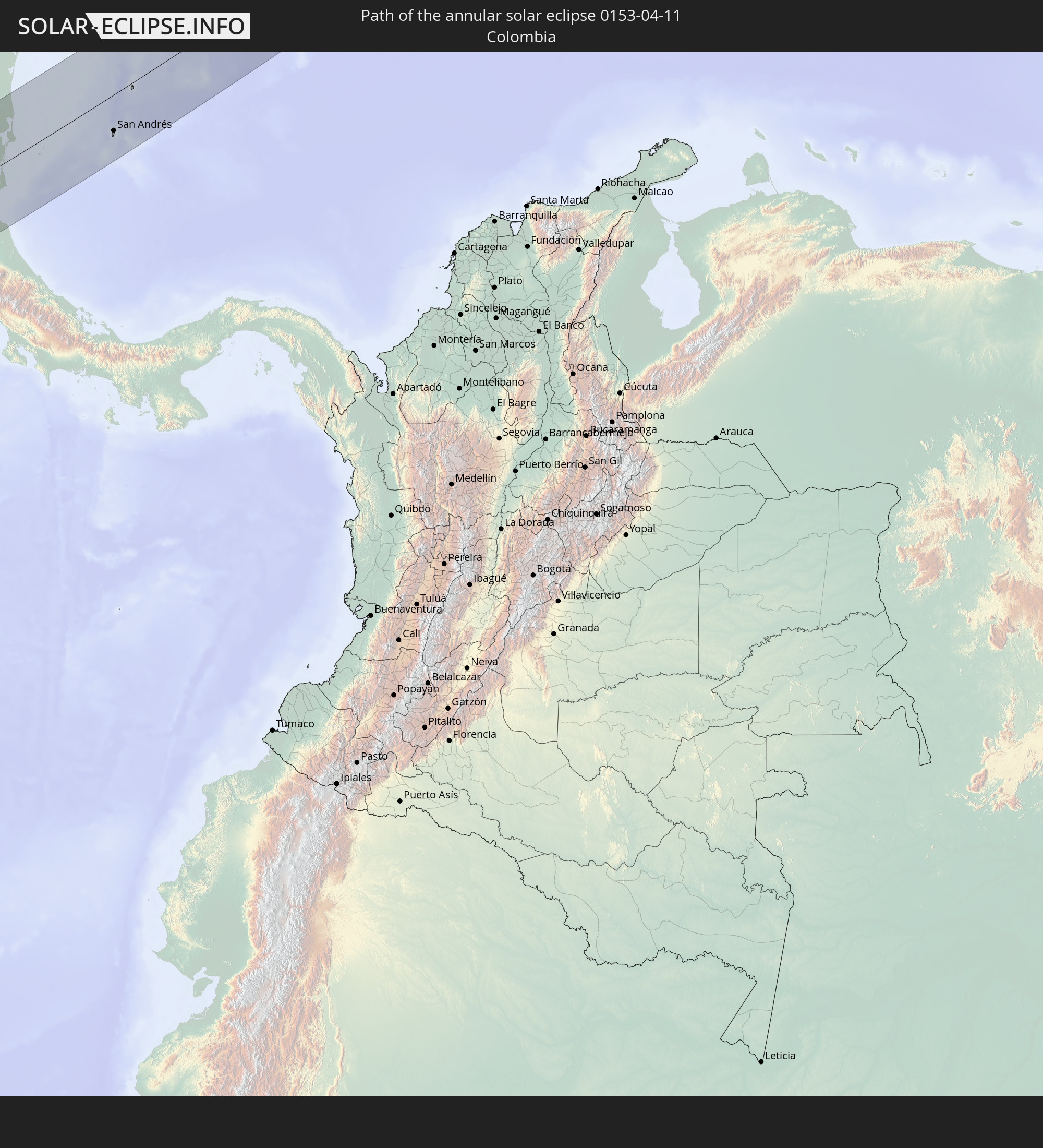 Colombia
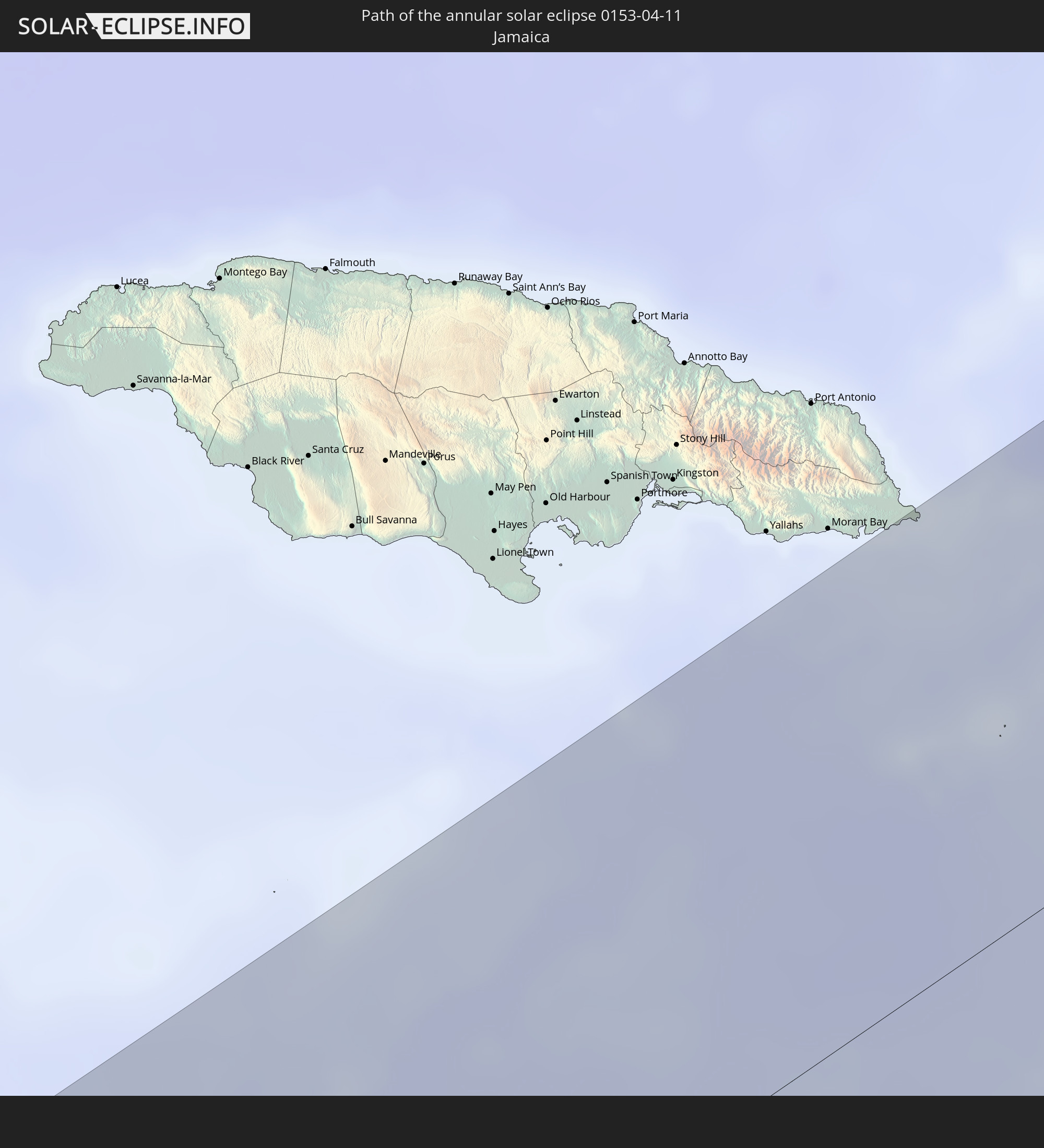 Jamaica
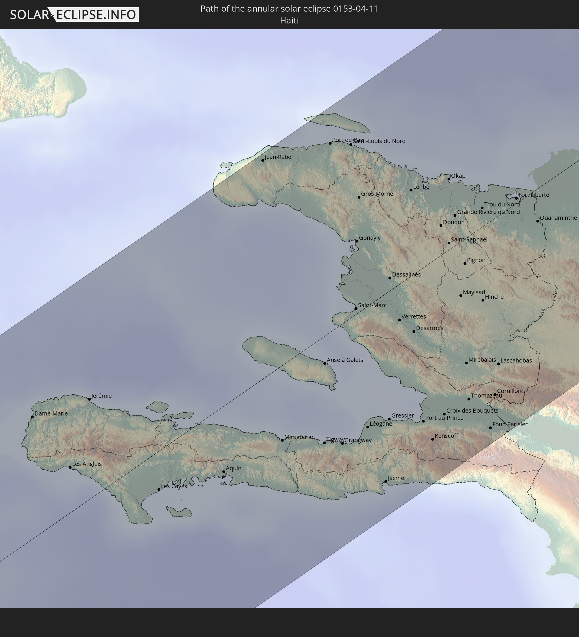 Haiti
Haiti
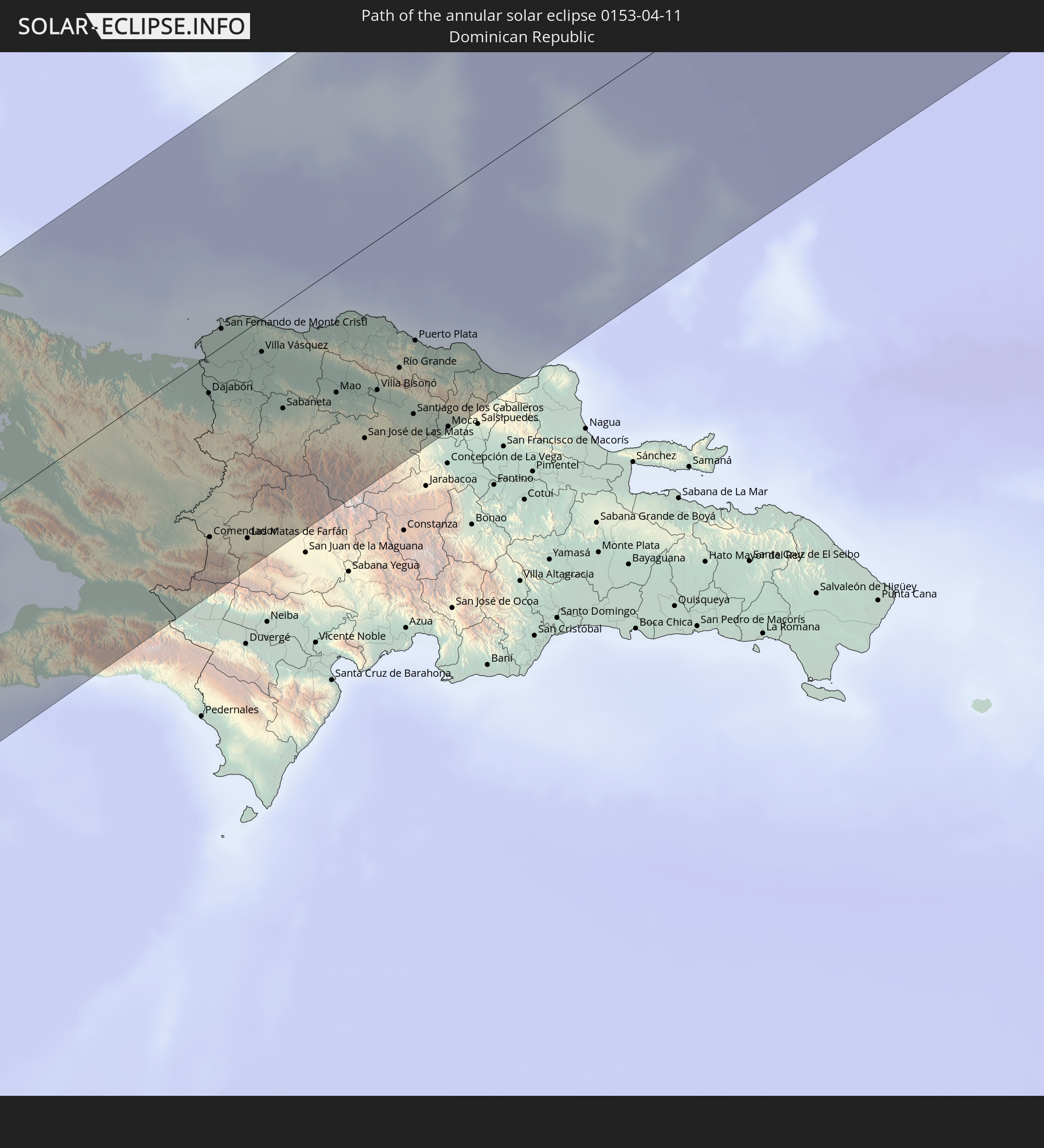 Dominican Republic
 Portugal
 Morocco
 Algeria
In den folgenden Ländern ist die Sonnenfinsternis partiell zu sehen
 Russia
 United States
 United States Minor Outlying Islands
 Canada
 Mexico
 Chile
Chile
 Greenland
 Guatemala
 Ecuador
 El Salvador
 Honduras
 Belize
 Nicaragua
 Costa Rica
 Cuba
Cuba
 Panama
 Colombia
 Cayman Islands
 Peru
Peru
 The Bahamas
 Jamaica
 Haiti
Haiti
 Brazil
 Venezuela
 Turks and Caicos Islands
 Dominican Republic
 Aruba
Aruba
 Bolivia
 Puerto Rico
 United States Virgin Islands
 Bermuda
 British Virgin Islands
 Anguilla
 Collectivity of Saint Martin
 Saint Barthélemy
 Saint Kitts and Nevis
 Antigua and Barbuda
 Montserrat
 Trinidad and Tobago
 Guadeloupe
 Grenada
 Dominica
 Saint Vincent and the Grenadines
 Guyana
 Martinique
 Saint Lucia
 Barbados
 Suriname
 Saint Pierre and Miquelon
 French Guiana
 Portugal
 Cabo Verde
 Iceland
 Spain
Spain
 Senegal
 Mauritania
 The Gambia
 Guinea-Bissau
 Guinea
 Sierra Leone
 Morocco
 Mali
Mali
 Liberia
 Republic of Ireland
 Svalbard and Jan Mayen
 Algeria
 United Kingdom
 Ivory Coast
 Faroe Islands
 Burkina Faso
 Gibraltar
 France
 Isle of Man
 Ghana
Ghana
 Guernsey
 Jersey
 Andorra
 Belgium
 Netherlands
 Norway
 Luxembourg
 Germany
 Switzerland
 Italy
Italy
 Monaco
 Denmark
 Liechtenstein
 Austria
 Sweden
 Czechia
 Poland
 Åland Islands
 Finland
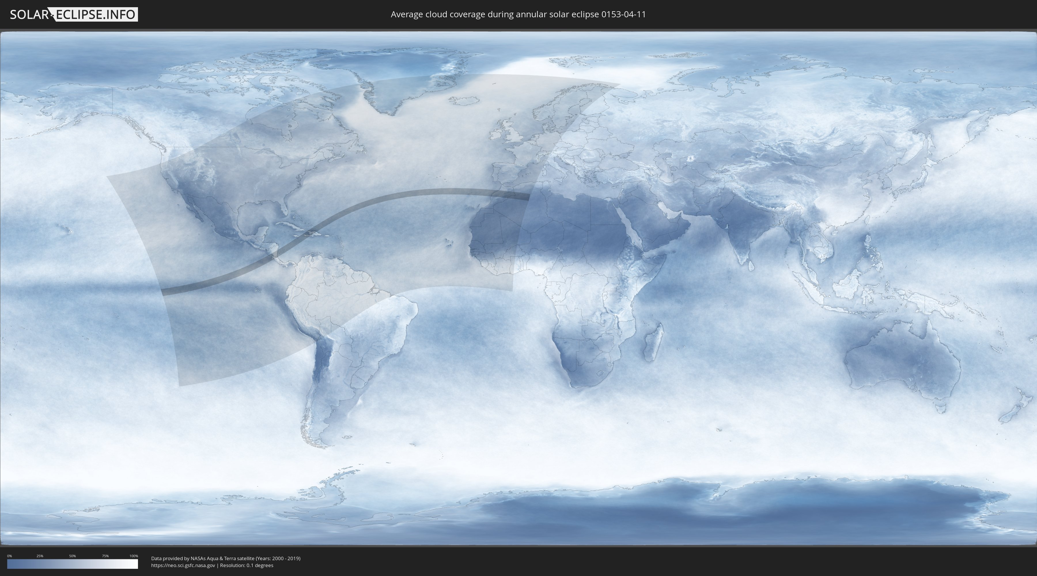
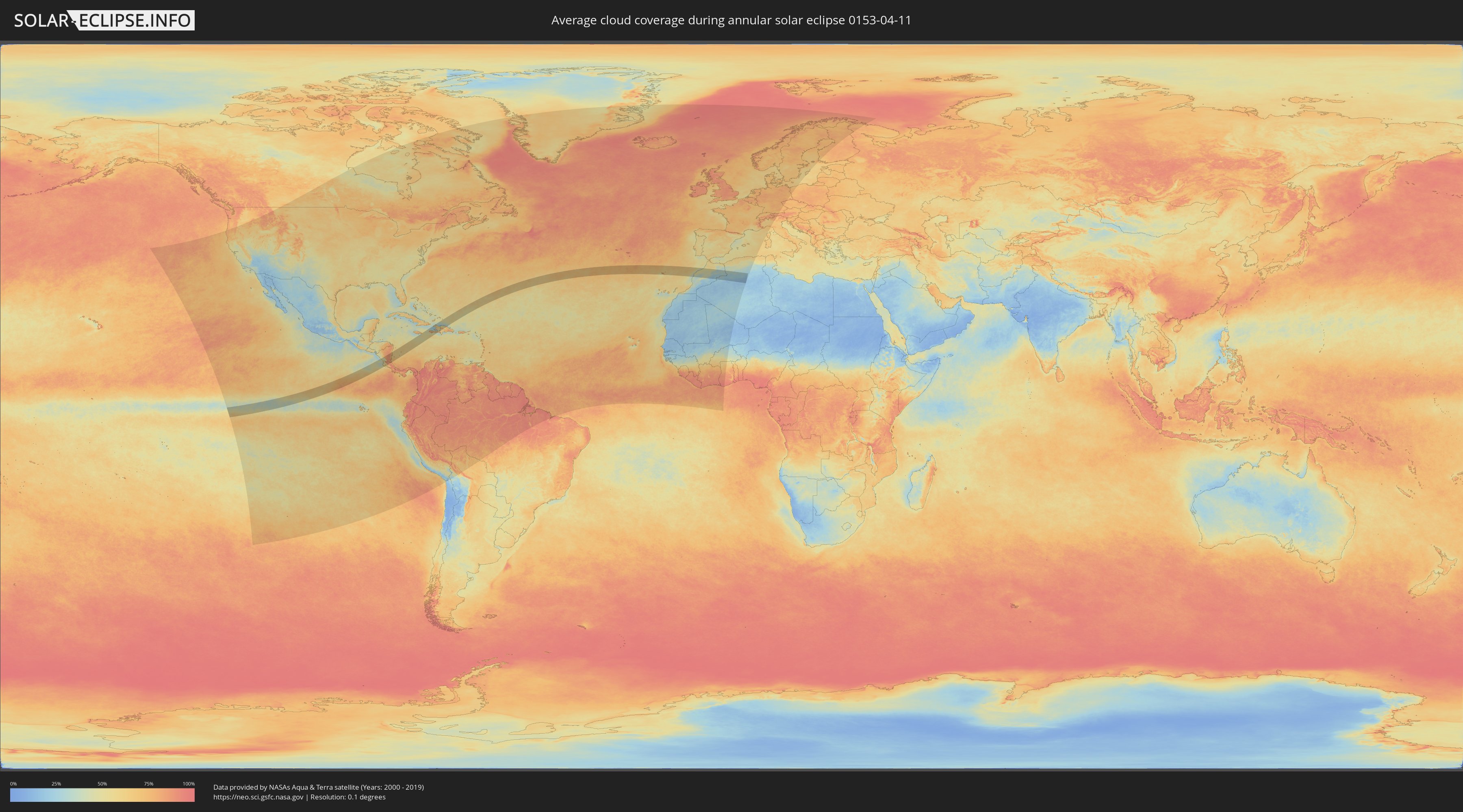
How will be the weather during the annular solar eclipse on 04/11/0153?
Where is the best place to see the annular solar eclipse of 04/11/0153?
The following maps show the average cloud coverage for the day of the annular solar eclipse.
With the help of these maps, it is possible to find the place along the eclipse path, which has the best
chance of a cloudless sky.
Nevertheless, you should consider local circumstances and inform about the weather of your chosen
observation site.
The data is provided by NASAs satellites
AQUA and TERRA.
The cloud maps are averaged over a period of 19 years (2000 - 2019).
Detailed country maps
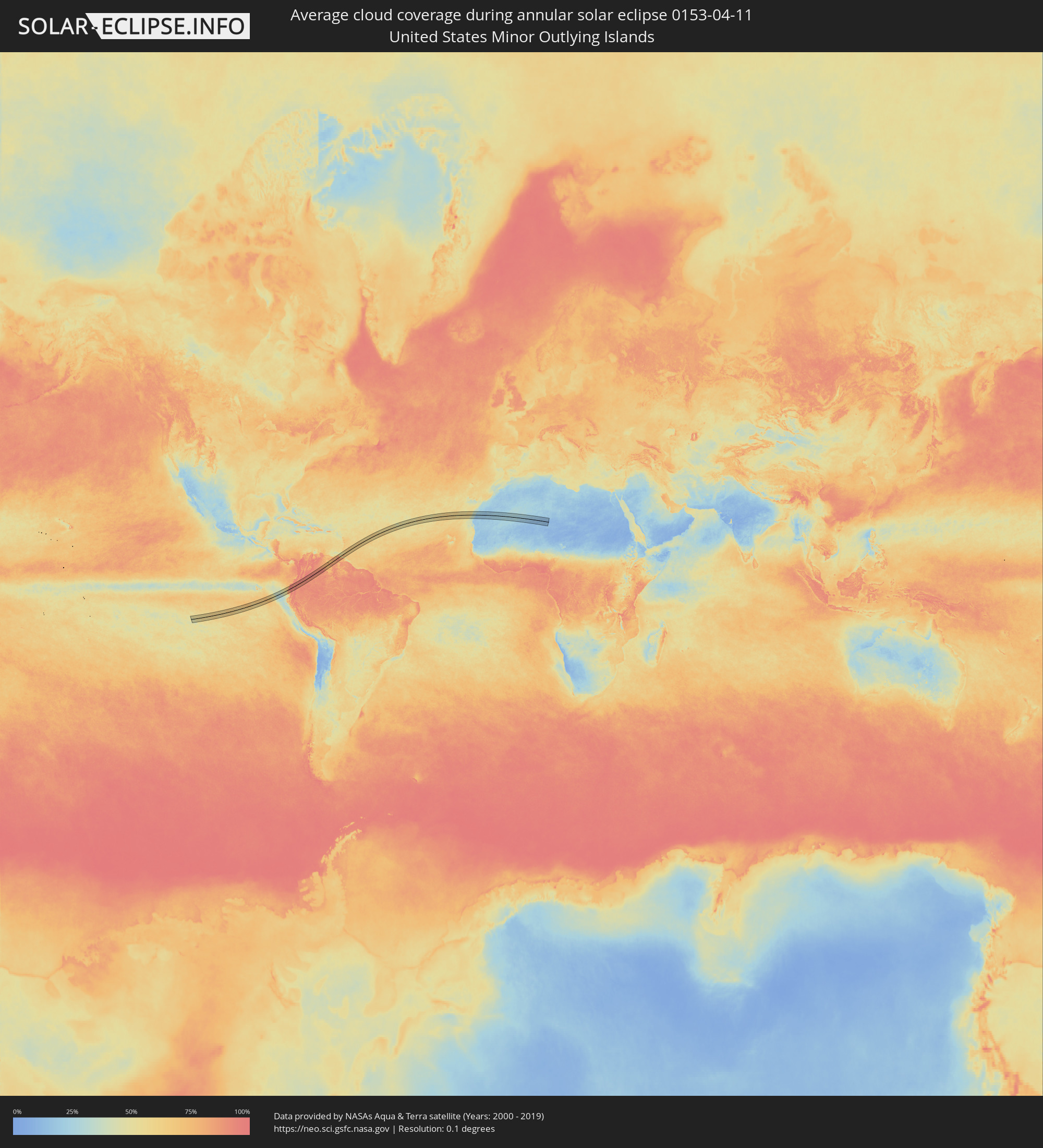 United States Minor Outlying Islands
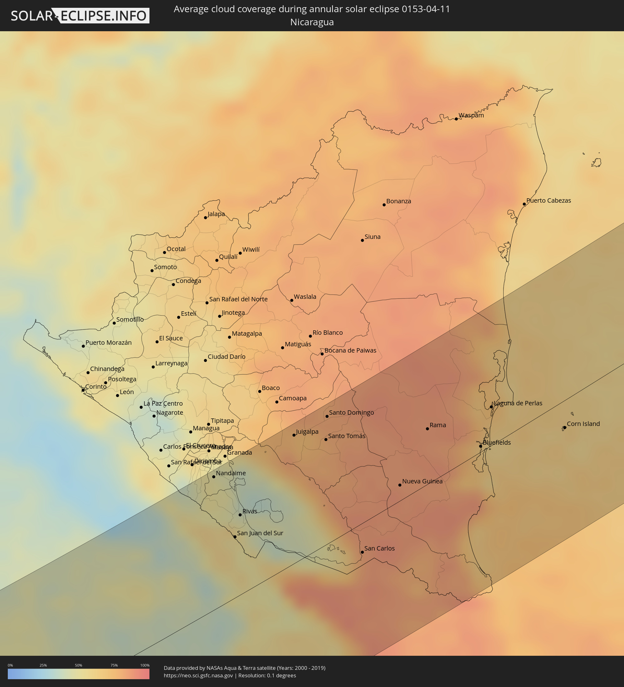 Nicaragua
 Costa Rica
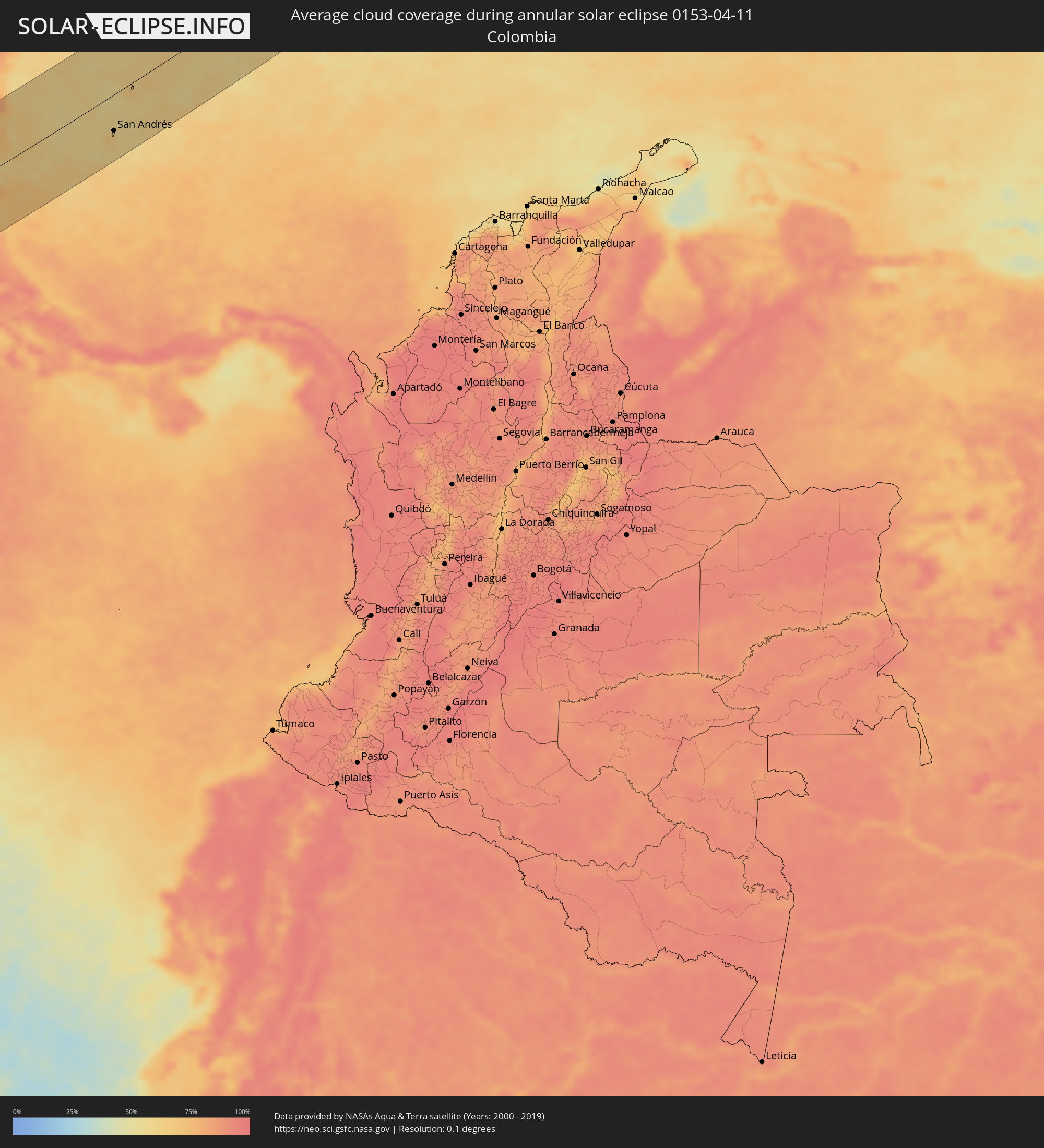 Colombia
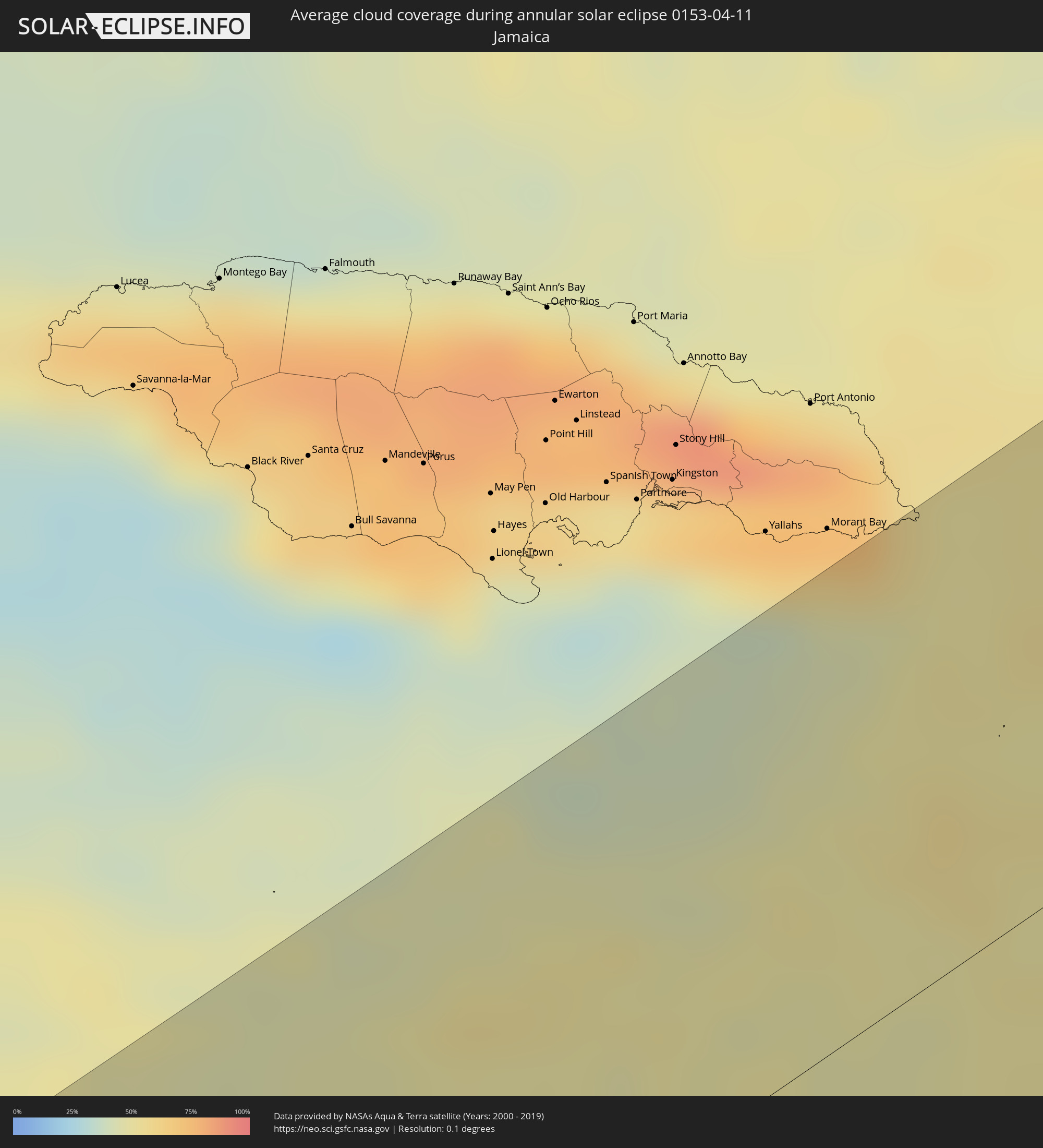 Jamaica
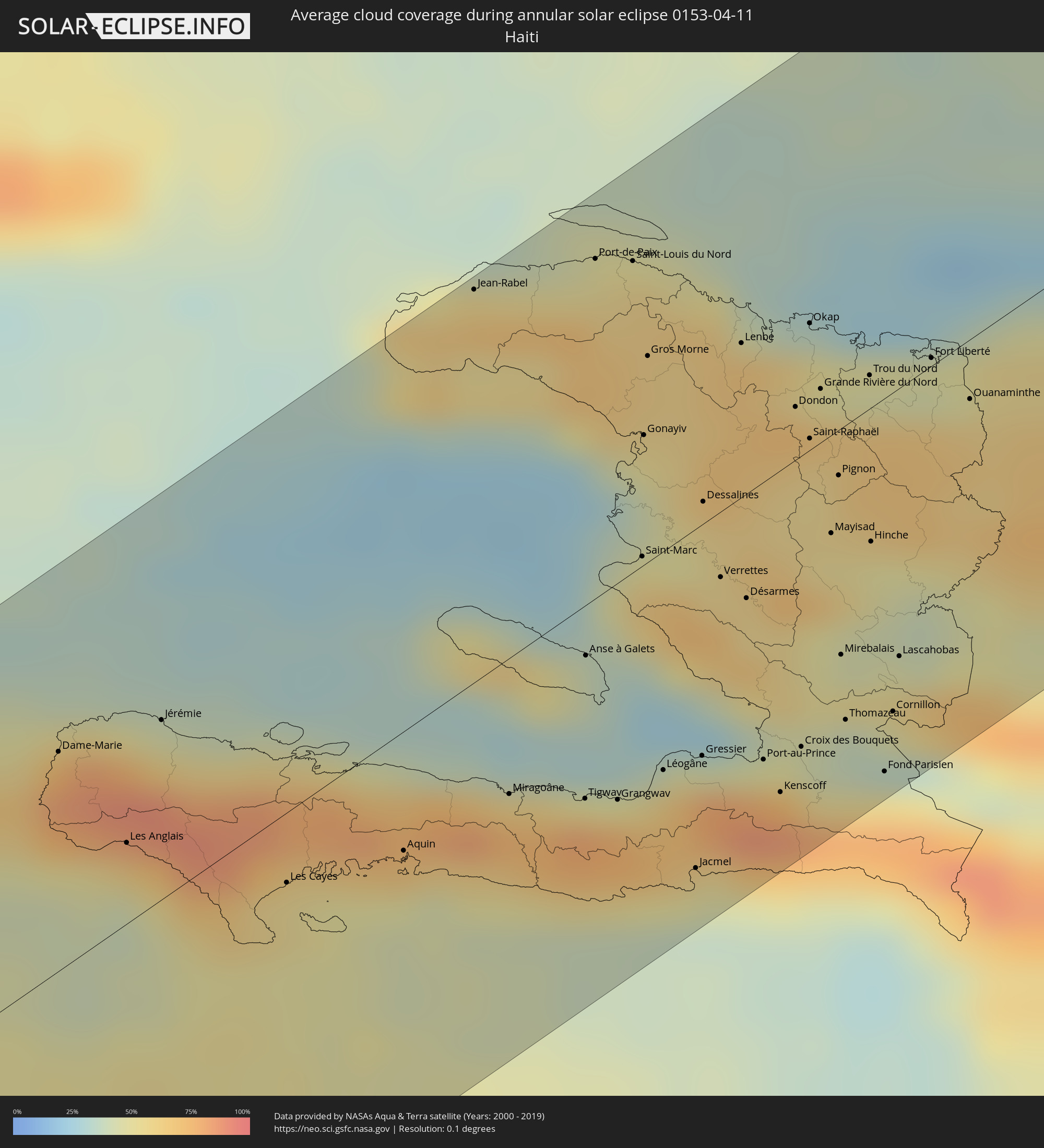 Haiti
Haiti
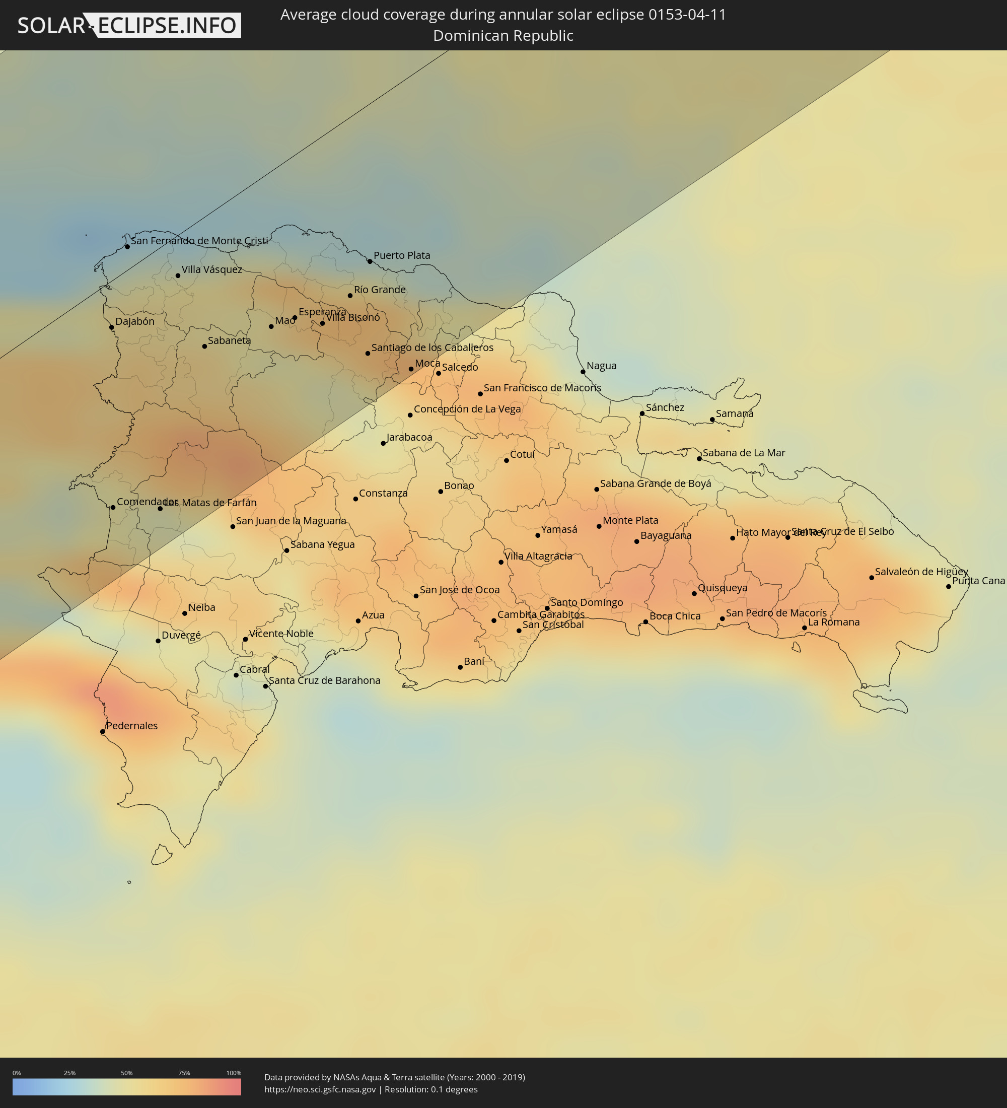 Dominican Republic
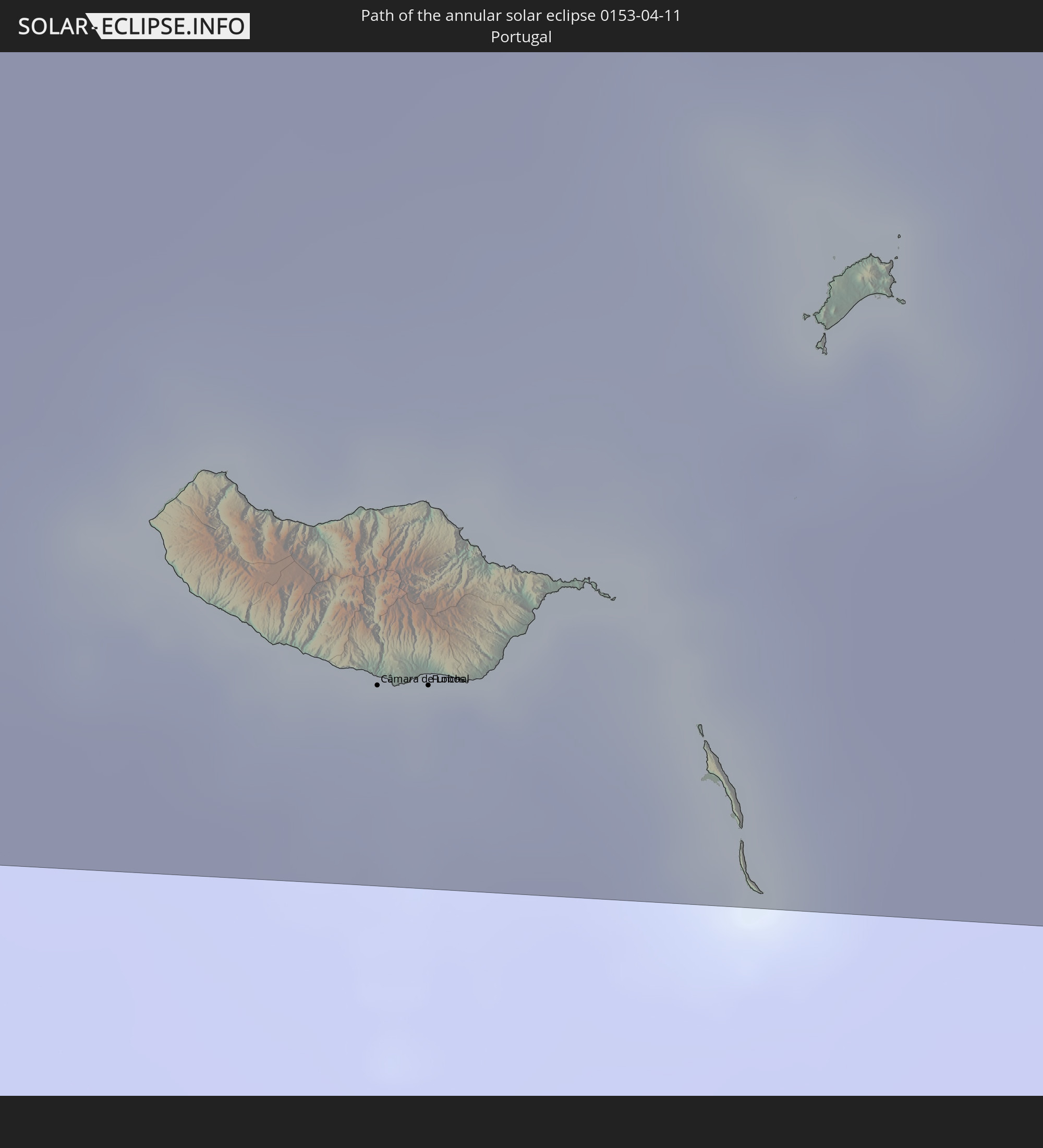
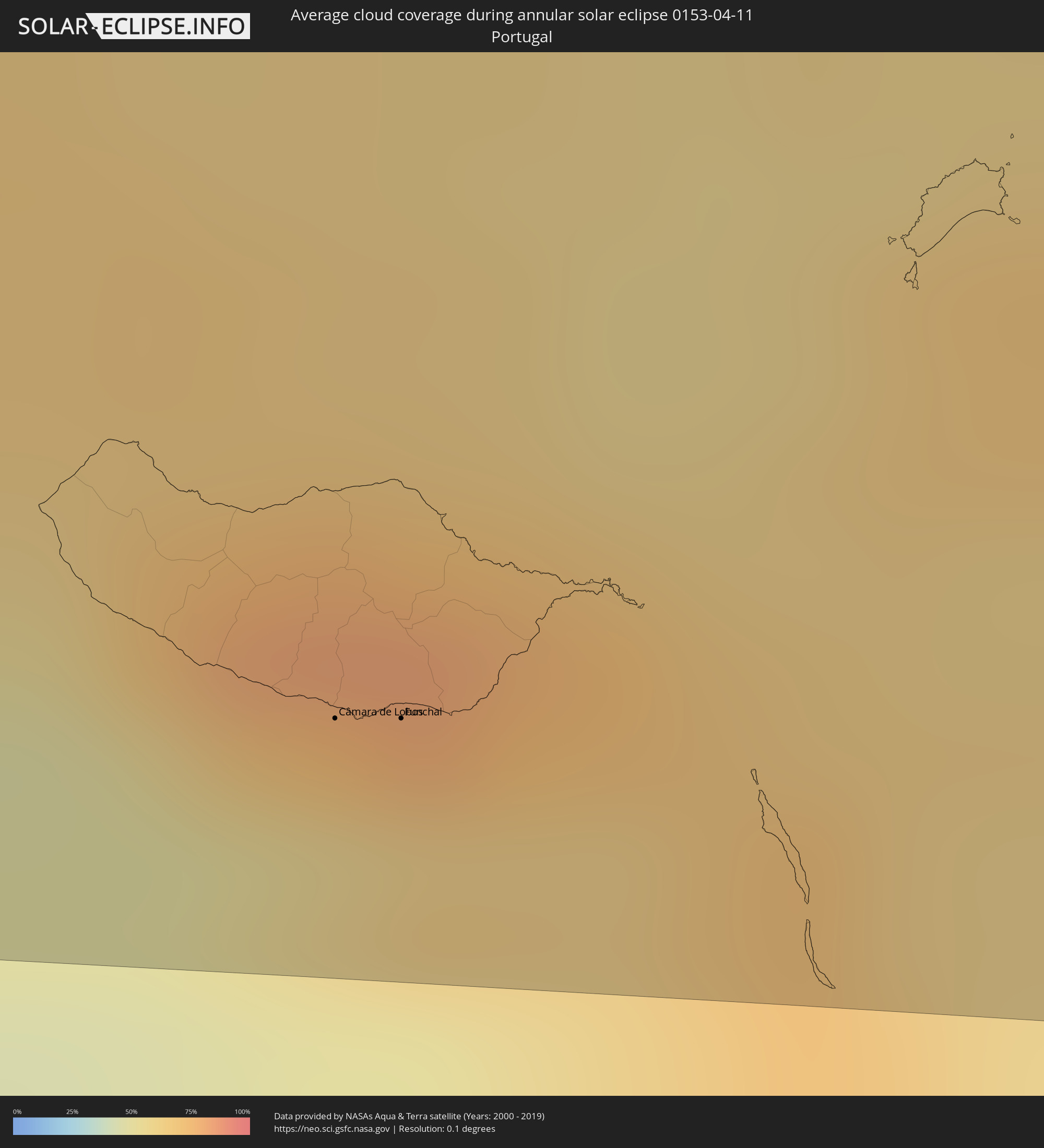 Portugal
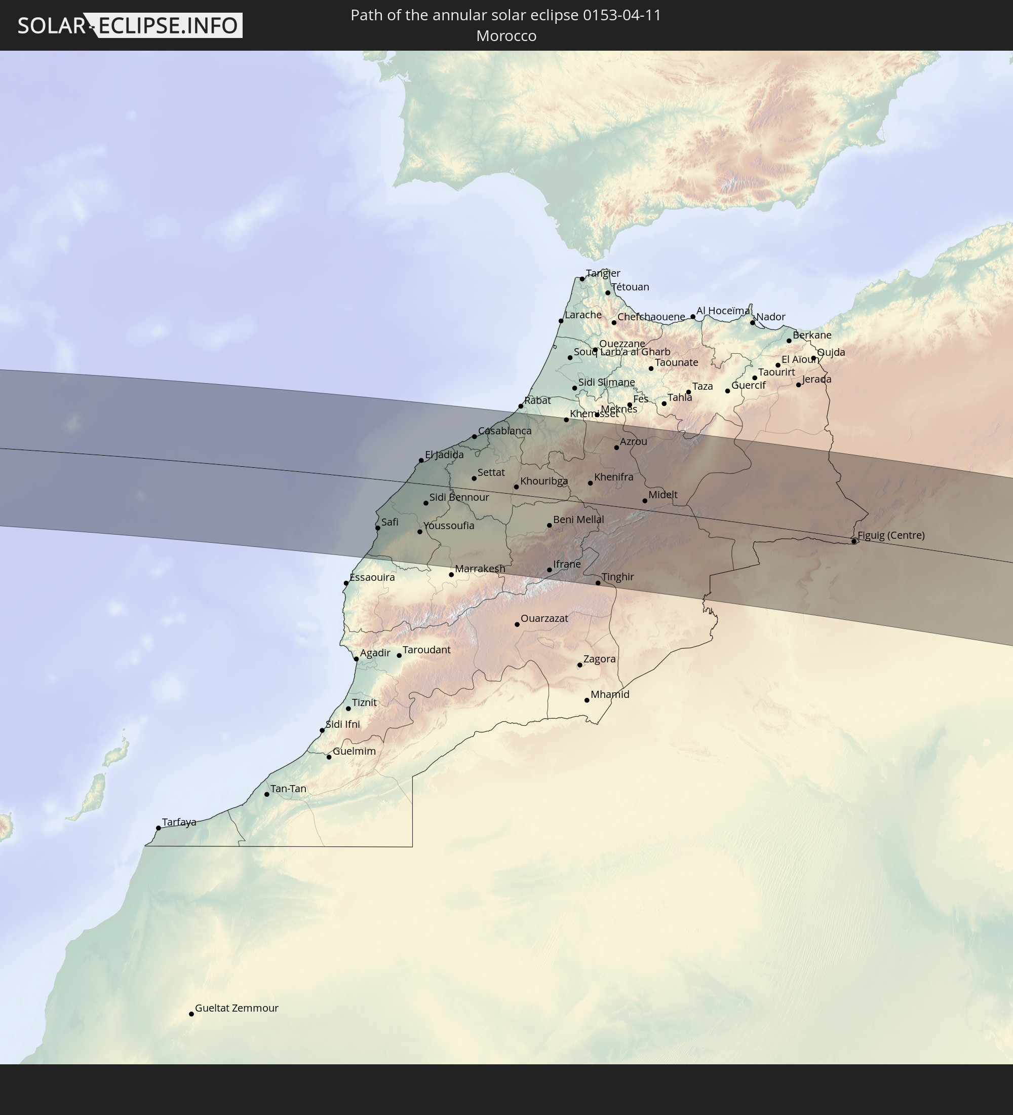
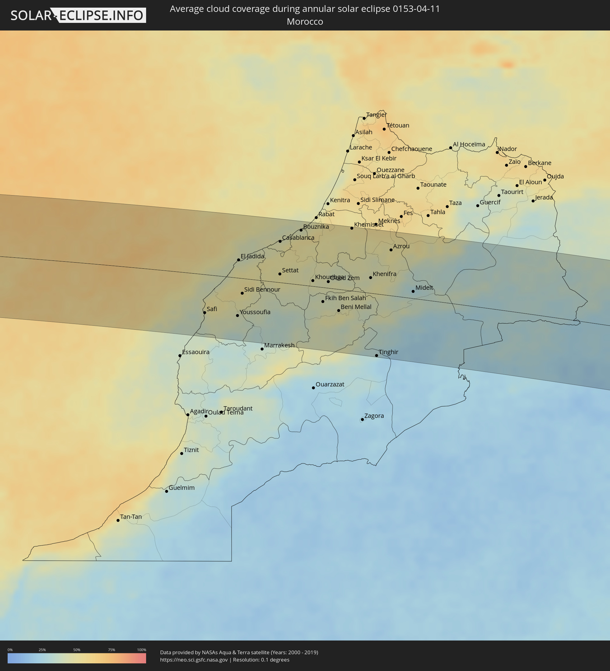 Morocco
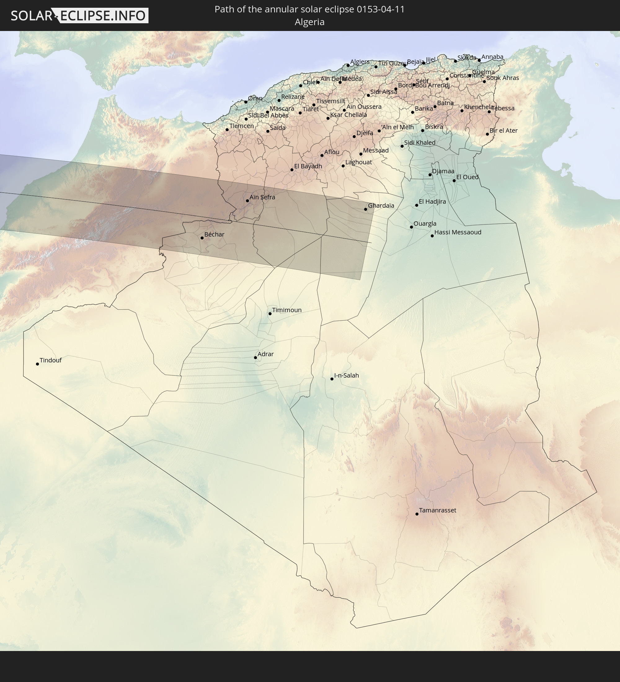
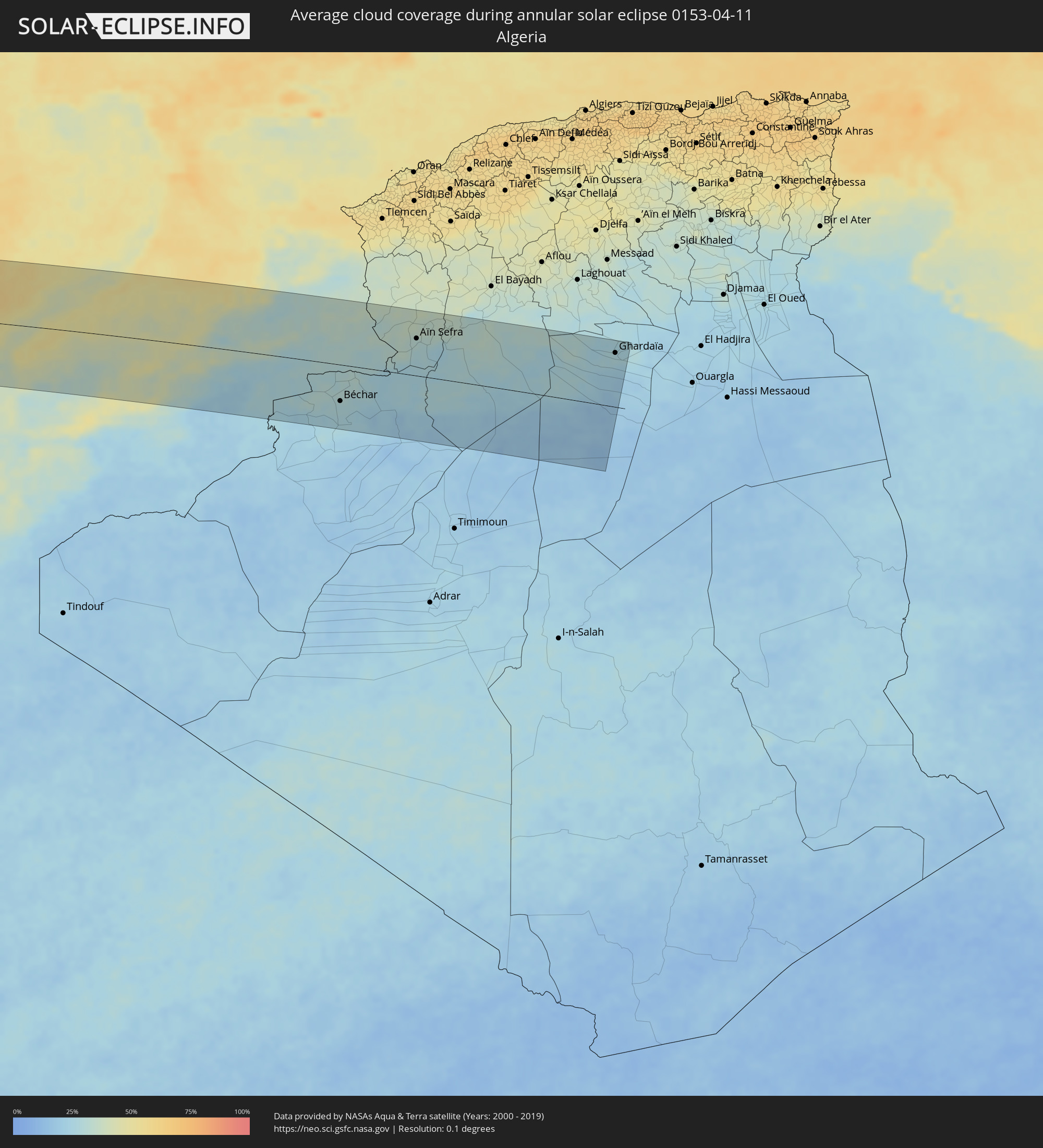 Algeria
Cities inside the path of the eclipse
The following table shows all locations with a population of more than 5,000 inside the eclipse path. Cities which have more than 100,000 inhabitants are marked bold. A click at the locations opens a detailed map.
| City | Type | Eclipse duration | Local time of max. eclipse | Distance to central line | Ø Cloud coverage |
|
Nandaime, Granada
|
annular | - | 09:17:00 UTC-05:45 | 108 km | 50% |
|
Belén, Rivas
|
annular | - | 09:16:50 UTC-05:45 | 74 km | 59% |
|
San Juan del Sur, Rivas
|
annular | - | 09:16:24 UTC-05:45 | 49 km | 57% |
|
Potosí, Rivas
|
annular | - | 09:16:53 UTC-05:45 | 72 km | 59% |
|
Rivas, Rivas
|
annular | - | 09:16:50 UTC-05:45 | 64 km | 53% |
|
San Jorge, Rivas
|
annular | - | 09:16:54 UTC-05:45 | 65 km | 51% |
|
Santa Cruz, Guanacaste
|
annular | - | 09:24:04 UTC-05:36 | 62 km | 57% |
|
Nicoya, Guanacaste
|
annular | - | 09:24:07 UTC-05:36 | 80 km | 60% |
|
Liberia, Guanacaste
|
annular | - | 09:25:02 UTC-05:36 | 34 km | 58% |
|
Juigalpa, Chontales
|
annular | - | 09:18:59 UTC-05:45 | 103 km | 82% |
|
El Ayote, Chontales
|
annular | - | 09:19:17 UTC-05:45 | 107 km | 74% |
|
Acoyapa, Chontales
|
annular | - | 09:19:05 UTC-05:45 | 79 km | 80% |
|
San José, Alajuela
|
annular | - | 09:26:12 UTC-05:36 | 20 km | 87% |
|
Cañas, Guanacaste
|
annular | - | 09:25:18 UTC-05:36 | 72 km | 58% |
|
Santo Tomás, Chontales
|
annular | - | 09:19:26 UTC-05:45 | 84 km | 79% |
|
Santo Domingo, Chontales
|
annular | - | 09:19:50 UTC-05:45 | 102 km | 79% |
|
Villa Sandino, Chontales
|
annular | - | 09:19:35 UTC-05:45 | 77 km | 81% |
|
Tilarán, Guanacaste
|
annular | - | 09:25:37 UTC-05:36 | 76 km | 55% |
|
San Carlos, Río San Juan
|
annular | - | 09:18:14 UTC-05:45 | 24 km | 81% |
|
Nueva Guinea, Atlántico Sur
|
annular | - | 09:19:57 UTC-05:45 | 12 km | 87% |
|
Rama, Atlántico Sur
|
annular | - | 09:21:19 UTC-05:45 | 44 km | 84% |
|
Bluefields, Atlántico Sur
|
annular | - | 09:21:57 UTC-05:45 | 4 km | 70% |
|
Laguna de Perlas, Atlántico Sur
|
annular | - | 09:22:47 UTC-05:45 | 30 km | 65% |
|
Corn Island, Atlántico Sur
|
annular | - | 09:23:44 UTC-05:45 | 22 km | 59% |
|
San Andrés, Archipiélago de San Andrés, Providencia y Santa Catalina
|
annular | - | 10:16:18 UTC-04:56 | 60 km | 63% |
|
Jérémie, GrandʼAnse
|
annular | - | 10:54:31 UTC-04:49 | 46 km | 46% |
|
Les Cayes, Sud
|
annular | - | 10:54:31 UTC-04:49 | 18 km | 54% |
|
Miragoâne, Nippes
|
annular | - | 10:56:48 UTC-04:49 | 35 km | 76% |
|
Tigwav, Ouest
|
annular | - | 10:57:23 UTC-04:49 | 50 km | 79% |
|
Port-de-Paix, Nord-Ouest
|
annular | - | 11:00:39 UTC-04:49 | 87 km | 56% |
|
Saint-Louis du Nord, Nord-Ouest
|
annular | - | 11:00:56 UTC-04:49 | 79 km | 58% |
|
Saint-Marc, Artibonite
|
annular | - | 10:59:16 UTC-04:49 | 2 km | 62% |
|
Gonayiv, Artibonite
|
annular | - | 11:00:00 UTC-04:49 | 33 km | 43% |
|
Léogâne, Ouest
|
annular | - | 10:58:10 UTC-04:49 | 56 km | 67% |
|
Jacmel, Sud-Est
|
annular | - | 10:57:51 UTC-04:49 | 87 km | 45% |
|
Gressier, Ouest
|
annular | - | 10:58:34 UTC-04:49 | 59 km | 44% |
|
Dessalines, Artibonite
|
annular | - | 11:00:05 UTC-04:49 | 6 km | 58% |
|
Verrettes, Artibonite
|
annular | - | 10:59:47 UTC-04:49 | 17 km | 58% |
|
Lenbe, Nord
|
annular | - | 11:01:19 UTC-04:49 | 39 km | 65% |
|
Désarmes, Artibonite
|
annular | - | 10:59:52 UTC-04:49 | 27 km | 58% |
|
Port-au-Prince, Ouest
|
annular | - | 10:59:02 UTC-04:49 | 71 km | 73% |
|
Okap, Nord
|
annular | - | 11:01:59 UTC-04:49 | 32 km | 35% |
|
Saint-Raphaël, Nord
|
annular | - | 11:01:18 UTC-04:49 | 3 km | 56% |
|
Mirebalais, Centre
|
annular | - | 11:00:17 UTC-04:49 | 58 km | 53% |
|
Thomazeau, Ouest
|
annular | - | 10:59:56 UTC-04:49 | 76 km | 40% |
|
Trou du Nord, Nord-Est
|
annular | - | 11:02:10 UTC-04:49 | 9 km | 65% |
|
Hinche, Centre
|
annular | - | 11:01:12 UTC-04:49 | 34 km | 49% |
|
Fond Parisien, Ouest
|
annular | - | 10:59:57 UTC-04:49 | 96 km | 56% |
|
Fort Liberté, Nord-Est
|
annular | - | 11:02:46 UTC-04:49 | 2 km | 48% |
|
Ouanaminthe, Nord-Est
|
annular | - | 11:02:50 UTC-04:49 | 15 km | 63% |
|
Dajabón, Dajabón
|
annular | - | 11:11:53 UTC-04:40 | 16 km | 63% |
|
Comendador, Elías Piña
|
annular | - | 11:10:29 UTC-04:40 | 78 km | 50% |
|
San Fernando de Monte Cristi, Monte Cristi
|
annular | - | 11:12:40 UTC-04:40 | 8 km | 47% |
|
Loma de Cabrera, Dajabón
|
annular | - | 11:11:56 UTC-04:40 | 33 km | 66% |
|
Las Matas de Farfán, San Juan
|
annular | - | 11:10:59 UTC-04:40 | 90 km | 46% |
|
Las Matas de Santa Cruz, Monte Cristi
|
annular | - | 11:12:41 UTC-04:40 | 17 km | 54% |
|
Villa Vásquez, Monte Cristi
|
annular | - | 11:13:00 UTC-04:40 | 14 km | 53% |
|
Sabaneta, Santiago Rodríguez
|
annular | - | 11:12:44 UTC-04:40 | 44 km | 59% |
|
Monción, Santiago Rodríguez
|
annular | - | 11:13:07 UTC-04:40 | 62 km | 64% |
|
Laguna Salada, Valverde
|
annular | - | 11:13:48 UTC-04:40 | 44 km | 52% |
|
Mao, Valverde
|
annular | - | 11:13:37 UTC-04:40 | 53 km | 47% |
|
Esperanza, Valverde
|
annular | - | 11:13:57 UTC-04:40 | 56 km | 47% |
|
San José de Las Matas, Santiago
|
annular | - | 11:13:34 UTC-04:40 | 81 km | 57% |
|
Villa Bisonó, Santiago
|
annular | - | 11:14:12 UTC-04:40 | 64 km | 52% |
|
Imbert, Puerto Plata
|
annular | - | 11:14:44 UTC-04:40 | 49 km | 54% |
|
Villa González, Santiago
|
annular | - | 11:14:24 UTC-04:40 | 71 km | 45% |
|
Río Grande, Puerto Plata
|
annular | - | 11:14:43 UTC-04:40 | 61 km | 71% |
|
Santiago de los Caballeros, Santiago
|
annular | - | 11:14:28 UTC-04:40 | 85 km | 51% |
|
Puerto Plata, Puerto Plata
|
annular | - | 11:15:12 UTC-04:40 | 54 km | 53% |
|
Tamboril, Santiago
|
annular | - | 11:14:47 UTC-04:40 | 87 km | 61% |
|
Licey al Medio, Santiago
|
annular | - | 11:14:42 UTC-04:40 | 92 km | 51% |
|
San Víctor Arriba, Espaillat
|
annular | - | 11:14:58 UTC-04:40 | 92 km | 72% |
|
Moca, Espaillat
|
annular | - | 11:14:49 UTC-04:40 | 101 km | 59% |
|
Veragua Arriba, Espaillat
|
annular | - | 11:15:45 UTC-04:40 | 94 km | 68% |
|
Gaspar Hernández, Espaillat
|
annular | - | 11:16:00 UTC-04:40 | 94 km | 68% |
|
Ribeira Brava, Madeira
|
annular | - | 17:58:20 UTC+00:00 | 95 km | 67% |
|
São Vicente, Madeira
|
annular | - | 17:21:30 UTC-00:36 | 78 km | 82% |
|
Câmara de Lobos, Madeira
|
annular | - | 17:58:24 UTC+00:00 | 96 km | 58% |
|
Nossa Senhora do Monte, Madeira
|
annular | - | 17:21:40 UTC-00:36 | 92 km | 78% |
|
Funchal, Madeira
|
annular | - | 17:58:27 UTC+00:00 | 96 km | 62% |
|
Santana, Madeira
|
annular | - | 17:21:36 UTC-00:36 | 77 km | 82% |
|
Caniço, Madeira
|
annular | - | 17:21:44 UTC-00:36 | 96 km | 62% |
|
Camacha, Madeira
|
annular | - | 17:21:42 UTC-00:36 | 90 km | 73% |
|
Santa Cruz, Madeira
|
annular | - | 17:21:44 UTC-00:36 | 90 km | 73% |
|
Machico, Madeira
|
annular | - | 17:21:44 UTC-00:36 | 88 km | 73% |
|
Camacha, Madeira
|
annular | - | 17:21:45 UTC-00:36 | 43 km | 67% |
|
Safi, Doukkala-Abda
|
annular | - | 17:32:09 UTC-00:30 | 77 km | 43% |
|
Youssoufia, Doukkala-Abda
|
annular | - | 17:32:25 UTC-00:30 | 76 km | 38% |
|
El Jadida, Doukkala-Abda
|
annular | - | 17:31:43 UTC-00:30 | 36 km | 43% |
|
Sidi Bennour, Doukkala-Abda
|
annular | - | 17:32:10 UTC-00:30 | 30 km | 49% |
|
Azemmour, Doukkala-Abda
|
annular | - | 17:31:45 UTC-00:30 | 41 km | 46% |
|
Nouaseur, Chaouia-Ouardigha
|
annular | - | 17:31:54 UTC-00:30 | 58 km | 49% |
|
Settat, Chaouia-Ouardigha
|
annular | - | 17:32:10 UTC-00:30 | 17 km | 48% |
|
Casablanca, Grand Casablanca
|
annular | - | 17:31:45 UTC-00:30 | 82 km | 47% |
|
Berrechid, Chaouia-Ouardigha
|
annular | - | 17:31:59 UTC-00:30 | 46 km | 49% |
|
Mohammedia, Grand Casablanca
|
annular | - | 17:31:44 UTC-00:30 | 95 km | 48% |
|
Bouznika, Chaouia-Ouardigha
|
annular | - | 17:31:43 UTC-00:30 | 109 km | 47% |
|
Skhirate, Rabat-Salé-Zemmour-Zaër
|
annular | - | 17:31:43 UTC-00:30 | 117 km | 48% |
|
Khouribga, Chaouia-Ouardigha
|
annular | - | 17:32:27 UTC-00:30 | 11 km | 45% |
|
Boujniba, Chaouia-Ouardigha
|
annular | - | 17:32:28 UTC-00:30 | 14 km | 44% |
|
Fkih Ben Salah, Tadla-Azilal
|
annular | - | 17:32:46 UTC-00:30 | 29 km | 44% |
|
Oued Zem, Chaouia-Ouardigha
|
annular | - | 17:32:32 UTC-00:30 | 12 km | 44% |
|
Beni Mellal, Tadla-Azilal
|
annular | - | 17:32:58 UTC-00:30 | 43 km | 46% |
|
Ifrane, Tadla-Azilal
|
annular | - | 17:33:23 UTC-00:30 | 114 km | 46% |
|
Kasba Tadla, Tadla-Azilal
|
annular | - | 17:32:48 UTC-00:30 | 14 km | 43% |
|
Khemisset, Rabat-Salé-Zemmour-Zaër
|
annular | - | 17:31:58 UTC-00:30 | 124 km | 50% |
|
Khenifra, Meknès-Tafilalet
|
annular | - | 17:32:42 UTC-00:30 | 30 km | 46% |
|
Tinghir, Souss-Massa-Drâa
|
annular | - | 17:33:42 UTC-00:30 | 125 km | 22% |
|
El Hajeb, Meknès-Tafilalet
|
annular | - | 17:32:13 UTC-00:30 | 117 km | 51% |
|
Azrou, Meknès-Tafilalet
|
annular | - | 17:32:26 UTC-00:30 | 91 km | 48% |
|
Midelt, Meknès-Tafilalet
|
annular | - | 17:33:03 UTC-00:30 | 14 km | 34% |
|
Béchar, Béchar
|
annular | - | 18:13:49 UTC+00:09 | 73 km | 27% |
|
Aïn Sefra, Naama
|
annular | - | 18:13:09 UTC+00:09 | 74 km | 31% |
|
El Abiodh Sidi Cheikh, El Bayadh
|
annular | - | 18:13:05 UTC+00:09 | 106 km | 30% |
|
Metlili Chaamba, Ghardaia
|
annular | - | 18:13:24 UTC+00:09 | 83 km | 23% |
|
Ghardaïa, Ghardaia
|
annular | - | 18:13:15 UTC+00:09 | 108 km | 27% |