Total solar eclipse of 07/04/0186
| Day of week: | Tuesday |
| Maximum duration of eclipse: | 06m47s |
| Maximum width of eclipse path: | 254 km |
| Saros cycle: | 78 |
| Coverage: | 100% |
| Magnitude: | 1.0787 |
| Gamma: | 0.0275 |
Wo kann man die Sonnenfinsternis vom 07/04/0186 sehen?
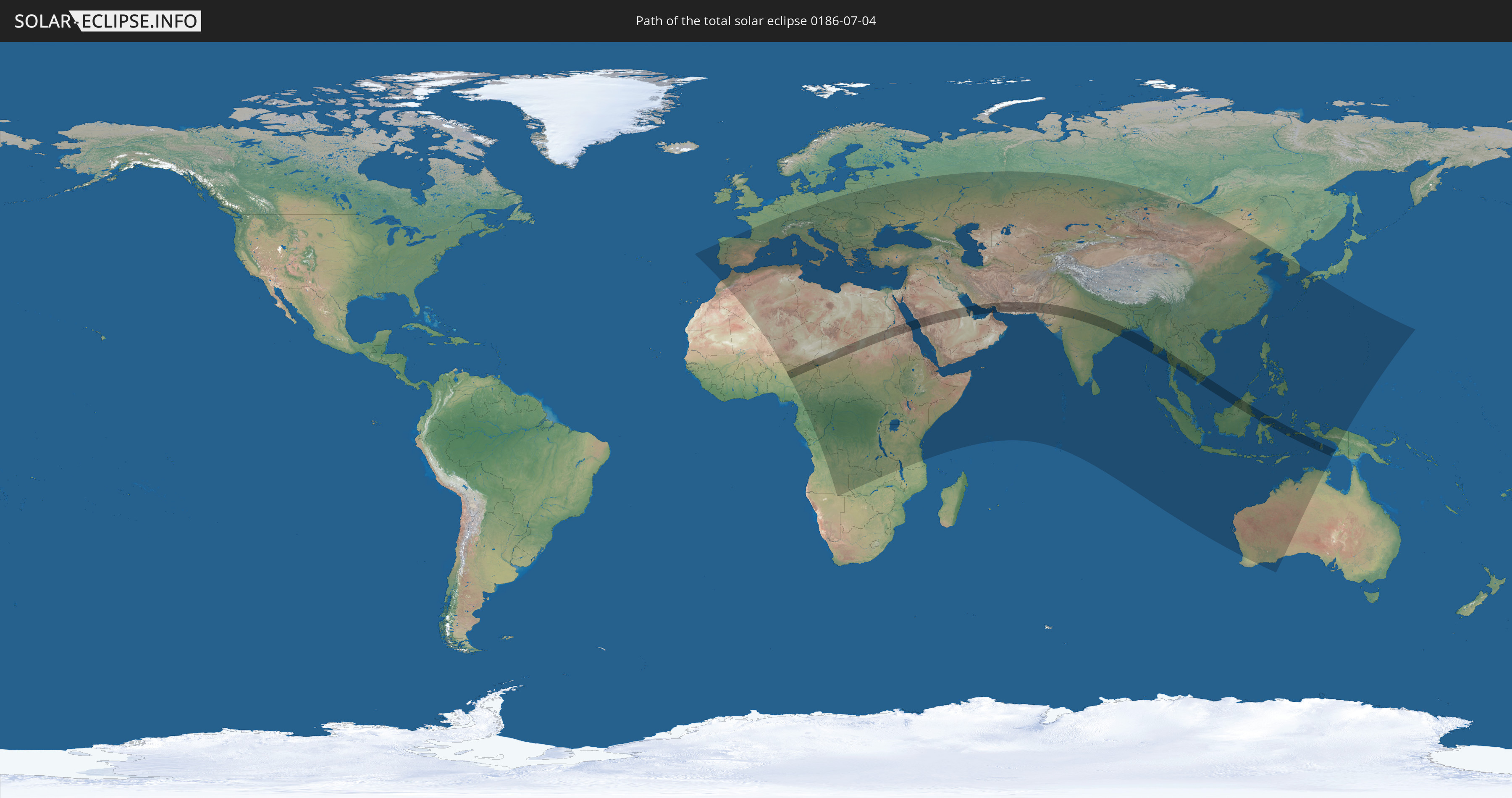
Die Sonnenfinsternis am 07/04/0186 kann man in 121 Ländern als partielle Sonnenfinsternis beobachten.
Der Finsternispfad verläuft durch 21 Länder. Nur in diesen Ländern ist sie als total Sonnenfinsternis zu sehen.
In den folgenden Ländern ist die Sonnenfinsternis total zu sehen
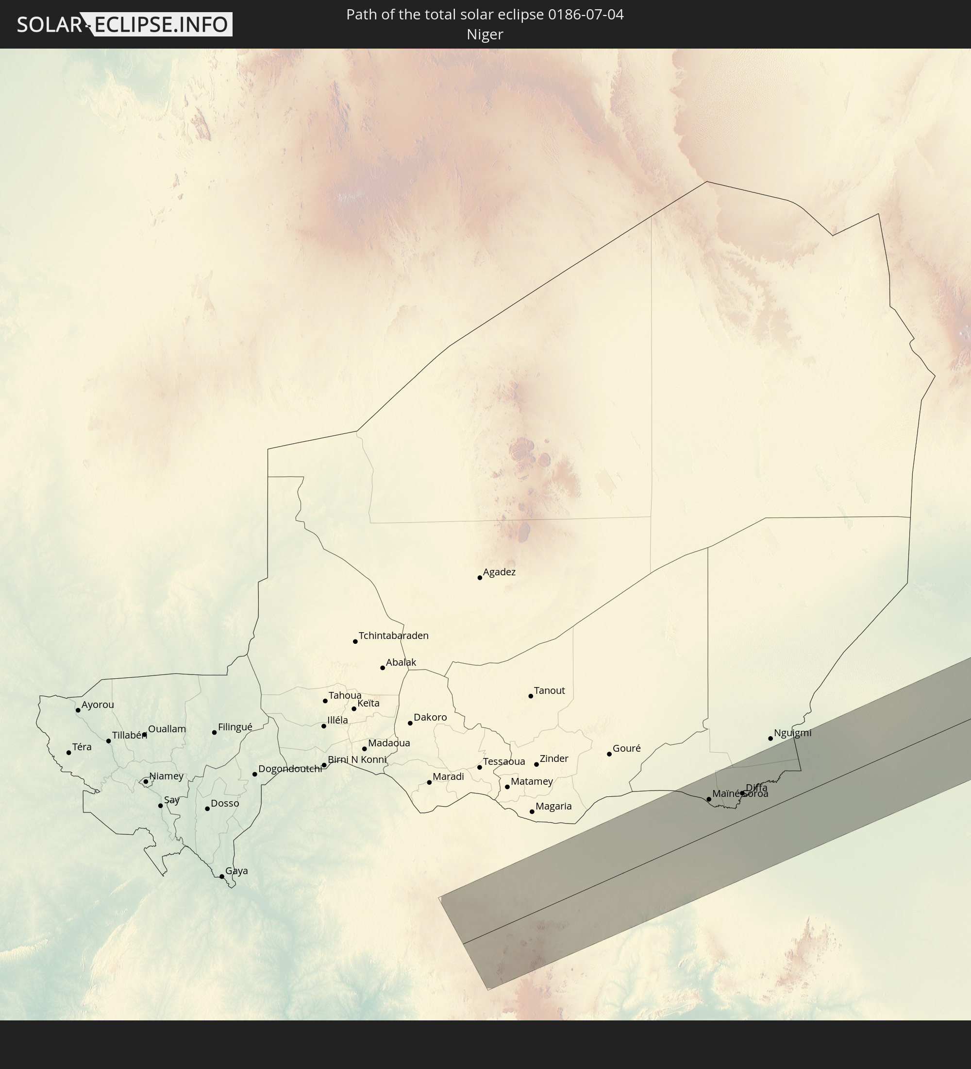 Niger
Niger
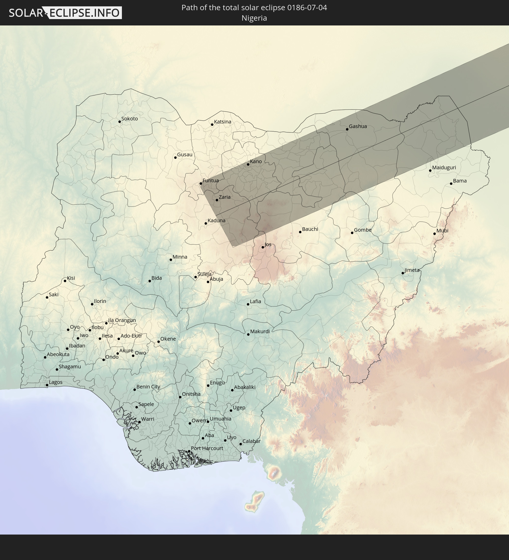 Nigeria
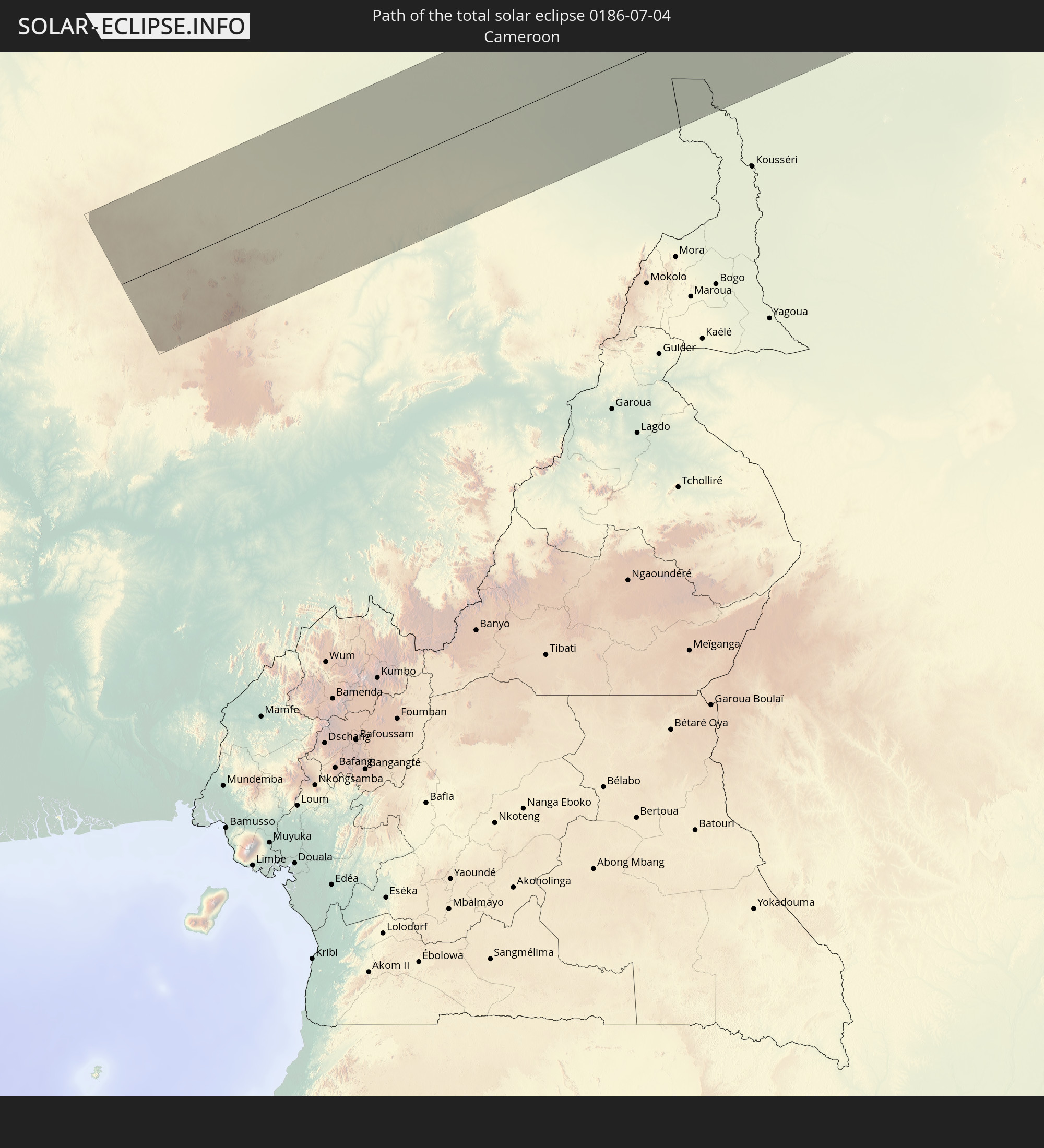 Cameroon
 Chad
Chad
 Sudan
Sudan
 Egypt
Egypt
 Saudi Arabia
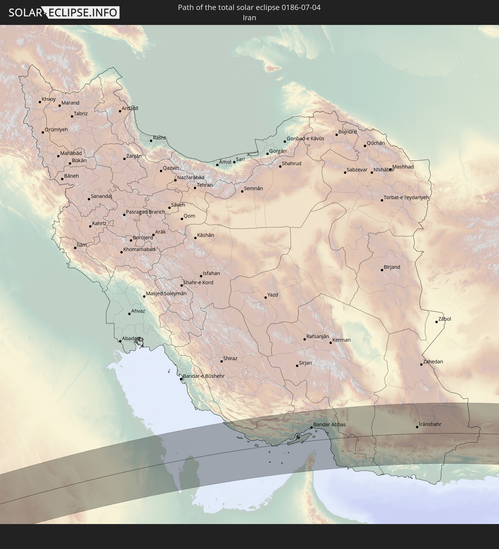 Iran
Iran
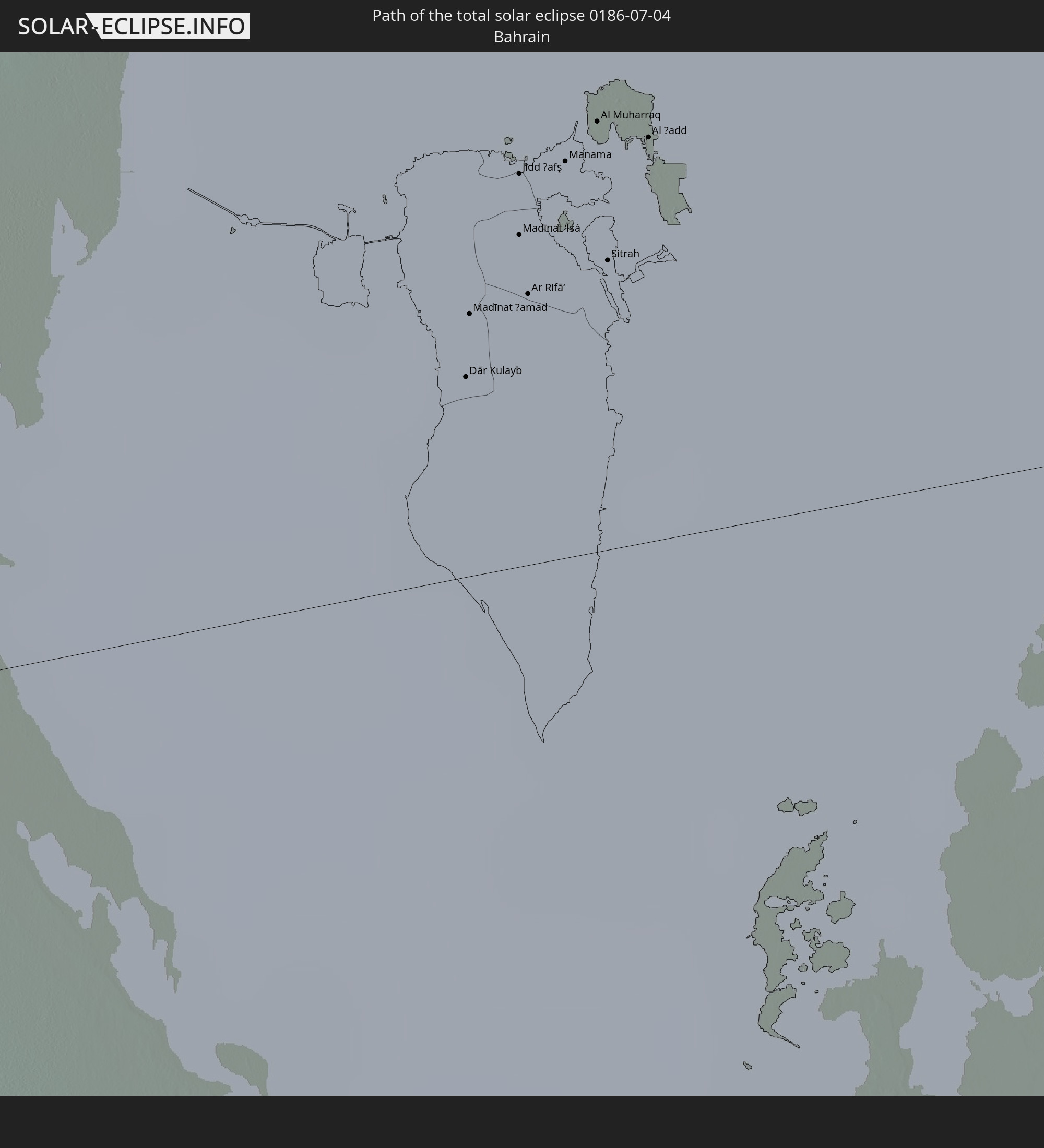 Bahrain
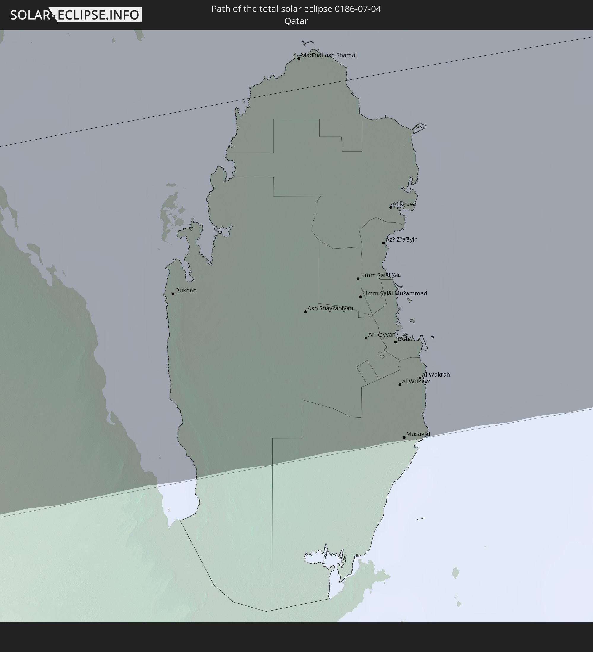 Qatar
Qatar
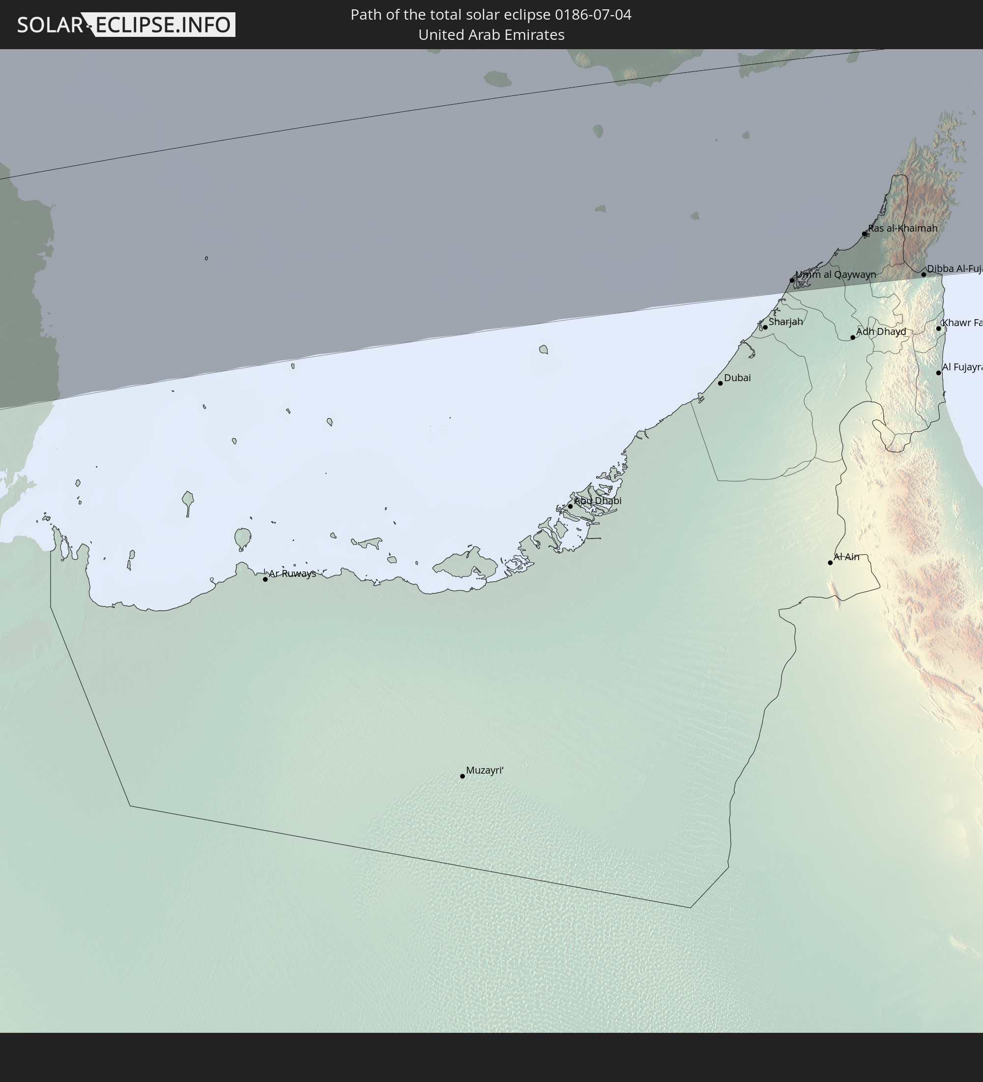 United Arab Emirates
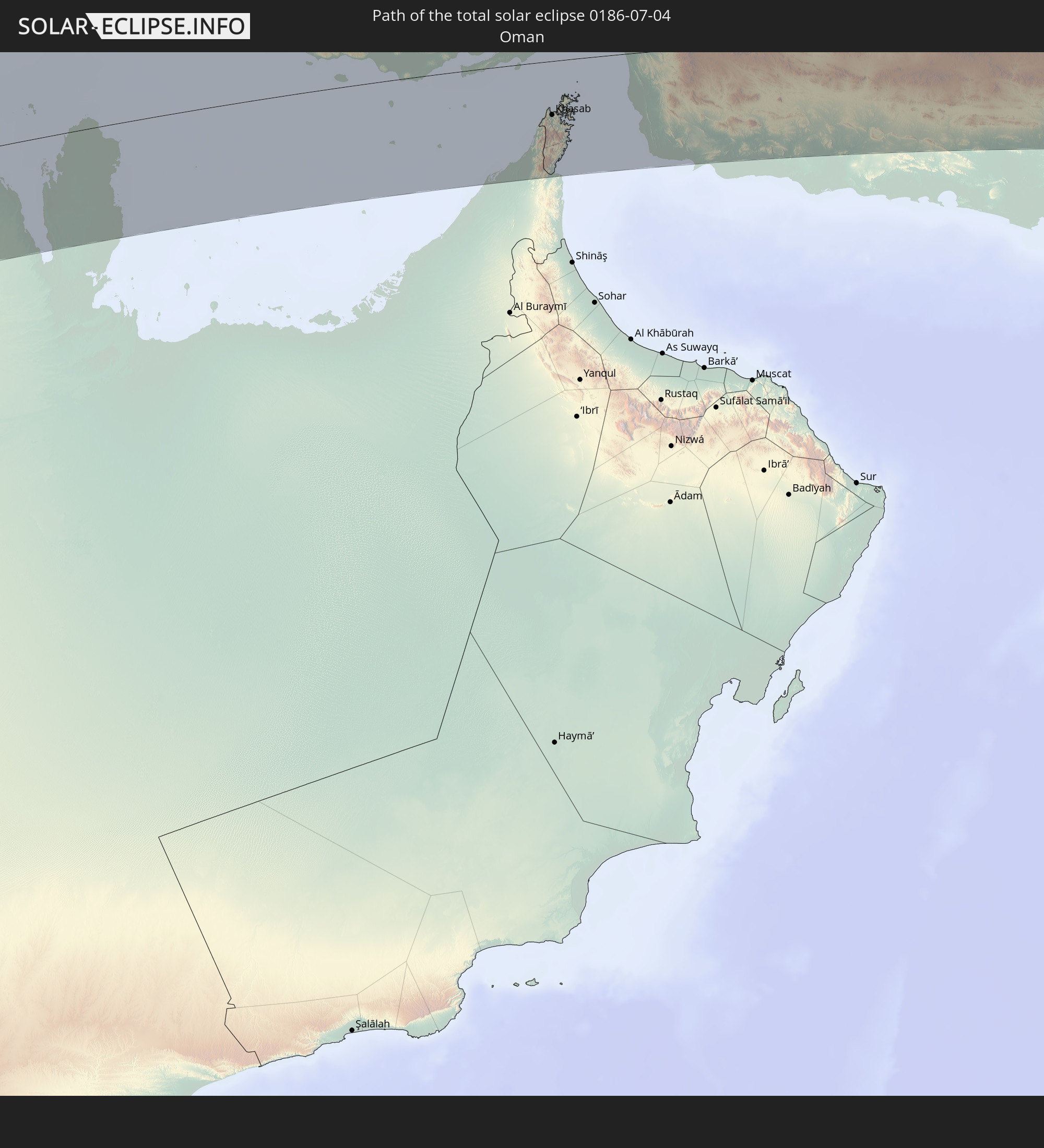 Oman
Oman
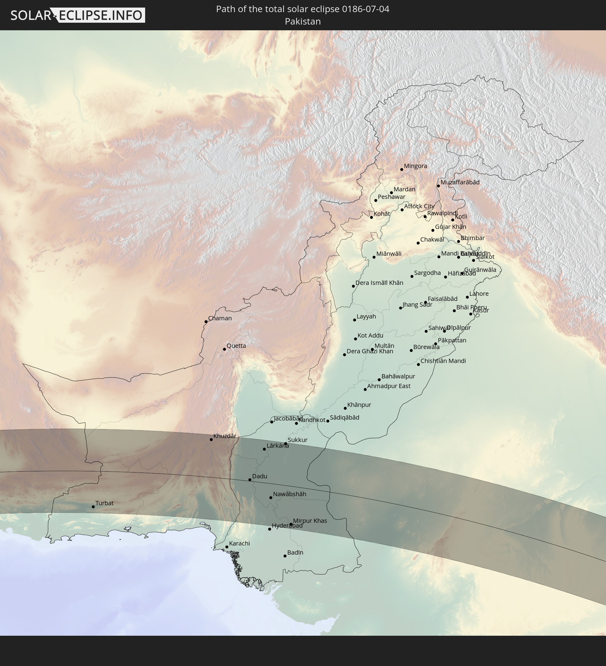 Pakistan
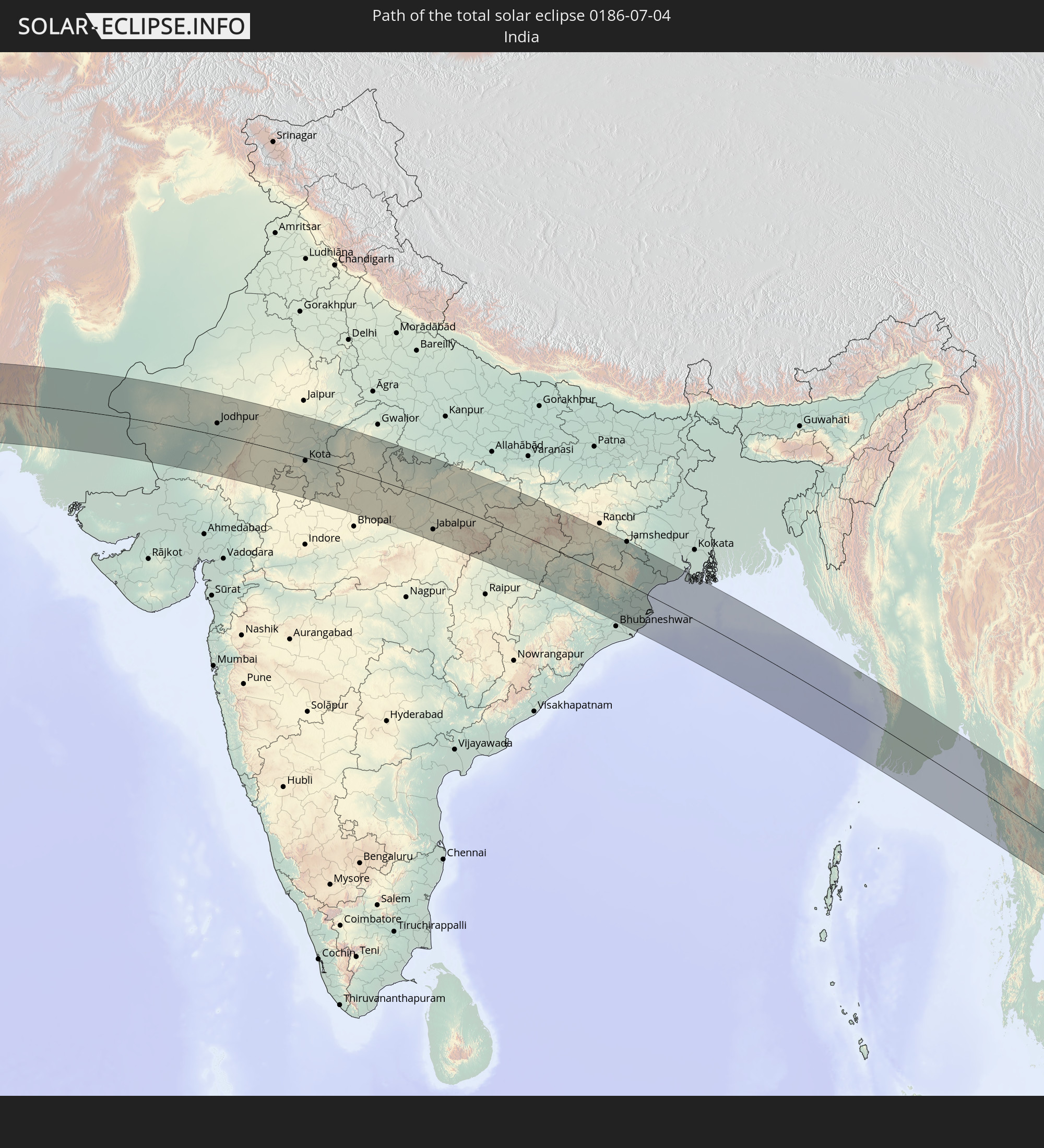 India
India
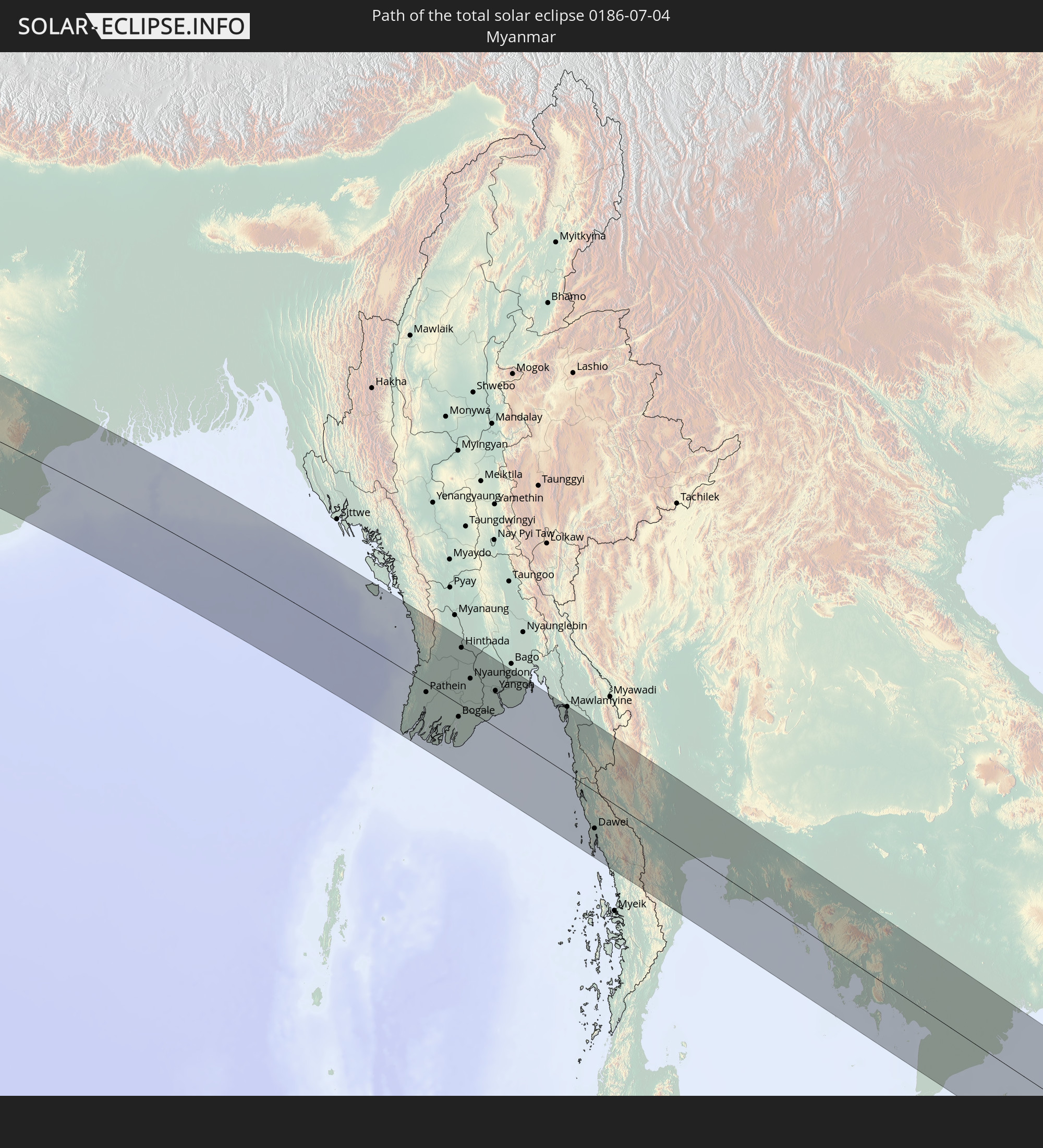 Myanmar
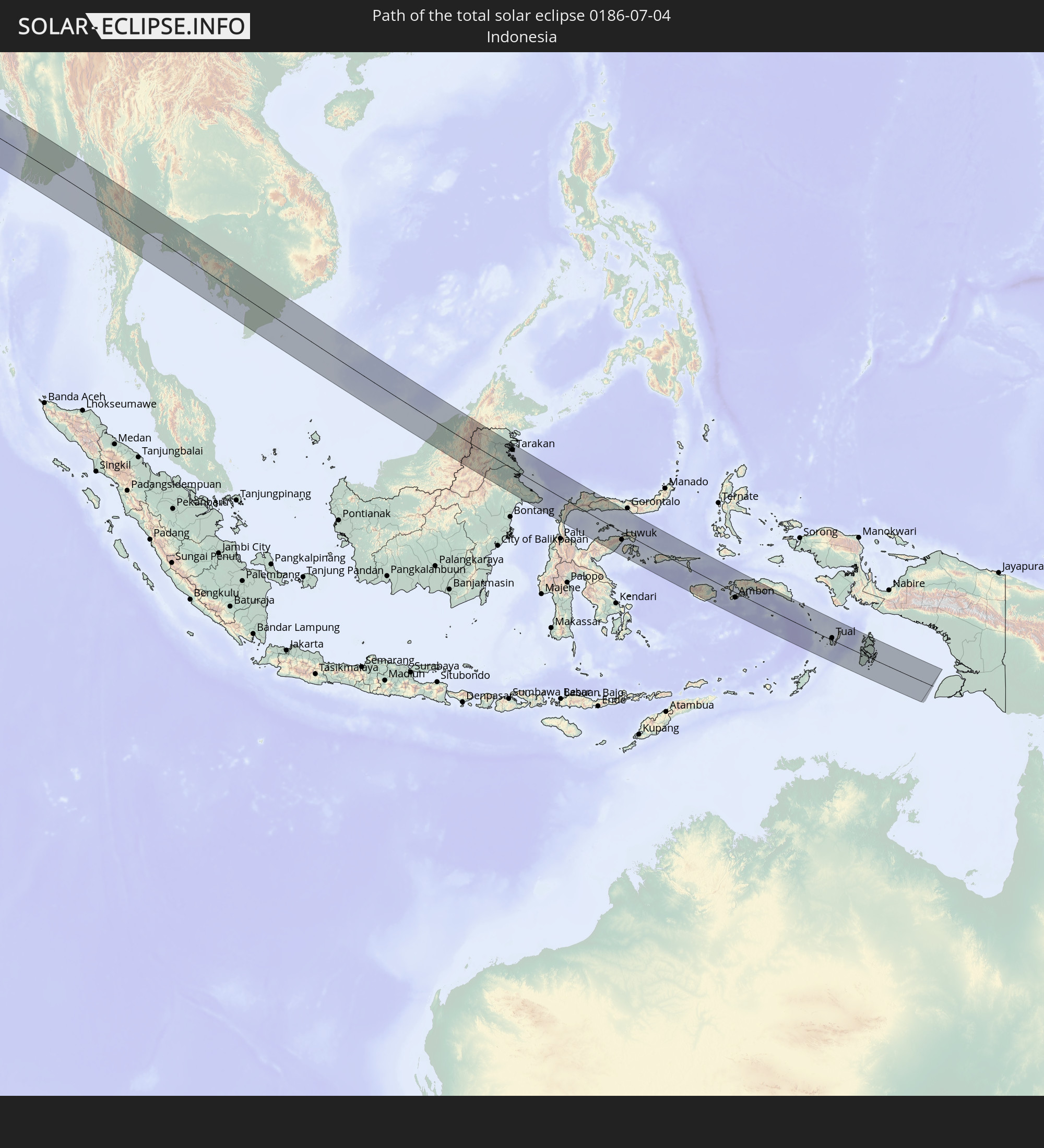 Indonesia
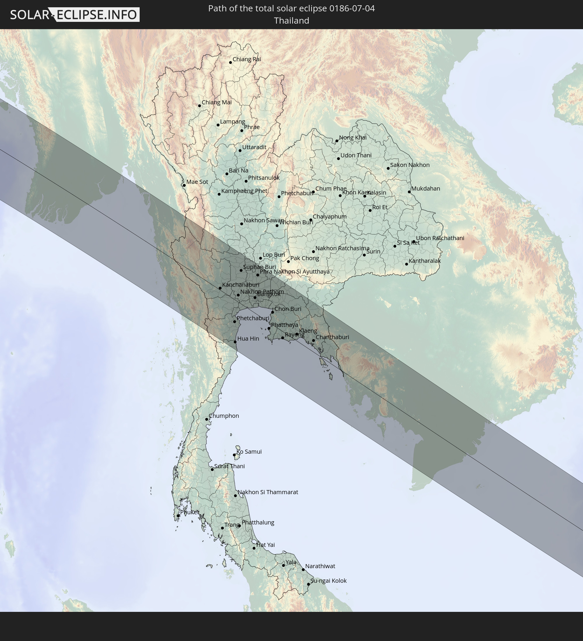 Thailand
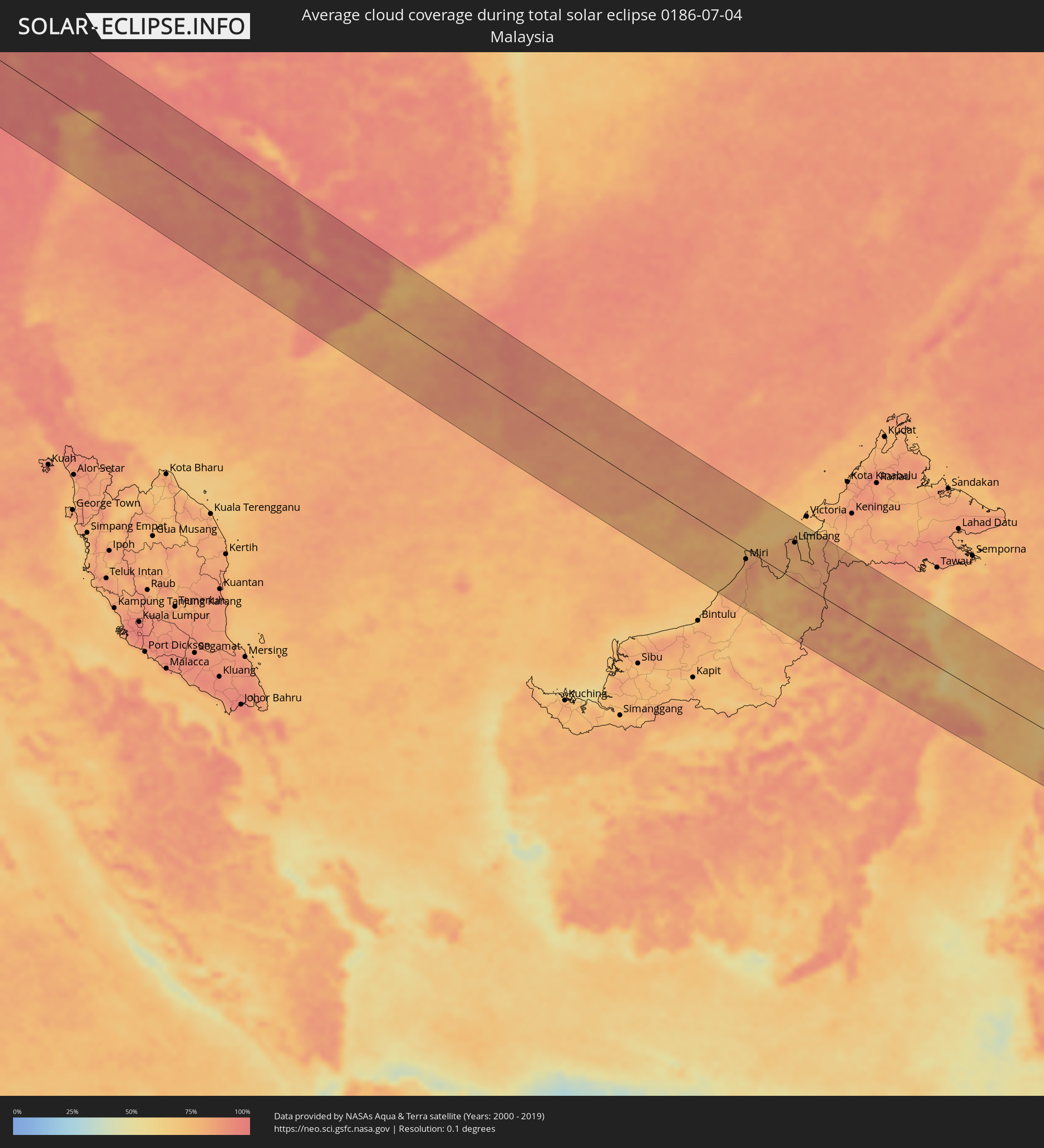
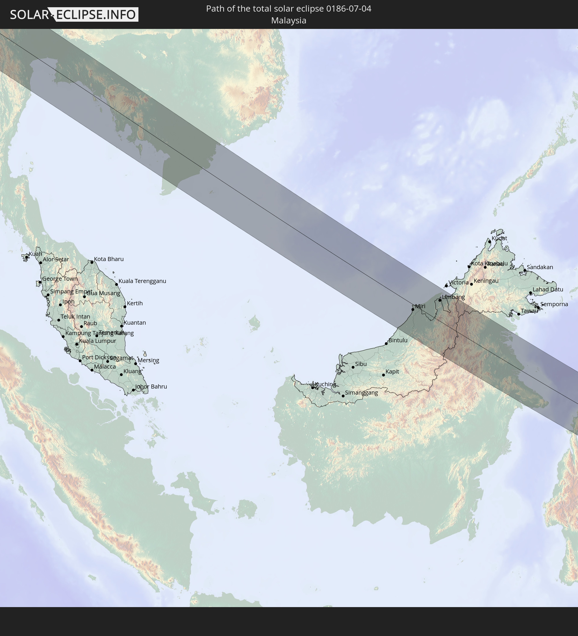 Malaysia
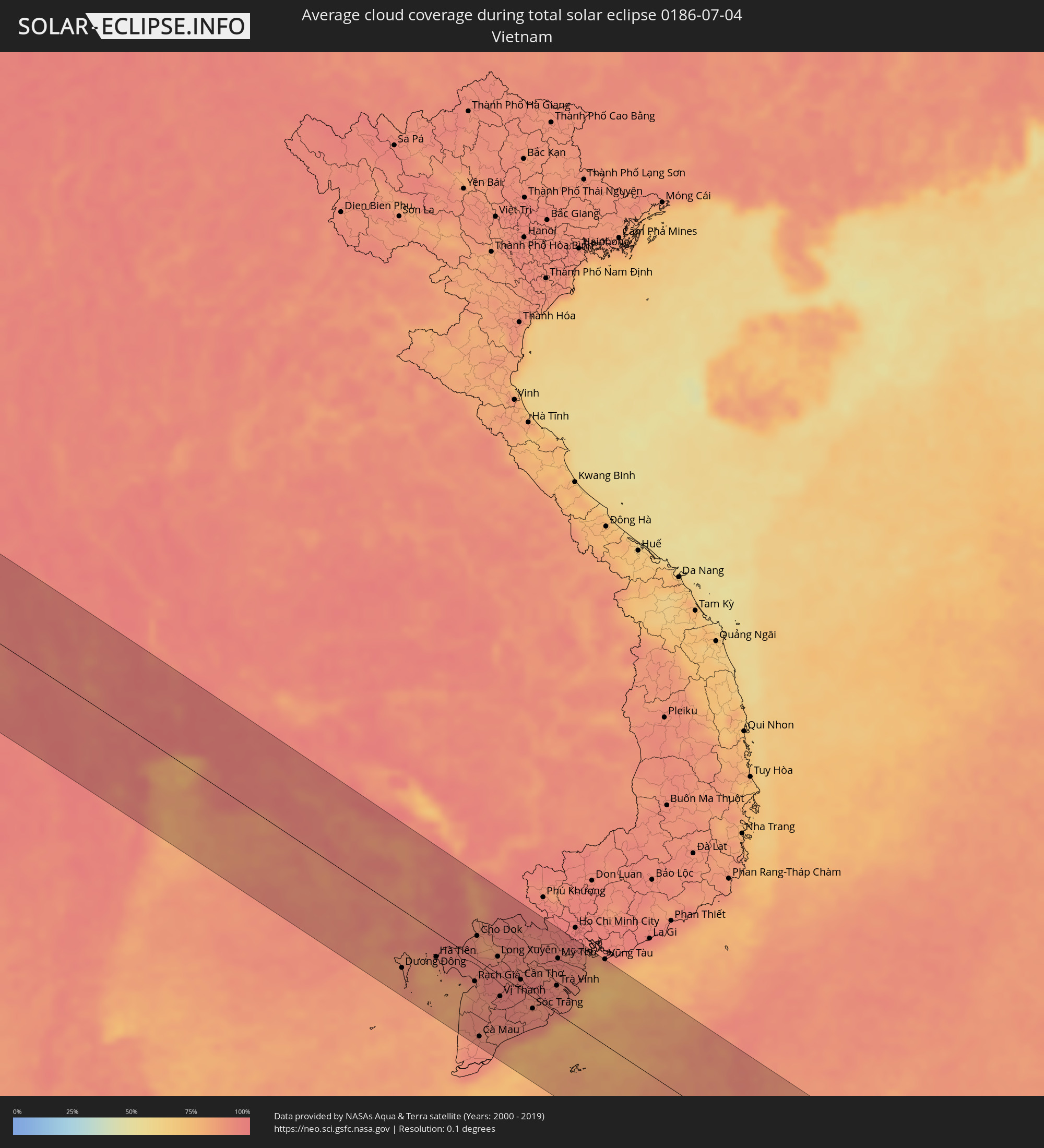
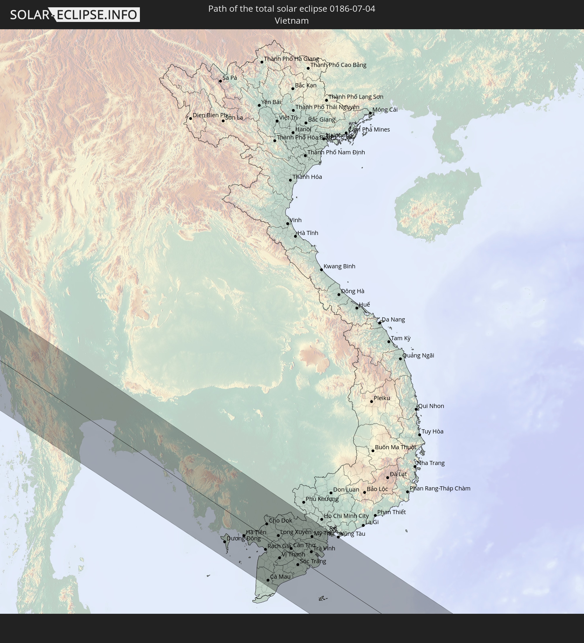 Vietnam
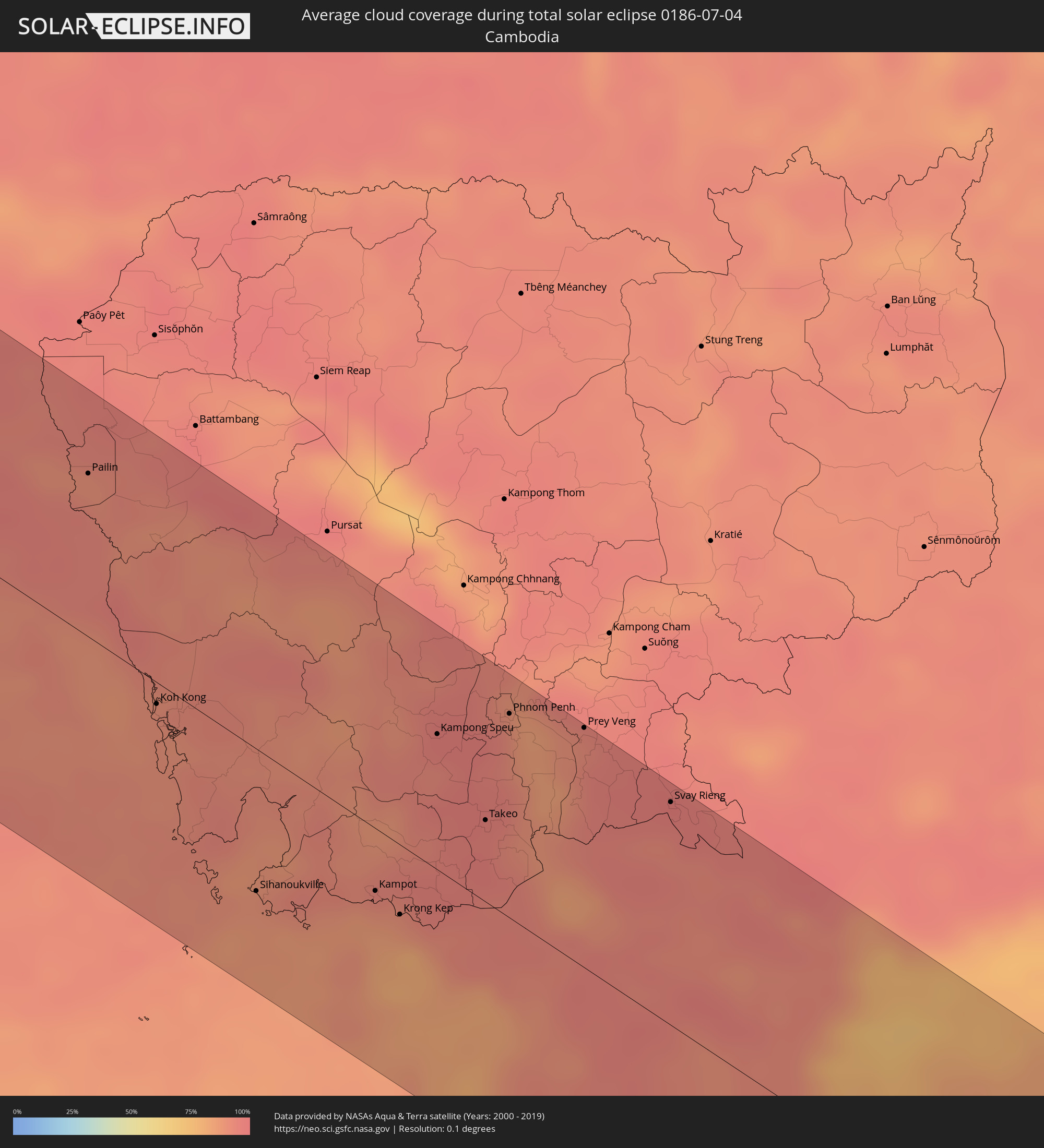
 Cambodia
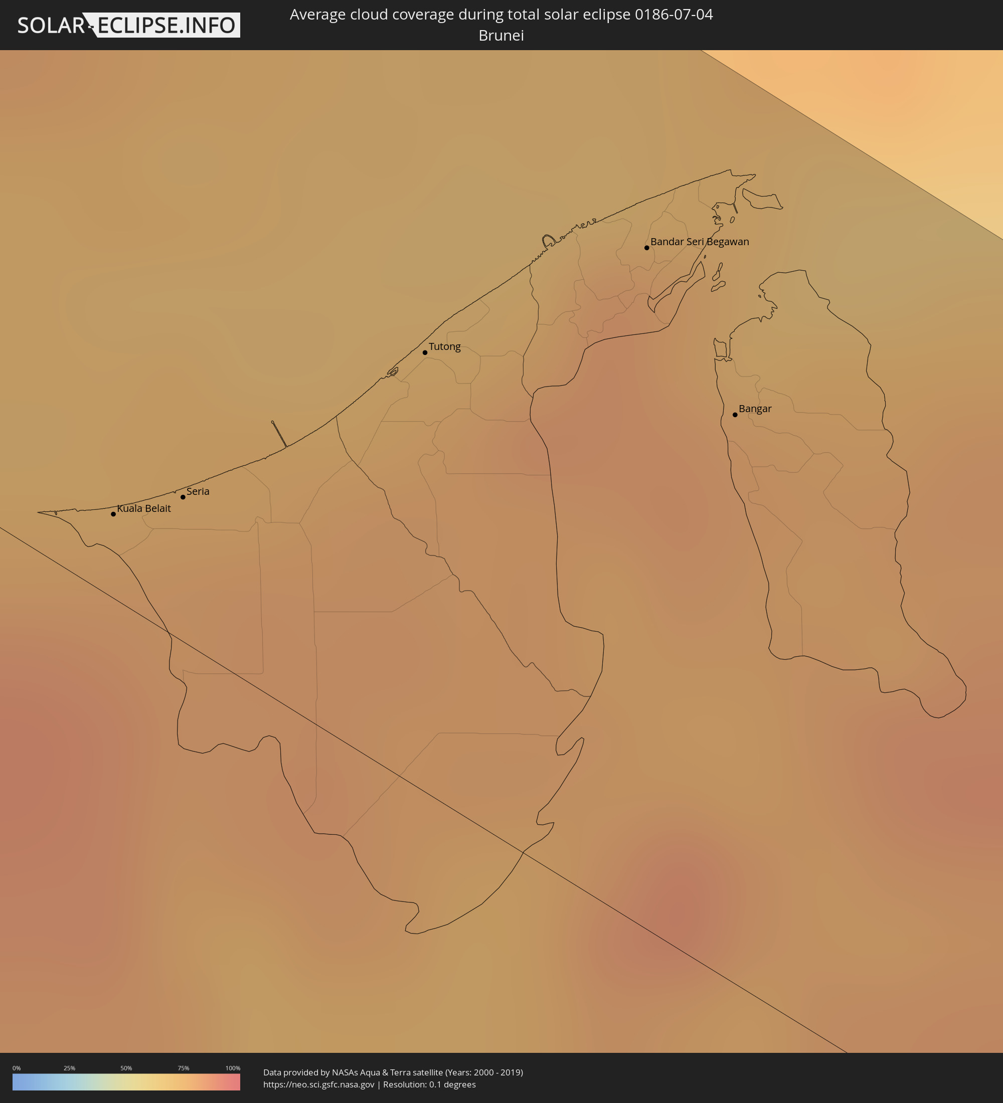
 Brunei
In den folgenden Ländern ist die Sonnenfinsternis partiell zu sehen
 Russia
 Portugal
 Spain
Spain
 Morocco
 Mali
Mali
 Algeria
 Gibraltar
 France
 Niger
Niger
 Andorra
 Nigeria
 Germany
 Switzerland
 Italy
Italy
 Monaco
 Tunisia
 Cameroon
 Gabon
Gabon
 Libya
Libya
 Liechtenstein
 Austria
 Republic of the Congo
 Angola
 Namibia
 Czechia
 Democratic Republic of the Congo
 San Marino
 Vatican City
 Slovenia
 Chad
Chad
 Croatia
 Poland
 Malta
Malta
 Central African Republic
 Bosnia and Herzegovina
 Hungary
 Slovakia
 Montenegro
 Serbia
 Albania
 Greece
 Romania
 Republic of Macedonia
 Lithuania
 Sudan
Sudan
 Zambia
 Ukraine
 Bulgaria
 Belarus
 Egypt
Egypt
 Turkey
 Moldova
 Rwanda
 Burundi
 Tanzania
 Uganda
 Cyprus
 Malawi
 Ethiopia
 Kenya
Kenya
 State of Palestine
 Israel
 Saudi Arabia
 Jordan
 Lebanon
 Syria
Syria
 Eritrea
 Iraq
Iraq
 Georgia
 Somalia
 Djibouti
 Yemen
Yemen
 Armenia
 Iran
Iran
 Azerbaijan
 Seychelles
 Kazakhstan
 Kuwait
 Bahrain
 Qatar
Qatar
 United Arab Emirates
 Oman
Oman
 Turkmenistan
 Uzbekistan
 Afghanistan
 Pakistan
 Tajikistan
 India
India
 Kyrgyzstan
 British Indian Ocean Territory
 Maldives
 China
China
 Sri Lanka
 Nepal
Nepal
 Mongolia
 Bangladesh
 Bhutan
 Myanmar
 Indonesia
 Cocos Islands
 Thailand
 Malaysia
 Laos
Laos
 Vietnam
 Cambodia
 Singapore
 Christmas Island
 Australia
 Macau
Macau
 Hong Kong
 Brunei
 Taiwan
 Philippines
 Japan
Japan
 East Timor
 North Korea
 South Korea
 Palau
Palau
 Federated States of Micronesia
 Guam
Guam
 Northern Mariana Islands
How will be the weather during the total solar eclipse on 07/04/0186?
Where is the best place to see the total solar eclipse of 07/04/0186?
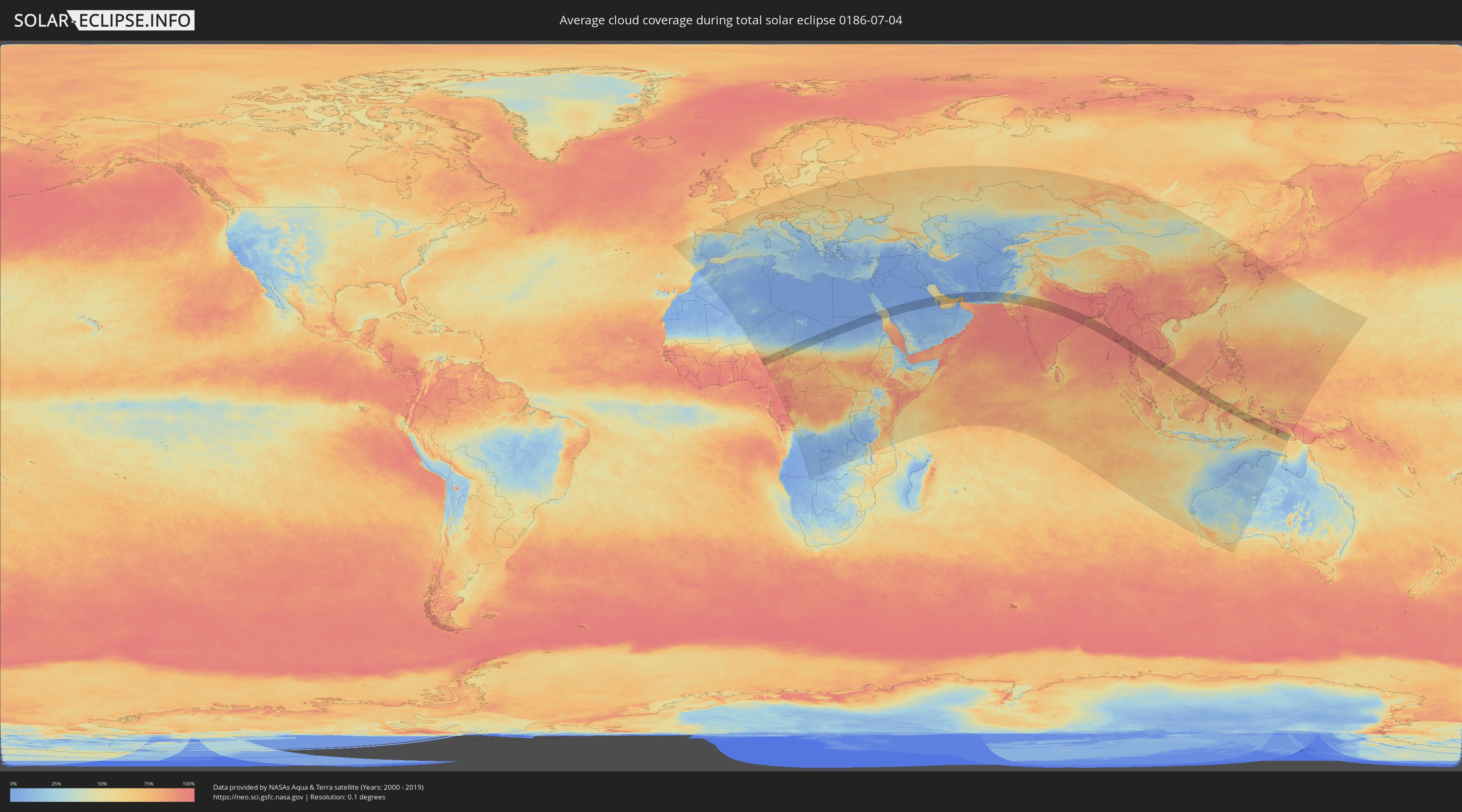
The following maps show the average cloud coverage for the day of the total solar eclipse.
With the help of these maps, it is possible to find the place along the eclipse path, which has the best
chance of a cloudless sky.
Nevertheless, you should consider local circumstances and inform about the weather of your chosen
observation site.
The data is provided by NASAs satellites
AQUA and TERRA.
The cloud maps are averaged over a period of 19 years (2000 - 2019).

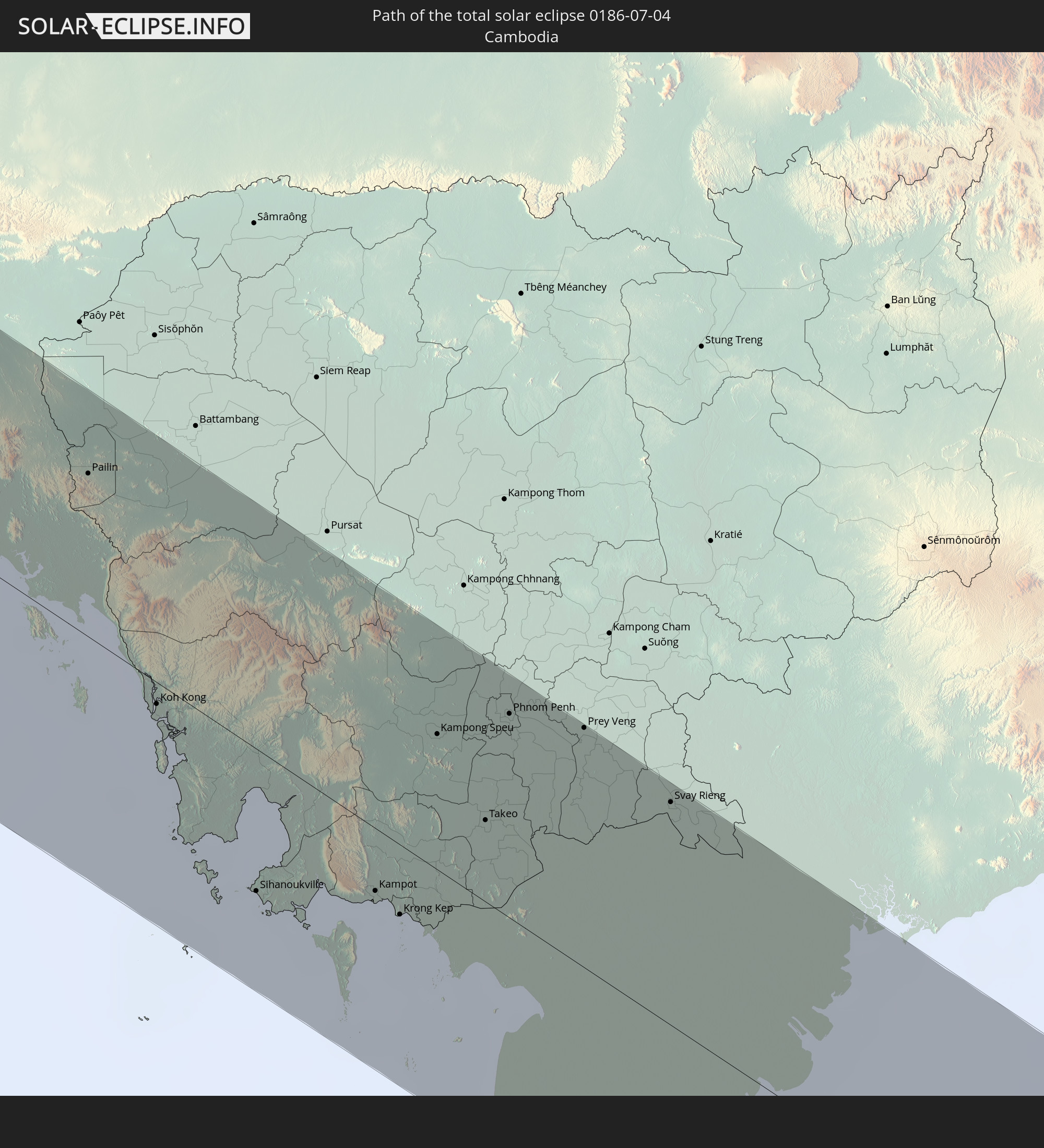
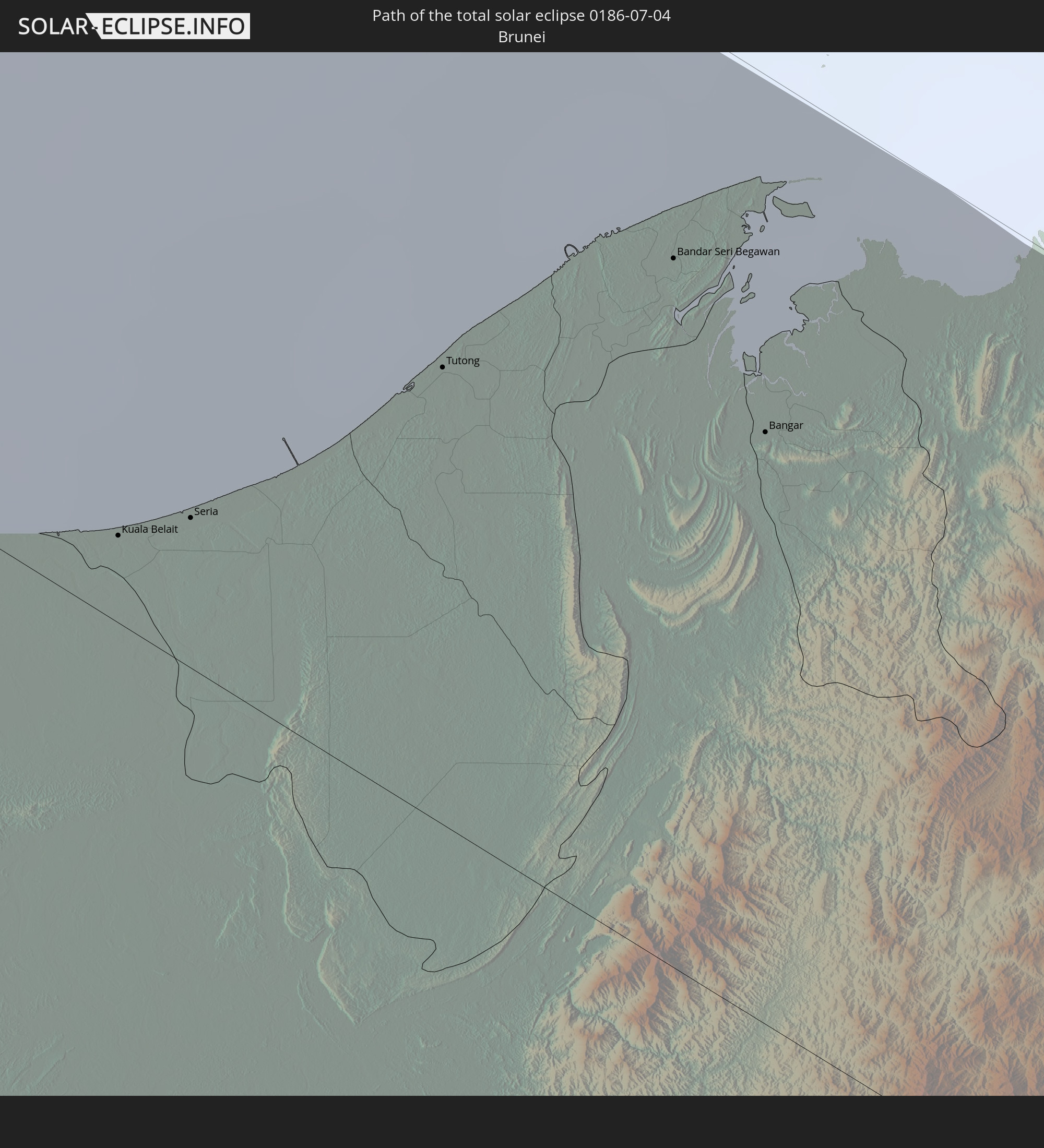
Detailed country maps
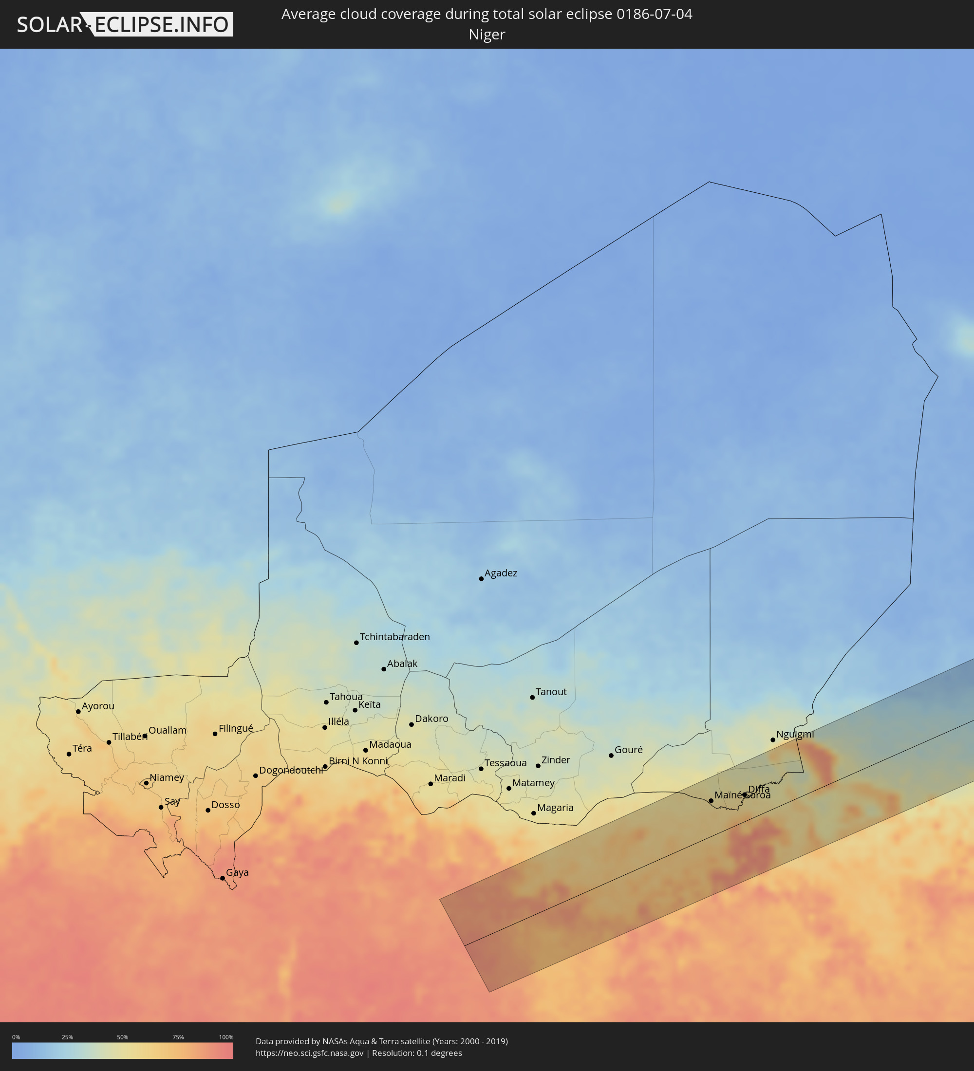 Niger
Niger
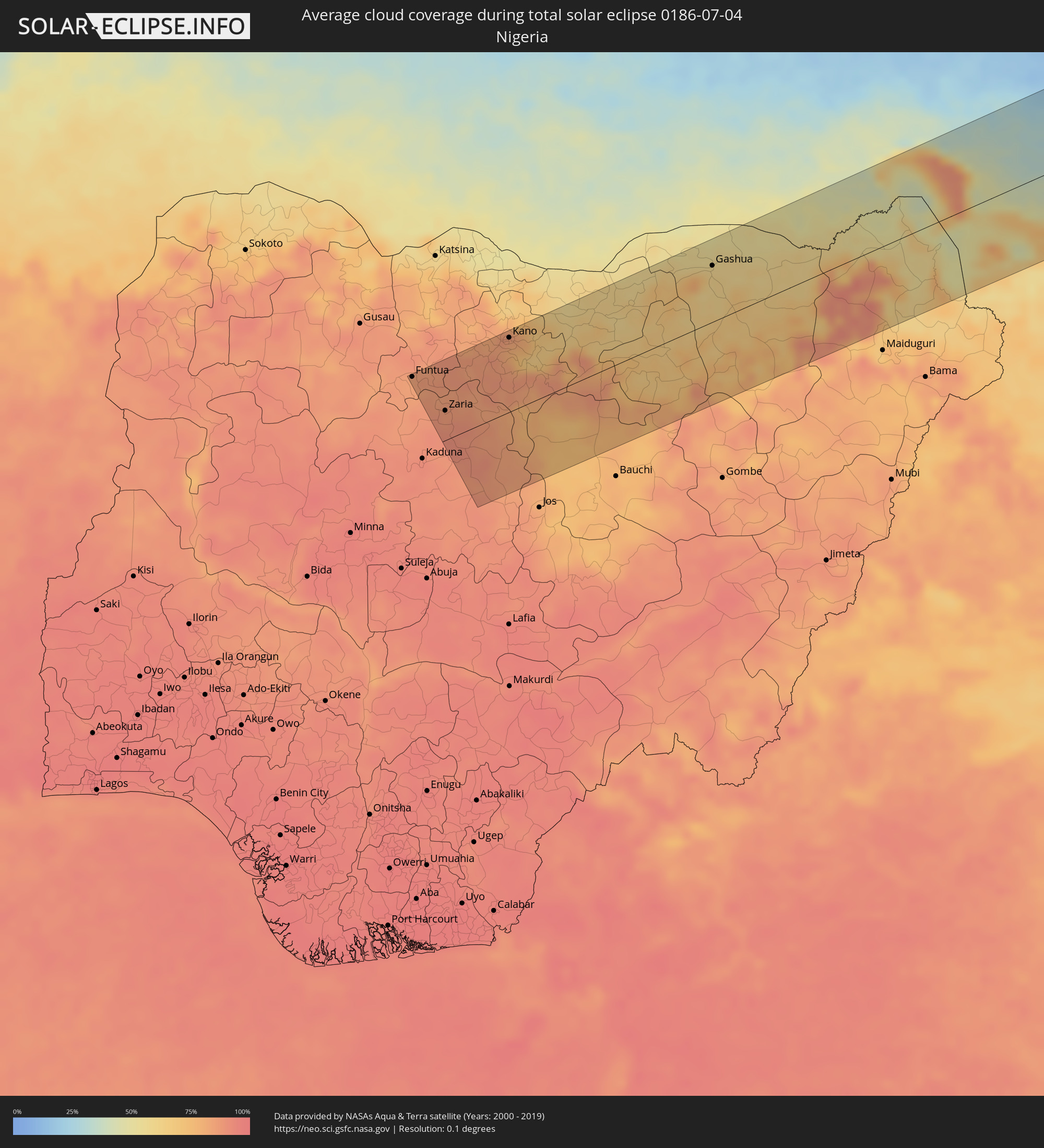 Nigeria
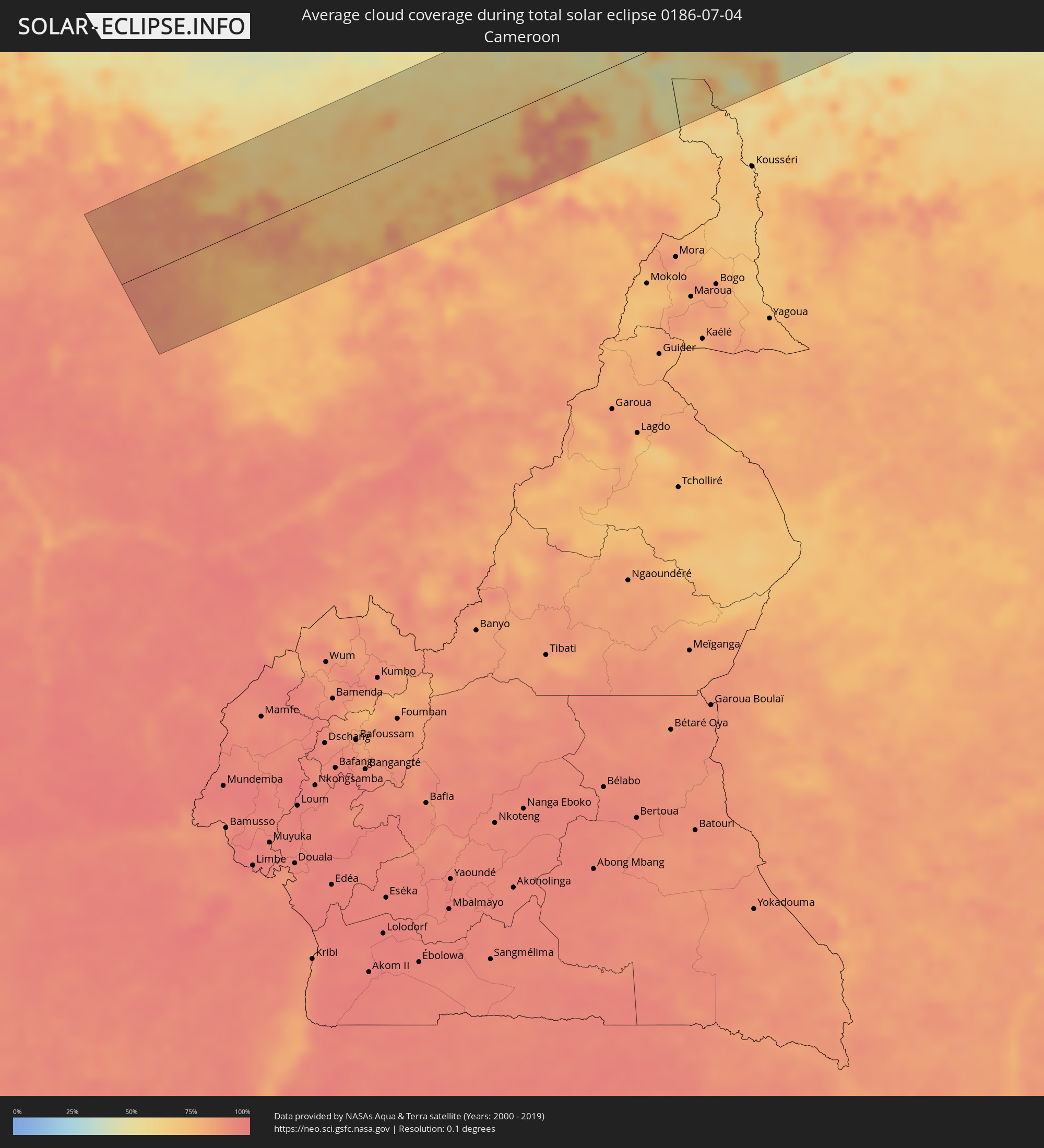 Cameroon
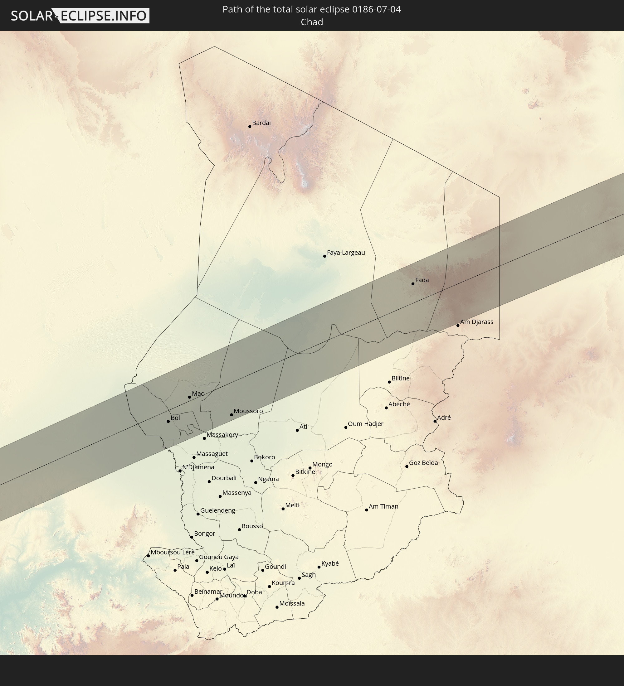
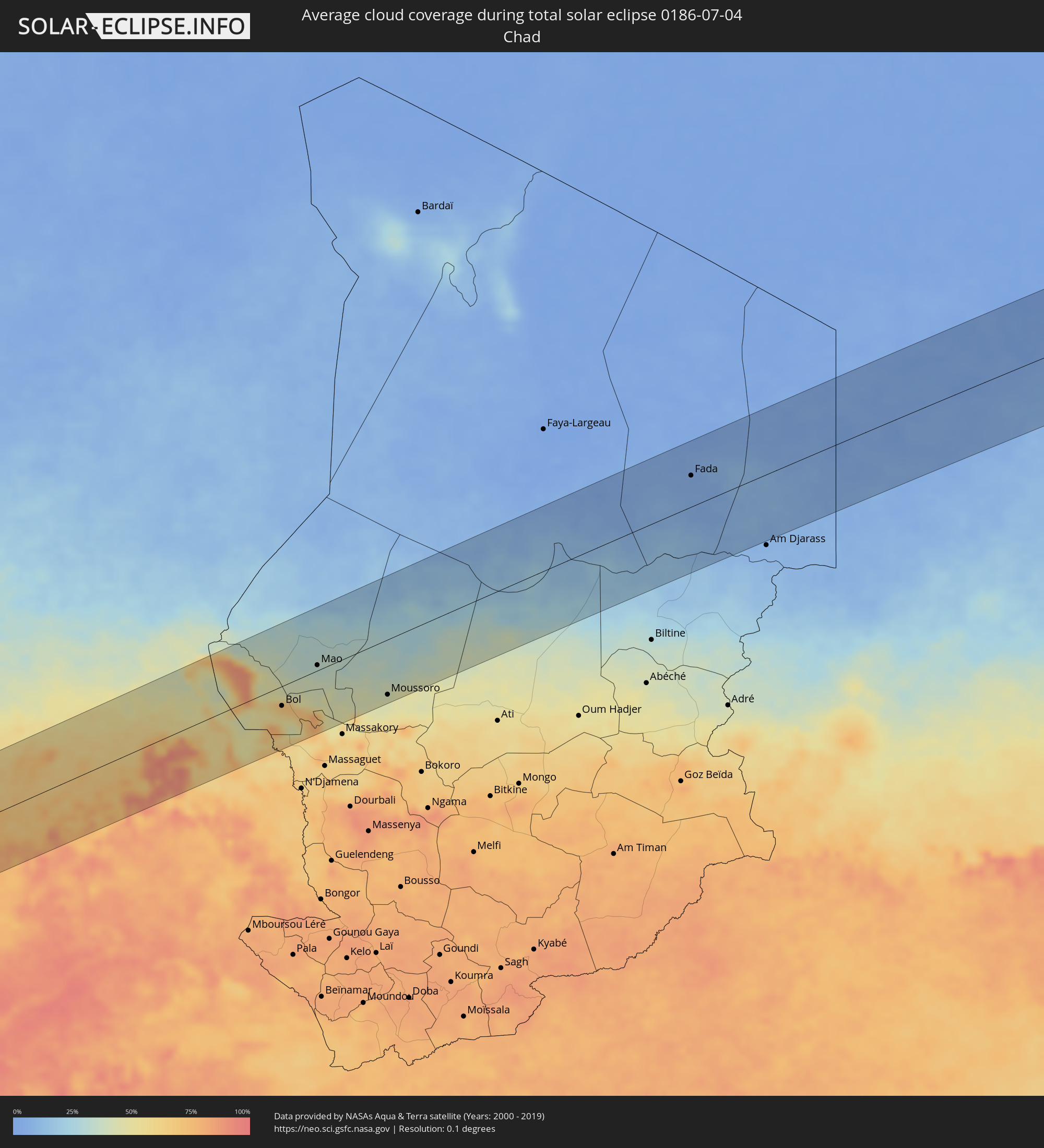 Chad
Chad
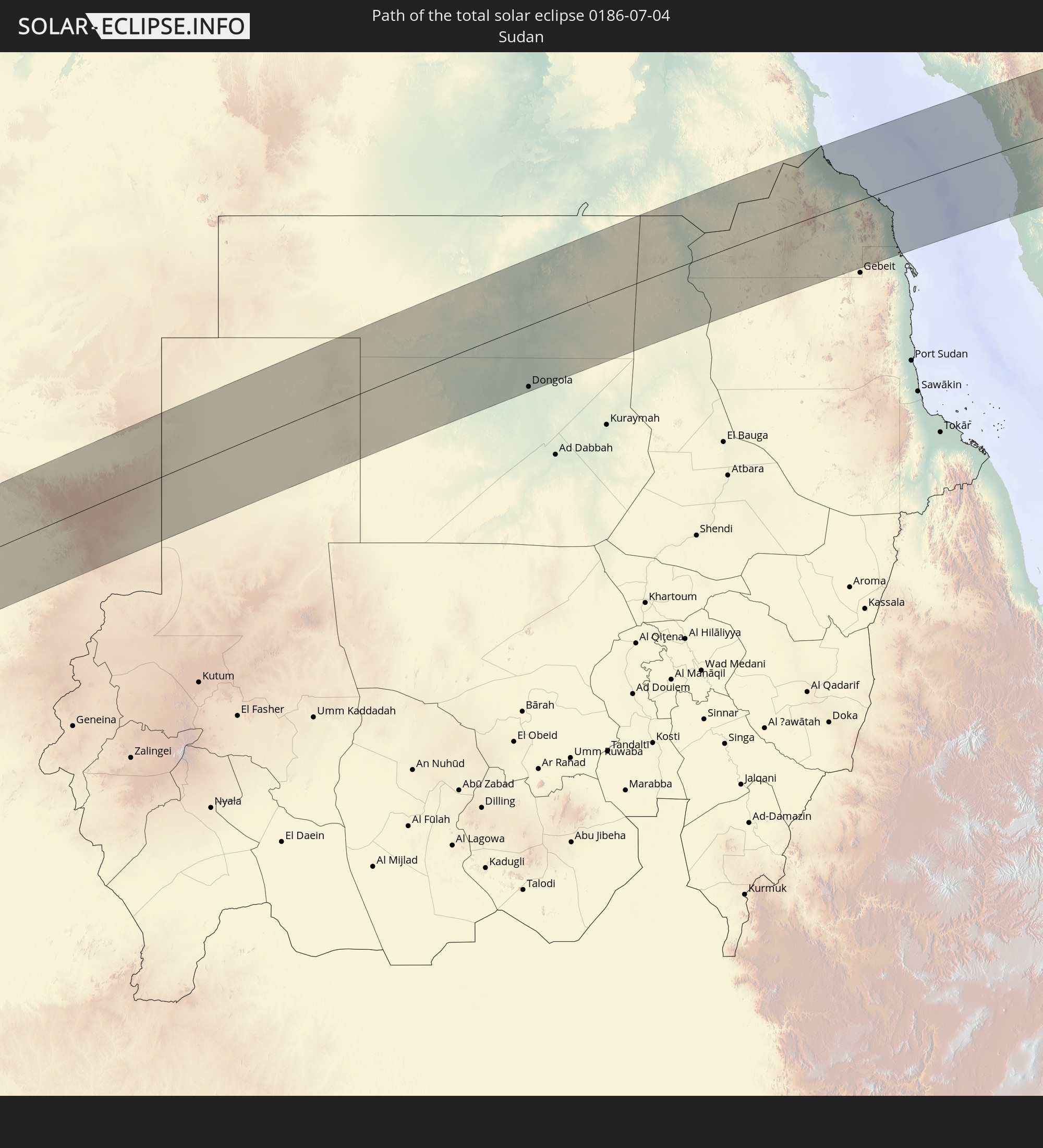
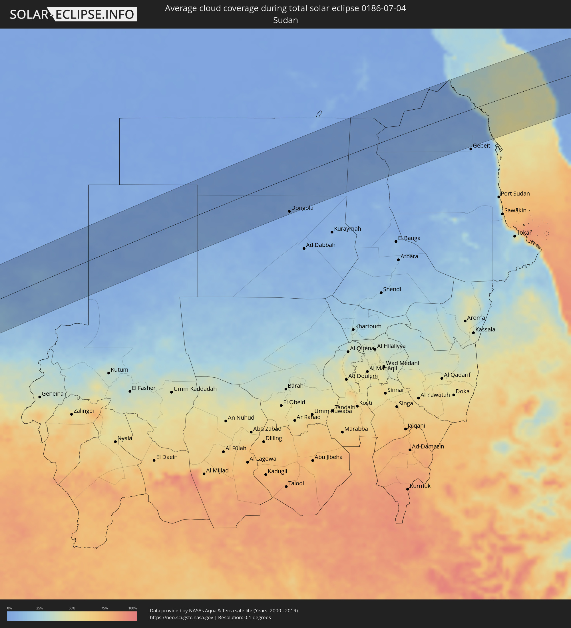 Sudan
Sudan
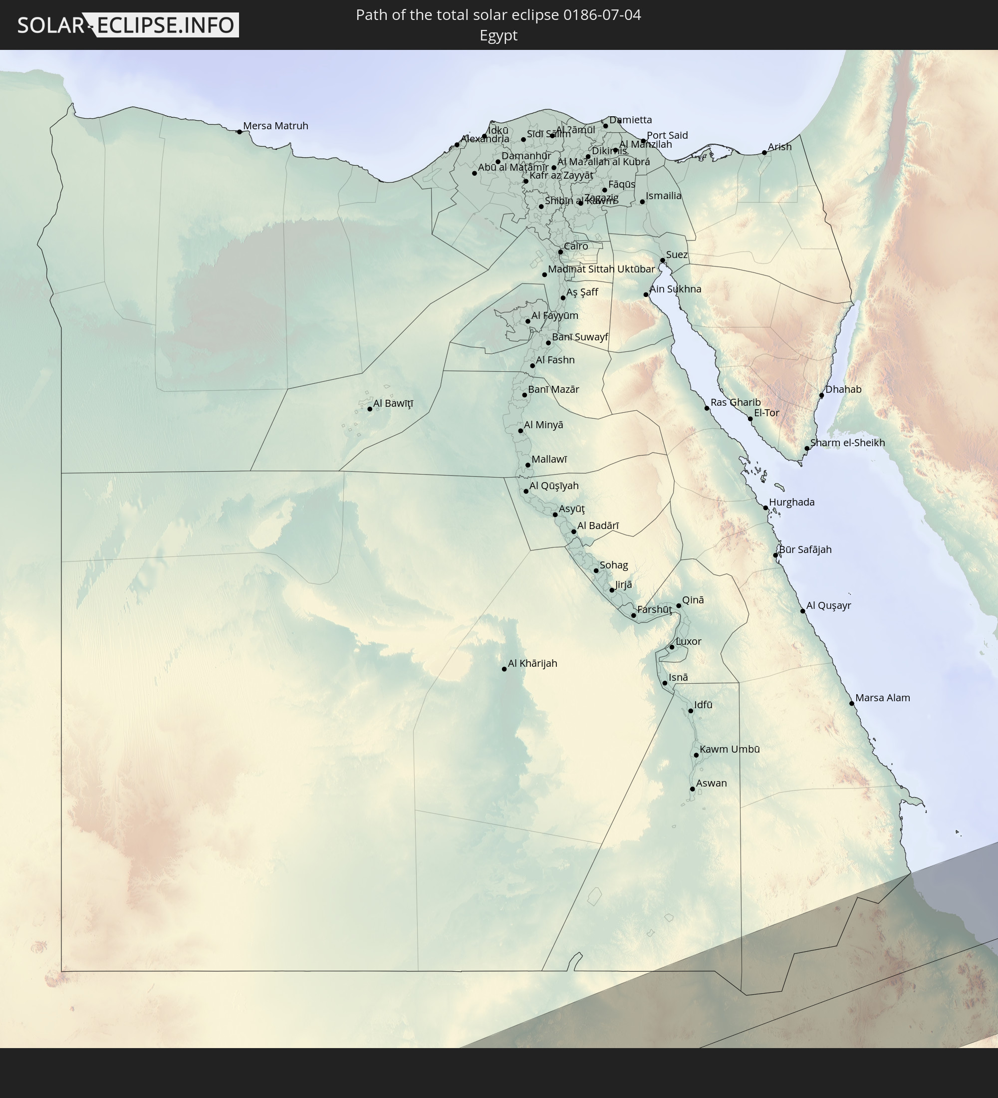
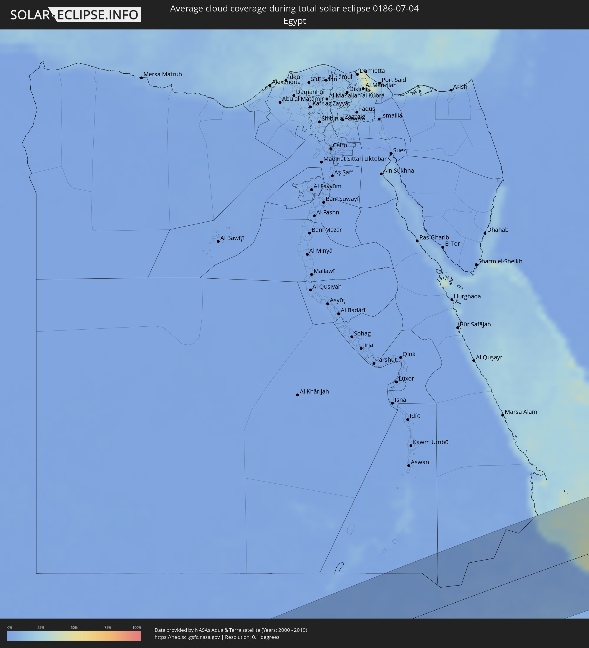 Egypt
Egypt
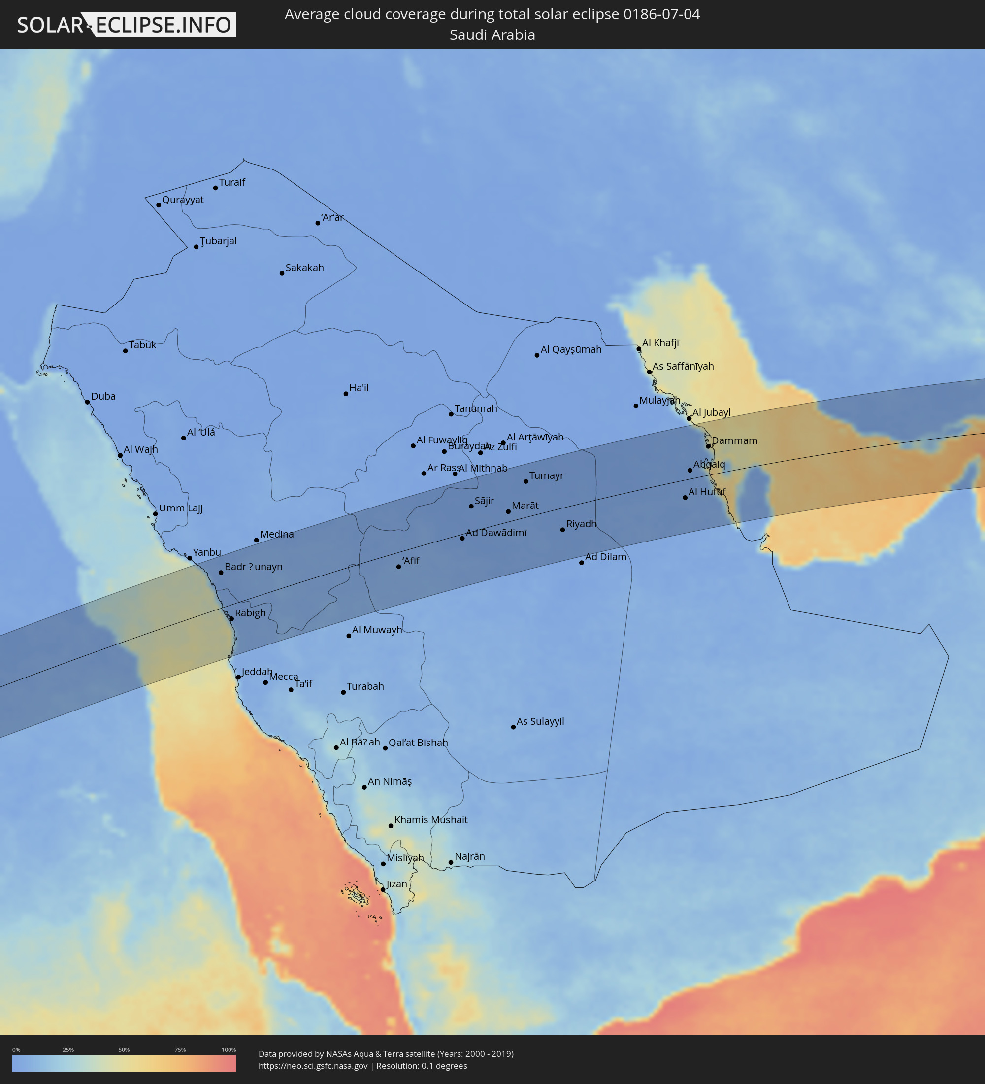 Saudi Arabia
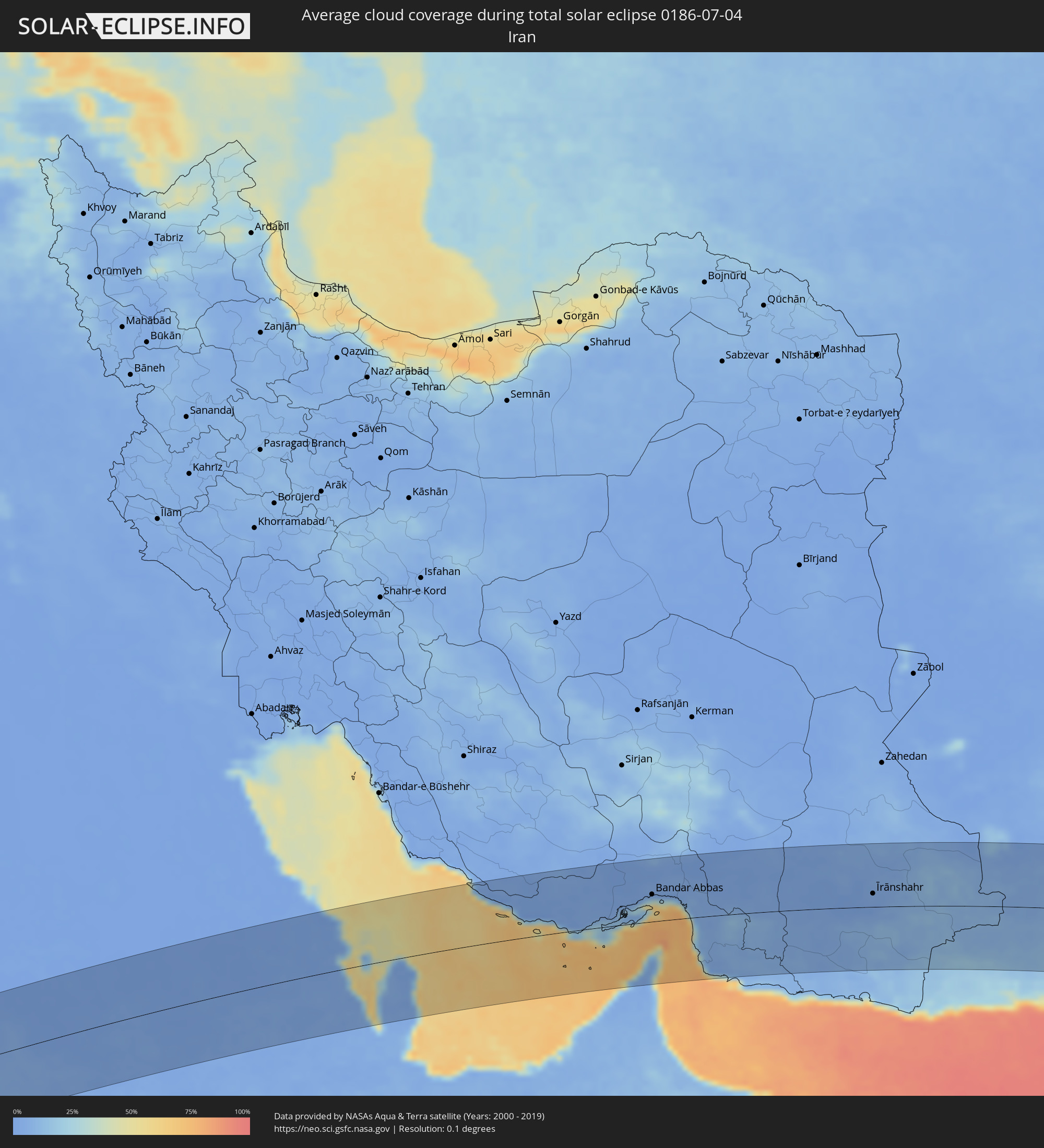 Iran
Iran
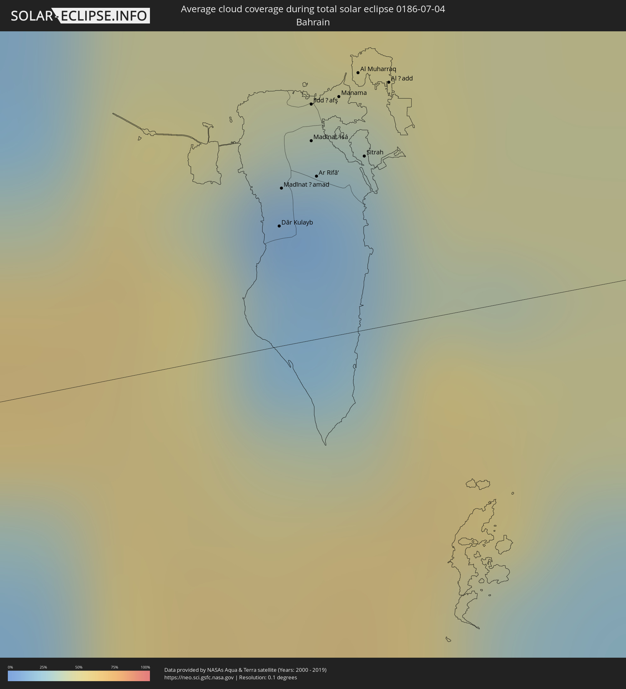 Bahrain
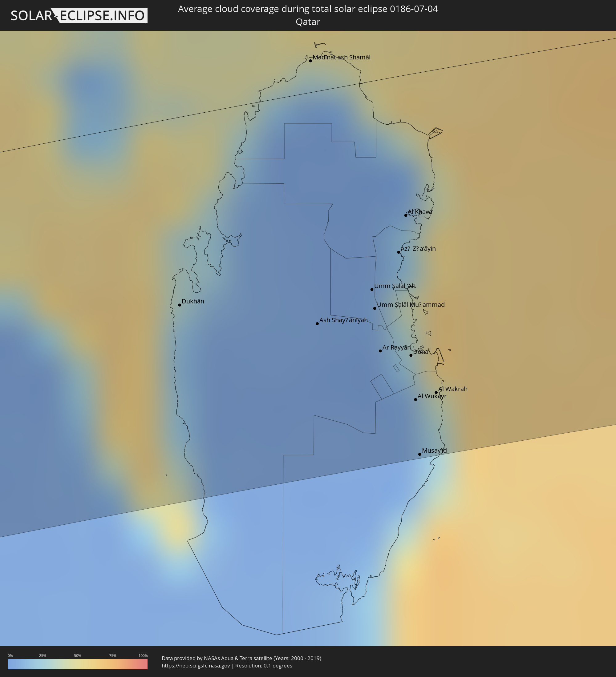 Qatar
Qatar
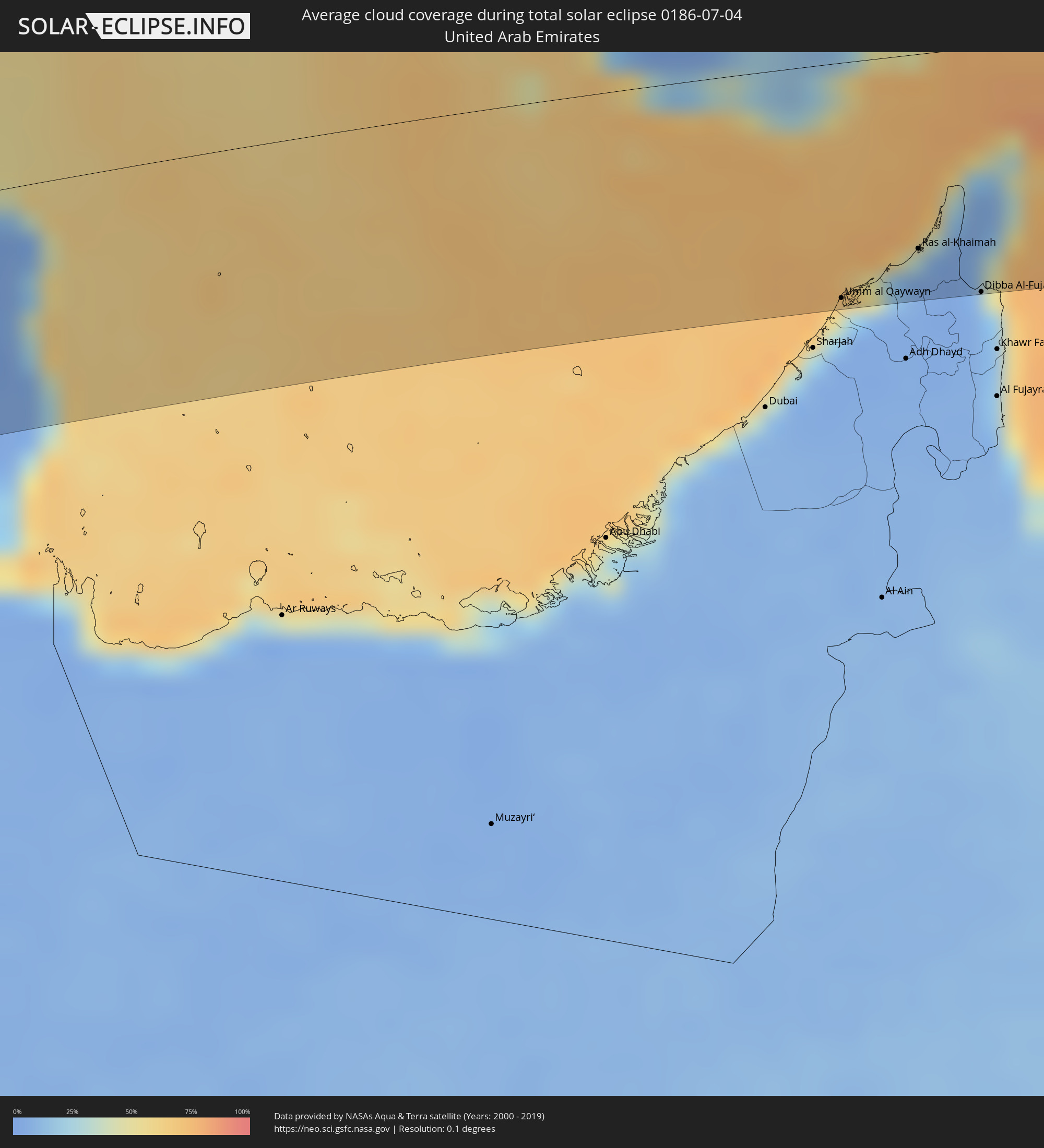 United Arab Emirates
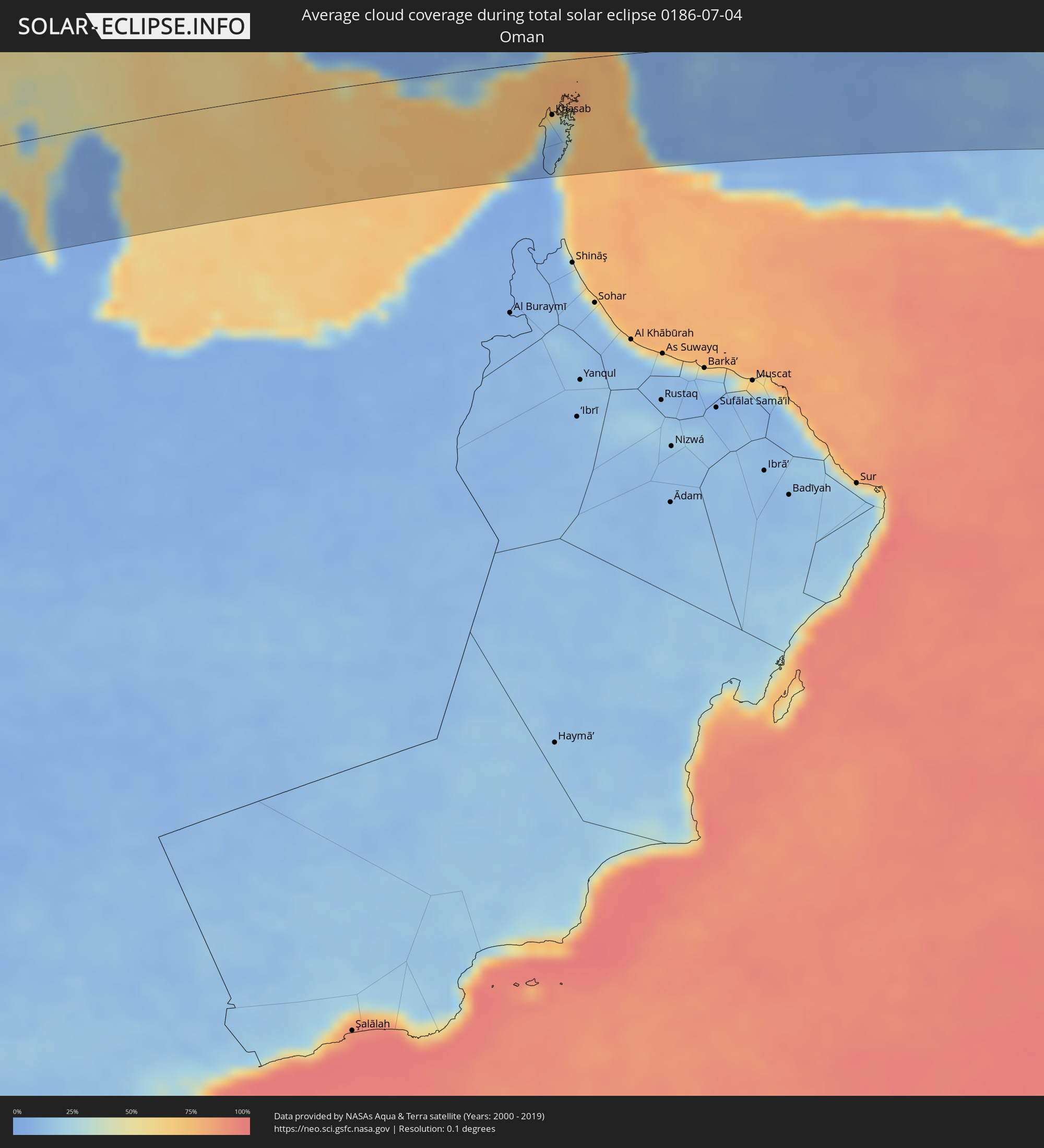 Oman
Oman
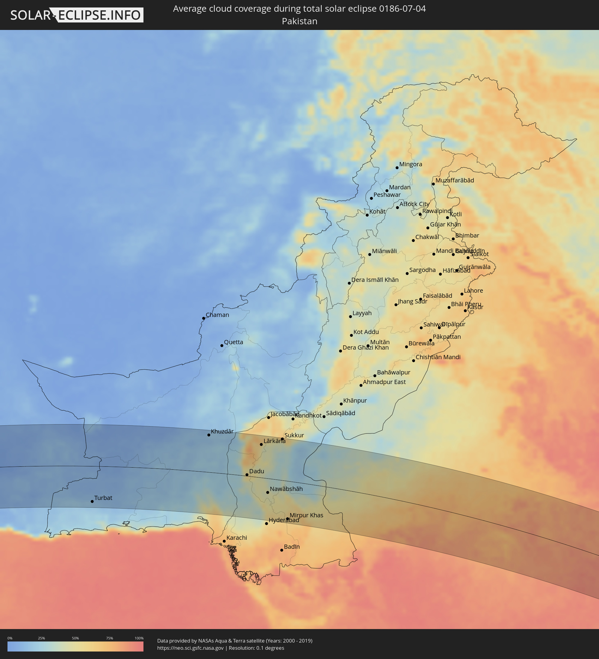 Pakistan
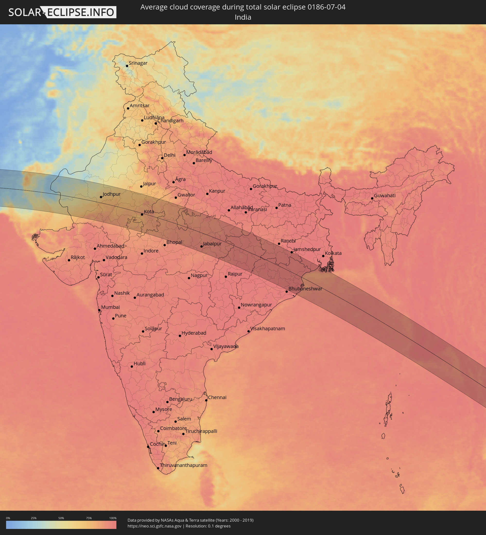 India
India
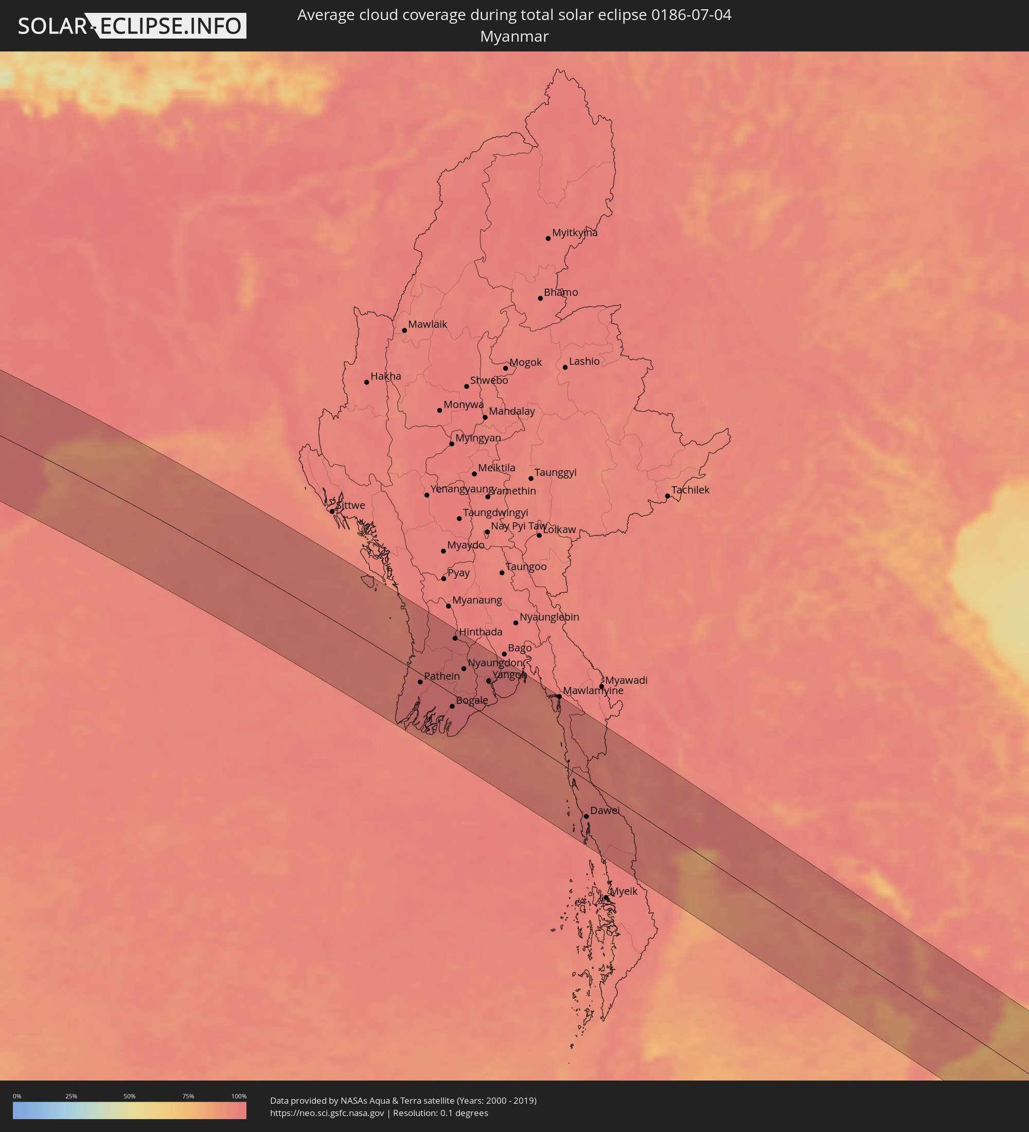 Myanmar
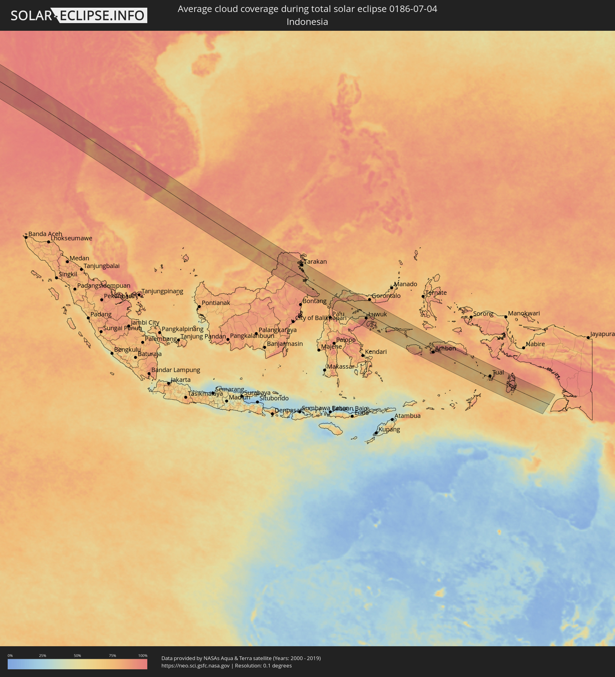 Indonesia
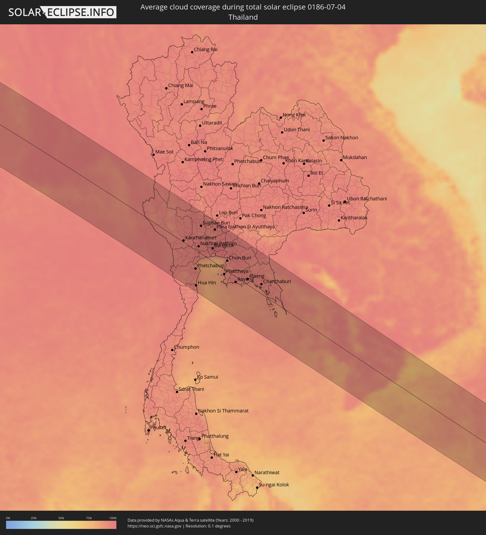 Thailand
 Malaysia
 Vietnam
 Cambodia
 Brunei
Cities inside the path of the eclipse
The following table shows all locations with a population of more than 5,000 inside the eclipse path. Cities which have more than 100,000 inhabitants are marked bold. A click at the locations opens a detailed map.
| City | Type | Eclipse duration | Local time of max. eclipse | Distance to central line | Ø Cloud coverage |
|
Funtua, Katsina
|
total | - | 05:24:34 UTC+00:13 | 97 km | 84% |
|
Zaria, Kaduna
|
total | - | 05:24:22 UTC+00:13 | 37 km | 87% |
|
Kano, Kano
|
total | - | 05:24:35 UTC+00:13 | 92 km | 79% |
|
Lere, Kaduna
|
total | - | 05:24:01 UTC+00:13 | 75 km | 83% |
|
Hadejia, Jigawa
|
total | - | 05:24:37 UTC+00:13 | 71 km | 64% |
|
Azare, Bauchi
|
total | - | 05:24:19 UTC+00:13 | 15 km | 65% |
|
Nguru, Yobe
|
total | - | 05:24:45 UTC+00:13 | 96 km | 62% |
|
Gashua, Yobe
|
total | - | 05:24:43 UTC+00:13 | 70 km | 60% |
|
Potiskum, Yobe
|
total | - | 05:24:17 UTC+00:13 | 50 km | 68% |
|
Daura, Yobe
|
total | - | 05:24:13 UTC+00:13 | 81 km | 79% |
|
Damaturu, Yobe
|
total | - | 05:24:16 UTC+00:13 | 86 km | 82% |
|
Maïné Soroa, Diffa
|
total | - | 05:24:50 UTC+00:13 | 60 km | 54% |
|
Diffa, Diffa
|
total | - | 05:24:53 UTC+00:13 | 45 km | 55% |
|
Bol, Lac
|
total | - | 06:11:40 UTC+01:00 | 33 km | 68% |
|
Mao, Kanem
|
total | - | 06:12:00 UTC+01:00 | 9 km | 34% |
|
Moussoro, Barh el Gazel
|
total | - | 06:11:56 UTC+01:00 | 91 km | 44% |
|
Fada, Ennedi-Ouest
|
total | - | 06:14:55 UTC+01:00 | 51 km | 4% |
|
Argo, Northern State
|
total | - | 07:30:55 UTC+02:10 | 69 km | 4% |
|
Dongola, Northern State
|
total | - | 07:30:45 UTC+02:10 | 106 km | 4% |
|
Badr Ḩunayn, Al Madīnah al Munawwarah
|
total | - | 08:38:20 UTC+03:06 | 78 km | 2% |
|
Rābigh, Makkah
|
total | - | 08:37:56 UTC+03:06 | 34 km | 20% |
|
‘Afīf, Ar Riyāḑ
|
total | - | 08:43:37 UTC+03:06 | 35 km | 6% |
|
Ad Dawādimī, Ar Riyāḑ
|
total | - | 08:46:06 UTC+03:06 | 11 km | 2% |
|
Riyadh, Ar Riyāḑ
|
total | - | 08:49:47 UTC+03:06 | 52 km | 1% |
|
Al Hufūf, Eastern Province
|
total | - | 08:54:56 UTC+03:06 | 42 km | 4% |
|
Abqaiq, Eastern Province
|
total | - | 08:55:26 UTC+03:06 | 18 km | 1% |
|
Tārūt, Eastern Province
|
total | - | 08:56:24 UTC+03:06 | 80 km | 11% |
|
Raḩīmah, Eastern Province
|
total | - | 08:56:31 UTC+03:06 | 95 km | 42% |
|
Dammam, Eastern Province
|
total | - | 08:56:26 UTC+03:06 | 64 km | 4% |
|
Khobar, Eastern Province
|
total | - | 08:56:32 UTC+03:06 | 45 km | 23% |
|
Dār Kulayb, Southern Governorate
|
total | - | 09:16:13 UTC+03:26 | 16 km | 19% |
|
Madīnat Ḩamad, Central Governorate
|
total | - | 09:16:15 UTC+03:26 | 21 km | 19% |
|
Jidd Ḩafş, Manama
|
total | - | 09:16:23 UTC+03:26 | 32 km | 13% |
|
Madīnat ‘Īsá, Southern Governorate
|
total | - | 09:16:21 UTC+03:26 | 27 km | 13% |
|
Ar Rifā‘, Southern Governorate
|
total | - | 09:16:21 UTC+03:26 | 22 km | 18% |
|
Manama, Manama
|
total | - | 09:16:27 UTC+03:26 | 32 km | 18% |
|
Al Muharraq, Muharraq
|
total | - | 09:16:31 UTC+03:26 | 35 km | 34% |
|
Sitrah, Manama
|
total | - | 09:16:29 UTC+03:26 | 23 km | 18% |
|
Al Ḩadd, Muharraq
|
total | - | 09:16:35 UTC+03:26 | 33 km | 42% |
|
Dukhān, Baladīyat ar Rayyān
|
total | - | 09:16:24 UTC+03:26 | 59 km | 17% |
|
Madīnat ash Shamāl, Madīnat ash Shamāl
|
total | - | 09:17:31 UTC+03:26 | 10 km | 7% |
|
Ash Shayḩānīyah, Baladīyat ar Rayyān
|
total | - | 09:17:11 UTC+03:26 | 74 km | 3% |
|
Umm Şalāl ‘Alī, Baladīyat Umm Şalāl
|
total | - | 09:17:34 UTC+03:26 | 66 km | 5% |
|
Umm Şalāl Muḩammad, Baladīyat Umm Şalāl
|
total | - | 09:17:33 UTC+03:26 | 72 km | 3% |
|
Az̧ Z̧a‘āyin, Baladīyat az̧ Z̧a‘āyin
|
total | - | 09:17:46 UTC+03:26 | 56 km | 37% |
|
Al Khawr, Al Khawr
|
total | - | 09:17:52 UTC+03:26 | 44 km | 20% |
|
Doha, Baladīyat ad Dawḩah
|
total | - | 09:17:42 UTC+03:26 | 89 km | 8% |
|
Al Wukayr, Al Wakrah
|
total | - | 09:17:40 UTC+03:26 | 103 km | 6% |
|
Musay‘īd, Al Wakrah
|
total | - | 09:17:37 UTC+03:26 | 121 km | 38% |
|
Al Wakrah, Al Wakrah
|
total | - | 09:17:48 UTC+03:26 | 102 km | 29% |
|
Kīsh, Hormozgan
|
total | - | 09:22:41 UTC+03:25 | 11 km | 48% |
|
Bandar-e Lengeh, Hormozgan
|
total | - | 09:24:24 UTC+03:25 | 0 km | 31% |
|
Umm al Qaywayn, Umm al Qaywayn
|
total | - | 09:40:55 UTC+03:41 | 118 km | 24% |
|
Ras al-Khaimah, Raʼs al Khaymah
|
total | - | 09:41:49 UTC+03:41 | 98 km | 35% |
|
Khasab, Musandam
|
total | - | 09:42:35 UTC+03:41 | 58 km | 21% |
|
Dibba Al-Fujairah, Al Fujayrah
|
total | - | 09:42:26 UTC+03:41 | 123 km | 19% |
|
Qeshm, Hormozgan
|
total | - | 09:27:24 UTC+03:25 | 27 km | 59% |
|
Dibba Al-Hisn, Al Fujayrah
|
total | - | 09:42:28 UTC+03:41 | 120 km | 19% |
|
Bandar Abbas, Hormozgan
|
total | - | 09:27:30 UTC+03:25 | 53 km | 34% |
|
Mīnāb, Hormozgan
|
total | - | 09:29:10 UTC+03:25 | 40 km | 5% |
|
Īrānshahr, Sistan and Baluchestan
|
total | - | 09:37:07 UTC+03:25 | 26 km | 3% |
|
Qaşr-e Qand, Sistan and Baluchestan
|
total | - | 09:37:11 UTC+03:25 | 80 km | 11% |
|
Khuzdār, Balochistān
|
total | - | 10:53:37 UTC+04:28 | 111 km | 14% |
|
Dadu, Sindh
|
total | - | 10:56:47 UTC+04:28 | 3 km | 52% |
|
Kambar, Sindh
|
total | - | 10:57:06 UTC+04:28 | 100 km | 65% |
|
Moro, Sindh
|
total | - | 10:57:23 UTC+04:28 | 2 km | 49% |
|
Lārkāna, Sindh
|
total | - | 10:57:38 UTC+04:28 | 99 km | 57% |
|
Nawābshāh, Sindh
|
total | - | 10:58:33 UTC+04:28 | 43 km | 46% |
|
Tando Ādam, Sindh
|
total | - | 10:59:23 UTC+04:28 | 94 km | 52% |
|
Tando Allāhyār, Sindh
|
total | - | 10:59:39 UTC+04:28 | 126 km | 62% |
|
Khairpur, Sindh
|
total | - | 10:59:00 UTC+04:28 | 103 km | 38% |
|
Sukkur, Sindh
|
total | - | 10:59:11 UTC+04:28 | 123 km | 43% |
|
Mirpur Khas, Sindh
|
total | - | 11:00:24 UTC+04:28 | 115 km | 64% |
|
Jodhpur, Rajasthan
|
total | - | 12:03:21 UTC+05:21 | 37 km | 66% |
|
Ajmer, Rajasthan
|
total | - | 12:07:25 UTC+05:21 | 95 km | 69% |
|
Bhīlwāra, Rajasthan
|
total | - | 12:08:13 UTC+05:21 | 24 km | 84% |
|
Kota, Rajasthan
|
total | - | 12:11:28 UTC+05:21 | 10 km | 76% |
|
Jhānsi, Uttar Pradesh
|
total | - | 12:18:13 UTC+05:21 | 101 km | 86% |
|
Jabalpur, Madhya Pradesh
|
total | - | 12:23:58 UTC+05:21 | 92 km | 94% |
|
Satna, Madhya Pradesh
|
total | - | 12:24:41 UTC+05:21 | 86 km | 90% |
|
Bilāspur, Chhattisgarh
|
total | - | 12:30:44 UTC+05:21 | 120 km | 97% |
|
Korba, Chhattisgarh
|
total | - | 12:31:46 UTC+05:21 | 71 km | 97% |
|
Cuttack, Odisha
|
total | - | 12:41:45 UTC+05:21 | 121 km | 96% |
|
Jamshedpur, Jharkhand
|
total | - | 12:39:28 UTC+05:21 | 127 km | 96% |
|
Pathein, Ayeyarwady
|
total | - | 14:08:54 UTC+06:24 | 16 km | 98% |
|
Bogale, Ayeyarwady
|
total | - | 14:10:47 UTC+06:24 | 24 km | 98% |
|
Hinthada, Ayeyarwady
|
total | - | 14:09:00 UTC+06:24 | 107 km | 97% |
|
Pyapon, Ayeyarwady
|
total | - | 14:11:17 UTC+06:24 | 9 km | 98% |
|
Kyaiklat, Ayeyarwady
|
total | - | 14:11:09 UTC+06:24 | 9 km | 98% |
|
Kanbe, Yangon
|
total | - | 14:11:17 UTC+06:24 | 49 km | 98% |
|
Yangon, Yangon
|
total | - | 14:11:25 UTC+06:24 | 67 km | 98% |
|
Thongwa, Yangon
|
total | - | 14:12:07 UTC+06:24 | 84 km | 98% |
|
Mawlamyine, Mon
|
total | - | 14:14:21 UTC+06:24 | 123 km | 96% |
|
Mudon, Mon
|
total | - | 14:14:49 UTC+06:24 | 107 km | 95% |
|
Dawei, Tanintharyi
|
total | - | 14:18:33 UTC+06:24 | 69 km | 97% |
|
Ratchaburi, Ratchaburi
|
total | - | 14:39:06 UTC+06:42 | 23 km | 97% |
|
Nakhon Pathom, Nakhon Pathom
|
total | - | 14:39:03 UTC+06:42 | 17 km | 96% |
|
Pak Kret, Nonthaburi
|
total | - | 14:39:37 UTC+06:42 | 53 km | 97% |
|
Bangkok, Bangkok
|
total | - | 14:39:49 UTC+06:42 | 38 km | 97% |
|
Samut Prakan, Samut Prakan
|
total | - | 14:40:10 UTC+06:42 | 29 km | 93% |
|
Khlong Luang, Pathum Thani
|
total | - | 14:39:37 UTC+06:42 | 75 km | 96% |
|
Phatthaya, Chon Buri
|
total | - | 14:41:28 UTC+06:42 | 15 km | 90% |
|
Si Racha, Chon Buri
|
total | - | 14:41:13 UTC+06:42 | 10 km | 92% |
|
Chon Buri, Chon Buri
|
total | - | 14:41:03 UTC+06:42 | 30 km | 92% |
|
Rayong, Rayong
|
total | - | 14:42:20 UTC+06:42 | 16 km | 93% |
|
Chanthaburi, Chanthaburi
|
total | - | 14:43:36 UTC+06:42 | 28 km | 95% |
|
Koh Kong, Koh Kong
|
total | - | 14:46:03 UTC+06:42 | 11 km | 90% |
|
Smach Mean Chey, Koh Kong
|
total | - | 14:46:12 UTC+06:42 | 14 km | 89% |
|
Sihanoukville, Preah Sihanouk
|
total | - | 14:48:00 UTC+06:42 | 71 km | 88% |
|
Kampot, Kampot
|
total | - | 14:48:50 UTC+06:42 | 31 km | 88% |
|
Kampong Speu, Kampong Speu
|
total | - | 14:48:12 UTC+06:42 | 67 km | 96% |
|
Phumĭ Véal Srê, Takeo
|
total | - | 14:49:06 UTC+06:42 | 39 km | 96% |
|
Takeo, Takeo
|
total | - | 14:49:06 UTC+06:42 | 41 km | 96% |
|
Phnom Penh, Phnom Penh
|
total | - | 14:48:33 UTC+06:42 | 102 km | 93% |
|
Ta Khmau, Kandal
|
total | - | 14:48:42 UTC+06:42 | 96 km | 86% |
|
Rạch Giá, Kiến Giang
|
total | - | 15:15:15 UTC+07:06 | 32 km | 89% |
|
Cho Dok, An Giang
|
total | - | 15:14:27 UTC+07:06 | 34 km | 90% |
|
Cà Mau, Cà Mau
|
total | - | 15:16:19 UTC+07:06 | 105 km | 92% |
|
Prey Veng, Prey Veng
|
total | - | 14:49:08 UTC+06:42 | 119 km | 91% |
|
Long Xuyên, An Giang
|
total | - | 15:15:13 UTC+07:06 | 24 km | 95% |
|
Thành phố Bạc Liêu, Bạc Liêu
|
total | - | 15:16:51 UTC+07:06 | 59 km | 92% |
|
Cần Thơ, Cần Thơ
|
total | - | 15:16:02 UTC+07:06 | 13 km | 95% |
|
Svay Rieng, Svay Rieng
|
total | - | 14:50:11 UTC+06:42 | 111 km | 96% |
|
Sóc Trăng, Sóc Trăng
|
total | - | 15:16:46 UTC+07:06 | 16 km | 94% |
|
Vĩnh Long, Vĩnh Long
|
total | - | 15:16:00 UTC+07:06 | 44 km | 93% |
|
Mỹ Tho, Tiền Giang
|
total | - | 15:16:18 UTC+07:06 | 78 km | 94% |
|
Tân An, Long An
|
total | - | 15:16:09 UTC+07:06 | 97 km | 95% |
|
Cần Giuộc, Long An
|
total | - | 15:16:21 UTC+07:06 | 120 km | 94% |
|
Miri, Sarawak
|
total | - | 15:44:16 UTC+07:21 | 18 km | 81% |
|
Kuala Belait, Belait
|
total | - | 16:02:36 UTC+07:39 | 11 km | 77% |
|
Seria, Belait
|
total | - | 16:02:39 UTC+07:39 | 18 km | 78% |
|
Tutong, Tutong
|
total | - | 16:02:42 UTC+07:39 | 56 km | 77% |
|
Bandar Seri Begawan, Brunei and Muara
|
total | - | 16:02:46 UTC+07:39 | 86 km | 82% |
|
Limbang, Sarawak
|
total | - | 15:44:39 UTC+07:21 | 71 km | 81% |
|
Bangar, Temburong
|
total | - | 16:03:03 UTC+07:39 | 72 km | 79% |
|
Sembakung, East Kalimantan
|
total | - | 16:23:09 UTC+07:57 | 113 km | 80% |
|
Tanjung Selor, North Kalimantan
|
total | - | 16:24:03 UTC+07:57 | 27 km | 86% |
|
Tarakan, North Kalimantan
|
total | - | 16:23:46 UTC+07:57 | 85 km | 68% |
|
Luwuk, Central Sulawesi
|
total | - | 16:29:16 UTC+07:57 | 36 km | 84% |
|
Ambon, Maluku
|
total | - | 17:57:18 UTC+09:22 | 24 km | 88% |
|
Amahai, Maluku
|
total | - | 17:57:13 UTC+09:22 | 49 km | 84% |
|
Tual, Maluku
|
total | - | 17:58:30 UTC+09:22 | 10 km | 69% |