Total solar eclipse of 05/06/0319
| Day of week: | Tuesday |
| Maximum duration of eclipse: | 03m56s |
| Maximum width of eclipse path: | 199 km |
| Saros cycle: | 72 |
| Coverage: | 100% |
| Magnitude: | 1.0508 |
| Gamma: | 0.5318 |
Wo kann man die Sonnenfinsternis vom 05/06/0319 sehen?
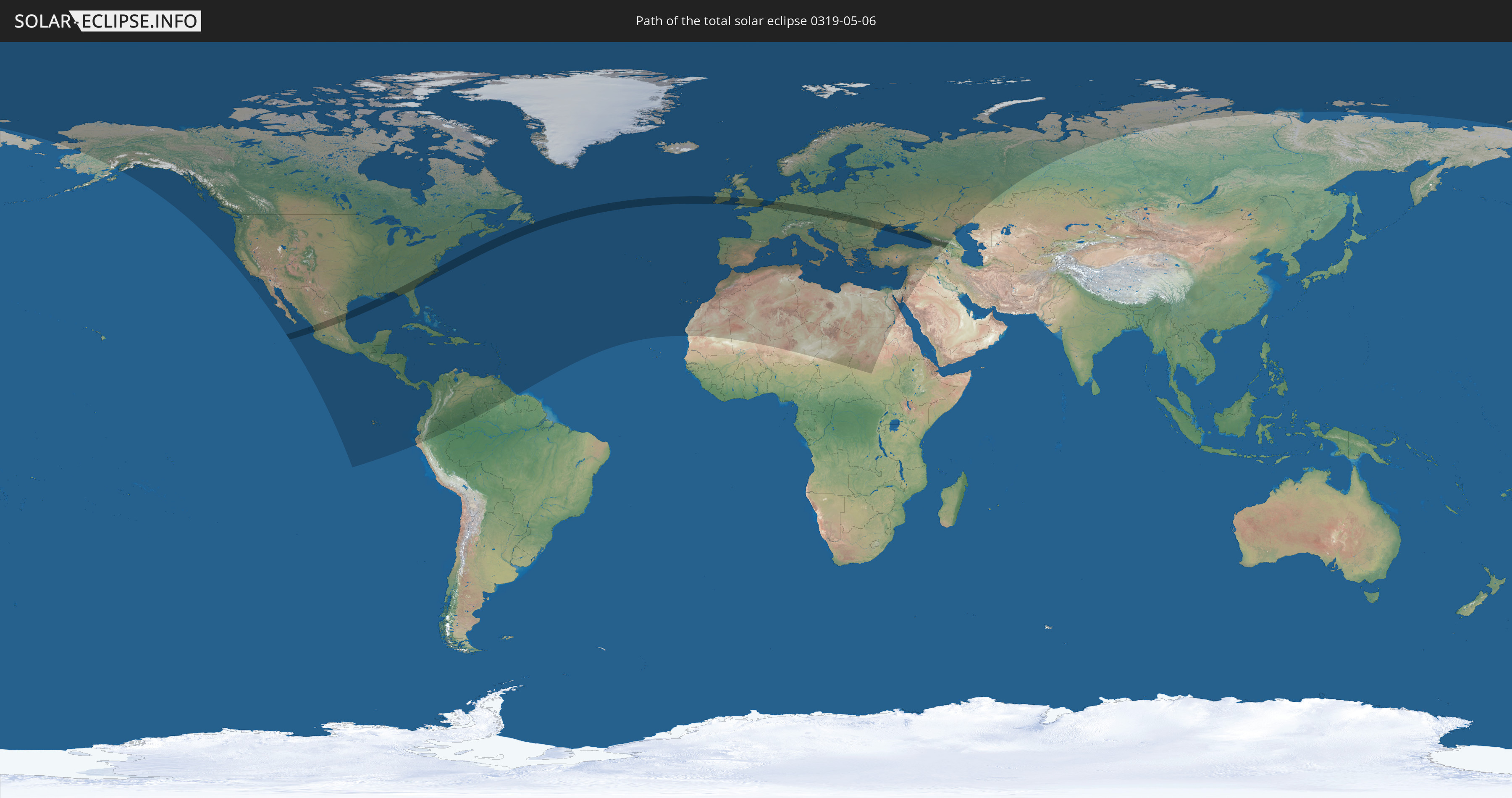
Die Sonnenfinsternis am 05/06/0319 kann man in 119 Ländern als partielle Sonnenfinsternis beobachten.
Der Finsternispfad verläuft durch 22 Länder. Nur in diesen Ländern ist sie als total Sonnenfinsternis zu sehen.
In den folgenden Ländern ist die Sonnenfinsternis total zu sehen
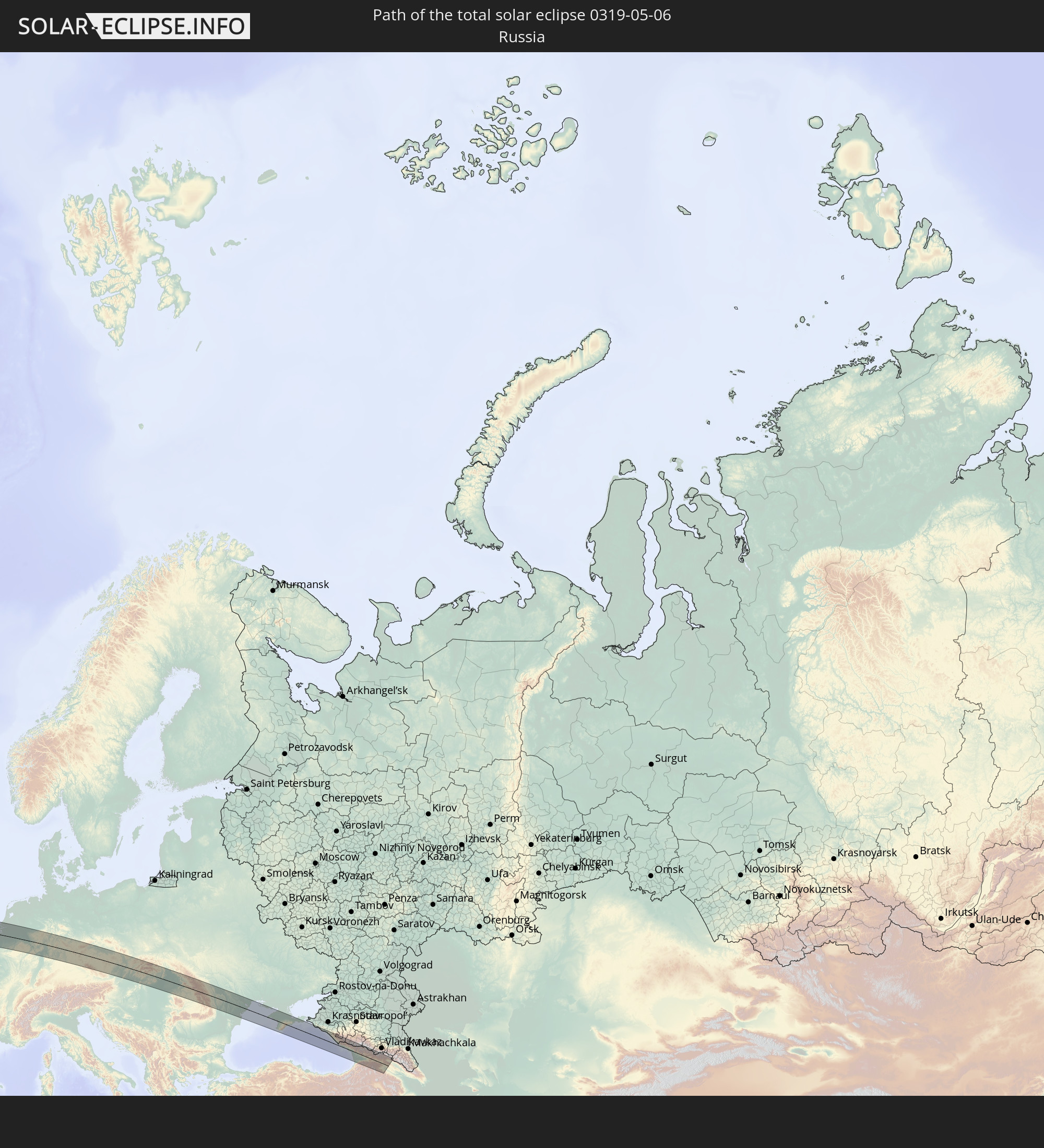 Russia
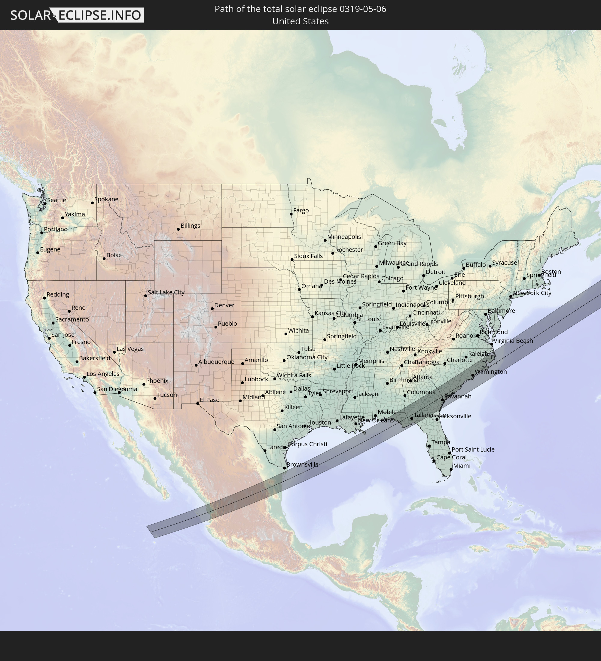 United States
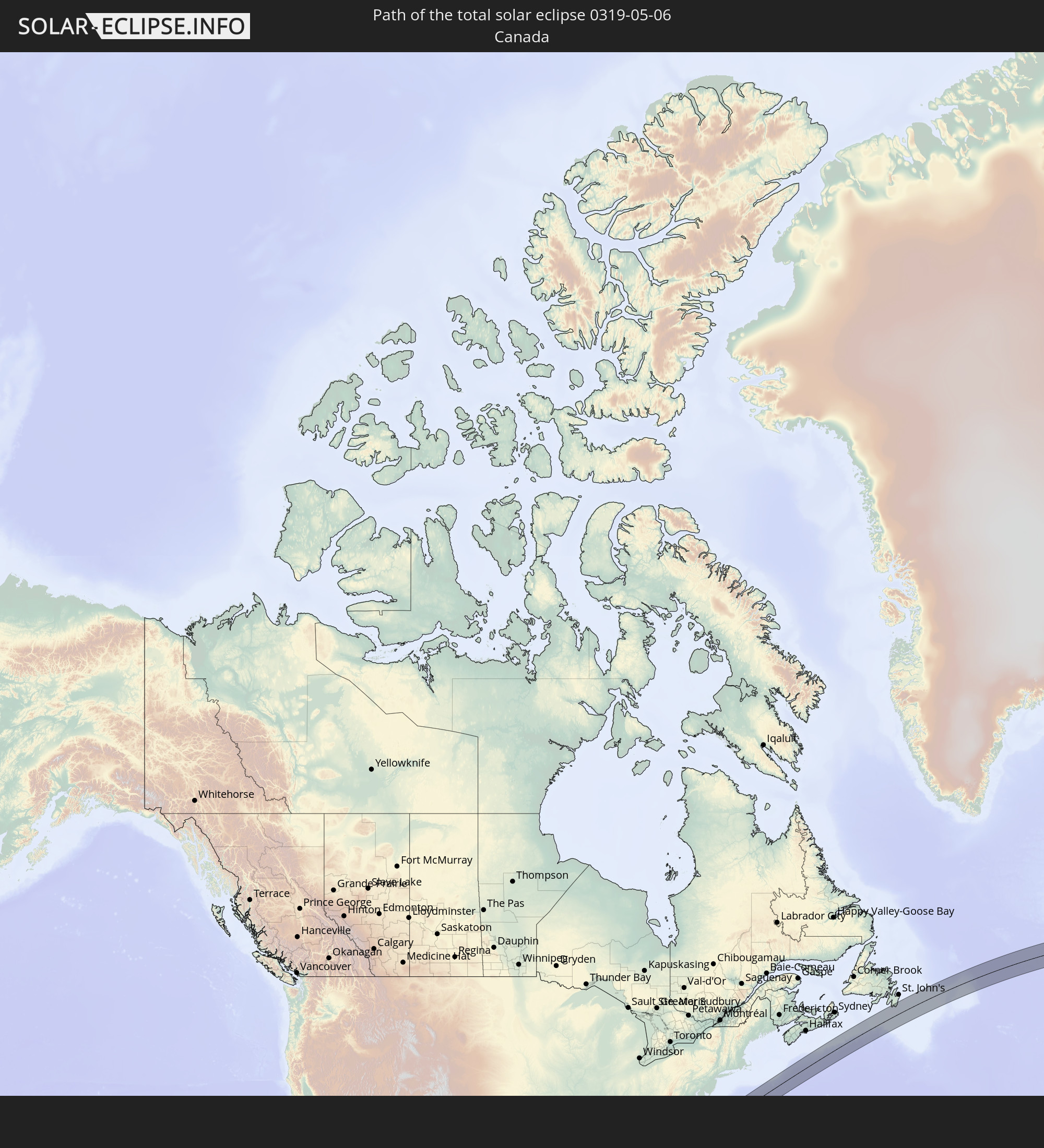 Canada
 Mexico
 Republic of Ireland
 United Kingdom
 France
 Belgium
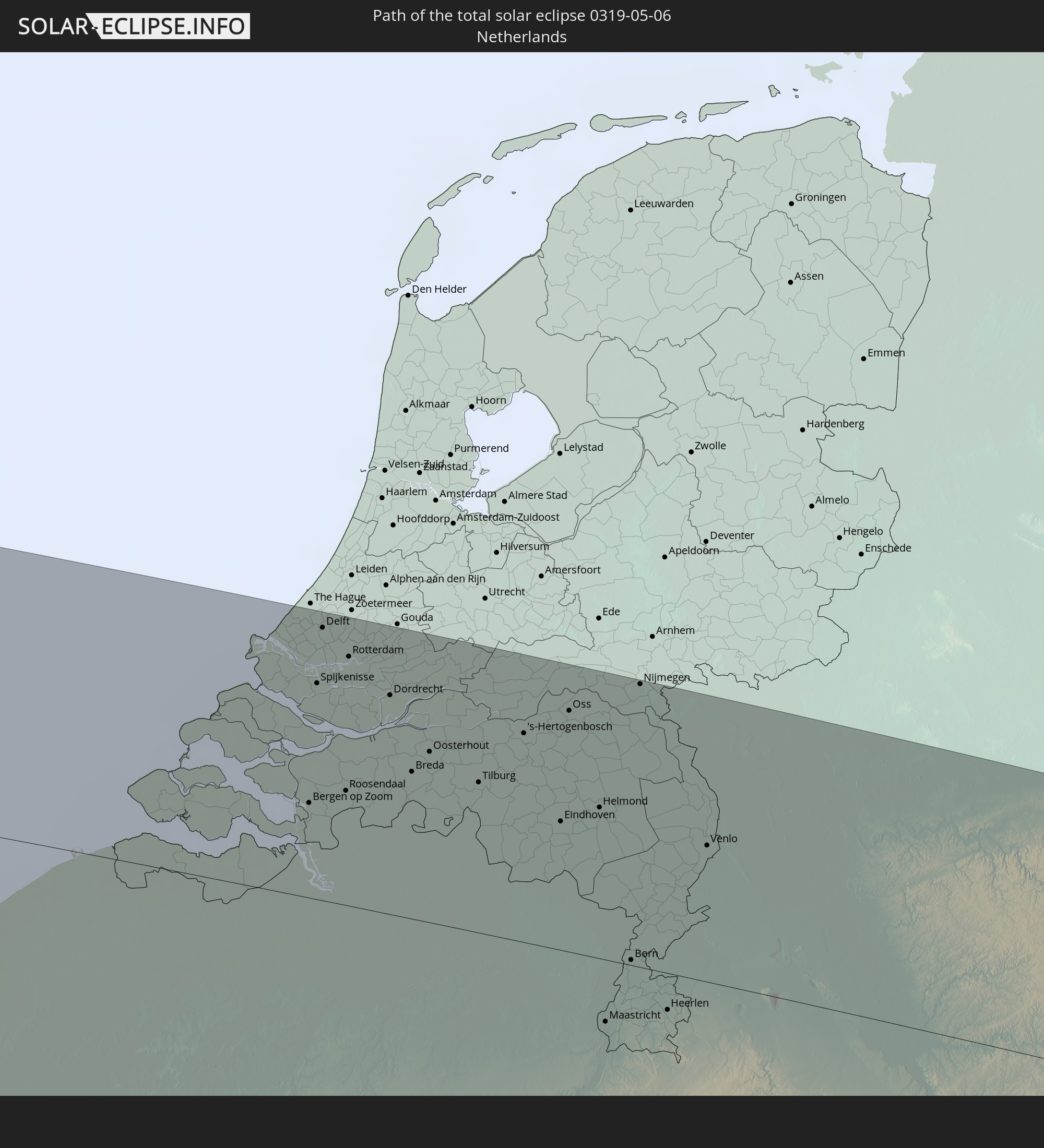 Netherlands
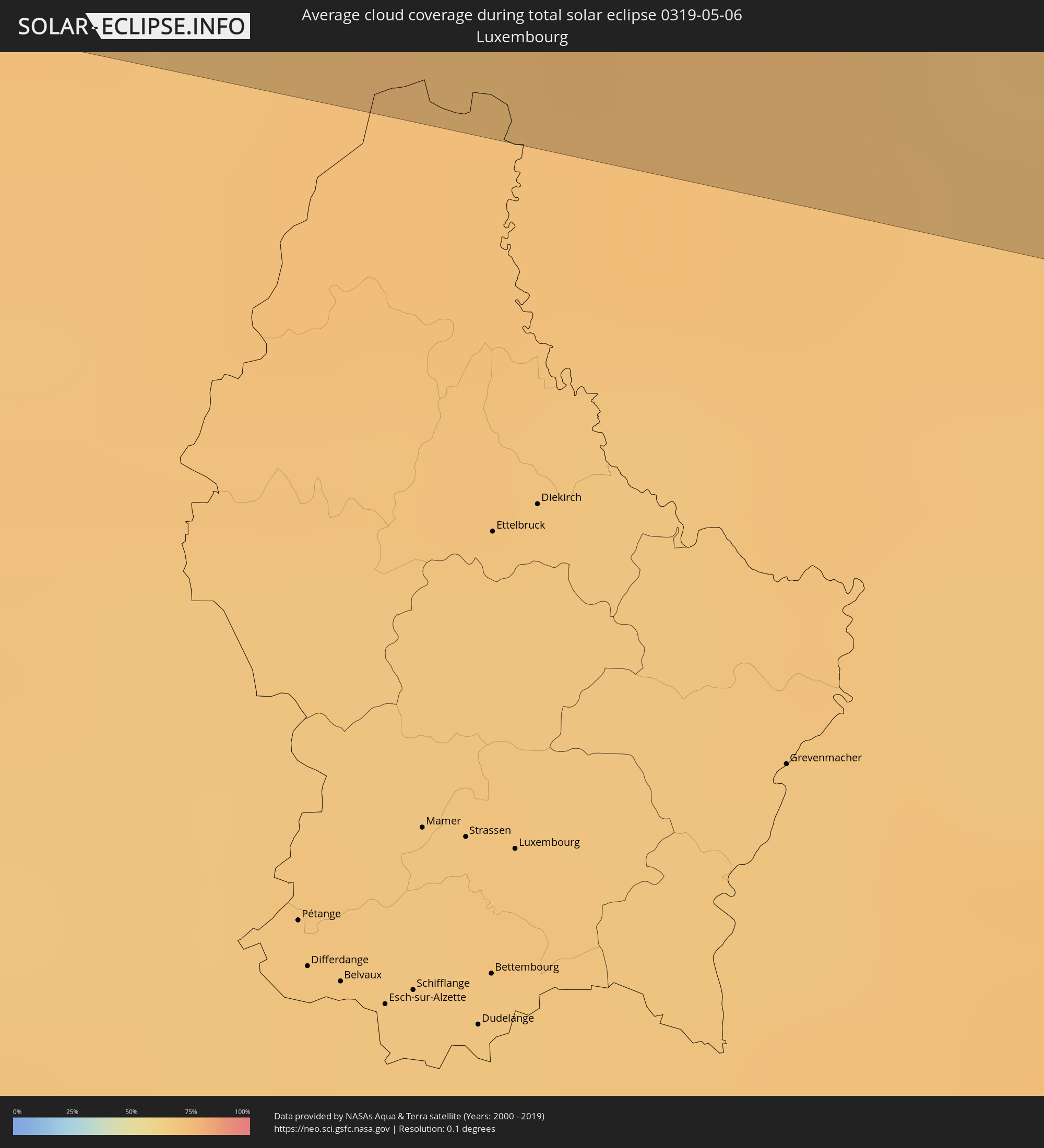
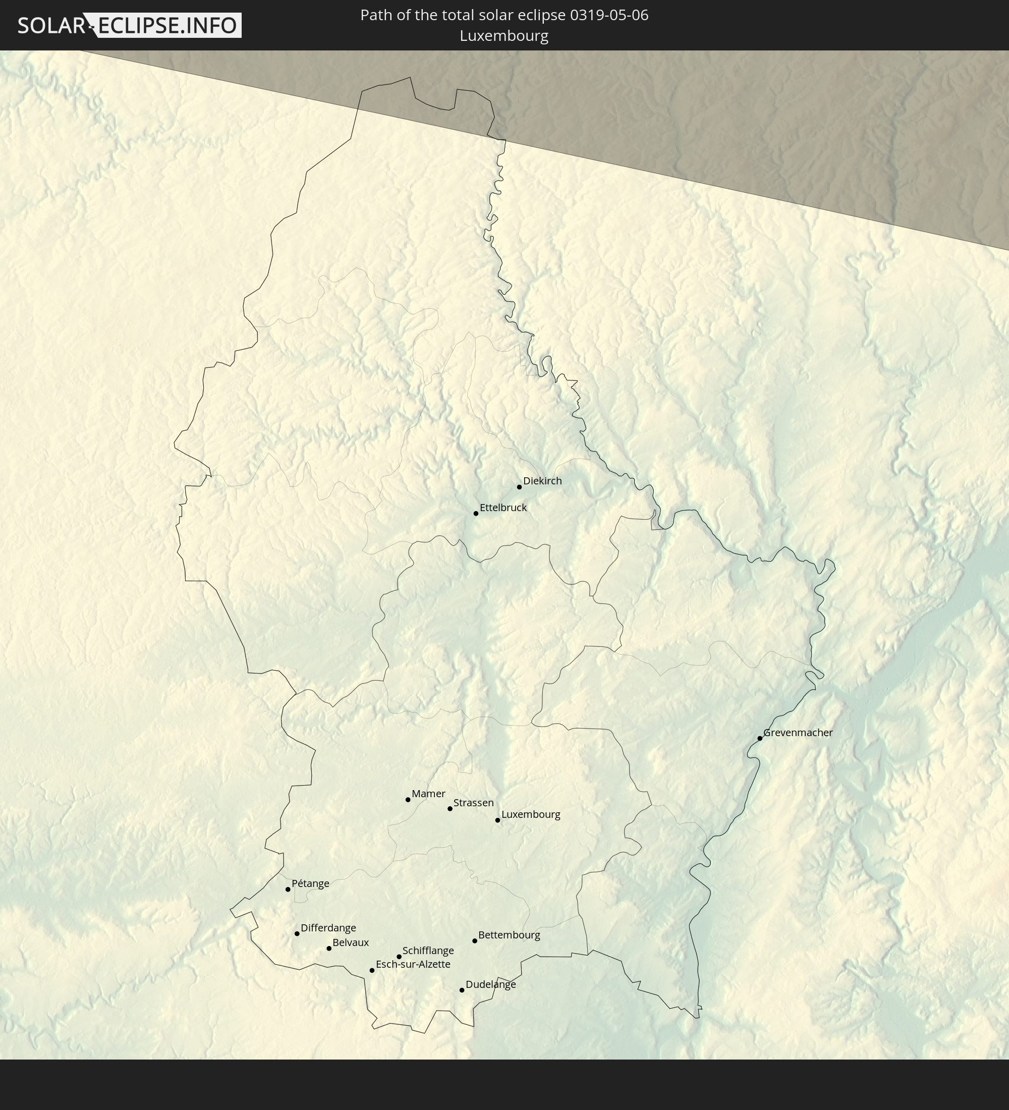 Luxembourg
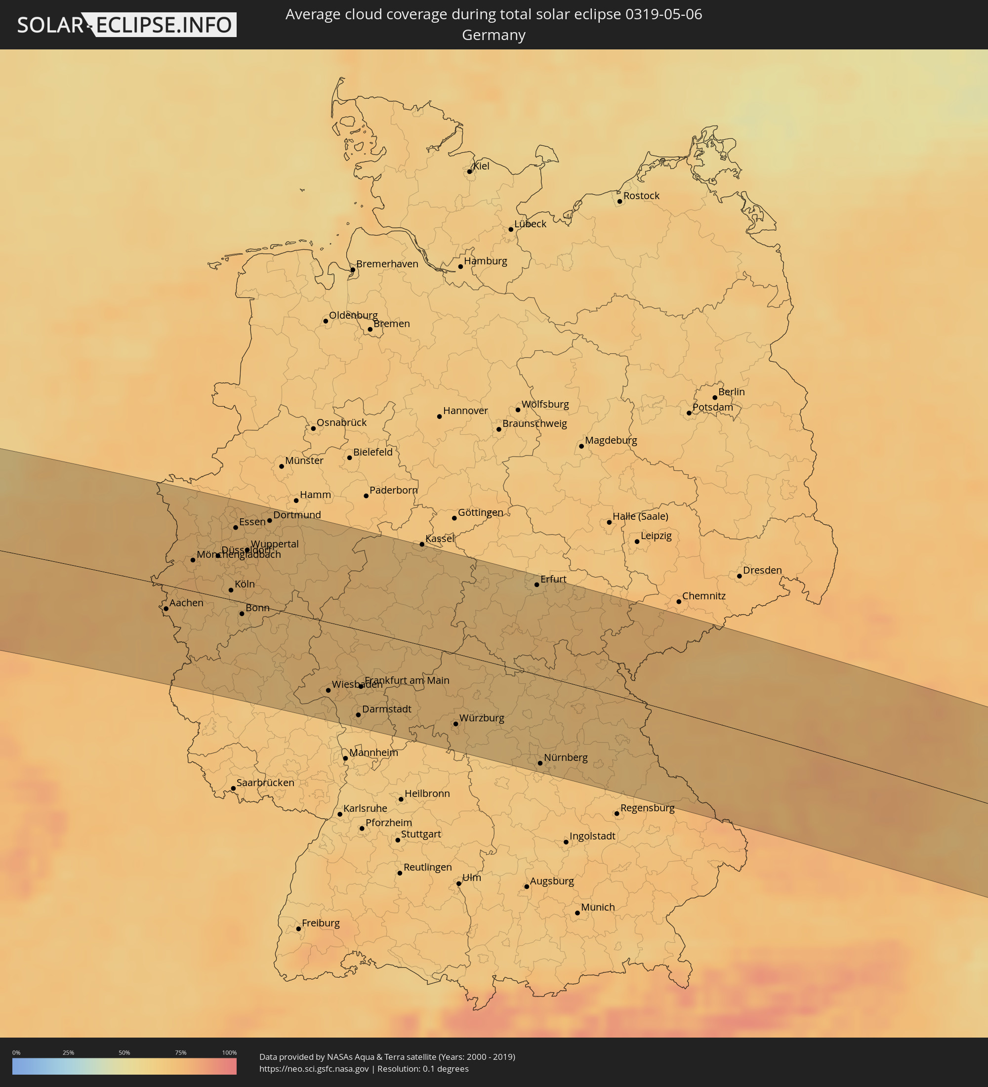
 Germany
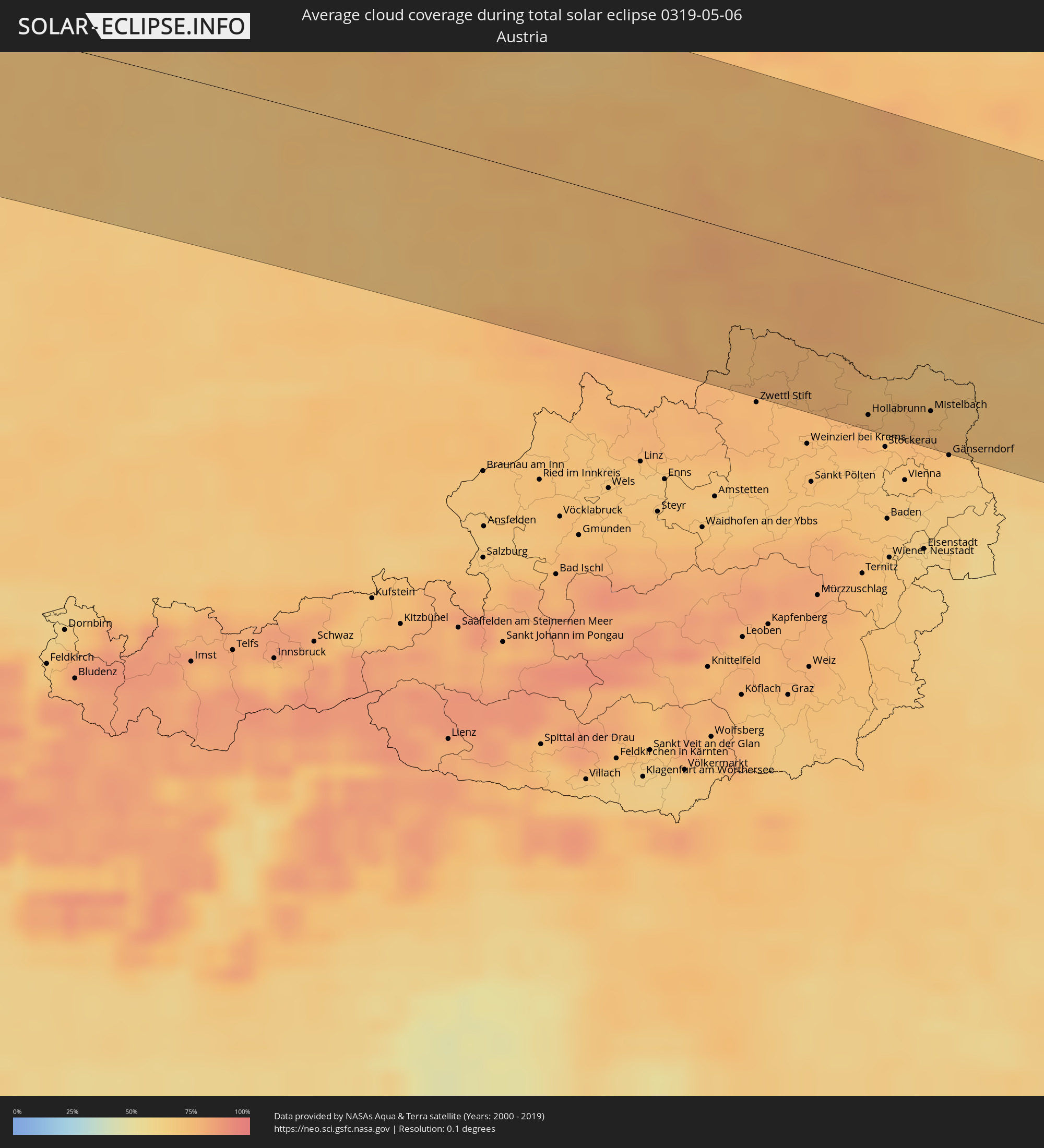
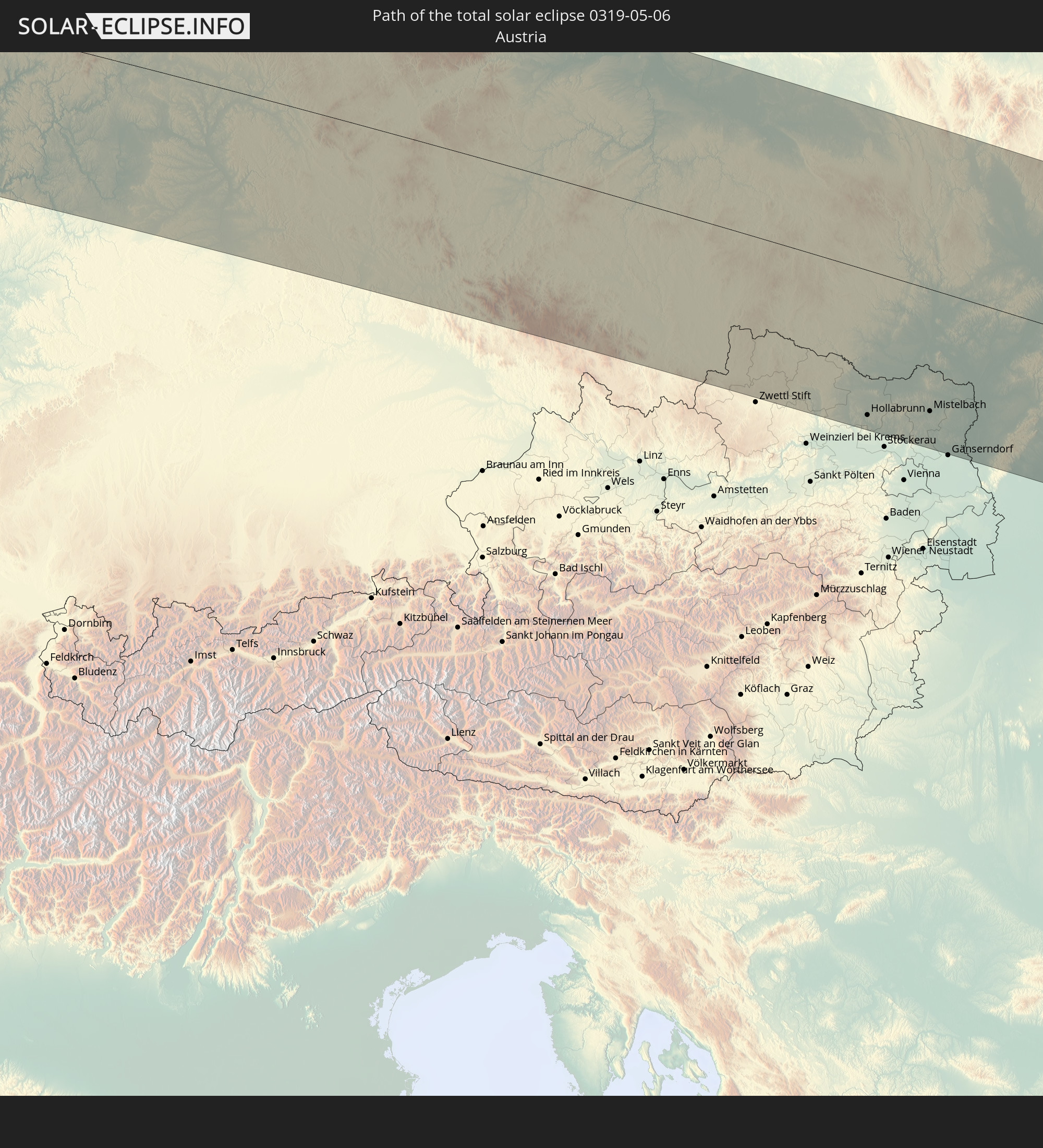 Austria
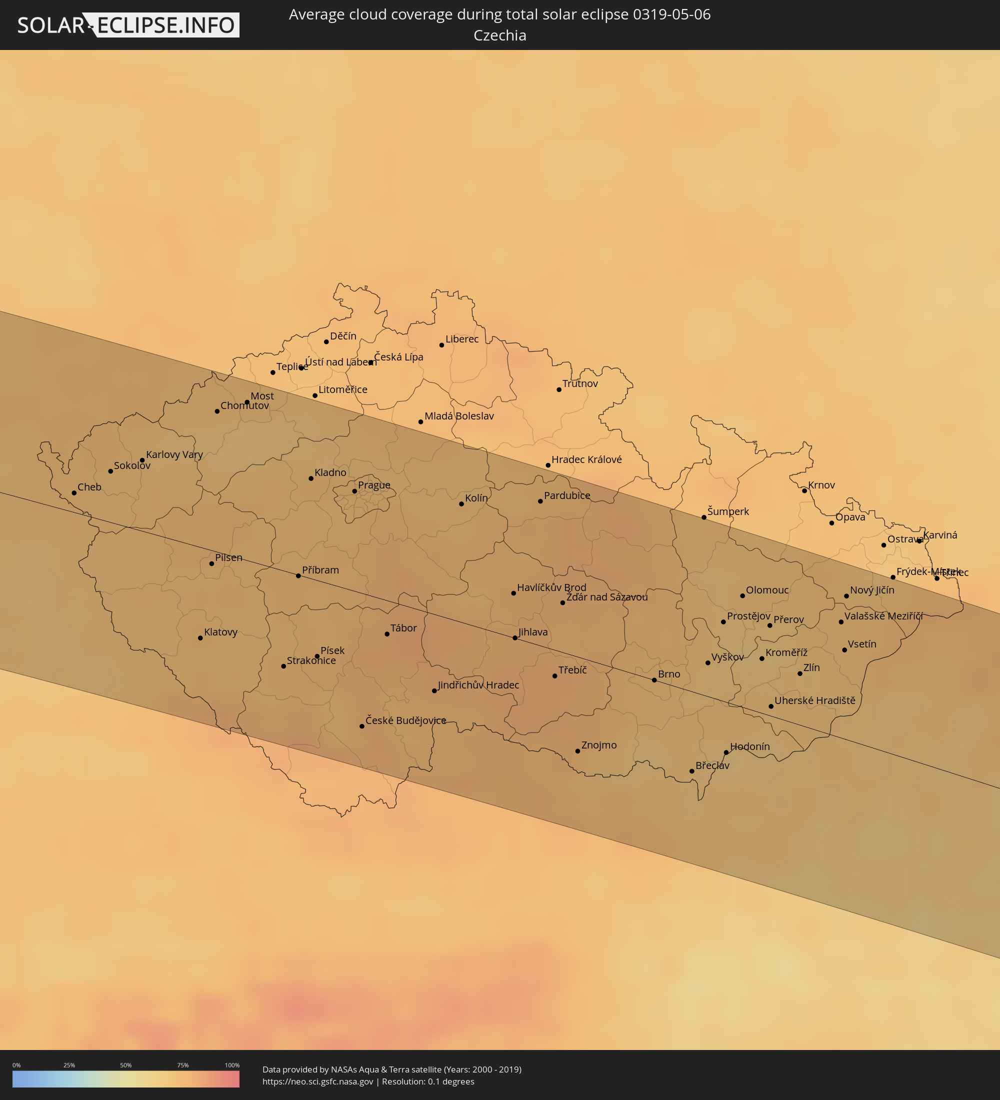
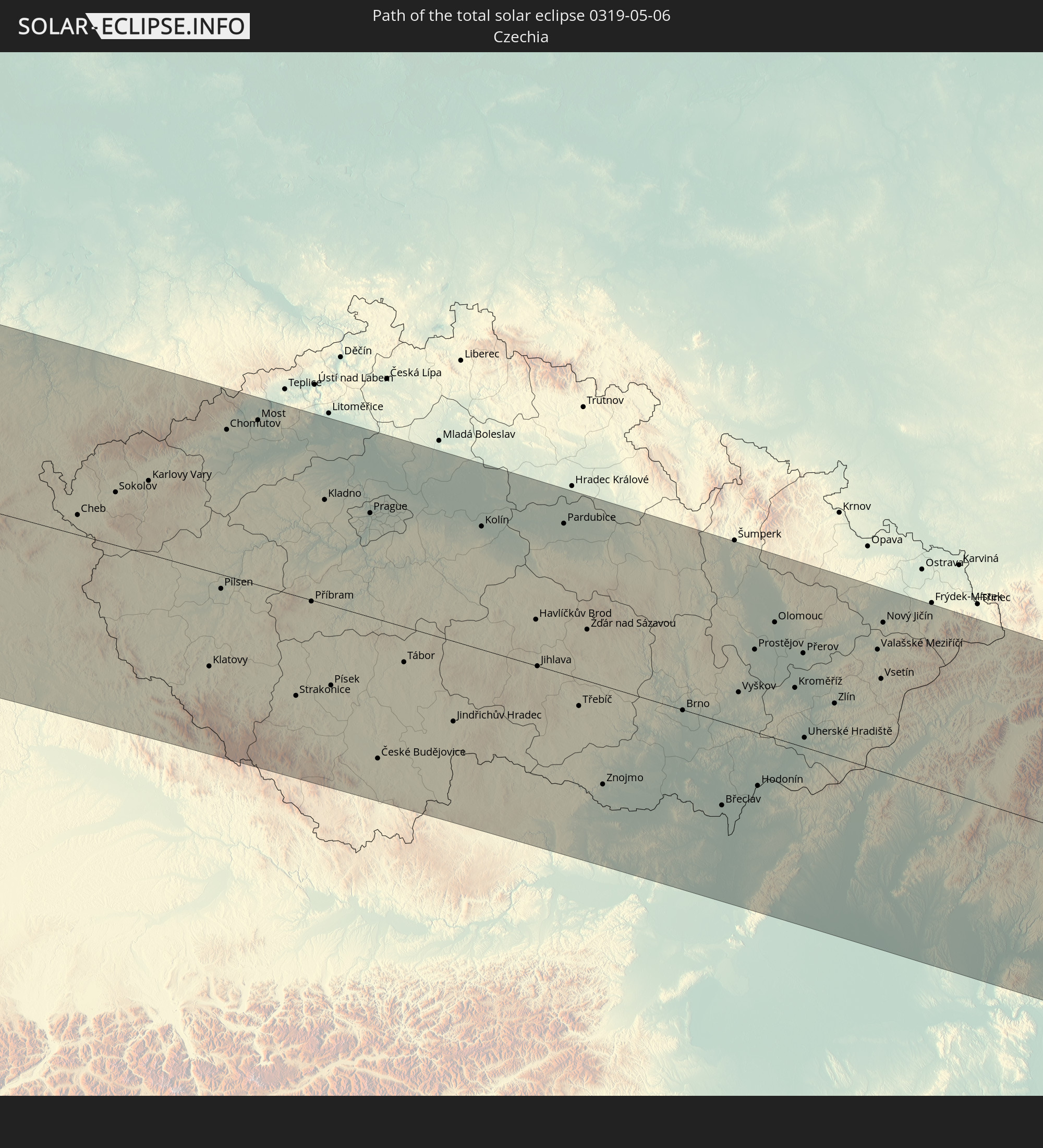 Czechia
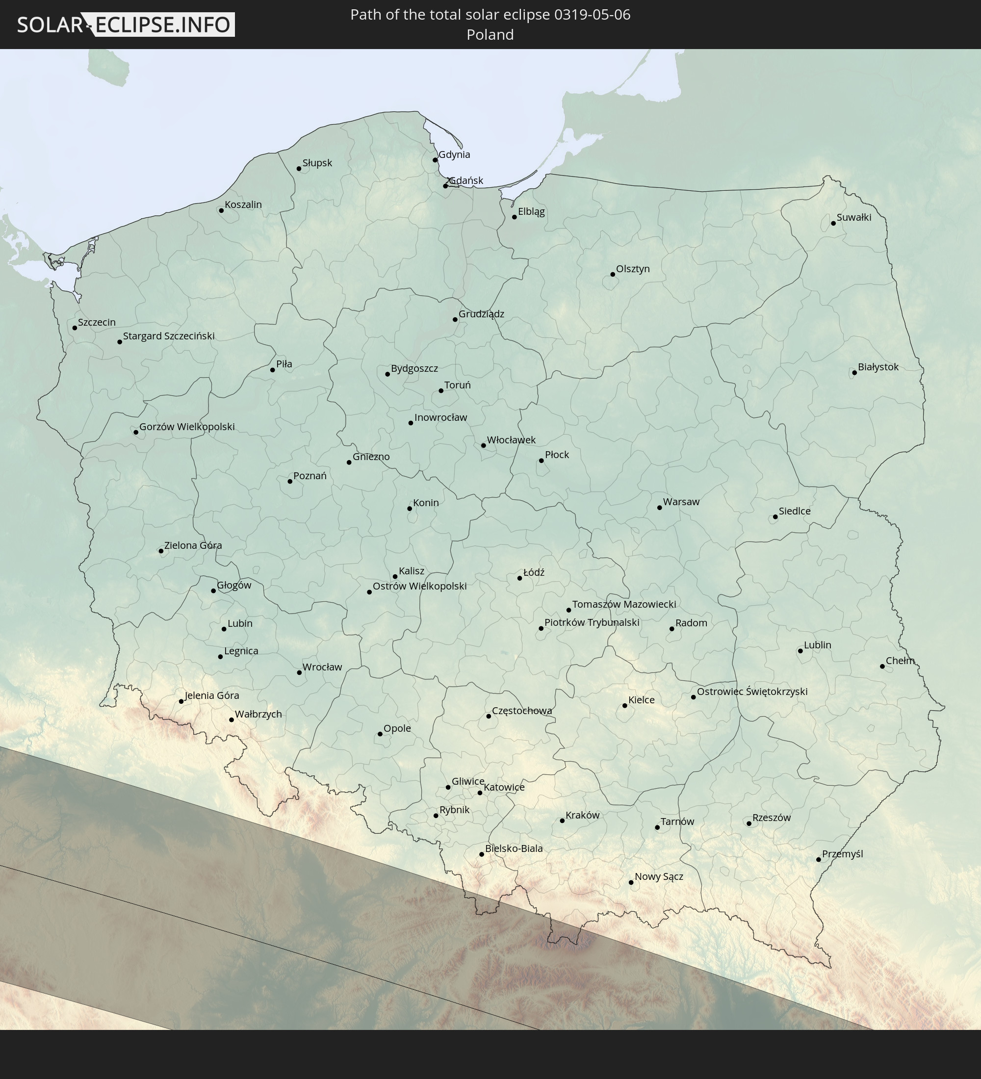 Poland
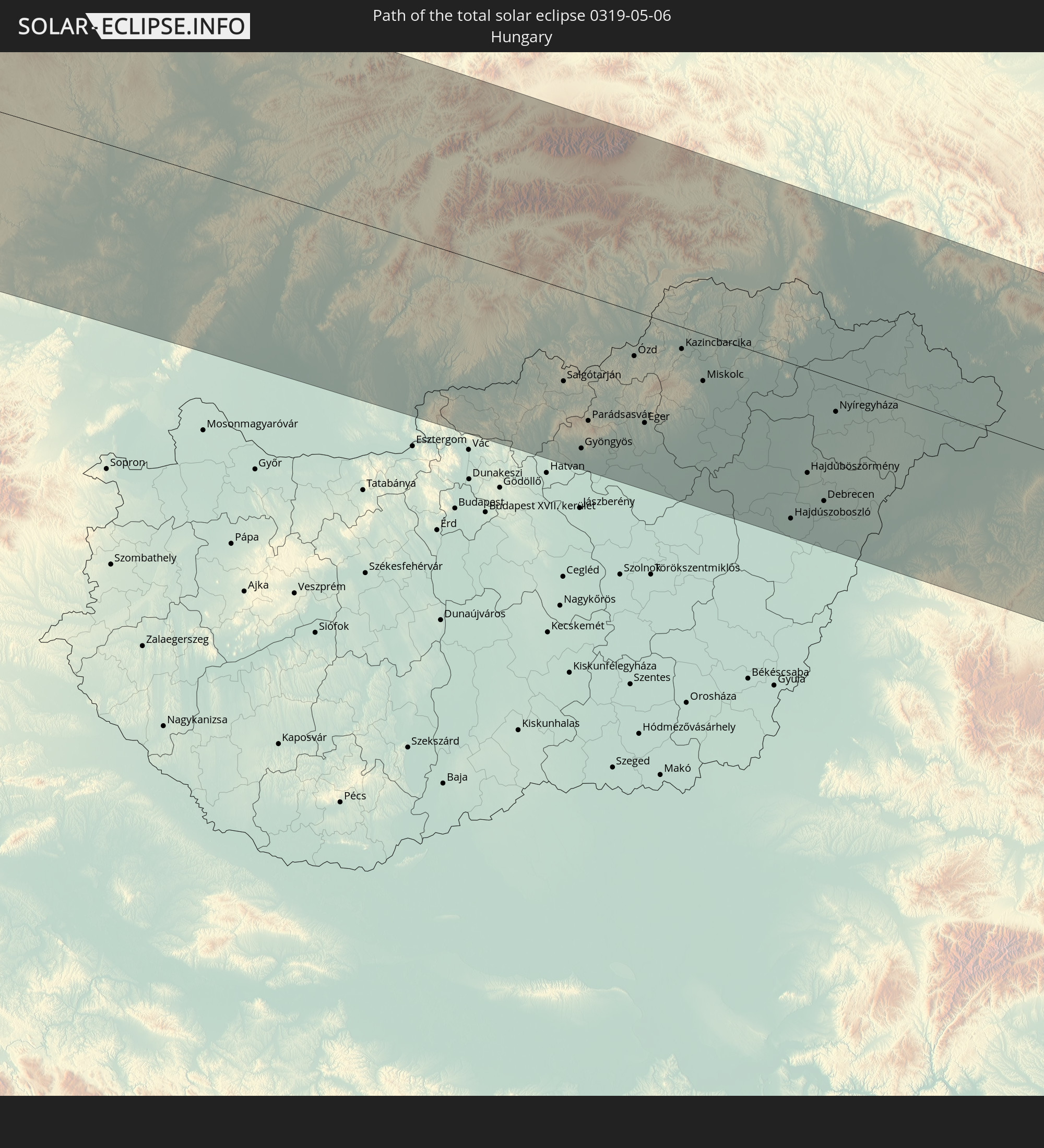 Hungary
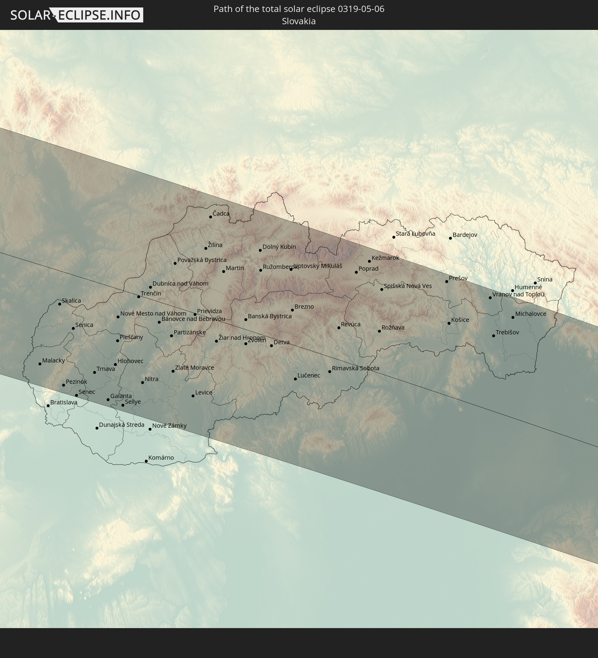 Slovakia
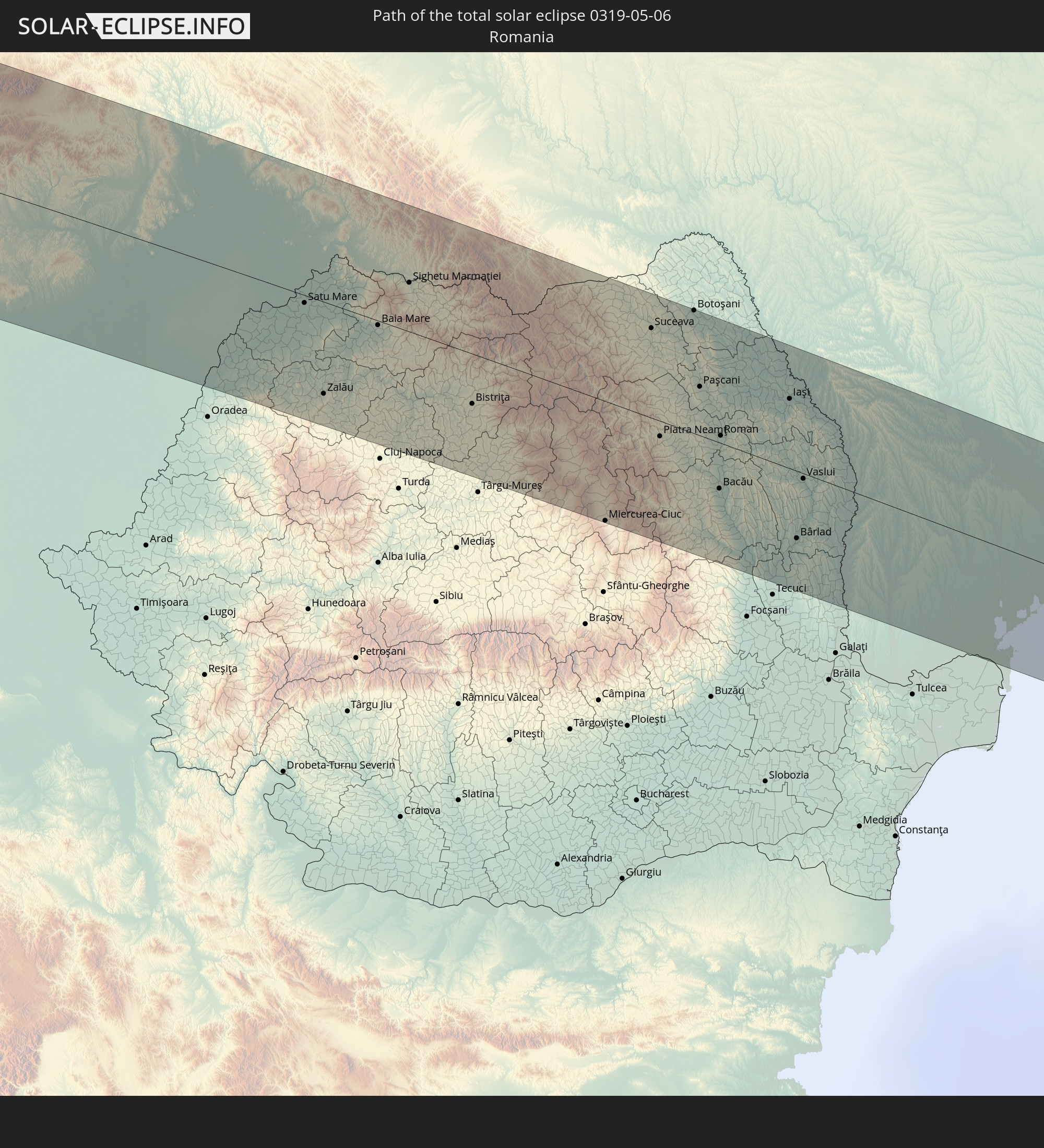 Romania
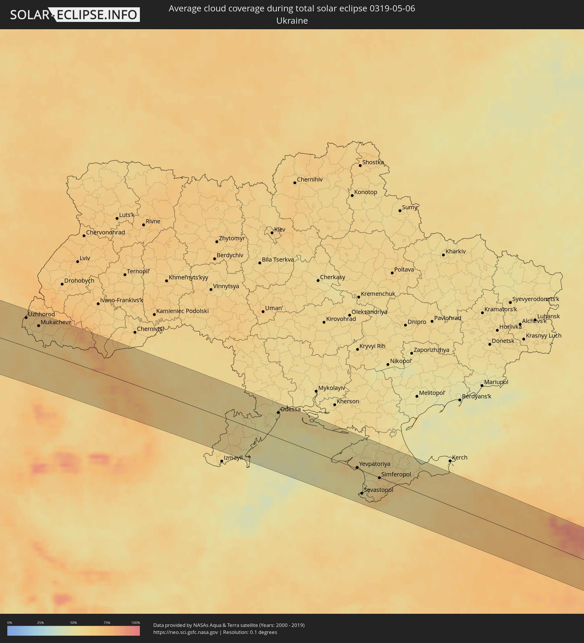
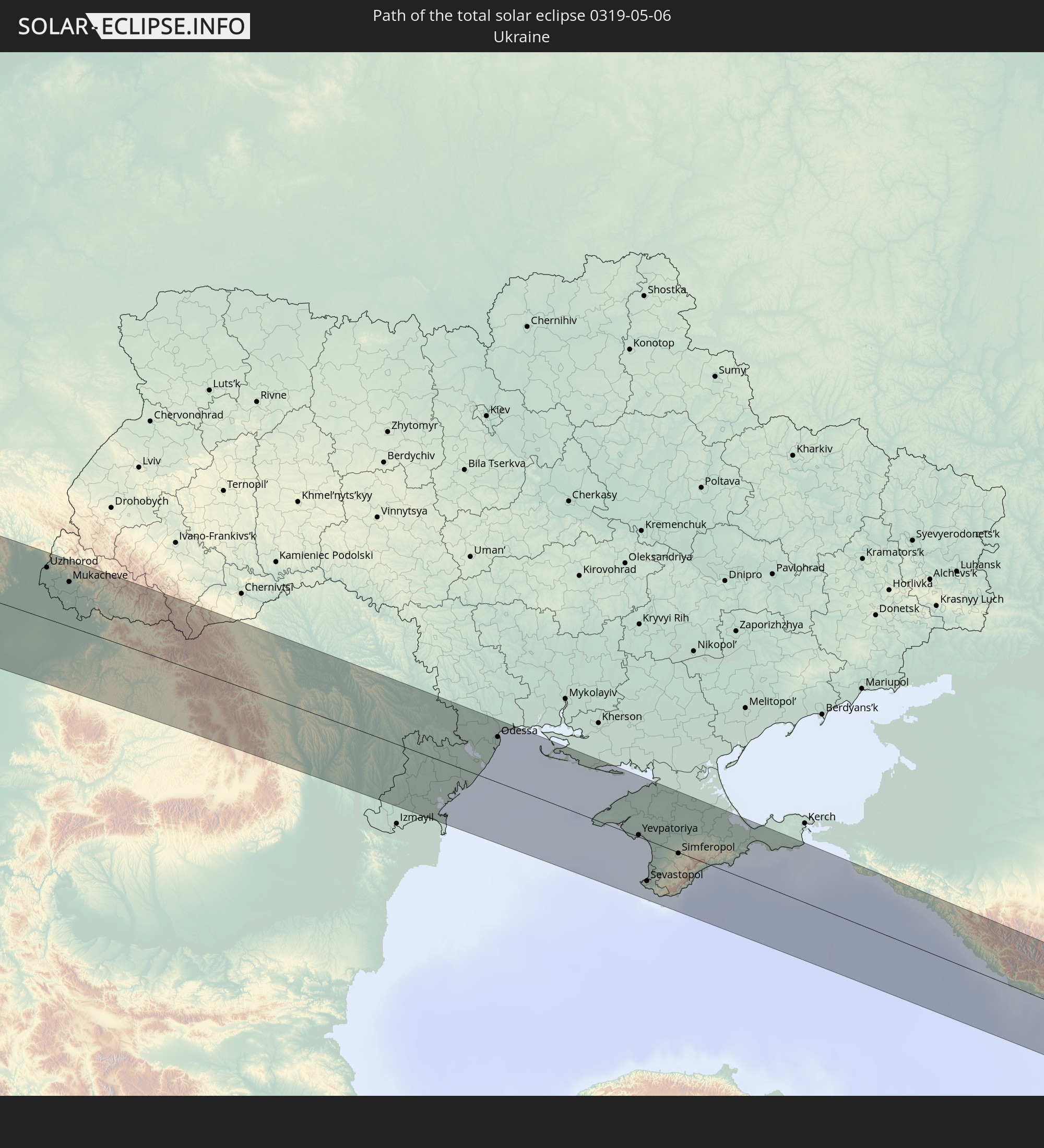 Ukraine
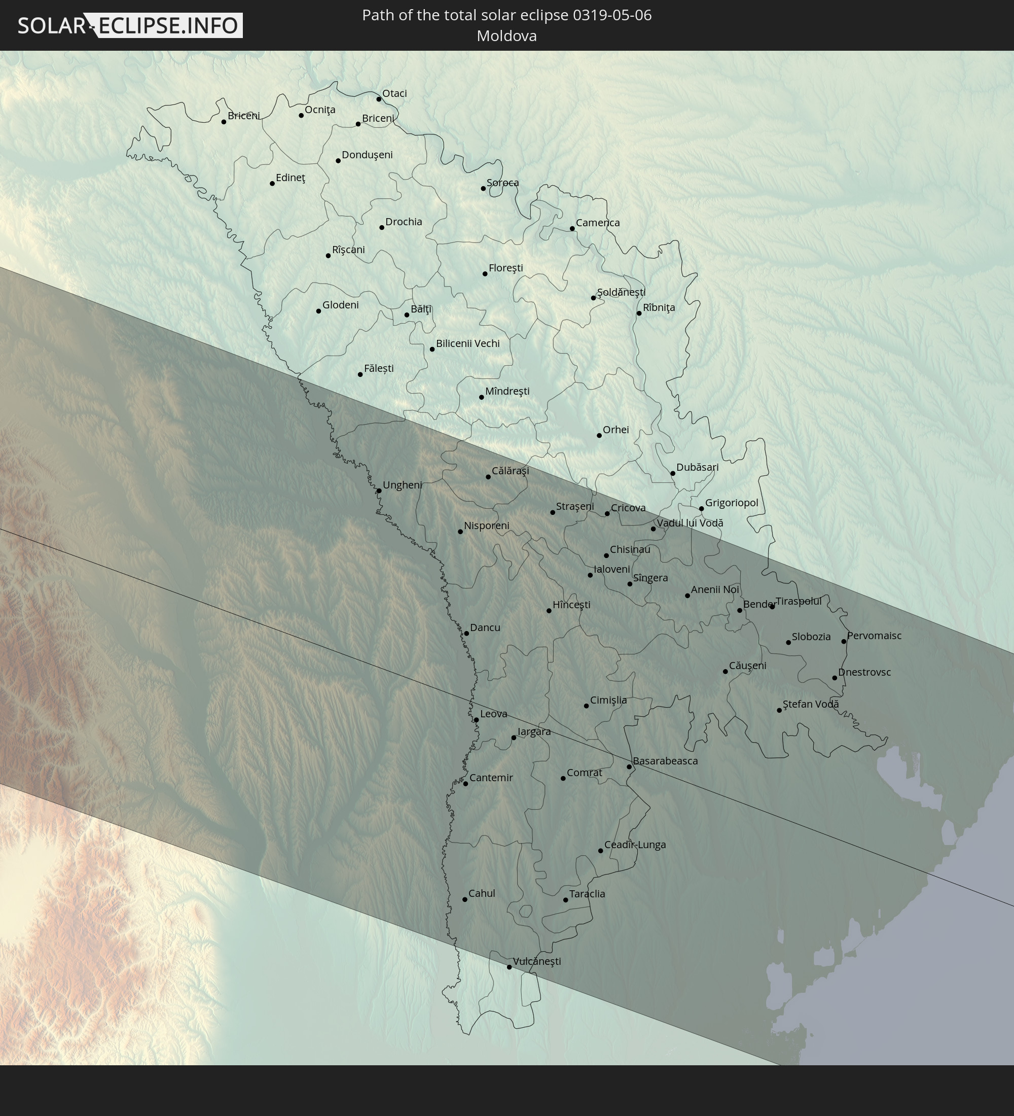 Moldova
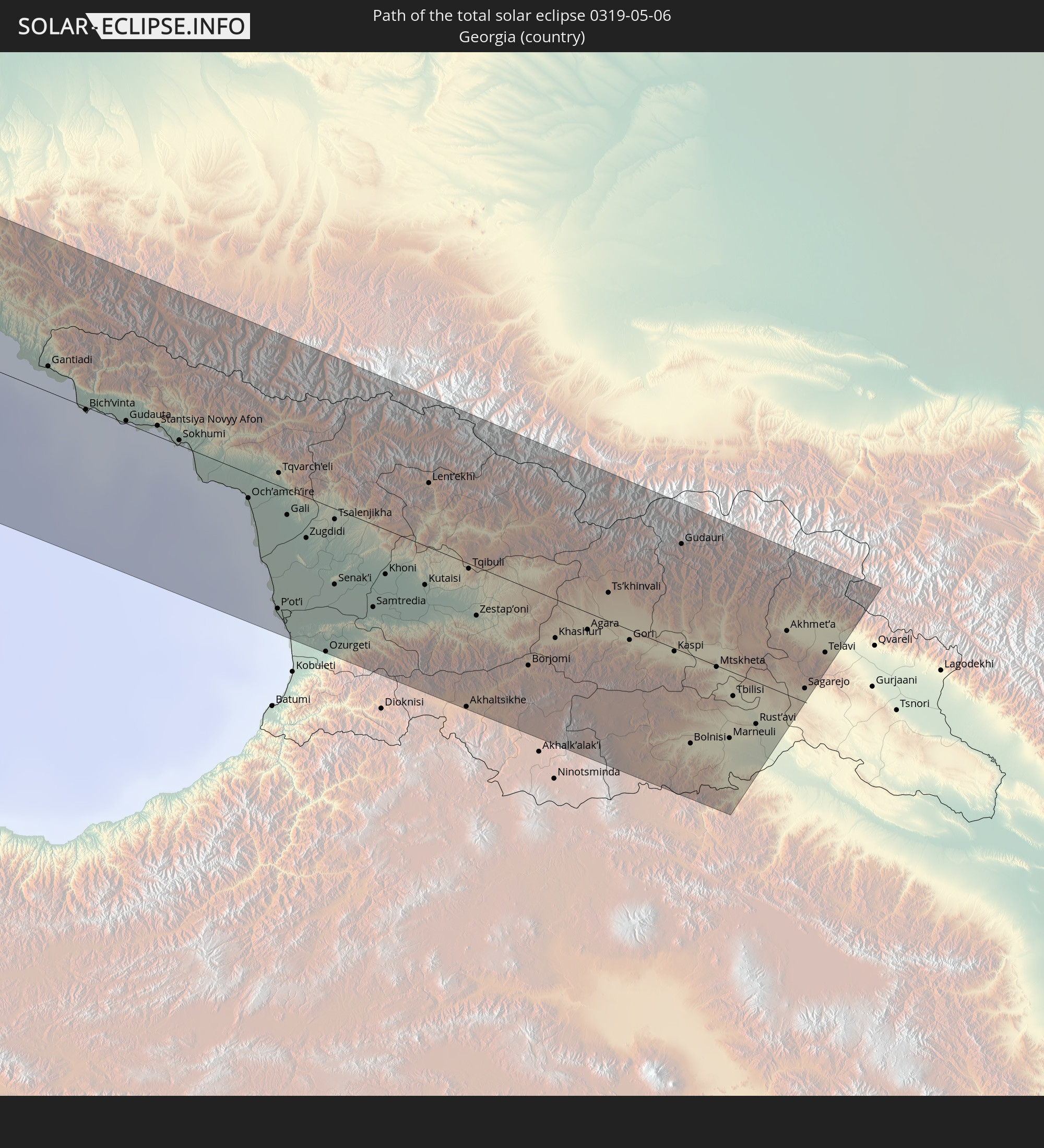 Georgia
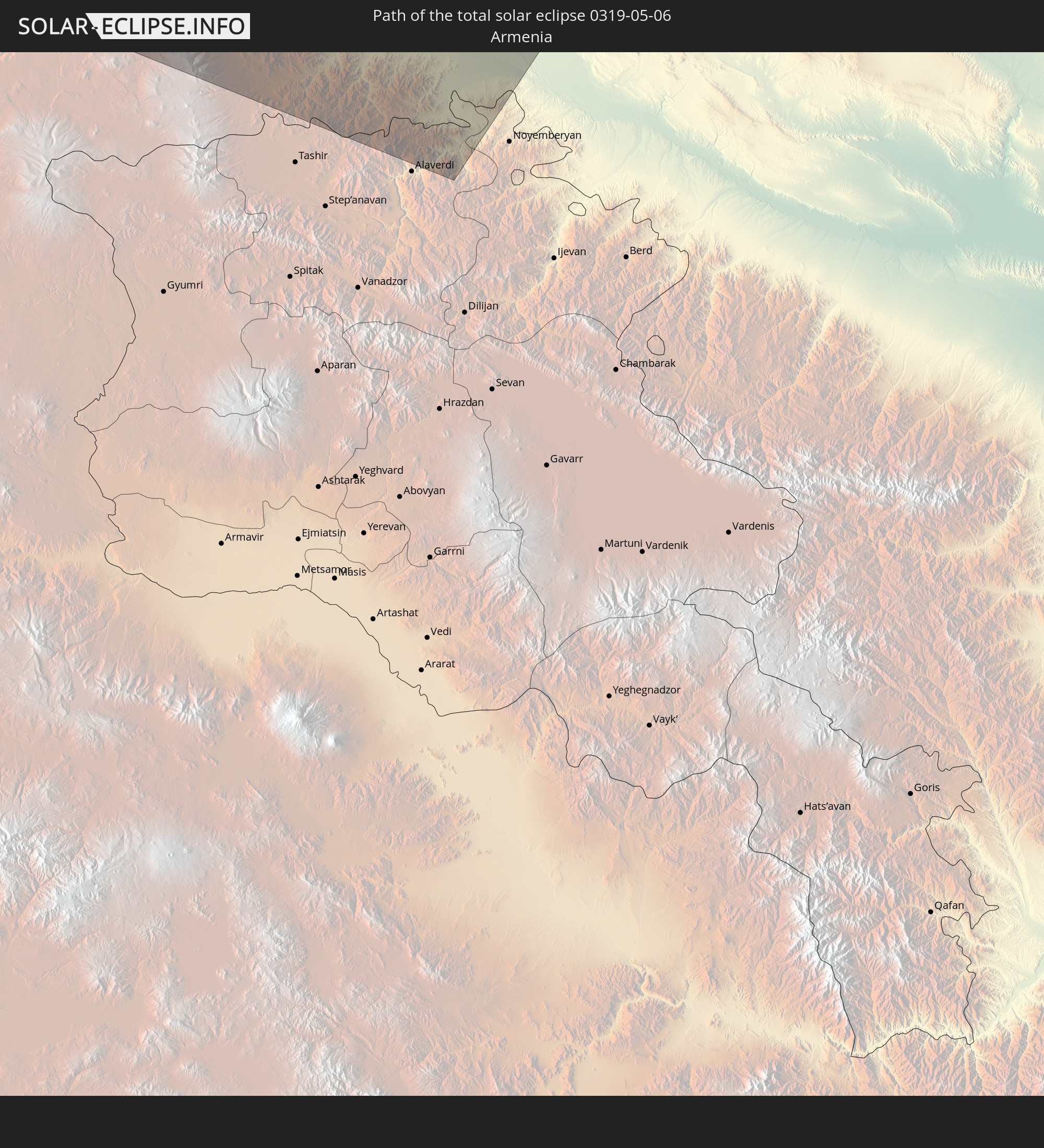 Armenia
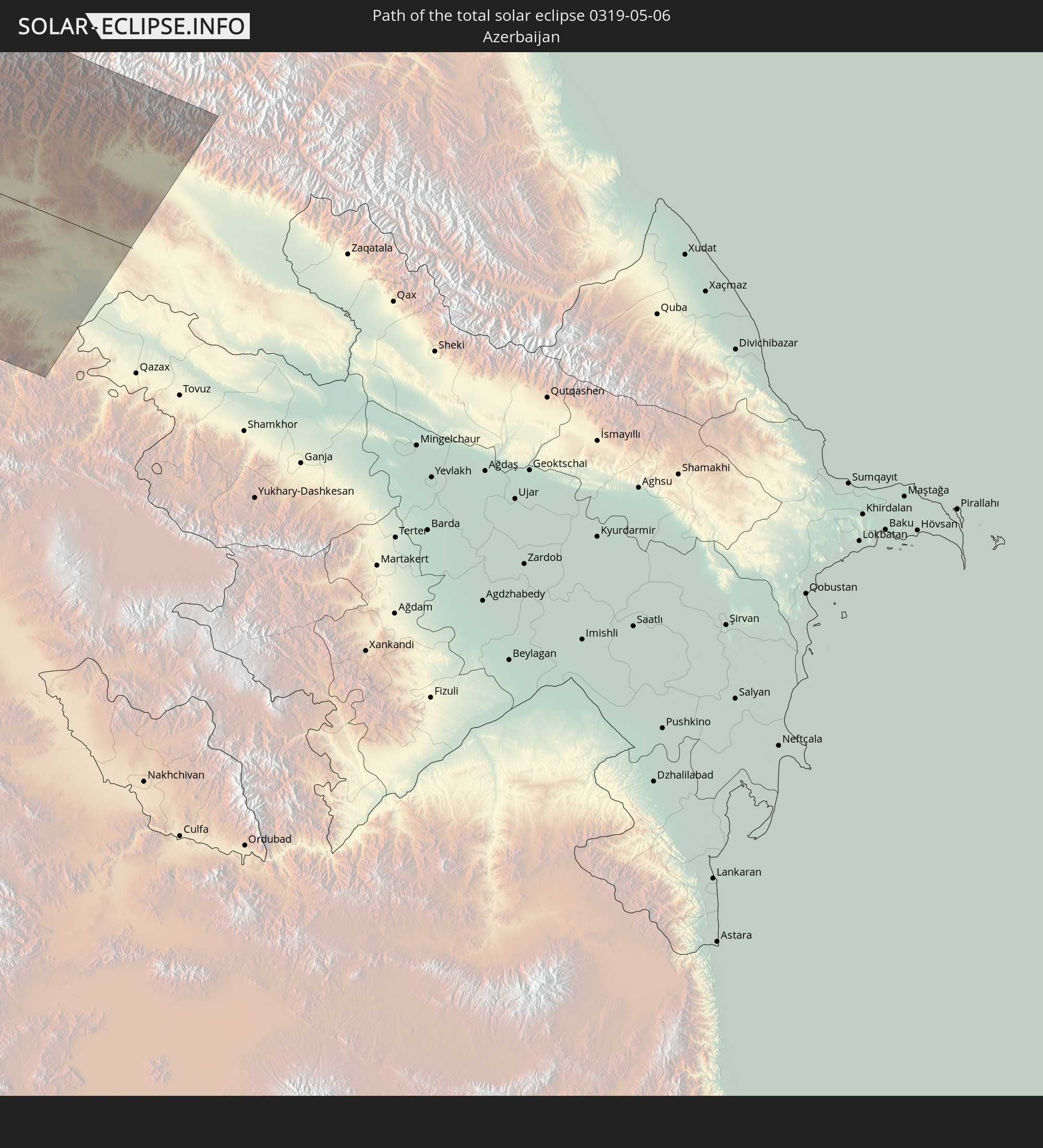 Azerbaijan
In den folgenden Ländern ist die Sonnenfinsternis partiell zu sehen
 Russia
 United States
 United States Minor Outlying Islands
 Canada
 Mexico
 Greenland
 Guatemala
 Ecuador
 El Salvador
 Honduras
 Belize
 Nicaragua
 Costa Rica
 Cuba
Cuba
 Panama
 Colombia
 Cayman Islands
 Peru
Peru
 The Bahamas
 Jamaica
 Haiti
Haiti
 Brazil
 Venezuela
 Turks and Caicos Islands
 Dominican Republic
 Aruba
Aruba
 Puerto Rico
 United States Virgin Islands
 Bermuda
 British Virgin Islands
 Anguilla
 Collectivity of Saint Martin
 Saint Barthélemy
 Saint Kitts and Nevis
 Antigua and Barbuda
 Montserrat
 Trinidad and Tobago
 Guadeloupe
 Grenada
 Dominica
 Saint Vincent and the Grenadines
 Guyana
 Martinique
 Saint Lucia
 Barbados
 Saint Pierre and Miquelon
 Portugal
 Iceland
 Spain
Spain
 Mauritania
 Morocco
 Mali
Mali
 Republic of Ireland
 Svalbard and Jan Mayen
 Algeria
 United Kingdom
 Faroe Islands
 Gibraltar
 France
 Isle of Man
 Guernsey
 Jersey
 Niger
Niger
 Andorra
 Belgium
 Netherlands
 Norway
 Luxembourg
 Germany
 Switzerland
 Italy
Italy
 Monaco
 Tunisia
 Denmark
 Libya
Libya
 Liechtenstein
 Austria
 Sweden
 Czechia
 San Marino
 Vatican City
 Slovenia
 Chad
Chad
 Croatia
 Poland
 Malta
Malta
 Bosnia and Herzegovina
 Hungary
 Slovakia
 Montenegro
 Serbia
 Albania
 Åland Islands
 Greece
 Romania
 Republic of Macedonia
 Finland
 Lithuania
 Latvia
 Estonia
 Sudan
Sudan
 Ukraine
 Bulgaria
 Belarus
 Egypt
Egypt
 Turkey
 Moldova
 Cyprus
 State of Palestine
 Israel
 Saudi Arabia
 Jordan
 Lebanon
 Syria
Syria
 Iraq
Iraq
 Georgia
 Armenia
 Azerbaijan
 Kazakhstan
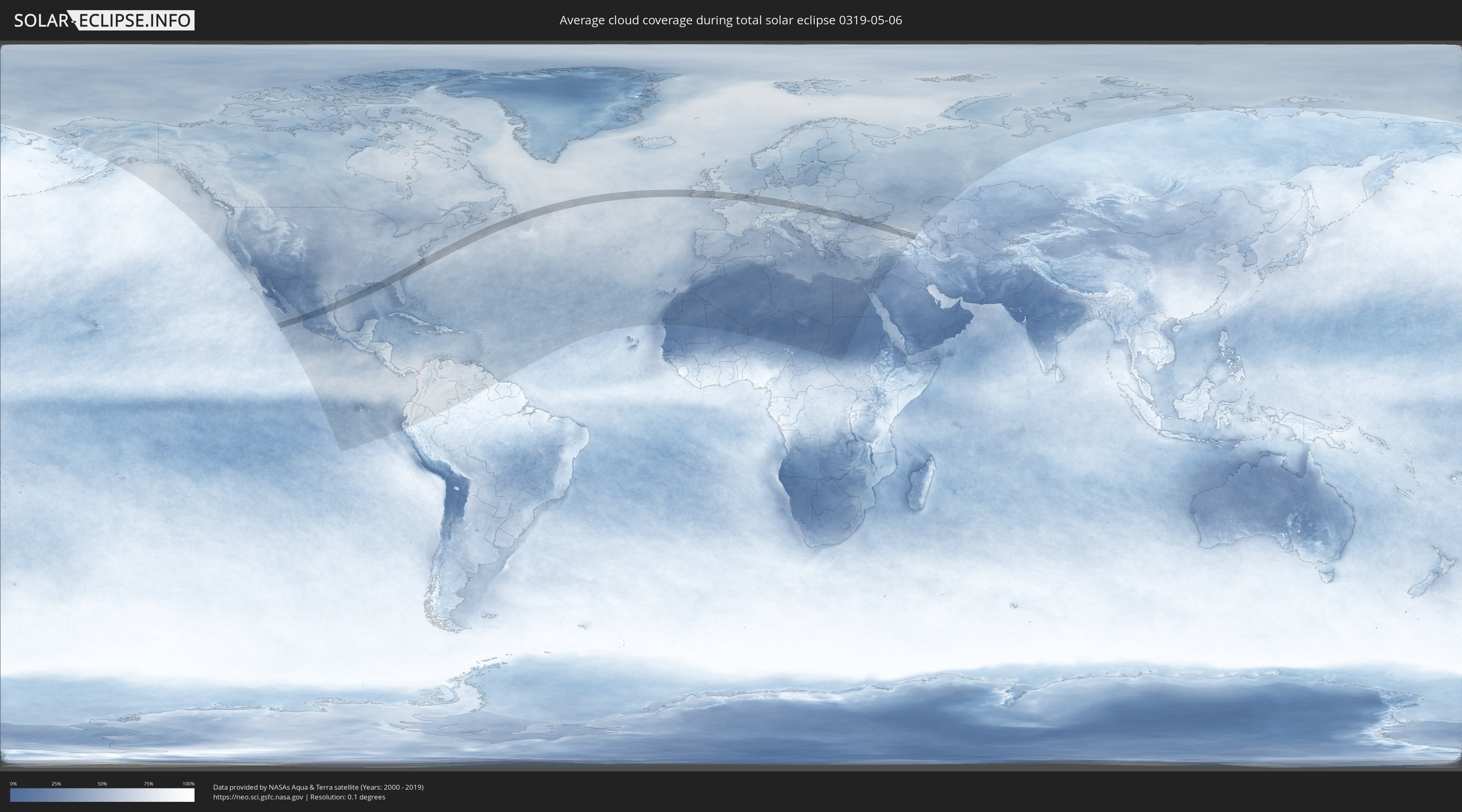
How will be the weather during the total solar eclipse on 05/06/0319?
Where is the best place to see the total solar eclipse of 05/06/0319?
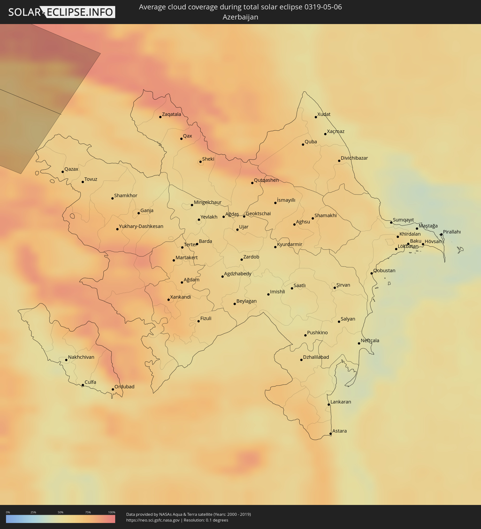
The following maps show the average cloud coverage for the day of the total solar eclipse.
With the help of these maps, it is possible to find the place along the eclipse path, which has the best
chance of a cloudless sky.
Nevertheless, you should consider local circumstances and inform about the weather of your chosen
observation site.
The data is provided by NASAs satellites
AQUA and TERRA.
The cloud maps are averaged over a period of 19 years (2000 - 2019).

Detailed country maps
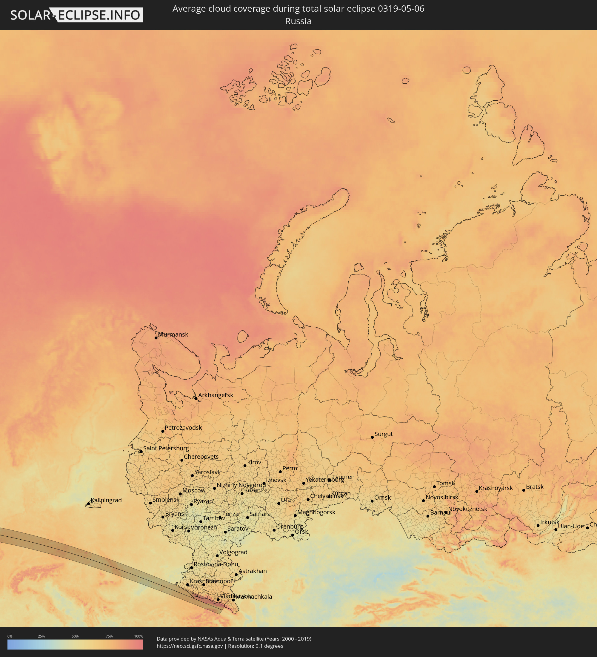 Russia
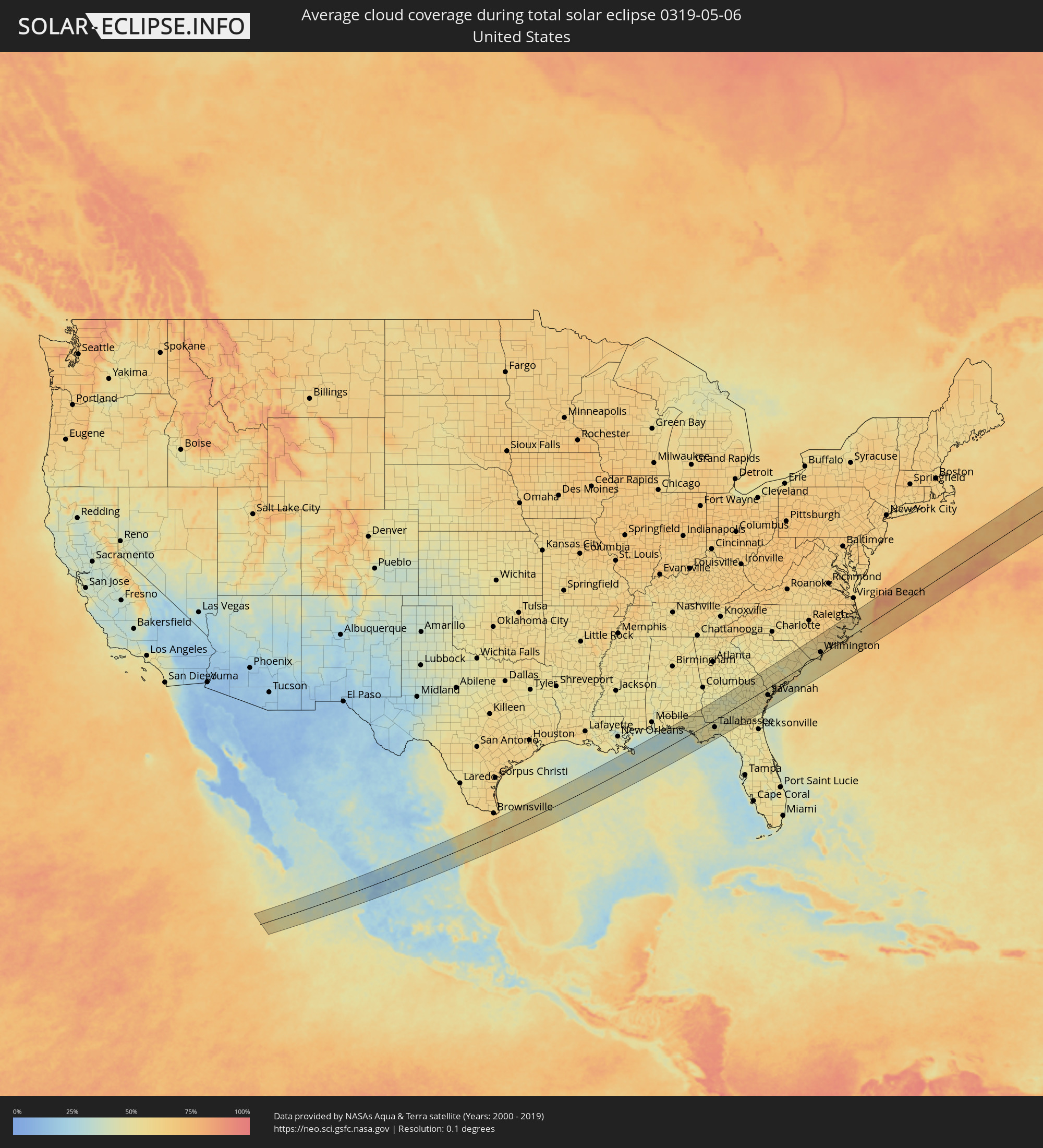 United States
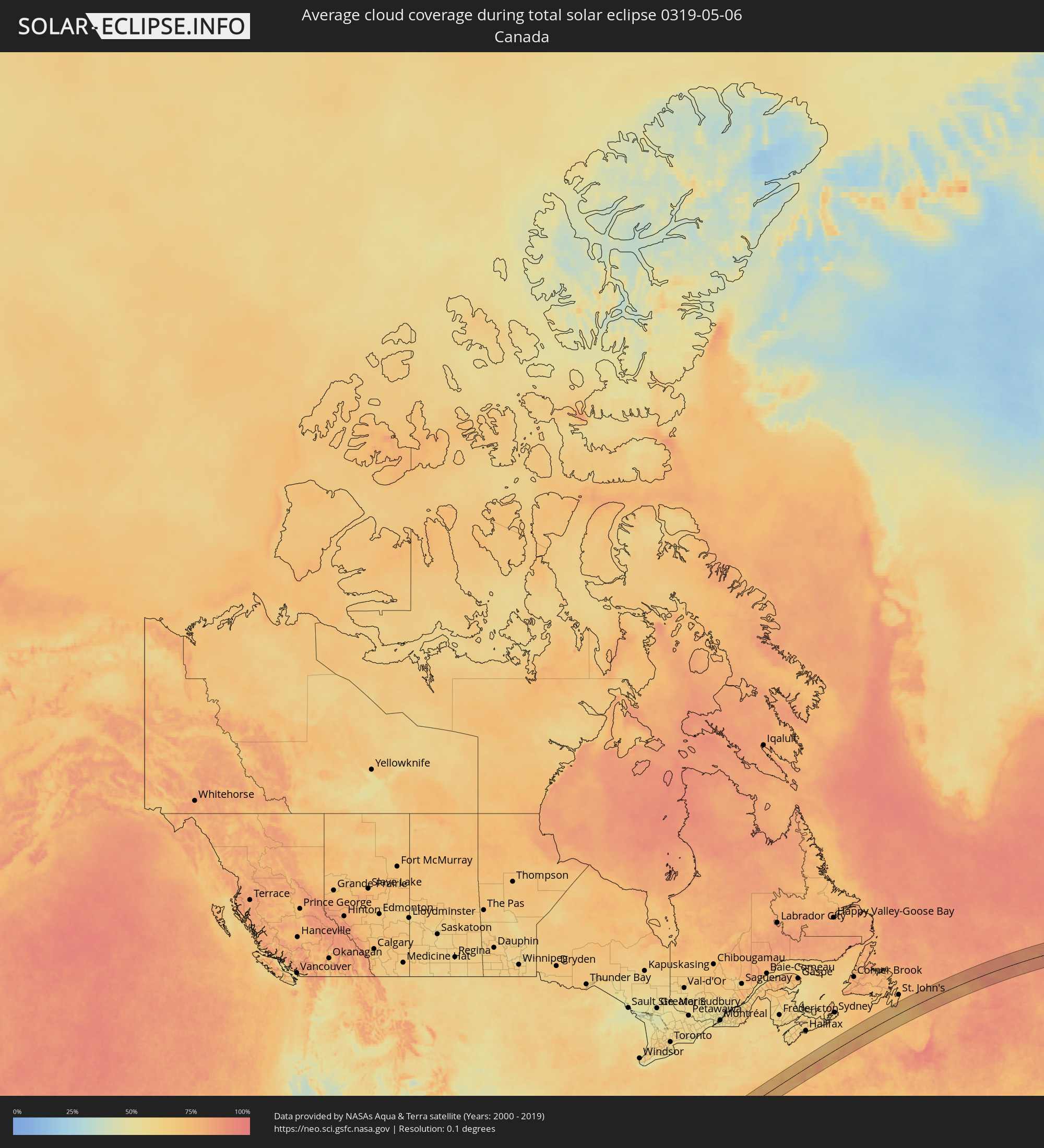 Canada
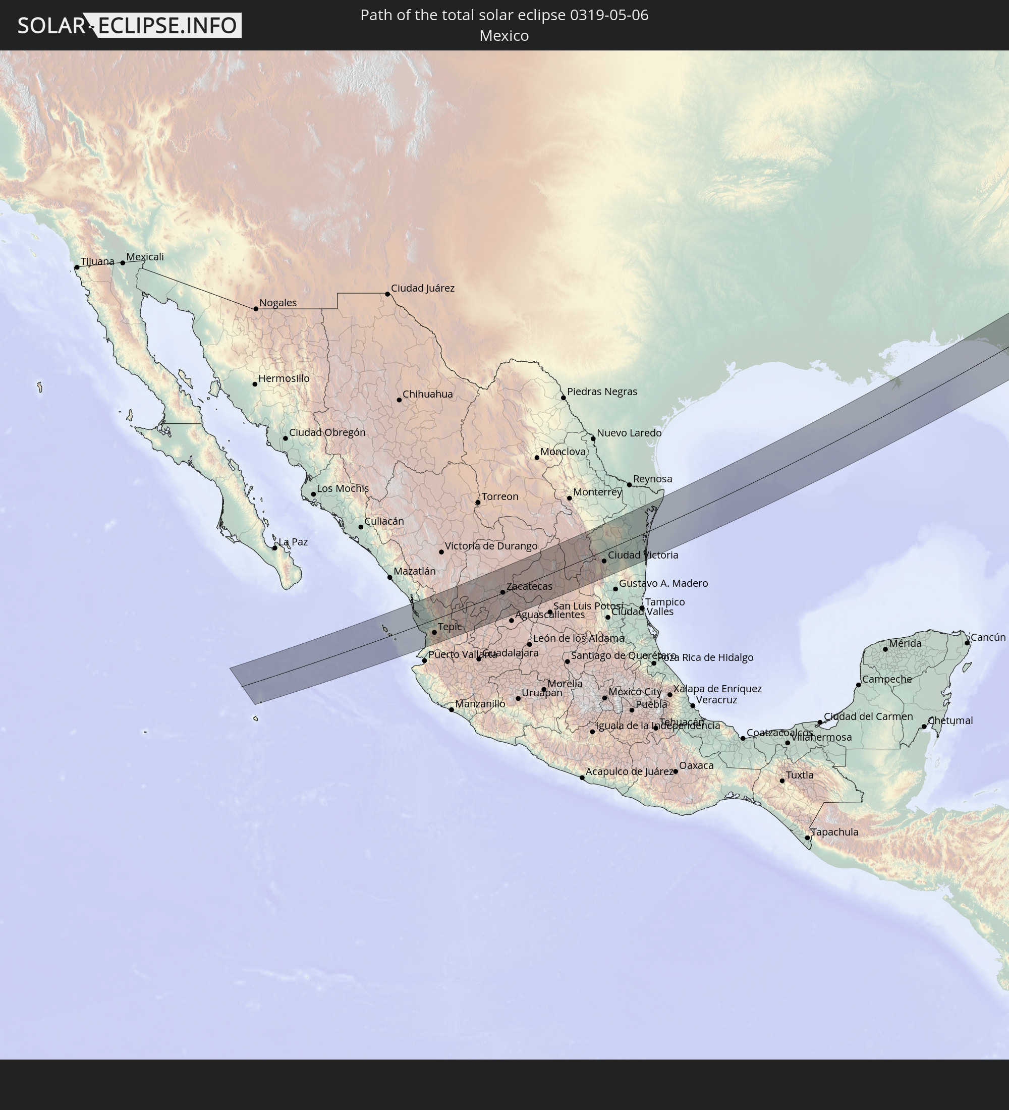
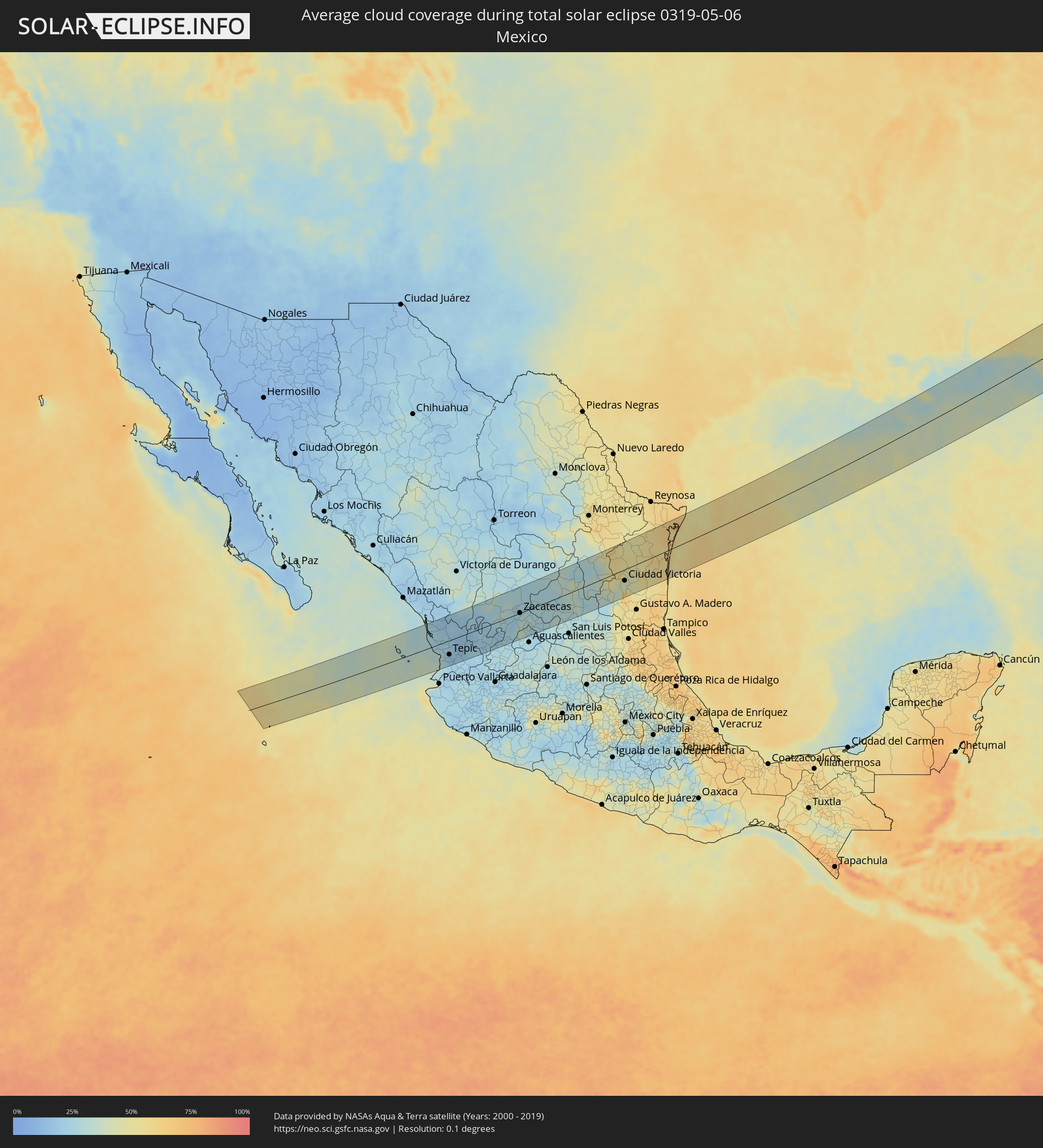 Mexico
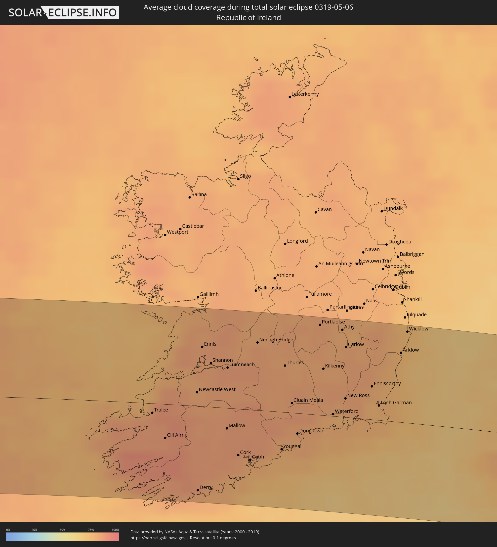 Republic of Ireland
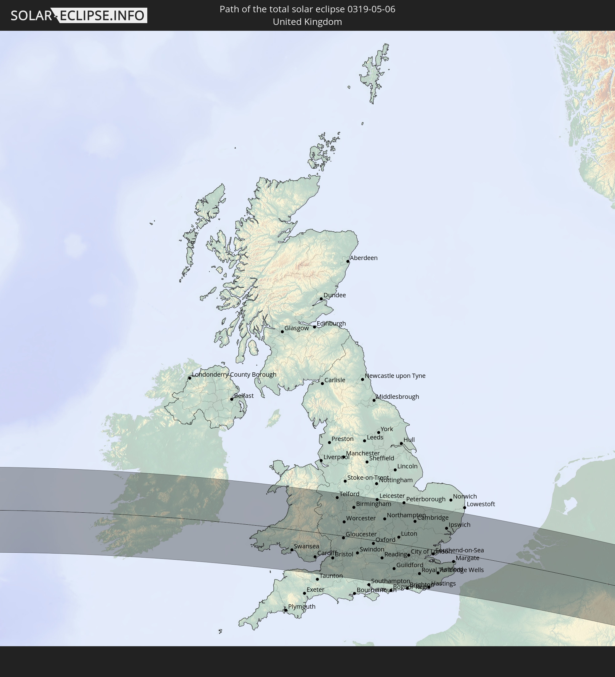
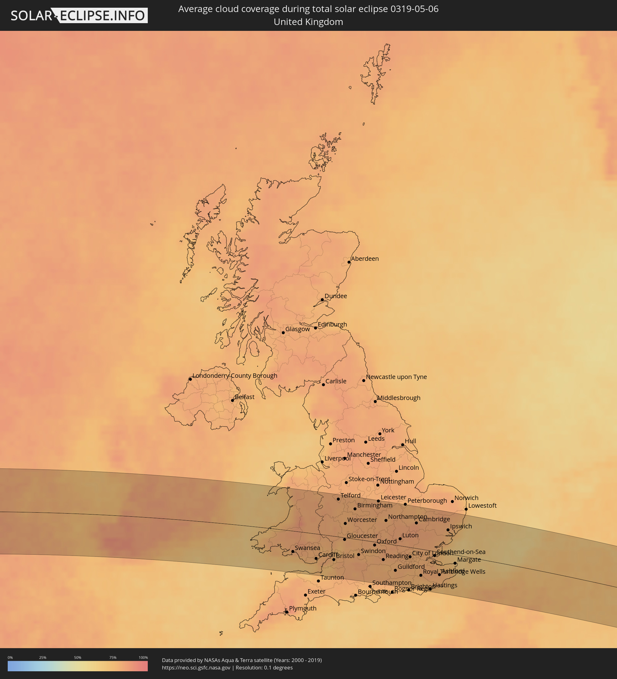 United Kingdom
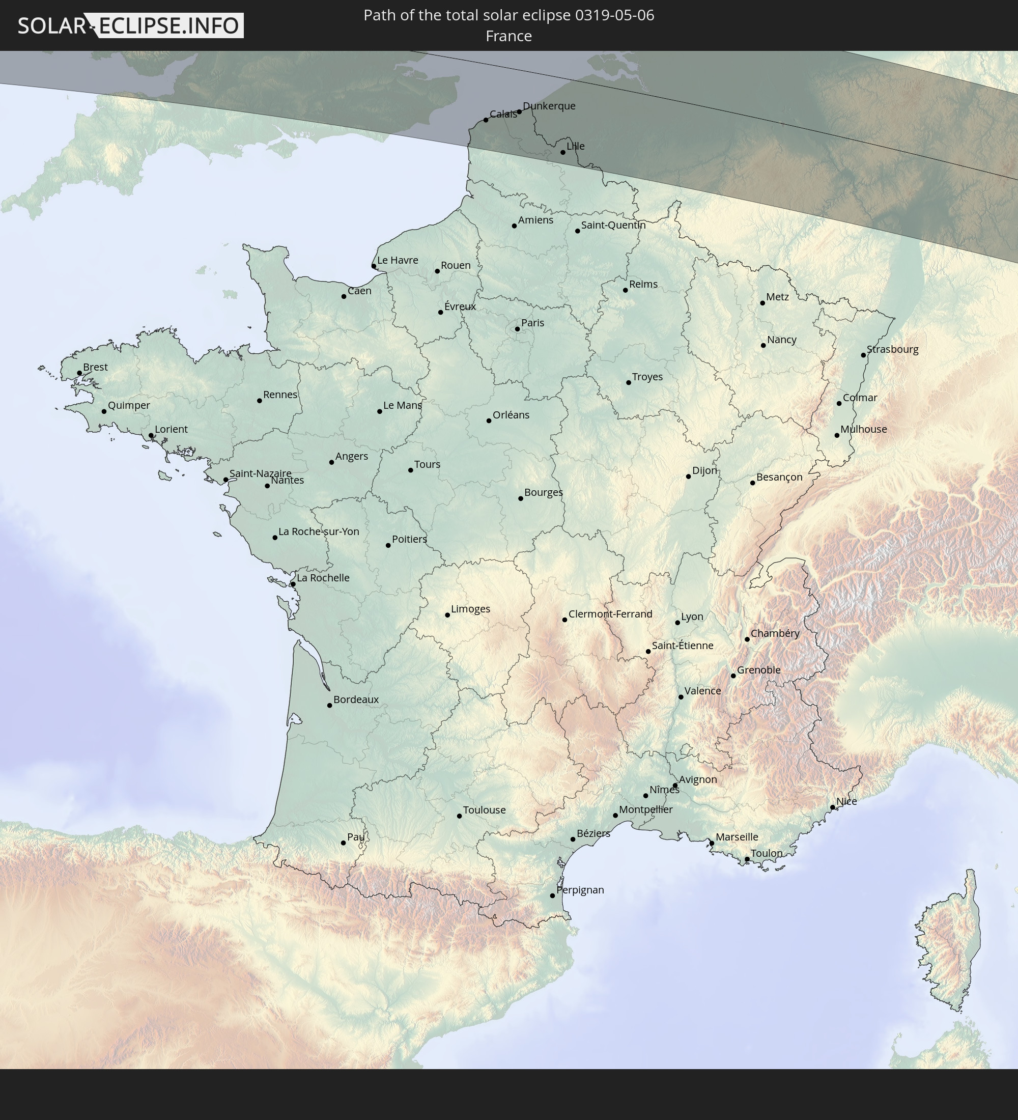
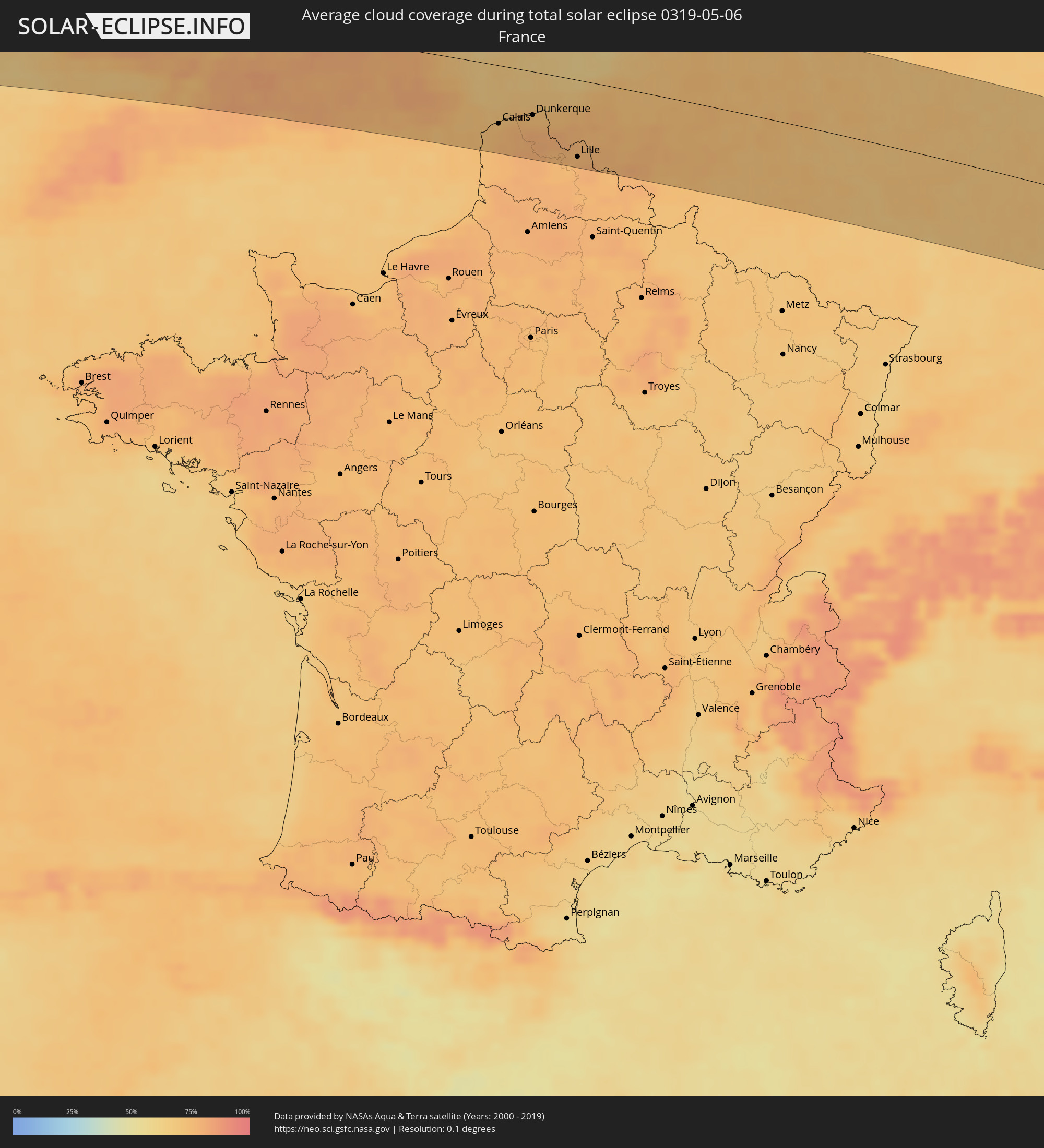 France
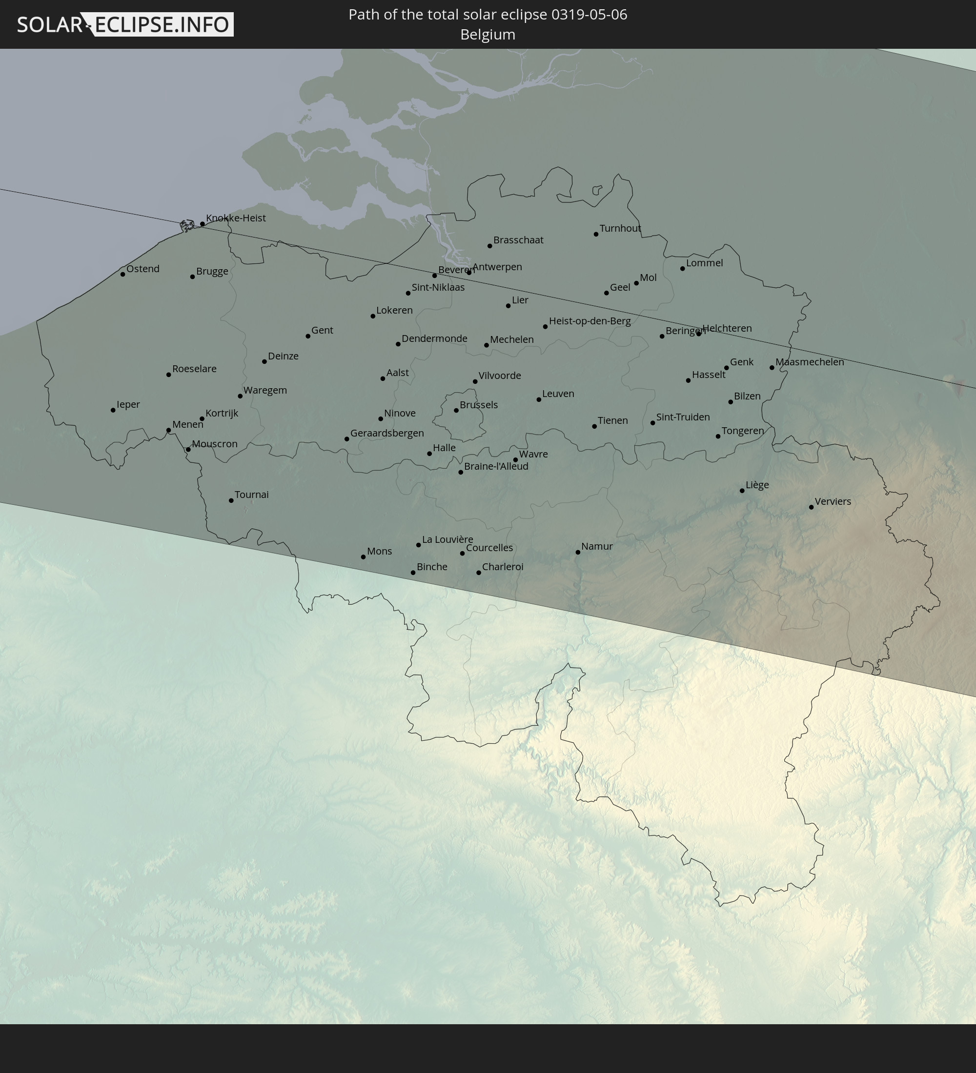
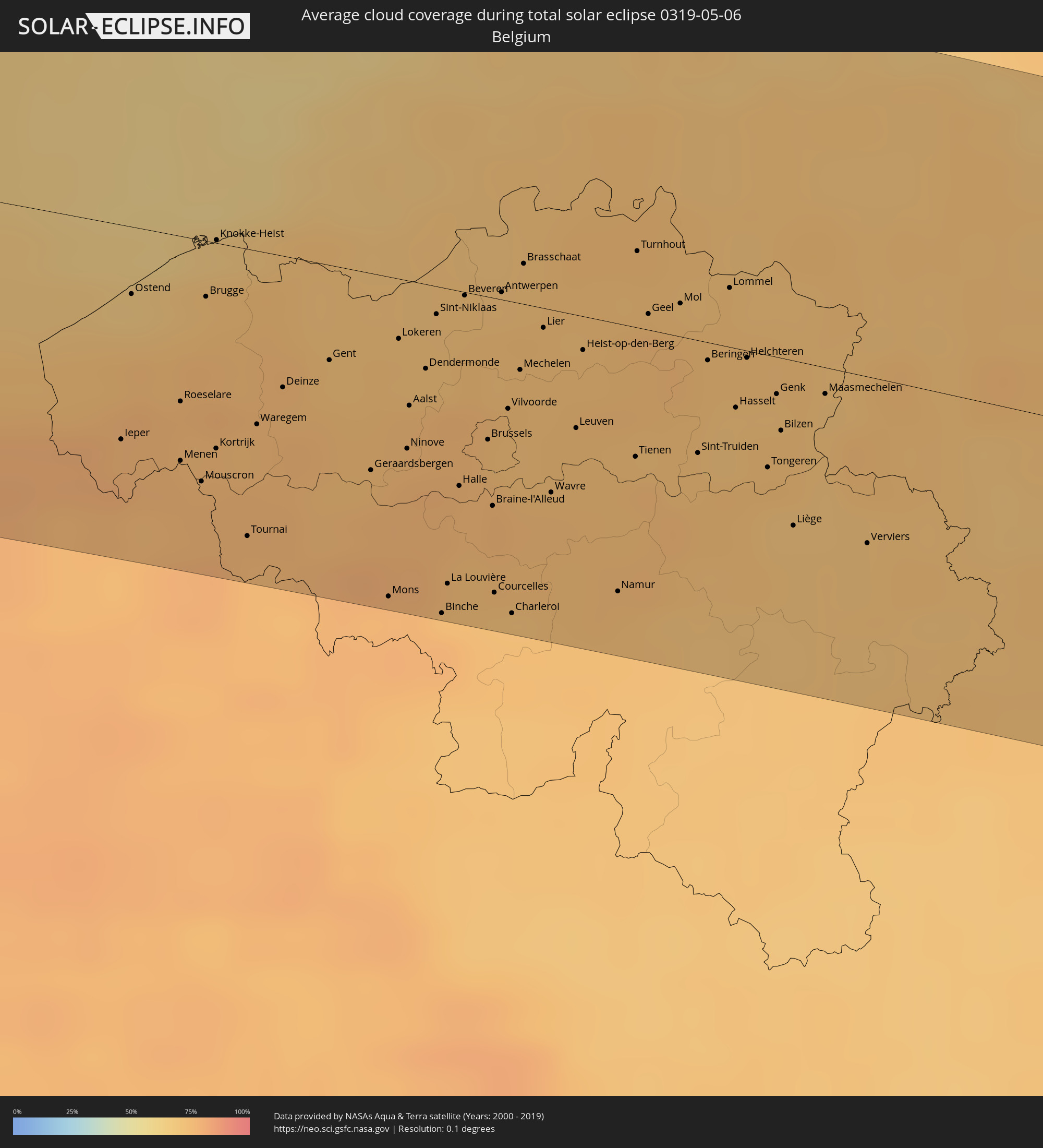 Belgium
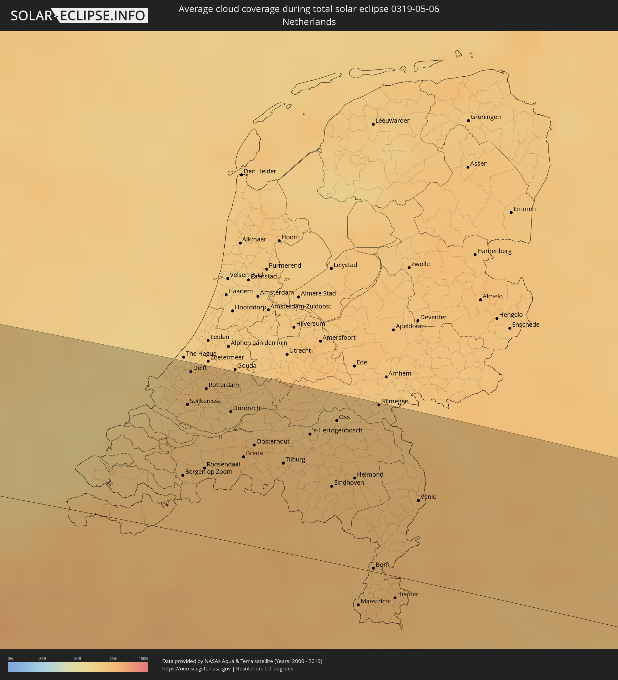 Netherlands
 Luxembourg
 Germany
 Austria
 Czechia
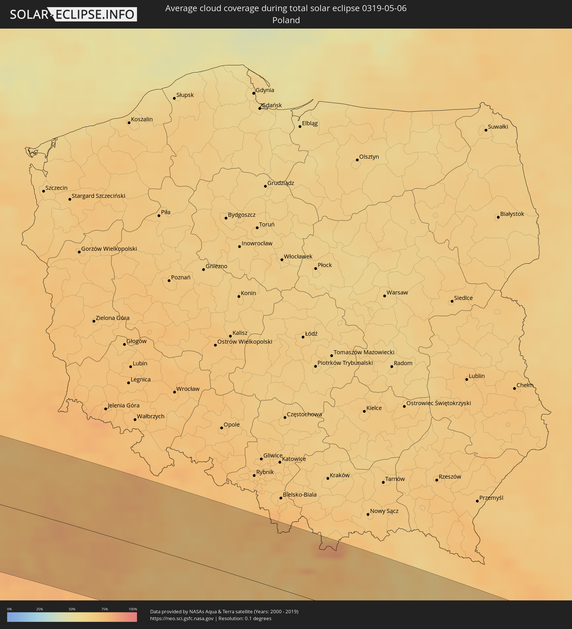 Poland
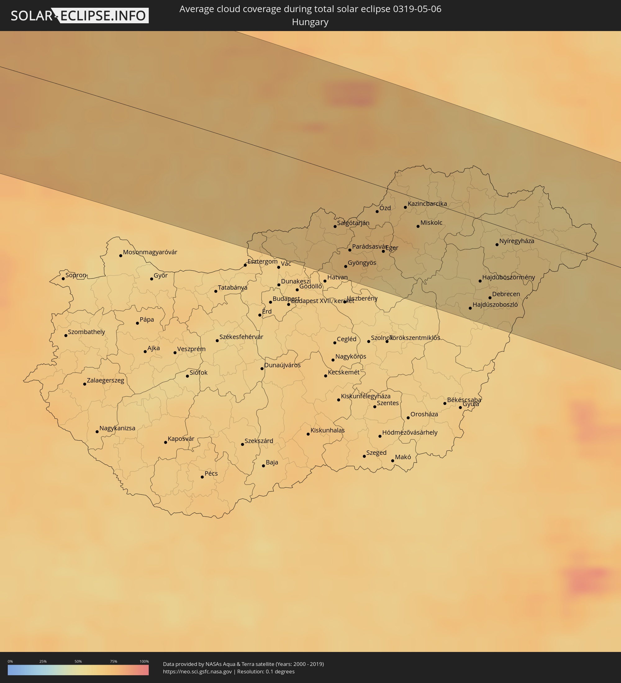 Hungary
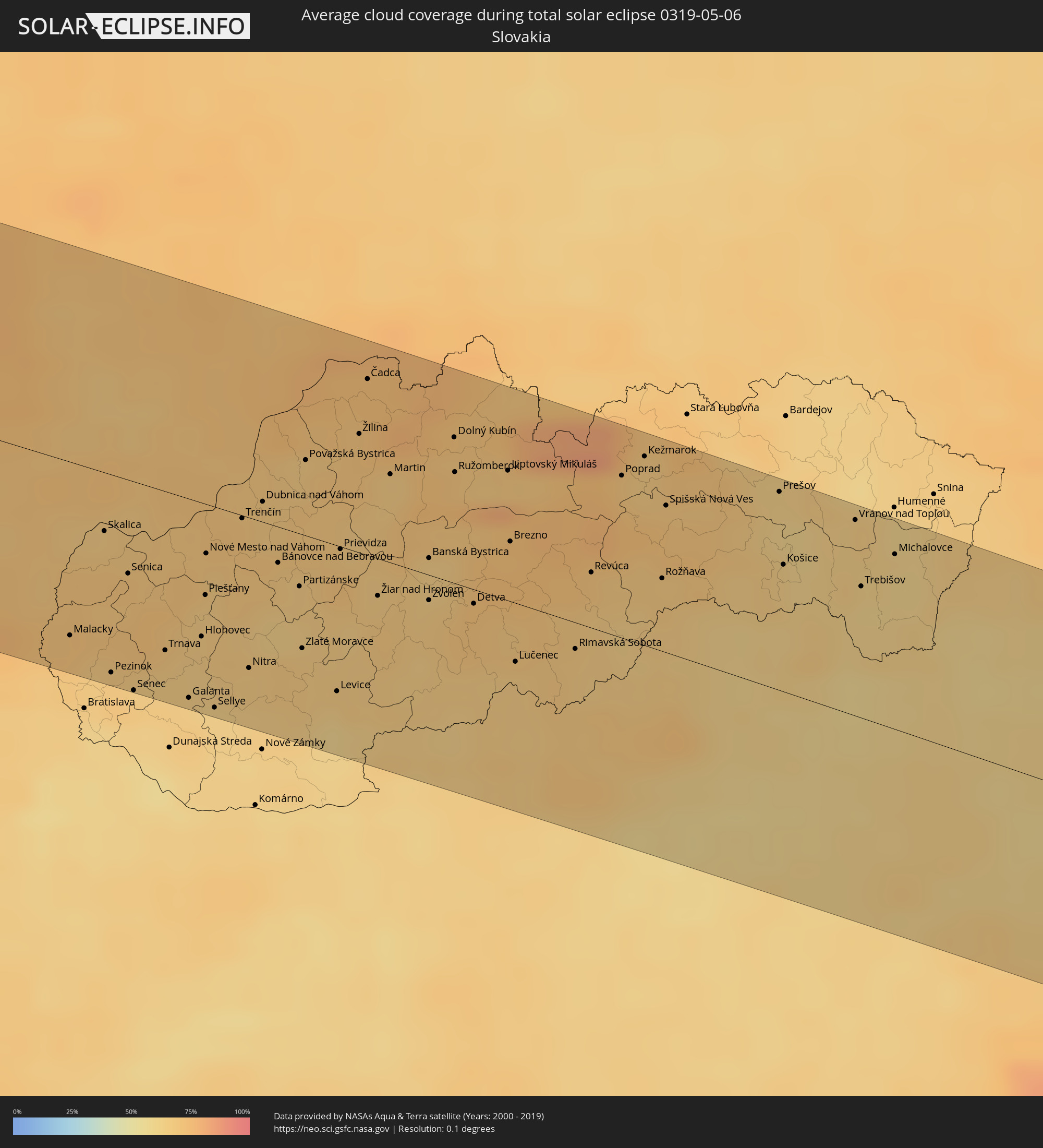 Slovakia
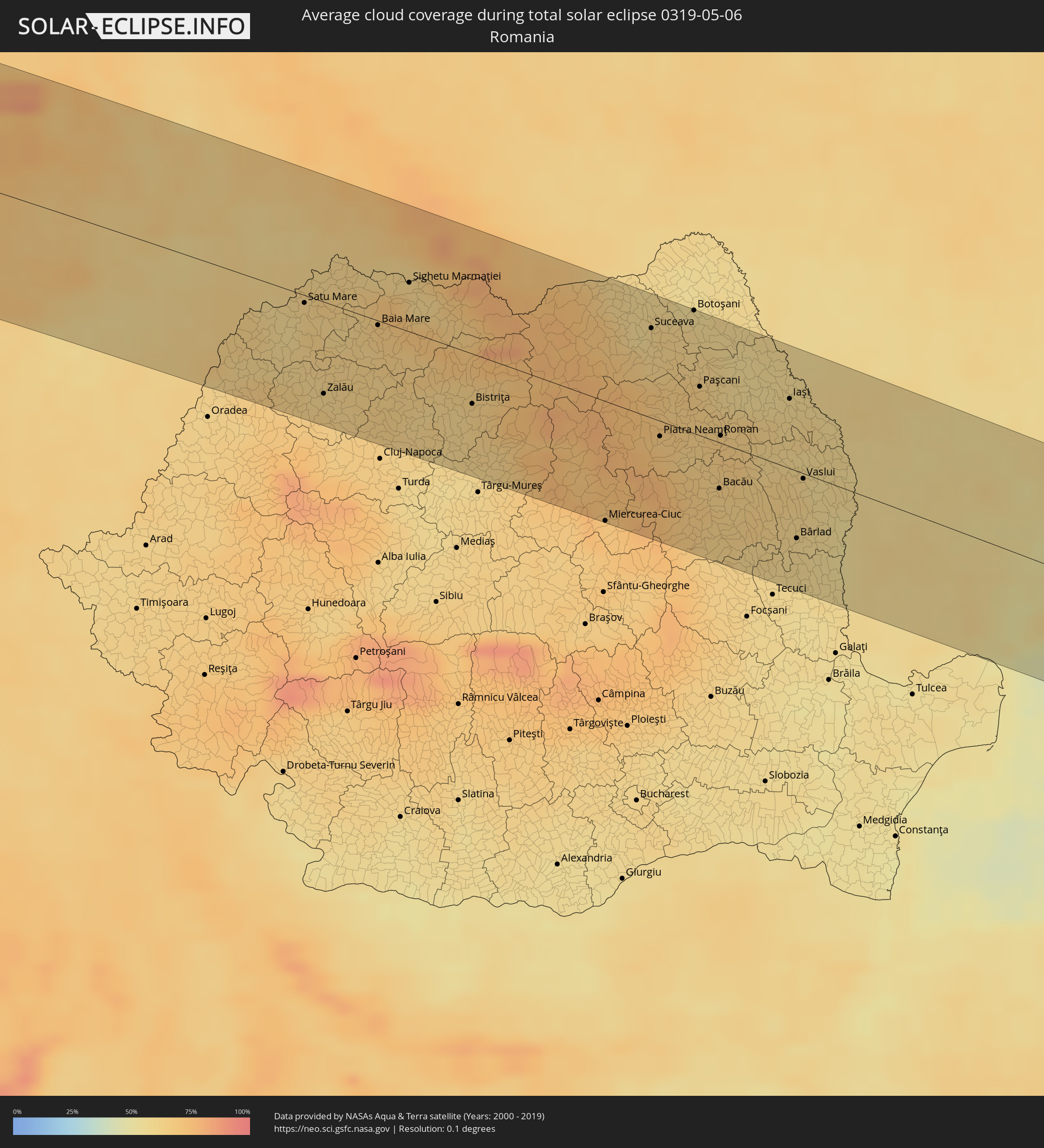 Romania
 Ukraine
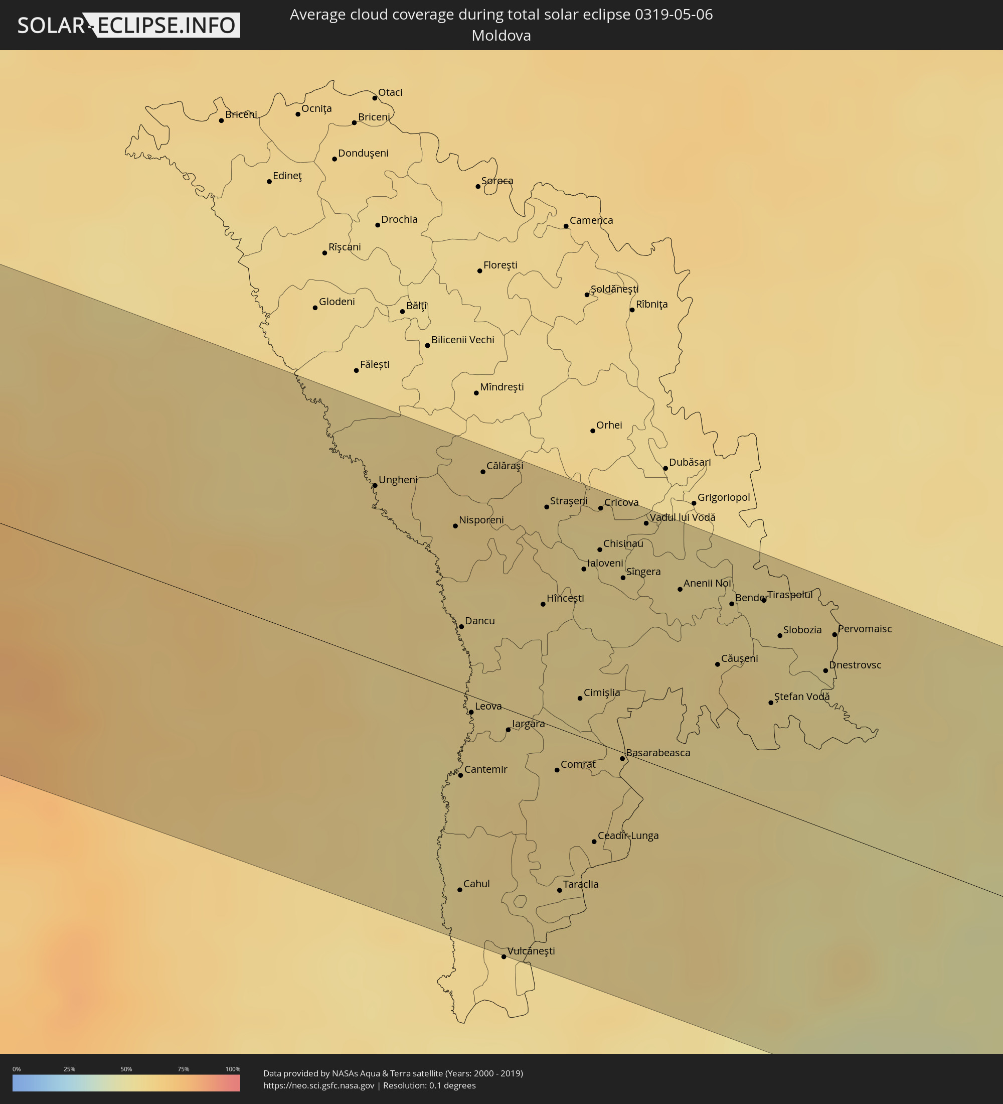 Moldova
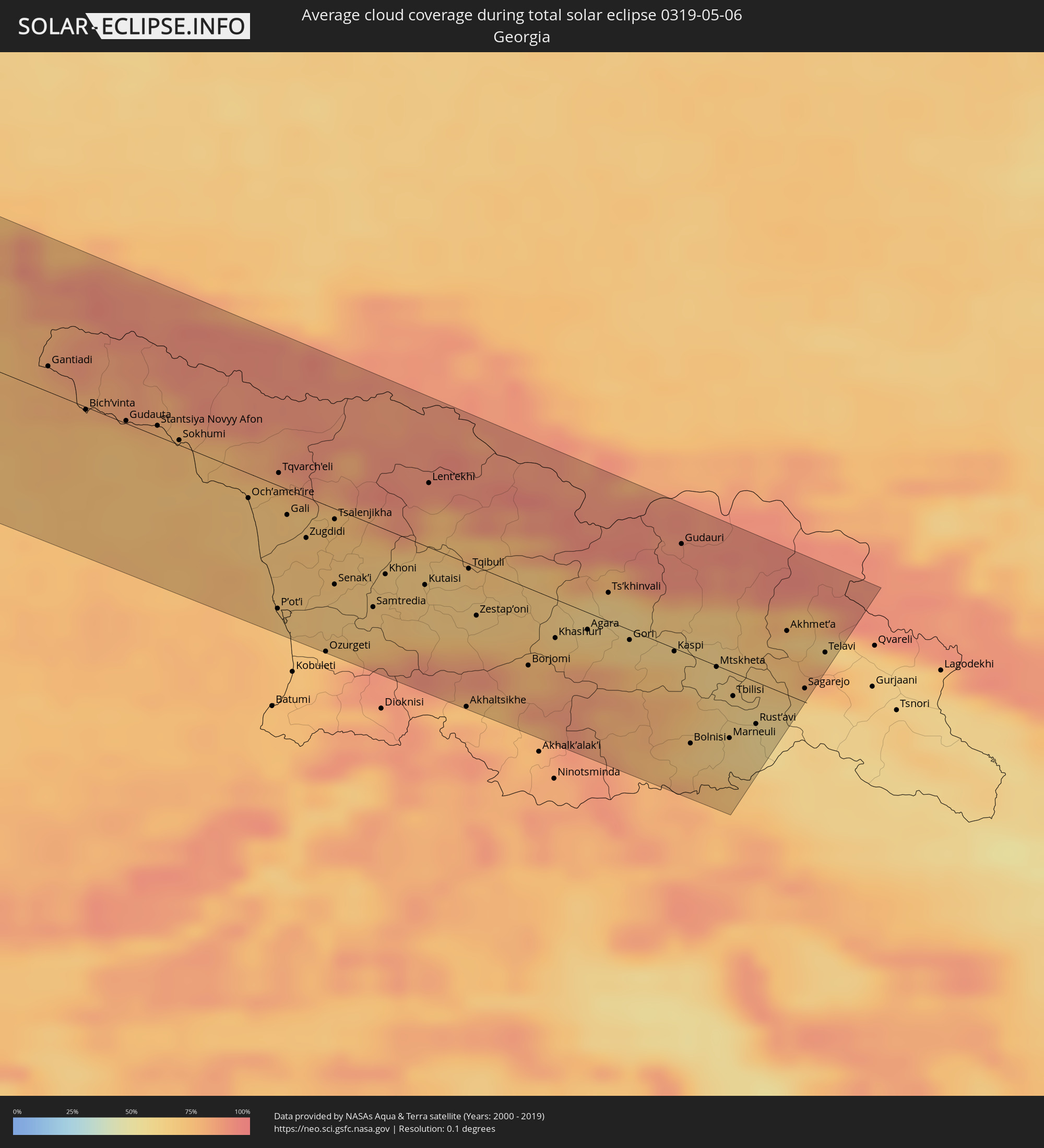 Georgia
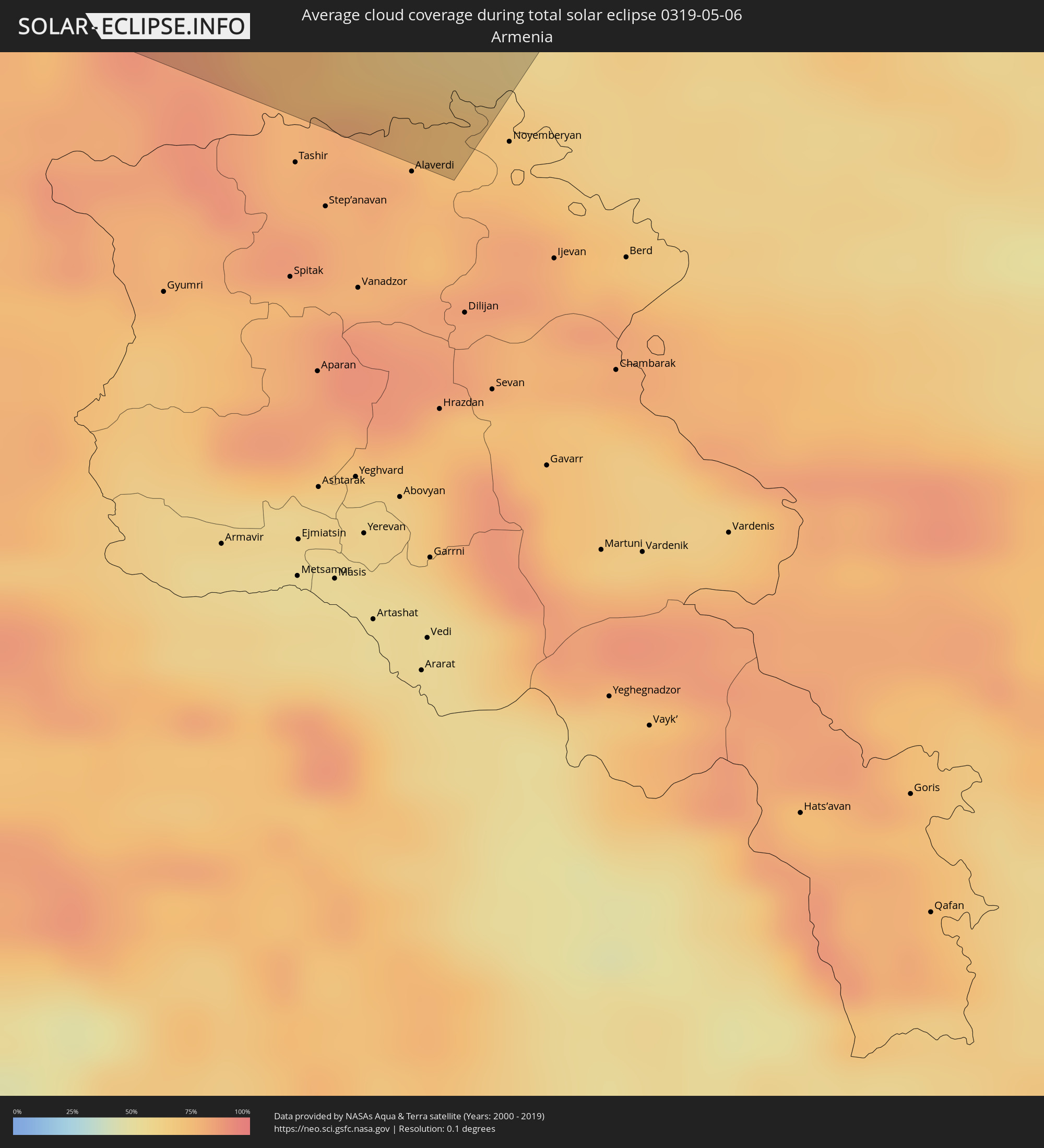 Armenia
 Azerbaijan
Cities inside the path of the eclipse
The following table shows all locations with a population of more than 5,000 inside the eclipse path. Cities which have more than 100,000 inhabitants are marked bold. A click at the locations opens a detailed map.
| City | Type | Eclipse duration | Local time of max. eclipse | Distance to central line | Ø Cloud coverage |
|
Acaponeta, Nayarit
|
total | - | 05:51:29 UTC-07:05 | 75 km | 21% |
|
Santiago Ixcuintla, Nayarit
|
total | - | 05:50:41 UTC-07:05 | 2 km | 24% |
|
Tepic, Nayarit
|
total | - | 05:50:18 UTC-07:05 | 45 km | 19% |
|
Jerez de García Salinas, Zacatecas
|
total | - | 06:20:29 UTC-06:36 | 3 km | 25% |
|
Fresnillo, Zacatecas
|
total | - | 06:21:06 UTC-06:36 | 54 km | 31% |
|
Víctor Rosales, Zacatecas
|
total | - | 06:20:49 UTC-06:36 | 23 km | 25% |
|
Zacatecas, Zacatecas
|
total | - | 06:20:36 UTC-06:36 | 0 km | 30% |
|
Rincón de Romos, Aguascalientes
|
total | - | 06:19:57 UTC-06:36 | 66 km | 27% |
|
Loreto, Zacatecas
|
total | - | 06:19:58 UTC-06:36 | 74 km | 27% |
|
Matehuala, San Luis Potosí
|
total | - | 06:21:35 UTC-06:36 | 16 km | 33% |
|
Ciudad Victoria, Tamaulipas
|
total | - | 06:21:43 UTC-06:36 | 35 km | 41% |
|
San Fernando, Tamaulipas
|
total | - | 06:23:11 UTC-06:36 | 37 km | 54% |
|
Panama City, Florida
|
total | - | 07:10:57 UTC-06:00 | 3 km | 42% |
|
Dothan, Alabama
|
total | - | 07:12:46 UTC-06:00 | 93 km | 51% |
|
Tallahassee, Florida
|
total | - | 08:12:08 UTC-05:00 | 36 km | 52% |
|
Albany, Georgia
|
total | - | 08:14:01 UTC-05:00 | 67 km | 47% |
|
Valdosta, Georgia
|
total | - | 08:13:21 UTC-05:00 | 47 km | 45% |
|
Hinesville, Georgia
|
total | - | 08:16:03 UTC-05:00 | 32 km | 53% |
|
Savannah, Georgia
|
total | - | 08:16:46 UTC-05:00 | 34 km | 51% |
|
Hilton Head Island, South Carolina
|
total | - | 08:17:14 UTC-05:00 | 38 km | 49% |
|
Summerville, South Carolina
|
total | - | 08:18:57 UTC-05:00 | 9 km | 55% |
|
Charleston, South Carolina
|
total | - | 08:18:44 UTC-05:00 | 26 km | 53% |
|
Wilmington, North Carolina
|
total | - | 08:22:42 UTC-05:00 | 13 km | 54% |
|
Jacksonville, North Carolina
|
total | - | 08:24:01 UTC-05:00 | 37 km | 60% |
|
Tralee, Munster
|
total | - | 14:54:52 UTC-00:25 | 9 km | 85% |
|
Ennis, Munster
|
total | - | 14:55:08 UTC-00:25 | 57 km | 82% |
|
Luimneach, Munster
|
total | - | 14:55:41 UTC-00:25 | 39 km | 84% |
|
Cork, Munster
|
total | - | 14:56:34 UTC-00:25 | 45 km | 83% |
|
Cluain Meala, Munster
|
total | - | 14:56:57 UTC-00:25 | 9 km | 82% |
|
Portlaoise, Leinster
|
total | - | 14:56:43 UTC-00:25 | 87 km | 81% |
|
Kilkenny, Leinster
|
total | - | 14:57:08 UTC-00:25 | 45 km | 80% |
|
Waterford, Munster
|
total | - | 14:57:40 UTC-00:25 | 2 km | 77% |
|
Athy, Leinster
|
total | - | 14:57:05 UTC-00:25 | 84 km | 79% |
|
Carlow, Leinster
|
total | - | 14:57:17 UTC-00:25 | 67 km | 82% |
|
Loch Garman, Leinster
|
total | - | 14:58:16 UTC-00:25 | 14 km | 76% |
|
Wicklow, Leinster
|
total | - | 14:58:02 UTC-00:25 | 88 km | 73% |
|
Cardiff, Wales
|
total | - | 15:27:43 UTC+00:00 | 56 km | 75% |
|
Bristol, England
|
total | - | 15:28:17 UTC+00:00 | 53 km | 77% |
|
Wolverhampton, England
|
total | - | 15:27:30 UTC+00:00 | 76 km | 79% |
|
Birmingham, England
|
total | - | 15:27:49 UTC+00:00 | 66 km | 79% |
|
Coventry, England
|
total | - | 15:28:14 UTC+00:00 | 62 km | 79% |
|
Leicester, England
|
total | - | 15:28:19 UTC+00:00 | 91 km | 80% |
|
Reading, England
|
total | - | 15:29:46 UTC+00:00 | 37 km | 78% |
|
Northampton, England
|
total | - | 15:28:58 UTC+00:00 | 51 km | 80% |
|
Luton, England
|
total | - | 15:29:47 UTC+00:00 | 15 km | 81% |
|
Sutton, England
|
total | - | 15:30:34 UTC+00:00 | 41 km | 79% |
|
London, England
|
total | - | 15:30:27 UTC+00:00 | 23 km | 78% |
|
Bexley, England
|
total | - | 15:30:46 UTC+00:00 | 27 km | 77% |
|
Boulogne-sur-Mer, Hauts-de-France
|
total | - | 15:42:11 UTC+00:09 | 89 km | 73% |
|
Calais, Hauts-de-France
|
total | - | 15:42:06 UTC+00:09 | 61 km | 73% |
|
Coulogne, Hauts-de-France
|
total | - | 15:42:10 UTC+00:09 | 63 km | 75% |
|
Oye-Plage, Hauts-de-France
|
total | - | 15:42:14 UTC+00:09 | 56 km | 75% |
|
Gravelines, Hauts-de-France
|
total | - | 15:42:17 UTC+00:09 | 54 km | 76% |
|
Saint-Omer, Hauts-de-France
|
total | - | 15:42:40 UTC+00:09 | 78 km | 77% |
|
Dunkerque, Hauts-de-France
|
total | - | 15:42:26 UTC+00:09 | 45 km | 75% |
|
Hazebrouck, Hauts-de-France
|
total | - | 15:42:55 UTC+00:09 | 77 km | 78% |
|
Nieppe, Hauts-de-France
|
total | - | 15:43:11 UTC+00:09 | 75 km | 76% |
|
Lille, Hauts-de-France
|
total | - | 15:43:27 UTC+00:09 | 80 km | 78% |
|
Halluin, Hauts-de-France
|
total | - | 15:33:58 UTC+00:00 | 63 km | 77% |
|
Templeuve, Hauts-de-France
|
total | - | 15:43:40 UTC+00:09 | 91 km | 79% |
|
Brugge, Flanders
|
total | - | 15:33:32 UTC+00:00 | 15 km | 73% |
|
Gent, Flanders
|
total | - | 15:34:06 UTC+00:00 | 26 km | 73% |
|
Mons, Wallonia
|
total | - | 15:35:00 UTC+00:00 | 88 km | 77% |
|
Aalst, Flanders
|
total | - | 15:34:29 UTC+00:00 | 34 km | 75% |
|
La Louvière, Wallonia
|
total | - | 15:35:08 UTC+00:00 | 81 km | 74% |
|
Brussels, Brussels Capital
|
total | - | 15:34:49 UTC+00:00 | 39 km | 75% |
|
Antwerpen, Flanders
|
total | - | 15:34:25 UTC+00:00 | 2 km | 73% |
|
Charleroi, Wallonia
|
total | - | 15:35:25 UTC+00:00 | 86 km | 73% |
|
Roosendaal, North Brabant
|
total | - | 15:53:37 UTC+00:19 | 37 km | 72% |
|
Mechelen, Flanders
|
total | - | 15:34:42 UTC+00:00 | 18 km | 74% |
|
Rotterdam, South Holland
|
total | - | 15:53:09 UTC+00:19 | 80 km | 67% |
|
Dordrecht, South Holland
|
total | - | 15:53:26 UTC+00:19 | 70 km | 69% |
|
Leuven, Flanders
|
total | - | 15:35:03 UTC+00:00 | 31 km | 74% |
|
Breda, North Brabant
|
total | - | 15:53:47 UTC+00:19 | 47 km | 72% |
|
Namur, Wallonia
|
total | - | 15:35:40 UTC+00:00 | 74 km | 74% |
|
Tilburg, North Brabant
|
total | - | 15:54:03 UTC+00:19 | 48 km | 71% |
|
's-Hertogenbosch, North Brabant
|
total | - | 15:54:01 UTC+00:19 | 67 km | 70% |
|
Eindhoven, North Brabant
|
total | - | 15:54:27 UTC+00:19 | 41 km | 73% |
|
Liège, Wallonia
|
total | - | 15:35:58 UTC+00:00 | 45 km | 71% |
|
Maastricht, Limburg
|
total | - | 15:55:20 UTC+00:19 | 20 km | 70% |
|
Born, Limburg
|
total | - | 15:55:12 UTC+00:19 | 2 km | 71% |
|
Nijmegen, Gelderland
|
total | - | 15:54:13 UTC+00:19 | 91 km | 71% |
|
Heerlen, Limburg
|
total | - | 15:55:30 UTC+00:19 | 12 km | 73% |
|
Aachen, North Rhine-Westphalia
|
total | - | 16:36:10 UTC+01:00 | 22 km | 72% |
|
Venlo, Limburg
|
total | - | 15:55:01 UTC+00:19 | 44 km | 73% |
|
Mönchengladbach, North Rhine-Westphalia
|
total | - | 16:35:54 UTC+01:00 | 28 km | 72% |
|
Duisburg, North Rhine-Westphalia
|
total | - | 16:35:49 UTC+01:00 | 60 km | 71% |
|
Düsseldorf, North Rhine-Westphalia
|
total | - | 16:36:05 UTC+01:00 | 37 km | 71% |
|
Köln, North Rhine-Westphalia
|
total | - | 16:36:34 UTC+01:00 | 8 km | 68% |
|
Essen, North Rhine-Westphalia
|
total | - | 16:35:57 UTC+01:00 | 66 km | 70% |
|
Bonn, North Rhine-Westphalia
|
total | - | 16:36:54 UTC+01:00 | 11 km | 69% |
|
Wuppertal, North Rhine-Westphalia
|
total | - | 16:36:17 UTC+01:00 | 48 km | 72% |
|
Dortmund, North Rhine-Westphalia
|
total | - | 16:36:11 UTC+01:00 | 80 km | 69% |
|
Wiesbaden, Hesse
|
total | - | 16:38:28 UTC+01:00 | 63 km | 68% |
|
Frankfurt am Main, Hesse
|
total | - | 16:38:42 UTC+01:00 | 52 km | 69% |
|
Nürnberg, Bavaria
|
total | - | 16:40:58 UTC+01:00 | 82 km | 68% |
|
Karlovy Vary, Karlovarský
|
total | - | 16:40:56 UTC+01:00 | 35 km | 72% |
|
Pilsen, Plzeňský
|
total | - | 16:41:48 UTC+01:00 | 7 km | 73% |
|
Chomutov, Ústecký
|
total | - | 16:40:55 UTC+01:00 | 70 km | 70% |
|
Most, Ústecký
|
total | - | 16:40:58 UTC+01:00 | 79 km | 67% |
|
Kladno, Central Bohemia
|
total | - | 16:41:39 UTC+01:00 | 50 km | 72% |
|
Prague, Praha
|
total | - | 16:41:52 UTC+01:00 | 50 km | 72% |
|
České Budějovice, Jihočeský
|
total | - | 16:43:19 UTC+01:00 | 68 km | 75% |
|
Gmünd, Lower Austria
|
total | - | 16:43:49 UTC+01:00 | 80 km | 76% |
|
Schrems, Lower Austria
|
total | - | 16:43:50 UTC+01:00 | 76 km | 77% |
|
Waidhofen an der Thaya, Lower Austria
|
total | - | 16:43:54 UTC+01:00 | 68 km | 78% |
|
Jihlava, Vysočina
|
total | - | 16:43:17 UTC+01:00 | 0 km | 76% |
|
Horn, Lower Austria
|
total | - | 16:44:15 UTC+01:00 | 77 km | 76% |
|
Pardubice, Pardubický
|
total | - | 16:42:32 UTC+01:00 | 72 km | 75% |
|
Hollabrunn, Lower Austria
|
total | - | 16:44:35 UTC+01:00 | 80 km | 76% |
|
Laa an der Thaya, Lower Austria
|
total | - | 16:44:30 UTC+01:00 | 56 km | 75% |
|
Mistelbach, Lower Austria
|
total | - | 16:44:46 UTC+01:00 | 68 km | 74% |
|
Brno, South Moravian
|
total | - | 16:43:59 UTC+01:00 | 0 km | 72% |
|
Poysdorf, Lower Austria
|
total | - | 16:44:40 UTC+01:00 | 56 km | 72% |
|
Zistersdorf, Lower Austria
|
total | - | 16:44:53 UTC+01:00 | 68 km | 73% |
|
Olomouc, Olomoucký
|
total | - | 16:43:43 UTC+01:00 | 56 km | 70% |
|
Trnava, Trnavský
|
total | - | 16:45:25 UTC+01:00 | 66 km | 68% |
|
Zlín, Zlín
|
total | - | 16:44:21 UTC+01:00 | 26 km | 70% |
|
Trenčín, Trenčiansky
|
total | - | 16:44:55 UTC+01:00 | 1 km | 70% |
|
Nitra, Nitriansky
|
total | - | 16:45:41 UTC+01:00 | 63 km | 66% |
|
Považská Bystrica, Trenčiansky
|
total | - | 16:44:46 UTC+01:00 | 31 km | 67% |
|
Prievidza, Nitriansky
|
total | - | 16:45:17 UTC+01:00 | 1 km | 68% |
|
Žilina, Žilinský
|
total | - | 16:44:45 UTC+01:00 | 49 km | 70% |
|
Martin, Žilinský
|
total | - | 16:45:01 UTC+01:00 | 37 km | 67% |
|
Zvolen, Banskobystrický
|
total | - | 16:45:44 UTC+01:00 | 10 km | 66% |
|
Banská Bystrica, Banskobystrický
|
total | - | 16:45:31 UTC+01:00 | 7 km | 64% |
|
Salgótarján, Nógrád
|
total | - | 16:46:33 UTC+01:00 | 46 km | 66% |
|
Zakopane, Lesser Poland Voivodeship
|
total | - | 17:09:04 UTC+01:24 | 84 km | 81% |
|
Parádsasvár, Heves
|
total | - | 16:46:51 UTC+01:00 | 62 km | 70% |
|
Poprad, Prešovský
|
total | - | 16:45:29 UTC+01:00 | 67 km | 69% |
|
Ózd, Borsod-Abaúj-Zemplén
|
total | - | 16:46:34 UTC+01:00 | 22 km | 68% |
|
Eger, Heves
|
total | - | 16:46:59 UTC+01:00 | 54 km | 64% |
|
Kazincbarcika, Borsod-Abaúj-Zemplén
|
total | - | 16:46:37 UTC+01:00 | 11 km | 66% |
|
Miskolc, Borsod-Abaúj-Zemplén
|
total | - | 16:46:51 UTC+01:00 | 23 km | 64% |
|
Prešov, Prešovský
|
total | - | 16:45:50 UTC+01:00 | 82 km | 63% |
|
Košice, Košický
|
total | - | 16:46:13 UTC+01:00 | 53 km | 62% |
|
Hajdúszoboszló, Hajdú-Bihar
|
total | - | 16:47:51 UTC+01:00 | 77 km | 61% |
|
Hajdúböszörmény, Hajdú-Bihar
|
total | - | 16:47:37 UTC+01:00 | 52 km | 60% |
|
Debrecen, Hajdú-Bihar
|
total | - | 16:47:49 UTC+01:00 | 63 km | 61% |
|
Nyíregyháza, Szabolcs-Szatmár-Bereg
|
total | - | 16:47:18 UTC+01:00 | 16 km | 60% |
|
Kisvárda, Szabolcs-Szatmár-Bereg
|
total | - | 16:47:04 UTC+01:00 | 20 km | 62% |
|
Uzhhorod, Zakarpattia
|
total | - | 17:48:41 UTC+02:02 | 67 km | 62% |
|
Mátészalka, Szabolcs-Szatmár-Bereg
|
total | - | 16:47:28 UTC+01:00 | 2 km | 62% |
|
Mukacheve, Zakarpattia
|
total | - | 17:49:01 UTC+02:02 | 59 km | 61% |
|
Satu Mare, Satu Mare
|
total | - | 17:32:12 UTC+01:44 | 5 km | 62% |
|
Zalău, Sălaj
|
total | - | 17:33:00 UTC+01:44 | 64 km | 62% |
|
Baia Mare, Satu Mare
|
total | - | 17:32:33 UTC+01:44 | 3 km | 66% |
|
Bistriţa, Bistriţa-Năsăud
|
total | - | 17:33:24 UTC+01:44 | 35 km | 64% |
|
Suceava, Suceava
|
total | - | 17:33:05 UTC+01:44 | 62 km | 62% |
|
Piatra Neamţ, Neamţ
|
total | - | 17:33:59 UTC+01:44 | 11 km | 70% |
|
Botoşani, Botoşani
|
total | - | 17:33:00 UTC+01:44 | 85 km | 57% |
|
Bacău, Bacău
|
total | - | 17:34:30 UTC+01:44 | 32 km | 62% |
|
Roman, Neamţ
|
total | - | 17:34:04 UTC+01:44 | 5 km | 66% |
|
Iaşi, Iaşi
|
total | - | 17:33:51 UTC+01:44 | 49 km | 58% |
|
Bârlad, Vaslui
|
total | - | 17:35:00 UTC+01:44 | 47 km | 59% |
|
Vaslui, Vaslui
|
total | - | 17:34:31 UTC+01:44 | 4 km | 62% |
|
Ungheni, Ungheni
|
total | - | 17:44:25 UTC+01:55 | 58 km | 58% |
|
Cahul, Cahul
|
total | - | 17:46:03 UTC+01:55 | 67 km | 57% |
|
Leova, Leova
|
total | - | 17:45:22 UTC+01:55 | 6 km | 58% |
|
Călăraşi, Călăraşi
|
total | - | 17:44:25 UTC+01:55 | 76 km | 59% |
|
Hînceşti, Hînceşti
|
total | - | 17:44:58 UTC+01:55 | 40 km | 56% |
|
Straşeni, Strășeni
|
total | - | 17:44:35 UTC+01:55 | 73 km | 59% |
|
Comrat, Găgăuzia
|
total | - | 17:45:38 UTC+01:55 | 14 km | 59% |
|
Taraclia, Taraclia
|
total | - | 17:46:06 UTC+01:55 | 55 km | 58% |
|
Ceadîr-Lunga, Găgăuzia
|
total | - | 17:45:56 UTC+01:55 | 34 km | 59% |
|
Chisinau, Chişinău
|
total | - | 17:44:47 UTC+01:55 | 65 km | 57% |
|
Căuşeni, Căuşeni
|
total | - | 17:45:17 UTC+01:55 | 42 km | 57% |
|
Tiraspolul, Stînga Nistrului
|
total | - | 17:45:02 UTC+01:55 | 69 km | 56% |
|
Bilhorod-Dnistrovs’kyy, Odessa
|
total | - | 17:52:56 UTC+02:02 | 21 km | 50% |
|
Illichivs’k, Odessa
|
total | - | 17:52:49 UTC+02:02 | 41 km | 54% |
|
Odessa, Odessa
|
total | - | 17:52:37 UTC+02:02 | 61 km | 52% |
|
Yevpatoriya, Republic of Crimea
|
total | - | 18:08:05 UTC+02:16 | 3 km | 58% |
|
Sevastopol, Gorod Sevastopol
|
total | - | 18:08:47 UTC+02:16 | 56 km | 54% |
|
Saki, Republic of Crimea
|
total | - | 18:08:09 UTC+02:16 | 2 km | 52% |
|
Simferopol, Republic of Crimea
|
total | - | 18:08:20 UTC+02:16 | 1 km | 60% |
|
Yalta, Republic of Crimea
|
total | - | 18:08:51 UTC+02:16 | 47 km | 65% |
|
Alushta, Republic of Crimea
|
total | - | 18:08:39 UTC+02:16 | 22 km | 62% |
|
Feodosiya, Republic of Crimea
|
total | - | 18:08:10 UTC+02:16 | 44 km | 63% |
|
Kabardinka, Krasnodarskiy
|
total | - | 18:22:38 UTC+02:30 | 80 km | 71% |
|
Gelendzhik, Krasnodarskiy
|
total | - | 18:22:43 UTC+02:30 | 75 km | 71% |
|
Arkhipo-Osipovka, Krasnodarskiy
|
total | - | 18:22:52 UTC+02:30 | 68 km | 71% |
|
Novomikhaylovskiy, Krasnodarskiy
|
total | - | 18:22:56 UTC+02:30 | 67 km | 68% |
|
Tuapse, Krasnodarskiy
|
total | - | 18:23:05 UTC+02:30 | 57 km | 70% |
|
Lazarevskoye, Krasnodarskiy
|
total | - | 18:23:15 UTC+02:30 | 45 km | 71% |
|
Dagomys, Krasnodarskiy
|
total | - | 18:23:27 UTC+02:30 | 30 km | 75% |
|
Sochi, Krasnodarskiy
|
total | - | 18:23:31 UTC+02:30 | 25 km | 73% |
|
Khosta, Krasnodarskiy
|
total | - | 18:23:35 UTC+02:30 | 21 km | 76% |
|
Kudepsta, Krasnodarskiy
|
total | - | 18:23:36 UTC+02:30 | 19 km | 76% |
|
Adler, Krasnodarskiy
|
total | - | 18:23:40 UTC+02:30 | 13 km | 77% |
|
Sokhumi, Abkhazia
|
total | - | 18:52:48 UTC+02:59 | 3 km | 75% |
|
P’ot’i, Samegrelo and Zemo Svaneti
|
total | - | 18:53:33 UTC+02:59 | 65 km | 71% |
|
Teberda, Karachayevo-Cherkesiya
|
total | - | 18:23:17 UTC+02:30 | 71 km | 91% |
|
Zugdidi, Samegrelo and Zemo Svaneti
|
total | - | 18:53:08 UTC+02:59 | 22 km | 72% |
|
Senak’i, Samegrelo and Zemo Svaneti
|
total | - | 18:53:20 UTC+02:59 | 40 km | 68% |
|
Samtredia, Imereti
|
total | - | 18:53:23 UTC+02:59 | 44 km | 68% |
|
Kutaisi, Imereti
|
total | - | 18:53:11 UTC+02:59 | 21 km | 68% |
|
Zestap’oni, Imereti
|
total | - | 18:53:15 UTC+02:59 | 26 km | 71% |
|
Khashuri, Shida Kartli
|
total | - | 18:53:14 UTC+02:59 | 21 km | 73% |
|
Ts’khinvali, Shida Kartli
|
total | - | 18:52:54 UTC+02:59 | 15 km | 62% |
|
Gori, Shida Kartli
|
total | - | 18:53:06 UTC+02:59 | 5 km | 65% |
|
Tbilisi, T'bilisi
|
total | - | 18:53:11 UTC+02:59 | 13 km | 63% |
|
Rust’avi, Kvemo Kartli
|
total | - | 18:53:17 UTC+02:59 | 22 km | 59% |