Total solar eclipse of 11/20/0393
| Day of week: | Saturday |
| Maximum duration of eclipse: | 03m05s |
| Maximum width of eclipse path: | 250 km |
| Saros cycle: | 97 |
| Coverage: | 100% |
| Magnitude: | 1.0373 |
| Gamma: | 0.864 |
Wo kann man die Sonnenfinsternis vom 11/20/0393 sehen?
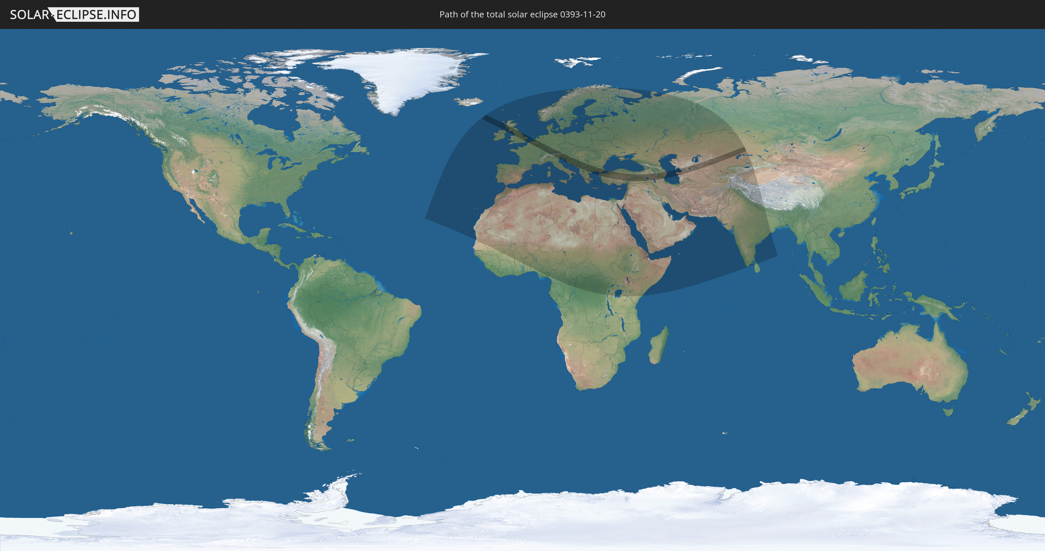
Die Sonnenfinsternis am 11/20/0393 kann man in 108 Ländern als partielle Sonnenfinsternis beobachten.
Der Finsternispfad verläuft durch 27 Länder. Nur in diesen Ländern ist sie als total Sonnenfinsternis zu sehen.
In den folgenden Ländern ist die Sonnenfinsternis total zu sehen
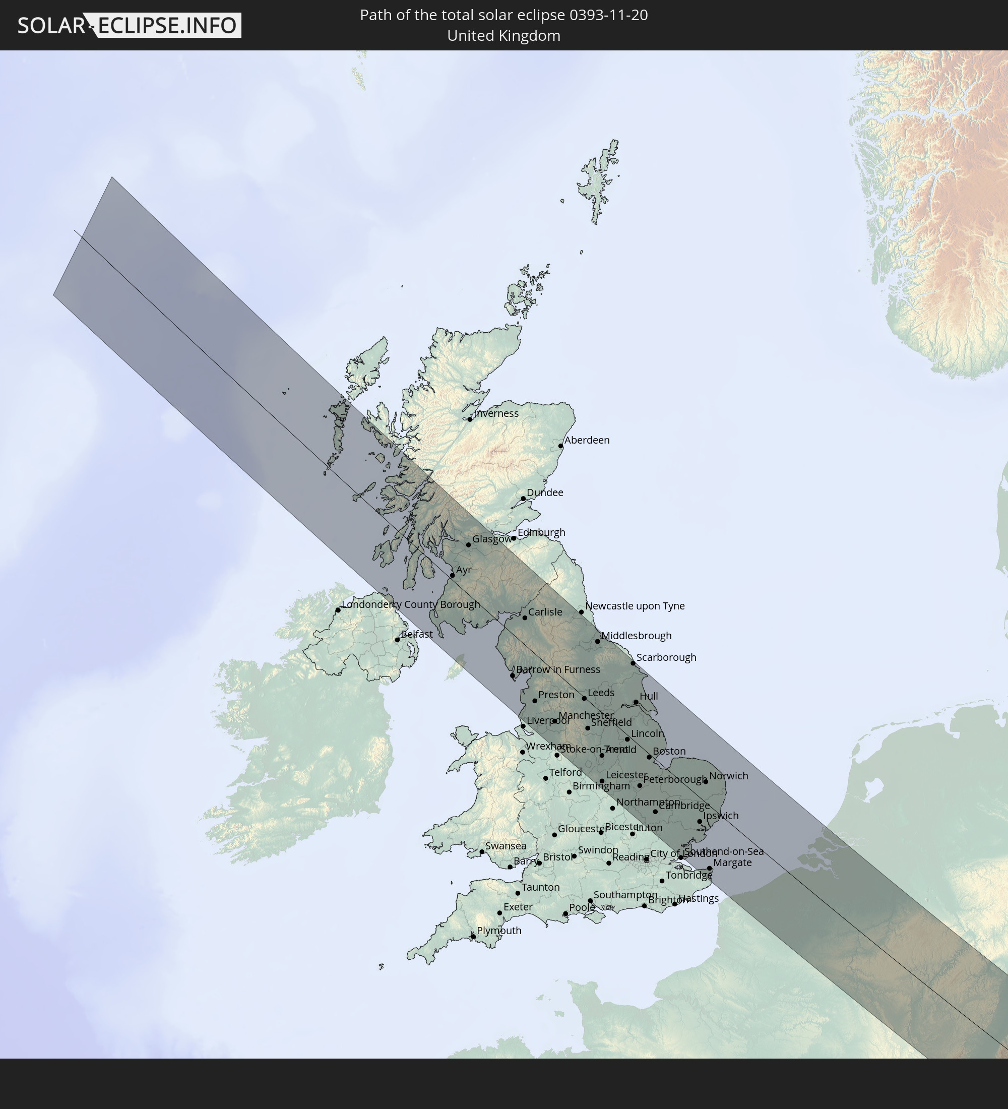 United Kingdom
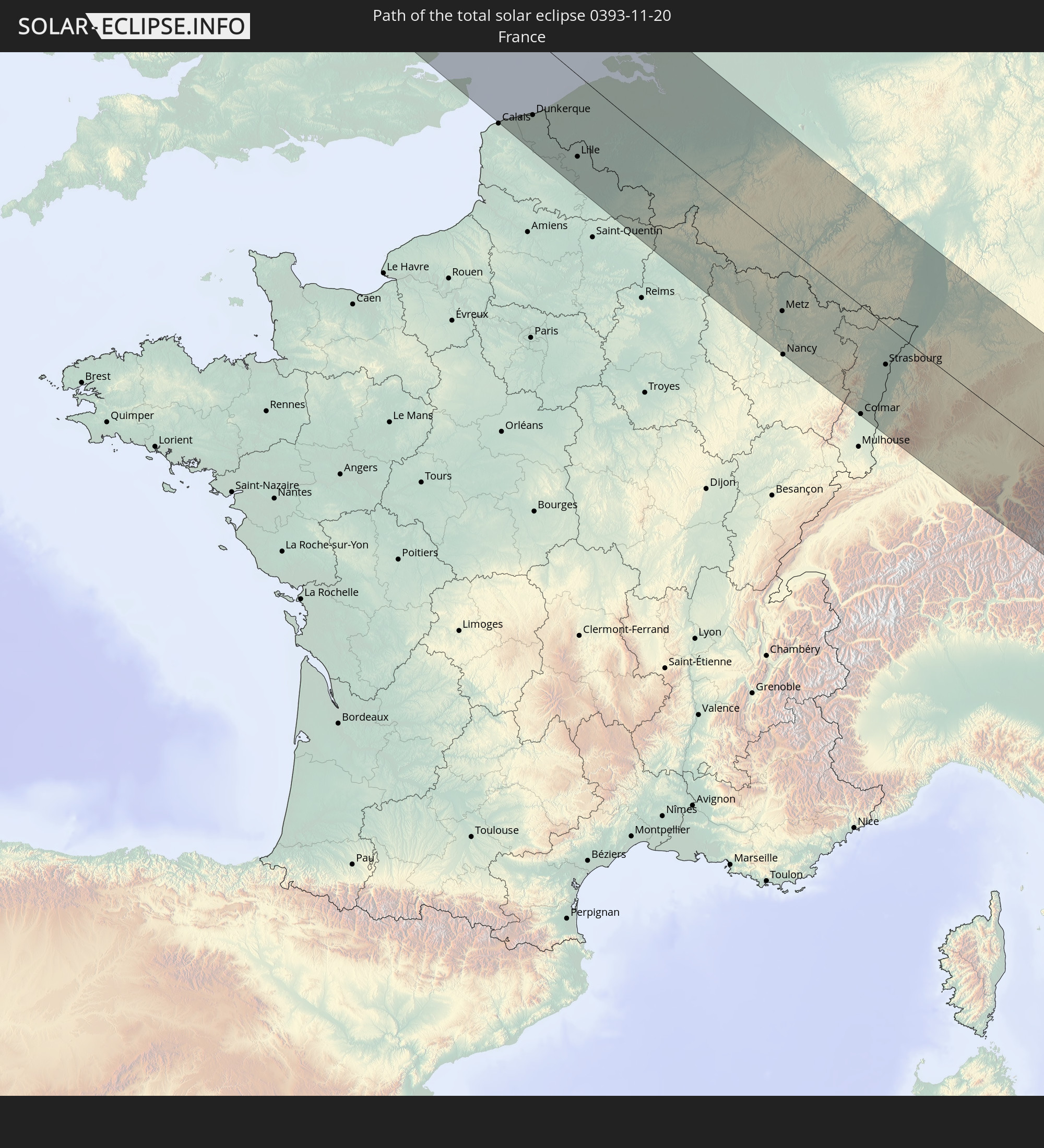 France
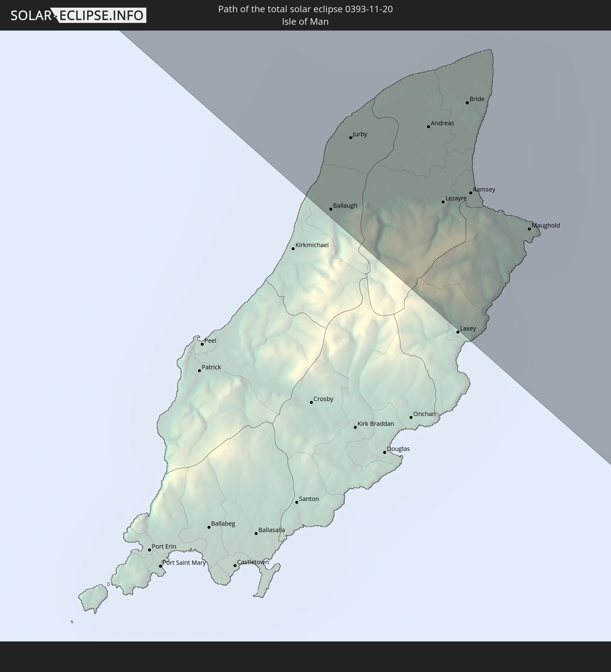 Isle of Man
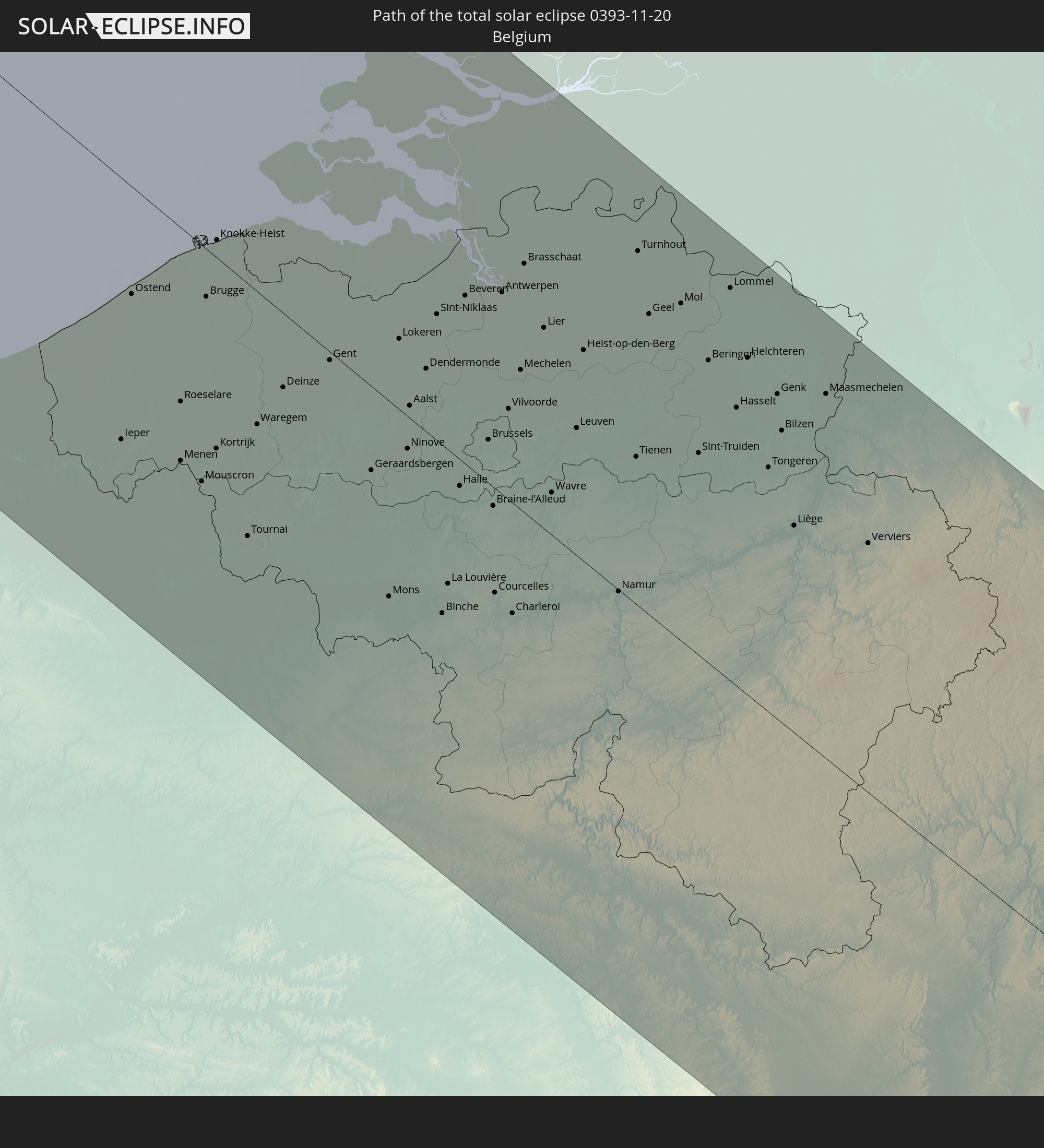 Belgium
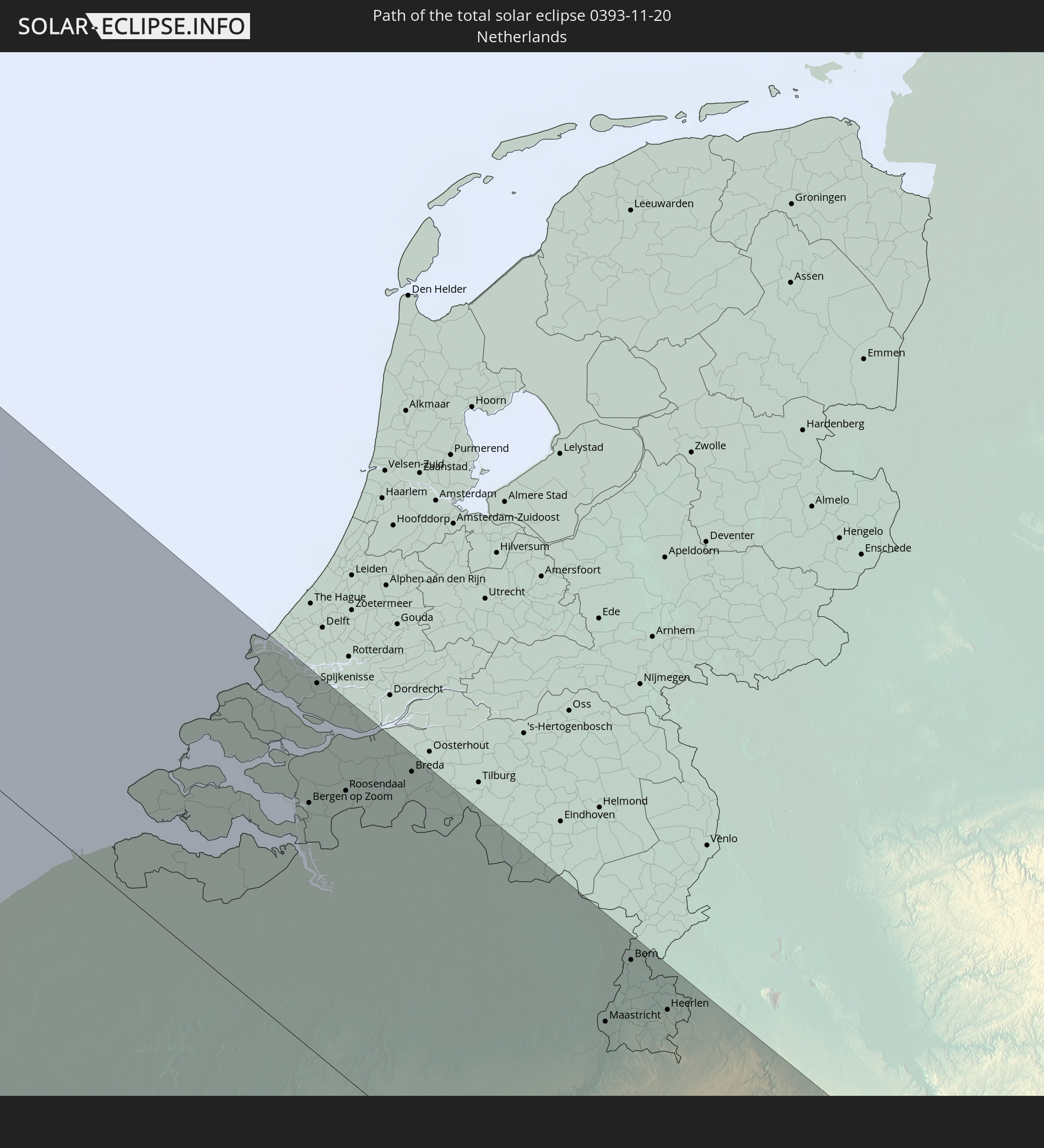 Netherlands
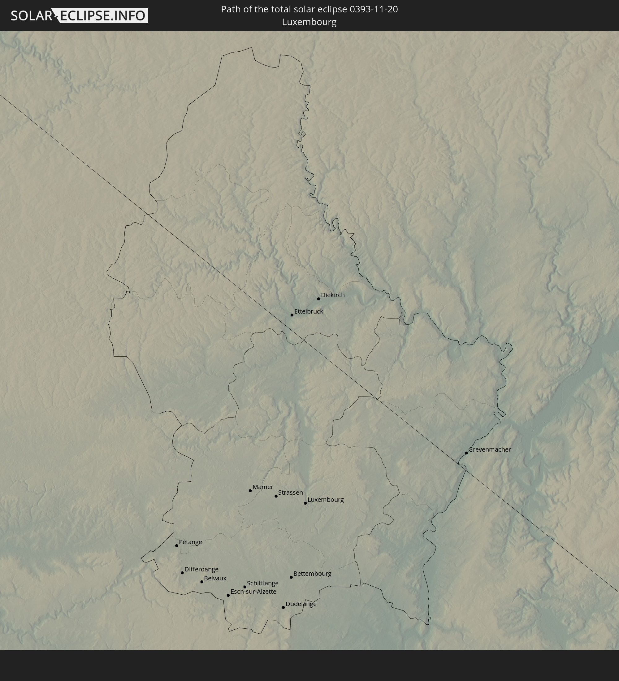 Luxembourg
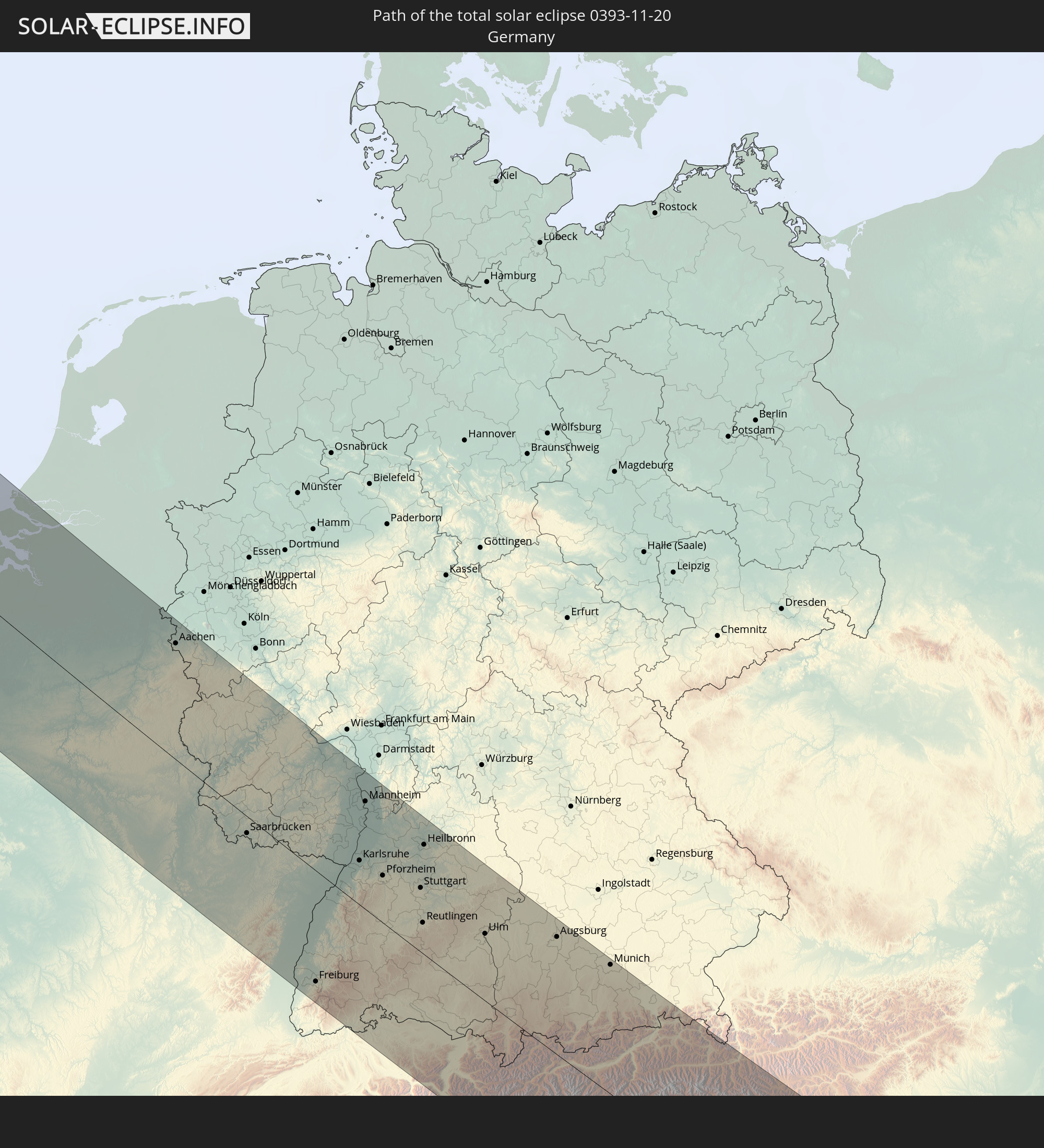 Germany
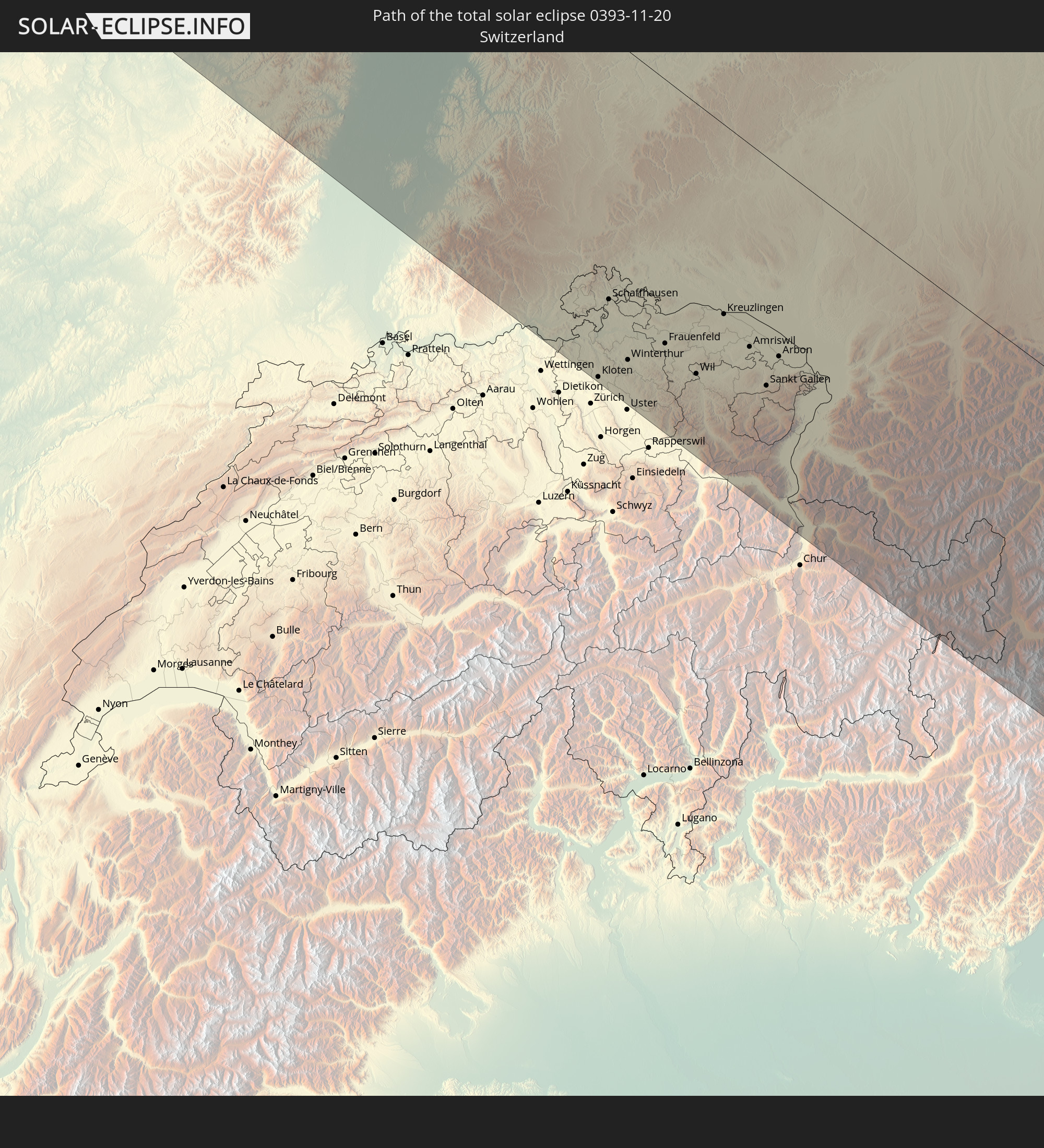 Switzerland
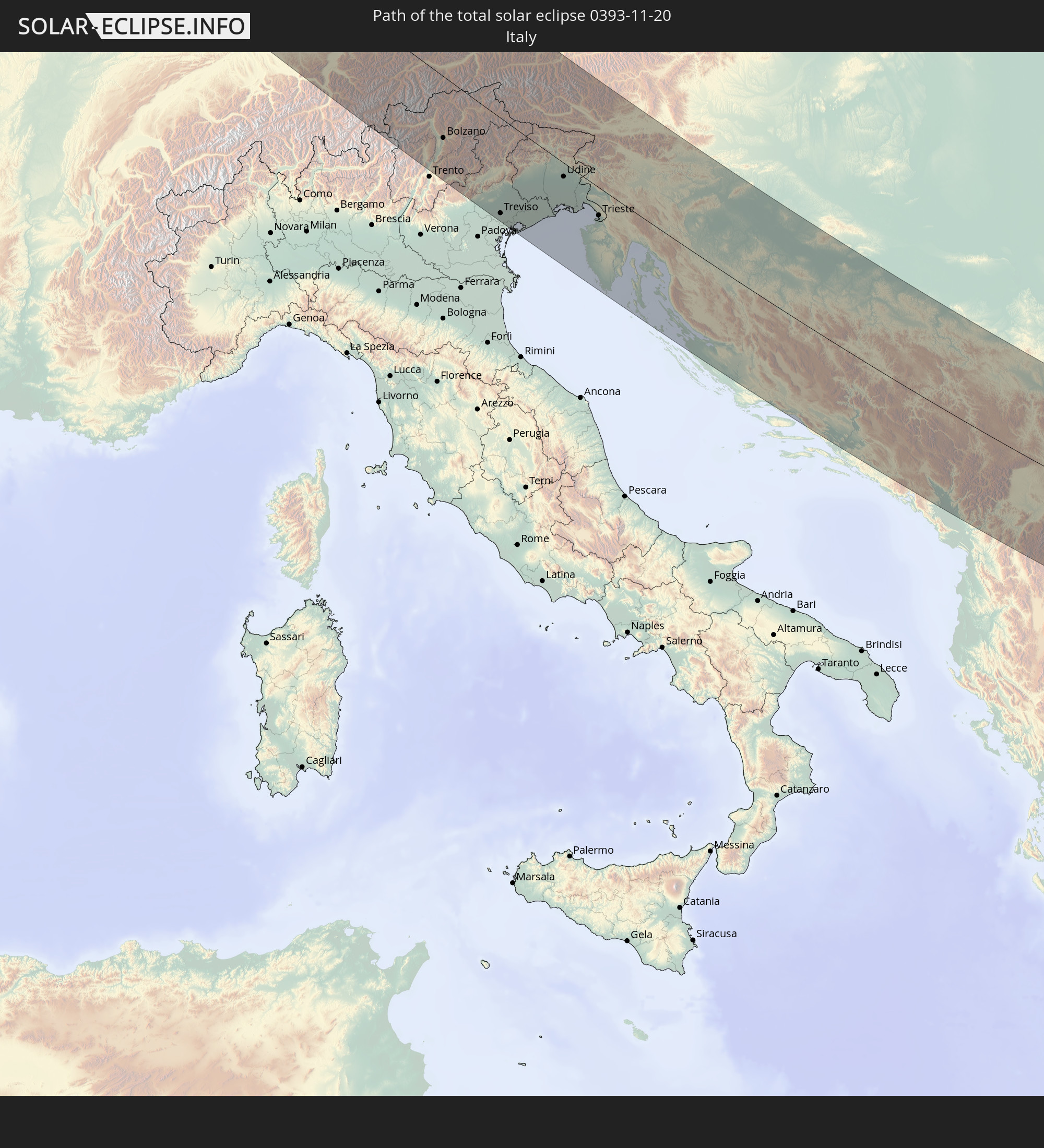 Italy
Italy
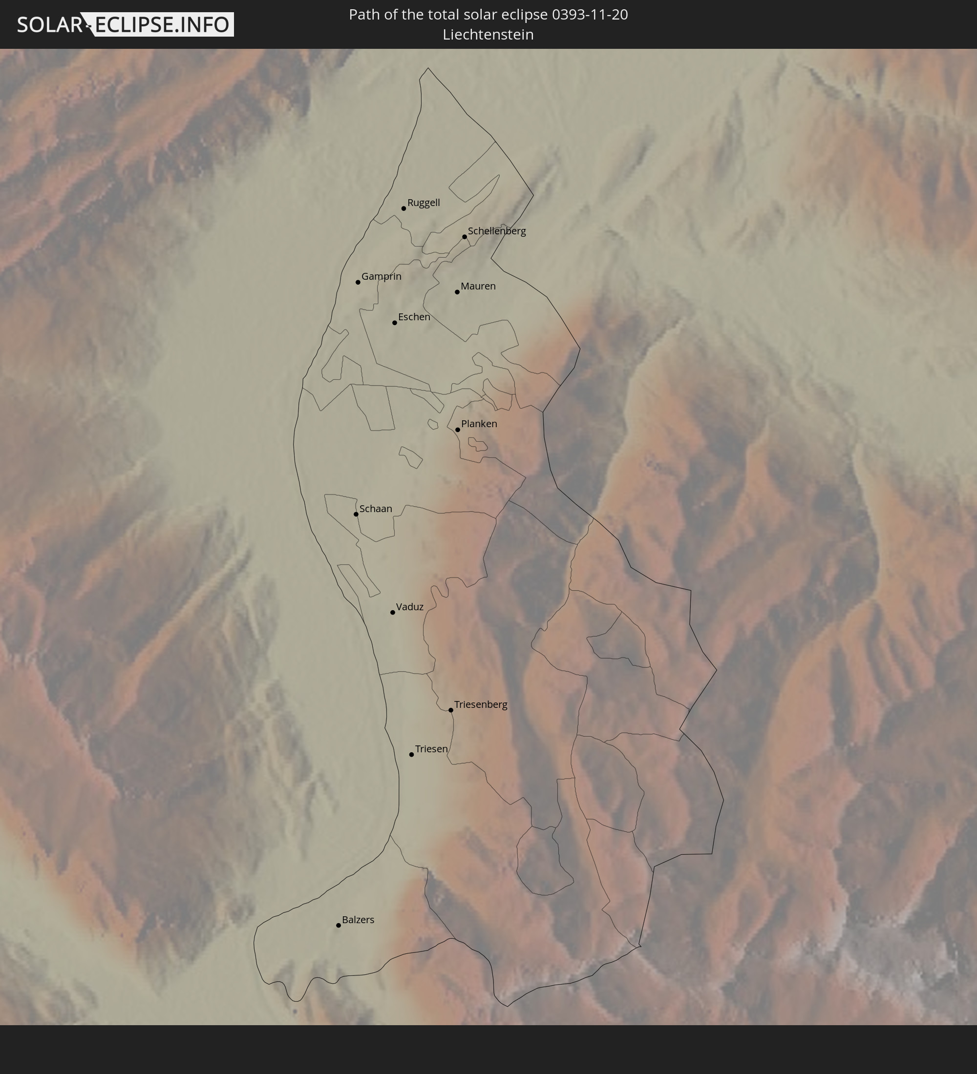 Liechtenstein
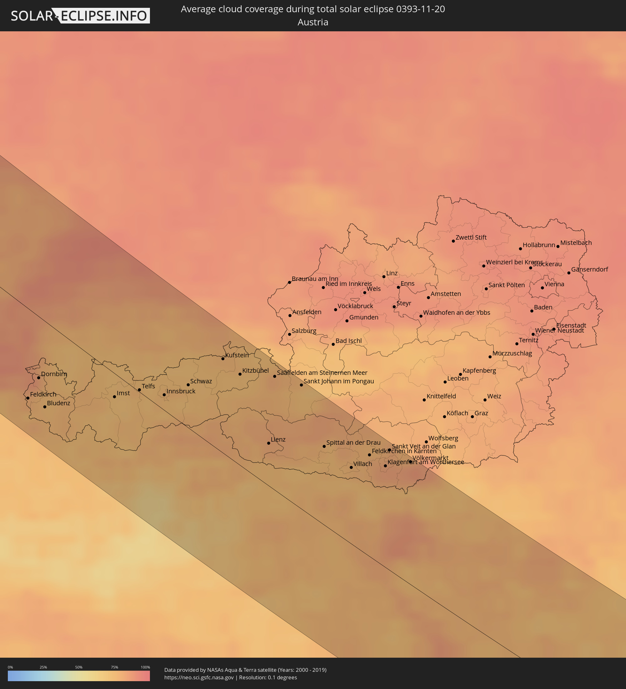
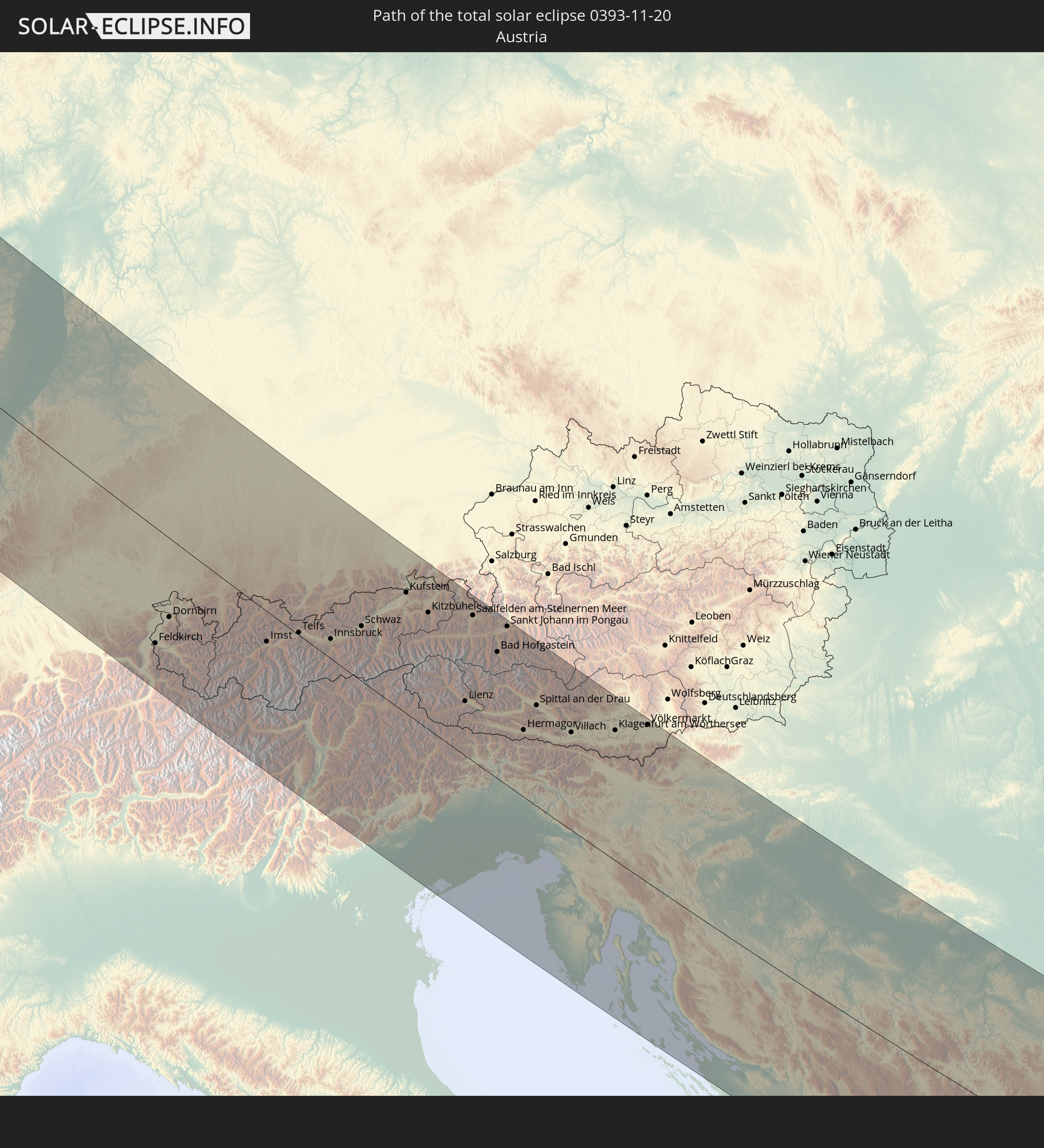 Austria
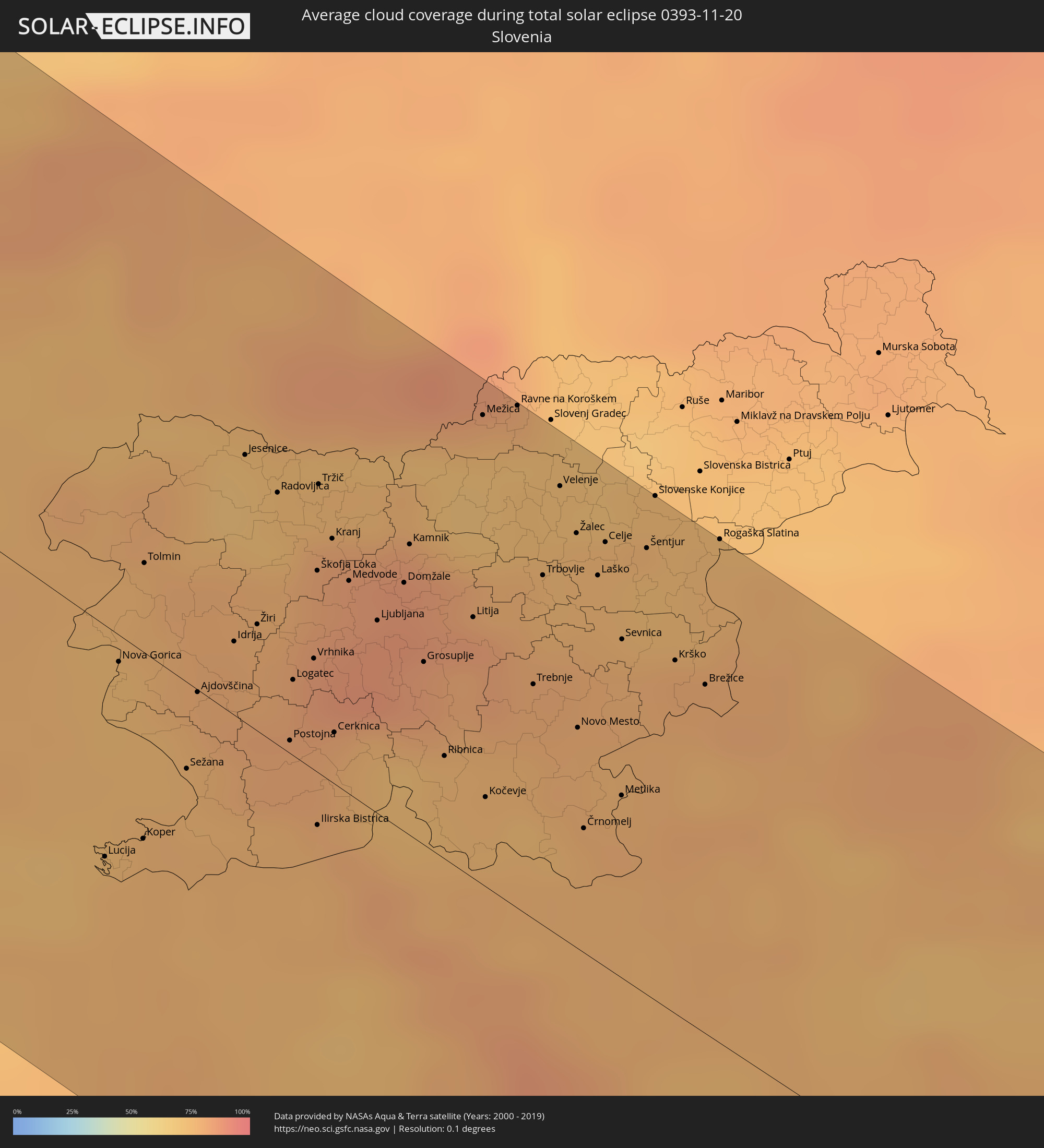
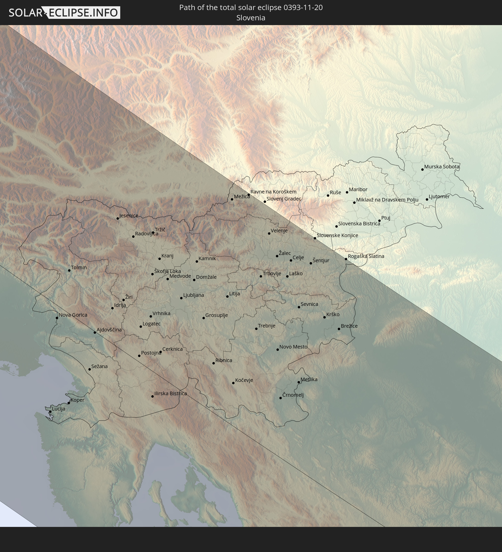 Slovenia
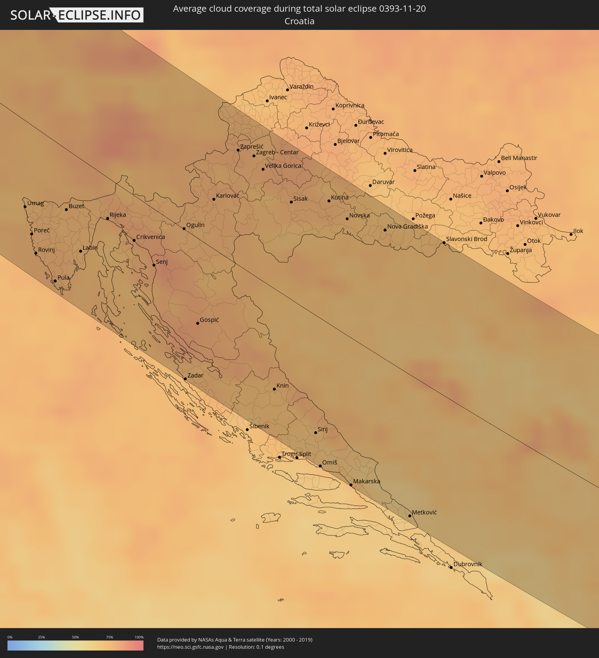
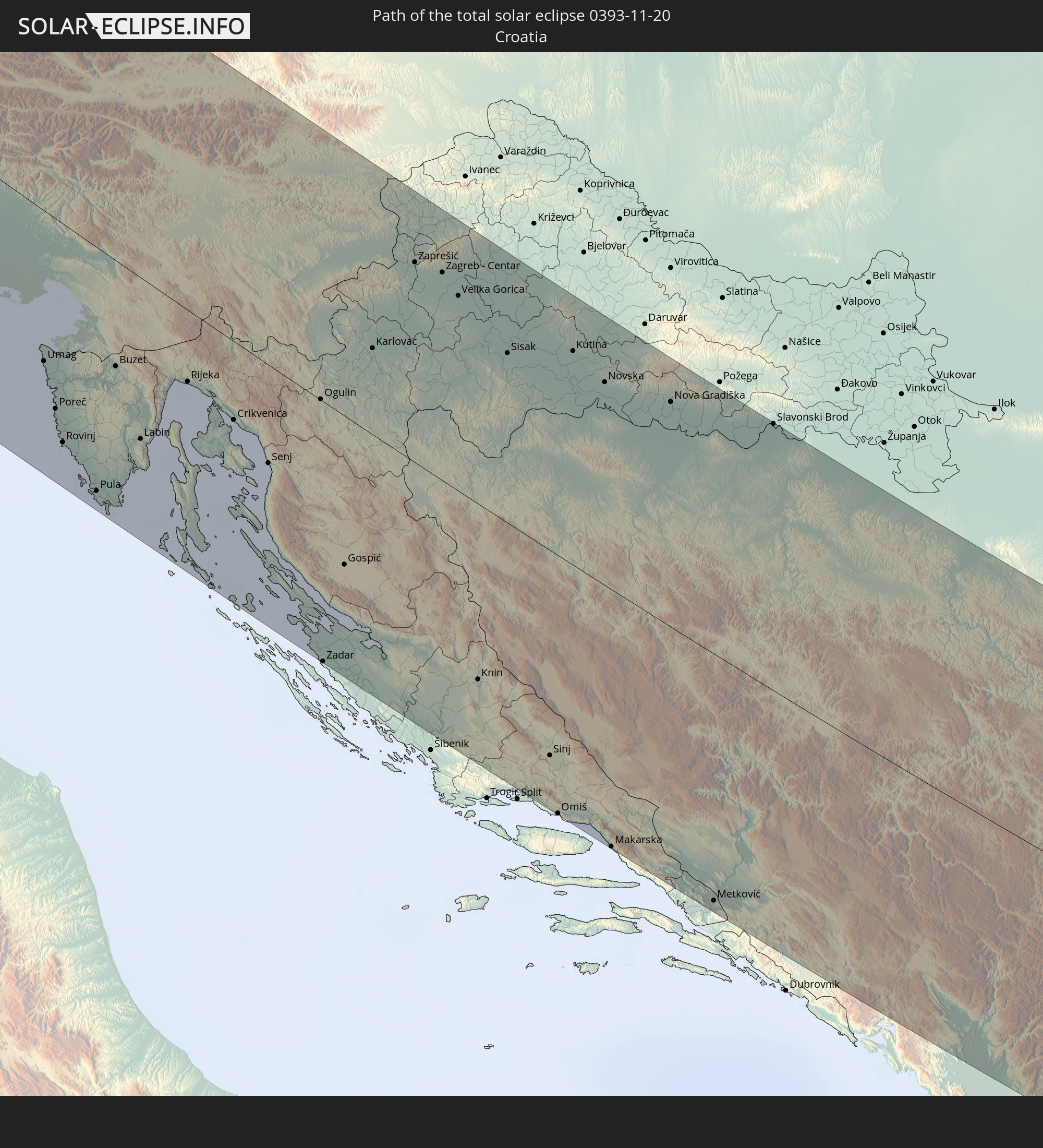 Croatia
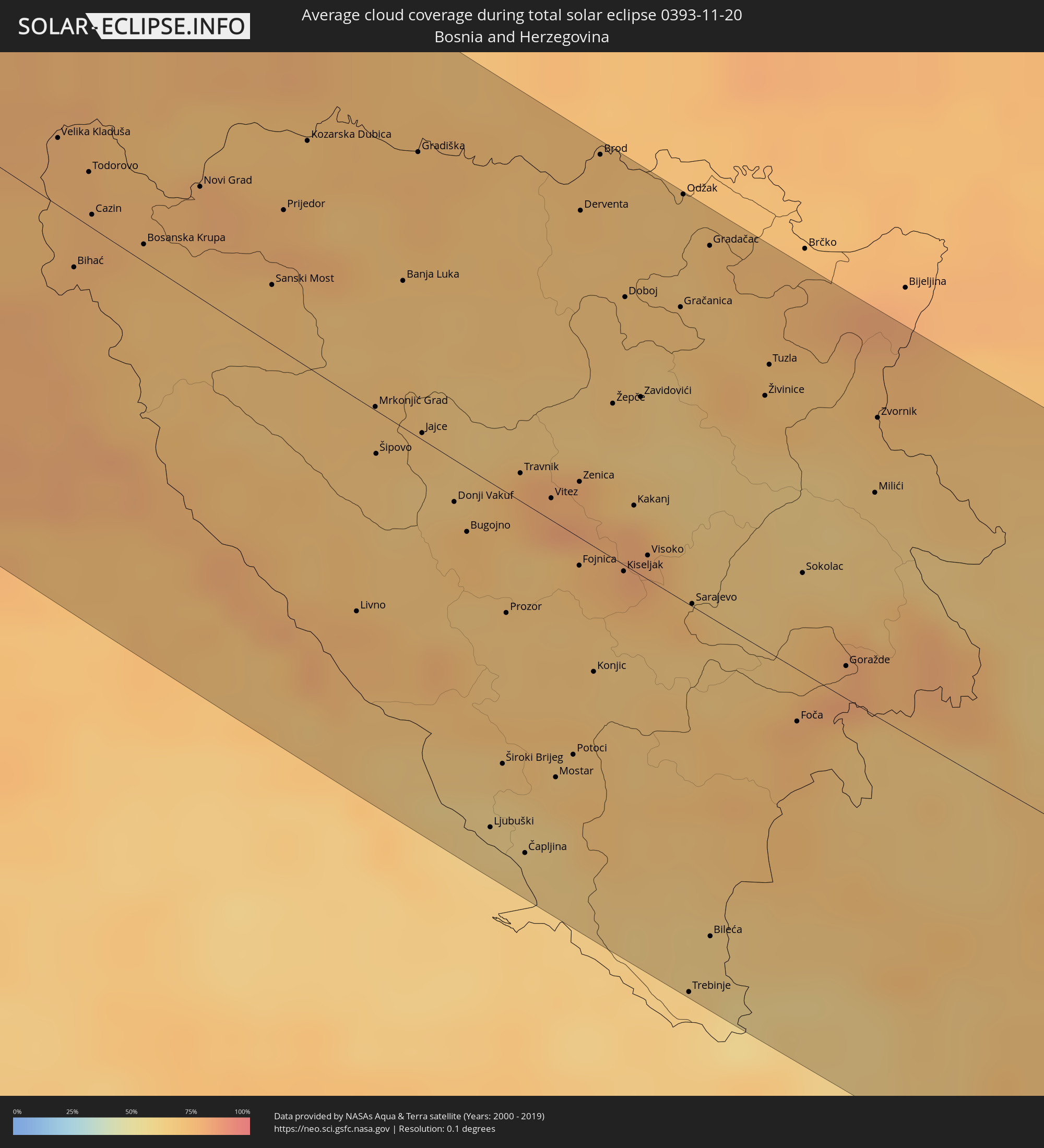
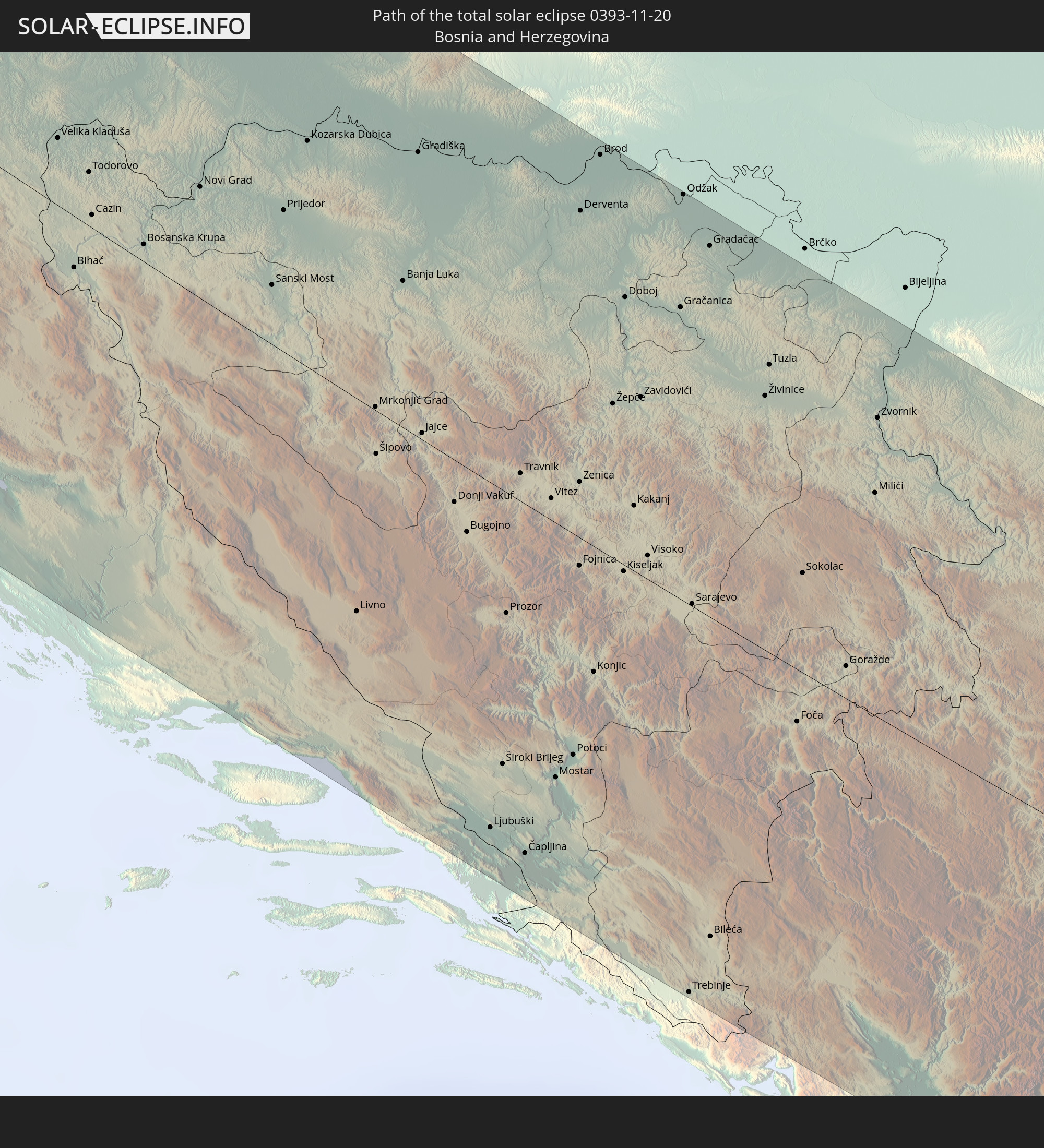 Bosnia and Herzegovina
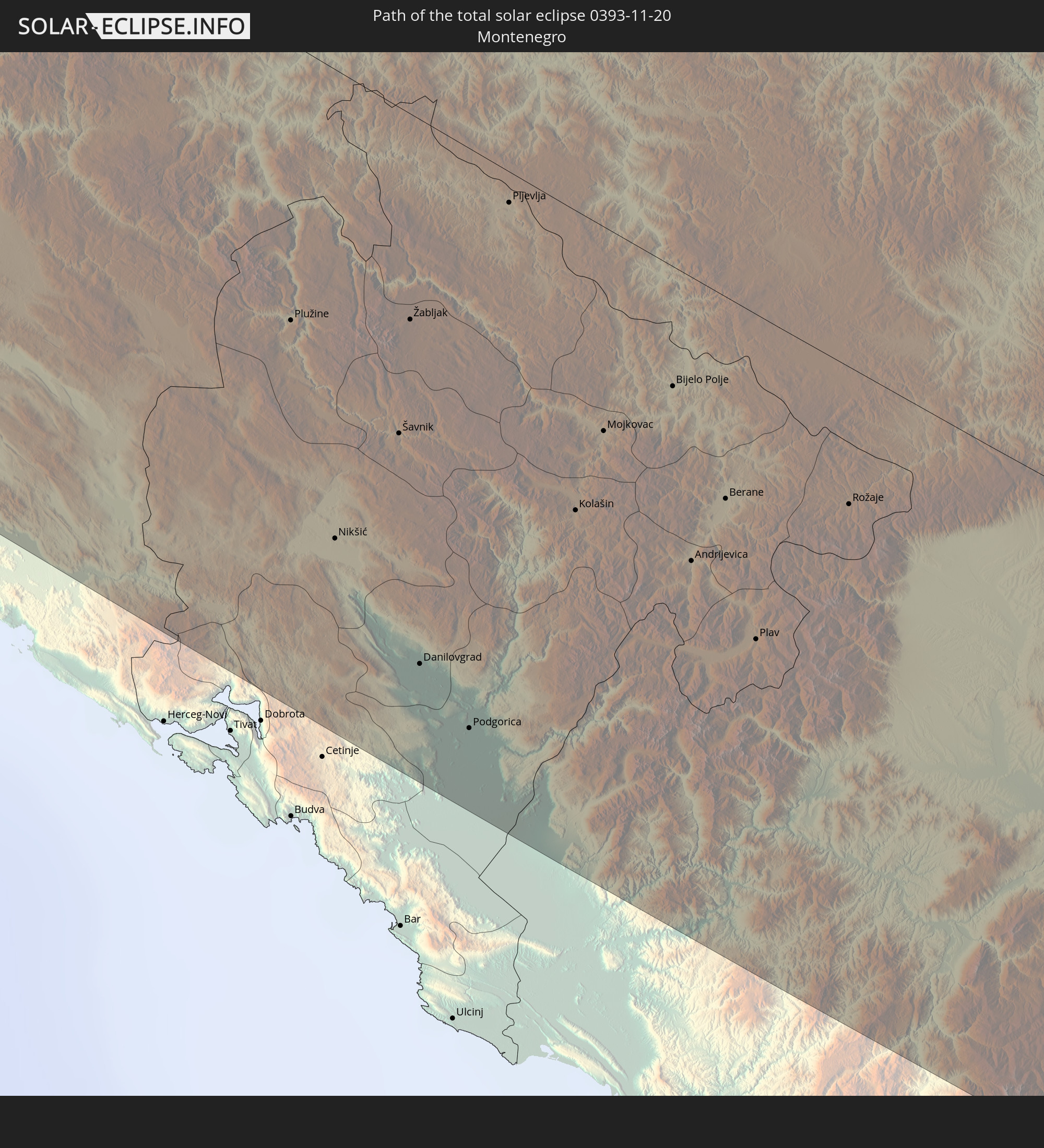 Montenegro
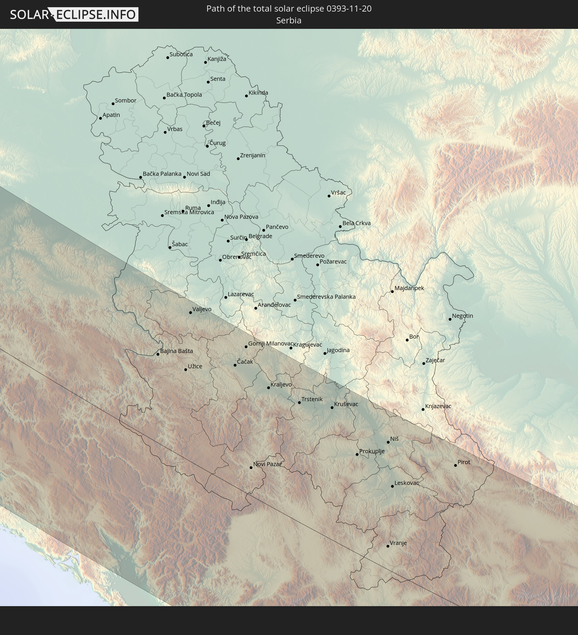 Serbia
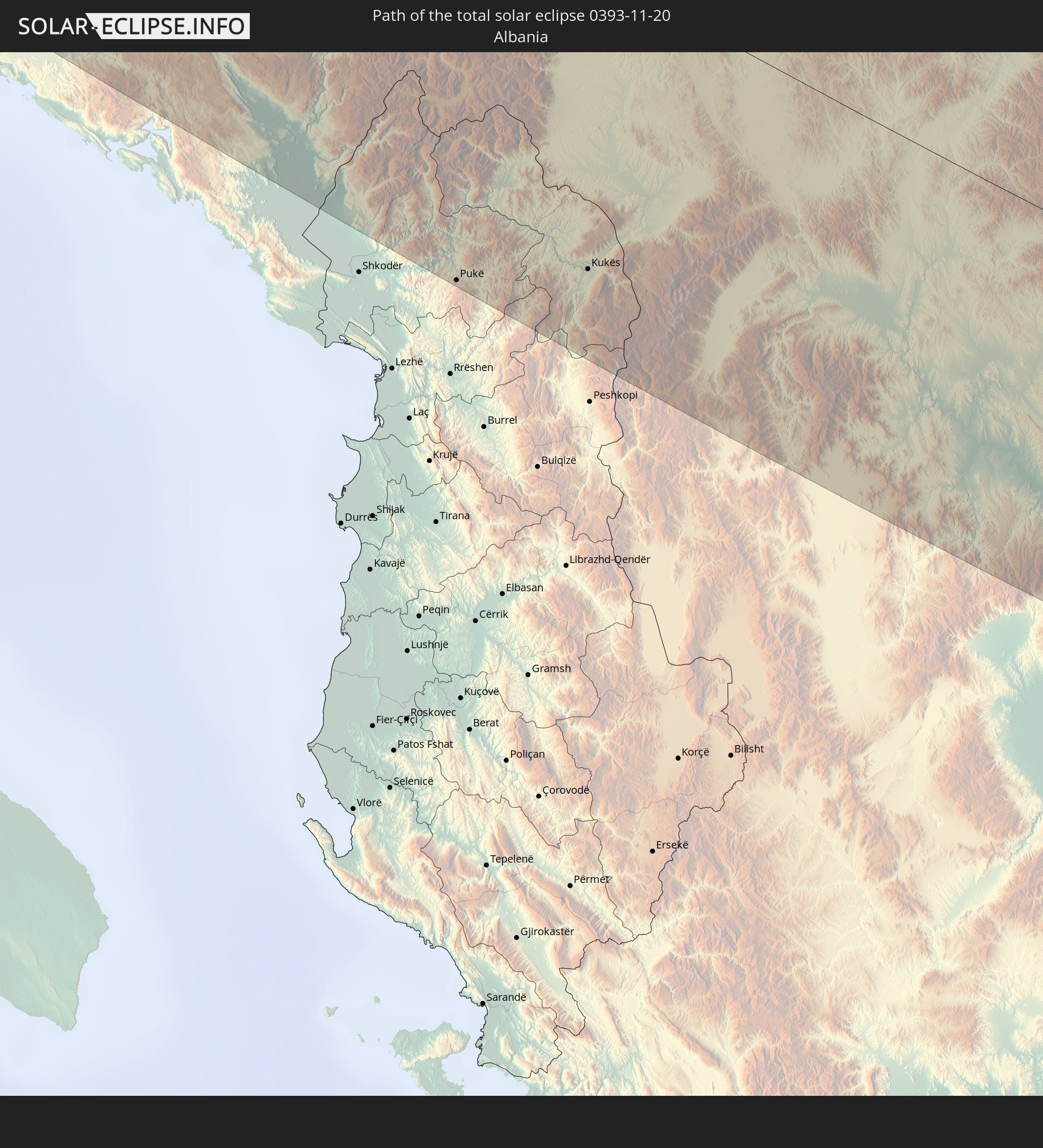 Albania
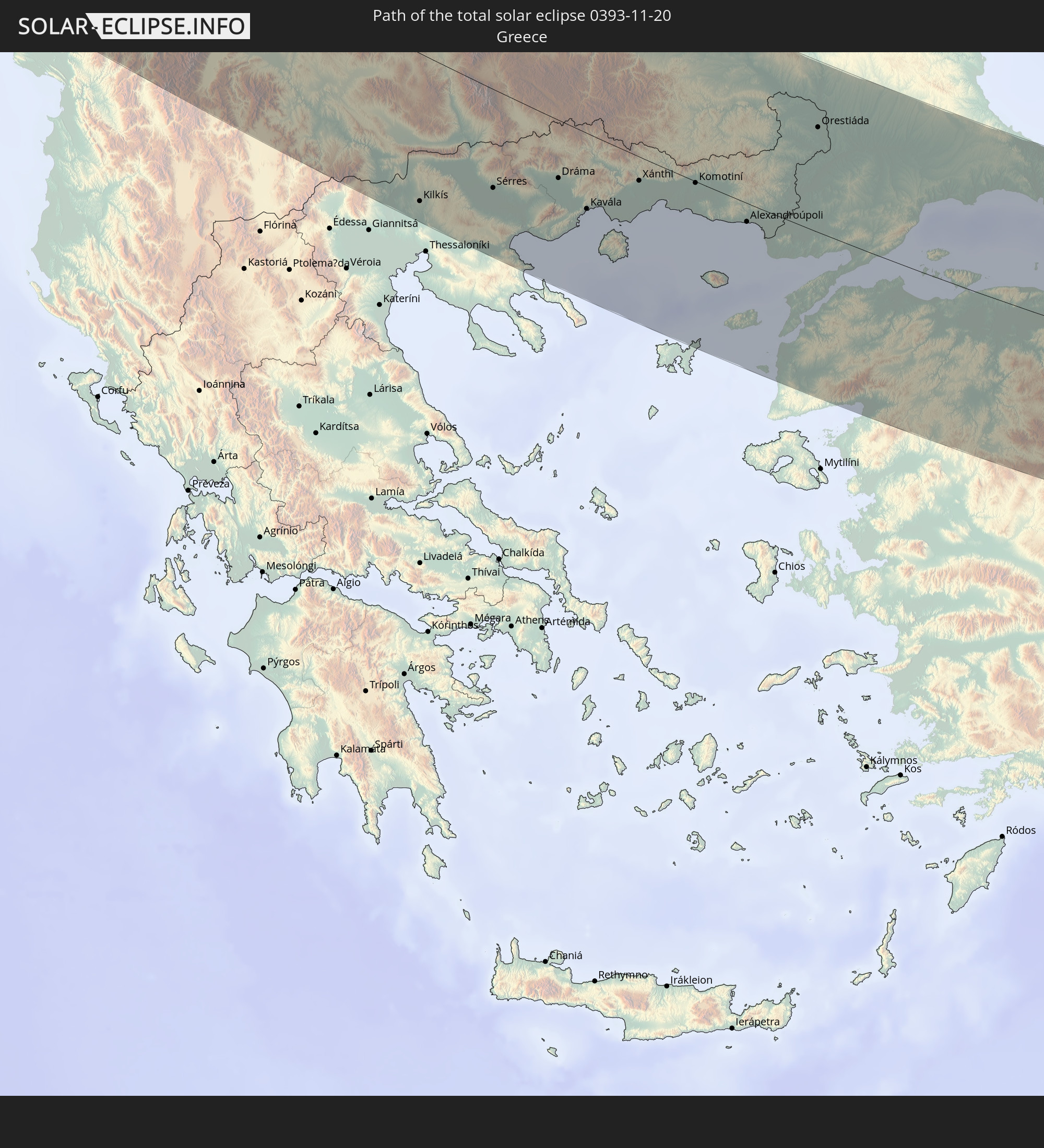 Greece
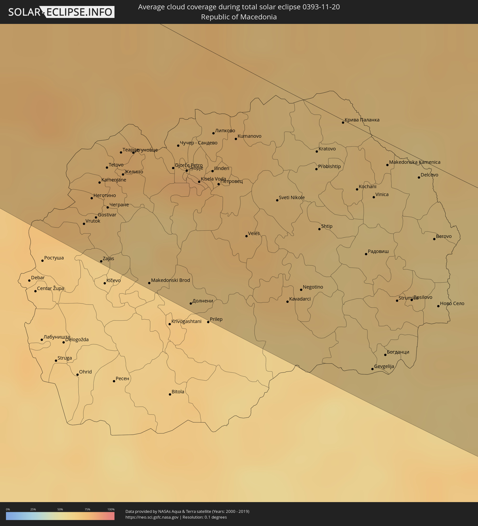
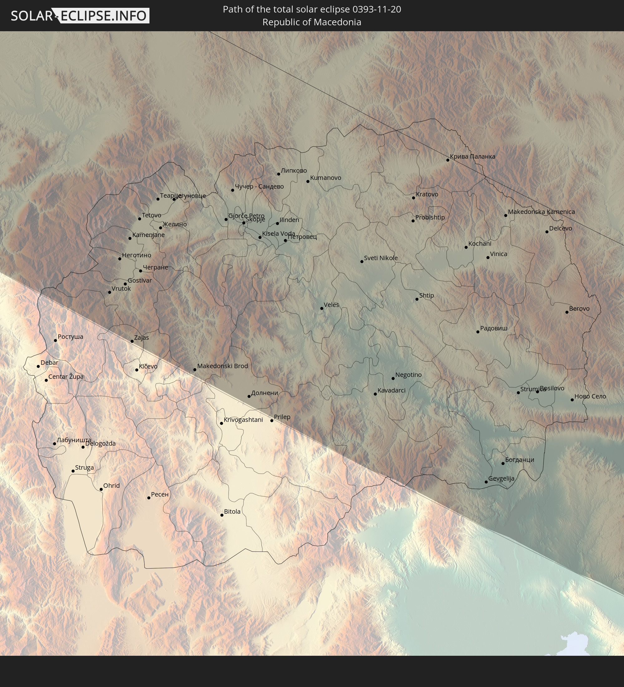 Republic of Macedonia
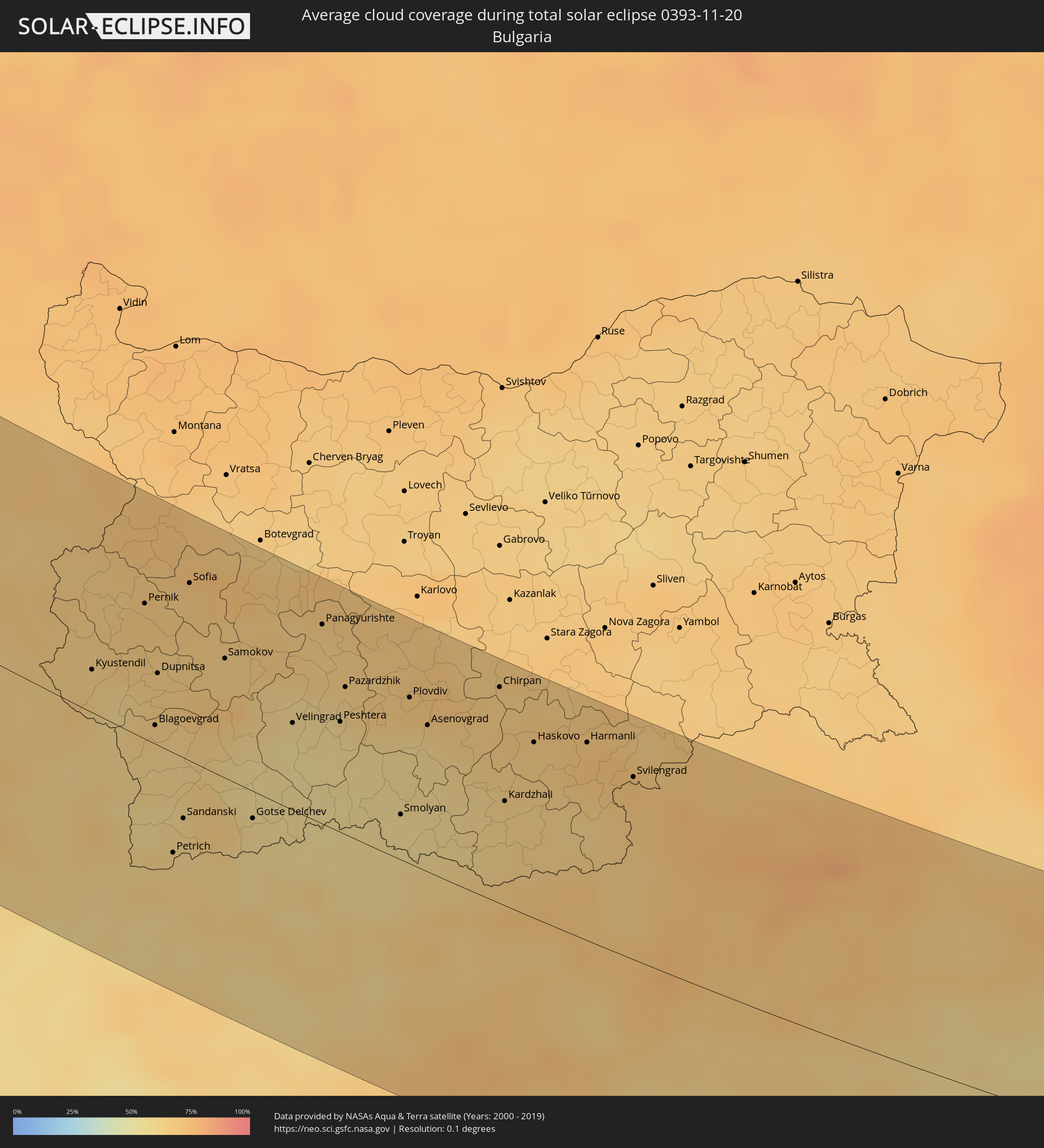
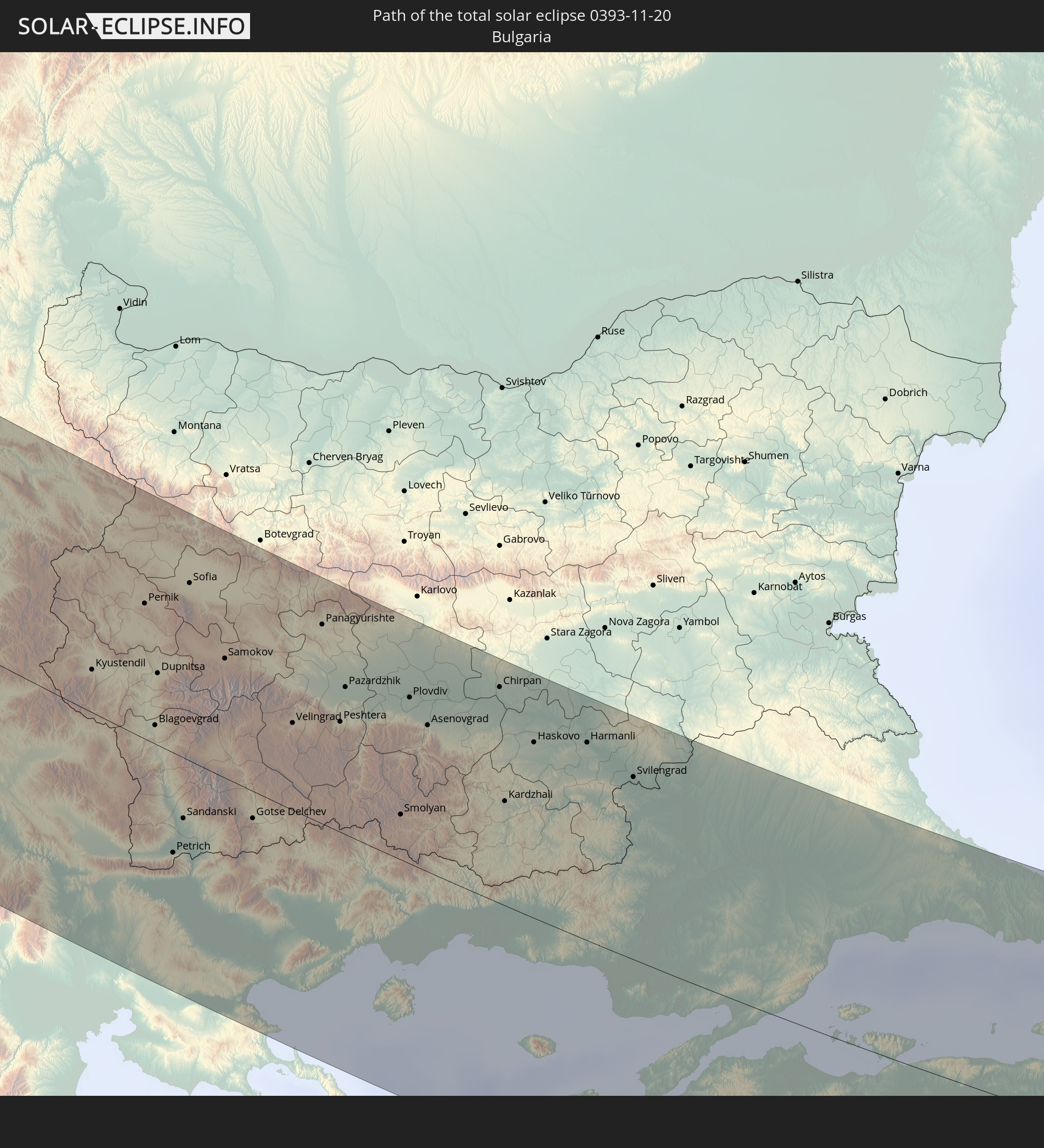 Bulgaria
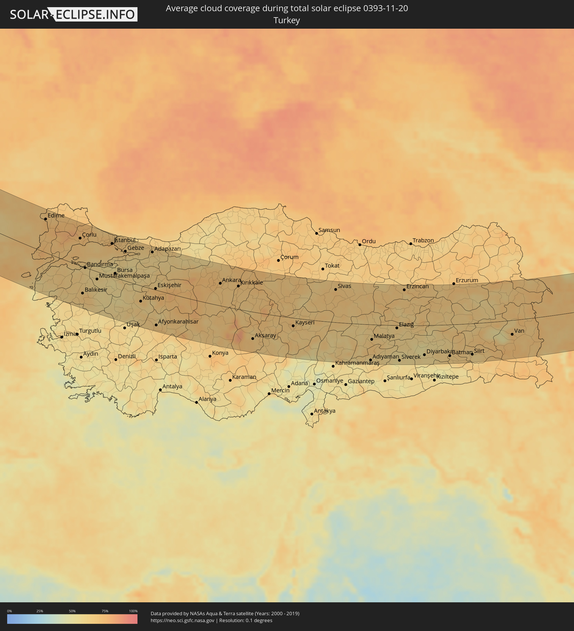
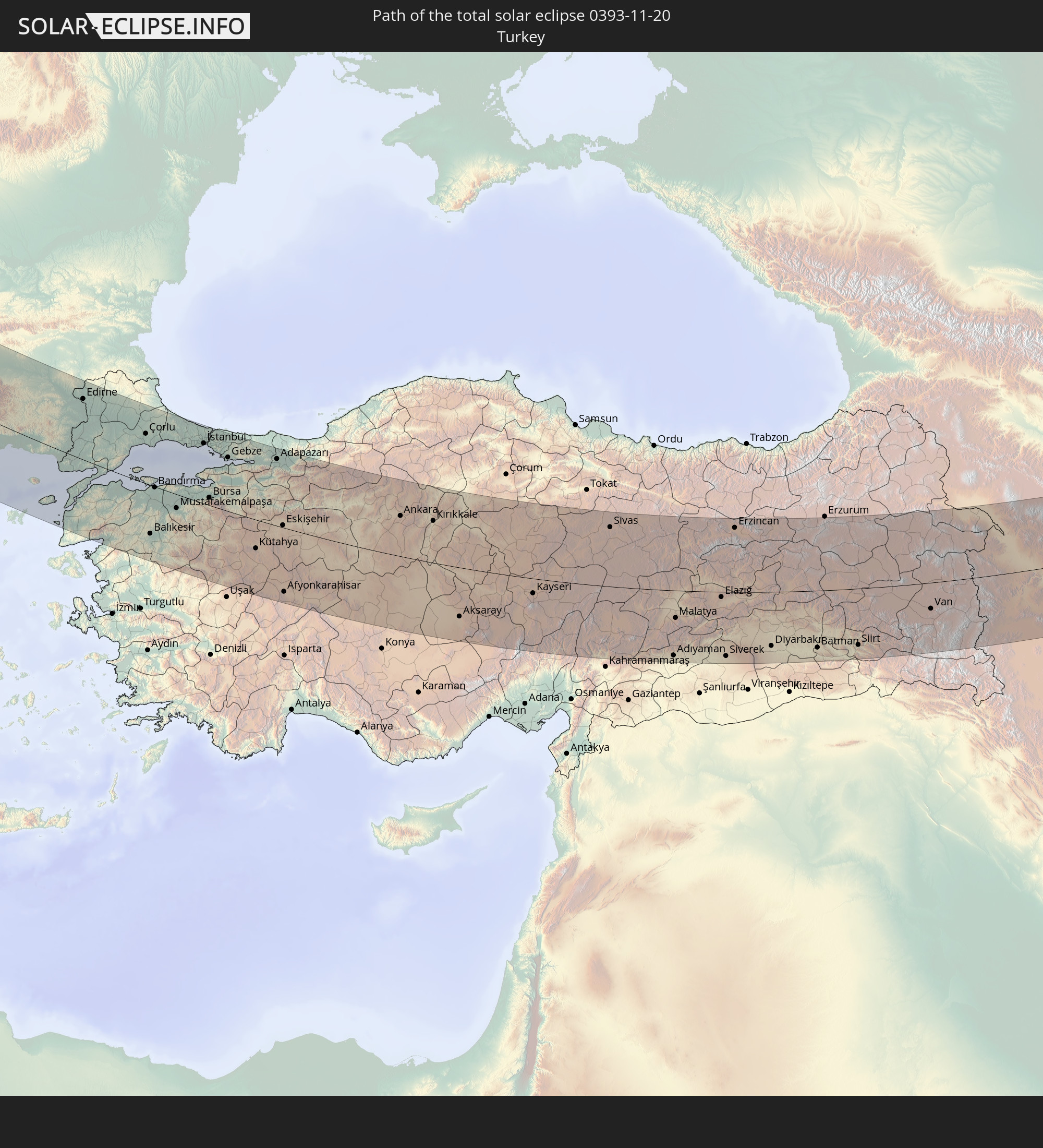 Turkey
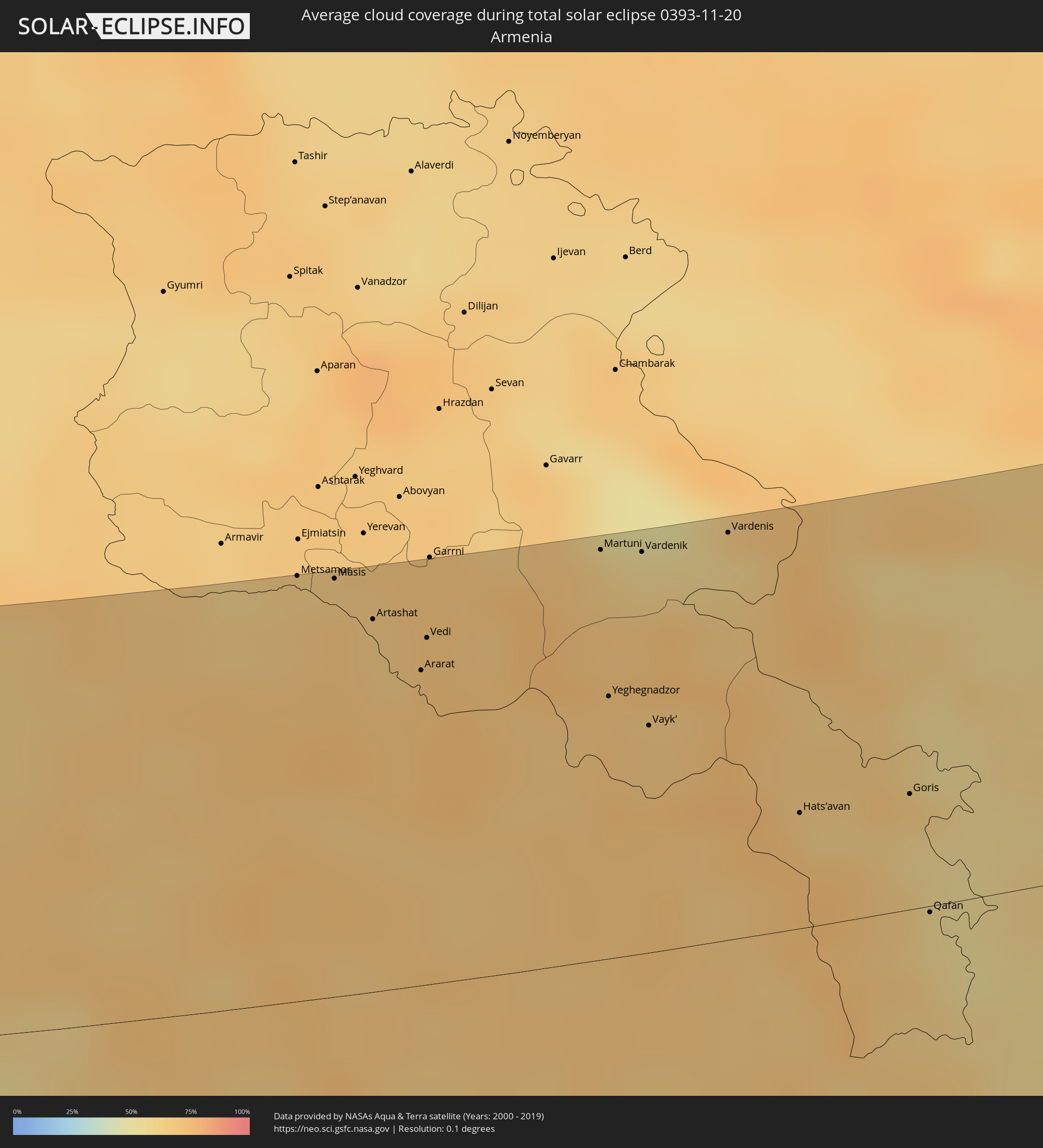
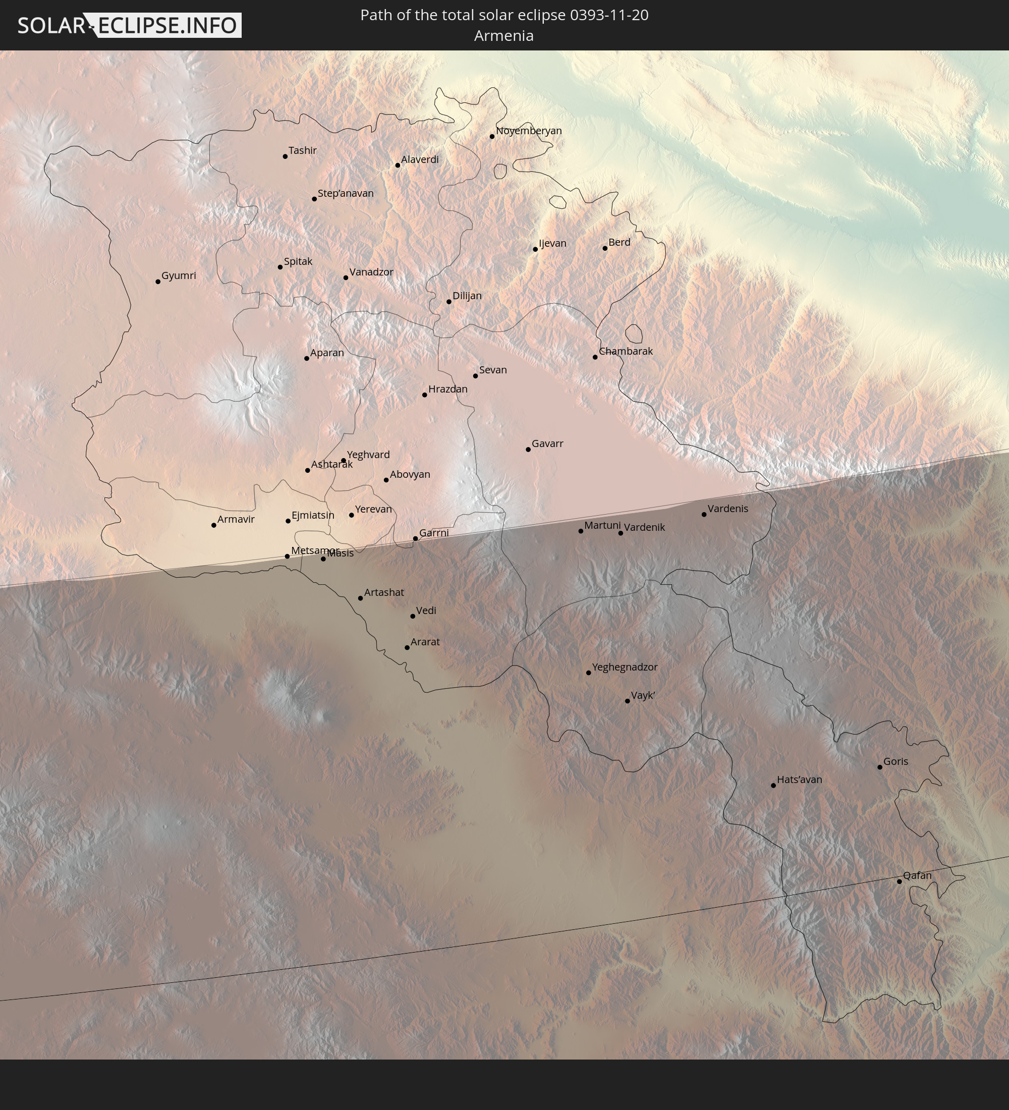 Armenia
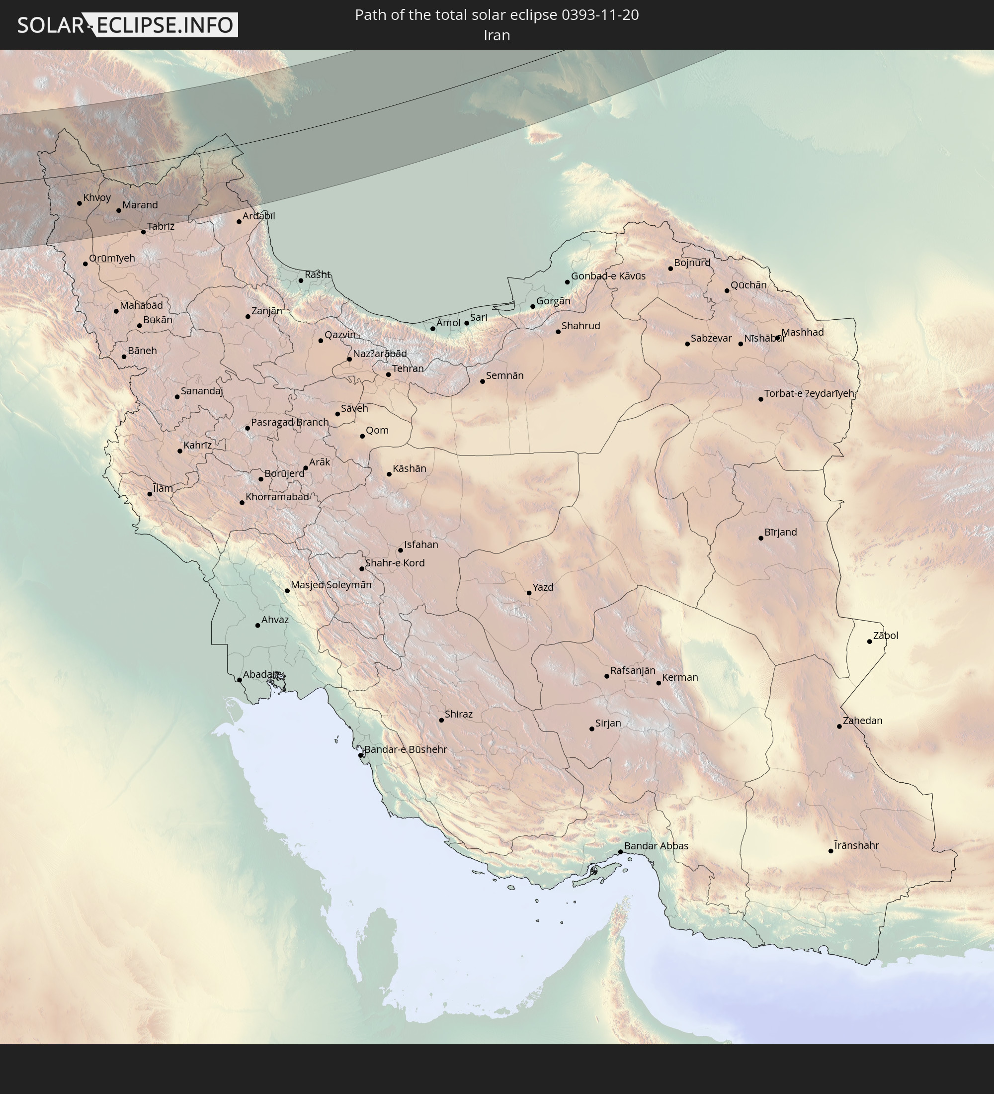 Iran
Iran
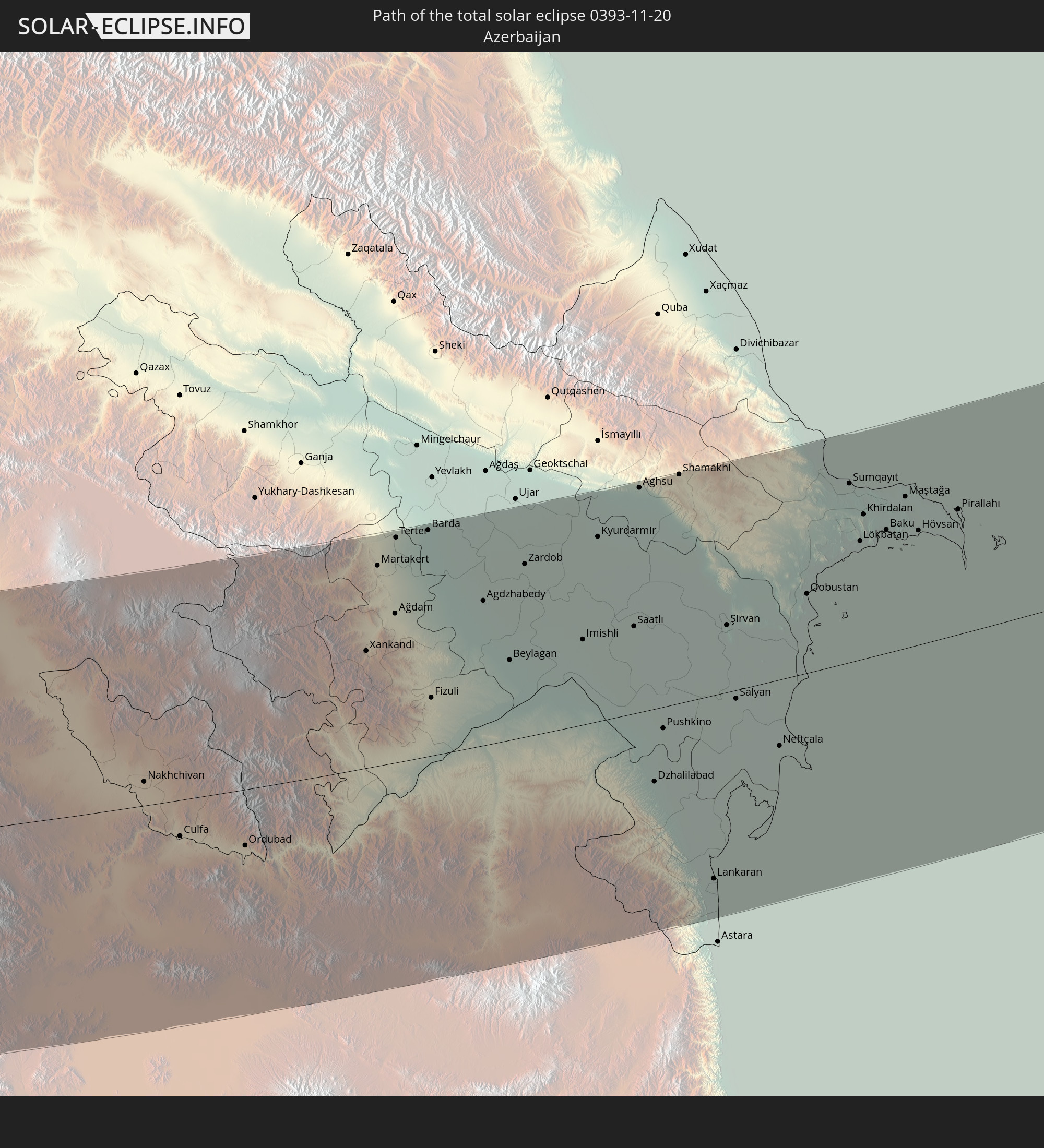 Azerbaijan
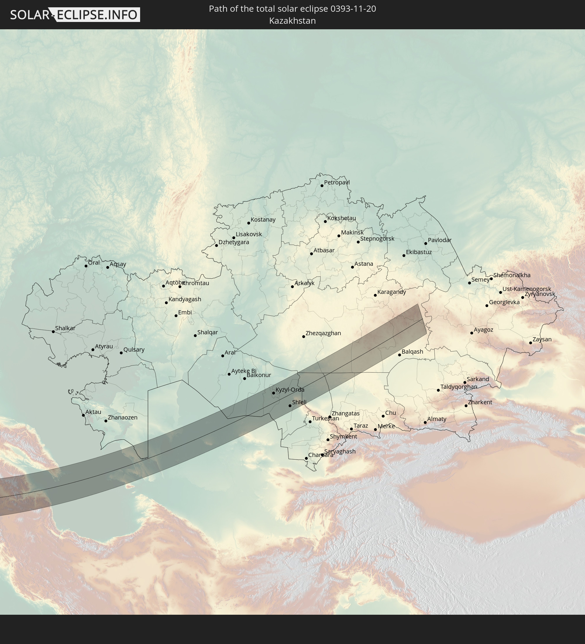 Kazakhstan
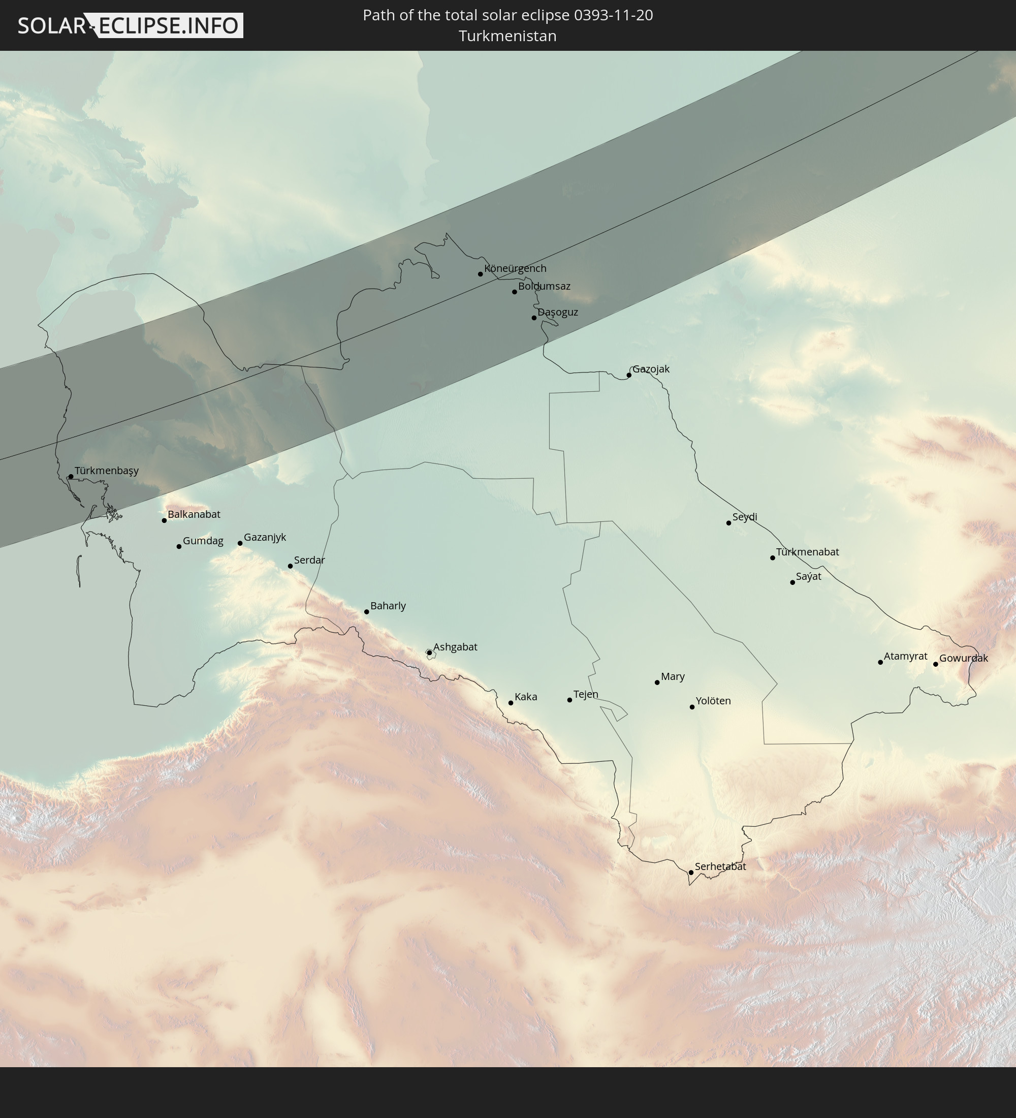 Turkmenistan
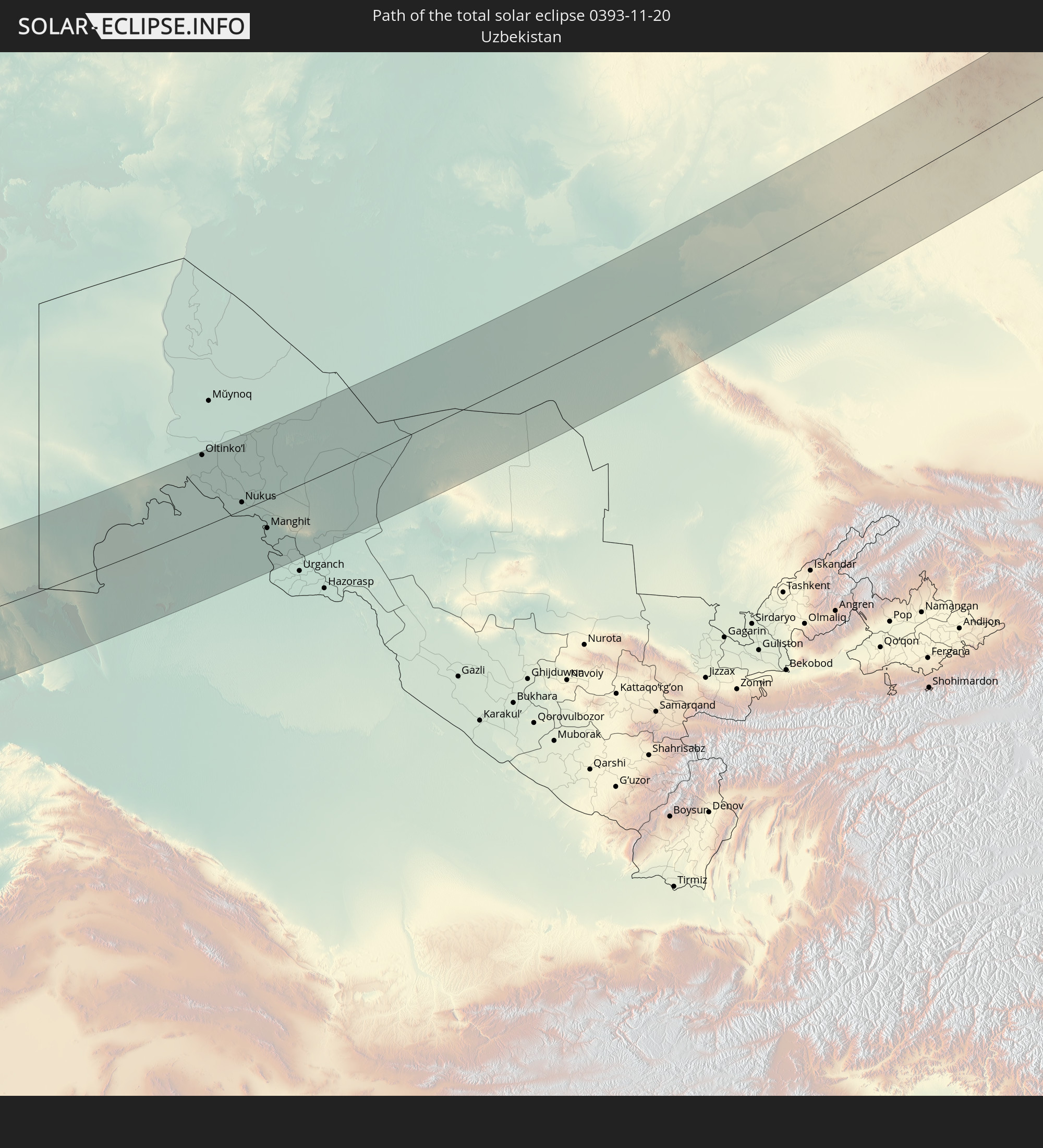 Uzbekistan
In den folgenden Ländern ist die Sonnenfinsternis partiell zu sehen
 Russia
 Portugal
 Spain
Spain
 Senegal
 Mauritania
 Morocco
 Mali
Mali
 Republic of Ireland
 Algeria
 United Kingdom
 Faroe Islands
 Burkina Faso
 Gibraltar
 France
 Isle of Man
 Ghana
Ghana
 Guernsey
 Jersey
 Togo
Togo
 Niger
Niger
 Benin
Benin
 Andorra
 Belgium
 Nigeria
 Netherlands
 Norway
 Luxembourg
 Germany
 Switzerland
 Italy
Italy
 Monaco
 Tunisia
 Denmark
 Cameroon
 Libya
Libya
 Liechtenstein
 Austria
 Sweden
 Republic of the Congo
 Czechia
 Democratic Republic of the Congo
 San Marino
 Vatican City
 Slovenia
 Chad
Chad
 Croatia
 Poland
 Malta
Malta
 Central African Republic
 Bosnia and Herzegovina
 Hungary
 Slovakia
 Montenegro
 Serbia
 Albania
 Åland Islands
 Greece
 Romania
 Republic of Macedonia
 Finland
 Lithuania
 Latvia
 Estonia
 Sudan
Sudan
 Ukraine
 Bulgaria
 Belarus
 Egypt
Egypt
 Turkey
 Moldova
 Rwanda
 Tanzania
 Uganda
 Cyprus
 Ethiopia
 Kenya
Kenya
 State of Palestine
 Israel
 Saudi Arabia
 Jordan
 Lebanon
 Syria
Syria
 Eritrea
 Iraq
Iraq
 Georgia
 Somalia
 Djibouti
 Yemen
Yemen
 Armenia
 Iran
Iran
 Azerbaijan
 Kazakhstan
 Kuwait
 Bahrain
 Qatar
Qatar
 United Arab Emirates
 Oman
Oman
 Turkmenistan
 Uzbekistan
 Afghanistan
 Pakistan
 Tajikistan
 India
India
 Kyrgyzstan
 Maldives
 China
China
 Sri Lanka
 Nepal
Nepal
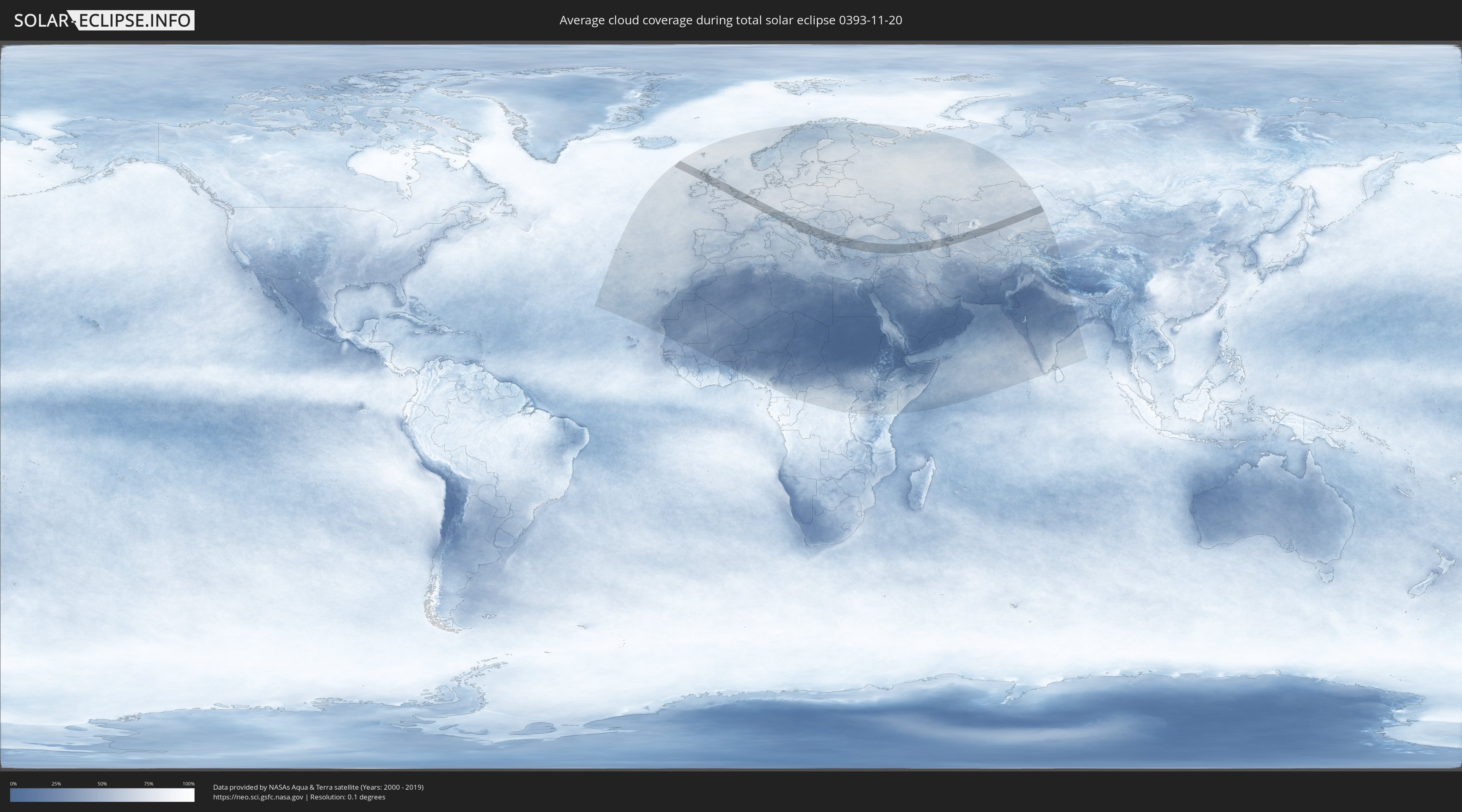
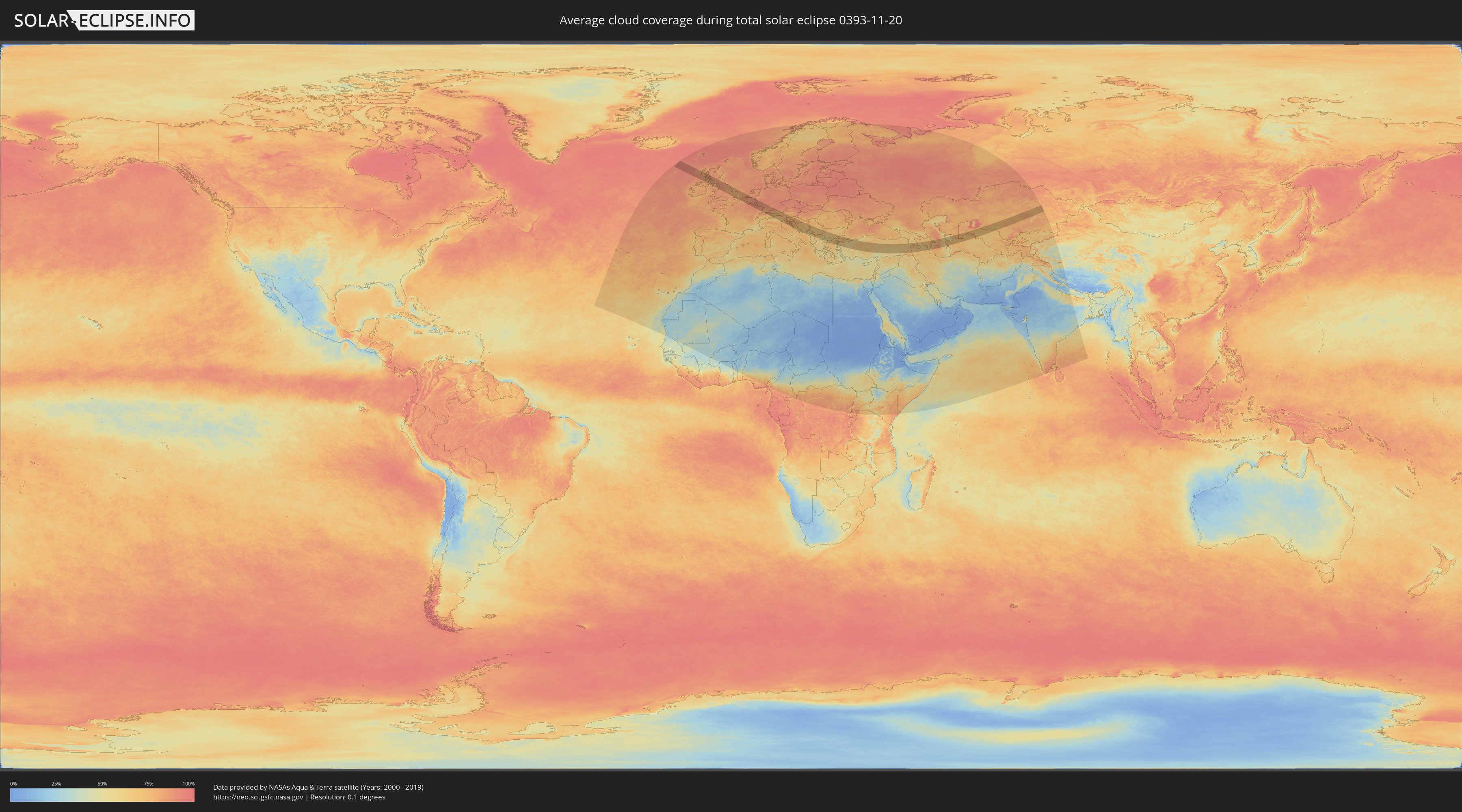
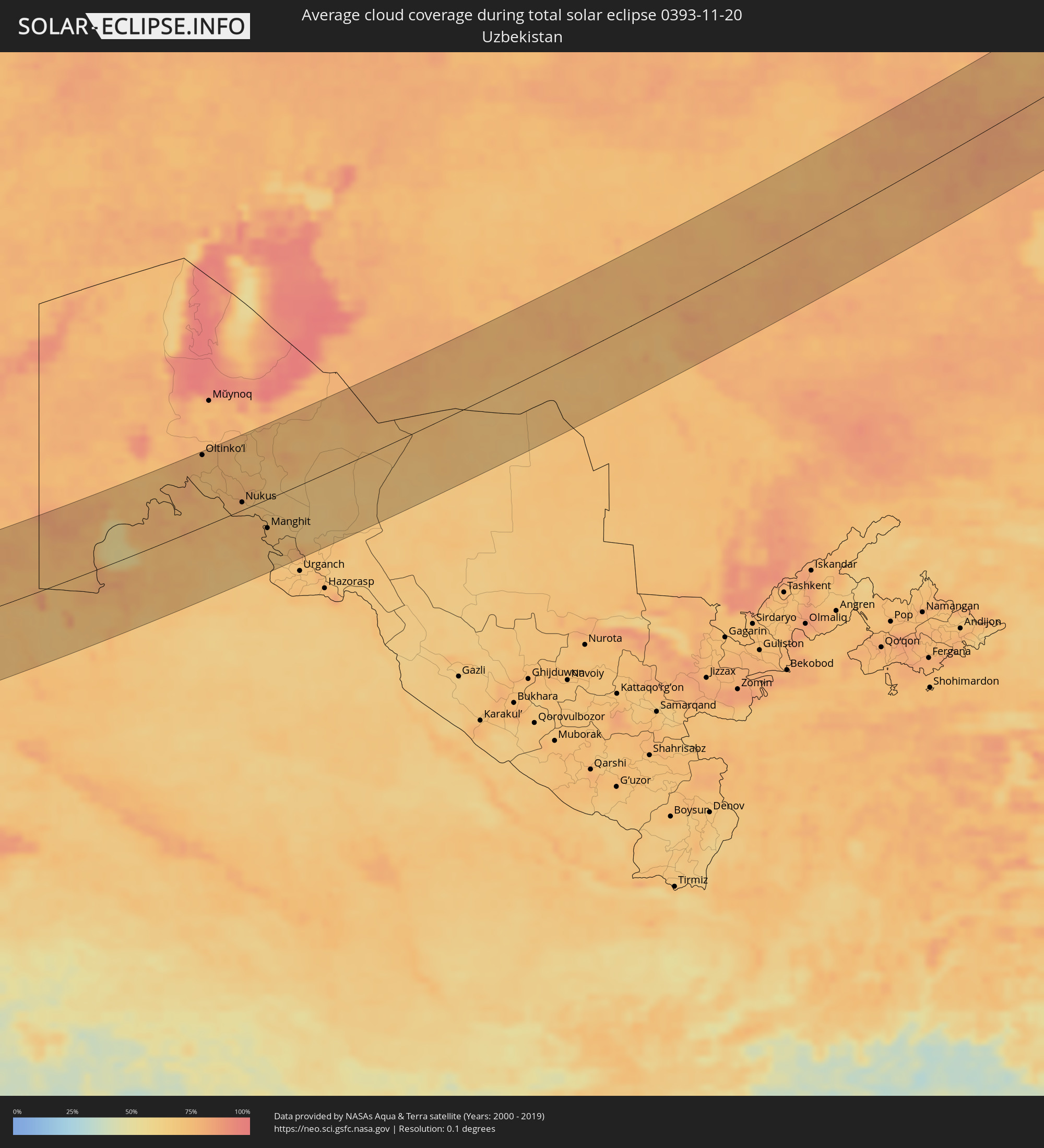
How will be the weather during the total solar eclipse on 11/20/0393?
Where is the best place to see the total solar eclipse of 11/20/0393?
The following maps show the average cloud coverage for the day of the total solar eclipse.
With the help of these maps, it is possible to find the place along the eclipse path, which has the best
chance of a cloudless sky.
Nevertheless, you should consider local circumstances and inform about the weather of your chosen
observation site.
The data is provided by NASAs satellites
AQUA and TERRA.
The cloud maps are averaged over a period of 19 years (2000 - 2019).
Detailed country maps
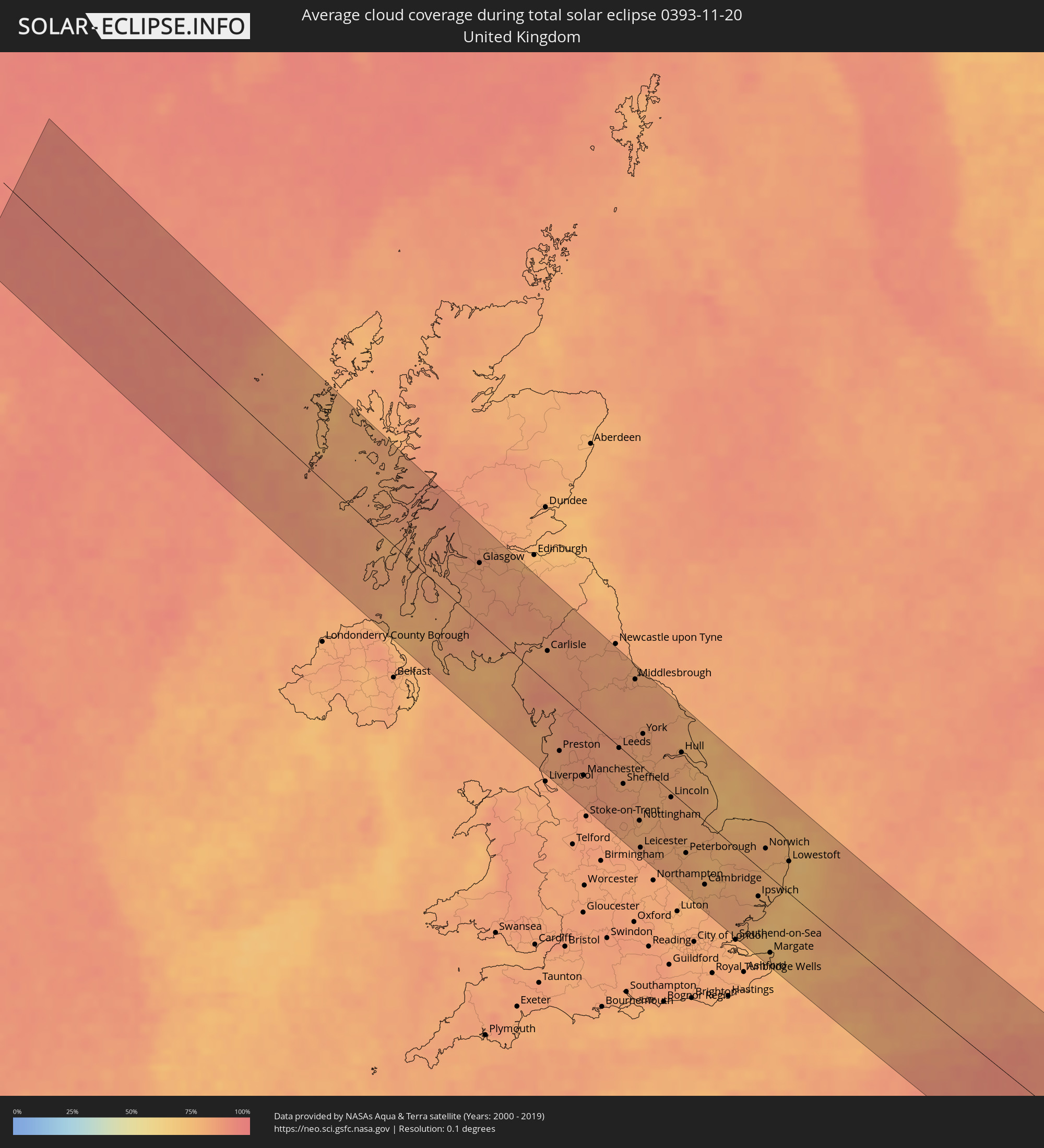 United Kingdom
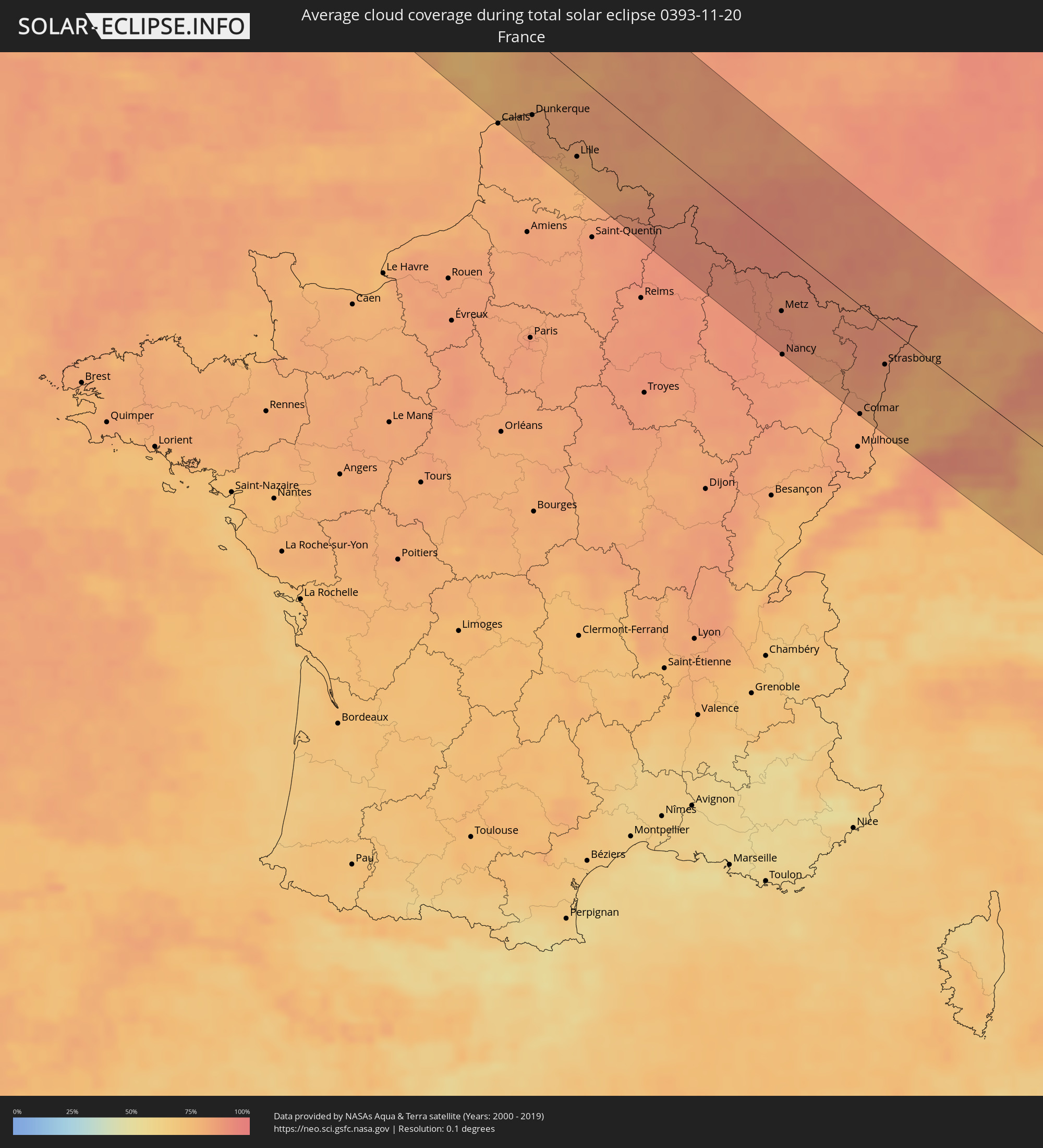 France
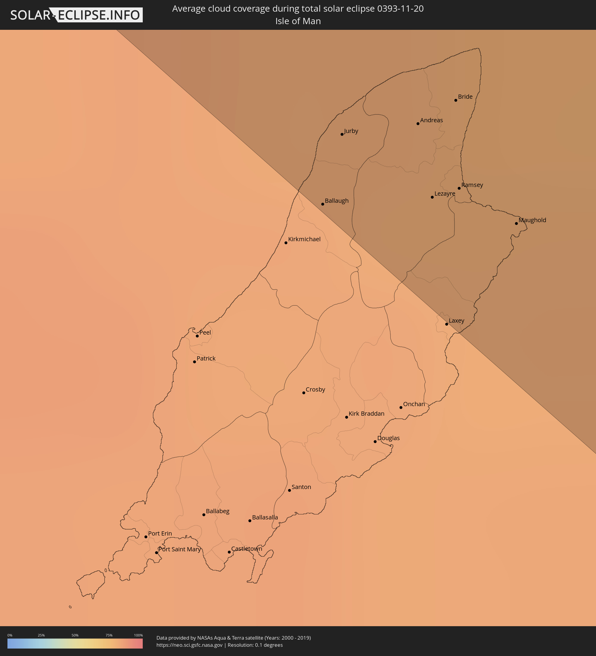 Isle of Man
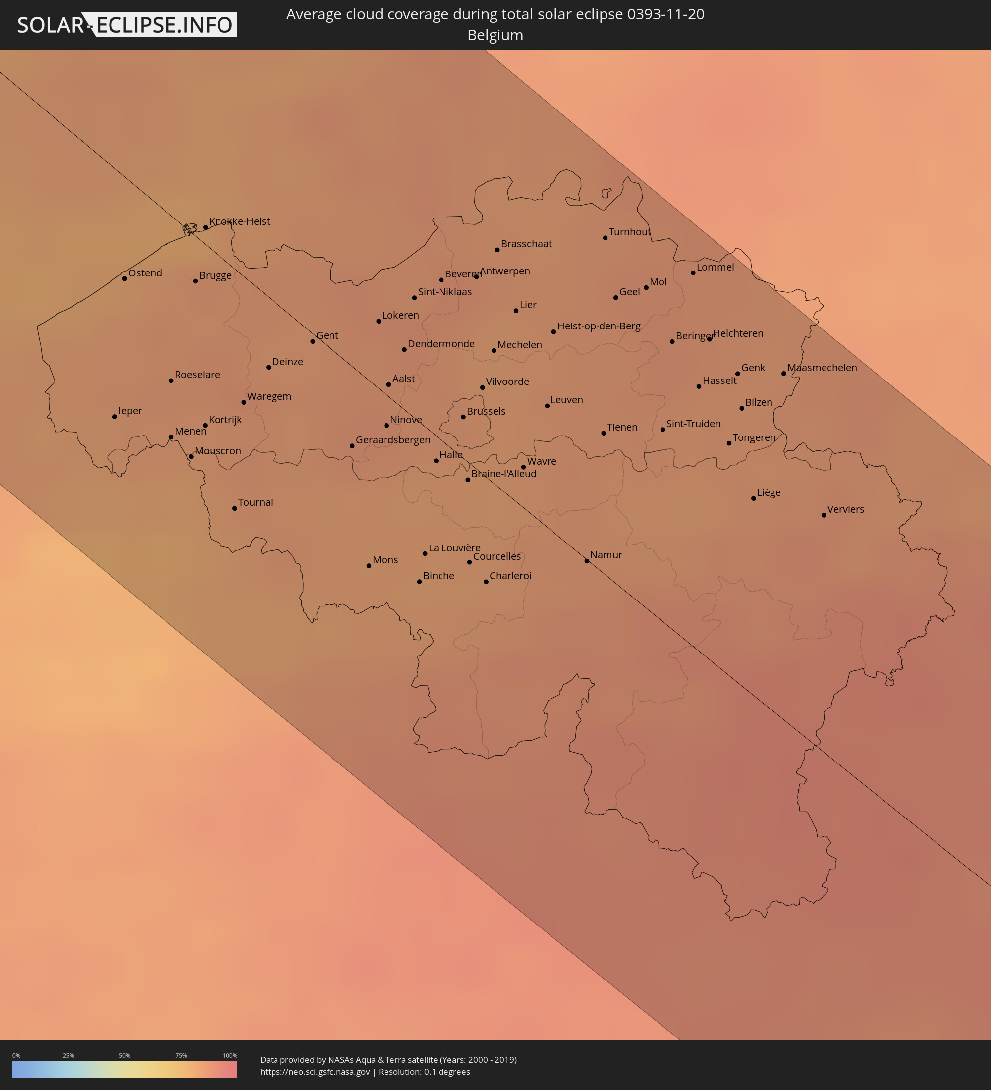 Belgium
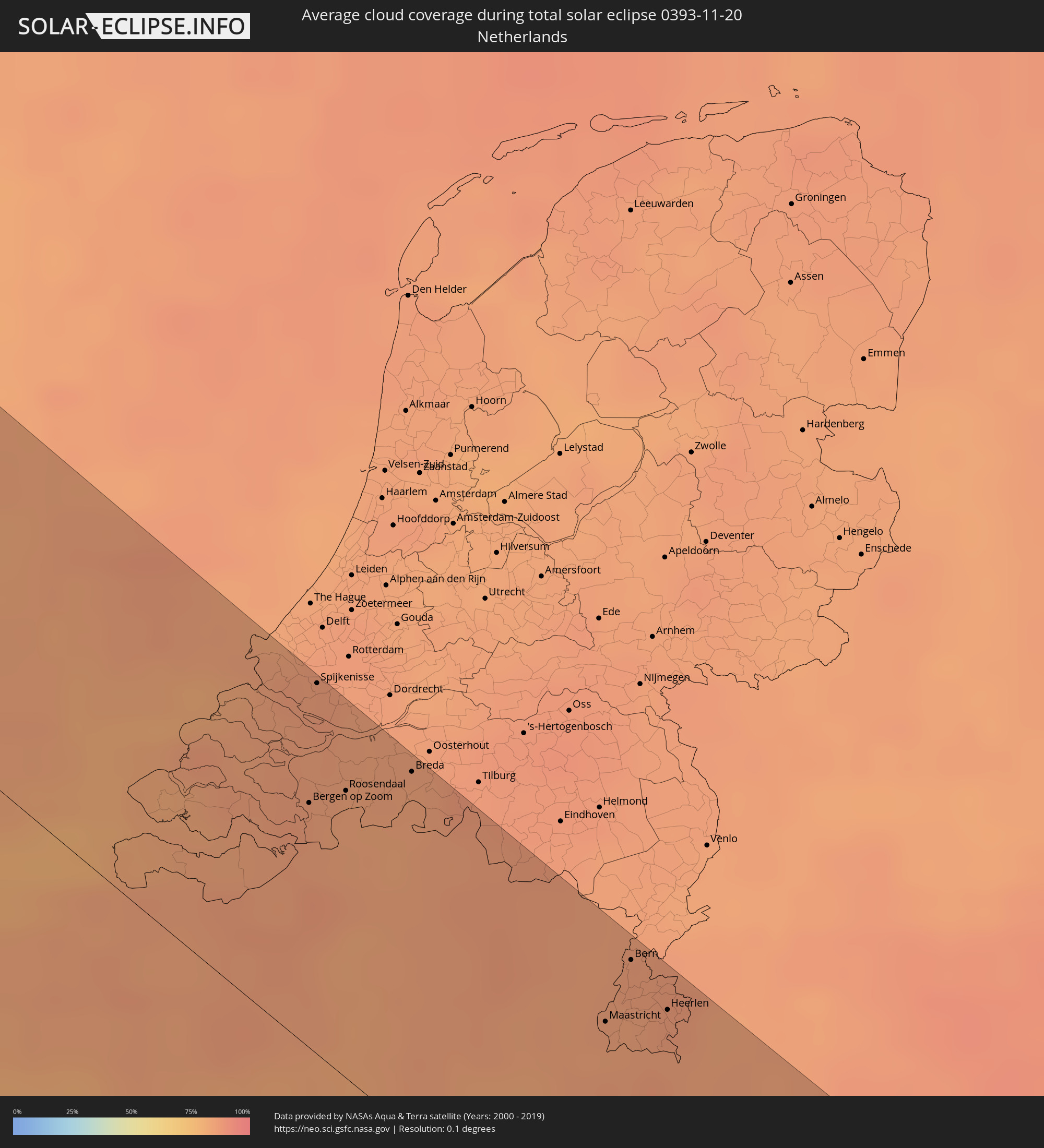 Netherlands
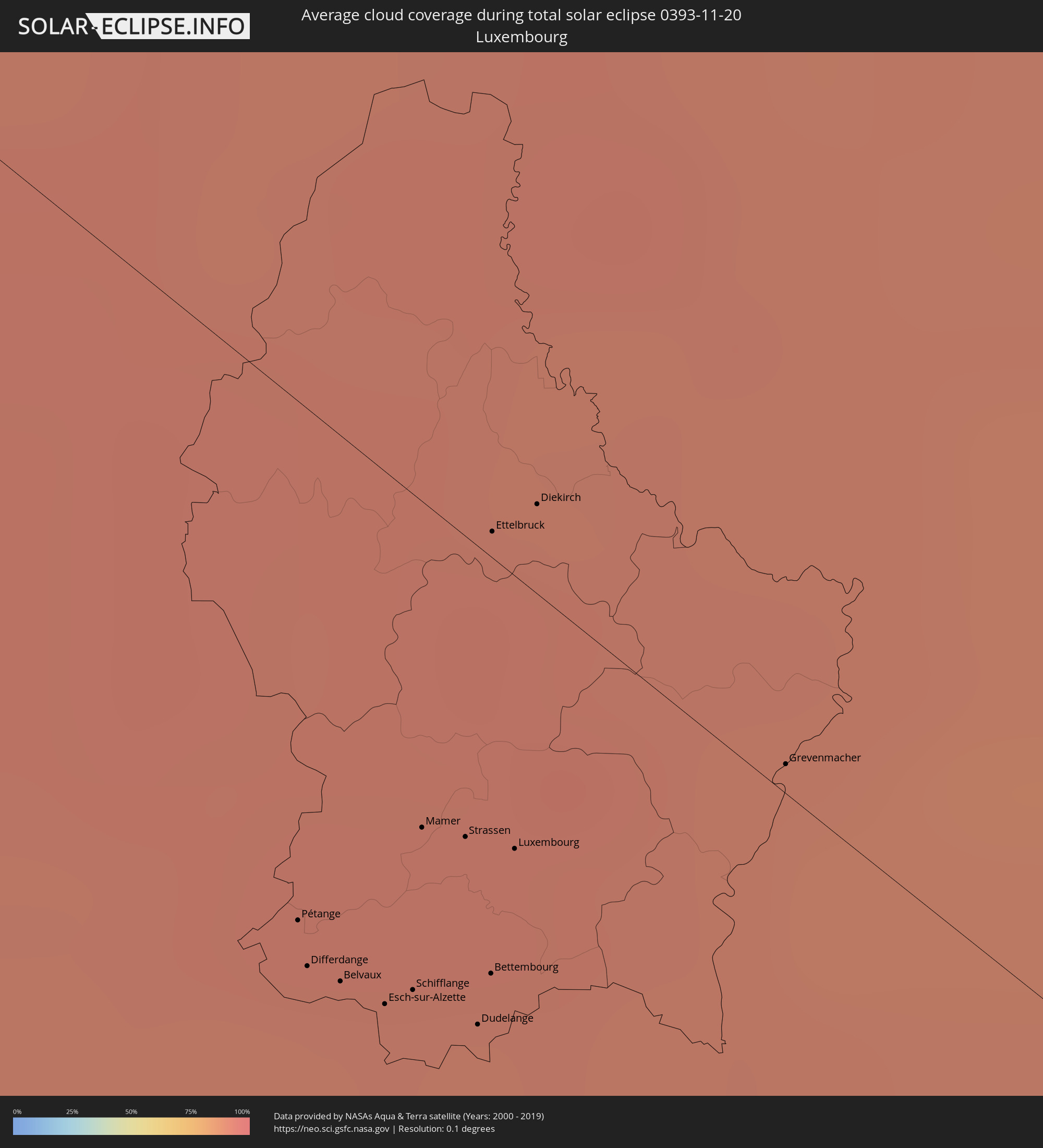 Luxembourg
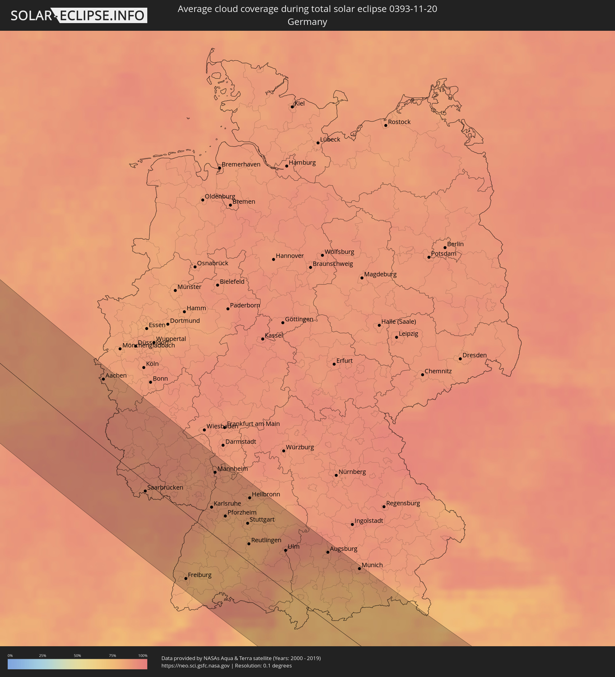 Germany
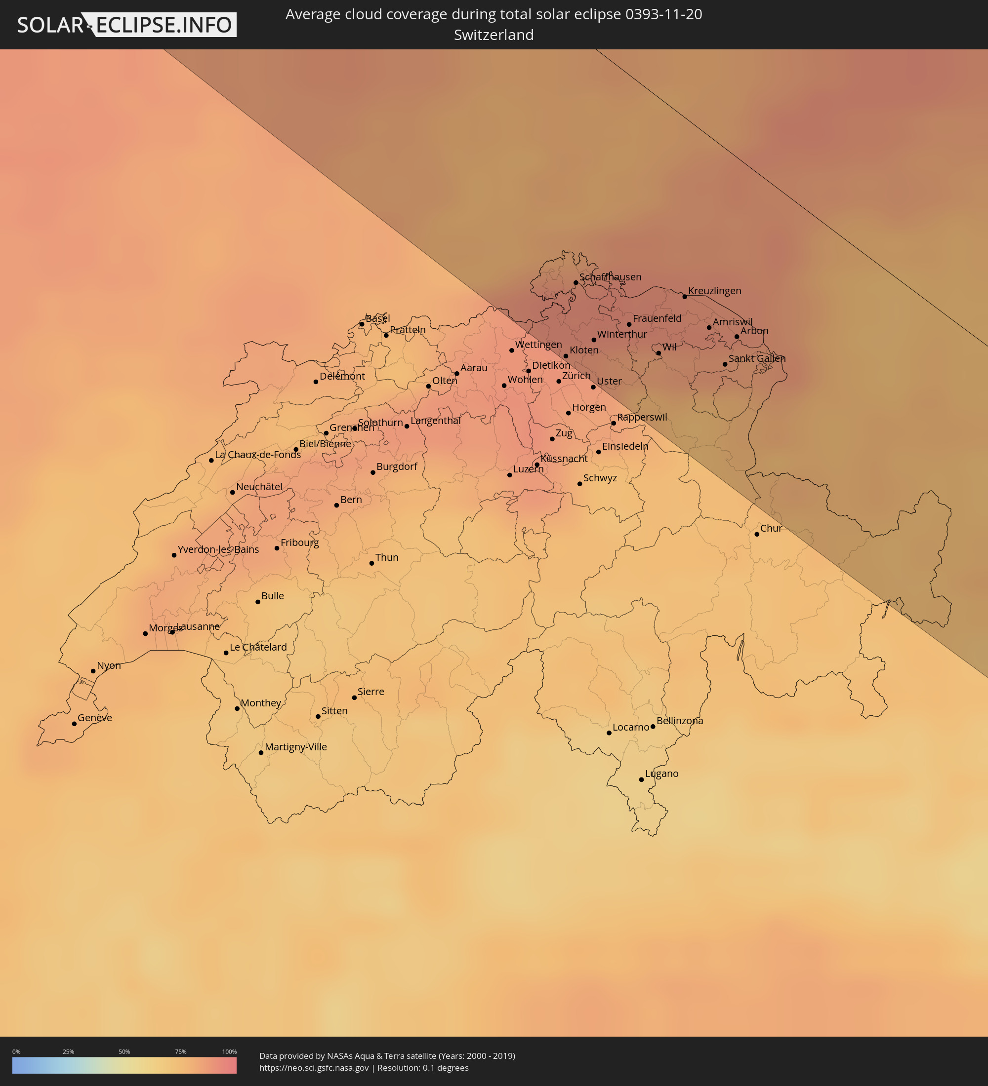 Switzerland
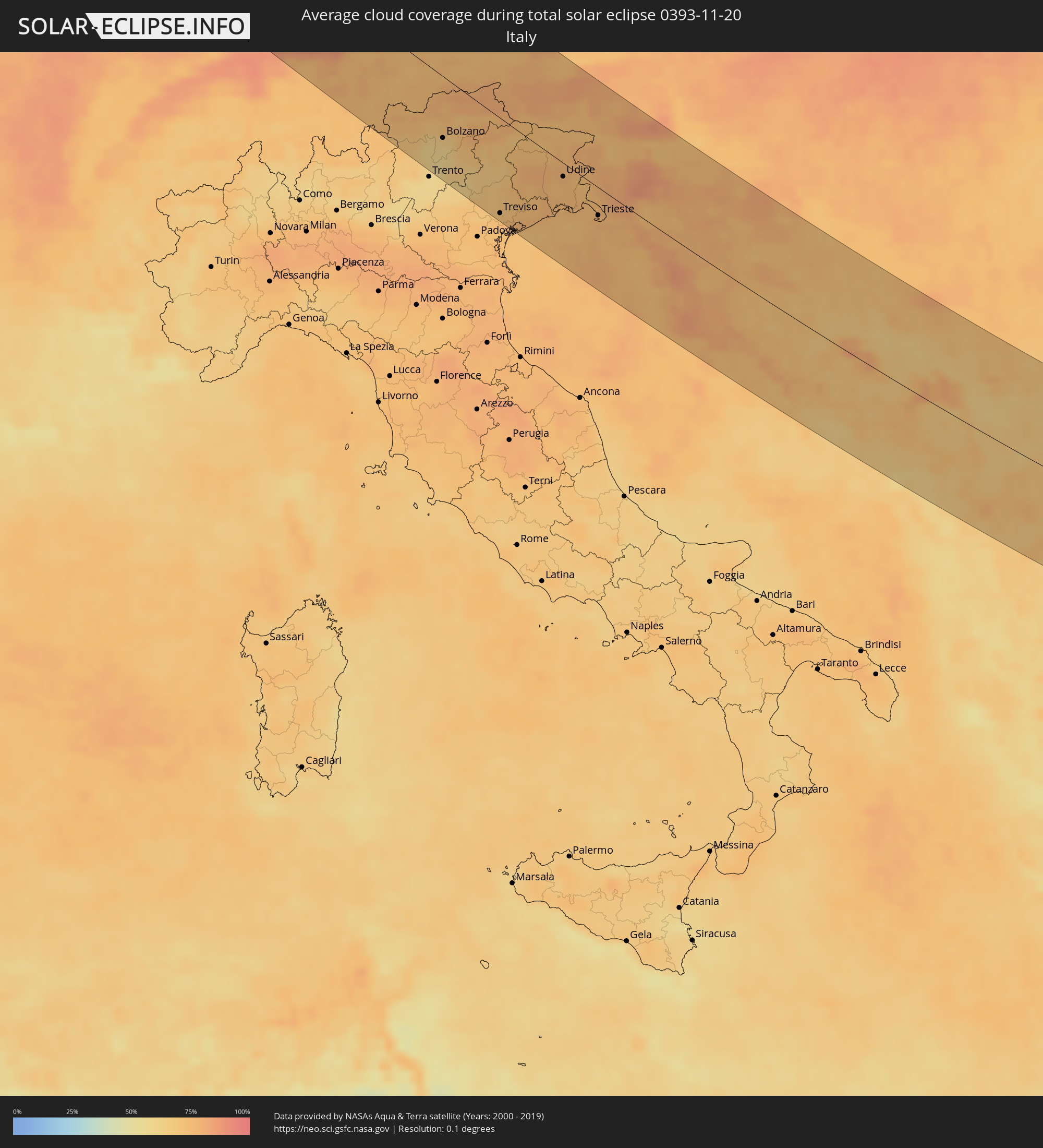 Italy
Italy
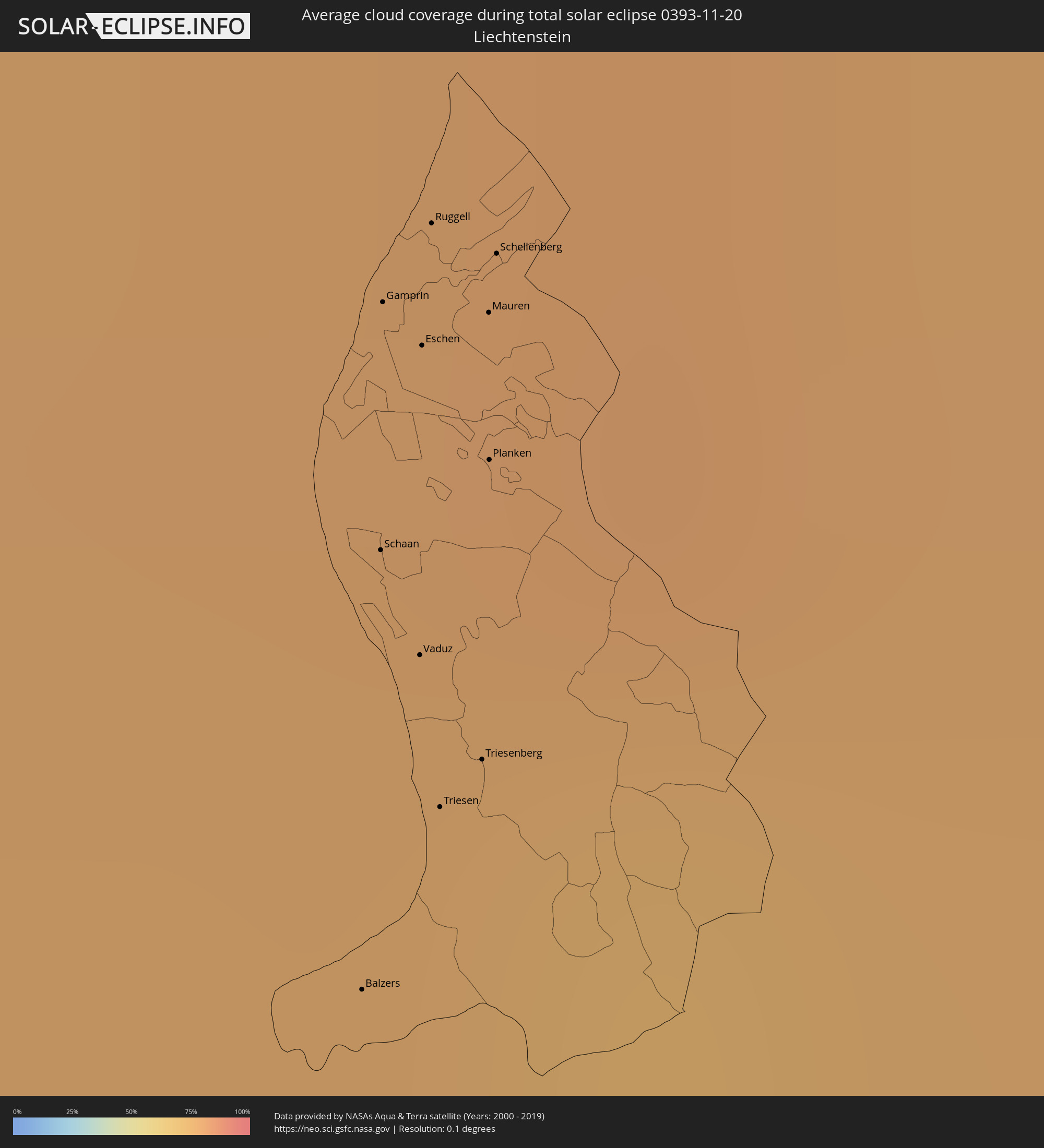 Liechtenstein
 Austria
 Slovenia
 Croatia
 Bosnia and Herzegovina
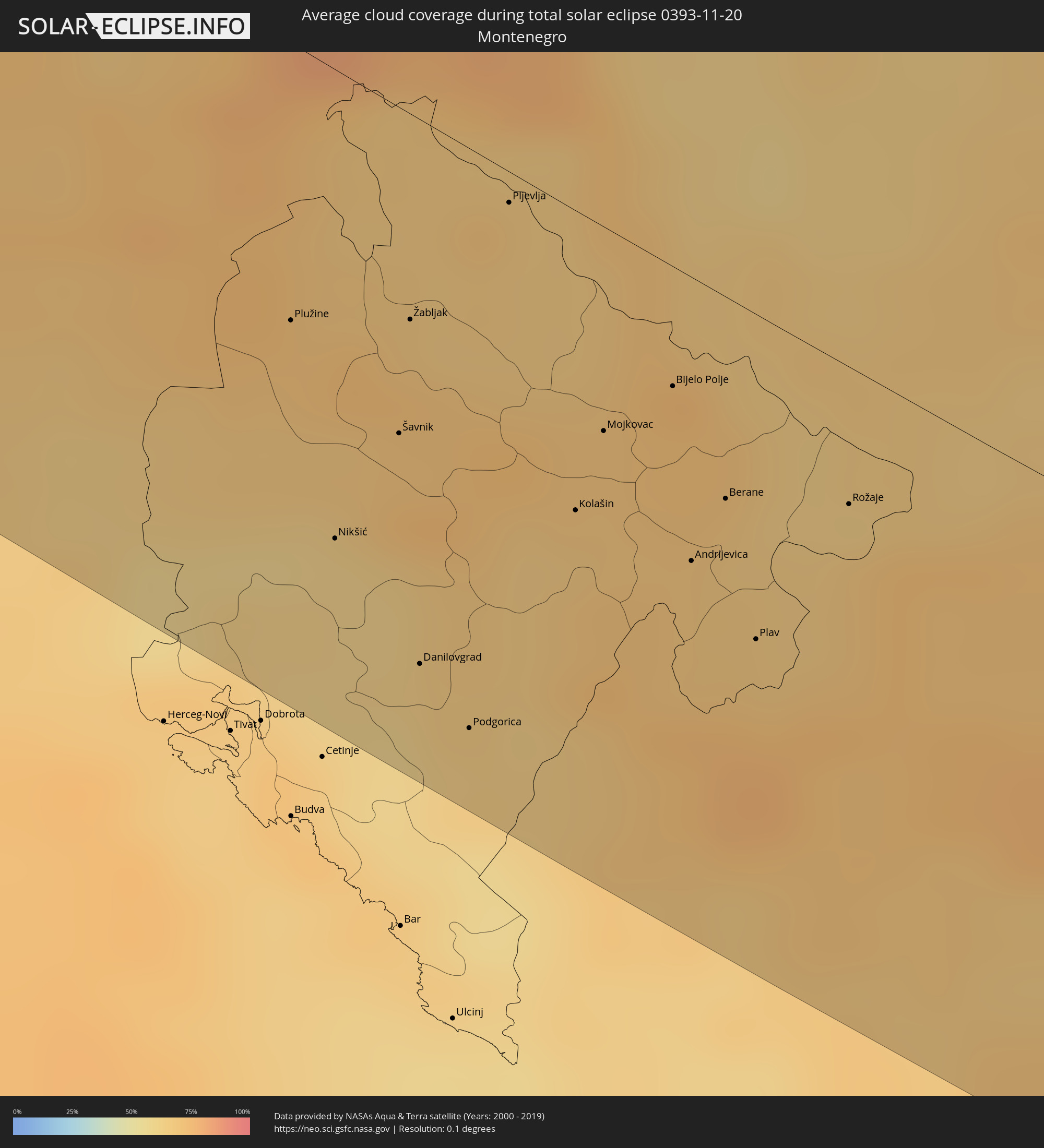 Montenegro
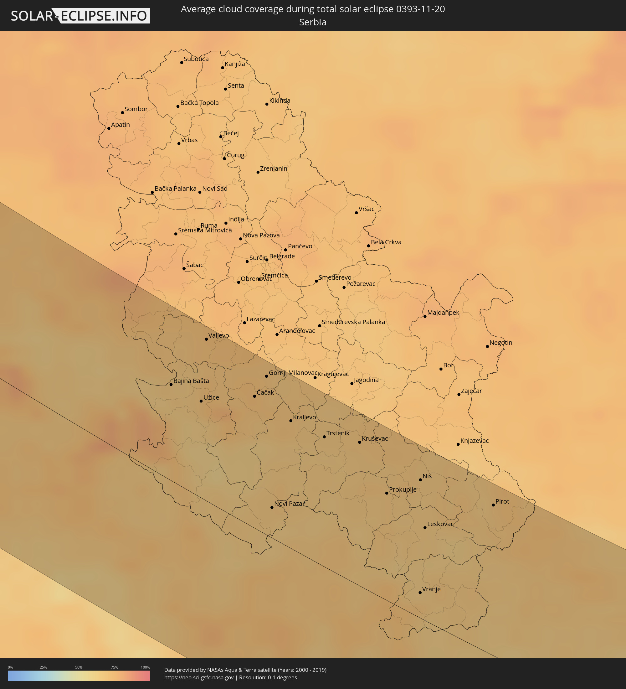 Serbia
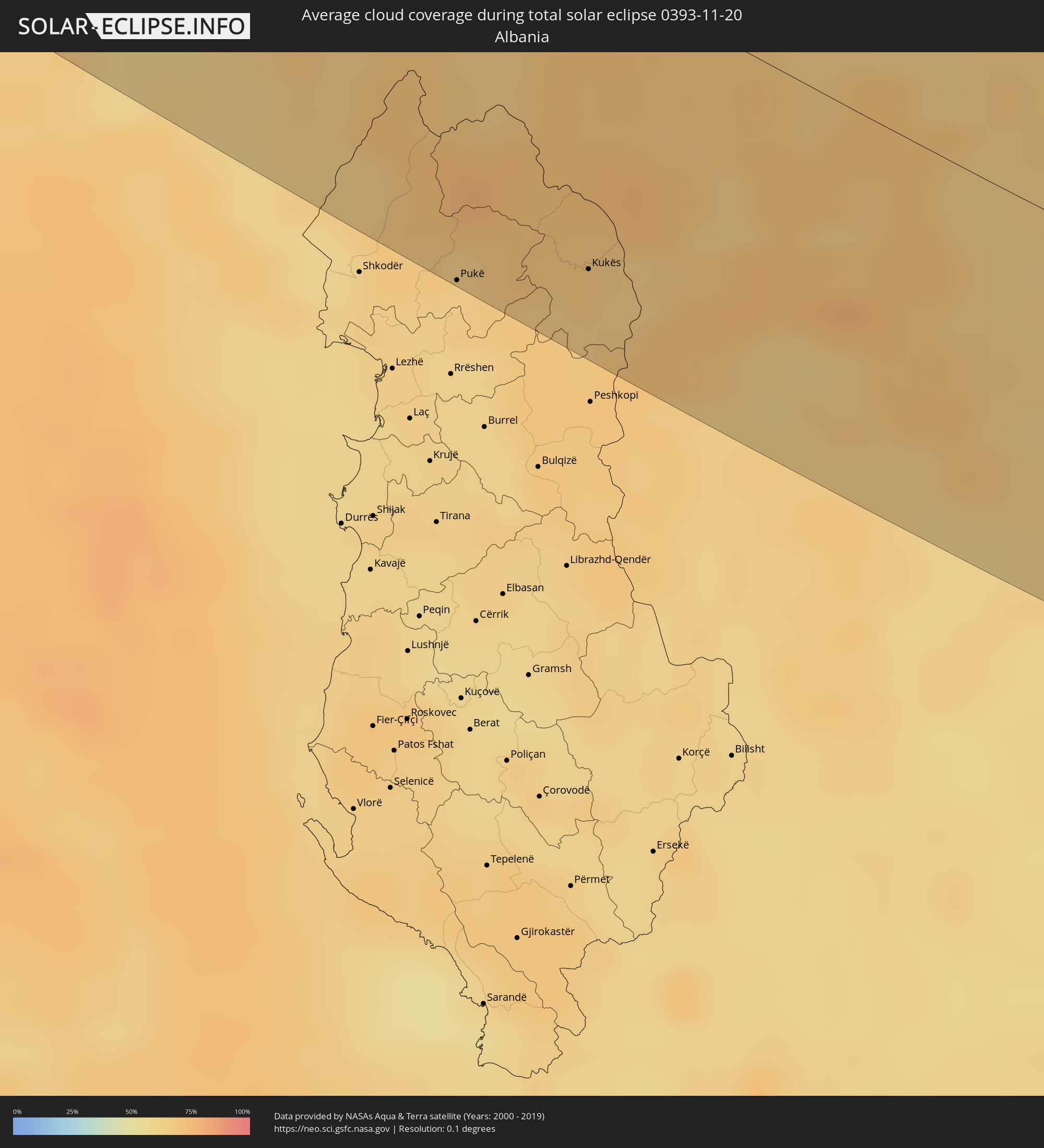 Albania
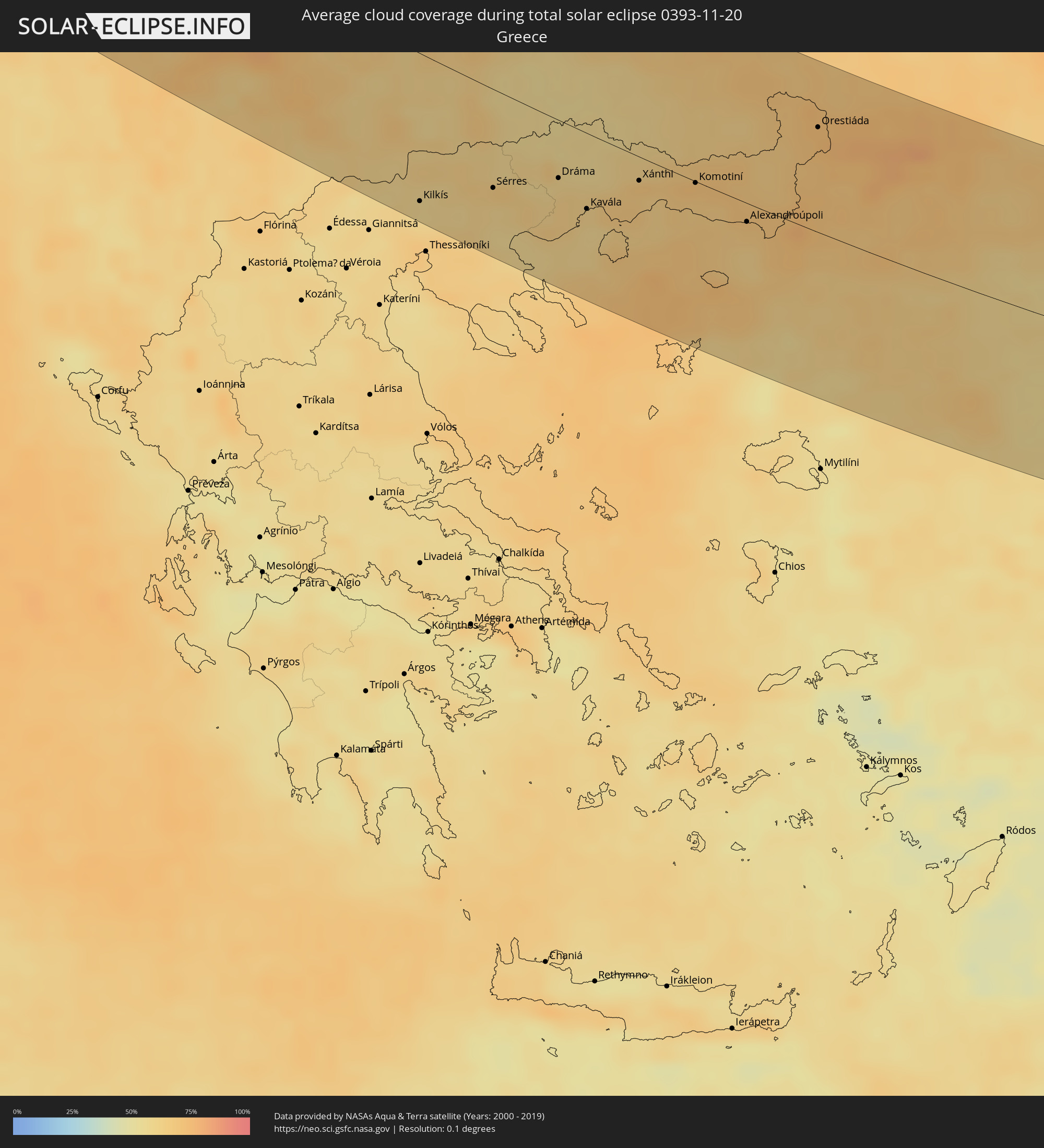 Greece
 Republic of Macedonia
 Bulgaria
 Turkey
 Armenia
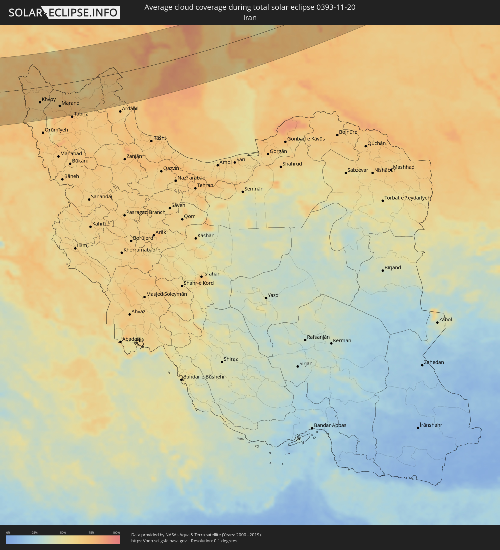 Iran
Iran
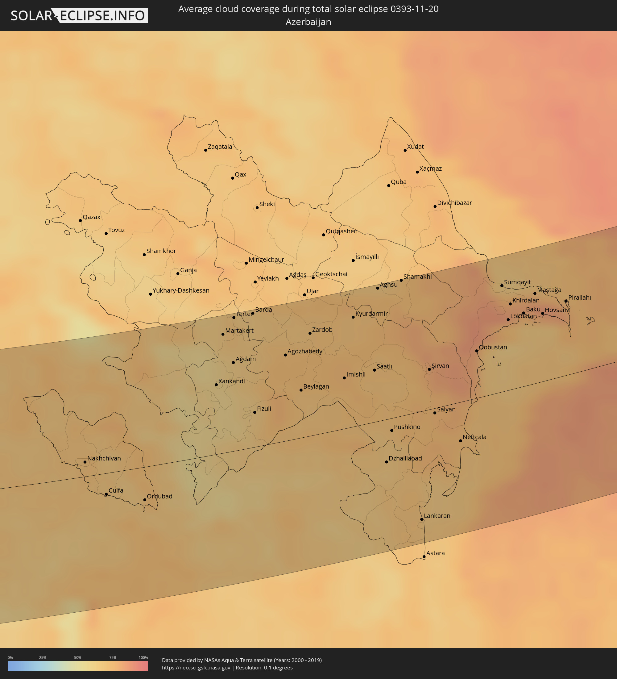 Azerbaijan
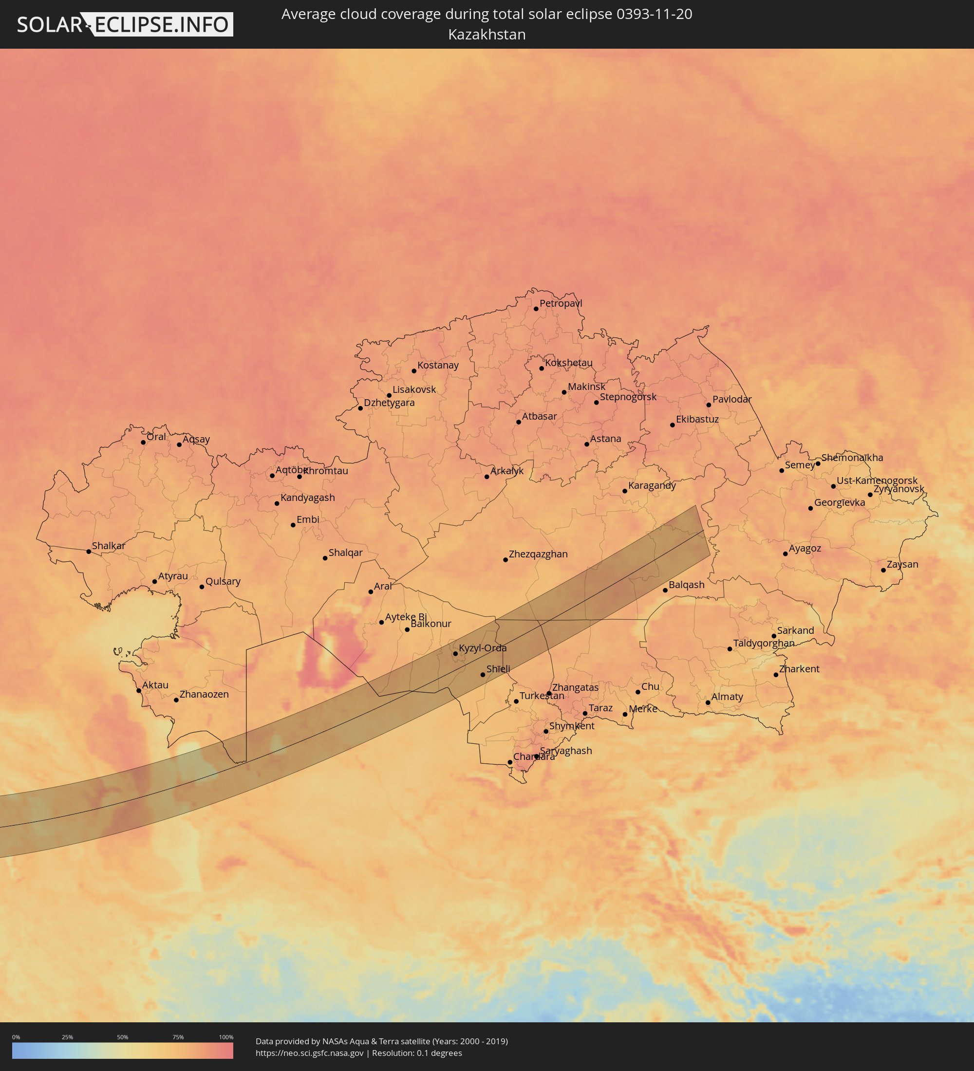 Kazakhstan
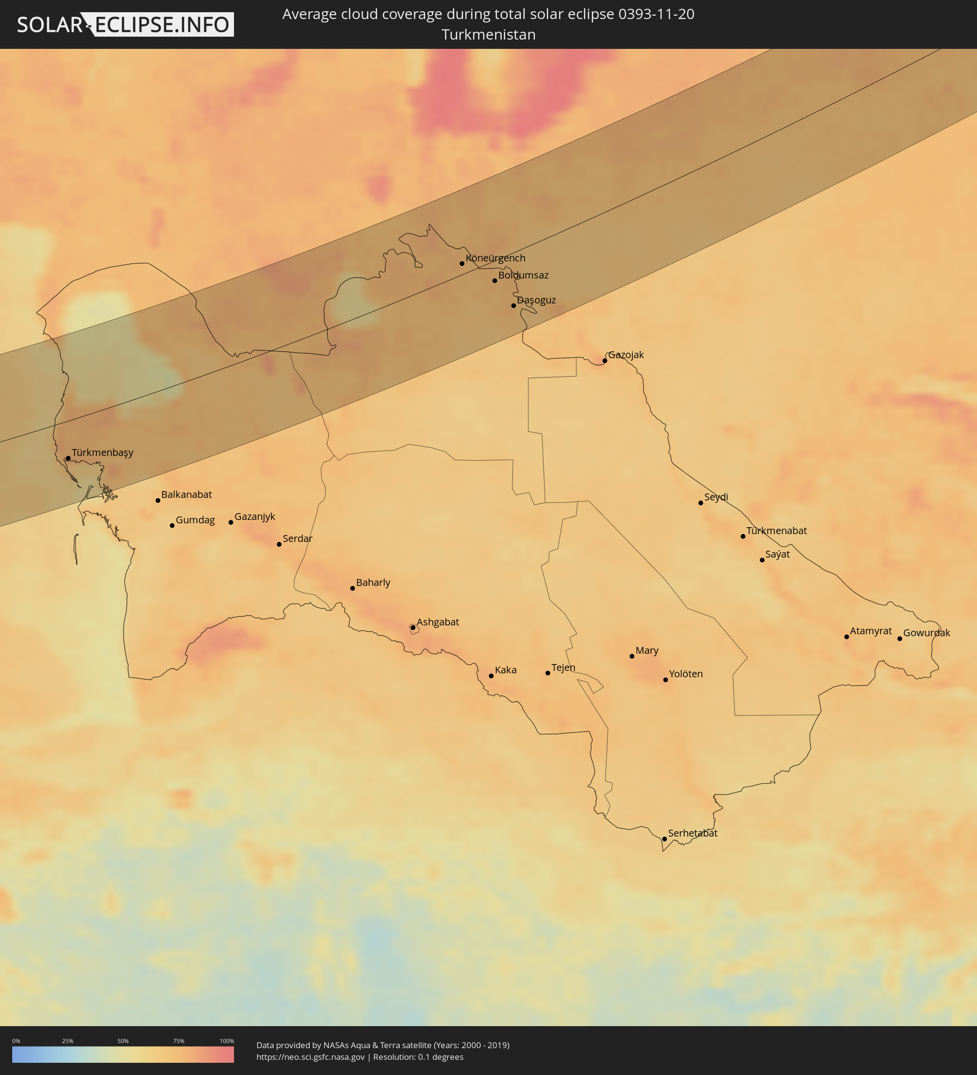 Turkmenistan
 Uzbekistan
Cities inside the path of the eclipse
The following table shows all locations with a population of more than 5,000 inside the eclipse path. Cities which have more than 100,000 inhabitants are marked bold. A click at the locations opens a detailed map.
| City | Type | Eclipse duration | Local time of max. eclipse | Distance to central line | Ø Cloud coverage |
|
Ballaugh, Ballaugh
|
total | - | 09:20:30 UTC+00:00 | 87 km | 82% |
|
Jurby, Jurby
|
total | - | 09:20:34 UTC+00:00 | 82 km | 80% |
|
Andreas, Andreas
|
total | - | 09:20:39 UTC+00:00 | 78 km | 79% |
|
Lezayre, Lezayre
|
total | - | 09:20:37 UTC+00:00 | 81 km | 80% |
|
Bride, Bride
|
total | - | 09:20:43 UTC+00:00 | 74 km | 79% |
|
Ramsey, Ramsey
|
total | - | 09:20:39 UTC+00:00 | 79 km | 80% |
|
Maughold, Maughold
|
total | - | 09:20:41 UTC+00:00 | 79 km | 80% |
|
Glasgow, Scotland
|
total | - | 09:22:19 UTC+00:00 | 54 km | 83% |
|
Manchester, England
|
total | - | 09:21:48 UTC+00:00 | 58 km | 84% |
|
Leeds, England
|
total | - | 09:22:45 UTC+00:00 | 1 km | 85% |
|
Derby, England
|
total | - | 09:22:01 UTC+00:00 | 72 km | 82% |
|
Sheffield, England
|
total | - | 09:22:27 UTC+00:00 | 33 km | 84% |
|
Nottingham, England
|
total | - | 09:22:22 UTC+00:00 | 55 km | 80% |
|
Leicester, England
|
total | - | 09:22:06 UTC+00:00 | 81 km | 84% |
|
Hull, England
|
total | - | 09:23:52 UTC+00:00 | 47 km | 81% |
|
Dunkerque, Hauts-de-France
|
total | - | 09:33:48 UTC+00:09 | 63 km | 82% |
|
Lille, Hauts-de-France
|
total | - | 09:34:16 UTC+00:09 | 67 km | 77% |
|
Douai, Hauts-de-France
|
total | - | 09:34:04 UTC+00:09 | 90 km | 78% |
|
Brugge, Flanders
|
total | - | 09:25:32 UTC+00:00 | 10 km | 84% |
|
Middelburg, Zeeland
|
total | - | 09:45:44 UTC+00:19 | 32 km | 83% |
|
Gent, Flanders
|
total | - | 09:25:59 UTC+00:00 | 2 km | 83% |
|
Goes, Zeeland
|
total | - | 09:46:03 UTC+00:19 | 45 km | 84% |
|
Spijkenisse, South Holland
|
total | - | 09:46:49 UTC+00:19 | 93 km | 86% |
|
Brussels, Brussels Capital
|
total | - | 09:26:34 UTC+00:00 | 9 km | 85% |
|
Antwerpen, Flanders
|
total | - | 09:26:54 UTC+00:00 | 43 km | 85% |
|
Charleroi, Wallonia
|
total | - | 09:26:22 UTC+00:00 | 24 km | 83% |
|
Roosendaal, North Brabant
|
total | - | 09:46:44 UTC+00:19 | 73 km | 83% |
|
Leuven, Flanders
|
total | - | 09:27:00 UTC+00:00 | 28 km | 83% |
|
Charleville-Mézières, Grand-Est
|
total | - | 09:35:35 UTC+00:09 | 68 km | 90% |
|
Breda, North Brabant
|
total | - | 09:47:08 UTC+00:19 | 91 km | 84% |
|
Namur, Wallonia
|
total | - | 09:26:54 UTC+00:00 | 0 km | 85% |
|
Liège, Wallonia
|
total | - | 09:27:52 UTC+00:00 | 45 km | 85% |
|
Maastricht, Limburg
|
total | - | 09:47:42 UTC+00:19 | 69 km | 83% |
|
Born, Limburg
|
total | - | 09:47:58 UTC+00:19 | 90 km | 85% |
|
Differdange, Luxembourg
|
total | - | 09:52:07 UTC+00:24 | 36 km | 89% |
|
Belvaux, Luxembourg
|
total | - | 09:52:09 UTC+00:24 | 35 km | 89% |
|
Esch-sur-Alzette, Luxembourg
|
total | - | 09:52:12 UTC+00:24 | 34 km | 89% |
|
Heerlen, Limburg
|
total | - | 09:48:04 UTC+00:19 | 85 km | 86% |
|
Bertrange, Luxembourg
|
total | - | 09:52:22 UTC+00:24 | 21 km | 90% |
|
Strassen, Luxembourg
|
total | - | 09:52:24 UTC+00:24 | 19 km | 90% |
|
Aachen, North Rhine-Westphalia
|
total | - | 10:28:35 UTC+01:00 | 81 km | 84% |
|
Ettelbruck, Diekirch
|
total | - | 09:52:36 UTC+00:24 | 2 km | 91% |
|
Luxembourg, Luxembourg
|
total | - | 09:52:28 UTC+00:24 | 18 km | 90% |
|
Diekirch, Diekirch
|
total | - | 09:52:40 UTC+00:24 | 6 km | 91% |
|
Metz, Grand-Est
|
total | - | 09:36:57 UTC+00:09 | 59 km | 89% |
|
Nancy, Grand-Est
|
total | - | 09:36:41 UTC+00:09 | 96 km | 87% |
|
Saarbrücken, Saarland
|
total | - | 10:28:43 UTC+01:00 | 12 km | 87% |
|
Colmar, Grand-Est
|
total | - | 09:37:52 UTC+00:09 | 96 km | 81% |
|
Strasbourg, Grand-Est
|
total | - | 09:38:40 UTC+00:09 | 35 km | 86% |
|
Freiburg, Baden-Württemberg
|
total | - | 10:29:07 UTC+01:00 | 82 km | 77% |
|
Karlsruhe, Baden-Württemberg
|
total | - | 10:30:26 UTC+01:00 | 32 km | 85% |
|
Mannheim, Baden-Württemberg
|
total | - | 10:30:49 UTC+01:00 | 78 km | 87% |
|
Schaffhausen, Schaffhausen
|
total | - | 10:30:01 UTC+01:00 | 73 km | 90% |
|
Winterthur, Zurich
|
total | - | 10:30:02 UTC+01:00 | 86 km | 87% |
|
Wetzikon, Zurich
|
total | - | 10:30:02 UTC+01:00 | 99 km | 83% |
|
Wil, Saint Gallen
|
total | - | 10:30:27 UTC+01:00 | 76 km | 83% |
|
Kreuzlingen, Thurgau
|
total | - | 10:30:44 UTC+01:00 | 53 km | 89% |
|
Stuttgart, Baden-Württemberg
|
total | - | 10:31:21 UTC+01:00 | 47 km | 78% |
|
Sankt Gallen, Saint Gallen
|
total | - | 10:30:53 UTC+01:00 | 64 km | 77% |
|
Buchs, Saint Gallen
|
total | - | 10:30:54 UTC+01:00 | 82 km | 76% |
|
Schaan, Schaan
|
total | - | 10:30:57 UTC+01:00 | 81 km | 76% |
|
Gamprin, Gamprin
|
total | - | 10:30:59 UTC+01:00 | 76 km | 76% |
|
Eschen, Eschen
|
total | - | 10:30:59 UTC+01:00 | 77 km | 76% |
|
Ruggell, Ruggell
|
total | - | 10:31:00 UTC+01:00 | 74 km | 76% |
|
Triesenberg, Triesenberg
|
total | - | 10:30:58 UTC+01:00 | 84 km | 76% |
|
Mauren, Mauren
|
total | - | 10:31:01 UTC+01:00 | 75 km | 76% |
|
Planken, Planken
|
total | - | 10:31:00 UTC+01:00 | 78 km | 76% |
|
Schellenberg, Schellenberg
|
total | - | 10:31:02 UTC+01:00 | 74 km | 76% |
|
Feldkirch, Vorarlberg
|
total | - | 10:31:07 UTC+01:00 | 71 km | 73% |
|
Dornbirn, Vorarlberg
|
total | - | 10:31:24 UTC+01:00 | 48 km | 79% |
|
Davos, Grisons
|
total | - | 10:31:14 UTC+01:00 | 99 km | 73% |
|
Augsburg, Bavaria
|
total | - | 10:33:31 UTC+01:00 | 89 km | 86% |
|
Merano, Trentino-Alto Adige
|
total | - | 10:33:06 UTC+01:00 | 52 km | 70% |
|
Bolzano, Trentino-Alto Adige
|
total | - | 10:33:17 UTC+01:00 | 60 km | 62% |
|
Innsbruck, Tyrol
|
total | - | 10:33:43 UTC+01:00 | 12 km | 74% |
|
Munich, Bavaria
|
total | - | 10:34:23 UTC+01:00 | 98 km | 79% |
|
Kufstein, Tyrol
|
total | - | 10:34:59 UTC+01:00 | 76 km | 74% |
|
Treviso, Veneto
|
total | - | 10:34:18 UTC+01:00 | 94 km | 71% |
|
San Donà di Piave, Veneto
|
total | - | 10:34:48 UTC+01:00 | 83 km | 77% |
|
Pordenone, Friuli Venezia Giulia
|
total | - | 10:35:04 UTC+01:00 | 49 km | 75% |
|
Saalfelden am Steinernen Meer, Salzburg
|
total | - | 10:35:56 UTC+01:00 | 92 km | 77% |
|
Udine, Friuli Venezia Giulia
|
total | - | 10:36:00 UTC+01:00 | 13 km | 76% |
|
Spittal an der Drau, Carinthia
|
total | - | 10:36:41 UTC+01:00 | 65 km | 74% |
|
Gorizia, Friuli Venezia Giulia
|
total | - | 10:36:33 UTC+01:00 | 8 km | 73% |
|
Koper, Koper-Capodistria
|
total | - | 10:36:35 UTC+01:00 | 40 km | 76% |
|
Trieste, Friuli Venezia Giulia
|
total | - | 10:36:43 UTC+01:00 | 28 km | 77% |
|
Pula, Istarska
|
total | - | 10:36:32 UTC+01:00 | 97 km | 76% |
|
Villach, Carinthia
|
total | - | 10:37:09 UTC+01:00 | 63 km | 73% |
|
Klagenfurt am Wörthersee, Carinthia
|
total | - | 10:37:52 UTC+01:00 | 84 km | 79% |
|
Kranj, Kranj
|
total | - | 10:37:48 UTC+01:00 | 51 km | 83% |
|
Rijeka, Primorsko-Goranska
|
total | - | 10:37:36 UTC+01:00 | 28 km | 73% |
|
Ljubljana, Ljubljana
|
total | - | 10:37:59 UTC+01:00 | 41 km | 86% |
|
Kamnik, Kamnik
|
total | - | 10:38:12 UTC+01:00 | 62 km | 86% |
|
Trbovlje, Trbovlje
|
total | - | 10:38:53 UTC+01:00 | 74 km | 75% |
|
Velenje, Velenje
|
total | - | 10:39:02 UTC+01:00 | 96 km | 73% |
|
Novo Mesto, Novo Mesto
|
total | - | 10:38:58 UTC+01:00 | 47 km | 78% |
|
Zadar, Zadarska
|
total | - | 10:38:36 UTC+01:00 | 106 km | 73% |
|
Celje, Celje
|
total | - | 10:39:14 UTC+01:00 | 90 km | 75% |
|
Karlovac, Karlovačka
|
total | - | 10:39:29 UTC+01:00 | 35 km | 78% |
|
Bihać, Federation of Bosnia and Herzegovina
|
total | - | 10:39:50 UTC+01:00 | 14 km | 75% |
|
Zagreb - Centar, City of Zagreb
|
total | - | 10:40:17 UTC+01:00 | 83 km | 78% |
|
Sisak, Sisačko-Moslavačka
|
total | - | 10:40:51 UTC+01:00 | 69 km | 77% |
|
Solin, Splitsko-Dalmatinska
|
total | - | 10:40:35 UTC+01:00 | 107 km | 67% |
|
Prijedor, Republic of Srspka
|
total | - | 10:41:17 UTC+01:00 | 38 km | 79% |
|
Banja Luka, Republic of Srspka
|
total | - | 10:42:03 UTC+01:00 | 40 km | 71% |
|
Bugojno, Federation of Bosnia and Herzegovina
|
total | - | 10:42:21 UTC+01:00 | 17 km | 73% |
|
Mostar, Federation of Bosnia and Herzegovina
|
total | - | 10:42:51 UTC+01:00 | 70 km | 64% |
|
Zenica, Federation of Bosnia and Herzegovina
|
total | - | 10:43:09 UTC+01:00 | 15 km | 81% |
|
Slavonski Brod, Slavonski Brod-Posavina
|
total | - | 10:43:31 UTC+01:00 | 110 km | 73% |
|
Sarajevo, Federation of Bosnia and Herzegovina
|
total | - | 10:43:53 UTC+01:00 | 1 km | 68% |
|
Tuzla, Federation of Bosnia and Herzegovina
|
total | - | 10:44:32 UTC+01:00 | 79 km | 74% |
|
Nikšić, Opština Nikšić
|
total | - | 10:44:48 UTC+01:00 | 78 km | 62% |
|
Danilovgrad, Danilovgrad
|
total | - | 10:45:09 UTC+01:00 | 91 km | 63% |
|
Podgorica, Podgorica
|
total | - | 10:45:21 UTC+01:00 | 97 km | 65% |
|
Pljevlja, Pljevlja
|
total | - | 10:45:37 UTC+01:00 | 5 km | 67% |
|
Mojkovac, Mojkovac
|
total | - | 10:45:59 UTC+01:00 | 34 km | 70% |
|
Bijelo Polje, Bijelo Polje
|
total | - | 10:46:17 UTC+01:00 | 20 km | 71% |
|
Užice, Central Serbia
|
total | - | 10:46:32 UTC+01:00 | 63 km | 68% |
|
Berane, Berane
|
total | - | 10:46:30 UTC+01:00 | 34 km | 67% |
|
Valjevo, Central Serbia
|
total | - | 10:46:40 UTC+01:00 | 105 km | 72% |
|
Pukë, Shkodër
|
total | - | 11:05:50 UTC+01:19 | 111 km | 67% |
|
Rožaje, Opština Rožaje
|
total | - | 10:47:02 UTC+01:00 | 23 km | 69% |
|
Čačak, Central Serbia
|
total | - | 10:47:27 UTC+01:00 | 86 km | 71% |
|
Kukës, Kukës
|
total | - | 11:06:48 UTC+01:19 | 87 km | 68% |
|
Novi Pazar, Central Serbia
|
total | - | 10:47:41 UTC+01:00 | 20 km | 66% |
|
Kraljevo, Central Serbia
|
total | - | 10:48:03 UTC+01:00 | 84 km | 66% |
|
Gostivar, Gostivar
|
total | - | 10:48:22 UTC+01:00 | 96 km | 65% |
|
Tetovo, Tetovo
|
total | - | 10:48:30 UTC+01:00 | 72 km | 71% |
|
Kruševac, Central Serbia
|
total | - | 10:49:13 UTC+01:00 | 96 km | 68% |
|
Skopje, Karpoš
|
total | - | 10:49:22 UTC+01:00 | 56 km | 73% |
|
Kumanovo, Kumanovo
|
total | - | 10:49:54 UTC+01:00 | 31 km | 70% |
|
Veles, Veles
|
total | - | 10:50:01 UTC+01:00 | 70 km | 70% |
|
Niš, Central Serbia
|
total | - | 10:50:15 UTC+01:00 | 93 km | 67% |
|
Leskovac, Central Serbia
|
total | - | 10:50:20 UTC+01:00 | 63 km | 67% |
|
Kavadarci, Kavadarci
|
total | - | 10:50:29 UTC+01:00 | 89 km | 62% |
|
Shtip, Štip
|
total | - | 10:50:50 UTC+01:00 | 51 km | 63% |
|
Strumica, Strumica
|
total | - | 10:51:42 UTC+01:00 | 66 km | 63% |
|
Kilkís, Central Macedonia
|
total | - | 11:27:03 UTC+01:34 | 102 km | 59% |
|
Pernik, Pernik
|
total | - | 11:52:24 UTC+02:00 | 65 km | 68% |
|
Blagoevgrad, Blagoevgrad
|
total | - | 11:52:33 UTC+02:00 | 9 km | 63% |
|
Sofia, Sofia-Capital
|
total | - | 11:52:56 UTC+02:00 | 85 km | 68% |
|
Sérres, Central Macedonia
|
total | - | 11:28:22 UTC+01:34 | 68 km | 64% |
|
Dráma, East Macedonia and Thrace
|
total | - | 11:29:32 UTC+01:34 | 40 km | 60% |
|
Pazardzhik, Pazardzhik
|
total | - | 11:54:55 UTC+02:00 | 72 km | 63% |
|
Kavála, East Macedonia and Thrace
|
total | - | 11:30:05 UTC+01:34 | 53 km | 60% |
|
Plovdiv, Plovdiv
|
total | - | 11:55:44 UTC+02:00 | 81 km | 69% |
|
Asenovgrad, Plovdiv
|
total | - | 11:55:59 UTC+02:00 | 72 km | 63% |
|
Xánthi, East Macedonia and Thrace
|
total | - | 11:31:00 UTC+01:34 | 17 km | 66% |
|
Kardzhali, Kŭrdzhali
|
total | - | 11:57:01 UTC+02:00 | 52 km | 64% |
|
Komotiní, East Macedonia and Thrace
|
total | - | 11:32:02 UTC+01:34 | 1 km | 68% |
|
Haskovo, Khaskovo
|
total | - | 11:57:20 UTC+02:00 | 87 km | 66% |
|
Alexandroúpoli, East Macedonia and Thrace
|
total | - | 11:33:02 UTC+01:34 | 13 km | 66% |
|
Orestiáda, East Macedonia and Thrace
|
total | - | 11:34:12 UTC+01:34 | 75 km | 71% |
|
İstanbul, Istanbul
|
total | - | 12:01:16 UTC+01:56 | 96 km | 69% |
|
Bursa, Bursa
|
total | - | 12:01:45 UTC+01:56 | 12 km | 61% |
|
Maltepe, Istanbul
|
total | - | 12:01:42 UTC+01:56 | 93 km | 66% |
|
Eskişehir, Eskişehir
|
total | - | 12:04:55 UTC+01:56 | 4 km | 73% |
|
Ankara, Ankara
|
total | - | 12:09:42 UTC+01:56 | 67 km | 66% |
|
Kayseri, Kayseri
|
total | - | 12:15:47 UTC+01:56 | 25 km | 63% |
|
Malatya, Malatya
|
total | - | 12:21:53 UTC+01:56 | 47 km | 68% |
|
Diyarbakır, Diyarbakır
|
total | - | 12:26:04 UTC+01:56 | 94 km | 57% |
|
Masis, Ararat Province
|
total | - | 13:33:29 UTC+02:58 | 119 km | 67% |
|
Artashat, Ararat Province
|
total | - | 13:33:49 UTC+02:58 | 106 km | 67% |
|
Ararat, Ararat Province
|
total | - | 13:34:13 UTC+02:58 | 90 km | 71% |
|
Salmās, Āz̄ārbāyjān-e Gharbī
|
total | - | 14:03:30 UTC+03:25 | 91 km | 64% |
|
Khvoy, Āz̄ārbāyjān-e Gharbī
|
total | - | 14:03:32 UTC+03:25 | 54 km | 66% |
|
Qarah Ẕīā’ od Dīn, Āz̄ārbāyjān-e Gharbī
|
total | - | 14:03:22 UTC+03:25 | 18 km | 67% |
|
Martuni, Gegharkunik Province
|
total | - | 13:35:02 UTC+02:58 | 116 km | 65% |
|
Nakhchivan, Nakhichevan
|
total | - | 13:57:28 UTC+03:19 | 12 km | 72% |
|
Vardenis, Gegharkunik Province
|
total | - | 13:35:46 UTC+02:58 | 115 km | 60% |
|
Marand, East Azerbaijan
|
total | - | 14:05:09 UTC+03:25 | 78 km | 72% |
|
Hats’avan, Syunik Province
|
total | - | 13:36:51 UTC+02:58 | 33 km | 64% |
|
Goris, Syunik Province
|
total | - | 13:37:27 UTC+02:58 | 33 km | 62% |
|
Qafan, Syunik Province
|
total | - | 13:37:52 UTC+02:58 | 2 km | 58% |
|
Xankandi, Xankǝndi
|
total | - | 13:59:19 UTC+03:19 | 60 km | 59% |
|
Ahar, East Azerbaijan
|
total | - | 14:07:27 UTC+03:25 | 92 km | 67% |
|
Pārsābād, Ardabīl
|
total | - | 14:07:50 UTC+03:25 | 21 km | 70% |
|
Saatlı, Saatlı
|
total | - | 14:02:00 UTC+03:19 | 44 km | 71% |
|
Lankaran, Lənkəran
|
total | - | 14:03:58 UTC+03:19 | 93 km | 67% |
|
Şirvan, Shirvan
|
total | - | 14:02:56 UTC+03:19 | 34 km | 76% |
|
Sumqayıt, Sumqayit
|
total | - | 14:03:31 UTC+03:19 | 89 km | 75% |
|
Baku, Baki
|
total | - | 14:04:06 UTC+03:19 | 61 km | 76% |
|
Maştağa, Baki
|
total | - | 14:04:08 UTC+03:19 | 75 km | 83% |
|
Türkmenbaşy, Balkan
|
total | - | 14:43:26 UTC+03:53 | 49 km | 68% |
|
Oltinko’l, Karakalpakstan
|
total | - | 15:22:30 UTC+04:27 | 96 km | 76% |
|
Köneürgench, Daşoguz
|
total | - | 14:49:21 UTC+03:53 | 12 km | 73% |
|
Akdepe
|
total | - | 14:49:58 UTC+03:53 | 23 km | 74% |
|
Khŭjayli, Karakalpakstan
|
total | - | 15:24:00 UTC+04:27 | 10 km | 75% |
|
Kegeyli Shahar, Karakalpakstan
|
total | - | 15:23:43 UTC+04:27 | 43 km | 75% |
|
Nukus, Karakalpakstan
|
total | - | 15:24:07 UTC+04:27 | 10 km | 76% |
|
Yylanly, Daşoguz
|
total | - | 14:50:34 UTC+03:53 | 54 km | 71% |
|
Boldumsaz, Daşoguz
|
total | - | 14:50:14 UTC+03:53 | 25 km | 73% |
|
Tagta, Daşoguz
|
total | - | 14:51:06 UTC+03:53 | 82 km | 73% |
|
Daşoguz, Daşoguz
|
total | - | 14:50:57 UTC+03:53 | 64 km | 71% |
|
Manghit, Karakalpakstan
|
total | - | 15:25:04 UTC+04:27 | 39 km | 73% |
|
Showot, Xorazm
|
total | - | 15:25:55 UTC+04:27 | 94 km | 69% |
|
Gurlan, Xorazm
|
total | - | 15:25:48 UTC+04:27 | 77 km | 69% |
|
Terenozek, Qyzylorda
|
total | - | 15:20:45 UTC+04:21 | 87 km | 76% |
|
Kyzyl-Orda, Qyzylorda
|
total | - | 15:21:32 UTC+04:21 | 49 km | 78% |
|
Kyzylorda, Qyzylorda
|
total | - | 15:21:32 UTC+04:21 | 49 km | 78% |
|
Tasböget, Qyzylorda
|
total | - | 15:21:40 UTC+04:21 | 40 km | 78% |
|
Shīeli, Qyzylorda
|
total | - | 15:23:36 UTC+04:21 | 63 km | 75% |
|
Aktau, Qaraghandy
|
total | - | 15:23:19 UTC+04:21 | 85 km | 79% |