Total solar eclipse of 06/20/0540
| Day of week: | Monday |
| Maximum duration of eclipse: | 06m07s |
| Maximum width of eclipse path: | 275 km |
| Saros cycle: | 84 |
| Coverage: | 100% |
| Magnitude: | 1.0801 |
| Gamma: | 0.3414 |
Wo kann man die Sonnenfinsternis vom 06/20/0540 sehen?
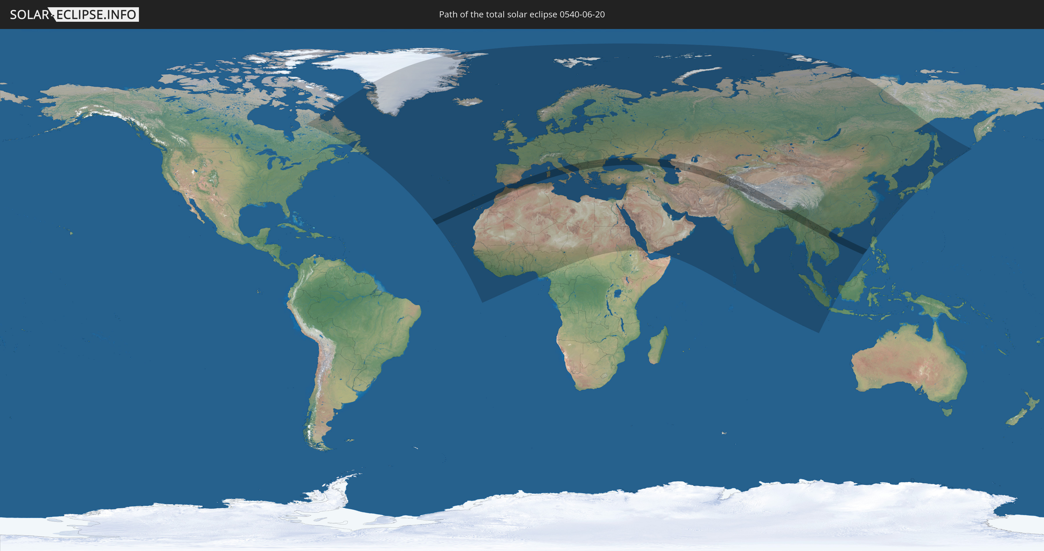
Die Sonnenfinsternis am 06/20/0540 kann man in 131 Ländern als partielle Sonnenfinsternis beobachten.
Der Finsternispfad verläuft durch 31 Länder. Nur in diesen Ländern ist sie als total Sonnenfinsternis zu sehen.
In den folgenden Ländern ist die Sonnenfinsternis total zu sehen
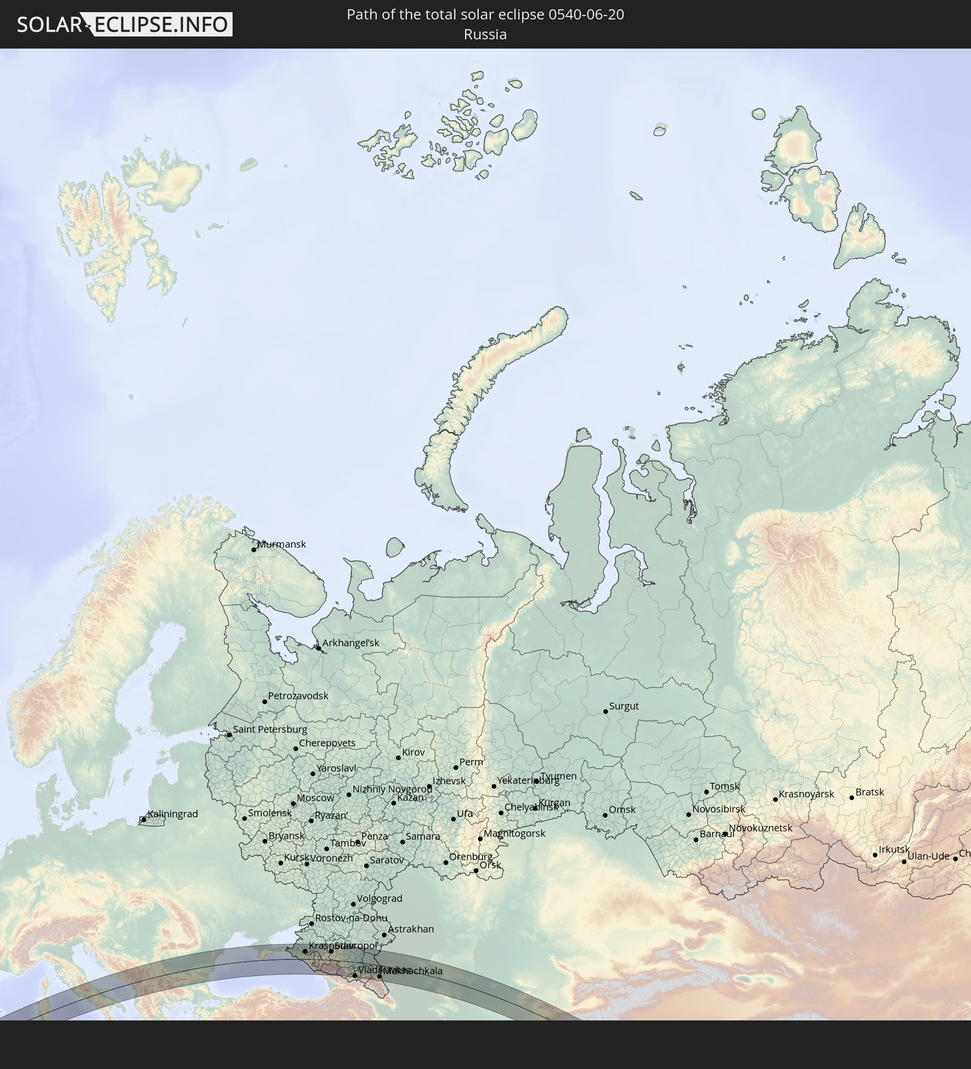 Russia
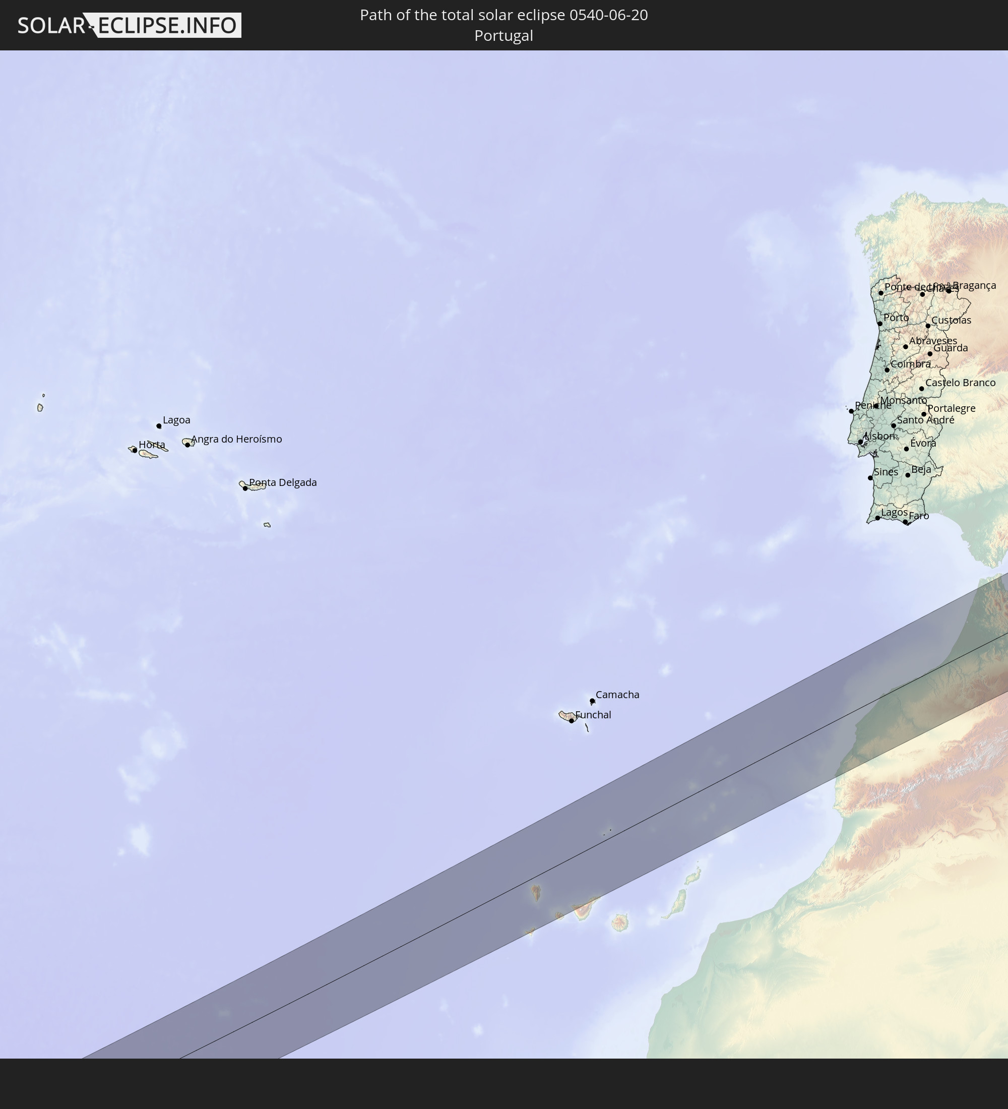 Portugal
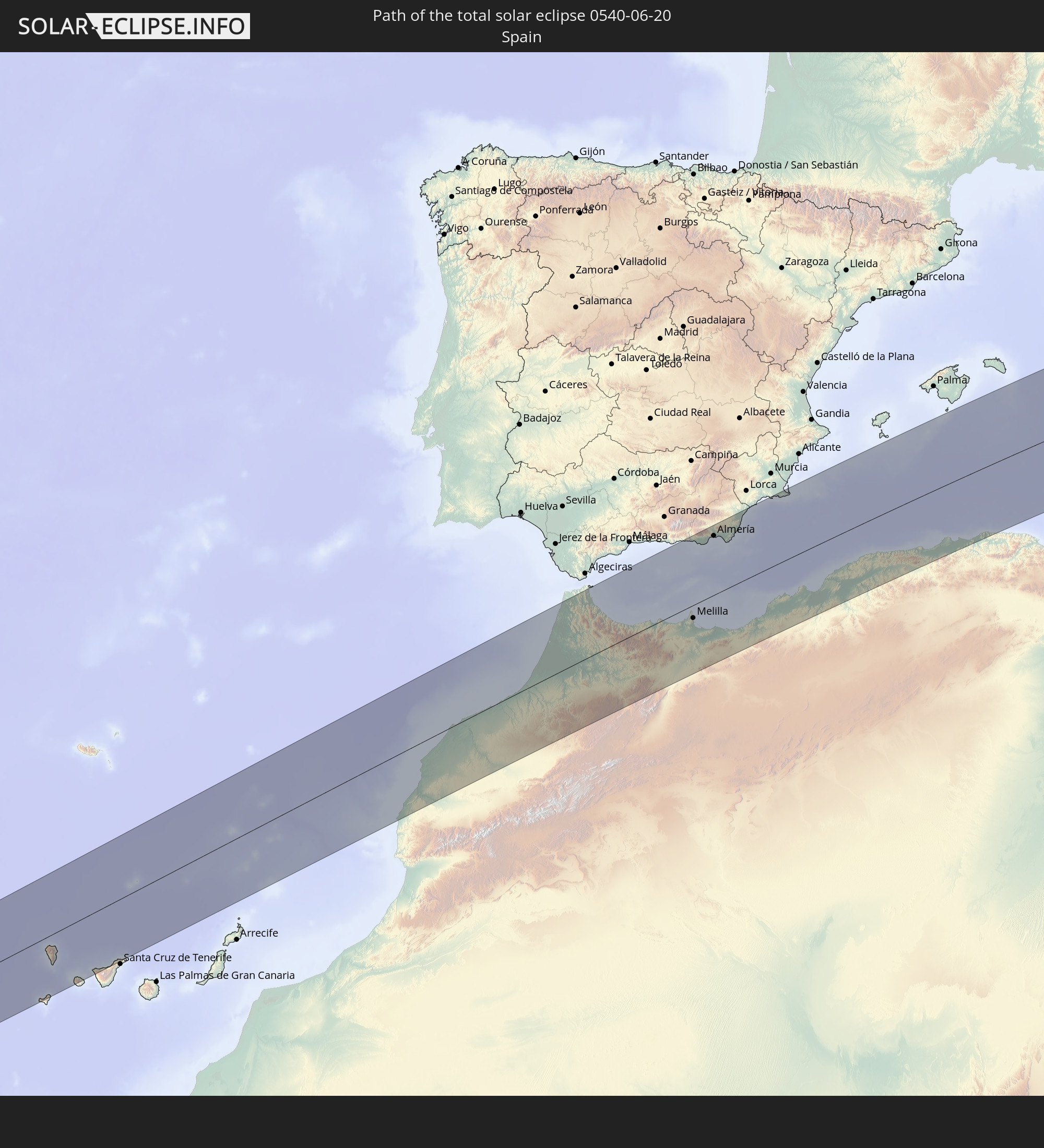 Spain
Spain
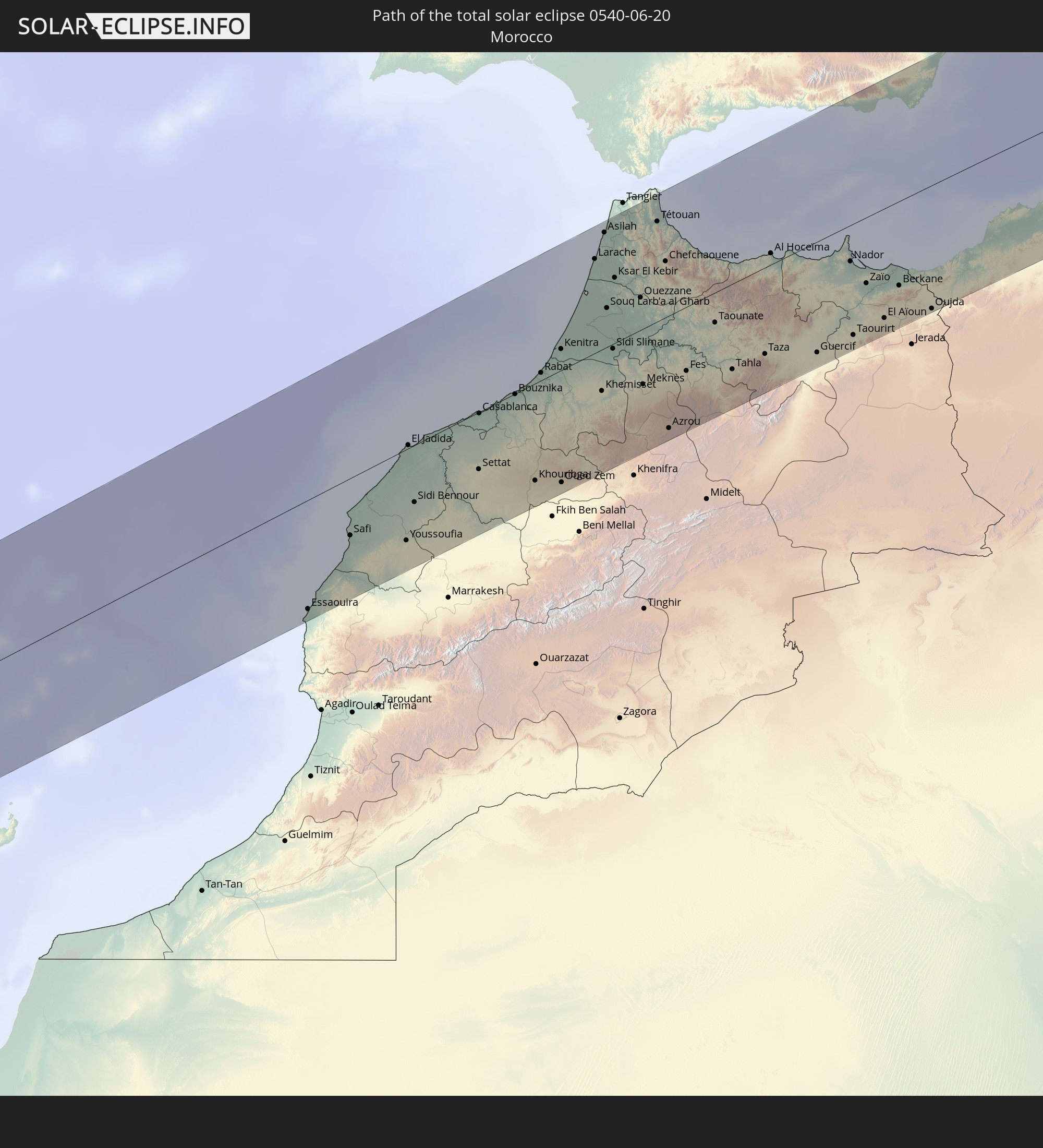 Morocco
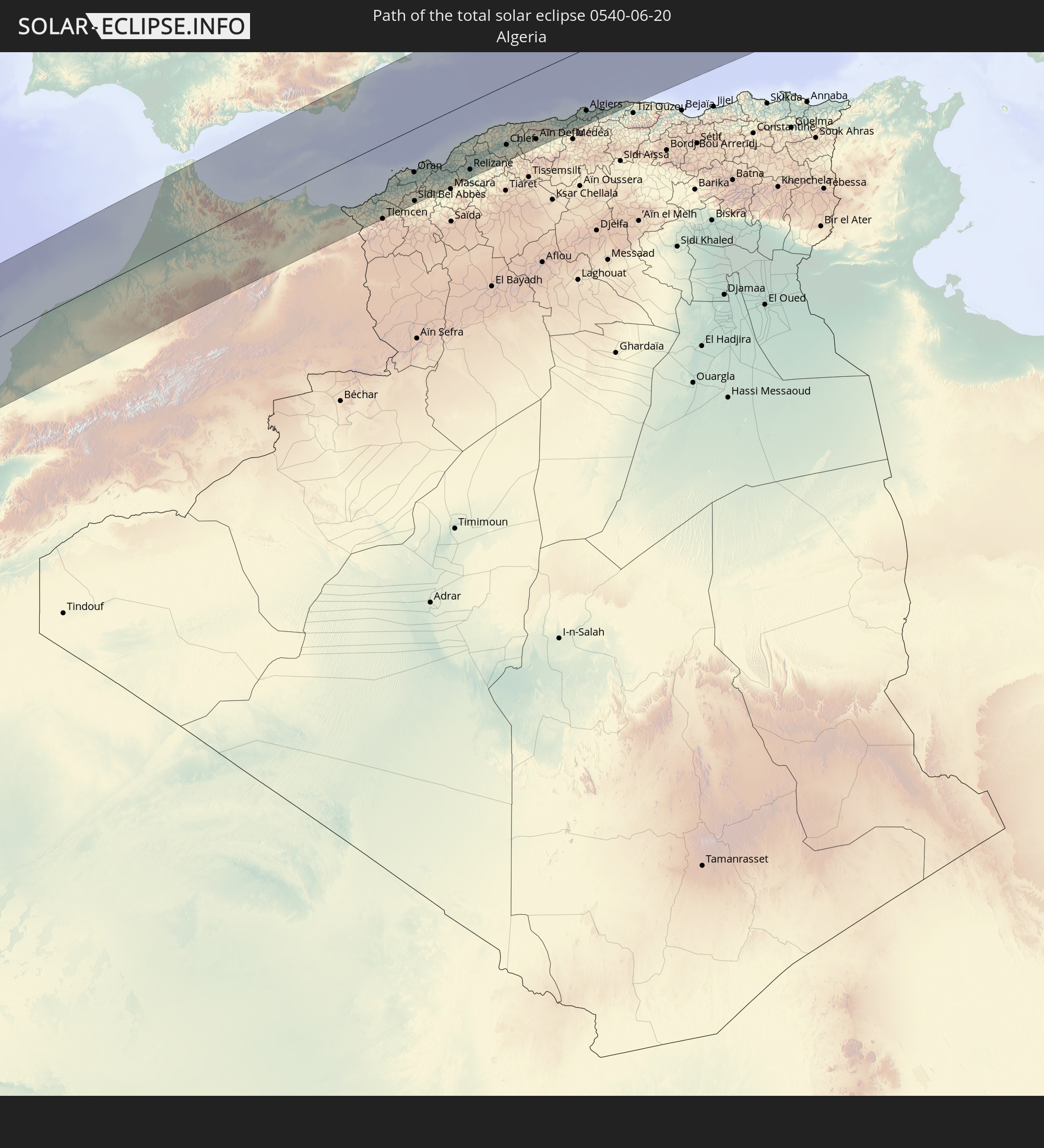 Algeria
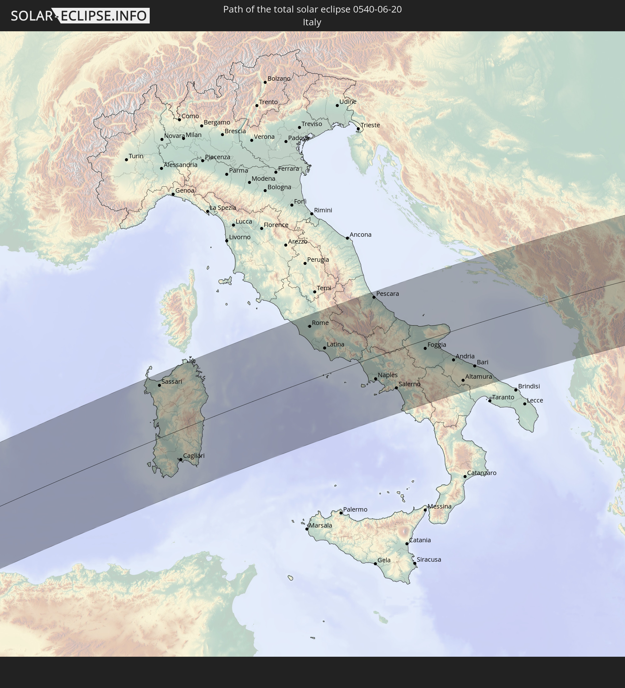 Italy
Italy
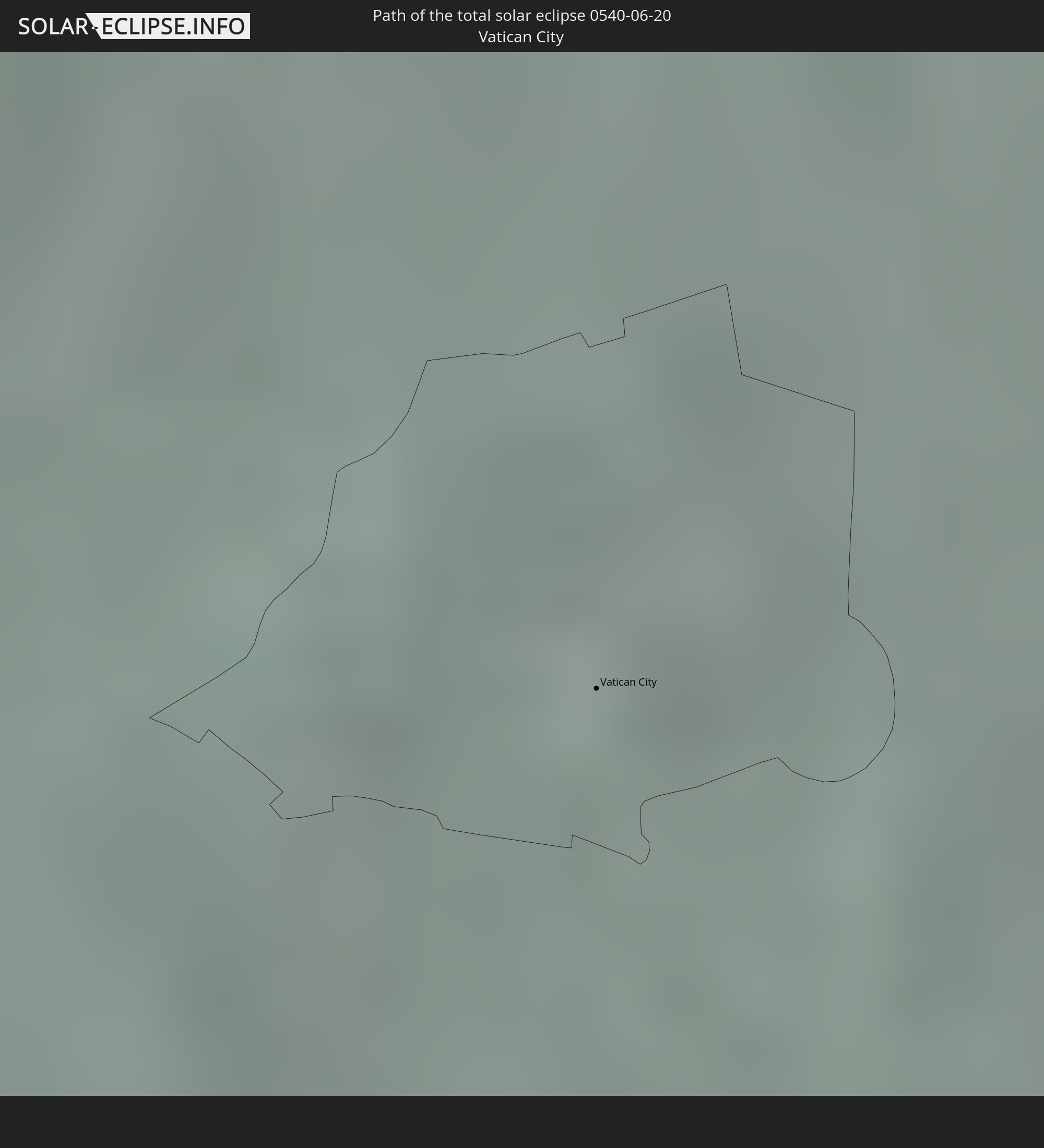 Vatican City
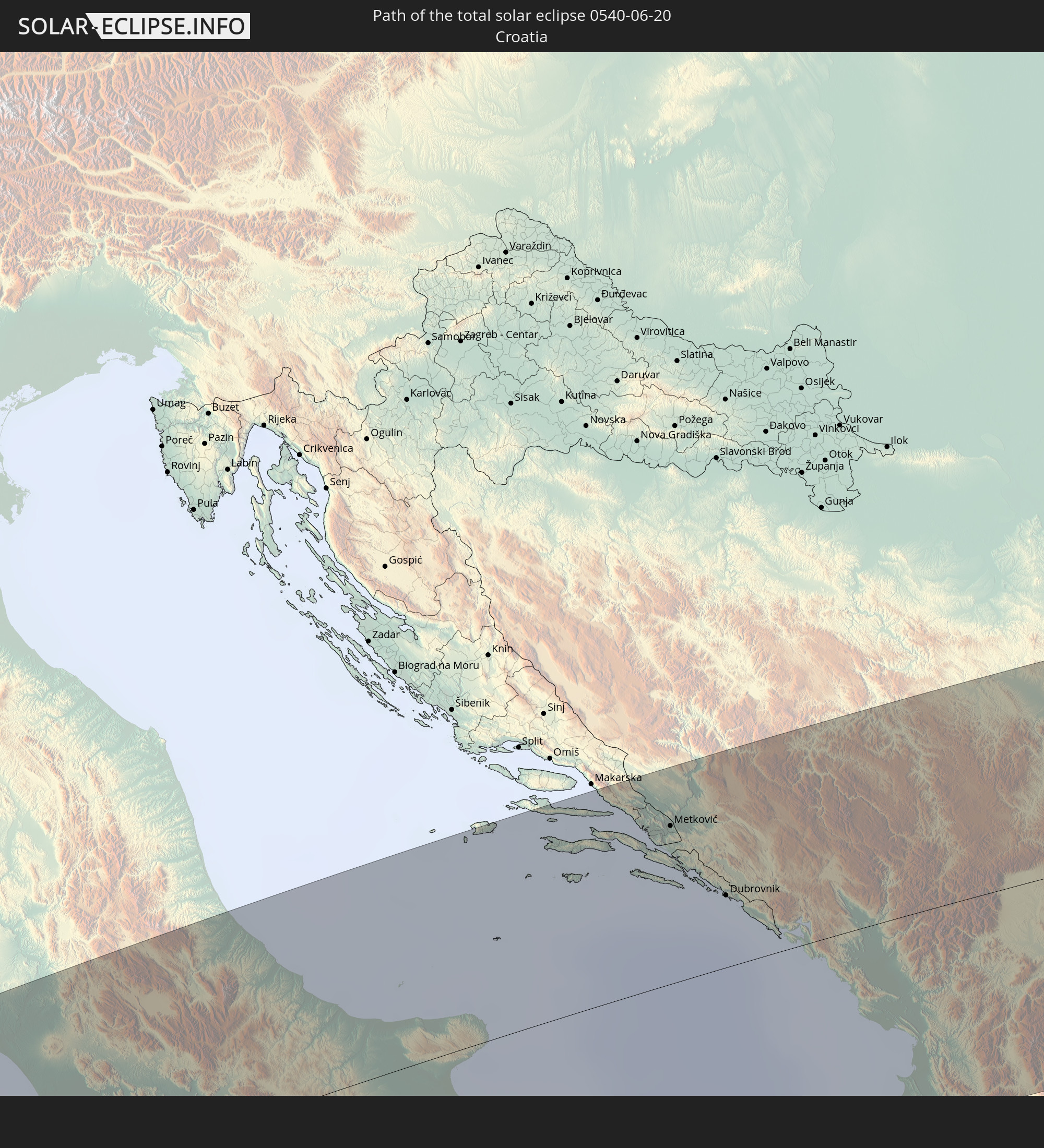 Croatia
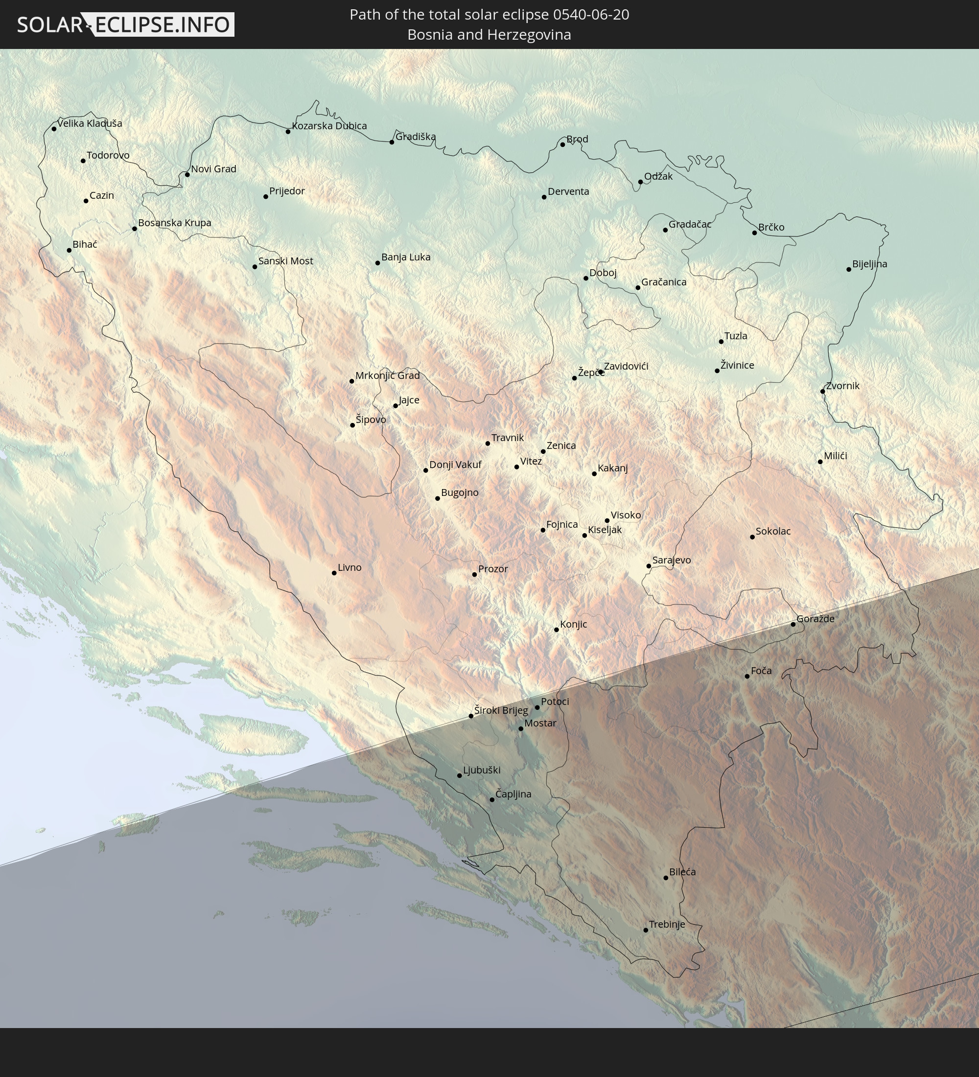 Bosnia and Herzegovina
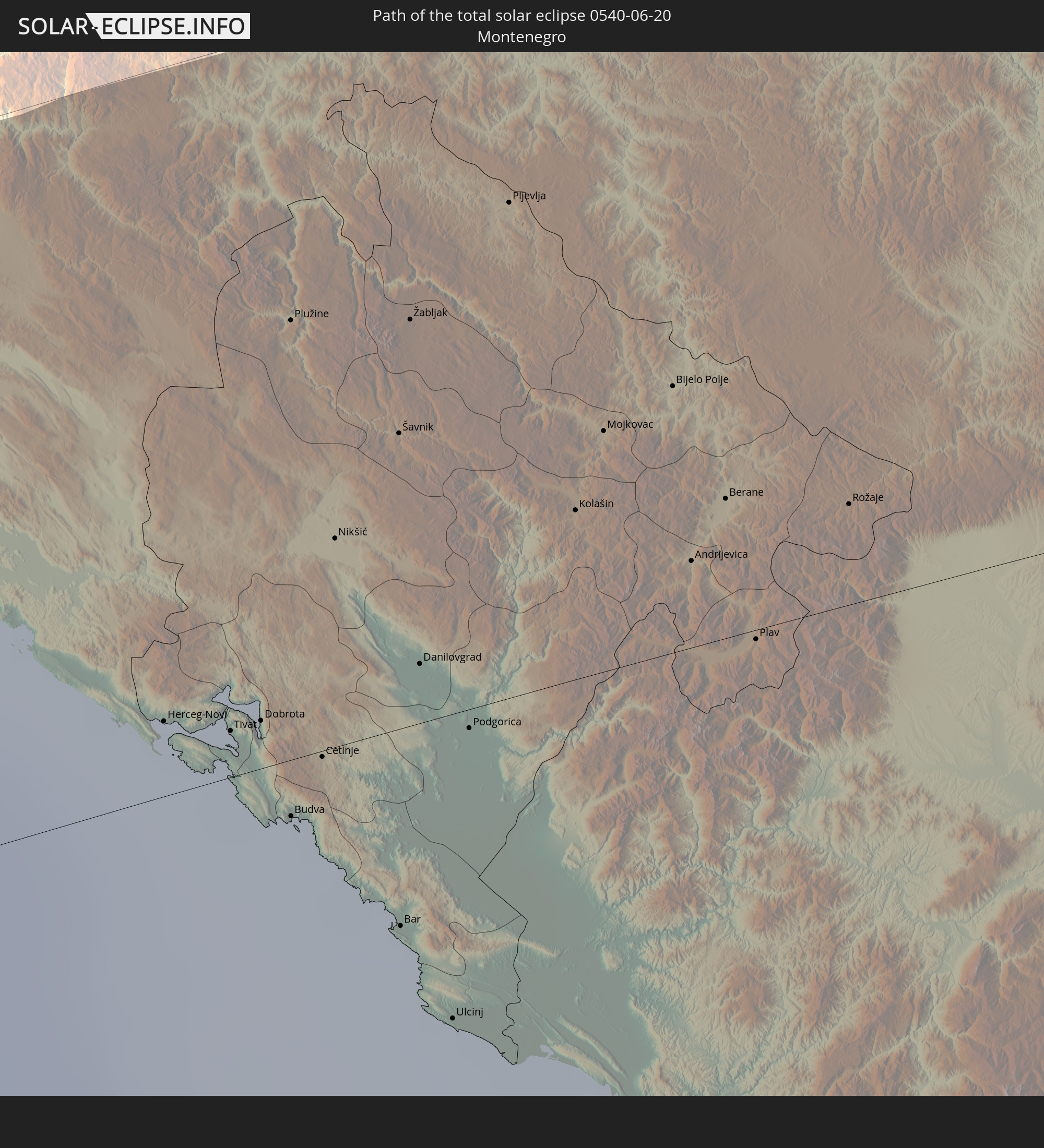 Montenegro
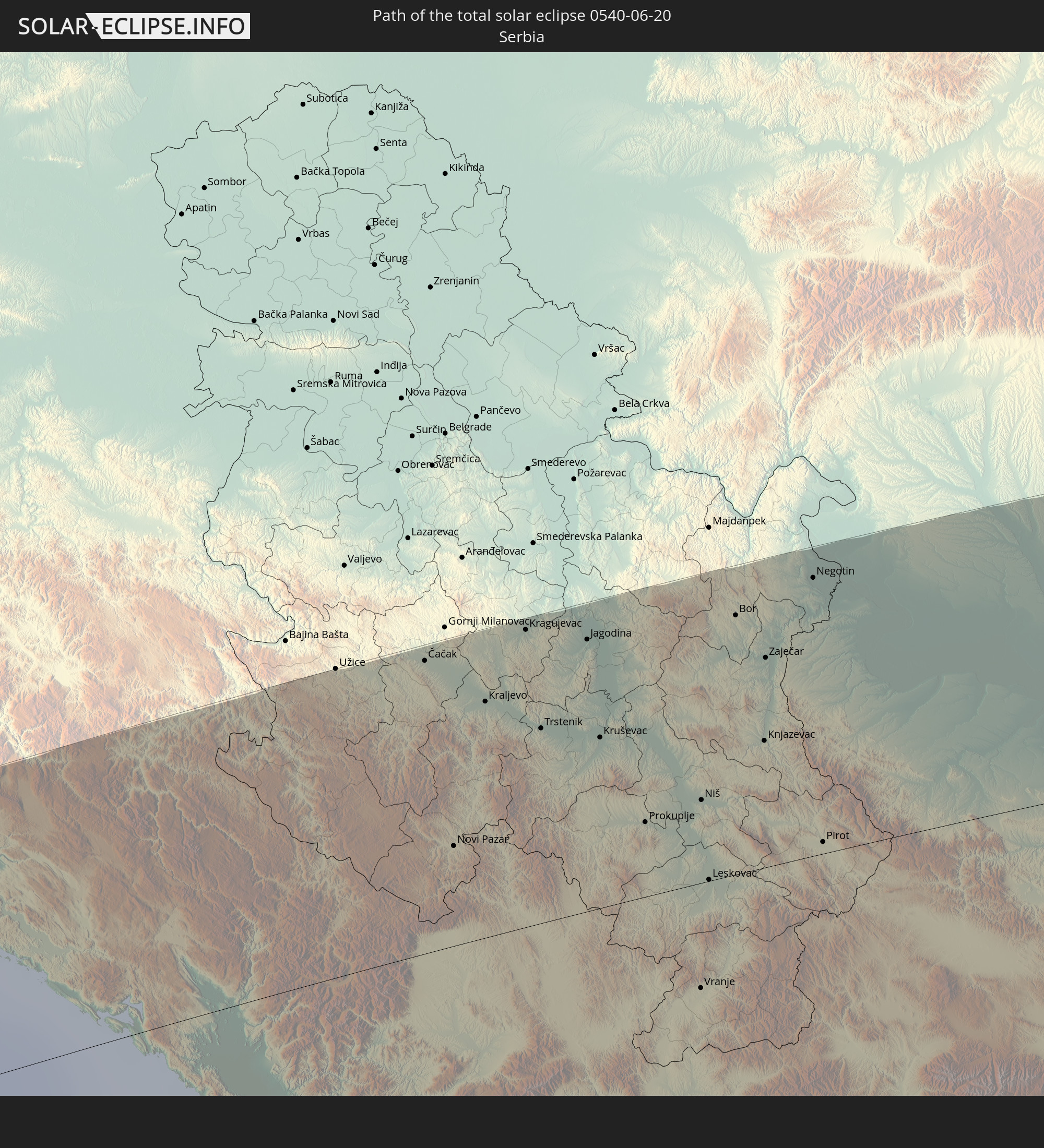 Serbia
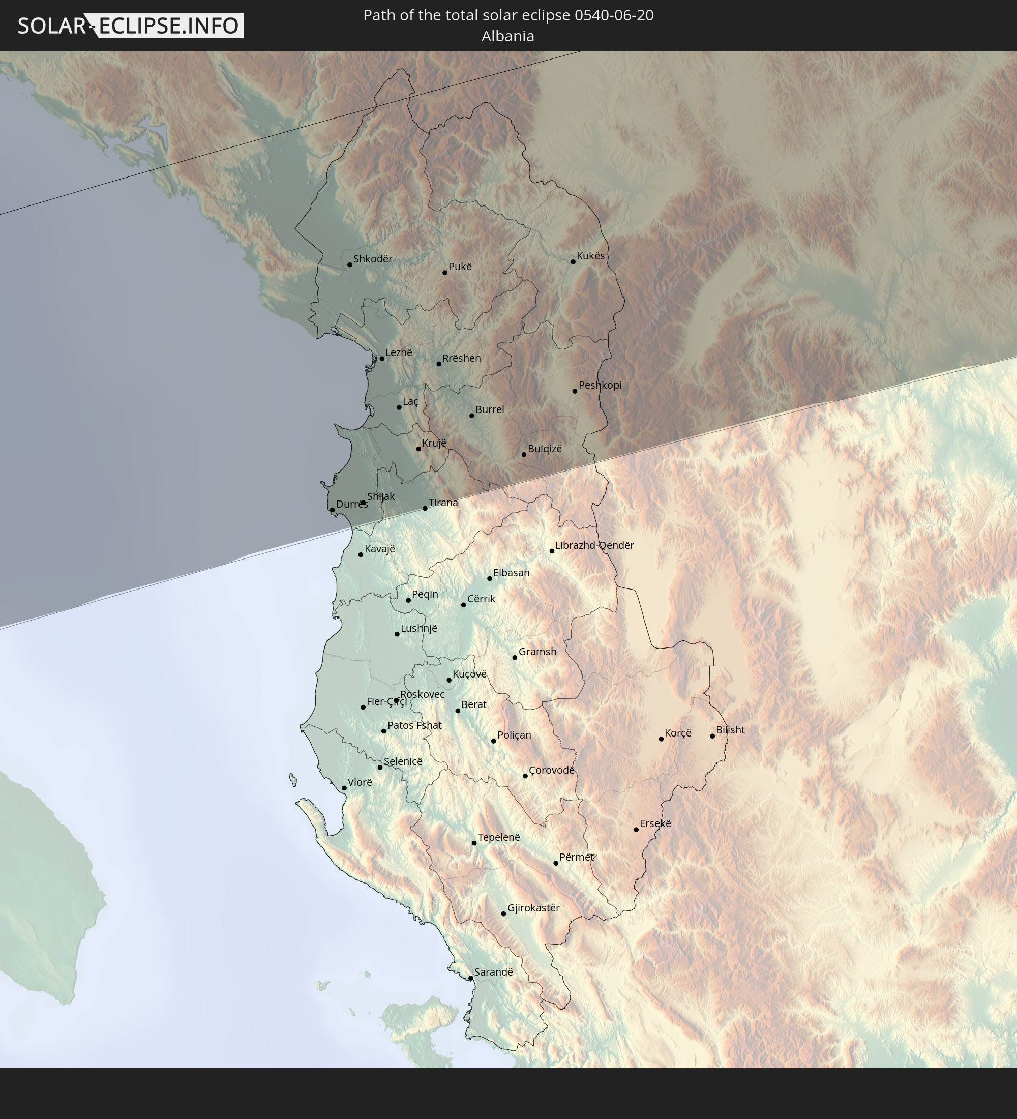 Albania
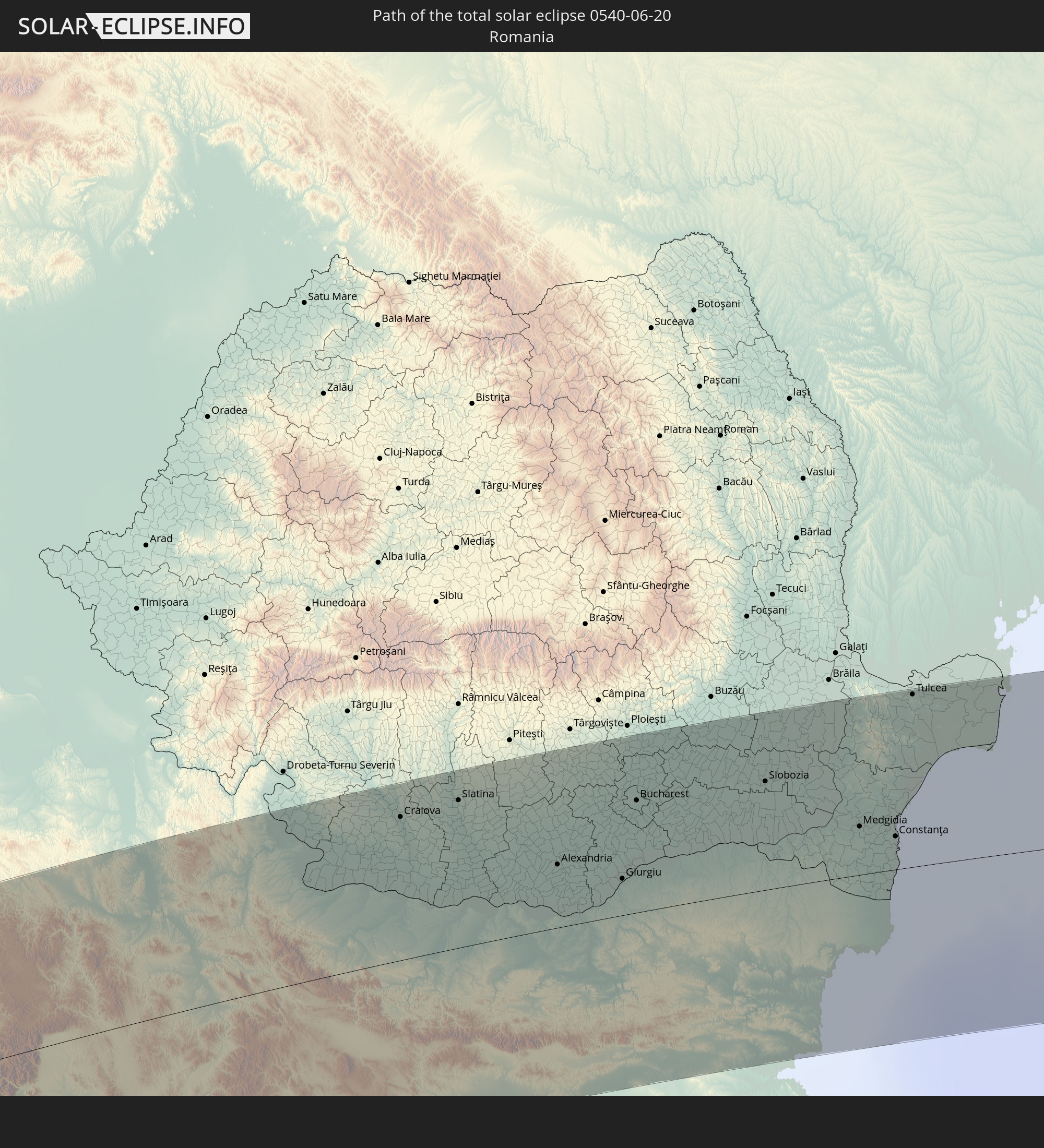 Romania
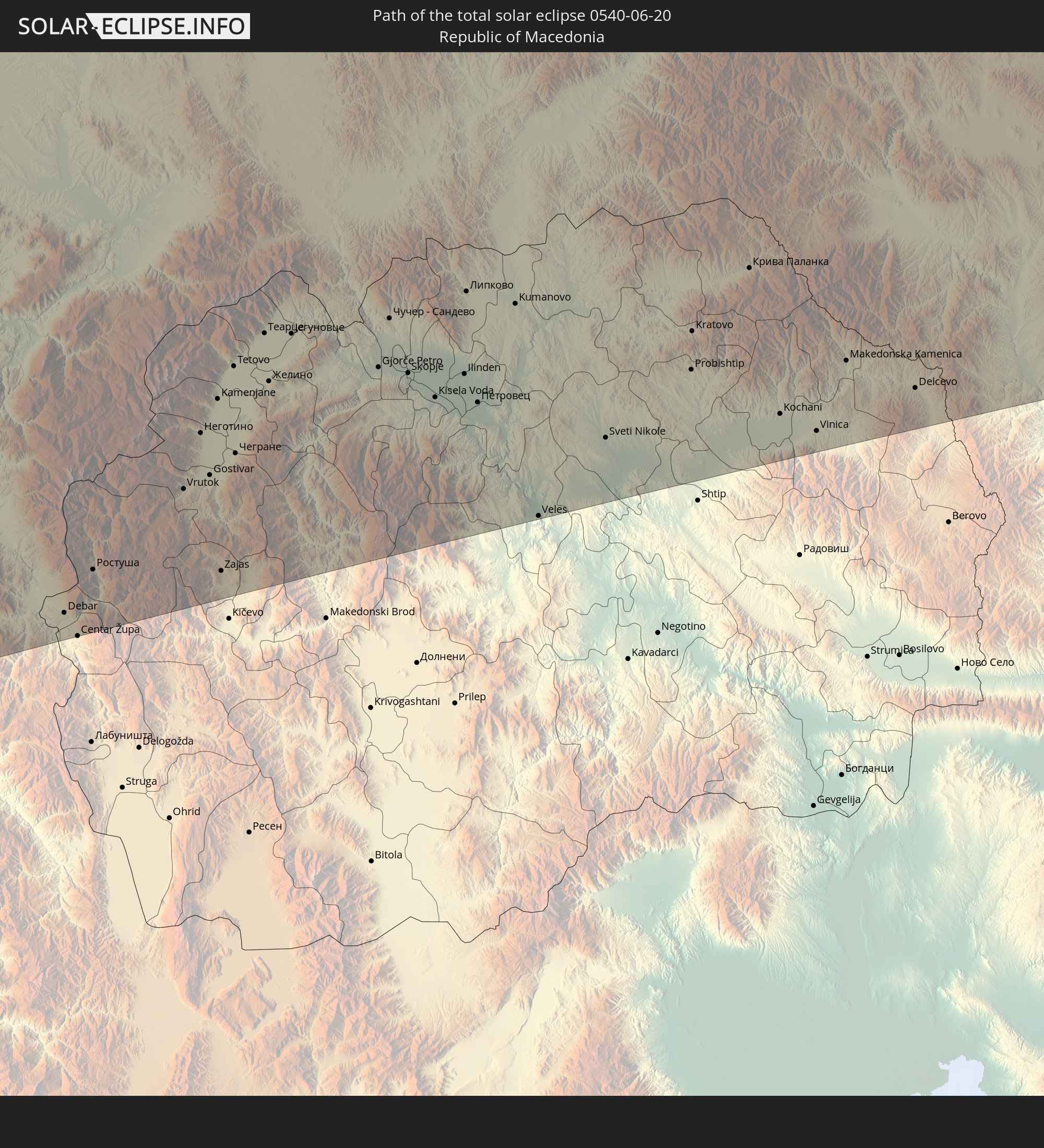 Republic of Macedonia
 Ukraine
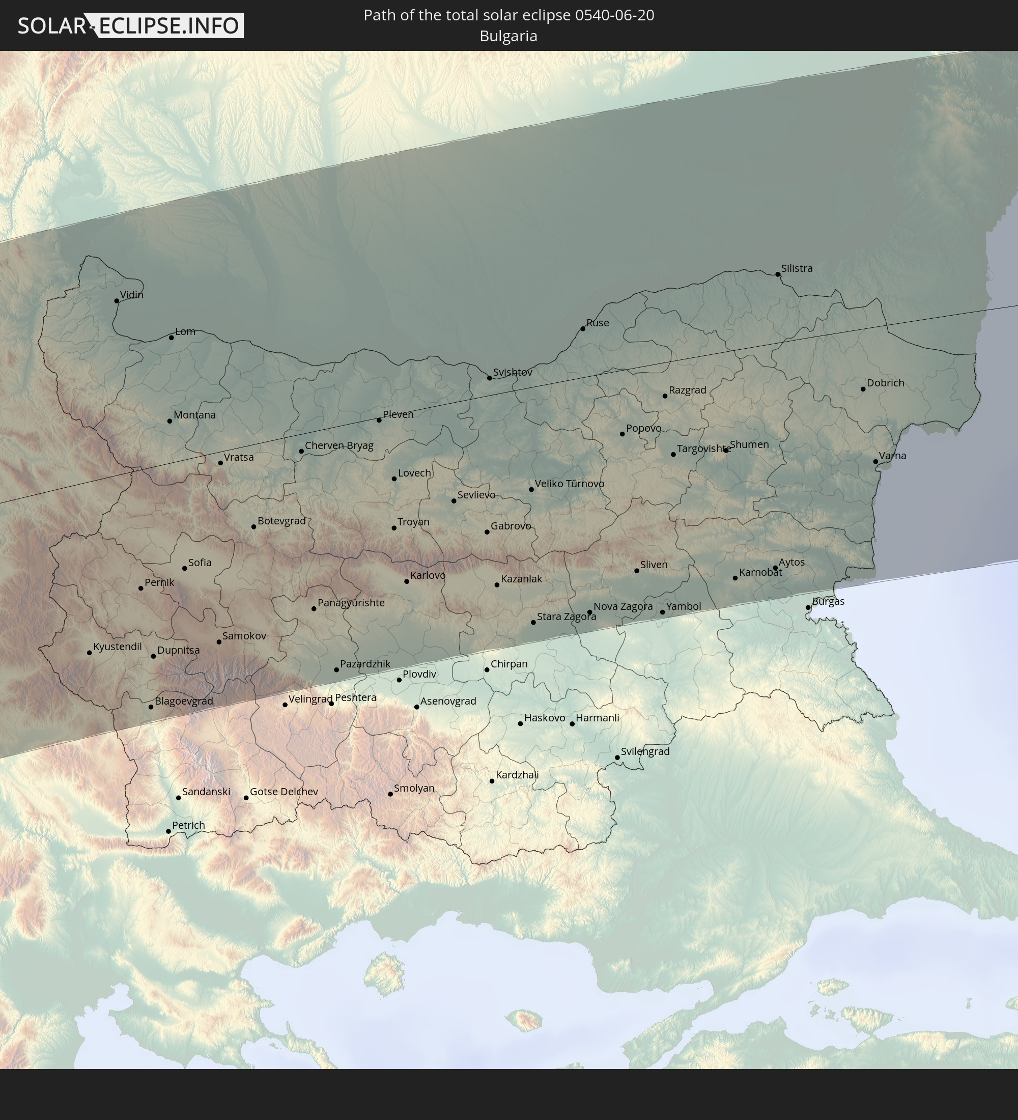 Bulgaria
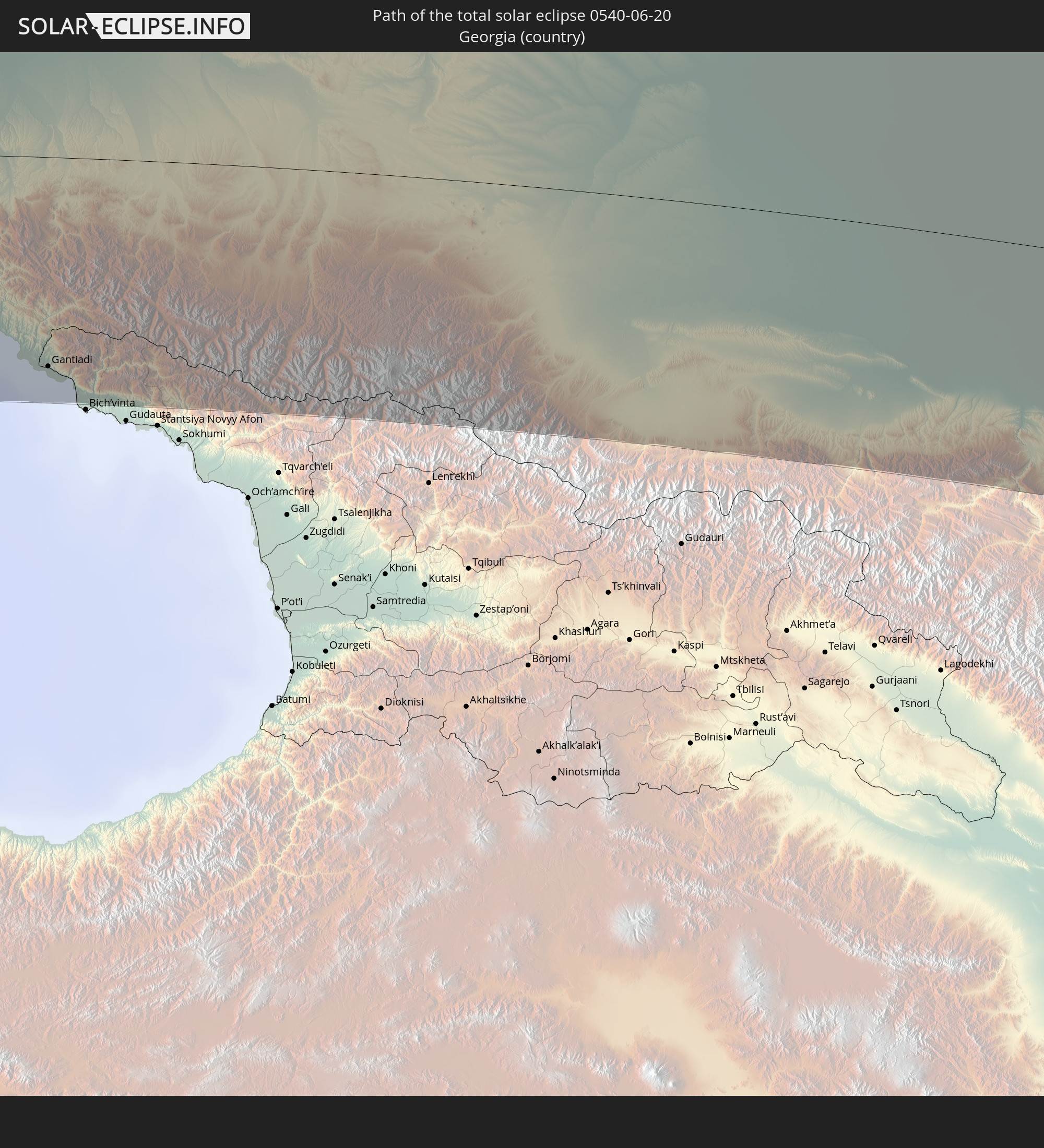 Georgia
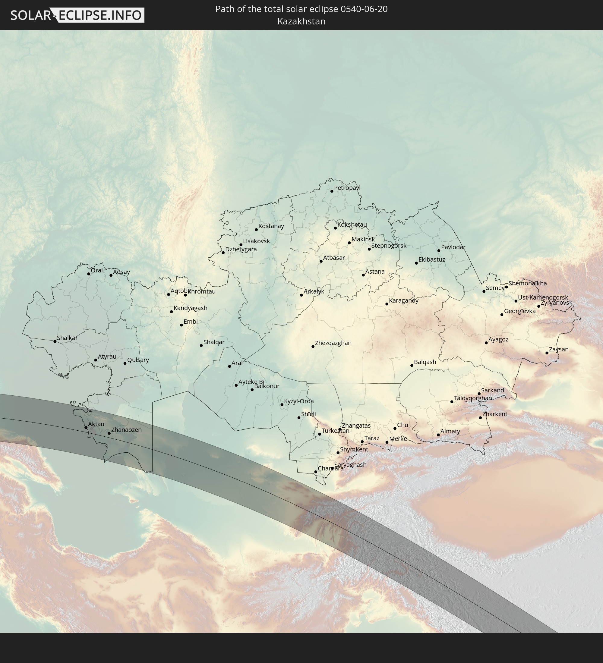 Kazakhstan
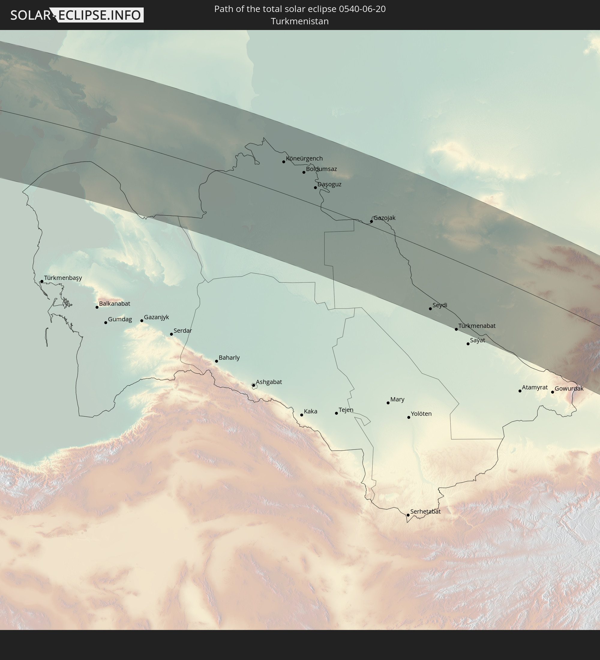 Turkmenistan
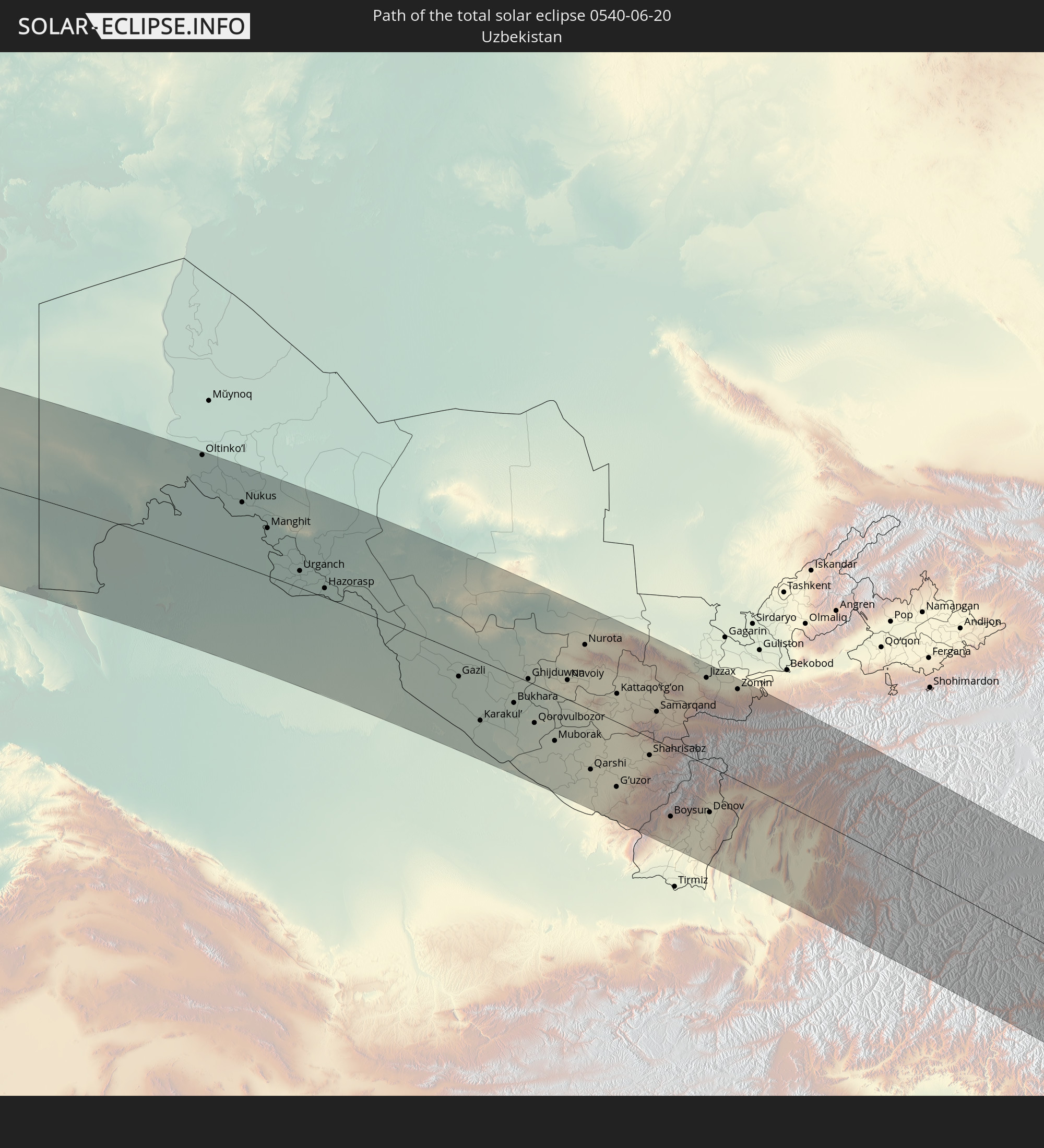 Uzbekistan
 Afghanistan
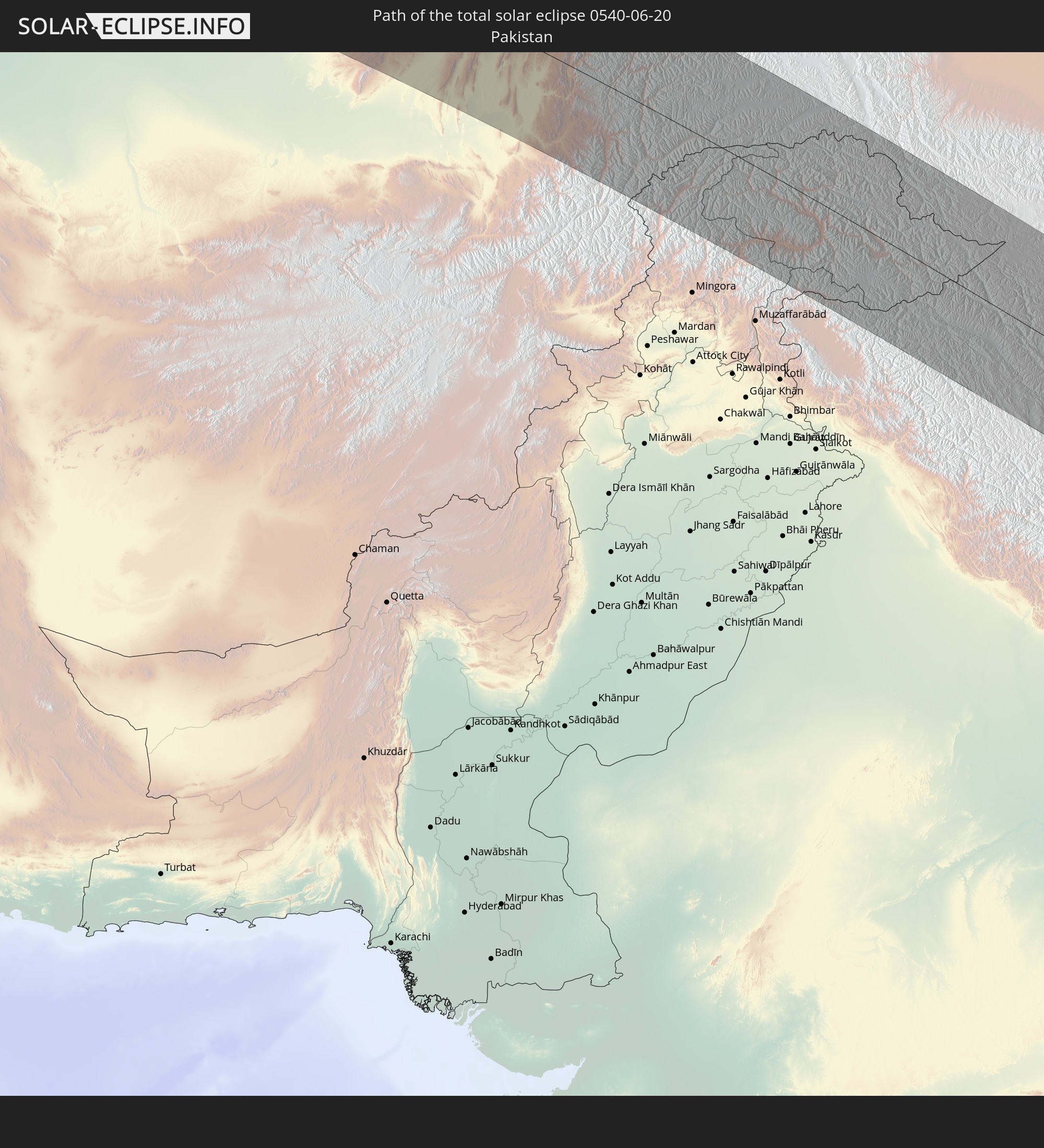 Pakistan
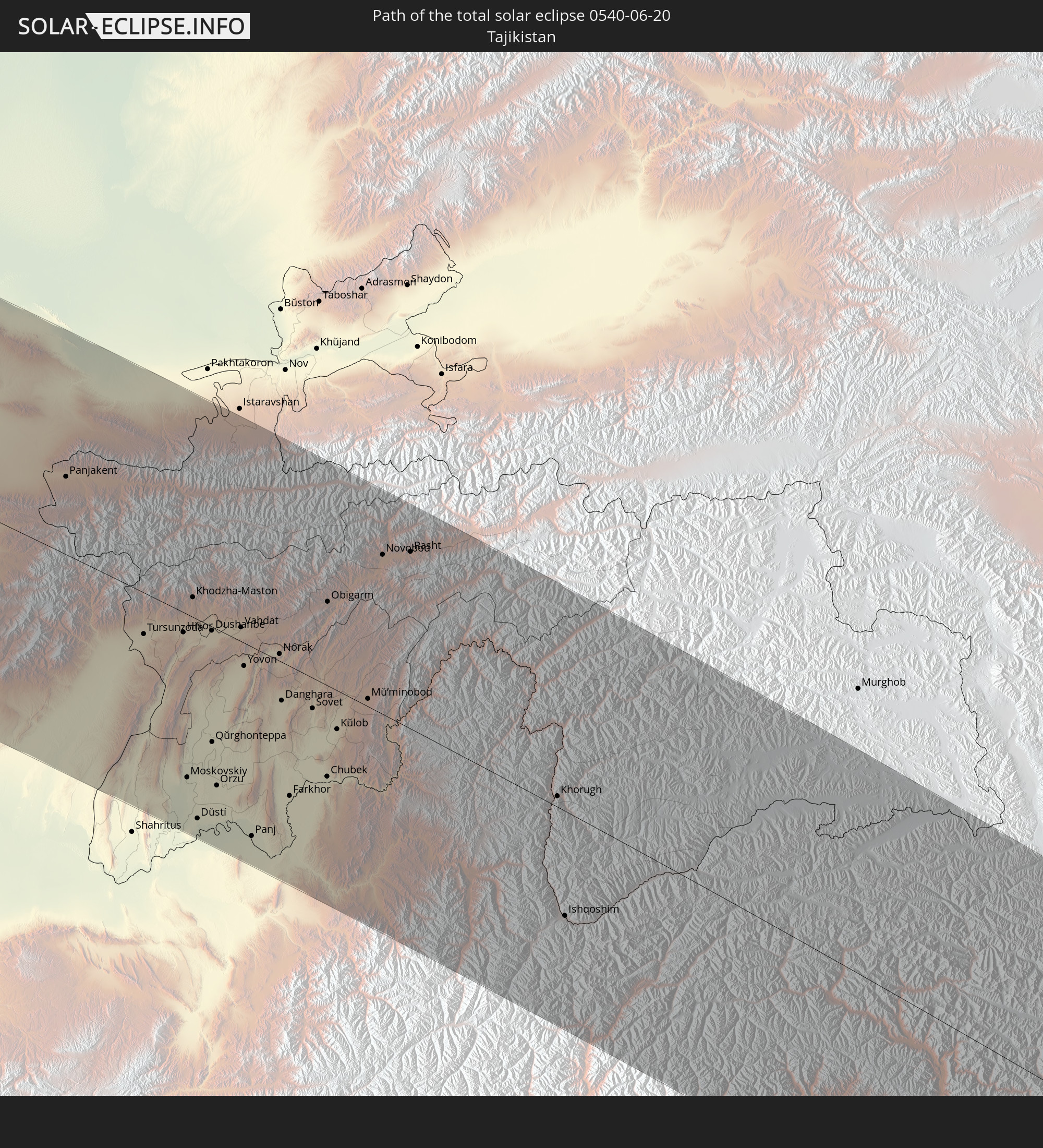 Tajikistan
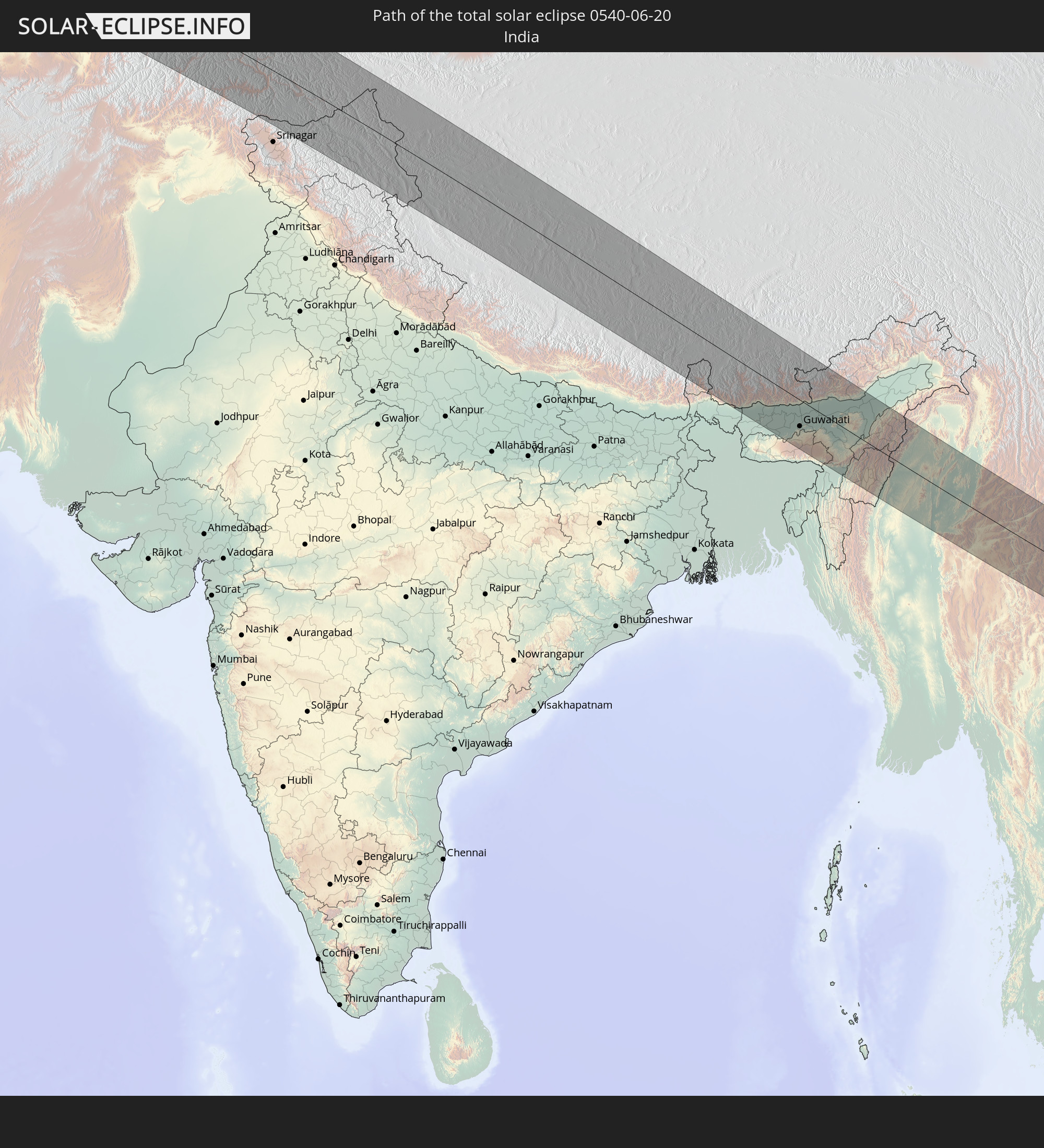 India
India
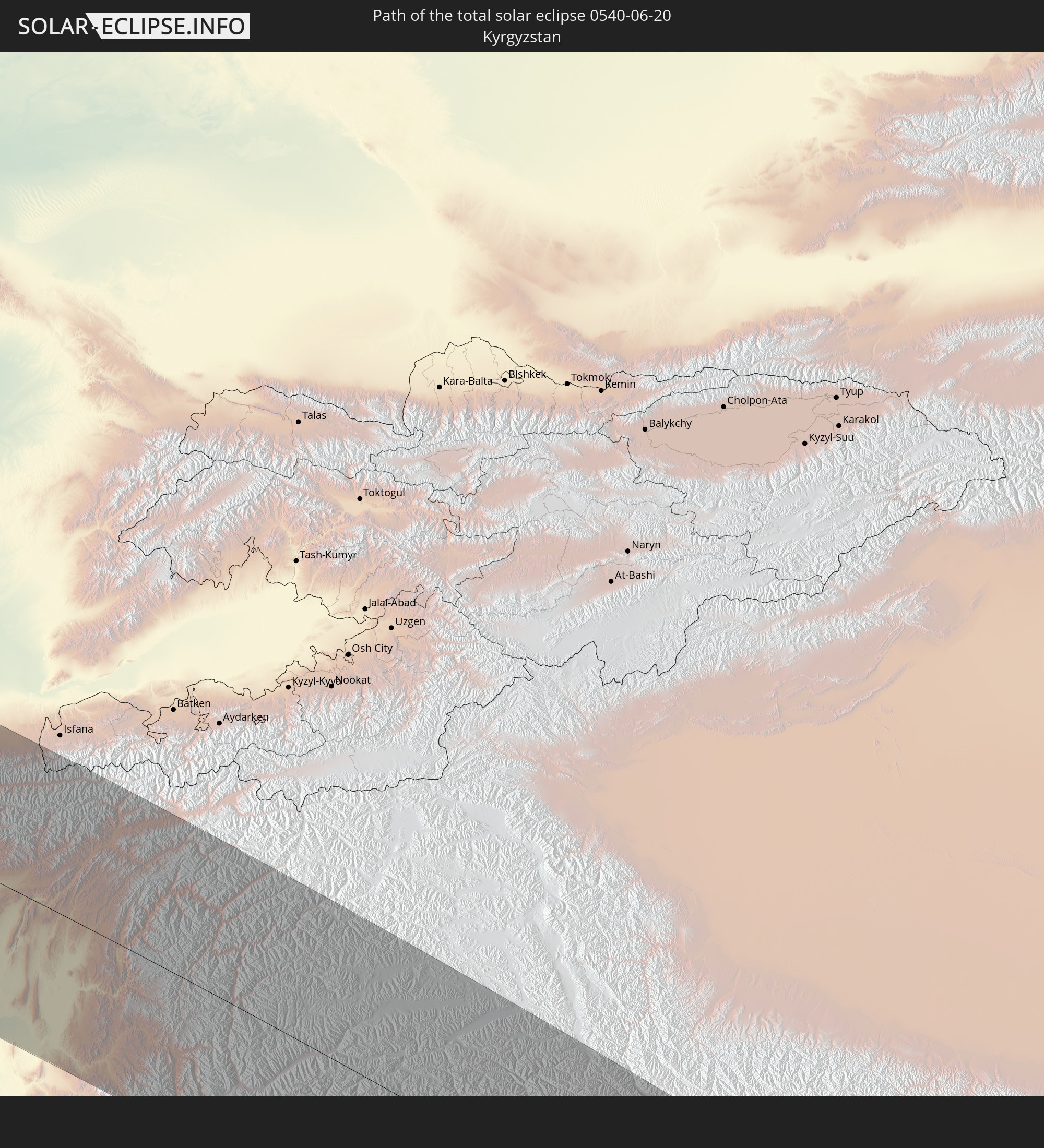 Kyrgyzstan
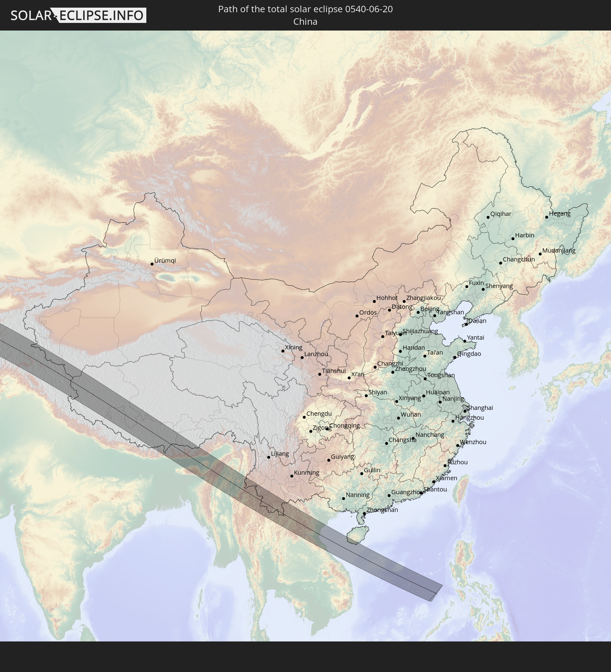 China
China
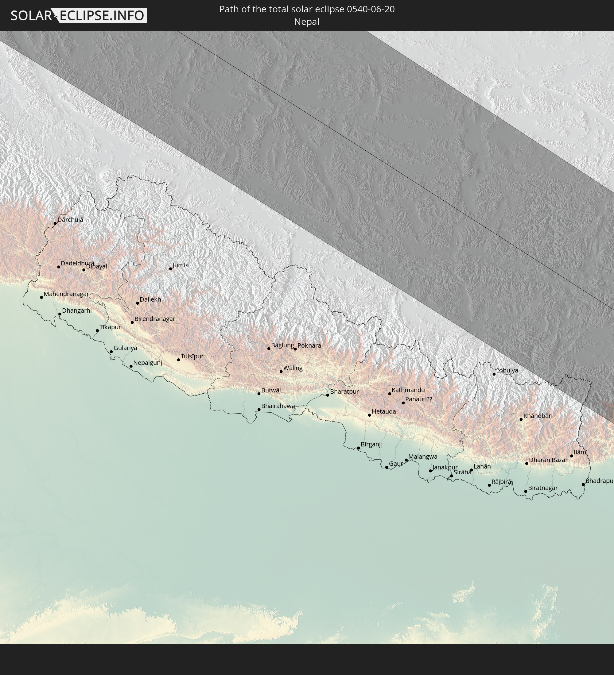 Nepal
Nepal
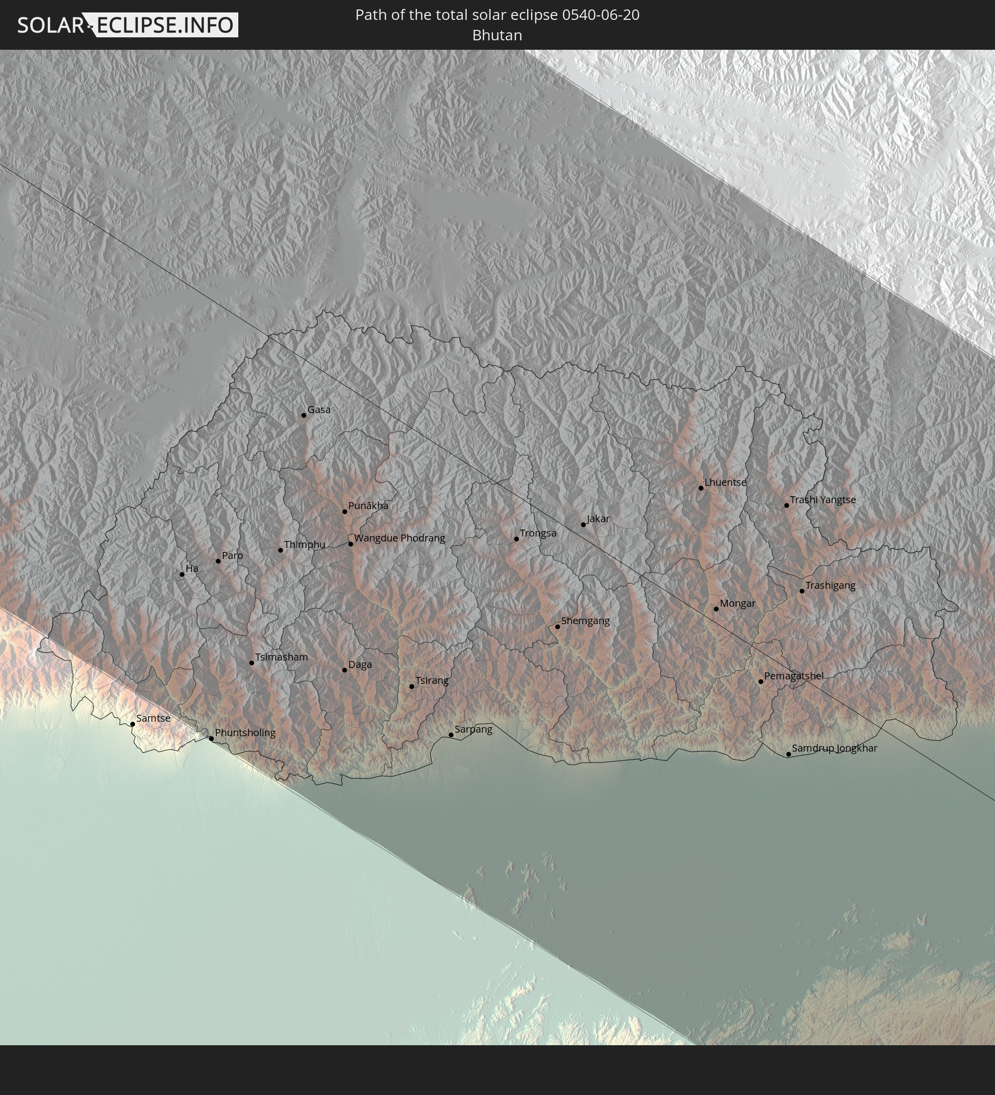 Bhutan
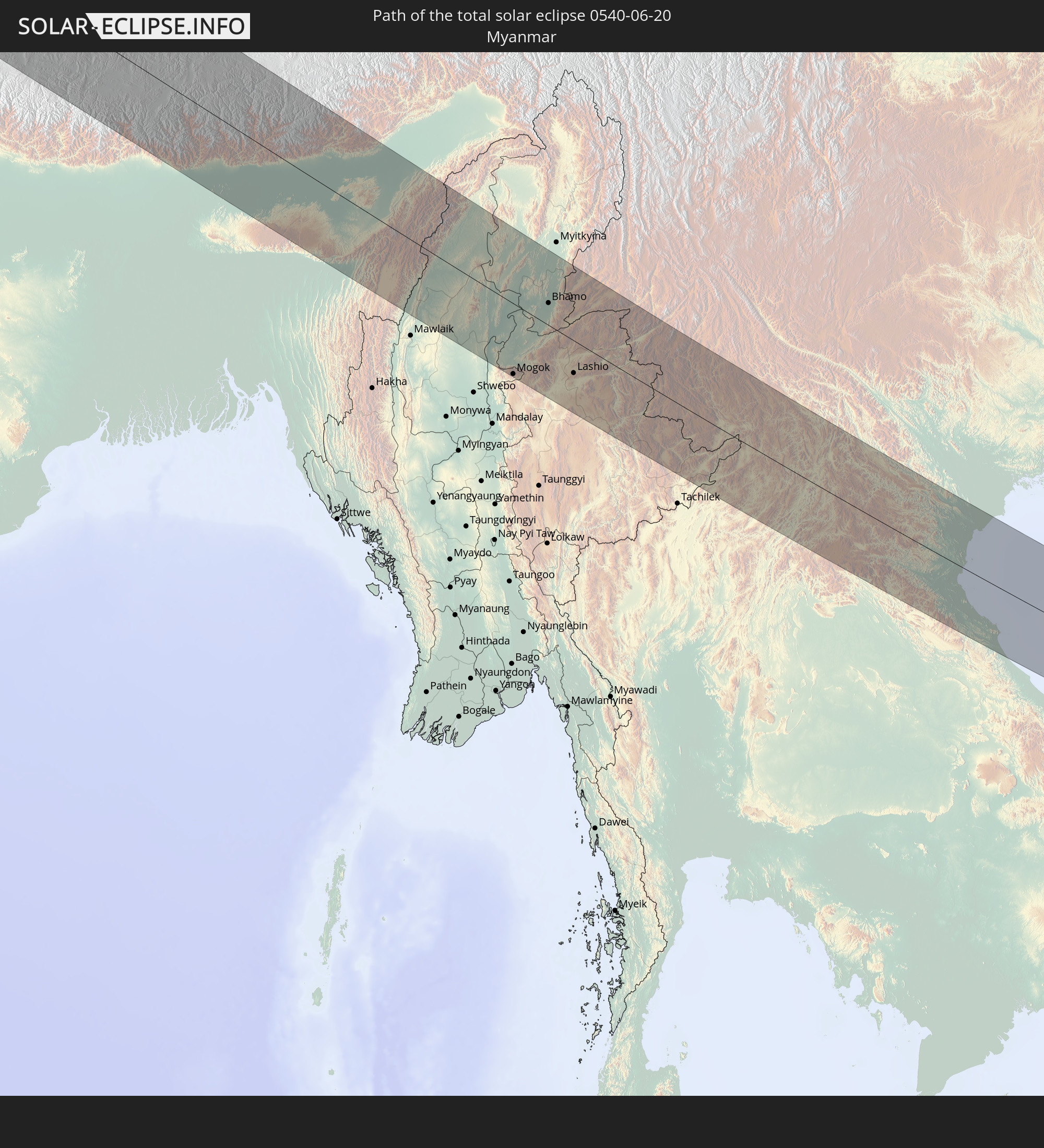 Myanmar
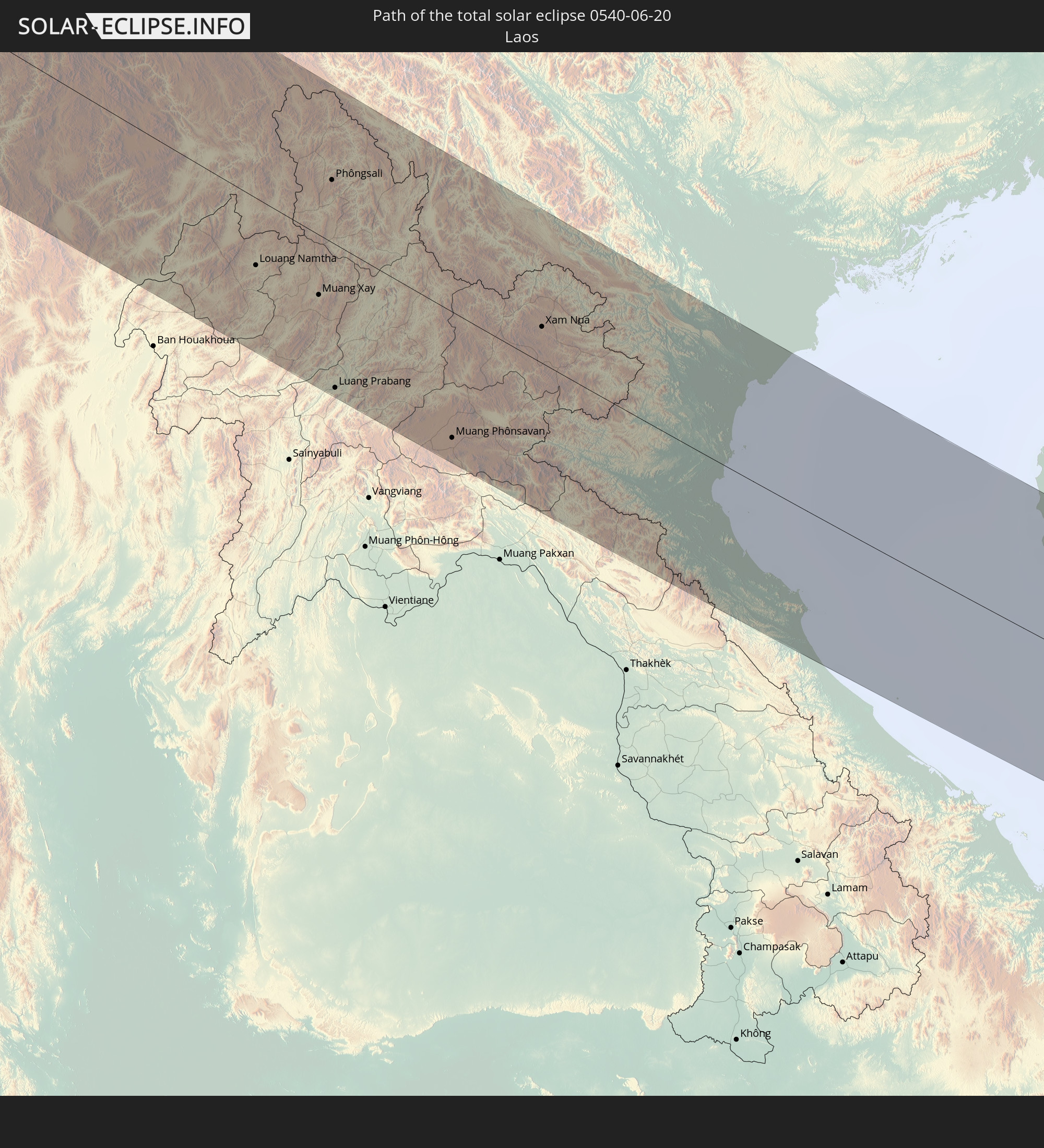 Laos
Laos
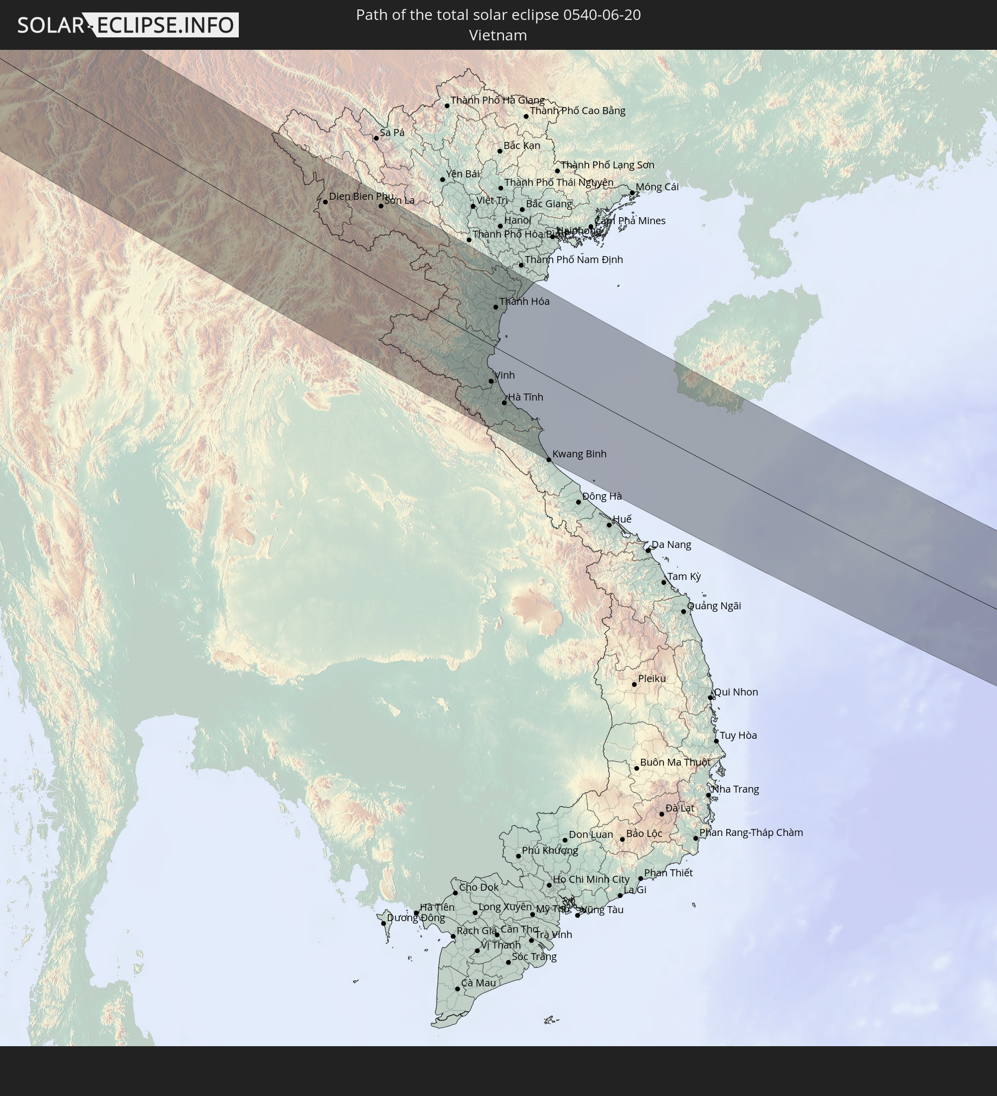 Vietnam
In den folgenden Ländern ist die Sonnenfinsternis partiell zu sehen
 Russia
 Canada
 Greenland
 Portugal
 Cabo Verde
 Iceland
 Spain
Spain
 Senegal
 Mauritania
 The Gambia
 Guinea-Bissau
 Guinea
 Sierra Leone
 Morocco
 Mali
Mali
 Liberia
 Republic of Ireland
 Svalbard and Jan Mayen
 Algeria
 United Kingdom
 Ivory Coast
 Faroe Islands
 Burkina Faso
 Gibraltar
 France
 Isle of Man
 Ghana
Ghana
 Guernsey
 Jersey
 Togo
Togo
 Niger
Niger
 Benin
Benin
 Andorra
 Belgium
 Nigeria
 Netherlands
 Norway
 Luxembourg
 Germany
 Switzerland
 Italy
Italy
 Monaco
 Tunisia
 Denmark
 Cameroon
 Libya
Libya
 Liechtenstein
 Austria
 Sweden
 Czechia
 San Marino
 Vatican City
 Slovenia
 Chad
Chad
 Croatia
 Poland
 Malta
Malta
 Central African Republic
 Bosnia and Herzegovina
 Hungary
 Slovakia
 Montenegro
 Serbia
 Albania
 Åland Islands
 Greece
 Romania
 Republic of Macedonia
 Finland
 Lithuania
 Latvia
 Estonia
 Sudan
Sudan
 Ukraine
 Bulgaria
 Belarus
 Egypt
Egypt
 Turkey
 Moldova
 Cyprus
 Ethiopia
 State of Palestine
 Israel
 Saudi Arabia
 Jordan
 Lebanon
 Syria
Syria
 Eritrea
 Iraq
Iraq
 Georgia
 Somalia
 Yemen
Yemen
 Armenia
 Iran
Iran
 Azerbaijan
 Kazakhstan
 Kuwait
 Bahrain
 Qatar
Qatar
 United Arab Emirates
 Oman
Oman
 Turkmenistan
 Uzbekistan
 Afghanistan
 Pakistan
 Tajikistan
 India
India
 Kyrgyzstan
 Maldives
 China
China
 Sri Lanka
 Nepal
Nepal
 Mongolia
 Bangladesh
 Bhutan
 Myanmar
 Indonesia
 Cocos Islands
 Thailand
 Malaysia
 Laos
Laos
 Vietnam
 Cambodia
 Singapore
 Macau
Macau
 Hong Kong
 Taiwan
 Philippines
 Japan
Japan
 North Korea
 South Korea
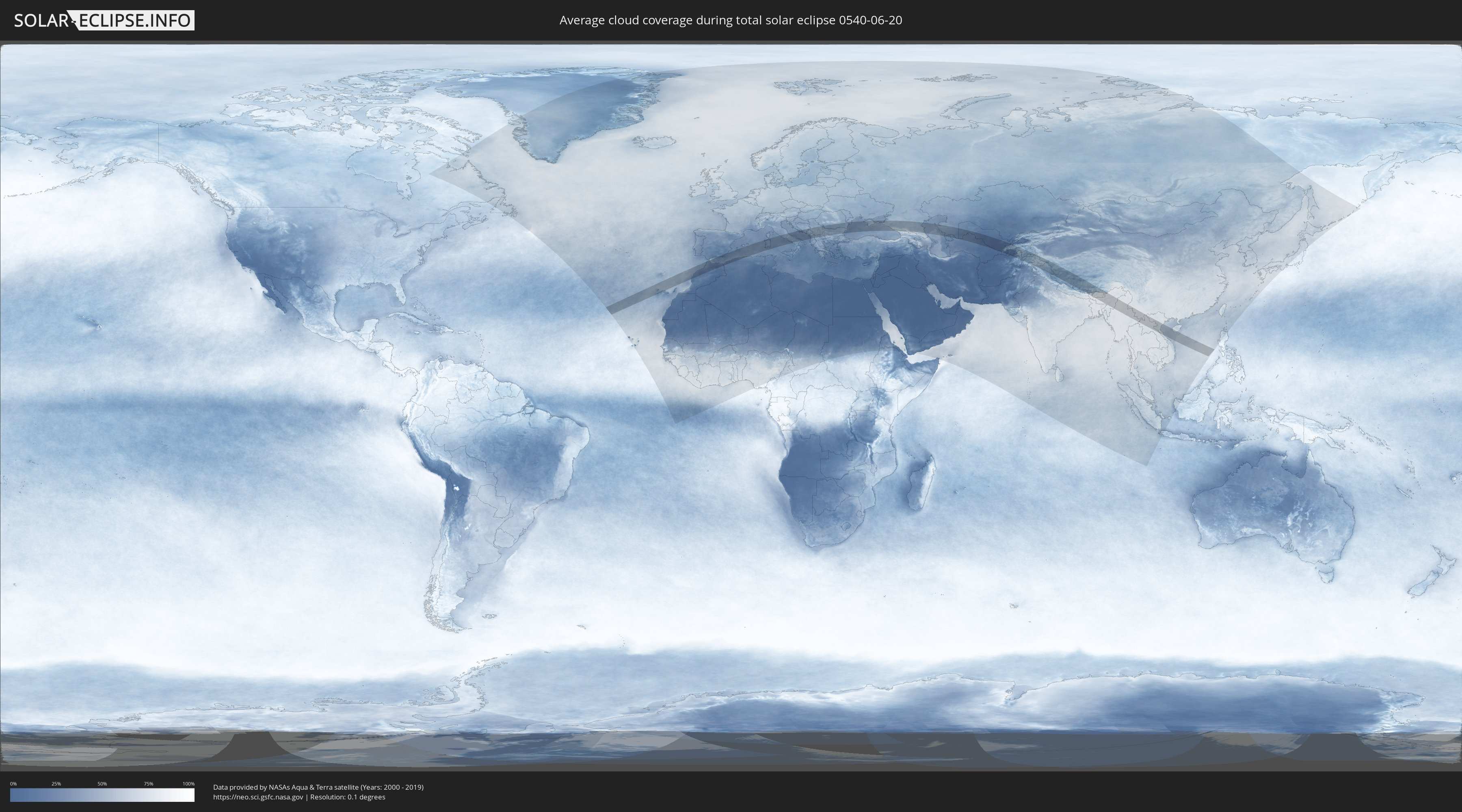
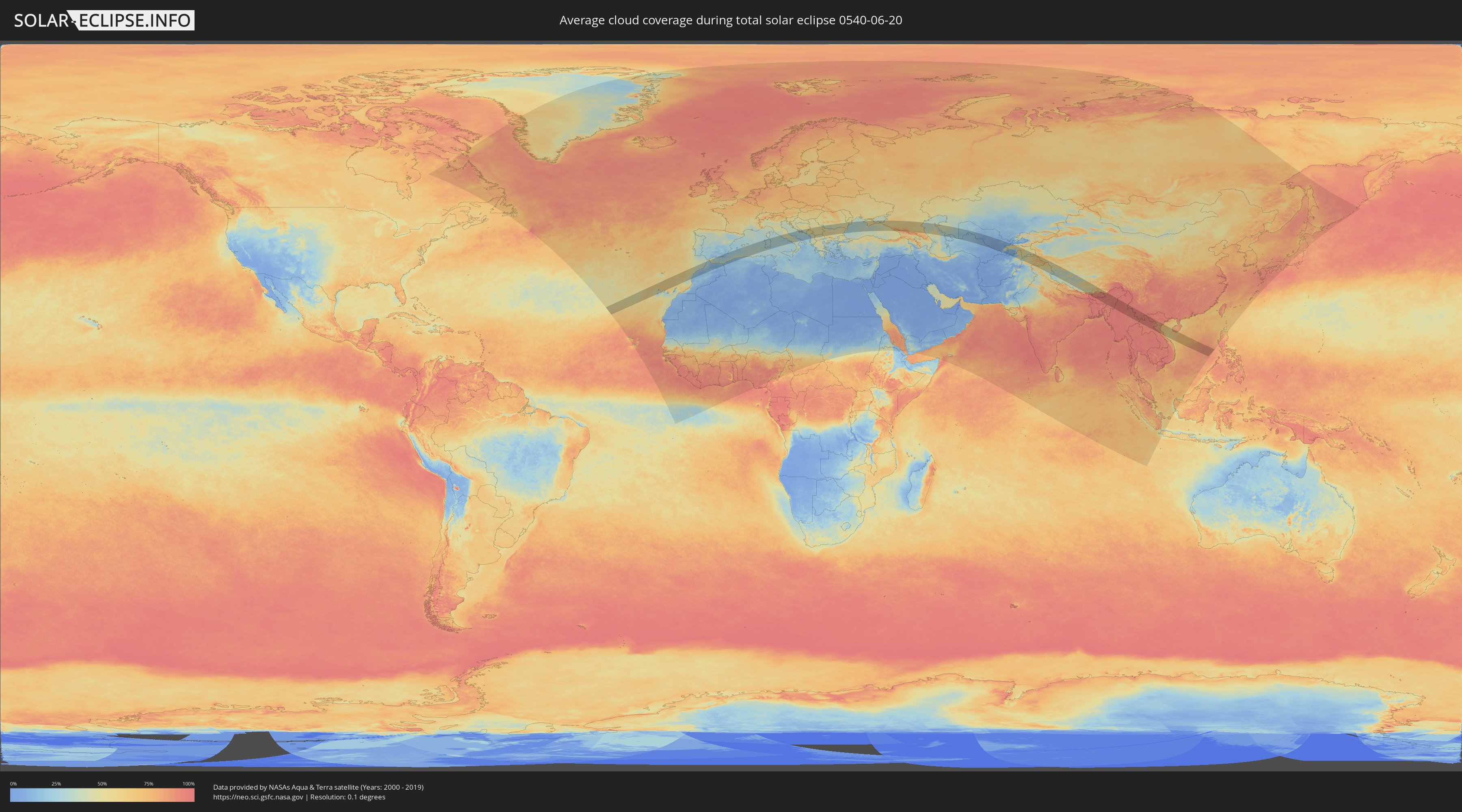
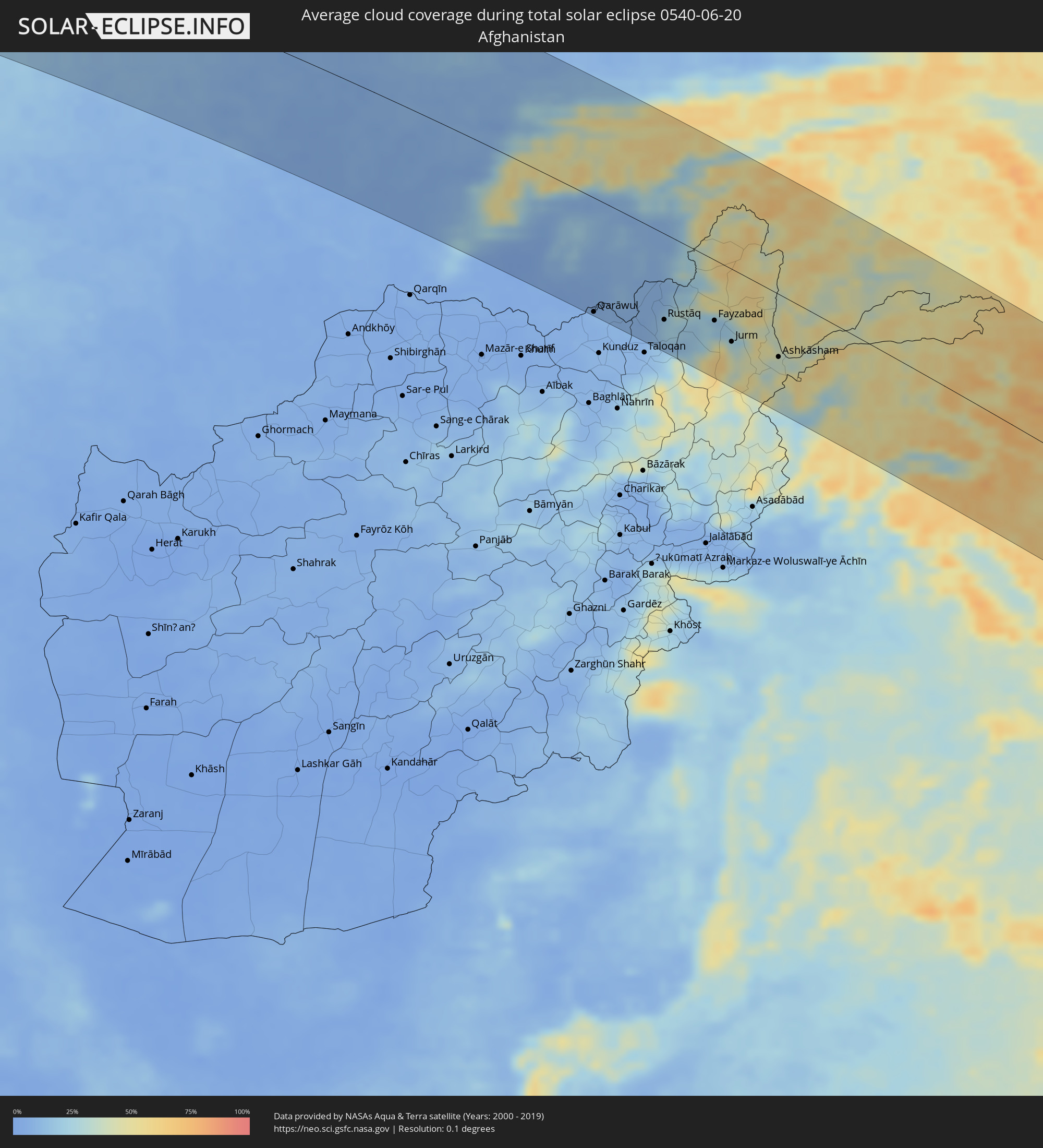
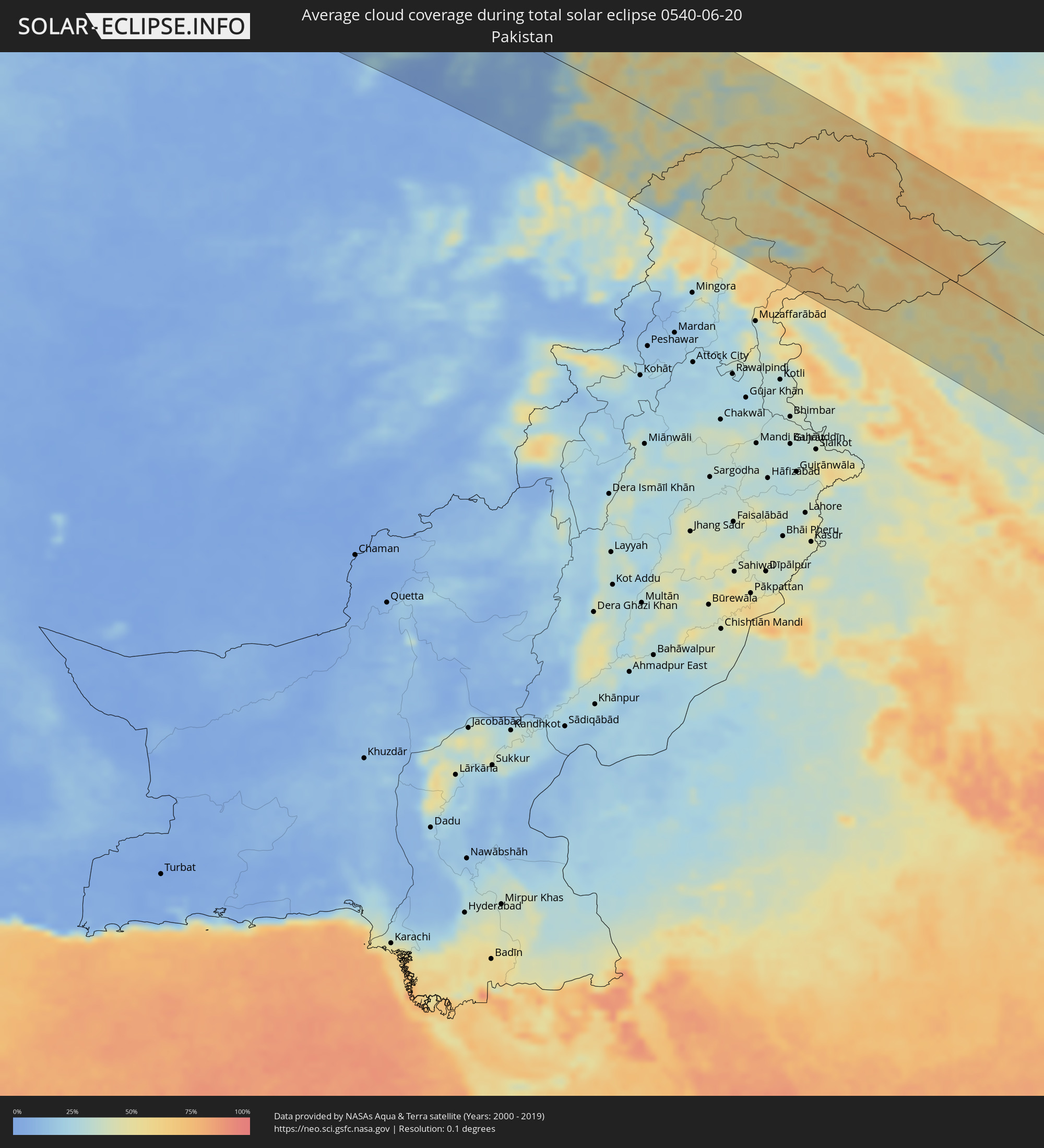
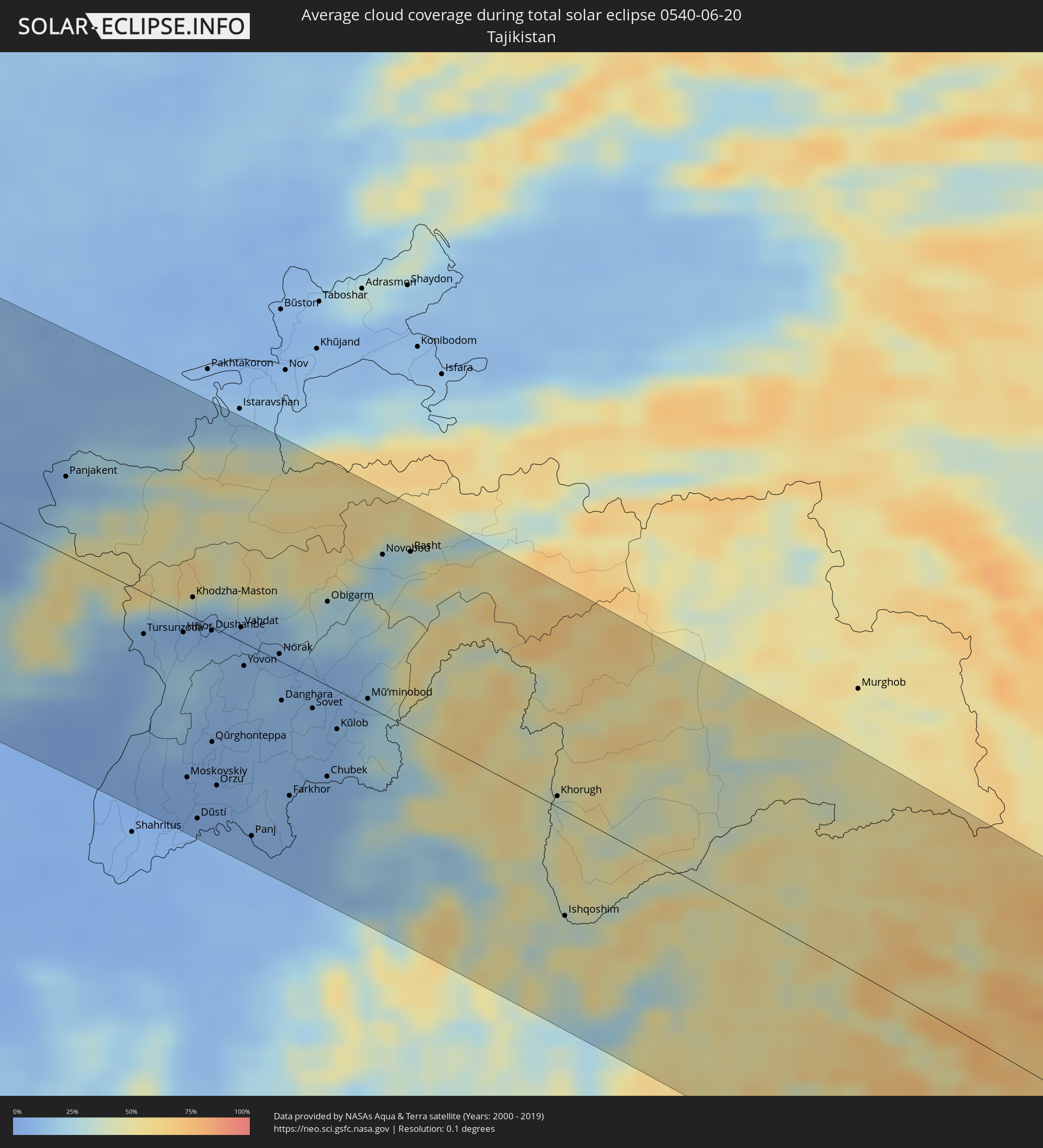
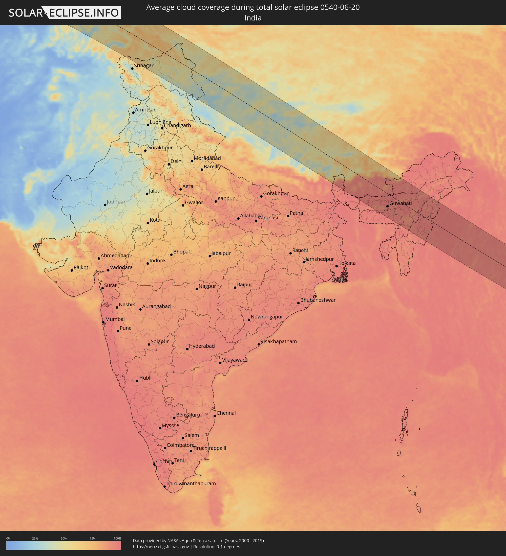
How will be the weather during the total solar eclipse on 06/20/0540?
Where is the best place to see the total solar eclipse of 06/20/0540?
The following maps show the average cloud coverage for the day of the total solar eclipse.
With the help of these maps, it is possible to find the place along the eclipse path, which has the best
chance of a cloudless sky.
Nevertheless, you should consider local circumstances and inform about the weather of your chosen
observation site.
The data is provided by NASAs satellites
AQUA and TERRA.
The cloud maps are averaged over a period of 19 years (2000 - 2019).
Detailed country maps
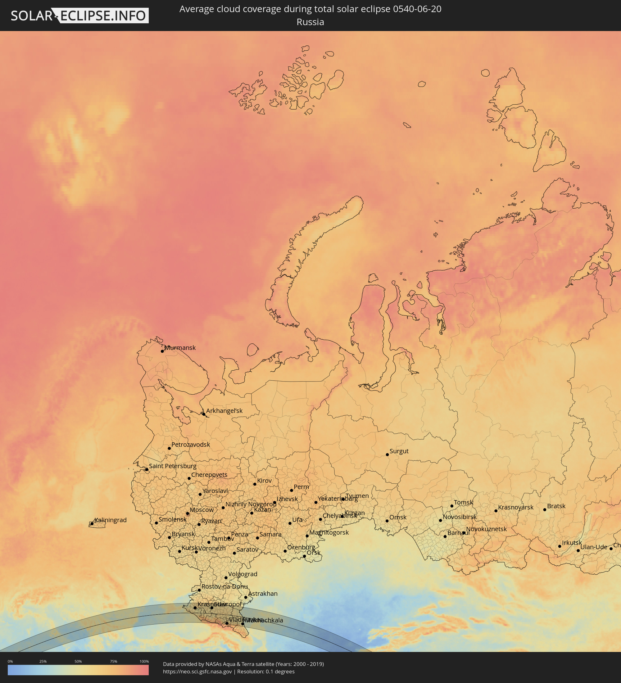 Russia
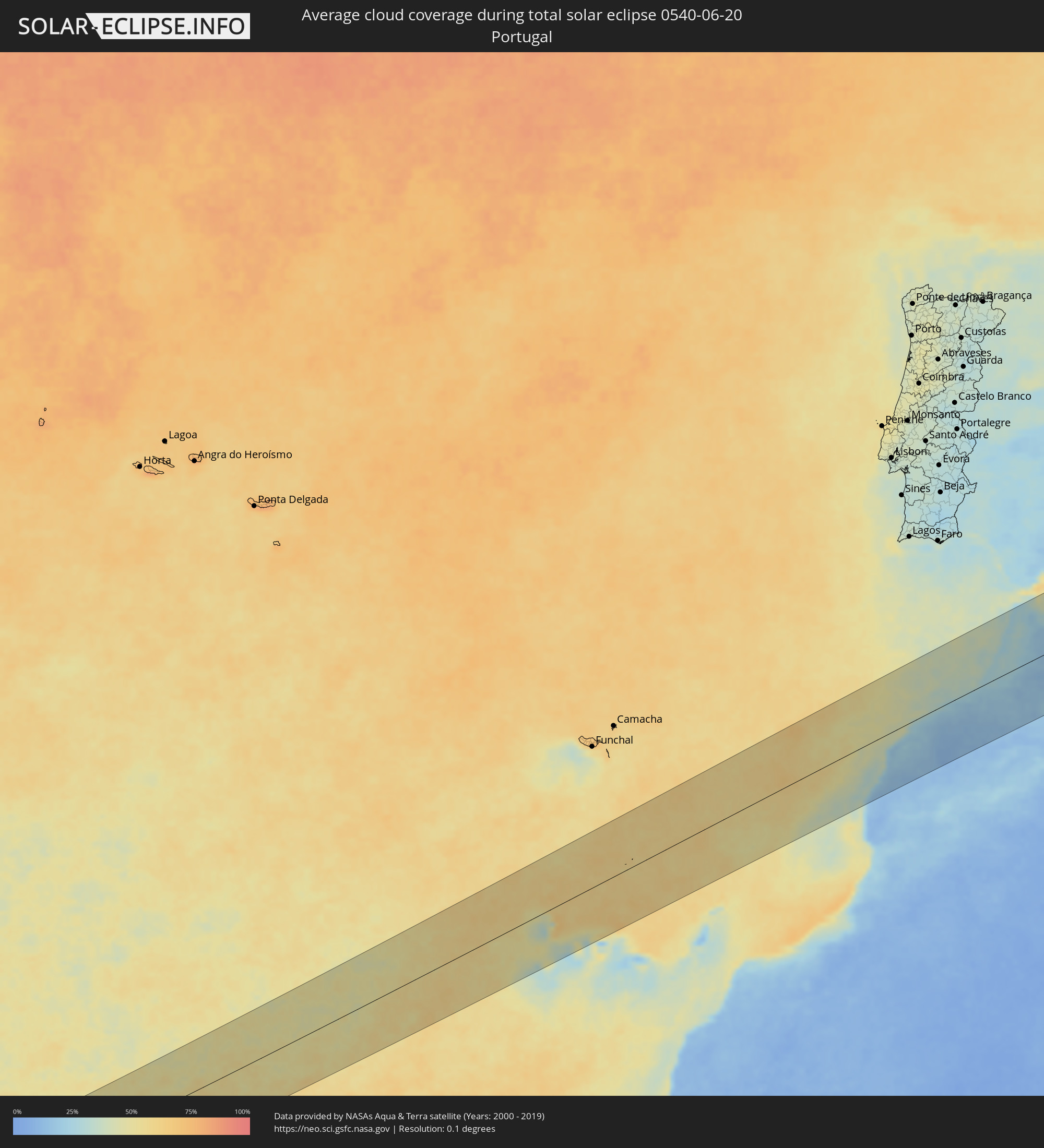 Portugal
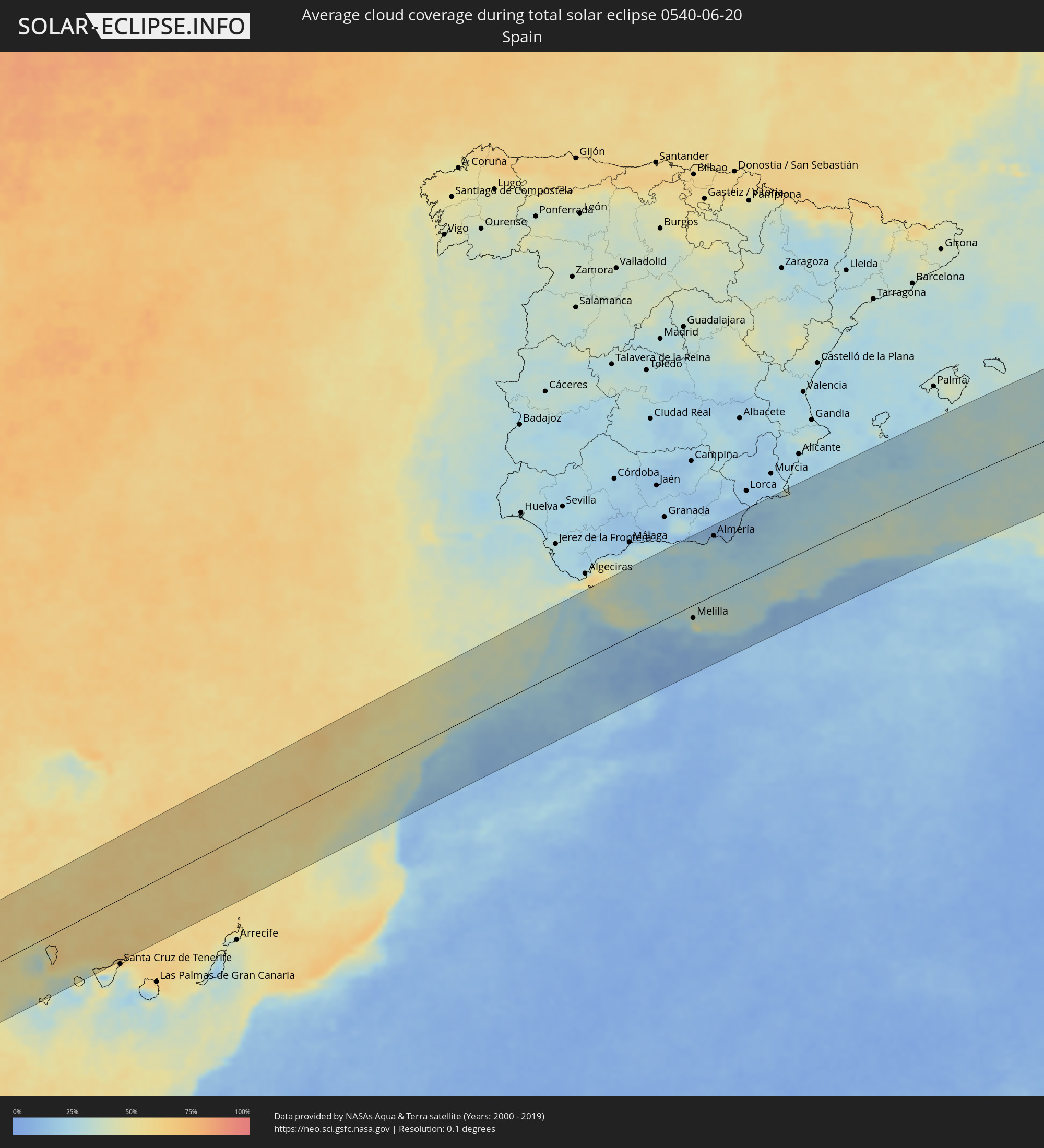 Spain
Spain
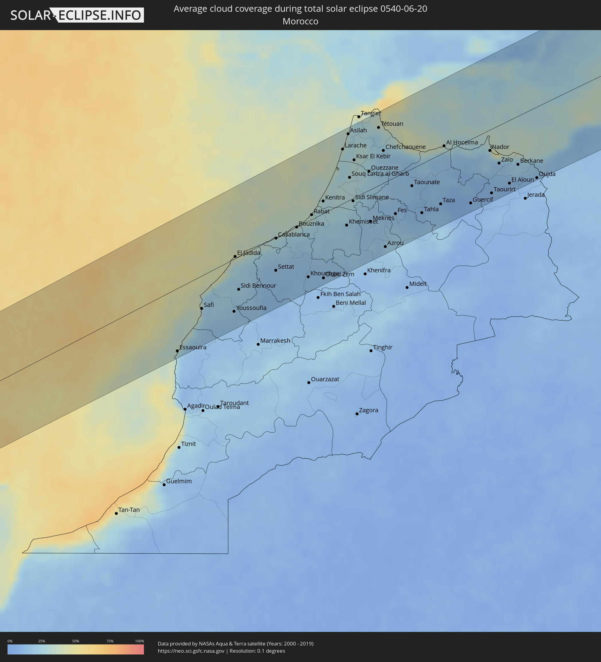 Morocco
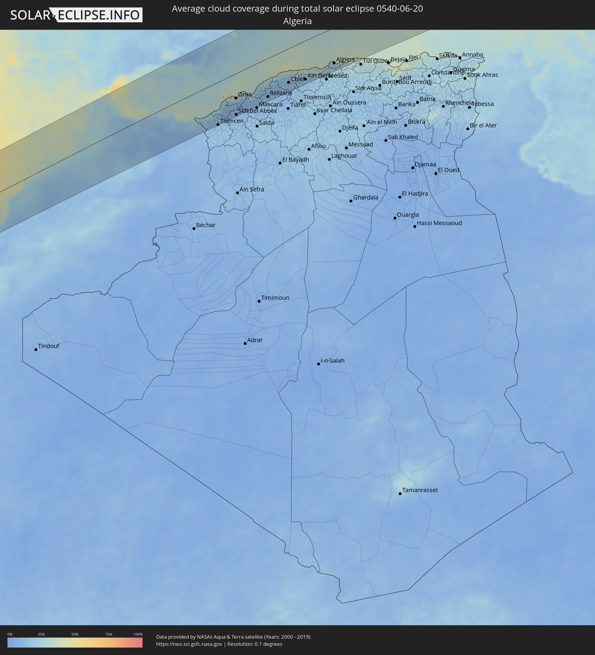 Algeria
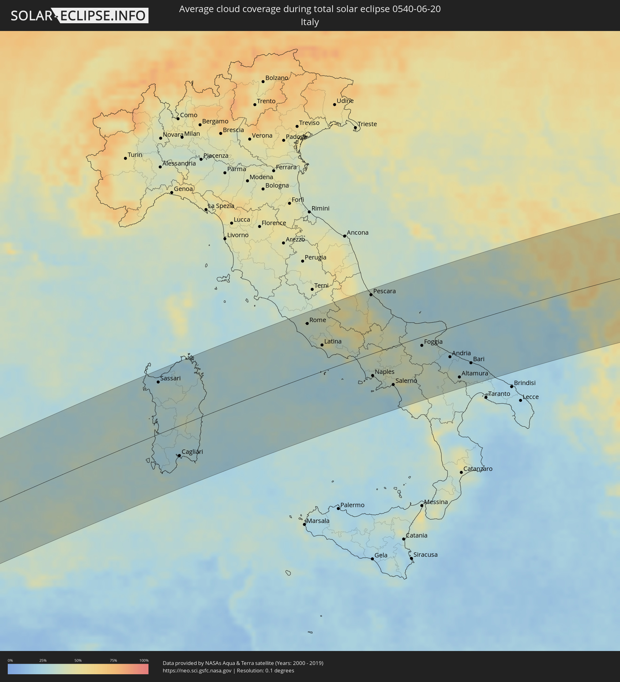 Italy
Italy
 Vatican City
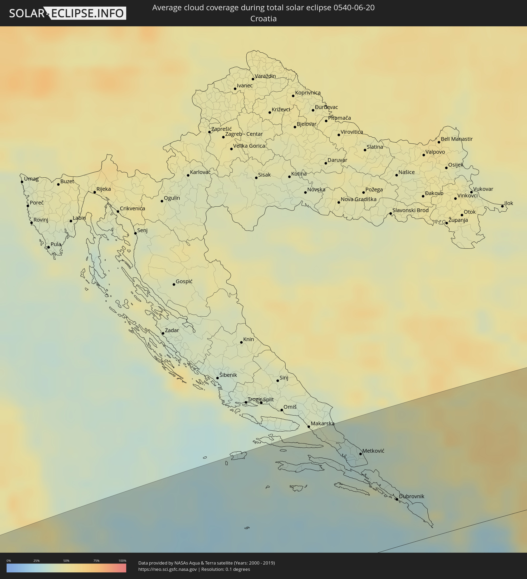 Croatia
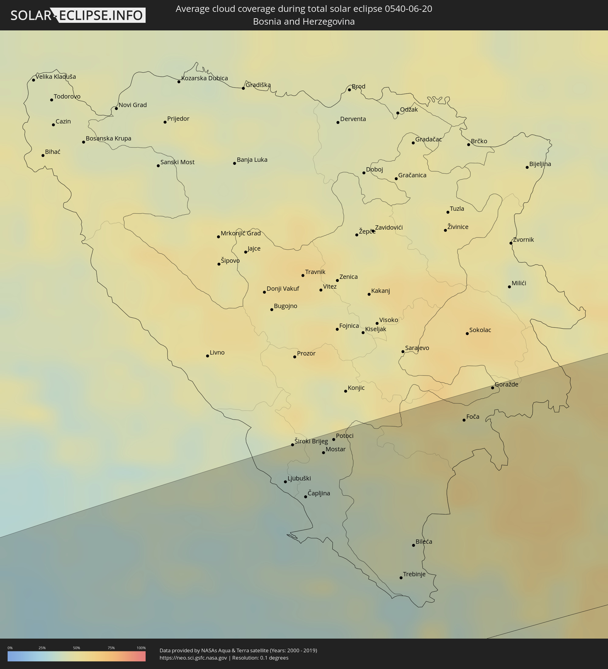 Bosnia and Herzegovina
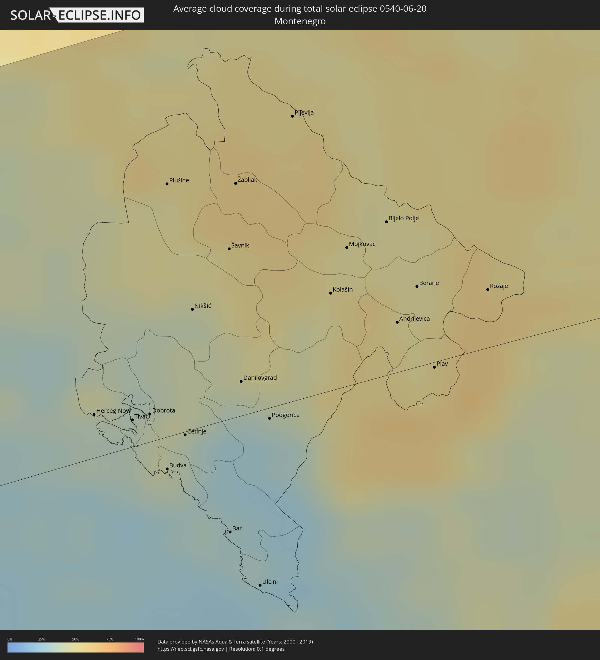 Montenegro
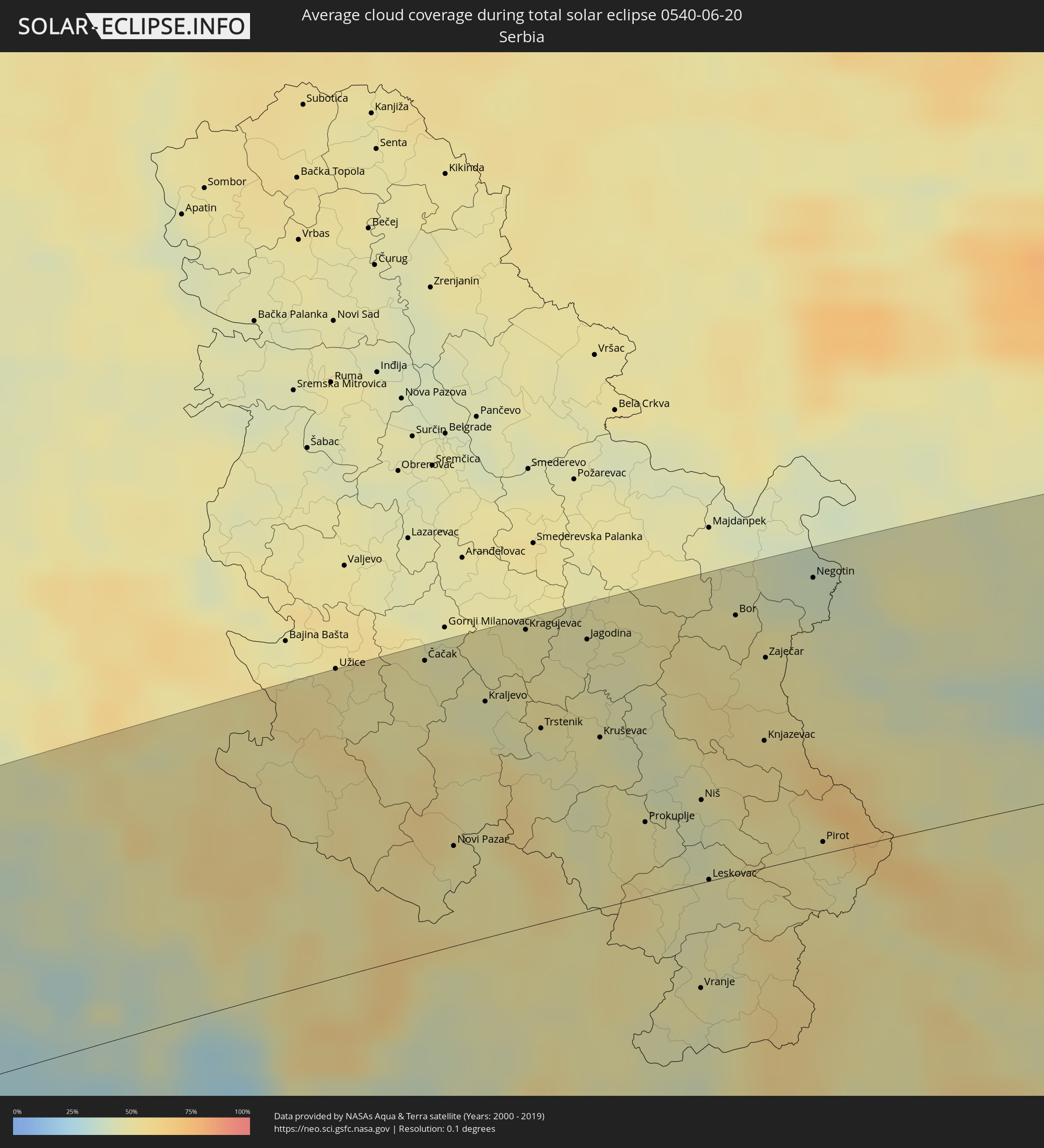 Serbia
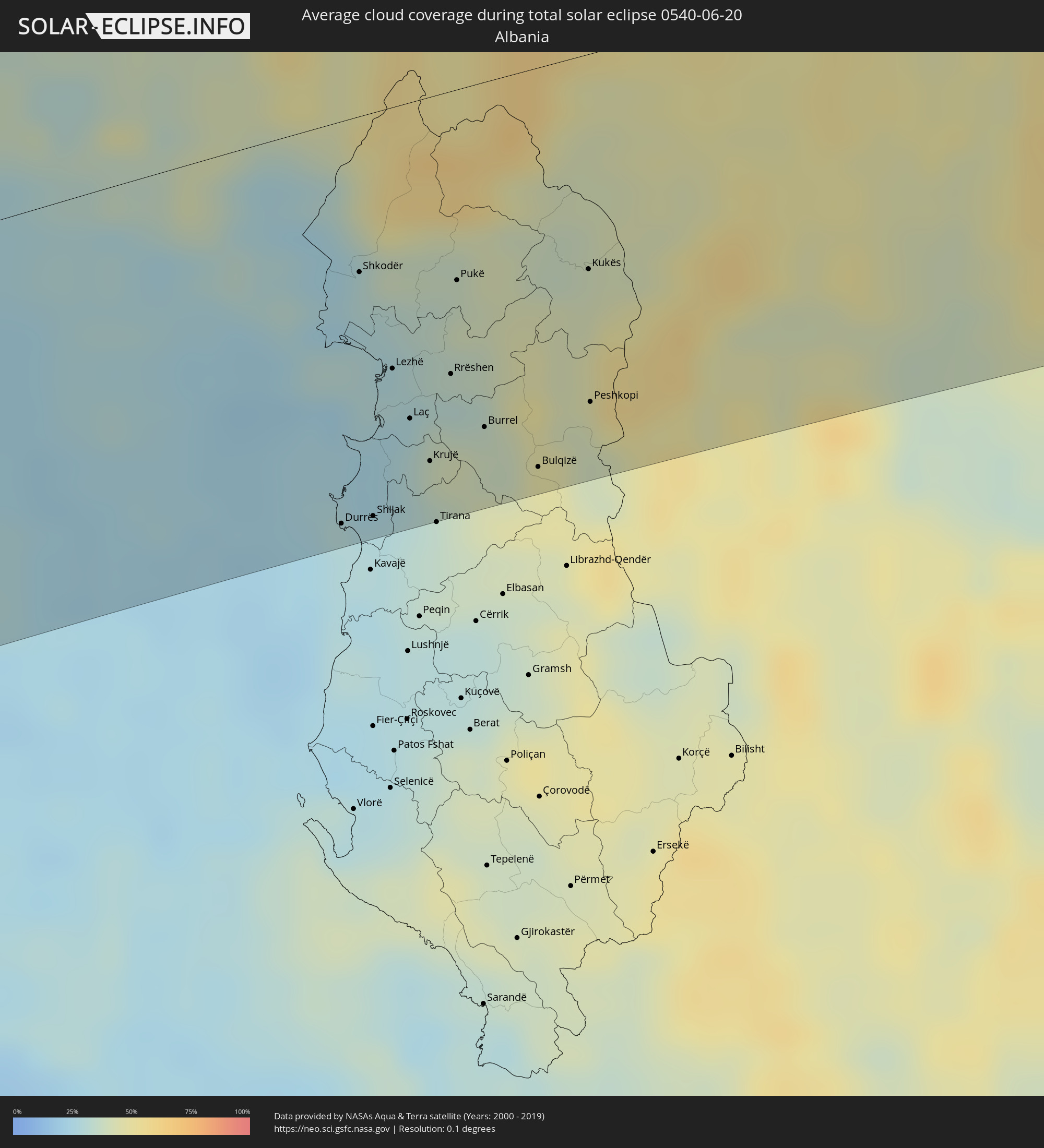 Albania
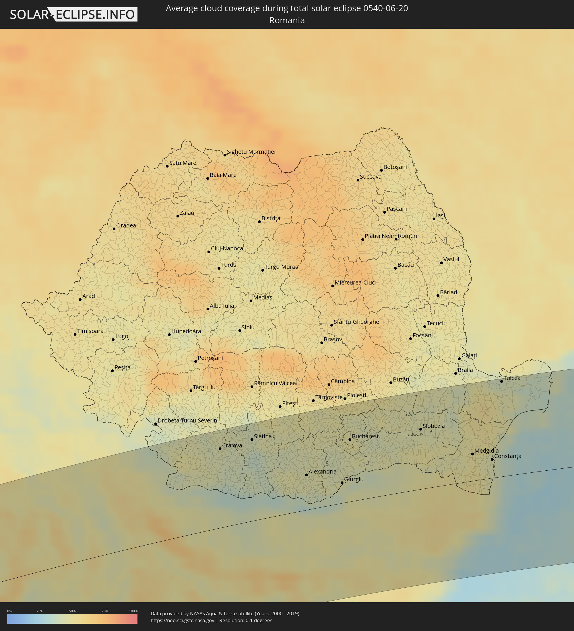 Romania
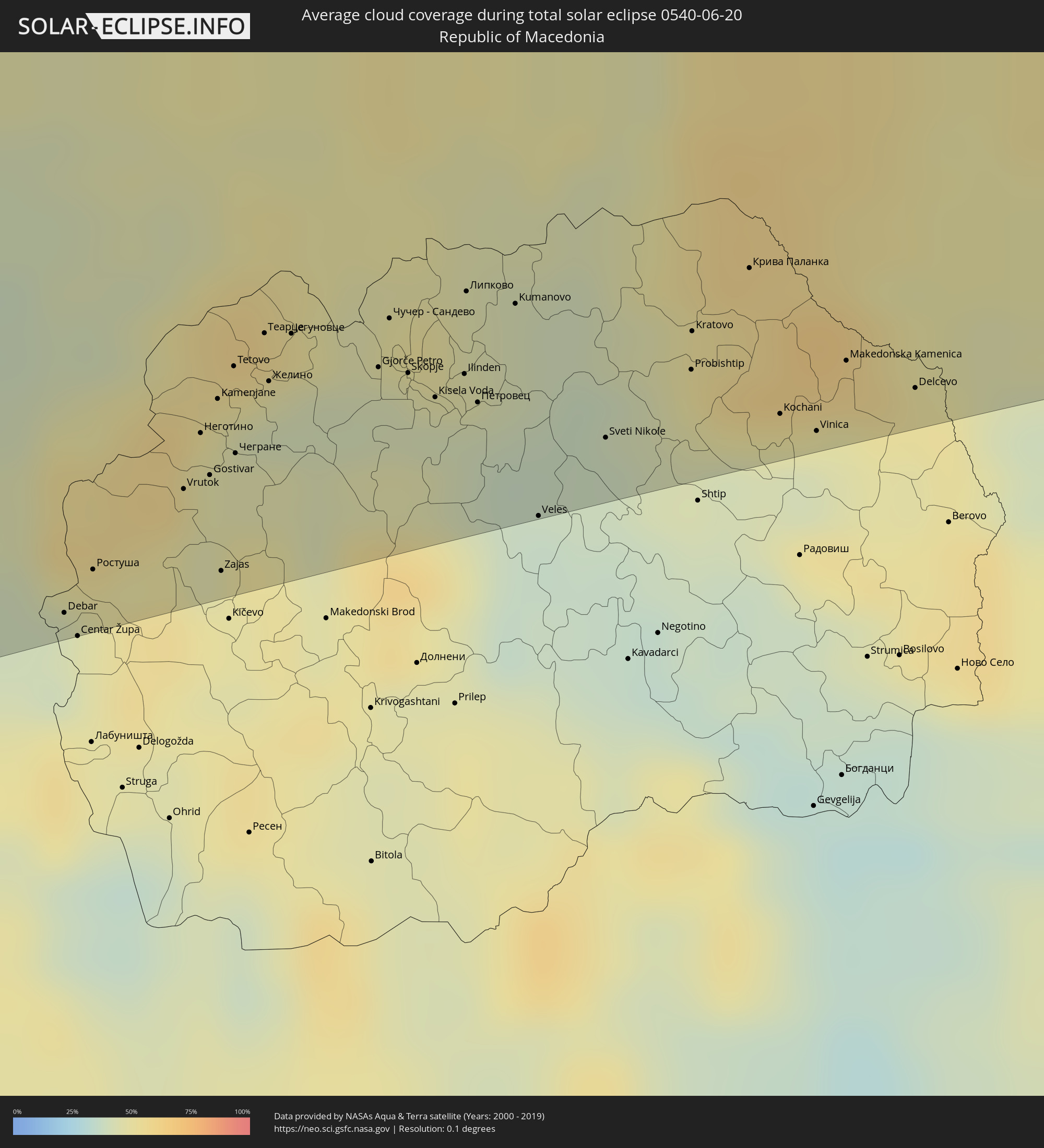 Republic of Macedonia
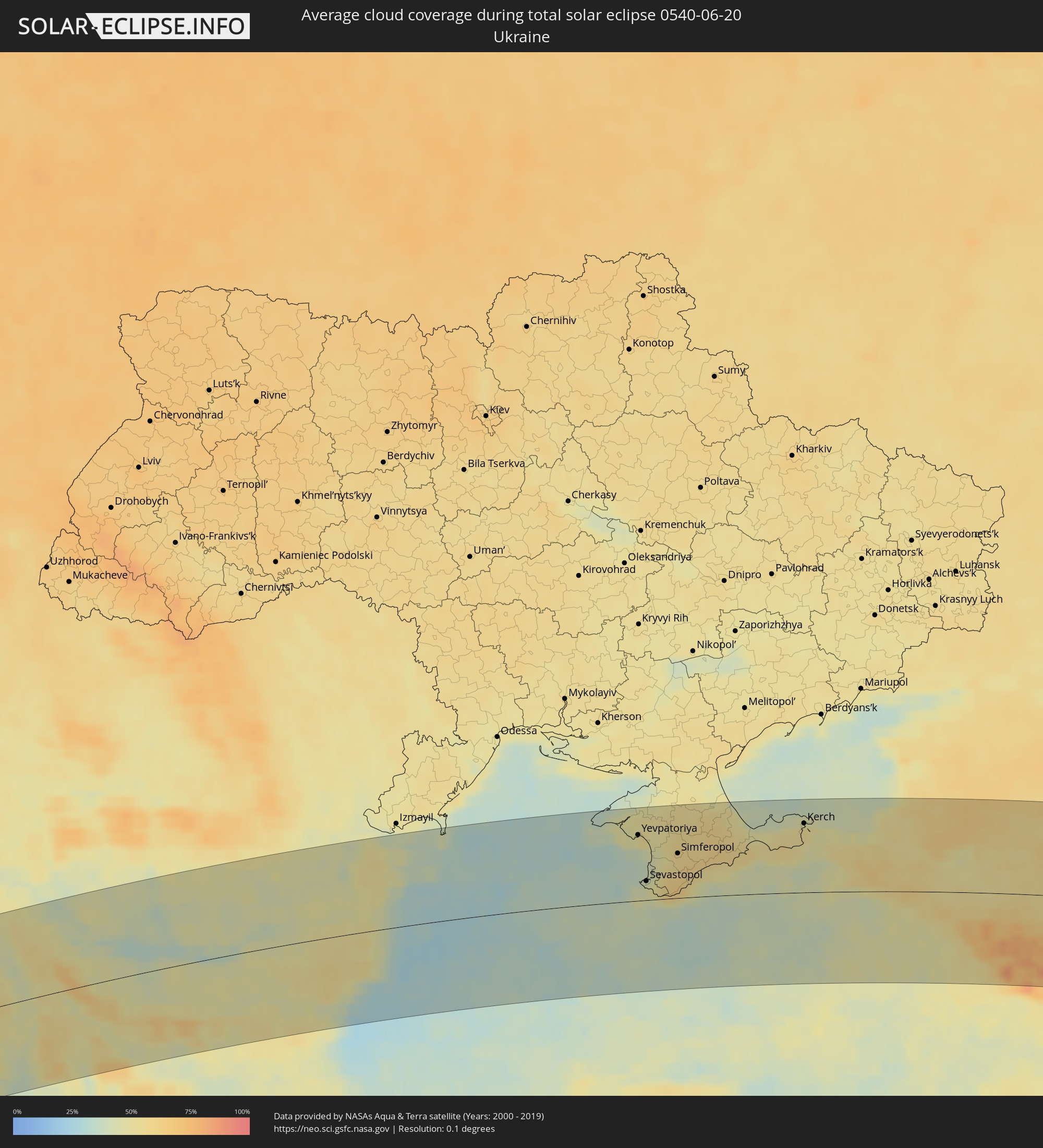 Ukraine
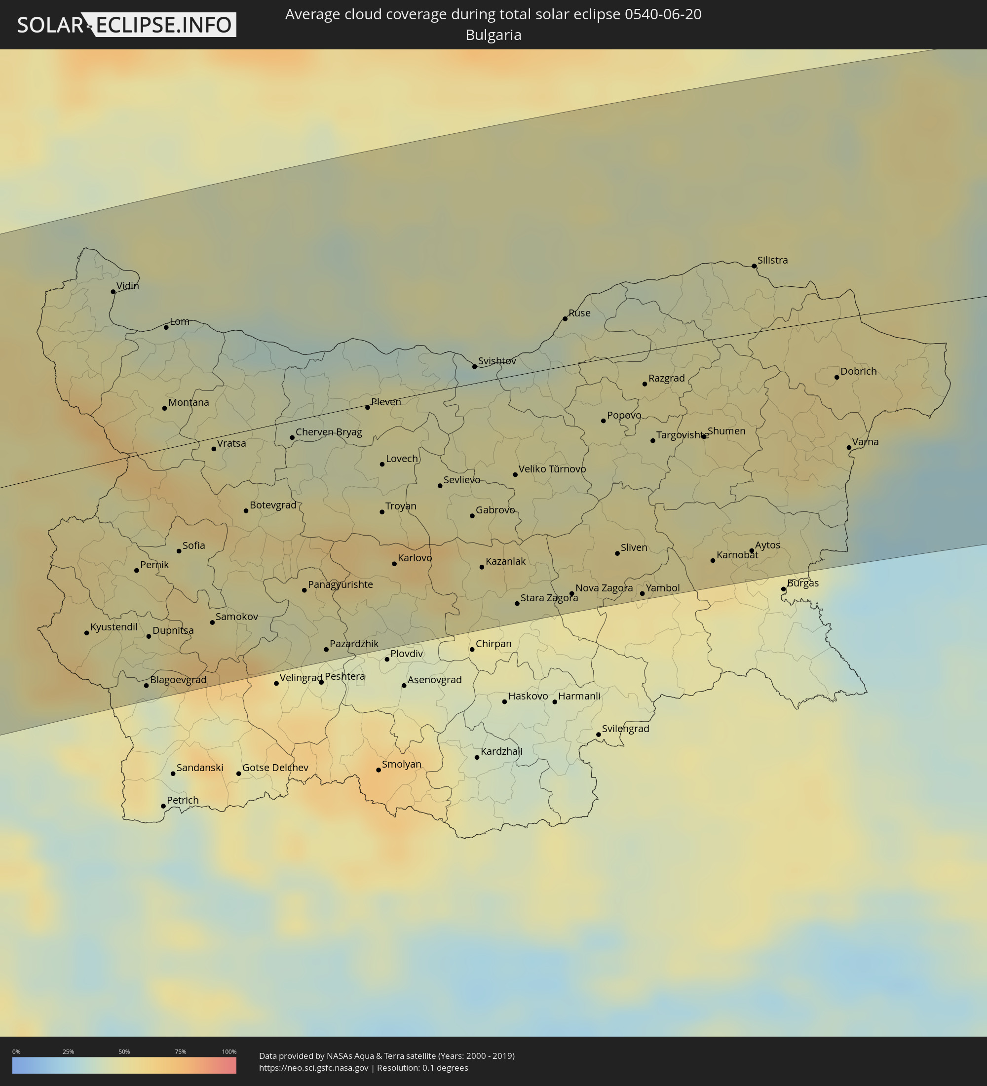 Bulgaria
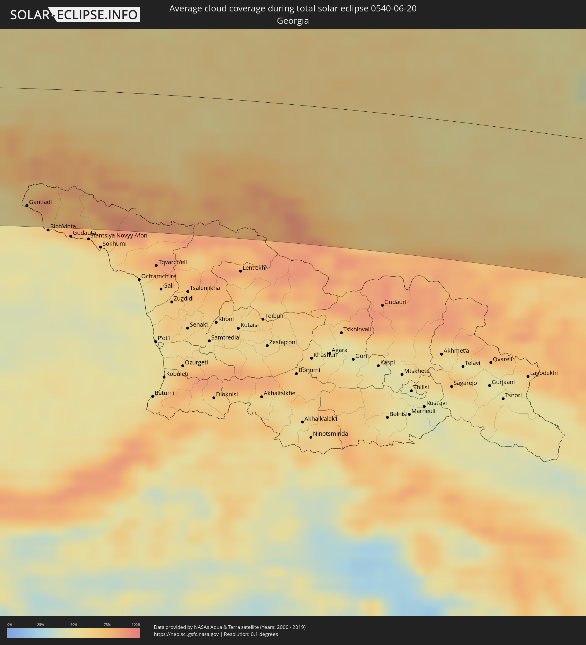 Georgia
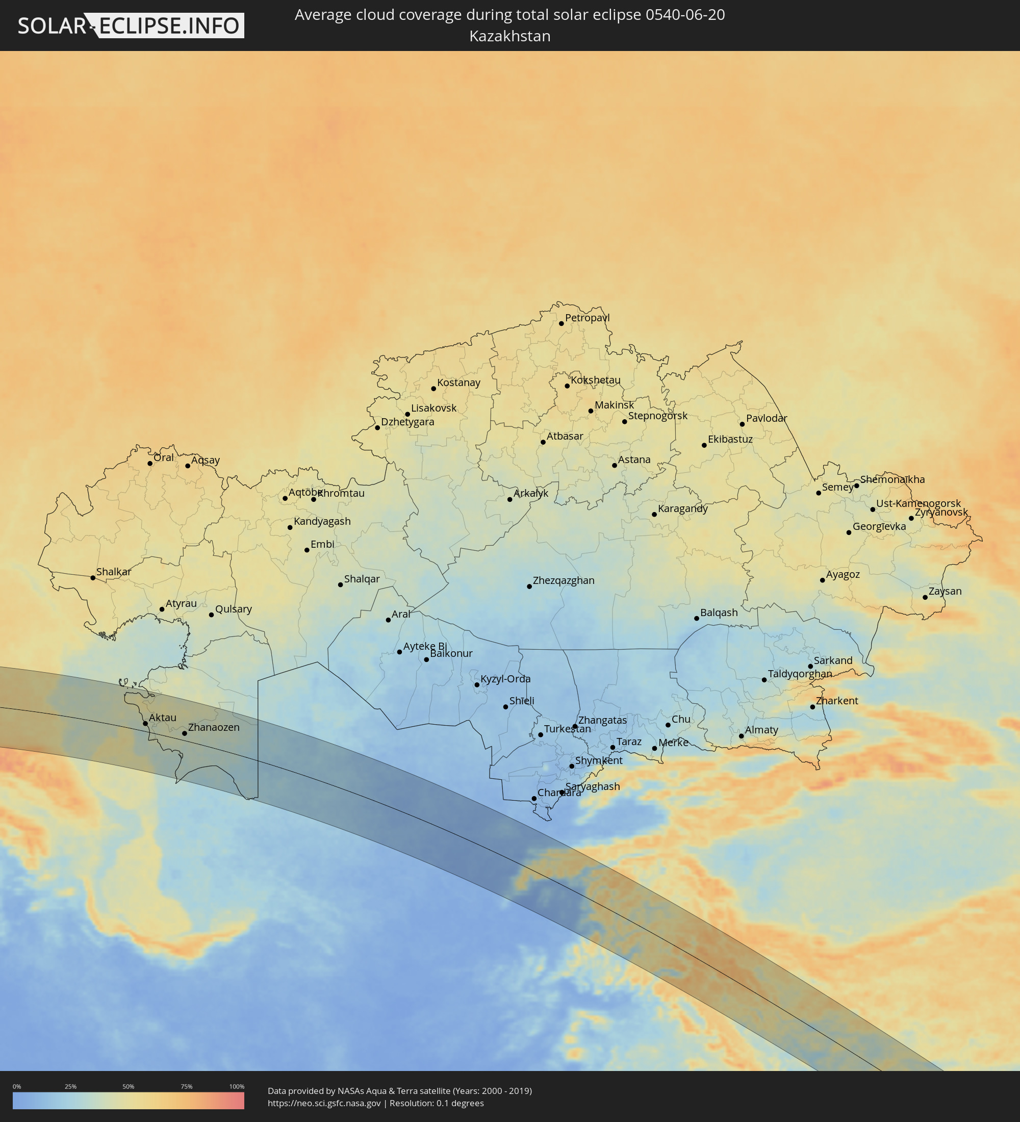 Kazakhstan
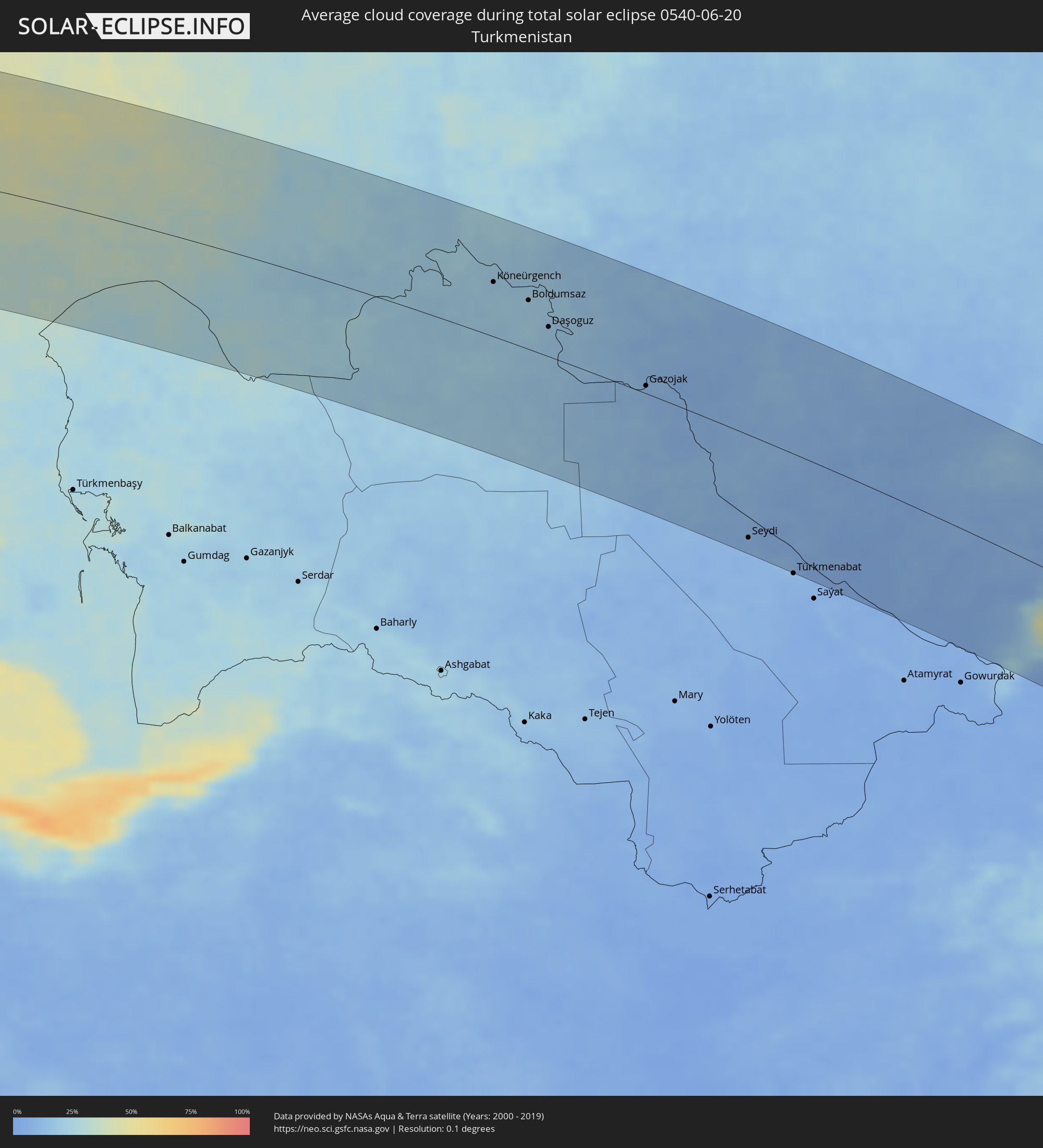 Turkmenistan
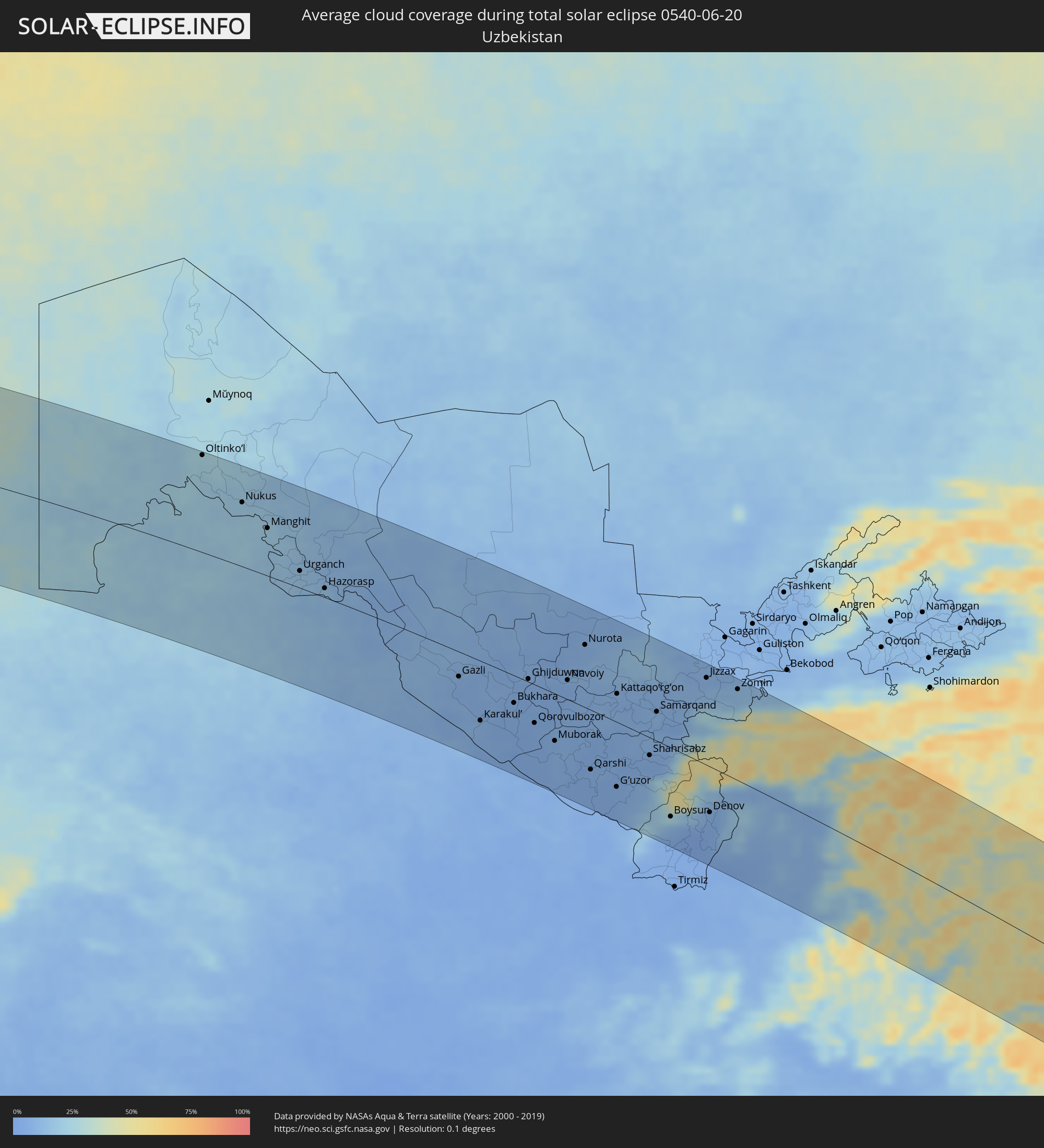 Uzbekistan
 Afghanistan
 Pakistan
 Tajikistan
 India
India
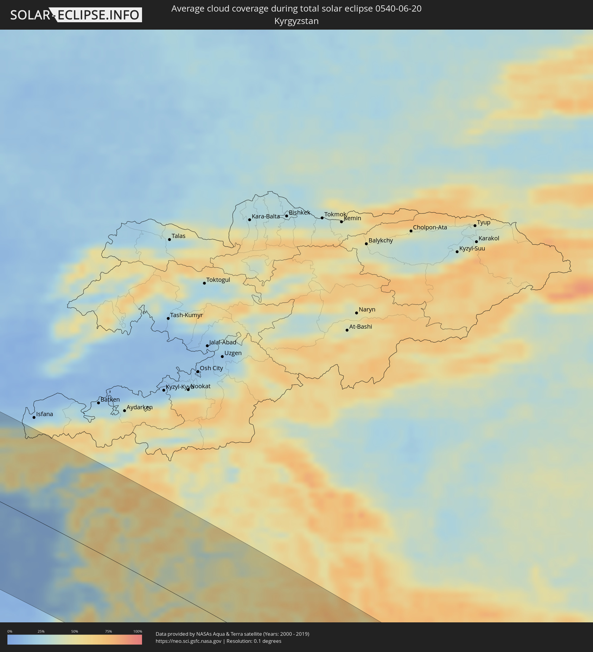 Kyrgyzstan
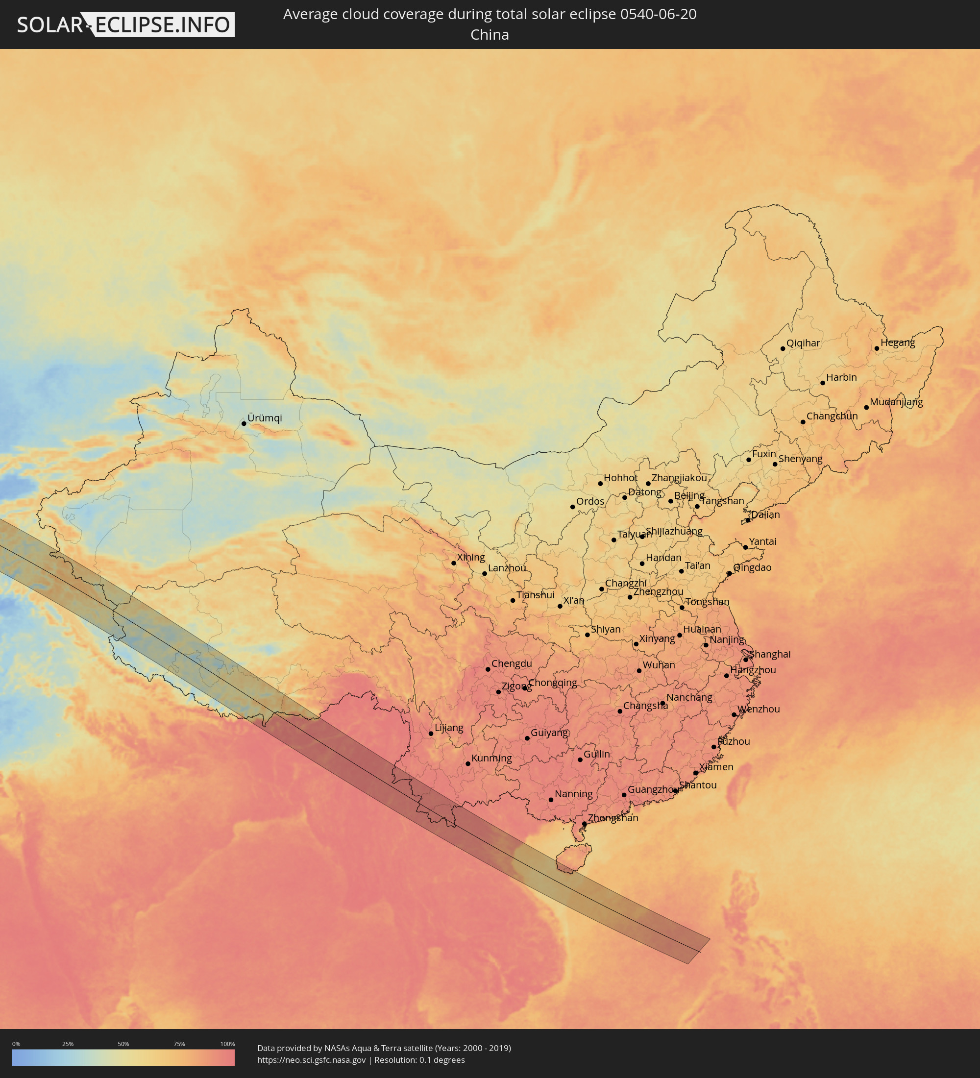 China
China
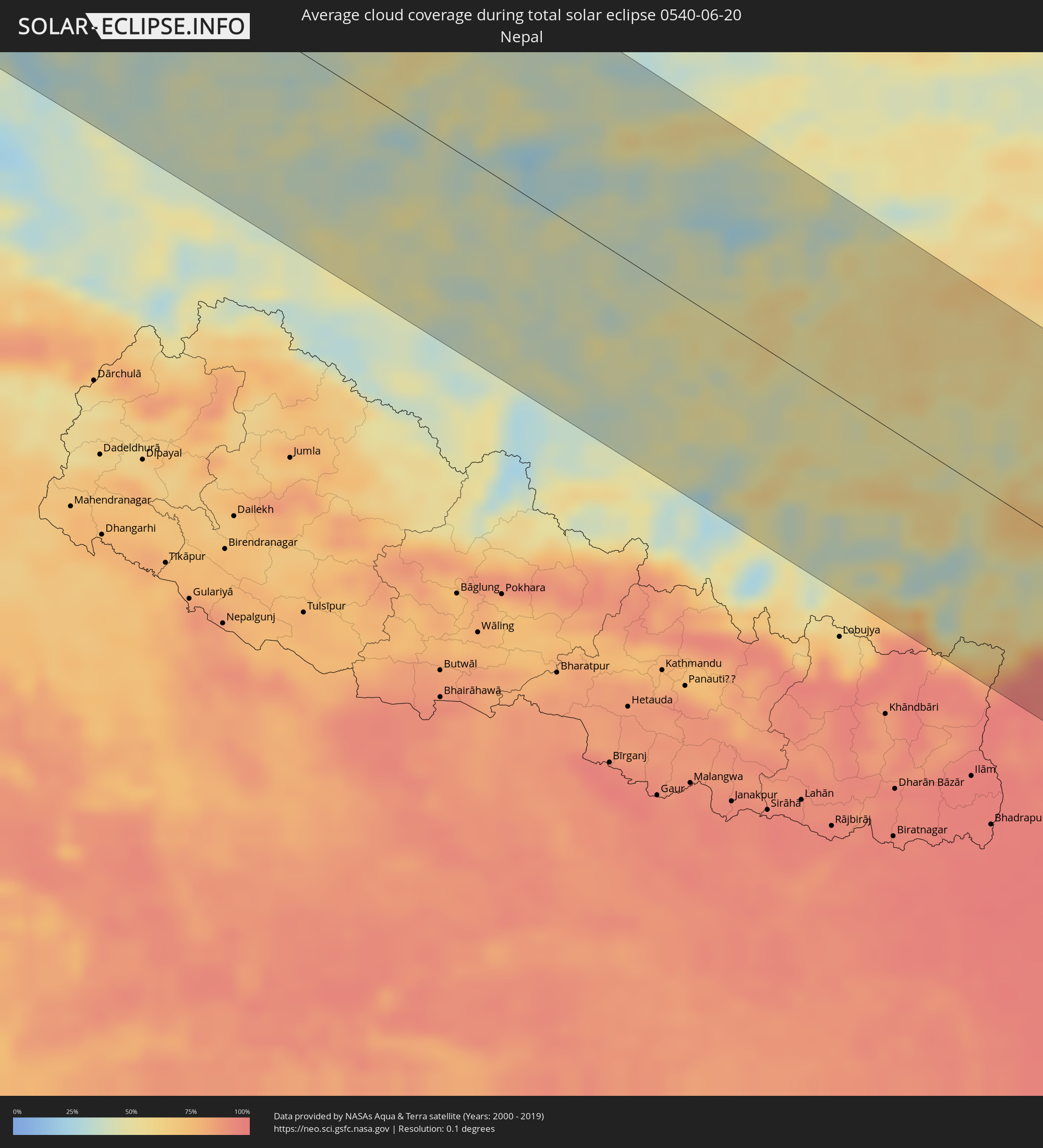 Nepal
Nepal
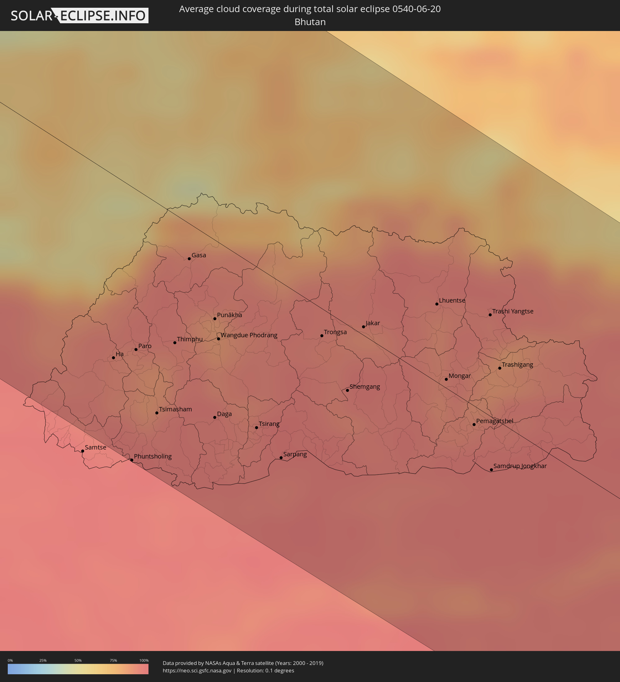 Bhutan
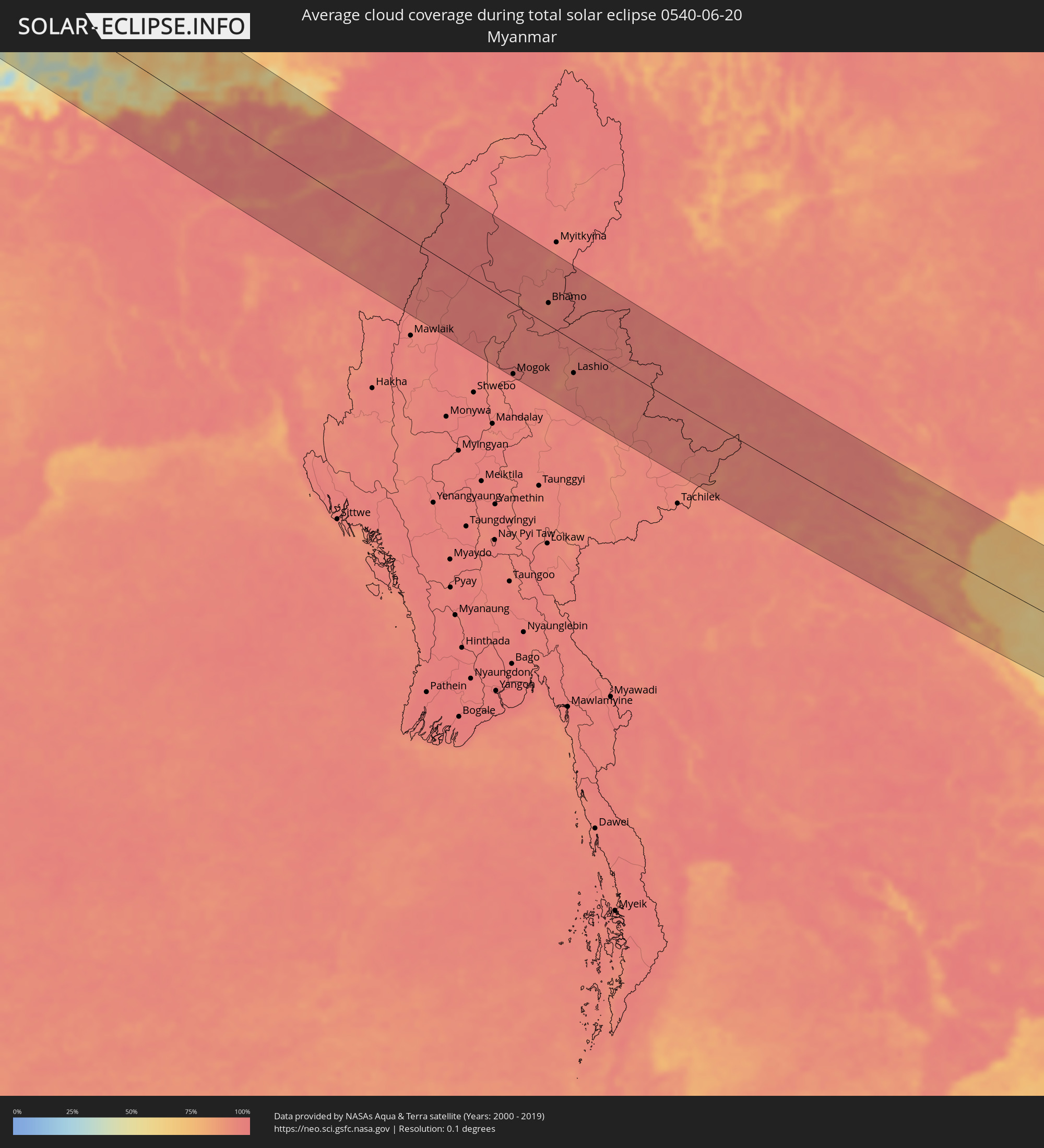 Myanmar
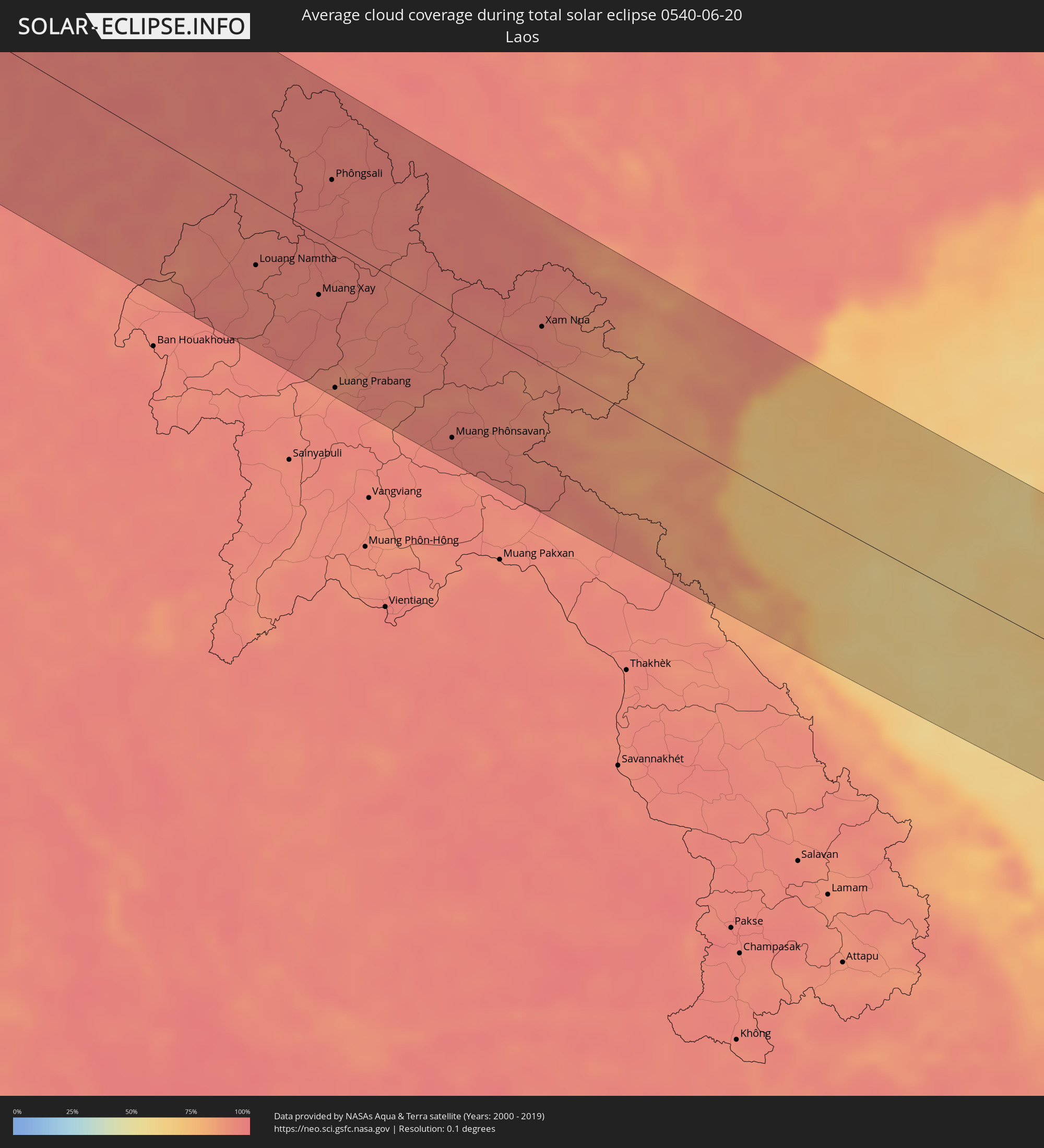 Laos
Laos
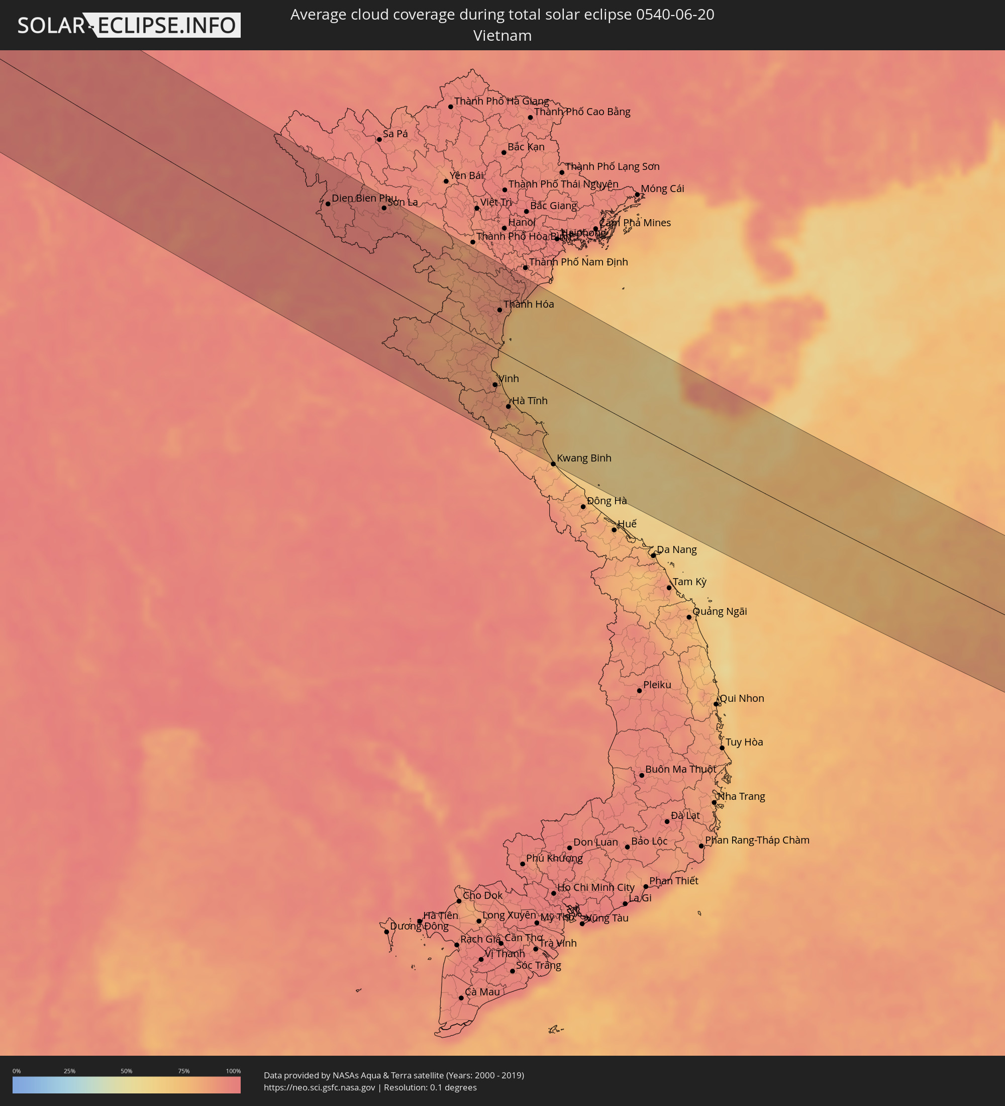 Vietnam
Cities inside the path of the eclipse
The following table shows all locations with a population of more than 5,000 inside the eclipse path. Cities which have more than 100,000 inhabitants are marked bold. A click at the locations opens a detailed map.
| City | Type | Eclipse duration | Local time of max. eclipse | Distance to central line | Ø Cloud coverage |
|
Puerto de la Cruz, Canary Islands
|
total | - | 06:15:58 UTC-01:01 | 123 km | 44% |
|
Casablanca, Grand Casablanca
|
total | - | 06:54:31 UTC-00:30 | 1 km | 25% |
|
Rabat, Rabat-Salé-Zemmour-Zaër
|
total | - | 06:55:18 UTC-00:30 | 8 km | 25% |
|
Kenitra, Gharb-Chrarda-Beni Hssen
|
total | - | 06:55:41 UTC-00:30 | 22 km | 27% |
|
Meknès, Meknès-Tafilalet
|
total | - | 06:55:42 UTC-00:30 | 58 km | 17% |
|
Tétouan, Tanger-Tétouan
|
total | - | 06:57:45 UTC-00:30 | 103 km | 27% |
|
Fes, Fès-Boulemane
|
total | - | 06:56:06 UTC-00:30 | 66 km | 16% |
|
Al Hoceïma, Taza-Al Hoceima-Taounate
|
total | - | 06:58:03 UTC-00:30 | 12 km | 28% |
|
Melilla, Melilla
|
total | - | 07:28:56 UTC+00:00 | 24 km | 43% |
|
El Ejido, Andalusia
|
total | - | 07:30:48 UTC+00:00 | 119 km | 25% |
|
Roquetas de Mar, Andalusia
|
total | - | 07:30:53 UTC+00:00 | 109 km | 26% |
|
Almería, Andalusia
|
total | - | 07:31:04 UTC+00:00 | 111 km | 27% |
|
Níjar, Andalusia
|
total | - | 07:31:22 UTC+00:00 | 114 km | 12% |
|
Oujda, Oriental
|
total | - | 06:58:27 UTC-00:30 | 127 km | 13% |
|
Cartagena, Murcia
|
total | - | 07:32:52 UTC+00:00 | 130 km | 25% |
|
Atamaría, Murcia
|
total | - | 07:32:58 UTC+00:00 | 122 km | 23% |
|
Oran, Oran
|
total | - | 07:40:06 UTC+00:09 | 75 km | 14% |
|
Sidi Bel Abbès, Sidi Bel Abbès
|
total | - | 07:39:30 UTC+00:09 | 126 km | 13% |
|
Mostaganem, Mostaganem
|
total | - | 07:40:51 UTC+00:09 | 80 km | 17% |
|
Relizane, Relizane
|
total | - | 07:40:55 UTC+00:09 | 117 km | 14% |
|
Chlef, Chlef
|
total | - | 07:41:58 UTC+00:09 | 104 km | 15% |
|
Blida, Blida
|
total | - | 07:43:26 UTC+00:09 | 129 km | 25% |
|
Algiers, Algiers
|
total | - | 07:43:56 UTC+00:09 | 108 km | 27% |
|
Boumerdas, Boumerdes
|
total | - | 07:44:17 UTC+00:09 | 123 km | 29% |
|
Cagliari, Sardinia
|
total | - | 08:42:57 UTC+01:00 | 64 km | 35% |
|
Acilia-Castel Fusano-Ostia Antica, Latium
|
total | - | 08:49:21 UTC+01:00 | 102 km | 31% |
|
Vatican City
|
total | - | 08:49:38 UTC+01:00 | 113 km | 37% |
|
Rome, Latium
|
total | - | 08:49:41 UTC+01:00 | 110 km | 37% |
|
Pescara, Abruzzo
|
total | - | 08:52:16 UTC+01:00 | 123 km | 34% |
|
Naples, Campania
|
total | - | 08:50:29 UTC+01:00 | 47 km | 31% |
|
Salerno, Campania
|
total | - | 08:50:56 UTC+01:00 | 81 km | 35% |
|
Foggia, Apulia
|
total | - | 08:52:45 UTC+01:00 | 18 km | 33% |
|
Bari, Apulia
|
total | - | 08:54:00 UTC+01:00 | 89 km | 25% |
|
Ljubuški, Federation of Bosnia and Herzegovina
|
total | - | 08:57:08 UTC+01:00 | 117 km | 33% |
|
Široki Brijeg, Federation of Bosnia and Herzegovina
|
total | - | 08:57:24 UTC+01:00 | 135 km | 35% |
|
Metković, Dubrovačko-Neretvanska
|
total | - | 08:57:07 UTC+01:00 | 99 km | 33% |
|
Mostar, Federation of Bosnia and Herzegovina
|
total | - | 08:57:38 UTC+01:00 | 126 km | 35% |
|
Potoci, Federation of Bosnia and Herzegovina
|
total | - | 08:57:47 UTC+01:00 | 131 km | 41% |
|
Dubrovnik, Dubrovačko-Neretvanska
|
total | - | 08:57:15 UTC+01:00 | 45 km | 37% |
|
Trebinje, Republic of Srspka
|
total | - | 08:57:39 UTC+01:00 | 46 km | 31% |
|
Bileća, Republic of Srspka
|
total | - | 08:57:56 UTC+01:00 | 62 km | 39% |
|
Herceg-Novi, Herceg Novi
|
total | - | 08:57:38 UTC+01:00 | 14 km | 36% |
|
Foča, Republic of Srspka
|
total | - | 08:59:03 UTC+01:00 | 121 km | 51% |
|
Budva, Budva
|
total | - | 08:57:52 UTC+01:00 | 11 km | 36% |
|
Nikšić, Opština Nikšić
|
total | - | 08:58:31 UTC+01:00 | 39 km | 40% |
|
Goražde, Federation of Bosnia and Herzegovina
|
total | - | 08:59:29 UTC+01:00 | 134 km | 47% |
|
Bar, Bar
|
total | - | 08:58:01 UTC+01:00 | 37 km | 30% |
|
Podgorica, Podgorica
|
total | - | 08:58:36 UTC+01:00 | 4 km | 29% |
|
Pljevlja, Pljevlja
|
total | - | 08:59:40 UTC+01:00 | 93 km | 56% |
|
Durrës, Durrës
|
total | - | 09:17:02 UTC+01:19 | 127 km | 28% |
|
Shkodër, Shkodër
|
total | - | 09:17:54 UTC+01:19 | 49 km | 30% |
|
Lezhë, Lezhë
|
total | - | 09:17:47 UTC+01:19 | 82 km | 29% |
|
Laç, Lezhë
|
total | - | 09:17:44 UTC+01:19 | 100 km | 31% |
|
Bijelo Polje, Bijelo Polje
|
total | - | 08:59:52 UTC+01:00 | 50 km | 50% |
|
Krujë, Durrës
|
total | - | 09:17:43 UTC+01:19 | 115 km | 35% |
|
Užice, Central Serbia
|
total | - | 09:00:50 UTC+01:00 | 136 km | 53% |
|
Berane, Berane
|
total | - | 08:59:50 UTC+01:00 | 26 km | 50% |
|
Burrel, Dibër
|
total | - | 09:18:08 UTC+01:19 | 109 km | 38% |
|
Čačak, Central Serbia
|
total | - | 09:01:32 UTC+01:00 | 129 km | 49% |
|
Kukës, Kukës
|
total | - | 09:19:10 UTC+01:19 | 68 km | 41% |
|
Peshkopi, Dibër
|
total | - | 09:18:48 UTC+01:19 | 110 km | 41% |
|
Novi Pazar, Central Serbia
|
total | - | 09:01:01 UTC+01:00 | 44 km | 47% |
|
Debar, Debar
|
total | - | 08:59:26 UTC+01:00 | 129 km | 40% |
|
Kraljevo, Central Serbia
|
total | - | 09:01:50 UTC+01:00 | 104 km | 48% |
|
Gostivar, Gostivar
|
total | - | 09:00:15 UTC+01:00 | 108 km | 46% |
|
Kragujevac, Central Serbia
|
total | - | 09:02:26 UTC+01:00 | 131 km | 50% |
|
Tetovo, Tetovo
|
total | - | 09:00:33 UTC+01:00 | 87 km | 43% |
|
Kruševac, Central Serbia
|
total | - | 09:02:35 UTC+01:00 | 75 km | 48% |
|
Skopje, Karpoš
|
total | - | 09:01:12 UTC+01:00 | 97 km | 42% |
|
Kumanovo, Kumanovo
|
total | - | 09:01:45 UTC+01:00 | 88 km | 43% |
|
Veles, Veles
|
total | - | 09:01:27 UTC+01:00 | 135 km | 35% |
|
Niš, Central Serbia
|
total | - | 09:03:09 UTC+01:00 | 37 km | 43% |
|
Leskovac, Central Serbia
|
total | - | 09:02:54 UTC+01:00 | 1 km | 46% |
|
Крива Паланка, Kriva Palanka
|
total | - | 09:02:43 UTC+01:00 | 93 km | 55% |
|
Kochani, Kočani
|
total | - | 09:02:35 UTC+01:00 | 125 km | 43% |
|
Sofia, Sofia-Capital
|
total | - | 10:04:39 UTC+02:00 | 58 km | 50% |
|
Craiova, Dolj
|
total | - | 09:51:12 UTC+01:44 | 110 km | 43% |
|
Slatina, Olt County
|
total | - | 09:52:08 UTC+01:44 | 113 km | 39% |
|
Pleven, Pleven
|
total | - | 10:07:14 UTC+02:00 | 2 km | 48% |
|
Alexandria, Teleorman
|
total | - | 09:53:12 UTC+01:44 | 49 km | 45% |
|
Stara Zagora, Stara Zagora
|
total | - | 10:08:01 UTC+02:00 | 126 km | 48% |
|
Giurgiu, Giurgiu
|
total | - | 09:54:06 UTC+01:44 | 28 km | 41% |
|
Ruse, Ruse
|
total | - | 10:09:41 UTC+02:00 | 25 km | 41% |
|
Bucharest, Bucureşti
|
total | - | 09:54:45 UTC+01:44 | 86 km | 46% |
|
Sliven, Sliven
|
total | - | 10:09:20 UTC+02:00 | 108 km | 54% |
|
Shumen, Shumen
|
total | - | 10:10:44 UTC+02:00 | 53 km | 50% |
|
Slobozia, Ialomiţa
|
total | - | 09:56:48 UTC+01:44 | 83 km | 46% |
|
Dobrich, Dobrich
|
total | - | 10:12:25 UTC+02:00 | 32 km | 54% |
|
Varna, Varna
|
total | - | 10:12:18 UTC+02:00 | 72 km | 44% |
|
Constanţa, Constanța
|
total | - | 09:58:33 UTC+01:44 | 26 km | 43% |
|
Tulcea, Tulcea
|
total | - | 09:59:29 UTC+01:44 | 132 km | 43% |
|
Yevpatoriya, Republic of Crimea
|
total | - | 10:38:35 UTC+02:16 | 97 km | 50% |
|
Sevastopol, Gorod Sevastopol
|
total | - | 10:38:35 UTC+02:16 | 28 km | 44% |
|
Saki, Republic of Crimea
|
total | - | 10:38:57 UTC+02:16 | 88 km | 46% |
|
Simferopol, Republic of Crimea
|
total | - | 10:39:45 UTC+02:16 | 66 km | 56% |
|
Yalta, Republic of Crimea
|
total | - | 10:39:40 UTC+02:16 | 15 km | 53% |
|
Alushta, Republic of Crimea
|
total | - | 10:40:09 UTC+02:16 | 33 km | 53% |
|
Feodosiya, Republic of Crimea
|
total | - | 10:41:59 UTC+02:16 | 70 km | 56% |
|
Kerch, Republic of Crimea
|
total | - | 10:43:59 UTC+02:16 | 102 km | 53% |
|
Novorossiysk, Krasnodarskiy
|
total | - | 11:00:24 UTC+02:30 | 30 km | 60% |
|
Krasnodar, Krasnodarskiy
|
total | - | 11:02:38 UTC+02:30 | 67 km | 54% |
|
Sochi, Krasnodarskiy
|
total | - | 11:03:50 UTC+02:30 | 93 km | 51% |
|
Gantiadi
|
total | - | 11:33:23 UTC+02:59 | 116 km | 59% |
|
Gagra, Abkhazia
|
total | - | 11:33:45 UTC+02:59 | 127 km | 64% |
|
Stavropol’, Stavropol'skiy
|
total | - | 11:08:04 UTC+02:30 | 76 km | 55% |
|
Nal’chik, Kabardino-Balkariya
|
total | - | 11:11:16 UTC+02:30 | 85 km | 68% |
|
Vladikavkaz, North Ossetia
|
total | - | 11:13:22 UTC+02:30 | 128 km | 77% |
|
Groznyy, Chechnya
|
total | - | 11:15:17 UTC+02:30 | 88 km | 60% |
|
Makhachkala, Dagestan
|
total | - | 11:18:54 UTC+02:30 | 104 km | 51% |
|
Fort-Shevchenko, Mangghystaū
|
total | - | 12:18:32 UTC+03:25 | 103 km | 46% |
|
Aktau, Mangghystaū
|
total | - | 12:20:39 UTC+03:25 | 25 km | 38% |
|
Yeraliyev, Mangghystaū
|
total | - | 12:21:53 UTC+03:25 | 17 km | 41% |
|
Zhetibay, Mangghystaū
|
total | - | 12:22:23 UTC+03:25 | 35 km | 43% |
|
Shetpe, Mangghystaū
|
total | - | 12:22:06 UTC+03:25 | 98 km | 48% |
|
Zhanaozen, Mangghystaū
|
total | - | 12:23:59 UTC+03:25 | 23 km | 37% |
|
Köneürgench, Daşoguz
|
total | - | 13:04:18 UTC+03:53 | 63 km | 21% |
|
Nukus, Karakalpakstan
|
total | - | 13:39:19 UTC+04:27 | 88 km | 19% |
|
Yylanly, Daşoguz
|
total | - | 13:05:40 UTC+03:53 | 25 km | 21% |
|
Boldumsaz, Daşoguz
|
total | - | 13:05:24 UTC+03:53 | 56 km | 21% |
|
Tagta, Daşoguz
|
total | - | 13:06:19 UTC+03:53 | 13 km | 17% |
|
Daşoguz, Daşoguz
|
total | - | 13:06:13 UTC+03:53 | 34 km | 17% |
|
Urganch, Xorazm
|
total | - | 13:42:01 UTC+04:27 | 23 km | 15% |
|
Gazojak, Lebap
|
total | - | 13:09:23 UTC+03:53 | 9 km | 10% |
|
Seydi, Mary
|
total | - | 13:13:55 UTC+03:53 | 119 km | 9% |
|
Farap, Lebap
|
total | - | 13:15:29 UTC+03:53 | 128 km | 10% |
|
Bukhara, Bukhara
|
total | - | 13:50:29 UTC+04:27 | 38 km | 6% |
|
Navoiy, Navoiy
|
total | - | 13:51:39 UTC+04:27 | 27 km | 6% |
|
Qarshi, Qashqadaryo
|
total | - | 13:53:51 UTC+04:27 | 83 km | 6% |
|
Samarqand, Samarqand
|
total | - | 13:54:42 UTC+04:27 | 40 km | 10% |
|
Panjakent, Viloyati Sughd
|
total | - | 14:03:13 UTC+04:35 | 48 km | 11% |
|
Jizzax, Jizzax
|
total | - | 13:55:27 UTC+04:27 | 119 km | 8% |
|
Denov, Surxondaryo
|
total | - | 13:57:59 UTC+04:27 | 63 km | 7% |
|
Tursunzoda, Republican Subordination
|
total | - | 14:05:29 UTC+04:35 | 26 km | 9% |
|
Dushanbe, Dushanbe
|
total | - | 14:06:17 UTC+04:35 | 2 km | 11% |
|
Qarāwul, Kunduz
|
total | - | 13:32:53 UTC+04:00 | 133 km | 7% |
|
Qŭrghonteppa, Khatlon
|
total | - | 14:07:15 UTC+04:35 | 72 km | 7% |
|
Imām Şāḩib, Kunduz
|
total | - | 13:33:10 UTC+04:00 | 130 km | 8% |
|
Vahdat, Republican Subordination
|
total | - | 14:06:37 UTC+04:35 | 9 km | 9% |
|
Dasht-e Archī, Kunduz
|
total | - | 13:33:35 UTC+04:00 | 126 km | 7% |
|
Ārt Khwājah, Takhar
|
total | - | 13:34:08 UTC+04:00 | 119 km | 8% |
|
Kŭlob, Khatlon
|
total | - | 14:08:38 UTC+04:35 | 24 km | 11% |
|
Rustāq, Takhar
|
total | - | 13:34:36 UTC+04:00 | 100 km | 18% |
|
Fayzabad, Badakhshan
|
total | - | 13:35:43 UTC+04:00 | 70 km | 19% |
|
Jurm, Badakhshan
|
total | - | 13:36:26 UTC+04:00 | 85 km | 33% |
|
Ashkāsham, Badakhshan
|
total | - | 13:37:42 UTC+04:00 | 73 km | 36% |
|
Khorugh, Gorno-Badakhshan
|
total | - | 14:11:47 UTC+04:35 | 7 km | 39% |
|
Ishqoshim, Gorno-Badakhshan
|
total | - | 14:12:57 UTC+04:35 | 66 km | 38% |
|
Gilgit, Gilgit-Baltistan
|
total | - | 14:10:47 UTC+04:28 | 27 km | 59% |
|
Rikaze, Tibet Autonomous Region
|
total | - | 18:06:52 UTC+08:00 | 64 km | 40% |
|
Phuntsholing, Chukha District
|
total | - | 15:31:42 UTC+05:21 | 134 km | 97% |
|
Jiangzi, Tibet Autonomous Region
|
total | - | 18:07:49 UTC+08:00 | 71 km | 56% |
|
Thimphu, Thimphu
|
total | - | 16:08:27 UTC+05:58 | 63 km | 91% |
|
Punākha, Punakha
|
total | - | 16:08:26 UTC+05:58 | 39 km | 85% |
|
Tsirang, Chirang
|
total | - | 16:09:22 UTC+05:58 | 79 km | 95% |
|
Sarpang, Geylegphug
|
total | - | 16:09:40 UTC+05:58 | 86 km | 96% |
|
Bongaigaon, Assam
|
total | - | 15:32:56 UTC+05:21 | 107 km | 97% |
|
Jakar, Bumthang
|
total | - | 16:09:02 UTC+05:58 | 4 km | 93% |
|
Pemagatshel, Pemagatshel District
|
total | - | 16:10:06 UTC+05:58 | 9 km | 97% |
|
Samdrup Jongkhar, Samdrup Jongkhar
|
total | - | 16:10:29 UTC+05:58 | 26 km | 97% |
|
Guwahati, Assam
|
total | - | 15:34:00 UTC+05:21 | 71 km | 94% |
|
Shillong, Meghalaya
|
total | - | 15:34:53 UTC+05:21 | 122 km | 96% |
|
Tezpur, Assam
|
total | - | 15:33:58 UTC+05:21 | 27 km | 91% |
|
Dimāpur, Nagaland
|
total | - | 15:35:22 UTC+05:21 | 9 km | 96% |
|
Imphal, Manipur
|
total | - | 15:36:54 UTC+05:21 | 84 km | 95% |
|
Kohima, Nagaland
|
total | - | 15:35:52 UTC+05:21 | 7 km | 97% |
|
Jorhāt, Assam
|
total | - | 15:34:30 UTC+05:21 | 114 km | 97% |
|
Mogok, Mandalay
|
total | - | 16:43:54 UTC+06:24 | 126 km | 95% |
|
Bhamo, Kachin
|
total | - | 16:42:31 UTC+06:24 | 39 km | 92% |
|
Lashio, Shan
|
total | - | 16:44:17 UTC+06:24 | 58 km | 95% |
|
Jinghong, Yunnan
|
total | - | 18:21:23 UTC+08:00 | 9 km | 95% |
|
Louang Namtha, Loungnamtha
|
total | - | 17:04:44 UTC+06:42 | 56 km | 93% |
|
Muang Xay, Oudômxai
|
total | - | 17:05:07 UTC+06:42 | 50 km | 94% |
|
Phôngsali, Phôngsali
|
total | - | 17:04:02 UTC+06:42 | 52 km | 95% |
|
Luang Prabang, Louangphabang
|
total | - | 17:06:01 UTC+06:42 | 120 km | 91% |
|
Dien Bien Phu, Tỉnh Ðiện Biên
|
total | - | 17:29:06 UTC+07:06 | 71 km | 95% |
|
Muang Phônsavan, Xiangkhoang
|
total | - | 17:06:36 UTC+06:42 | 106 km | 94% |
|
Xam Nua, Houaphan
|
total | - | 17:05:40 UTC+06:42 | 31 km | 93% |
|
Yên Vinh, Nghệ An
|
total | - | 17:32:10 UTC+07:06 | 56 km | 86% |
|
Vinh, Nghệ An
|
total | - | 17:32:10 UTC+07:06 | 54 km | 86% |
|
Thanh Hóa, Thanh Hóa
|
total | - | 17:31:02 UTC+07:06 | 59 km | 88% |
|
Bỉm Sơn, Thanh Hóa
|
total | - | 17:30:45 UTC+07:06 | 91 km | 90% |
|
Hà Tĩnh, Hà Tĩnh
|
total | - | 17:32:30 UTC+07:06 | 76 km | 84% |
|
Thành Phố Ninh Bình, Ninh Bình
|
total | - | 17:30:34 UTC+07:06 | 115 km | 92% |
|
Kwang Binh, Quảng Bình
|
total | - | 17:33:22 UTC+07:06 | 125 km | 83% |
|
Sanya, Hainan
|
total | - | 18:25:50 UTC+08:00 | 95 km | 73% |