Total solar eclipse of 06/16/0885
| Day of week: | Saturday |
| Maximum duration of eclipse: | 05m02s |
| Maximum width of eclipse path: | 323 km |
| Saros cycle: | 109 |
| Coverage: | 100% |
| Magnitude: | 1.0772 |
| Gamma: | 0.632 |
Wo kann man die Sonnenfinsternis vom 06/16/0885 sehen?
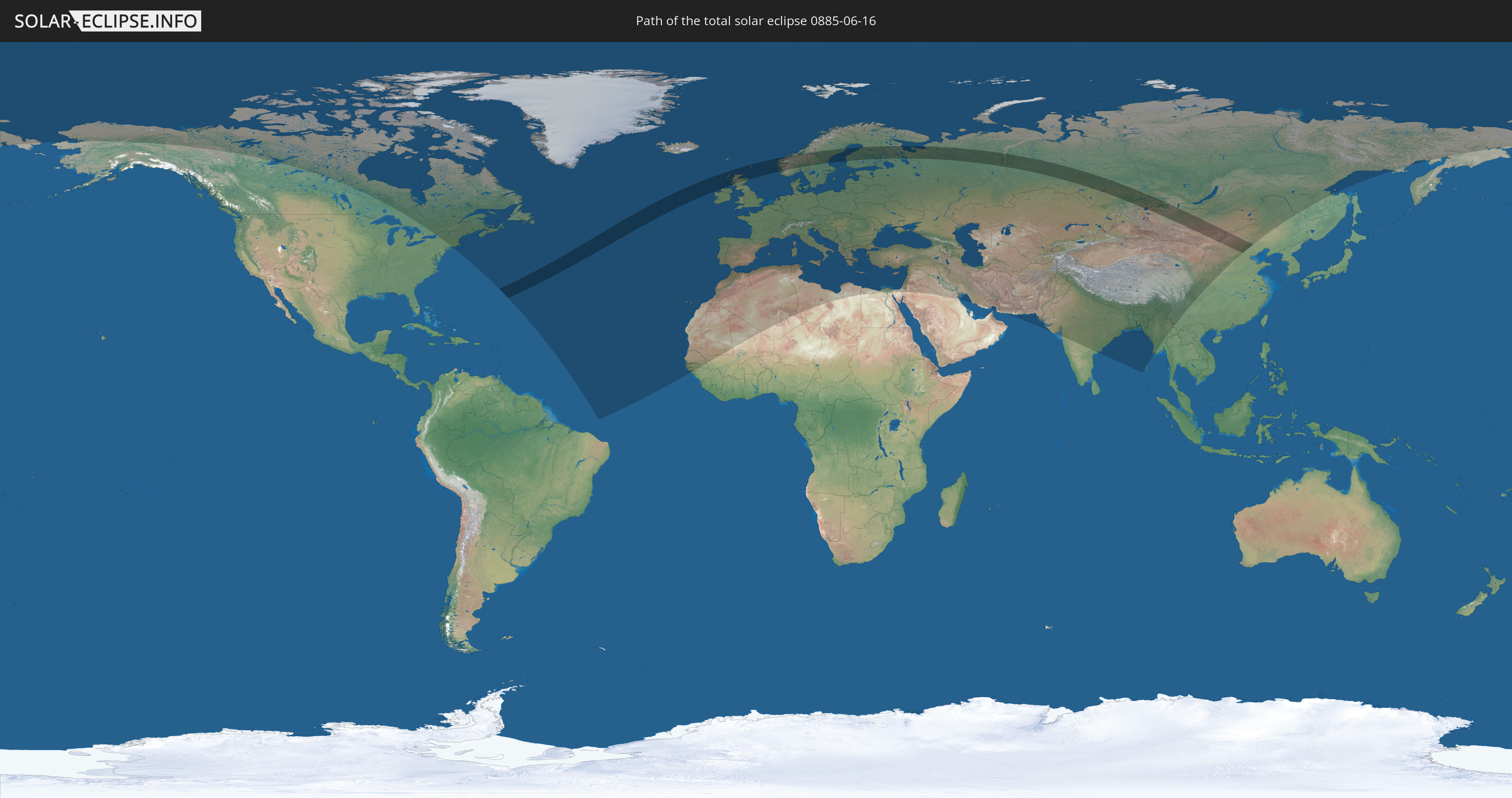
Die Sonnenfinsternis am 06/16/0885 kann man in 96 Ländern als partielle Sonnenfinsternis beobachten.
Der Finsternispfad verläuft durch 8 Länder. Nur in diesen Ländern ist sie als total Sonnenfinsternis zu sehen.
In den folgenden Ländern ist die Sonnenfinsternis total zu sehen
 Russia
 Republic of Ireland
 United Kingdom
 Norway
 Sweden
 Finland
 China
China
 Mongolia
In den folgenden Ländern ist die Sonnenfinsternis partiell zu sehen
 Russia
 United States
 Canada
 Greenland
 Saint Pierre and Miquelon
 Portugal
 Cabo Verde
 Iceland
 Spain
Spain
 Senegal
 Mauritania
 The Gambia
 Guinea-Bissau
 Guinea
 Morocco
 Mali
Mali
 Republic of Ireland
 Svalbard and Jan Mayen
 Algeria
 United Kingdom
 Faroe Islands
 Gibraltar
 France
 Isle of Man
 Guernsey
 Jersey
 Andorra
 Belgium
 Netherlands
 Norway
 Luxembourg
 Germany
 Switzerland
 Italy
Italy
 Monaco
 Tunisia
 Denmark
 Libya
Libya
 Liechtenstein
 Austria
 Sweden
 Czechia
 San Marino
 Vatican City
 Slovenia
 Croatia
 Poland
 Malta
Malta
 Bosnia and Herzegovina
 Hungary
 Slovakia
 Montenegro
 Serbia
 Albania
 Åland Islands
 Greece
 Romania
 Republic of Macedonia
 Finland
 Lithuania
 Latvia
 Estonia
 Ukraine
 Bulgaria
 Belarus
 Egypt
Egypt
 Turkey
 Moldova
 Cyprus
 State of Palestine
 Israel
 Saudi Arabia
 Jordan
 Lebanon
 Syria
Syria
 Iraq
Iraq
 Georgia
 Armenia
 Iran
Iran
 Azerbaijan
 Kazakhstan
 Kuwait
 Oman
Oman
 Turkmenistan
 Uzbekistan
 Afghanistan
 Pakistan
 Tajikistan
 India
India
 Kyrgyzstan
 China
China
 Nepal
Nepal
 Mongolia
 Bangladesh
 Bhutan
 Myanmar
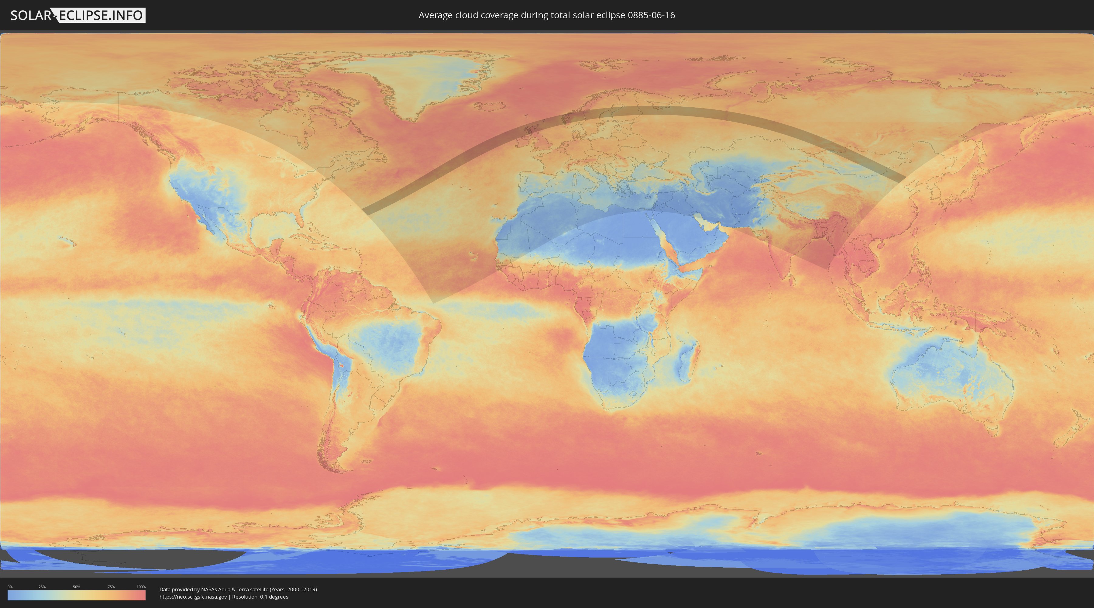
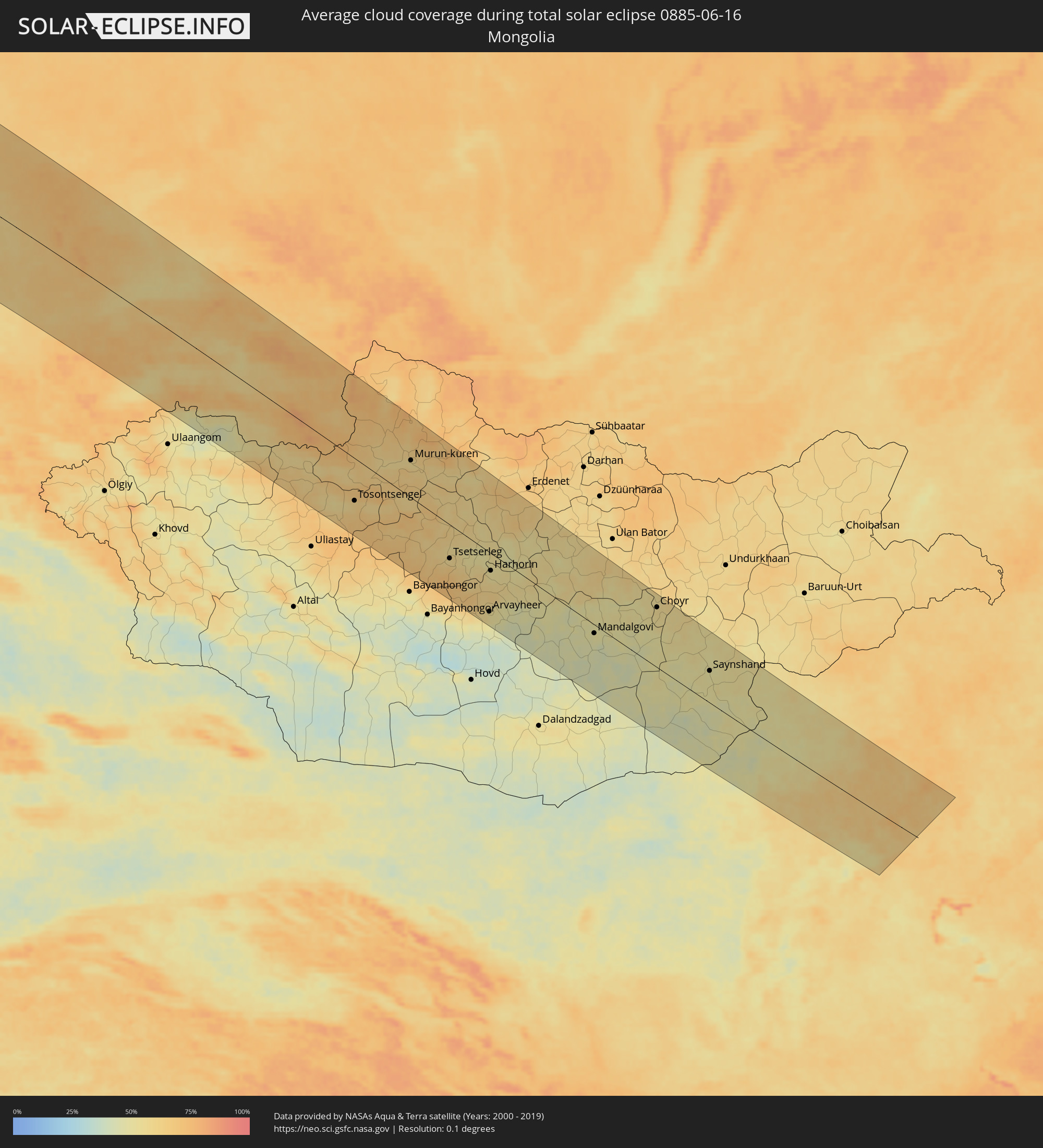
How will be the weather during the total solar eclipse on 06/16/0885?
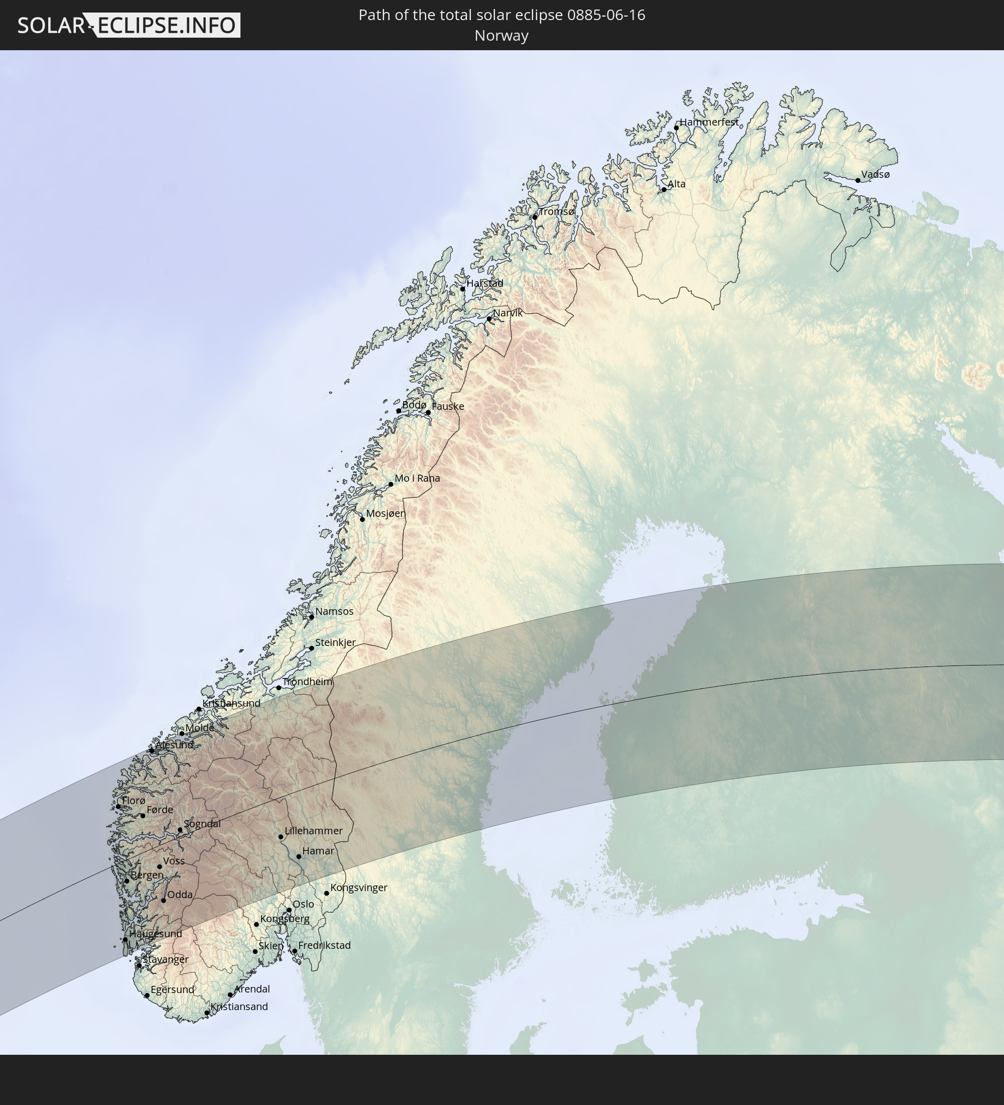
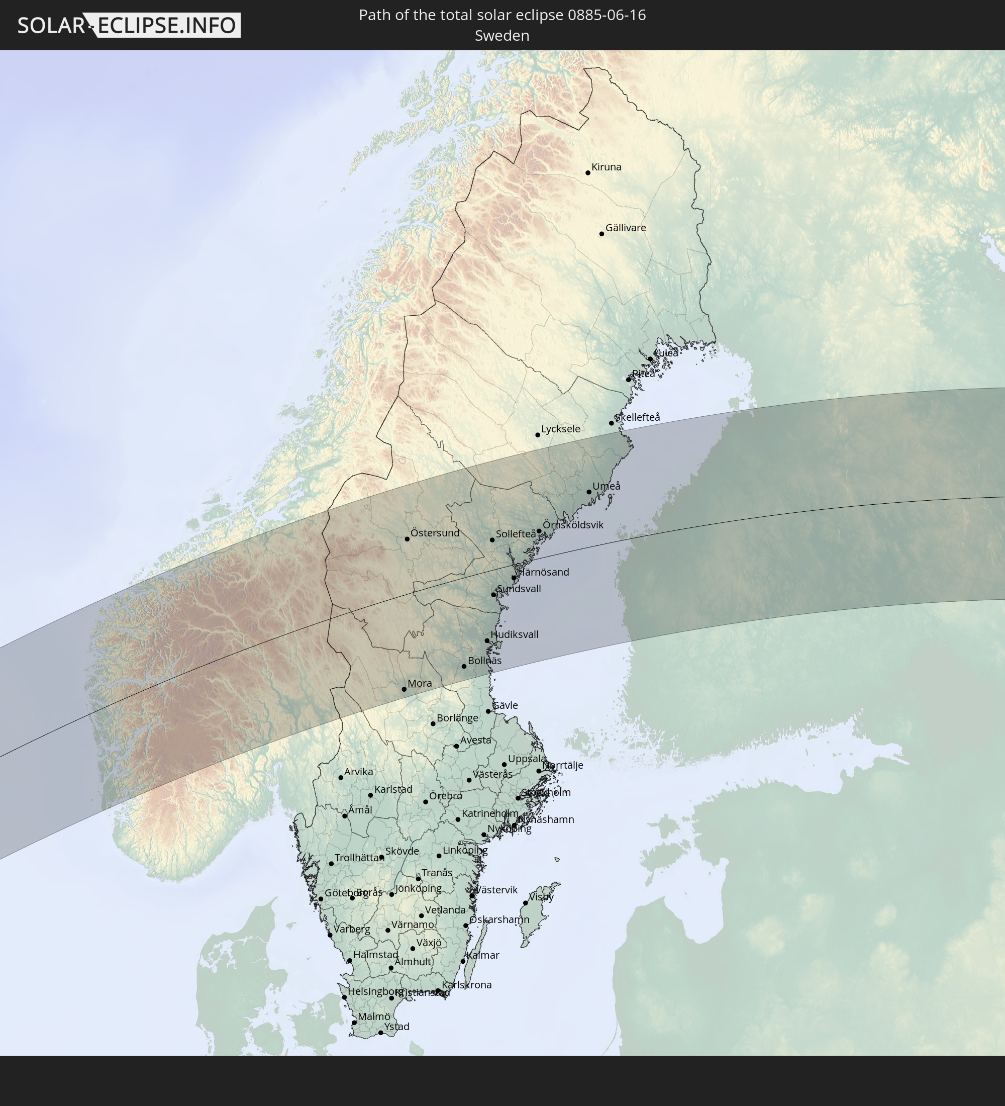
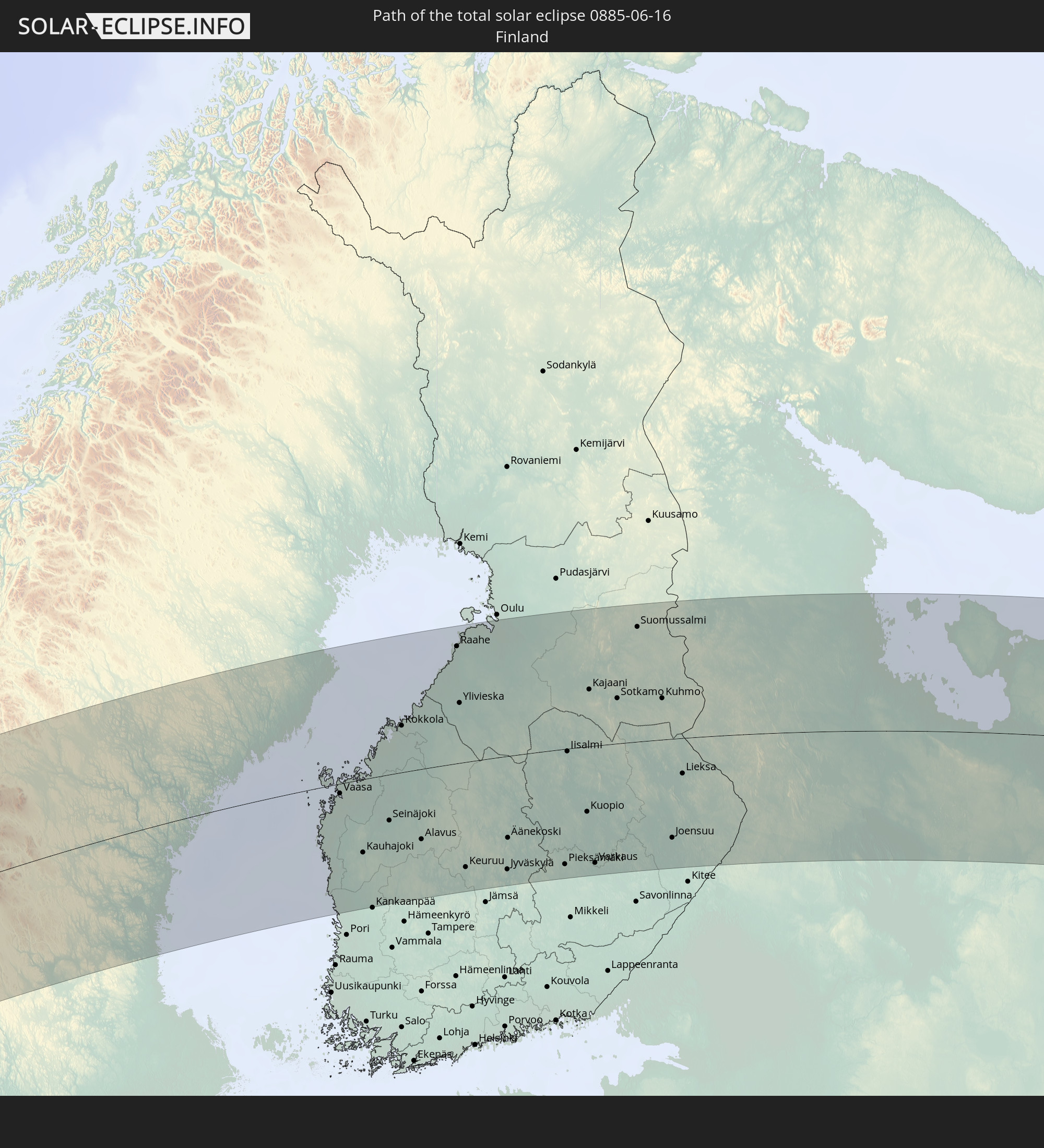
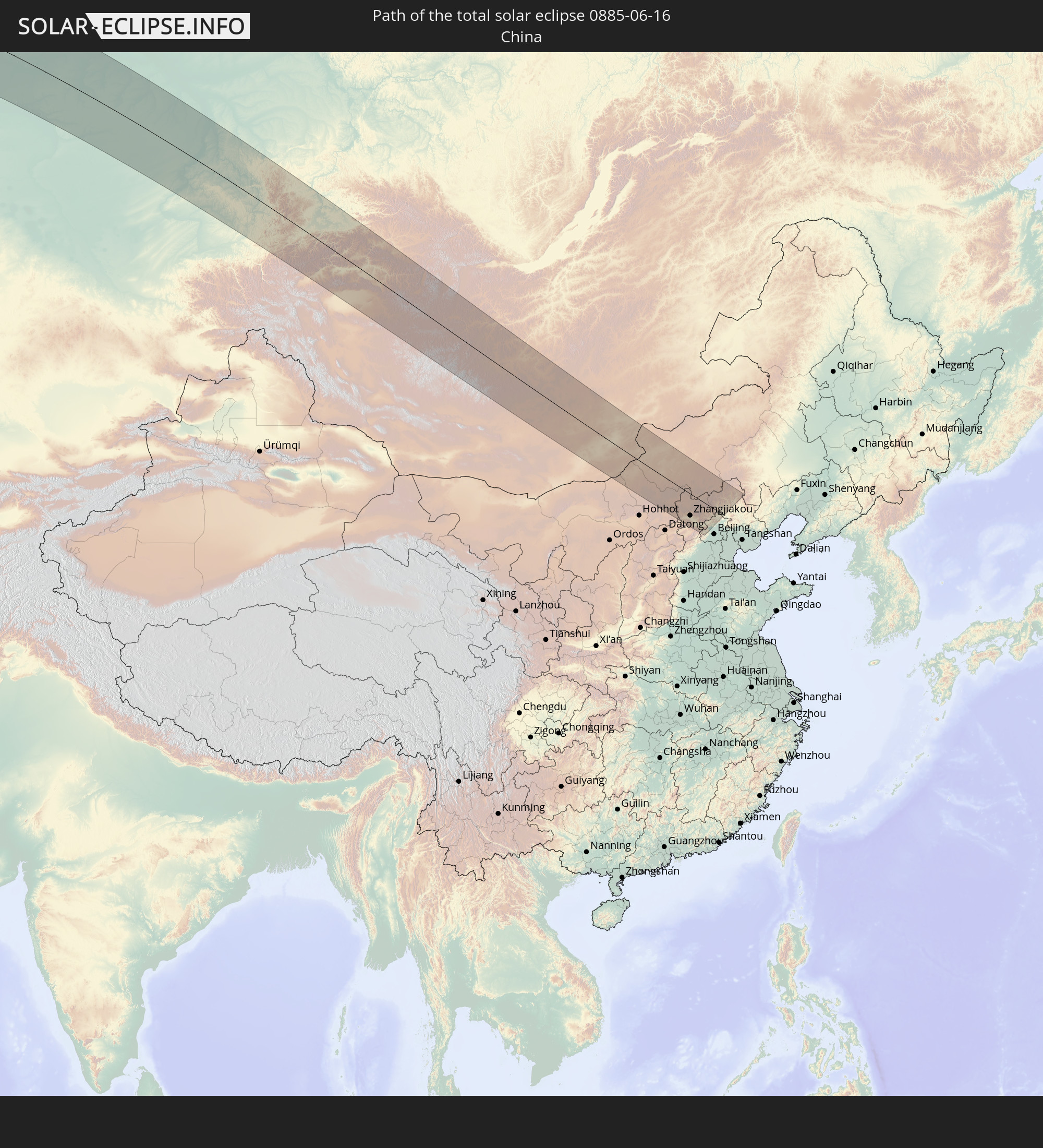
Where is the best place to see the total solar eclipse of 06/16/0885?
The following maps show the average cloud coverage for the day of the total solar eclipse.
With the help of these maps, it is possible to find the place along the eclipse path, which has the best
chance of a cloudless sky.
Nevertheless, you should consider local circumstances and inform about the weather of your chosen
observation site.
The data is provided by NASAs satellites
AQUA and TERRA.
The cloud maps are averaged over a period of 19 years (2000 - 2019).

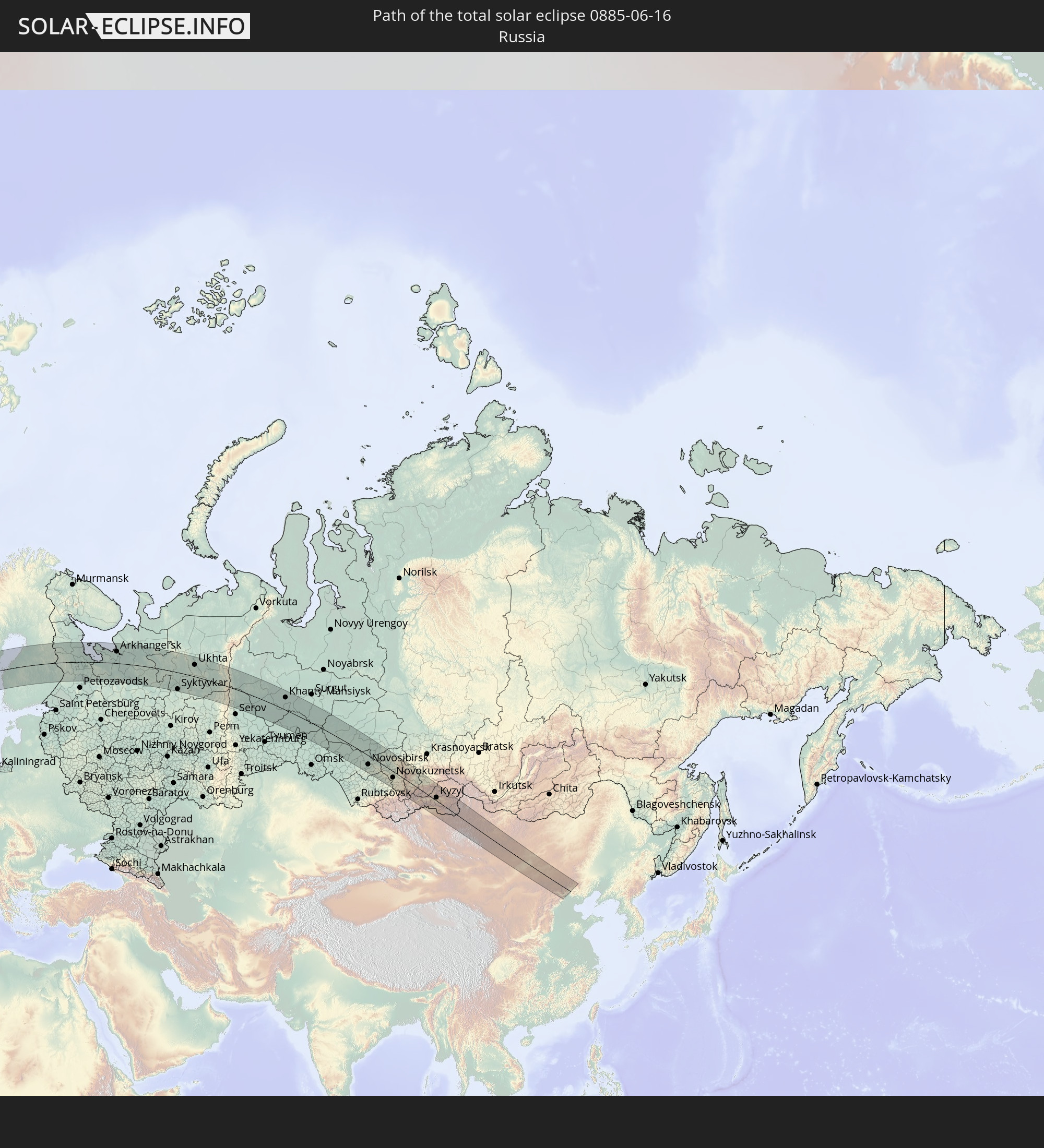
Detailed country maps
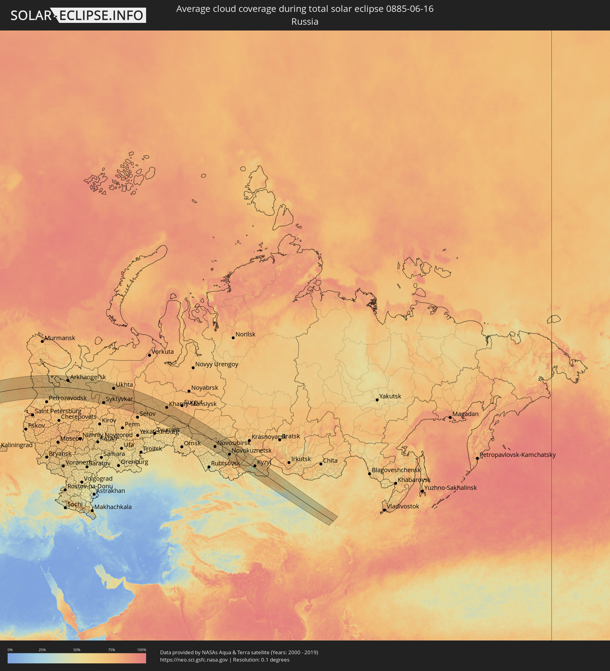 Russia
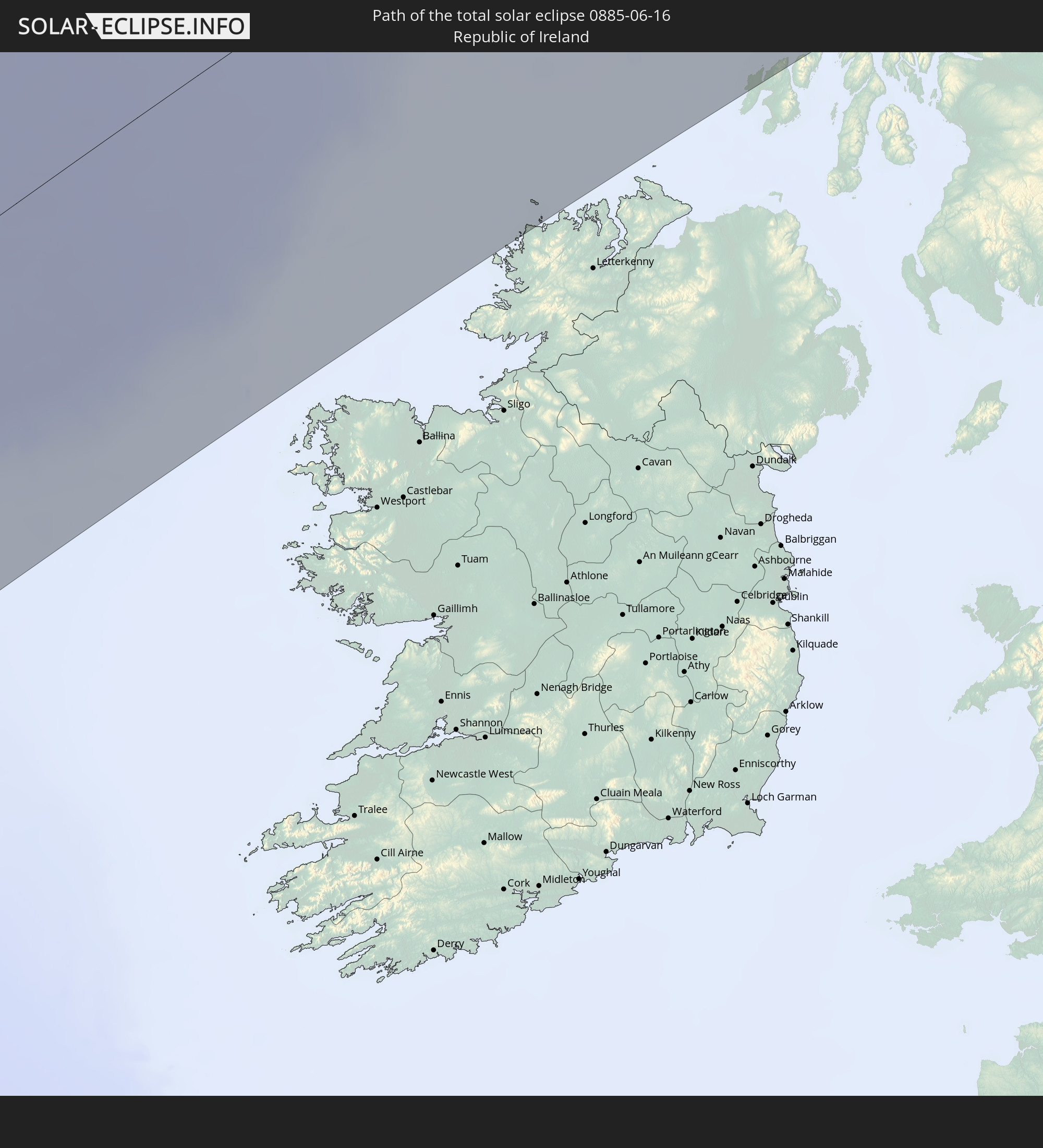
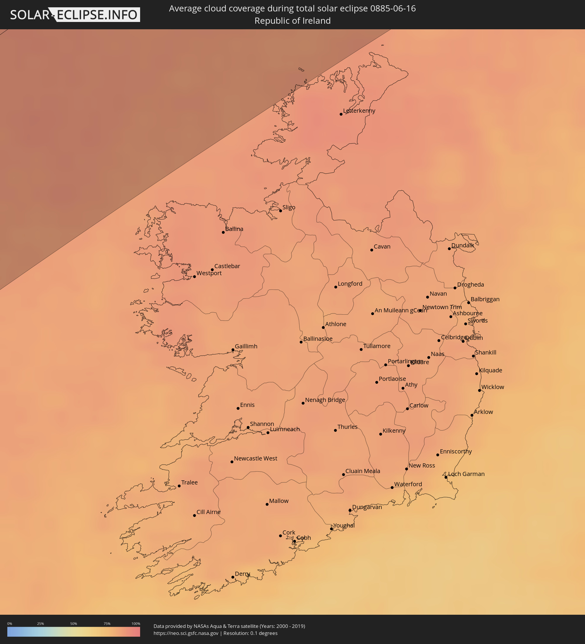 Republic of Ireland
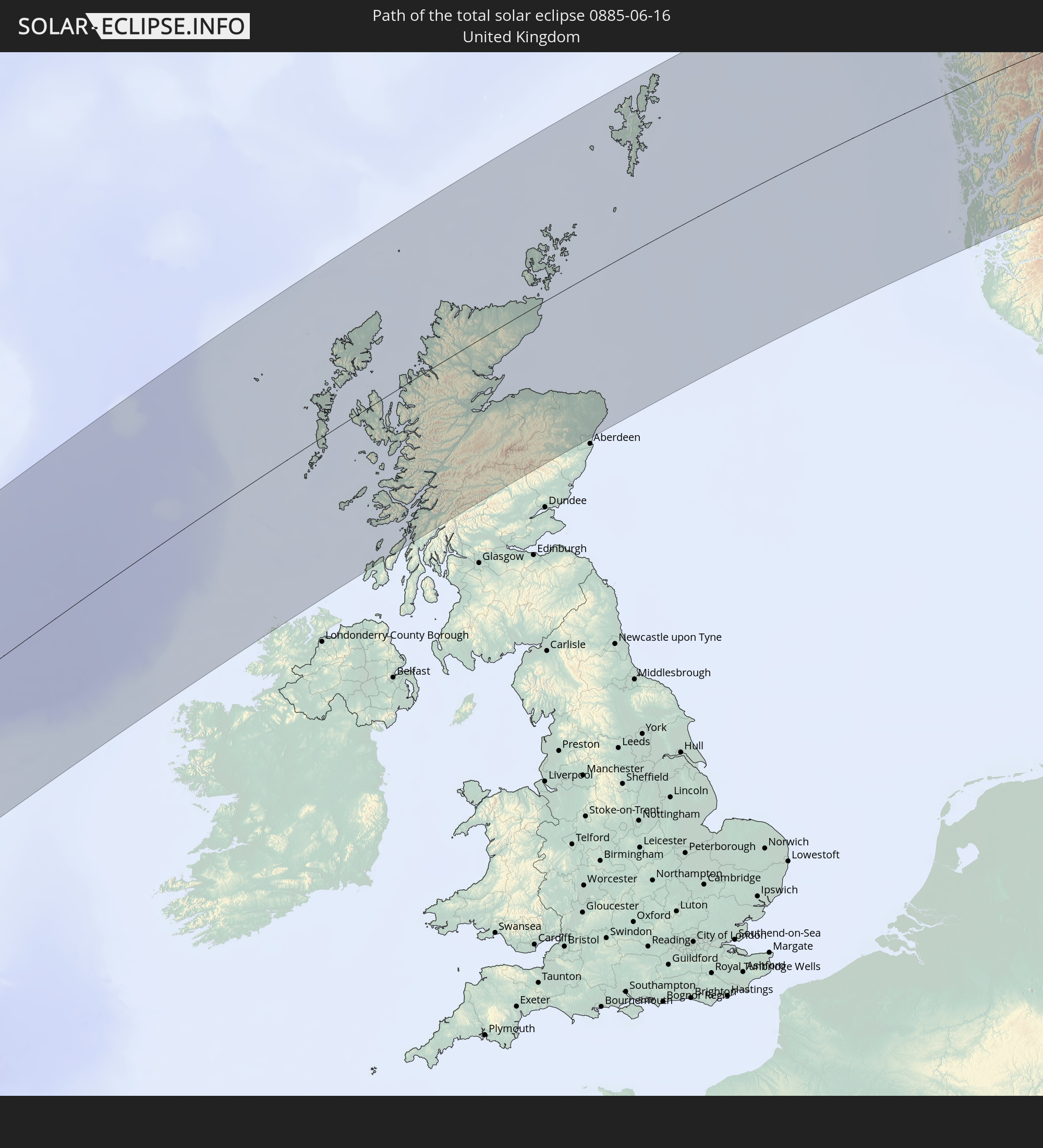
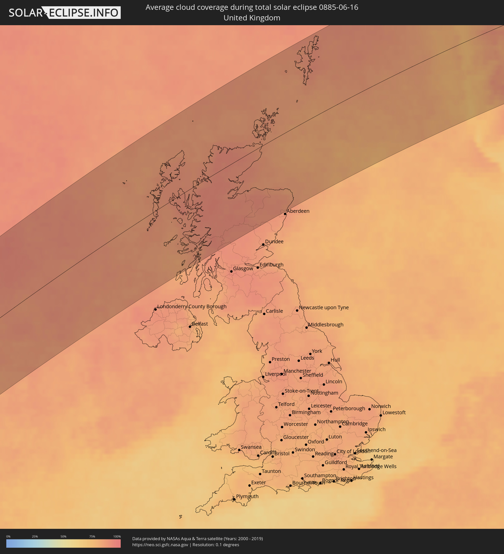 United Kingdom
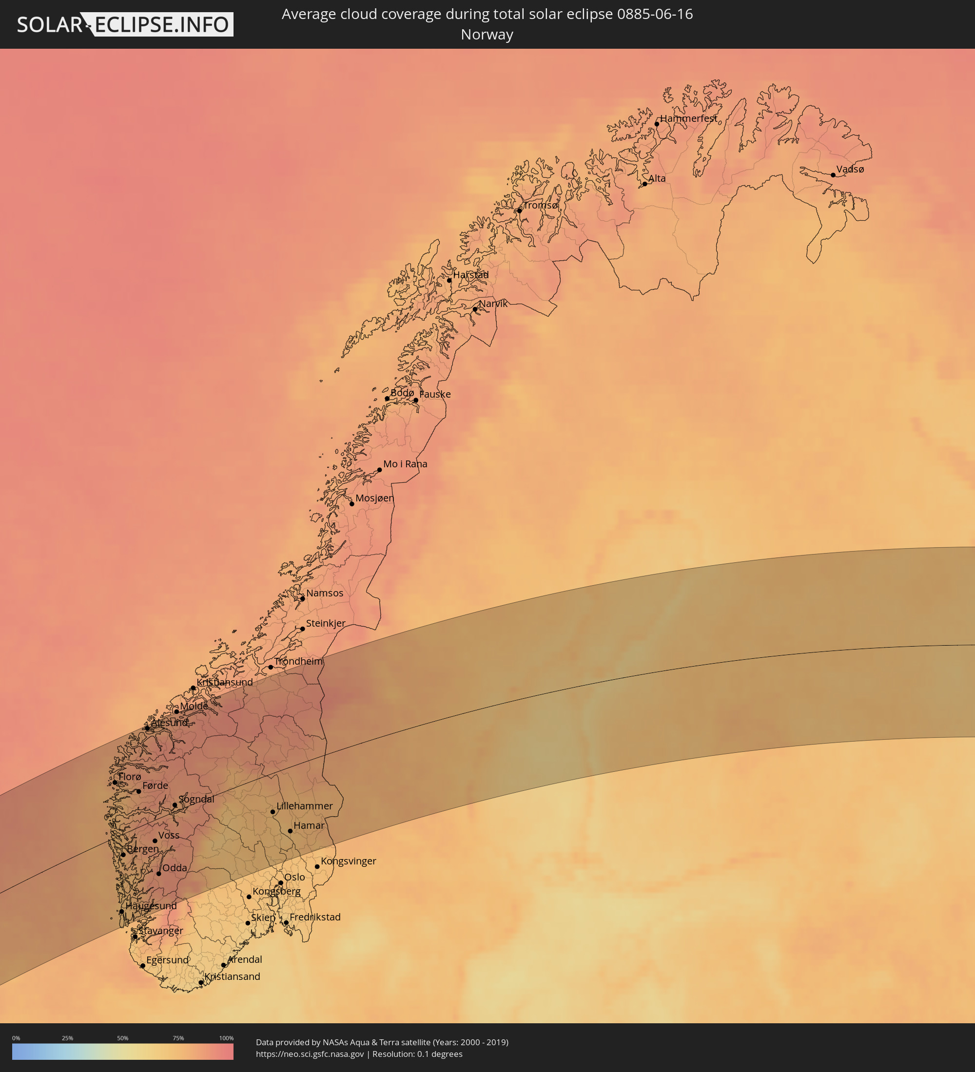 Norway
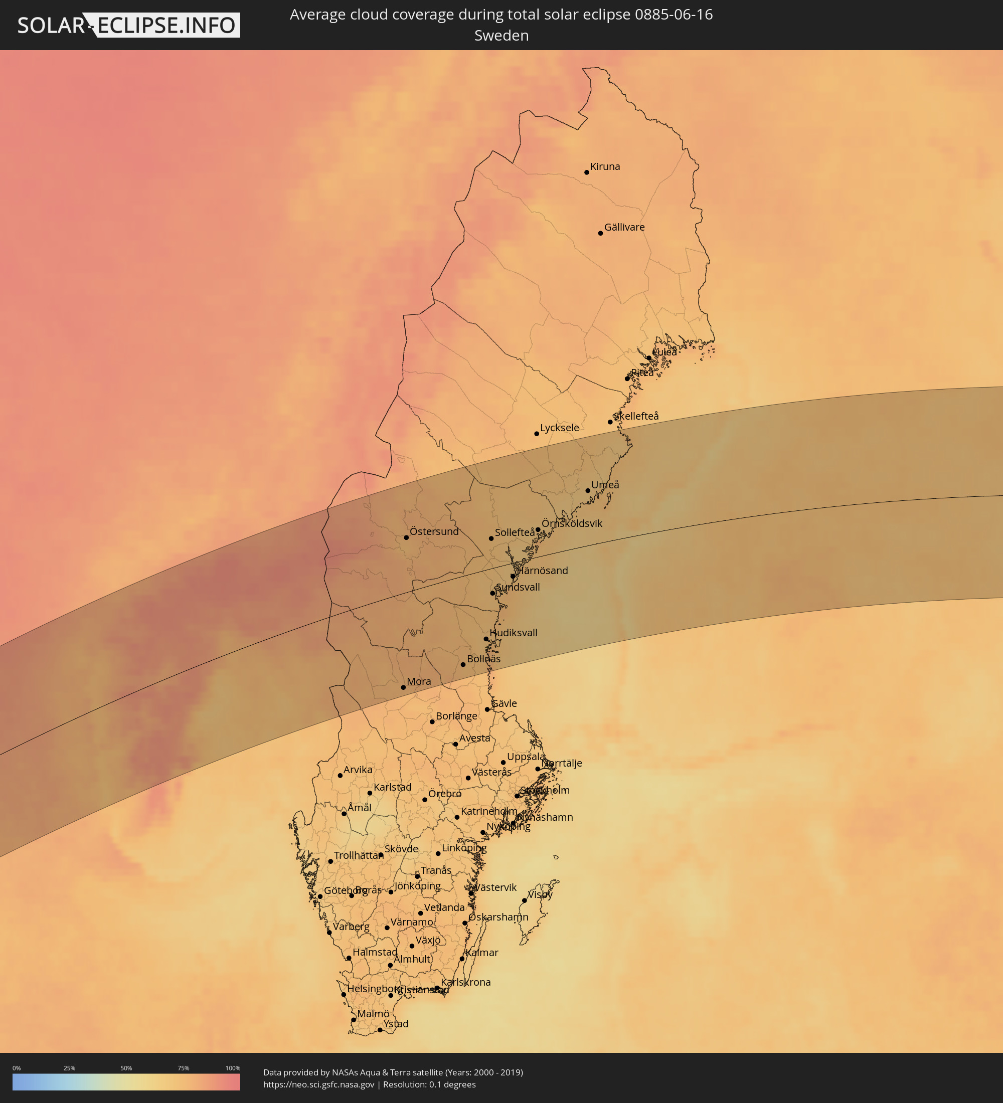 Sweden
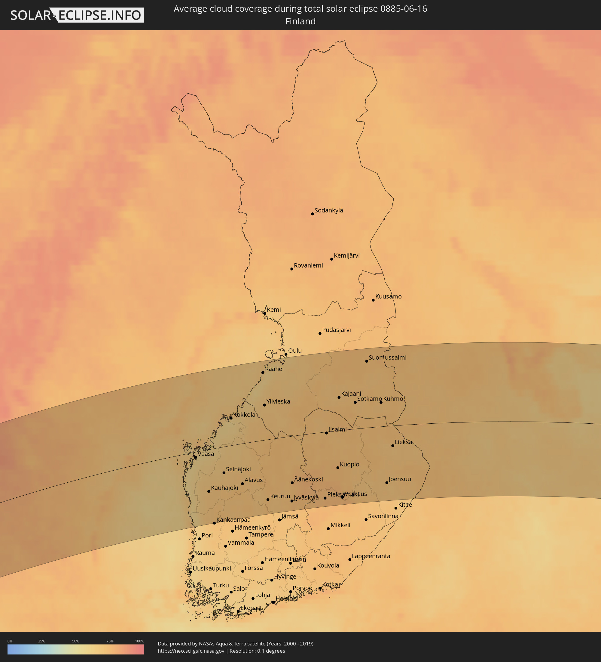 Finland
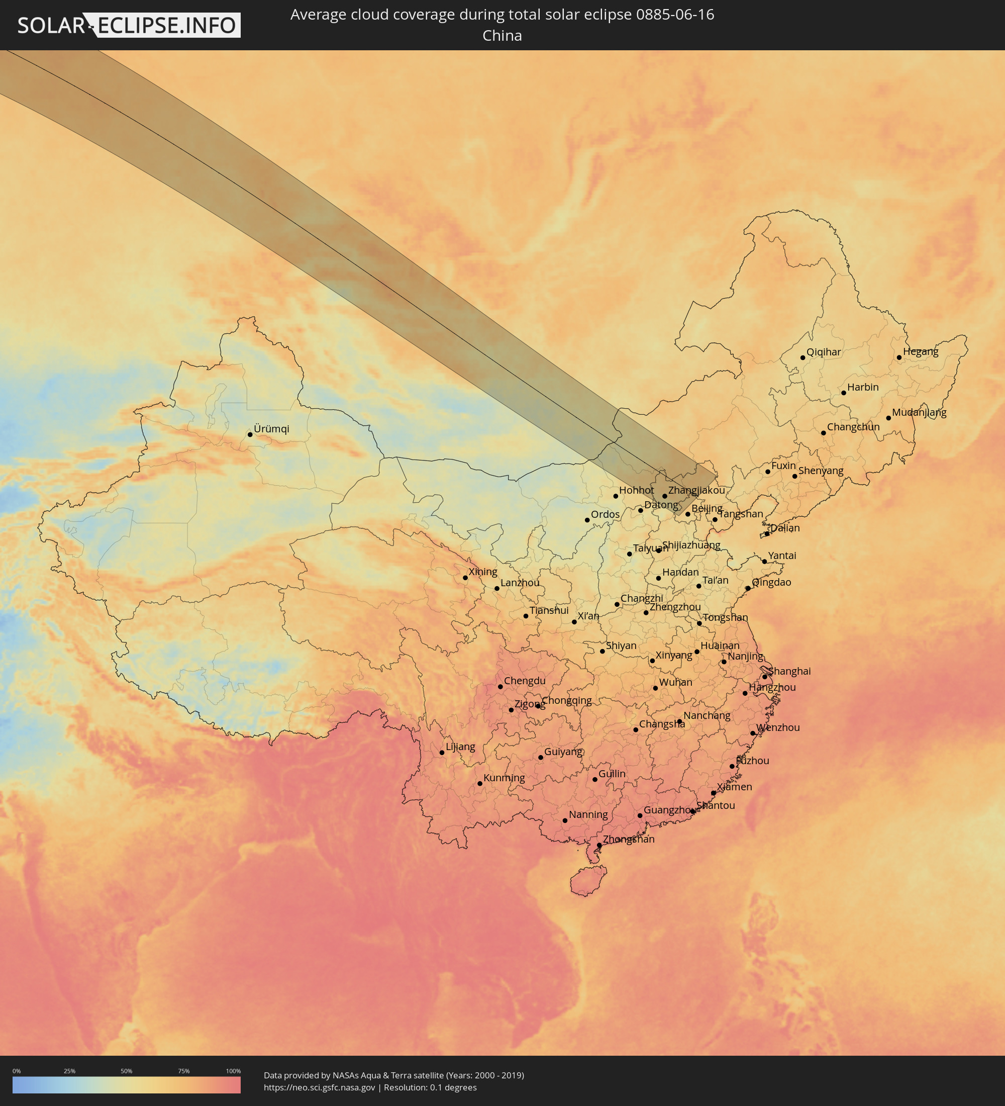 China
China
 Mongolia
Cities inside the path of the eclipse
The following table shows all locations with a population of more than 5,000 inside the eclipse path. Cities which have more than 100,000 inhabitants are marked bold. A click at the locations opens a detailed map.
| City | Type | Eclipse duration | Local time of max. eclipse | Distance to central line | Ø Cloud coverage |
|
Isle of Lewis, Scotland
|
total | - | 09:53:41 UTC+00:00 | 66 km | 88% |
|
Stornoway, Scotland
|
total | - | 09:53:41 UTC+00:00 | 65 km | 88% |
|
Isle of Skye, Scotland
|
total | - | 09:52:35 UTC+00:00 | 21 km | 91% |
|
Oban, Scotland
|
total | - | 09:51:53 UTC+00:00 | 135 km | 86% |
|
Fort William, Scotland
|
total | - | 09:52:47 UTC+00:00 | 108 km | 91% |
|
Dingwall, Scotland
|
total | - | 09:54:30 UTC+00:00 | 55 km | 89% |
|
Inverness, Scotland
|
total | - | 09:54:31 UTC+00:00 | 73 km | 91% |
|
Nairn, Scotland
|
total | - | 09:54:58 UTC+00:00 | 73 km | 89% |
|
Forres, Scotland
|
total | - | 09:55:14 UTC+00:00 | 79 km | 90% |
|
Thurso, Scotland
|
total | - | 09:56:40 UTC+00:00 | 15 km | 87% |
|
Elgin, Scotland
|
total | - | 09:55:34 UTC+00:00 | 83 km | 91% |
|
Lossiemouth, Scotland
|
total | - | 09:55:42 UTC+00:00 | 78 km | 89% |
|
Wick, Scotland
|
total | - | 09:56:51 UTC+00:00 | 20 km | 86% |
|
Buckie, Scotland
|
total | - | 09:55:56 UTC+00:00 | 93 km | 88% |
|
Orkney, Scotland
|
total | - | 09:57:42 UTC+00:00 | 36 km | 86% |
|
Kirkwall, Scotland
|
total | - | 09:57:42 UTC+00:00 | 36 km | 86% |
|
Kemnay, Scotland
|
total | - | 09:55:49 UTC+00:00 | 150 km | 88% |
|
Inverurie, Scotland
|
total | - | 09:55:56 UTC+00:00 | 147 km | 89% |
|
Dyce, Scotland
|
total | - | 09:56:01 UTC+00:00 | 160 km | 88% |
|
Ellon, Scotland
|
total | - | 09:56:20 UTC+00:00 | 148 km | 87% |
|
Fraserburgh, Scotland
|
total | - | 09:56:49 UTC+00:00 | 118 km | 83% |
|
Peterhead, Scotland
|
total | - | 09:56:47 UTC+00:00 | 142 km | 85% |
|
Lerwick, Scotland
|
total | - | 10:00:48 UTC+00:00 | 99 km | 88% |
|
Shetland, Scotland
|
total | - | 10:00:48 UTC+00:00 | 99 km | 88% |
|
Florø, Sogn og Fjordane
|
total | - | 11:08:04 UTC+01:00 | 93 km | 80% |
|
Askøy, Hordaland
|
total | - | 11:06:58 UTC+01:00 | 34 km | 74% |
|
Åkrehamn, Rogaland
|
total | - | 11:05:46 UTC+01:00 | 150 km | 73% |
|
Haugesund, Rogaland
|
total | - | 11:06:01 UTC+01:00 | 136 km | 71% |
|
Ytrebygda, Hordaland
|
total | - | 11:06:58 UTC+01:00 | 46 km | 76% |
|
Kopervik, Rogaland
|
total | - | 11:05:55 UTC+01:00 | 150 km | 73% |
|
Bergen, Hordaland
|
total | - | 11:07:06 UTC+01:00 | 37 km | 76% |
|
Indre Arna, Hordaland
|
total | - | 11:07:16 UTC+01:00 | 40 km | 80% |
|
Leirvik, Hordaland
|
total | - | 11:06:38 UTC+01:00 | 105 km | 76% |
|
Ulsteinvik, Møre og Romsdal
|
total | - | 11:09:34 UTC+01:00 | 150 km | 82% |
|
Førde, Sogn og Fjordane
|
total | - | 11:08:42 UTC+01:00 | 60 km | 82% |
|
Volda, Møre og Romsdal
|
total | - | 11:09:35 UTC+01:00 | 125 km | 86% |
|
Ørsta, Møre og Romsdal
|
total | - | 11:09:41 UTC+01:00 | 129 km | 84% |
|
Ålesund, Møre og Romsdal
|
total | - | 11:09:59 UTC+01:00 | 157 km | 82% |
|
Voss, Hordaland
|
total | - | 11:08:25 UTC+01:00 | 38 km | 85% |
|
Odda, Hordaland
|
total | - | 11:07:59 UTC+01:00 | 98 km | 86% |
|
Hermansverk, Sogn og Fjordane
|
total | - | 11:09:23 UTC+01:00 | 11 km | 81% |
|
Sogndal, Sogn og Fjordane
|
total | - | 11:09:40 UTC+01:00 | 14 km | 80% |
|
Lillehammer, Oppland
|
total | - | 11:12:55 UTC+01:00 | 68 km | 72% |
|
Raufoss, Oppland
|
total | - | 11:12:44 UTC+01:00 | 111 km | 72% |
|
Gjøvik, Oppland
|
total | - | 11:12:53 UTC+01:00 | 105 km | 72% |
|
Brumunddal, Hedmark
|
total | - | 11:13:12 UTC+01:00 | 102 km | 70% |
|
Hamar, Hedmark
|
total | - | 11:13:16 UTC+01:00 | 113 km | 72% |
|
Elverum, Hedmark
|
total | - | 11:13:51 UTC+01:00 | 112 km | 76% |
|
Mora, Dalarna
|
total | - | 11:17:04 UTC+01:00 | 149 km | 76% |
|
Orsa, Dalarna
|
total | - | 11:17:13 UTC+01:00 | 138 km | 77% |
|
Östersund, Jämtland
|
total | - | 11:18:32 UTC+01:00 | 82 km | 75% |
|
Ljusdal, Gävleborg
|
total | - | 11:19:12 UTC+01:00 | 84 km | 75% |
|
Bollnäs, Gävleborg
|
total | - | 11:19:14 UTC+01:00 | 139 km | 74% |
|
Söderhamn, Gävleborg
|
total | - | 11:19:55 UTC+01:00 | 154 km | 74% |
|
Hudiksvall, Gävleborg
|
total | - | 11:20:12 UTC+01:00 | 108 km | 71% |
|
Sollefteå, Västernorrland
|
total | - | 11:21:06 UTC+01:00 | 45 km | 73% |
|
Sundsvall, Västernorrland
|
total | - | 11:20:45 UTC+01:00 | 40 km | 72% |
|
Timrå, Västernorrland
|
total | - | 11:20:49 UTC+01:00 | 30 km | 70% |
|
Kramfors, Västernorrland
|
total | - | 11:21:29 UTC+01:00 | 13 km | 69% |
|
Härnösand, Västernorrland
|
total | - | 11:21:30 UTC+01:00 | 22 km | 70% |
|
Örnsköldsvik, Västernorrland
|
total | - | 11:22:35 UTC+01:00 | 40 km | 69% |
|
Umeå, Västerbotten
|
total | - | 11:24:18 UTC+01:00 | 82 km | 67% |
|
Holmsund, Västerbotten
|
total | - | 11:24:21 UTC+01:00 | 68 km | 72% |
|
Vaasa, Ostrobothnia
|
total | - | 12:05:13 UTC+01:39 | 12 km | 61% |
|
Kauhajoki, Southern Ostrobothnia
|
total | - | 12:05:36 UTC+01:39 | 90 km | 71% |
|
Kurikka, Southern Ostrobothnia
|
total | - | 12:05:54 UTC+01:39 | 72 km | 71% |
|
Jakobstad, Ostrobothnia
|
total | - | 12:06:27 UTC+01:39 | 42 km | 61% |
|
Seinäjoki, Southern Ostrobothnia
|
total | - | 12:06:22 UTC+01:39 | 56 km | 69% |
|
Lapua, Southern Ostrobothnia
|
total | - | 12:06:35 UTC+01:39 | 39 km | 69% |
|
Kokkola, Central Ostrobothnia
|
total | - | 12:06:54 UTC+01:39 | 57 km | 60% |
|
Raahe, Northern Ostrobothnia
|
total | - | 12:08:21 UTC+01:39 | 138 km | 64% |
|
Ylivieska, Northern Ostrobothnia
|
total | - | 12:08:20 UTC+01:39 | 73 km | 69% |
|
Keuruu, Central Finland
|
total | - | 12:08:12 UTC+01:39 | 130 km | 72% |
|
Nivala, Northern Ostrobothnia
|
total | - | 12:08:43 UTC+01:39 | 51 km | 70% |
|
Saarijärvi, Central Finland
|
total | - | 12:08:51 UTC+01:39 | 85 km | 72% |
|
Kempele, Northern Ostrobothnia
|
total | - | 12:09:20 UTC+01:39 | 157 km | 67% |
|
Jyväskylä, Central Finland
|
total | - | 12:09:16 UTC+01:39 | 140 km | 74% |
|
Äänekoski, Central Finland
|
total | - | 12:09:20 UTC+01:39 | 100 km | 74% |
|
Laukaa, Central Finland
|
total | - | 12:09:32 UTC+01:39 | 122 km | 76% |
|
Pieksämäki, Southern Savonia
|
total | - | 12:10:46 UTC+01:39 | 142 km | 76% |
|
Iisalmi, Northern Savo
|
total | - | 12:10:52 UTC+01:39 | 3 km | 72% |
|
Siilinjärvi, Northern Savo
|
total | - | 12:11:20 UTC+01:39 | 58 km | 74% |
|
Kuopio, Northern Savo
|
total | - | 12:11:21 UTC+01:39 | 80 km | 74% |
|
Kajaani, Kainuu
|
total | - | 12:11:24 UTC+01:39 | 68 km | 71% |
|
Leppävirta, Northern Savo
|
total | - | 12:11:27 UTC+01:39 | 125 km | 76% |
|
Varkaus, Northern Savo
|
total | - | 12:11:33 UTC+01:39 | 145 km | 76% |
|
Sotkamo, Kainuu
|
total | - | 12:12:04 UTC+01:39 | 54 km | 71% |
|
Liperi, North Karelia
|
total | - | 12:13:06 UTC+01:39 | 127 km | 71% |
|
Kuhmo, Kainuu
|
total | - | 12:13:07 UTC+01:39 | 50 km | 71% |
|
Joensuu, North Karelia
|
total | - | 12:13:30 UTC+01:39 | 122 km | 69% |
|
Kontiolahti, North Karelia
|
total | - | 12:13:34 UTC+01:39 | 105 km | 71% |
|
Lieksa, North Karelia
|
total | - | 12:13:41 UTC+01:39 | 43 km | 69% |
|
Severodvinsk, Arkhangelskaya
|
total | - | 13:13:02 UTC+02:30 | 95 km | 61% |
|
Arkhangel’sk, Arkhangelskaya
|
total | - | 13:13:41 UTC+02:30 | 95 km | 61% |
|
Novodvinsk, Arkhangelskaya
|
total | - | 13:14:00 UTC+02:30 | 83 km | 62% |
|
Ezhva, Komi Republic
|
total | - | 13:24:49 UTC+02:30 | 129 km | 71% |
|
Syktyvkar, Komi Republic
|
total | - | 13:25:01 UTC+02:30 | 143 km | 71% |
|
Ukhta, Komi Republic
|
total | - | 13:25:26 UTC+02:30 | 97 km | 69% |
|
Nyagan, Khanty-Mansiyskiy Avtonomnyy Okrug
|
total | - | 15:07:34 UTC+04:02 | 142 km | 73% |
|
Khanty-Mansiysk, Khanty-Mansiyskiy Avtonomnyy Okrug
|
total | - | 15:11:16 UTC+04:02 | 105 km | 75% |
|
Novosibirsk, Novosibirsk
|
total | - | 17:35:20 UTC+06:11 | 81 km | 69% |
|
Berdsk, Novosibirsk
|
total | - | 17:35:49 UTC+06:11 | 102 km | 65% |
|
Iskitim, Novosibirsk
|
total | - | 17:36:04 UTC+06:11 | 107 km | 65% |
|
Yurga, Kemerovo
|
total | - | 17:34:51 UTC+06:11 | 49 km | 63% |
|
Zarinsk, Altai Krai
|
total | - | 17:37:56 UTC+06:11 | 138 km | 63% |
|
Tomsk, Tomsk
|
total | - | 17:33:41 UTC+06:11 | 125 km | 67% |
|
Anzhero-Sudzhensk, Kemerovo
|
total | - | 17:34:35 UTC+06:11 | 122 km | 68% |
|
Kemerovo, Kemerovo
|
total | - | 17:35:45 UTC+06:11 | 55 km | 65% |
|
Leninsk-Kuznetsky, Kemerovo
|
total | - | 17:36:48 UTC+06:11 | 18 km | 64% |
|
Berëzovskiy, Kemerovo
|
total | - | 17:35:22 UTC+06:11 | 83 km | 67% |
|
Belovo, Kemerovo
|
total | - | 17:37:11 UTC+06:11 | 24 km | 62% |
|
Prokop’yevsk, Kemerovo
|
total | - | 17:38:03 UTC+06:11 | 59 km | 63% |
|
Novokuznetsk, Kemerovo
|
total | - | 17:38:22 UTC+06:11 | 57 km | 65% |
|
Osinniki, Kemerovo
|
total | - | 17:38:37 UTC+06:11 | 61 km | 64% |
|
Myski, Kemerovo
|
total | - | 17:38:35 UTC+06:11 | 37 km | 66% |
|
Mezhdurechensk, Kemerovo
|
total | - | 17:38:39 UTC+06:11 | 33 km | 66% |
|
Chernogorsk, Khakasiya
|
total | - | 17:38:58 UTC+06:11 | 103 km | 62% |
|
Sayanogorsk, Khakasiya
|
total | - | 17:40:04 UTC+06:11 | 40 km | 62% |
|
Abakan, Khakasiya
|
total | - | 17:39:09 UTC+06:11 | 98 km | 61% |
|
Minusinsk, Krasnoyarskiy
|
total | - | 17:39:11 UTC+06:11 | 109 km | 59% |
|
Kyzyl, Tyva
|
total | - | 17:42:20 UTC+06:11 | 35 km | 54% |
|
Tosontsengel, Dzabkhan
|
total | - | 17:41:37 UTC+06:06 | 84 km | 61% |
|
Murun-kuren, Hövsgöl
|
total | - | 18:41:14 UTC+07:07 | 74 km | 57% |
|
Tsetserleg, Arhangay
|
total | - | 18:43:57 UTC+07:07 | 69 km | 57% |
|
Arvayheer, Övörhangay
|
total | - | 18:45:19 UTC+07:07 | 124 km | 53% |
|
Kharkhorin, Övörhangay
|
total | - | 18:44:08 UTC+07:07 | 37 km | 52% |
|
Harhorin, Övörhangay
|
total | - | 18:44:07 UTC+07:07 | 36 km | 52% |
|
Bulgan, Bulgan
|
total | - | 18:41:56 UTC+07:07 | 142 km | 63% |
|
Mandalgovi, Middle Govĭ
|
total | - | 18:45:14 UTC+07:07 | 18 km | 50% |
|
Choyr, Govĭ-Sumber
|
total | - | 18:44:00 UTC+07:07 | 128 km | 56% |
|
Saynshand, East Gobi Aymag
|
total | - | 18:45:14 UTC+07:07 | 71 km | 49% |
|
Erenhot, Inner Mongolia
|
total | - | 19:38:28 UTC+08:00 | 44 km | 50% |
|
Zhangjiakou, Hebei
|
total | - | 19:40:19 UTC+08:00 | 97 km | 54% |
|
Zhangjiakou Shi Xuanhua Qu, Hebei
|
total | - | 19:40:27 UTC+08:00 | 111 km | 53% |