Total solar eclipse of 12/22/0968
| Day of week: | Thursday |
| Maximum duration of eclipse: | 02m28s |
| Maximum width of eclipse path: | 246 km |
| Saros cycle: | 115 |
| Coverage: | 100% |
| Magnitude: | 1.03 |
| Gamma: | 0.9105 |
Wo kann man die Sonnenfinsternis vom 12/22/0968 sehen?
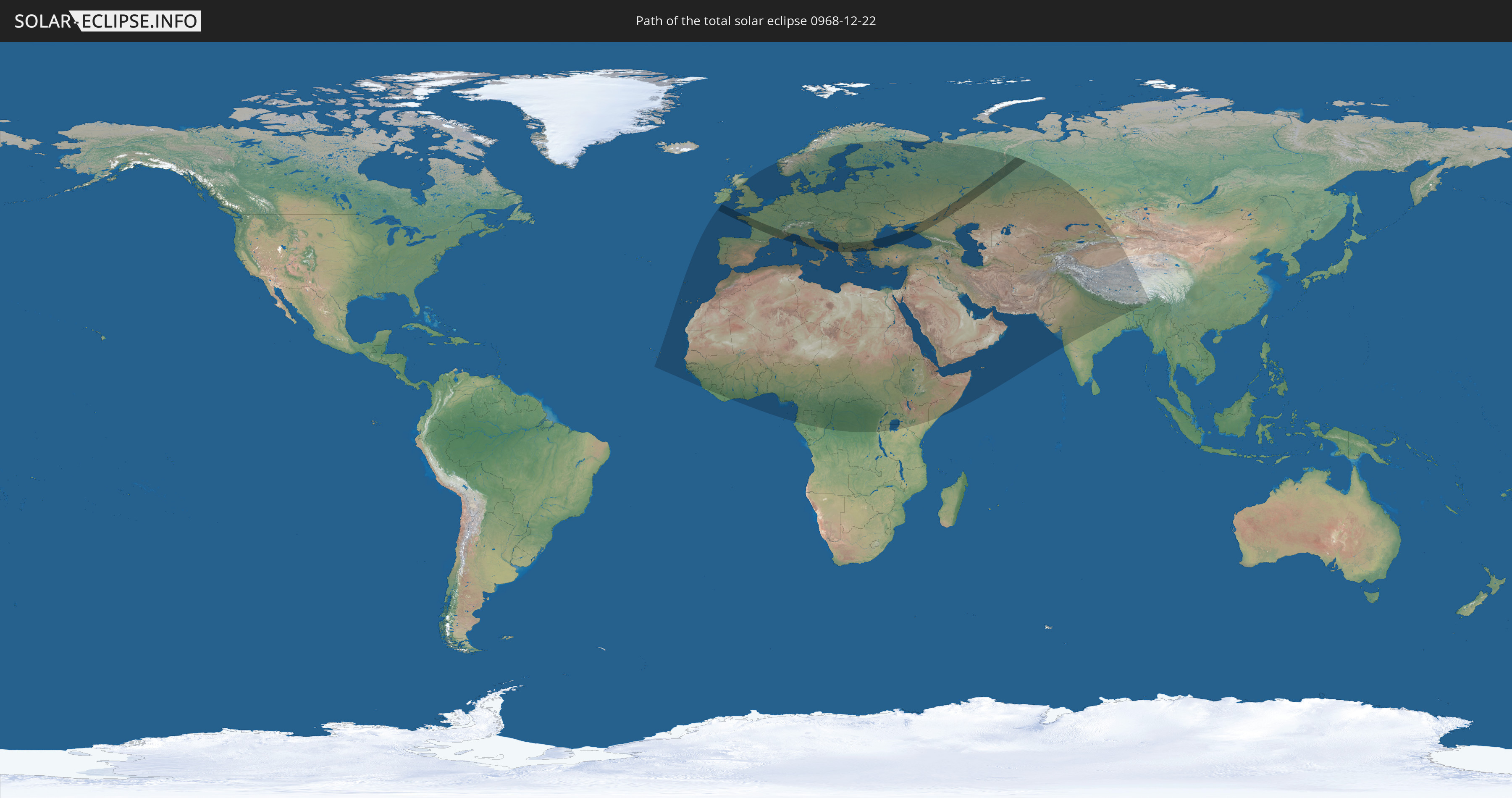
Die Sonnenfinsternis am 12/22/0968 kann man in 118 Ländern als partielle Sonnenfinsternis beobachten.
Der Finsternispfad verläuft durch 16 Länder. Nur in diesen Ländern ist sie als total Sonnenfinsternis zu sehen.
In den folgenden Ländern ist die Sonnenfinsternis total zu sehen
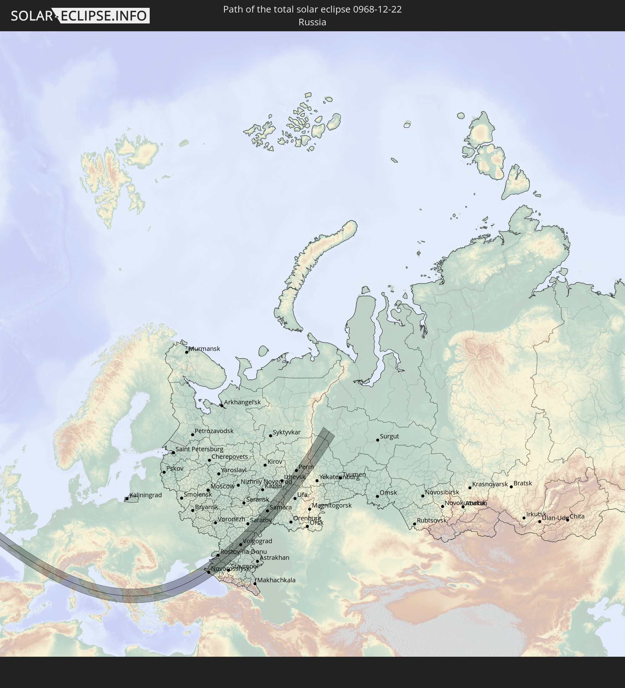 Russia
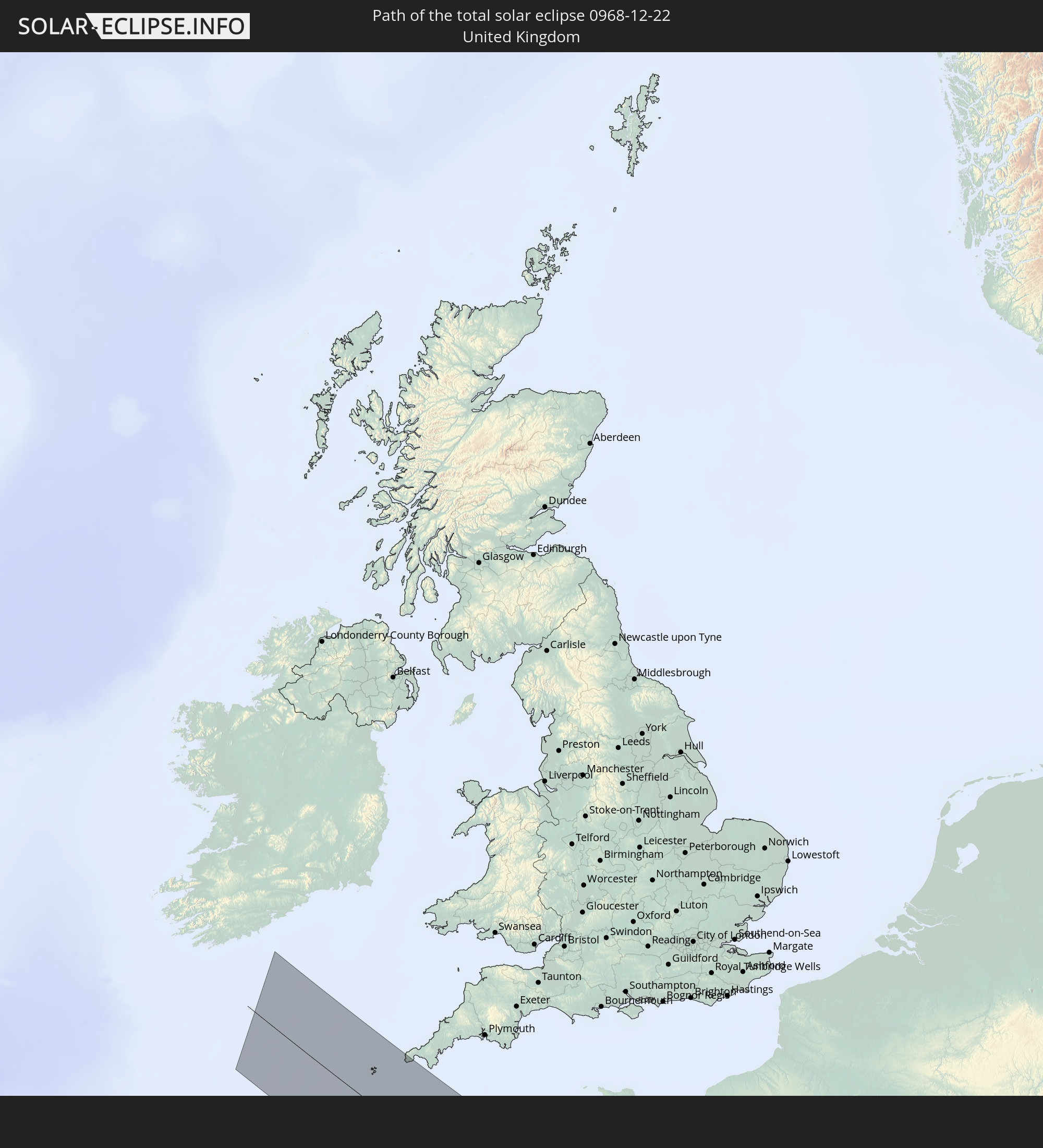 United Kingdom
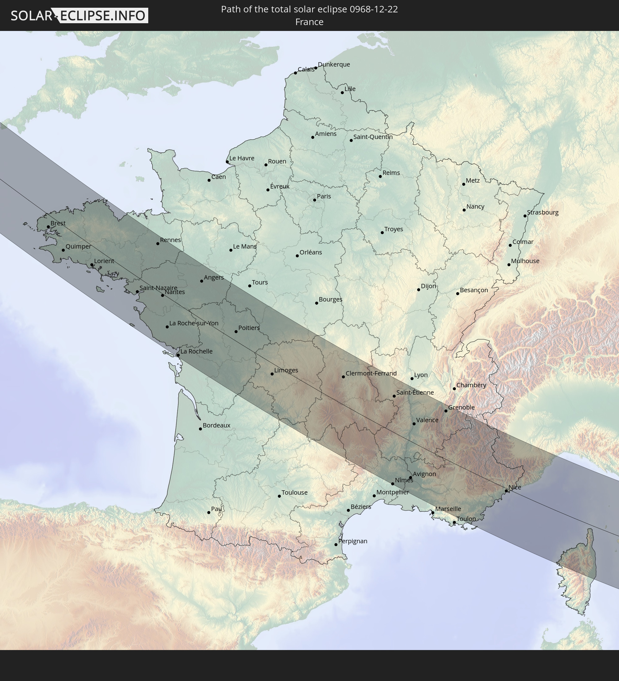 France
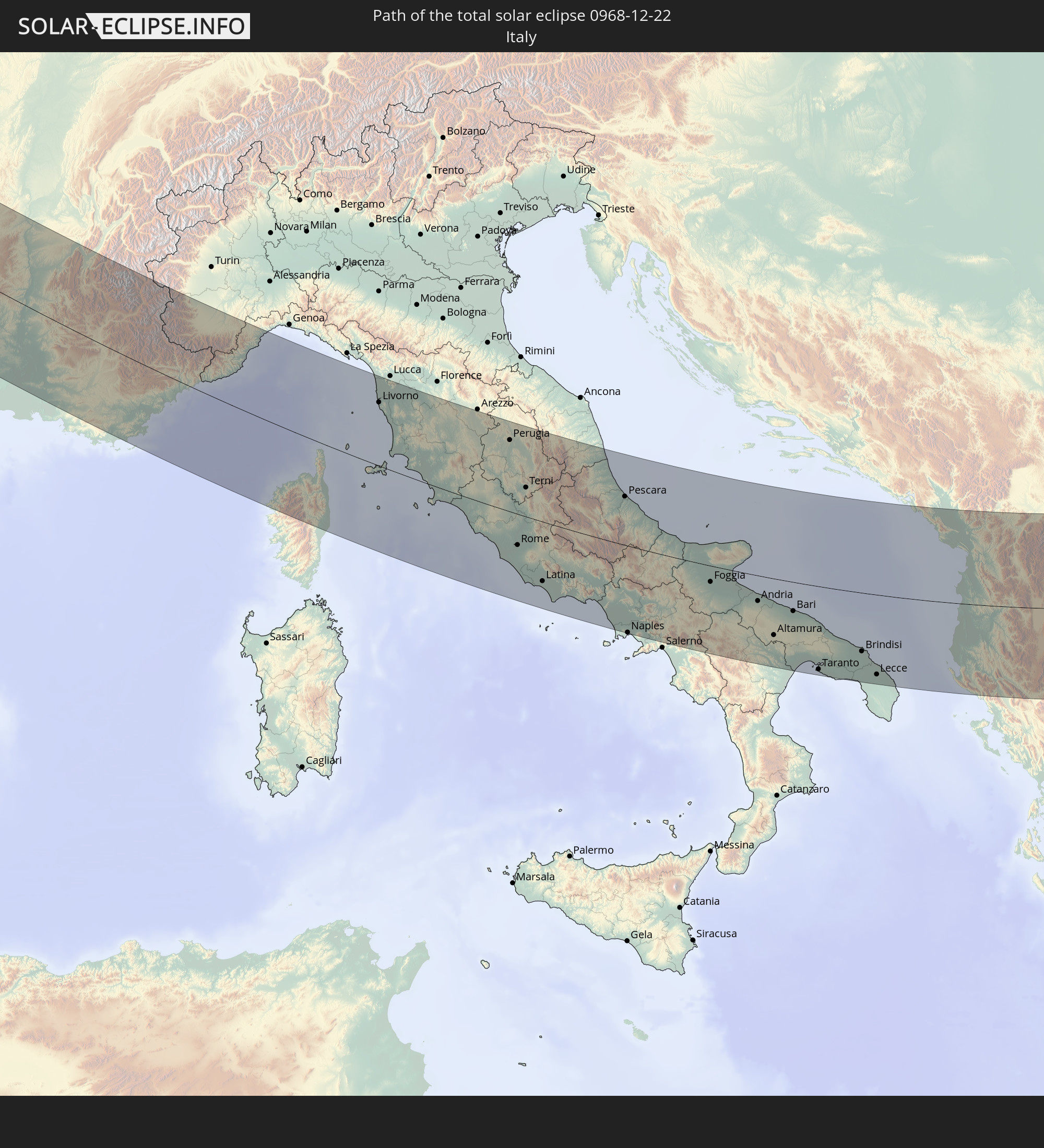 Italy
Italy
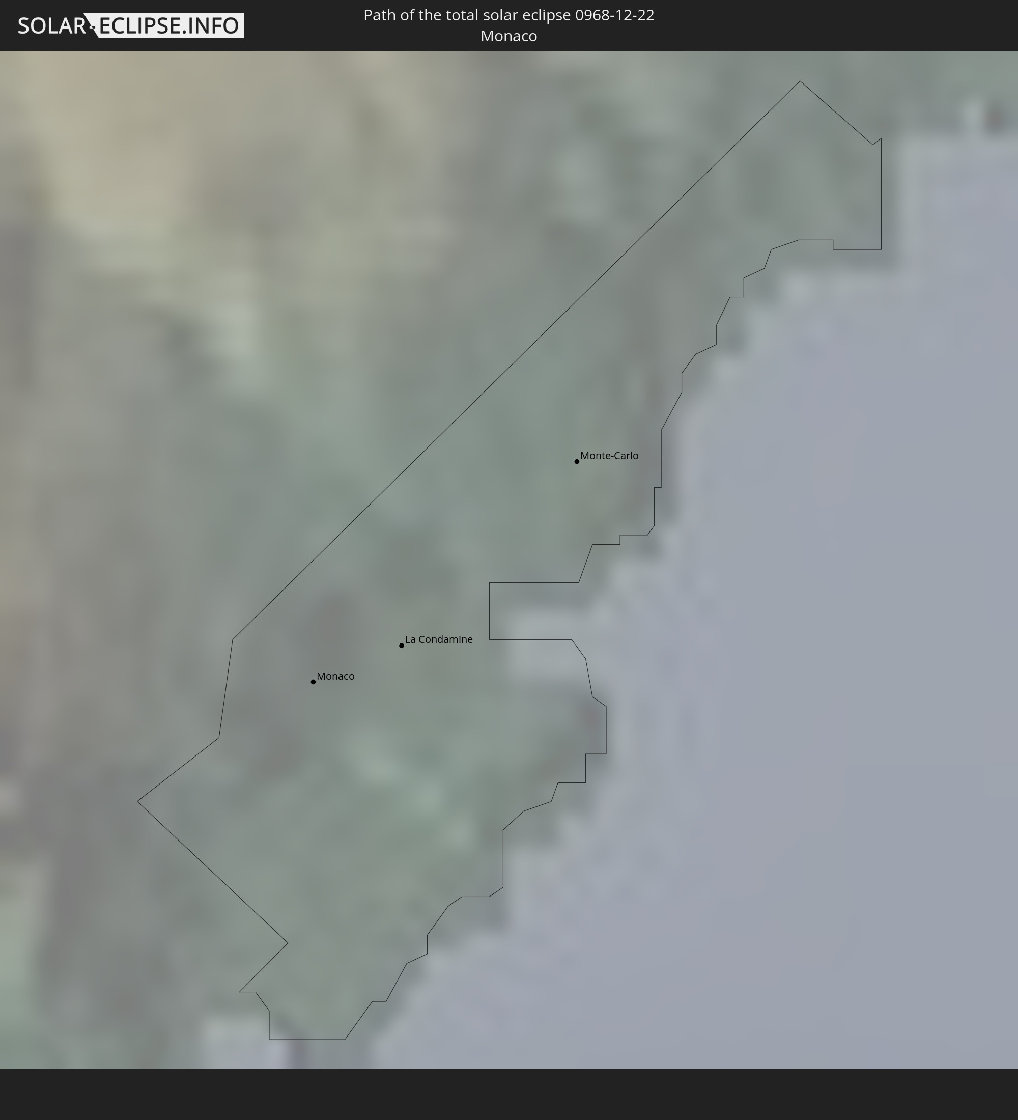 Monaco
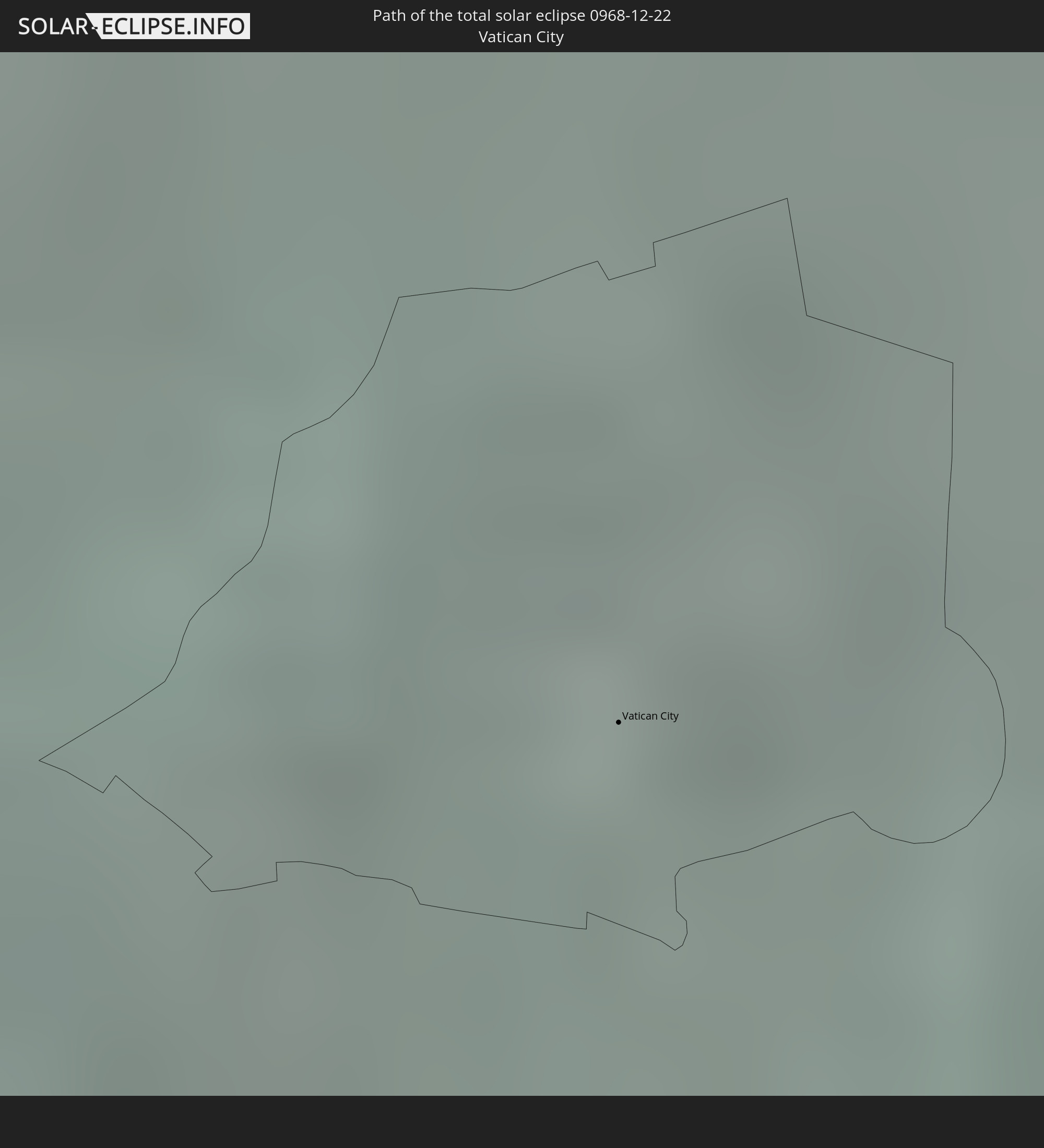 Vatican City
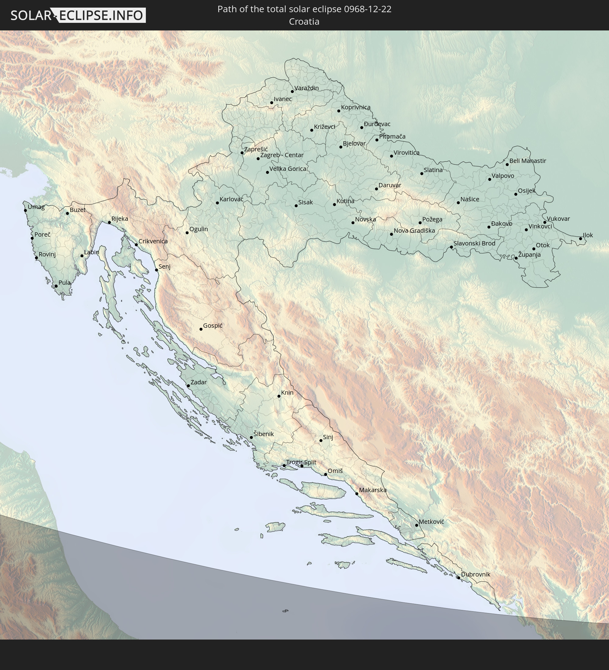 Croatia
 Montenegro
 Serbia
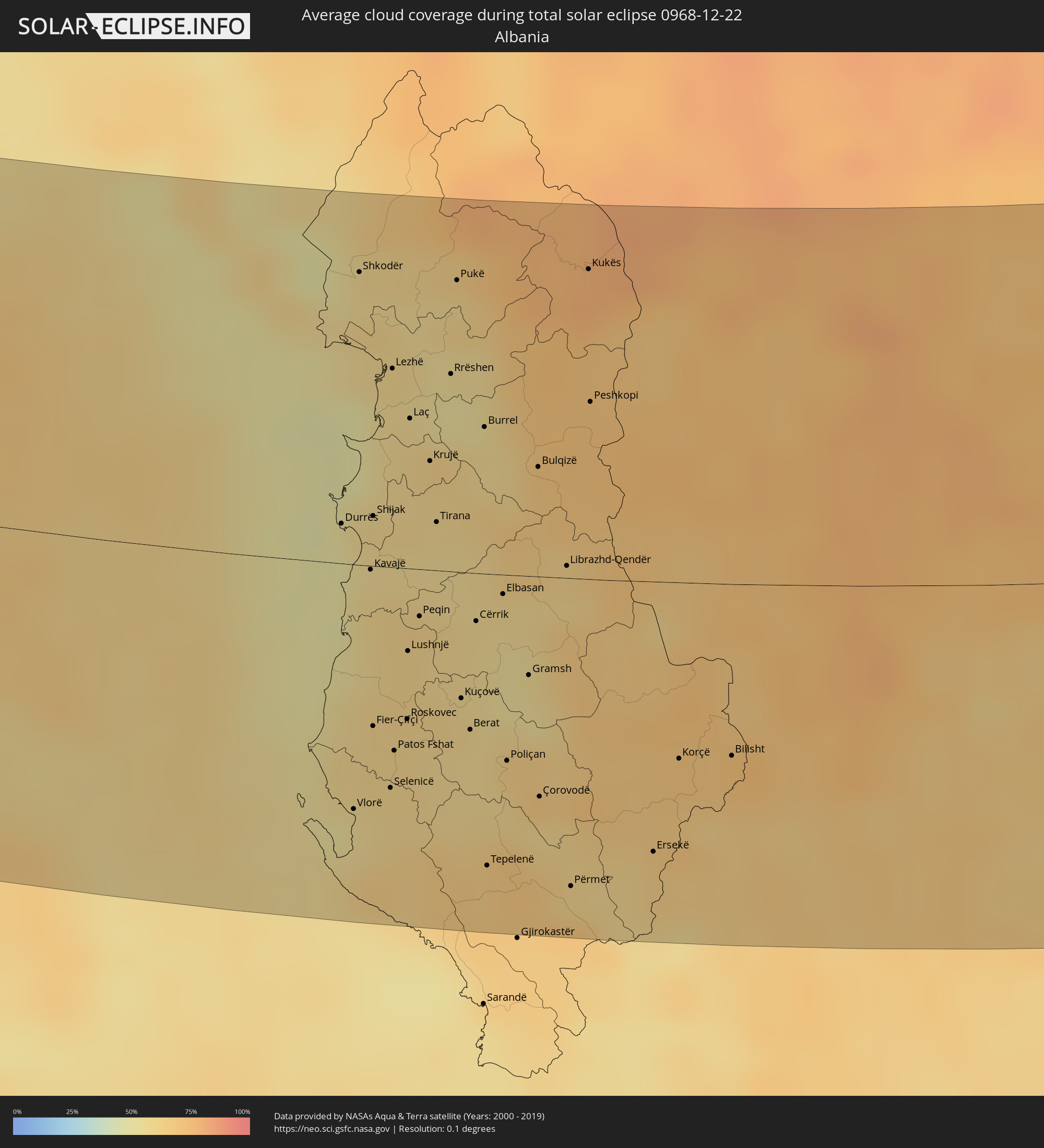
 Albania
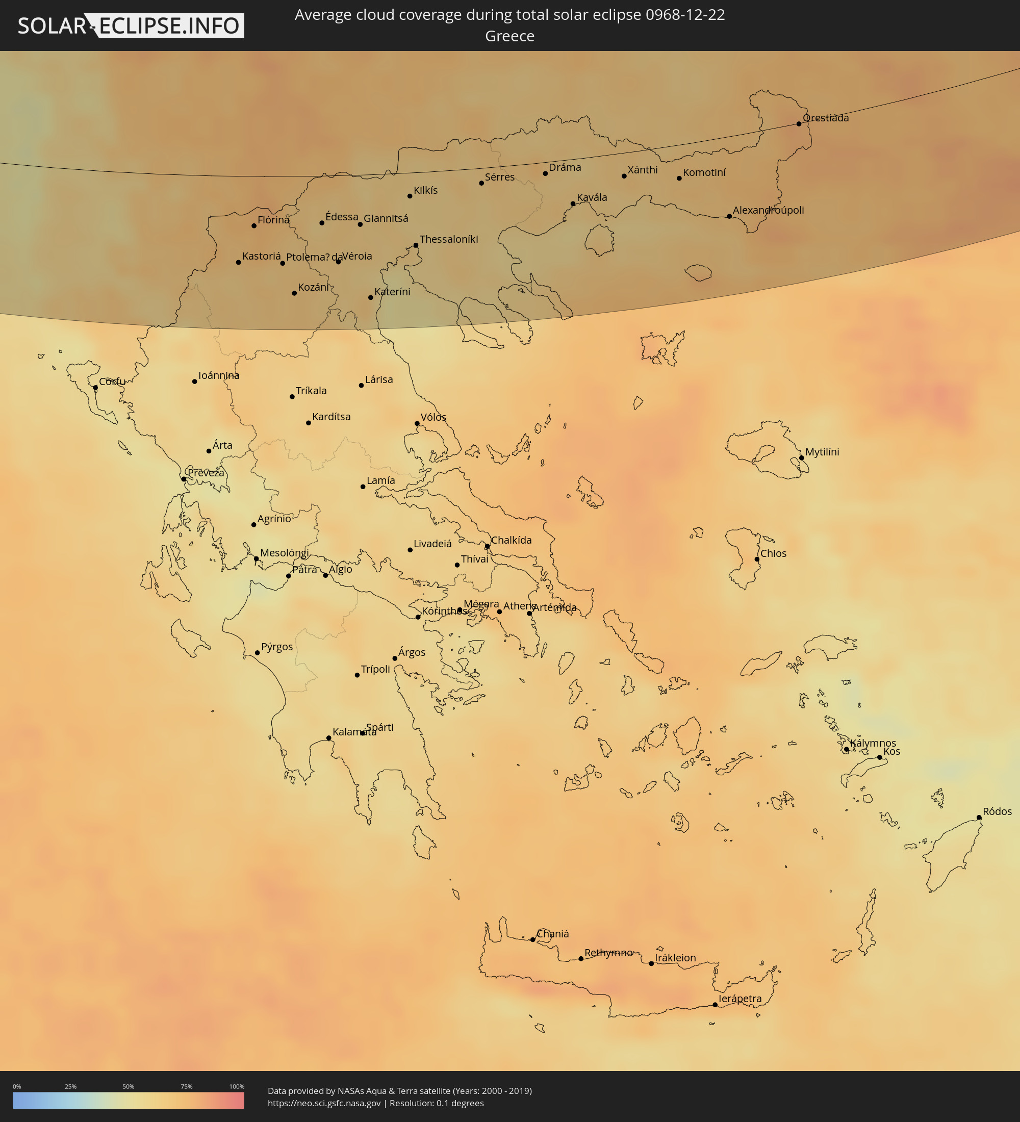
 Greece
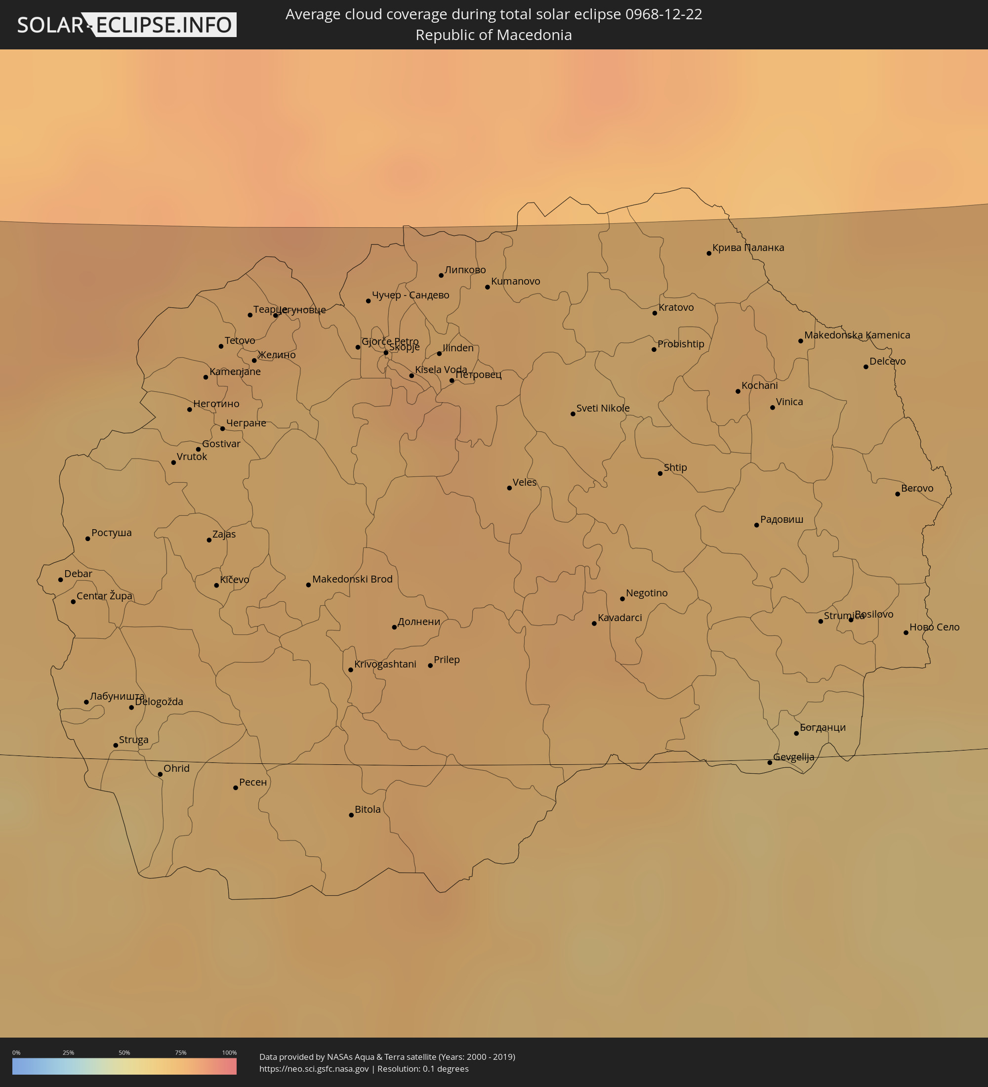
 Republic of Macedonia
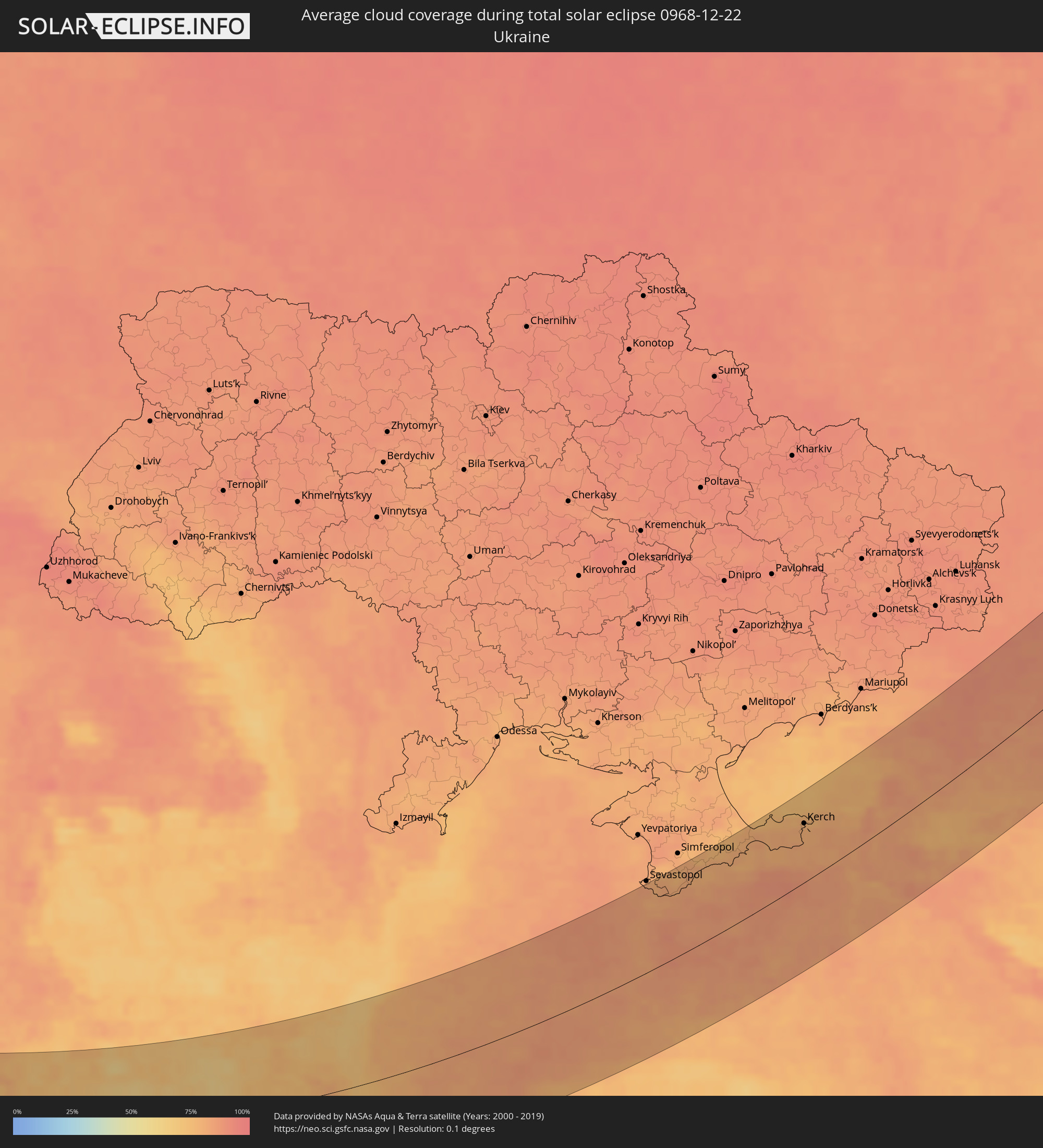
 Ukraine
 Bulgaria
 Turkey
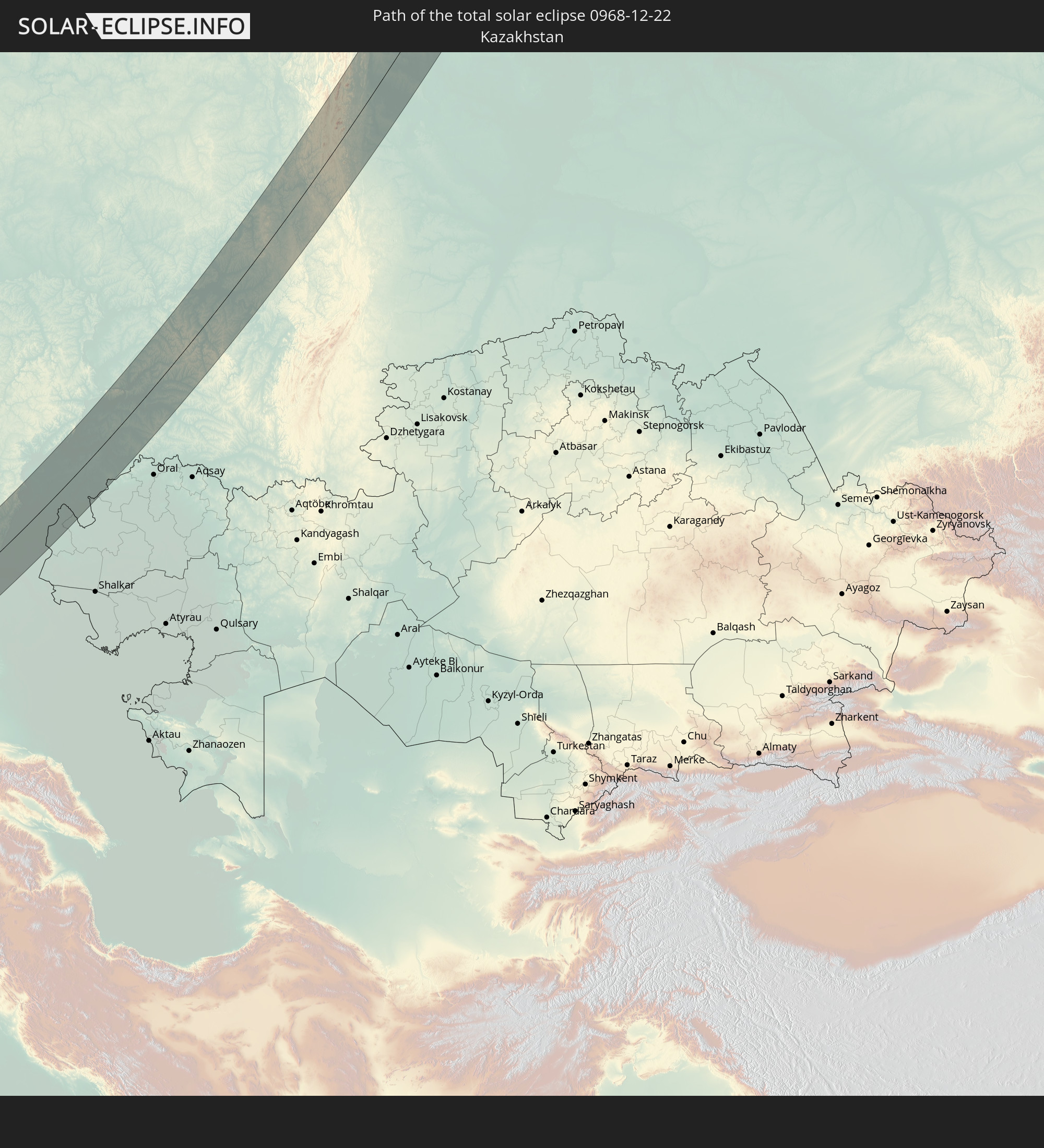 Kazakhstan
In den folgenden Ländern ist die Sonnenfinsternis partiell zu sehen
 Russia
 Portugal
 Cabo Verde
 Spain
Spain
 Senegal
 Mauritania
 The Gambia
 Guinea-Bissau
 Guinea
 Sierra Leone
 Morocco
 Mali
Mali
 Liberia
 Republic of Ireland
 Algeria
 United Kingdom
 Ivory Coast
 Burkina Faso
 Gibraltar
 France
 Isle of Man
 Ghana
Ghana
 Guernsey
 Jersey
 Togo
Togo
 Niger
Niger
 Benin
Benin
 Andorra
 Belgium
 Nigeria
 Netherlands
 Norway
 Equatorial Guinea
 Luxembourg
 Germany
 Switzerland
 São Tomé and Príncipe
 Italy
Italy
 Monaco
 Tunisia
 Denmark
 Cameroon
 Gabon
Gabon
 Libya
Libya
 Liechtenstein
 Austria
 Sweden
 Republic of the Congo
 Czechia
 Democratic Republic of the Congo
 San Marino
 Vatican City
 Slovenia
 Chad
Chad
 Croatia
 Poland
 Malta
Malta
 Central African Republic
 Bosnia and Herzegovina
 Hungary
 Slovakia
 Montenegro
 Serbia
 Albania
 Åland Islands
 Greece
 Romania
 Republic of Macedonia
 Finland
 Lithuania
 Latvia
 Estonia
 Sudan
Sudan
 Ukraine
 Bulgaria
 Belarus
 Egypt
Egypt
 Turkey
 Moldova
 Rwanda
 Burundi
 Tanzania
 Uganda
 Cyprus
 Ethiopia
 Kenya
Kenya
 State of Palestine
 Israel
 Saudi Arabia
 Jordan
 Lebanon
 Syria
Syria
 Eritrea
 Iraq
Iraq
 Georgia
 Somalia
 Djibouti
 Yemen
Yemen
 Armenia
 Iran
Iran
 Azerbaijan
 Kazakhstan
 Kuwait
 Bahrain
 Qatar
Qatar
 United Arab Emirates
 Oman
Oman
 Turkmenistan
 Uzbekistan
 Afghanistan
 Pakistan
 Tajikistan
 India
India
 Kyrgyzstan
 China
China
 Nepal
Nepal
 Bangladesh
 Bhutan
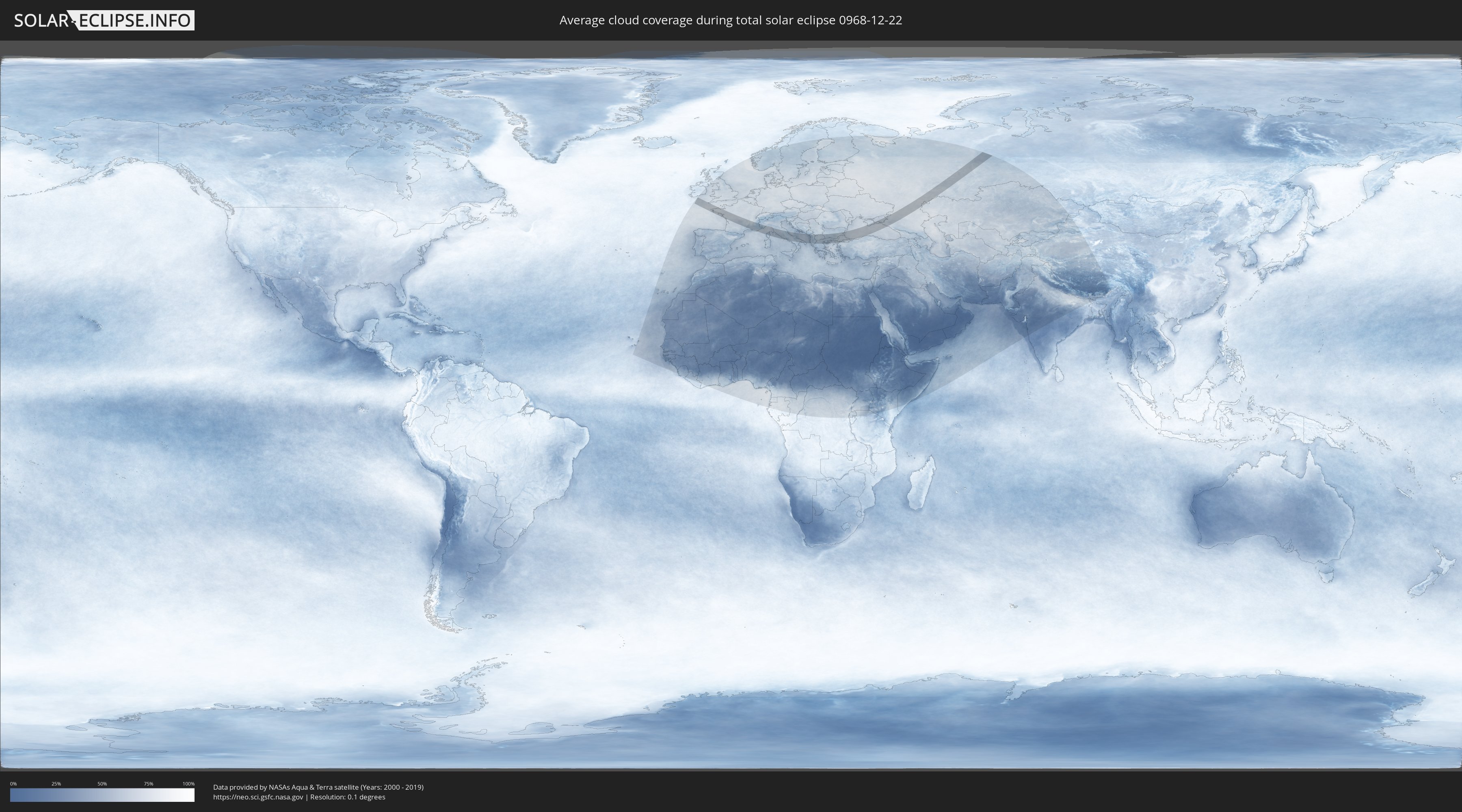
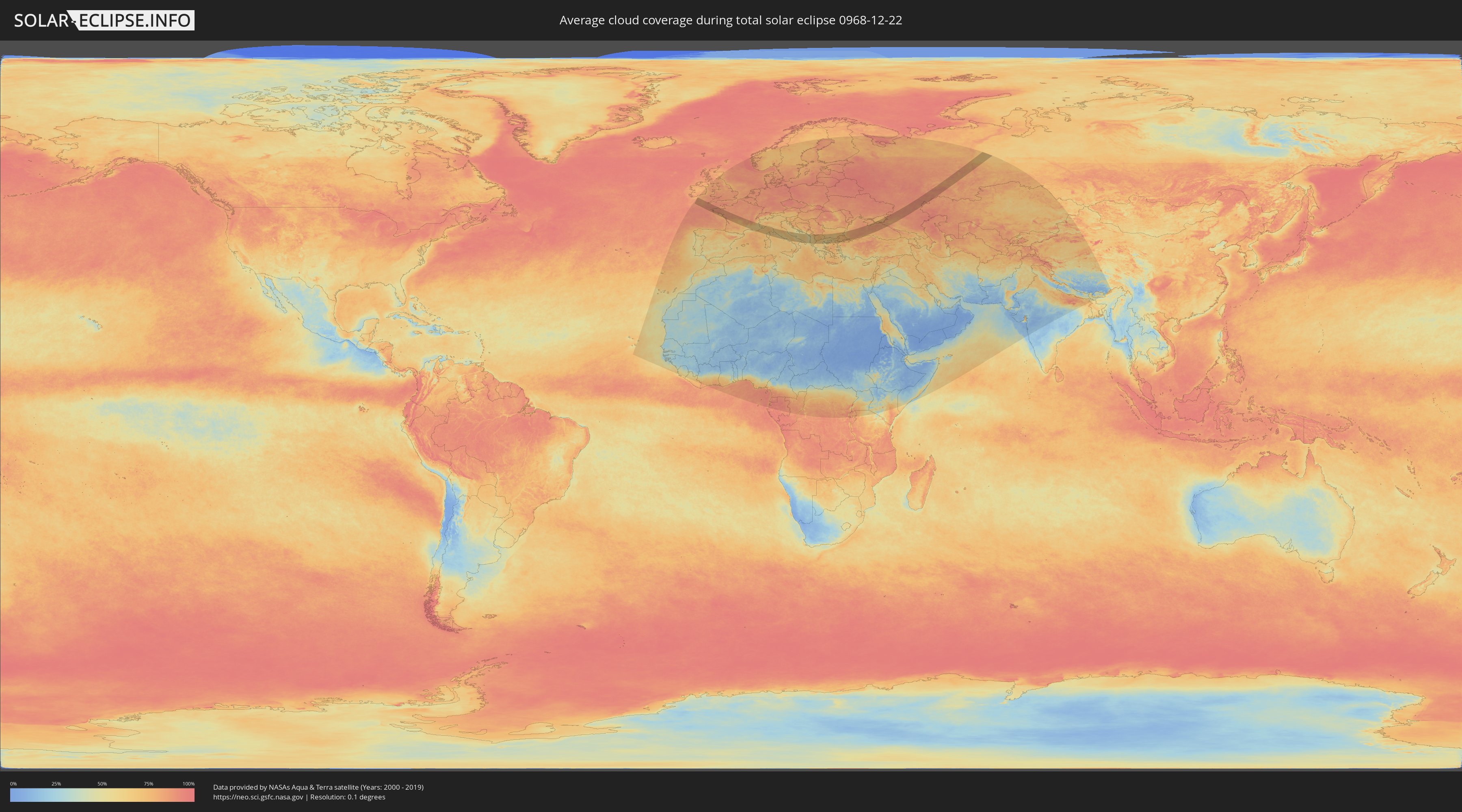
How will be the weather during the total solar eclipse on 12/22/0968?
Where is the best place to see the total solar eclipse of 12/22/0968?
The following maps show the average cloud coverage for the day of the total solar eclipse.
With the help of these maps, it is possible to find the place along the eclipse path, which has the best
chance of a cloudless sky.
Nevertheless, you should consider local circumstances and inform about the weather of your chosen
observation site.
The data is provided by NASAs satellites
AQUA and TERRA.
The cloud maps are averaged over a period of 19 years (2000 - 2019).
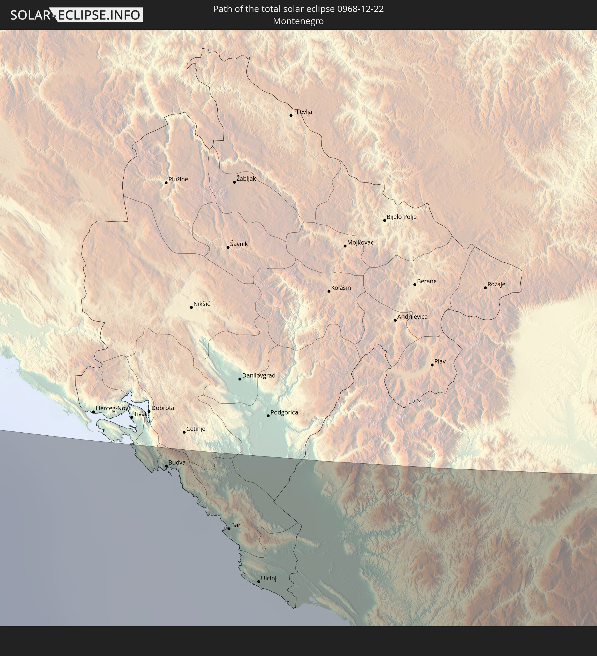
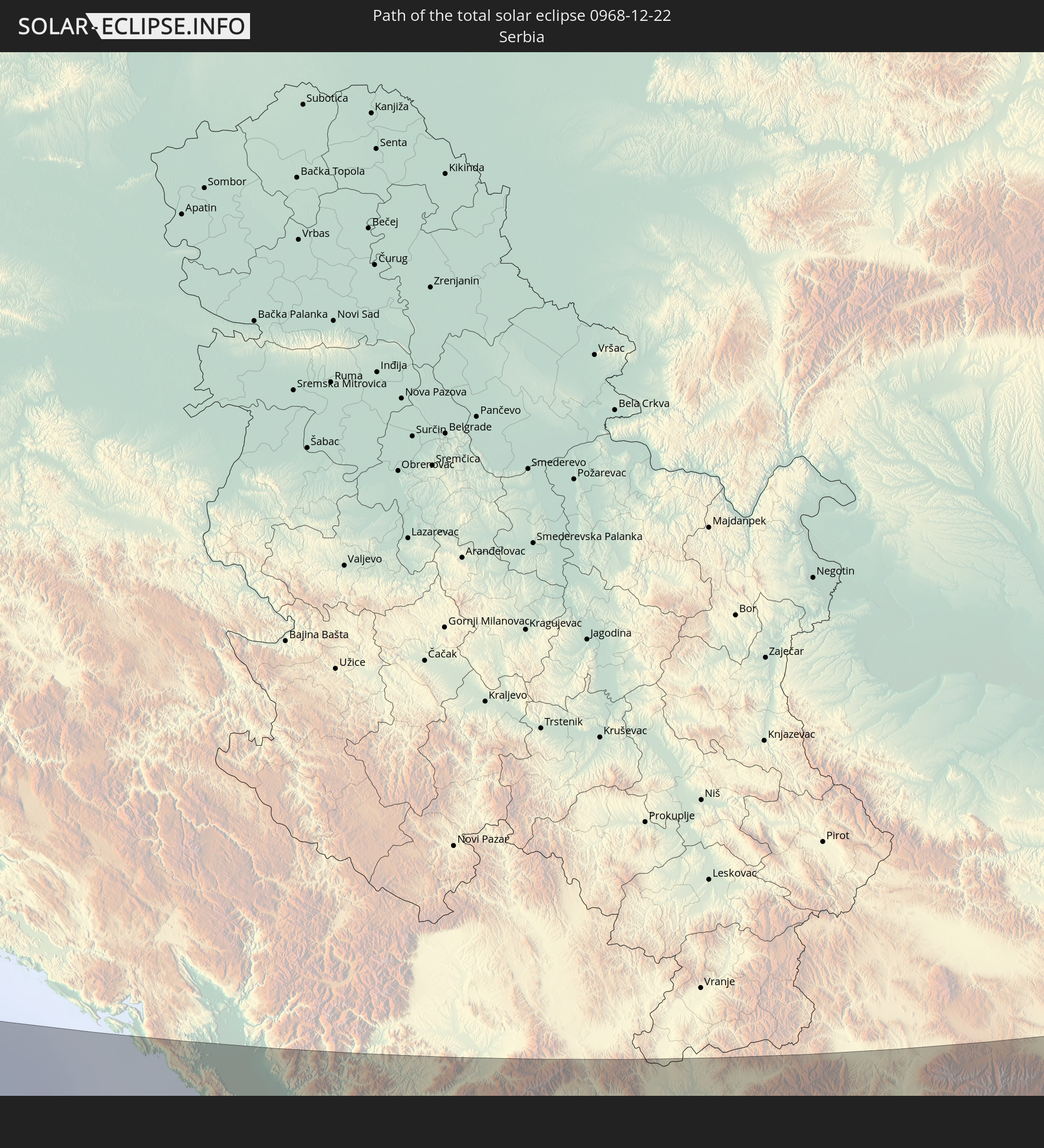
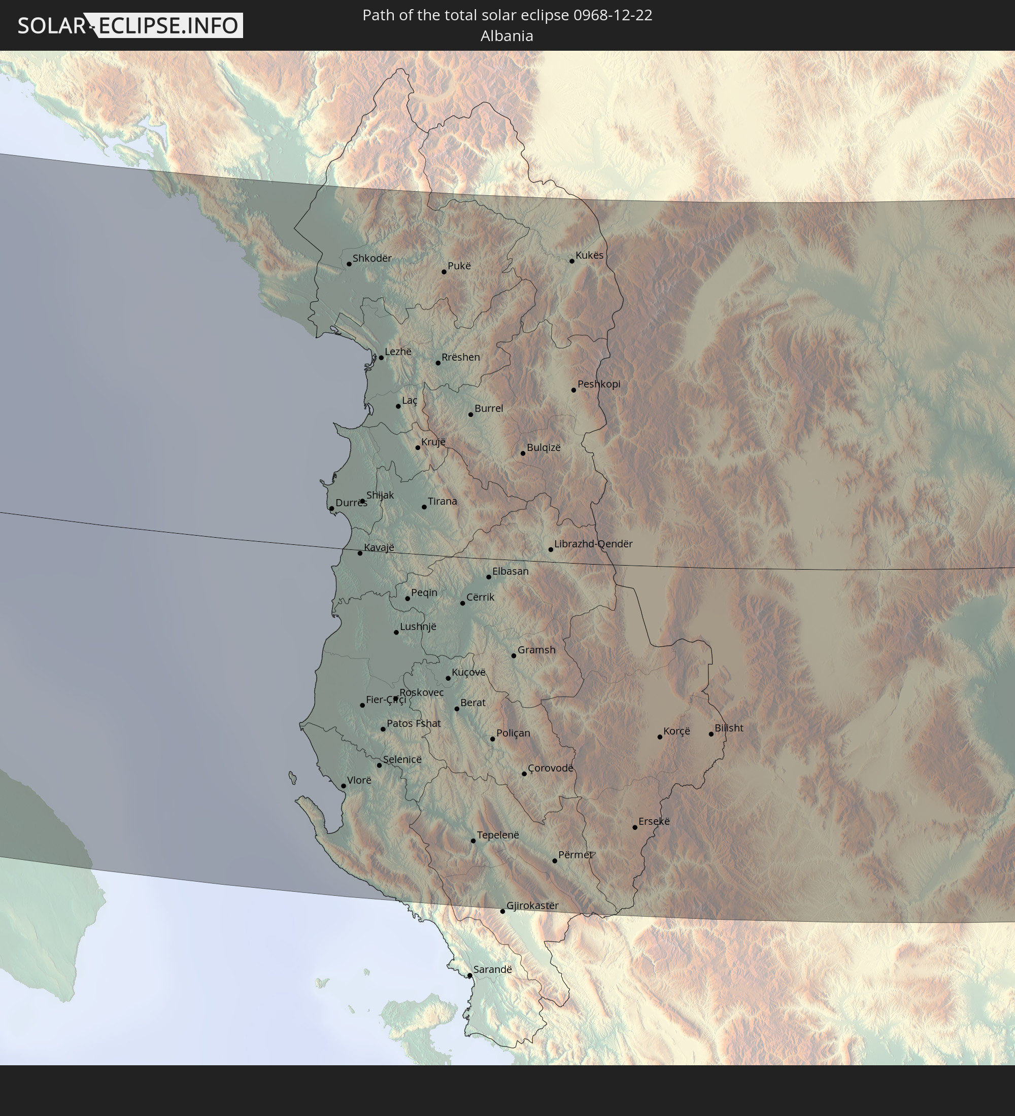
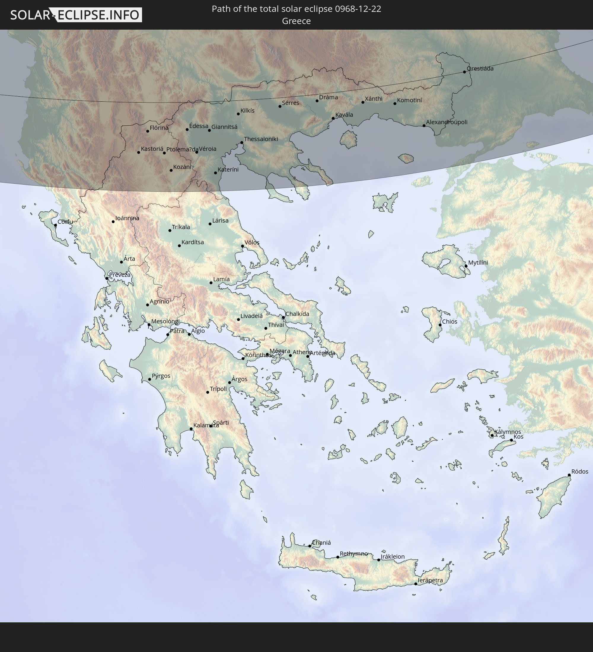
Detailed country maps
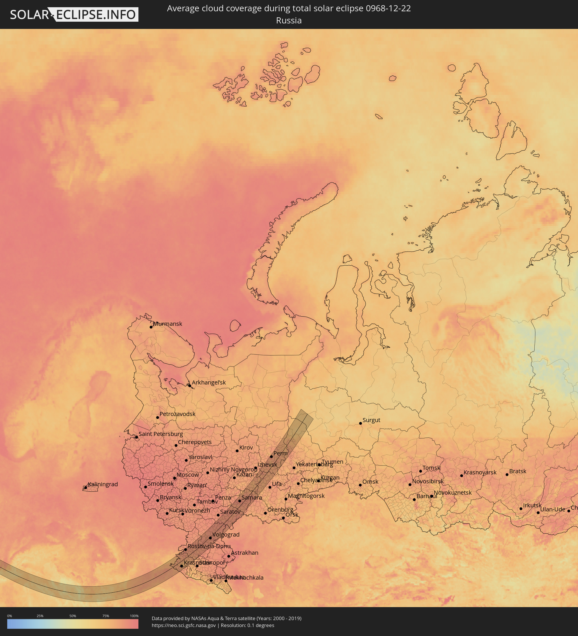 Russia
 United Kingdom
 France
 Italy
Italy
 Monaco
 Vatican City
 Croatia
 Montenegro
 Serbia
 Albania
 Greece
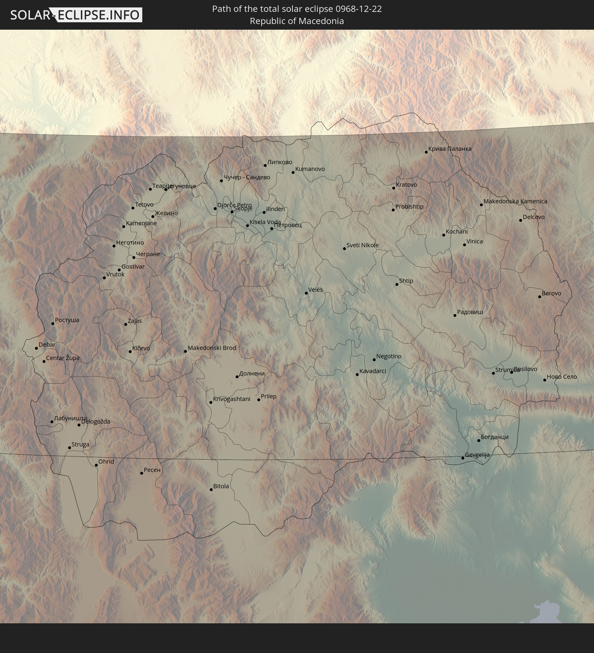
 Republic of Macedonia
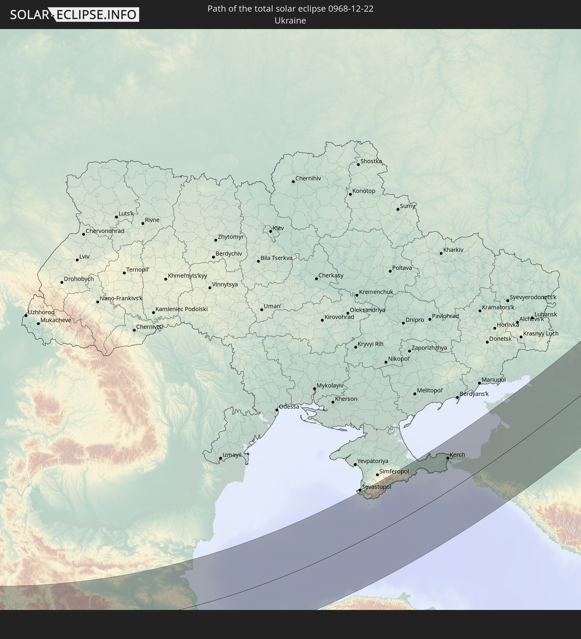
 Ukraine
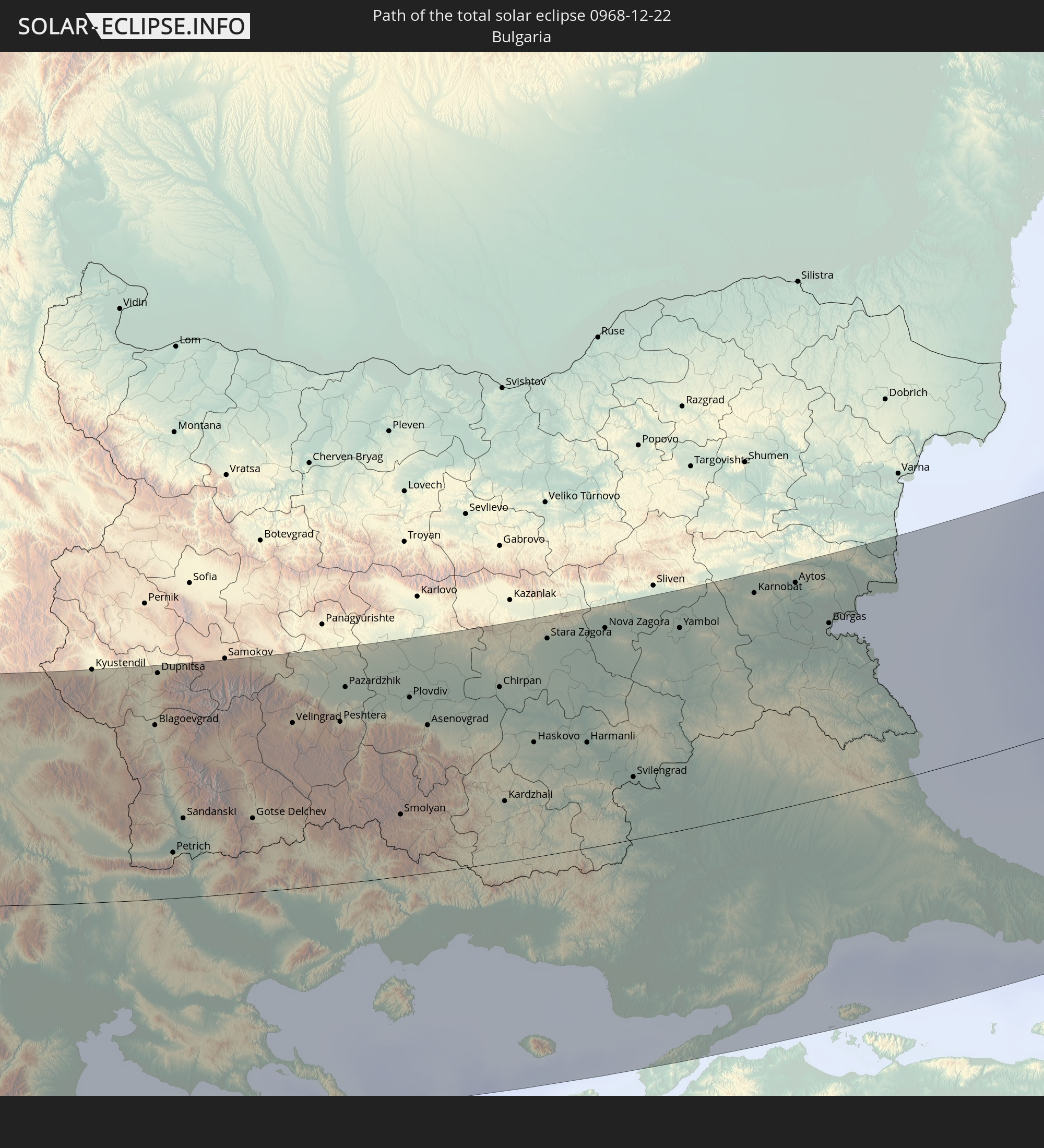
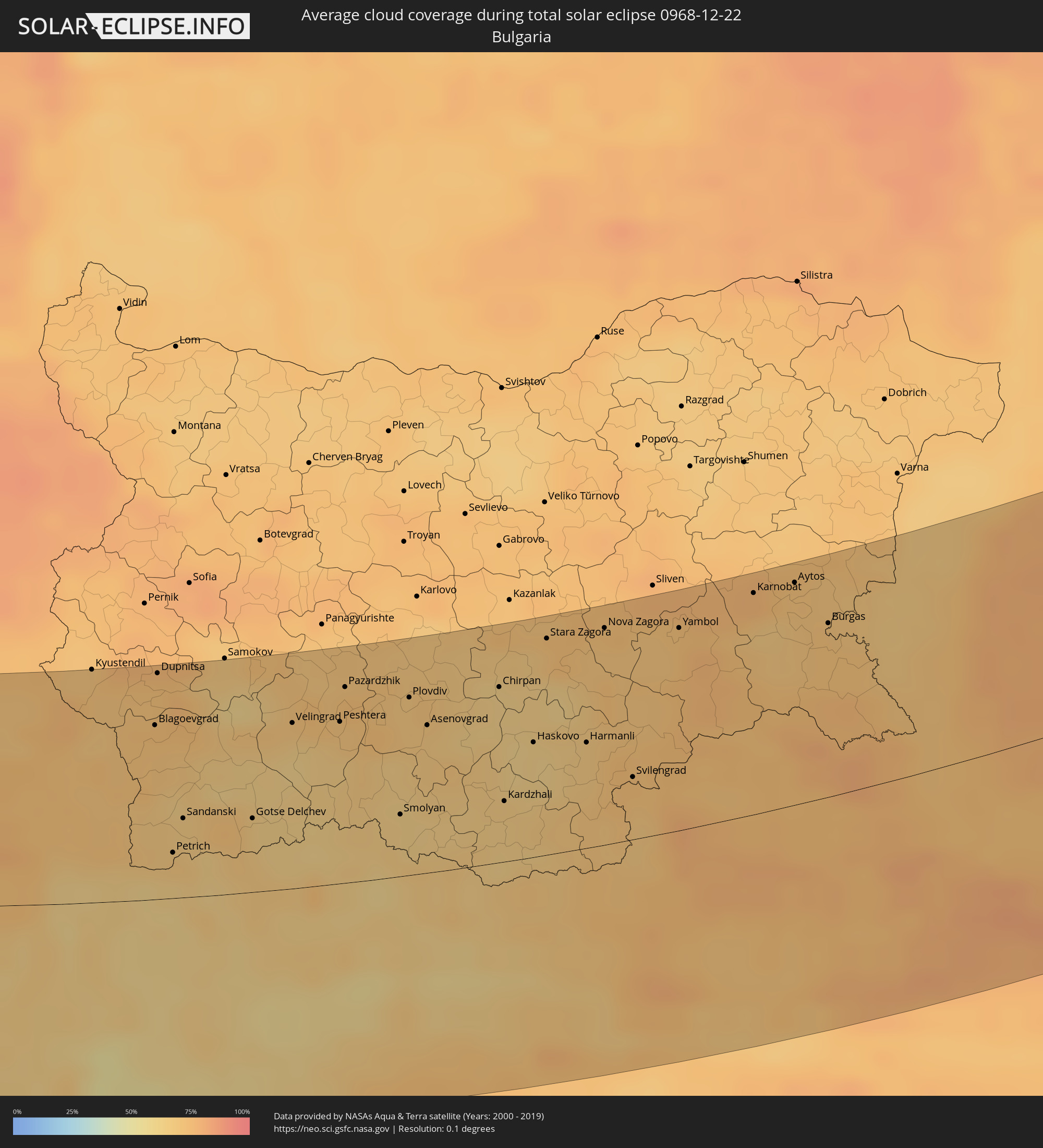 Bulgaria
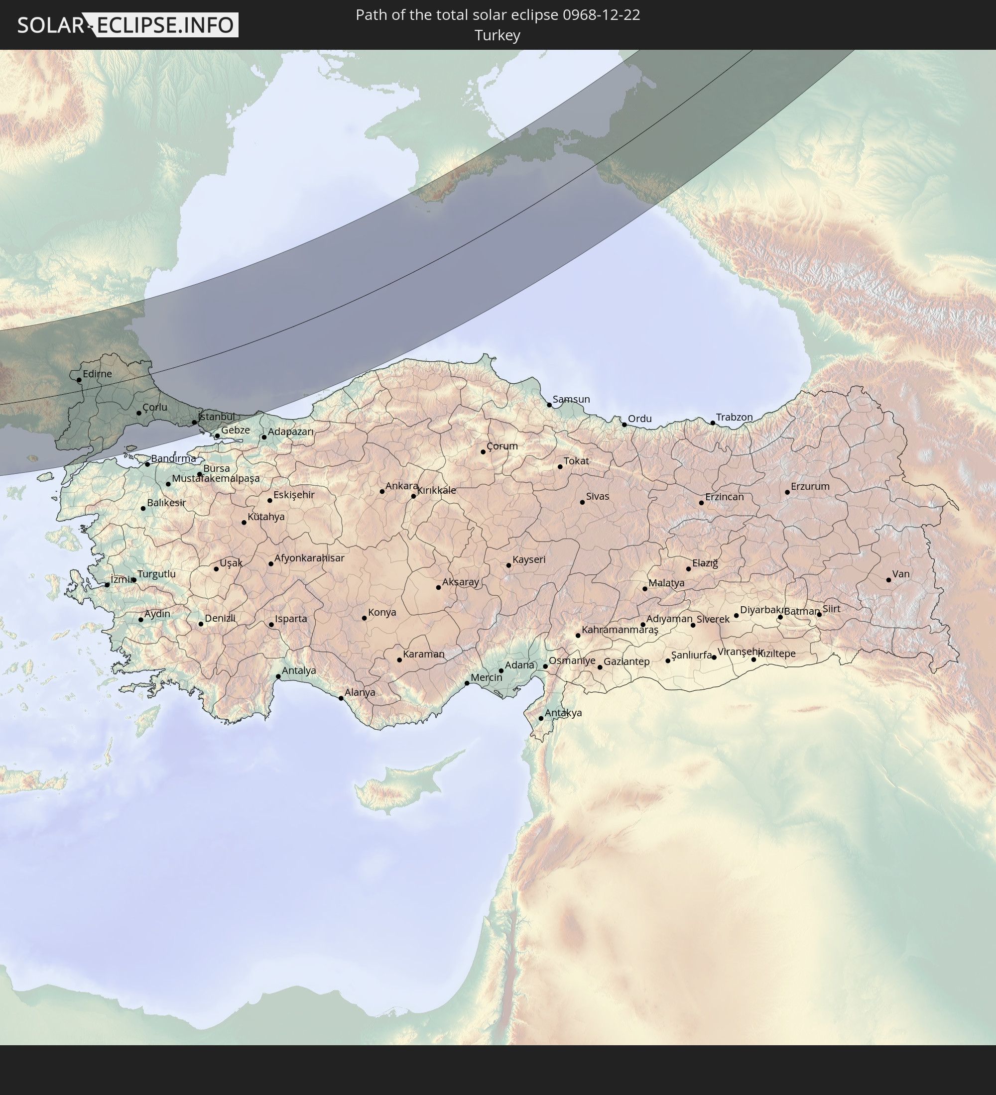
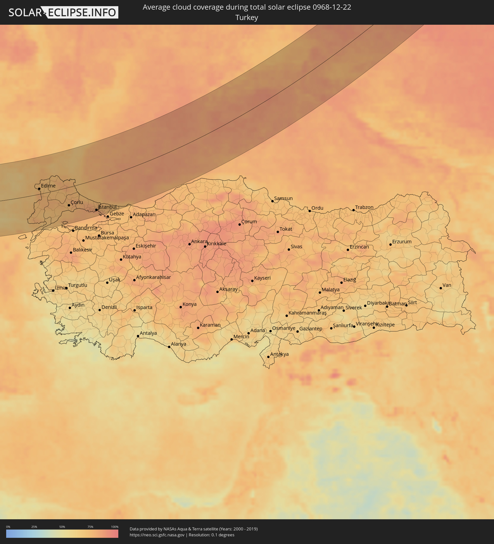 Turkey
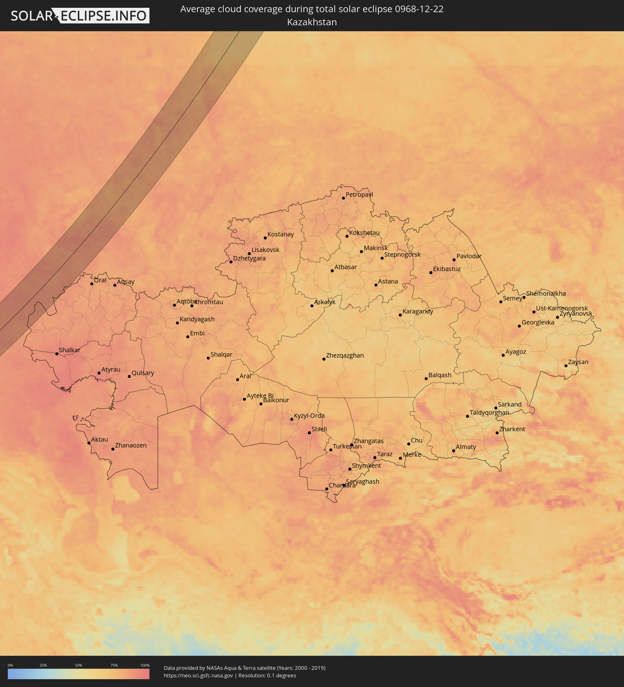 Kazakhstan
Cities inside the path of the eclipse
The following table shows all locations with a population of more than 5,000 inside the eclipse path. Cities which have more than 100,000 inhabitants are marked bold. A click at the locations opens a detailed map.
| City | Type | Eclipse duration | Local time of max. eclipse | Distance to central line | Ø Cloud coverage |
|
Brest, Brittany
|
total | - | 08:56:27 UTC+00:09 | 19 km | 86% |
|
Saint-Nazaire, Pays de la Loire
|
total | - | 08:57:05 UTC+00:09 | 24 km | 80% |
|
Rennes, Brittany
|
total | - | 08:58:44 UTC+00:09 | 75 km | 84% |
|
Nantes, Pays de la Loire
|
total | - | 08:57:38 UTC+00:09 | 3 km | 85% |
|
La Rochelle, Nouvelle-Aquitaine
|
total | - | 08:56:39 UTC+00:09 | 84 km | 82% |
|
Angers, Pays de la Loire
|
total | - | 08:59:00 UTC+00:09 | 62 km | 86% |
|
Poitiers, Nouvelle-Aquitaine
|
total | - | 08:58:46 UTC+00:09 | 16 km | 86% |
|
Limoges, Nouvelle-Aquitaine
|
total | - | 08:58:49 UTC+00:09 | 19 km | 78% |
|
Clermont-Ferrand, Auvergne-Rhône-Alpes
|
total | - | 09:00:53 UTC+00:09 | 48 km | 80% |
|
Nîmes, Occitania
|
total | - | 09:00:01 UTC+00:09 | 95 km | 68% |
|
Saint-Étienne, Auvergne-Rhône-Alpes
|
total | - | 09:02:02 UTC+00:09 | 64 km | 84% |
|
Avignon, Provence-Alpes-Côte d'Azur
|
total | - | 09:00:44 UTC+00:09 | 67 km | 66% |
|
Aix-en-Provence, Provence-Alpes-Côte d'Azur
|
total | - | 09:01:04 UTC+00:09 | 85 km | 65% |
|
Grenoble, Auvergne-Rhône-Alpes
|
total | - | 09:03:24 UTC+00:09 | 87 km | 78% |
|
Antibes, Provence-Alpes-Côte d'Azur
|
total | - | 09:03:23 UTC+00:09 | 24 km | 66% |
|
Nice, Provence-Alpes-Côte d'Azur
|
total | - | 09:03:44 UTC+00:09 | 5 km | 65% |
|
Monaco
|
total | - | 09:03:59 UTC+00:09 | 3 km | 66% |
|
La Condamine
|
total | - | 09:03:59 UTC+00:09 | 3 km | 66% |
|
Monte-Carlo
|
total | - | 09:04:00 UTC+00:09 | 4 km | 66% |
|
Livorno, Tuscany
|
total | - | 09:58:37 UTC+01:00 | 76 km | 65% |
|
Pisa, Tuscany
|
total | - | 09:58:55 UTC+01:00 | 95 km | 71% |
|
Acilia-Castel Fusano-Ostia Antica, Latium
|
total | - | 09:59:48 UTC+01:00 | 57 km | 62% |
|
Perugia, Umbria
|
total | - | 10:01:19 UTC+01:00 | 88 km | 73% |
|
Vatican City
|
total | - | 10:00:09 UTC+01:00 | 39 km | 66% |
|
Rome, Latium
|
total | - | 10:00:14 UTC+01:00 | 39 km | 66% |
|
Terni, Umbria
|
total | - | 10:01:09 UTC+01:00 | 36 km | 65% |
|
Latina, Latium
|
total | - | 10:00:26 UTC+01:00 | 75 km | 64% |
|
Pescara, Abruzzo
|
total | - | 10:03:35 UTC+01:00 | 61 km | 57% |
|
Naples, Campania
|
total | - | 10:02:03 UTC+01:00 | 111 km | 62% |
|
Caserta, Campania
|
total | - | 10:02:25 UTC+01:00 | 86 km | 64% |
|
Foggia, Apulia
|
total | - | 10:04:53 UTC+01:00 | 21 km | 56% |
|
Andria, Apulia
|
total | - | 10:05:58 UTC+01:00 | 33 km | 58% |
|
Bari, Apulia
|
total | - | 10:06:51 UTC+01:00 | 38 km | 67% |
|
Taranto, Apulia
|
total | - | 10:06:55 UTC+01:00 | 109 km | 59% |
|
Brindisi, Apulia
|
total | - | 10:08:21 UTC+01:00 | 77 km | 67% |
|
Lecce, Apulia
|
total | - | 10:08:33 UTC+01:00 | 105 km | 66% |
|
Budva, Budva
|
total | - | 10:11:28 UTC+01:00 | 115 km | 53% |
|
Bar, Bar
|
total | - | 10:11:46 UTC+01:00 | 96 km | 55% |
|
Ulcinj, Ulcinj
|
total | - | 10:11:51 UTC+01:00 | 79 km | 50% |
|
Durrës, Durrës
|
total | - | 10:31:04 UTC+01:19 | 13 km | 49% |
|
Vlorë, Vlorë
|
total | - | 10:30:26 UTC+01:19 | 82 km | 56% |
|
Shkodër, Shkodër
|
total | - | 10:31:50 UTC+01:19 | 96 km | 57% |
|
Kavajë, Tiranë
|
total | - | 10:31:10 UTC+01:19 | 1 km | 61% |
|
Fier-Çifçi, Fier
|
total | - | 10:30:47 UTC+01:19 | 53 km | 60% |
|
Lezhë, Lezhë
|
total | - | 10:31:50 UTC+01:19 | 66 km | 57% |
|
Lushnjë, Fier
|
total | - | 10:31:14 UTC+01:19 | 27 km | 62% |
|
Laç, Lezhë
|
total | - | 10:31:50 UTC+01:19 | 50 km | 60% |
|
Krujë, Durrës
|
total | - | 10:31:52 UTC+01:19 | 36 km | 59% |
|
Tirana, Tiranë
|
total | - | 10:31:46 UTC+01:19 | 16 km | 57% |
|
Berat, Berat
|
total | - | 10:31:30 UTC+01:19 | 52 km | 58% |
|
Burrel, Dibër
|
total | - | 10:32:22 UTC+01:19 | 49 km | 58% |
|
Elbasan, Elbasan
|
total | - | 10:32:05 UTC+01:19 | 6 km | 58% |
|
Kukës, Kukës
|
total | - | 10:33:31 UTC+01:19 | 102 km | 78% |
|
Peshkopi, Dibër
|
total | - | 10:33:12 UTC+01:19 | 59 km | 71% |
|
Centar Župa, Centar Župa
|
total | - | 10:13:57 UTC+01:00 | 36 km | 73% |
|
Korçë, Korçë
|
total | - | 10:33:00 UTC+01:19 | 59 km | 68% |
|
Ohrid, Ohrid
|
total | - | 10:14:06 UTC+01:00 | 3 km | 66% |
|
Gostivar, Gostivar
|
total | - | 10:14:51 UTC+01:00 | 73 km | 73% |
|
Kičevo, Kičevo
|
total | - | 10:14:43 UTC+01:00 | 41 km | 73% |
|
Tetovo, Tetovo
|
total | - | 10:15:09 UTC+01:00 | 96 km | 75% |
|
Bitola, Bitola
|
total | - | 10:15:03 UTC+01:00 | 12 km | 73% |
|
Flórina, West Macedonia
|
total | - | 10:49:52 UTC+01:34 | 40 km | 71% |
|
Skopje, Karpoš
|
total | - | 10:16:00 UTC+01:00 | 96 km | 76% |
|
Prilep, Prilep
|
total | - | 10:15:43 UTC+01:00 | 23 km | 75% |
|
Ptolemaḯda, West Macedonia
|
total | - | 10:50:10 UTC+01:34 | 69 km | 66% |
|
Kumanovo, Kumanovo
|
total | - | 10:16:38 UTC+01:00 | 111 km | 75% |
|
Veles, Veles
|
total | - | 10:16:25 UTC+01:00 | 64 km | 77% |
|
Kozáni, West Macedonia
|
total | - | 10:50:13 UTC+01:34 | 93 km | 67% |
|
Kavadarci, Kavadarci
|
total | - | 10:16:39 UTC+01:00 | 33 km | 73% |
|
Édessa, Central Macedonia
|
total | - | 10:51:06 UTC+01:34 | 38 km | 64% |
|
Náousa, Central Macedonia
|
total | - | 10:51:01 UTC+01:34 | 57 km | 64% |
|
Shtip, Štip
|
total | - | 10:17:15 UTC+01:00 | 67 km | 72% |
|
Véroia, Central Macedonia
|
total | - | 10:51:12 UTC+01:34 | 69 km | 63% |
|
Крива Паланка, Kriva Palanka
|
total | - | 10:17:51 UTC+01:00 | 117 km | 72% |
|
Giannitsá, Central Macedonia
|
total | - | 10:51:48 UTC+01:34 | 40 km | 64% |
|
Kochani, Kočani
|
total | - | 10:17:47 UTC+01:00 | 86 km | 72% |
|
Радовиш, Radoviš
|
total | - | 10:17:40 UTC+01:00 | 54 km | 71% |
|
Kateríni, Central Macedonia
|
total | - | 10:51:35 UTC+01:34 | 98 km | 67% |
|
Strumica, Strumica
|
total | - | 10:17:52 UTC+01:00 | 31 km | 66% |
|
Kyustendil, Kyustendil
|
total | - | 11:18:35 UTC+02:00 | 125 km | 72% |
|
Kilkís, Central Macedonia
|
total | - | 10:52:51 UTC+01:34 | 19 km | 60% |
|
Thessaloníki, Central Macedonia
|
total | - | 10:52:42 UTC+01:34 | 58 km | 57% |
|
Blagoevgrad, Blagoevgrad
|
total | - | 11:19:10 UTC+02:00 | 94 km | 72% |
|
Dupnitsa, Kyustendil
|
total | - | 11:19:23 UTC+02:00 | 121 km | 73% |
|
Petrich, Blagoevgrad
|
total | - | 11:18:57 UTC+02:00 | 25 km | 69% |
|
Sandanski, Blagoevgrad
|
total | - | 11:19:12 UTC+02:00 | 43 km | 66% |
|
Sérres, Central Macedonia
|
total | - | 10:54:14 UTC+01:34 | 12 km | 64% |
|
Velingrad, Pazardzhik
|
total | - | 11:20:53 UTC+02:00 | 89 km | 64% |
|
Dráma, East Macedonia and Thrace
|
total | - | 10:55:27 UTC+01:34 | 9 km | 64% |
|
Pazardzhik, Pazardzhik
|
total | - | 11:21:40 UTC+02:00 | 105 km | 73% |
|
Kavála, East Macedonia and Thrace
|
total | - | 10:55:49 UTC+01:34 | 35 km | 57% |
|
Smolyan, Smolyan
|
total | - | 11:21:56 UTC+02:00 | 33 km | 64% |
|
Plovdiv, Plovdiv
|
total | - | 11:22:26 UTC+02:00 | 95 km | 71% |
|
Asenovgrad, Plovdiv
|
total | - | 11:22:34 UTC+02:00 | 79 km | 67% |
|
Xánthi, East Macedonia and Thrace
|
total | - | 10:56:53 UTC+01:34 | 19 km | 63% |
|
Kardzhali, Kŭrdzhali
|
total | - | 11:23:18 UTC+02:00 | 32 km | 66% |
|
Komotiní, East Macedonia and Thrace
|
total | - | 10:57:54 UTC+01:34 | 27 km | 69% |
|
Haskovo, Khaskovo
|
total | - | 11:23:51 UTC+02:00 | 61 km | 62% |
|
Stara Zagora, Stara Zagora
|
total | - | 11:24:20 UTC+02:00 | 114 km | 70% |
|
Alexandroúpoli, East Macedonia and Thrace
|
total | - | 10:58:40 UTC+01:34 | 62 km | 65% |
|
Nova Zagora, Sliven
|
total | - | 11:25:05 UTC+02:00 | 114 km | 73% |
|
Yambol, Yambol
|
total | - | 11:26:02 UTC+02:00 | 106 km | 73% |
|
Edirne, Edirne
|
total | - | 11:22:35 UTC+01:56 | 17 km | 75% |
|
Keşan, Edirne
|
total | - | 11:22:15 UTC+01:56 | 73 km | 74% |
|
Gelibolu, Çanakkale Province
|
total | - | 11:22:03 UTC+01:56 | 123 km | 73% |
|
Uzunköprü, Edirne
|
total | - | 11:22:36 UTC+01:56 | 30 km | 77% |
|
Malkara, Tekirdağ
|
total | - | 11:22:48 UTC+01:56 | 74 km | 69% |
|
Babaeski, Kırklareli
|
total | - | 11:23:30 UTC+01:56 | 19 km | 78% |
|
Hayrabolu, Tekirdağ
|
total | - | 11:23:24 UTC+01:56 | 43 km | 75% |
|
Kırklareli, Kırklareli
|
total | - | 11:23:57 UTC+01:56 | 12 km | 73% |
|
Lüleburgaz, Kırklareli
|
total | - | 11:24:01 UTC+01:56 | 27 km | 76% |
|
Burgas, Burgas
|
total | - | 11:27:55 UTC+02:00 | 90 km | 71% |
|
Tekirdağ, Tekirdağ
|
total | - | 11:24:04 UTC+01:56 | 76 km | 74% |
|
Çorlu, Tekirdağ
|
total | - | 11:24:46 UTC+01:56 | 62 km | 76% |
|
Çerkezköy, Tekirdağ
|
total | - | 11:25:14 UTC+01:56 | 52 km | 78% |
|
Silivri, Istanbul
|
total | - | 11:25:37 UTC+01:56 | 80 km | 79% |
|
Esenyurt, Istanbul
|
total | - | 11:26:27 UTC+01:56 | 95 km | 78% |
|
İstanbul, Istanbul
|
total | - | 11:27:00 UTC+01:56 | 103 km | 79% |
|
Maltepe, Istanbul
|
total | - | 11:27:22 UTC+01:56 | 116 km | 77% |
|
Balaklava, Gorod Sevastopol
|
total | - | 11:56:30 UTC+02:16 | 111 km | 80% |
|
Alupka, Republic of Crimea
|
total | - | 11:57:18 UTC+02:16 | 85 km | 81% |
|
Gaspra, Republic of Crimea
|
total | - | 11:57:25 UTC+02:16 | 84 km | 82% |
|
Yalta, Republic of Crimea
|
total | - | 11:57:33 UTC+02:16 | 88 km | 83% |
|
Massandra, Republic of Crimea
|
total | - | 11:57:35 UTC+02:16 | 88 km | 83% |
|
Gurzuf, Republic of Crimea
|
total | - | 11:57:46 UTC+02:16 | 88 km | 85% |
|
Partenit, Republic of Crimea
|
total | - | 11:57:54 UTC+02:16 | 88 km | 82% |
|
Alushta, Republic of Crimea
|
total | - | 11:58:03 UTC+02:16 | 95 km | 79% |
|
Sudak, Republic of Crimea
|
total | - | 11:59:08 UTC+02:16 | 89 km | 81% |
|
Stary Krym, Republic of Crimea
|
total | - | 11:59:23 UTC+02:16 | 101 km | 80% |
|
Kirovskoye, Republic of Crimea
|
partial | - | 11:59:37 UTC+02:16 | 116 km | 75% |
|
Feodosiya, Republic of Crimea
|
total | - | 11:59:54 UTC+02:16 | 90 km | 78% |
|
Primorskiy, Republic of Crimea
|
total | - | 12:00:06 UTC+02:16 | 94 km | 78% |
|
Lenino, Republic of Crimea
|
total | - | 12:00:41 UTC+02:16 | 98 km | 79% |
|
Shchyolkino, Republic of Crimea
|
total | - | 12:00:47 UTC+02:16 | 108 km | 78% |
|
Kerch, Republic of Crimea
|
total | - | 12:01:57 UTC+02:16 | 73 km | 79% |
|
Novorossiysk, Krasnodarskiy
|
total | - | 12:18:30 UTC+02:30 | 42 km | 77% |
|
Krasnodar, Krasnodarskiy
|
total | - | 12:20:41 UTC+02:30 | 66 km | 82% |
|
Rostov-na-Donu, Rostov Oblast
|
total | - | 12:22:01 UTC+02:30 | 93 km | 89% |
|
Novocherkassk, Rostov Oblast
|
total | - | 12:22:37 UTC+02:30 | 91 km | 87% |
|
Volgodonsk, Rostov Oblast
|
total | - | 12:26:00 UTC+02:30 | 1 km | 87% |
|
Volgograd, Volgograd
|
total | - | 12:29:30 UTC+02:30 | 17 km | 88% |
|
Volzhskiy, Volgograd
|
total | - | 12:29:55 UTC+02:30 | 26 km | 87% |
|
Kamyshin, Volgograd
|
total | - | 12:30:31 UTC+02:30 | 47 km | 89% |
|
Zhänibek, Batys Qazaqstan
|
total | - | 13:27:56 UTC+03:25 | 79 km | 84% |
|
Balakovo, Saratov
|
total | - | 13:23:14 UTC+03:20 | 73 km | 93% |
|
Novokuybyshevsk, Samara
|
total | - | 13:25:33 UTC+03:20 | 42 km | 90% |
|
Samara, Samara
|
total | - | 13:25:45 UTC+03:20 | 40 km | 91% |
|
Al’met’yevsk, Tatarstan
|
total | - | 12:37:22 UTC+02:30 | 51 km | 82% |
|
Oktyabr’skiy, Bashkortostan
|
total | - | 14:11:14 UTC+04:02 | 36 km | 84% |
|
Sarapul, Udmurtiya
|
total | - | 13:28:04 UTC+03:20 | 84 km | 83% |
|
Neftekamsk, Bashkortostan
|
total | - | 14:11:03 UTC+04:02 | 35 km | 83% |
|
Perm, Perm
|
total | - | 14:11:43 UTC+04:02 | 65 km | 89% |