Total solar eclipse of 05/29/1025
| Day of week: | Sunday |
| Maximum duration of eclipse: | 05m25s |
| Maximum width of eclipse path: | 199 km |
| Saros cycle: | 102 |
| Coverage: | 100% |
| Magnitude: | 1.0602 |
| Gamma: | 0.1145 |
Wo kann man die Sonnenfinsternis vom 05/29/1025 sehen?

Die Sonnenfinsternis am 05/29/1025 kann man in 113 Ländern als partielle Sonnenfinsternis beobachten.
Der Finsternispfad verläuft durch 14 Länder. Nur in diesen Ländern ist sie als total Sonnenfinsternis zu sehen.
In den folgenden Ländern ist die Sonnenfinsternis total zu sehen
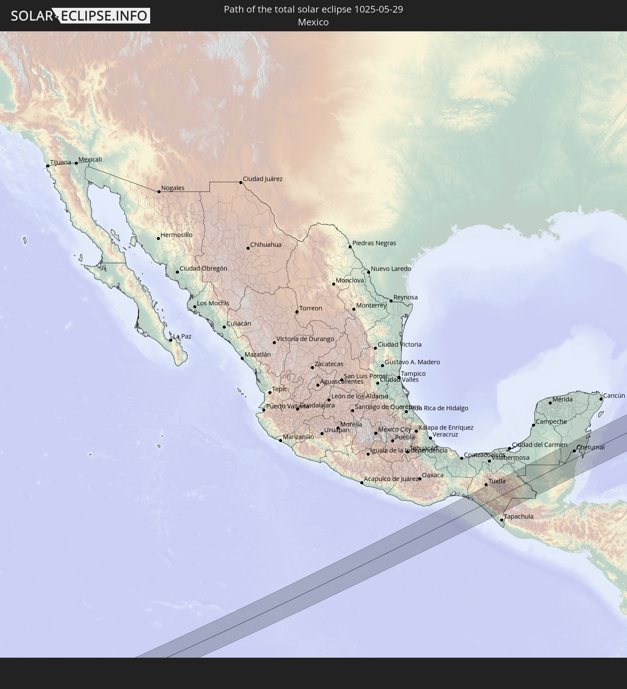 Mexico
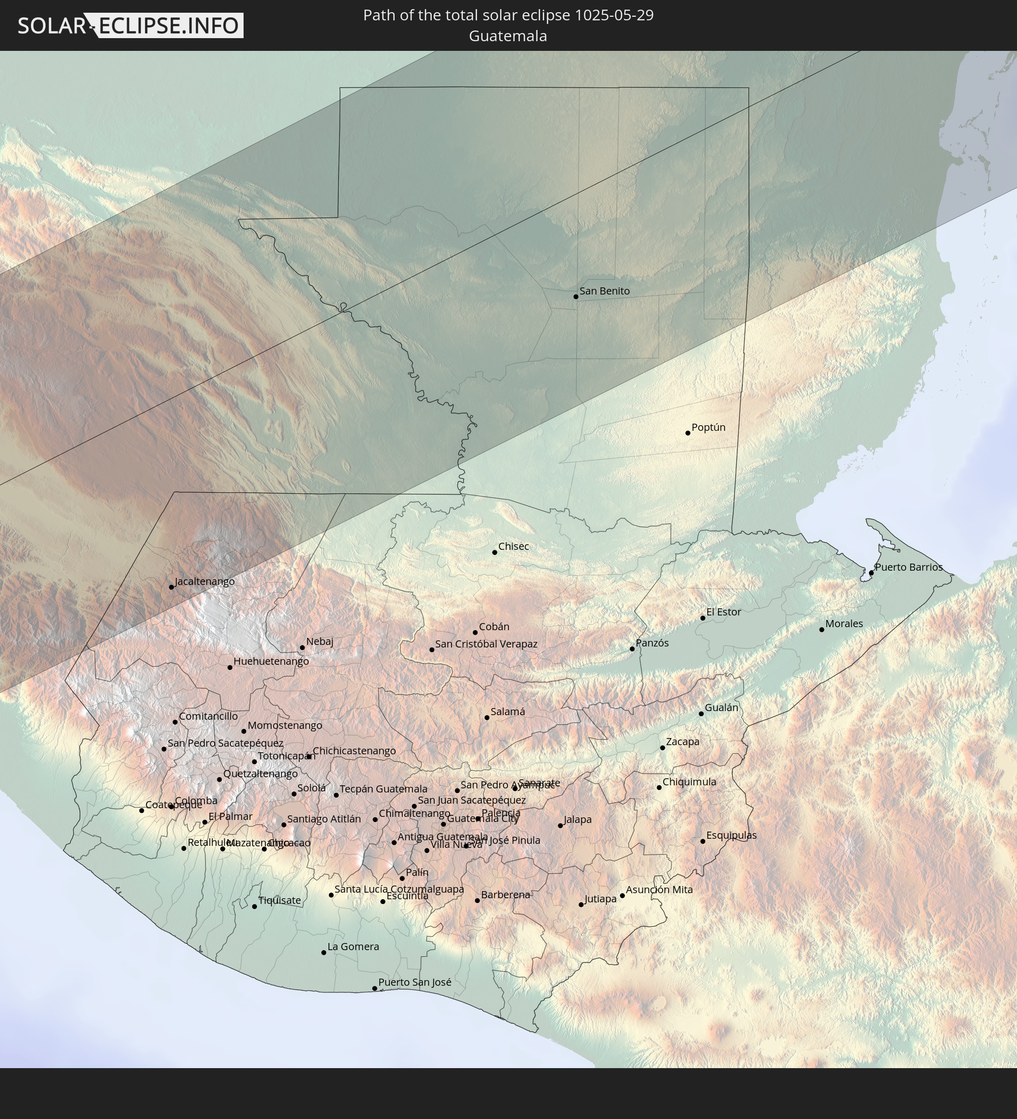 Guatemala
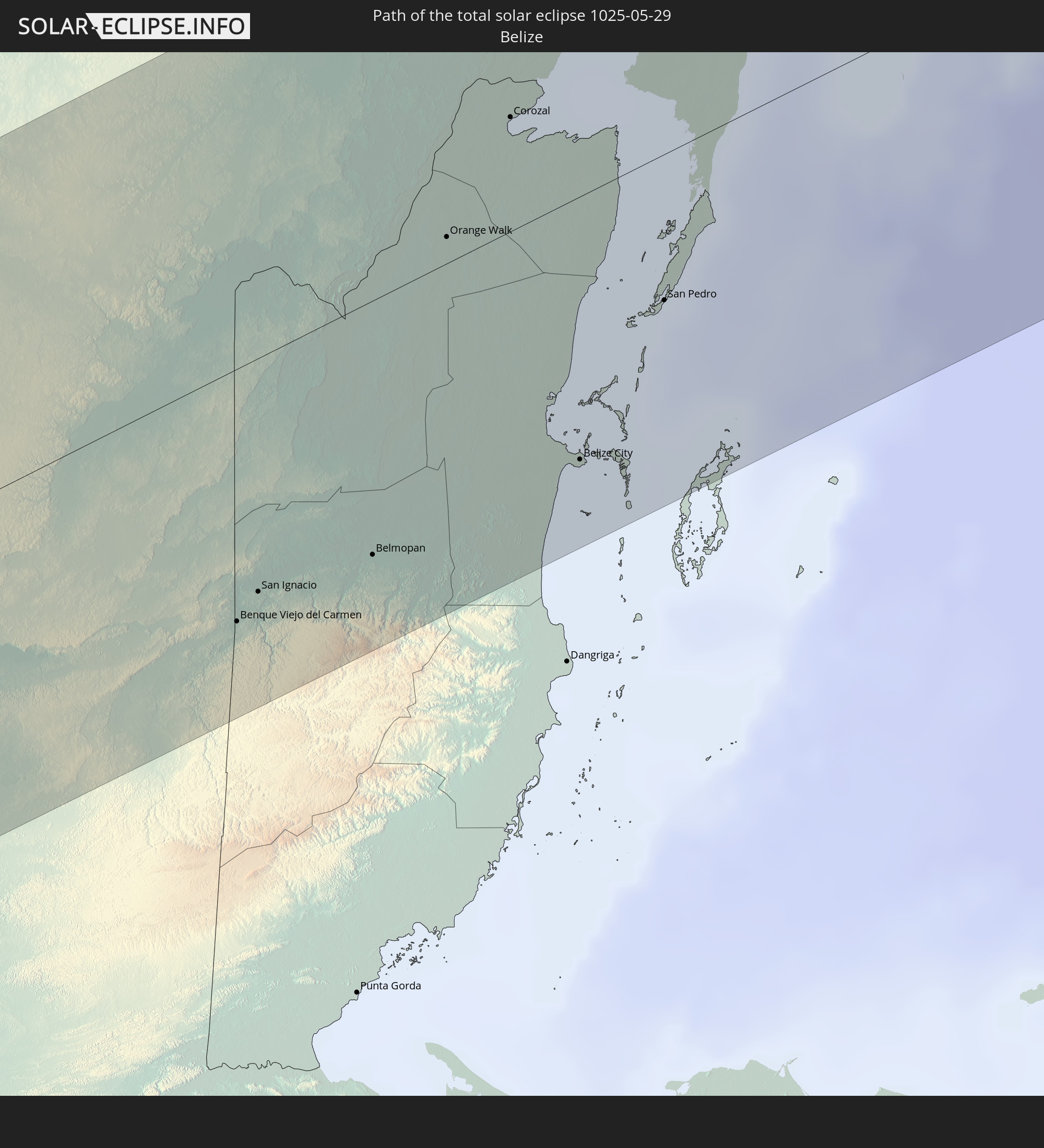 Belize
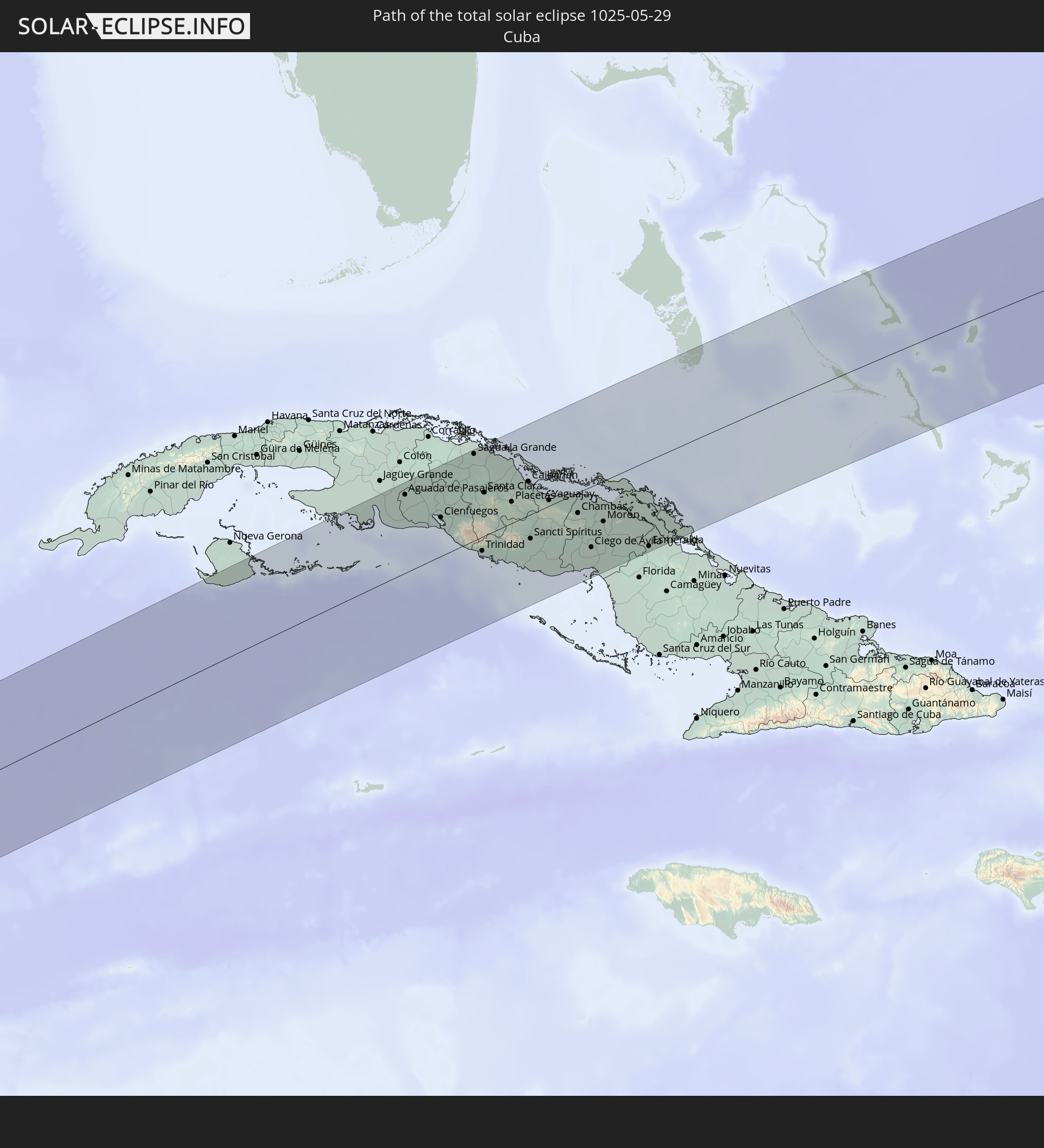 Cuba
Cuba
 The Bahamas
 Mauritania
 Mali
Mali
 Burkina Faso
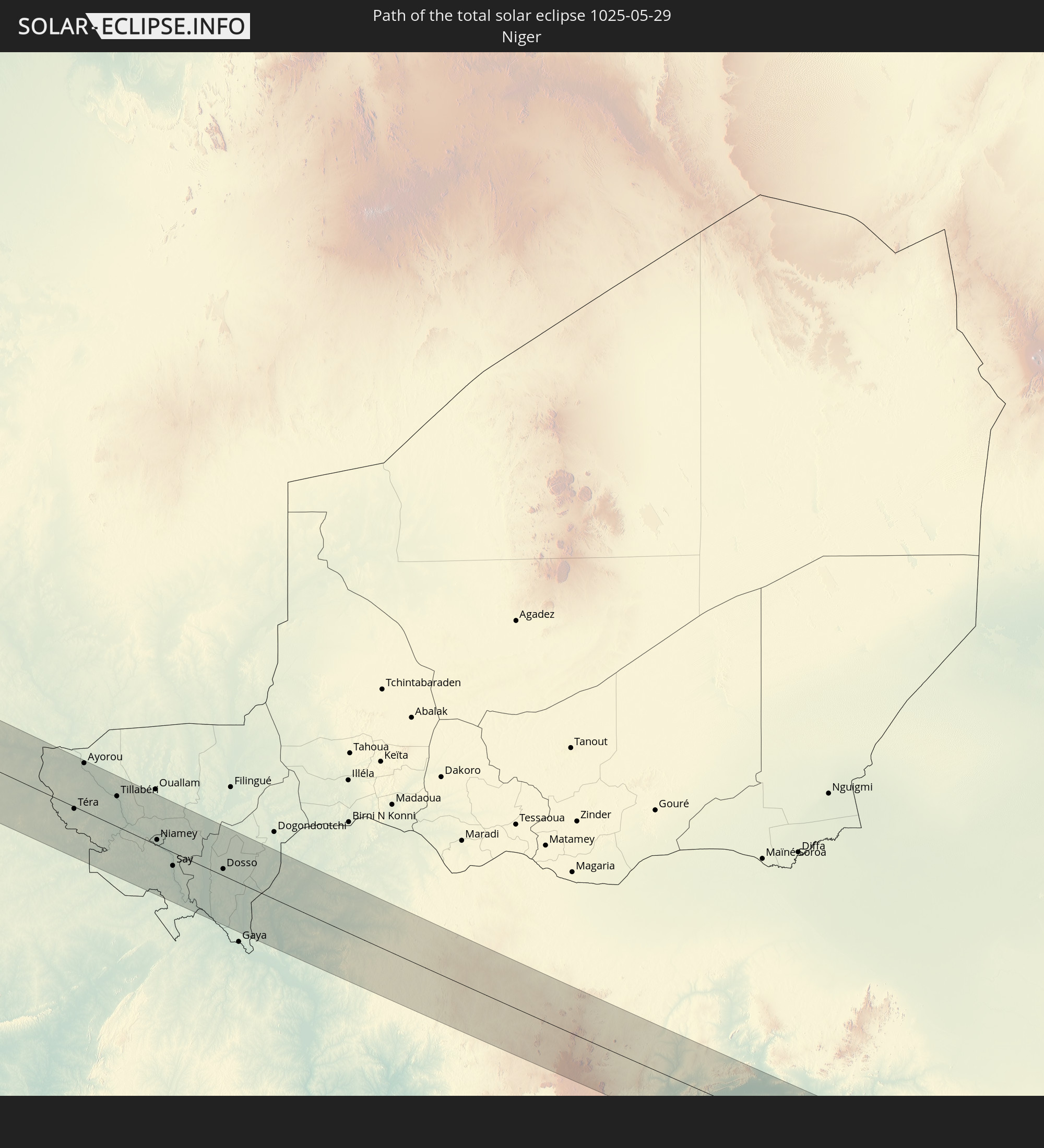 Niger
Niger
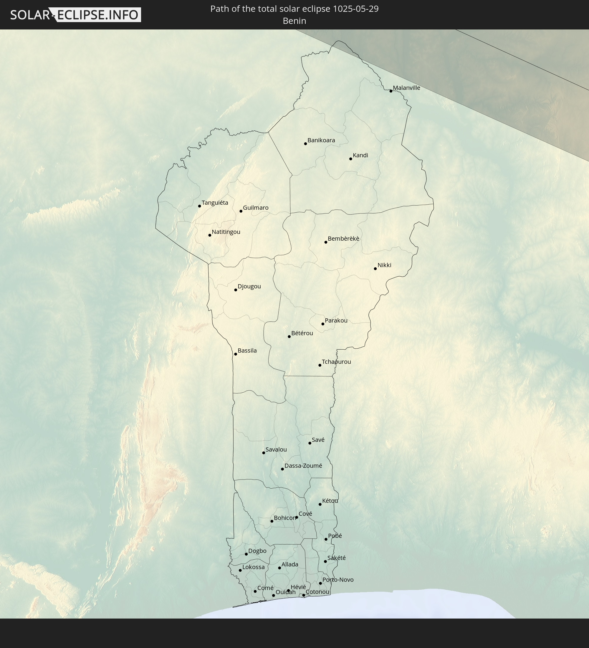 Benin
Benin
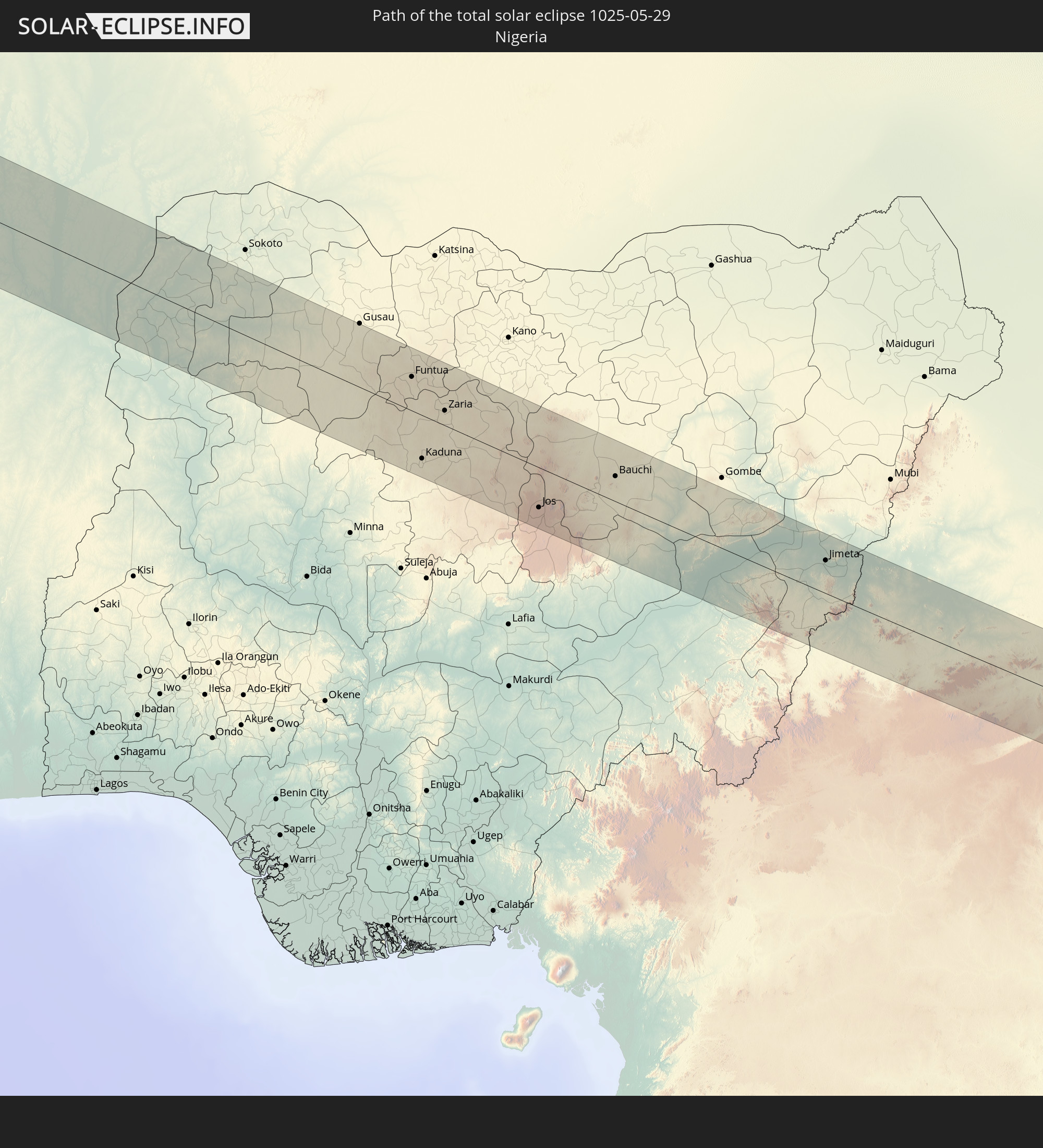 Nigeria
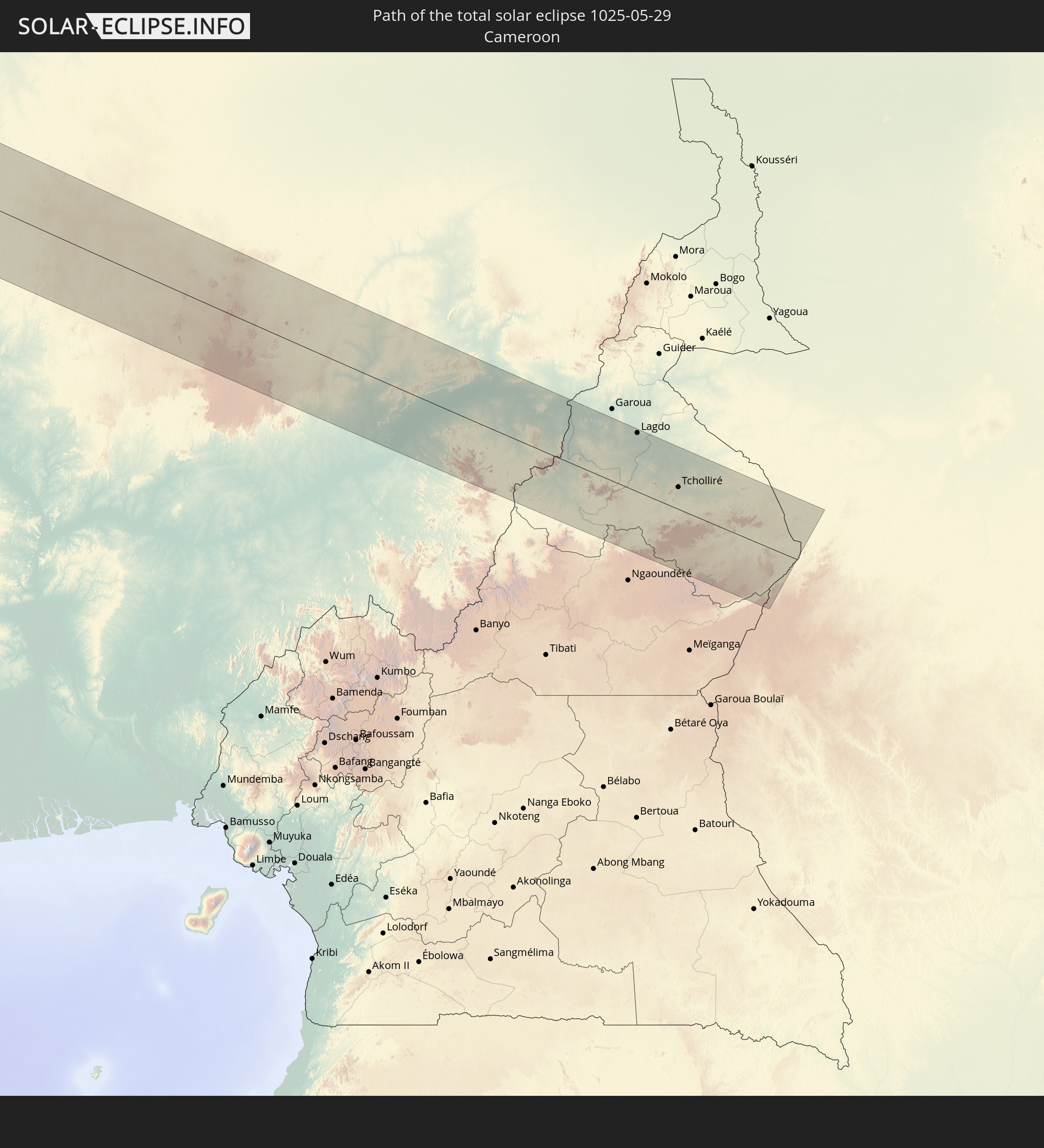 Cameroon
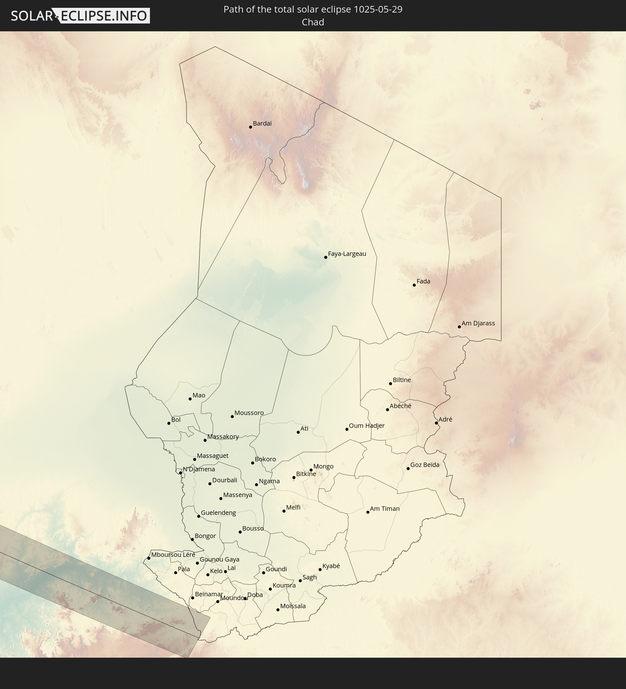 Chad
Chad
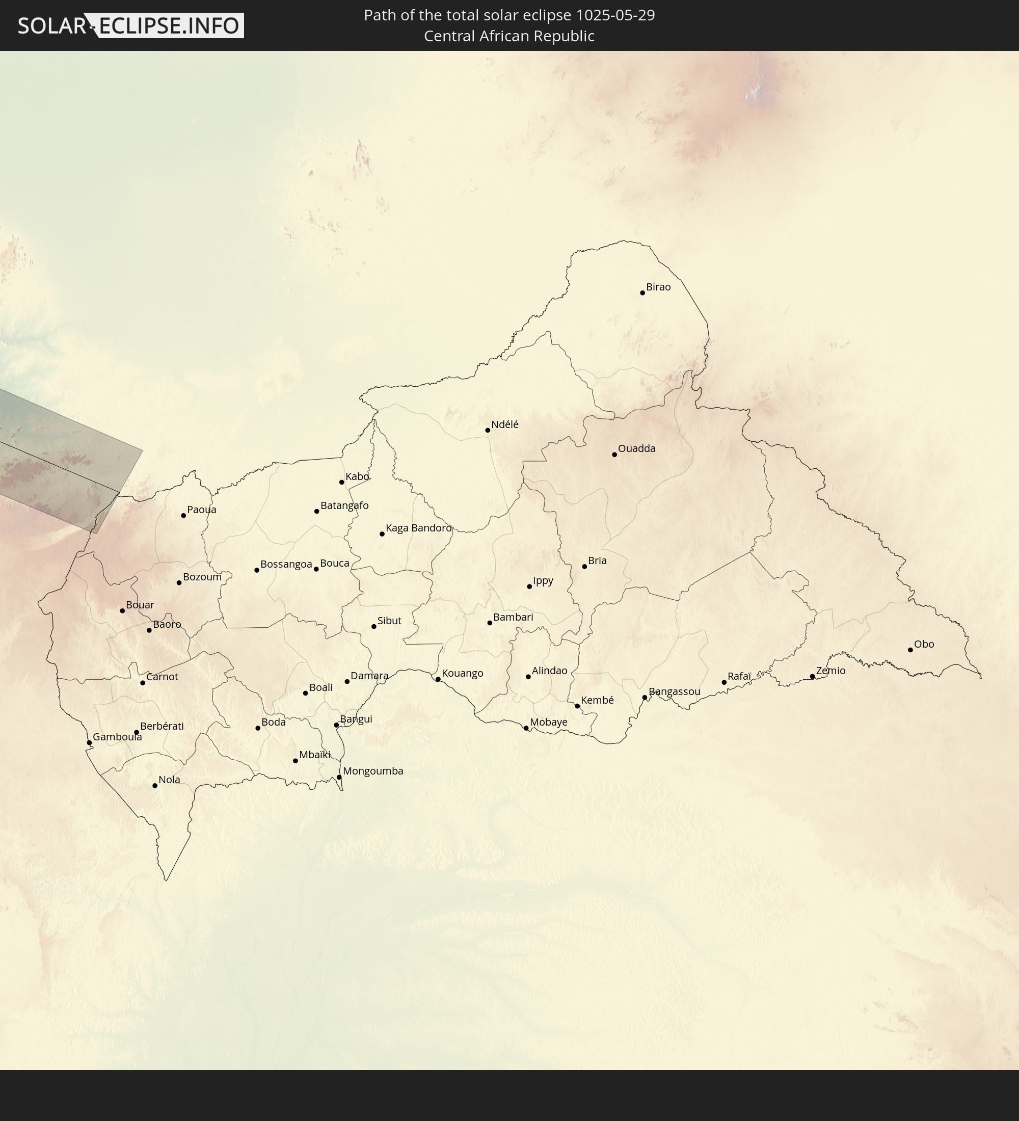 Central African Republic
In den folgenden Ländern ist die Sonnenfinsternis partiell zu sehen
 United States
 United States Minor Outlying Islands
 Canada
 Mexico
 Greenland
 Guatemala
 Ecuador
 El Salvador
 Honduras
 Belize
 Nicaragua
 Costa Rica
 Cuba
Cuba
 Panama
 Colombia
 Cayman Islands
 Peru
Peru
 The Bahamas
 Jamaica
 Haiti
Haiti
 Brazil
 Venezuela
 Turks and Caicos Islands
 Dominican Republic
 Aruba
Aruba
 Puerto Rico
 United States Virgin Islands
 Bermuda
 British Virgin Islands
 Anguilla
 Collectivity of Saint Martin
 Saint Barthélemy
 Saint Kitts and Nevis
 Antigua and Barbuda
 Montserrat
 Trinidad and Tobago
 Guadeloupe
 Grenada
 Dominica
 Saint Vincent and the Grenadines
 Guyana
 Martinique
 Saint Lucia
 Barbados
 Suriname
 Saint Pierre and Miquelon
 French Guiana
 Portugal
 Cabo Verde
 Spain
Spain
 Senegal
 Mauritania
 The Gambia
 Guinea-Bissau
 Guinea
 Saint Helena, Ascension and Tristan da Cunha
 Sierra Leone
 Morocco
 Mali
Mali
 Liberia
 Republic of Ireland
 Algeria
 United Kingdom
 Ivory Coast
 Burkina Faso
 Gibraltar
 France
 Isle of Man
 Ghana
Ghana
 Guernsey
 Jersey
 Togo
Togo
 Niger
Niger
 Benin
Benin
 Andorra
 Belgium
 Nigeria
 Netherlands
 Equatorial Guinea
 Luxembourg
 Germany
 Switzerland
 São Tomé and Príncipe
 Italy
Italy
 Monaco
 Tunisia
 Cameroon
 Gabon
Gabon
 Libya
Libya
 Liechtenstein
 Austria
 Czechia
 San Marino
 Vatican City
 Slovenia
 Chad
Chad
 Croatia
 Malta
Malta
 Central African Republic
 Bosnia and Herzegovina
 Hungary
 Slovakia
 Montenegro
 Serbia
 Albania
 Greece
 Romania
 Republic of Macedonia
 Bulgaria
 Egypt
Egypt
 Turkey
 Cyprus
 Syria
Syria
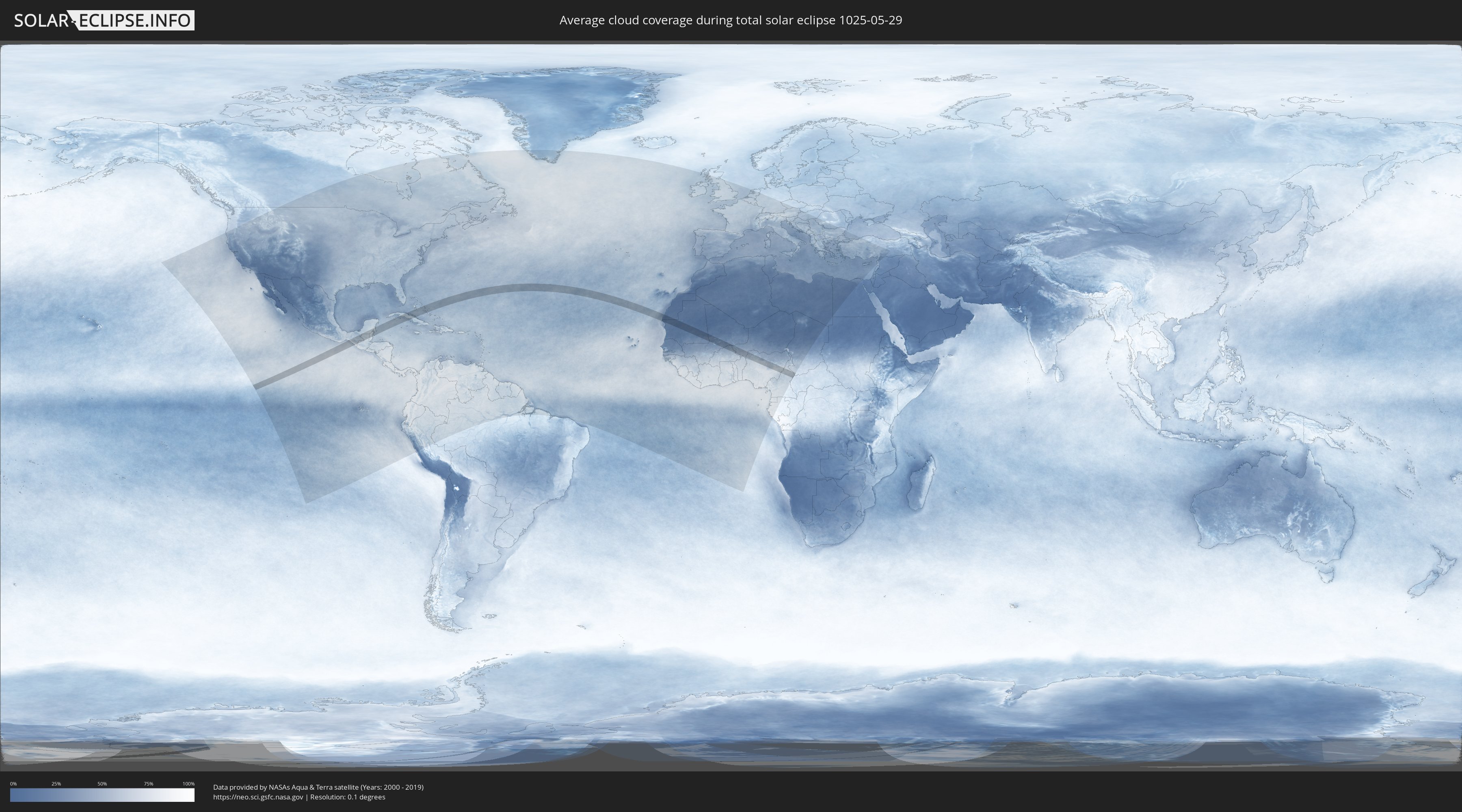
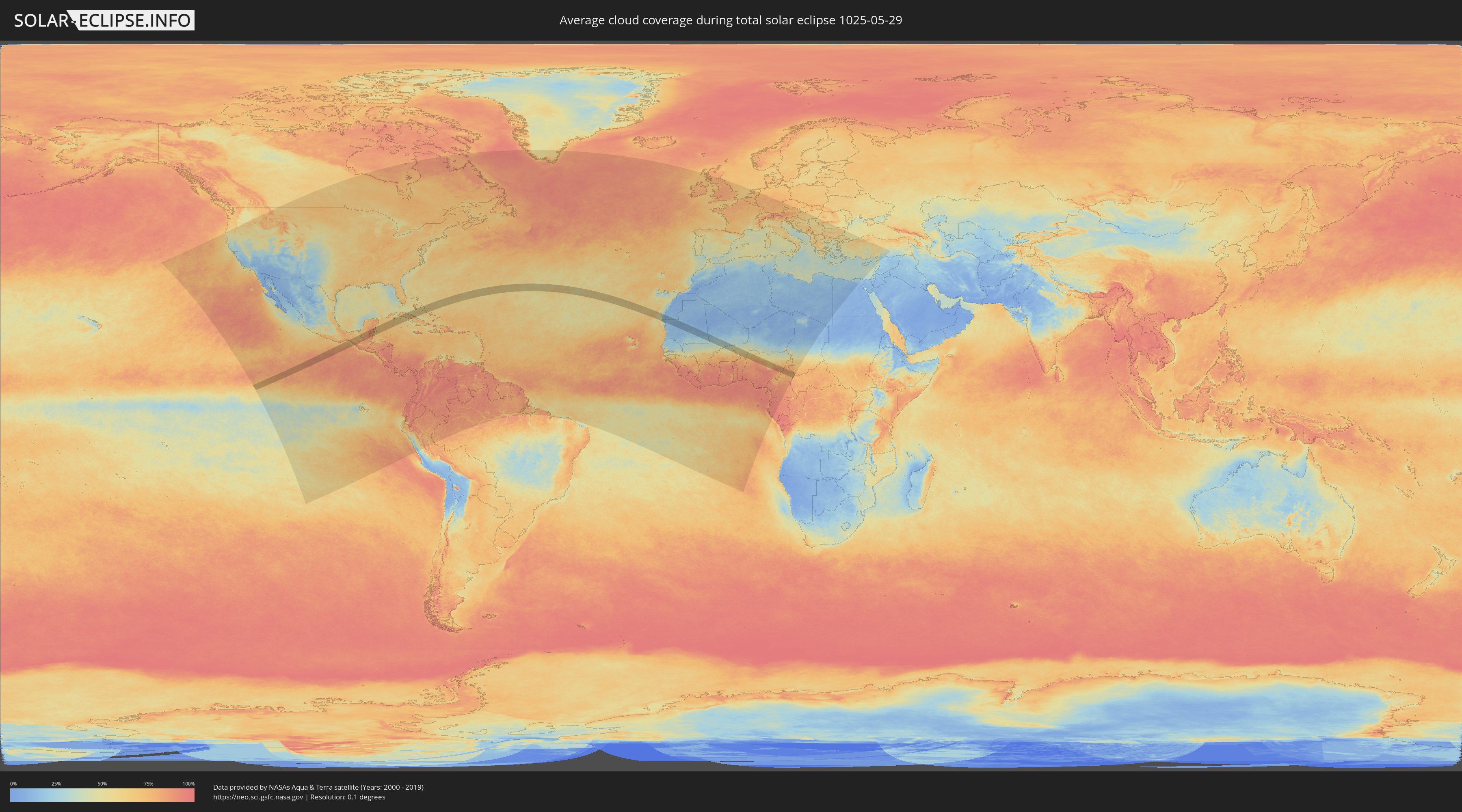
How will be the weather during the total solar eclipse on 05/29/1025?
Where is the best place to see the total solar eclipse of 05/29/1025?
The following maps show the average cloud coverage for the day of the total solar eclipse.
With the help of these maps, it is possible to find the place along the eclipse path, which has the best
chance of a cloudless sky.
Nevertheless, you should consider local circumstances and inform about the weather of your chosen
observation site.
The data is provided by NASAs satellites
AQUA and TERRA.
The cloud maps are averaged over a period of 19 years (2000 - 2019).
Detailed country maps
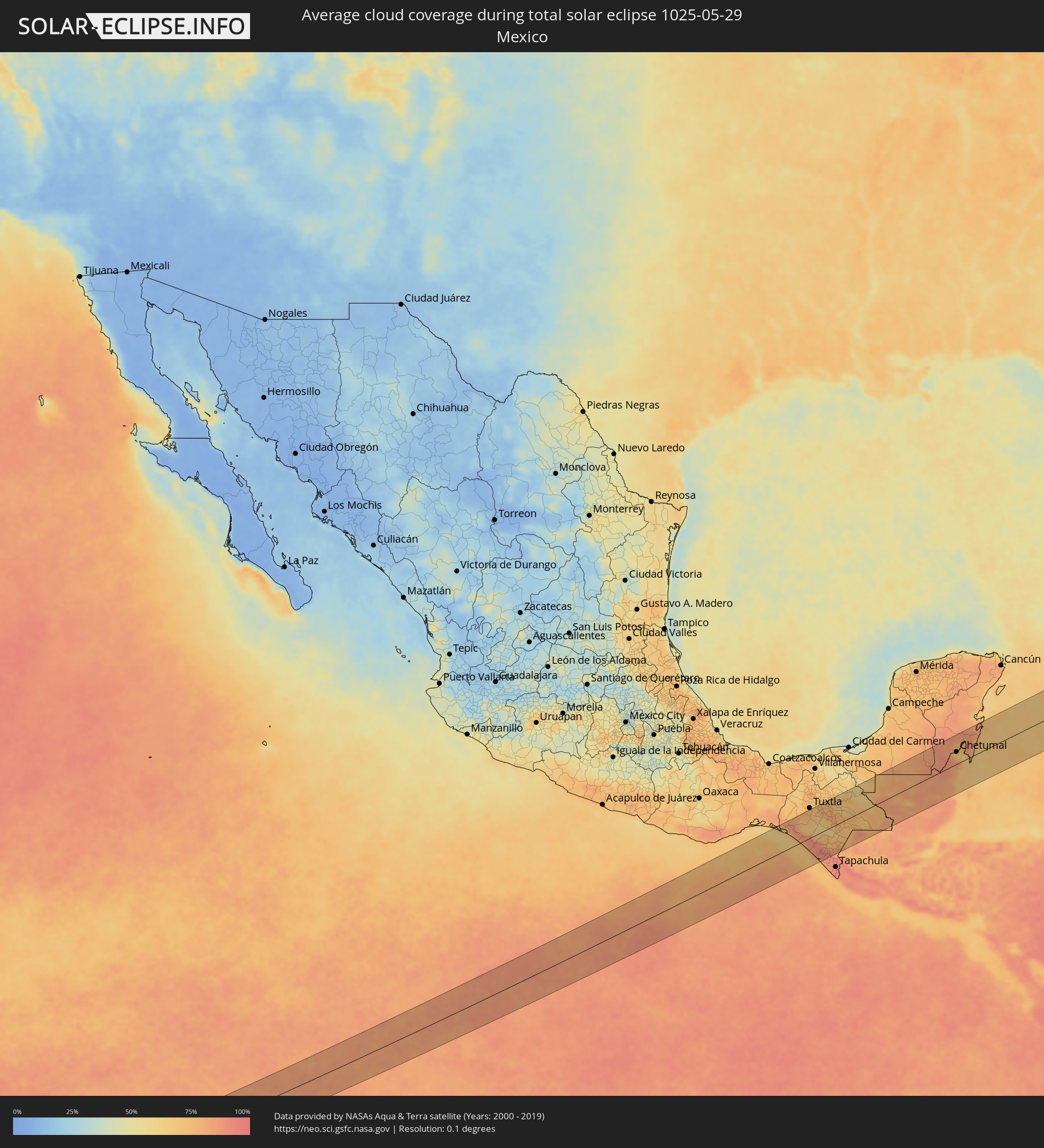 Mexico
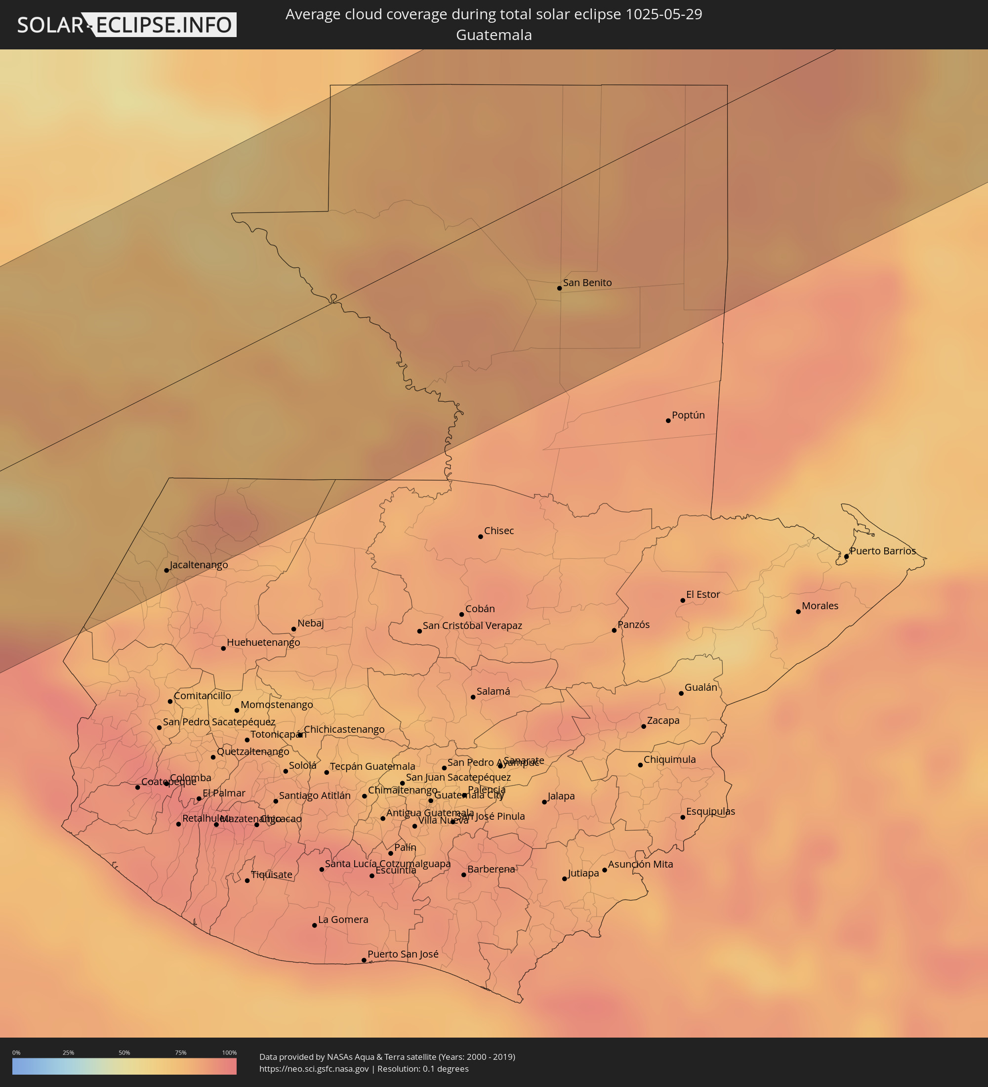 Guatemala
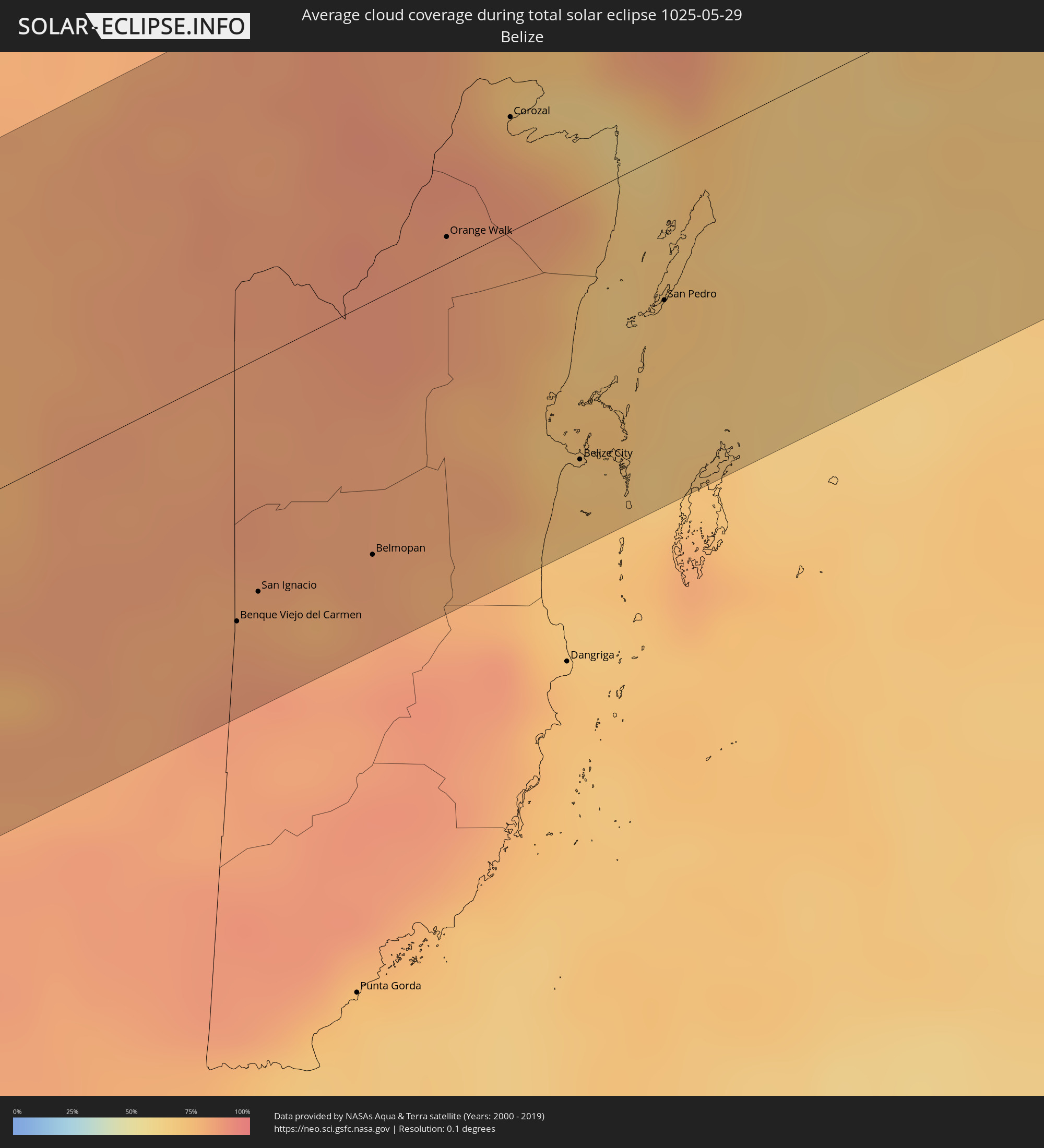 Belize
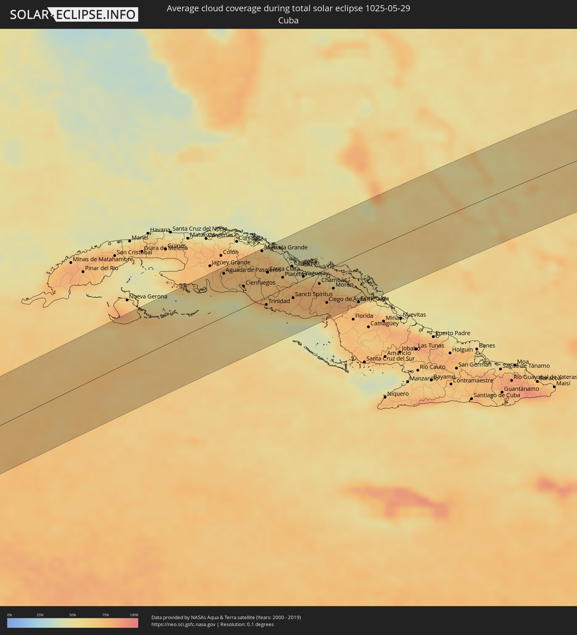 Cuba
Cuba
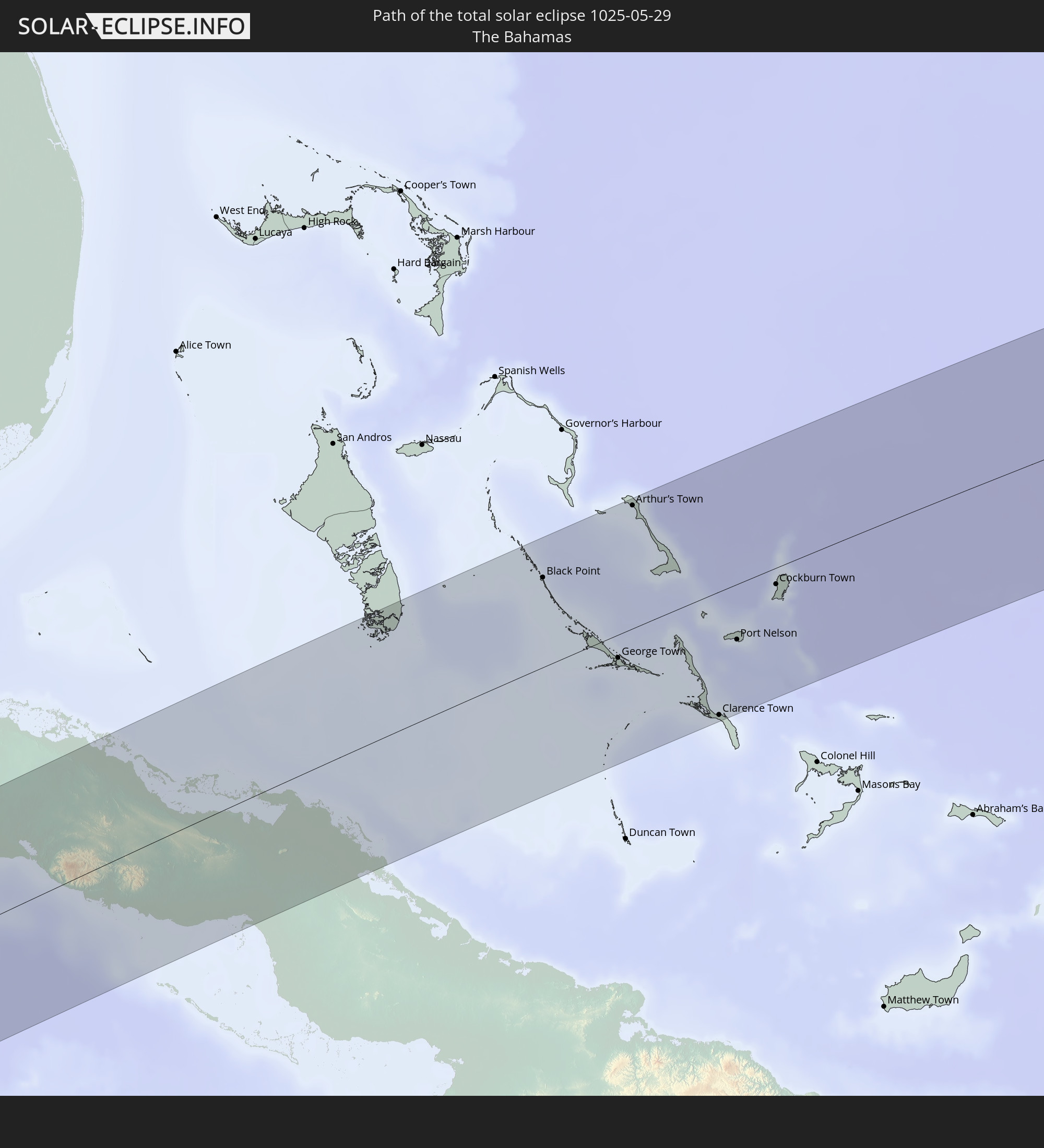
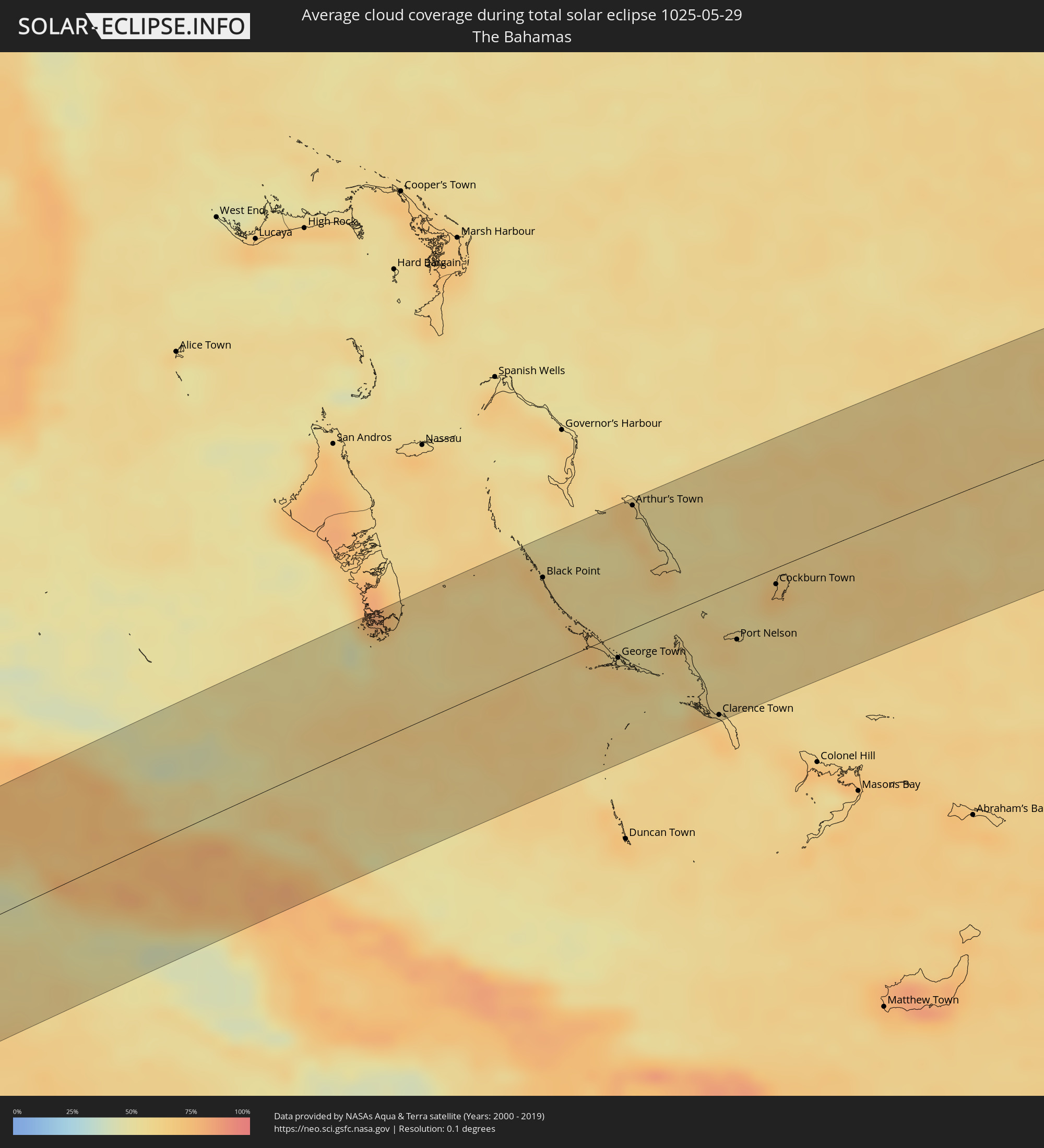 The Bahamas
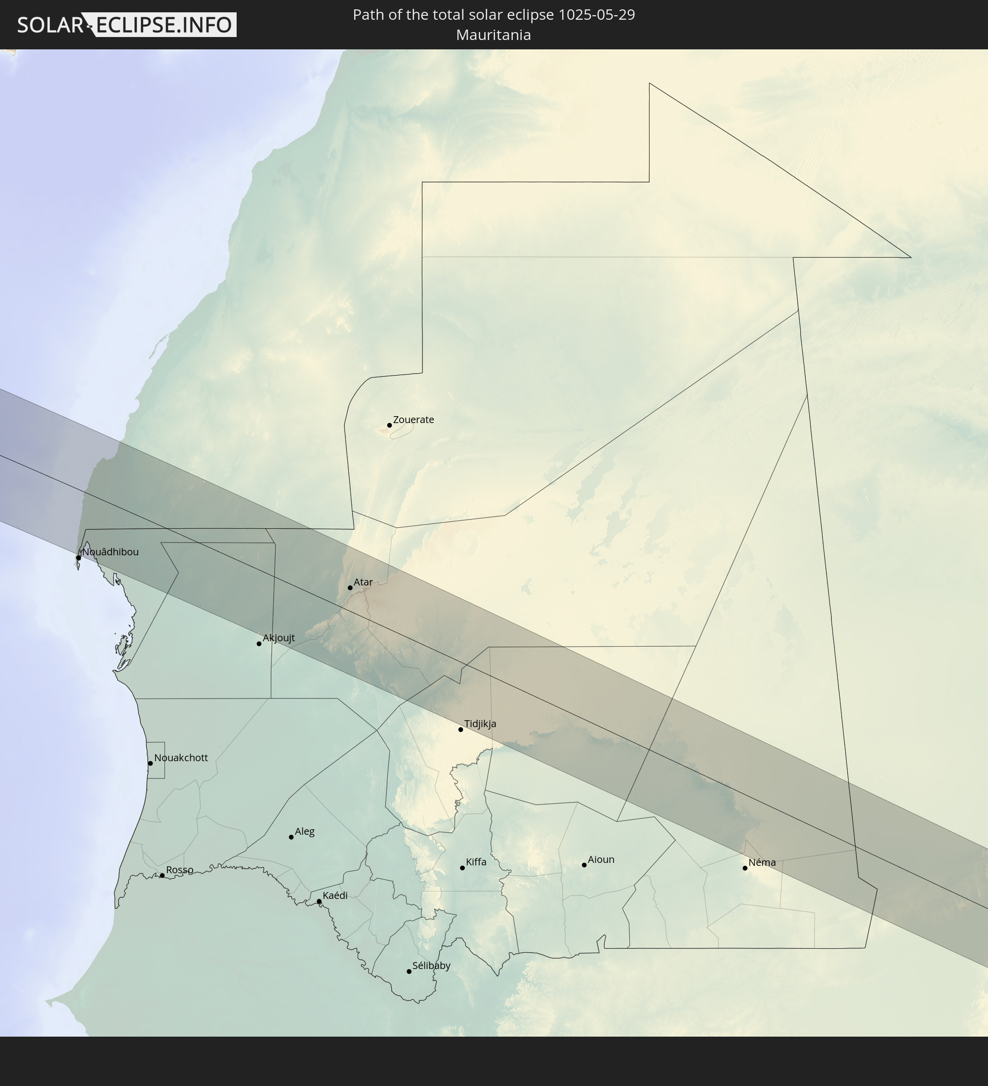
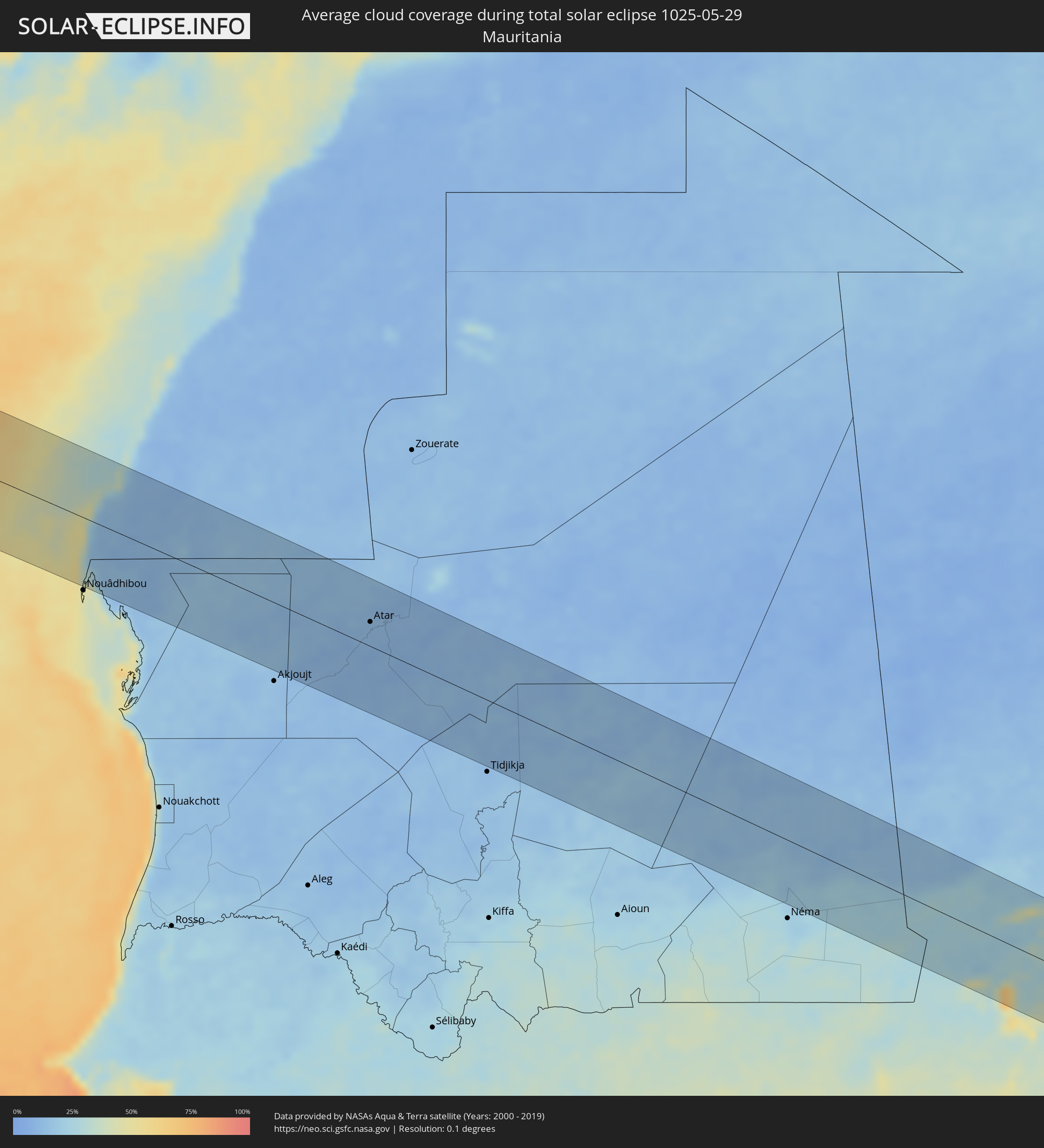 Mauritania
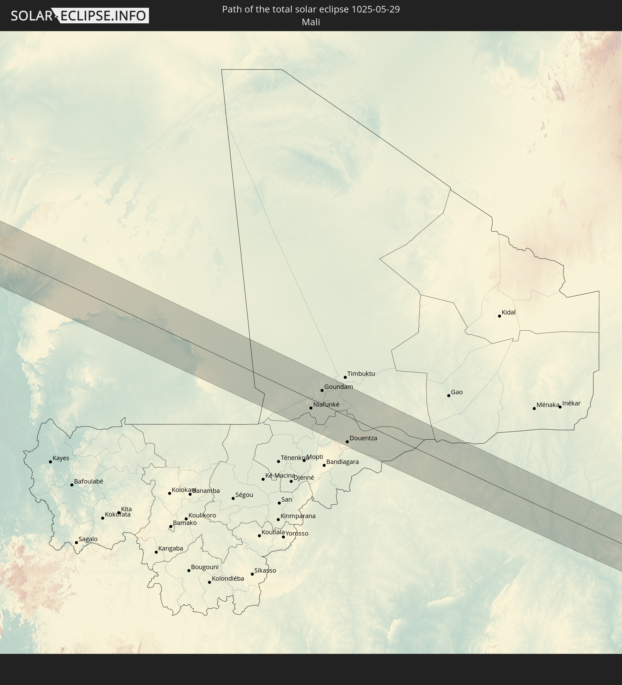
 Mali
Mali
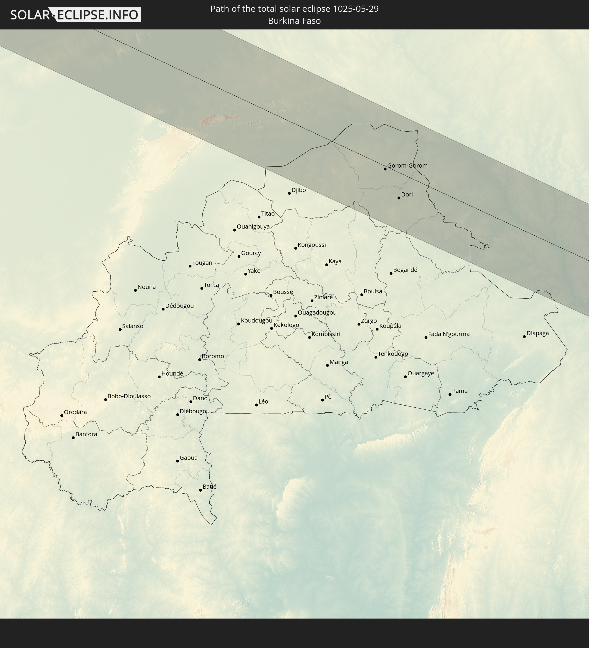
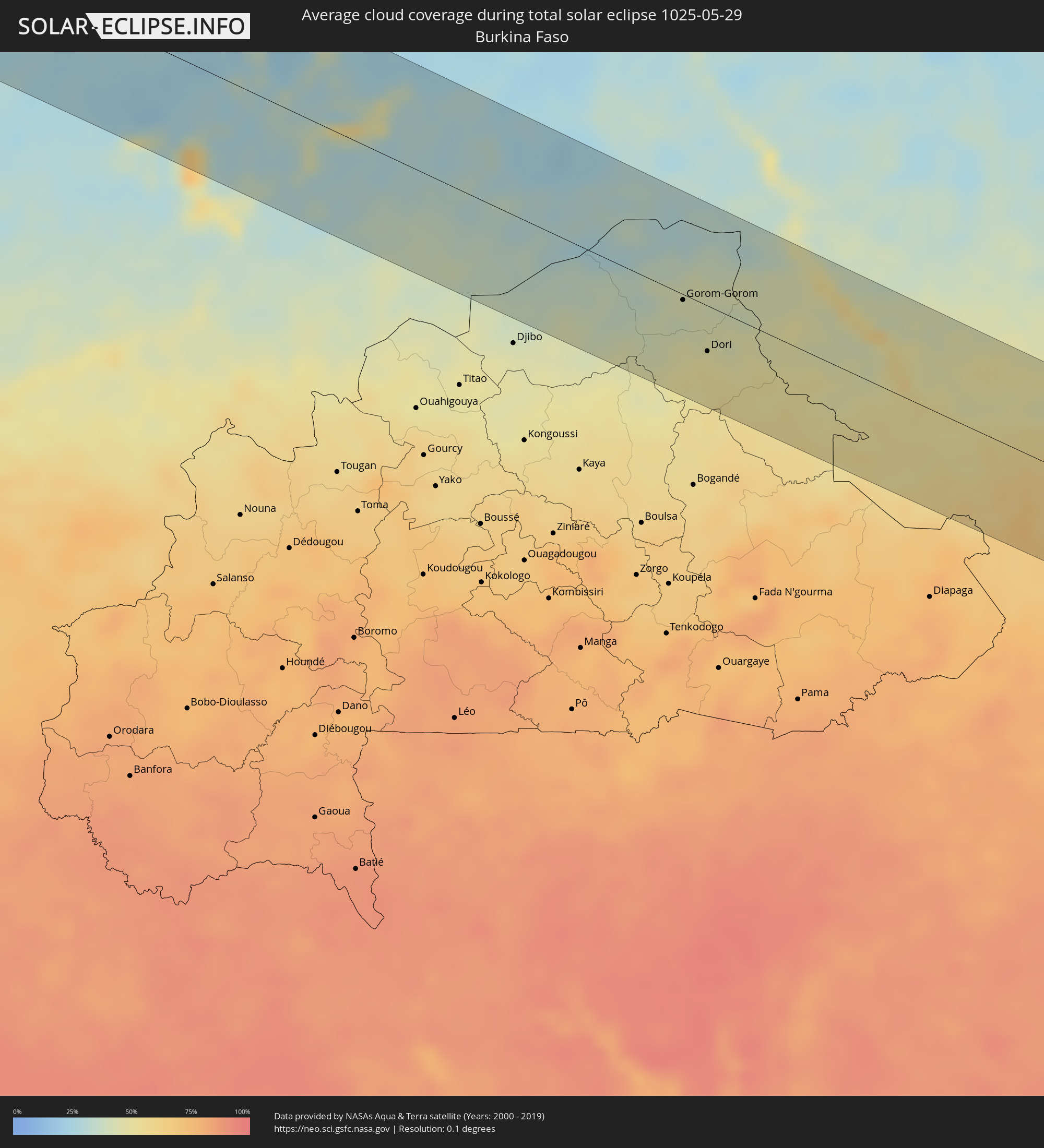 Burkina Faso
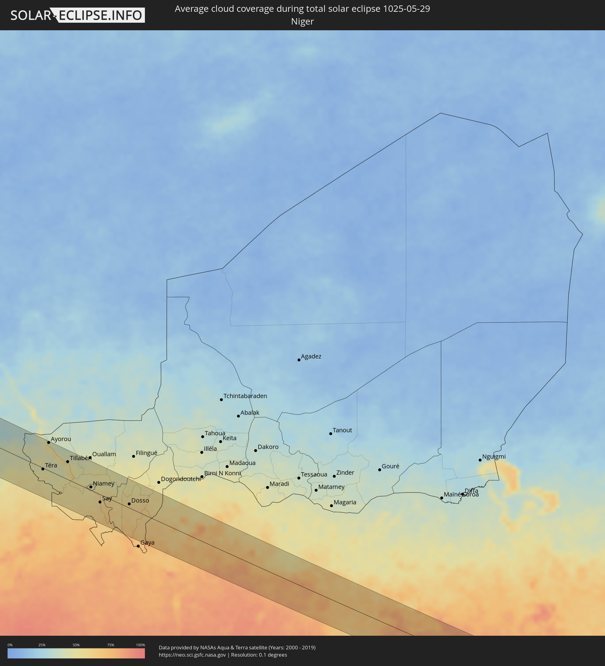 Niger
Niger
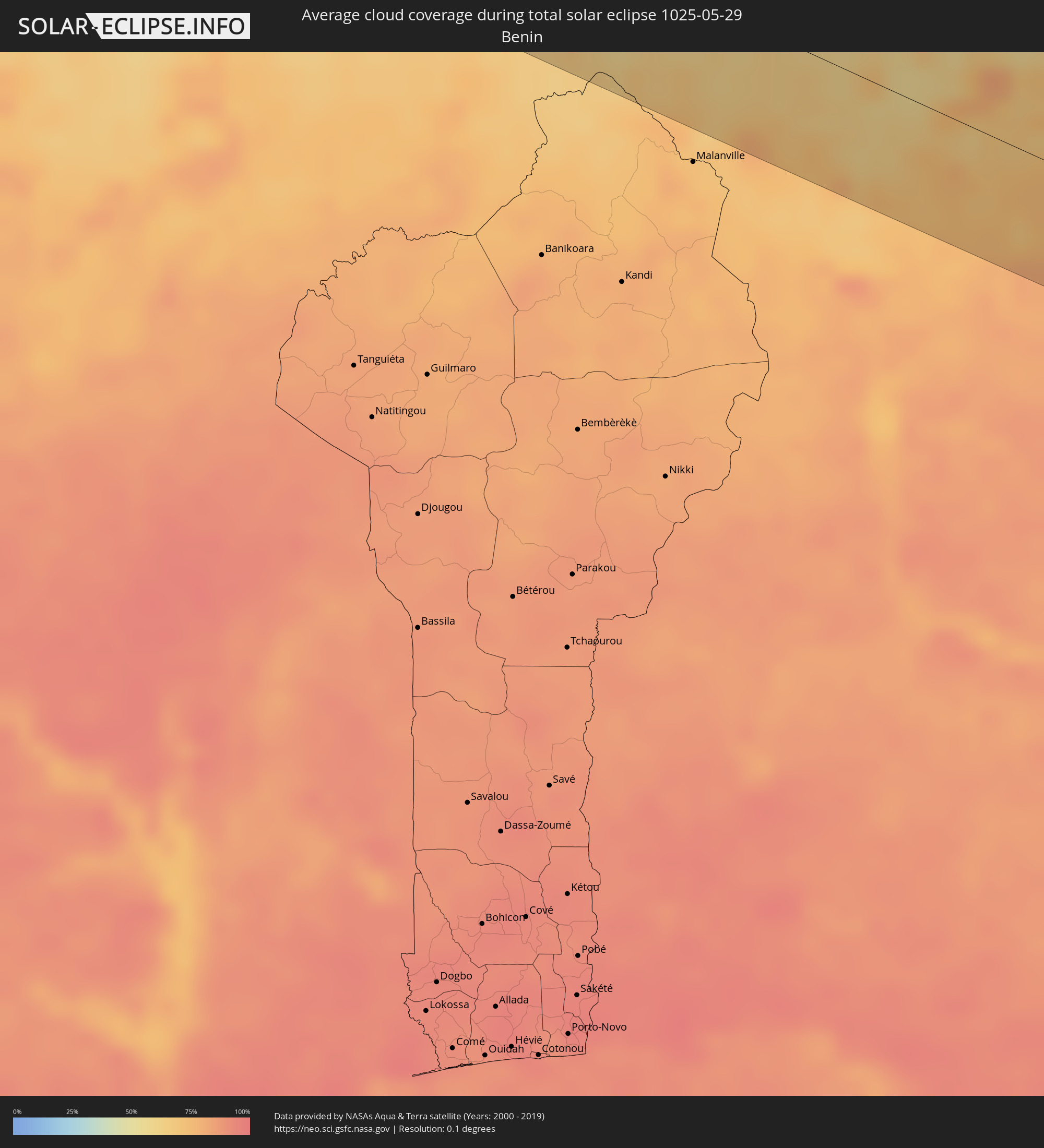 Benin
Benin
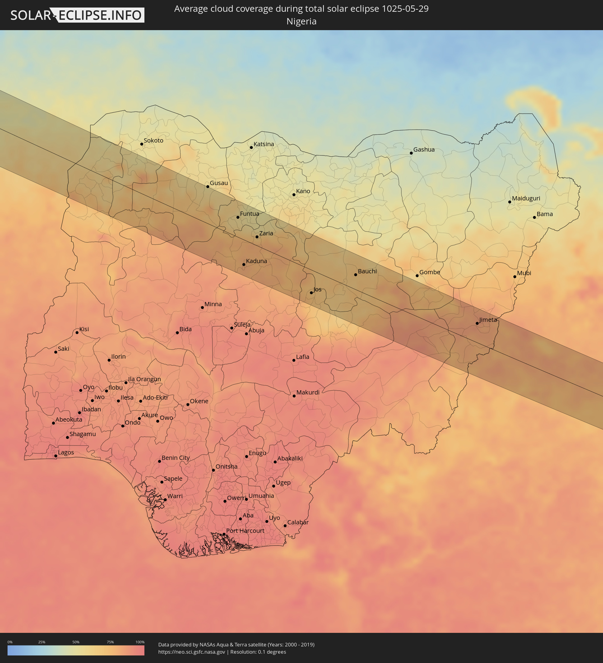 Nigeria
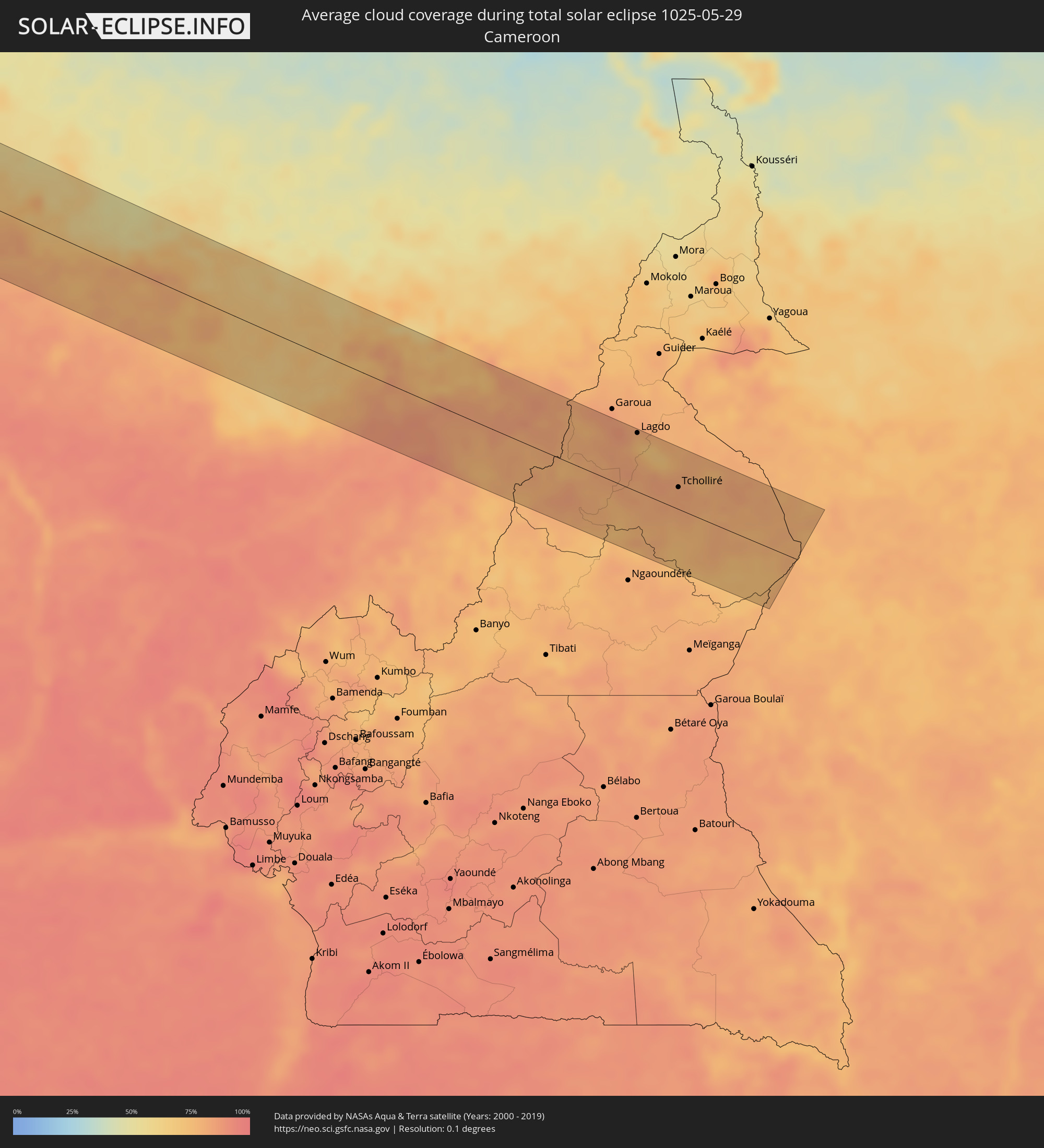 Cameroon
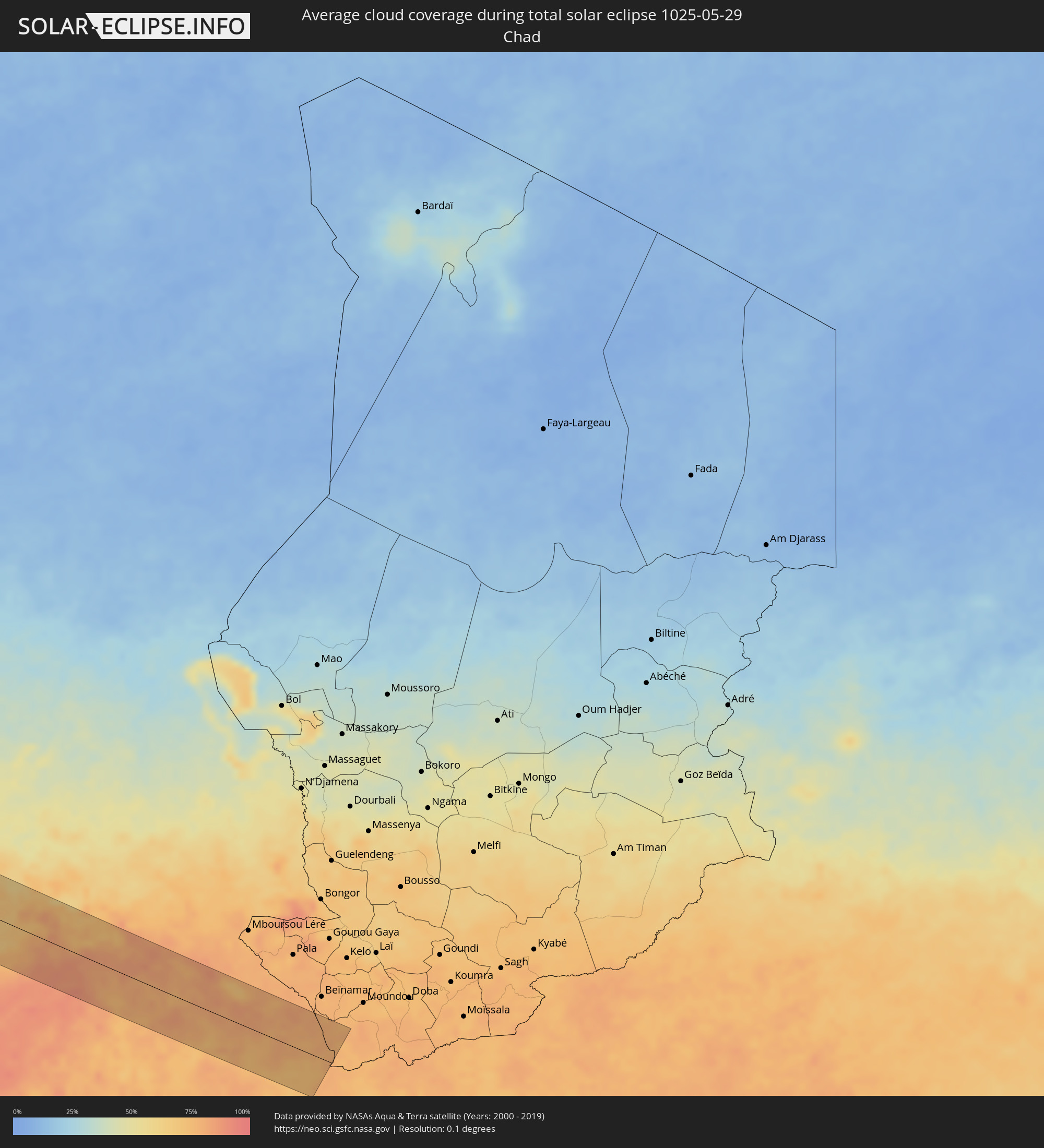 Chad
Chad
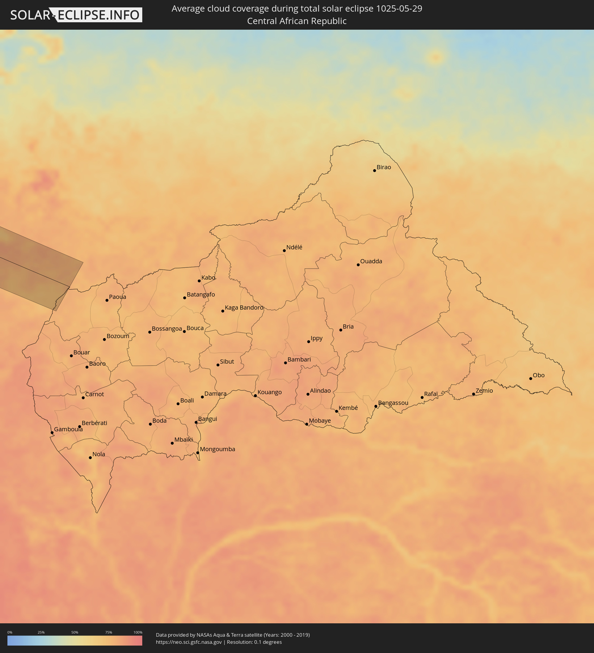 Central African Republic
Cities inside the path of the eclipse
The following table shows all locations with a population of more than 5,000 inside the eclipse path. Cities which have more than 100,000 inhabitants are marked bold. A click at the locations opens a detailed map.
| City | Type | Eclipse duration | Local time of max. eclipse | Distance to central line | Ø Cloud coverage |
|
Arriaga, Chiapas
|
total | - | 07:15:08 UTC-06:36 | 80 km | 79% |
|
Tonalá, Chiapas
|
total | - | 07:15:06 UTC-06:36 | 58 km | 79% |
|
Pijijiapan, Chiapas
|
total | - | 07:15:06 UTC-06:36 | 8 km | 85% |
|
Chiapa de Corzo, Chiapas
|
total | - | 07:16:15 UTC-06:36 | 84 km | 71% |
|
Mapastepec, Chiapas
|
total | - | 07:15:05 UTC-06:36 | 48 km | 84% |
|
Acala, Chiapas
|
total | - | 07:16:16 UTC-06:36 | 59 km | 73% |
|
San Cristóbal de las Casas, Chiapas
|
total | - | 07:16:34 UTC-06:36 | 68 km | 80% |
|
Venustiano Carranza, Chiapas
|
total | - | 07:16:14 UTC-06:36 | 25 km | 67% |
|
Teopisca, Chiapas
|
total | - | 07:16:30 UTC-06:36 | 41 km | 79% |
|
Motozintla, Chiapas
|
total | - | 07:15:32 UTC-06:36 | 86 km | 80% |
|
Frontera Comalapa, Chiapas
|
total | - | 07:15:54 UTC-06:36 | 62 km | 74% |
|
Comitán, Chiapas
|
total | - | 07:16:29 UTC-06:36 | 5 km | 74% |
|
Ocosingo, Chiapas
|
total | - | 07:17:10 UTC-06:36 | 59 km | 65% |
|
Las Margaritas, Chiapas
|
total | - | 07:16:40 UTC-06:36 | 5 km | 70% |
|
San Antonio Huista, Huehuetenango
|
total | - | 07:50:43 UTC-06:02 | 81 km | 76% |
|
Jacaltenango, Huehuetenango
|
total | - | 07:50:46 UTC-06:02 | 81 km | 82% |
|
Concepción, Huehuetenango
|
total | - | 07:50:45 UTC-06:02 | 89 km | 85% |
|
San Mateo Ixtatán, Huehuetenango
|
total | - | 07:51:08 UTC-06:02 | 77 km | 81% |
|
Tenosique de Pino Suárez, Tabasco
|
total | - | 07:18:18 UTC-06:36 | 83 km | 63% |
|
Barillas, Huehuetenango
|
total | - | 07:51:14 UTC-06:02 | 88 km | 77% |
|
Nueva Palestina, Chiapas
|
total | - | 07:17:46 UTC-06:36 | 10 km | 73% |
|
San Carlos, Tabasco
|
total | - | 07:18:36 UTC-06:36 | 78 km | 68% |
|
Sayaxché, Petén
|
total | - | 07:52:57 UTC-06:02 | 72 km | 80% |
|
La Libertad, Petén
|
total | - | 07:53:16 UTC-06:02 | 48 km | 80% |
|
San Benito, Petén
|
total | - | 07:53:34 UTC-06:02 | 44 km | 81% |
|
San Andrés, Petén
|
total | - | 07:53:38 UTC-06:02 | 39 km | 69% |
|
Flores, Petén
|
total | - | 07:53:36 UTC-06:02 | 45 km | 81% |
|
Santa Ana, Petén
|
total | - | 07:53:32 UTC-06:02 | 60 km | 82% |
|
Melchor de Mencos, Petén
|
total | - | 07:54:26 UTC-06:02 | 66 km | 82% |
|
Benque Viejo del Carmen, Cayo
|
total | - | 08:03:44 UTC-05:52 | 66 km | 85% |
|
San Ignacio, Cayo
|
total | - | 08:03:52 UTC-05:52 | 61 km | 82% |
|
Belmopan, Cayo
|
total | - | 08:04:16 UTC-05:52 | 66 km | 83% |
|
Orange Walk, Orange Walk
|
total | - | 08:05:20 UTC-05:52 | 7 km | 86% |
|
Bacalar, Quintana Roo
|
total | - | 08:11:53 UTC-05:47 | 58 km | 79% |
|
Corozal, Corozal
|
total | - | 08:05:51 UTC-05:52 | 30 km | 79% |
|
Chetumal, Quintana Roo
|
total | - | 08:11:48 UTC-05:47 | 38 km | 65% |
|
Belize City, Belize
|
total | - | 08:05:05 UTC-05:52 | 68 km | 72% |
|
San Pedro, Belize
|
total | - | 08:05:46 UTC-05:52 | 38 km | 72% |
|
Cienfuegos, Cienfuegos
|
total | - | 08:42:59 UTC-05:29 | 41 km | 57% |
|
Santo Domingo, Villa Clara
|
total | - | 08:43:47 UTC-05:29 | 76 km | 71% |
|
Cumanayagua, Cienfuegos
|
total | - | 08:43:20 UTC-05:29 | 30 km | 66% |
|
Ranchuelo, Villa Clara
|
total | - | 08:43:40 UTC-05:29 | 50 km | 72% |
|
Sagua la Grande, Villa Clara
|
total | - | 08:44:17 UTC-05:29 | 91 km | 73% |
|
Cifuentes, Villa Clara
|
total | - | 08:44:09 UTC-05:29 | 74 km | 72% |
|
Trinidad, Sancti Spíritus
|
total | - | 08:43:16 UTC-05:29 | 15 km | 62% |
|
Manicaragua, Villa Clara
|
total | - | 08:43:40 UTC-05:29 | 20 km | 70% |
|
Santa Clara, Villa Clara
|
total | - | 08:43:59 UTC-05:29 | 45 km | 73% |
|
Encrucijada, Villa Clara
|
total | - | 08:44:23 UTC-05:29 | 63 km | 74% |
|
Condado, Sancti Spíritus
|
total | - | 08:43:34 UTC-05:29 | 13 km | 74% |
|
Camajuaní, Villa Clara
|
total | - | 08:44:24 UTC-05:29 | 44 km | 71% |
|
Placetas, Villa Clara
|
total | - | 08:44:20 UTC-05:29 | 22 km | 71% |
|
Cabaiguán, Sancti Spíritus
|
total | - | 08:44:18 UTC-05:29 | 8 km | 76% |
|
Caibarién, Villa Clara
|
total | - | 08:44:52 UTC-05:29 | 35 km | 62% |
|
Sancti Spíritus, Sancti Spíritus
|
total | - | 08:44:13 UTC-05:29 | 25 km | 70% |
|
Yaguajay, Sancti Spíritus
|
total | - | 08:45:00 UTC-05:29 | 6 km | 75% |
|
Ciego de Ávila, Ciego de Ávila
|
total | - | 08:45:10 UTC-05:29 | 64 km | 74% |
|
Morón, Ciego de Ávila
|
total | - | 08:45:41 UTC-05:29 | 42 km | 76% |
|
Black Point, Black Point
|
total | - | 14:21:15 UTC+00:00 | 67 km | 67% |
|
George Town, Exuma
|
total | - | 09:12:06 UTC-05:09 | 17 km | 61% |
|
Arthur’s Town, Cat Island
|
total | - | 09:13:34 UTC-05:09 | 91 km | 65% |
|
Clarence Town, Long Island
|
total | - | 09:13:03 UTC-05:09 | 92 km | 71% |
|
Port Nelson, Rum Cay
|
total | - | 09:13:56 UTC-05:09 | 41 km | 58% |
|
Cockburn Town, San Salvador
|
total | - | 09:14:56 UTC-05:09 | 12 km | 70% |
|
Atar, Adrar
|
total | - | 16:31:28 UTC-00:16 | 32 km | 12% |
|
Niafunké, Tombouctou
|
total | - | 16:42:22 UTC-00:16 | 26 km | 32% |
|
Goundam, Tombouctou
|
total | - | 16:42:08 UTC-00:16 | 38 km | 31% |
|
Douentza, Mopti
|
total | - | 16:43:38 UTC-00:16 | 72 km | 33% |
|
Gorom-Gorom, Sahel
|
total | - | 16:45:11 UTC-00:16 | 5 km | 40% |
|
Dori, Sahel
|
total | - | 16:45:34 UTC-00:16 | 37 km | 50% |
|
Téra, Tillabéri
|
total | - | 17:15:34 UTC+00:13 | 3 km | 49% |
|
Ayorou, Tillabéri
|
total | - | 17:15:04 UTC+00:13 | 77 km | 55% |
|
Tillabéri, Tillabéri
|
total | - | 17:15:38 UTC+00:13 | 49 km | 53% |
|
Niamey, Niamey
|
total | - | 17:16:19 UTC+00:13 | 8 km | 51% |
|
Kollo, Tillabéri
|
total | - | 17:16:32 UTC+00:13 | 2 km | 58% |
|
Say, Tillabéri
|
total | - | 17:16:41 UTC+00:13 | 22 km | 60% |
|
Dosso, Dosso
|
total | - | 17:16:54 UTC+00:13 | 11 km | 60% |
|
Birnin Kebbi, Kebbi
|
total | - | 17:17:31 UTC+00:13 | 4 km | 63% |
|
Jega, Kebbi
|
total | - | 17:17:42 UTC+00:13 | 19 km | 63% |
|
Argungu, Kebbi
|
total | - | 17:17:23 UTC+00:13 | 40 km | 55% |
|
Tambuwal, Sokoto
|
total | - | 17:17:37 UTC+00:13 | 11 km | 60% |
|
Gummi, Zamfara
|
total | - | 17:17:52 UTC+00:13 | 6 km | 66% |
|
Zuru, Kebbi
|
total | - | 17:18:21 UTC+00:13 | 60 km | 78% |
|
Sofo-Birnin-Gwari, Kaduna
|
total | - | 17:18:47 UTC+00:13 | 34 km | 79% |
|
Funtua, Katsina
|
total | - | 17:18:30 UTC+00:13 | 42 km | 60% |
|
Kaduna, Kaduna
|
total | - | 17:19:07 UTC+00:13 | 54 km | 80% |
|
Zaria, Kaduna
|
total | - | 17:18:47 UTC+00:13 | 18 km | 78% |
|
Dutsen Wai, Kaduna
|
total | - | 17:18:58 UTC+00:13 | 13 km | 78% |
|
Lere, Kaduna
|
total | - | 17:19:15 UTC+00:13 | 17 km | 79% |
|
Jos, Plateau
|
total | - | 17:19:31 UTC+00:13 | 50 km | 71% |
|
Bauchi, Bauchi
|
total | - | 17:19:18 UTC+00:13 | 31 km | 66% |
|
Pindiga, Gombe
|
total | - | 17:19:27 UTC+00:13 | 46 km | 82% |
|
Kumo, Gombe
|
total | - | 17:19:24 UTC+00:13 | 65 km | 72% |
|
Jalingo, Taraba
|
total | - | 17:20:01 UTC+00:13 | 46 km | 85% |
|
Numan, Adamawa
|
total | - | 17:19:40 UTC+00:13 | 41 km | 79% |
|
Jimeta, Adamawa
|
total | - | 17:19:43 UTC+00:13 | 41 km | 82% |
|
Poli, North
|
total | - | 17:20:02 UTC+00:13 | 7 km | 79% |
|
Lagdo, North
|
total | - | 17:19:42 UTC+00:13 | 69 km | 75% |
|
Tcholliré, North
|
total | - | 17:19:57 UTC+00:13 | 26 km | 81% |
|
Rey Bouba, North
|
total | - | 17:19:49 UTC+00:13 | 54 km | 81% |