Annular solar eclipse of 05/11/1119
| Day of week: | Sunday |
| Maximum duration of eclipse: | 06m24s |
| Maximum width of eclipse path: | 192 km |
| Saros cycle: | 104 |
| Coverage: | 94.8% |
| Magnitude: | 0.9484 |
| Gamma: | 0.1386 |
Wo kann man die Sonnenfinsternis vom 05/11/1119 sehen?
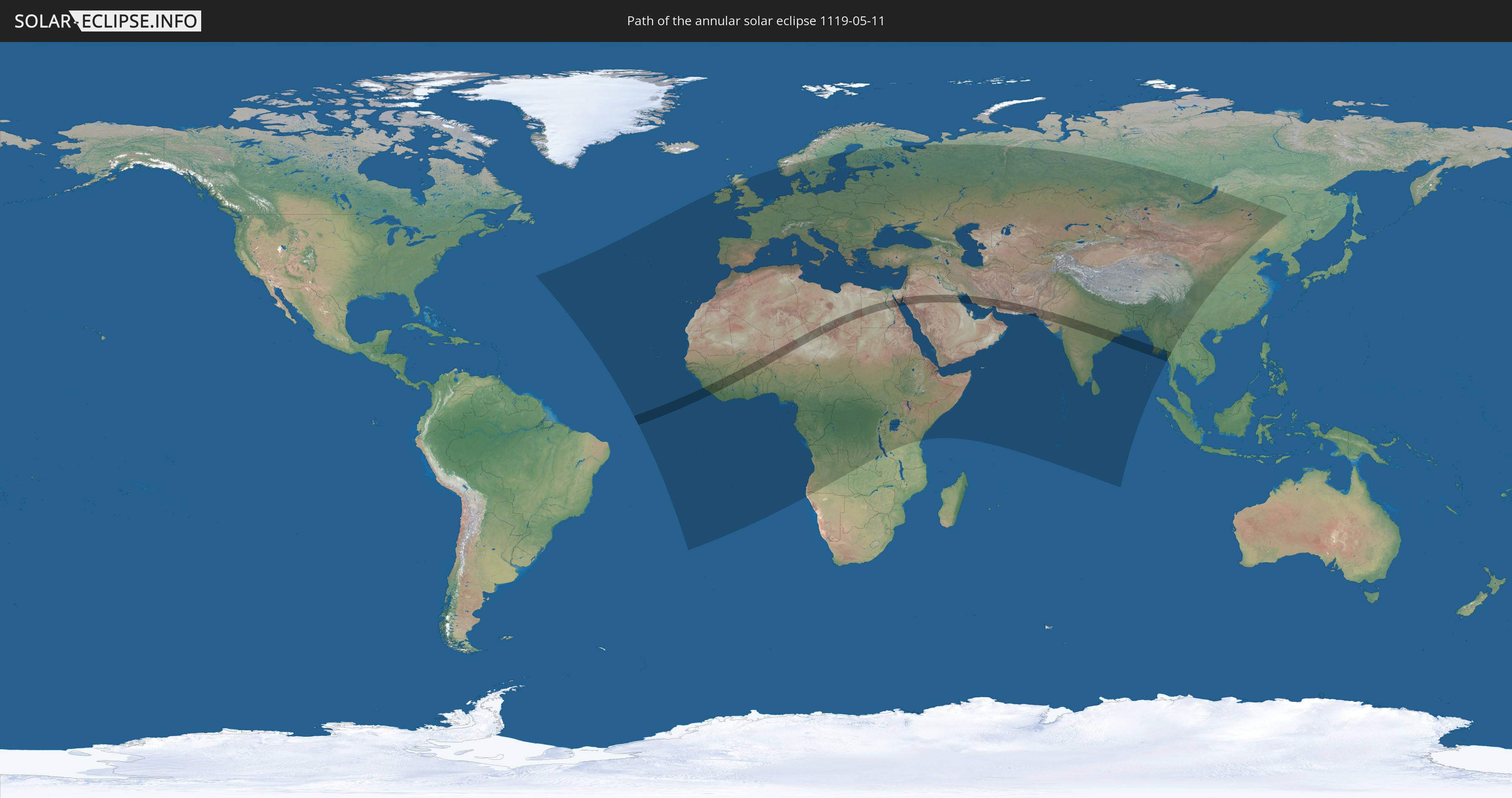
Die Sonnenfinsternis am 05/11/1119 kann man in 131 Ländern als partielle Sonnenfinsternis beobachten.
Der Finsternispfad verläuft durch 20 Länder. Nur in diesen Ländern ist sie als annular Sonnenfinsternis zu sehen.
In den folgenden Ländern ist die Sonnenfinsternis annular zu sehen
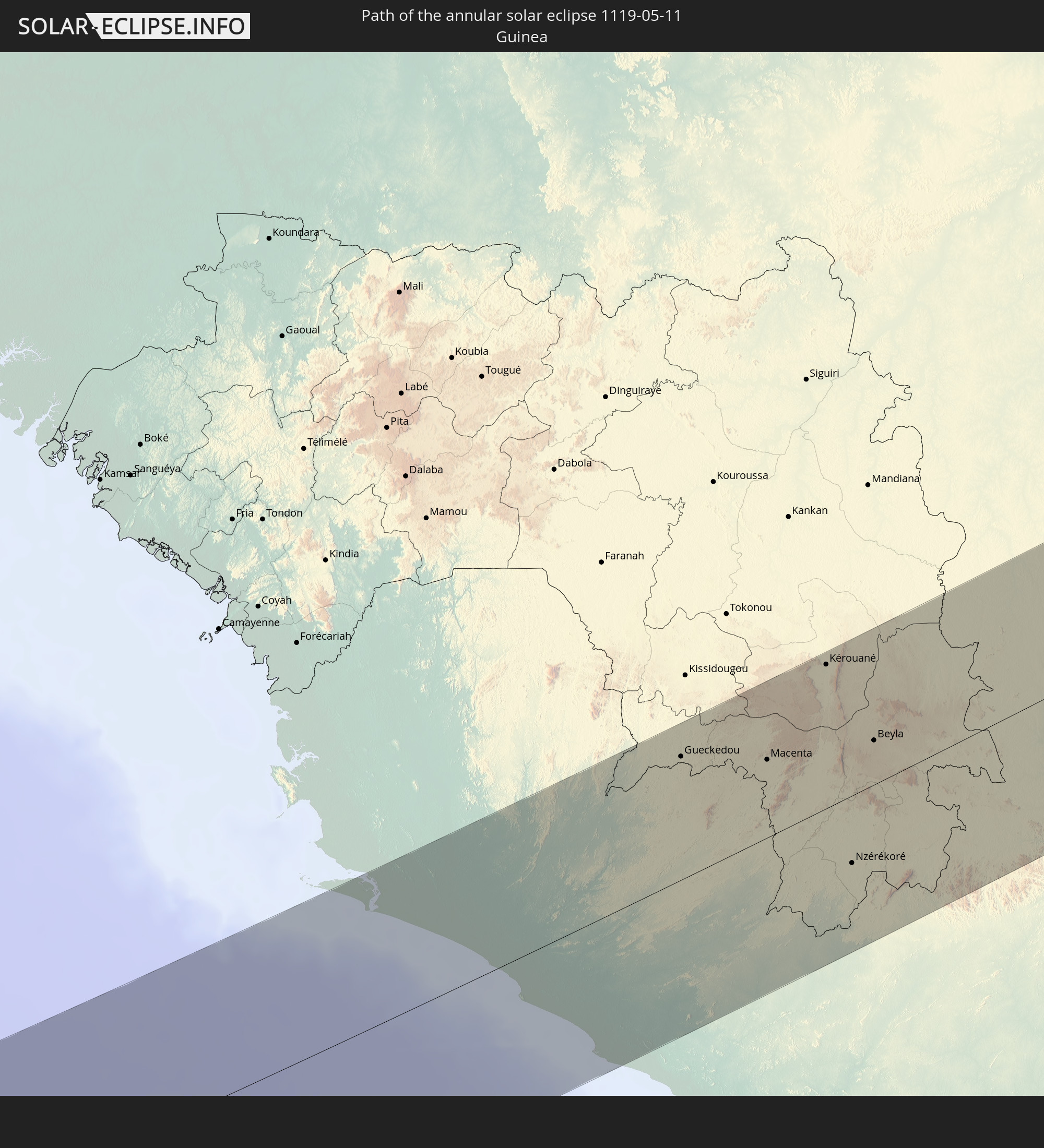 Guinea
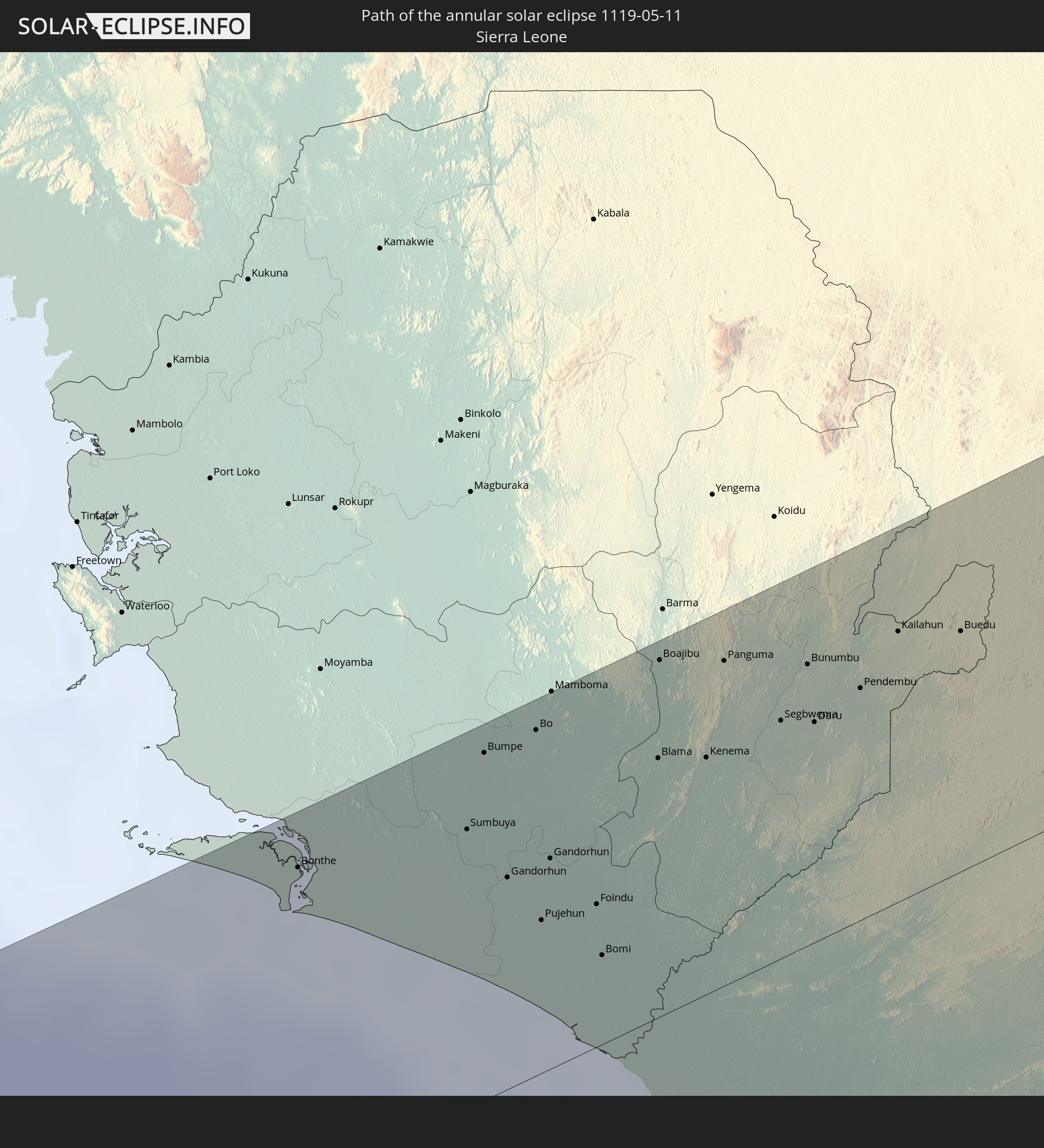 Sierra Leone
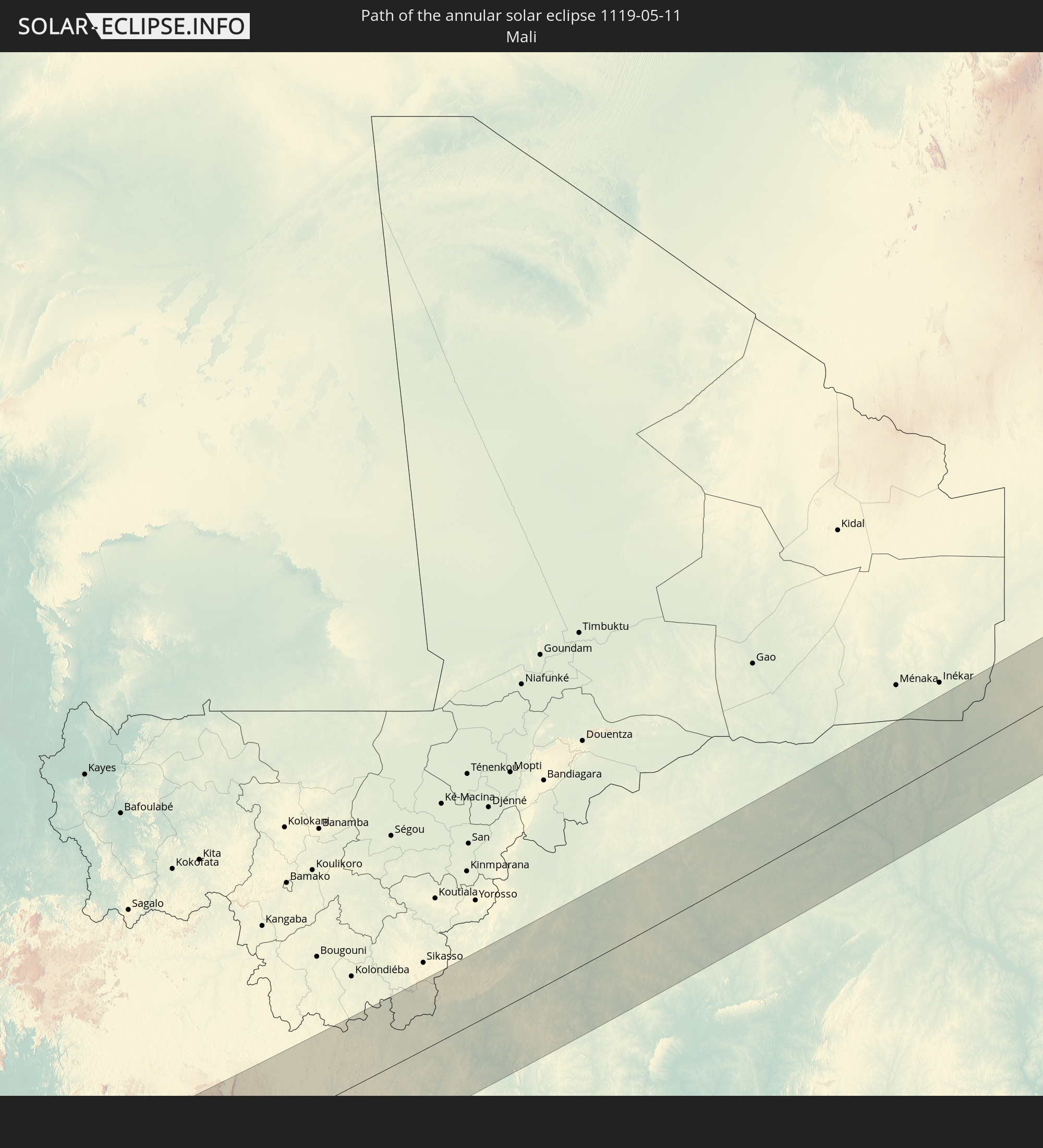 Mali
Mali
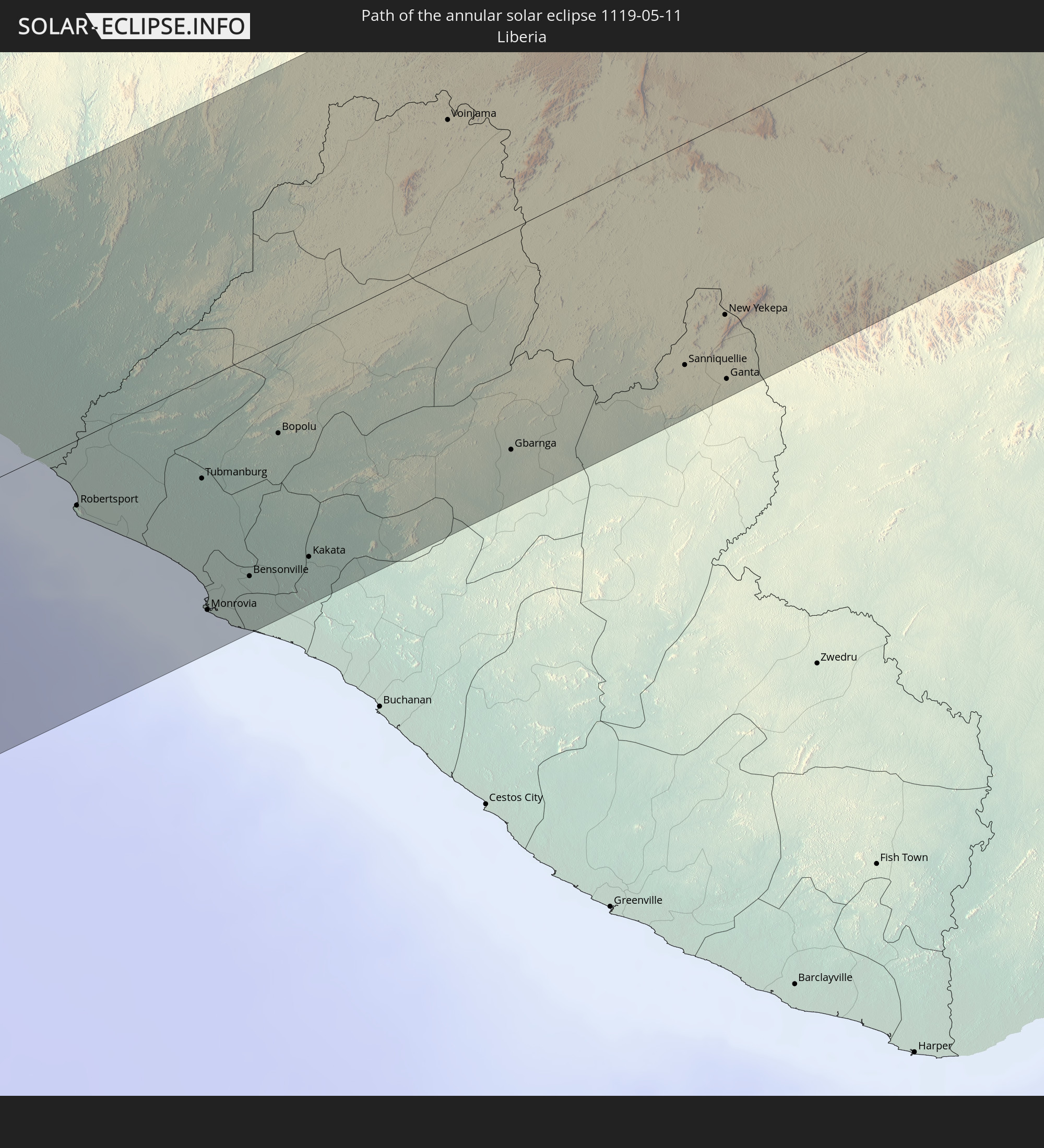 Liberia
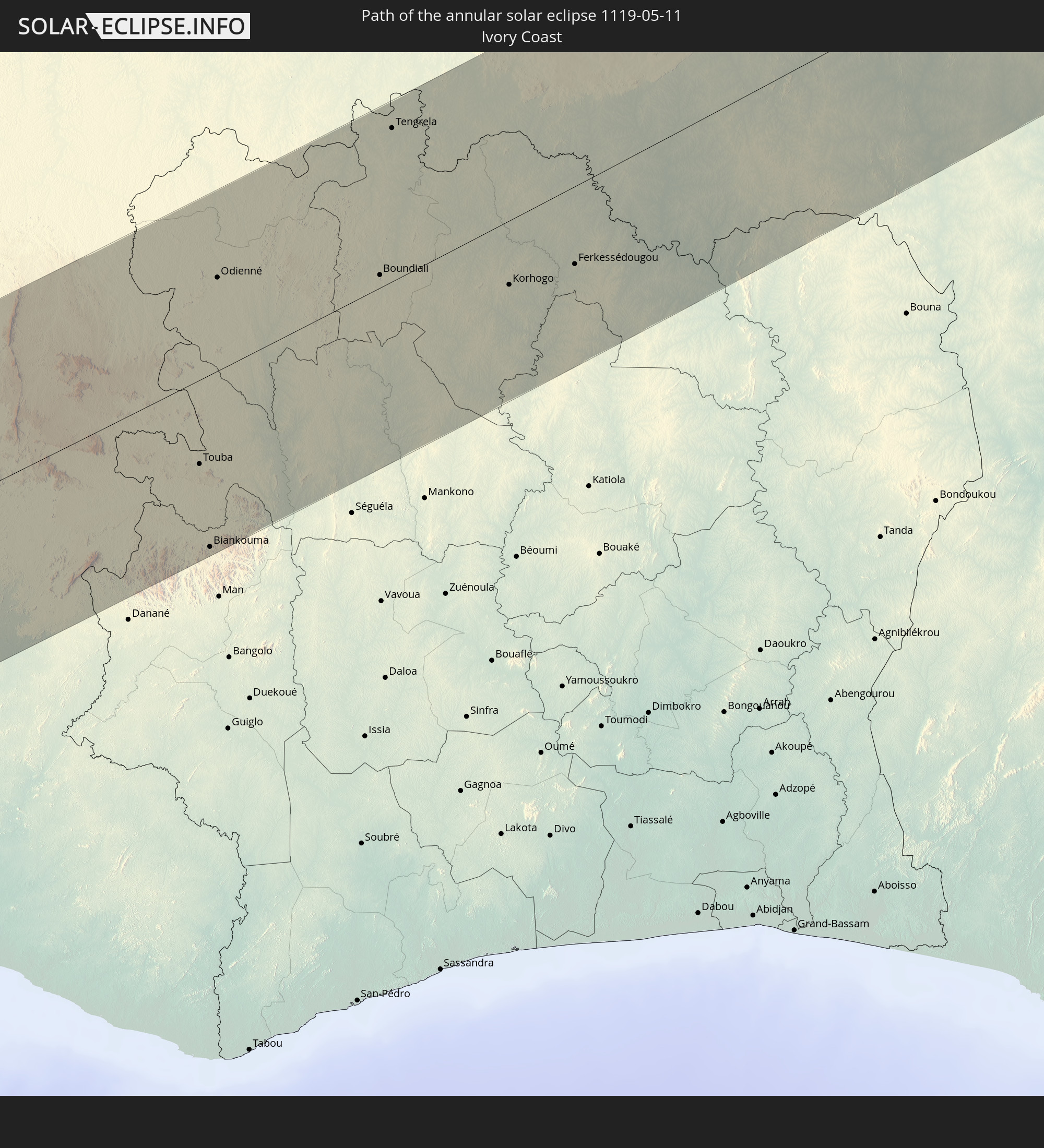 Ivory Coast
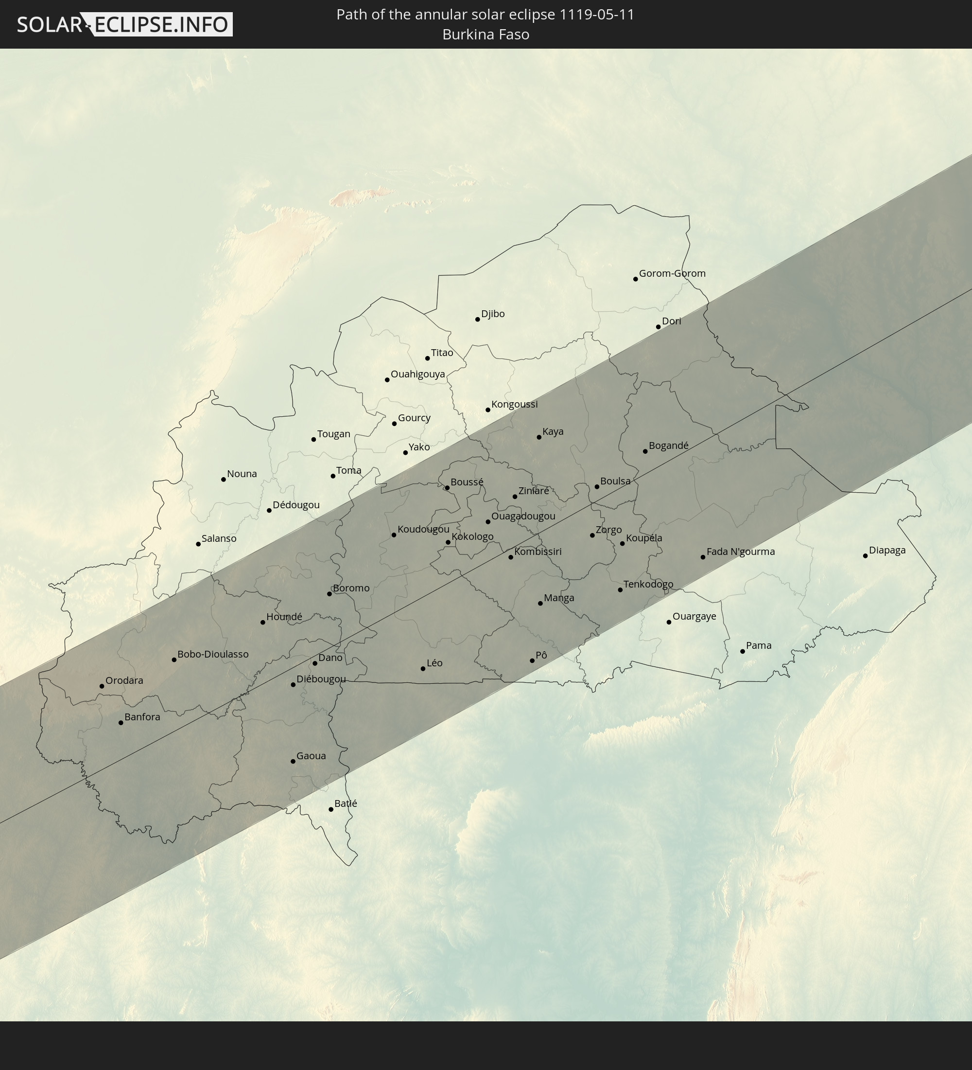 Burkina Faso
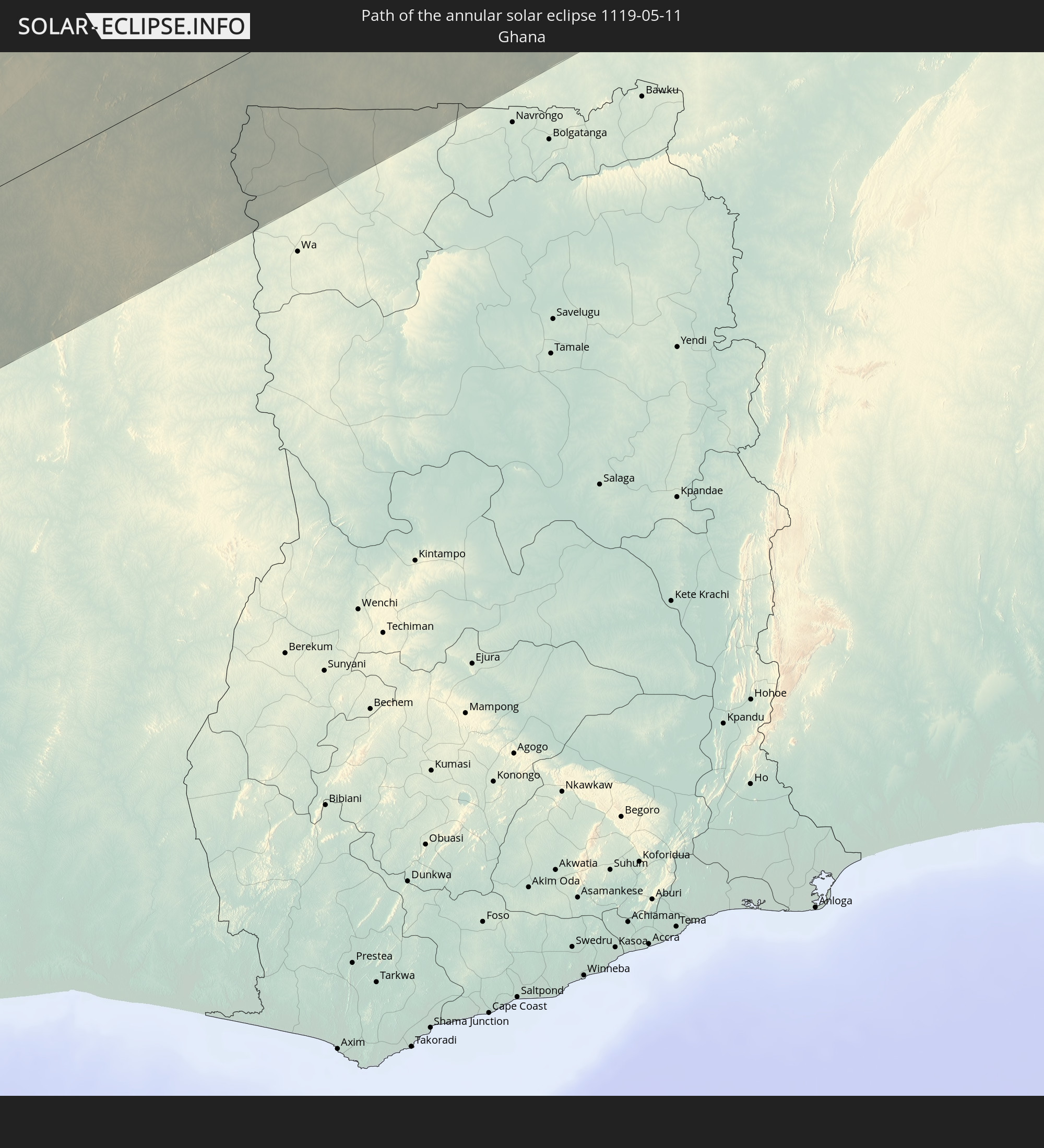 Ghana
Ghana
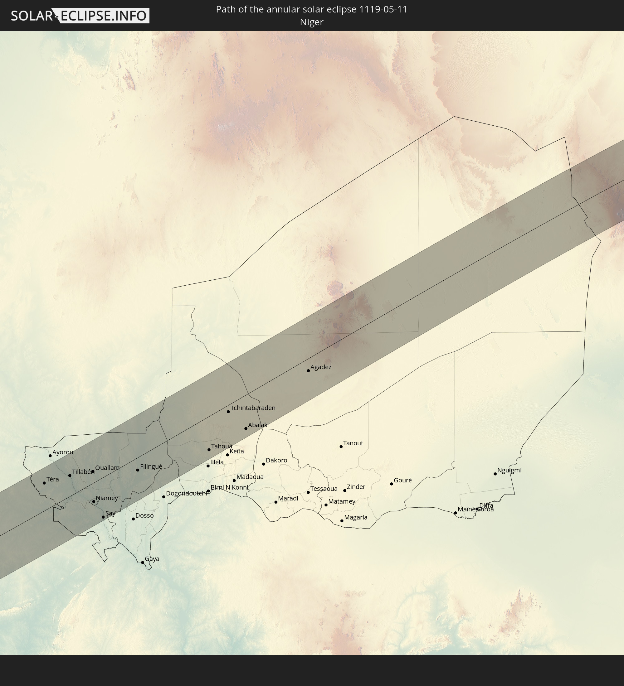 Niger
Niger
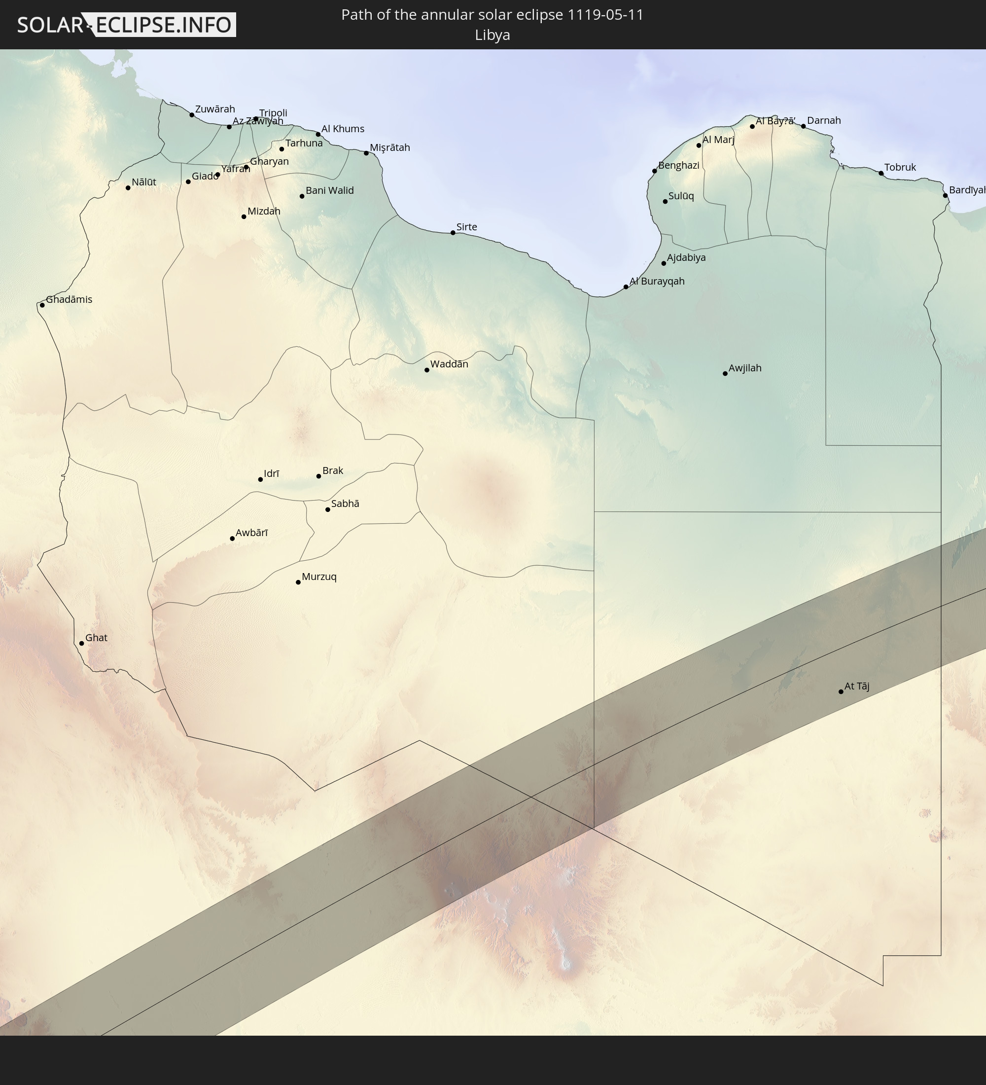 Libya
Libya
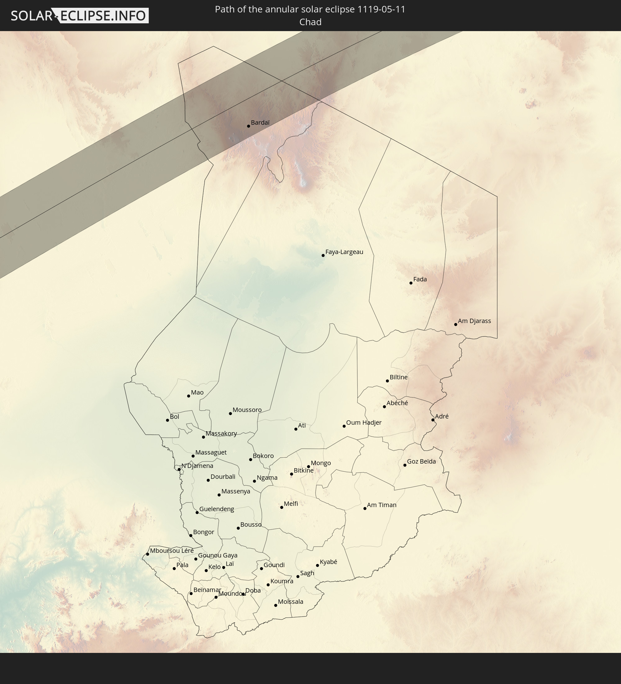 Chad
Chad
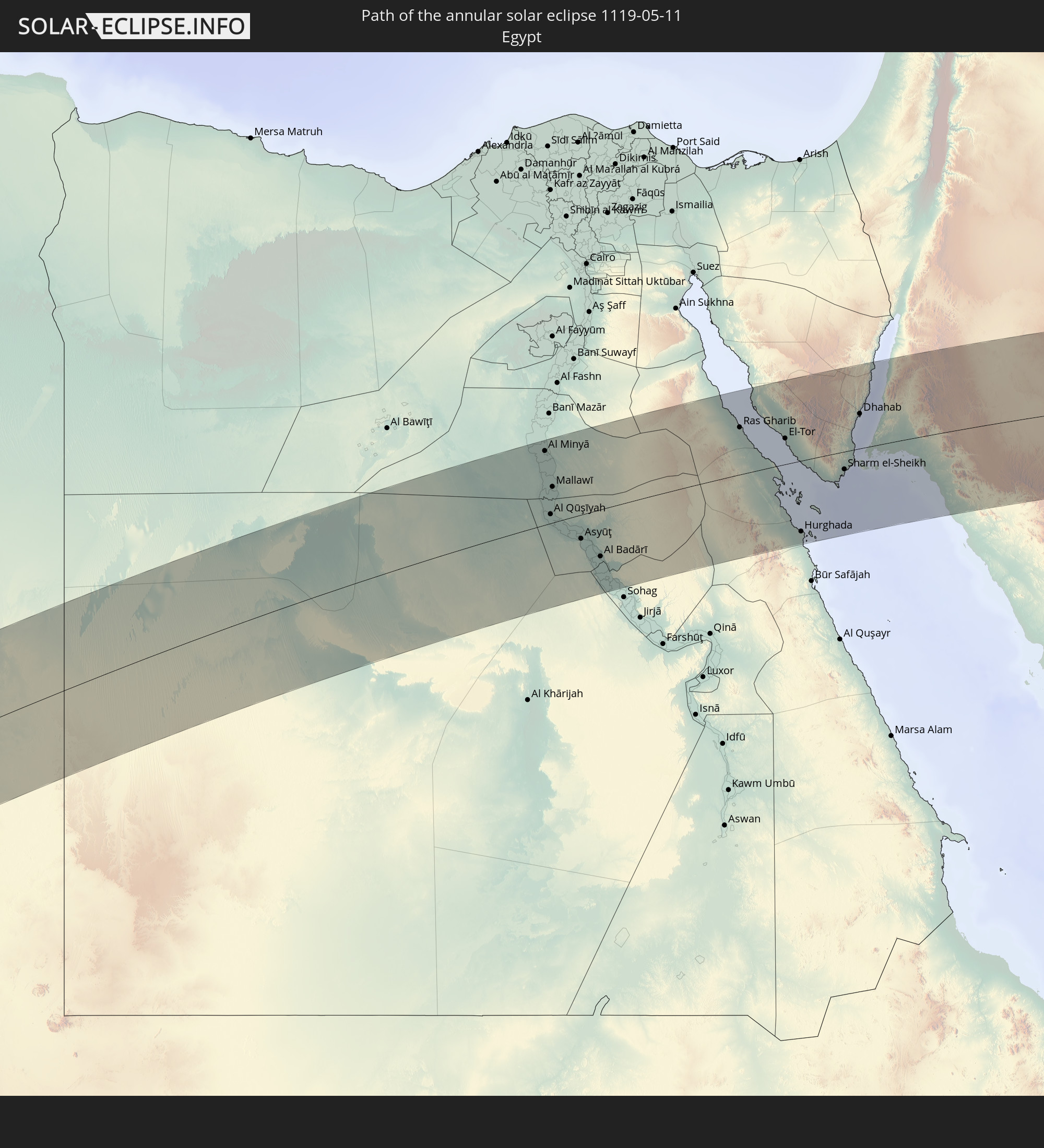 Egypt
Egypt
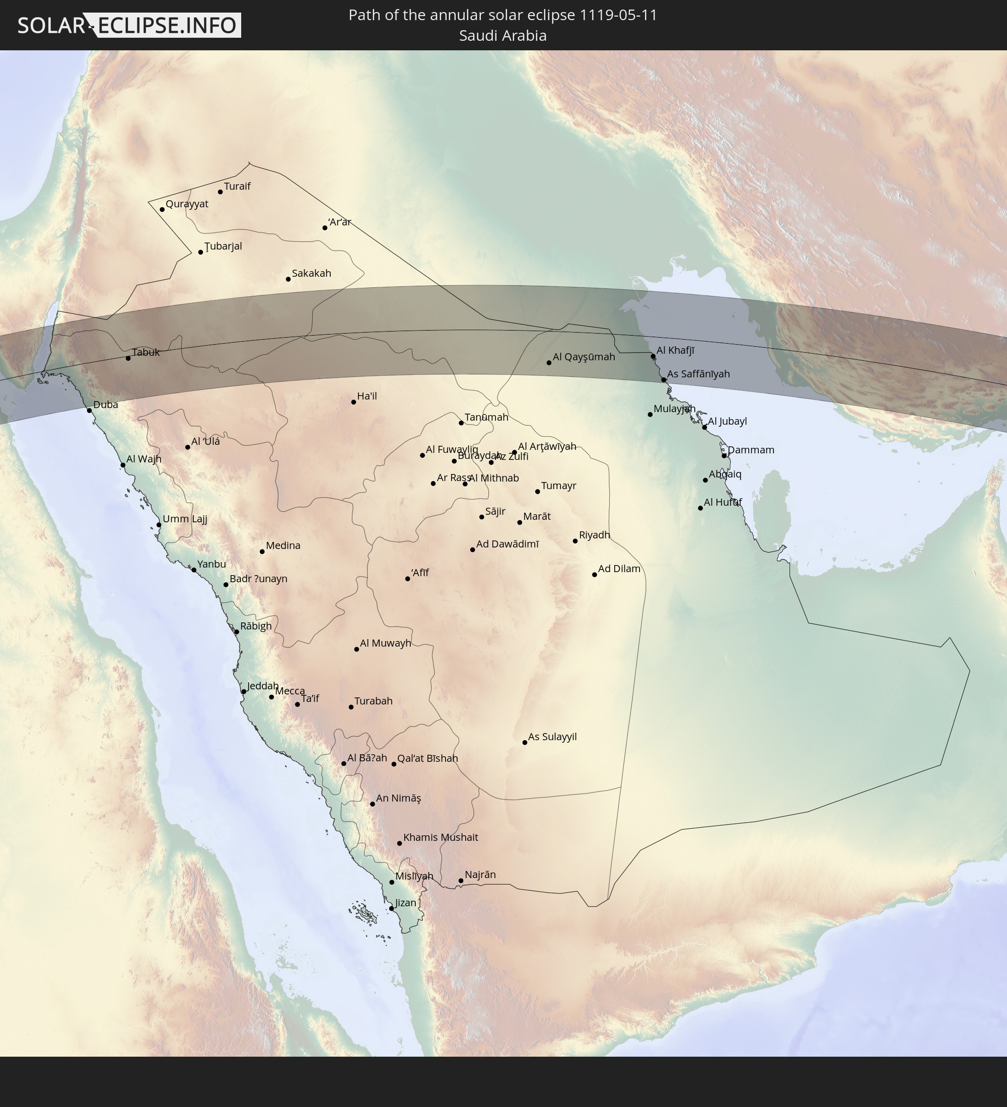 Saudi Arabia
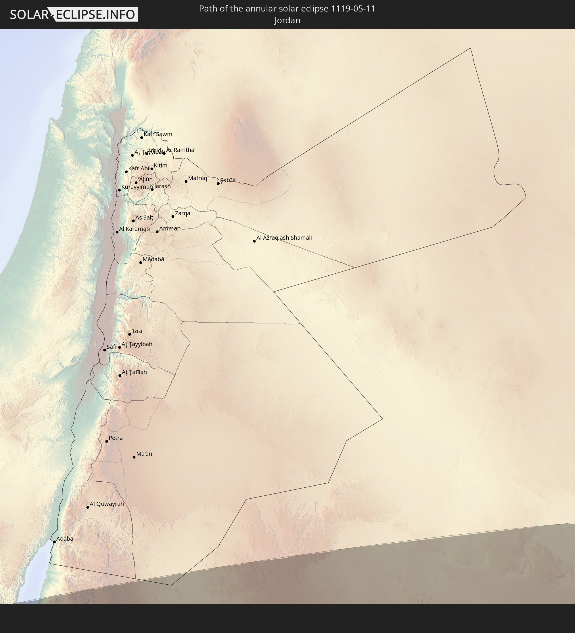 Jordan
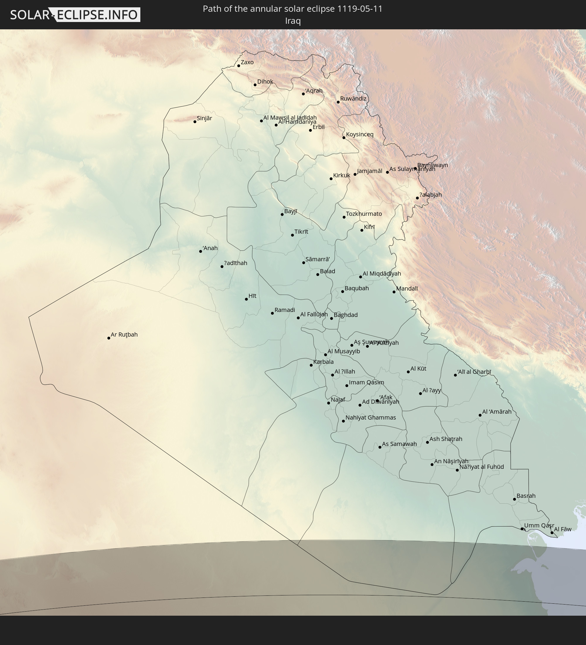 Iraq
Iraq
 Iran
Iran
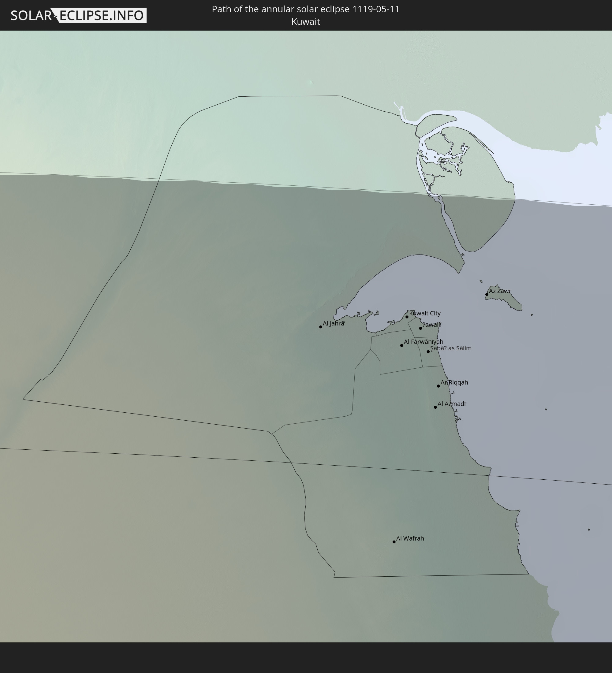 Kuwait
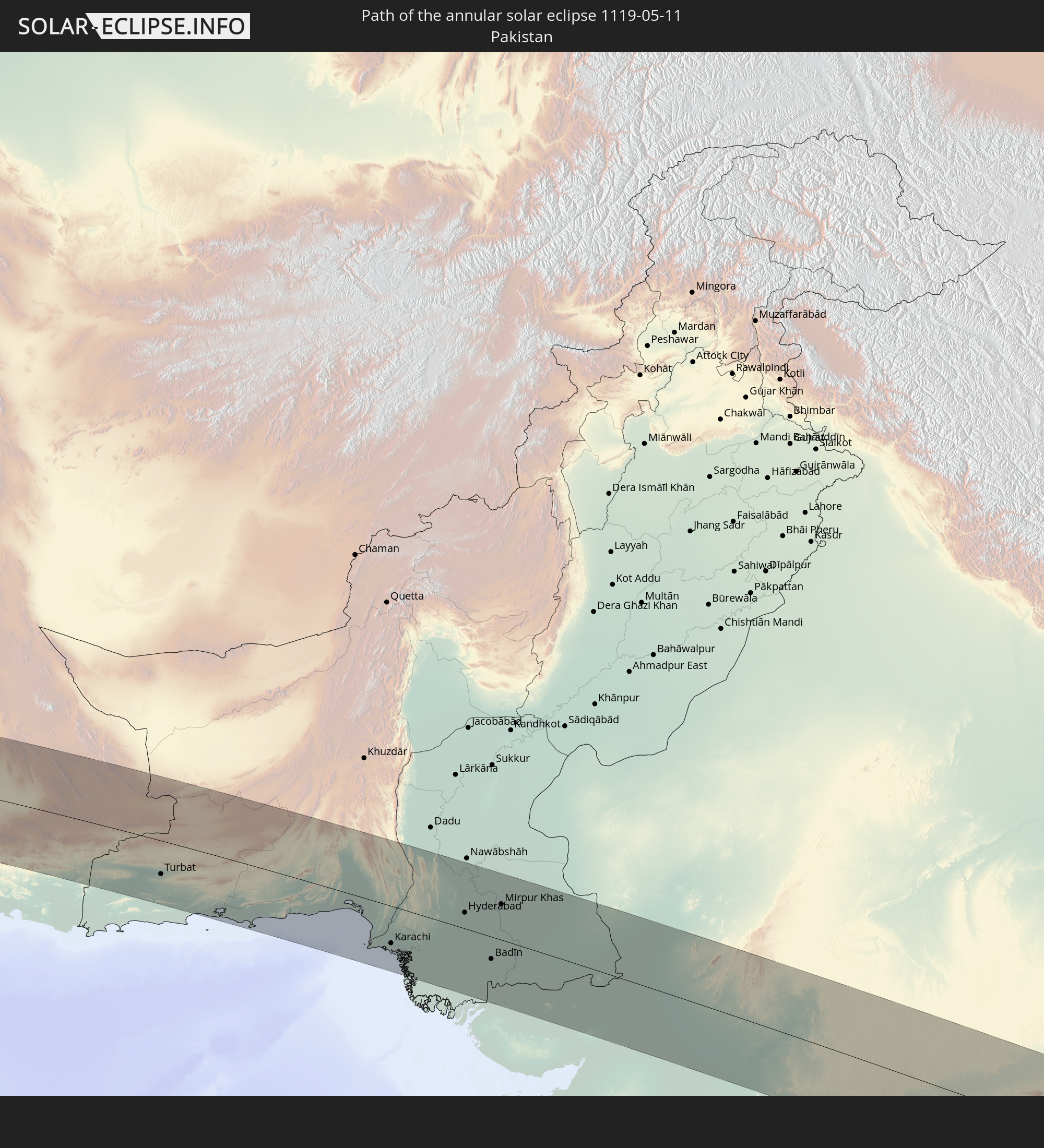 Pakistan
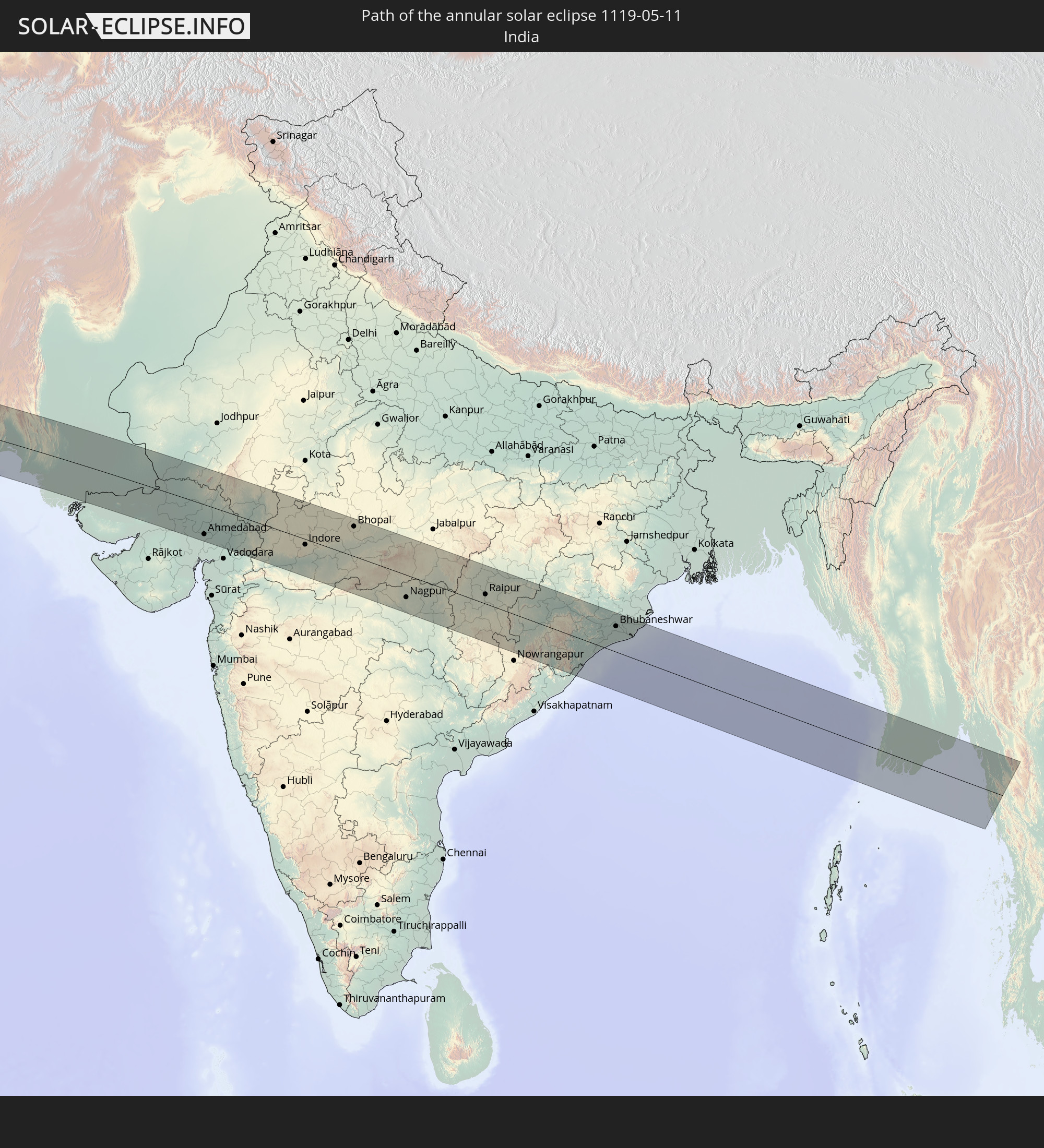 India
India
 Myanmar
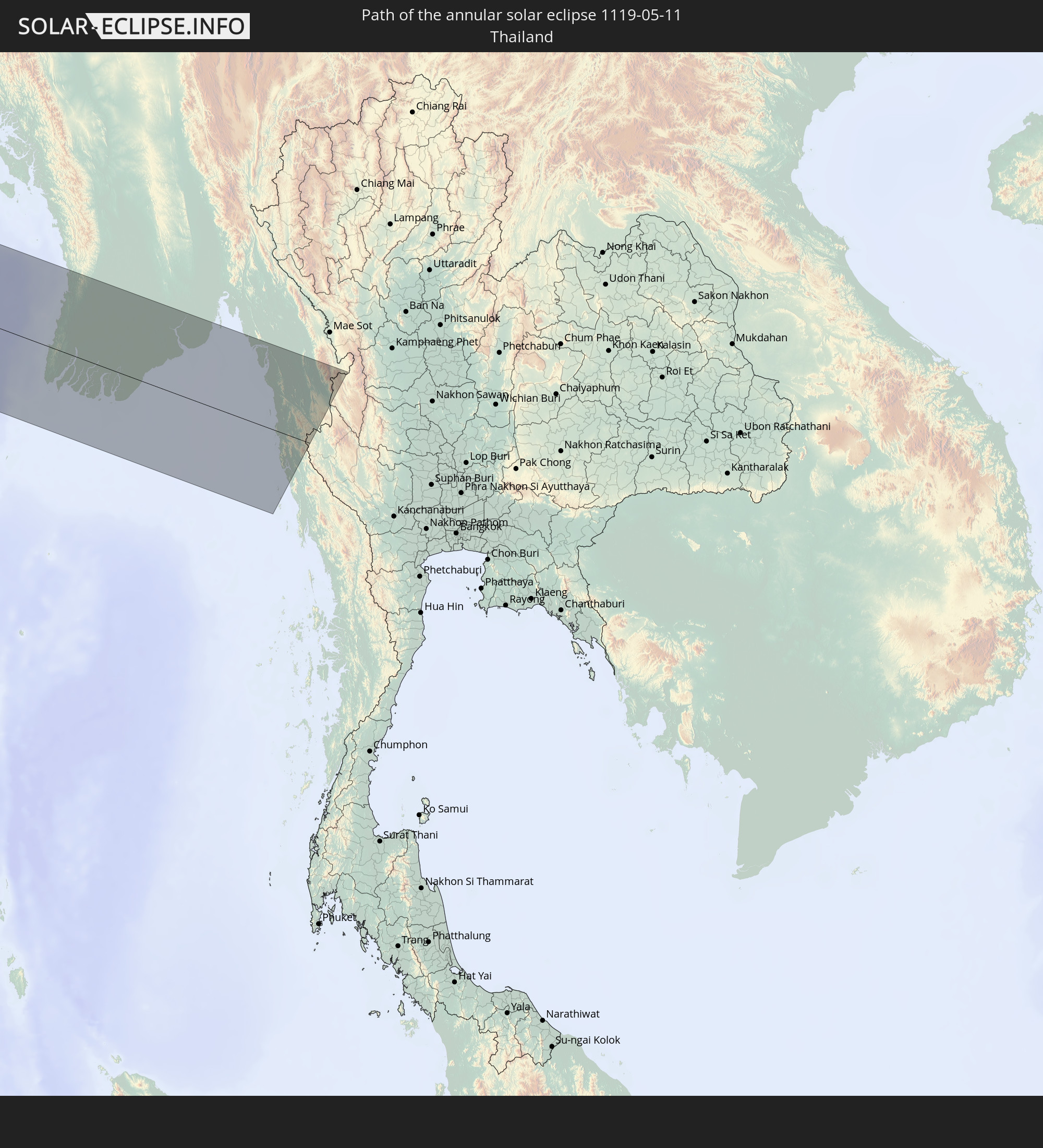 Thailand
In den folgenden Ländern ist die Sonnenfinsternis partiell zu sehen
 Russia
 Portugal
 Cabo Verde
 Spain
Spain
 Senegal
 Mauritania
 The Gambia
 Guinea-Bissau
 Guinea
 Saint Helena, Ascension and Tristan da Cunha
 Sierra Leone
 Morocco
 Mali
Mali
 Liberia
 Republic of Ireland
 Algeria
 United Kingdom
 Ivory Coast
 Burkina Faso
 Gibraltar
 France
 Isle of Man
 Ghana
Ghana
 Guernsey
 Jersey
 Togo
Togo
 Niger
Niger
 Benin
Benin
 Andorra
 Belgium
 Nigeria
 Netherlands
 Norway
 Equatorial Guinea
 Luxembourg
 Germany
 Switzerland
 São Tomé and Príncipe
 Italy
Italy
 Monaco
 Tunisia
 Denmark
 Cameroon
 Gabon
Gabon
 Libya
Libya
 Liechtenstein
 Austria
 Sweden
 Republic of the Congo
 Angola
 Namibia
 Czechia
 Democratic Republic of the Congo
 San Marino
 Vatican City
 Slovenia
 Chad
Chad
 Croatia
 Poland
 Malta
Malta
 Central African Republic
 Bosnia and Herzegovina
 Hungary
 Slovakia
 Montenegro
 Serbia
 Albania
 Åland Islands
 Greece
 Romania
 Republic of Macedonia
 Finland
 Lithuania
 Latvia
 Estonia
 Sudan
Sudan
 Zambia
 Ukraine
 Bulgaria
 Belarus
 Egypt
Egypt
 Turkey
 Moldova
 Rwanda
 Burundi
 Tanzania
 Uganda
 Cyprus
 Ethiopia
 Kenya
Kenya
 State of Palestine
 Israel
 Saudi Arabia
 Jordan
 Lebanon
 Syria
Syria
 Eritrea
 Iraq
Iraq
 Georgia
 Somalia
 Djibouti
 Yemen
Yemen
 Armenia
 Iran
Iran
 Azerbaijan
 Seychelles
 Kazakhstan
 Kuwait
 Bahrain
 Qatar
Qatar
 United Arab Emirates
 Oman
Oman
 Turkmenistan
 Uzbekistan
 Afghanistan
 Pakistan
 Tajikistan
 India
India
 Kyrgyzstan
 British Indian Ocean Territory
 Maldives
 China
China
 Sri Lanka
 Nepal
Nepal
 Mongolia
 Bangladesh
 Bhutan
 Myanmar
 Thailand
 Laos
Laos
 Vietnam
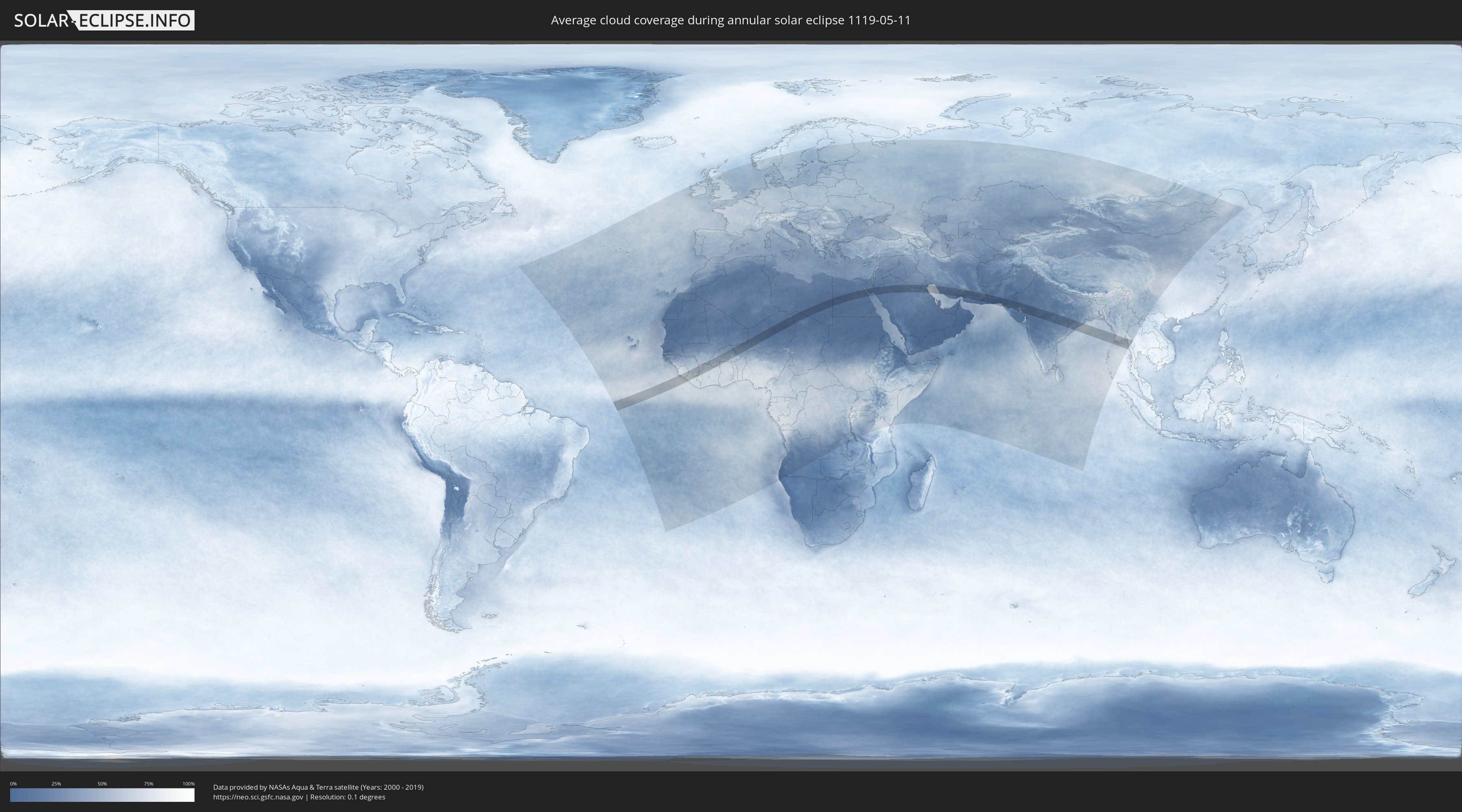
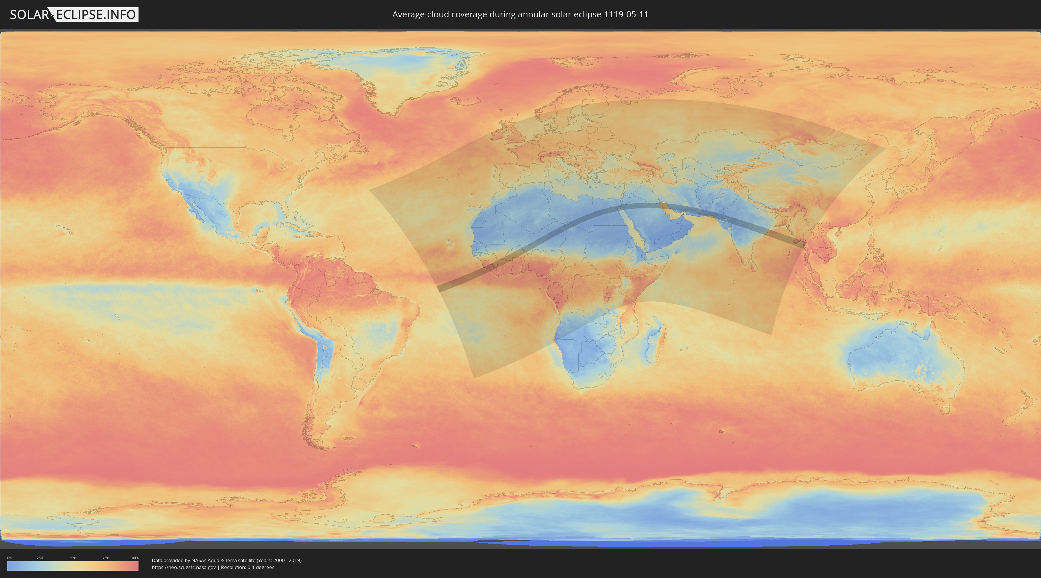
How will be the weather during the annular solar eclipse on 05/11/1119?
Where is the best place to see the annular solar eclipse of 05/11/1119?
The following maps show the average cloud coverage for the day of the annular solar eclipse.
With the help of these maps, it is possible to find the place along the eclipse path, which has the best
chance of a cloudless sky.
Nevertheless, you should consider local circumstances and inform about the weather of your chosen
observation site.
The data is provided by NASAs satellites
AQUA and TERRA.
The cloud maps are averaged over a period of 19 years (2000 - 2019).
Detailed country maps
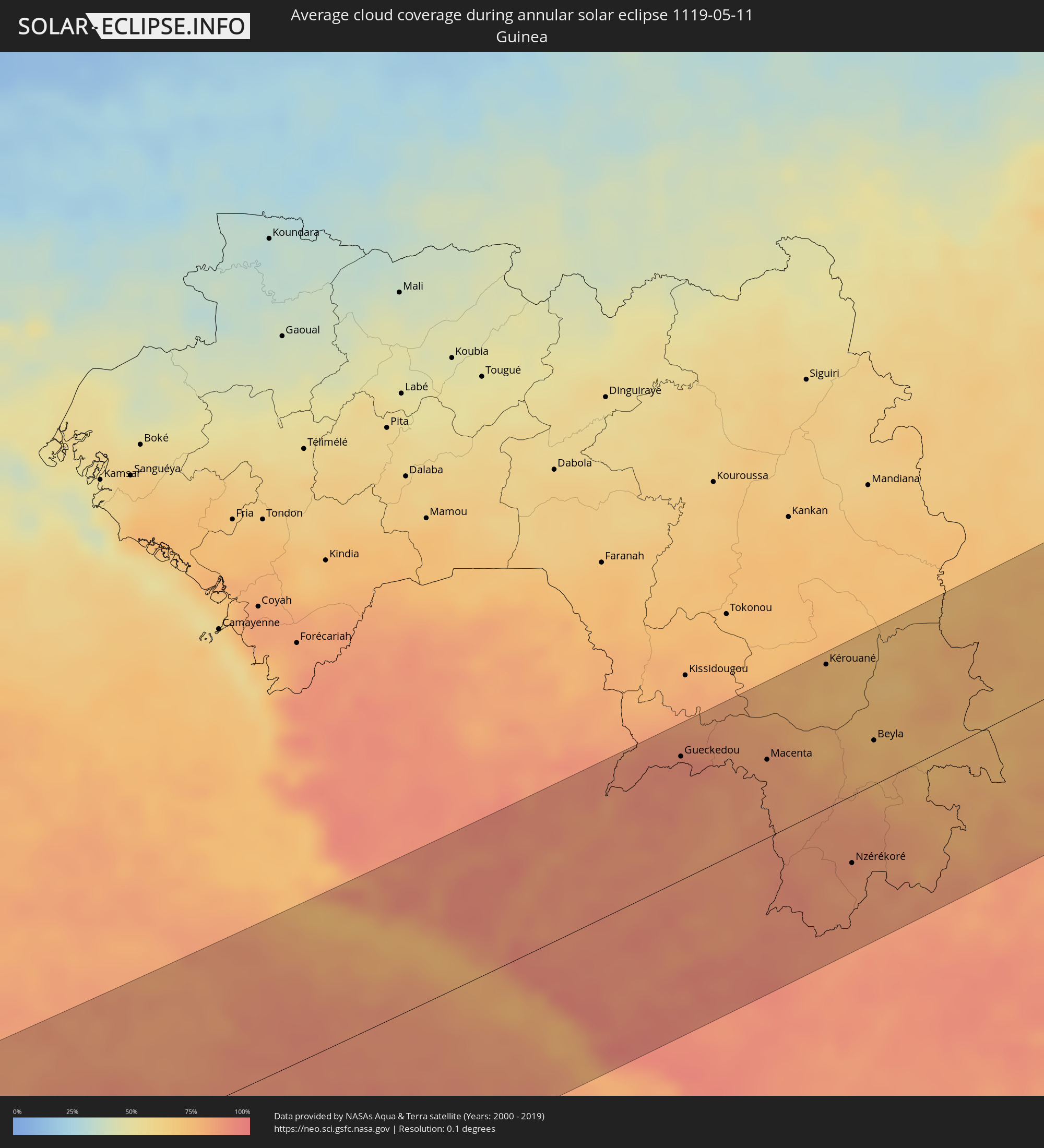 Guinea
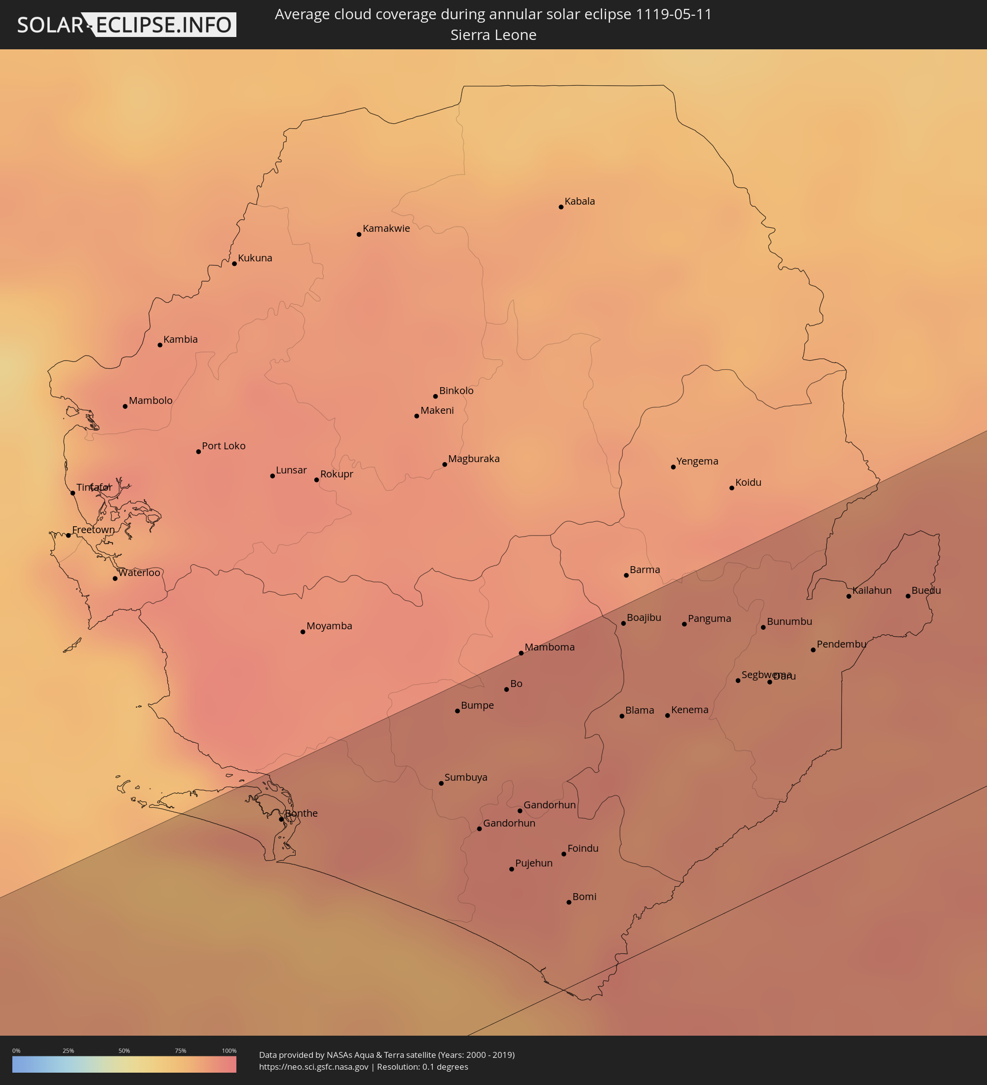 Sierra Leone
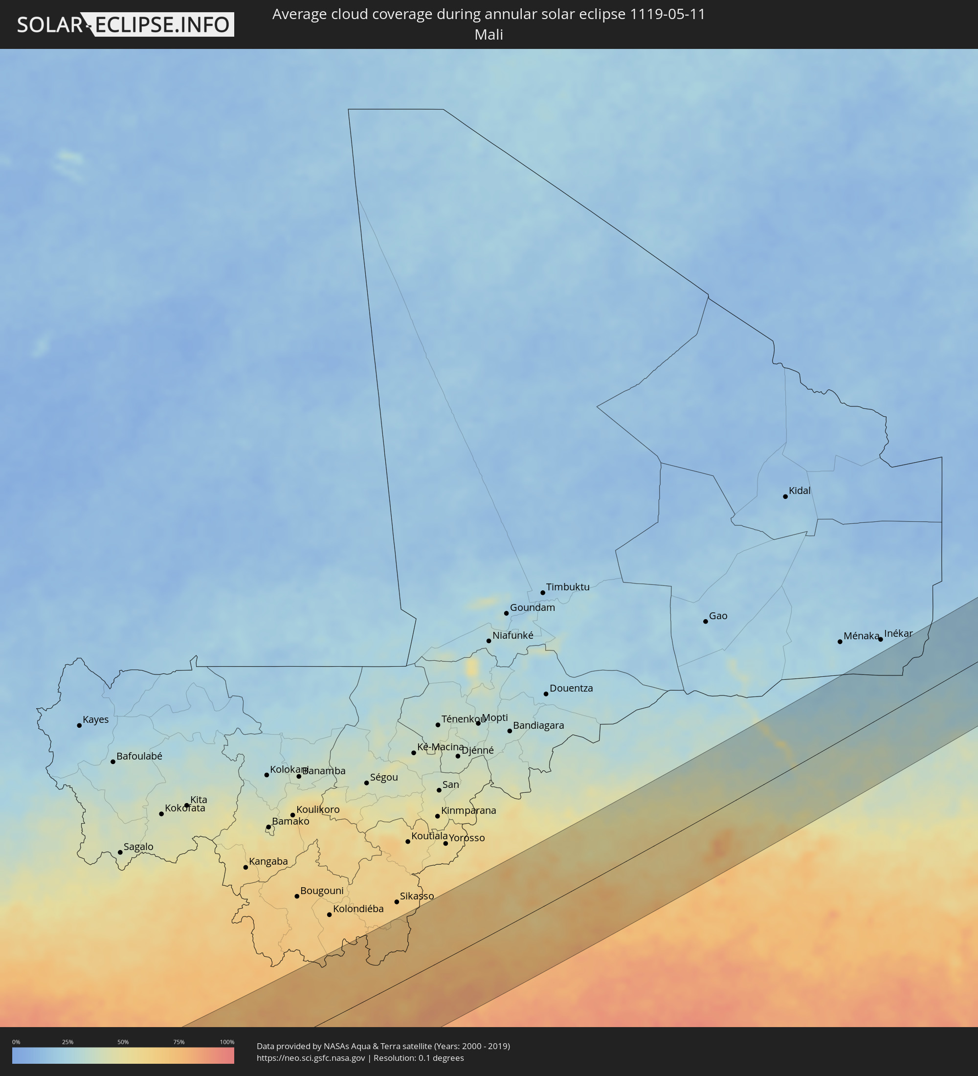 Mali
Mali
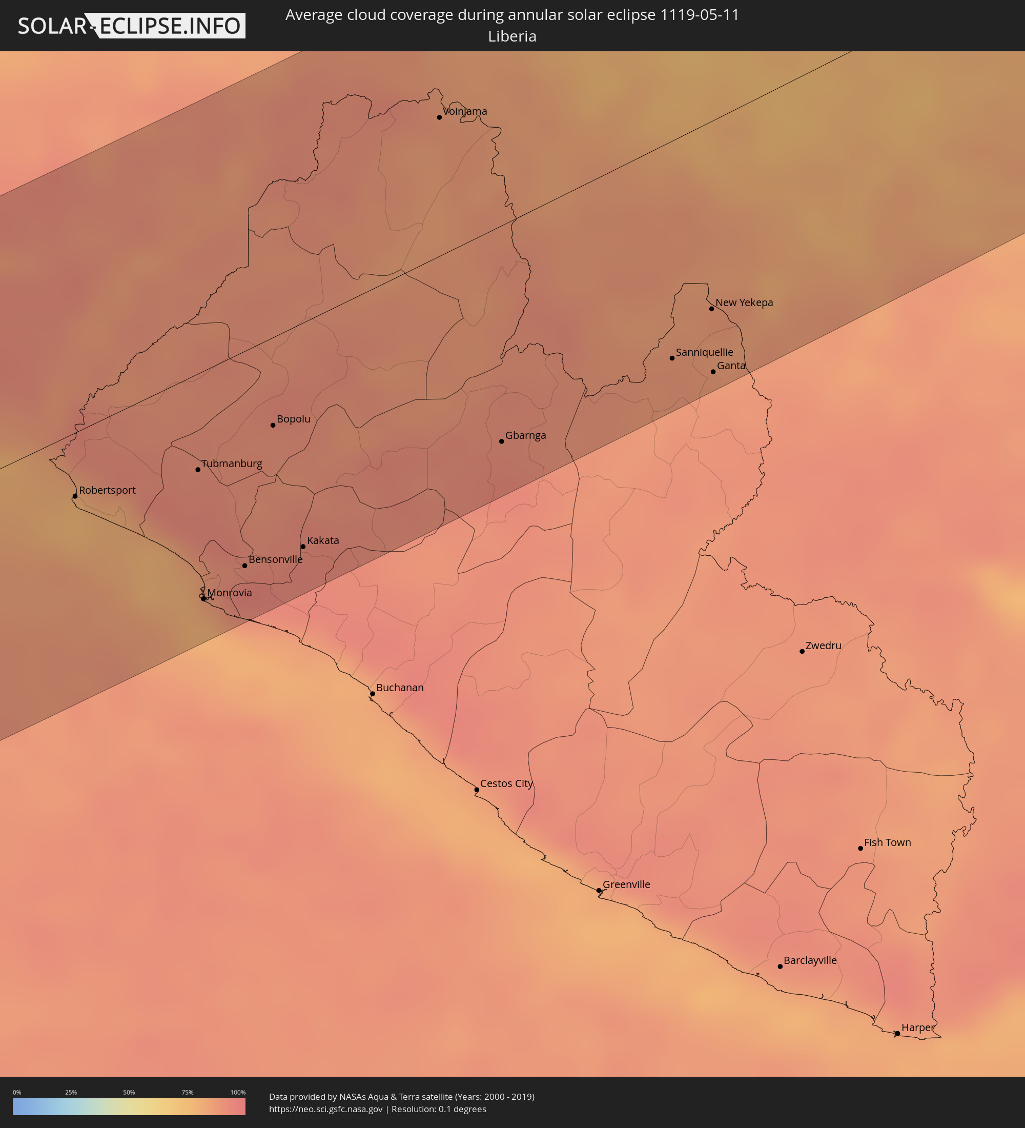 Liberia
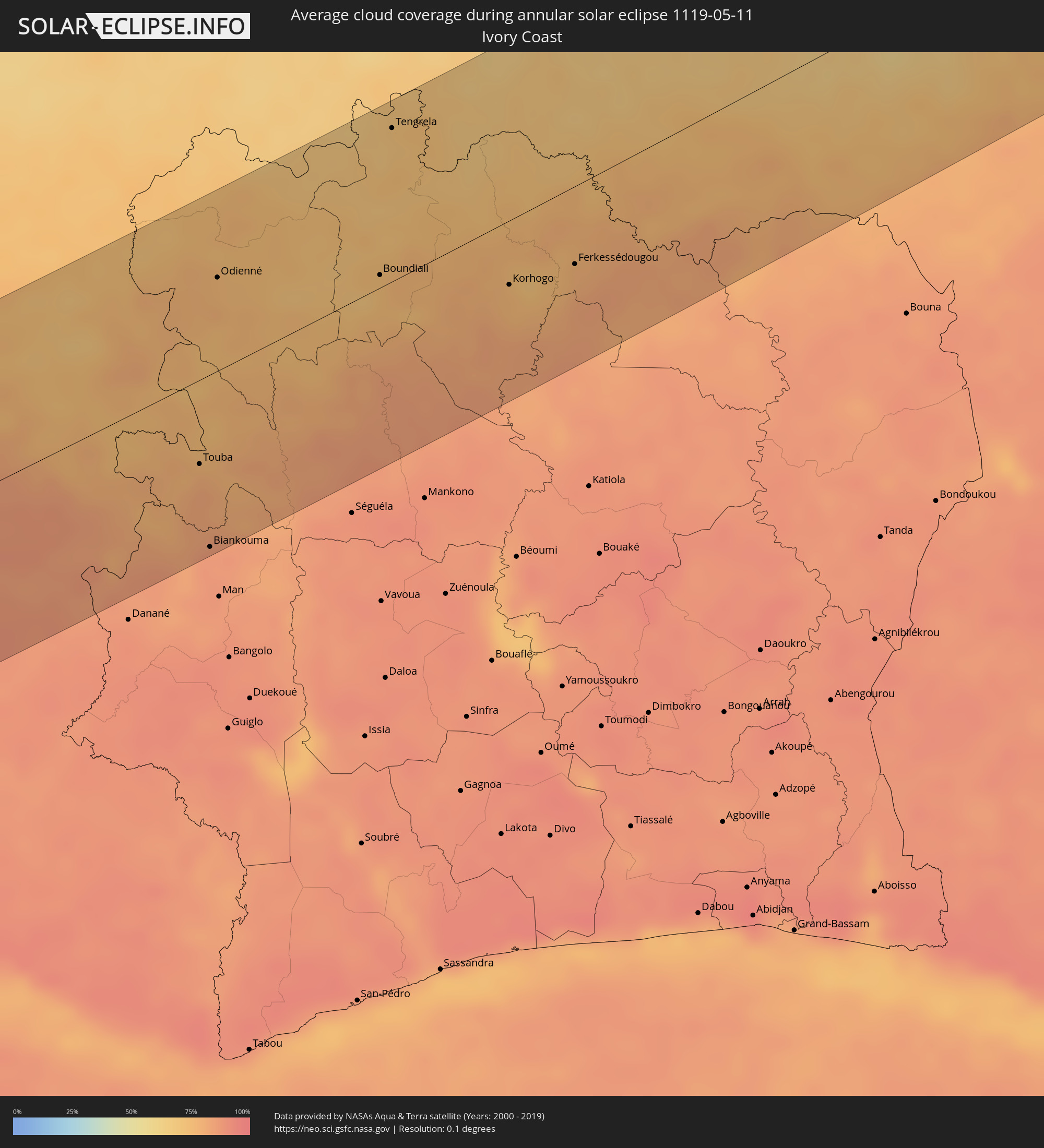 Ivory Coast
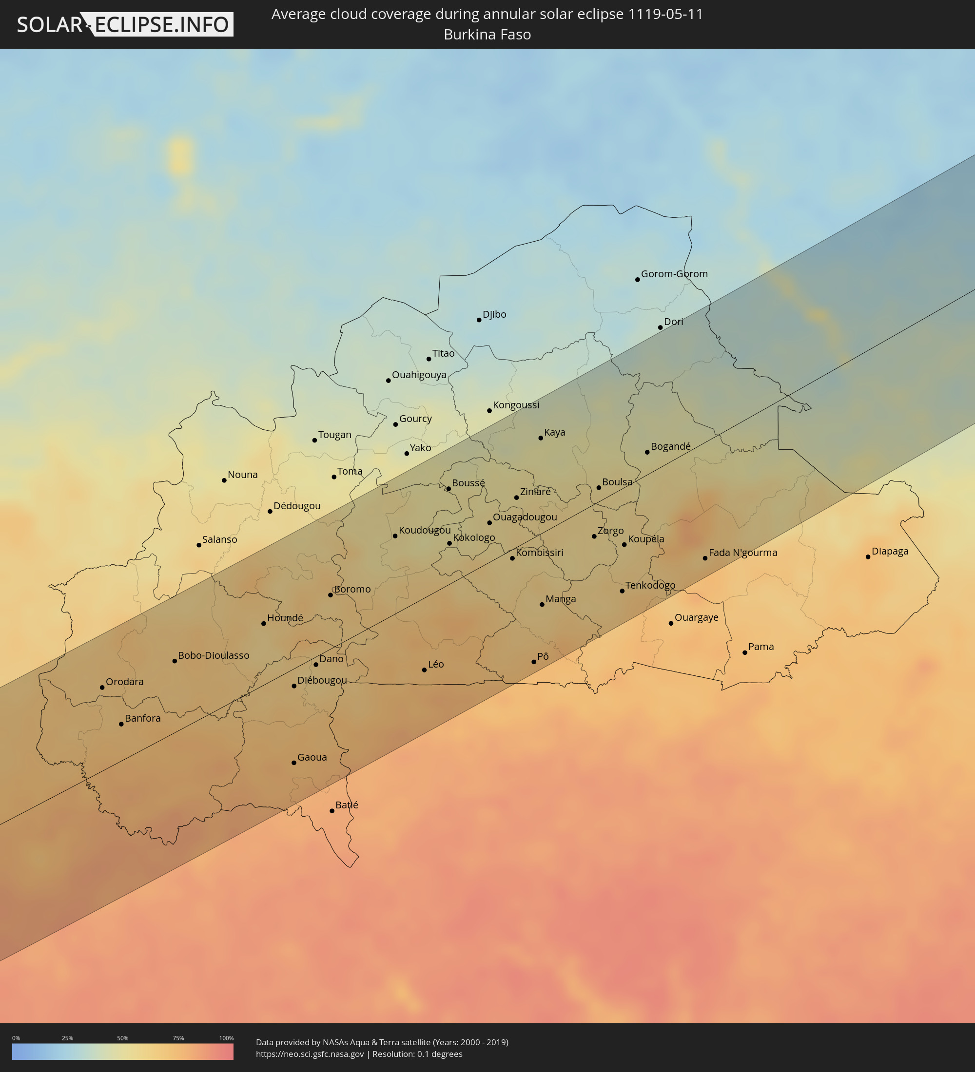 Burkina Faso
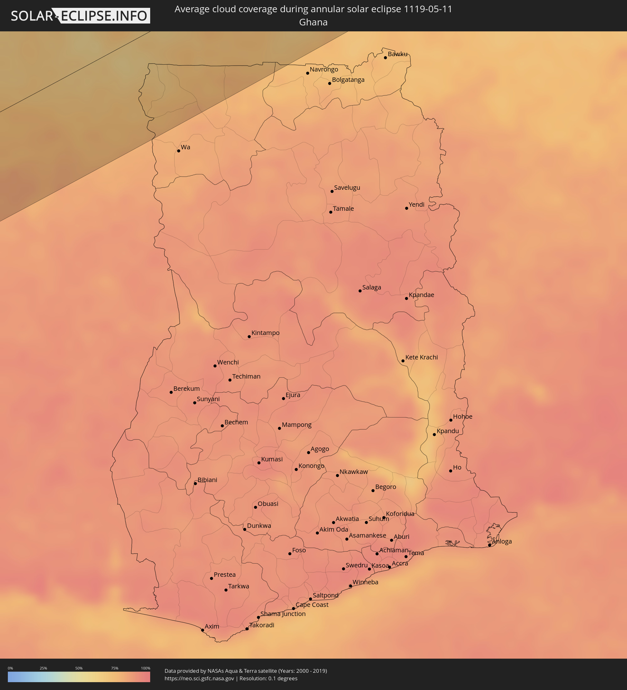 Ghana
Ghana
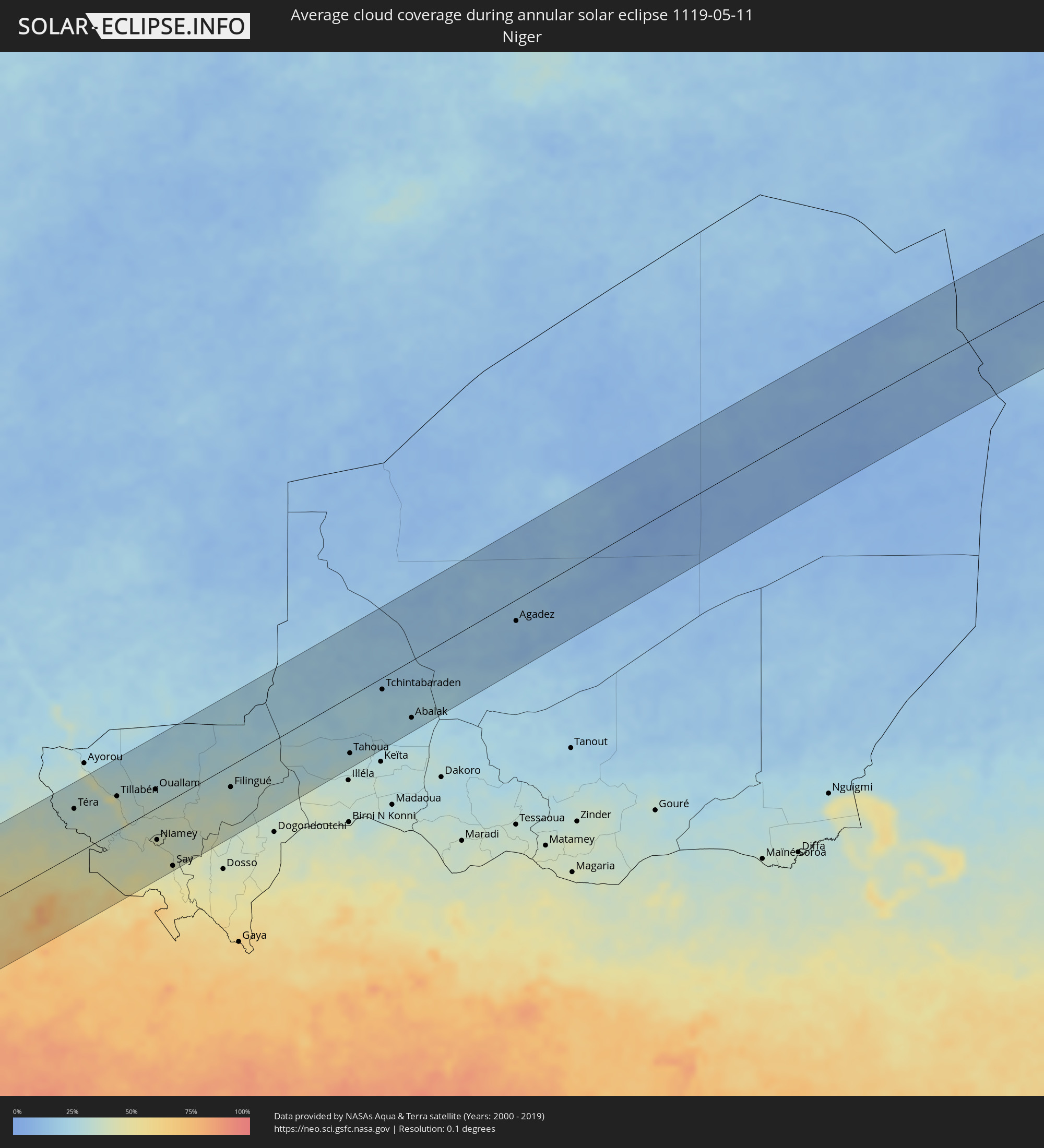 Niger
Niger
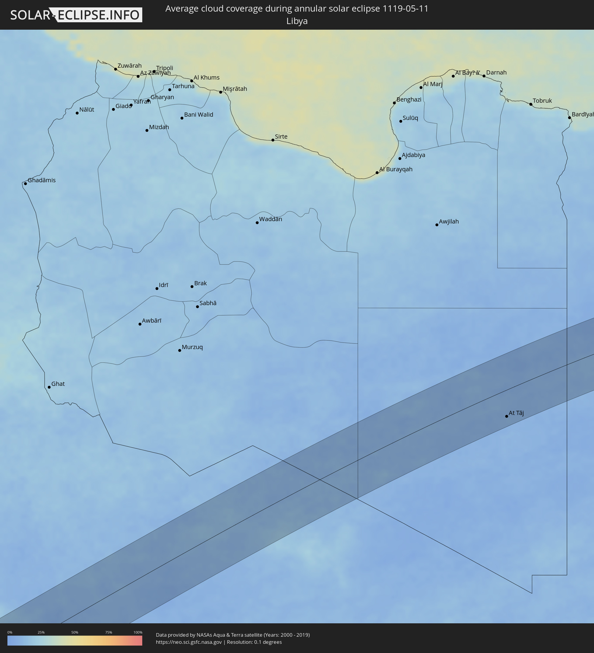 Libya
Libya
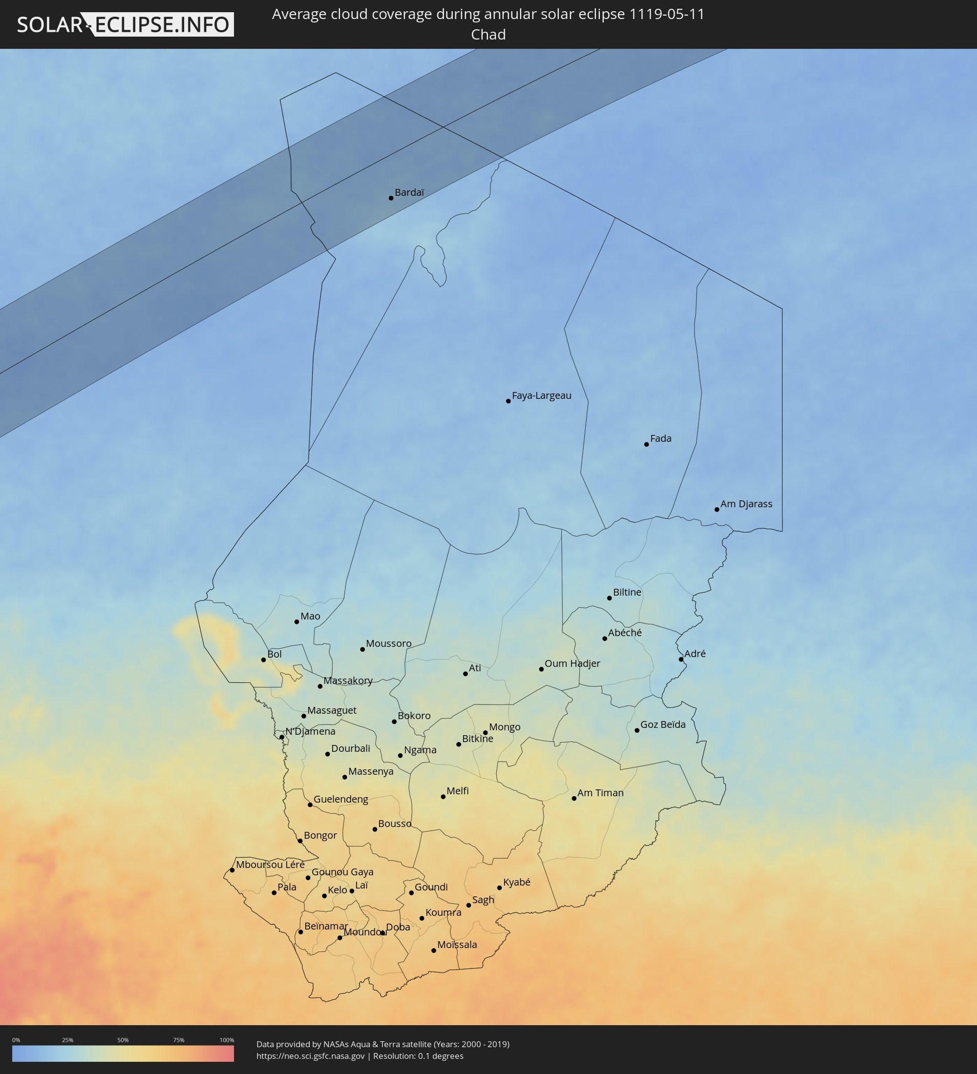 Chad
Chad
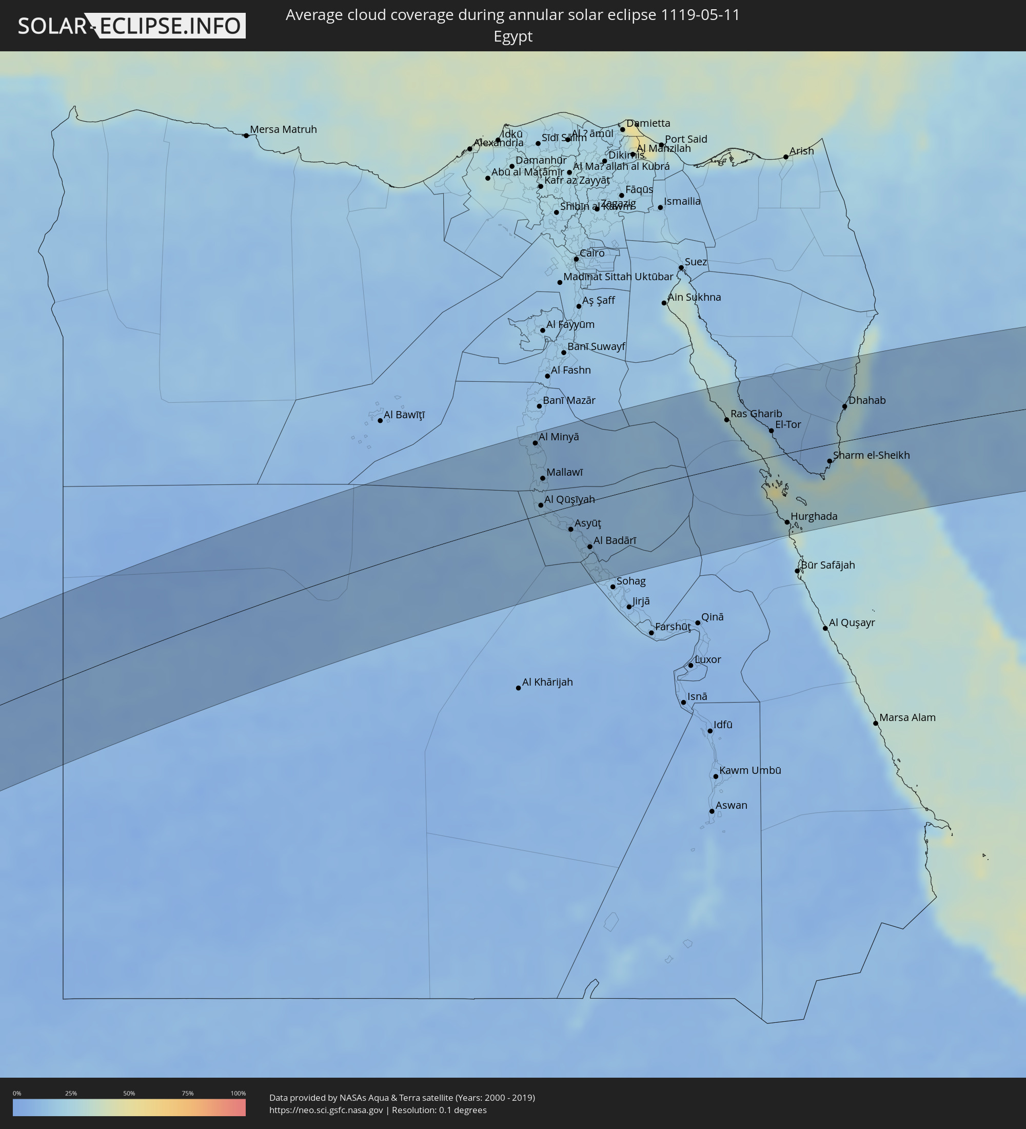 Egypt
Egypt
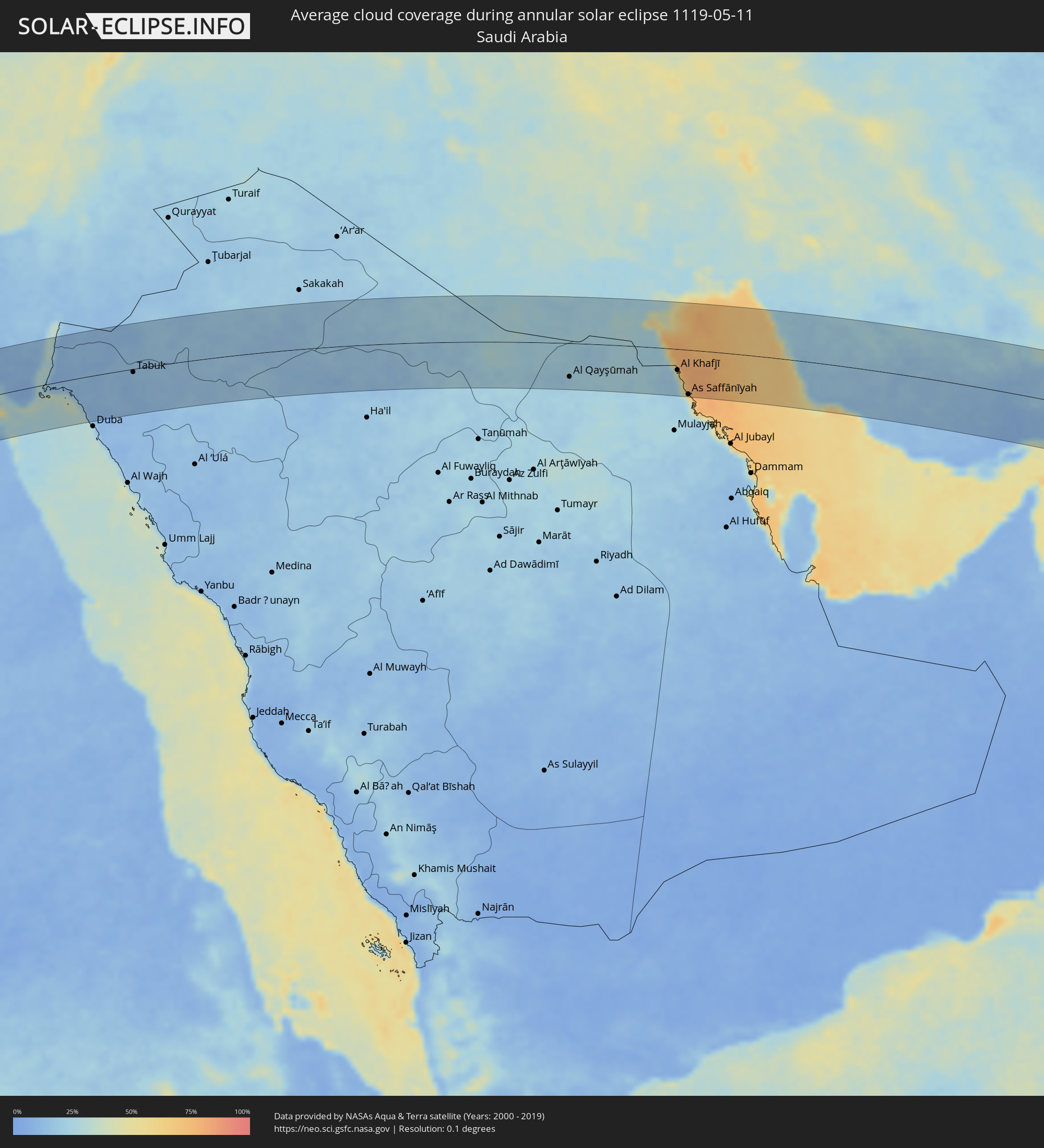 Saudi Arabia
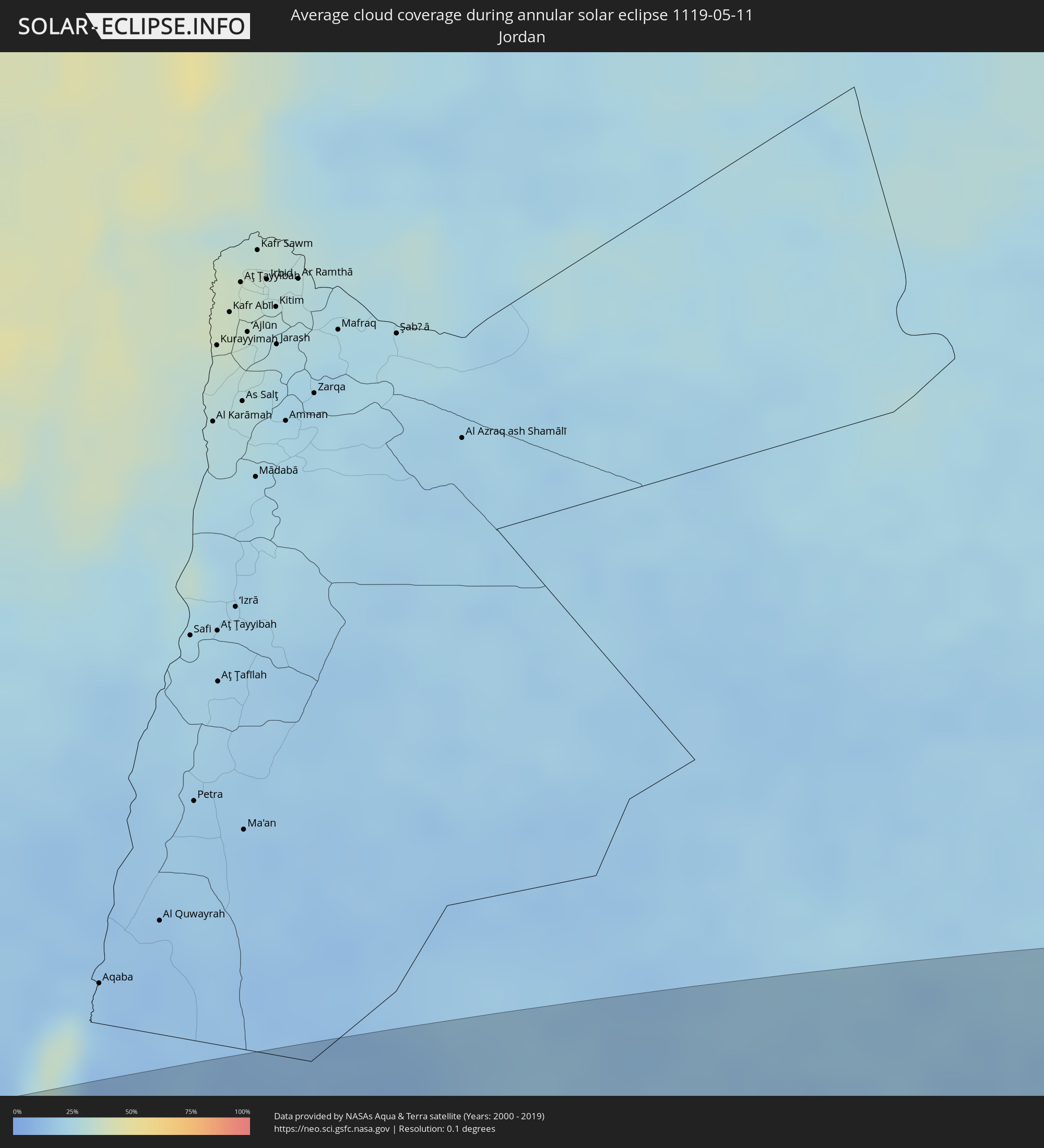 Jordan
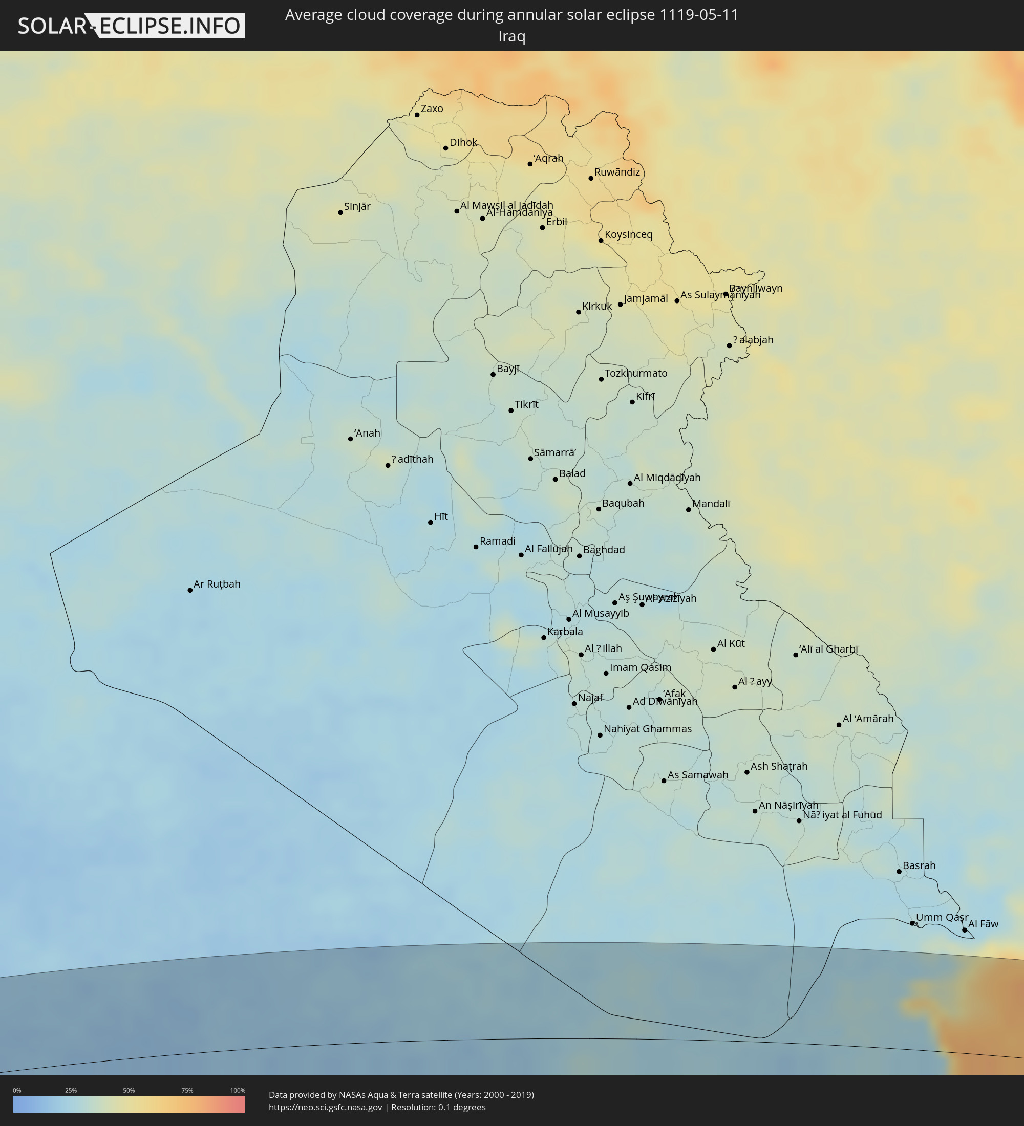 Iraq
Iraq
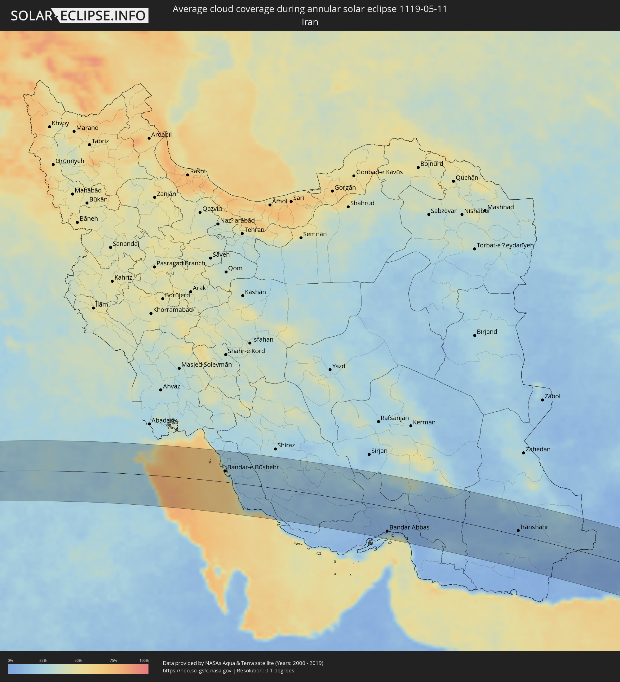 Iran
Iran
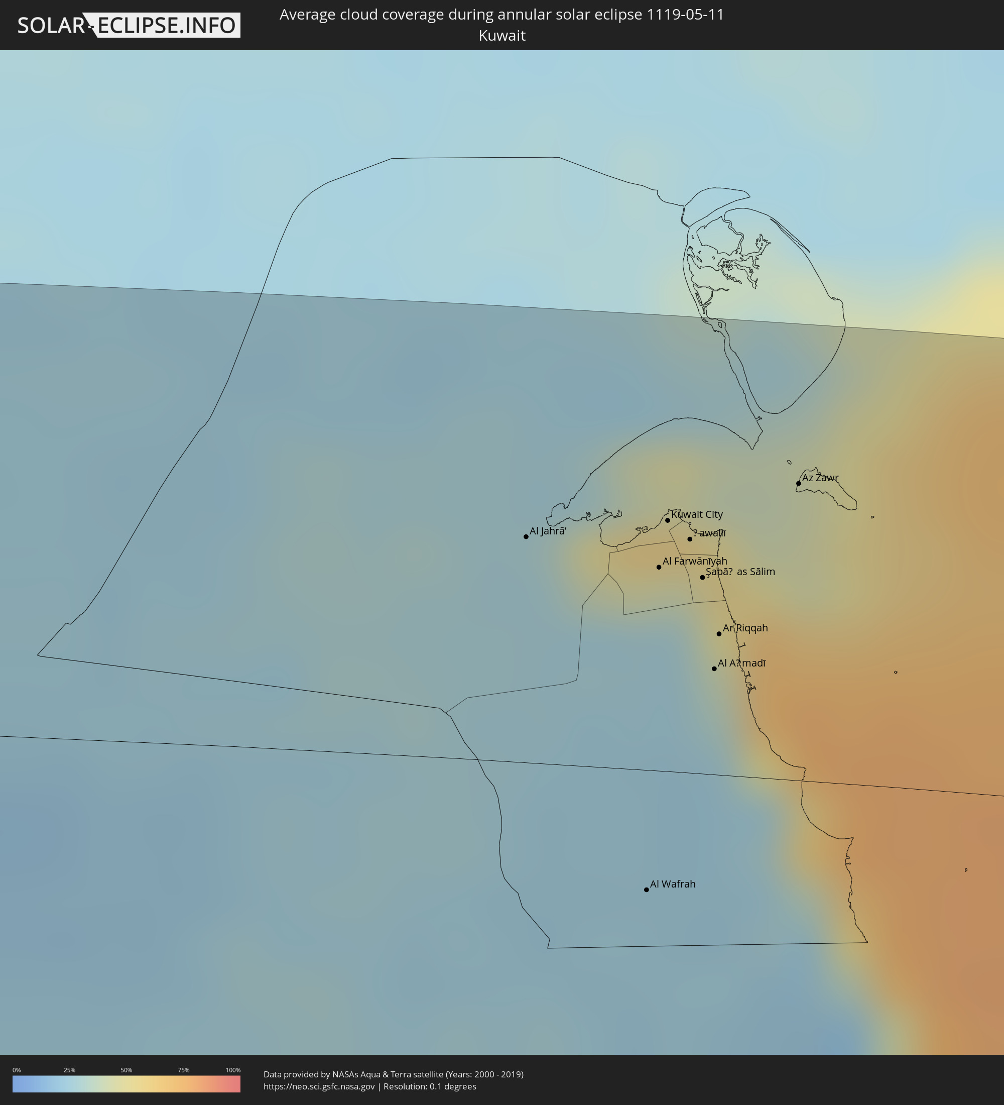 Kuwait
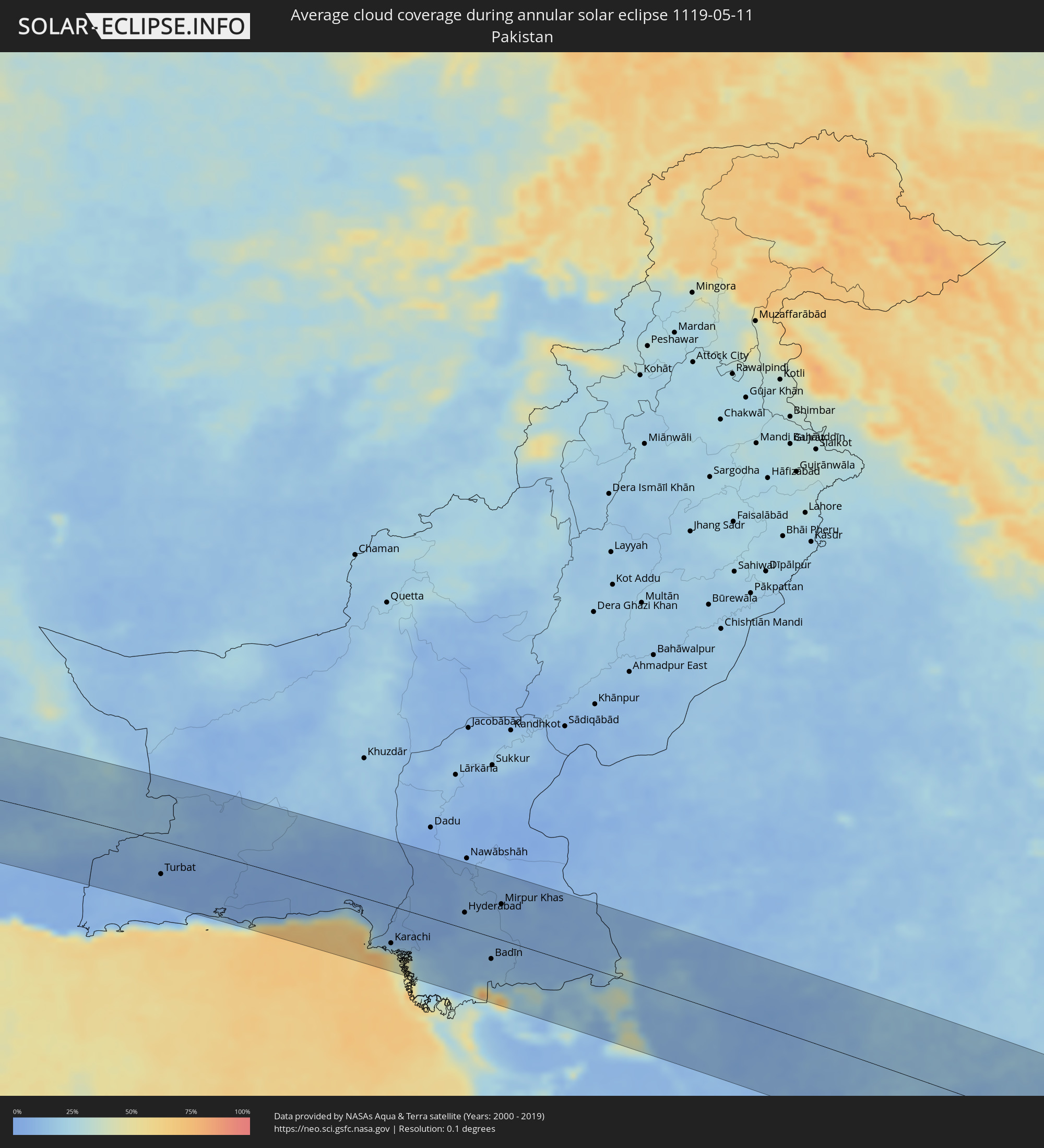 Pakistan
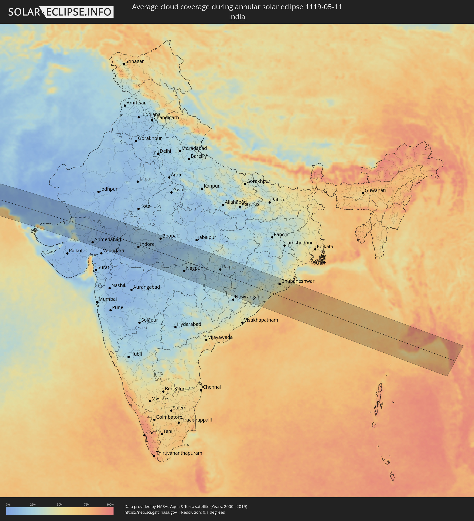 India
India
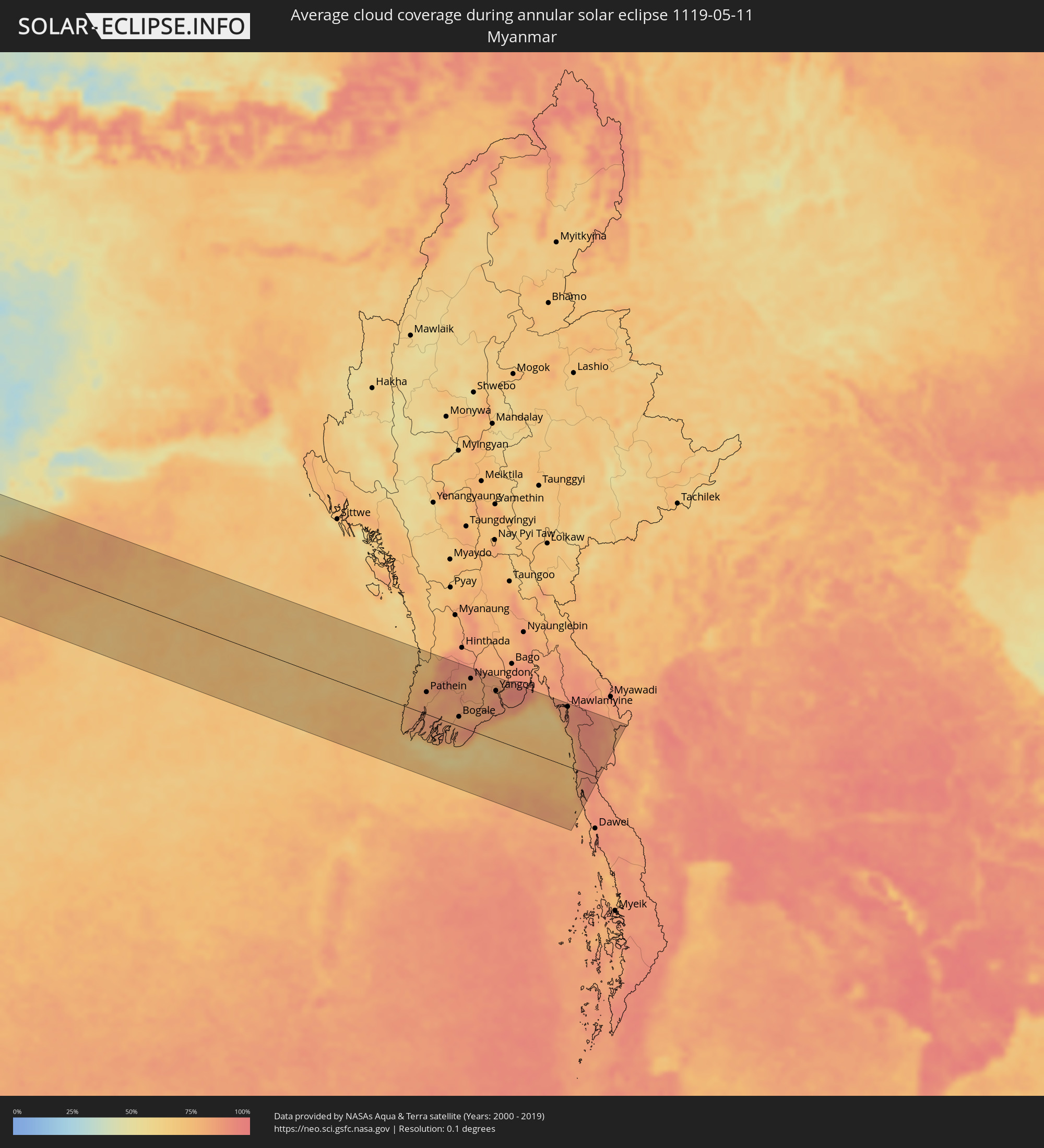 Myanmar
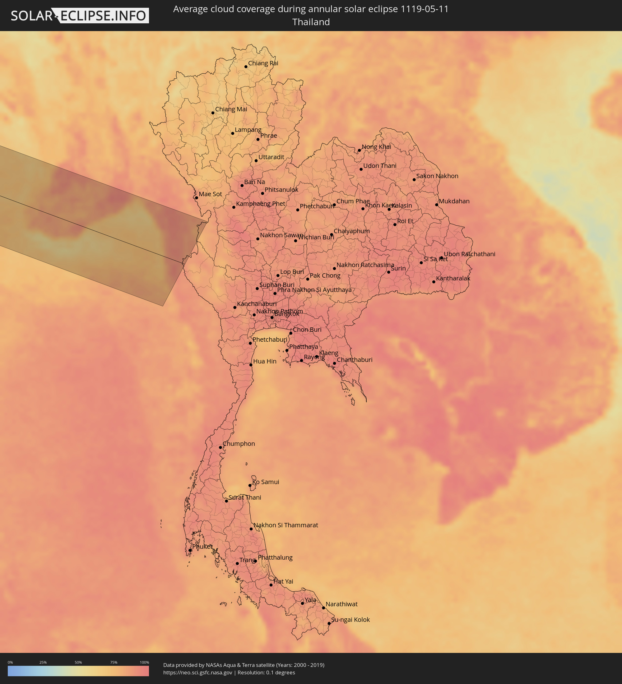 Thailand
Cities inside the path of the eclipse
The following table shows all locations with a population of more than 5,000 inside the eclipse path. Cities which have more than 100,000 inhabitants are marked bold. A click at the locations opens a detailed map.
| City | Type | Eclipse duration | Local time of max. eclipse | Distance to central line | Ø Cloud coverage |
|
Bonthe, Southern Province
|
annular | - | 07:40:16 UTC-00:16 | 103 km | 84% |
|
Bumpe, Southern Province
|
annular | - | 07:40:54 UTC-00:16 | 112 km | 90% |
|
Gandorhun, Southern Province
|
annular | - | 07:40:32 UTC-00:16 | 68 km | 92% |
|
Bo, Southern Province
|
annular | - | 07:41:04 UTC-00:16 | 111 km | 91% |
|
Pujehun, Southern Province
|
annular | - | 07:40:26 UTC-00:16 | 49 km | 92% |
|
Gandorhun, Southern Province
|
annular | - | 07:40:39 UTC-00:16 | 68 km | 91% |
|
Robertsport, Grand Cape Mount
|
annular | - | 07:12:59 UTC-00:43 | 28 km | 77% |
|
Blama, Eastern Province
|
annular | - | 07:41:09 UTC-00:16 | 83 km | 89% |
|
Boajibu, Eastern Province
|
annular | - | 07:41:29 UTC-00:16 | 114 km | 90% |
|
Kenema, Eastern Province
|
annular | - | 07:41:14 UTC-00:16 | 76 km | 87% |
|
Panguma, Eastern Province
|
annular | - | 07:41:35 UTC-00:16 | 104 km | 89% |
|
Segbwema, Eastern Province
|
annular | - | 07:41:28 UTC-00:16 | 76 km | 87% |
|
Bunumbu, Eastern Province
|
annular | - | 07:41:42 UTC-00:16 | 90 km | 86% |
|
Tubmanburg, Bomi
|
annular | - | 07:13:22 UTC-00:43 | 43 km | 91% |
|
Monrovia, Montserrado
|
annular | - | 07:12:48 UTC-00:43 | 101 km | 82% |
|
Pendembu, Eastern Province
|
annular | - | 07:41:43 UTC-00:16 | 74 km | 87% |
|
Bensonville, Montserrado
|
annular | - | 07:13:02 UTC-00:43 | 95 km | 95% |
|
Kailahun, Eastern Province
|
annular | - | 07:41:58 UTC-00:16 | 86 km | 88% |
|
Bopolu, Gbarpolu
|
annular | - | 07:13:44 UTC-00:43 | 39 km | 89% |
|
Kakata, Margibi
|
annular | - | 07:13:15 UTC-00:43 | 99 km | 94% |
|
Gueckedou, Nzerekore
|
annular | - | 07:42:31 UTC-00:16 | 94 km | 91% |
|
Voinjama, Lofa
|
annular | - | 07:15:34 UTC-00:43 | 61 km | 87% |
|
Gbarnga, Bong
|
annular | - | 07:14:12 UTC-00:43 | 95 km | 91% |
|
Macenta, Nzerekore
|
annular | - | 07:42:51 UTC-00:16 | 59 km | 84% |
|
Kérouané, Kankan
|
annular | - | 07:43:56 UTC-00:16 | 109 km | 74% |
|
Nzérékoré, Nzerekore
|
annular | - | 07:42:22 UTC-00:16 | 51 km | 87% |
|
Sanniquellie, Nimba
|
annular | - | 07:15:01 UTC-00:43 | 96 km | 87% |
|
Beyla, Nzerekore
|
annular | - | 07:43:30 UTC-00:16 | 33 km | 75% |
|
New Yekepa, Nimba
|
annular | - | 07:15:21 UTC-00:43 | 83 km | 87% |
|
Ganta, Nimba
|
annular | - | 07:15:03 UTC-00:43 | 111 km | 87% |
|
Touba, Woroba
|
annular | - | 07:43:39 UTC-00:16 | 55 km | 80% |
|
Biankouma, Montagnes
|
annular | - | 07:43:06 UTC-00:16 | 112 km | 87% |
|
Odienné, Denguélé
|
annular | - | 07:45:08 UTC-00:16 | 61 km | 76% |
|
Boundiali, Savanes
|
annular | - | 07:45:55 UTC-00:16 | 8 km | 74% |
|
Tengrela, Savanes
|
annular | - | 07:47:07 UTC-00:16 | 99 km | 70% |
|
Korhogo, Savanes
|
annular | - | 07:46:28 UTC-00:16 | 41 km | 76% |
|
Ferkessédougou, Savanes
|
annular | - | 07:46:59 UTC-00:16 | 50 km | 78% |
|
Banfora, Cascades
|
annular | - | 07:48:36 UTC-00:16 | 30 km | 71% |
|
Bobo-Dioulasso, Hauts-Bassins
|
annular | - | 07:49:42 UTC-00:16 | 60 km | 66% |
|
Houndé, Hauts-Bassins
|
annular | - | 07:50:48 UTC-00:16 | 51 km | 59% |
|
Gaoua, Sud-Ouest
|
annular | - | 07:49:30 UTC-00:16 | 80 km | 75% |
|
Koudougou, Centre-Ouest
|
annular | - | 07:52:54 UTC-00:16 | 65 km | 53% |
|
Léo, Centre-Ouest
|
annular | - | 07:51:37 UTC-00:16 | 61 km | 74% |
|
Kokologo, Centre-Ouest
|
annular | - | 07:53:18 UTC-00:16 | 33 km | 56% |
|
Ouagadougou, Centre
|
annular | - | 07:53:54 UTC-00:16 | 32 km | 56% |
|
Kombissiri, Centre-Sud
|
annular | - | 07:53:41 UTC-00:16 | 8 km | 58% |
|
Kaya, Centre-Nord
|
annular | - | 07:55:23 UTC-00:16 | 79 km | 49% |
|
Garango, Centre-Est
|
annular | - | 07:54:10 UTC-00:16 | 75 km | 61% |
|
Tenkodogo, Centre-Est
|
annular | - | 07:54:20 UTC-00:16 | 86 km | 64% |
|
Koupéla, Centre-Est
|
annular | - | 07:54:54 UTC-00:16 | 48 km | 58% |
|
Fada N'gourma, Est
|
annular | - | 07:55:32 UTC-00:16 | 97 km | 74% |
|
Téra, Tillabéri
|
annular | - | 08:28:30 UTC+00:13 | 71 km | 33% |
|
Tillabéri, Tillabéri
|
annular | - | 08:29:38 UTC+00:13 | 52 km | 42% |
|
Ouallam, Tillabéri
|
annular | - | 08:30:36 UTC+00:13 | 29 km | 32% |
|
Niamey, Niamey
|
annular | - | 08:29:26 UTC+00:13 | 50 km | 42% |
|
Kollo, Tillabéri
|
annular | - | 08:29:25 UTC+00:13 | 82 km | 43% |
|
Say, Tillabéri
|
annular | - | 08:29:10 UTC+00:13 | 104 km | 42% |
|
Filingué, Tillabéri
|
annular | - | 08:32:17 UTC+00:13 | 33 km | 33% |
|
Tahoua, Tahoua
|
annular | - | 08:35:55 UTC+00:13 | 87 km | 30% |
|
Tchintabaraden, Tahoua
|
annular | - | 08:38:19 UTC+00:13 | 18 km | 22% |
|
Abalak, Tahoua
|
annular | - | 08:38:21 UTC+00:13 | 87 km | 23% |
|
Agadez, Agadez
|
annular | - | 08:43:40 UTC+00:13 | 32 km | 16% |
|
Alaghsas, Agadez
|
annular | - | 08:43:47 UTC+00:13 | 29 km | 16% |
|
Bardaï, Tibesti
|
annular | - | 09:56:46 UTC+01:00 | 73 km | 15% |
|
At Tāj, Al Kufrah
|
annular | - | 10:11:11 UTC+00:52 | 71 km | 10% |
|
Al Jawf, Al Kufrah
|
annular | - | 10:11:11 UTC+00:52 | 72 km | 10% |
|
Al Minyā, Minya
|
annular | - | 11:46:35 UTC+02:00 | 84 km | 16% |
|
Dayrūţ, Asyut
|
annular | - | 11:46:13 UTC+02:00 | 23 km | 18% |
|
Al Qūşīyah, Asyut
|
annular | - | 11:46:08 UTC+02:00 | 10 km | 16% |
|
Abū Qurqāş, Minya
|
annular | - | 11:46:41 UTC+02:00 | 62 km | 15% |
|
Mallawī, Minya
|
annular | - | 11:46:30 UTC+02:00 | 41 km | 18% |
|
Dayr Mawās, Minya
|
annular | - | 11:46:25 UTC+02:00 | 31 km | 18% |
|
Manfalūţ, Asyut
|
annular | - | 11:46:30 UTC+02:00 | 8 km | 17% |
|
Abnūb, Asyut
|
annular | - | 11:47:02 UTC+02:00 | 17 km | 16% |
|
Asyūţ, Asyut
|
annular | - | 11:47:03 UTC+02:00 | 27 km | 16% |
|
Abū Tīj, Asyut
|
annular | - | 11:47:22 UTC+02:00 | 46 km | 15% |
|
Al Badārī, Asyut
|
annular | - | 11:47:38 UTC+02:00 | 54 km | 17% |
|
Juhaynah, Sohag
|
annular | - | 11:47:35 UTC+02:00 | 90 km | 13% |
|
Ţahţā, Sohag
|
annular | - | 11:47:42 UTC+02:00 | 80 km | 15% |
|
Hurghada, Red Sea
|
annular | - | 11:55:44 UTC+02:00 | 81 km | 21% |
|
Tabuk, Tabuk
|
annular | - | 13:12:19 UTC+03:06 | 7 km | 13% |
|
Al Qayşūmah, Eastern Province
|
annular | - | 13:41:41 UTC+03:06 | 72 km | 21% |
|
Al Jahrā’, Al Jahrāʼ
|
annular | - | 13:45:31 UTC+03:06 | 49 km | 26% |
|
Al Wafrah, Al Aḩmadī
|
annular | - | 13:46:33 UTC+03:06 | 26 km | 24% |
|
Ar Rābiyah, Al Asimah
|
annular | - | 13:46:16 UTC+03:06 | 46 km | 28% |
|
Ash Shāmīyah, Al Asimah
|
annular | - | 13:46:20 UTC+03:06 | 52 km | 30% |
|
Janūb as Surrah, Al Farwaniyah
|
annular | - | 13:46:24 UTC+03:06 | 44 km | 30% |
|
Ad Dasmah, Al Asimah
|
annular | - | 13:46:25 UTC+03:06 | 55 km | 43% |
|
Ḩawallī, Hawalli
|
annular | - | 13:46:31 UTC+03:06 | 51 km | 30% |
|
Bayān, Hawalli
|
annular | - | 13:46:35 UTC+03:06 | 48 km | 30% |
|
Salwá, Hawalli
|
annular | - | 13:46:40 UTC+03:06 | 47 km | 49% |
|
Al Aḩmadī, Al Aḩmadī
|
annular | - | 13:46:46 UTC+03:06 | 23 km | 34% |
|
Al Finţās, Al Aḩmadī
|
annular | - | 13:46:50 UTC+03:06 | 34 km | 41% |
|
Al Mahbūlah, Al Aḩmadī
|
annular | - | 13:46:52 UTC+03:06 | 31 km | 34% |
|
Al Manqaf, Al Aḩmadī
|
annular | - | 13:46:54 UTC+03:06 | 26 km | 34% |
|
Az Zawr, Al Asimah
|
annular | - | 13:47:06 UTC+03:06 | 65 km | 46% |
|
Al Khafjī, Eastern Province
|
annular | - | 13:48:09 UTC+03:06 | 45 km | 36% |
|
As Saffānīyah, Eastern Province
|
annular | - | 13:49:00 UTC+03:06 | 95 km | 30% |
|
Khārk, Bushehr
|
annular | - | 14:11:19 UTC+03:25 | 62 km | 66% |
|
Bandar-e Ganāveh, Bushehr
|
annular | - | 14:11:36 UTC+03:25 | 99 km | 55% |
|
Bandar-e Būshehr, Bushehr
|
annular | - | 14:12:45 UTC+03:25 | 35 km | 48% |
|
Borāzjān, Bushehr
|
annular | - | 14:13:30 UTC+03:25 | 73 km | 21% |
|
Fīrūzābād, Fars
|
annular | - | 14:17:00 UTC+03:25 | 43 km | 23% |
|
Akbarābād, Fars
|
annular | - | 14:17:12 UTC+03:25 | 90 km | 26% |
|
Fasā, Fars
|
annular | - | 14:19:24 UTC+03:25 | 68 km | 18% |
|
Gerāsh, Fars
|
annular | - | 14:21:27 UTC+03:25 | 64 km | 16% |
|
Dārāb, Fars
|
annular | - | 14:21:32 UTC+03:25 | 62 km | 20% |
|
Bandar Abbas, Hormozgan
|
annular | - | 14:26:31 UTC+03:25 | 80 km | 32% |
|
Mīnāb, Hormozgan
|
annular | - | 14:28:15 UTC+03:25 | 70 km | 8% |
|
Īrānshahr, Sistan and Baluchestan
|
annular | - | 14:35:01 UTC+03:25 | 15 km | 10% |
|
Qaşr-e Qand, Sistan and Baluchestan
|
annular | - | 14:36:01 UTC+03:25 | 87 km | 6% |
|
Turbat, Balochistān
|
annular | - | 15:42:35 UTC+04:28 | 57 km | 6% |
|
Karachi, Sindh
|
annular | - | 15:49:30 UTC+04:28 | 63 km | 22% |
|
Thatta, Sindh
|
annular | - | 15:50:44 UTC+04:28 | 55 km | 13% |
|
Hyderabad, Sindh
|
annular | - | 15:50:40 UTC+04:28 | 27 km | 10% |
|
Hāla, Sindh
|
annular | - | 15:50:18 UTC+04:28 | 73 km | 10% |
|
Tando Muhammad Khān, Sindh
|
annular | - | 15:51:08 UTC+04:28 | 3 km | 10% |
|
Shāhdādpur, Sindh
|
annular | - | 15:50:26 UTC+04:28 | 91 km | 10% |
|
Mātli, Sindh
|
annular | - | 15:51:21 UTC+04:28 | 2 km | 9% |
|
Tando Ādam, Sindh
|
annular | - | 15:50:38 UTC+04:28 | 75 km | 11% |
|
Tando Allāhyār, Sindh
|
annular | - | 15:51:01 UTC+04:28 | 45 km | 11% |
|
Badīn, Sindh
|
annular | - | 15:51:57 UTC+04:28 | 38 km | 12% |
|
Mirpur Khas, Sindh
|
annular | - | 15:51:18 UTC+04:28 | 60 km | 10% |
|
Digri, Sindh
|
annular | - | 15:51:47 UTC+04:28 | 24 km | 9% |
|
Umarkot, Sindh
|
annular | - | 15:52:18 UTC+04:28 | 65 km | 9% |
|
Ahmedabad, Gujarat
|
annular | - | 16:50:31 UTC+05:21 | 92 km | 10% |
|
Udaipur, Rajasthan
|
annular | - | 16:50:03 UTC+05:21 | 107 km | 11% |
|
Māndu, Madhya Pradesh
|
annular | - | 16:53:35 UTC+05:21 | 69 km | 12% |
|
Ujjain, Madhya Pradesh
|
annular | - | 16:53:08 UTC+05:21 | 30 km | 15% |
|
Indore, Madhya Pradesh
|
annular | - | 16:53:36 UTC+05:21 | 17 km | 15% |
|
Dewas, Madhya Pradesh
|
annular | - | 16:53:33 UTC+05:21 | 16 km | 17% |
|
Punāsa, Madhya Pradesh
|
annular | - | 16:54:29 UTC+05:21 | 49 km | 9% |
|
Bhopal, Madhya Pradesh
|
annular | - | 16:54:15 UTC+05:21 | 93 km | 17% |
|
Nagpur, Maharashtra
|
annular | - | 16:57:14 UTC+05:21 | 70 km | 19% |
|
Bhilai, Chhattisgarh
|
annular | - | 16:58:26 UTC+05:21 | 20 km | 24% |
|
Raipur, Chhattisgarh
|
annular | - | 16:58:30 UTC+05:21 | 29 km | 24% |
|
Brahmapur, Odisha
|
annular | - | 17:01:19 UTC+05:21 | 57 km | 45% |
|
Bhubaneshwar, Odisha
|
annular | - | 17:00:51 UTC+05:21 | 81 km | 45% |
|
Cuttack, Odisha
|
annular | - | 17:00:43 UTC+05:21 | 103 km | 45% |
|
Pathein, Ayeyarwady
|
annular | - | 18:07:48 UTC+06:24 | 45 km | 79% |
|
Wakema, Ayeyarwady
|
annular | - | 18:07:53 UTC+06:24 | 44 km | 82% |
|
Bogale, Ayeyarwady
|
annular | - | 18:08:03 UTC+06:24 | 19 km | 81% |
|
Maubin, Ayeyarwady
|
annular | - | 18:07:45 UTC+06:24 | 75 km | 81% |
|
Pyapon, Ayeyarwady
|
annular | - | 18:08:02 UTC+06:24 | 29 km | 82% |
|
Kyaiklat, Ayeyarwady
|
annular | - | 18:07:55 UTC+06:24 | 47 km | 78% |
|
Twante, Yangon
|
annular | - | 18:07:44 UTC+06:24 | 83 km | 80% |
|
Kanbe, Yangon
|
annular | - | 18:07:44 UTC+06:24 | 85 km | 85% |
|
Yangon, Yangon
|
annular | - | 18:07:39 UTC+06:24 | 101 km | 87% |
|
Thongwa, Yangon
|
annular | - | 18:07:38 UTC+06:24 | 110 km | 93% |
|
Kyaikkami, Mon
|
annular | - | 18:07:53 UTC+06:24 | 77 km | 80% |
|
Martaban, Mon
|
annular | - | 18:07:36 UTC+06:24 | 126 km | 86% |
|
Mawlamyine, Mon
|
annular | - | 18:07:38 UTC+06:24 | 123 km | 86% |
|
Mudon, Mon
|
annular | - | 18:07:45 UTC+06:24 | 102 km | 89% |