Total solar eclipse of 05/01/1166
| Day of week: | Sunday |
| Maximum duration of eclipse: | 05m06s |
| Maximum width of eclipse path: | 189 km |
| Saros cycle: | 105 |
| Coverage: | 100% |
| Magnitude: | 1.0567 |
| Gamma: | -0.1406 |
Wo kann man die Sonnenfinsternis vom 05/01/1166 sehen?
Die Sonnenfinsternis am 05/01/1166 kann man in 121 Ländern als partielle Sonnenfinsternis beobachten.
Der Finsternispfad verläuft durch 14 Länder. Nur in diesen Ländern ist sie als total Sonnenfinsternis zu sehen.
In den folgenden Ländern ist die Sonnenfinsternis total zu sehen
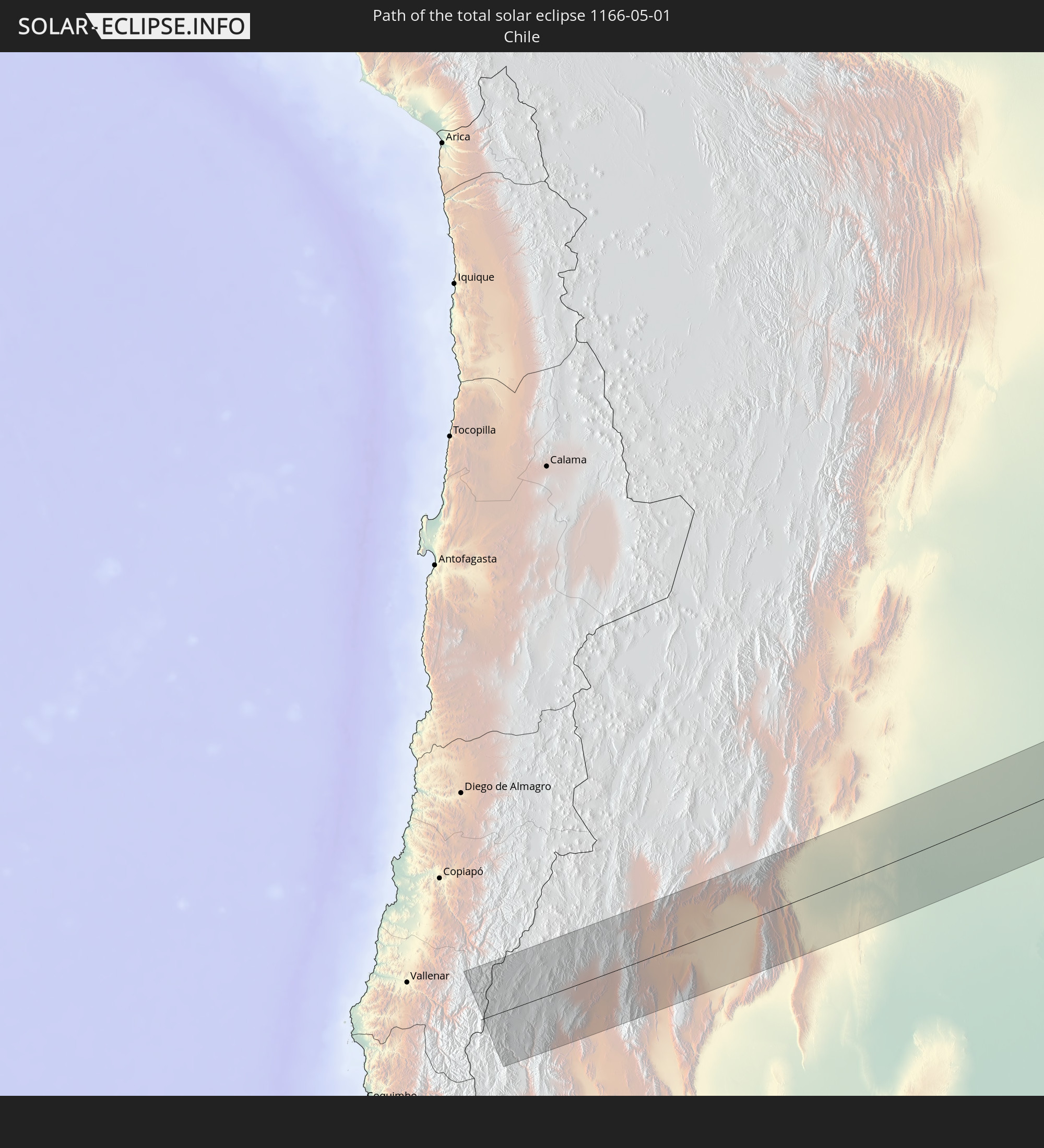 Chile
Chile
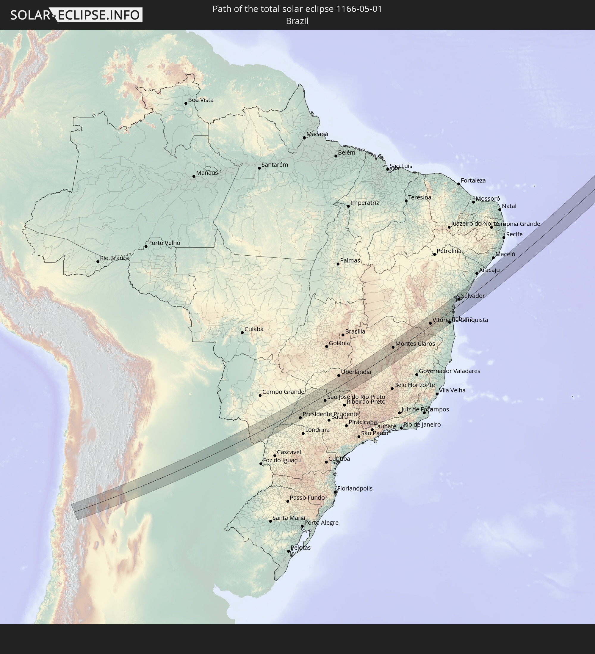 Brazil
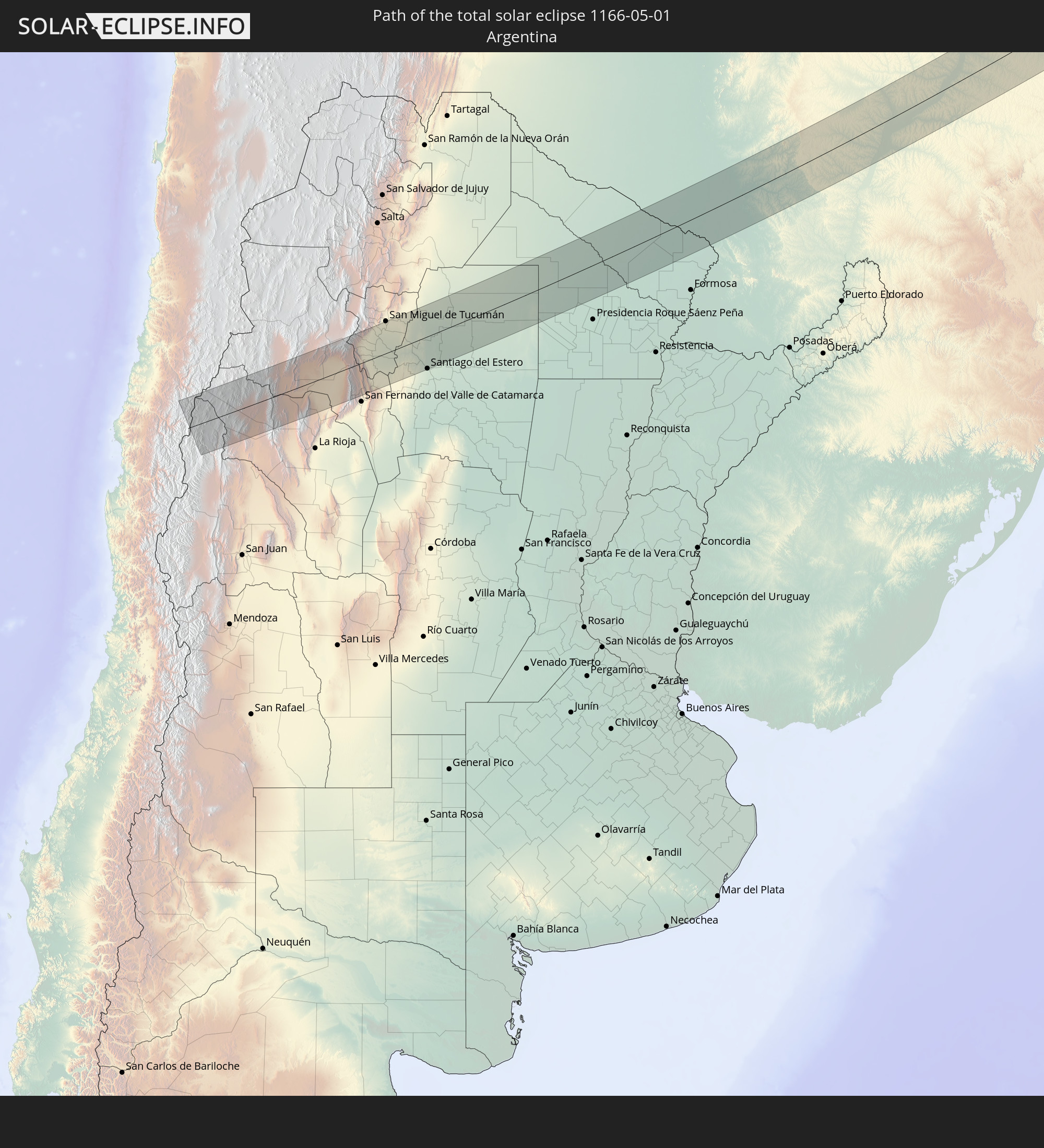 Argentina
 Paraguay
 Guinea
 Sierra Leone
 Mali
Mali
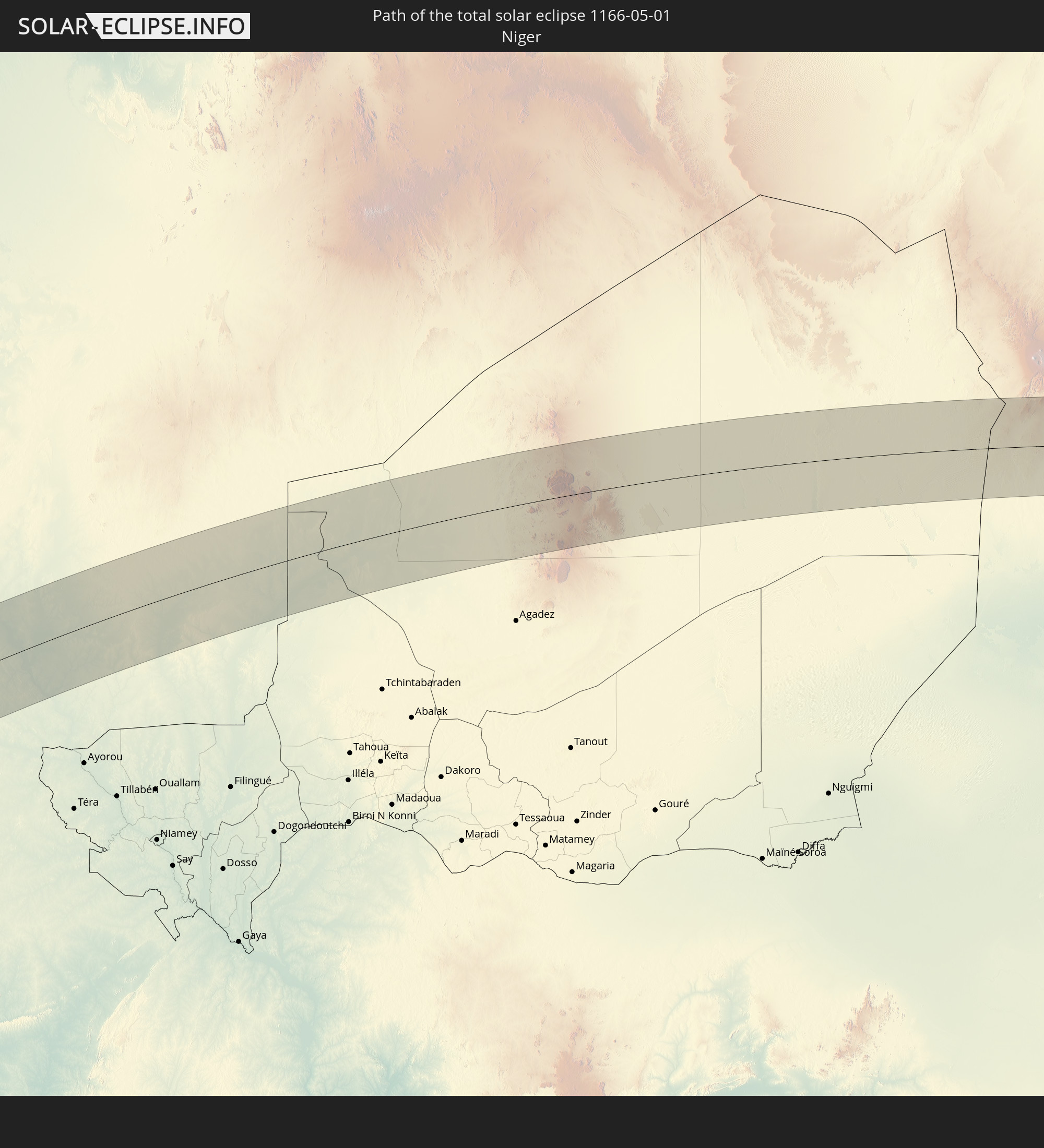 Niger
Niger
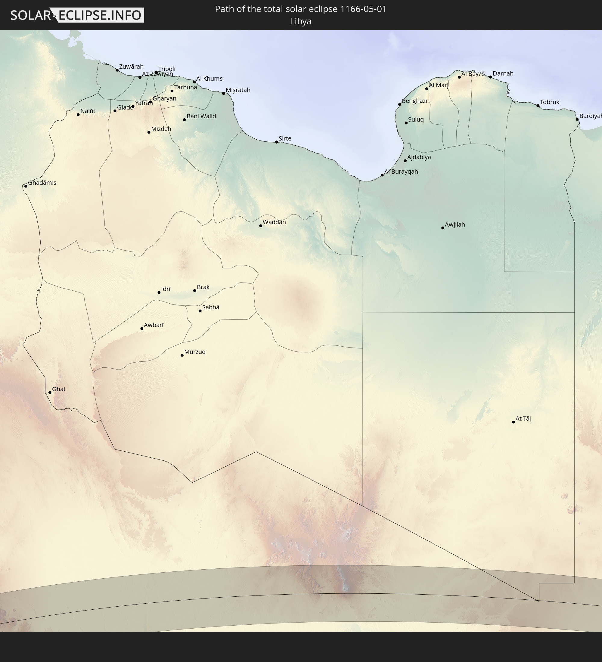 Libya
Libya
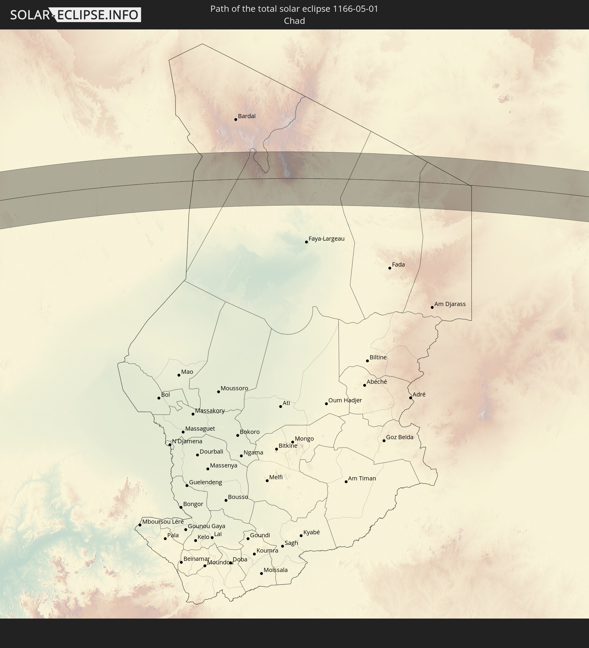 Chad
Chad
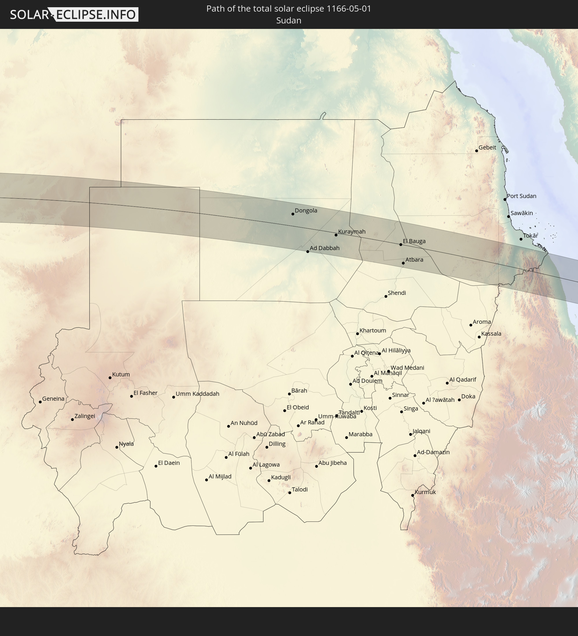 Sudan
Sudan
 Saudi Arabia
 Eritrea
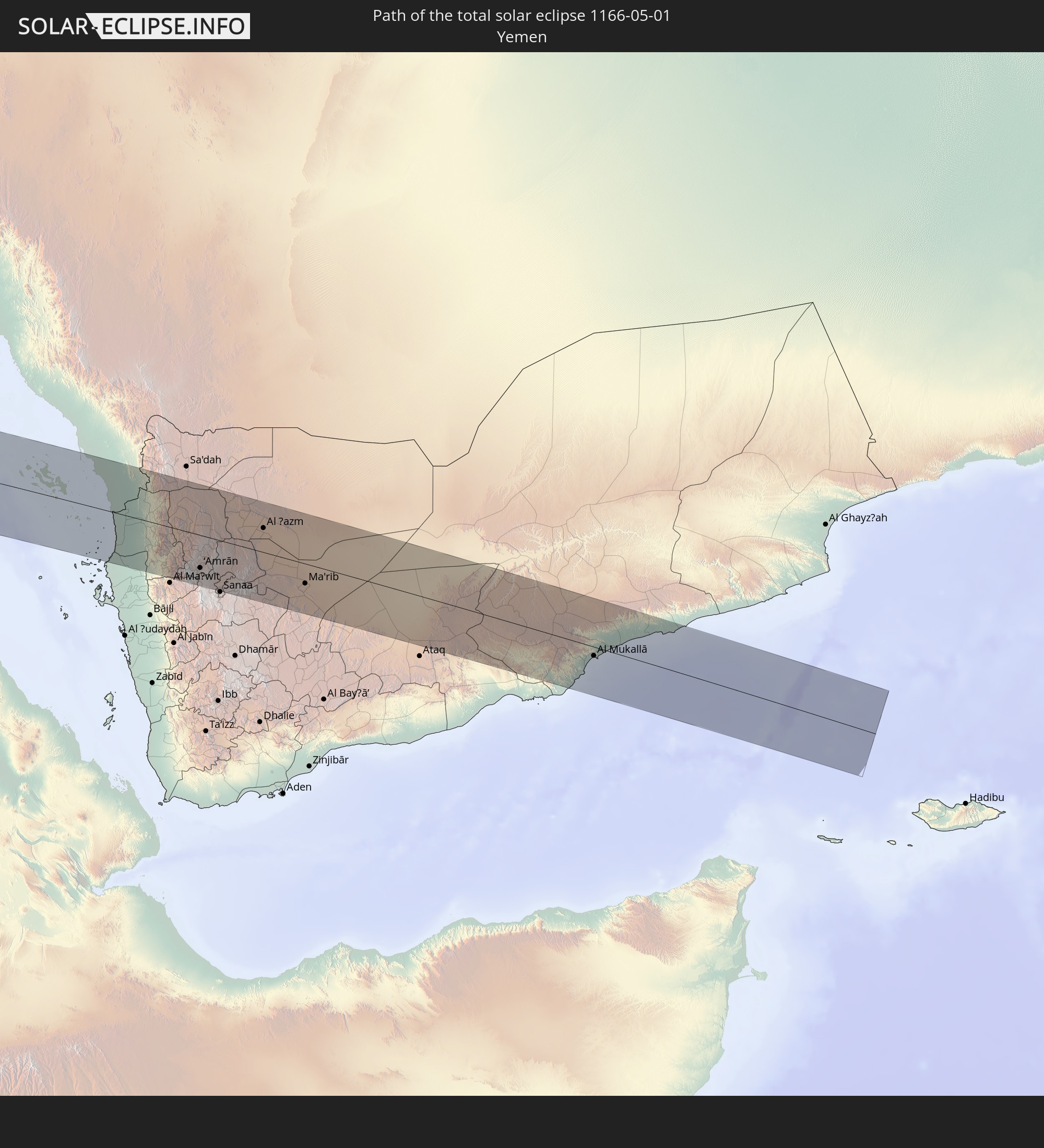 Yemen
Yemen
In den folgenden Ländern ist die Sonnenfinsternis partiell zu sehen
 Russia
 Chile
Chile
 Ecuador
 Colombia
 Peru
Peru
 Brazil
 Argentina
 Venezuela
 Bolivia
 Paraguay
 Trinidad and Tobago
 Falkland Islands
 Guyana
 Uruguay
 Suriname
 French Guiana
 South Georgia and the South Sandwich Islands
 Portugal
 Cabo Verde
 Spain
Spain
 Senegal
 Mauritania
 The Gambia
 Guinea-Bissau
 Guinea
 Saint Helena, Ascension and Tristan da Cunha
 Sierra Leone
 Morocco
 Mali
Mali
 Liberia
 Algeria
 Ivory Coast
 Burkina Faso
 Gibraltar
 France
 Ghana
Ghana
 Togo
Togo
 Niger
Niger
 Benin
Benin
 Andorra
 Belgium
 Nigeria
 Equatorial Guinea
 Luxembourg
 Germany
 Switzerland
 São Tomé and Príncipe
 Italy
Italy
 Monaco
 Tunisia
 Cameroon
 Gabon
Gabon
 Libya
Libya
 Liechtenstein
 Austria
 Republic of the Congo
 Angola
 Czechia
 Democratic Republic of the Congo
 San Marino
 Vatican City
 Slovenia
 Chad
Chad
 Croatia
 Poland
 Malta
Malta
 Central African Republic
 Bosnia and Herzegovina
 Hungary
 Slovakia
 Montenegro
 Serbia
 Albania
 Greece
 Romania
 Republic of Macedonia
 Sudan
Sudan
 Zambia
 Ukraine
 Bulgaria
 Egypt
Egypt
 Turkey
 Moldova
 Rwanda
 Burundi
 Tanzania
 Uganda
 Mozambique
 Cyprus
 Malawi
 Ethiopia
 Kenya
Kenya
 State of Palestine
 Israel
 Saudi Arabia
 Jordan
 Lebanon
 Syria
Syria
 Eritrea
 Iraq
Iraq
 Georgia
 French Southern and Antarctic Lands
 Somalia
 Djibouti
 Yemen
Yemen
 Madagascar
 Comoros
 Armenia
 Iran
Iran
 Azerbaijan
 Mayotte
 Seychelles
 Kazakhstan
 Kuwait
 Bahrain
 Qatar
Qatar
 United Arab Emirates
 Oman
Oman
 Turkmenistan
 Uzbekistan
 Afghanistan
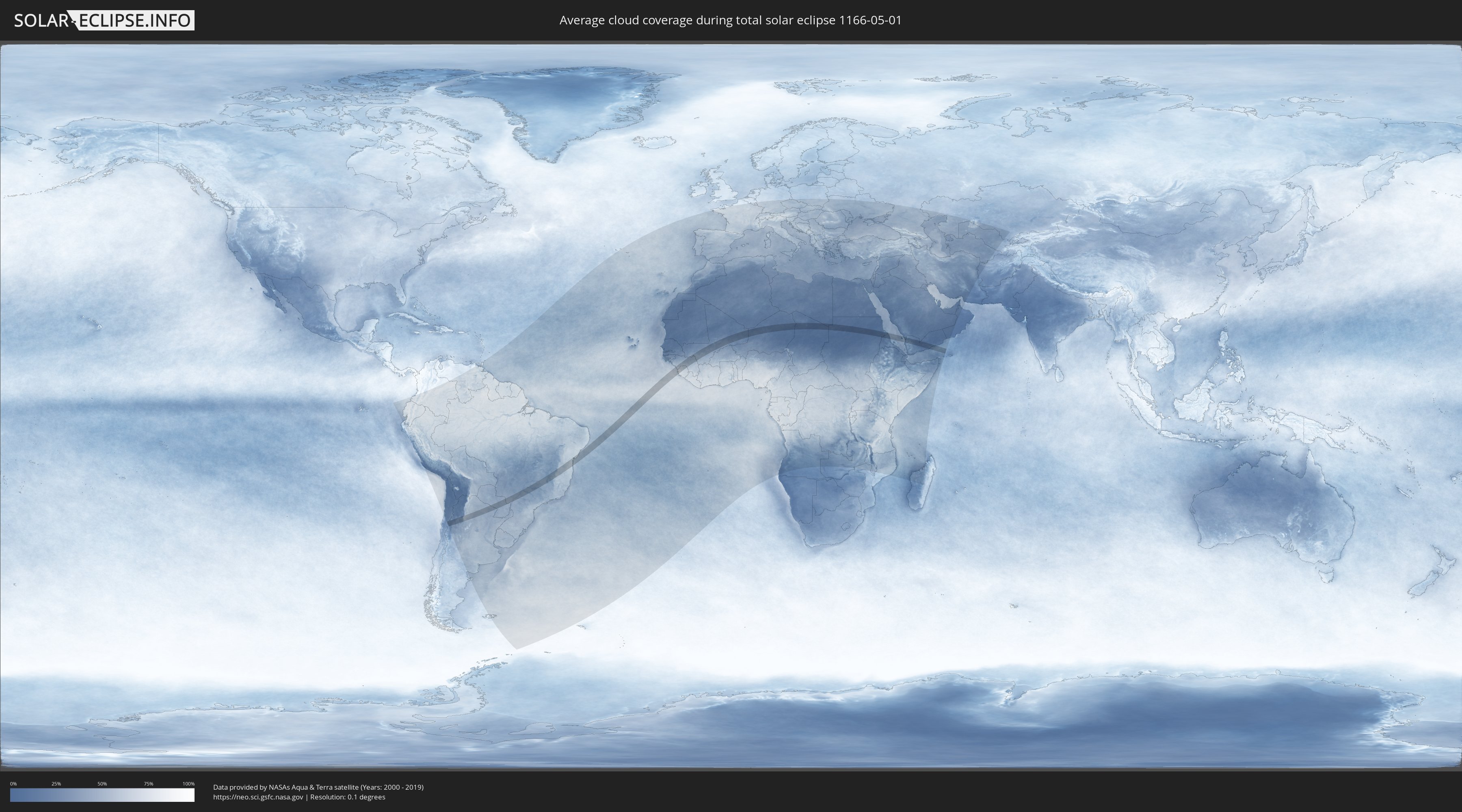
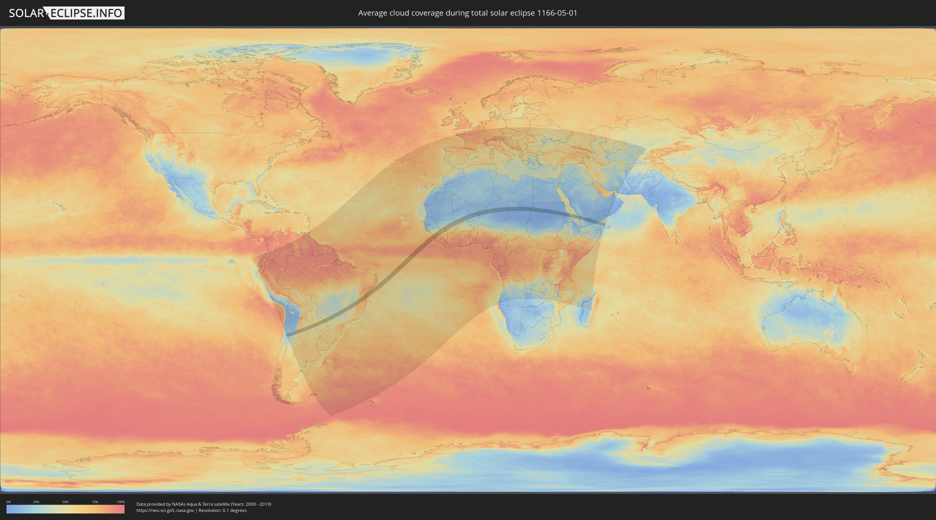
How will be the weather during the total solar eclipse on 05/01/1166?
Where is the best place to see the total solar eclipse of 05/01/1166?
The following maps show the average cloud coverage for the day of the total solar eclipse.
With the help of these maps, it is possible to find the place along the eclipse path, which has the best
chance of a cloudless sky.
Nevertheless, you should consider local circumstances and inform about the weather of your chosen
observation site.
The data is provided by NASAs satellites
AQUA and TERRA.
The cloud maps are averaged over a period of 19 years (2000 - 2019).
Detailed country maps
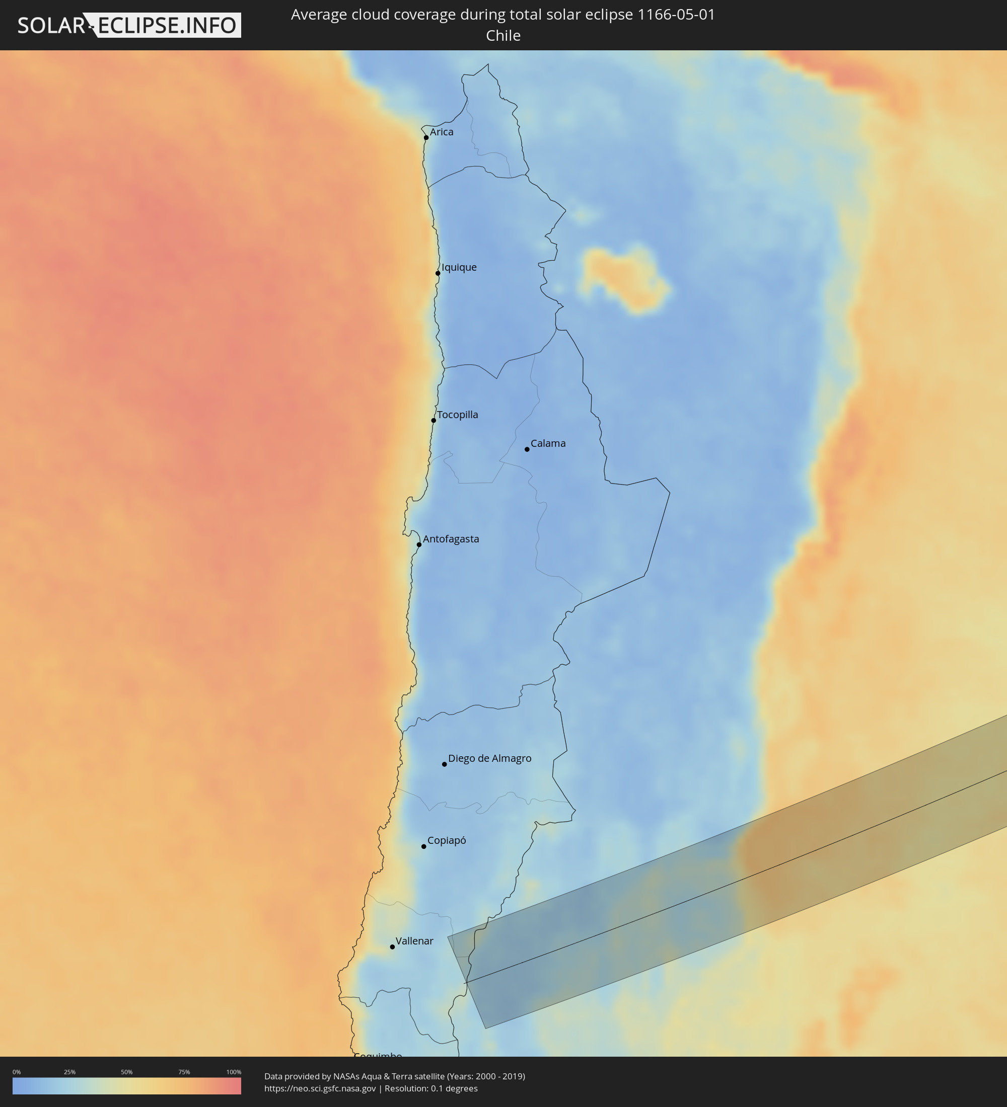 Chile
Chile
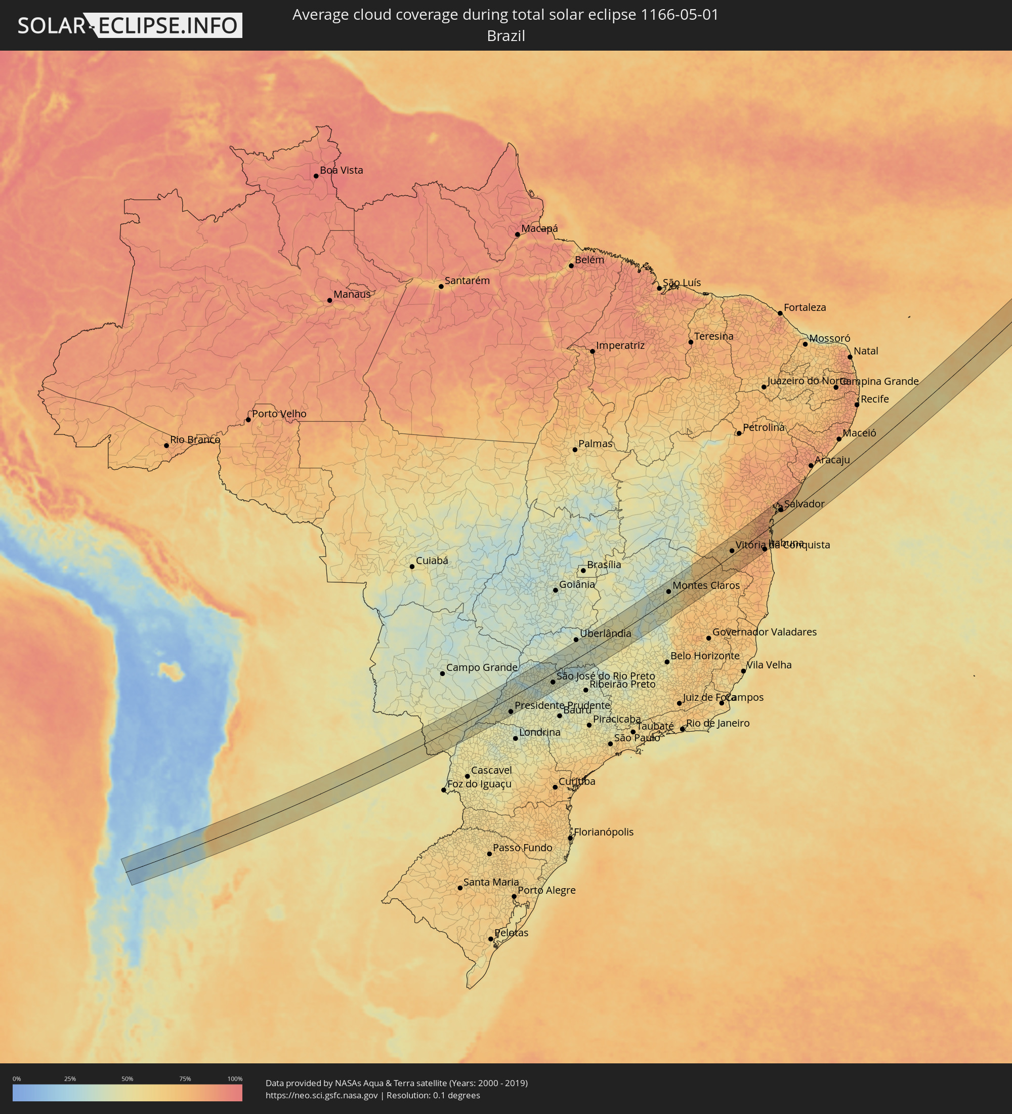 Brazil
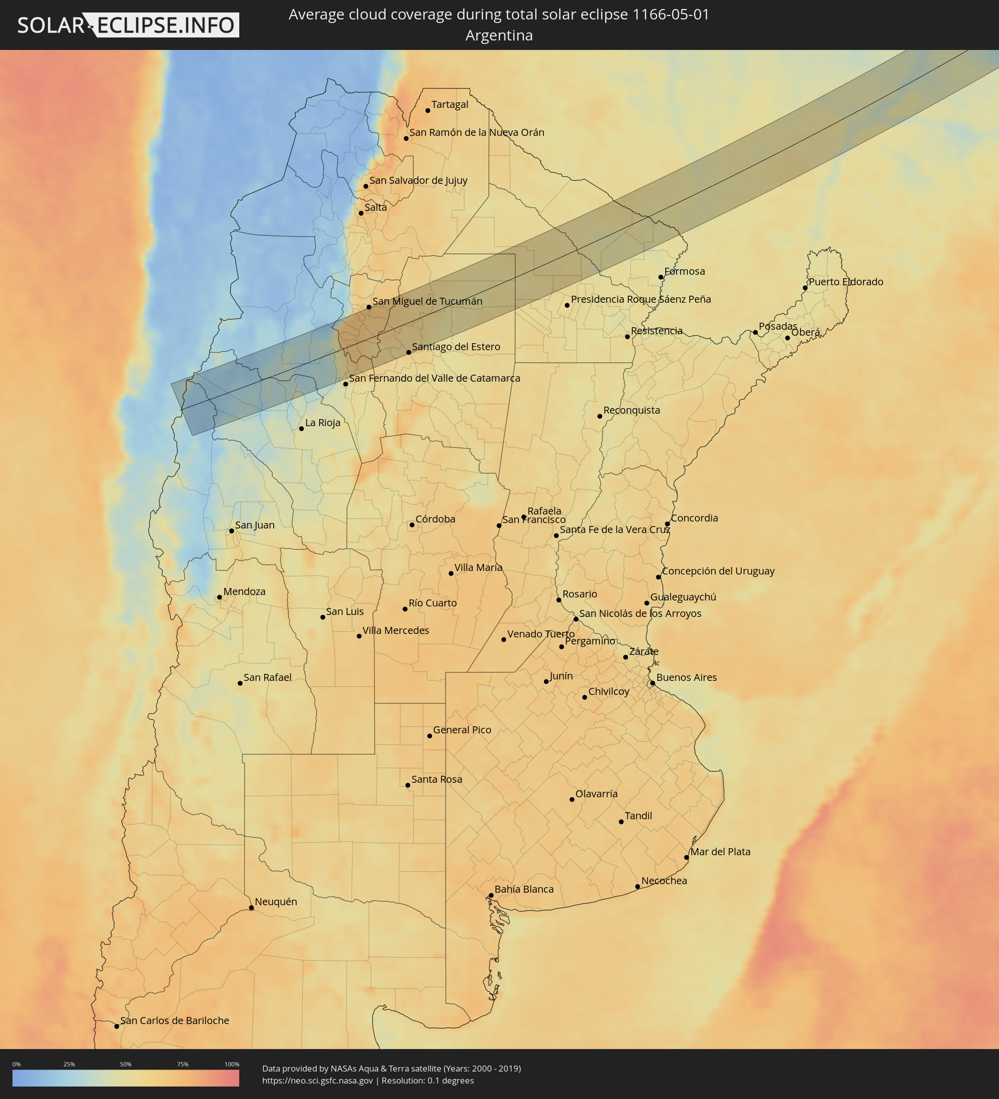 Argentina
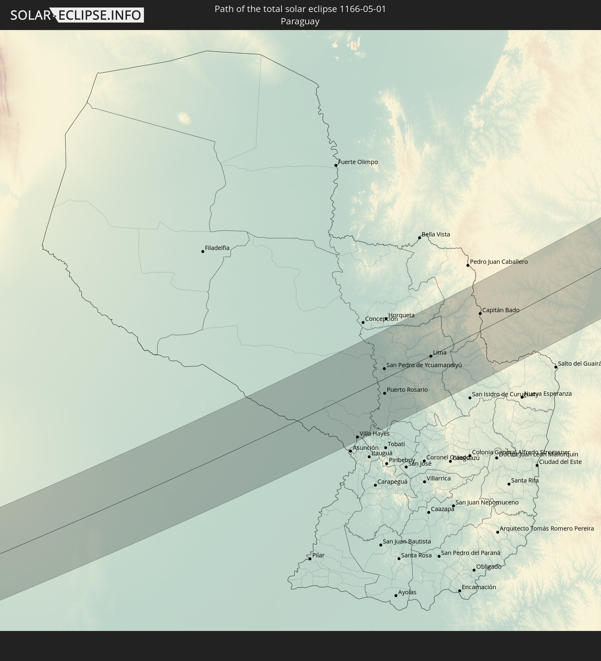
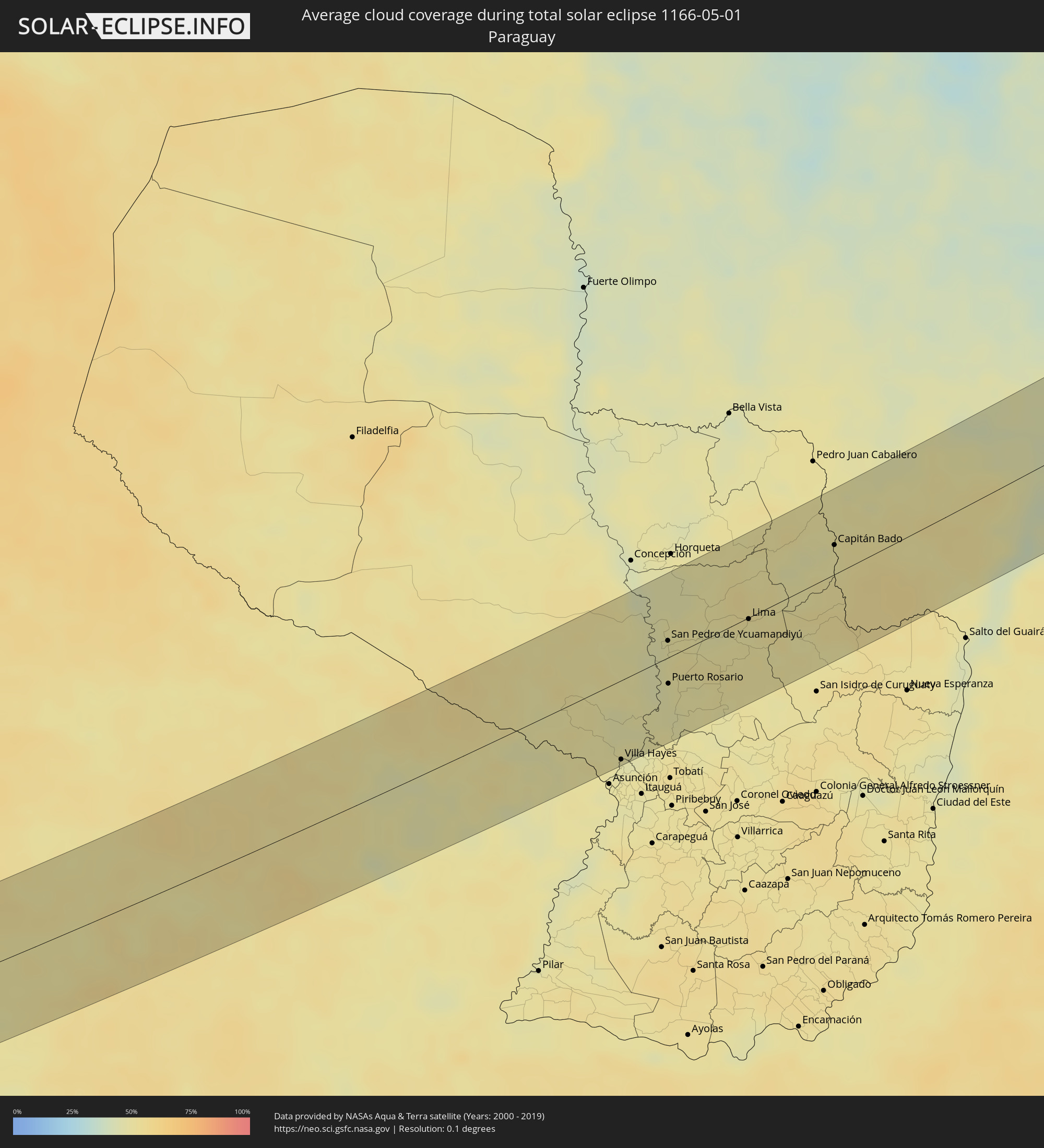 Paraguay
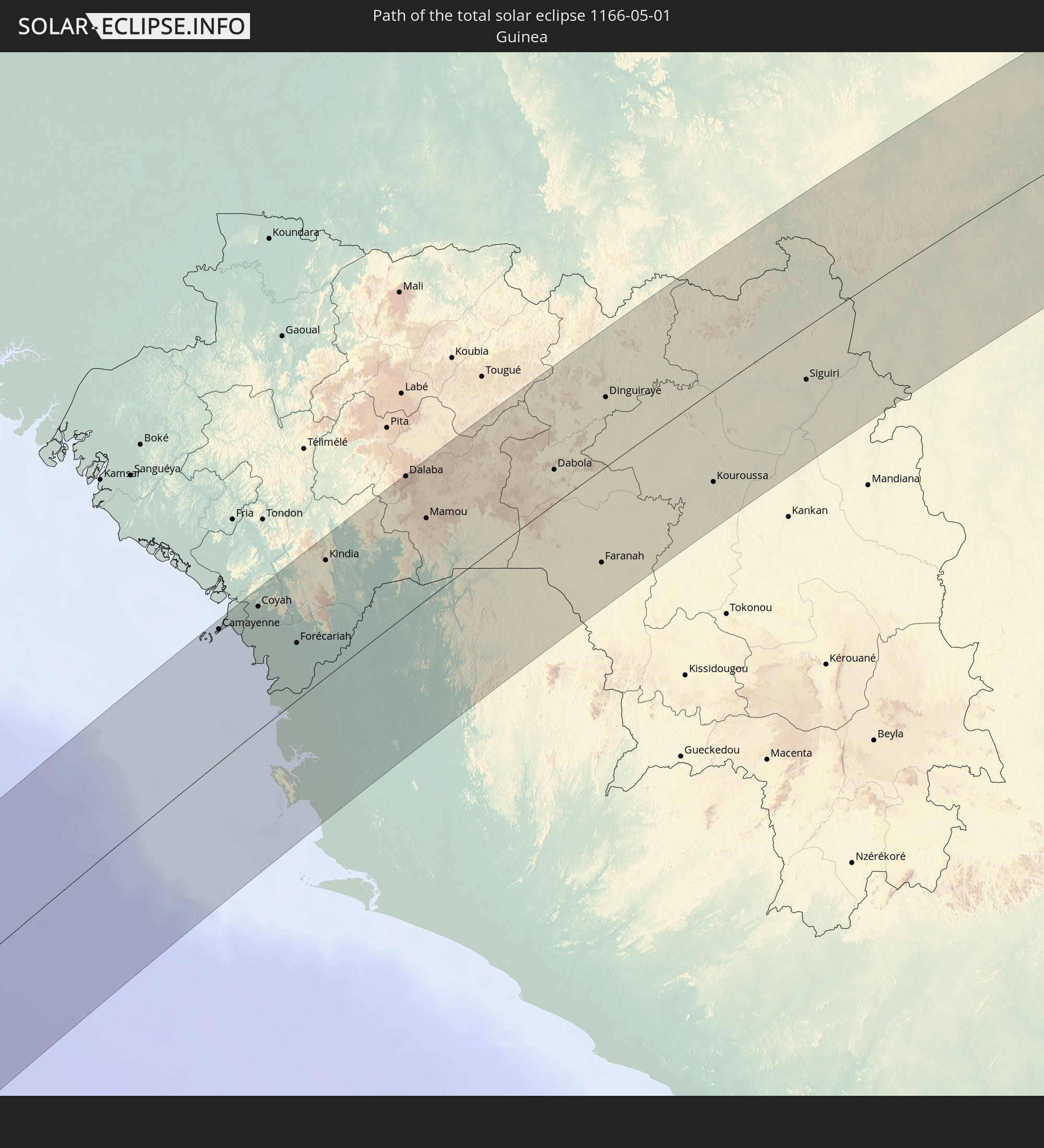
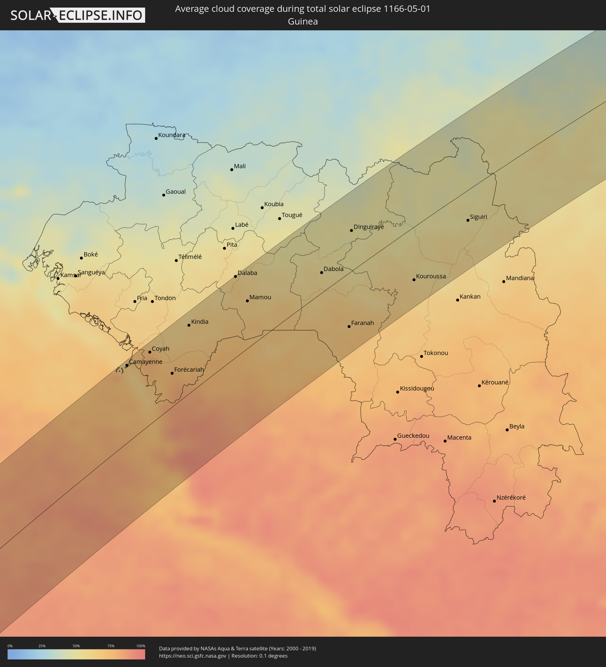 Guinea
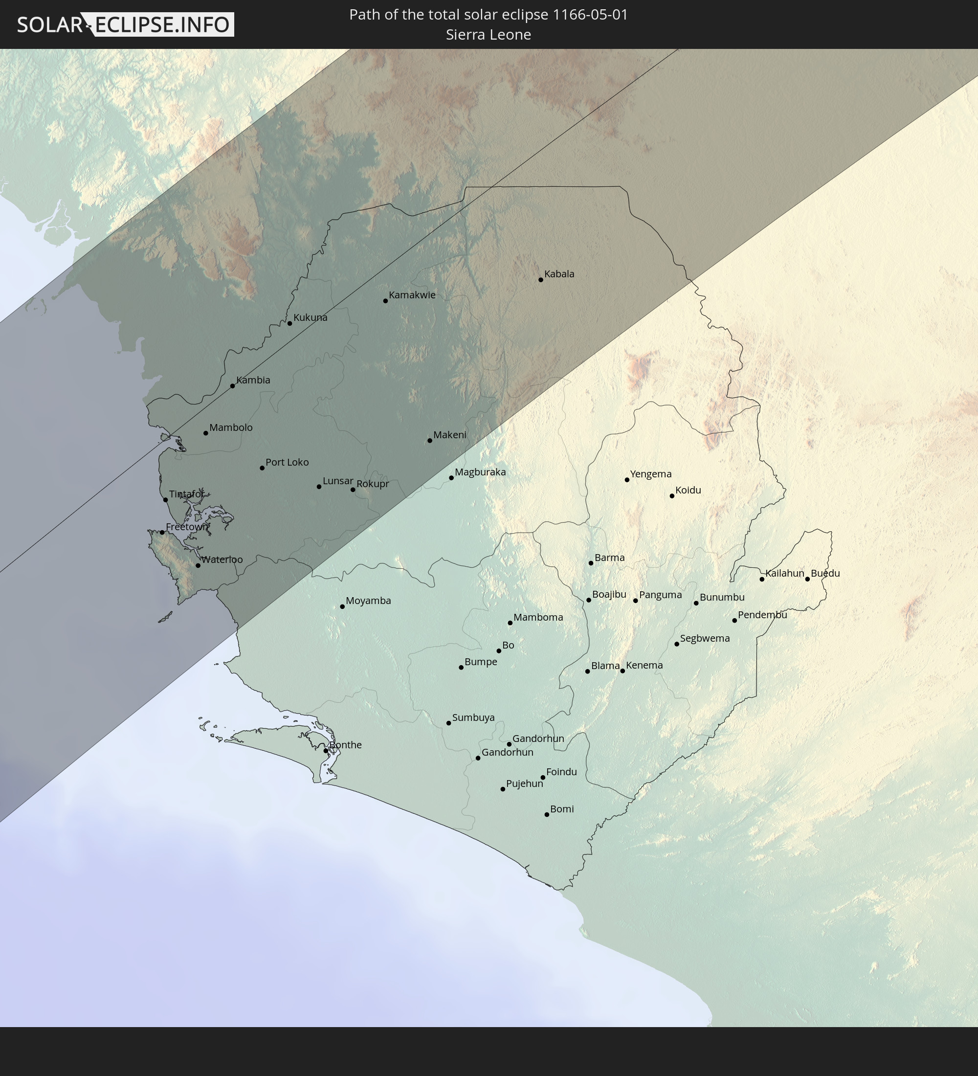
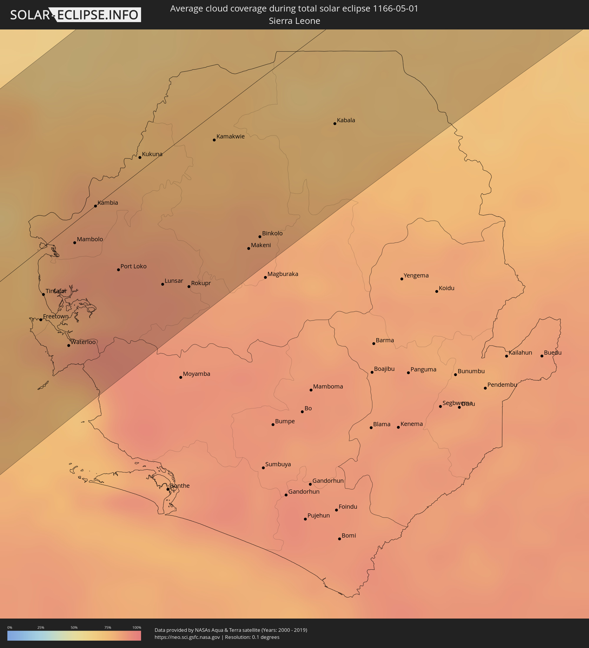 Sierra Leone
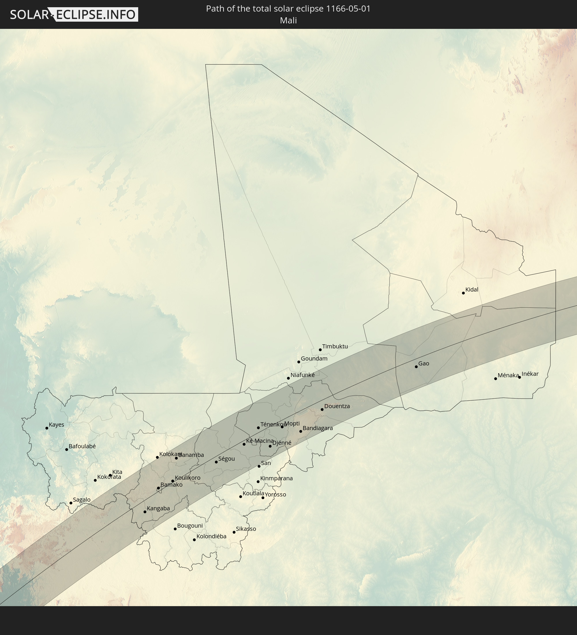
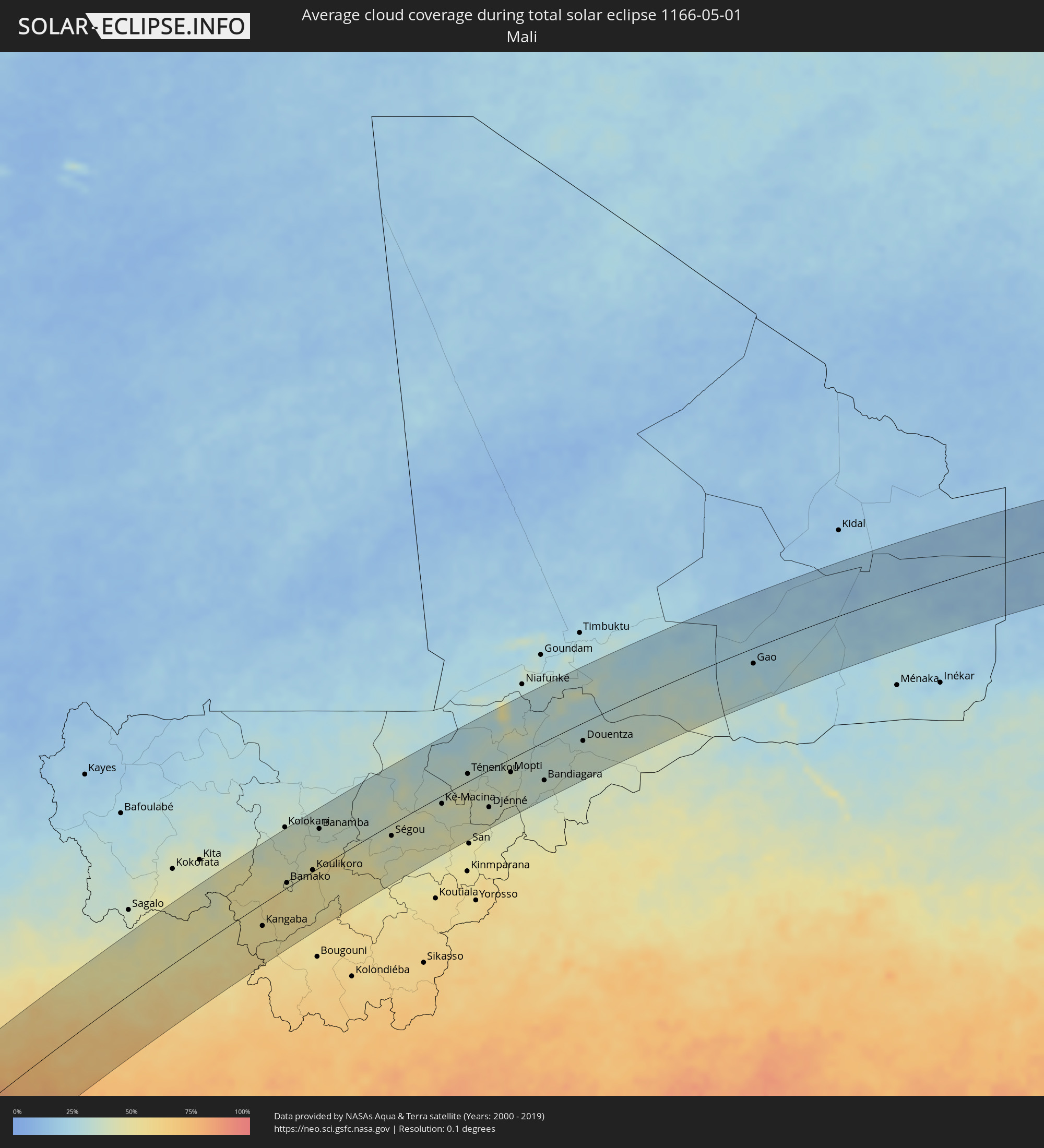 Mali
Mali
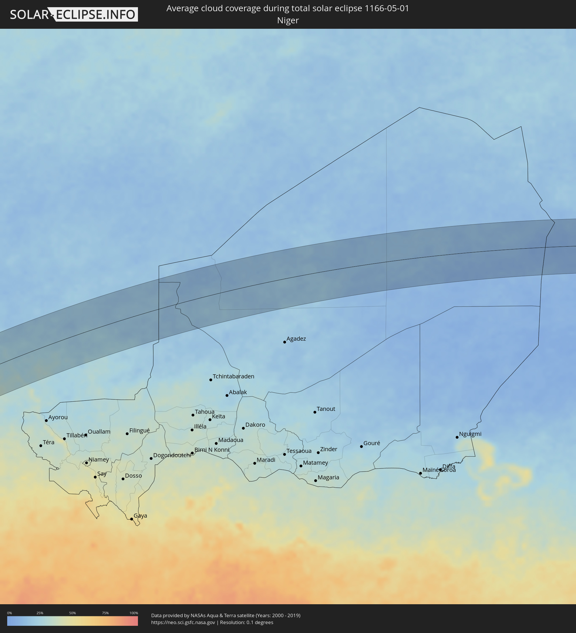 Niger
Niger
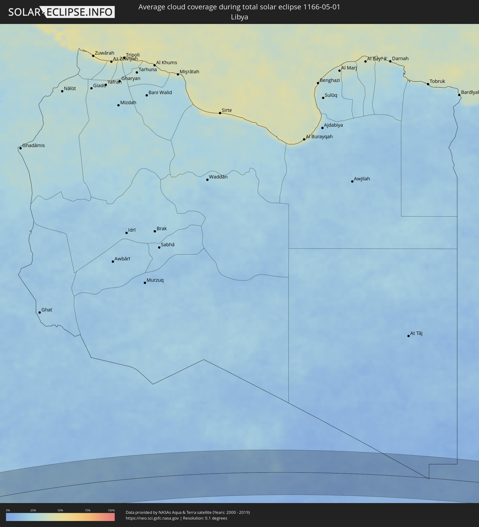 Libya
Libya
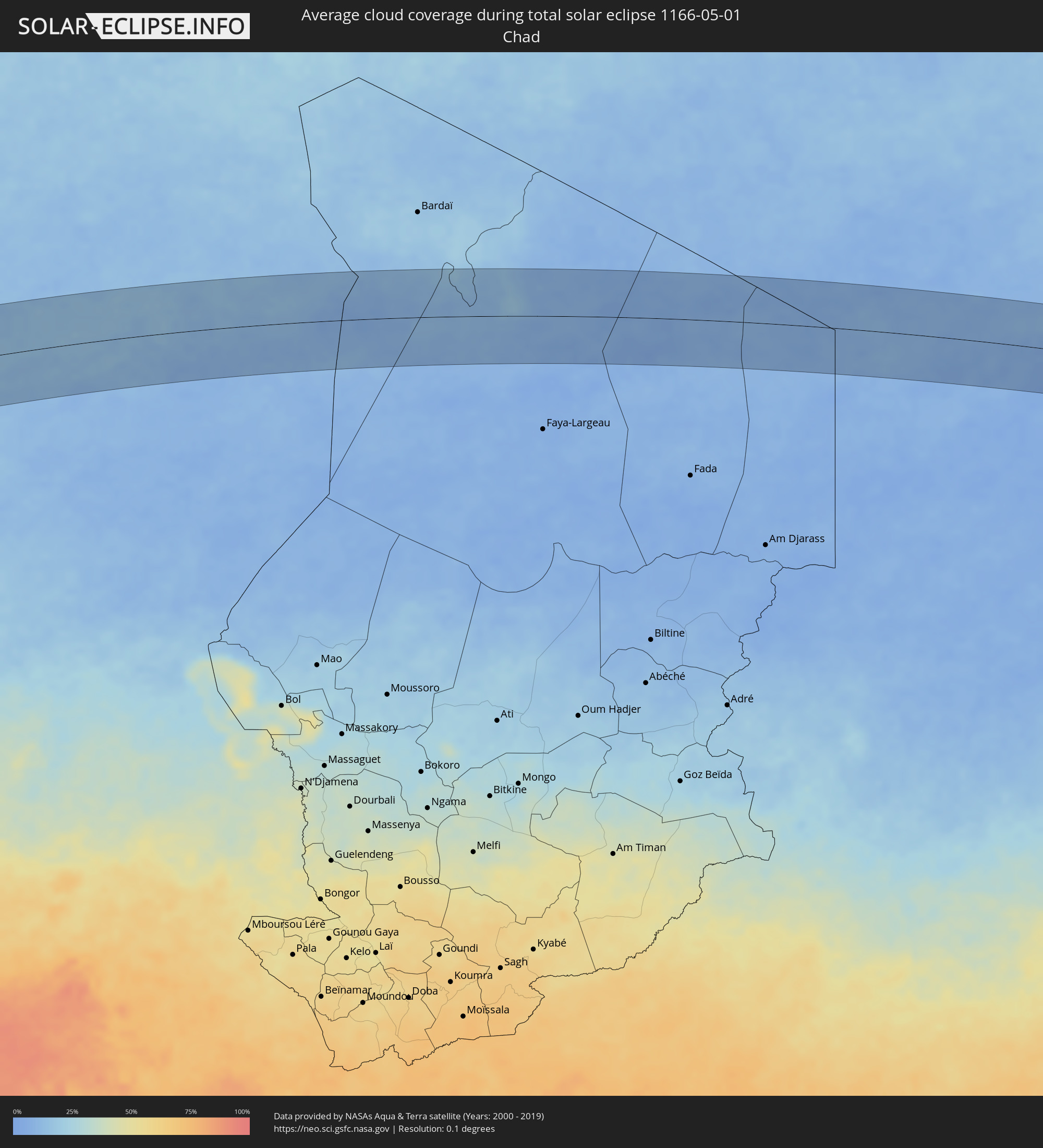 Chad
Chad
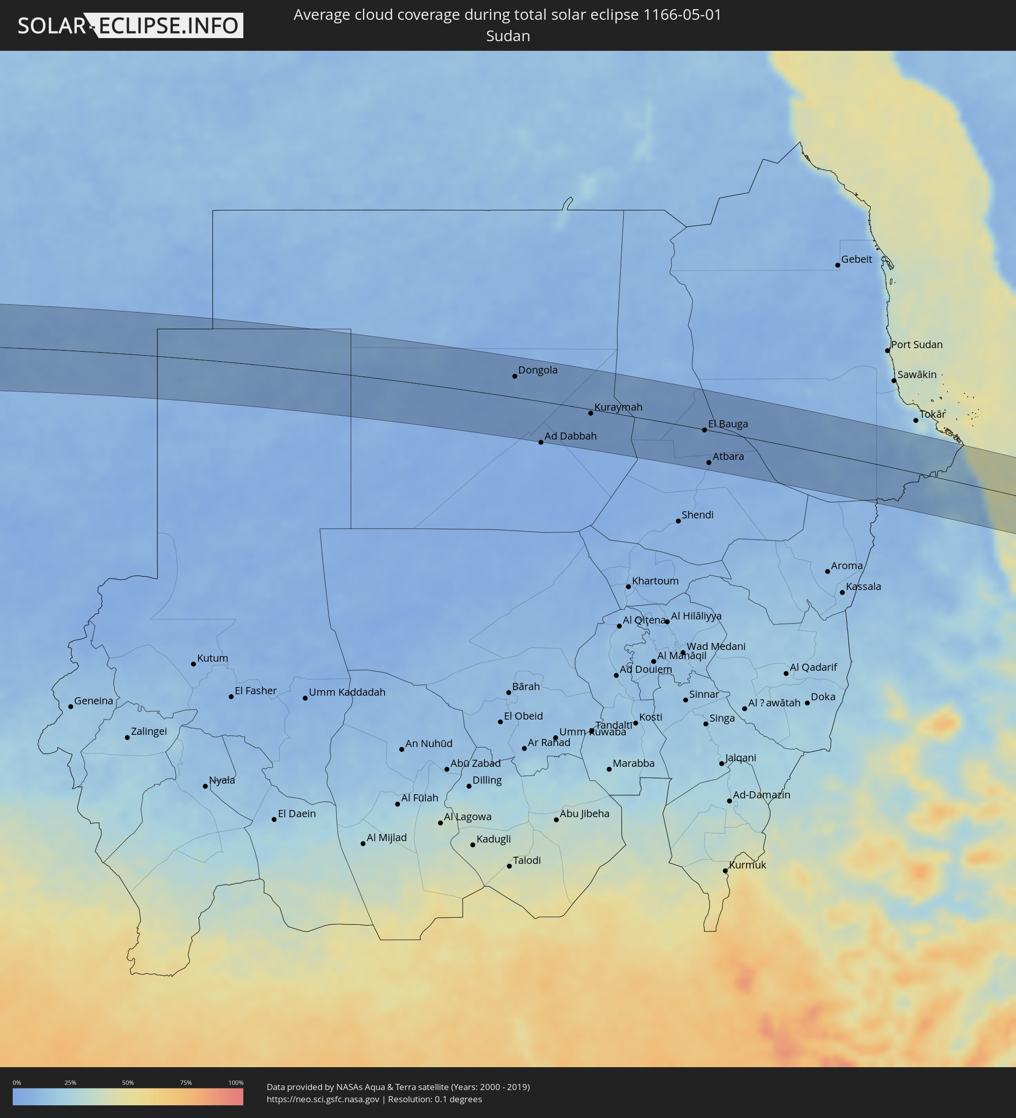 Sudan
Sudan
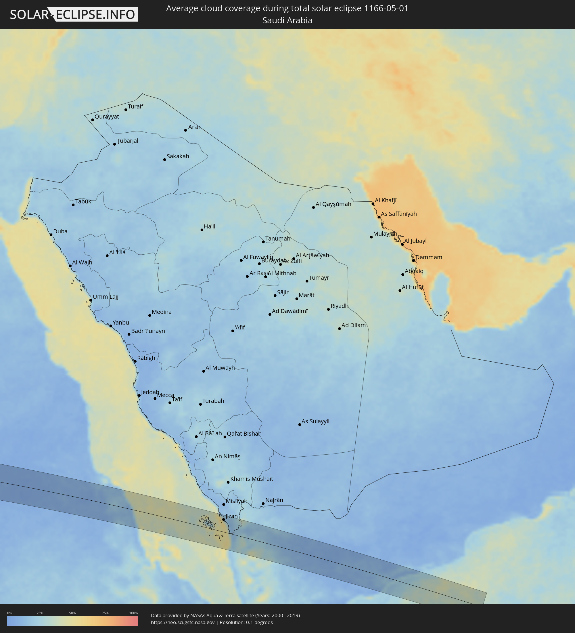 Saudi Arabia
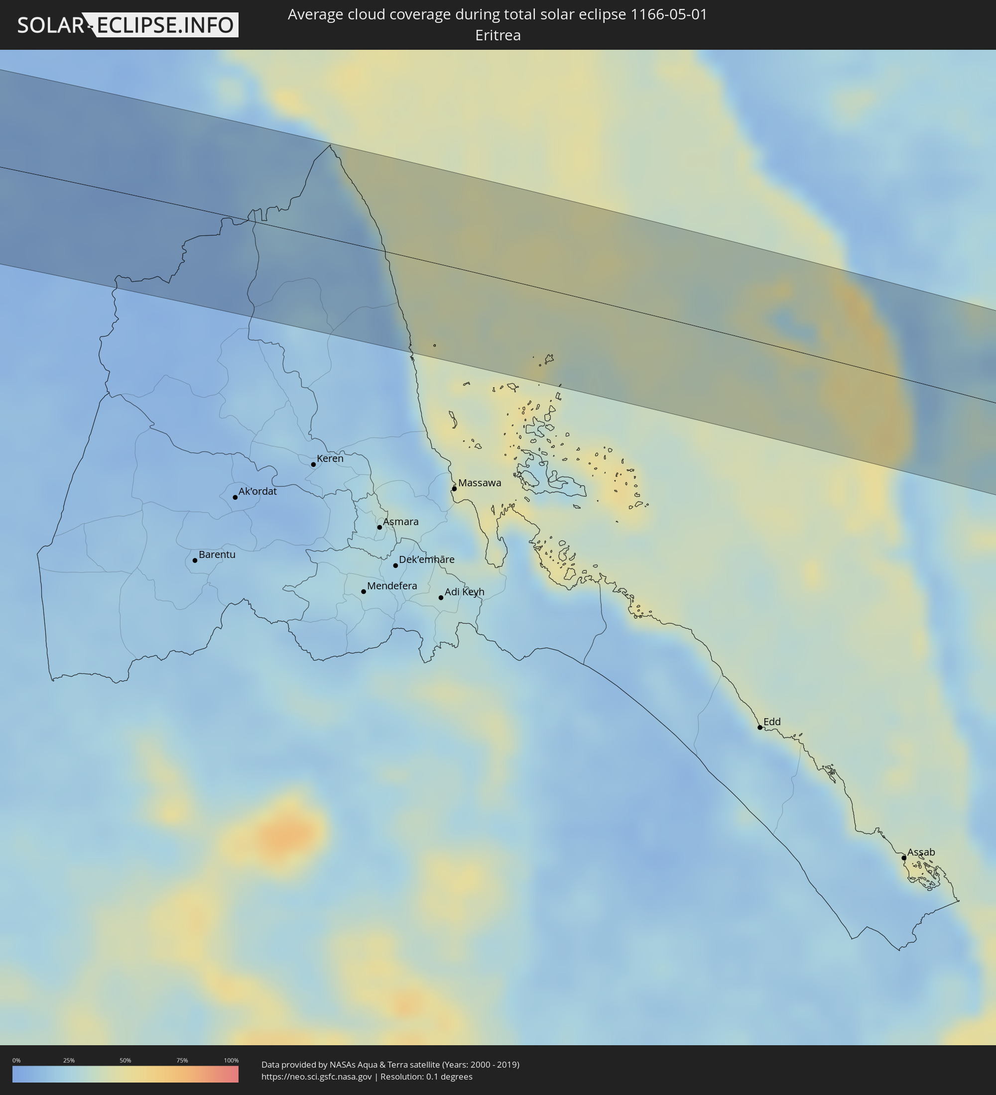 Eritrea
 Yemen
Yemen
Cities inside the path of the eclipse
The following table shows all locations with a population of more than 5,000 inside the eclipse path. Cities which have more than 100,000 inhabitants are marked bold. A click at the locations opens a detailed map.
| City | Type | Eclipse duration | Local time of max. eclipse | Distance to central line | Ø Cloud coverage |
|
Fiambalá, Catamarca Province
|
total | - | 06:56:46 UTC-04:16 | 64 km | 25% |
|
Tinogasta, Catamarca Province
|
total | - | 06:56:46 UTC-04:16 | 23 km | 31% |
|
Arauco, La Rioja Province
|
total | - | 06:56:48 UTC-04:16 | 57 km | 32% |
|
Andalgalá, Catamarca Province
|
total | - | 06:56:52 UTC-04:16 | 27 km | 32% |
|
Aguilares, Tucumán Province
|
total | - | 06:56:57 UTC-04:16 | 19 km | 66% |
|
La Cocha, Tucumán Province
|
total | - | 06:56:56 UTC-04:16 | 18 km | 67% |
|
Los Altos, Catamarca Province
|
total | - | 06:56:56 UTC-04:16 | 48 km | 64% |
|
Monteros, Tucumán Province
|
total | - | 06:56:59 UTC-04:16 | 43 km | 67% |
|
Famaillá, Tucumán Province
|
total | - | 06:57:00 UTC-04:16 | 51 km | 66% |
|
Simoca, Tucumán Province
|
total | - | 06:56:59 UTC-04:16 | 28 km | 66% |
|
Bella Vista, Tucumán Province
|
total | - | 06:57:01 UTC-04:16 | 49 km | 67% |
|
San Miguel de Tucumán, Tucumán Province
|
total | - | 06:57:02 UTC-04:16 | 68 km | 68% |
|
Termas de Río Hondo, Santiago del Estero Province
|
total | - | 06:57:02 UTC-04:16 | 15 km | 55% |
|
Santiago del Estero, Santiago del Estero Province
|
total | - | 06:57:05 UTC-04:16 | 68 km | 60% |
|
Clodomira, Santiago del Estero Province
|
total | - | 06:57:07 UTC-04:16 | 50 km | 59% |
|
Los Frentones, Chaco Province
|
total | - | 06:57:43 UTC-04:16 | 36 km | 53% |
|
Pampa del Infierno, Chaco Province
|
total | - | 06:57:45 UTC-04:16 | 56 km | 52% |
|
Castelli, Chaco Province
|
total | - | 06:57:58 UTC-04:16 | 22 km | 57% |
|
Tres Isletas, Chaco Province
|
total | - | 06:57:57 UTC-04:16 | 69 km | 53% |
|
Pampa del Indio, Chaco Province
|
total | - | 06:58:07 UTC-04:16 | 63 km | 52% |
|
Ibarreta, Formosa Province
|
total | - | 06:58:17 UTC-04:16 | 21 km | 49% |
|
Comandante Fontana, Formosa Province
|
total | - | 06:58:18 UTC-04:16 | 1 km | 47% |
|
Pirané, Formosa Province
|
total | - | 06:58:23 UTC-04:16 | 63 km | 49% |
|
Benjamín Aceval, Presidente Hayes
|
total | - | 07:25:08 UTC-03:50 | 53 km | 49% |
|
Villa Hayes, Presidente Hayes
|
total | - | 07:25:07 UTC-03:50 | 67 km | 48% |
|
San Pedro de Ycuamandiyú, San Pedro
|
total | - | 07:25:31 UTC-03:50 | 14 km | 48% |
|
Puerto Rosario, San Pedro
|
total | - | 07:25:25 UTC-03:50 | 22 km | 47% |
|
Lima, San Pedro
|
total | - | 07:25:50 UTC-03:50 | 1 km | 49% |
|
Capitán Bado, Amambay
|
total | - | 07:26:19 UTC-03:50 | 25 km | 49% |
|
Presidente Prudente, São Paulo
|
total | - | 08:12:48 UTC-03:06 | 64 km | 41% |
|
Andradina, São Paulo
|
total | - | 08:13:21 UTC-03:06 | 55 km | 40% |
|
Araçatuba, São Paulo
|
total | - | 08:13:43 UTC-03:06 | 24 km | 40% |
|
Fernandópolis, São Paulo
|
total | - | 08:14:16 UTC-03:06 | 55 km | 41% |
|
Penápolis, São Paulo
|
total | - | 08:13:49 UTC-03:06 | 63 km | 41% |
|
Votuporanga, São Paulo
|
total | - | 08:14:21 UTC-03:06 | 27 km | 43% |
|
São José do Rio Preto, São Paulo
|
total | - | 08:14:30 UTC-03:06 | 42 km | 43% |
|
Olímpia, São Paulo
|
total | - | 08:14:50 UTC-03:06 | 59 km | 39% |
|
Barretos, São Paulo
|
total | - | 08:15:08 UTC-03:06 | 60 km | 38% |
|
Uberaba, Minas Gerais
|
total | - | 08:15:58 UTC-03:06 | 18 km | 41% |
|
Patrocínio, Minas Gerais
|
total | - | 08:17:04 UTC-03:06 | 6 km | 42% |
|
Araxá, Minas Gerais
|
total | - | 08:16:43 UTC-03:06 | 58 km | 44% |
|
Patos de Minas, Minas Gerais
|
total | - | 08:17:37 UTC-03:06 | 14 km | 47% |
|
Pirapora, Minas Gerais
|
total | - | 08:19:36 UTC-03:06 | 39 km | 35% |
|
Montes Claros, Minas Gerais
|
total | - | 08:20:54 UTC-03:06 | 31 km | 44% |
|
Vitória da Conquista, Bahia
|
total | - | 08:57:33 UTC-02:34 | 16 km | 68% |
|
Itapetinga, Bahia
|
total | - | 08:57:47 UTC-02:34 | 56 km | 78% |
|
Jequié, Bahia
|
total | - | 08:59:12 UTC-02:34 | 58 km | 71% |
|
Itabuna, Bahia
|
total | - | 08:59:08 UTC-02:34 | 77 km | 81% |
|
Valença, Bahia
|
total | - | 09:00:41 UTC-02:34 | 36 km | 75% |
|
Salvador, Bahia
|
total | - | 09:01:40 UTC-02:34 | 34 km | 67% |
|
Lauro de Freitas, Bahia
|
total | - | 09:01:56 UTC-02:34 | 29 km | 67% |
|
Camaçari, Bahia
|
total | - | 09:02:09 UTC-02:34 | 46 km | 77% |
|
Camayenne, Conakry
|
total | - | 12:37:54 UTC-00:16 | 88 km | 71% |
|
Conakry, Conakry
|
total | - | 12:37:56 UTC-00:16 | 87 km | 71% |
|
Coyah, Kindia
|
total | - | 12:38:55 UTC-00:16 | 82 km | 78% |
|
Freetown, Western Area
|
total | - | 12:36:48 UTC-00:16 | 36 km | 79% |
|
Freetown, Western Area
|
total | - | 12:37:02 UTC-00:16 | 35 km | 81% |
|
Tintafor, Northern Province
|
total | - | 12:37:20 UTC-00:16 | 24 km | 76% |
|
Hastings, Western Area
|
total | - | 12:37:04 UTC-00:16 | 51 km | 86% |
|
Kassiri, Northern Province
|
total | - | 12:38:09 UTC-00:16 | 3 km | 81% |
|
Forécariah, Kindia
|
total | - | 12:39:07 UTC-00:16 | 38 km | 76% |
|
Waterloo, Western Area
|
total | - | 12:37:09 UTC-00:16 | 59 km | 82% |
|
Mambolo, Northern Province
|
total | - | 12:38:18 UTC-00:16 | 10 km | 85% |
|
Kambia, Northern Province
|
total | - | 12:38:57 UTC-00:16 | 0 km | 84% |
|
Kindia, Kindia
|
total | - | 12:40:47 UTC-00:16 | 78 km | 63% |
|
Port Loko, Northern Province
|
total | - | 12:38:36 UTC-00:16 | 41 km | 88% |
|
Kukuna, Northern Province
|
total | - | 12:40:03 UTC-00:16 | 6 km | 77% |
|
Lunsar, Northern Province
|
total | - | 12:39:03 UTC-00:16 | 65 km | 88% |
|
Rokupr, Northern Province
|
total | - | 12:39:24 UTC-00:16 | 76 km | 87% |
|
Dalaba, Mamou
|
total | - | 12:43:23 UTC-00:16 | 93 km | 64% |
|
Kamakwie, Northern Province
|
total | - | 12:41:15 UTC-00:16 | 13 km | 75% |
|
Mamou, Mamou
|
total | - | 12:43:11 UTC-00:16 | 55 km | 63% |
|
Makeni, Northern Province
|
total | - | 12:40:36 UTC-00:16 | 80 km | 84% |
|
Binkolo, Northern Province
|
total | - | 12:40:53 UTC-00:16 | 79 km | 82% |
|
Kabala, Northern Province
|
total | - | 12:43:04 UTC-00:16 | 51 km | 70% |
|
Dabola, Faranah
|
total | - | 12:46:12 UTC-00:16 | 23 km | 58% |
|
Faranah, Faranah
|
total | - | 12:45:50 UTC-00:16 | 63 km | 70% |
|
Dinguiraye, Faranah
|
total | - | 12:48:07 UTC-00:16 | 47 km | 48% |
|
Kouroussa, Kankan
|
total | - | 12:49:01 UTC-00:16 | 63 km | 60% |
|
Siguiri, Kankan
|
total | - | 12:52:06 UTC-00:16 | 37 km | 56% |
|
Kangaba, Koulikoro
|
total | - | 12:54:50 UTC-00:16 | 35 km | 54% |
|
Kati, Koulikoro
|
total | - | 12:57:01 UTC-00:16 | 21 km | 48% |
|
Bamako, Bamako
|
total | - | 12:57:03 UTC-00:16 | 8 km | 46% |
|
Koulikoro, Koulikoro
|
total | - | 12:58:29 UTC-00:16 | 2 km | 47% |
|
Banamba, Koulikoro
|
total | - | 12:59:52 UTC-00:16 | 61 km | 37% |
|
Ségou, Ségou
|
total | - | 13:02:42 UTC-00:16 | 19 km | 40% |
|
Markala, Ségou
|
total | - | 13:03:30 UTC-00:16 | 1 km | 43% |
|
Ké-Macina, Ségou
|
total | - | 13:05:38 UTC-00:16 | 13 km | 41% |
|
Ténenkou, Mopti
|
total | - | 13:07:28 UTC-00:16 | 12 km | 36% |
|
Djénné, Mopti
|
total | - | 13:07:32 UTC-00:16 | 60 km | 42% |
|
Mopti, Mopti
|
total | - | 13:09:18 UTC-00:16 | 22 km | 40% |
|
Bandiagara, Mopti
|
total | - | 13:10:31 UTC-00:16 | 63 km | 36% |
|
Douentza, Mopti
|
total | - | 13:13:04 UTC-00:16 | 30 km | 35% |
|
Gao, Gao
|
total | - | 13:21:43 UTC-00:16 | 26 km | 27% |
|
Argo, Northern State
|
total | - | 16:41:38 UTC+02:10 | 75 km | 5% |
|
Dongola, Northern State
|
total | - | 16:41:41 UTC+02:10 | 39 km | 7% |
|
Marawī, Northern State
|
total | - | 16:42:49 UTC+02:10 | 16 km | 5% |
|
Kuraymah, Northern State
|
total | - | 16:42:51 UTC+02:10 | 8 km | 4% |
|
El Bauga, River Nile
|
total | - | 16:44:27 UTC+02:10 | 2 km | 8% |
|
Ed Damer, River Nile
|
total | - | 16:44:29 UTC+02:10 | 73 km | 6% |
|
Berber, River Nile
|
total | - | 16:44:30 UTC+02:10 | 27 km | 5% |
|
Atbara, River Nile
|
total | - | 16:44:30 UTC+02:10 | 61 km | 6% |
|
Farasān, Jizan
|
total | - | 17:45:44 UTC+03:06 | 18 km | 36% |
|
Jizan, Jizan
|
total | - | 17:45:53 UTC+03:06 | 50 km | 35% |
|
Mizhirah, Jizan
|
total | - | 17:45:57 UTC+03:06 | 48 km | 28% |
|
Abū ‘Arīsh, Jizan
|
total | - | 17:45:59 UTC+03:06 | 66 km | 15% |
|
Al Jarādīyah, Jizan
|
total | - | 17:46:02 UTC+03:06 | 26 km | 13% |
|
Şāmitah, Jizan
|
total | - | 17:46:02 UTC+03:06 | 29 km | 13% |
|
Ḩajjah, Ḩajjah
|
total | - | 17:46:17 UTC+03:06 | 50 km | 41% |
|
‘Amrān, Omran
|
total | - | 17:46:24 UTC+03:06 | 45 km | 35% |
|
Al Ḩazm, Al Jawf
|
total | - | 17:46:38 UTC+03:06 | 33 km | 12% |
|
Ma'rib, Ma’rib
|
total | - | 17:46:48 UTC+03:06 | 27 km | 12% |
|
Al Mukallā, Muḩāfaz̧at Ḩaḑramawt
|
total | - | 17:47:32 UTC+03:06 | 12 km | 24% |