Total solar eclipse of 02/09/1785
| Day of week: | Wednesday |
| Maximum duration of eclipse: | 04m07s |
| Maximum width of eclipse path: | 159 km |
| Saros cycle: | 127 |
| Coverage: | 100% |
| Magnitude: | 1.048 |
| Gamma: | 0.008 |
Wo kann man die Sonnenfinsternis vom 02/09/1785 sehen?
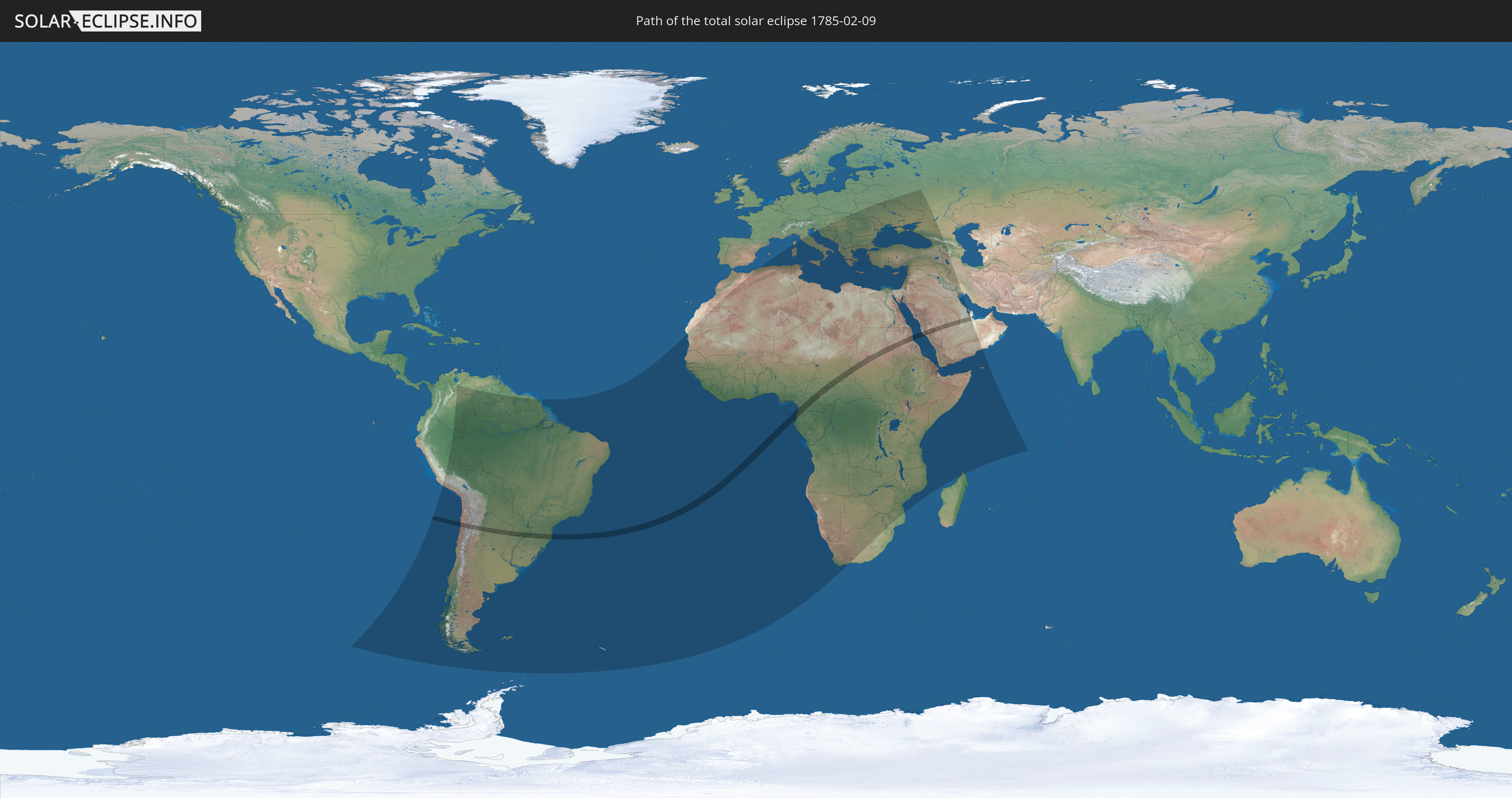
Die Sonnenfinsternis am 02/09/1785 kann man in 106 Ländern als partielle Sonnenfinsternis beobachten.
Der Finsternispfad verläuft durch 12 Länder. Nur in diesen Ländern ist sie als total Sonnenfinsternis zu sehen.
In den folgenden Ländern ist die Sonnenfinsternis total zu sehen
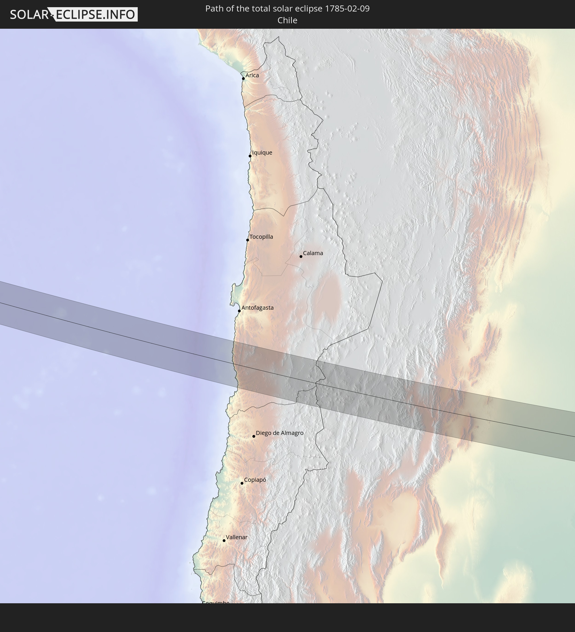 Chile
Chile
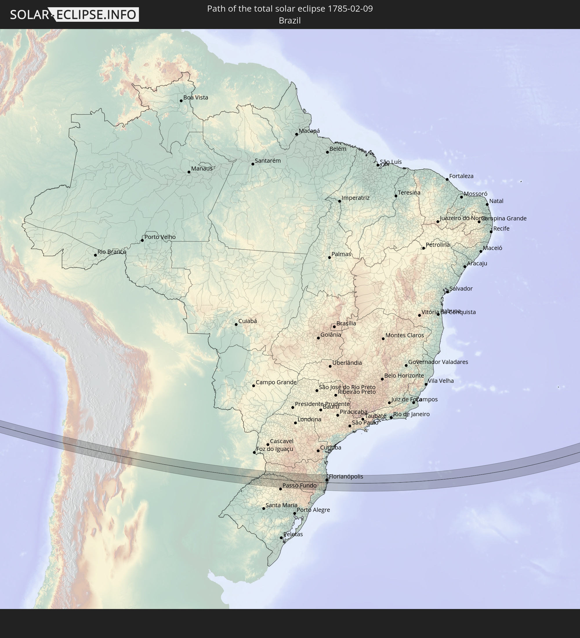 Brazil
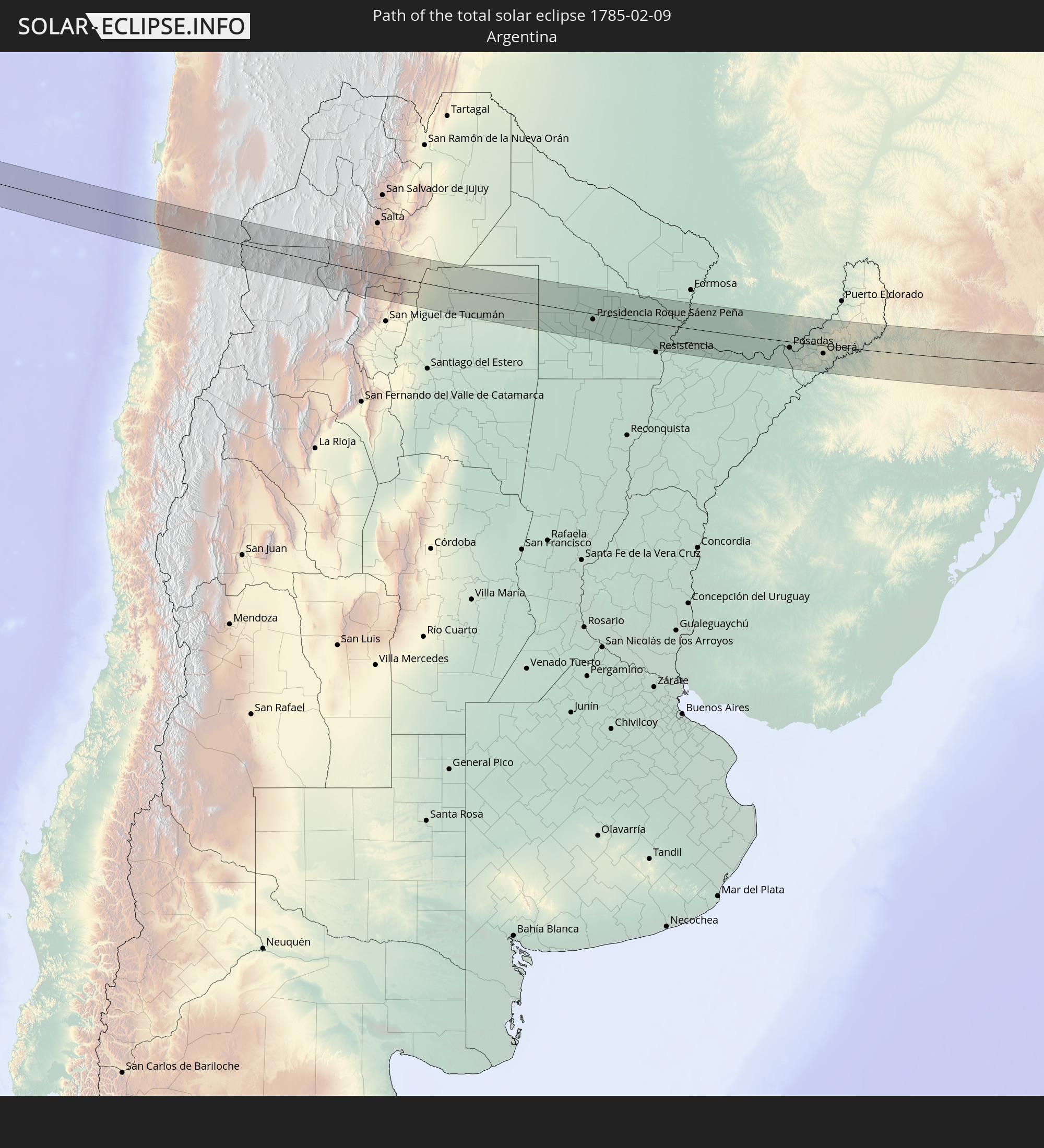 Argentina
 Paraguay
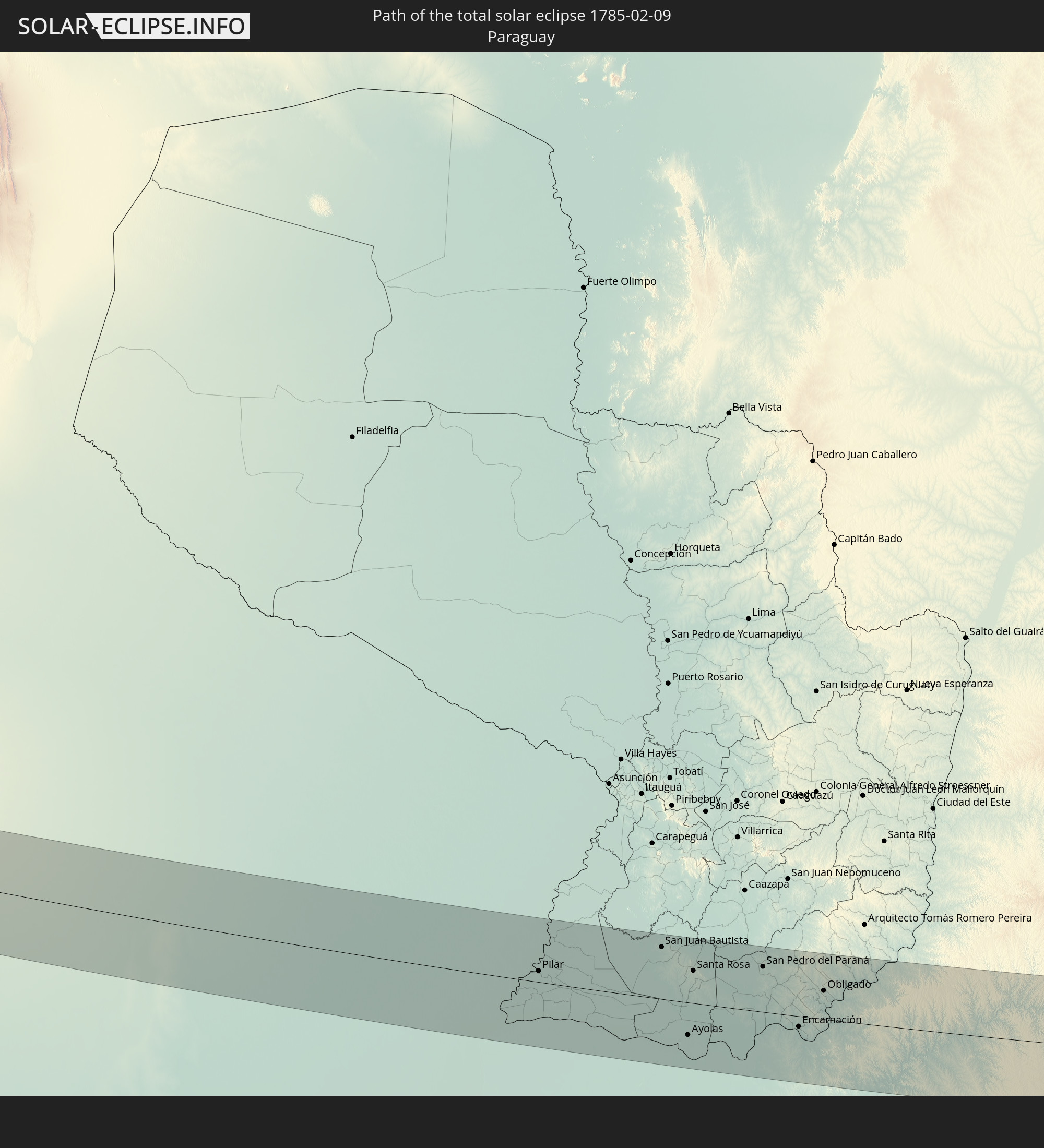
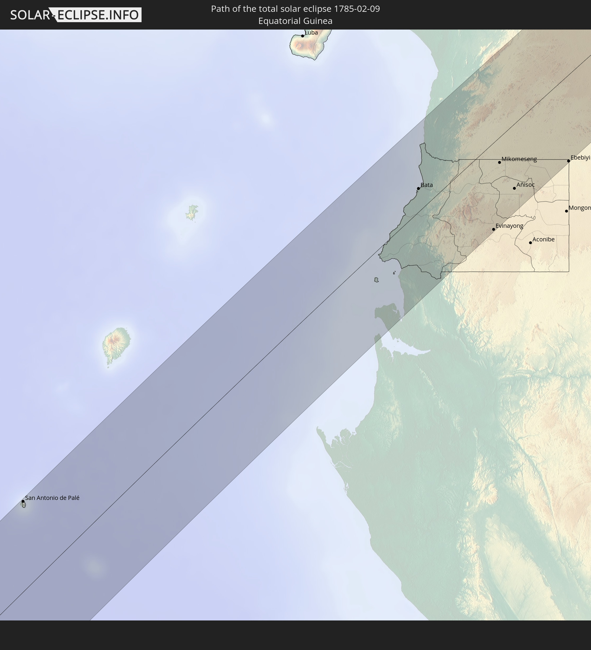 Equatorial Guinea
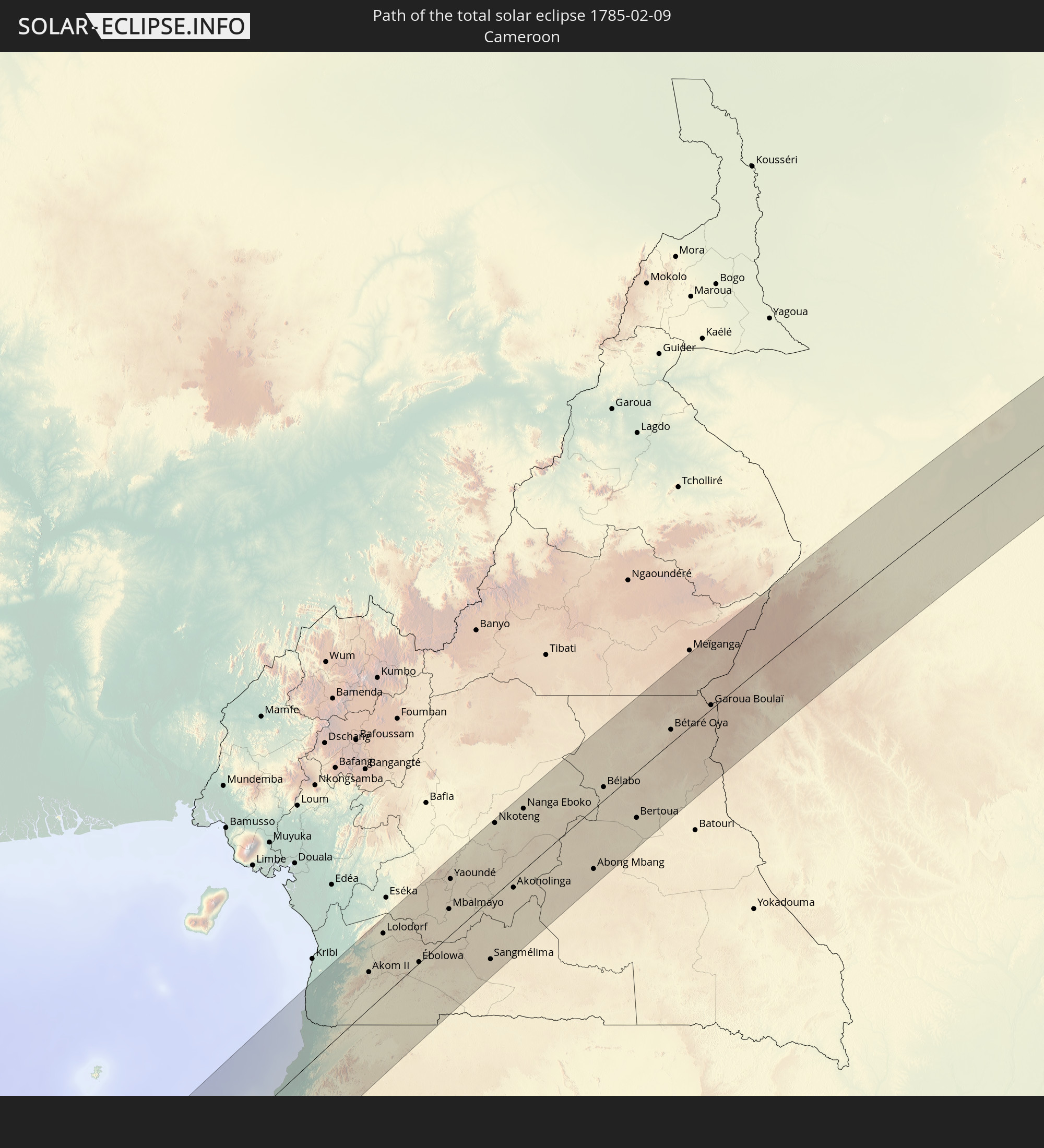 Cameroon
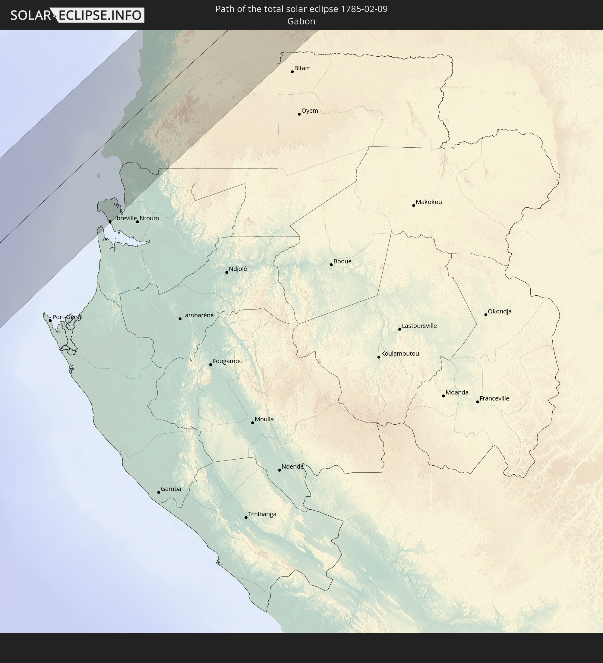 Gabon
Gabon
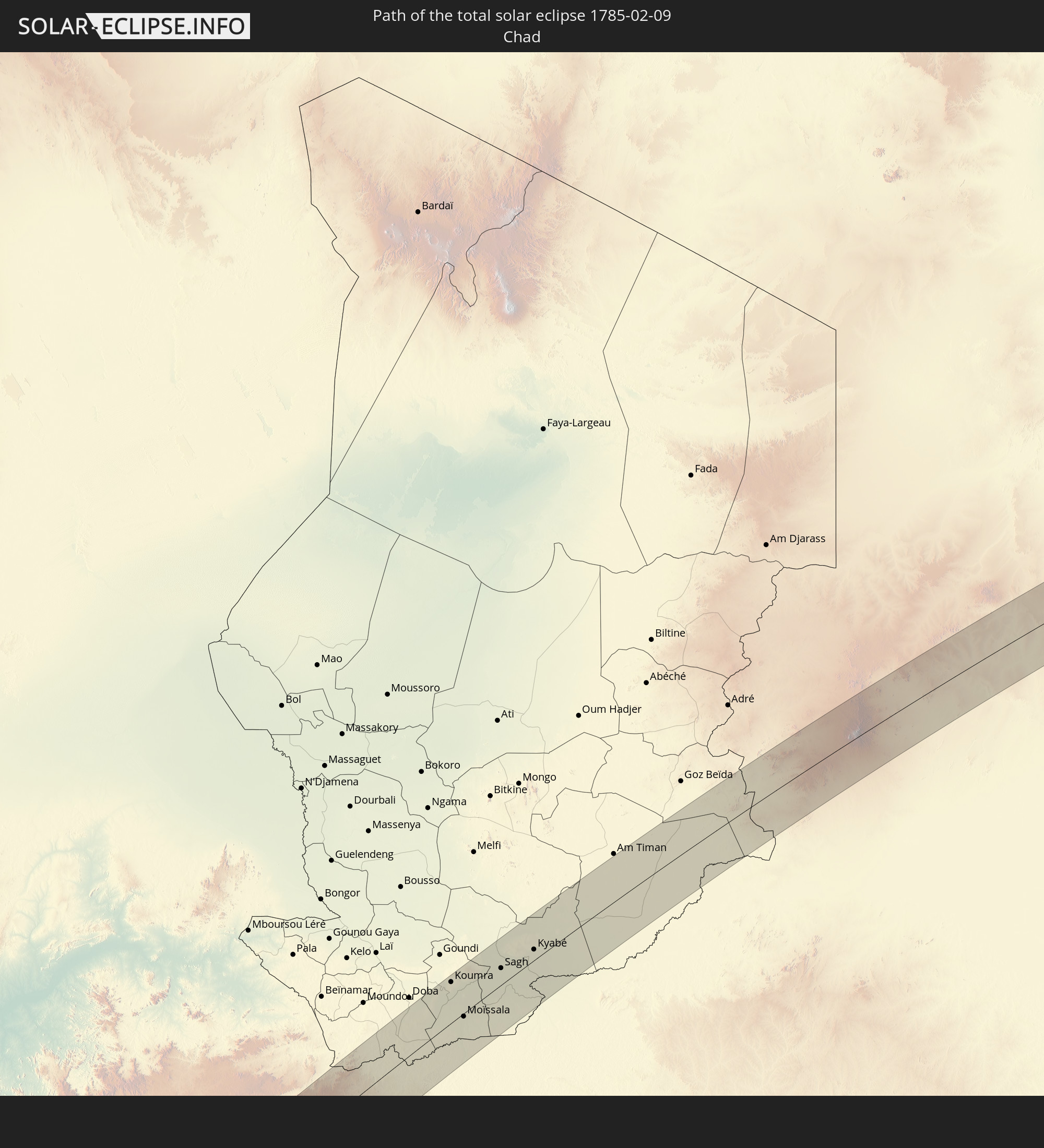 Chad
Chad
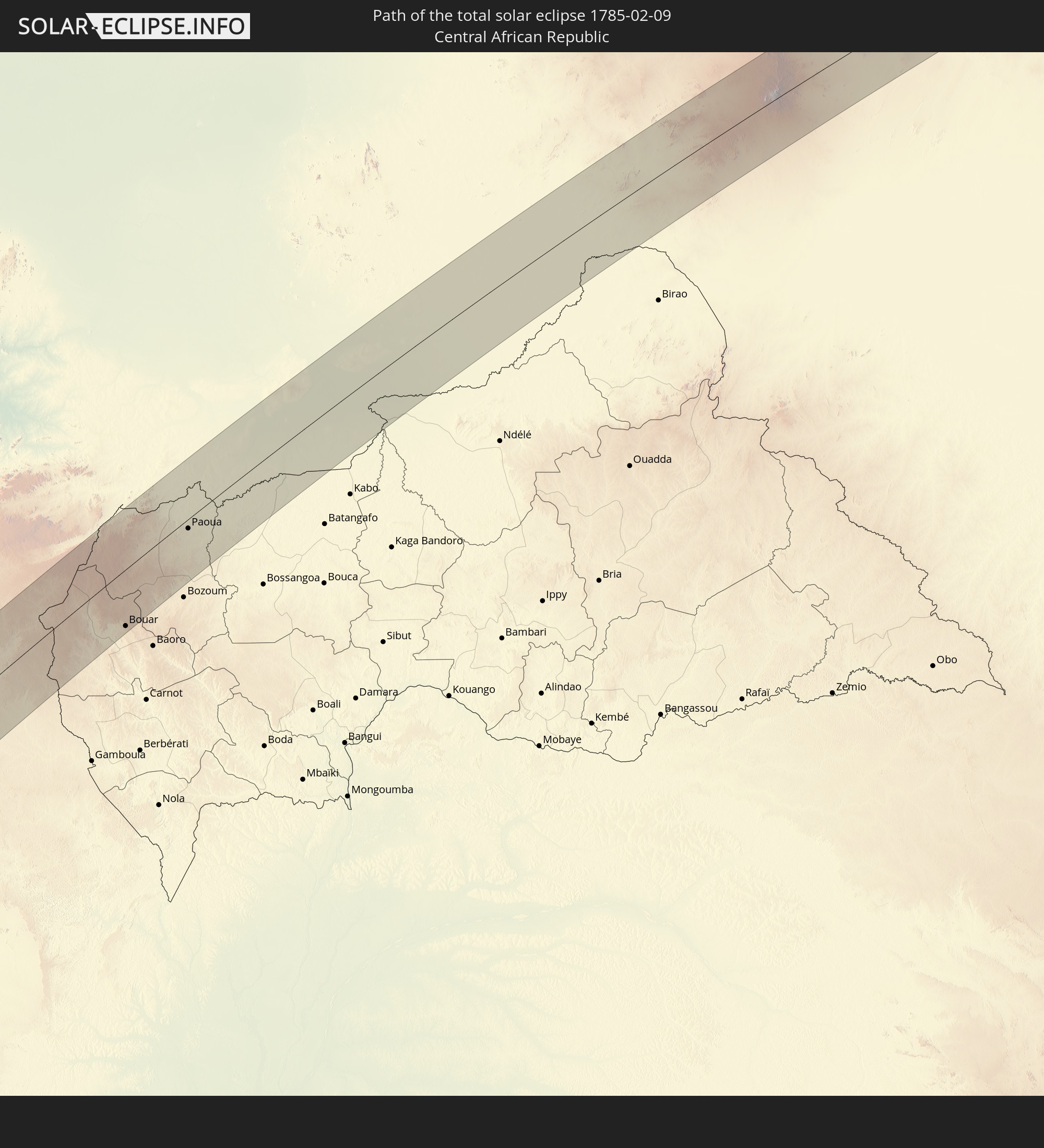 Central African Republic
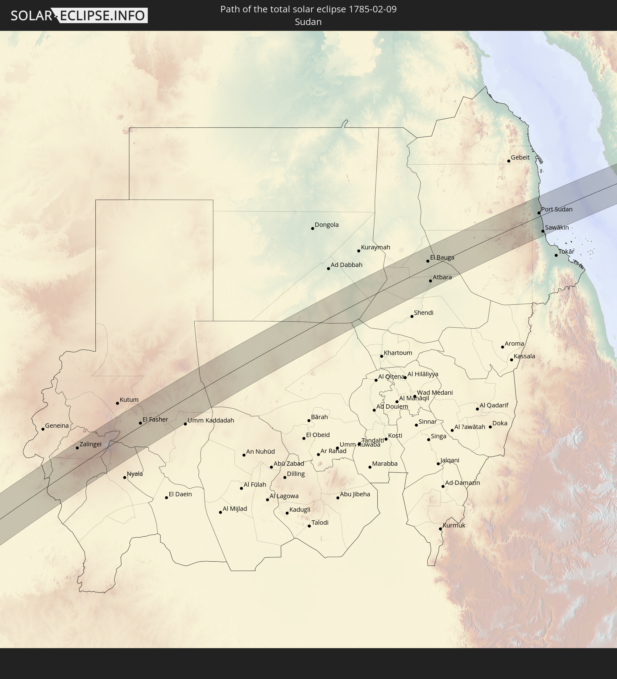 Sudan
Sudan
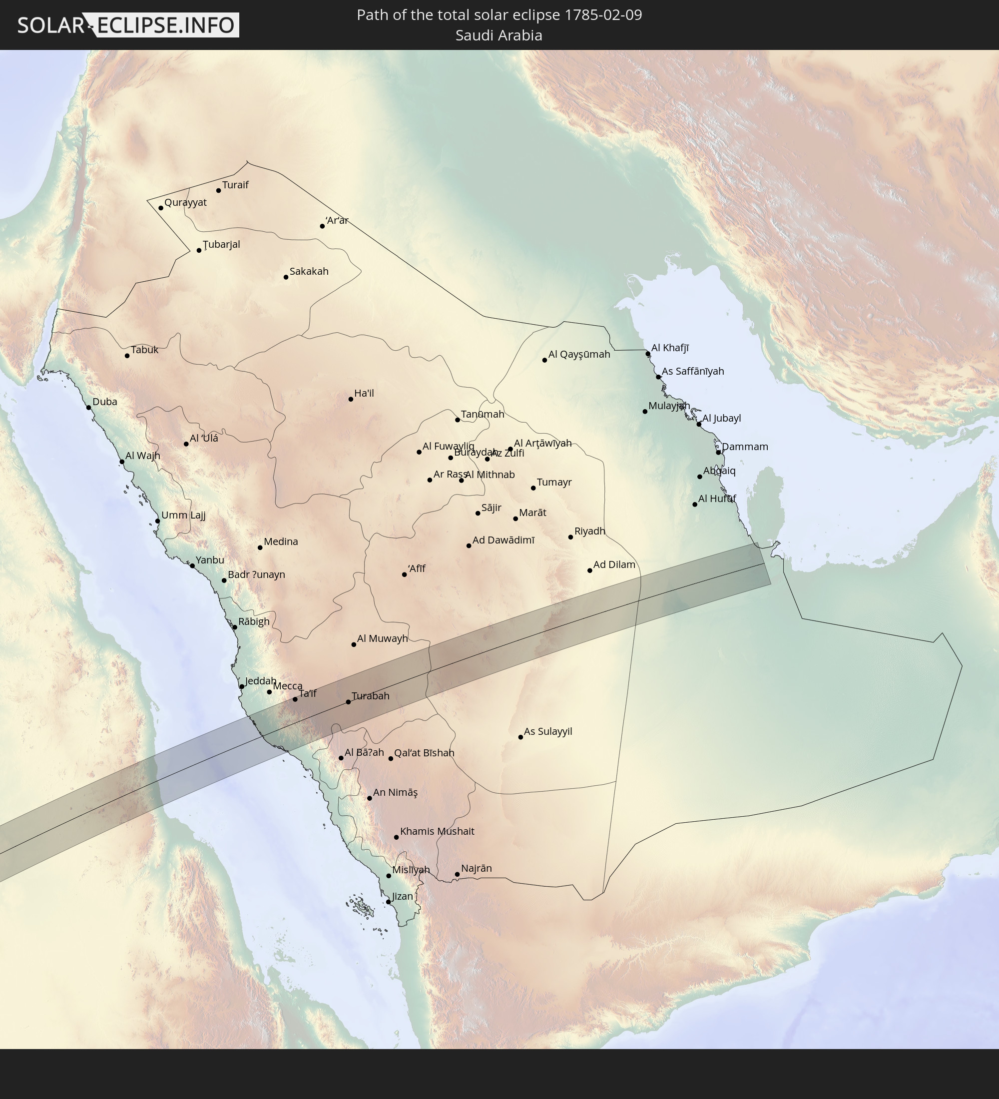 Saudi Arabia
 Qatar
Qatar
In den folgenden Ländern ist die Sonnenfinsternis partiell zu sehen
 Russia
 Chile
Chile
 Colombia
 Peru
Peru
 Brazil
 Argentina
 Venezuela
 Bolivia
 Paraguay
 Falkland Islands
 Guyana
 Uruguay
 Suriname
 French Guiana
 South Georgia and the South Sandwich Islands
 Senegal
 Mauritania
 The Gambia
 Guinea-Bissau
 Guinea
 Saint Helena, Ascension and Tristan da Cunha
 Sierra Leone
 Morocco
 Mali
Mali
 Liberia
 Algeria
 Ivory Coast
 Burkina Faso
 France
 Ghana
Ghana
 Togo
Togo
 Niger
Niger
 Benin
Benin
 Nigeria
 Equatorial Guinea
 São Tomé and Príncipe
 Italy
Italy
 Tunisia
 Cameroon
 Gabon
Gabon
 Libya
Libya
 Republic of the Congo
 Angola
 Namibia
 Democratic Republic of the Congo
 San Marino
 Vatican City
 Slovenia
 Chad
Chad
 Croatia
 Poland
 Malta
Malta
 Central African Republic
 Bosnia and Herzegovina
 Hungary
 South Africa
 Slovakia
 Montenegro
 Serbia
 Albania
 Greece
 Botswana
 Romania
 Republic of Macedonia
 Sudan
Sudan
 Zambia
 Ukraine
 Bulgaria
 Belarus
 Egypt
Egypt
 Zimbabwe
 Turkey
 Moldova
 Rwanda
 Burundi
 Tanzania
 Uganda
 Mozambique
 Cyprus
 Malawi
 Ethiopia
 Kenya
Kenya
 State of Palestine
 Israel
 Saudi Arabia
 Jordan
 Lebanon
 Syria
Syria
 Eritrea
 Iraq
Iraq
 Georgia
 French Southern and Antarctic Lands
 Somalia
 Djibouti
 Yemen
Yemen
 Madagascar
 Comoros
 Armenia
 Iran
Iran
 Azerbaijan
 Mayotte
 Seychelles
 Kuwait
 Bahrain
 Qatar
Qatar
 Oman
Oman
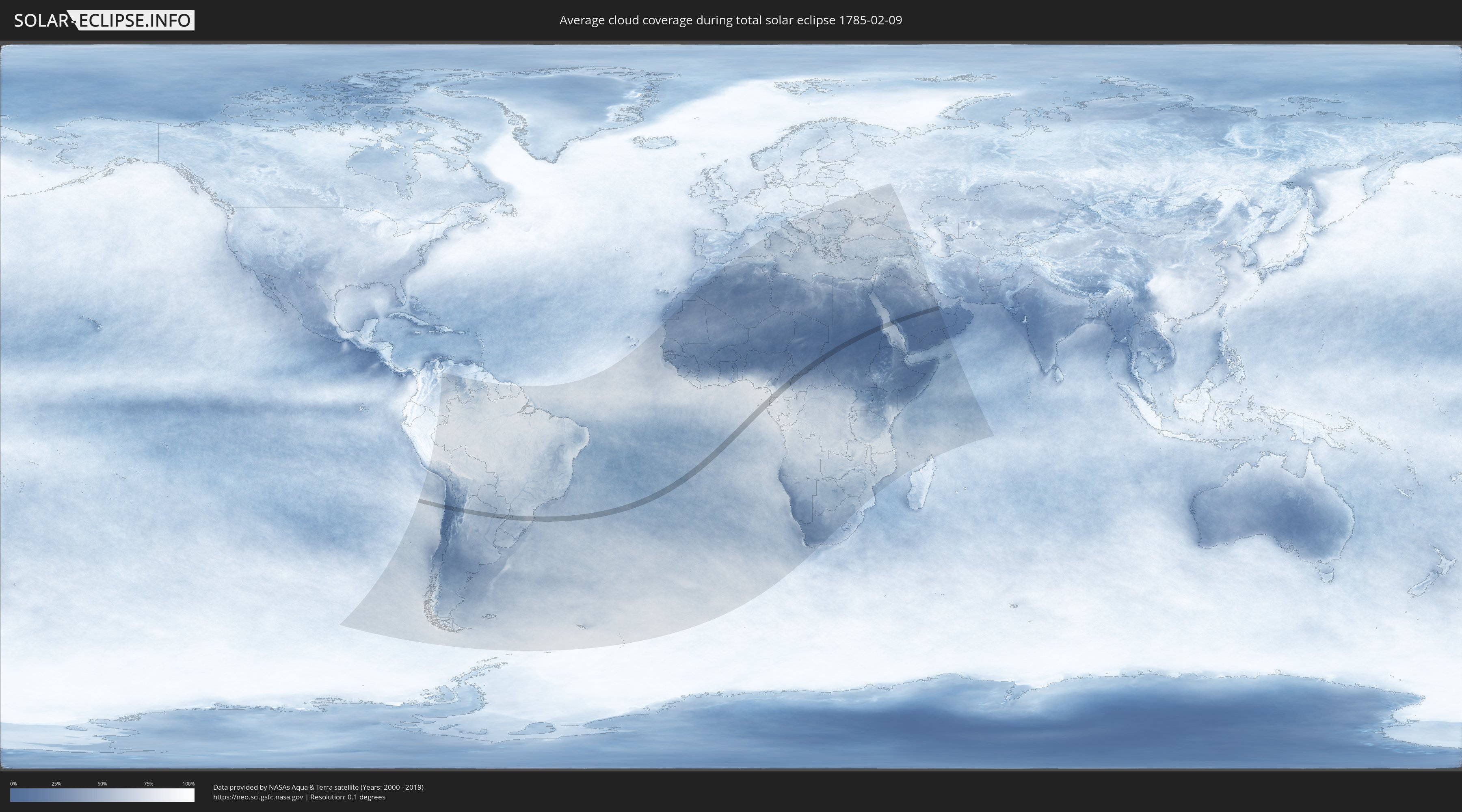
How will be the weather during the total solar eclipse on 02/09/1785?
Where is the best place to see the total solar eclipse of 02/09/1785?
The following maps show the average cloud coverage for the day of the total solar eclipse.
With the help of these maps, it is possible to find the place along the eclipse path, which has the best
chance of a cloudless sky.
Nevertheless, you should consider local circumstances and inform about the weather of your chosen
observation site.
The data is provided by NASAs satellites
AQUA and TERRA.
The cloud maps are averaged over a period of 19 years (2000 - 2019).

Detailed country maps
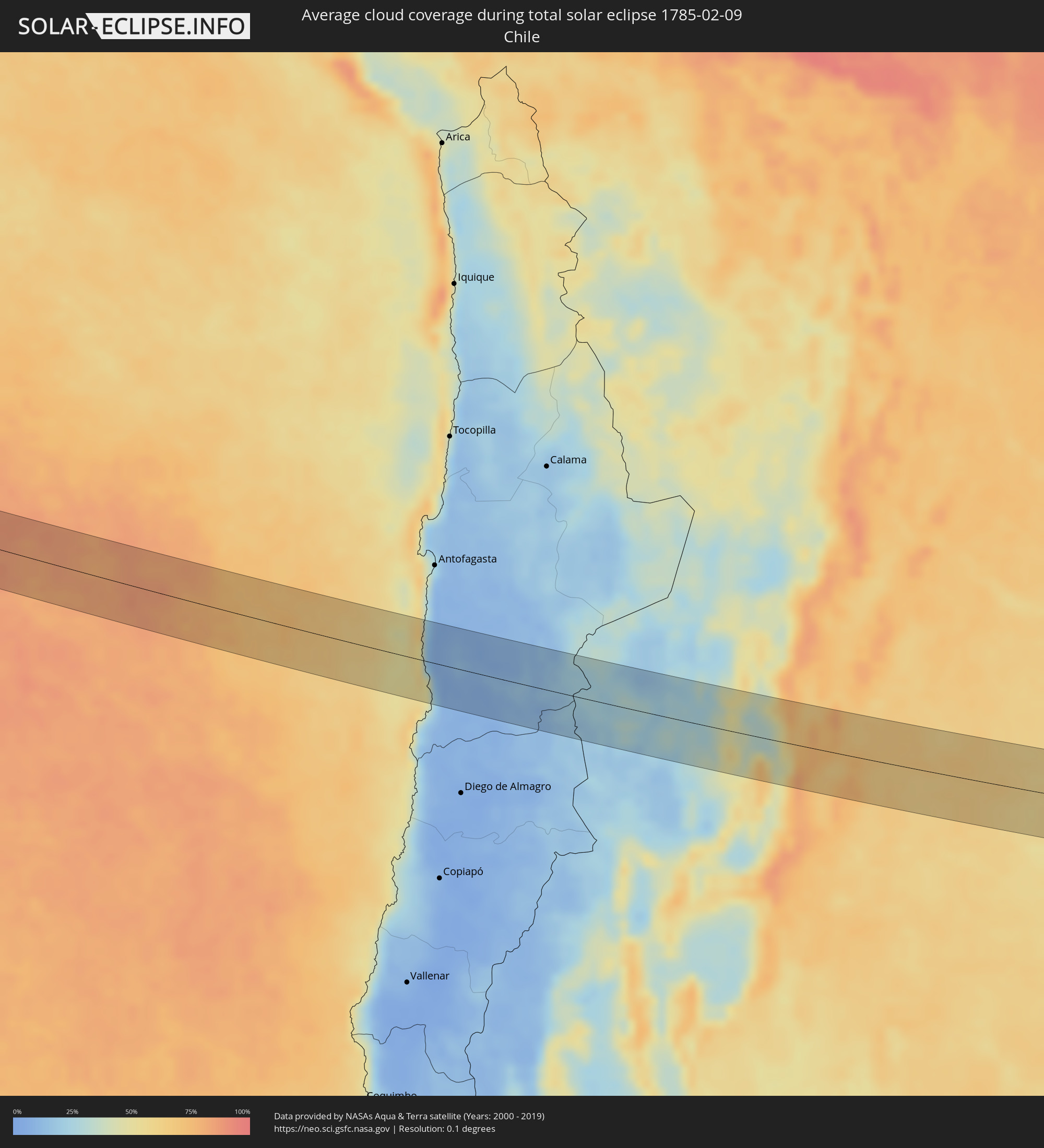 Chile
Chile
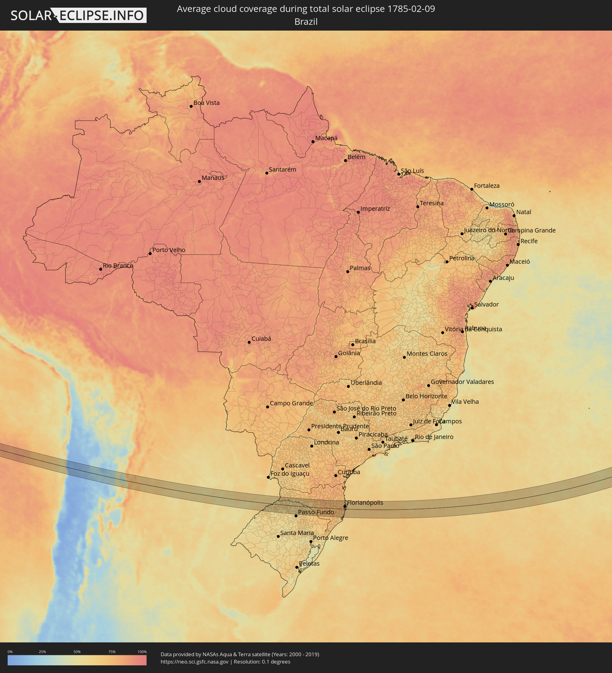 Brazil
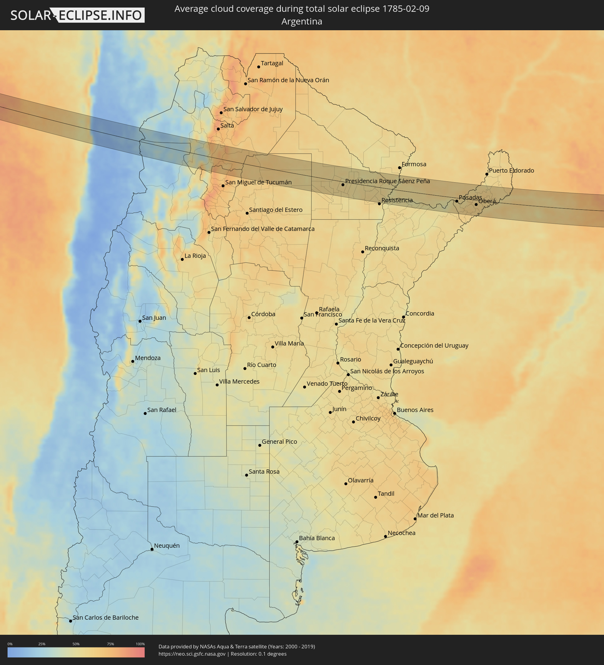 Argentina
 Paraguay
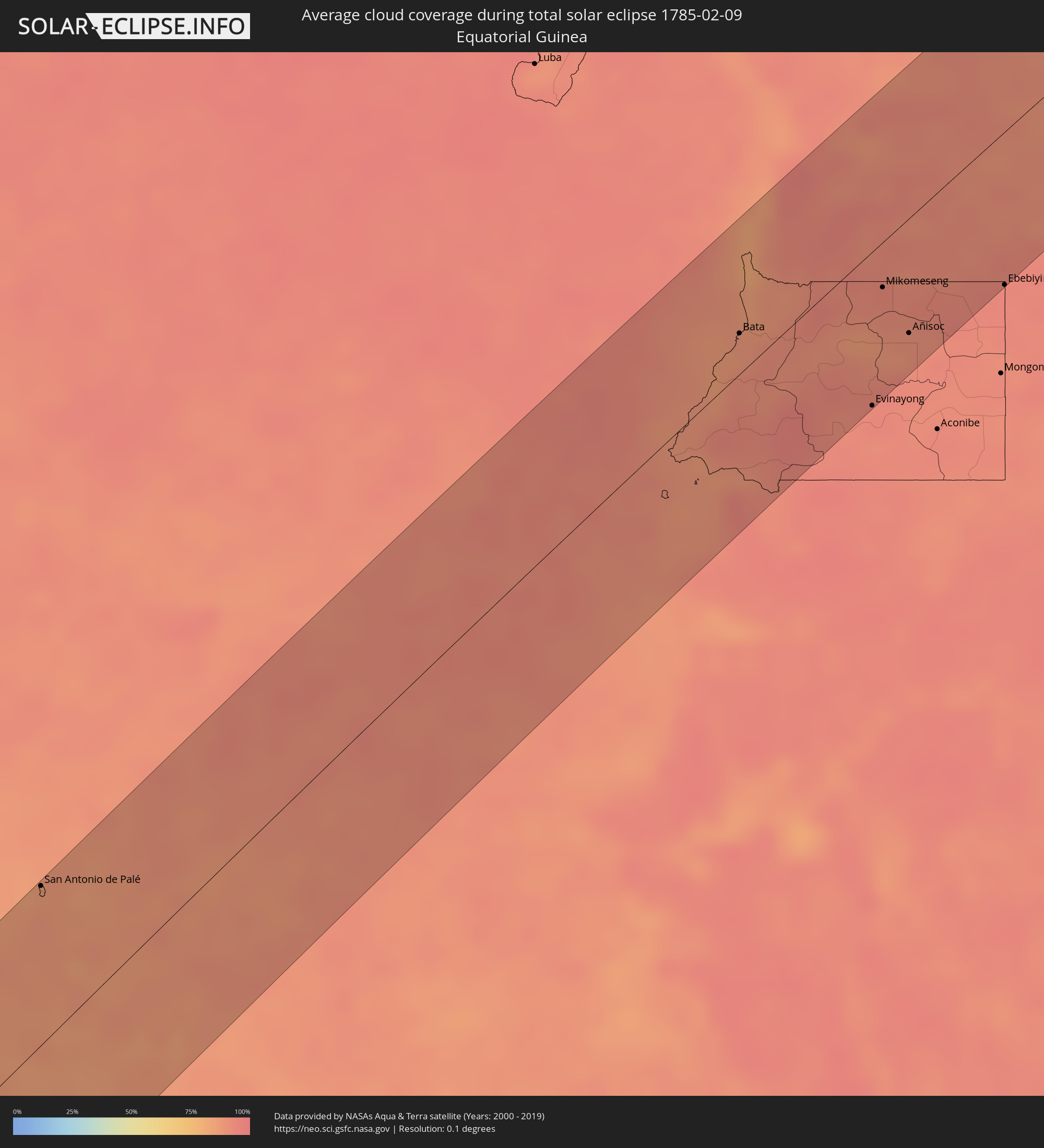 Equatorial Guinea
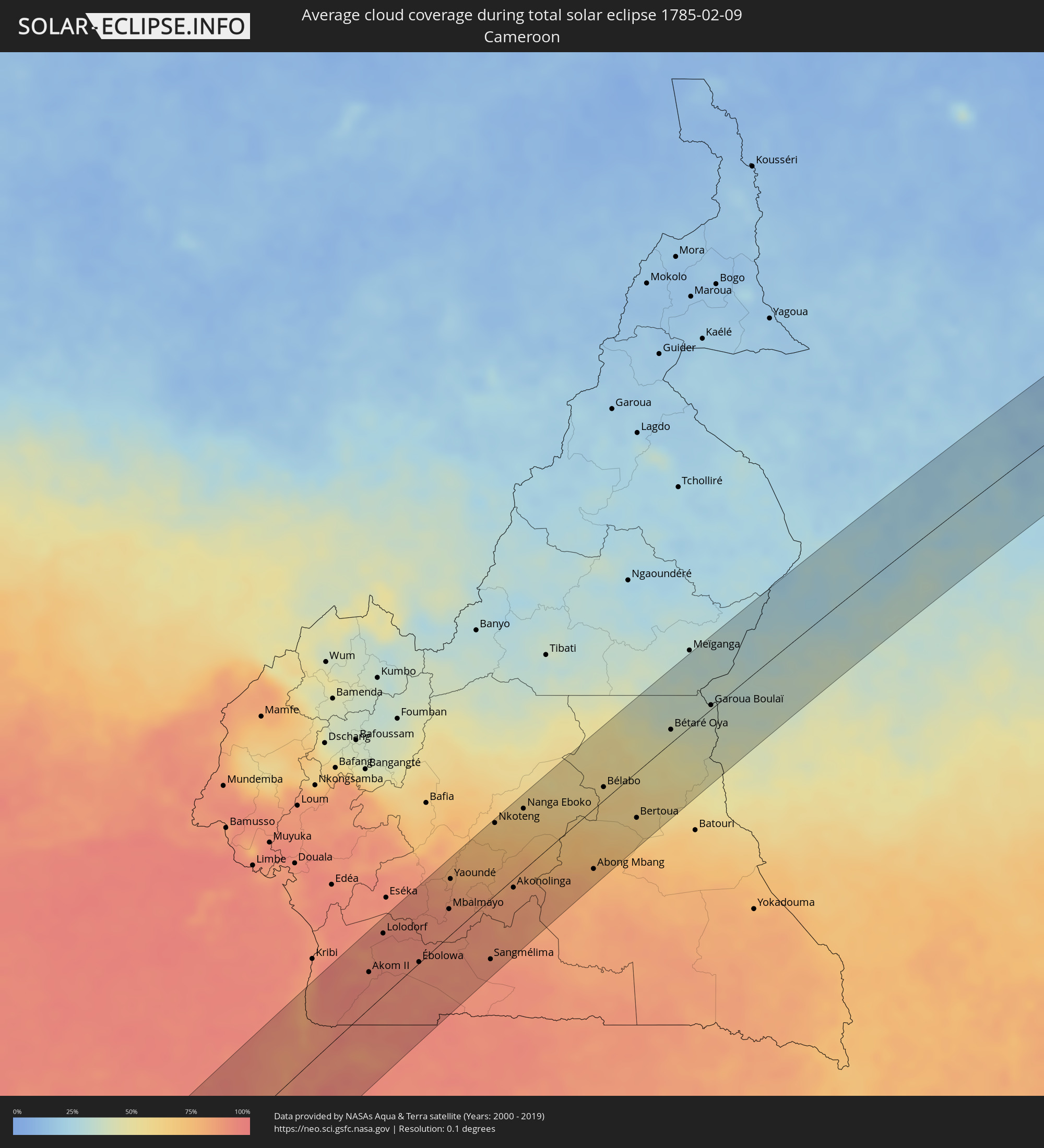 Cameroon
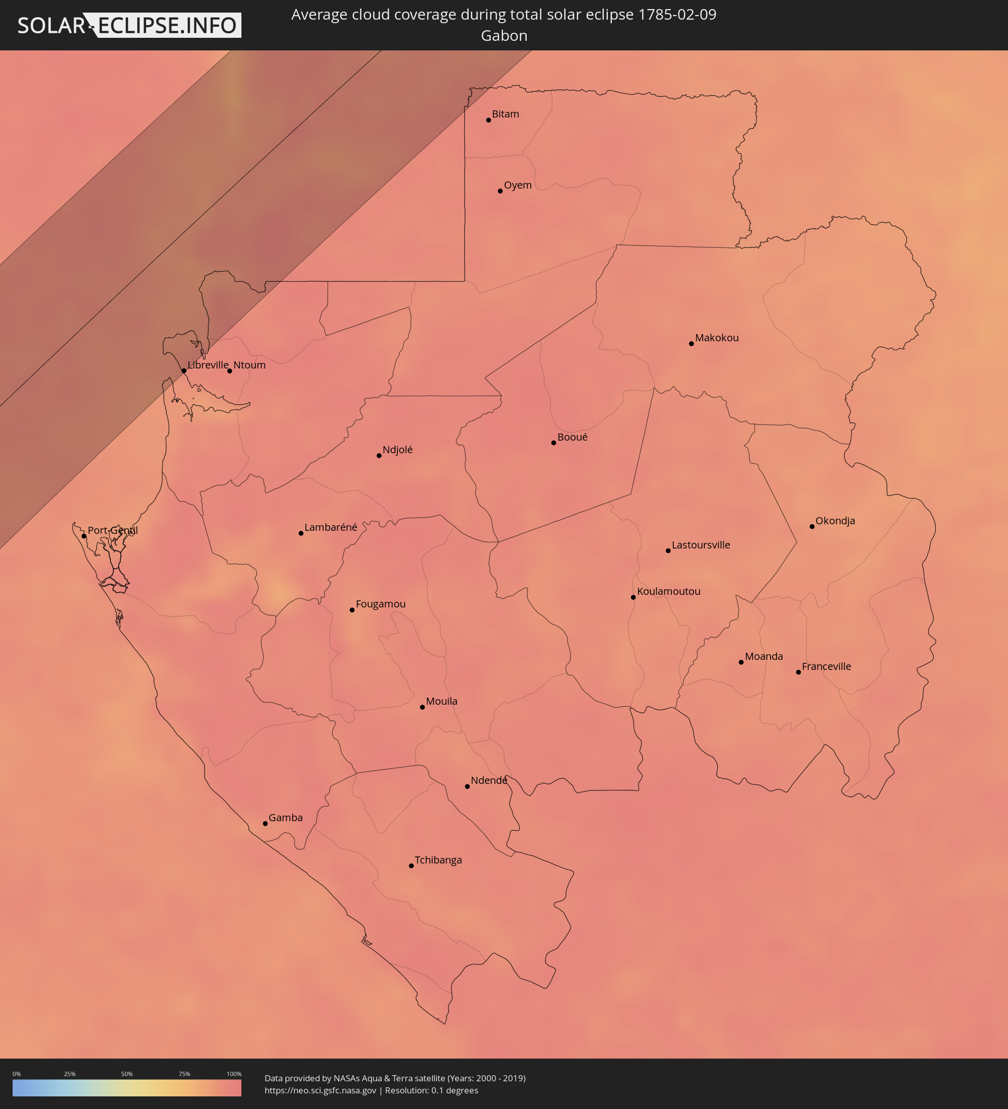 Gabon
Gabon
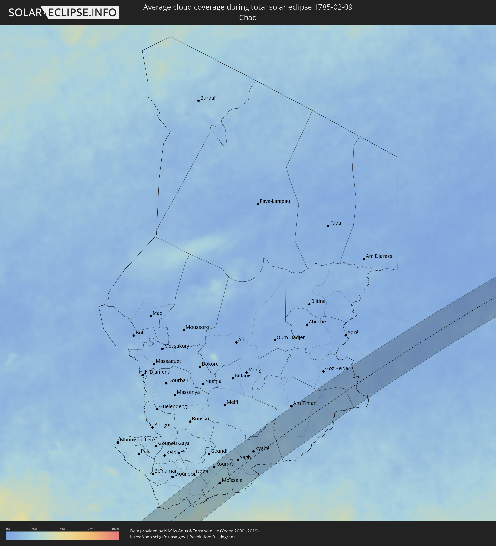 Chad
Chad
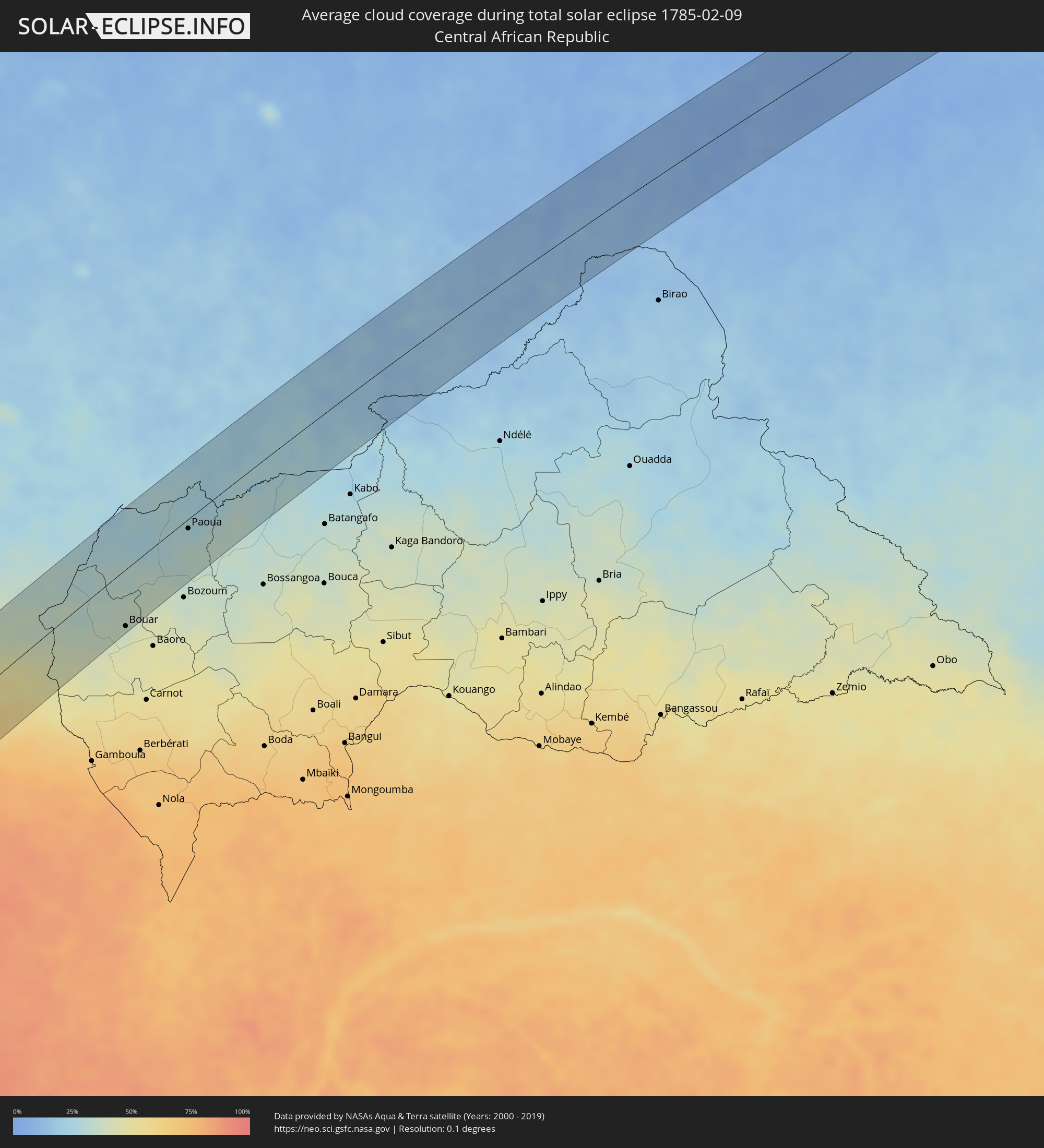 Central African Republic
 Sudan
Sudan
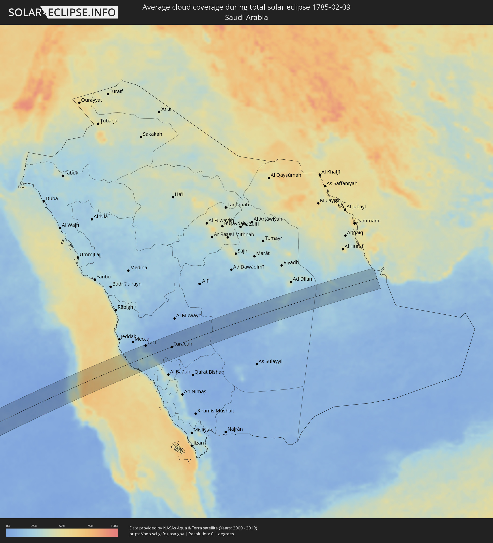 Saudi Arabia
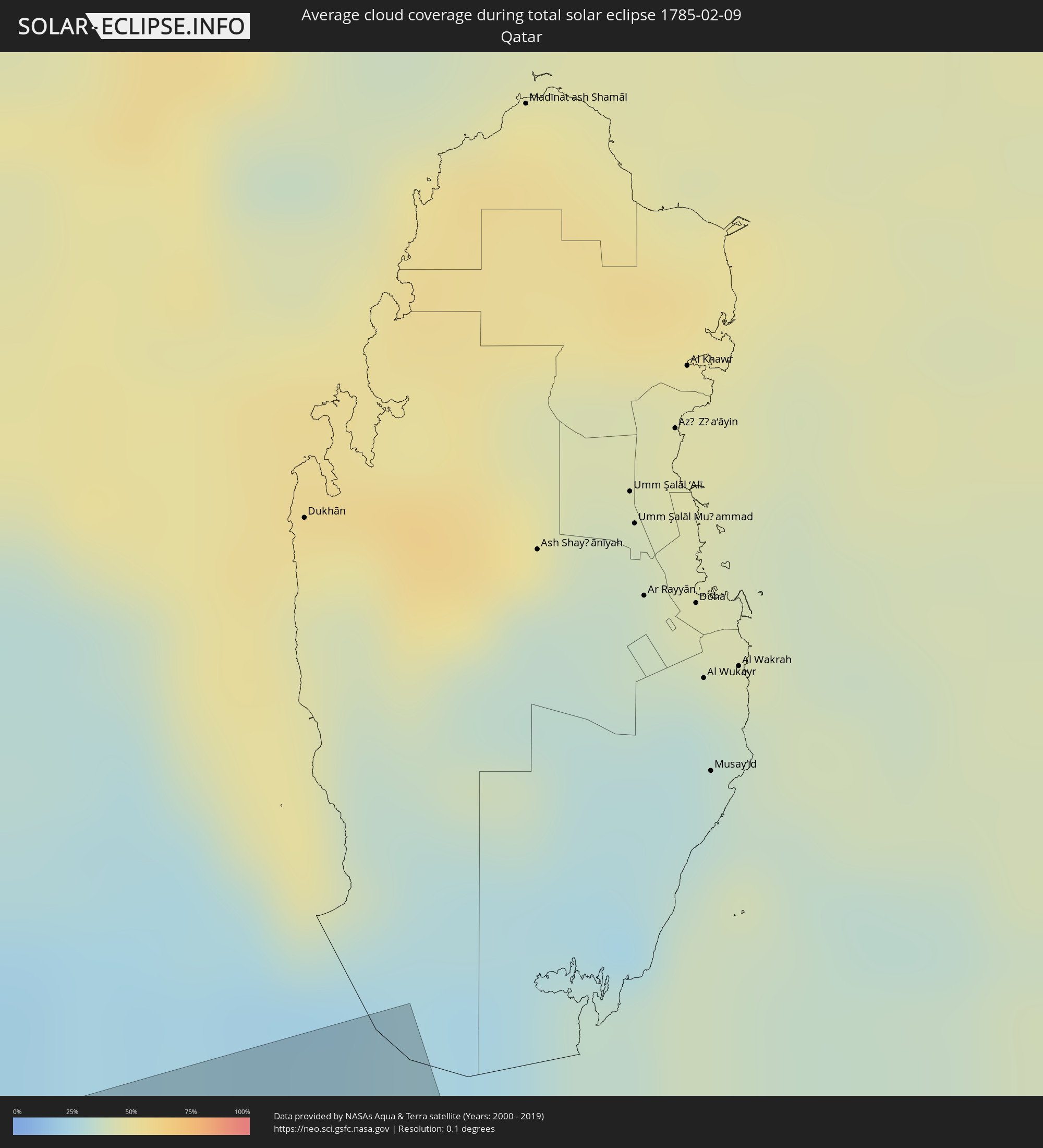 Qatar
Qatar
Cities inside the path of the eclipse
The following table shows all locations with a population of more than 5,000 inside the eclipse path. Cities which have more than 100,000 inhabitants are marked bold. A click at the locations opens a detailed map.
| City | Type | Eclipse duration | Local time of max. eclipse | Distance to central line | Ø Cloud coverage |
|
Cafayate, Salta Province
|
total | - | 06:42:16 UTC-04:16 | 37 km | 64% |
|
Las Breñas, Chaco Province
|
total | - | 06:44:19 UTC-04:16 | 57 km | 59% |
|
Corzuela, Chaco Province
|
total | - | 06:44:20 UTC-04:16 | 40 km | 57% |
|
Campo Largo, Chaco Province
|
total | - | 06:44:22 UTC-04:16 | 21 km | 57% |
|
Presidencia Roque Sáenz Peña, Chaco Province
|
total | - | 06:44:33 UTC-04:16 | 13 km | 58% |
|
Tres Isletas, Chaco Province
|
total | - | 06:44:28 UTC-04:16 | 36 km | 58% |
|
Quitilipi, Chaco Province
|
total | - | 06:44:41 UTC-04:16 | 19 km | 56% |
|
Machagai, Chaco Province
|
total | - | 06:44:47 UTC-04:16 | 22 km | 54% |
|
Presidencia de la Plaza, Chaco Province
|
total | - | 06:44:54 UTC-04:16 | 27 km | 54% |
|
El Colorado, Formosa Province
|
total | - | 06:45:00 UTC-04:16 | 56 km | 51% |
|
General José de San Martín, Chaco Province
|
total | - | 06:45:04 UTC-04:16 | 31 km | 53% |
|
Pilar, Ñeembucú
|
total | - | 07:11:50 UTC-03:50 | 10 km | 55% |
|
San Juan Bautista, Misiones
|
total | - | 07:12:29 UTC-03:50 | 48 km | 62% |
|
Ayolas, Misiones
|
total | - | 07:12:45 UTC-03:50 | 30 km | 50% |
|
Santa Rosa, Misiones
|
total | - | 07:12:42 UTC-03:50 | 30 km | 61% |
|
San Pedro del Paraná, Itapúa
|
total | - | 07:13:06 UTC-03:50 | 41 km | 59% |
|
Posadas, Misiones Province
|
total | - | 06:47:15 UTC-04:16 | 14 km | 58% |
|
Encarnación, Itapúa
|
total | - | 07:13:24 UTC-03:50 | 9 km | 56% |
|
Hohenau, Itapúa
|
total | - | 07:13:26 UTC-03:50 | 19 km | 60% |
|
Candelaria, Misiones Province
|
total | - | 06:47:22 UTC-04:16 | 22 km | 61% |
|
Obligado, Itapúa
|
total | - | 07:13:30 UTC-03:50 | 26 km | 61% |
|
Jardín América, Misiones Province
|
total | - | 06:47:39 UTC-04:16 | 30 km | 61% |
|
Oberá, Misiones Province
|
total | - | 06:47:48 UTC-04:16 | 18 km | 63% |
|
Puerto Rico, Misiones Province
|
total | - | 06:47:45 UTC-04:16 | 59 km | 58% |
|
Aristóbulo del Valle, Misiones Province
|
total | - | 06:47:53 UTC-04:16 | 27 km | 62% |
|
Veinticinco de Mayo, Misiones Province
|
total | - | 06:48:02 UTC-04:16 | 2 km | 57% |
|
Dos de Mayo, Misiones Province
|
total | - | 06:48:02 UTC-04:16 | 38 km | 62% |
|
Santa Rosa, Rio Grande do Sul
|
total | - | 07:58:38 UTC-03:06 | 54 km | 59% |
|
El Soberbio, Misiones Province
|
total | - | 06:48:25 UTC-04:16 | 12 km | 53% |
|
Frederico Westphalen, Rio Grande do Sul
|
total | - | 07:59:21 UTC-03:06 | 13 km | 64% |
|
Palmeira das Missões, Rio Grande do Sul
|
total | - | 07:59:29 UTC-03:06 | 46 km | 57% |
|
Chapecó, Santa Catarina
|
total | - | 07:59:55 UTC-03:06 | 49 km | 61% |
|
Erechim, Rio Grande do Sul
|
total | - | 08:00:15 UTC-03:06 | 8 km | 64% |
|
Concórdia, Santa Catarina
|
total | - | 08:00:25 UTC-03:06 | 39 km | 64% |
|
Capinzal, Santa Catarina
|
total | - | 08:00:46 UTC-03:06 | 30 km | 62% |
|
Joaçaba, Santa Catarina
|
total | - | 08:00:50 UTC-03:06 | 49 km | 63% |
|
Campos Novos, Santa Catarina
|
total | - | 08:01:06 UTC-03:06 | 26 km | 65% |
|
Estrela, Rio Grande do Sul
|
total | - | 08:01:24 UTC-03:06 | 46 km | 71% |
|
Curitibanos, Santa Catarina
|
total | - | 08:01:38 UTC-03:06 | 43 km | 72% |
|
Lages, Santa Catarina
|
total | - | 08:01:54 UTC-03:06 | 15 km | 75% |
|
Rio do Sul, Santa Catarina
|
total | - | 08:02:28 UTC-03:06 | 56 km | 75% |
|
São José, Santa Catarina
|
total | - | 08:02:59 UTC-03:06 | 53 km | 70% |
|
Santo Amaro da Imperatriz, Santa Catarina
|
total | - | 08:03:18 UTC-03:06 | 7 km | 75% |
|
Imbituba, Santa Catarina
|
total | - | 08:03:27 UTC-03:06 | 54 km | 64% |
|
Biguaçu, Santa Catarina
|
total | - | 08:03:25 UTC-03:06 | 29 km | 70% |
|
Tijucas, Santa Catarina
|
total | - | 08:03:25 UTC-03:06 | 57 km | 66% |
|
Campinas, Santa Catarina
|
total | - | 08:03:28 UTC-03:06 | 18 km | 69% |
|
Florianópolis, Santa Catarina
|
total | - | 08:03:31 UTC-03:06 | 18 km | 66% |
|
San Antonio de Palé, Annobón Province
|
total | - | 13:41:05 UTC+00:13 | 75 km | 88% |
|
Libreville, Estuaire
|
total | - | 13:49:59 UTC+00:13 | 76 km | 91% |
|
Bata, Litoral
|
total | - | 13:52:49 UTC+00:13 | 20 km | 88% |
|
Evinayong, Centro Sur
|
total | - | 13:53:14 UTC+00:13 | 75 km | 94% |
|
Akom II, South
|
total | - | 13:55:23 UTC+00:13 | 35 km | 90% |
|
Mikomeseng, Kié-Ntem
|
total | - | 13:54:26 UTC+00:13 | 22 km | 92% |
|
Lolodorf, South
|
total | - | 13:56:18 UTC+00:13 | 59 km | 92% |
|
Añisoc, Wele-Nzas
|
total | - | 13:54:13 UTC+00:13 | 56 km | 90% |
|
Ébolowa, South
|
total | - | 13:56:21 UTC+00:13 | 1 km | 90% |
|
Ambam, South
|
total | - | 13:55:44 UTC+00:13 | 52 km | 93% |
|
Ebebiyin, Kié-Ntem
|
total | - | 13:55:27 UTC+00:13 | 75 km | 94% |
|
Mbalmayo, Centre
|
total | - | 13:57:46 UTC+00:13 | 26 km | 90% |
|
Yaoundé, Centre
|
total | - | 13:58:19 UTC+00:13 | 54 km | 84% |
|
Mbandjok, Centre
|
total | - | 13:59:41 UTC+00:13 | 74 km | 71% |
|
Sangmélima, South
|
total | - | 13:57:31 UTC+00:13 | 58 km | 90% |
|
Nkoteng, Centre
|
total | - | 13:59:57 UTC+00:13 | 70 km | 71% |
|
Akonolinga, Centre
|
total | - | 13:59:07 UTC+00:13 | 9 km | 83% |
|
Nanga Eboko, Centre
|
total | - | 14:00:38 UTC+00:13 | 59 km | 64% |
|
Abong Mbang, East
|
total | - | 14:00:38 UTC+00:13 | 59 km | 77% |
|
Bélabo, East
|
total | - | 14:02:10 UTC+00:13 | 13 km | 60% |
|
Doumé, East
|
total | - | 14:01:20 UTC+00:13 | 57 km | 72% |
|
Dimako, East
|
total | - | 14:01:42 UTC+00:13 | 53 km | 66% |
|
Bertoua, East
|
total | - | 14:02:08 UTC+00:13 | 45 km | 62% |
|
Bétaré Oya, East
|
total | - | 14:04:04 UTC+00:13 | 13 km | 43% |
|
Garoua Boulaï, East
|
total | - | 14:05:00 UTC+00:13 | 4 km | 37% |
|
Bouar, Nana-Mambéré
|
total | - | 14:06:18 UTC+00:13 | 66 km | 38% |
|
Paoua, Ouham-Pendé
|
total | - | 14:08:58 UTC+00:13 | 11 km | 30% |
|
Béboto, Logone Oriental
|
total | - | 14:57:25 UTC+01:00 | 45 km | 22% |
|
Koumra, Mandoul
|
total | - | 14:58:51 UTC+01:00 | 60 km | 23% |
|
Moïssala, Mandoul
|
total | - | 14:58:23 UTC+01:00 | 5 km | 23% |
|
Sagh, Moyen-Chari
|
total | - | 14:59:59 UTC+01:00 | 25 km | 18% |
|
Kyabé, Moyen-Chari
|
total | - | 15:00:53 UTC+01:00 | 16 km | 16% |
|
Zalingei, Central Darfur
|
total | - | 16:18:25 UTC+02:10 | 49 km | 6% |
|
El Fasher, Northern Darfur
|
total | - | 16:20:29 UTC+02:10 | 8 km | 5% |
|
El Bauga, River Nile
|
total | - | 16:28:38 UTC+02:10 | 18 km | 6% |
|
Ed Damer, River Nile
|
total | - | 16:28:17 UTC+02:10 | 51 km | 4% |
|
Berber, River Nile
|
total | - | 16:28:32 UTC+02:10 | 9 km | 3% |
|
Atbara, River Nile
|
total | - | 16:28:21 UTC+02:10 | 41 km | 4% |
|
Port Sudan, Red Sea
|
total | - | 16:30:32 UTC+02:10 | 9 km | 34% |
|
Sawākin, Red Sea
|
total | - | 16:30:20 UTC+02:10 | 48 km | 39% |
|
Ash Shafā, Makkah
|
total | - | 17:28:43 UTC+03:06 | 33 km | 23% |
|
Ta’if, Makkah
|
total | - | 17:28:49 UTC+03:06 | 50 km | 8% |
|
Turabah, Makkah
|
total | - | 17:29:03 UTC+03:06 | 2 km | 6% |