Total solar eclipse of 07/28/1851
| Day of week: | Monday |
| Maximum duration of eclipse: | 03m41s |
| Maximum width of eclipse path: | 296 km |
| Saros cycle: | 143 |
| Coverage: | 100% |
| Magnitude: | 1.0577 |
| Gamma: | 0.7644 |
Wo kann man die Sonnenfinsternis vom 07/28/1851 sehen?
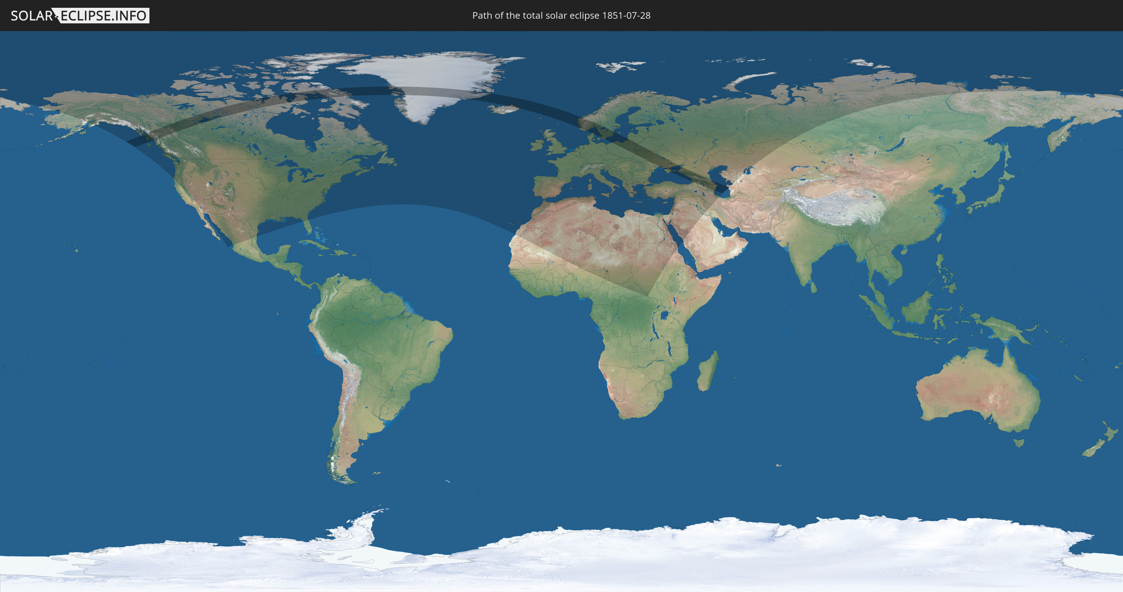
Die Sonnenfinsternis am 07/28/1851 kann man in 86 Ländern als partielle Sonnenfinsternis beobachten.
Der Finsternispfad verläuft durch 19 Länder. Nur in diesen Ländern ist sie als total Sonnenfinsternis zu sehen.
In den folgenden Ländern ist die Sonnenfinsternis total zu sehen
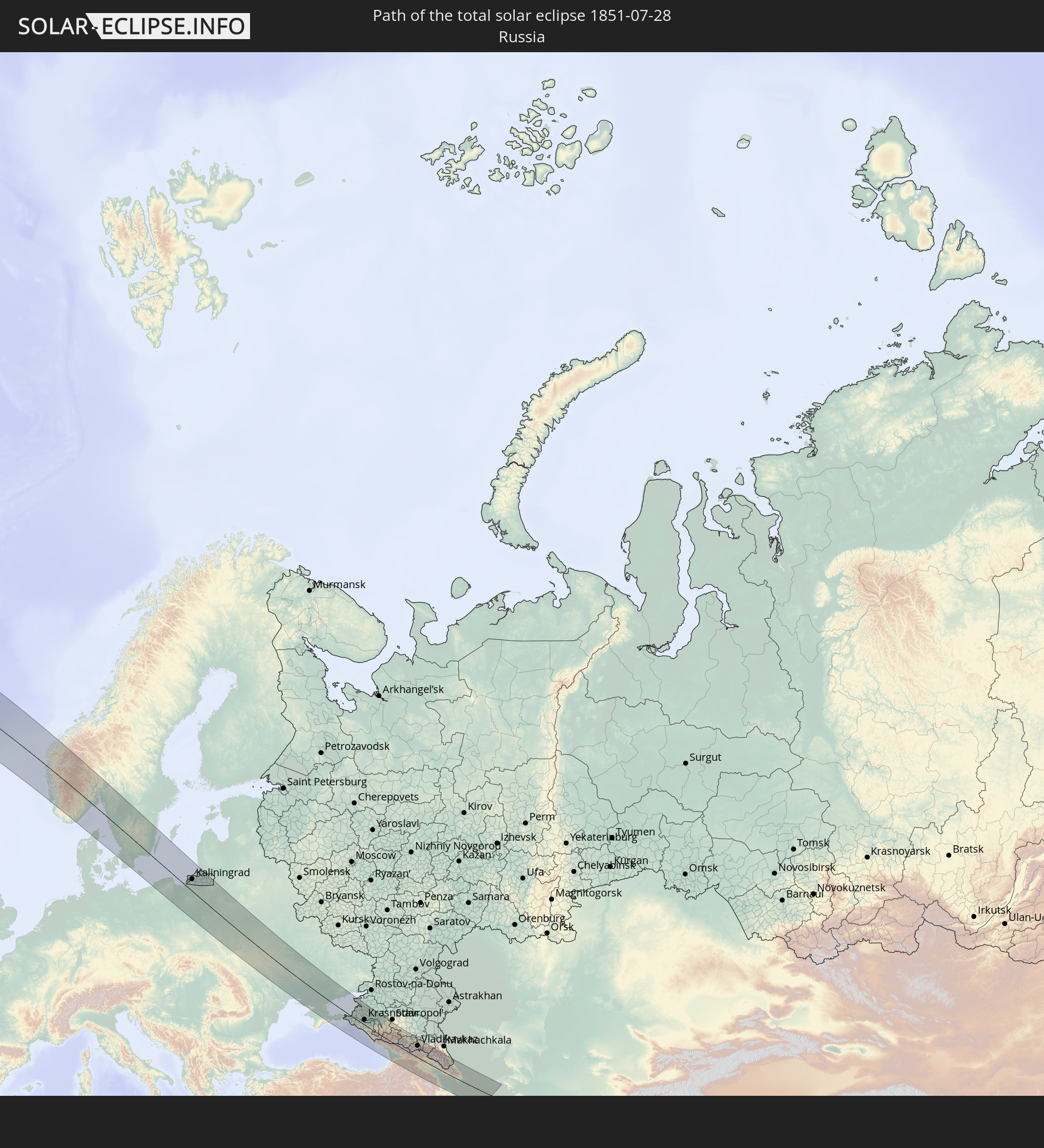 Russia
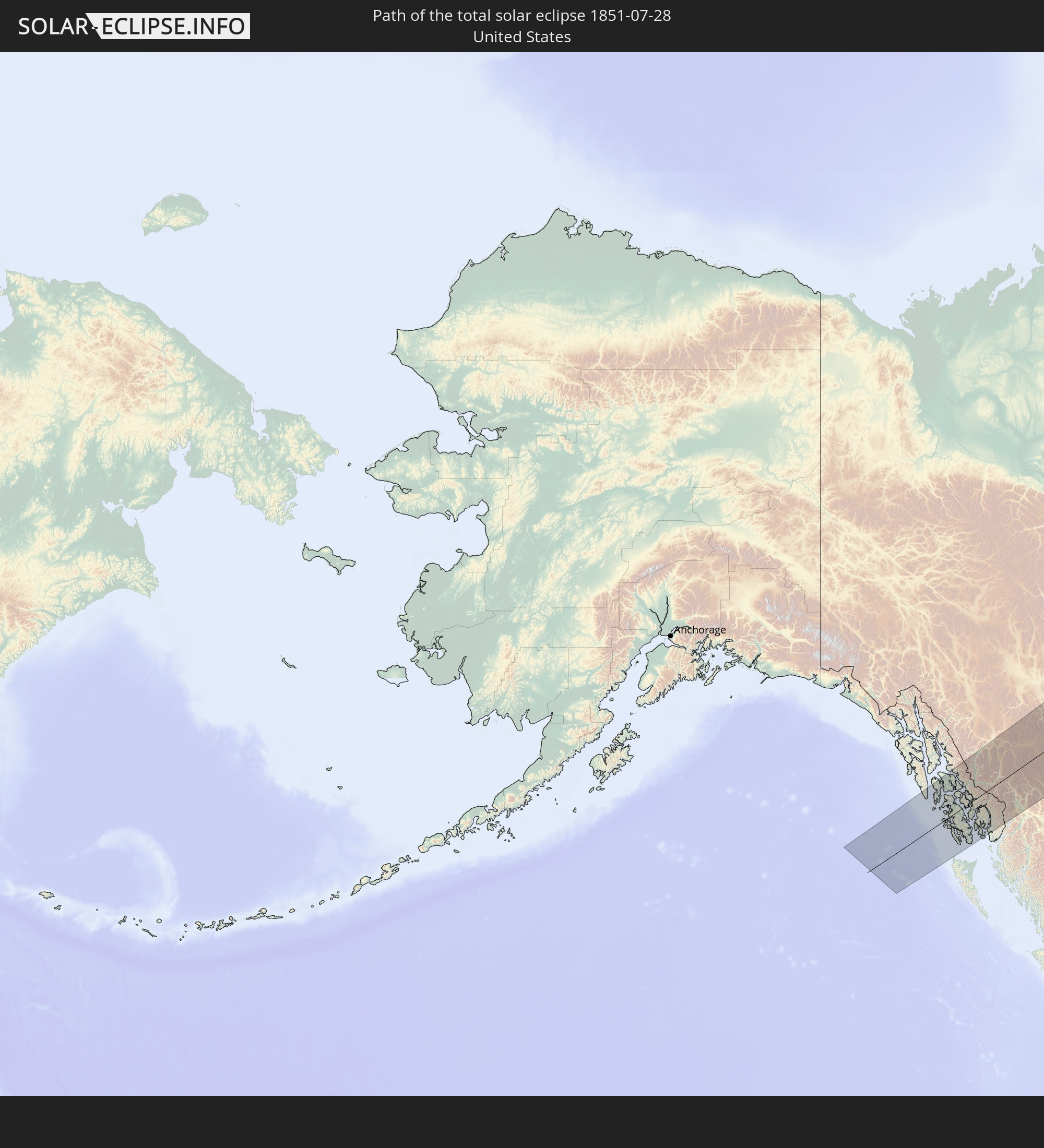 United States
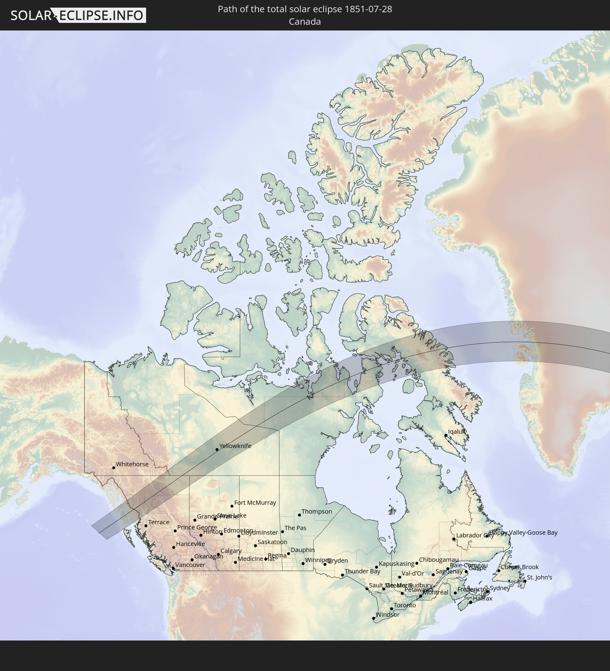 Canada
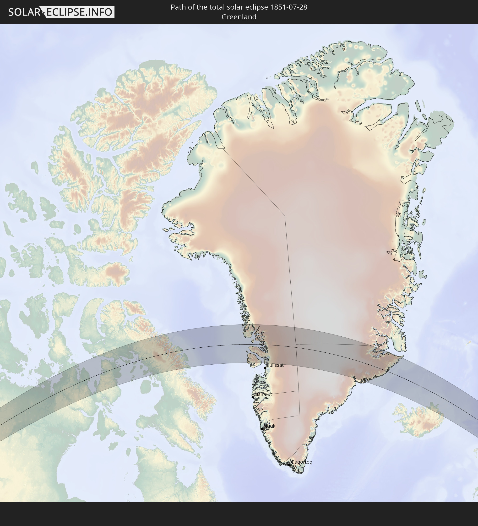 Greenland
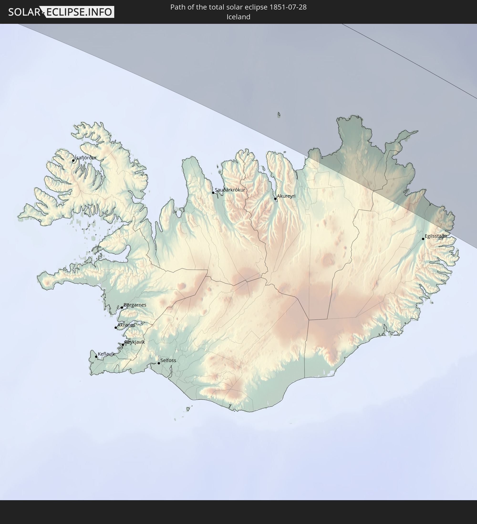 Iceland
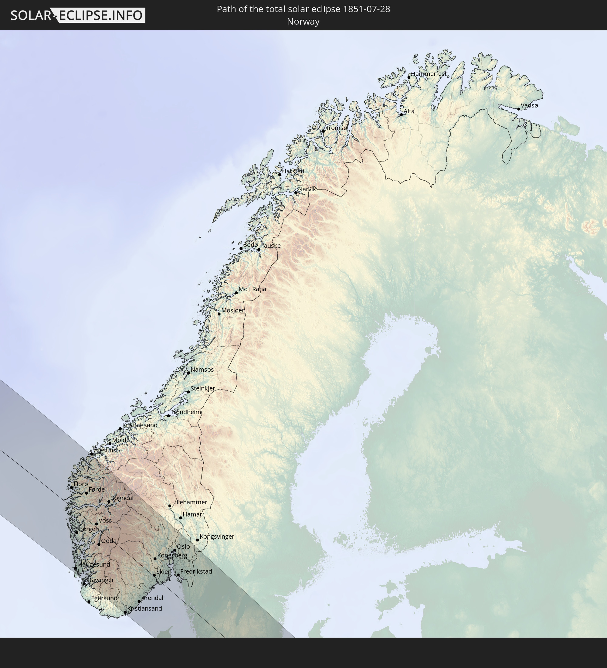 Norway
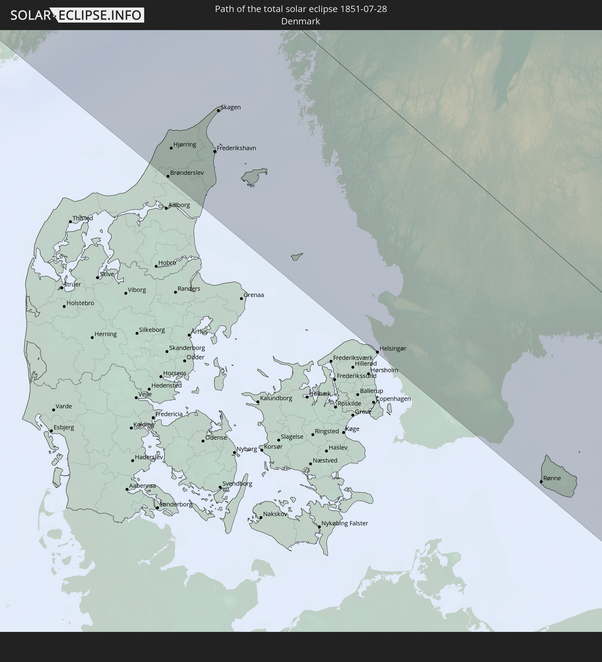 Denmark
 Sweden
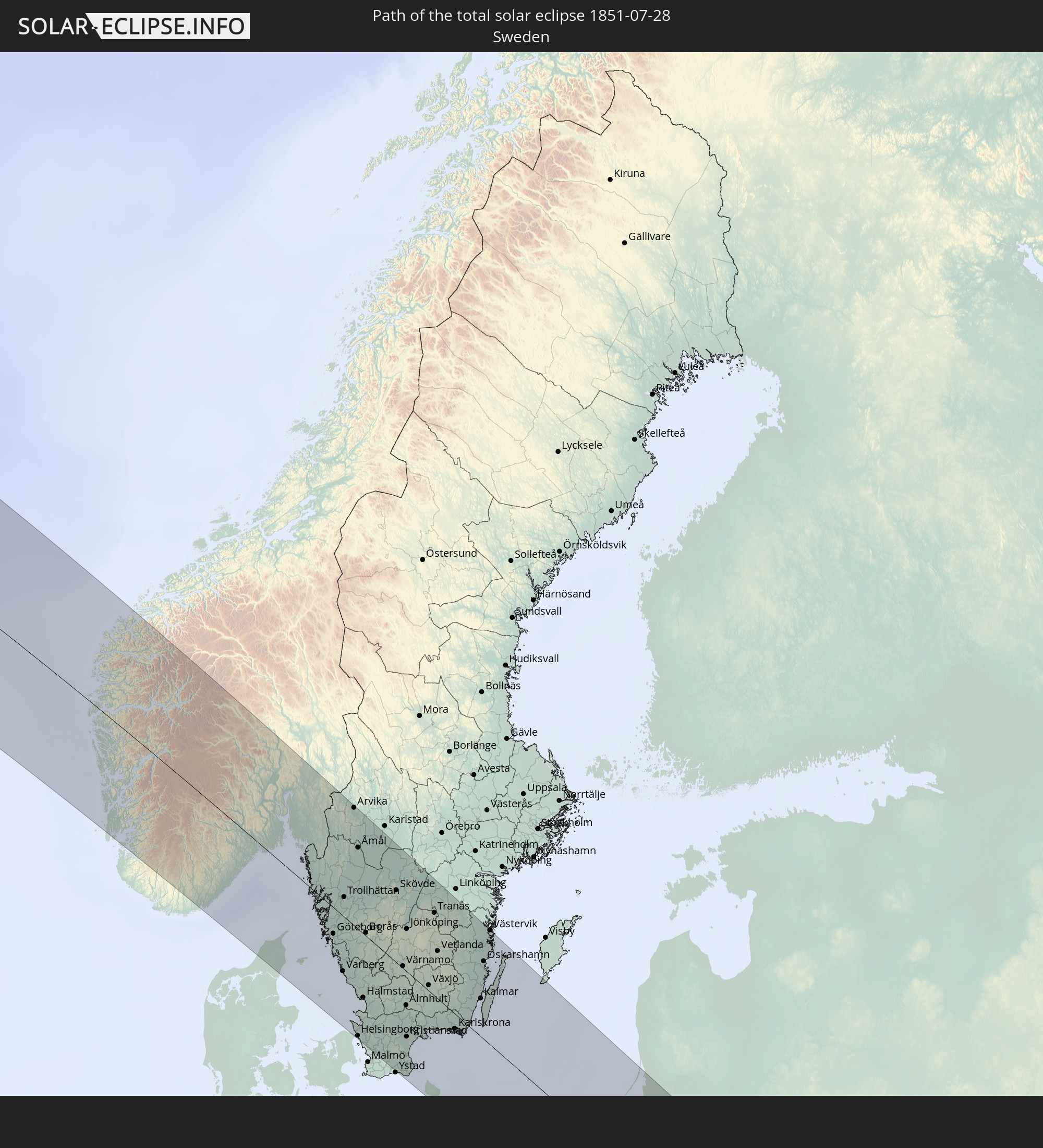
 Poland
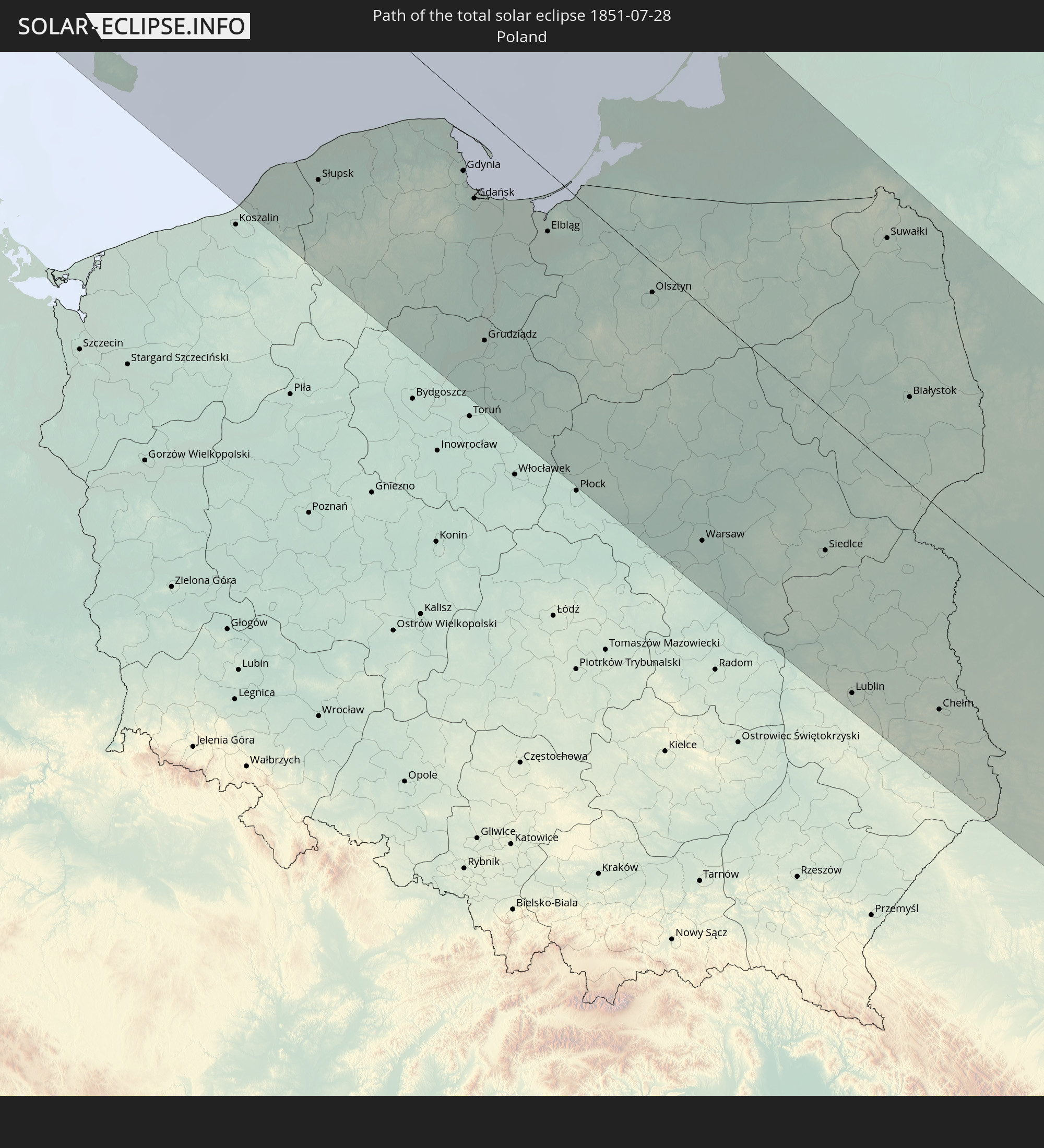
 Lithuania
 Ukraine
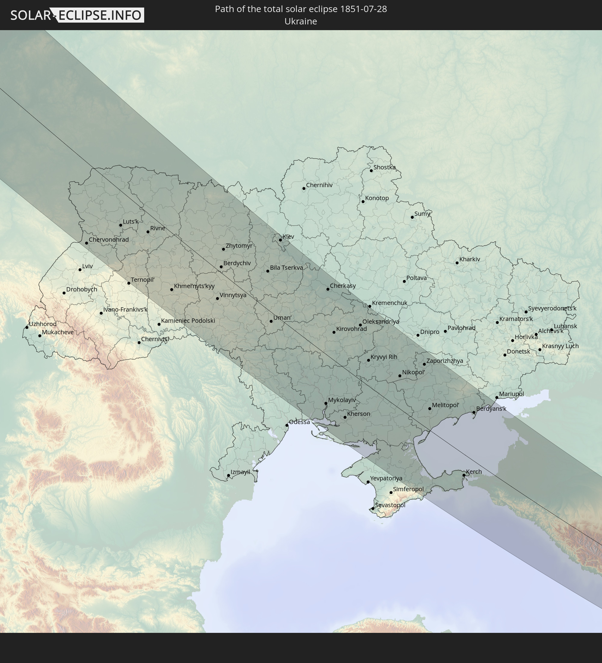
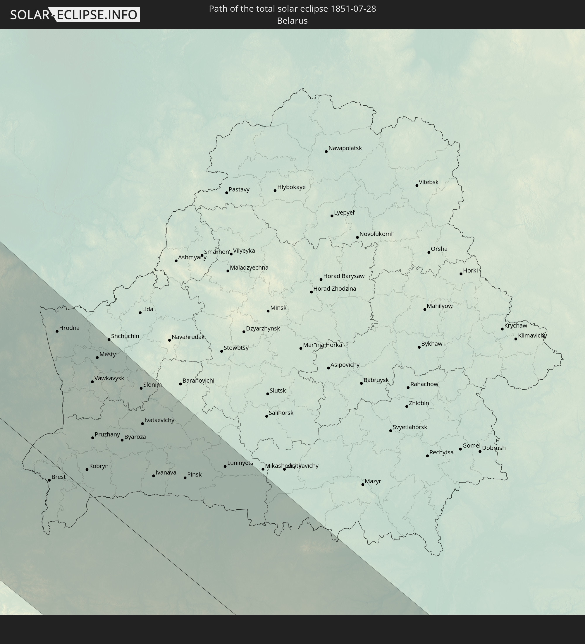 Belarus
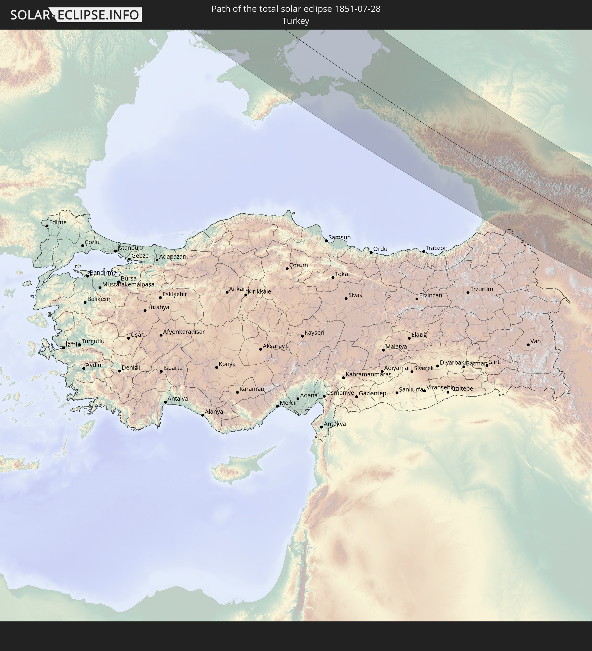 Turkey
 Moldova
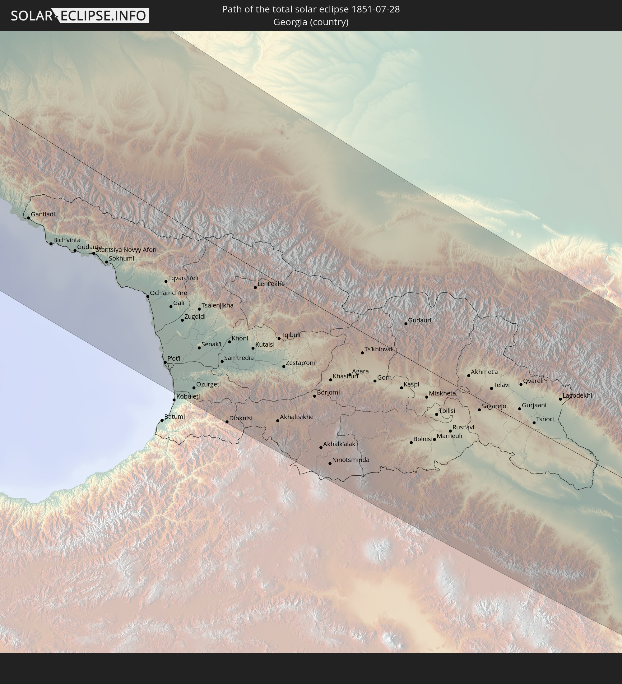 Georgia
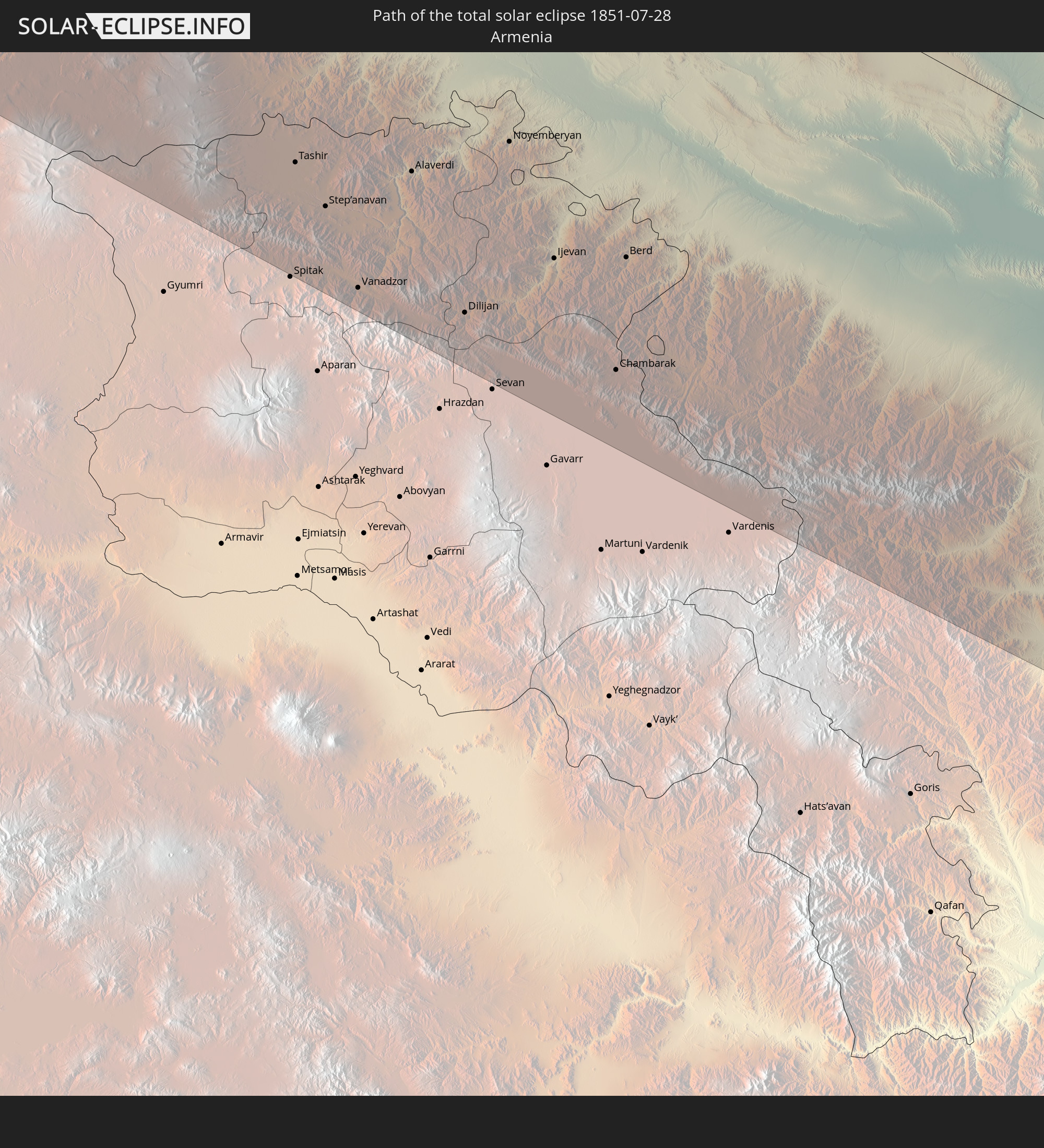 Armenia
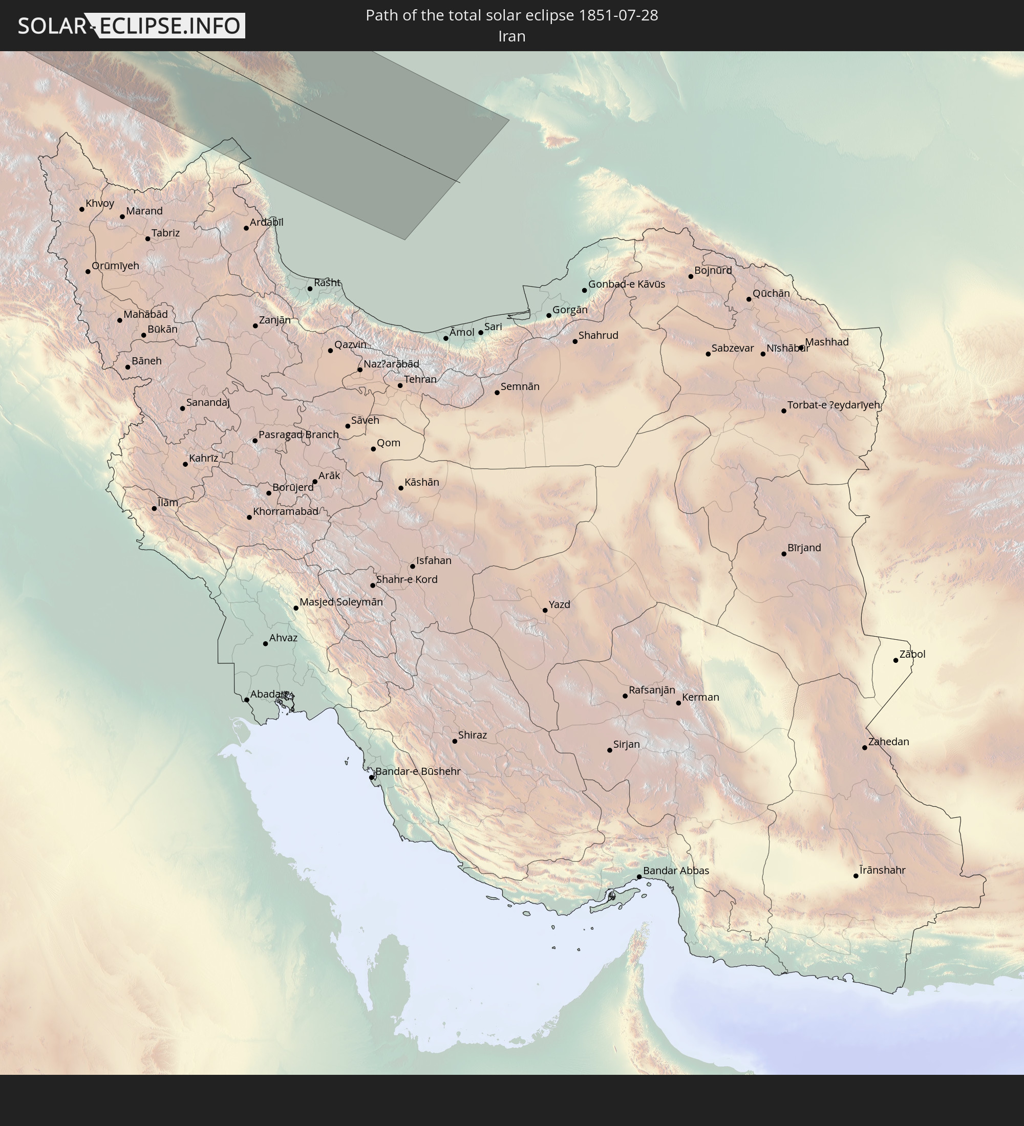 Iran
Iran
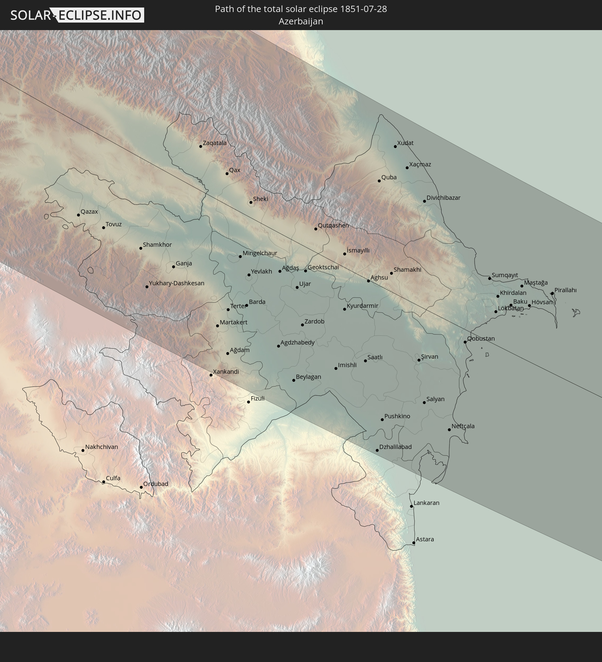 Azerbaijan
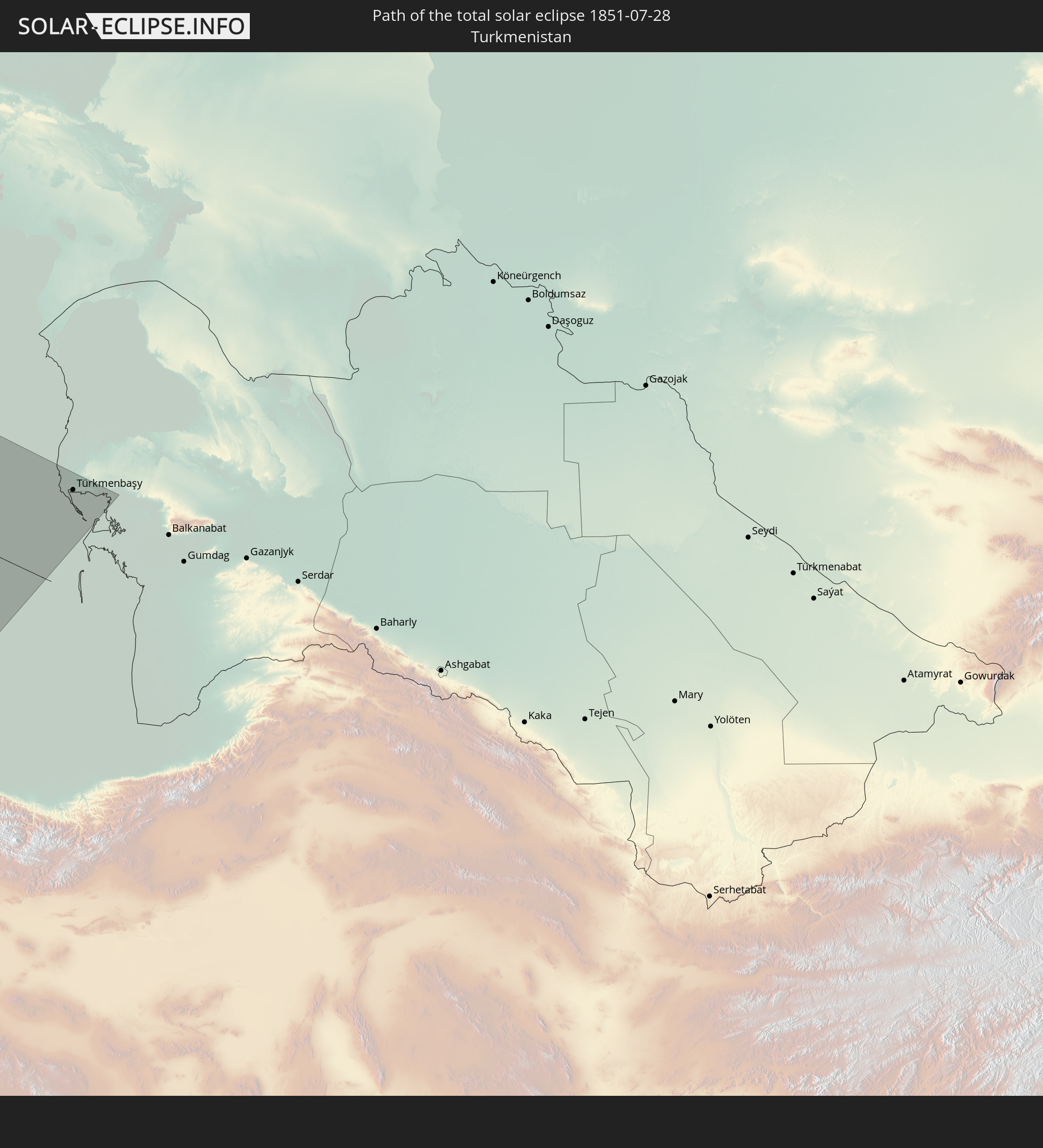 Turkmenistan
In den folgenden Ländern ist die Sonnenfinsternis partiell zu sehen
 Russia
 United States
 Canada
 Mexico
 Greenland
 Saint Pierre and Miquelon
 Portugal
 Iceland
 Spain
Spain
 Mauritania
 Morocco
 Mali
Mali
 Republic of Ireland
 Svalbard and Jan Mayen
 Algeria
 United Kingdom
 Faroe Islands
 Gibraltar
 France
 Isle of Man
 Guernsey
 Jersey
 Niger
Niger
 Andorra
 Belgium
 Nigeria
 Netherlands
 Norway
 Luxembourg
 Germany
 Switzerland
 Italy
Italy
 Monaco
 Tunisia
 Denmark
 Cameroon
 Libya
Libya
 Liechtenstein
 Austria
 Sweden
 Czechia
 Democratic Republic of the Congo
 San Marino
 Vatican City
 Slovenia
 Chad
Chad
 Croatia
 Poland
 Malta
Malta
 Central African Republic
 Bosnia and Herzegovina
 Hungary
 Slovakia
 Montenegro
 Serbia
 Albania
 Åland Islands
 Greece
 Romania
 Republic of Macedonia
 Finland
 Lithuania
 Latvia
 Estonia
 Sudan
Sudan
 Ukraine
 Bulgaria
 Belarus
 Egypt
Egypt
 Turkey
 Moldova
 Cyprus
 State of Palestine
 Israel
 Saudi Arabia
 Jordan
 Lebanon
 Syria
Syria
 Iraq
Iraq
 Georgia
 Armenia
 Iran
Iran
 Azerbaijan
 Kazakhstan
 Turkmenistan
 Uzbekistan
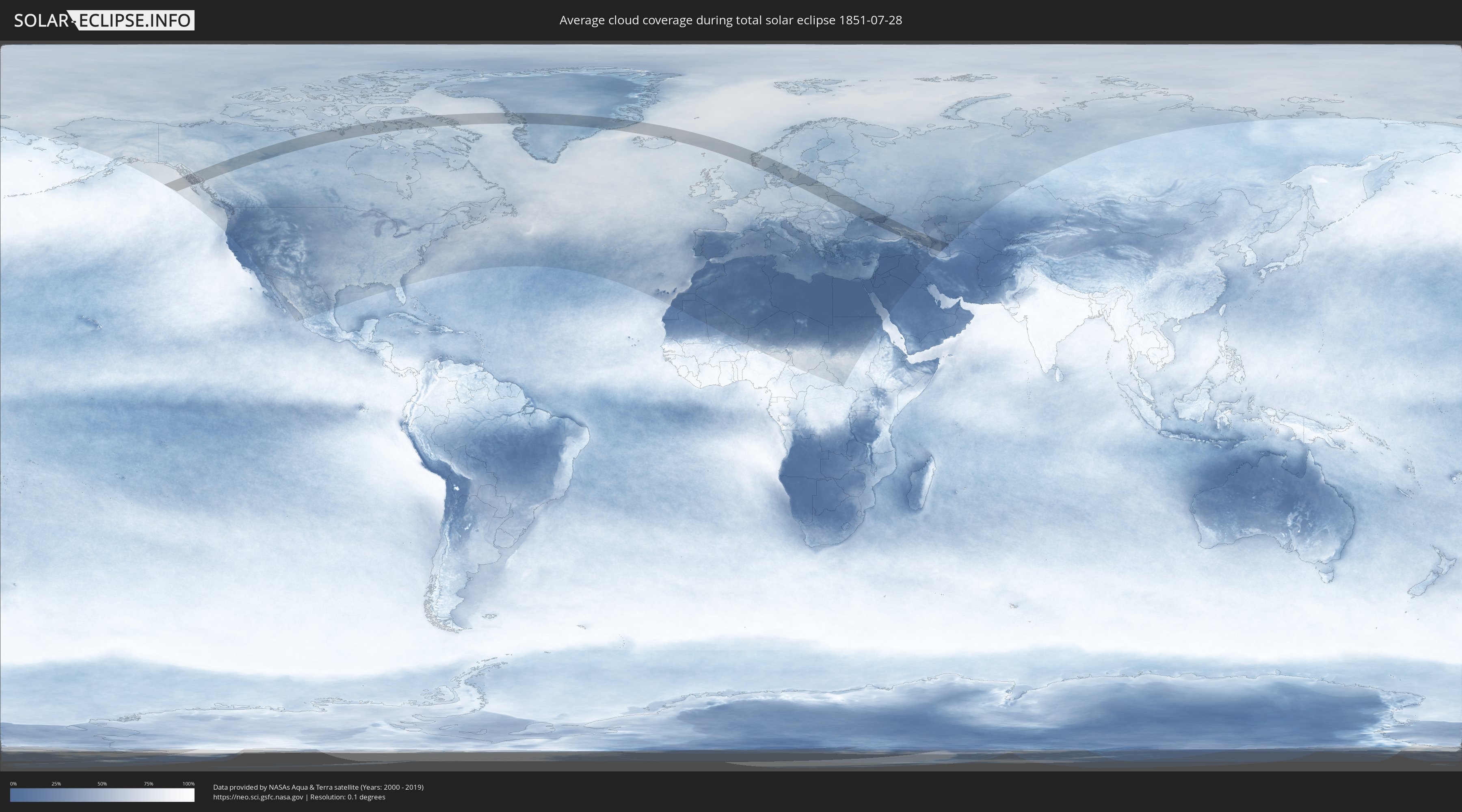
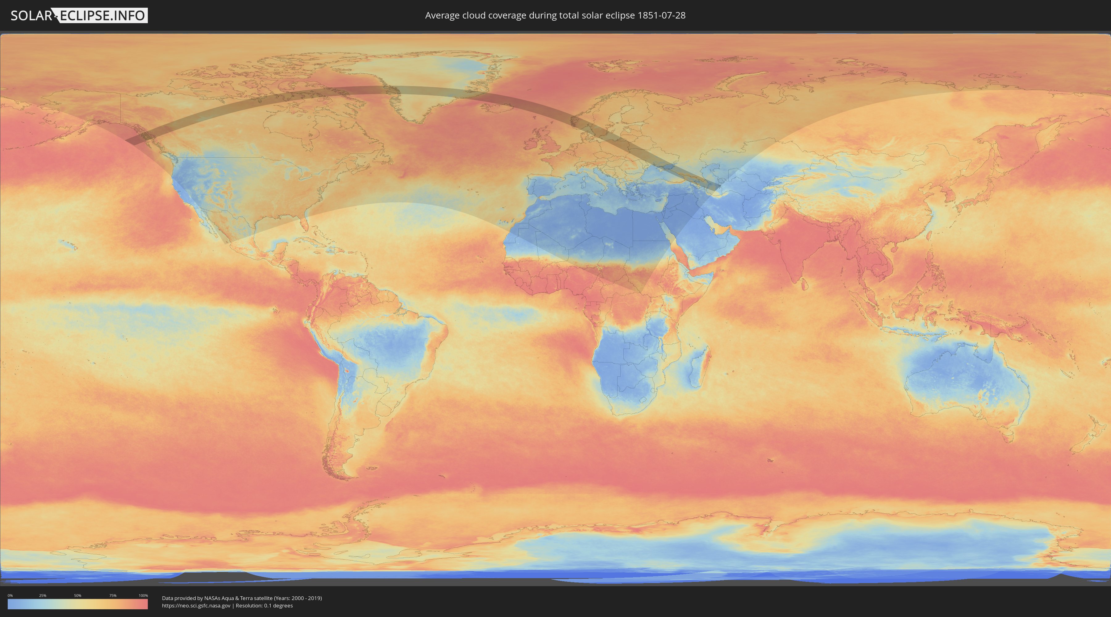
How will be the weather during the total solar eclipse on 07/28/1851?
Where is the best place to see the total solar eclipse of 07/28/1851?
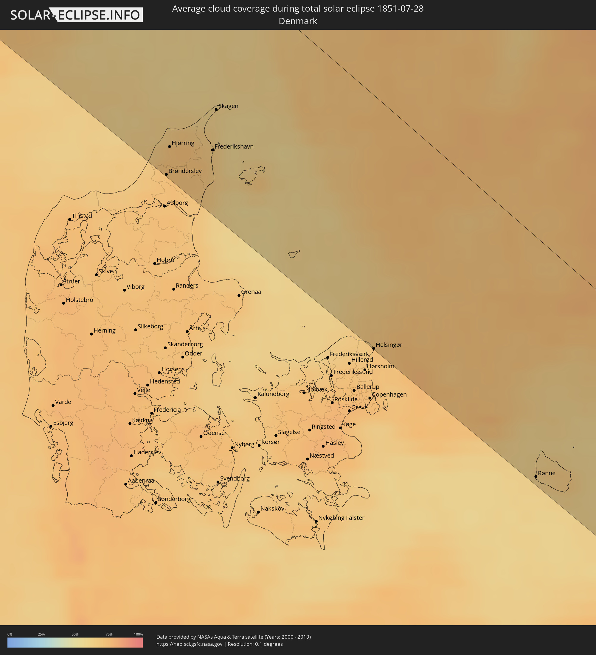
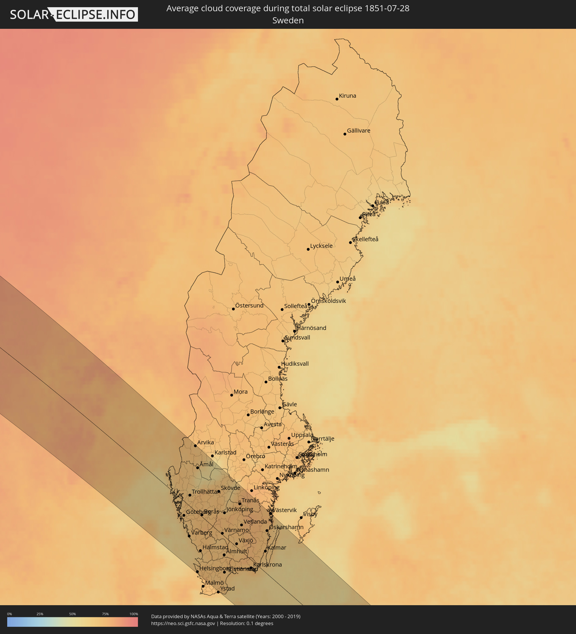
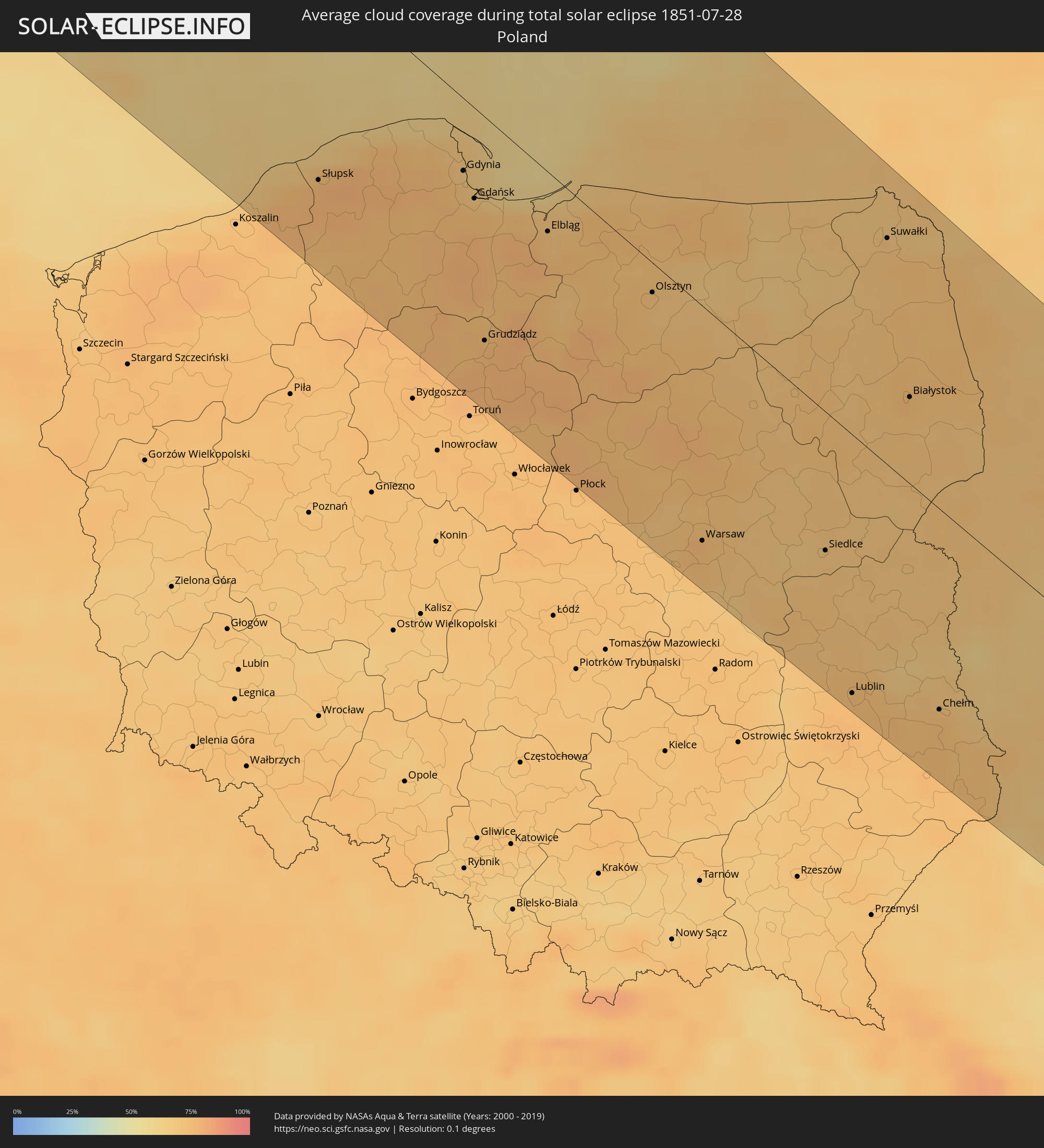
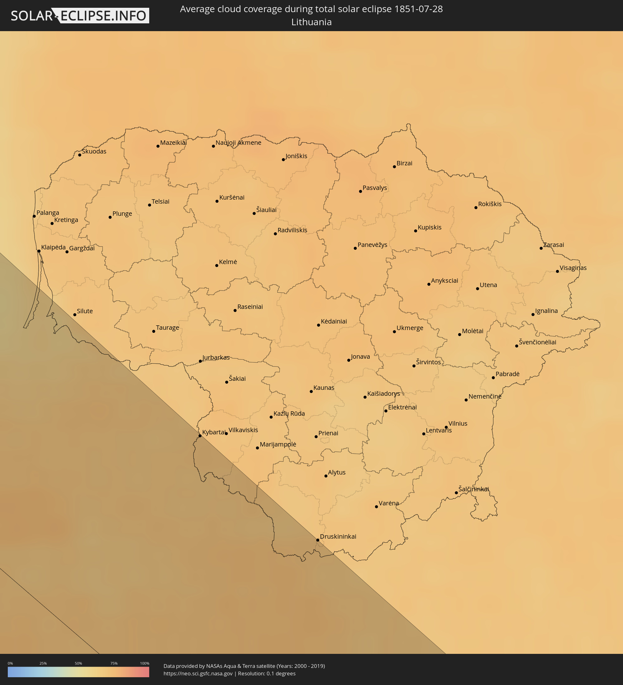
The following maps show the average cloud coverage for the day of the total solar eclipse.
With the help of these maps, it is possible to find the place along the eclipse path, which has the best
chance of a cloudless sky.
Nevertheless, you should consider local circumstances and inform about the weather of your chosen
observation site.
The data is provided by NASAs satellites
AQUA and TERRA.
The cloud maps are averaged over a period of 19 years (2000 - 2019).
Detailed country maps
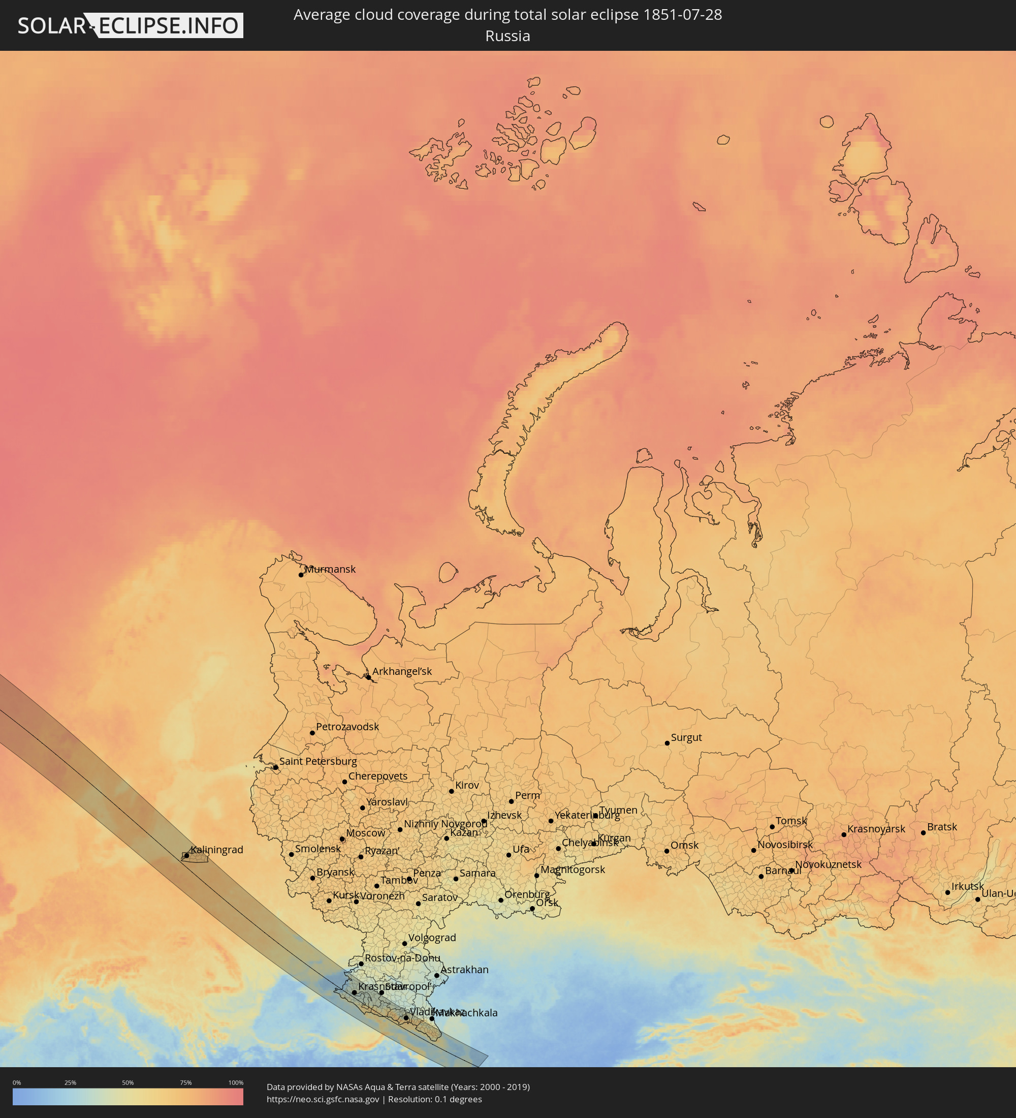 Russia
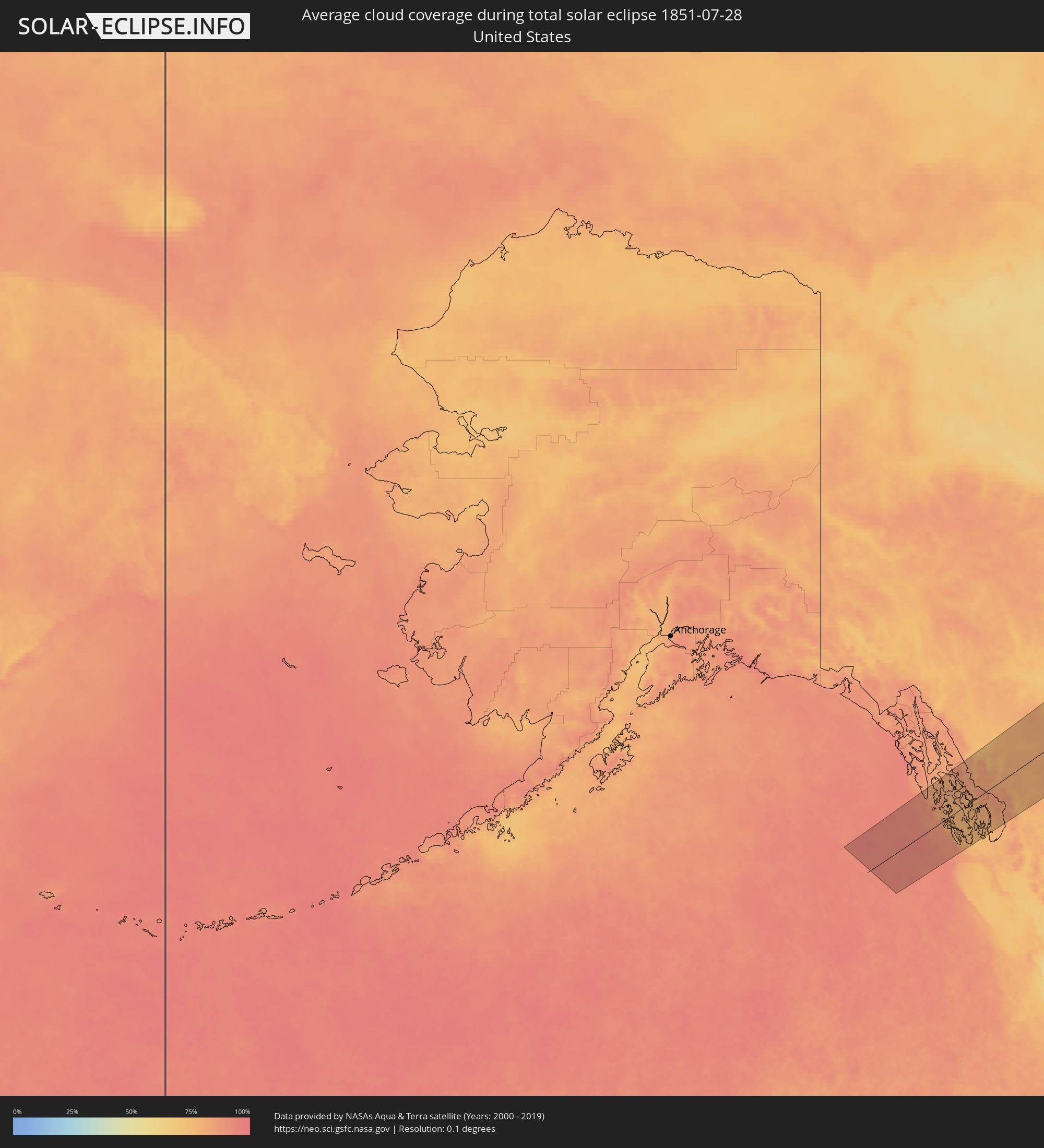 United States
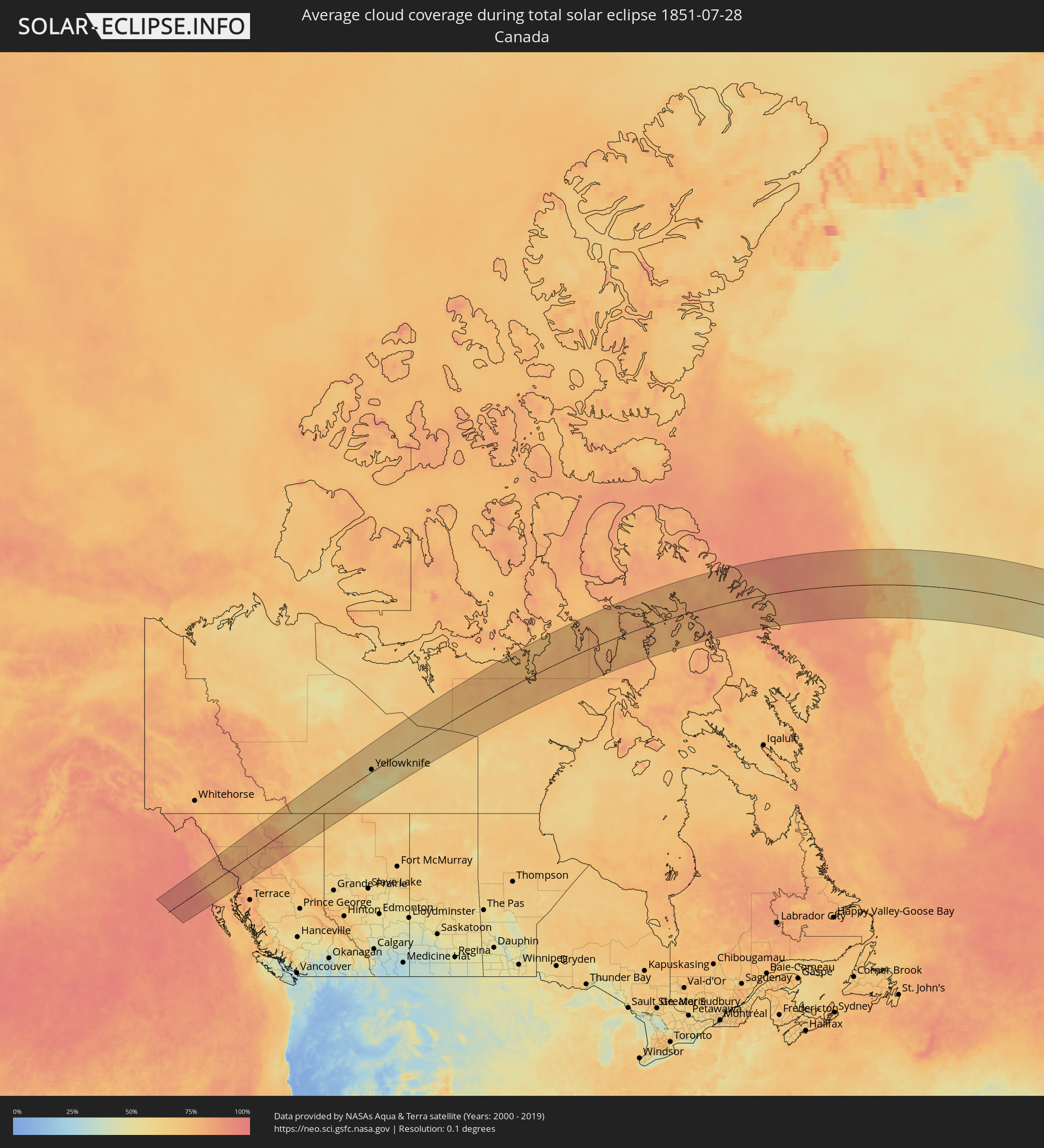 Canada
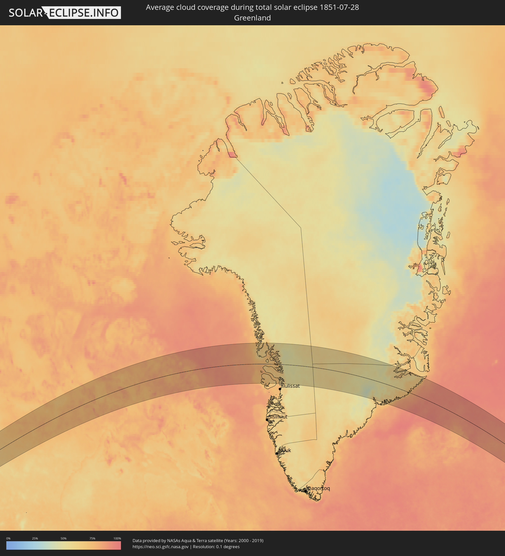 Greenland
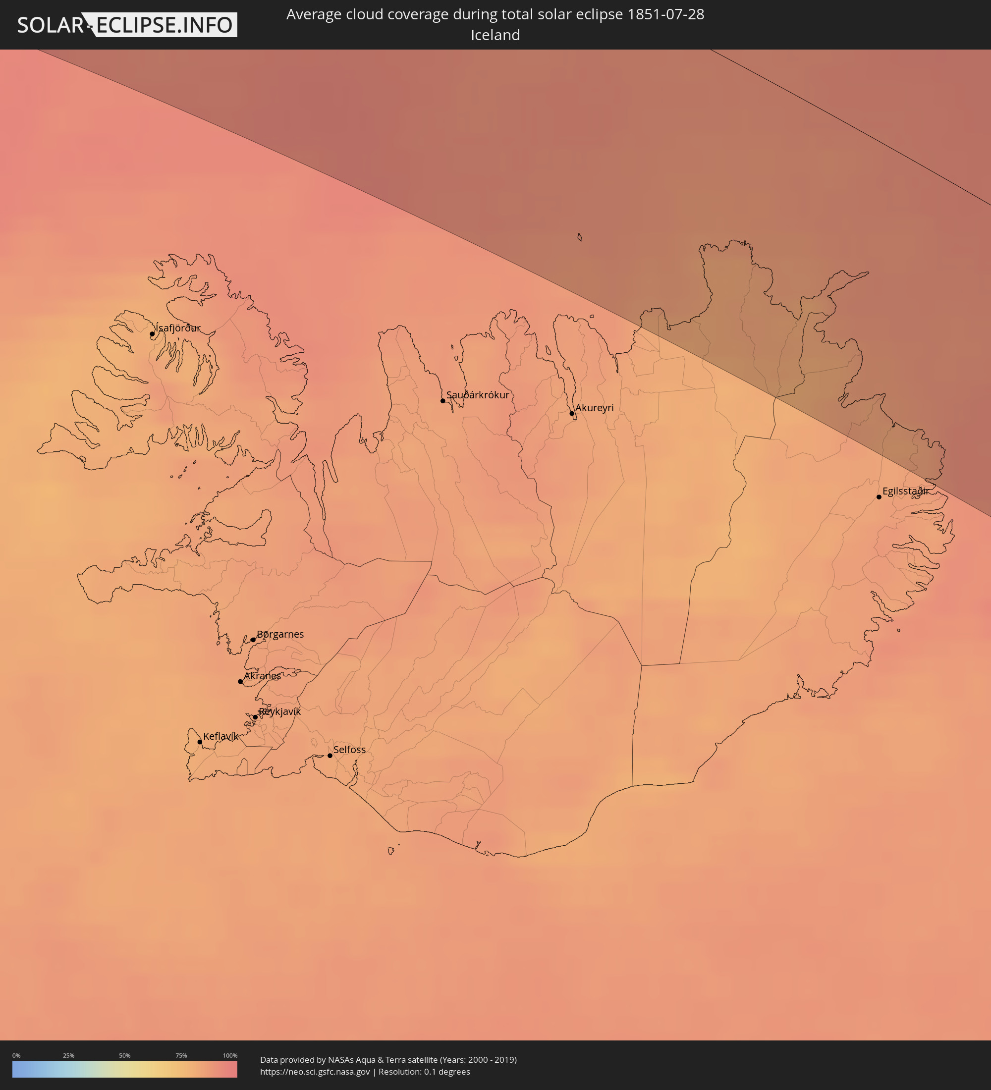 Iceland
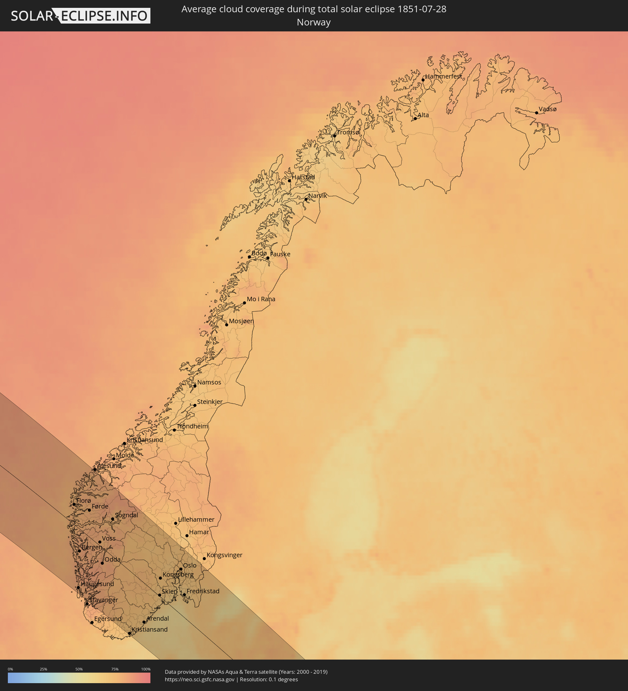 Norway
 Denmark
 Sweden
 Poland
 Lithuania
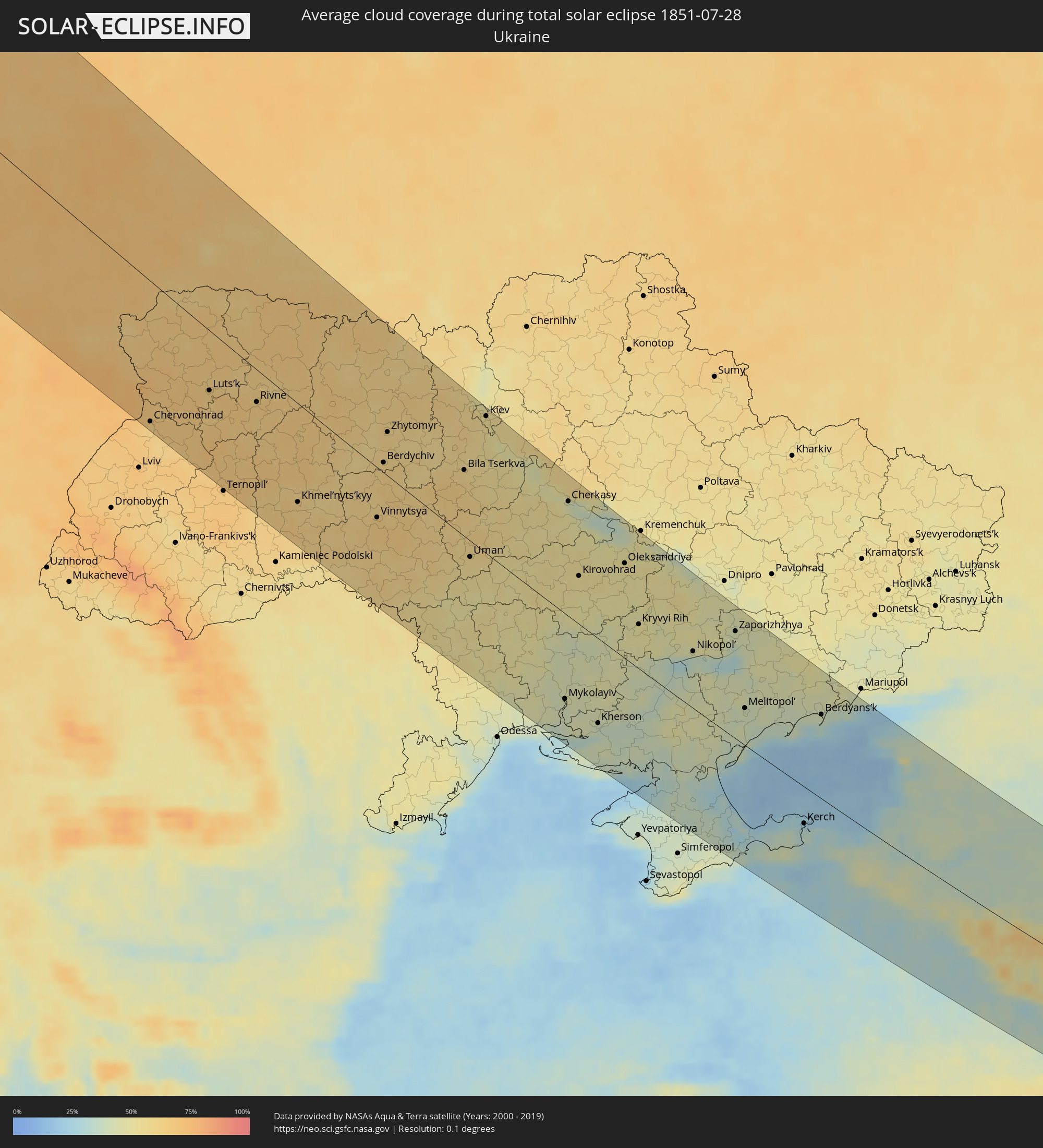 Ukraine
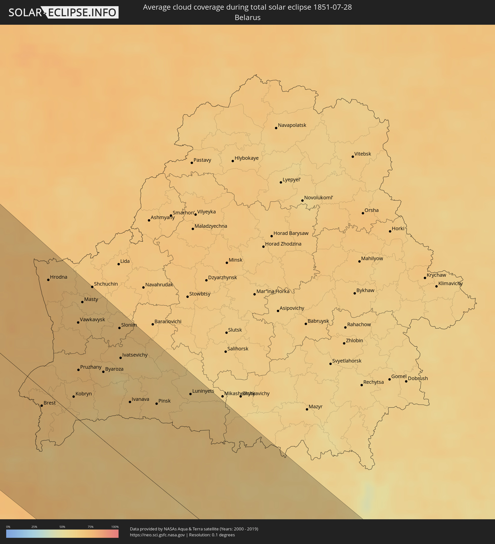 Belarus
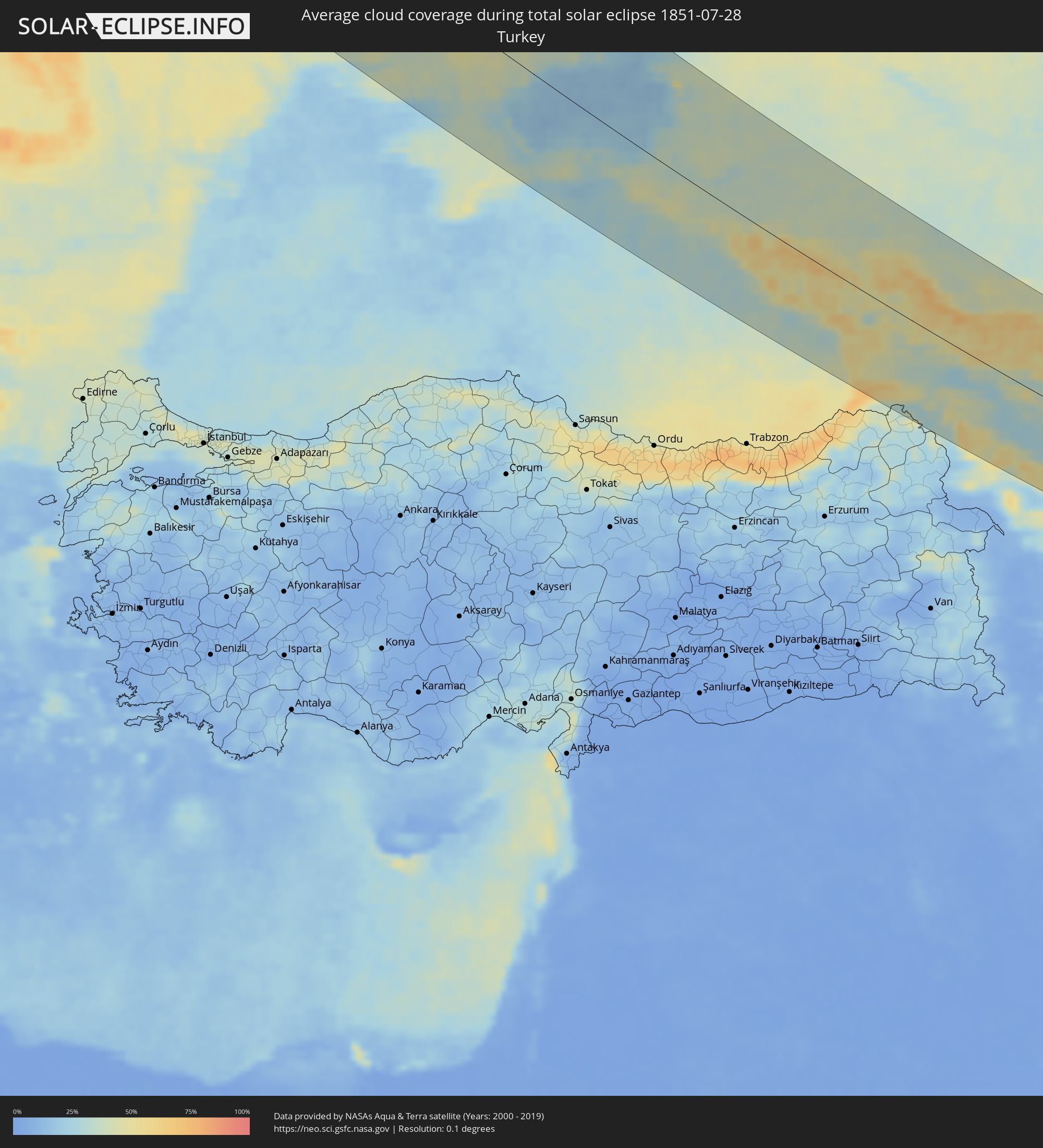 Turkey
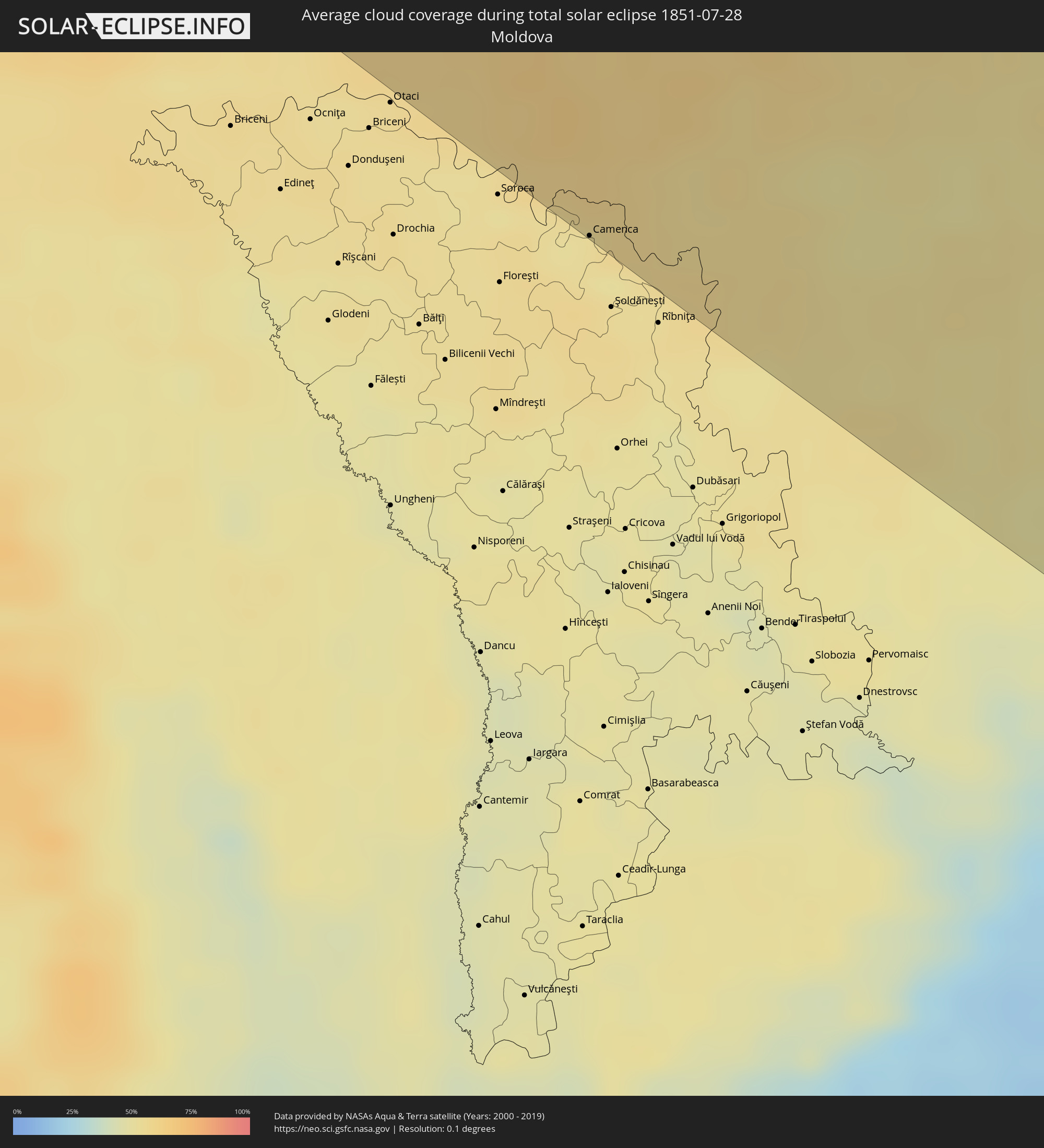 Moldova
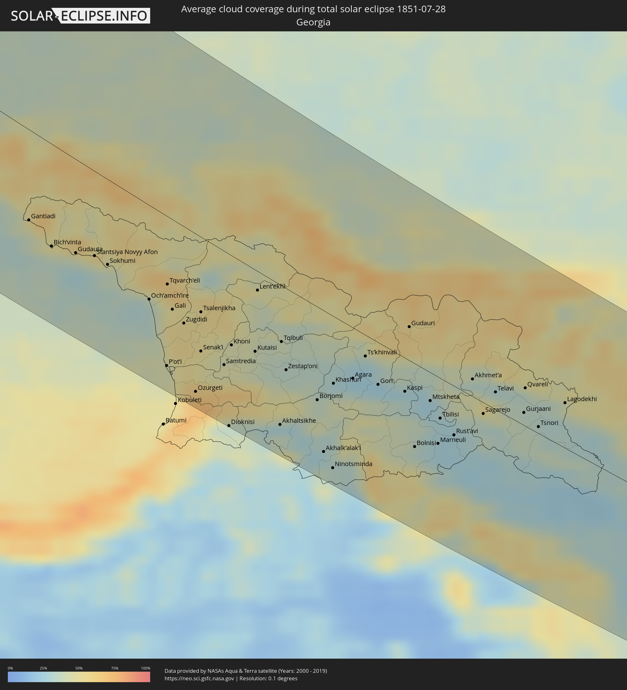 Georgia
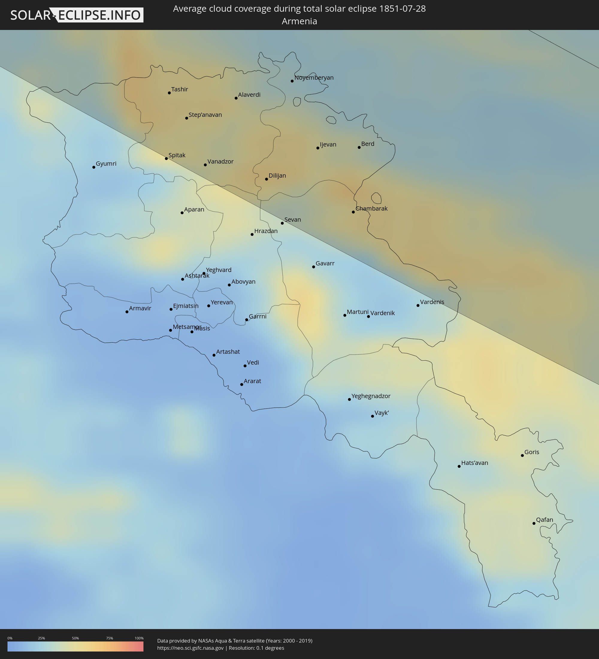 Armenia
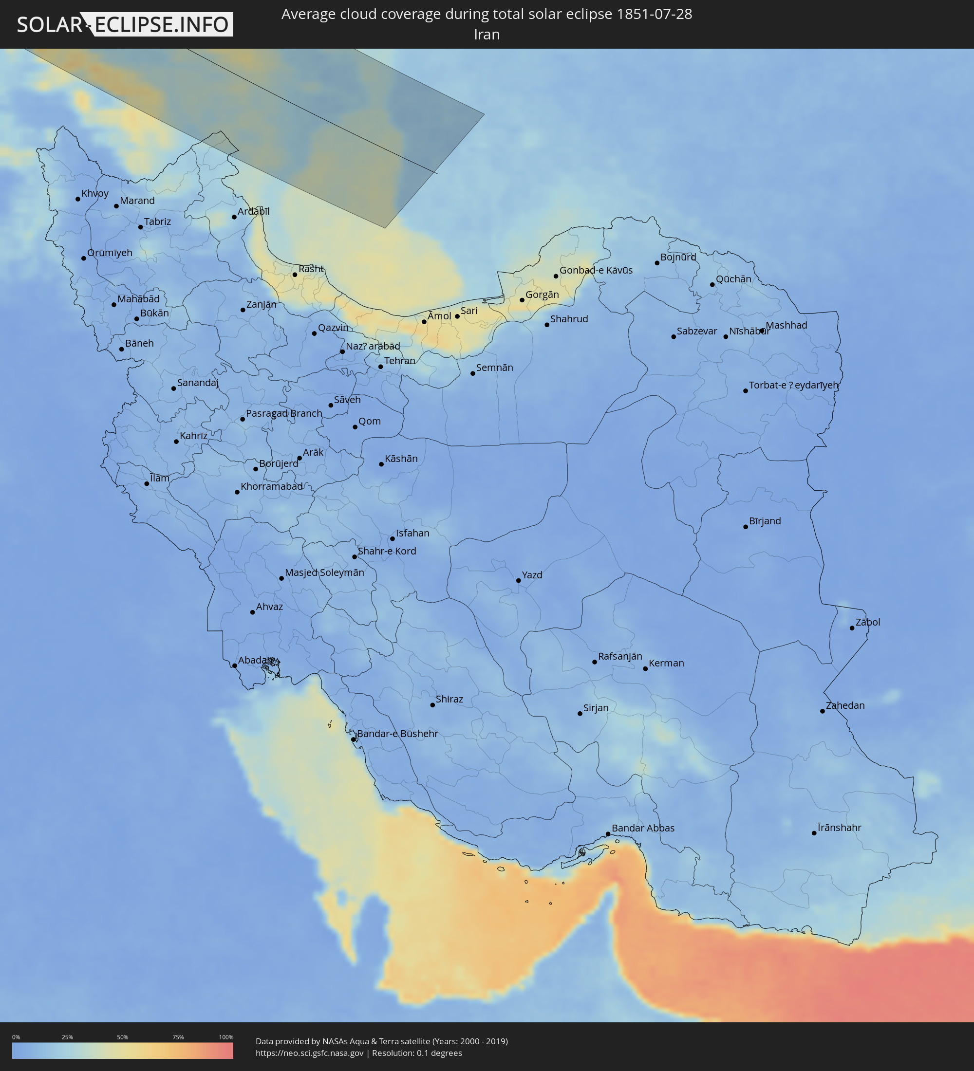 Iran
Iran
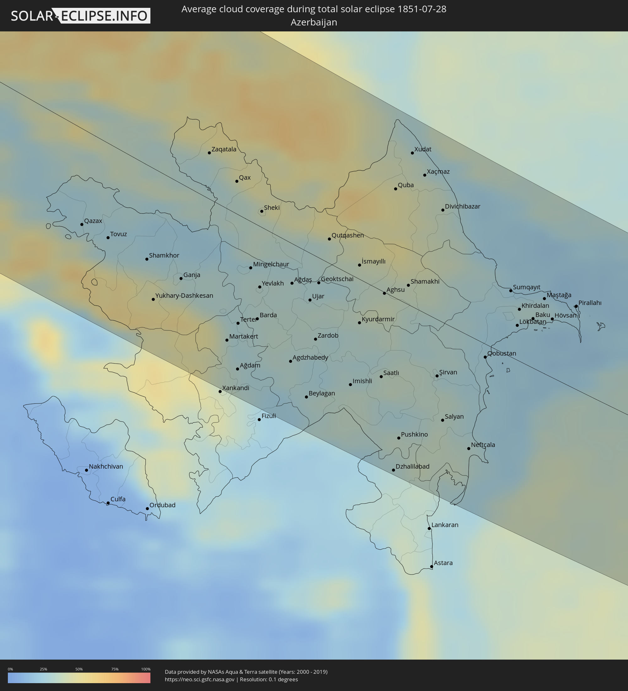 Azerbaijan
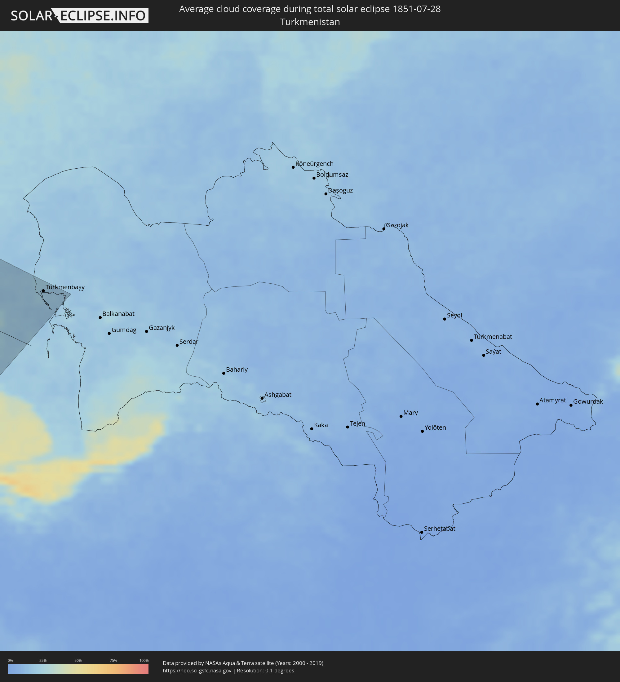 Turkmenistan
Cities inside the path of the eclipse
The following table shows all locations with a population of more than 5,000 inside the eclipse path. Cities which have more than 100,000 inhabitants are marked bold. A click at the locations opens a detailed map.
| City | Type | Eclipse duration | Local time of max. eclipse | Distance to central line | Ø Cloud coverage |
|
Ketchikan, Alaska
|
total | - | 03:26:06 UTC-10:00 | 83 km | 76% |
|
Yellowknife, Northwest Territories
|
total | - | 05:59:11 UTC-07:33 | 19 km | 61% |
|
Haugesund, Rogaland
|
total | - | 16:03:03 UTC+01:00 | 138 km | 79% |
|
Bergen, Hordaland
|
total | - | 16:01:27 UTC+01:00 | 51 km | 81% |
|
Kristiansand, Vest-Agder
|
total | - | 16:06:50 UTC+01:00 | 148 km | 66% |
|
Arendal, Aust-Agder
|
total | - | 16:06:44 UTC+01:00 | 92 km | 68% |
|
Skien, Telemark
|
total | - | 16:05:53 UTC+01:00 | 6 km | 69% |
|
Kongsberg, Buskerud
|
total | - | 16:05:07 UTC+01:00 | 44 km | 71% |
|
Brønderslev, North Denmark
|
total | - | 16:09:26 UTC+01:00 | 150 km | 71% |
|
Hirtshals, North Denmark
|
total | - | 16:08:53 UTC+01:00 | 123 km | 67% |
|
Hjørring, North Denmark
|
total | - | 16:09:07 UTC+01:00 | 132 km | 72% |
|
Drammen, Buskerud
|
total | - | 16:05:17 UTC+01:00 | 70 km | 71% |
|
Sandefjord, Vestfold
|
total | - | 16:06:21 UTC+01:00 | 19 km | 65% |
|
Tønsberg, Vestfold
|
total | - | 16:06:13 UTC+01:00 | 37 km | 65% |
|
Sæby, North Denmark
|
total | - | 16:09:38 UTC+01:00 | 123 km | 66% |
|
Frederikshavn, North Denmark
|
total | - | 16:09:27 UTC+01:00 | 114 km | 66% |
|
Skagen, North Denmark
|
total | - | 16:08:59 UTC+01:00 | 87 km | 60% |
|
Moss, Østfold
|
total | - | 16:06:03 UTC+01:00 | 61 km | 65% |
|
Oslo, Oslo
|
total | - | 16:05:16 UTC+01:00 | 104 km | 73% |
|
Fredrikstad, Østfold
|
total | - | 16:06:34 UTC+01:00 | 54 km | 68% |
|
Halden, Østfold
|
total | - | 16:06:57 UTC+01:00 | 64 km | 68% |
|
Uddevalla, Västra Götaland
|
total | - | 16:08:35 UTC+01:00 | 26 km | 69% |
|
Göteborg, Västra Götaland
|
total | - | 16:09:43 UTC+01:00 | 37 km | 70% |
|
Trollhättan, Västra Götaland
|
total | - | 16:08:52 UTC+01:00 | 26 km | 71% |
|
Hellebæk, Capital Region
|
total | - | 16:12:53 UTC+01:00 | 151 km | 70% |
|
Helsingør, Capital Region
|
total | - | 16:12:58 UTC+01:00 | 152 km | 70% |
|
Helsingborg, Skåne
|
total | - | 16:12:59 UTC+01:00 | 148 km | 70% |
|
Halmstad, Halland
|
total | - | 16:11:58 UTC+01:00 | 89 km | 68% |
|
Borås, Västra Götaland
|
total | - | 16:10:10 UTC+01:00 | 10 km | 73% |
|
Skövde, Västra Götaland
|
total | - | 16:09:24 UTC+01:00 | 97 km | 72% |
|
Kristianstad, Skåne
|
total | - | 16:13:42 UTC+01:00 | 90 km | 70% |
|
Jönköping, Jönköping
|
total | - | 16:10:37 UTC+01:00 | 57 km | 72% |
|
Rønne, Capital Region
|
total | - | 16:15:36 UTC+01:00 | 148 km | 62% |
|
Växjö, Kronoberg
|
total | - | 16:12:30 UTC+01:00 | 20 km | 71% |
|
Motala, Östergötland
|
total | - | 16:09:40 UTC+01:00 | 155 km | 71% |
|
Karlskrona, Blekinge
|
total | - | 16:14:06 UTC+01:00 | 26 km | 72% |
|
Kalmar, Kalmar
|
total | - | 16:13:32 UTC+01:00 | 55 km | 72% |
|
Słupsk, Pomeranian Voivodeship
|
total | - | 16:41:42 UTC+01:24 | 105 km | 75% |
|
Gdynia, Pomeranian Voivodeship
|
total | - | 16:42:10 UTC+01:24 | 37 km | 72% |
|
Gdańsk, Pomeranian Voivodeship
|
total | - | 16:42:30 UTC+01:24 | 46 km | 72% |
|
Grudziądz, Kujawsko-Pomorskie
|
total | - | 16:44:04 UTC+01:24 | 115 km | 76% |
|
Elbląg, Warmian-Masurian Voivodeship
|
total | - | 16:43:07 UTC+01:24 | 35 km | 71% |
|
Olsztyn, Warmian-Masurian Voivodeship
|
total | - | 16:44:08 UTC+01:24 | 20 km | 71% |
|
Kaliningrad, Kaliningrad
|
total | - | 16:18:31 UTC+01:00 | 64 km | 69% |
|
Warsaw, Masovian Voivodeship
|
total | - | 16:47:01 UTC+01:24 | 126 km | 74% |
|
Łomża, Podlasie
|
total | - | 16:45:40 UTC+01:24 | 4 km | 72% |
|
Siedlce, Masovian Voivodeship
|
total | - | 16:47:30 UTC+01:24 | 74 km | 70% |
|
Lublin, Lublin Voivodeship
|
total | - | 16:49:10 UTC+01:24 | 141 km | 73% |
|
Kybartai
|
total | - | 16:43:18 UTC+01:24 | 155 km | 71% |
|
Suwałki, Podlasie
|
total | - | 16:44:16 UTC+01:24 | 120 km | 71% |
|
Białystok, Podlasie
|
total | - | 16:46:02 UTC+01:24 | 50 km | 72% |
|
Chełm, Lublin Voivodeship
|
total | - | 16:49:35 UTC+01:24 | 110 km | 75% |
|
Brest, Brest
|
total | - | 17:13:59 UTC+01:50 | 19 km | 68% |
|
Hrodna, Grodnenskaya
|
total | - | 17:11:14 UTC+01:50 | 122 km | 73% |
|
Kobryn, Brest
|
total | - | 17:13:56 UTC+01:50 | 20 km | 67% |
|
Vawkavysk, Grodnenskaya
|
total | - | 17:12:19 UTC+01:50 | 104 km | 70% |
|
Pruzhany, Brest
|
total | - | 17:13:22 UTC+01:50 | 54 km | 72% |
|
Masty, Grodnenskaya
|
total | - | 17:11:53 UTC+01:50 | 131 km | 68% |
|
Shchuchin, Grodnenskaya
|
total | - | 17:11:37 UTC+01:50 | 156 km | 68% |
|
Byaroza, Brest
|
total | - | 17:13:31 UTC+01:50 | 78 km | 67% |
|
Slonim, Grodnenskaya
|
total | - | 17:12:38 UTC+01:50 | 136 km | 68% |
|
Ivatsevichy, Brest
|
total | - | 17:13:17 UTC+01:50 | 107 km | 66% |
|
Luts’k, Volyn
|
total | - | 17:28:43 UTC+02:02 | 60 km | 65% |
|
Ivanava, Brest
|
total | - | 17:14:18 UTC+01:50 | 67 km | 66% |
|
Pinsk, Brest
|
total | - | 17:14:27 UTC+01:50 | 92 km | 66% |
|
Rivne, Rivne
|
total | - | 17:29:07 UTC+02:02 | 33 km | 64% |
|
Luninyets, Brest
|
total | - | 17:14:22 UTC+01:50 | 132 km | 62% |
|
Khmel’nyts’kyy, Khmelnytskyi
|
total | - | 17:31:17 UTC+02:02 | 103 km | 62% |
|
Vinnytsya, Vinnyts'ka
|
total | - | 17:31:48 UTC+02:02 | 53 km | 65% |
|
Zhytomyr, Zhytomyr
|
total | - | 17:30:06 UTC+02:02 | 50 km | 60% |
|
Camenca, Teleneşti
|
total | - | 17:26:45 UTC+01:55 | 149 km | 52% |
|
Bila Tserkva, Kiev
|
total | - | 17:31:01 UTC+02:02 | 71 km | 61% |
|
Kiev, Kyiv City
|
total | - | 17:29:58 UTC+02:02 | 147 km | 56% |
|
Mykolayiv, Mykolaiv
|
total | - | 17:35:46 UTC+02:02 | 99 km | 40% |
|
Cherkasy, Cherkasy
|
total | - | 17:31:47 UTC+02:02 | 125 km | 47% |
|
Kirovohrad, Kirovohrad
|
total | - | 17:33:17 UTC+02:02 | 56 km | 52% |
|
Kherson, Kherson
|
total | - | 17:36:17 UTC+02:02 | 97 km | 39% |
|
Kryvyi Rih, Dnipropetrovsk
|
total | - | 17:34:17 UTC+02:02 | 50 km | 50% |
|
Zaporizhzhya, Zaporizhia
|
total | - | 17:34:24 UTC+02:02 | 125 km | 43% |
|
Novorossiysk, Krasnodarskiy
|
total | - | 18:07:14 UTC+02:30 | 46 km | 42% |
|
Krasnodar, Krasnodarskiy
|
total | - | 18:06:36 UTC+02:30 | 37 km | 35% |
|
Sochi, Krasnodarskiy
|
total | - | 18:08:38 UTC+02:30 | 68 km | 34% |
|
Maykop, Adygeya
|
total | - | 18:07:05 UTC+02:30 | 49 km | 36% |
|
Sokhumi, Abkhazia
|
total | - | 18:38:09 UTC+02:59 | 68 km | 38% |
|
Armavir, Krasnodarskiy
|
total | - | 18:06:21 UTC+02:30 | 126 km | 39% |
|
P’ot’i, Samegrelo and Zemo Svaneti
|
total | - | 18:39:14 UTC+02:59 | 121 km | 45% |
|
Zugdidi, Samegrelo and Zemo Svaneti
|
total | - | 18:38:41 UTC+02:59 | 79 km | 54% |
|
Nevinnomyssk, Stavropol'skiy
|
total | - | 18:06:44 UTC+02:30 | 126 km | 38% |
|
Cherkessk, Karachayevo-Cherkesiya
|
total | - | 18:07:18 UTC+02:30 | 93 km | 34% |
|
Senak’i, Samegrelo and Zemo Svaneti
|
total | - | 18:38:59 UTC+02:59 | 94 km | 48% |
|
Samtredia, Imereti
|
total | - | 18:39:05 UTC+02:59 | 93 km | 45% |
|
Kutaisi, Imereti
|
total | - | 18:38:50 UTC+02:59 | 67 km | 40% |
|
Kislovodsk, Stavropol'skiy
|
total | - | 18:07:37 UTC+02:30 | 92 km | 51% |
|
Zestap’oni, Imereti
|
total | - | 18:38:59 UTC+02:59 | 67 km | 36% |
|
Pyatigorsk, Stavropol'skiy
|
total | - | 18:07:21 UTC+02:30 | 120 km | 40% |
|
Khashuri, Shida Kartli
|
total | - | 18:39:00 UTC+02:59 | 55 km | 36% |
|
Nal’chik, Kabardino-Balkariya
|
total | - | 18:08:00 UTC+02:30 | 90 km | 43% |
|
Ts’khinvali, Shida Kartli
|
total | - | 18:38:35 UTC+02:59 | 17 km | 27% |
|
Gori, Shida Kartli
|
total | - | 18:38:53 UTC+02:59 | 39 km | 27% |
|
Tashir, Lori Province
|
total | - | 18:38:50 UTC+02:58 | 112 km | 51% |
|
Step’anavan, Lori Province
|
total | - | 18:38:57 UTC+02:58 | 118 km | 48% |
|
Vanadzor, Lori Province
|
total | - | 18:39:12 UTC+02:58 | 136 km | 48% |
|
Vladikavkaz, North Ossetia
|
total | - | 18:08:23 UTC+02:30 | 89 km | 60% |
|
Alaverdi, Lori Province
|
total | - | 18:38:45 UTC+02:58 | 101 km | 47% |
|
Nazran’, Ingushetiya
|
total | - | 18:08:06 UTC+02:30 | 112 km | 43% |
|
Tbilisi, T'bilisi
|
total | - | 18:39:05 UTC+02:59 | 34 km | 28% |
|
Dilijan, Tavush Province
|
total | - | 18:39:11 UTC+02:58 | 126 km | 36% |
|
Rust’avi, Kvemo Kartli
|
total | - | 18:39:14 UTC+02:59 | 47 km | 26% |
|
Noyemberyan, Tavush Province
|
total | - | 18:38:34 UTC+02:58 | 78 km | 38% |
|
Ijevan, Tavush Province
|
total | - | 18:38:55 UTC+02:58 | 102 km | 48% |
|
Chambarak, Gegharkunik Province
|
total | - | 18:39:14 UTC+02:58 | 119 km | 45% |
|
Berd, Tavush Province
|
total | - | 18:38:50 UTC+02:58 | 90 km | 48% |
|
Telavi, Kakheti
|
total | - | 18:38:36 UTC+02:59 | 18 km | 41% |
|
Ganja, Gǝncǝ
|
total | - | 19:00:12 UTC+03:19 | 74 km | 32% |
|
Ağdam, Ağdam
|
total | - | 19:00:56 UTC+03:19 | 116 km | 32% |
|
Mingelchaur, Mingǝcevir
|
total | - | 18:59:53 UTC+03:19 | 42 km | 30% |
|
Barda, Bǝrdǝ
|
total | - | 19:00:22 UTC+03:19 | 70 km | 31% |
|
Yevlakh, Yevlax City
|
total | - | 19:00:02 UTC+03:19 | 46 km | 32% |
|
Sheki, Shaki City
|
total | - | 18:59:17 UTC+03:19 | 15 km | 35% |
|
Pārsābād, Ardabīl
|
total | - | 19:07:22 UTC+03:25 | 111 km | 33% |
|
Saatlı, Saatlı
|
total | - | 19:00:30 UTC+03:19 | 65 km | 35% |
|
Xaçmaz, Xaçmaz
|
total | - | 18:58:22 UTC+03:19 | 103 km | 39% |
|
Şirvan, Shirvan
|
total | - | 19:00:18 UTC+03:19 | 46 km | 34% |
|
Salyan, Salyan
|
total | - | 19:00:43 UTC+03:19 | 76 km | 35% |
|
Sumqayıt, Sumqayit
|
total | - | 18:59:12 UTC+03:19 | 51 km | 28% |
|
Baku, Baki
|
total | - | 18:59:23 UTC+03:19 | 42 km | 27% |
|
Maştağa, Baki
|
total | - | 18:59:09 UTC+03:19 | 60 km | 30% |
|
Türkmenbaşy, Balkan
|
total | - | 19:32:44 UTC+03:53 | 117 km | 20% |