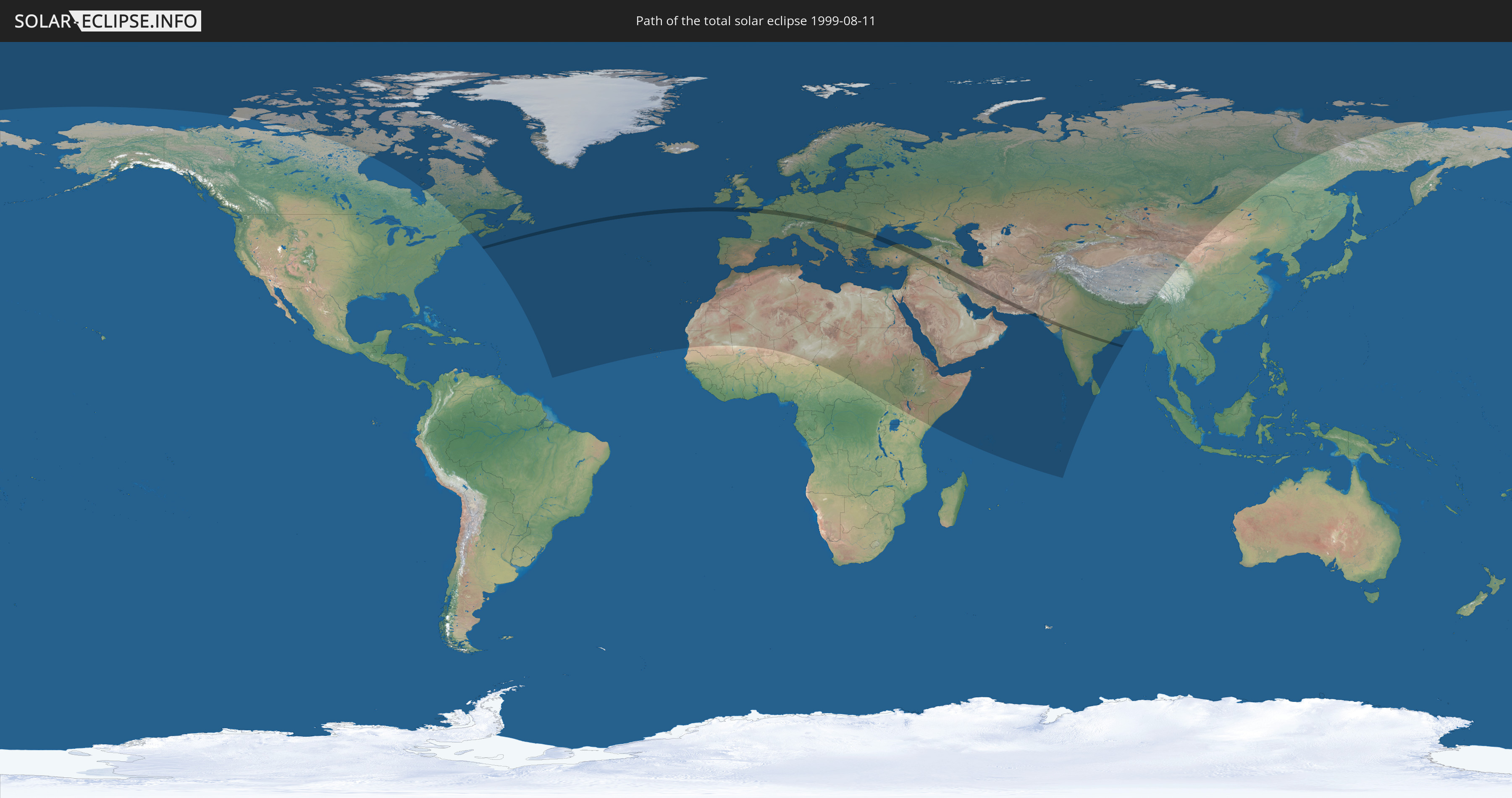
Total solar eclipse of 08/11/1999
449 people have seen this solar eclipse.
| Day of week: | Wednesday |
| Maximum duration of eclipse: | 02m23s |
| Maximum width of eclipse path: | 112 km |
| Saros cycle: | 145 |
| Coverage: | 100% |
| Magnitude: | 1.0286 |
| Gamma: | 0.5062 |
Wo kann man die Sonnenfinsternis vom 08/11/1999 sehen?
Die Sonnenfinsternis am 08/11/1999 kann man in 109 Ländern als partielle Sonnenfinsternis beobachten.
Der Finsternispfad verläuft durch 18 Länder. Nur in diesen Ländern ist sie als total Sonnenfinsternis zu sehen.
In den folgenden Ländern ist die Sonnenfinsternis total zu sehen
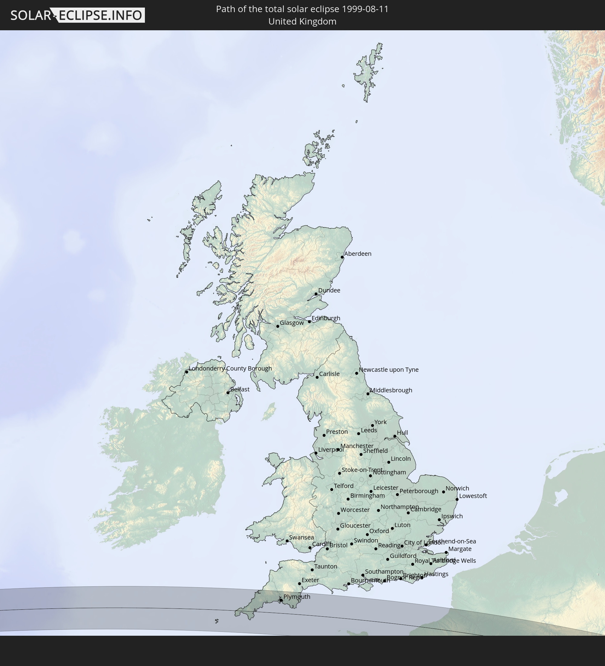 United Kingdom
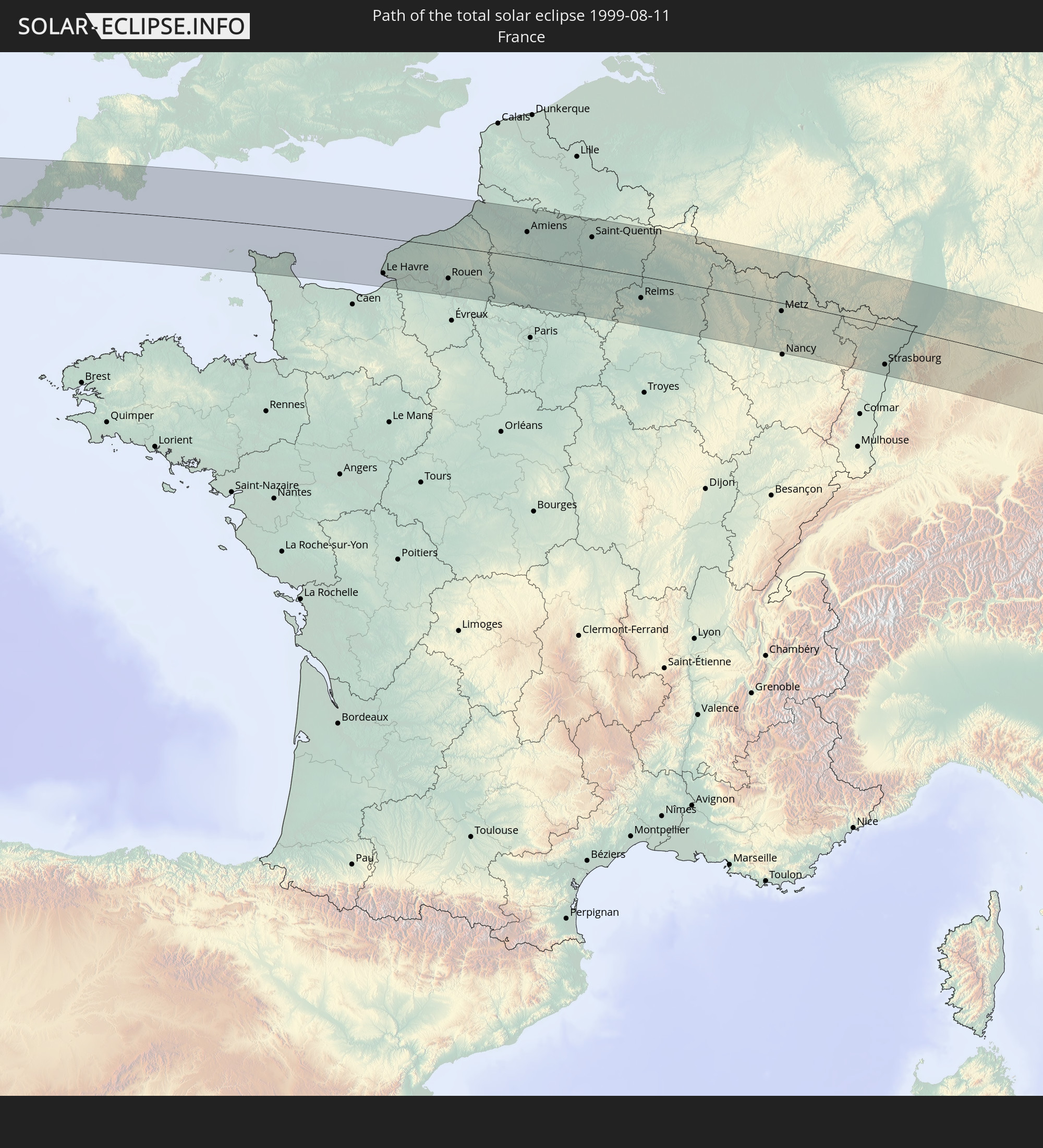 France
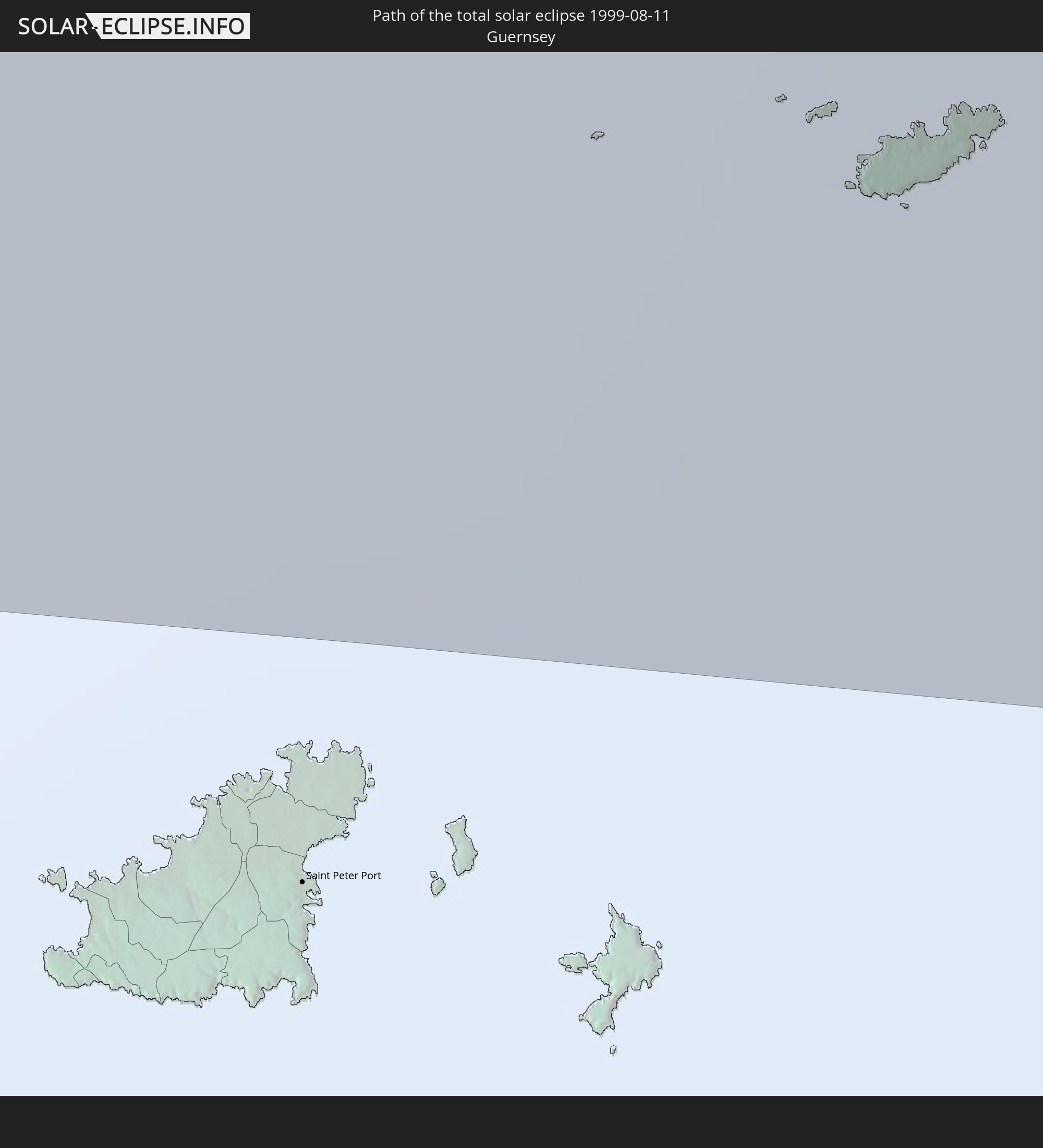 Guernsey
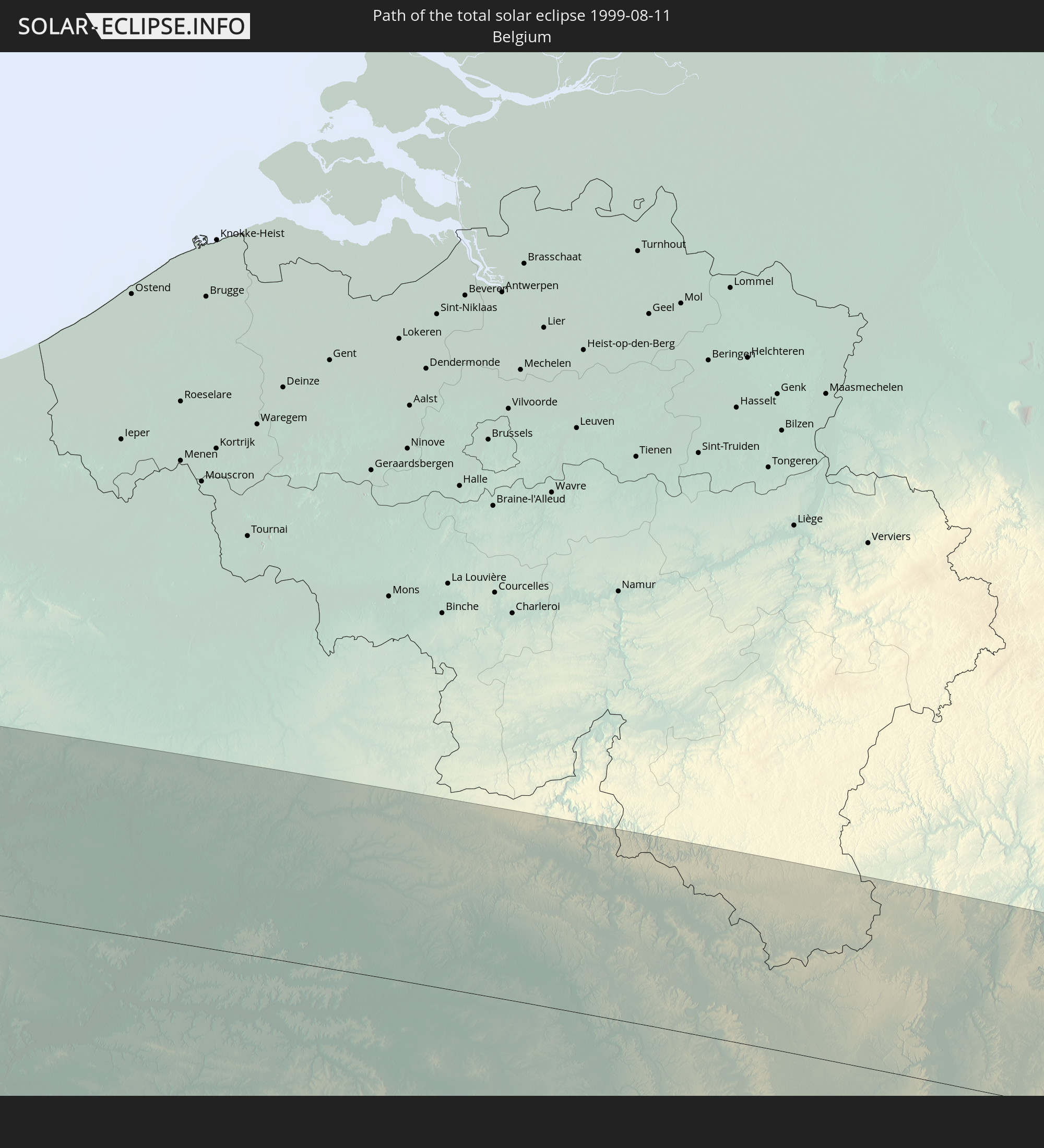 Belgium
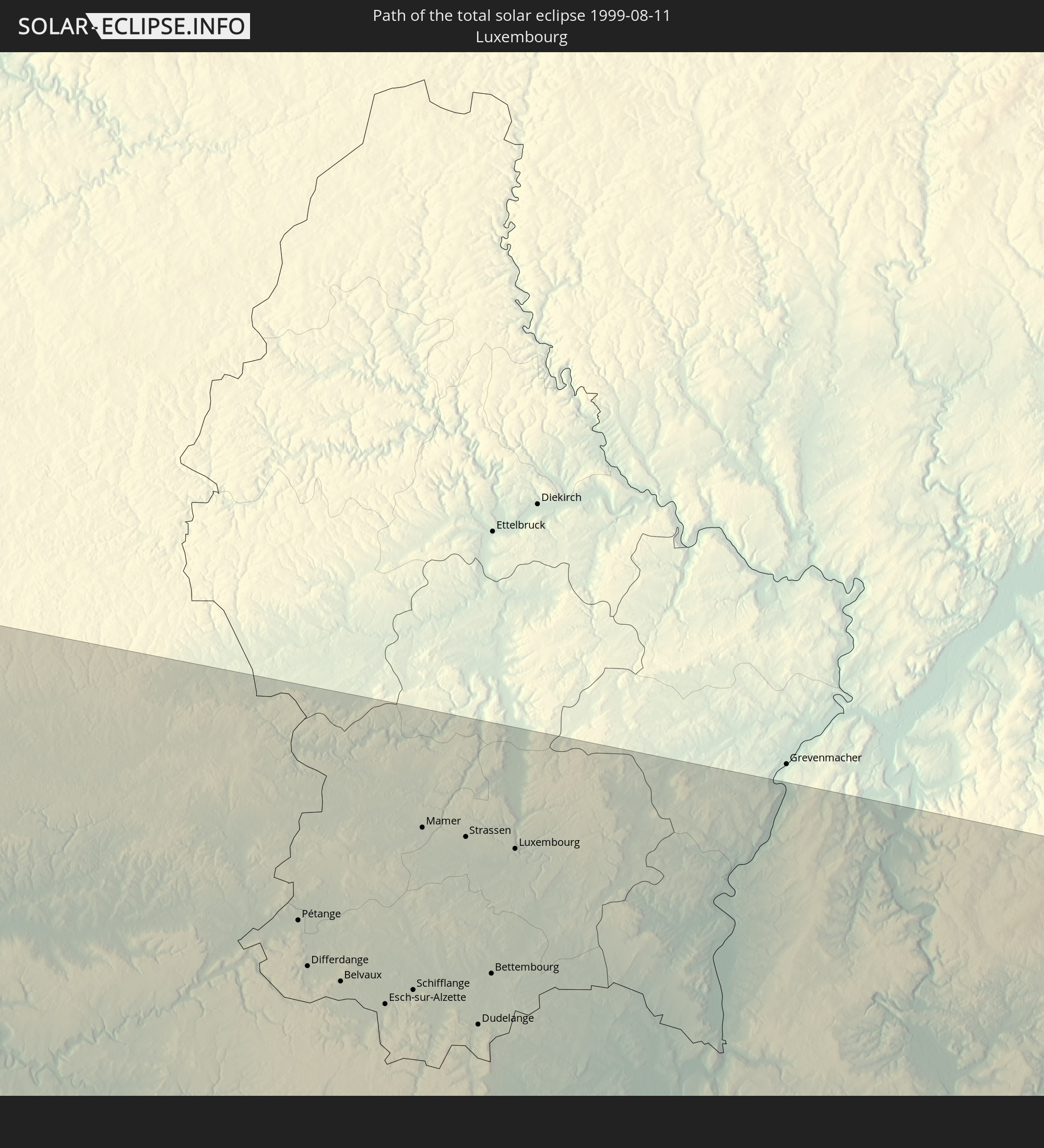 Luxembourg
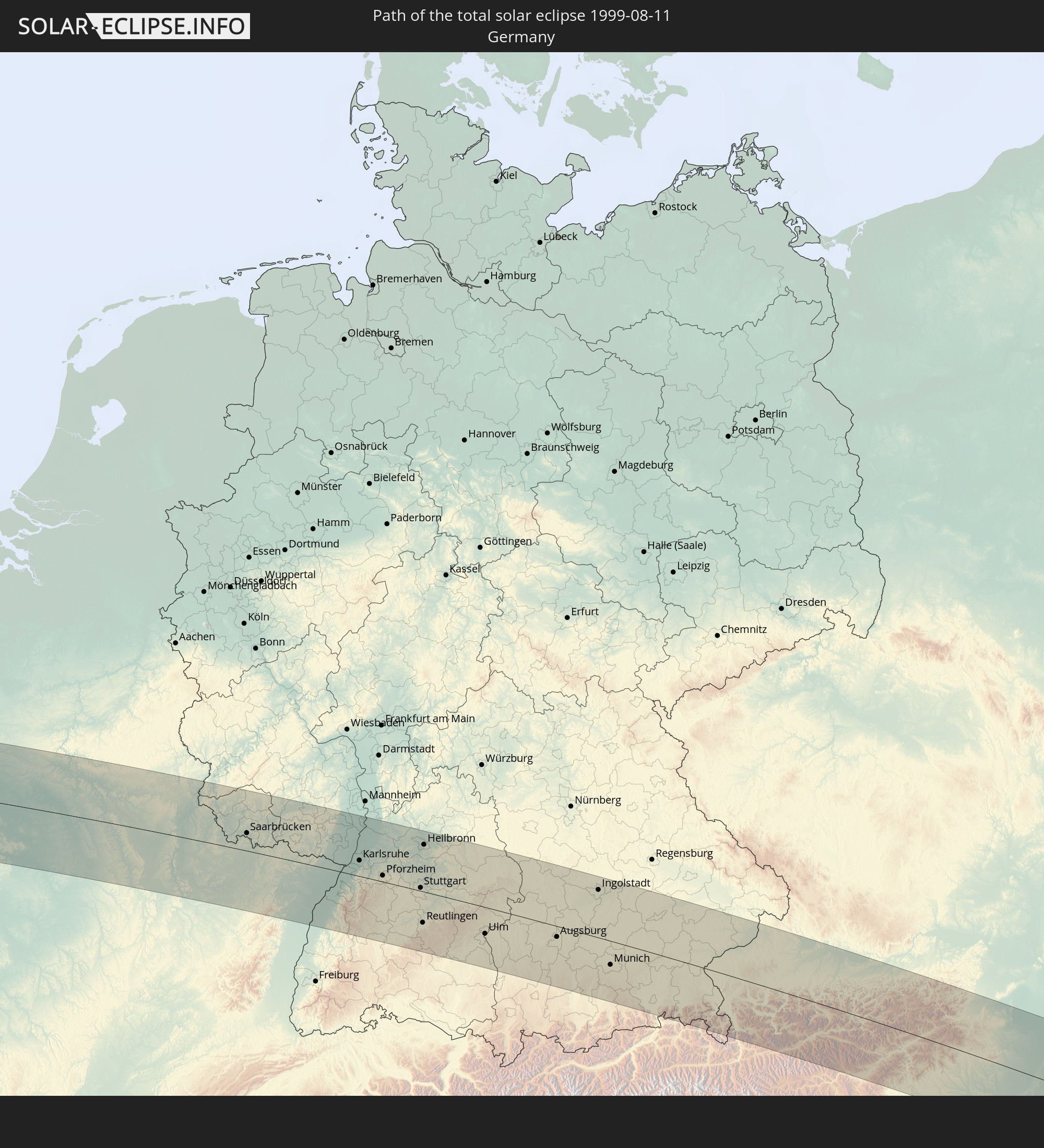 Germany
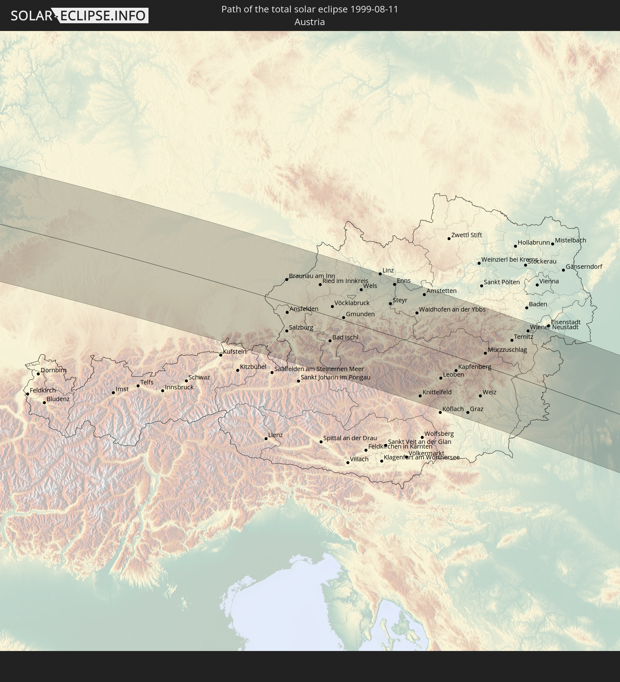 Austria
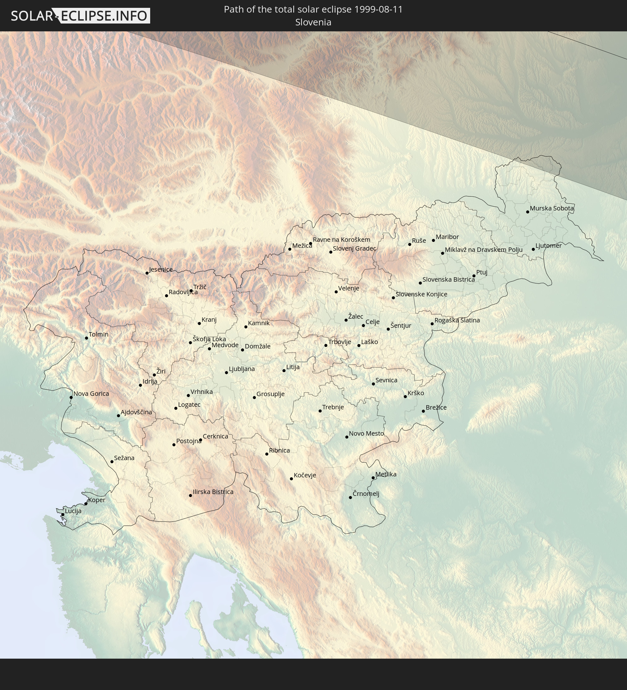 Slovenia
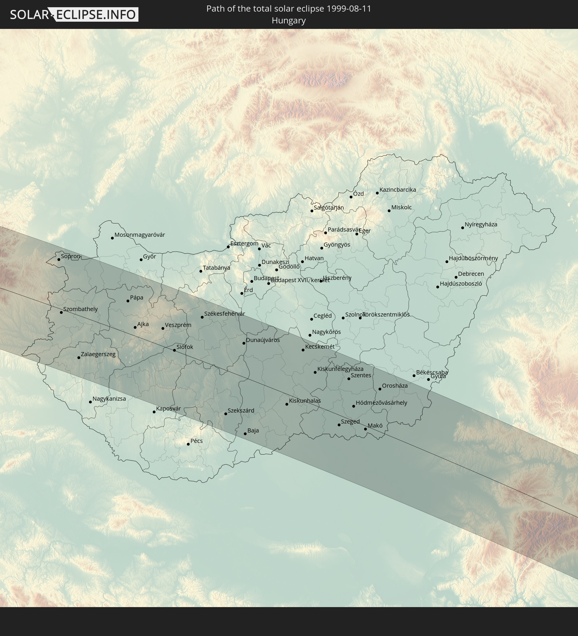 Hungary
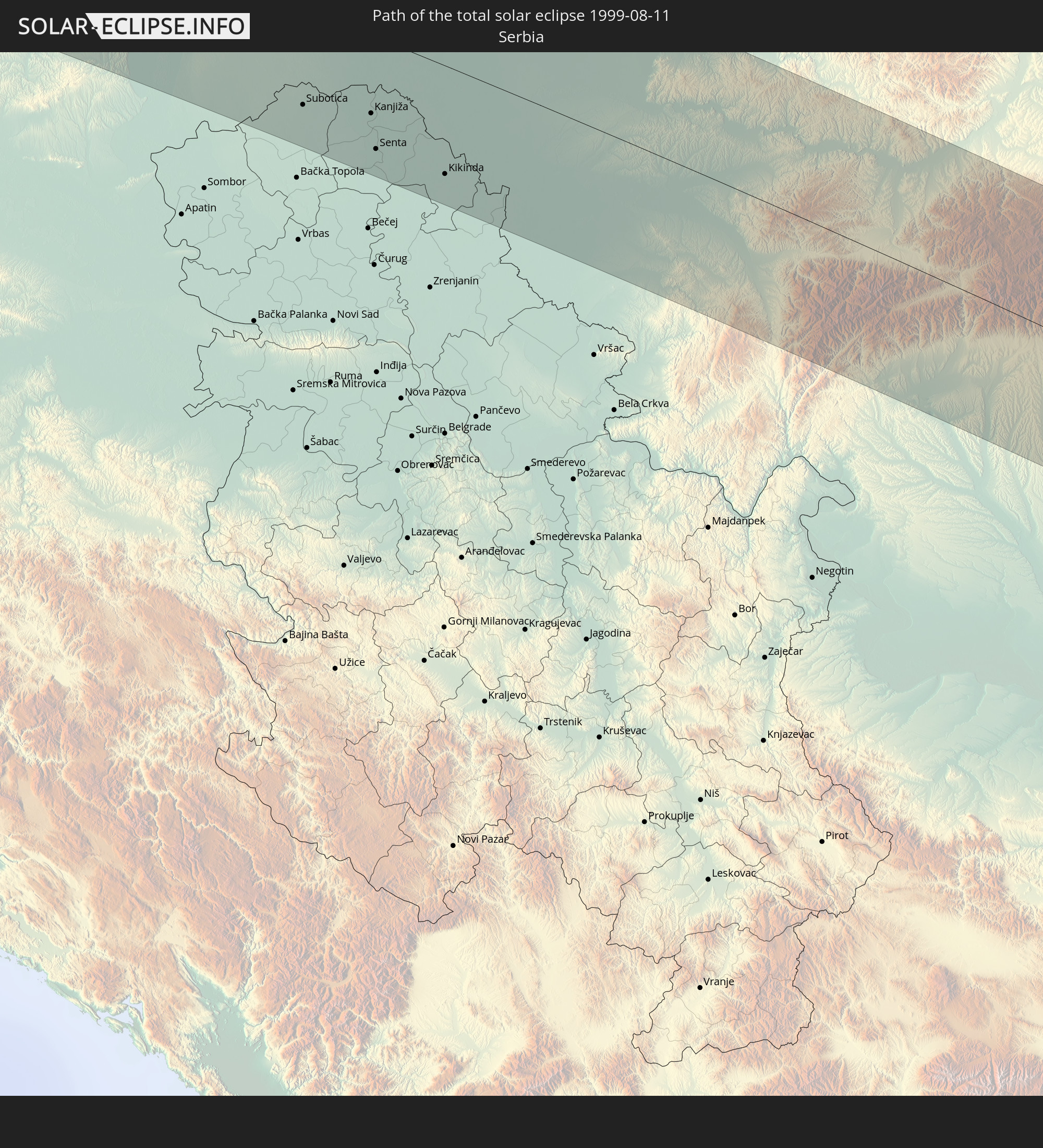 Serbia
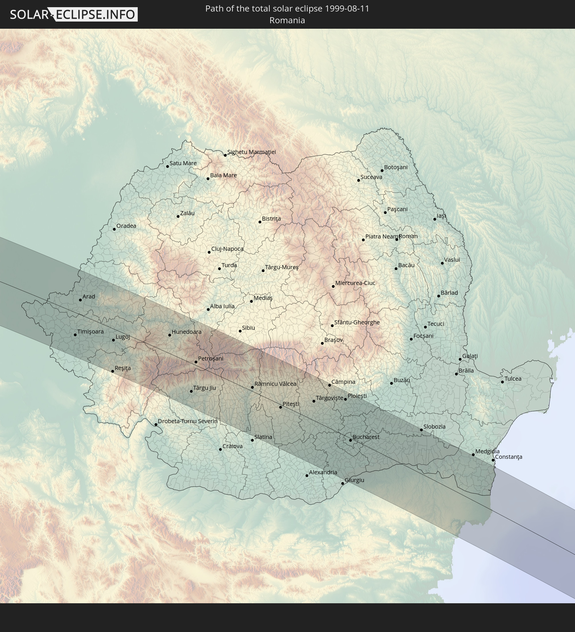 Romania
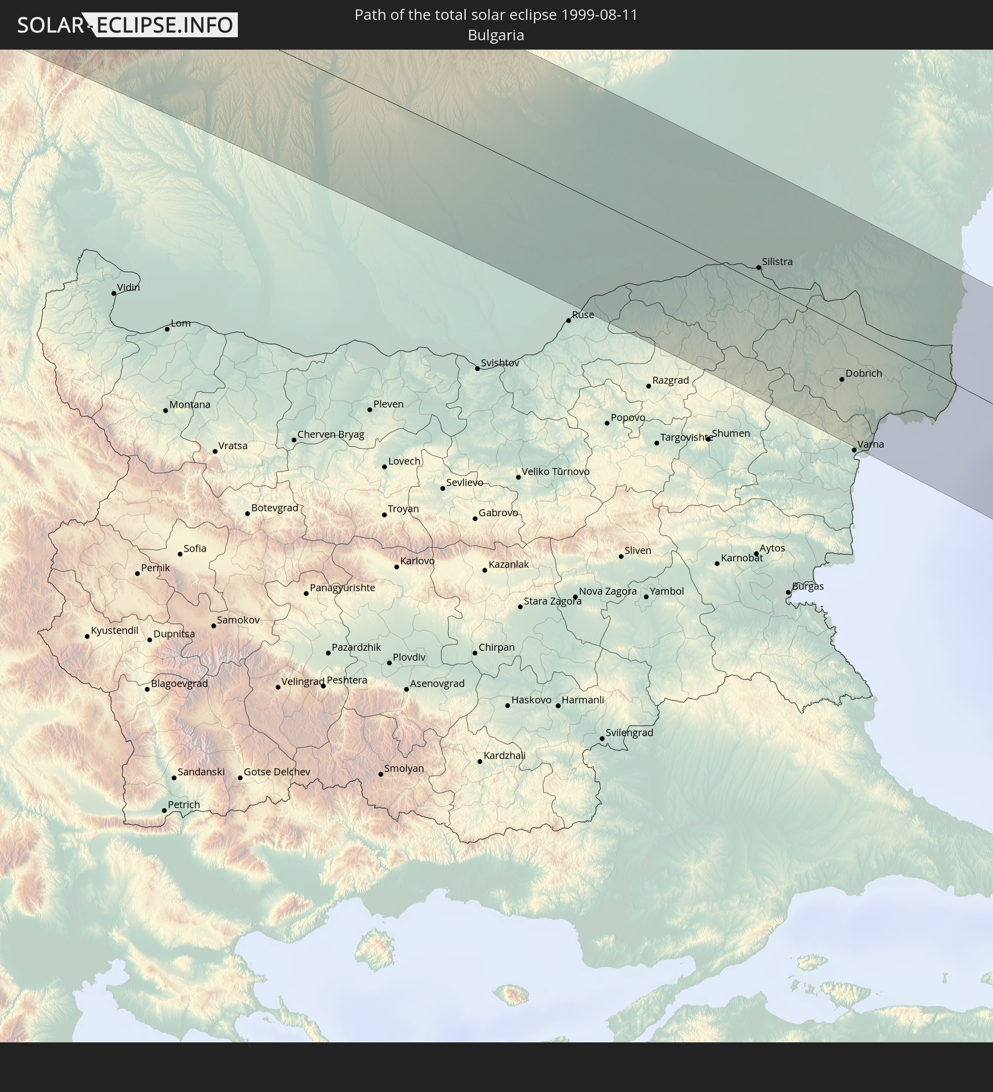 Bulgaria
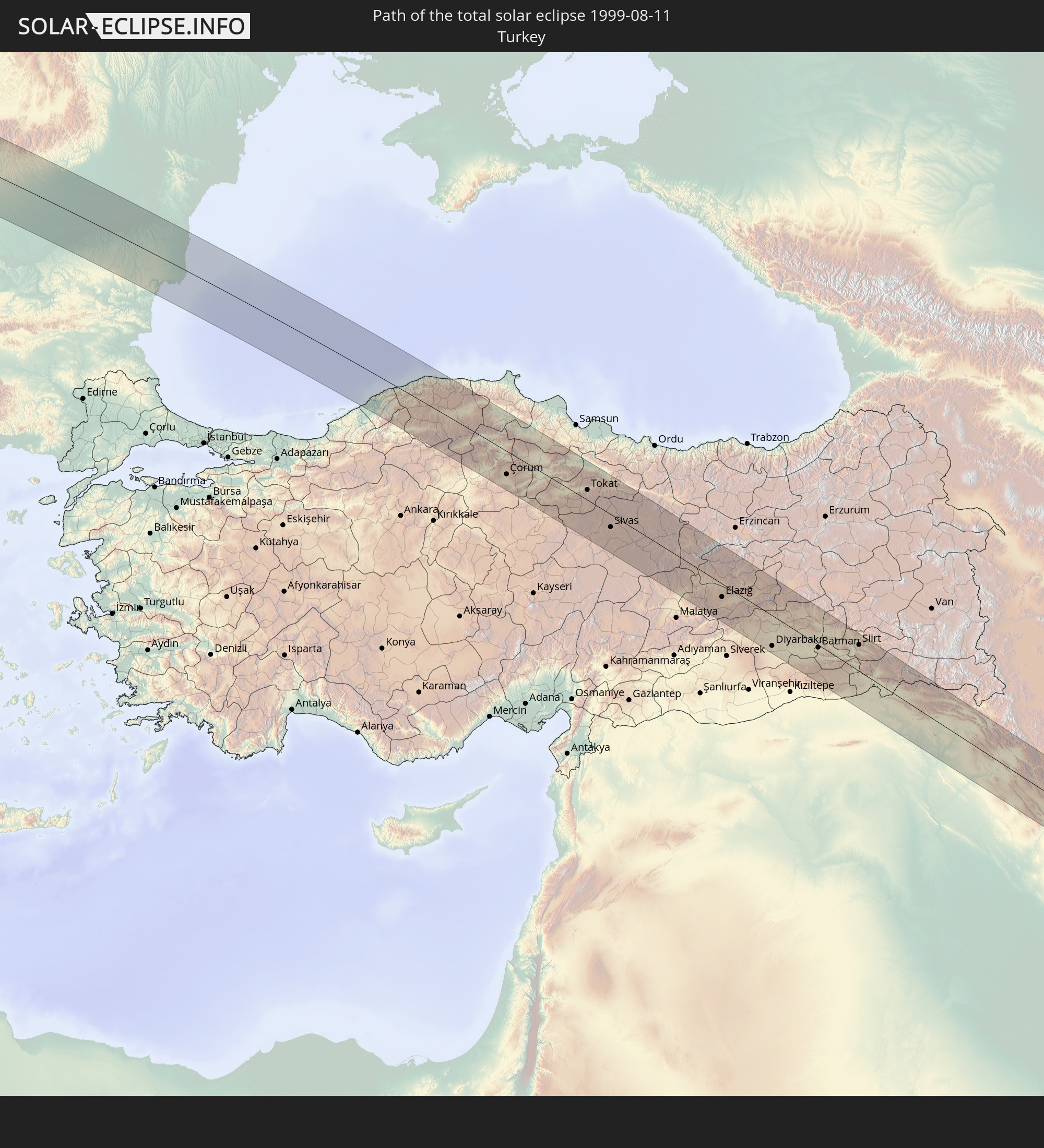 Turkey
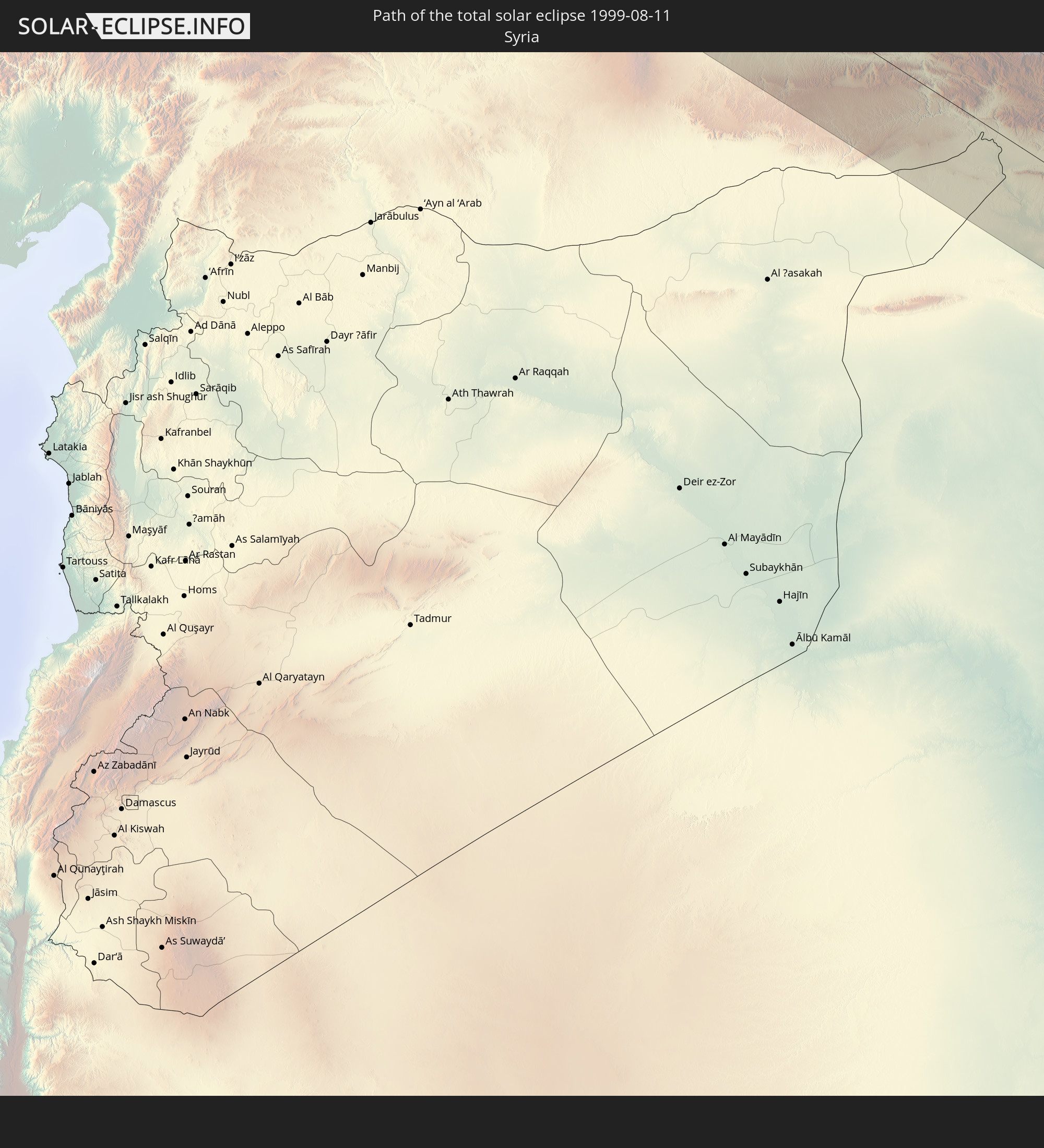 Syria
Syria
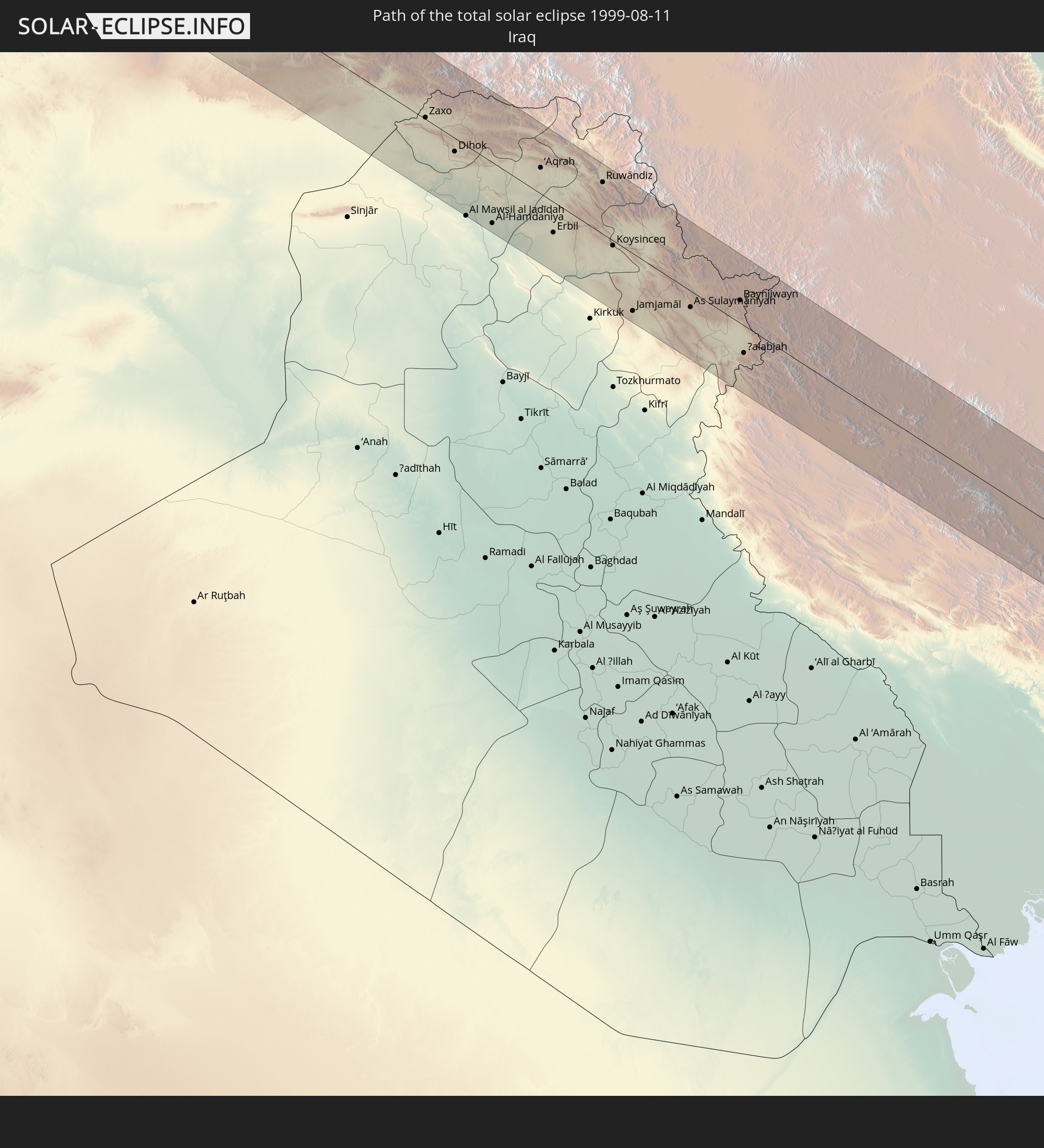 Iraq
Iraq
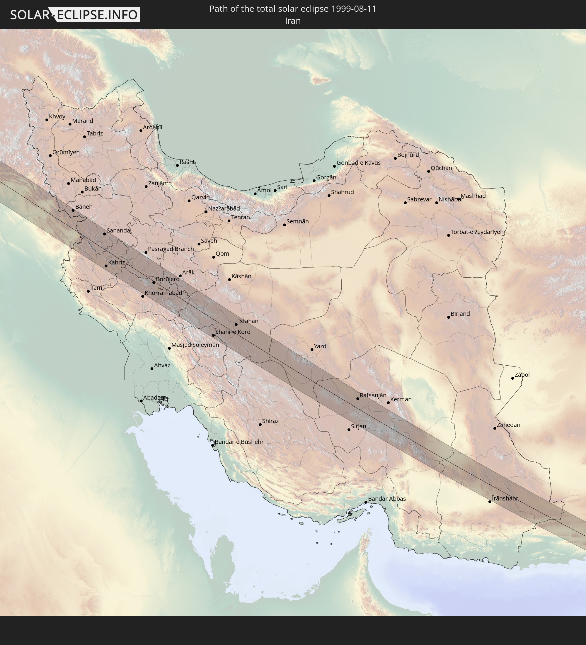 Iran
Iran
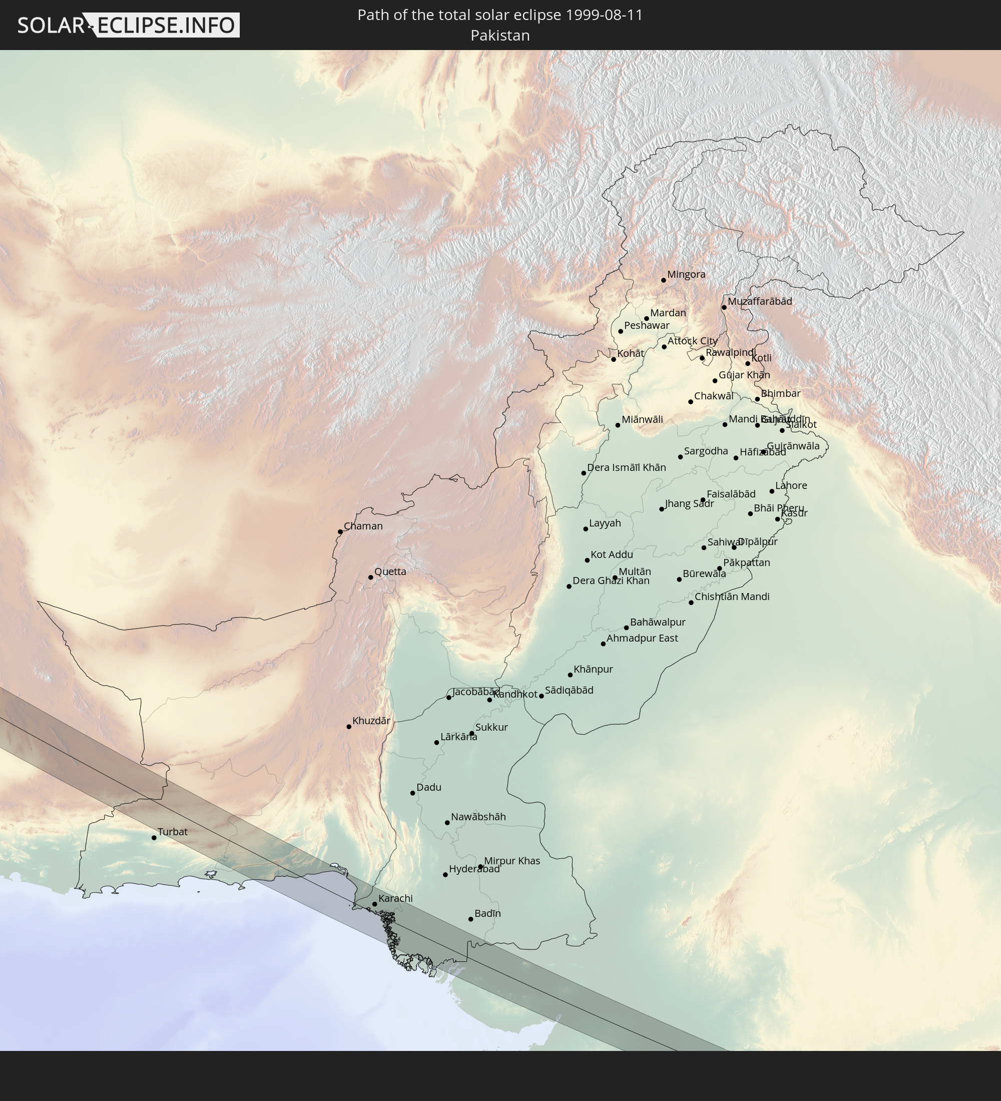 Pakistan
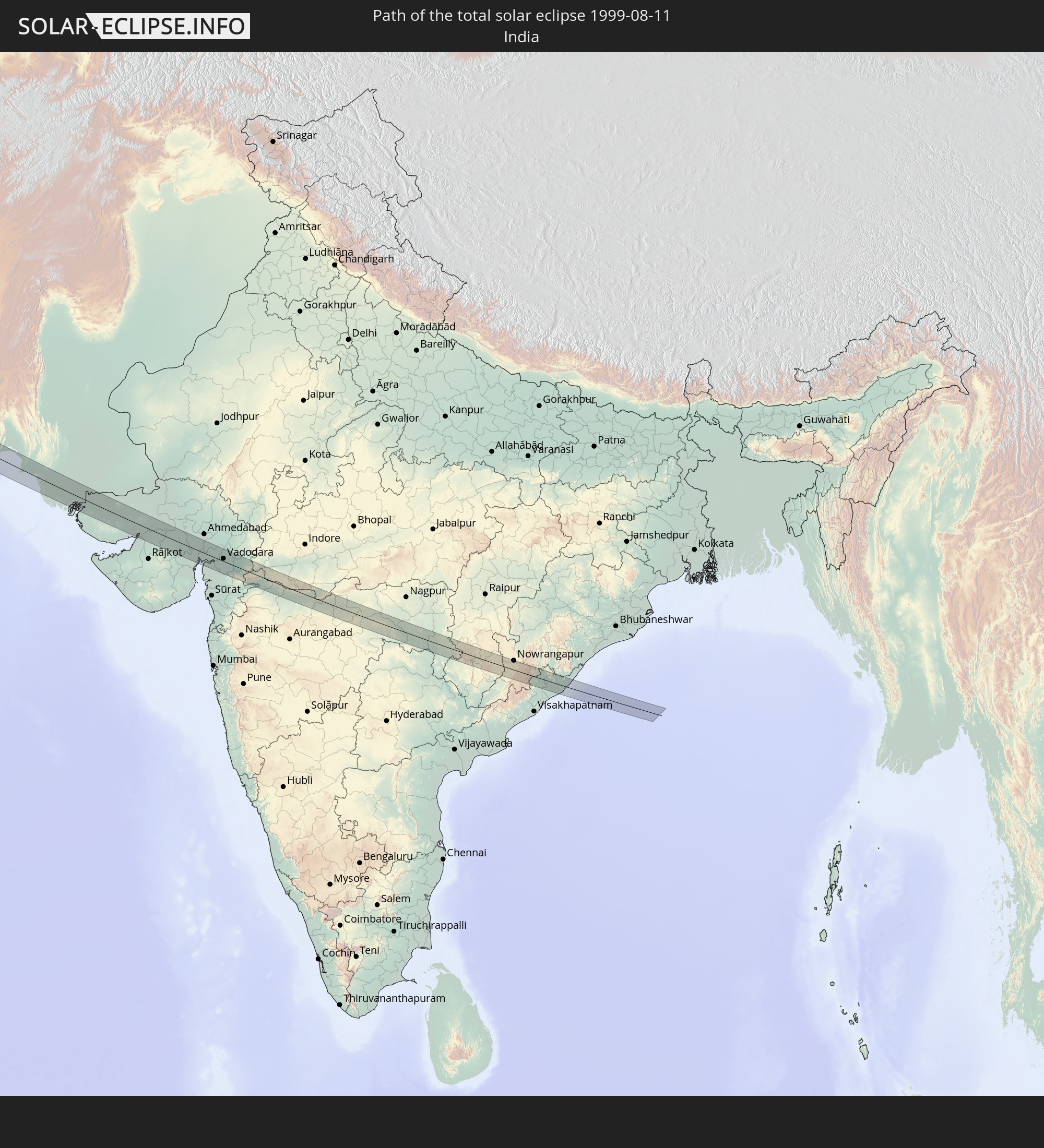 India
India
In den folgenden Ländern ist die Sonnenfinsternis partiell zu sehen
 Russia
 United States
 Canada
 Greenland
 Saint Pierre and Miquelon
 Portugal
 Cabo Verde
 Iceland
 Spain
Spain
 Mauritania
 Morocco
 Mali
Mali
 Republic of Ireland
 Svalbard and Jan Mayen
 Algeria
 United Kingdom
 Faroe Islands
 Gibraltar
 France
 Isle of Man
 Guernsey
 Jersey
 Niger
Niger
 Andorra
 Belgium
 Netherlands
 Norway
 Luxembourg
 Germany
 Switzerland
 Italy
Italy
 Monaco
 Tunisia
 Denmark
 Libya
Libya
 Liechtenstein
 Austria
 Sweden
 Czechia
 San Marino
 Vatican City
 Slovenia
 Chad
Chad
 Croatia
 Poland
 Malta
Malta
 Central African Republic
 Bosnia and Herzegovina
 Hungary
 Slovakia
 Montenegro
 Serbia
 Albania
 Åland Islands
 Greece
 Romania
 Republic of Macedonia
 Finland
 Lithuania
 Latvia
 Estonia
 Sudan
Sudan
 Ukraine
 Bulgaria
 Belarus
 Egypt
Egypt
 Turkey
 Moldova
 Uganda
 Cyprus
 Ethiopia
 Kenya
Kenya
 State of Palestine
 Israel
 Saudi Arabia
 Jordan
 Lebanon
 Syria
Syria
 Eritrea
 Iraq
Iraq
 Georgia
 Somalia
 Djibouti
 Yemen
Yemen
 Armenia
 Iran
Iran
 Azerbaijan
 Seychelles
 Kazakhstan
 Kuwait
 Bahrain
 Qatar
Qatar
 United Arab Emirates
 Oman
Oman
 Turkmenistan
 Uzbekistan
 Afghanistan
 Pakistan
 Tajikistan
 India
India
 Kyrgyzstan
 British Indian Ocean Territory
 Maldives
 China
China
 Sri Lanka
 Nepal
Nepal
 Mongolia
 Bangladesh
 Bhutan
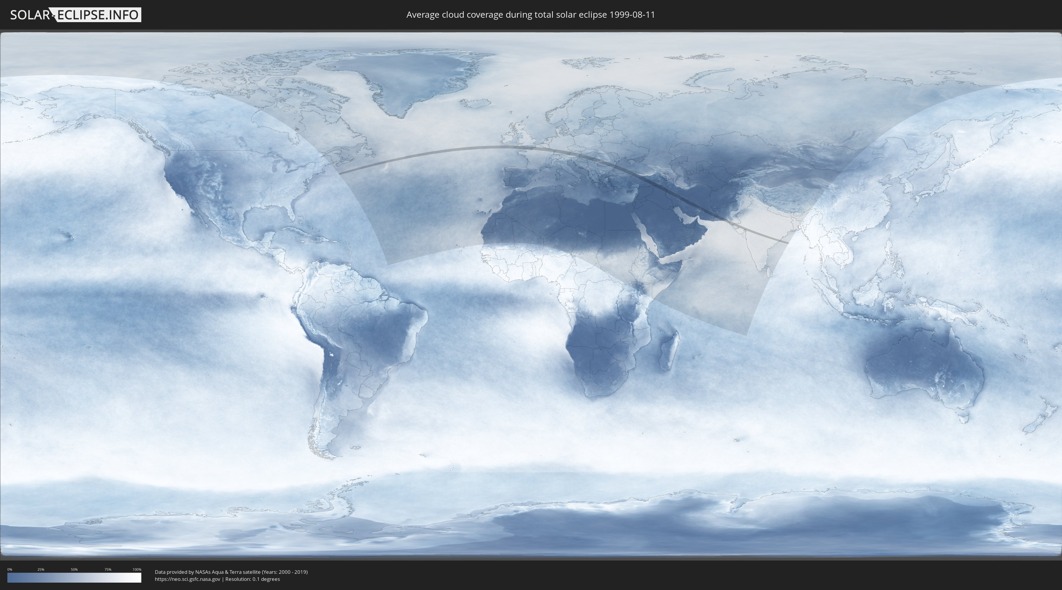
How will be the weather during the total solar eclipse on 08/11/1999?
Where is the best place to see the total solar eclipse of 08/11/1999?
The following maps show the average cloud coverage for the day of the total solar eclipse.
With the help of these maps, it is possible to find the place along the eclipse path, which has the best
chance of a cloudless sky.
Nevertheless, you should consider local circumstances and inform about the weather of your chosen
observation site.
The data is provided by NASAs satellites
AQUA and TERRA.
The cloud maps are averaged over a period of 19 years (2000 - 2019).

Detailed country maps
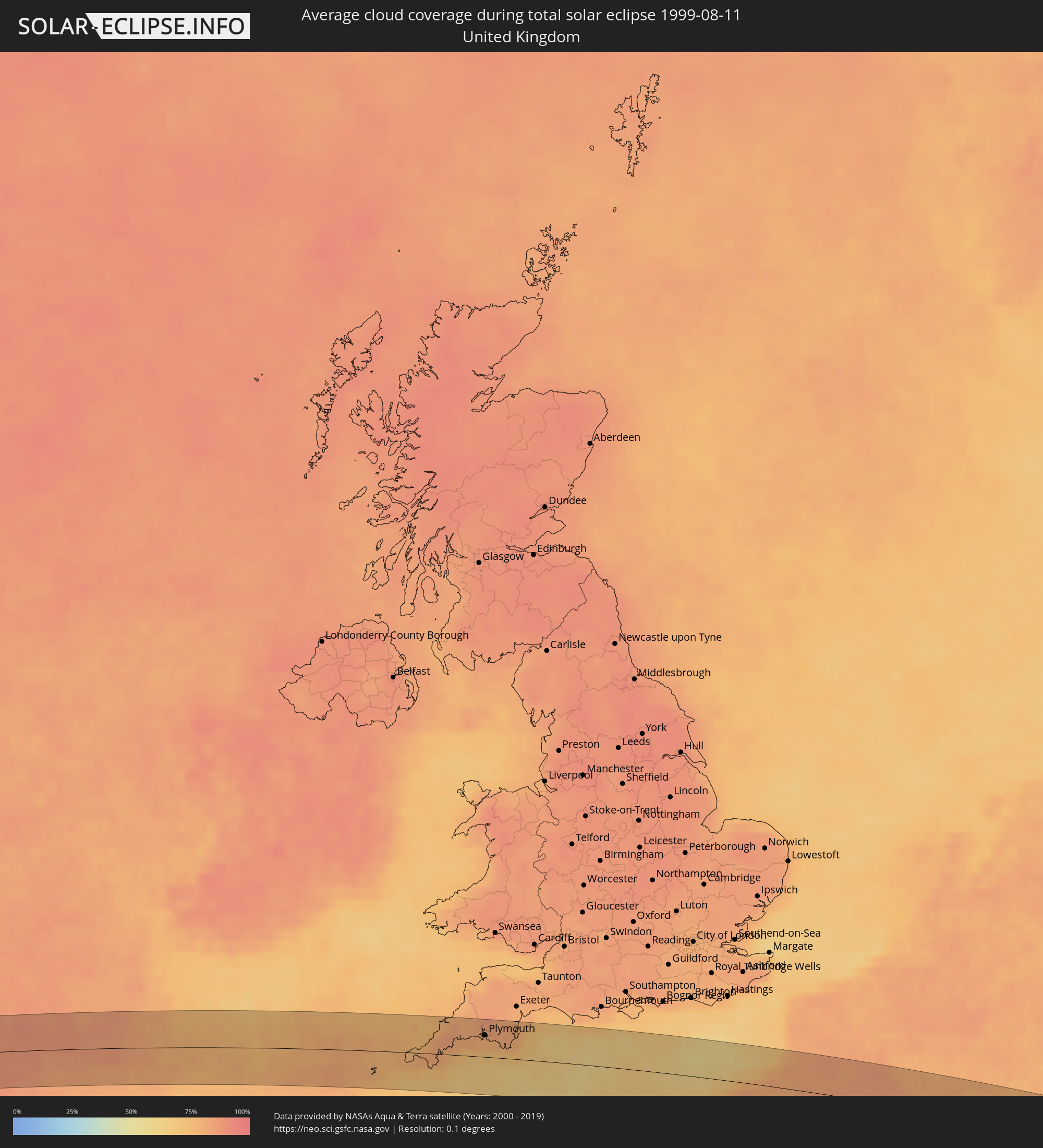 United Kingdom
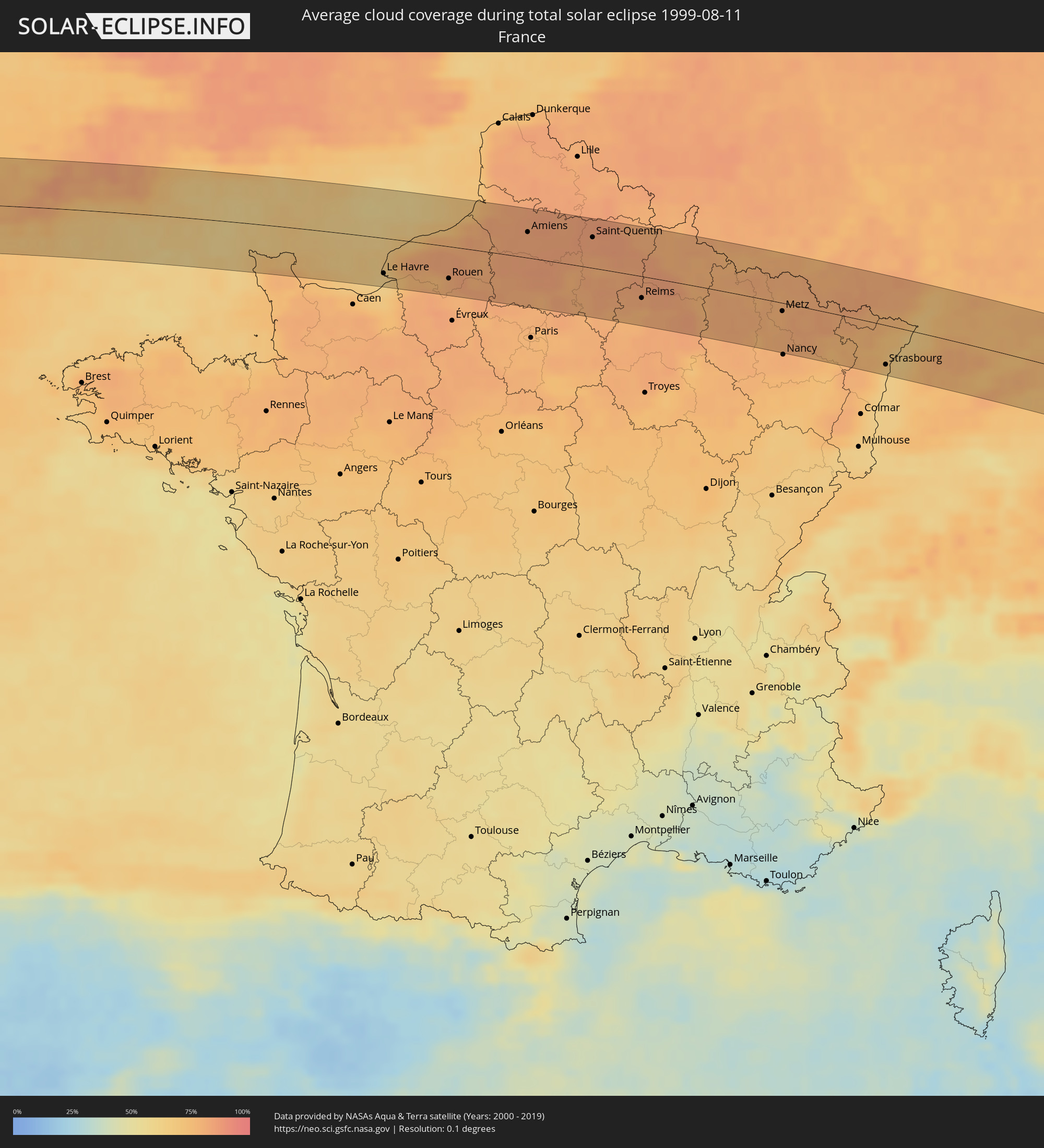 France
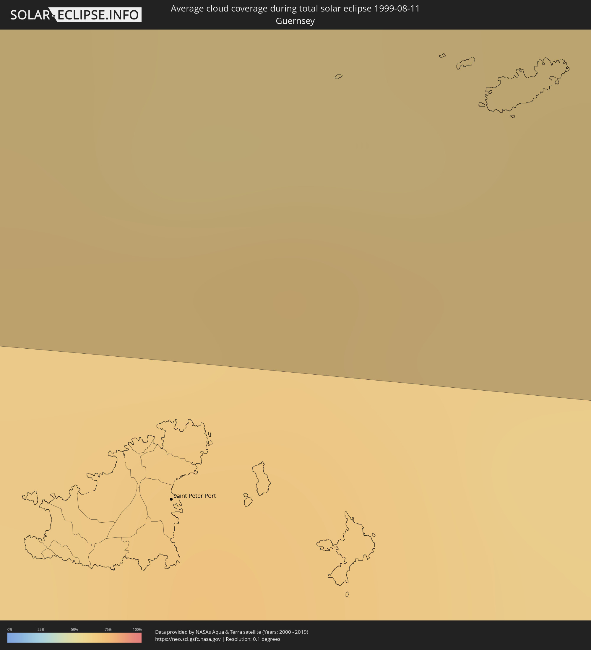 Guernsey
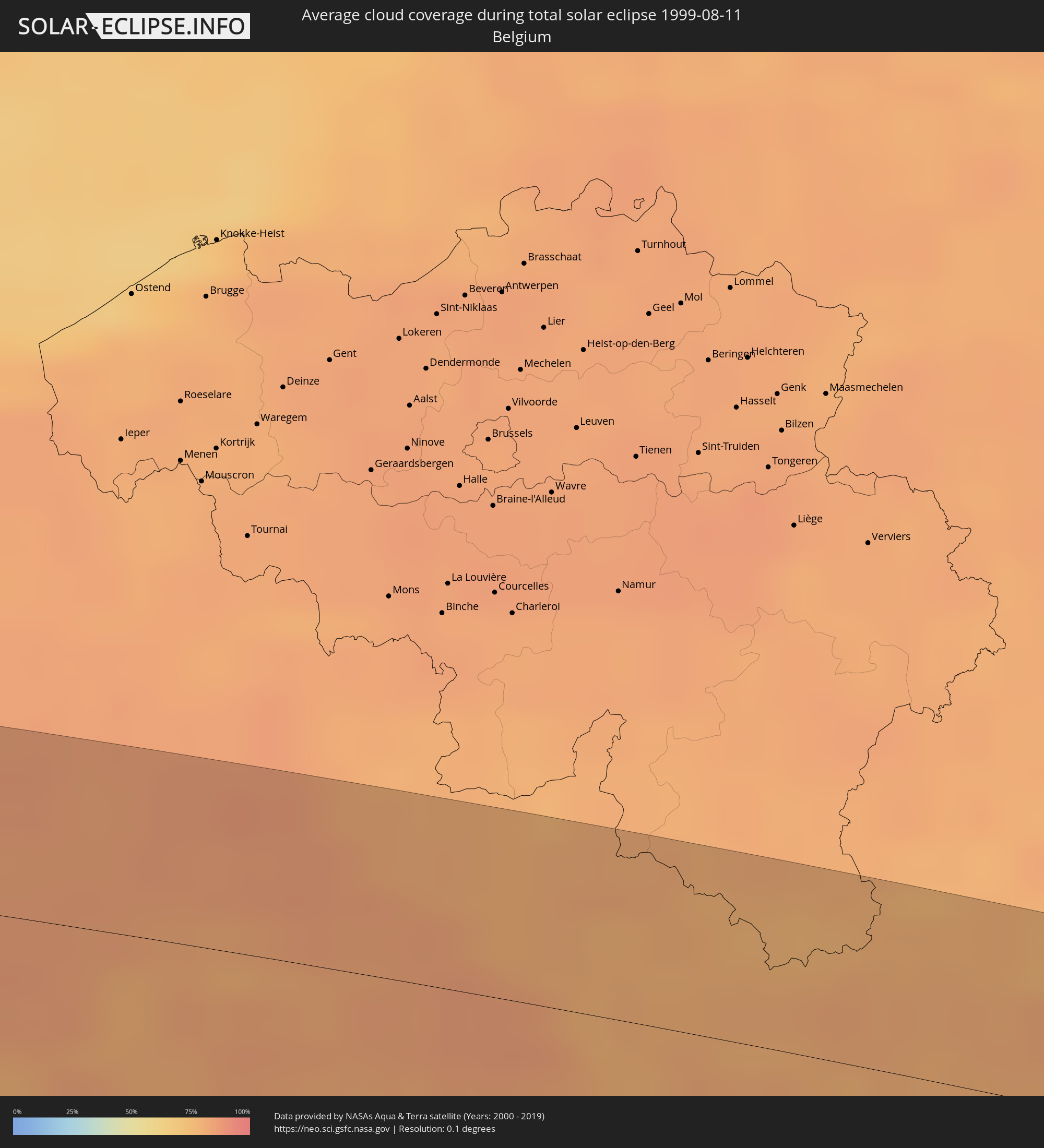 Belgium
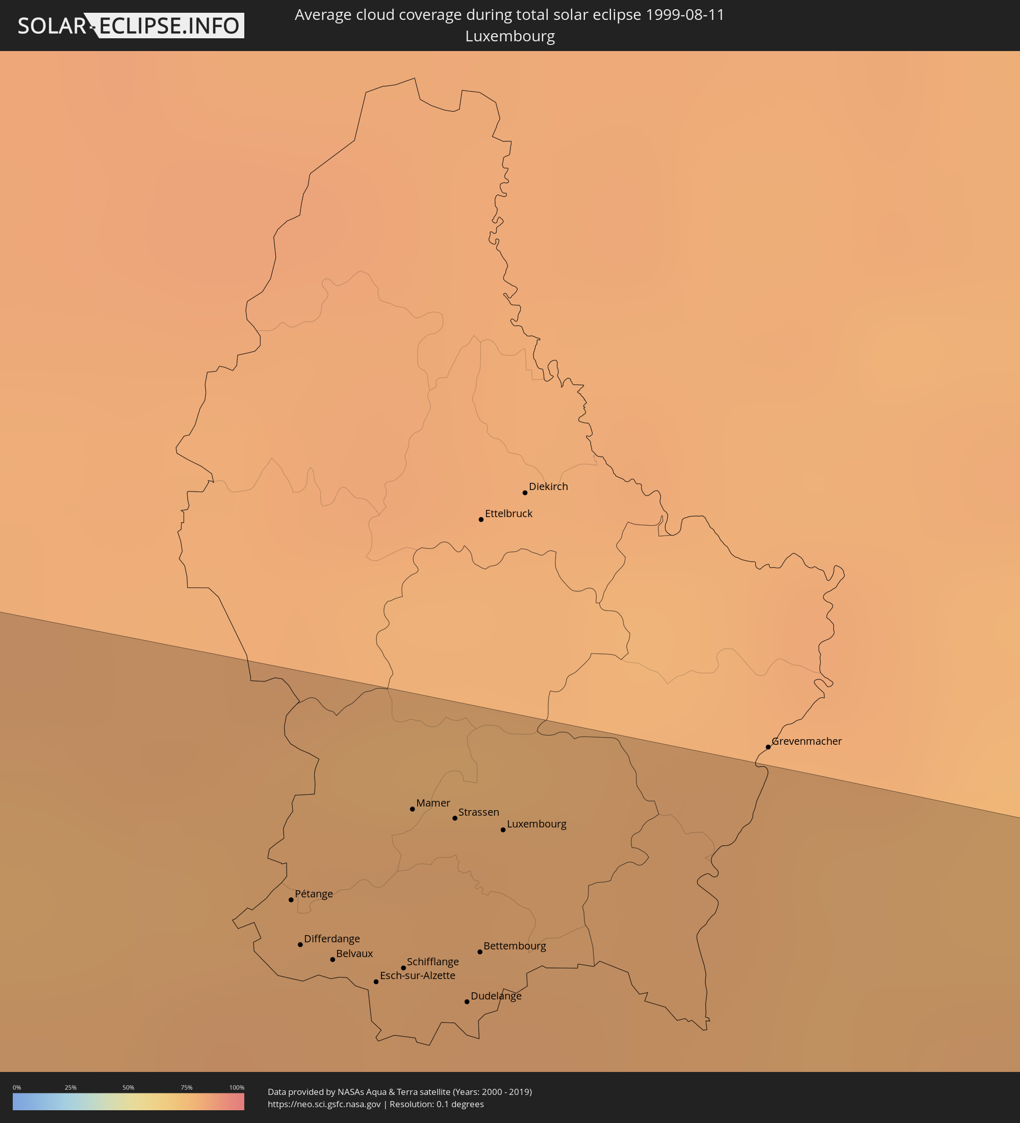 Luxembourg
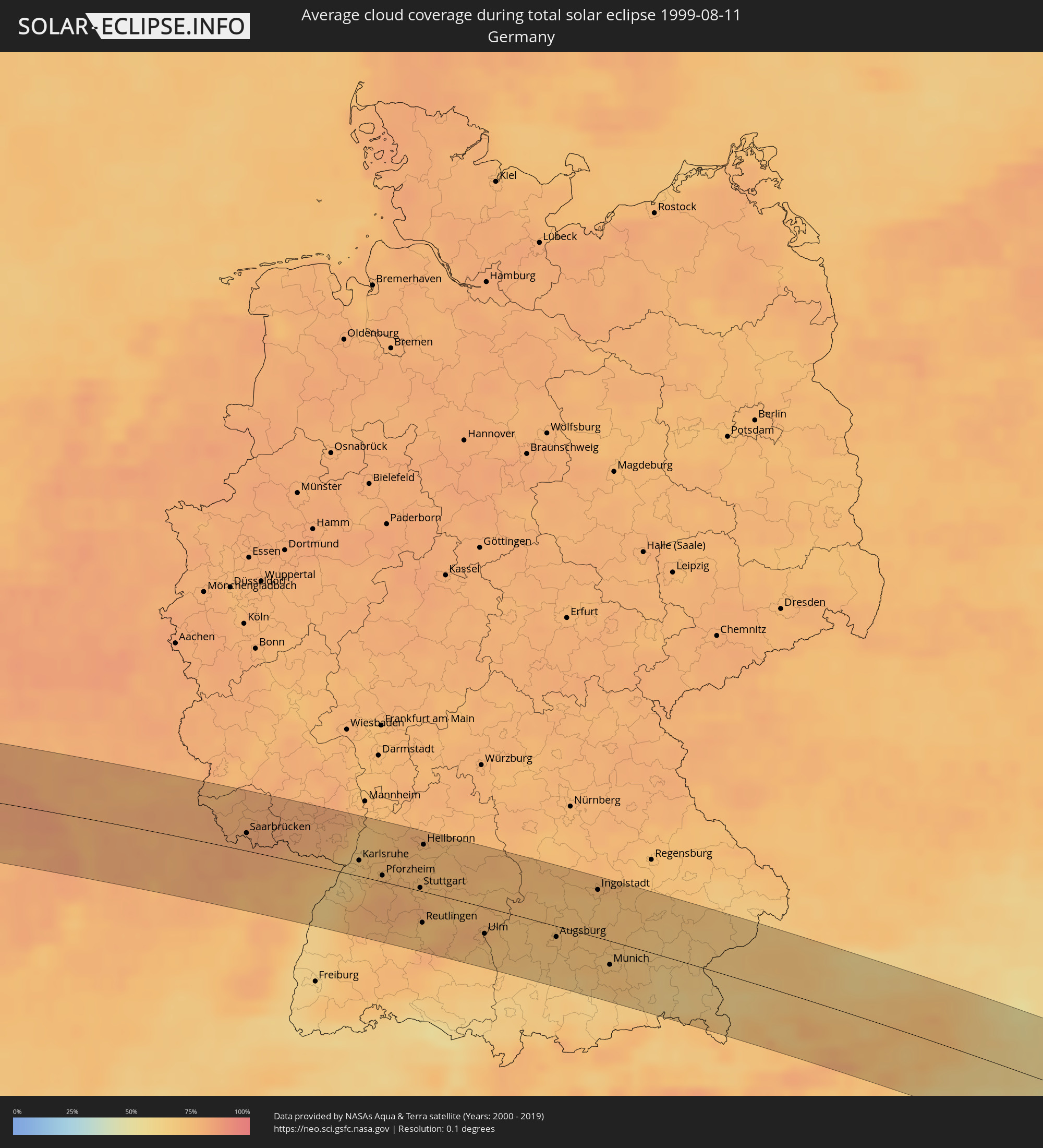 Germany
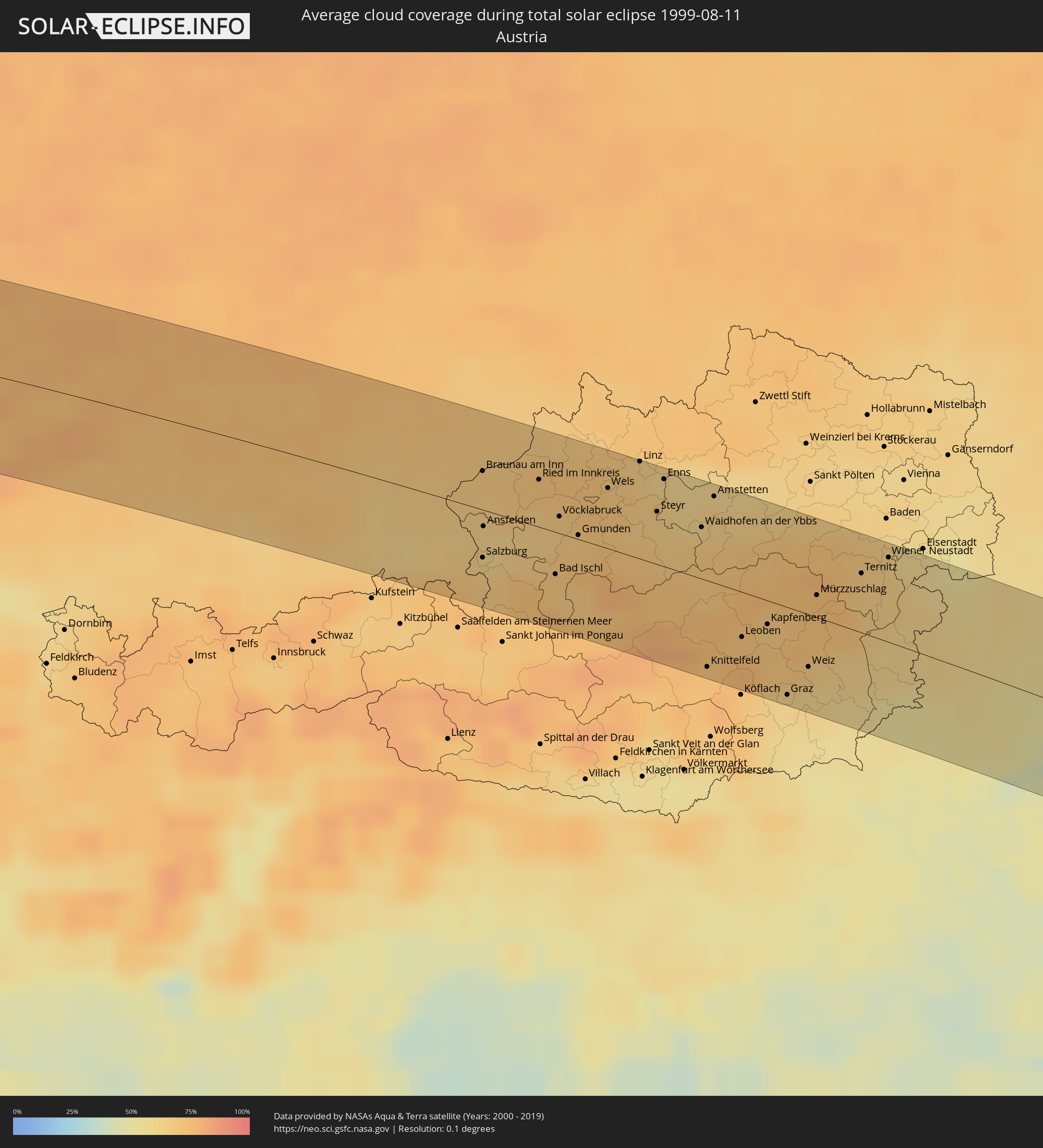 Austria
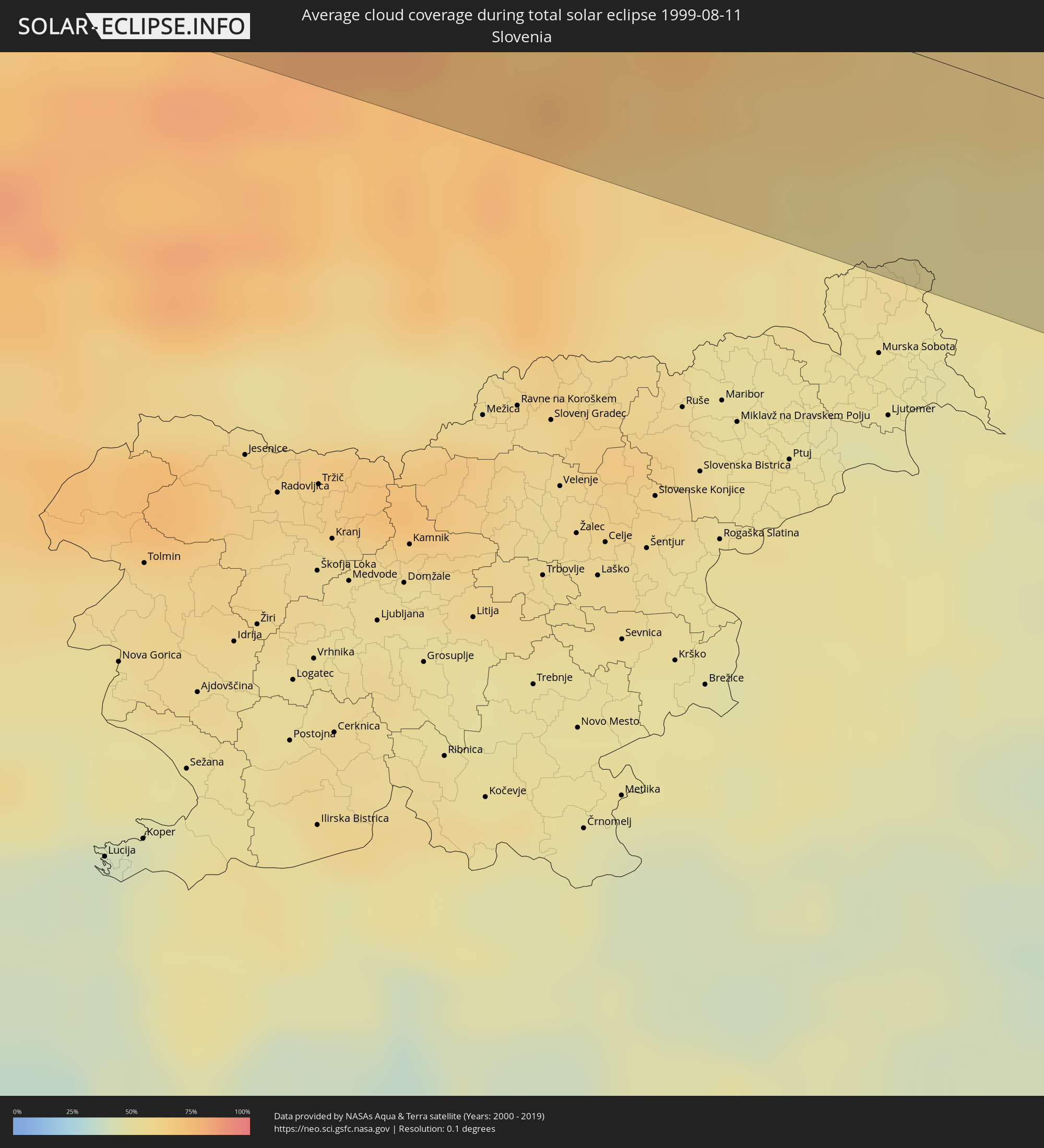 Slovenia
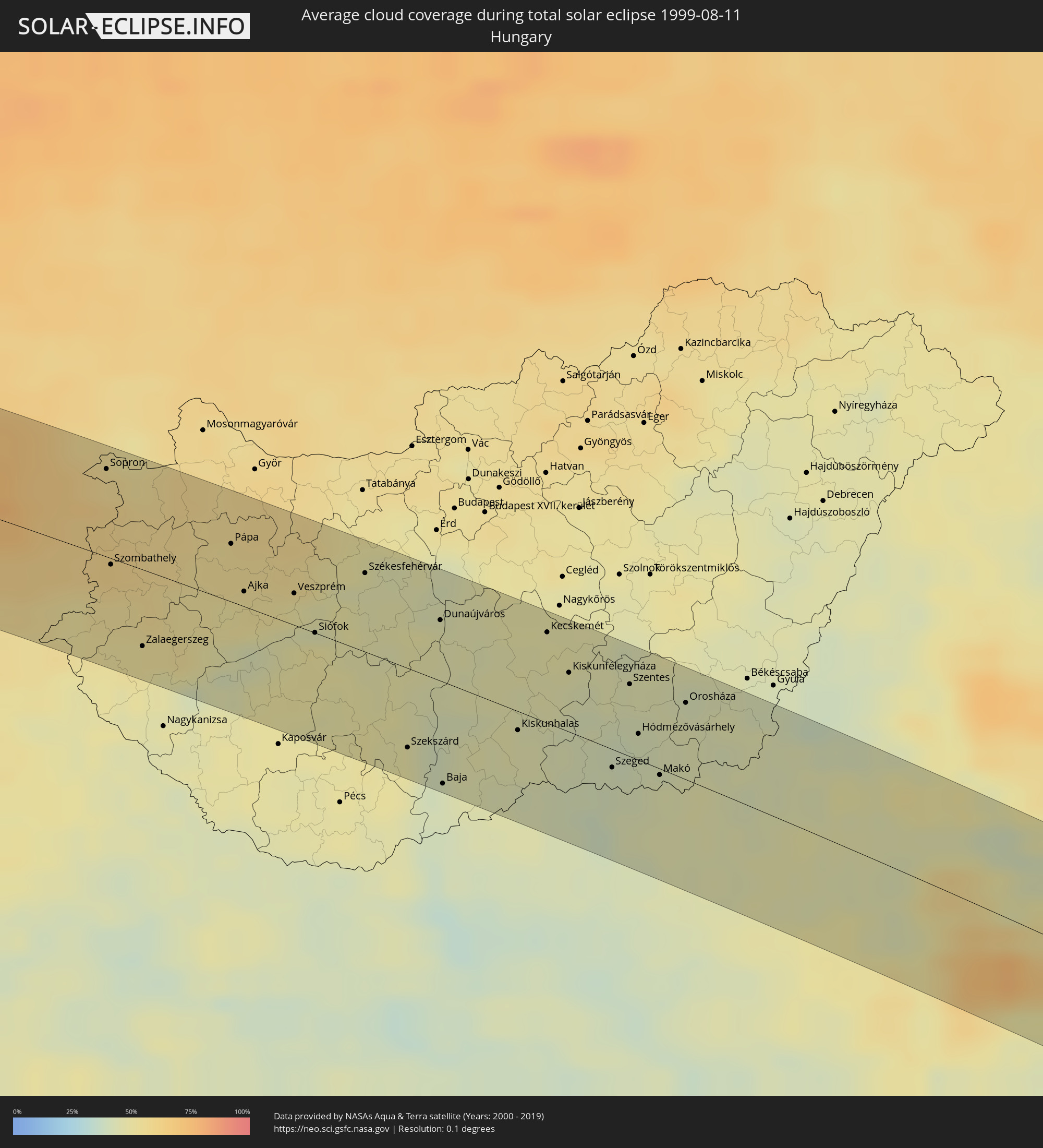 Hungary
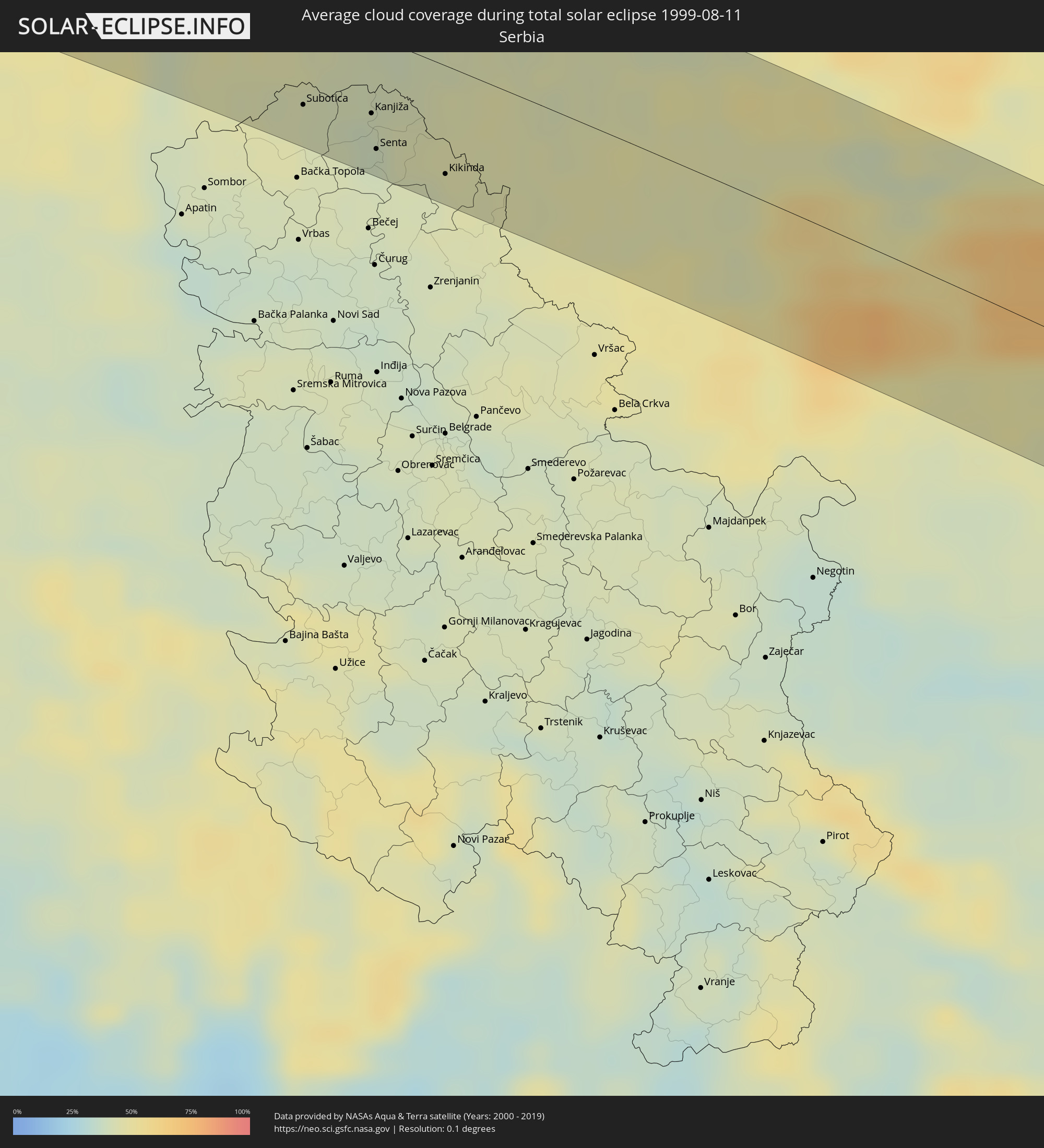 Serbia
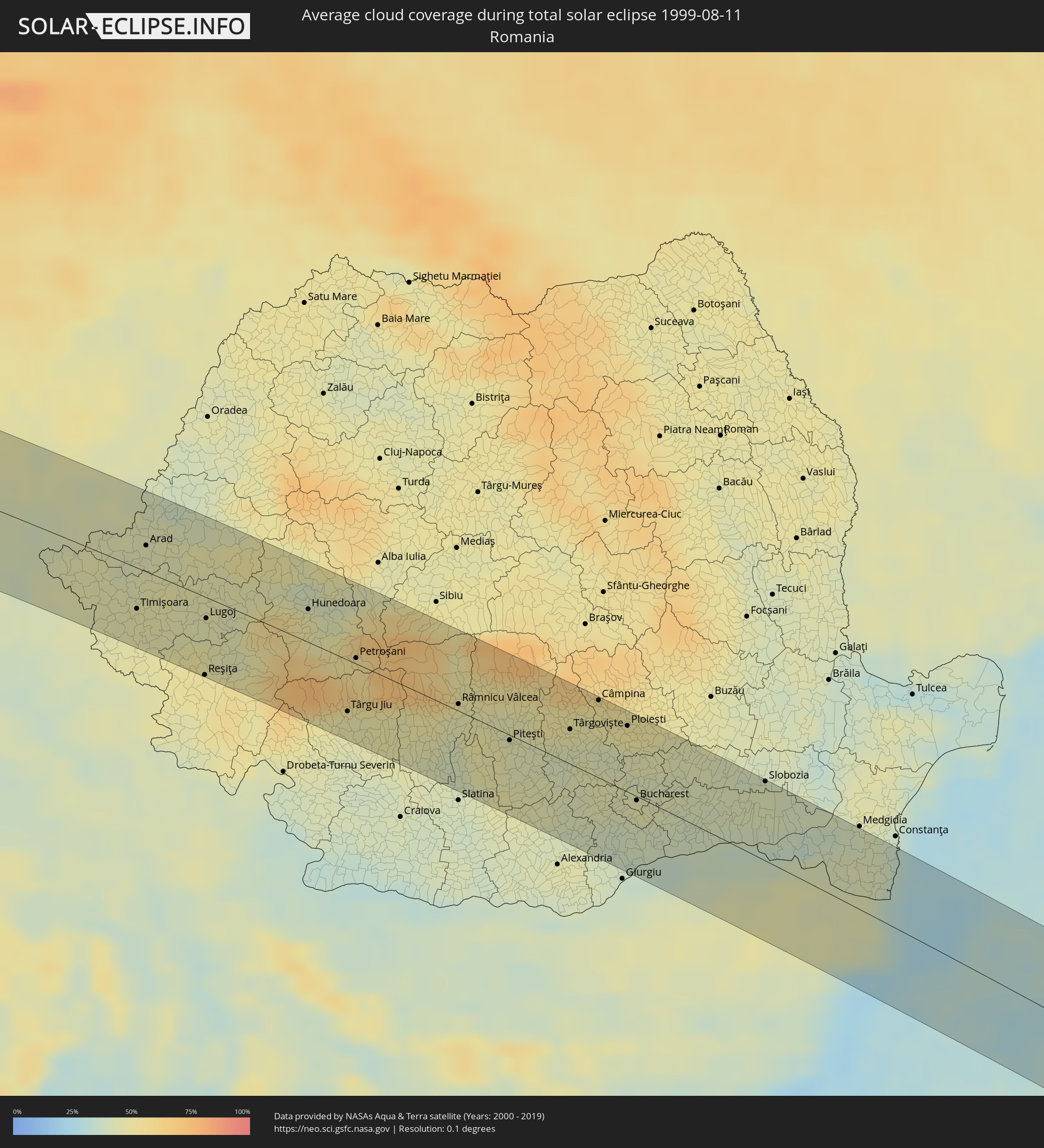 Romania
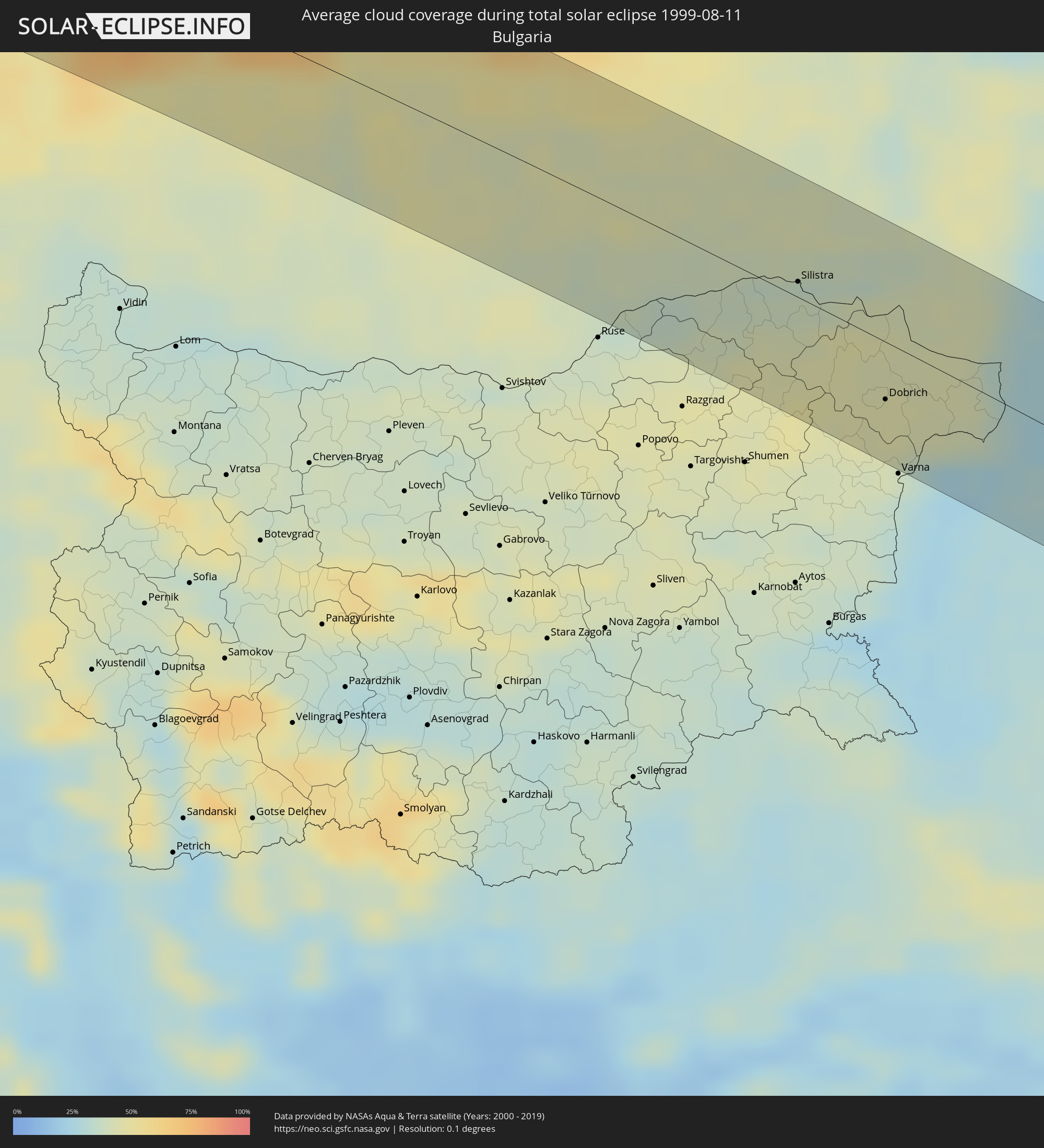 Bulgaria
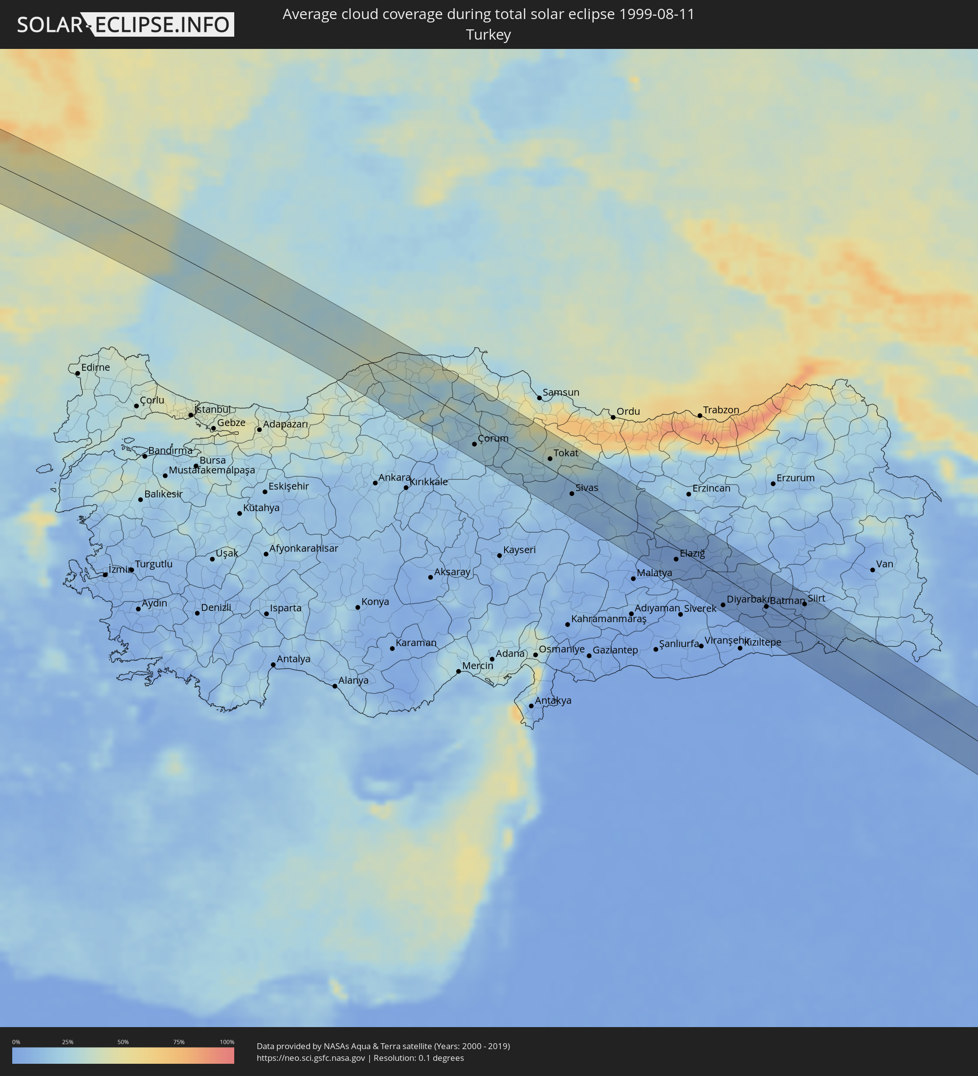 Turkey
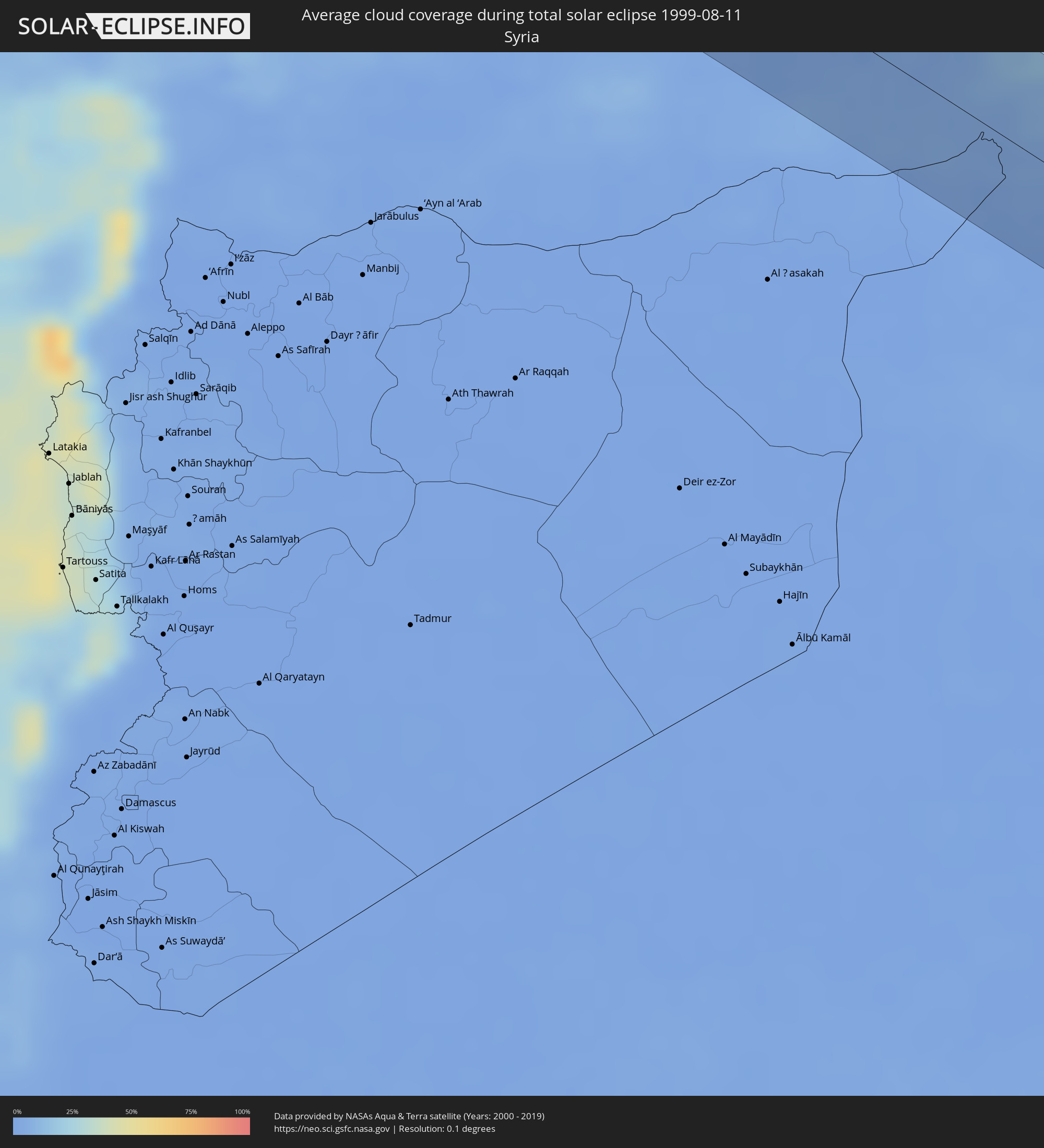 Syria
Syria
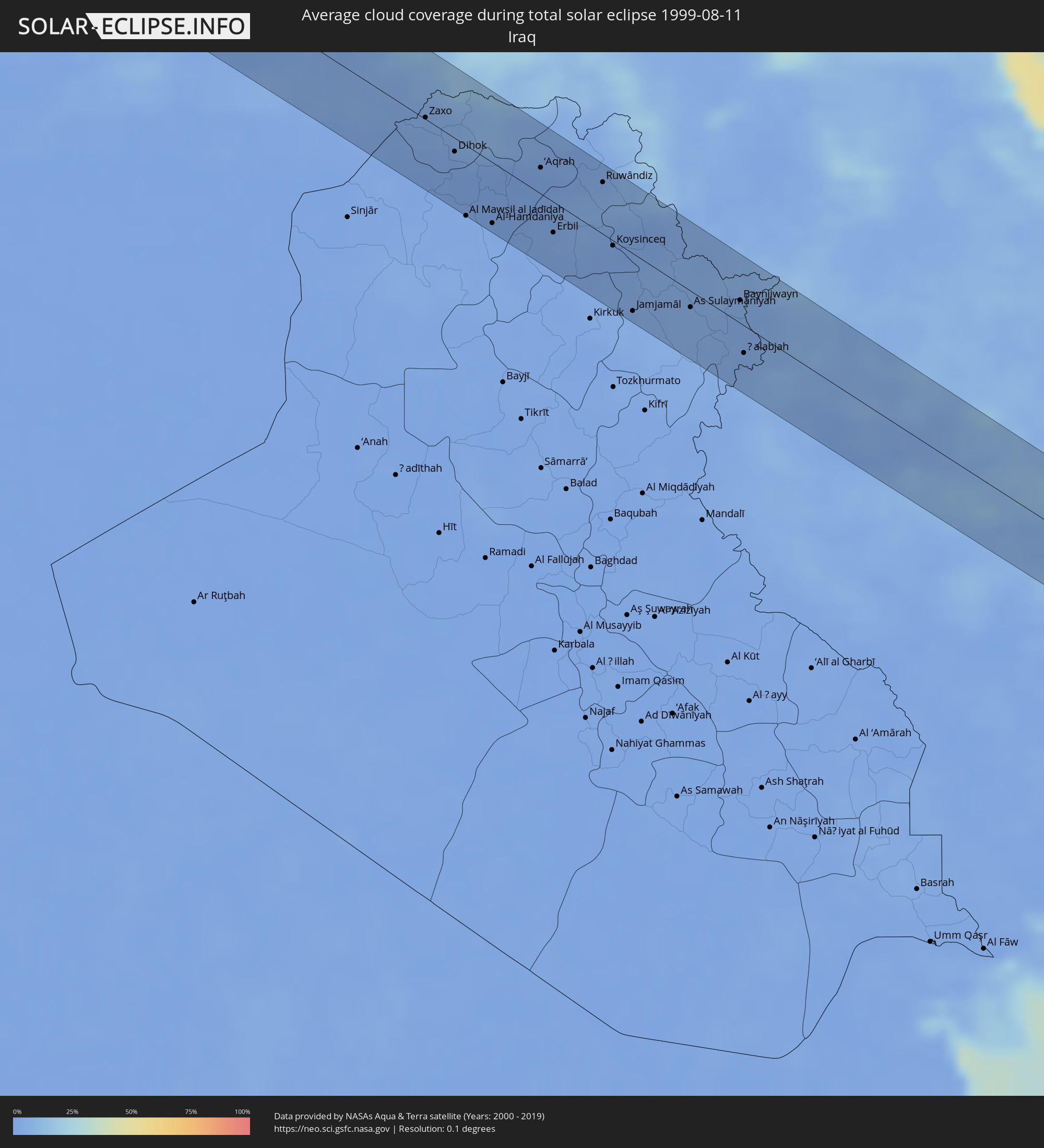 Iraq
Iraq
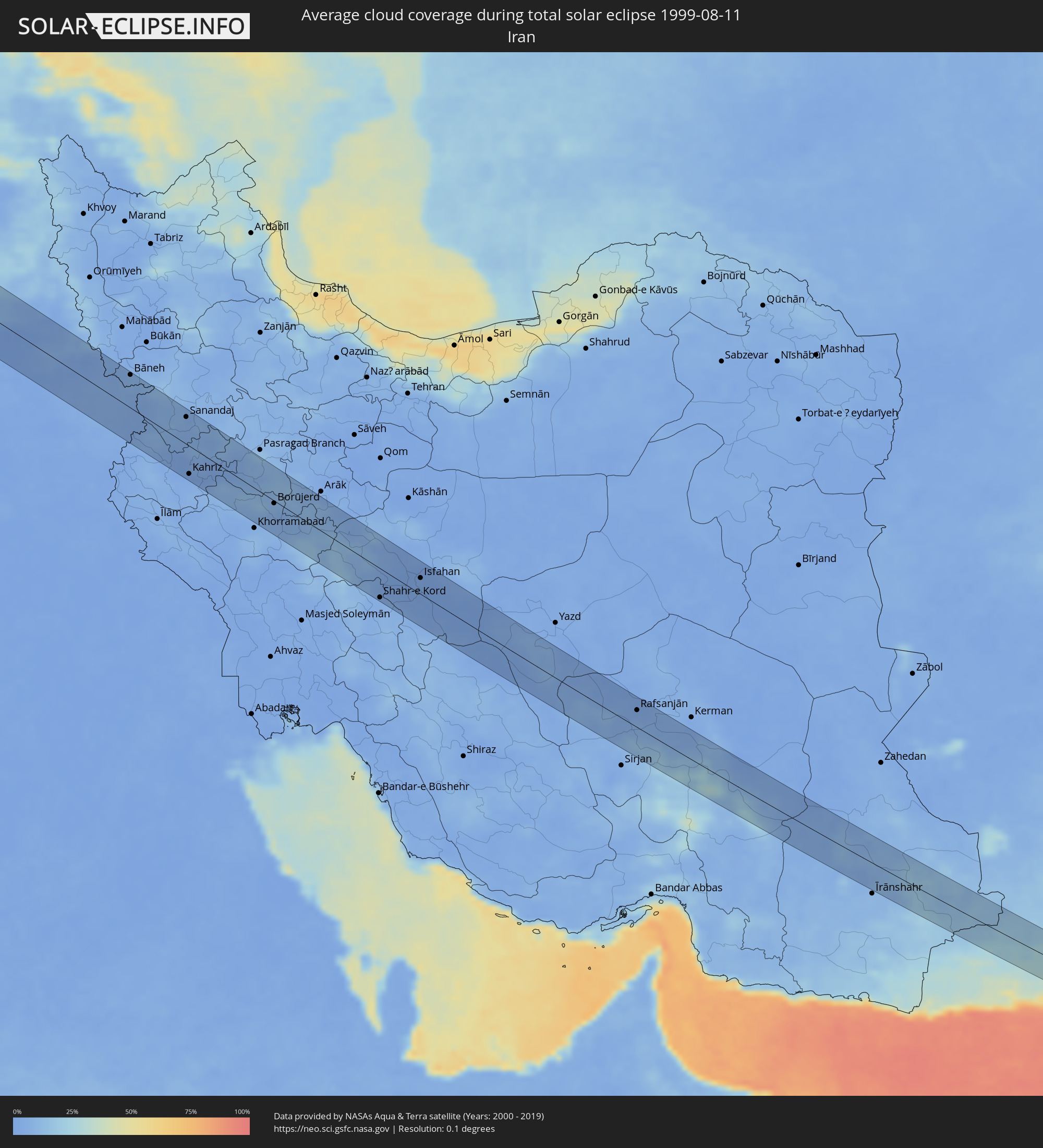 Iran
Iran
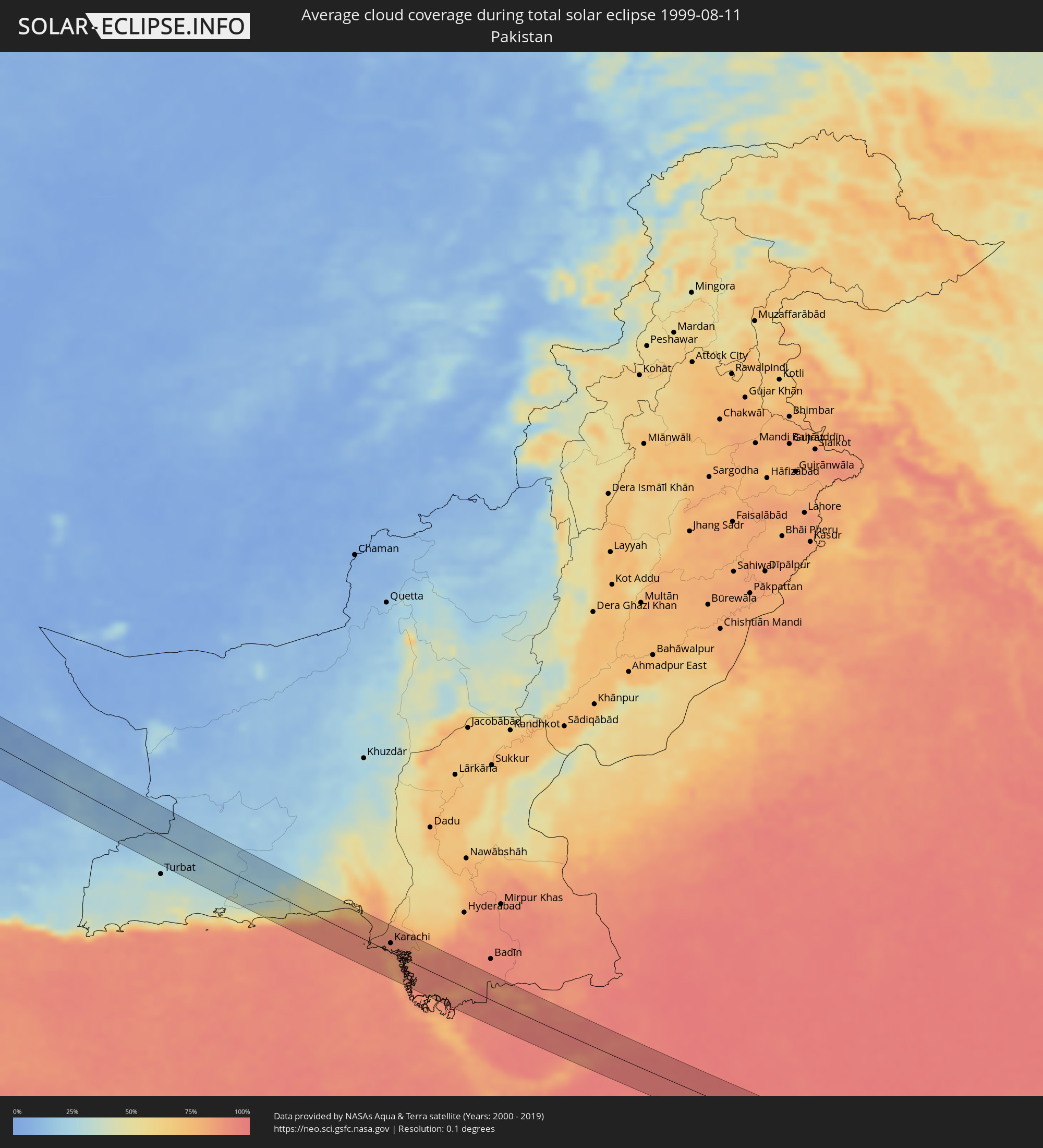 Pakistan
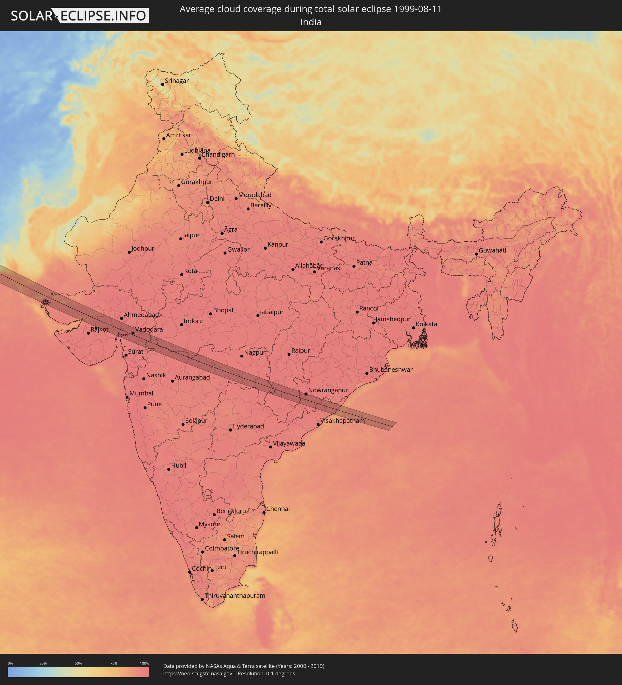 India
India
Cities inside the path of the eclipse
The following table shows all locations with a population of more than 5,000 inside the eclipse path. Cities which have more than 100,000 inhabitants are marked bold. A click at the locations opens a detailed map.
| City | Type | Eclipse duration | Local time of max. eclipse | Distance to central line | Ø Cloud coverage |
|
Penzance, England
|
total | - | 11:11:42 UTC+01:00 | 4 km | 79% |
|
Camborne, England
|
total | - | 11:12:05 UTC+01:00 | 8 km | 80% |
|
Helston, England
|
total | - | 11:12:03 UTC+01:00 | 5 km | 76% |
|
Newquay, England
|
total | - | 11:12:30 UTC+01:00 | 31 km | 82% |
|
Falmouth, England
|
total | - | 11:12:21 UTC+01:00 | 2 km | 81% |
|
St Austell, England
|
total | - | 11:12:52 UTC+01:00 | 24 km | 80% |
|
Par, England
|
total | - | 11:12:59 UTC+01:00 | 25 km | 80% |
|
Torpoint, England
|
total | - | 11:13:41 UTC+01:00 | 30 km | 77% |
|
Tavistock, England
|
total | - | 11:13:51 UTC+01:00 | 50 km | 82% |
|
Plymouth, England
|
total | - | 11:13:46 UTC+01:00 | 30 km | 79% |
|
Plympton, England
|
total | - | 11:13:53 UTC+01:00 | 33 km | 79% |
|
Ivybridge, England
|
total | - | 11:14:05 UTC+01:00 | 33 km | 80% |
|
Torquay, England
|
total | - | 11:14:41 UTC+01:00 | 44 km | 79% |
|
Le Havre, Normandy
|
total | - | 12:19:33 UTC+02:00 | 38 km | 63% |
|
Rouen, Normandy
|
total | - | 12:21:03 UTC+02:00 | 35 km | 79% |
|
Beauvais, Hauts-de-France
|
total | - | 12:22:34 UTC+02:00 | 26 km | 81% |
|
Amiens, Hauts-de-France
|
total | - | 12:23:01 UTC+02:00 | 28 km | 82% |
|
Compiègne, Hauts-de-France
|
total | - | 12:23:44 UTC+02:00 | 19 km | 80% |
|
Saint-Quentin, Hauts-de-France
|
total | - | 12:24:32 UTC+02:00 | 33 km | 83% |
|
Reims, Grand-Est
|
total | - | 12:25:37 UTC+02:00 | 24 km | 82% |
|
Châlons-en-Champagne, Grand-Est
|
total | - | 12:26:07 UTC+02:00 | 52 km | 81% |
|
Charleville-Mézières, Grand-Est
|
total | - | 12:26:46 UTC+02:00 | 42 km | 81% |
|
Bouillon, Wallonia
|
total | - | 12:27:19 UTC+02:00 | 49 km | 79% |
|
Florenville, Wallonia
|
total | - | 12:27:41 UTC+02:00 | 42 km | 77% |
|
Virton, Wallonia
|
total | - | 12:28:02 UTC+02:00 | 31 km | 78% |
|
Étalle, Wallonia
|
total | - | 12:28:09 UTC+02:00 | 44 km | 76% |
|
Habay-la-Vieille, Wallonia
|
total | - | 12:28:11 UTC+02:00 | 49 km | 76% |
|
Aubange, Wallonia
|
total | - | 12:28:29 UTC+02:00 | 35 km | 80% |
|
Arlon, Wallonia
|
total | - | 12:28:30 UTC+02:00 | 48 km | 77% |
|
Messancy, Wallonia
|
total | - | 12:28:30 UTC+02:00 | 38 km | 80% |
|
Pétange, Luxembourg
|
total | - | 12:28:36 UTC+02:00 | 35 km | 80% |
|
Differdange, Luxembourg
|
total | - | 12:28:37 UTC+02:00 | 31 km | 80% |
|
Belvaux, Luxembourg
|
total | - | 12:28:40 UTC+02:00 | 31 km | 80% |
|
Esch-sur-Alzette, Luxembourg
|
total | - | 12:28:45 UTC+02:00 | 29 km | 80% |
|
Schifflange, Luxembourg
|
total | - | 12:28:49 UTC+02:00 | 31 km | 80% |
|
Mamer, Luxembourg
|
total | - | 12:28:50 UTC+02:00 | 44 km | 79% |
|
Bertrange, Luxembourg
|
total | - | 12:28:52 UTC+02:00 | 43 km | 80% |
|
Strassen, Luxembourg
|
total | - | 12:28:55 UTC+02:00 | 44 km | 80% |
|
Dudelange, Luxembourg
|
total | - | 12:28:56 UTC+02:00 | 29 km | 80% |
|
Bettembourg, Luxembourg
|
total | - | 12:28:57 UTC+02:00 | 34 km | 80% |
|
Luxembourg, Luxembourg
|
total | - | 12:29:00 UTC+02:00 | 44 km | 80% |
|
Thionville, Grand-Est
|
total | - | 12:29:03 UTC+02:00 | 18 km | 79% |
|
Metz, Grand-Est
|
total | - | 12:29:04 UTC+02:00 | 9 km | 79% |
|
Saarbrücken, Saarland
|
total | - | 12:30:23 UTC+02:00 | 16 km | 81% |
|
Strasbourg, Grand-Est
|
total | - | 12:31:41 UTC+02:00 | 43 km | 69% |
|
Kaiserslautern, Rheinland-Pfalz
|
total | - | 12:31:40 UTC+02:00 | 51 km | 80% |
|
Haguenau, Grand-Est
|
total | - | 12:31:44 UTC+02:00 | 17 km | 70% |
|
Karlsruhe, Baden-Württemberg
|
total | - | 12:32:45 UTC+02:00 | 14 km | 70% |
|
Pforzheim, Baden-Württemberg
|
total | - | 12:33:15 UTC+02:00 | 6 km | 77% |
|
Stuttgart, Baden-Württemberg
|
total | - | 12:34:04 UTC+02:00 | 3 km | 76% |
|
Reutlingen, Baden-Württemberg
|
total | - | 12:34:09 UTC+02:00 | 28 km | 72% |
|
Heilbronn, Baden-Württemberg
|
total | - | 12:34:05 UTC+02:00 | 42 km | 75% |
|
Schwäbisch Gmünd, Baden-Württemberg
|
total | - | 12:35:06 UTC+02:00 | 16 km | 73% |
|
Ulm, Baden-Württemberg
|
total | - | 12:35:31 UTC+02:00 | 24 km | 71% |
|
Aalen, Baden-Württemberg
|
total | - | 12:35:36 UTC+02:00 | 25 km | 74% |
|
Augsburg, Bavaria
|
total | - | 12:37:04 UTC+02:00 | 10 km | 72% |
|
Ingolstadt, Bavaria
|
total | - | 12:37:51 UTC+02:00 | 43 km | 72% |
|
Munich, Bavaria
|
total | - | 12:38:18 UTC+02:00 | 21 km | 72% |
|
Braunau am Inn, Upper Austria
|
total | - | 12:40:48 UTC+02:00 | 22 km | 67% |
|
Salzburg, Salzburg
|
total | - | 12:40:58 UTC+02:00 | 27 km | 67% |
|
Ansfelden, Salzburg
|
total | - | 12:40:55 UTC+02:00 | 9 km | 63% |
|
Bad Ischl, Upper Austria
|
total | - | 12:42:01 UTC+02:00 | 24 km | 69% |
|
Wels, Upper Austria
|
total | - | 12:42:32 UTC+02:00 | 34 km | 71% |
|
Linz, Upper Austria
|
total | - | 12:42:55 UTC+02:00 | 54 km | 66% |
|
Steyr, Upper Austria
|
total | - | 12:43:16 UTC+02:00 | 30 km | 65% |
|
Amstetten, Lower Austria
|
total | - | 12:44:01 UTC+02:00 | 48 km | 63% |
|
Leoben, Styria
|
total | - | 12:44:46 UTC+02:00 | 25 km | 71% |
|
Kapfenberg, Styria
|
total | - | 12:45:05 UTC+02:00 | 13 km | 70% |
|
Graz, Styria
|
total | - | 12:45:34 UTC+02:00 | 49 km | 62% |
|
Ternitz, Lower Austria
|
total | - | 12:46:15 UTC+02:00 | 33 km | 67% |
|
Wiener Neustadt, Lower Austria
|
total | - | 12:46:34 UTC+02:00 | 47 km | 62% |
|
Šalovci, Šalovci
|
total | - | 12:47:14 UTC+02:00 | 54 km | 49% |
|
Hodoš, Hodoš-Hodos
|
total | - | 12:47:18 UTC+02:00 | 53 km | 49% |
|
Sopron, Győr-Moson-Sopron
|
total | - | 12:47:14 UTC+02:00 | 44 km | 56% |
|
Szombathely, Vas
|
total | - | 12:47:34 UTC+02:00 | 3 km | 58% |
|
Zalaegerszeg, Zala
|
total | - | 12:48:12 UTC+02:00 | 38 km | 52% |
|
Pápa, Veszprém
|
total | - | 12:49:00 UTC+02:00 | 29 km | 55% |
|
Veszprém, Veszprém
|
total | - | 12:49:56 UTC+02:00 | 16 km | 49% |
|
Székesfehérvár, Fejér
|
total | - | 12:50:45 UTC+02:00 | 39 km | 46% |
|
Szekszárd, Tolna
|
total | - | 12:51:53 UTC+02:00 | 40 km | 48% |
|
Dunaújváros, Fejér
|
total | - | 12:51:51 UTC+02:00 | 30 km | 46% |
|
Baja, Bács-Kiskun
|
total | - | 12:52:28 UTC+02:00 | 51 km | 43% |
|
Subotica, Vojvodina
|
total | - | 12:53:48 UTC+02:00 | 39 km | 42% |
|
Kecskemét, Bács-Kiskun
|
total | - | 12:53:13 UTC+02:00 | 45 km | 48% |
|
Kiskunfélegyháza, Bács-Kiskun
|
total | - | 12:53:38 UTC+02:00 | 30 km | 45% |
|
Kanjiža, Vojvodina
|
total | - | 12:54:32 UTC+02:00 | 31 km | 42% |
|
Senta, Vojvodina
|
total | - | 12:54:41 UTC+02:00 | 45 km | 40% |
|
Novi Kneževac, Vojvodina
|
total | - | 12:54:38 UTC+02:00 | 31 km | 42% |
|
Čoka, Vojvodina
|
total | - | 12:54:48 UTC+02:00 | 41 km | 40% |
|
Szeged, Csongrád
|
total | - | 12:54:33 UTC+02:00 | 9 km | 42% |
|
Hódmezővásárhely, Csongrád
|
total | - | 12:54:45 UTC+02:00 | 13 km | 41% |
|
Mokrin
|
total | - | 12:55:17 UTC+02:00 | 34 km | 43% |
|
Kikinda, Vojvodina
|
total | - | 12:55:28 UTC+02:00 | 43 km | 44% |
|
Srpska Crnja
|
total | - | 12:55:58 UTC+02:00 | 48 km | 44% |
|
Timişoara, Timiş
|
total | - | 13:56:55 UTC+03:00 | 29 km | 46% |
|
Arad, Arad
|
total | - | 13:56:42 UTC+03:00 | 18 km | 44% |
|
Reşiţa, Caraş-Severin
|
total | - | 13:58:32 UTC+03:00 | 55 km | 50% |
|
Lugoj, Timiş
|
total | - | 13:58:11 UTC+03:00 | 15 km | 45% |
|
Hunedoara, Hunedoara
|
total | - | 13:59:55 UTC+03:00 | 23 km | 48% |
|
Târgu Jiu, Gorj
|
total | - | 14:01:17 UTC+03:00 | 36 km | 47% |
|
Petroşani, Hunedoara
|
total | - | 14:01:04 UTC+03:00 | 4 km | 55% |
|
Râmnicu Vâlcea, Vâlcea
|
total | - | 14:03:11 UTC+03:00 | 5 km | 47% |
|
Piteşti, Argeş
|
total | - | 14:04:20 UTC+03:00 | 4 km | 45% |
|
Târgovişte, Dâmboviţa
|
total | - | 14:05:18 UTC+03:00 | 24 km | 43% |
|
Ploieşti, Prahova
|
total | - | 14:06:15 UTC+03:00 | 46 km | 50% |
|
Bucharest, Bucureşti
|
total | - | 14:07:00 UTC+03:00 | 3 km | 44% |
|
Kubrat, Razgrad
|
total | - | 14:08:27 UTC+03:00 | 52 km | 43% |
|
Tutrakan, Silistra
|
total | - | 14:08:22 UTC+03:00 | 23 km | 37% |
|
Isperih, Razgrad
|
total | - | 14:09:09 UTC+03:00 | 48 km | 45% |
|
Dulovo, Silistra
|
total | - | 14:09:35 UTC+03:00 | 27 km | 44% |
|
Silistra, Silistra
|
total | - | 14:09:26 UTC+03:00 | 7 km | 39% |
|
Slobozia, Ialomiţa
|
total | - | 14:09:03 UTC+03:00 | 55 km | 42% |
|
Tervel, Dobrich
|
total | - | 14:10:07 UTC+03:00 | 24 km | 45% |
|
Dobrich, Dobrich
|
total | - | 14:11:06 UTC+03:00 | 27 km | 45% |
|
General-Toshevo, Dobrich
|
total | - | 14:11:17 UTC+03:00 | 6 km | 43% |
|
Zlatni Pyasatsi, Varna
|
total | - | 14:11:50 UTC+03:00 | 47 km | 34% |
|
Balchik, Dobrich
|
total | - | 14:11:53 UTC+03:00 | 29 km | 37% |
|
Kavarna, Dobrich
|
total | - | 14:12:09 UTC+03:00 | 21 km | 36% |
|
Çorum, Çorum
|
total | - | 14:27:32 UTC+03:00 | 33 km | 20% |
|
Amasya, Amasya
|
total | - | 14:28:47 UTC+03:00 | 15 km | 26% |
|
Turhal, Tokat
|
total | - | 14:29:36 UTC+03:00 | 1 km | 25% |
|
Tokat, Tokat
|
total | - | 14:30:28 UTC+03:00 | 15 km | 27% |
|
Sivas, Sivas
|
total | - | 14:32:07 UTC+03:00 | 18 km | 12% |
|
Elazığ, Elazığ
|
total | - | 14:37:17 UTC+03:00 | 19 km | 4% |
|
Diyarbakır, Diyarbakır
|
total | - | 14:40:02 UTC+03:00 | 44 km | 2% |
|
Bismil, Diyarbakır
|
total | - | 14:40:48 UTC+03:00 | 30 km | 2% |
|
Batman, Batman
|
total | - | 14:41:25 UTC+03:00 | 4 km | 2% |
|
Midyat, Mardin
|
total | - | 14:42:31 UTC+03:00 | 38 km | 3% |
|
Siirt, Siirt
|
total | - | 14:42:30 UTC+03:00 | 39 km | 3% |
|
Cizre, Şırnak
|
total | - | 14:43:52 UTC+03:00 | 6 km | 4% |
|
Silopi, Şırnak
|
total | - | 14:44:24 UTC+03:00 | 1 km | 5% |
|
Zaxo, Dahūk
|
total | - | 15:44:53 UTC+04:00 | 1 km | 4% |
|
Dihok, Dahūk
|
total | - | 15:45:47 UTC+04:00 | 10 km | 2% |
|
Sīnah, Dahūk
|
total | - | 15:45:57 UTC+04:00 | 14 km | 2% |
|
Al Mawşil al Jadīdah, Nīnawá
|
total | - | 15:46:52 UTC+04:00 | 55 km | 1% |
|
Tallkayf, Nīnawá
|
total | - | 15:46:37 UTC+04:00 | 39 km | 2% |
|
Al-Hamdaniya, Nīnawá
|
total | - | 15:47:21 UTC+04:00 | 47 km | 1% |
|
‘Aqrah, Nīnawá
|
total | - | 15:47:13 UTC+04:00 | 20 km | 1% |
|
Erbil, Arbīl
|
total | - | 15:48:20 UTC+04:00 | 24 km | 3% |
|
Koysinceq, Arbīl
|
total | - | 15:49:21 UTC+04:00 | 4 km | 2% |
|
Jamjamāl, As Sulaymānīyah
|
total | - | 15:50:34 UTC+04:00 | 45 km | 4% |
|
As Sulaymānīyah, As Sulaymānīyah
|
total | - | 15:51:17 UTC+04:00 | 13 km | 5% |
|
Bāneh, Kordestān
|
total | - | 16:21:06 UTC+04:30 | 50 km | 6% |
|
Baynjiwayn, As Sulaymānīyah
|
total | - | 15:51:50 UTC+04:00 | 18 km | 4% |
|
Ḩalabjah, As Sulaymānīyah
|
total | - | 15:52:40 UTC+04:00 | 22 km | 4% |
|
Sanandaj, Kordestān
|
total | - | 16:23:40 UTC+04:30 | 41 km | 6% |
|
Kahrīz, Kermānshāh
|
total | - | 16:25:23 UTC+04:30 | 43 km | 1% |
|
Borūjerd, Lorestān
|
total | - | 16:28:13 UTC+04:30 | 4 km | 7% |
|
Malāyer, Hamadān
|
total | - | 16:27:36 UTC+04:30 | 37 km | 11% |
|
Alīgūdarz, Lorestān
|
total | - | 16:30:09 UTC+04:30 | 3 km | 11% |
|
Khomeyn, Markazi
|
total | - | 16:30:08 UTC+04:30 | 39 km | 6% |
|
Shahr-e Kord, Chahār Maḩāll va Bakhtīārī
|
total | - | 16:33:16 UTC+04:30 | 46 km | 5% |
|
Najafābād, Isfahan
|
total | - | 16:33:15 UTC+04:30 | 8 km | 2% |
|
Isfahan, Isfahan
|
total | - | 16:33:32 UTC+04:30 | 26 km | 1% |
|
Shāhreẕā, Isfahan
|
total | - | 16:34:49 UTC+04:30 | 23 km | 2% |
|
Rafsanjān, Kerman
|
total | - | 16:41:21 UTC+04:30 | 28 km | 4% |
|
Bam, Kerman
|
total | - | 16:45:20 UTC+04:30 | 19 km | 6% |
|
Gadāni, Balochistān
|
total | - | 17:26:05 UTC+05:00 | 20 km | 90% |
|
Karachi, Sindh
|
total | - | 17:26:31 UTC+05:00 | 14 km | 88% |
|
Malīr Cantonment, Sindh
|
total | - | 17:26:30 UTC+05:00 | 23 km | 89% |
|
Ghāro, Sindh
|
total | - | 17:26:56 UTC+05:00 | 20 km | 92% |
|
Mīrpur Sakro, Sindh
|
total | - | 17:27:13 UTC+05:00 | 2 km | 92% |
|
Thatta, Sindh
|
total | - | 17:27:02 UTC+05:00 | 35 km | 93% |
|
Chuhar Jamāli, Sindh
|
total | - | 17:27:34 UTC+05:00 | 2 km | 94% |
|
Jāti, Sindh
|
total | - | 17:27:42 UTC+05:00 | 11 km | 92% |
|
Bhuj, Gujarat
|
total | - | 17:59:38 UTC+05:30 | 40 km | 96% |
|
Gāndhīdhām, Gujarat
|
total | - | 17:59:59 UTC+05:30 | 38 km | 91% |
|
Surendranagar, Gujarat
|
total | - | 18:00:48 UTC+05:30 | 11 km | 97% |
|
Nadiād, Gujarat
|
total | - | 18:01:03 UTC+05:30 | 34 km | 98% |
|
Ānand, Gujarat
|
total | - | 18:01:15 UTC+05:30 | 24 km | 98% |
|
Vadodara, Gujarat
|
total | - | 18:01:37 UTC+05:30 | 8 km | 98% |
|
Jalgaon, Maharashtra
|
total | - | 18:03:29 UTC+05:30 | 34 km | 96% |
|
Bhusāval, Maharashtra
|
total | - | 18:03:27 UTC+05:30 | 21 km | 97% |
|
Burhānpur, Madhya Pradesh
|
total | - | 18:03:08 UTC+05:30 | 23 km | 98% |
|
Akola, Maharashtra
|
total | - | 18:03:53 UTC+05:30 | 10 km | 97% |
|
Yavatmāl, Maharashtra
|
total | - | 18:04:16 UTC+05:30 | 2 km | 96% |
|
Chānda, Maharashtra
|
total | - | 18:04:44 UTC+05:30 | 6 km | 97% |
|
Nowrangapur, Odisha
|
total | - | 18:05:13 UTC+05:30 | 29 km | 98% |