Annular solar eclipse of 12/08/2113
| Day of week: | Friday |
| Maximum duration of eclipse: | 09m35s |
| Maximum width of eclipse path: | 304 km |
| Saros cycle: | 134 |
| Coverage: | 93% |
| Magnitude: | 0.9296 |
| Gamma: | 0.5049 |
Wo kann man die Sonnenfinsternis vom 12/08/2113 sehen?
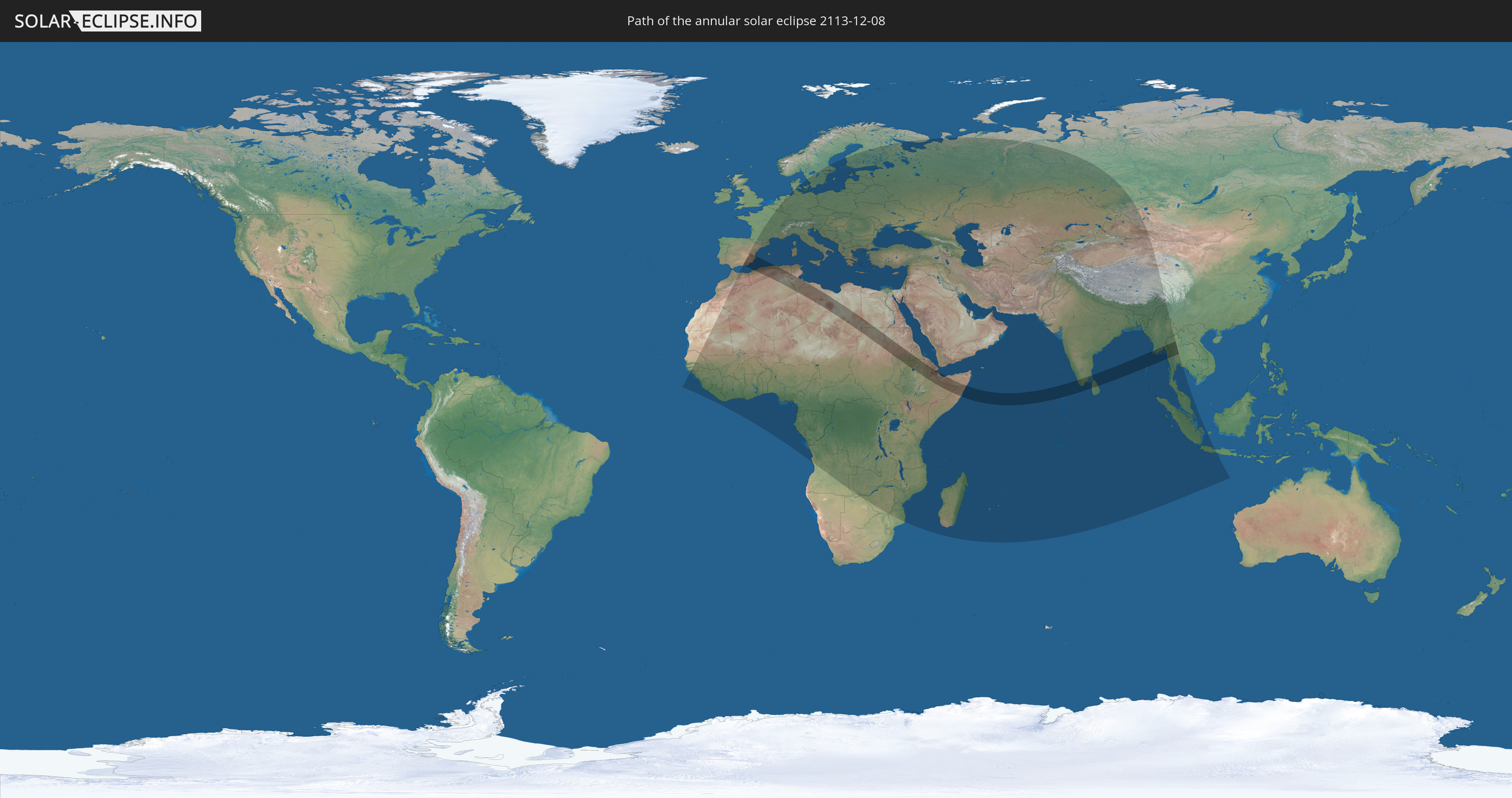
Die Sonnenfinsternis am 12/08/2113 kann man in 134 Ländern als partielle Sonnenfinsternis beobachten.
Der Finsternispfad verläuft durch 15 Länder. Nur in diesen Ländern ist sie als annular Sonnenfinsternis zu sehen.
In den folgenden Ländern ist die Sonnenfinsternis annular zu sehen
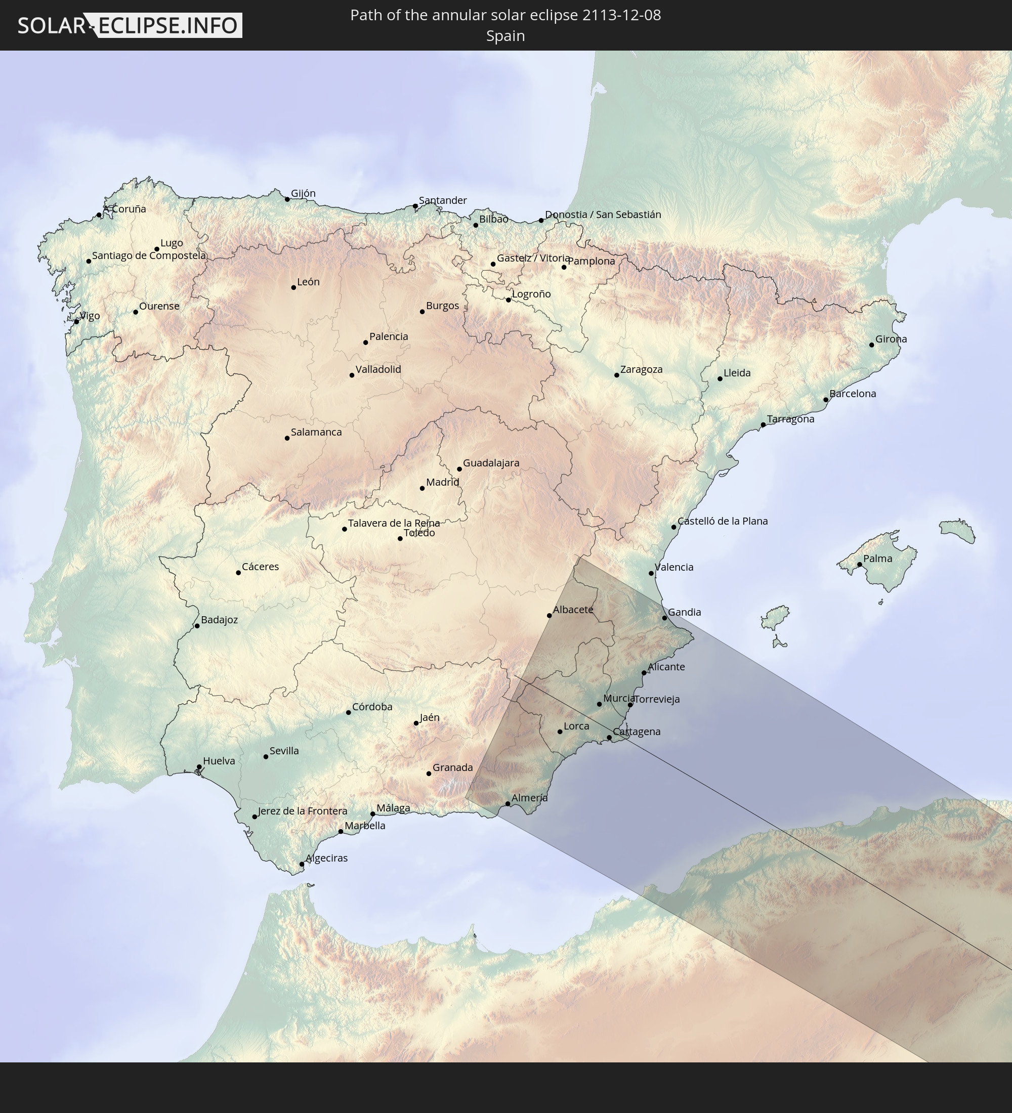 Spain
Spain
 Algeria
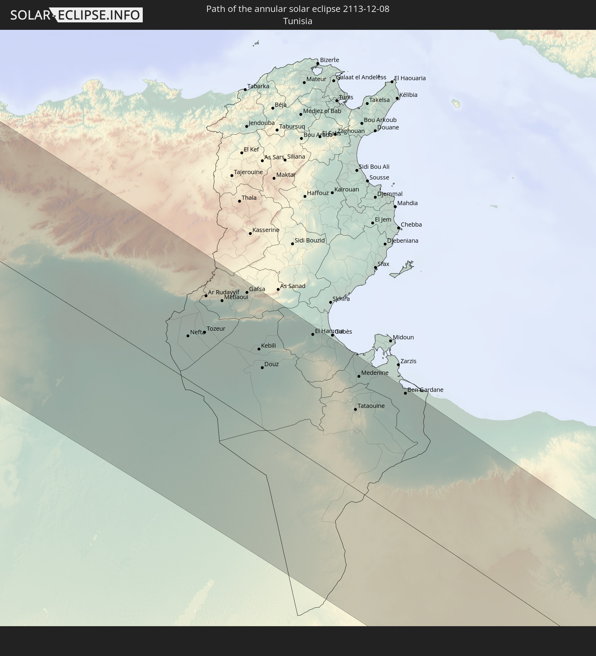 Tunisia
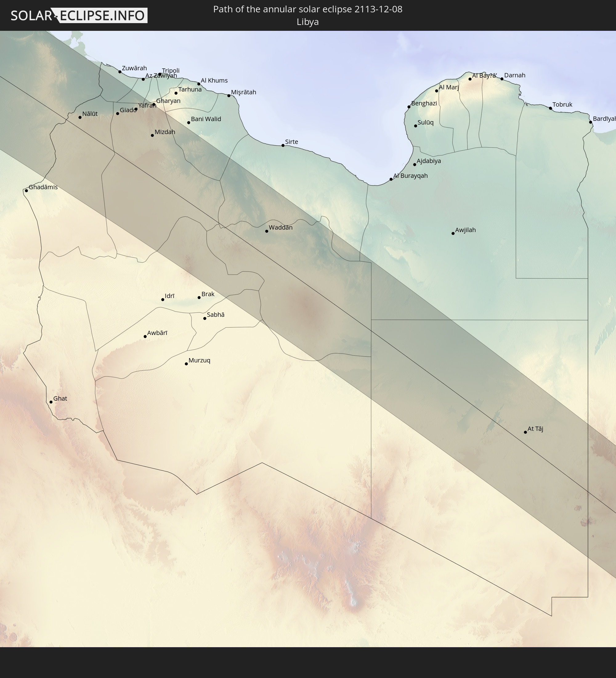 Libya
Libya
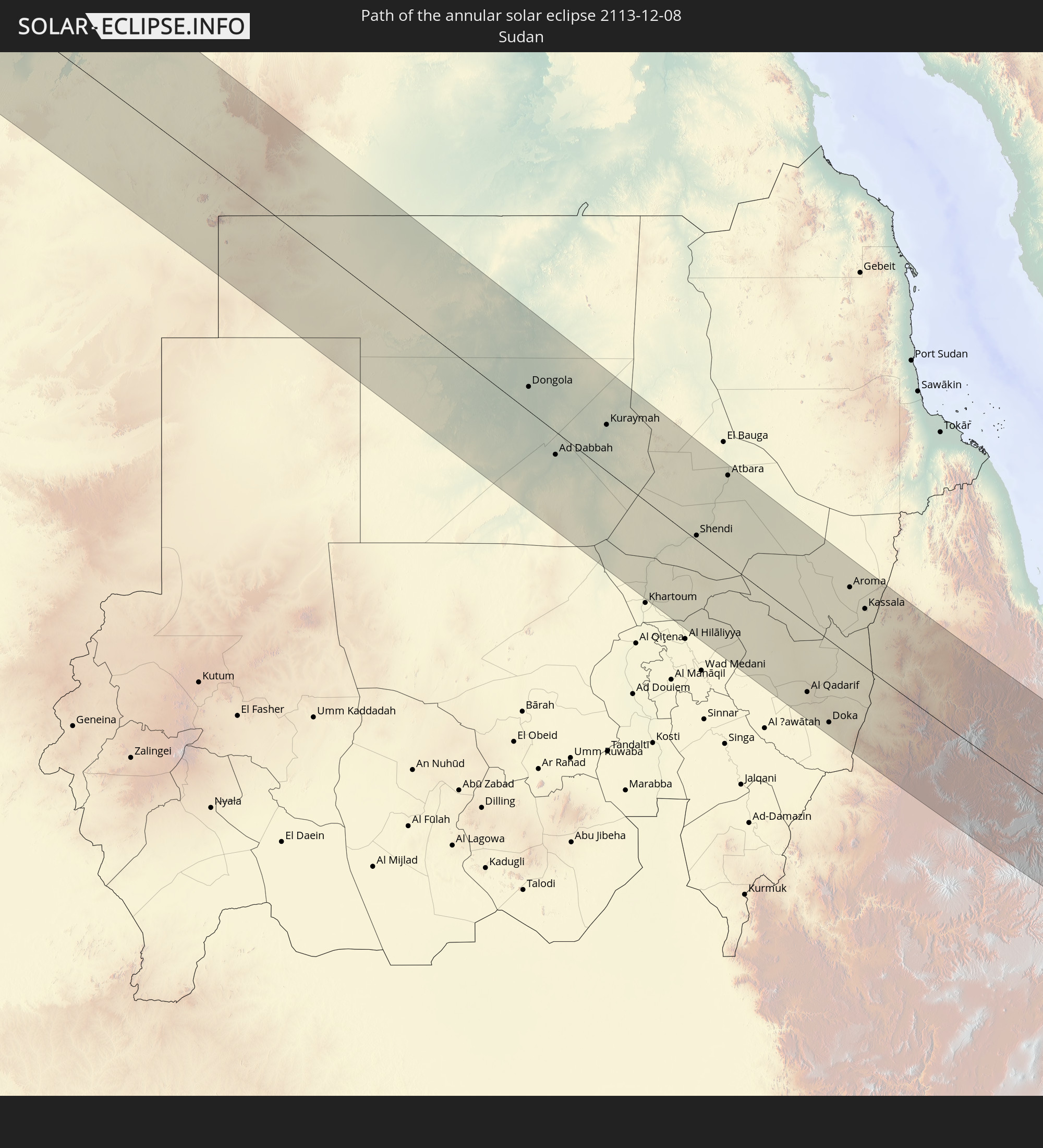 Sudan
Sudan
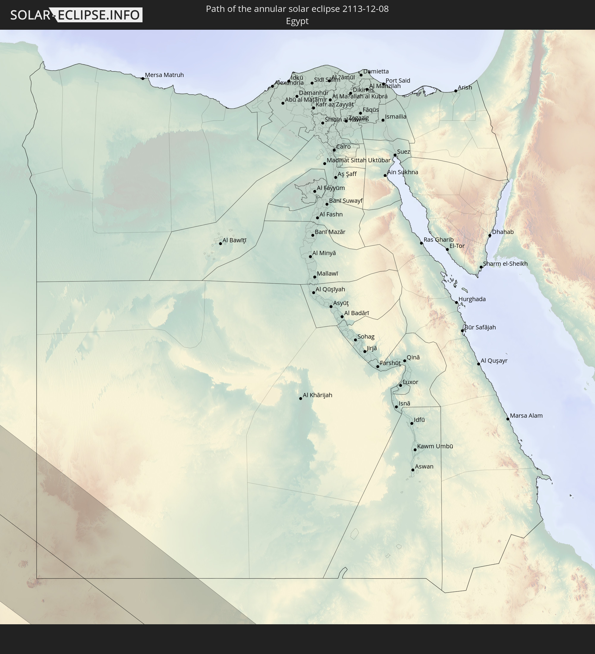 Egypt
Egypt
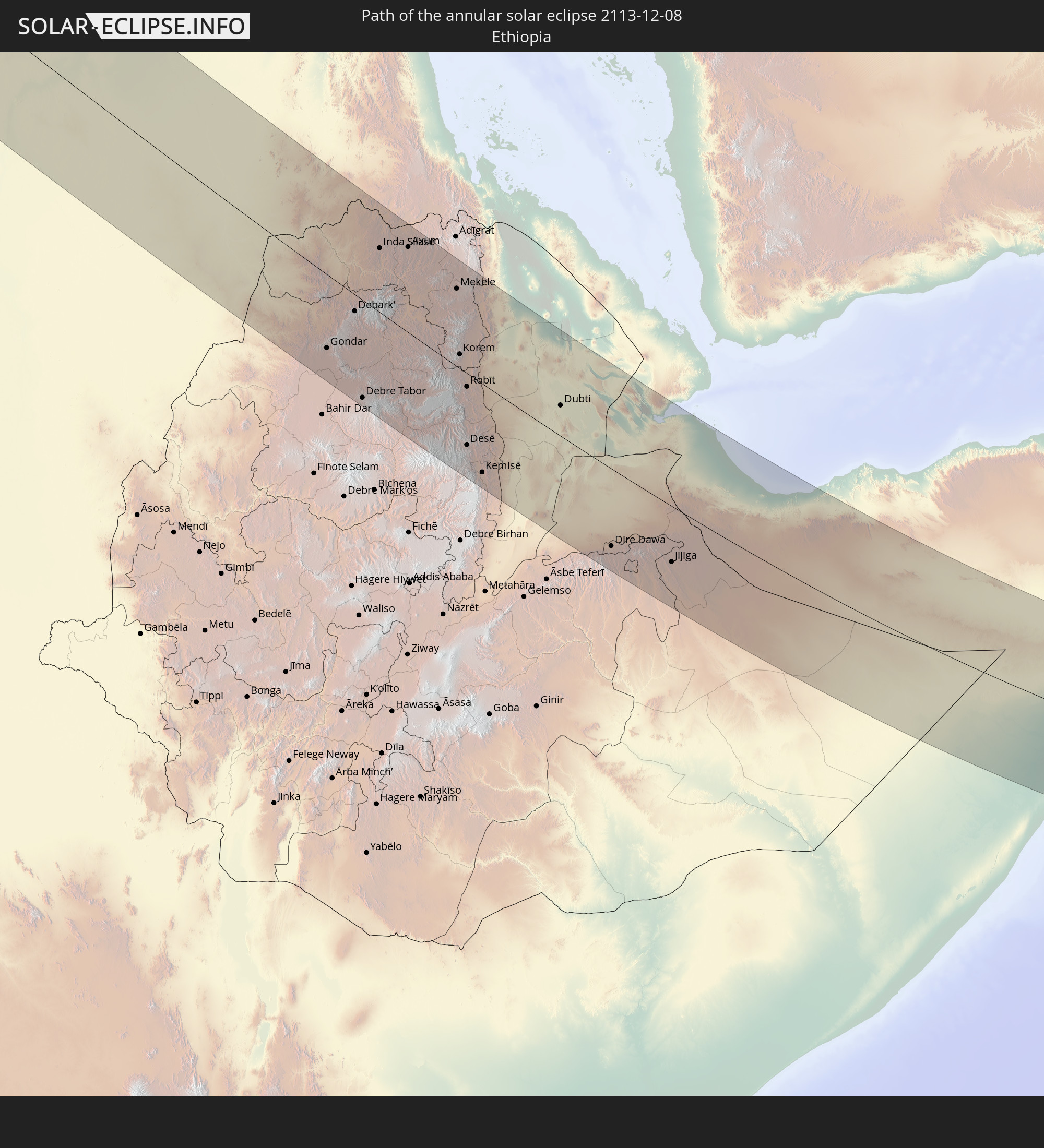 Ethiopia
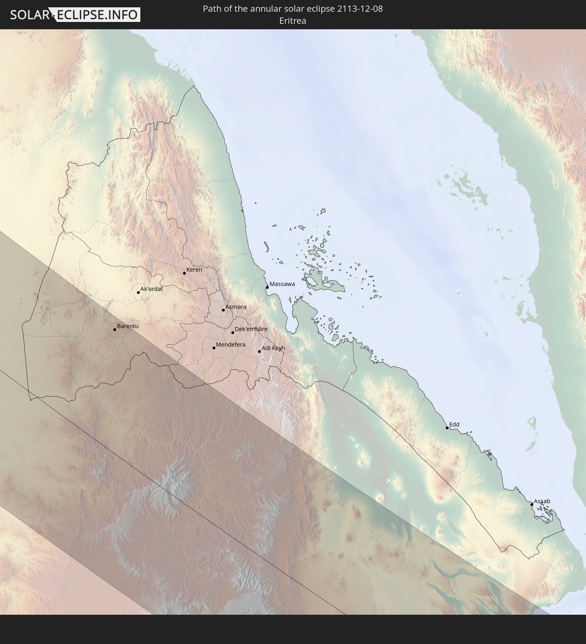 Eritrea
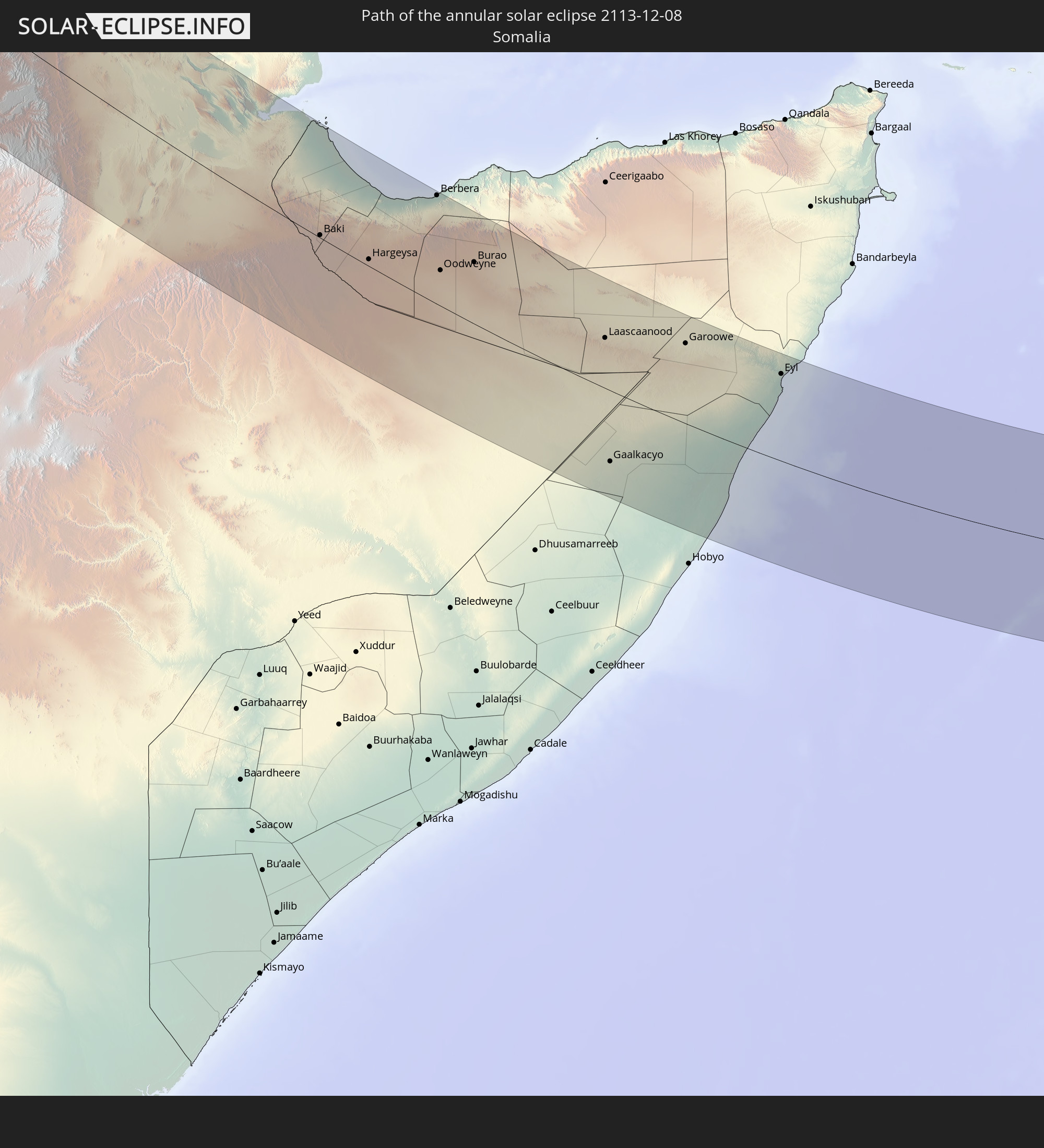 Somalia
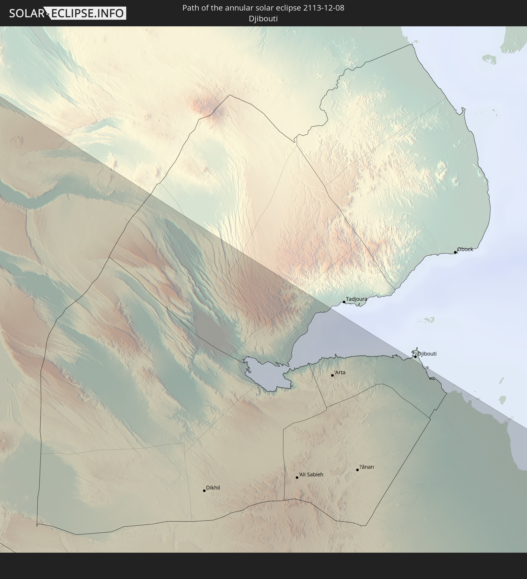 Djibouti
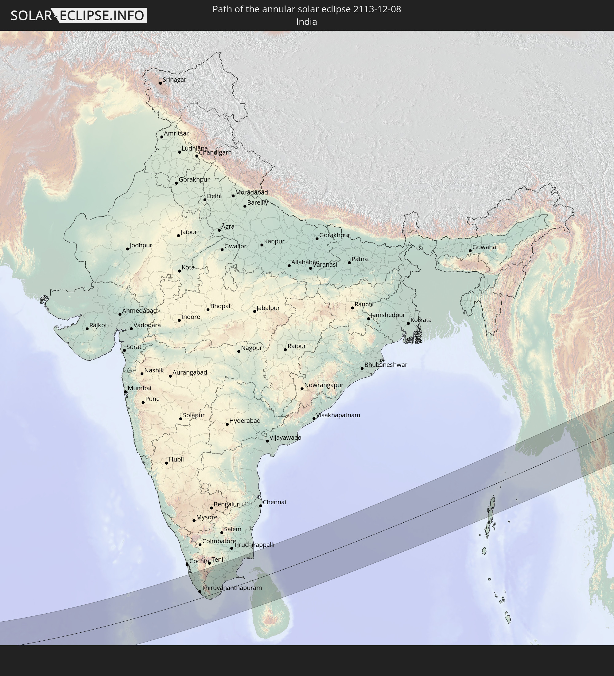 India
India
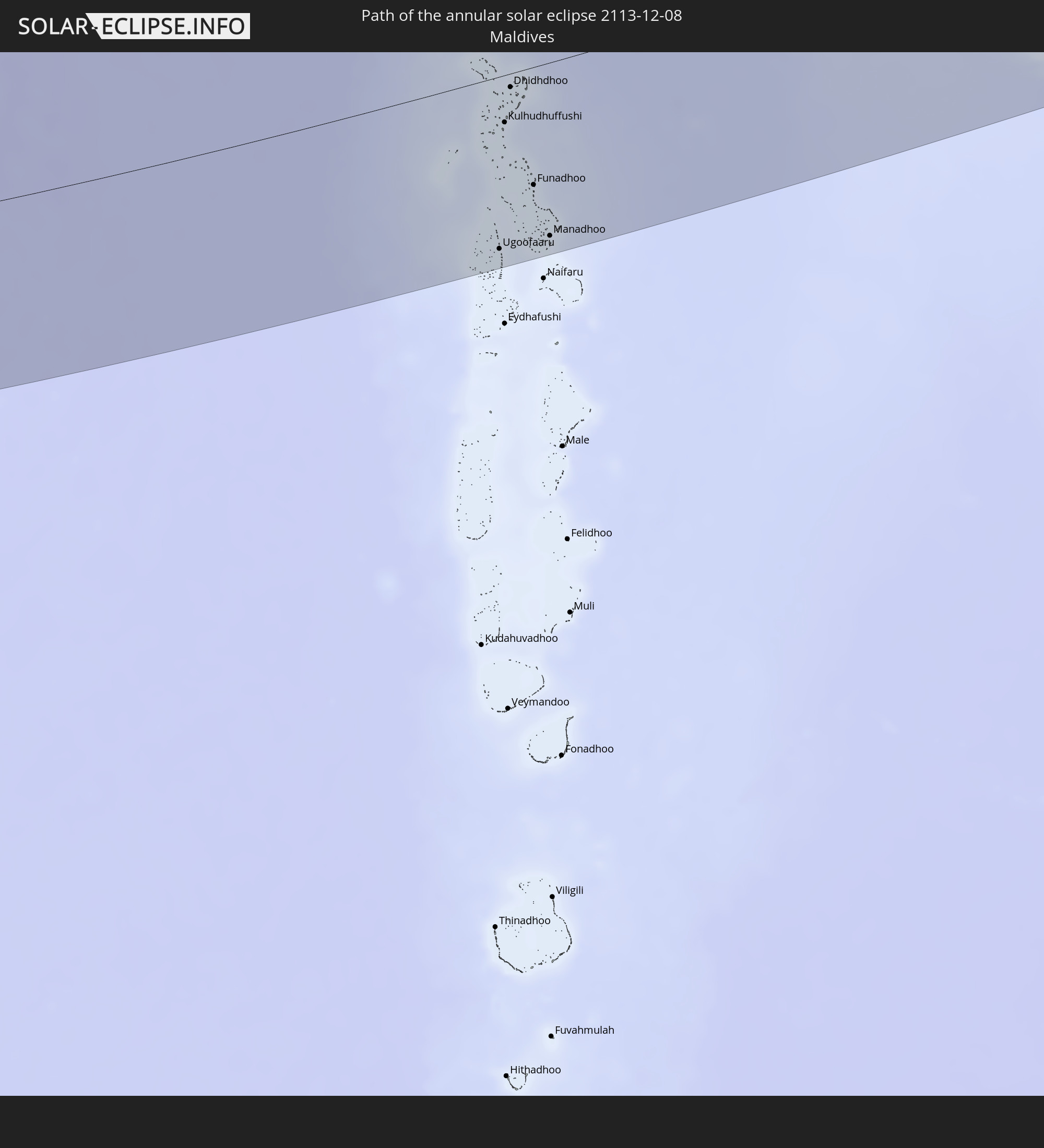 Maldives
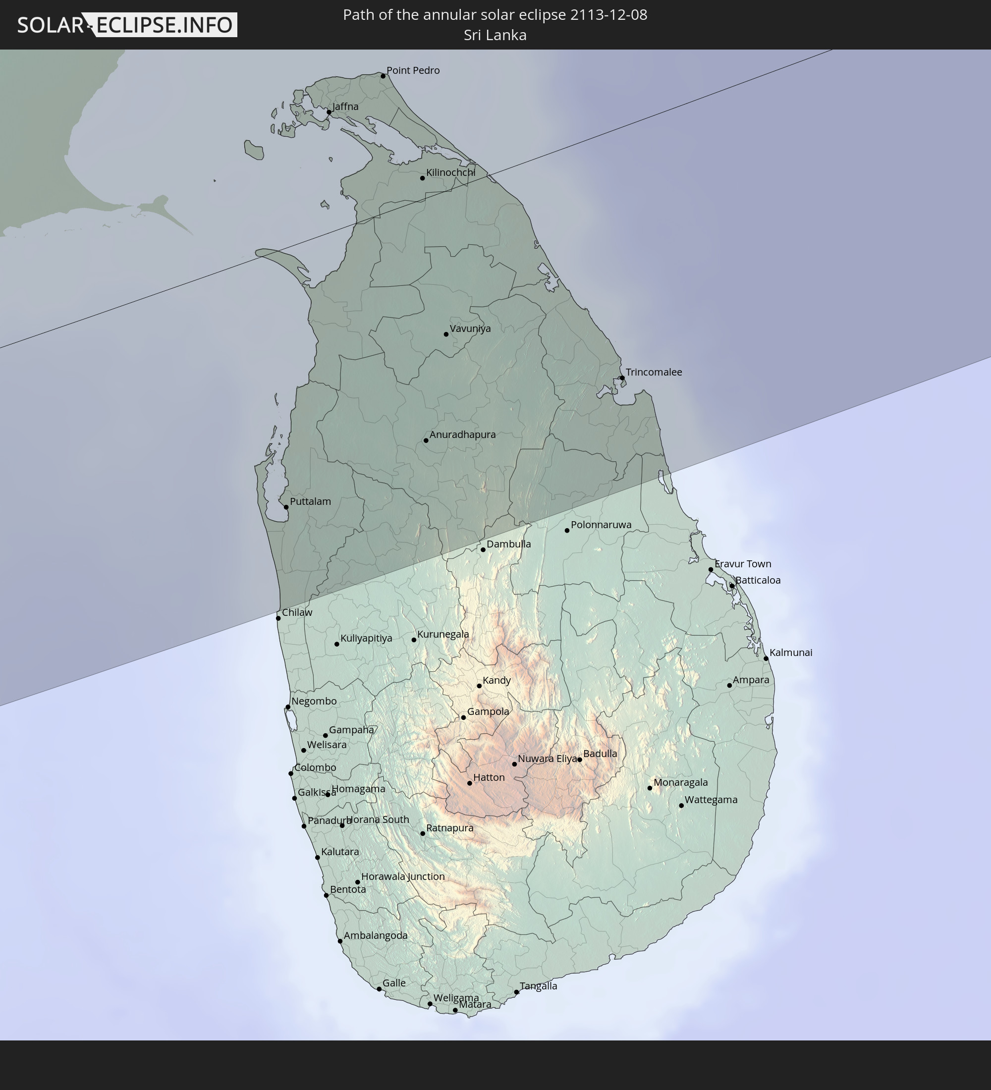 Sri Lanka
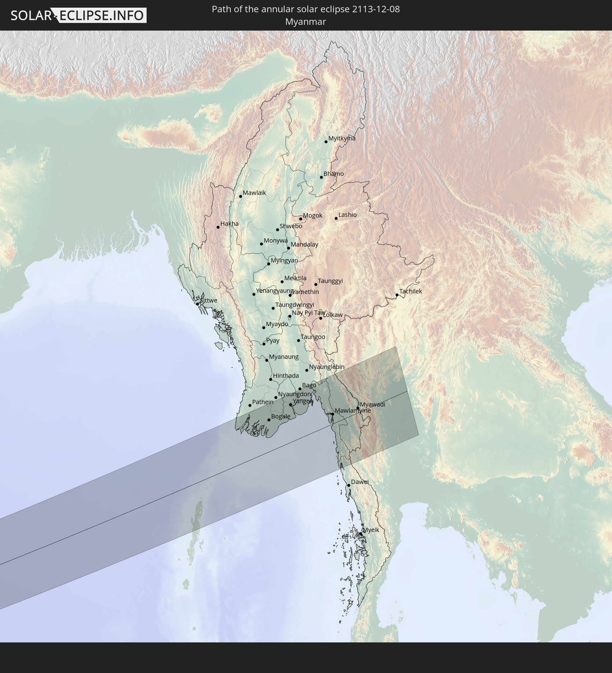 Myanmar
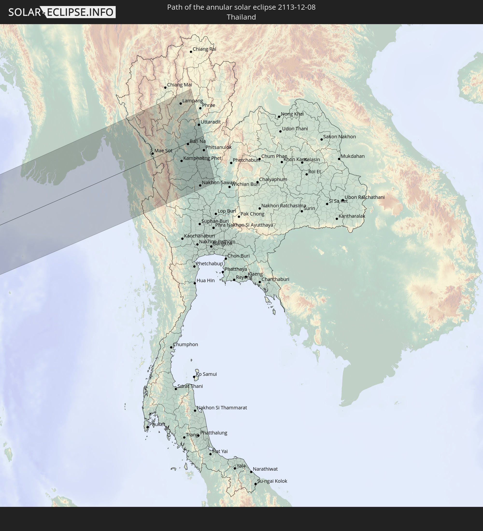 Thailand
In den folgenden Ländern ist die Sonnenfinsternis partiell zu sehen
 Russia
 Spain
Spain
 Senegal
 Mauritania
 The Gambia
 Guinea-Bissau
 Guinea
 Sierra Leone
 Morocco
 Mali
Mali
 Liberia
 Algeria
 Ivory Coast
 Burkina Faso
 France
 Ghana
Ghana
 Togo
Togo
 Niger
Niger
 Benin
Benin
 Andorra
 Belgium
 Nigeria
 Netherlands
 Equatorial Guinea
 Luxembourg
 Germany
 Switzerland
 São Tomé and Príncipe
 Italy
Italy
 Monaco
 Tunisia
 Denmark
 Cameroon
 Gabon
Gabon
 Libya
Libya
 Liechtenstein
 Austria
 Sweden
 Republic of the Congo
 Angola
 Namibia
 Czechia
 Democratic Republic of the Congo
 San Marino
 Vatican City
 Slovenia
 Chad
Chad
 Croatia
 Poland
 Malta
Malta
 Central African Republic
 Bosnia and Herzegovina
 Hungary
 Slovakia
 Montenegro
 Serbia
 Albania
 Åland Islands
 Greece
 Botswana
 Romania
 Republic of Macedonia
 Finland
 Lithuania
 Latvia
 Estonia
 Sudan
Sudan
 Zambia
 Ukraine
 Bulgaria
 Belarus
 Egypt
Egypt
 Zimbabwe
 Turkey
 Moldova
 Rwanda
 Burundi
 Tanzania
 Uganda
 Mozambique
 Cyprus
 Malawi
 Ethiopia
 Kenya
Kenya
 State of Palestine
 Israel
 Saudi Arabia
 Jordan
 Lebanon
 Syria
Syria
 Eritrea
 Iraq
Iraq
 Georgia
 French Southern and Antarctic Lands
 Somalia
 Djibouti
 Yemen
Yemen
 Madagascar
 Comoros
 Armenia
 Iran
Iran
 Azerbaijan
 Mayotte
 Seychelles
 Kazakhstan
 Kuwait
 Bahrain
 Qatar
Qatar
 United Arab Emirates
 Oman
Oman
 Turkmenistan
 Réunion
 Uzbekistan
 Mauritius
 Afghanistan
 Pakistan
 Tajikistan
 India
India
 Kyrgyzstan
 British Indian Ocean Territory
 Maldives
 China
China
 Sri Lanka
 Nepal
Nepal
 Mongolia
 Bangladesh
 Bhutan
 Myanmar
 Indonesia
 Cocos Islands
 Thailand
 Malaysia
 Singapore
 Christmas Island
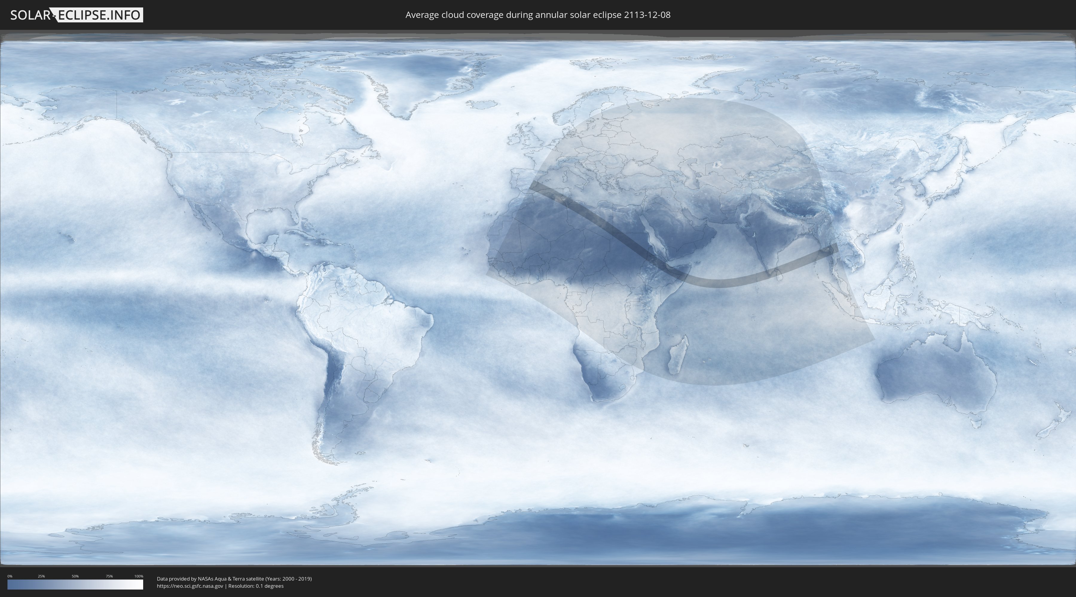
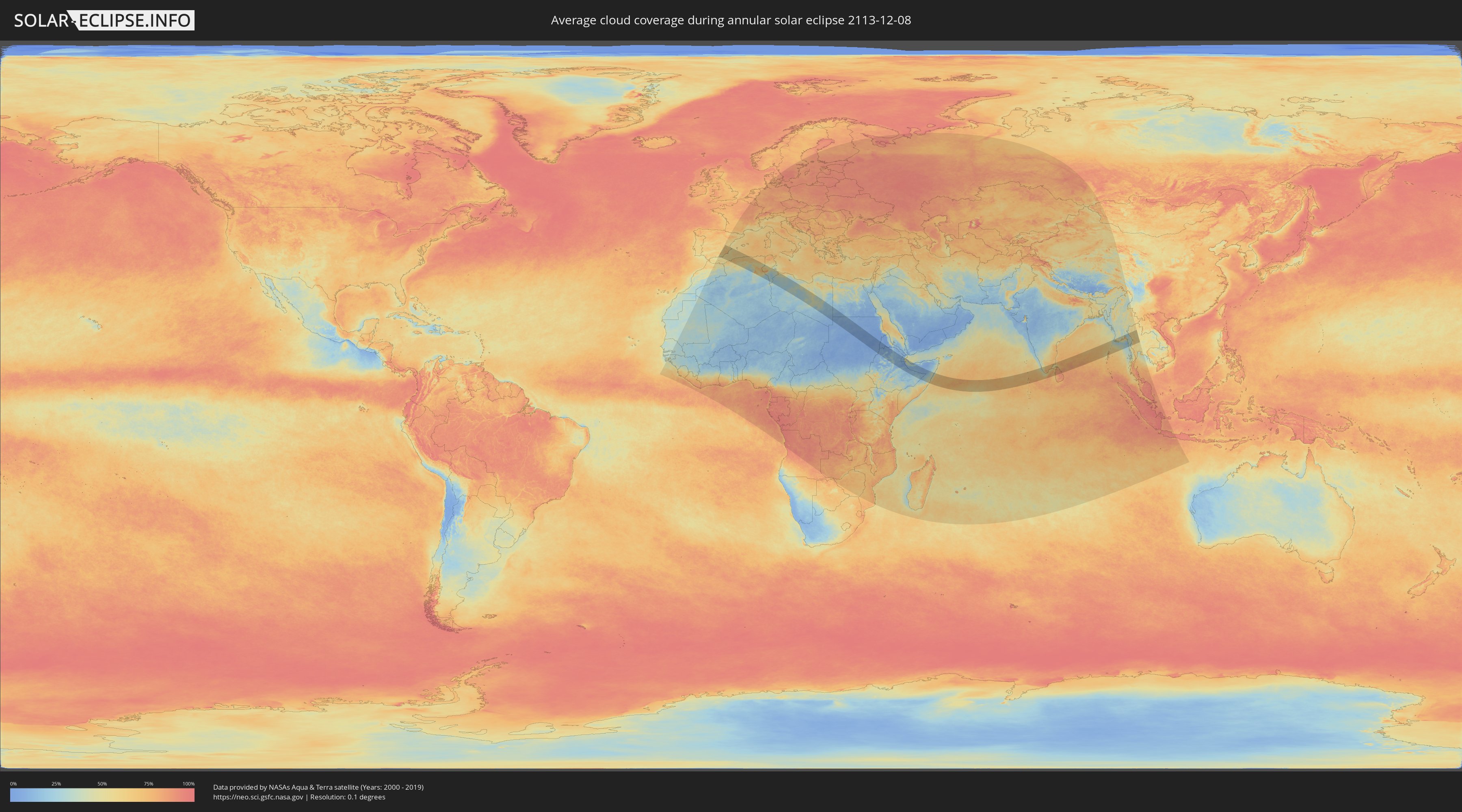
How will be the weather during the annular solar eclipse on 12/08/2113?
Where is the best place to see the annular solar eclipse of 12/08/2113?
The following maps show the average cloud coverage for the day of the annular solar eclipse.
With the help of these maps, it is possible to find the place along the eclipse path, which has the best
chance of a cloudless sky.
Nevertheless, you should consider local circumstances and inform about the weather of your chosen
observation site.
The data is provided by NASAs satellites
AQUA and TERRA.
The cloud maps are averaged over a period of 19 years (2000 - 2019).
Detailed country maps
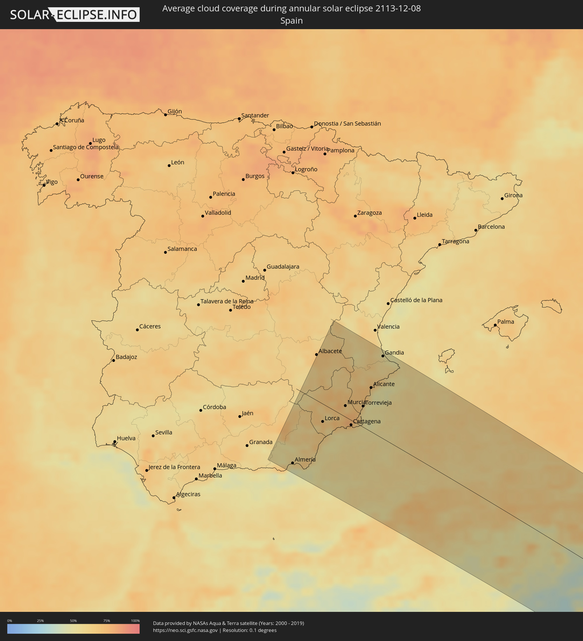 Spain
Spain
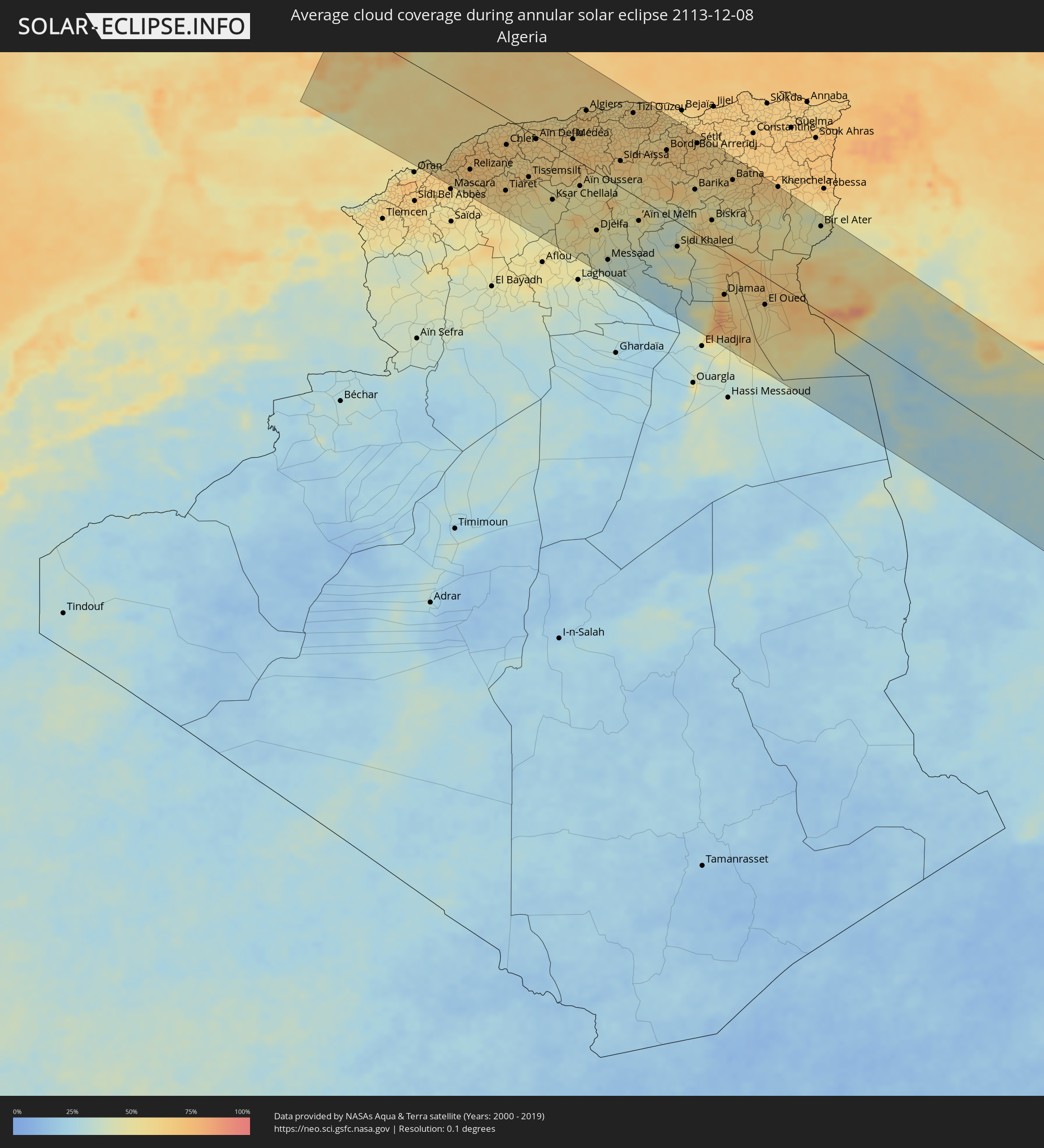 Algeria
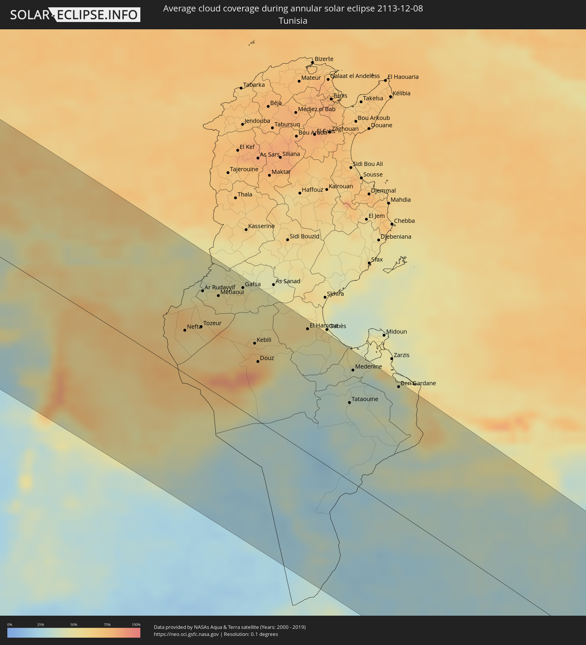 Tunisia
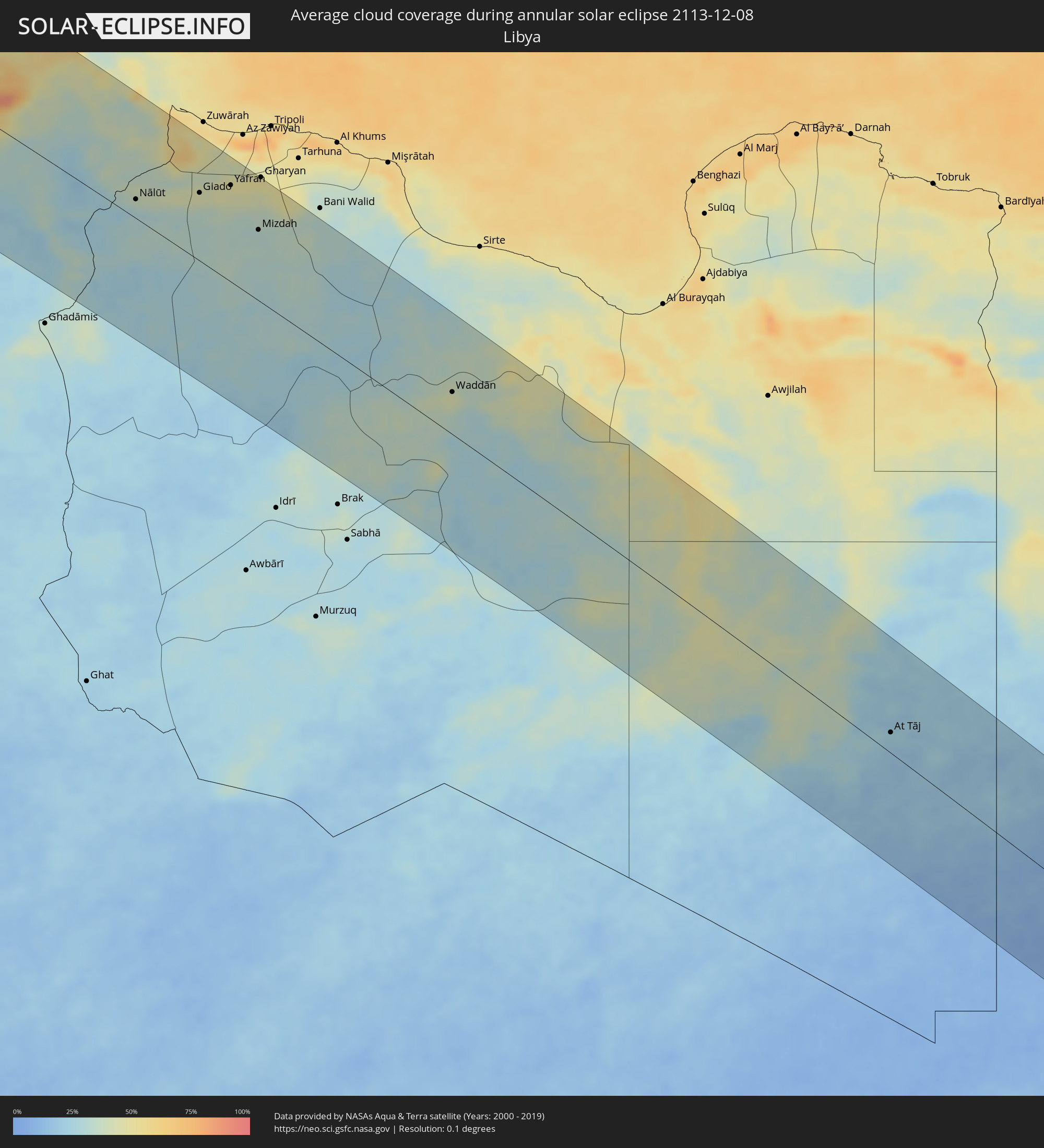 Libya
Libya
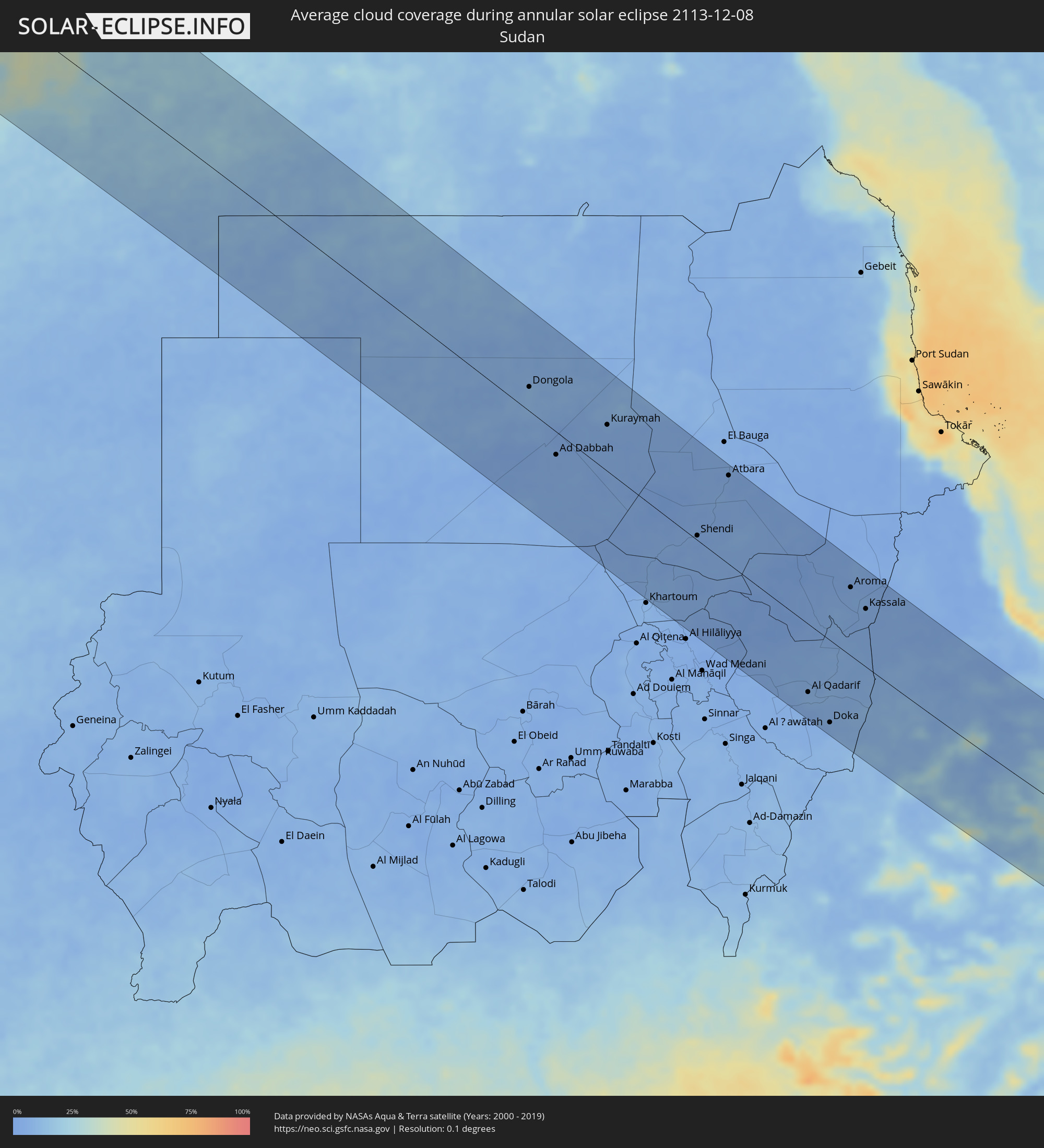 Sudan
Sudan
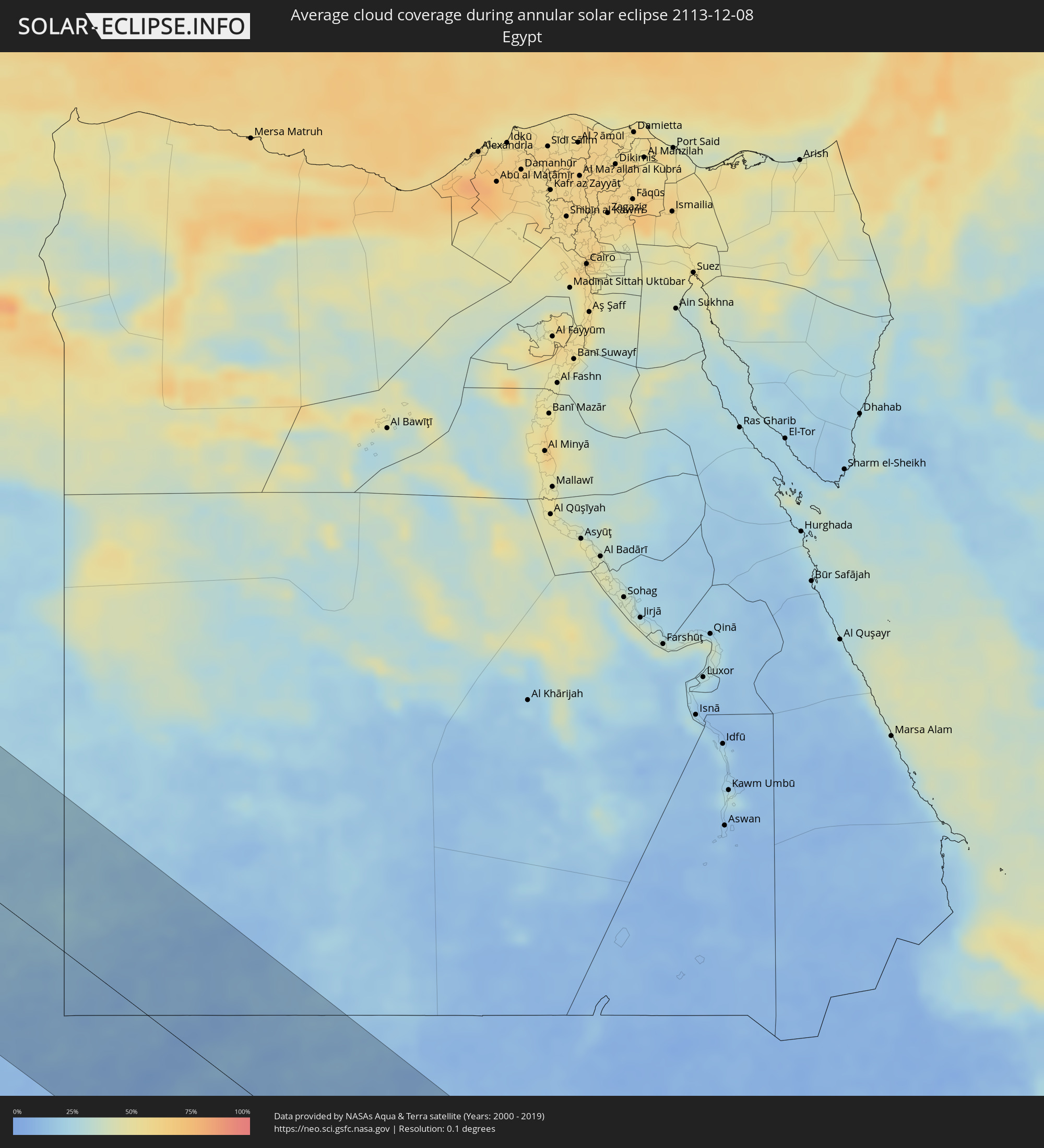 Egypt
Egypt
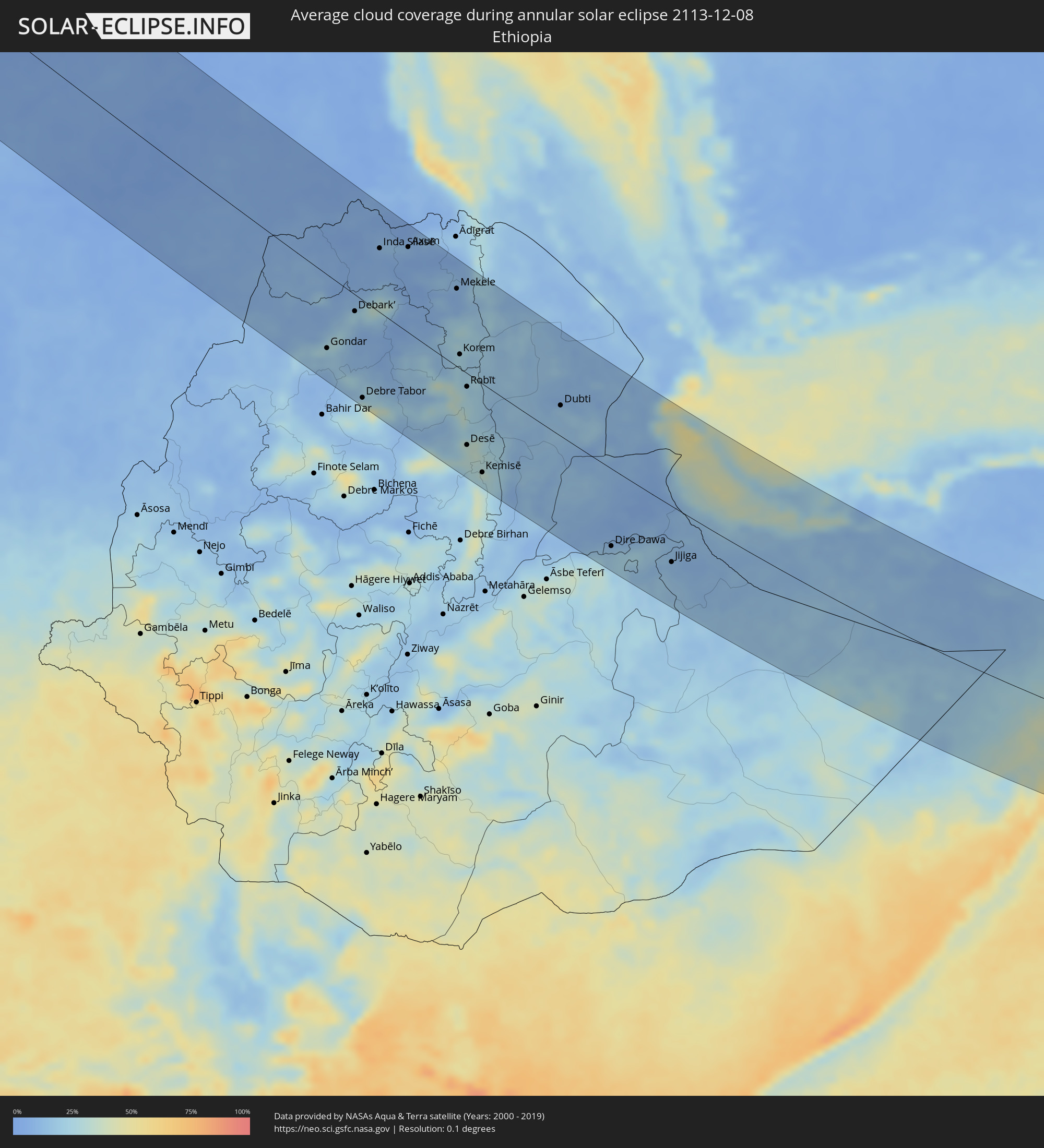 Ethiopia
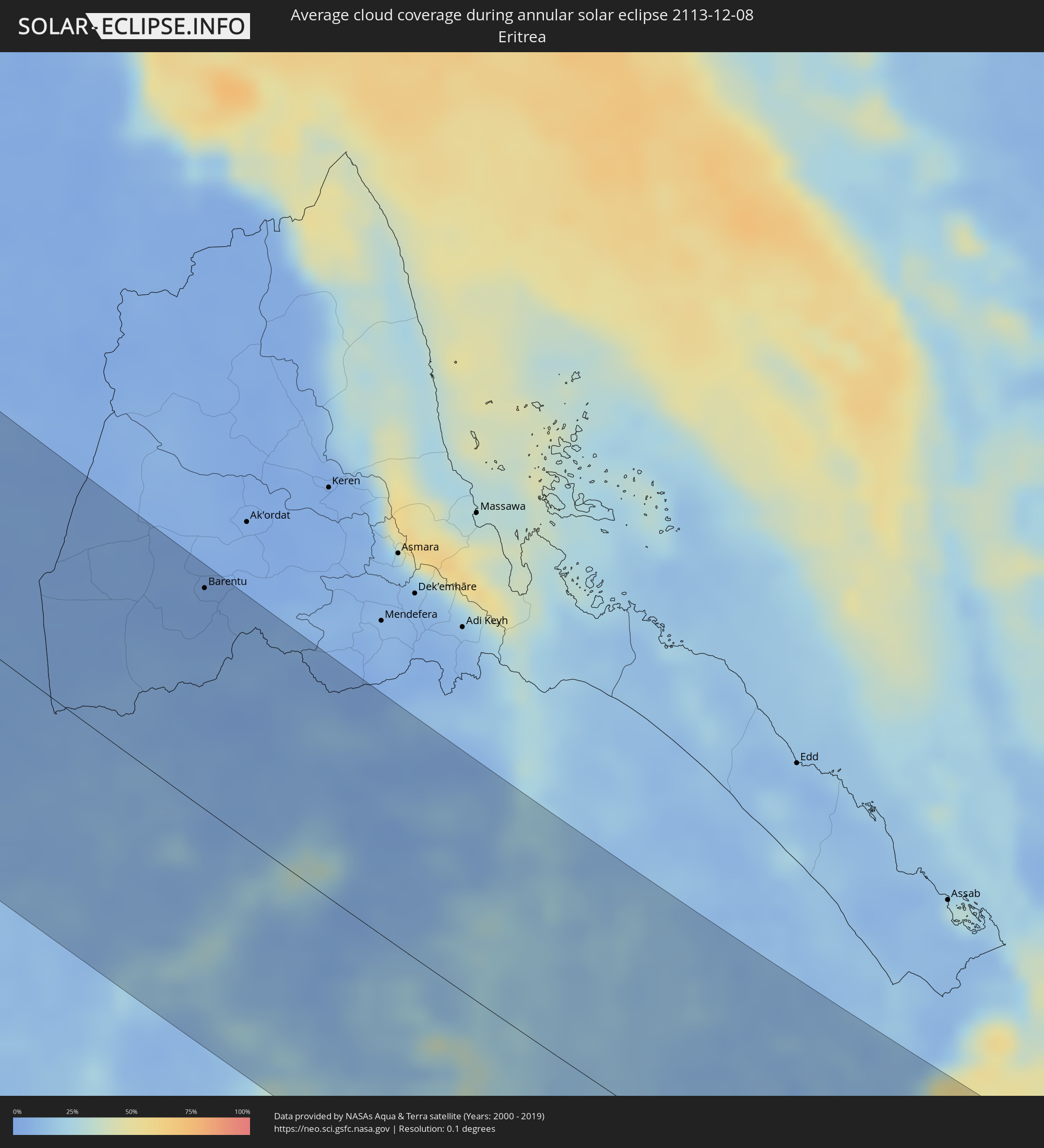 Eritrea
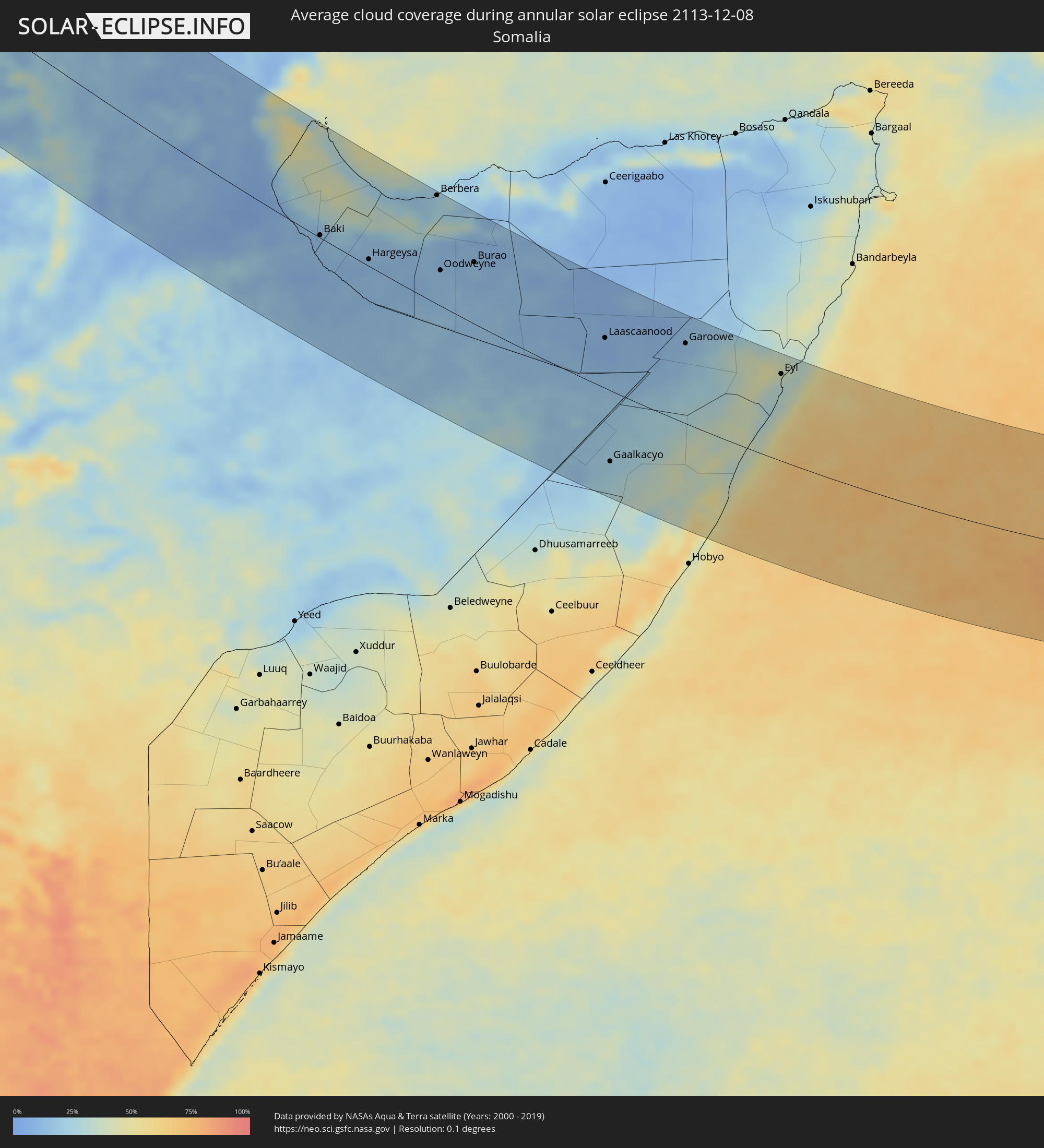 Somalia
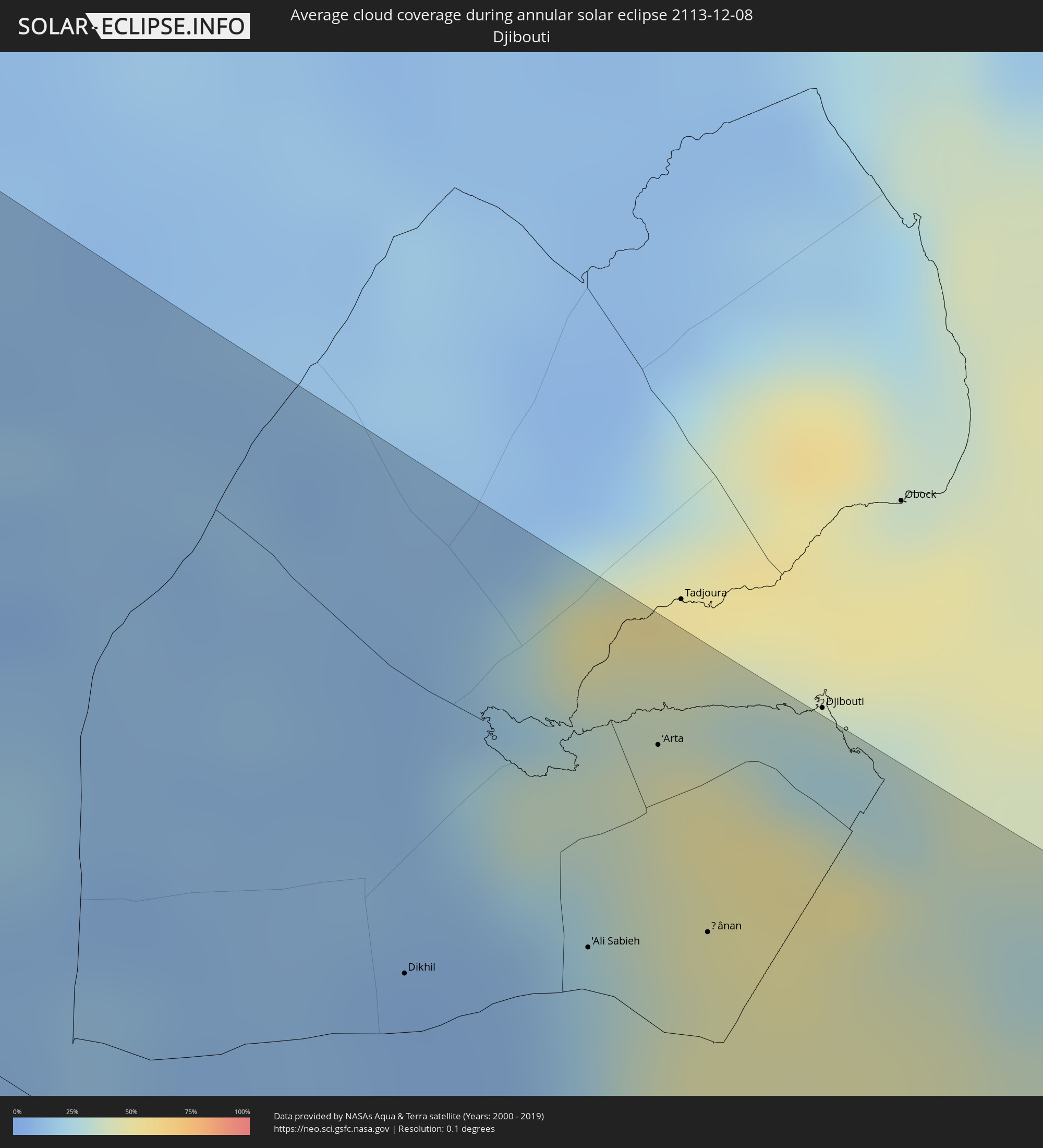 Djibouti
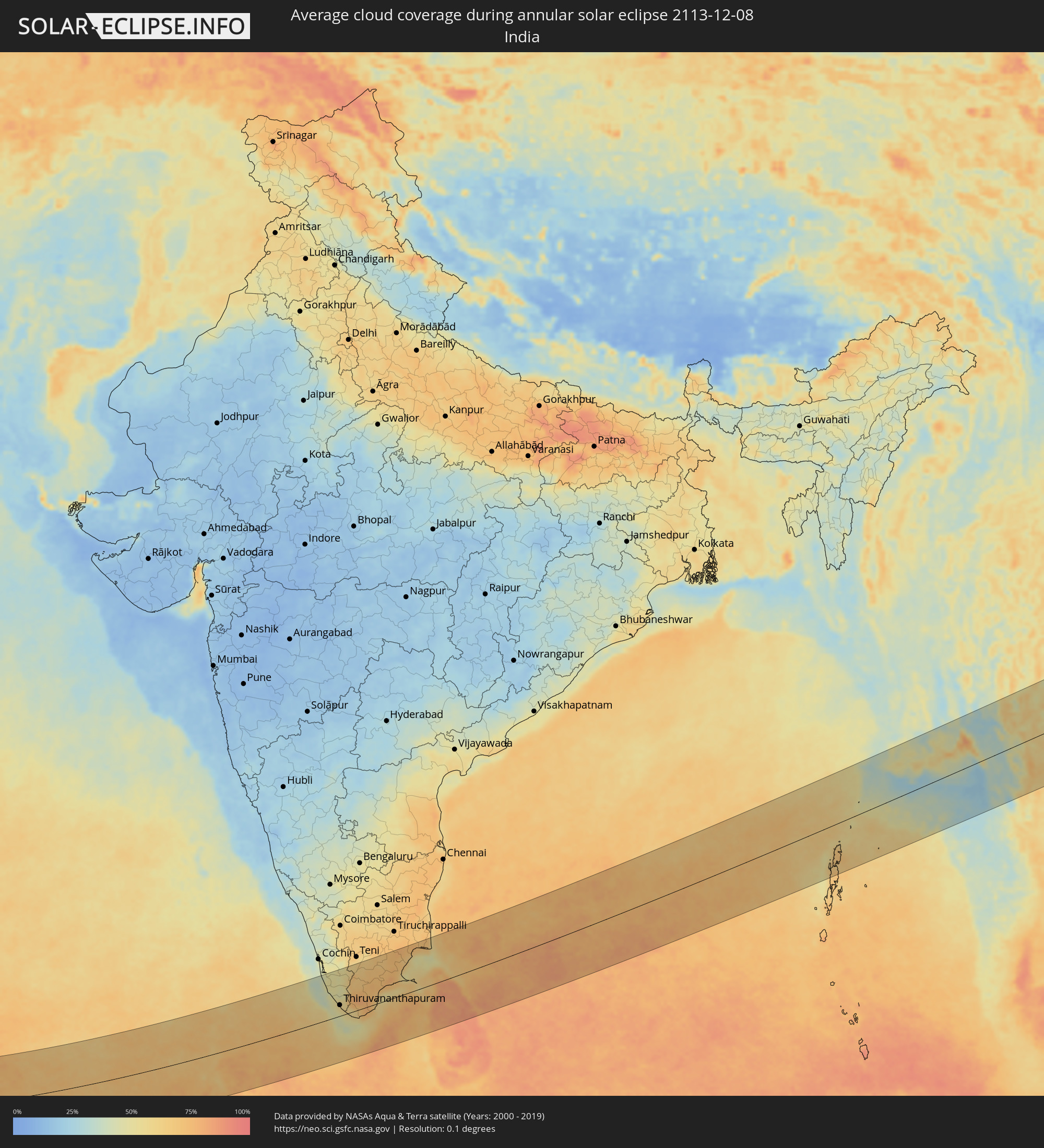 India
India
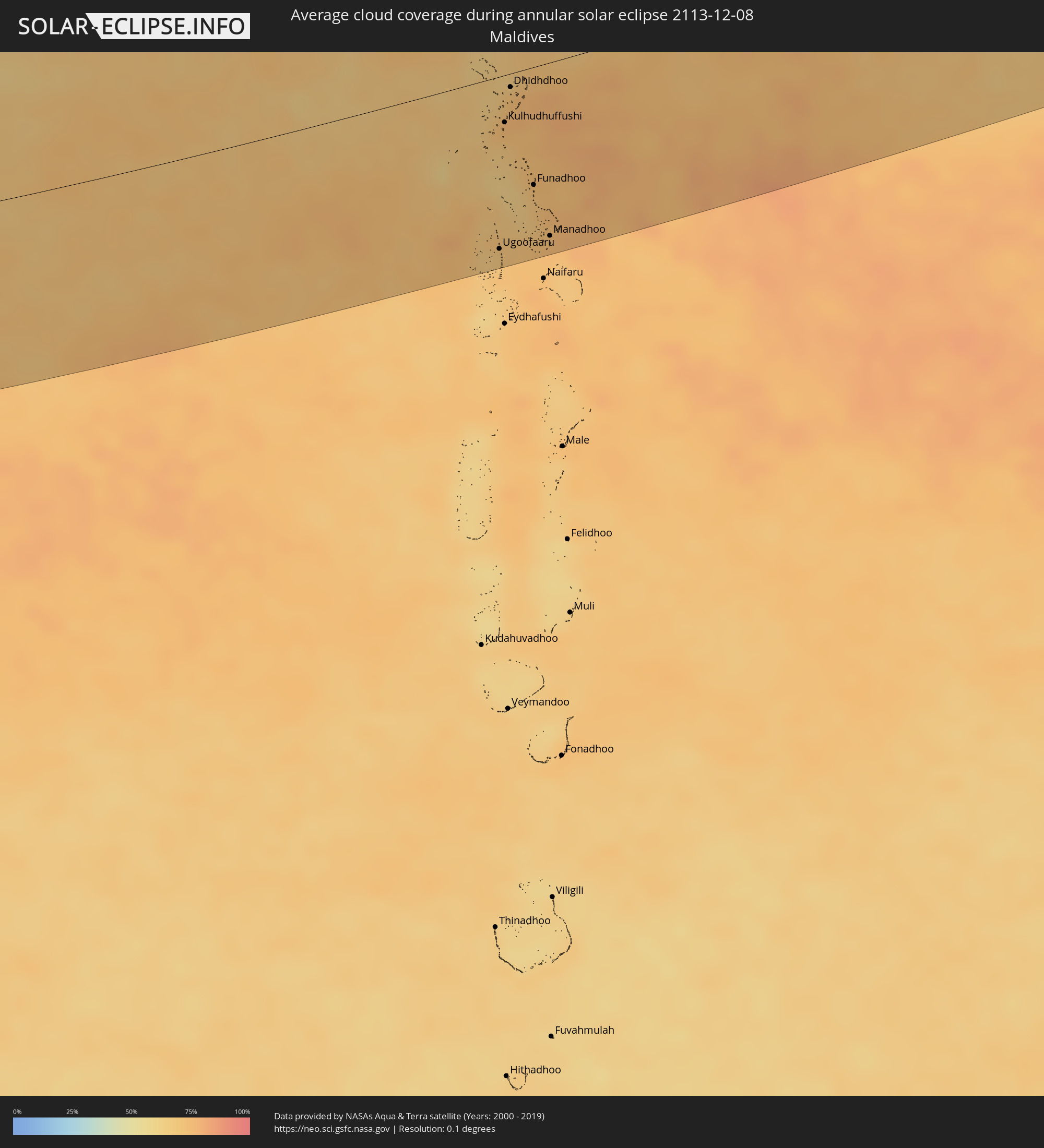 Maldives
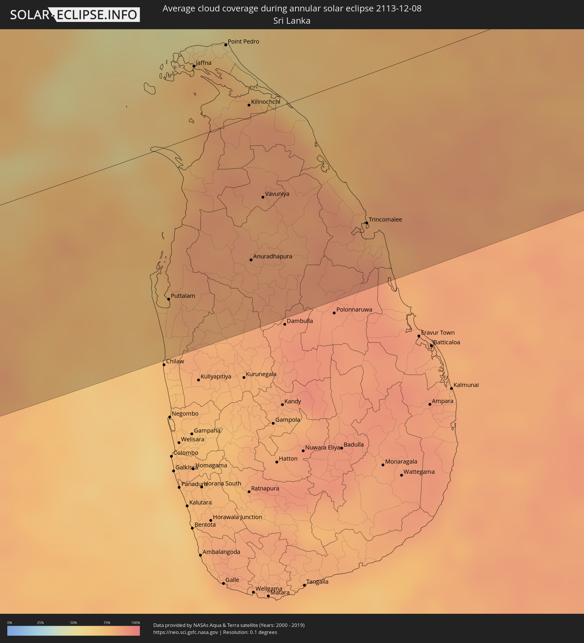 Sri Lanka
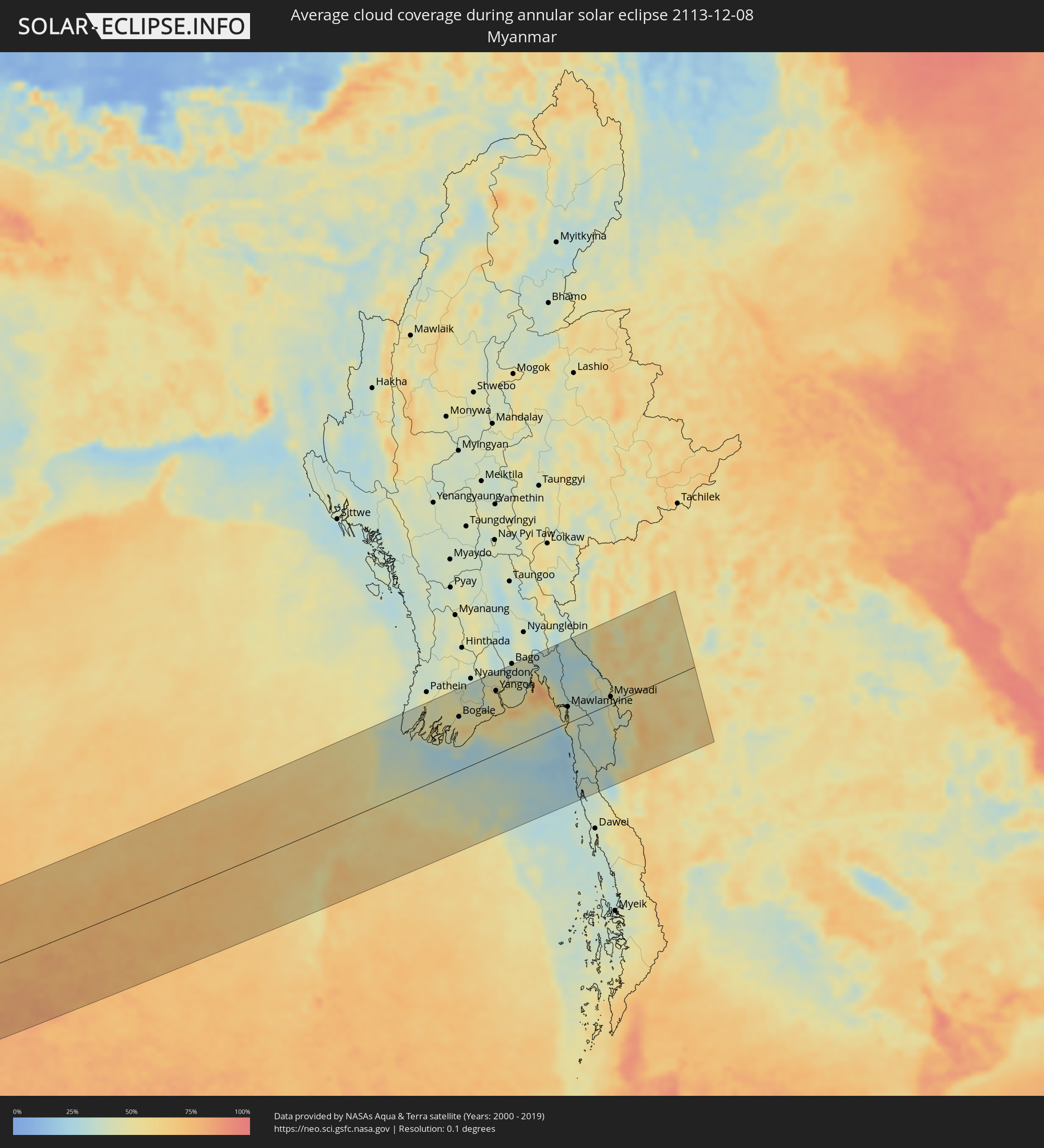 Myanmar
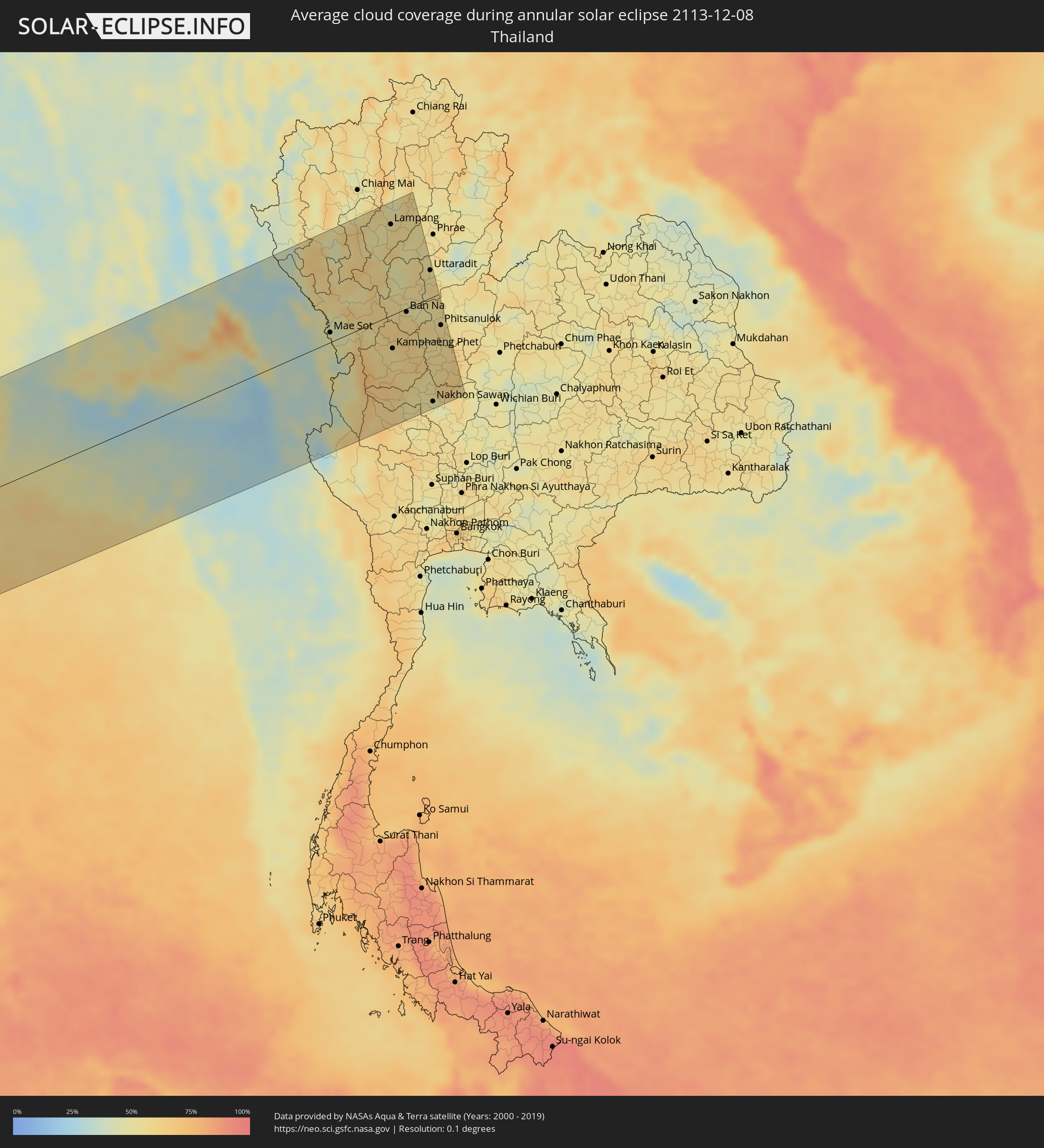 Thailand
Cities inside the path of the eclipse
The following table shows all locations with a population of more than 5,000 inside the eclipse path. Cities which have more than 100,000 inhabitants are marked bold. A click at the locations opens a detailed map.
| City | Type | Eclipse duration | Local time of max. eclipse | Distance to central line | Ø Cloud coverage |
|
Roquetas de Mar, Andalusia
|
annular | - | 08:17:17 UTC+01:00 | 162 km | 54% |
|
Almería, Andalusia
|
annular | - | 08:17:22 UTC+01:00 | 148 km | 45% |
|
Lorca, Murcia
|
annular | - | 08:18:06 UTC+01:00 | 34 km | 70% |
|
Murcia, Murcia
|
annular | - | 08:18:29 UTC+01:00 | 21 km | 64% |
|
Cartagena, Murcia
|
annular | - | 08:18:18 UTC+01:00 | 9 km | 59% |
|
Orihuela, Valencia
|
annular | - | 08:18:37 UTC+01:00 | 39 km | 69% |
|
Elda, Valencia
|
annular | - | 08:18:55 UTC+01:00 | 83 km | 70% |
|
Elche, Valencia
|
annular | - | 08:18:48 UTC+01:00 | 67 km | 71% |
|
Torrevieja, Valencia
|
annular | - | 08:18:38 UTC+01:00 | 40 km | 60% |
|
Alicante, Valencia
|
annular | - | 08:18:56 UTC+01:00 | 84 km | 57% |
|
Alcoy, Valencia
|
annular | - | 08:19:11 UTC+01:00 | 119 km | 62% |
|
Alzira, Valencia
|
annular | - | 08:19:30 UTC+01:00 | 164 km | 61% |
|
Gandia, Valencia
|
annular | - | 08:19:28 UTC+01:00 | 157 km | 55% |
|
Benidorm, Valencia
|
annular | - | 08:19:11 UTC+01:00 | 118 km | 50% |
|
Mostaganem, Mostaganem
|
annular | - | 08:17:42 UTC+01:00 | 123 km | 64% |
|
Denia, Valencia
|
annular | - | 08:19:29 UTC+01:00 | 158 km | 61% |
|
Relizane, Relizane
|
annular | - | 08:17:46 UTC+01:00 | 120 km | 67% |
|
Tiaret, Tiaret
|
annular | - | 08:17:53 UTC+01:00 | 120 km | 63% |
|
Chlef, Chlef
|
annular | - | 08:18:19 UTC+01:00 | 43 km | 66% |
|
Médéa, Medea
|
annular | - | 08:18:59 UTC+01:00 | 31 km | 66% |
|
Blida, Blida
|
annular | - | 08:19:08 UTC+01:00 | 54 km | 65% |
|
Algiers, Algiers
|
annular | - | 08:19:23 UTC+01:00 | 91 km | 65% |
|
Djelfa, Djelfa
|
annular | - | 08:18:24 UTC+01:00 | 96 km | 53% |
|
Boumerdas, Boumerdes
|
annular | - | 08:19:36 UTC+01:00 | 113 km | 59% |
|
Tizi Ouzou, Tizi Ouzou
|
annular | - | 08:19:51 UTC+01:00 | 134 km | 61% |
|
Bordj Bou Arreridj, Bordj Bou Arréridj
|
annular | - | 08:19:52 UTC+01:00 | 108 km | 68% |
|
Sétif, Sétif
|
annular | - | 08:20:16 UTC+01:00 | 150 km | 68% |
|
Biskra, Biskra
|
annular | - | 08:19:46 UTC+01:00 | 39 km | 59% |
|
Batna, Batna
|
annular | - | 08:20:22 UTC+01:00 | 127 km | 64% |
|
El Oued, El Oued
|
annular | - | 08:19:48 UTC+01:00 | 47 km | 58% |
|
Nefta, Tawzar
|
annular | - | 08:20:38 UTC+01:00 | 52 km | 60% |
|
Tozeur, Tawzar
|
annular | - | 08:20:50 UTC+01:00 | 70 km | 56% |
|
Ar Rudayyif, Gafsa
|
annular | - | 08:21:02 UTC+01:00 | 114 km | 51% |
|
Degache, Tawzar
|
annular | - | 08:20:54 UTC+01:00 | 79 km | 64% |
|
Metlaoui, Gafsa
|
annular | - | 08:21:10 UTC+01:00 | 121 km | 55% |
|
Gafsa, Gafsa
|
annular | - | 08:21:29 UTC+01:00 | 149 km | 55% |
|
Kebili, Qibilī
|
annular | - | 08:21:18 UTC+01:00 | 92 km | 66% |
|
El Golaa, Qibilī
|
annular | - | 08:21:15 UTC+01:00 | 73 km | 77% |
|
Jemna, Qibilī
|
annular | - | 08:21:17 UTC+01:00 | 82 km | 69% |
|
Douz, Qibilī
|
annular | - | 08:21:15 UTC+01:00 | 72 km | 77% |
|
El Hamma, Qābis
|
annular | - | 08:21:58 UTC+01:00 | 151 km | 54% |
|
Tataouine, Tataouine
|
annular | - | 08:22:05 UTC+01:00 | 95 km | 39% |
|
Medenine, Madanīn
|
annular | - | 08:22:17 UTC+01:00 | 138 km | 41% |
|
Nālūt, Sha‘bīyat Nālūt
|
annular | - | 09:22:09 UTC+02:00 | 24 km | 33% |
|
Ben Gardane, Madanīn
|
annular | - | 08:22:45 UTC+01:00 | 154 km | 38% |
|
Giado
|
annular | - | 09:23:01 UTC+02:00 | 87 km | 44% |
|
Zintan, Jabal al Gharbi District
|
annular | - | 09:23:12 UTC+02:00 | 97 km | 38% |
|
Yafran, Jabal al Gharbi District
|
annular | - | 09:23:28 UTC+02:00 | 124 km | 48% |
|
Mizdah, Jabal al Gharbi District
|
annular | - | 09:23:41 UTC+02:00 | 91 km | 32% |
|
Hūn, Al Jufrah
|
annular | - | 09:26:05 UTC+02:00 | 41 km | 41% |
|
Waddān, Al Jufrah
|
annular | - | 09:26:17 UTC+02:00 | 55 km | 44% |
|
At Tāj, Al Kufrah
|
annular | - | 09:35:38 UTC+02:00 | 27 km | 22% |
|
Al Jawf, Al Kufrah
|
annular | - | 09:35:39 UTC+02:00 | 27 km | 22% |
|
Argo, Northern State
|
annular | - | 09:50:23 UTC+02:00 | 61 km | 8% |
|
Dongola, Northern State
|
annular | - | 09:50:44 UTC+02:00 | 36 km | 10% |
|
Ad Dabbah, Northern State
|
annular | - | 09:52:33 UTC+02:00 | 34 km | 5% |
|
Marawī, Northern State
|
annular | - | 09:54:06 UTC+02:00 | 60 km | 5% |
|
Kuraymah, Northern State
|
annular | - | 09:54:08 UTC+02:00 | 68 km | 6% |
|
El Matama, River Nile
|
annular | - | 09:59:03 UTC+02:00 | 4 km | 4% |
|
Shendi, River Nile
|
annular | - | 09:59:15 UTC+02:00 | 7 km | 4% |
|
Ed Damer, River Nile
|
annular | - | 09:59:46 UTC+02:00 | 122 km | 3% |
|
Atbara, River Nile
|
annular | - | 09:59:43 UTC+02:00 | 132 km | 4% |
|
Al Qadarif, Al Qaḑārif
|
annular | - | 10:06:40 UTC+02:00 | 104 km | 8% |
|
Doka, Al Qaḑārif
|
annular | - | 10:08:14 UTC+02:00 | 126 km | 6% |
|
Aroma, Kassala
|
annular | - | 10:06:49 UTC+02:00 | 104 km | 4% |
|
Wagar, Kassala
|
annular | - | 10:06:41 UTC+02:00 | 138 km | 6% |
|
Kassala, Kassala
|
annular | - | 10:07:53 UTC+02:00 | 88 km | 5% |
|
Gondar, Amhara
|
annular | - | 11:13:54 UTC+03:00 | 100 km | 23% |
|
Barentu, Gash-Barka
|
annular | - | 11:11:29 UTC+03:00 | 134 km | 3% |
|
Ādīs Zemen, Amhara
|
annular | - | 11:15:22 UTC+03:00 | 124 km | 15% |
|
Debark’, Amhara
|
annular | - | 11:14:29 UTC+03:00 | 23 km | 21% |
|
Debre Tabor, Amhara
|
annular | - | 11:16:21 UTC+03:00 | 134 km | 30% |
|
Inda Silasē, Tigray
|
annular | - | 11:14:31 UTC+03:00 | 87 km | 8% |
|
Axum, Tigray
|
annular | - | 11:15:46 UTC+03:00 | 117 km | 9% |
|
Mekele, Tigray
|
annular | - | 11:18:42 UTC+03:00 | 107 km | 9% |
|
Korem, Tigray
|
annular | - | 11:20:00 UTC+03:00 | 20 km | 24% |
|
Maych’ew, Tigray
|
annular | - | 11:19:44 UTC+03:00 | 46 km | 23% |
|
Desē, Amhara
|
annular | - | 11:22:01 UTC+03:00 | 100 km | 28% |
|
Kemisē, Amhara
|
annular | - | 11:23:16 UTC+03:00 | 124 km | 26% |
|
Dubti, Āfar
|
annular | - | 11:25:47 UTC+03:00 | 43 km | 15% |
|
Dire Dawa, Dire Dawa
|
annular | - | 11:31:03 UTC+03:00 | 111 km | 17% |
|
Harar, Harari
|
annular | - | 11:32:15 UTC+03:00 | 123 km | 20% |
|
Dikhil, Dikhil
|
annular | - | 11:30:45 UTC+03:00 | 61 km | 8% |
|
'Ali Sabieh, Ali Sabieh
|
annular | - | 11:31:49 UTC+03:00 | 85 km | 21% |
|
Jijiga, Somali
|
annular | - | 11:34:28 UTC+03:00 | 81 km | 12% |
|
‘Arta, Arta
|
annular | - | 11:31:47 UTC+03:00 | 127 km | 39% |
|
Ḏânan, Ali Sabieh
|
annular | - | 11:32:31 UTC+03:00 | 101 km | 42% |
|
Baki, Awdal
|
annular | - | 11:35:44 UTC+03:00 | 3 km | 15% |
|
Hargeysa, Woqooyi Galbeed
|
annular | - | 11:38:30 UTC+03:00 | 9 km | 12% |
|
Berbera, Woqooyi Galbeed
|
annular | - | 11:40:41 UTC+03:00 | 146 km | 23% |
|
Oodweyne, Togdheer
|
annular | - | 11:42:13 UTC+03:00 | 48 km | 15% |
|
Burao, Togdheer
|
annular | - | 11:43:44 UTC+03:00 | 84 km | 15% |
|
Laascaanood, Sool
|
annular | - | 11:51:48 UTC+03:00 | 70 km | 10% |
|
Gaalkacyo, Mudug
|
annular | - | 11:54:20 UTC+03:00 | 100 km | 22% |
|
Garoowe, Nugaal
|
annular | - | 11:56:07 UTC+03:00 | 113 km | 14% |
|
Eyl, Nugaal
|
annular | - | 12:01:45 UTC+03:00 | 126 km | 38% |
|
Ugoofaaru, Raa Atoll
|
annular | - | 15:18:33 UTC+05:00 | 139 km | 68% |
|
Kulhudhuffushi, Haa Dhaalu Atholhu
|
annular | - | 15:18:11 UTC+05:00 | 38 km | 74% |
|
Dhidhdhoo, Haa Alifu Atholhu
|
annular | - | 15:18:08 UTC+05:00 | 11 km | 71% |
|
Funadhoo, Shaviyani Atholhu
|
annular | - | 15:18:52 UTC+05:00 | 95 km | 74% |
|
Manadhoo, Noonu Atoll
|
annular | - | 15:19:17 UTC+05:00 | 140 km | 73% |
|
Kollam, Kerala
|
annular | - | 15:53:47 UTC+05:30 | 91 km | 48% |
|
Thiruvananthapuram, Kerala
|
annular | - | 15:54:38 UTC+05:30 | 36 km | 53% |
|
Neyyāttinkara, Kerala
|
annular | - | 15:54:55 UTC+05:30 | 22 km | 57% |
|
Kadayanallur, Tamil Nadu
|
annular | - | 15:55:00 UTC+05:30 | 85 km | 66% |
|
Nāgercoil, Tamil Nadu
|
annular | - | 15:55:37 UTC+05:30 | 13 km | 56% |
|
Rajapalaiyam, Tamil Nadu
|
annular | - | 15:55:09 UTC+05:30 | 118 km | 67% |
|
Tirunelveli, Tamil Nadu
|
annular | - | 15:55:45 UTC+05:30 | 36 km | 78% |
|
Sivakasi, Tamil Nadu
|
annular | - | 15:55:34 UTC+05:30 | 109 km | 70% |
|
Kovilpatti, Tamil Nadu
|
annular | - | 15:55:50 UTC+05:30 | 77 km | 74% |
|
Virudunagar, Tamil Nadu
|
annular | - | 15:55:45 UTC+05:30 | 117 km | 70% |
|
Aruppukkottai, Tamil Nadu
|
annular | - | 15:56:01 UTC+05:30 | 104 km | 72% |
|
Madurai, Tamil Nadu
|
annular | - | 15:55:50 UTC+05:30 | 147 km | 69% |
|
Paramagudi, Tamil Nadu
|
annular | - | 15:56:48 UTC+05:30 | 91 km | 78% |
|
Kāraikkudi, Tamil Nadu
|
annular | - | 15:56:48 UTC+05:30 | 139 km | 72% |
|
Pattukkottai, Tamil Nadu
|
annular | - | 15:57:28 UTC+05:30 | 156 km | 74% |
|
Puttalam, North Western
|
annular | - | 15:59:27 UTC+05:30 | 113 km | 76% |
|
Jaffna, Northern Province
|
annular | - | 15:58:55 UTC+05:30 | 52 km | 75% |
|
Valvedditturai, Northern Province
|
annular | - | 15:59:04 UTC+05:30 | 61 km | 71% |
|
Point Pedro, Northern Province
|
annular | - | 15:59:10 UTC+05:30 | 59 km | 71% |
|
Kilinochchi, Northern Province
|
annular | - | 15:59:37 UTC+05:30 | 9 km | 82% |
|
Anuradhapura, North Central
|
annular | - | 16:00:10 UTC+05:30 | 105 km | 83% |
|
Vavuniya, Northern Province
|
annular | - | 16:00:05 UTC+05:30 | 62 km | 81% |
|
Trincomalee, Eastern Province
|
annular | - | 16:01:11 UTC+05:30 | 109 km | 82% |
|
Bogale, Ayeyarwady
|
annular | - | 17:09:35 UTC+06:30 | 108 km | 49% |
|
Maubin, Ayeyarwady
|
annular | - | 17:09:25 UTC+06:30 | 142 km | 47% |
|
Pyapon, Ayeyarwady
|
annular | - | 17:09:44 UTC+06:30 | 95 km | 52% |
|
Kyaiklat, Ayeyarwady
|
annular | - | 17:09:39 UTC+06:30 | 109 km | 47% |
|
Twante, Yangon
|
annular | - | 17:09:34 UTC+06:30 | 128 km | 38% |
|
Kanbe, Yangon
|
annular | - | 17:09:36 UTC+06:30 | 124 km | 46% |
|
Yangon, Yangon
|
annular | - | 17:09:37 UTC+06:30 | 127 km | 52% |
|
Thongwa, Yangon
|
annular | - | 17:09:49 UTC+06:30 | 107 km | 45% |
|
Kyaikto, Mon
|
annular | - | 17:09:39 UTC+06:30 | 142 km | 43% |
|
Thaton, Mon
|
annular | - | 17:10:04 UTC+06:30 | 87 km | 38% |
|
Kyaikkami, Mon
|
annular | - | 17:10:43 UTC+06:30 | 7 km | 42% |
|
Martaban, Mon
|
annular | - | 17:10:26 UTC+06:30 | 36 km | 41% |
|
Mawlamyine, Mon
|
annular | - | 17:10:28 UTC+06:30 | 32 km | 41% |
|
Hpa-an, Kayin
|
annular | - | 17:10:12 UTC+06:30 | 72 km | 33% |
|
Mudon, Mon
|
annular | - | 17:10:40 UTC+06:30 | 4 km | 43% |
|
Mae Sot, Tak
|
annular | - | 17:40:41 UTC+07:00 | 15 km | 48% |
|
Tak, Tak
|
annular | - | 17:40:46 UTC+07:00 | 6 km | 56% |
|
Thoen, Lampang
|
annular | - | 17:40:17 UTC+07:00 | 78 km | 58% |
|
Lampang, Lampang
|
annular | - | 17:39:53 UTC+07:00 | 135 km | 56% |
|
Kamphaeng Phet, Kamphaeng Phet
|
annular | - | 17:41:09 UTC+07:00 | 50 km | 55% |
|
Ban Na, Sukhothai
|
annular | - | 17:40:52 UTC+07:00 | 5 km | 57% |
|
Si Satchanalai, Sukhothai
|
annular | - | 17:40:32 UTC+07:00 | 45 km | 55% |
|
Sawankhalok, Sukhothai
|
annular | - | 17:40:41 UTC+07:00 | 23 km | 52% |
|
Khanu Woralaksaburi, Kamphaeng Phet
|
annular | - | 17:41:32 UTC+07:00 | 108 km | 57% |
|
Uttaradit, Uttaradit
|
annular | - | 17:40:33 UTC+07:00 | 41 km | 55% |
|
Nakhon Sawan, Nakhon Sawan
|
annular | - | 17:41:50 UTC+07:00 | 156 km | 50% |
|
Phitsanulok, Phitsanulok
|
annular | - | 17:41:09 UTC+07:00 | 47 km | 57% |
|
Bang Krathum, Phitsanulok
|
annular | - | 17:41:20 UTC+07:00 | 74 km | 56% |
|
Phichit, Phichit
|
annular | - | 17:41:26 UTC+07:00 | 90 km | 57% |
|
Taphan Hin, Phichit
|
annular | - | 17:41:35 UTC+07:00 | 116 km | 61% |