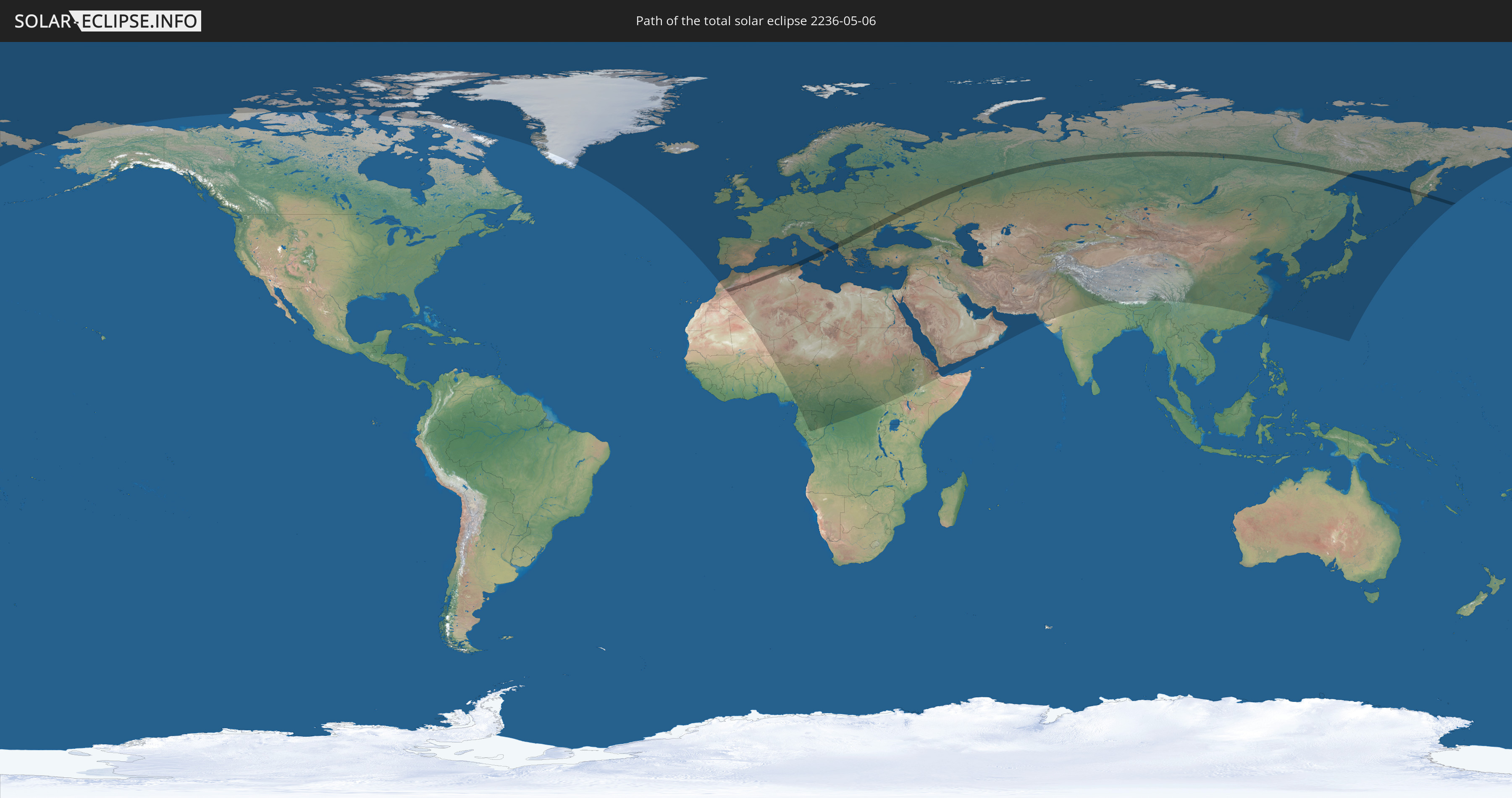
Total solar eclipse of 05/06/2236
| Day of week: | Friday |
| Maximum duration of eclipse: | 01m59s |
| Maximum width of eclipse path: | 126 km |
| Saros cycle: | 132 |
| Coverage: | 100% |
| Magnitude: | 1.0269 |
| Gamma: | 0.6848 |
Wo kann man die Sonnenfinsternis vom 05/06/2236 sehen?
Die Sonnenfinsternis am 05/06/2236 kann man in 109 Ländern als partielle Sonnenfinsternis beobachten.
Der Finsternispfad verläuft durch 13 Länder. Nur in diesen Ländern ist sie als total Sonnenfinsternis zu sehen.
In den folgenden Ländern ist die Sonnenfinsternis total zu sehen
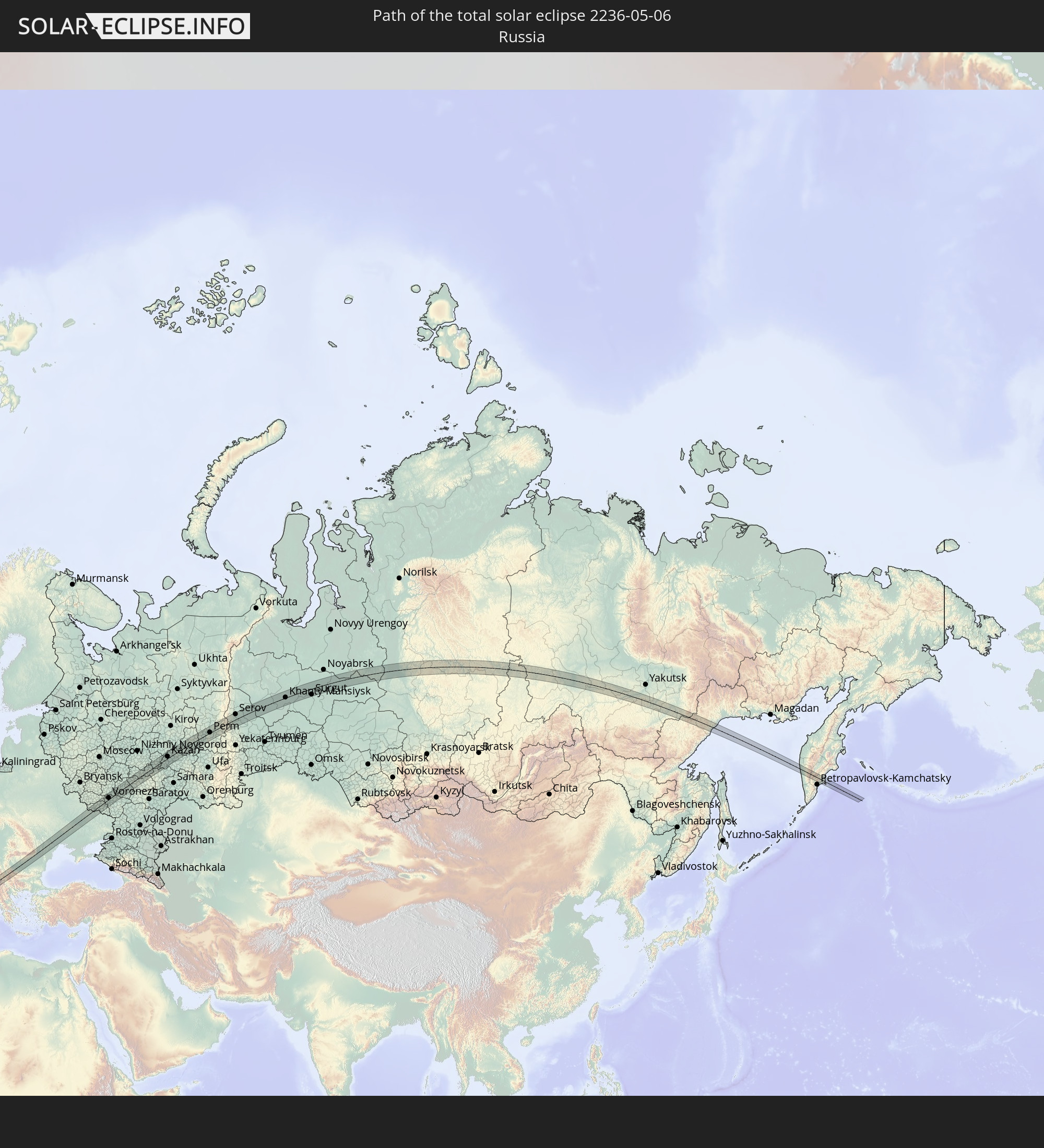 Russia
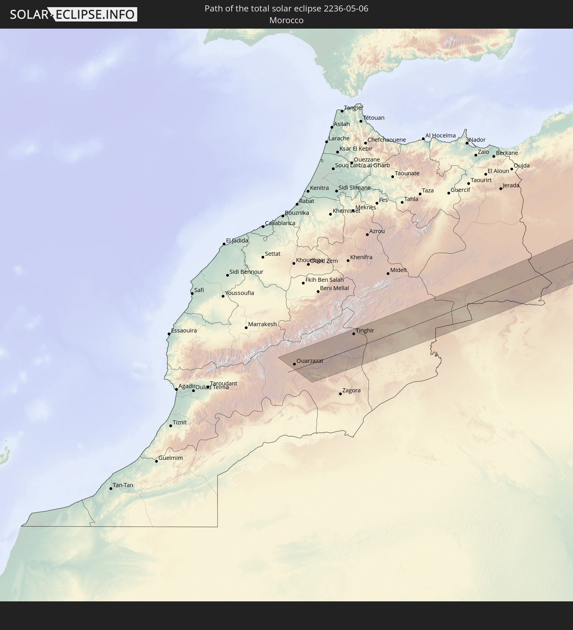 Morocco
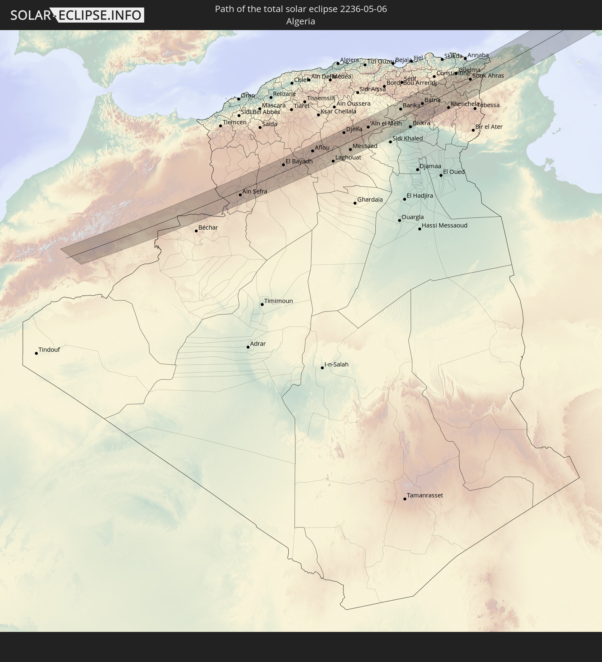 Algeria
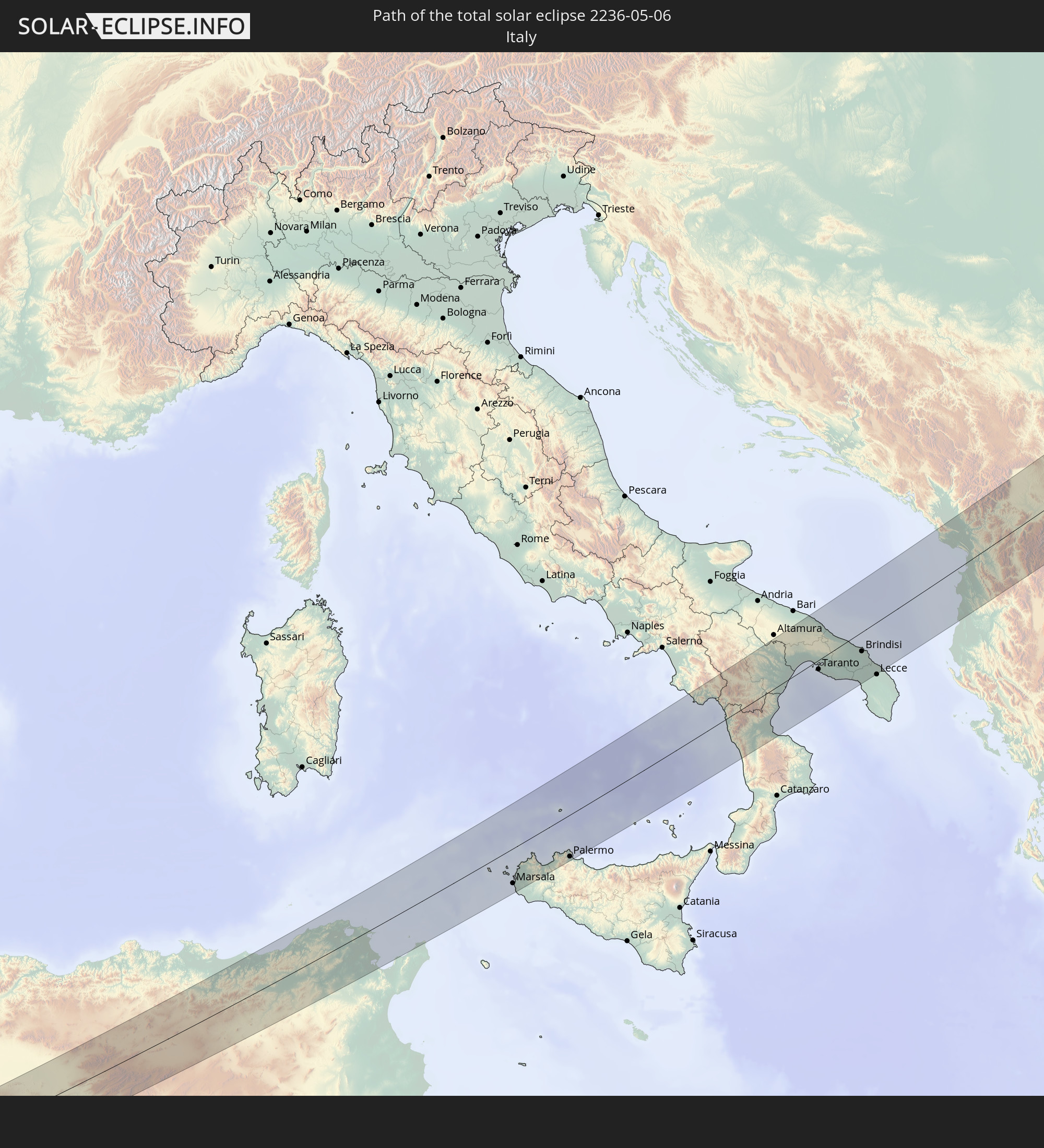 Italy
Italy
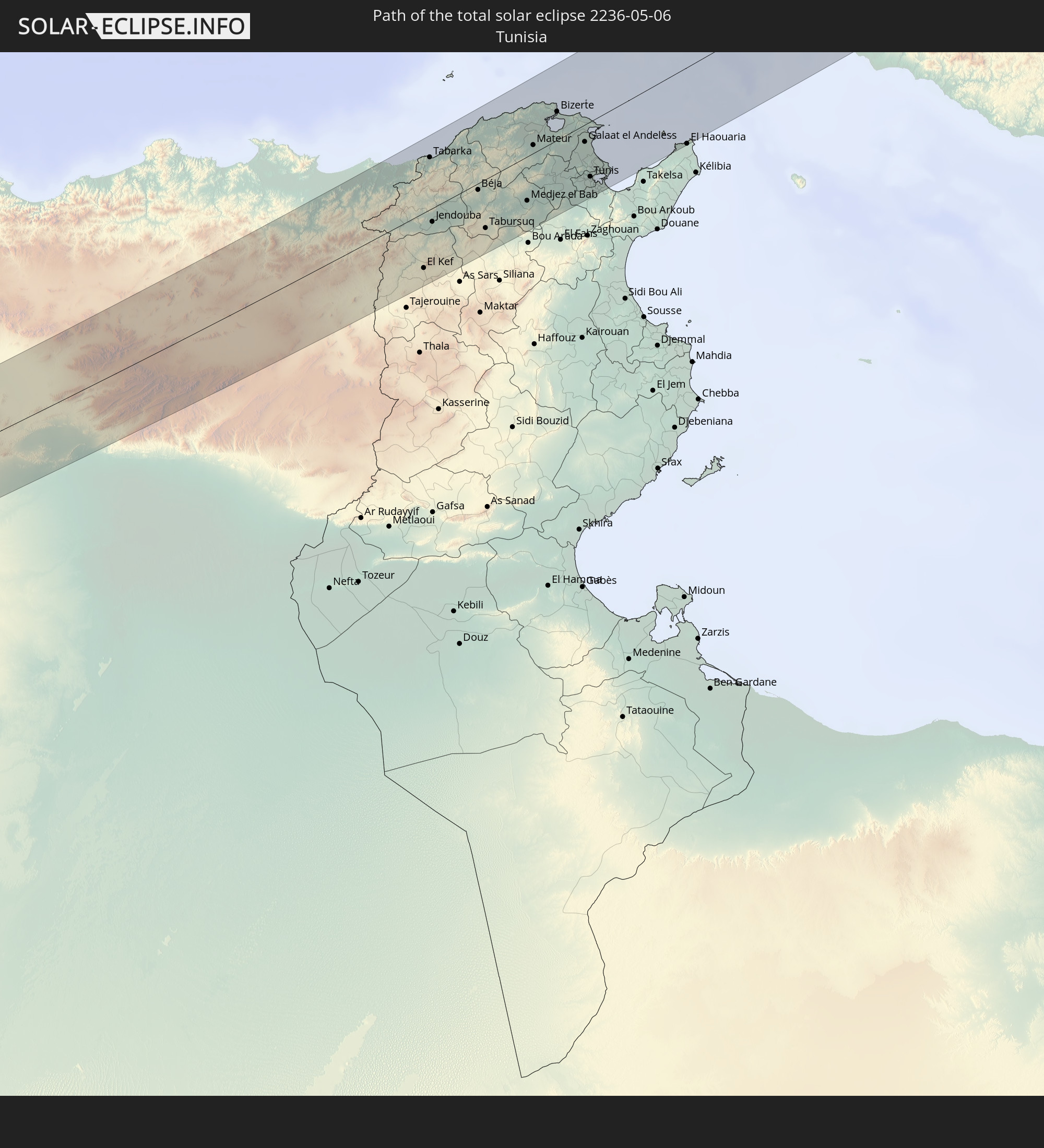 Tunisia
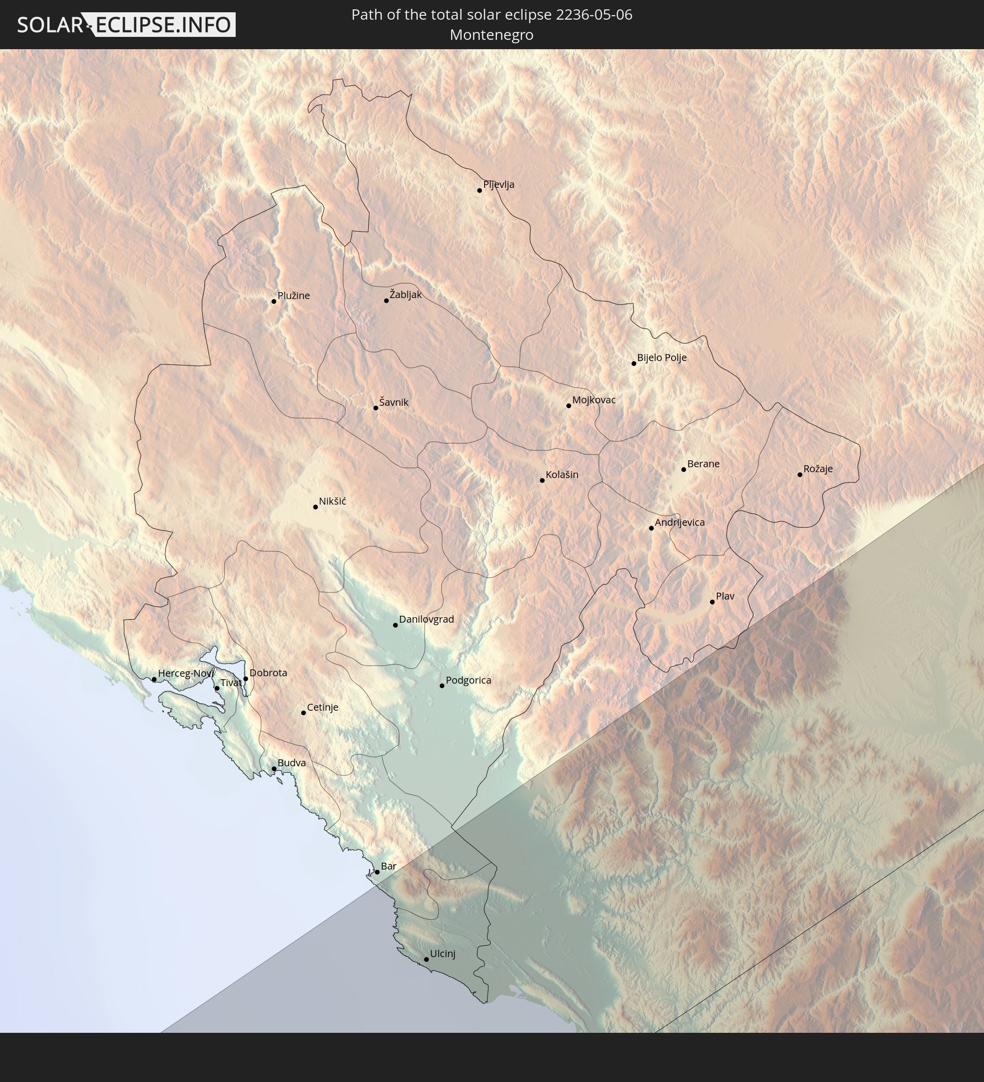 Montenegro
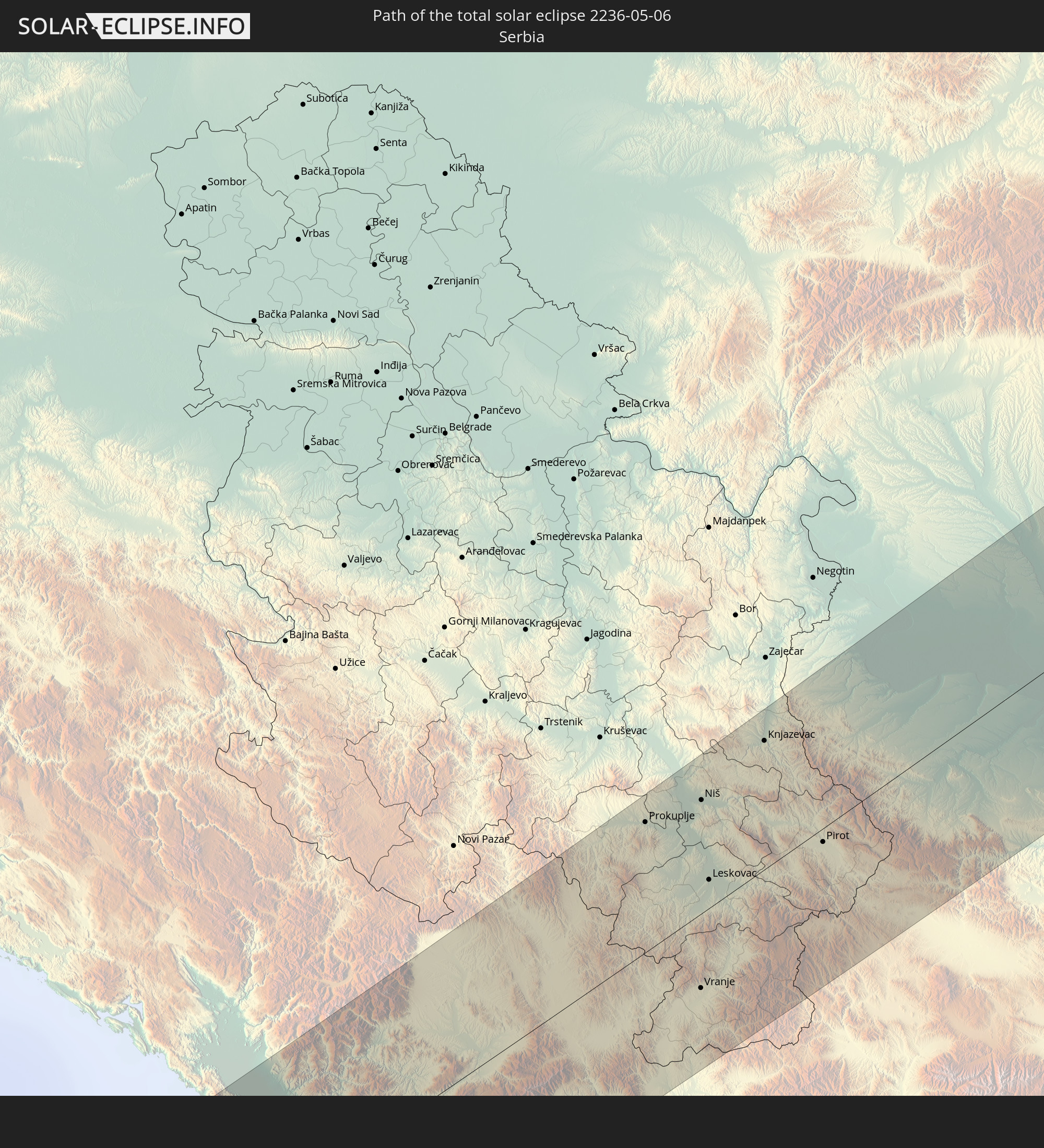 Serbia
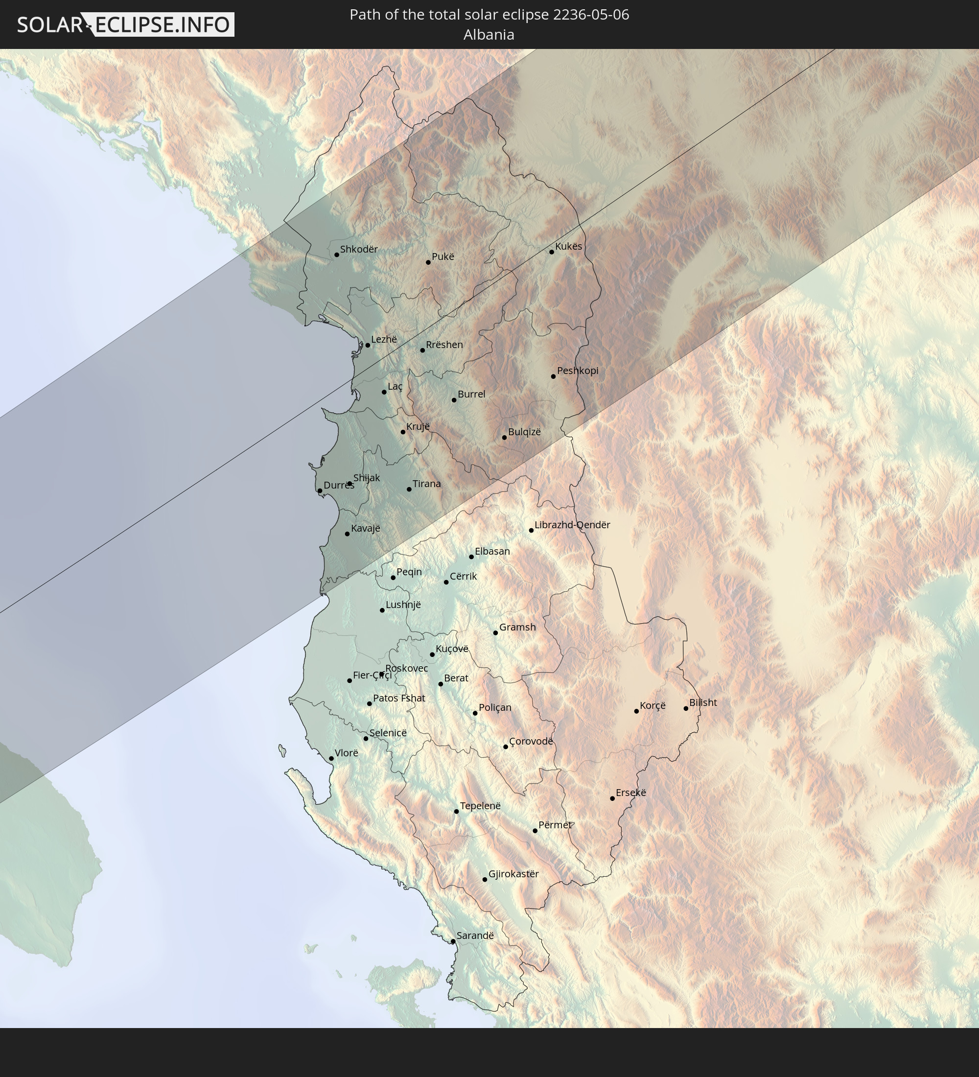 Albania
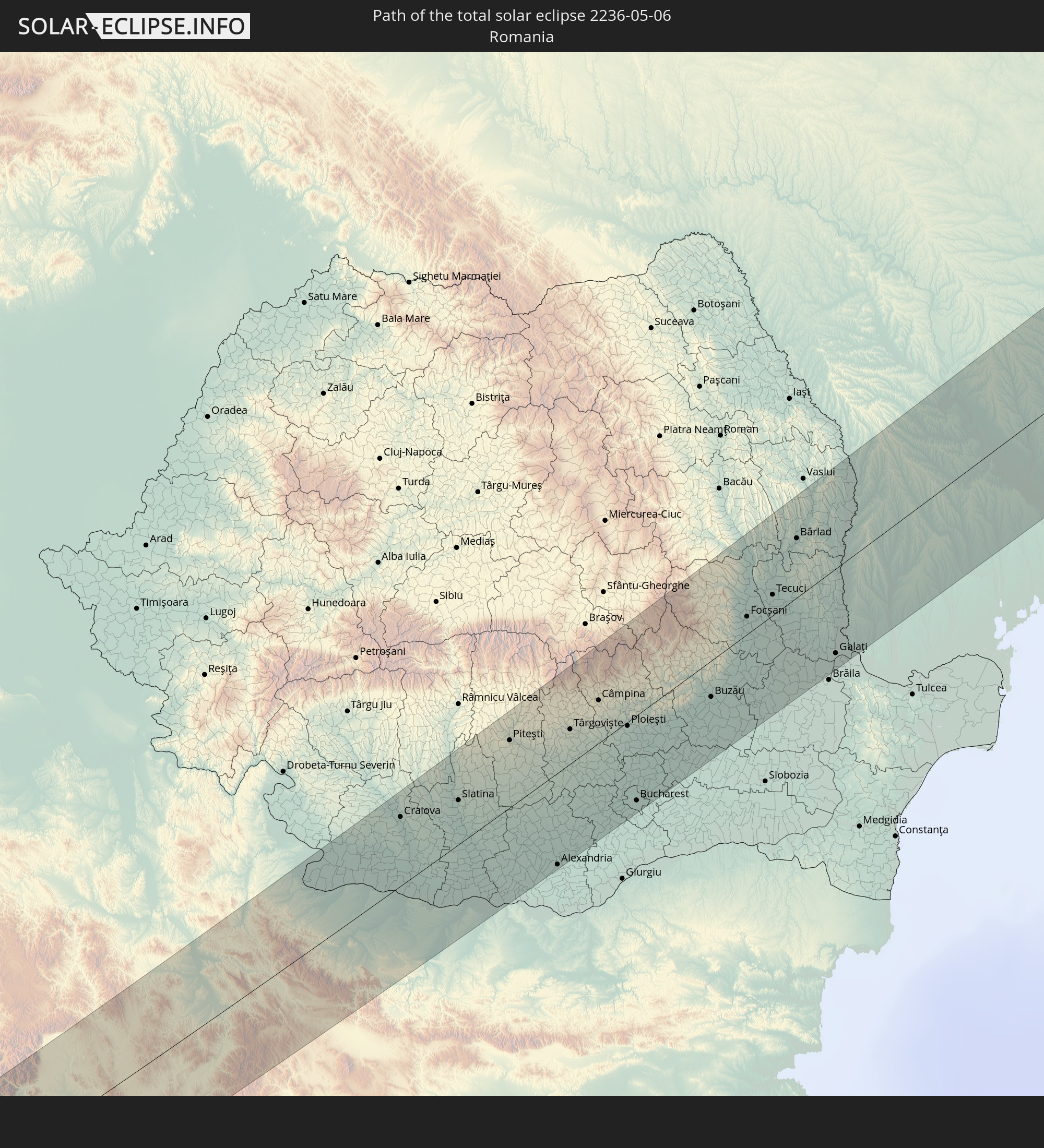 Romania
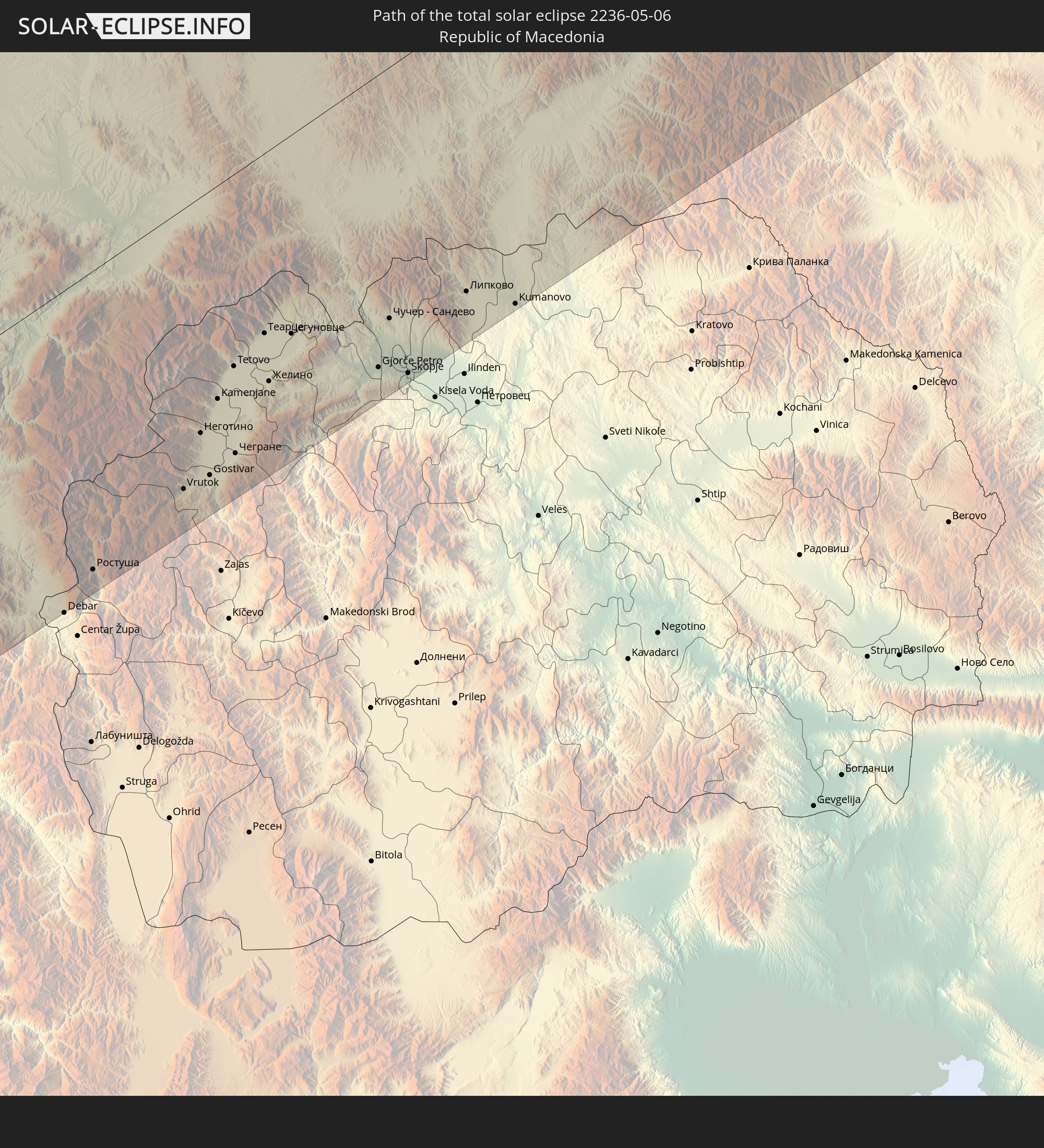 Republic of Macedonia
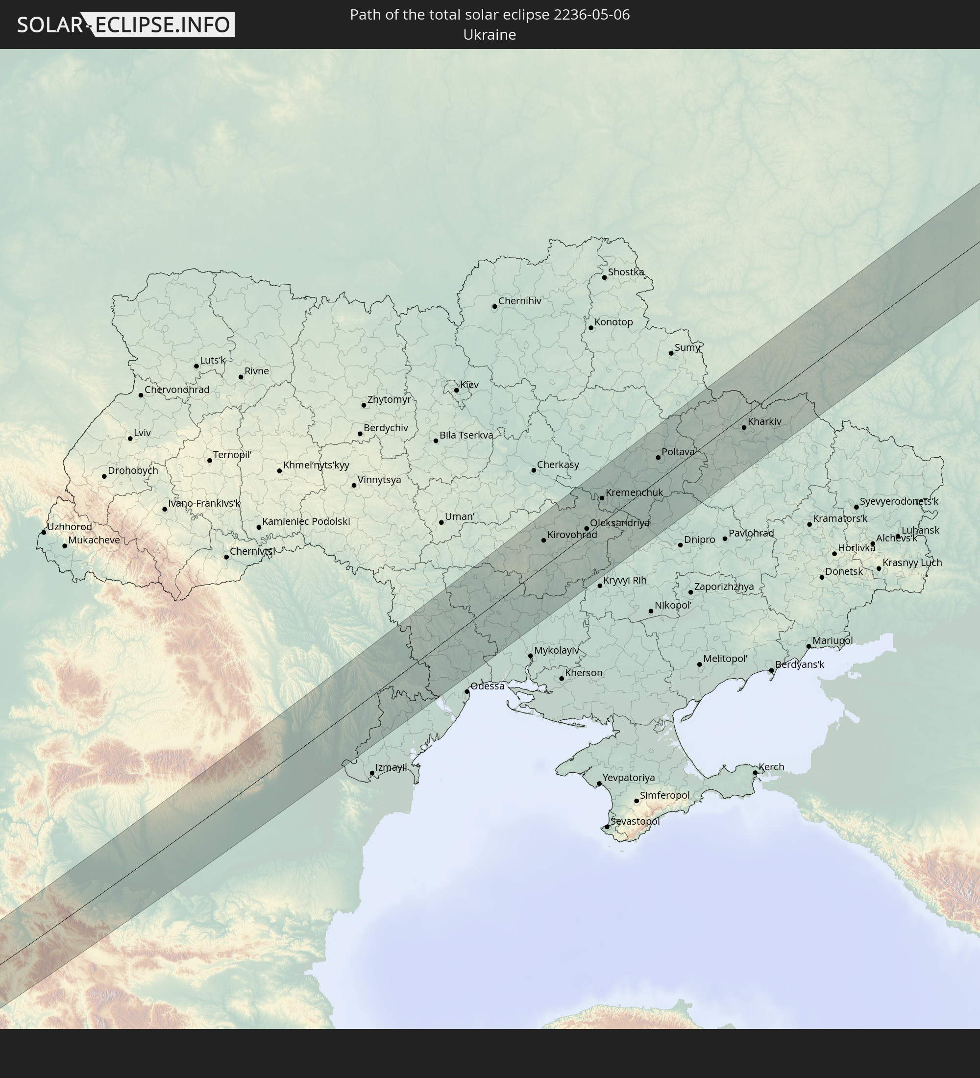 Ukraine
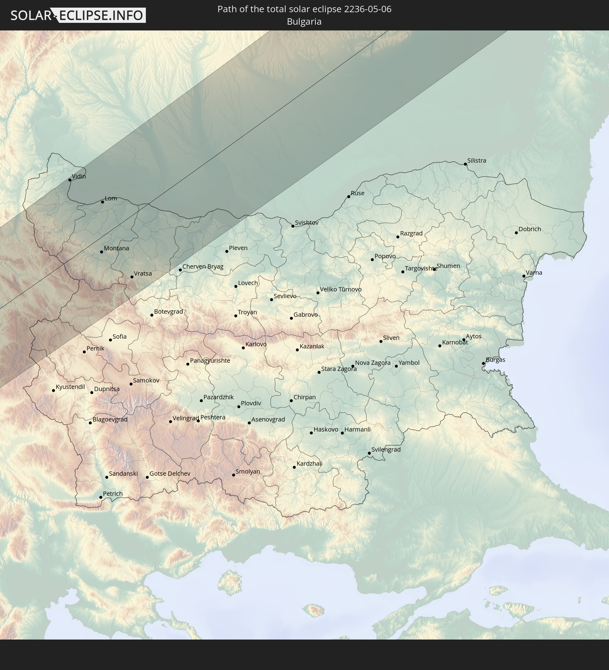 Bulgaria
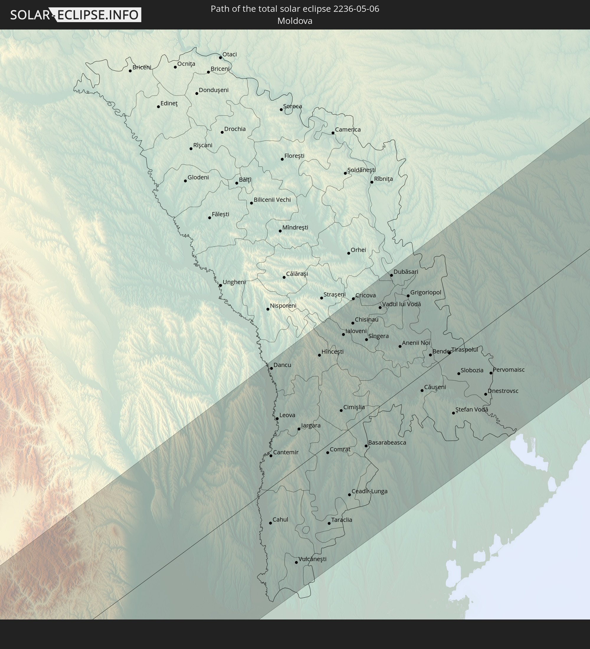 Moldova
In den folgenden Ländern ist die Sonnenfinsternis partiell zu sehen
 Russia
 United States
 Canada
 Greenland
 Portugal
 Iceland
 Spain
Spain
 Morocco
 Mali
Mali
 Republic of Ireland
 Svalbard and Jan Mayen
 Algeria
 United Kingdom
 Faroe Islands
 Gibraltar
 France
 Isle of Man
 Guernsey
 Jersey
 Niger
Niger
 Andorra
 Belgium
 Nigeria
 Netherlands
 Norway
 Equatorial Guinea
 Luxembourg
 Germany
 Switzerland
 Italy
Italy
 Monaco
 Tunisia
 Denmark
 Cameroon
 Gabon
Gabon
 Libya
Libya
 Liechtenstein
 Austria
 Sweden
 Republic of the Congo
 Czechia
 Democratic Republic of the Congo
 San Marino
 Vatican City
 Slovenia
 Chad
Chad
 Croatia
 Poland
 Malta
Malta
 Central African Republic
 Bosnia and Herzegovina
 Hungary
 Slovakia
 Montenegro
 Serbia
 Albania
 Åland Islands
 Greece
 Romania
 Republic of Macedonia
 Finland
 Lithuania
 Latvia
 Estonia
 Sudan
Sudan
 Ukraine
 Bulgaria
 Belarus
 Egypt
Egypt
 Turkey
 Moldova
 Cyprus
 Ethiopia
 State of Palestine
 Israel
 Saudi Arabia
 Jordan
 Lebanon
 Syria
Syria
 Eritrea
 Iraq
Iraq
 Georgia
 Somalia
 Djibouti
 Yemen
Yemen
 Armenia
 Iran
Iran
 Azerbaijan
 Kazakhstan
 Kuwait
 Bahrain
 Qatar
Qatar
 United Arab Emirates
 Oman
Oman
 Turkmenistan
 Uzbekistan
 Afghanistan
 Pakistan
 Tajikistan
 India
India
 Kyrgyzstan
 China
China
 Nepal
Nepal
 Mongolia
 Myanmar
 Taiwan
 Japan
Japan
 North Korea
 South Korea
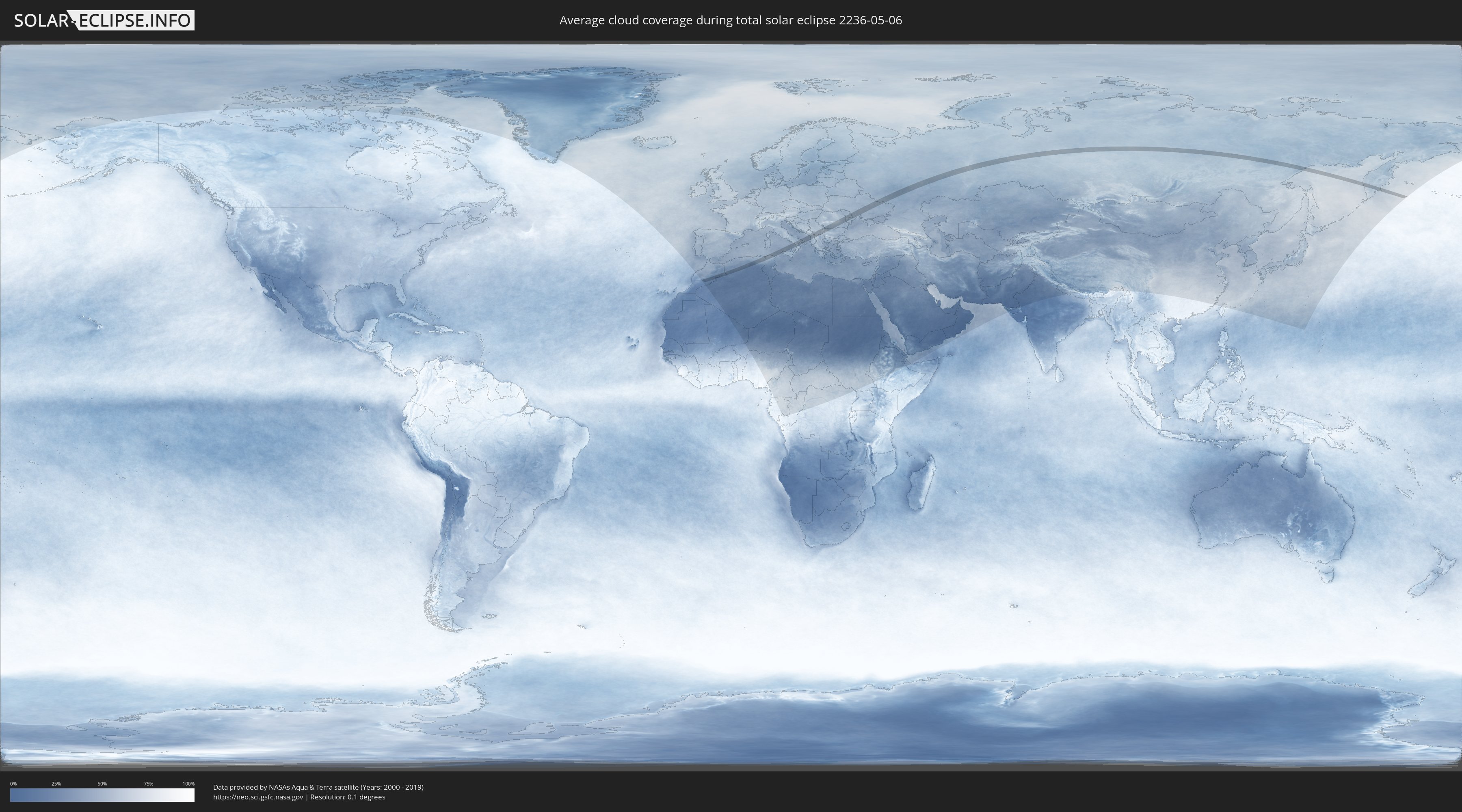
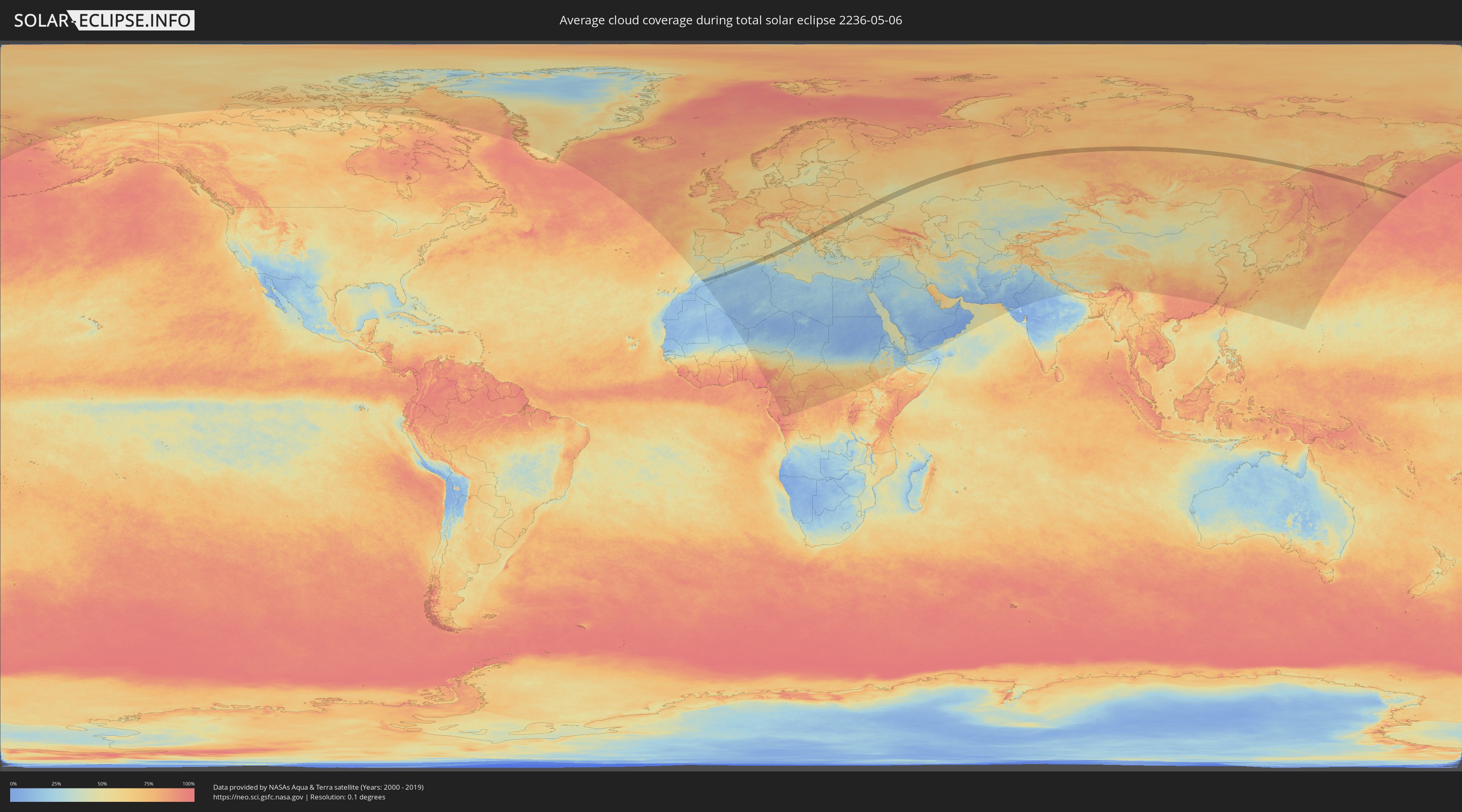
How will be the weather during the total solar eclipse on 05/06/2236?
Where is the best place to see the total solar eclipse of 05/06/2236?
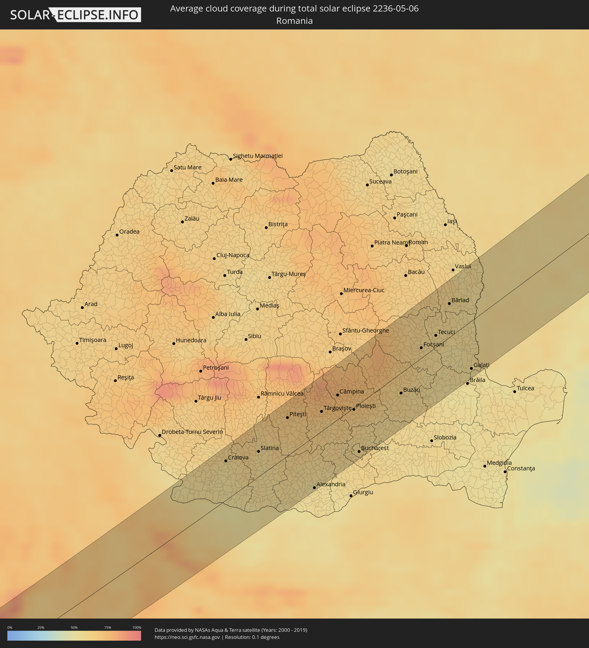
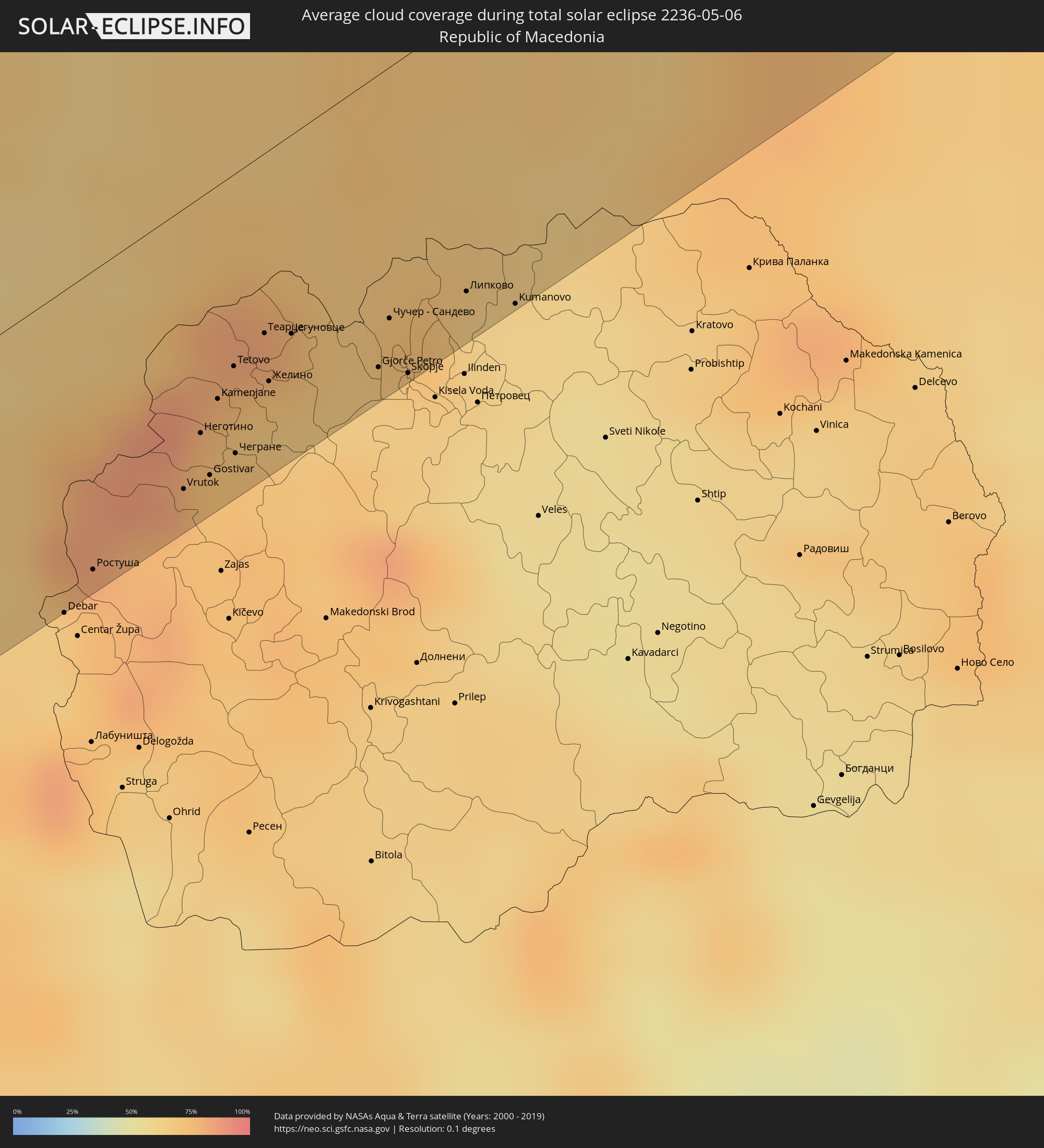
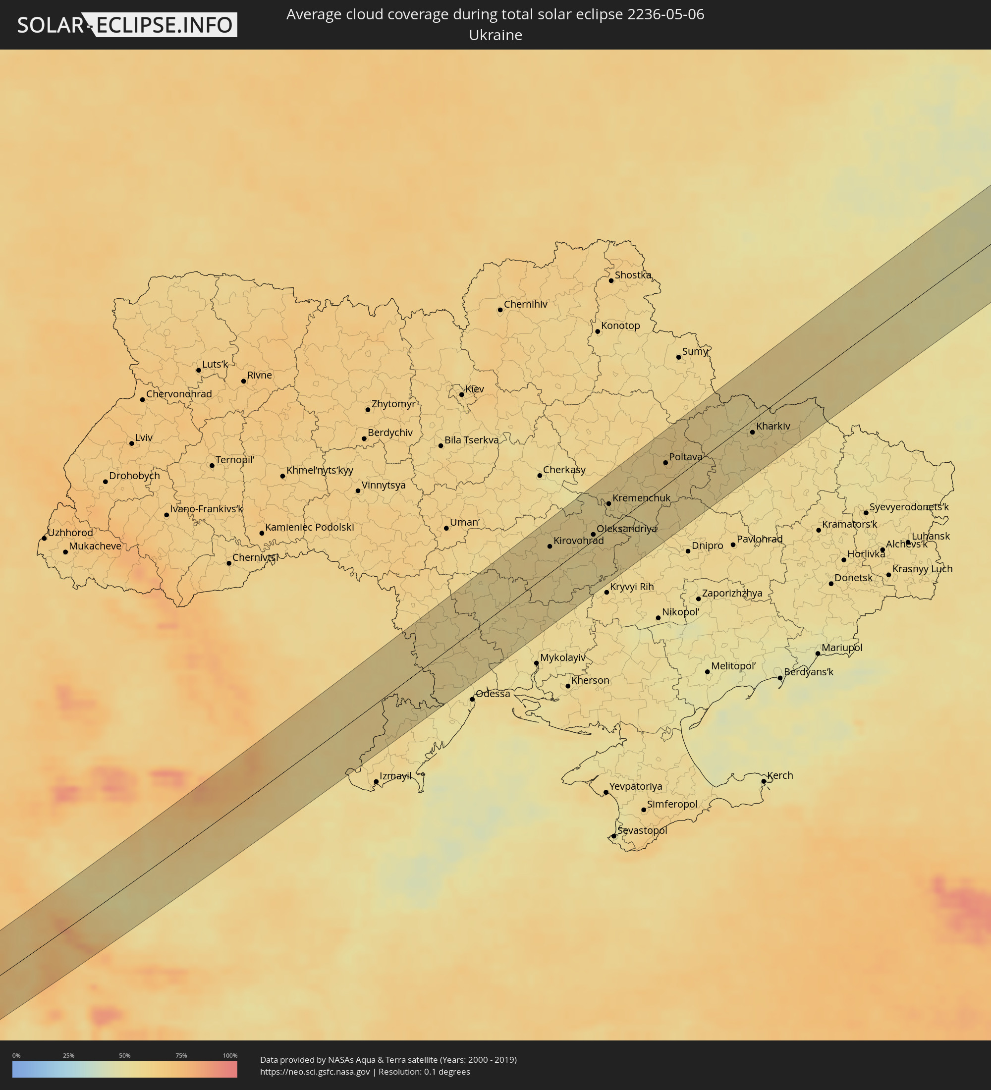
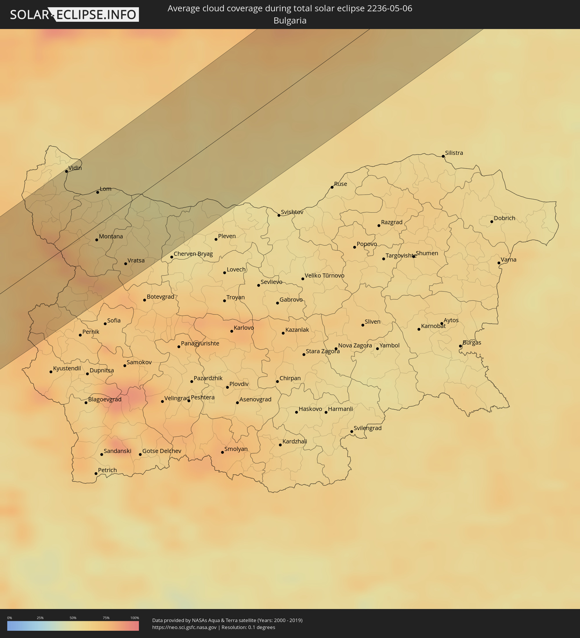
The following maps show the average cloud coverage for the day of the total solar eclipse.
With the help of these maps, it is possible to find the place along the eclipse path, which has the best
chance of a cloudless sky.
Nevertheless, you should consider local circumstances and inform about the weather of your chosen
observation site.
The data is provided by NASAs satellites
AQUA and TERRA.
The cloud maps are averaged over a period of 19 years (2000 - 2019).
Detailed country maps
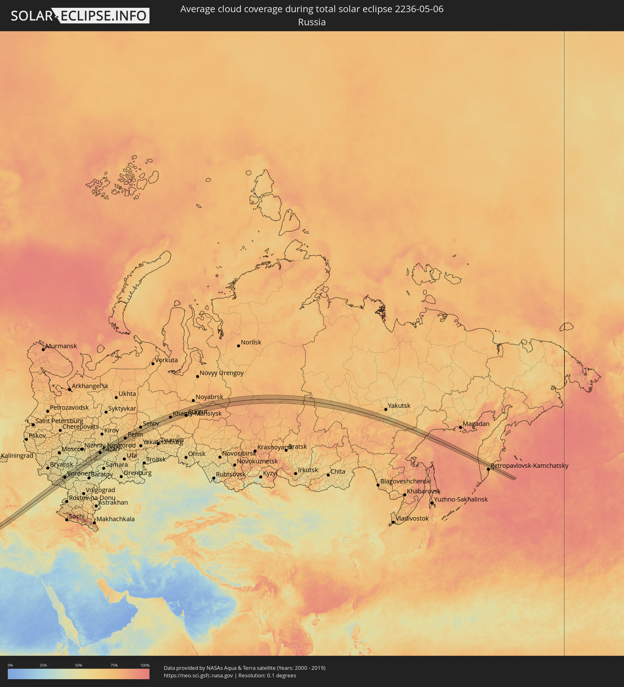 Russia
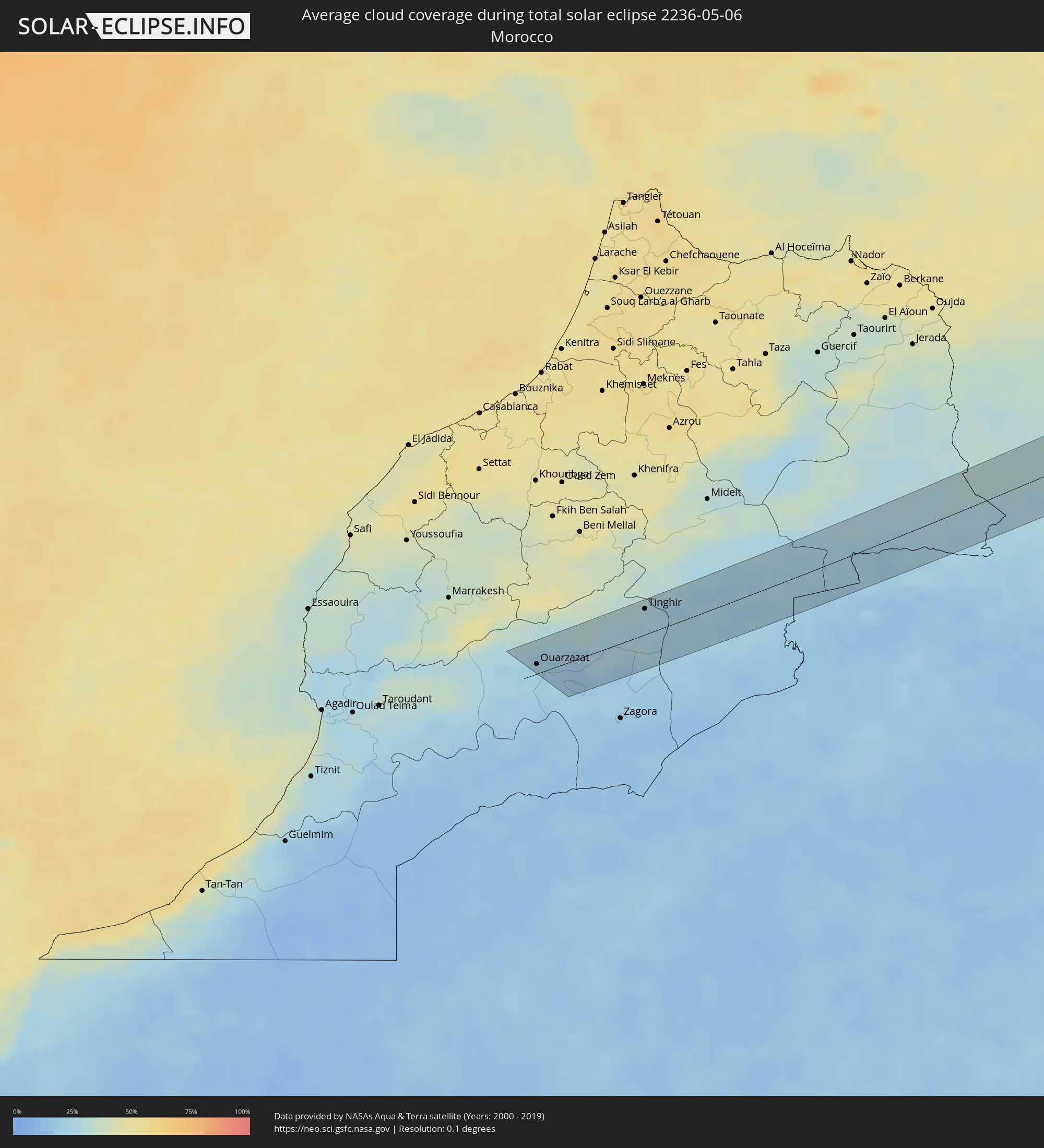 Morocco
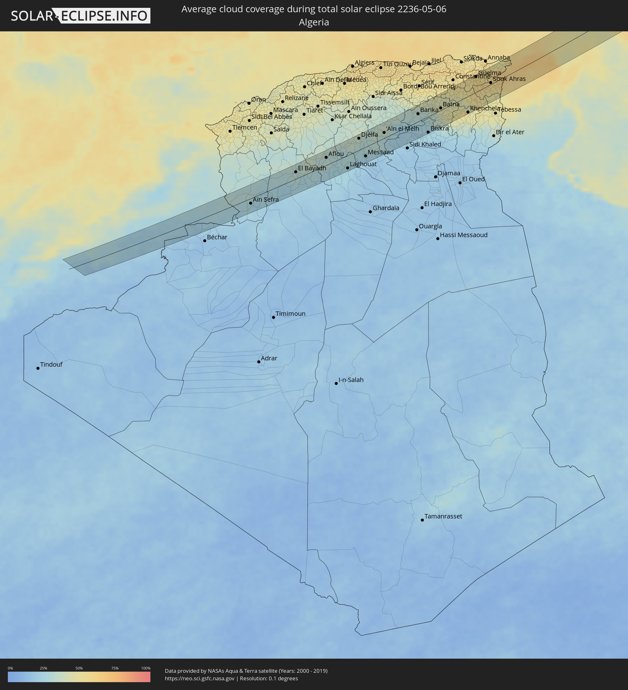 Algeria
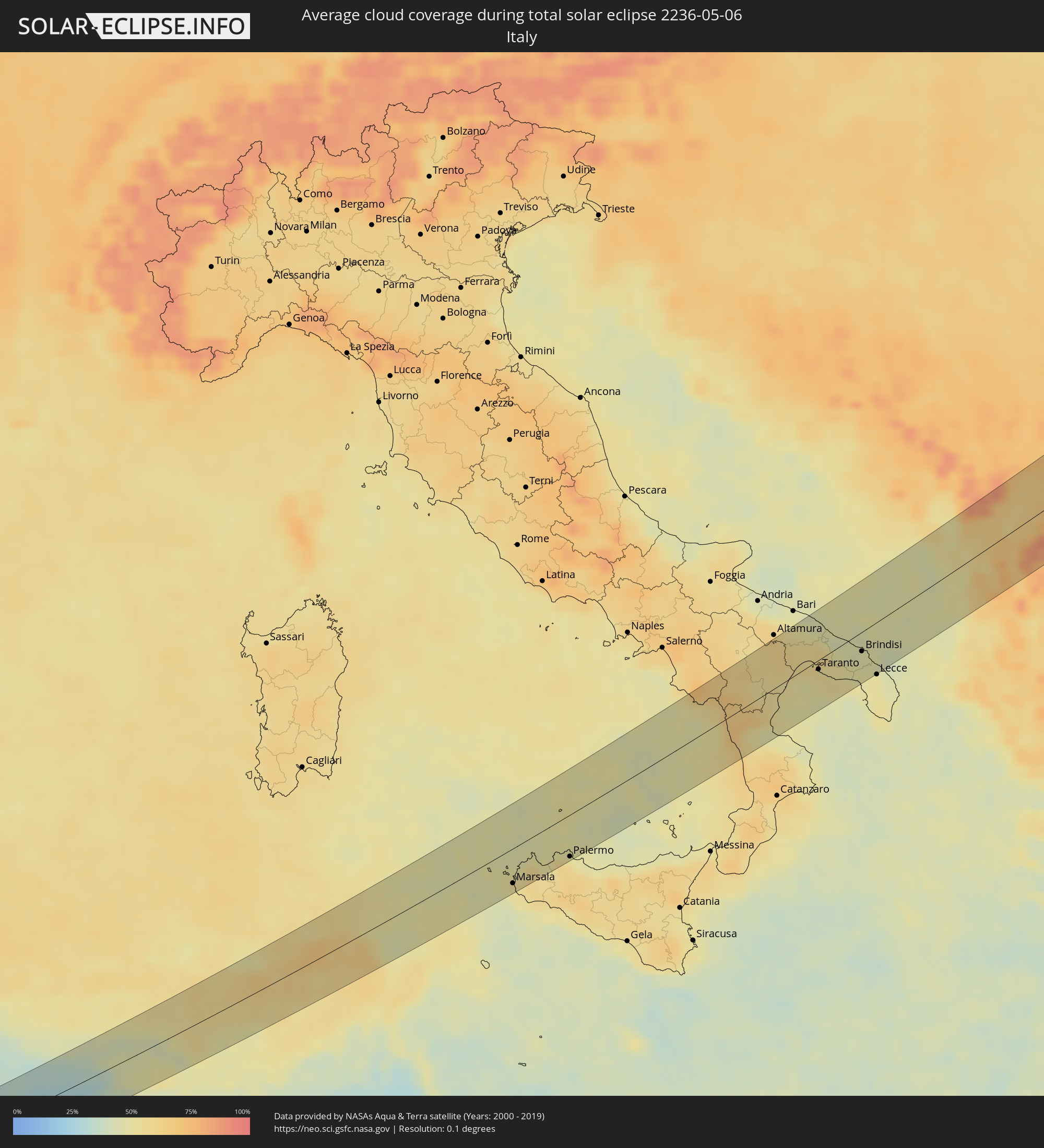 Italy
Italy
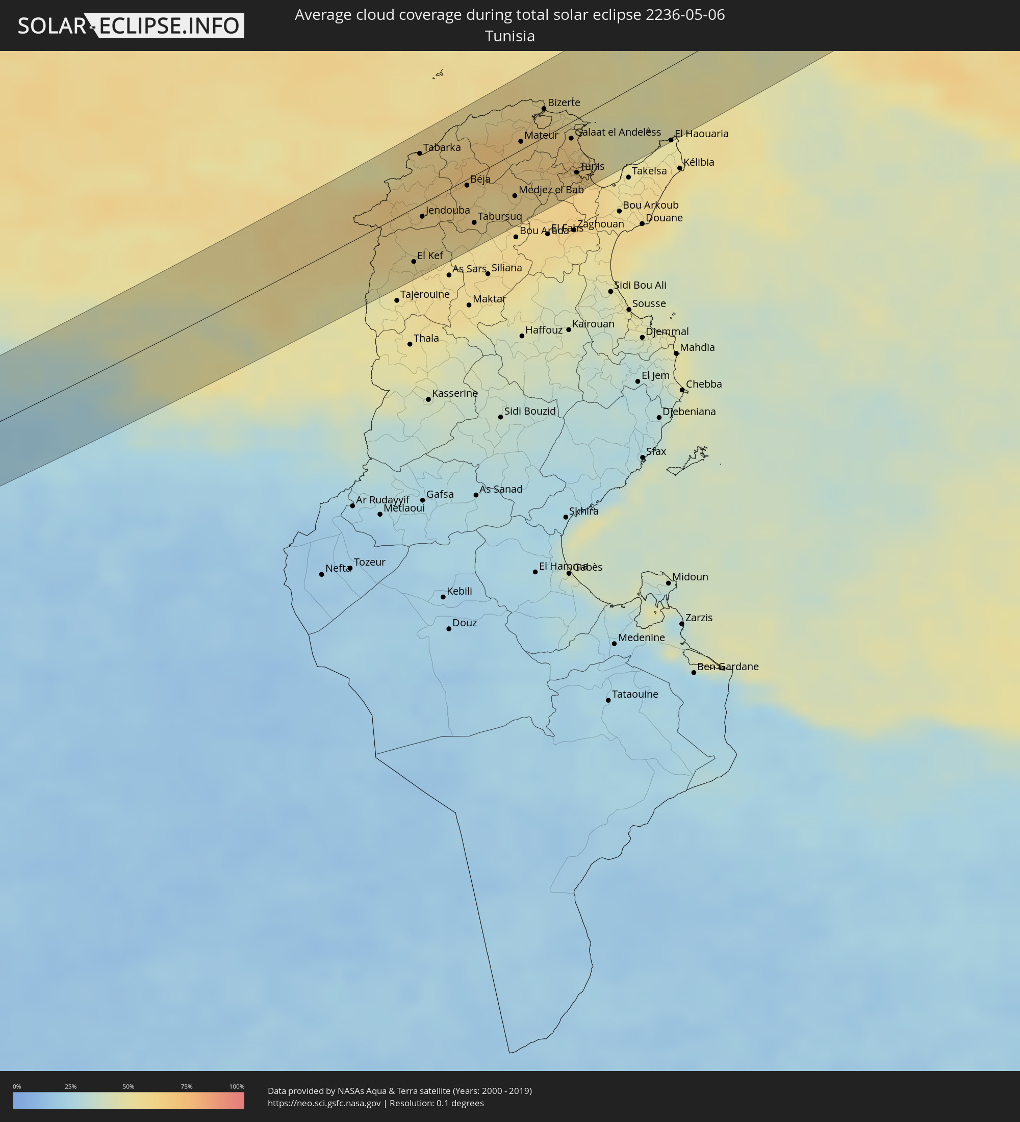 Tunisia
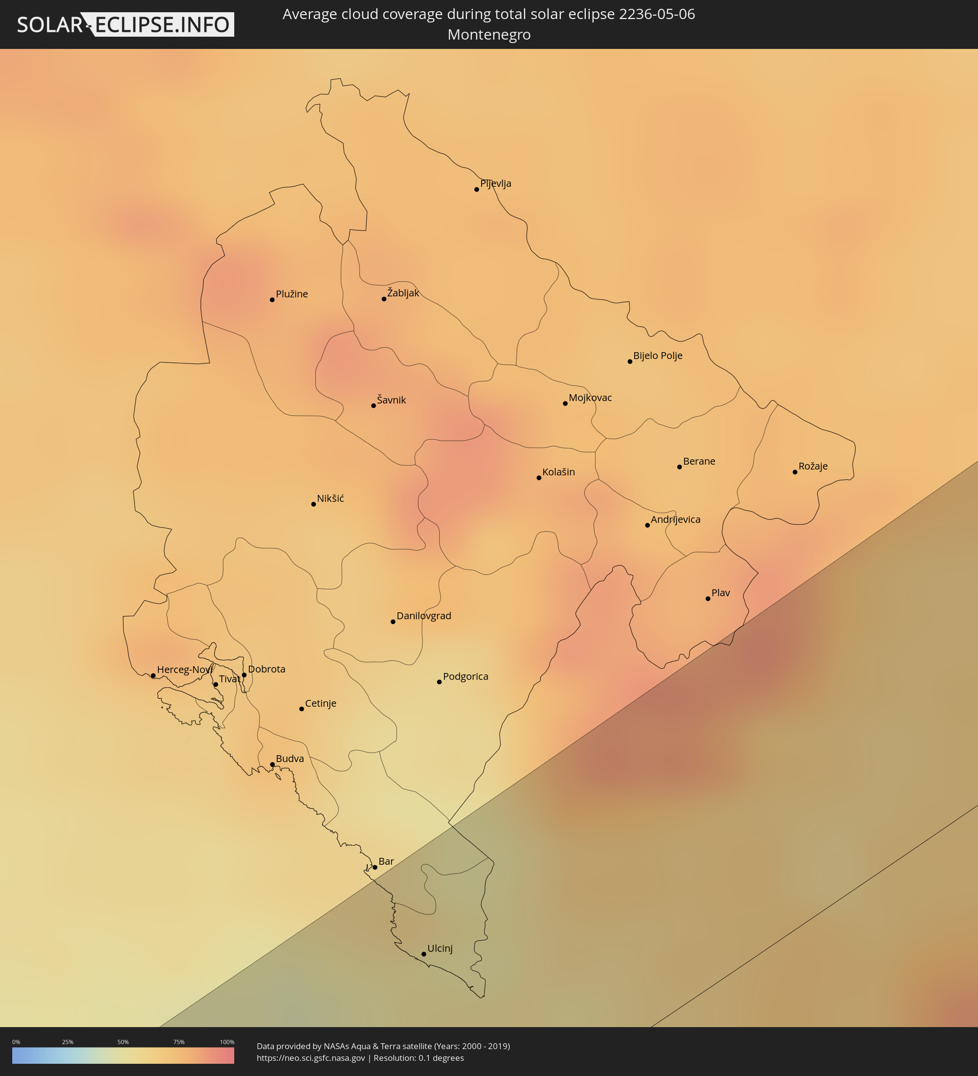 Montenegro
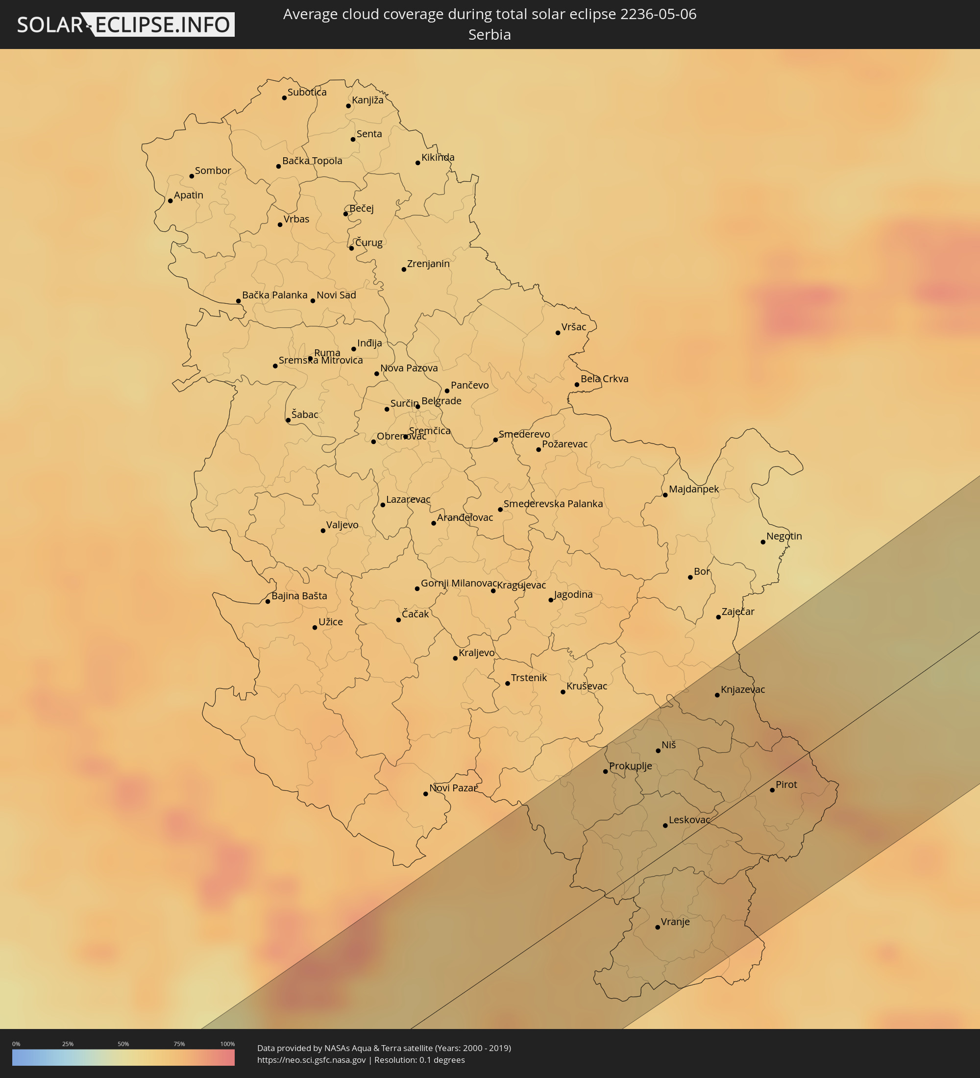 Serbia
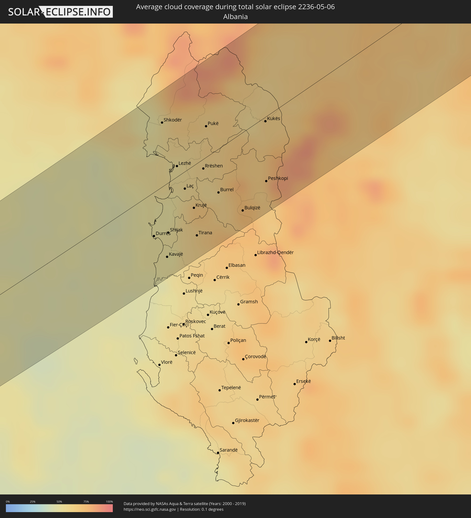 Albania
 Romania
 Republic of Macedonia
 Ukraine
 Bulgaria
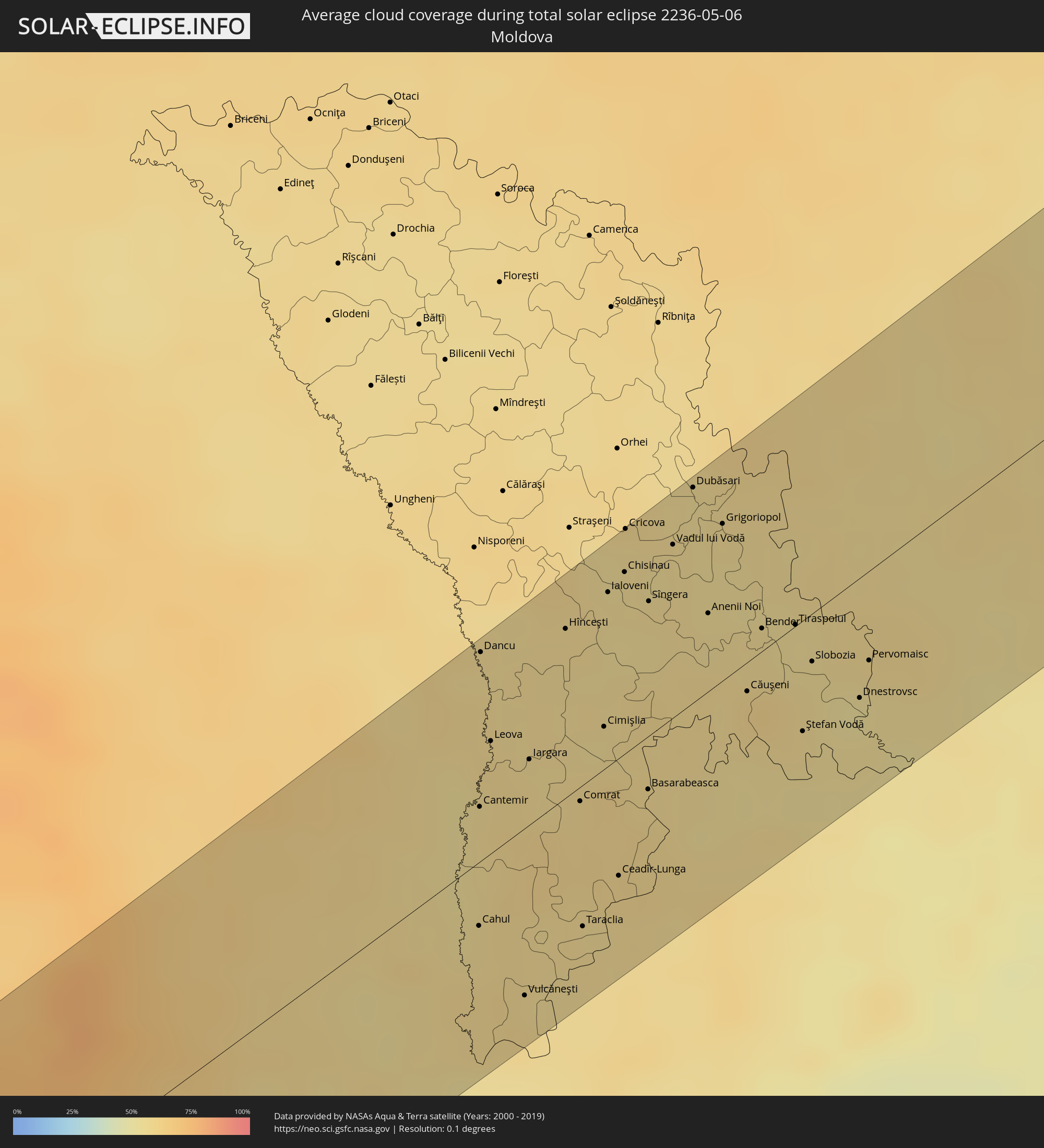 Moldova
Cities inside the path of the eclipse
The following table shows all locations with a population of more than 5,000 inside the eclipse path. Cities which have more than 100,000 inhabitants are marked bold. A click at the locations opens a detailed map.
| City | Type | Eclipse duration | Local time of max. eclipse | Distance to central line | Ø Cloud coverage |
|
Ouarzazat, Souss-Massa-Drâa
|
total | - | 06:44:22 UTC+01:00 | 18 km | 20% |
|
Tinghir, Souss-Massa-Drâa
|
total | - | 06:44:38 UTC+01:00 | 29 km | 26% |
|
Aflou, Laghouat
|
total | - | 06:46:15 UTC+01:00 | 31 km | 31% |
|
Laghouat, Laghouat
|
total | - | 06:45:43 UTC+01:00 | 43 km | 25% |
|
Djelfa, Djelfa
|
total | - | 06:46:53 UTC+01:00 | 35 km | 32% |
|
Messaad, Djelfa
|
total | - | 06:46:08 UTC+01:00 | 30 km | 24% |
|
Barika, Batna
|
total | - | 06:47:45 UTC+01:00 | 22 km | 29% |
|
Tolga, Biskra
|
total | - | 06:46:47 UTC+01:00 | 48 km | 24% |
|
Biskra, Biskra
|
total | - | 06:46:57 UTC+01:00 | 46 km | 25% |
|
Aïn Touta, Batna
|
total | - | 06:47:42 UTC+01:00 | 1 km | 30% |
|
Batna, Batna
|
total | - | 06:47:58 UTC+01:00 | 6 km | 45% |
|
Aïn Fakroun, Oum el Bouaghi
|
total | - | 06:48:34 UTC+01:00 | 19 km | 49% |
|
Oum el Bouaghi, Oum el Bouaghi
|
total | - | 06:48:25 UTC+01:00 | 11 km | 49% |
|
Khenchela, Khenchela
|
total | - | 06:47:46 UTC+01:00 | 47 km | 48% |
|
Aïn Beïda, Oum el Bouaghi
|
total | - | 06:48:18 UTC+01:00 | 21 km | 52% |
|
Guelma, Guelma
|
total | - | 06:49:18 UTC+01:00 | 44 km | 59% |
|
Besbes, El Tarf
|
total | - | 06:49:40 UTC+01:00 | 51 km | 54% |
|
Souk Ahras, Souk Ahras
|
total | - | 06:49:02 UTC+01:00 | 5 km | 55% |
|
El Kef, Kef
|
total | - | 06:48:54 UTC+01:00 | 38 km | 54% |
|
Tabarka, Jundūbah
|
total | - | 06:50:05 UTC+01:00 | 36 km | 58% |
|
Jendouba, Jundūbah
|
total | - | 06:49:24 UTC+01:00 | 9 km | 59% |
|
Béja, Bājah
|
total | - | 06:49:45 UTC+01:00 | 17 km | 60% |
|
Testour, Bājah
|
total | - | 06:49:30 UTC+01:00 | 33 km | 58% |
|
Medjez el Bab, Bājah
|
total | - | 06:49:40 UTC+01:00 | 30 km | 57% |
|
Mateur, Banzart
|
total | - | 06:50:16 UTC+01:00 | 6 km | 63% |
|
Menzel Bourguiba, Banzart
|
total | - | 06:50:27 UTC+01:00 | 19 km | 61% |
|
Menzel Abderhaman, Banzart
|
total | - | 06:50:35 UTC+01:00 | 17 km | 59% |
|
Bizerte, Banzart
|
total | - | 06:50:39 UTC+01:00 | 20 km | 58% |
|
El Alia, Banzart
|
total | - | 06:50:30 UTC+01:00 | 5 km | 59% |
|
Galaat el Andeless, Ariana
|
total | - | 06:50:20 UTC+01:00 | 13 km | 63% |
|
La Mohammedia, Tūnis
|
total | - | 06:49:44 UTC+01:00 | 53 km | 60% |
|
Tunis, Tūnis
|
total | - | 06:49:58 UTC+01:00 | 38 km | 61% |
|
Al Marsá, Tūnis
|
total | - | 06:50:04 UTC+01:00 | 40 km | 61% |
|
Carthage, Tūnis
|
total | - | 06:50:03 UTC+01:00 | 42 km | 61% |
|
Marsala, Sicily
|
total | - | 06:51:46 UTC+01:00 | 42 km | 50% |
|
Trapani, Sicily
|
total | - | 06:52:08 UTC+01:00 | 27 km | 49% |
|
Alcamo, Sicily
|
total | - | 06:52:08 UTC+01:00 | 51 km | 51% |
|
Partinico, Sicily
|
total | - | 06:52:16 UTC+01:00 | 51 km | 52% |
|
Palermo, Sicily
|
total | - | 06:52:26 UTC+01:00 | 50 km | 59% |
|
Matera, Basilicate
|
total | - | 06:57:22 UTC+01:00 | 45 km | 60% |
|
Santeramo in Colle, Apulia
|
total | - | 06:57:38 UTC+01:00 | 48 km | 57% |
|
Massafra, Apulia
|
total | - | 06:57:23 UTC+01:00 | 23 km | 56% |
|
Putignano, Apulia
|
total | - | 06:57:50 UTC+01:00 | 39 km | 51% |
|
Taranto, Apulia
|
total | - | 06:57:09 UTC+01:00 | 22 km | 55% |
|
Monopoli, Apulia
|
total | - | 06:58:04 UTC+01:00 | 38 km | 49% |
|
Martina Franca, Apulia
|
total | - | 06:57:39 UTC+01:00 | 15 km | 58% |
|
Ostuni, Apulia
|
total | - | 06:57:46 UTC+01:00 | 11 km | 47% |
|
Francavilla Fontana, Apulia
|
total | - | 06:57:27 UTC+01:00 | 15 km | 52% |
|
Manduria, Apulia
|
total | - | 06:57:14 UTC+01:00 | 30 km | 50% |
|
Brindisi, Apulia
|
total | - | 06:57:43 UTC+01:00 | 30 km | 47% |
|
Ulcinj, Ulcinj
|
total | - | 07:00:24 UTC+01:00 | 39 km | 52% |
|
Durrës, Durrës
|
total | - | 06:59:26 UTC+01:00 | 27 km | 50% |
|
Shkodër, Shkodër
|
total | - | 07:00:45 UTC+01:00 | 39 km | 55% |
|
Kavajë, Tiranë
|
total | - | 06:59:14 UTC+01:00 | 45 km | 53% |
|
Shijak, Durrës
|
total | - | 06:59:31 UTC+01:00 | 31 km | 50% |
|
Lezhë, Lezhë
|
total | - | 07:00:18 UTC+01:00 | 6 km | 54% |
|
Mamurras, Lezhë
|
total | - | 06:59:58 UTC+01:00 | 15 km | 59% |
|
Laç, Lezhë
|
total | - | 07:00:04 UTC+01:00 | 10 km | 59% |
|
Fushë-Krujë, Durrës
|
total | - | 06:59:48 UTC+01:00 | 25 km | 58% |
|
Kamëz, Tiranë
|
total | - | 06:59:39 UTC+01:00 | 36 km | 63% |
|
Krujë, Durrës
|
total | - | 06:59:53 UTC+01:00 | 26 km | 63% |
|
Tirana, Tiranë
|
total | - | 06:59:35 UTC+01:00 | 44 km | 61% |
|
Rrëshen, Lezhë
|
total | - | 07:00:22 UTC+01:00 | 6 km | 57% |
|
Burrel, Dibër
|
total | - | 07:00:08 UTC+01:00 | 27 km | 63% |
|
Bulqizë, Dibër
|
total | - | 07:00:01 UTC+01:00 | 47 km | 69% |
|
Kukës, Kukës
|
total | - | 07:01:07 UTC+01:00 | 3 km | 63% |
|
Peshkopi, Dibër
|
total | - | 07:00:26 UTC+01:00 | 39 km | 65% |
|
Ростуша, Mavrovo and Rostuša Municipality
|
total | - | 07:00:23 UTC+01:00 | 54 km | 75% |
|
Неготино, Vrapčište
|
total | - | 07:00:58 UTC+01:00 | 42 km | 74% |
|
Vrapčište, Vrapčište
|
total | - | 07:00:53 UTC+01:00 | 47 km | 73% |
|
Dolna Banjica, Gostivar
|
total | - | 07:00:48 UTC+01:00 | 52 km | 73% |
|
Gostivar, Gostivar
|
total | - | 07:00:50 UTC+01:00 | 51 km | 73% |
|
Bogovinje, Bogovinje
|
total | - | 07:01:03 UTC+01:00 | 40 km | 74% |
|
Šipkovica, Tetovo
|
total | - | 07:01:15 UTC+01:00 | 30 km | 77% |
|
Kamenjane, Bogovinje
|
total | - | 07:01:06 UTC+01:00 | 38 km | 74% |
|
Tetovo, Tetovo
|
total | - | 07:01:13 UTC+01:00 | 34 km | 69% |
|
Чегране
|
total | - | 07:00:56 UTC+01:00 | 50 km | 75% |
|
Brvenica, Brvenica
|
total | - | 07:01:09 UTC+01:00 | 39 km | 69% |
|
Džepčište, Tetovo
|
total | - | 07:01:17 UTC+01:00 | 41 km | 69% |
|
Кондово
|
total | - | 07:01:22 UTC+01:00 | 50 km | 65% |
|
Чучер - Сандево, Čučer-Sandevo
|
total | - | 07:01:34 UTC+01:00 | 46 km | 67% |
|
Skopje, Karpoš
|
total | - | 07:01:24 UTC+01:00 | 57 km | 64% |
|
Prokuplje, Central Serbia
|
total | - | 07:03:38 UTC+01:00 | 49 km | 68% |
|
Kumanovo, Kumanovo
|
total | - | 07:01:45 UTC+01:00 | 58 km | 61% |
|
Vranje, Central Serbia
|
total | - | 07:02:34 UTC+01:00 | 28 km | 66% |
|
Niš, Central Serbia
|
total | - | 07:03:56 UTC+01:00 | 47 km | 62% |
|
Leskovac, Central Serbia
|
total | - | 07:03:23 UTC+01:00 | 11 km | 64% |
|
Knjazevac, Central Serbia
|
total | - | 07:04:32 UTC+01:00 | 49 km | 68% |
|
Pirot, Central Serbia
|
total | - | 07:03:57 UTC+01:00 | 7 km | 69% |
|
Belogradchik, Vidin
|
total | - | 08:04:50 UTC+02:00 | 34 km | 70% |
|
Vidin, Vidin
|
total | - | 08:05:34 UTC+02:00 | 61 km | 57% |
|
Slivnitsa, Sofia Province
|
total | - | 08:03:38 UTC+02:00 | 56 km | 65% |
|
Godech, Sofia Province
|
total | - | 08:03:56 UTC+02:00 | 45 km | 68% |
|
Berkovitsa, Montana
|
total | - | 08:04:21 UTC+02:00 | 23 km | 79% |
|
Montana, Montana
|
total | - | 08:04:43 UTC+02:00 | 18 km | 62% |
|
Lom, Montana
|
total | - | 08:05:26 UTC+02:00 | 26 km | 58% |
|
Varshets, Montana
|
total | - | 08:04:22 UTC+02:00 | 34 km | 74% |
|
Svoge, Sofia Province
|
total | - | 08:03:59 UTC+02:00 | 58 km | 75% |
|
Valchedram, Montana
|
total | - | 08:05:20 UTC+02:00 | 5 km | 56% |
|
Vratsa, Vratsa
|
total | - | 08:04:32 UTC+02:00 | 51 km | 68% |
|
Mezdra, Vratsa
|
total | - | 08:04:29 UTC+02:00 | 61 km | 64% |
|
Kozloduy, Vratsa
|
total | - | 08:05:38 UTC+02:00 | 22 km | 52% |
|
Craiova, Dolj
|
total | - | 08:06:37 UTC+02:00 | 44 km | 55% |
|
Byala Slatina, Vratsa
|
total | - | 08:05:10 UTC+02:00 | 42 km | 55% |
|
Oryahovo, Vratsa
|
total | - | 08:05:40 UTC+02:00 | 17 km | 52% |
|
Knezha, Pleven
|
total | - | 08:05:18 UTC+02:00 | 43 km | 54% |
|
Caracal, Olt County
|
total | - | 08:06:33 UTC+02:00 | 15 km | 57% |
|
Slatina, Olt County
|
total | - | 08:07:07 UTC+02:00 | 29 km | 57% |
|
Piteşti, Argeş
|
total | - | 08:08:08 UTC+02:00 | 42 km | 66% |
|
Alexandria, Teleorman
|
total | - | 08:06:51 UTC+02:00 | 58 km | 55% |
|
Târgovişte, Dâmboviţa
|
total | - | 08:08:36 UTC+02:00 | 24 km | 62% |
|
Câmpina, Prahova
|
total | - | 08:09:07 UTC+02:00 | 27 km | 73% |
|
Ploieşti, Prahova
|
total | - | 08:08:58 UTC+02:00 | 2 km | 66% |
|
Bucharest, Bucureşti
|
total | - | 08:08:05 UTC+02:00 | 57 km | 61% |
|
Buzău, Buzău
|
total | - | 08:09:48 UTC+02:00 | 28 km | 61% |
|
Râmnicu Sărat, Buzău
|
total | - | 08:10:22 UTC+02:00 | 12 km | 60% |
|
Focșani, Vrancea
|
total | - | 08:11:01 UTC+02:00 | 11 km | 58% |
|
Tecuci, Galaţi
|
total | - | 08:11:26 UTC+02:00 | 13 km | 58% |
|
Bârlad, Vaslui
|
total | - | 08:12:16 UTC+02:00 | 36 km | 59% |
|
Galaţi, Galaţi
|
total | - | 08:11:06 UTC+02:00 | 52 km | 54% |
|
Huşi, Vaslui
|
total | - | 08:13:19 UTC+02:00 | 57 km | 58% |
|
Cahul, Cahul
|
total | - | 08:12:01 UTC+02:00 | 19 km | 57% |
|
Dancu, Hînceşti
|
total | - | 08:13:34 UTC+02:00 | 60 km | 56% |
|
Leova, Leova
|
total | - | 08:13:06 UTC+02:00 | 31 km | 58% |
|
Vulcăneşti, Găgăuzia
|
total | - | 08:11:46 UTC+02:00 | 47 km | 59% |
|
Hînceşti, Hînceşti
|
total | - | 08:13:57 UTC+02:00 | 47 km | 56% |
|
Comrat, Găgăuzia
|
total | - | 08:13:02 UTC+02:00 | 13 km | 59% |
|
Taraclia, Taraclia
|
total | - | 08:12:20 UTC+02:00 | 42 km | 58% |
|
Cimişlia, Cimişlia
|
total | - | 08:13:31 UTC+02:00 | 18 km | 57% |
|
Ceadîr-Lunga, Găgăuzia
|
total | - | 08:12:43 UTC+02:00 | 34 km | 59% |
|
Chisinau, Chişinău
|
total | - | 08:14:27 UTC+02:00 | 55 km | 57% |
|
Basarabeasca, Basarabeasca
|
total | - | 08:13:18 UTC+02:00 | 21 km | 58% |
|
Dubăsari, Teleneşti
|
total | - | 08:15:07 UTC+02:00 | 60 km | 56% |
|
Grigoriopol, Teleneşti
|
total | - | 08:15:01 UTC+02:00 | 45 km | 56% |
|
Căuşeni, Căuşeni
|
total | - | 08:14:09 UTC+02:00 | 17 km | 57% |
|
Tiraspolul, Stînga Nistrului
|
total | - | 08:14:40 UTC+02:00 | 13 km | 56% |
|
Dnestrovsc, Teleneşti
|
total | - | 08:14:28 UTC+02:00 | 36 km | 55% |
|
Pervomays’k, Mykolaiv
|
total | - | 08:17:42 UTC+02:00 | 56 km | 55% |
|
Yuzhnoukrains'k, Mykolaiv
|
total | - | 08:17:32 UTC+02:00 | 24 km | 56% |
|
Voznesensk, Mykolaiv
|
total | - | 08:17:12 UTC+02:00 | 25 km | 55% |
|
Kirovohrad, Kirovohrad
|
total | - | 08:19:36 UTC+02:00 | 30 km | 56% |
|
Znomenka, Kirovohrad
|
total | - | 08:20:16 UTC+02:00 | 31 km | 57% |
|
Dolyns'ka, Kirovohrad
|
total | - | 08:19:16 UTC+02:00 | 29 km | 56% |
|
Oleksandriya, Kirovohrad
|
total | - | 08:20:32 UTC+02:00 | 16 km | 55% |
|
Kremenchuk, Poltava
|
total | - | 08:21:30 UTC+02:00 | 31 km | 55% |
|
Zhovti Vody, Dnipropetrovsk
|
total | - | 08:20:16 UTC+02:00 | 43 km | 55% |
|
Komsomolsk, Poltava
|
total | - | 08:21:34 UTC+02:00 | 26 km | 55% |
|
Poltava, Poltava
|
total | - | 08:23:20 UTC+02:00 | 25 km | 62% |
|
Krasnohrad, Kharkiv
|
total | - | 08:23:42 UTC+02:00 | 33 km | 57% |
|
Lyubotyn, Kharkiv
|
total | - | 08:25:08 UTC+02:00 | 10 km | 57% |
|
Merefa, Kharkiv
|
total | - | 08:25:01 UTC+02:00 | 23 km | 56% |
|
Kharkiv, Kharkiv
|
total | - | 08:25:28 UTC+02:00 | 19 km | 55% |
|
Belgorod, Belgorod
|
total | - | 09:26:51 UTC+03:00 | 32 km | 58% |
|
Chuhuyiv, Kharkiv
|
total | - | 08:25:35 UTC+02:00 | 49 km | 58% |
|
Gubkin, Belgorod
|
total | - | 09:28:52 UTC+03:00 | 47 km | 56% |
|
Staryy Oskol, Belgorod
|
total | - | 09:29:10 UTC+03:00 | 38 km | 59% |
|
Voronezh, Voronezj
|
total | - | 09:31:02 UTC+03:00 | 22 km | 51% |
|
Tambov, Tambov
|
total | - | 09:34:58 UTC+03:00 | 19 km | 48% |
|
Saransk, Mordoviya
|
total | - | 09:41:02 UTC+03:00 | 20 km | 55% |
|
Zelenodolsk, Tatarstan
|
total | - | 09:47:02 UTC+03:00 | 42 km | 58% |
|
Kazan, Tatarstan
|
total | - | 09:47:36 UTC+03:00 | 24 km | 57% |
|
Izhevsk, Udmurtiya
|
total | - | 10:53:31 UTC+04:00 | 18 km | 60% |
|
Votkinsk, Udmurtiya
|
total | - | 10:54:39 UTC+04:00 | 27 km | 62% |
|
Chaykovskiy, Perm
|
total | - | 11:54:27 UTC+05:00 | 55 km | 64% |
|
Perm, Perm
|
total | - | 11:58:20 UTC+05:00 | 3 km | 67% |
|
Lys’va, Perm
|
total | - | 12:00:13 UTC+05:00 | 31 km | 70% |
|
Serov, Sverdlovsk
|
total | - | 12:04:50 UTC+05:00 | 45 km | 66% |
|
Nefteyugansk, Khanty-Mansiyskiy Avtonomnyy Okrug
|
total | - | 12:19:25 UTC+05:00 | 53 km | 76% |
|
Surgut, Khanty-Mansiyskiy Avtonomnyy Okrug
|
total | - | 12:20:23 UTC+05:00 | 50 km | 75% |