Total solar eclipse of 10/04/2480
| Day of week: | Friday |
| Maximum duration of eclipse: | 05m26s |
| Maximum width of eclipse path: | 231 km |
| Saros cycle: | 161 |
| Coverage: | 100% |
| Magnitude: | 1.0631 |
| Gamma: | 0.4543 |
Wo kann man die Sonnenfinsternis vom 10/04/2480 sehen?

Die Sonnenfinsternis am 10/04/2480 kann man in 135 Ländern als partielle Sonnenfinsternis beobachten.
Der Finsternispfad verläuft durch 16 Länder. Nur in diesen Ländern ist sie als total Sonnenfinsternis zu sehen.
In den folgenden Ländern ist die Sonnenfinsternis total zu sehen
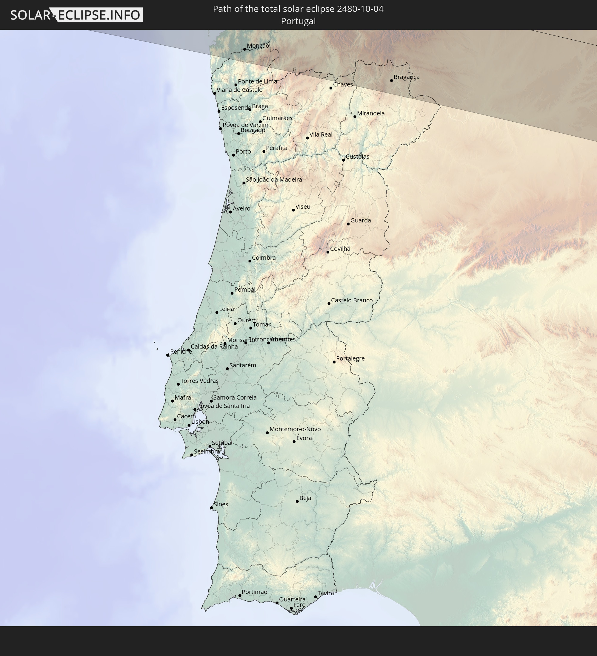 Portugal
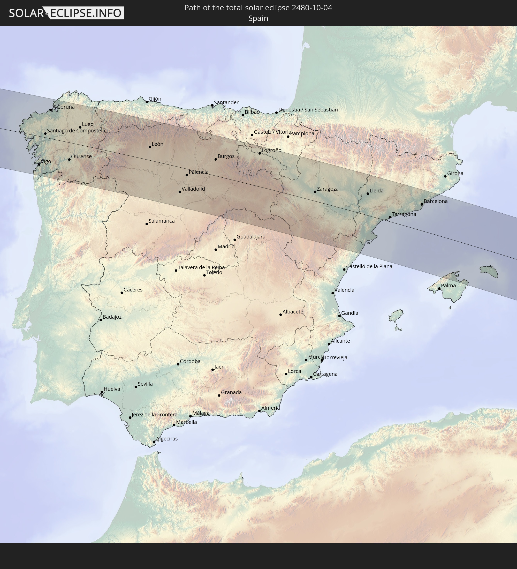 Spain
Spain
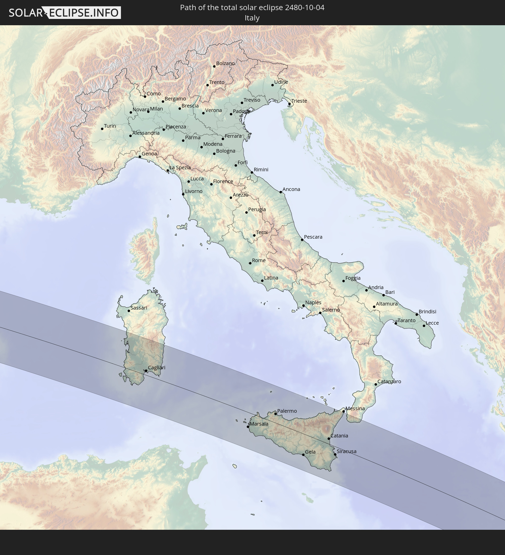 Italy
Italy
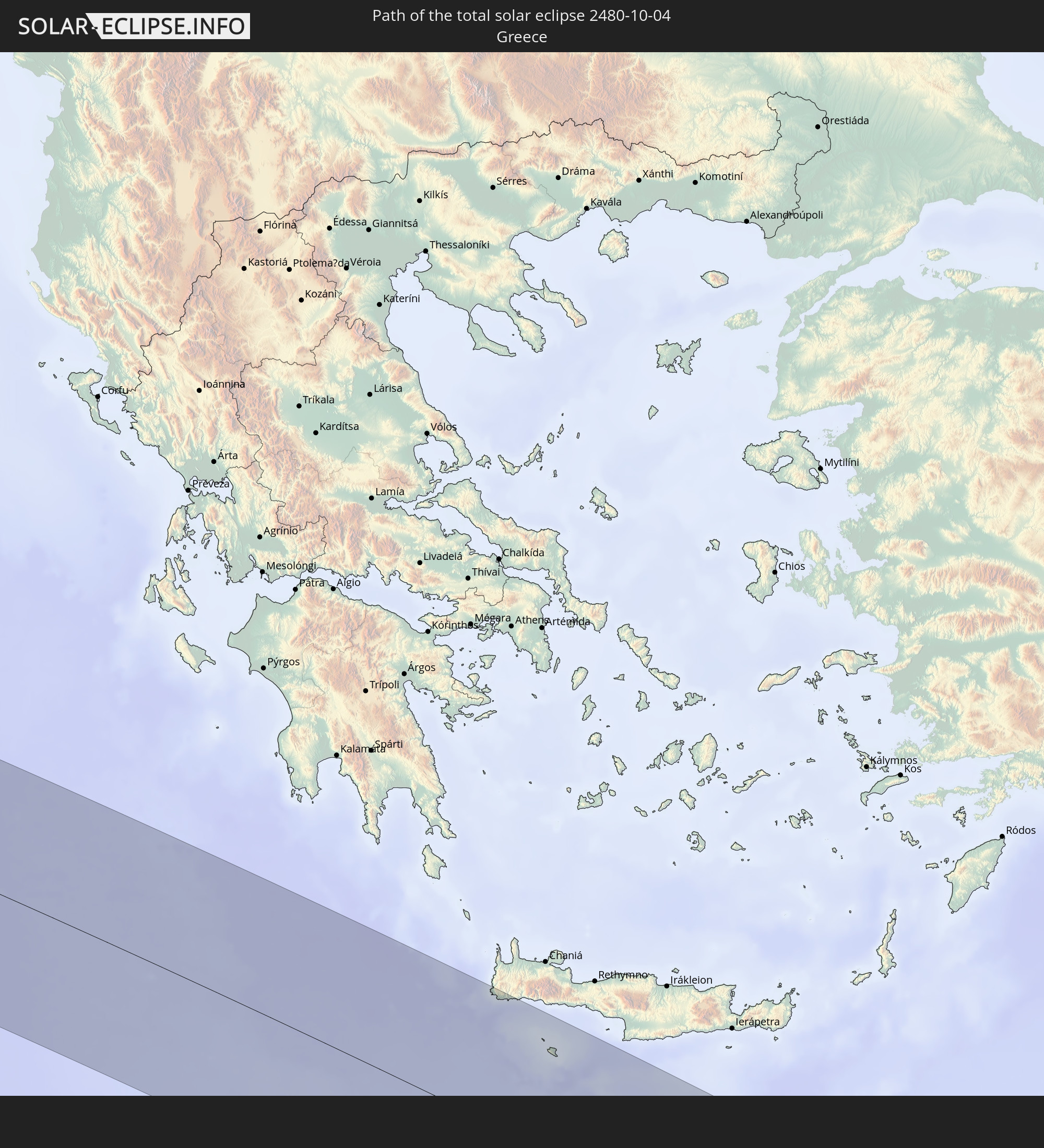 Greece
 Egypt
Egypt
 Israel
 Saudi Arabia
 Jordan
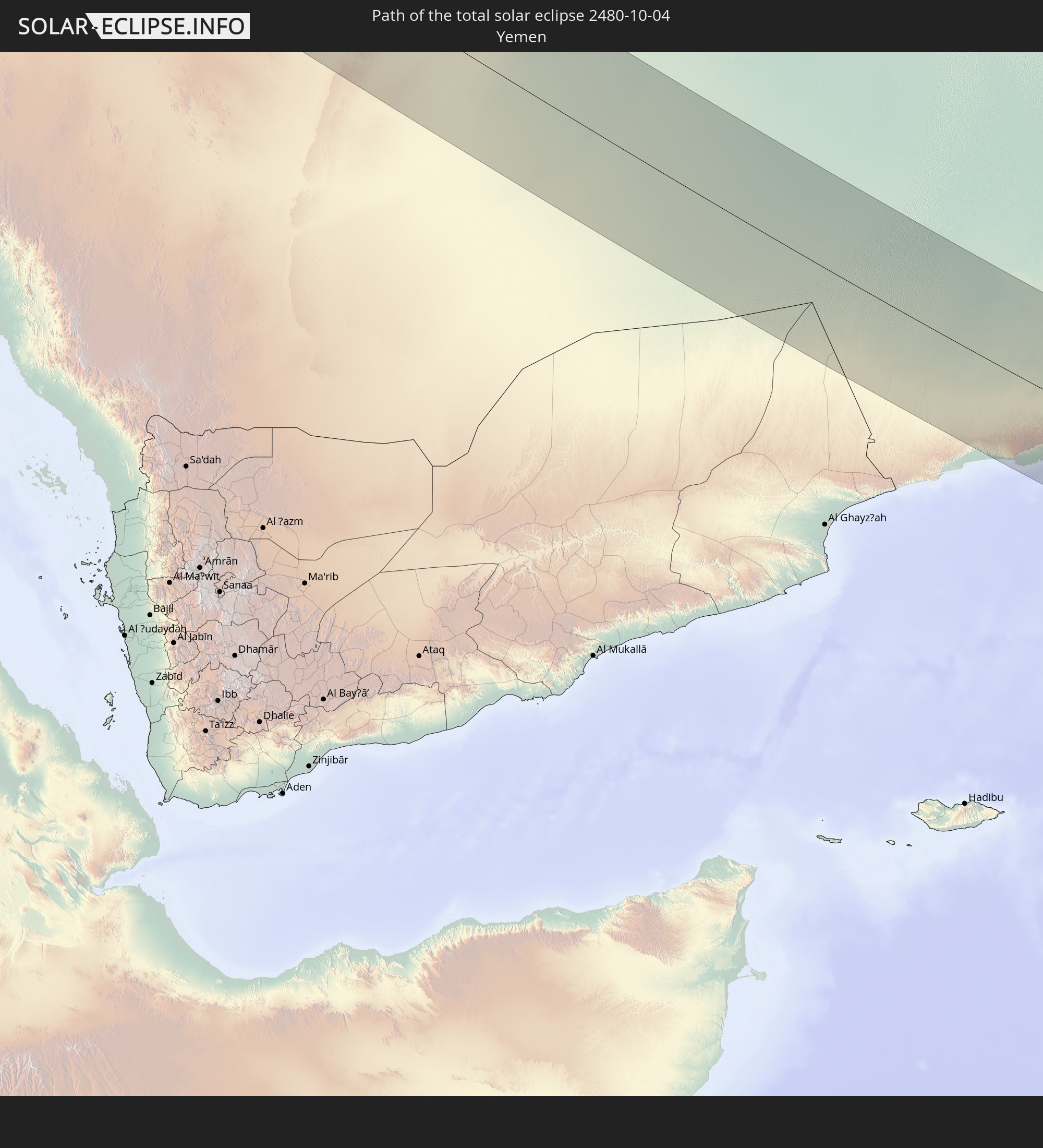 Yemen
Yemen
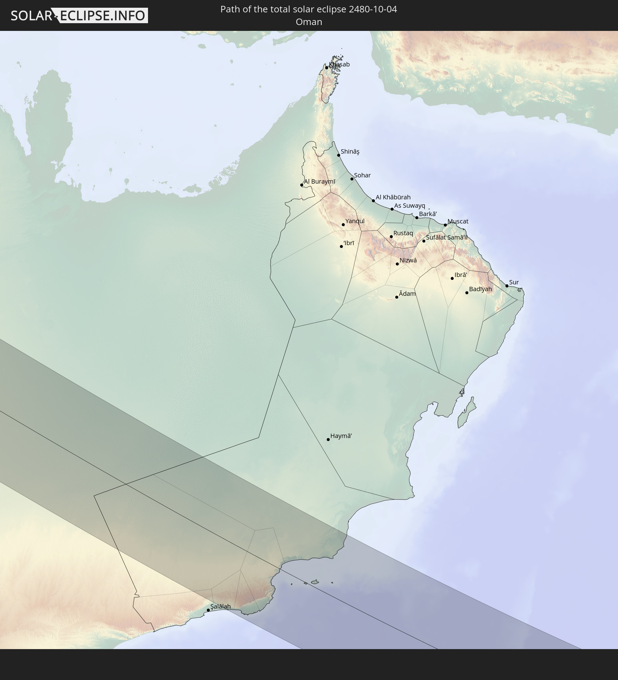 Oman
Oman
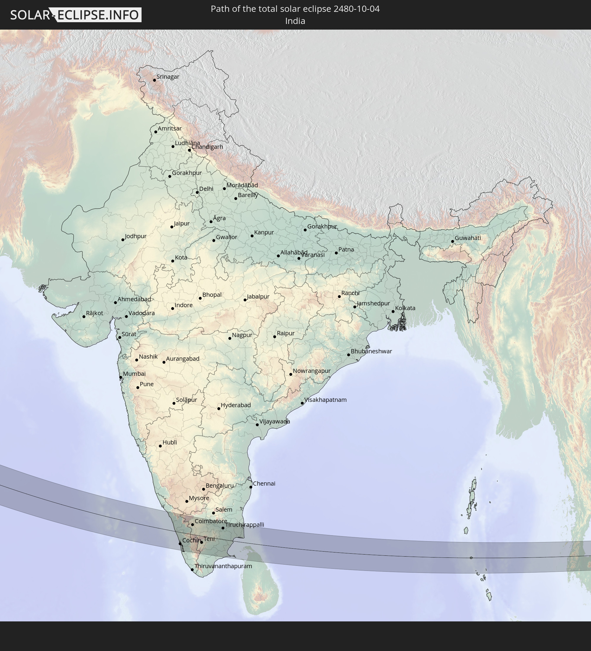 India
India
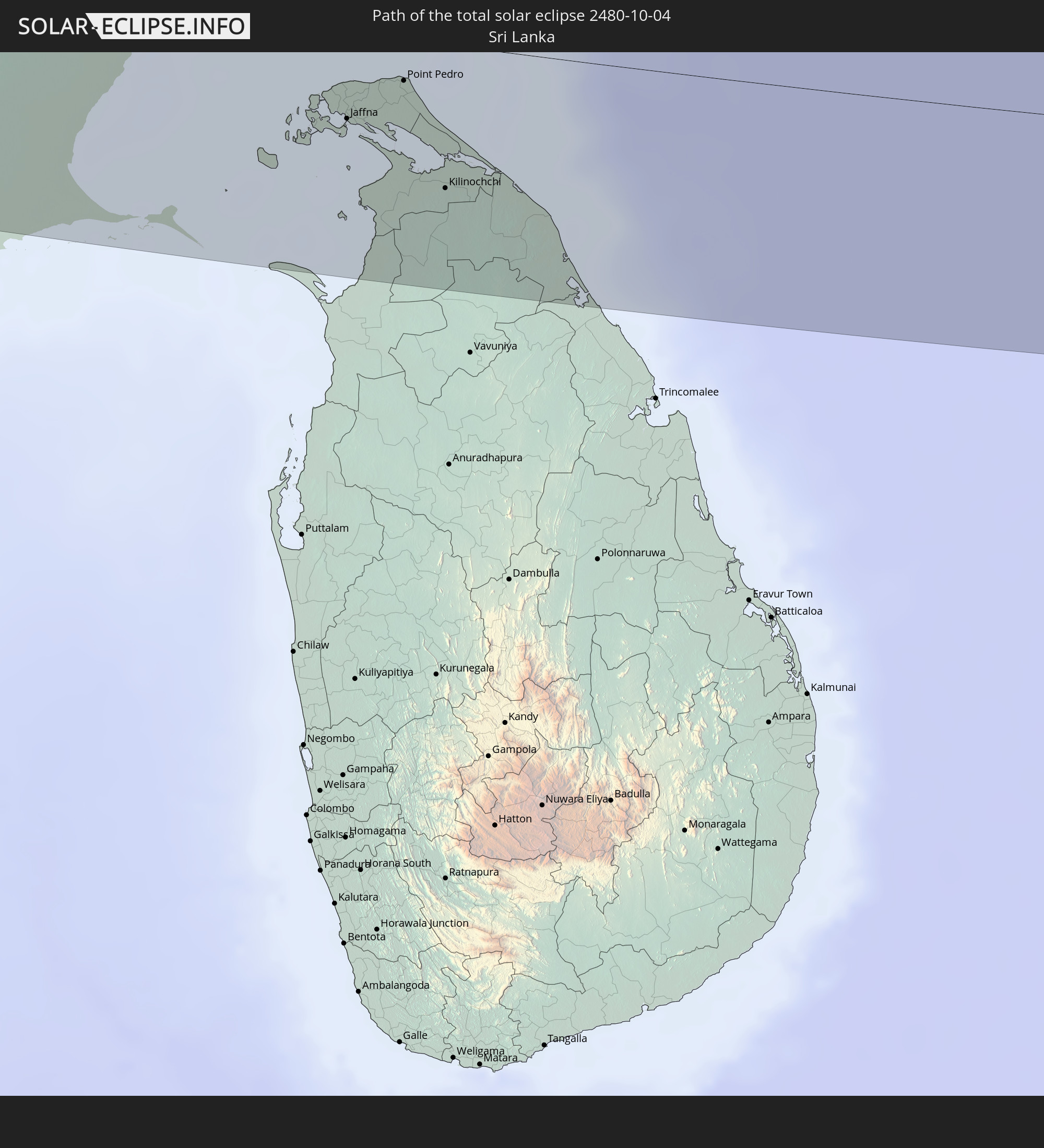 Sri Lanka
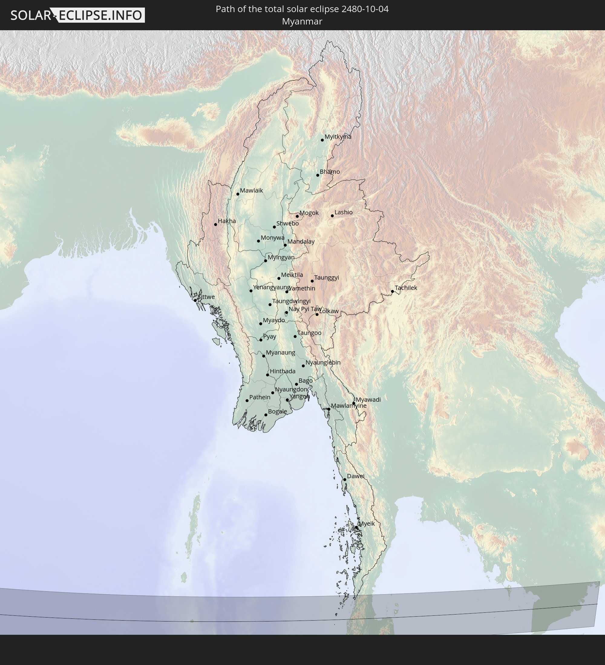 Myanmar
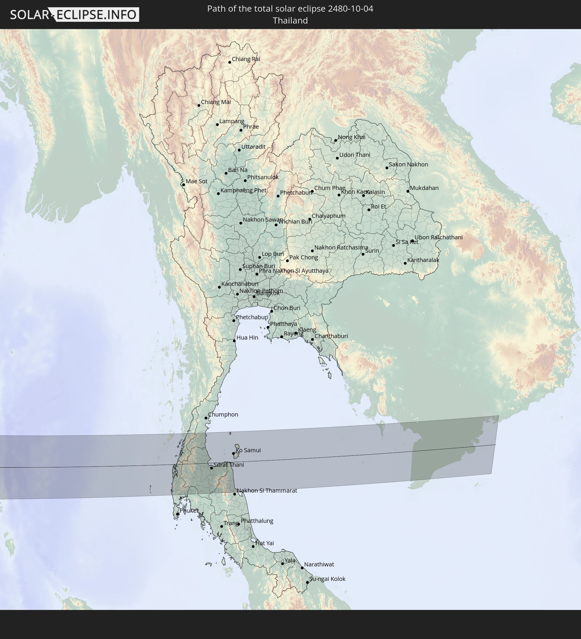 Thailand
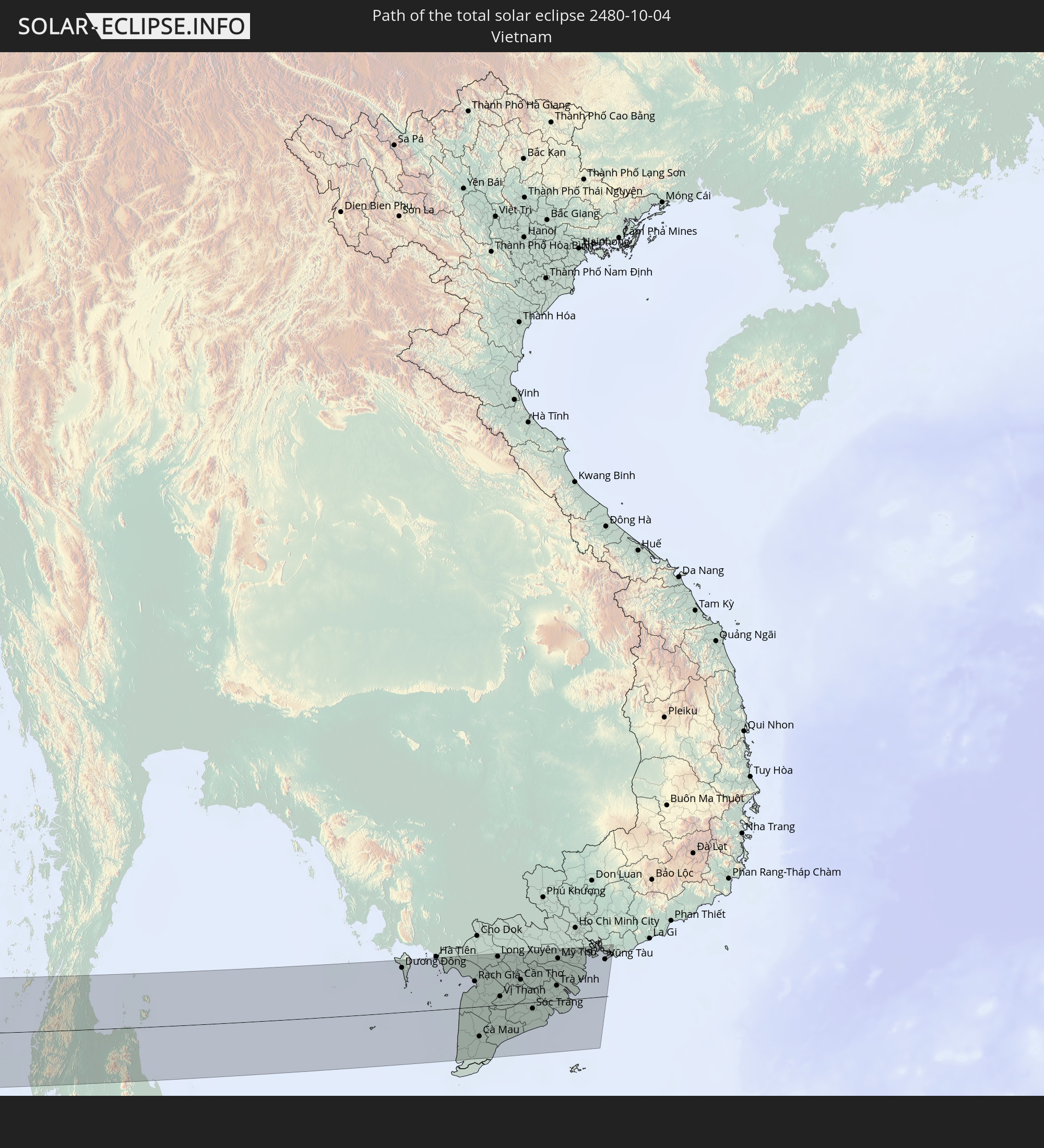 Vietnam
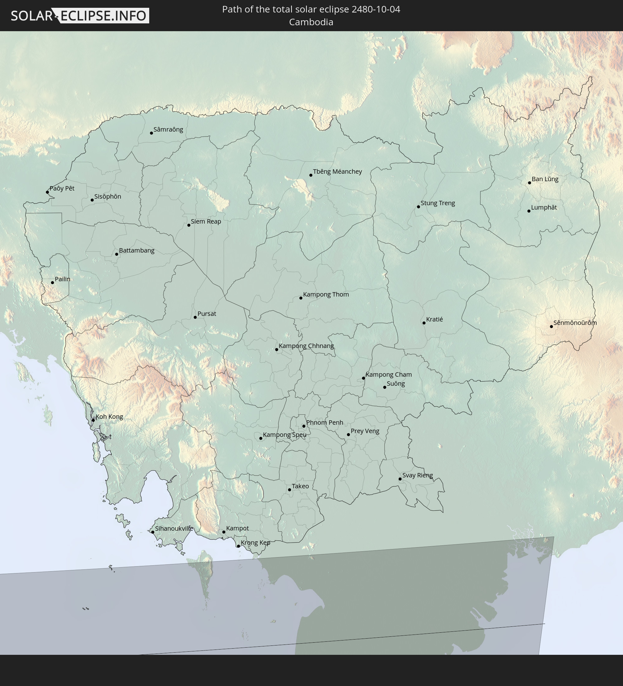 Cambodia
In den folgenden Ländern ist die Sonnenfinsternis partiell zu sehen
 Russia
 Portugal
 Iceland
 Spain
Spain
 Senegal
 Mauritania
 The Gambia
 Guinea-Bissau
 Guinea
 Morocco
 Mali
Mali
 Republic of Ireland
 Svalbard and Jan Mayen
 Algeria
 United Kingdom
 Ivory Coast
 Faroe Islands
 Burkina Faso
 Gibraltar
 France
 Isle of Man
 Ghana
Ghana
 Guernsey
 Jersey
 Togo
Togo
 Niger
Niger
 Benin
Benin
 Andorra
 Belgium
 Nigeria
 Netherlands
 Norway
 Luxembourg
 Germany
 Switzerland
 Italy
Italy
 Monaco
 Tunisia
 Denmark
 Cameroon
 Libya
Libya
 Liechtenstein
 Austria
 Sweden
 Republic of the Congo
 Czechia
 Democratic Republic of the Congo
 San Marino
 Vatican City
 Slovenia
 Chad
Chad
 Croatia
 Poland
 Malta
Malta
 Central African Republic
 Bosnia and Herzegovina
 Hungary
 Slovakia
 Montenegro
 Serbia
 Albania
 Åland Islands
 Greece
 Romania
 Republic of Macedonia
 Finland
 Lithuania
 Latvia
 Estonia
 Sudan
Sudan
 Ukraine
 Bulgaria
 Belarus
 Egypt
Egypt
 Turkey
 Moldova
 Rwanda
 Burundi
 Tanzania
 Uganda
 Cyprus
 Ethiopia
 Kenya
Kenya
 State of Palestine
 Israel
 Saudi Arabia
 Jordan
 Lebanon
 Syria
Syria
 Eritrea
 Iraq
Iraq
 Georgia
 French Southern and Antarctic Lands
 Somalia
 Djibouti
 Yemen
Yemen
 Madagascar
 Comoros
 Armenia
 Iran
Iran
 Azerbaijan
 Mayotte
 Seychelles
 Kazakhstan
 Kuwait
 Bahrain
 Qatar
Qatar
 United Arab Emirates
 Oman
Oman
 Turkmenistan
 Uzbekistan
 Mauritius
 Afghanistan
 Pakistan
 Tajikistan
 India
India
 Kyrgyzstan
 British Indian Ocean Territory
 Maldives
 China
China
 Sri Lanka
 Nepal
Nepal
 Mongolia
 Bangladesh
 Bhutan
 Myanmar
 Indonesia
 Cocos Islands
 Thailand
 Malaysia
 Laos
Laos
 Vietnam
 Cambodia
 Singapore
 Christmas Island
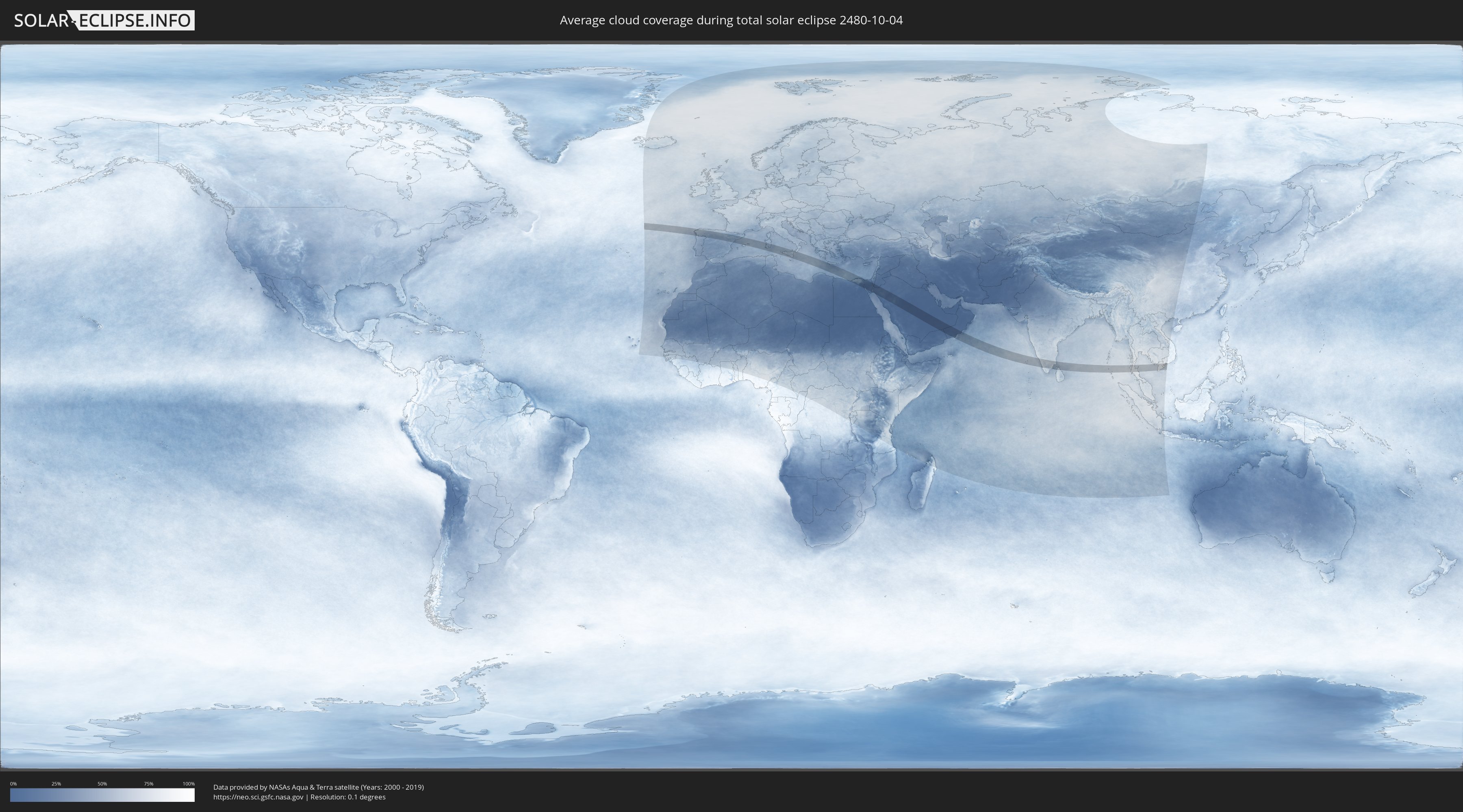
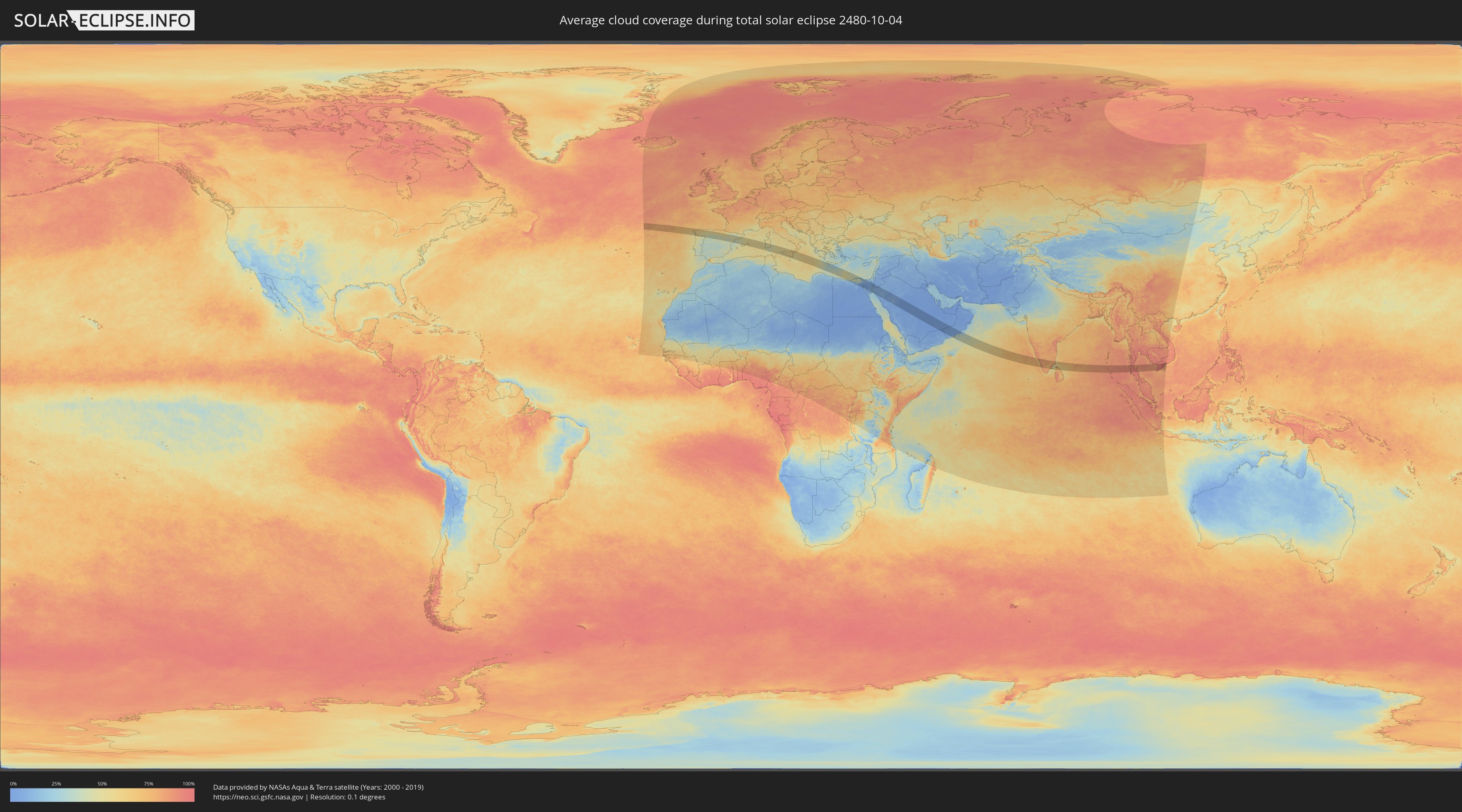
How will be the weather during the total solar eclipse on 10/04/2480?
Where is the best place to see the total solar eclipse of 10/04/2480?
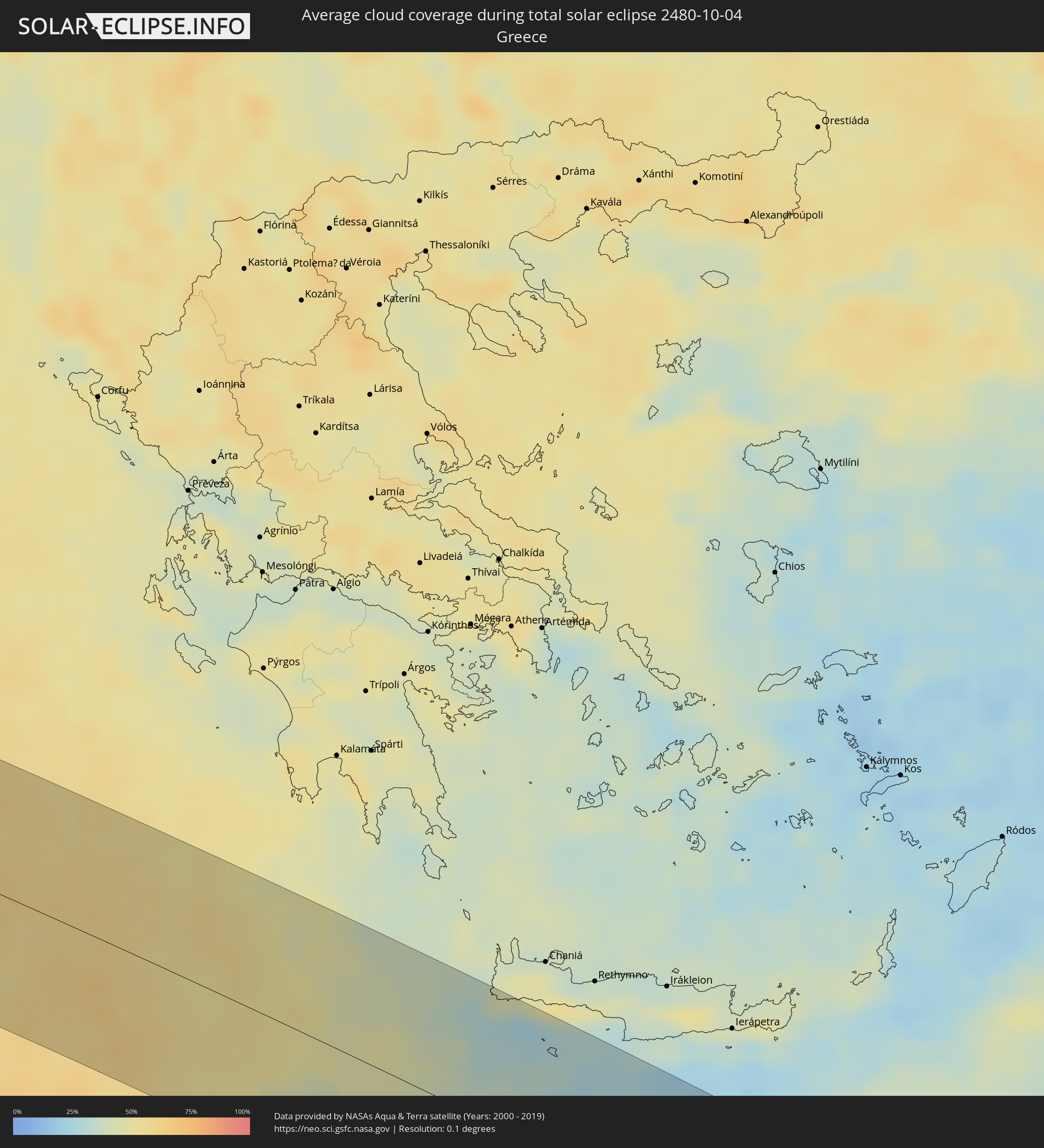
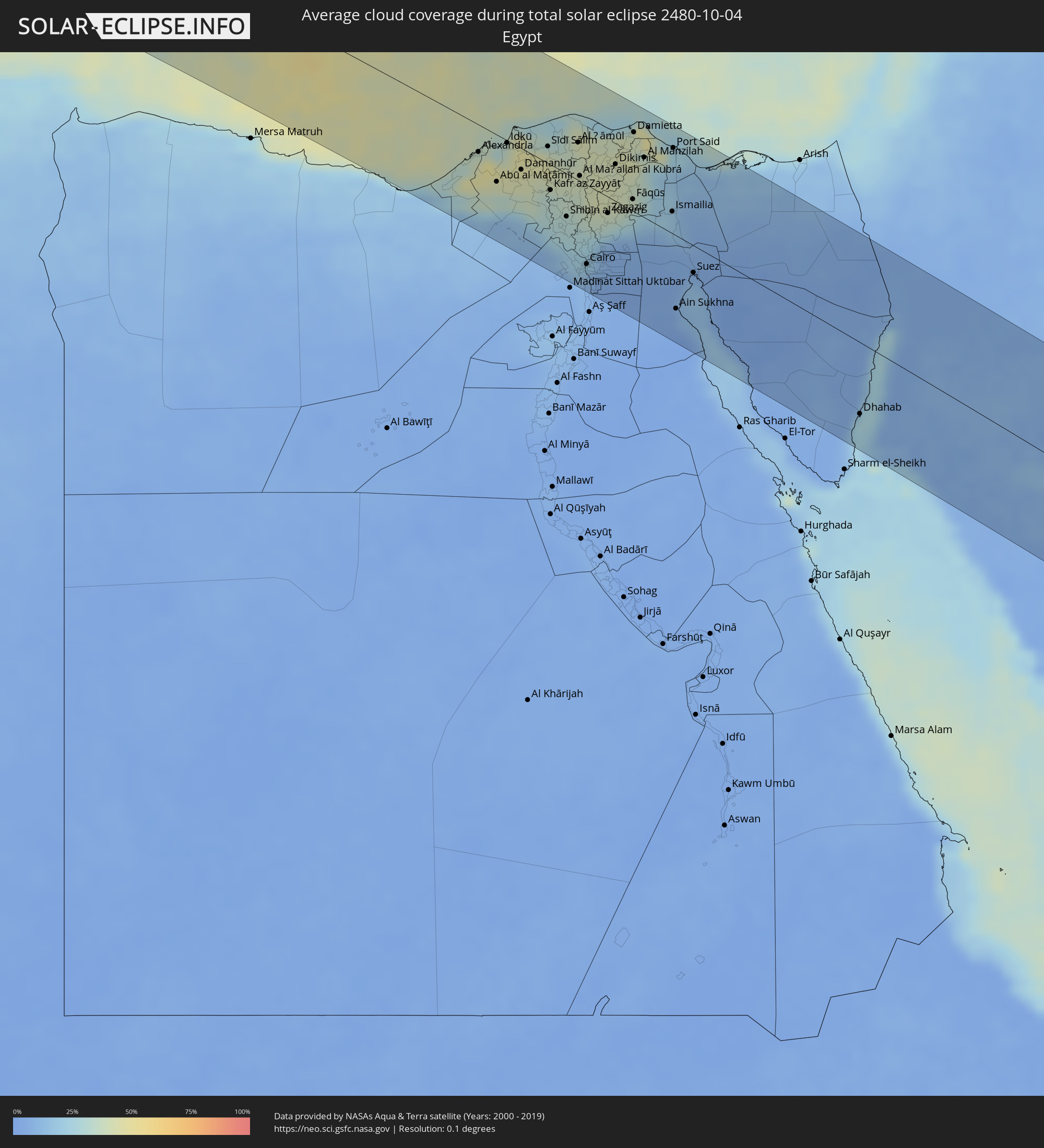
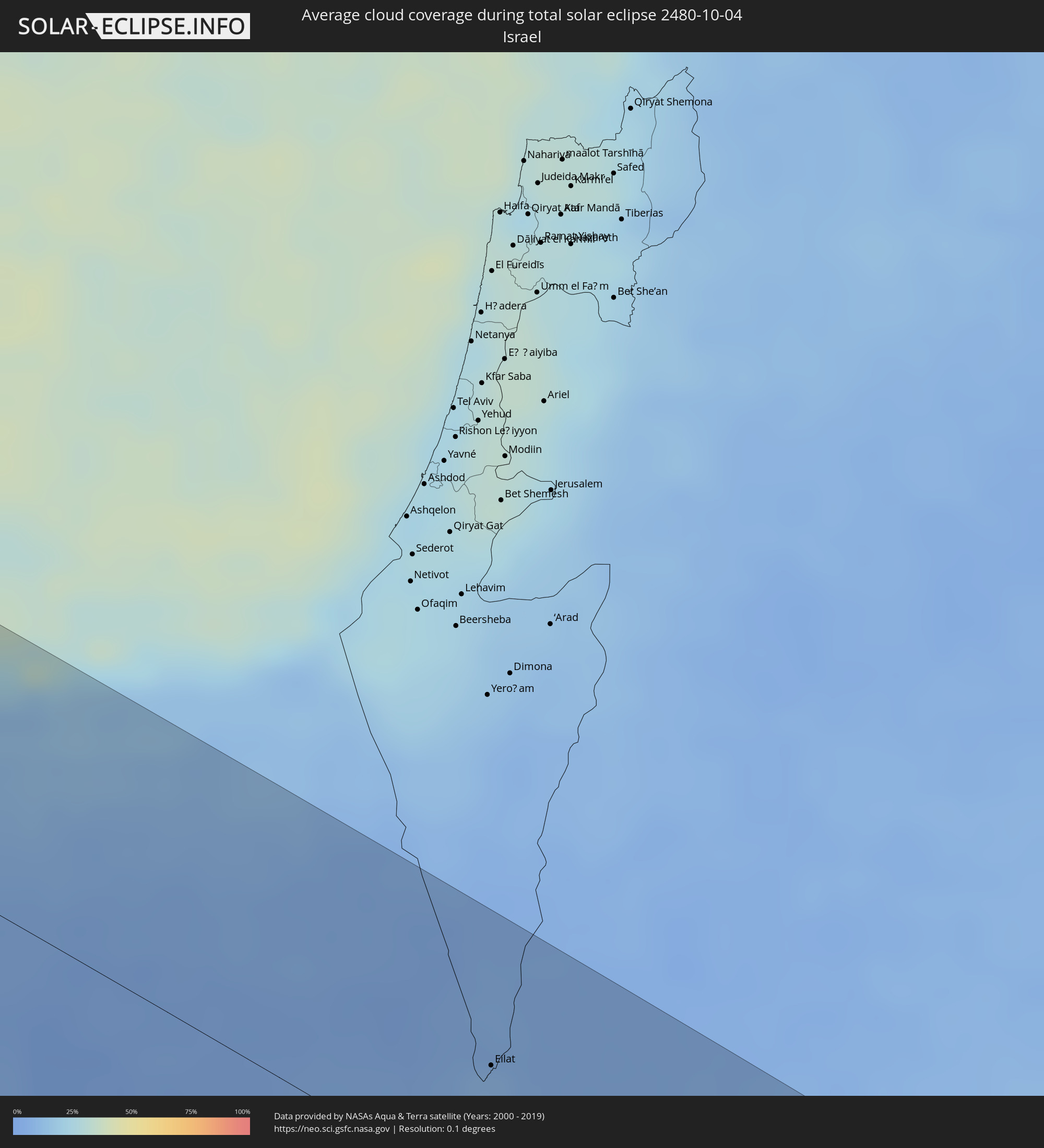
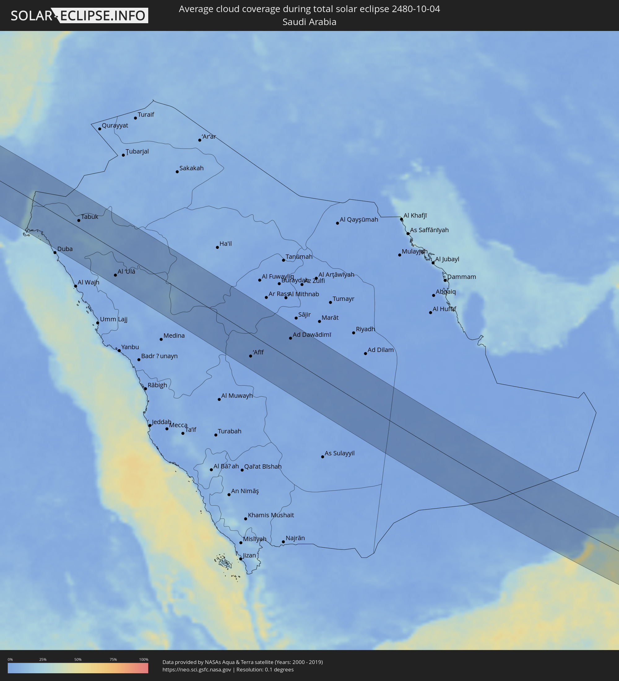
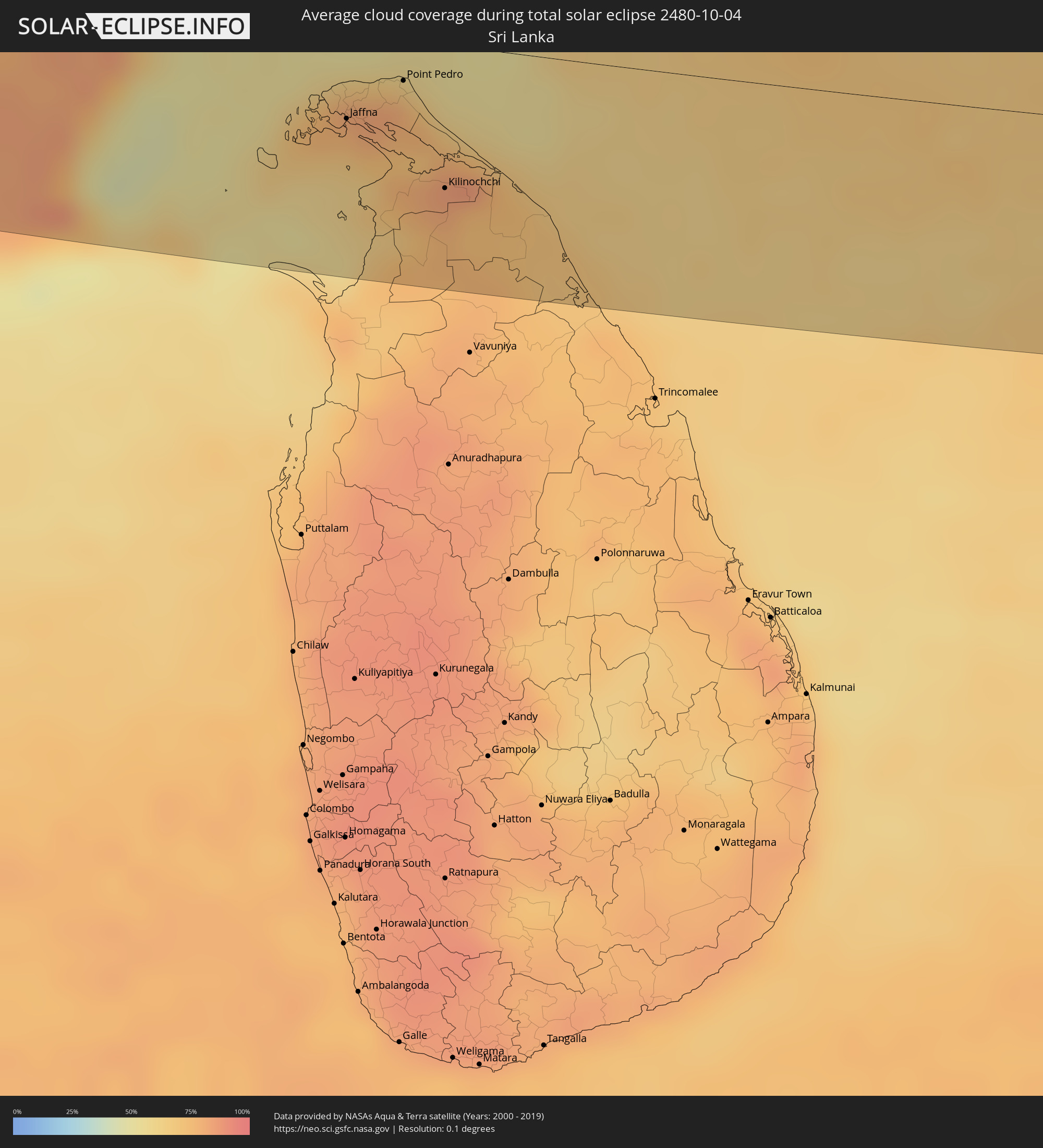
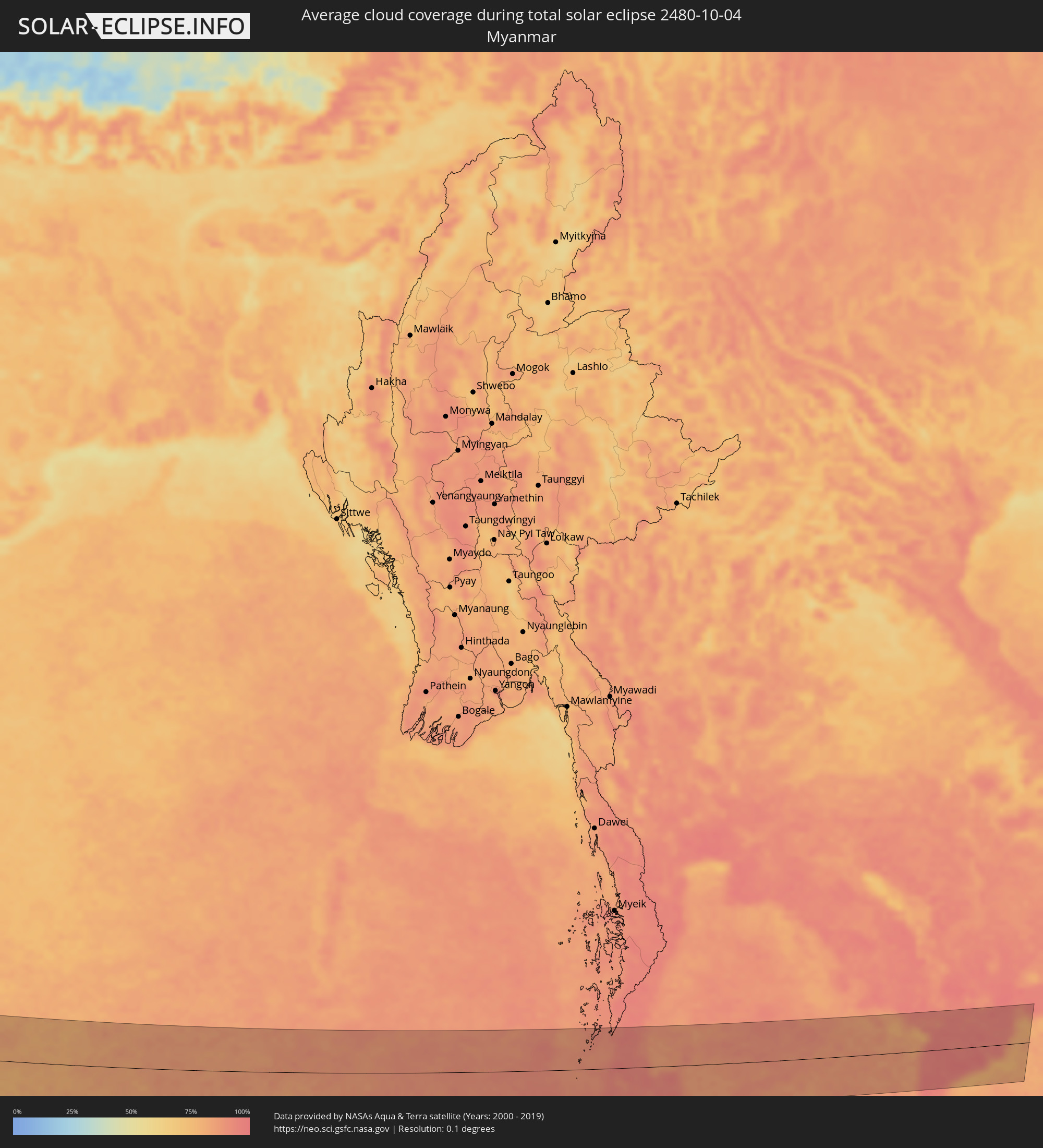
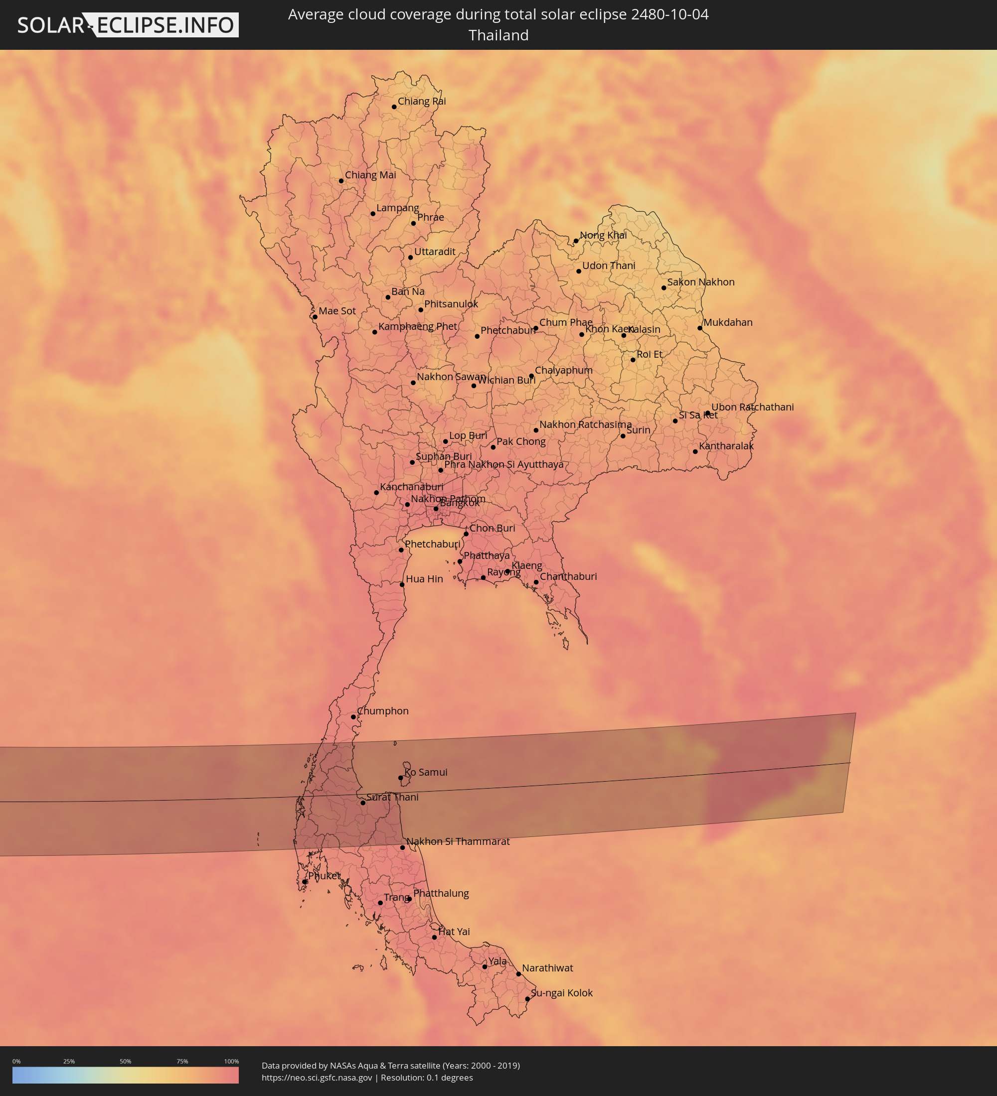
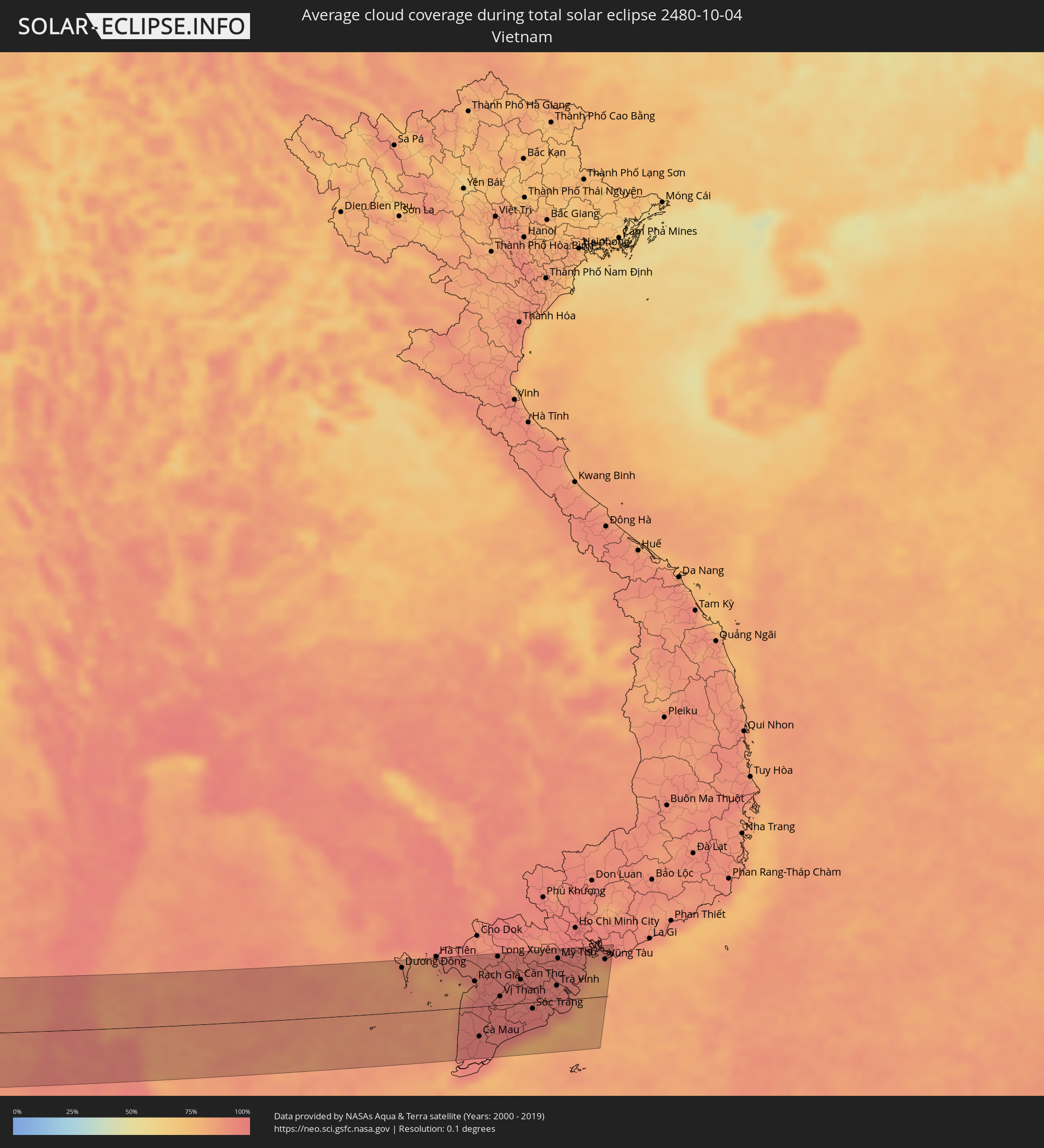
The following maps show the average cloud coverage for the day of the total solar eclipse.
With the help of these maps, it is possible to find the place along the eclipse path, which has the best
chance of a cloudless sky.
Nevertheless, you should consider local circumstances and inform about the weather of your chosen
observation site.
The data is provided by NASAs satellites
AQUA and TERRA.
The cloud maps are averaged over a period of 19 years (2000 - 2019).
Detailed country maps
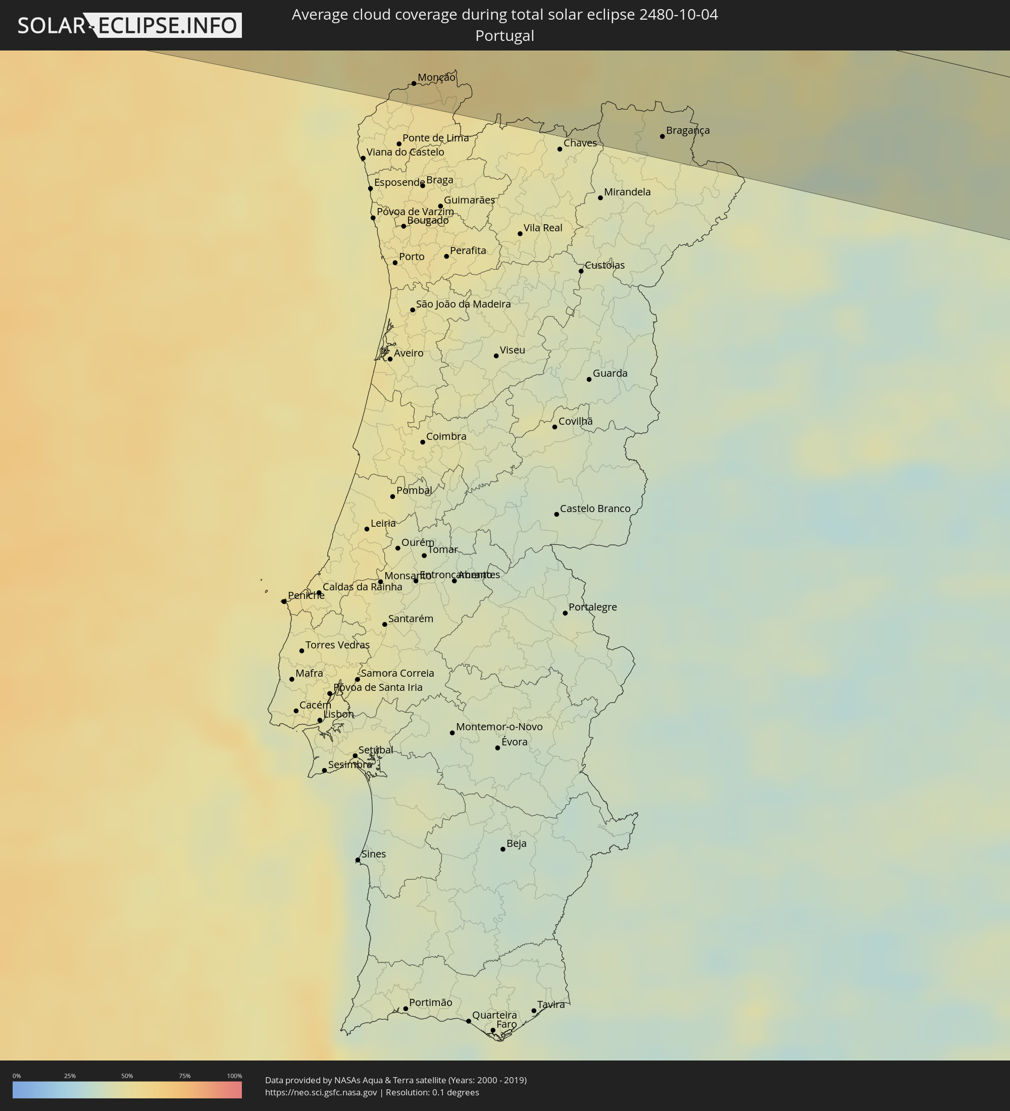 Portugal
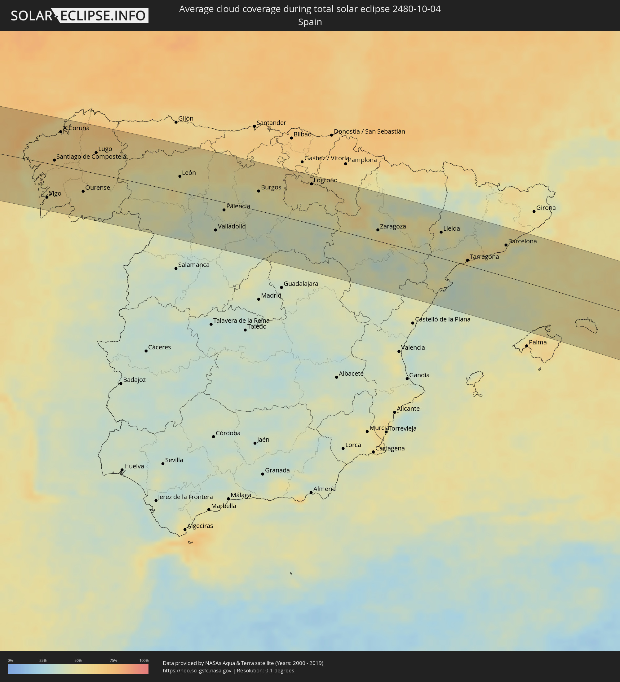 Spain
Spain
 Italy
Italy
 Greece
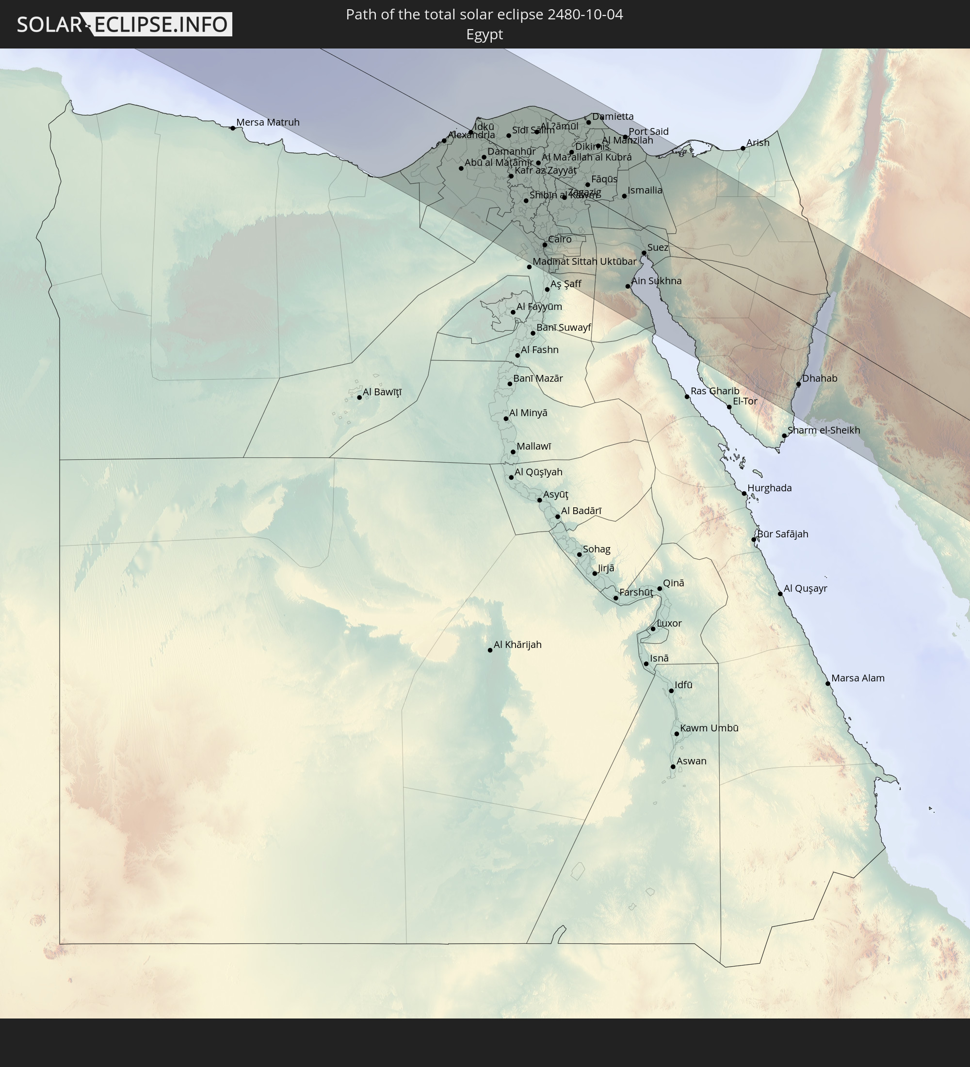
 Egypt
Egypt
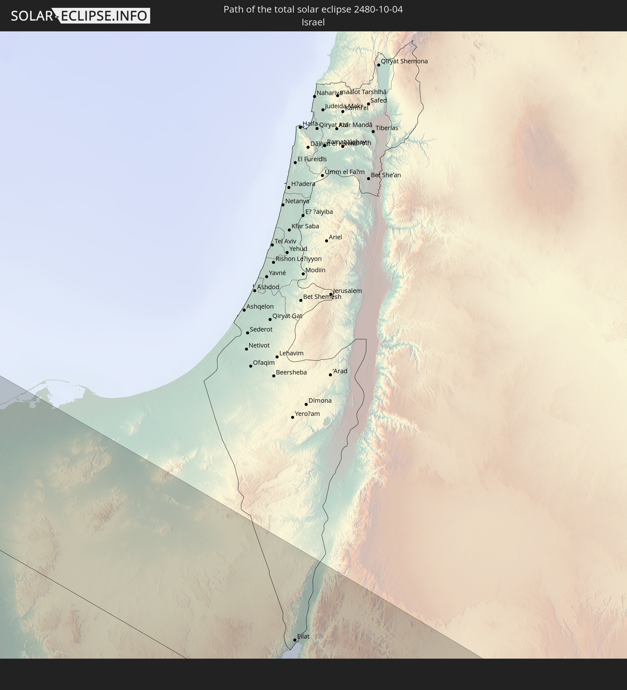
 Israel
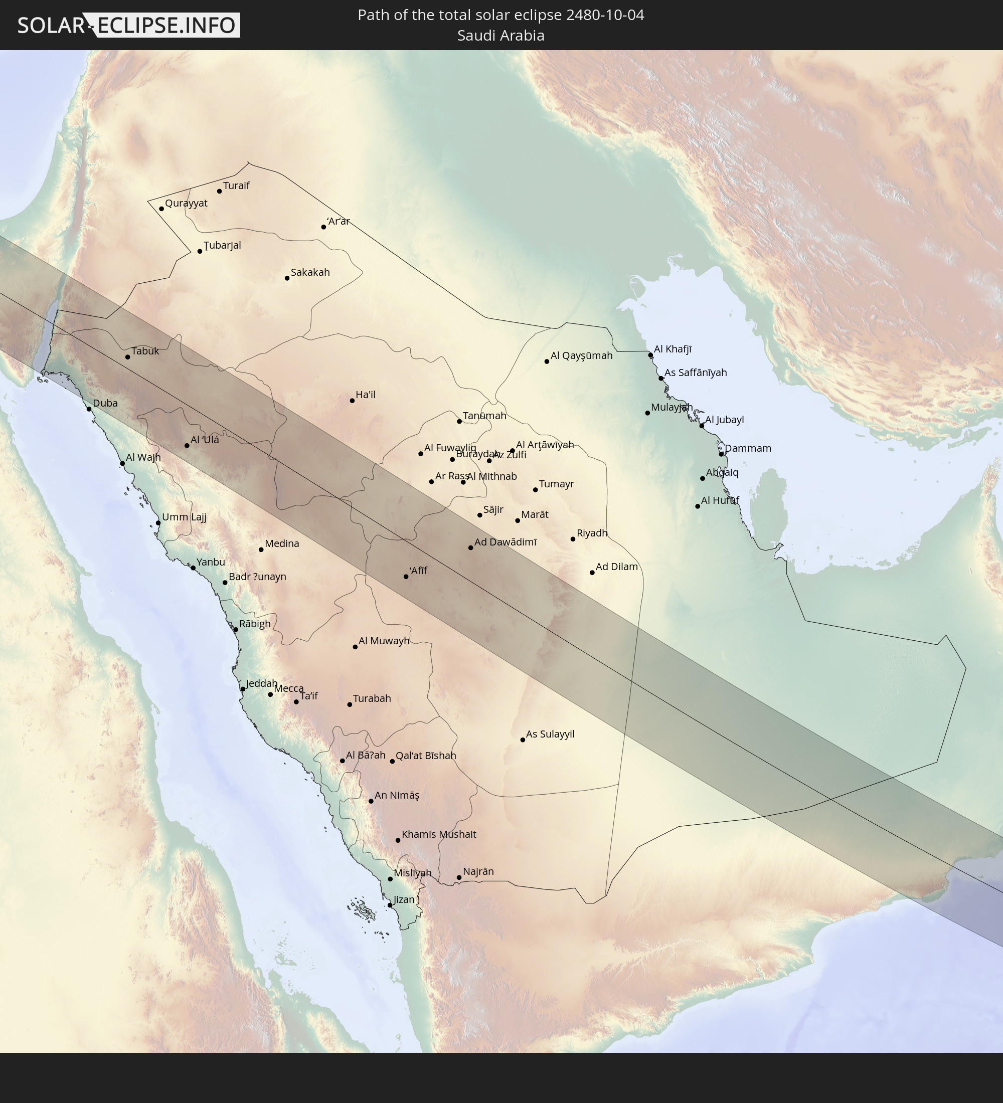
 Saudi Arabia
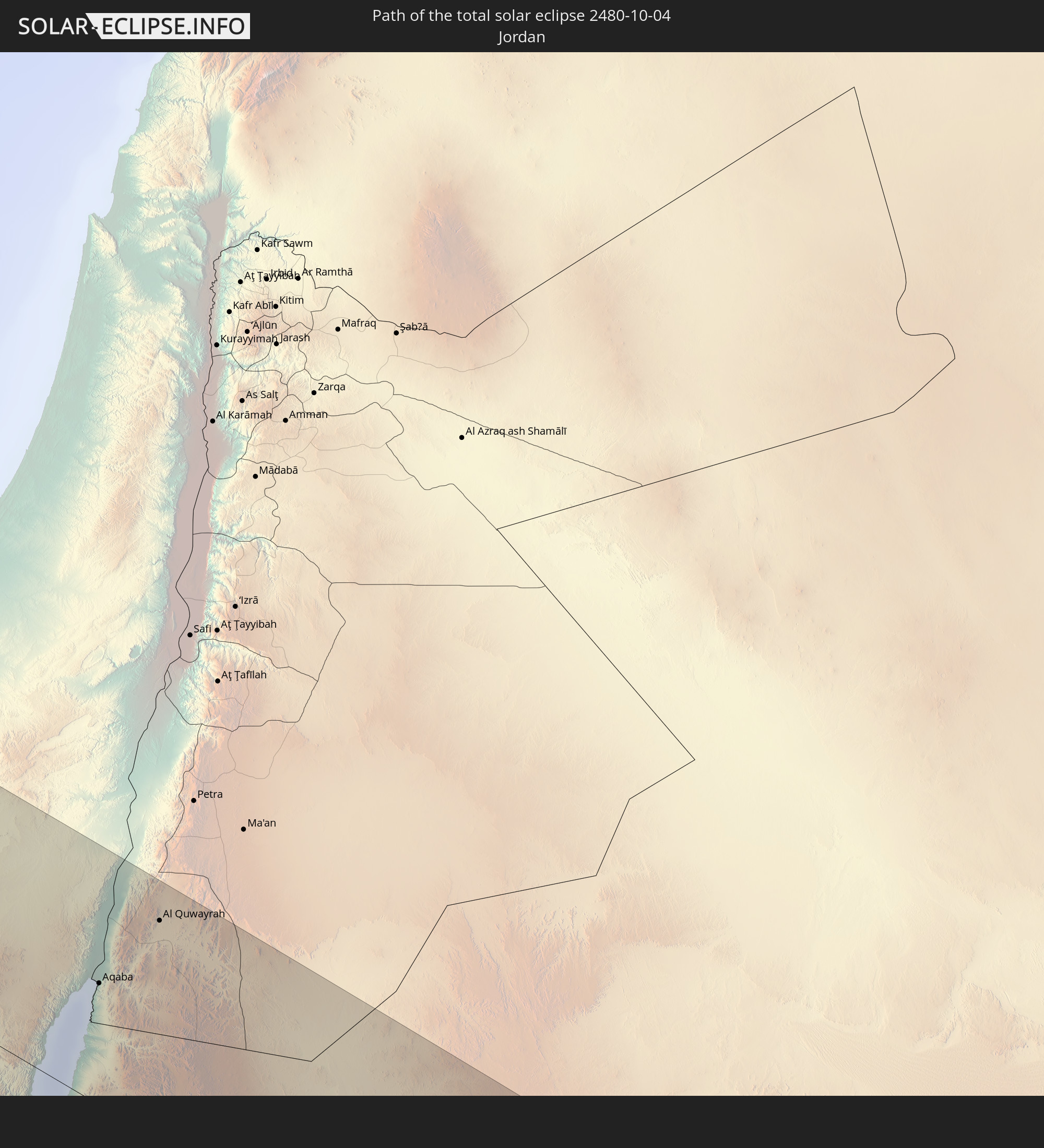
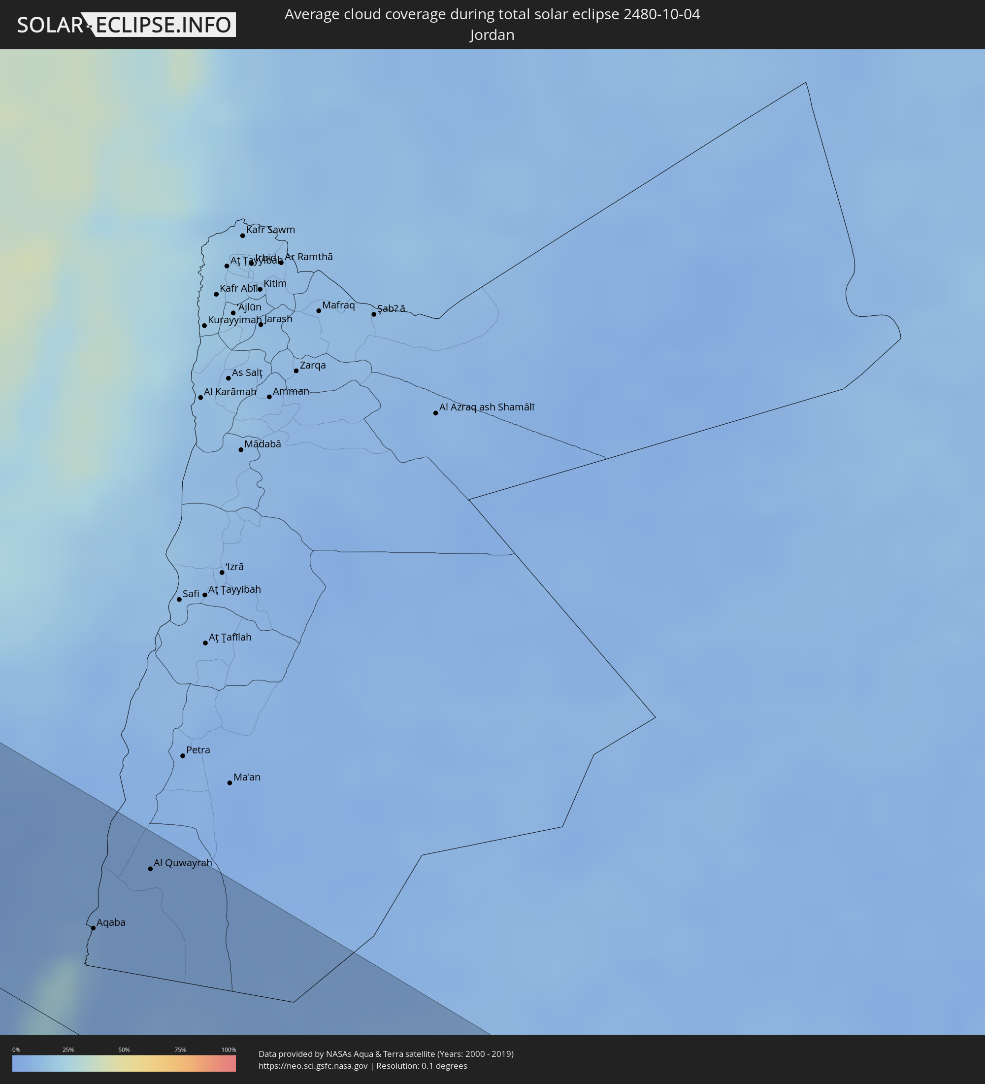 Jordan
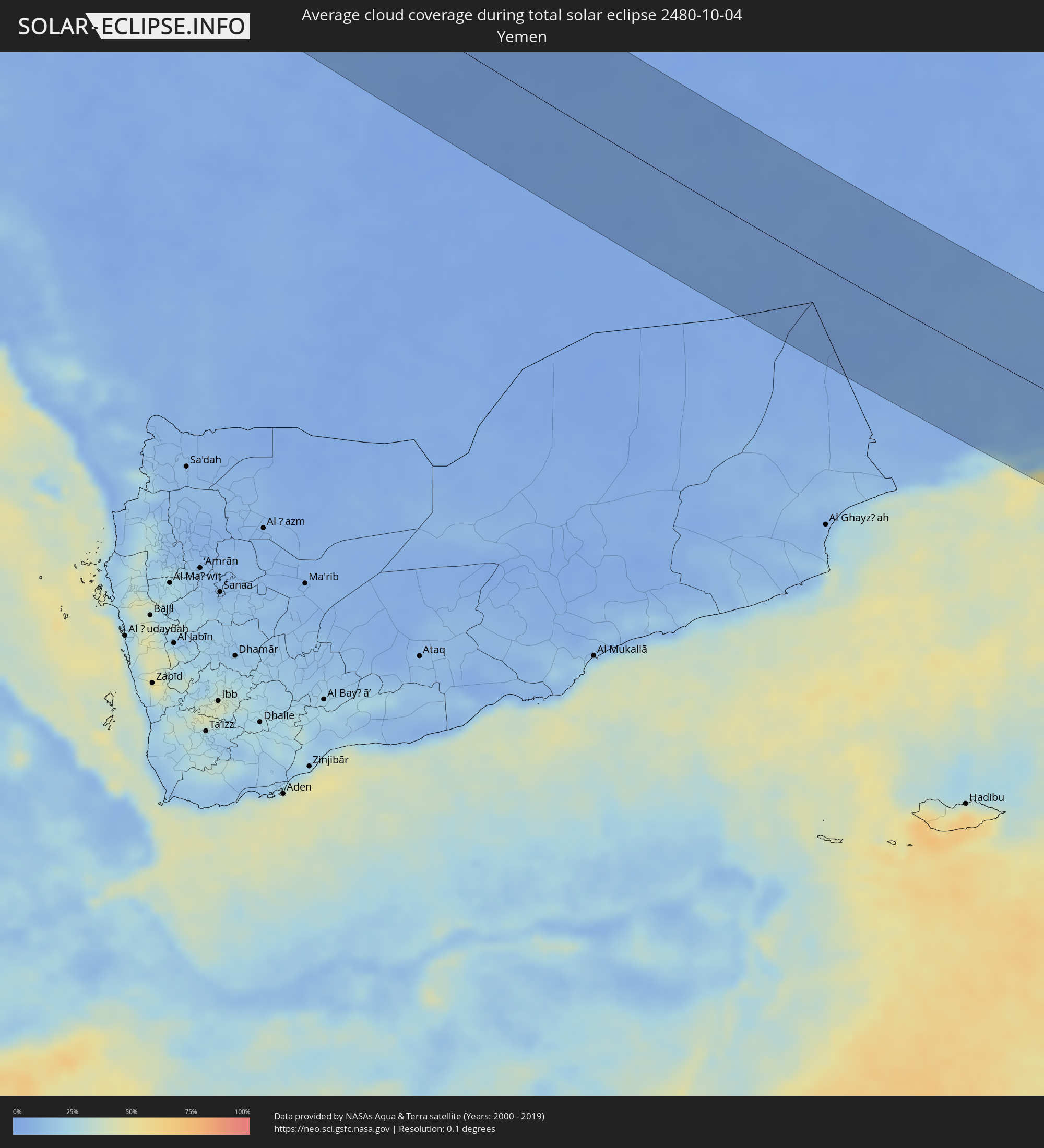 Yemen
Yemen
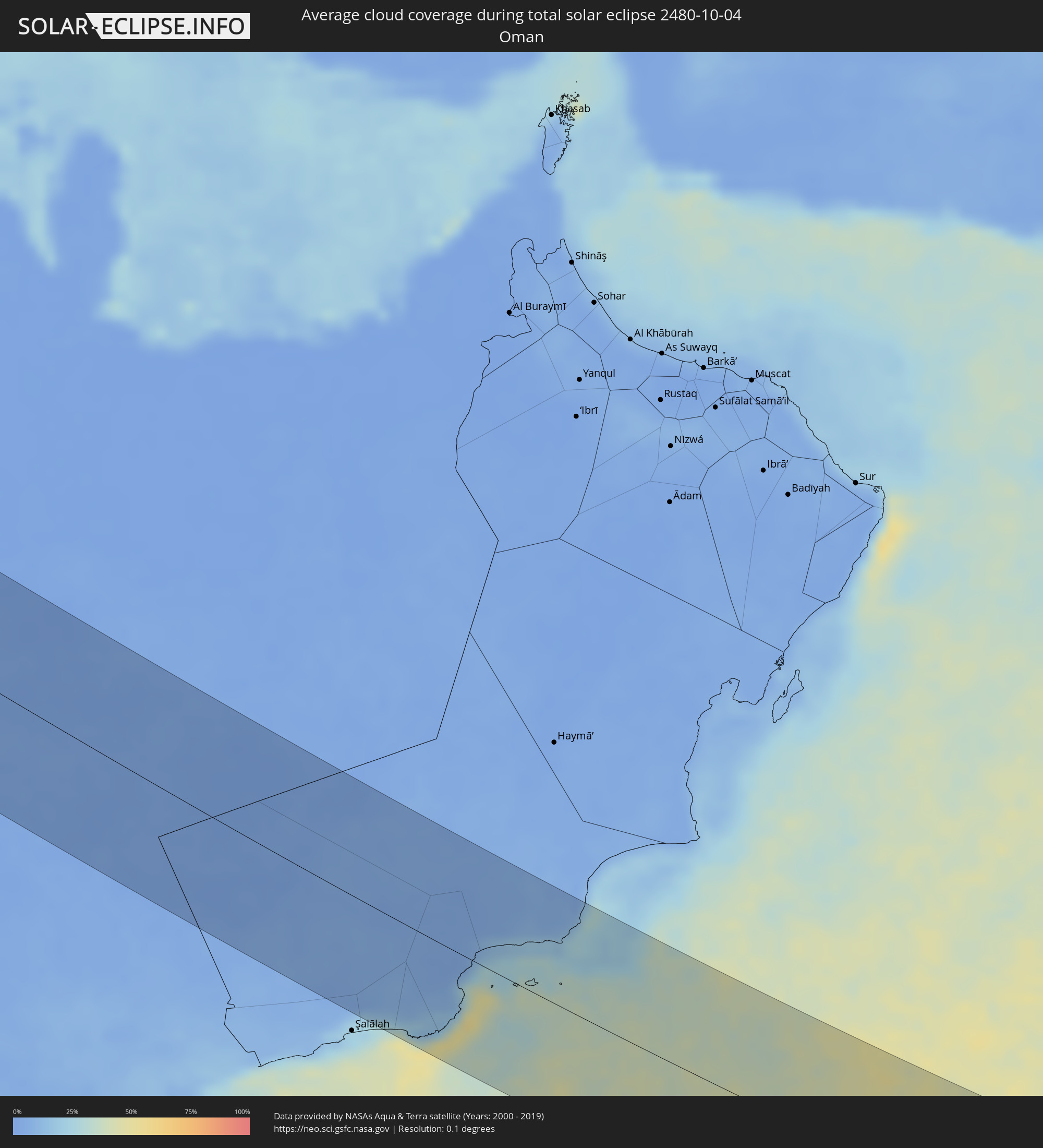 Oman
Oman
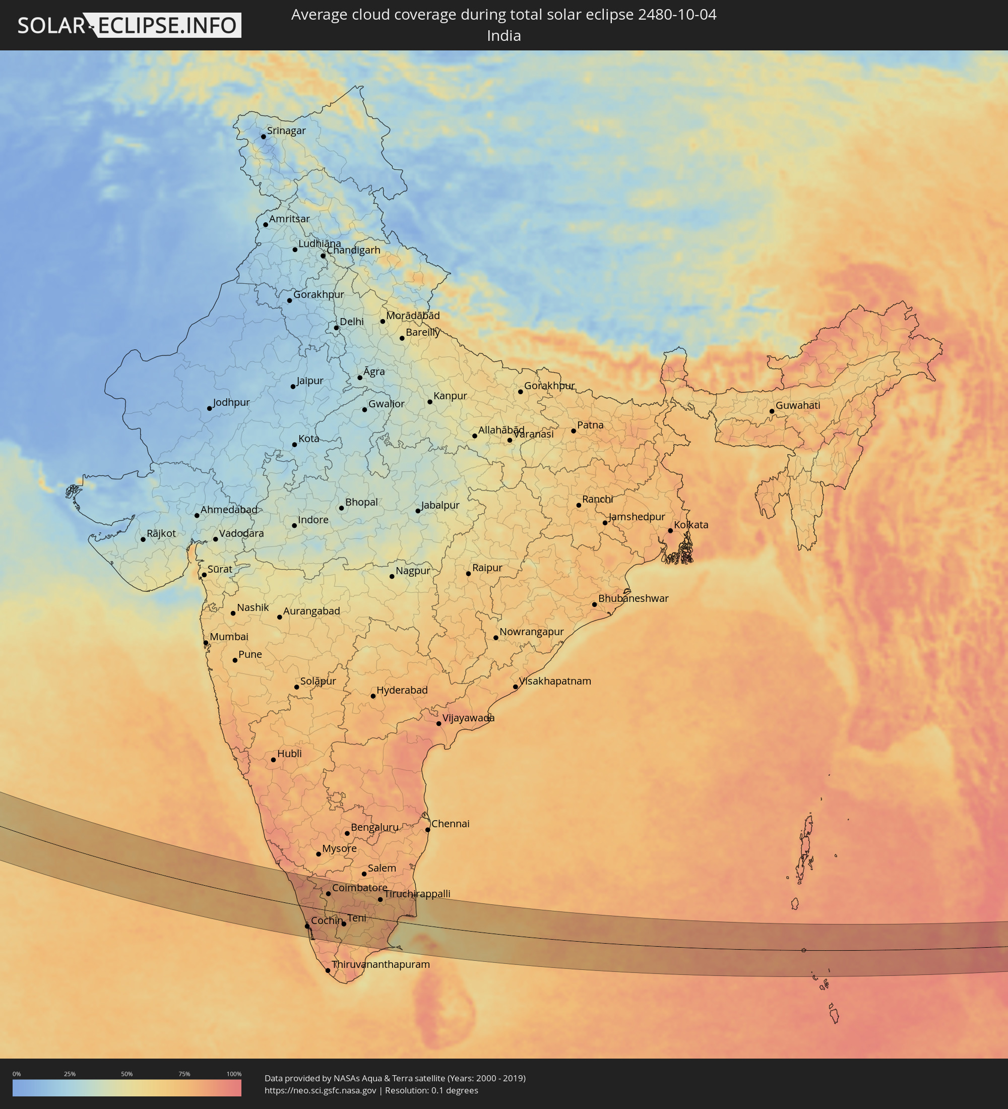 India
India
 Sri Lanka
 Myanmar
 Thailand
 Vietnam
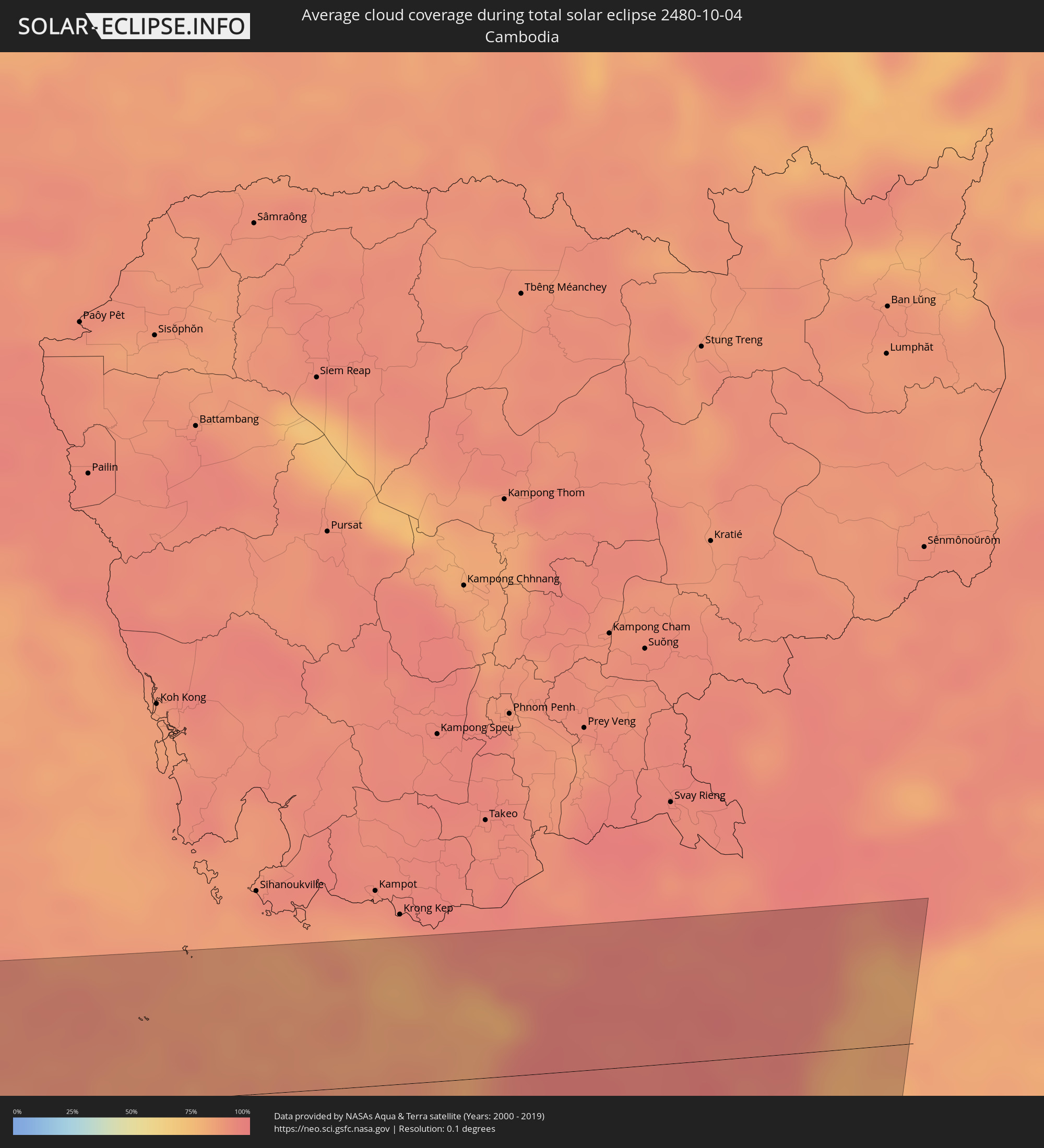 Cambodia
Cities inside the path of the eclipse
The following table shows all locations with a population of more than 5,000 inside the eclipse path. Cities which have more than 100,000 inhabitants are marked bold. A click at the locations opens a detailed map.
| City | Type | Eclipse duration | Local time of max. eclipse | Distance to central line | Ø Cloud coverage |
|
Vigo, Galicia
|
total | - | 08:34:47 UTC+01:00 | 65 km | 53% |
|
Pontevedra, Galicia
|
total | - | 08:34:57 UTC+01:00 | 42 km | 54% |
|
Valenza, Viana do Castelo
|
total | - | 07:34:40 UTC+00:00 | 86 km | 52% |
|
Santiago de Compostela, Galicia
|
total | - | 08:35:17 UTC+01:00 | 8 km | 63% |
|
Monção, Viana do Castelo
|
total | - | 07:34:46 UTC+00:00 | 78 km | 53% |
|
A Coruña, Galicia
|
total | - | 08:35:41 UTC+01:00 | 64 km | 61% |
|
Ferrol, Galicia
|
total | - | 08:35:50 UTC+01:00 | 79 km | 60% |
|
Ourense, Galicia
|
total | - | 08:35:11 UTC+01:00 | 39 km | 56% |
|
Lugo, Galicia
|
total | - | 08:35:46 UTC+01:00 | 39 km | 62% |
|
Bragança, Bragança
|
total | - | 07:35:18 UTC+00:00 | 78 km | 46% |
|
León, Castille and León
|
total | - | 08:36:21 UTC+01:00 | 30 km | 48% |
|
Valladolid, Castille and León
|
total | - | 08:36:08 UTC+01:00 | 57 km | 42% |
|
Palencia, Castille and León
|
total | - | 08:36:28 UTC+01:00 | 15 km | 46% |
|
Burgos, Castille and León
|
total | - | 08:37:05 UTC+01:00 | 37 km | 47% |
|
Logroño, La Rioja
|
total | - | 08:37:50 UTC+01:00 | 75 km | 56% |
|
Zaragoza, Aragon
|
total | - | 08:38:14 UTC+01:00 | 21 km | 53% |
|
Lleida, Catalonia
|
total | - | 08:39:09 UTC+01:00 | 49 km | 43% |
|
Tarragona, Catalonia
|
total | - | 08:39:16 UTC+01:00 | 10 km | 41% |
|
Manresa, Catalonia
|
total | - | 08:40:00 UTC+01:00 | 88 km | 43% |
|
Terrassa, Catalonia
|
total | - | 08:40:02 UTC+01:00 | 76 km | 51% |
|
Barcelona, Catalonia
|
total | - | 08:40:02 UTC+01:00 | 60 km | 49% |
|
Mataró, Catalonia
|
total | - | 08:40:19 UTC+01:00 | 83 km | 42% |
|
Cagliari, Sardinia
|
total | - | 08:44:41 UTC+01:00 | 11 km | 45% |
|
Marsala, Sicily
|
total | - | 08:47:34 UTC+01:00 | 39 km | 51% |
|
Trapani, Sicily
|
total | - | 08:47:44 UTC+01:00 | 14 km | 54% |
|
Mazara del Vallo, Sicily
|
total | - | 08:47:42 UTC+01:00 | 50 km | 55% |
|
Alcamo, Sicily
|
total | - | 08:48:11 UTC+01:00 | 4 km | 57% |
|
Sciacca, Sicily
|
total | - | 08:48:12 UTC+01:00 | 49 km | 52% |
|
Palermo, Sicily
|
total | - | 08:48:37 UTC+01:00 | 24 km | 59% |
|
Bagheria, Sicily
|
total | - | 08:48:48 UTC+01:00 | 24 km | 55% |
|
Licata, Sicily
|
total | - | 08:49:04 UTC+01:00 | 64 km | 52% |
|
Caltanissetta, Sicily
|
total | - | 08:49:17 UTC+01:00 | 20 km | 55% |
|
Gela, Sicily
|
total | - | 08:49:24 UTC+01:00 | 57 km | 52% |
|
Caltagirone, Sicily
|
total | - | 08:49:45 UTC+01:00 | 31 km | 60% |
|
Vittoria, Sicily
|
total | - | 08:49:43 UTC+01:00 | 60 km | 60% |
|
Ragusa, Sicily
|
total | - | 08:49:56 UTC+01:00 | 56 km | 63% |
|
Paternò, Sicily
|
total | - | 08:50:15 UTC+01:00 | 16 km | 55% |
|
Catania, Sicily
|
total | - | 08:50:26 UTC+01:00 | 14 km | 54% |
|
Acireale, Sicily
|
total | - | 08:50:34 UTC+01:00 | 29 km | 57% |
|
Siracusa, Sicily
|
total | - | 08:50:36 UTC+01:00 | 22 km | 54% |
|
Reggio Calabria, Calabria
|
total | - | 08:51:14 UTC+01:00 | 97 km | 62% |
|
Alexandria, Alexandria
|
total | - | 10:13:24 UTC+02:00 | 27 km | 43% |
|
Kafr ad Dawwār, Beheira
|
total | - | 10:13:46 UTC+02:00 | 27 km | 49% |
|
Idkū, Beheira
|
total | - | 10:13:59 UTC+02:00 | 2 km | 36% |
|
Damanhūr, Beheira
|
total | - | 10:14:26 UTC+02:00 | 21 km | 43% |
|
Kafr ash Shaykh, Kafr el-Sheikh
|
total | - | 10:15:15 UTC+02:00 | 9 km | 43% |
|
Tanda, Gharbia
|
total | - | 10:15:33 UTC+02:00 | 20 km | 35% |
|
Shibīn al Kawm, Monufia
|
total | - | 10:15:41 UTC+02:00 | 43 km | 30% |
|
Al Maḩallah al Kubrá, Gharbia
|
total | - | 10:15:45 UTC+02:00 | 5 km | 40% |
|
Banhā, Qalyubia
|
total | - | 10:16:03 UTC+02:00 | 44 km | 29% |
|
Cairo, Cairo
|
total | - | 10:16:25 UTC+02:00 | 79 km | 17% |
|
Ḩalwān, Cairo
|
total | - | 10:16:38 UTC+02:00 | 98 km | 7% |
|
Bilqās, Dakahlia
|
total | - | 10:15:58 UTC+02:00 | 38 km | 40% |
|
Al Manşūrah, Dakahlia
|
total | - | 10:16:07 UTC+02:00 | 22 km | 42% |
|
Zagazig, Sharqia
|
total | - | 10:16:35 UTC+02:00 | 16 km | 35% |
|
Bilbays, Sharqia
|
total | - | 10:16:48 UTC+02:00 | 30 km | 13% |
|
Dikirnis, Dakahlia
|
total | - | 10:16:29 UTC+02:00 | 37 km | 39% |
|
Ismailia, Ismailia
|
total | - | 10:18:02 UTC+02:00 | 22 km | 18% |
|
Port Said, Port Said
|
total | - | 10:17:41 UTC+02:00 | 85 km | 26% |
|
Suez, Suez
|
total | - | 10:18:54 UTC+02:00 | 27 km | 10% |
|
Eilat, Southern District
|
total | - | 10:23:55 UTC+02:00 | 51 km | 9% |
|
Aqaba, Aqaba
|
total | - | 10:24:04 UTC+02:00 | 51 km | 14% |
|
Al Quwayrah, Ma’an
|
total | - | 10:24:29 UTC+02:00 | 92 km | 4% |
|
Tabuk, Tabuk
|
total | - | 11:28:07 UTC+03:00 | 22 km | 7% |
|
Al ‘Ulá, Al Madīnah al Munawwarah
|
total | - | 11:32:33 UTC+03:00 | 79 km | 3% |
|
‘Afīf, Ar Riyāḑ
|
total | - | 11:46:35 UTC+03:00 | 71 km | 1% |
|
Ad Dawādimī, Ar Riyāḑ
|
total | - | 11:49:17 UTC+03:00 | 66 km | 1% |
|
Tellicherry, Kerala
|
total | - | 15:42:31 UTC+05:30 | 110 km | 70% |
|
Kozhikode, Kerala
|
total | - | 15:43:32 UTC+05:30 | 62 km | 67% |
|
Ponnāni, Kerala
|
total | - | 15:44:20 UTC+05:30 | 12 km | 65% |
|
Trichūr, Kerala
|
total | - | 15:45:02 UTC+05:30 | 10 km | 82% |
|
Cochin, Kerala
|
total | - | 15:45:46 UTC+05:30 | 72 km | 74% |
|
Palakkad, Kerala
|
total | - | 15:45:21 UTC+05:30 | 27 km | 82% |
|
Ooty, Tamil Nadu
|
total | - | 15:44:38 UTC+05:30 | 98 km | 84% |
|
Coimbatore, Tamil Nadu
|
total | - | 15:45:30 UTC+05:30 | 59 km | 77% |
|
Tiruppur, Tamil Nadu
|
total | - | 15:45:54 UTC+05:30 | 78 km | 82% |
|
Teni, Tamil Nadu
|
total | - | 15:47:21 UTC+05:30 | 41 km | 73% |
|
Rajapalaiyam, Tamil Nadu
|
total | - | 15:48:05 UTC+05:30 | 101 km | 80% |
|
Dindigul, Tamil Nadu
|
total | - | 15:47:36 UTC+05:30 | 7 km | 76% |
|
Madurai, Tamil Nadu
|
total | - | 15:48:18 UTC+05:30 | 40 km | 70% |
|
Tiruchirappalli, Tamil Nadu
|
total | - | 15:48:01 UTC+05:30 | 68 km | 78% |
|
Kāraikkudi, Tamil Nadu
|
total | - | 15:48:58 UTC+05:30 | 13 km | 81% |
|
Pudukkottai, Tamil Nadu
|
total | - | 15:48:41 UTC+05:30 | 23 km | 76% |
|
Thanjāvūr, Tamil Nadu
|
total | - | 15:48:37 UTC+05:30 | 72 km | 79% |
|
Kumbakonam, Tamil Nadu
|
total | - | 15:48:44 UTC+05:30 | 96 km | 76% |
|
Nāgappattinam, Tamil Nadu
|
total | - | 15:49:31 UTC+05:30 | 81 km | 80% |
|
Jaffna, Northern Province
|
total | - | 15:50:56 UTC+05:30 | 38 km | 77% |
|
Valvedditturai, Northern Province
|
total | - | 15:50:58 UTC+05:30 | 19 km | 80% |
|
Point Pedro, Northern Province
|
total | - | 15:51:02 UTC+05:30 | 18 km | 80% |
|
Kilinochchi, Northern Province
|
total | - | 15:51:41 UTC+05:30 | 62 km | 81% |
|
Phang Nga, Phangnga
|
total | - | 17:36:03 UTC+07:00 | 90 km | 93% |
|
Ranong, Ranong
|
total | - | 17:34:50 UTC+07:00 | 78 km | 94% |
|
Ban Nam Yuen, Chumphon
|
total | - | 17:34:59 UTC+07:00 | 67 km | 94% |
|
Chai Buri, Surat Thani
|
total | - | 17:36:14 UTC+07:00 | 91 km | 93% |
|
Lang Suan, Chumphon
|
total | - | 17:35:00 UTC+07:00 | 74 km | 91% |
|
Chaiya, Surat Thani
|
total | - | 17:35:31 UTC+07:00 | 11 km | 92% |
|
Phunphin, Surat Thani
|
total | - | 17:35:45 UTC+07:00 | 19 km | 95% |
|
Surat Thani, Surat Thani
|
total | - | 17:35:46 UTC+07:00 | 17 km | 95% |
|
Ban Na San, Surat Thani
|
total | - | 17:36:03 UTC+07:00 | 55 km | 94% |
|
Wiang Sa, Surat Thani
|
total | - | 17:36:11 UTC+07:00 | 73 km | 93% |
|
Don Sak, Surat Thani
|
total | - | 17:35:44 UTC+07:00 | 1 km | 93% |
|
Ko Samui, Surat Thani
|
total | - | 17:35:38 UTC+07:00 | 25 km | 88% |
|
Ko Pha Ngan, Nakhon Si Thammarat
|
total | - | 17:35:28 UTC+07:00 | 49 km | 90% |
|
Dương Đông, Kiến Giang
|
total | - | 17:36:03 UTC+07:00 | 75 km | 85% |
|
Rạch Giá, Kiến Giang
|
total | - | 17:36:23 UTC+07:00 | 43 km | 94% |
|
Cà Mau, Cà Mau
|
total | - | 17:37:02 UTC+07:00 | 50 km | 97% |
|
Long Xuyên, An Giang
|
total | - | 17:36:08 UTC+07:00 | 82 km | 95% |
|
Vị Thanh, Hau Giang
|
total | - | 17:36:37 UTC+07:00 | 15 km | 95% |
|
Thành phố Bạc Liêu, Bạc Liêu
|
total | - | 17:37:01 UTC+07:00 | 42 km | 94% |
|
Sadek, Đồng Tháp
|
total | - | 17:36:15 UTC+07:00 | 68 km | 95% |
|
Cần Thơ, Cần Thơ
|
total | - | 17:36:27 UTC+07:00 | 40 km | 96% |
|
Sóc Trăng, Sóc Trăng
|
total | - | 17:36:48 UTC+07:00 | 10 km | 98% |
|
Vĩnh Long, Vĩnh Long
|
total | - | 17:36:18 UTC+07:00 | 62 km | 95% |
|
Ấp Tân Ngãi, Bến Tre
|
total | - | 17:36:21 UTC+07:00 | 57 km | 95% |
|
Trà Vinh, Trà Vinh
|
total | - | 17:36:34 UTC+07:00 | 25 km | 94% |
|
Mỹ Tho, Tiền Giang
|
total | - | 17:36:15 UTC+07:00 | 71 km | 94% |
|
Bến Tre, Bến Tre
|
total | - | 17:36:21 UTC+07:00 | 57 km | 95% |
|
Cần Giờ, Ho Chi Minh City
|
total | - | 17:36:16 UTC+07:00 | 71 km | 81% |
|
Vũng Tàu, Bà Rịa-Vũng Tàu
|
total | - | 17:36:19 UTC+07:00 | 62 km | 80% |
|
Thành Phố Bà Rịa, Bà Rịa-Vũng Tàu
|
total | - | 17:36:13 UTC+07:00 | 79 km | 91% |