Annular solar eclipse of 01/08/2513
| Day of week: | Sunday |
| Maximum duration of eclipse: | 10m25s |
| Maximum width of eclipse path: | 329 km |
| Saros cycle: | 159 |
| Coverage: | 92.4% |
| Magnitude: | 0.924 |
| Gamma: | 0.4982 |
Wo kann man die Sonnenfinsternis vom 01/08/2513 sehen?
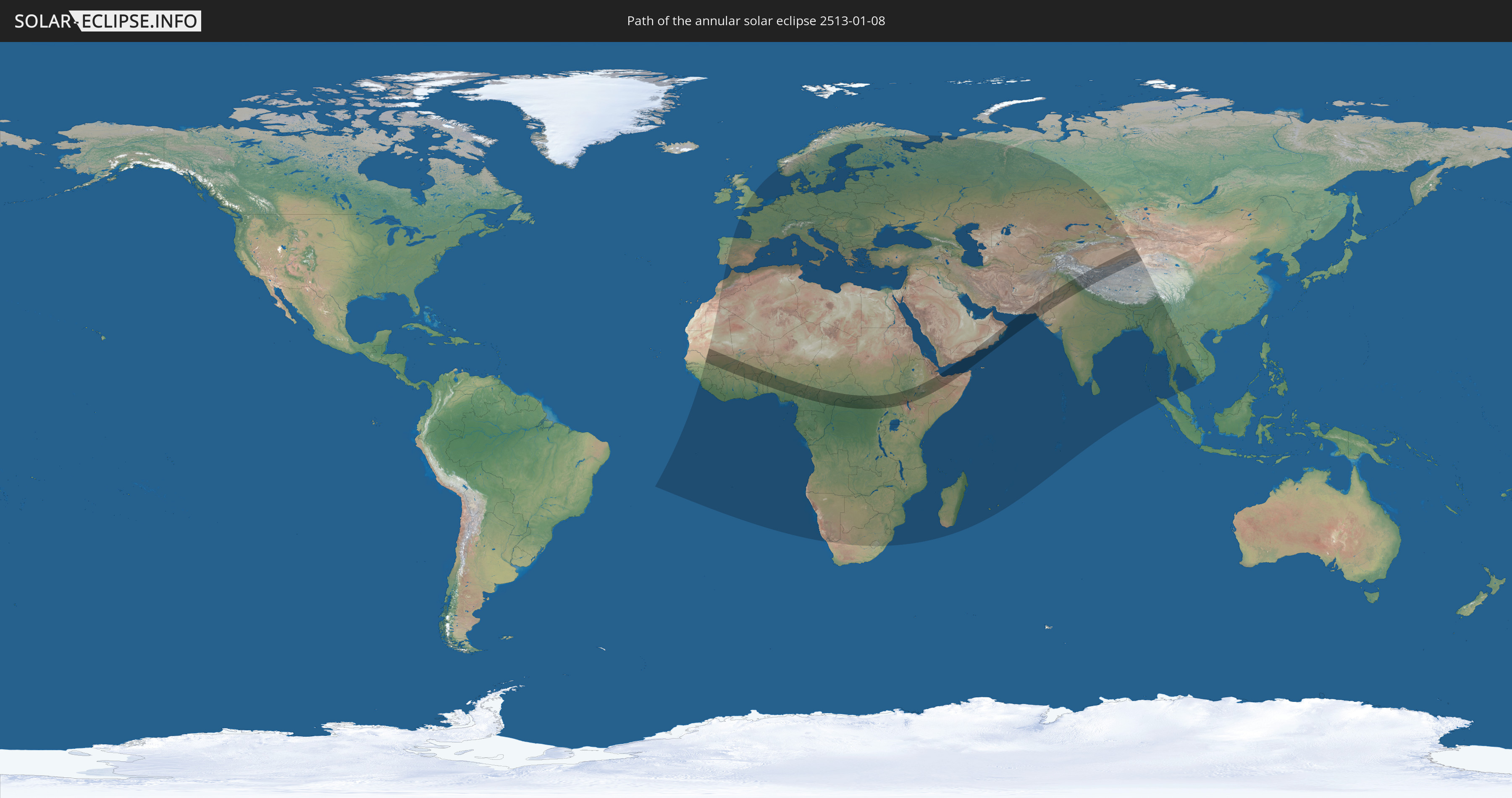
Die Sonnenfinsternis am 01/08/2513 kann man in 140 Ländern als partielle Sonnenfinsternis beobachten.
Der Finsternispfad verläuft durch 22 Länder. Nur in diesen Ländern ist sie als annular Sonnenfinsternis zu sehen.
In den folgenden Ländern ist die Sonnenfinsternis annular zu sehen
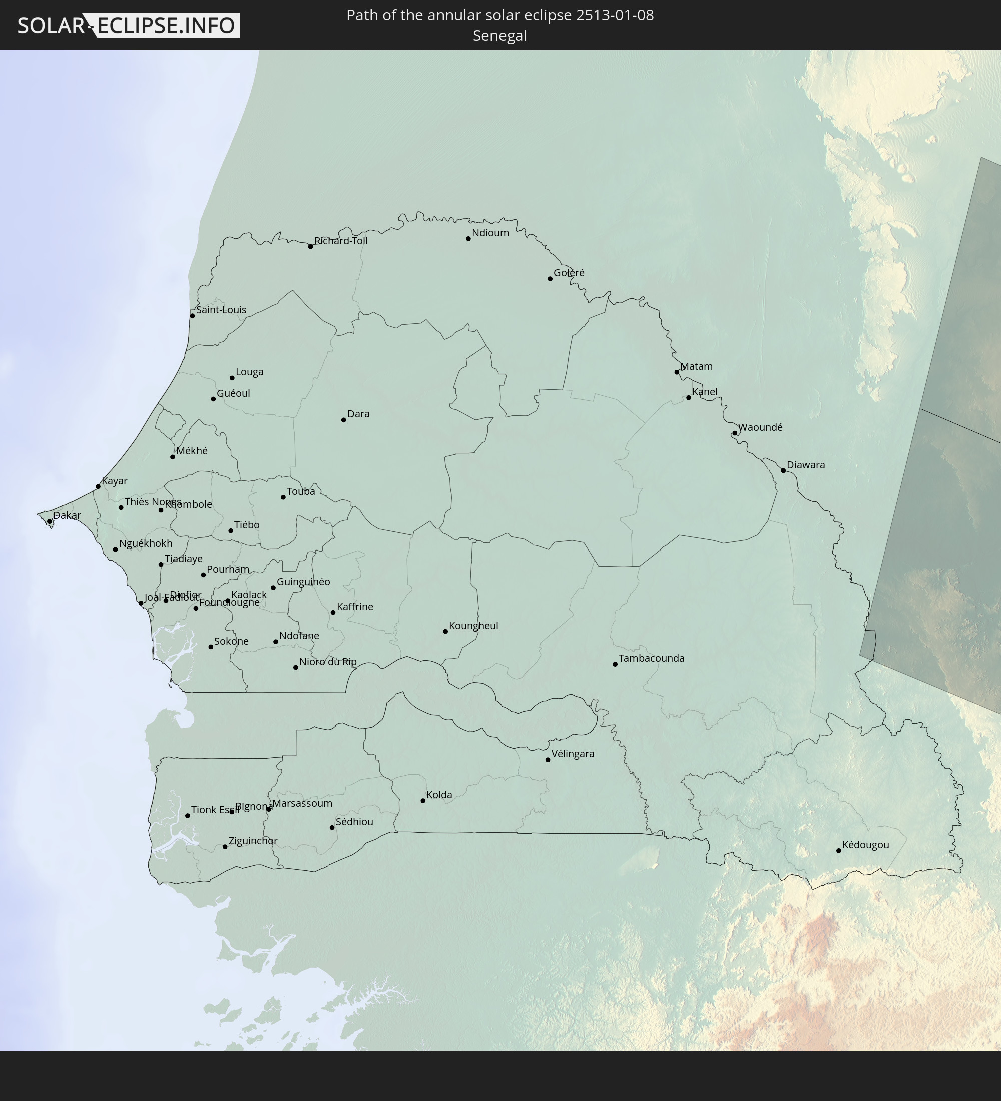 Senegal
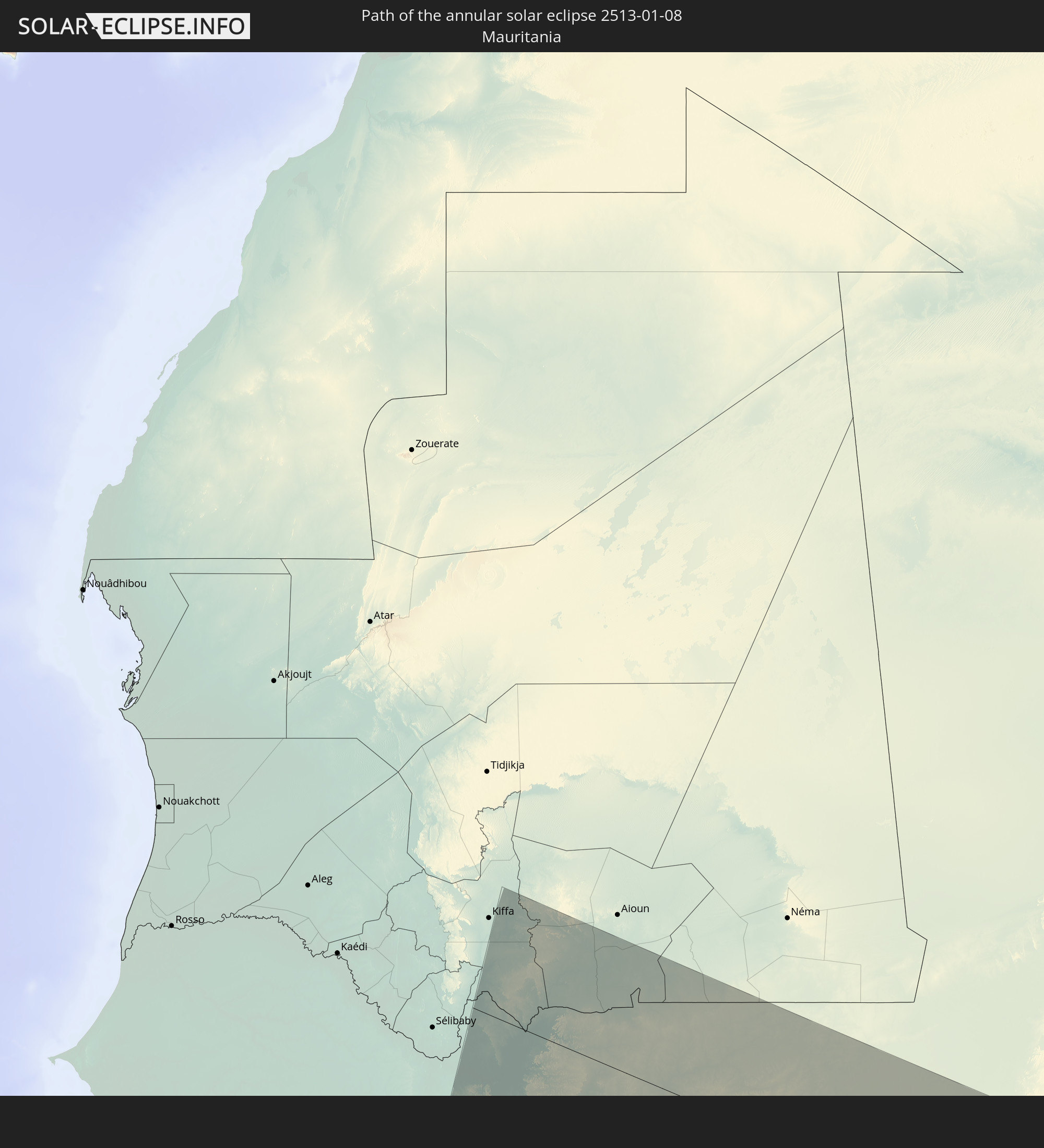 Mauritania
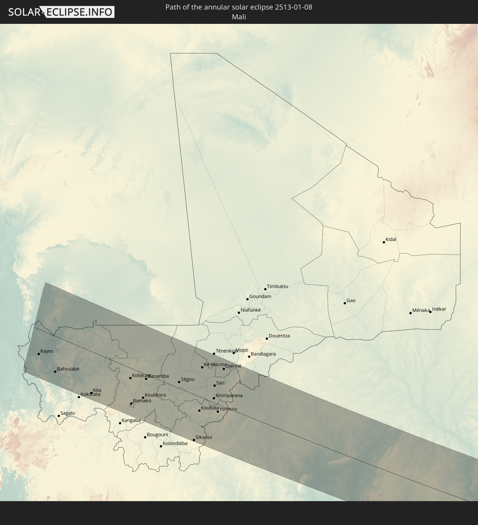 Mali
Mali
 Burkina Faso
 Ghana
Ghana
 Togo
Togo
 Benin
Benin
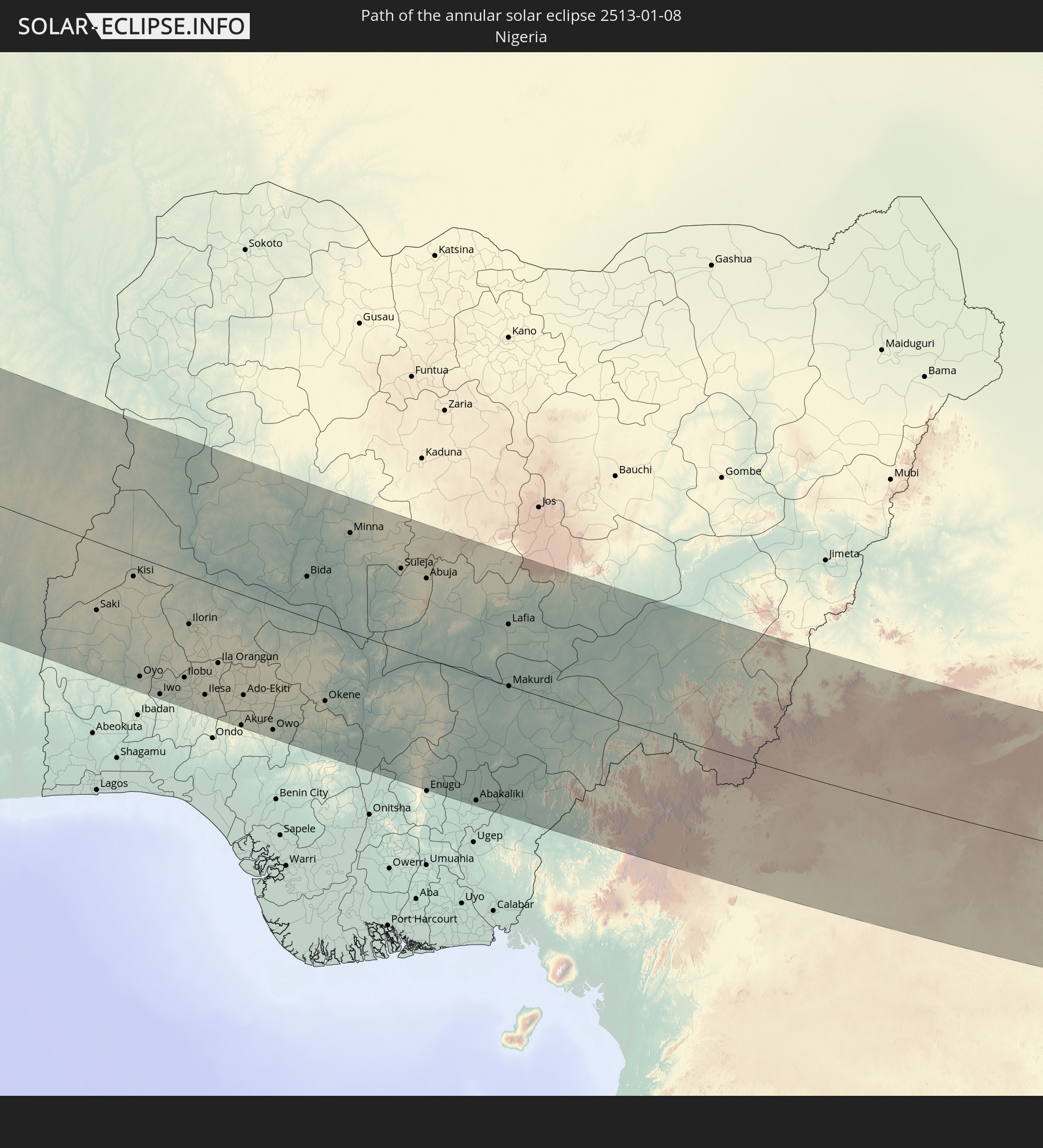 Nigeria
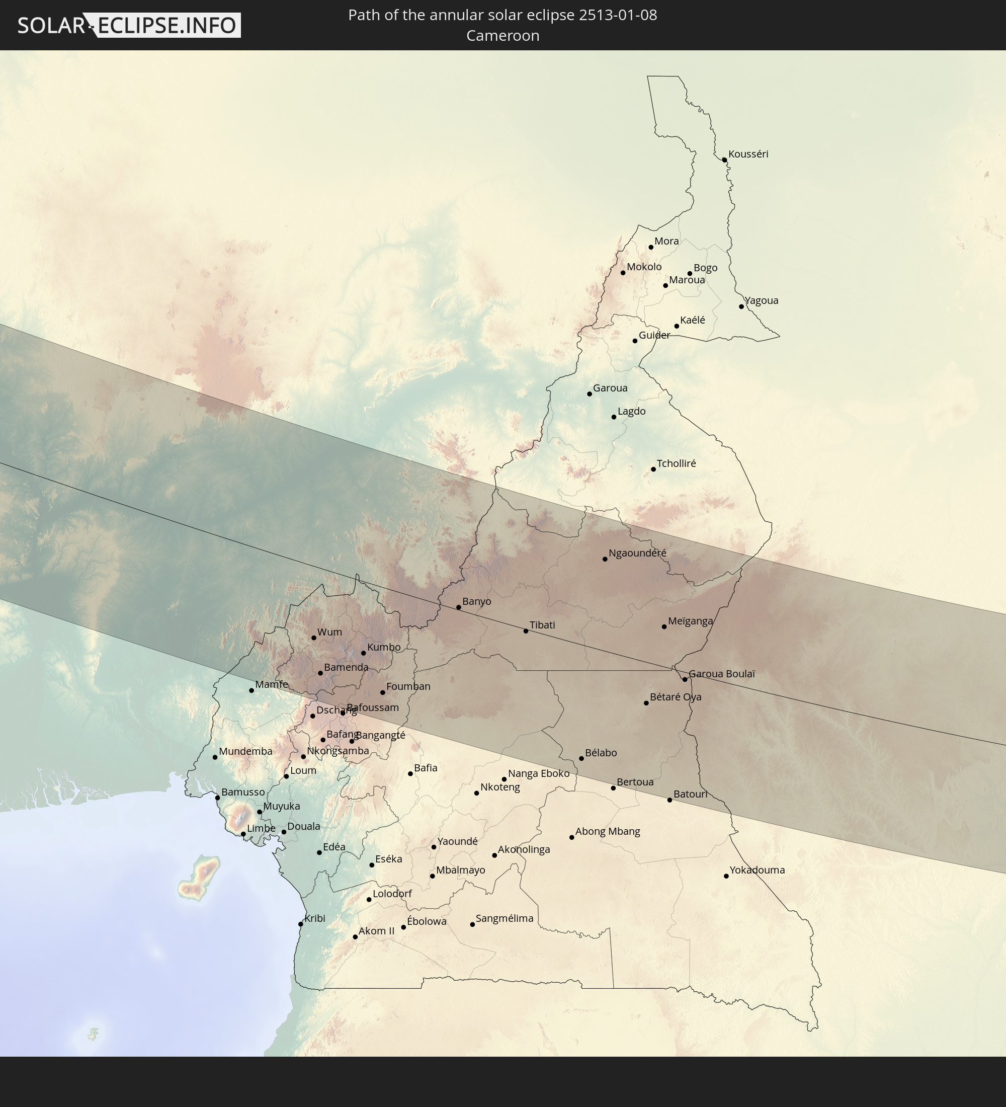 Cameroon
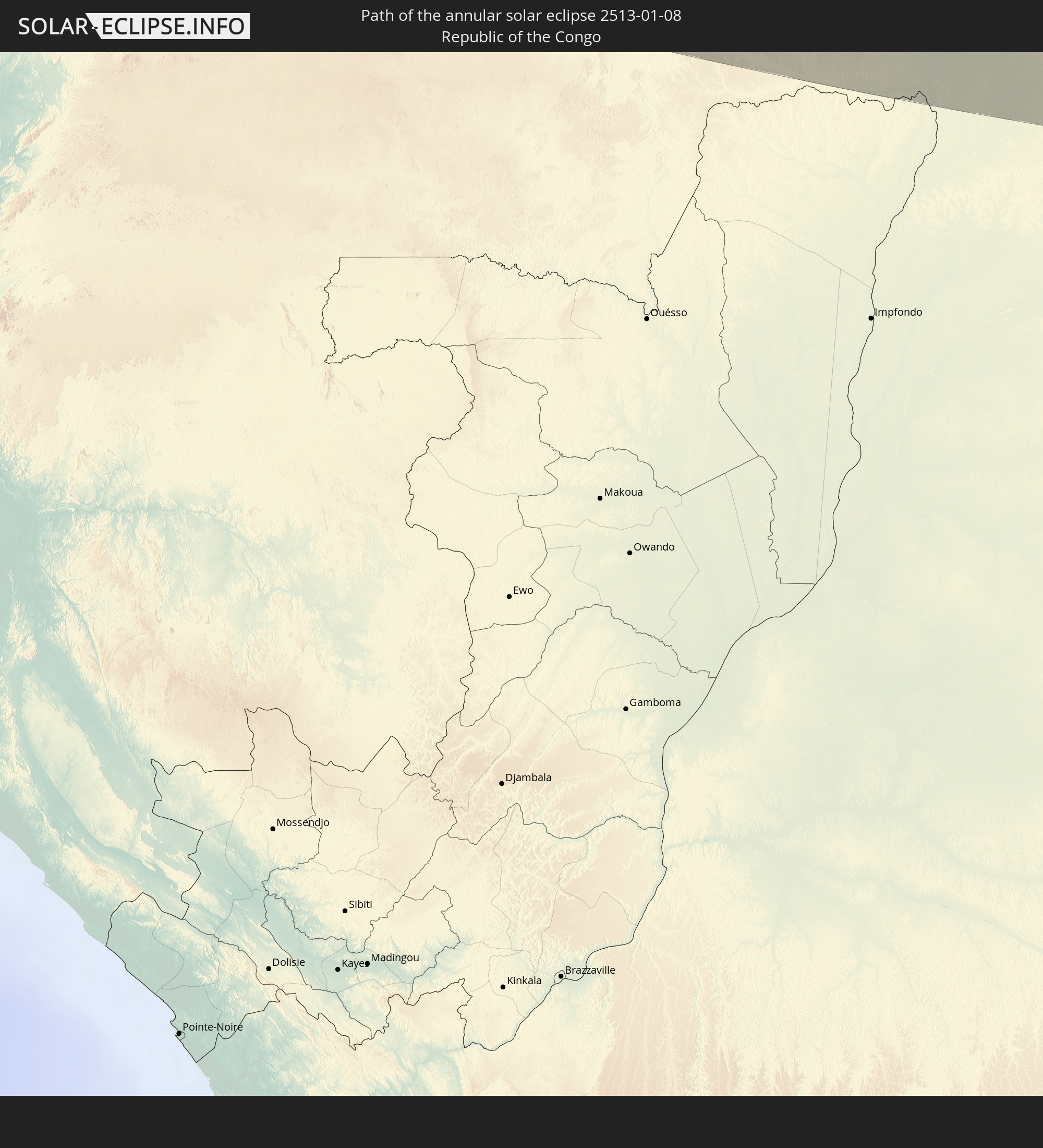 Republic of the Congo
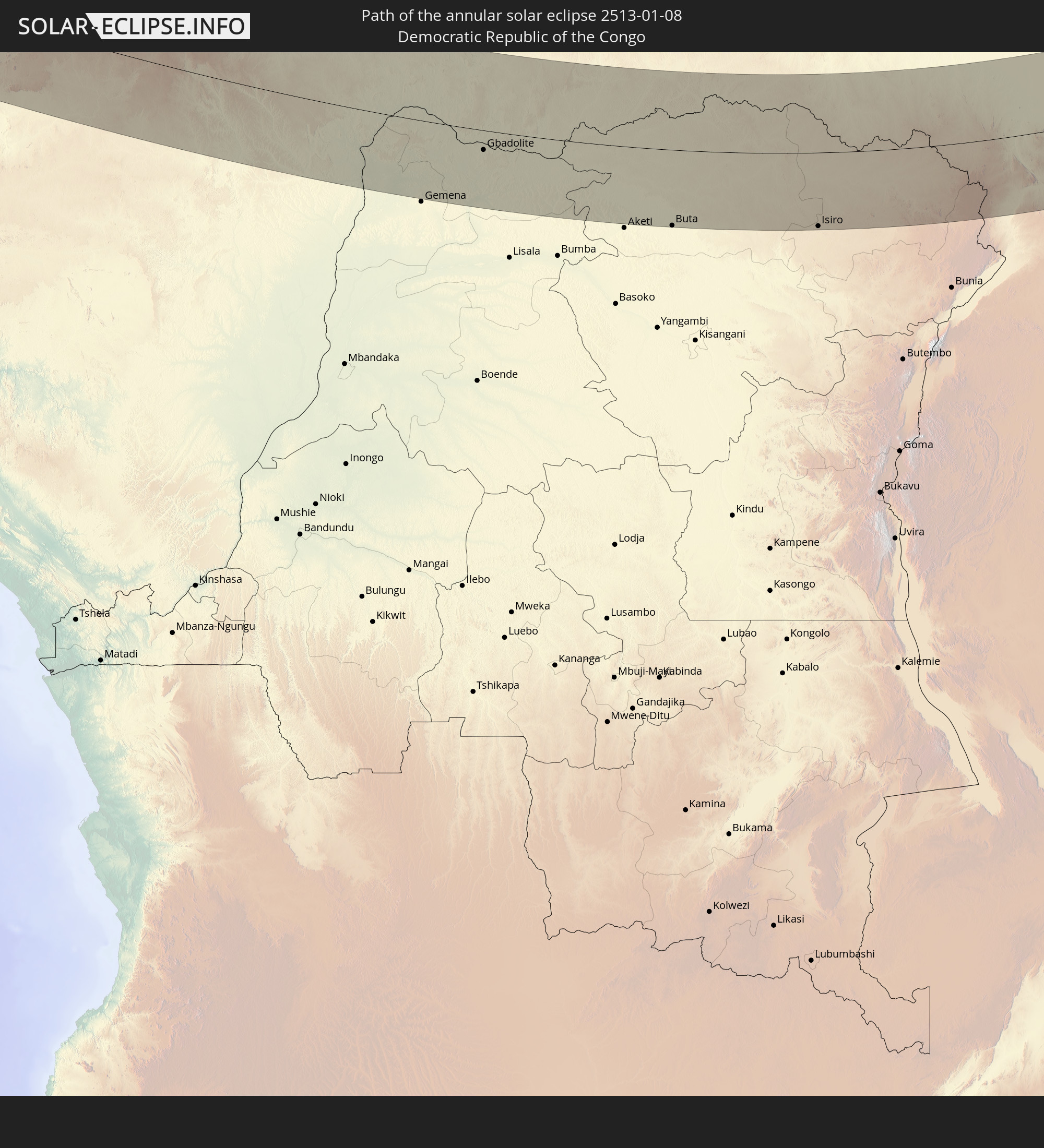 Democratic Republic of the Congo
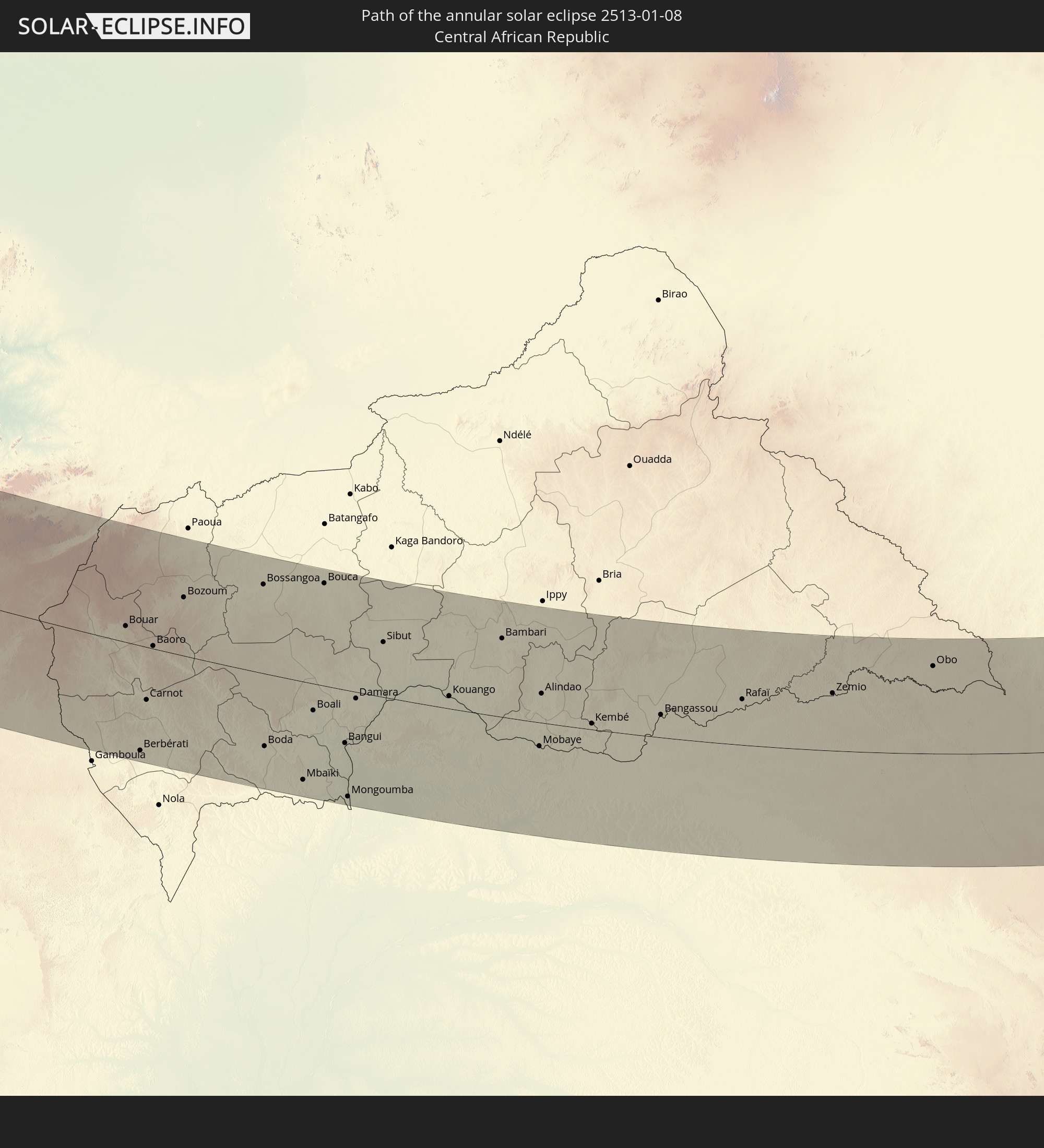 Central African Republic
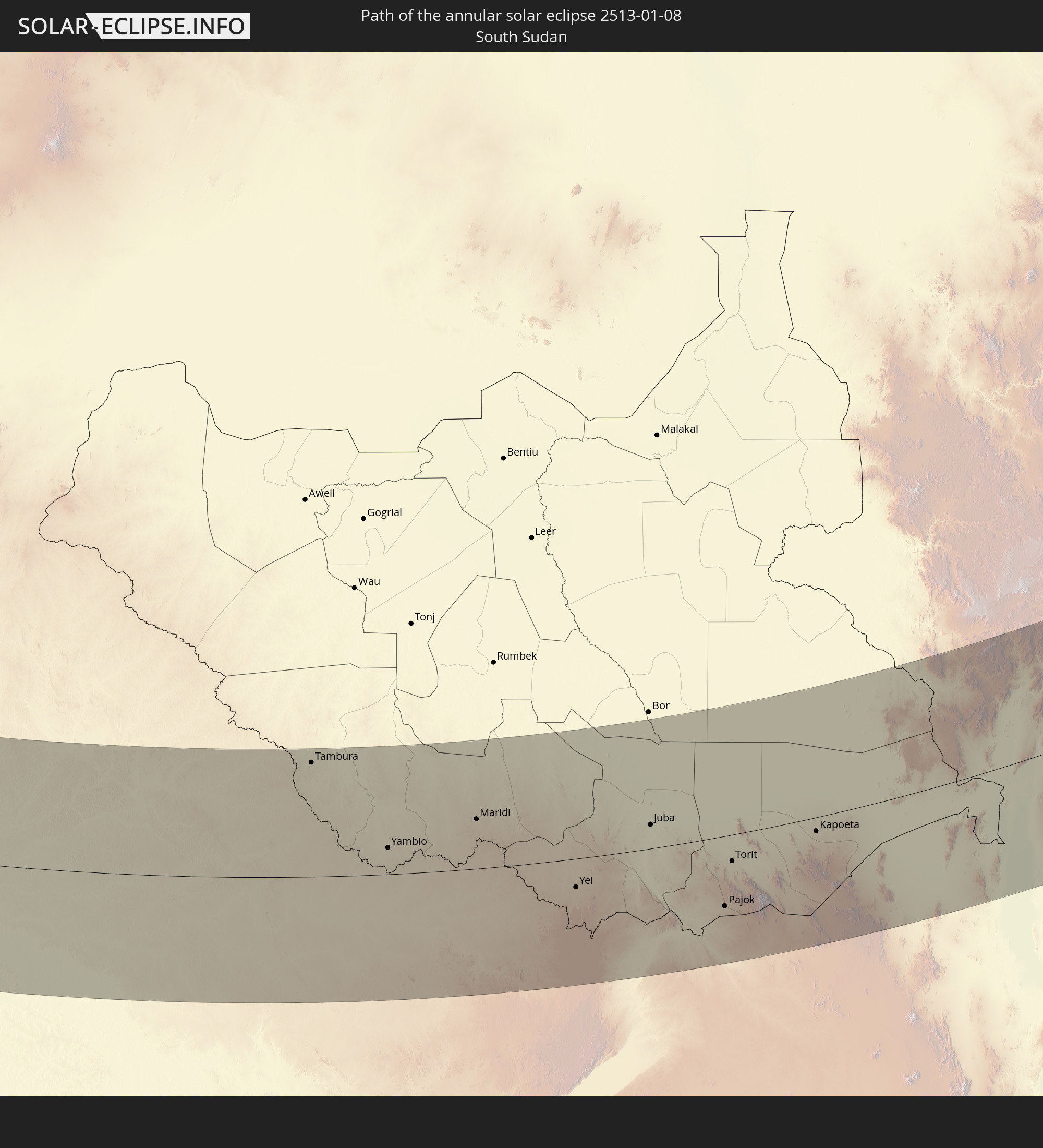 South Sudan
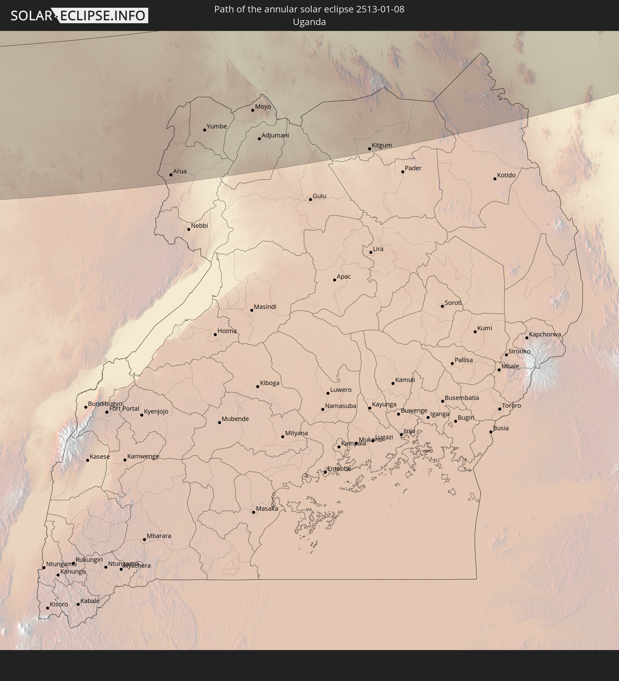 Uganda
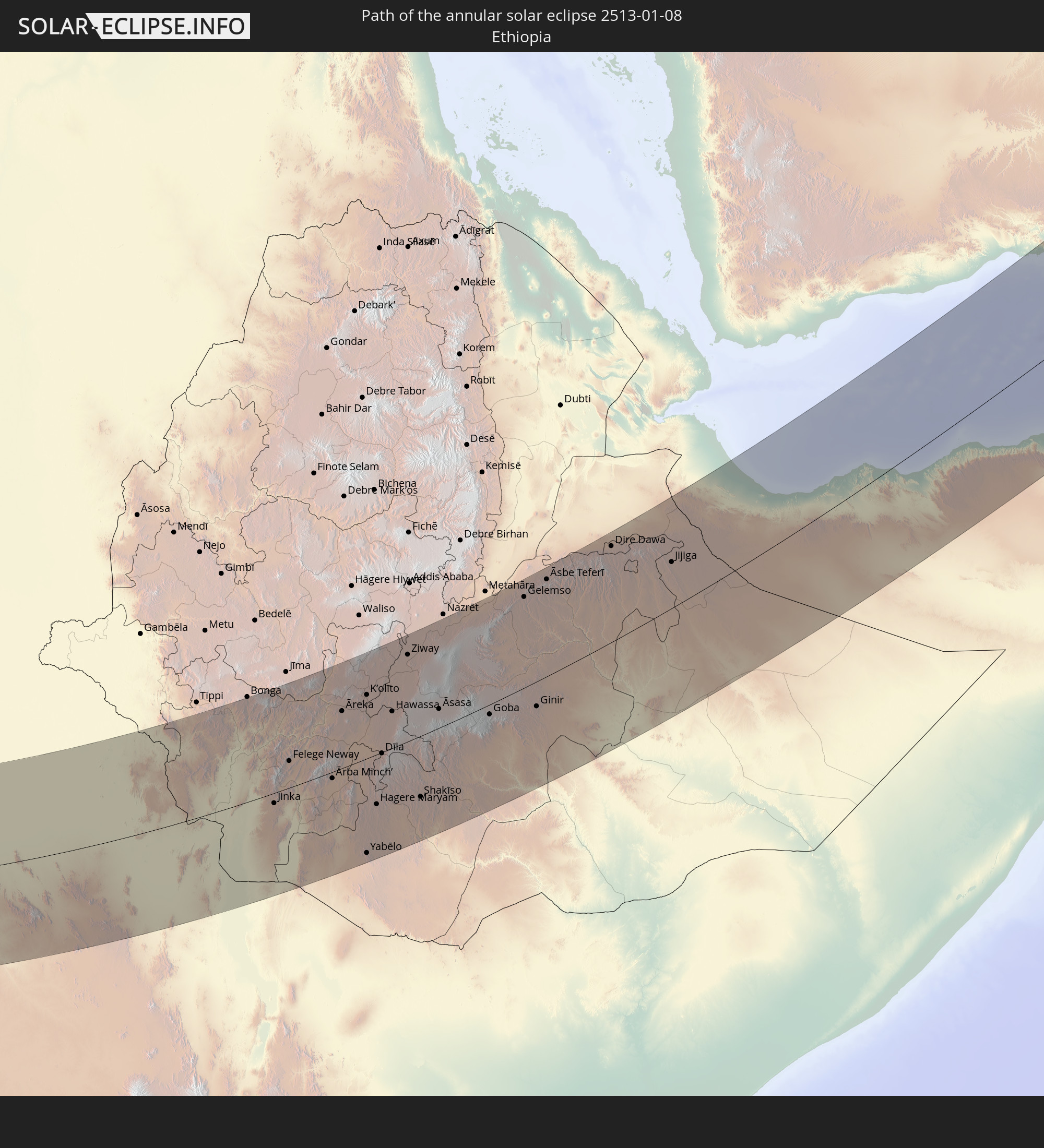 Ethiopia
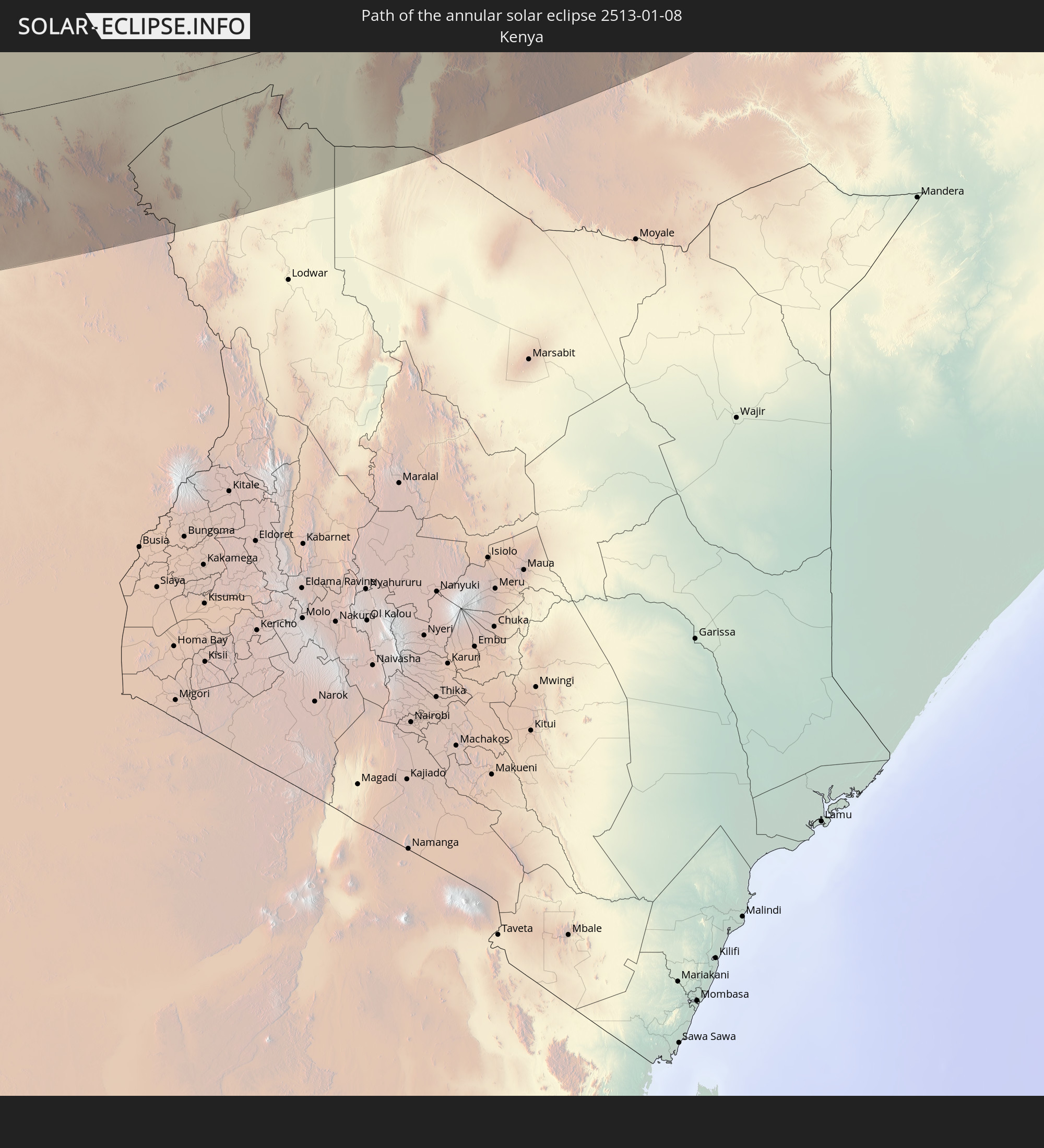 Kenya
Kenya
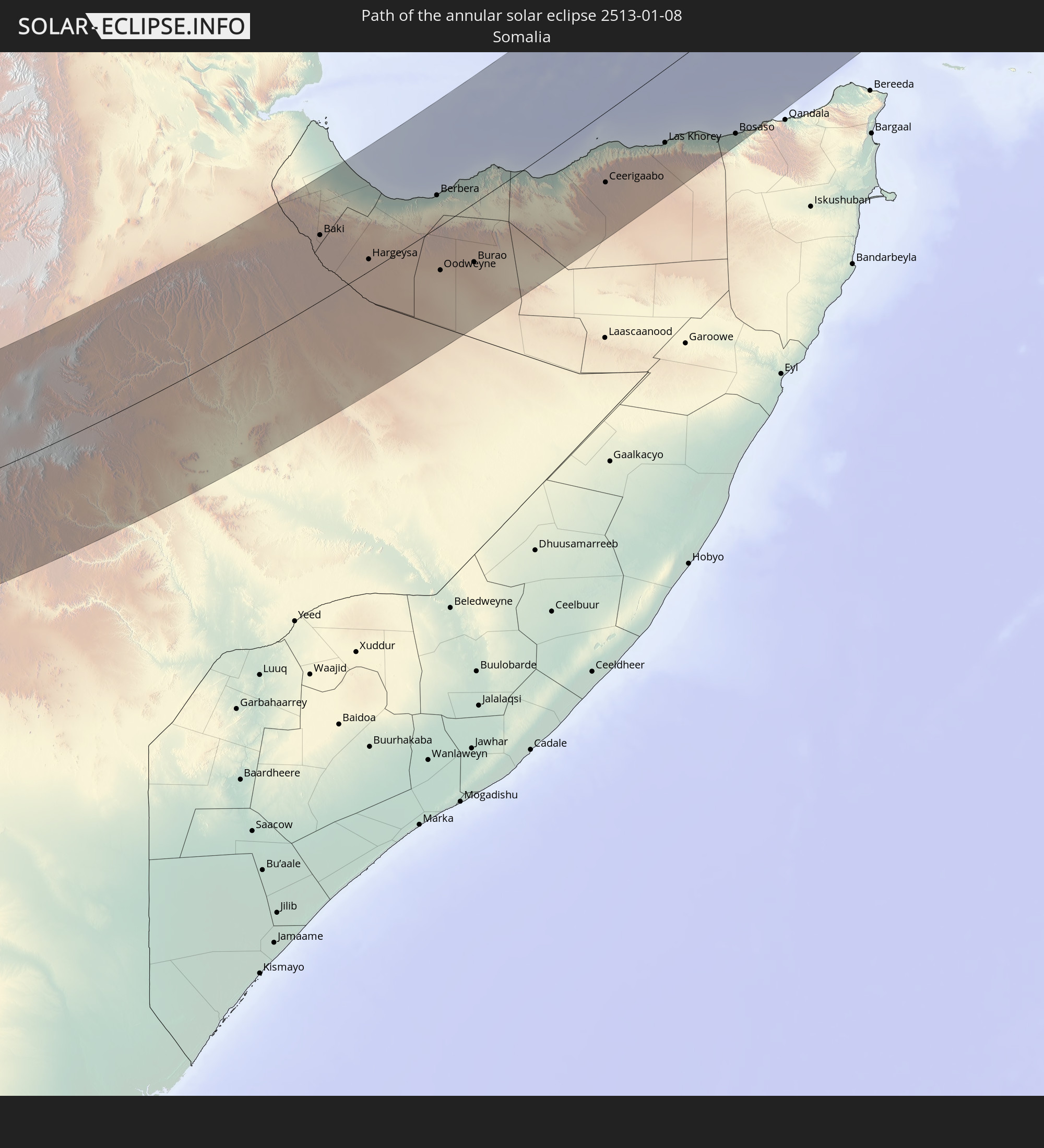 Somalia
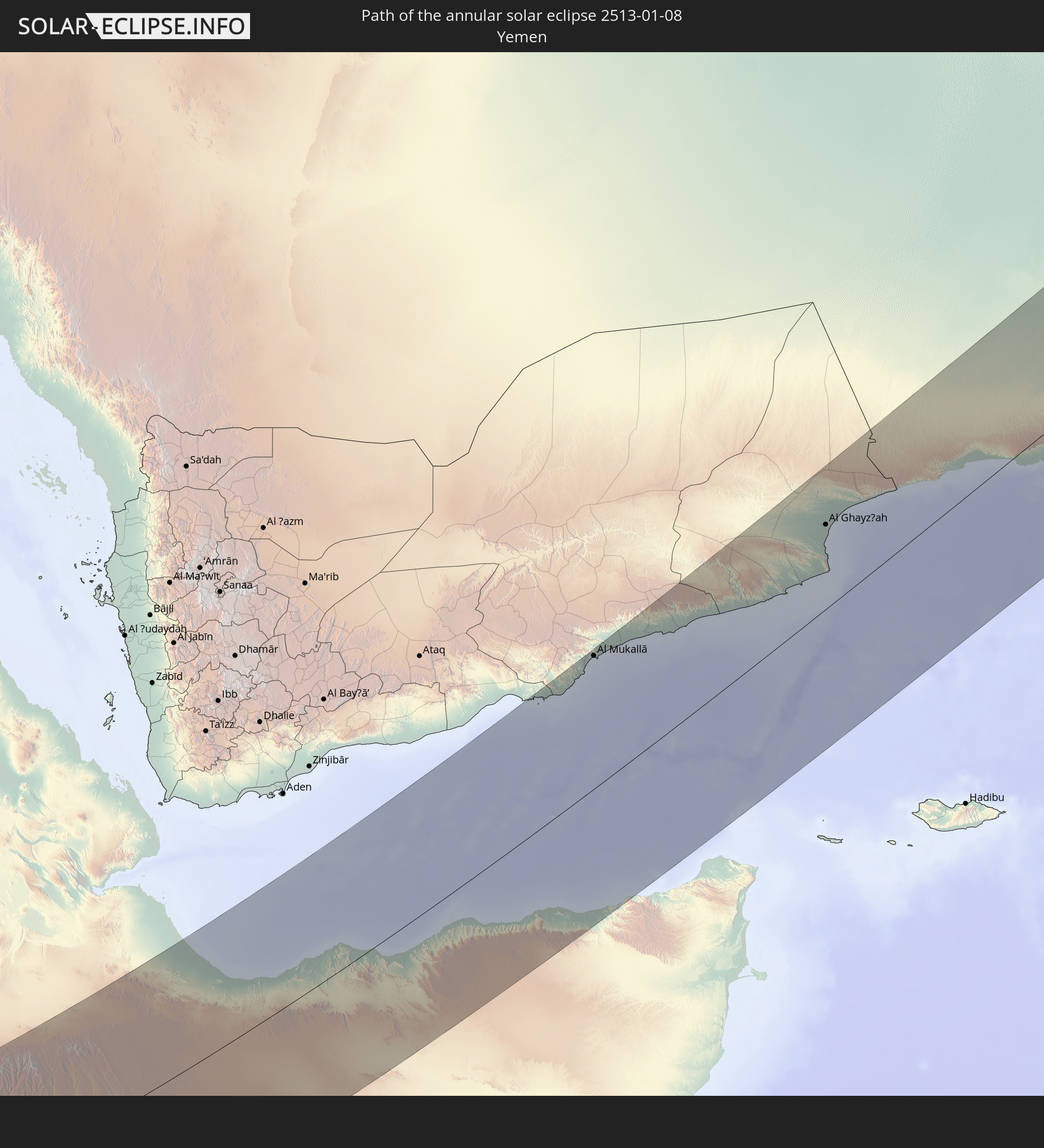 Yemen
Yemen
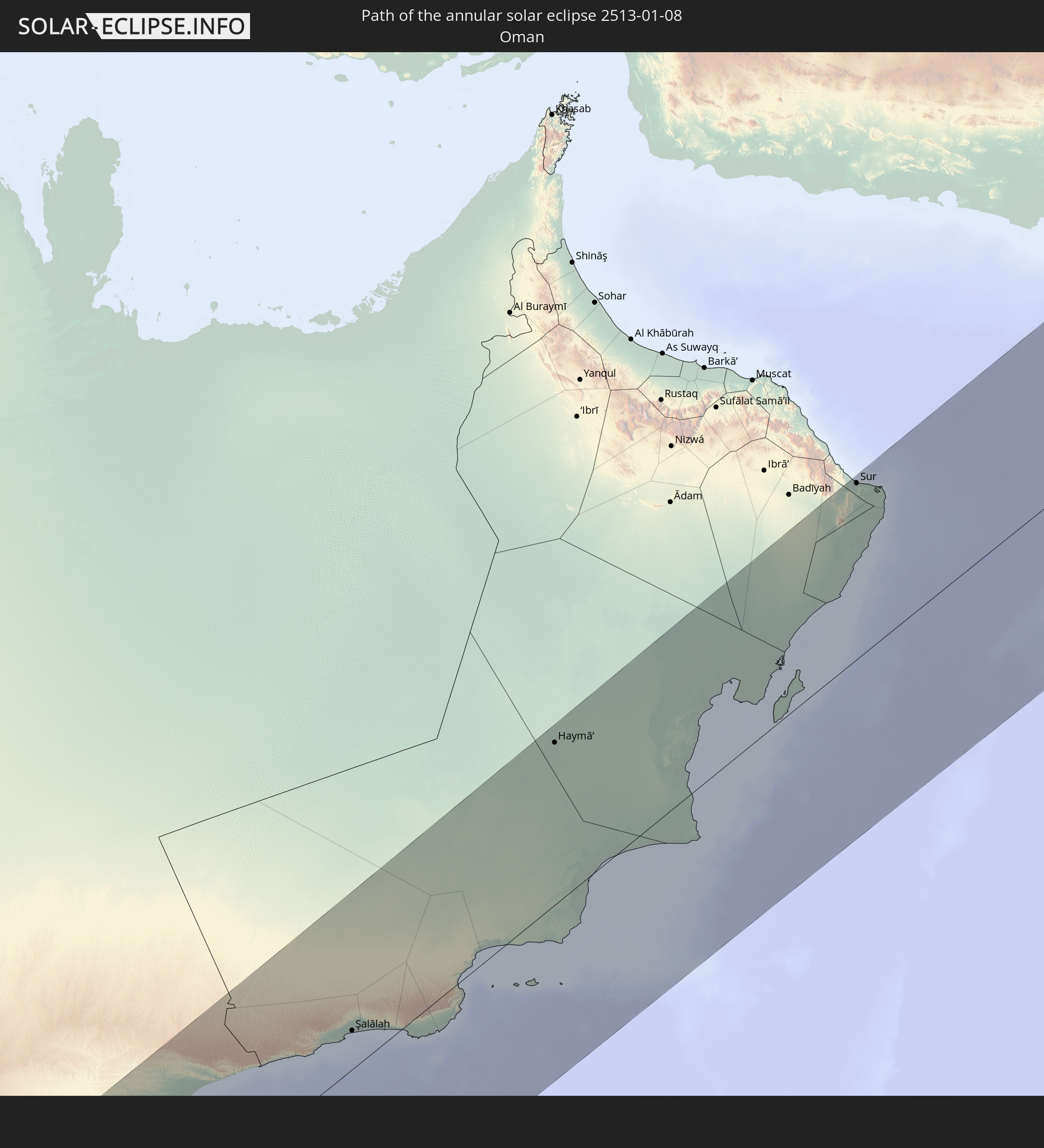 Oman
Oman
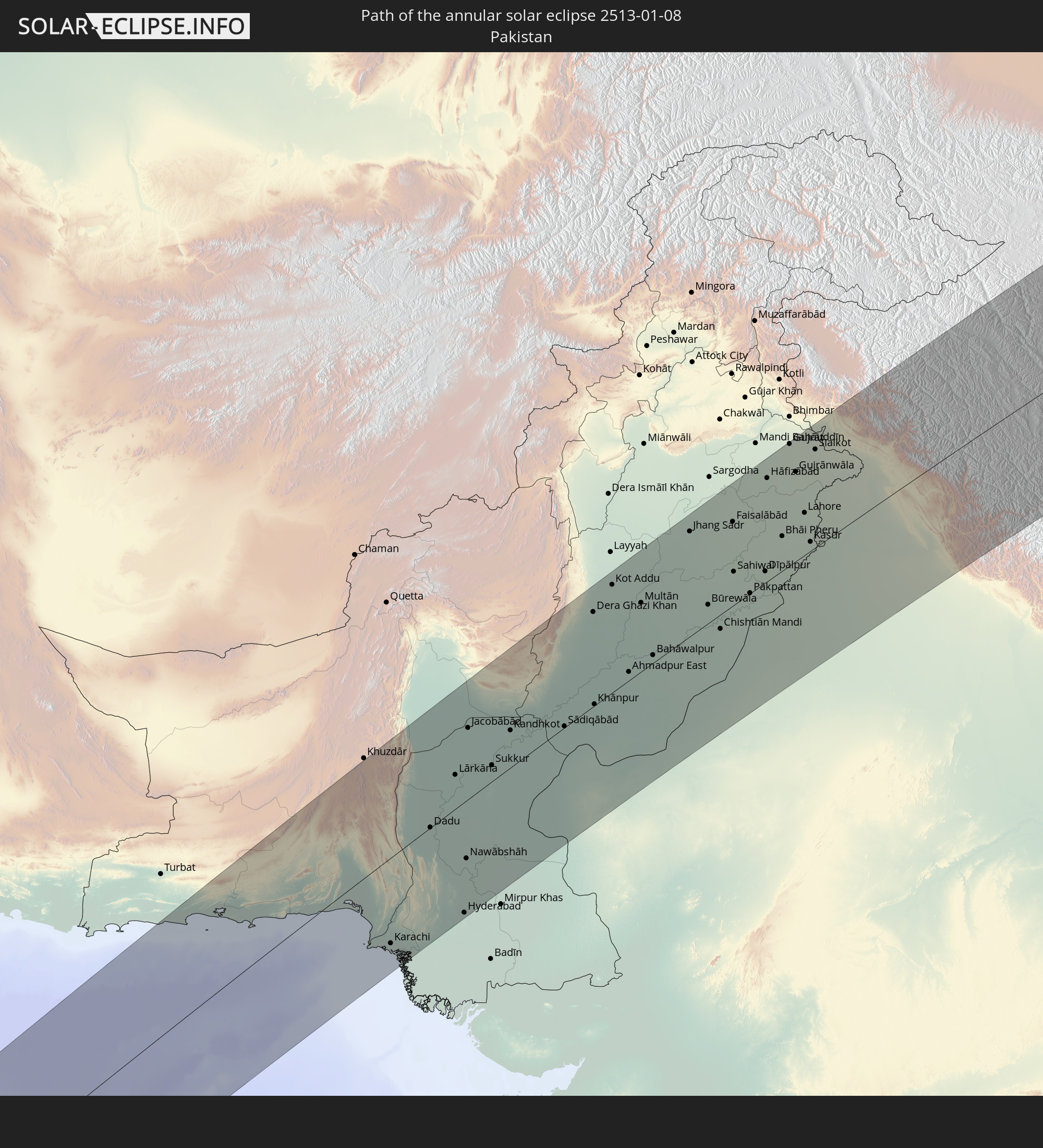 Pakistan
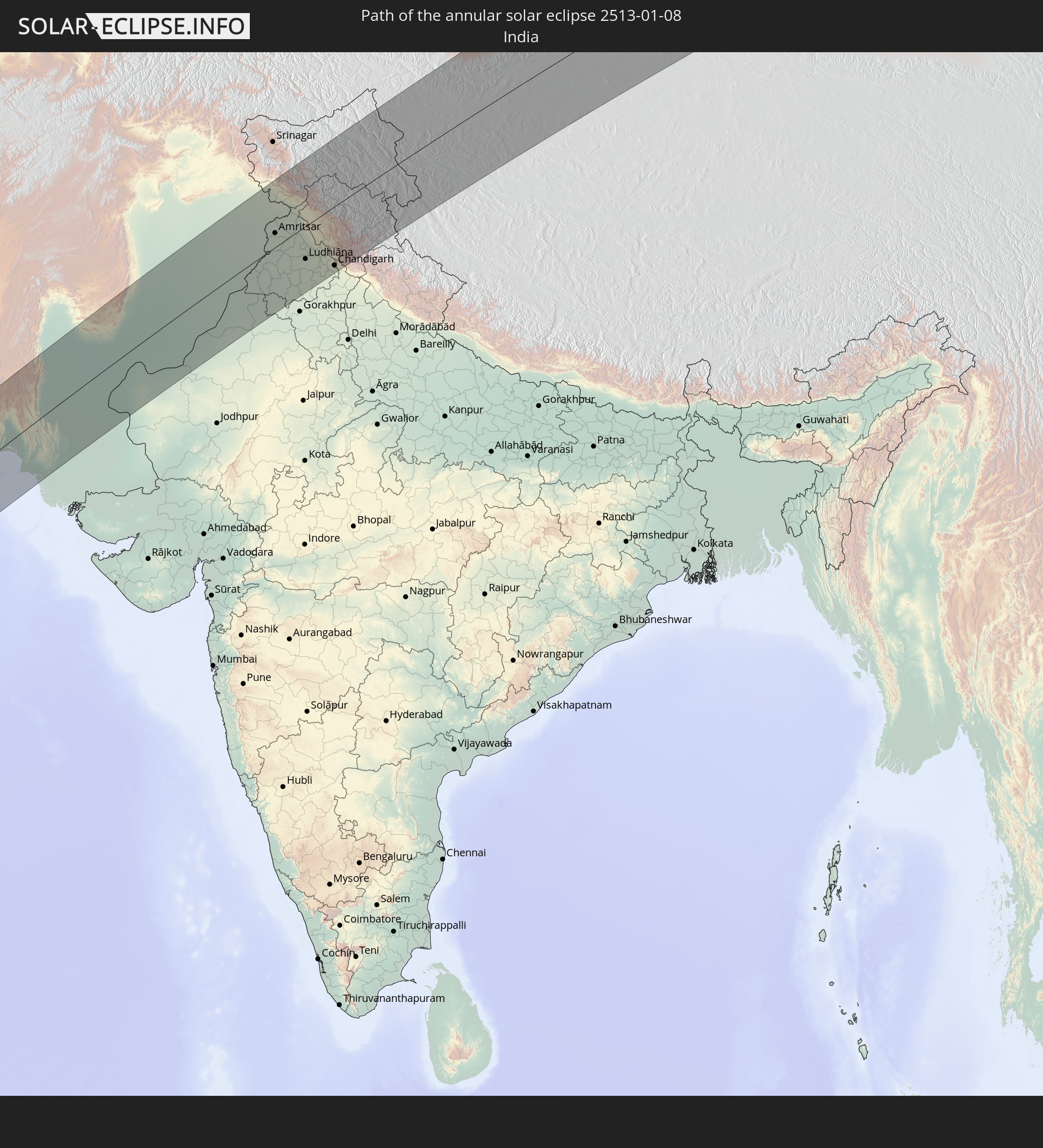 India
India
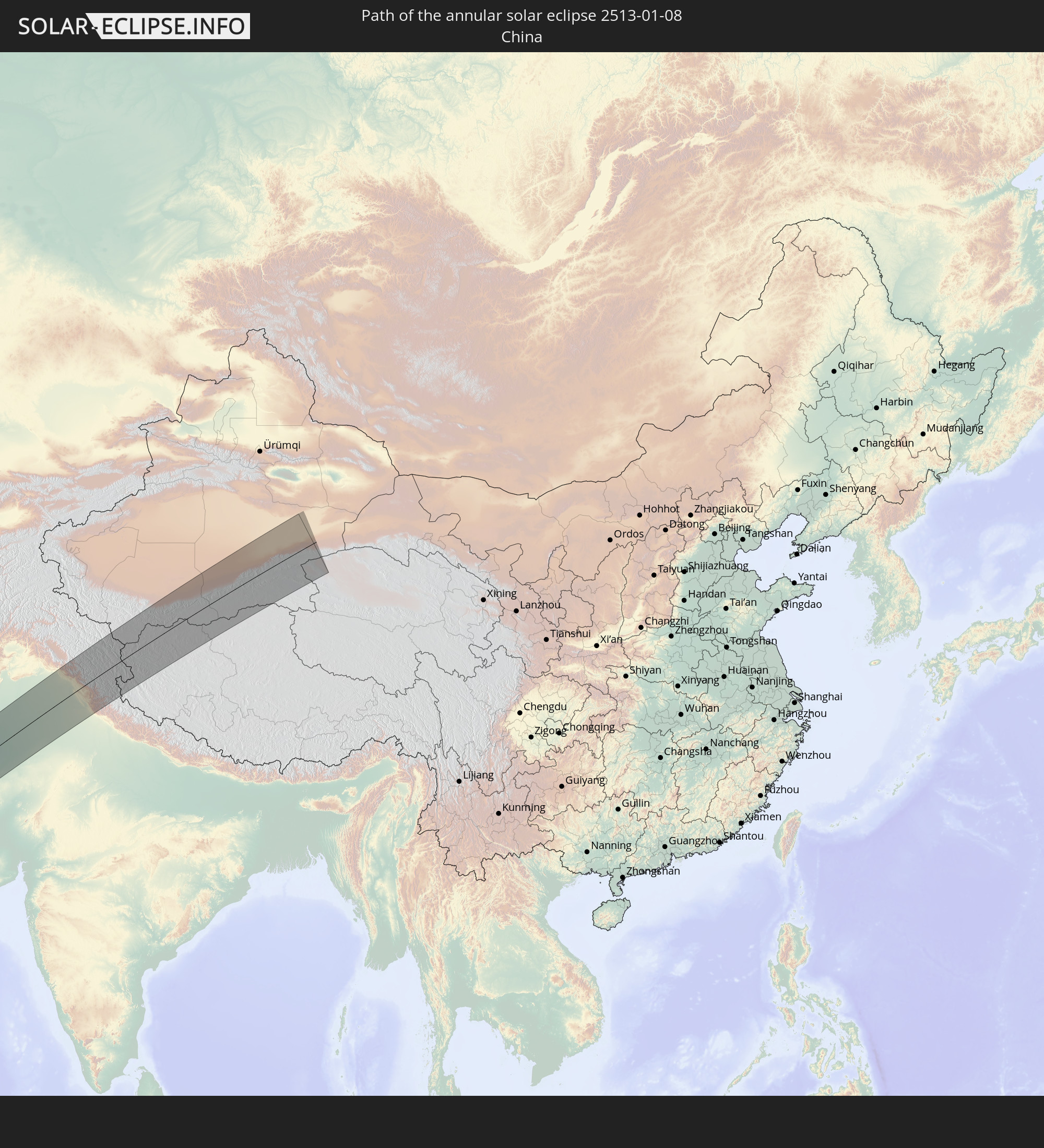 China
China
In den folgenden Ländern ist die Sonnenfinsternis partiell zu sehen
 Russia
 Spain
Spain
 Senegal
 Mauritania
 Guinea
 Saint Helena, Ascension and Tristan da Cunha
 Sierra Leone
 Morocco
 Mali
Mali
 Liberia
 Algeria
 United Kingdom
 Ivory Coast
 Burkina Faso
 Gibraltar
 France
 Ghana
Ghana
 Guernsey
 Jersey
 Togo
Togo
 Niger
Niger
 Benin
Benin
 Andorra
 Belgium
 Nigeria
 Netherlands
 Norway
 Equatorial Guinea
 Luxembourg
 Germany
 Switzerland
 São Tomé and Príncipe
 Italy
Italy
 Monaco
 Tunisia
 Denmark
 Cameroon
 Gabon
Gabon
 Libya
Libya
 Liechtenstein
 Austria
 Sweden
 Republic of the Congo
 Angola
 Namibia
 Czechia
 Democratic Republic of the Congo
 San Marino
 Vatican City
 Slovenia
 Chad
Chad
 Croatia
 Poland
 Malta
Malta
 Central African Republic
 Bosnia and Herzegovina
 Hungary
 South Africa
 Slovakia
 Montenegro
 Serbia
 Albania
 Åland Islands
 Greece
 Botswana
 Romania
 Republic of Macedonia
 Finland
 Lithuania
 Latvia
 Estonia
 Sudan
Sudan
 Zambia
 Ukraine
 Bulgaria
 Belarus
 Egypt
Egypt
 Zimbabwe
 Turkey
 Moldova
 Lesotho
 Rwanda
 Burundi
 Tanzania
 Uganda
 Mozambique
 Swaziland
 Cyprus
 Malawi
 Ethiopia
 Kenya
Kenya
 State of Palestine
 Israel
 Saudi Arabia
 Jordan
 Lebanon
 Syria
Syria
 Eritrea
 Iraq
Iraq
 Georgia
 French Southern and Antarctic Lands
 Somalia
 Djibouti
 Yemen
Yemen
 Madagascar
 Comoros
 Armenia
 Iran
Iran
 Azerbaijan
 Mayotte
 Seychelles
 Kazakhstan
 Kuwait
 Bahrain
 Qatar
Qatar
 United Arab Emirates
 Oman
Oman
 Turkmenistan
 Réunion
 Uzbekistan
 Mauritius
 Afghanistan
 Pakistan
 Tajikistan
 India
India
 Kyrgyzstan
 British Indian Ocean Territory
 Maldives
 China
China
 Sri Lanka
 Nepal
Nepal
 Bangladesh
 Bhutan
 Myanmar
 Indonesia
 Thailand
 Malaysia
 Laos
Laos
 Vietnam
 Cambodia
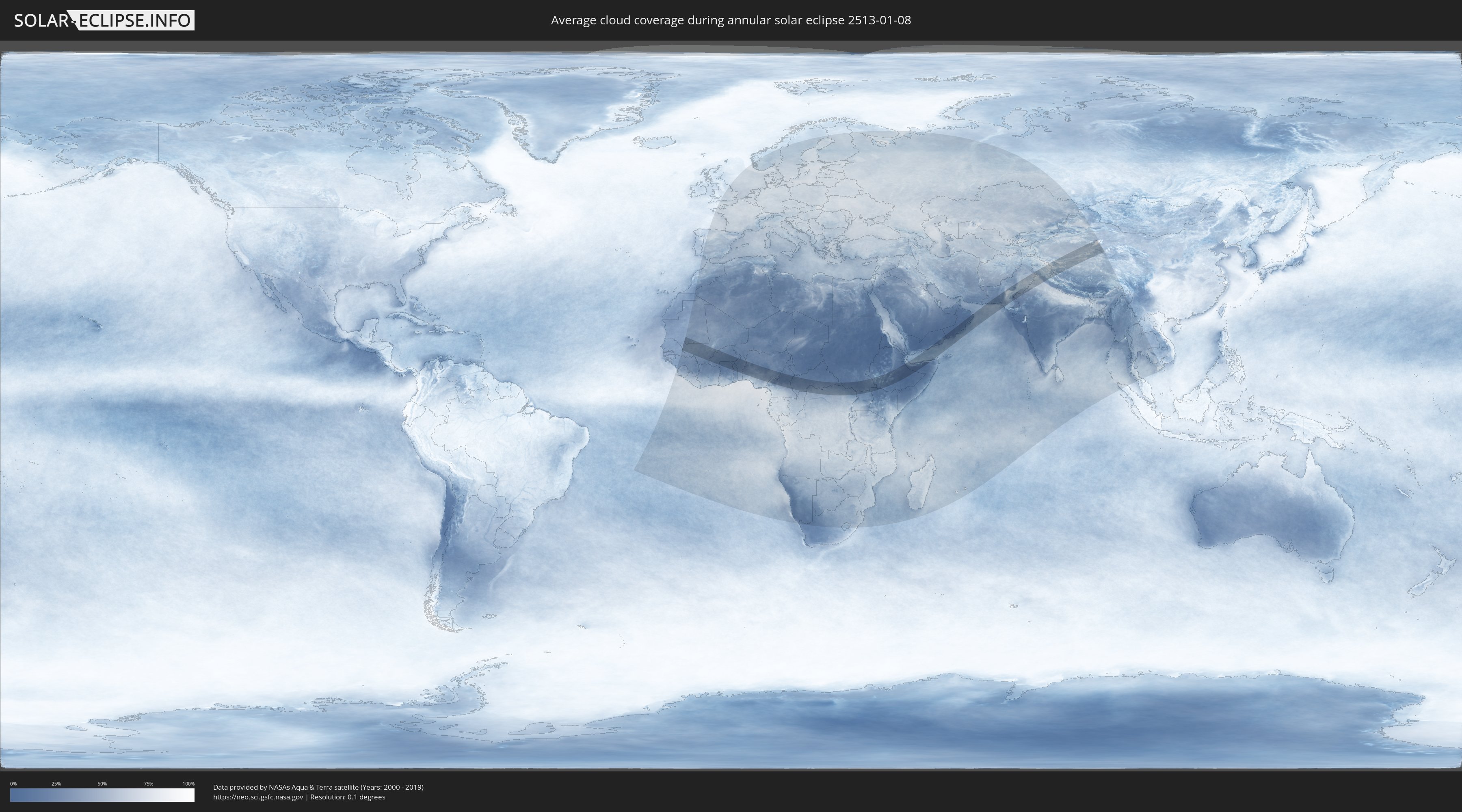
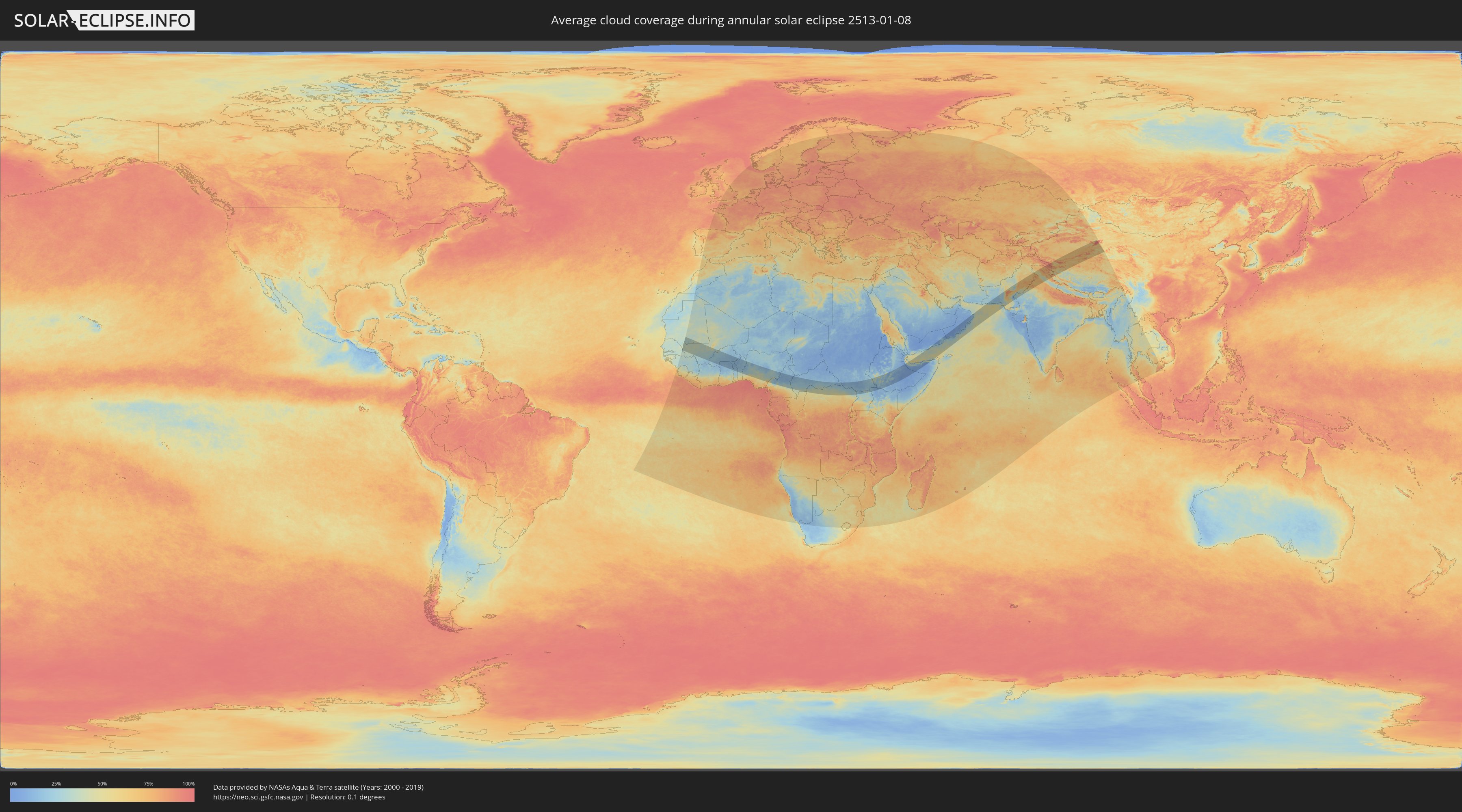
How will be the weather during the annular solar eclipse on 01/08/2513?
Where is the best place to see the annular solar eclipse of 01/08/2513?
The following maps show the average cloud coverage for the day of the annular solar eclipse.
With the help of these maps, it is possible to find the place along the eclipse path, which has the best
chance of a cloudless sky.
Nevertheless, you should consider local circumstances and inform about the weather of your chosen
observation site.
The data is provided by NASAs satellites
AQUA and TERRA.
The cloud maps are averaged over a period of 19 years (2000 - 2019).
Detailed country maps
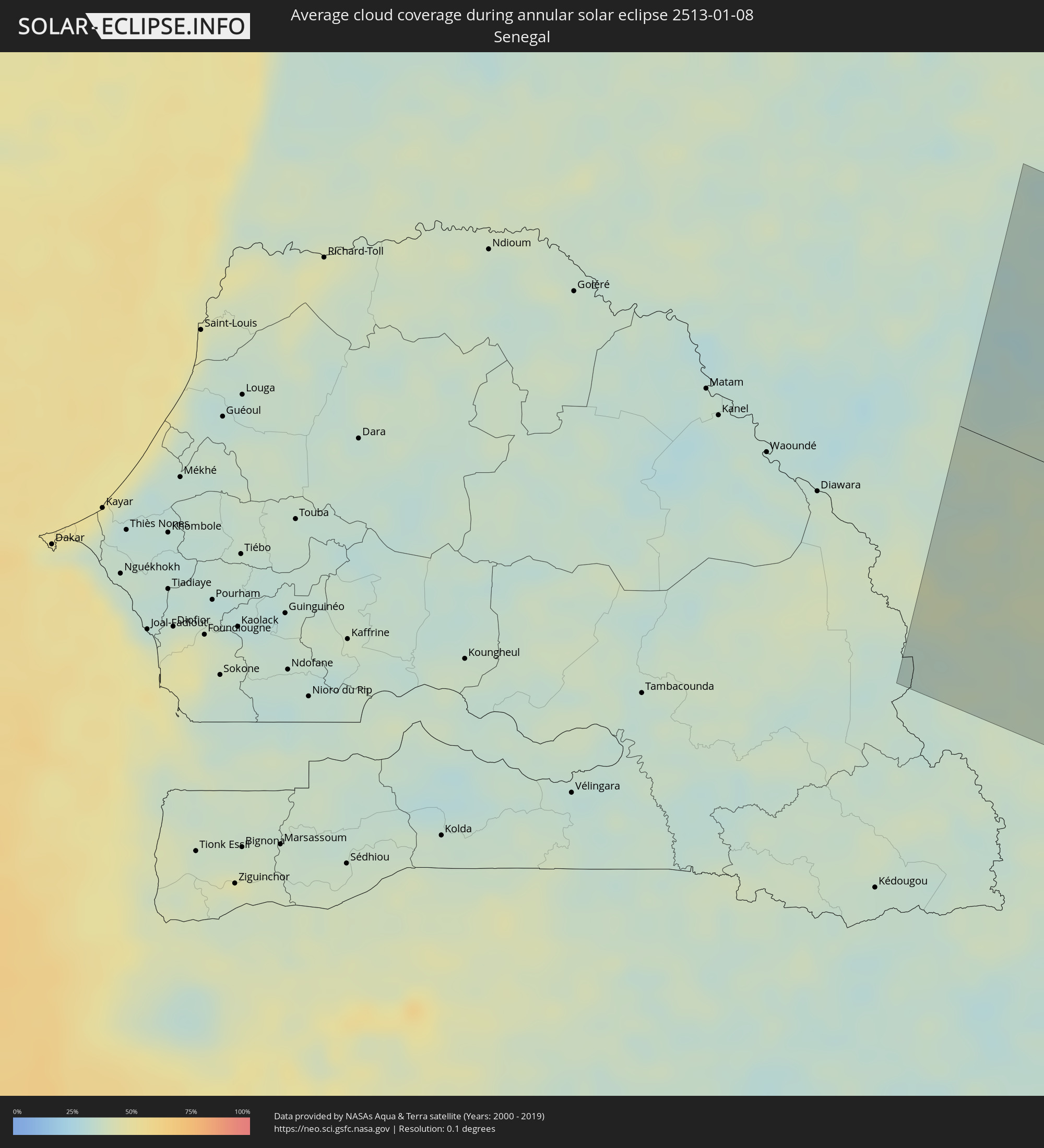 Senegal
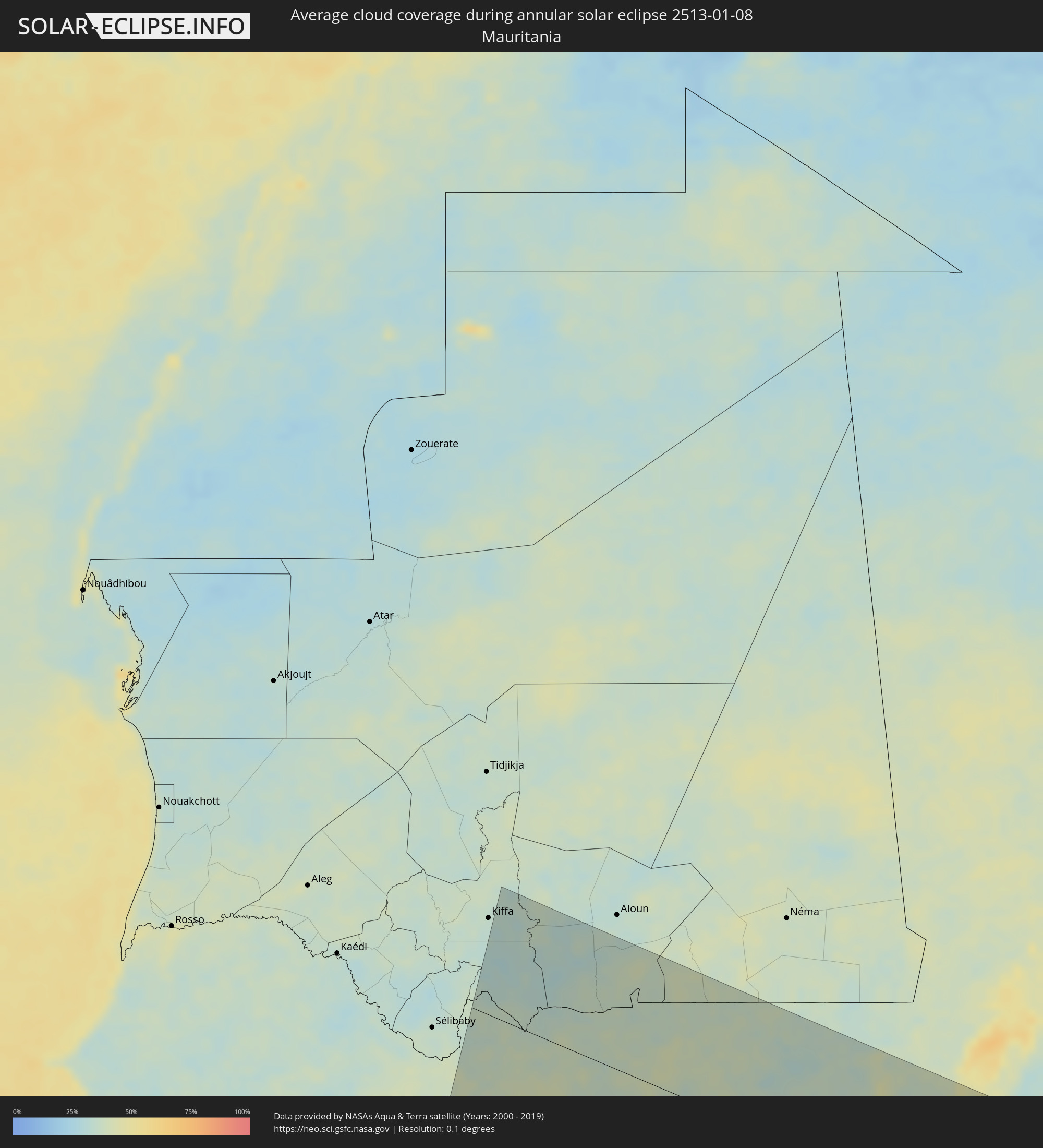 Mauritania
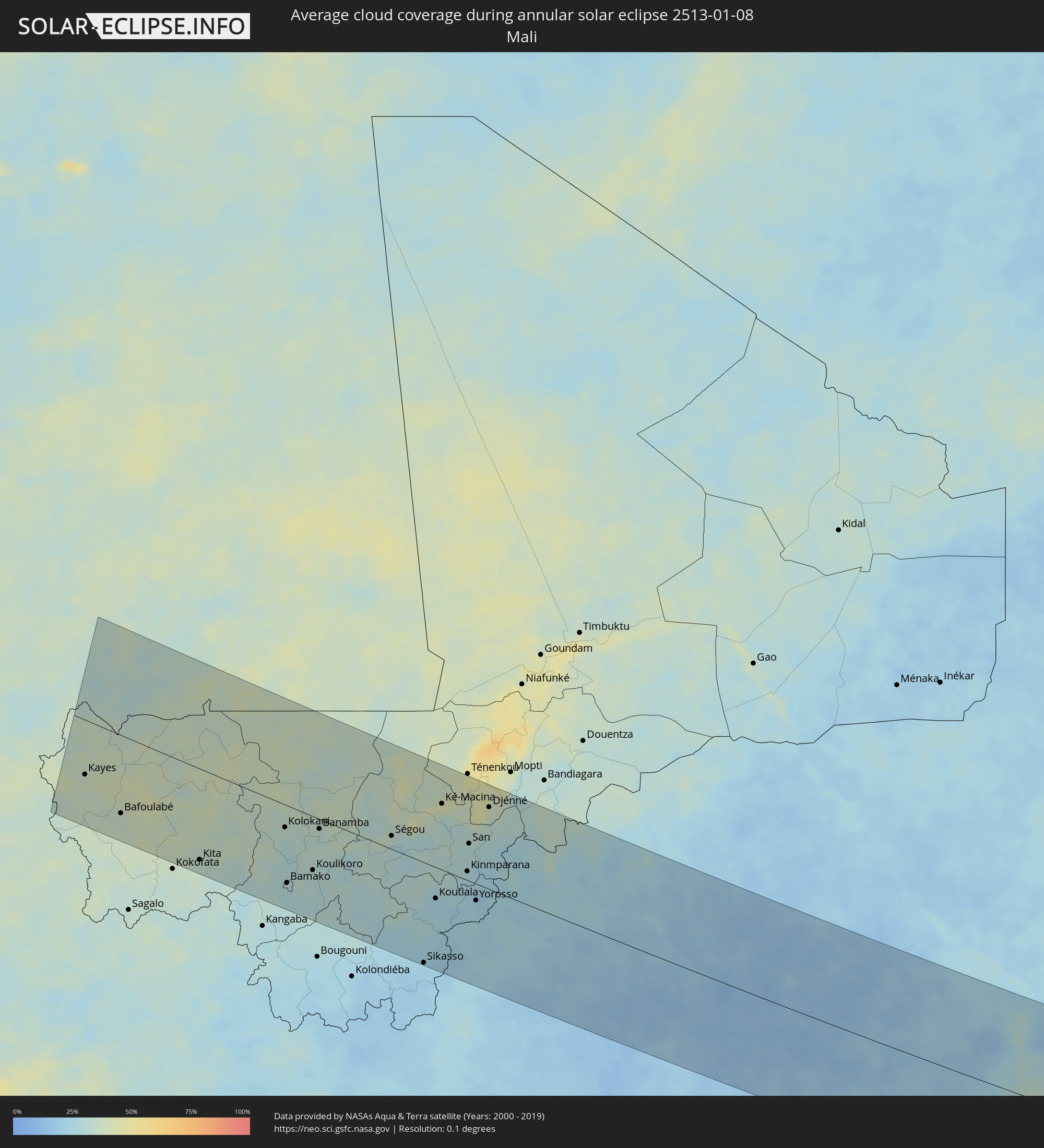 Mali
Mali
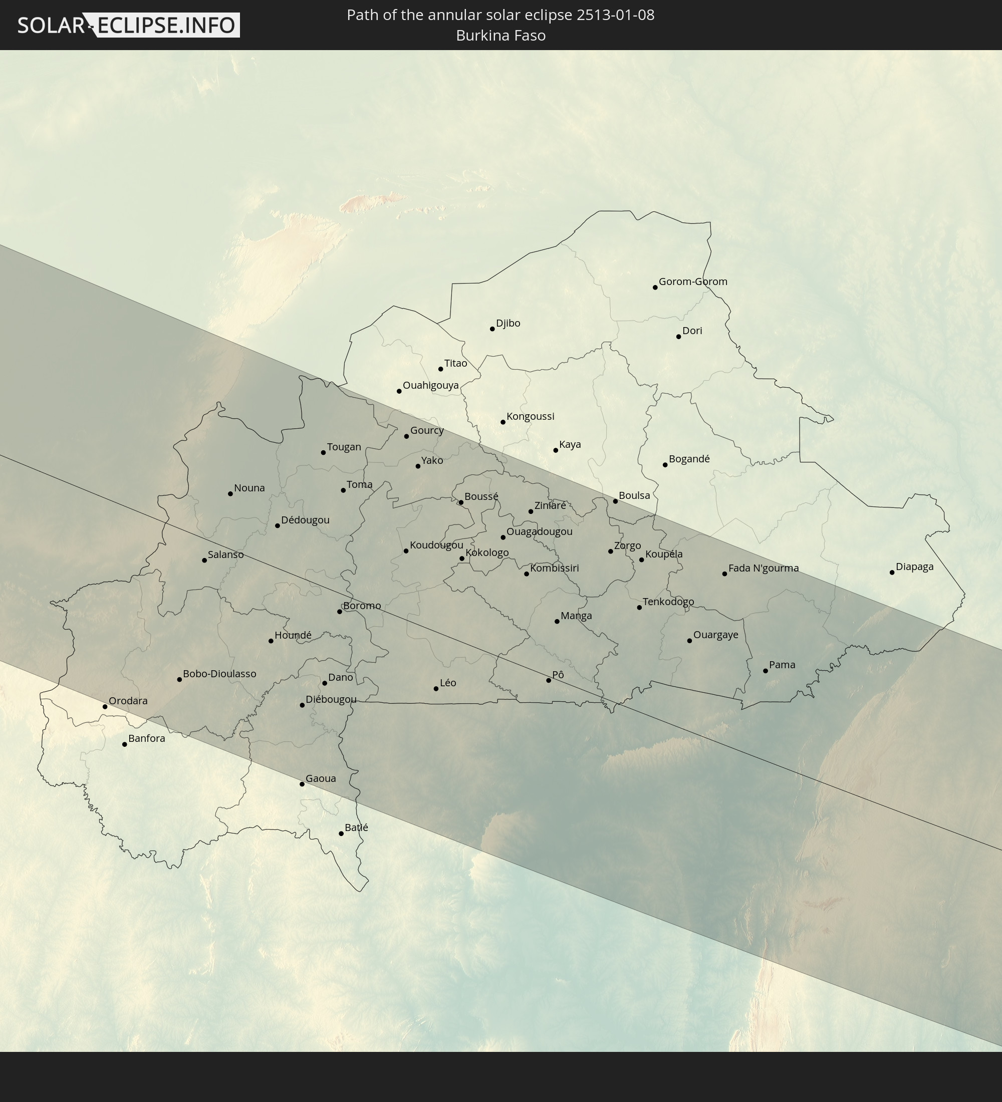
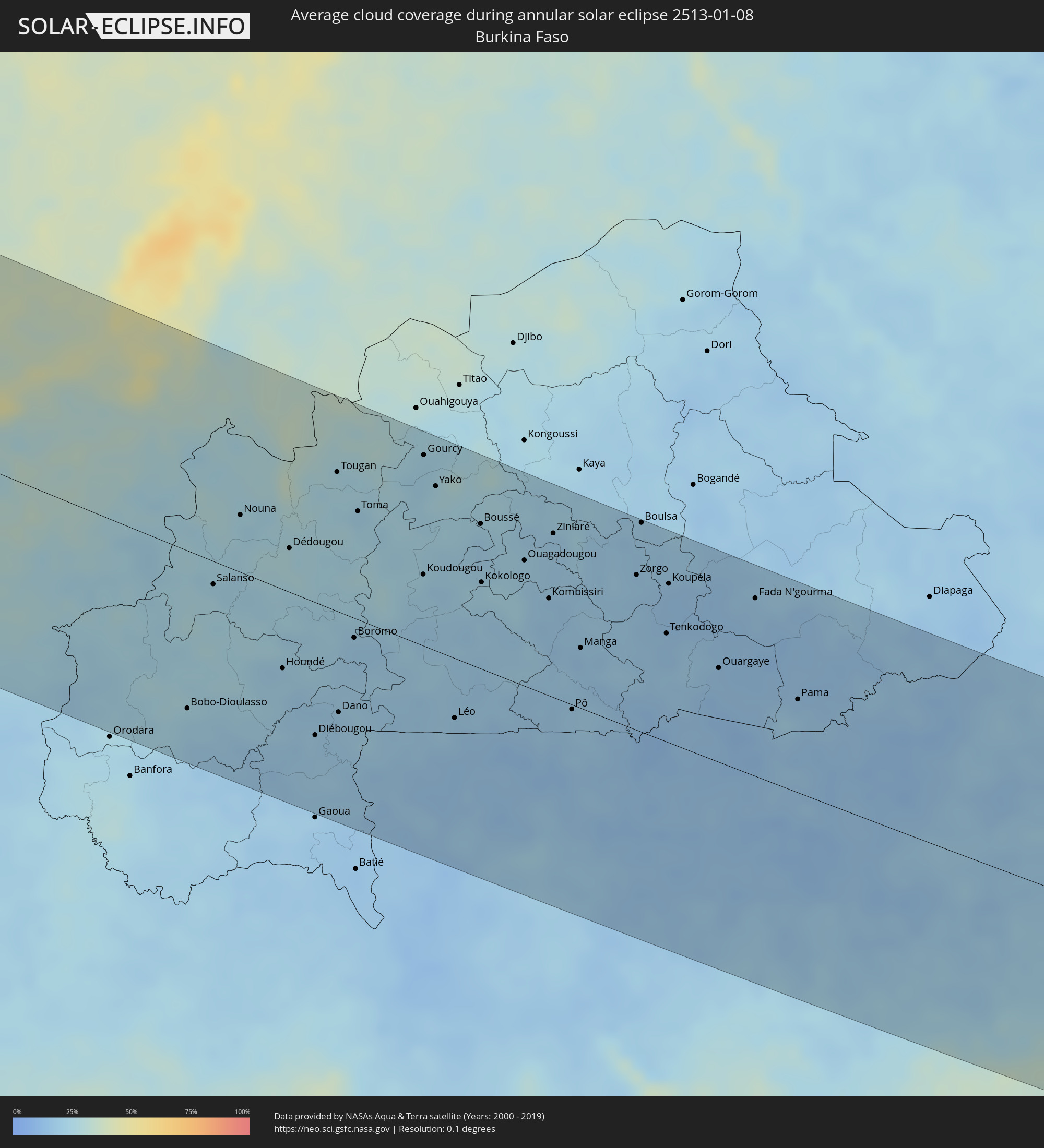 Burkina Faso
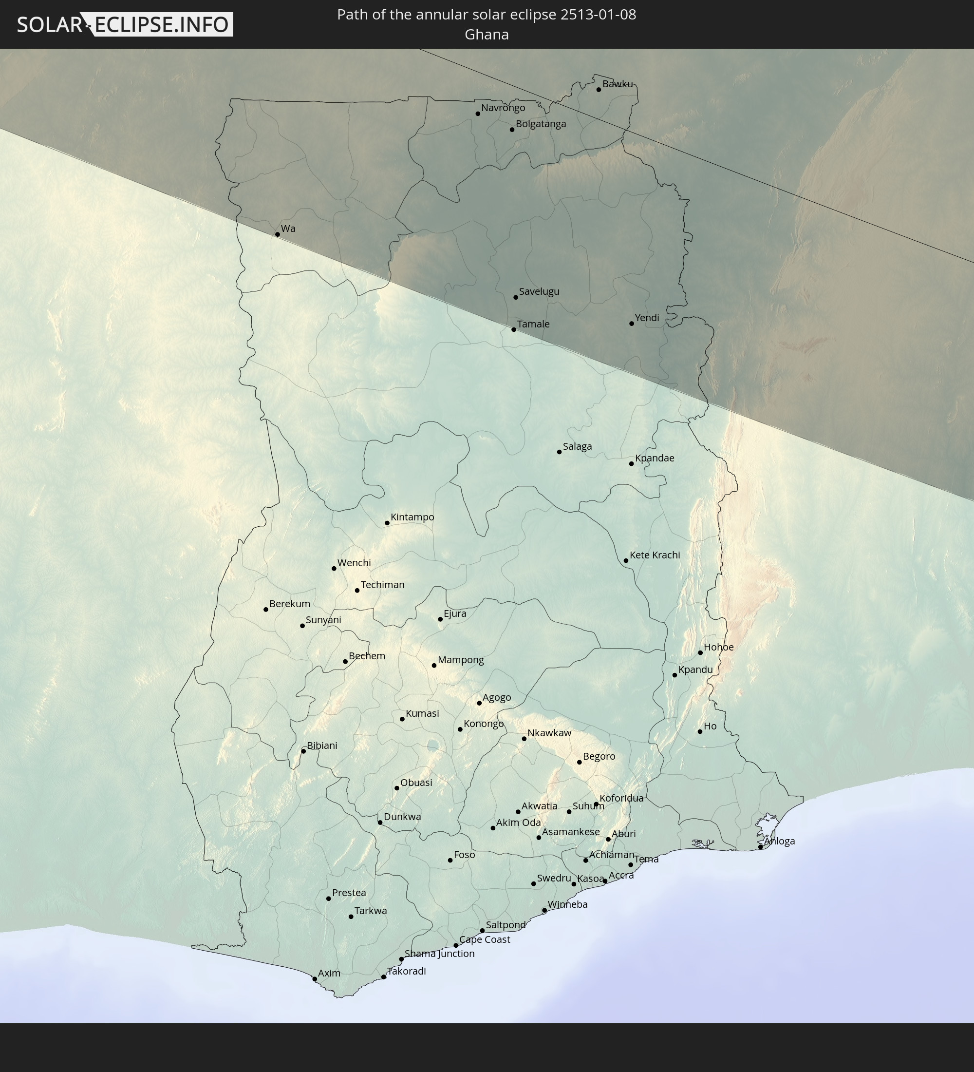
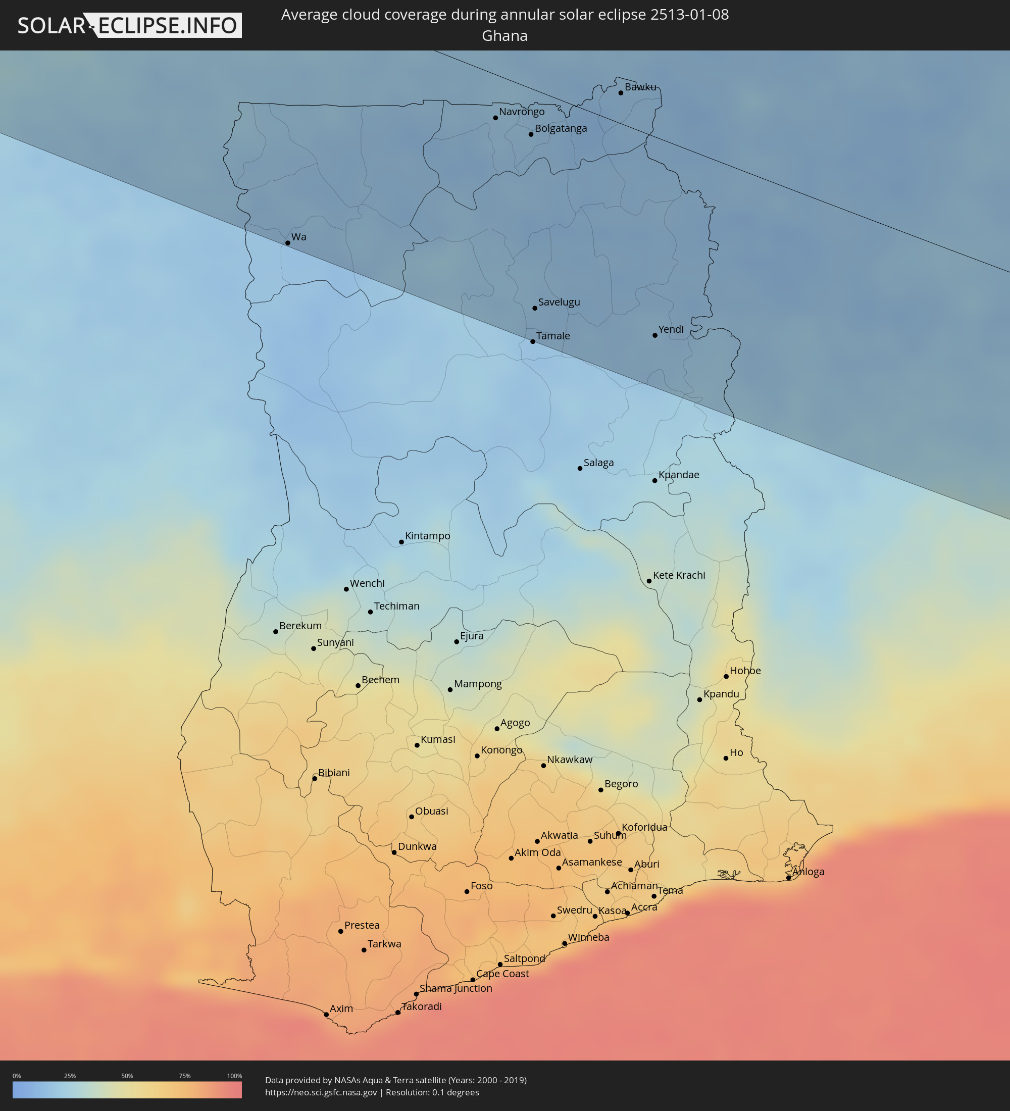 Ghana
Ghana
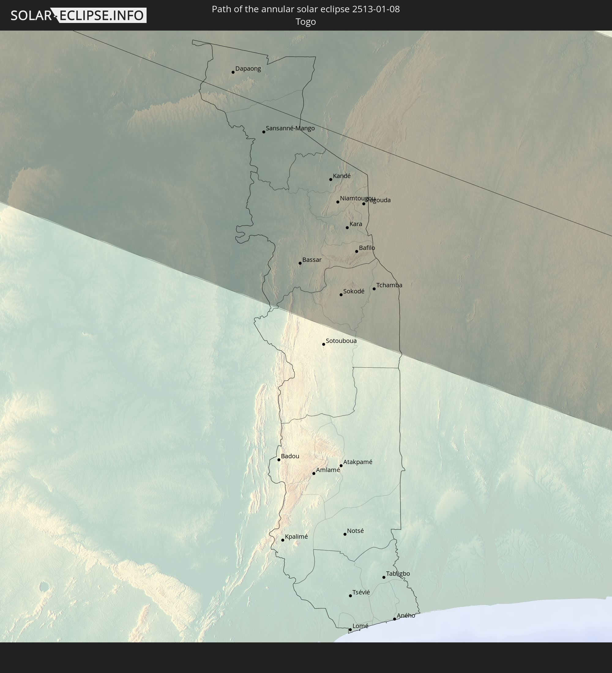
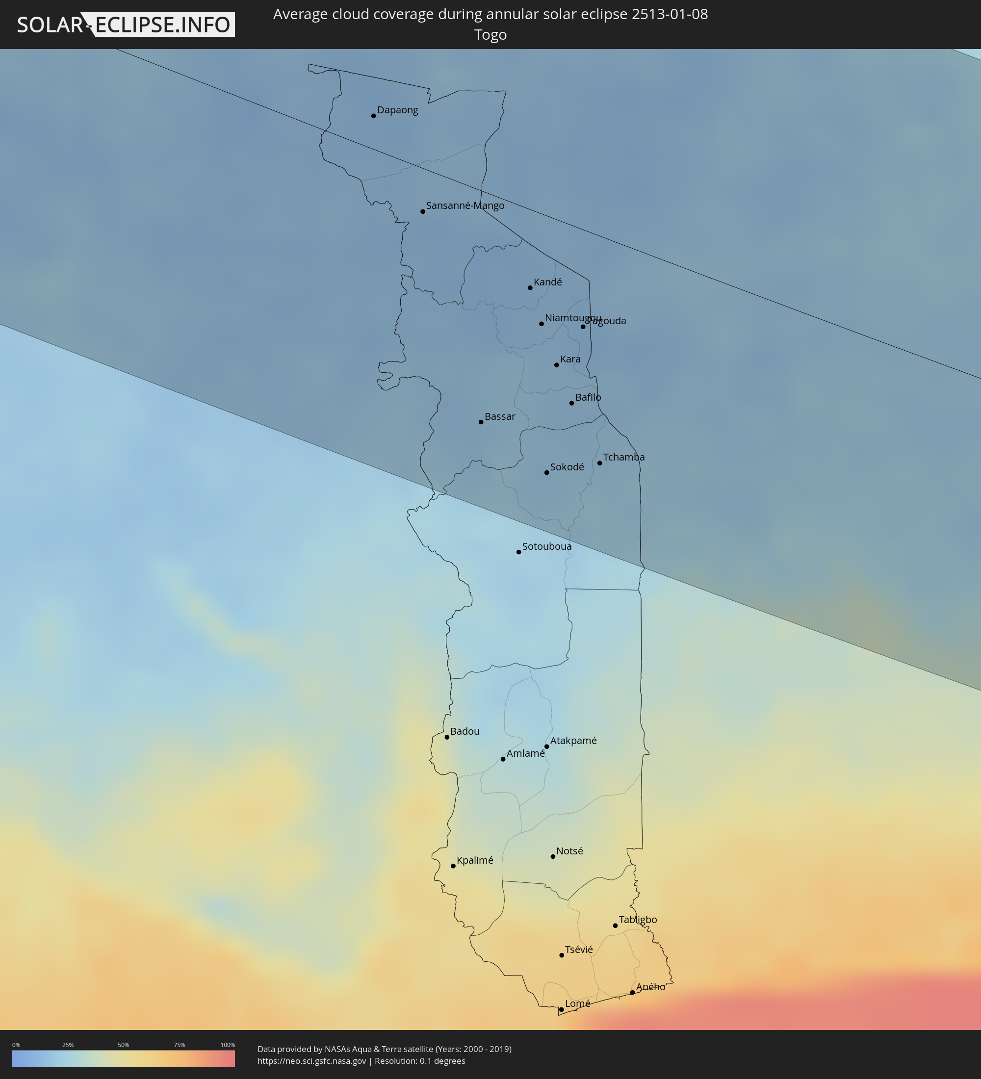 Togo
Togo
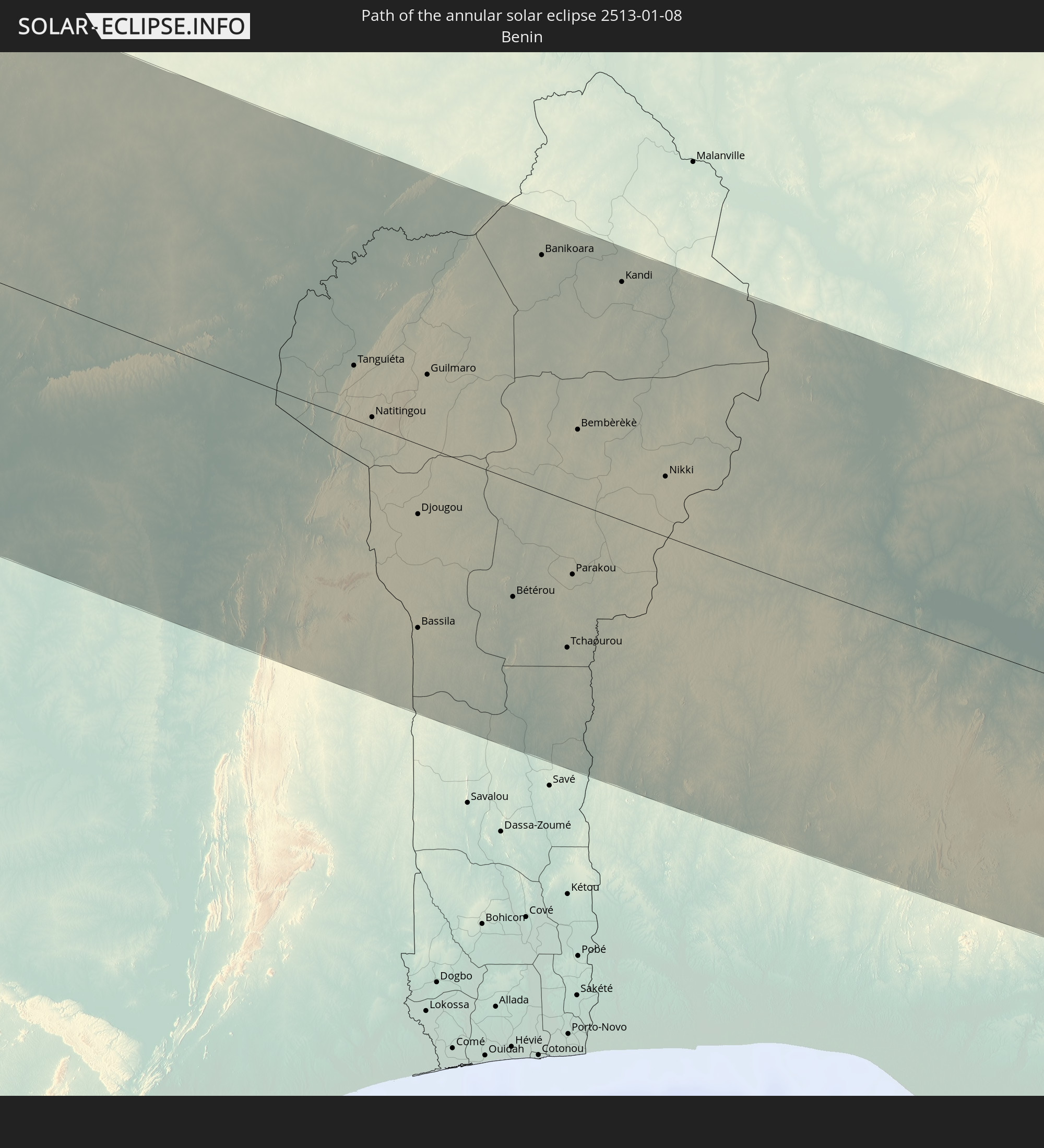
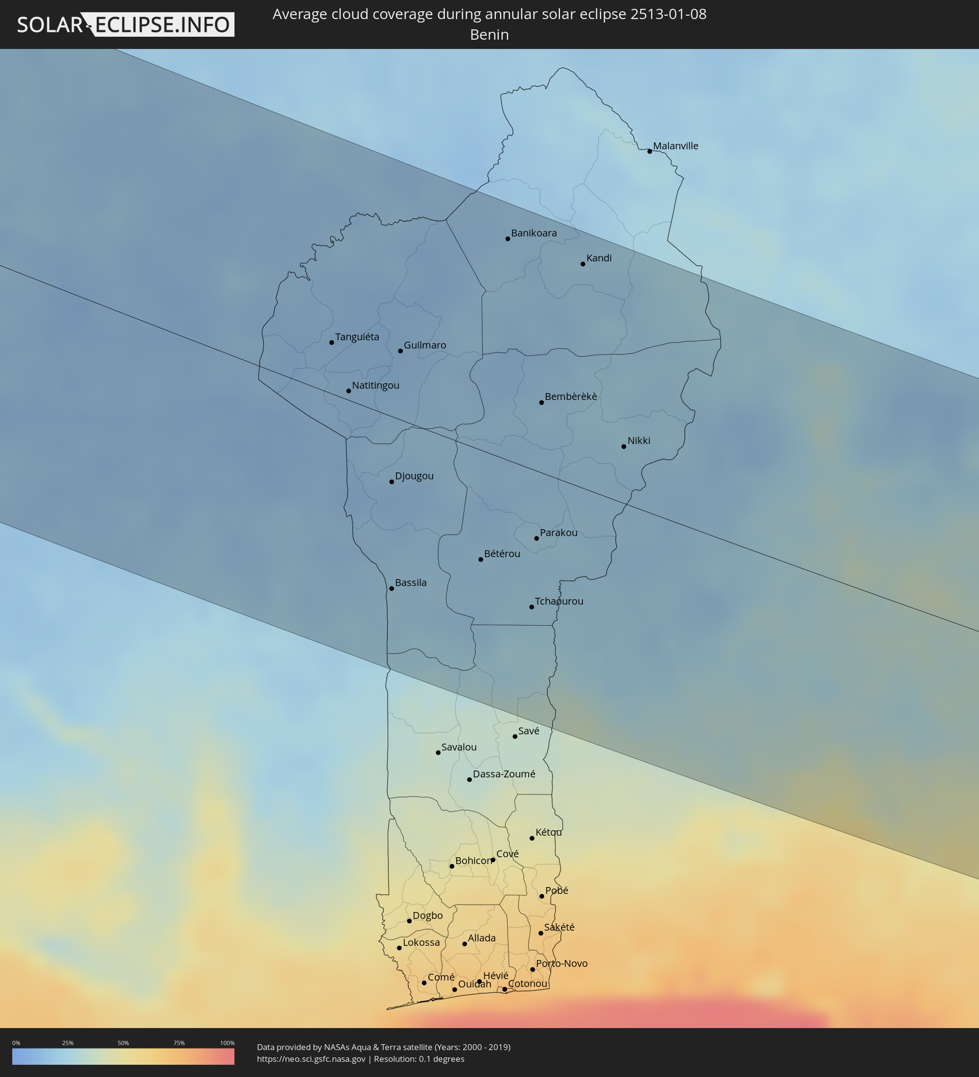 Benin
Benin
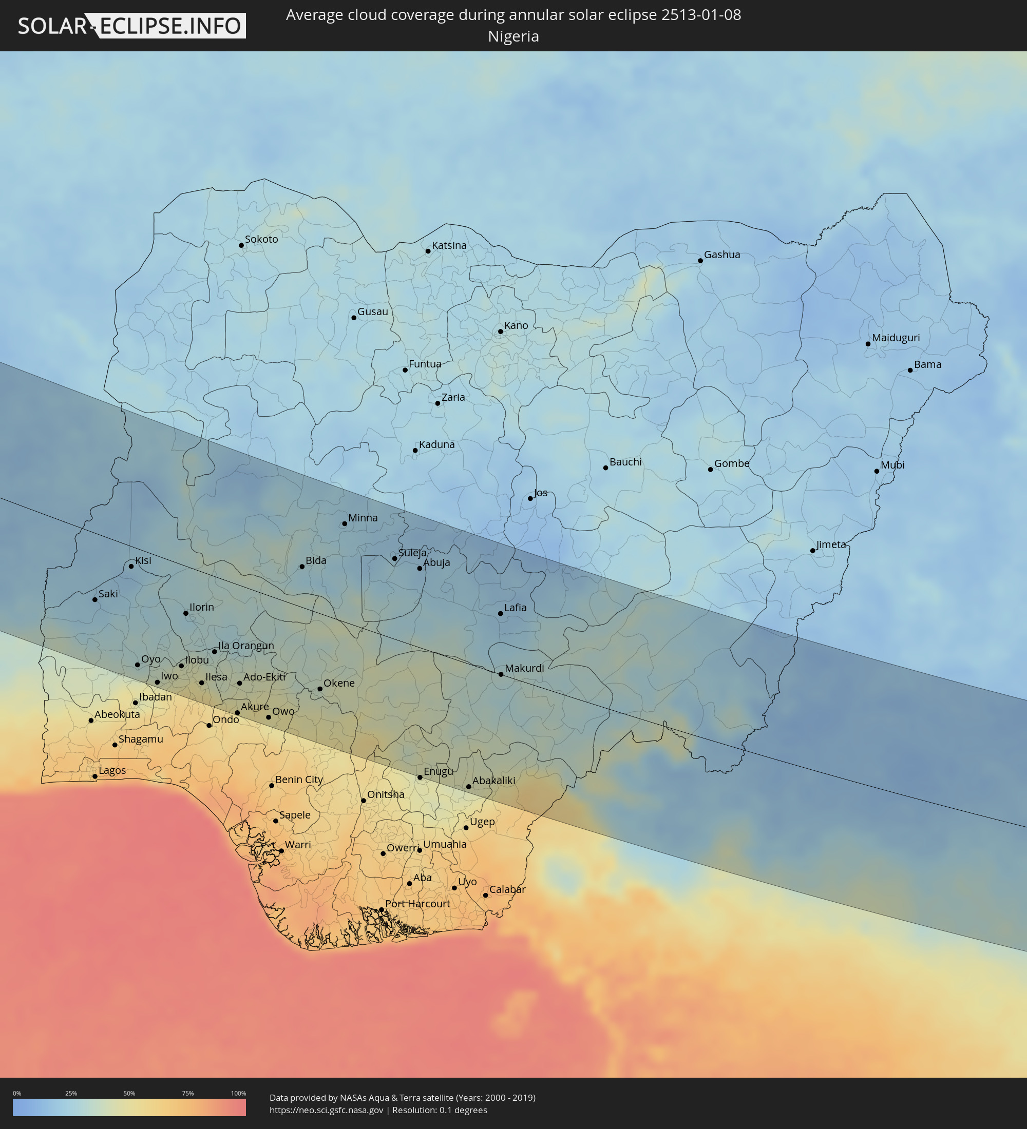 Nigeria
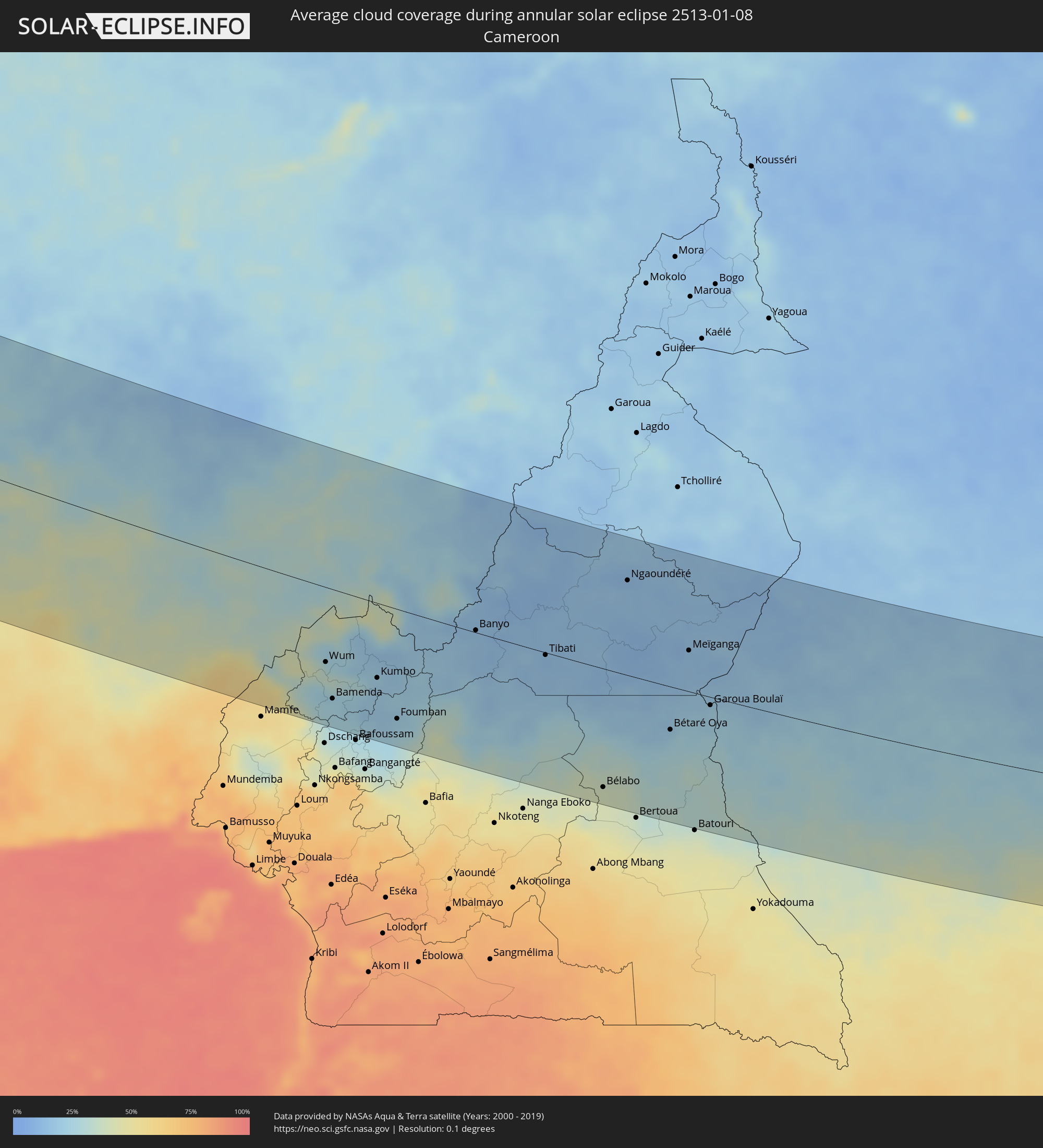 Cameroon
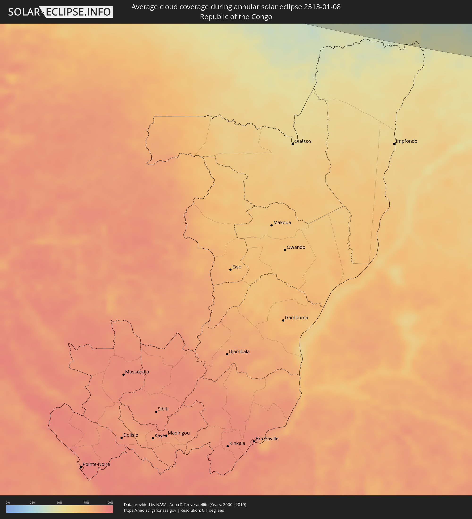 Republic of the Congo
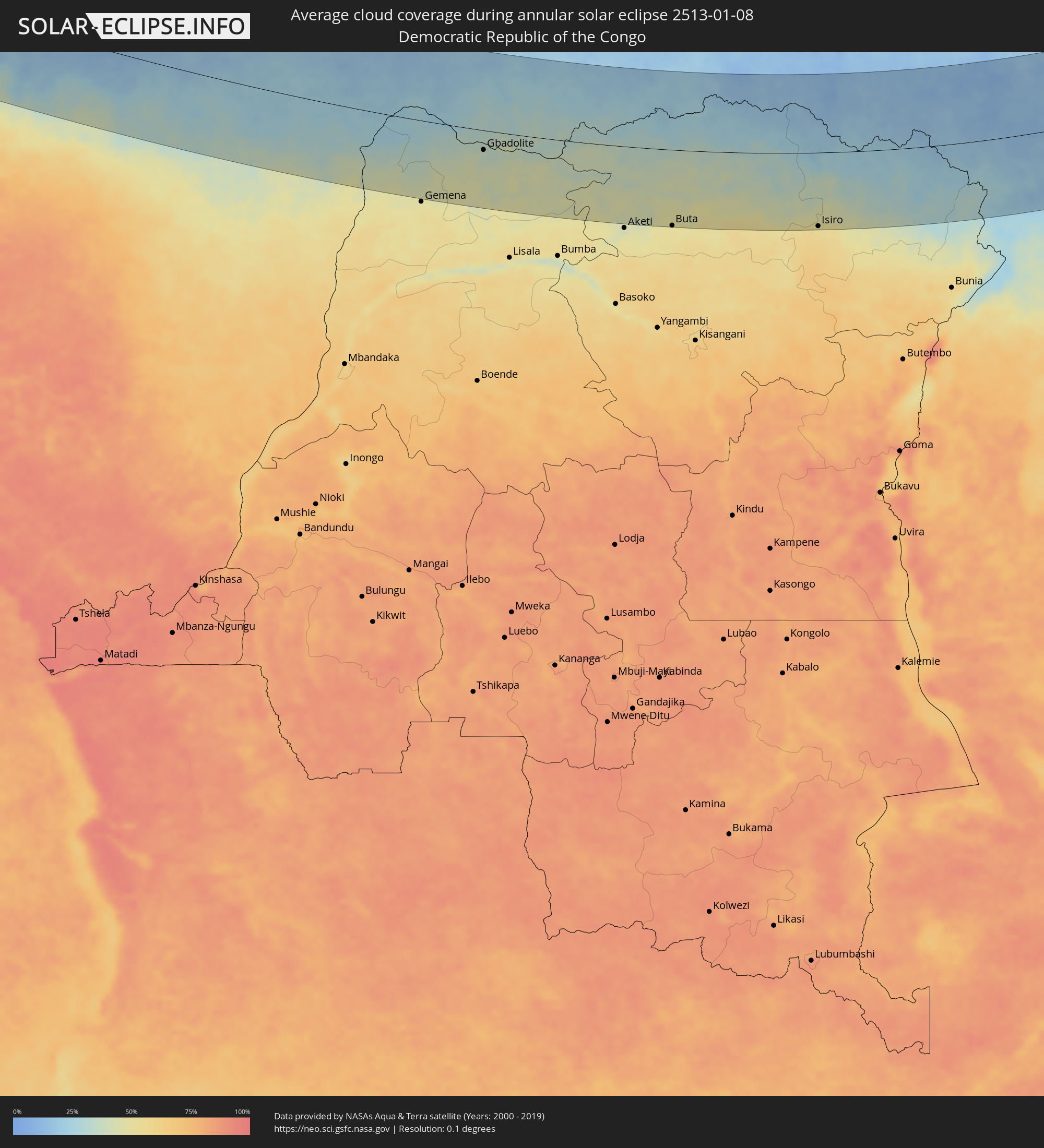 Democratic Republic of the Congo
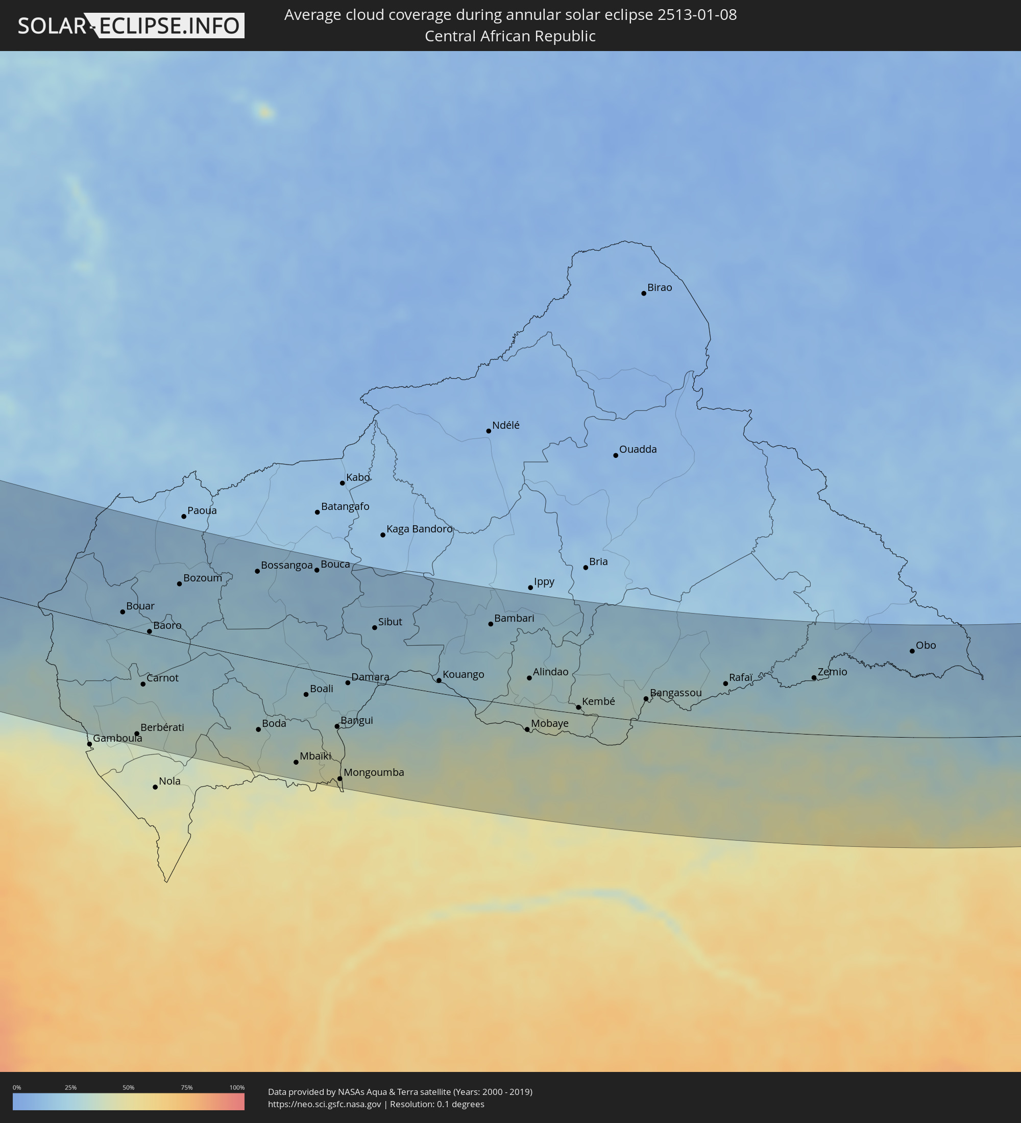 Central African Republic
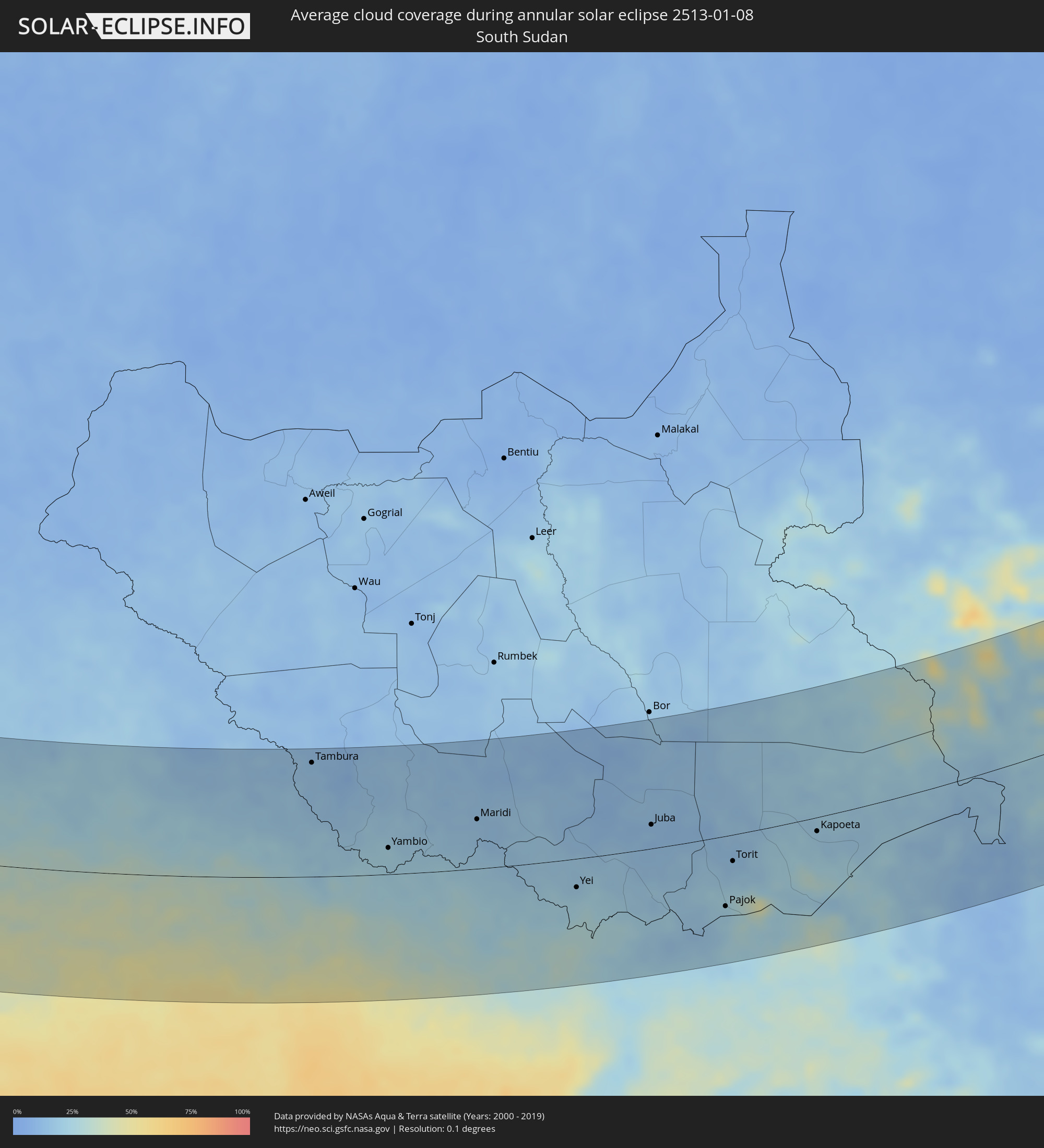 South Sudan
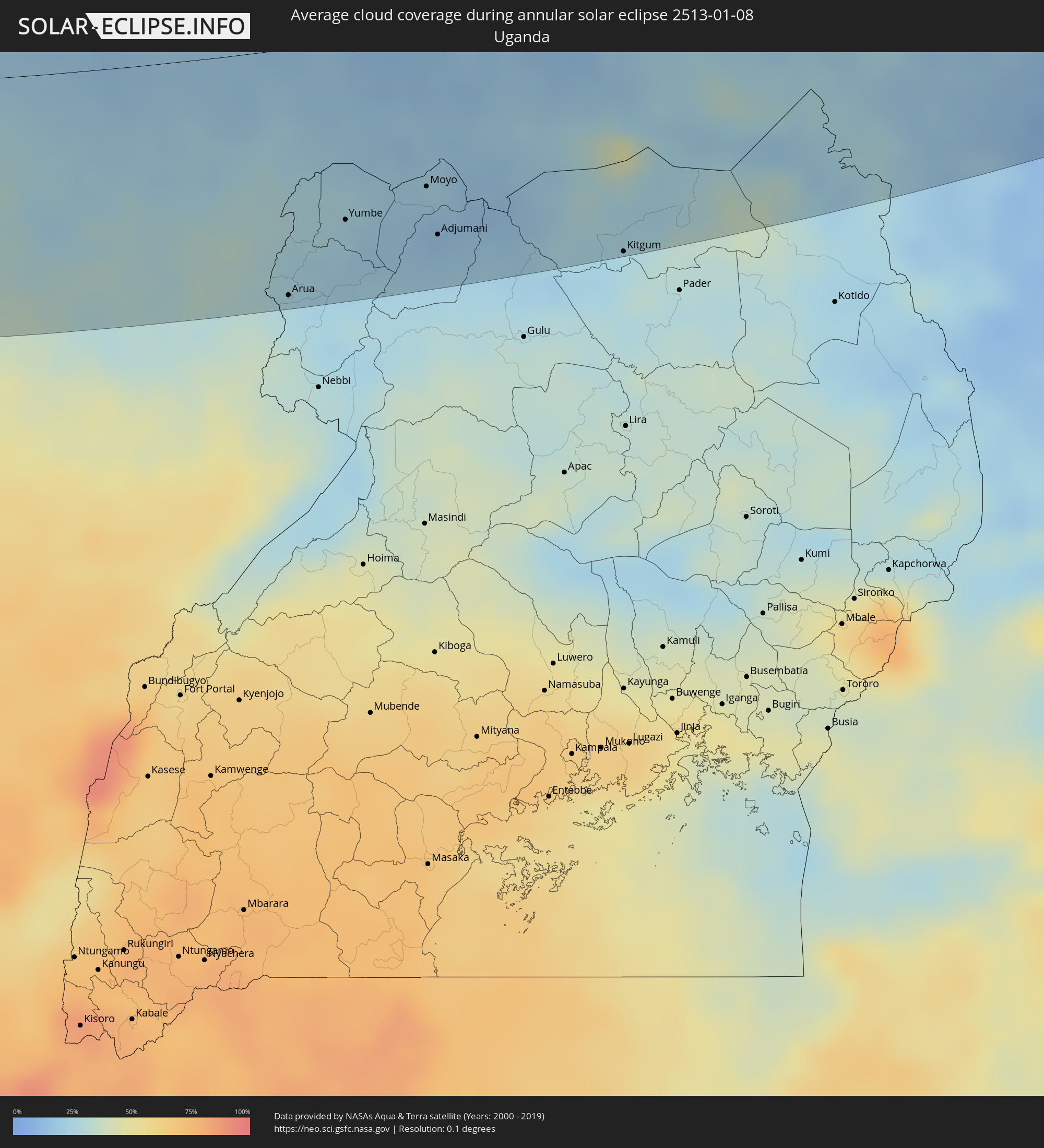 Uganda
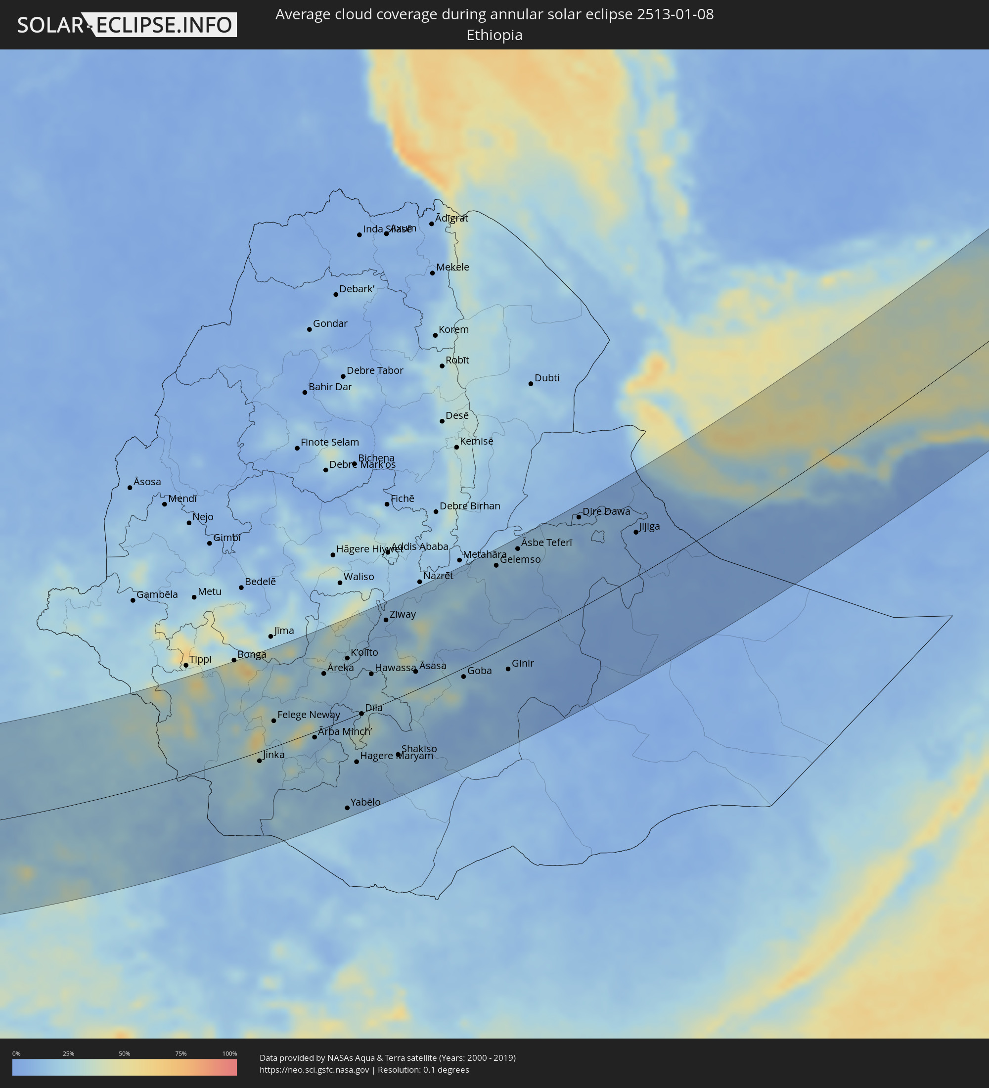 Ethiopia
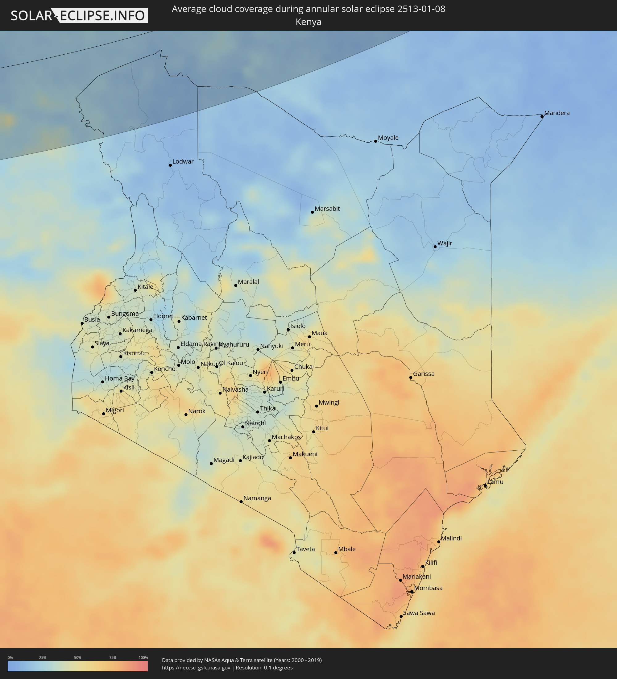 Kenya
Kenya
 Somalia
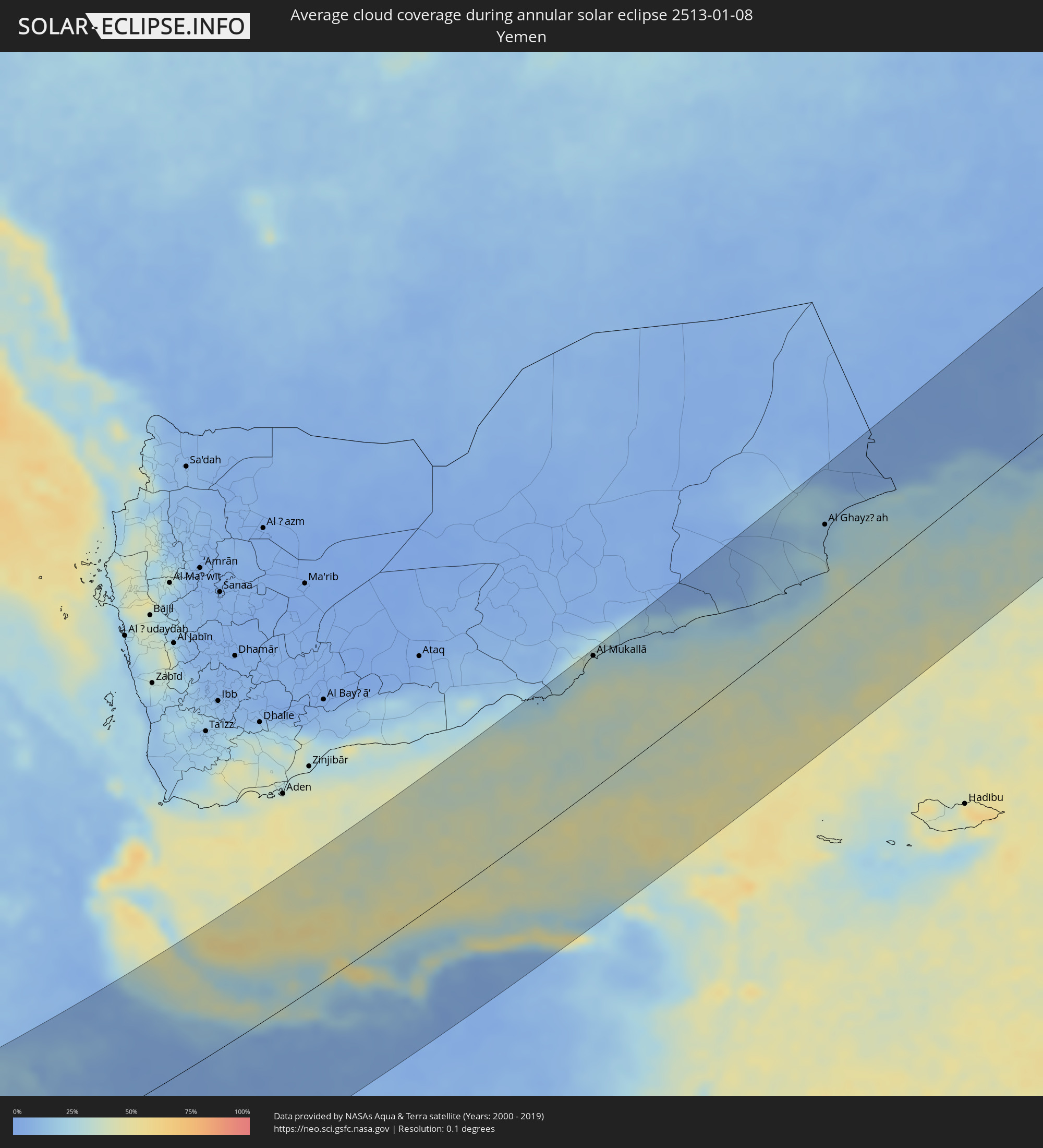 Yemen
Yemen
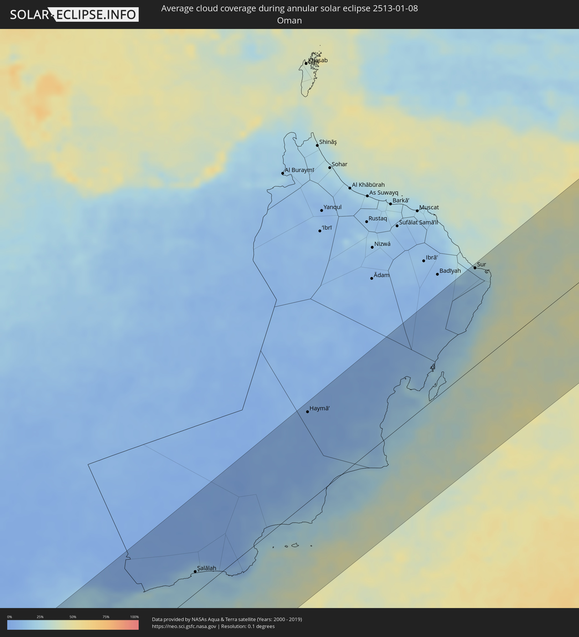 Oman
Oman
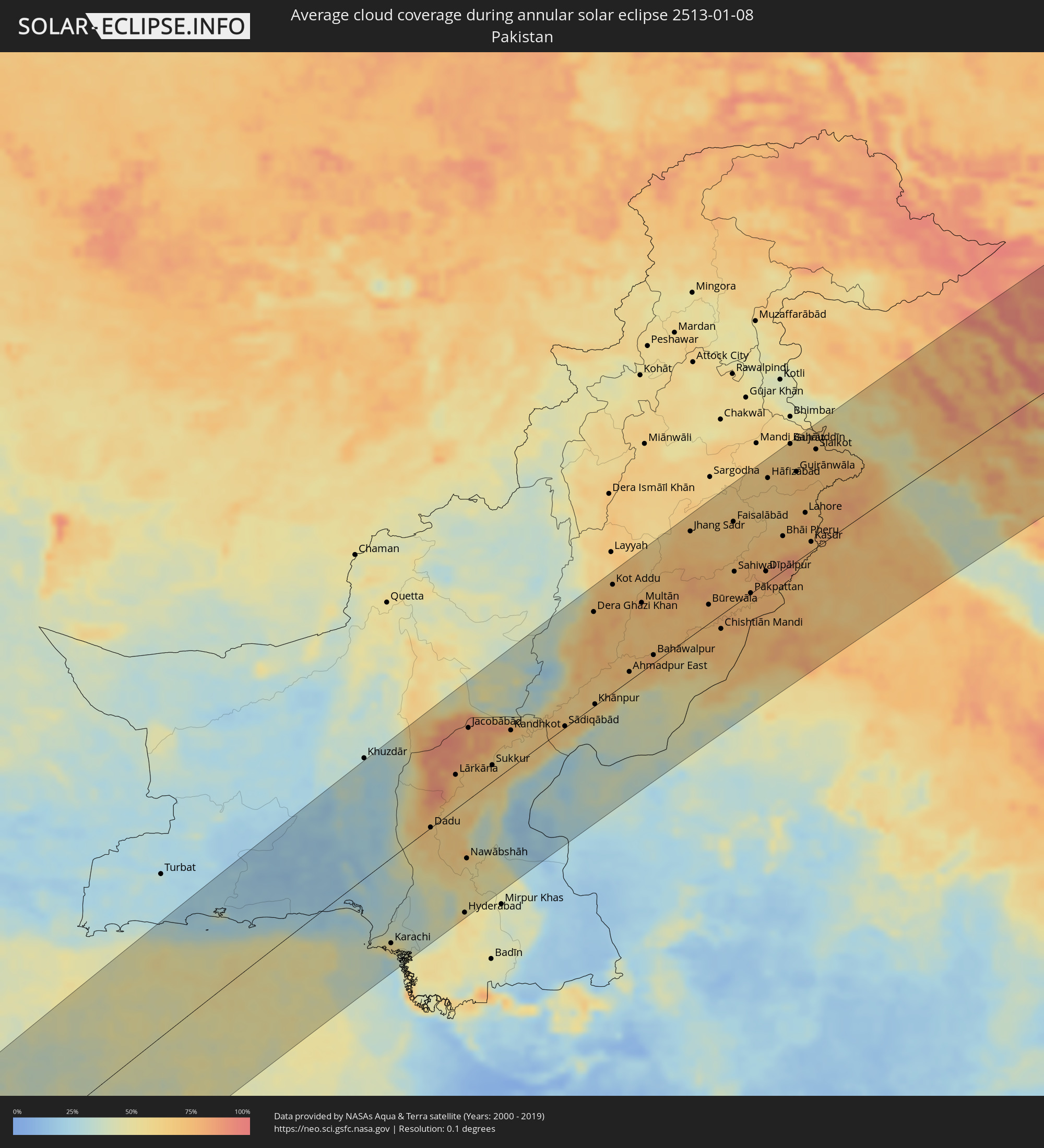 Pakistan
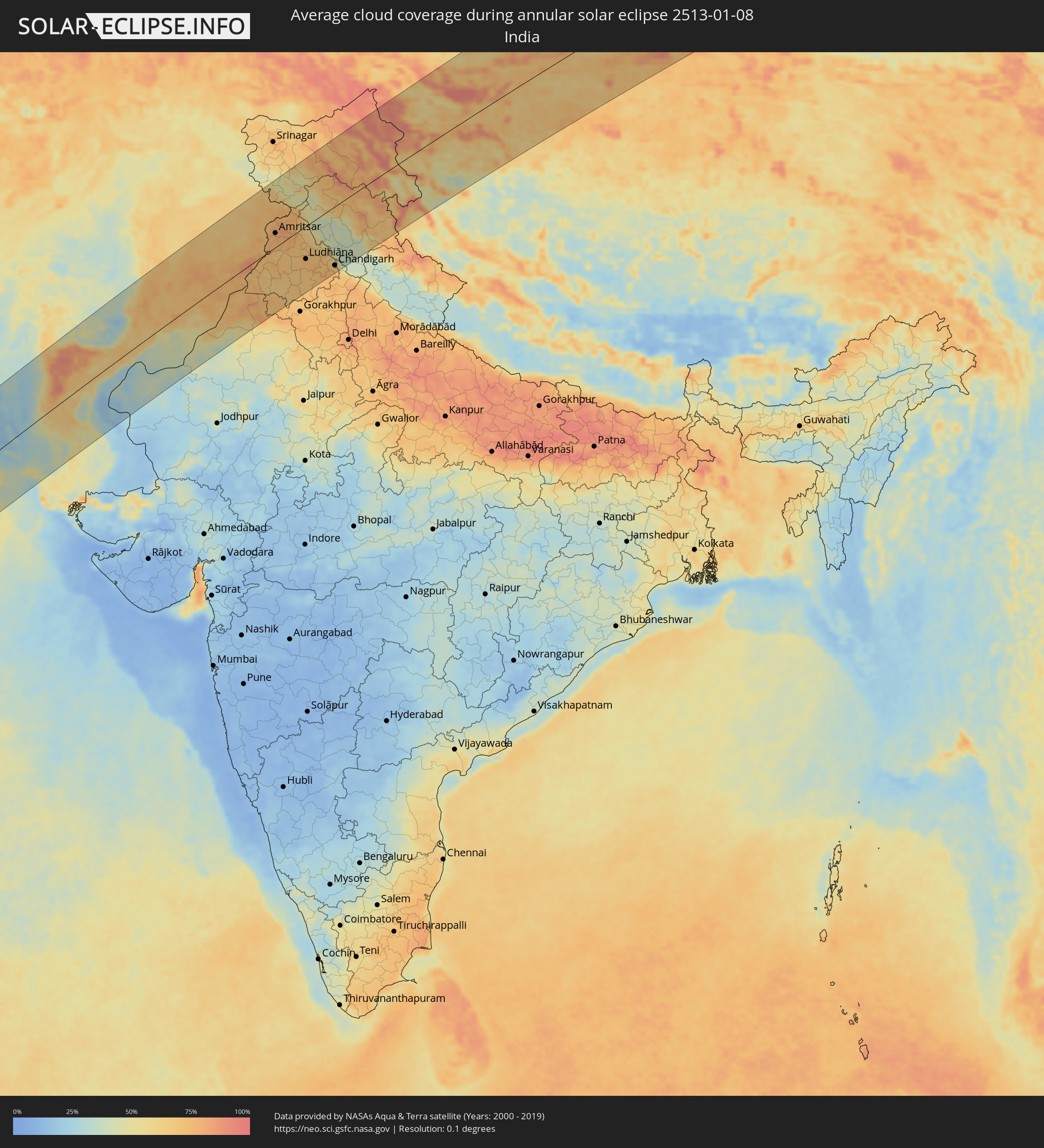 India
India
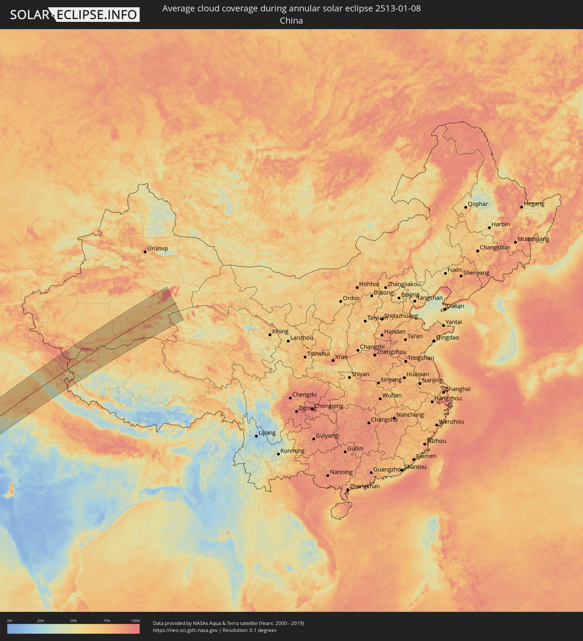 China
China
Cities inside the path of the eclipse
The following table shows all locations with a population of more than 5,000 inside the eclipse path. Cities which have more than 100,000 inhabitants are marked bold. A click at the locations opens a detailed map.
| City | Type | Eclipse duration | Local time of max. eclipse | Distance to central line | Ø Cloud coverage |
|
Kayes, Kayes
|
annular | - | 07:17:14 UTC+00:00 | 92 km | 39% |
|
Bafoulabé, Kayes
|
annular | - | 07:17:00 UTC+00:00 | 132 km | 36% |
|
Kati, Koulikoro
|
annular | - | 07:17:22 UTC+00:00 | 125 km | 27% |
|
Kolokani, Koulikoro
|
annular | - | 07:17:54 UTC+00:00 | 39 km | 34% |
|
Bamako, Bamako
|
annular | - | 07:17:21 UTC+00:00 | 132 km | 29% |
|
Koulikoro, Koulikoro
|
annular | - | 07:17:40 UTC+00:00 | 92 km | 29% |
|
Banamba, Koulikoro
|
annular | - | 07:18:08 UTC+00:00 | 17 km | 32% |
|
Ségou, Ségou
|
annular | - | 07:18:41 UTC+00:00 | 23 km | 33% |
|
Markala, Ségou
|
annular | - | 07:18:56 UTC+00:00 | 57 km | 35% |
|
Sikasso, Sikasso
|
annular | - | 07:17:42 UTC+00:00 | 172 km | 20% |
|
Koutiala, Sikasso
|
annular | - | 07:18:26 UTC+00:00 | 53 km | 26% |
|
San, Ségou
|
annular | - | 07:19:20 UTC+00:00 | 64 km | 29% |
|
Bobo-Dioulasso, Hauts-Bassins
|
annular | - | 07:18:25 UTC+00:00 | 131 km | 22% |
|
Nouna, Boucle du Mouhoun
|
annular | - | 07:19:37 UTC+00:00 | 47 km | 24% |
|
Houndé, Hauts-Bassins
|
annular | - | 07:19:06 UTC+00:00 | 65 km | 21% |
|
Dédougou, Boucle du Mouhoun
|
annular | - | 07:19:42 UTC+00:00 | 36 km | 28% |
|
Wa, Upper West
|
annular | - | 07:18:59 UTC+00:00 | 173 km | 15% |
|
Koudougou, Centre-Ouest
|
annular | - | 07:20:21 UTC+00:00 | 59 km | 22% |
|
Léo, Centre-Ouest
|
annular | - | 07:19:51 UTC+00:00 | 50 km | 17% |
|
Ouagadougou, Centre
|
annular | - | 07:21:03 UTC+00:00 | 104 km | 21% |
|
Kombissiri, Centre-Sud
|
annular | - | 07:21:01 UTC+00:00 | 81 km | 18% |
|
Navrongo, Upper East
|
annular | - | 07:20:30 UTC+00:00 | 30 km | 18% |
|
Bolgatanga, Upper East
|
annular | - | 07:20:38 UTC+00:00 | 32 km | 15% |
|
Savelugu, Northern
|
annular | - | 07:20:01 UTC+00:00 | 151 km | 15% |
|
Garango, Centre-Est
|
annular | - | 07:21:29 UTC+00:00 | 85 km | 17% |
|
Tenkodogo, Centre-Est
|
annular | - | 07:21:38 UTC+00:00 | 90 km | 15% |
|
Koupéla, Centre-Est
|
annular | - | 07:21:54 UTC+00:00 | 132 km | 16% |
|
Bawku, Upper East
|
annular | - | 07:21:18 UTC+00:00 | 21 km | 16% |
|
Yendi, Northern
|
annular | - | 07:20:36 UTC+00:00 | 138 km | 17% |
|
Dapaong, Savanes
|
annular | - | 07:21:34 UTC+00:00 | 18 km | 13% |
|
Fada N'gourma, Est
|
annular | - | 07:22:27 UTC+00:00 | 148 km | 16% |
|
Sansanné-Mango, Savanes
|
annular | - | 07:21:31 UTC+00:00 | 24 km | 12% |
|
Bassar, Kara
|
annular | - | 07:21:11 UTC+00:00 | 127 km | 16% |
|
Kandé, Kara
|
annular | - | 07:21:49 UTC+00:00 | 43 km | 13% |
|
Niamtougou, Kara
|
annular | - | 07:21:46 UTC+00:00 | 61 km | 15% |
|
Sokodé, Centrale
|
annular | - | 07:21:22 UTC+00:00 | 141 km | 18% |
|
Kara, Kara
|
annular | - | 07:21:43 UTC+00:00 | 80 km | 17% |
|
Tanguiéta, Atakora
|
annular | - | 08:22:24 UTC+01:00 | 35 km | 13% |
|
Bafilo, Kara
|
annular | - | 07:21:41 UTC+00:00 | 98 km | 16% |
|
Pagouda, Kara
|
annular | - | 07:21:58 UTC+00:00 | 53 km | 13% |
|
Natitingou, Atakora
|
annular | - | 08:22:19 UTC+01:00 | 6 km | 14% |
|
Tchamba, Centrale
|
annular | - | 07:21:40 UTC+00:00 | 125 km | 21% |
|
Bassila, Donga
|
annular | - | 08:21:53 UTC+01:00 | 118 km | 20% |
|
Djougou, Donga
|
annular | - | 08:22:16 UTC+01:00 | 45 km | 14% |
|
Guilmaro, Atakora
|
annular | - | 08:22:48 UTC+01:00 | 47 km | 13% |
|
Bétérou, Borgou
|
annular | - | 08:22:34 UTC+01:00 | 75 km | 19% |
|
Banikoara, Alibori
|
annular | - | 08:23:58 UTC+01:00 | 151 km | 19% |
|
Tchaourou, Borgou
|
annular | - | 08:22:45 UTC+01:00 | 95 km | 23% |
|
Parakou, Borgou
|
annular | - | 08:23:01 UTC+01:00 | 47 km | 20% |
|
Bembèrèkè, Borgou
|
annular | - | 08:23:33 UTC+01:00 | 48 km | 19% |
|
Kandi, Alibori
|
annular | - | 08:24:24 UTC+01:00 | 153 km | 20% |
|
Nikki, Borgou
|
annular | - | 08:23:58 UTC+01:00 | 39 km | 18% |
|
Oyo, Oyo
|
annular | - | 08:23:38 UTC+01:00 | 153 km | 32% |
|
Iwo, Osun
|
annular | - | 08:23:48 UTC+01:00 | 166 km | 50% |
|
Ilorin, Kwara
|
annular | - | 08:24:39 UTC+01:00 | 62 km | 25% |
|
Ilesa, Osun
|
annular | - | 08:24:27 UTC+01:00 | 146 km | 52% |
|
Effon Alaiye, Ekiti
|
annular | - | 08:24:39 UTC+01:00 | 137 km | 39% |
|
Akure, Ondo
|
annular | - | 08:24:47 UTC+01:00 | 169 km | 49% |
|
Ado-Ekiti, Ekiti
|
annular | - | 08:25:00 UTC+01:00 | 129 km | 44% |
|
Owo, Ondo
|
annular | - | 08:25:14 UTC+01:00 | 161 km | 48% |
|
Okene, Kogi
|
annular | - | 08:26:13 UTC+01:00 | 100 km | 37% |
|
Minna, Niger
|
annular | - | 08:27:46 UTC+01:00 | 128 km | 24% |
|
Abuja, Abuja Federal Capital Territory
|
annular | - | 08:28:44 UTC+01:00 | 104 km | 19% |
|
Makurdi, Benue
|
annular | - | 08:29:27 UTC+01:00 | 1 km | 29% |
|
Bali, North-West
|
annular | - | 08:30:45 UTC+01:00 | 147 km | 27% |
|
Wum, North-West
|
annular | - | 08:31:05 UTC+01:00 | 92 km | 28% |
|
Bamenda, North-West
|
annular | - | 08:31:00 UTC+01:00 | 134 km | 25% |
|
Mbouda, West
|
annular | - | 08:31:00 UTC+01:00 | 167 km | 27% |
|
Fundong, North-West
|
annular | - | 08:31:20 UTC+01:00 | 100 km | 30% |
|
Foumbot, West
|
annular | - | 08:31:33 UTC+01:00 | 167 km | 26% |
|
Kumbo, North-West
|
annular | - | 08:31:57 UTC+01:00 | 92 km | 19% |
|
Foumban, West
|
annular | - | 08:32:05 UTC+01:00 | 135 km | 23% |
|
Banyo, Adamaoua
|
annular | - | 08:34:11 UTC+01:00 | 3 km | 15% |
|
Ngaoundéré, Adamaoua
|
annular | - | 08:37:45 UTC+01:00 | 118 km | 15% |
|
Meïganga, Adamaoua
|
annular | - | 08:38:40 UTC+01:00 | 51 km | 15% |
|
Garoua Boulaï, East
|
annular | - | 08:38:47 UTC+01:00 | 10 km | 22% |
|
Bouar, Nana-Mambéré
|
annular | - | 08:40:57 UTC+01:00 | 23 km | 21% |
|
Berbérati, Mambéré-Kadéï
|
annular | - | 08:40:26 UTC+01:00 | 153 km | 36% |
|
Carnot, Mambéré-Kadéï
|
annular | - | 08:40:59 UTC+01:00 | 77 km | 30% |
|
Bozoum, Ouham-Pendé
|
annular | - | 08:42:52 UTC+01:00 | 85 km | 18% |
|
Bossangoa, Ouham
|
annular | - | 08:45:24 UTC+01:00 | 130 km | 21% |
|
Mbaïki, Lobaye
|
annular | - | 08:45:01 UTC+01:00 | 144 km | 38% |
|
Bimbo, Ombella-M'Poko
|
annular | - | 08:46:14 UTC+01:00 | 93 km | 34% |
|
Bangui, Bangui
|
annular | - | 08:46:38 UTC+01:00 | 78 km | 31% |
|
Libenge, Équateur
|
annular | - | 08:46:24 UTC+01:00 | 154 km | 42% |
|
Damara, Ombella-M'Poko
|
annular | - | 08:47:21 UTC+01:00 | 10 km | 25% |
|
Sibut, Kémo
|
annular | - | 08:48:45 UTC+01:00 | 81 km | 21% |
|
Bosobolo, Équateur
|
annular | - | 08:49:46 UTC+01:00 | 71 km | 36% |
|
Bambari, Ouaka
|
annular | - | 08:52:53 UTC+01:00 | 116 km | 22% |
|
Businga, Équateur
|
annular | - | 08:51:47 UTC+01:00 | 148 km | 45% |
|
Gbadolite, Équateur
|
annular | - | 08:52:42 UTC+01:00 | 42 km | 36% |
|
Bangassou, Mbomou
|
annular | - | 08:58:00 UTC+01:00 | 34 km | 32% |
|
Bondo, Orientale
|
annular | - | 09:59:48 UTC+02:00 | 60 km | 38% |
|
Buta, Orientale
|
annular | - | 10:02:05 UTC+02:00 | 166 km | 49% |
 Tambura, Western Equatoria
|
annular | - | 10:13:12 UTC+02:00 | 153 km | 14% |
|
Isiro, Orientale
|
annular | - | 10:11:03 UTC+02:00 | 162 km | 52% |
|
Yambio, Western Equatoria
|
annular | - | 10:15:19 UTC+02:00 | 35 km | 23% |
|
Maridi, Western Equatoria
|
annular | - | 10:19:23 UTC+02:00 | 66 km | 16% |
|
Watsa, Orientale
|
annular | - | 10:17:41 UTC+02:00 | 143 km | 32% |
|
Yei, Central Equatoria
|
annular | - | 10:22:45 UTC+02:00 | 38 km | 20% |
|
Arua, Northern Region
|
annular | - | 11:22:25 UTC+03:00 | 160 km | 28% |
|
Yumbe, Northern Region
|
annular | - | 11:24:05 UTC+03:00 | 116 km | 26% |
|
Juba, Central Equatoria
|
annular | - | 10:26:51 UTC+02:00 | 32 km | 13% |
|
Moyo, Northern Region
|
annular | - | 11:26:00 UTC+03:00 | 102 km | 21% |
|
Adjumani, Northern Region
|
annular | - | 11:25:55 UTC+03:00 | 134 km | 16% |
|
Pajok, Eastern Equatoria
|
annular | - | 10:28:58 UTC+02:00 | 93 km | 23% |
|
Torit, Eastern Equatoria
|
annular | - | 10:29:56 UTC+02:00 | 35 km | 16% |
|
Kitgum, Northern Region
|
annular | - | 11:29:44 UTC+03:00 | 165 km | 26% |
|
Kapoeta, Eastern Equatoria
|
annular | - | 10:34:08 UTC+02:00 | 18 km | 20% |
|
Felege Neway, Southern Nations, Nationalities, and People's Region
|
annular | - | 11:48:33 UTC+03:00 | 43 km | 24% |
|
Ārba Minch’, Southern Nations, Nationalities, and People's Region
|
annular | - | 11:50:41 UTC+03:00 | 10 km | 15% |
|
Dīla, Southern Nations, Nationalities, and People's Region
|
annular | - | 11:54:07 UTC+03:00 | 2 km | 21% |
|
Yirga ‘Alem, Southern Nations, Nationalities, and People's Region
|
annular | - | 11:54:59 UTC+03:00 | 28 km | 19% |
|
Hawassa, Southern Nations, Nationalities, and People's Region
|
annular | - | 11:55:39 UTC+03:00 | 58 km | 15% |
|
Shashemenē, Oromiya
|
annular | - | 11:56:19 UTC+03:00 | 66 km | 20% |
|
Ziway, Oromiya
|
annular | - | 11:57:50 UTC+03:00 | 136 km | 10% |
|
Shakīso, Oromiya
|
annular | - | 11:55:23 UTC+03:00 | 96 km | 18% |
|
Goba, Oromiya
|
annular | - | 12:01:13 UTC+03:00 | 15 km | 21% |
|
Dire Dawa, Dire Dawa
|
annular | - | 12:11:57 UTC+03:00 | 143 km | 12% |
|
Harar, Harari
|
annular | - | 12:12:26 UTC+03:00 | 102 km | 11% |
|
Jijiga, Somali
|
annular | - | 12:14:55 UTC+03:00 | 68 km | 6% |
|
Baki, Awdal
|
annular | - | 12:17:47 UTC+03:00 | 86 km | 9% |
|
Hargeysa, Woqooyi Galbeed
|
annular | - | 12:19:38 UTC+03:00 | 15 km | 8% |
|
Berbera, Woqooyi Galbeed
|
annular | - | 12:24:09 UTC+03:00 | 41 km | 27% |
|
Oodweyne, Togdheer
|
annular | - | 12:22:47 UTC+03:00 | 58 km | 4% |
|
Burao, Togdheer
|
annular | - | 12:24:31 UTC+03:00 | 75 km | 5% |
|
Ceerigaabo, Sanaag
|
annular | - | 12:32:00 UTC+03:00 | 88 km | 8% |
|
Las Khorey, Sanaag
|
annular | - | 12:35:20 UTC+03:00 | 91 km | 37% |
|
Al Mukallā, Muḩāfaz̧at Ḩaḑramawt
|
annular | - | 12:42:36 UTC+03:00 | 151 km | 30% |
|
Bosaso, Bari
|
annular | - | 12:38:27 UTC+03:00 | 143 km | 18% |
|
Al Ghayz̧ah, Al Mahrah
|
annular | - | 12:52:55 UTC+03:00 | 93 km | 19% |
|
Şalālah, Z̧ufār
|
annular | - | 13:58:32 UTC+04:00 | 35 km | 19% |
|
Haymā’, Al Wusţá
|
annular | - | 14:06:11 UTC+04:00 | 142 km | 4% |
|
Sur, Ash Sharqiyah South Governorate
|
annular | - | 14:14:29 UTC+04:00 | 153 km | 21% |
|
Karachi, Sindh
|
annular | - | 15:27:34 UTC+05:00 | 120 km | 57% |
|
Lārkāna, Sindh
|
annular | - | 15:29:36 UTC+05:00 | 47 km | 75% |
|
Hyderabad, Sindh
|
annular | - | 15:29:23 UTC+05:00 | 155 km | 60% |
|
Sukkur, Sindh
|
annular | - | 15:30:25 UTC+05:00 | 22 km | 70% |
|
Multān, Punjab
|
annular | - | 15:33:28 UTC+05:00 | 94 km | 76% |
|
Bahāwalpur, Punjab
|
annular | - | 15:33:43 UTC+05:00 | 11 km | 78% |
|
Jhang Sadr, Punjab
|
annular | - | 15:34:14 UTC+05:00 | 143 km | 70% |
|
Faisalābād, Punjab
|
annular | - | 15:34:58 UTC+05:00 | 115 km | 72% |
|
Gangānagar, Rajasthan
|
annular | - | 16:05:53 UTC+05:30 | 65 km | 72% |
|
Sheikhupura, Punjab
|
annular | - | 15:35:46 UTC+05:00 | 92 km | 68% |
|
Gujrānwāla, Punjab
|
annular | - | 15:35:53 UTC+05:00 | 122 km | 70% |
|
Hanumāngarh, Rajasthan
|
annular | - | 16:06:20 UTC+05:30 | 121 km | 78% |
|
Lahore, Punjab
|
annular | - | 15:36:08 UTC+05:00 | 58 km | 76% |
|
Sialkot, Punjab
|
annular | - | 15:36:07 UTC+05:00 | 133 km | 72% |
|
Jammu, Kashmir
|
annular | - | 16:06:22 UTC+05:30 | 137 km | 66% |
|
Amritsar, Punjab
|
annular | - | 16:06:36 UTC+05:30 | 35 km | 79% |
|
Bhatinda, Punjab
|
annular | - | 16:06:51 UTC+05:30 | 97 km | 67% |
|
Sirsa, Haryana
|
annular | - | 16:06:59 UTC+05:30 | 164 km | 77% |
|
Jalandhar, Punjab
|
annular | - | 16:07:16 UTC+05:30 | 30 km | 71% |
|
Pathānkot, Punjab
|
annular | - | 16:07:09 UTC+05:30 | 53 km | 66% |
|
Ludhiāna, Punjab
|
annular | - | 16:07:34 UTC+05:30 | 82 km | 76% |
|
Patiāla, Punjab
|
annular | - | 16:08:06 UTC+05:30 | 165 km | 70% |
|
Chandigarh, Chandigarh
|
annular | - | 16:08:22 UTC+05:30 | 149 km | 72% |
|
Shimla, Himachal Pradesh
|
annular | - | 16:08:37 UTC+05:30 | 135 km | 40% |