Total solar eclipse of 06/17/2672
| Day of week: | Monday |
| Maximum duration of eclipse: | 04m36s |
| Maximum width of eclipse path: | 335 km |
| Saros cycle: | 167 |
| Coverage: | 100% |
| Magnitude: | 1.0735 |
| Gamma: | 0.6987 |
Wo kann man die Sonnenfinsternis vom 06/17/2672 sehen?
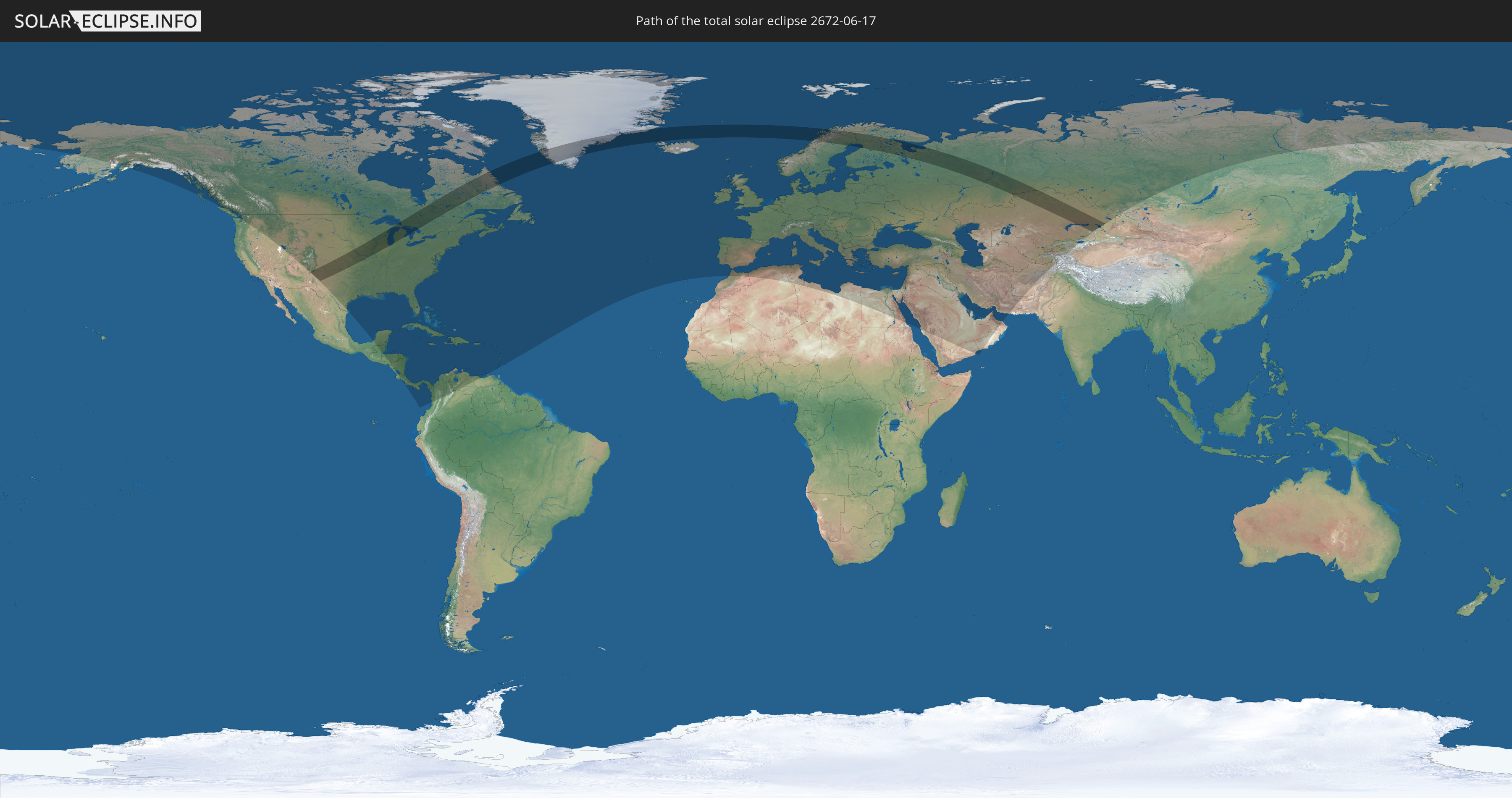
Die Sonnenfinsternis am 06/17/2672 kann man in 121 Ländern als partielle Sonnenfinsternis beobachten.
Der Finsternispfad verläuft durch 10 Länder. Nur in diesen Ländern ist sie als total Sonnenfinsternis zu sehen.
In den folgenden Ländern ist die Sonnenfinsternis total zu sehen
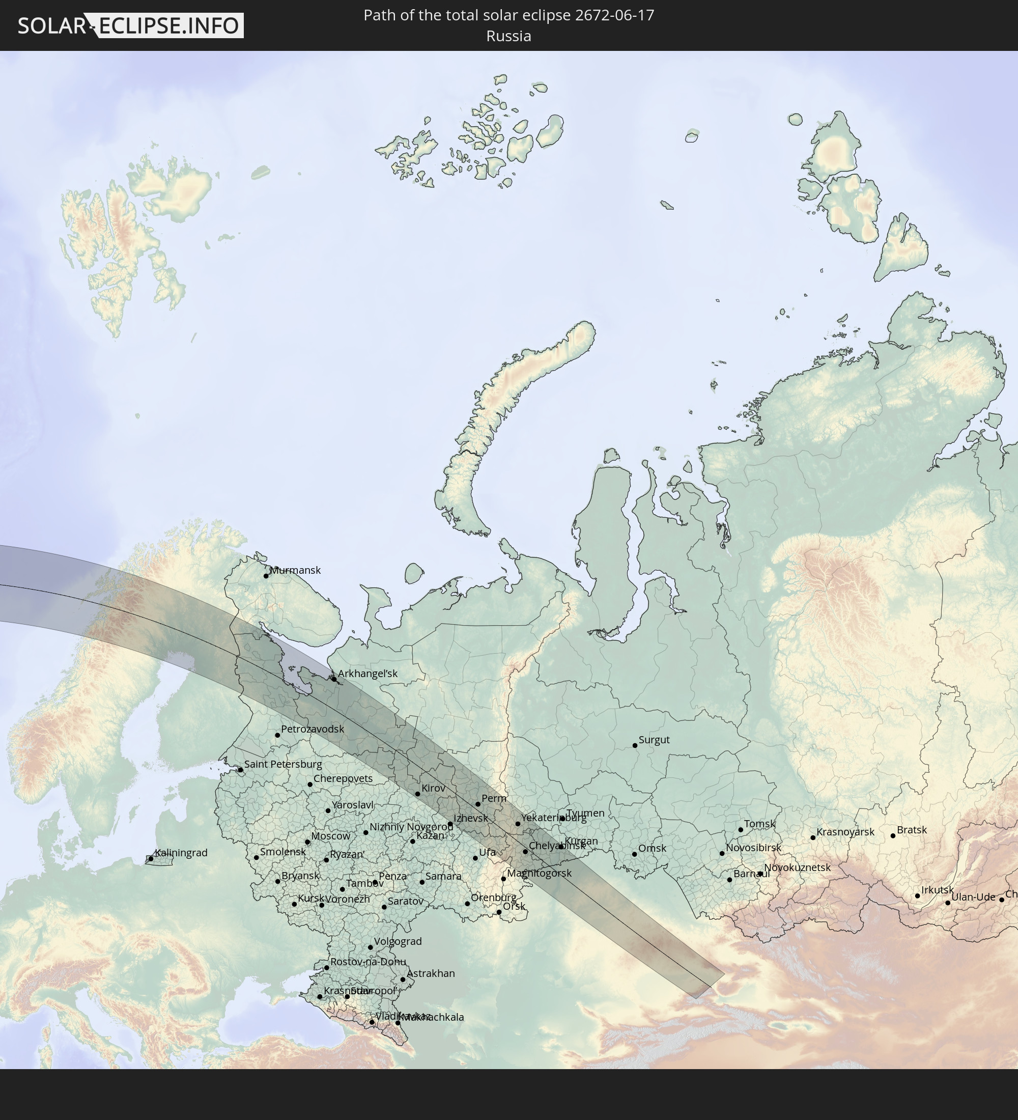 Russia
 United States
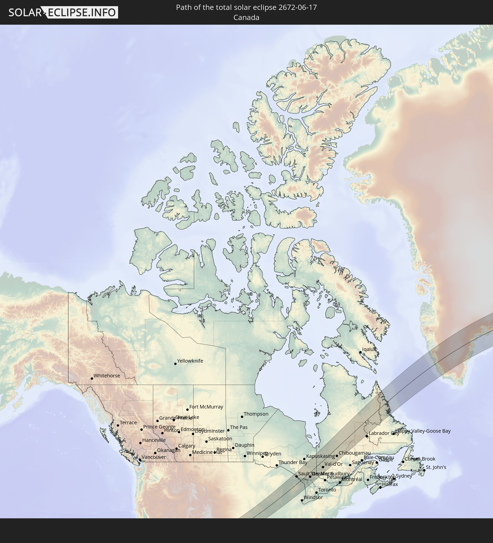 Canada
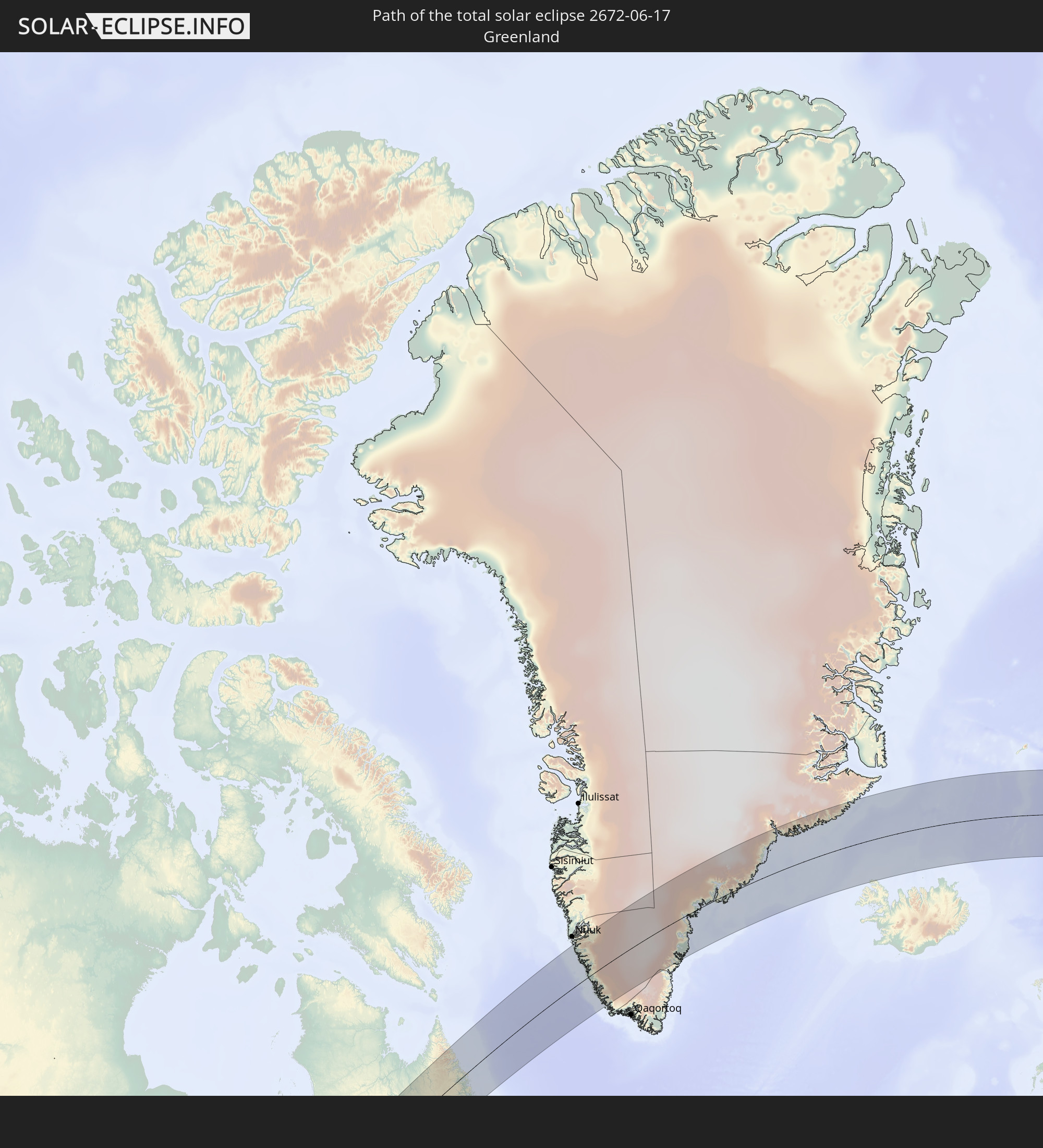 Greenland
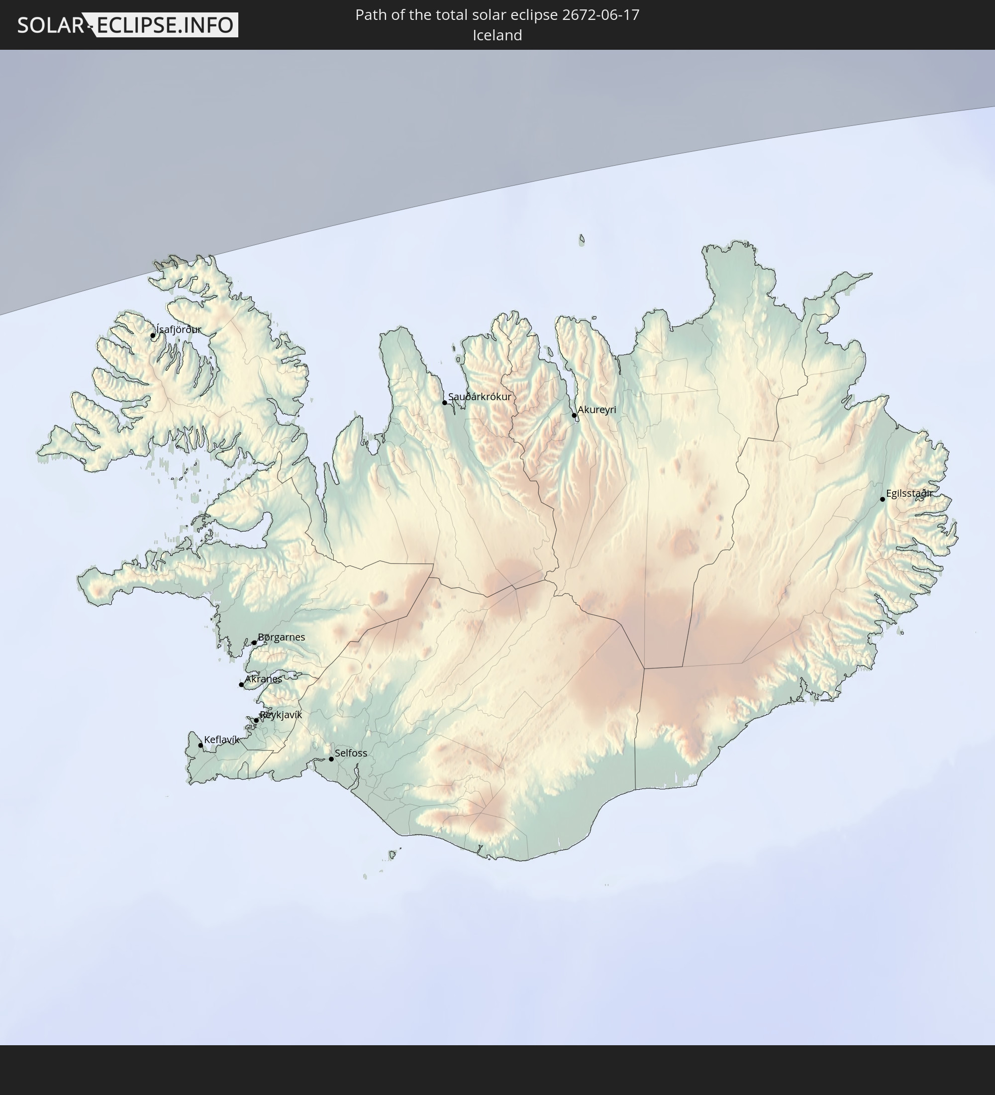 Iceland
 Norway
 Sweden
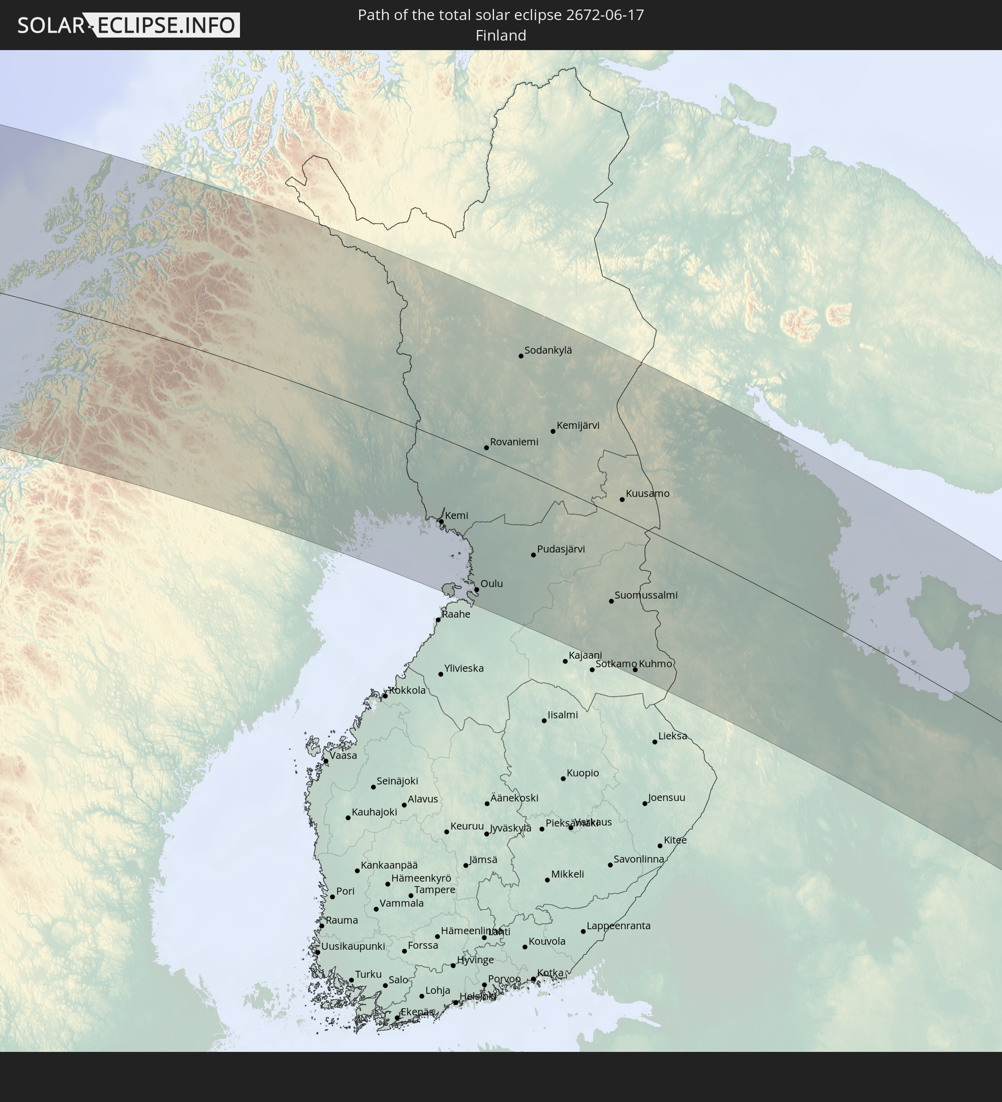 Finland
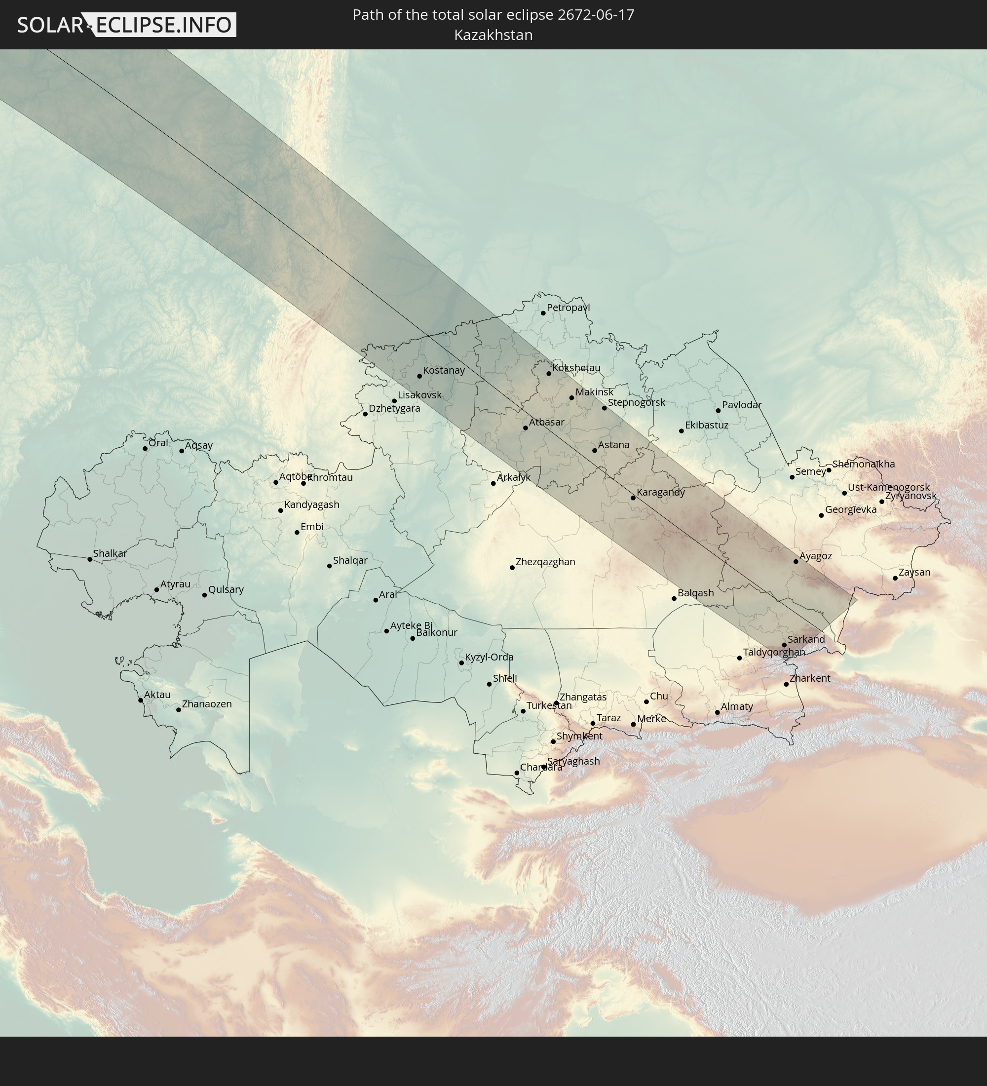 Kazakhstan
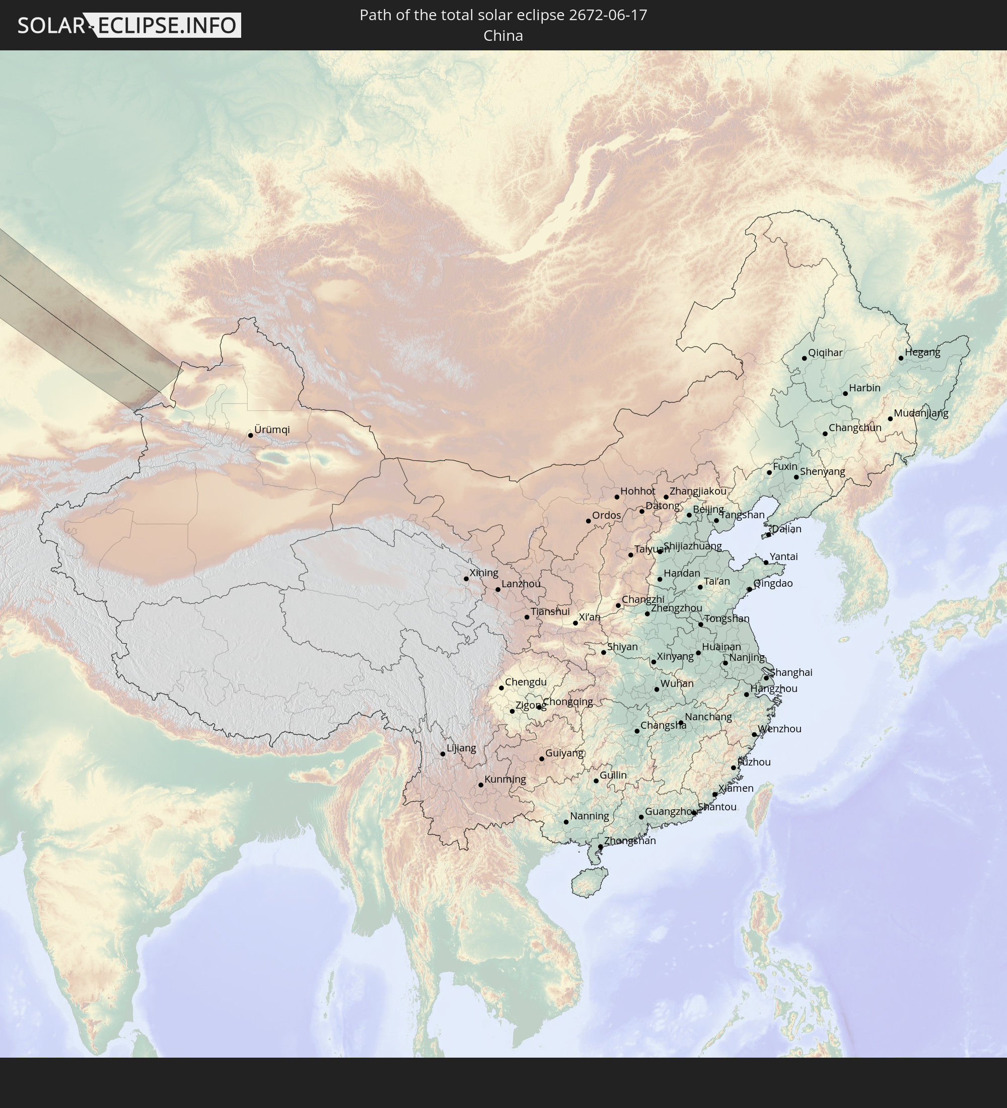 China
China
In den folgenden Ländern ist die Sonnenfinsternis partiell zu sehen
 Russia
 United States
 United States Minor Outlying Islands
 Canada
 Mexico
 Greenland
 Guatemala
 Honduras
 Belize
 Nicaragua
 Costa Rica
 Cuba
Cuba
 Panama
 Colombia
 Cayman Islands
 The Bahamas
 Jamaica
 Haiti
Haiti
 Venezuela
 Turks and Caicos Islands
 Dominican Republic
 Aruba
Aruba
 Puerto Rico
 United States Virgin Islands
 Bermuda
 British Virgin Islands
 Anguilla
 Collectivity of Saint Martin
 Saint Barthélemy
 Saint Kitts and Nevis
 Antigua and Barbuda
 Montserrat
 Guadeloupe
 Grenada
 Dominica
 Saint Vincent and the Grenadines
 Martinique
 Saint Lucia
 Saint Pierre and Miquelon
 Portugal
 Iceland
 Spain
Spain
 Morocco
 Republic of Ireland
 Svalbard and Jan Mayen
 Algeria
 United Kingdom
 Faroe Islands
 Gibraltar
 France
 Isle of Man
 Guernsey
 Jersey
 Andorra
 Belgium
 Netherlands
 Norway
 Luxembourg
 Germany
 Switzerland
 Italy
Italy
 Monaco
 Tunisia
 Denmark
 Libya
Libya
 Liechtenstein
 Austria
 Sweden
 Czechia
 San Marino
 Vatican City
 Slovenia
 Croatia
 Poland
 Malta
Malta
 Bosnia and Herzegovina
 Hungary
 Slovakia
 Montenegro
 Serbia
 Albania
 Åland Islands
 Greece
 Romania
 Republic of Macedonia
 Finland
 Lithuania
 Latvia
 Estonia
 Ukraine
 Bulgaria
 Belarus
 Egypt
Egypt
 Turkey
 Moldova
 Cyprus
 State of Palestine
 Israel
 Saudi Arabia
 Jordan
 Lebanon
 Syria
Syria
 Iraq
Iraq
 Georgia
 Yemen
Yemen
 Armenia
 Iran
Iran
 Azerbaijan
 Kazakhstan
 Kuwait
 Bahrain
 Qatar
Qatar
 United Arab Emirates
 Oman
Oman
 Turkmenistan
 Uzbekistan
 Afghanistan
 Pakistan
 Tajikistan
 Kyrgyzstan
 China
China
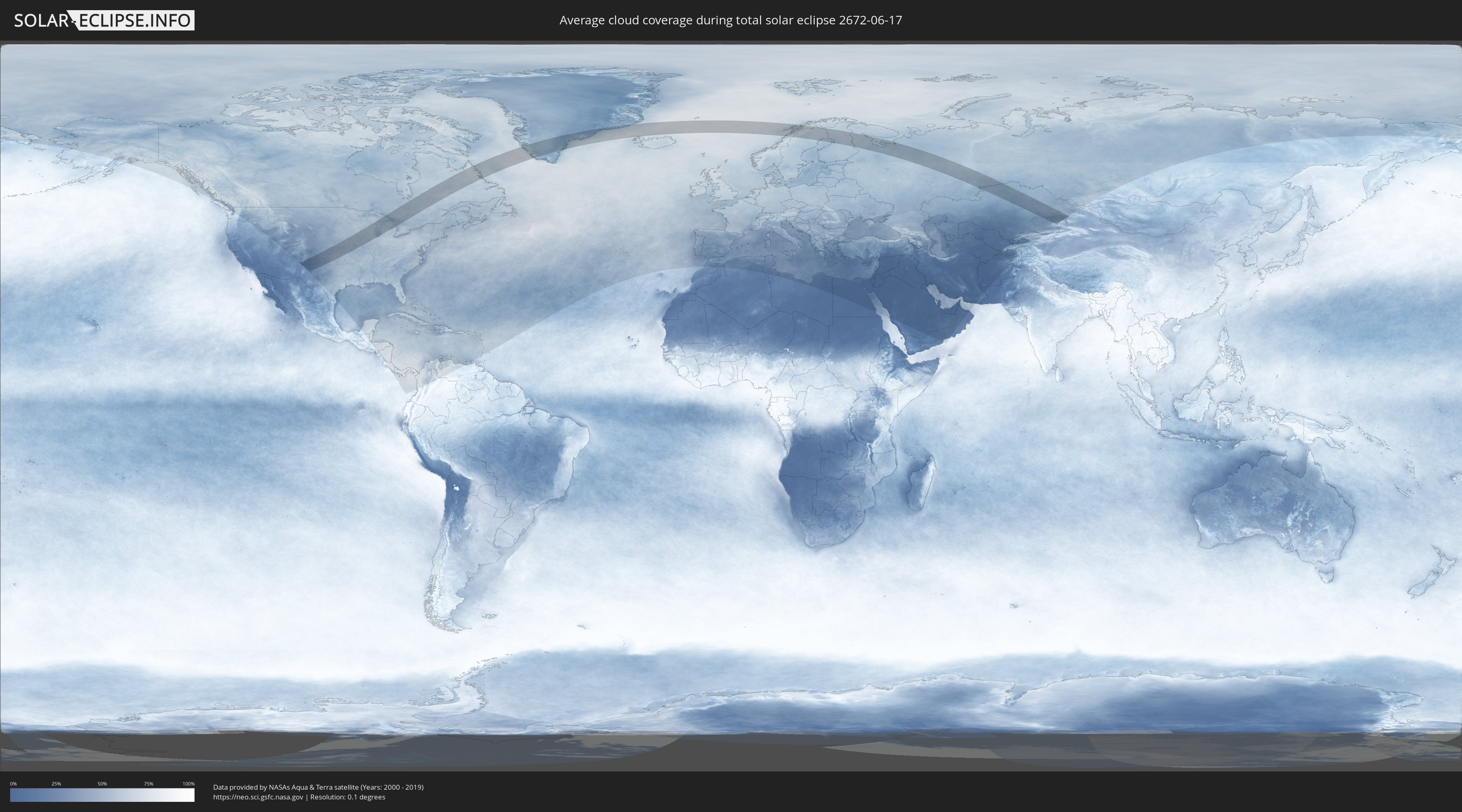
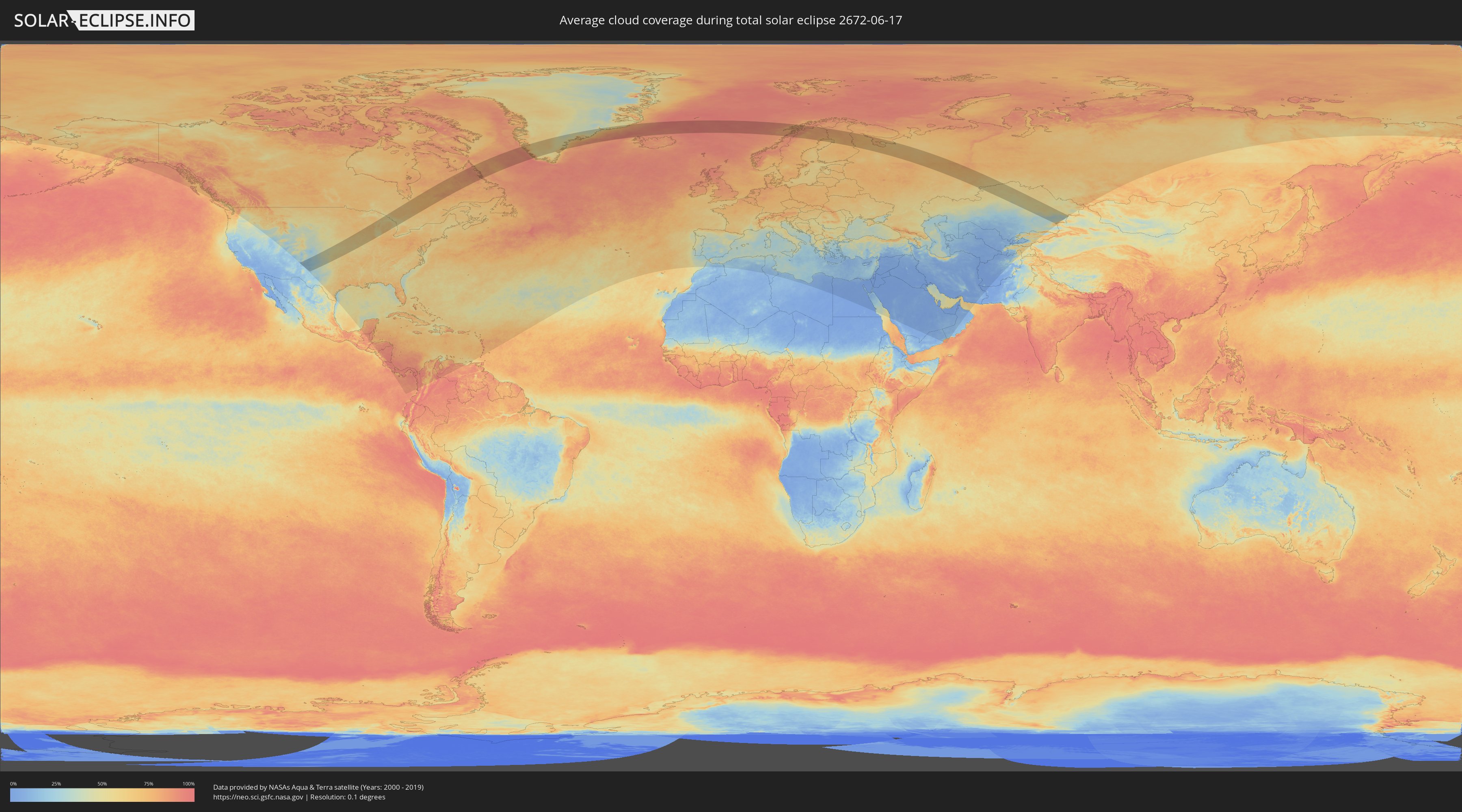
How will be the weather during the total solar eclipse on 06/17/2672?
Where is the best place to see the total solar eclipse of 06/17/2672?
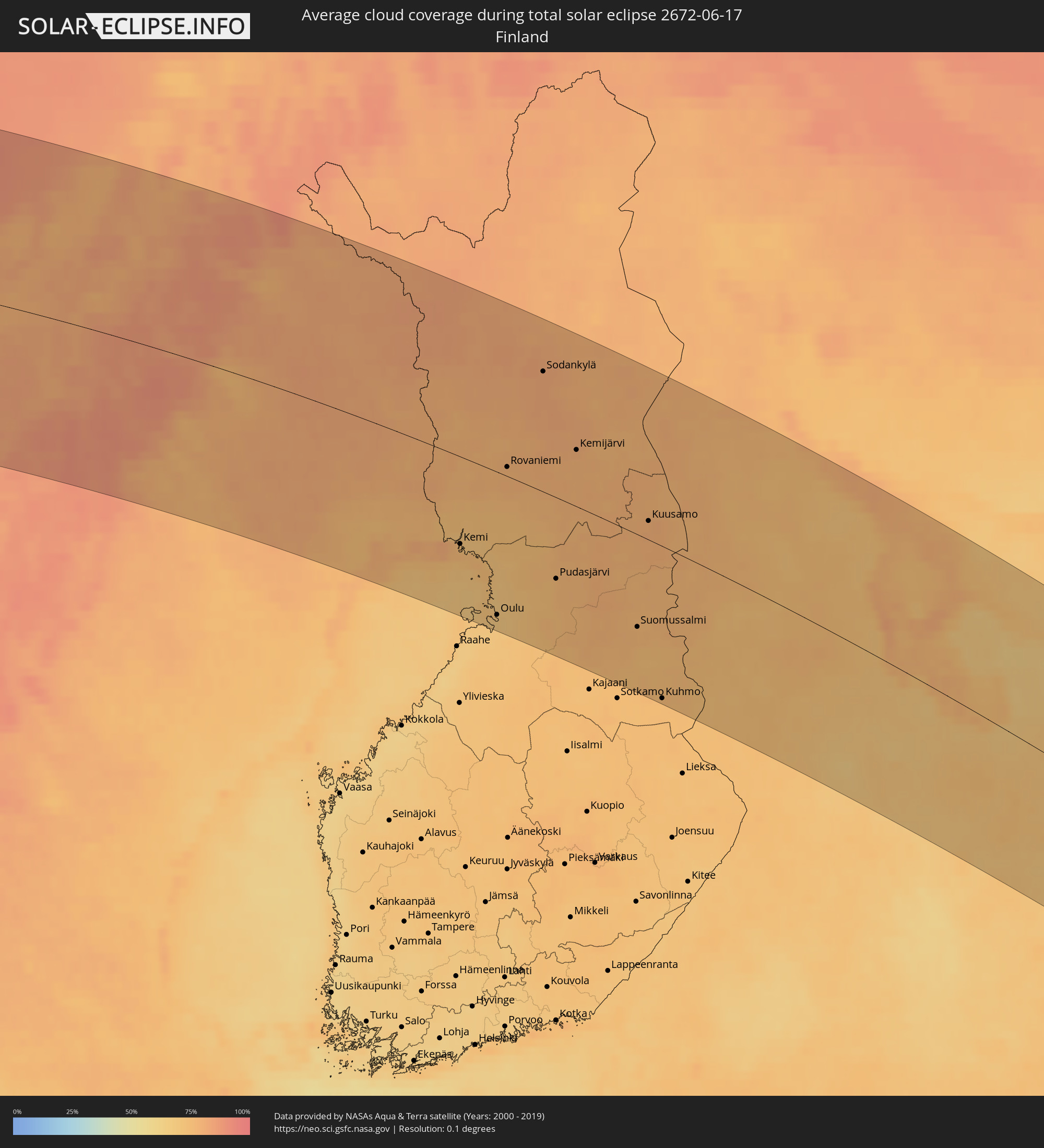
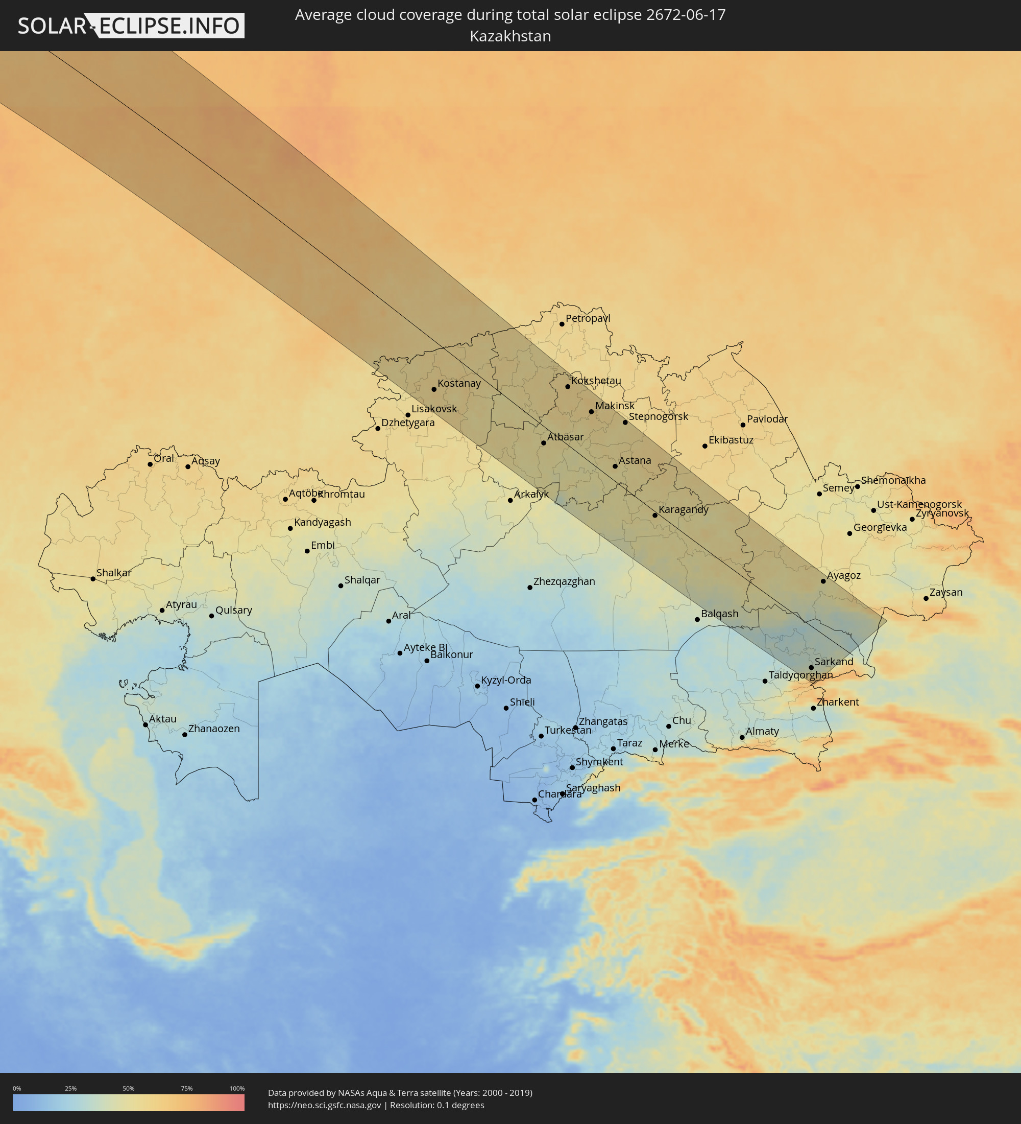
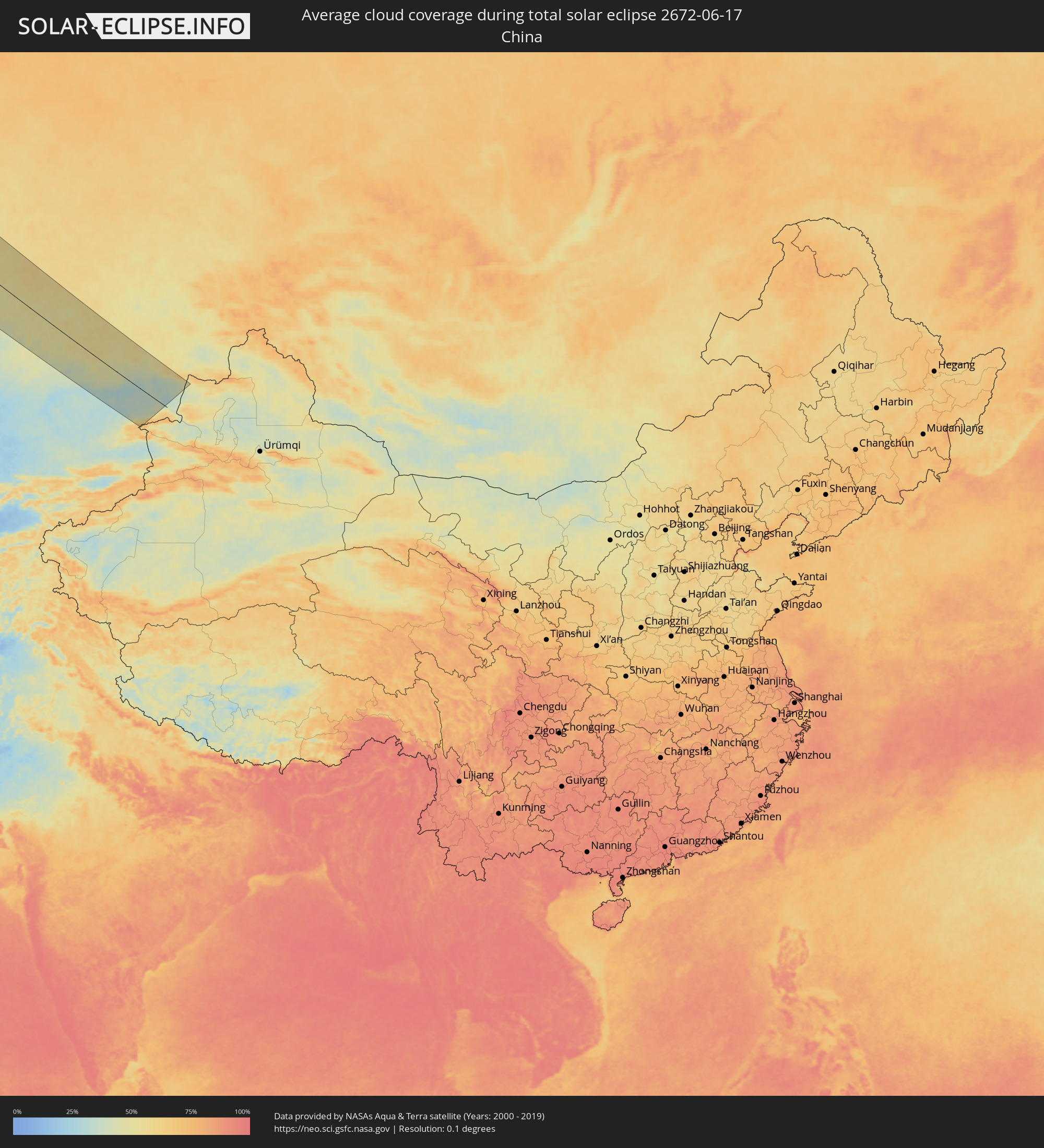
The following maps show the average cloud coverage for the day of the total solar eclipse.
With the help of these maps, it is possible to find the place along the eclipse path, which has the best
chance of a cloudless sky.
Nevertheless, you should consider local circumstances and inform about the weather of your chosen
observation site.
The data is provided by NASAs satellites
AQUA and TERRA.
The cloud maps are averaged over a period of 19 years (2000 - 2019).
Detailed country maps
 Russia
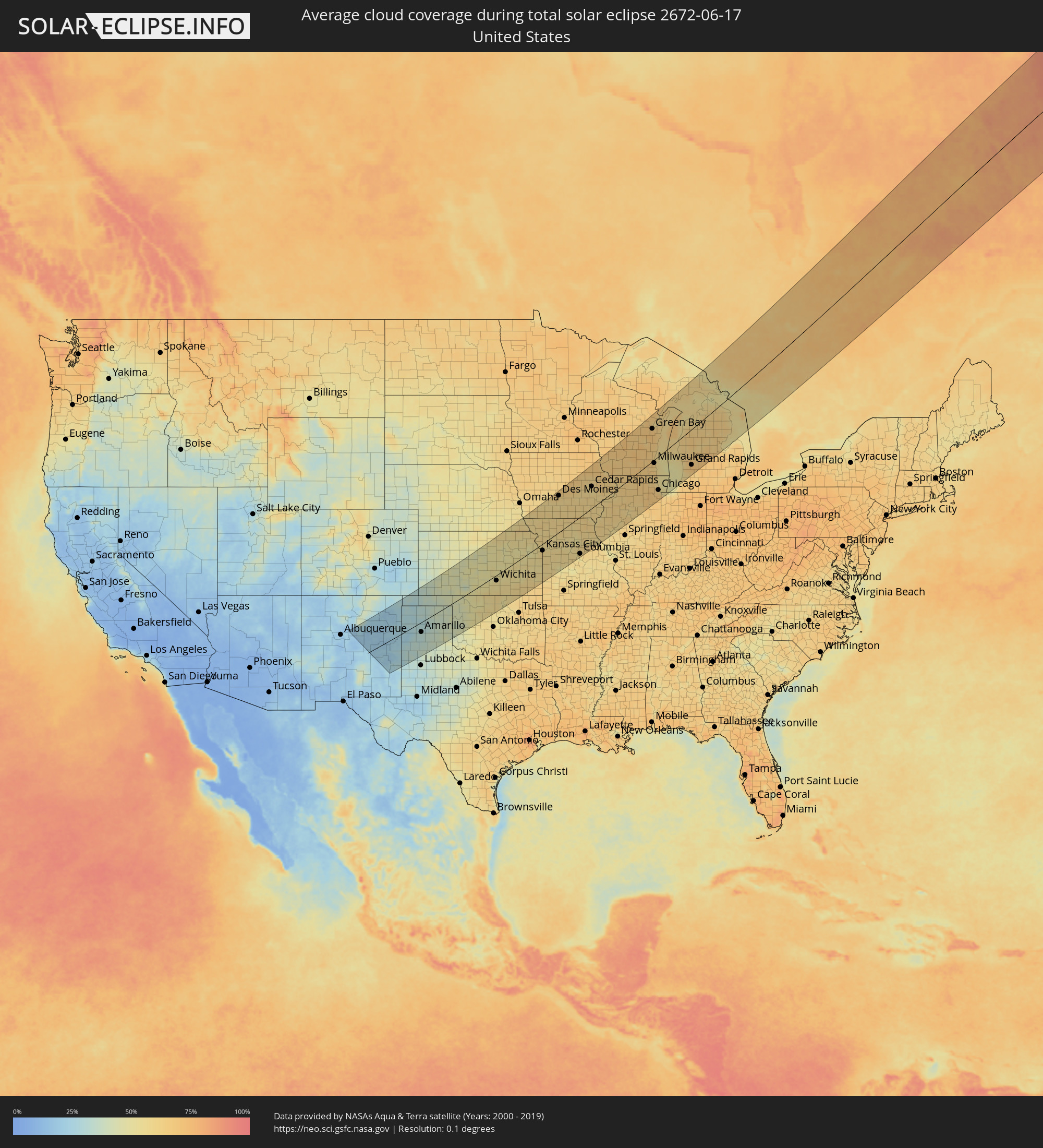 United States
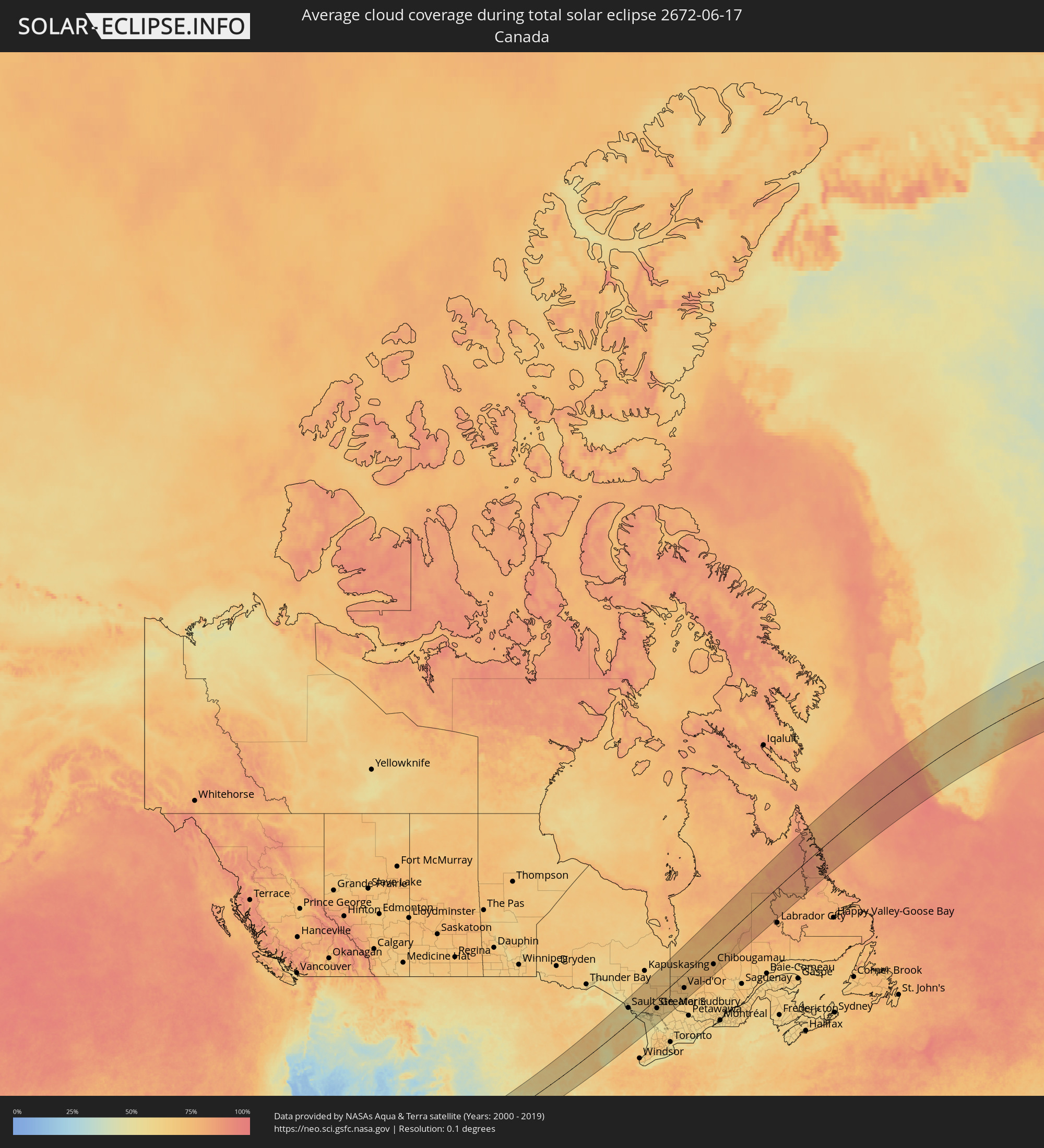 Canada
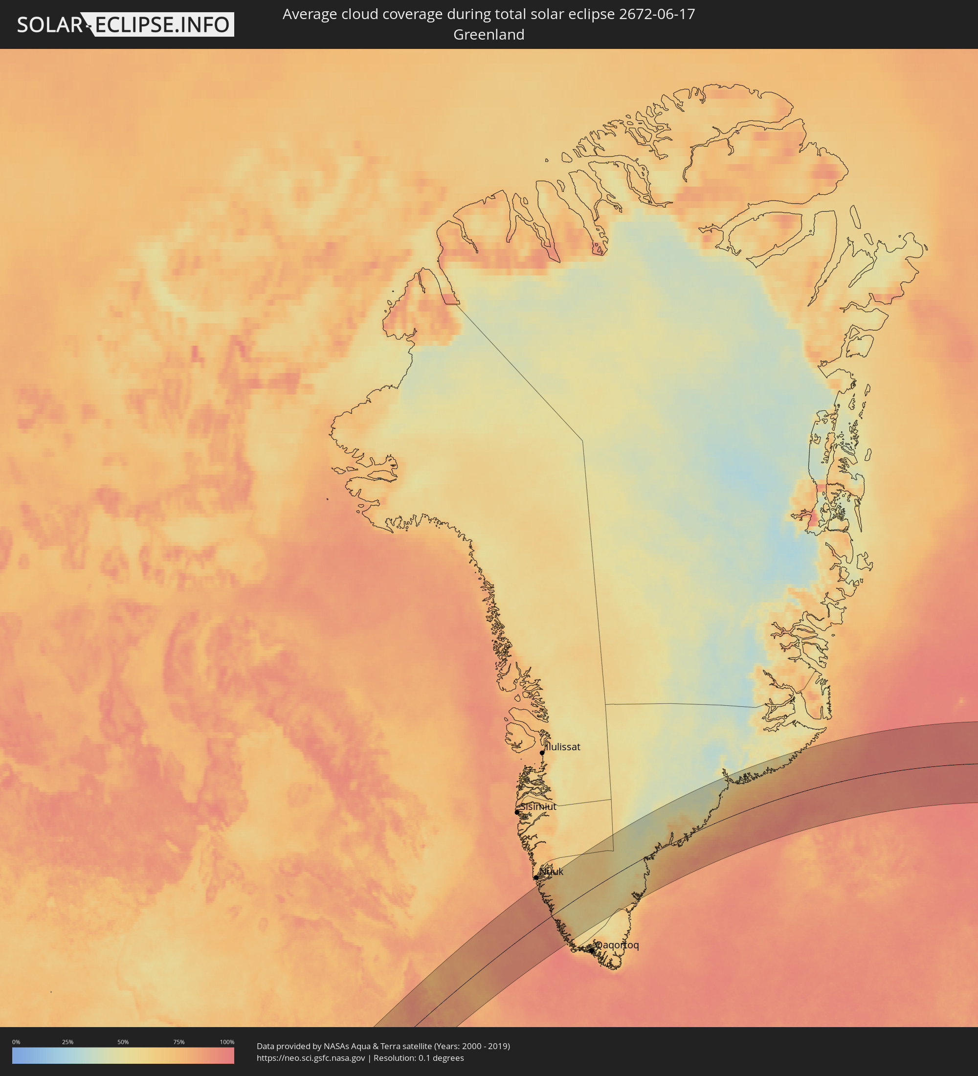 Greenland
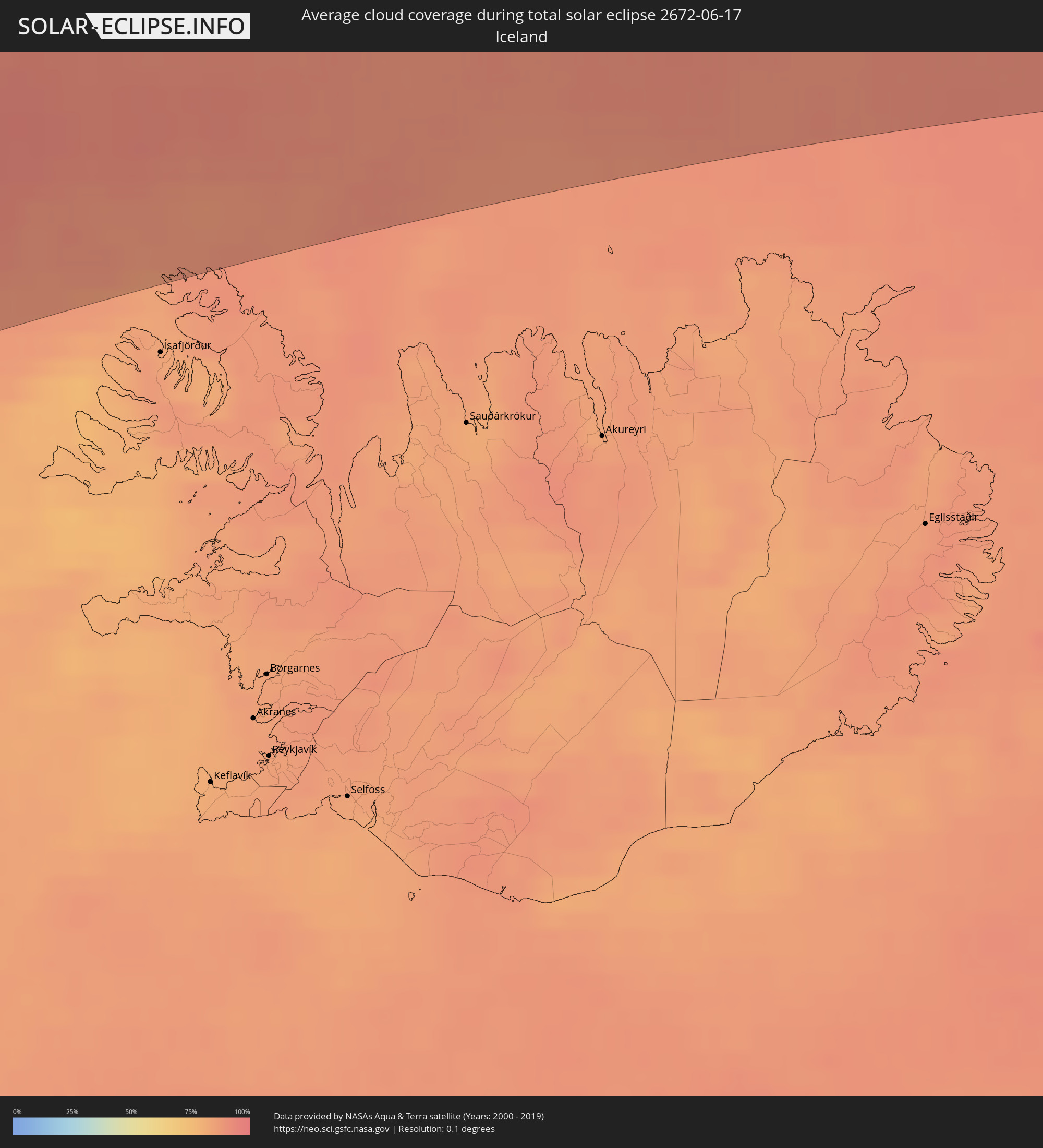 Iceland
 Norway
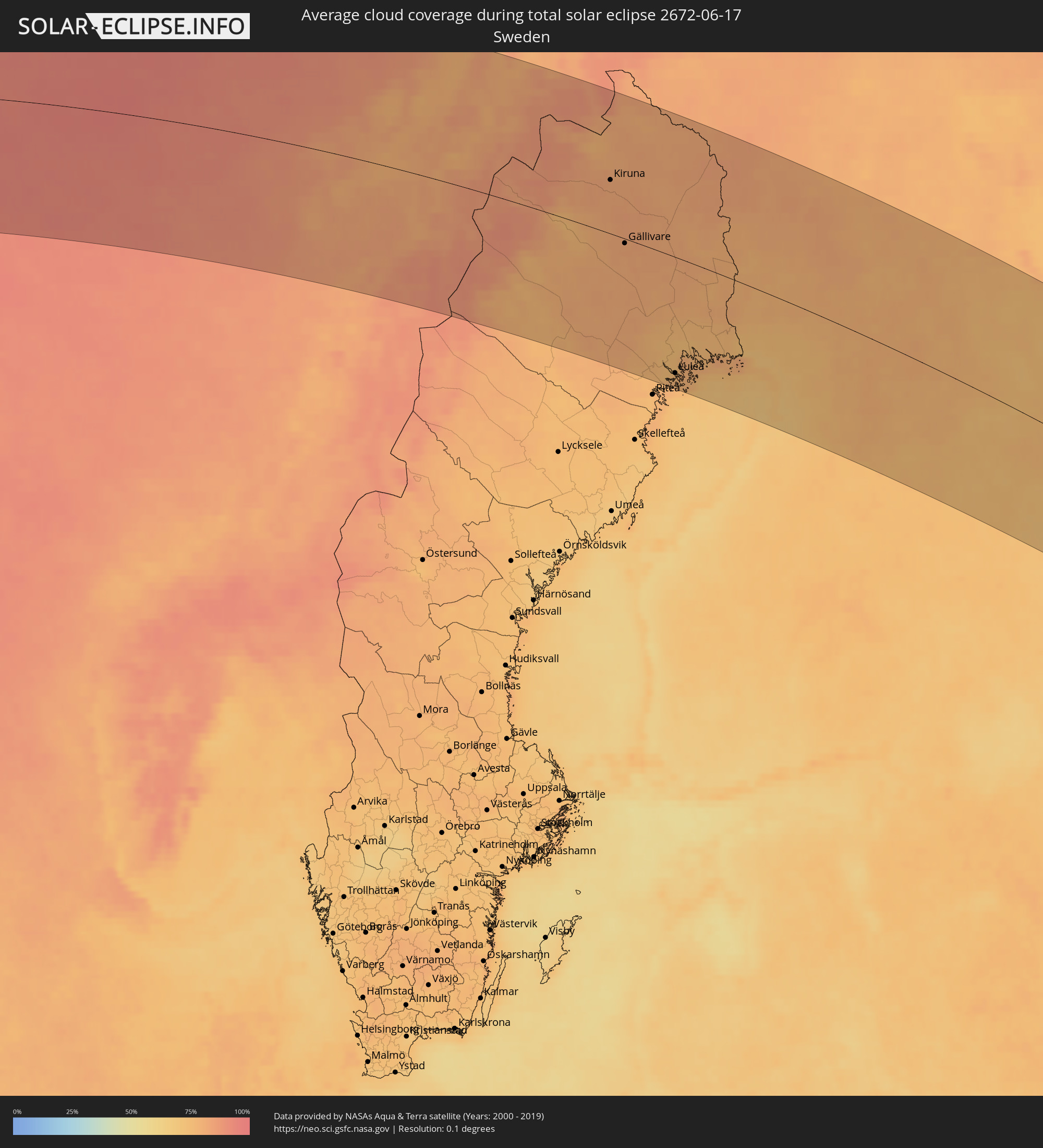 Sweden
 Finland
 Kazakhstan
 China
China
Cities inside the path of the eclipse
The following table shows all locations with a population of more than 5,000 inside the eclipse path. Cities which have more than 100,000 inhabitants are marked bold. A click at the locations opens a detailed map.
| City | Type | Eclipse duration | Local time of max. eclipse | Distance to central line | Ø Cloud coverage |
|
Amarillo, Texas
|
total | - | 05:54:18 UTC-06:00 | 46 km | 33% |
|
Wichita, Kansas
|
total | - | 05:55:33 UTC-06:00 | 24 km | 54% |
|
Topeka, Kansas
|
total | - | 05:56:45 UTC-06:00 | 21 km | 54% |
|
Lawrence, Kansas
|
total | - | 05:56:32 UTC-06:00 | 24 km | 50% |
|
Saint Joseph, Missouri
|
total | - | 05:57:28 UTC-06:00 | 46 km | 58% |
|
Olathe, Kansas
|
total | - | 05:56:18 UTC-06:00 | 37 km | 58% |
|
Overland Park, Kansas
|
total | - | 05:56:24 UTC-06:00 | 36 km | 59% |
|
Kansas City, Missouri
|
total | - | 05:56:32 UTC-06:00 | 38 km | 60% |
|
Lee's Summit, Missouri
|
total | - | 05:56:14 UTC-06:00 | 55 km | 56% |
|
East Independence, Missouri
|
total | - | 05:56:28 UTC-06:00 | 40 km | 59% |
|
Des Moines, Iowa
|
total | - | 05:59:38 UTC-06:00 | 149 km | 62% |
|
Columbia, Missouri
|
total | - | 05:55:47 UTC-06:00 | 154 km | 58% |
|
Cedar Rapids, Iowa
|
total | - | 05:59:49 UTC-06:00 | 87 km | 55% |
|
Davenport, Iowa
|
total | - | 05:58:58 UTC-06:00 | 19 km | 57% |
|
Peoria, Illinois
|
total | - | 05:57:39 UTC-06:00 | 134 km | 62% |
|
Madison, Wisconsin
|
total | - | 06:01:00 UTC-06:00 | 68 km | 63% |
|
Rockford, Illinois
|
total | - | 05:59:49 UTC-06:00 | 31 km | 65% |
|
Aurora, Illinois
|
total | - | 05:59:00 UTC-06:00 | 103 km | 67% |
|
Elgin, Illinois
|
total | - | 05:59:23 UTC-06:00 | 82 km | 64% |
|
Joliet, Illinois
|
total | - | 05:58:38 UTC-06:00 | 136 km | 68% |
|
Green Bay, Wisconsin
|
total | - | 06:02:59 UTC-06:00 | 122 km | 69% |
|
Arlington Heights, Illinois
|
total | - | 05:59:26 UTC-06:00 | 93 km | 66% |
|
Milwaukee, Wisconsin
|
total | - | 06:00:48 UTC-06:00 | 12 km | 64% |
|
Waukegan, Illinois
|
total | - | 05:59:49 UTC-06:00 | 75 km | 59% |
|
Kenosha, Wisconsin
|
total | - | 06:00:08 UTC-06:00 | 56 km | 61% |
|
Racine, Wisconsin
|
total | - | 06:00:20 UTC-06:00 | 46 km | 61% |
|
Chicago, Illinois
|
total | - | 05:59:03 UTC-06:00 | 130 km | 63% |
|
Hammond, Indiana
|
total | - | 05:58:39 UTC-06:00 | 162 km | 68% |
|
Grand Rapids, Michigan
|
total | - | 07:00:32 UTC-05:00 | 134 km | 68% |
|
Sault Ste. Marie, Ontario
|
total | - | 07:05:55 UTC-05:00 | 103 km | 53% |
|
Elliot Lake, Ontario
|
total | - | 07:05:47 UTC-05:00 | 10 km | 59% |
|
Timmins, Ontario
|
total | - | 07:09:12 UTC-05:00 | 114 km | 67% |
|
Rayside-Balfour, Ontario
|
total | - | 07:06:14 UTC-05:00 | 48 km | 64% |
|
Greater Sudbury, Ontario
|
total | - | 07:06:04 UTC-05:00 | 68 km | 63% |
|
Kirkland Lake, Ontario
|
total | - | 07:08:49 UTC-05:00 | 28 km | 69% |
|
Temiskaming Shores, Ontario
|
total | - | 07:07:48 UTC-05:00 | 49 km | 65% |
|
North Bay, Ontario
|
total | - | 07:05:57 UTC-05:00 | 159 km | 58% |
|
La Sarre, Quebec
|
total | - | 07:10:00 UTC-05:00 | 37 km | 66% |
|
Rouyn-Noranda, Quebec
|
total | - | 07:09:06 UTC-05:00 | 29 km | 67% |
|
Amos, Quebec
|
total | - | 07:09:47 UTC-05:00 | 38 km | 68% |
|
Val-d'Or, Quebec
|
total | - | 07:09:04 UTC-05:00 | 93 km | 71% |
|
Chibougamau, Quebec
|
total | - | 07:12:50 UTC-05:00 | 109 km | 75% |
|
Bodø, Nordland
|
total | - | 14:41:43 UTC+01:00 | 70 km | 80% |
|
Fauske, Nordland
|
total | - | 14:42:22 UTC+01:00 | 61 km | 83% |
|
Harstad, Troms
|
total | - | 14:41:18 UTC+01:00 | 118 km | 80% |
|
Narvik, Nordland
|
total | - | 14:42:14 UTC+01:00 | 90 km | 84% |
|
Kiruna, Norrbotten
|
total | - | 14:44:31 UTC+01:00 | 65 km | 82% |
|
Gällivare, Norrbotten
|
total | - | 14:45:40 UTC+01:00 | 11 km | 82% |
|
Malmberget, Norrbotten
|
total | - | 14:45:36 UTC+01:00 | 8 km | 81% |
|
Älvsbyn, Norrbotten
|
total | - | 14:47:44 UTC+01:00 | 154 km | 76% |
|
Boden, Norrbotten
|
total | - | 14:47:56 UTC+01:00 | 127 km | 75% |
|
Luleå, Norrbotten
|
total | - | 14:48:31 UTC+01:00 | 145 km | 76% |
|
Kalix, Norrbotten
|
total | - | 14:48:44 UTC+01:00 | 101 km | 76% |
|
Ylitornio, Lapland
|
total | - | 15:48:25 UTC+02:00 | 45 km | 79% |
|
Tornio, Lapland
|
total | - | 15:49:18 UTC+02:00 | 85 km | 81% |
|
Keminmaa, Lapland
|
total | - | 15:49:34 UTC+02:00 | 84 km | 74% |
|
Kemi, Lapland
|
total | - | 15:49:40 UTC+02:00 | 90 km | 75% |
|
Kittilä, Lapland
|
total | - | 15:47:13 UTC+02:00 | 115 km | 80% |
|
Haukipudas, Northern Ostrobothnia
|
total | - | 15:50:52 UTC+02:00 | 133 km | 68% |
|
Ii, Northern Ostrobothnia
|
total | - | 15:50:41 UTC+02:00 | 118 km | 68% |
|
Oulunsalo, Northern Ostrobothnia
|
total | - | 15:51:14 UTC+02:00 | 157 km | 68% |
|
Oulu, Northern Ostrobothnia
|
total | - | 15:51:10 UTC+02:00 | 148 km | 68% |
|
Kempele, Northern Ostrobothnia
|
total | - | 15:51:19 UTC+02:00 | 158 km | 69% |
|
Rovaniemi, Lapland
|
total | - | 15:49:14 UTC+02:00 | 11 km | 77% |
|
Kiiminki, Northern Ostrobothnia
|
total | - | 15:51:10 UTC+02:00 | 130 km | 69% |
|
Muhos, Northern Ostrobothnia
|
total | - | 15:51:44 UTC+02:00 | 159 km | 71% |
|
Sodankylä, Lapland
|
total | - | 15:48:24 UTC+02:00 | 118 km | 81% |
|
Pudasjärvi, Northern Ostrobothnia
|
total | - | 15:51:24 UTC+02:00 | 84 km | 75% |
|
Pyhäjärvi, Lapland
|
total | - | 15:49:10 UTC+02:00 | 94 km | 80% |
|
Kemijärvi, Lapland
|
total | - | 15:49:50 UTC+02:00 | 57 km | 79% |
|
Suomussalmi, Kainuu
|
total | - | 15:53:07 UTC+02:00 | 96 km | 76% |
|
Kuusamo, Northern Ostrobothnia
|
total | - | 15:51:41 UTC+02:00 | 19 km | 79% |
|
Kuhmo, Kainuu
|
total | - | 15:54:31 UTC+02:00 | 159 km | 74% |
|
Severodvinsk, Arkhangelskaya
|
total | - | 16:58:02 UTC+03:00 | 121 km | 67% |
|
Arkhangel’sk, Arkhangelskaya
|
total | - | 16:58:17 UTC+03:00 | 137 km | 66% |
|
Kotlas, Arkhangelskaya
|
total | - | 17:05:06 UTC+03:00 | 8 km | 67% |
|
Kirov, Kirov
|
total | - | 17:09:50 UTC+03:00 | 144 km | 70% |
|
Kirovo-Chepetsk, Kirov
|
total | - | 17:09:58 UTC+03:00 | 135 km | 70% |
|
Glazov, Udmurtiya
|
total | - | 18:10:56 UTC+04:00 | 83 km | 70% |
|
Votkinsk, Udmurtiya
|
total | - | 18:12:43 UTC+04:00 | 135 km | 68% |
|
Chaykovskiy, Perm
|
total | - | 19:13:09 UTC+05:00 | 156 km | 72% |
|
Krasnokamsk, Perm
|
total | - | 19:11:15 UTC+05:00 | 21 km | 73% |
|
Perm, Perm
|
total | - | 19:11:22 UTC+05:00 | 32 km | 75% |
|
Kungur, Perm
|
total | - | 19:12:15 UTC+05:00 | 11 km | 72% |
|
Lys’va, Perm
|
total | - | 19:11:15 UTC+05:00 | 98 km | 74% |
|
Chusovoy, Perm
|
total | - | 19:10:58 UTC+05:00 | 114 km | 75% |
|
Satka, Chelyabinsk
|
total | - | 19:15:47 UTC+05:00 | 129 km | 69% |
|
Zlatoust, Chelyabinsk
|
total | - | 19:15:34 UTC+05:00 | 93 km | 69% |
|
Pervoural’sk, Sverdlovsk
|
total | - | 19:13:01 UTC+05:00 | 73 km | 71% |
|
Nizhniy Tagil, Sverdlovsk
|
total | - | 19:11:31 UTC+05:00 | 161 km | 73% |
|
Novoural’sk, Sverdlovsk
|
total | - | 19:12:31 UTC+05:00 | 106 km | 70% |
|
Miass, Chelyabinsk
|
total | - | 19:15:44 UTC+05:00 | 86 km | 68% |
|
Polevskoy, Sverdlovsk
|
total | - | 19:13:41 UTC+05:00 | 43 km | 66% |
|
Yekaterinburg, Sverdlovsk
|
total | - | 19:13:04 UTC+05:00 | 93 km | 74% |
|
Ozersk, Chelyabinsk
|
total | - | 19:14:40 UTC+05:00 | 17 km | 68% |
|
Snezhinsk, Chelyabinsk
|
total | - | 19:14:11 UTC+05:00 | 30 km | 68% |
|
Chelyabinsk, Chelyabinsk
|
total | - | 19:15:29 UTC+05:00 | 29 km | 66% |
|
Asbest, Sverdlovsk
|
total | - | 19:12:48 UTC+05:00 | 138 km | 73% |
|
Troitsk, Chelyabinsk
|
total | - | 19:16:58 UTC+05:00 | 113 km | 59% |
|
Kamensk-Ural’skiy, Sverdlovsk
|
total | - | 19:13:37 UTC+05:00 | 105 km | 67% |
|
Komsomolets, Qostanay
|
total | - | 19:17:25 UTC+05:00 | 126 km | 54% |
|
Fedorovka, Qostanay
|
total | - | 19:17:30 UTC+05:00 | 111 km | 55% |
|
Kachar, Qostanay
|
total | - | 19:17:52 UTC+05:00 | 126 km | 58% |
|
Rudnyy, Qostanay
|
total | - | 19:18:23 UTC+05:00 | 152 km | 59% |
|
Kostanay, Qostanay
|
total | - | 19:17:59 UTC+05:00 | 110 km | 60% |
|
Shadrinsk, Kurgan
|
total | - | 19:13:57 UTC+05:00 | 143 km | 62% |
|
Borovskoy, Qostanay
|
total | - | 19:17:06 UTC+05:00 | 36 km | 56% |
|
Qusmuryn, Qostanay
|
total | - | 19:18:53 UTC+05:00 | 138 km | 56% |
|
Kurgan, Kurgan
|
total | - | 19:14:39 UTC+05:00 | 155 km | 63% |
|
Esil, Aqmola
|
total | - | 19:19:14 UTC+05:00 | 108 km | 54% |
|
Sergeyevka, Soltüstik Qazaqstan
|
total | - | 19:16:28 UTC+05:00 | 103 km | 54% |
|
Atbasar, Aqmola
|
total | - | 19:19:01 UTC+05:00 | 40 km | 52% |
|
Kokshetau, Aqmola
|
total | - | 19:16:52 UTC+05:00 | 133 km | 60% |
|
Akkol’, Aqmola
|
total | - | 19:16:48 UTC+05:00 | 143 km | 57% |
|
Shchuchinsk, Aqmola
|
total | - | 19:17:08 UTC+05:00 | 136 km | 59% |
|
Makinsk, Aqmola
|
total | - | 19:17:28 UTC+05:00 | 119 km | 58% |
|
Astana, Astana Qalasy
|
total | - | 19:19:03 UTC+05:00 | 38 km | 56% |
|
Stepnogorsk, Aqmola
|
total | - | 19:17:27 UTC+05:00 | 157 km | 54% |
|
Osakarovka, Qaraghandy
|
total | - | 19:19:29 UTC+05:00 | 33 km | 51% |
|
Shakhan, Qaraghandy
|
total | - | 19:20:21 UTC+05:00 | 34 km | 49% |
|
Sorang, Qaraghandy
|
total | - | 19:20:20 UTC+05:00 | 29 km | 49% |
|
Abay, Qaraghandy
|
total | - | 19:20:31 UTC+05:00 | 45 km | 49% |
|
Aqtas, Qaraghandy
|
total | - | 19:20:18 UTC+05:00 | 28 km | 51% |
|
Temirtau, Qaraghandy
|
total | - | 19:19:59 UTC+05:00 | 4 km | 54% |
|
Aqtaū, Qaraghandy
|
total | - | 19:19:43 UTC+05:00 | 24 km | 52% |
|
Yereymentau, Aqmola
|
total | - | 19:18:01 UTC+05:00 | 146 km | 58% |
|
Karagandy, Qaraghandy
|
total | - | 19:20:11 UTC+05:00 | 25 km | 52% |
|
Qarqaraly, Qaraghandy
|
total | - | 19:19:54 UTC+05:00 | 53 km | 55% |
|
Sarkand, Almaty Oblysy
|
total | - | 19:22:26 UTC+05:00 | 117 km | 48% |
|
Ayagoz, East Kazakhstan
|
total | - | 19:19:31 UTC+05:00 | 141 km | 48% |
|
Urzhar, East Kazakhstan
|
total | - | 19:19:53 UTC+05:00 | 117 km | 39% |