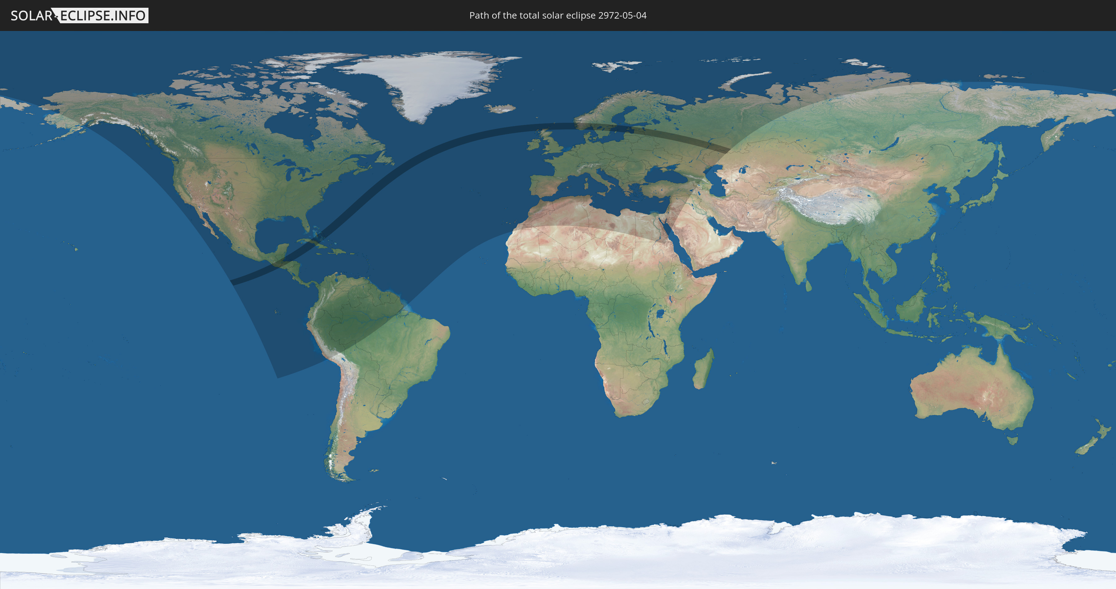
Total solar eclipse of 05/04/2972
| Day of week: | Monday |
| Maximum duration of eclipse: | 04m40s |
| Maximum width of eclipse path: | 251 km |
| Saros cycle: | 173 |
| Coverage: | 100% |
| Magnitude: | 1.0657 |
| Gamma: | 0.5235 |
Wo kann man die Sonnenfinsternis vom 05/04/2972 sehen?
Die Sonnenfinsternis am 05/04/2972 kann man in 120 Ländern als partielle Sonnenfinsternis beobachten.
Der Finsternispfad verläuft durch 16 Länder. Nur in diesen Ländern ist sie als total Sonnenfinsternis zu sehen.
In den folgenden Ländern ist die Sonnenfinsternis total zu sehen
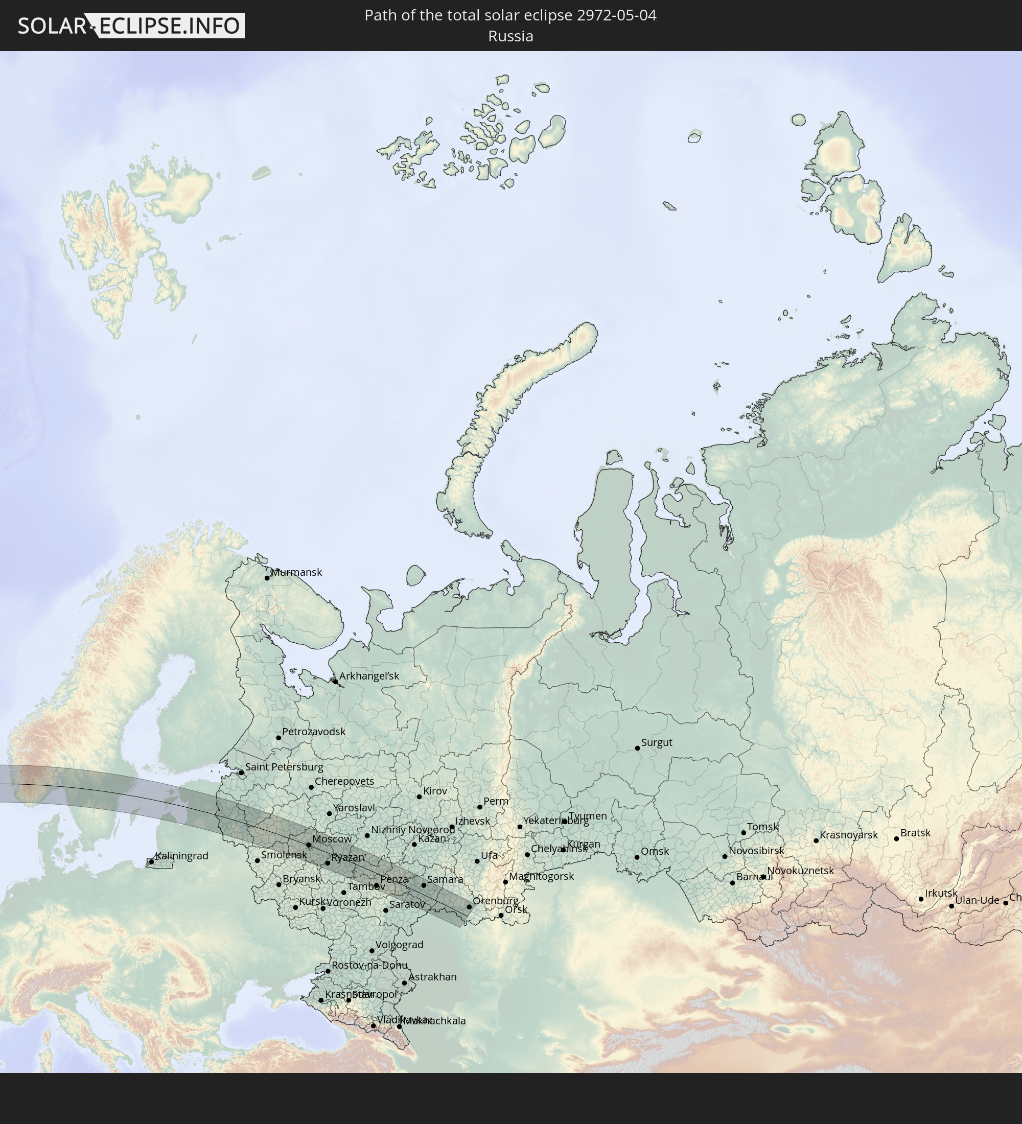 Russia
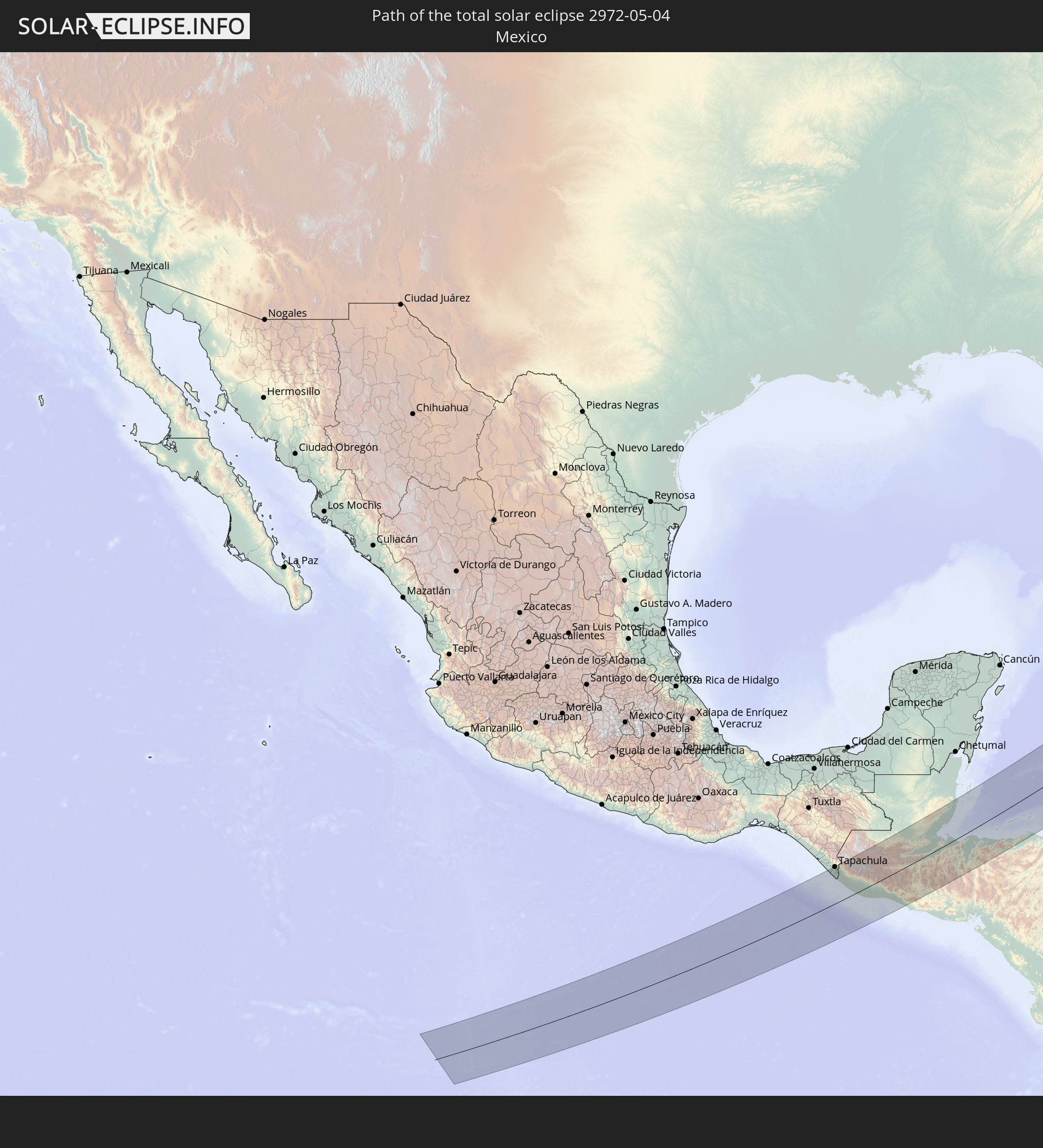 Mexico
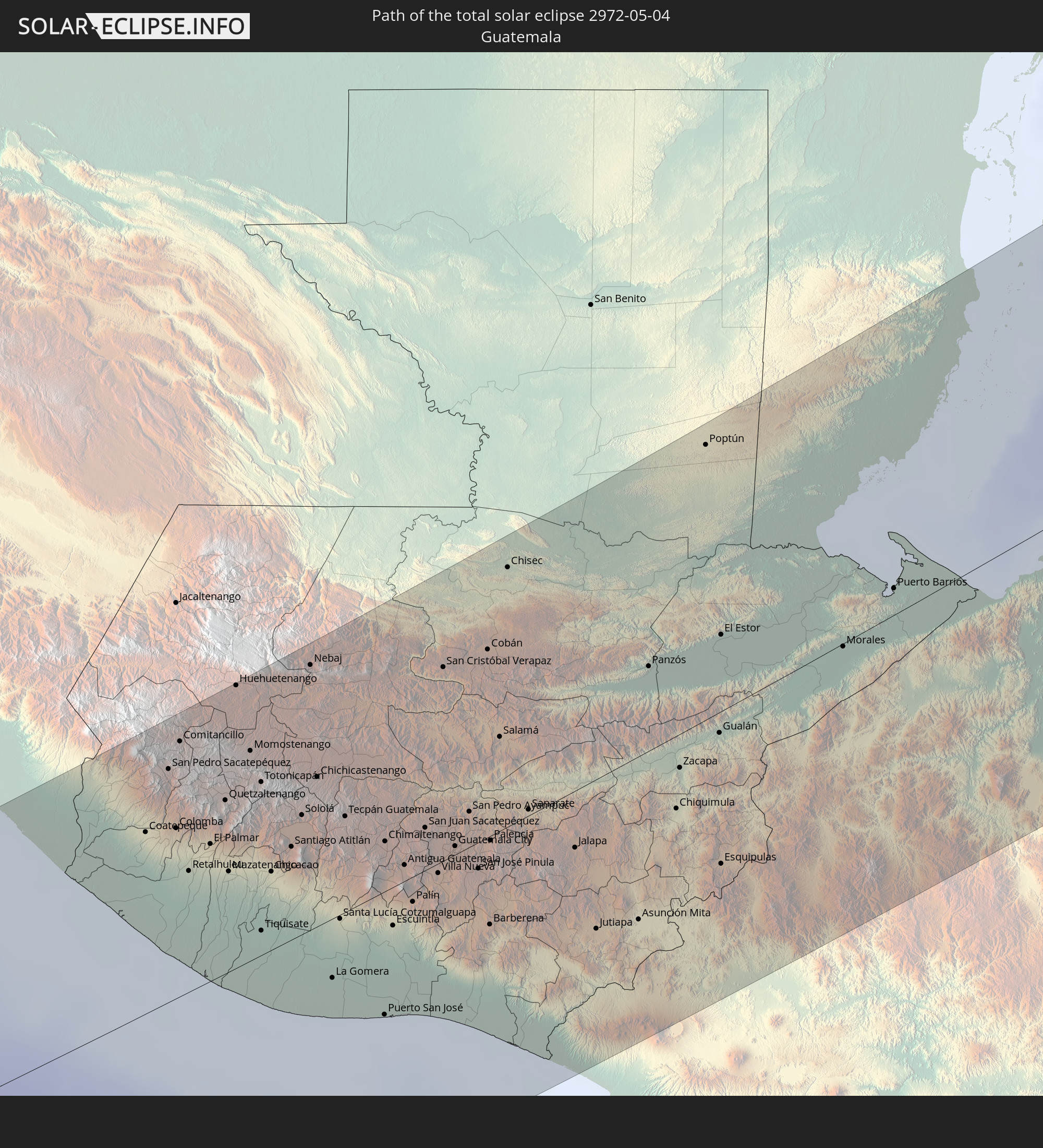 Guatemala
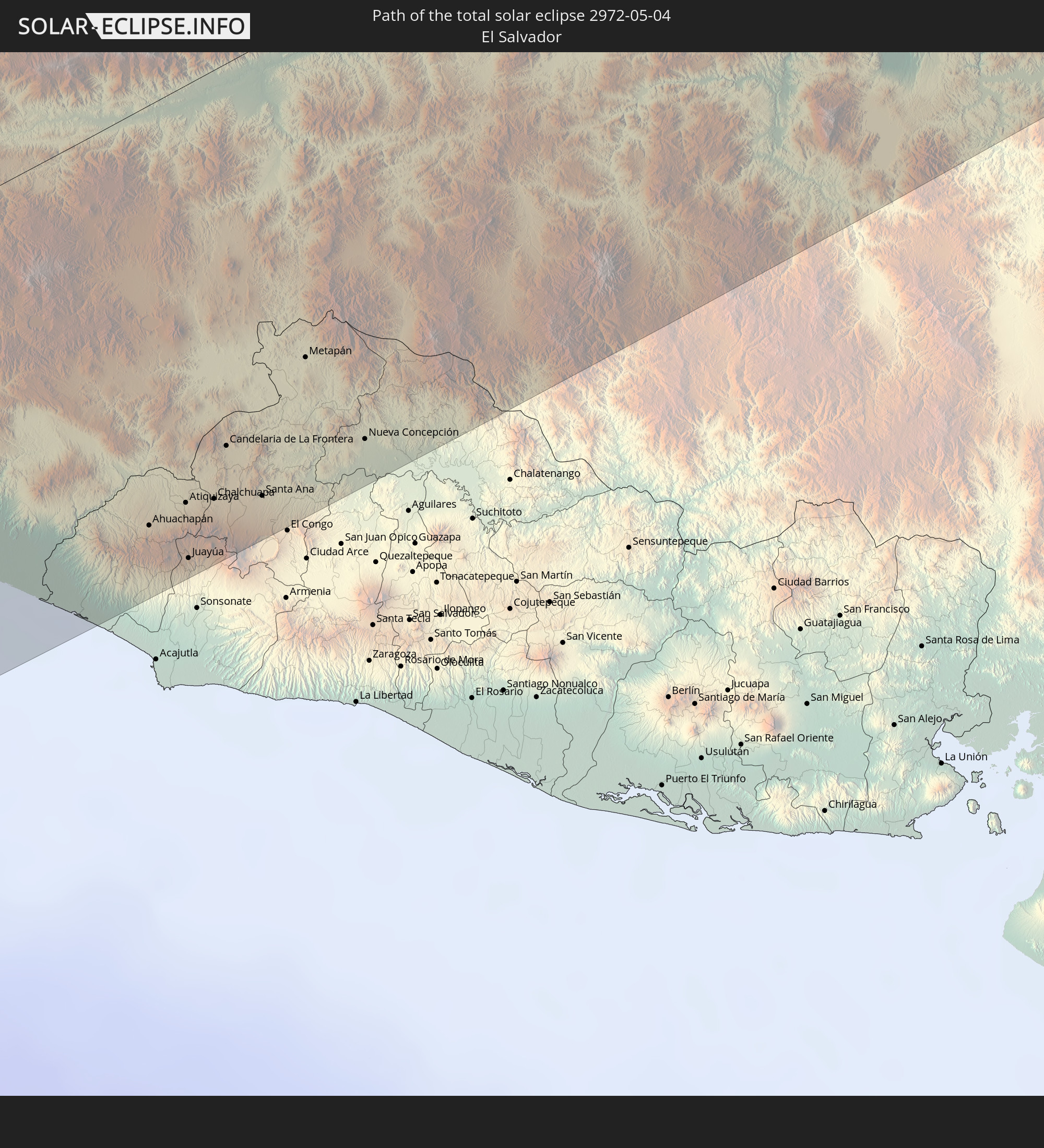 El Salvador
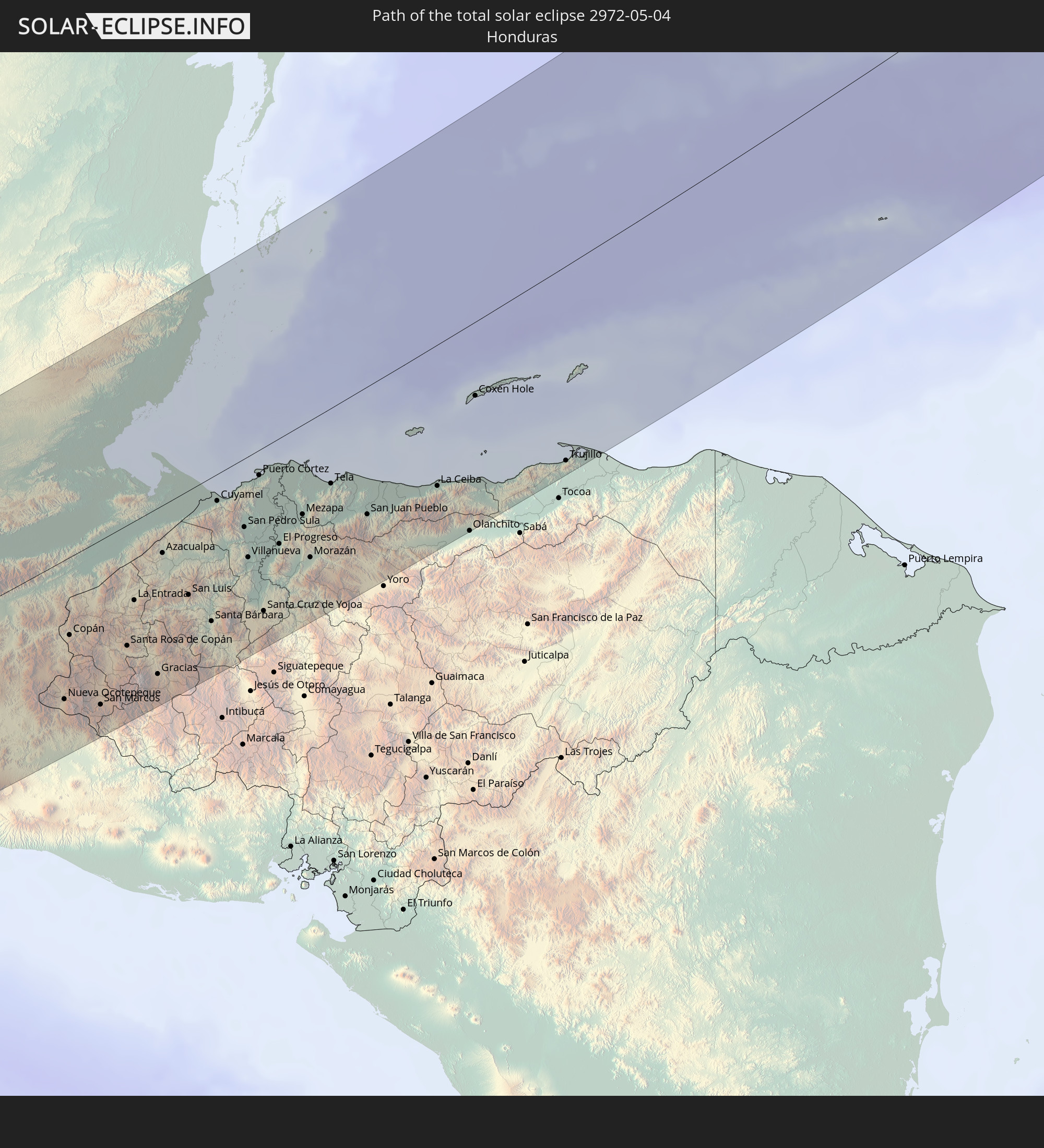 Honduras
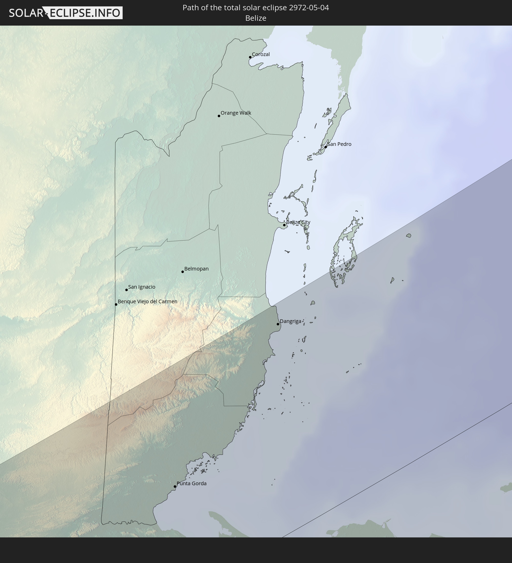 Belize
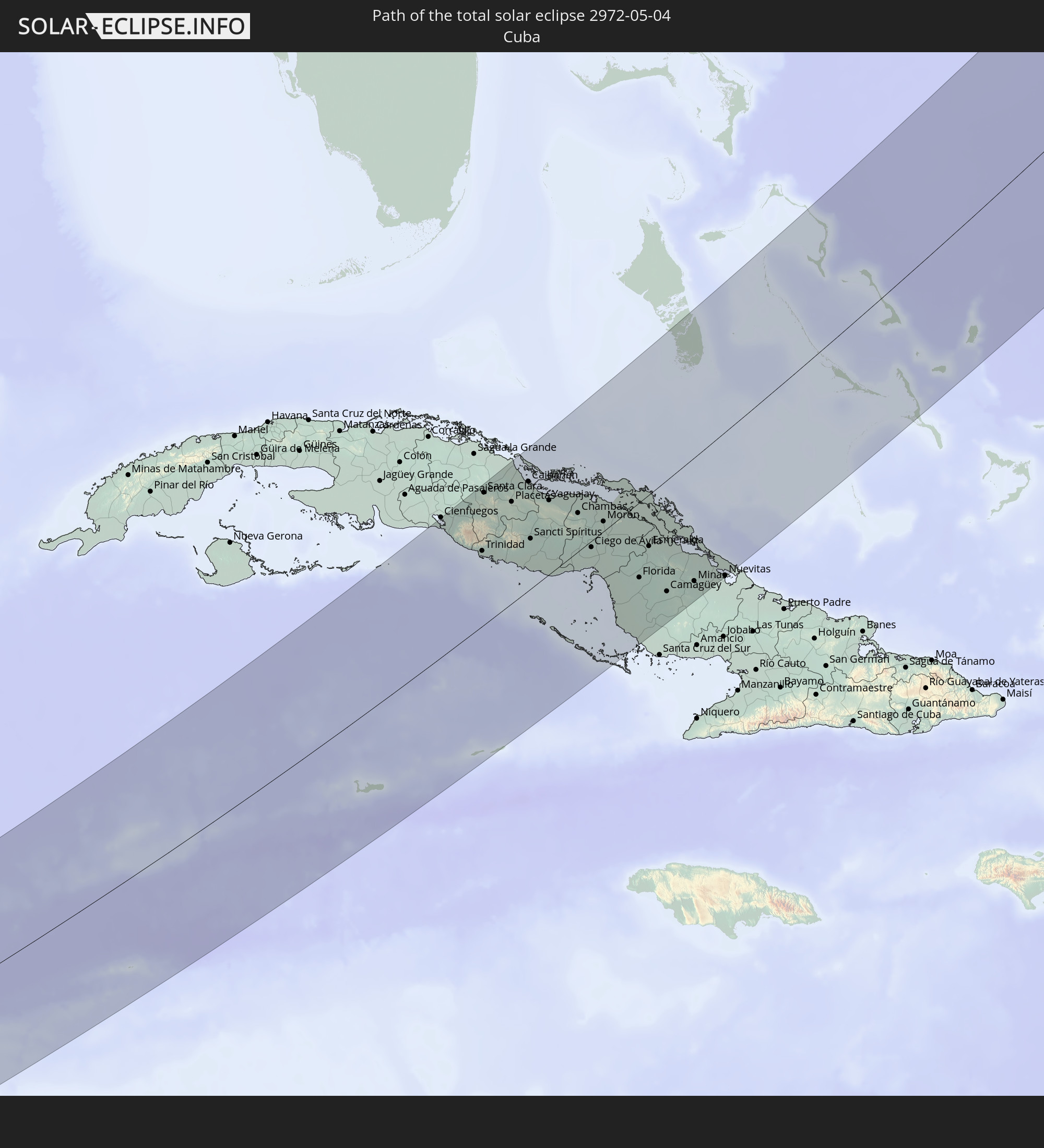 Cuba
Cuba
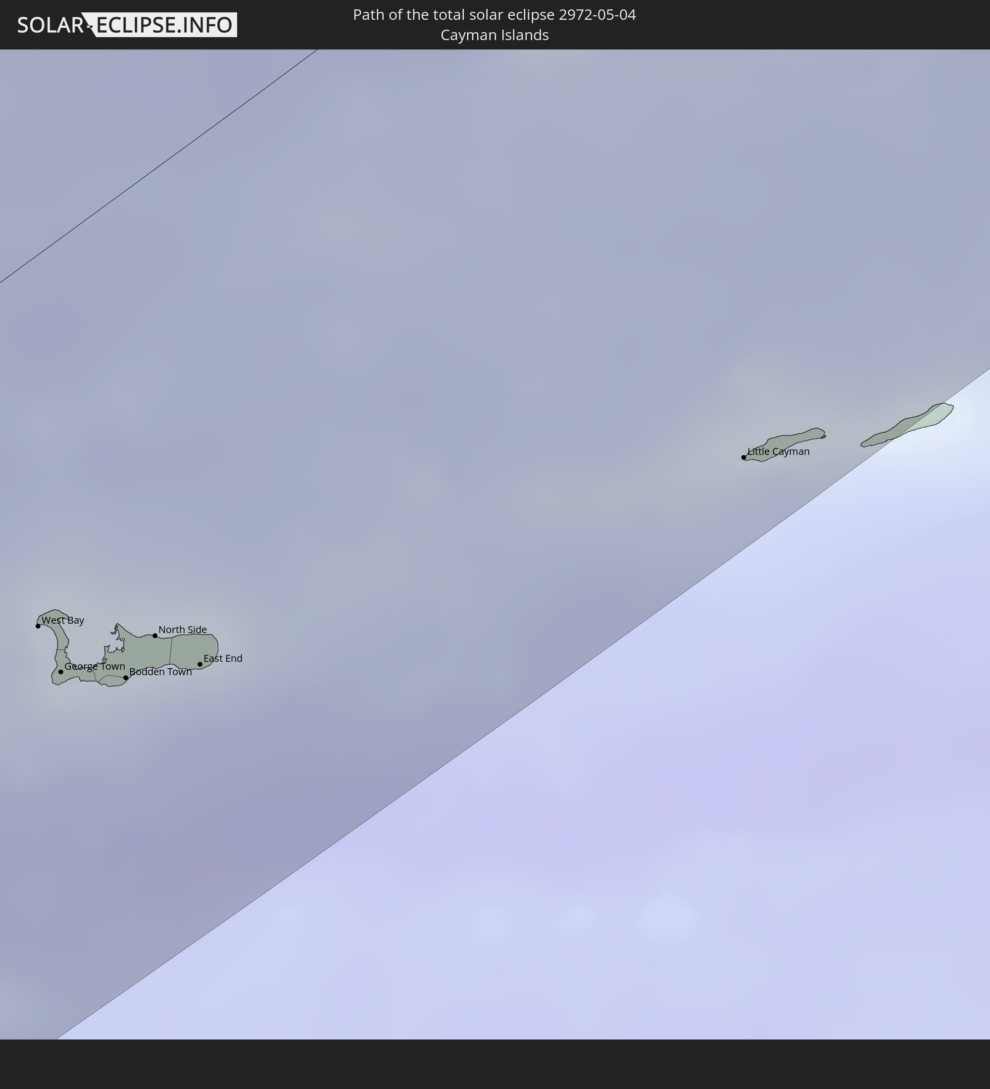 Cayman Islands
 The Bahamas
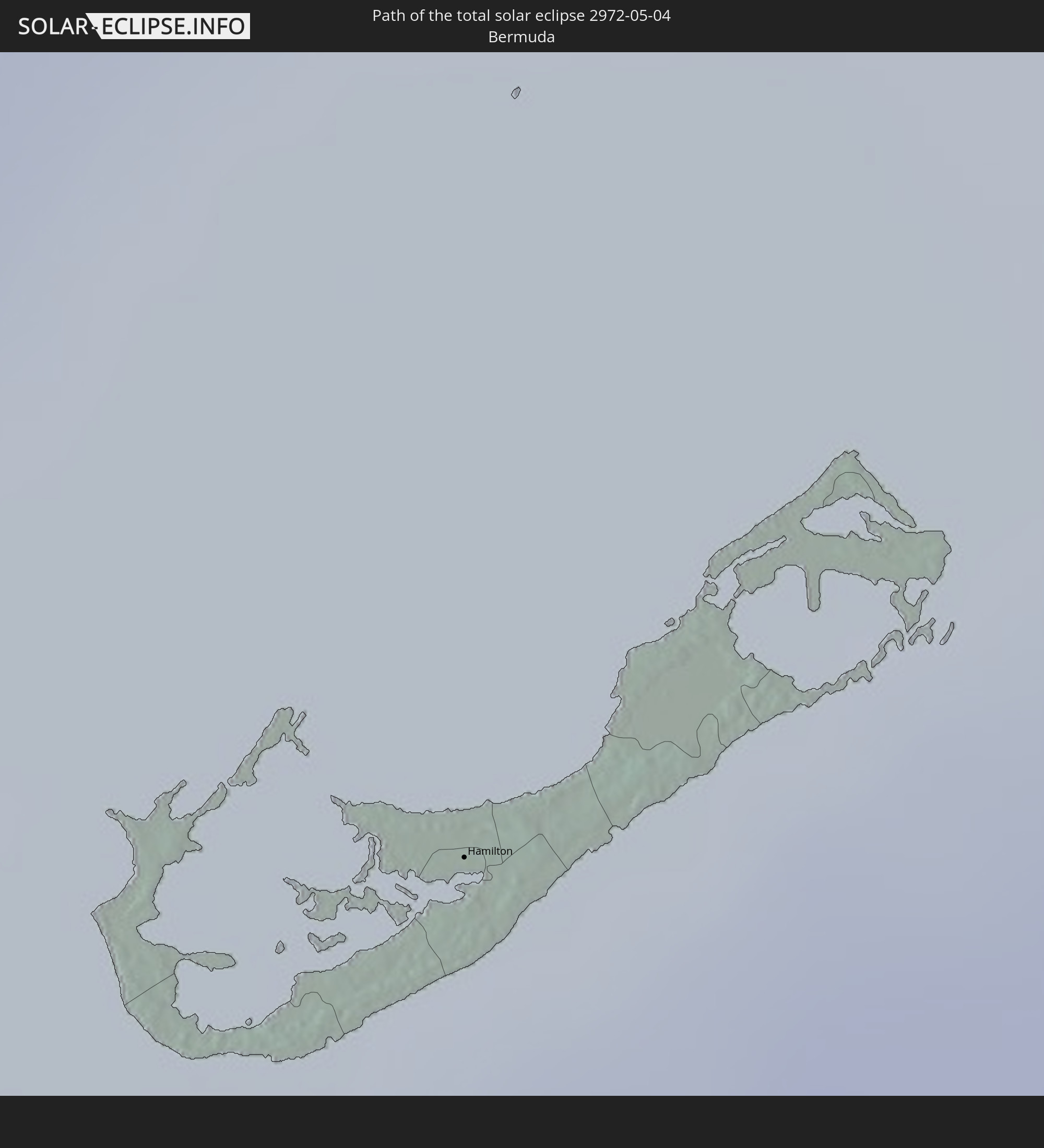 Bermuda
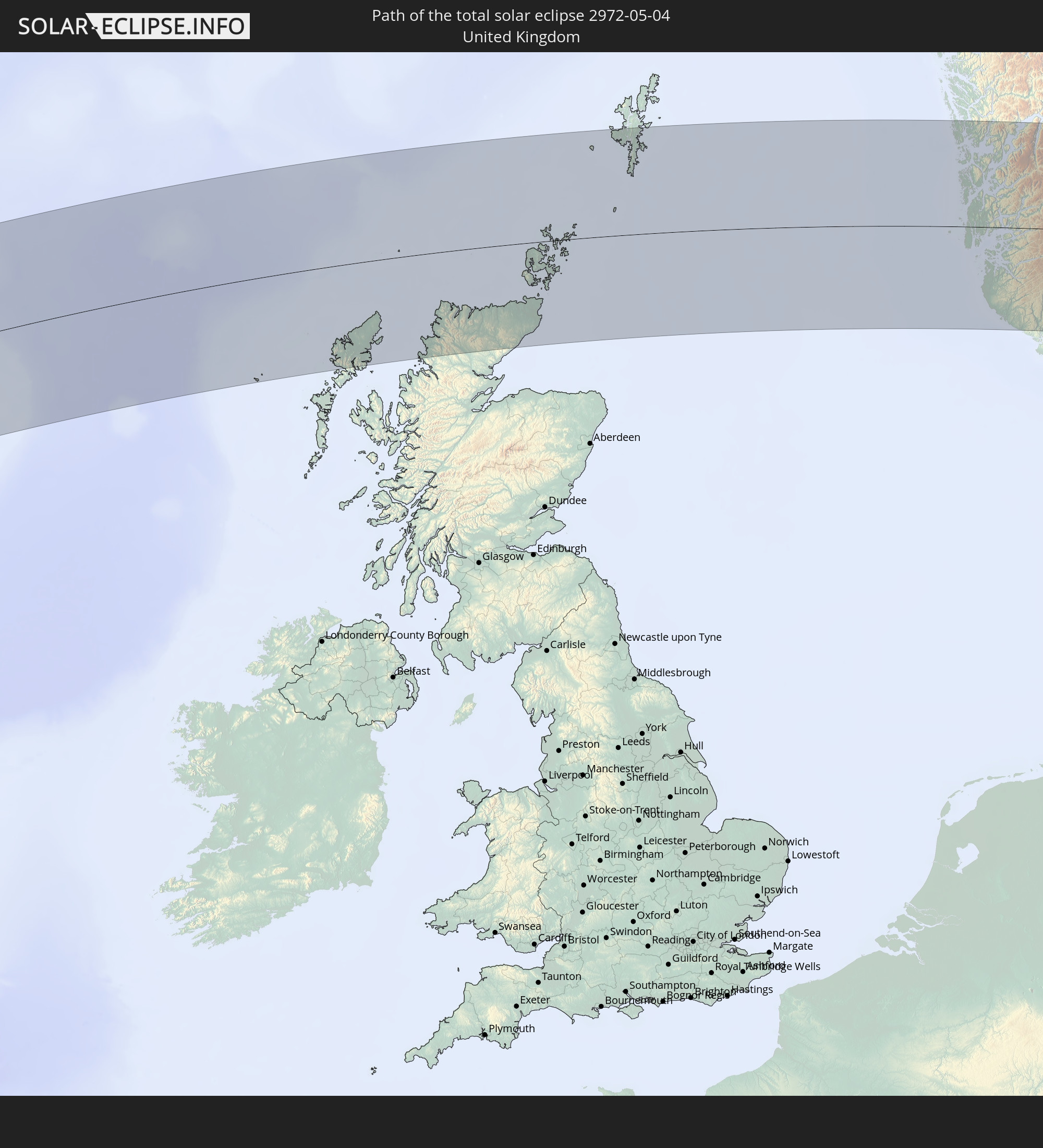 United Kingdom
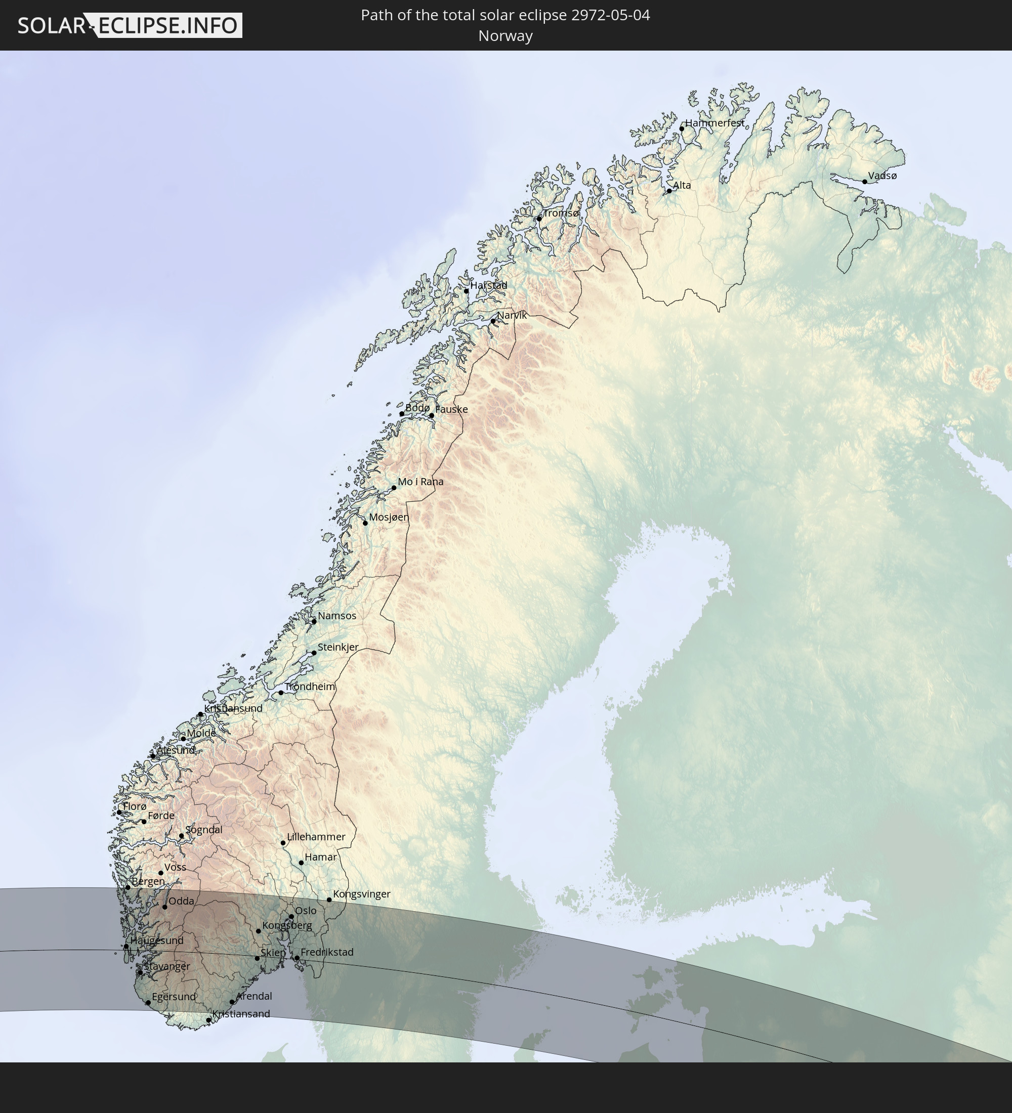 Norway
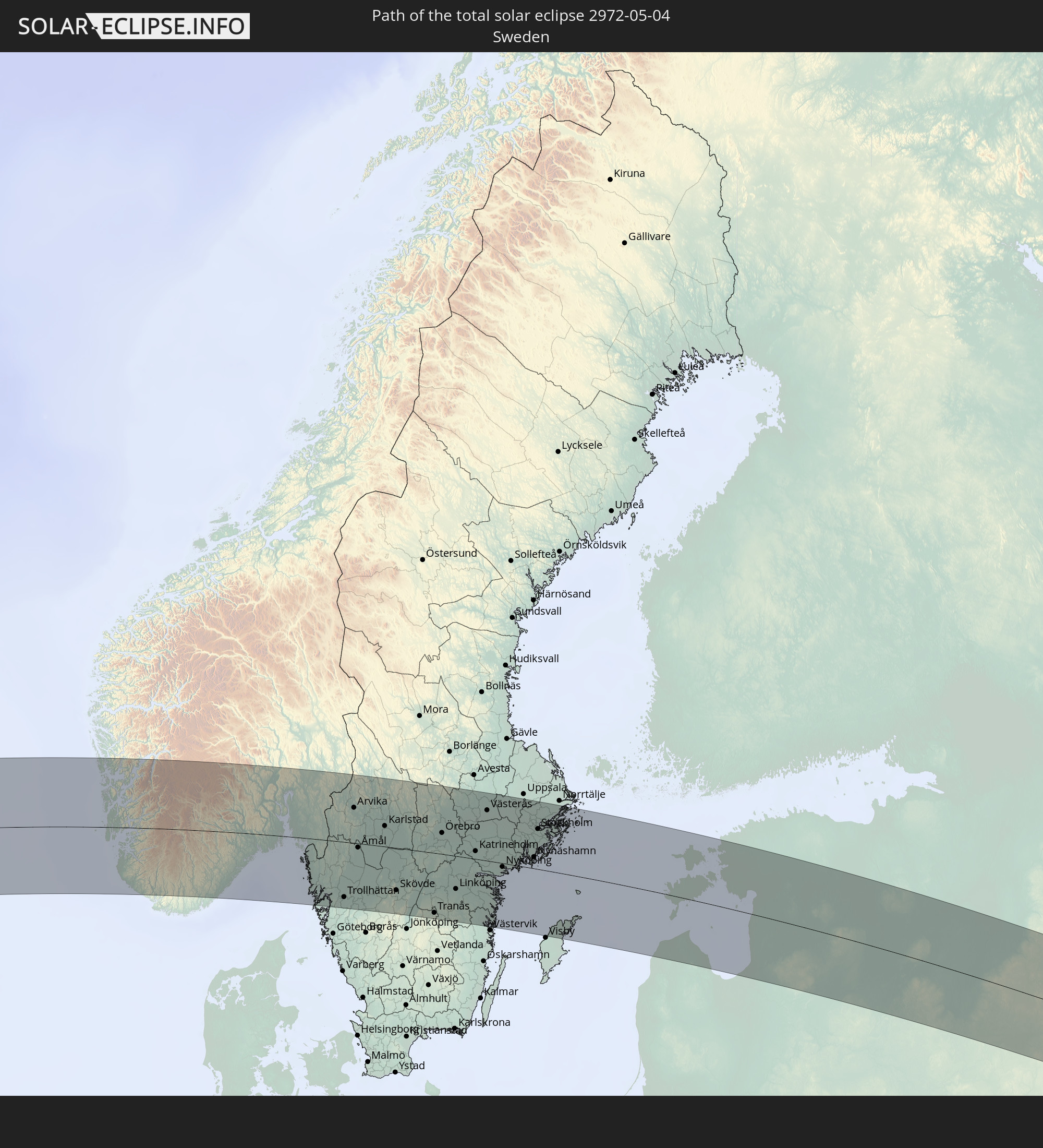 Sweden
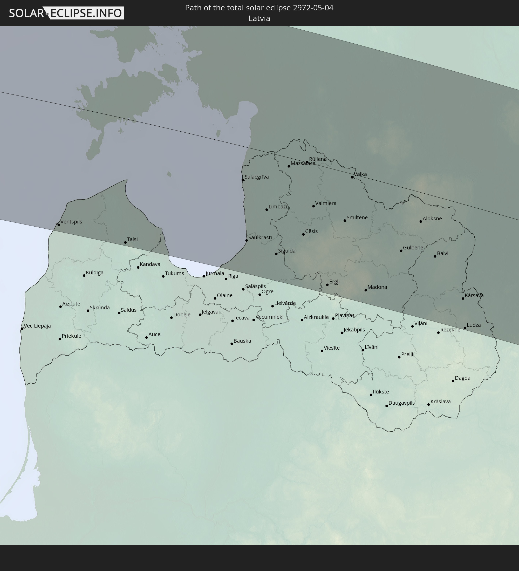 Latvia
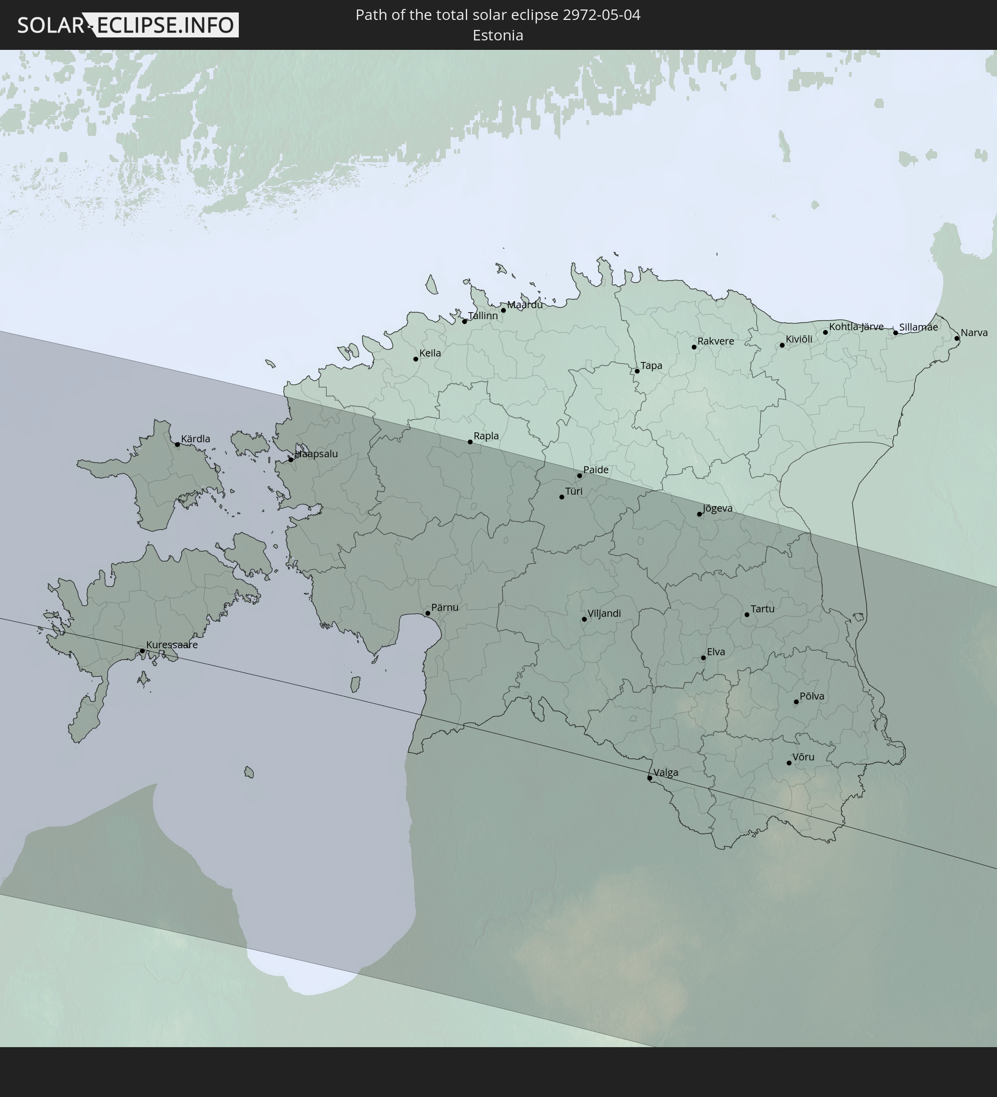 Estonia
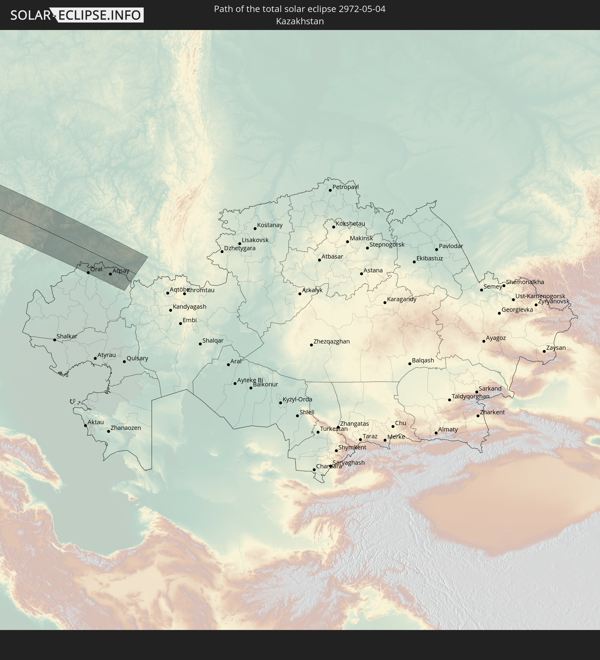 Kazakhstan
In den folgenden Ländern ist die Sonnenfinsternis partiell zu sehen
 Russia
 United States
 United States Minor Outlying Islands
 Canada
 Mexico
 Greenland
 Guatemala
 Ecuador
 El Salvador
 Honduras
 Belize
 Nicaragua
 Costa Rica
 Cuba
Cuba
 Panama
 Colombia
 Cayman Islands
 Peru
Peru
 The Bahamas
 Jamaica
 Haiti
Haiti
 Brazil
 Venezuela
 Turks and Caicos Islands
 Dominican Republic
 Aruba
Aruba
 Bolivia
 Puerto Rico
 United States Virgin Islands
 Bermuda
 British Virgin Islands
 Anguilla
 Collectivity of Saint Martin
 Saint Barthélemy
 Saint Kitts and Nevis
 Antigua and Barbuda
 Montserrat
 Trinidad and Tobago
 Guadeloupe
 Grenada
 Dominica
 Saint Vincent and the Grenadines
 Guyana
 Martinique
 Saint Lucia
 Barbados
 Suriname
 Saint Pierre and Miquelon
 French Guiana
 Portugal
 Iceland
 Spain
Spain
 Mauritania
 Morocco
 Republic of Ireland
 Svalbard and Jan Mayen
 Algeria
 United Kingdom
 Faroe Islands
 Gibraltar
 France
 Isle of Man
 Guernsey
 Jersey
 Andorra
 Belgium
 Netherlands
 Norway
 Luxembourg
 Germany
 Switzerland
 Italy
Italy
 Monaco
 Tunisia
 Denmark
 Libya
Libya
 Liechtenstein
 Austria
 Sweden
 Czechia
 San Marino
 Vatican City
 Slovenia
 Croatia
 Poland
 Malta
Malta
 Bosnia and Herzegovina
 Hungary
 Slovakia
 Montenegro
 Serbia
 Albania
 Åland Islands
 Greece
 Romania
 Republic of Macedonia
 Finland
 Lithuania
 Latvia
 Estonia
 Sudan
Sudan
 Ukraine
 Bulgaria
 Belarus
 Egypt
Egypt
 Turkey
 Moldova
 Cyprus
 State of Palestine
 Israel
 Saudi Arabia
 Jordan
 Lebanon
 Syria
Syria
 Iraq
Iraq
 Georgia
 Armenia
 Iran
Iran
 Azerbaijan
 Kazakhstan
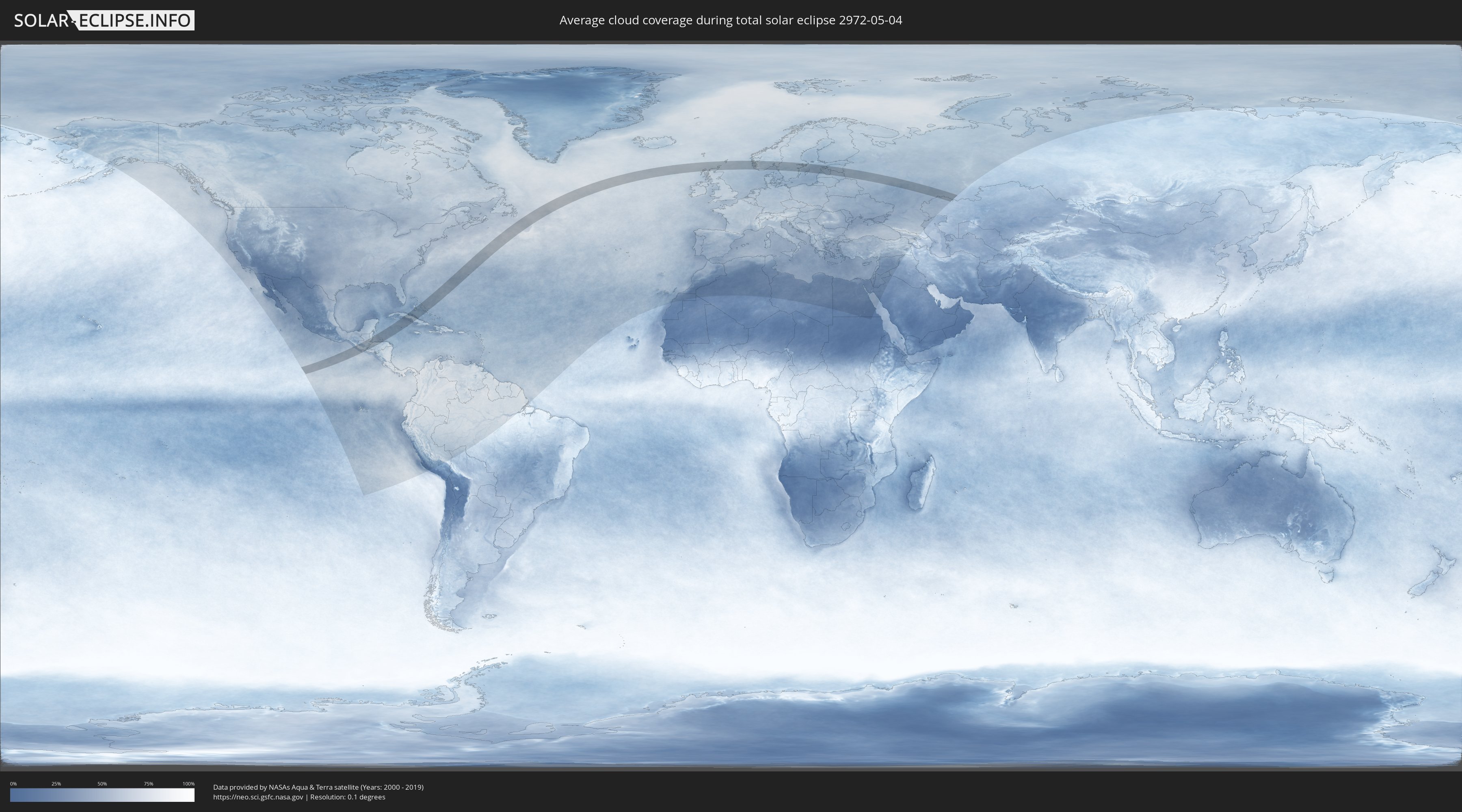
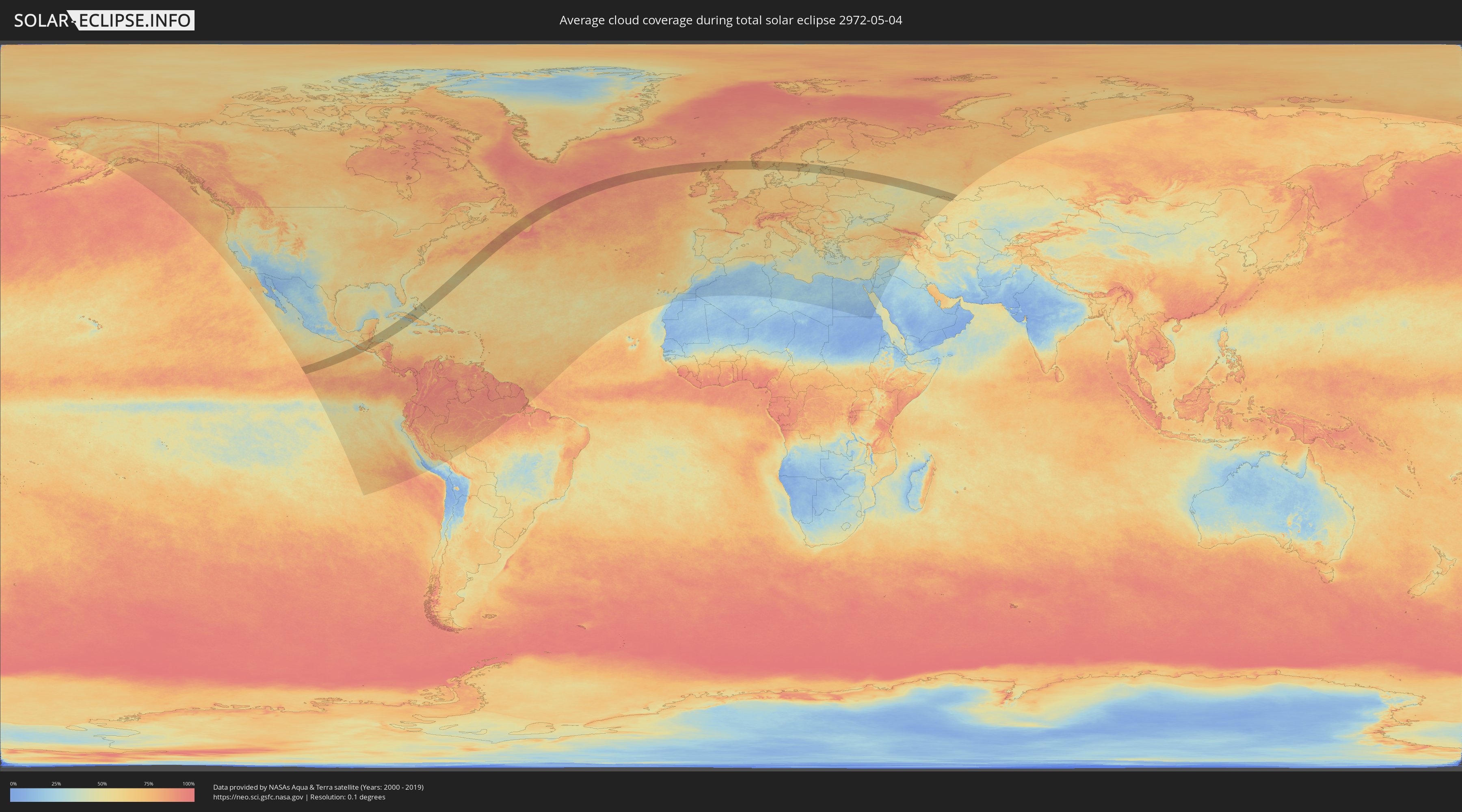
How will be the weather during the total solar eclipse on 05/04/2972?
Where is the best place to see the total solar eclipse of 05/04/2972?
The following maps show the average cloud coverage for the day of the total solar eclipse.
With the help of these maps, it is possible to find the place along the eclipse path, which has the best
chance of a cloudless sky.
Nevertheless, you should consider local circumstances and inform about the weather of your chosen
observation site.
The data is provided by NASAs satellites
AQUA and TERRA.
The cloud maps are averaged over a period of 19 years (2000 - 2019).
Detailed country maps
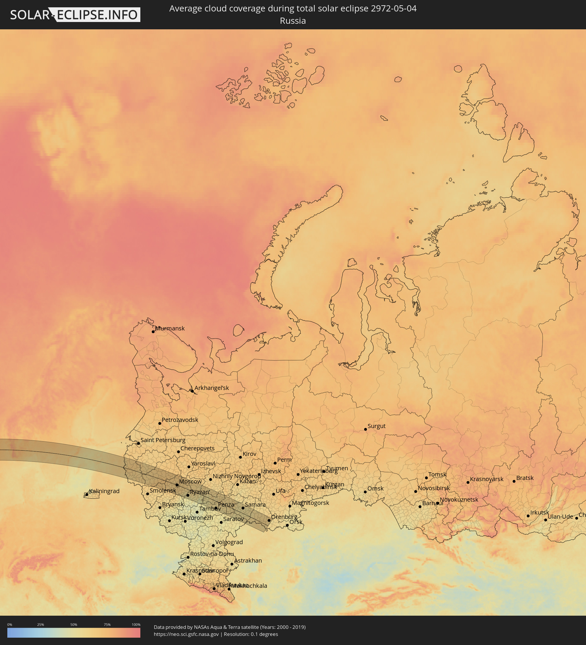 Russia
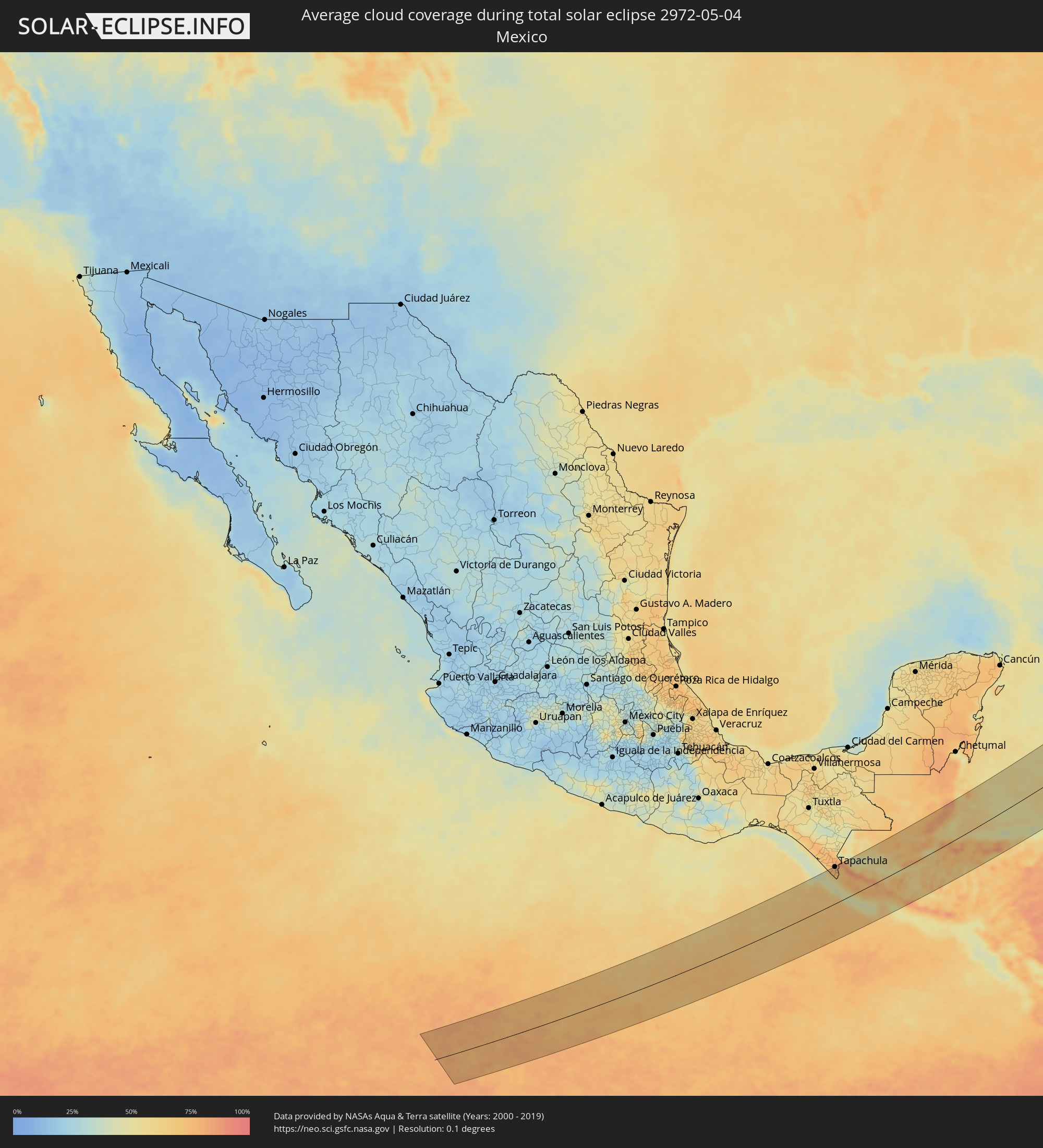 Mexico
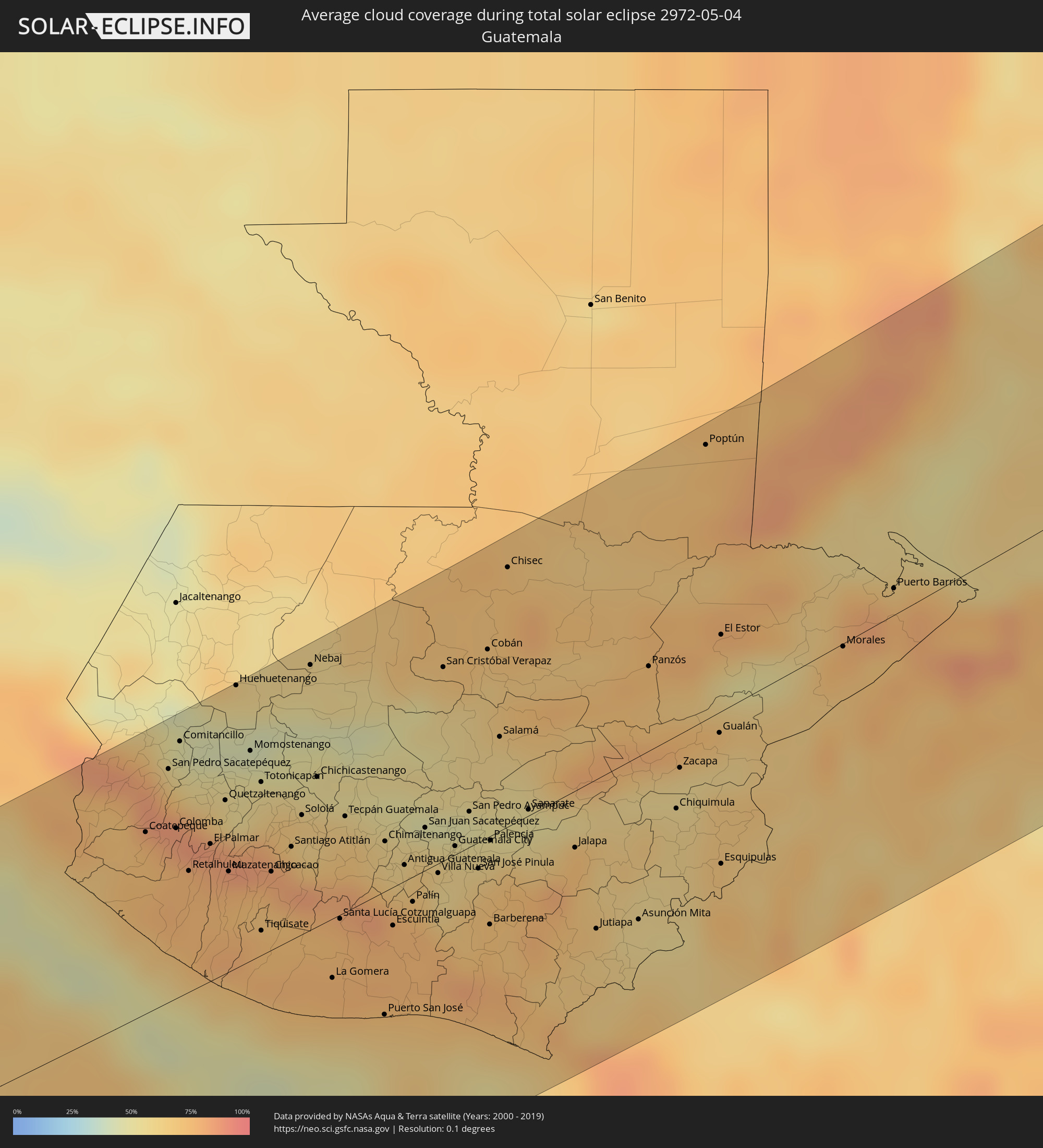 Guatemala
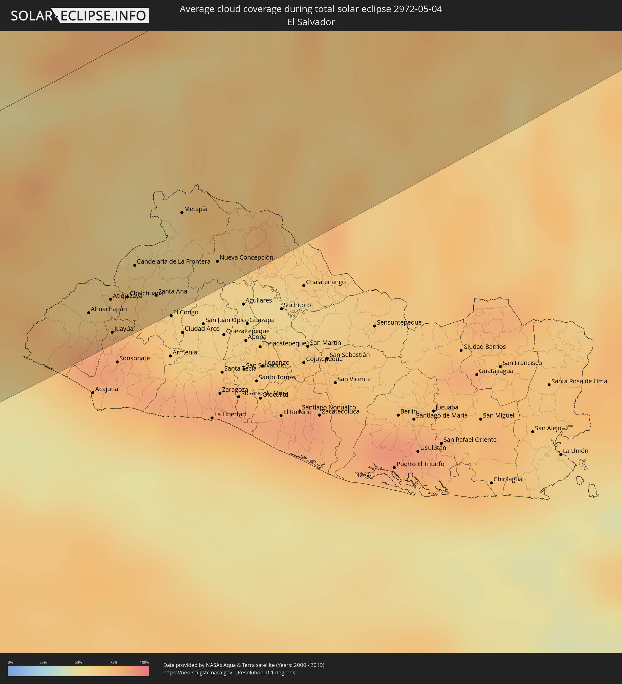 El Salvador
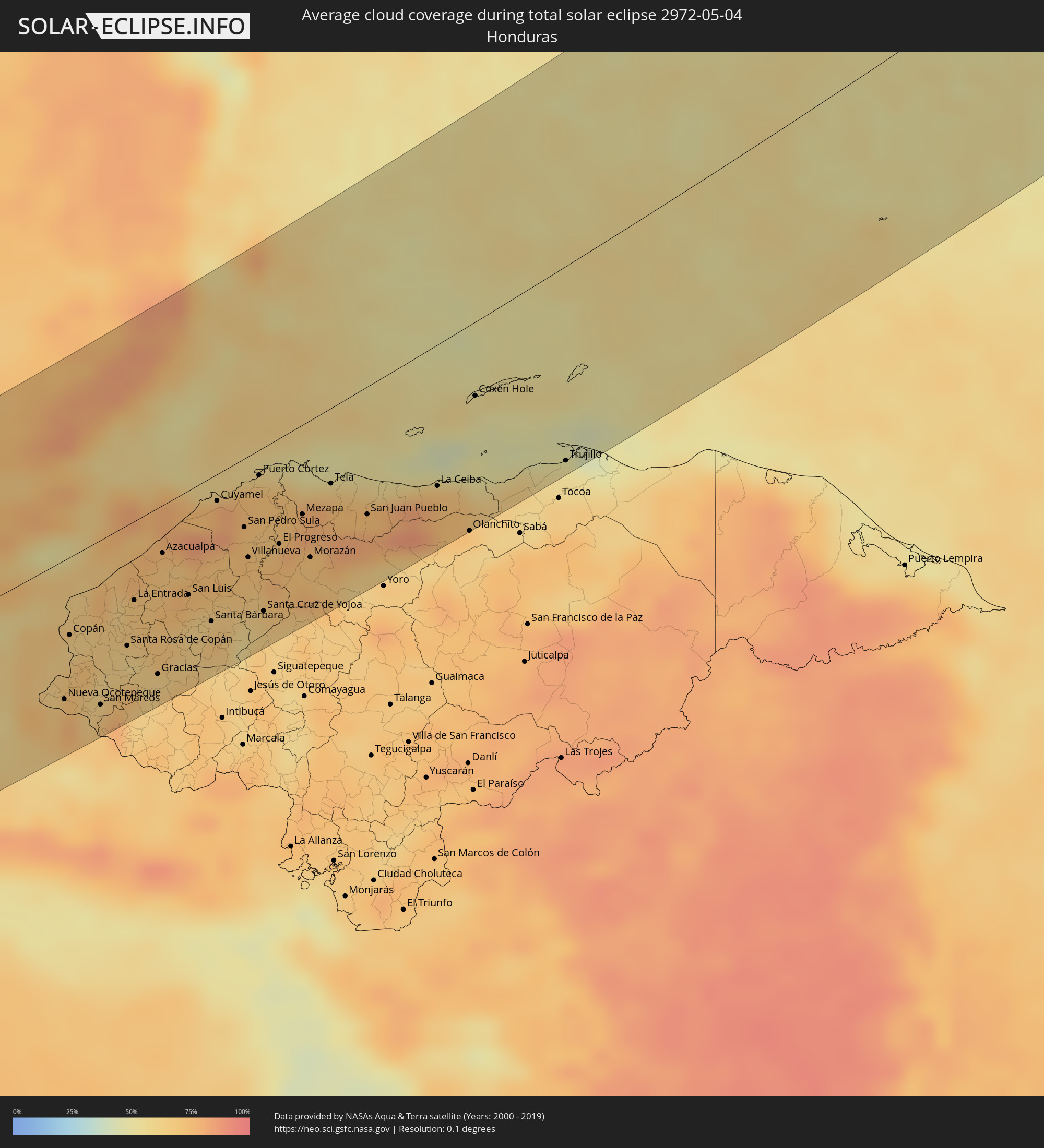 Honduras
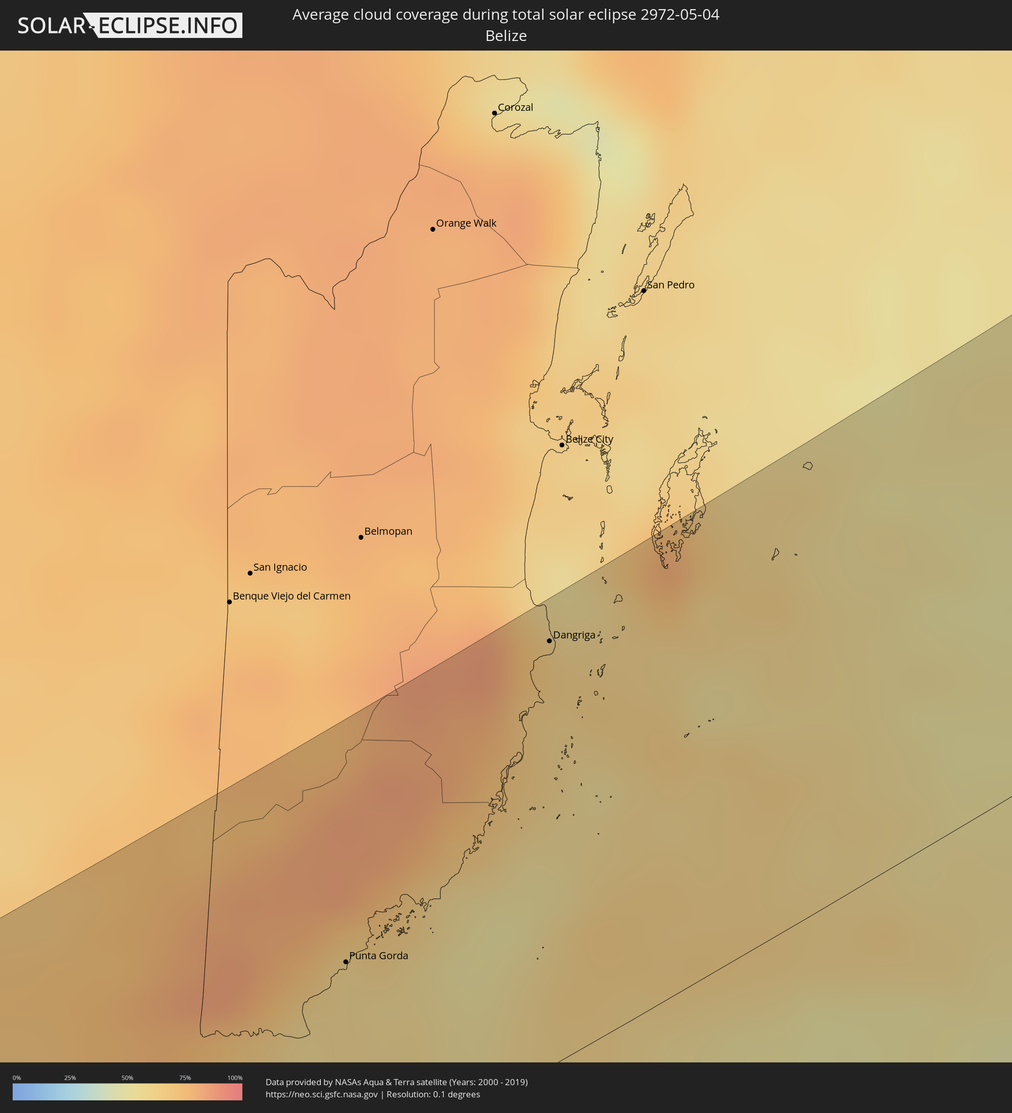 Belize
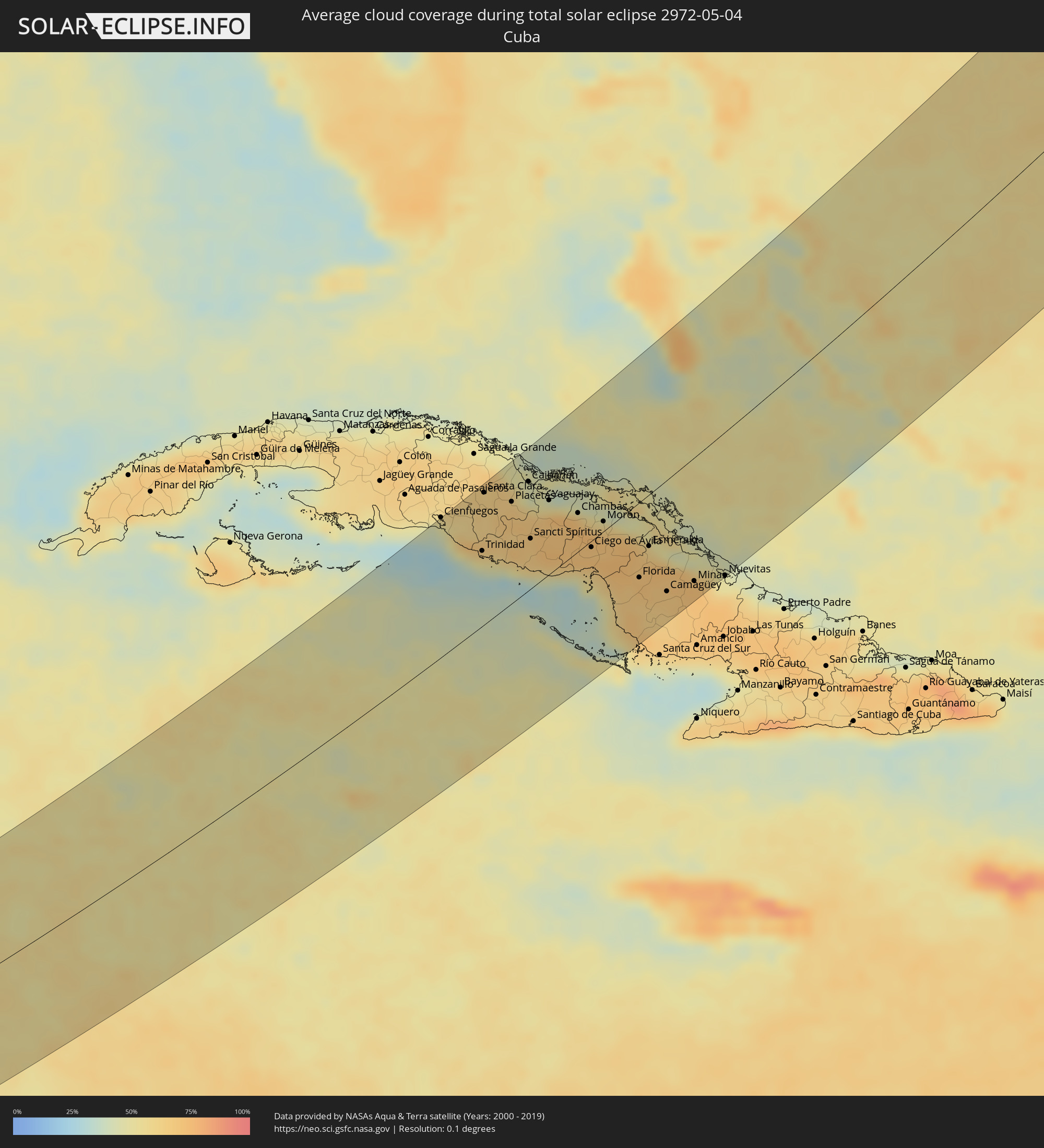 Cuba
Cuba
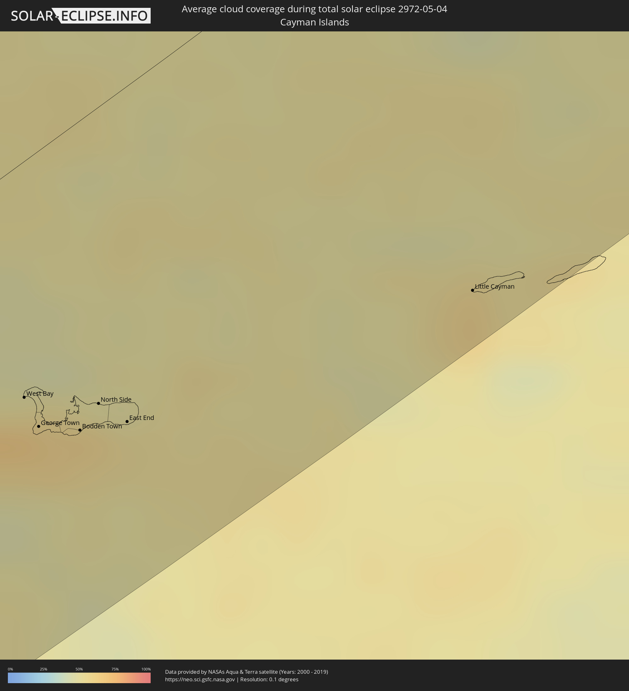 Cayman Islands
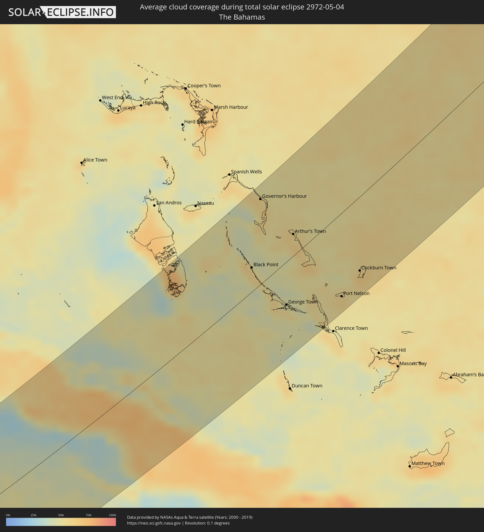 The Bahamas
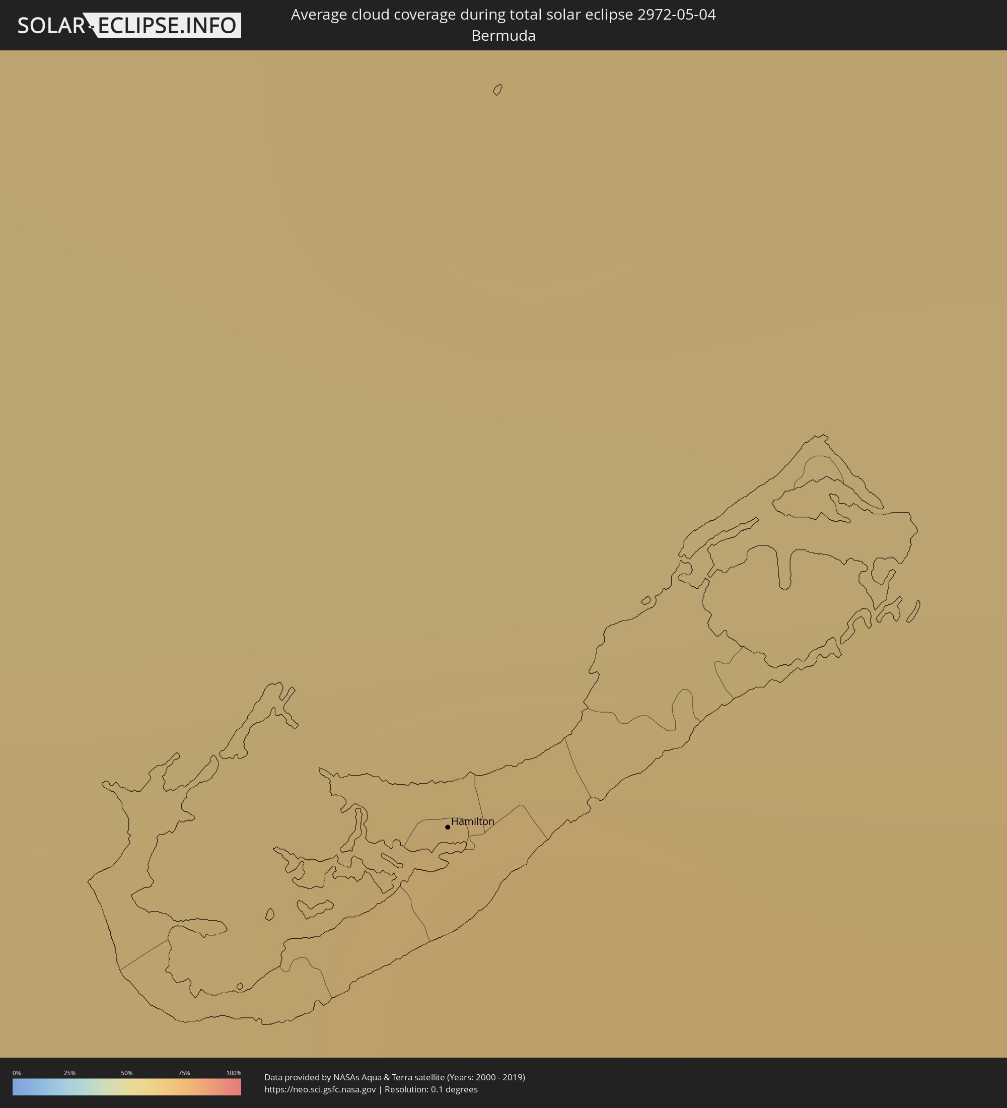 Bermuda
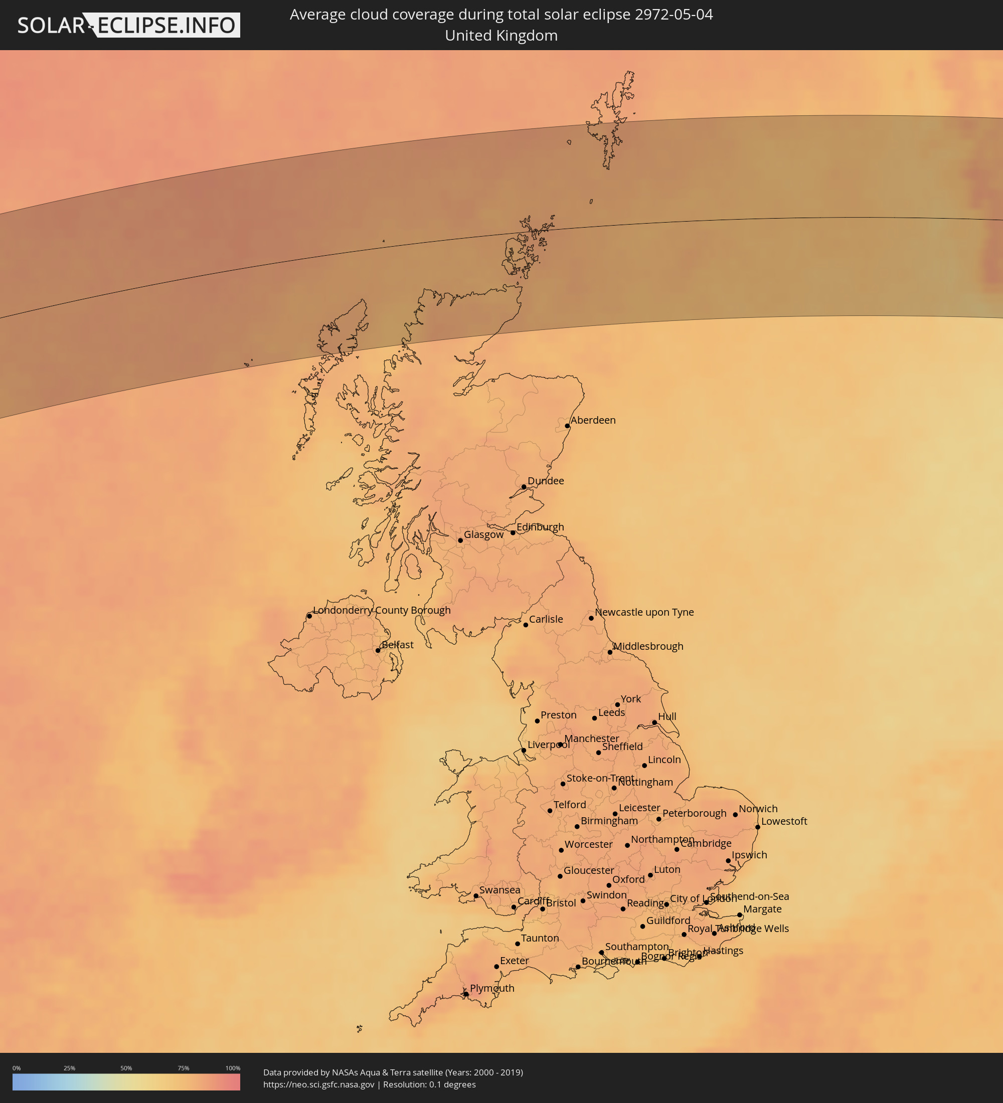 United Kingdom
 Norway
 Sweden
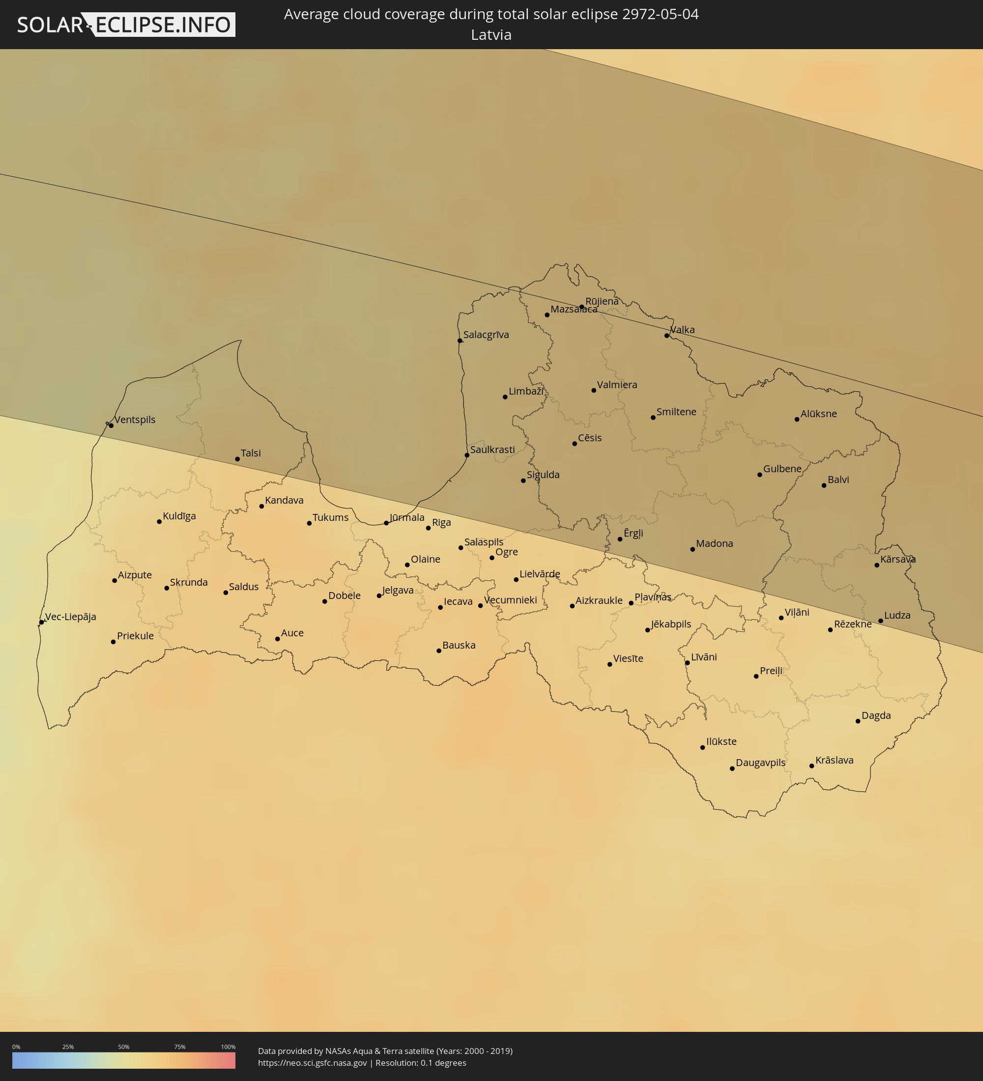 Latvia
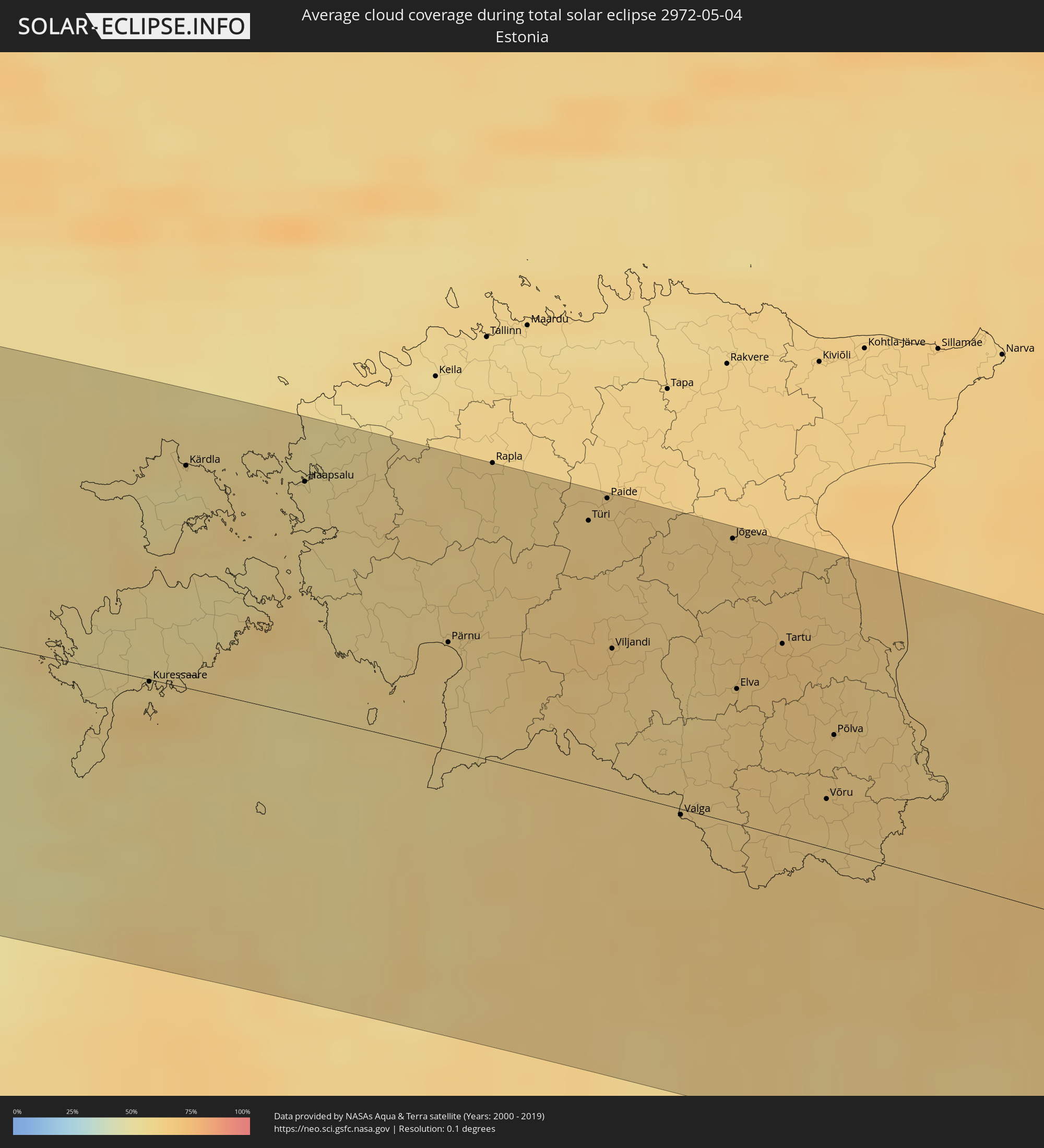 Estonia
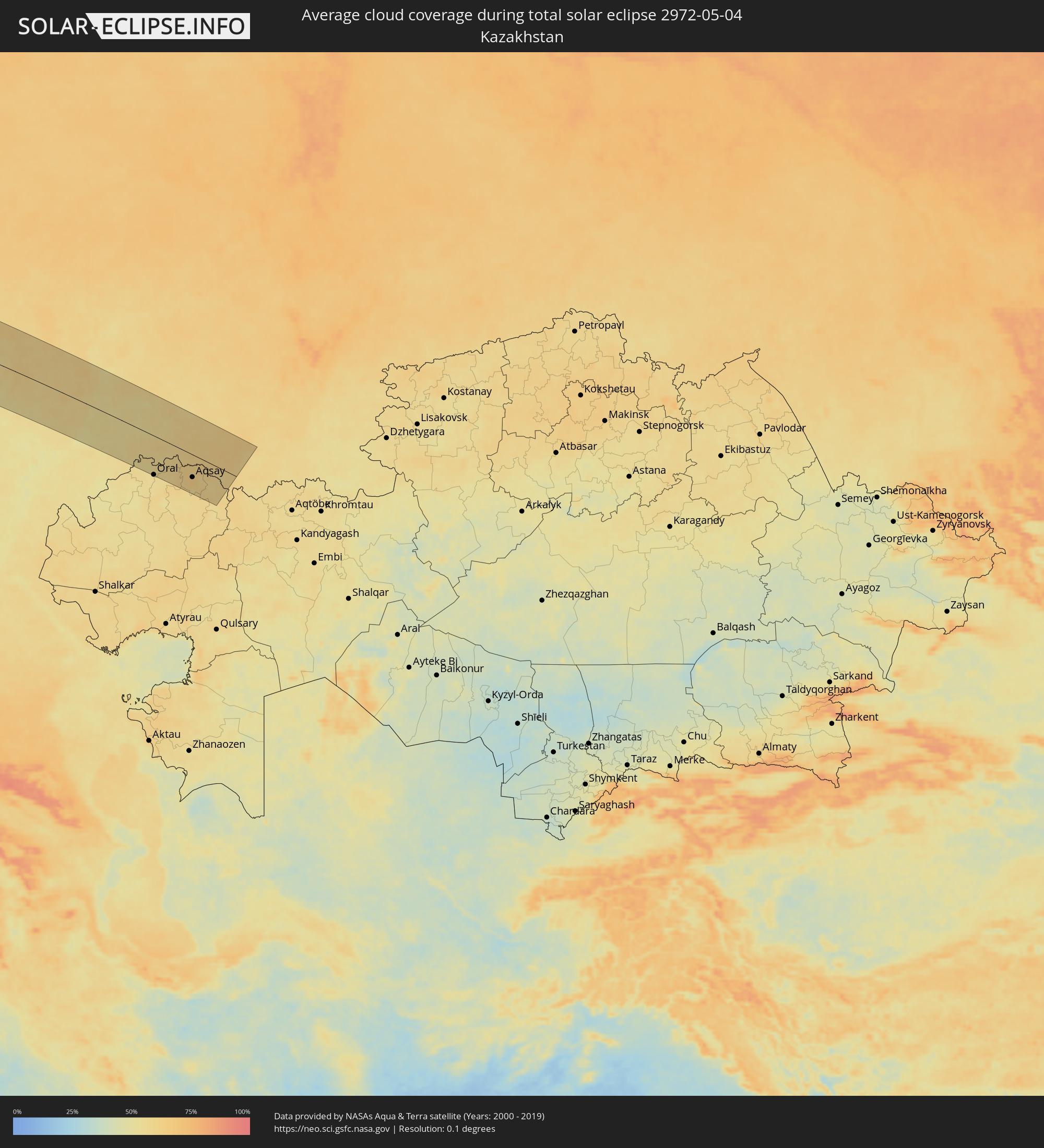 Kazakhstan
Cities inside the path of the eclipse
The following table shows all locations with a population of more than 5,000 inside the eclipse path. Cities which have more than 100,000 inhabitants are marked bold. A click at the locations opens a detailed map.
| City | Type | Eclipse duration | Local time of max. eclipse | Distance to central line | Ø Cloud coverage |
|
Puerto Madero, Chiapas
|
total | - | 06:54:04 UTC-06:00 | 105 km | 58% |
|
Vida Mejor I, Chiapas
|
total | - | 06:54:16 UTC-06:00 | 115 km | 77% |
|
Tapachula, Chiapas
|
total | - | 06:54:19 UTC-06:00 | 116 km | 77% |
|
Brisas Barra de Suchiate, Chiapas
|
total | - | 06:53:51 UTC-06:00 | 77 km | 55% |
|
Tuxtla Chico, Chiapas
|
total | - | 06:54:22 UTC-06:00 | 115 km | 76% |
|
Quetzaltenango, Quetzaltenango
|
total | - | 06:54:17 UTC-06:00 | 73 km | 80% |
|
Huehuetenango, Huehuetenango
|
total | - | 06:54:55 UTC-06:00 | 118 km | 46% |
|
Totonicapán, Totonicapán
|
total | - | 06:54:24 UTC-06:00 | 73 km | 64% |
|
Chichicastenango, Quiché
|
total | - | 06:54:27 UTC-06:00 | 62 km | 64% |
|
Santa Lucía Cotzumalguapa, Escuintla
|
total | - | 06:53:41 UTC-06:00 | 2 km | 76% |
|
Chimaltenango, Chimaltenango
|
total | - | 06:54:07 UTC-06:00 | 21 km | 60% |
|
Escuintla, Escuintla
|
total | - | 06:53:40 UTC-06:00 | 16 km | 76% |
|
San Juan Sacatepéquez, Guatemala
|
total | - | 06:54:13 UTC-06:00 | 18 km | 61% |
|
Petapa, Guatemala
|
total | - | 06:53:56 UTC-06:00 | 8 km | 62% |
|
Guatemala City, Guatemala
|
total | - | 06:54:07 UTC-06:00 | 4 km | 62% |
|
San José Pinula, Guatemala
|
total | - | 06:54:01 UTC-06:00 | 11 km | 71% |
|
Cobán, Alta Verapaz
|
total | - | 06:55:14 UTC-06:00 | 78 km | 64% |
|
Tacuba, Ahuachapán
|
total | - | 06:53:14 UTC-06:00 | 99 km | 81% |
|
Concepción de Ataco, Ahuachapán
|
total | - | 06:53:12 UTC-06:00 | 106 km | 81% |
|
Ahuachapán, Ahuachapán
|
total | - | 06:53:16 UTC-06:00 | 101 km | 81% |
|
Atiquizaya, Ahuachapán
|
total | - | 06:53:21 UTC-06:00 | 100 km | 70% |
|
Juayúa, Sonsonate
|
total | - | 06:53:10 UTC-06:00 | 114 km | 81% |
|
Chalchuapa, Santa Ana
|
total | - | 06:53:22 UTC-06:00 | 103 km | 72% |
|
Candelaria de La Frontera, Santa Ana
|
total | - | 06:53:32 UTC-06:00 | 92 km | 69% |
|
Santa Ana, Santa Ana
|
total | - | 06:53:23 UTC-06:00 | 108 km | 69% |
|
Coatepeque, Santa Ana
|
total | - | 06:53:19 UTC-06:00 | 118 km | 66% |
|
Metapán, Santa Ana
|
total | - | 06:53:51 UTC-06:00 | 81 km | 60% |
|
Nueva Concepción, Chalatenango
|
total | - | 06:53:36 UTC-06:00 | 108 km | 61% |
|
Punta Gorda, Toledo
|
total | - | 06:56:18 UTC-06:00 | 58 km | 59% |
|
Santa Rosa de Copán, Copán
|
total | - | 06:54:31 UTC-06:00 | 73 km | 63% |
|
La Entrada, Copán
|
total | - | 06:54:54 UTC-06:00 | 48 km | 69% |
|
Puerto Barrios, Izabal
|
total | - | 06:55:50 UTC-06:00 | 11 km | 76% |
|
Santa Bárbara, Santa Bárbara
|
total | - | 06:54:48 UTC-06:00 | 86 km | 69% |
|
Dangriga, Stann Creek
|
total | - | 06:57:36 UTC-06:00 | 111 km | 64% |
|
Cofradía, Cortés
|
total | - | 06:55:28 UTC-06:00 | 44 km | 71% |
|
San Pedro Sula, Cortés
|
total | - | 06:55:37 UTC-06:00 | 41 km | 74% |
|
Villanueva, Cortés
|
total | - | 06:55:22 UTC-06:00 | 60 km | 71% |
|
Puerto Cortez, Cortés
|
total | - | 06:56:05 UTC-06:00 | 15 km | 71% |
|
El Progreso, Yoro
|
total | - | 06:55:31 UTC-06:00 | 63 km | 74% |
|
Morazán, Yoro
|
total | - | 06:55:27 UTC-06:00 | 82 km | 74% |
|
Tela, Atlántida
|
total | - | 06:56:06 UTC-06:00 | 45 km | 65% |
|
Santa Rita, Yoro
|
total | - | 06:55:18 UTC-06:00 | 113 km | 63% |
|
La Ceiba, Atlántida
|
total | - | 06:56:13 UTC-06:00 | 83 km | 70% |
|
Olanchito, Yoro
|
total | - | 06:55:52 UTC-06:00 | 121 km | 65% |
|
West Bay, West Bay
|
total | - | 08:03:07 UTC-05:00 | 59 km | 63% |
|
George Town, George Town
|
total | - | 08:03:01 UTC-05:00 | 68 km | 57% |
|
Bodden Town, Bodden Town
|
total | - | 08:03:03 UTC-05:00 | 77 km | 58% |
|
North Side, North Side
|
total | - | 08:03:11 UTC-05:00 | 73 km | 58% |
|
East End, East End
|
total | - | 08:03:08 UTC-05:00 | 83 km | 53% |
|
Little Cayman, Sister Island
|
total | - | 08:04:07 UTC-05:00 | 113 km | 58% |
|
Trinidad, Sancti Spíritus
|
total | - | 08:07:35 UTC-05:00 | 69 km | 50% |
|
Manicaragua, Villa Clara
|
total | - | 08:08:09 UTC-05:00 | 99 km | 62% |
|
Santa Clara, Villa Clara
|
total | - | 08:08:34 UTC-05:00 | 121 km | 62% |
|
Placetas, Villa Clara
|
total | - | 08:08:34 UTC-05:00 | 93 km | 67% |
|
Cabaiguán, Sancti Spíritus
|
total | - | 08:08:16 UTC-05:00 | 62 km | 67% |
|
Caibarién, Villa Clara
|
total | - | 08:09:00 UTC-05:00 | 99 km | 51% |
|
Sancti Spíritus, Sancti Spíritus
|
total | - | 08:08:03 UTC-05:00 | 46 km | 66% |
|
Yaguajay, Sancti Spíritus
|
total | - | 08:08:48 UTC-05:00 | 67 km | 70% |
|
Ciego de Ávila, Ciego de Ávila
|
total | - | 08:08:14 UTC-05:00 | 6 km | 71% |
|
Morón, Ciego de Ávila
|
total | - | 08:08:45 UTC-05:00 | 9 km | 69% |
|
Florida, Camagüey
|
total | - | 08:08:00 UTC-05:00 | 68 km | 70% |
|
Camagüey, Camagüey
|
total | - | 08:07:56 UTC-05:00 | 100 km | 67% |
|
Nuevitas, Camagüey
|
total | - | 08:08:33 UTC-05:00 | 128 km | 53% |
|
Black Point, Black Point
|
total | - | 13:13:19 UTC+00:00 | 32 km | 60% |
|
Governor’s Harbour, Central Eleuthera
|
total | - | 13:15:14 UTC+00:00 | 111 km | 58% |
|
George Town, Exuma
|
total | - | 08:12:41 UTC-05:00 | 57 km | 53% |
|
Arthur’s Town, Cat Island
|
total | - | 08:14:39 UTC-05:00 | 28 km | 62% |
|
Port Nelson, Rum Cay
|
total | - | 08:13:30 UTC-05:00 | 109 km | 52% |
|
Cockburn Town, San Salvador
|
total | - | 08:14:24 UTC-05:00 | 96 km | 63% |
|
Hamilton, Hamilton city
|
total | - | 09:37:34 UTC-04:00 | 112 km | 65% |
|
Isle of Lewis, Scotland
|
total | - | 15:18:55 UTC+00:00 | 88 km | 78% |
|
Stornoway, Scotland
|
total | - | 15:18:56 UTC+00:00 | 89 km | 78% |
|
Thurso, Scotland
|
total | - | 15:21:02 UTC+00:00 | 66 km | 76% |
|
Wick, Scotland
|
total | - | 15:21:29 UTC+00:00 | 86 km | 80% |
|
Orkney, Scotland
|
total | - | 15:21:13 UTC+00:00 | 26 km | 78% |
|
Kirkwall, Scotland
|
total | - | 15:21:13 UTC+00:00 | 26 km | 78% |
|
Lerwick, Scotland
|
total | - | 15:21:43 UTC+00:00 | 96 km | 81% |
|
Shetland, Scotland
|
total | - | 15:21:43 UTC+00:00 | 96 km | 81% |
|
Haugesund, Rogaland
|
total | - | 16:26:36 UTC+01:00 | 6 km | 64% |
|
Bergen, Hordaland
|
total | - | 16:25:45 UTC+01:00 | 115 km | 70% |
|
Stavanger, Rogaland
|
total | - | 16:27:18 UTC+01:00 | 43 km | 66% |
|
Arendal, Aust-Agder
|
total | - | 16:29:35 UTC+01:00 | 92 km | 61% |
|
Skien, Telemark
|
total | - | 16:29:20 UTC+01:00 | 5 km | 67% |
|
Kongsberg, Buskerud
|
total | - | 16:28:54 UTC+01:00 | 46 km | 68% |
|
Drammen, Buskerud
|
total | - | 16:29:07 UTC+01:00 | 56 km | 70% |
|
Sandefjord, Vestfold
|
total | - | 16:29:44 UTC+01:00 | 12 km | 65% |
|
Tønsberg, Vestfold
|
total | - | 16:29:42 UTC+01:00 | 4 km | 65% |
|
Moss, Østfold
|
total | - | 16:29:40 UTC+01:00 | 24 km | 67% |
|
Oslo, Oslo
|
total | - | 16:29:13 UTC+01:00 | 78 km | 71% |
|
Fredrikstad, Østfold
|
total | - | 16:30:01 UTC+01:00 | 2 km | 67% |
|
Halden, Østfold
|
total | - | 16:30:21 UTC+01:00 | 6 km | 64% |
|
Uddevalla, Västra Götaland
|
total | - | 16:31:26 UTC+01:00 | 89 km | 63% |
|
Trollhättan, Västra Götaland
|
total | - | 16:31:40 UTC+01:00 | 94 km | 62% |
|
Karlstad, Värmland
|
total | - | 16:31:08 UTC+01:00 | 35 km | 66% |
|
Skövde, Västra Götaland
|
total | - | 16:32:20 UTC+01:00 | 72 km | 64% |
|
Örebro, Örebro
|
total | - | 16:32:01 UTC+01:00 | 36 km | 68% |
|
Linköping, Östergötland
|
total | - | 16:33:07 UTC+01:00 | 56 km | 63% |
|
Norrköping, Östergötland
|
total | - | 16:33:10 UTC+01:00 | 31 km | 64% |
|
Eskilstuna, Södermanland
|
total | - | 16:32:28 UTC+01:00 | 57 km | 65% |
|
Västerås, Västmanland
|
total | - | 16:32:13 UTC+01:00 | 85 km | 68% |
|
Södertälje, Stockholm
|
total | - | 16:33:06 UTC+01:00 | 48 km | 62% |
|
Upplands Väsby, Stockholm
|
total | - | 16:32:52 UTC+01:00 | 86 km | 65% |
|
Stockholm, Stockholm
|
total | - | 16:33:08 UTC+01:00 | 67 km | 61% |
|
Haninge, Stockholm
|
total | - | 16:33:20 UTC+01:00 | 50 km | 61% |
|
Ventspils, Ventspils
|
total | - | 17:36:34 UTC+02:00 | 106 km | 52% |
|
Kuressaare, Saare
|
total | - | 17:35:54 UTC+02:00 | 1 km | 62% |
|
Talsi, Talsu Rajons
|
total | - | 17:37:03 UTC+02:00 | 109 km | 65% |
|
Haapsalu, Lääne
|
total | - | 17:35:24 UTC+02:00 | 88 km | 57% |
|
Daugavgrīva, Riga
|
total | - | 17:37:43 UTC+02:00 | 111 km | 59% |
|
Pärnu, Pärnumaa
|
total | - | 17:36:19 UTC+02:00 | 41 km | 61% |
|
Limbaži, Limbažu Rajons
|
total | - | 17:37:23 UTC+02:00 | 50 km | 59% |
|
Rapla, Raplamaa
|
total | - | 17:35:40 UTC+02:00 | 112 km | 61% |
|
Sigulda, Sigulda
|
total | - | 17:37:49 UTC+02:00 | 87 km | 60% |
|
Cēsis, Cēsu Rajons
|
total | - | 17:37:45 UTC+02:00 | 64 km | 61% |
|
Valmiera, Valmieras Rajons
|
total | - | 17:37:32 UTC+02:00 | 37 km | 61% |
|
Türi, Järvamaa
|
total | - | 17:36:04 UTC+02:00 | 100 km | 62% |
|
Paide, Järvamaa
|
total | - | 17:36:01 UTC+02:00 | 110 km | 62% |
|
Viljandi, Viljandimaa
|
total | - | 17:36:38 UTC+02:00 | 54 km | 65% |
|
Smiltene, Smiltene
|
total | - | 17:37:47 UTC+02:00 | 42 km | 63% |
|
Valka, Valkas Rajons
|
total | - | 17:37:25 UTC+02:00 | 3 km | 61% |
|
Valga, Valgamaa
|
total | - | 17:37:25 UTC+02:00 | 2 km | 61% |
|
Madona, Madonas Rajons
|
total | - | 17:38:31 UTC+02:00 | 99 km | 61% |
|
Jõgeva, Jõgevamaa
|
total | - | 17:36:23 UTC+02:00 | 107 km | 64% |
|
Elva, Tartu
|
total | - | 17:37:00 UTC+02:00 | 51 km | 63% |
|
Tartu, Tartu
|
total | - | 17:36:53 UTC+02:00 | 73 km | 67% |
|
Gulbene, Gulbenes Rajons
|
total | - | 17:38:16 UTC+02:00 | 56 km | 62% |
|
Võru, Võrumaa
|
total | - | 17:37:35 UTC+02:00 | 19 km | 62% |
|
Põlva, Põlvamaa
|
total | - | 17:37:20 UTC+02:00 | 44 km | 62% |
|
Balvi, Balvu Rajons
|
total | - | 17:38:27 UTC+02:00 | 53 km | 60% |
|
Ludza, Ludzas Rajons
|
total | - | 17:39:13 UTC+02:00 | 109 km | 60% |
|
Pskov, Pskov
|
total | - | 18:37:53 UTC+03:00 | 38 km | 64% |
|
Tver, Tverskaya
|
total | - | 18:39:59 UTC+03:00 | 78 km | 67% |
|
Zelenograd, Moscow
|
total | - | 18:41:03 UTC+03:00 | 14 km | 65% |
|
Khimki, Moscow Oblast
|
total | - | 18:41:09 UTC+03:00 | 10 km | 64% |
|
Moscow, Moscow
|
total | - | 18:41:19 UTC+03:00 | 1 km | 67% |
|
Ryazan’, Rjazan
|
total | - | 18:42:35 UTC+03:00 | 70 km | 53% |
|
Vladimir, Vladimir
|
total | - | 18:40:55 UTC+03:00 | 102 km | 62% |
|
Penza, Penza
|
total | - | 18:43:46 UTC+03:00 | 83 km | 54% |
|
Saransk, Mordoviya
|
total | - | 18:42:44 UTC+03:00 | 21 km | 57% |
|
Syzran’, Samara
|
total | - | 19:43:20 UTC+04:00 | 7 km | 58% |
|
Tol’yatti, Samara
|
total | - | 19:42:48 UTC+04:00 | 70 km | 56% |
|
Samara, Samara
|
total | - | 19:42:58 UTC+04:00 | 59 km | 54% |
|
Oral, Batys Qazaqstan
|
total | - | 20:44:37 UTC+05:00 | 102 km | 55% |
|
Fedorovka, Batys Qazaqstan
|
total | - | 20:44:29 UTC+05:00 | 86 km | 57% |
|
Aqsay, Batys Qazaqstan
|
total | - | 20:44:17 UTC+05:00 | 59 km | 64% |
|
Chingirlau, Batys Qazaqstan
|
total | - | 20:44:03 UTC+05:00 | 33 km | 59% |
|
Orenburg, Orenburg
|
total | - | 20:43:09 UTC+05:00 | 66 km | 60% |