Annular solar eclipse of 05/27/-0147
| Day of week: | Wednesday |
| Maximum duration of eclipse: | 05m21s |
| Maximum width of eclipse path: | 162 km |
| Saros cycle: | 64 |
| Coverage: | 95.6% |
| Magnitude: | 0.956 |
| Gamma: | 0.1319 |
Wo kann man die Sonnenfinsternis vom 05/27/-0147 sehen?
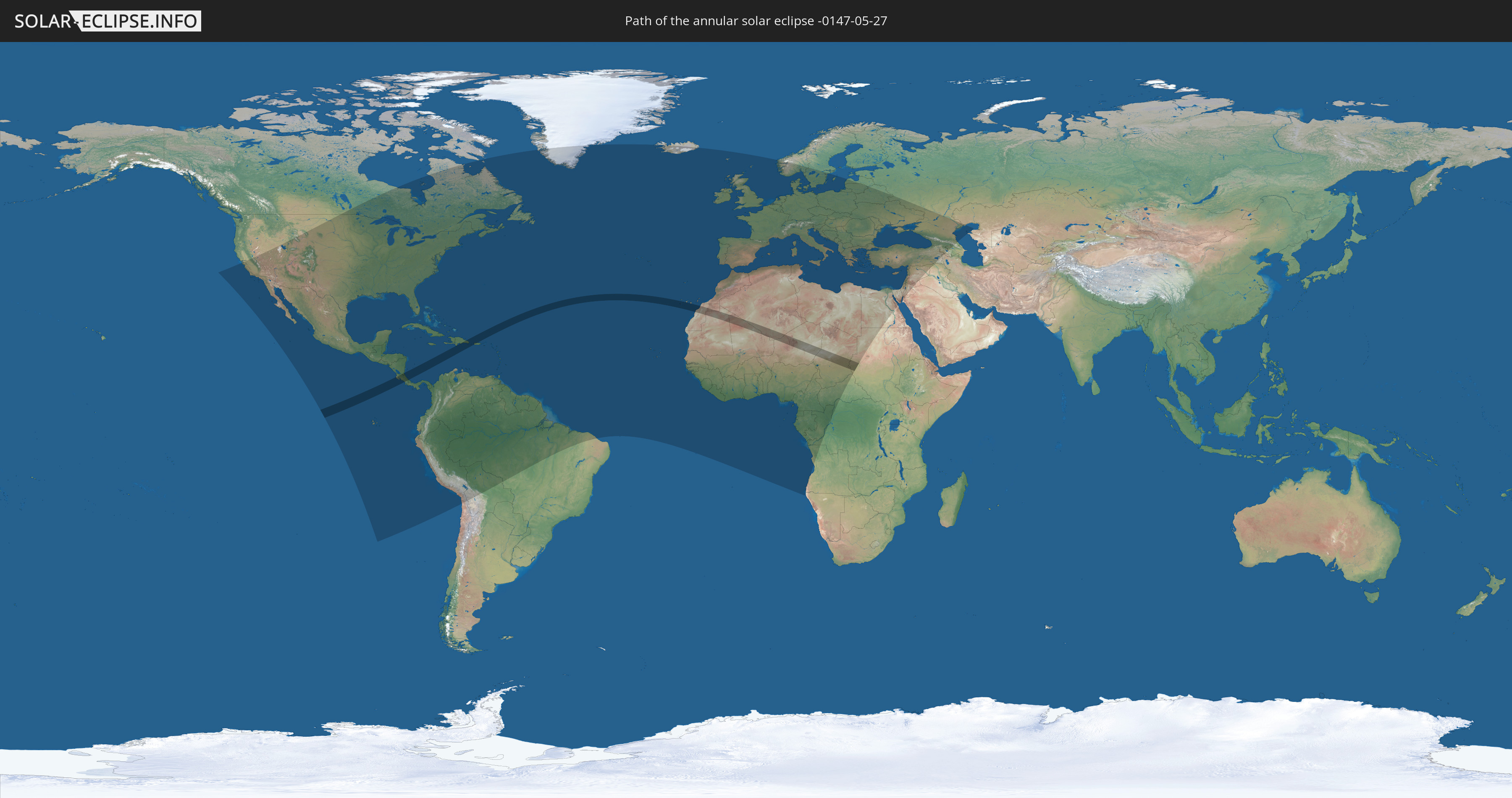
Die Sonnenfinsternis am 05/27/-0147 kann man in 141 Ländern als partielle Sonnenfinsternis beobachten.
Der Finsternispfad verläuft durch 12 Länder. Nur in diesen Ländern ist sie als annular Sonnenfinsternis zu sehen.
In den folgenden Ländern ist die Sonnenfinsternis annular zu sehen
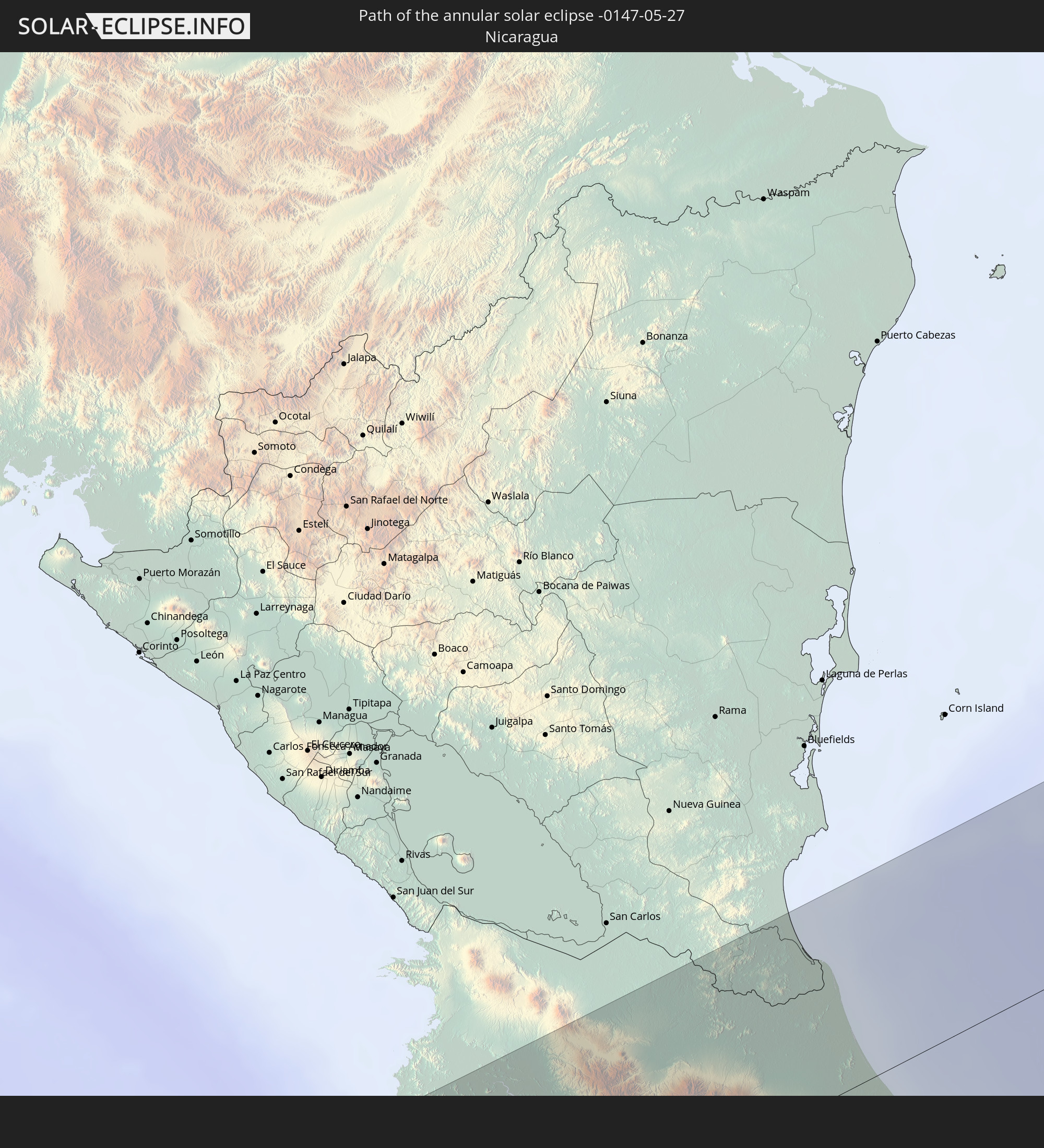 Nicaragua
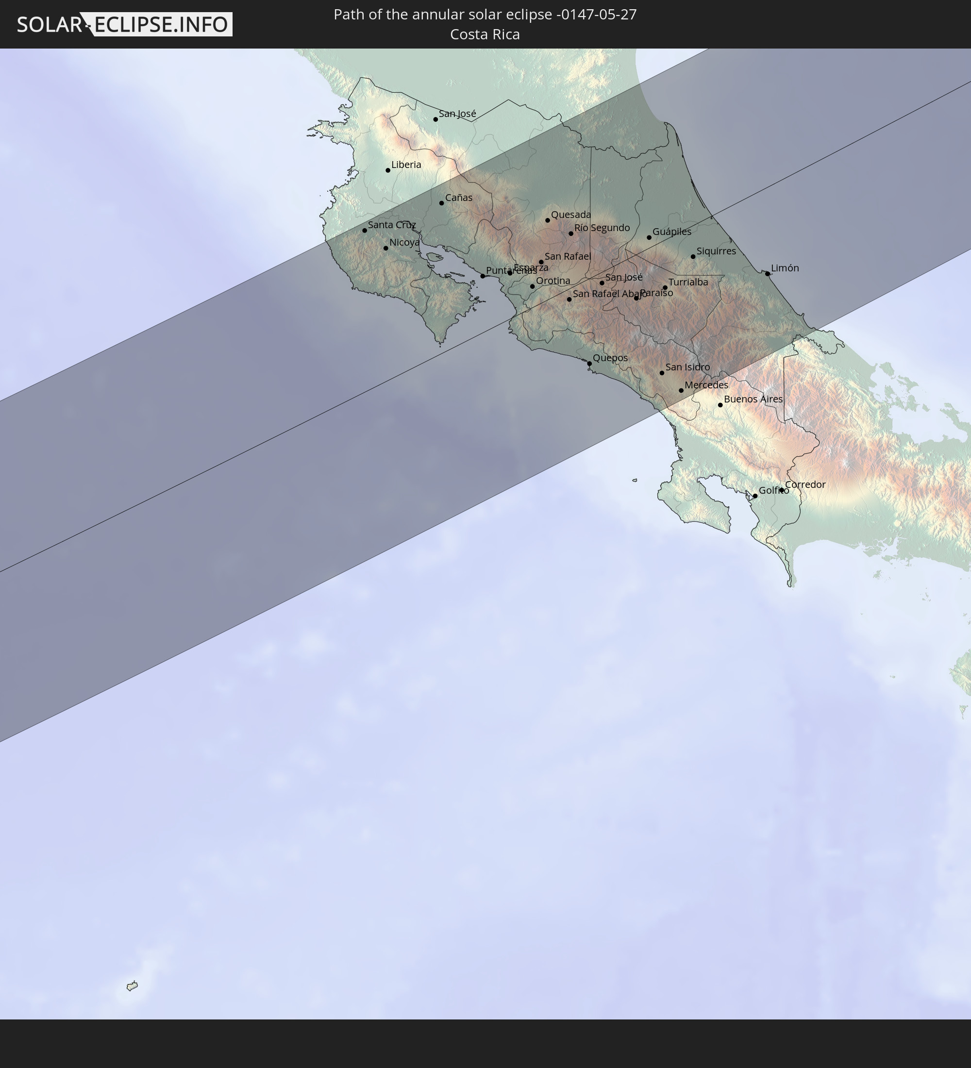 Costa Rica
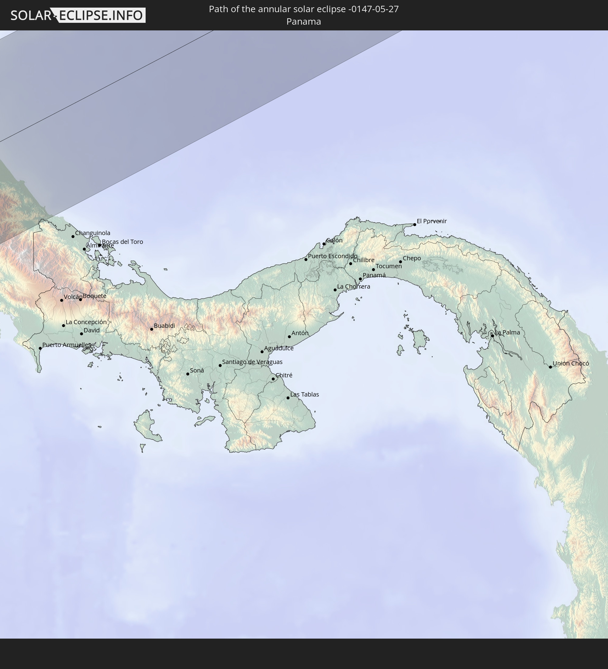 Panama
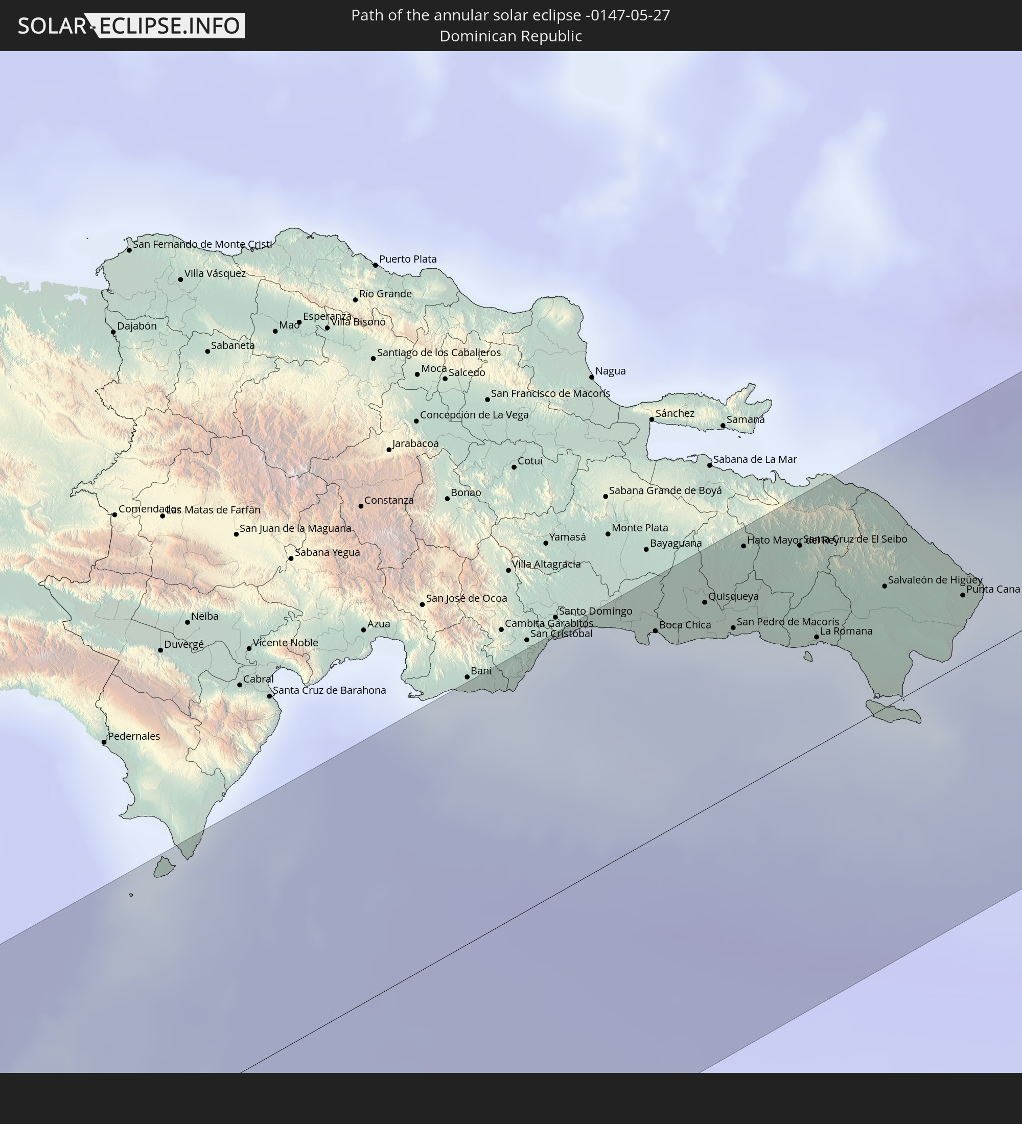 Dominican Republic
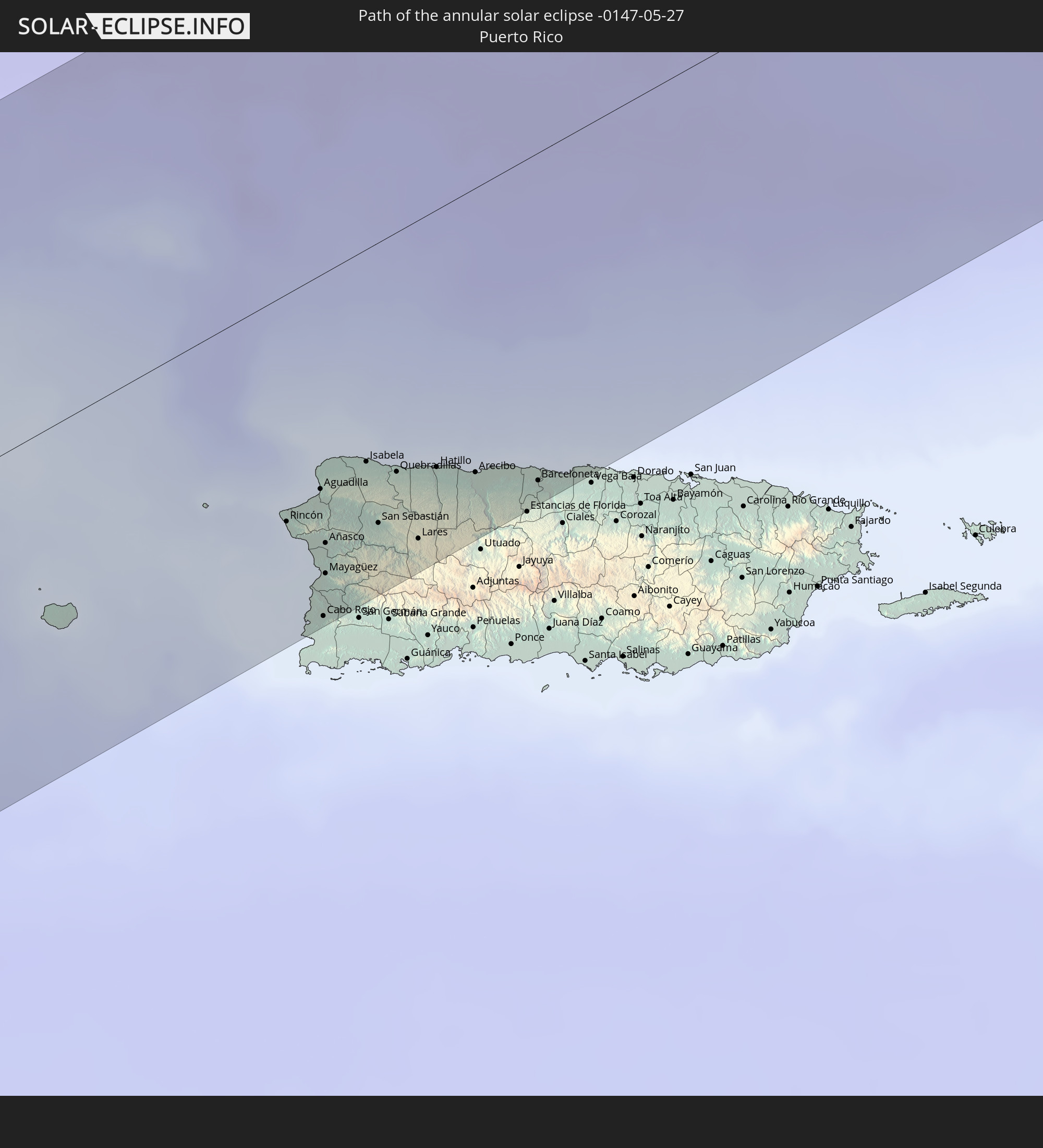 Puerto Rico
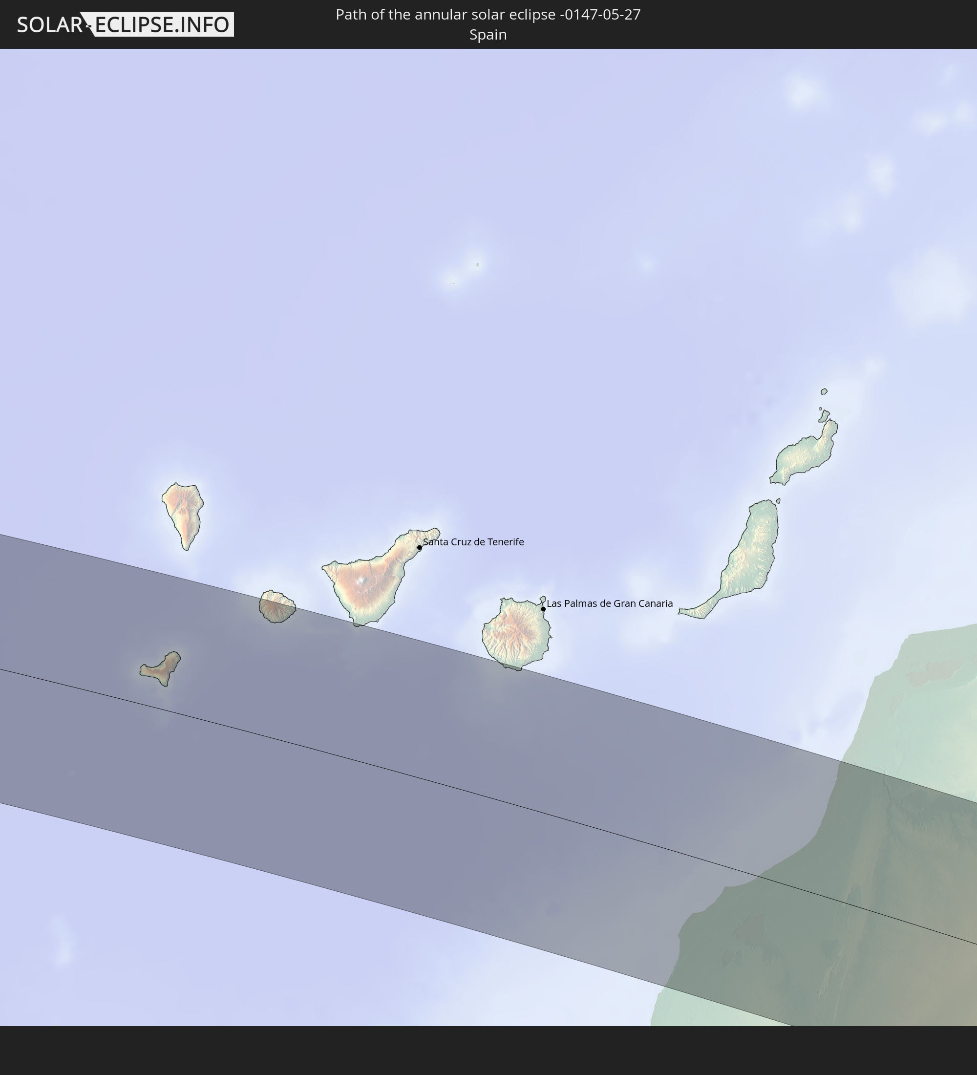 Spain
Spain
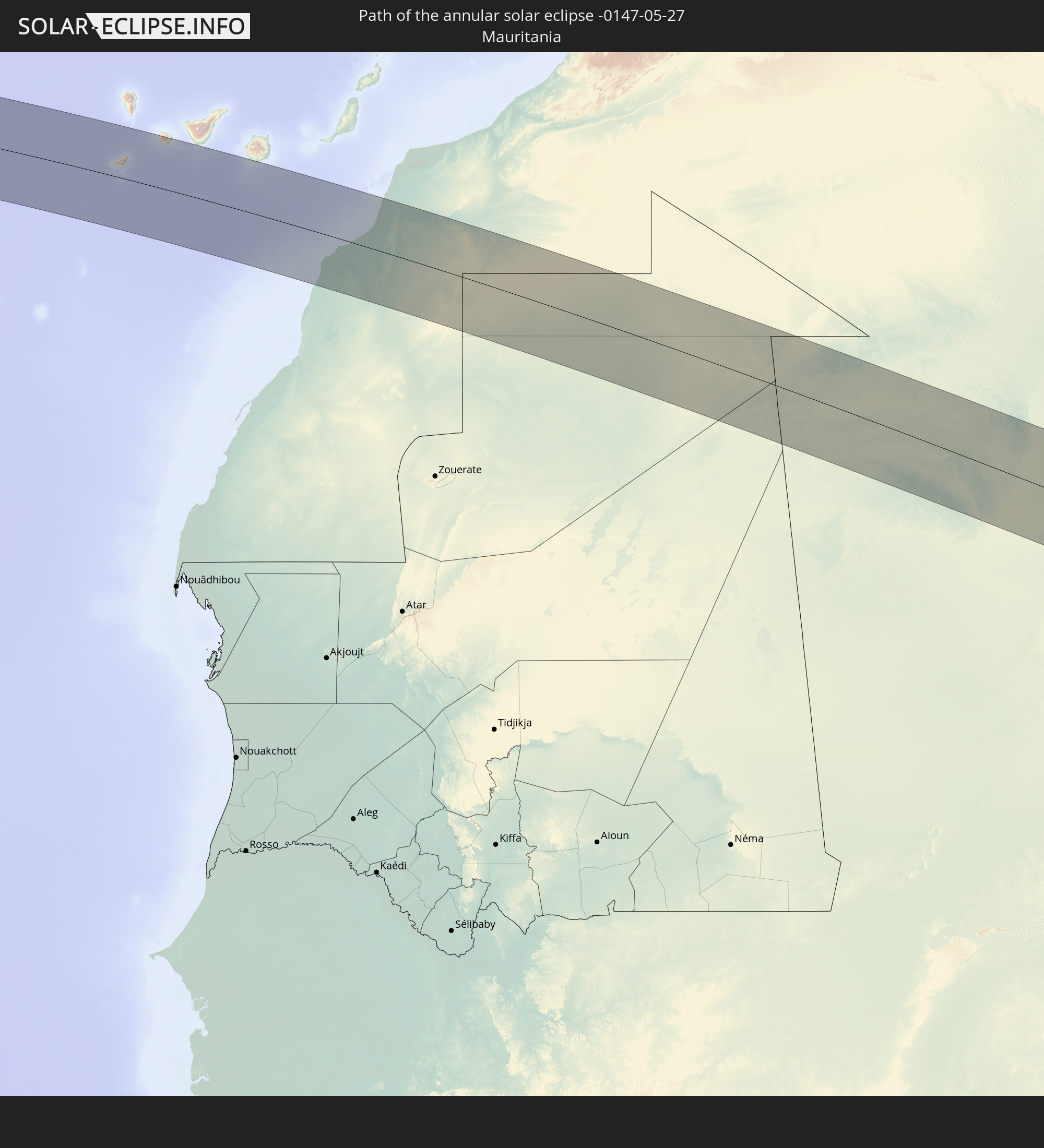 Mauritania
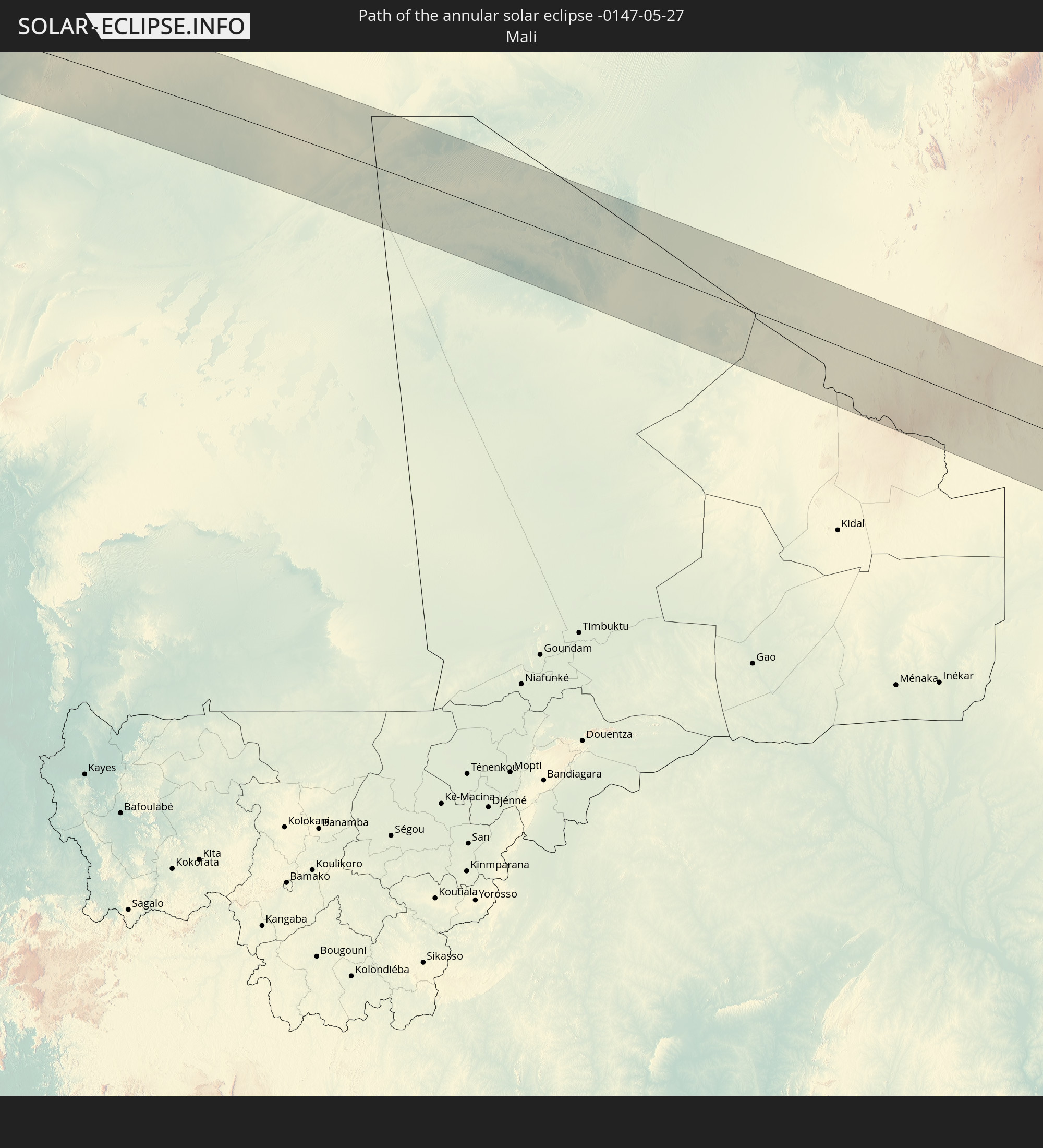 Mali
Mali
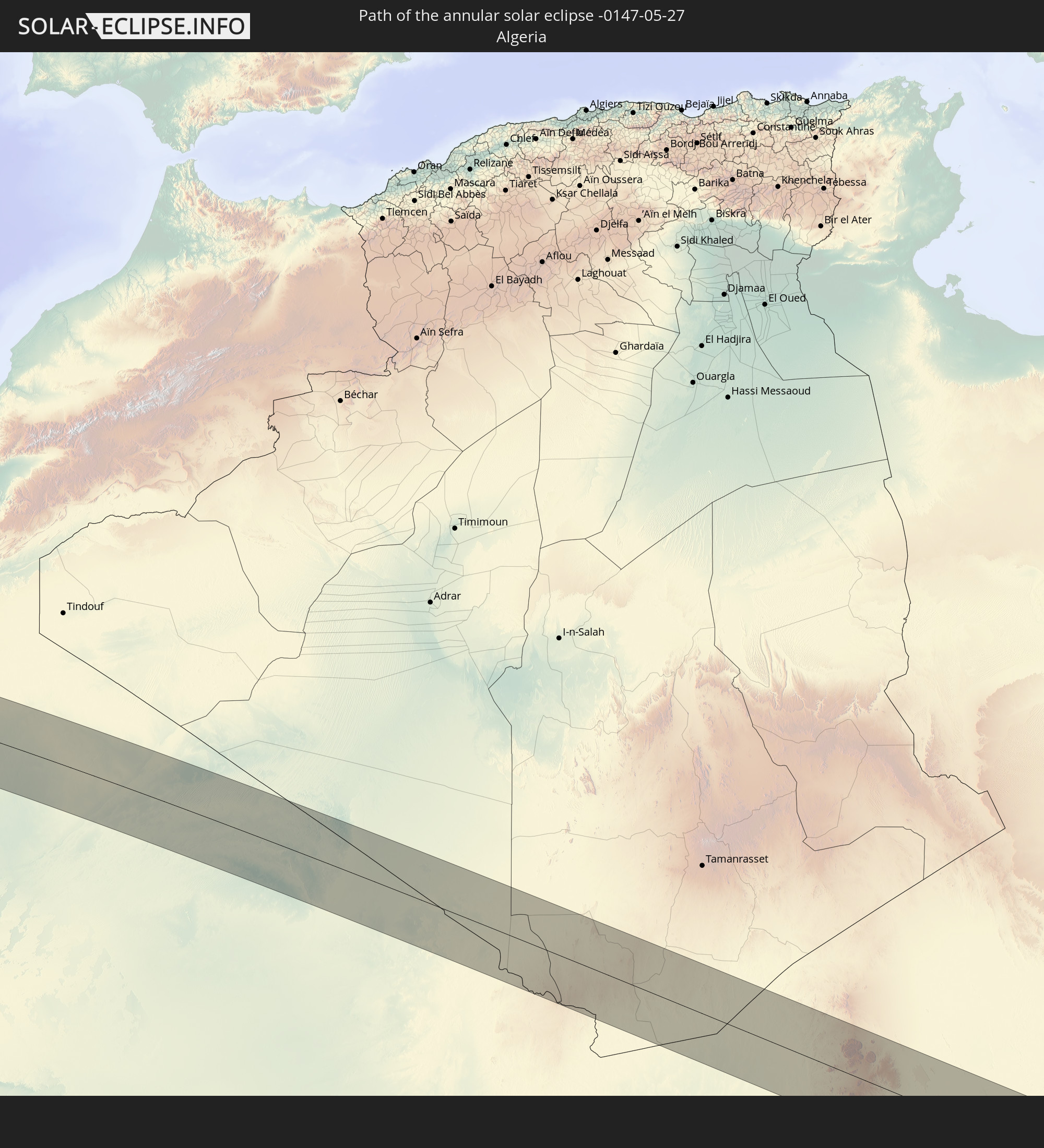 Algeria
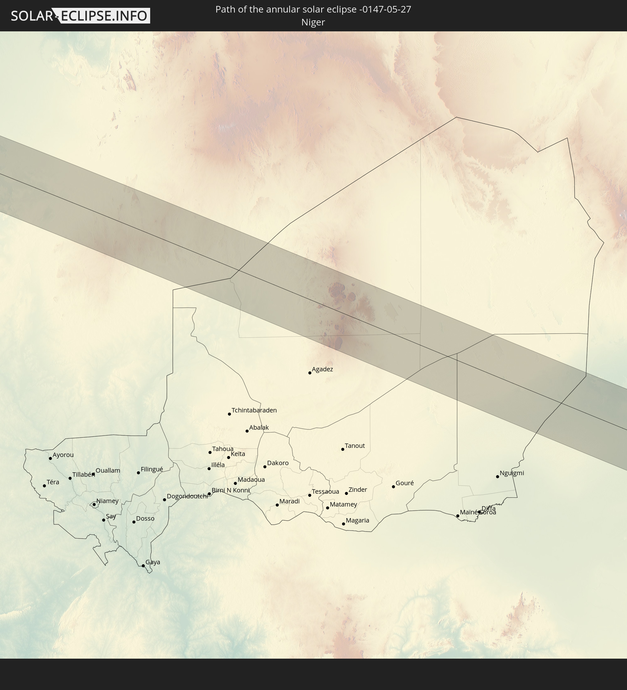 Niger
Niger
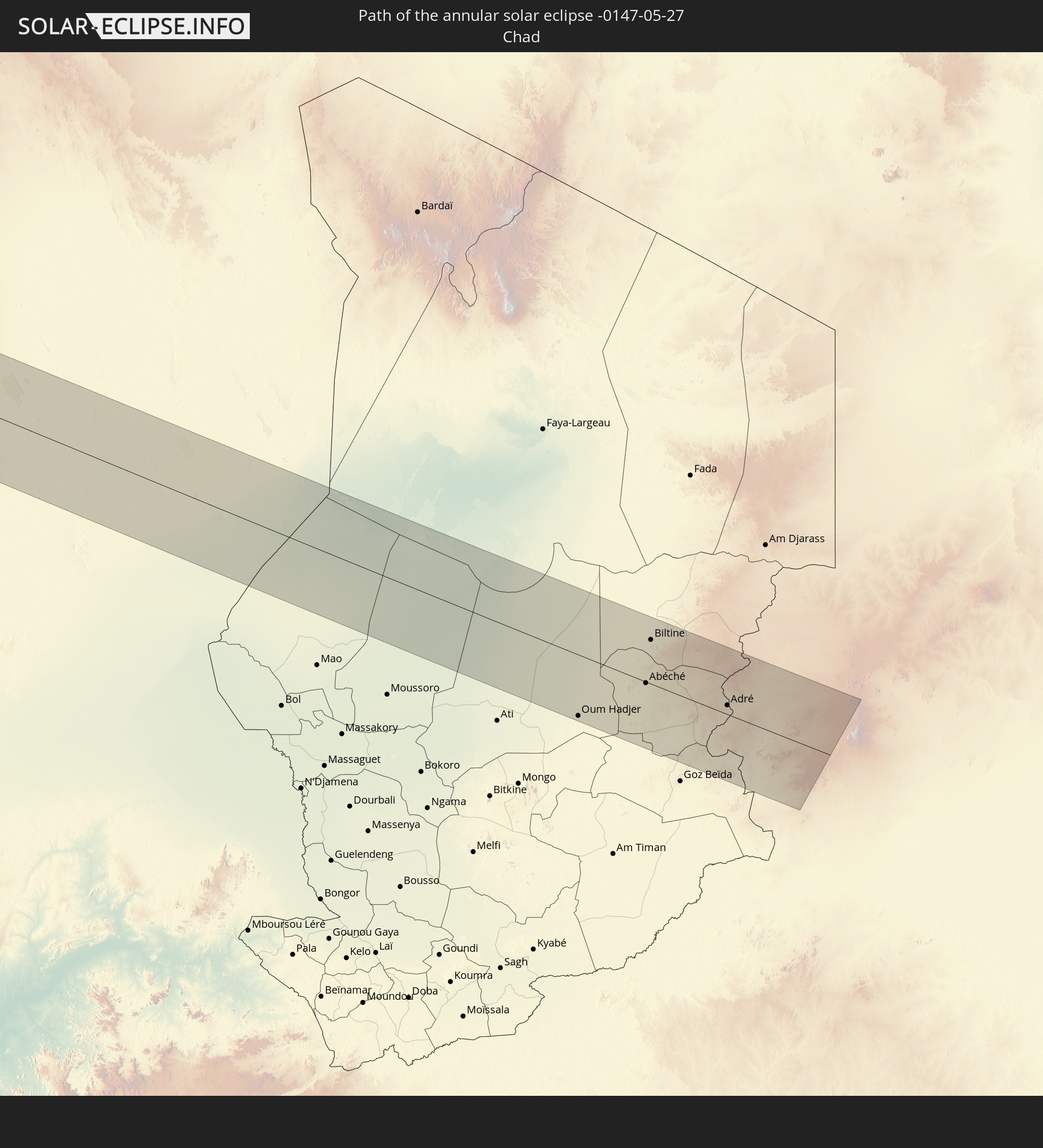 Chad
Chad
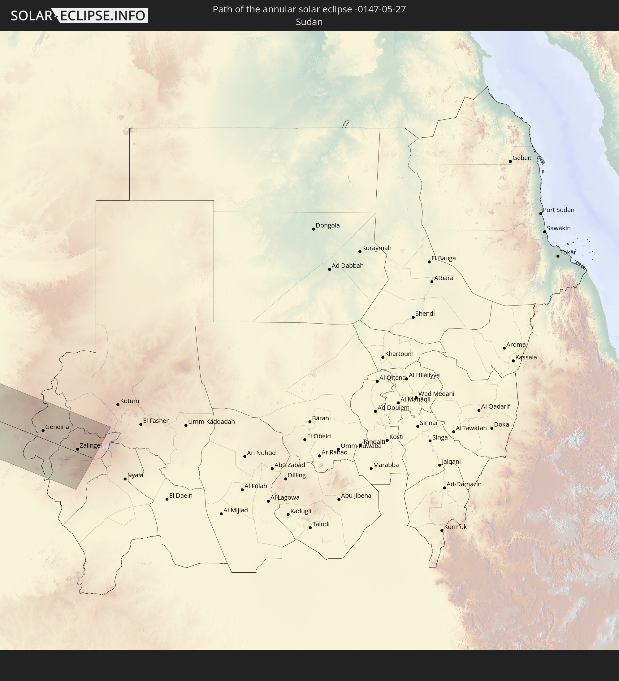 Sudan
Sudan
In den folgenden Ländern ist die Sonnenfinsternis partiell zu sehen
 Russia
 United States
 United States Minor Outlying Islands
 Canada
 Mexico
 Chile
Chile
 Greenland
 Guatemala
 Ecuador
 El Salvador
 Honduras
 Belize
 Nicaragua
 Costa Rica
 Cuba
Cuba
 Panama
 Colombia
 Cayman Islands
 Peru
Peru
 The Bahamas
 Jamaica
 Haiti
Haiti
 Brazil
 Venezuela
 Turks and Caicos Islands
 Dominican Republic
 Aruba
Aruba
 Bolivia
 Puerto Rico
 United States Virgin Islands
 Bermuda
 British Virgin Islands
 Anguilla
 Collectivity of Saint Martin
 Saint Barthélemy
 Saint Kitts and Nevis
 Antigua and Barbuda
 Montserrat
 Trinidad and Tobago
 Guadeloupe
 Grenada
 Dominica
 Saint Vincent and the Grenadines
 Guyana
 Martinique
 Saint Lucia
 Barbados
 Suriname
 Saint Pierre and Miquelon
 French Guiana
 Portugal
 Cabo Verde
 Iceland
 Spain
Spain
 Senegal
 Mauritania
 The Gambia
 Guinea-Bissau
 Guinea
 Sierra Leone
 Morocco
 Mali
Mali
 Liberia
 Republic of Ireland
 Algeria
 United Kingdom
 Ivory Coast
 Faroe Islands
 Burkina Faso
 Gibraltar
 France
 Isle of Man
 Ghana
Ghana
 Guernsey
 Jersey
 Togo
Togo
 Niger
Niger
 Benin
Benin
 Andorra
 Belgium
 Nigeria
 Netherlands
 Norway
 Equatorial Guinea
 Luxembourg
 Germany
 Switzerland
 São Tomé and Príncipe
 Italy
Italy
 Monaco
 Tunisia
 Denmark
 Cameroon
 Gabon
Gabon
 Libya
Libya
 Liechtenstein
 Austria
 Sweden
 Republic of the Congo
 Angola
 Czechia
 Democratic Republic of the Congo
 San Marino
 Vatican City
 Slovenia
 Chad
Chad
 Croatia
 Poland
 Malta
Malta
 Central African Republic
 Bosnia and Herzegovina
 Hungary
 Slovakia
 Montenegro
 Serbia
 Albania
 Greece
 Romania
 Republic of Macedonia
 Lithuania
 Latvia
 Sudan
Sudan
 Ukraine
 Bulgaria
 Belarus
 Egypt
Egypt
 Turkey
 Moldova
 Cyprus
 State of Palestine
 Israel
 Saudi Arabia
 Jordan
 Lebanon
 Syria
Syria
 Iraq
Iraq
 Georgia
 Armenia
 Iran
Iran
 Azerbaijan
 Kazakhstan
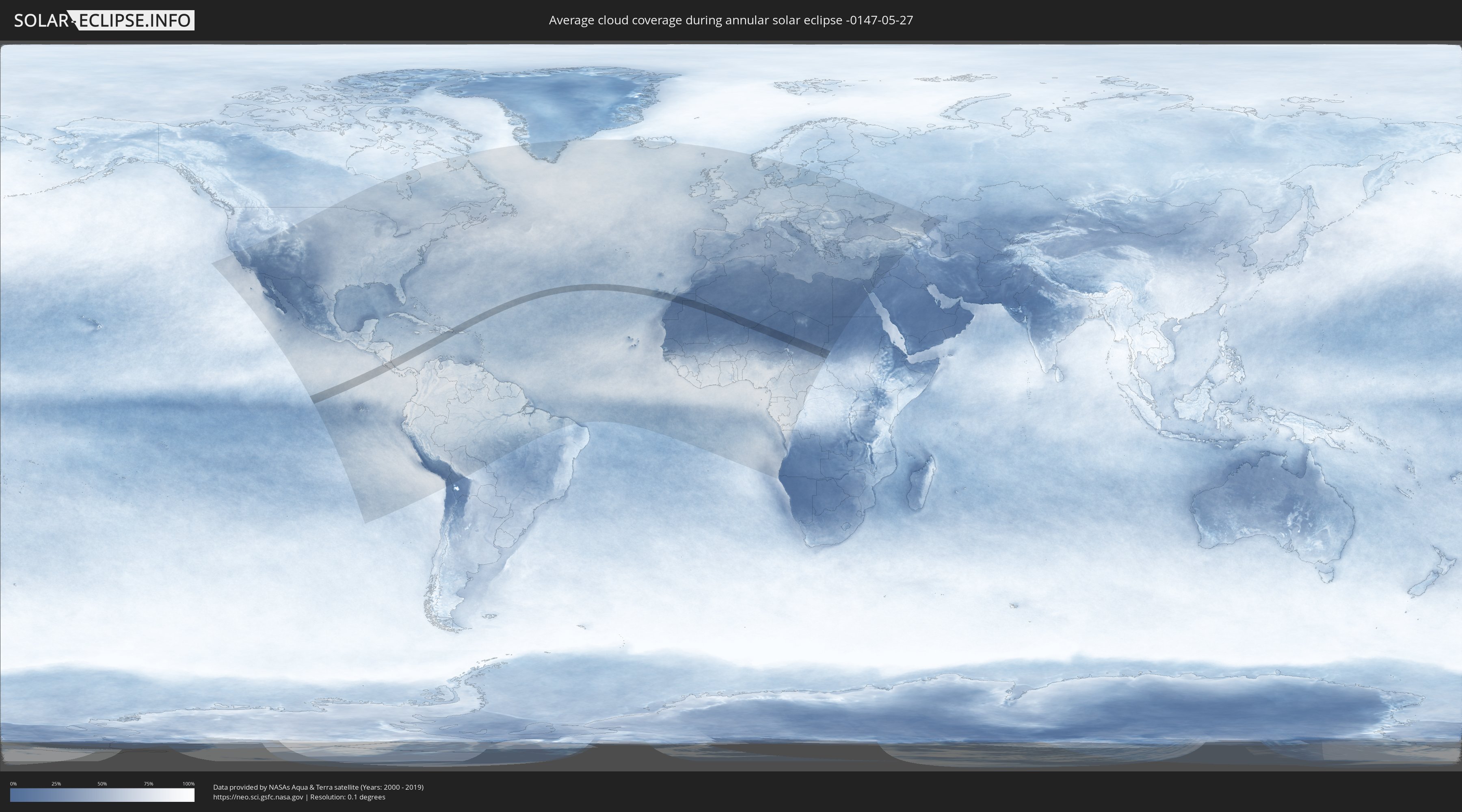
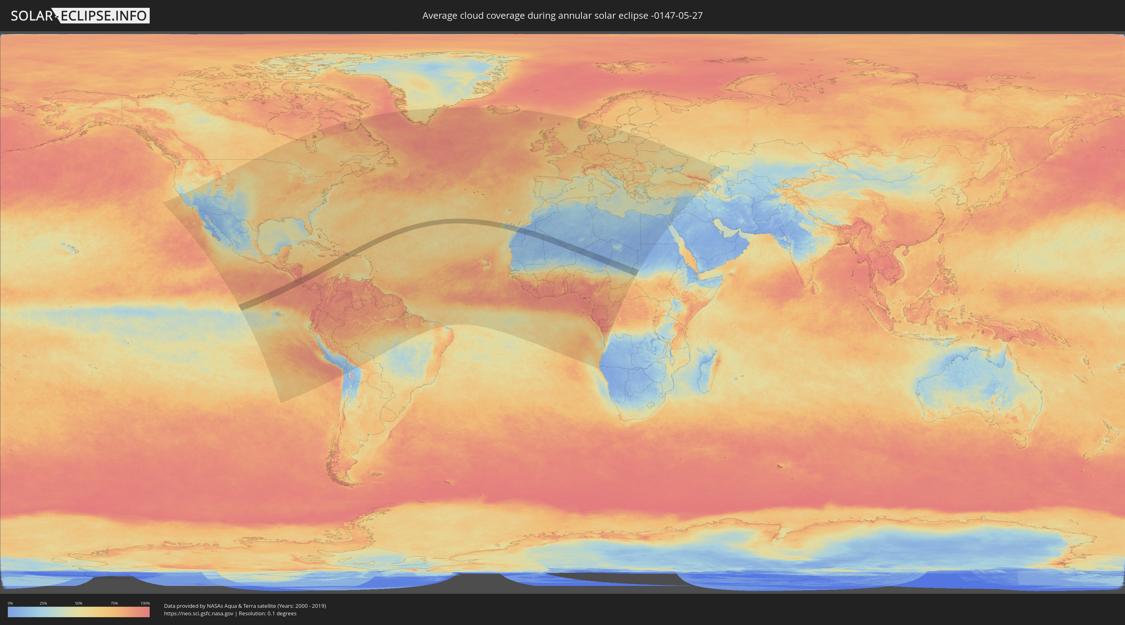
How will be the weather during the annular solar eclipse on 05/27/-0147?
Where is the best place to see the annular solar eclipse of 05/27/-0147?
The following maps show the average cloud coverage for the day of the annular solar eclipse.
With the help of these maps, it is possible to find the place along the eclipse path, which has the best
chance of a cloudless sky.
Nevertheless, you should consider local circumstances and inform about the weather of your chosen
observation site.
The data is provided by NASAs satellites
AQUA and TERRA.
The cloud maps are averaged over a period of 19 years (2000 - 2019).
Detailed country maps
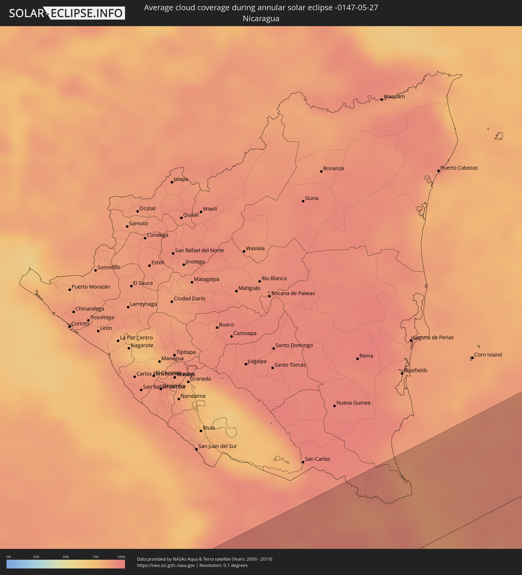 Nicaragua
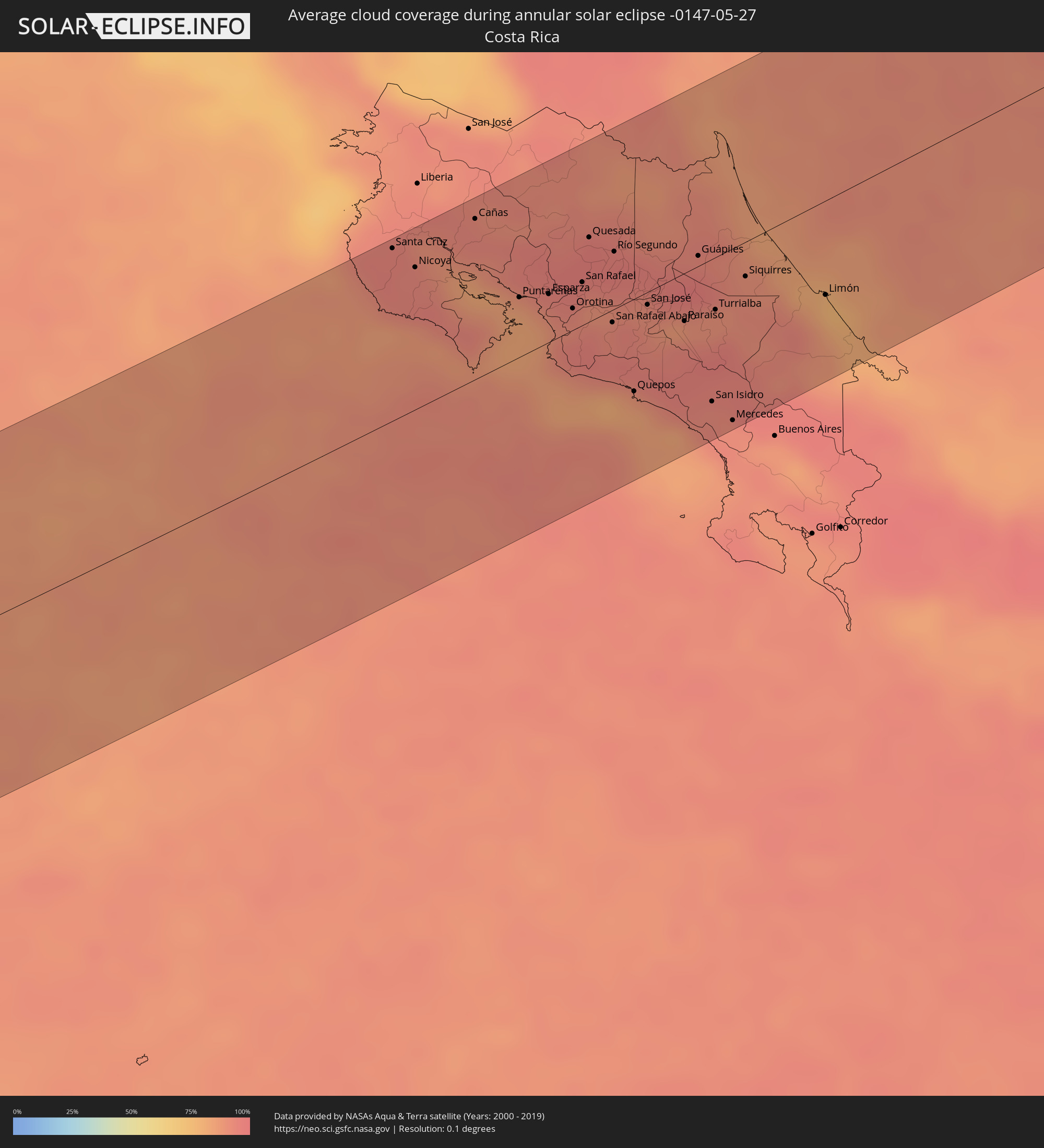 Costa Rica
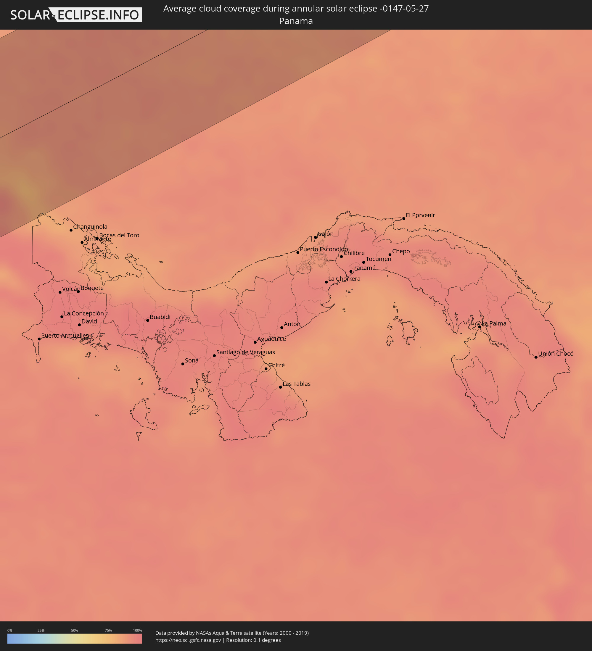 Panama
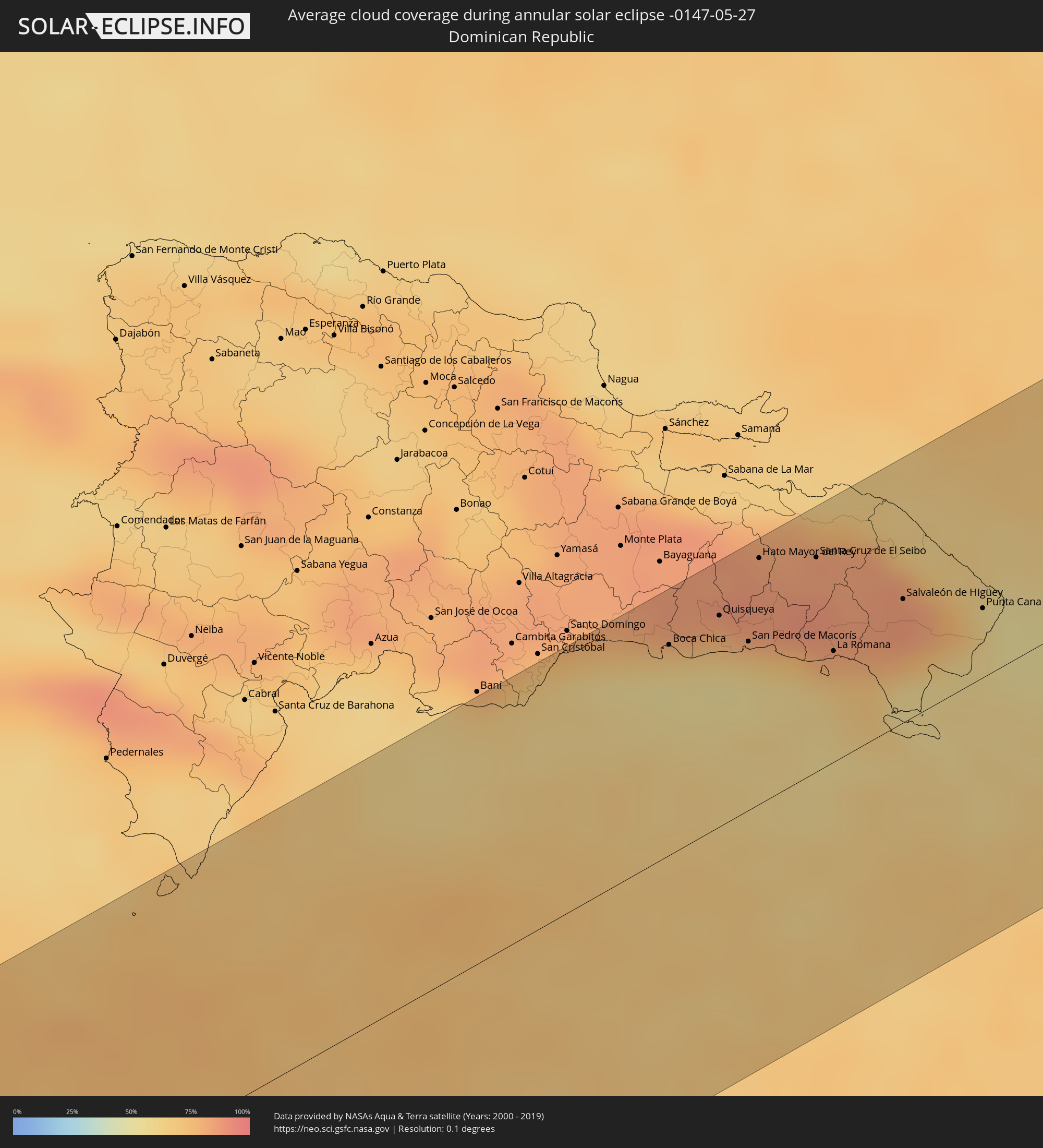 Dominican Republic
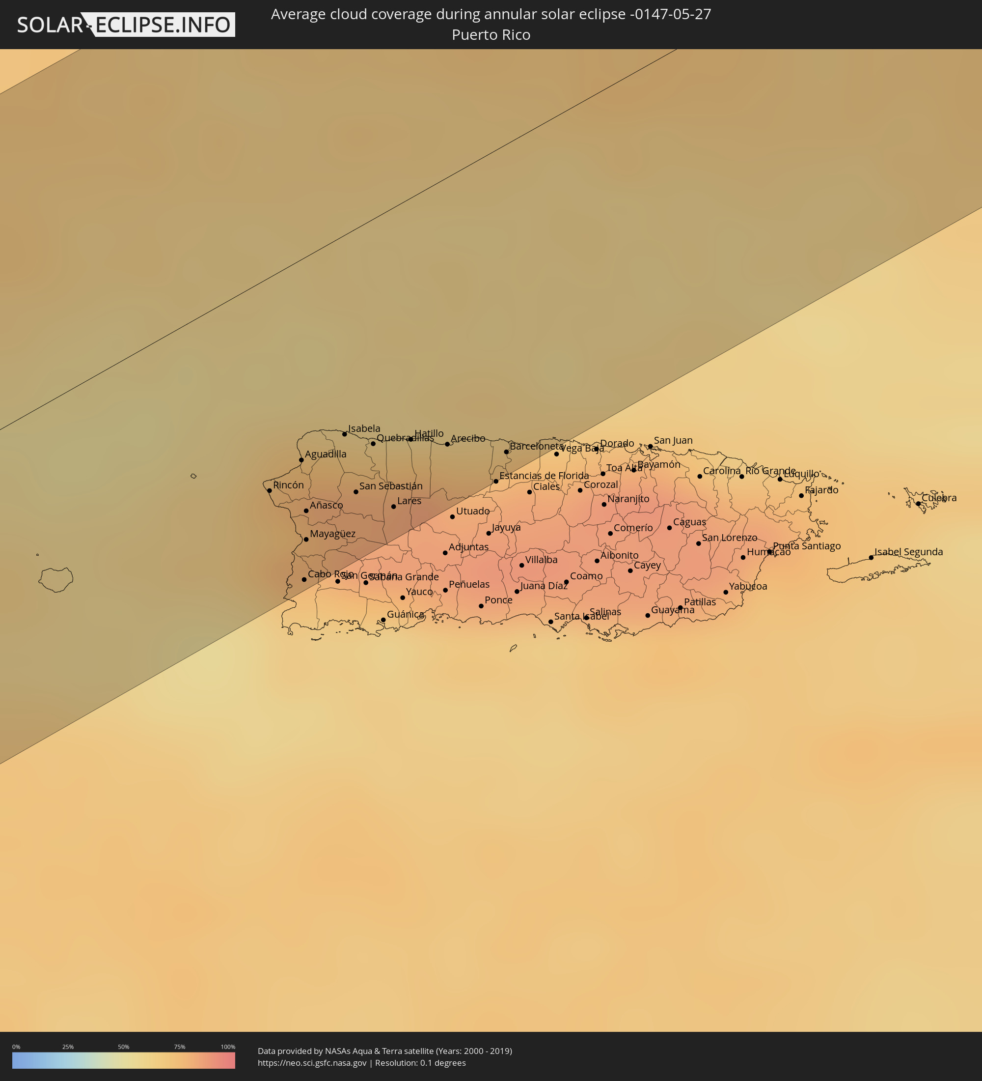 Puerto Rico
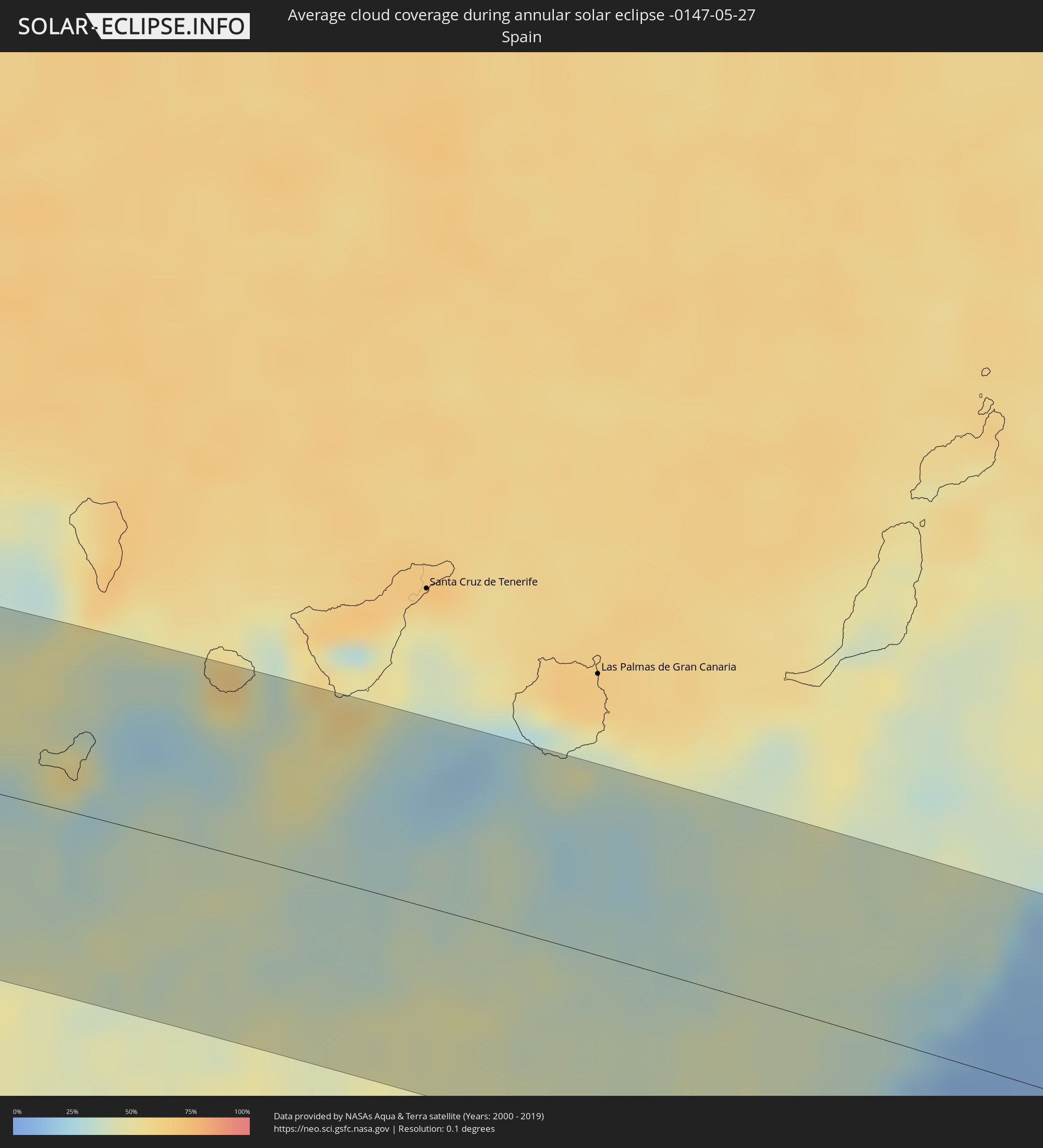 Spain
Spain
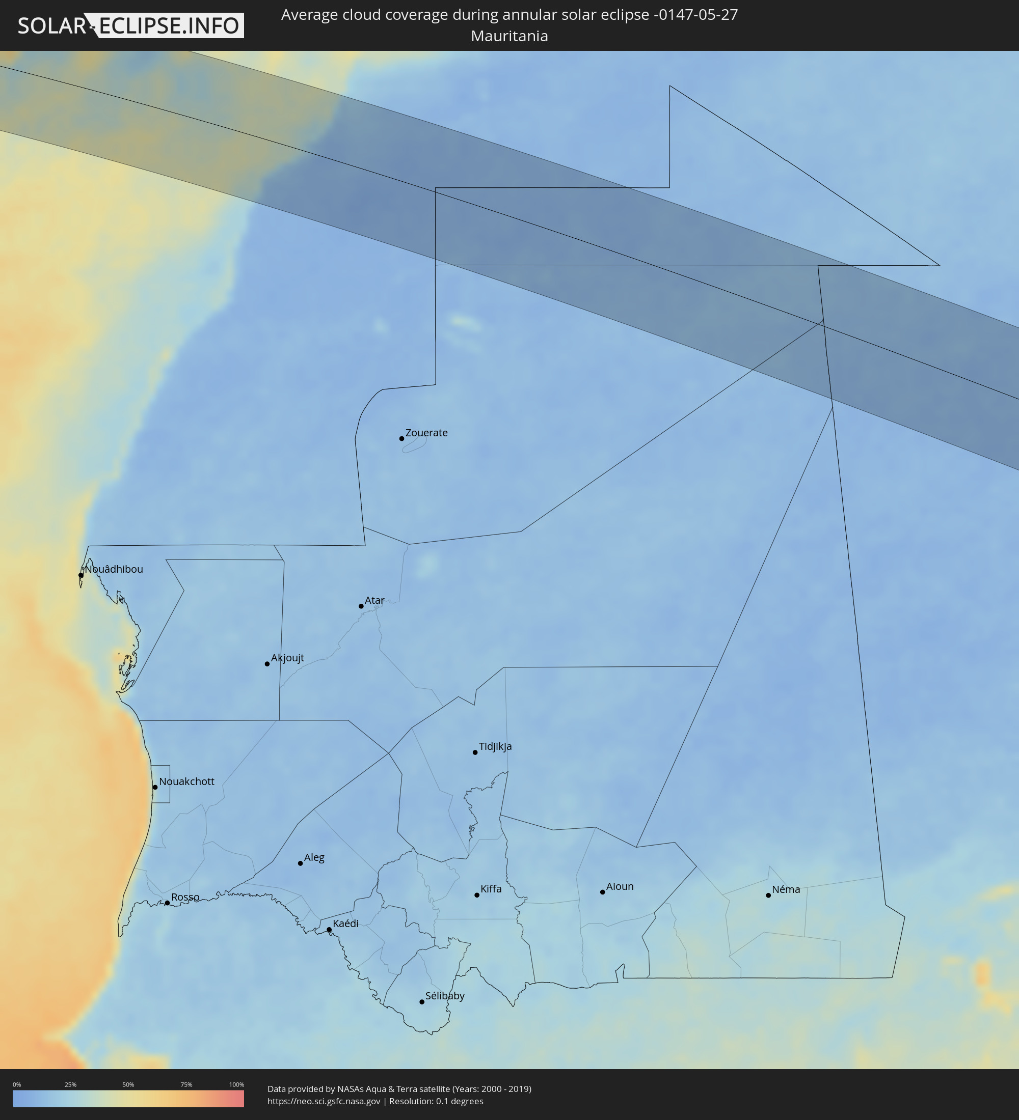 Mauritania
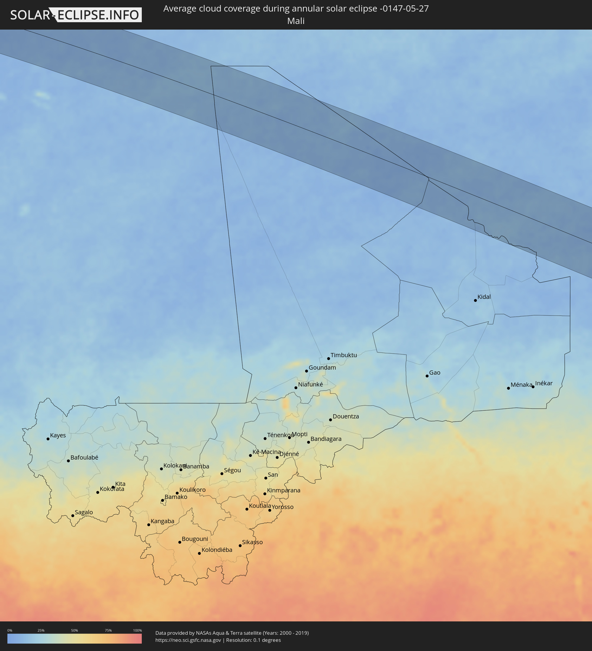 Mali
Mali
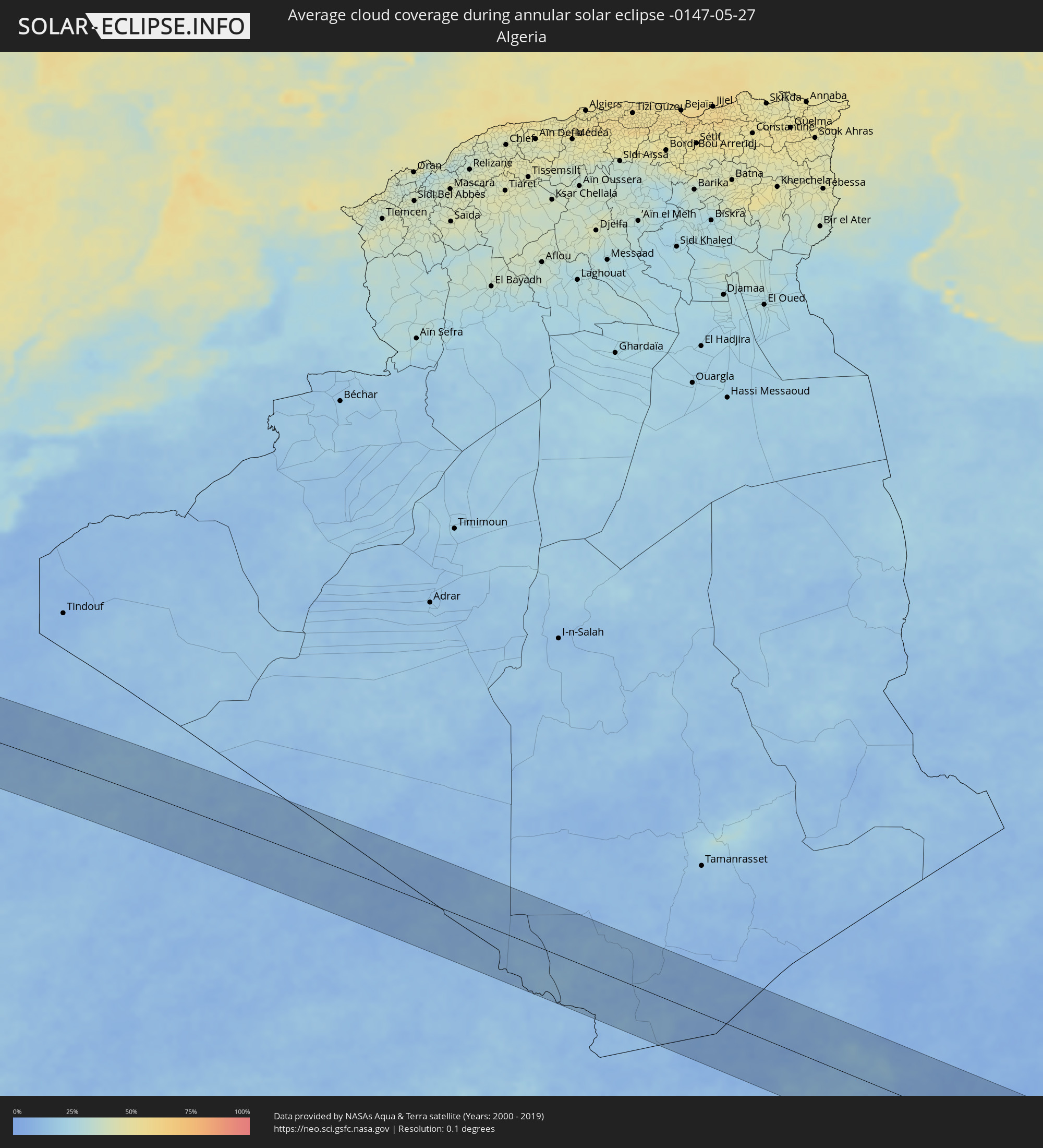 Algeria
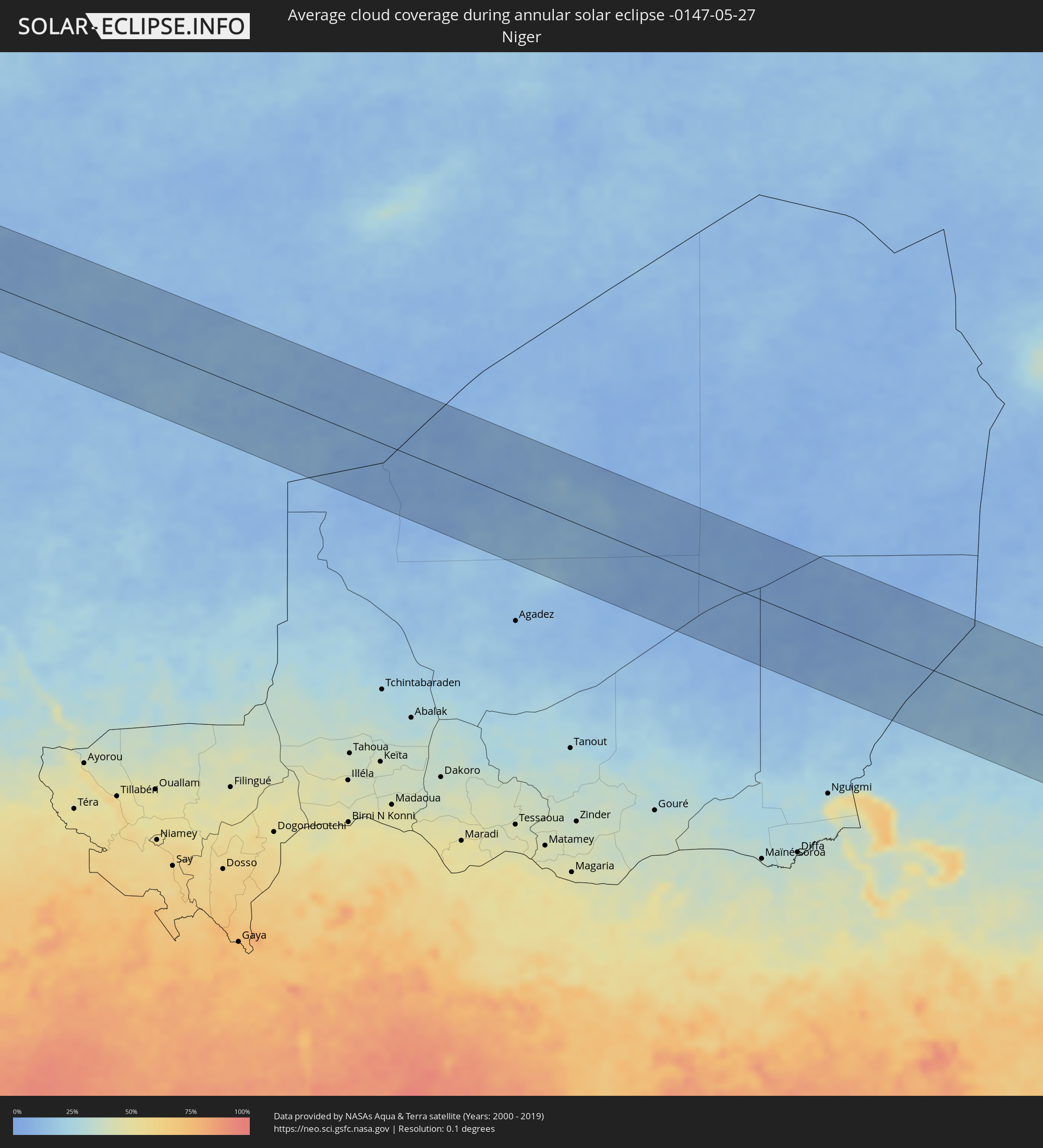 Niger
Niger
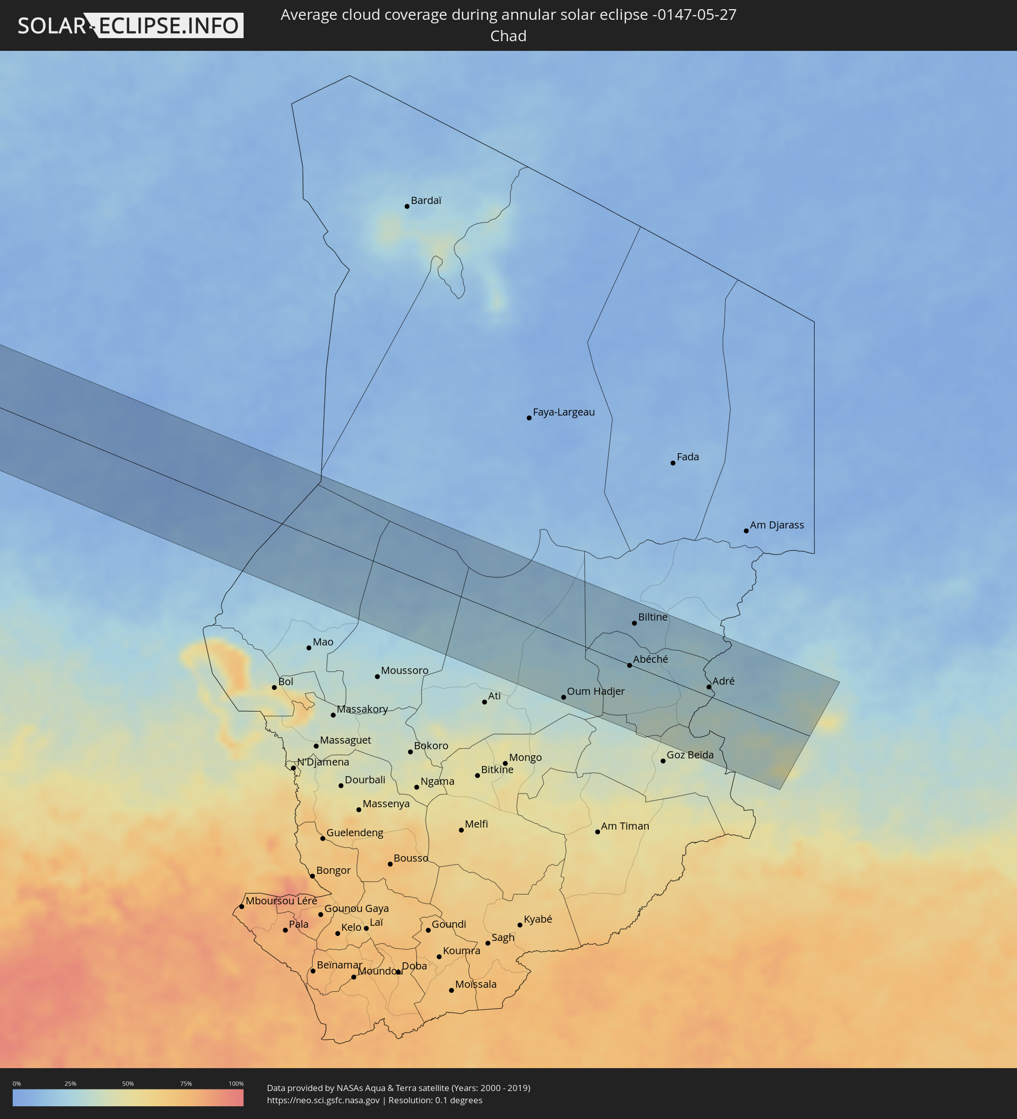 Chad
Chad
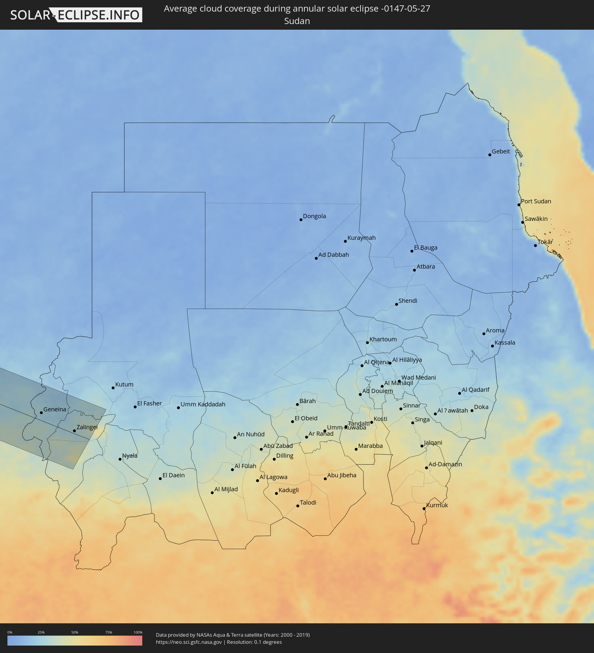 Sudan
Sudan
Cities inside the path of the eclipse
The following table shows all locations with a population of more than 5,000 inside the eclipse path. Cities which have more than 100,000 inhabitants are marked bold. A click at the locations opens a detailed map.
| City | Type | Eclipse duration | Local time of max. eclipse | Distance to central line | Ø Cloud coverage |
|
Santa Cruz, Guanacaste
|
annular | - | 07:15:43 UTC-05:36 | 100 km | 95% |
|
Nicoya, Guanacaste
|
annular | - | 07:15:40 UTC-05:36 | 82 km | 94% |
|
Cañas, Guanacaste
|
annular | - | 07:16:09 UTC-05:36 | 92 km | 94% |
|
Puntarenas, Puntarenas
|
annular | - | 07:15:47 UTC-05:36 | 34 km | 83% |
|
Esparza, Puntarenas
|
annular | - | 07:15:54 UTC-05:36 | 28 km | 88% |
|
San Ramón, Alajuela
|
annular | - | 07:16:06 UTC-05:36 | 27 km | 96% |
|
San Rafael, Alajuela
|
annular | - | 07:16:05 UTC-05:36 | 25 km | 96% |
|
Quesada, Alajuela
|
annular | - | 07:16:23 UTC-05:36 | 49 km | 97% |
|
Naranjo, Alajuela
|
annular | - | 07:16:10 UTC-05:36 | 24 km | 92% |
|
Santiago, San José
|
annular | - | 07:15:56 UTC-05:36 | 4 km | 93% |
|
San Rafael Abajo, San José
|
annular | - | 07:15:56 UTC-05:36 | 7 km | 93% |
|
Río Segundo, Alajuela
|
annular | - | 07:16:22 UTC-05:36 | 33 km | 96% |
|
Colón, Heredia
|
annular | - | 07:16:03 UTC-05:36 | 1 km | 95% |
|
Alajuela, Alajuela
|
annular | - | 07:16:10 UTC-05:36 | 7 km | 91% |
|
San Antonio, Heredia
|
annular | - | 07:16:09 UTC-05:36 | 3 km | 91% |
|
Escazú, San José
|
annular | - | 07:16:06 UTC-05:36 | 6 km | 92% |
|
San Rafael, Heredia
|
annular | - | 07:16:13 UTC-05:36 | 2 km | 90% |
|
San Josecito, Heredia
|
annular | - | 07:16:14 UTC-05:36 | 2 km | 90% |
|
San José, San José
|
annular | - | 07:16:09 UTC-05:36 | 7 km | 92% |
|
Sabanilla, San José
|
annular | - | 07:16:11 UTC-05:36 | 8 km | 89% |
|
Granadilla, San José
|
annular | - | 07:16:11 UTC-05:36 | 10 km | 89% |
|
Tres Ríos, Cartago
|
annular | - | 07:16:10 UTC-05:36 | 15 km | 89% |
|
Paraíso, Cartago
|
annular | - | 07:16:10 UTC-05:36 | 28 km | 94% |
|
Guápiles, Limón
|
annular | - | 07:16:37 UTC-05:36 | 6 km | 97% |
|
San Isidro, San José
|
annular | - | 07:15:46 UTC-05:36 | 82 km | 93% |
|
Turrialba, Cartago
|
annular | - | 07:16:20 UTC-05:36 | 30 km | 90% |
|
Daniel Flores, San José
|
annular | - | 07:15:44 UTC-05:36 | 87 km | 94% |
|
Siquirres, Limón
|
annular | - | 07:16:39 UTC-05:36 | 20 km | 91% |
|
Limón, Limón
|
annular | - | 07:16:49 UTC-05:36 | 54 km | 77% |
|
Paya, Peravia
|
annular | - | 08:36:43 UTC-04:40 | 92 km | 68% |
|
Nizao, Peravia
|
annular | - | 08:36:49 UTC-04:40 | 86 km | 63% |
|
Yaguate, San Cristóbal
|
annular | - | 08:36:59 UTC-04:40 | 93 km | 65% |
|
San Gregorio de Nigua, San Cristóbal
|
annular | - | 08:37:12 UTC-04:40 | 93 km | 67% |
|
Bajos de Haina, San Cristóbal
|
annular | - | 08:37:20 UTC-04:40 | 93 km | 62% |
|
Bella Vista, Nacional
|
annular | - | 08:37:31 UTC-04:40 | 92 km | 70% |
|
La Julia, Nacional
|
annular | - | 08:37:33 UTC-04:40 | 93 km | 70% |
|
San Carlos, Nacional
|
annular | - | 08:37:38 UTC-04:40 | 93 km | 70% |
|
Ciudad Nueva, Nacional
|
annular | - | 08:37:36 UTC-04:40 | 91 km | 70% |
|
Villa Francisca, Nacional
|
annular | - | 08:37:36 UTC-04:40 | 91 km | 70% |
|
Villa Consuelo, Nacional
|
annular | - | 08:37:38 UTC-04:40 | 93 km | 70% |
|
Santo Domingo Este, Santo Domingo
|
annular | - | 08:37:42 UTC-04:40 | 91 km | 70% |
|
Boca Chica, Santo Domingo
|
annular | - | 08:38:01 UTC-04:40 | 74 km | 66% |
|
Los Llanos, San Pedro de Macorís
|
annular | - | 08:38:27 UTC-04:40 | 85 km | 81% |
|
Quisqueya, San Pedro de Macorís
|
annular | - | 08:38:28 UTC-04:40 | 74 km | 79% |
|
San Pedro de Macorís, San Pedro de Macorís
|
annular | - | 08:38:30 UTC-04:40 | 59 km | 66% |
|
Hato Mayor del Rey, Hato Mayor
|
annular | - | 08:39:02 UTC-04:40 | 86 km | 86% |
|
Santa Cruz de El Seibo, El Seíbo
|
annular | - | 08:39:22 UTC-04:40 | 75 km | 85% |
|
Guaymate, La Romana
|
annular | - | 08:39:11 UTC-04:40 | 55 km | 87% |
|
La Romana, La Romana
|
annular | - | 08:38:56 UTC-04:40 | 39 km | 65% |
|
Salvaleón de Higüey, La Altagracia
|
annular | - | 08:39:38 UTC-04:40 | 43 km | 87% |
|
San Rafael del Yuma, La Altagracia
|
annular | - | 08:39:24 UTC-04:40 | 24 km | 62% |
|
Otra Banda, La Altagracia
|
annular | - | 08:39:46 UTC-04:40 | 44 km | 87% |
|
Punta Cana, La Altagracia
|
annular | - | 08:40:04 UTC-04:40 | 24 km | 63% |
|
Rincón, Rincon
|
annular | - | 09:21:33 UTC-04:00 | 59 km | 73% |
|
Aguada, Aguada
|
annular | - | 09:21:43 UTC-04:00 | 58 km | 76% |
|
Puerto Real, Cabo Rojo
|
annular | - | 09:21:15 UTC-04:00 | 88 km | 70% |
|
Aguadilla, Aguadilla
|
annular | - | 09:21:51 UTC-04:00 | 56 km | 76% |
|
Cabo Rojo, Cabo Rojo
|
annular | - | 09:21:20 UTC-04:00 | 89 km | 70% |
|
Mayagüez, Mayaguez
|
annular | - | 09:21:31 UTC-04:00 | 78 km | 78% |
|
Añasco, Añasco
|
annular | - | 09:21:39 UTC-04:00 | 70 km | 78% |
|
Hormigueros, Hormigueros
|
annular | - | 09:21:27 UTC-04:00 | 85 km | 70% |
|
Moca, Moca
|
annular | - | 09:21:52 UTC-04:00 | 61 km | 80% |
|
Isabela, Isabela
|
annular | - | 09:22:11 UTC-04:00 | 55 km | 71% |
|
Las Marías, Las Marias
|
annular | - | 09:21:51 UTC-04:00 | 81 km | 80% |
|
San Sebastián, San Sebastian
|
annular | - | 09:21:59 UTC-04:00 | 73 km | 80% |
|
Maricao, Maricao
|
annular | - | 09:21:45 UTC-04:00 | 89 km | 83% |
|
Quebradillas, Quebradillas
|
annular | - | 09:22:17 UTC-04:00 | 62 km | 71% |
|
Lares, Lares
|
annular | - | 09:22:06 UTC-04:00 | 83 km | 82% |
|
Camuy, Camuy
|
annular | - | 09:22:28 UTC-04:00 | 66 km | 72% |
|
Hatillo, Hatillo
|
annular | - | 09:22:30 UTC-04:00 | 67 km | 72% |
|
Arecibo, Arecibo
|
annular | - | 09:22:40 UTC-04:00 | 74 km | 69% |
|
Barceloneta, Barceloneta
|
annular | - | 09:22:56 UTC-04:00 | 85 km | 75% |
|
Manatí, Manati
|
annular | - | 09:22:58 UTC-04:00 | 90 km | 82% |
|
San Sebastián de la Gomera, Canary Islands
|
annular | - | 14:50:43 UTC-01:01 | 86 km | 42% |
 Laayoune Plage
|
annular | - | 15:07:25 UTC-00:52 | 80 km | 24% |
|
Oum Hadjer, Batha
|
annular | - | 17:36:46 UTC+01:00 | 103 km | 31% |
|
Abéché, Ouadaï
|
annular | - | 17:36:19 UTC+01:00 | 2 km | 26% |
|
Biltine, Wadi Fira
|
annular | - | 17:35:52 UTC+01:00 | 74 km | 20% |
|
Adré, Ouadaï
|
annular | - | 17:36:22 UTC+01:00 | 15 km | 26% |
|
Geneina, Western Darfur
|
annular | - | 18:46:16 UTC+02:10 | 24 km | 25% |
|
Zalingei, Central Darfur
|
annular | - | 18:46:23 UTC+02:10 | 8 km | 26% |