Total solar eclipse of 07/04/-0335
| Day of week: | Thursday |
| Maximum duration of eclipse: | 05m53s |
| Maximum width of eclipse path: | 225 km |
| Saros cycle: | 60 |
| Coverage: | 100% |
| Magnitude: | 1.0685 |
| Gamma: | 0.1213 |
Wo kann man die Sonnenfinsternis vom 07/04/-0335 sehen?
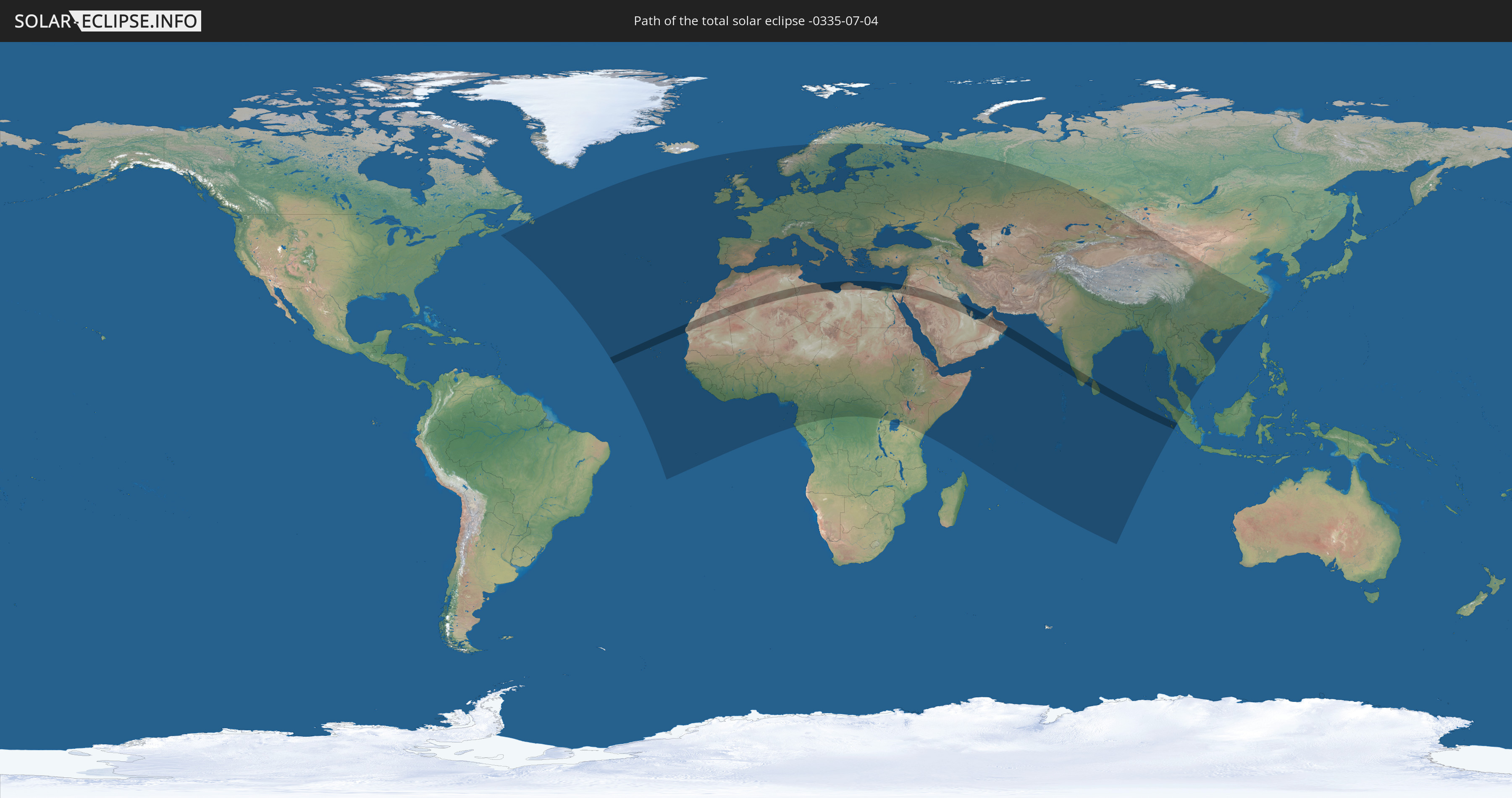
Die Sonnenfinsternis am 07/04/-0335 kann man in 133 Ländern als partielle Sonnenfinsternis beobachten.
Der Finsternispfad verläuft durch 18 Länder. Nur in diesen Ländern ist sie als total Sonnenfinsternis zu sehen.
In den folgenden Ländern ist die Sonnenfinsternis total zu sehen
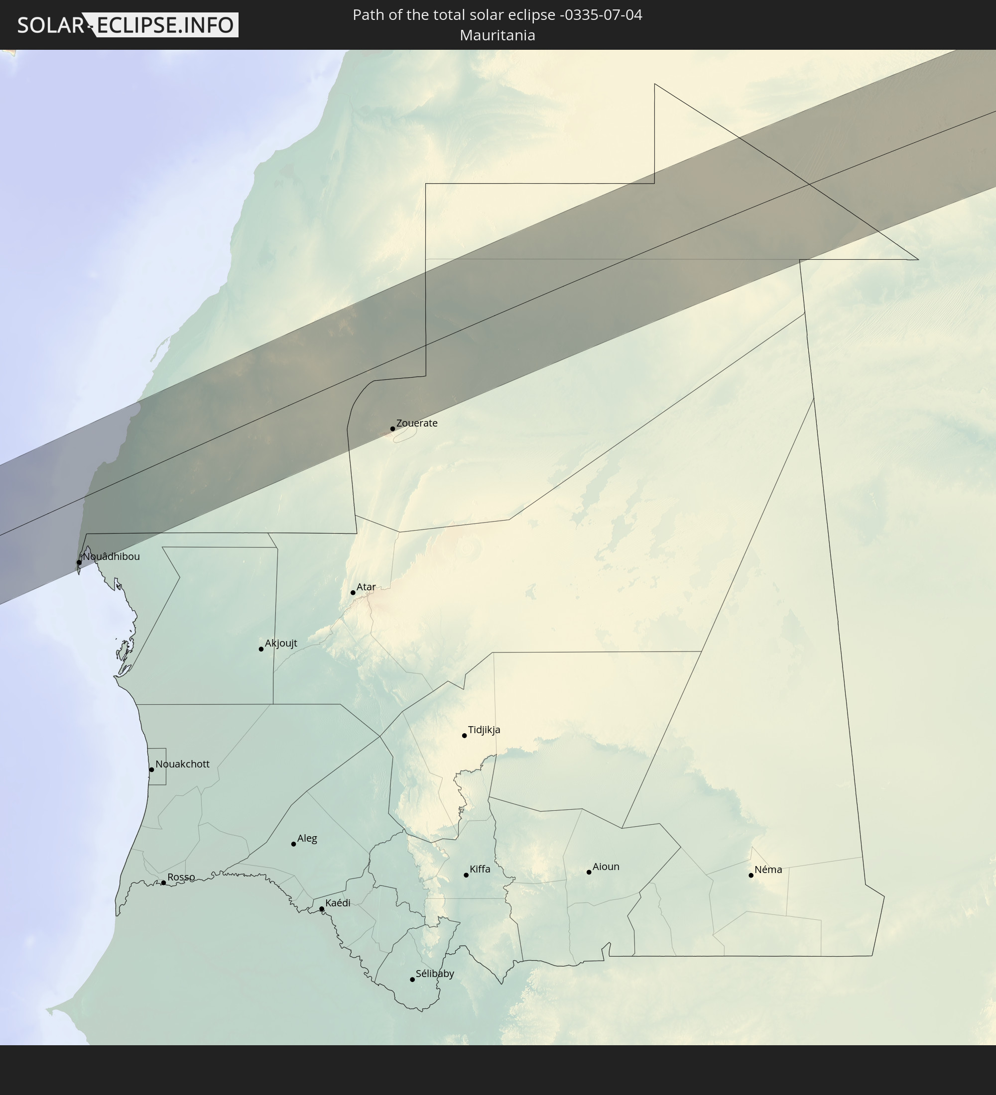 Mauritania
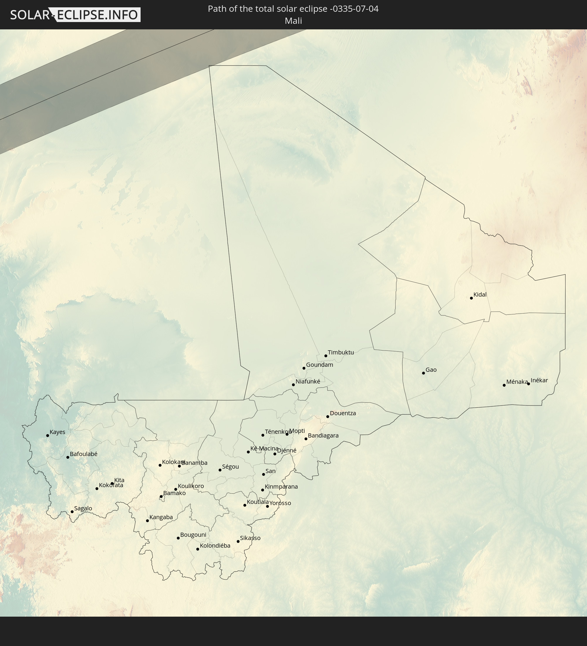 Mali
Mali
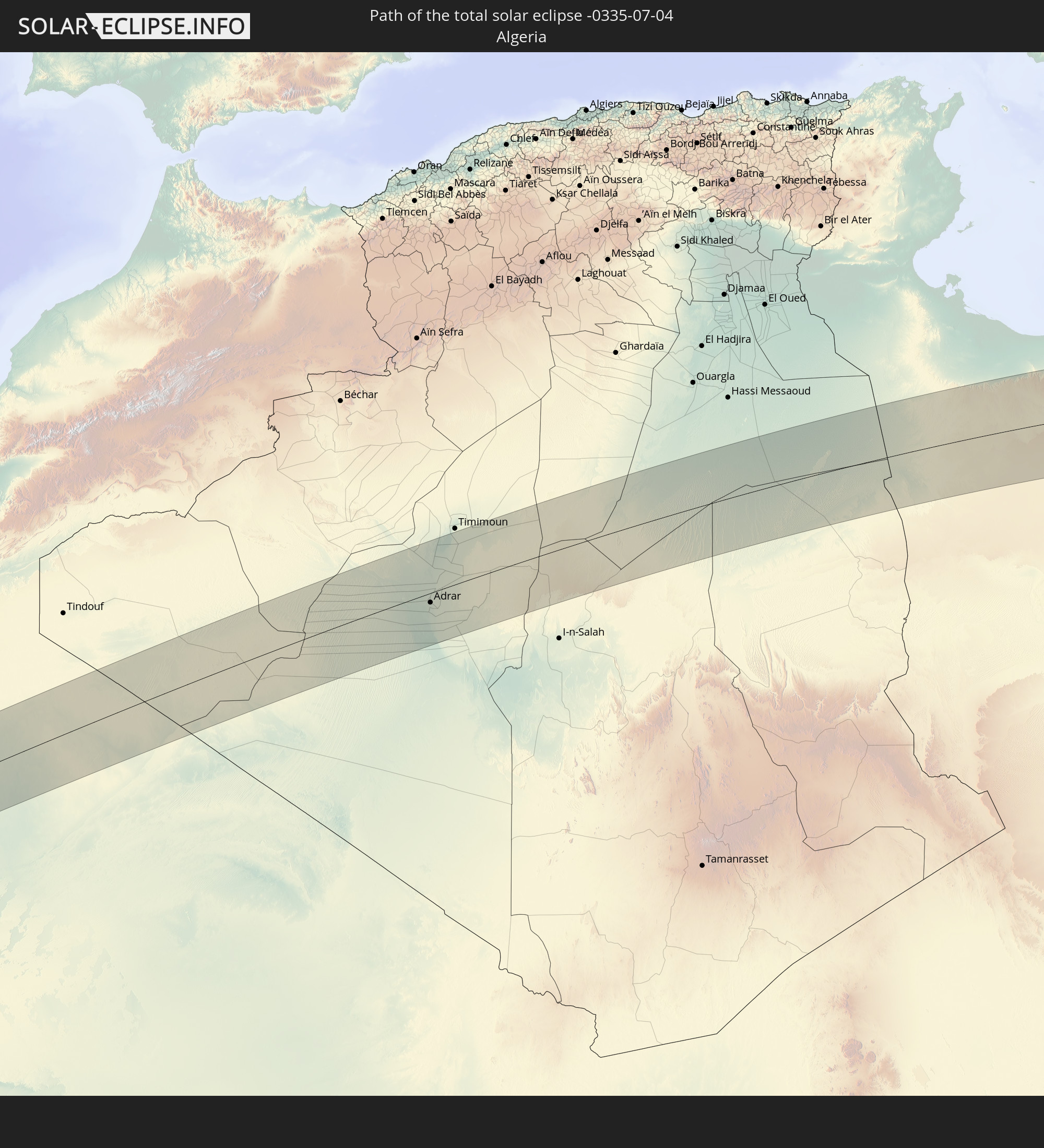 Algeria
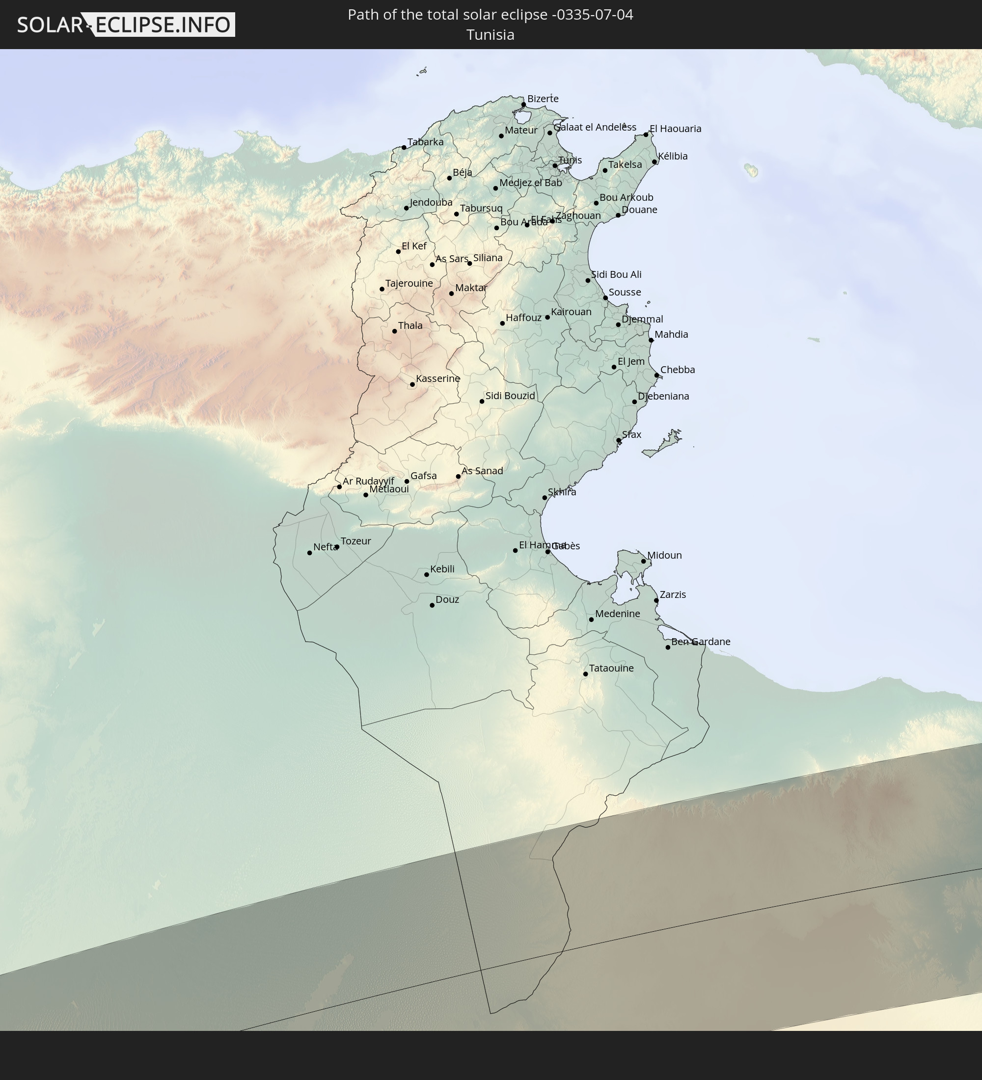 Tunisia
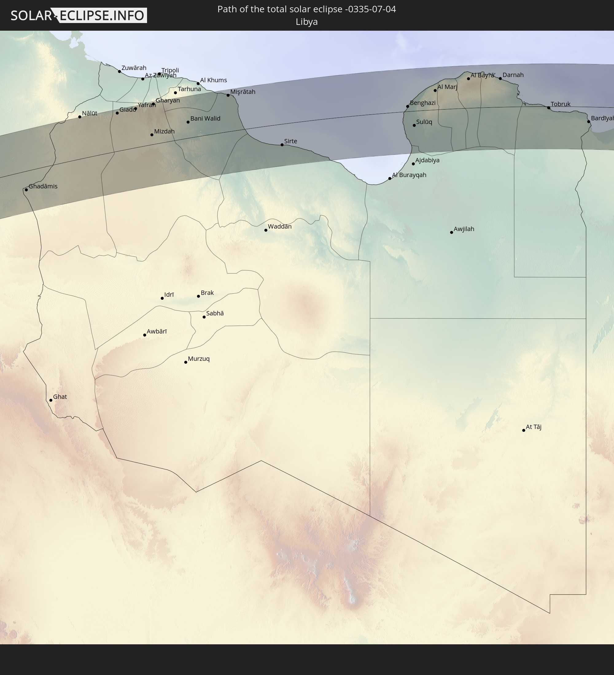 Libya
Libya
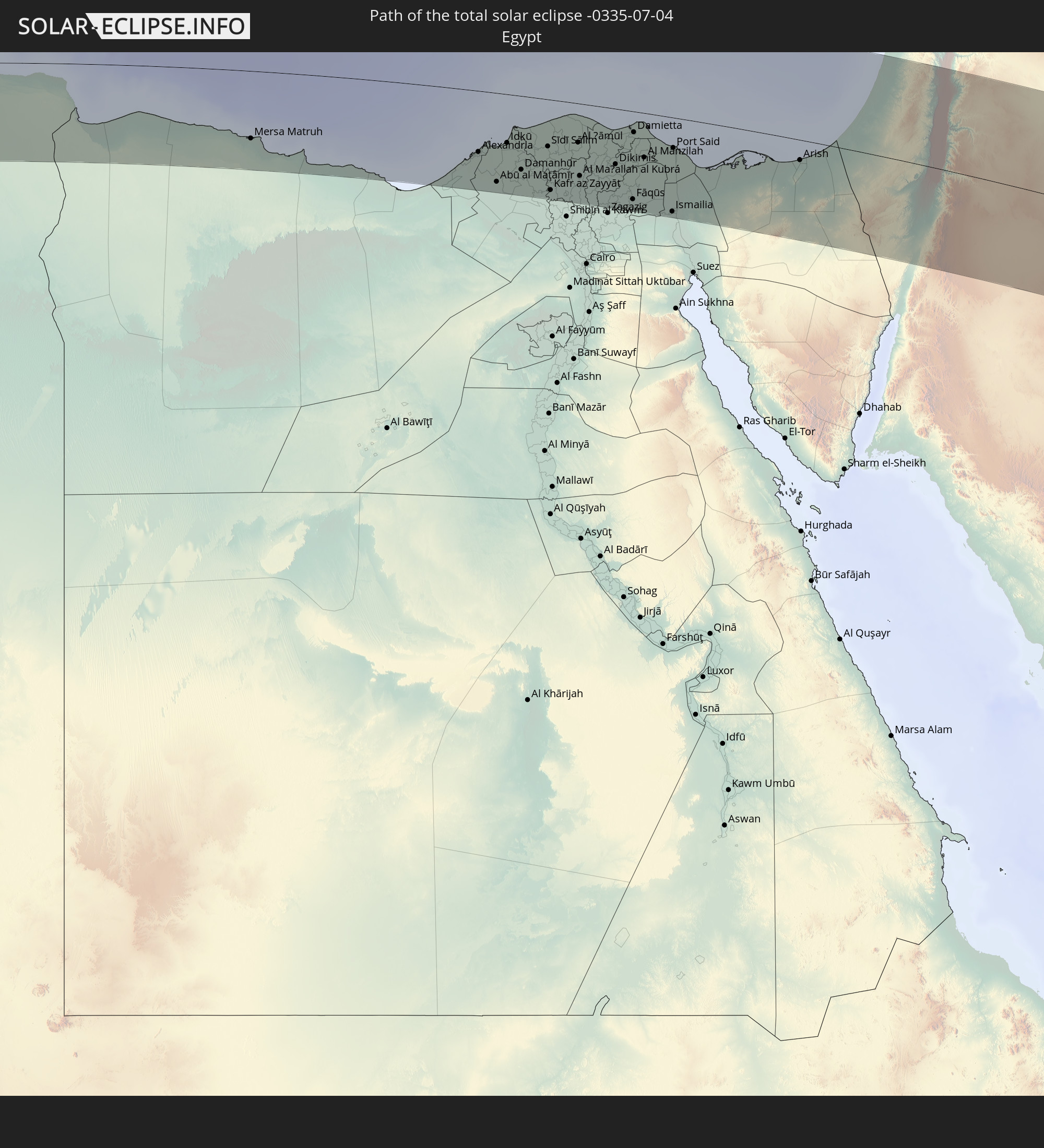 Egypt
Egypt
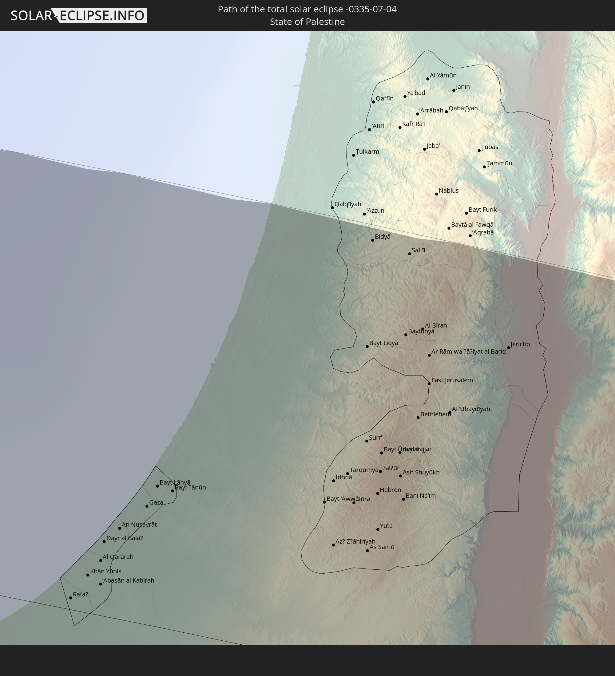 State of Palestine
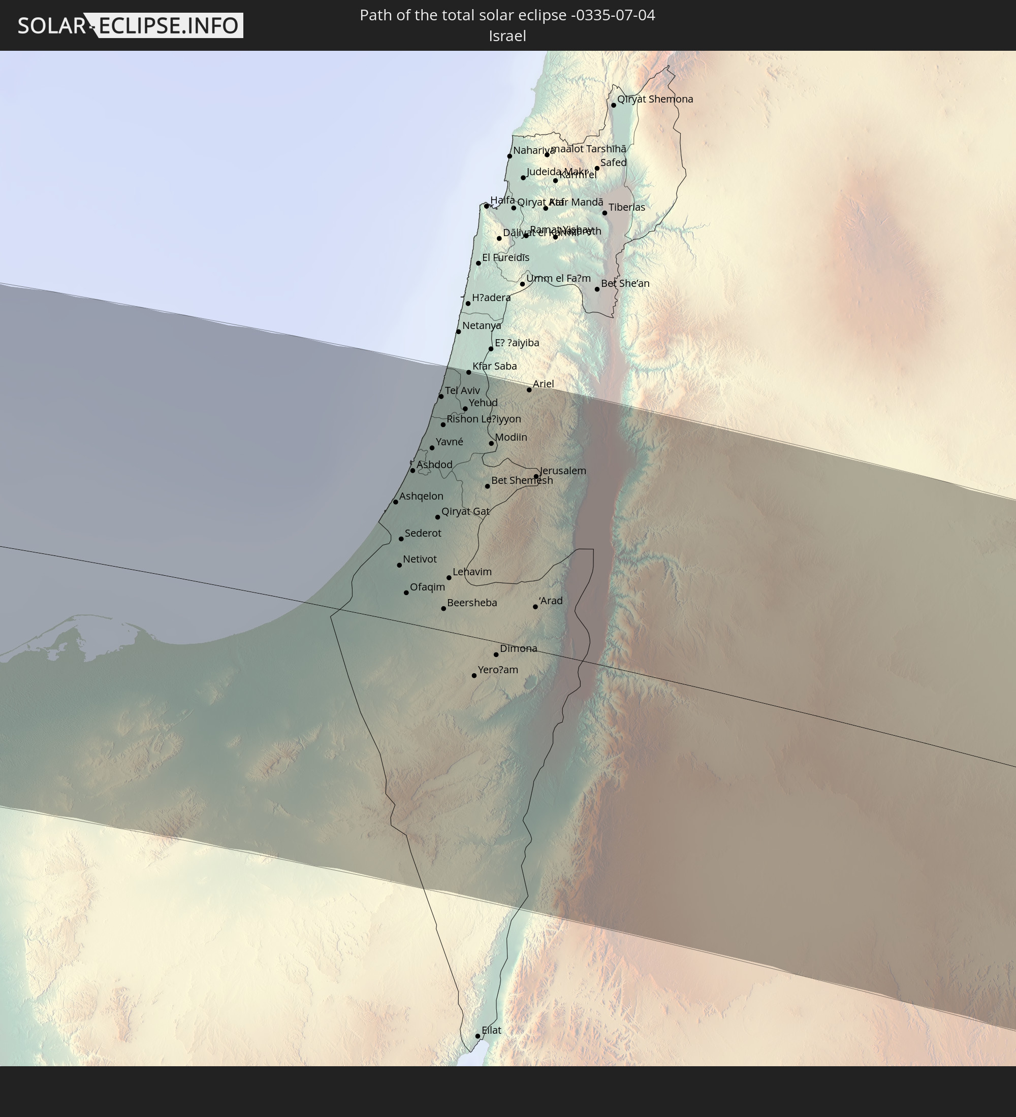 Israel
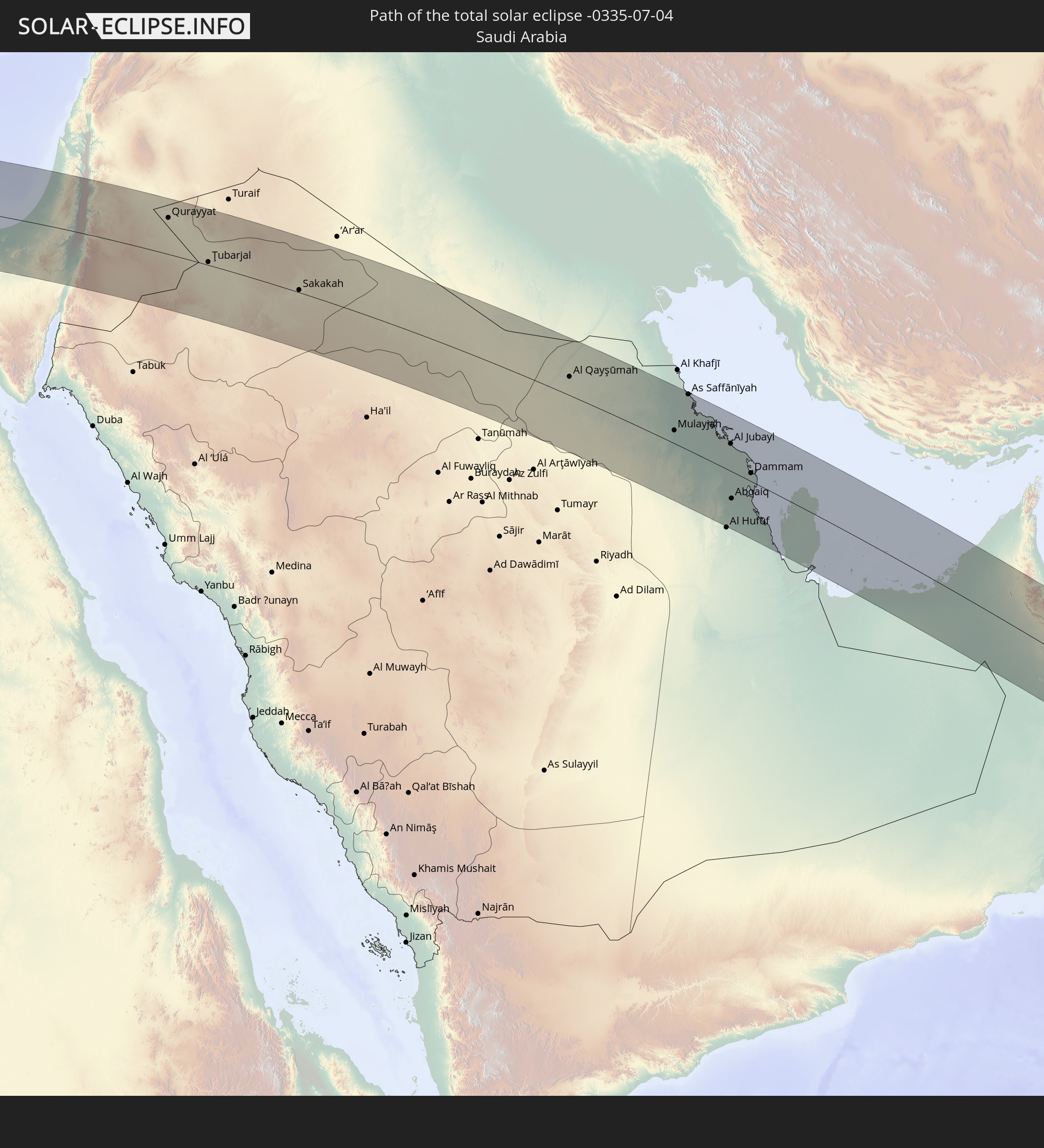 Saudi Arabia
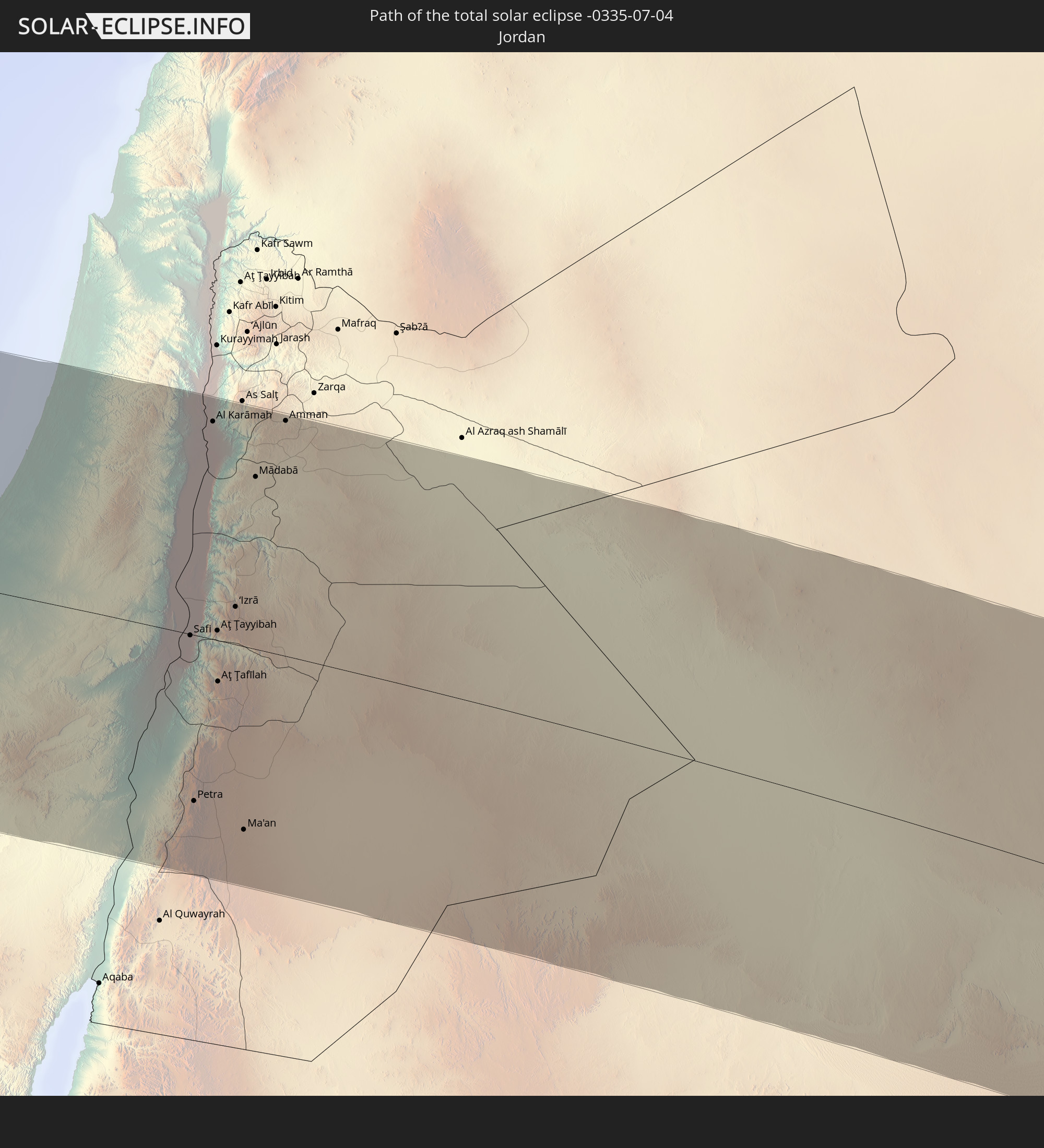 Jordan
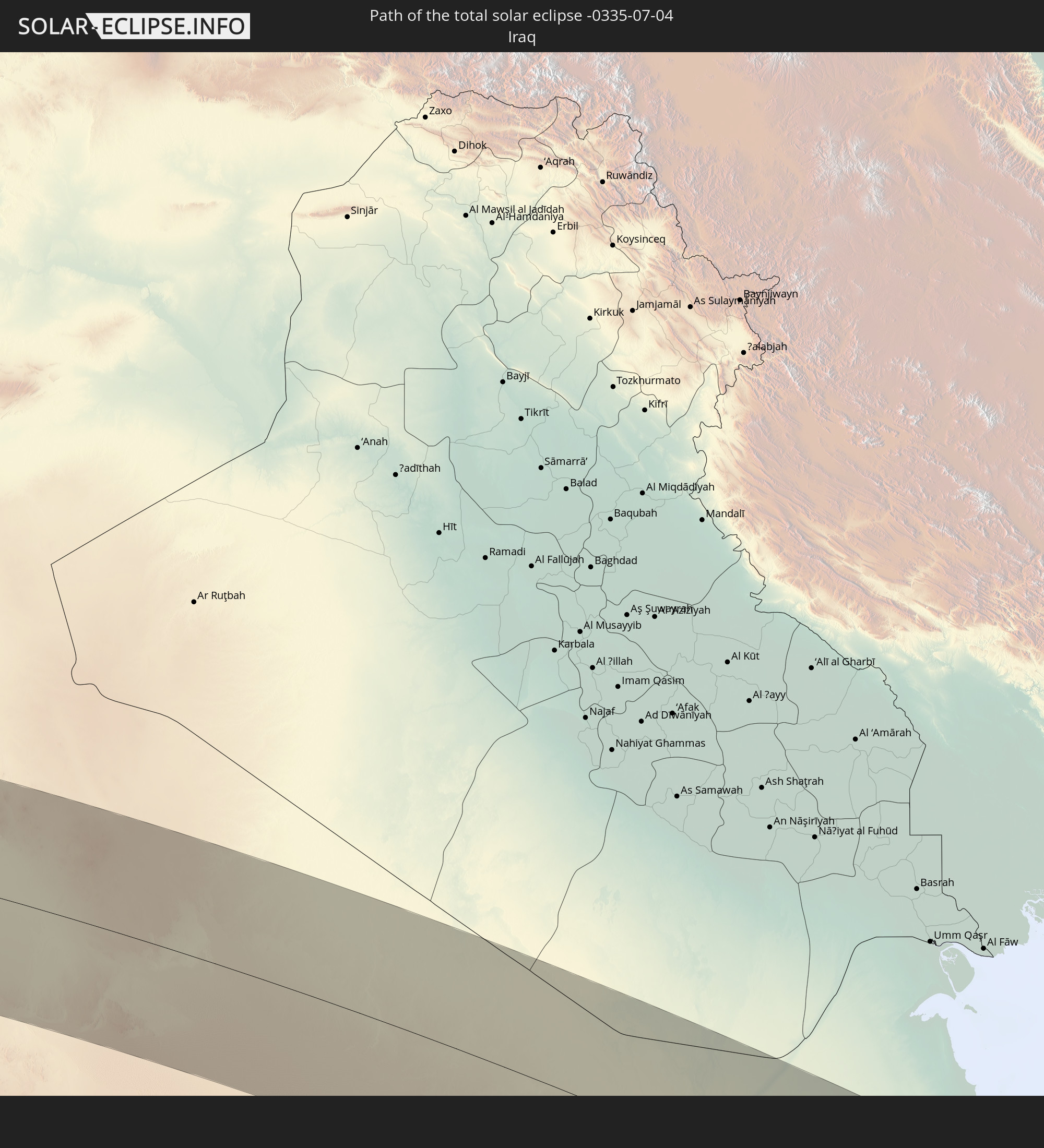 Iraq
Iraq
 Bahrain
 Qatar
Qatar
 United Arab Emirates
 Oman
Oman
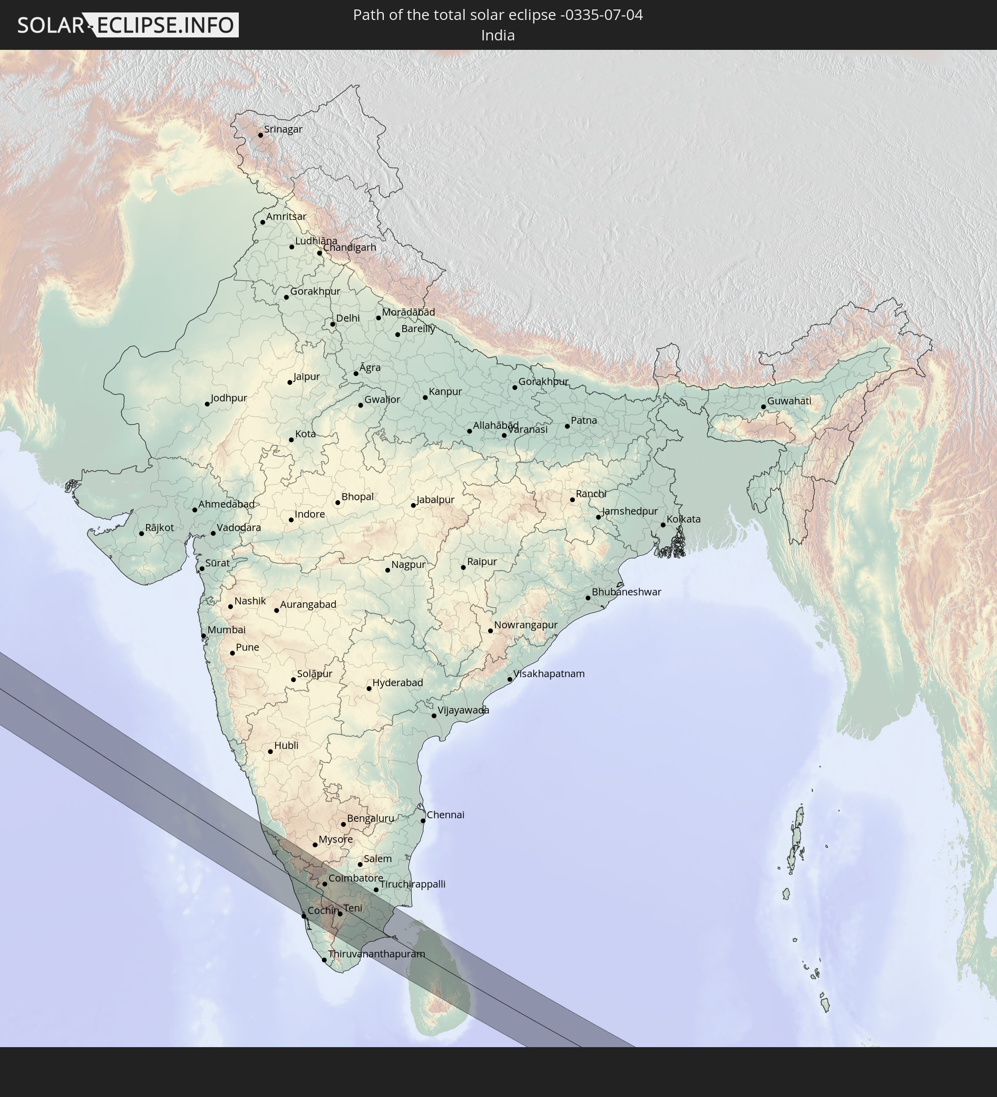 India
India
 Sri Lanka
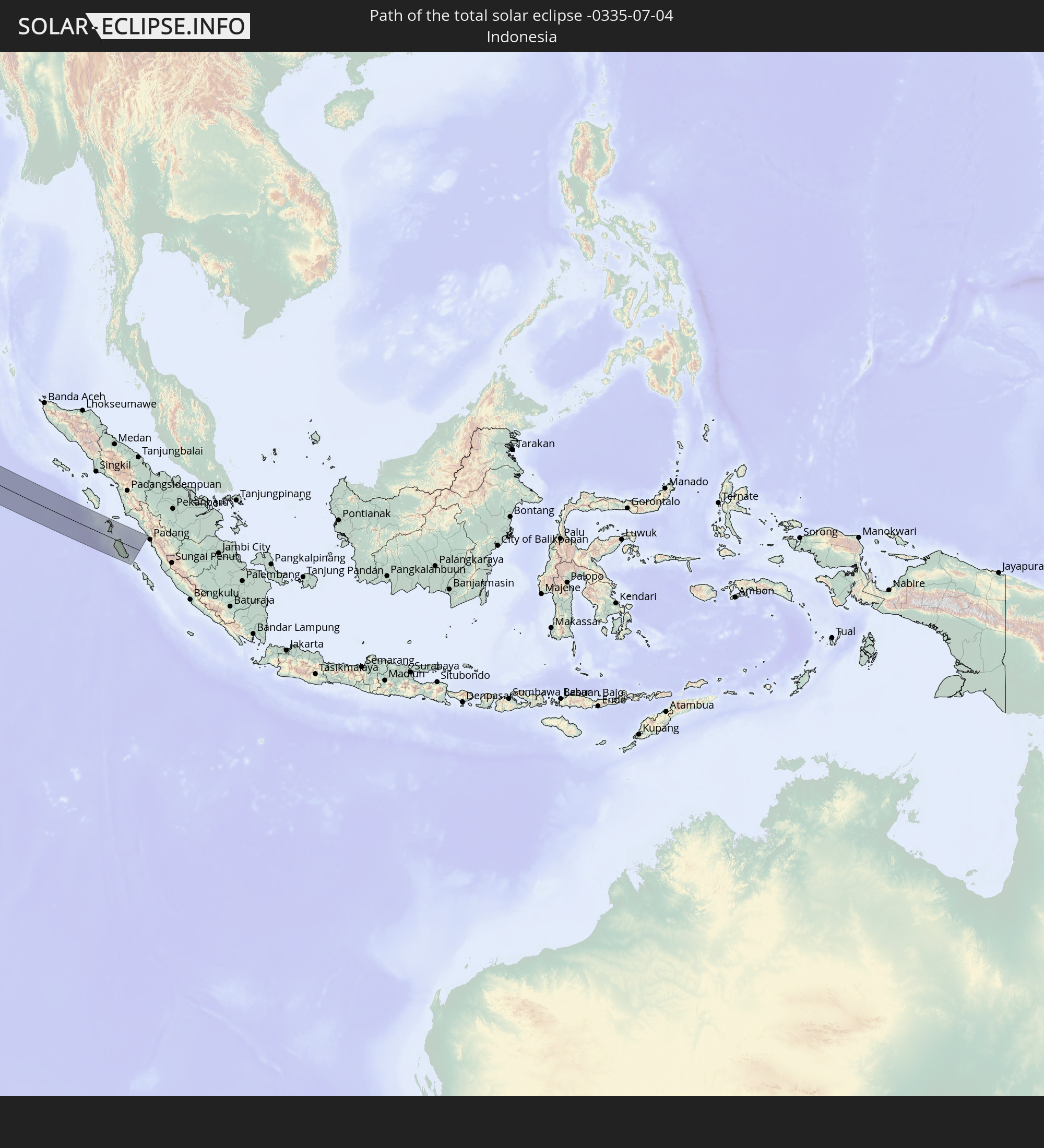 Indonesia
In den folgenden Ländern ist die Sonnenfinsternis partiell zu sehen
 Russia
 Canada
 Portugal
 Cabo Verde
 Spain
Spain
 Senegal
 Mauritania
 The Gambia
 Guinea-Bissau
 Guinea
 Saint Helena, Ascension and Tristan da Cunha
 Sierra Leone
 Morocco
 Mali
Mali
 Liberia
 Republic of Ireland
 Algeria
 United Kingdom
 Ivory Coast
 Faroe Islands
 Burkina Faso
 Gibraltar
 France
 Isle of Man
 Ghana
Ghana
 Guernsey
 Jersey
 Togo
Togo
 Niger
Niger
 Benin
Benin
 Andorra
 Belgium
 Nigeria
 Netherlands
 Norway
 Equatorial Guinea
 Luxembourg
 Germany
 Switzerland
 São Tomé and Príncipe
 Italy
Italy
 Monaco
 Tunisia
 Denmark
 Cameroon
 Gabon
Gabon
 Libya
Libya
 Liechtenstein
 Austria
 Sweden
 Republic of the Congo
 Czechia
 Democratic Republic of the Congo
 San Marino
 Vatican City
 Slovenia
 Chad
Chad
 Croatia
 Poland
 Malta
Malta
 Central African Republic
 Bosnia and Herzegovina
 Hungary
 Slovakia
 Montenegro
 Serbia
 Albania
 Åland Islands
 Greece
 Romania
 Republic of Macedonia
 Finland
 Lithuania
 Latvia
 Estonia
 Sudan
Sudan
 Ukraine
 Bulgaria
 Belarus
 Egypt
Egypt
 Turkey
 Moldova
 Uganda
 Cyprus
 Ethiopia
 Kenya
Kenya
 State of Palestine
 Israel
 Saudi Arabia
 Jordan
 Lebanon
 Syria
Syria
 Eritrea
 Iraq
Iraq
 Georgia
 Somalia
 Djibouti
 Yemen
Yemen
 Armenia
 Iran
Iran
 Azerbaijan
 Seychelles
 Kazakhstan
 Kuwait
 Bahrain
 Qatar
Qatar
 United Arab Emirates
 Oman
Oman
 Turkmenistan
 Uzbekistan
 Mauritius
 Afghanistan
 Pakistan
 Tajikistan
 India
India
 Kyrgyzstan
 British Indian Ocean Territory
 Maldives
 China
China
 Sri Lanka
 Nepal
Nepal
 Mongolia
 Bangladesh
 Bhutan
 Myanmar
 Indonesia
 Thailand
 Malaysia
 Laos
Laos
 Vietnam
 Cambodia
 Macau
Macau
 Hong Kong
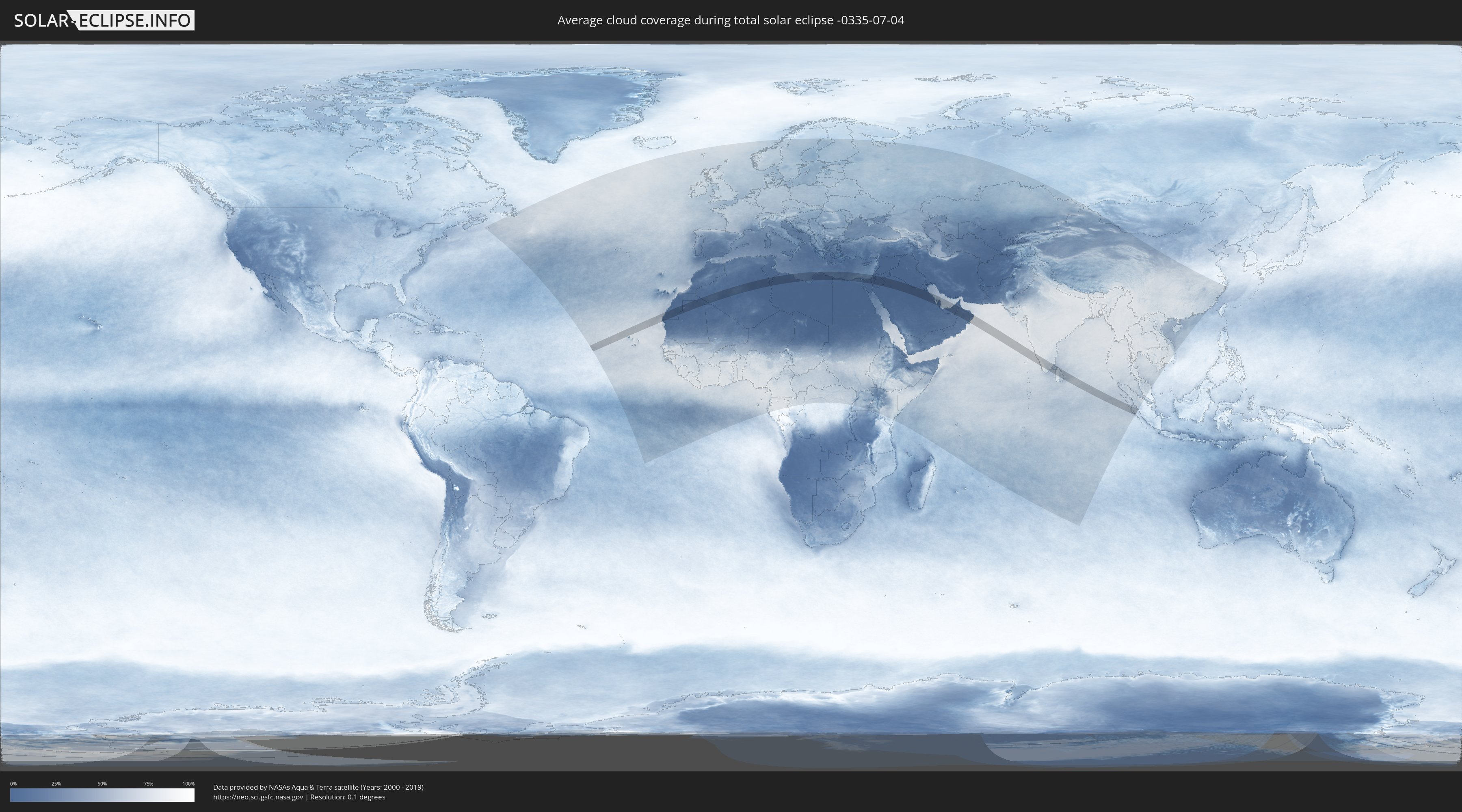
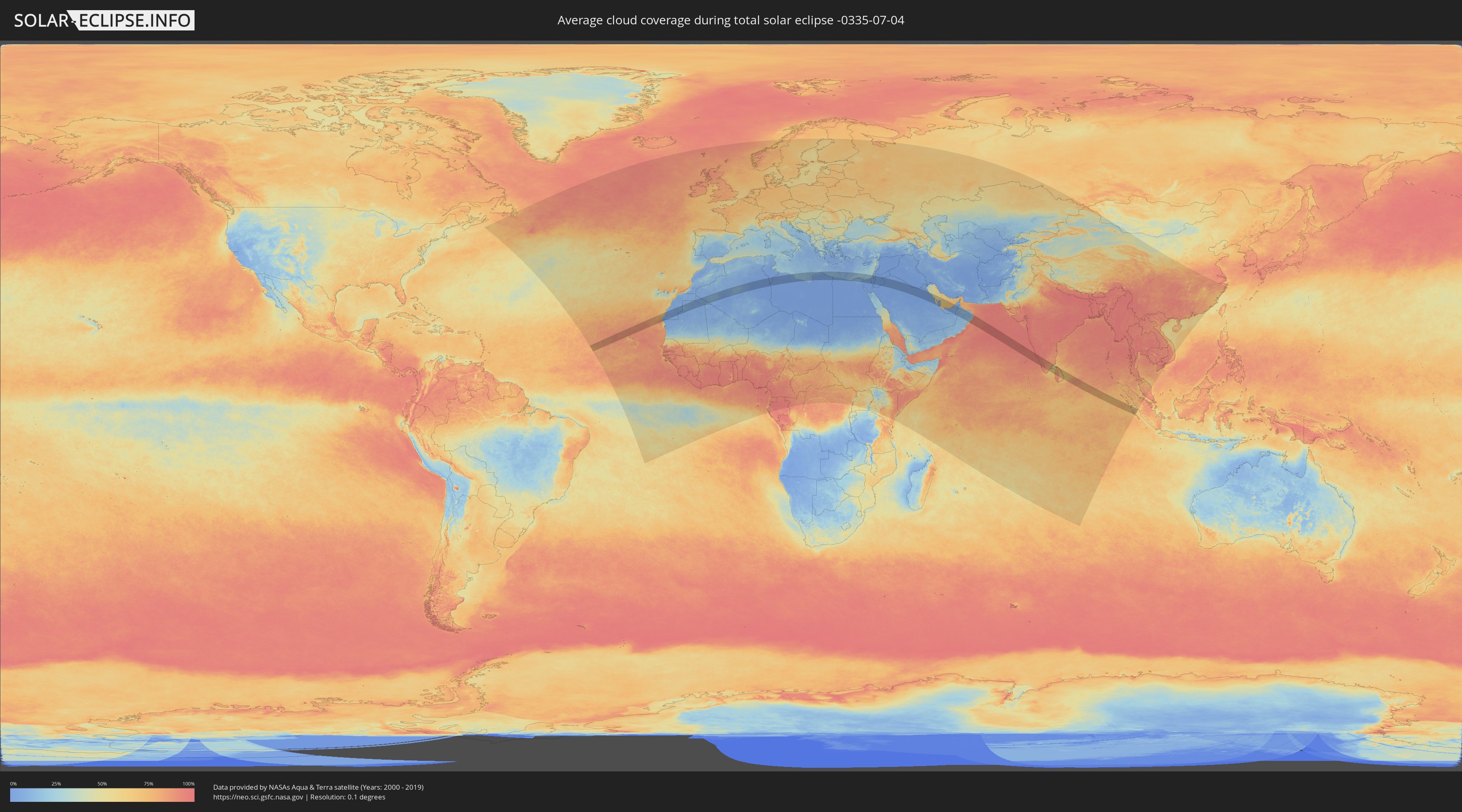
How will be the weather during the total solar eclipse on 07/04/-0335?
Where is the best place to see the total solar eclipse of 07/04/-0335?
The following maps show the average cloud coverage for the day of the total solar eclipse.
With the help of these maps, it is possible to find the place along the eclipse path, which has the best
chance of a cloudless sky.
Nevertheless, you should consider local circumstances and inform about the weather of your chosen
observation site.
The data is provided by NASAs satellites
AQUA and TERRA.
The cloud maps are averaged over a period of 19 years (2000 - 2019).
Detailed country maps
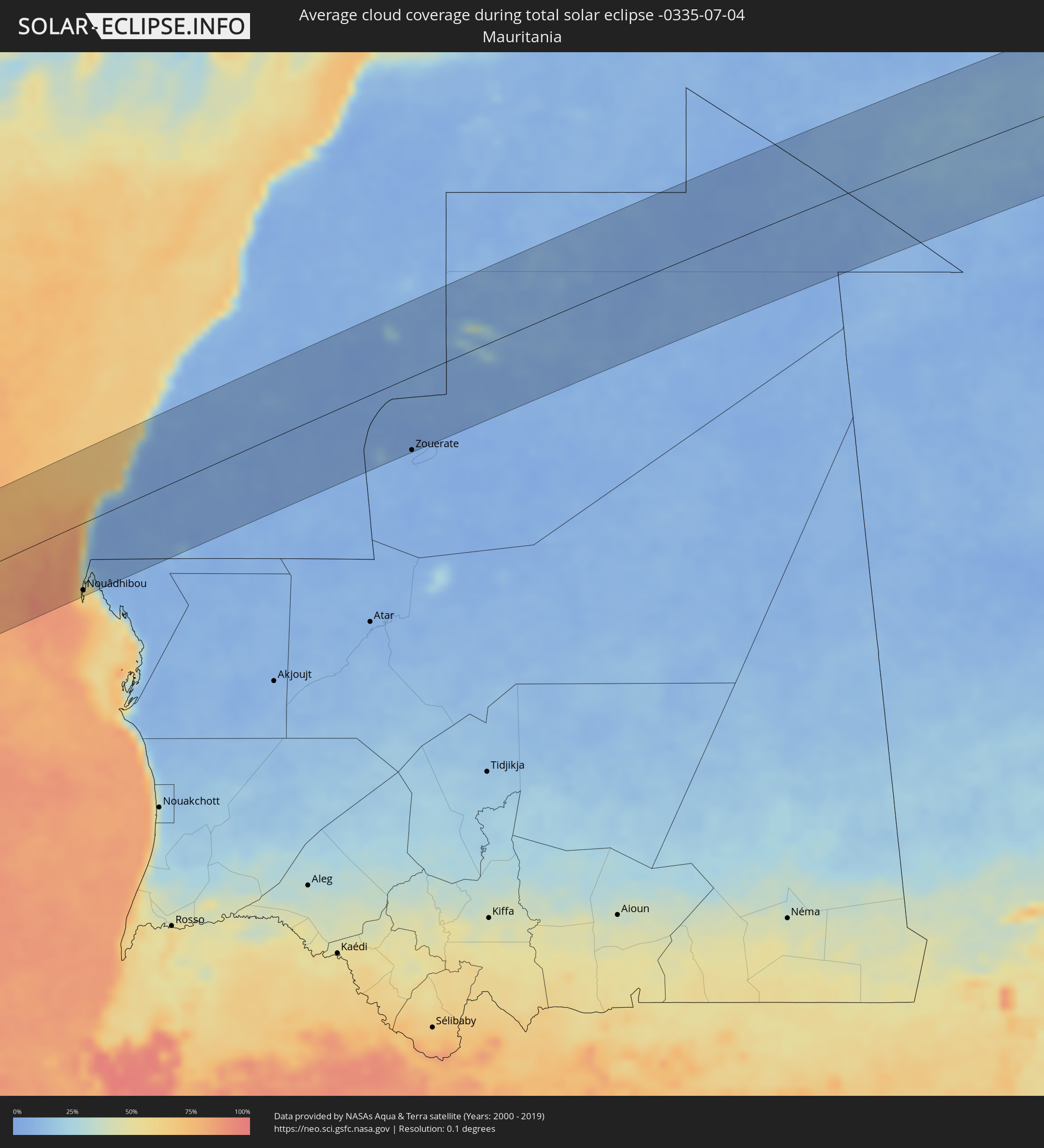 Mauritania
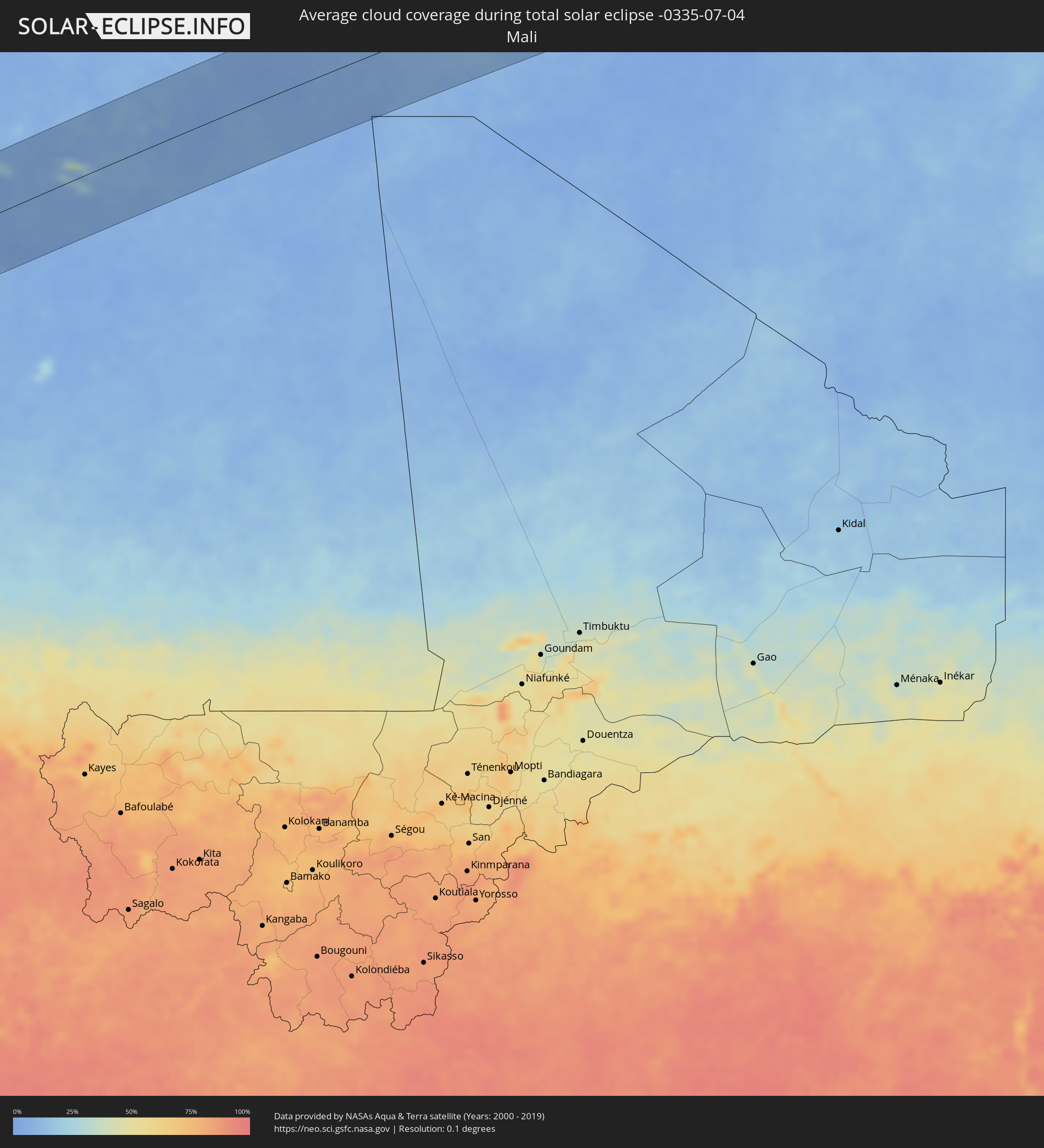 Mali
Mali
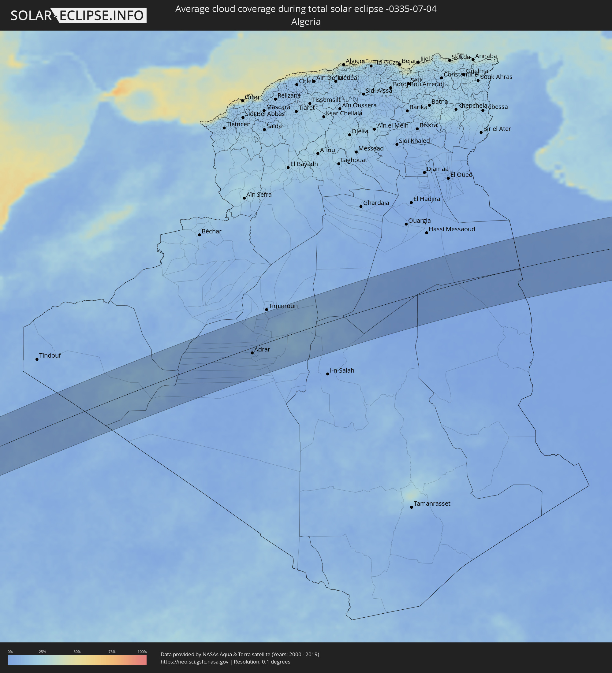 Algeria
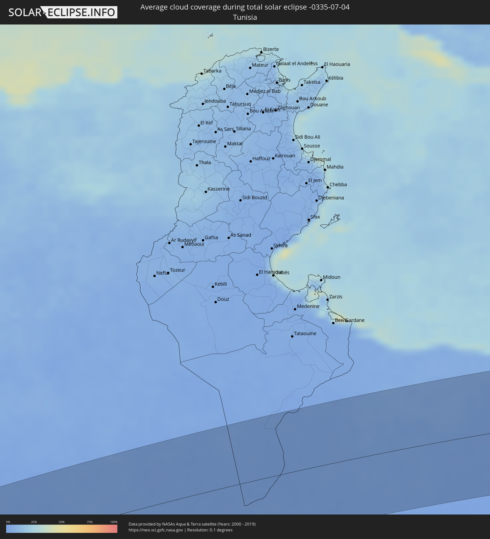 Tunisia
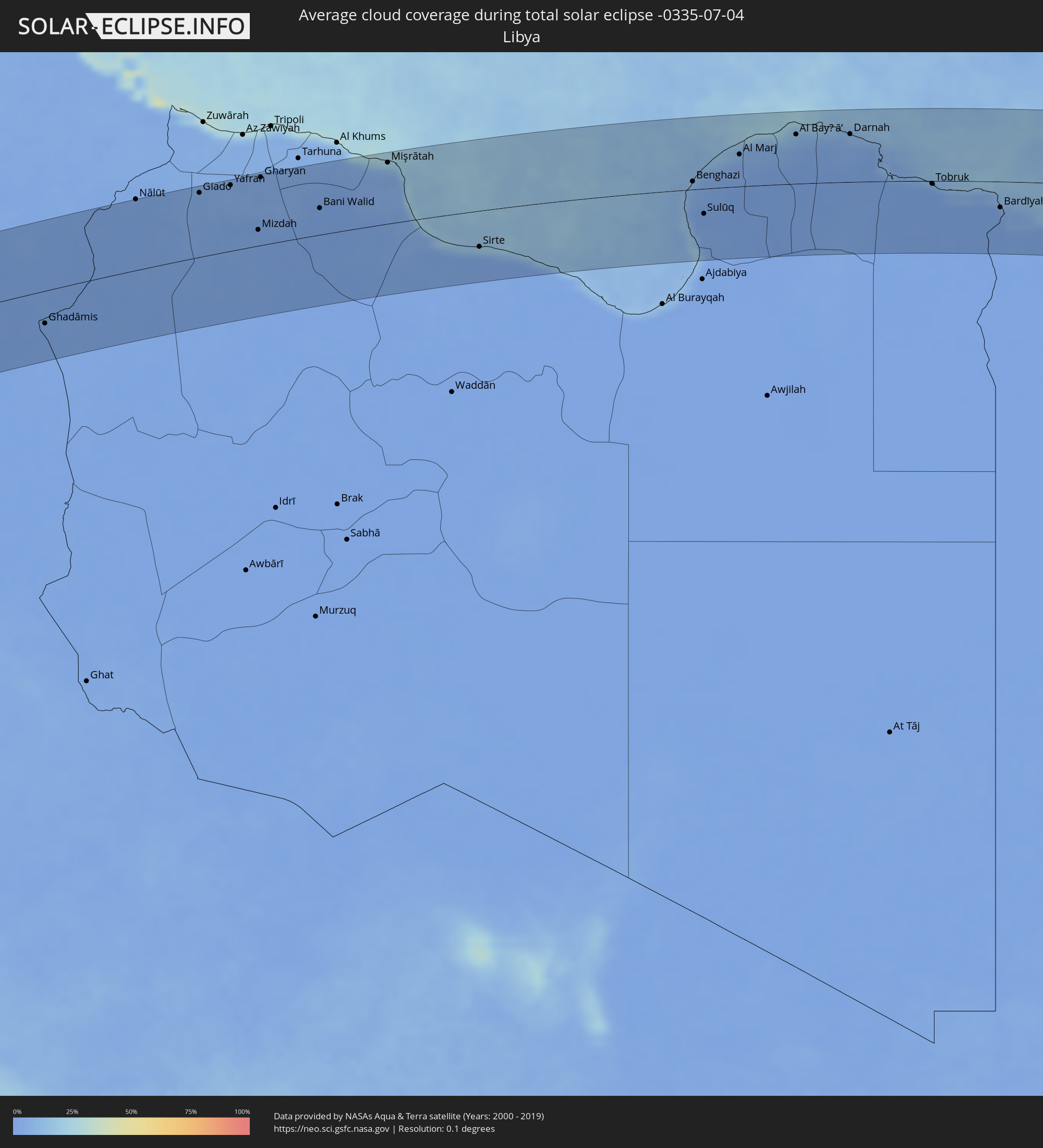 Libya
Libya
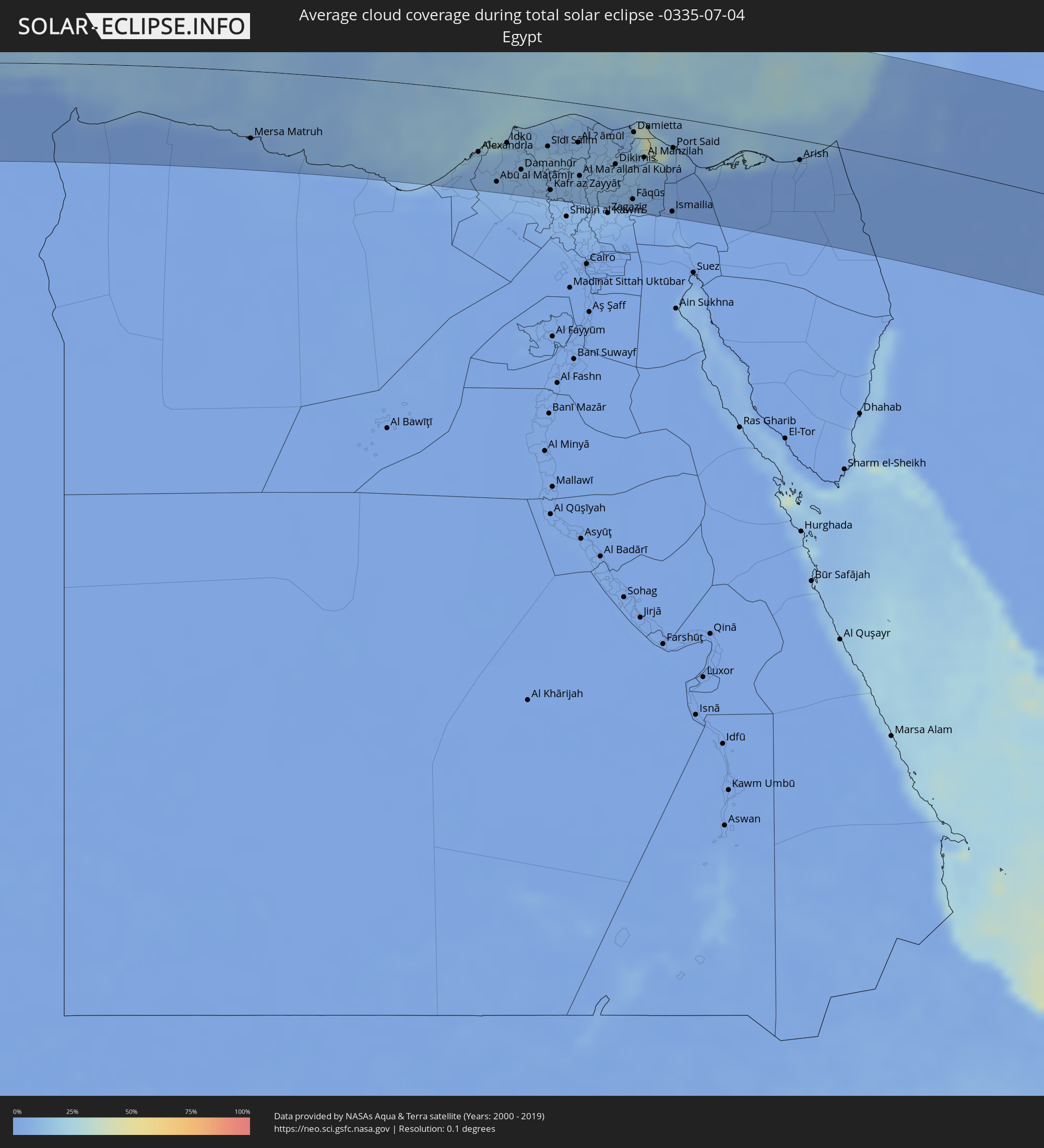 Egypt
Egypt
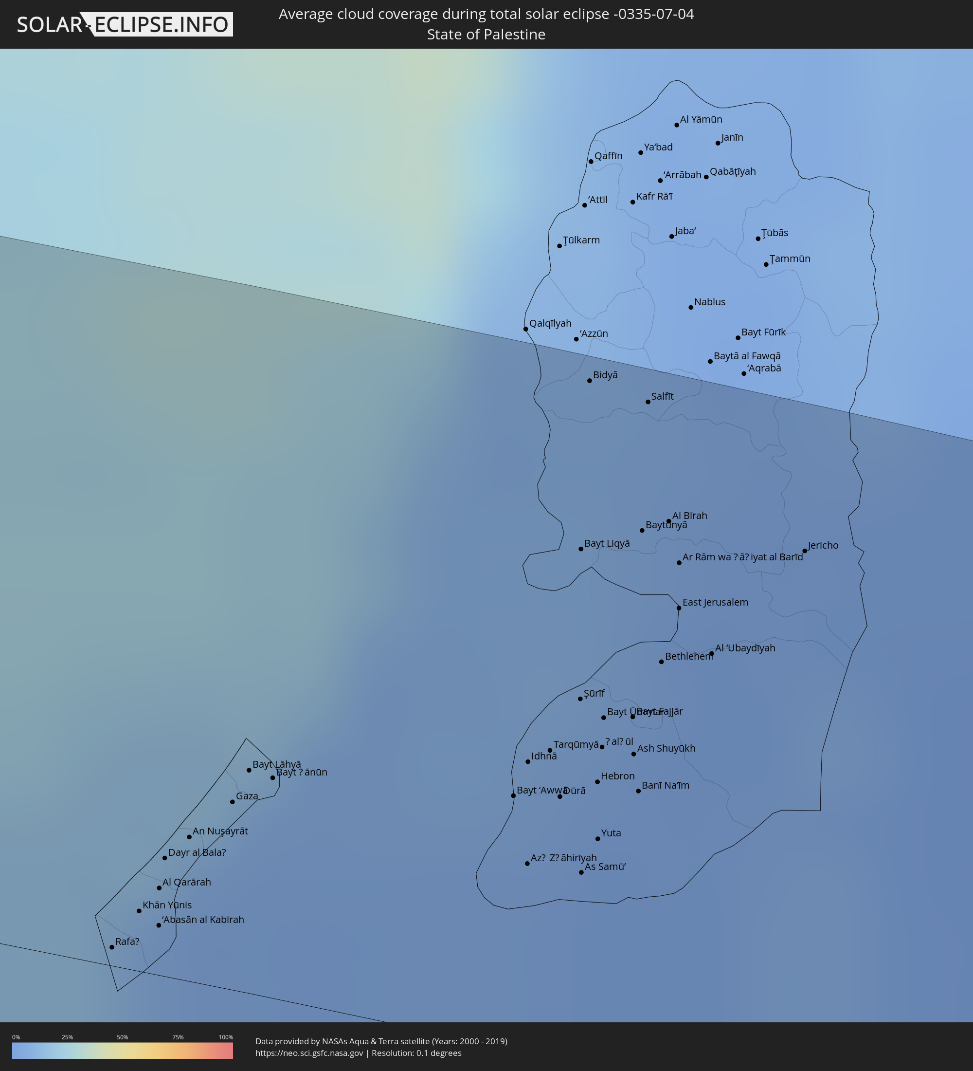 State of Palestine
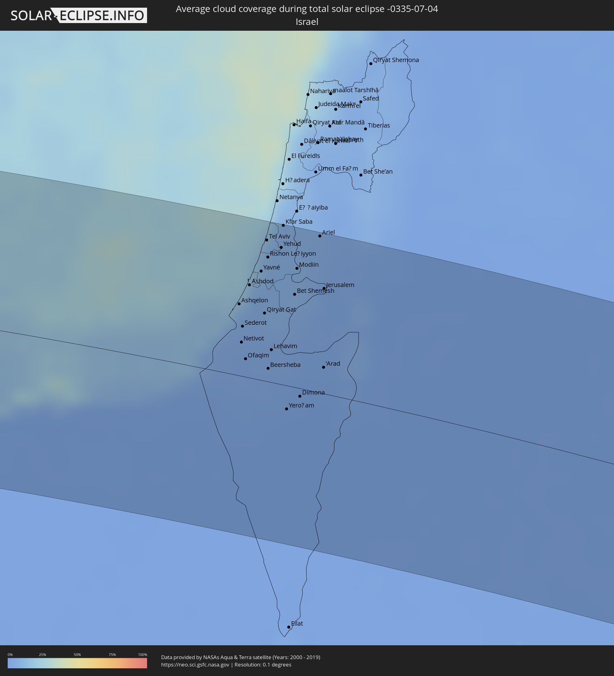 Israel
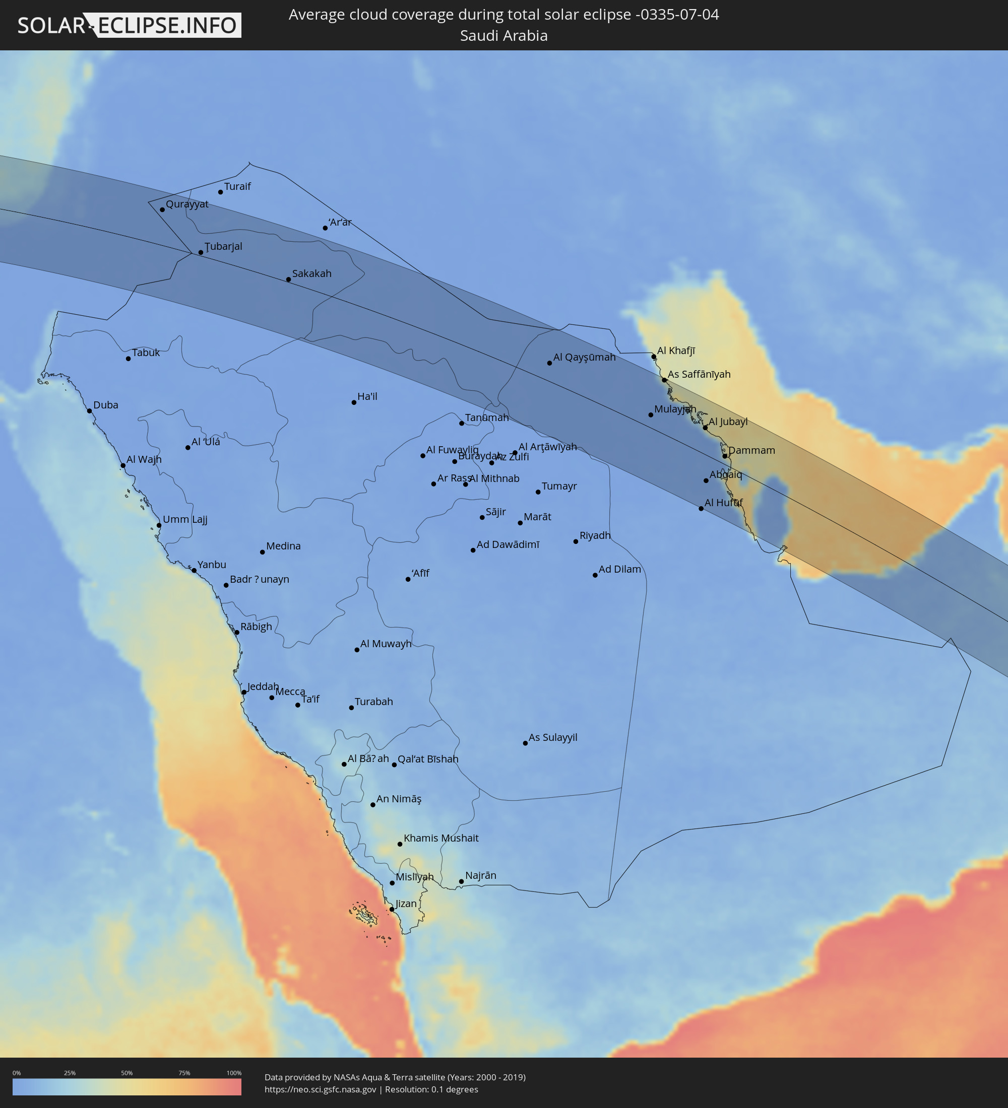 Saudi Arabia
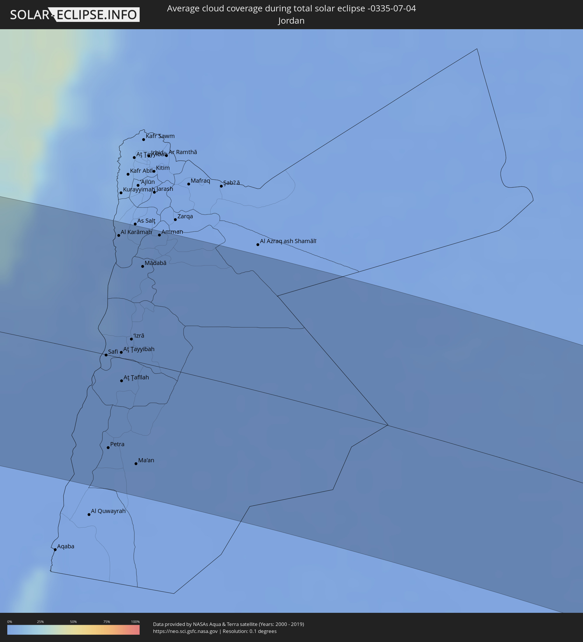 Jordan
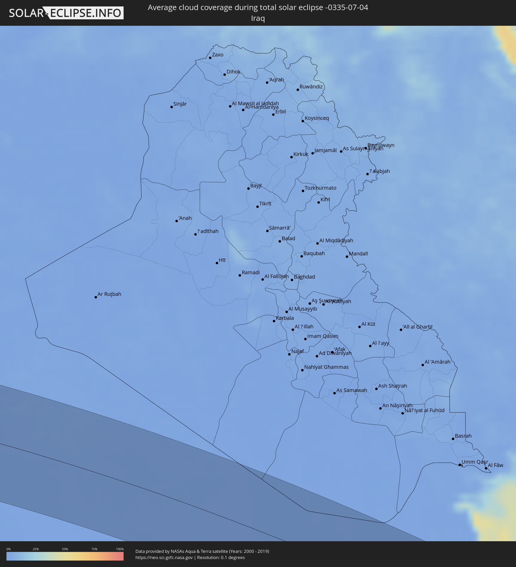 Iraq
Iraq
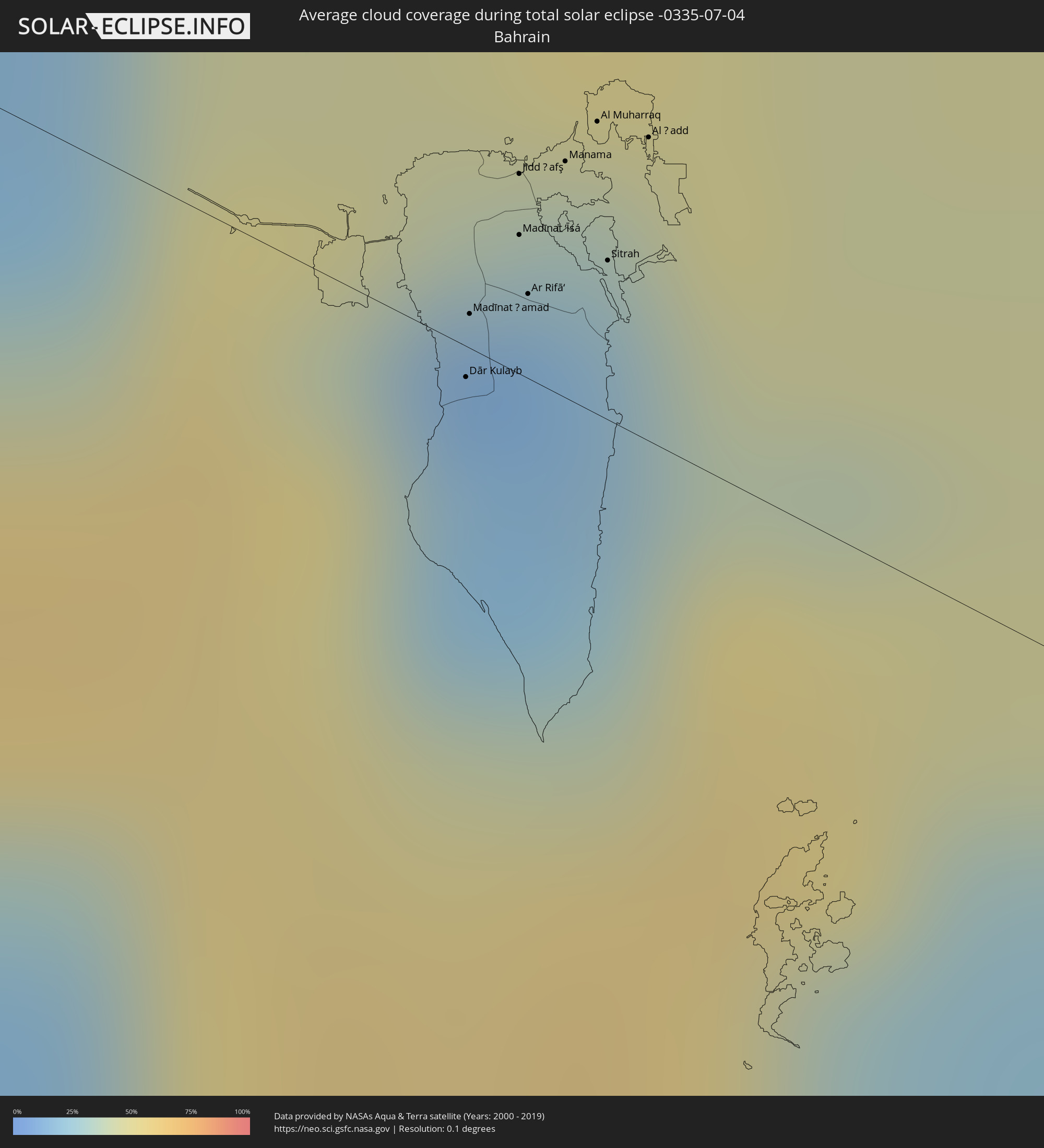 Bahrain
 Qatar
Qatar
 United Arab Emirates
 Oman
Oman
 India
India
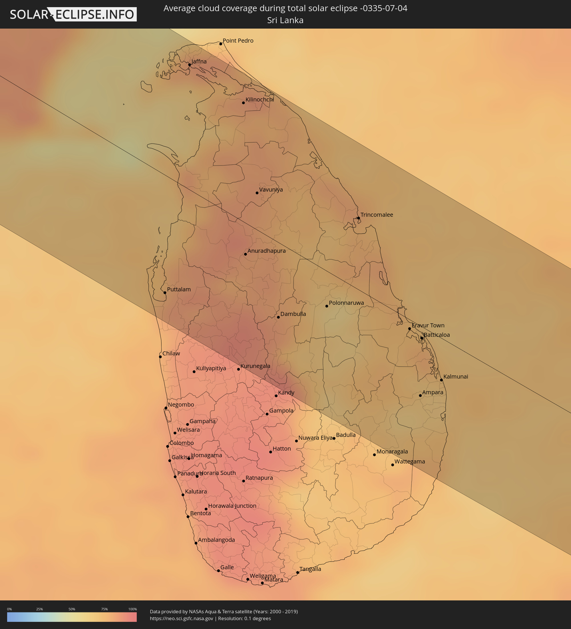 Sri Lanka
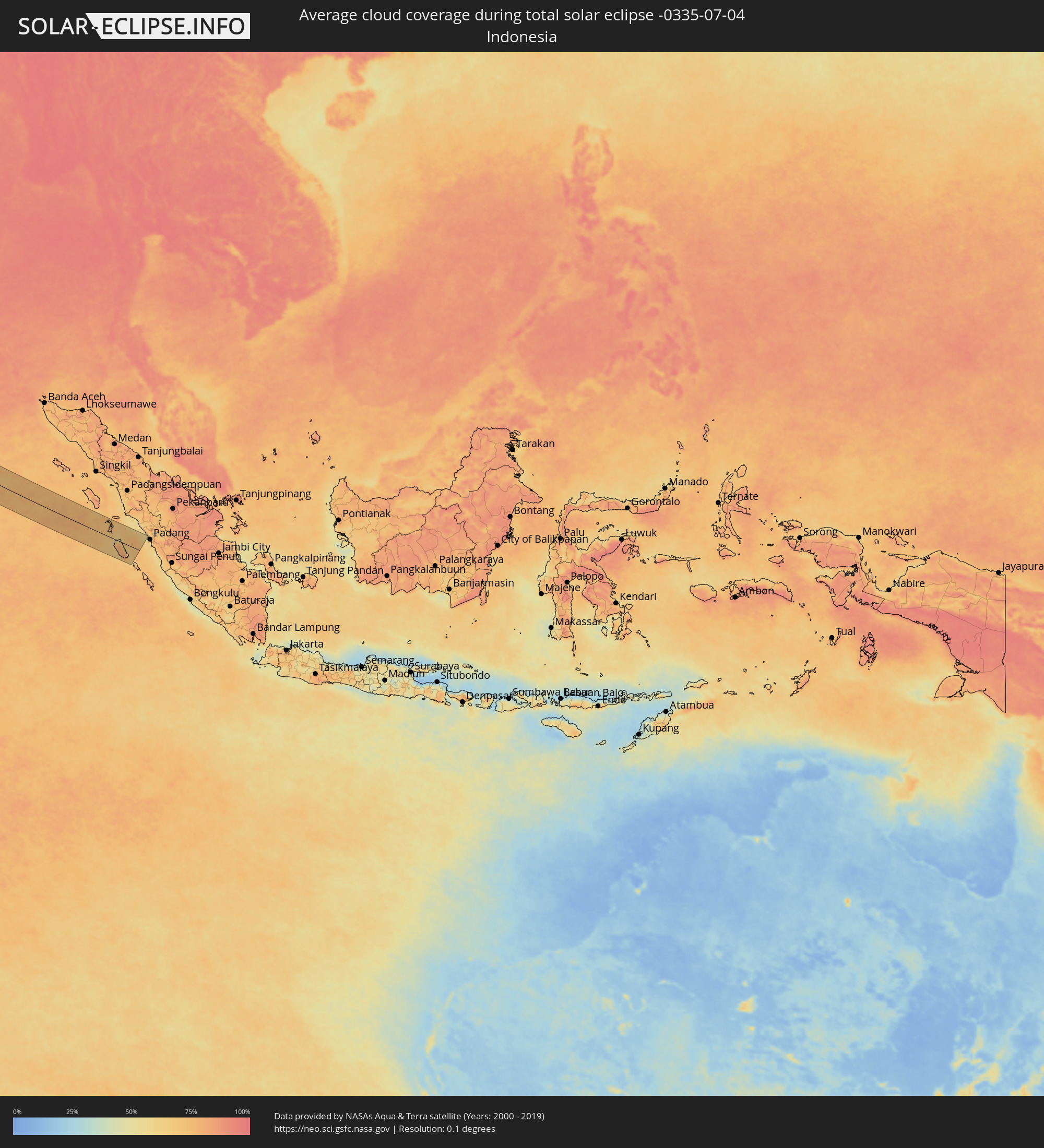 Indonesia
Cities inside the path of the eclipse
The following table shows all locations with a population of more than 5,000 inside the eclipse path. Cities which have more than 100,000 inhabitants are marked bold. A click at the locations opens a detailed map.
| City | Type | Eclipse duration | Local time of max. eclipse | Distance to central line | Ø Cloud coverage |
|
Nouâdhibou, Dakhlet Nouadhibou
|
total | - | 07:39:42 UTC-00:16 | 88 km | 63% |
|
Zouerate, Tiris Zemmour
|
total | - | 07:43:18 UTC-00:16 | 96 km | 4% |
|
Adrar, Adrar
|
total | - | 08:23:48 UTC+00:09 | 19 km | 7% |
|
Nālūt, Sha‘bīyat Nālūt
|
total | - | 09:26:49 UTC+00:52 | 108 km | 2% |
|
Zintan, Jabal al Gharbi District
|
total | - | 09:29:05 UTC+00:52 | 90 km | 3% |
|
Yafran, Jabal al Gharbi District
|
total | - | 09:29:40 UTC+00:52 | 100 km | 4% |
|
Mizdah, Jabal al Gharbi District
|
total | - | 09:30:05 UTC+00:52 | 24 km | 1% |
|
Gharyan, Jabal al Gharbi District
|
total | - | 09:30:37 UTC+00:52 | 103 km | 4% |
|
Bani Walid, Mişrātah
|
total | - | 09:32:08 UTC+00:52 | 41 km | 1% |
|
Mişrātah, Mişrātah
|
total | - | 09:34:35 UTC+00:52 | 93 km | 10% |
|
Sirte, Surt
|
total | - | 09:36:55 UTC+00:52 | 55 km | 4% |
|
Benghazi, Banghāzī
|
total | - | 09:44:34 UTC+00:52 | 12 km | 5% |
|
Al Abyār, Al Marj
|
total | - | 09:45:44 UTC+00:52 | 17 km | 2% |
|
Al Marj, Al Marj
|
total | - | 09:46:19 UTC+00:52 | 49 km | 3% |
|
Al Bayḑā’, Al Jabal al Akhḑar
|
total | - | 09:48:24 UTC+00:52 | 76 km | 7% |
|
Al Qubbah, Darnah
|
total | - | 09:49:28 UTC+00:52 | 74 km | 6% |
|
Darnah, Darnah
|
total | - | 09:50:20 UTC+00:52 | 73 km | 8% |
|
Tobruk, Sha‘bīyat al Buţnān
|
total | - | 09:53:14 UTC+00:52 | 4 km | 5% |
|
Alexandria, Alexandria
|
total | - | 11:14:49 UTC+02:00 | 69 km | 10% |
|
Kafr ad Dawwār, Beheira
|
total | - | 11:15:16 UTC+02:00 | 76 km | 10% |
|
Idkū, Beheira
|
total | - | 11:15:38 UTC+02:00 | 55 km | 10% |
|
Damanhūr, Beheira
|
total | - | 11:16:08 UTC+02:00 | 83 km | 10% |
|
Disūq, Kafr el-Sheikh
|
total | - | 11:16:33 UTC+02:00 | 70 km | 10% |
|
Kafr ash Shaykh, Kafr el-Sheikh
|
total | - | 11:17:16 UTC+02:00 | 68 km | 12% |
|
Tanda, Gharbia
|
total | - | 11:17:32 UTC+02:00 | 103 km | 9% |
|
Al Maḩallah al Kubrá, Gharbia
|
total | - | 11:17:53 UTC+02:00 | 81 km | 12% |
|
Bilqās, Dakahlia
|
total | - | 11:18:16 UTC+02:00 | 52 km | 12% |
|
Al Manşūrah, Dakahlia
|
total | - | 11:18:23 UTC+02:00 | 71 km | 11% |
|
Dikirnis, Dakahlia
|
total | - | 11:18:54 UTC+02:00 | 62 km | 13% |
|
Abū Kabīr, Sharqia
|
total | - | 11:19:14 UTC+02:00 | 101 km | 9% |
|
Ismailia, Ismailia
|
total | - | 11:20:47 UTC+02:00 | 106 km | 2% |
|
Port Said, Port Said
|
total | - | 11:20:32 UTC+02:00 | 34 km | 16% |
|
Arish, North Sinai
|
total | - | 11:24:20 UTC+02:00 | 23 km | 1% |
|
Khān Yūnis, Gaza Strip
|
total | - | 11:25:28 UTC+02:00 | 10 km | 3% |
|
‘Abasān al Jadīdah
|
total | - | 11:25:34 UTC+02:00 | 10 km | 3% |
|
Gaza, Gaza Strip
|
total | - | 11:25:46 UTC+02:00 | 30 km | 4% |
|
Ashqelon, Southern District
|
total | - | 11:46:36 UTC+02:20 | 50 km | 6% |
|
Netivot, Southern District
|
total | - | 11:46:47 UTC+02:20 | 24 km | 3% |
|
Ashdod, Southern District
|
total | - | 11:46:43 UTC+02:20 | 65 km | 14% |
|
Qiryat Gat, Southern District
|
total | - | 11:47:06 UTC+02:20 | 48 km | 6% |
|
Tel Aviv, Tel Aviv
|
total | - | 11:46:53 UTC+02:20 | 99 km | 9% |
|
Beersheba, Southern District
|
total | - | 11:47:22 UTC+02:20 | 9 km | 2% |
|
Ness Ziona, Central District
|
total | - | 11:47:00 UTC+02:20 | 83 km | 6% |
|
Kfar Saba, Central District
|
total | - | 11:47:08 UTC+02:20 | 112 km | 6% |
|
Az̧ Z̧āhirīyah, West Bank
|
total | - | 11:27:03 UTC+02:00 | 30 km | 2% |
|
Dayr Sāmit
|
total | - | 11:27:00 UTC+02:00 | 42 km | 3% |
|
Kafr Qāsim, Central District
|
total | - | 11:47:20 UTC+02:20 | 107 km | 6% |
|
Ḩablah, West Bank
|
total | - | 11:26:38 UTC+02:00 | 112 km | 6% |
|
Oranit, West Bank
|
total | - | 11:26:41 UTC+02:00 | 109 km | 6% |
|
Bet Shemesh, Jerusalem
|
total | - | 11:47:35 UTC+02:20 | 65 km | 6% |
|
Modiin, Central District
|
total | - | 11:47:32 UTC+02:20 | 84 km | 7% |
|
Dimona, Southern District
|
total | - | 11:48:04 UTC+02:20 | 6 km | 1% |
|
Bayt Liqyā, West Bank
|
total | - | 11:27:01 UTC+02:00 | 82 km | 6% |
|
Hebron, West Bank
|
total | - | 11:27:17 UTC+02:00 | 45 km | 2% |
|
Naḩḩālīn, West Bank
|
total | - | 11:27:15 UTC+02:00 | 63 km | 4% |
|
Biddū, West Bank
|
total | - | 11:27:14 UTC+02:00 | 80 km | 6% |
|
Az Zaytūnīyah, West Bank
|
total | - | 11:27:12 UTC+02:00 | 93 km | 4% |
|
Salfīt, West Bank
|
total | - | 11:27:10 UTC+02:00 | 107 km | 5% |
|
Ariel, Jerusalem
|
total | - | 11:27:10 UTC+02:00 | 110 km | 5% |
|
‘Arad, Southern District
|
total | - | 11:48:24 UTC+02:20 | 18 km | 1% |
|
Jerusalem, Jerusalem
|
total | - | 11:48:06 UTC+02:20 | 74 km | 3% |
|
East Jerusalem, West Bank
|
total | - | 11:48:08 UTC+02:20 | 76 km | 3% |
|
Jericho, West Bank
|
total | - | 11:27:56 UTC+02:00 | 89 km | 2% |
|
Safi, Karak
|
total | - | 11:52:13 UTC+02:23 | 1 km | 1% |
|
Petra, Ma’an
|
total | - | 11:52:43 UTC+02:23 | 78 km | 0% |
|
Al Karāmah, Balqa
|
total | - | 11:51:56 UTC+02:23 | 101 km | 2% |
|
Aţ Ţafīlah, Tafielah
|
total | - | 11:52:41 UTC+02:23 | 19 km | 0% |
|
Buşayrā, Tafielah
|
total | - | 11:52:46 UTC+02:23 | 31 km | 0% |
|
‘Ayy, Karak
|
total | - | 11:52:35 UTC+02:23 | 14 km | 1% |
|
‘Izrā, Karak
|
total | - | 11:52:42 UTC+02:23 | 18 km | 1% |
|
Al Mazār al Janūbī, Karak
|
total | - | 11:52:45 UTC+02:23 | 8 km | 1% |
|
Qīr Moāv, Ma’an
|
total | - | 11:52:42 UTC+02:23 | 20 km | 1% |
|
Ma'an, Ma’an
|
total | - | 11:53:25 UTC+02:23 | 86 km | 1% |
|
Karak City, Karak
|
total | - | 11:52:52 UTC+02:23 | 20 km | 0% |
|
Mādabā, Madaba
|
total | - | 11:52:36 UTC+02:23 | 80 km | 0% |
|
Umm as Summāq, Amman
|
total | - | 11:52:38 UTC+02:23 | 100 km | 0% |
|
Jāwā, Amman
|
total | - | 11:52:51 UTC+02:23 | 98 km | 0% |
|
Amman, Amman
|
total | - | 11:52:48 UTC+02:23 | 109 km | 1% |
|
Qurayyat, Al Jawf
|
total | - | 12:39:43 UTC+03:06 | 74 km | 0% |
|
Ţubarjal, Al Jawf
|
total | - | 12:42:27 UTC+03:06 | 6 km | 0% |
|
Sakakah, Al Jawf
|
total | - | 12:47:42 UTC+03:06 | 5 km | 0% |
|
Al Qayşūmah, Eastern Province
|
total | - | 13:03:12 UTC+03:06 | 37 km | 0% |
|
Al Mubarraz, Eastern Province
|
total | - | 13:14:23 UTC+03:06 | 110 km | 4% |
|
Al Qurayn, Eastern Province
|
total | - | 13:14:20 UTC+03:06 | 101 km | 4% |
|
Al Jubayl, Eastern Province
|
total | - | 13:12:26 UTC+03:06 | 53 km | 21% |
|
Al Munayzilah, Eastern Province
|
total | - | 13:14:36 UTC+03:06 | 108 km | 3% |
|
Abqaiq, Eastern Province
|
total | - | 13:13:53 UTC+03:06 | 53 km | 1% |
|
Aţ Ţaraf, Eastern Province
|
total | - | 13:14:45 UTC+03:06 | 108 km | 3% |
|
Umm as Sāhik, Eastern Province
|
total | - | 13:13:26 UTC+03:06 | 29 km | 3% |
|
Tārūt, Eastern Province
|
total | - | 13:13:48 UTC+03:06 | 27 km | 11% |
|
Raḩīmah, Eastern Province
|
total | - | 13:13:40 UTC+03:06 | 41 km | 42% |
|
Dammam, Eastern Province
|
total | - | 13:14:07 UTC+03:06 | 16 km | 4% |
|
Khobar, Eastern Province
|
total | - | 13:14:32 UTC+03:06 | 5 km | 23% |
|
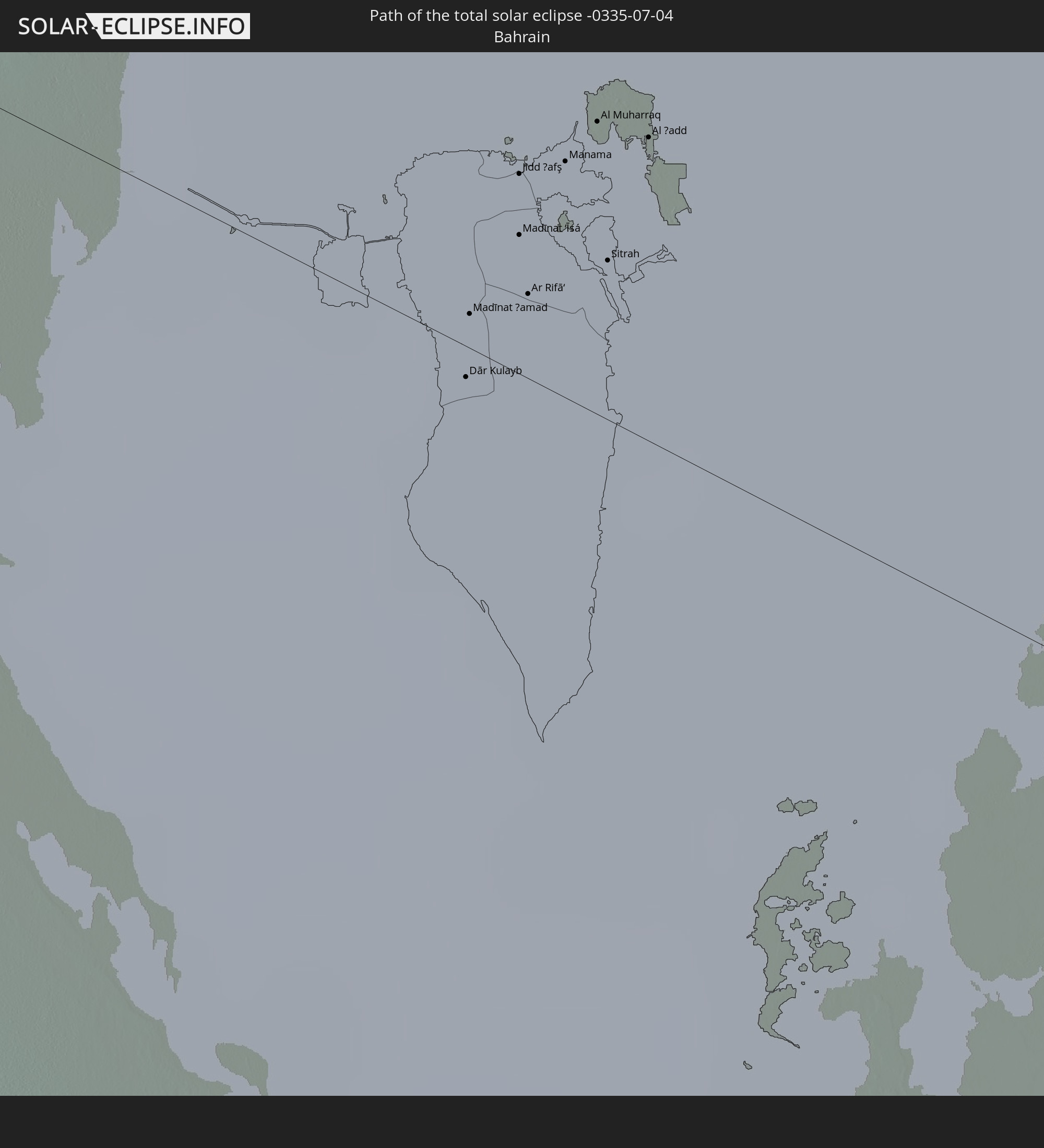
Dār Kulayb, Southern Governorate
|
total | - | 13:34:42 UTC+03:26 | 2 km | 19% |
|
Madīnat Ḩamad, Central Governorate
|
total | - | 13:34:38 UTC+03:26 | 3 km | 19% |
|
Jidd Ḩafş, Manama
|
total | - | 13:34:35 UTC+03:26 | 15 km | 13% |
|
Madīnat ‘Īsá, Southern Governorate
|
total | - | 13:34:39 UTC+03:26 | 10 km | 13% |
|
Ar Rifā‘, Southern Governorate
|
total | - | 13:34:43 UTC+03:26 | 6 km | 18% |
|
Manama, Manama
|
total | - | 13:34:39 UTC+03:26 | 17 km | 18% |
|
Al Muharraq, Muharraq
|
total | - | 13:34:40 UTC+03:26 | 21 km | 34% |
|
Sitrah, Manama
|
total | - | 13:34:49 UTC+03:26 | 12 km | 18% |
|
Al Ḩadd, Muharraq
|
total | - | 13:34:46 UTC+03:26 | 22 km | 42% |
|
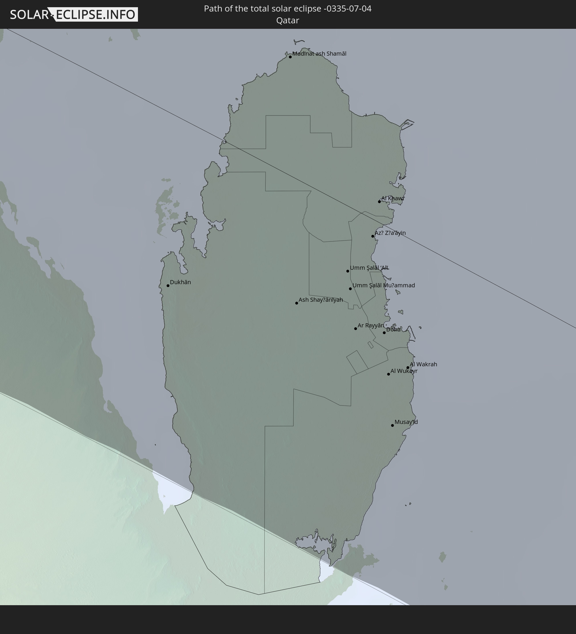
Dukhān, Baladīyat ar Rayyān
|
total | - | 13:36:08 UTC+03:26 | 53 km | 17% |
|
Madīnat ash Shamāl, Madīnat ash Shamāl
|
total | - | 13:36:02 UTC+03:26 | 36 km | 7% |
|
Ash Shayḩānīyah, Baladīyat ar Rayyān
|
total | - | 13:37:06 UTC+03:26 | 38 km | 3% |
|
Umm Şalāl ‘Alī, Baladīyat Umm Şalāl
|
total | - | 13:37:19 UTC+03:26 | 20 km | 5% |
|
Umm Şalāl Muḩammad, Baladīyat Umm Şalāl
|
total | - | 13:37:25 UTC+03:26 | 25 km | 3% |
|
Ar Rayyān, Baladīyat ar Rayyān
|
total | - | 13:37:37 UTC+03:26 | 36 km | 2% |
|
Az̧ Z̧a‘āyin, Baladīyat az̧ Z̧a‘āyin
|
total | - | 13:37:21 UTC+03:26 | 5 km | 37% |
|
Al Khawr, Al Khawr
|
total | - | 13:37:15 UTC+03:26 | 6 km | 20% |
|
Doha, Baladīyat ad Dawḩah
|
total | - | 13:37:50 UTC+03:26 | 33 km | 8% |
|
Al Wukayr, Al Wakrah
|
total | - | 13:38:02 UTC+03:26 | 45 km | 6% |
|
Musay‘īd, Al Wakrah
|
total | - | 13:38:17 UTC+03:26 | 60 km | 38% |
|
Al Wakrah, Al Wakrah
|
total | - | 13:38:09 UTC+03:26 | 39 km | 29% |
|
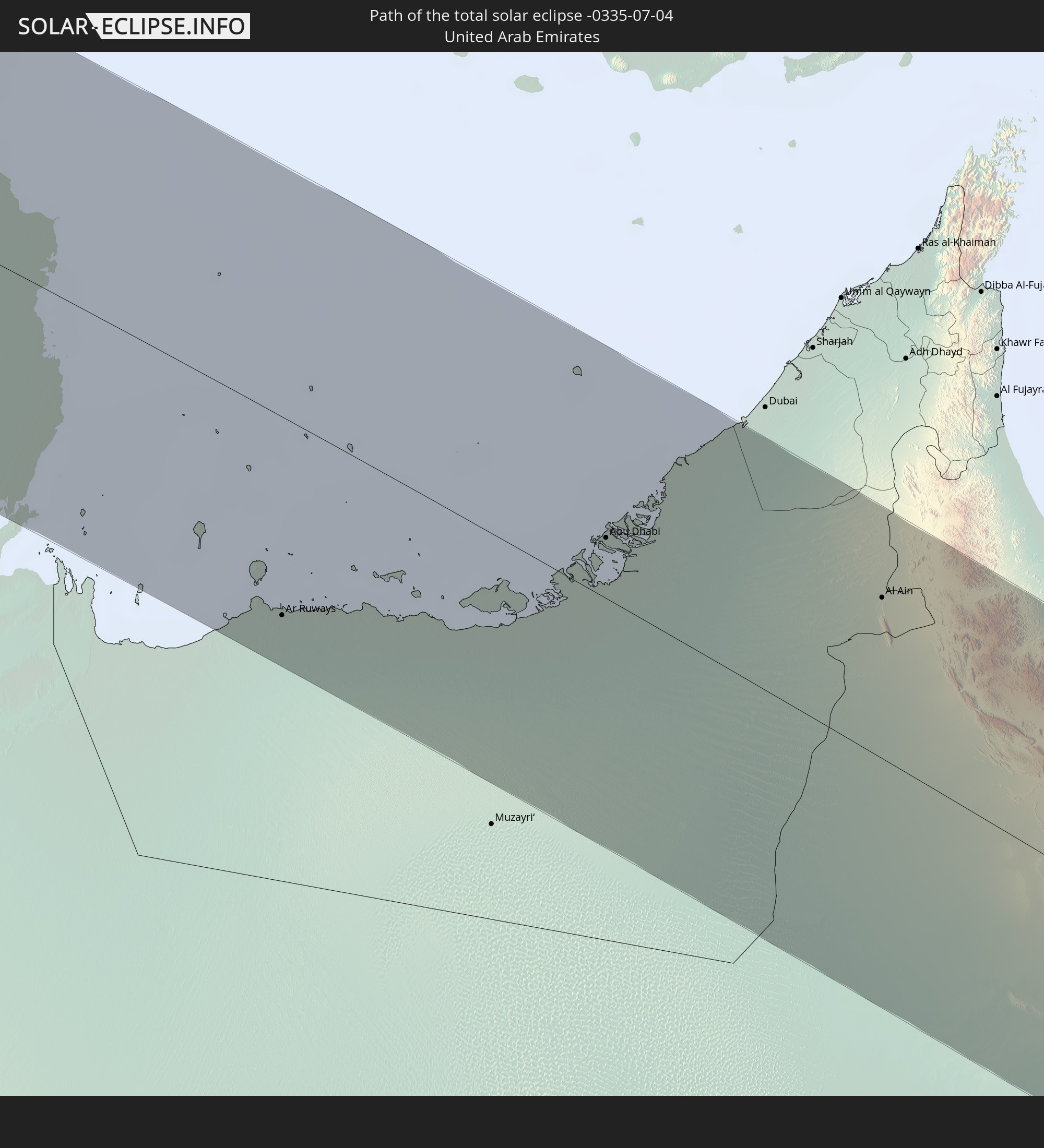
Ar Ruways, Abu Dhabi
|
total | - | 13:56:54 UTC+03:41 | 89 km | 5% |
|
Abu Dhabi, Abu Dhabi
|
total | - | 13:59:31 UTC+03:41 | 27 km | 25% |
|
Al Ain, Abu Dhabi
|
total | - | 14:02:26 UTC+03:41 | 71 km | 7% |
|
Al Buraymī, Al Buraimi
|
total | - | 14:02:24 UTC+03:41 | 79 km | 8% |
|
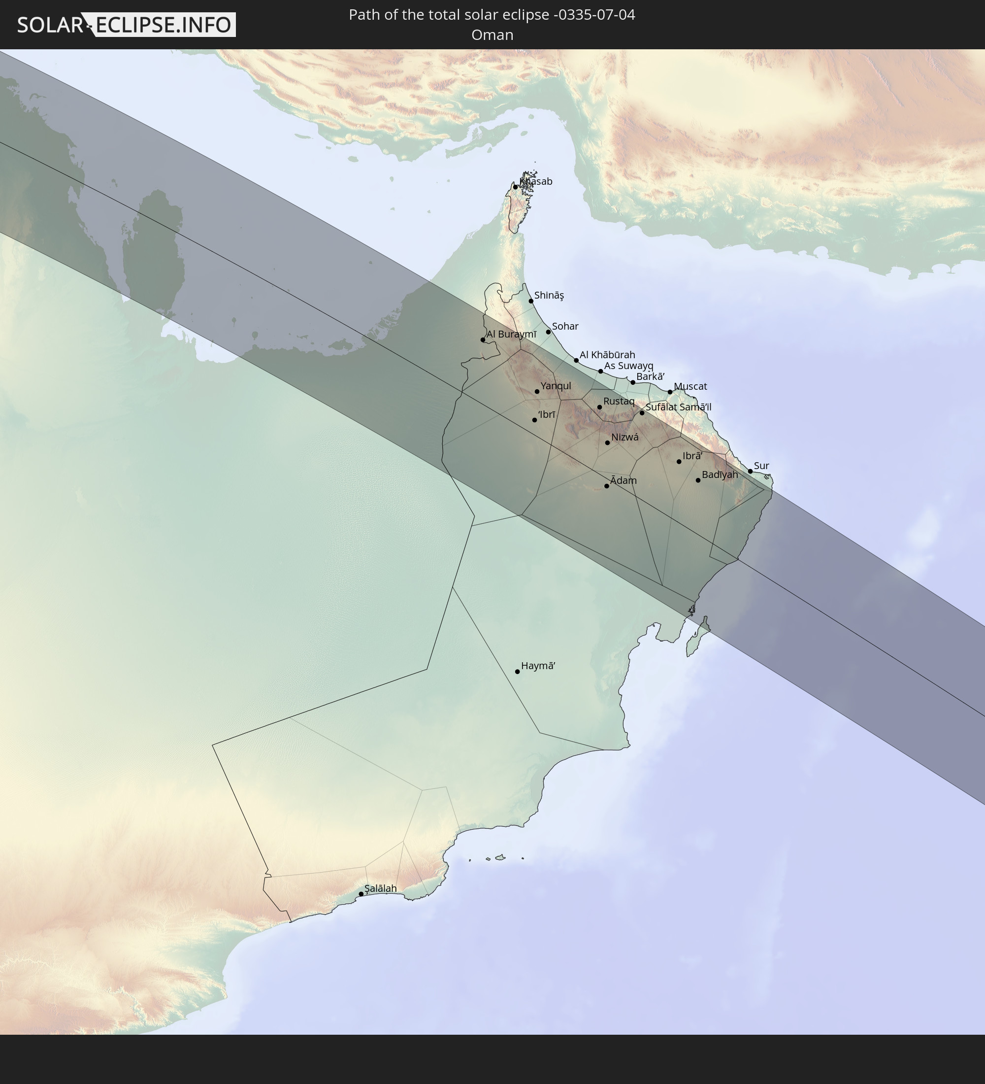
‘Ibrī, Az̧ Z̧āhirah
|
total | - | 14:05:08 UTC+03:41 | 18 km | 11% |
|
Yanqul, Az̧ Z̧āhirah
|
total | - | 14:04:40 UTC+03:41 | 55 km | 12% |
|
Bahlā’, Muḩāfaz̧at ad Dākhilīyah
|
total | - | 14:06:50 UTC+03:41 | 35 km | 13% |
|
Rustaq, Al Batinah South Governorate
|
total | - | 14:06:26 UTC+03:41 | 82 km | 15% |
|
Ādam, Muḩāfaz̧at ad Dākhilīyah
|
total | - | 14:08:04 UTC+03:41 | 10 km | 12% |
|
Bayt al ‘Awābī, Al Batinah South Governorate
|
total | - | 14:06:44 UTC+03:41 | 79 km | 16% |
|
Nizwá, Muḩāfaz̧at ad Dākhilīyah
|
total | - | 14:07:17 UTC+03:41 | 44 km | 12% |
|
Izkī, Muḩāfaz̧at ad Dākhilīyah
|
total | - | 14:07:40 UTC+03:41 | 56 km | 14% |
|
Sufālat Samā’il, Muḩāfaz̧at ad Dākhilīyah
|
total | - | 14:07:32 UTC+03:41 | 106 km | 9% |
|
Ibrā’, Ash Sharqiyah North Governorate
|
total | - | 14:09:16 UTC+03:41 | 75 km | 12% |
|
Al Qābil, Ash Sharqiyah North Governorate
|
total | - | 14:09:42 UTC+03:41 | 72 km | 11% |
|
Badīyah, Ash Sharqiyah North Governorate
|
total | - | 14:10:03 UTC+03:41 | 66 km | 11% |
|
Mangalore, Karnataka
|
total | - | 16:21:01 UTC+05:21 | 98 km | 96% |
|
Tellicherry, Kerala
|
total | - | 16:22:46 UTC+05:21 | 24 km | 89% |
|
Kozhikode, Kerala
|
total | - | 16:23:30 UTC+05:21 | 6 km | 89% |
|
Ponnāni, Kerala
|
total | - | 16:24:07 UTC+05:21 | 43 km | 88% |
|
Trichūr, Kerala
|
total | - | 16:24:34 UTC+05:21 | 50 km | 92% |
|
Cochin, Kerala
|
total | - | 16:25:11 UTC+05:21 | 102 km | 89% |
|
Palakkad, Kerala
|
total | - | 16:24:34 UTC+05:21 | 1 km | 94% |
|
Ooty, Tamil Nadu
|
total | - | 16:23:55 UTC+05:21 | 62 km | 90% |
|
Coimbatore, Tamil Nadu
|
total | - | 16:24:31 UTC+05:21 | 39 km | 88% |
|
Tiruppur, Tamil Nadu
|
total | - | 16:24:38 UTC+05:21 | 72 km | 88% |
|
Teni, Tamil Nadu
|
total | - | 16:25:51 UTC+05:21 | 25 km | 84% |
|
Rajapalaiyam, Tamil Nadu
|
total | - | 16:26:28 UTC+05:21 | 75 km | 86% |
|
Dindigul, Tamil Nadu
|
total | - | 16:25:46 UTC+05:21 | 37 km | 83% |
|
Madurai, Tamil Nadu
|
total | - | 16:26:19 UTC+05:21 | 2 km | 83% |
|
Pudukkottai, Tamil Nadu
|
total | - | 16:26:13 UTC+05:21 | 86 km | 82% |
|
Puttalam, North Western
|
total | - | 16:27:23 UTC+05:19 | 81 km | 80% |
|
Jaffna, Northern Province
|
total | - | 16:25:54 UTC+05:19 | 85 km | 80% |
|
Kilinochchi, Northern Province
|
total | - | 16:26:21 UTC+05:19 | 81 km | 80% |
|
Anuradhapura, North Central
|
total | - | 16:27:24 UTC+05:19 | 22 km | 82% |
|
Vavuniya, Northern Province
|
total | - | 16:27:01 UTC+05:19 | 25 km | 83% |
|
Dambulla, Central
|
total | - | 16:27:55 UTC+05:19 | 52 km | 81% |
|
Polonnaruwa, North Central
|
total | - | 16:28:00 UTC+05:19 | 24 km | 62% |
|
Trincomalee, Eastern Province
|
total | - | 16:27:30 UTC+05:19 | 49 km | 76% |
|
Eravur Town, Eastern Province
|
total | - | 16:28:23 UTC+05:19 | 6 km | 74% |
|
Ampara, Eastern Province
|
total | - | 16:28:51 UTC+05:19 | 48 km | 66% |
|
Batticaloa, Eastern Province
|
total | - | 16:28:29 UTC+05:19 | 8 km | 78% |
|
Kalmunai, Eastern Province
|
total | - | 16:28:49 UTC+05:19 | 29 km | 66% |
|
Shanjeev Home, Eastern Province
|
total | - | 16:28:51 UTC+05:19 | 31 km | 66% |