Total solar eclipse of 03/05/-0701
| Day of week: | Tuesday |
| Maximum duration of eclipse: | 05m33s |
| Maximum width of eclipse path: | 246 km |
| Saros cycle: | 38 |
| Coverage: | 100% |
| Magnitude: | 1.0643 |
| Gamma: | 0.528 |
Wo kann man die Sonnenfinsternis vom 03/05/-0701 sehen?

Die Sonnenfinsternis am 03/05/-0701 kann man in 139 Ländern als partielle Sonnenfinsternis beobachten.
Der Finsternispfad verläuft durch 18 Länder. Nur in diesen Ländern ist sie als total Sonnenfinsternis zu sehen.
In den folgenden Ländern ist die Sonnenfinsternis total zu sehen
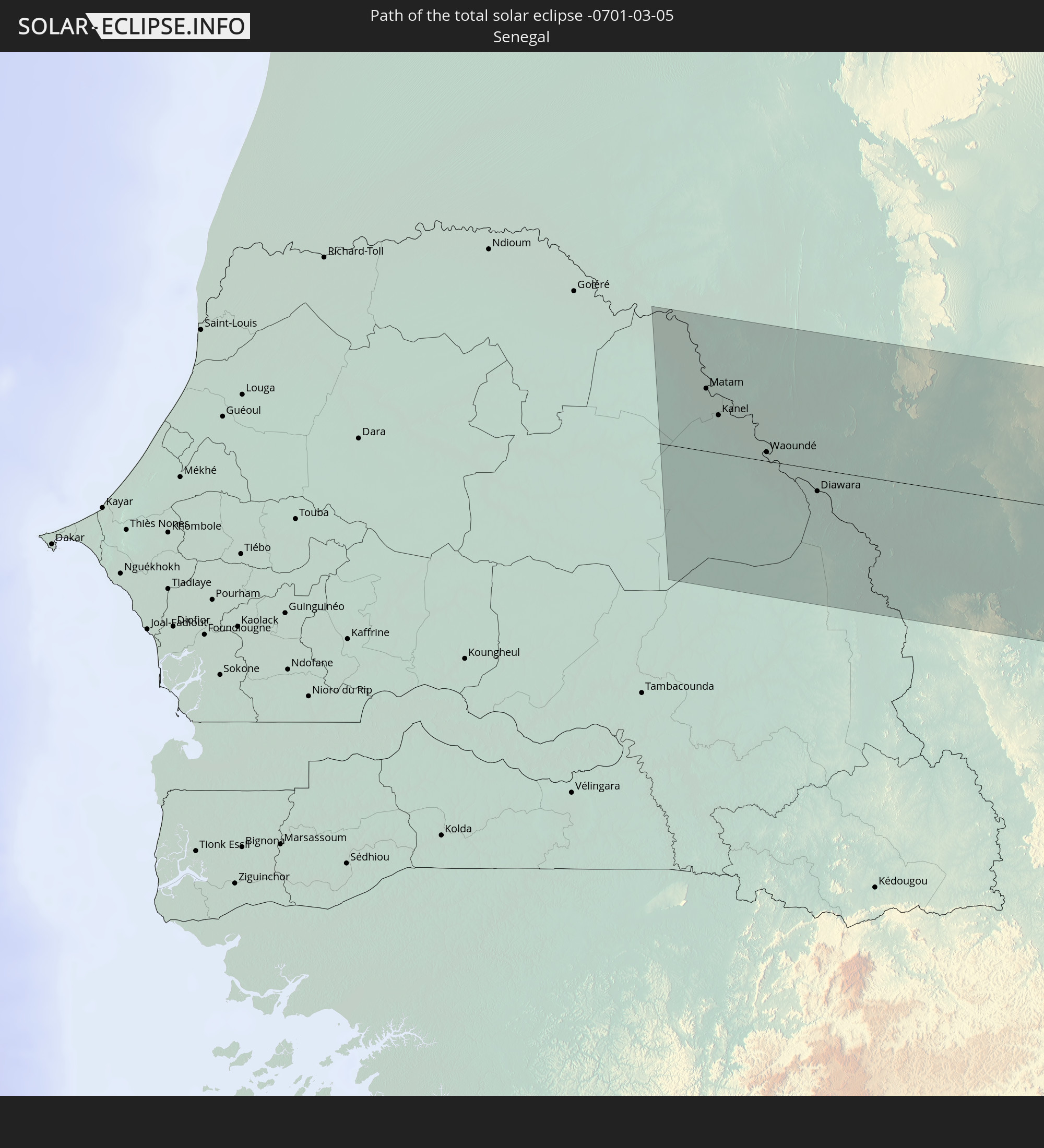 Senegal
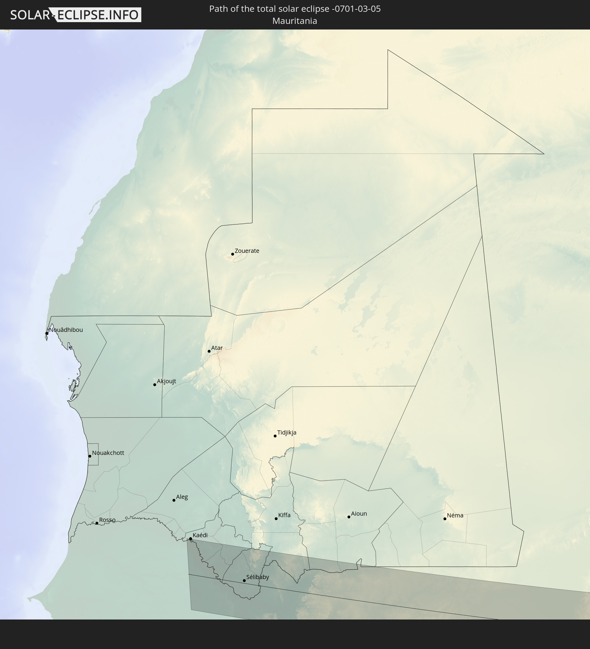 Mauritania
 Mali
Mali
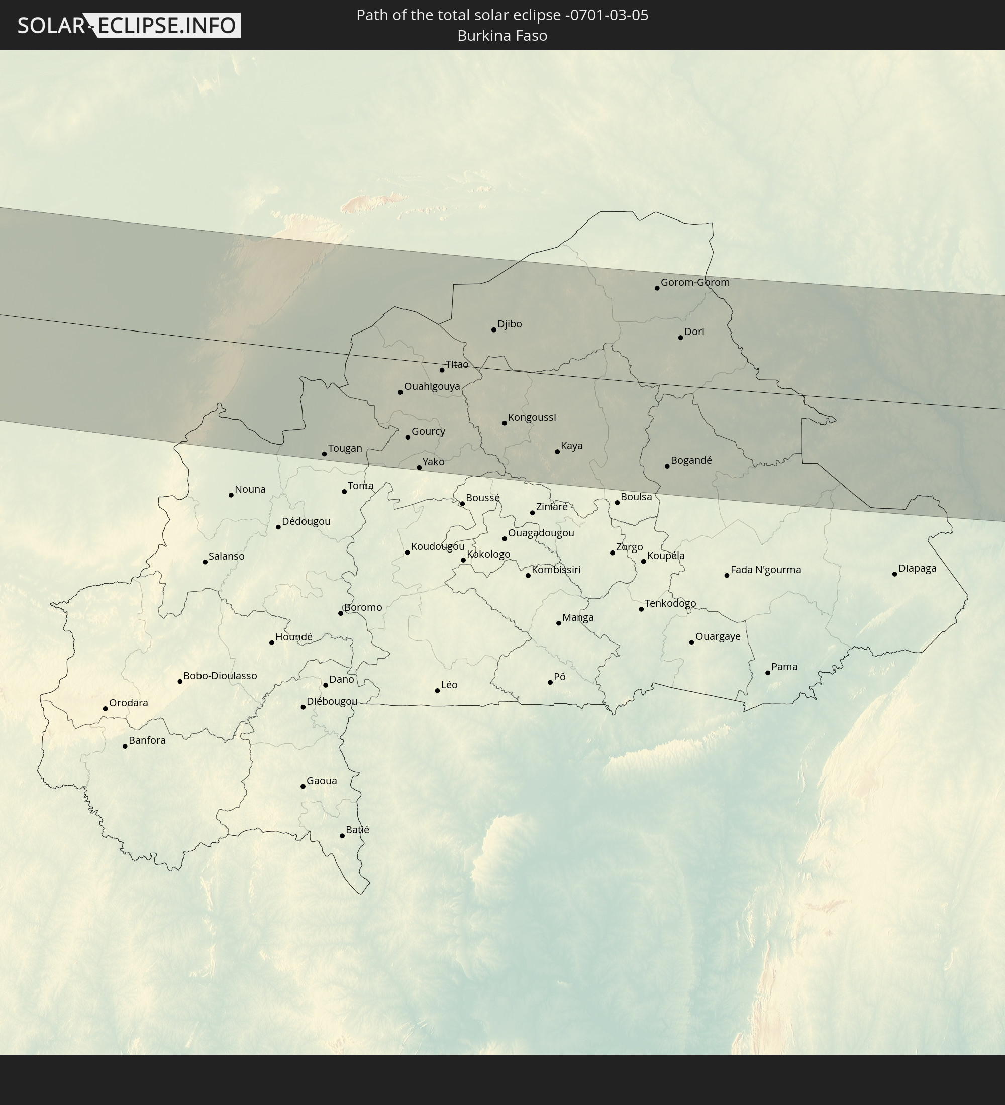 Burkina Faso
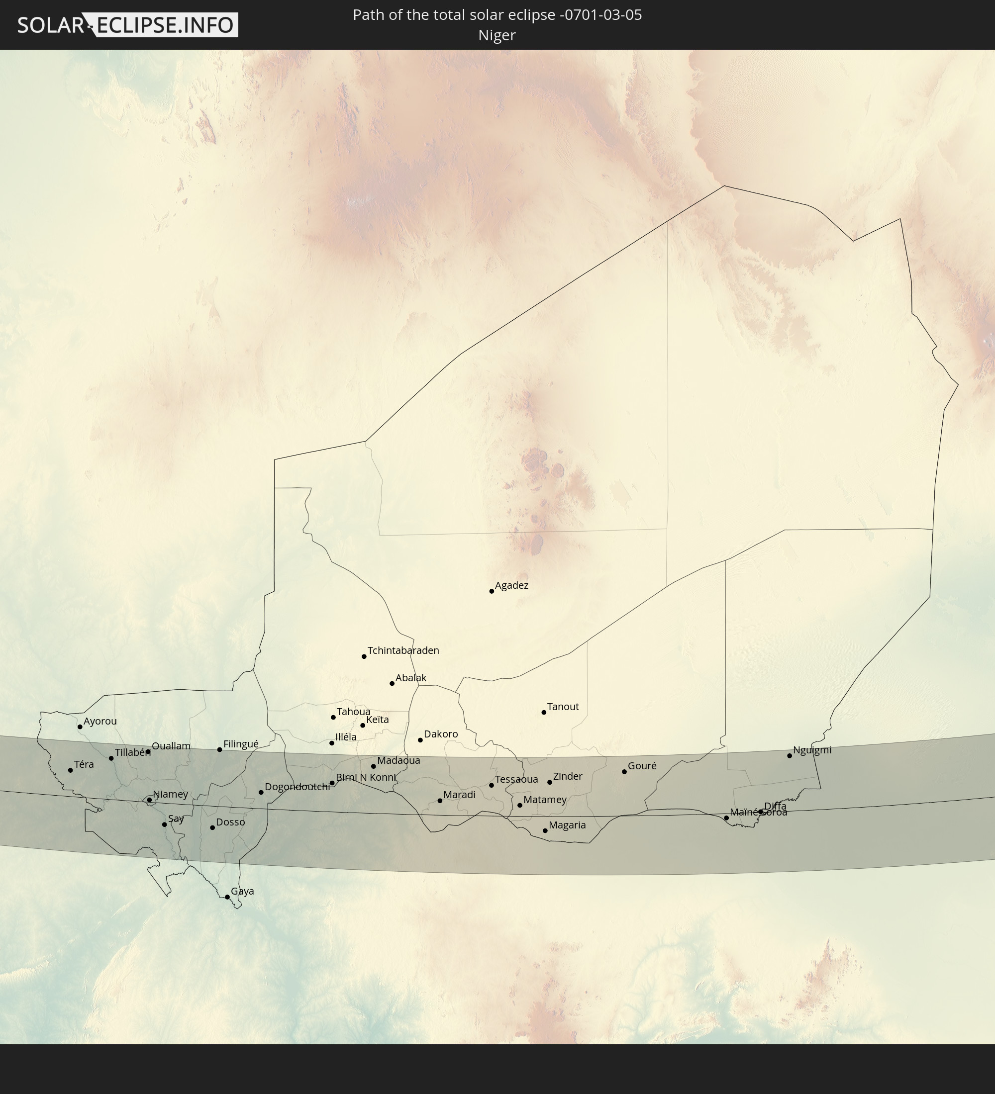 Niger
Niger
 Nigeria
 Cameroon
 Chad
Chad
 Sudan
Sudan
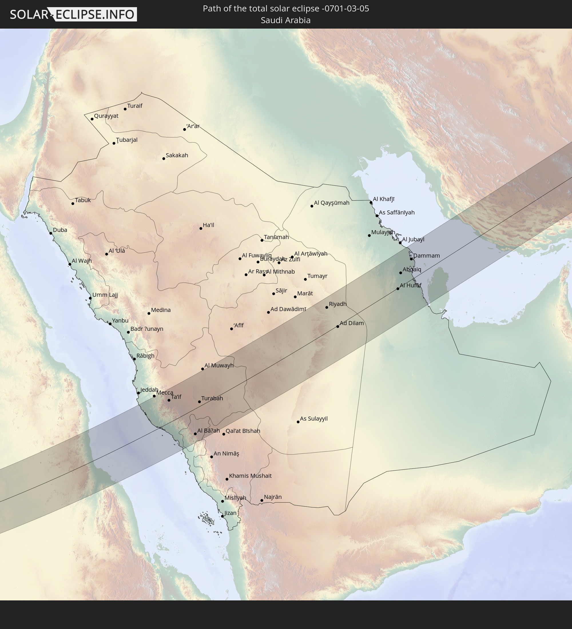 Saudi Arabia
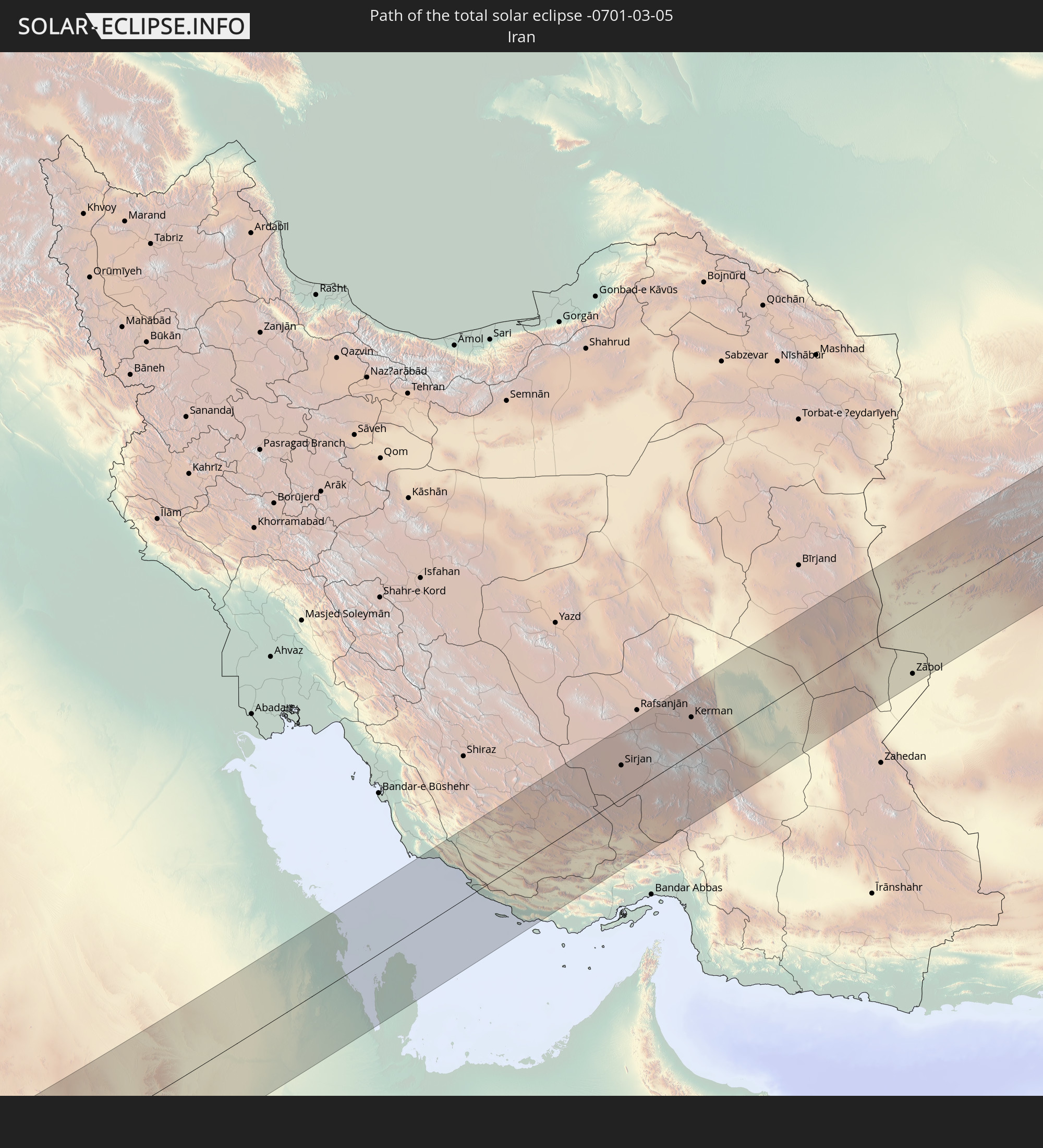 Iran
Iran
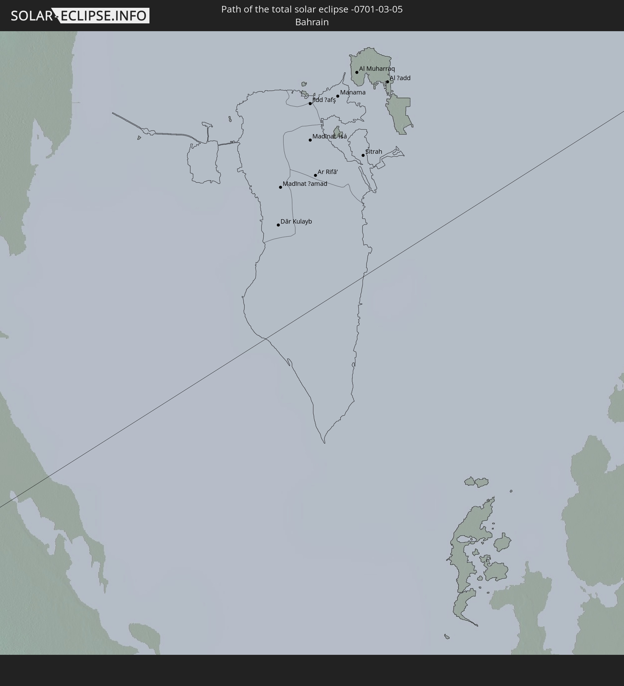 Bahrain
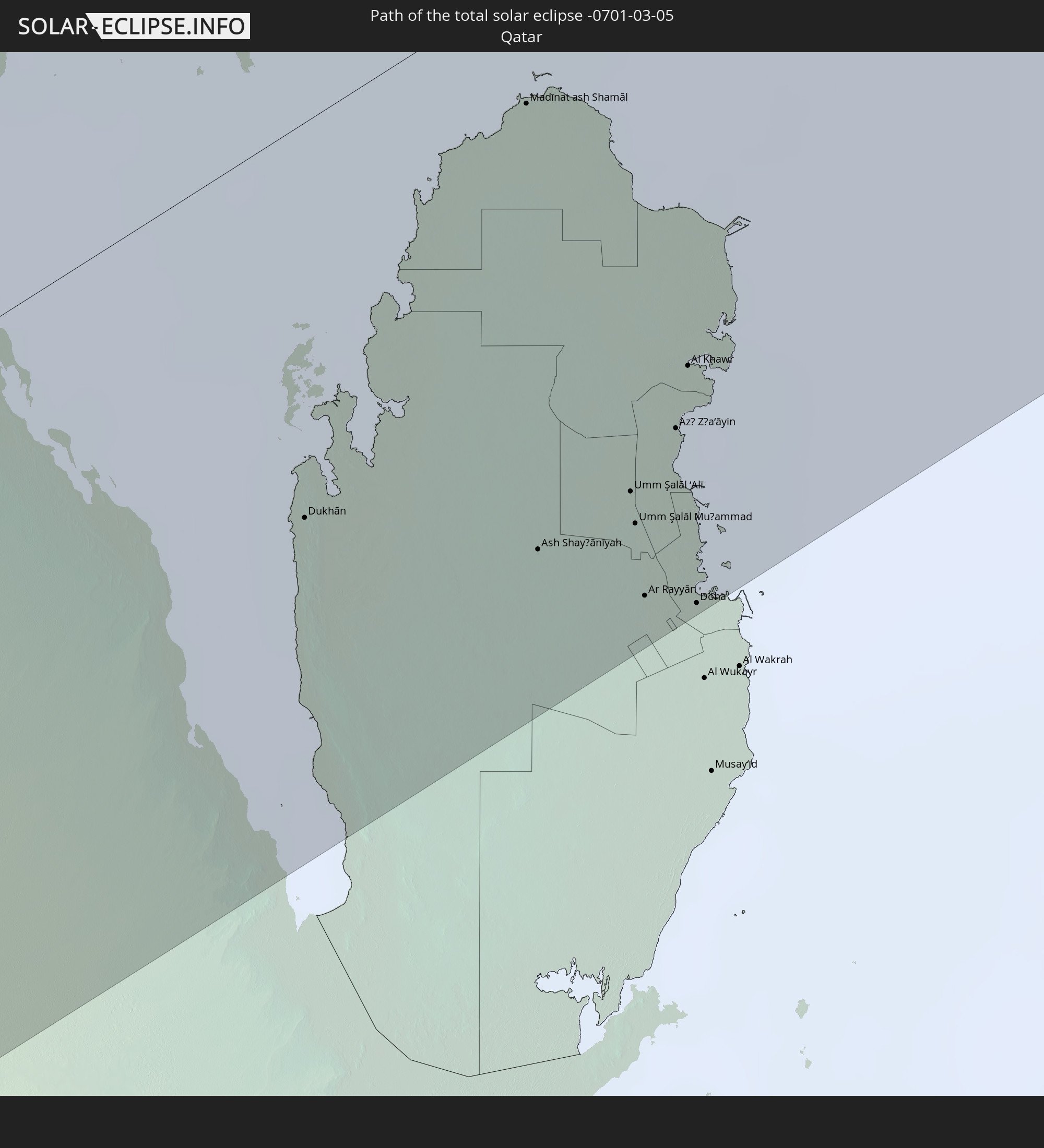 Qatar
Qatar
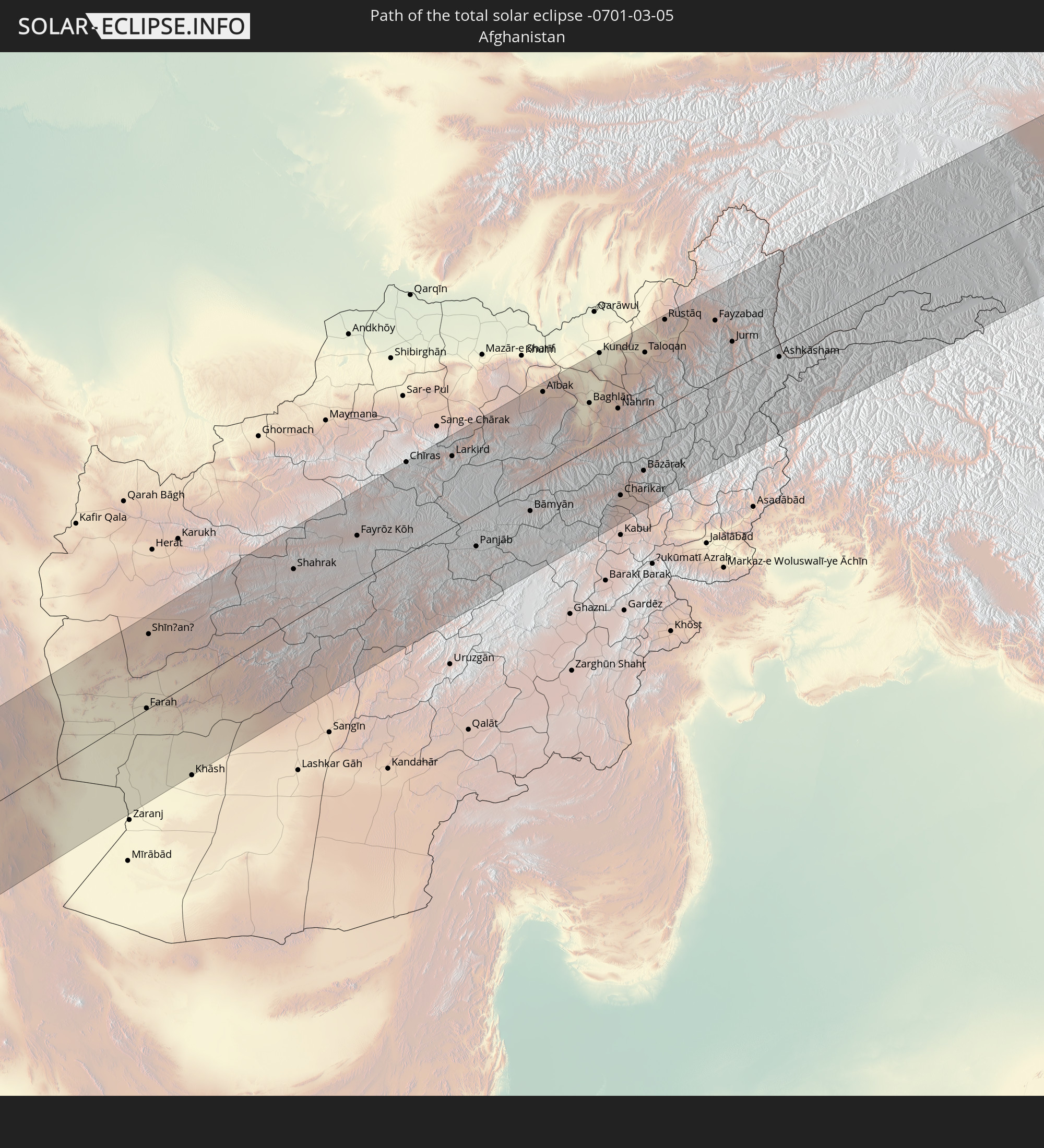 Afghanistan
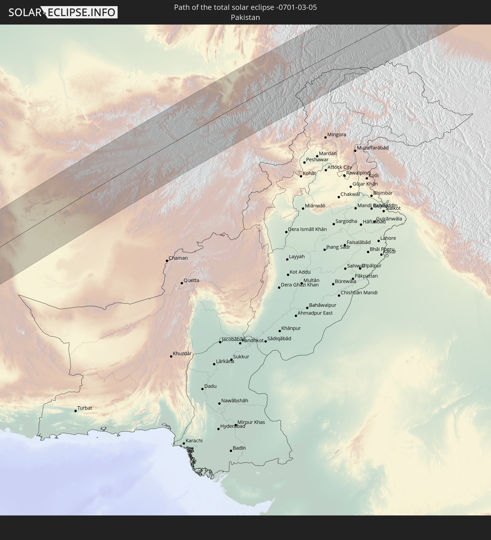 Pakistan
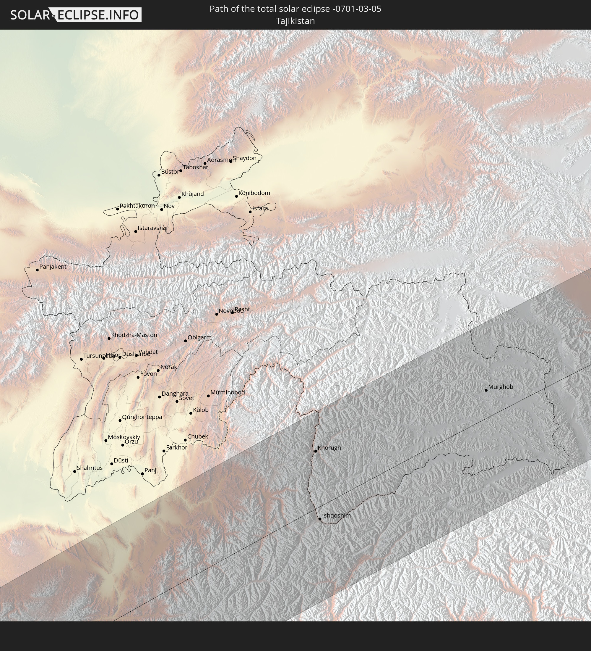 Tajikistan
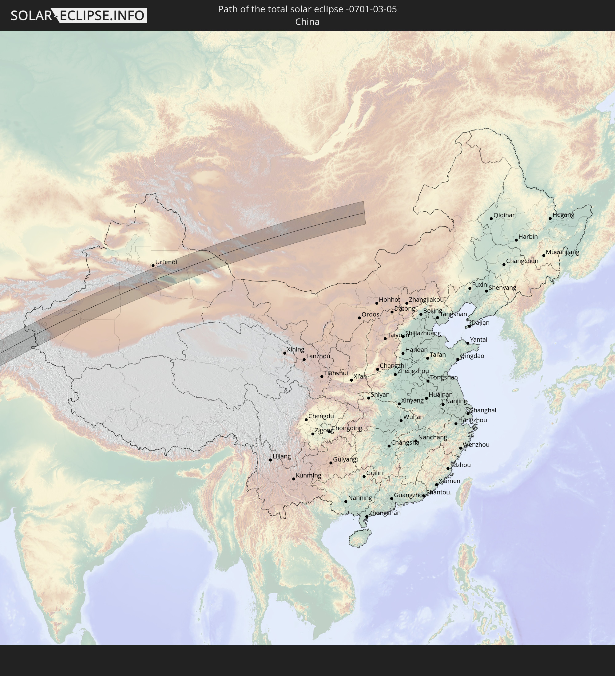 China
China
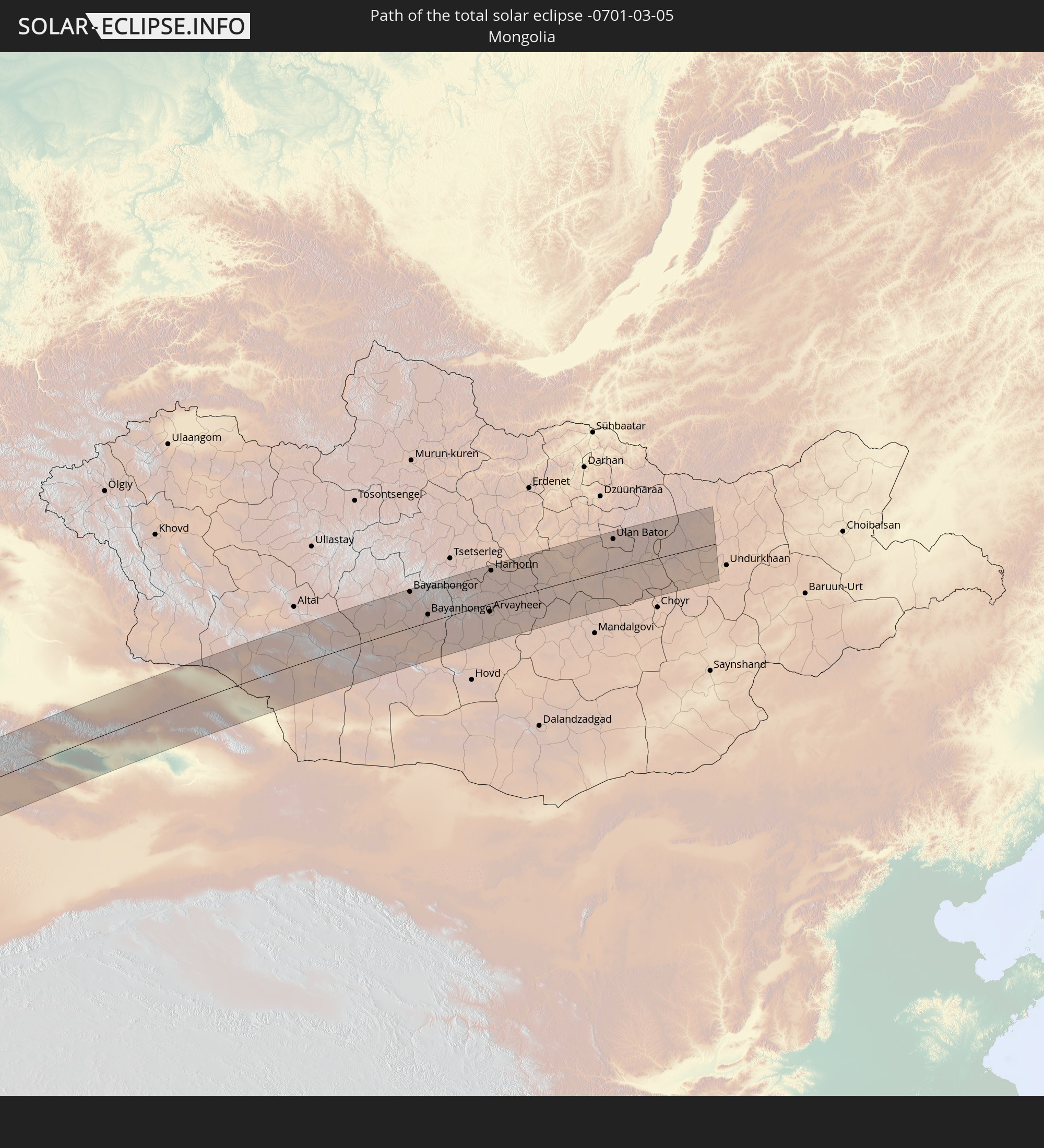 Mongolia
In den folgenden Ländern ist die Sonnenfinsternis partiell zu sehen
 Russia
 Portugal
 Iceland
 Spain
Spain
 Senegal
 Mauritania
 Guinea
 Saint Helena, Ascension and Tristan da Cunha
 Sierra Leone
 Morocco
 Mali
Mali
 Liberia
 Republic of Ireland
 Svalbard and Jan Mayen
 Algeria
 United Kingdom
 Ivory Coast
 Faroe Islands
 Burkina Faso
 Gibraltar
 France
 Isle of Man
 Ghana
Ghana
 Guernsey
 Jersey
 Togo
Togo
 Niger
Niger
 Benin
Benin
 Andorra
 Belgium
 Nigeria
 Netherlands
 Norway
 Equatorial Guinea
 Luxembourg
 Germany
 Switzerland
 São Tomé and Príncipe
 Italy
Italy
 Monaco
 Tunisia
 Denmark
 Cameroon
 Gabon
Gabon
 Libya
Libya
 Liechtenstein
 Austria
 Sweden
 Republic of the Congo
 Angola
 Namibia
 Czechia
 Democratic Republic of the Congo
 San Marino
 Vatican City
 Slovenia
 Chad
Chad
 Croatia
 Poland
 Malta
Malta
 Central African Republic
 Bosnia and Herzegovina
 Hungary
 Slovakia
 Montenegro
 Serbia
 Albania
 Åland Islands
 Greece
 Botswana
 Romania
 Republic of Macedonia
 Finland
 Lithuania
 Latvia
 Estonia
 Sudan
Sudan
 Zambia
 Ukraine
 Bulgaria
 Belarus
 Egypt
Egypt
 Zimbabwe
 Turkey
 Moldova
 Rwanda
 Burundi
 Tanzania
 Uganda
 Mozambique
 Cyprus
 Malawi
 Ethiopia
 Kenya
Kenya
 State of Palestine
 Israel
 Saudi Arabia
 Jordan
 Lebanon
 Syria
Syria
 Eritrea
 Iraq
Iraq
 Georgia
 French Southern and Antarctic Lands
 Somalia
 Djibouti
 Yemen
Yemen
 Comoros
 Armenia
 Iran
Iran
 Azerbaijan
 Mayotte
 Seychelles
 Kazakhstan
 Kuwait
 Bahrain
 Qatar
Qatar
 United Arab Emirates
 Oman
Oman
 Turkmenistan
 Uzbekistan
 Afghanistan
 Pakistan
 Tajikistan
 India
India
 Kyrgyzstan
 Maldives
 China
China
 Sri Lanka
 Nepal
Nepal
 Mongolia
 Bangladesh
 Bhutan
 Myanmar
 Thailand
 Laos
Laos
 Vietnam
 Cambodia
 Macau
Macau
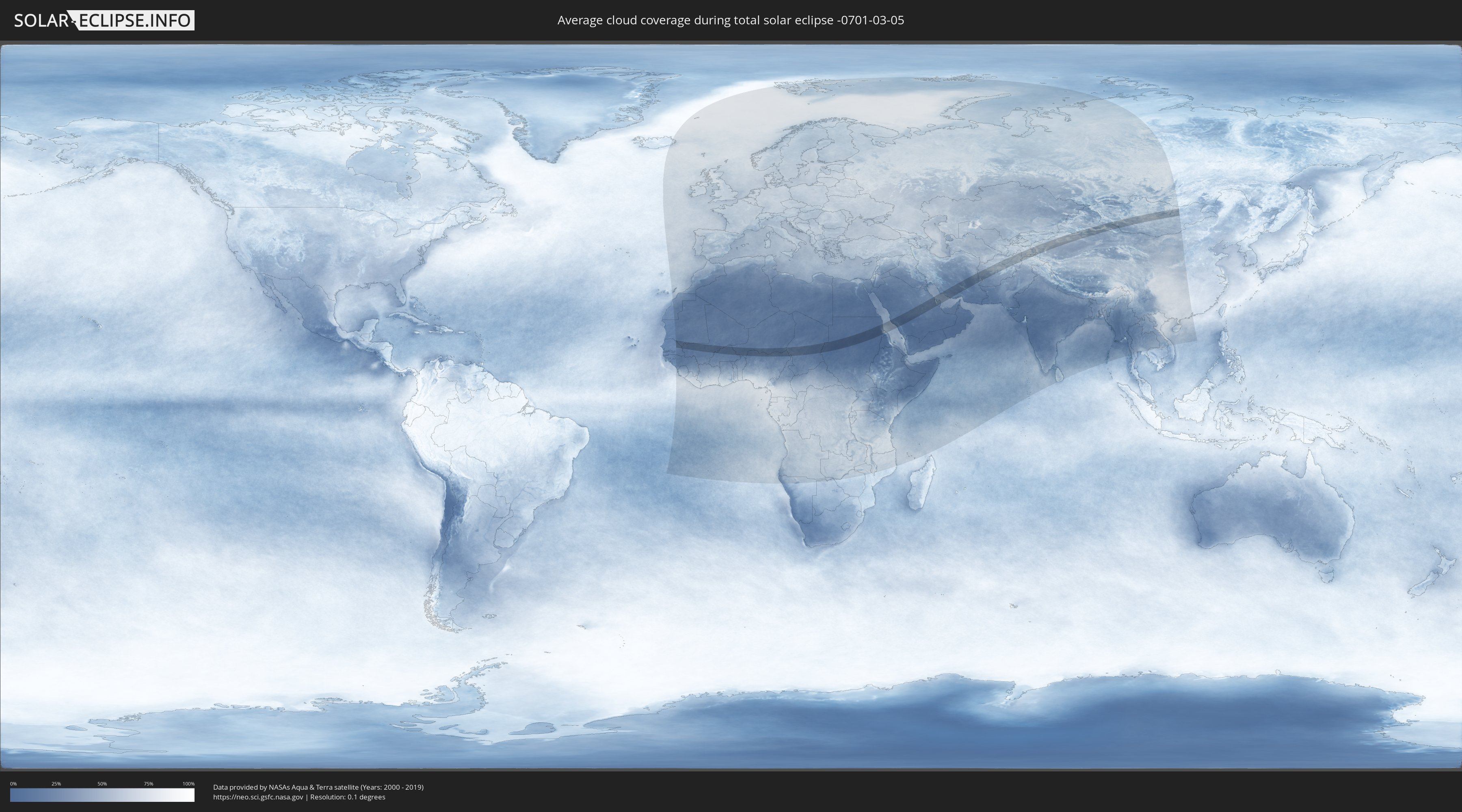
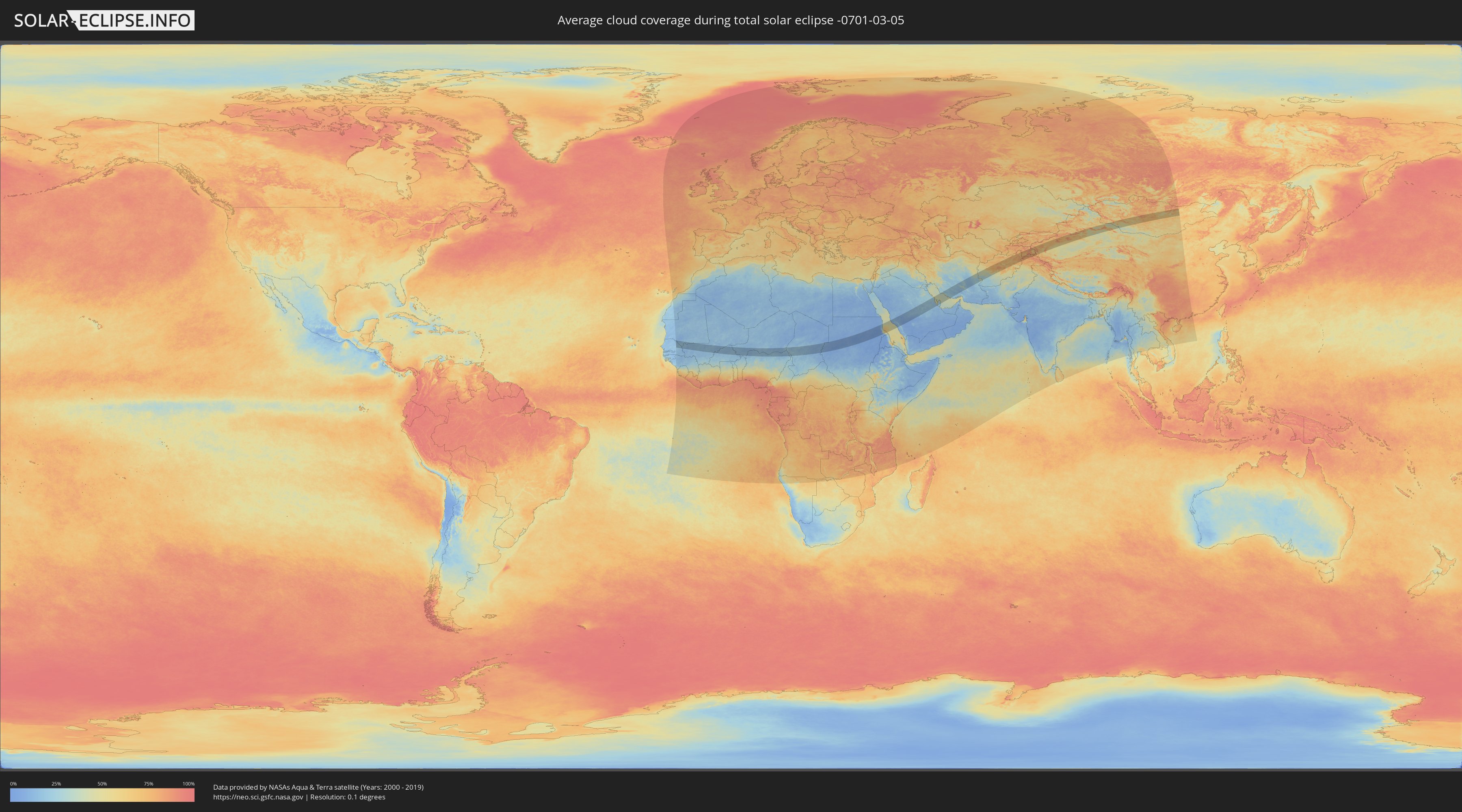
How will be the weather during the total solar eclipse on 03/05/-0701?
Where is the best place to see the total solar eclipse of 03/05/-0701?
The following maps show the average cloud coverage for the day of the total solar eclipse.
With the help of these maps, it is possible to find the place along the eclipse path, which has the best
chance of a cloudless sky.
Nevertheless, you should consider local circumstances and inform about the weather of your chosen
observation site.
The data is provided by NASAs satellites
AQUA and TERRA.
The cloud maps are averaged over a period of 19 years (2000 - 2019).
Detailed country maps
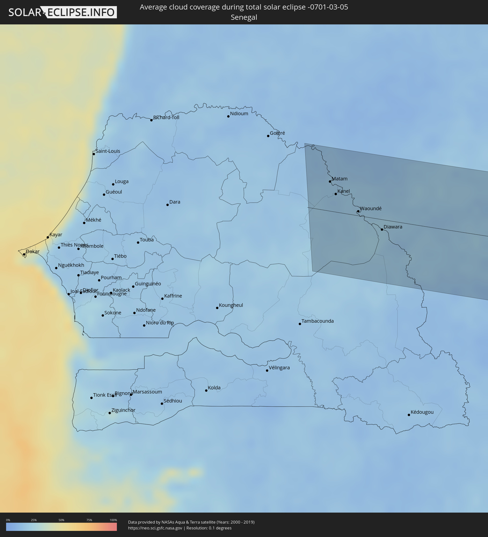 Senegal
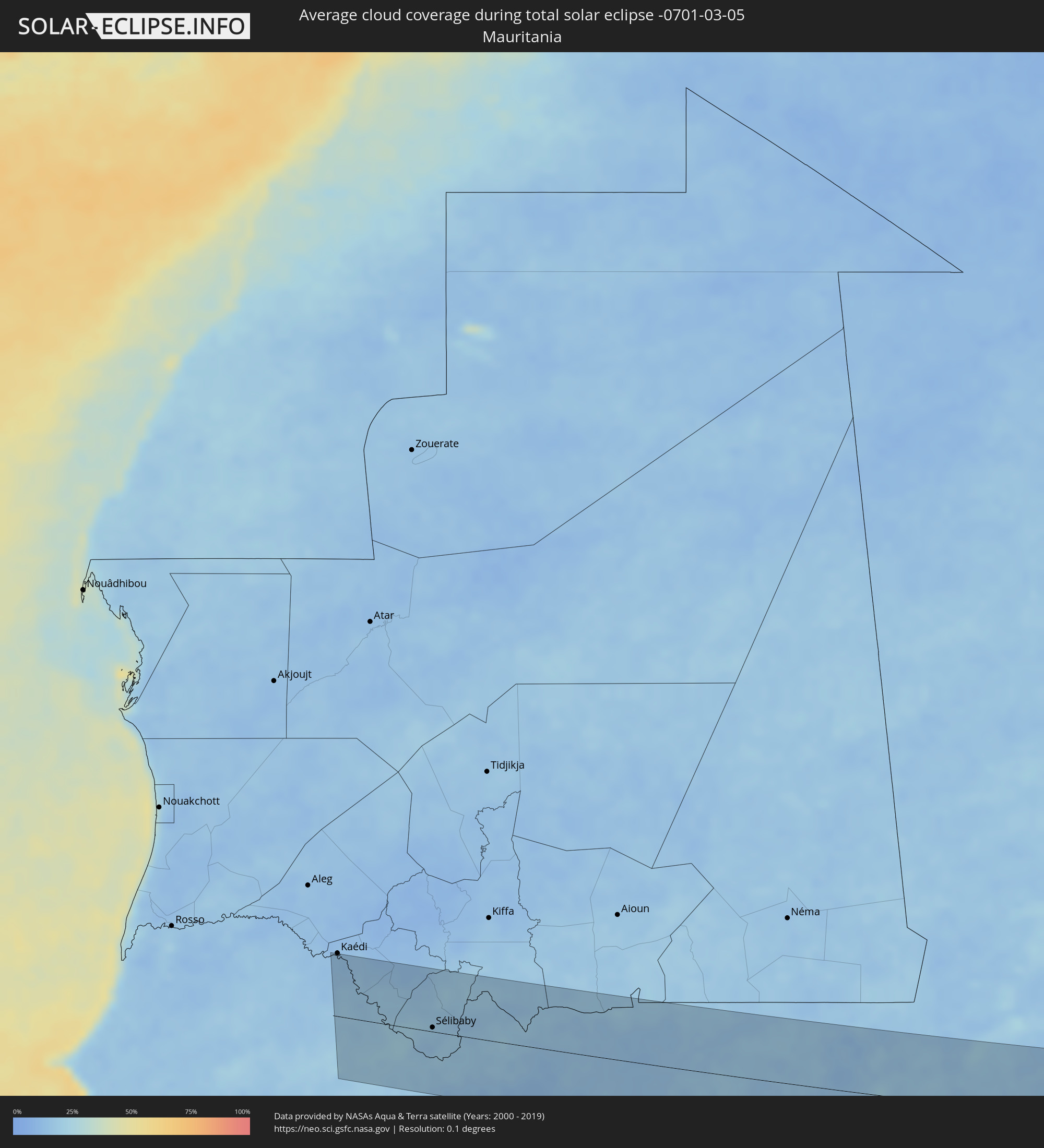 Mauritania
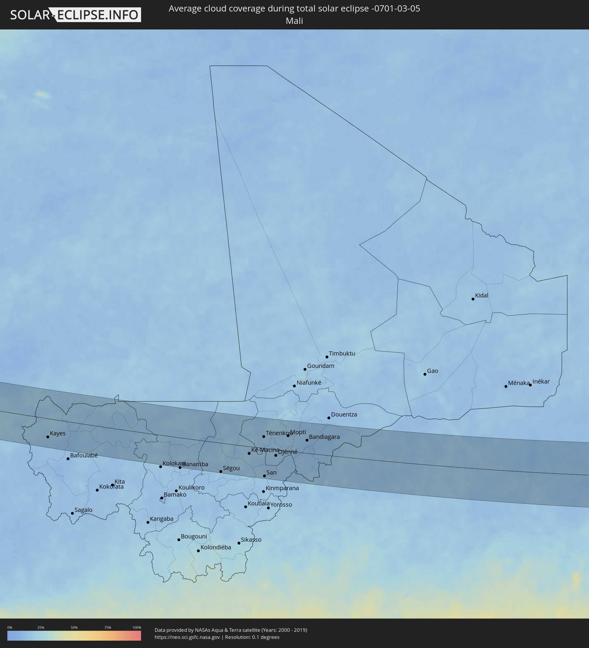 Mali
Mali
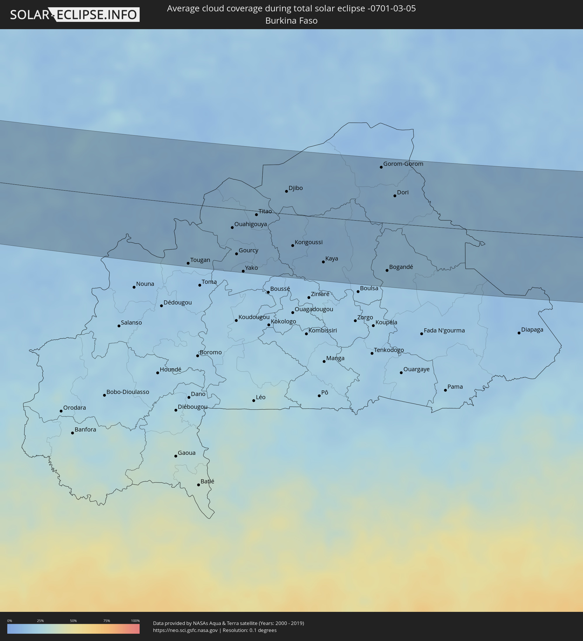 Burkina Faso
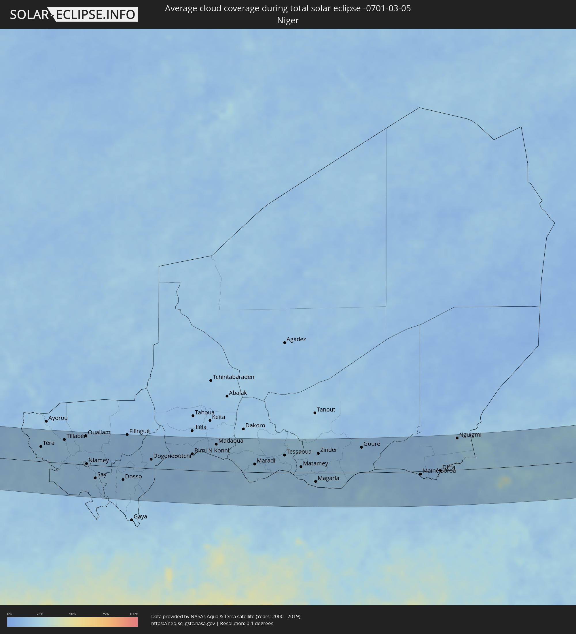 Niger
Niger
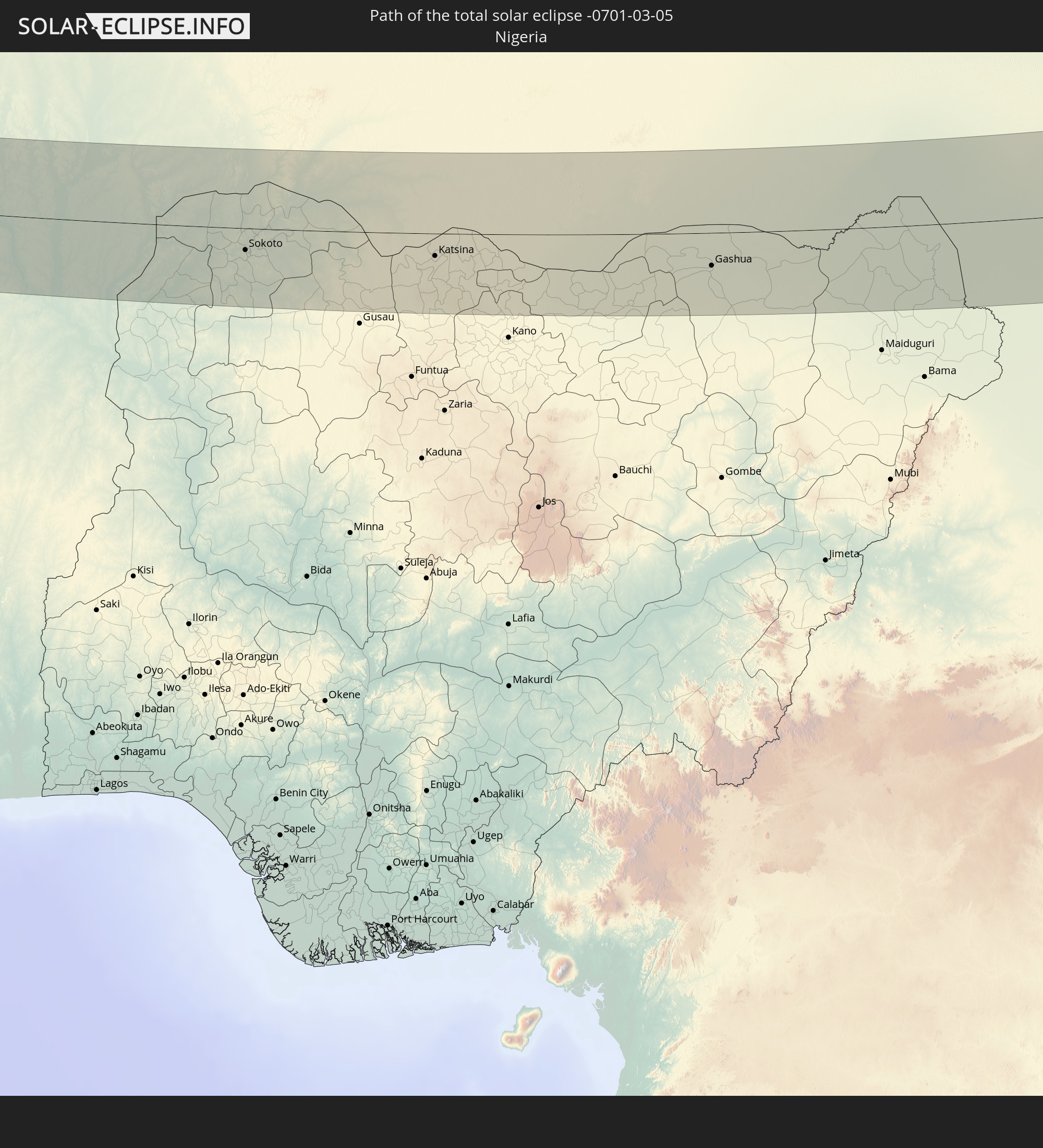
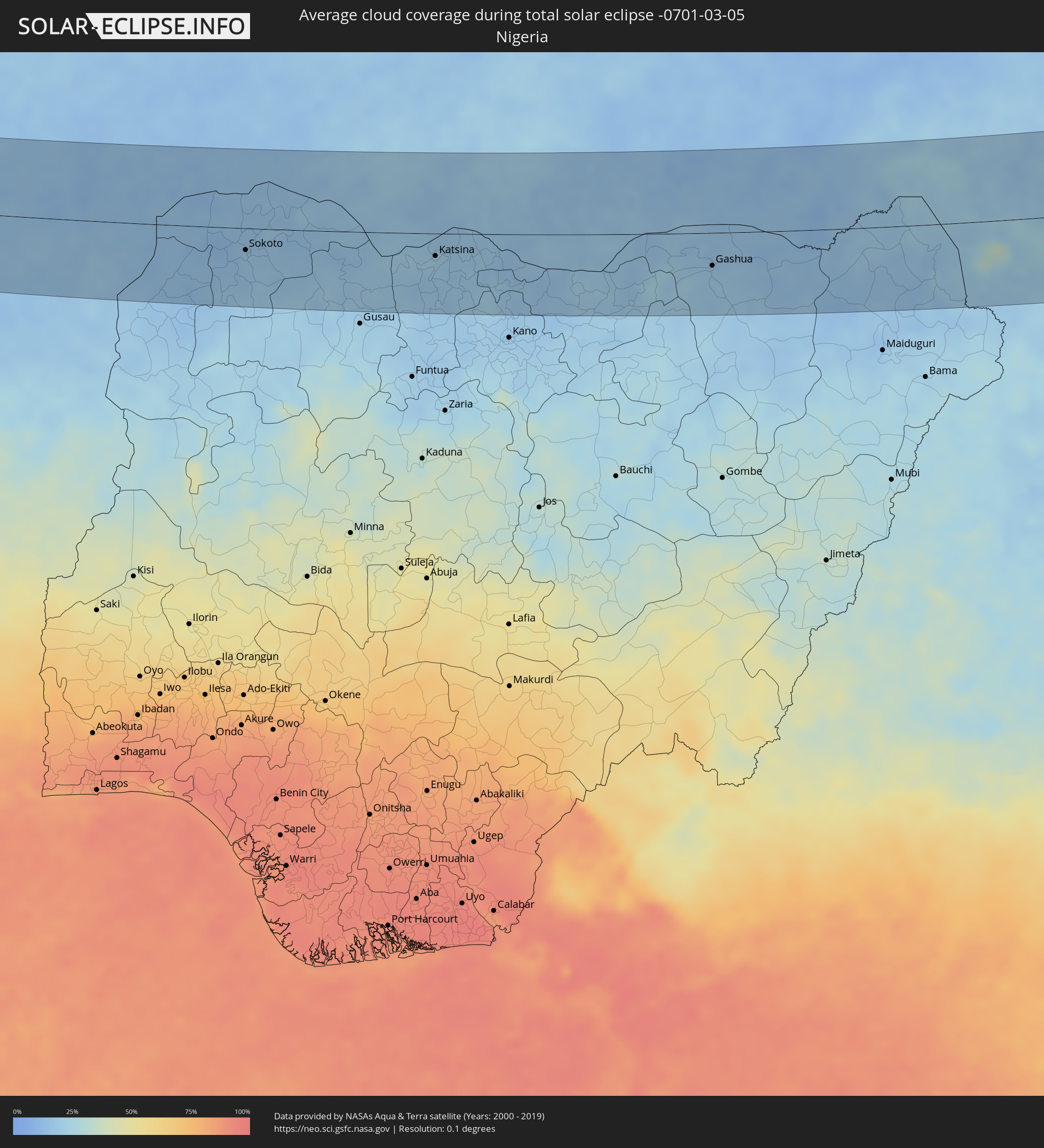 Nigeria
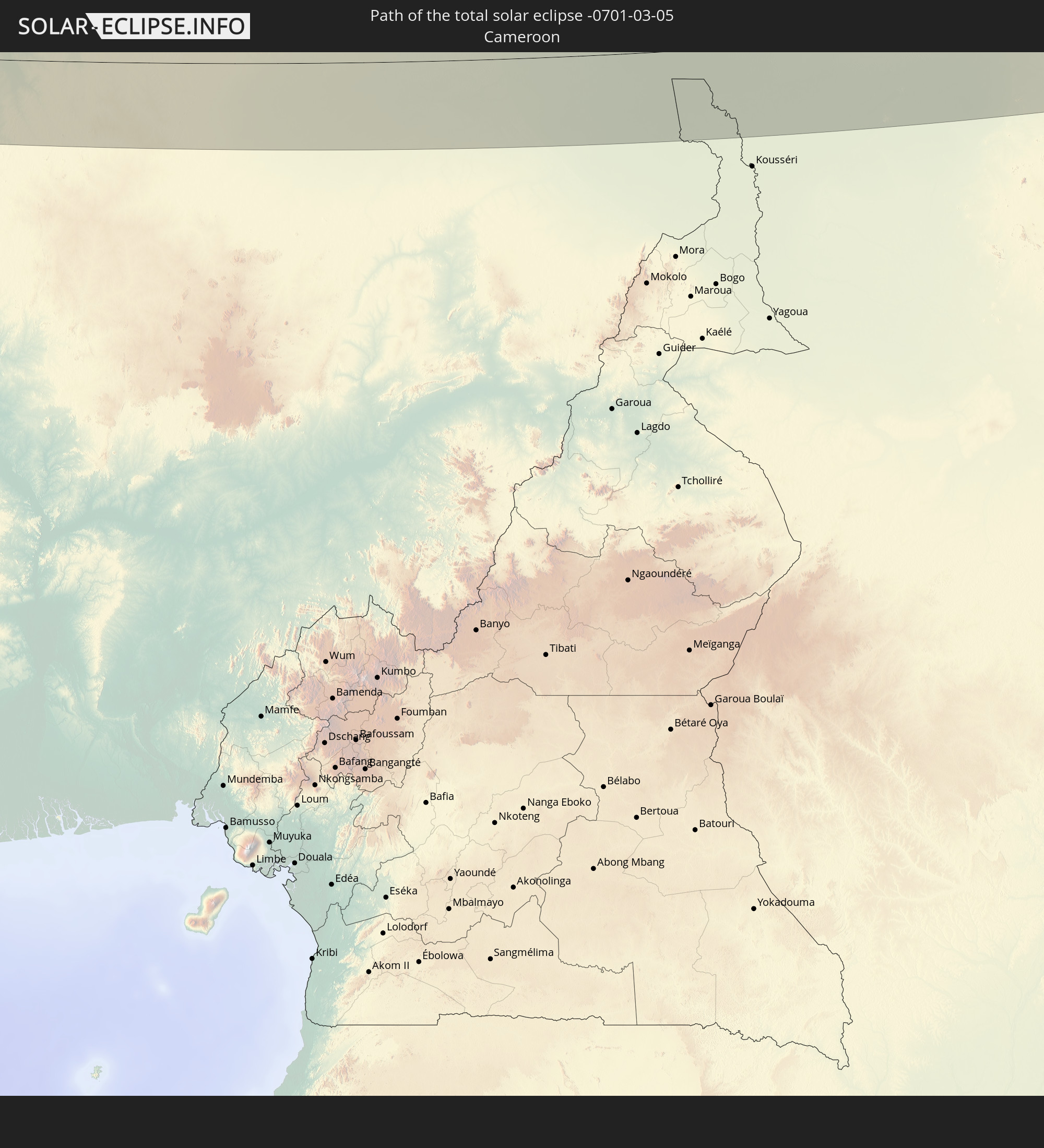
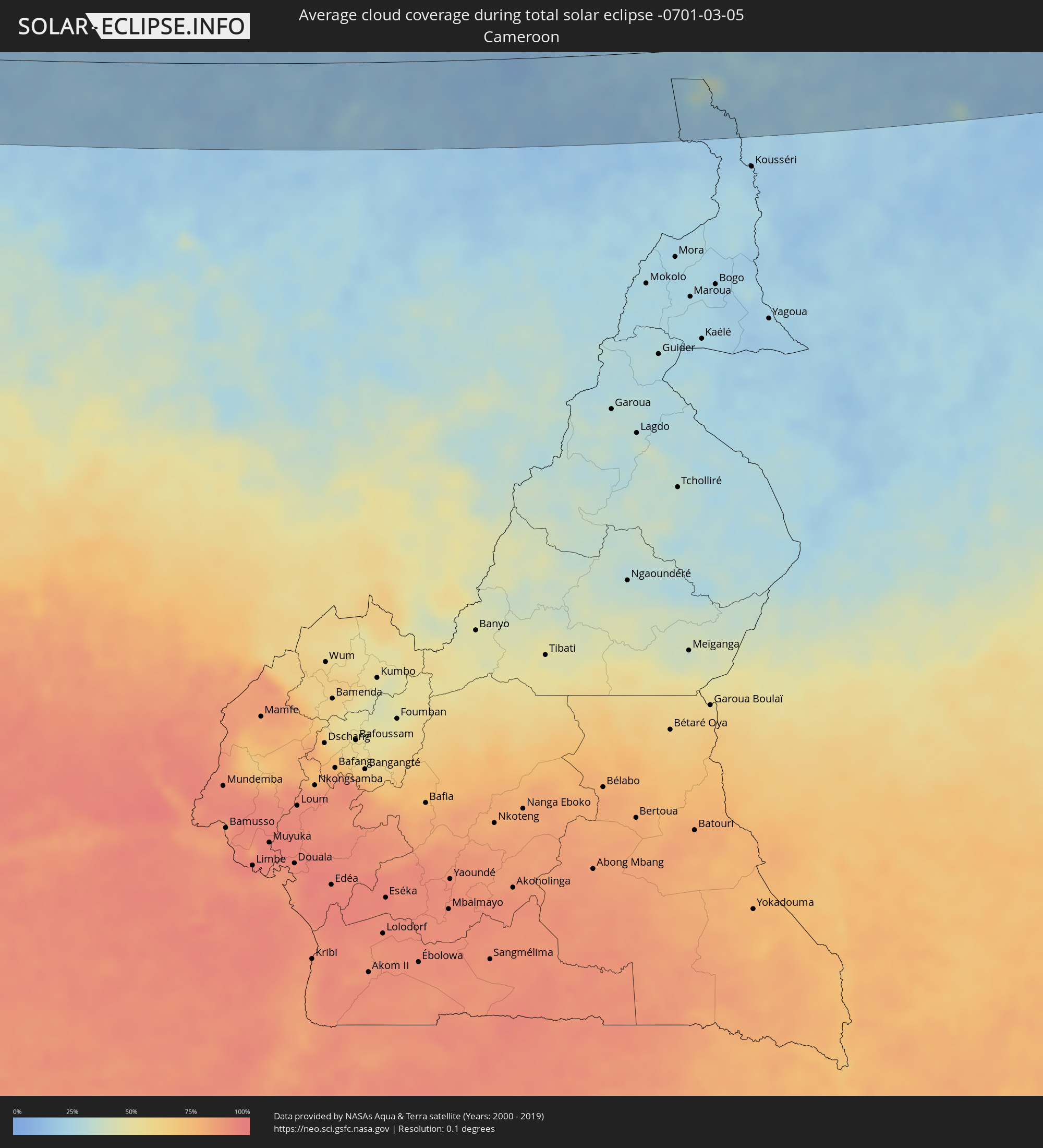 Cameroon
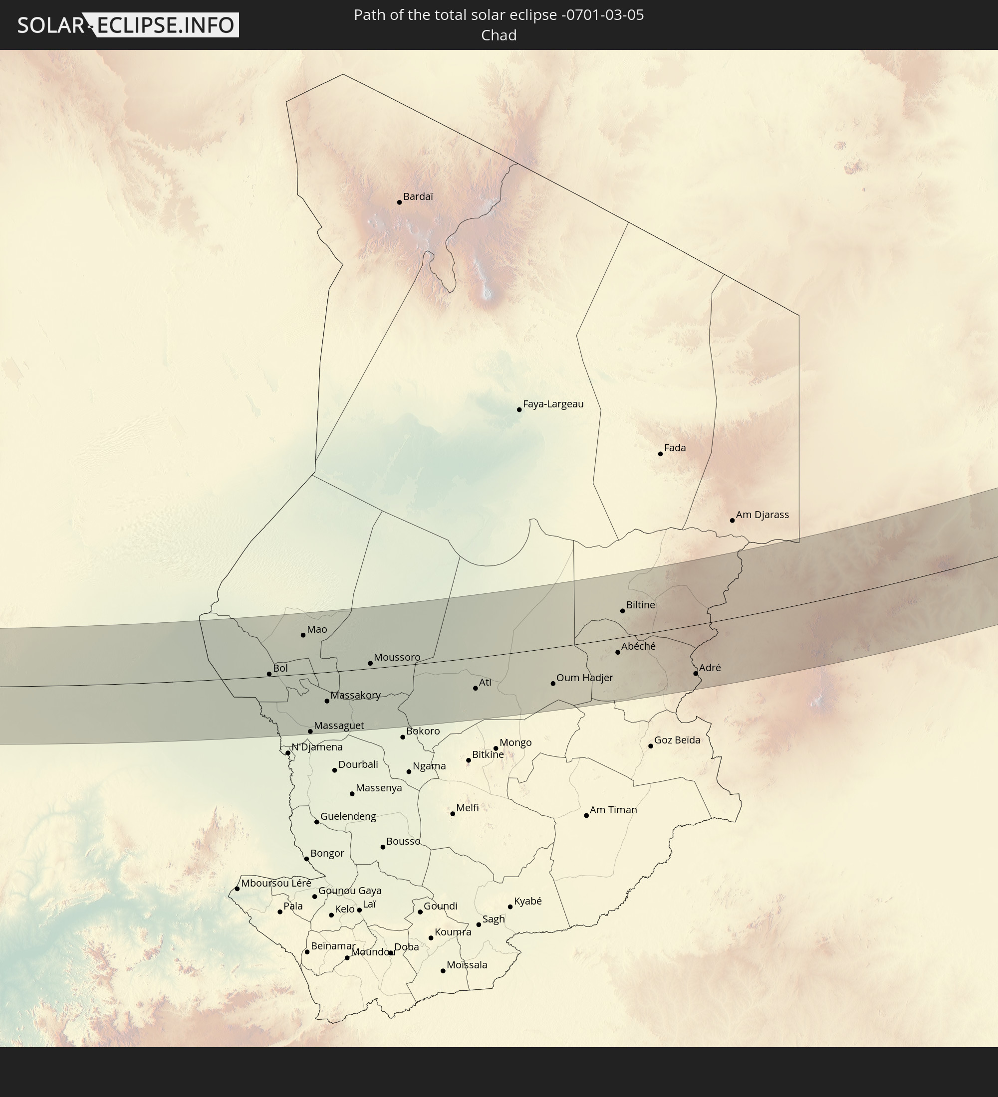
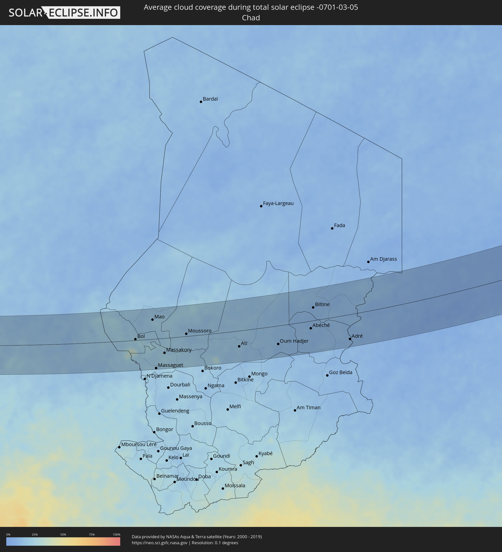 Chad
Chad
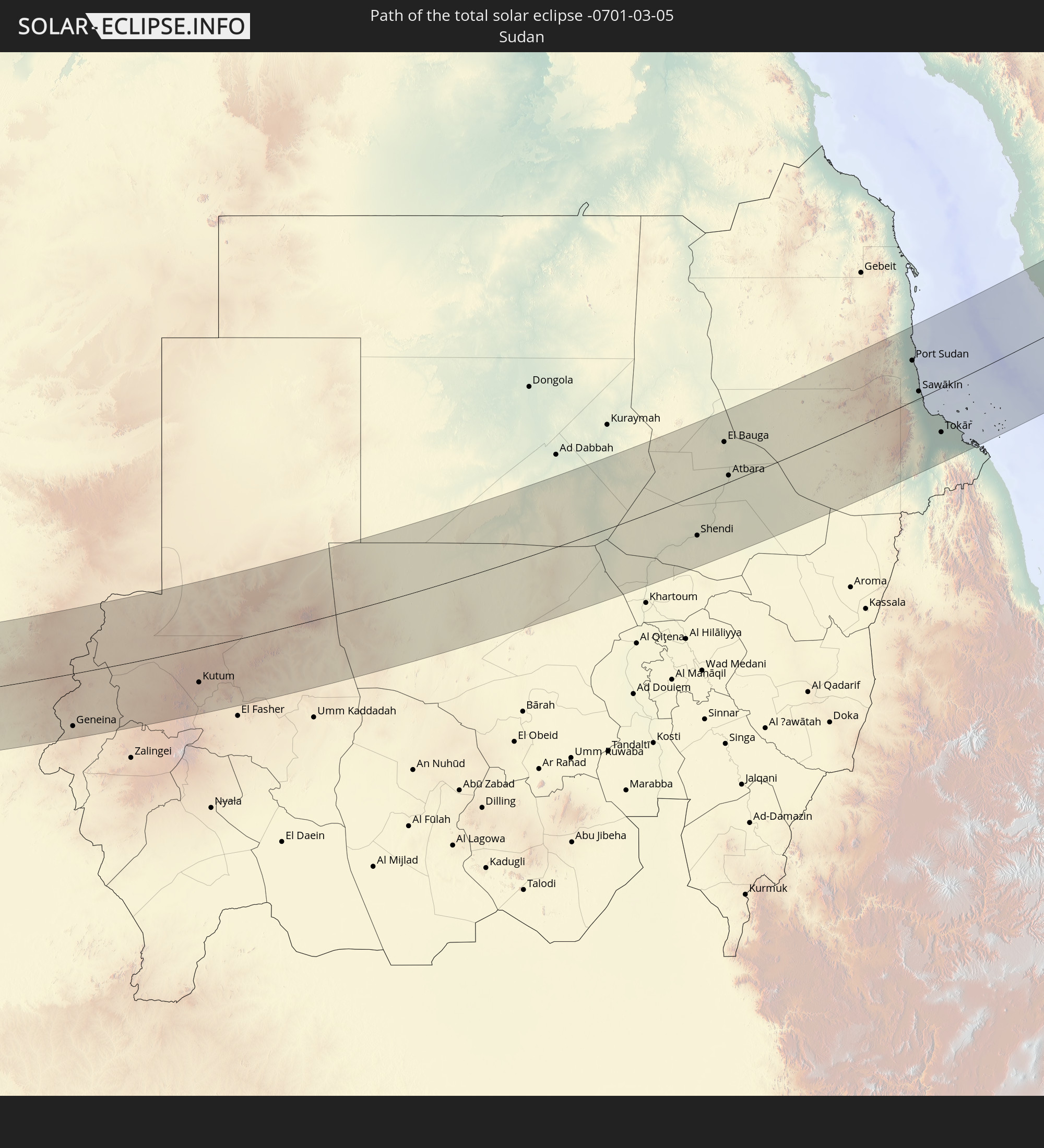
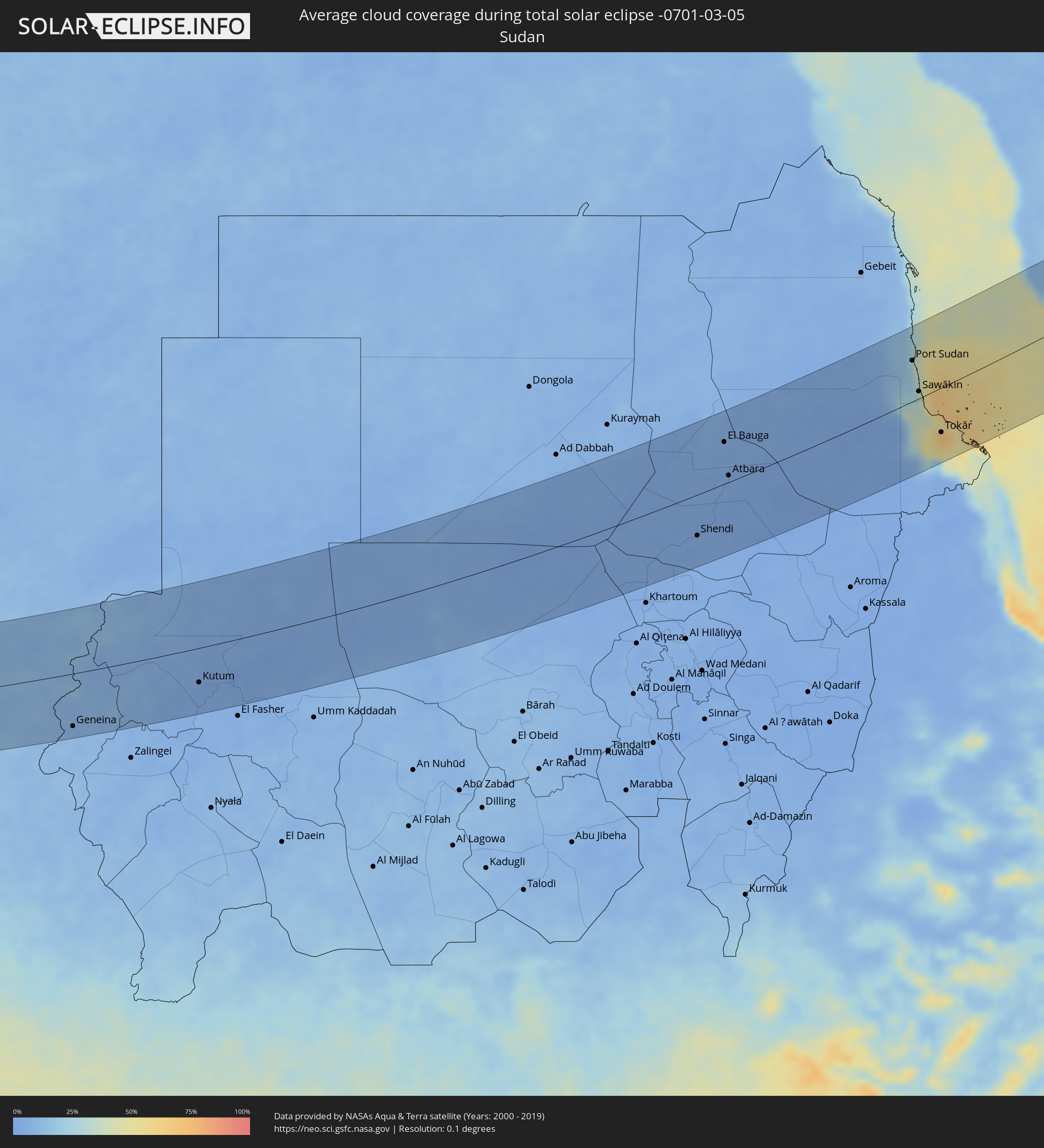 Sudan
Sudan
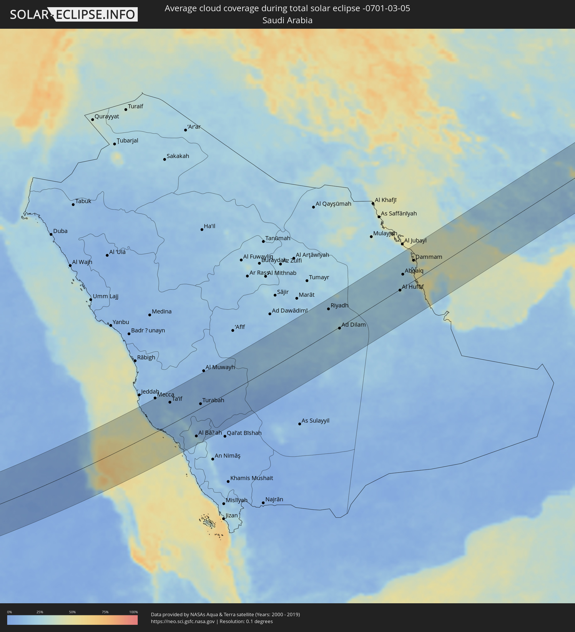 Saudi Arabia
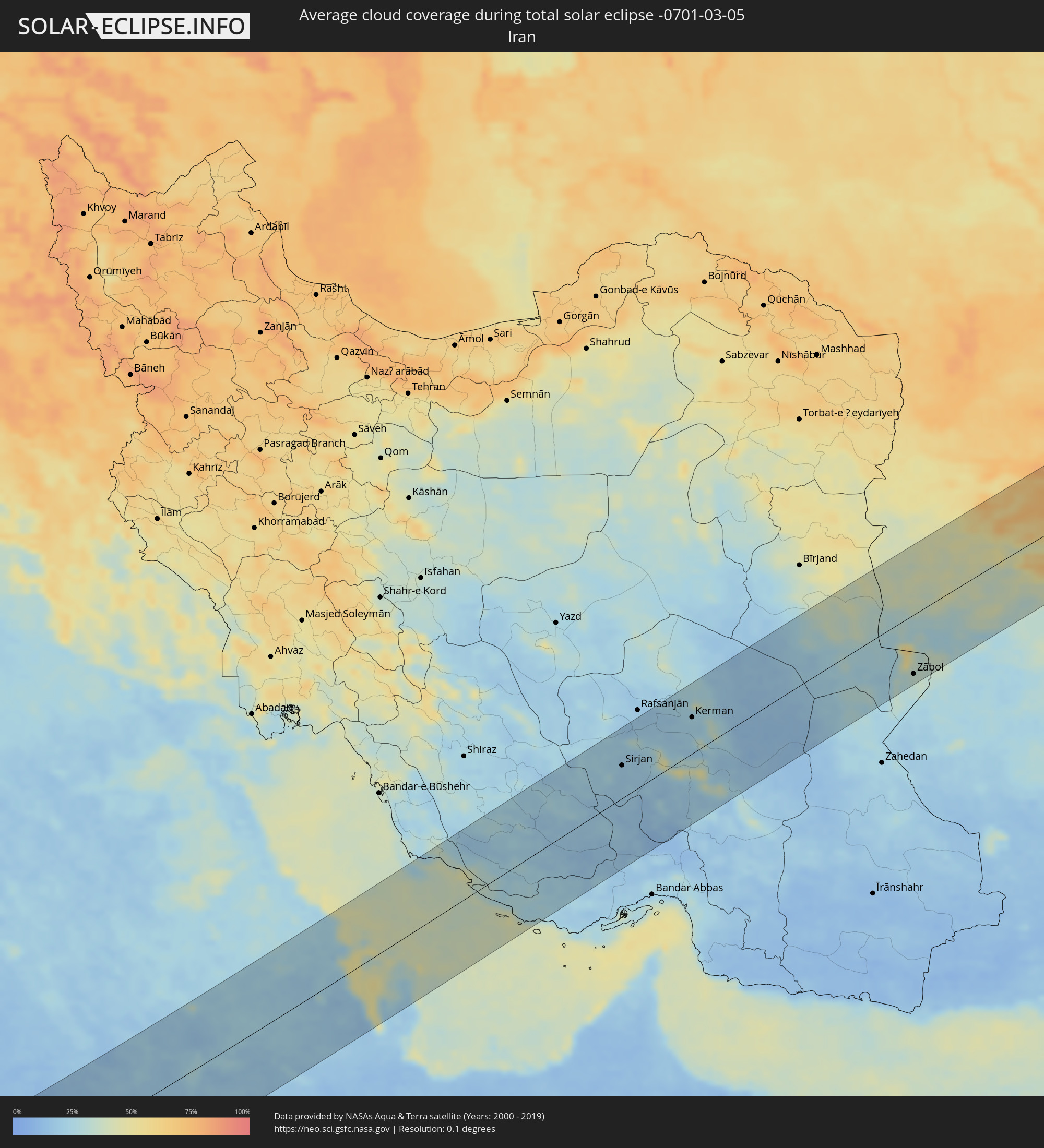 Iran
Iran
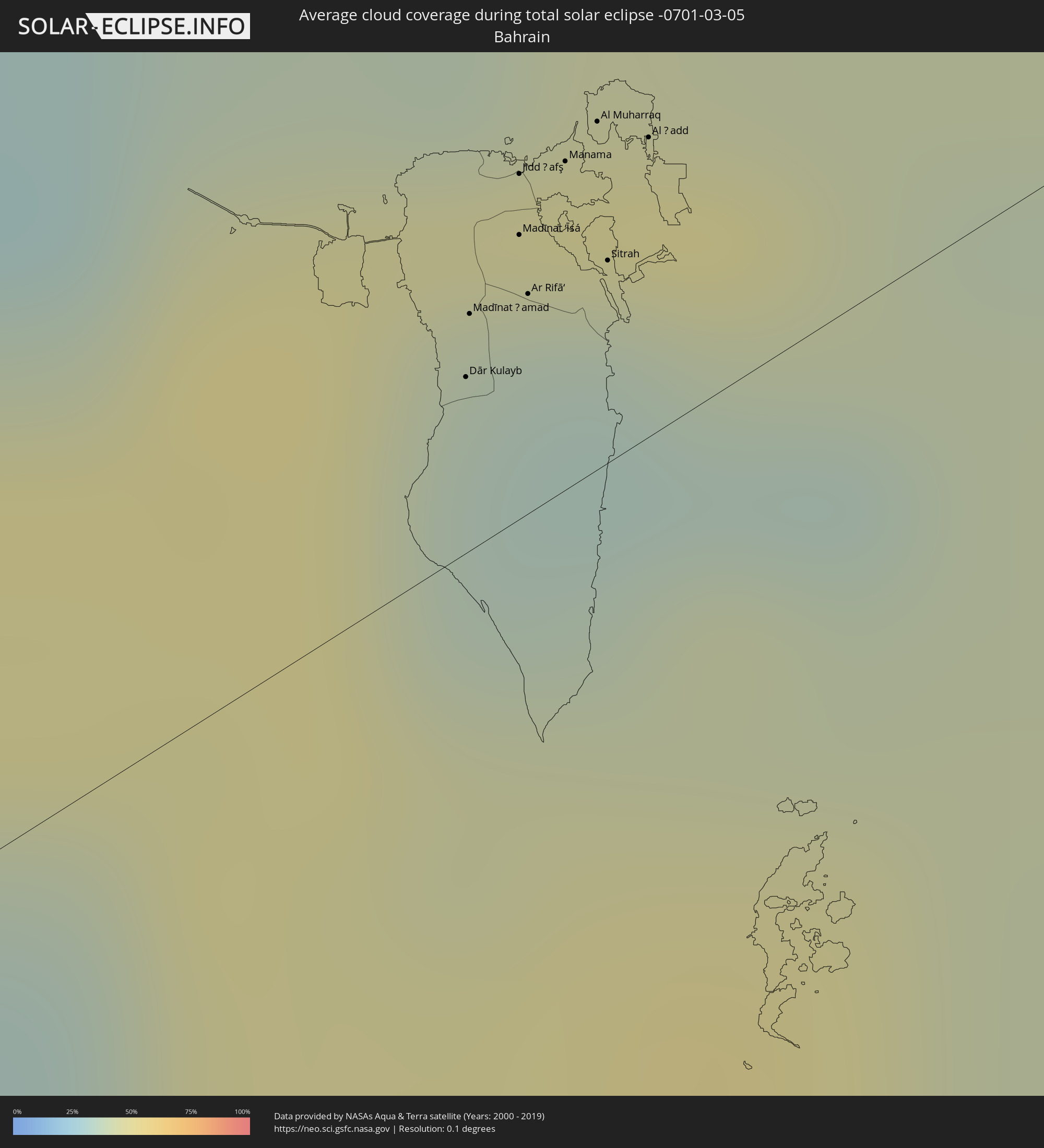 Bahrain
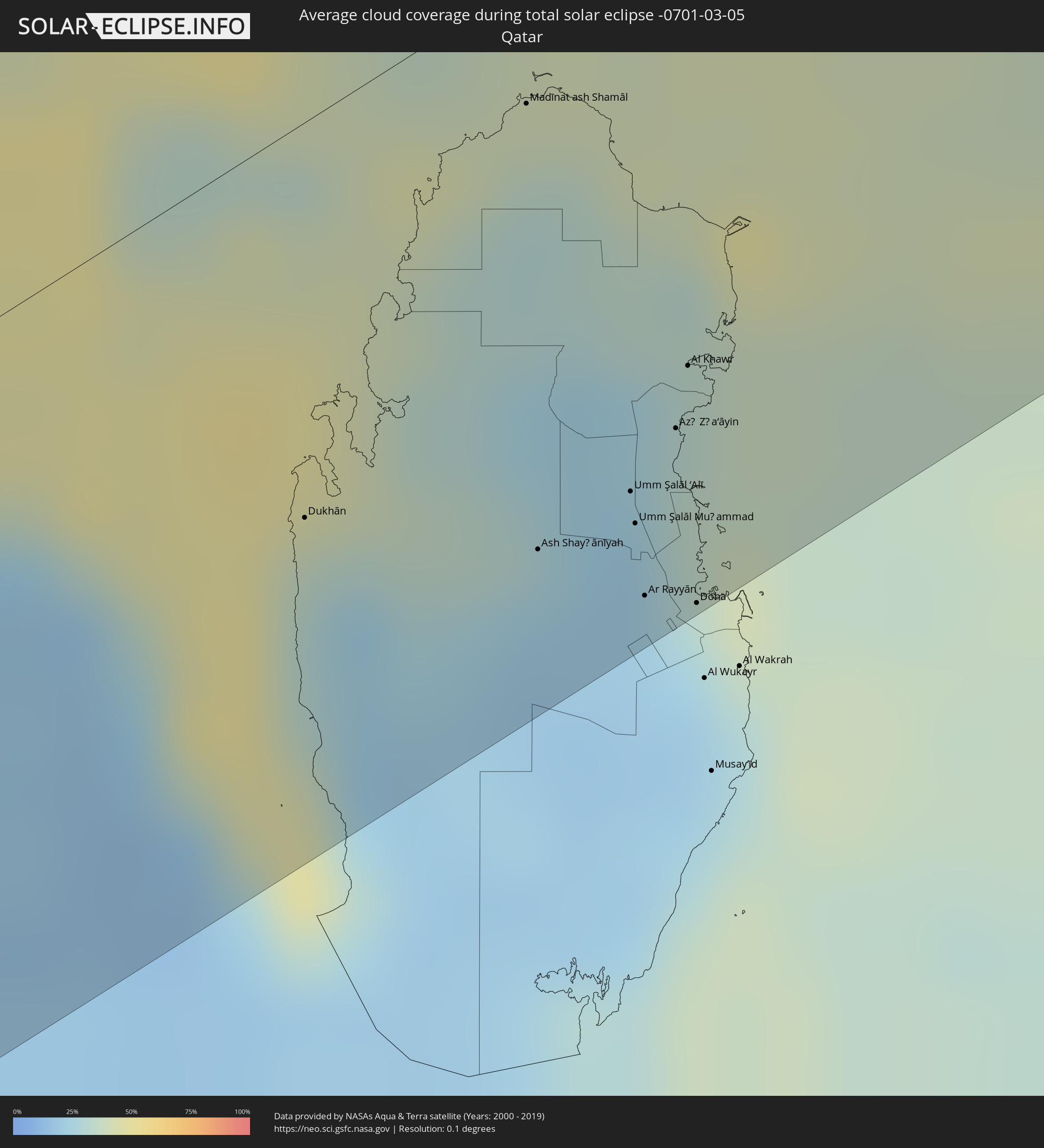 Qatar
Qatar
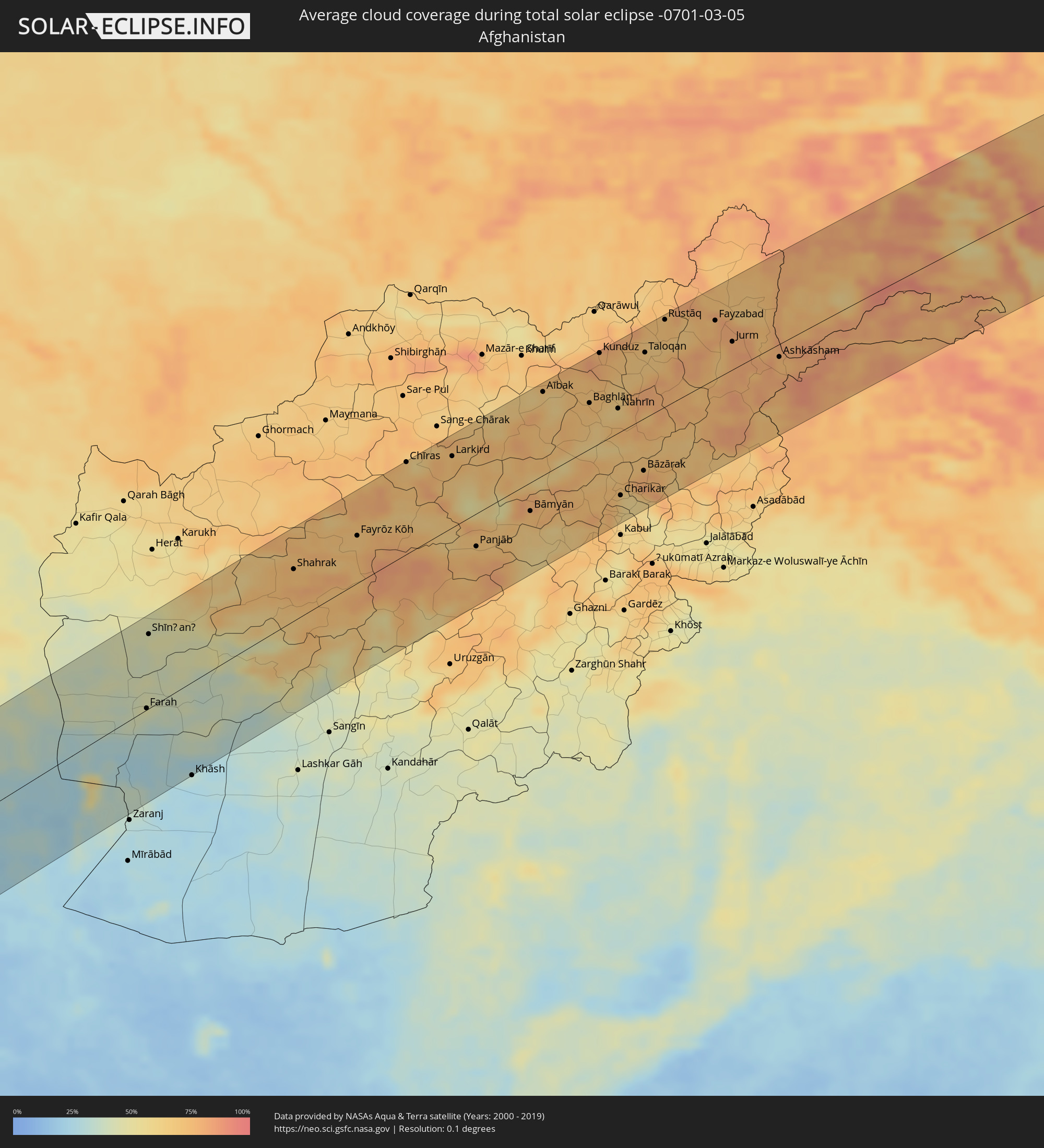 Afghanistan
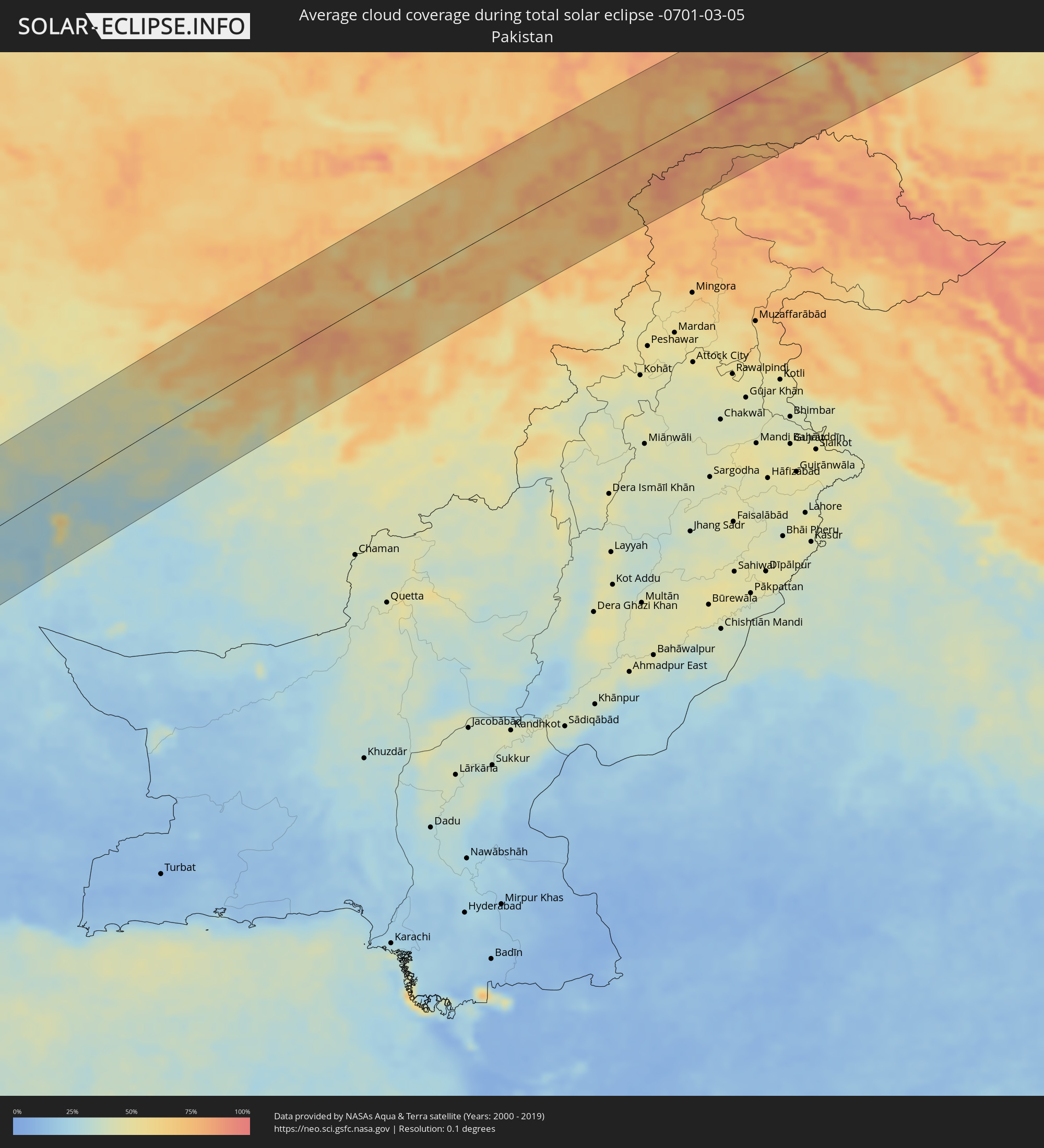 Pakistan
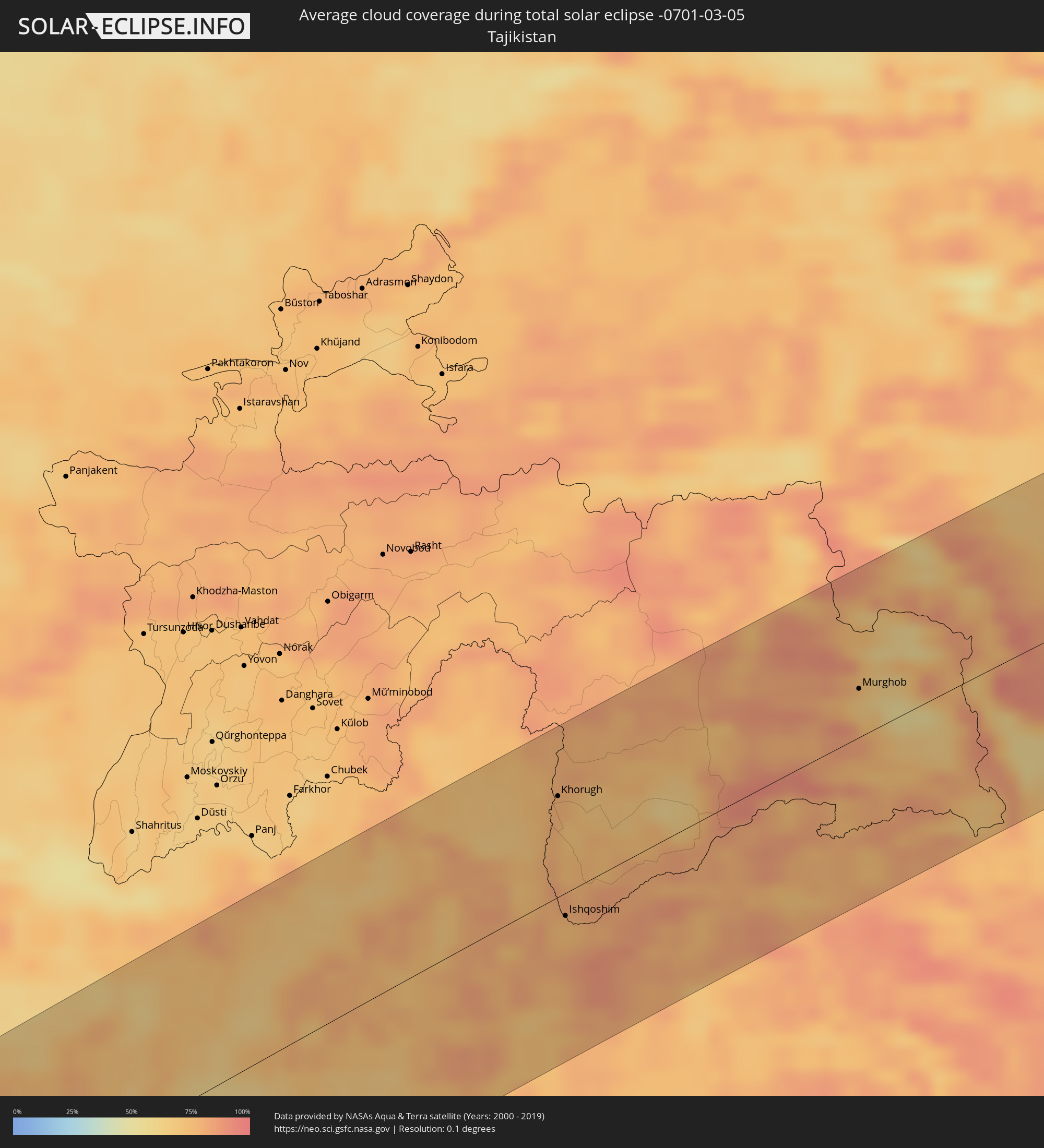 Tajikistan
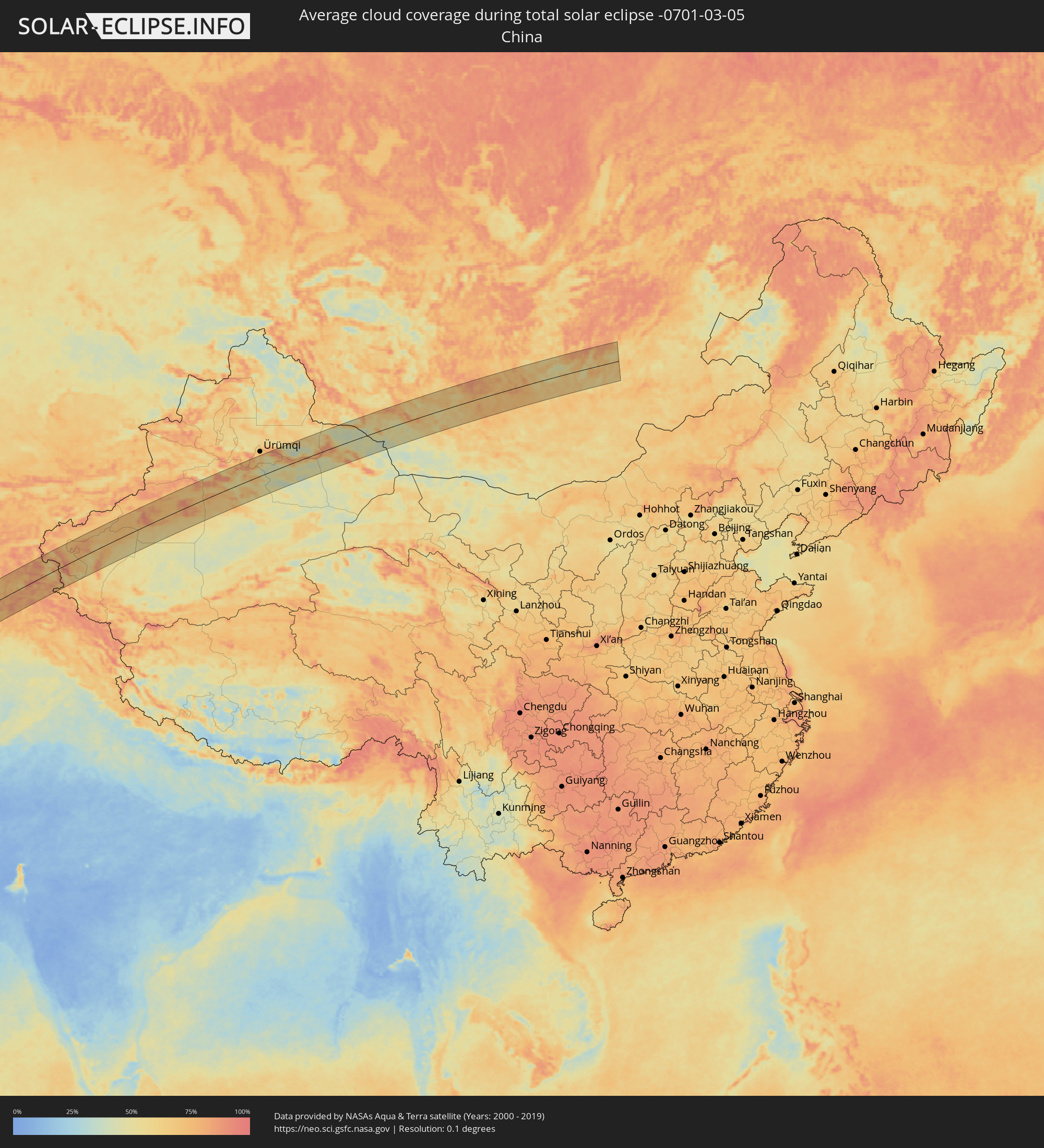 China
China
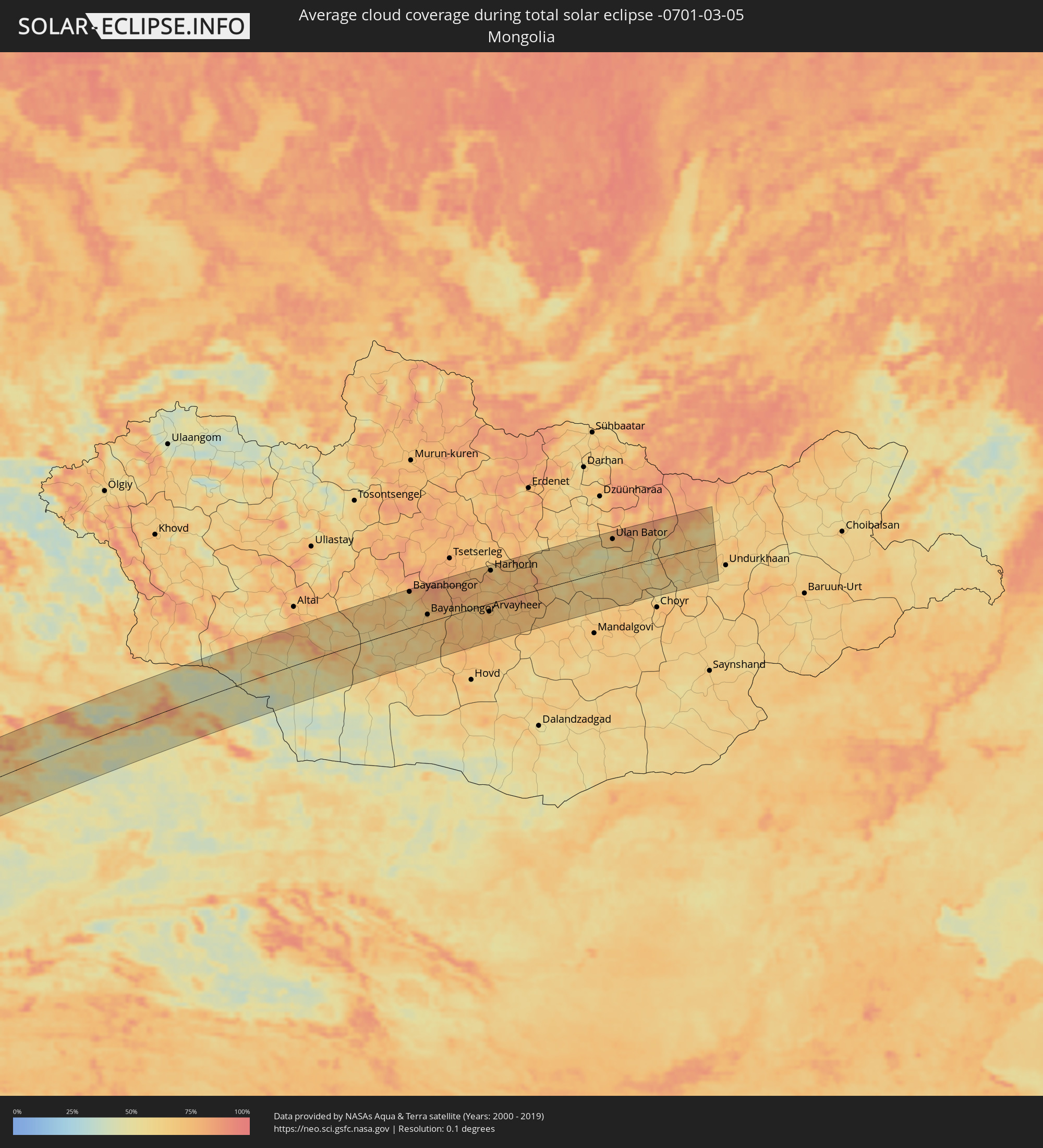 Mongolia
Cities inside the path of the eclipse
The following table shows all locations with a population of more than 5,000 inside the eclipse path. Cities which have more than 100,000 inhabitants are marked bold. A click at the locations opens a detailed map.
| City | Type | Eclipse duration | Local time of max. eclipse | Distance to central line | Ø Cloud coverage |
|
Ouro Sogui, Matam
|
total | - | 07:04:12 UTC-00:16 | 38 km | 17% |
|
Matam, Matam
|
total | - | 07:04:15 UTC-00:16 | 47 km | 17% |
|
Kanel, Matam
|
total | - | 07:04:07 UTC-00:16 | 26 km | 17% |
|
Sémé, Matam
|
total | - | 07:03:54 UTC-00:16 | 3 km | 19% |
|
Waoundé, Matam
|
total | - | 07:03:58 UTC-00:16 | 6 km | 19% |
|
Diawara, Matam
|
total | - | 07:03:49 UTC-00:16 | 15 km | 20% |
|
Sélibaby, Guidimaka
|
total | - | 07:04:00 UTC-00:16 | 6 km | 18% |
|
Kayes, Kayes
|
total | - | 07:03:31 UTC-00:16 | 60 km | 13% |
|
Ségou, Ségou
|
total | - | 07:04:10 UTC-00:16 | 93 km | 16% |
|
Markala, Ségou
|
total | - | 07:04:28 UTC-00:16 | 61 km | 17% |
|
Ké-Macina, Ségou
|
total | - | 07:05:00 UTC-00:16 | 23 km | 20% |
|
Ténenkou, Mopti
|
total | - | 07:05:39 UTC-00:16 | 37 km | 17% |
|
San, Ségou
|
total | - | 07:04:36 UTC-00:16 | 90 km | 18% |
|
Djénné, Mopti
|
total | - | 07:05:18 UTC-00:16 | 19 km | 16% |
|
Mopti, Mopti
|
total | - | 07:06:01 UTC-00:16 | 49 km | 18% |
|
Bandiagara, Mopti
|
total | - | 07:06:10 UTC-00:16 | 41 km | 12% |
|
Tougan, Boucle du Mouhoun
|
total | - | 07:05:16 UTC-00:16 | 94 km | 18% |
|
Ouahigouya, Nord
|
total | - | 07:06:04 UTC-00:16 | 30 km | 16% |
|
Gourcy, Nord
|
total | - | 07:05:46 UTC-00:16 | 71 km | 17% |
|
Yako, Nord
|
total | - | 07:05:36 UTC-00:16 | 98 km | 16% |
|
Titao, Nord
|
total | - | 07:06:26 UTC-00:16 | 6 km | 16% |
|
Djibo, Sahel
|
total | - | 07:07:00 UTC-00:16 | 35 km | 17% |
|
Kongoussi, Centre-Nord
|
total | - | 07:06:20 UTC-00:16 | 50 km | 13% |
|
Kaya, Centre-Nord
|
total | - | 07:06:23 UTC-00:16 | 71 km | 16% |
|
Gorom-Gorom, Sahel
|
total | - | 07:08:12 UTC-00:16 | 87 km | 16% |
|
Bogandé, Est
|
total | - | 07:06:51 UTC-00:16 | 76 km | 17% |
|
Dori, Sahel
|
total | - | 07:07:56 UTC-00:16 | 44 km | 16% |
|
Téra, Tillabéri
|
total | - | 07:38:09 UTC+00:13 | 47 km | 17% |
|
Niamey, Niamey
|
total | - | 07:38:38 UTC+00:13 | 3 km | 16% |
|
Dosso, Dosso
|
total | - | 07:39:01 UTC+00:13 | 41 km | 16% |
|
Dogondoutchi, Dosso
|
total | - | 07:40:17 UTC+00:13 | 29 km | 14% |
|
Birnin Kebbi, Kebbi
|
total | - | 07:39:16 UTC+00:13 | 102 km | 15% |
|
Argungu, Kebbi
|
total | - | 07:39:49 UTC+00:13 | 68 km | 12% |
|
Sokoto, Sokoto
|
total | - | 07:40:45 UTC+00:13 | 29 km | 17% |
|
Birni N Konni, Tahoua
|
total | - | 07:41:30 UTC+00:13 | 52 km | 15% |
|
Madaoua, Tahoua
|
total | - | 07:42:26 UTC+00:13 | 86 km | 16% |
|
Talata Mafara, Zamfara
|
total | - | 07:41:00 UTC+00:13 | 81 km | 18% |
|
Moriki, Zamfara
|
total | - | 07:41:43 UTC+00:13 | 46 km | 16% |
|
Kaura Namoda, Zamfara
|
total | - | 07:41:31 UTC+00:13 | 77 km | 19% |
|
Maradi, Maradi
|
total | - | 07:42:56 UTC+00:13 | 25 km | 18% |
|
Katsina, Katsina
|
total | - | 07:42:55 UTC+00:13 | 30 km | 19% |
|
Mayahi, Maradi
|
total | - | 07:43:59 UTC+00:13 | 77 km | 17% |
|
Tessaoua, Maradi
|
total | - | 07:44:06 UTC+00:13 | 56 km | 19% |
|
Zinder, Zinder
|
total | - | 07:45:13 UTC+00:13 | 62 km | 17% |
|
Mirriah, Zinder
|
total | - | 07:45:17 UTC+00:13 | 51 km | 15% |
|
Gumel, Jigawa
|
total | - | 07:44:25 UTC+00:13 | 69 km | 20% |
|
Hadejia, Jigawa
|
total | - | 07:44:58 UTC+00:13 | 89 km | 18% |
|
Nguru, Yobe
|
total | - | 07:45:52 UTC+00:13 | 43 km | 22% |
|
Gashua, Yobe
|
total | - | 07:46:33 UTC+00:13 | 44 km | 17% |
|
Geidam, Yobe
|
total | - | 07:47:39 UTC+00:13 | 44 km | 16% |
|
Diffa, Diffa
|
total | - | 07:48:57 UTC+00:13 | 0 km | 16% |
|
Makary, Far North
|
total | - | 07:50:34 UTC+00:13 | 93 km | 18% |
|
Bol, Lac
|
total | - | 08:38:32 UTC+01:00 | 4 km | 23% |
|
Mao, Kanem
|
total | - | 08:40:07 UTC+01:00 | 73 km | 21% |
|
Massaguet, Hadjer-Lamis
|
total | - | 08:38:26 UTC+01:00 | 111 km | 19% |
|
Massakory, Hadjer-Lamis
|
total | - | 08:39:26 UTC+01:00 | 56 km | 21% |
|
Moussoro, Barh el Gazel
|
total | - | 08:41:17 UTC+01:00 | 9 km | 15% |
|
Ati, Batha
|
total | - | 08:43:37 UTC+01:00 | 59 km | 17% |
|
Oum Hadjer, Batha
|
total | - | 08:45:55 UTC+01:00 | 69 km | 10% |
|
Abéché, Ouadaï
|
total | - | 08:48:29 UTC+01:00 | 28 km | 10% |
|
Biltine, Wadi Fira
|
total | - | 08:49:30 UTC+01:00 | 48 km | 10% |
|
Adré, Ouadaï
|
total | - | 08:50:27 UTC+01:00 | 92 km | 9% |
|
Geneina, Western Darfur
|
total | - | 10:00:49 UTC+02:10 | 98 km | 9% |
|
Kutum, Northern Darfur
|
total | - | 10:05:54 UTC+02:10 | 64 km | 4% |
|
El Matama, River Nile
|
total | - | 10:27:51 UTC+02:10 | 66 km | 5% |
|
Shendi, River Nile
|
total | - | 10:28:00 UTC+02:10 | 71 km | 5% |
|
El Bauga, River Nile
|
total | - | 10:31:16 UTC+02:10 | 72 km | 7% |
|
Ed Damer, River Nile
|
total | - | 10:30:30 UTC+02:10 | 2 km | 5% |
|
Berber, River Nile
|
total | - | 10:31:07 UTC+02:10 | 45 km | 5% |
|
Atbara, River Nile
|
total | - | 10:30:41 UTC+02:10 | 12 km | 5% |
|
Port Sudan, Red Sea
|
total | - | 10:41:00 UTC+02:10 | 68 km | 21% |
|
Sawākin, Red Sea
|
total | - | 10:40:34 UTC+02:10 | 12 km | 27% |
|
Tokār, Red Sea
|
total | - | 10:40:36 UTC+02:10 | 75 km | 64% |
|
Ash Shafā, Makkah
|
total | - | 11:47:12 UTC+03:06 | 67 km | 19% |
|
Ta’if, Makkah
|
total | - | 11:47:43 UTC+03:06 | 81 km | 11% |
|
Al Bāḩah, Al Bahah
|
total | - | 11:48:37 UTC+03:06 | 94 km | 27% |
|
Turabah, Makkah
|
total | - | 11:50:36 UTC+03:06 | 15 km | 11% |
|
Riyadh, Ar Riyāḑ
|
total | - | 12:07:07 UTC+03:06 | 85 km | 20% |
|
Ad Dilam, Ar Riyāḑ
|
total | - | 12:07:22 UTC+03:06 | 5 km | 24% |
|
Al Hufūf, Eastern Province
|
total | - | 12:14:28 UTC+03:06 | 4 km | 23% |
|
Abqaiq, Eastern Province
|
total | - | 12:15:19 UTC+03:06 | 44 km | 22% |
|
Tārūt, Eastern Province
|
total | - | 12:16:46 UTC+03:06 | 85 km | 39% |
|
Raḩīmah, Eastern Province
|
total | - | 12:16:58 UTC+03:06 | 96 km | 44% |
|
Dammam, Eastern Province
|
total | - | 12:16:47 UTC+03:06 | 68 km | 23% |
|
Khobar, Eastern Province
|
total | - | 12:16:52 UTC+03:06 | 48 km | 32% |
|
Dār Kulayb, Southern Governorate
|
total | - | 12:36:36 UTC+03:26 | 12 km | 36% |
|
Madīnat Ḩamad, Central Governorate
|
total | - | 12:36:39 UTC+03:26 | 16 km | 36% |
|
Madīnat ‘Īsá, Southern Governorate
|
total | - | 12:36:48 UTC+03:26 | 20 km | 39% |
|
Jidd Ḩafş, Manama
|
total | - | 12:36:51 UTC+03:26 | 24 km | 39% |
|
Ar Rifā‘, Southern Governorate
|
total | - | 12:36:46 UTC+03:26 | 15 km | 33% |
|
Manama, Manama
|
total | - | 12:36:56 UTC+03:26 | 23 km | 36% |
|
Al Muharraq, Muharraq
|
total | - | 12:37:02 UTC+03:26 | 24 km | 48% |
|
Sitrah, Manama
|
total | - | 12:36:57 UTC+03:26 | 14 km | 36% |
|
Al Ḩadd, Muharraq
|
total | - | 12:37:07 UTC+03:26 | 21 km | 40% |
|
Dukhān, Baladīyat ar Rayyān
|
total | - | 12:36:35 UTC+03:26 | 63 km | 32% |
|
Madīnat ash Shamāl, Madīnat ash Shamāl
|
total | - | 12:38:14 UTC+03:26 | 19 km | 35% |
|
Ash Shayḩānīyah, Baladīyat ar Rayyān
|
total | - | 12:37:32 UTC+03:26 | 92 km | 23% |
|
Umm Şalāl ‘Alī, Baladīyat Umm Şalāl
|
total | - | 12:38:02 UTC+03:26 | 92 km | 21% |
|
Umm Şalāl Muḩammad, Baladīyat Umm Şalāl
|
total | - | 12:38:00 UTC+03:26 | 98 km | 21% |
|
Ar Rayyān, Baladīyat ar Rayyān
|
total | - | 12:37:55 UTC+03:26 | 110 km | 20% |
|
Az̧ Z̧a‘āyin, Baladīyat az̧ Z̧a‘āyin
|
total | - | 12:38:20 UTC+03:26 | 87 km | 34% |
|
Al Khawr, Al Khawr
|
total | - | 12:38:29 UTC+03:26 | 78 km | 32% |
|
Doha, Baladīyat ad Dawḩah
|
total | - | 12:38:07 UTC+03:26 | 117 km | 24% |
|
Fasā, Fars
|
total | - | 12:45:40 UTC+03:25 | 113 km | 22% |
|
Gerāsh, Fars
|
total | - | 12:45:40 UTC+03:25 | 32 km | 23% |
|
Neyrīz, Fars
|
total | - | 12:47:18 UTC+03:25 | 101 km | 21% |
|
Dārāb, Fars
|
total | - | 12:47:24 UTC+03:25 | 48 km | 26% |
|
Sirjan, Kerman
|
total | - | 12:50:17 UTC+03:25 | 54 km | 19% |
|
Bardsīr, Kerman
|
total | - | 12:52:25 UTC+03:25 | 51 km | 21% |
|
Kerman, Kerman
|
total | - | 12:53:40 UTC+03:25 | 59 km | 24% |
|
Zābol, Sistan and Baluchestan
|
total | - | 13:02:30 UTC+03:25 | 95 km | 34% |
|
Farah, Farah
|
total | - | 13:38:29 UTC+04:00 | 2 km | 42% |
|
Bāmyān, Bamyan
|
total | - | 13:48:33 UTC+04:00 | 34 km | 72% |
|
Aībak, Samangan
|
total | - | 13:48:59 UTC+04:00 | 97 km | 67% |
|
Baghlān, Baghlan
|
total | - | 13:49:59 UTC+04:00 | 54 km | 71% |
|
Pul-e Khumrī, Baghlan
|
total | - | 13:49:59 UTC+04:00 | 35 km | 67% |
|
Kunduz, Kunduz
|
total | - | 13:50:14 UTC+04:00 | 105 km | 77% |
|
Paghmān, Kabul
|
total | - | 13:50:12 UTC+04:00 | 107 km | 71% |
|
Khanabad, Kunduz
|
total | - | 13:50:36 UTC+04:00 | 89 km | 72% |
|
Charikar, Parwan
|
total | - | 13:50:34 UTC+04:00 | 75 km | 61% |
|
Bāzārak, Panjshir
|
total | - | 13:51:06 UTC+04:00 | 61 km | 79% |
|
Taloqan, Takhar
|
total | - | 13:51:12 UTC+04:00 | 76 km | 67% |
|
Fayzabad, Badakhshan
|
total | - | 13:52:39 UTC+04:00 | 68 km | 77% |
|
Khorugh, Gorno-Badakhshan
|
total | - | 14:29:09 UTC+04:35 | 63 km | 77% |
|
Ishqoshim, Gorno-Badakhshan
|
total | - | 14:29:16 UTC+04:35 | 14 km | 74% |
|
Murghob, Gorno-Badakhshan
|
total | - | 14:32:10 UTC+04:35 | 30 km | 66% |
|
Kashgar, Xinjiang Uyghur Autonomous Region
|
total | - | 17:59:07 UTC+08:00 | 79 km | 79% |
|
Shache, Xinjiang Uyghur Autonomous Region
|
total | - | 18:00:47 UTC+08:00 | 74 km | 85% |
|
Aykol, Xinjiang Uyghur Autonomous Region
|
total | - | 18:03:04 UTC+08:00 | 73 km | 83% |
|
Aksu, Xinjiang Uyghur Autonomous Region
|
total | - | 18:03:07 UTC+08:00 | 91 km | 82% |
|
Aral, Xinjiang Uyghur Autonomous Region
|
total | - | 18:04:19 UTC+08:00 | 9 km | 72% |
|
Kuqa, Xinjiang Uyghur Autonomous Region
|
total | - | 18:05:22 UTC+08:00 | 54 km | 82% |
|
Korla, Xinjiang Uyghur Autonomous Region
|
total | - | 18:08:02 UTC+08:00 | 49 km | 66% |
|
Sishilichengzi, Xinjiang Uyghur Autonomous Region
|
total | - | 18:08:12 UTC+08:00 | 39 km | 71% |
|
Turpan, Xinjiang Uyghur Autonomous Region
|
total | - | 18:09:38 UTC+08:00 | 20 km | 58% |
|
Bayanhongor, Bayanhongor
|
total | - | 17:20:16 UTC+07:07 | 88 km | 64% |
|
Bayanhongor, Bayanhongor
|
total | - | 17:20:54 UTC+07:07 | 19 km | 69% |
|
Arvayheer, Övörhangay
|
total | - | 17:21:32 UTC+07:07 | 19 km | 72% |
|
Kharkhorin, Övörhangay
|
total | - | 17:20:47 UTC+07:07 | 79 km | 79% |
|
Harhorin, Övörhangay
|
total | - | 17:20:47 UTC+07:07 | 80 km | 79% |
|
Ulan Bator, Ulaanbaatar
|
total | - | 17:21:14 UTC+07:07 | 74 km | 72% |
|
Зуунмод, Central Aimak
|
total | - | 17:21:25 UTC+07:07 | 51 km | 55% |
|
Dzuunmod, Central Aimak
|
total | - | 17:21:25 UTC+07:07 | 51 km | 55% |