Total solar eclipse of 06/11/-0938
| Day of week: | Monday |
| Maximum duration of eclipse: | 05m04s |
| Maximum width of eclipse path: | 318 km |
| Saros cycle: | 51 |
| Coverage: | 100% |
| Magnitude: | 1.0773 |
| Gamma: | 0.6183 |
Wo kann man die Sonnenfinsternis vom 06/11/-0938 sehen?
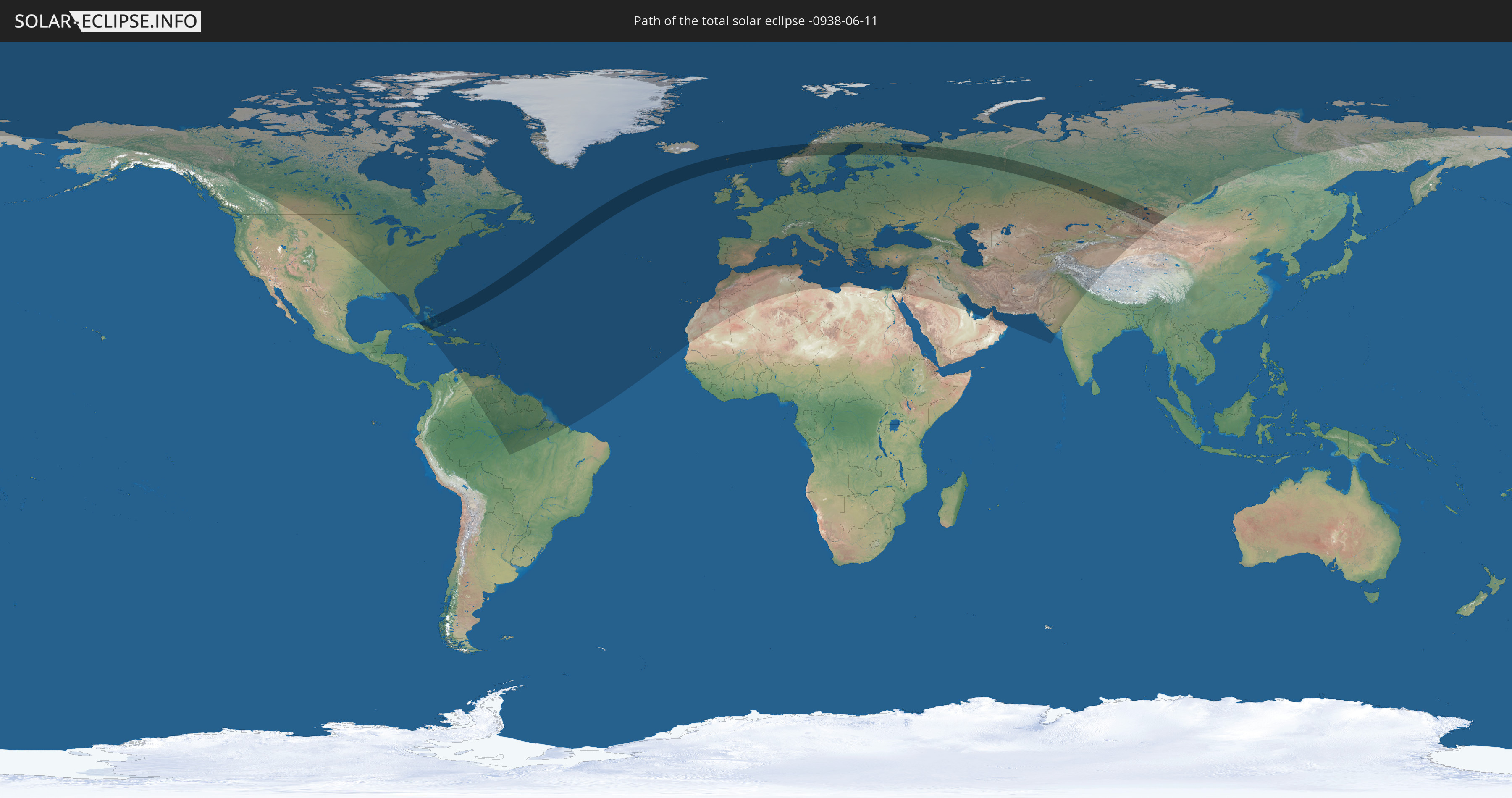
Die Sonnenfinsternis am 06/11/-0938 kann man in 122 Ländern als partielle Sonnenfinsternis beobachten.
Der Finsternispfad verläuft durch 9 Länder. Nur in diesen Ländern ist sie als total Sonnenfinsternis zu sehen.
In den folgenden Ländern ist die Sonnenfinsternis total zu sehen
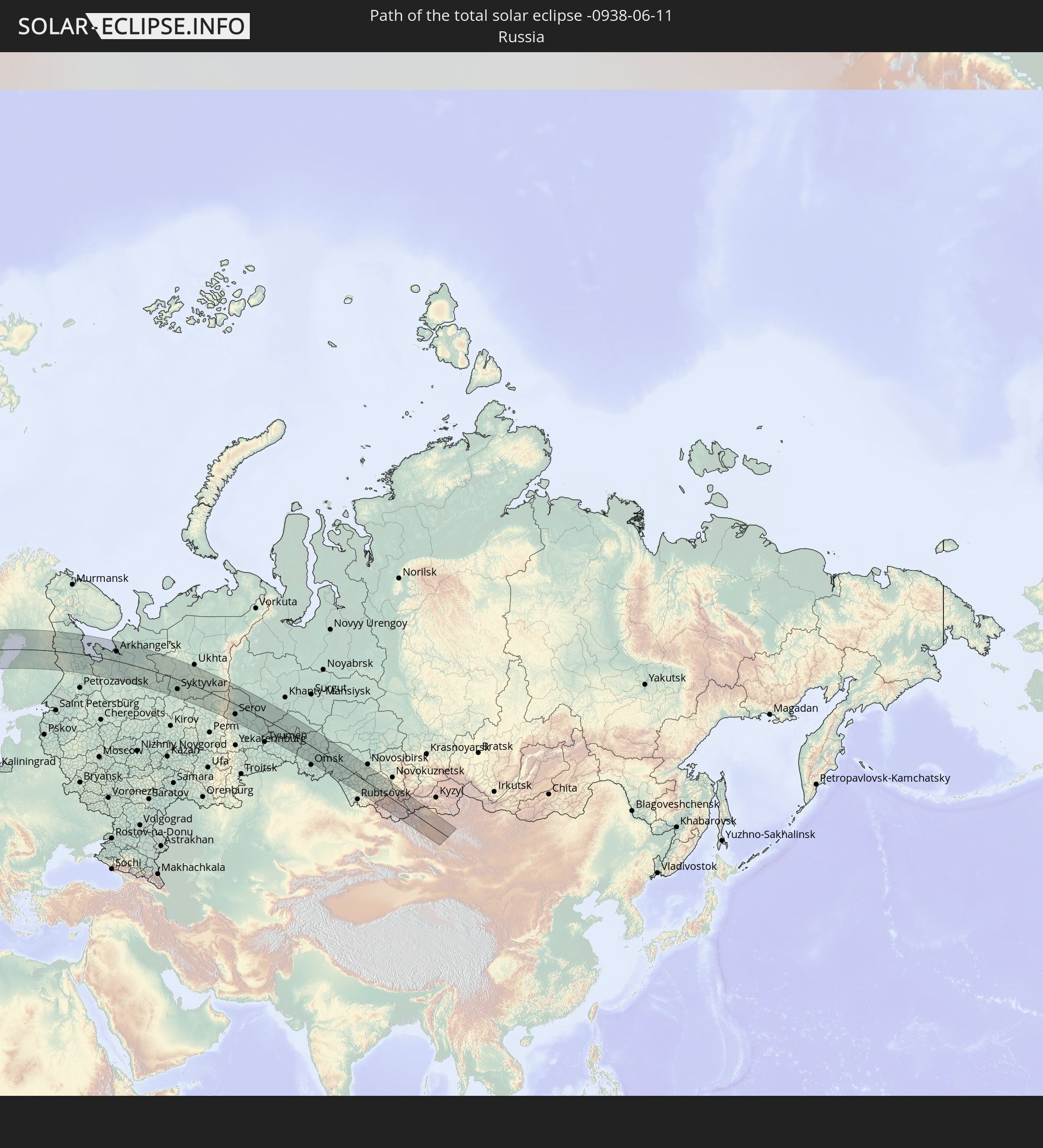 Russia
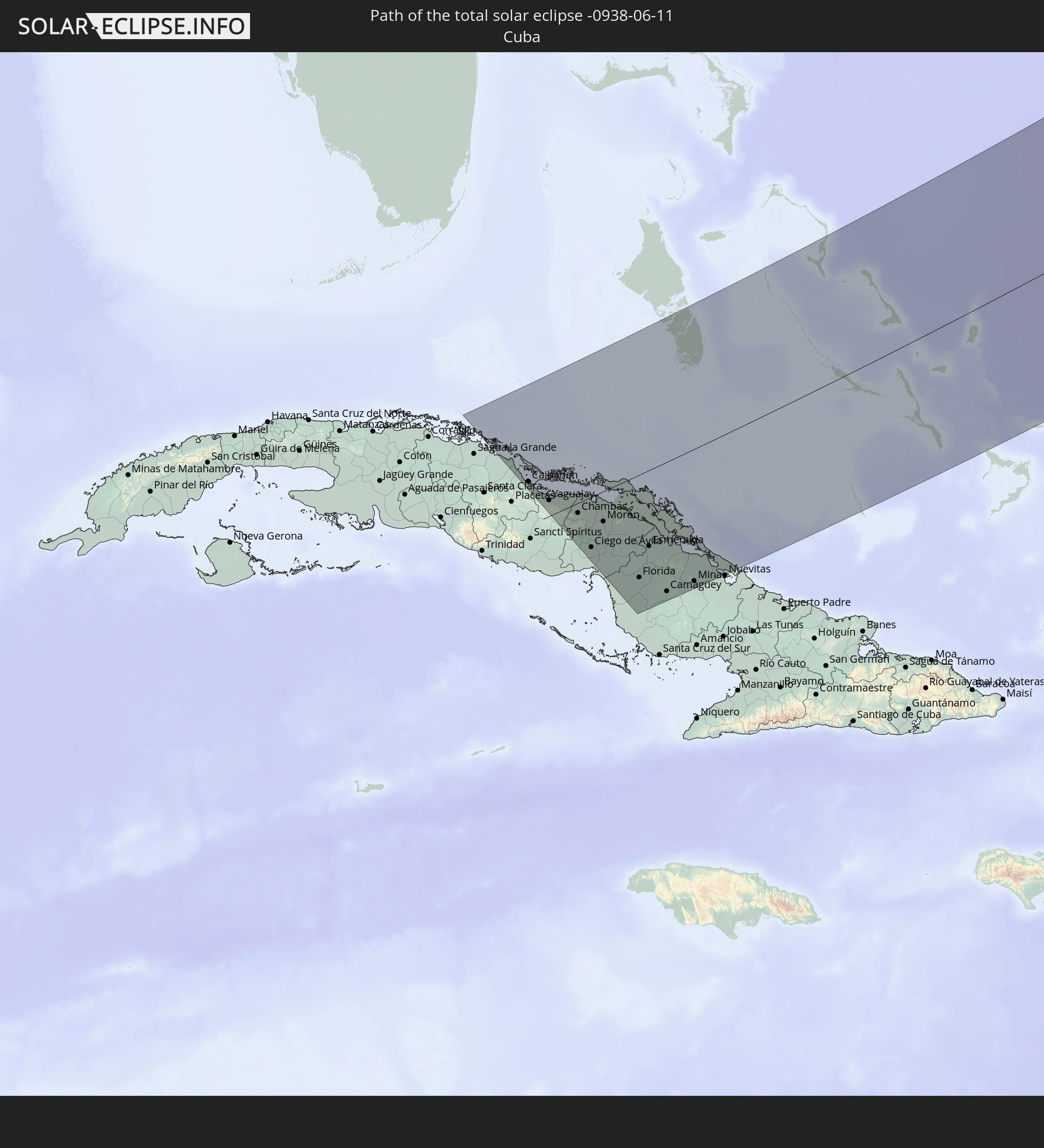 Cuba
Cuba
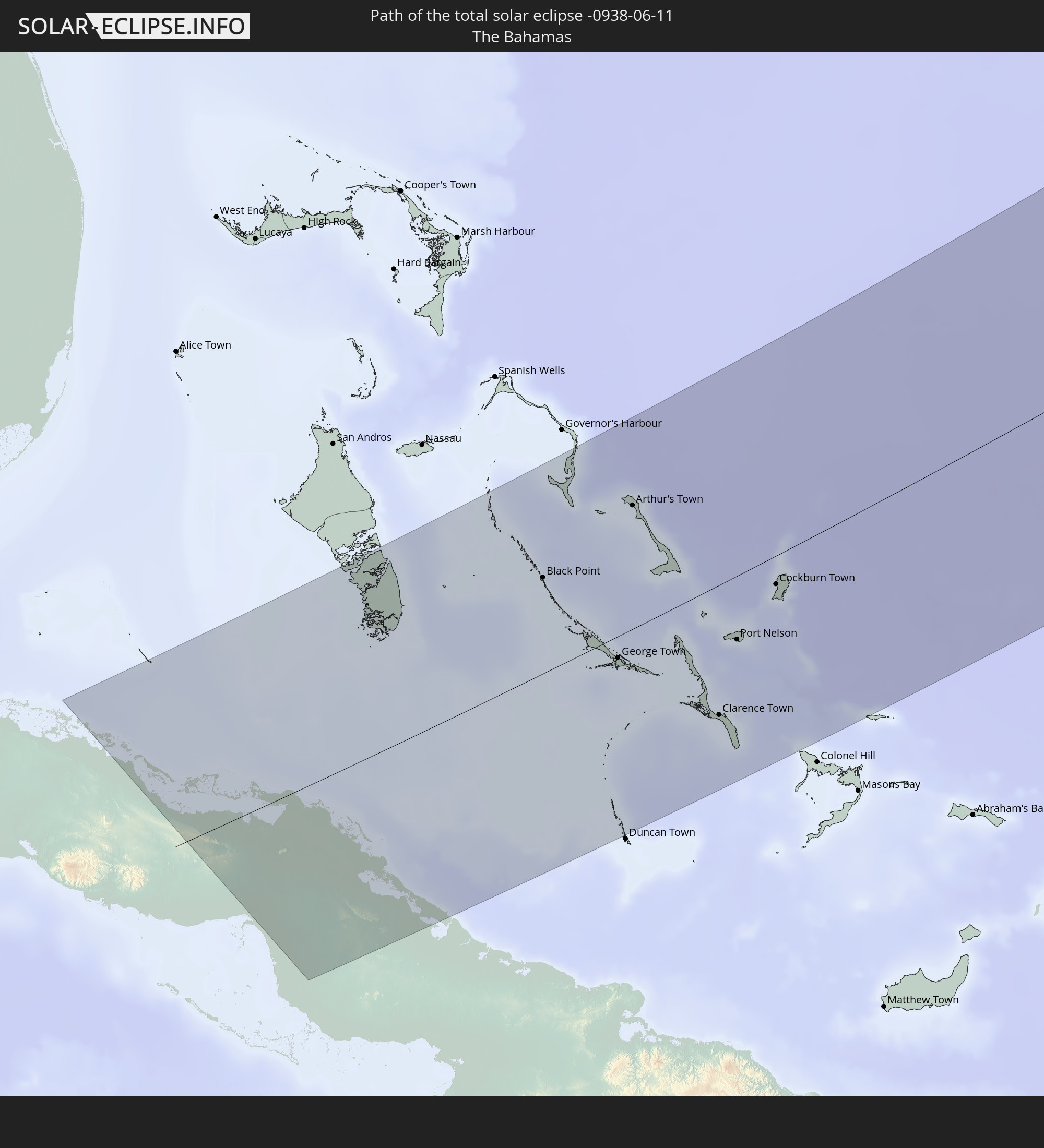 The Bahamas
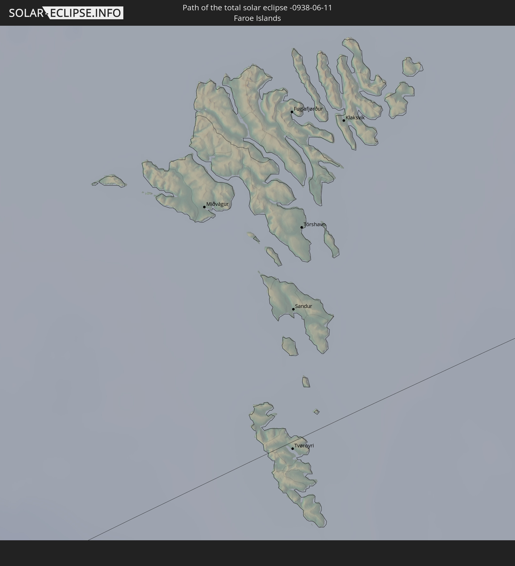 Faroe Islands
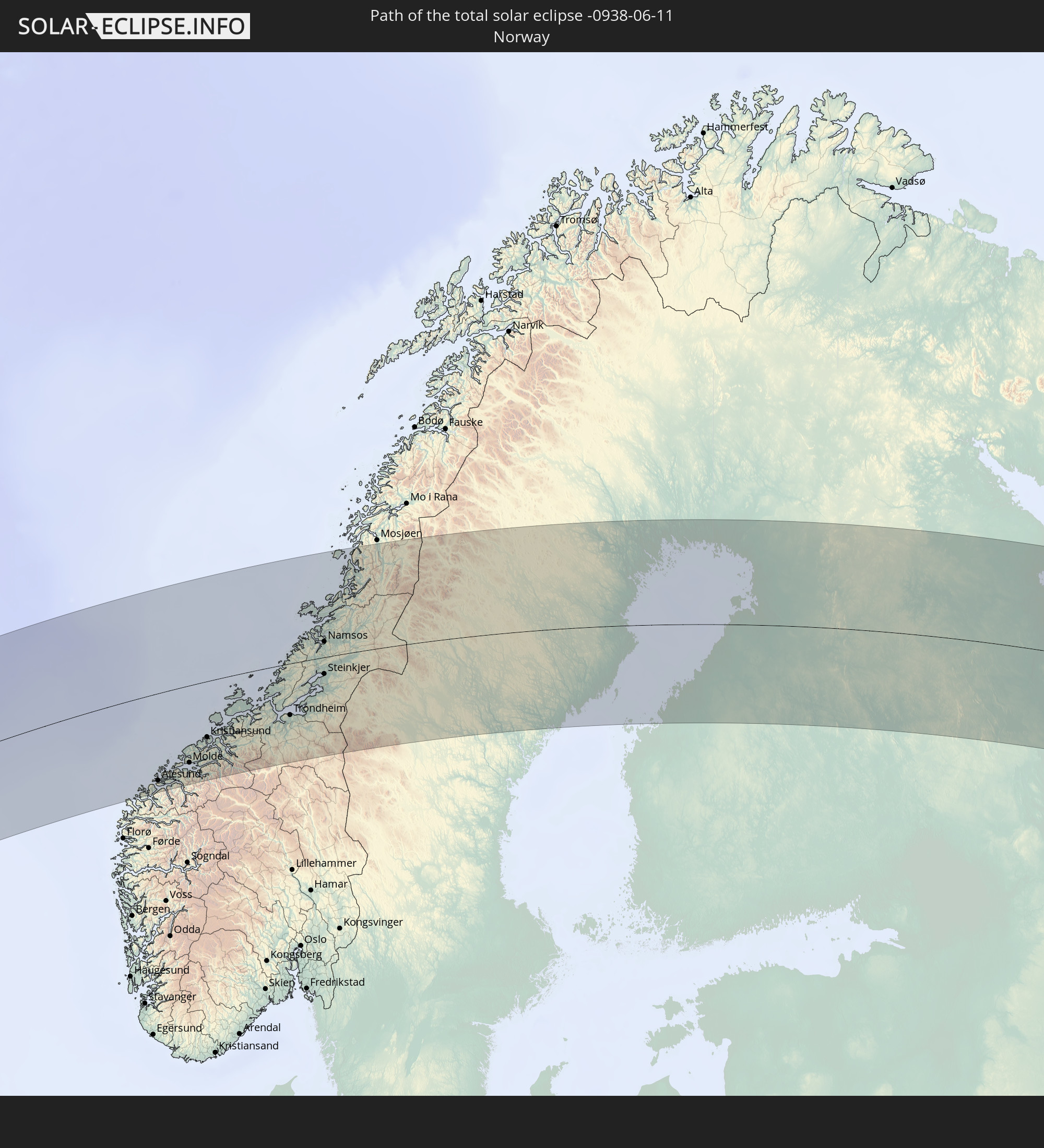 Norway
 Sweden
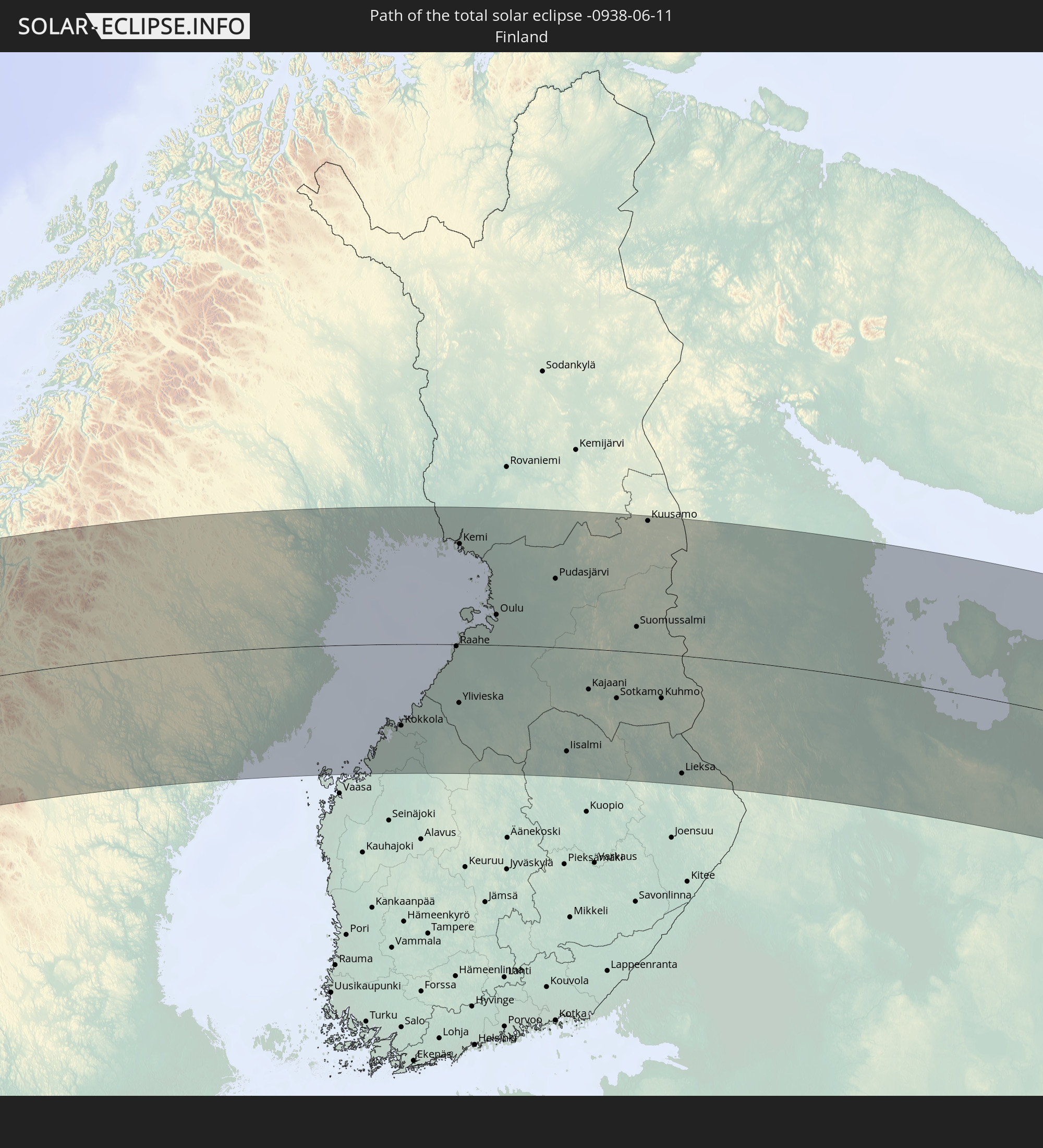 Finland
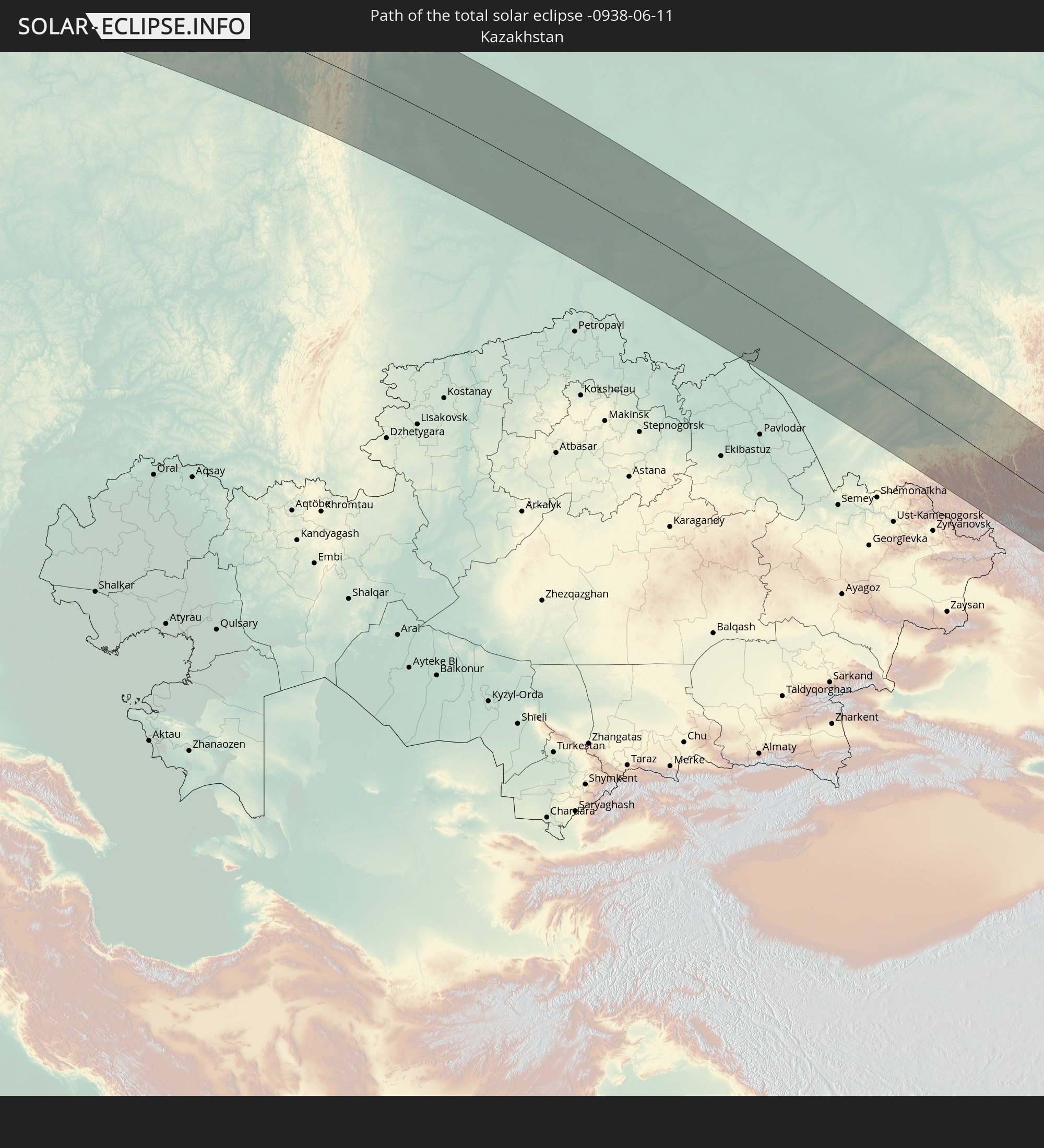 Kazakhstan
 Mongolia
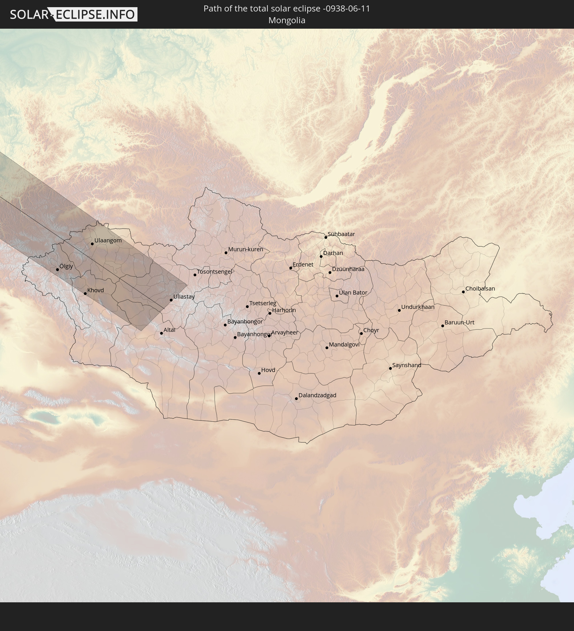
In den folgenden Ländern ist die Sonnenfinsternis partiell zu sehen
 Russia
 United States
 United States Minor Outlying Islands
 Canada
 Greenland
 Cuba
Cuba
 Colombia
 The Bahamas
 Haiti
Haiti
 Brazil
 Venezuela
 Turks and Caicos Islands
 Dominican Republic
 Aruba
Aruba
 Puerto Rico
 United States Virgin Islands
 Bermuda
 British Virgin Islands
 Anguilla
 Collectivity of Saint Martin
 Saint Barthélemy
 Saint Kitts and Nevis
 Antigua and Barbuda
 Montserrat
 Trinidad and Tobago
 Guadeloupe
 Grenada
 Dominica
 Saint Vincent and the Grenadines
 Guyana
 Martinique
 Saint Lucia
 Barbados
 Suriname
 Saint Pierre and Miquelon
 French Guiana
 Portugal
 Cabo Verde
 Iceland
 Spain
Spain
 Mauritania
 Morocco
 Mali
Mali
 Republic of Ireland
 Svalbard and Jan Mayen
 Algeria
 United Kingdom
 Faroe Islands
 Gibraltar
 France
 Isle of Man
 Guernsey
 Jersey
 Andorra
 Belgium
 Netherlands
 Norway
 Luxembourg
 Germany
 Switzerland
 Italy
Italy
 Monaco
 Tunisia
 Denmark
 Libya
Libya
 Liechtenstein
 Austria
 Sweden
 Czechia
 San Marino
 Vatican City
 Slovenia
 Croatia
 Poland
 Malta
Malta
 Bosnia and Herzegovina
 Hungary
 Slovakia
 Montenegro
 Serbia
 Albania
 Åland Islands
 Greece
 Romania
 Republic of Macedonia
 Finland
 Lithuania
 Latvia
 Estonia
 Ukraine
 Bulgaria
 Belarus
 Egypt
Egypt
 Turkey
 Moldova
 Cyprus
 State of Palestine
 Israel
 Saudi Arabia
 Jordan
 Lebanon
 Syria
Syria
 Iraq
Iraq
 Georgia
 Armenia
 Iran
Iran
 Azerbaijan
 Kazakhstan
 Kuwait
 Bahrain
 Qatar
Qatar
 United Arab Emirates
 Oman
Oman
 Turkmenistan
 Uzbekistan
 Afghanistan
 Pakistan
 Tajikistan
 India
India
 Kyrgyzstan
 China
China
 Mongolia
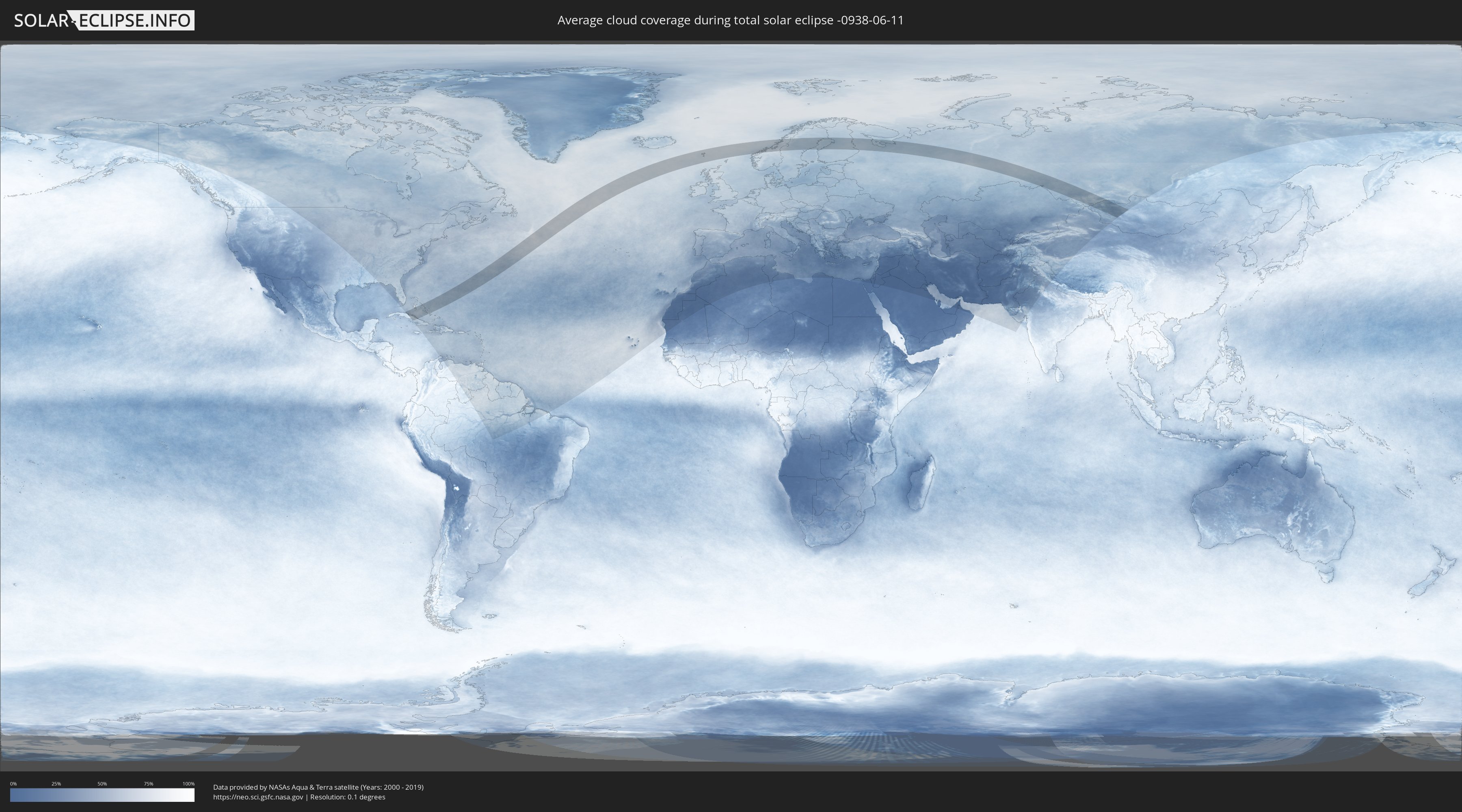
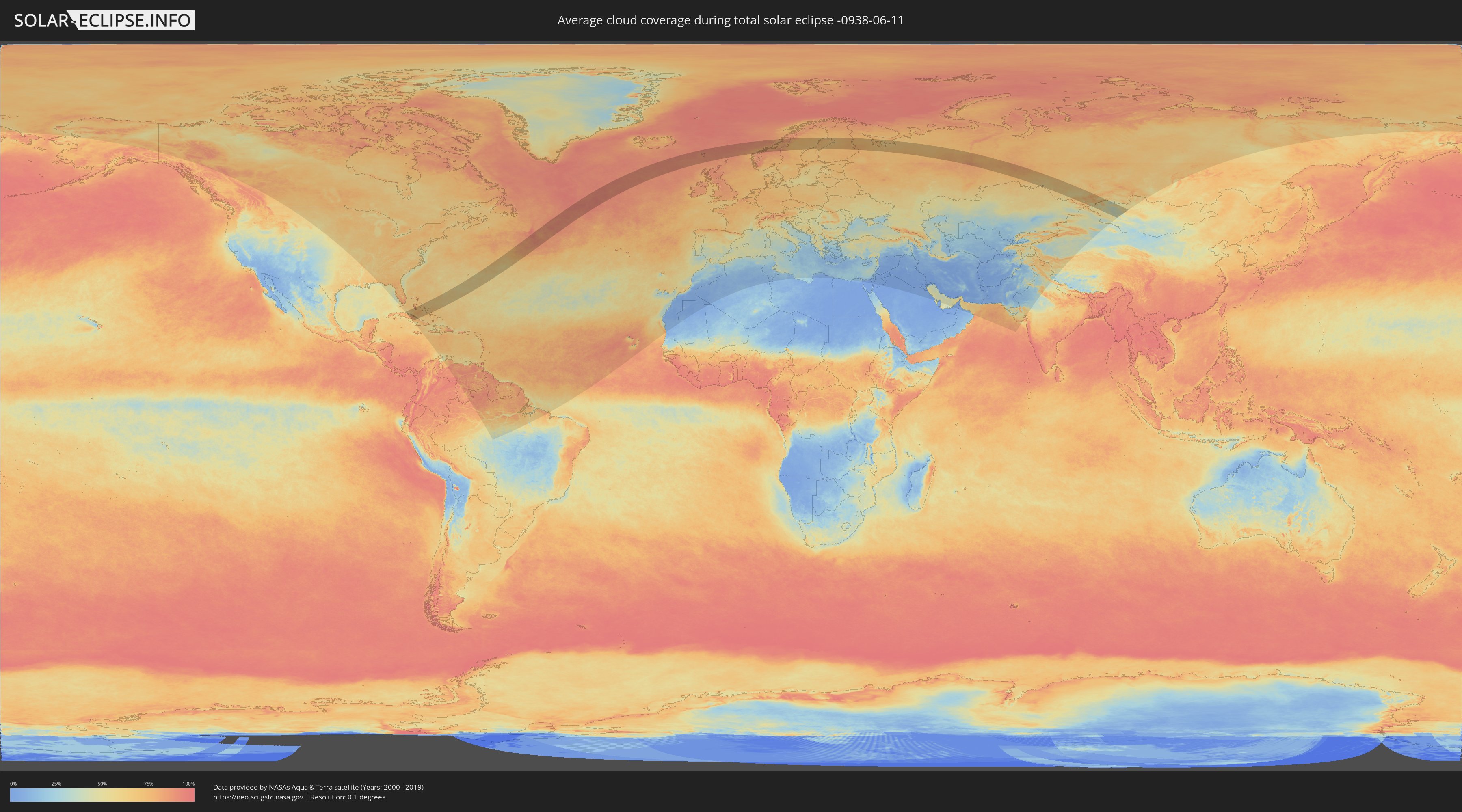
How will be the weather during the total solar eclipse on 06/11/-0938?
Where is the best place to see the total solar eclipse of 06/11/-0938?
The following maps show the average cloud coverage for the day of the total solar eclipse.
With the help of these maps, it is possible to find the place along the eclipse path, which has the best
chance of a cloudless sky.
Nevertheless, you should consider local circumstances and inform about the weather of your chosen
observation site.
The data is provided by NASAs satellites
AQUA and TERRA.
The cloud maps are averaged over a period of 19 years (2000 - 2019).
Detailed country maps
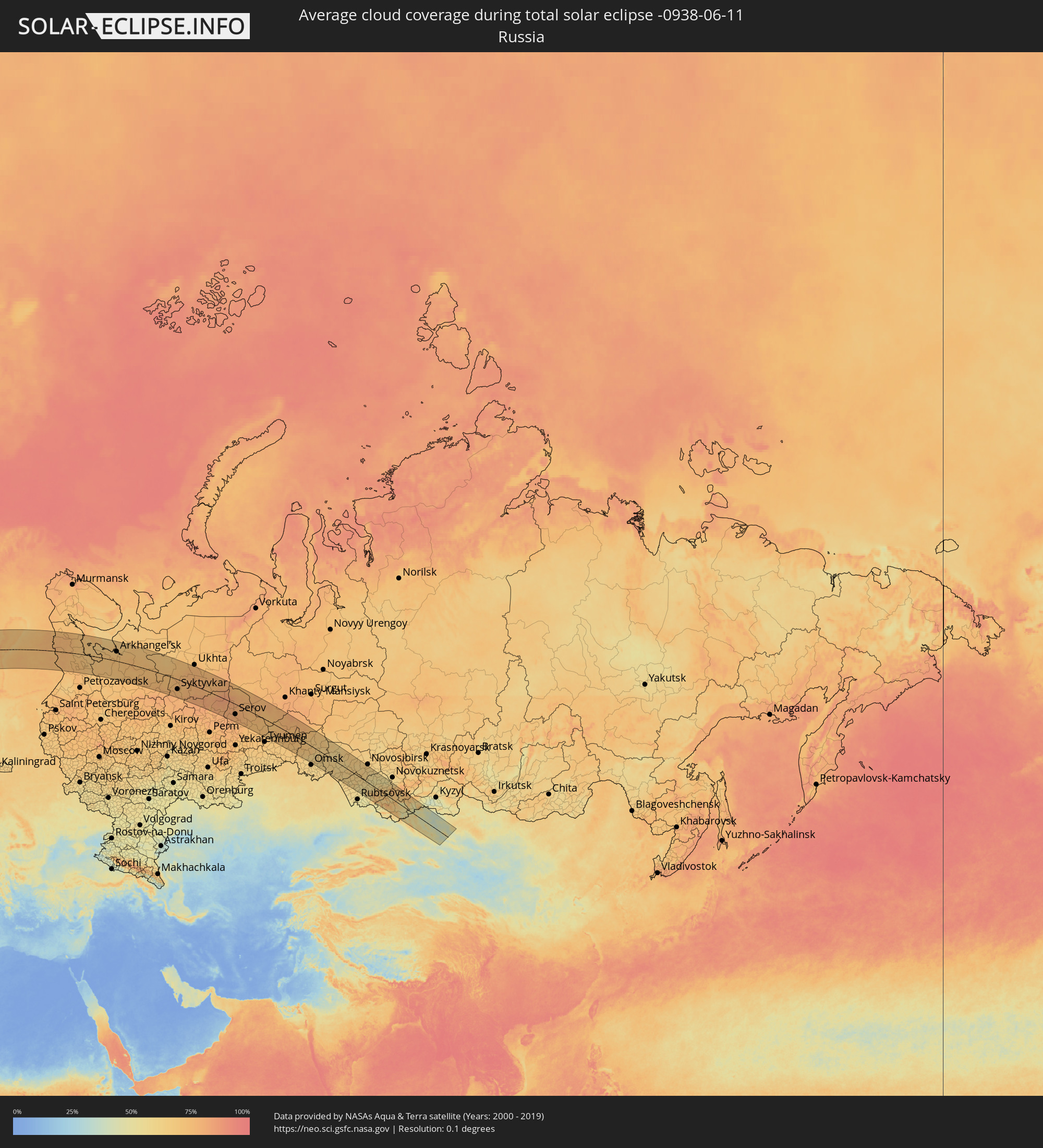 Russia
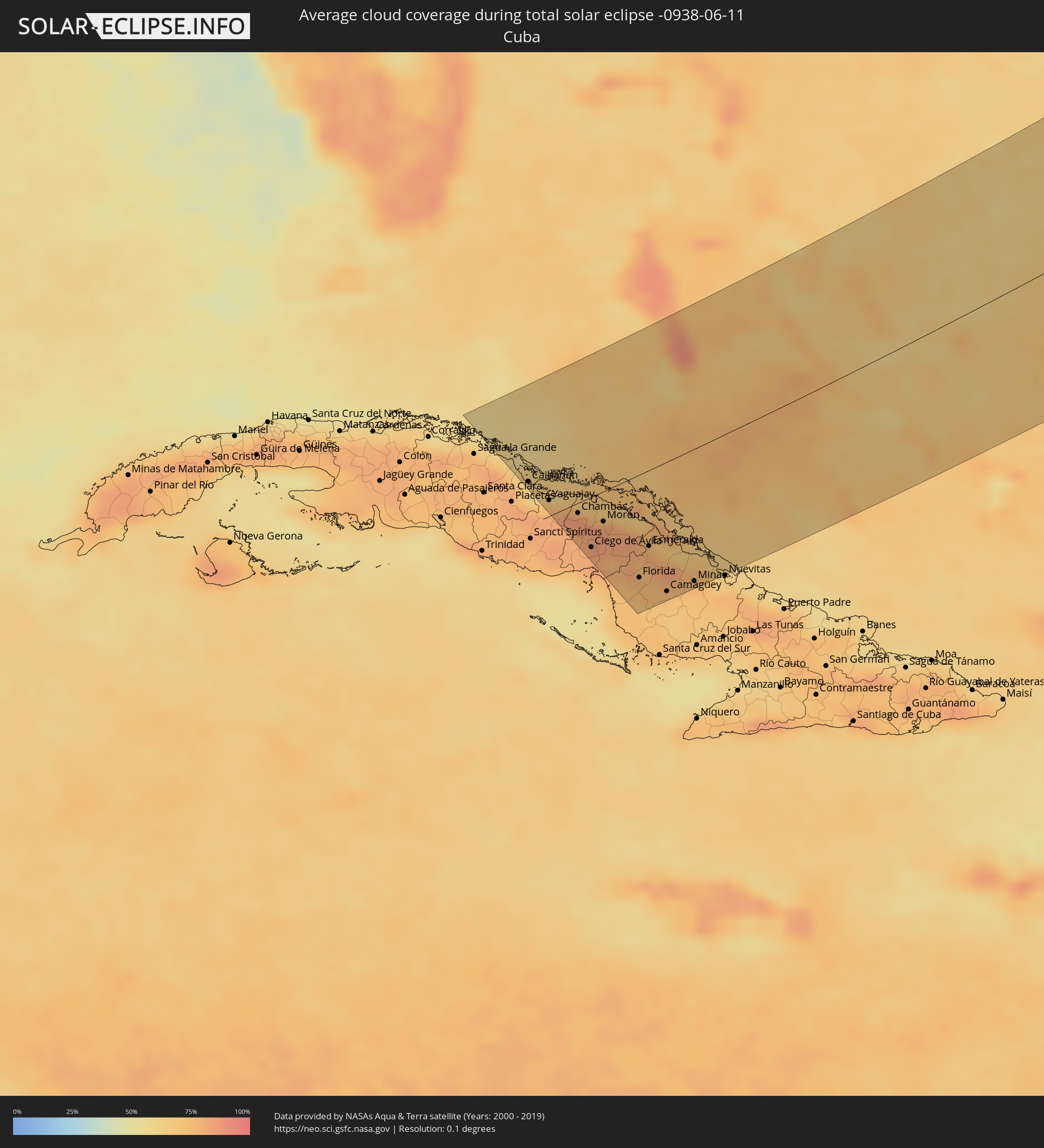 Cuba
Cuba
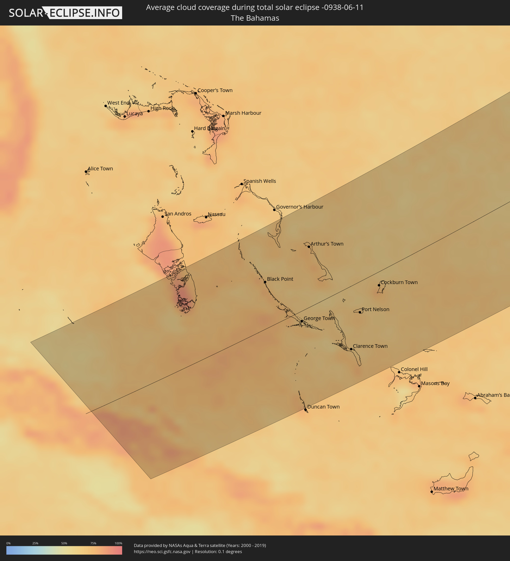 The Bahamas
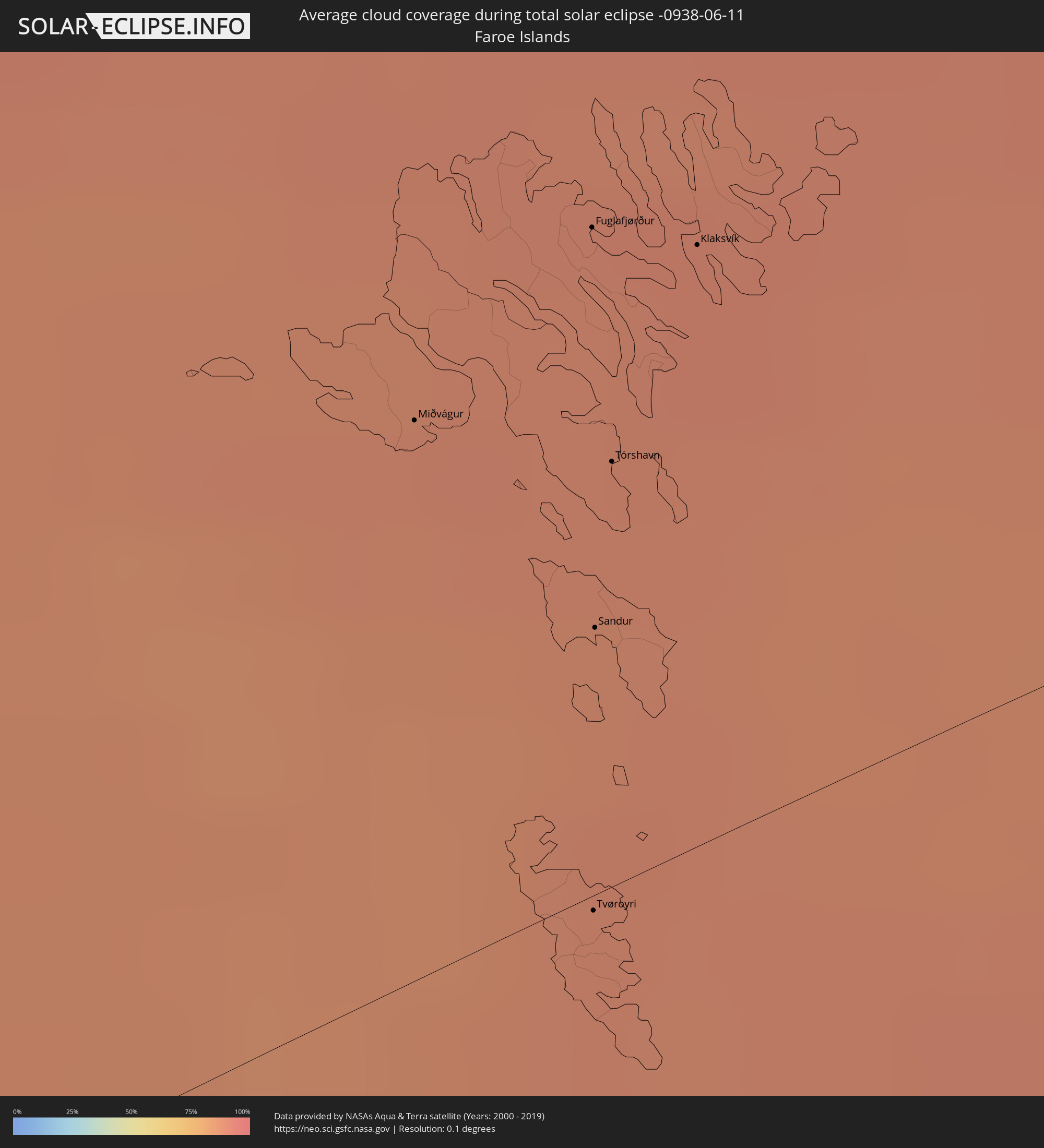 Faroe Islands
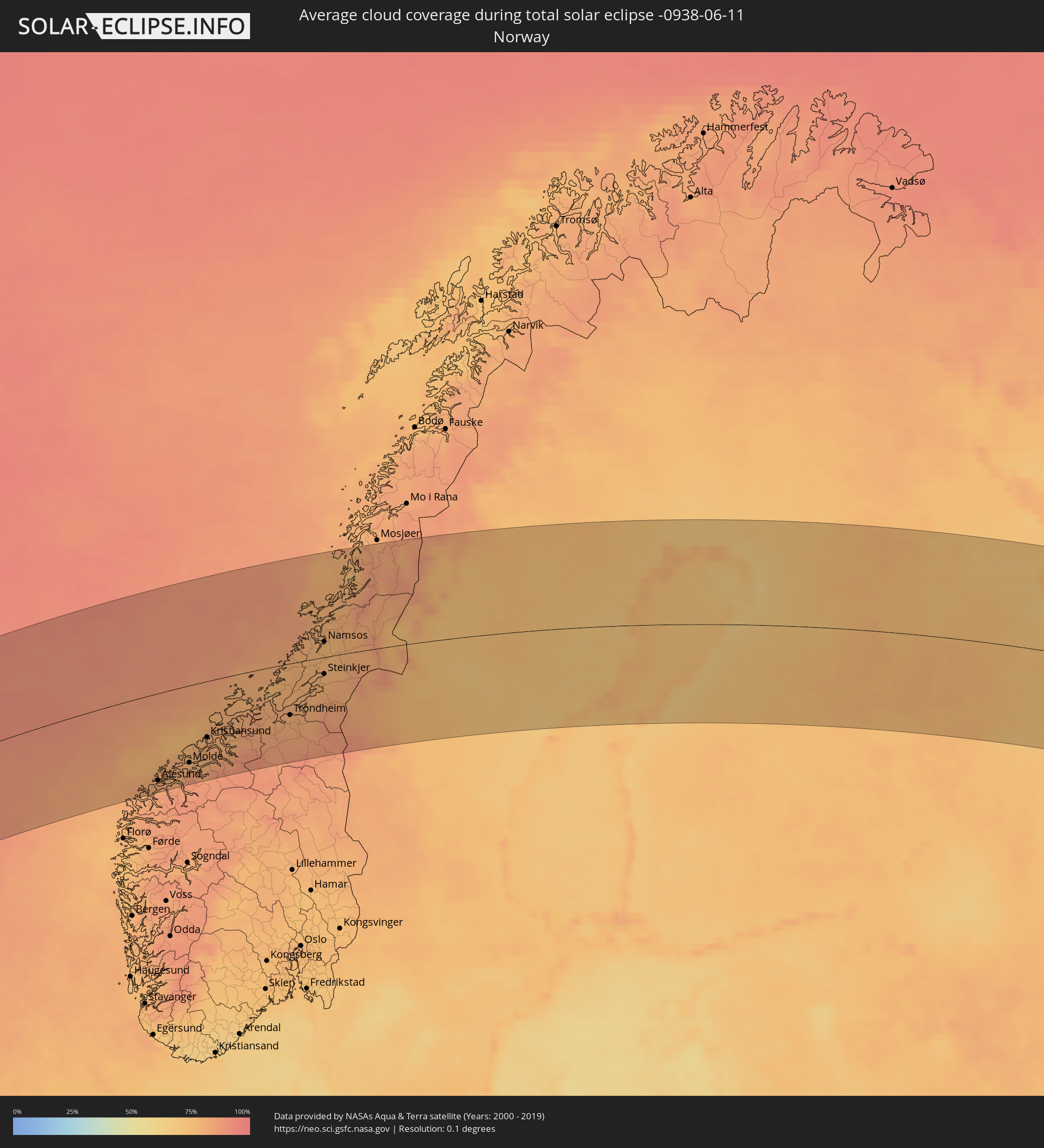 Norway
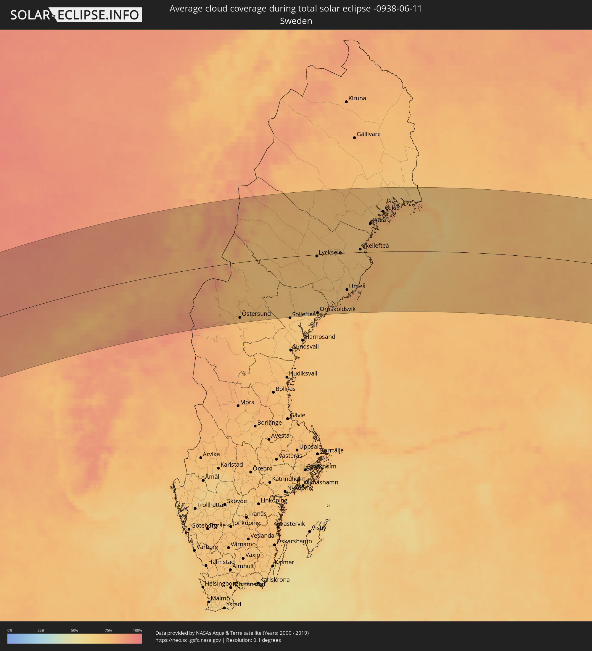 Sweden
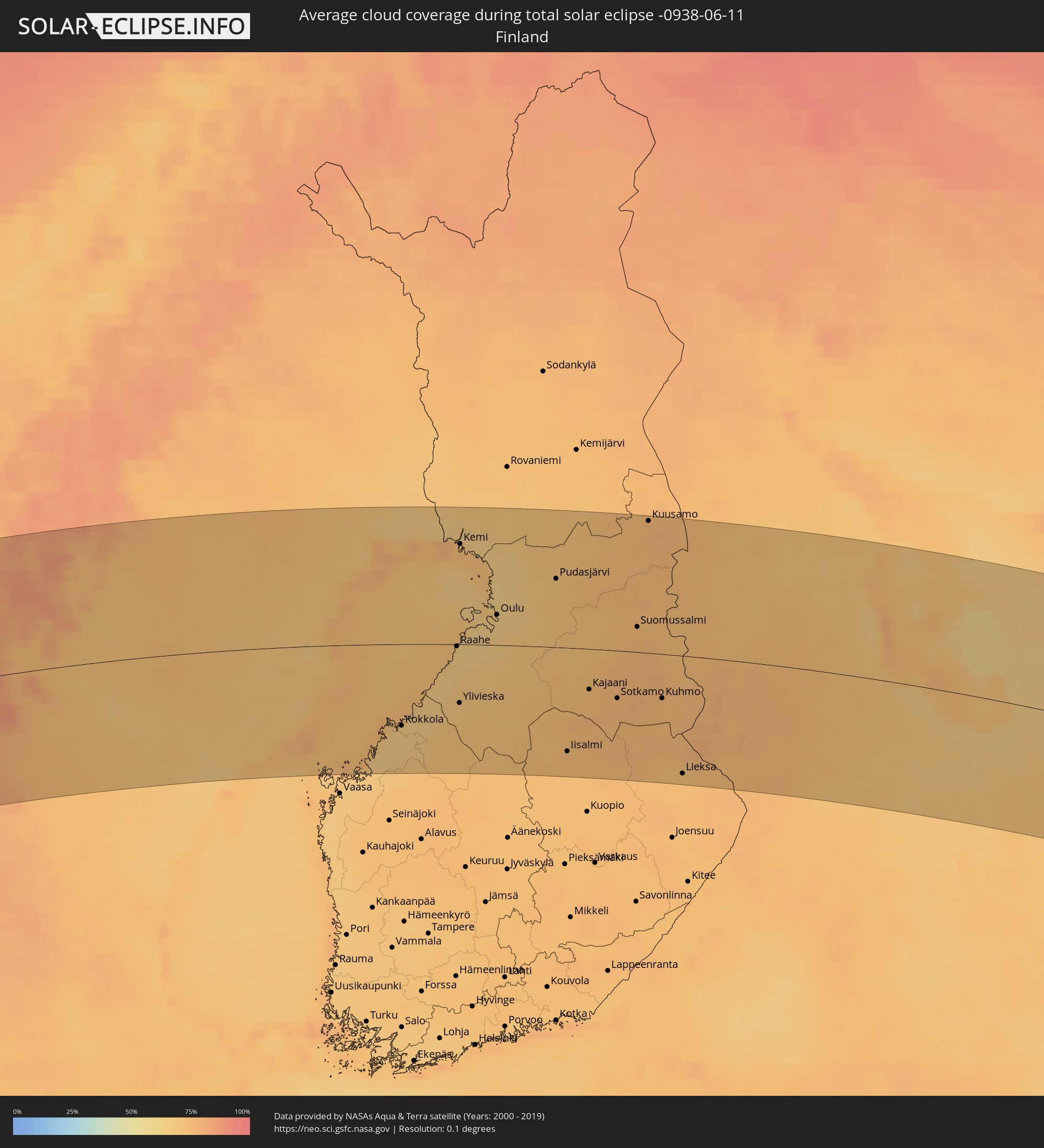 Finland
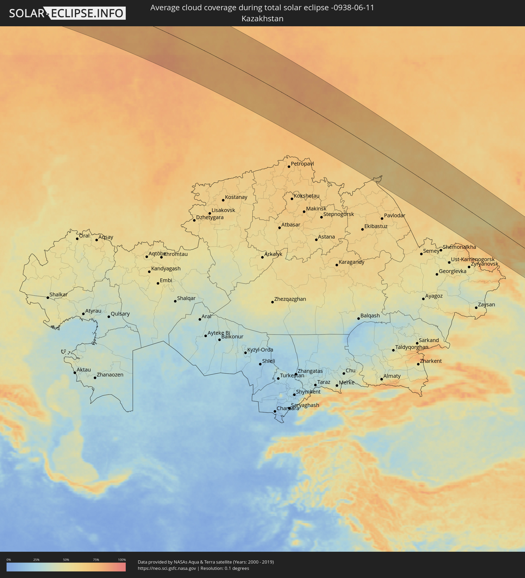 Kazakhstan
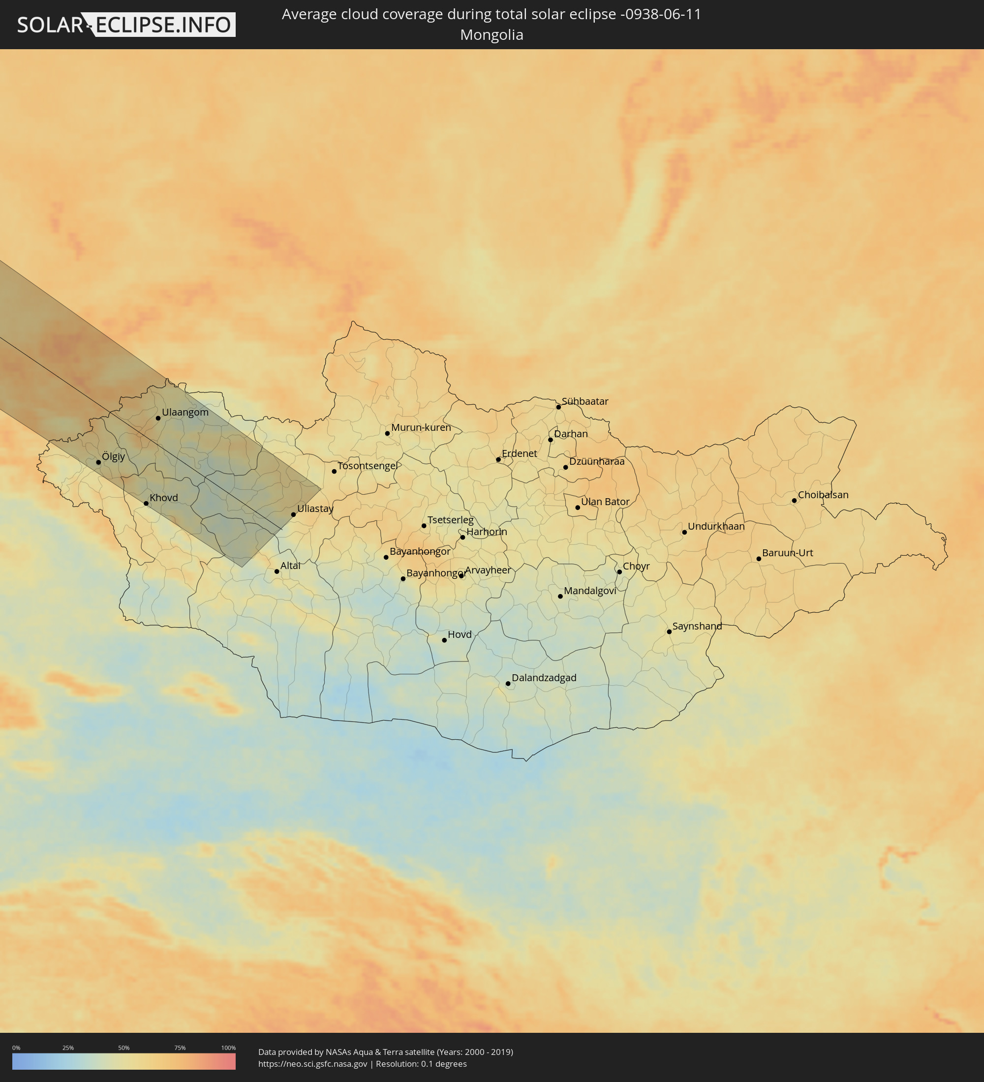 Mongolia
Cities inside the path of the eclipse
The following table shows all locations with a population of more than 5,000 inside the eclipse path. Cities which have more than 100,000 inhabitants are marked bold. A click at the locations opens a detailed map.
| City | Type | Eclipse duration | Local time of max. eclipse | Distance to central line | Ø Cloud coverage |
|
Caibarién, Villa Clara
|
total | - | 05:01:19 UTC-05:29 | 46 km | 71% |
|
Yaguajay, Sancti Spíritus
|
total | - | 05:01:01 UTC-05:29 | 17 km | 80% |
|
Florencia, Ciego de Ávila
|
total | - | 05:00:43 UTC-05:29 | 13 km | 82% |
|
Chambas, Ciego de Ávila
|
total | - | 05:00:44 UTC-05:29 | 12 km | 83% |
|
Venezuela, Ciego de Ávila
|
total | - | 05:00:13 UTC-05:29 | 62 km | 78% |
|
Ciego de Ávila, Ciego de Ávila
|
total | - | 05:00:18 UTC-05:29 | 53 km | 82% |
|
Ciro Redondo, Ciego de Ávila
|
total | - | 05:00:28 UTC-05:29 | 41 km | 85% |
|
Morón, Ciego de Ávila
|
total | - | 05:00:31 UTC-05:29 | 42 km | 85% |
|
Baraguá, Ciego de Ávila
|
total | - | 05:00:05 UTC-05:29 | 75 km | 82% |
|
Primero de Enero, Ciego de Ávila
|
total | - | 05:00:16 UTC-05:29 | 59 km | 81% |
|
Florida, Camagüey
|
total | - | 04:59:45 UTC-05:29 | 109 km | 75% |
|
Vertientes, Camagüey
|
total | - | 04:59:27 UTC-05:29 | 140 km | 70% |
|
Esmeralda, Camagüey
|
total | - | 05:00:03 UTC-05:29 | 80 km | 80% |
|
Camagüey, Camagüey
|
total | - | 04:59:28 UTC-05:29 | 136 km | 75% |
|
Minas, Camagüey
|
total | - | 04:59:27 UTC-05:29 | 138 km | 78% |
|
Black Point, Black Point
|
total | - | 10:31:24 UTC+00:00 | 70 km | 76% |
|
George Town, Exuma
|
total | - | 05:21:02 UTC-05:09 | 16 km | 70% |
|
Arthur’s Town, Cat Island
|
total | - | 05:22:14 UTC-05:09 | 93 km | 73% |
|
Clarence Town, Long Island
|
total | - | 05:20:17 UTC-05:09 | 95 km | 72% |
|
Port Nelson, Rum Cay
|
total | - | 05:20:51 UTC-05:09 | 46 km | 65% |
|
Cockburn Town, San Salvador
|
total | - | 05:21:12 UTC-05:09 | 25 km | 74% |
|
Miðvágur, Vágar
|
total | - | 11:36:52 UTC-00:27 | 58 km | 88% |
|
Fuglafjørður, Eysturoy
|
total | - | 11:37:22 UTC-00:27 | 69 km | 88% |
|
Tvøroyri, Suðuroy
|
total | - | 11:36:55 UTC-00:27 | 10 km | 88% |
|
Sandur, Sandoy
|
total | - | 11:37:07 UTC-00:27 | 28 km | 87% |
|
Tórshavn, Streymoy
|
total | - | 11:37:15 UTC-00:27 | 43 km | 88% |
|
Klaksvík, Norðoyar
|
total | - | 11:37:35 UTC-00:27 | 61 km | 90% |
|
Ulsteinvik, Møre og Romsdal
|
total | - | 13:17:09 UTC+01:00 | 147 km | 80% |
|
Ålesund, Møre og Romsdal
|
total | - | 13:17:28 UTC+01:00 | 137 km | 81% |
|
Molde, Møre og Romsdal
|
total | - | 13:18:29 UTC+01:00 | 121 km | 81% |
|
Kristiansund, Møre og Romsdal
|
total | - | 13:19:02 UTC+01:00 | 87 km | 78% |
|
Trondheim, Sør-Trøndelag
|
total | - | 13:21:34 UTC+01:00 | 80 km | 79% |
|
Malvik, Sør-Trøndelag
|
total | - | 13:21:50 UTC+01:00 | 83 km | 80% |
|
Stjørdalshalsen, Nord-Trøndelag
|
total | - | 13:22:04 UTC+01:00 | 81 km | 80% |
|
Levanger, Nord-Trøndelag
|
total | - | 13:22:22 UTC+01:00 | 54 km | 80% |
|
Verdal, Nord-Trøndelag
|
total | - | 13:22:31 UTC+01:00 | 51 km | 78% |
|
Steinkjer, Nord-Trøndelag
|
total | - | 13:22:29 UTC+01:00 | 26 km | 77% |
|
Namsos, Nord-Trøndelag
|
total | - | 13:22:24 UTC+01:00 | 24 km | 77% |
|
Östersund, Jämtland
|
total | - | 13:25:36 UTC+01:00 | 142 km | 74% |
|
Lycksele, Västerbotten
|
total | - | 13:28:35 UTC+01:00 | 9 km | 72% |
|
Örnsköldsvik, Västernorrland
|
total | - | 13:29:16 UTC+01:00 | 149 km | 68% |
|
Umeå, Västerbotten
|
total | - | 13:30:20 UTC+01:00 | 94 km | 72% |
|
Holmsund, Västerbotten
|
total | - | 13:30:29 UTC+01:00 | 108 km | 77% |
|
Skellefteå, Västerbotten
|
total | - | 13:30:23 UTC+01:00 | 7 km | 68% |
|
Älvsbyn, Norrbotten
|
total | - | 13:29:52 UTC+01:00 | 110 km | 72% |
|
Piteå, Norrbotten
|
total | - | 13:30:28 UTC+01:00 | 70 km | 71% |
|
Boden, Norrbotten
|
total | - | 13:30:19 UTC+01:00 | 126 km | 71% |
|
Luleå, Norrbotten
|
total | - | 13:30:49 UTC+01:00 | 99 km | 71% |
|
Jakobstad, Ostrobothnia
|
total | - | 14:12:19 UTC+01:39 | 115 km | 66% |
|
Kokkola, Central Ostrobothnia
|
total | - | 14:12:33 UTC+01:39 | 97 km | 66% |
|
Kalix, Norrbotten
|
total | - | 13:31:24 UTC+01:00 | 128 km | 69% |
|
Kalajoki, Northern Ostrobothnia
|
total | - | 14:12:56 UTC+01:39 | 51 km | 66% |
|
Tornio, Lapland
|
total | - | 14:11:58 UTC+01:39 | 127 km | 78% |
|
Raahe, Northern Ostrobothnia
|
total | - | 14:13:03 UTC+01:39 | 2 km | 66% |
|
Keminmaa, Lapland
|
total | - | 14:12:17 UTC+01:39 | 122 km | 72% |
|
Ylivieska, Northern Ostrobothnia
|
total | - | 14:13:32 UTC+01:39 | 69 km | 70% |
|
Kemi, Lapland
|
total | - | 14:12:21 UTC+01:39 | 115 km | 74% |
|
Oulainen, Northern Ostrobothnia
|
total | - | 14:13:36 UTC+01:39 | 48 km | 71% |
|
Nivala, Northern Ostrobothnia
|
total | - | 14:14:00 UTC+01:39 | 87 km | 72% |
|
Haukipudas, Northern Ostrobothnia
|
total | - | 14:13:21 UTC+01:39 | 54 km | 63% |
|
Oulunsalo, Northern Ostrobothnia
|
total | - | 14:13:35 UTC+01:39 | 27 km | 66% |
|
Oulu, Northern Ostrobothnia
|
total | - | 14:13:34 UTC+01:39 | 35 km | 65% |
|
Kiiminki, Northern Ostrobothnia
|
total | - | 14:13:43 UTC+01:39 | 49 km | 66% |
|
Muhos, Northern Ostrobothnia
|
total | - | 14:14:07 UTC+01:39 | 13 km | 69% |
|
Kiuruvesi, Northern Savo
|
total | - | 14:15:31 UTC+01:39 | 115 km | 72% |
|
Pudasjärvi, Northern Ostrobothnia
|
total | - | 14:14:21 UTC+01:39 | 79 km | 71% |
|
Iisalmi, Northern Savo
|
total | - | 14:16:02 UTC+01:39 | 124 km | 74% |
|
Kajaani, Kainuu
|
total | - | 14:15:54 UTC+01:39 | 49 km | 75% |
|
Sotkamo, Kainuu
|
total | - | 14:16:30 UTC+01:39 | 56 km | 76% |
|
Suomussalmi, Kainuu
|
total | - | 14:16:12 UTC+01:39 | 30 km | 75% |
|
Nurmes, North Karelia
|
total | - | 14:17:33 UTC+01:39 | 119 km | 76% |
|
Kuusamo, Northern Ostrobothnia
|
total | - | 14:15:27 UTC+01:39 | 150 km | 76% |
|
Kuhmo, Kainuu
|
total | - | 14:17:19 UTC+01:39 | 52 km | 76% |
|
Lieksa, North Karelia
|
total | - | 14:18:25 UTC+01:39 | 141 km | 72% |
|
Kostomuksha, Republic of Karelia
|
total | - | 15:08:09 UTC+02:30 | 4 km | 75% |
|
Segezha, Republic of Karelia
|
total | - | 15:11:34 UTC+02:30 | 68 km | 72% |
|
Severodvinsk, Arkhangelskaya
|
total | - | 15:14:07 UTC+02:30 | 70 km | 67% |
|
Mirnyy, Arkhangelskaya
|
total | - | 15:16:33 UTC+02:30 | 119 km | 73% |
|
Arkhangel’sk, Arkhangelskaya
|
total | - | 15:14:33 UTC+02:30 | 76 km | 65% |
|
Novodvinsk, Arkhangelskaya
|
total | - | 15:14:51 UTC+02:30 | 65 km | 67% |
|
Ezhva, Komi Republic
|
total | - | 15:23:14 UTC+02:30 | 69 km | 73% |
|
Syktyvkar, Komi Republic
|
total | - | 15:23:27 UTC+02:30 | 81 km | 74% |
|
Severoural’sk, Sverdlovsk
|
total | - | 17:01:08 UTC+04:02 | 47 km | 76% |
|
Krasnotur’insk, Sverdlovsk
|
total | - | 17:01:45 UTC+04:02 | 79 km | 81% |
|
Serov, Sverdlovsk
|
total | - | 17:02:05 UTC+04:02 | 87 km | 80% |
|
Yugorsk, Khanty-Mansiyskiy Avtonomnyy Okrug
|
total | - | 17:00:19 UTC+04:02 | 153 km | 75% |
|
Uray, Khanty-Mansiyskiy Avtonomnyy Okrug
|
total | - | 17:02:18 UTC+04:02 | 74 km | 75% |
|
Tavda, Sverdlovsk
|
total | - | 17:05:21 UTC+04:02 | 119 km | 74% |
|
Tobol’sk, Tyumenskaya
|
total | - | 17:05:35 UTC+04:02 | 20 km | 77% |
|
Karasuk, Novosibirsk
|
total | - | 19:20:43 UTC+06:11 | 131 km | 59% |
|
Kuybyshev, Novosibirsk
|
total | - | 19:18:29 UTC+06:11 | 39 km | 63% |
|
Kamen’-na-Obi, Altai Krai
|
total | - | 19:20:18 UTC+06:11 | 11 km | 63% |
|
Aleysk, Altai Krai
|
total | - | 19:21:40 UTC+06:11 | 76 km | 59% |
|
Berdsk, Novosibirsk
|
total | - | 19:18:50 UTC+06:11 | 145 km | 63% |
|
Iskitim, Novosibirsk
|
total | - | 19:18:57 UTC+06:11 | 142 km | 65% |
|
Barnaul, Altai Krai
|
total | - | 19:20:27 UTC+06:11 | 42 km | 66% |
|
Zarinsk, Altai Krai
|
total | - | 19:19:48 UTC+06:11 | 118 km | 63% |
|
Biysk, Altai Krai
|
total | - | 19:21:09 UTC+06:11 | 20 km | 57% |
|
Gorno-Altaysk, Altai Republic
|
total | - | 19:21:40 UTC+06:11 | 7 km | 57% |
|
Ölgiy, Bayan-Ölgiy
|
total | - | 19:19:03 UTC+06:06 | 123 km | 47% |
|
Khovd, Hovd
|
total | - | 19:19:28 UTC+06:06 | 143 km | 47% |
|
Ulaangom, Uvs
|
total | - | 19:17:17 UTC+06:06 | 57 km | 51% |
|
Uliastay, Dzabkhan
|
total | - | 19:17:40 UTC+06:06 | 50 km | 50% |