Total solar eclipse of 04/30/-0983
| Day of week: | Monday |
| Maximum duration of eclipse: | 06m08s |
| Maximum width of eclipse path: | 285 km |
| Saros cycle: | 32 |
| Coverage: | 100% |
| Magnitude: | 1.079 |
| Gamma: | 0.4466 |
Wo kann man die Sonnenfinsternis vom 04/30/-0983 sehen?
Die Sonnenfinsternis am 04/30/-0983 kann man in 131 Ländern als partielle Sonnenfinsternis beobachten.
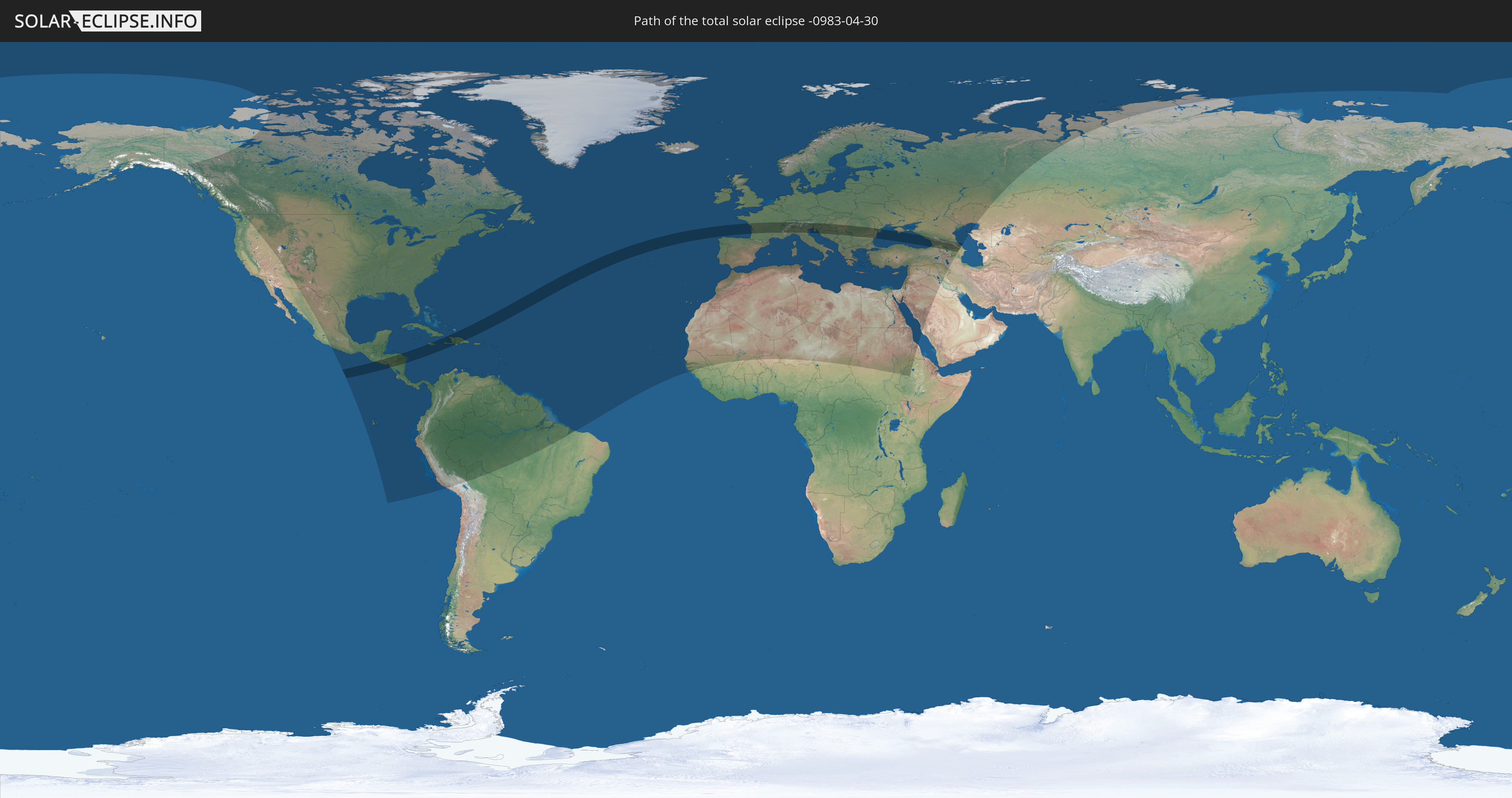
Der Finsternispfad verläuft durch 28 Länder. Nur in diesen Ländern ist sie als total Sonnenfinsternis zu sehen.
In den folgenden Ländern ist die Sonnenfinsternis total zu sehen
 Russia
 United States Minor Outlying Islands
 Guatemala
 El Salvador
 Honduras
 Nicaragua
 Jamaica
 Haiti
Haiti
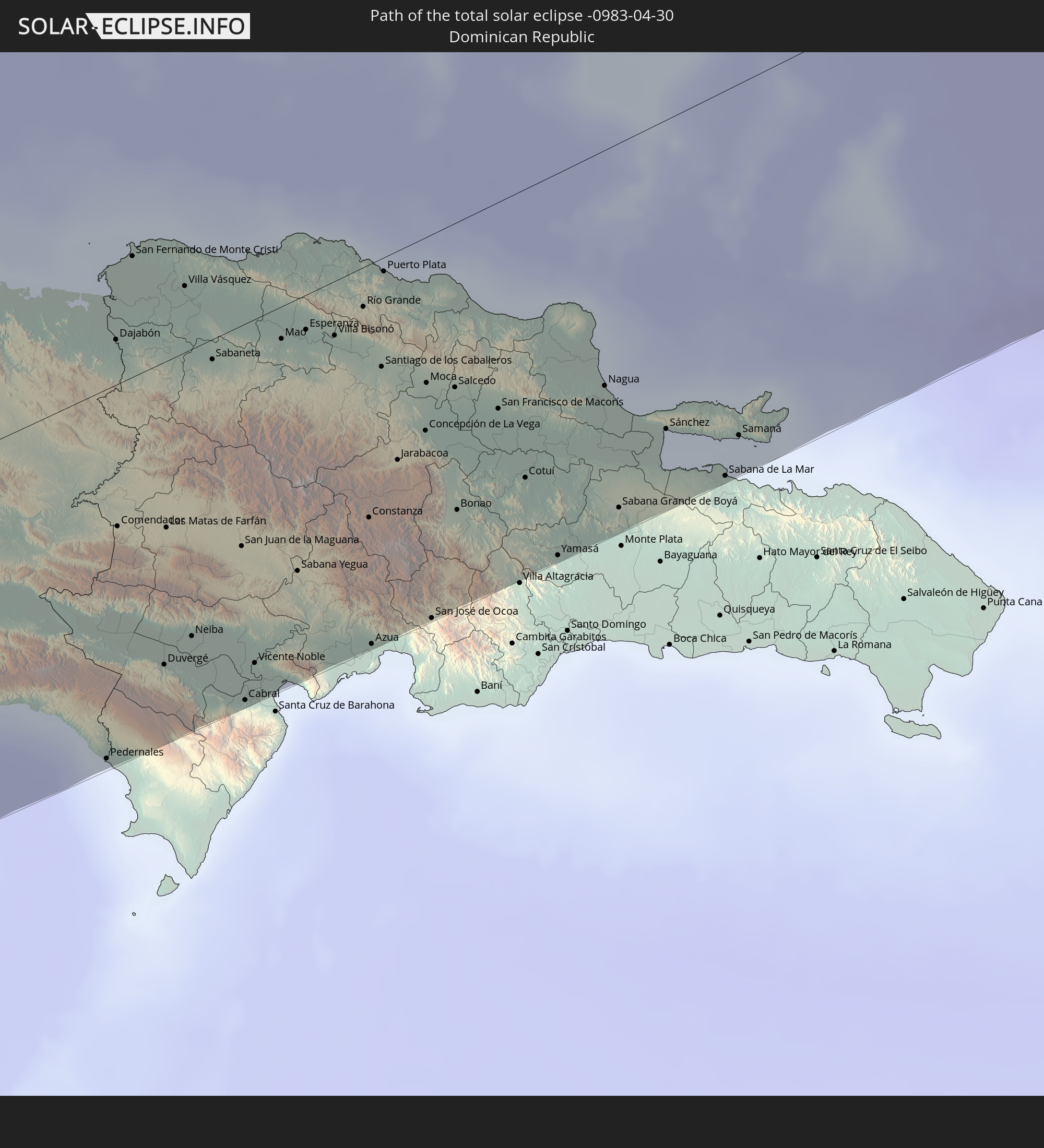 Dominican Republic
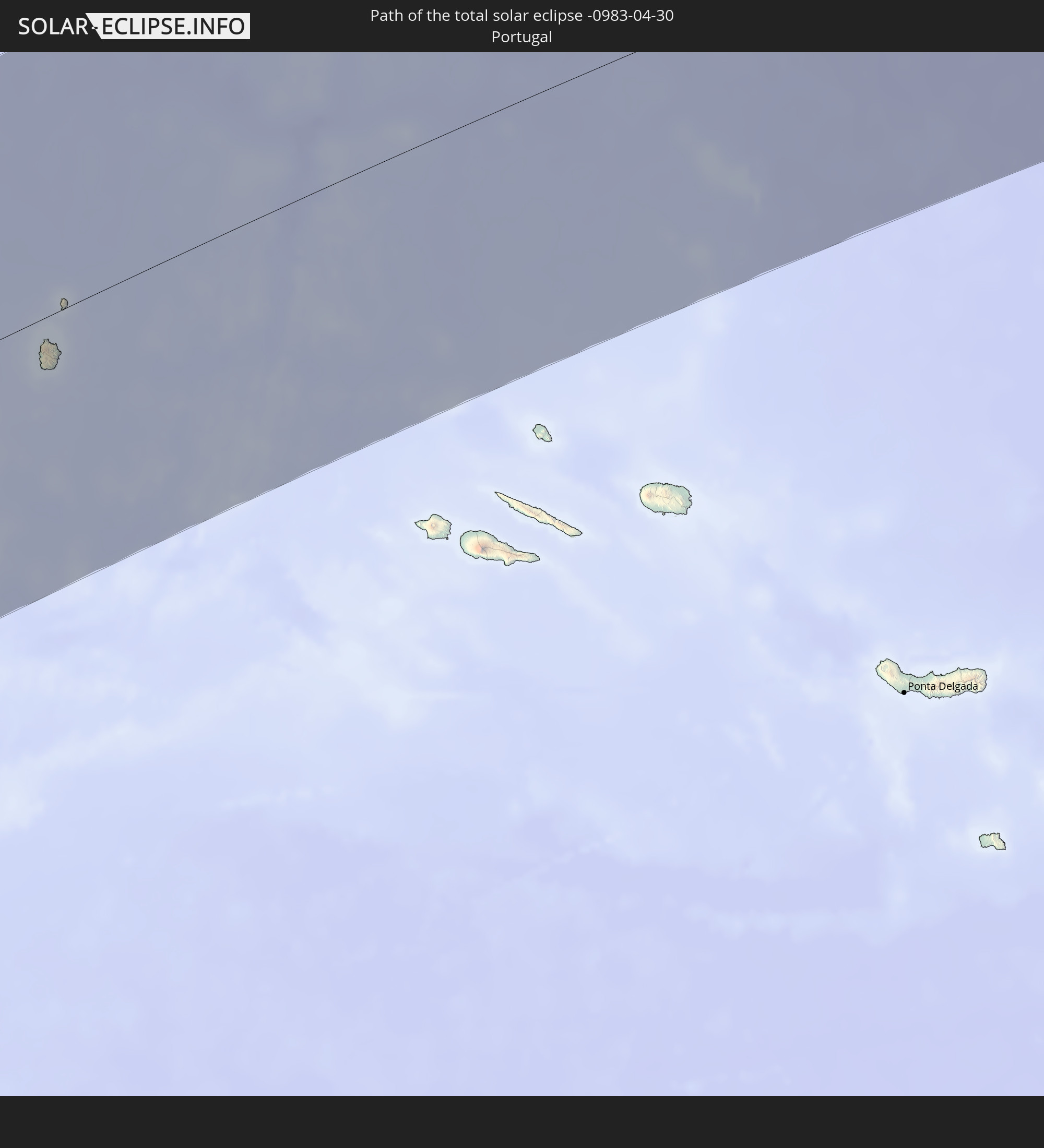 Portugal
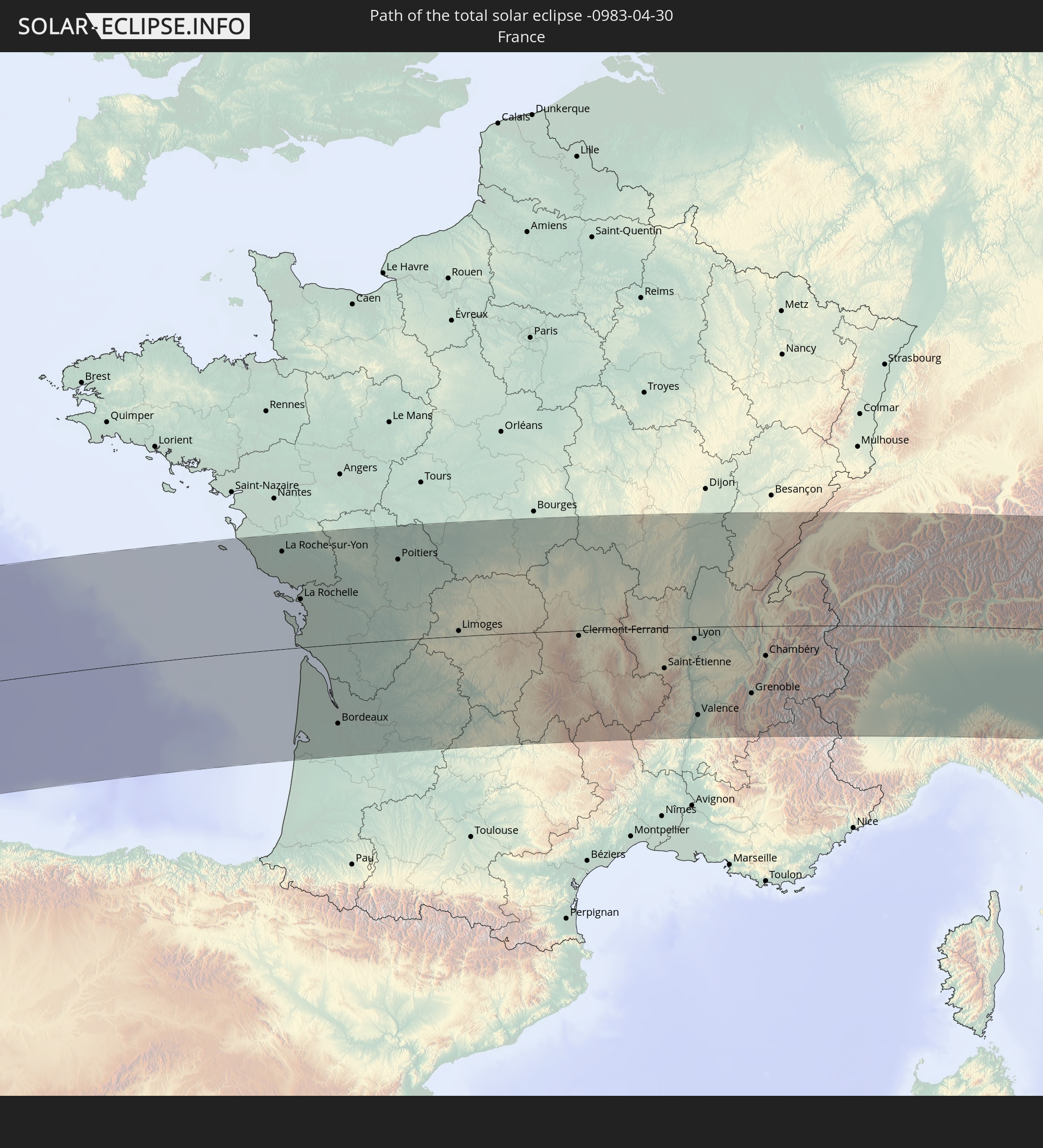 France
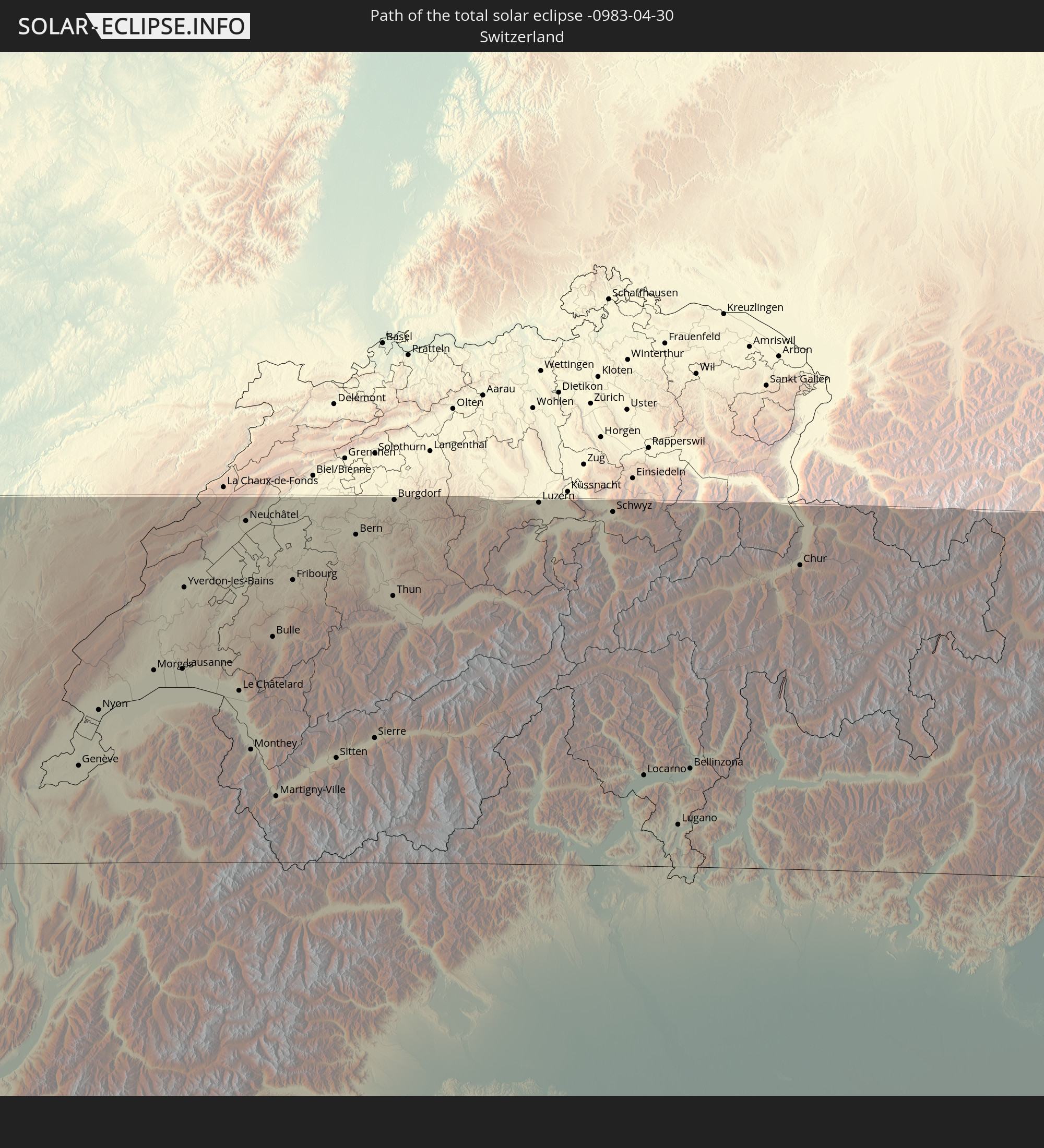 Switzerland
 Italy
Italy
 Liechtenstein
 Austria
 Slovenia
 Croatia
 Bosnia and Herzegovina
 Hungary
 Serbia
 Romania
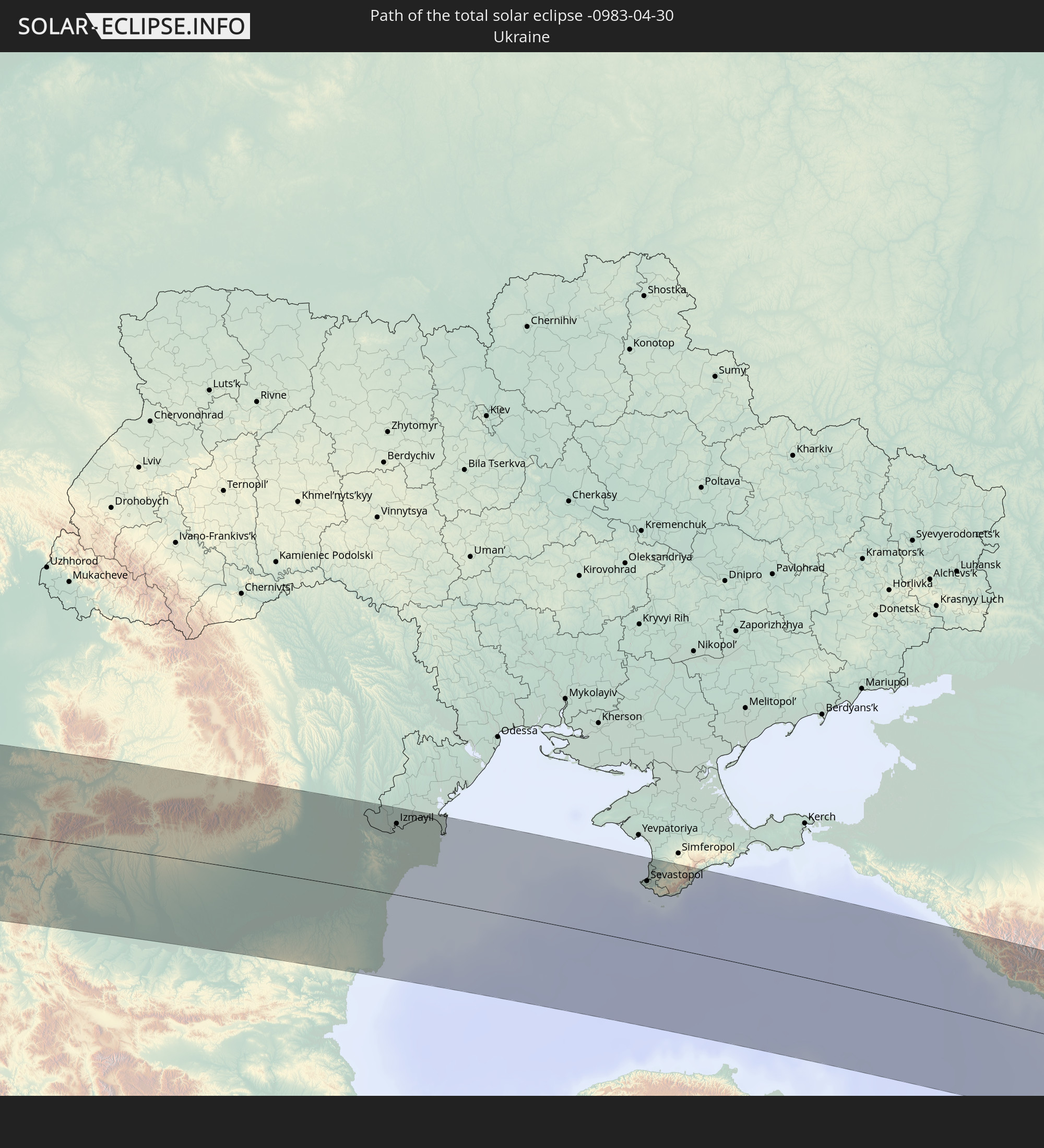 Ukraine
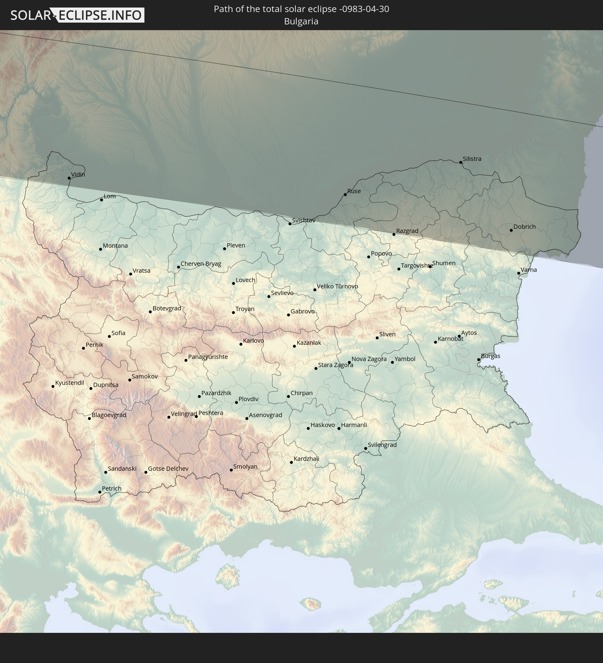 Bulgaria
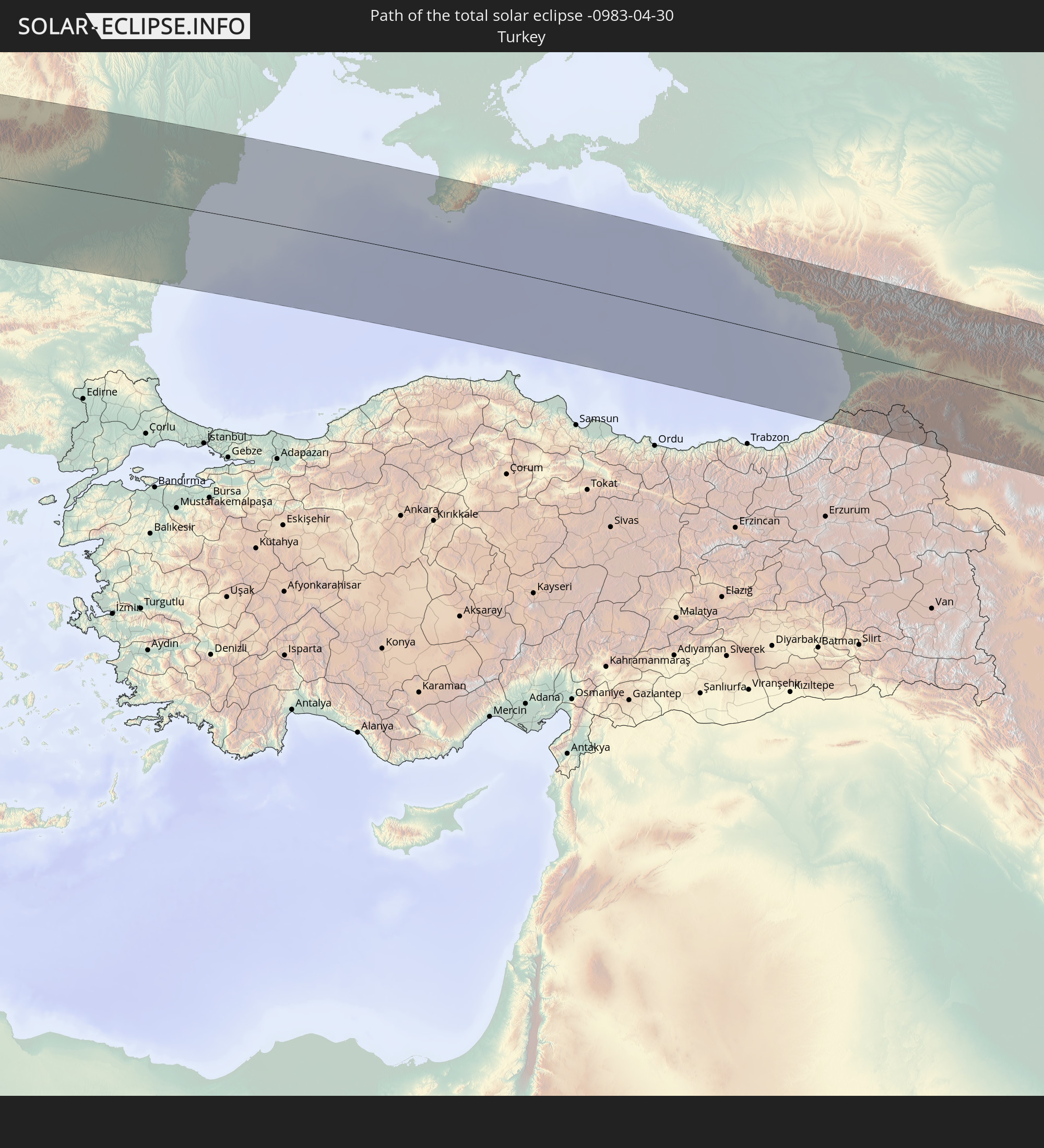 Turkey
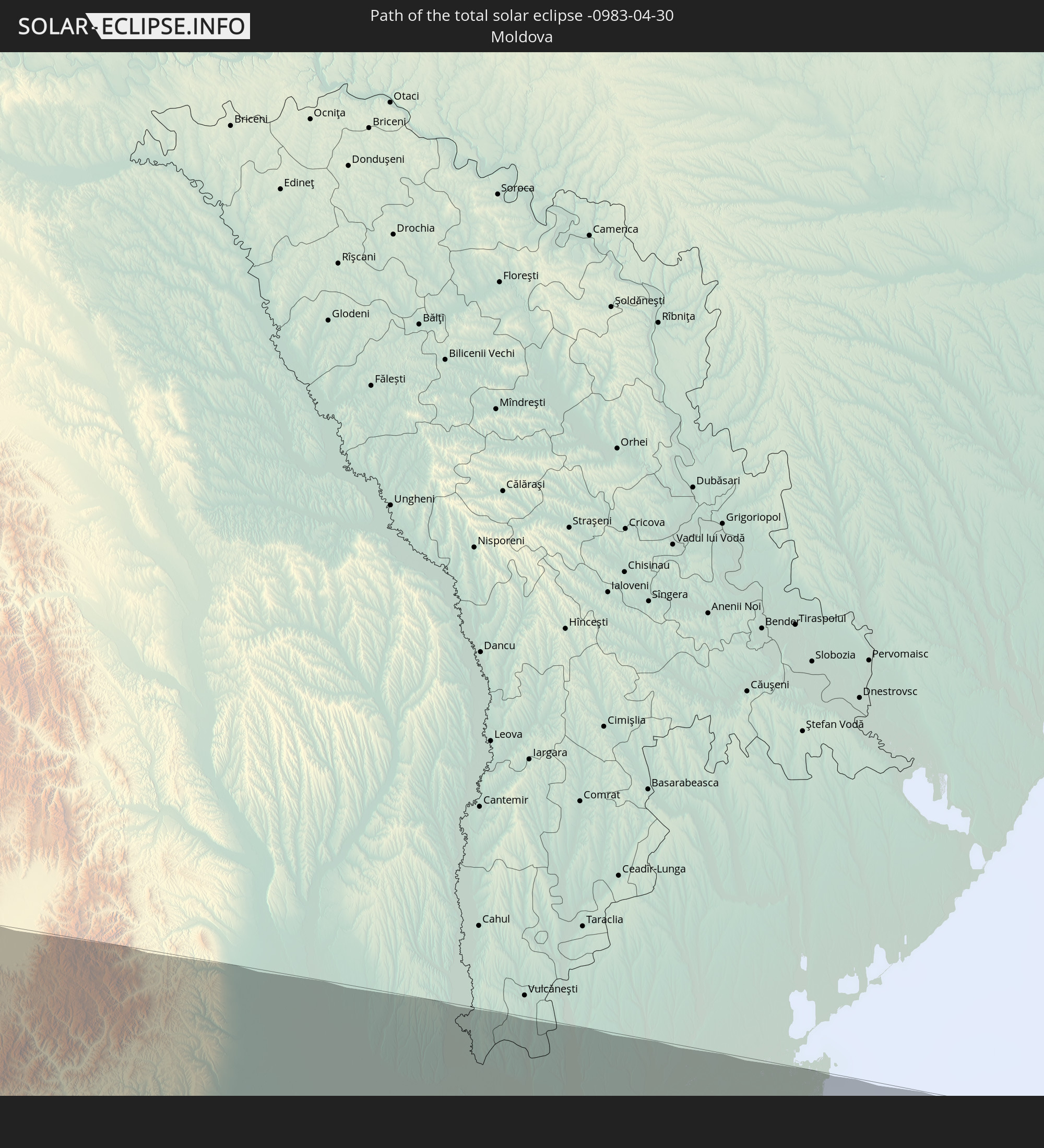 Moldova
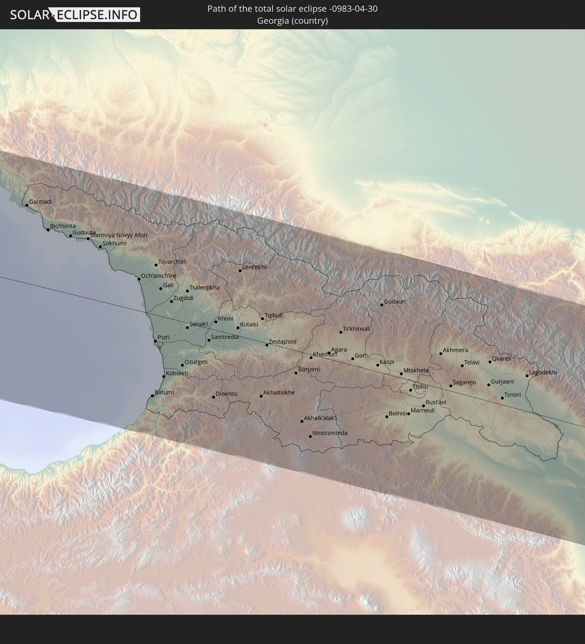 Georgia
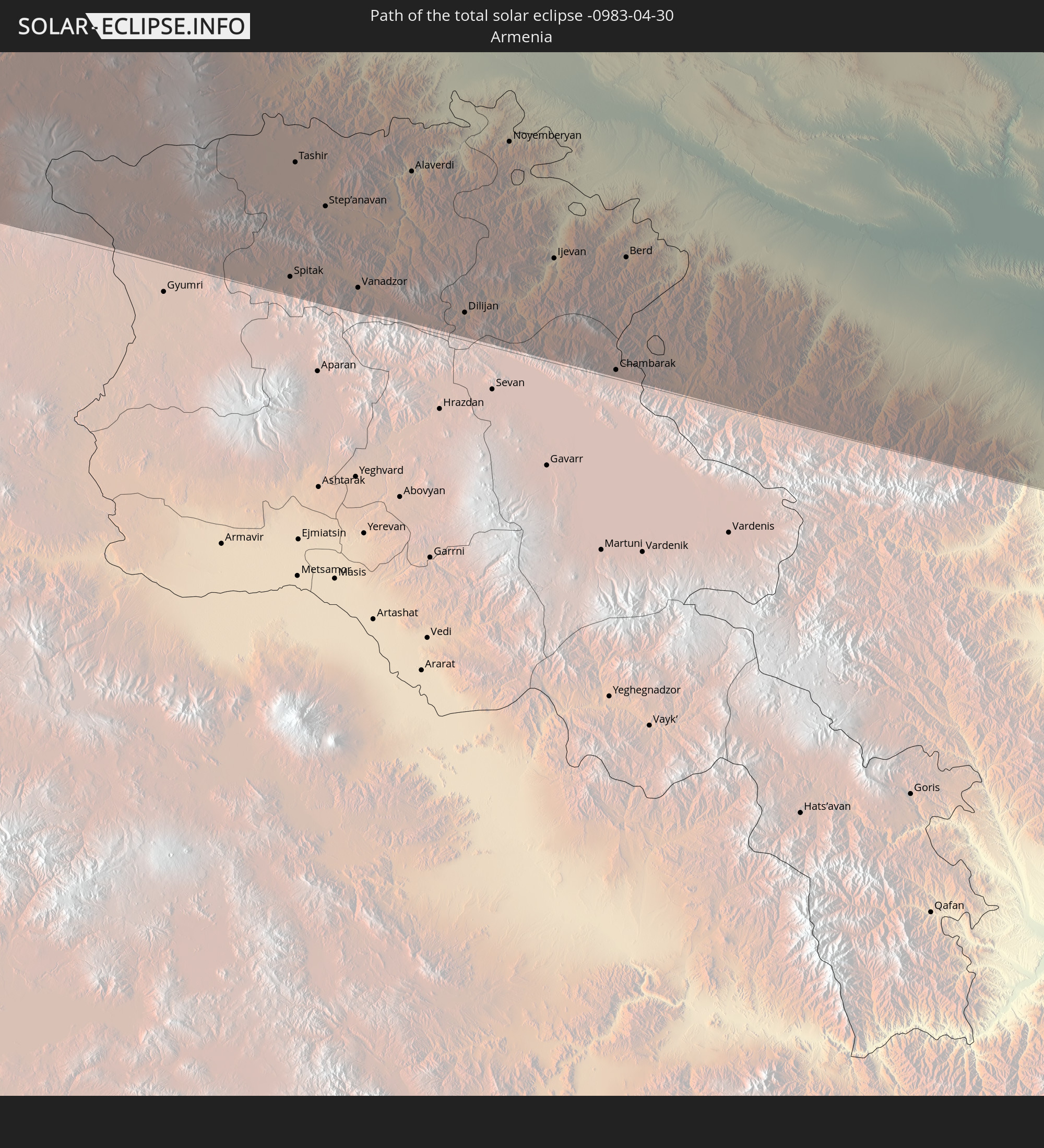 Armenia
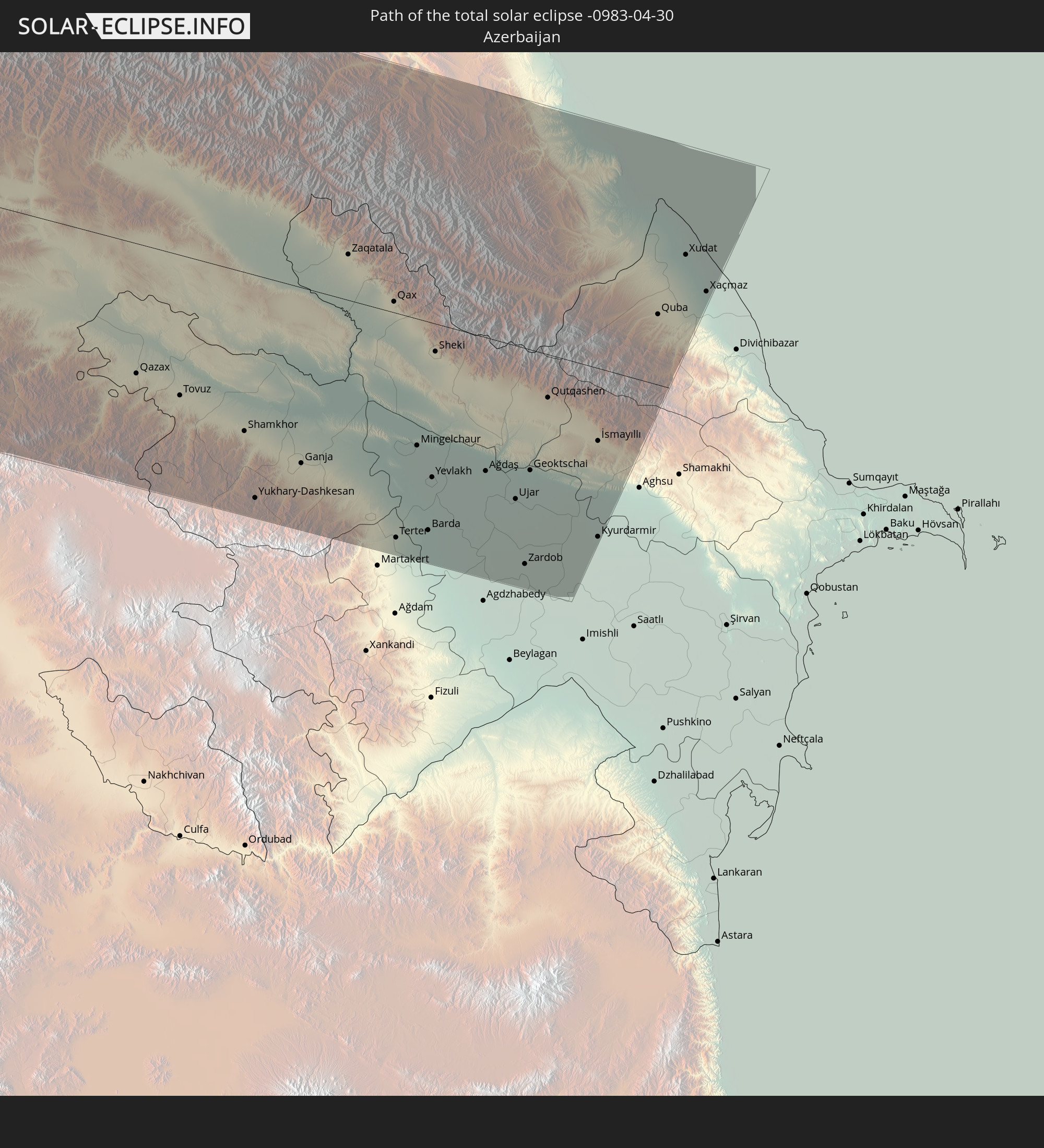 Azerbaijan
In den folgenden Ländern ist die Sonnenfinsternis partiell zu sehen
 Russia
 United States
 United States Minor Outlying Islands
 Canada
 Mexico
 Greenland
 Guatemala
 Ecuador
 El Salvador
 Honduras
 Belize
 Nicaragua
 Costa Rica
 Cuba
Cuba
 Panama
 Colombia
 Cayman Islands
 Peru
Peru
 The Bahamas
 Jamaica
 Haiti
Haiti
 Brazil
 Venezuela
 Turks and Caicos Islands
 Dominican Republic
 Aruba
Aruba
 Bolivia
 Puerto Rico
 United States Virgin Islands
 Bermuda
 British Virgin Islands
 Anguilla
 Collectivity of Saint Martin
 Saint Barthélemy
 Saint Kitts and Nevis
 Antigua and Barbuda
 Montserrat
 Trinidad and Tobago
 Guadeloupe
 Grenada
 Dominica
 Saint Vincent and the Grenadines
 Guyana
 Martinique
 Saint Lucia
 Barbados
 Suriname
 Saint Pierre and Miquelon
 French Guiana
 Portugal
 Cabo Verde
 Iceland
 Spain
Spain
 Senegal
 Mauritania
 The Gambia
 Guinea-Bissau
 Guinea
 Morocco
 Mali
Mali
 Republic of Ireland
 Svalbard and Jan Mayen
 Algeria
 United Kingdom
 Faroe Islands
 Burkina Faso
 Gibraltar
 France
 Isle of Man
 Guernsey
 Jersey
 Niger
Niger
 Andorra
 Belgium
 Netherlands
 Norway
 Luxembourg
 Germany
 Switzerland
 Italy
Italy
 Monaco
 Tunisia
 Denmark
 Libya
Libya
 Liechtenstein
 Austria
 Sweden
 Czechia
 San Marino
 Vatican City
 Slovenia
 Chad
Chad
 Croatia
 Poland
 Malta
Malta
 Bosnia and Herzegovina
 Hungary
 Slovakia
 Montenegro
 Serbia
 Albania
 Åland Islands
 Greece
 Romania
 Republic of Macedonia
 Finland
 Lithuania
 Latvia
 Estonia
 Sudan
Sudan
 Ukraine
 Bulgaria
 Belarus
 Egypt
Egypt
 Turkey
 Moldova
 Cyprus
 Ethiopia
 State of Palestine
 Israel
 Saudi Arabia
 Jordan
 Lebanon
 Syria
Syria
 Eritrea
 Iraq
Iraq
 Georgia
 Armenia
 Iran
Iran
 Azerbaijan
 Kazakhstan
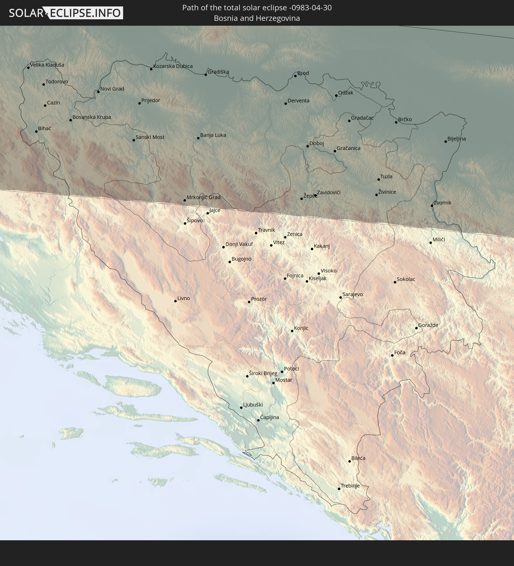
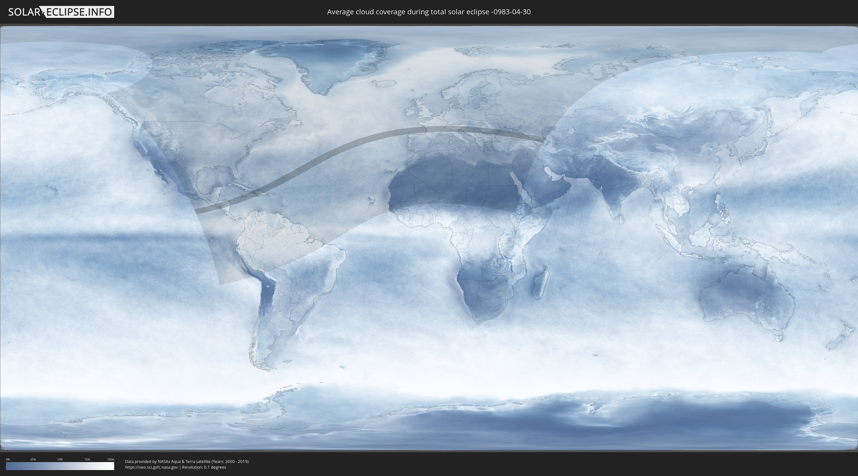
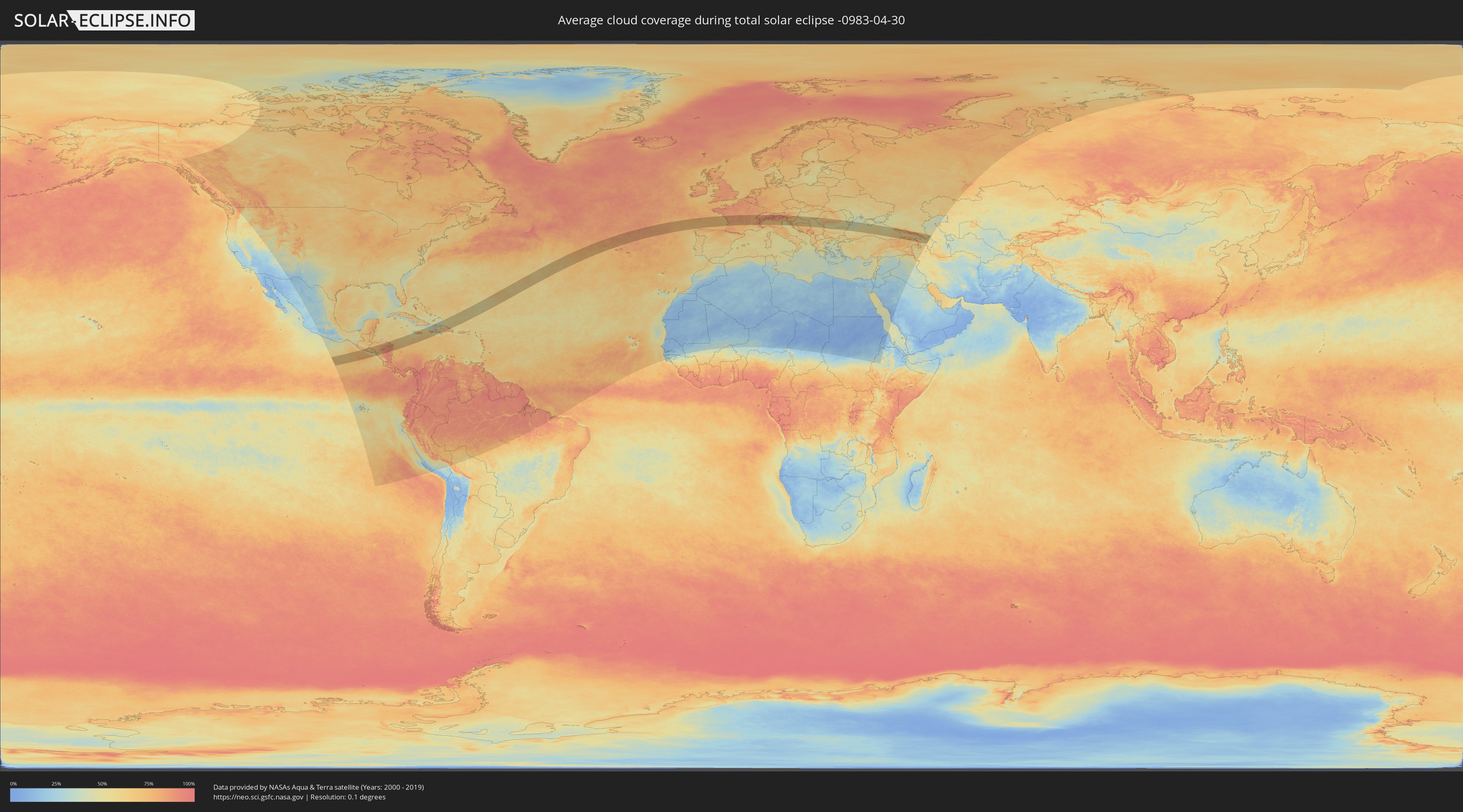
How will be the weather during the total solar eclipse on 04/30/-0983?
Where is the best place to see the total solar eclipse of 04/30/-0983?
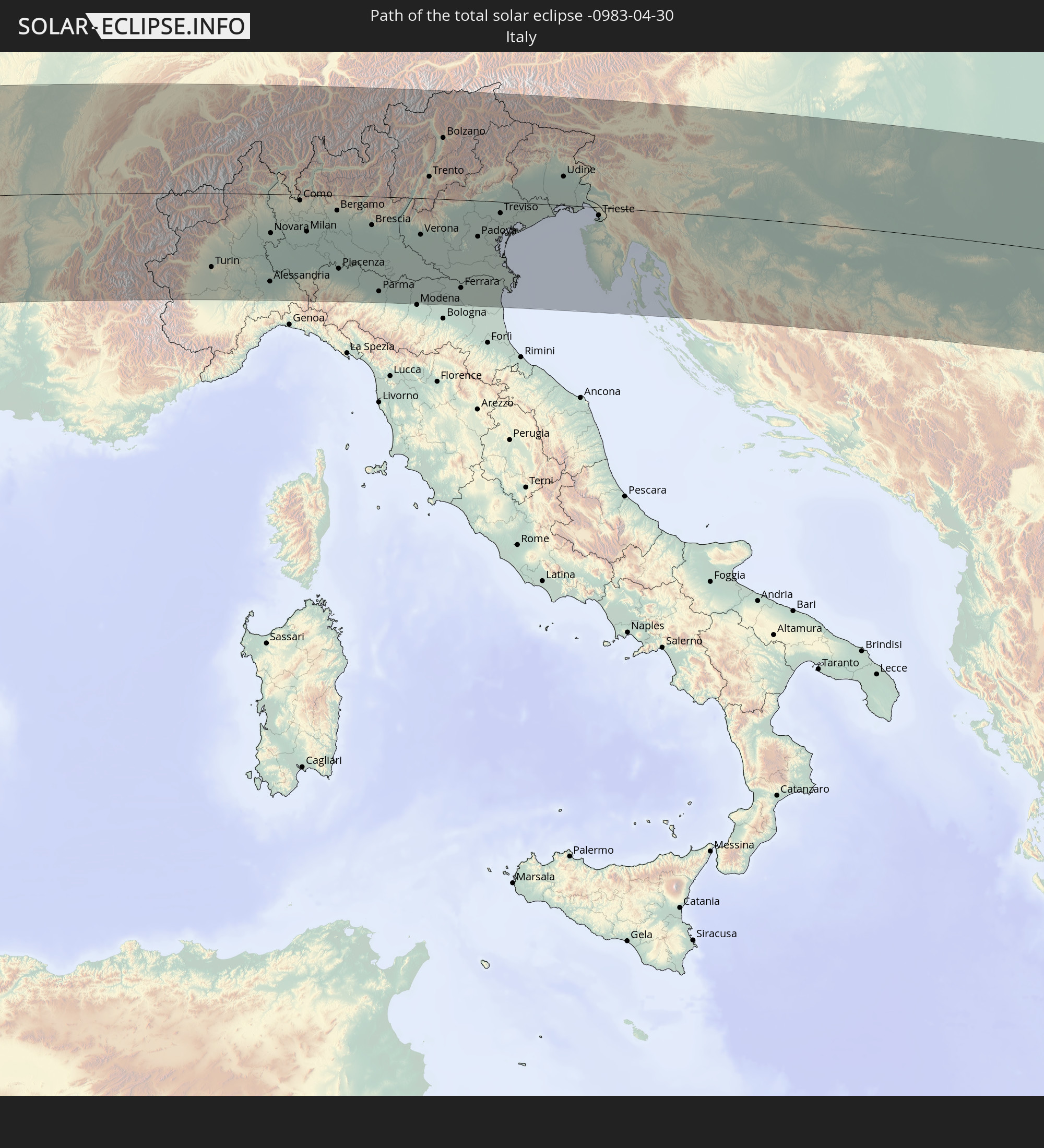
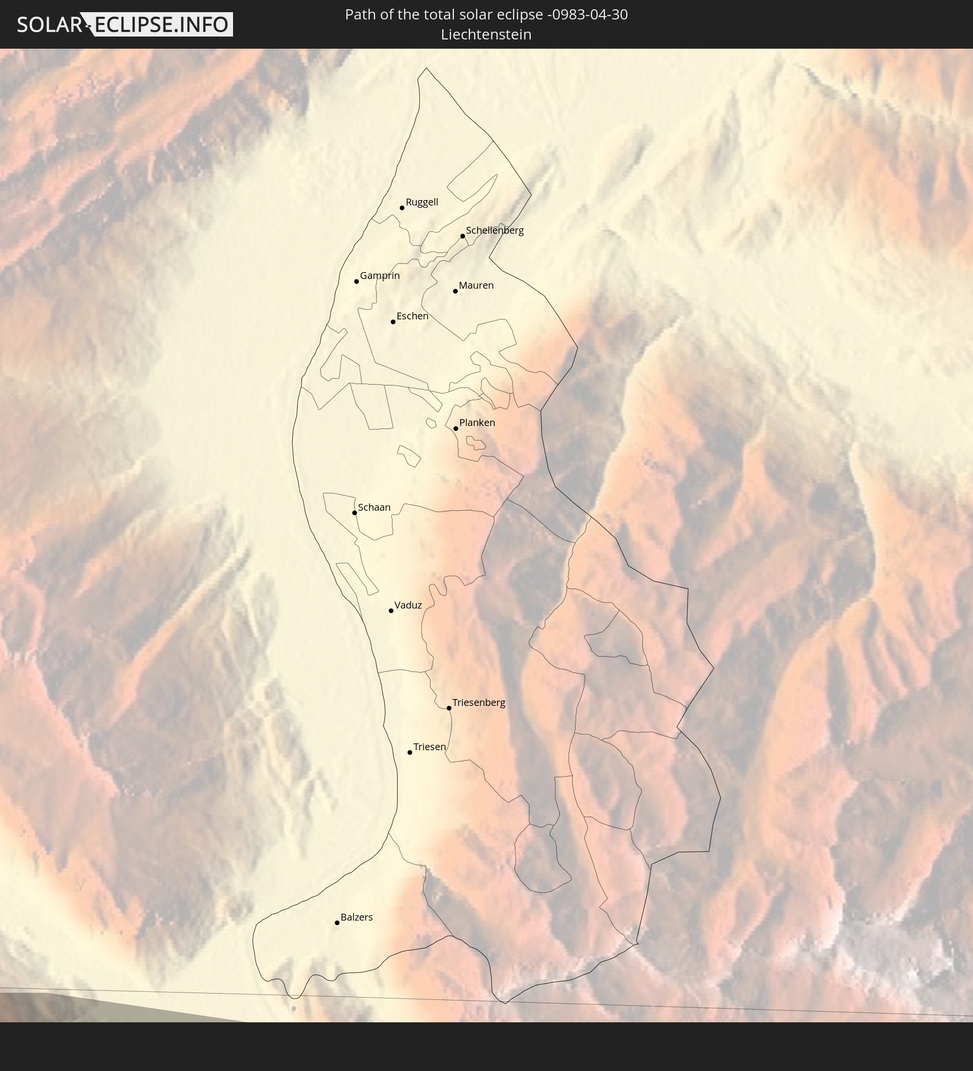
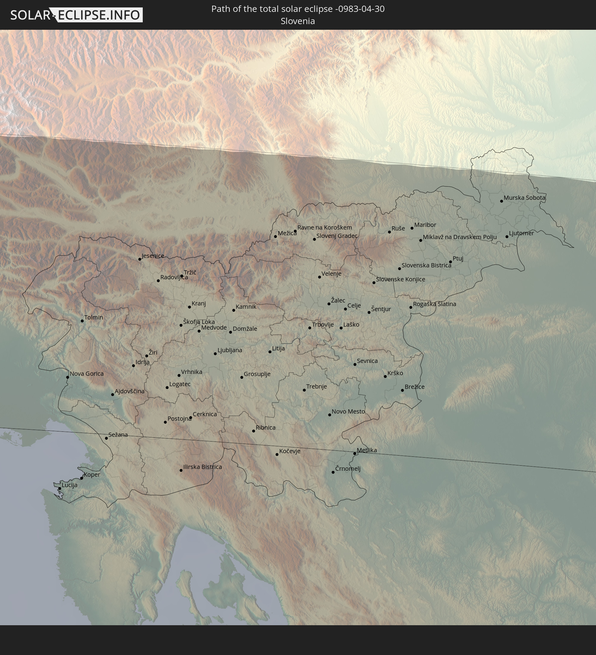
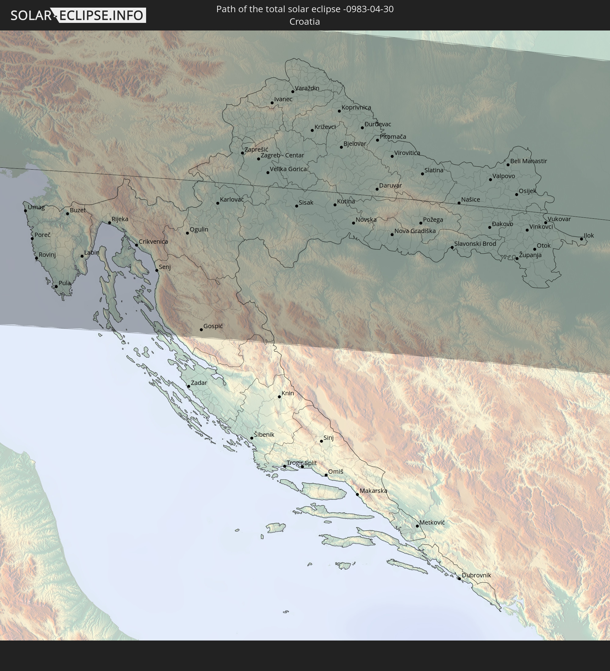
The following maps show the average cloud coverage for the day of the total solar eclipse.
With the help of these maps, it is possible to find the place along the eclipse path, which has the best
chance of a cloudless sky.
Nevertheless, you should consider local circumstances and inform about the weather of your chosen
observation site.
The data is provided by NASAs satellites
AQUA and TERRA.
The cloud maps are averaged over a period of 19 years (2000 - 2019).
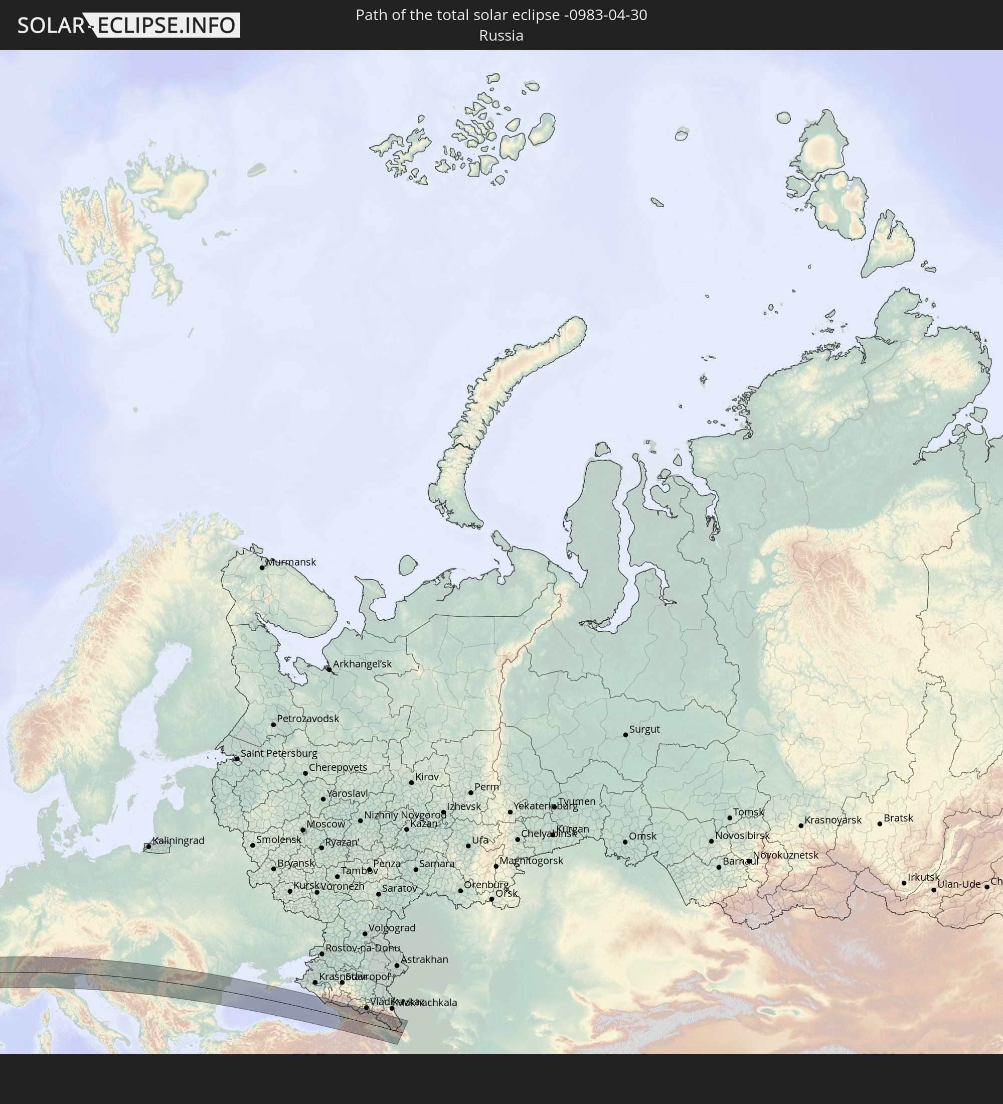
Detailed country maps
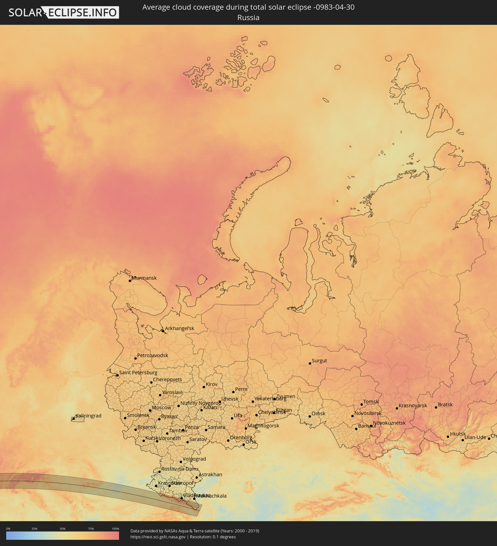 Russia
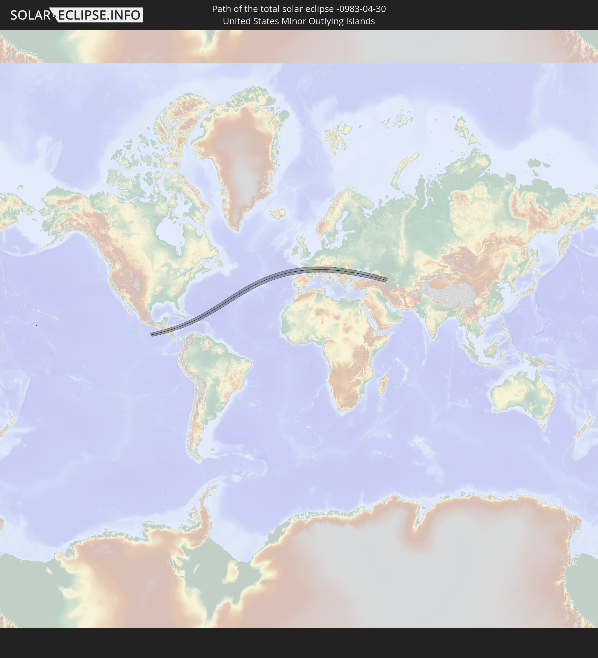
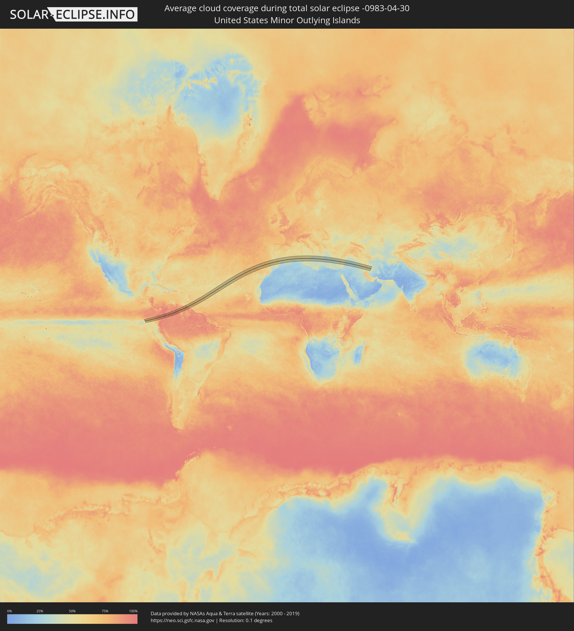 United States Minor Outlying Islands
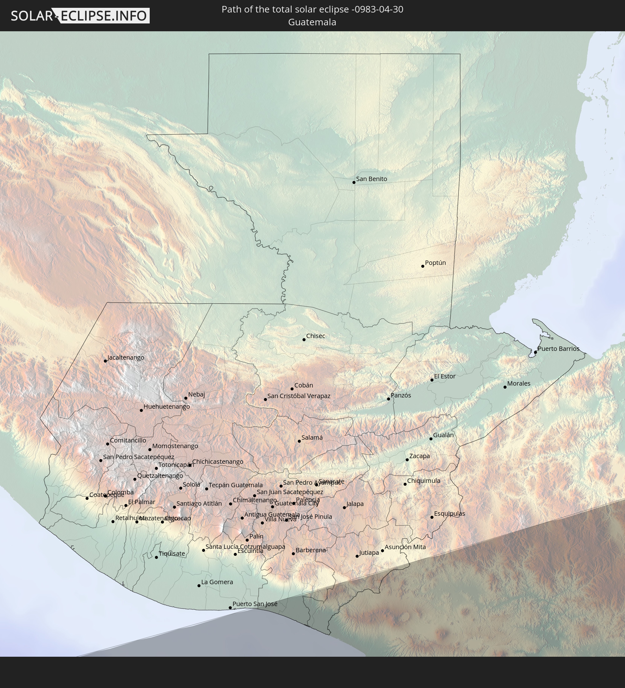
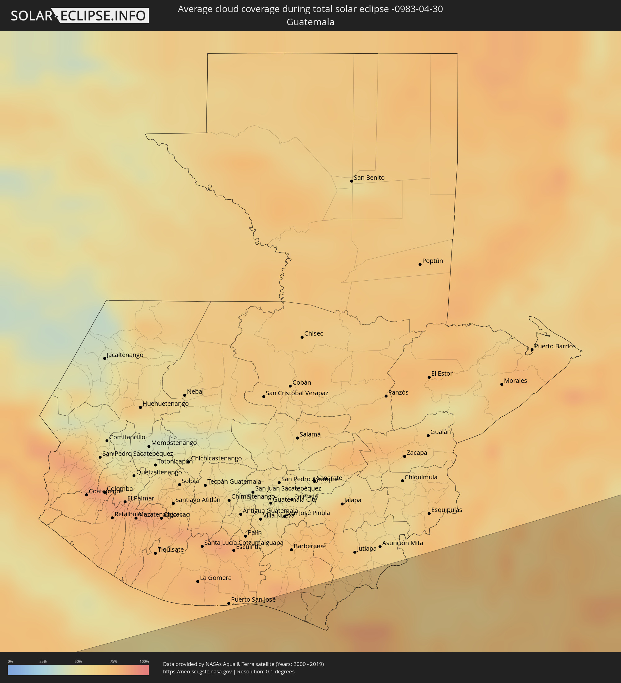 Guatemala
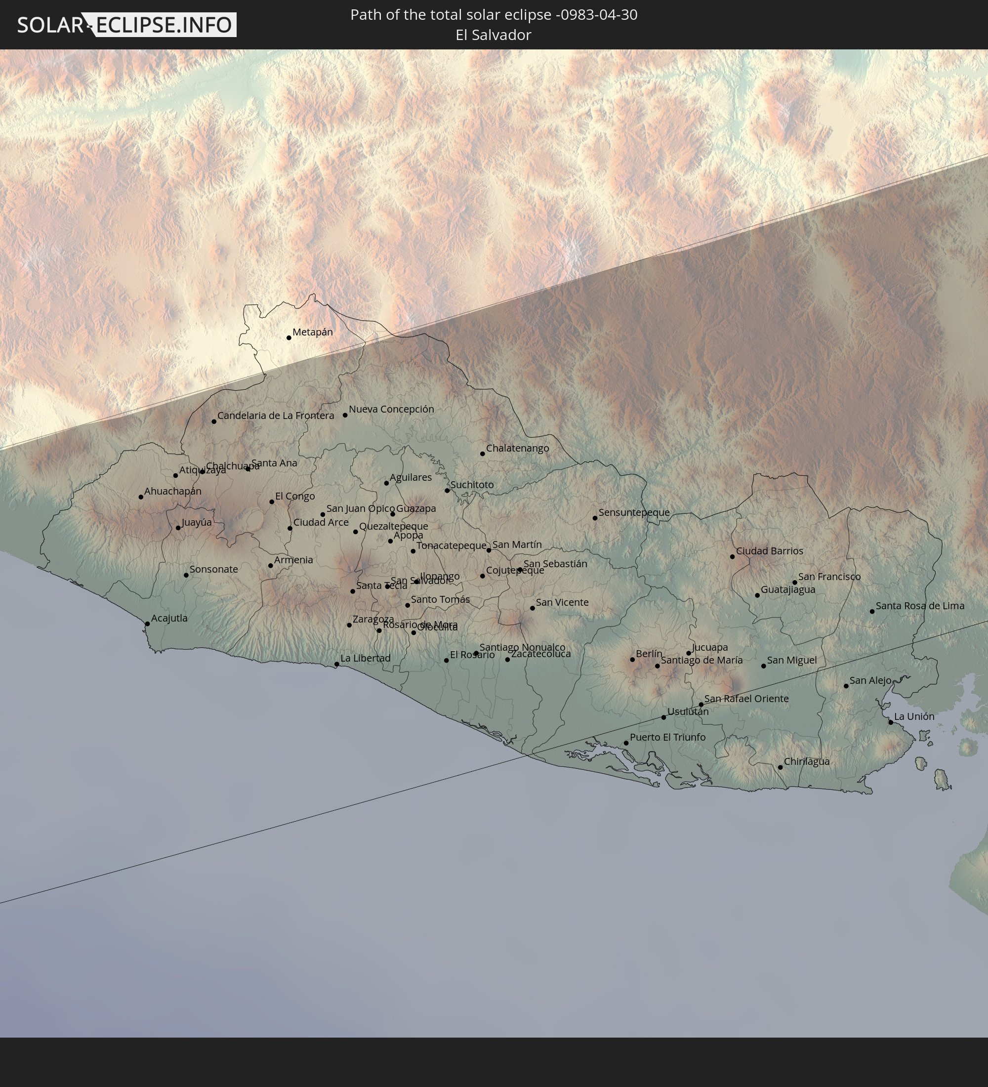
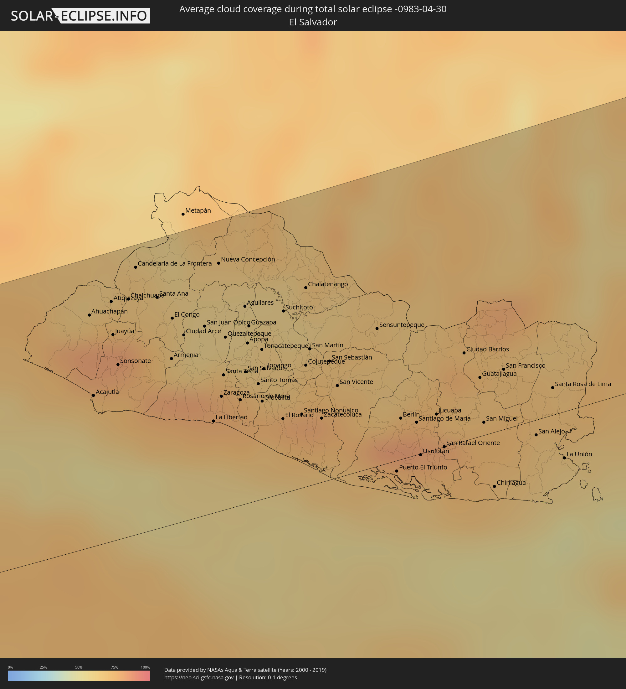 El Salvador
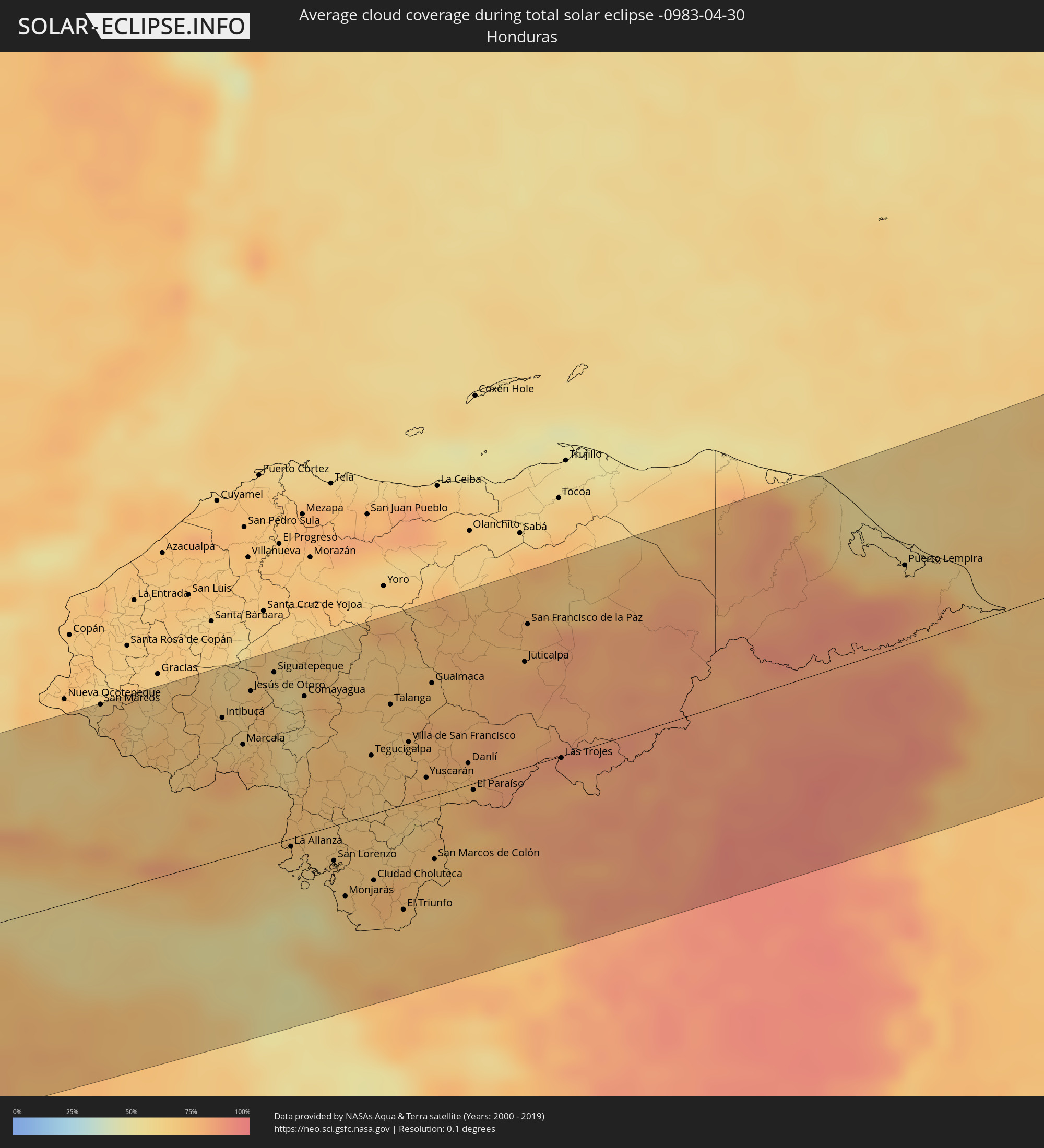 Honduras
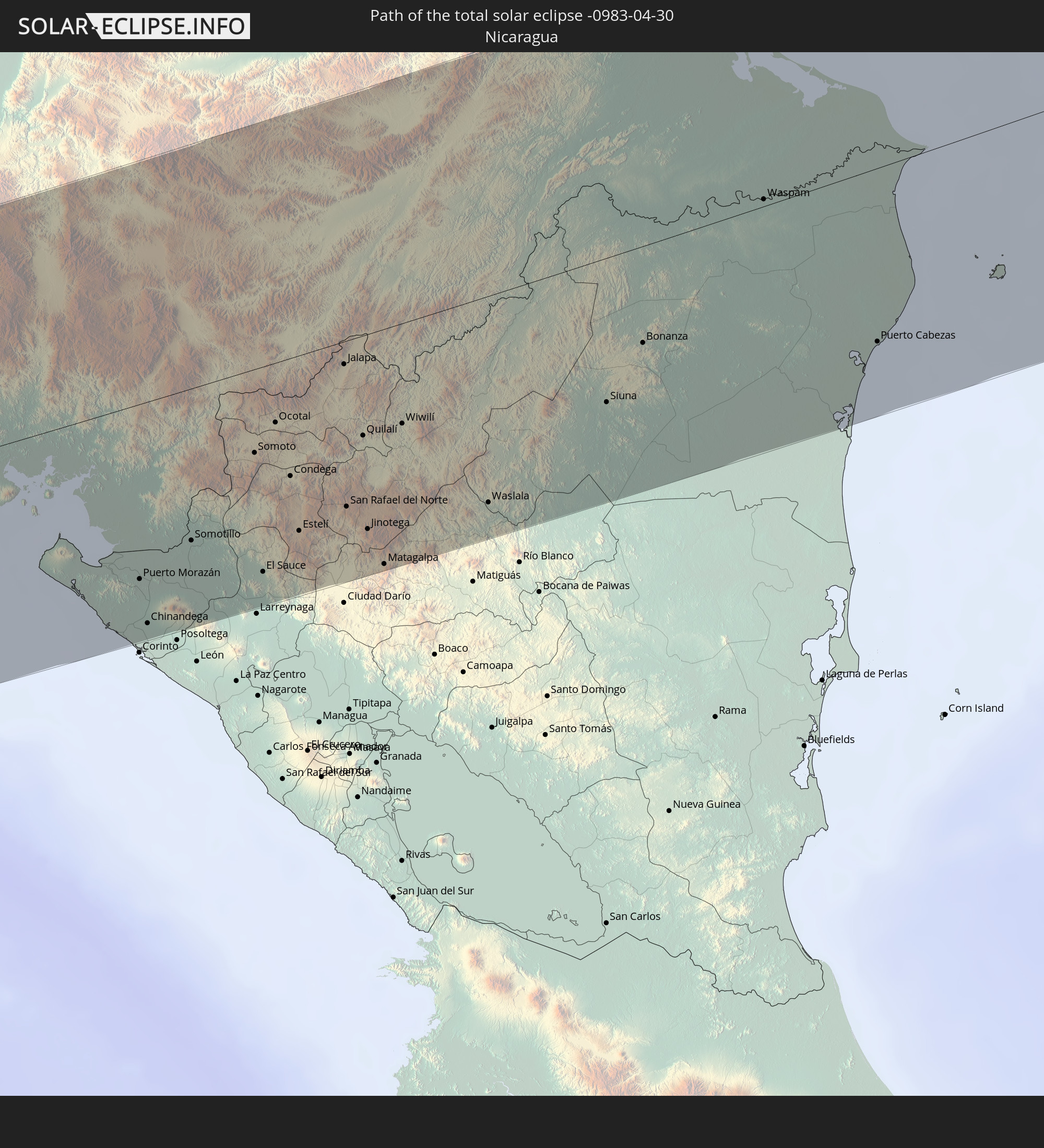
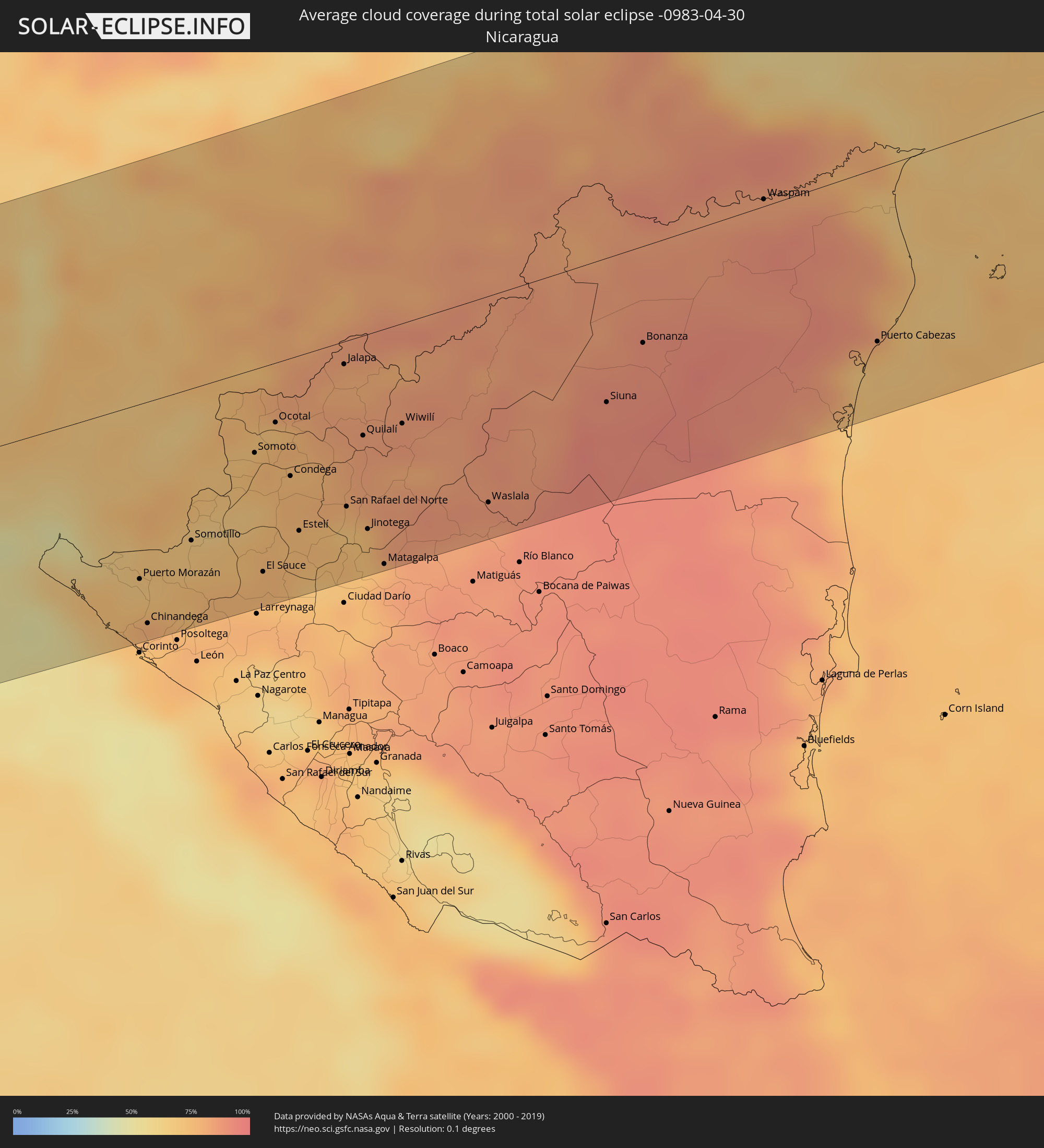 Nicaragua
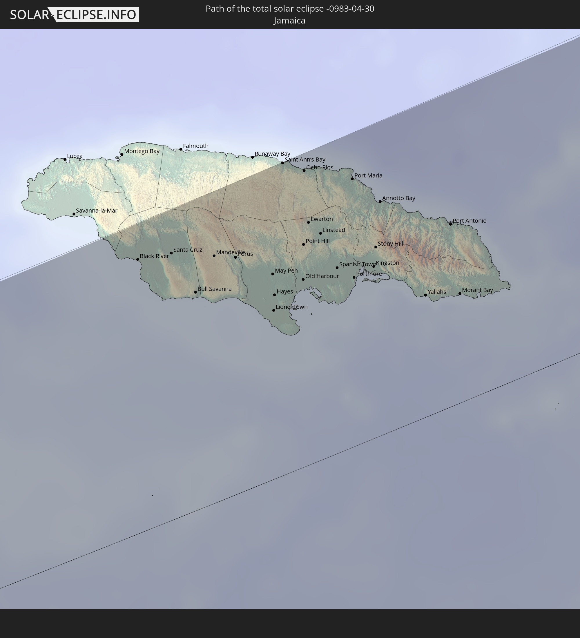
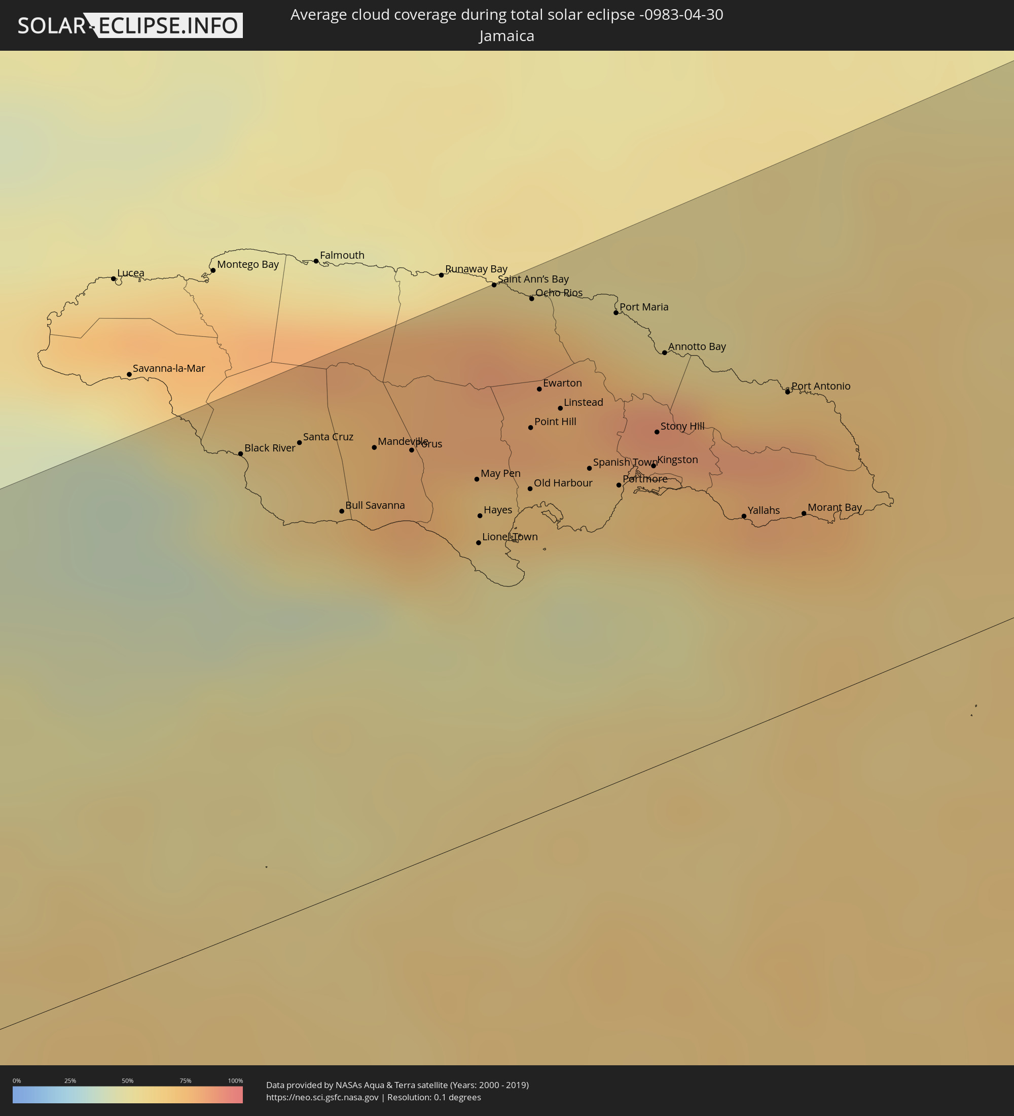 Jamaica
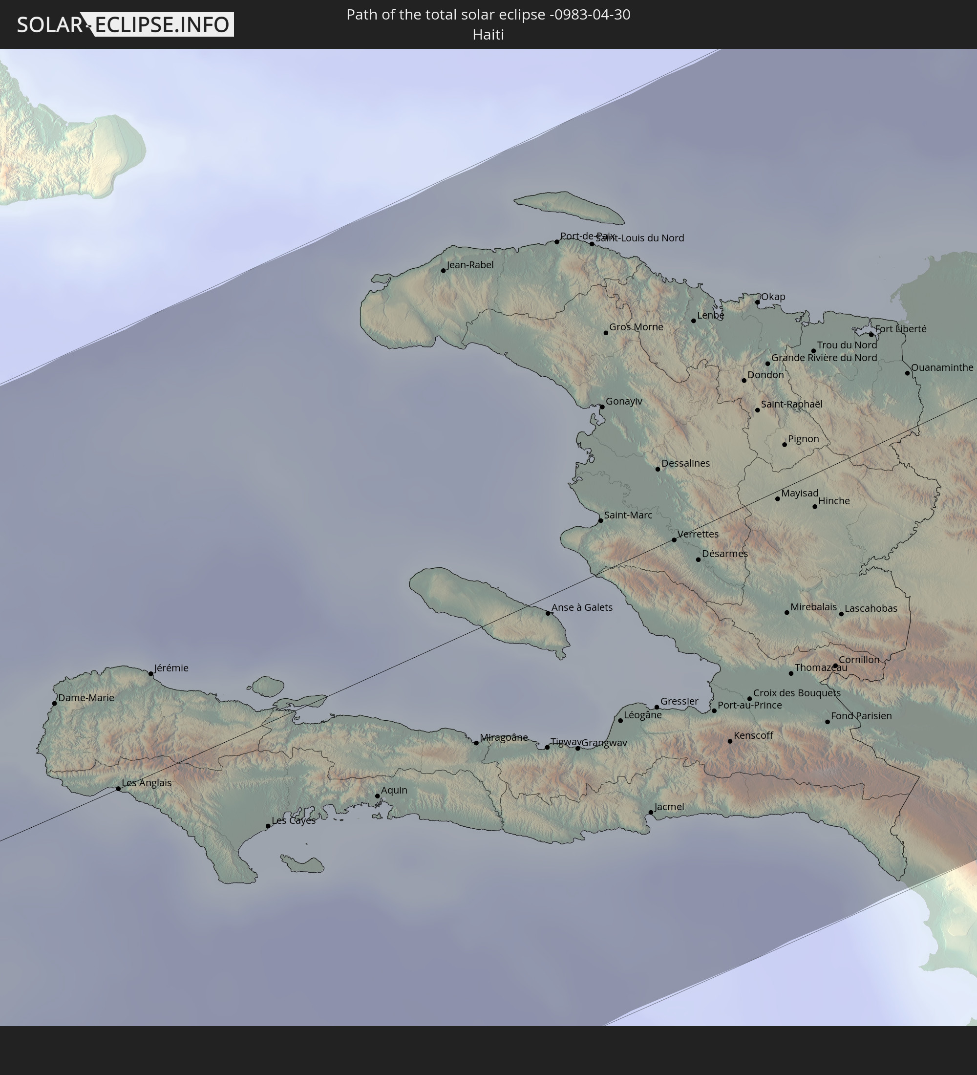
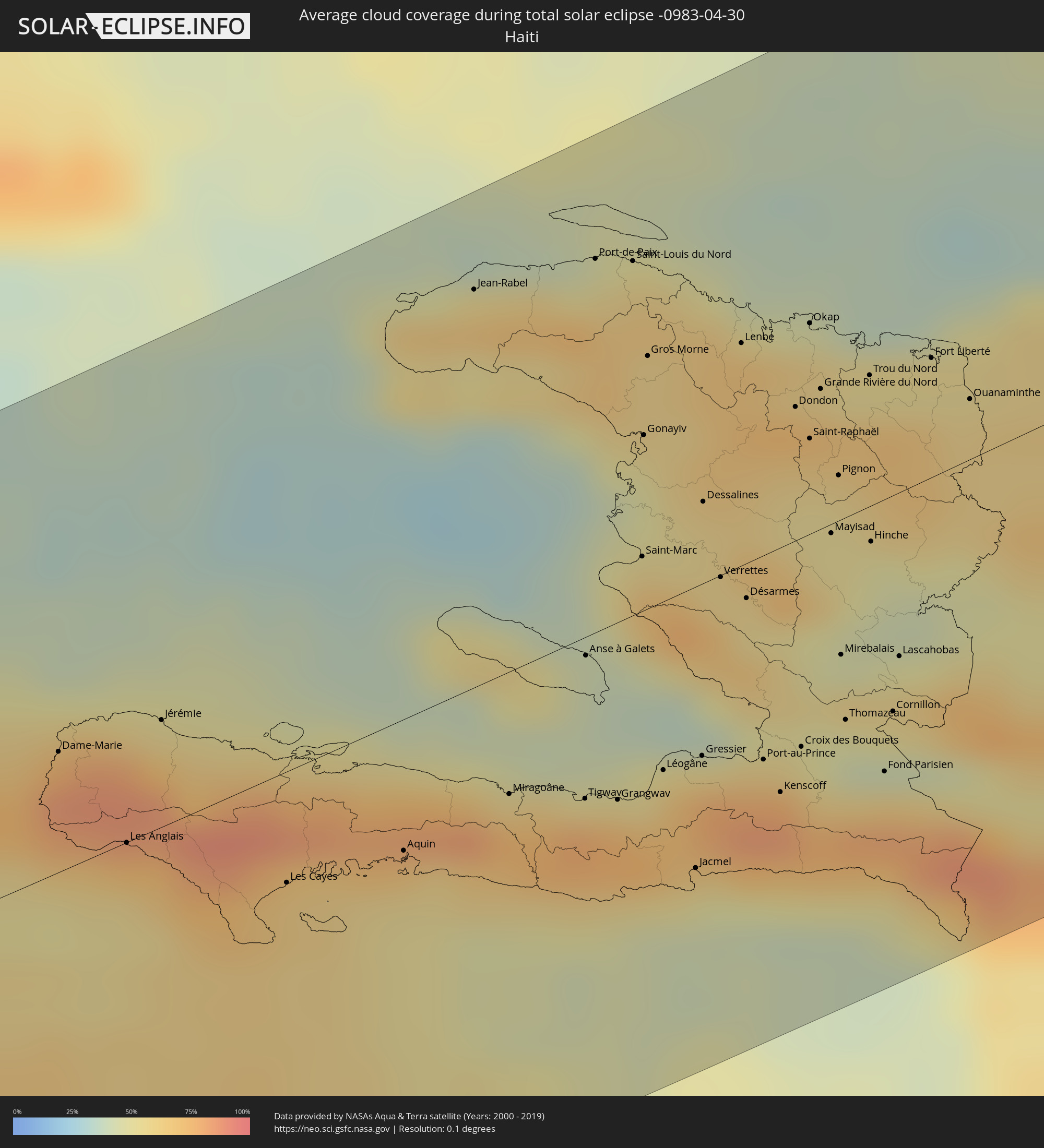 Haiti
Haiti
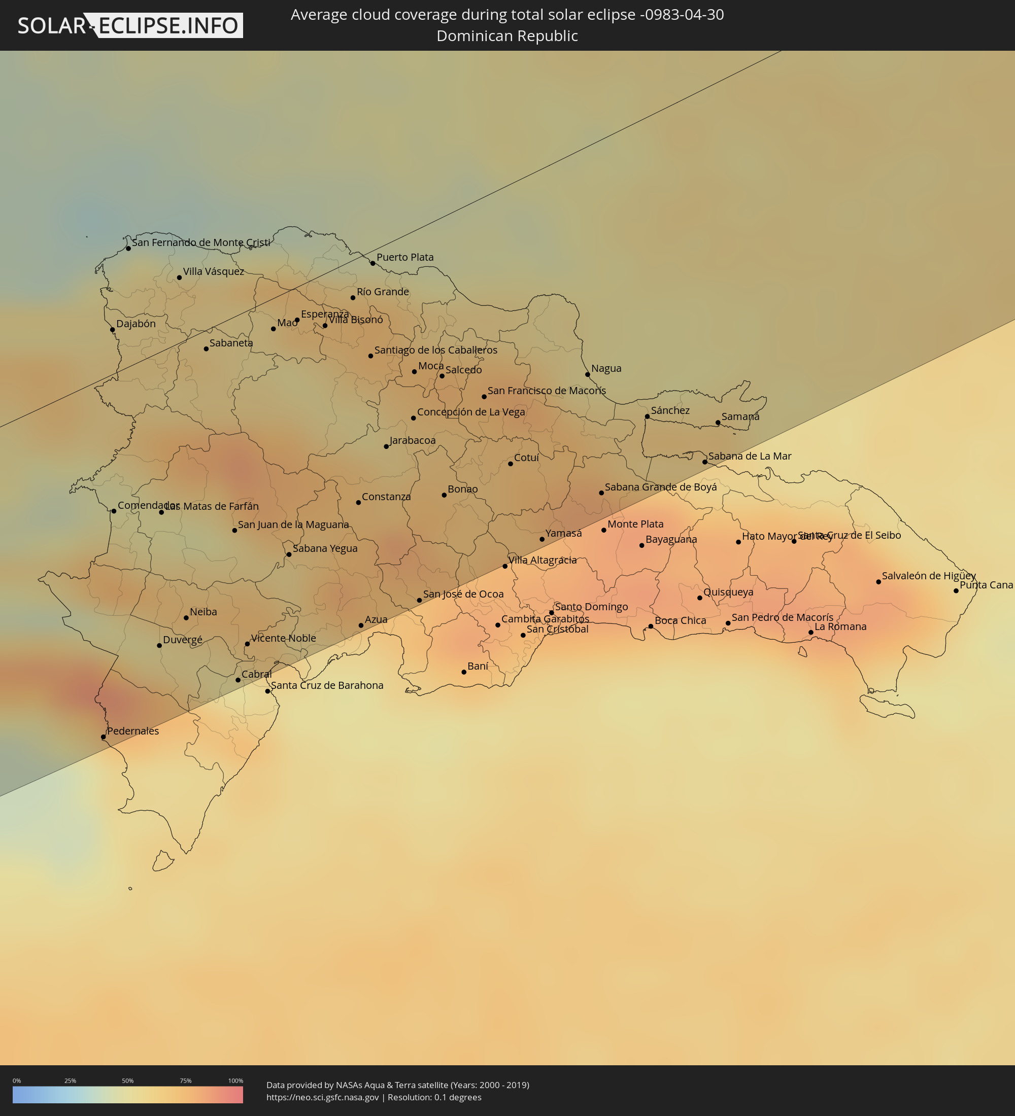 Dominican Republic
 Portugal
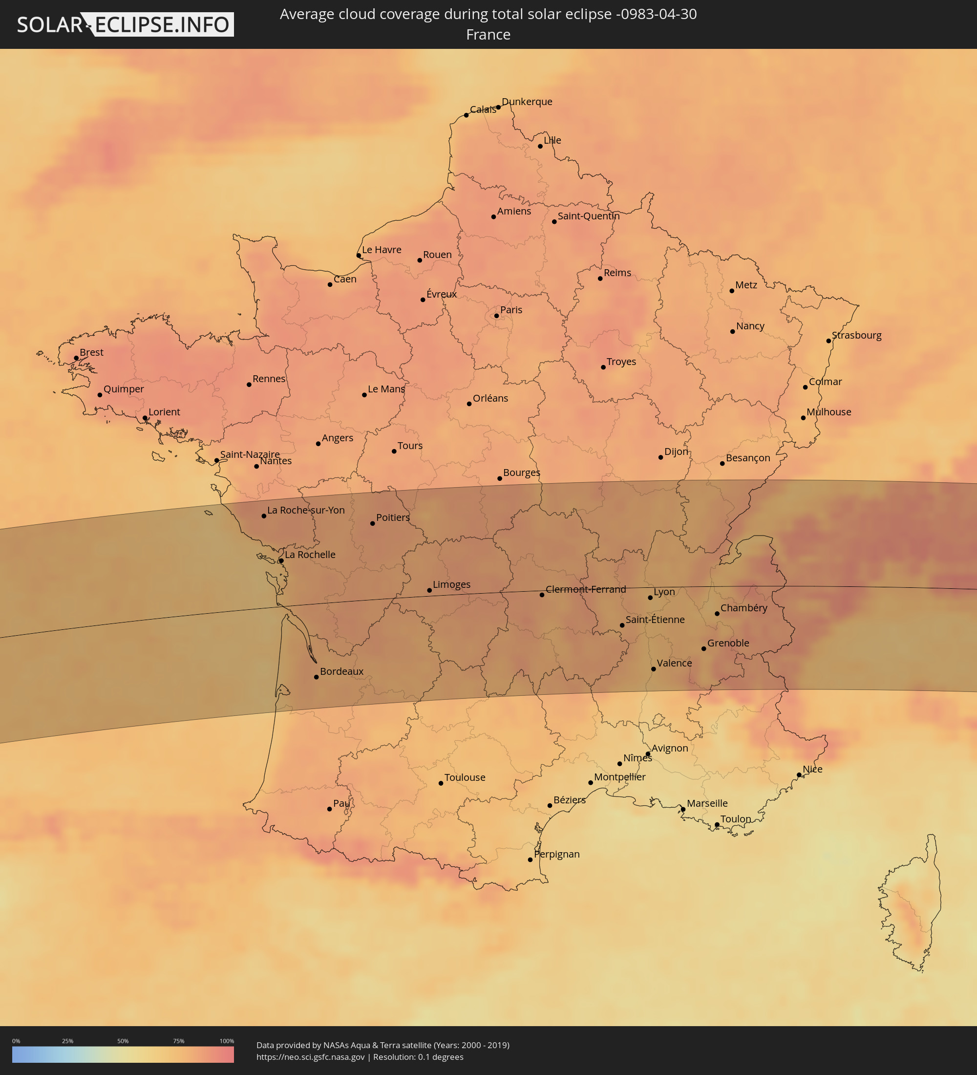 France
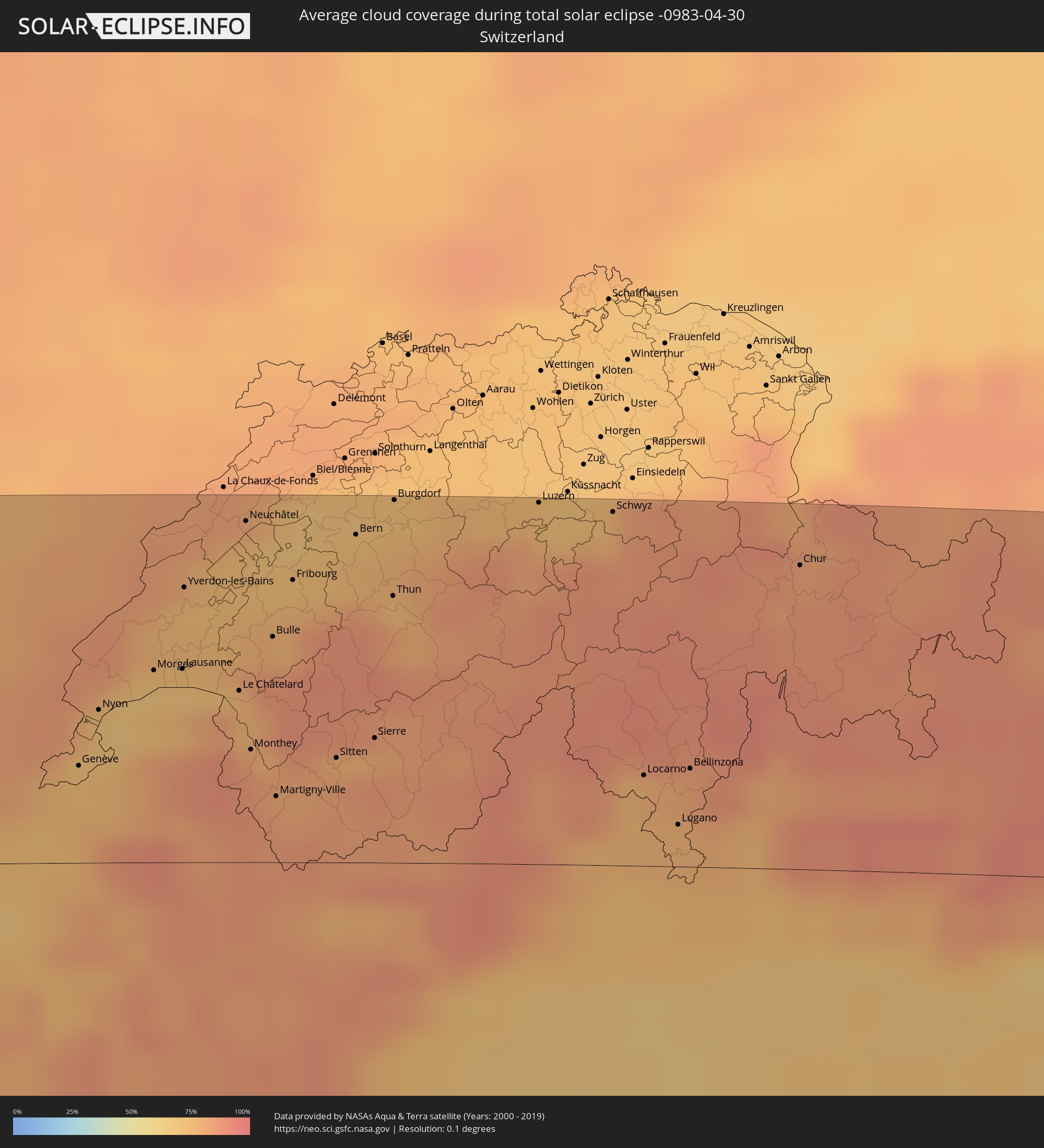 Switzerland
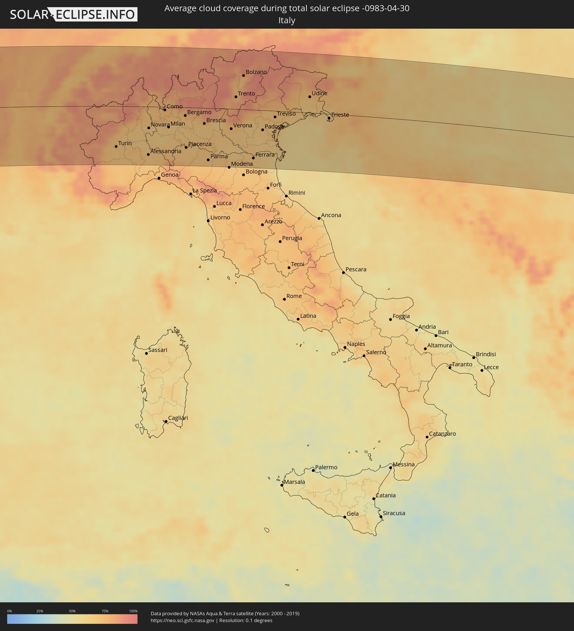 Italy
Italy
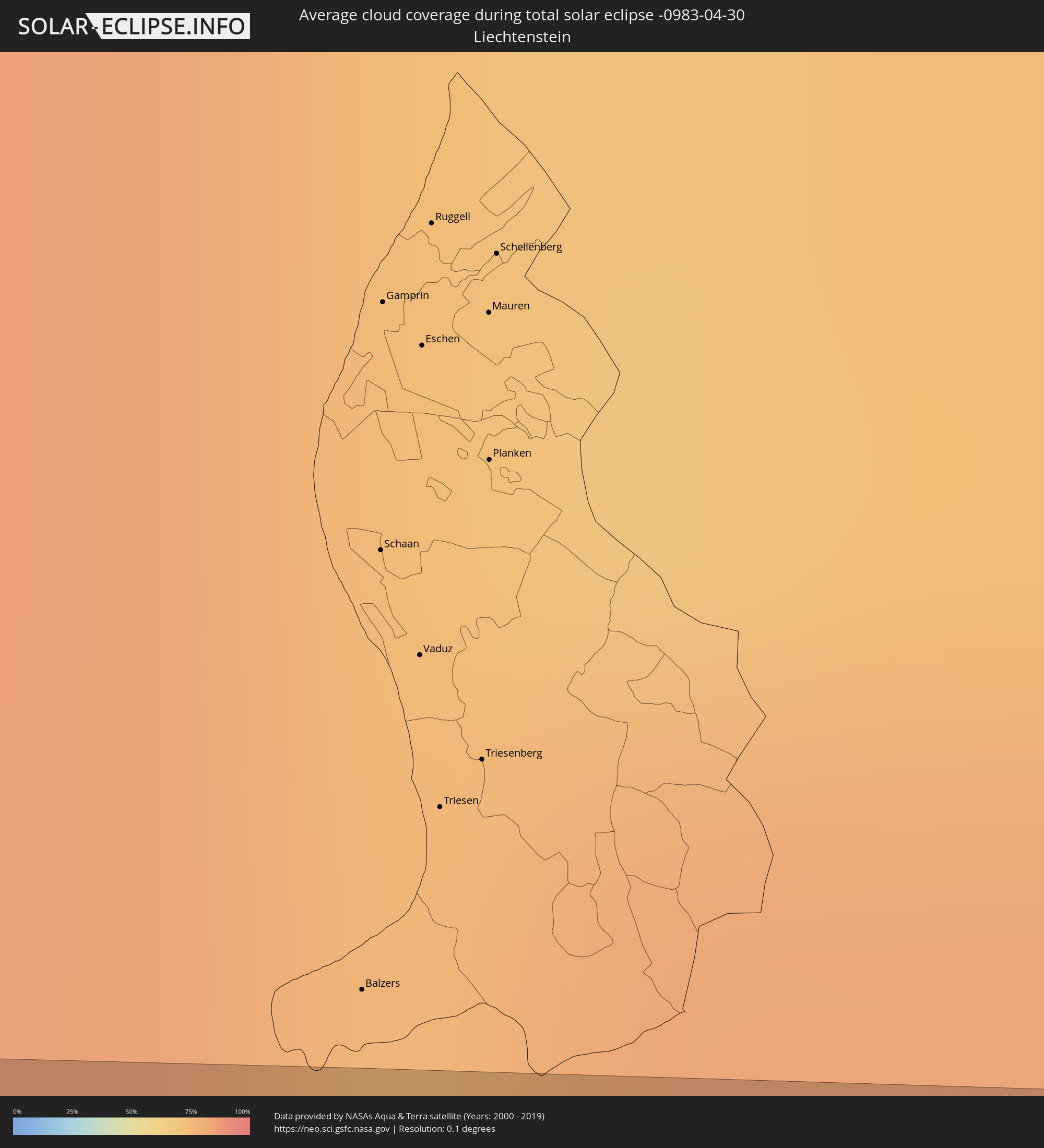 Liechtenstein
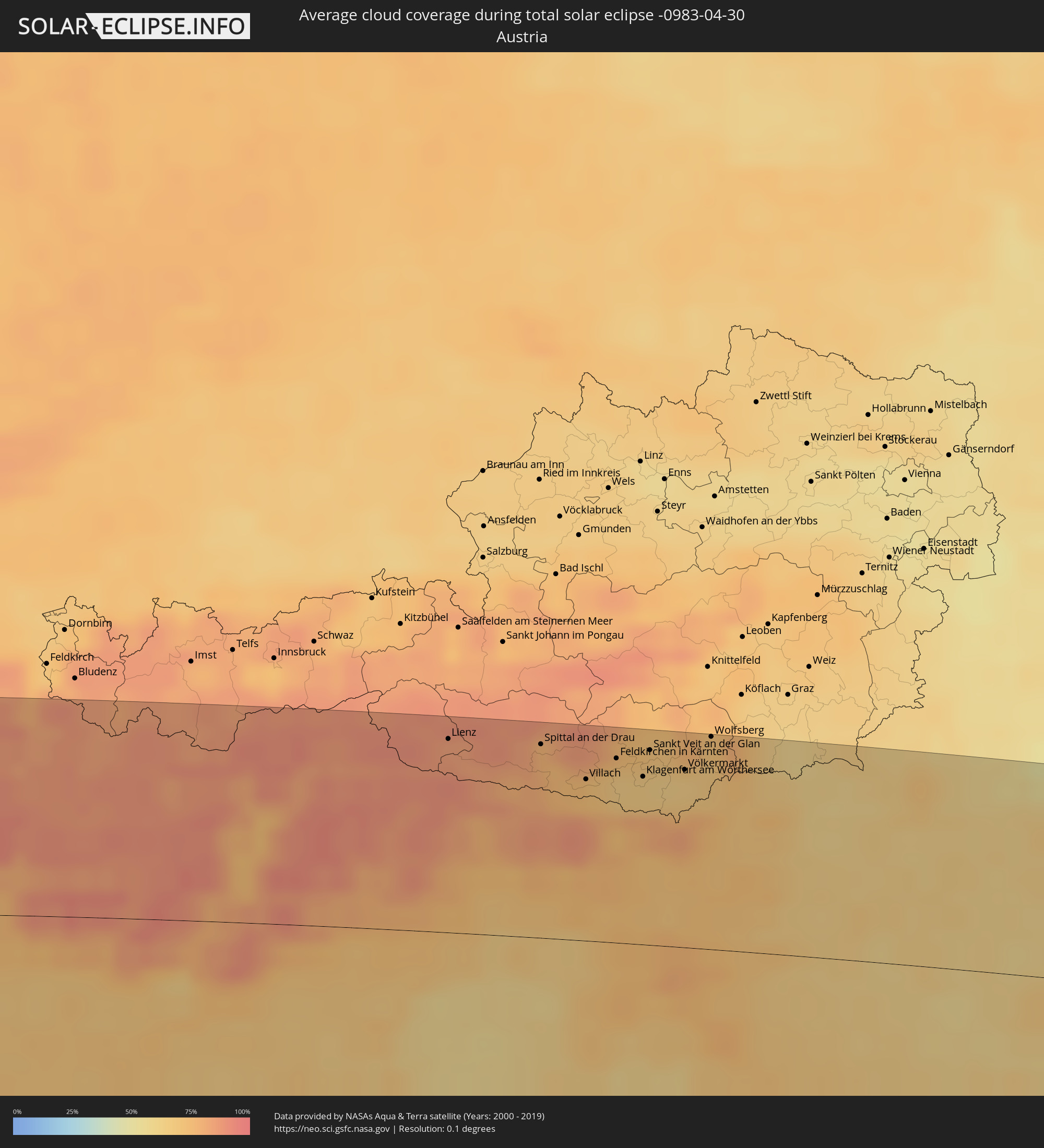 Austria
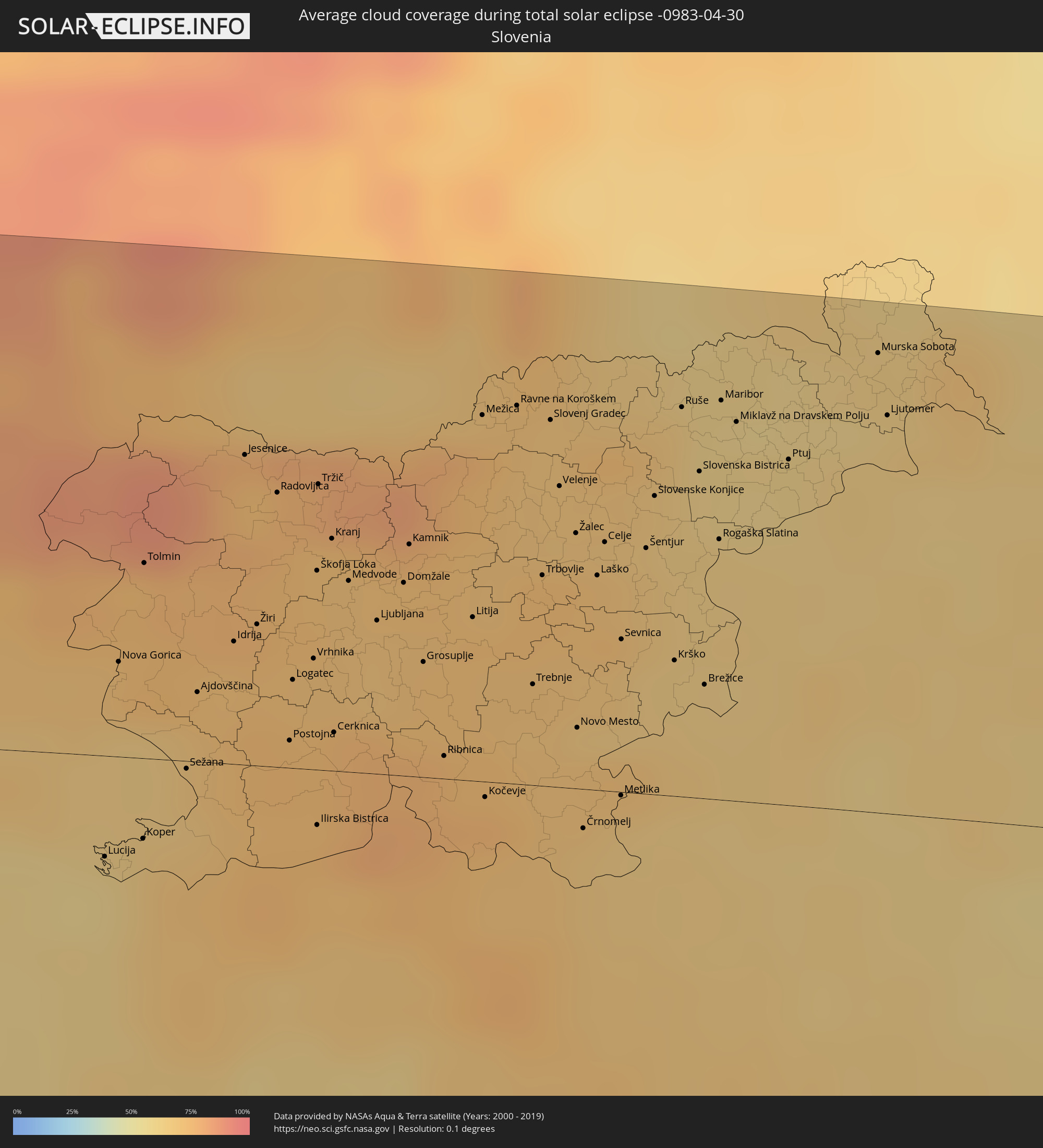 Slovenia
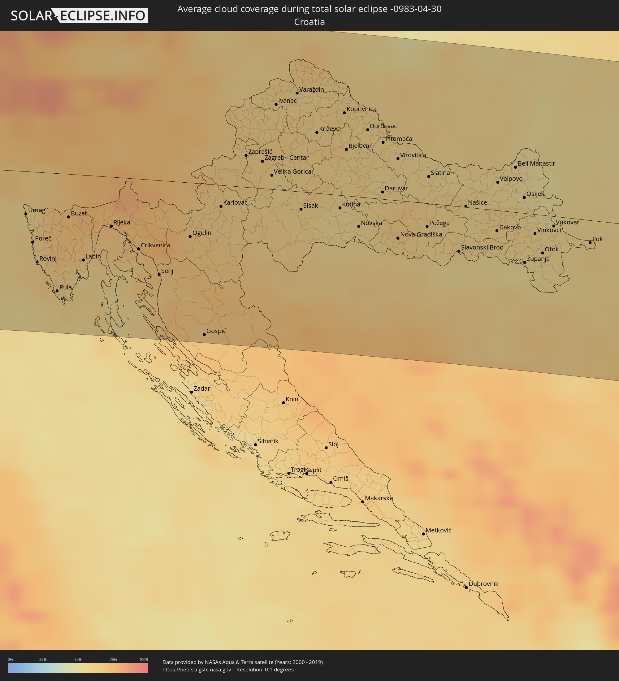 Croatia
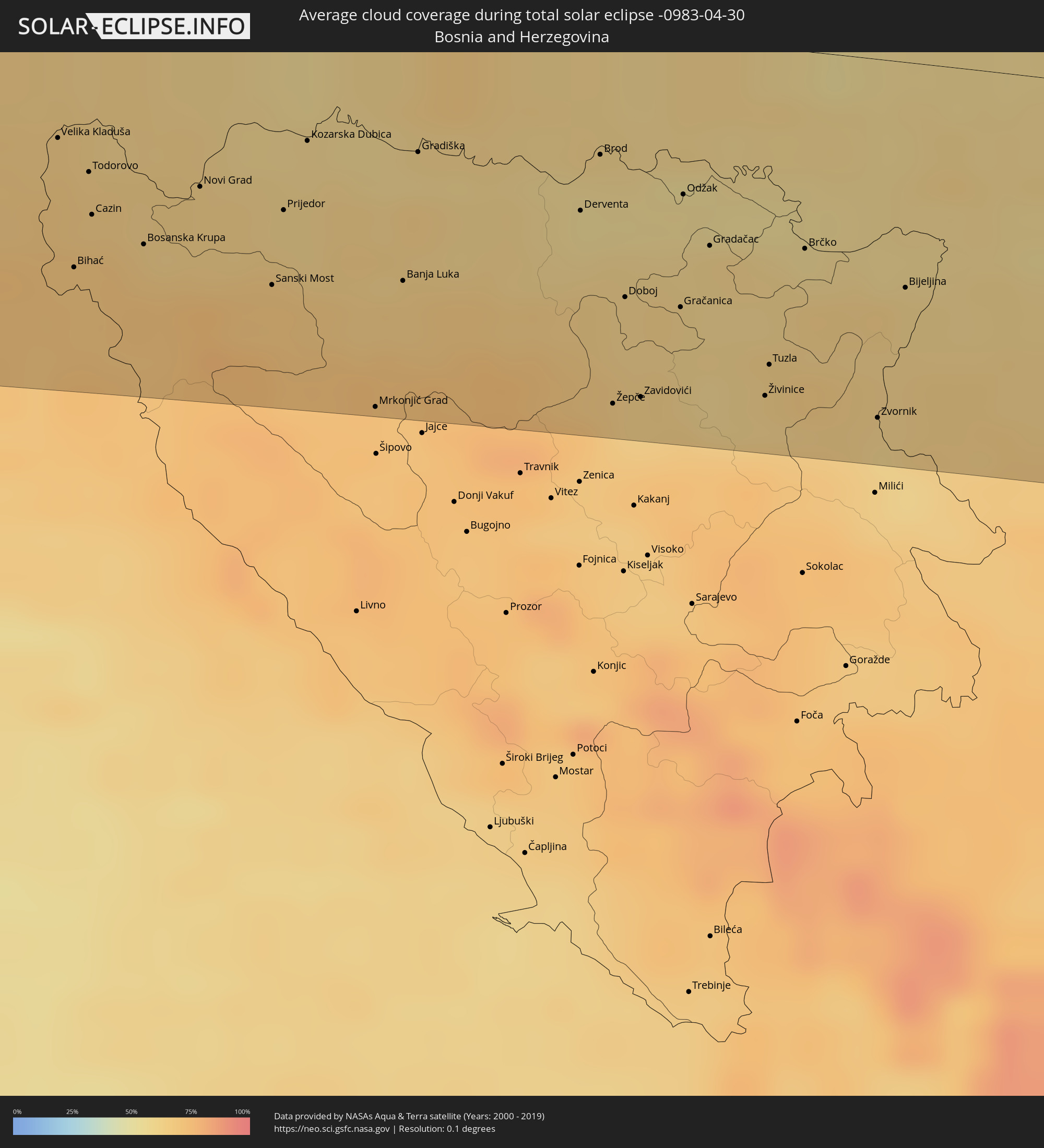 Bosnia and Herzegovina
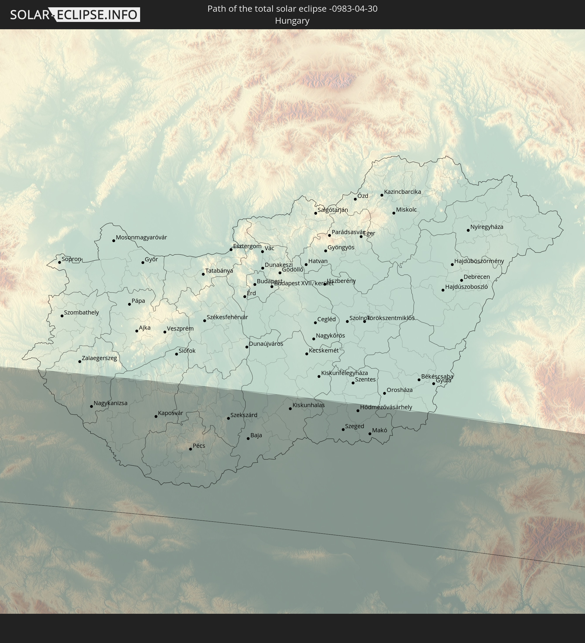
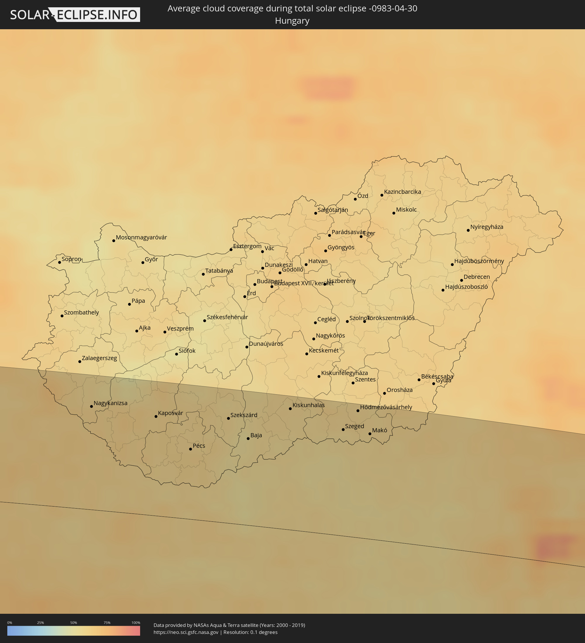 Hungary
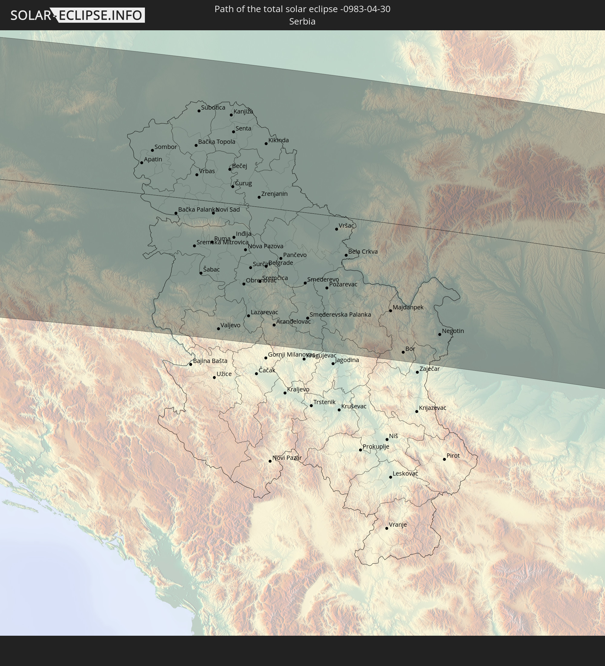
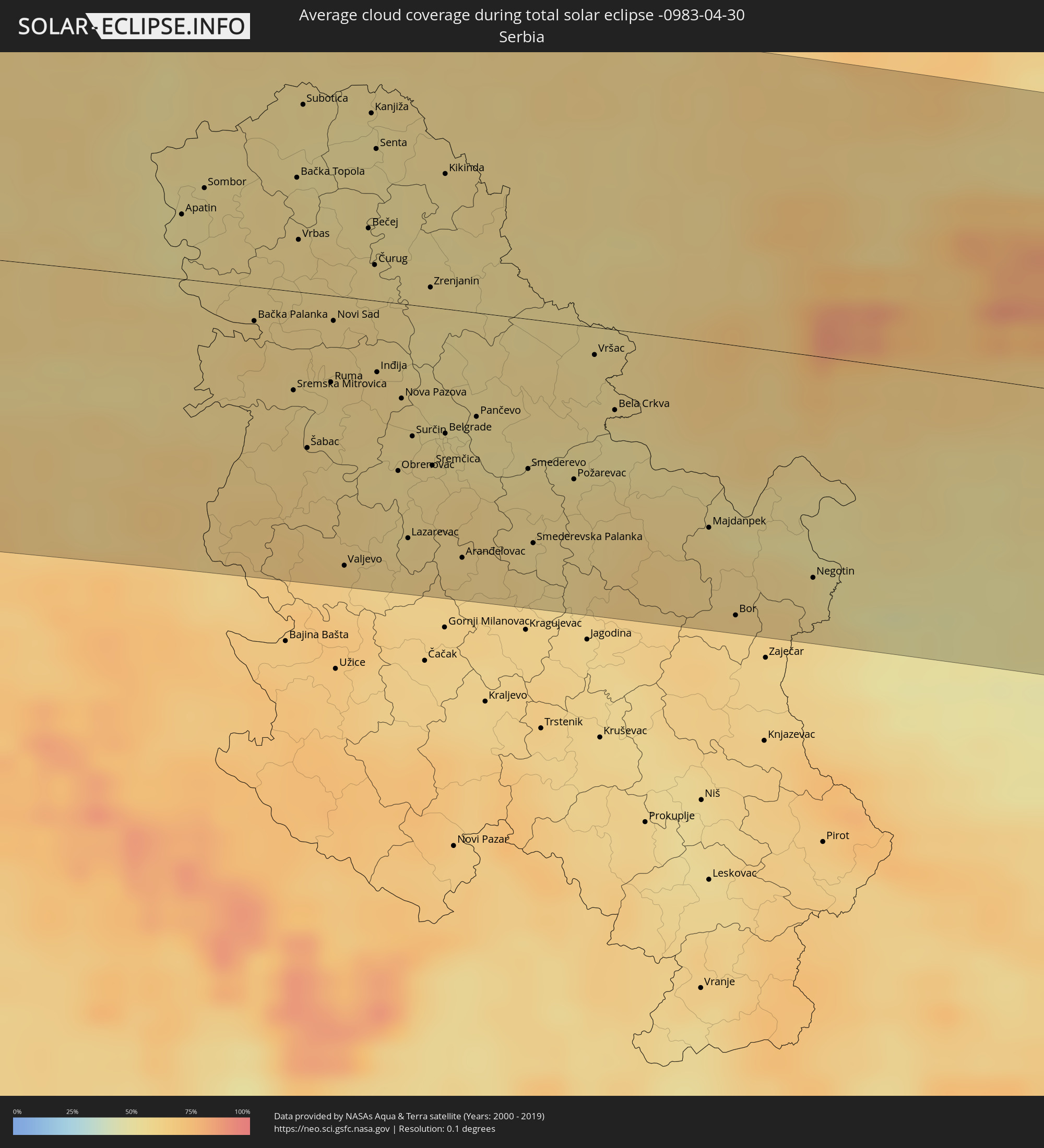 Serbia
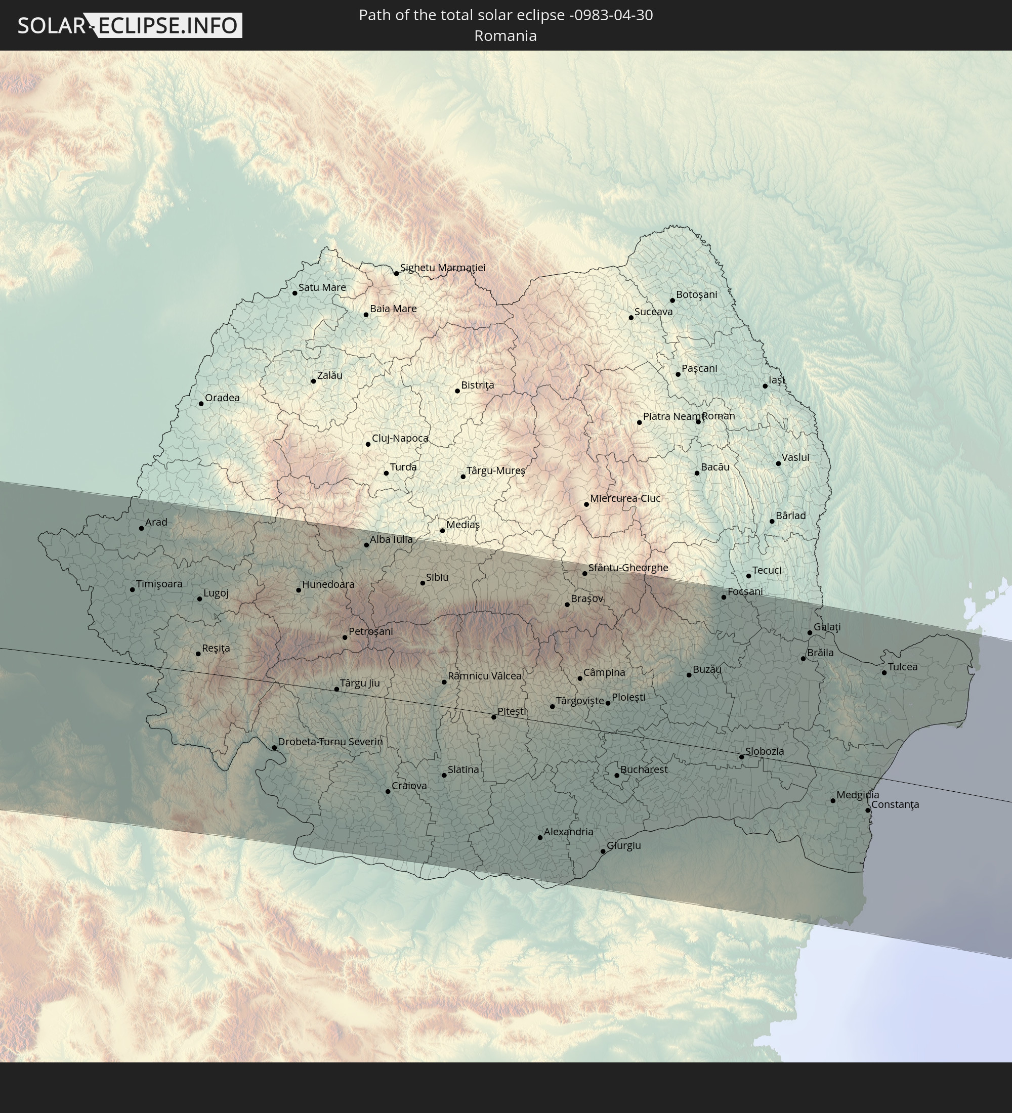
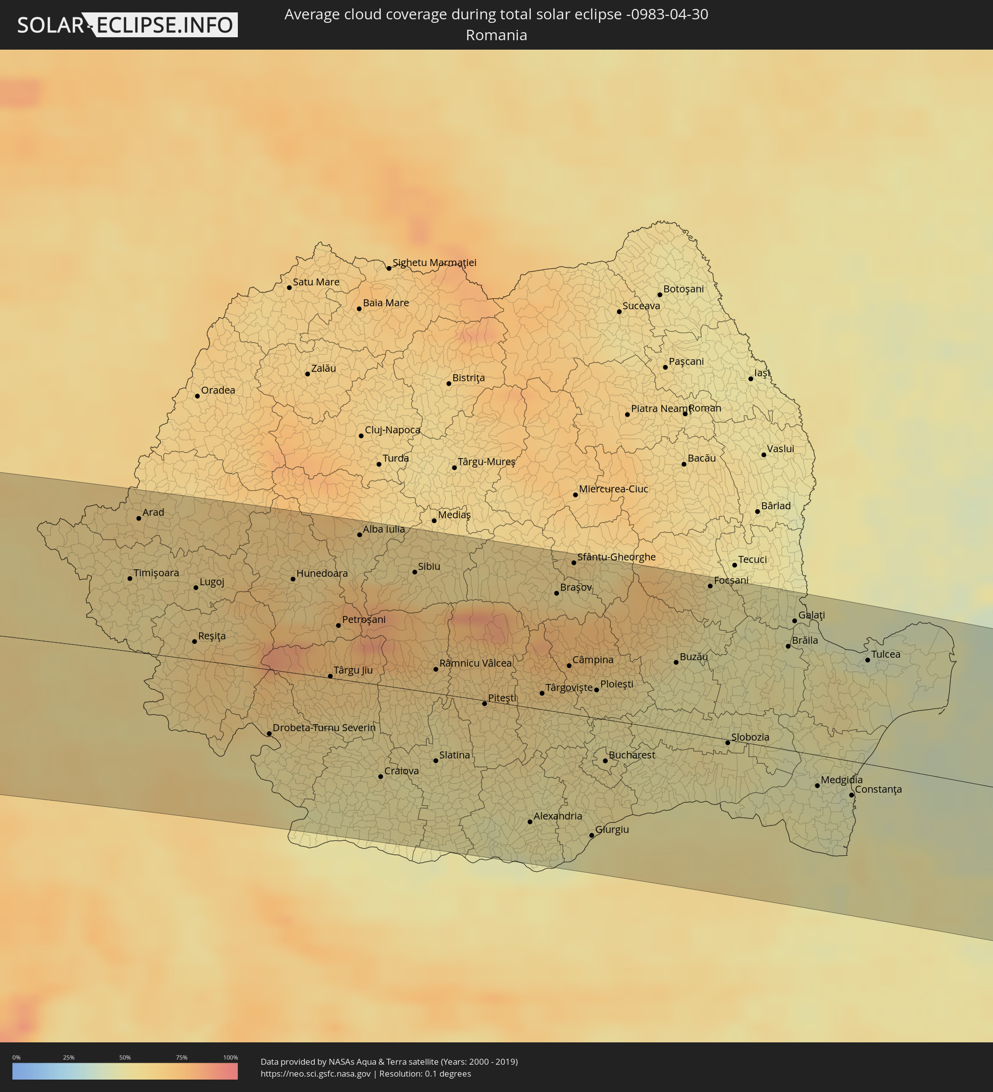 Romania
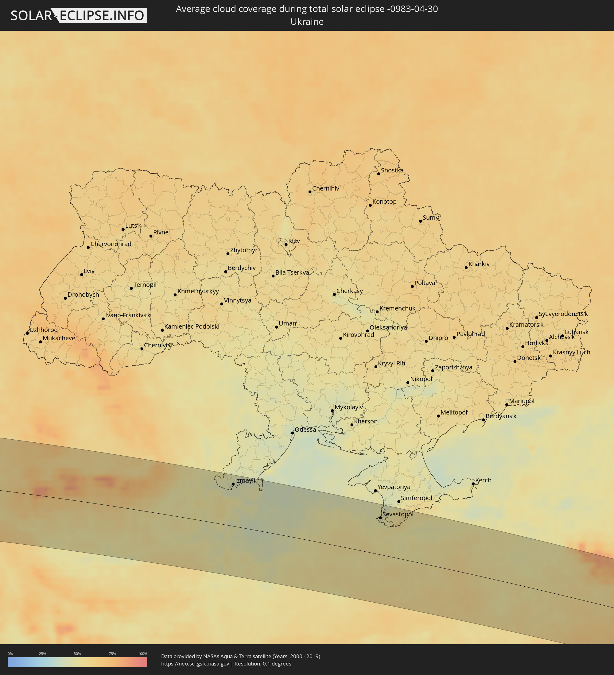 Ukraine
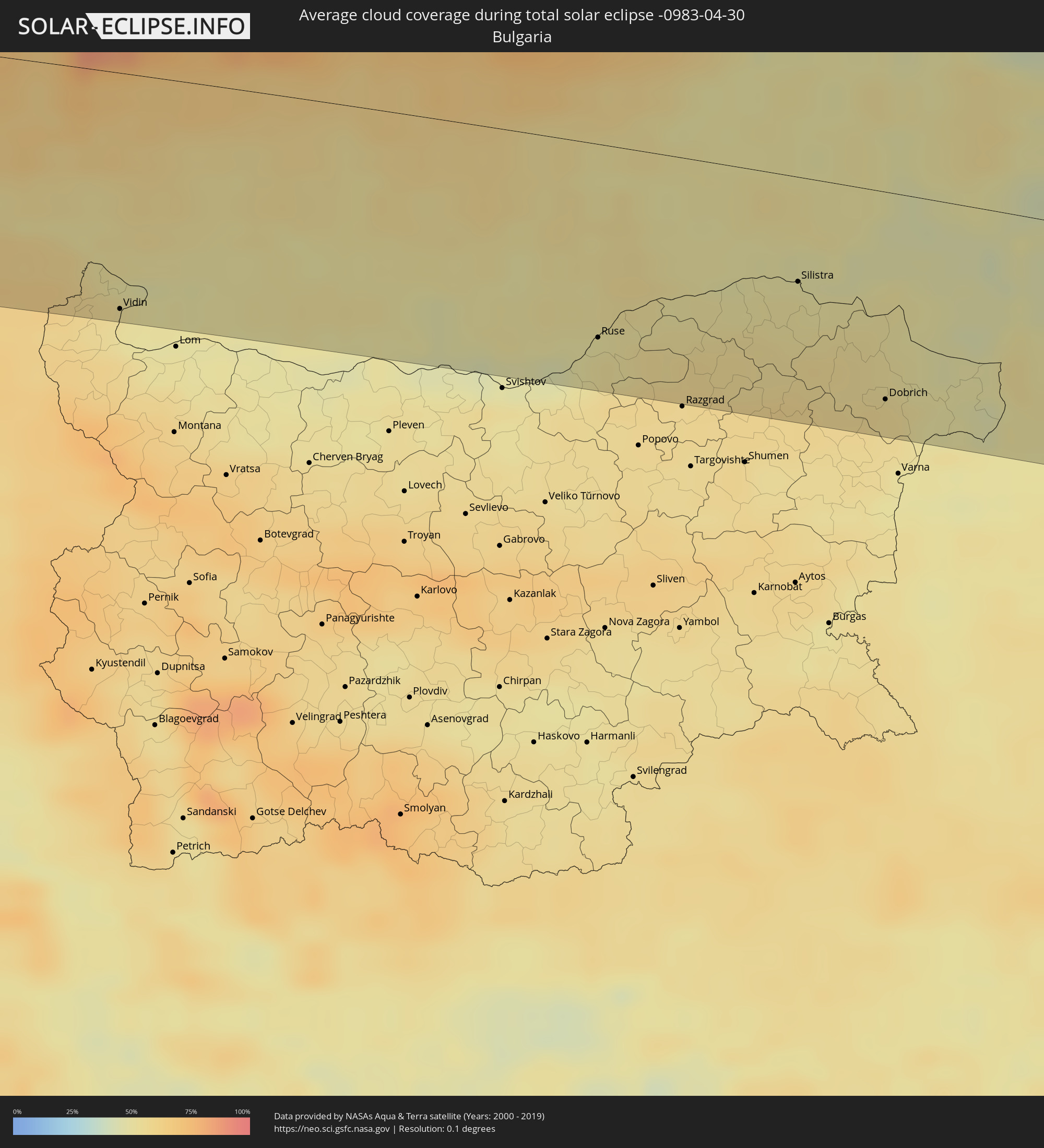 Bulgaria
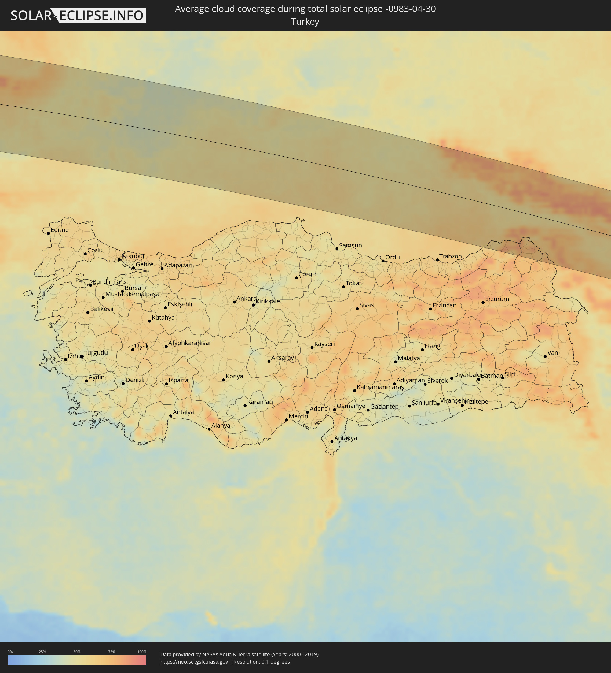 Turkey
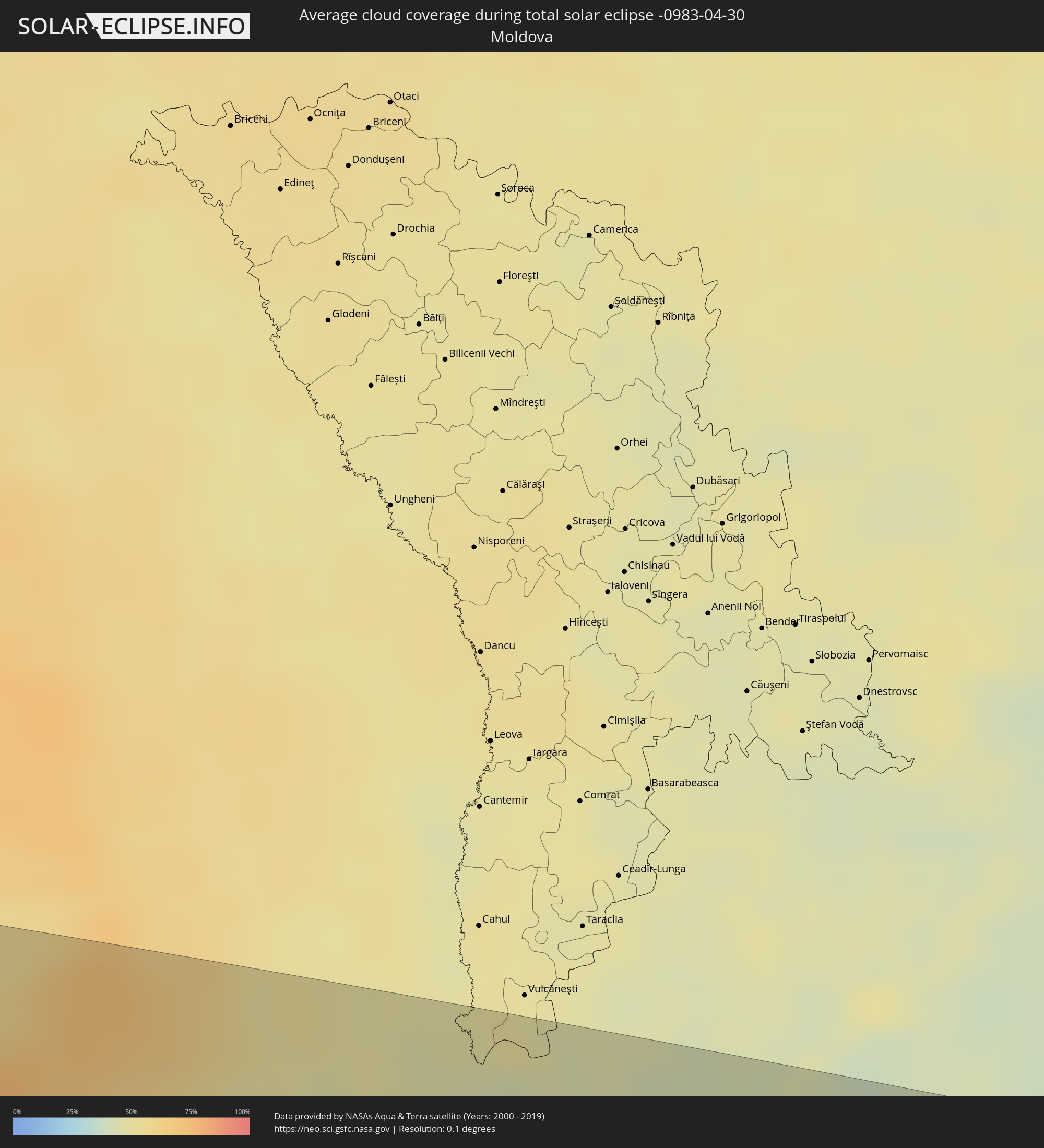 Moldova
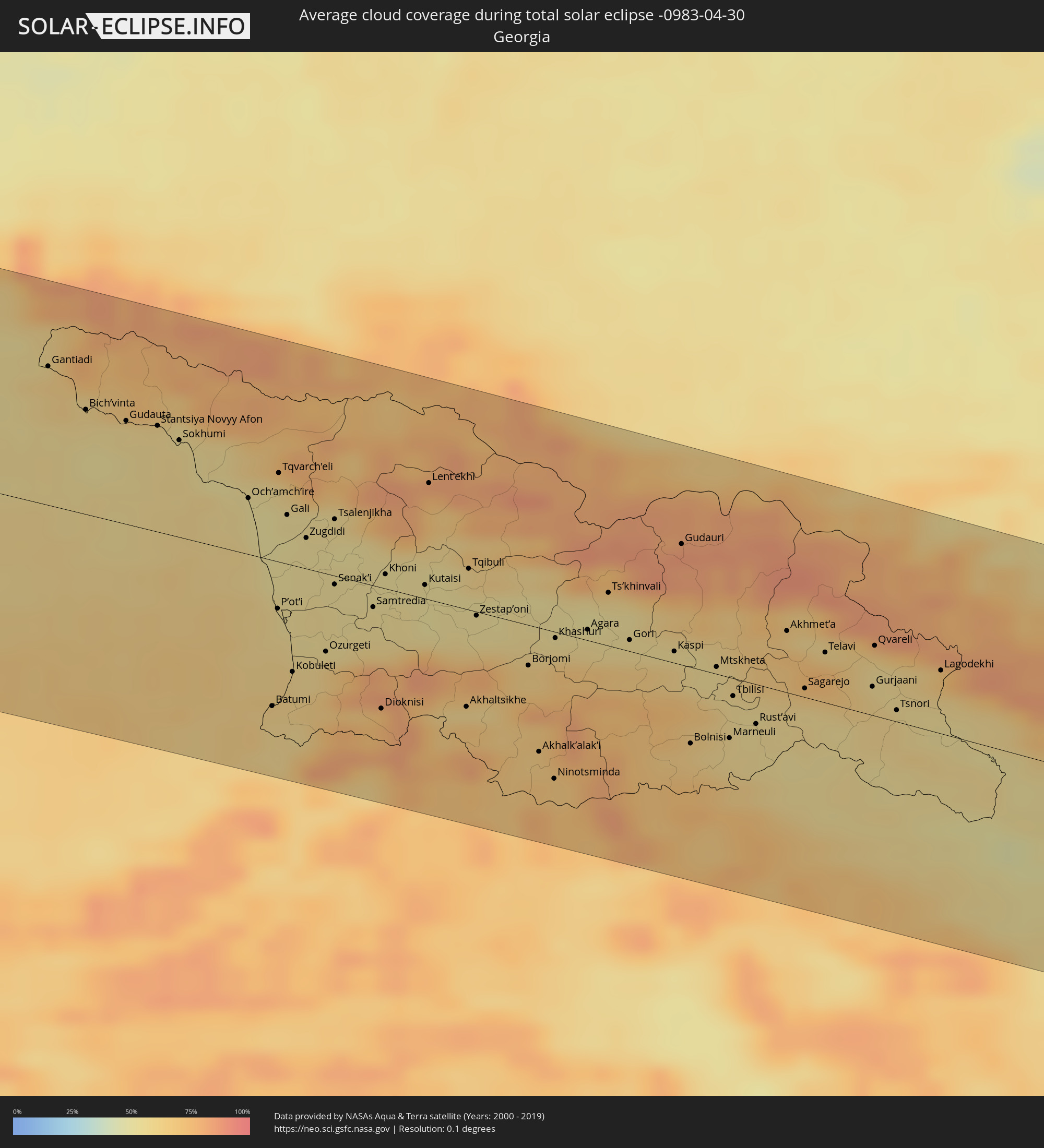 Georgia
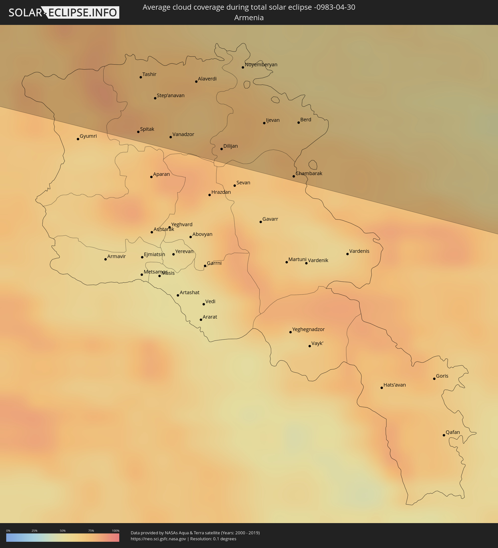 Armenia
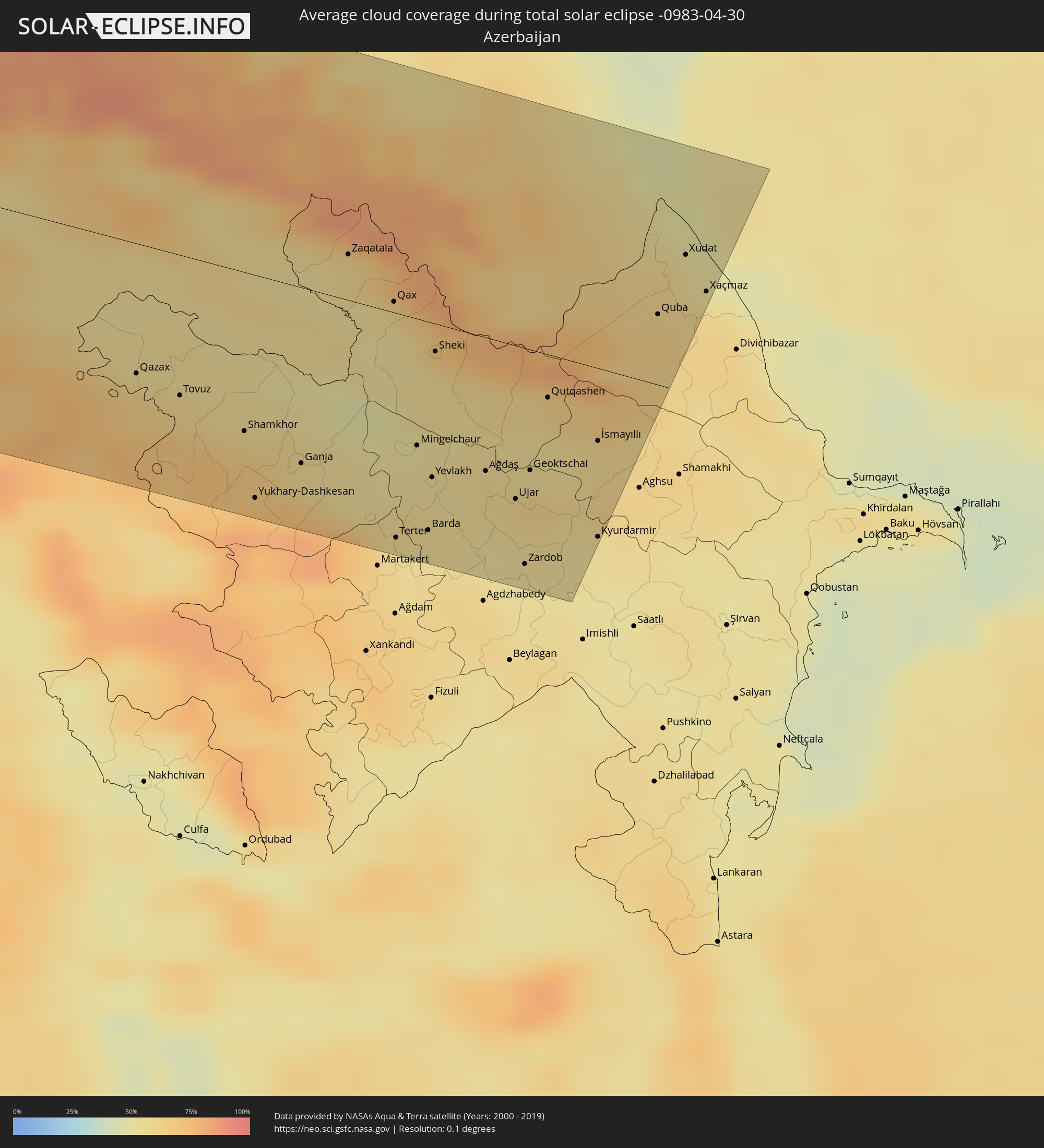 Azerbaijan
Cities inside the path of the eclipse
The following table shows all locations with a population of more than 5,000 inside the eclipse path. Cities which have more than 100,000 inhabitants are marked bold. A click at the locations opens a detailed map.
| City | Type | Eclipse duration | Local time of max. eclipse | Distance to central line | Ø Cloud coverage |
|
Moyuta, Jutiapa
|
total | - | 06:18:51 UTC-06:02 | 121 km | 74% |
|
Ahuachapán, Ahuachapán
|
total | - | 06:24:01 UTC-05:56 | 102 km | 82% |
|
Atescatempa, Jutiapa
|
total | - | 06:19:01 UTC-06:02 | 126 km | 68% |
|
Sonsonate, Sonsonate
|
total | - | 06:23:49 UTC-05:56 | 77 km | 74% |
|
Santa Ana, Santa Ana
|
total | - | 06:24:07 UTC-05:56 | 101 km | 68% |
|
San Salvador, San Salvador
|
total | - | 06:23:49 UTC-05:56 | 58 km | 75% |
|
Cojutepeque, Cuscatlán
|
total | - | 06:23:52 UTC-05:56 | 53 km | 74% |
|
Zacatecoluca, La Paz
|
total | - | 06:23:39 UTC-05:56 | 28 km | 75% |
|
San Vicente, San Vicente
|
total | - | 06:23:48 UTC-05:56 | 40 km | 76% |
|
Usulután, Usulután
|
total | - | 06:23:32 UTC-05:56 | 1 km | 76% |
|
San Miguel, San Miguel
|
total | - | 06:23:42 UTC-05:56 | 6 km | 74% |
|
Siguatepeque, Comayagua
|
total | - | 06:32:51 UTC-05:48 | 114 km | 64% |
|
La Paz, La Paz
|
total | - | 06:32:35 UTC-05:48 | 79 km | 57% |
|
Comayagua, Comayagua
|
total | - | 06:32:43 UTC-05:48 | 92 km | 65% |
|
San Lorenzo, Valle
|
total | - | 06:31:40 UTC-05:48 | 23 km | 65% |
|
Tegucigalpa, Francisco Morazán
|
total | - | 06:32:23 UTC-05:48 | 39 km | 69% |
|
Ciudad Choluteca, Choluteca
|
total | - | 06:31:34 UTC-05:48 | 45 km | 74% |
|
Chinandega, Chinandega
|
total | - | 06:34:33 UTC-05:45 | 118 km | 73% |
|
Danlí, El Paraíso
|
total | - | 06:32:26 UTC-05:48 | 14 km | 72% |
|
Somoto, Madriz
|
total | - | 06:35:31 UTC-05:45 | 44 km | 73% |
|
El Paraíso, El Paraíso
|
total | - | 06:32:15 UTC-05:48 | 4 km | 76% |
|
Ocotal, Nueva Segovia
|
total | - | 06:35:41 UTC-05:45 | 32 km | 74% |
|
Estelí, Estelí
|
total | - | 06:35:08 UTC-05:45 | 93 km | 74% |
|
Juticalpa, Olancho
|
total | - | 06:33:11 UTC-05:48 | 70 km | 79% |
|
Jalapa, Nueva Segovia
|
total | - | 06:36:03 UTC-05:45 | 12 km | 80% |
|
Jinotega, Jinotega
|
total | - | 06:35:12 UTC-05:45 | 103 km | 73% |
|
Matagalpa, Matagalpa
|
total | - | 06:35:02 UTC-05:45 | 125 km | 82% |
|
Siuna, Atlántico Norte (RAAN)
|
total | - | 06:36:06 UTC-05:45 | 76 km | 92% |
|
Puerto Cabezas, Atlántico Norte (RAAN)
|
total | - | 06:36:46 UTC-05:45 | 91 km | 69% |
|
Santa Cruz, St. Elizabeth
|
total | - | 07:21:43 UTC-05:07 | 117 km | 65% |
|
Mandeville, Manchester
|
total | - | 07:21:48 UTC-05:07 | 109 km | 75% |
|
May Pen, Clarendon
|
total | - | 07:21:50 UTC-05:07 | 90 km | 66% |
|
Saint Ann’s Bay, St Ann
|
total | - | 07:22:28 UTC-05:07 | 137 km | 79% |
|
Linstead, Saint Catherine
|
total | - | 07:22:10 UTC-05:07 | 99 km | 78% |
|
Spanish Town, Saint Catherine
|
total | - | 07:22:01 UTC-05:07 | 81 km | 67% |
|
Kingston, Kingston
|
total | - | 07:22:07 UTC-05:07 | 75 km | 70% |
|
Port Antonio, Portland
|
total | - | 07:22:31 UTC-05:07 | 80 km | 69% |
|
Morant Bay, St. Thomas
|
total | - | 07:22:10 UTC-05:07 | 48 km | 69% |
|
Jérémie, GrandʼAnse
|
total | - | 07:42:40 UTC-04:49 | 31 km | 56% |
|
Les Cayes, Sud
|
total | - | 07:42:18 UTC-04:49 | 32 km | 63% |
|
Miragoâne, Nippes
|
total | - | 07:43:03 UTC-04:49 | 35 km | 75% |
|
Tigwav, Ouest
|
total | - | 07:43:11 UTC-04:49 | 46 km | 78% |
|
Port-de-Paix, Nord-Ouest
|
total | - | 07:45:17 UTC-04:49 | 106 km | 57% |
|
Léogâne, Ouest
|
total | - | 07:43:27 UTC-04:49 | 48 km | 68% |
|
Jacmel, Sud-Est
|
total | - | 07:43:08 UTC-04:49 | 80 km | 48% |
|
Port-au-Prince, Ouest
|
total | - | 07:43:42 UTC-04:49 | 58 km | 77% |
|
Okap, Nord
|
total | - | 07:45:28 UTC-04:49 | 59 km | 46% |
|
San Juan de la Maguana, San Juan
|
total | - | 07:53:51 UTC-04:40 | 80 km | 58% |
|
Mao, Valverde
|
total | - | 07:55:00 UTC-04:40 | 12 km | 54% |
|
Azua, Azua
|
total | - | 07:53:43 UTC-04:40 | 138 km | 61% |
|
Santiago de los Caballeros, Santiago
|
total | - | 07:55:09 UTC-04:40 | 39 km | 63% |
|
Puerto Plata, Puerto Plata
|
total | - | 07:55:38 UTC-04:40 | 5 km | 61% |
|
Concepción de La Vega, La Vega
|
total | - | 07:54:57 UTC-04:40 | 70 km | 65% |
|
Moca, Espaillat
|
total | - | 07:55:12 UTC-04:40 | 53 km | 68% |
|
Bonao, Monseñor Nouel
|
total | - | 07:54:39 UTC-04:40 | 104 km | 70% |
|
San Francisco de Macorís, Duarte
|
total | - | 07:55:16 UTC-04:40 | 74 km | 67% |
|
La Rochelle, Nouvelle-Aquitaine
|
total | - | 15:03:28 UTC+00:09 | 57 km | 71% |
|
Bordeaux, Nouvelle-Aquitaine
|
total | - | 15:04:54 UTC+00:09 | 94 km | 78% |
|
Poitiers, Nouvelle-Aquitaine
|
total | - | 15:04:55 UTC+00:09 | 94 km | 85% |
|
Limoges, Nouvelle-Aquitaine
|
total | - | 15:06:26 UTC+00:09 | 6 km | 81% |
|
Clermont-Ferrand, Auvergne-Rhône-Alpes
|
total | - | 15:08:28 UTC+00:09 | 6 km | 81% |
|
Saint-Étienne, Auvergne-Rhône-Alpes
|
total | - | 15:10:05 UTC+00:09 | 48 km | 81% |
|
Lyon, Auvergne-Rhône-Alpes
|
total | - | 15:10:19 UTC+00:09 | 14 km | 75% |
|
Valence, Auvergne-Rhône-Alpes
|
total | - | 15:10:58 UTC+00:09 | 105 km | 71% |
|
Grenoble, Auvergne-Rhône-Alpes
|
total | - | 15:11:38 UTC+00:09 | 80 km | 75% |
|
Genève, Geneva
|
total | - | 16:01:55 UTC+01:00 | 35 km | 73% |
|
Lausanne, Vaud
|
total | - | 16:02:08 UTC+01:00 | 70 km | 69% |
|
Neuchâtel, Neuchâtel
|
total | - | 16:02:01 UTC+01:00 | 123 km | 74% |
|
Fribourg, Fribourg
|
total | - | 16:02:23 UTC+01:00 | 102 km | 77% |
|
Sitten, Valais
|
total | - | 16:03:02 UTC+01:00 | 38 km | 84% |
|
Bern, Bern
|
total | - | 16:02:32 UTC+01:00 | 118 km | 75% |
|
Thun, Bern
|
total | - | 16:02:51 UTC+01:00 | 96 km | 75% |
|
Turin, Piedmont
|
total | - | 16:04:16 UTC+01:00 | 91 km | 69% |
|
Luzern, Lucerne
|
total | - | 16:03:13 UTC+01:00 | 130 km | 74% |
|
Milan, Lombardy
|
total | - | 16:05:19 UTC+01:00 | 45 km | 67% |
|
Chur, Grisons
|
total | - | 16:04:27 UTC+01:00 | 110 km | 86% |
|
Brescia, Lombardy
|
total | - | 16:06:09 UTC+01:00 | 35 km | 68% |
|
Parma, Emilia-Romagna
|
total | - | 16:06:52 UTC+01:00 | 117 km | 70% |
|
Reggio nell'Emilia, Emilia-Romagna
|
total | - | 16:07:12 UTC+01:00 | 127 km | 70% |
|
Verona, Veneto
|
total | - | 16:06:53 UTC+01:00 | 45 km | 68% |
|
Padova, Veneto
|
total | - | 16:07:38 UTC+01:00 | 44 km | 67% |
|
Mestre, Veneto
|
total | - | 16:07:51 UTC+01:00 | 33 km | 66% |
|
Lienz, Tyrol
|
total | - | 16:07:03 UTC+01:00 | 117 km | 86% |
|
Spittal an der Drau, Carinthia
|
total | - | 16:07:37 UTC+01:00 | 117 km | 78% |
|
Koper, Koper-Capodistria
|
total | - | 16:08:56 UTC+01:00 | 21 km | 64% |
|
Trieste, Friuli Venezia Giulia
|
total | - | 16:08:53 UTC+01:00 | 10 km | 67% |
|
Pula, Istarska
|
total | - | 16:09:38 UTC+01:00 | 96 km | 62% |
|
Villach, Carinthia
|
total | - | 16:08:03 UTC+01:00 | 98 km | 73% |
|
Feldkirchen in Kärnten, Carinthia
|
total | - | 16:08:07 UTC+01:00 | 112 km | 65% |
|
Klagenfurt am Wörthersee, Carinthia
|
total | - | 16:08:22 UTC+01:00 | 102 km | 67% |
|
Kranj, Kranj
|
total | - | 16:08:45 UTC+01:00 | 59 km | 71% |
|
Sankt Veit an der Glan, Carinthia
|
total | - | 16:08:16 UTC+01:00 | 118 km | 66% |
|
Rijeka, Primorsko-Goranska
|
total | - | 16:09:37 UTC+01:00 | 40 km | 67% |
|
Ljubljana, Ljubljana
|
total | - | 16:09:02 UTC+01:00 | 39 km | 70% |
|
Völkermarkt, Carinthia
|
total | - | 16:08:33 UTC+01:00 | 108 km | 64% |
|
Wolfsberg, Carinthia
|
total | - | 16:08:32 UTC+01:00 | 129 km | 67% |
|
Trbovlje, Trbovlje
|
total | - | 16:09:19 UTC+01:00 | 54 km | 73% |
|
Velenje, Velenje
|
total | - | 16:09:10 UTC+01:00 | 77 km | 69% |
|
Novo Mesto, Novo Mesto
|
total | - | 16:09:44 UTC+01:00 | 16 km | 70% |
|
Deutschlandsberg, Styria
|
total | - | 16:08:49 UTC+01:00 | 128 km | 67% |
|
Celje, Celje
|
total | - | 16:09:24 UTC+01:00 | 64 km | 70% |
|
Karlovac, Karlovačka
|
total | - | 16:10:17 UTC+01:00 | 17 km | 64% |
|
Maribor, Maribor
|
total | - | 16:09:21 UTC+01:00 | 102 km | 61% |
|
Velika Kladuša, Federation of Bosnia and Herzegovina
|
total | - | 16:10:44 UTC+01:00 | 49 km | 66% |
|
Ptuj, Ptuj
|
total | - | 16:09:38 UTC+01:00 | 88 km | 61% |
|
Bihać, Federation of Bosnia and Herzegovina
|
total | - | 16:11:07 UTC+01:00 | 90 km | 69% |
|
Cazin, Federation of Bosnia and Herzegovina
|
total | - | 16:11:02 UTC+01:00 | 72 km | 68% |
|
Zagreb - Centar, City of Zagreb
|
total | - | 16:10:16 UTC+01:00 | 22 km | 63% |
|
Varaždin, Varaždinska
|
total | - | 16:10:03 UTC+01:00 | 78 km | 62% |
|
Sisak, Sisačko-Moslavačka
|
total | - | 16:10:52 UTC+01:00 | 14 km | 61% |
|
Prijedor, Republic of Srspka
|
total | - | 16:11:32 UTC+01:00 | 66 km | 63% |
|
Nagykanizsa, Zala
|
total | - | 16:10:19 UTC+01:00 | 99 km | 62% |
|
Banja Luka, Republic of Srspka
|
total | - | 16:12:02 UTC+01:00 | 85 km | 65% |
|
Kaposvár, Somogy
|
total | - | 16:10:55 UTC+01:00 | 96 km | 60% |
|
Slavonski Brod, Slavonski Brod-Posavina
|
total | - | 16:12:12 UTC+01:00 | 36 km | 58% |
|
Doboj, Republic of Srspka
|
total | - | 16:12:39 UTC+01:00 | 83 km | 62% |
|
Pécs, Baranya
|
total | - | 16:11:27 UTC+01:00 | 68 km | 61% |
|
Tuzla, Federation of Bosnia and Herzegovina
|
total | - | 16:13:11 UTC+01:00 | 100 km | 62% |
|
Osijek, Osječko-Baranjska
|
total | - | 16:12:14 UTC+01:00 | 12 km | 56% |
|
Szekszárd, Tolna
|
total | - | 16:11:28 UTC+01:00 | 101 km | 59% |
|
Vinkovci, Vukovar-Sirmium
|
total | - | 16:12:33 UTC+01:00 | 16 km | 60% |
|
Brčko, Brčko
|
total | - | 16:12:57 UTC+01:00 | 62 km | 59% |
|
Baja, Bács-Kiskun
|
total | - | 16:11:47 UTC+01:00 | 84 km | 56% |
|
Sombor, Vojvodina
|
total | - | 16:12:16 UTC+01:00 | 41 km | 55% |
|
Bijeljina, Republic of Srspka
|
total | - | 16:13:18 UTC+01:00 | 71 km | 61% |
|
Kiskunhalas, Bács-Kiskun
|
total | - | 16:11:50 UTC+01:00 | 117 km | 58% |
|
Subotica, Vojvodina
|
total | - | 16:12:15 UTC+01:00 | 81 km | 55% |
|
Šabac, Central Serbia
|
total | - | 16:13:35 UTC+01:00 | 68 km | 62% |
|
Novi Sad, Vojvodina
|
total | - | 16:13:11 UTC+01:00 | 11 km | 59% |
|
Valjevo, Central Serbia
|
total | - | 16:14:09 UTC+01:00 | 118 km | 64% |
|
Szeged, Csongrád
|
total | - | 16:12:22 UTC+01:00 | 103 km | 57% |
|
Hódmezővásárhely, Csongrád
|
total | - | 16:12:18 UTC+01:00 | 122 km | 60% |
|
Zrenjanin, Vojvodina
|
total | - | 16:13:21 UTC+01:00 | 9 km | 57% |
|
Belgrade, Central Serbia
|
total | - | 16:13:57 UTC+01:00 | 55 km | 56% |
|
Makó, Csongrád
|
total | - | 16:12:35 UTC+01:00 | 102 km | 58% |
|
Pančevo, Vojvodina
|
total | - | 16:13:59 UTC+01:00 | 46 km | 52% |
|
Smederevo, Central Serbia
|
total | - | 16:14:20 UTC+01:00 | 66 km | 56% |
|
Timişoara, Timiş
|
total | - | 16:57:50 UTC+01:44 | 57 km | 58% |
|
Arad, Arad
|
total | - | 16:57:27 UTC+01:44 | 106 km | 62% |
|
Vidin, Vidin
|
total | - | 17:15:58 UTC+02:00 | 120 km | 50% |
|
Craiova, Dolj
|
total | - | 17:00:29 UTC+01:44 | 74 km | 52% |
|
Braşov, Braşov
|
total | - | 16:59:55 UTC+01:44 | 94 km | 69% |
|
Ruse, Ruse
|
total | - | 17:17:26 UTC+02:00 | 99 km | 50% |
|
Ploieşti, Prahova
|
total | - | 17:00:47 UTC+01:44 | 22 km | 58% |
|
Bucharest, Bucureşti
|
total | - | 17:01:19 UTC+01:44 | 34 km | 53% |
|
Kubrat, Razgrad
|
total | - | 17:17:42 UTC+02:00 | 98 km | 56% |
|
Tutrakan, Silistra
|
total | - | 17:17:29 UTC+02:00 | 69 km | 51% |
|
Isperih, Razgrad
|
total | - | 17:17:54 UTC+02:00 | 103 km | 55% |
|
Silistra, Silistra
|
total | - | 17:17:40 UTC+02:00 | 53 km | 50% |
|
Dobrich, Dobrich
|
total | - | 17:18:23 UTC+02:00 | 106 km | 56% |
|
Brăila, Brăila
|
total | - | 17:01:09 UTC+01:44 | 82 km | 47% |
|
Galaţi, Galaţi
|
total | - | 17:01:00 UTC+01:44 | 103 km | 46% |
|
Balchik, Dobrich
|
total | - | 17:18:39 UTC+02:00 | 118 km | 53% |
|
Reni, Odessa
|
total | - | 17:18:44 UTC+02:02 | 108 km | 44% |
|
Kavarna, Dobrich
|
total | - | 17:18:41 UTC+02:00 | 114 km | 52% |
|
Constanţa, Constanța
|
total | - | 17:02:27 UTC+01:44 | 28 km | 44% |
|
Izmayil, Odessa
|
total | - | 17:19:01 UTC+02:02 | 103 km | 42% |
|
Kiliya, Odessa
|
total | - | 17:19:02 UTC+02:02 | 121 km | 42% |
|
Vylkove, Odessa
|
total | - | 17:19:11 UTC+02:02 | 120 km | 45% |
|
Sevastopol, Gorod Sevastopol
|
total | - | 17:34:51 UTC+02:16 | 91 km | 46% |
|
Bakhchisaray, Republic of Crimea
|
total | - | 17:34:44 UTC+02:16 | 114 km | 50% |
|
Yalta, Republic of Crimea
|
total | - | 17:35:03 UTC+02:16 | 92 km | 53% |
|
Gurzuf, Republic of Crimea
|
total | - | 17:35:01 UTC+02:16 | 99 km | 51% |
|
Alushta, Republic of Crimea
|
total | - | 17:34:55 UTC+02:16 | 115 km | 53% |
|
Lazarevskoye, Krasnodarskiy
|
total | - | 17:50:26 UTC+02:30 | 119 km | 51% |
|
Sochi, Krasnodarskiy
|
total | - | 17:50:45 UTC+02:30 | 93 km | 55% |
|
Adler, Krasnodarskiy
|
total | - | 17:50:55 UTC+02:30 | 78 km | 60% |
|
Sokhumi, Abkhazia
|
total | - | 18:20:14 UTC+02:59 | 53 km | 57% |
|
Arhavi, Artvin
|
total | - | 17:19:30 UTC+01:56 | 119 km | 62% |
|
Hopa, Artvin
|
total | - | 17:19:28 UTC+01:56 | 113 km | 63% |
|
Batumi, Ajaria
|
total | - | 18:21:29 UTC+02:59 | 81 km | 60% |
|
Borçka, Artvin
|
total | - | 17:19:29 UTC+01:56 | 111 km | 61% |
|
P’ot’i, Samegrelo and Zemo Svaneti
|
total | - | 18:21:01 UTC+02:59 | 26 km | 58% |
|
Zugdidi, Samegrelo and Zemo Svaneti
|
total | - | 18:20:41 UTC+02:59 | 17 km | 53% |
|
Şavşat, Artvin
|
total | - | 17:19:34 UTC+01:56 | 110 km | 76% |
|
Kutaisi, Imereti
|
total | - | 18:20:53 UTC+02:59 | 8 km | 52% |
|
Ardahan, Ardahan
|
total | - | 17:19:40 UTC+01:56 | 117 km | 72% |
|
Hanak, Ardahan
|
total | - | 17:19:33 UTC+01:56 | 101 km | 70% |
|
Ts’khinvali, Shida Kartli
|
total | - | 18:20:50 UTC+02:59 | 29 km | 54% |
|
Gori, Shida Kartli
|
total | - | 18:21:03 UTC+02:59 | 6 km | 57% |
|
Spitak, Lori Province
|
total | - | 18:20:53 UTC+02:58 | 115 km | 75% |
|
Tashir, Lori Province
|
total | - | 18:20:37 UTC+02:58 | 83 km | 69% |
|
Step’anavan, Lori Province
|
total | - | 18:20:43 UTC+02:58 | 93 km | 72% |
|
Vanadzor, Lori Province
|
total | - | 18:20:53 UTC+02:58 | 113 km | 76% |
|
Alaverdi, Lori Province
|
total | - | 18:20:36 UTC+02:58 | 78 km | 68% |
|
Tbilisi, T'bilisi
|
total | - | 18:21:15 UTC+02:59 | 10 km | 57% |
|
Dilijan, Tavush Province
|
total | - | 18:20:54 UTC+02:58 | 112 km | 72% |
|
Rust’avi, Kvemo Kartli
|
total | - | 18:21:22 UTC+02:59 | 22 km | 56% |
|
Ijevan, Tavush Province
|
total | - | 18:20:45 UTC+02:58 | 91 km | 70% |
|
Chambarak, Gegharkunik Province
|
total | - | 18:20:58 UTC+02:58 | 117 km | 69% |
|
Berd, Tavush Province
|
total | - | 18:20:43 UTC+02:58 | 86 km | 70% |
|
Shamkhor, Şǝmkir
|
total | - | 18:42:06 UTC+03:19 | 78 km | 64% |
|
Ganja, Gǝncǝ
|
total | - | 18:42:11 UTC+03:19 | 86 km | 57% |
|
Mingelchaur, Mingǝcevir
|
total | - | 18:42:00 UTC+03:19 | 62 km | 53% |
|
Barda, Bǝrdǝ
|
total | - | 18:42:20 UTC+03:19 | 102 km | 56% |
|
Yevlakh, Yevlax City
|
total | - | 18:42:07 UTC+03:19 | 76 km | 55% |
|
Sheki, Shaki City
|
total | - | 18:41:37 UTC+03:19 | 14 km | 61% |
|
Ağdaş, Ağdaş
|
total | - | 18:42:03 UTC+03:19 | 65 km | 58% |
|
Akhty, Dagestan
|
total | - | 17:52:11 UTC+02:30 | 28 km | 58% |
|
Geoktschai, Göyçay
|
total | - | 18:42:00 UTC+03:19 | 59 km | 56% |
|
Kurush, Dagestan
|
total | - | 17:52:19 UTC+02:30 | 11 km | 76% |
|
Mamedkala, Dagestan
|
total | - | 17:51:30 UTC+02:30 | 112 km | 54% |
|
Kasumkent, Dagestan
|
total | - | 17:51:56 UTC+02:30 | 60 km | 63% |
|
Derbent, Dagestan
|
total | - | 17:51:34 UTC+02:30 | 105 km | 54% |
|
Belidzhi, Dagestan
|
total | - | 17:51:42 UTC+02:30 | 89 km | 54% |
|
Xaçmaz, Xaçmaz
|
total | - | 18:41:07 UTC+03:19 | 52 km | 55% |