Annular solar eclipse of 05/15/-1272
| Day of week: | Monday |
| Maximum duration of eclipse: | 00m52s |
| Maximum width of eclipse path: | 29 km |
| Saros cycle: | 27 |
| Coverage: | 99.2% |
| Magnitude: | 0.9919 |
| Gamma: | -0.2 |
Wo kann man die Sonnenfinsternis vom 05/15/-1272 sehen?
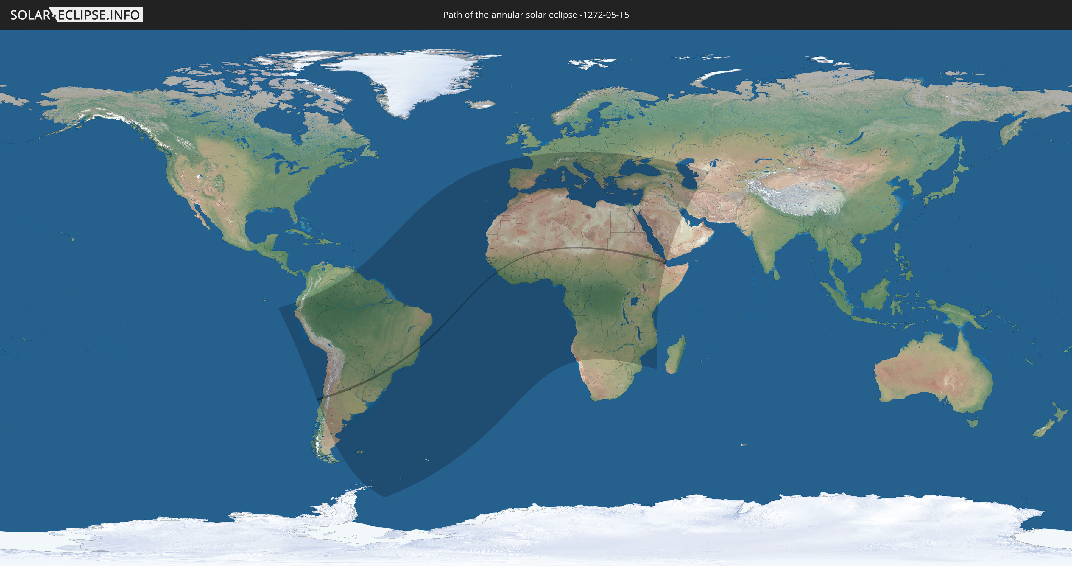
Die Sonnenfinsternis am 05/15/-1272 kann man in 112 Ländern als partielle Sonnenfinsternis beobachten.
Der Finsternispfad verläuft durch 14 Länder. Nur in diesen Ländern ist sie als annular Sonnenfinsternis zu sehen.
In den folgenden Ländern ist die Sonnenfinsternis annular zu sehen
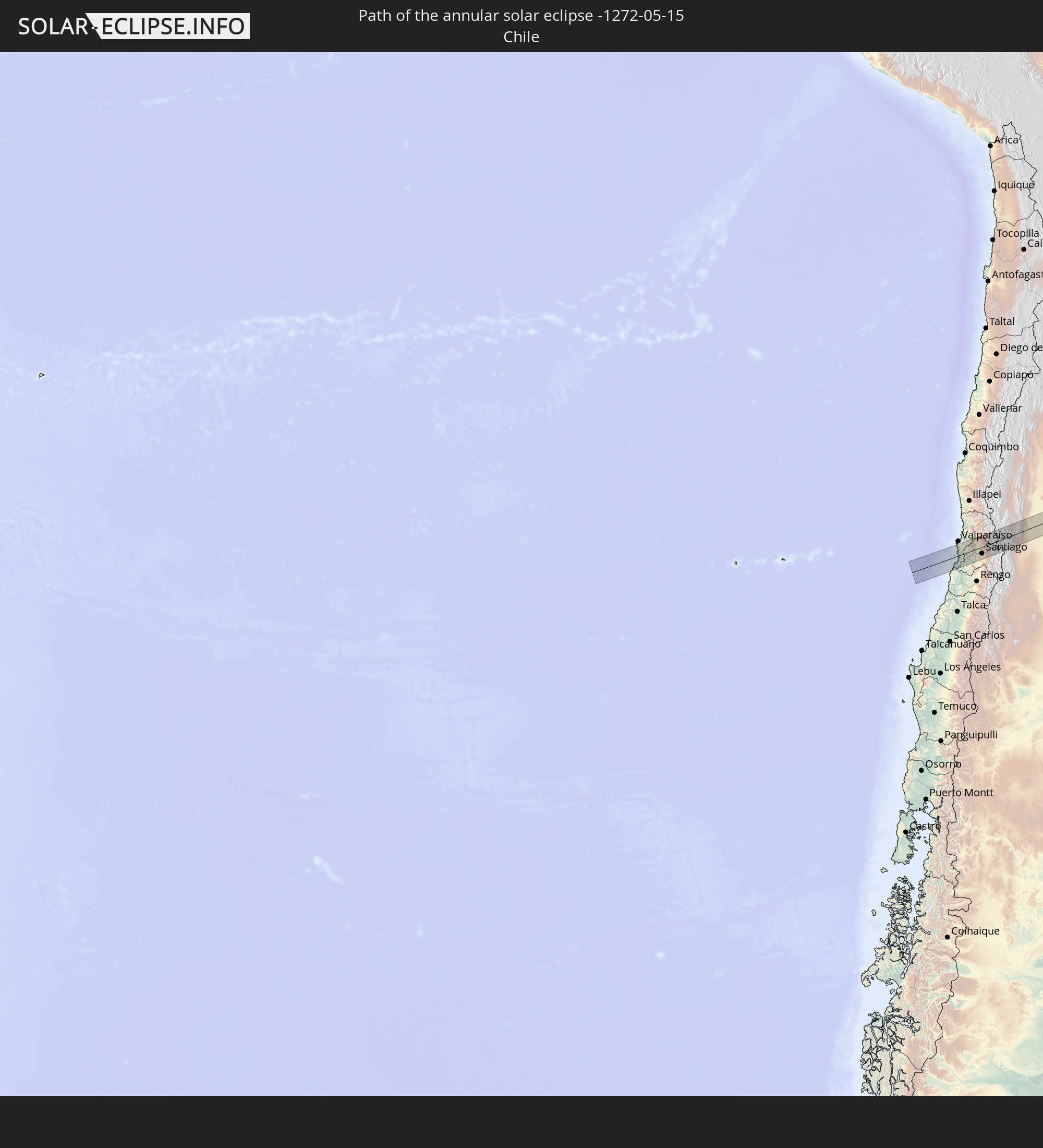 Chile
Chile
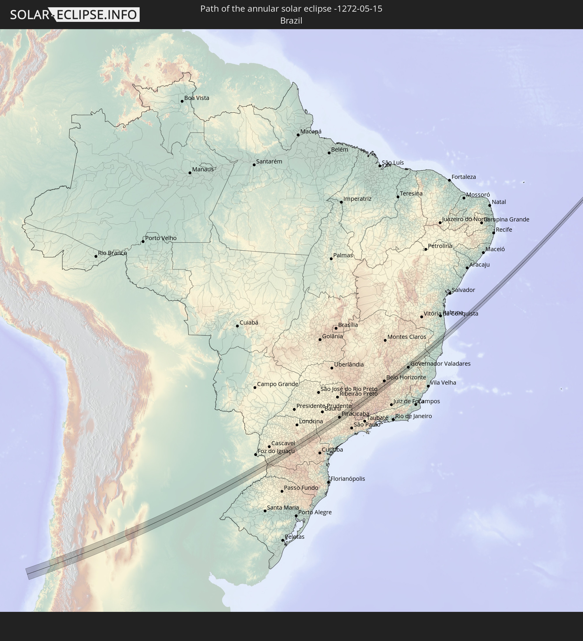 Brazil
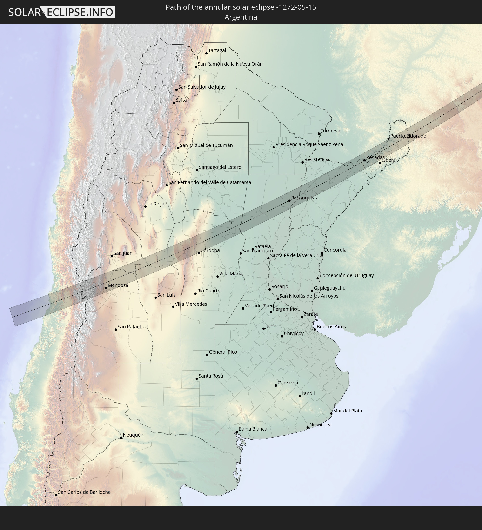 Argentina
 Paraguay
 Guinea
 Sierra Leone
 Mali
Mali
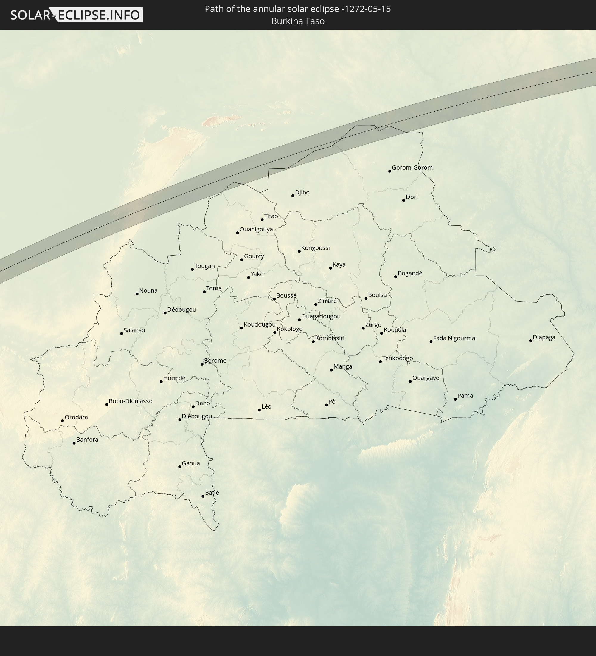 Burkina Faso
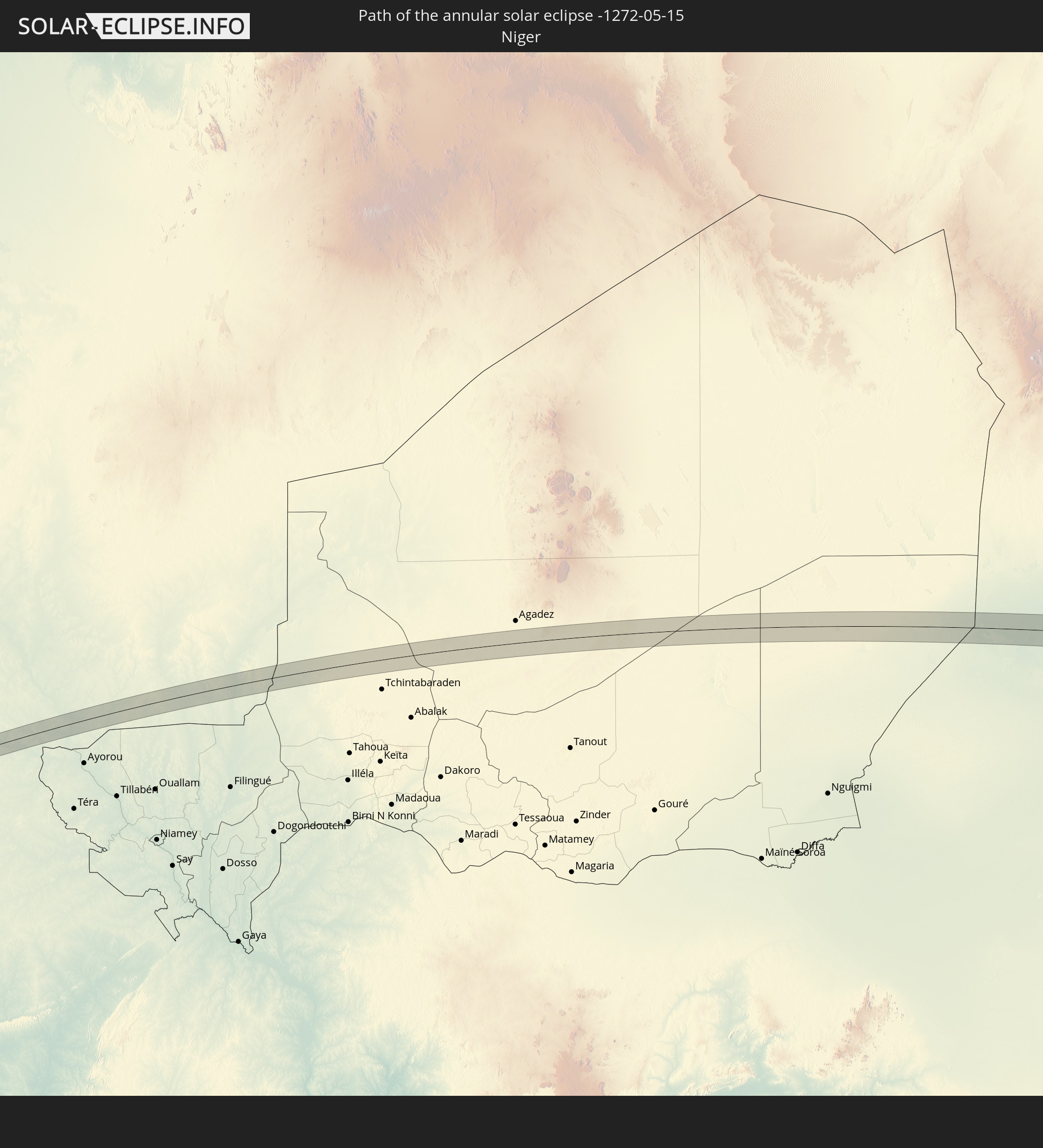 Niger
Niger
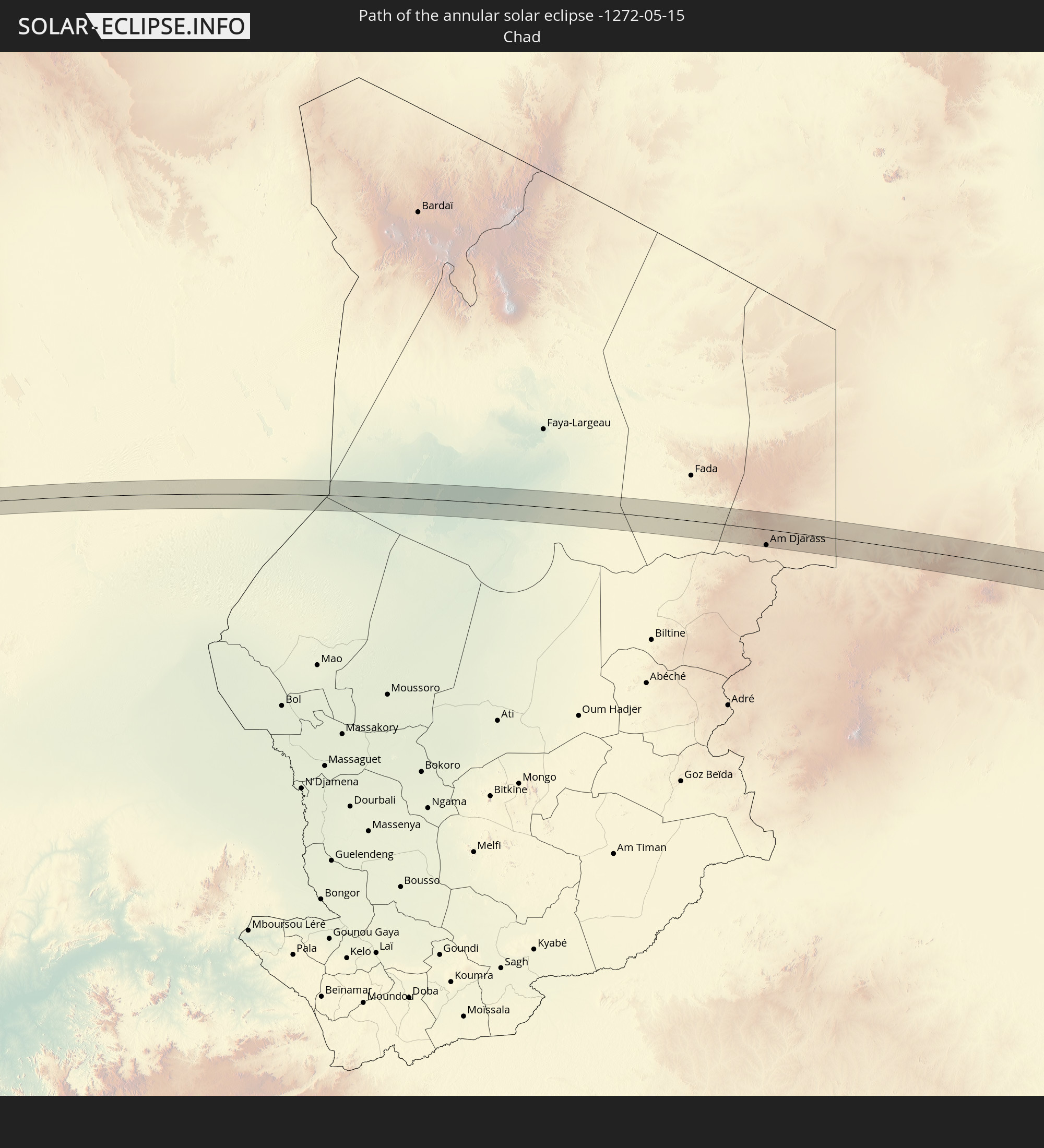 Chad
Chad
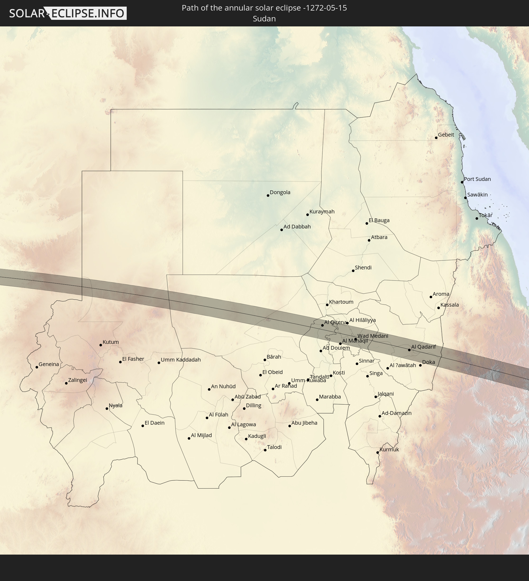 Sudan
Sudan
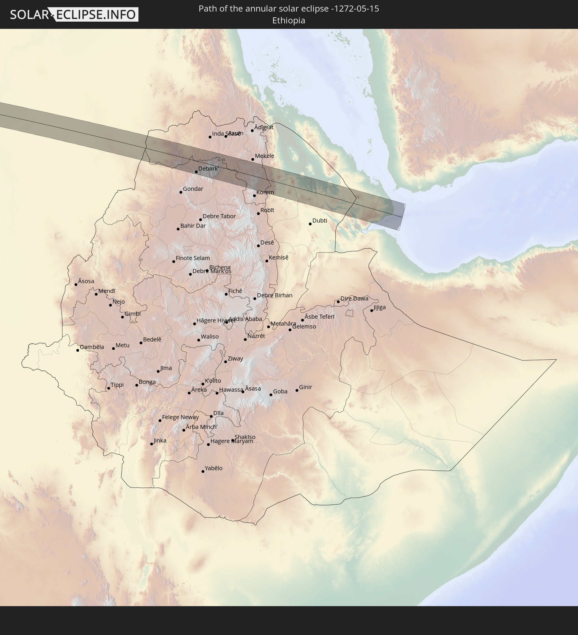 Ethiopia
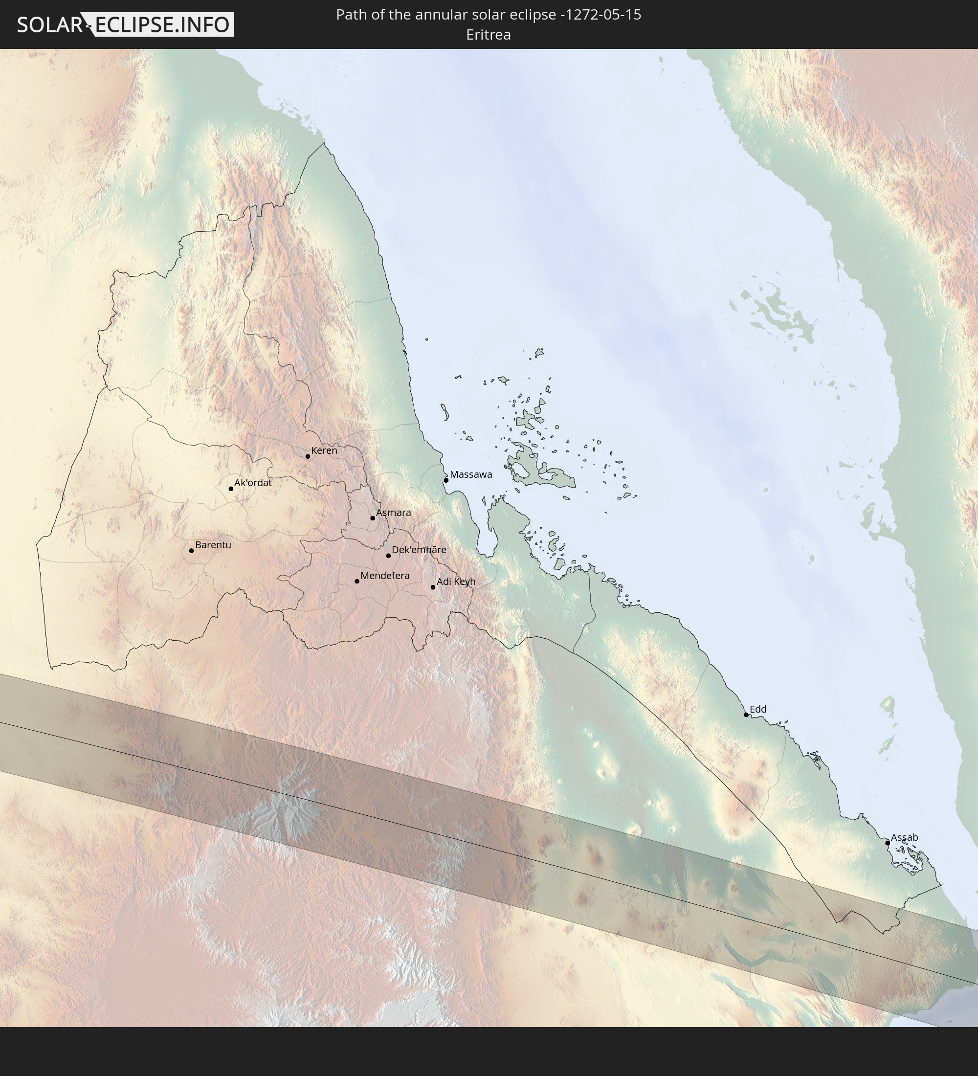 Eritrea
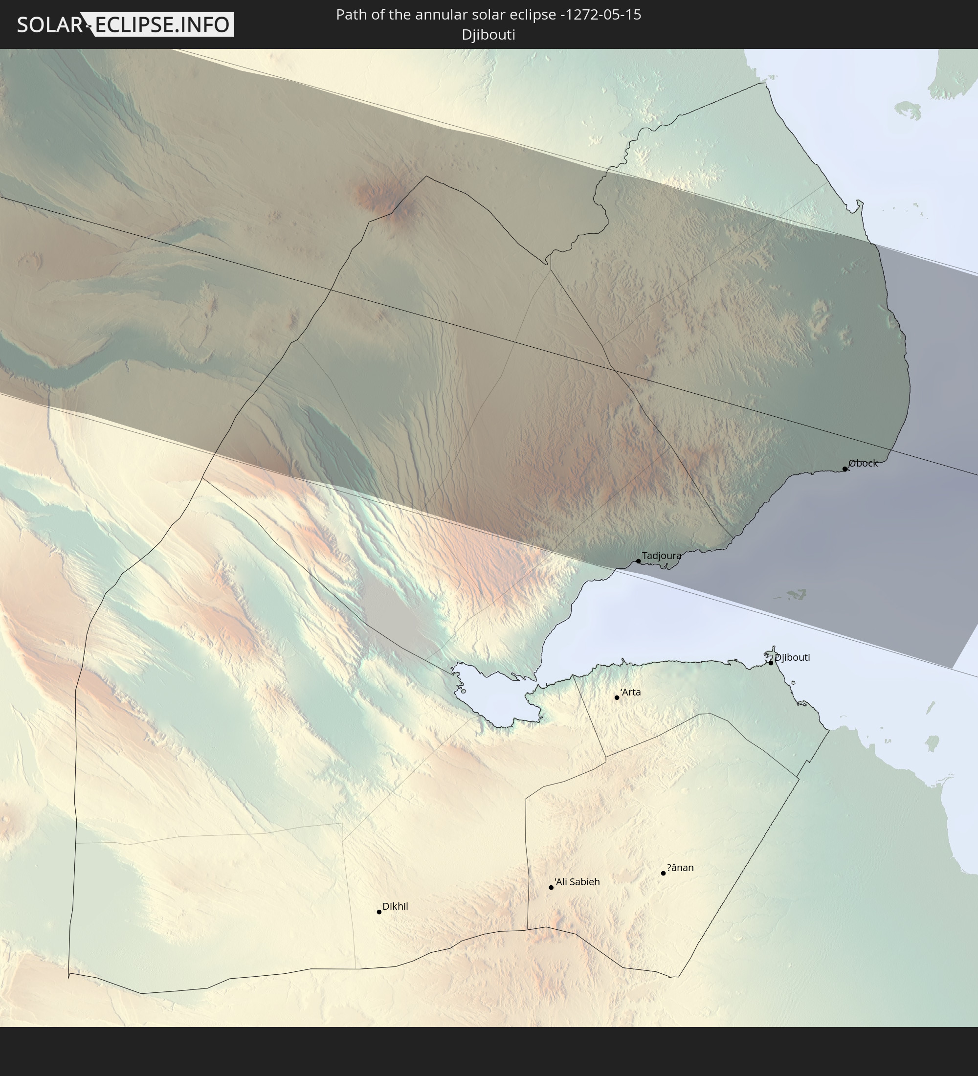 Djibouti
In den folgenden Ländern ist die Sonnenfinsternis partiell zu sehen
 Antarctica
 Russia
 Chile
Chile
 Ecuador
 Colombia
 Peru
Peru
 Brazil
 Argentina
 Venezuela
 Bolivia
 Paraguay
 Falkland Islands
 Guyana
 Uruguay
 Suriname
 French Guiana
 South Georgia and the South Sandwich Islands
 Portugal
 Cabo Verde
 Spain
Spain
 Senegal
 Mauritania
 The Gambia
 Guinea-Bissau
 Guinea
 Saint Helena, Ascension and Tristan da Cunha
 Sierra Leone
 Morocco
 Mali
Mali
 Liberia
 Algeria
 Ivory Coast
 Burkina Faso
 Gibraltar
 France
 Ghana
Ghana
 Togo
Togo
 Niger
Niger
 Benin
Benin
 Andorra
 Nigeria
 Equatorial Guinea
 Germany
 Switzerland
 São Tomé and Príncipe
 Italy
Italy
 Monaco
 Tunisia
 Cameroon
 Gabon
Gabon
 Libya
Libya
 Liechtenstein
 Austria
 Republic of the Congo
 Angola
 Namibia
 Czechia
 Democratic Republic of the Congo
 San Marino
 Vatican City
 Slovenia
 Chad
Chad
 Croatia
 Malta
Malta
 Central African Republic
 Bosnia and Herzegovina
 Hungary
 Slovakia
 Montenegro
 Serbia
 Albania
 Greece
 Botswana
 Romania
 Republic of Macedonia
 Sudan
Sudan
 Zambia
 Ukraine
 Bulgaria
 Egypt
Egypt
 Zimbabwe
 Turkey
 Moldova
 Rwanda
 Burundi
 Tanzania
 Uganda
 Mozambique
 Cyprus
 Malawi
 Ethiopia
 Kenya
Kenya
 State of Palestine
 Israel
 Saudi Arabia
 Jordan
 Lebanon
 Syria
Syria
 Eritrea
 Iraq
Iraq
 Georgia
 French Southern and Antarctic Lands
 Somalia
 Djibouti
 Yemen
Yemen
 Armenia
 Iran
Iran
 Azerbaijan
 Kazakhstan
 Kuwait
 Turkmenistan
 Uzbekistan
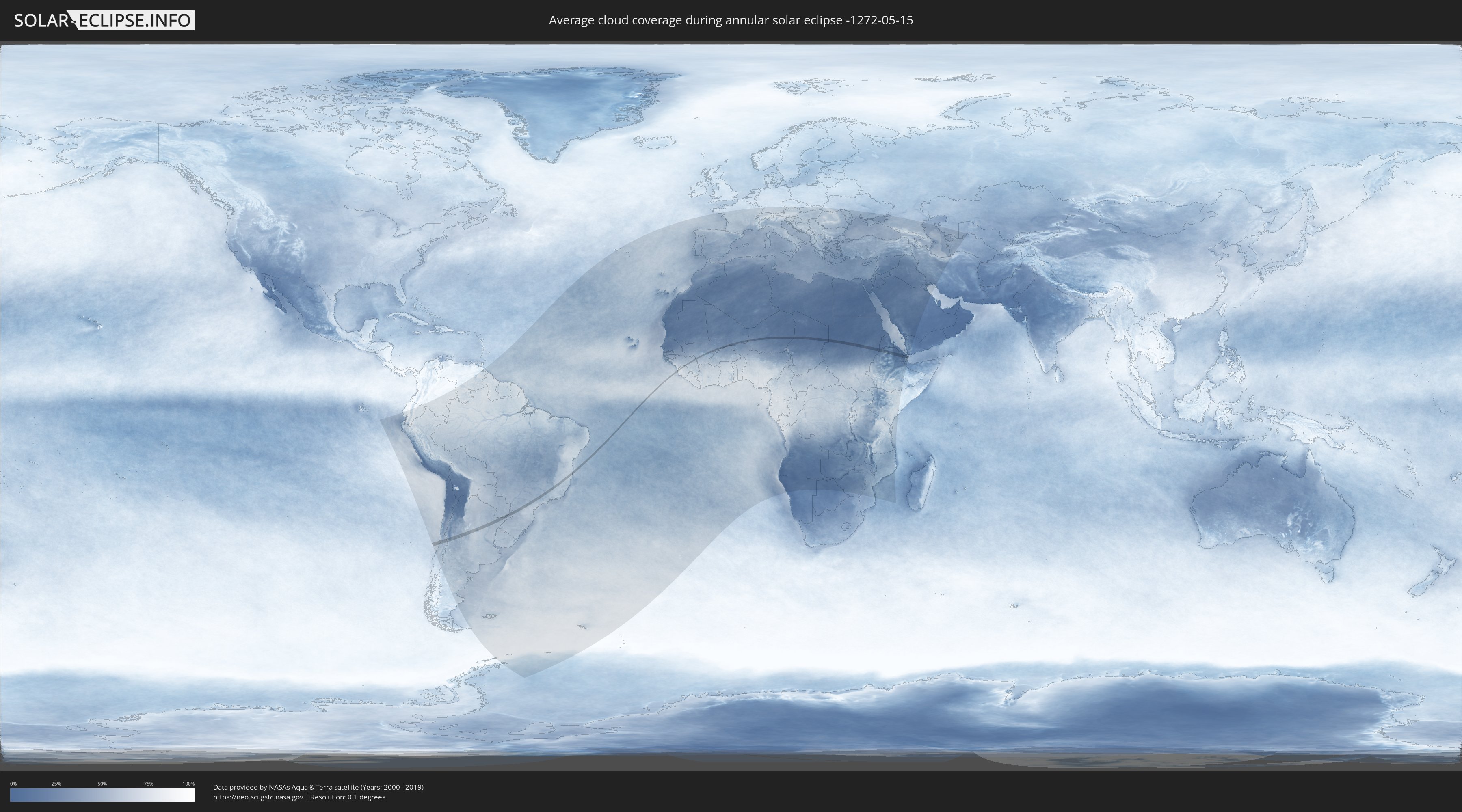
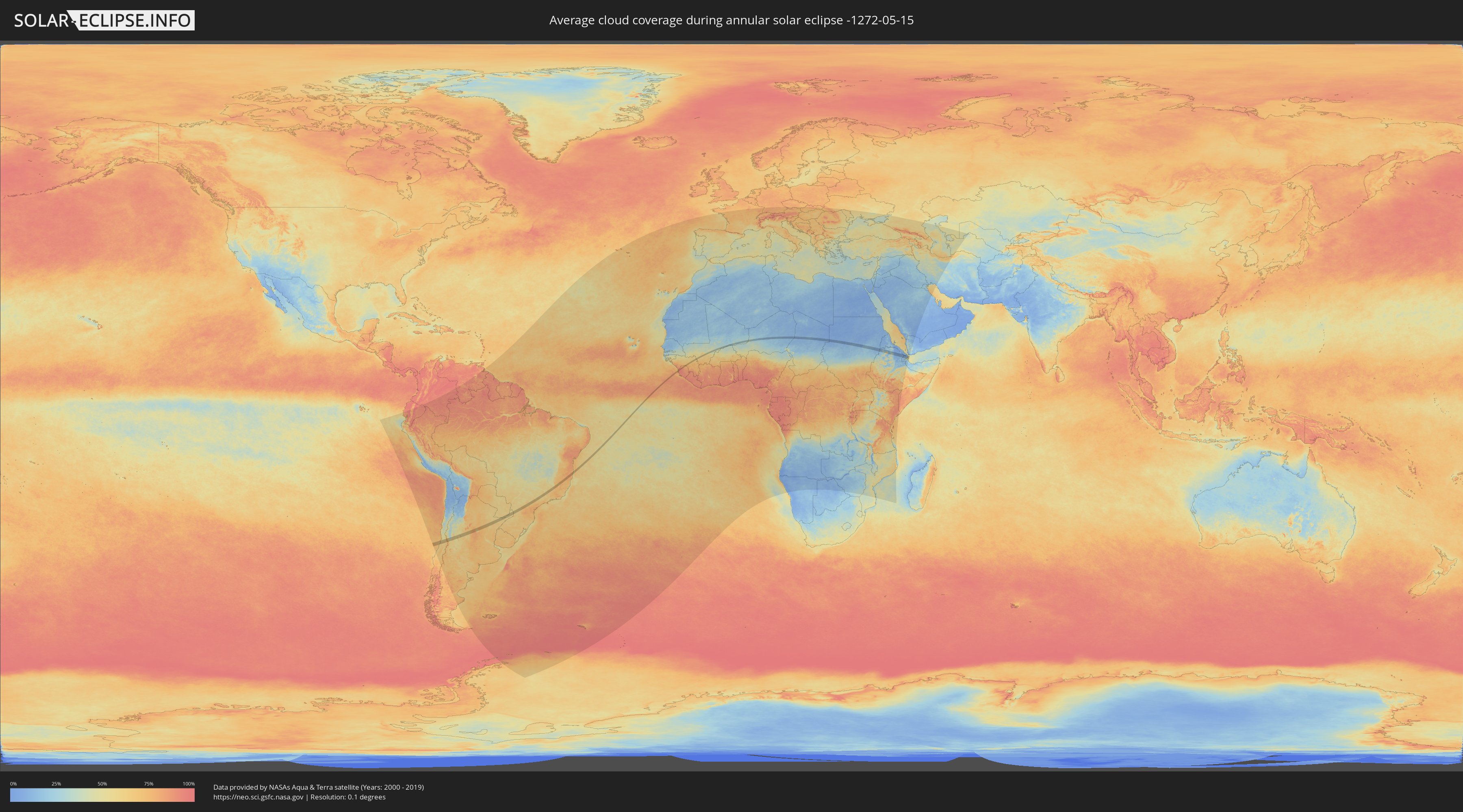
How will be the weather during the annular solar eclipse on 05/15/-1272?
Where is the best place to see the annular solar eclipse of 05/15/-1272?
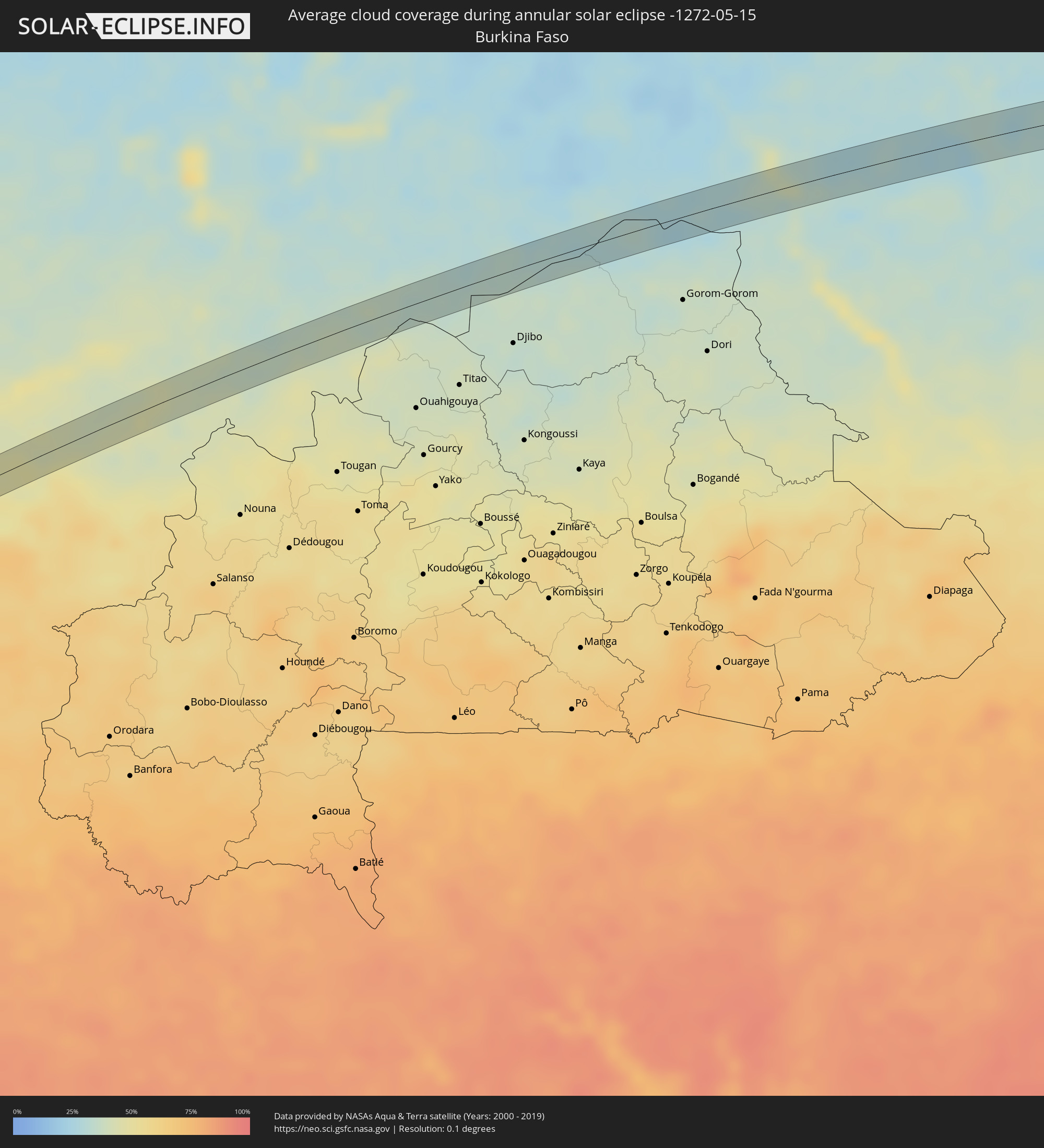
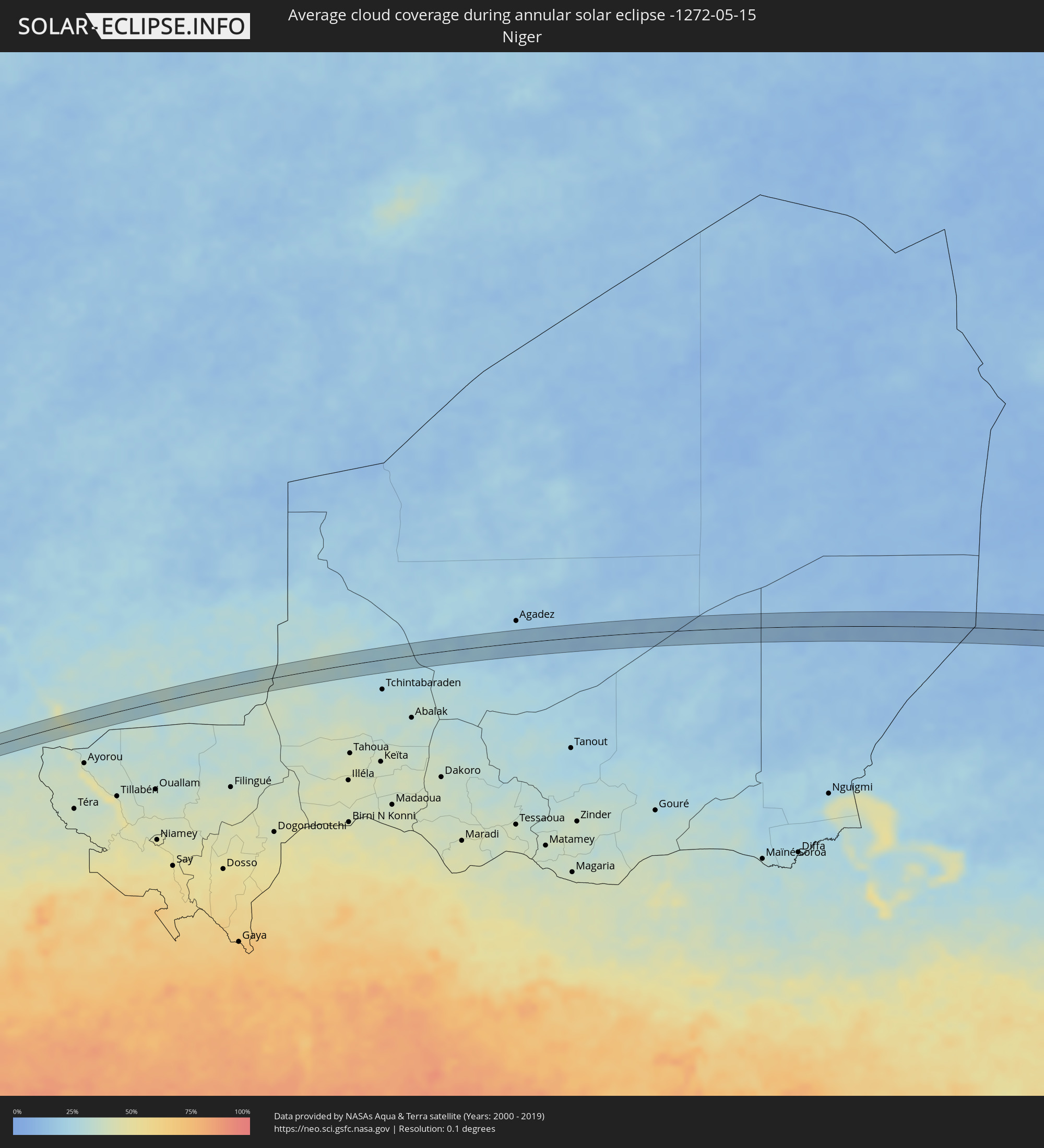
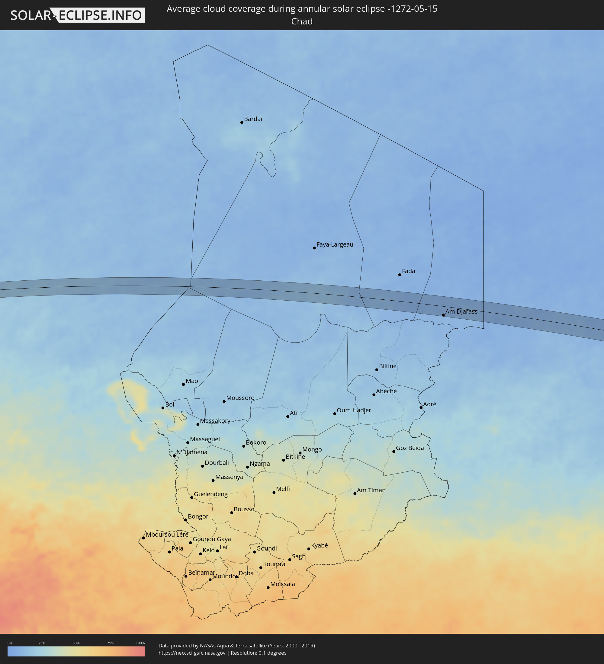
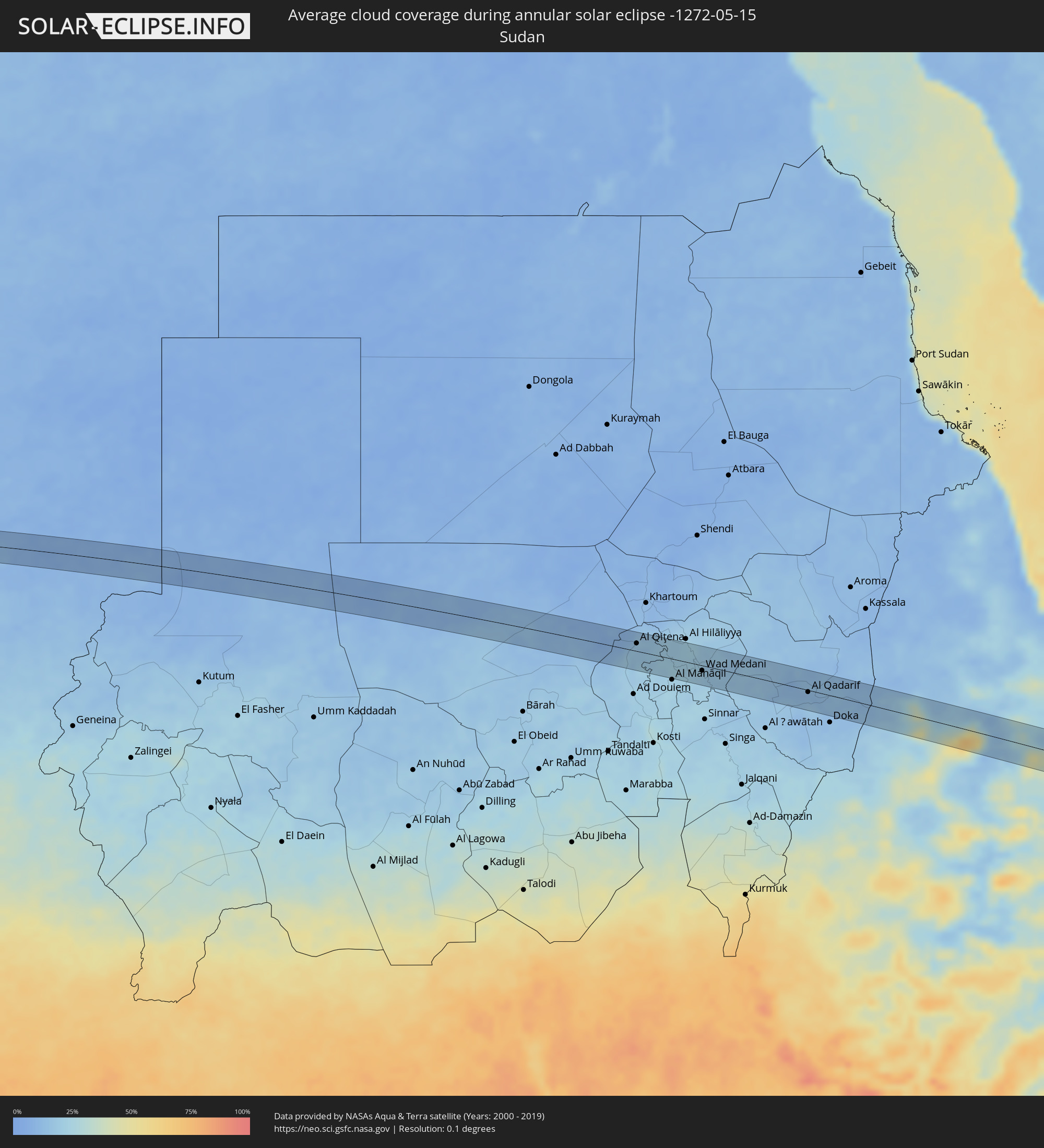
The following maps show the average cloud coverage for the day of the annular solar eclipse.
With the help of these maps, it is possible to find the place along the eclipse path, which has the best
chance of a cloudless sky.
Nevertheless, you should consider local circumstances and inform about the weather of your chosen
observation site.
The data is provided by NASAs satellites
AQUA and TERRA.
The cloud maps are averaged over a period of 19 years (2000 - 2019).
Detailed country maps
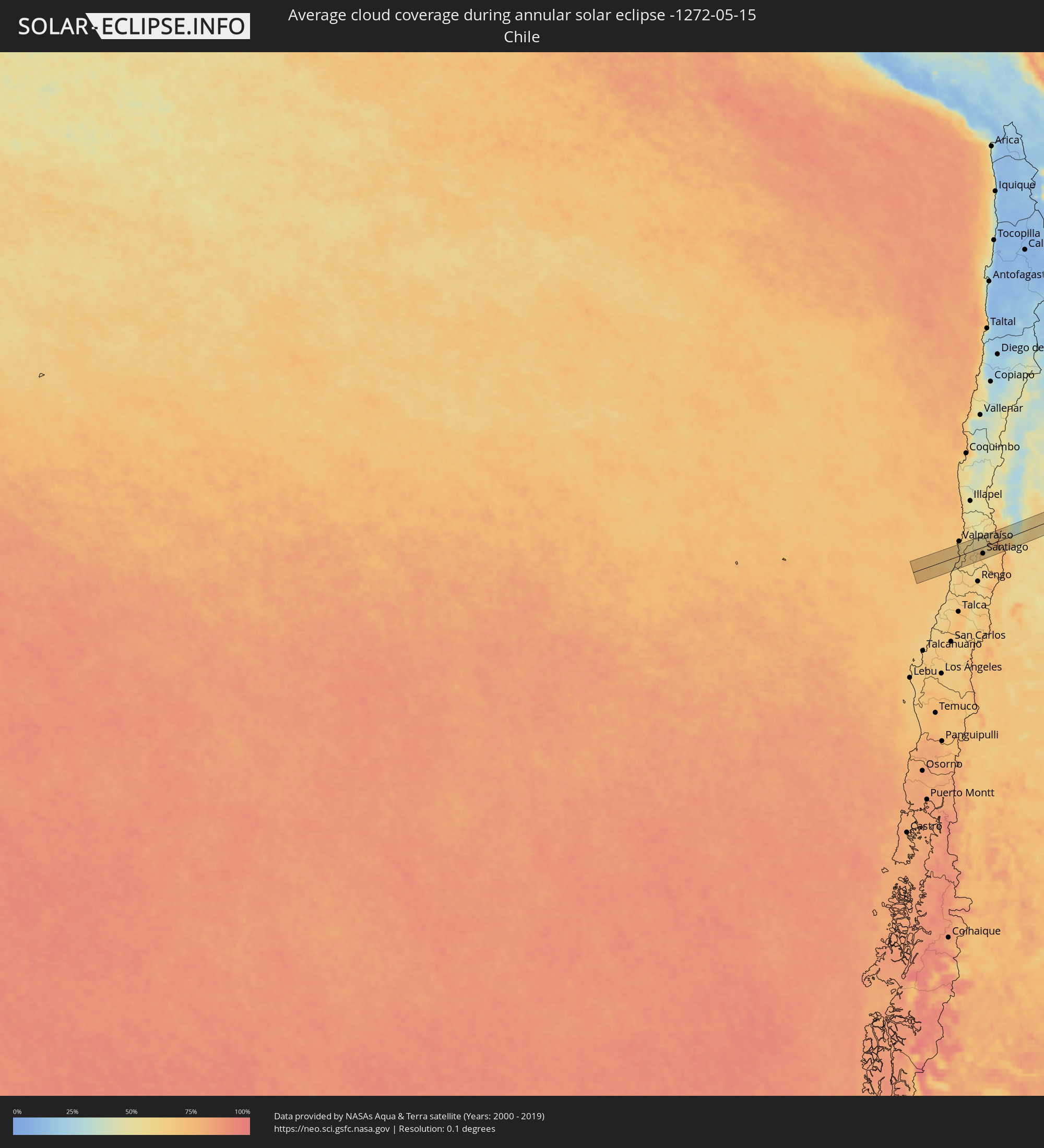 Chile
Chile
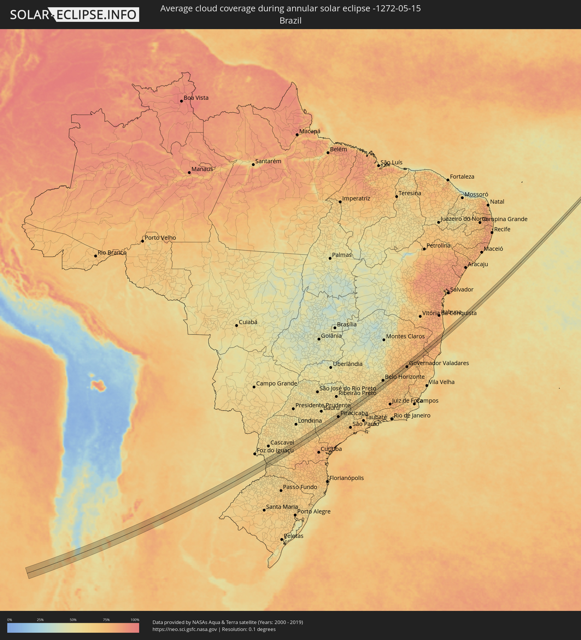 Brazil
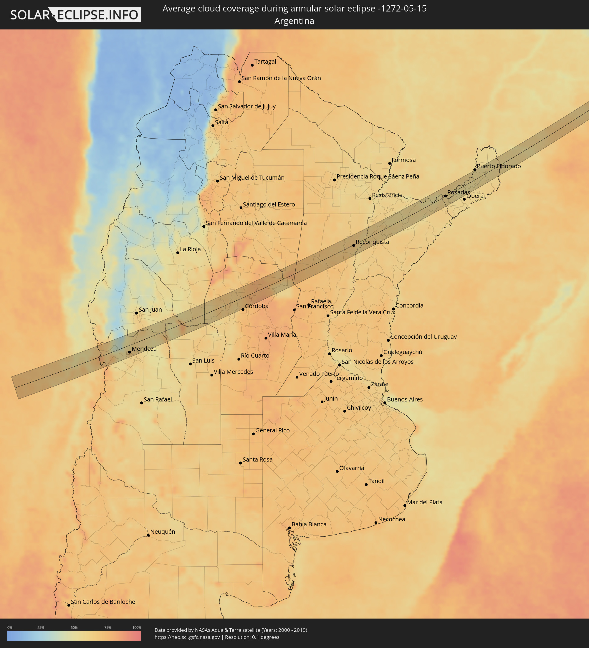 Argentina
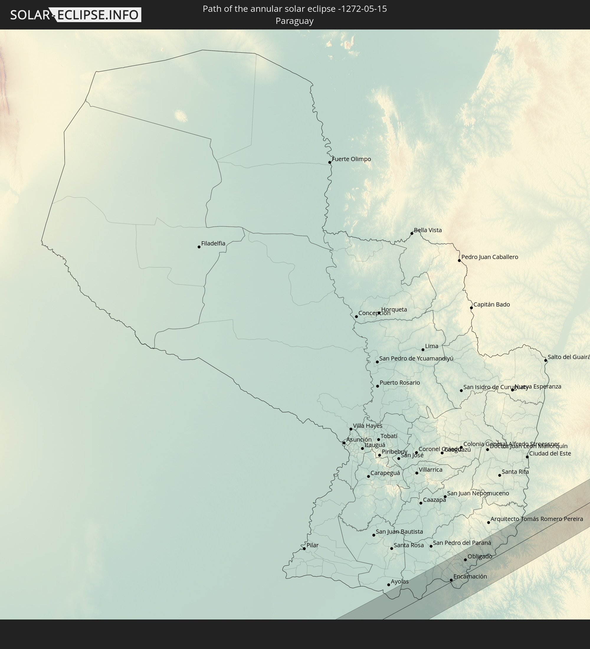
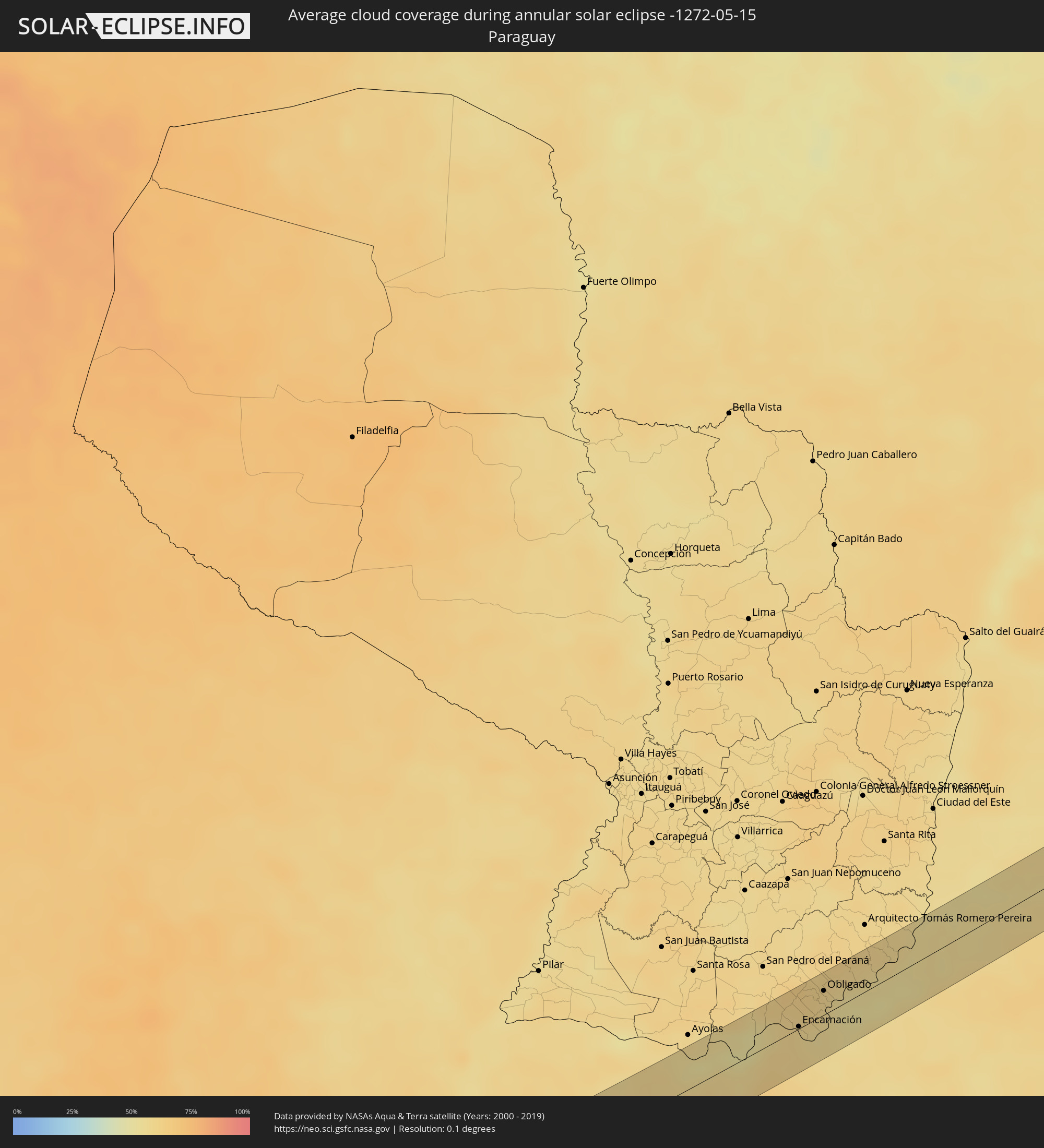 Paraguay
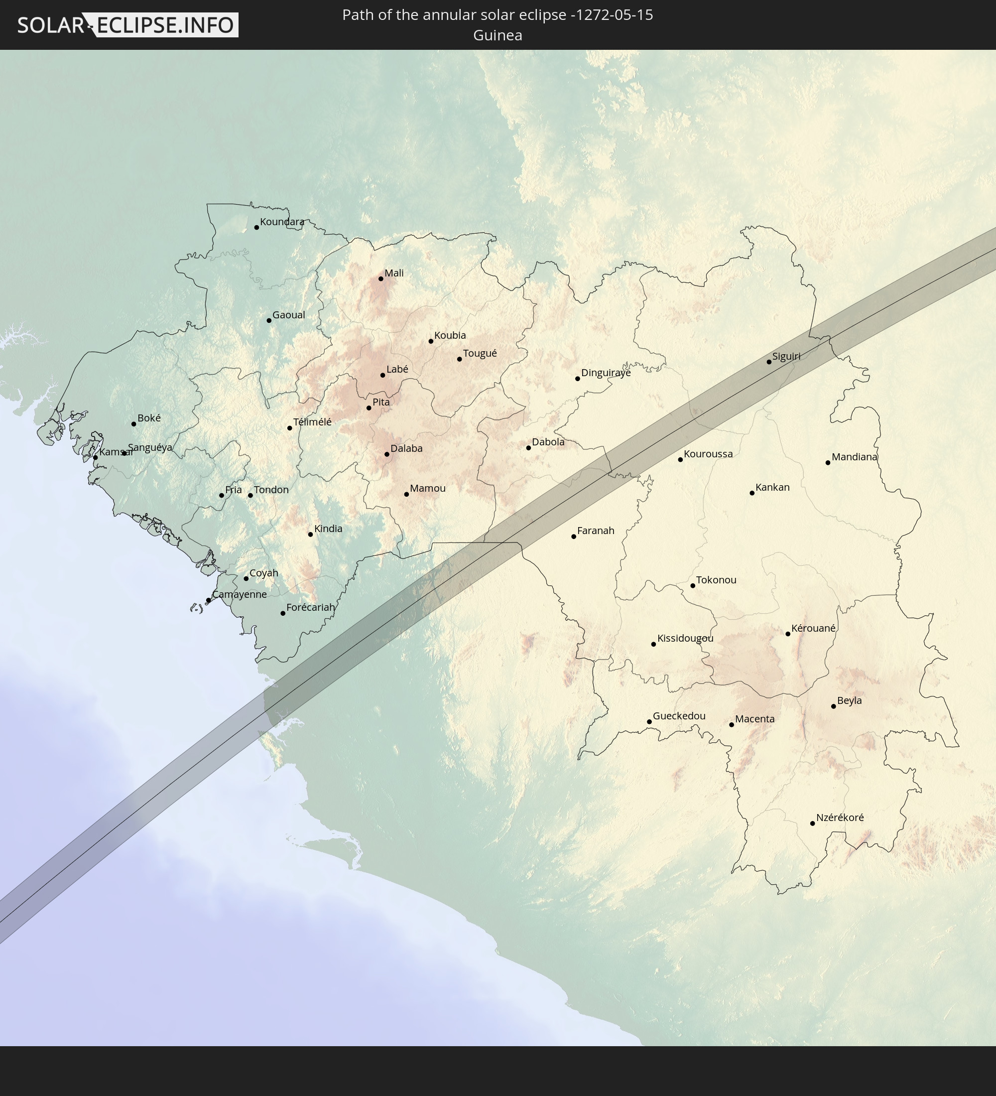
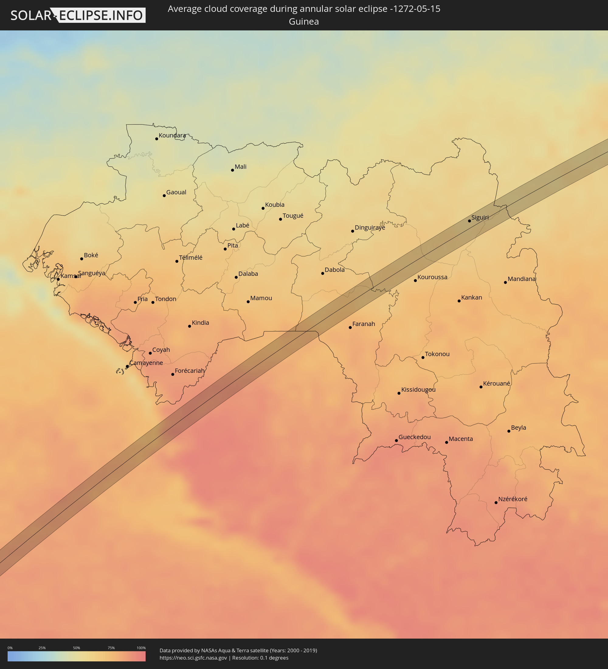 Guinea
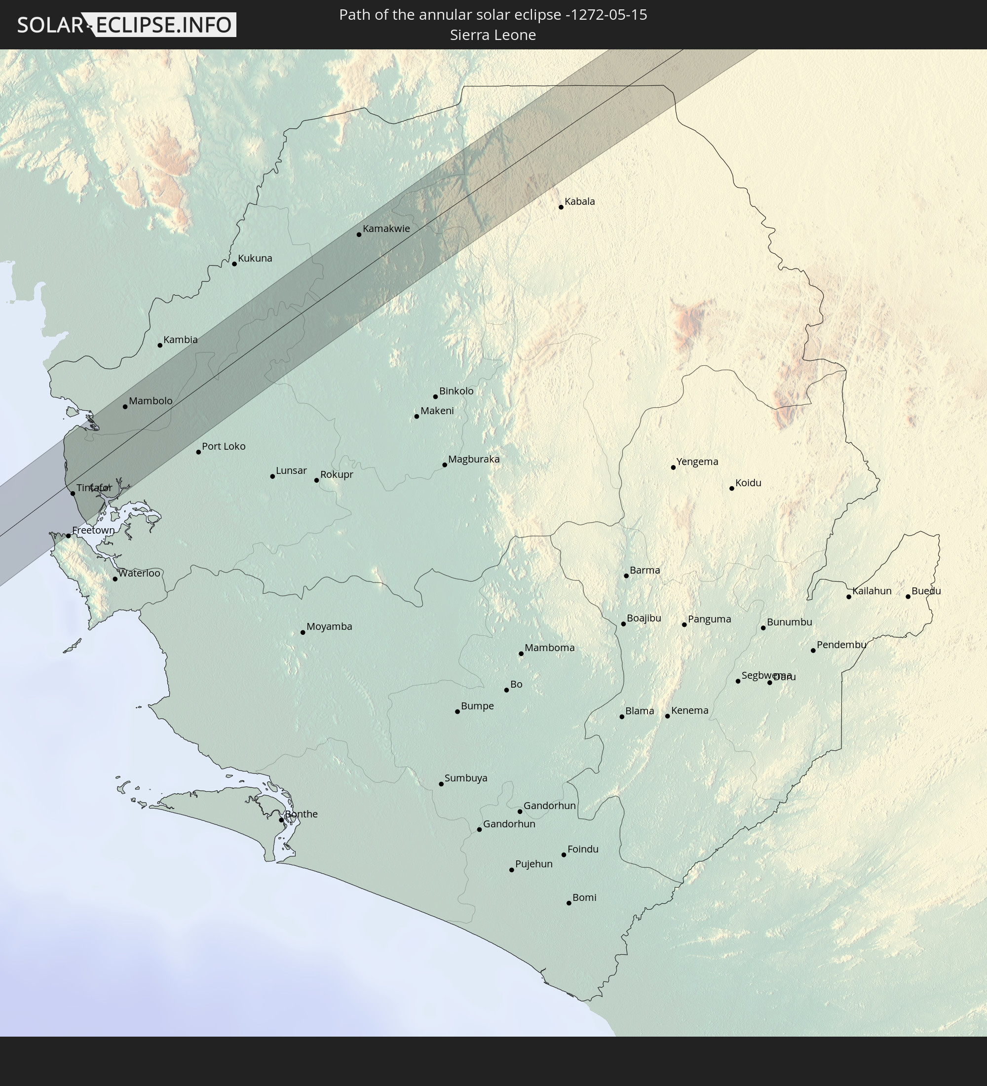
 Sierra Leone
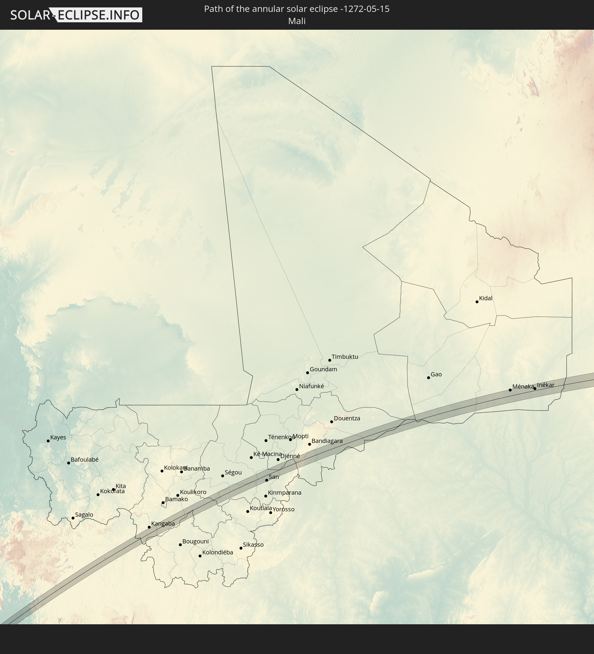
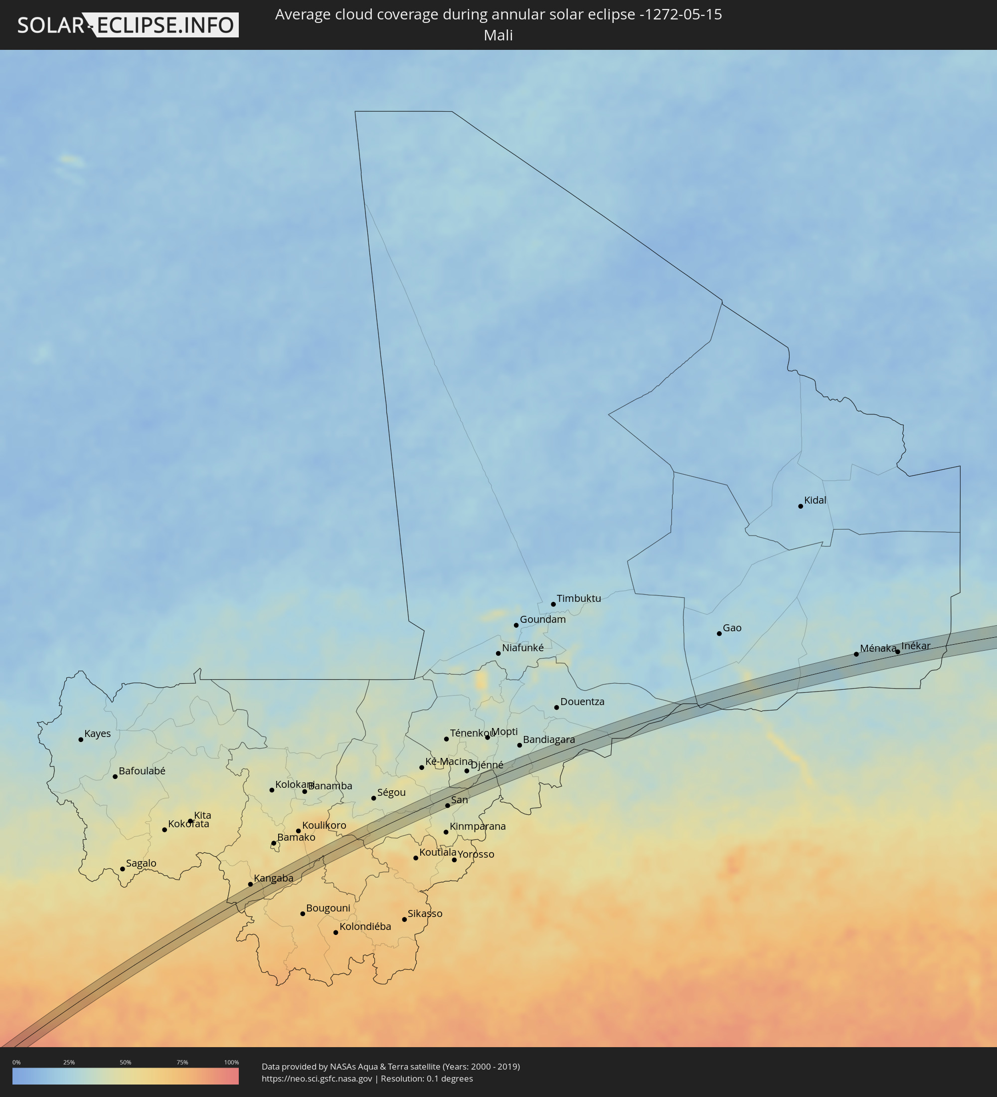 Mali
Mali
 Burkina Faso
 Niger
Niger
 Chad
Chad
 Sudan
Sudan
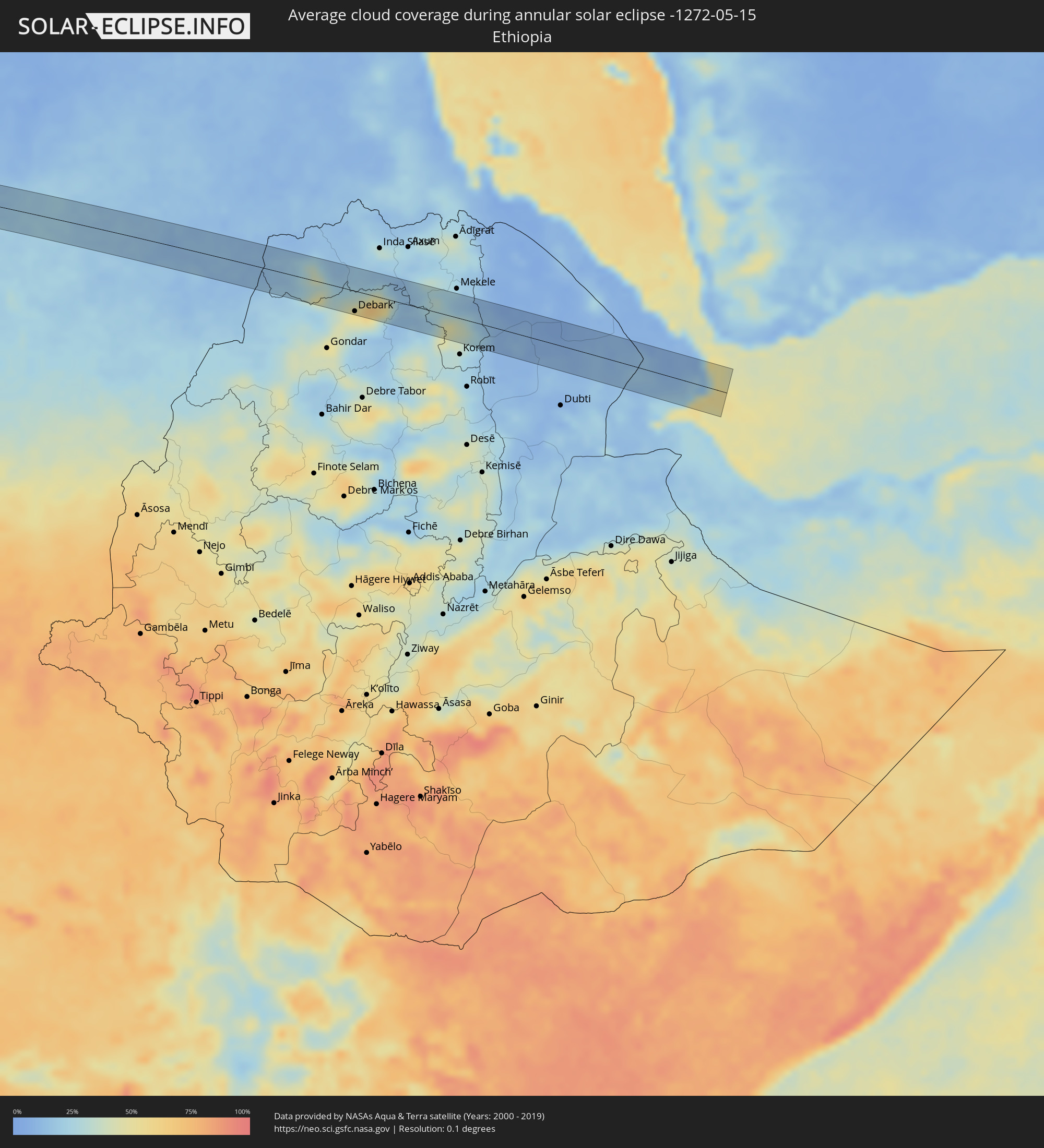 Ethiopia
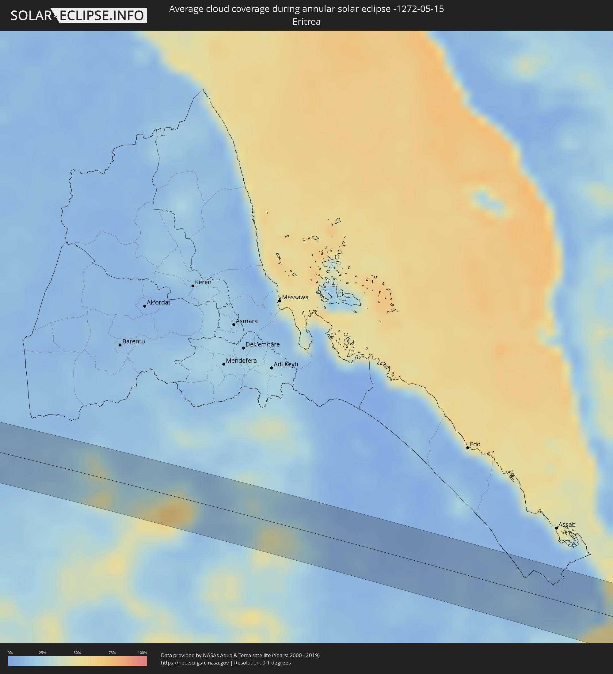 Eritrea
 Djibouti
Cities inside the path of the eclipse
The following table shows all locations with a population of more than 5,000 inside the eclipse path. Cities which have more than 100,000 inhabitants are marked bold. A click at the locations opens a detailed map.
| City | Type | Eclipse duration | Local time of max. eclipse | Distance to central line | Ø Cloud coverage |
|
Cartagena, Valparaíso
|
annular | - | 06:46:55 UTC-04:42 | 3 km | 63% |
|
San Antonio, Valparaíso
|
annular | - | 06:46:55 UTC-04:42 | 7 km | 63% |
|
Villa Alemana, Valparaíso
|
annular | - | 06:46:53 UTC-04:42 | 43 km | 63% |
|
Limache, Valparaíso
|
annular | - | 06:46:54 UTC-04:42 | 42 km | 61% |
|
Melipilla, Santiago Metropolitan
|
annular | - | 06:46:58 UTC-04:42 | 30 km | 65% |
|
El Monte, Santiago Metropolitan
|
annular | - | 06:46:59 UTC-04:42 | 36 km | 62% |
|
Talagante, Santiago Metropolitan
|
annular | - | 06:46:59 UTC-04:42 | 36 km | 64% |
|
Peñaflor, Santiago Metropolitan
|
annular | - | 06:46:59 UTC-04:42 | 32 km | 65% |
|
Lampa, Santiago Metropolitan
|
annular | - | 06:46:58 UTC-04:42 | 1 km | 63% |
|
Lo Prado, Santiago Metropolitan
|
annular | - | 06:46:59 UTC-04:42 | 20 km | 71% |
|
San Bernardo, Santiago Metropolitan
|
annular | - | 06:47:00 UTC-04:42 | 36 km | 65% |
|
Chicureo Abajo, Santiago Metropolitan
|
annular | - | 06:46:59 UTC-04:42 | 6 km | 69% |
|
Santiago, Santiago Metropolitan
|
annular | - | 06:47:00 UTC-04:42 | 24 km | 67% |
|
La Pintana, Santiago Metropolitan
|
annular | - | 06:47:01 UTC-04:42 | 38 km | 65% |
|
Los Andes, Valparaíso
|
annular | - | 06:46:57 UTC-04:42 | 39 km | 55% |
|
Villa Presidente Frei, Ñuñoa, Santiago, Chile, Santiago Metropolitan
|
annular | - | 06:47:00 UTC-04:42 | 27 km | 67% |
|
Puente Alto, Santiago Metropolitan
|
annular | - | 06:47:01 UTC-04:42 | 42 km | 65% |
|
Mendoza, Mendoza Province
|
annular | - | 07:13:09 UTC-04:16 | 26 km | 66% |
|
Villa Carlos Paz, Cordoba Province
|
annular | - | 07:14:03 UTC-04:16 | 33 km | 62% |
|
La Falda, Cordoba Province
|
annular | - | 07:14:04 UTC-04:16 | 1 km | 63% |
|
Cosquín, Cordoba Province
|
annular | - | 07:14:04 UTC-04:16 | 16 km | 61% |
|
La Calera, Cordoba Province
|
annular | - | 07:14:06 UTC-04:16 | 31 km | 70% |
|
Río Ceballos, Cordoba Province
|
annular | - | 07:14:07 UTC-04:16 | 14 km | 67% |
|
Jesús María, Cordoba Province
|
annular | - | 07:14:11 UTC-04:16 | 4 km | 72% |
|
Vera, Santa Fe Province
|
annular | - | 07:15:41 UTC-04:16 | 10 km | 66% |
|
Reconquista, Santa Fe Province
|
annular | - | 07:15:59 UTC-04:16 | 4 km | 65% |
|
Goya, Corrientes Province
|
annular | - | 07:16:08 UTC-04:16 | 20 km | 63% |
|
Santa Lucía, Corrientes Province
|
annular | - | 07:16:14 UTC-04:16 | 12 km | 64% |
|
Posadas, Misiones Province
|
annular | - | 07:18:14 UTC-04:16 | 0 km | 59% |
|
Encarnación, Itapúa
|
annular | - | 07:44:24 UTC-03:50 | 2 km | 59% |
|
Hohenau, Itapúa
|
annular | - | 07:44:33 UTC-03:50 | 20 km | 61% |
|
Obligado, Itapúa
|
annular | - | 07:44:38 UTC-03:50 | 19 km | 59% |
|
Jardín América, Misiones Province
|
annular | - | 07:18:43 UTC-04:16 | 1 km | 53% |
|
Puerto Rico, Misiones Province
|
annular | - | 07:18:55 UTC-04:16 | 13 km | 54% |
|
Aristóbulo del Valle, Misiones Province
|
annular | - | 07:18:53 UTC-04:16 | 23 km | 57% |
|
Montecarlo, Misiones Province
|
annular | - | 07:19:10 UTC-04:16 | 22 km | 54% |
|
Puerto Eldorado, Misiones Province
|
annular | - | 07:45:24 UTC-03:50 | 34 km | 54% |
|
Dos de Mayo, Misiones Province
|
annular | - | 07:19:02 UTC-04:16 | 26 km | 57% |
|
San Vicente, Misiones Province
|
annular | - | 07:19:31 UTC-04:16 | 14 km | 57% |
|
Piracicaba, São Paulo
|
annular | - | 08:36:39 UTC-03:06 | 1 km | 63% |
|
Rio Claro, São Paulo
|
annular | - | 08:36:57 UTC-03:06 | 24 km | 62% |
|
Limeira, São Paulo
|
annular | - | 08:36:59 UTC-03:06 | 1 km | 63% |
|
Araras, São Paulo
|
annular | - | 08:37:08 UTC-03:06 | 19 km | 62% |
|
Americana, São Paulo
|
annular | - | 08:36:55 UTC-03:06 | 19 km | 60% |
|
Mogi-Gaucu, São Paulo
|
annular | - | 08:37:31 UTC-03:06 | 8 km | 57% |
|
São João da Boa Vista, São Paulo
|
annular | - | 08:37:57 UTC-03:06 | 19 km | 58% |
|
Poços de Caldas, Minas Gerais
|
annular | - | 08:38:18 UTC-03:06 | 22 km | 61% |
|
Alfenas, Minas Gerais
|
annular | - | 08:39:08 UTC-03:06 | 17 km | 56% |
|
Varginha, Minas Gerais
|
annular | - | 08:39:32 UTC-03:06 | 25 km | 63% |
|
Lavras, Minas Gerais
|
annular | - | 08:40:11 UTC-03:06 | 24 km | 64% |
|
Ibirité, Minas Gerais
|
annular | - | 08:42:11 UTC-03:06 | 26 km | 60% |
|
Belo Horizonte, Minas Gerais
|
annular | - | 08:42:24 UTC-03:06 | 27 km | 60% |
|
Itabira, Minas Gerais
|
annular | - | 08:43:25 UTC-03:06 | 8 km | 70% |
|
João Monlevade, Minas Gerais
|
annular | - | 08:43:18 UTC-03:06 | 12 km | 75% |
|
Timóteo, Minas Gerais
|
annular | - | 08:44:04 UTC-03:06 | 26 km | 67% |
|
Ipatinga, Minas Gerais
|
annular | - | 08:44:18 UTC-03:06 | 23 km | 62% |
|
Governador Valadares, Minas Gerais
|
annular | - | 08:45:33 UTC-03:06 | 8 km | 74% |
|
Porto Seguro, Bahia
|
annular | - | 09:24:07 UTC-02:34 | 1 km | 67% |
|
Tintafor, Northern Province
|
annular | - | 13:22:29 UTC-00:16 | 4 km | 81% |
|
Mambolo, Northern Province
|
annular | - | 13:23:33 UTC-00:16 | 10 km | 88% |
|
Kamakwie, Northern Province
|
annular | - | 13:26:50 UTC-00:16 | 11 km | 85% |
|
Siguiri, Kankan
|
annular | - | 13:38:39 UTC-00:16 | 8 km | 61% |
|
San, Ségou
|
annular | - | 13:52:52 UTC-00:16 | 17 km | 39% |
|
Ménaka, Gao
|
annular | - | 14:13:22 UTC-00:16 | 17 km | 29% |
|
Inékar, Gao
|
annular | - | 14:14:59 UTC-00:16 | 5 km | 32% |
|
Am Djarass, Ennedi-Est
|
annular | - | 16:01:50 UTC+01:00 | 28 km | 9% |
|
Wad az Zāki, White Nile
|
annular | - | 17:18:12 UTC+02:10 | 33 km | 19% |
|
Al Qiţena, White Nile
|
annular | - | 17:18:19 UTC+02:10 | 14 km | 16% |
|
Al Kiremit al ‘Arakiyyīn, Al Jazīrah
|
annular | - | 17:18:32 UTC+02:10 | 29 km | 21% |
|
Al Hasaheisa, Al Jazīrah
|
annular | - | 17:18:44 UTC+02:10 | 24 km | 22% |
|
Al Masallamiyya, Al Jazīrah
|
annular | - | 17:18:44 UTC+02:10 | 5 km | 22% |
|
Wad Medani, Al Jazīrah
|
annular | - | 17:18:48 UTC+02:10 | 9 km | 19% |
|
Al Qadarif, Al Qaḑārif
|
annular | - | 17:19:29 UTC+02:10 | 4 km | 13% |
|
Debark’, Amhara
|
annular | - | 17:37:16 UTC+02:27 | 33 km | 52% |
|
Maych’ew, Tigray
|
annular | - | 17:37:35 UTC+02:27 | 27 km | 36% |
|
Tadjoura, Tadjourah
|
annular | - | 17:37:52 UTC+02:27 | 38 km | 47% |
|
Obock, Obock
|
annular | - | 17:37:55 UTC+02:27 | 7 km | 46% |