Total solar eclipse of 01/28/0157
| Day of week: | Friday |
| Maximum duration of eclipse: | 04m34s |
| Maximum width of eclipse path: | 161 km |
| Saros cycle: | 72 |
| Coverage: | 100% |
| Magnitude: | 1.0482 |
| Gamma: | 0.1059 |
Wo kann man die Sonnenfinsternis vom 01/28/0157 sehen?
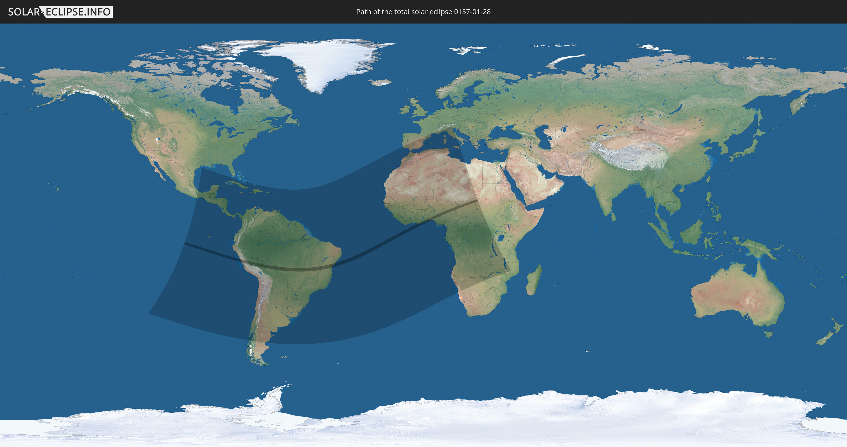
Die Sonnenfinsternis am 01/28/0157 kann man in 98 Ländern als partielle Sonnenfinsternis beobachten.
Der Finsternispfad verläuft durch 10 Länder. Nur in diesen Ländern ist sie als total Sonnenfinsternis zu sehen.
In den folgenden Ländern ist die Sonnenfinsternis total zu sehen
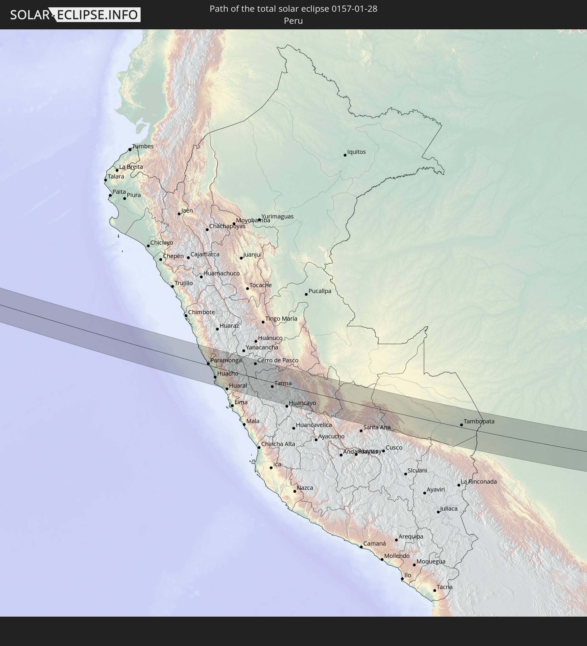 Peru
Peru
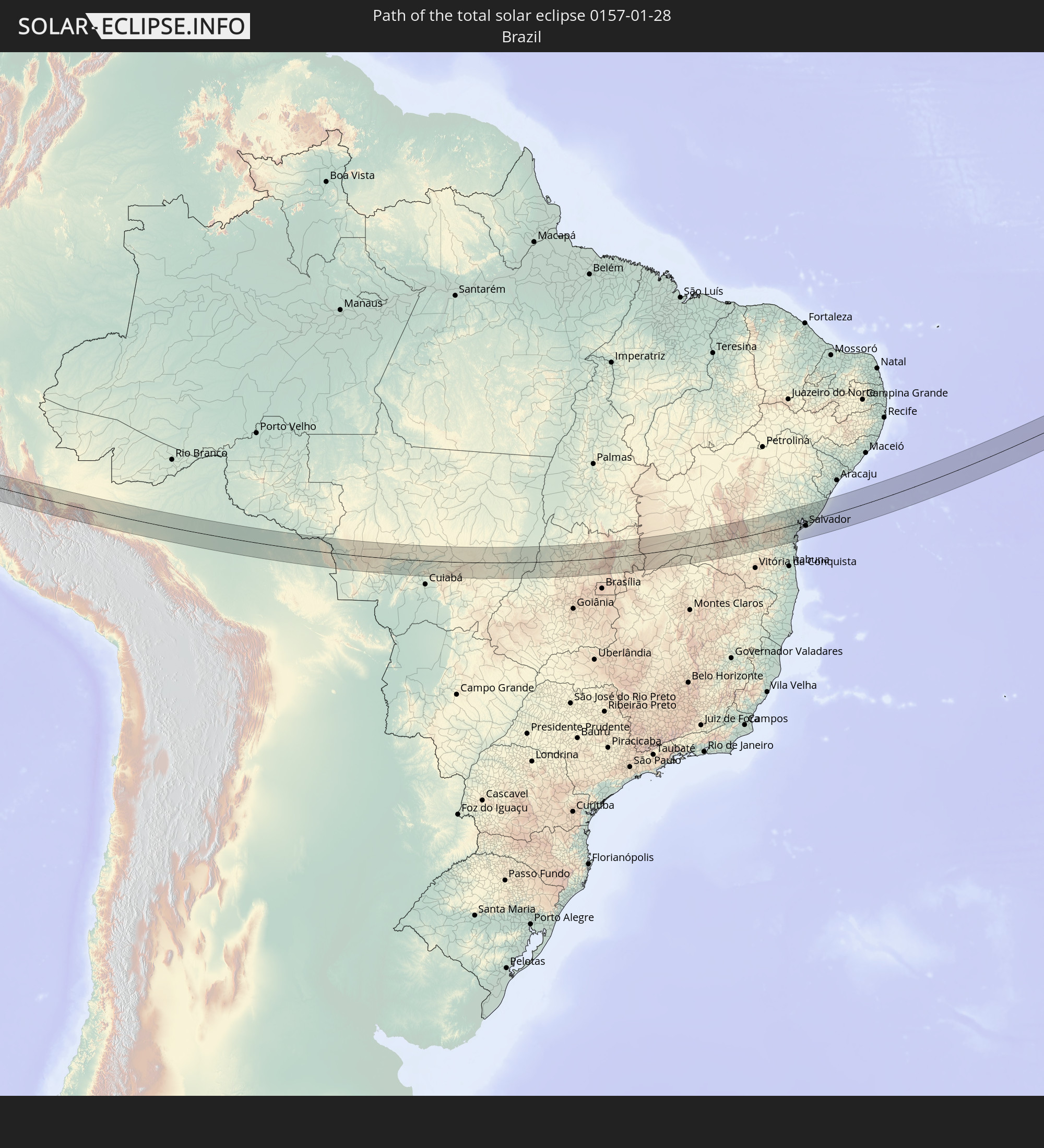 Brazil
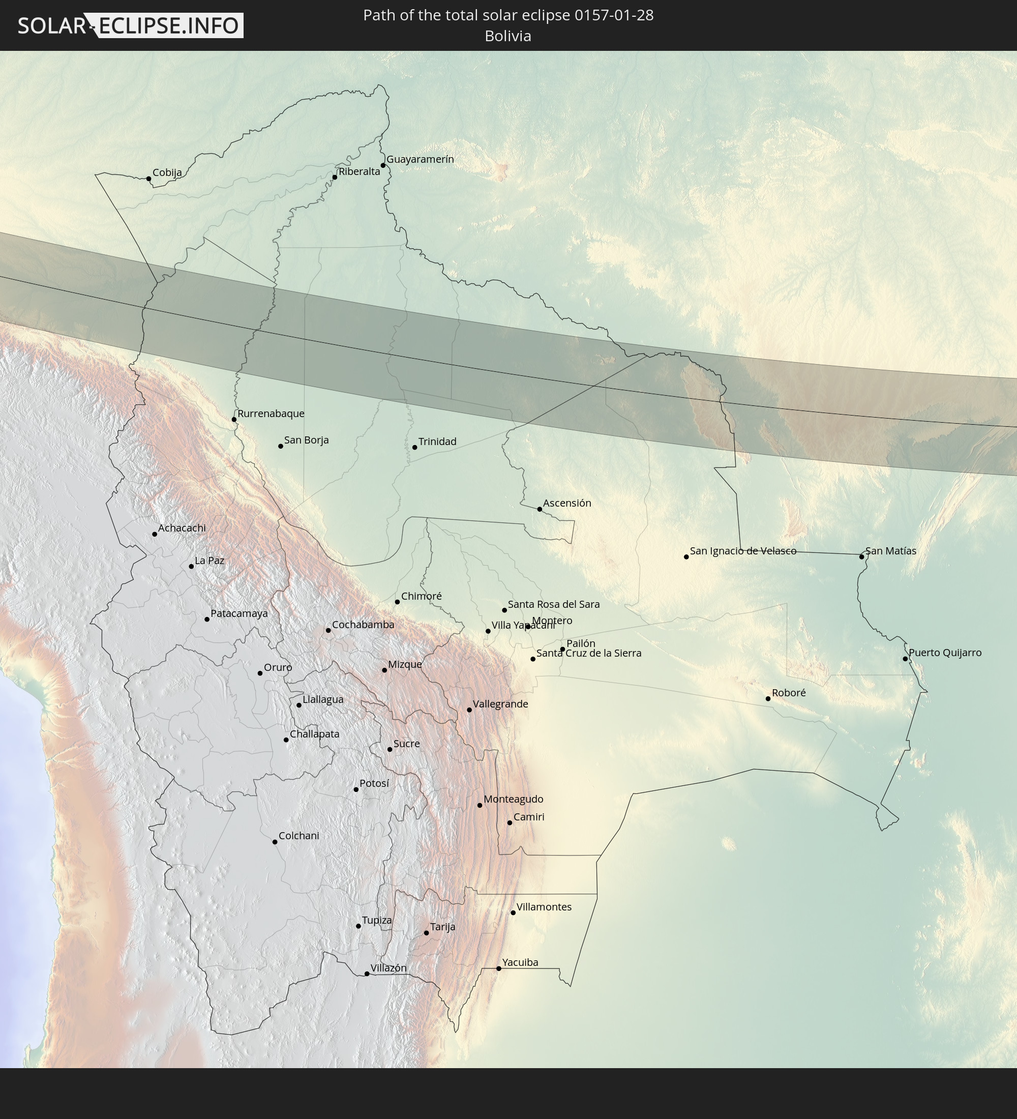 Bolivia
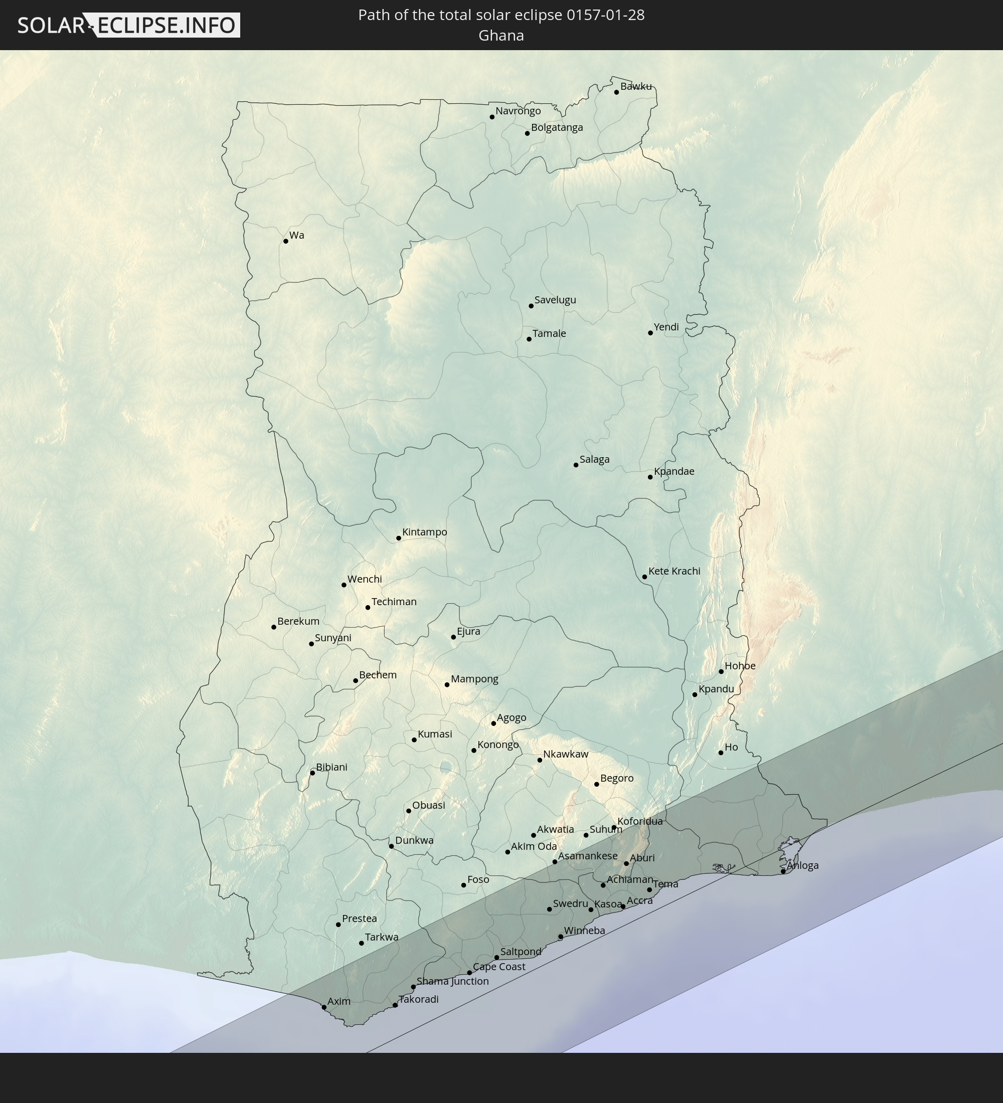 Ghana
Ghana
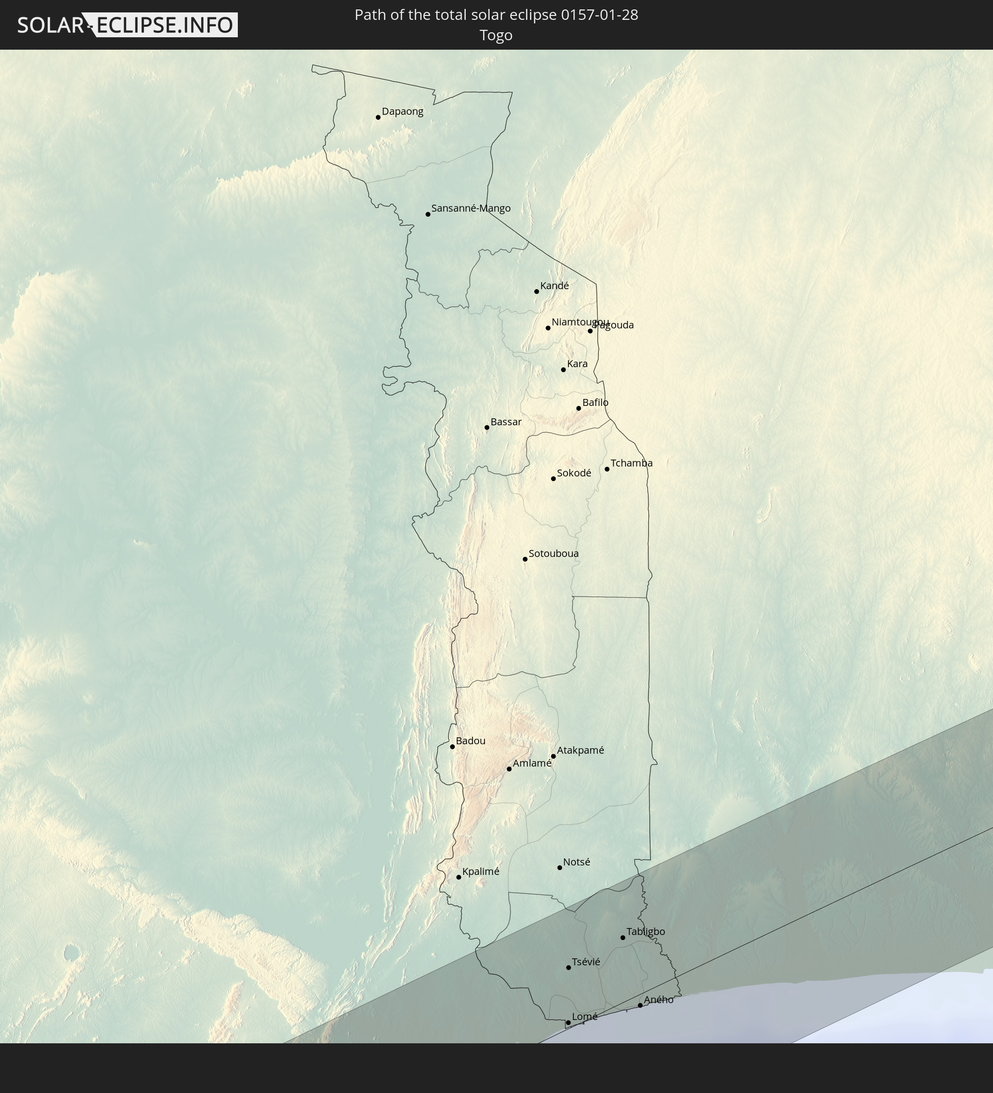 Togo
Togo
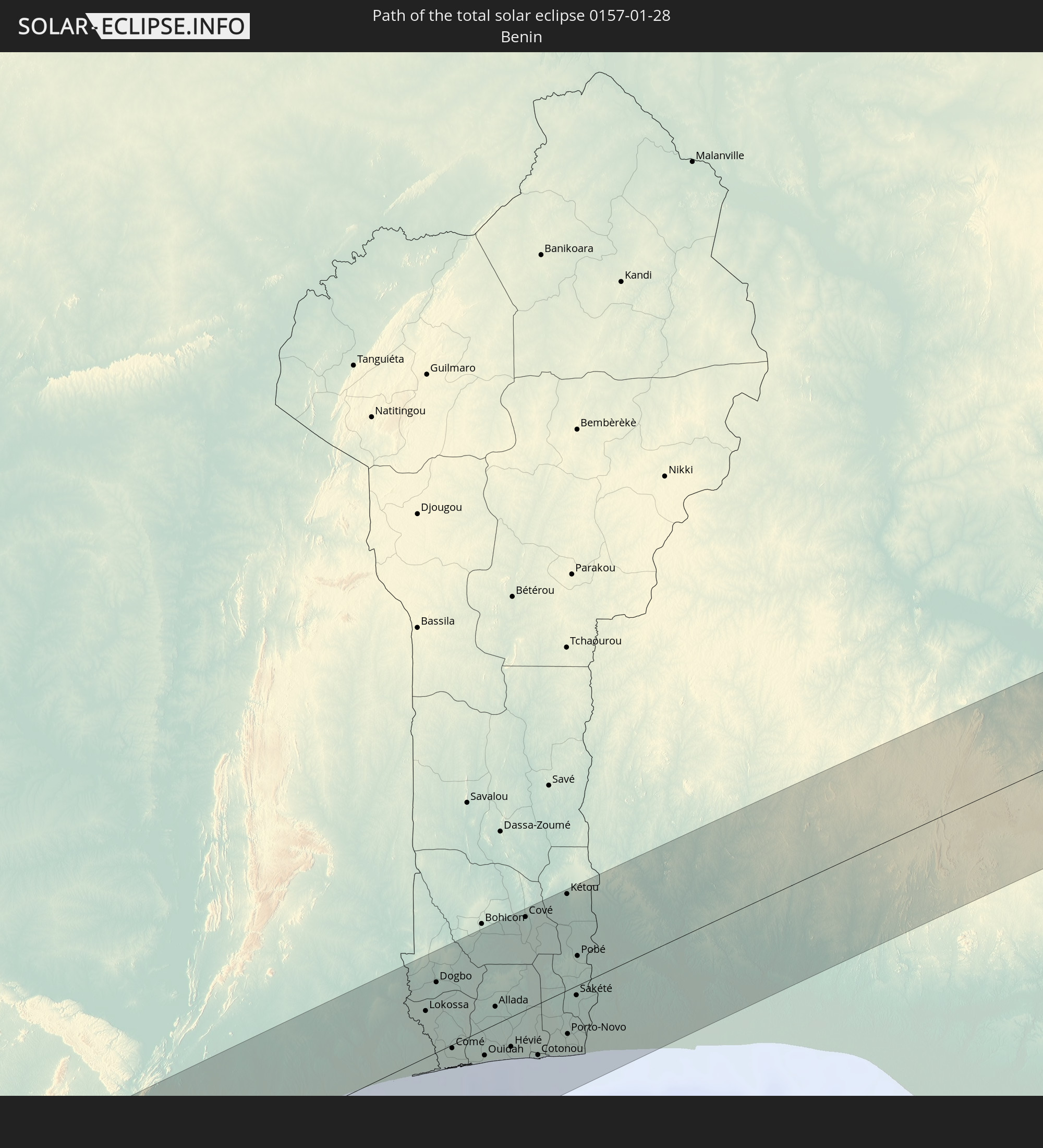 Benin
Benin
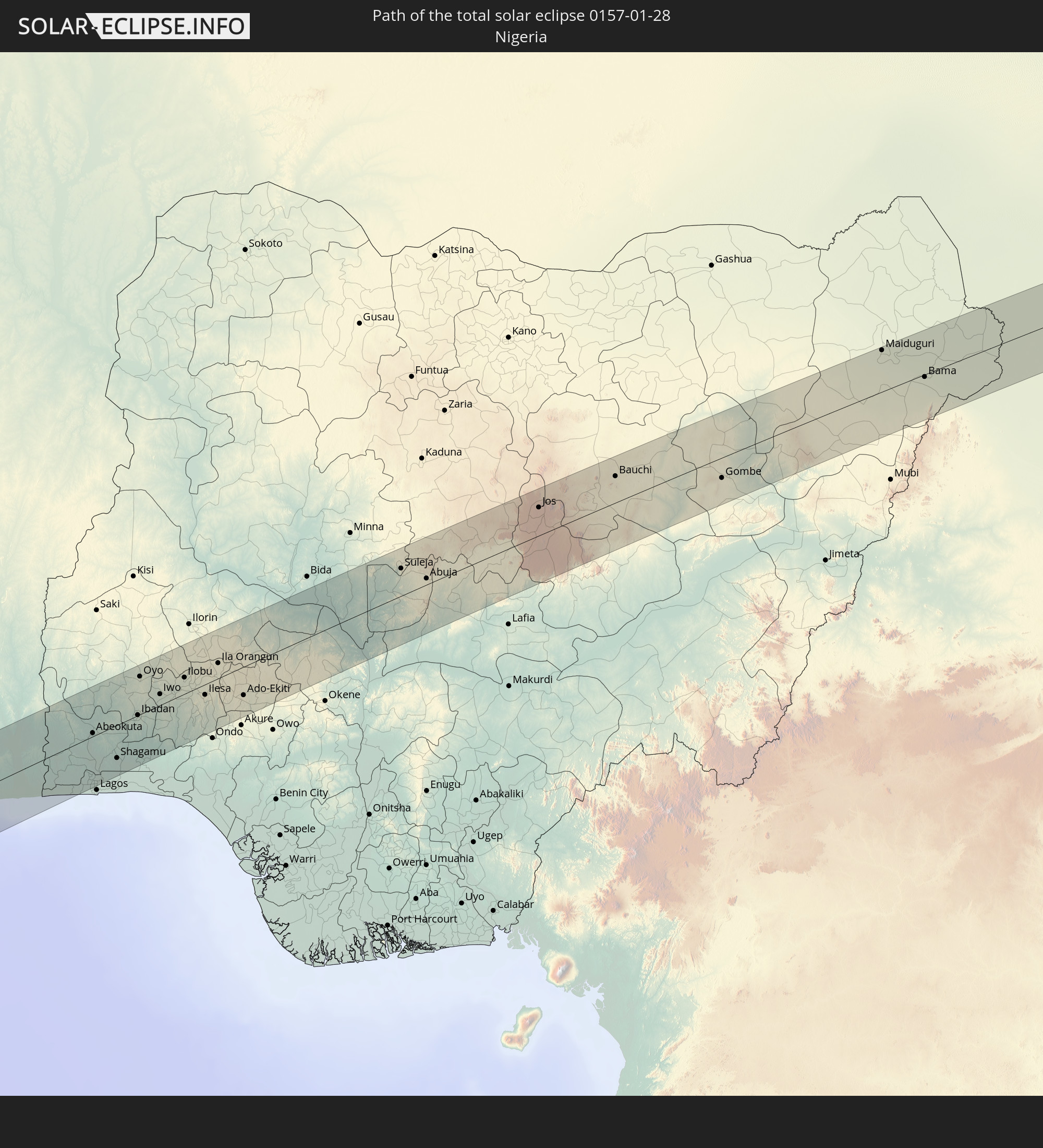 Nigeria
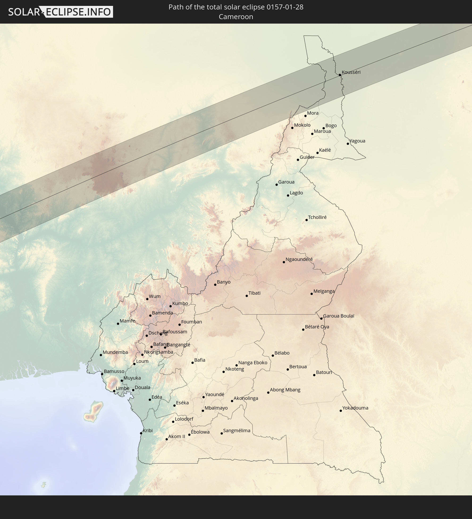 Cameroon
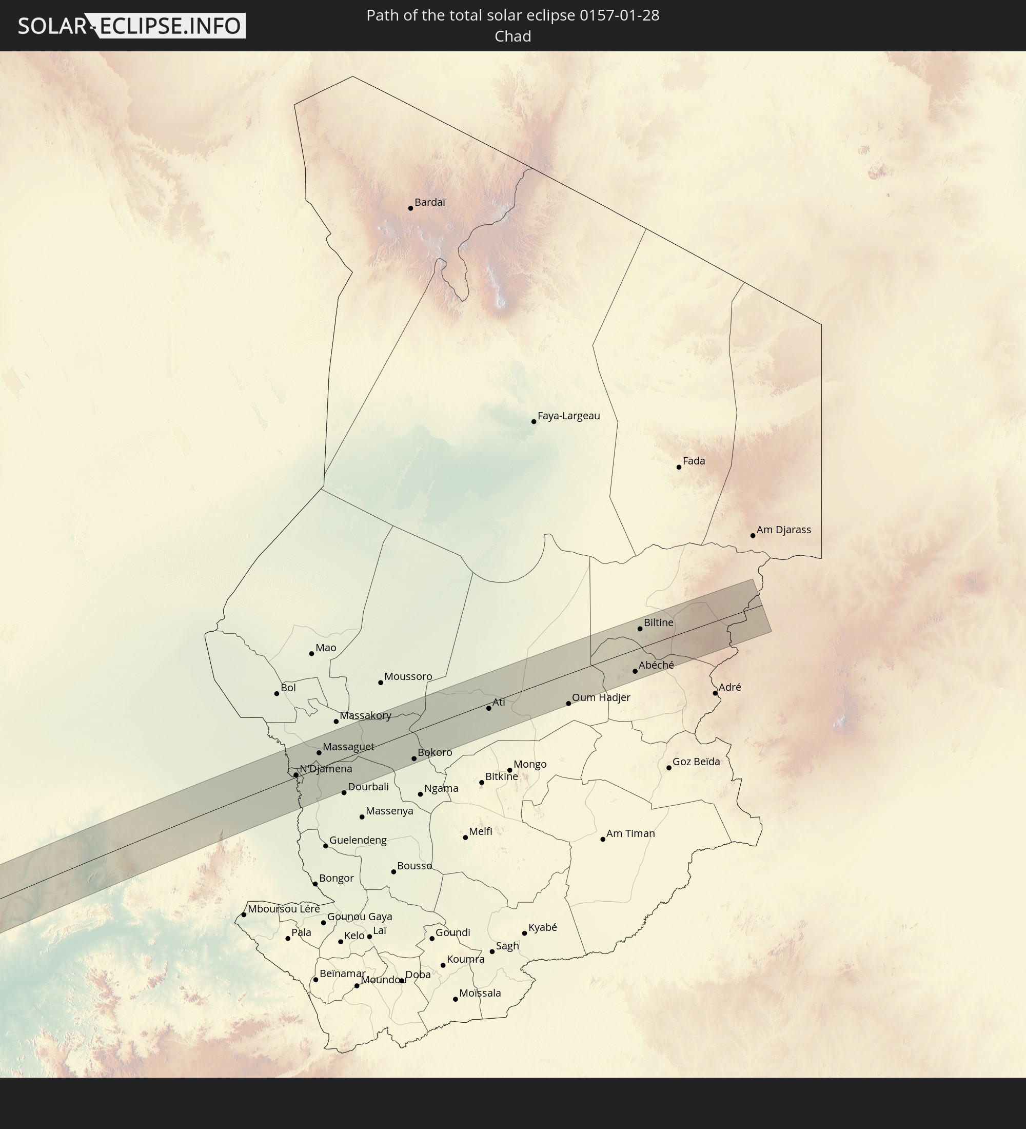 Chad
Chad
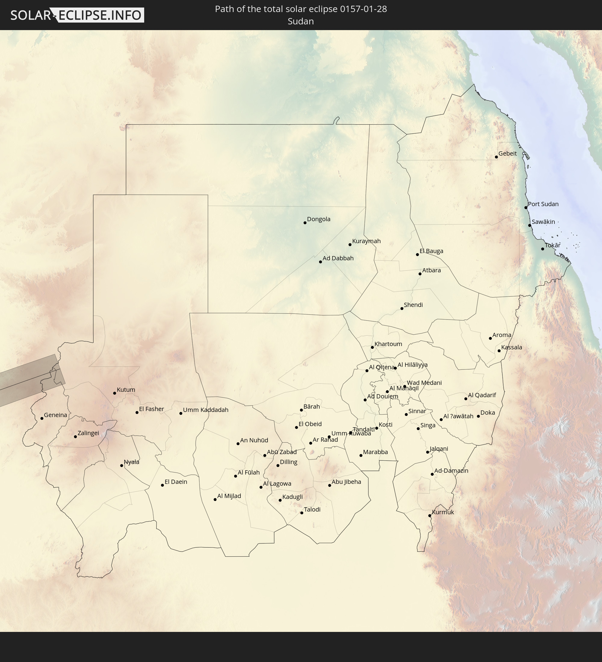 Sudan
Sudan
In den folgenden Ländern ist die Sonnenfinsternis partiell zu sehen
 United States
 United States Minor Outlying Islands
 Mexico
 Chile
Chile
 Guatemala
 Ecuador
 El Salvador
 Honduras
 Belize
 Nicaragua
 Costa Rica
 Cuba
Cuba
 Panama
 Colombia
 Cayman Islands
 Peru
Peru
 The Bahamas
 Jamaica
 Haiti
Haiti
 Brazil
 Argentina
 Venezuela
 Turks and Caicos Islands
 Dominican Republic
 Aruba
Aruba
 Bolivia
 Puerto Rico
 United States Virgin Islands
 British Virgin Islands
 Anguilla
 Collectivity of Saint Martin
 Saint Barthélemy
 Saint Kitts and Nevis
 Paraguay
 Antigua and Barbuda
 Montserrat
 Trinidad and Tobago
 Guadeloupe
 Grenada
 Dominica
 Saint Vincent and the Grenadines
 Guyana
 Martinique
 Saint Lucia
 Barbados
 Uruguay
 Suriname
 French Guiana
 Portugal
 Cabo Verde
 Spain
Spain
 Senegal
 Mauritania
 The Gambia
 Guinea-Bissau
 Guinea
 Saint Helena, Ascension and Tristan da Cunha
 Sierra Leone
 Morocco
 Mali
Mali
 Liberia
 Algeria
 Ivory Coast
 Burkina Faso
 Gibraltar
 France
 Ghana
Ghana
 Togo
Togo
 Niger
Niger
 Benin
Benin
 Nigeria
 Equatorial Guinea
 São Tomé and Príncipe
 Italy
Italy
 Monaco
 Tunisia
 Cameroon
 Gabon
Gabon
 Libya
Libya
 Republic of the Congo
 Angola
 Namibia
 Democratic Republic of the Congo
 San Marino
 Vatican City
 Chad
Chad
 Malta
Malta
 Central African Republic
 Botswana
 Sudan
Sudan
 Zambia
 Zimbabwe
 Rwanda
 Burundi
 Tanzania
 Uganda
 Mozambique
 Malawi
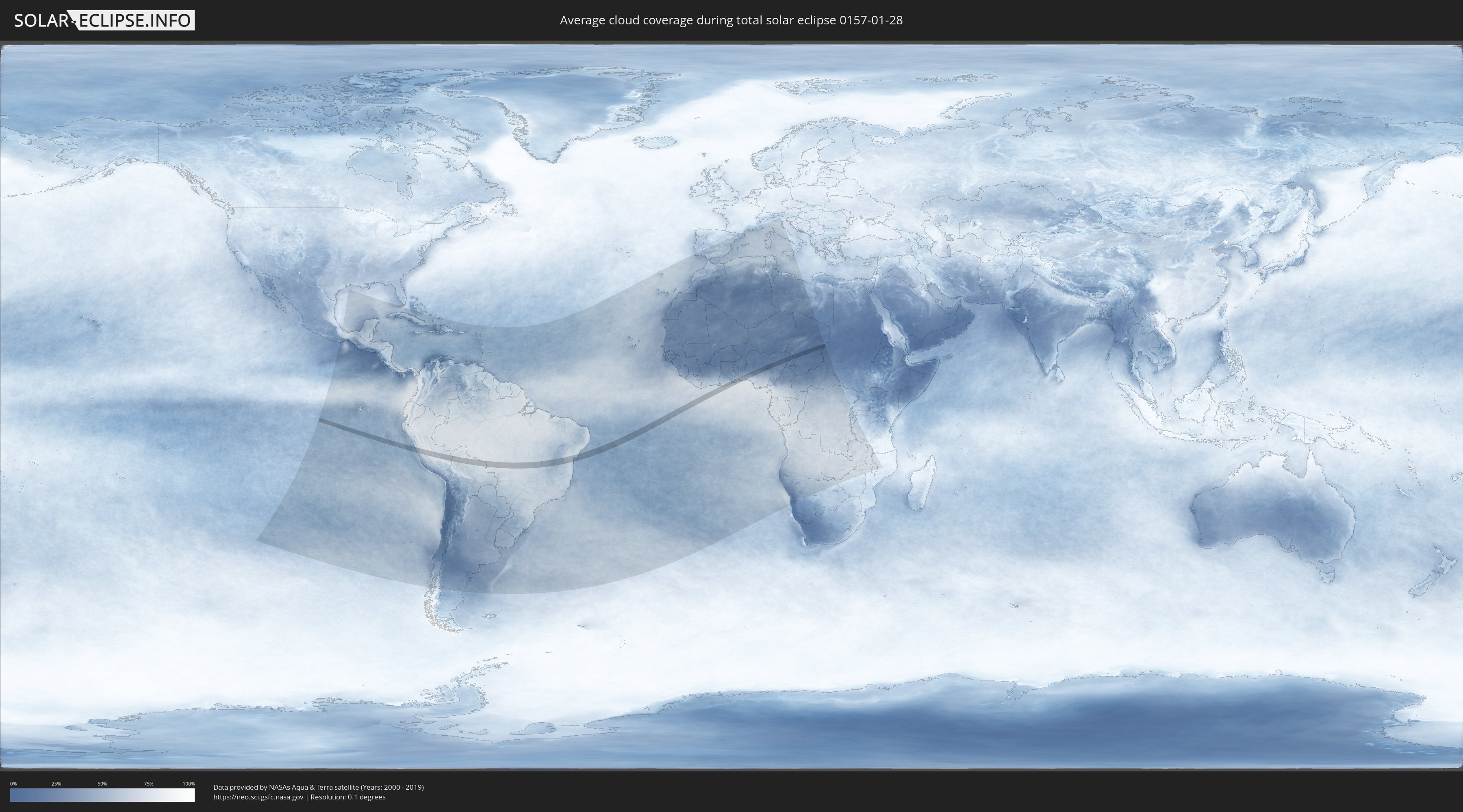
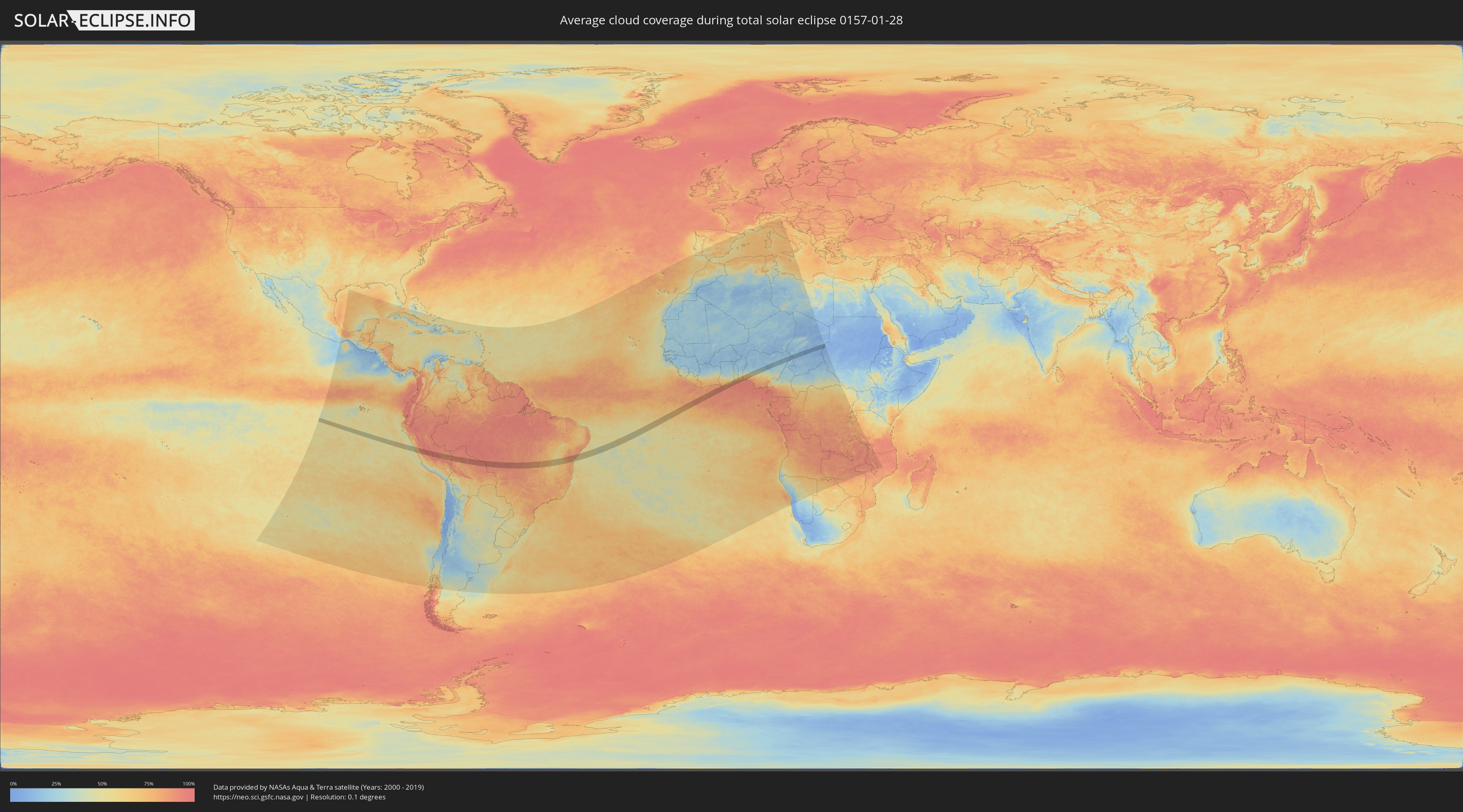
How will be the weather during the total solar eclipse on 01/28/0157?
Where is the best place to see the total solar eclipse of 01/28/0157?
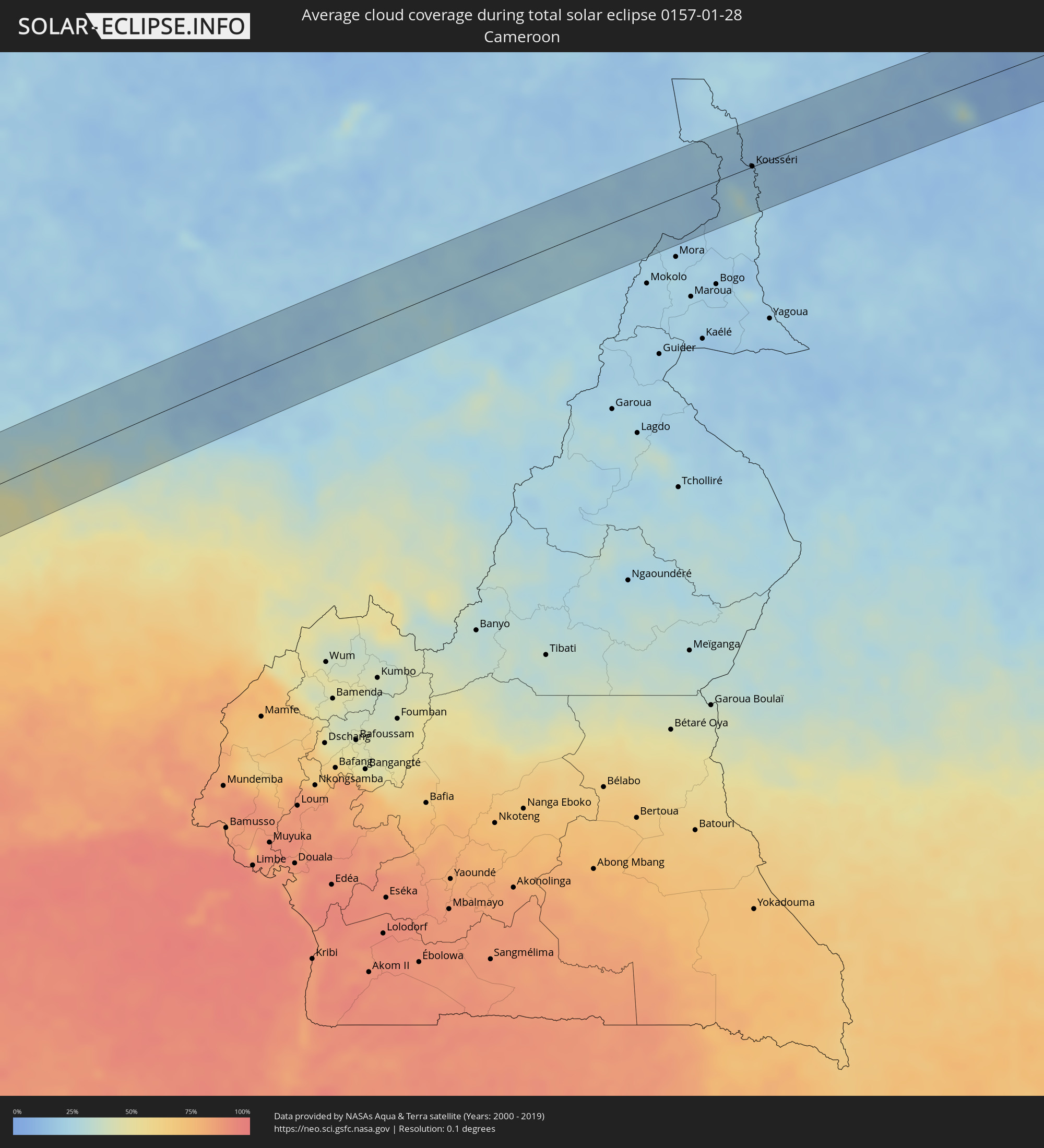
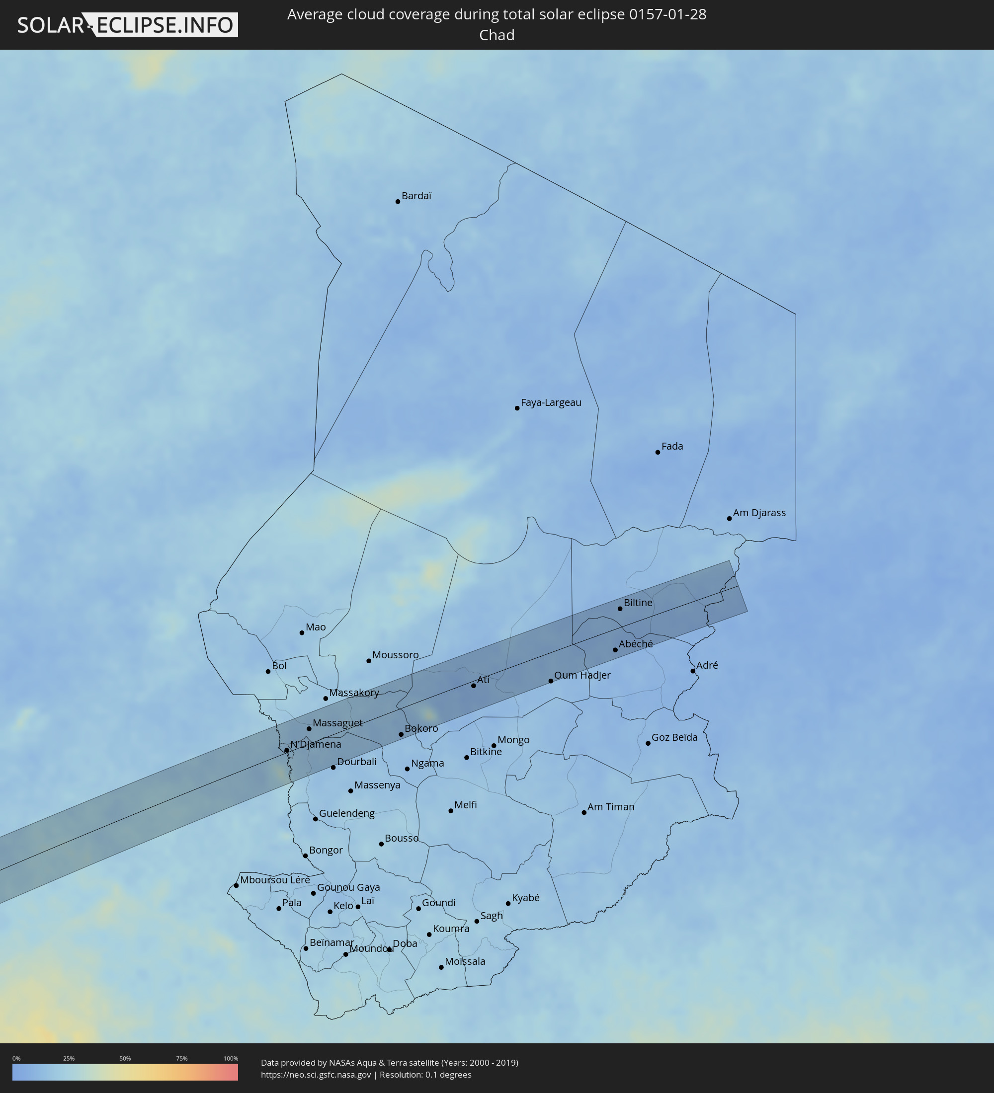
The following maps show the average cloud coverage for the day of the total solar eclipse.
With the help of these maps, it is possible to find the place along the eclipse path, which has the best
chance of a cloudless sky.
Nevertheless, you should consider local circumstances and inform about the weather of your chosen
observation site.
The data is provided by NASAs satellites
AQUA and TERRA.
The cloud maps are averaged over a period of 19 years (2000 - 2019).
Detailed country maps
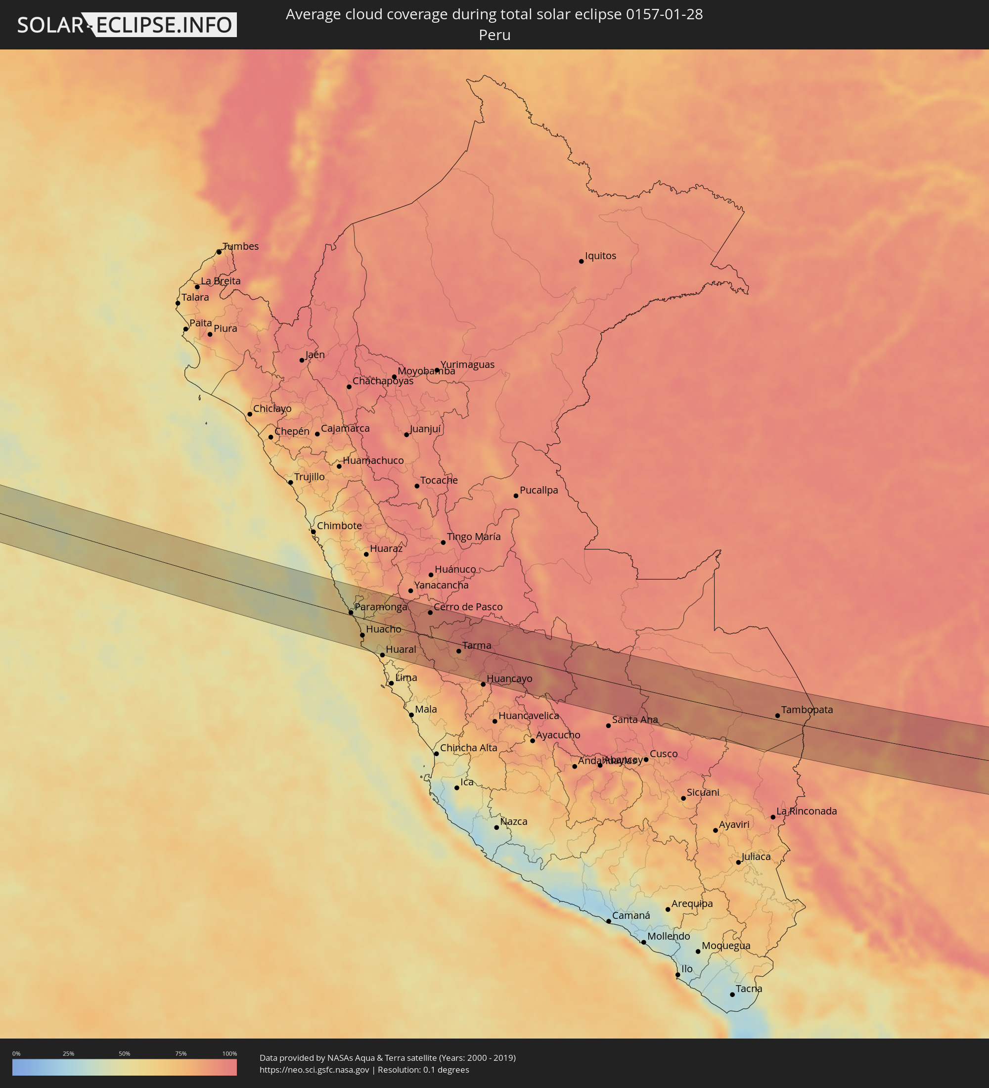 Peru
Peru
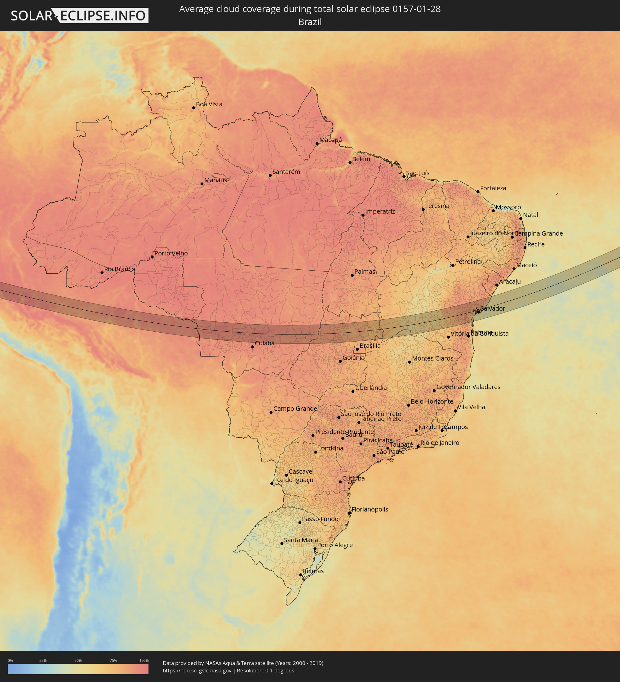 Brazil
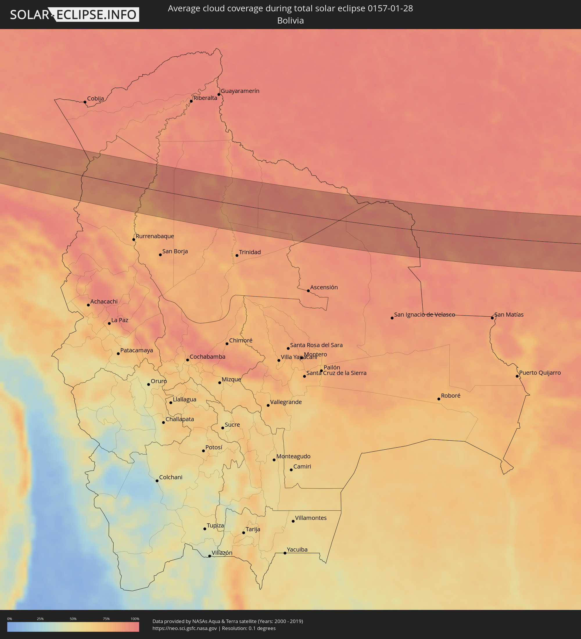 Bolivia
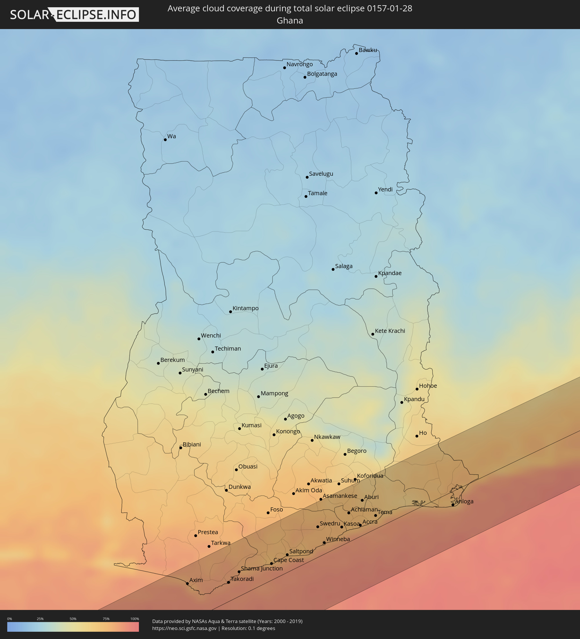 Ghana
Ghana
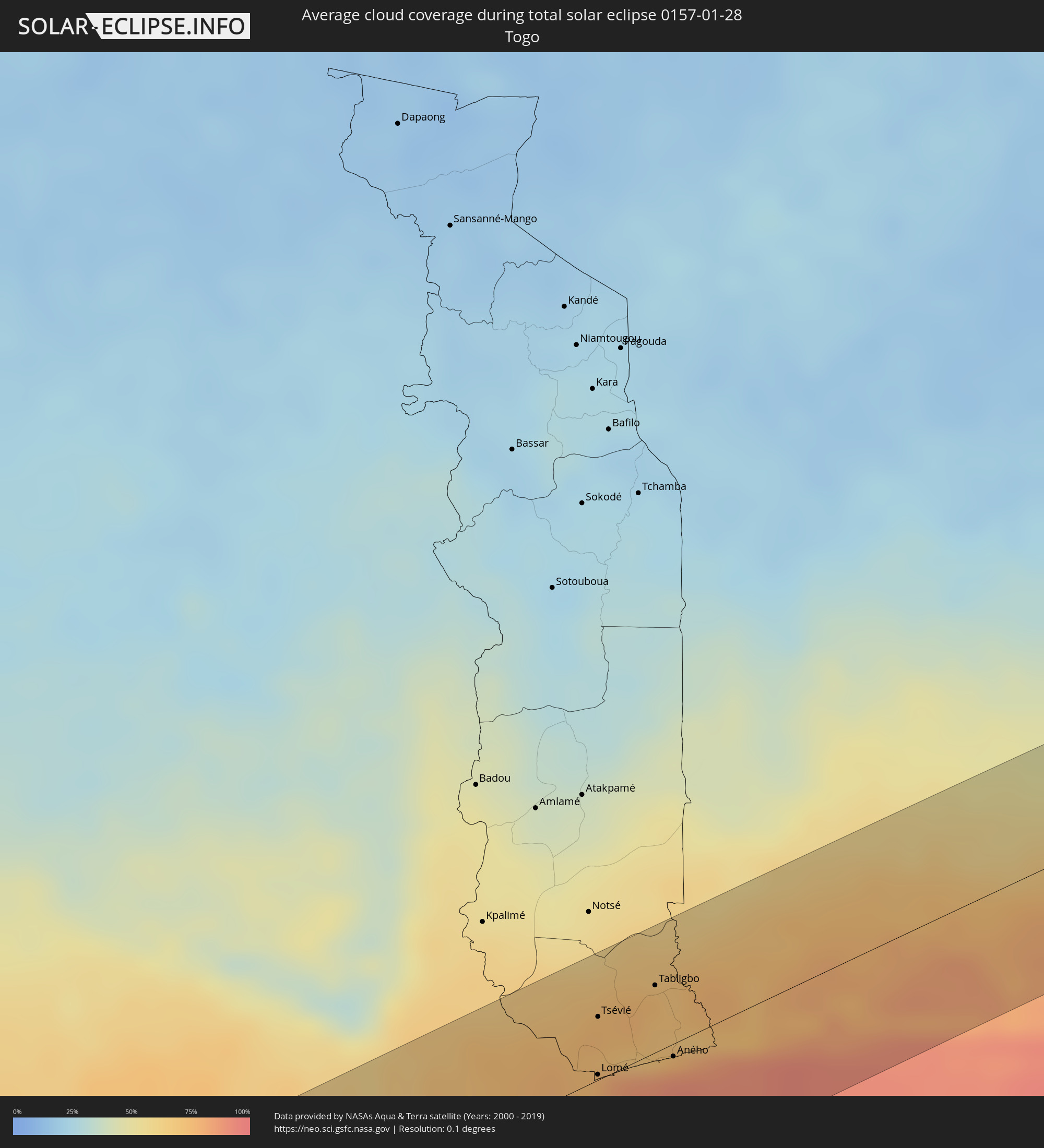 Togo
Togo
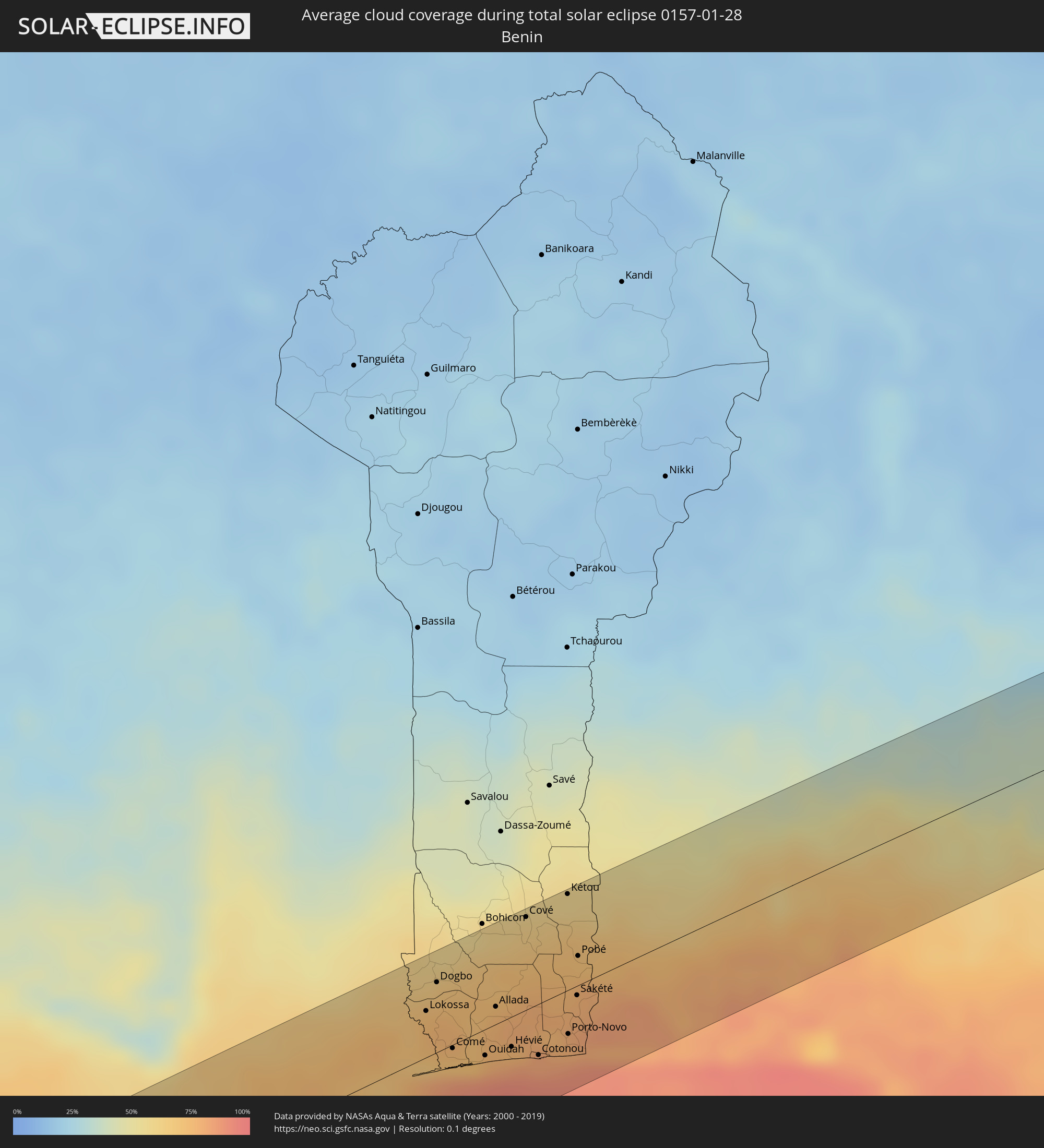 Benin
Benin
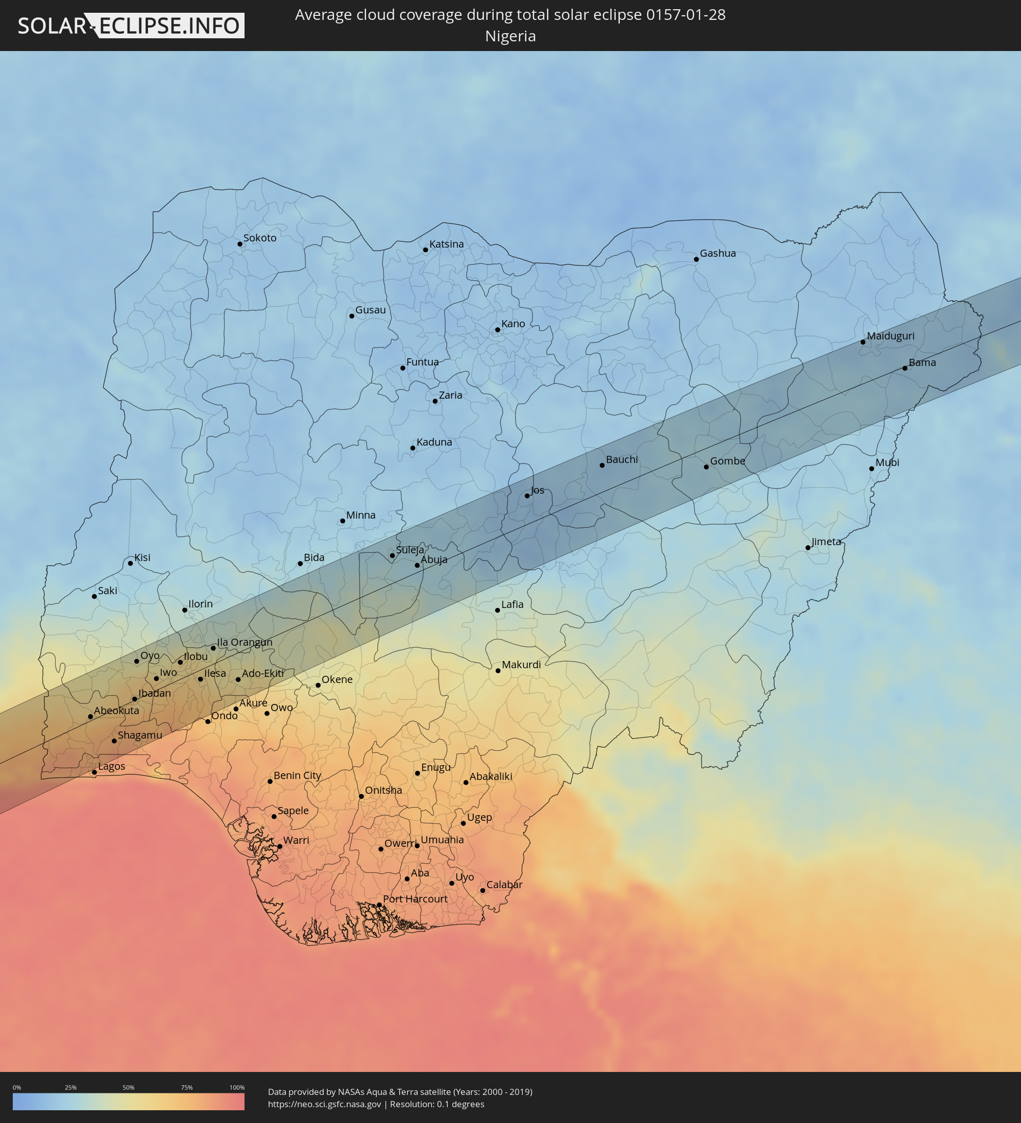 Nigeria
 Cameroon
 Chad
Chad
 Sudan
Sudan
Cities inside the path of the eclipse
The following table shows all locations with a population of more than 5,000 inside the eclipse path. Cities which have more than 100,000 inhabitants are marked bold. A click at the locations opens a detailed map.
| City | Type | Eclipse duration | Local time of max. eclipse | Distance to central line | Ø Cloud coverage |
|
Huarmey, Ancash
|
total | - | 08:01:24 UTC-05:08 | 60 km | 62% |
|
Pativilca, Lima region
|
total | - | 08:01:56 UTC-05:08 | 3 km | 66% |
|
Barranca, Lima region
|
total | - | 08:01:58 UTC-05:08 | 2 km | 63% |
|
Puerto Supe, Lima region
|
total | - | 08:02:00 UTC-05:08 | 7 km | 64% |
|
Supe, Lima region
|
total | - | 08:02:02 UTC-05:08 | 6 km | 64% |
|
Végueta, Lima region
|
total | - | 08:02:10 UTC-05:08 | 28 km | 71% |
|
Huacho, Lima region
|
total | - | 08:02:13 UTC-05:08 | 36 km | 67% |
|
Oyón, Lima region
|
total | - | 08:02:58 UTC-05:08 | 35 km | 85% |
|
Cerro de Pasco, Pasco Region
|
total | - | 08:03:31 UTC-05:08 | 49 km | 89% |
|
Morococha, Junín Region
|
total | - | 08:03:54 UTC-05:08 | 48 km | 87% |
|
Carhuamayo, Junín Region
|
total | - | 08:03:49 UTC-05:08 | 29 km | 89% |
|
Junín, Junín Region
|
total | - | 08:03:56 UTC-05:08 | 4 km | 89% |
|
La Oroya, Junín Region
|
total | - | 08:04:08 UTC-05:08 | 32 km | 84% |
|
Tarma, Junín Region
|
total | - | 08:04:20 UTC-05:08 | 16 km | 83% |
|
Acolla, Junín Region
|
total | - | 08:04:35 UTC-05:08 | 46 km | 82% |
|
Jauja, Junín Region
|
total | - | 08:04:39 UTC-05:08 | 49 km | 83% |
|
San Ramón, Junín Region
|
total | - | 08:04:38 UTC-05:08 | 25 km | 93% |
|
Concepción, Junín Region
|
total | - | 08:04:54 UTC-05:08 | 59 km | 82% |
|
San Jerónimo, Junín Region
|
total | - | 08:04:57 UTC-05:08 | 63 km | 78% |
|
Perené, Junín Region
|
total | - | 08:04:44 UTC-05:08 | 48 km | 92% |
|
Satipo, Junín Region
|
total | - | 08:05:30 UTC-05:08 | 31 km | 91% |
|
Mazamari, Junín Region
|
total | - | 08:05:39 UTC-05:08 | 26 km | 90% |
|
Pangoa, Cusco
|
total | - | 08:07:45 UTC-05:08 | 20 km | 92% |
|
Tambopata, Madre de Dios
|
total | - | 08:12:57 UTC-05:08 | 8 km | 85% |
|
Puerto Maldonado, Madre de Dios
|
total | - | 08:13:11 UTC-05:08 | 20 km | 82% |
|
Barra do Bugres, Mato Grosso
|
total | - | 10:06:35 UTC-03:38 | 66 km | 90% |
|
Uruaçu, Goiás
|
total | - | 10:59:02 UTC-03:06 | 2 km | 83% |
|
Niquelândia, Goiás
|
total | - | 11:00:56 UTC-03:06 | 2 km | 82% |
|
Bom Jesus da Lapa, Bahia
|
total | - | 11:48:34 UTC-02:34 | 65 km | 54% |
|
Guanambi, Bahia
|
total | - | 11:49:52 UTC-02:34 | 54 km | 64% |
|
Caetité, Bahia
|
total | - | 11:50:52 UTC-02:34 | 43 km | 60% |
|
Brumado, Bahia
|
total | - | 11:53:10 UTC-02:34 | 75 km | 65% |
|
Itaberaba, Bahia
|
total | - | 11:58:25 UTC-02:34 | 75 km | 85% |
|
Jequié, Bahia
|
total | - | 11:58:05 UTC-02:34 | 75 km | 79% |
|
Jaguaquara, Bahia
|
total | - | 11:58:40 UTC-02:34 | 42 km | 80% |
|
Santo Antônio de Jesus, Bahia
|
total | - | 12:01:13 UTC-02:34 | 0 km | 82% |
|
Santo Estêvão, Bahia
|
total | - | 12:01:41 UTC-02:34 | 58 km | 85% |
|
Cruz das Almas, Bahia
|
total | - | 12:01:56 UTC-02:34 | 28 km | 84% |
|
Valença, Bahia
|
total | - | 12:01:28 UTC-02:34 | 48 km | 68% |
|
Nazaré, Bahia
|
total | - | 12:01:54 UTC-02:34 | 14 km | 74% |
|
Feira de Santana, Bahia
|
total | - | 12:02:41 UTC-02:34 | 67 km | 85% |
|
Santo Amaro, Bahia
|
total | - | 12:03:13 UTC-02:34 | 30 km | 79% |
|
Salvador, Bahia
|
total | - | 12:03:28 UTC-02:34 | 21 km | 50% |
|
São Sebastião do Passé, Bahia
|
total | - | 12:03:53 UTC-02:34 | 28 km | 83% |
|
Alagoinhas, Bahia
|
total | - | 12:04:26 UTC-02:34 | 66 km | 84% |
|
Catu, Bahia
|
total | - | 12:04:22 UTC-02:34 | 41 km | 81% |
|
Lauro de Freitas, Bahia
|
total | - | 12:04:04 UTC-02:34 | 18 km | 52% |
|
Camaçari, Bahia
|
total | - | 12:04:15 UTC-02:34 | 3 km | 66% |
|
Mata de São João, Bahia
|
total | - | 12:04:28 UTC-02:34 | 20 km | 76% |
|
Entre Rios, Bahia
|
total | - | 12:05:37 UTC-02:34 | 77 km | 86% |
|
Axim, Western
|
total | - | 16:09:56 UTC-00:00 | 45 km | 78% |
|
Takoradi, Western
|
total | - | 16:10:24 UTC-00:00 | 22 km | 85% |
|
Sekondi-Takoradi, Western
|
total | - | 16:10:29 UTC-00:00 | 25 km | 88% |
|
Shama Junction, Western
|
total | - | 16:10:36 UTC-00:00 | 28 km | 86% |
|
Elmina, Central
|
total | - | 16:10:54 UTC-00:00 | 22 km | 83% |
|
Cape Coast, Central
|
total | - | 16:11:01 UTC-00:00 | 19 km | 87% |
|
Saltpond, Central
|
total | - | 16:11:15 UTC-00:00 | 20 km | 82% |
|
Mumford, Central
|
total | - | 16:11:33 UTC-00:00 | 11 km | 78% |
|
Apam, Central
|
total | - | 16:11:35 UTC-00:00 | 12 km | 86% |
|
Swedru, Central
|
total | - | 16:11:45 UTC-00:00 | 35 km | 76% |
|
Winneba, Central
|
total | - | 16:11:43 UTC-00:00 | 13 km | 80% |
|
Kasoa, Central
|
total | - | 16:12:00 UTC-00:00 | 21 km | 80% |
|
Nsawam, Eastern
|
total | - | 16:12:13 UTC-00:00 | 45 km | 73% |
|
Achiaman, Greater Accra
|
total | - | 16:12:10 UTC-00:00 | 34 km | 75% |
|
Gbawe, Greater Accra
|
total | - | 16:12:07 UTC-00:00 | 20 km | 75% |
|
Dome, Greater Accra
|
total | - | 16:12:14 UTC-00:00 | 24 km | 73% |
|
Accra, Greater Accra
|
total | - | 16:12:13 UTC-00:00 | 13 km | 78% |
|
Aburi, Eastern
|
total | - | 16:12:23 UTC-00:00 | 41 km | 73% |
|
Medina Estates, Greater Accra
|
total | - | 16:12:18 UTC-00:00 | 22 km | 73% |
|
Teshi Old Town, Greater Accra
|
total | - | 16:12:18 UTC-00:00 | 11 km | 82% |
|
Akropong
|
total | - | 16:12:32 UTC-00:00 | 49 km | 66% |
|
Nungua, Greater Accra
|
total | - | 16:12:20 UTC-00:00 | 11 km | 82% |
|
Tema, Greater Accra
|
total | - | 16:12:26 UTC-00:00 | 15 km | 75% |
|
Anloga, Volta
|
total | - | 16:13:15 UTC-00:00 | 17 km | 85% |
|
Keta, Volta
|
total | - | 16:13:24 UTC-00:00 | 9 km | 83% |
|
Lomé, Maritime
|
total | - | 15:58:26 UTC-00:16 | 3 km | 88% |
|
Tsévié, Maritime
|
total | - | 15:58:35 UTC-00:16 | 32 km | 75% |
|
Tabligbo, Maritime
|
total | - | 15:58:53 UTC-00:16 | 34 km | 74% |
|
Vogan, Maritime
|
total | - | 15:58:47 UTC-00:16 | 7 km | 71% |
|
Aného, Maritime
|
total | - | 15:58:46 UTC-00:16 | 6 km | 89% |
|
Aplahoué, Kouffo
|
total | - | 16:28:55 UTC+00:13 | 60 km | 64% |
|
Lokossa, Mono
|
total | - | 16:28:48 UTC+00:13 | 29 km | 74% |
|
Dogbo, Kouffo
|
total | - | 16:28:56 UTC+00:13 | 44 km | 71% |
|
Grand-Popo, Mono
|
total | - | 16:28:42 UTC+00:13 | 12 km | 84% |
|
Comé, Mono
|
total | - | 16:28:48 UTC+00:13 | 2 km | 72% |
|
Ouidah, Atlantique
|
total | - | 16:28:56 UTC+00:13 | 16 km | 79% |
|
Allada, Atlantique
|
total | - | 16:29:08 UTC+00:13 | 11 km | 77% |
|
Hévié, Atlantique
|
total | - | 16:29:05 UTC+00:13 | 19 km | 84% |
|
Cové, Zou
|
total | - | 16:29:33 UTC+00:13 | 58 km | 64% |
|
Abomey-Calavi, Atlantique
|
total | - | 16:29:11 UTC+00:13 | 21 km | 83% |
|
Cotonou, Littoral
|
total | - | 16:29:11 UTC+00:13 | 32 km | 83% |
|
Kétou, Plateau
|
total | - | 16:29:48 UTC+00:13 | 60 km | 58% |
|
Porto-Novo, Ouémé
|
total | - | 16:29:23 UTC+00:13 | 27 km | 79% |
|
Sakété, Plateau
|
total | - | 16:29:33 UTC+00:13 | 6 km | 80% |
|
Pobé, Plateau
|
total | - | 16:29:40 UTC+00:13 | 18 km | 73% |
|
Ikeja, Lagos
|
total | - | 16:29:58 UTC+00:13 | 52 km | 80% |
|
Abeokuta, Ogun
|
total | - | 16:30:14 UTC+00:13 | 4 km | 65% |
|
Ebute Ikorodu, Lagos
|
total | - | 16:30:04 UTC+00:13 | 59 km | 84% |
|
Shagamu, Ogun
|
total | - | 16:30:18 UTC+00:13 | 41 km | 84% |
|
Ibadan, Oyo
|
total | - | 16:30:43 UTC+00:13 | 0 km | 60% |
|
Ijebu-Ode, Ogun
|
total | - | 16:30:28 UTC+00:13 | 57 km | 84% |
|
Oyo, Oyo
|
total | - | 16:30:57 UTC+00:13 | 47 km | 48% |
|
Iwo, Osun
|
total | - | 16:31:01 UTC+00:13 | 14 km | 67% |
|
Ikire, Osun
|
total | - | 16:30:54 UTC+00:13 | 13 km | 69% |
|
Inisa, Osun
|
total | - | 16:31:12 UTC+00:13 | 28 km | 53% |
|
Gbongan, Osun
|
total | - | 16:31:03 UTC+00:13 | 10 km | 70% |
|
Osogbo, Osun
|
total | - | 16:31:19 UTC+00:13 | 10 km | 59% |
|
Ikirun, Osun
|
total | - | 16:31:27 UTC+00:13 | 19 km | 58% |
|
Ilesa, Osun
|
total | - | 16:31:22 UTC+00:13 | 13 km | 64% |
|
Ila Orangun, Osun
|
total | - | 16:31:38 UTC+00:13 | 19 km | 49% |
|
Effon Alaiye, Ekiti
|
total | - | 16:31:29 UTC+00:13 | 19 km | 54% |
|
Ijero-Ekiti, Ekiti
|
total | - | 16:31:39 UTC+00:13 | 9 km | 53% |
|
Ado-Ekiti, Ekiti
|
total | - | 16:31:40 UTC+00:13 | 35 km | 56% |
|
Ise-Ekiti, Ekiti
|
total | - | 16:31:43 UTC+00:13 | 61 km | 64% |
|
Suleja, Niger
|
total | - | 16:33:23 UTC+00:13 | 34 km | 27% |
|
Abuja, Abuja Federal Capital Territory
|
total | - | 16:33:30 UTC+00:13 | 8 km | 23% |
|
Jos, Plateau
|
total | - | 16:34:28 UTC+00:13 | 35 km | 15% |
|
Bauchi, Bauchi
|
total | - | 16:35:00 UTC+00:13 | 33 km | 18% |
|
Gombe, Gombe
|
total | - | 16:35:30 UTC+00:13 | 25 km | 25% |
|
Maiduguri, Borno
|
total | - | 16:36:33 UTC+00:13 | 52 km | 21% |
|
Kousséri, Far North
|
total | - | 16:37:04 UTC+00:13 | 0 km | 20% |
|
N'Djamena, Chari-Baguirmi
|
total | - | 17:23:42 UTC+01:00 | 3 km | 20% |
|
Massaguet, Hadjer-Lamis
|
total | - | 17:23:51 UTC+01:00 | 25 km | 16% |
|
Bokoro, Hadjer-Lamis
|
total | - | 17:24:08 UTC+01:00 | 48 km | 15% |
|
Ati, Batha
|
total | - | 17:24:27 UTC+01:00 | 10 km | 8% |
|
Oum Hadjer, Batha
|
total | - | 17:24:35 UTC+01:00 | 53 km | 13% |
|
Abéché, Ouadaï
|
total | - | 17:24:43 UTC+01:00 | 39 km | 10% |
|
Biltine, Wadi Fira
|
total | - | 17:24:47 UTC+01:00 | 32 km | 10% |