Total solar eclipse of 06/17/1433
| Day of week: | Monday |
| Maximum duration of eclipse: | 04m38s |
| Maximum width of eclipse path: | 309 km |
| Saros cycle: | 108 |
| Coverage: | 100% |
| Magnitude: | 1.0714 |
| Gamma: | 0.6558 |
Wo kann man die Sonnenfinsternis vom 06/17/1433 sehen?
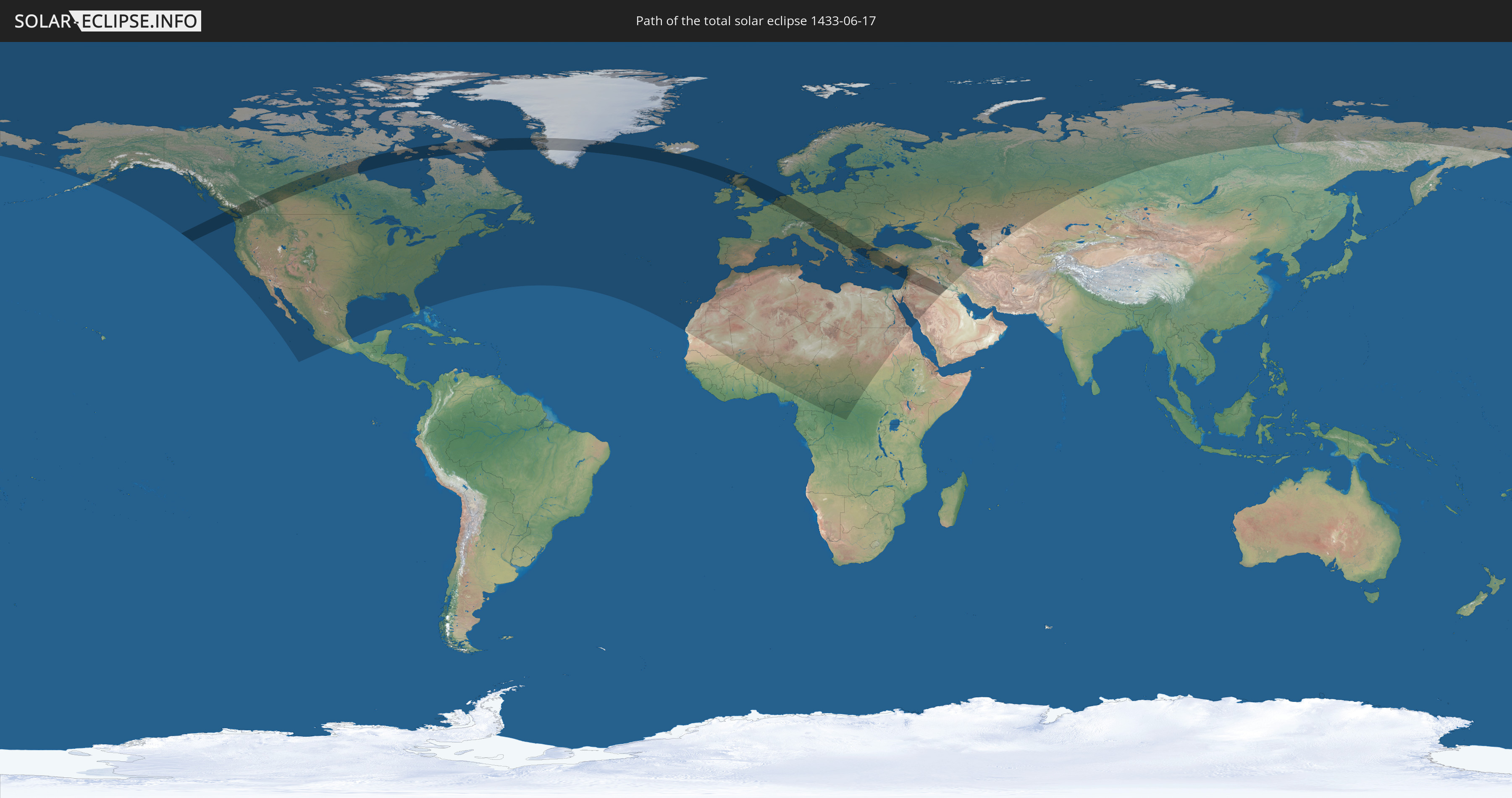
Die Sonnenfinsternis am 06/17/1433 kann man in 92 Ländern als partielle Sonnenfinsternis beobachten.
Der Finsternispfad verläuft durch 29 Länder. Nur in diesen Ländern ist sie als total Sonnenfinsternis zu sehen.
In den folgenden Ländern ist die Sonnenfinsternis total zu sehen
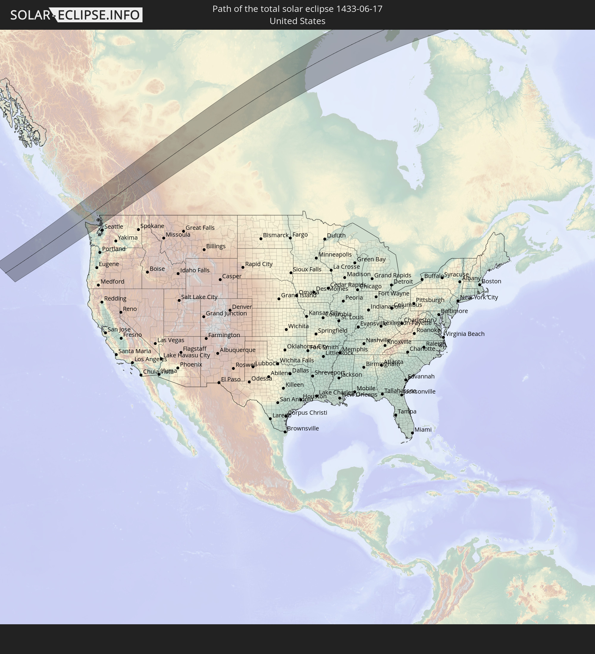 United States
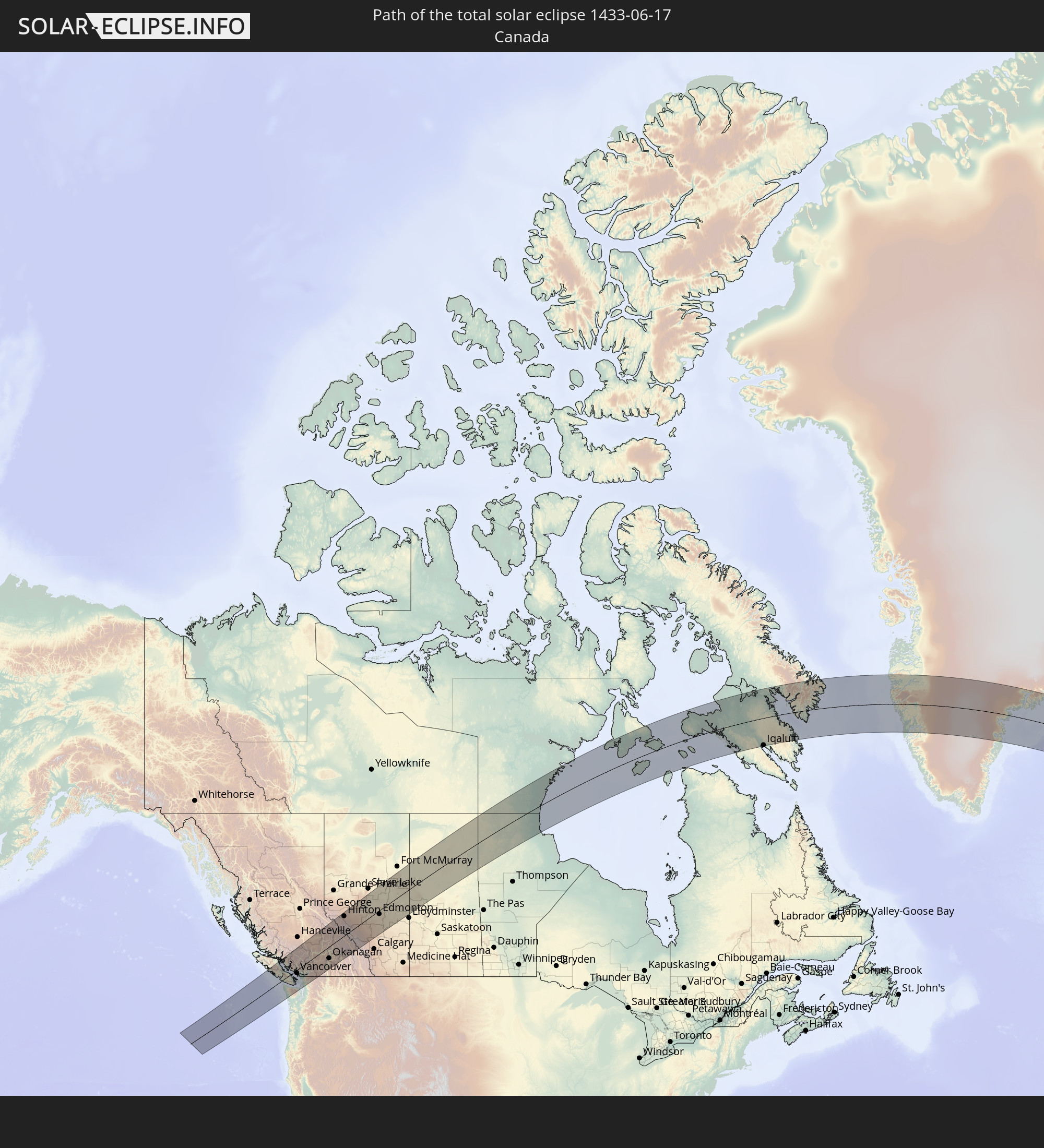 Canada
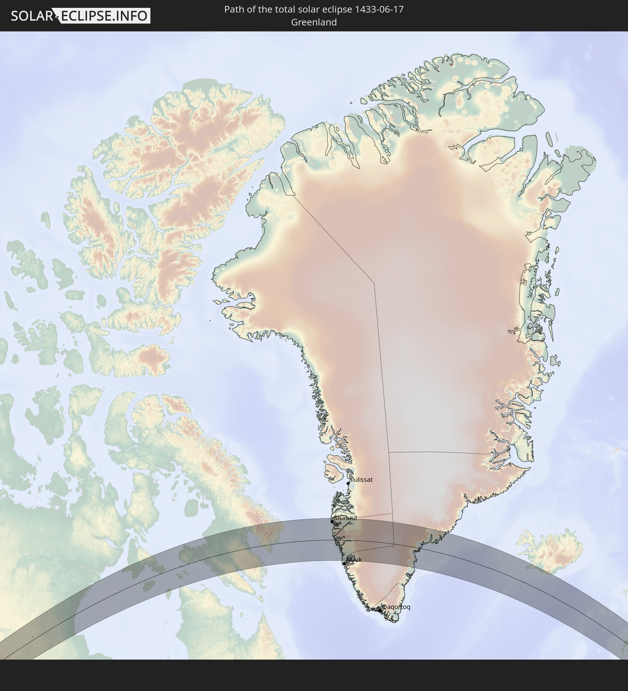 Greenland
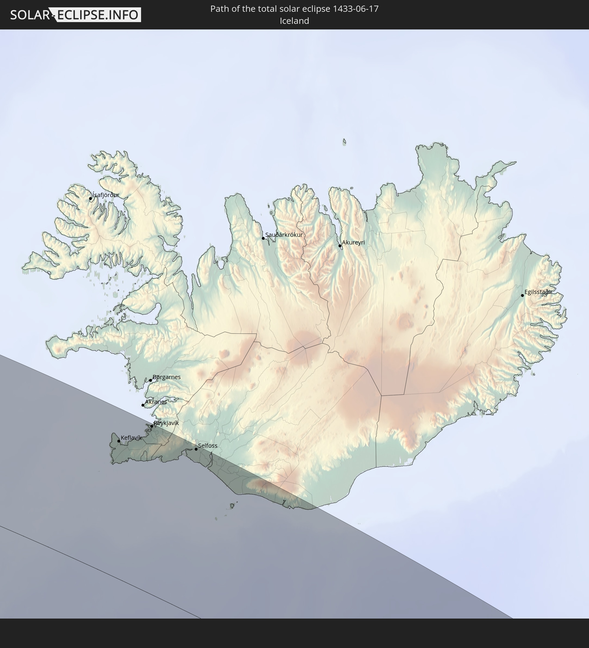 Iceland
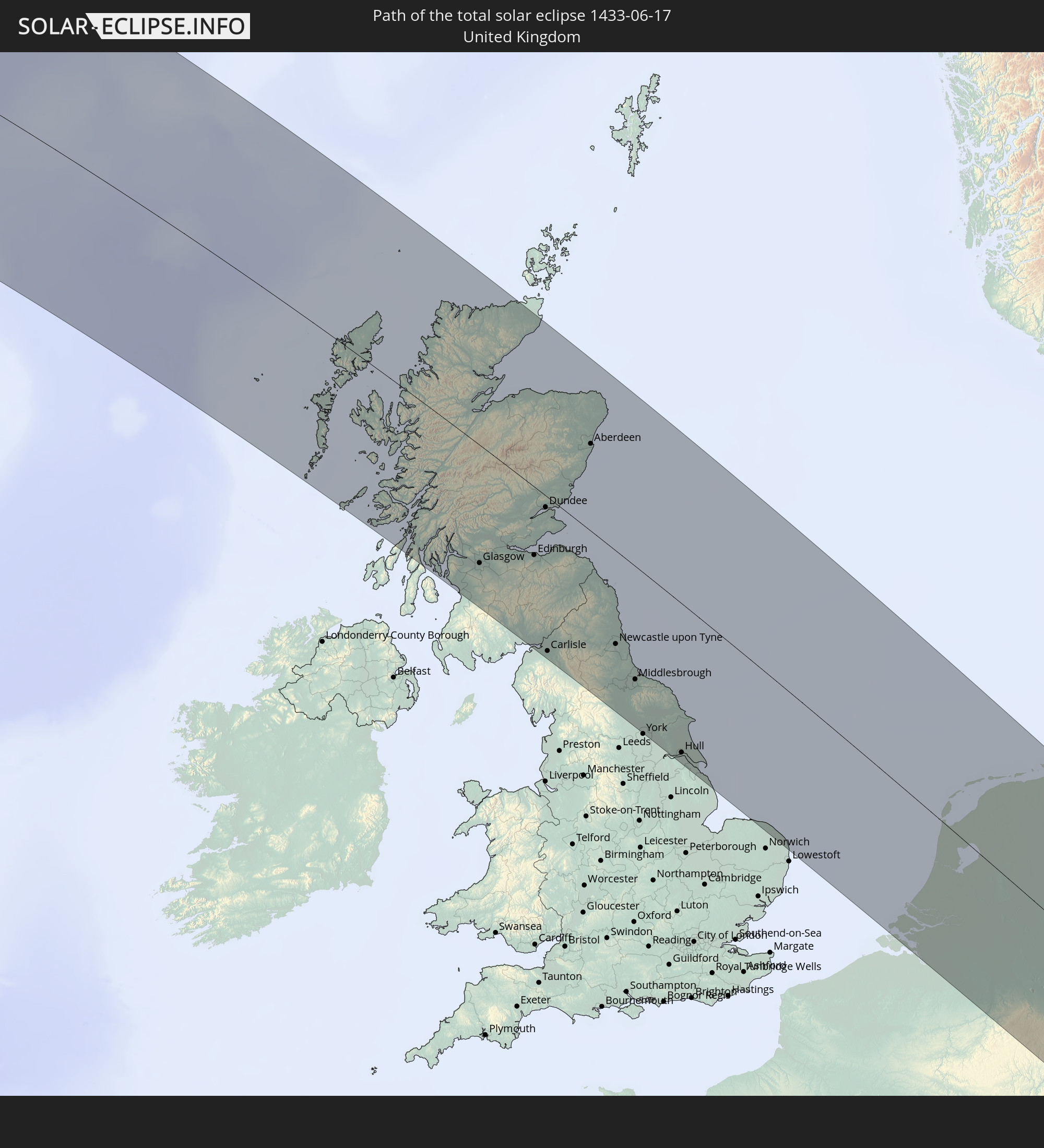 United Kingdom
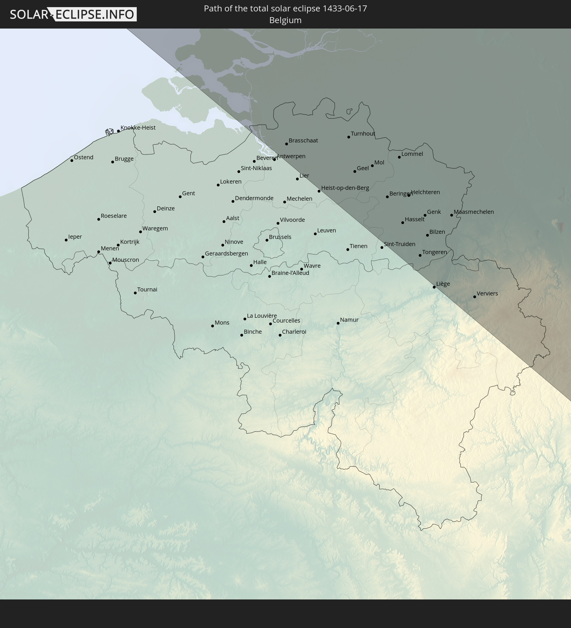 Belgium
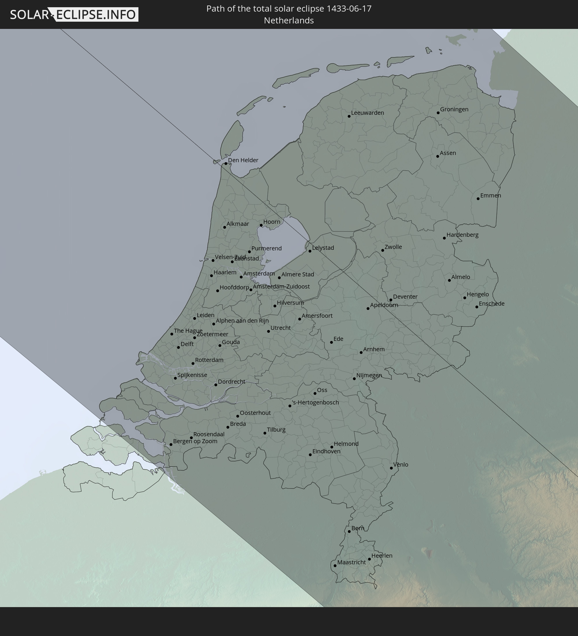 Netherlands
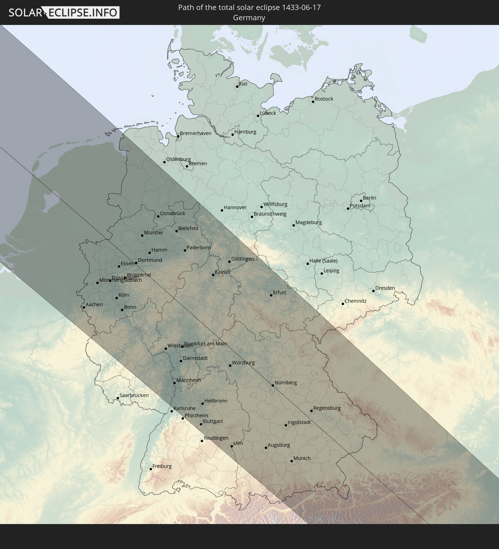 Germany
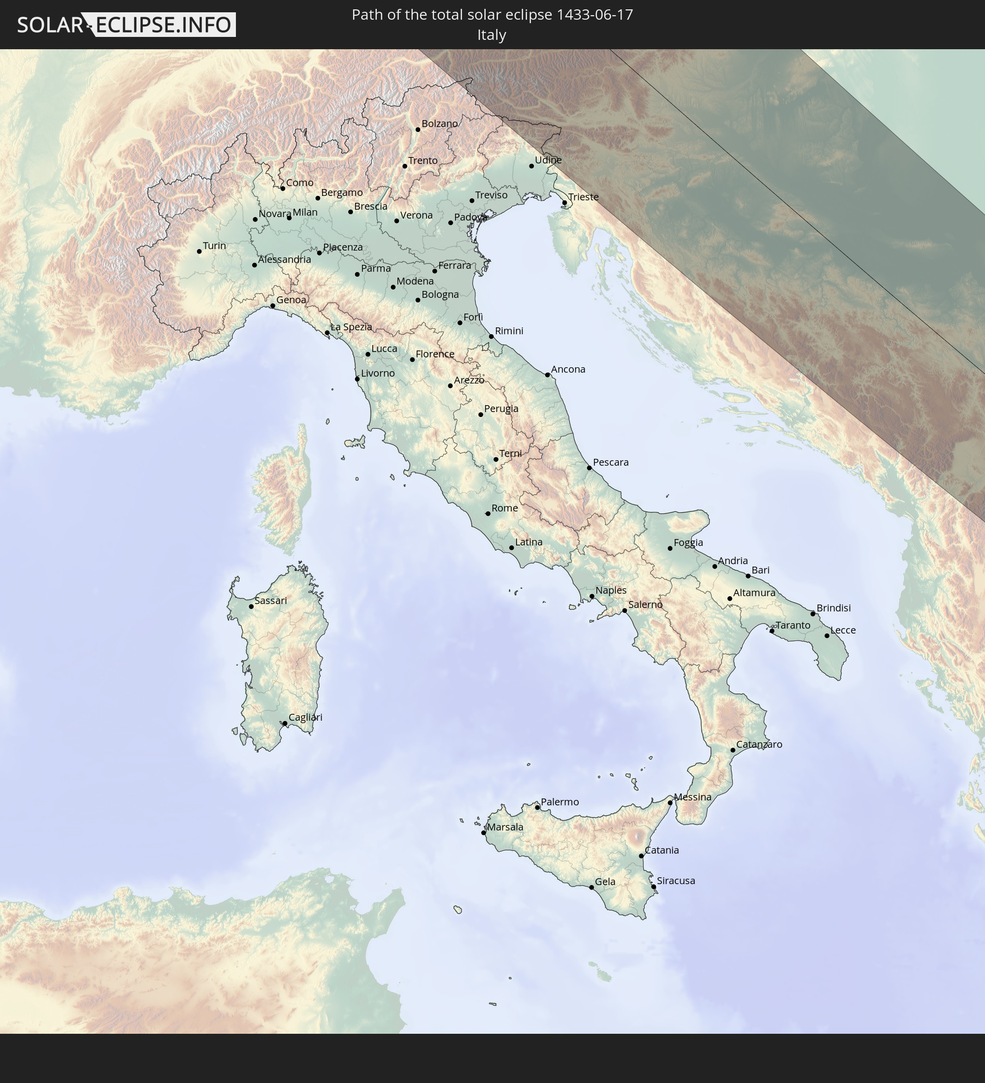 Italy
Italy
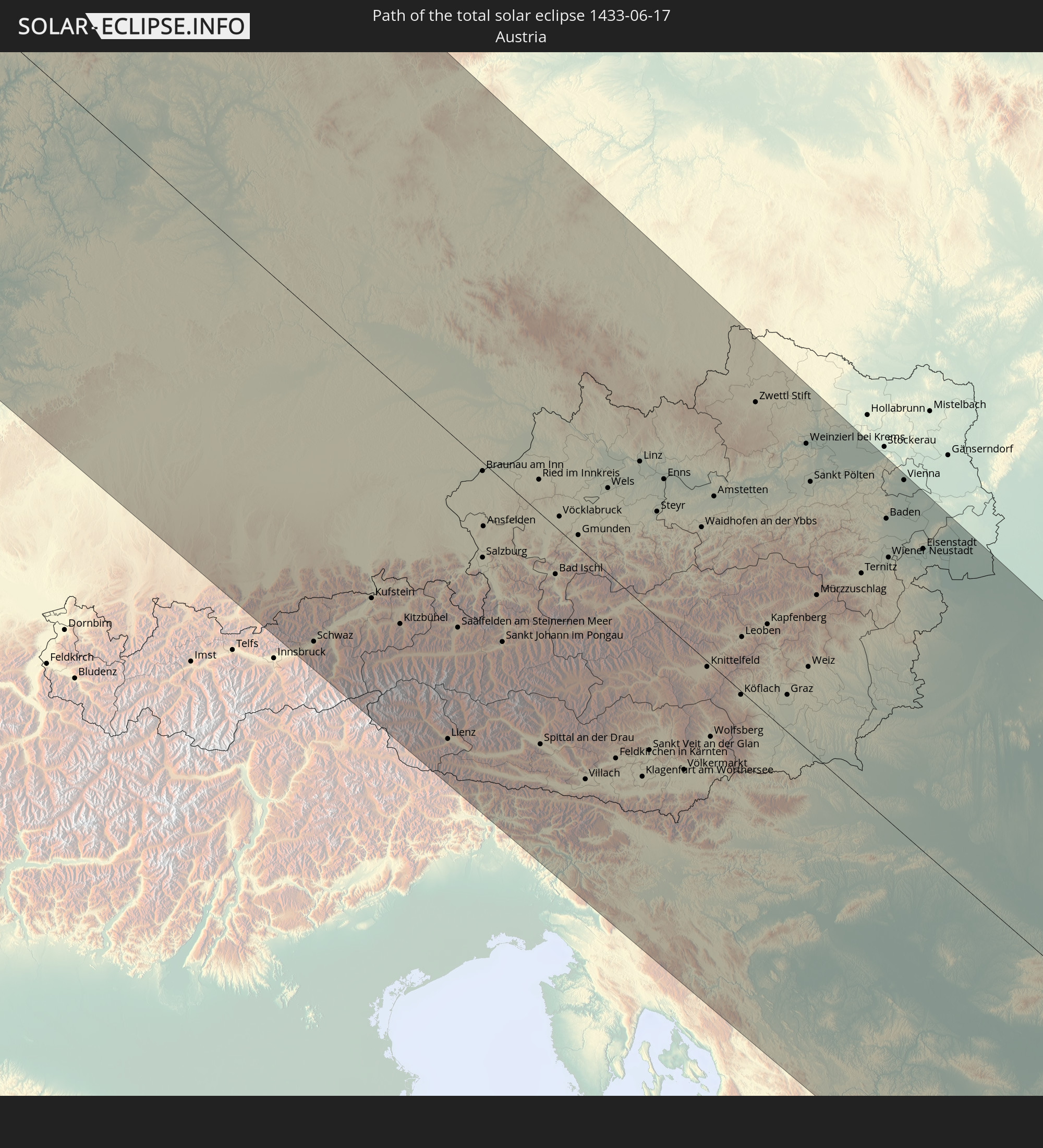 Austria
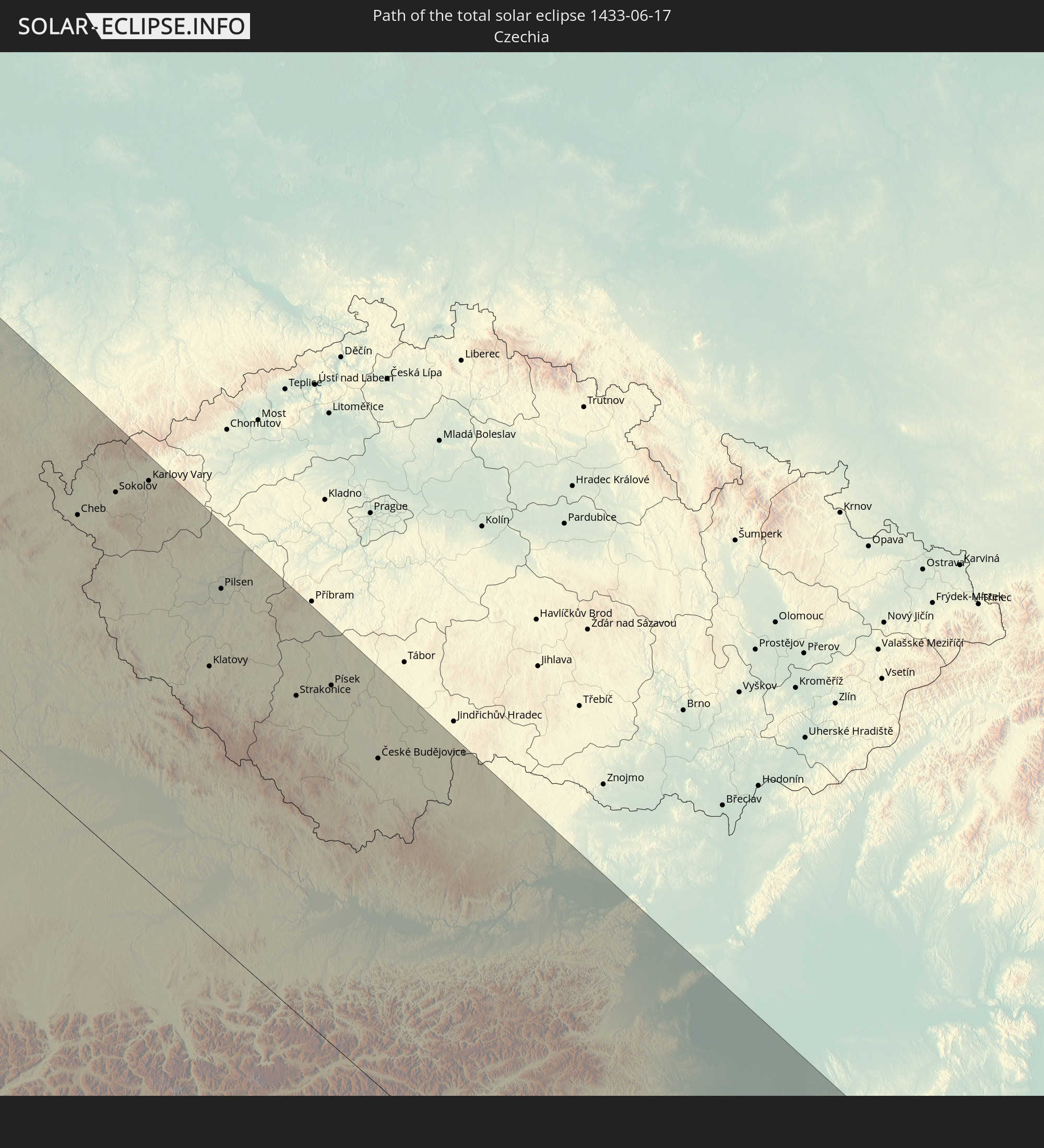 Czechia
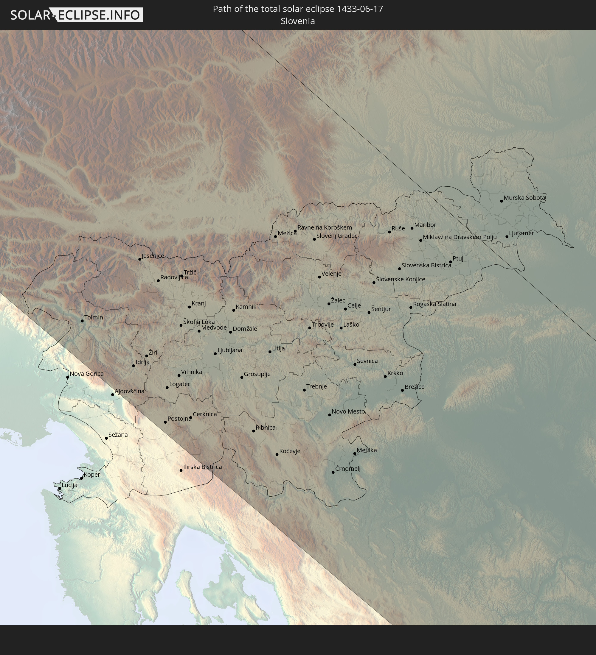 Slovenia
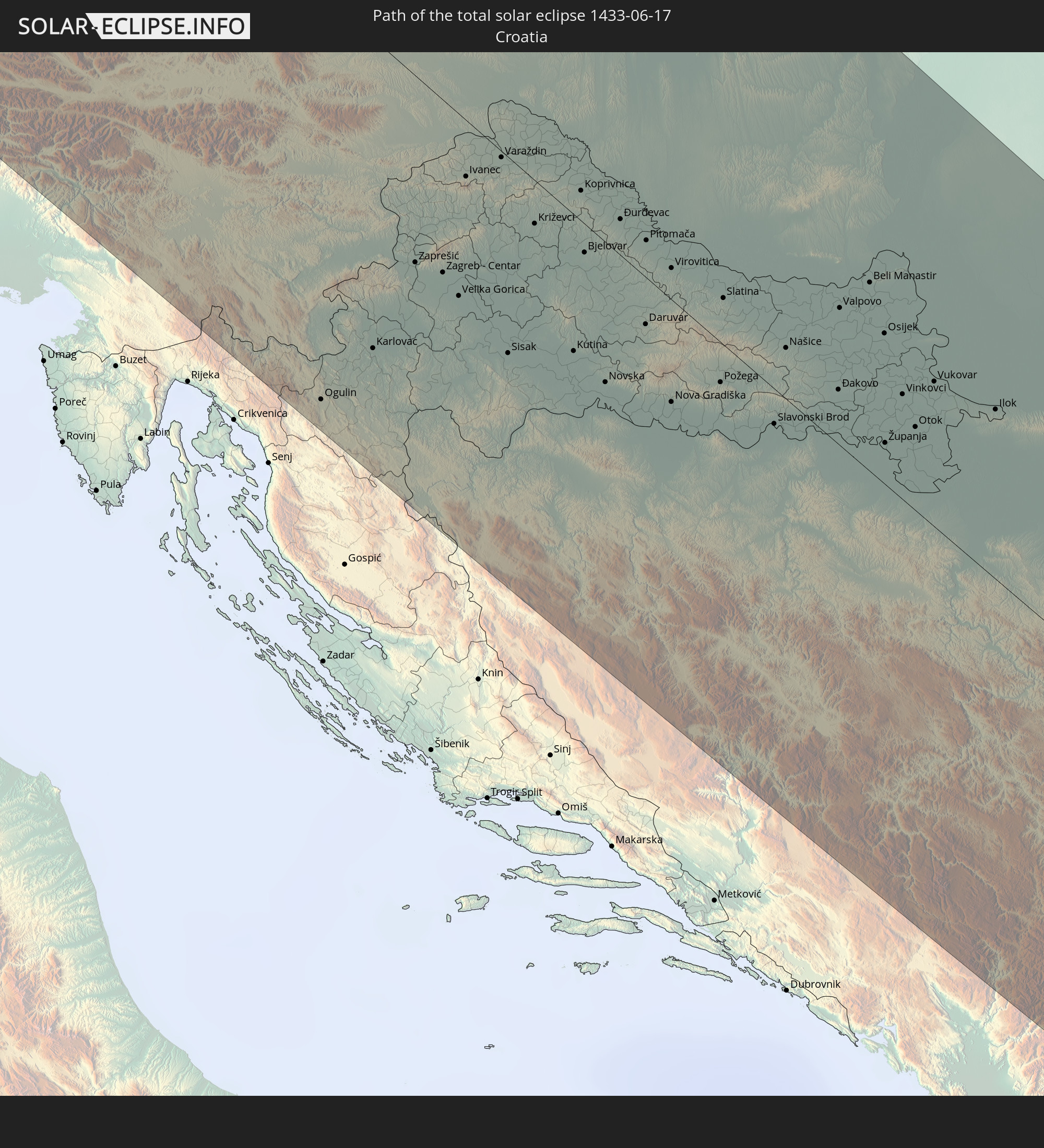 Croatia
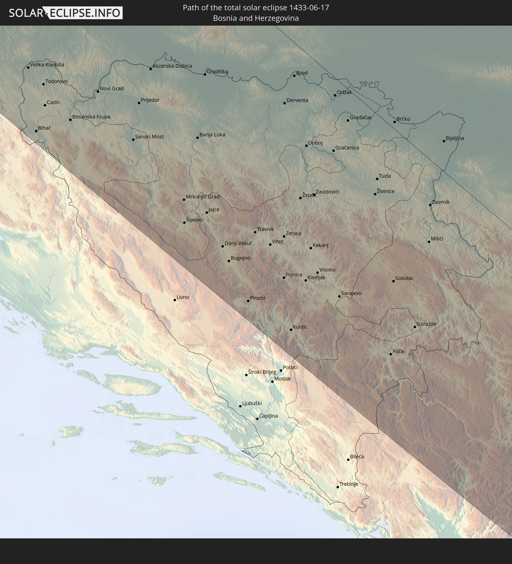 Bosnia and Herzegovina
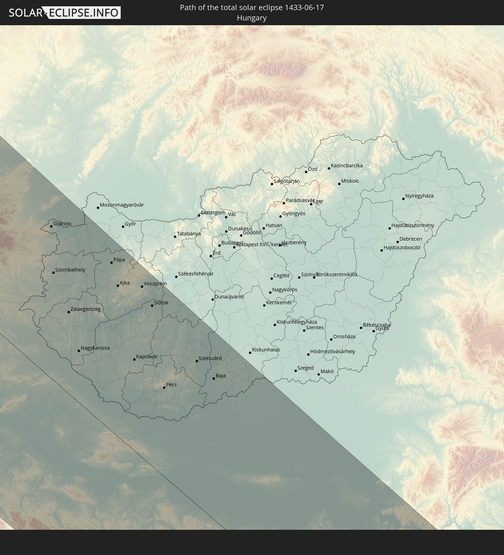 Hungary
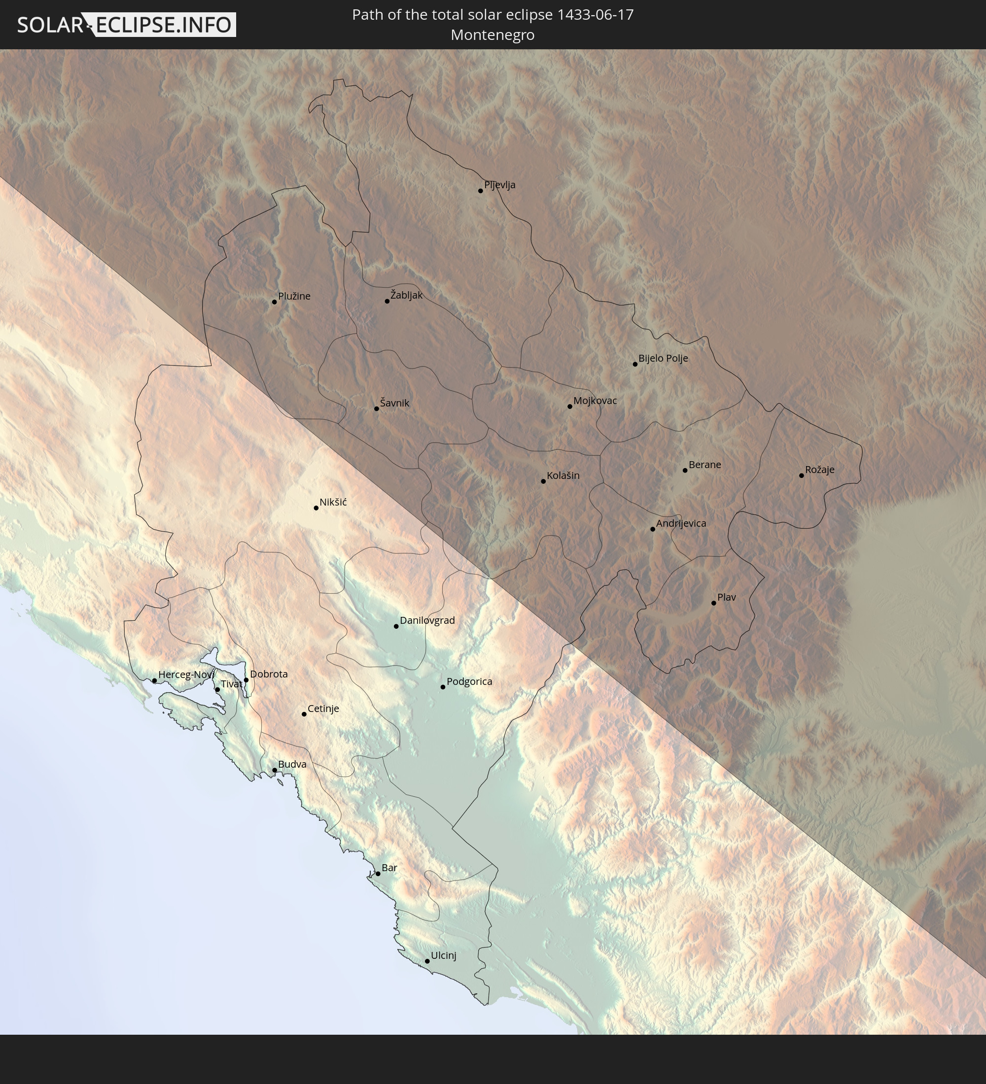 Montenegro
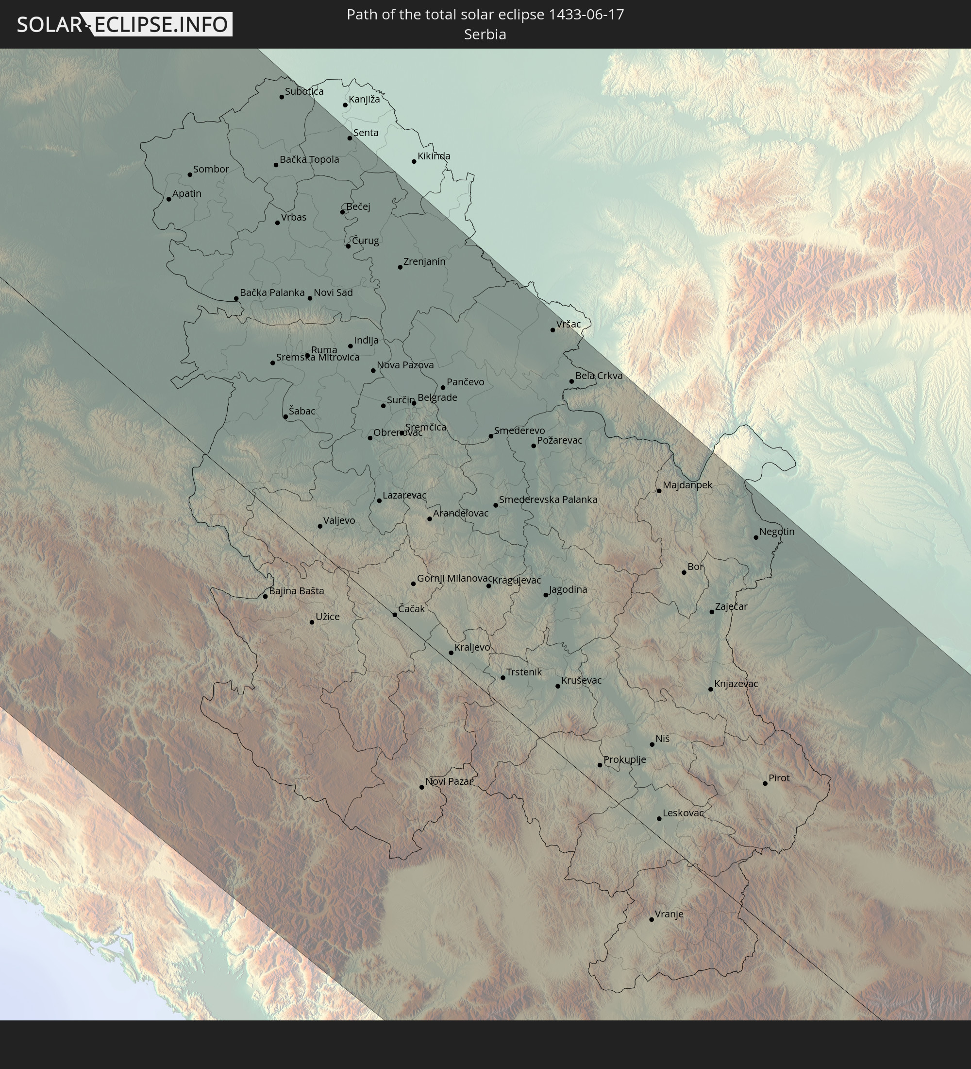 Serbia
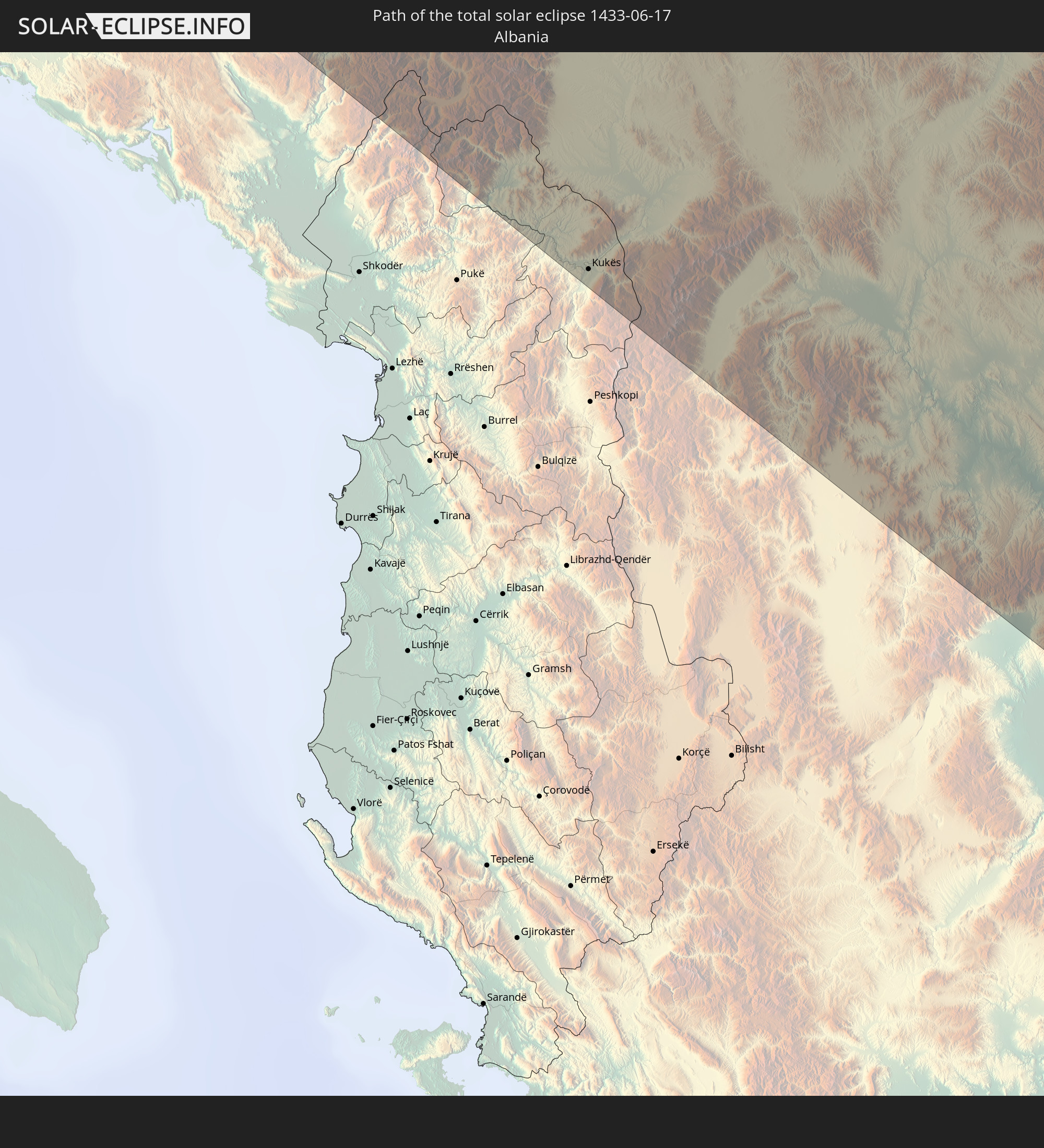 Albania
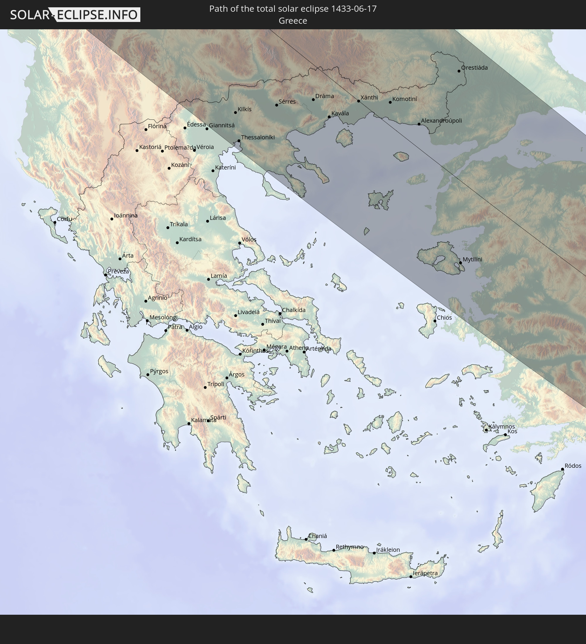 Greece
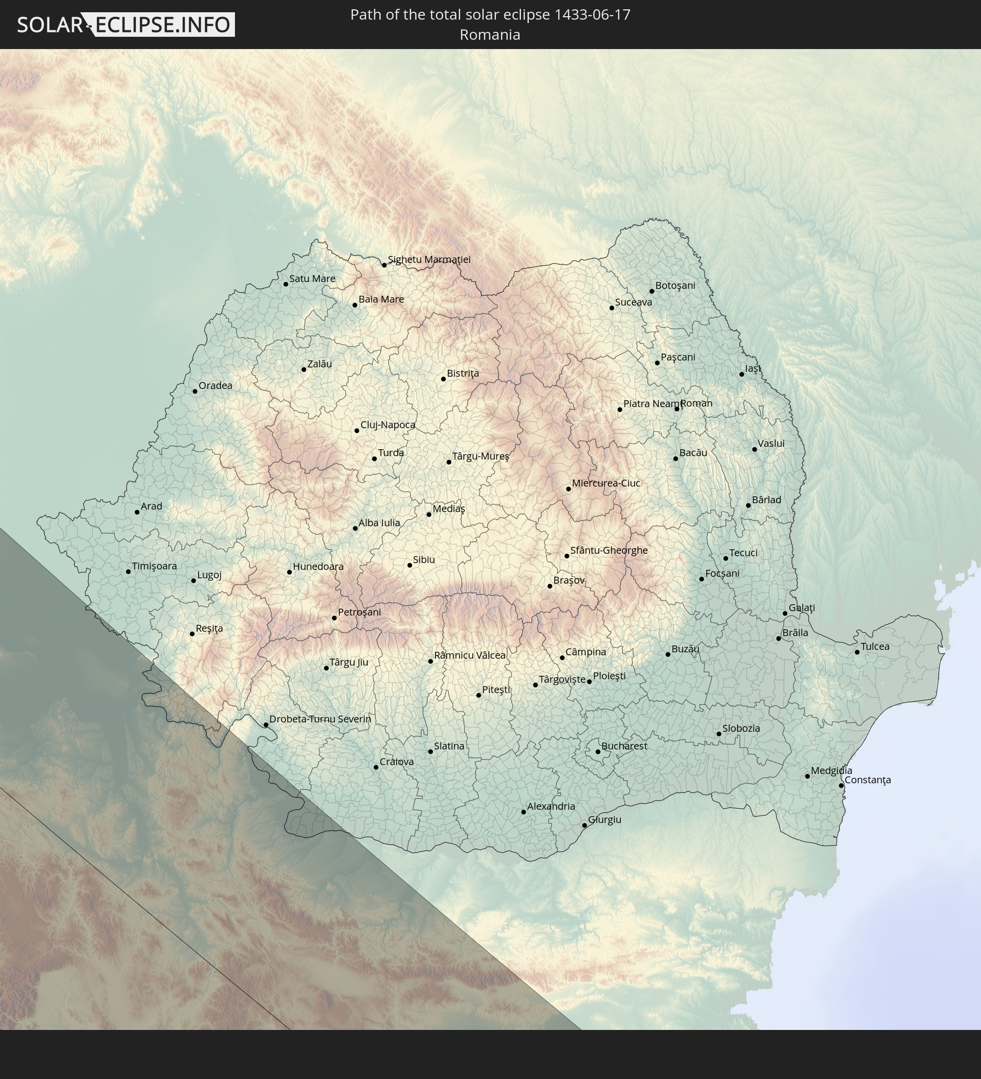 Romania
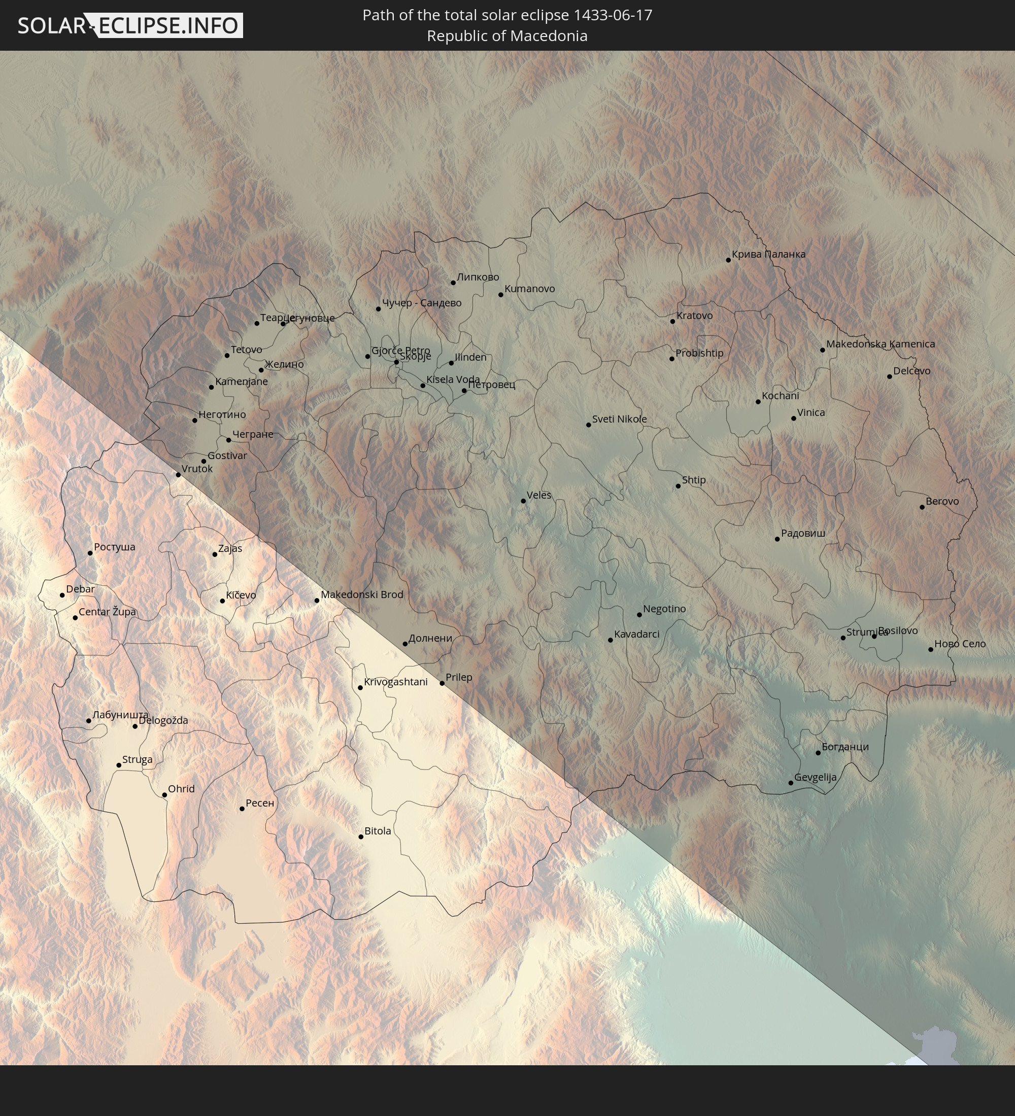 Republic of Macedonia
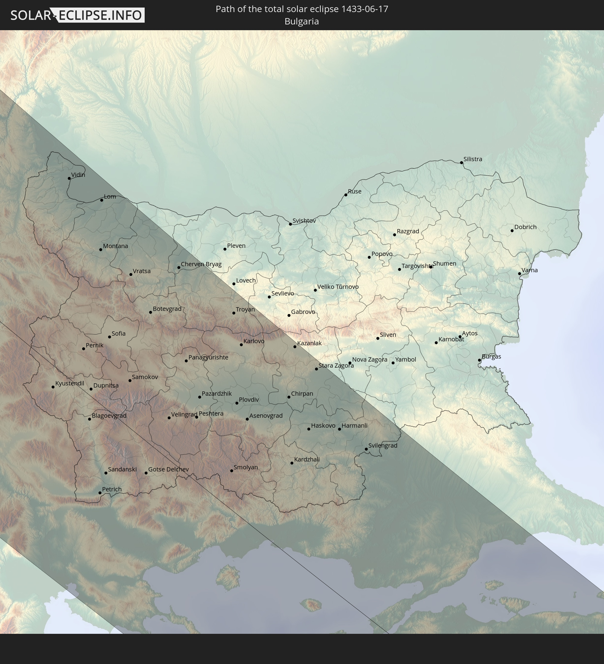 Bulgaria
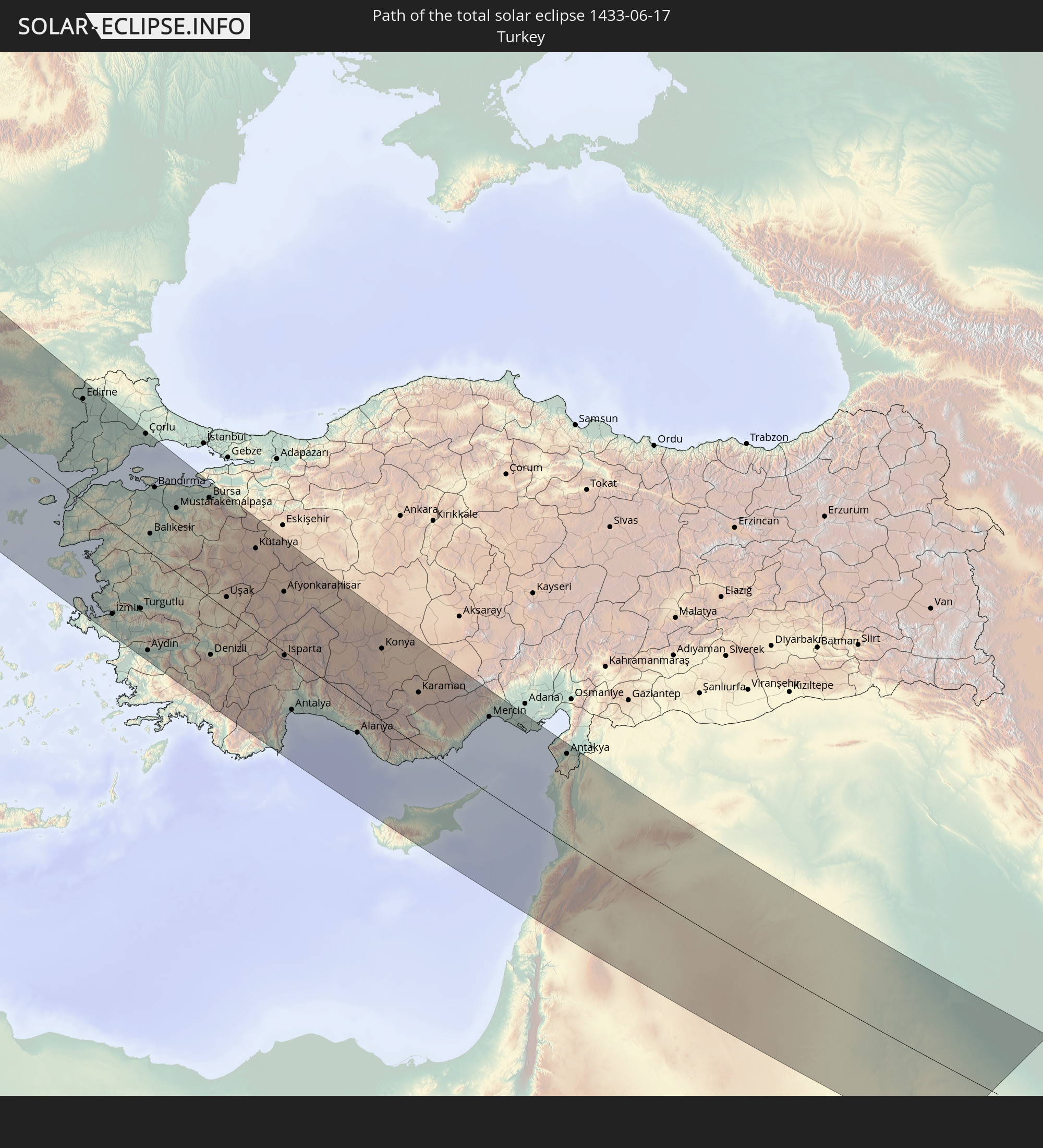 Turkey
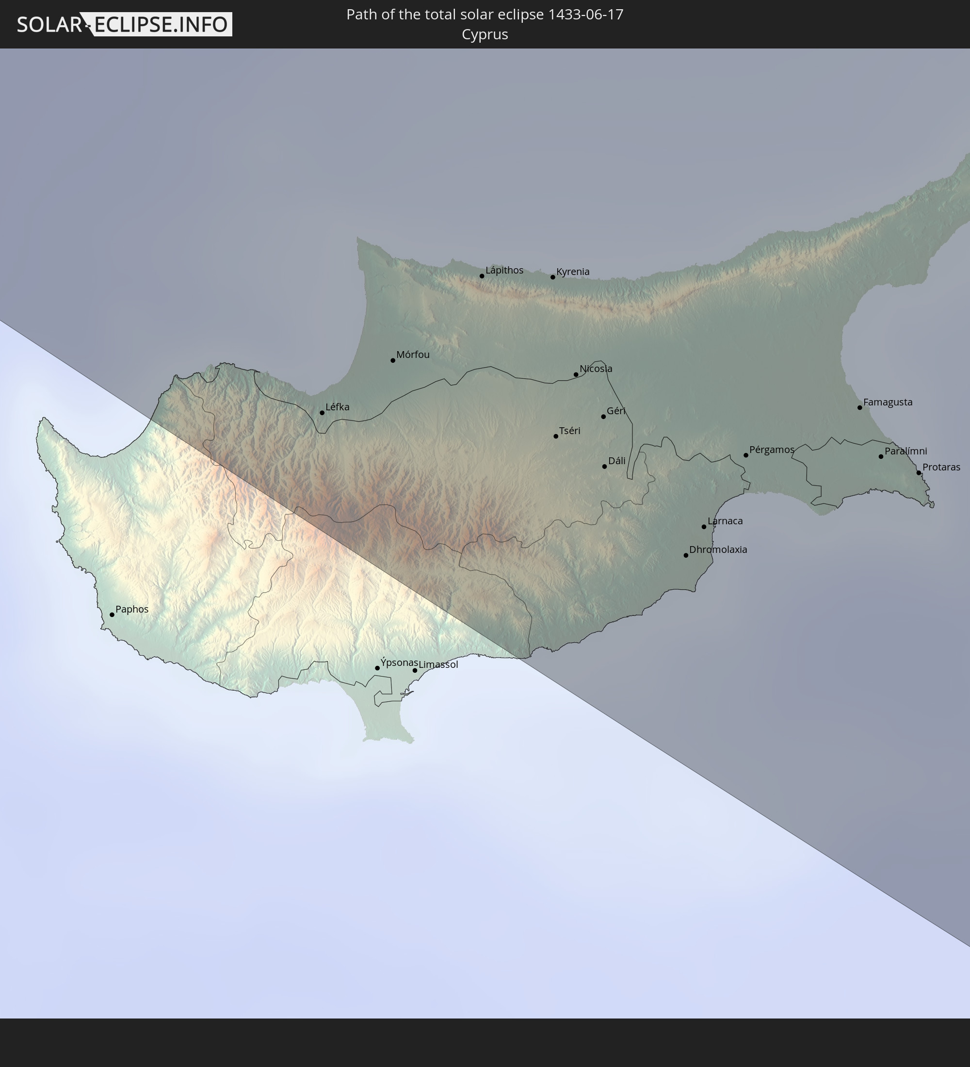 Cyprus
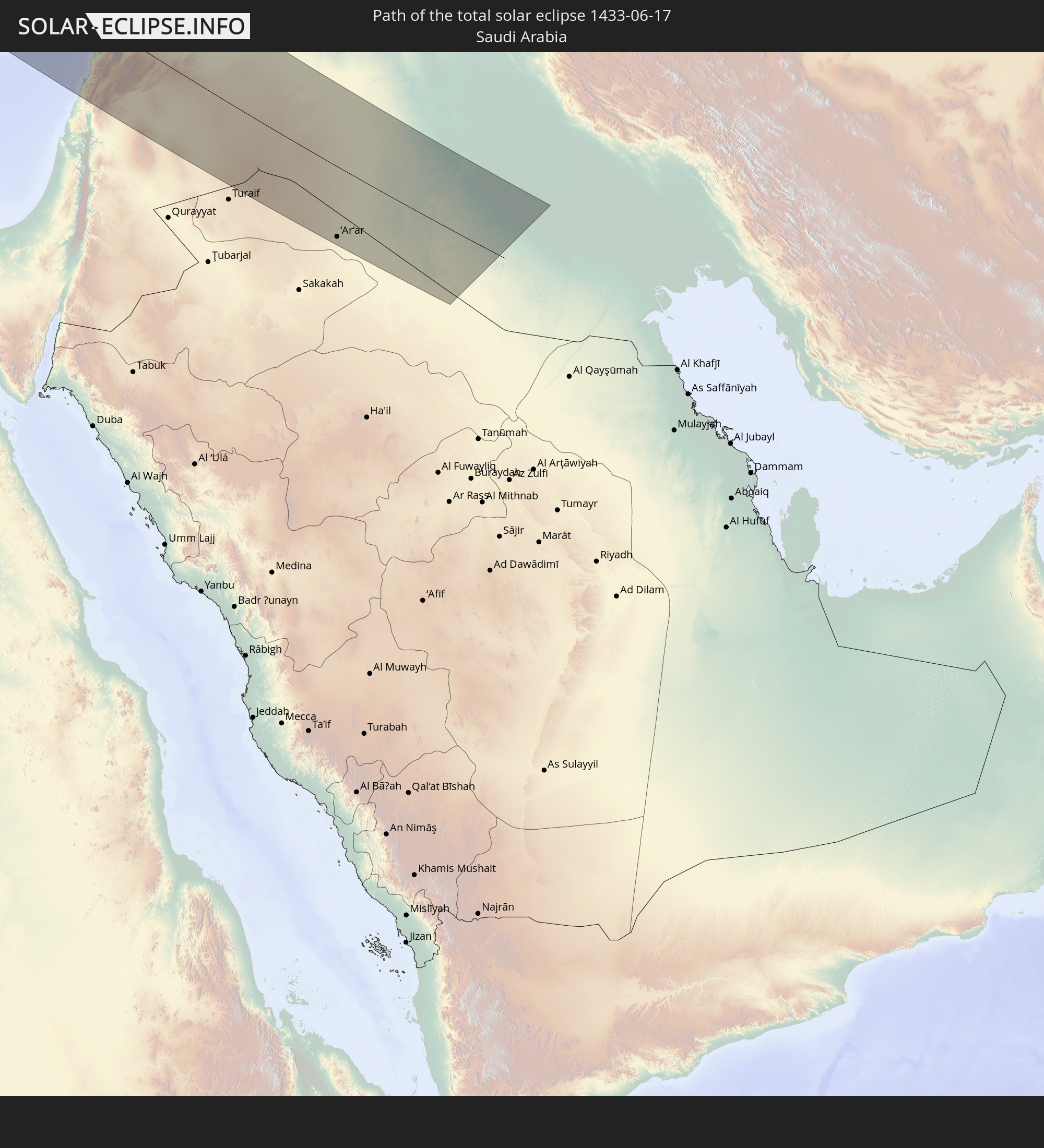 Saudi Arabia
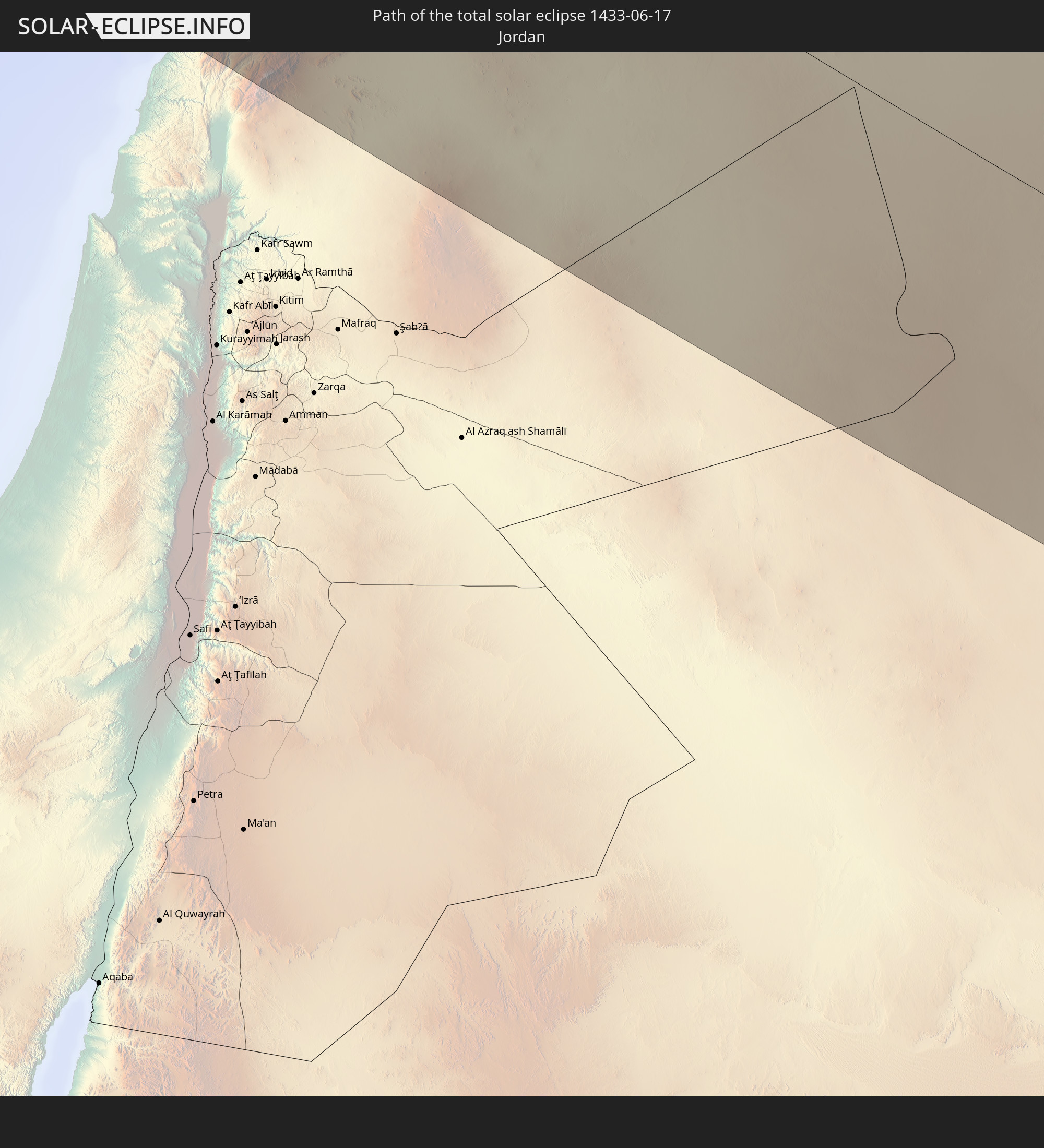 Jordan
 Lebanon
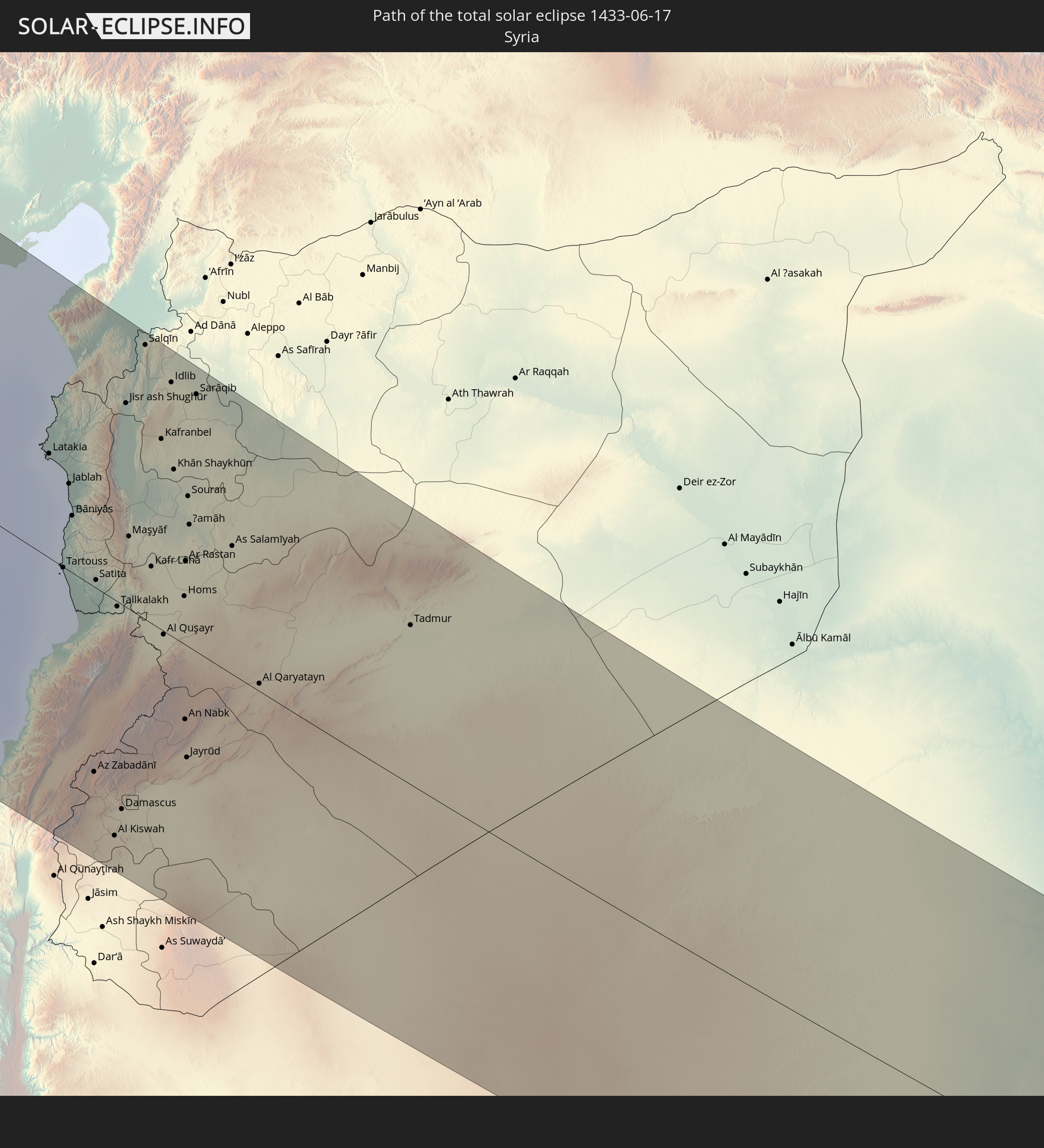 Syria
Syria
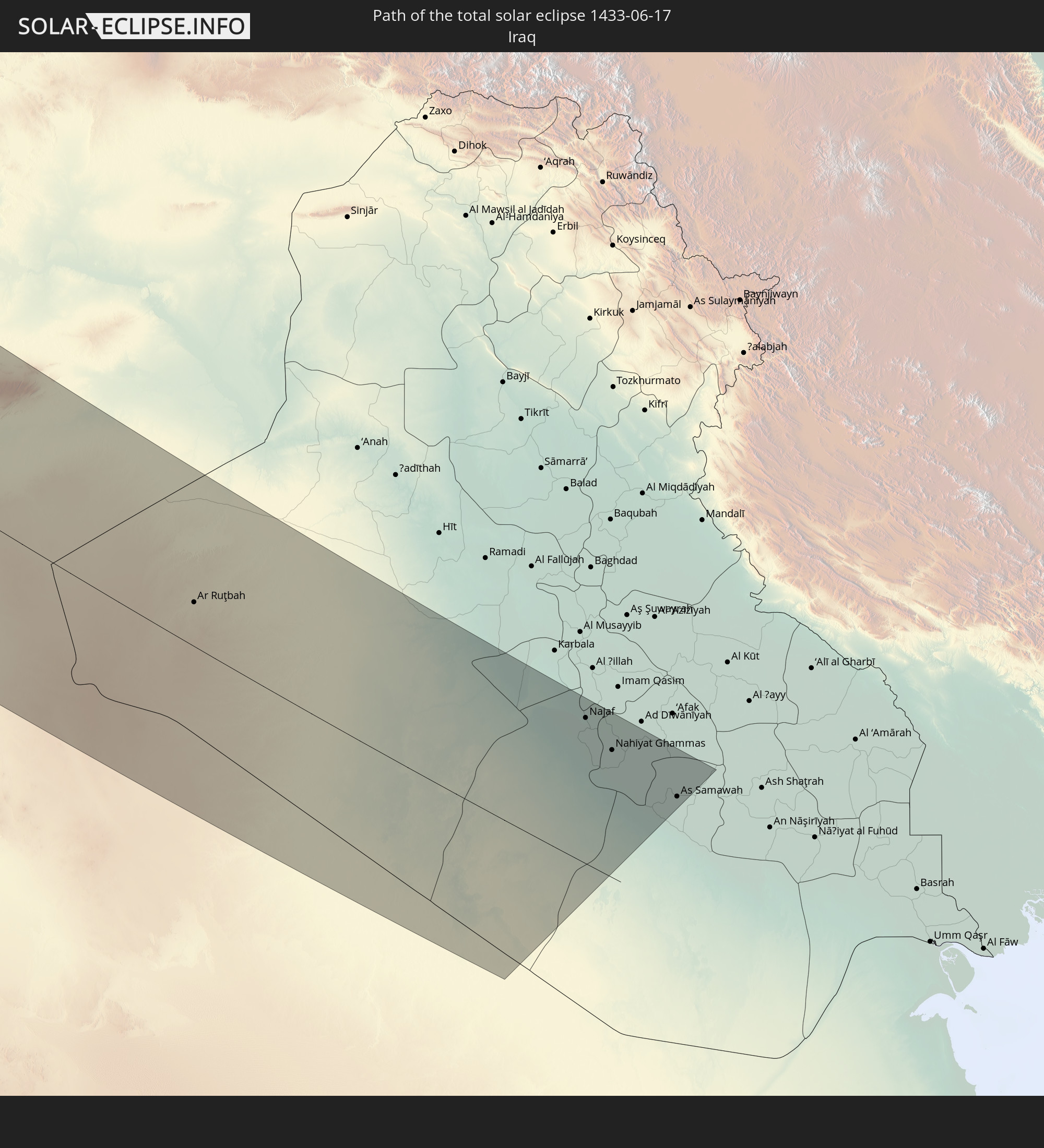 Iraq
Iraq
In den folgenden Ländern ist die Sonnenfinsternis partiell zu sehen
 Russia
 United States
 Canada
 Mexico
 Greenland
 The Bahamas
 Bermuda
 Saint Pierre and Miquelon
 Portugal
 Iceland
 Spain
Spain
 Mauritania
 Morocco
 Mali
Mali
 Republic of Ireland
 Svalbard and Jan Mayen
 Algeria
 United Kingdom
 Faroe Islands
 Burkina Faso
 Gibraltar
 France
 Isle of Man
 Guernsey
 Jersey
 Togo
Togo
 Niger
Niger
 Benin
Benin
 Andorra
 Belgium
 Nigeria
 Netherlands
 Norway
 Luxembourg
 Germany
 Switzerland
 Italy
Italy
 Monaco
 Tunisia
 Denmark
 Cameroon
 Libya
Libya
 Liechtenstein
 Austria
 Sweden
 Republic of the Congo
 Czechia
 Democratic Republic of the Congo
 San Marino
 Vatican City
 Slovenia
 Chad
Chad
 Croatia
 Poland
 Malta
Malta
 Central African Republic
 Bosnia and Herzegovina
 Hungary
 Slovakia
 Montenegro
 Serbia
 Albania
 Åland Islands
 Greece
 Romania
 Republic of Macedonia
 Finland
 Lithuania
 Latvia
 Estonia
 Sudan
Sudan
 Ukraine
 Bulgaria
 Belarus
 Egypt
Egypt
 Turkey
 Moldova
 Cyprus
 State of Palestine
 Israel
 Saudi Arabia
 Jordan
 Lebanon
 Syria
Syria
 Iraq
Iraq
 Georgia
 Armenia
 Iran
Iran
 Azerbaijan
 Kazakhstan
 Turkmenistan
 Uzbekistan
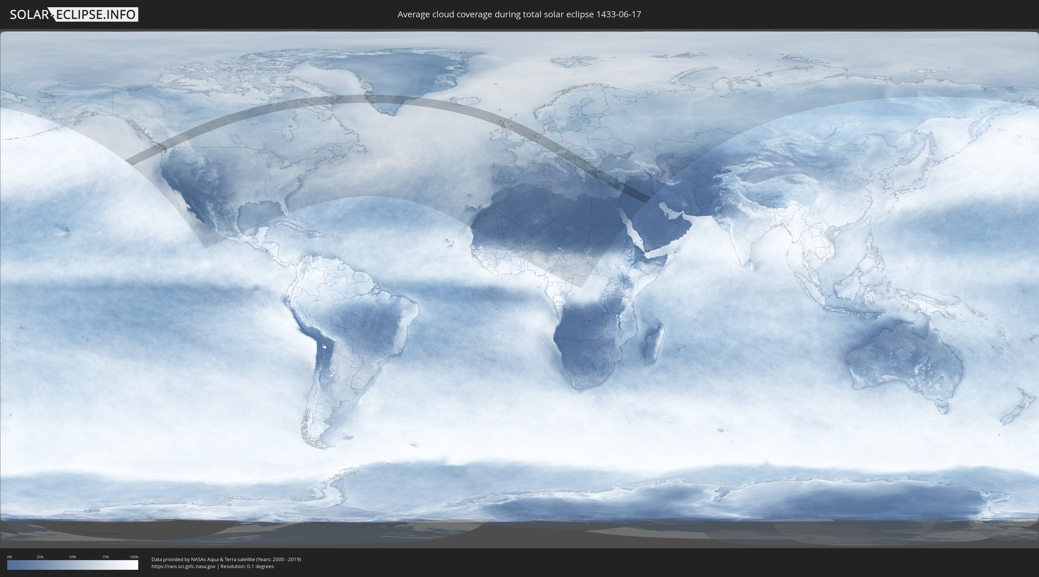
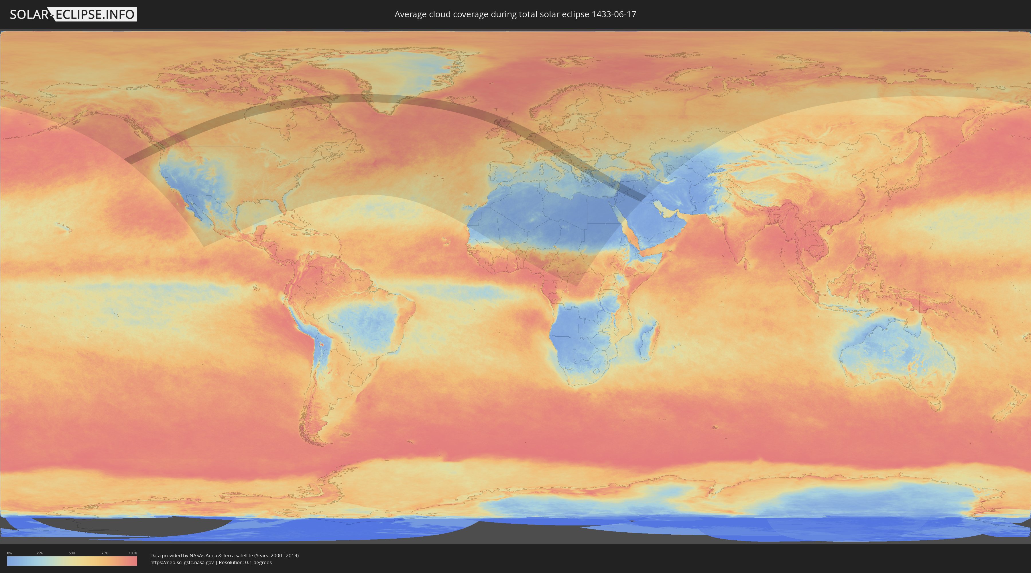
How will be the weather during the total solar eclipse on 06/17/1433?
Where is the best place to see the total solar eclipse of 06/17/1433?
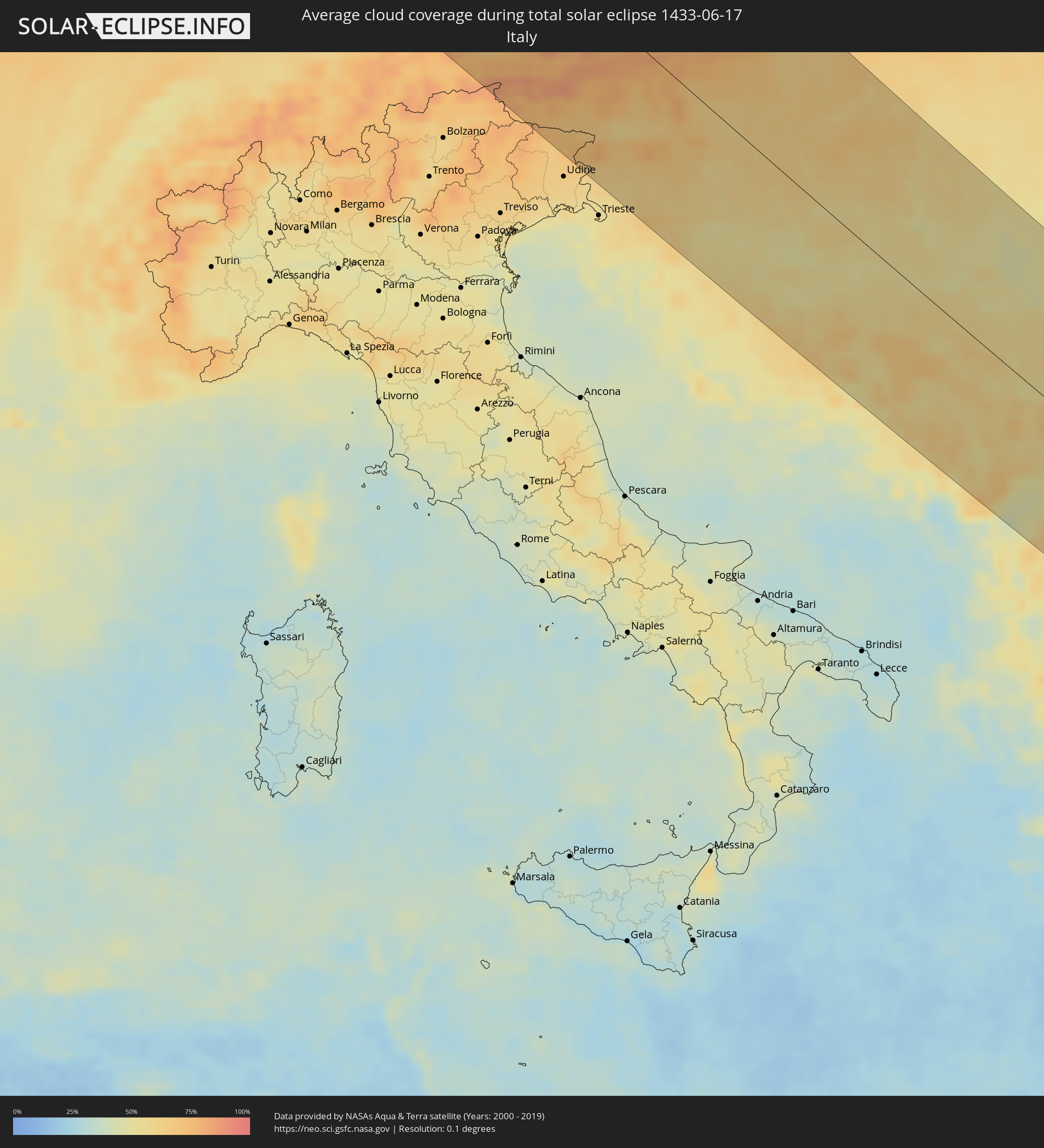
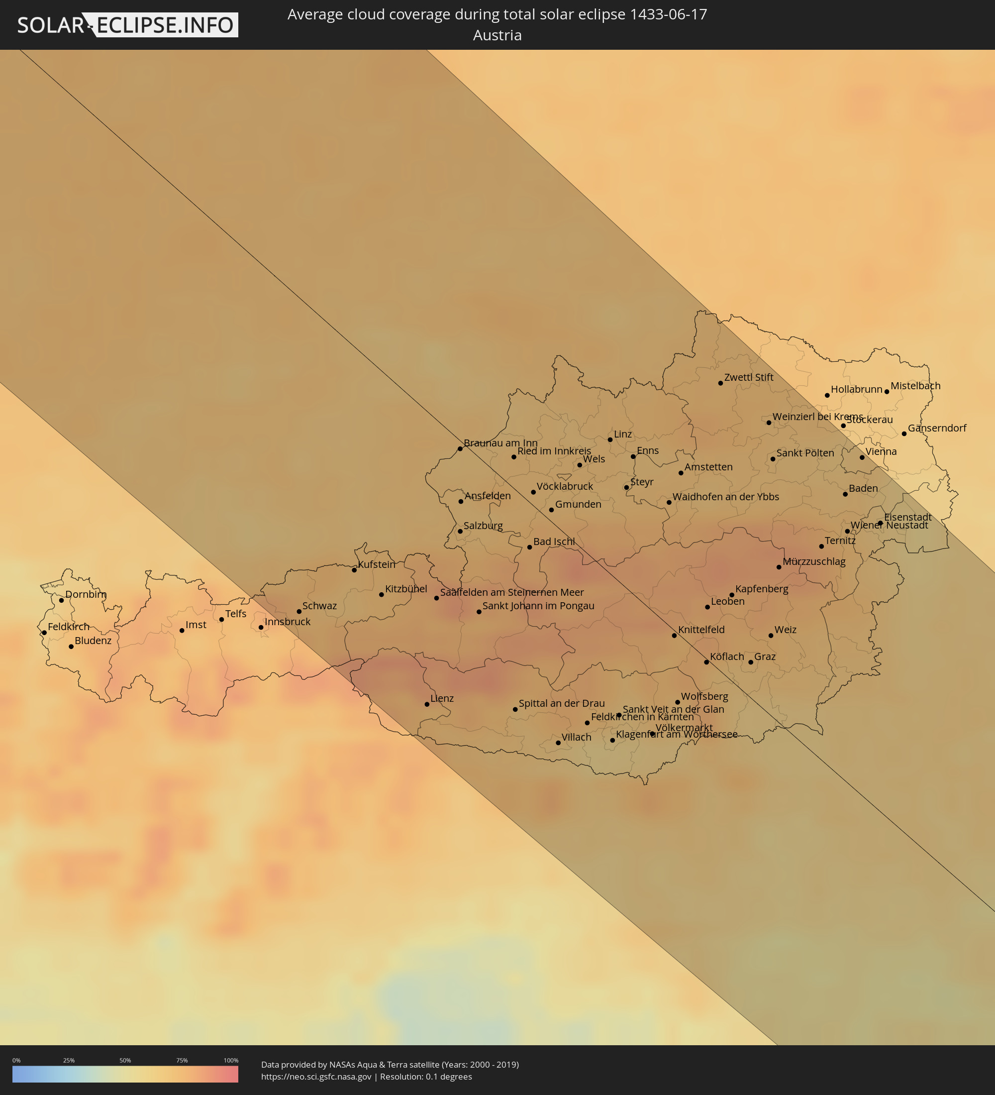
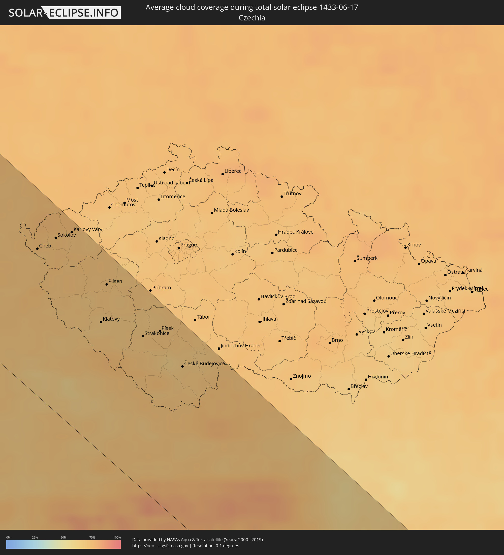
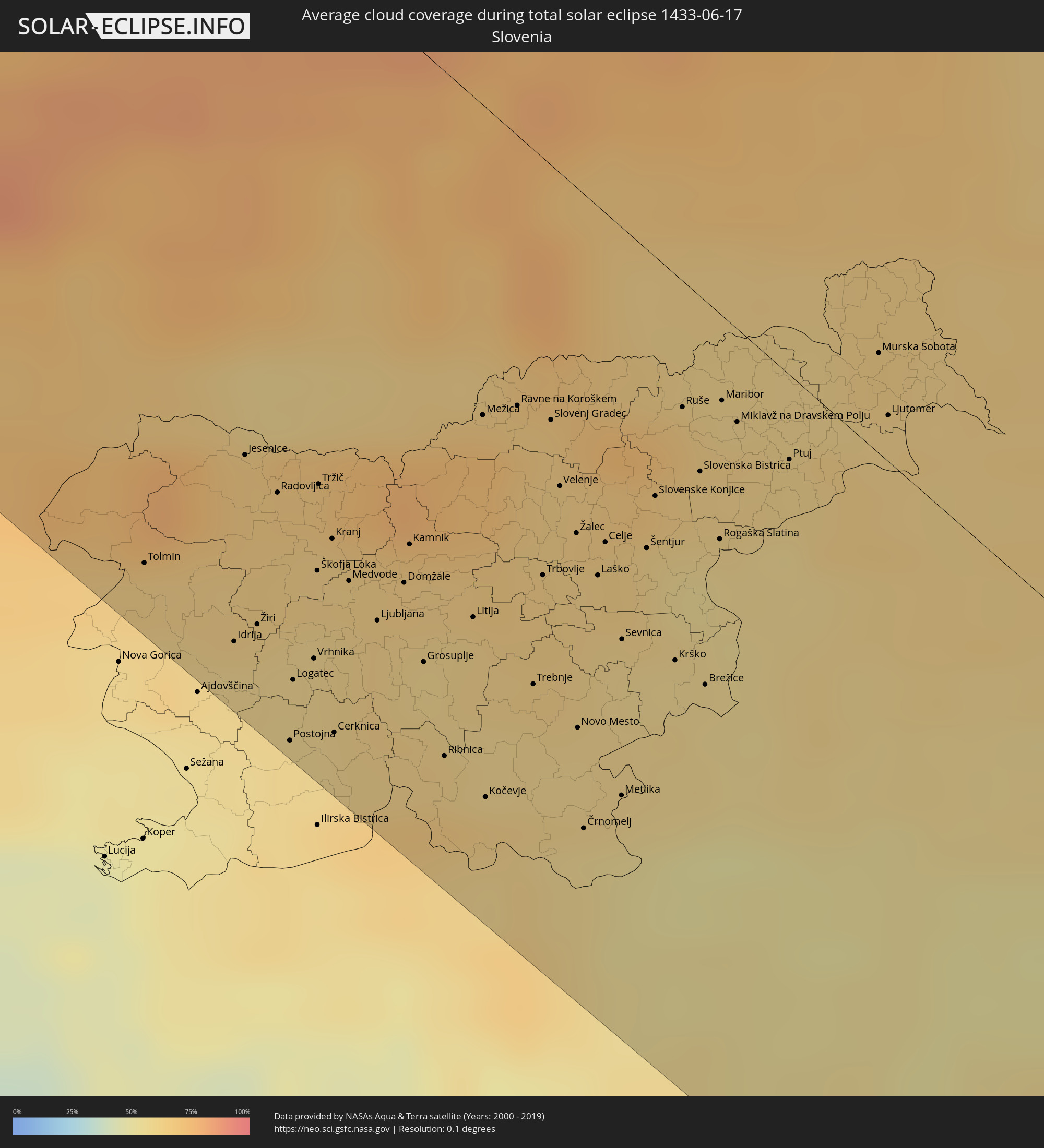
The following maps show the average cloud coverage for the day of the total solar eclipse.
With the help of these maps, it is possible to find the place along the eclipse path, which has the best
chance of a cloudless sky.
Nevertheless, you should consider local circumstances and inform about the weather of your chosen
observation site.
The data is provided by NASAs satellites
AQUA and TERRA.
The cloud maps are averaged over a period of 19 years (2000 - 2019).
Detailed country maps
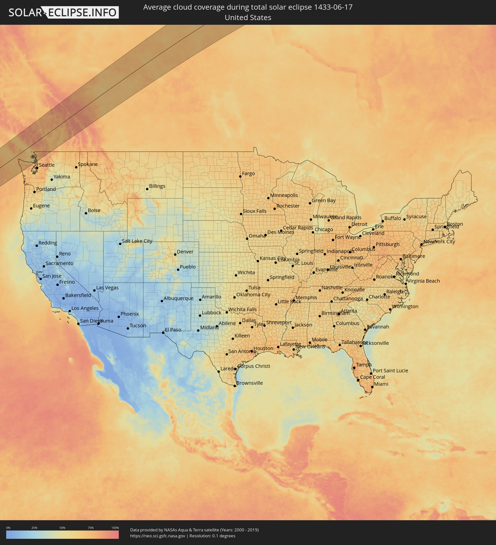 United States
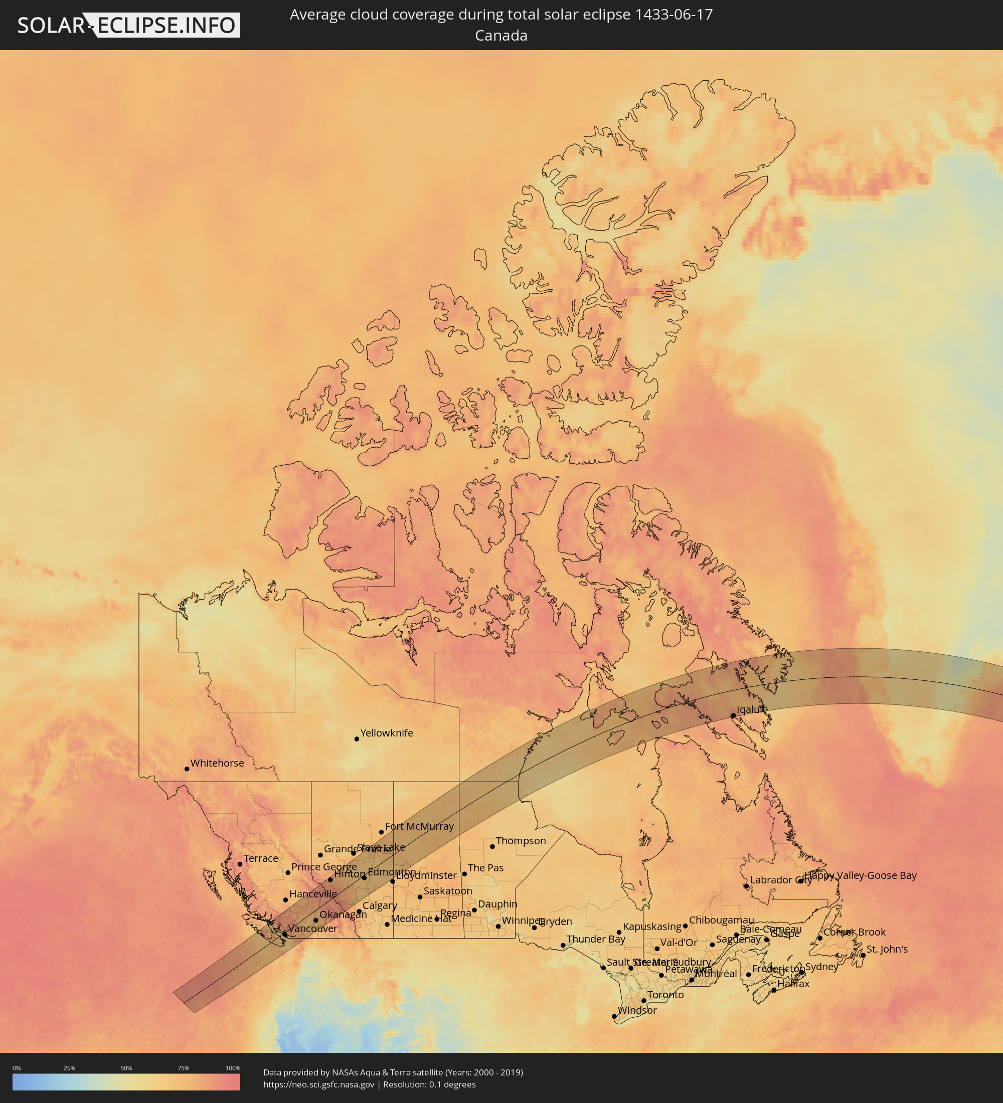 Canada
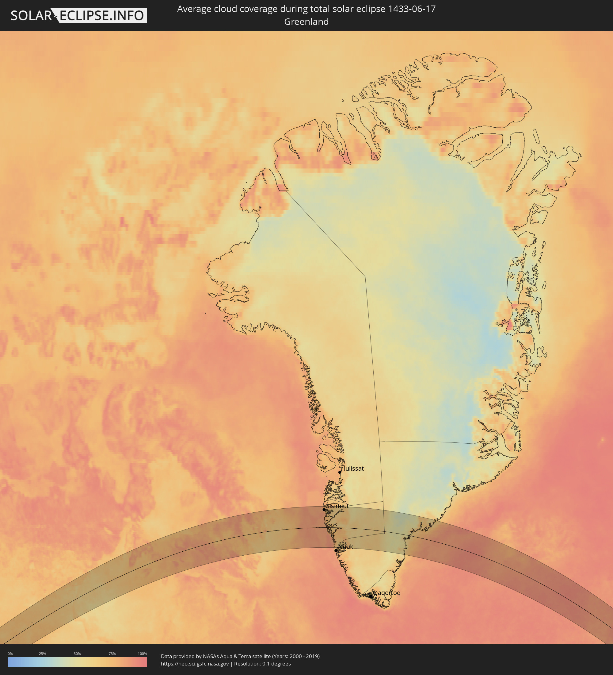 Greenland
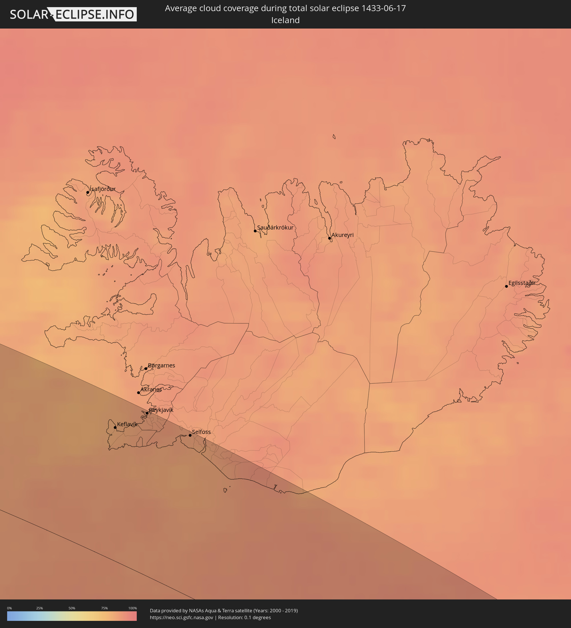 Iceland
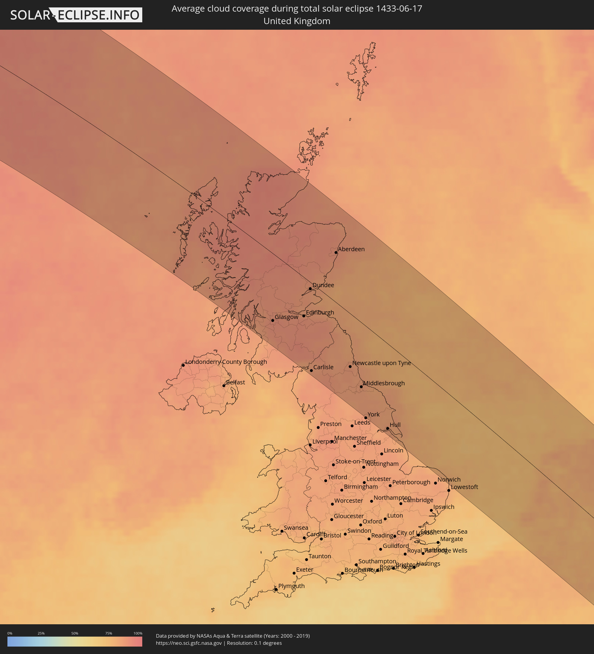 United Kingdom
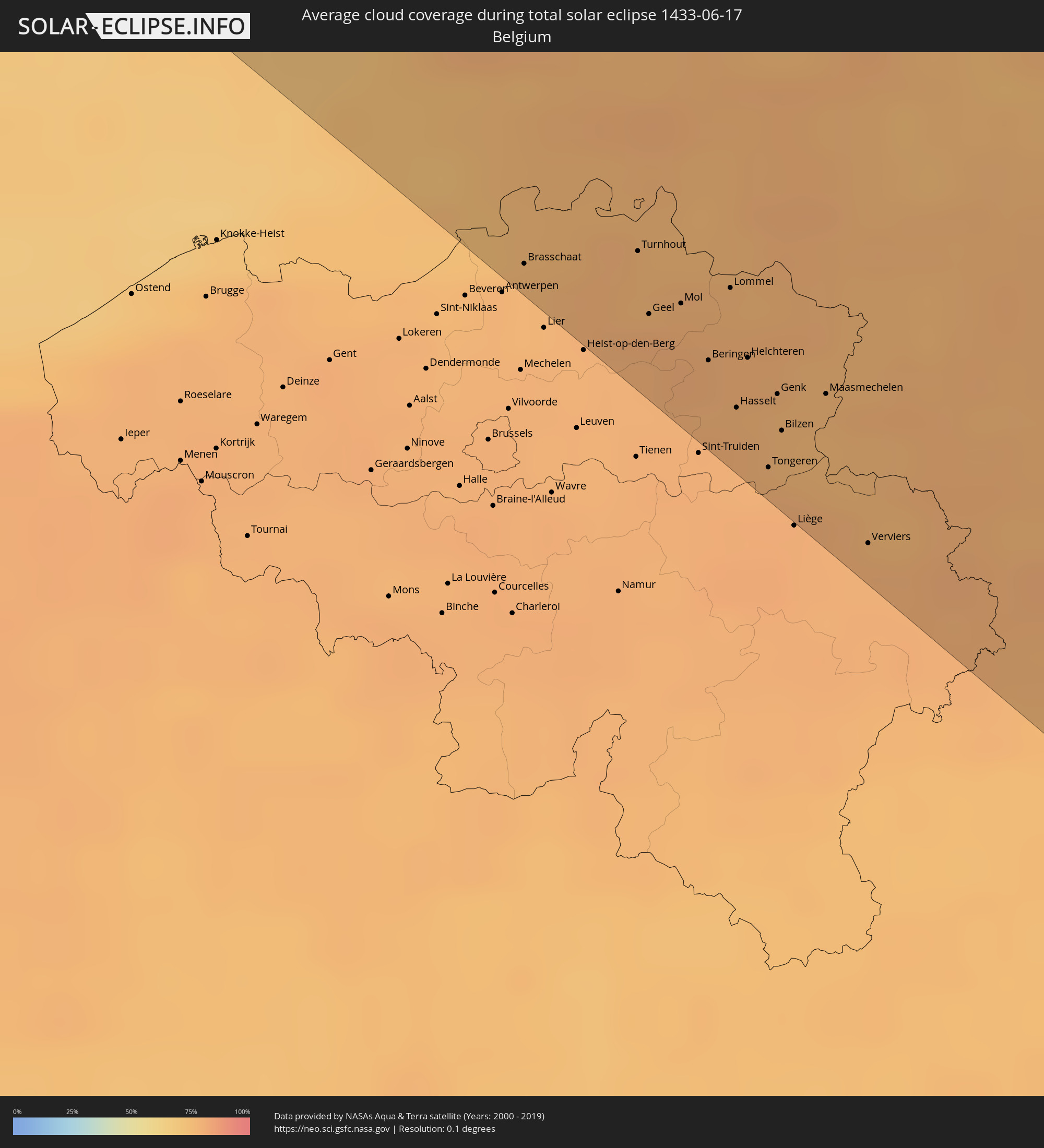 Belgium
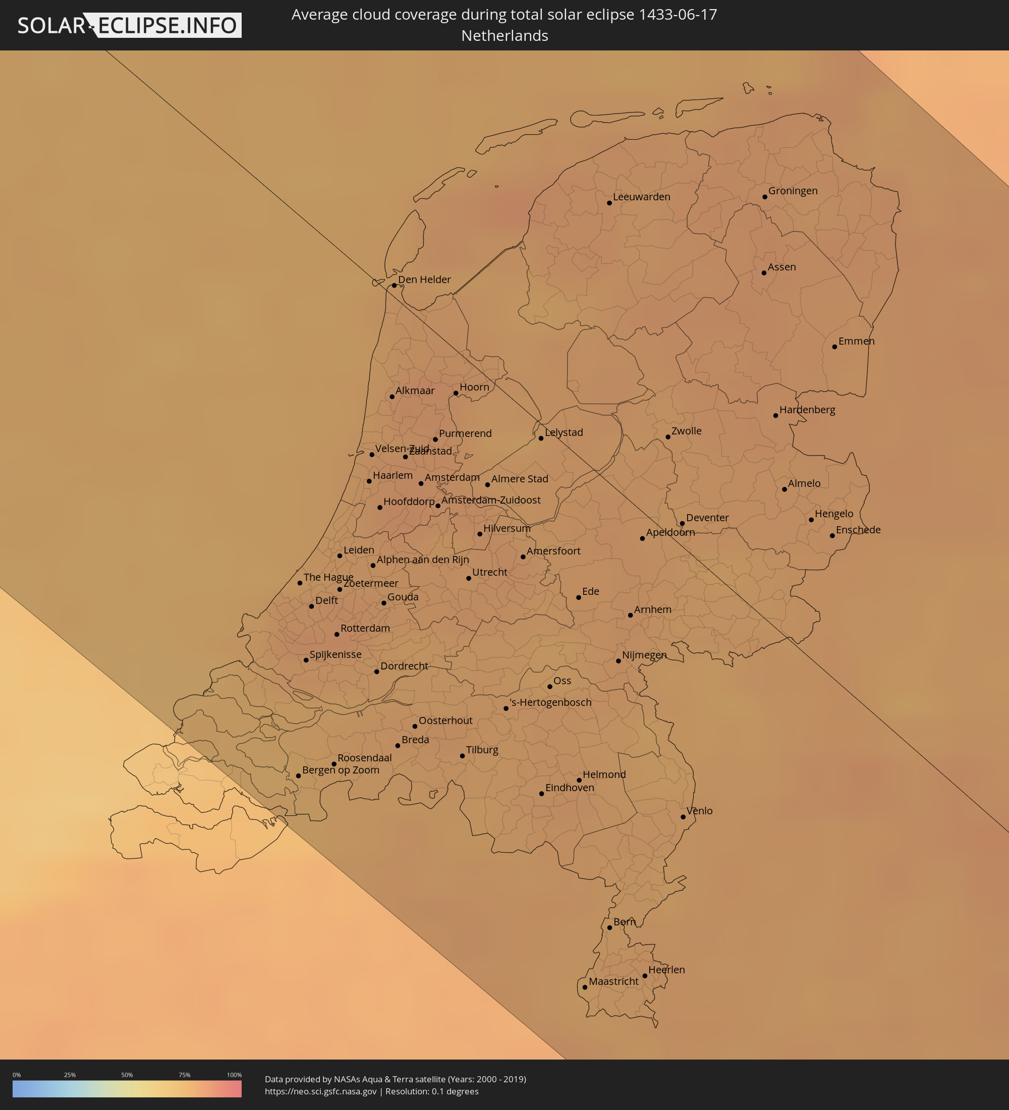 Netherlands
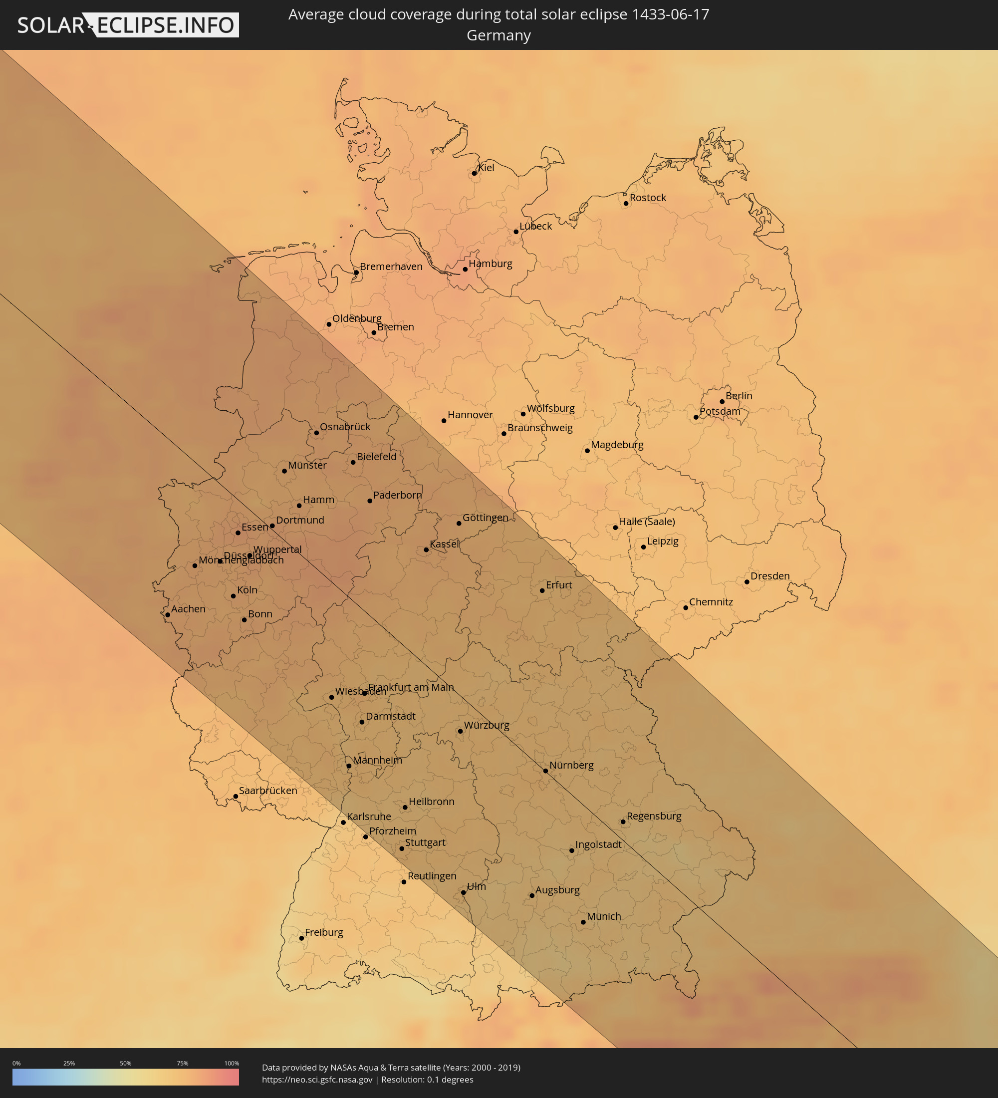 Germany
 Italy
Italy
 Austria
 Czechia
 Slovenia
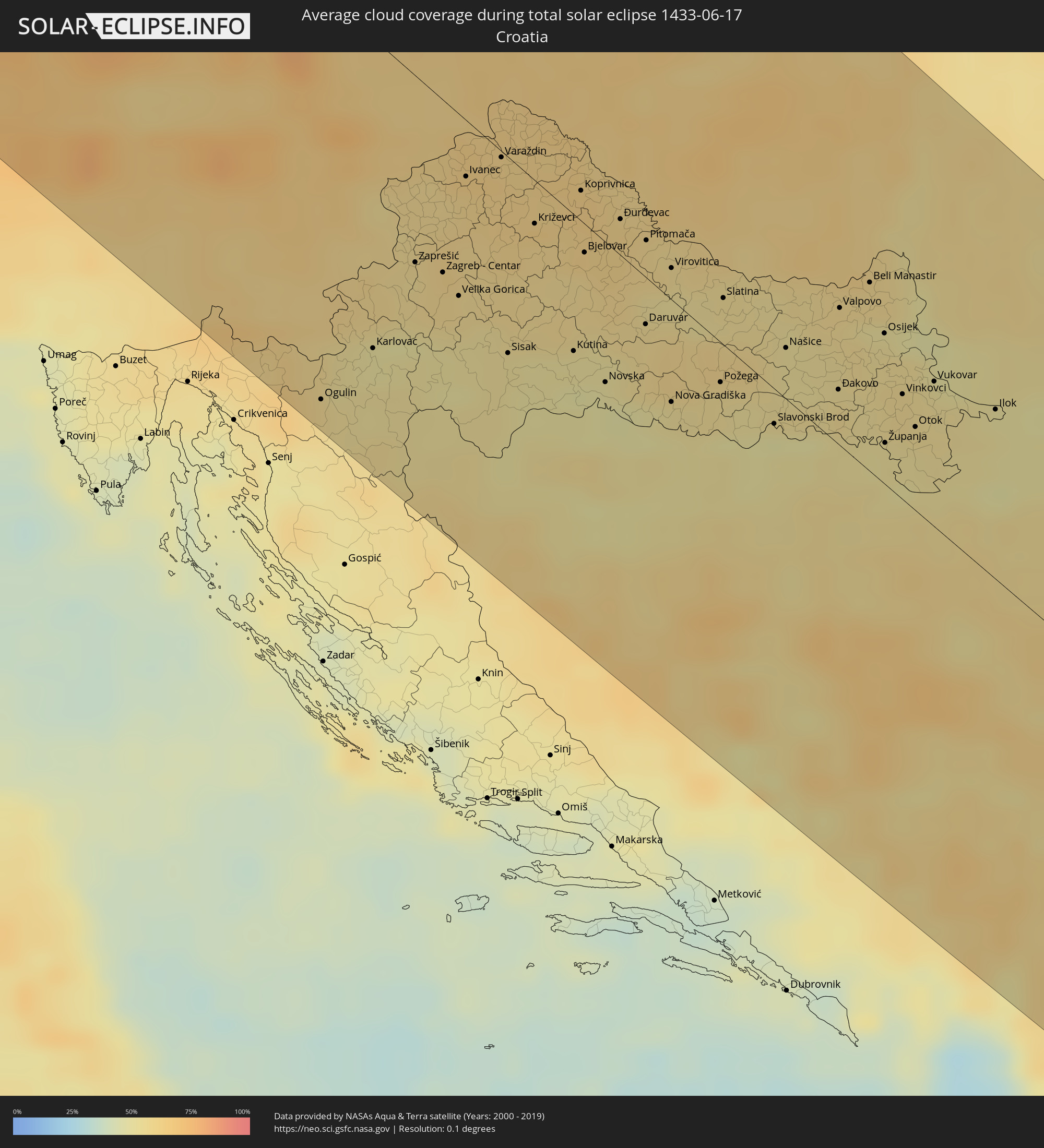 Croatia
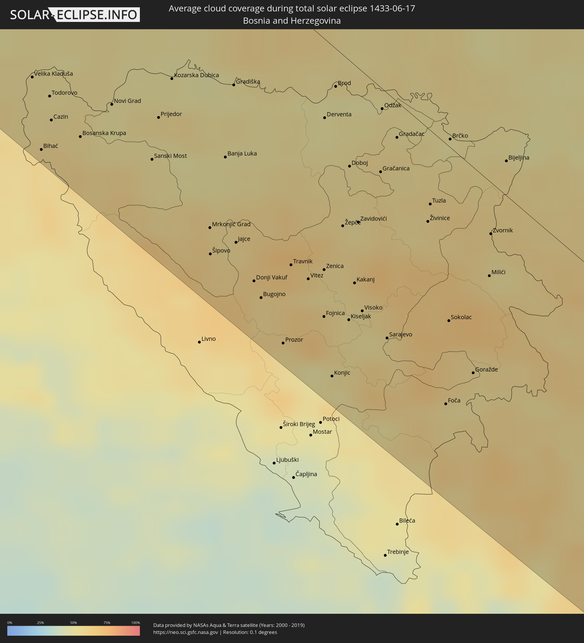 Bosnia and Herzegovina
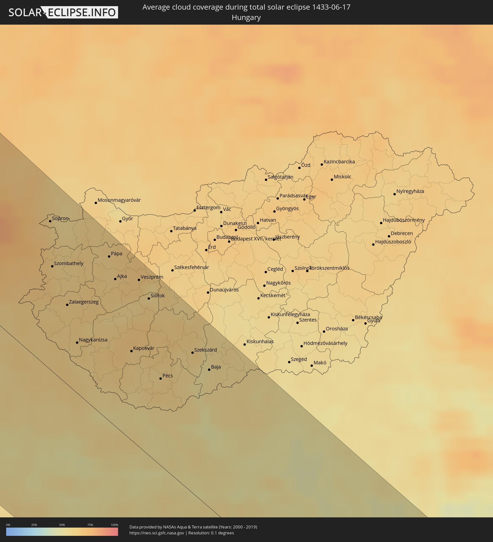 Hungary
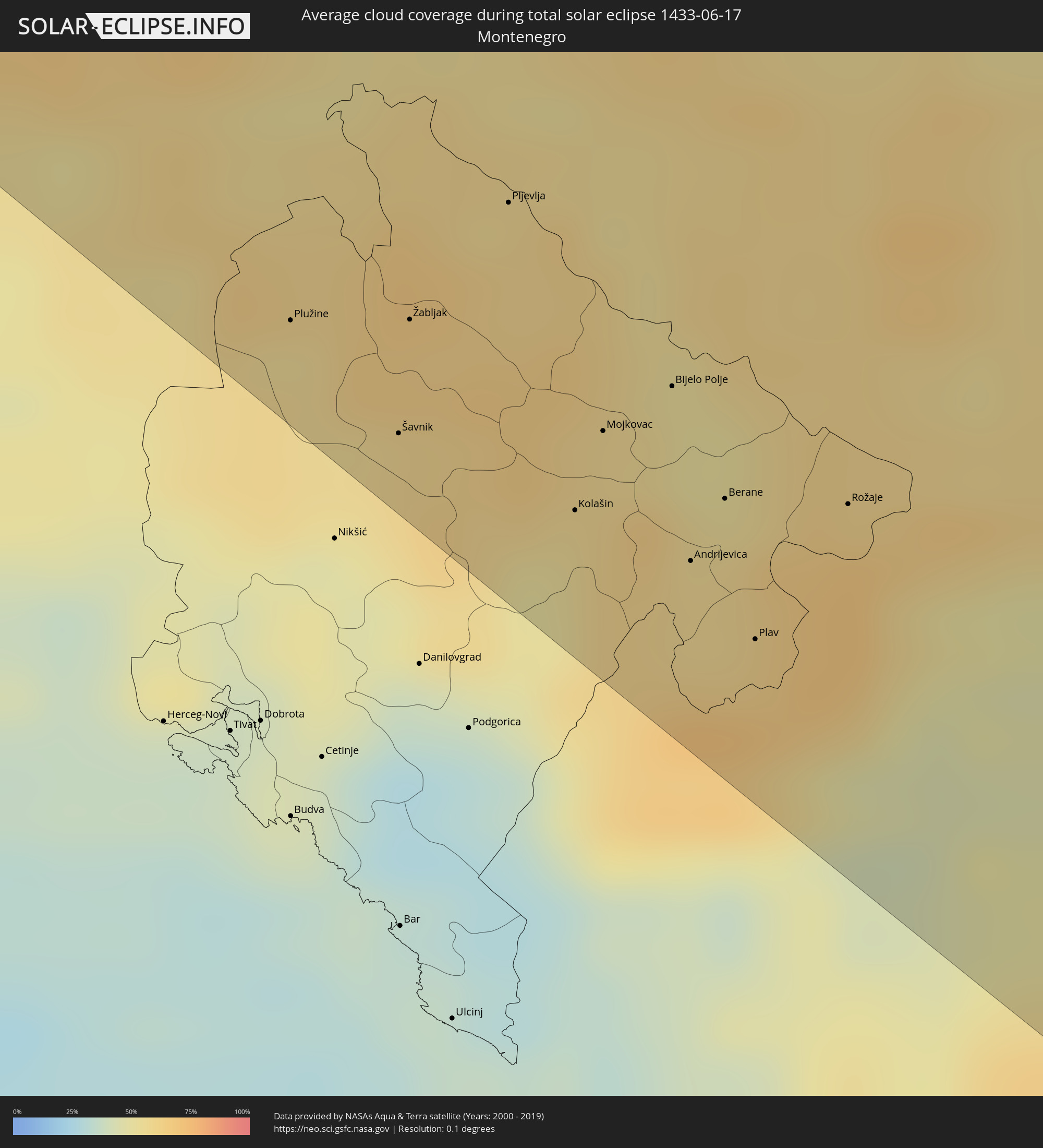 Montenegro
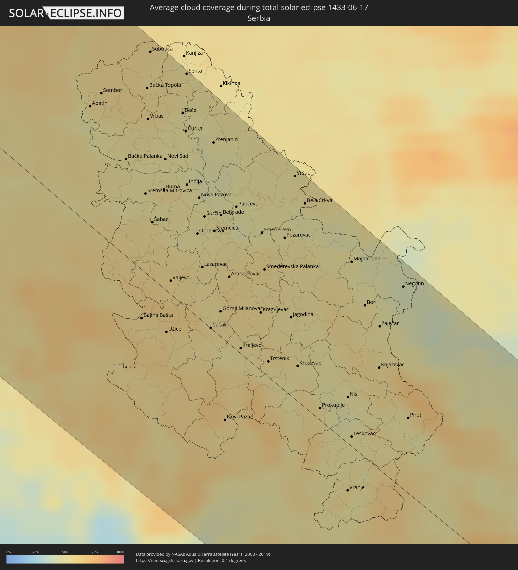 Serbia
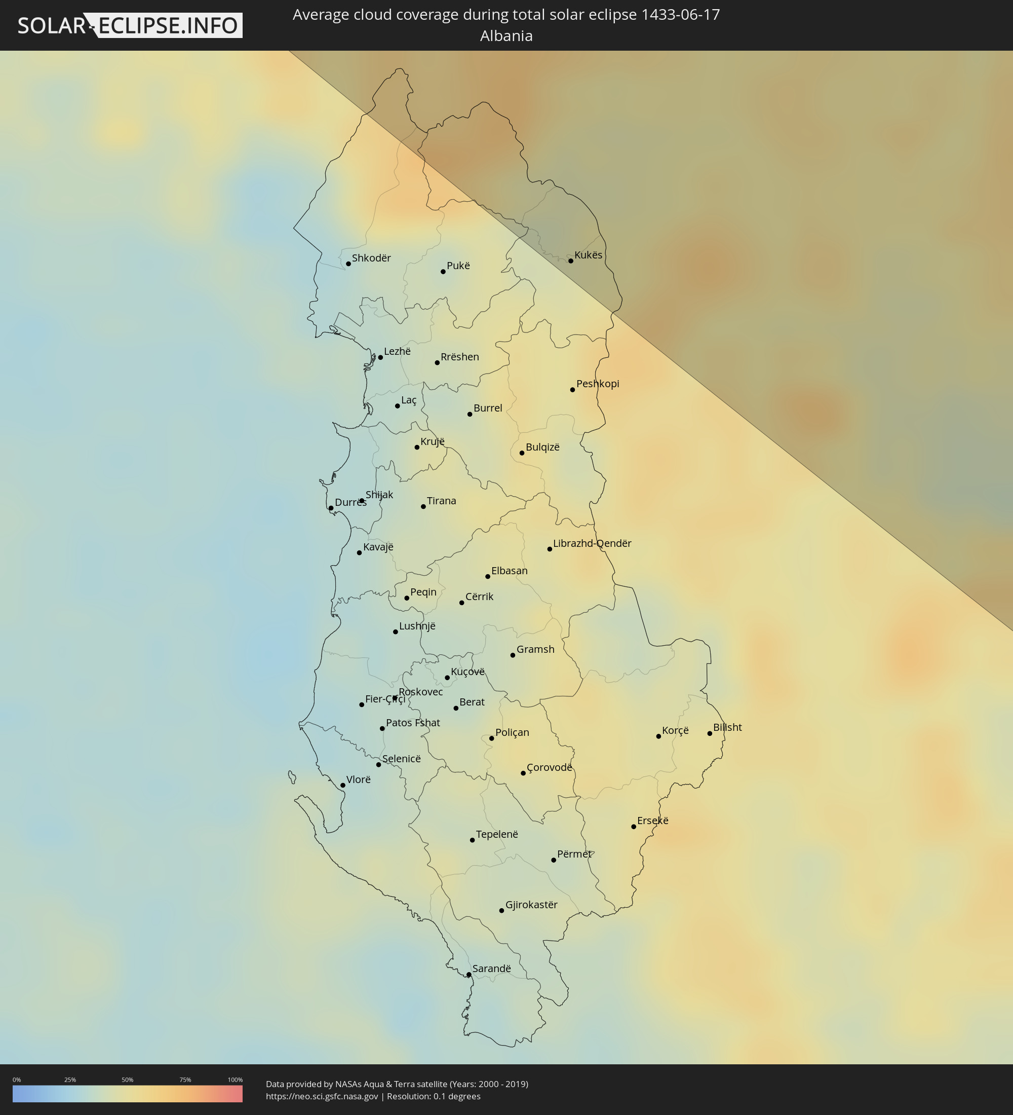 Albania
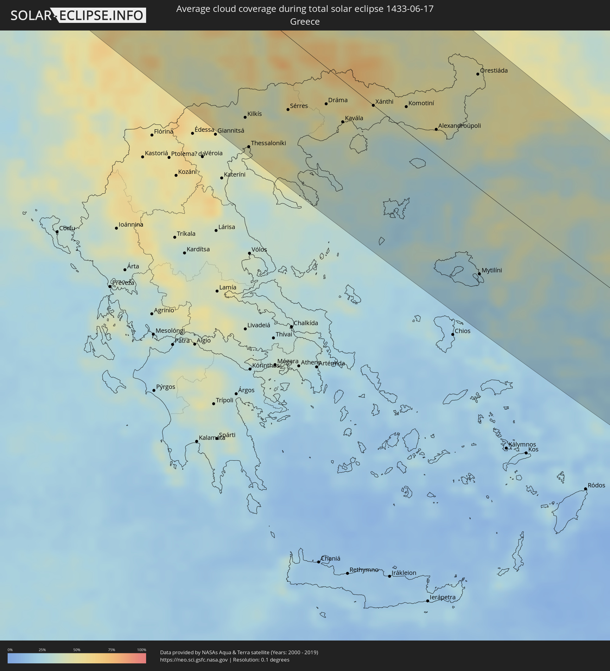 Greece
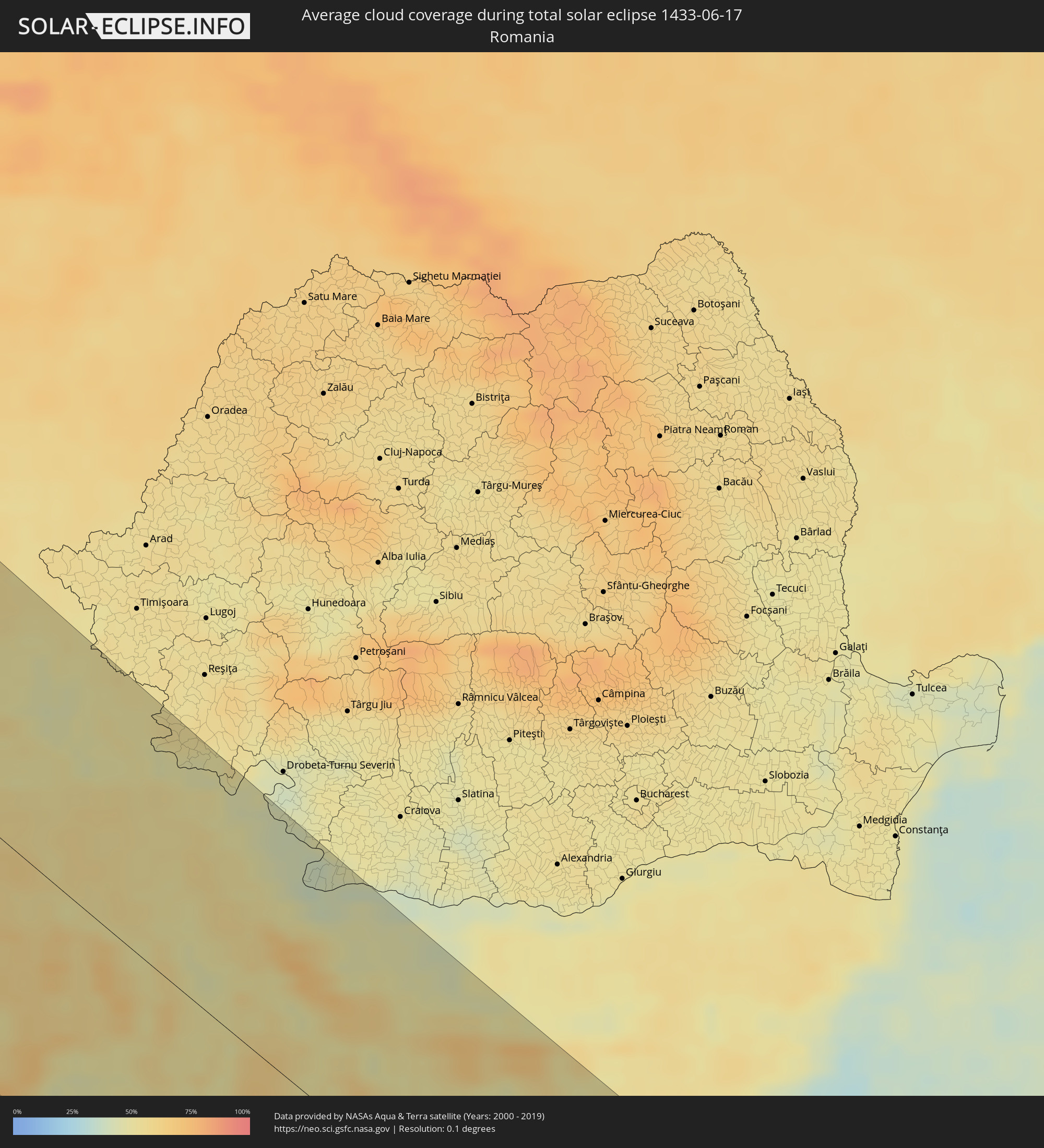 Romania
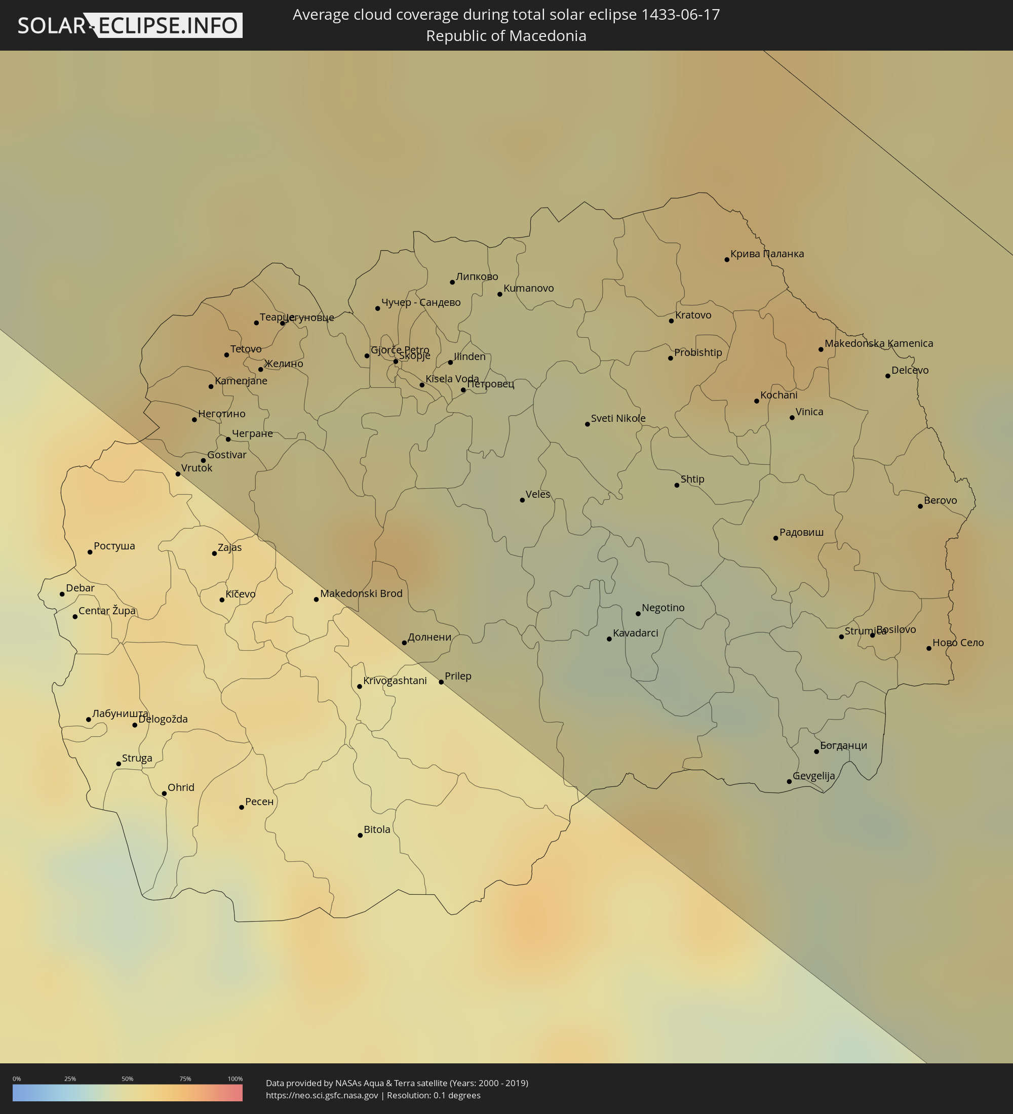 Republic of Macedonia
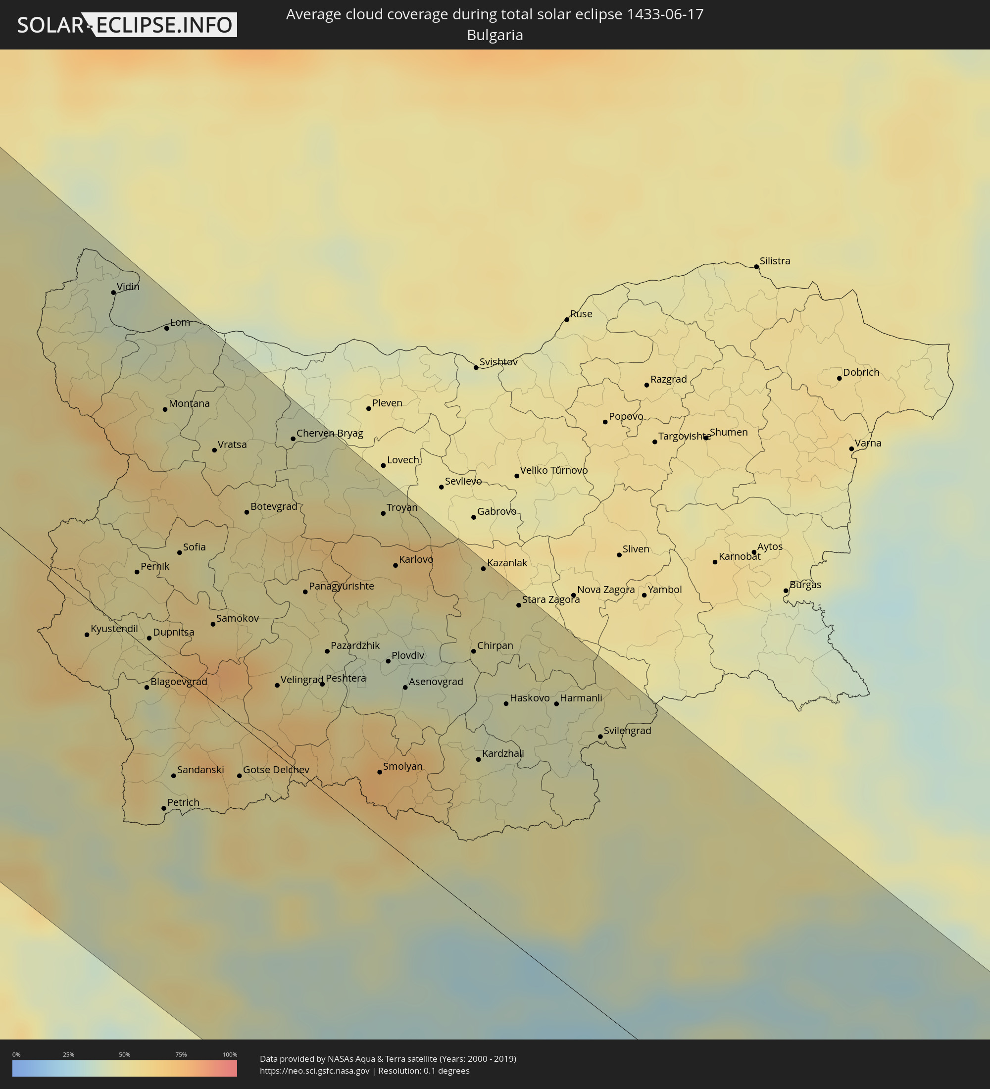 Bulgaria
 Turkey
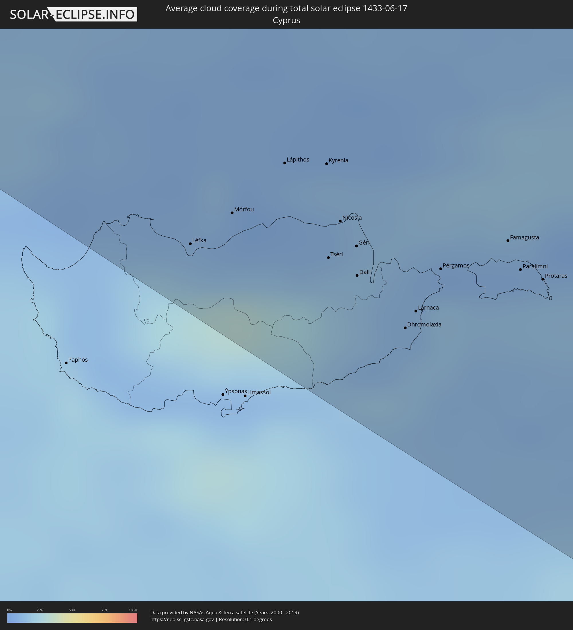 Cyprus
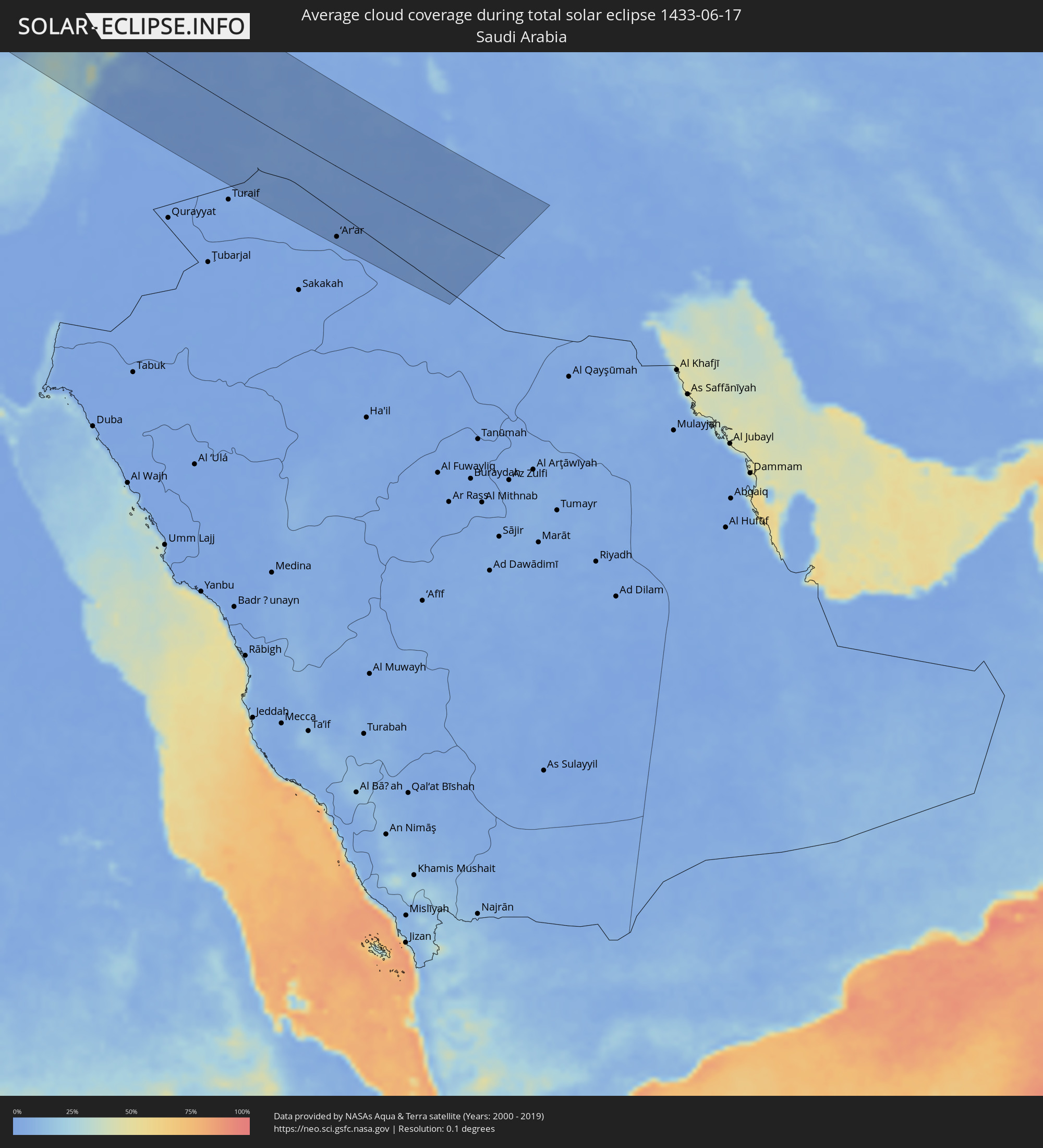 Saudi Arabia
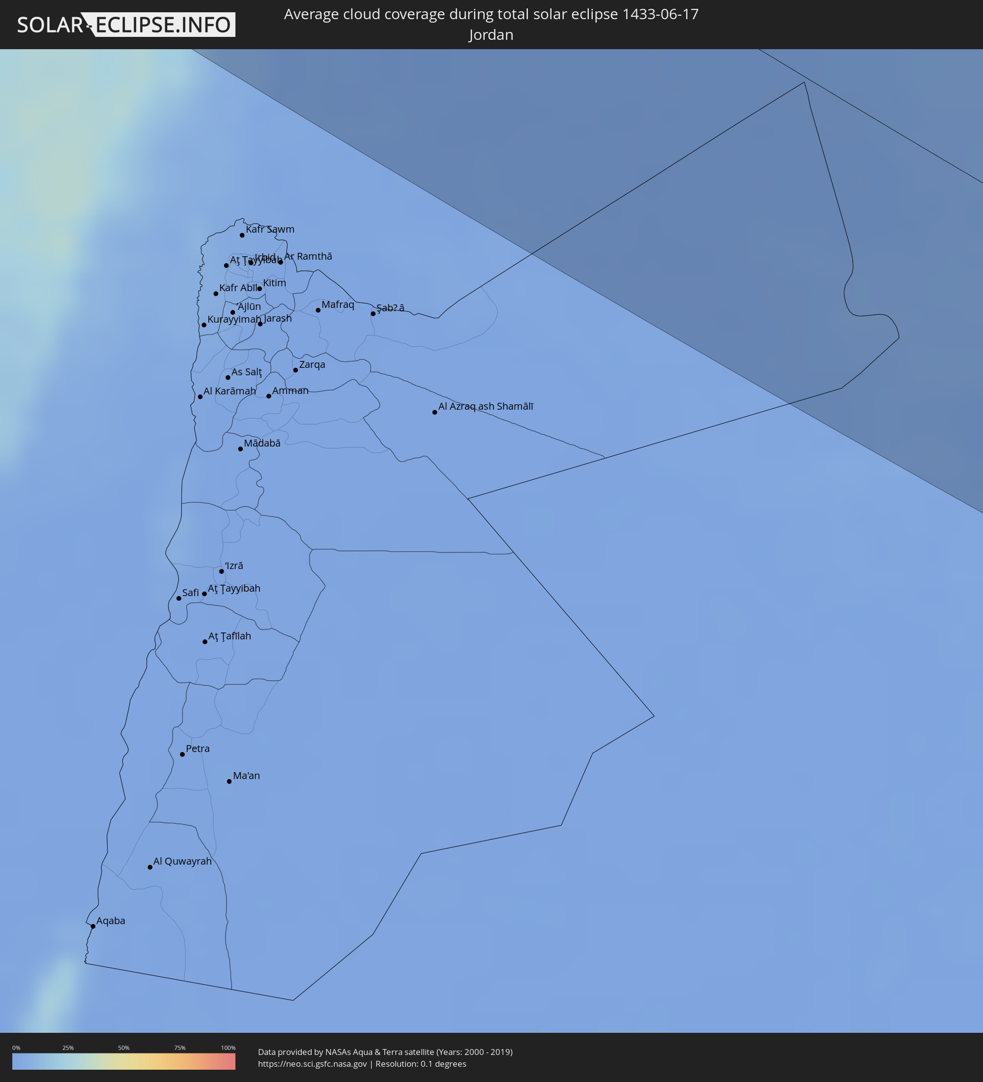 Jordan
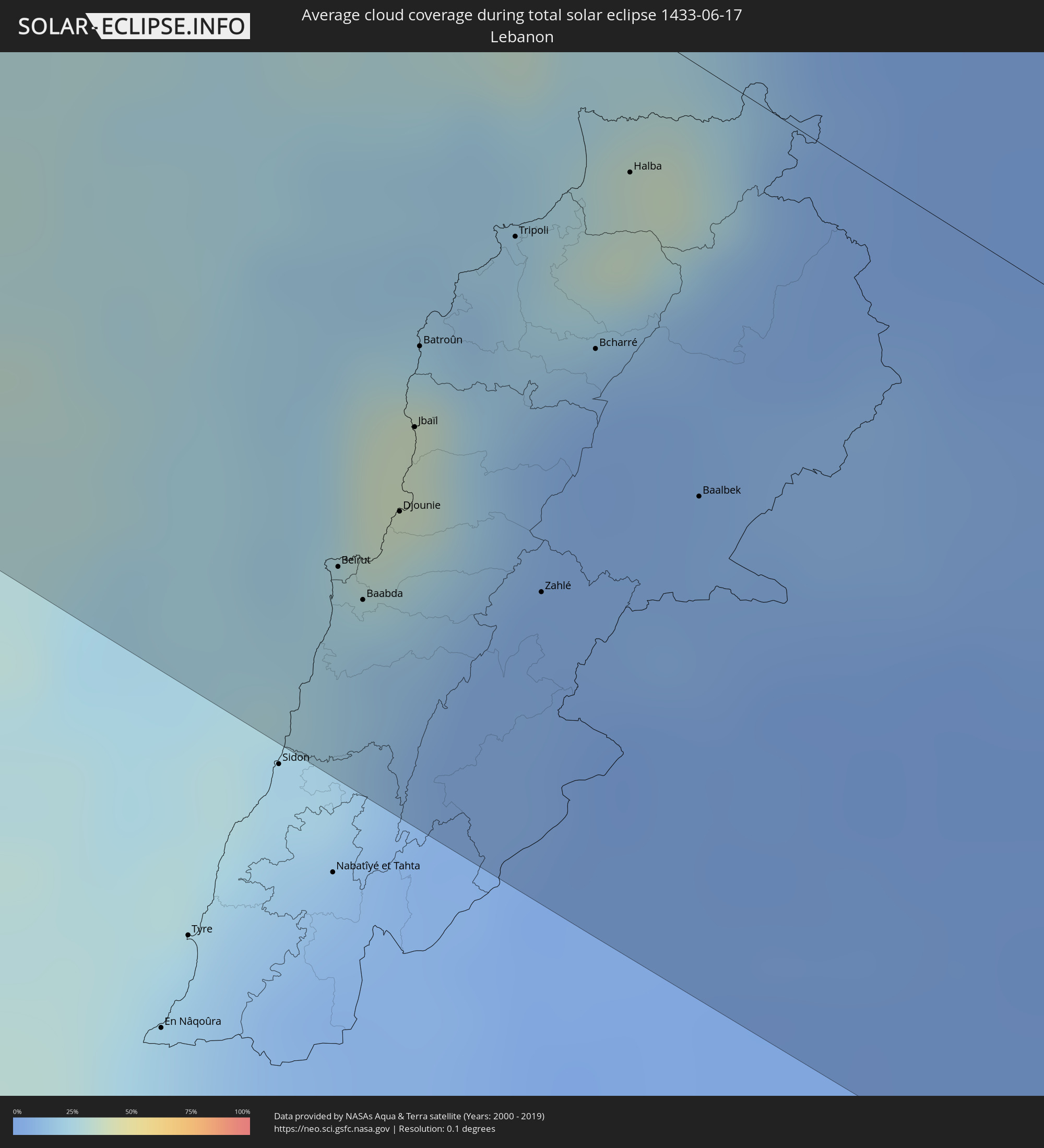 Lebanon
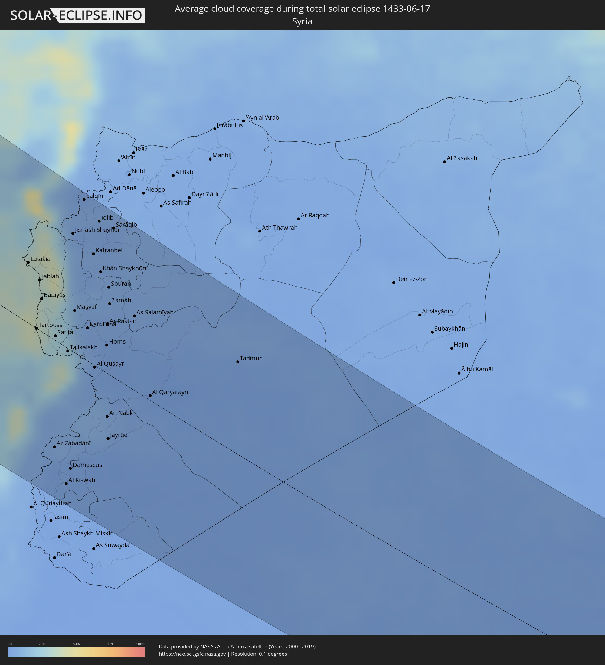 Syria
Syria
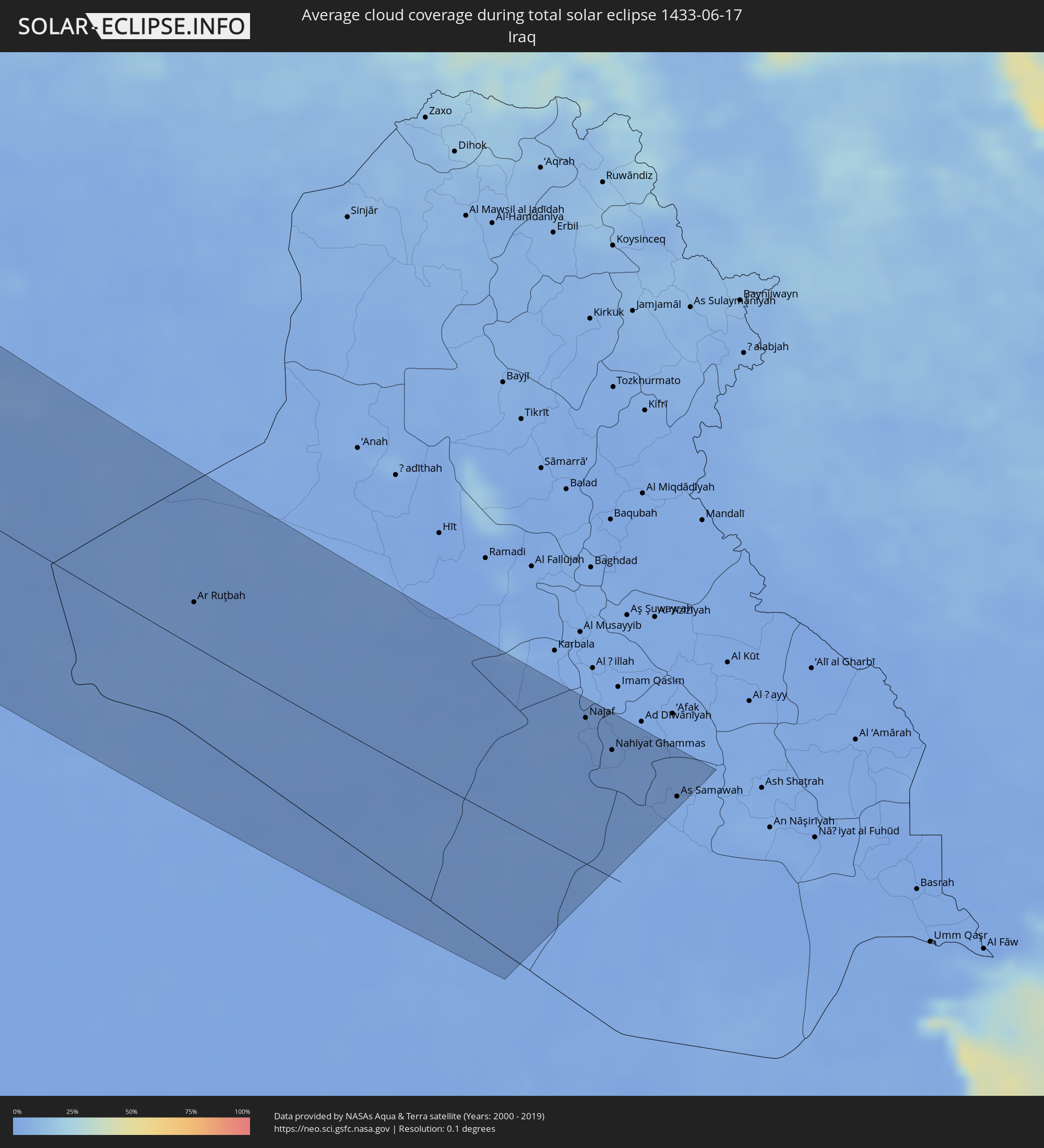 Iraq
Iraq
Cities inside the path of the eclipse
The following table shows all locations with a population of more than 5,000 inside the eclipse path. Cities which have more than 100,000 inhabitants are marked bold. A click at the locations opens a detailed map.
| City | Type | Eclipse duration | Local time of max. eclipse | Distance to central line | Ø Cloud coverage |
|
Port Angeles, Washington
|
total | - | 05:27:13 UTC-08:00 | 112 km | 71% |
|
Victoria, British Columbia
|
total | - | 05:27:35 UTC-08:00 | 86 km | 63% |
|
Vancouver, British Columbia
|
total | - | 05:28:33 UTC-08:00 | 29 km | 68% |
|
Ladner, British Columbia
|
total | - | 05:28:21 UTC-08:00 | 39 km | 66% |
|
Anmore, British Columbia
|
total | - | 05:28:35 UTC-08:00 | 27 km | 77% |
|
Surrey, British Columbia
|
total | - | 05:28:19 UTC-08:00 | 48 km | 65% |
|
Oak Harbor, Washington
|
total | - | 05:27:15 UTC-08:00 | 130 km | 61% |
|
Anacortes, Washington
|
total | - | 05:27:31 UTC-08:00 | 110 km | 64% |
|
Camano, Washington
|
total | - | 05:27:05 UTC-08:00 | 146 km | 63% |
|
Bellingham, Washington
|
total | - | 05:27:48 UTC-08:00 | 93 km | 67% |
|
Lynden, Washington
|
total | - | 05:28:02 UTC-08:00 | 78 km | 67% |
|
Mount Vernon, Washington
|
total | - | 05:27:21 UTC-08:00 | 131 km | 71% |
|
Abbotsford, British Columbia
|
total | - | 05:28:08 UTC-08:00 | 76 km | 77% |
|
Sedro-Woolley, Washington
|
total | - | 05:27:26 UTC-08:00 | 127 km | 73% |
|
Okanagan, British Columbia
|
total | - | 05:29:20 UTC-08:00 | 78 km | 69% |
|
Edmonton, Alberta
|
total | - | 05:59:28 UTC-07:33 | 28 km | 73% |
|
Sisimiut, Qeqqata
|
total | - | 10:55:10 UTC-03:26 | 127 km | 81% |
|
Keflavík, Southern Peninsula
|
total | - | 13:22:23 UTC-01:28 | 126 km | 80% |
|
Hafnarfjörður, Capital Region
|
total | - | 13:22:52 UTC-01:28 | 145 km | 84% |
|
Garðabær, Capital Region
|
total | - | 13:22:51 UTC-01:28 | 148 km | 84% |
|
Kópavogur, Capital Region
|
total | - | 13:22:51 UTC-01:28 | 151 km | 84% |
|
Reykjavík, Capital Region
|
total | - | 13:22:50 UTC-01:28 | 153 km | 84% |
|
Selfoss, South
|
total | - | 13:23:48 UTC-01:28 | 152 km | 83% |
|
Glasgow, Scotland
|
total | - | 15:16:40 UTC+00:00 | 113 km | 90% |
|
Edinburgh, Scotland
|
total | - | 15:17:19 UTC+00:00 | 65 km | 89% |
|
Dundee, Scotland
|
total | - | 15:16:38 UTC+00:00 | 15 km | 85% |
|
Aberdeen, Scotland
|
total | - | 15:16:10 UTC+00:00 | 81 km | 88% |
|
Newcastle upon Tyne, England
|
total | - | 15:20:04 UTC+00:00 | 92 km | 86% |
|
Sunderland, England
|
total | - | 15:20:20 UTC+00:00 | 87 km | 84% |
|
Middlesbrough, England
|
total | - | 15:20:59 UTC+00:00 | 110 km | 84% |
|
Hull, England
|
total | - | 15:23:00 UTC+00:00 | 146 km | 84% |
|
The Hague, South Holland
|
total | - | 15:48:19 UTC+00:19 | 94 km | 79% |
|
Rotterdam, South Holland
|
total | - | 15:48:41 UTC+00:19 | 98 km | 78% |
|
Brasschaat, Flanders
|
total | - | 15:30:14 UTC+00:00 | 151 km | 76% |
|
Amsterdam, North Holland
|
total | - | 15:48:08 UTC+00:19 | 45 km | 81% |
|
Turnhout, Flanders
|
total | - | 15:30:27 UTC+00:00 | 128 km | 77% |
|
Geel, Flanders
|
total | - | 15:30:44 UTC+00:00 | 140 km | 80% |
|
Tilburg, North Brabant
|
total | - | 15:49:39 UTC+00:19 | 101 km | 77% |
|
Utrecht, Utrecht
|
total | - | 15:48:45 UTC+00:19 | 56 km | 80% |
|
Almere Stad, Flevoland
|
total | - | 15:48:20 UTC+00:19 | 27 km | 80% |
|
Beringen, Flanders
|
total | - | 15:31:04 UTC+00:00 | 138 km | 78% |
|
Hasselt, Flanders
|
total | - | 15:31:20 UTC+00:00 | 144 km | 79% |
|
Eindhoven, North Brabant
|
total | - | 15:50:04 UTC+00:19 | 95 km | 78% |
|
Herstal, Wallonia
|
total | - | 15:31:57 UTC+00:00 | 153 km | 79% |
|
Maasmechelen, Flanders
|
total | - | 15:31:28 UTC+00:00 | 124 km | 77% |
|
Verviers, Wallonia
|
total | - | 15:32:13 UTC+00:00 | 149 km | 78% |
|
Groningen, Groningen
|
total | - | 15:47:36 UTC+00:19 | 104 km | 82% |
|
Duisburg, North Rhine-Westphalia
|
total | - | 16:31:15 UTC+01:00 | 36 km | 78% |
|
Düsseldorf, North Rhine-Westphalia
|
total | - | 16:31:37 UTC+01:00 | 57 km | 77% |
|
Köln, North Rhine-Westphalia
|
total | - | 16:32:12 UTC+01:00 | 70 km | 76% |
|
Essen, North Rhine-Westphalia
|
total | - | 16:31:20 UTC+01:00 | 23 km | 81% |
|
Dortmund, North Rhine-Westphalia
|
total | - | 16:31:28 UTC+01:00 | 6 km | 81% |
|
Frankfurt am Main, Hesse
|
total | - | 16:34:28 UTC+01:00 | 62 km | 74% |
|
Stuttgart, Baden-Württemberg
|
total | - | 16:36:59 UTC+01:00 | 147 km | 74% |
|
Munich, Bavaria
|
total | - | 16:39:06 UTC+01:00 | 87 km | 68% |
|
Cheb, Karlovarský
|
total | - | 16:36:06 UTC+01:00 | 116 km | 69% |
|
Sokolov, Karlovarský
|
total | - | 16:36:01 UTC+01:00 | 136 km | 72% |
|
Karlovy Vary, Karlovarský
|
total | - | 16:36:01 UTC+01:00 | 151 km | 70% |
|
Salzburg, Salzburg
|
total | - | 16:40:13 UTC+01:00 | 43 km | 74% |
|
Klatovy, Plzeňský
|
total | - | 16:37:36 UTC+01:00 | 104 km | 66% |
|
Pilsen, Plzeňský
|
total | - | 16:37:02 UTC+01:00 | 136 km | 70% |
|
Villach, Carinthia
|
total | - | 16:42:30 UTC+01:00 | 104 km | 64% |
|
Strakonice, Jihočeský
|
total | - | 16:38:03 UTC+01:00 | 123 km | 69% |
|
Wels, Upper Austria
|
total | - | 16:39:57 UTC+01:00 | 42 km | 71% |
|
Písek, Jihočeský
|
total | - | 16:38:03 UTC+01:00 | 138 km | 70% |
|
Linz, Upper Austria
|
total | - | 16:39:47 UTC+01:00 | 66 km | 71% |
|
Klagenfurt am Wörthersee, Carinthia
|
total | - | 16:42:37 UTC+01:00 | 78 km | 61% |
|
Kranj, Kranj
|
total | - | 16:43:17 UTC+01:00 | 110 km | 63% |
|
České Budějovice, Jihočeský
|
total | - | 16:38:43 UTC+01:00 | 127 km | 68% |
|
Ljubljana, Ljubljana
|
total | - | 16:43:39 UTC+01:00 | 116 km | 62% |
|
Trbovlje, Trbovlje
|
total | - | 16:43:38 UTC+01:00 | 83 km | 64% |
|
Velenje, Velenje
|
total | - | 16:43:19 UTC+01:00 | 61 km | 64% |
|
Novo Mesto, Novo Mesto
|
total | - | 16:44:15 UTC+01:00 | 104 km | 59% |
|
Celje, Celje
|
total | - | 16:43:34 UTC+01:00 | 66 km | 64% |
|
Graz, Styria
|
total | - | 16:42:14 UTC+01:00 | 26 km | 68% |
|
Karlovac, Karlovačka
|
total | - | 16:44:53 UTC+01:00 | 111 km | 51% |
|
Sankt Pölten, Lower Austria
|
total | - | 16:40:23 UTC+01:00 | 120 km | 69% |
|
Maribor, Maribor
|
total | - | 16:43:09 UTC+01:00 | 27 km | 62% |
|
Ptuj, Ptuj
|
total | - | 16:43:26 UTC+01:00 | 16 km | 60% |
|
Bihać, Federation of Bosnia and Herzegovina
|
total | - | 16:46:05 UTC+01:00 | 152 km | 56% |
|
Zagreb - Centar, City of Zagreb
|
total | - | 16:44:28 UTC+01:00 | 62 km | 58% |
|
Varaždin, Varaždinska
|
total | - | 16:43:45 UTC+01:00 | 15 km | 63% |
|
Vienna, Vienna
|
total | - | 16:40:35 UTC+01:00 | 158 km | 68% |
|
Sisak, Sisačko-Moslavačka
|
total | - | 16:45:09 UTC+01:00 | 71 km | 53% |
|
Sopron, Győr-Moson-Sopron
|
total | - | 16:41:31 UTC+01:00 | 125 km | 63% |
|
Szombathely, Vas
|
total | - | 16:42:17 UTC+01:00 | 91 km | 65% |
|
Zalaegerszeg, Zala
|
total | - | 16:43:00 UTC+01:00 | 73 km | 64% |
|
Nagykanizsa, Zala
|
total | - | 16:43:40 UTC+01:00 | 45 km | 62% |
|
Banja Luka, Republic of Srspka
|
total | - | 16:46:28 UTC+01:00 | 88 km | 52% |
|
Bugojno, Federation of Bosnia and Herzegovina
|
total | - | 16:47:42 UTC+01:00 | 135 km | 59% |
|
Kaposvár, Somogy
|
total | - | 16:44:01 UTC+01:00 | 79 km | 63% |
|
Zenica, Federation of Bosnia and Herzegovina
|
total | - | 16:47:34 UTC+01:00 | 102 km | 54% |
|
Veszprém, Veszprém
|
total | - | 16:42:50 UTC+01:00 | 144 km | 66% |
|
Slavonski Brod, Slavonski Brod-Posavina
|
total | - | 16:46:02 UTC+01:00 | 18 km | 48% |
|
Pécs, Baranya
|
total | - | 16:44:34 UTC+01:00 | 76 km | 62% |
|
Sarajevo, Federation of Bosnia and Herzegovina
|
total | - | 16:48:14 UTC+01:00 | 107 km | 58% |
|
Tuzla, Federation of Bosnia and Herzegovina
|
total | - | 16:47:11 UTC+01:00 | 32 km | 57% |
|
Osijek, Osječko-Baranjska
|
total | - | 16:45:32 UTC+01:00 | 60 km | 53% |
|
Vinkovci, Vukovar-Sirmium
|
total | - | 16:45:59 UTC+01:00 | 39 km | 56% |
|
Brčko, Brčko
|
total | - | 16:46:40 UTC+01:00 | 4 km | 53% |
|
Baja, Bács-Kiskun
|
total | - | 16:44:35 UTC+01:00 | 121 km | 57% |
|
Vukovar, Vukovar-Sirmium
|
total | - | 16:45:56 UTC+01:00 | 53 km | 54% |
|
Žabljak, Opština Žabljak
|
total | - | 16:49:29 UTC+01:00 | 127 km | 63% |
|
Bijeljina, Republic of Srspka
|
total | - | 16:46:56 UTC+01:00 | 15 km | 56% |
|
Pljevlja, Pljevlja
|
total | - | 16:49:12 UTC+01:00 | 98 km | 59% |
|
Kolašin, Opština Kolašin
|
total | - | 16:50:05 UTC+01:00 | 135 km | 54% |
|
Mojkovac, Mojkovac
|
total | - | 16:49:52 UTC+01:00 | 119 km | 58% |
|
Subotica, Vojvodina
|
total | - | 16:44:50 UTC+01:00 | 151 km | 55% |
|
Bijelo Polje, Bijelo Polje
|
total | - | 16:49:46 UTC+01:00 | 104 km | 56% |
|
Novi Sad, Vojvodina
|
total | - | 16:46:15 UTC+01:00 | 89 km | 50% |
|
Berane, Berane
|
total | - | 16:50:06 UTC+01:00 | 114 km | 58% |
|
Plav, Opština Plav
|
total | - | 16:50:30 UTC+01:00 | 132 km | 62% |
|
Rožaje, Opština Rožaje
|
total | - | 16:50:10 UTC+01:00 | 100 km | 66% |
|
Čačak, Central Serbia
|
total | - | 16:48:31 UTC+01:00 | 16 km | 53% |
|
Kukës, Kukës
|
total | - | 17:10:43 UTC+01:19 | 152 km | 45% |
|
Belgrade, Central Serbia
|
total | - | 16:47:04 UTC+01:00 | 86 km | 52% |
|
Novi Pazar, Central Serbia
|
total | - | 16:49:44 UTC+01:00 | 56 km | 54% |
|
Gostivar, Gostivar
|
total | - | 16:51:53 UTC+01:00 | 151 km | 54% |
|
Kragujevac, Central Serbia
|
total | - | 16:48:24 UTC+01:00 | 41 km | 55% |
|
Tetovo, Tetovo
|
total | - | 16:51:33 UTC+01:00 | 129 km | 49% |
|
Skopje, Karpoš
|
total | - | 16:51:38 UTC+01:00 | 109 km | 48% |
|
Moldova Nouă, Caraş-Severin
|
total | - | 17:31:45 UTC+01:44 | 140 km | 47% |
|
Kumanovo, Kumanovo
|
total | - | 16:51:27 UTC+01:00 | 82 km | 46% |
|
Veles, Veles
|
total | - | 16:52:06 UTC+01:00 | 113 km | 44% |
|
Niš, Central Serbia
|
total | - | 16:49:36 UTC+01:00 | 33 km | 46% |
|
Leskovac, Central Serbia
|
total | - | 16:50:07 UTC+01:00 | 13 km | 51% |
|
Kavadarci, Kavadarci
|
total | - | 16:52:33 UTC+01:00 | 125 km | 44% |
|
Shtip, Štip
|
total | - | 16:52:05 UTC+01:00 | 88 km | 43% |
|
Gogoşu, Mehedinţi
|
total | - | 17:32:26 UTC+01:44 | 157 km | 42% |
|
Strumica, Strumica
|
total | - | 16:52:36 UTC+01:00 | 93 km | 43% |
|
Thessaloníki, Central Macedonia
|
total | - | 17:28:42 UTC+01:34 | 145 km | 43% |
|
Calafat, Dolj
|
total | - | 17:33:04 UTC+01:44 | 144 km | 39% |
|
Ciupercenii Noi, Dolj
|
total | - | 17:33:12 UTC+01:44 | 138 km | 39% |
|
Pernik, Pernik
|
total | - | 17:50:50 UTC+02:00 | 29 km | 52% |
|
Cetate, Dolj
|
total | - | 17:32:54 UTC+01:44 | 160 km | 43% |
|
Poiana Mare, Dolj
|
total | - | 17:33:12 UTC+01:44 | 144 km | 42% |
|
Blagoevgrad, Blagoevgrad
|
total | - | 17:51:45 UTC+02:00 | 17 km | 42% |
|
Maglavit, Dolj
|
total | - | 17:33:01 UTC+01:44 | 156 km | 43% |
|
Piscu Vechi, Dolj
|
total | - | 17:33:14 UTC+01:44 | 147 km | 40% |
|
Sofia, Sofia-Capital
|
total | - | 17:50:43 UTC+02:00 | 53 km | 55% |
|
Sérres, Central Macedonia
|
total | - | 17:28:04 UTC+01:34 | 75 km | 42% |
|
Vratsa, Vratsa
|
total | - | 17:49:56 UTC+02:00 | 111 km | 55% |
|
Dráma, East Macedonia and Thrace
|
total | - | 17:27:59 UTC+01:34 | 38 km | 50% |
|
Pazardzhik, Pazardzhik
|
total | - | 17:51:32 UTC+02:00 | 63 km | 45% |
|
Kavála, East Macedonia and Thrace
|
total | - | 17:28:19 UTC+01:34 | 49 km | 42% |
|
Plovdiv, Plovdiv
|
total | - | 17:51:37 UTC+02:00 | 80 km | 39% |
|
Xánthi, East Macedonia and Thrace
|
total | - | 17:28:02 UTC+01:34 | 12 km | 45% |
|
Komotiní, East Macedonia and Thrace
|
total | - | 17:28:04 UTC+01:34 | 34 km | 41% |
|
Haskovo, Khaskovo
|
total | - | 17:51:58 UTC+02:00 | 107 km | 45% |
|
Stara Zagora, Stara Zagora
|
total | - | 17:51:13 UTC+02:00 | 151 km | 50% |
|
Alexandroúpoli, East Macedonia and Thrace
|
total | - | 17:28:28 UTC+01:34 | 33 km | 37% |
|
Mytilíni, North Aegean
|
total | - | 17:31:00 UTC+01:34 | 94 km | 25% |
|
İzmir, İzmir
|
total | - | 17:54:02 UTC+01:56 | 123 km | 26% |
|
Manisa, Manisa
|
total | - | 17:53:44 UTC+01:56 | 91 km | 32% |
|
Bursa, Bursa
|
total | - | 17:51:21 UTC+01:56 | 135 km | 46% |
|
Denizli, Denizli
|
total | - | 17:54:46 UTC+01:56 | 80 km | 23% |
|
Antalya, Antalya
|
total | - | 17:55:45 UTC+01:56 | 78 km | 26% |
|
Konya, Konya
|
total | - | 17:54:09 UTC+01:56 | 103 km | 32% |
|
Léfka, Nicosia
|
total | - | 18:14:16 UTC+02:13 | 132 km | 16% |
|
Mórfou, Nicosia
|
total | - | 18:14:07 UTC+02:13 | 118 km | 8% |
|
Kyrenia, Keryneia
|
total | - | 18:13:52 UTC+02:13 | 88 km | 10% |
|
Nicosia, Nicosia
|
total | - | 18:14:04 UTC+02:13 | 99 km | 12% |
|
Larnaca, Larnaka
|
total | - | 18:14:20 UTC+02:13 | 112 km | 14% |
|
Pérgamos, Larnaka
|
total | - | 18:14:09 UTC+02:13 | 97 km | 15% |
|
Famagusta, Ammochostos
|
total | - | 18:14:00 UTC+02:13 | 76 km | 8% |
|
Protaras, Ammochostos
|
total | - | 18:14:07 UTC+02:13 | 80 km | 14% |
|
Mercin, Mersin
|
total | - | 17:55:09 UTC+01:56 | 114 km | 21% |
|
Tarsus, Mersin
|
total | - | 17:54:56 UTC+01:56 | 138 km | 23% |
|
Beirut, Beyrouth
|
total | - | 18:01:41 UTC+02:00 | 114 km | 23% |
|
Djounie, Mont-Liban
|
total | - | 18:01:32 UTC+02:00 | 99 km | 33% |
|
Jbaïl, Mont-Liban
|
total | - | 18:01:21 UTC+02:00 | 84 km | 36% |
|
Batroûn, Liban-Nord
|
total | - | 18:01:11 UTC+02:00 | 71 km | 24% |
|
Latakia, Latakia
|
total | - | 18:24:45 UTC+02:25 | 55 km | 34% |
|
Tripoli, Liban-Nord
|
total | - | 18:00:54 UTC+02:00 | 45 km | 16% |
|
Tartouss, Tartus
|
total | - | 18:25:32 UTC+02:25 | 0 km | 36% |
|
Zahlé, Béqaa
|
total | - | 18:01:37 UTC+02:00 | 98 km | 5% |
|
Jablah, Latakia
|
total | - | 18:24:56 UTC+02:25 | 49 km | 33% |
|
Bcharré, Liban-Nord
|
total | - | 18:01:05 UTC+02:00 | 57 km | 16% |
|
Baalbek, Baalbek-Hermel
|
total | - | 18:01:20 UTC+02:00 | 68 km | 5% |
|
Damascus, Dimashq
|
total | - | 18:27:07 UTC+02:25 | 111 km | 1% |
|
Idlib, Idlib
|
total | - | 18:24:01 UTC+02:25 | 134 km | 3% |
|
Homs, Homs
|
total | - | 18:25:30 UTC+02:25 | 27 km | 2% |
|
Ḩamāh, Hama
|
total | - | 18:24:59 UTC+02:25 | 67 km | 3% |
|
As Salamīyah, Hama
|
total | - | 18:25:03 UTC+02:25 | 70 km | 4% |
|
‘Ar‘ar, Northern Borders
|
total | - | 19:10:02 UTC+03:06 | 129 km | 1% |
|
Najaf, An Najaf
|
total | - | 18:58:11 UTC+02:57 | 129 km | 3% |
|
Kufa, An Najaf
|
total | - | 18:58:07 UTC+02:57 | 135 km | 3% |
|
Al Mishkhāb, An Najaf
|
total | - | 18:58:22 UTC+02:57 | 111 km | 2% |
|
Ash Shāmīyah, Al Qādisīyah
|
total | - | 18:58:08 UTC+02:57 | 132 km | 2% |
|
Nahiyat Ghammas, Al Qādisīyah
|
total | - | 18:58:22 UTC+02:57 | 111 km | 2% |
|
Nāḩiyat ash Shināfīyah, Al Qādisīyah
|
total | - | 18:58:31 UTC+02:57 | 98 km | 2% |
|
Ar Rumaythah, Al Muthanná
|
total | - | 18:58:19 UTC+02:57 | 116 km | 2% |
|
As Samawah, Al Muthanná
|
total | - | 18:58:29 UTC+02:57 | 101 km | 2% |