Total solar eclipse of 06/24/1778
| Day of week: | Wednesday |
| Maximum duration of eclipse: | 05m52s |
| Maximum width of eclipse path: | 255 km |
| Saros cycle: | 133 |
| Coverage: | 100% |
| Magnitude: | 1.0746 |
| Gamma: | 0.3127 |
Wo kann man die Sonnenfinsternis vom 06/24/1778 sehen?
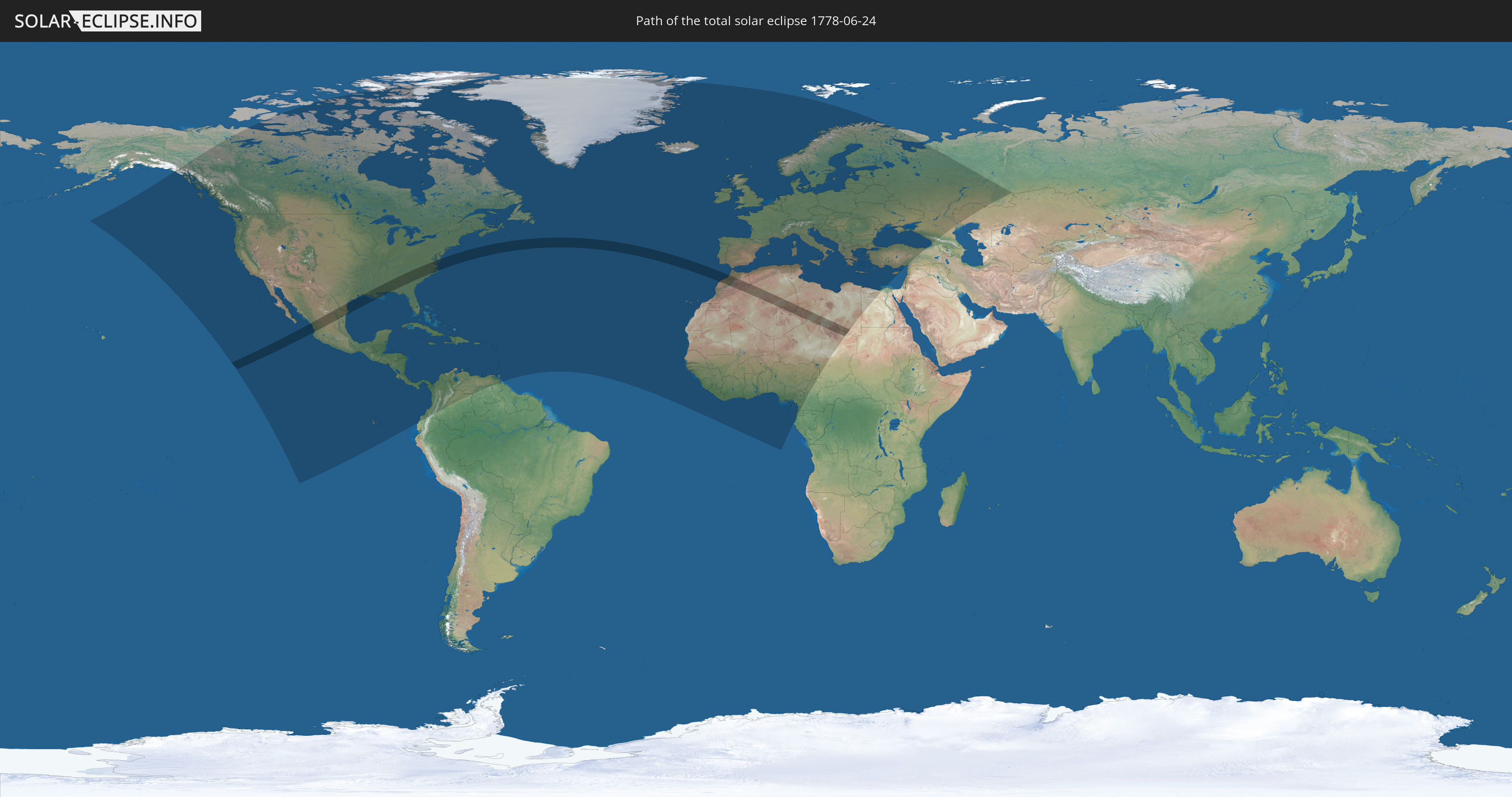
Die Sonnenfinsternis am 06/24/1778 kann man in 123 Ländern als partielle Sonnenfinsternis beobachten.
Der Finsternispfad verläuft durch 8 Länder. Nur in diesen Ländern ist sie als total Sonnenfinsternis zu sehen.
In den folgenden Ländern ist die Sonnenfinsternis total zu sehen
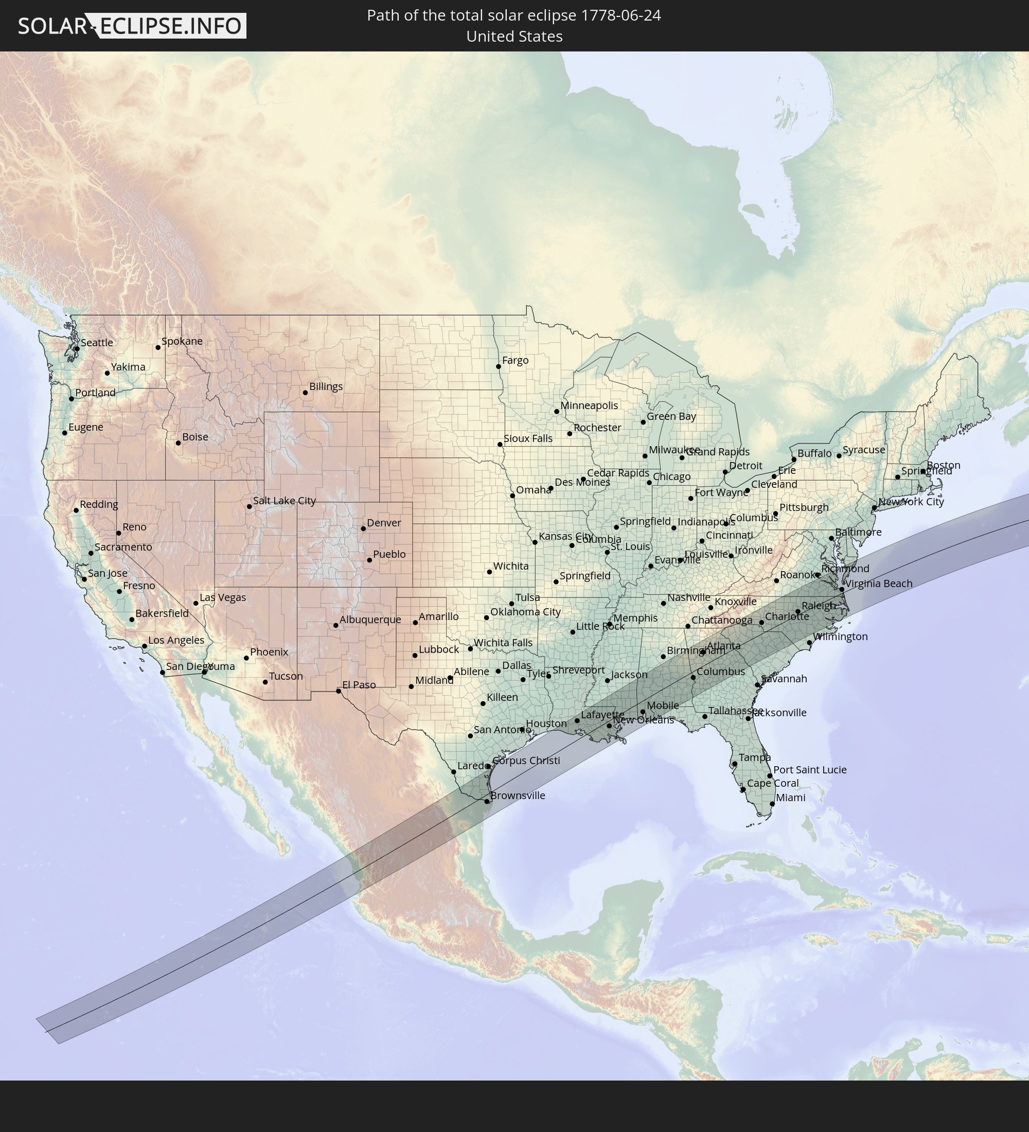 United States
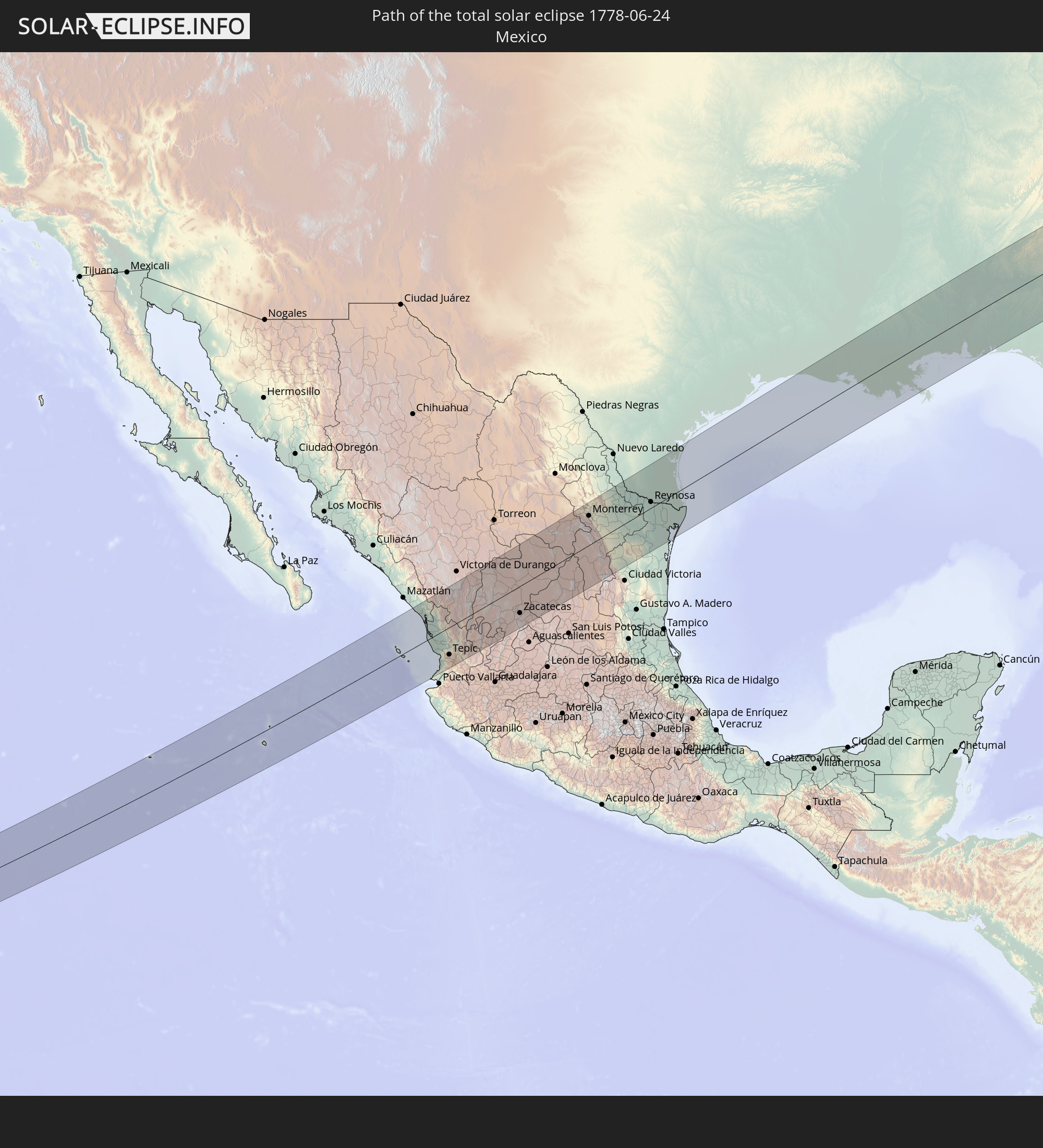 Mexico
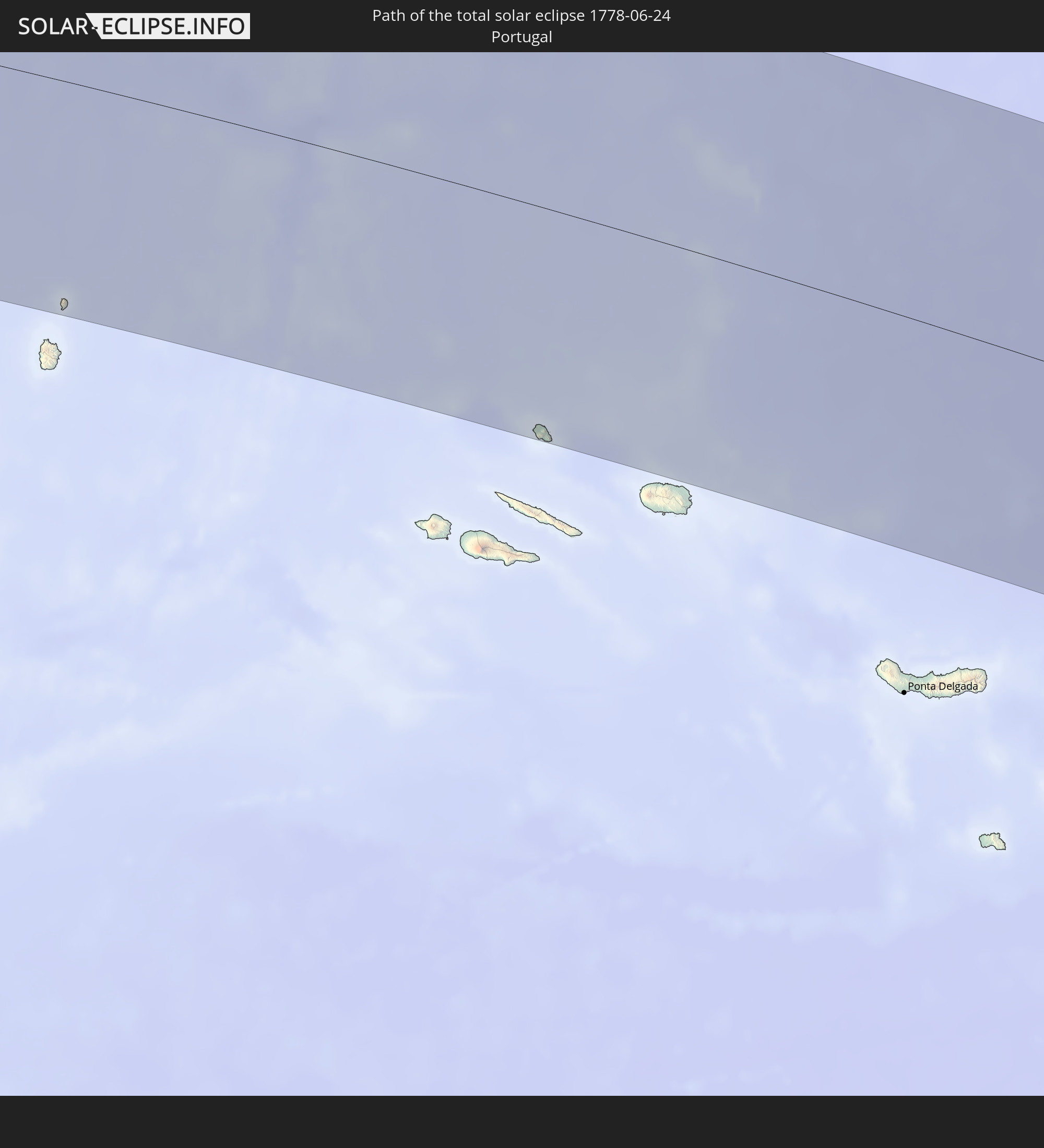 Portugal
 Morocco
 Algeria
 Niger
Niger
 Libya
Libya
 Chad
Chad
In den folgenden Ländern ist die Sonnenfinsternis partiell zu sehen
 Russia
 United States
 United States Minor Outlying Islands
 Canada
 Mexico
 Greenland
 Guatemala
 Ecuador
 El Salvador
 Honduras
 Belize
 Nicaragua
 Costa Rica
 Cuba
Cuba
 Panama
 Colombia
 Cayman Islands
 The Bahamas
 Jamaica
 Haiti
Haiti
 Venezuela
 Turks and Caicos Islands
 Dominican Republic
 Aruba
Aruba
 Puerto Rico
 United States Virgin Islands
 Bermuda
 British Virgin Islands
 Anguilla
 Collectivity of Saint Martin
 Saint Barthélemy
 Saint Kitts and Nevis
 Antigua and Barbuda
 Montserrat
 Trinidad and Tobago
 Guadeloupe
 Grenada
 Dominica
 Saint Vincent and the Grenadines
 Martinique
 Saint Lucia
 Barbados
 Saint Pierre and Miquelon
 Portugal
 Cabo Verde
 Iceland
 Spain
Spain
 Senegal
 Mauritania
 The Gambia
 Guinea-Bissau
 Guinea
 Sierra Leone
 Morocco
 Mali
Mali
 Liberia
 Republic of Ireland
 Svalbard and Jan Mayen
 Algeria
 United Kingdom
 Ivory Coast
 Faroe Islands
 Burkina Faso
 Gibraltar
 France
 Isle of Man
 Ghana
Ghana
 Guernsey
 Jersey
 Togo
Togo
 Niger
Niger
 Benin
Benin
 Andorra
 Belgium
 Nigeria
 Netherlands
 Norway
 Equatorial Guinea
 Luxembourg
 Germany
 Switzerland
 São Tomé and Príncipe
 Italy
Italy
 Monaco
 Tunisia
 Denmark
 Cameroon
 Gabon
Gabon
 Libya
Libya
 Liechtenstein
 Austria
 Sweden
 Czechia
 San Marino
 Vatican City
 Slovenia
 Chad
Chad
 Croatia
 Poland
 Malta
Malta
 Bosnia and Herzegovina
 Hungary
 Slovakia
 Montenegro
 Serbia
 Albania
 Åland Islands
 Greece
 Romania
 Republic of Macedonia
 Finland
 Lithuania
 Latvia
 Estonia
 Ukraine
 Bulgaria
 Belarus
 Egypt
Egypt
 Turkey
 Moldova
 Cyprus
 Georgia
 Kazakhstan
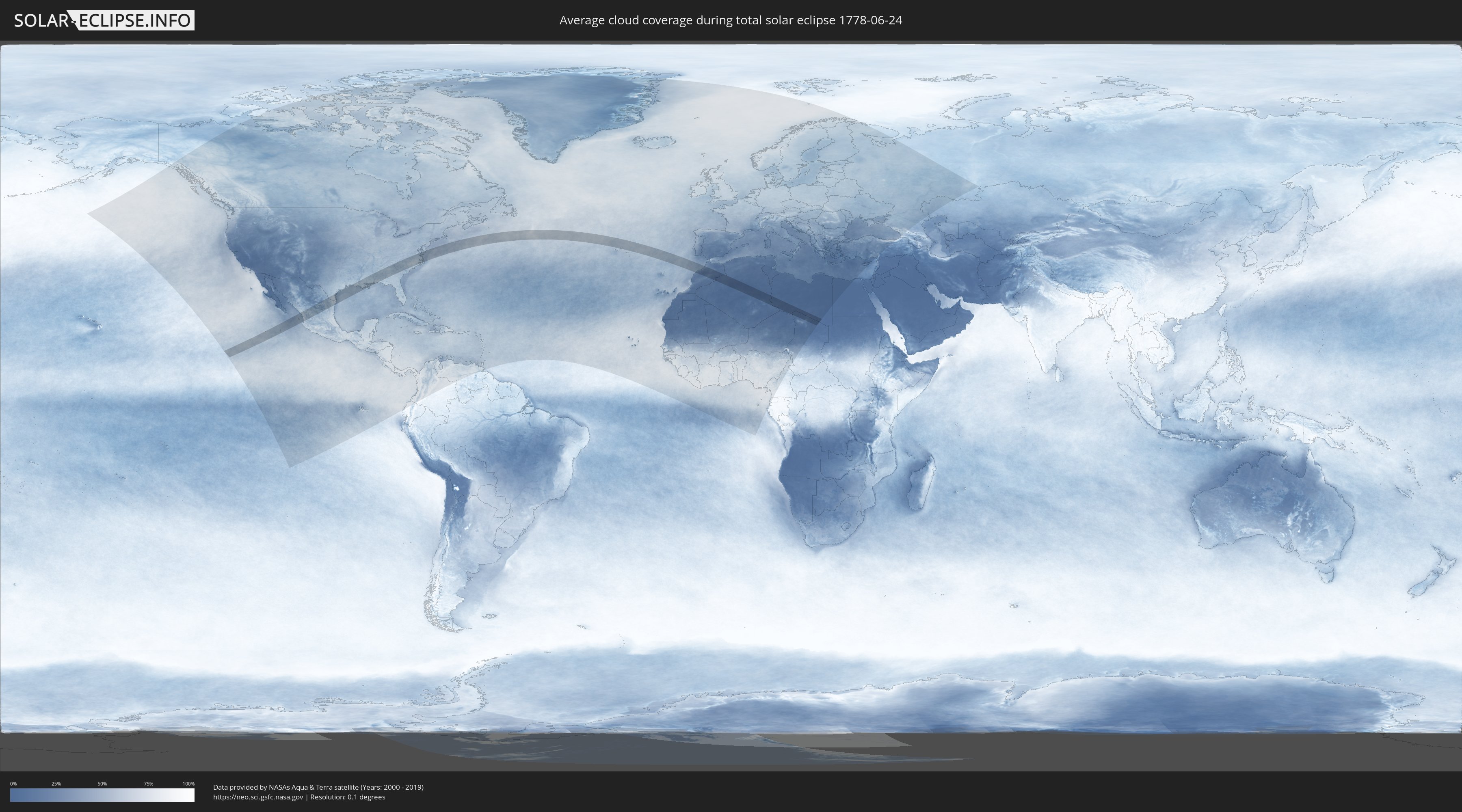
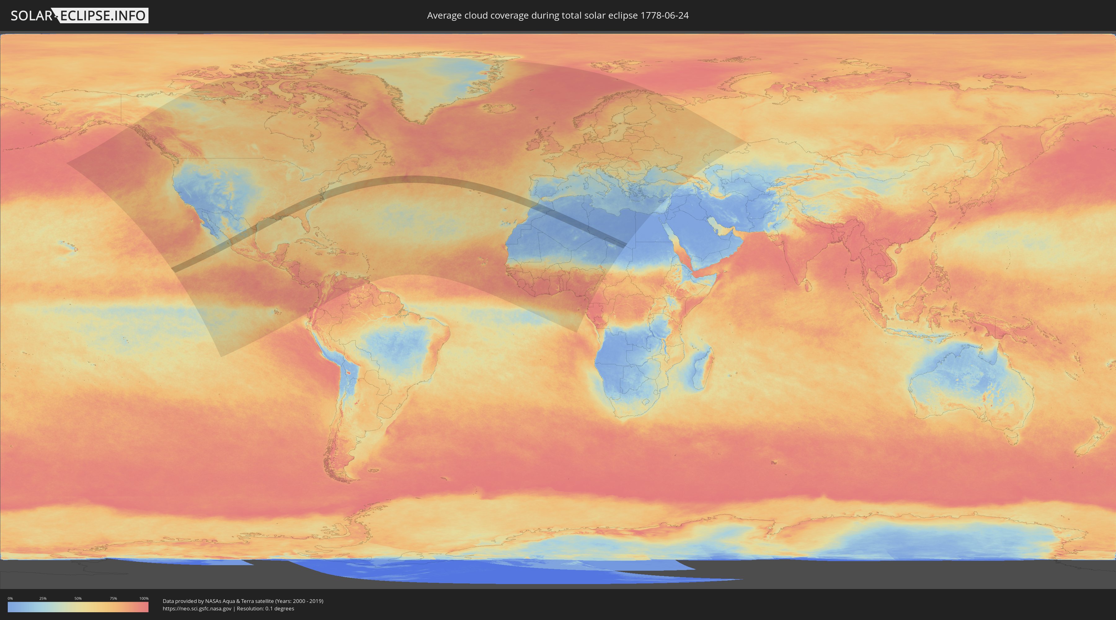
How will be the weather during the total solar eclipse on 06/24/1778?
Where is the best place to see the total solar eclipse of 06/24/1778?
The following maps show the average cloud coverage for the day of the total solar eclipse.
With the help of these maps, it is possible to find the place along the eclipse path, which has the best
chance of a cloudless sky.
Nevertheless, you should consider local circumstances and inform about the weather of your chosen
observation site.
The data is provided by NASAs satellites
AQUA and TERRA.
The cloud maps are averaged over a period of 19 years (2000 - 2019).
Detailed country maps
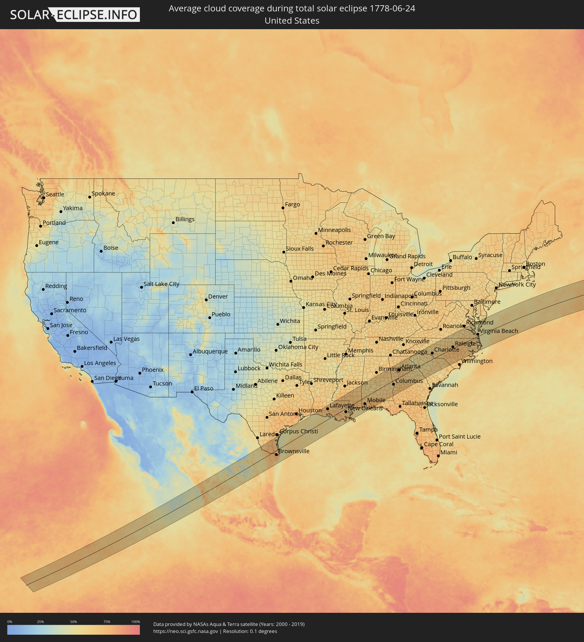 United States
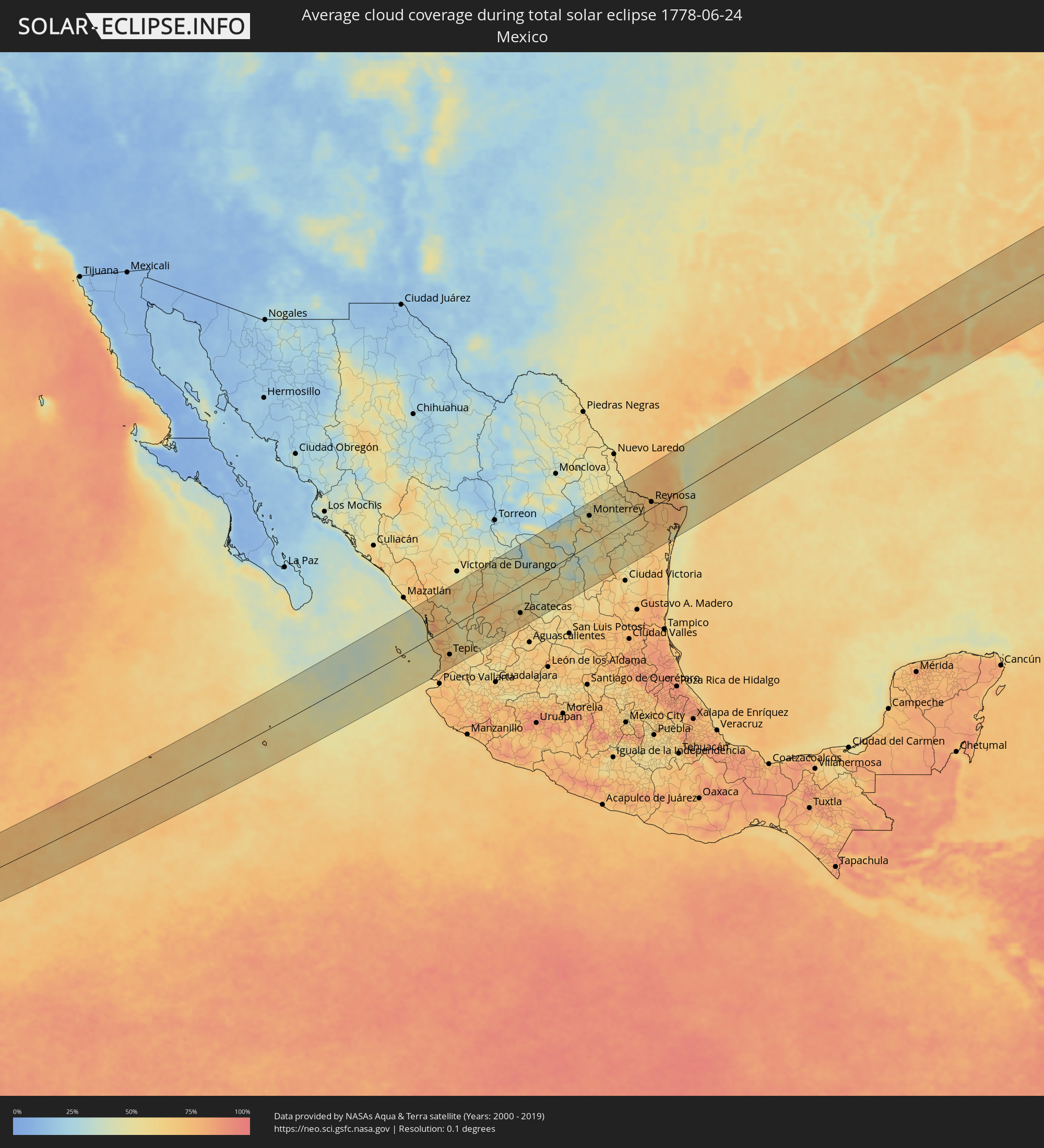 Mexico
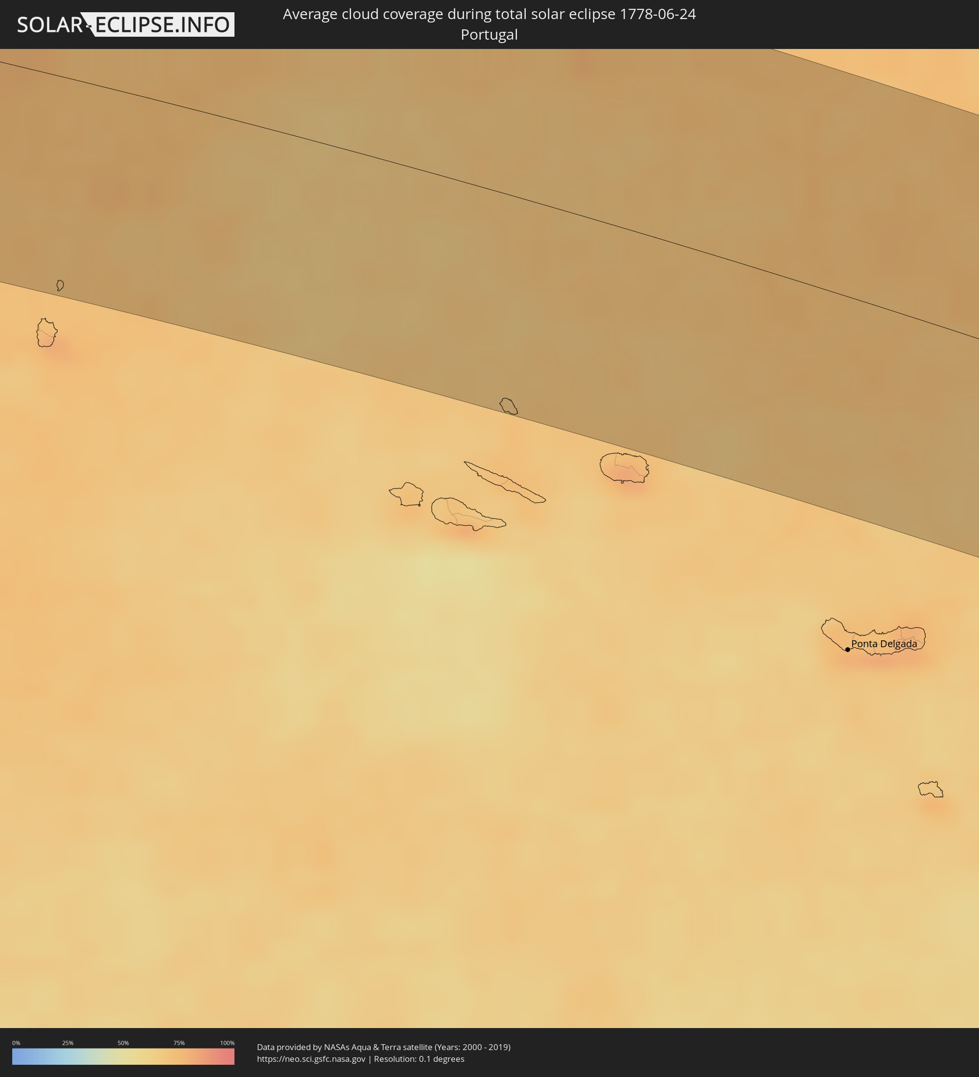 Portugal
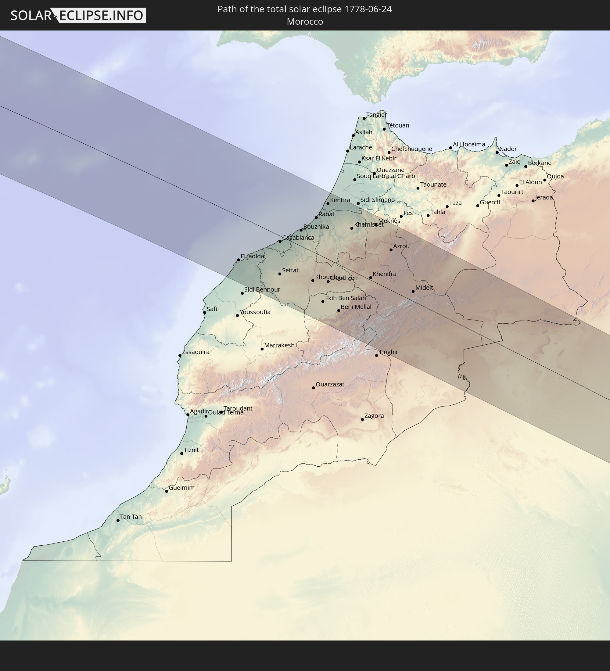
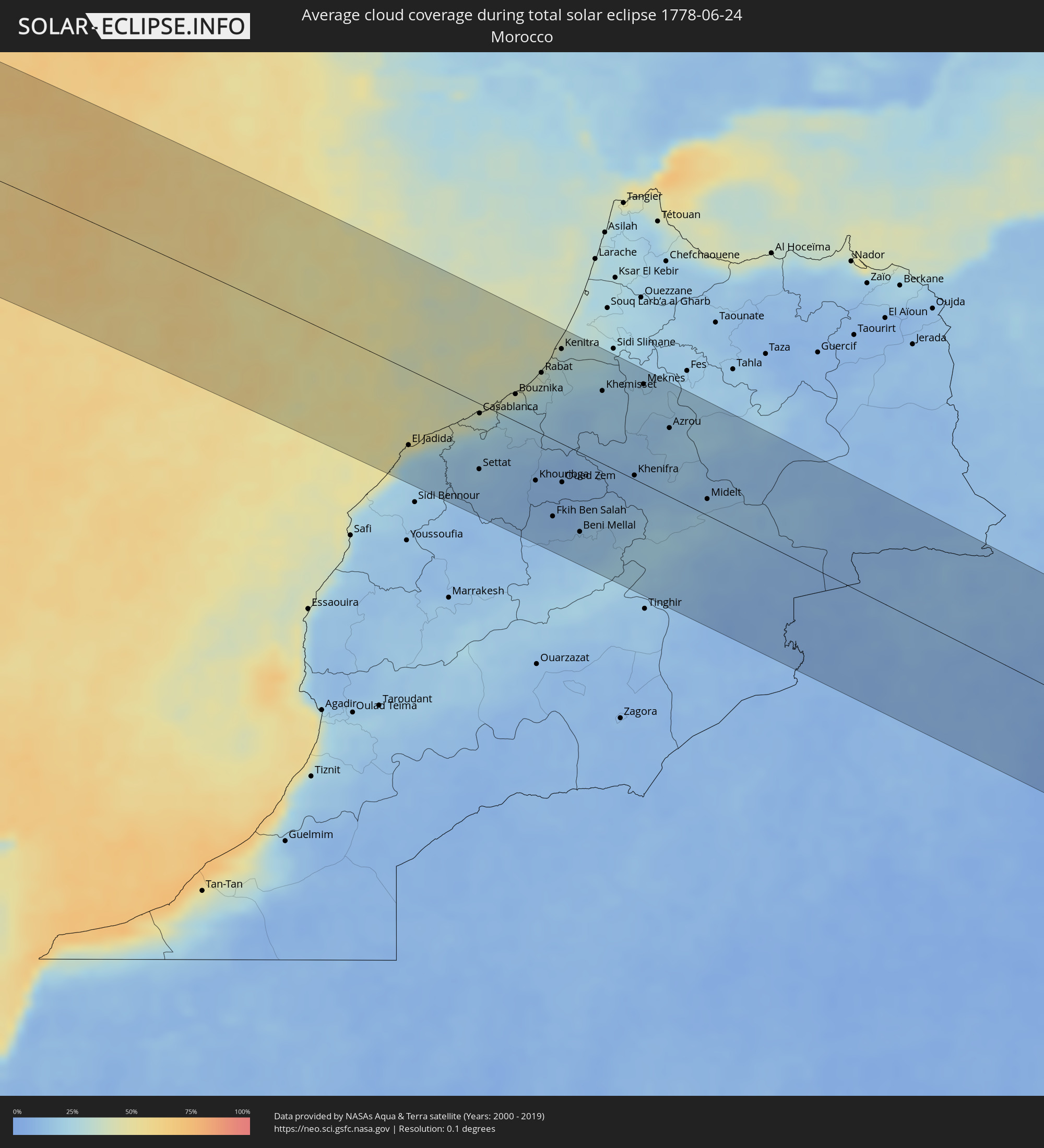 Morocco
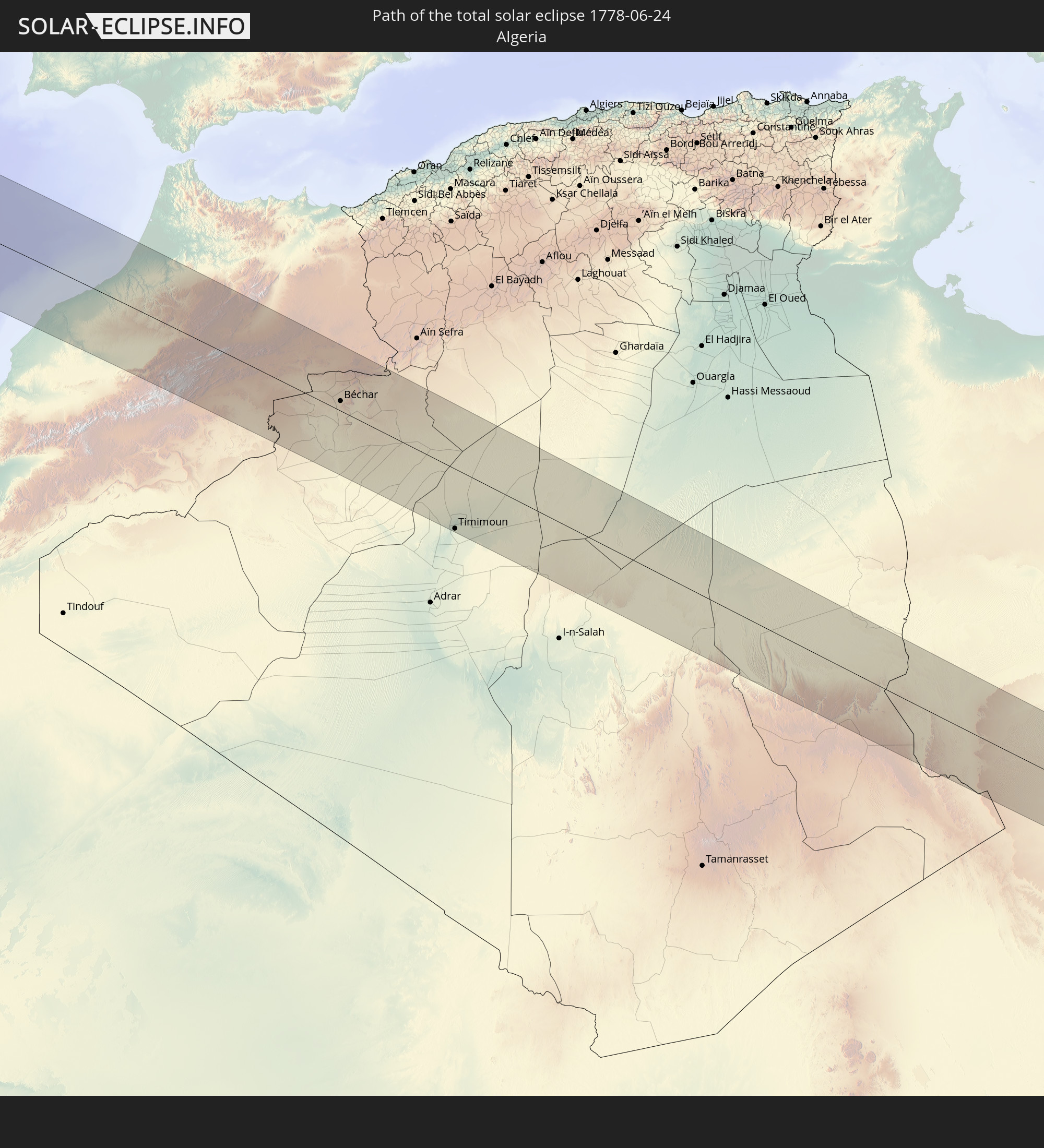
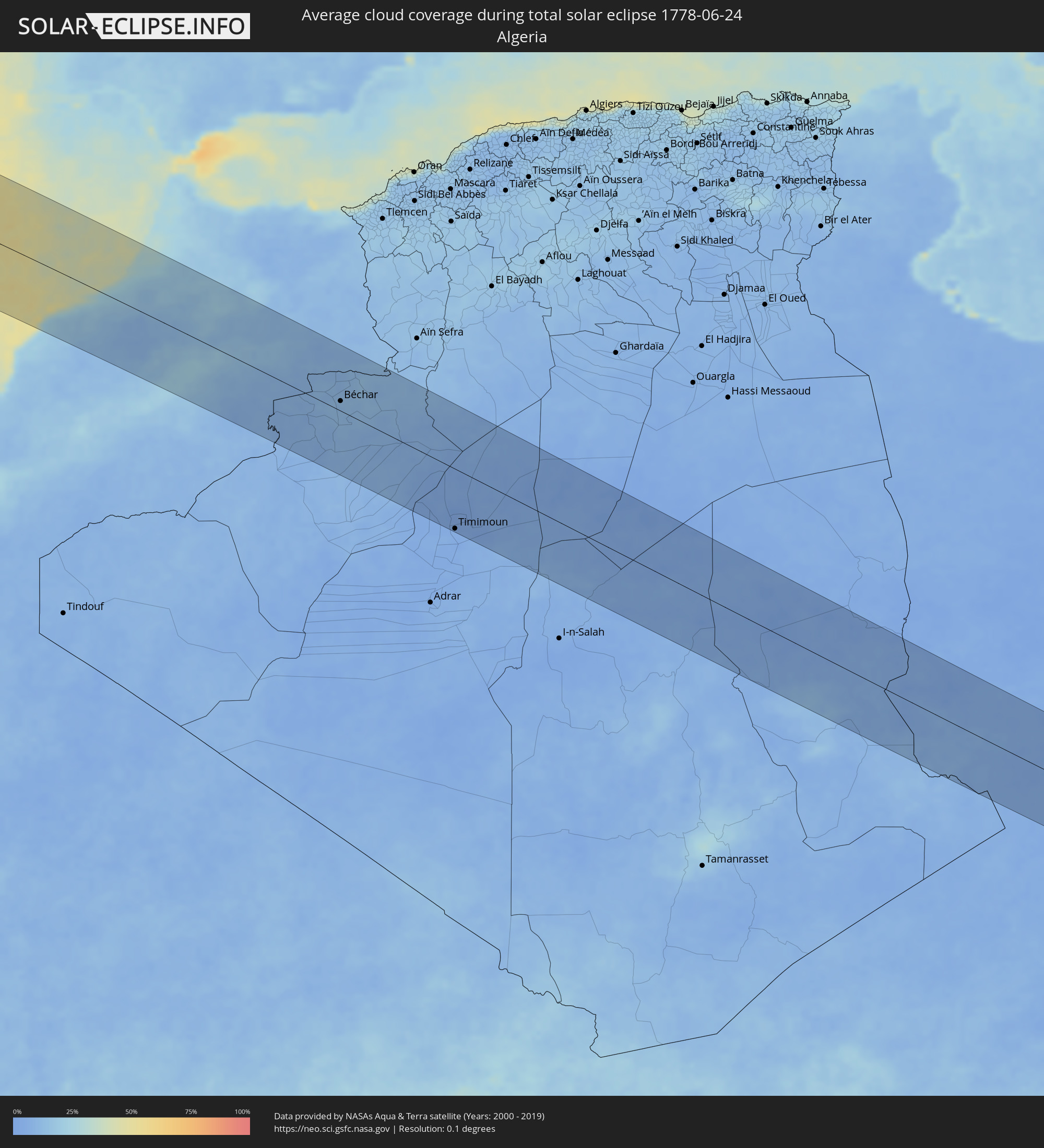 Algeria
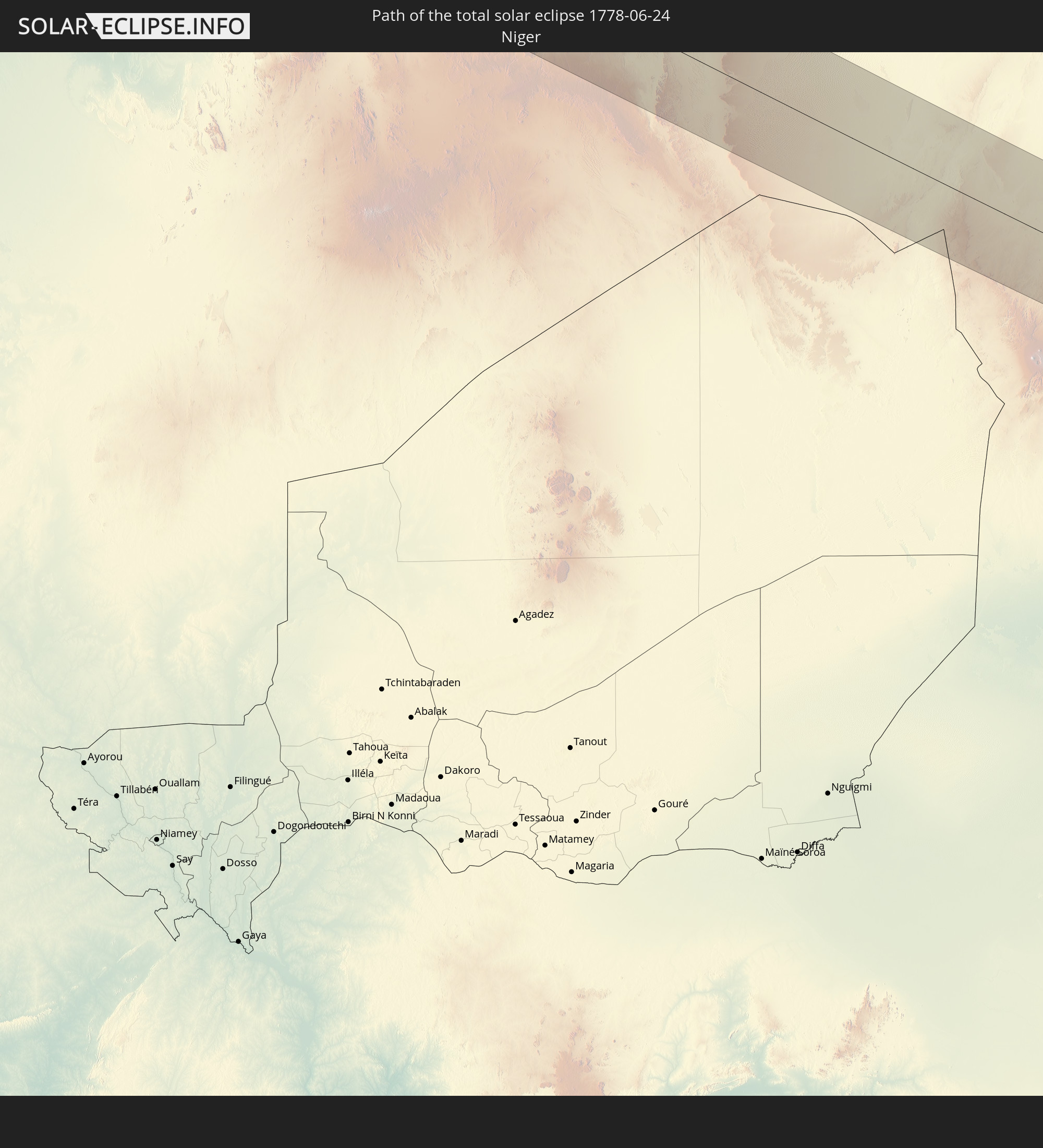
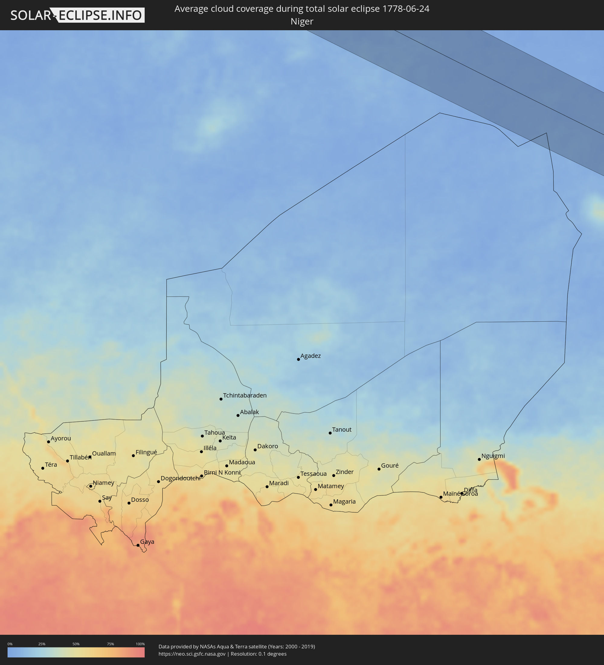 Niger
Niger
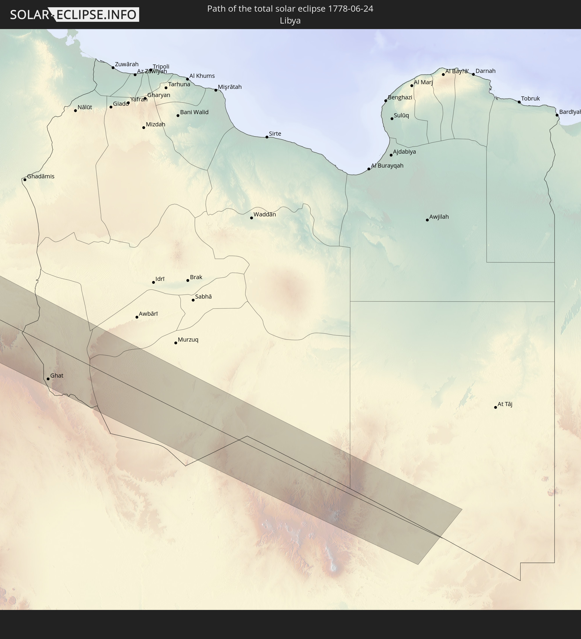
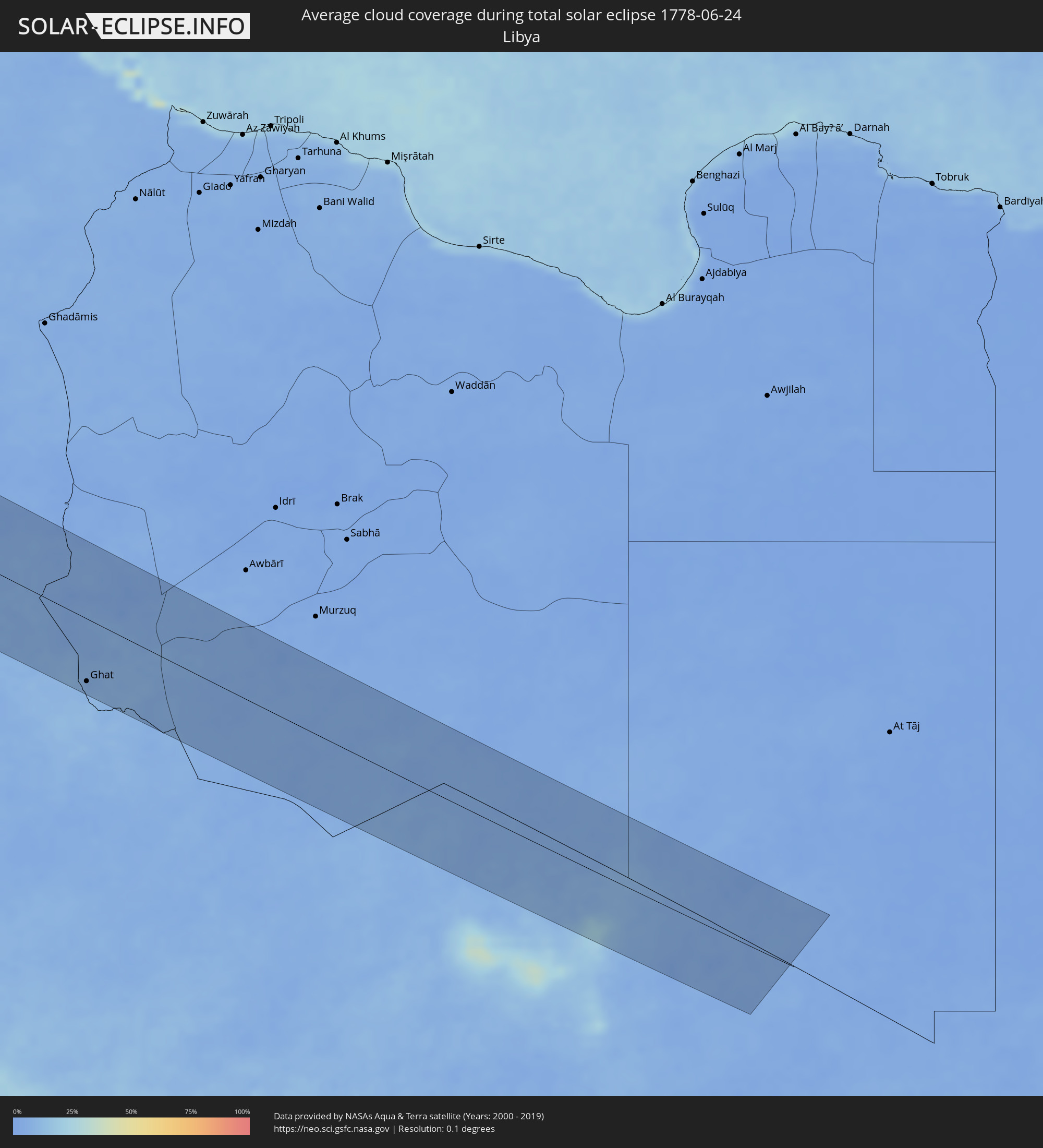 Libya
Libya
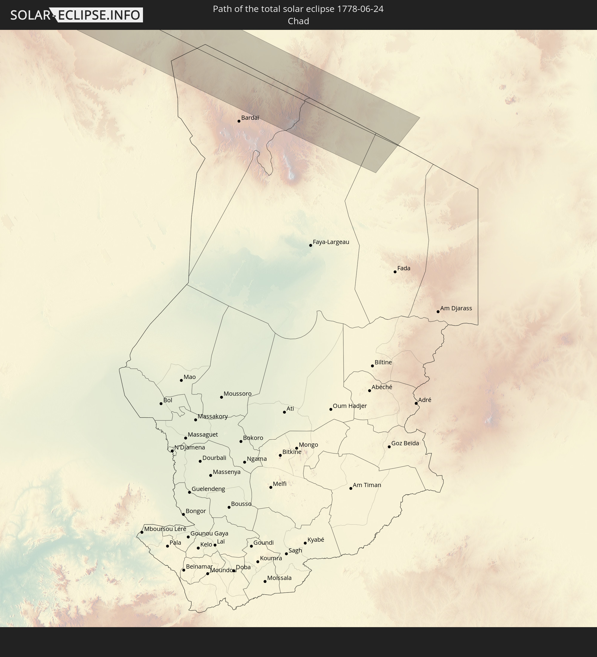
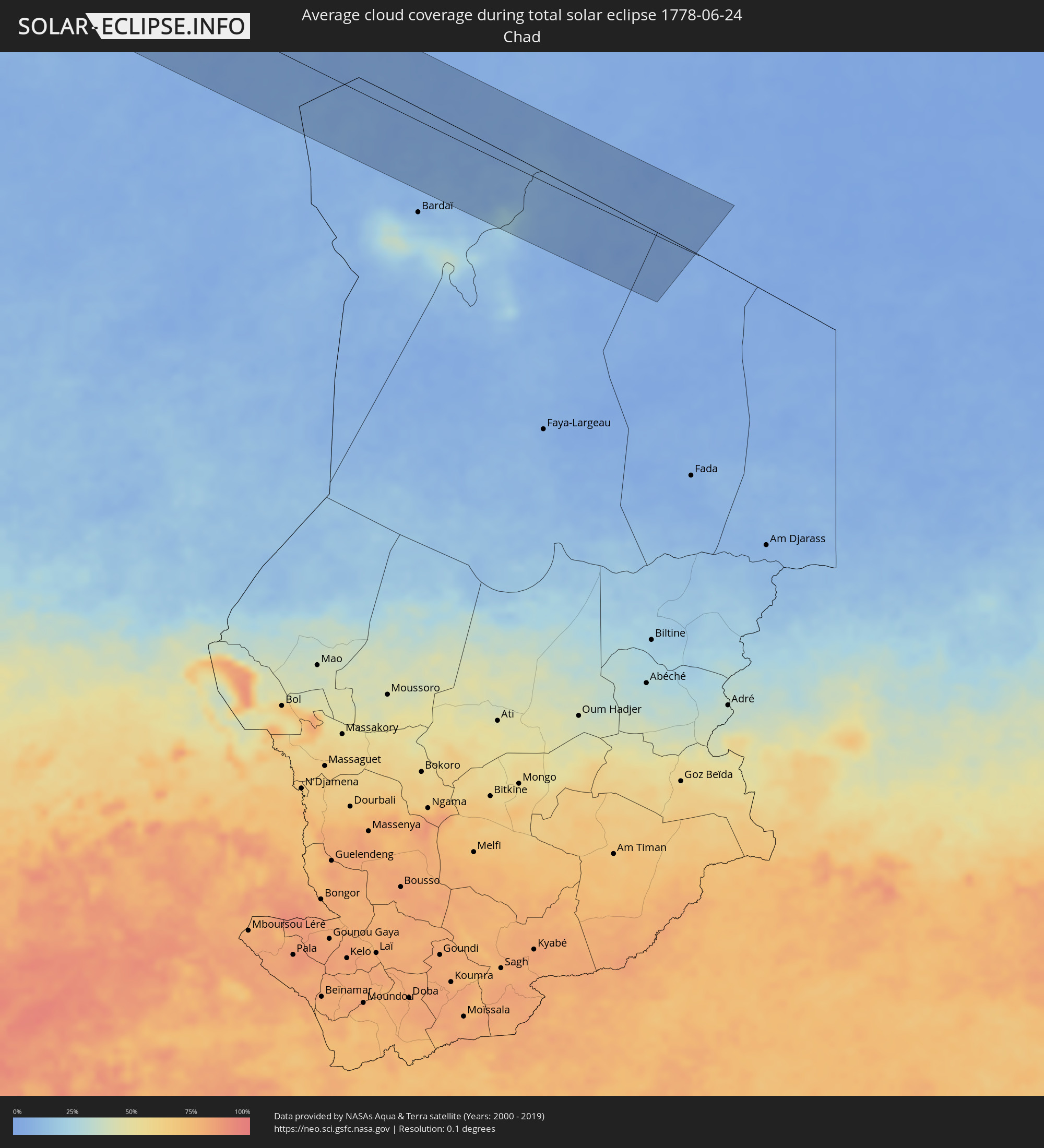 Chad
Chad
Cities inside the path of the eclipse
The following table shows all locations with a population of more than 5,000 inside the eclipse path. Cities which have more than 100,000 inhabitants are marked bold. A click at the locations opens a detailed map.
| City | Type | Eclipse duration | Local time of max. eclipse | Distance to central line | Ø Cloud coverage |
|
Escuinapa de Hidalgo, Sinaloa
|
total | - | 06:59:34 UTC-07:05 | 93 km | 65% |
|
Acaponeta, Nayarit
|
total | - | 06:59:17 UTC-07:05 | 39 km | 83% |
|
Santiago Ixcuintla, Nayarit
|
total | - | 06:58:34 UTC-07:05 | 35 km | 73% |
|
Las Varas, Nayarit
|
total | - | 06:57:52 UTC-07:05 | 99 km | 73% |
|
Compostela, Nayarit
|
total | - | 06:58:00 UTC-07:05 | 106 km | 65% |
|
Tepic, Nayarit
|
total | - | 06:58:19 UTC-07:05 | 80 km | 68% |
|
Vicente Guerrero, Durango
|
total | - | 07:30:14 UTC-06:36 | 87 km | 55% |
|
Sombrerete, Zacatecas
|
total | - | 07:30:14 UTC-06:36 | 60 km | 55% |
|
Juan Aldama, Zacatecas
|
total | - | 07:31:07 UTC-06:36 | 110 km | 50% |
|
Colotlán, Jalisco
|
total | - | 07:28:36 UTC-06:36 | 106 km | 59% |
|
Río Grande, Zacatecas
|
total | - | 07:30:42 UTC-06:36 | 47 km | 52% |
|
Jerez de García Salinas, Zacatecas
|
total | - | 07:29:19 UTC-06:36 | 68 km | 60% |
|
Fresnillo, Zacatecas
|
total | - | 07:29:59 UTC-06:36 | 23 km | 54% |
|
Víctor Rosales, Zacatecas
|
total | - | 07:29:47 UTC-06:36 | 55 km | 63% |
|
Zacatecas, Zacatecas
|
total | - | 07:29:37 UTC-06:36 | 78 km | 66% |
|
Saltillo, Coahuila
|
total | - | 07:33:30 UTC-06:36 | 95 km | 50% |
|
Matehuala, San Luis Potosí
|
total | - | 07:31:29 UTC-06:36 | 94 km | 52% |
|
García, Nuevo León
|
total | - | 07:34:11 UTC-06:36 | 110 km | 41% |
|
Mitras Poniente, Nuevo León
|
total | - | 07:34:14 UTC-06:36 | 98 km | 48% |
|
Monterrey, Nuevo León
|
total | - | 07:34:09 UTC-06:36 | 83 km | 50% |
|
Apodaca, Nuevo León
|
total | - | 07:34:20 UTC-06:36 | 83 km | 52% |
|
Fraccionamiento Real Palmas, Nuevo León
|
total | - | 07:34:31 UTC-06:36 | 97 km | 55% |
|
Santiago, Nuevo León
|
total | - | 07:33:55 UTC-06:36 | 51 km | 64% |
|
Allende, Nuevo León
|
total | - | 07:33:48 UTC-06:36 | 29 km | 62% |
|
Cadereyta, Nuevo León
|
total | - | 07:34:12 UTC-06:36 | 57 km | 54% |
|
Montemorelos, Nuevo León
|
total | - | 07:33:47 UTC-06:36 | 11 km | 57% |
|
Hidalgo, Nuevo León
|
total | - | 07:34:44 UTC-06:36 | 64 km | 49% |
|
Linares, Nuevo León
|
total | - | 07:33:30 UTC-06:36 | 34 km | 54% |
|
Ciudad Miguel Alemán, Tamaulipas
|
total | - | 07:35:45 UTC-06:36 | 85 km | 61% |
|
Reynosa, Tamaulipas
|
total | - | 07:35:45 UTC-06:36 | 17 km | 74% |
|
McAllen, Texas
|
total | - | 08:12:33 UTC-06:00 | 25 km | 74% |
|
San Fernando, Tamaulipas
|
total | - | 07:34:15 UTC-06:36 | 108 km | 68% |
|
Río Bravo, Tamaulipas
|
total | - | 07:35:45 UTC-06:36 | 2 km | 76% |
|
Valle Hermoso, Tamaulipas
|
total | - | 07:35:30 UTC-06:36 | 47 km | 75% |
|
Harlingen, Texas
|
total | - | 08:12:51 UTC-06:00 | 3 km | 77% |
|
Heroica Matamoros, Tamaulipas
|
total | - | 07:35:57 UTC-06:36 | 43 km | 79% |
|
Brownsville, Texas
|
total | - | 08:12:35 UTC-06:00 | 41 km | 79% |
|
Lafayette, Louisiana
|
total | - | 08:22:25 UTC-06:00 | 91 km | 80% |
|
Baton Rouge, Louisiana
|
total | - | 08:23:30 UTC-06:00 | 70 km | 74% |
|
Kenner, Louisiana
|
total | - | 08:23:41 UTC-06:00 | 19 km | 73% |
|
New Orleans, Louisiana
|
total | - | 08:23:47 UTC-06:00 | 31 km | 78% |
|
West Gulfport, Mississippi
|
total | - | 08:25:22 UTC-06:00 | 36 km | 62% |
|
Mobile, Alabama
|
total | - | 08:26:50 UTC-06:00 | 59 km | 65% |
|
Montgomery, Alabama
|
total | - | 08:31:05 UTC-06:00 | 18 km | 65% |
|
Columbus, Georgia
|
total | - | 09:32:43 UTC-05:00 | 34 km | 63% |
|
Atlanta, Georgia
|
total | - | 09:35:17 UTC-05:00 | 63 km | 75% |
|
Sandy Springs, Georgia
|
total | - | 09:35:32 UTC-05:00 | 80 km | 73% |
|
Johns Creek, Georgia
|
total | - | 09:35:54 UTC-05:00 | 82 km | 72% |
|
Macon, Georgia
|
total | - | 09:34:53 UTC-05:00 | 59 km | 60% |
|
Warner Robins, Georgia
|
total | - | 09:34:35 UTC-05:00 | 81 km | 67% |
|
Athens, Georgia
|
total | - | 09:36:48 UTC-05:00 | 38 km | 68% |
|
Greenville, South Carolina
|
total | - | 09:39:19 UTC-05:00 | 81 km | 60% |
|
Gastonia, North Carolina
|
total | - | 09:41:28 UTC-05:00 | 69 km | 65% |
|
Columbia, South Carolina
|
total | - | 09:39:54 UTC-05:00 | 61 km | 63% |
|
Rock Hill, South Carolina
|
total | - | 09:41:13 UTC-05:00 | 29 km | 62% |
|
Charlotte, North Carolina
|
total | - | 09:41:53 UTC-05:00 | 51 km | 69% |
|
Concord, North Carolina
|
total | - | 09:42:30 UTC-05:00 | 57 km | 66% |
|
Winston-Salem, North Carolina
|
total | - | 09:43:55 UTC-05:00 | 111 km | 64% |
|
High Point, North Carolina
|
total | - | 09:44:03 UTC-05:00 | 87 km | 65% |
|
Greensboro, North Carolina
|
total | - | 09:44:30 UTC-05:00 | 90 km | 67% |
|
Durham, North Carolina
|
total | - | 09:45:39 UTC-05:00 | 45 km | 72% |
|
Fayetteville, North Carolina
|
total | - | 09:44:23 UTC-05:00 | 49 km | 77% |
|
Raleigh, North Carolina
|
total | - | 09:45:43 UTC-05:00 | 12 km | 74% |
|
Greenville, North Carolina
|
total | - | 09:47:22 UTC-05:00 | 55 km | 74% |
|
Suffolk, Virginia
|
total | - | 09:50:04 UTC-05:00 | 26 km | 64% |
|
Newport News, Virginia
|
total | - | 09:50:43 UTC-05:00 | 57 km | 60% |
|
Norfolk, Virginia
|
total | - | 09:50:41 UTC-05:00 | 26 km | 67% |
|
Virginia Beach, Virginia
|
total | - | 09:51:09 UTC-05:00 | 15 km | 59% |
|
Lagoa, Azores
|
total | - | 14:32:28 UTC-01:54 | 120 km | 70% |
|
El Jadida, Doukkala-Abda
|
total | - | 16:25:20 UTC-00:30 | 79 km | 37% |
|
Azemmour, Doukkala-Abda
|
total | - | 16:25:25 UTC-00:30 | 69 km | 26% |
|
Nouaseur, Chaouia-Ouardigha
|
total | - | 16:25:48 UTC-00:30 | 31 km | 21% |
|
Settat, Chaouia-Ouardigha
|
total | - | 16:26:16 UTC-00:30 | 69 km | 14% |
|
Casablanca, Grand Casablanca
|
total | - | 16:25:34 UTC-00:30 | 10 km | 31% |
|
Berrechid, Chaouia-Ouardigha
|
total | - | 16:25:58 UTC-00:30 | 41 km | 19% |
|
Mohammedia, Grand Casablanca
|
total | - | 16:25:36 UTC-00:30 | 9 km | 32% |
|
Bouznika, Chaouia-Ouardigha
|
total | - | 16:25:37 UTC-00:30 | 28 km | 31% |
|
Skhirate, Rabat-Salé-Zemmour-Zaër
|
total | - | 16:25:38 UTC-00:30 | 40 km | 30% |
|
Khouribga, Chaouia-Ouardigha
|
total | - | 16:26:53 UTC-00:30 | 52 km | 9% |
|
Rabat, Rabat-Salé-Zemmour-Zaër
|
total | - | 16:25:34 UTC-00:30 | 64 km | 28% |
|
Sale, Rabat-Salé-Zemmour-Zaër
|
total | - | 16:25:32 UTC-00:30 | 69 km | 32% |
|
Boujniba, Chaouia-Ouardigha
|
total | - | 16:26:56 UTC-00:30 | 45 km | 9% |
|
Fkih Ben Salah, Tadla-Azilal
|
total | - | 16:27:28 UTC-00:30 | 82 km | 11% |
|
Kenitra, Gharb-Chrarda-Beni Hssen
|
total | - | 16:25:26 UTC-00:30 | 99 km | 29% |
|
Oued Zem, Chaouia-Ouardigha
|
total | - | 16:27:07 UTC-00:30 | 41 km | 9% |
|
Beni Mellal, Tadla-Azilal
|
total | - | 16:27:52 UTC-00:30 | 84 km | 15% |
|
Tiflet, Rabat-Salé-Zemmour-Zaër
|
total | - | 16:26:03 UTC-00:30 | 74 km | 18% |
|
Sidi Yahia El Gharb, Gharb-Chrarda-Beni Hssen
|
total | - | 16:25:33 UTC-00:30 | 115 km | 30% |
|
Kasba Tadla, Tadla-Azilal
|
total | - | 16:27:37 UTC-00:30 | 55 km | 13% |
|
Khemisset, Rabat-Salé-Zemmour-Zaër
|
total | - | 16:26:17 UTC-00:30 | 76 km | 17% |
|
Khenifra, Meknès-Tafilalet
|
total | - | 16:27:35 UTC-00:30 | 4 km | 12% |
|
Meknès, Meknès-Tafilalet
|
total | - | 16:26:30 UTC-00:30 | 104 km | 18% |
|
El Hajeb, Meknès-Tafilalet
|
total | - | 16:26:52 UTC-00:30 | 91 km | 19% |
|
Azrou, Meknès-Tafilalet
|
total | - | 16:27:15 UTC-00:30 | 72 km | 17% |
|
Midelt, Meknès-Tafilalet
|
total | - | 16:28:25 UTC-00:30 | 17 km | 16% |
|
Béchar, Béchar
|
total | - | 17:10:38 UTC+00:09 | 18 km | 10% |
|
Figuig (Centre), Oriental
|
total | - | 16:30:50 UTC-00:30 | 109 km | 12% |
|
Timimoun, Adrar
|
total | - | 17:14:16 UTC+00:09 | 110 km | 4% |
|
Illizi, Illizi
|
total | - | 17:18:53 UTC+00:09 | 18 km | 6% |
|
Ghat, Sha‘bīyat Ghāt
|
total | - | 18:03:46 UTC+00:52 | 92 km | 6% |