Total solar eclipse of 11/19/1816
| Day of week: | Tuesday |
| Maximum duration of eclipse: | 02m00s |
| Maximum width of eclipse path: | 145 km |
| Saros cycle: | 120 |
| Coverage: | 100% |
| Magnitude: | 1.0233 |
| Gamma: | 0.8408 |
Wo kann man die Sonnenfinsternis vom 11/19/1816 sehen?
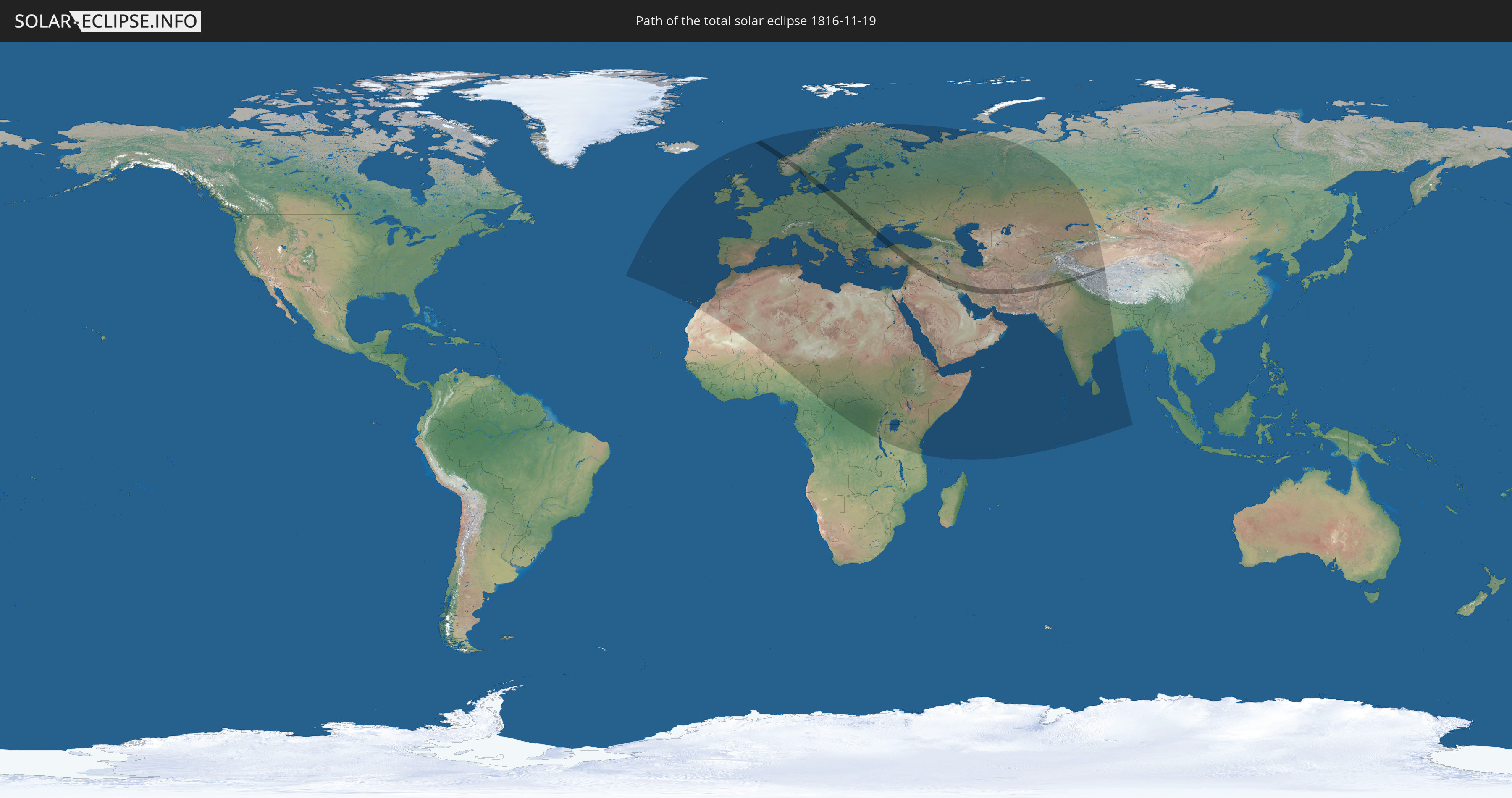
Die Sonnenfinsternis am 11/19/1816 kann man in 106 Ländern als partielle Sonnenfinsternis beobachten.
Der Finsternispfad verläuft durch 17 Länder. Nur in diesen Ländern ist sie als total Sonnenfinsternis zu sehen.
In den folgenden Ländern ist die Sonnenfinsternis total zu sehen
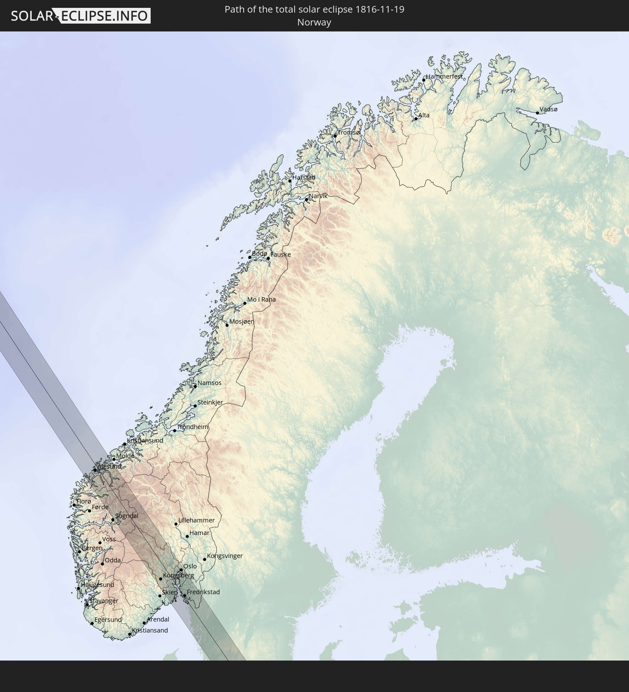 Norway
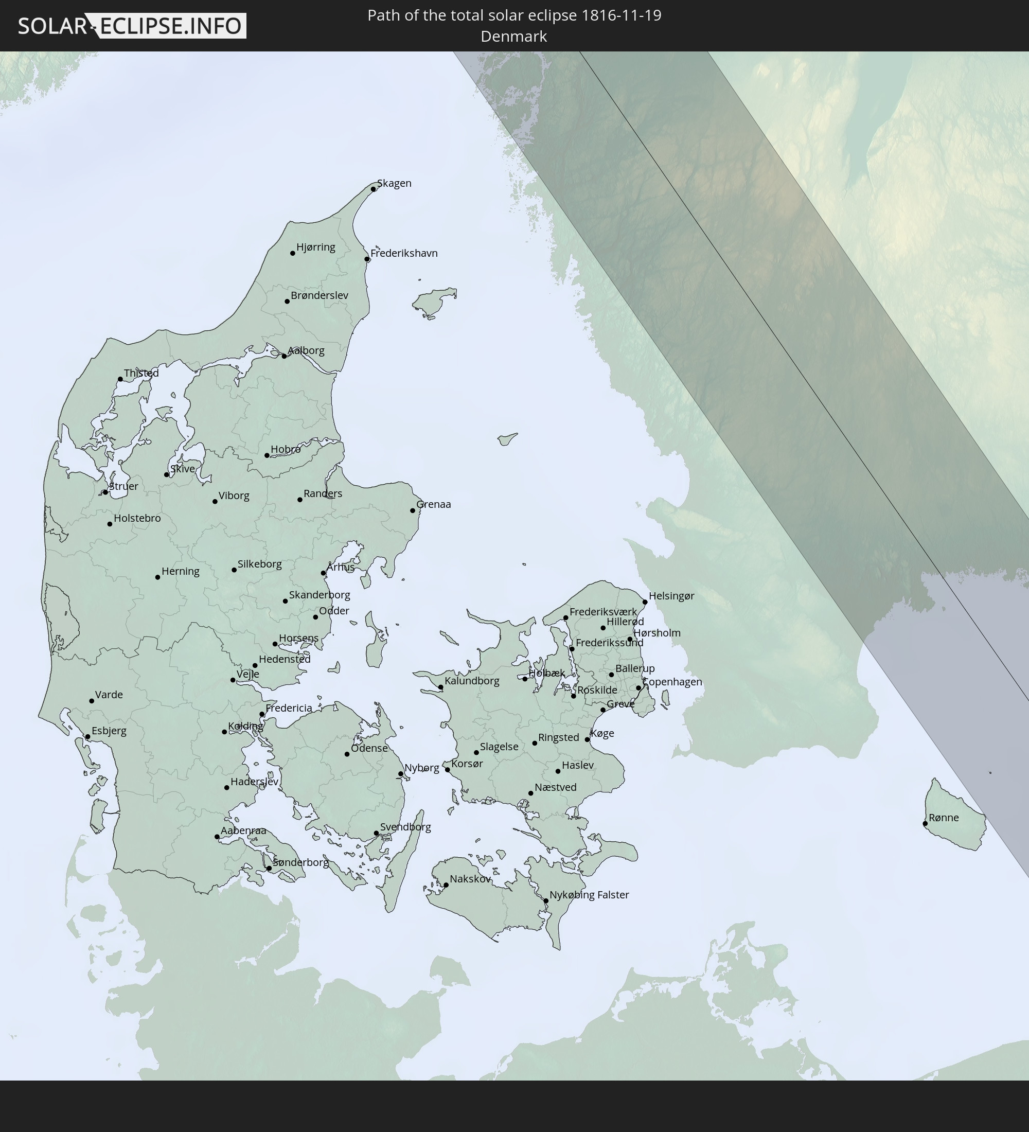 Denmark
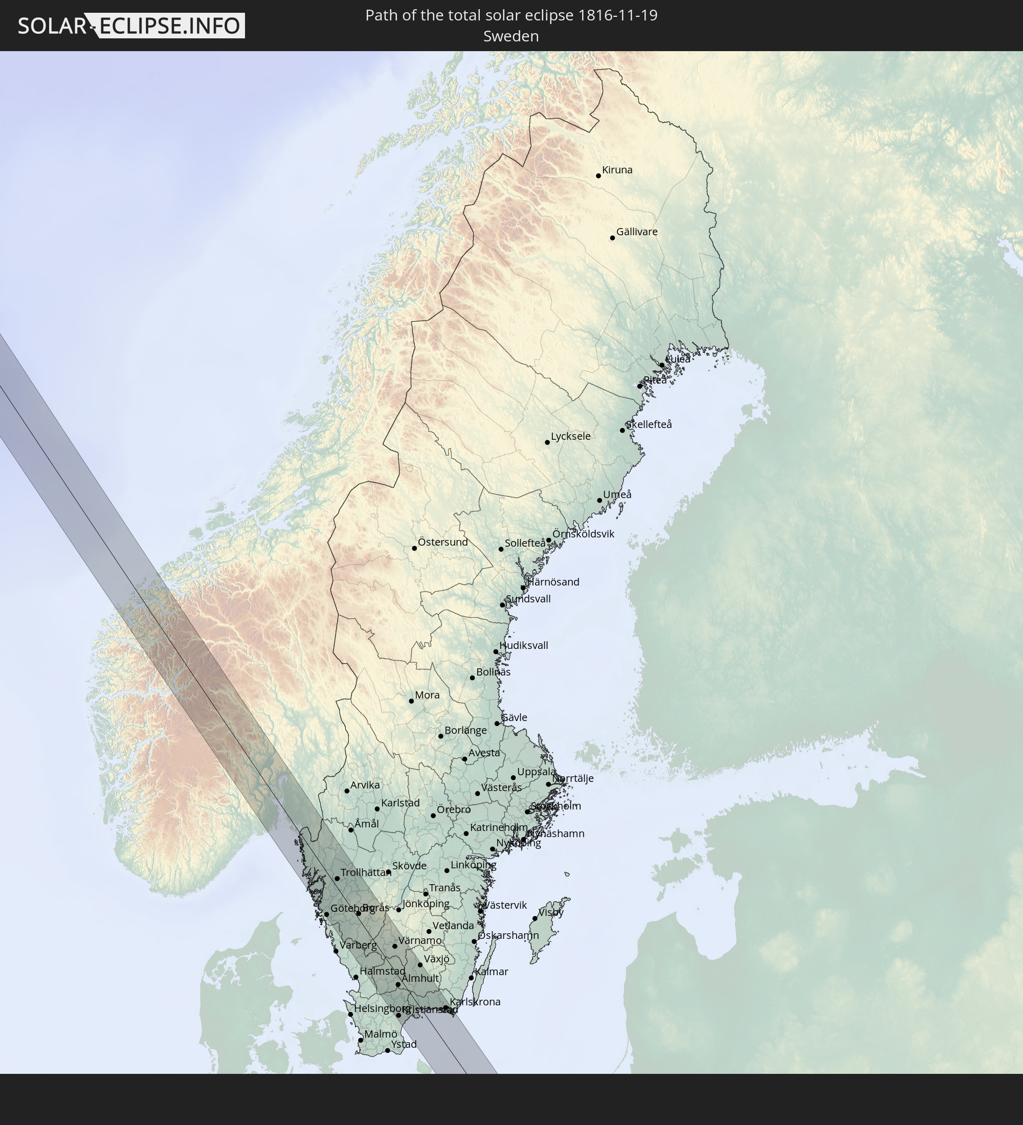 Sweden
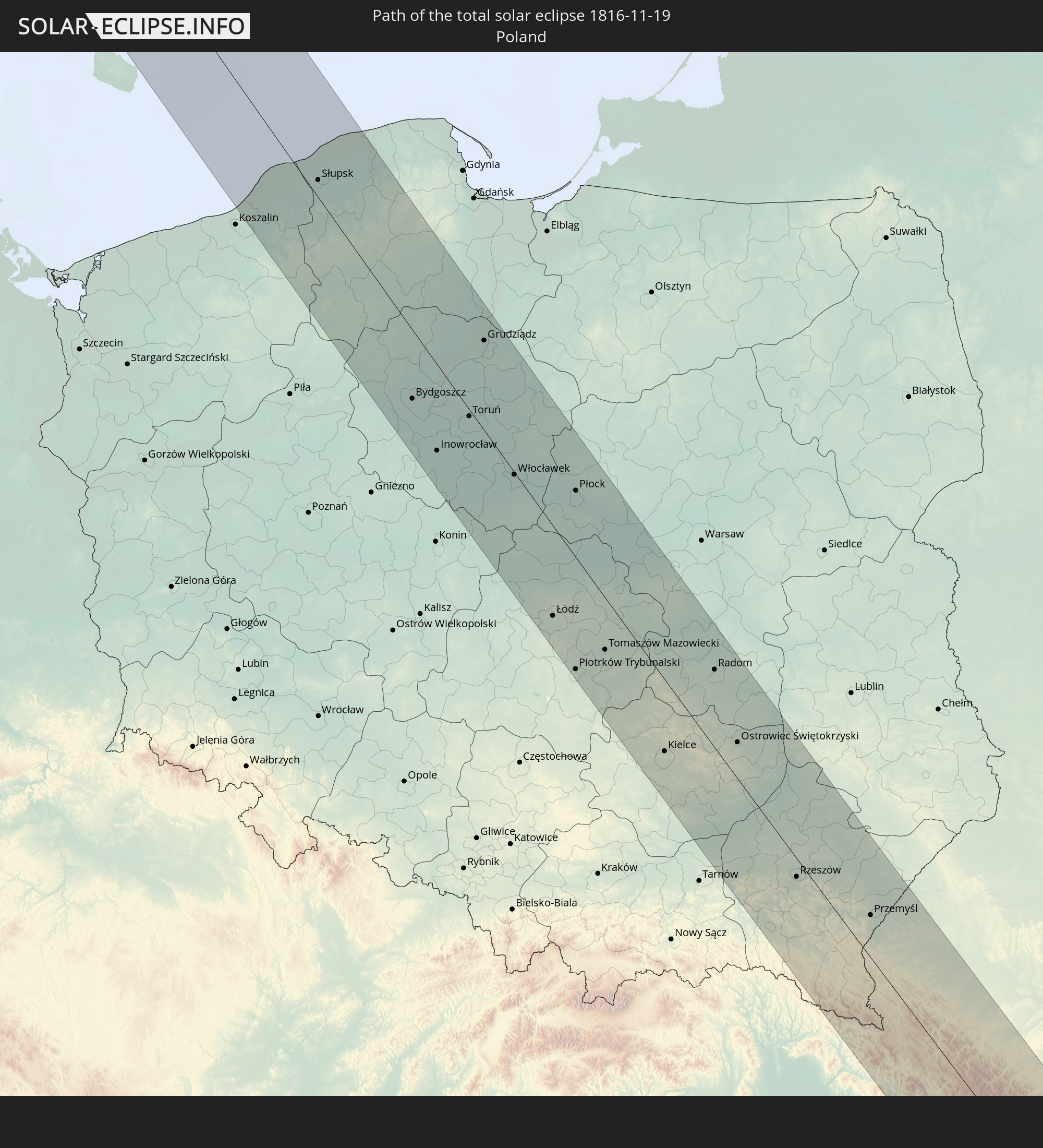 Poland
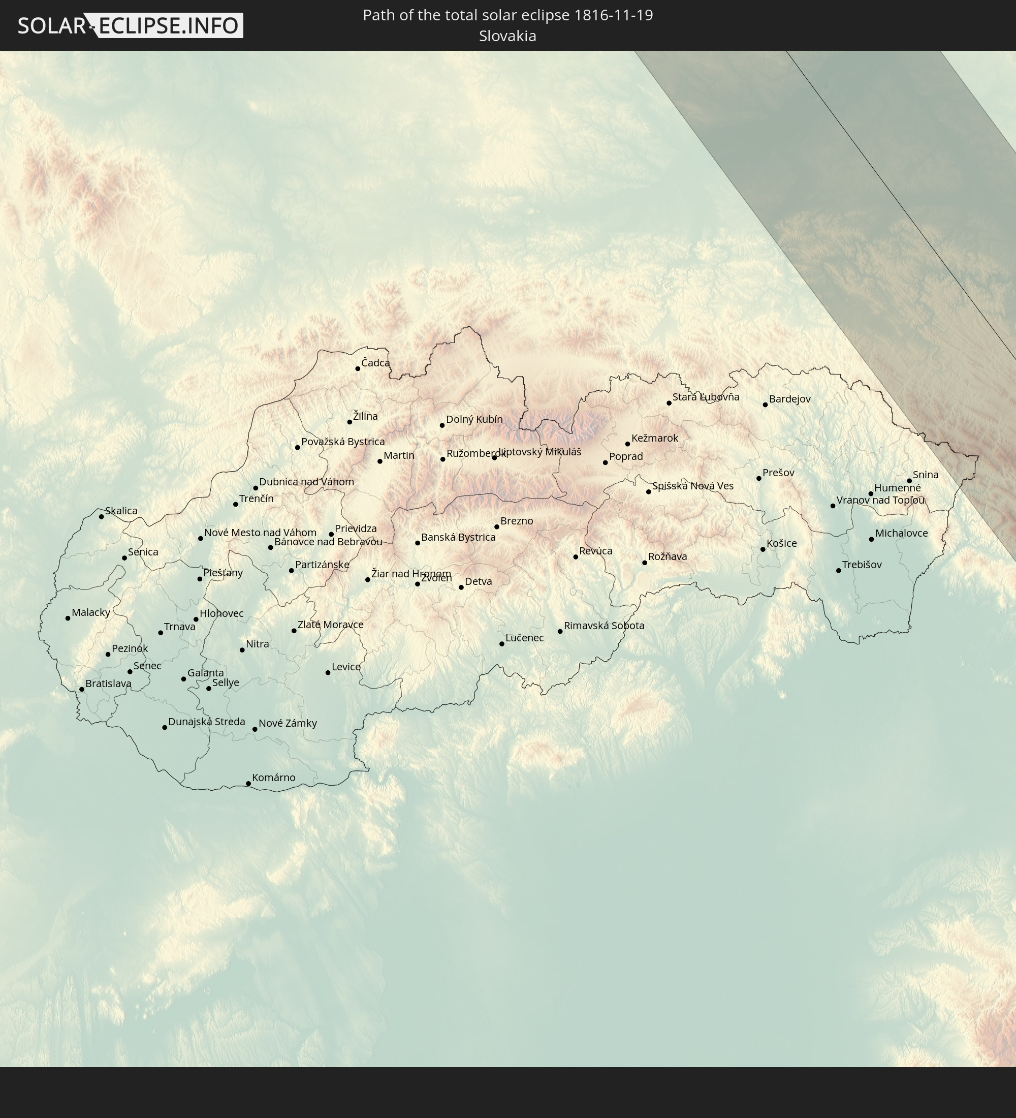 Slovakia
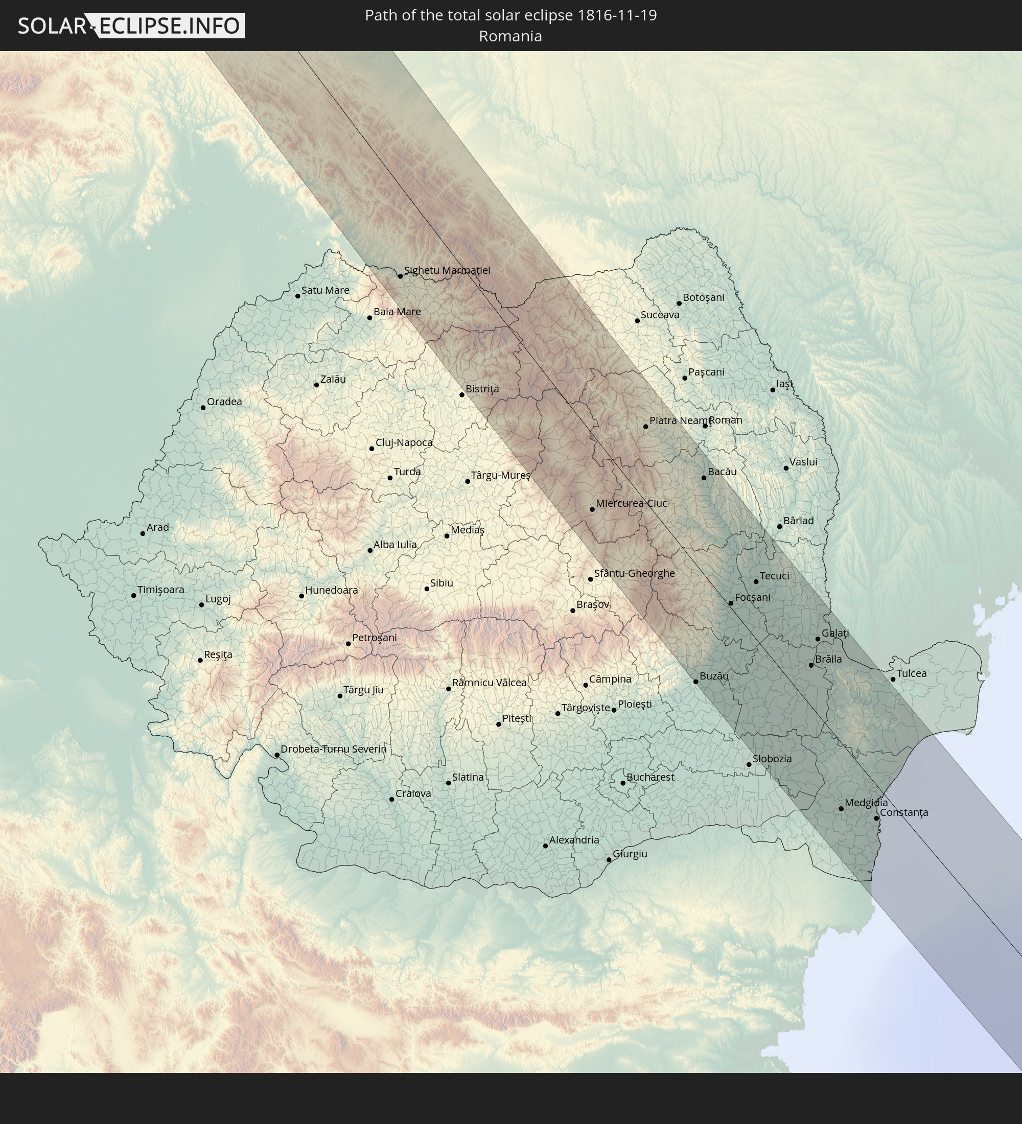 Romania
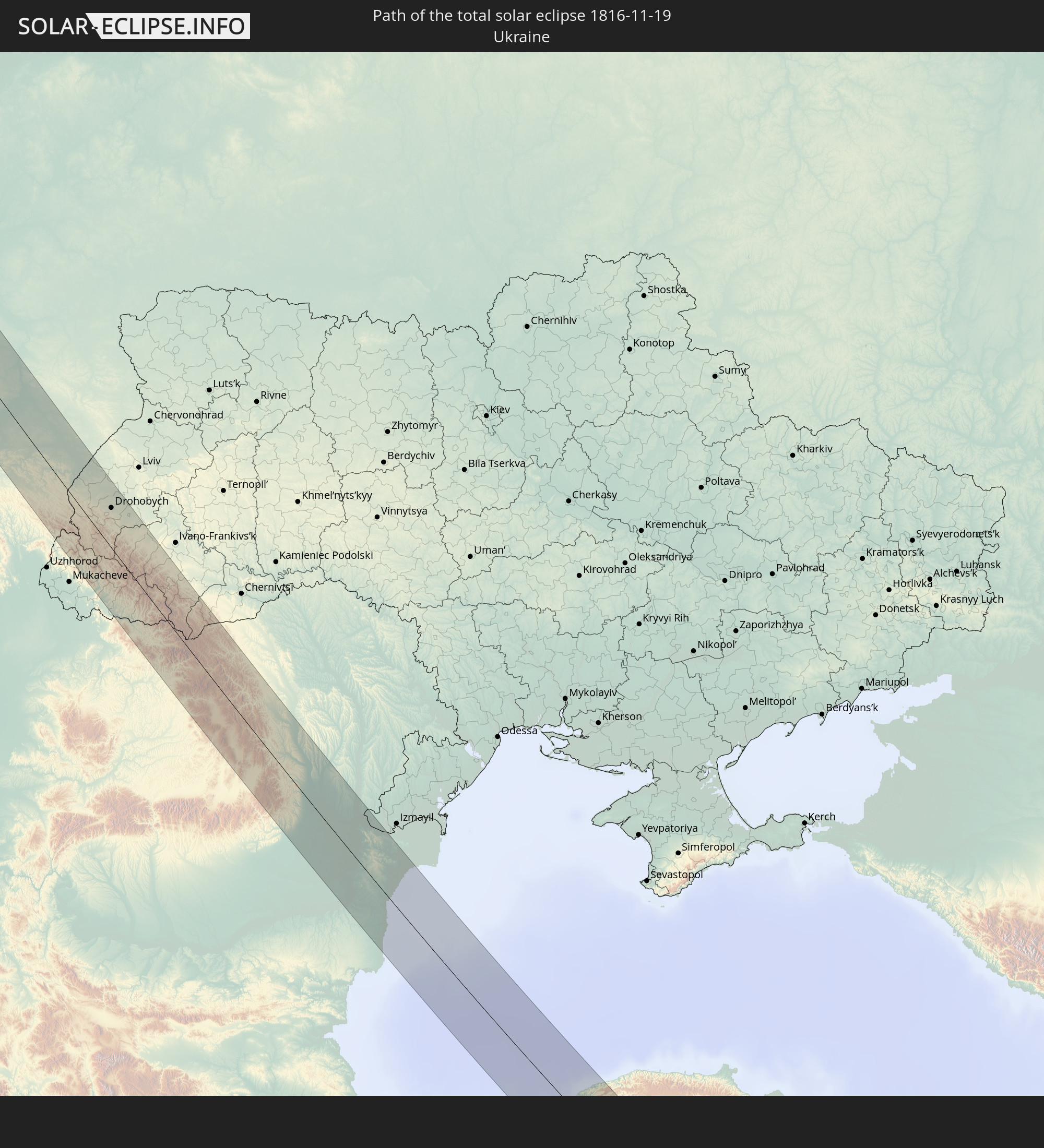 Ukraine
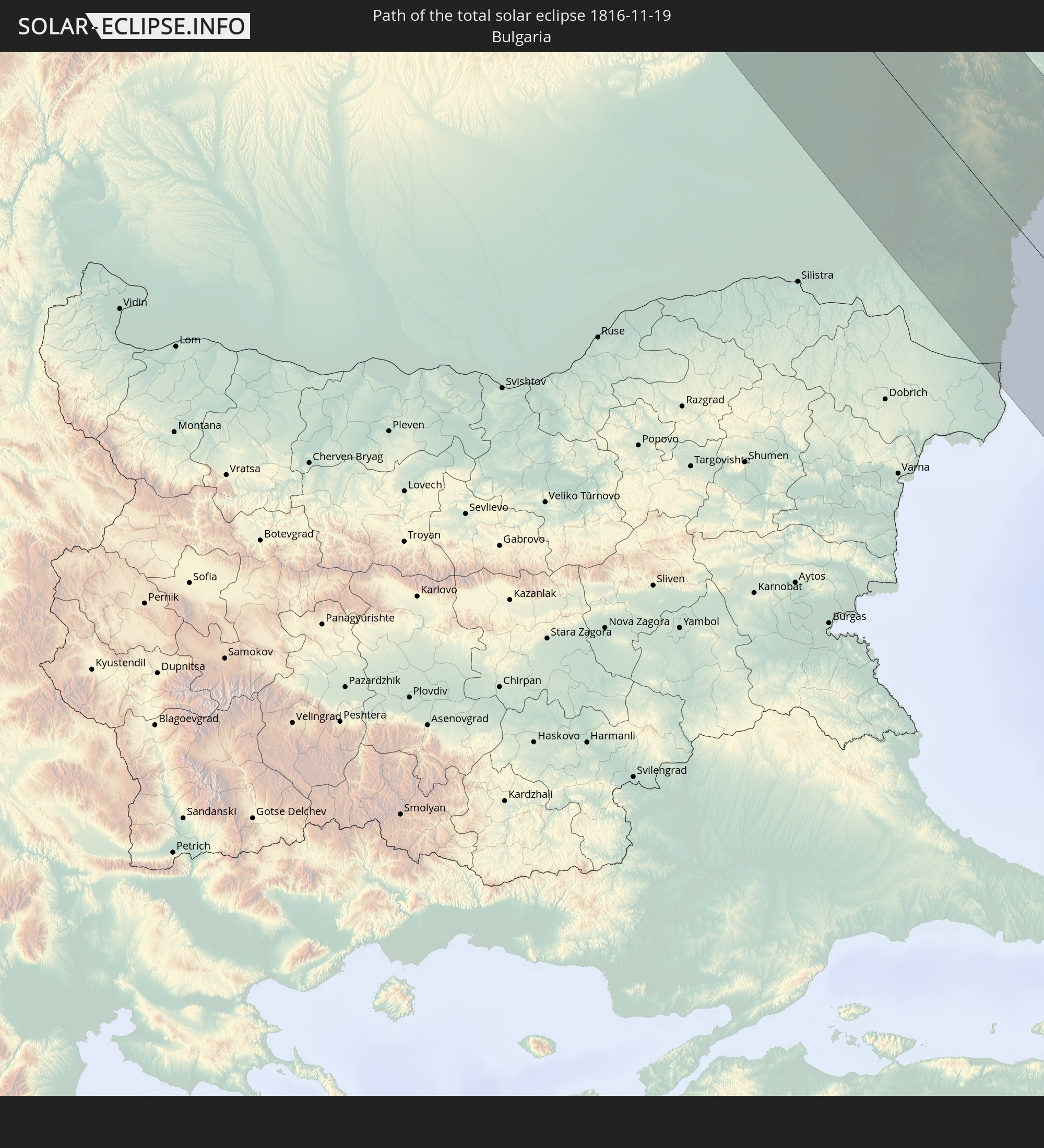 Bulgaria
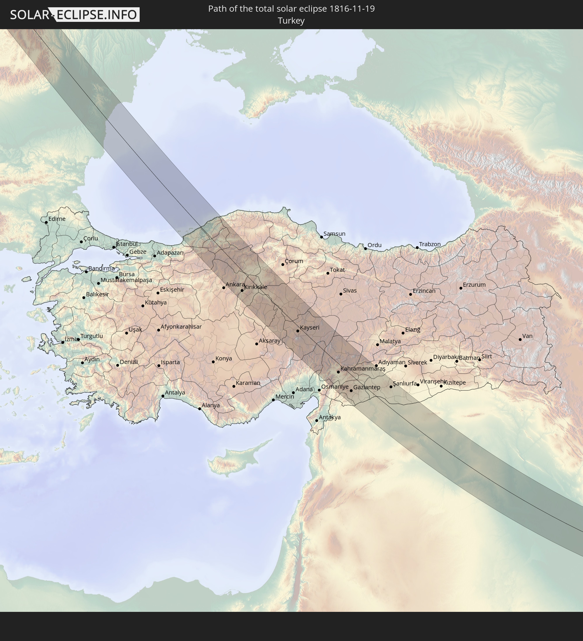 Turkey
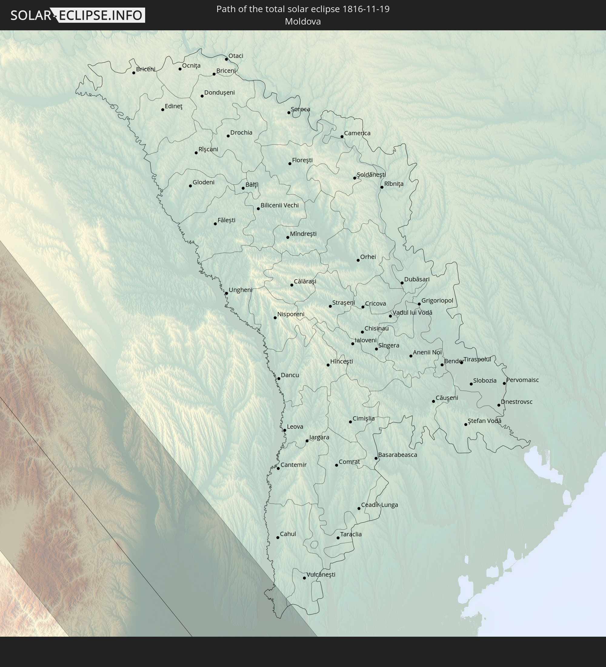 Moldova
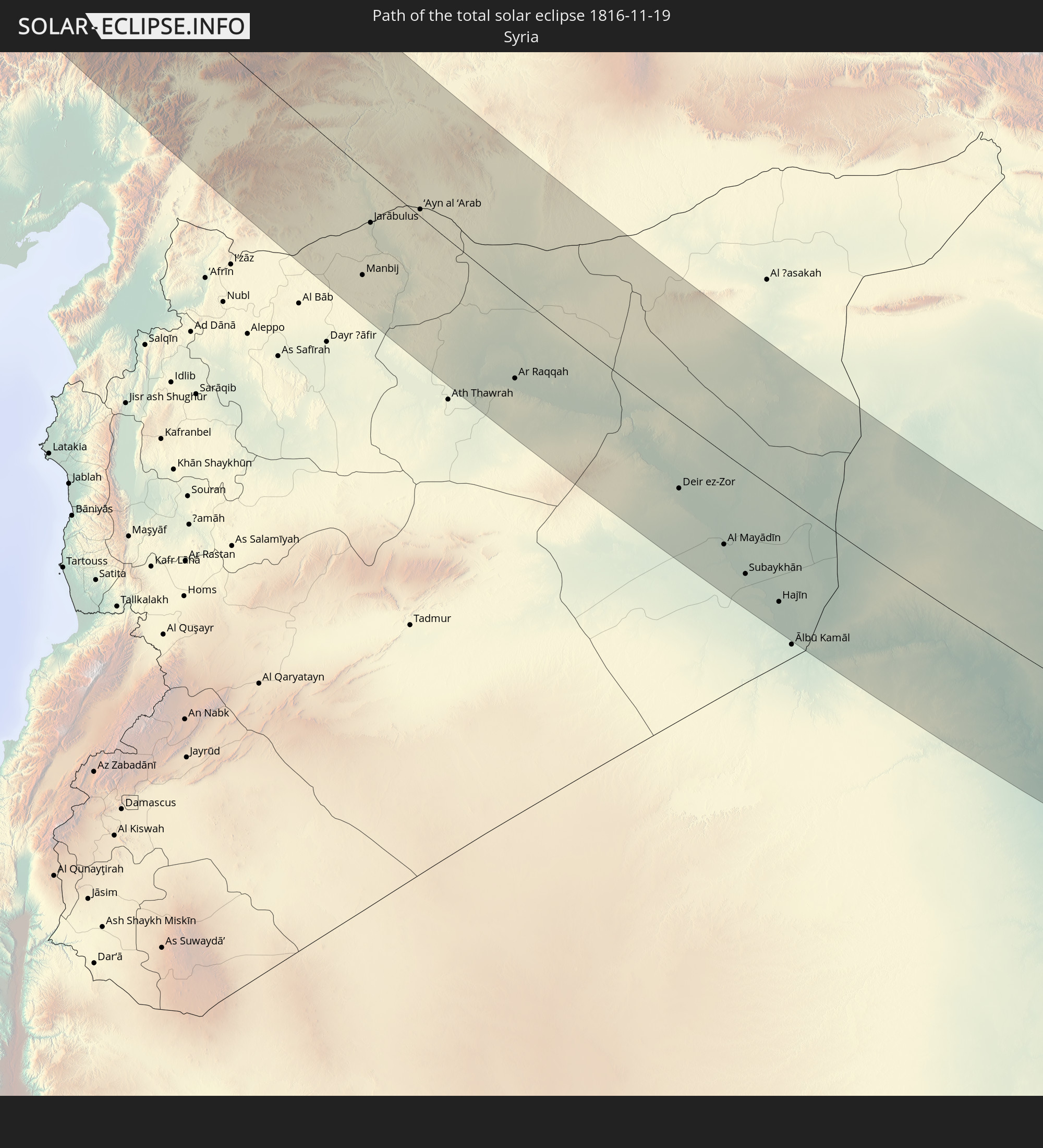 Syria
Syria
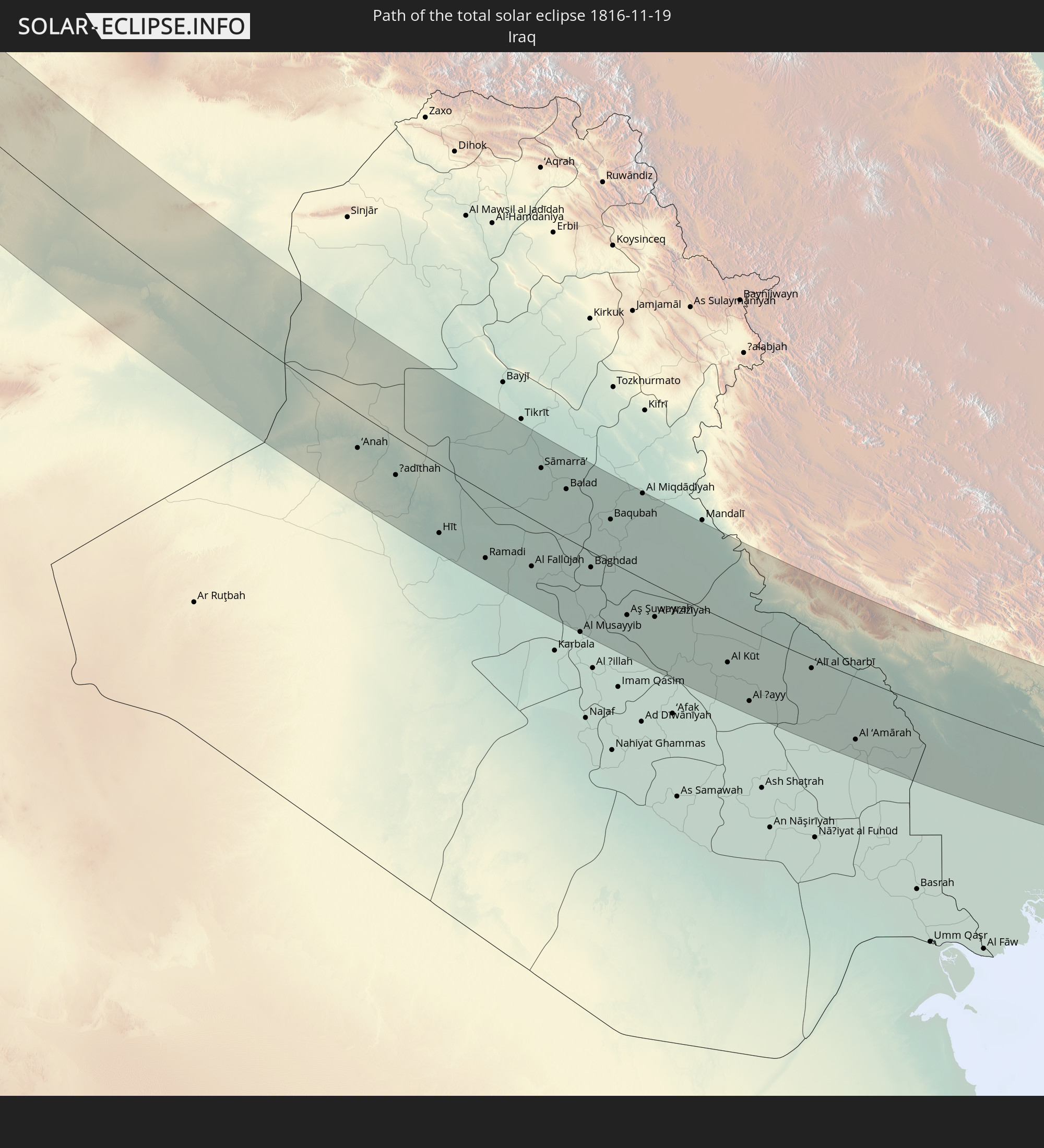 Iraq
Iraq
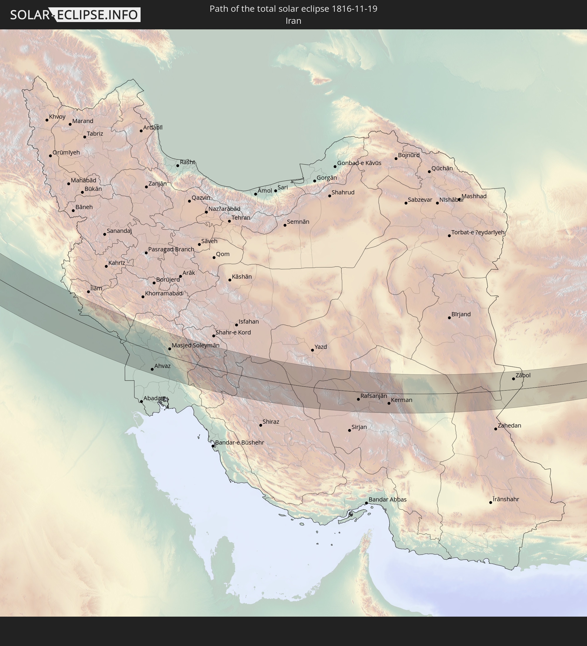 Iran
Iran
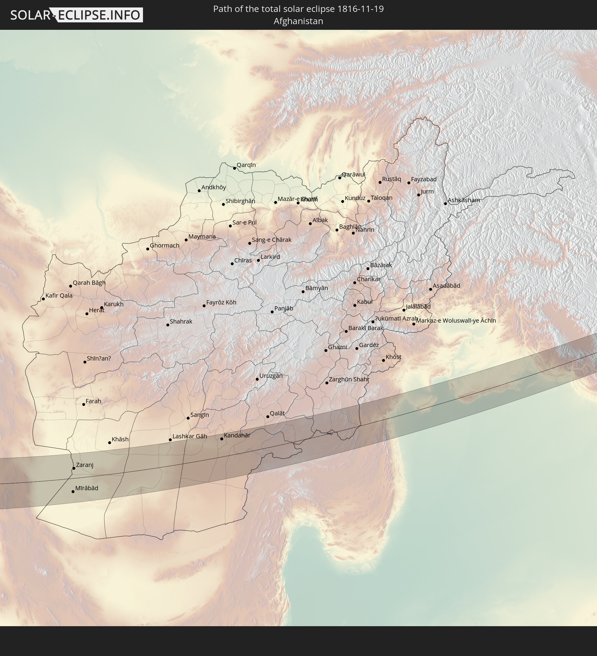 Afghanistan
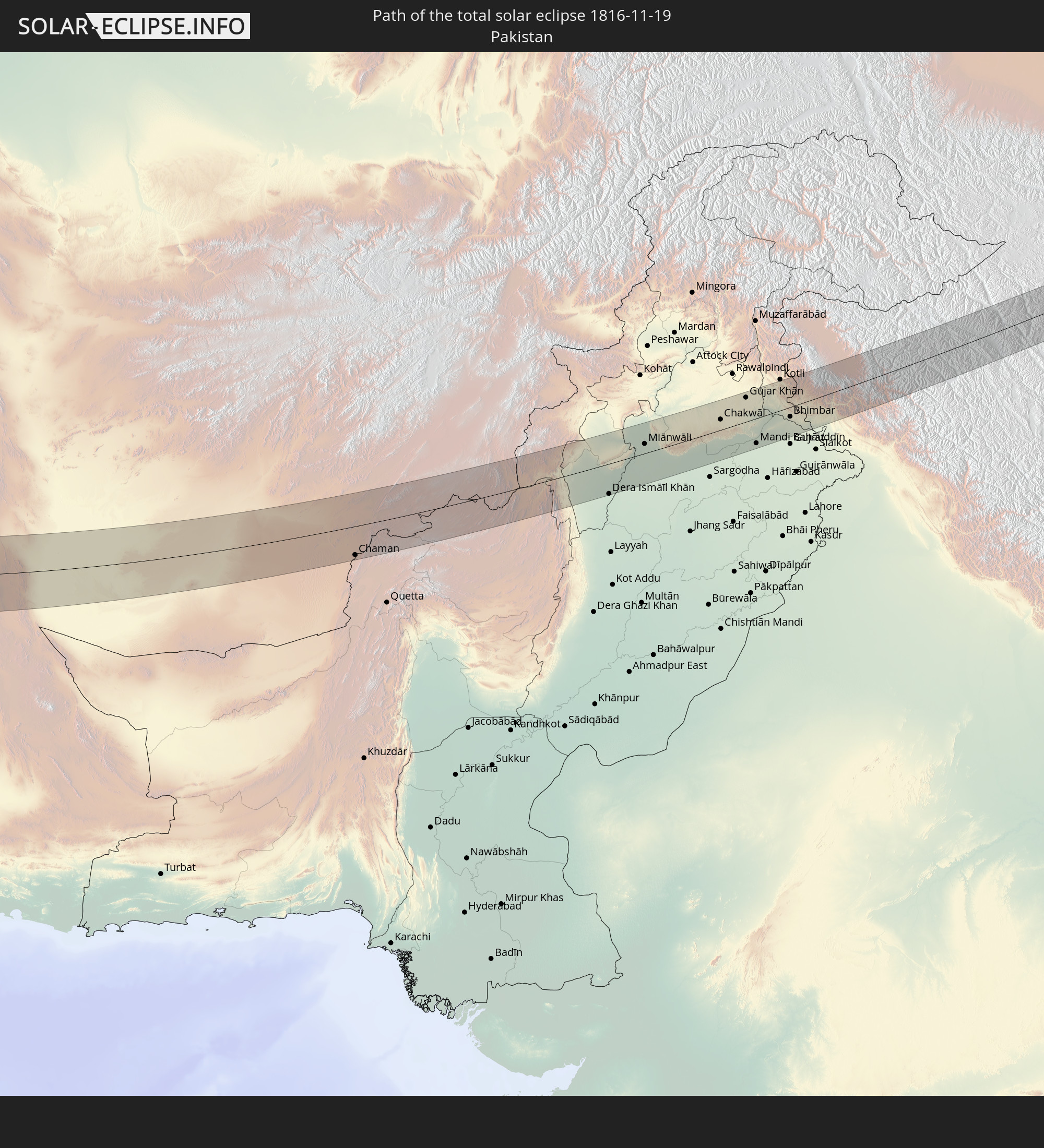 Pakistan
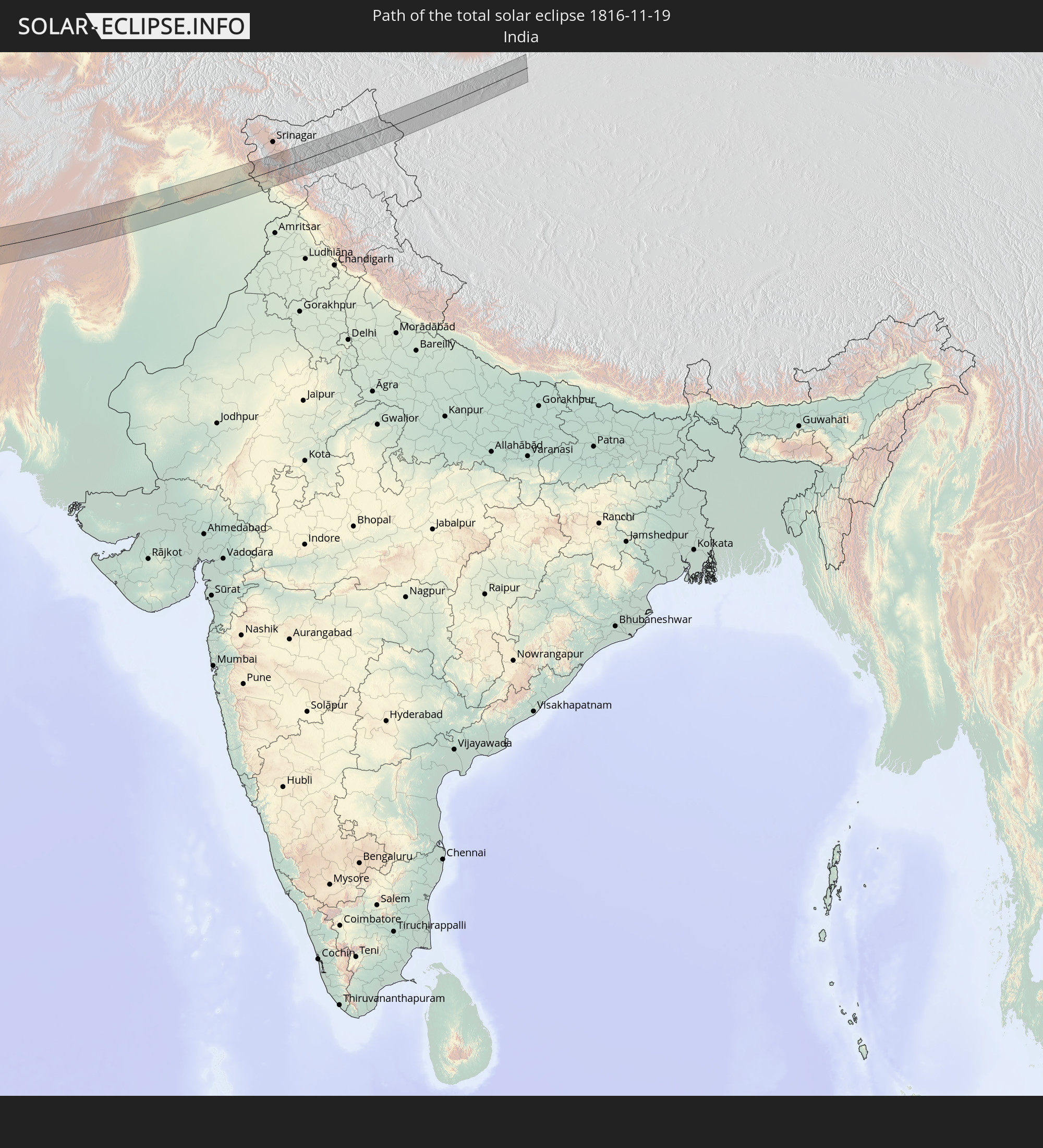 India
India
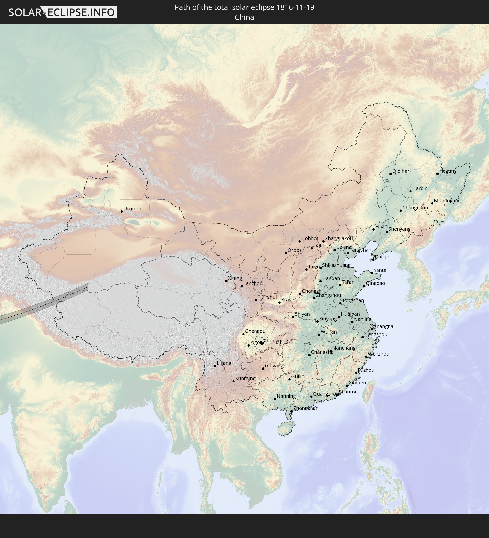 China
China
In den folgenden Ländern ist die Sonnenfinsternis partiell zu sehen
 Russia
 Portugal
 Spain
Spain
 Mauritania
 Morocco
 Mali
Mali
 Republic of Ireland
 Algeria
 United Kingdom
 Faroe Islands
 Gibraltar
 France
 Isle of Man
 Guernsey
 Jersey
 Niger
Niger
 Andorra
 Belgium
 Nigeria
 Netherlands
 Norway
 Luxembourg
 Germany
 Switzerland
 Italy
Italy
 Monaco
 Tunisia
 Denmark
 Cameroon
 Libya
Libya
 Liechtenstein
 Austria
 Sweden
 Republic of the Congo
 Czechia
 Democratic Republic of the Congo
 San Marino
 Vatican City
 Slovenia
 Chad
Chad
 Croatia
 Poland
 Malta
Malta
 Central African Republic
 Bosnia and Herzegovina
 Hungary
 Slovakia
 Montenegro
 Serbia
 Albania
 Åland Islands
 Greece
 Romania
 Republic of Macedonia
 Finland
 Lithuania
 Latvia
 Estonia
 Sudan
Sudan
 Ukraine
 Bulgaria
 Belarus
 Egypt
Egypt
 Turkey
 Moldova
 Rwanda
 Burundi
 Tanzania
 Uganda
 Cyprus
 Ethiopia
 Kenya
Kenya
 State of Palestine
 Israel
 Saudi Arabia
 Jordan
 Lebanon
 Syria
Syria
 Eritrea
 Iraq
Iraq
 Georgia
 Somalia
 Djibouti
 Yemen
Yemen
 Armenia
 Iran
Iran
 Azerbaijan
 Seychelles
 Kazakhstan
 Kuwait
 Bahrain
 Qatar
Qatar
 United Arab Emirates
 Oman
Oman
 Turkmenistan
 Uzbekistan
 Afghanistan
 Pakistan
 Tajikistan
 India
India
 Kyrgyzstan
 British Indian Ocean Territory
 Maldives
 China
China
 Sri Lanka
 Nepal
Nepal
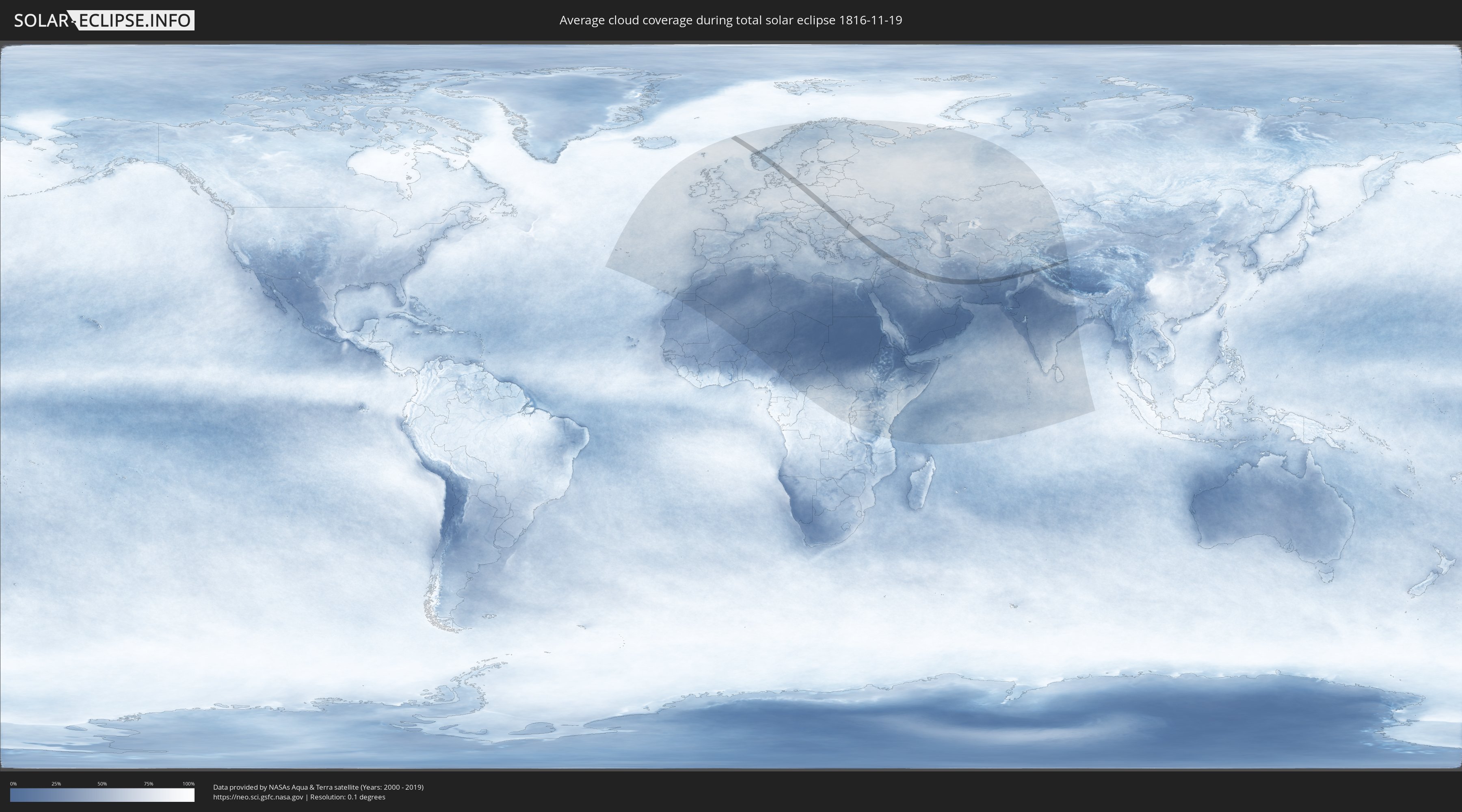
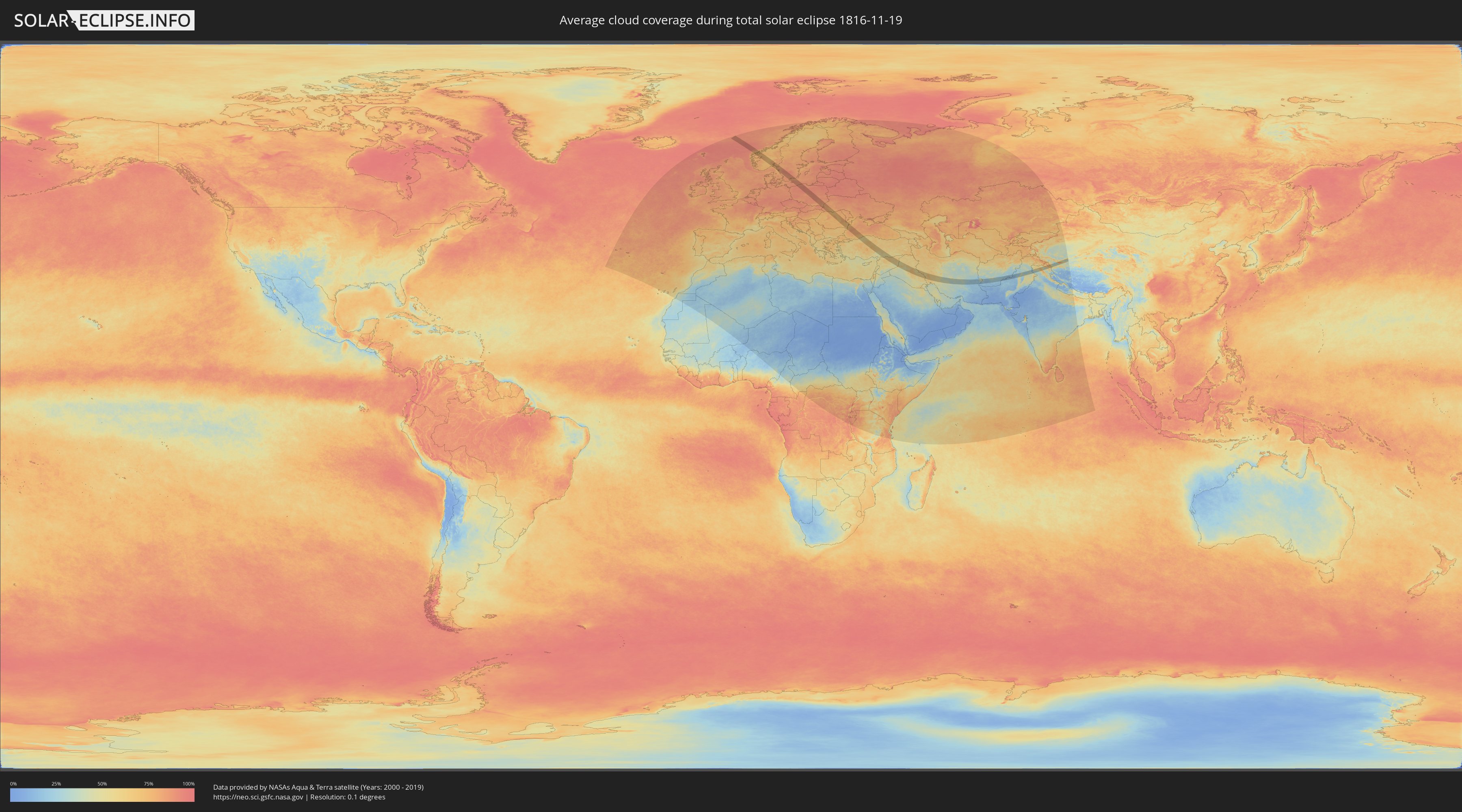
How will be the weather during the total solar eclipse on 11/19/1816?
Where is the best place to see the total solar eclipse of 11/19/1816?
The following maps show the average cloud coverage for the day of the total solar eclipse.
With the help of these maps, it is possible to find the place along the eclipse path, which has the best
chance of a cloudless sky.
Nevertheless, you should consider local circumstances and inform about the weather of your chosen
observation site.
The data is provided by NASAs satellites
AQUA and TERRA.
The cloud maps are averaged over a period of 19 years (2000 - 2019).
Detailed country maps
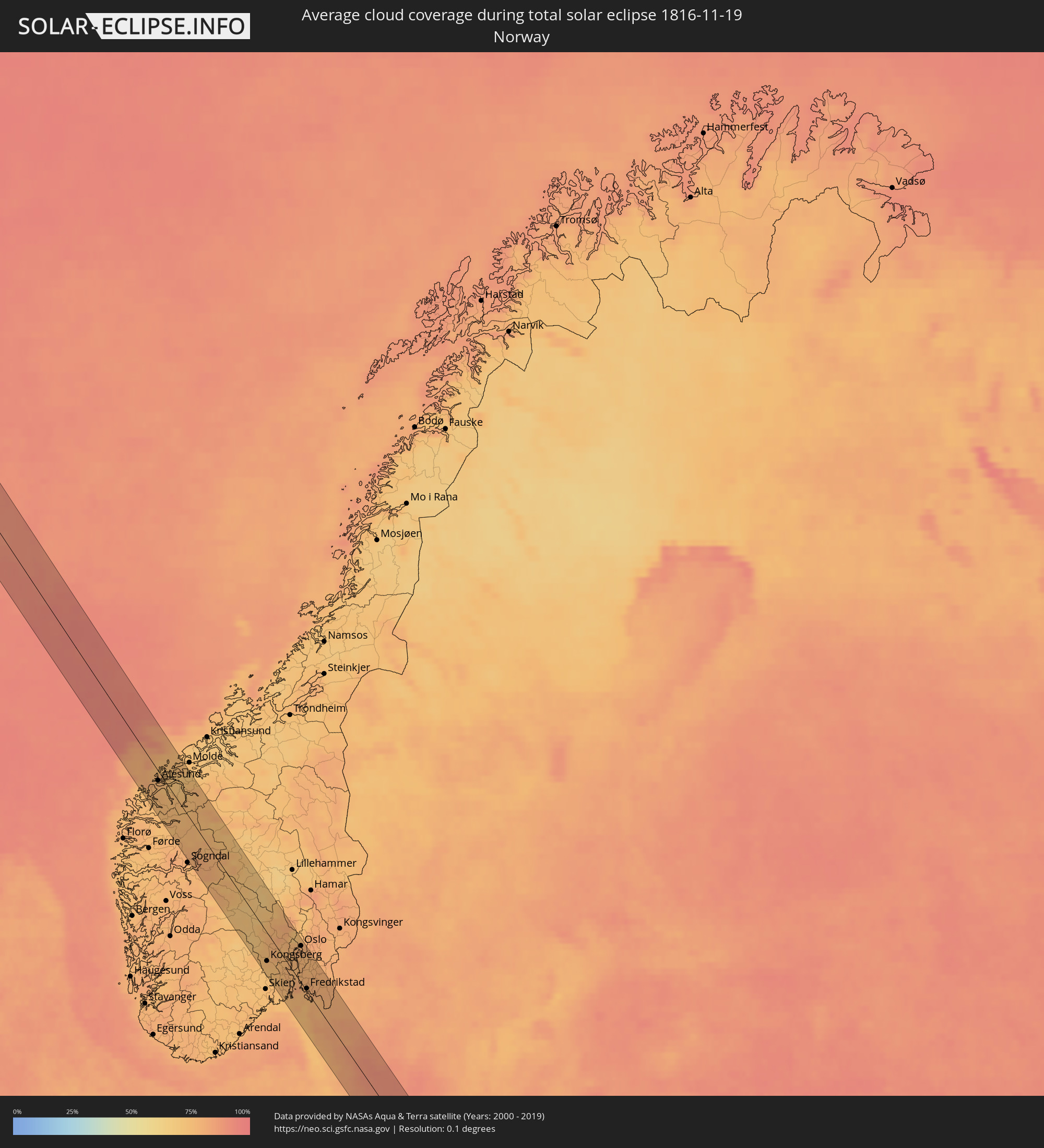 Norway
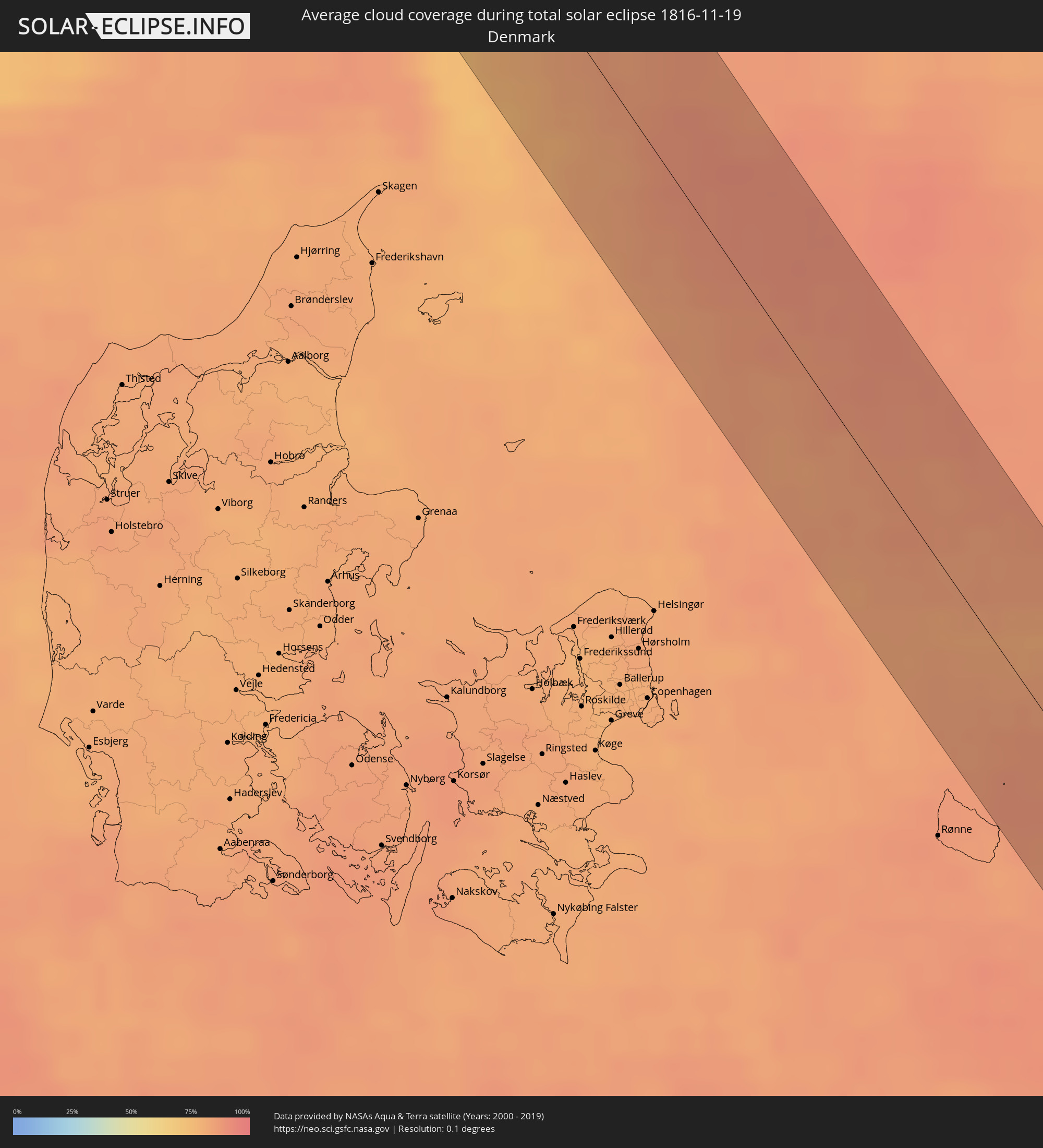 Denmark
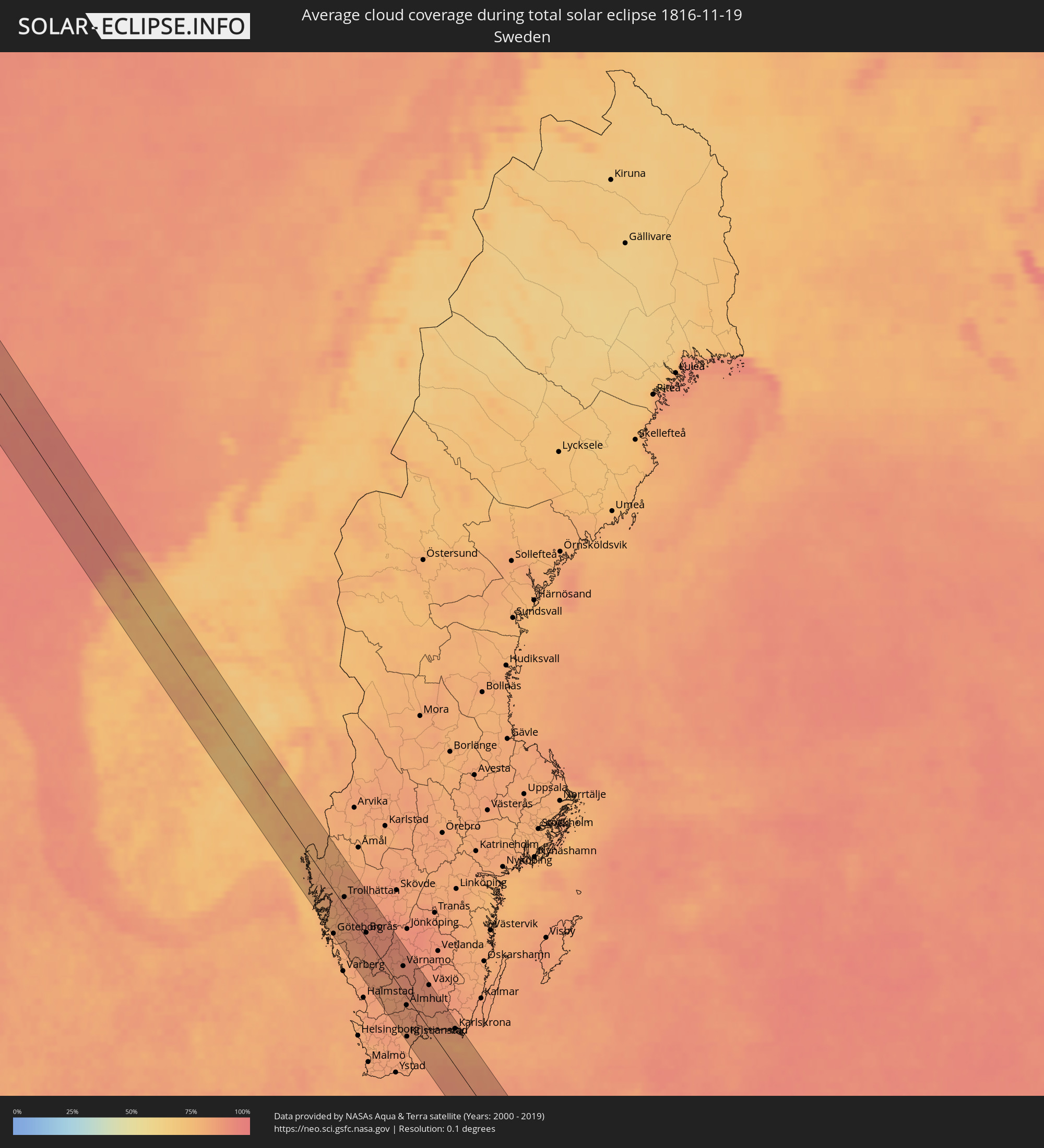 Sweden
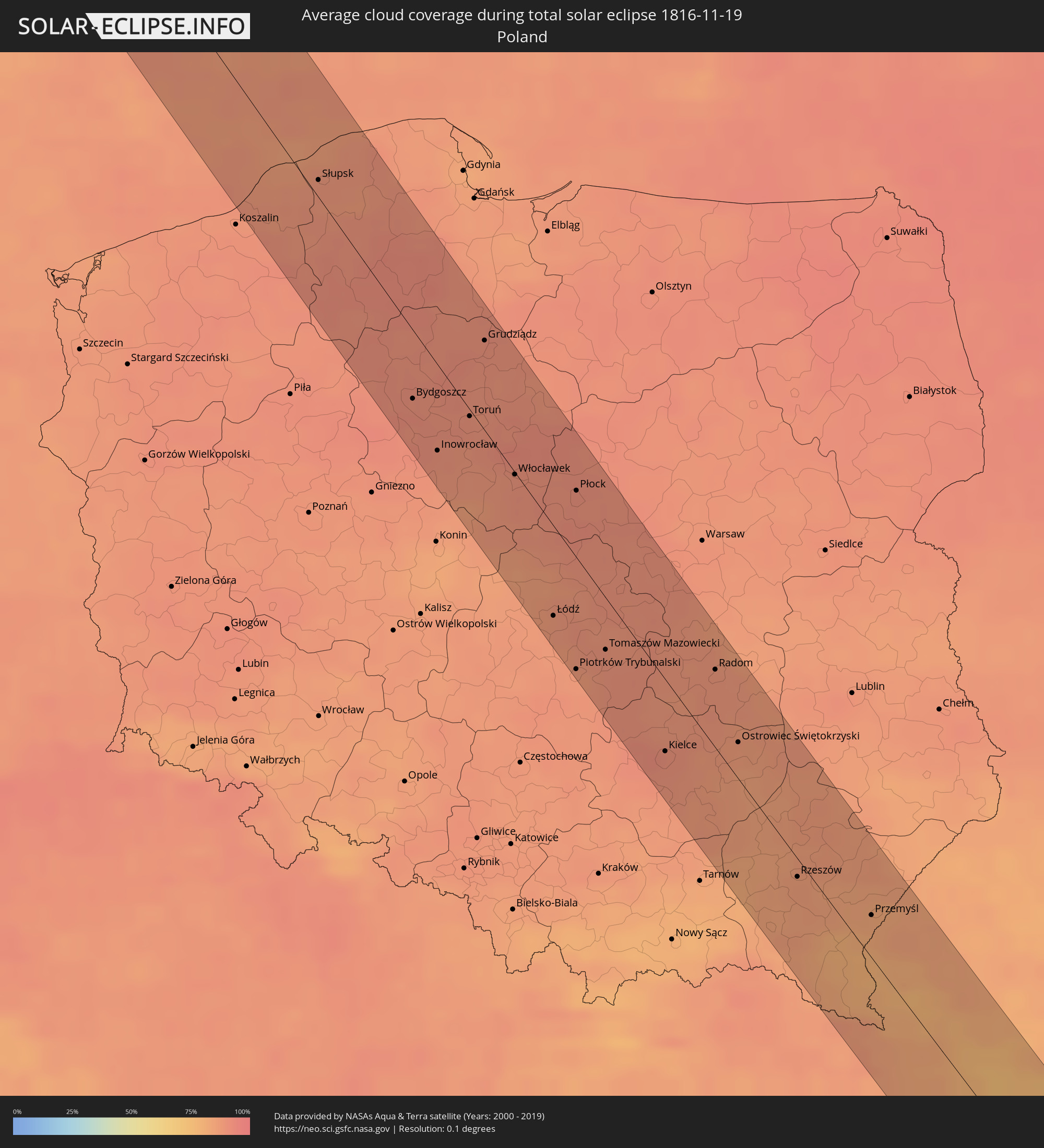 Poland
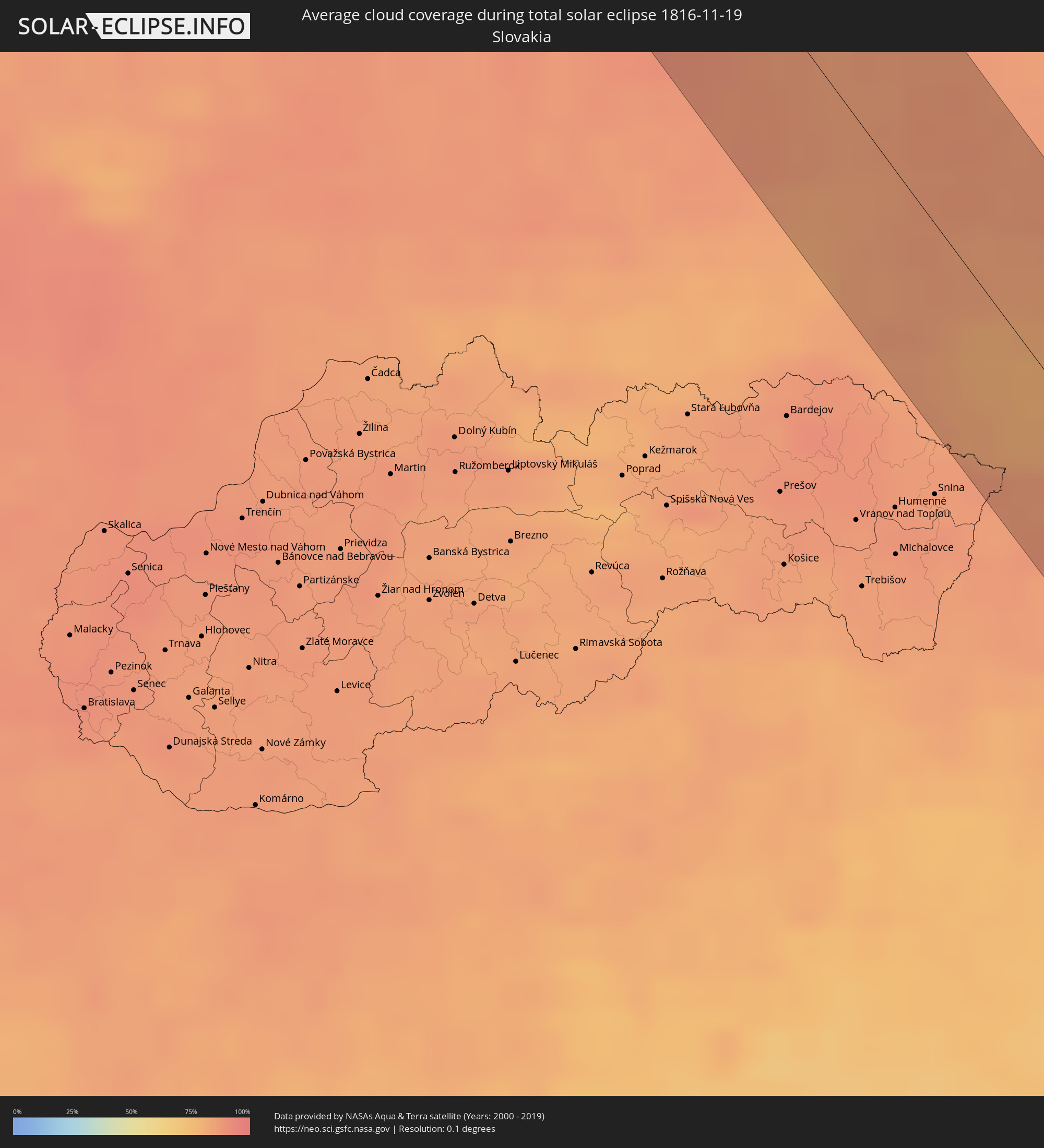 Slovakia
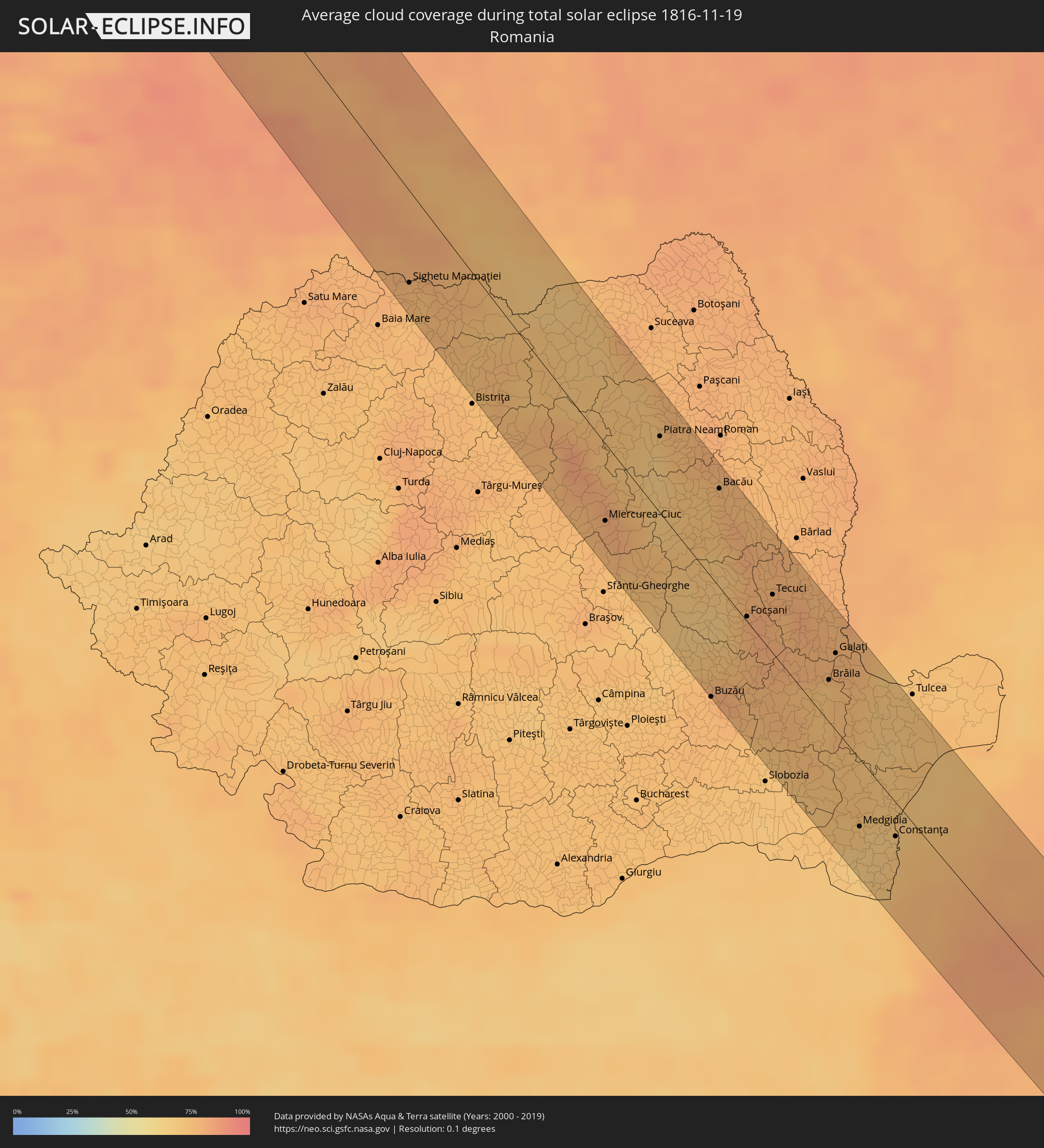 Romania
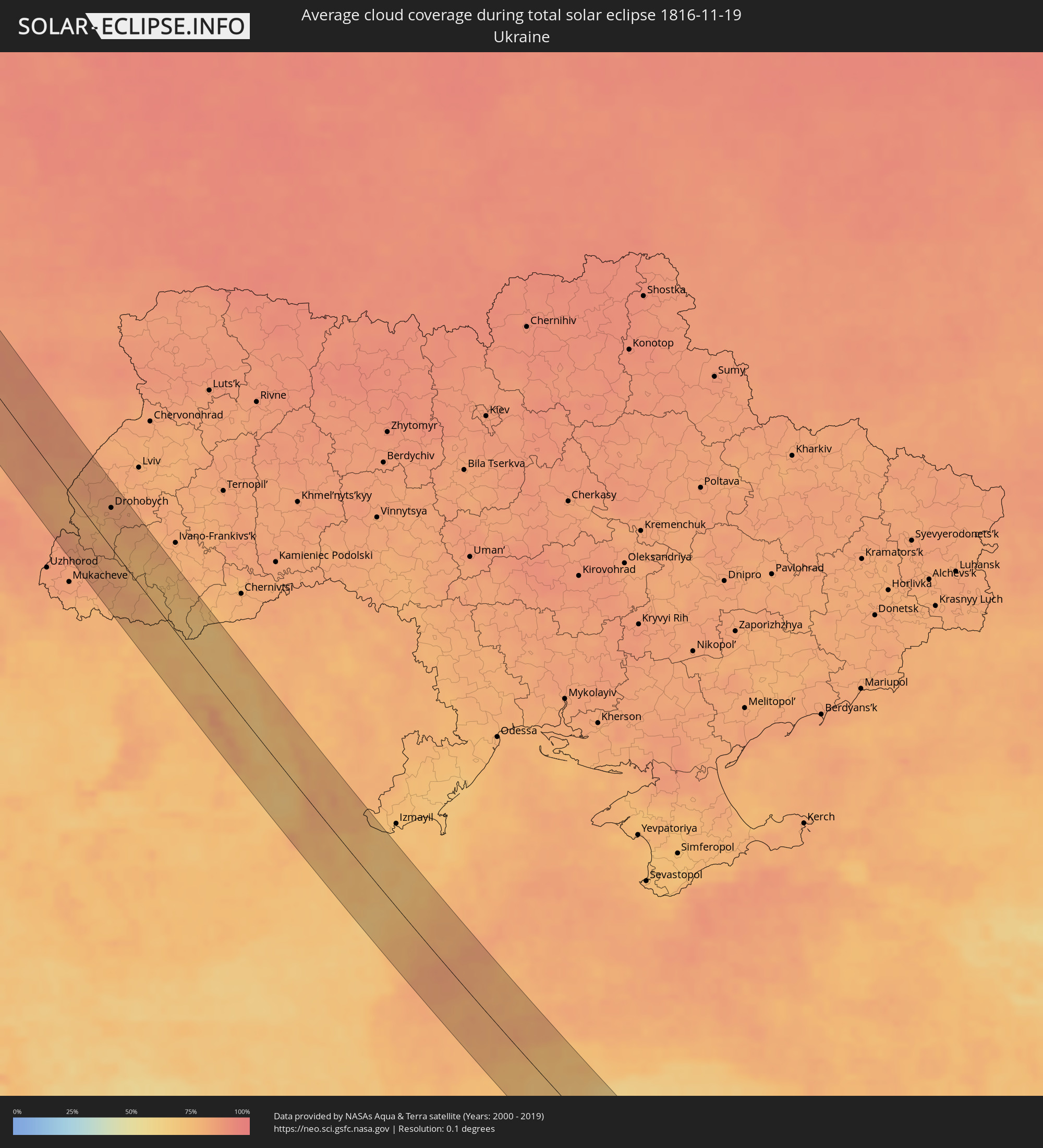 Ukraine
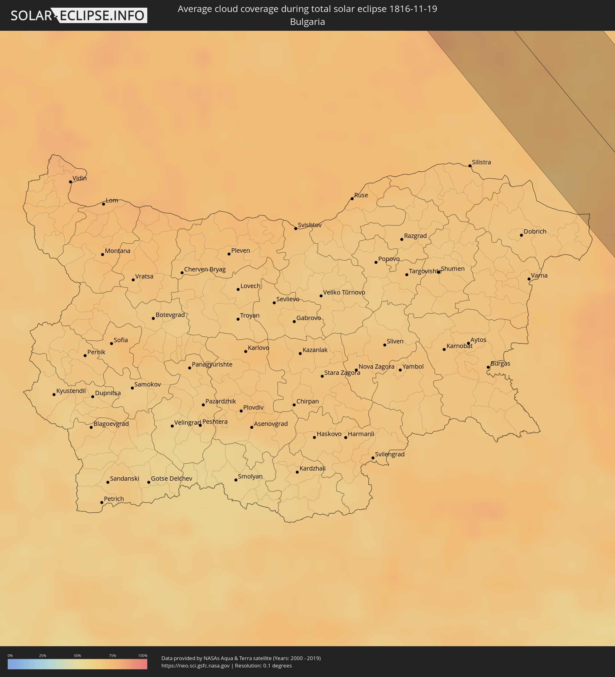 Bulgaria
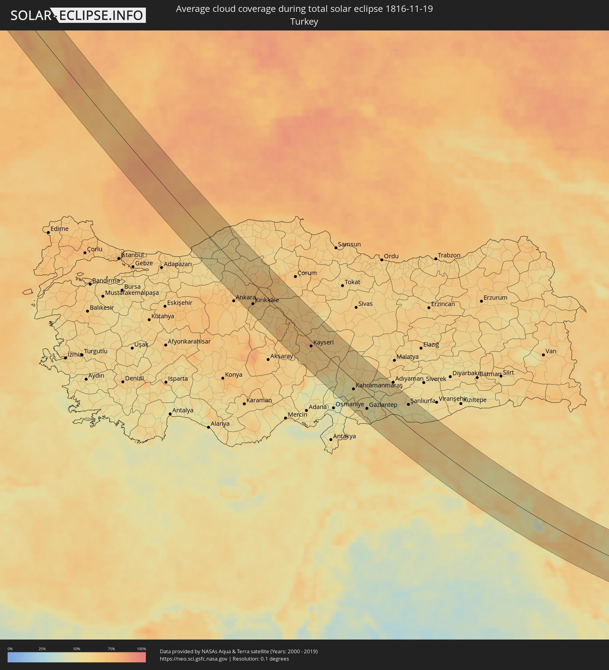 Turkey
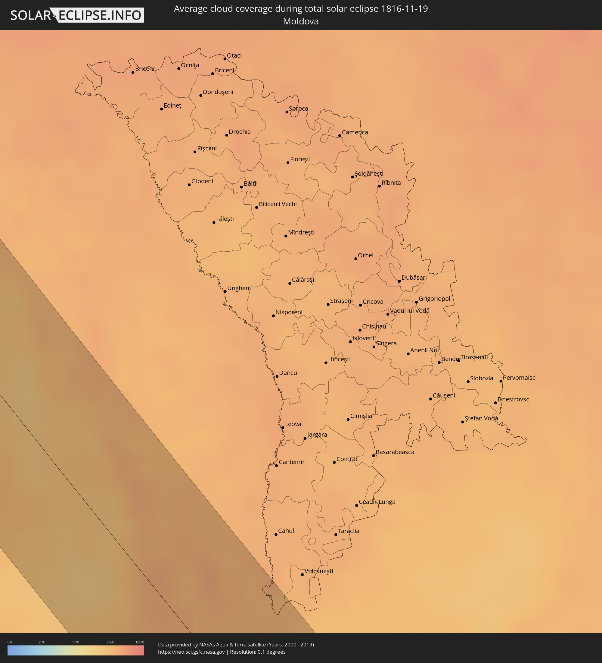 Moldova
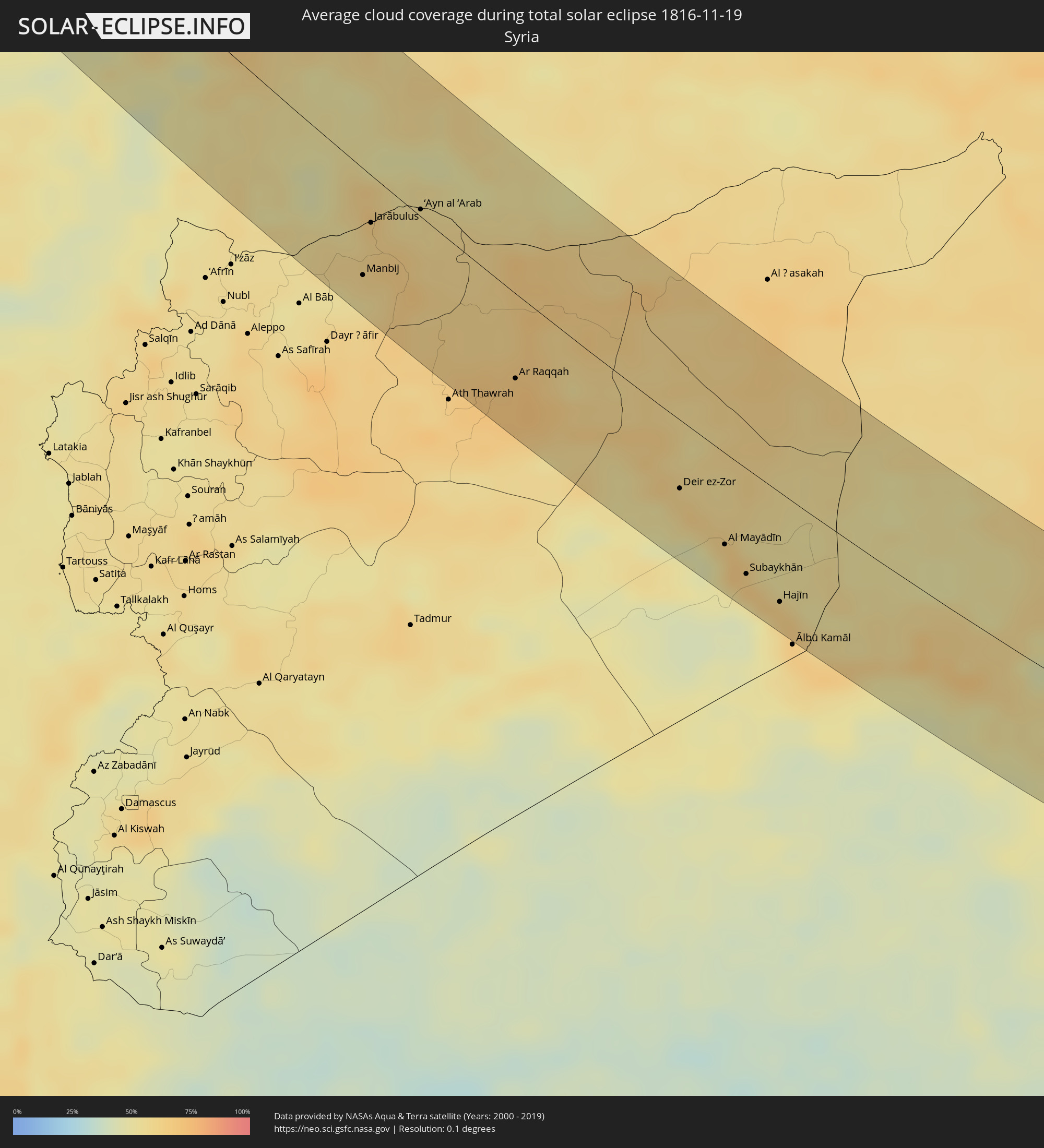 Syria
Syria
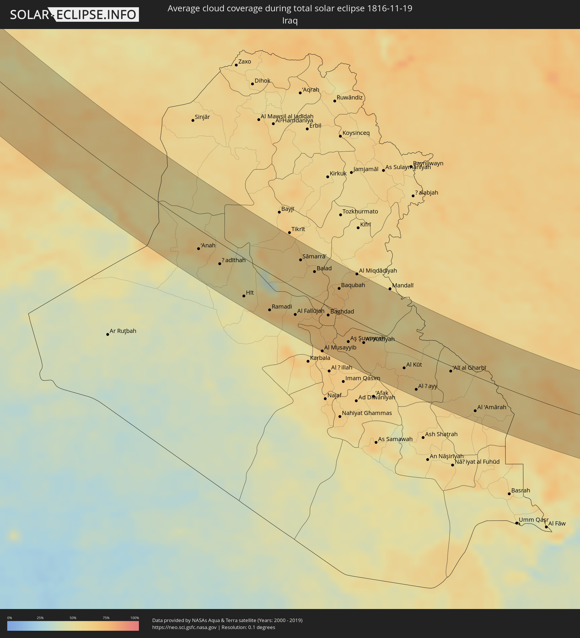 Iraq
Iraq
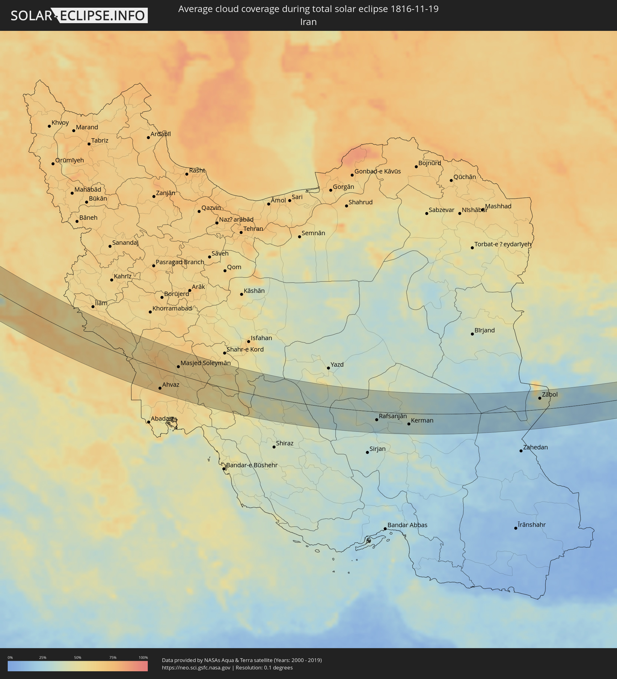 Iran
Iran
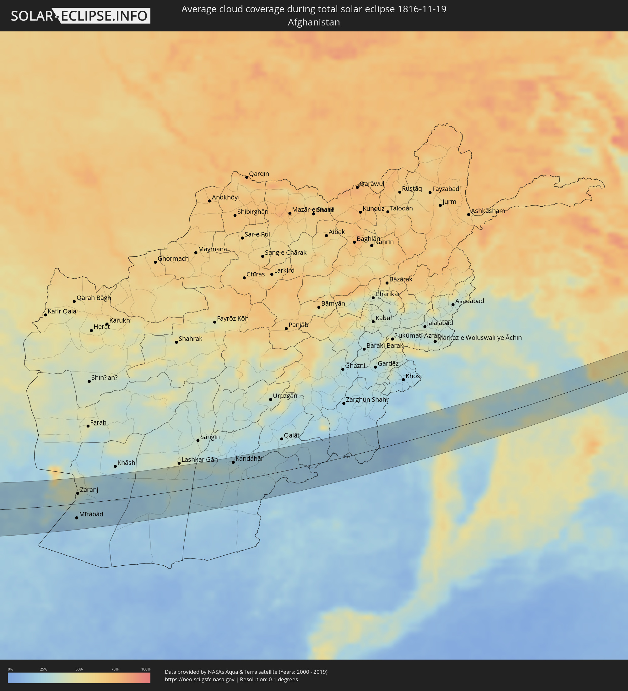 Afghanistan
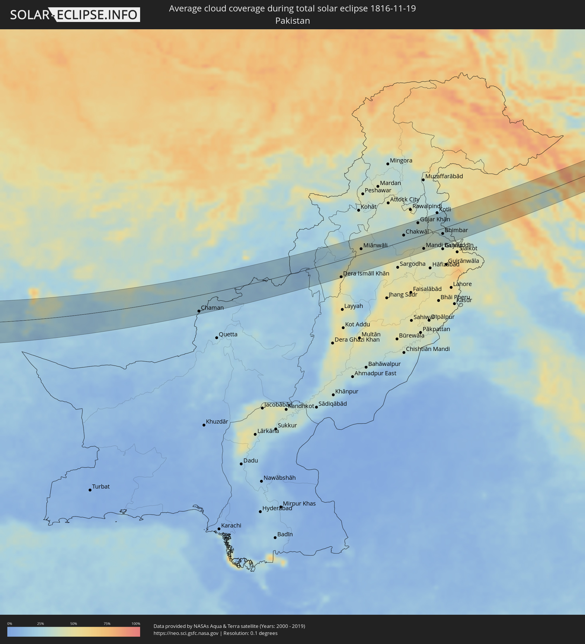 Pakistan
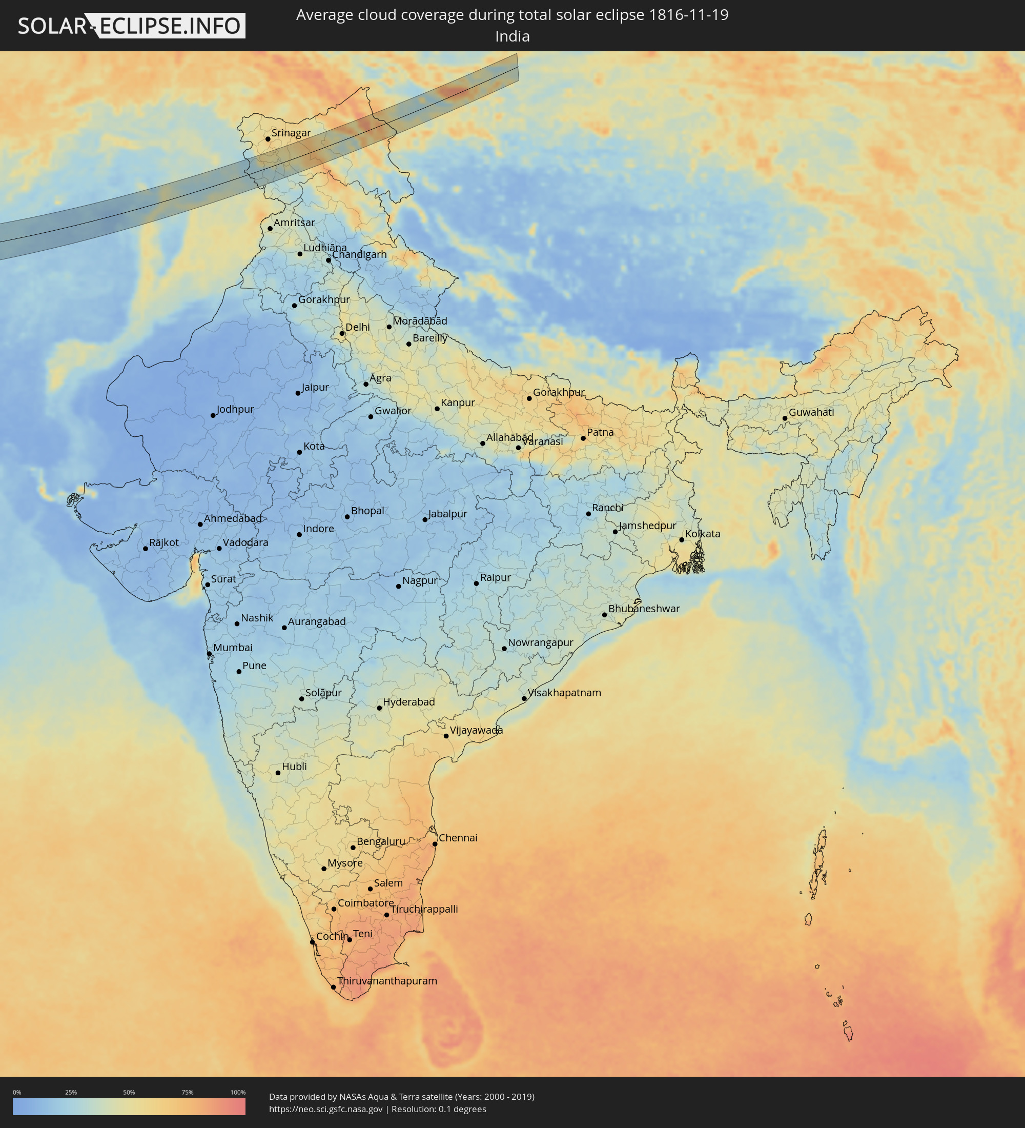 India
India
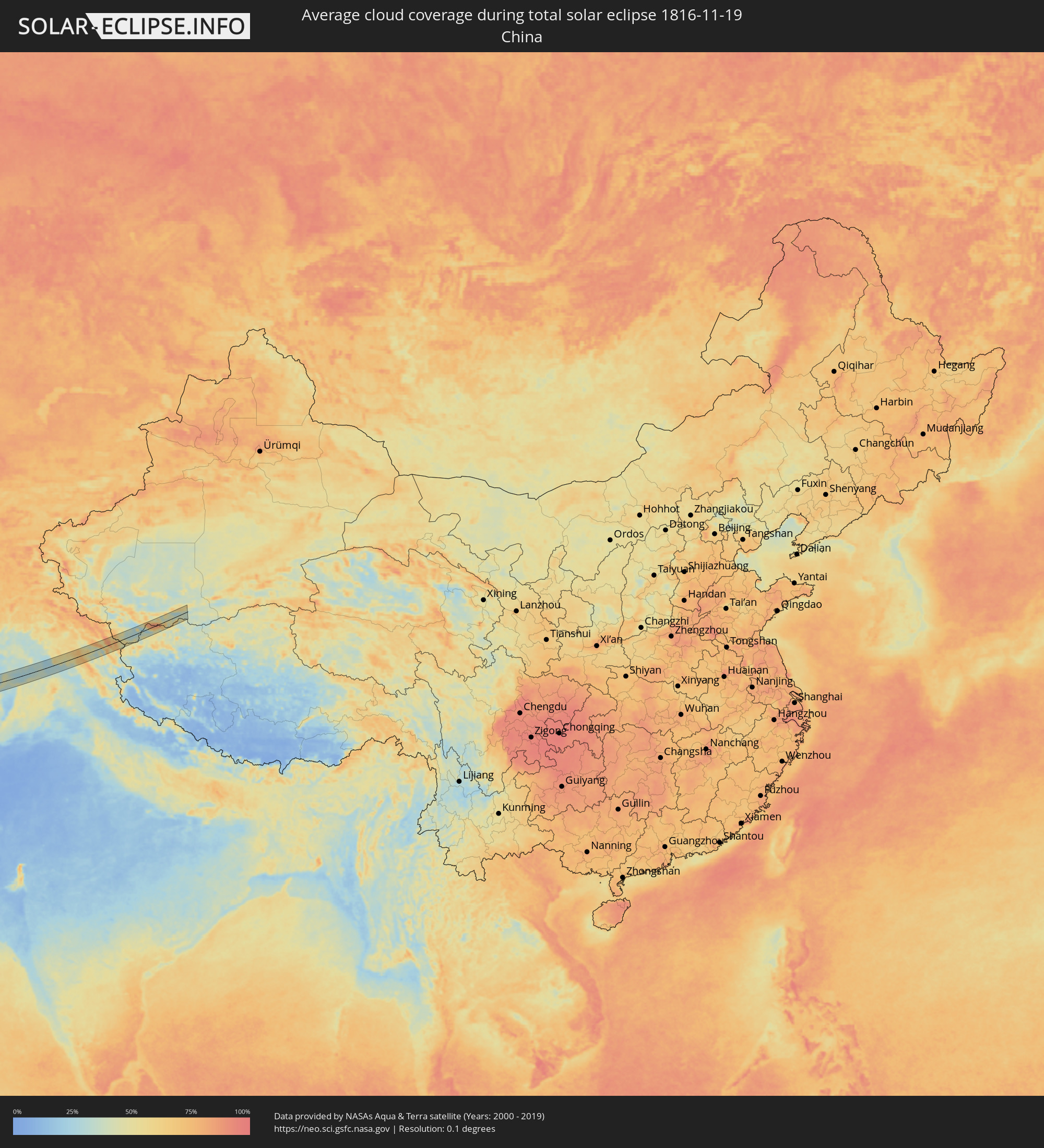 China
China
Cities inside the path of the eclipse
The following table shows all locations with a population of more than 5,000 inside the eclipse path. Cities which have more than 100,000 inhabitants are marked bold. A click at the locations opens a detailed map.
| City | Type | Eclipse duration | Local time of max. eclipse | Distance to central line | Ø Cloud coverage |
|
Ørsta, Møre og Romsdal
|
total | - | 10:21:09 UTC+01:00 | 27 km | 76% |
|
Ålesund, Møre og Romsdal
|
total | - | 10:21:22 UTC+01:00 | 9 km | 77% |
|
Kongsberg, Buskerud
|
total | - | 10:22:19 UTC+01:00 | 29 km | 75% |
|
Drammen, Buskerud
|
total | - | 10:22:50 UTC+01:00 | 2 km | 76% |
|
Sandefjord, Vestfold
|
total | - | 10:22:31 UTC+01:00 | 36 km | 74% |
|
Hønefoss, Buskerud
|
total | - | 10:23:06 UTC+01:00 | 31 km | 80% |
|
Tønsberg, Vestfold
|
total | - | 10:22:45 UTC+01:00 | 19 km | 78% |
|
Horten, Vestfold
|
total | - | 10:22:53 UTC+01:00 | 6 km | 78% |
|
Drøbak, Akershus
|
total | - | 10:23:09 UTC+01:00 | 17 km | 78% |
|
Moss, Østfold
|
total | - | 10:23:03 UTC+01:00 | 4 km | 79% |
|
Nesoddtangen, Akershus
|
total | - | 10:23:17 UTC+01:00 | 31 km | 79% |
|
Oslo, Oslo
|
total | - | 10:23:23 UTC+01:00 | 37 km | 79% |
|
Ås, Akershus
|
total | - | 10:23:17 UTC+01:00 | 24 km | 77% |
|
Ski, Akershus
|
total | - | 10:23:21 UTC+01:00 | 30 km | 77% |
|
Fredrikstad, Østfold
|
total | - | 10:23:11 UTC+01:00 | 3 km | 77% |
|
Askim, Østfold
|
total | - | 10:23:34 UTC+01:00 | 37 km | 78% |
|
Halden, Østfold
|
total | - | 10:23:32 UTC+01:00 | 19 km | 78% |
|
Stenungsund, Västra Götaland
|
total | - | 10:23:25 UTC+01:00 | 27 km | 80% |
|
Uddevalla, Västra Götaland
|
total | - | 10:23:40 UTC+01:00 | 4 km | 83% |
|
Göteborg, Västra Götaland
|
total | - | 10:23:24 UTC+01:00 | 43 km | 82% |
|
Kungälv, Västra Götaland
|
total | - | 10:23:29 UTC+01:00 | 32 km | 81% |
|
Lerum, Västra Götaland
|
total | - | 10:23:42 UTC+01:00 | 24 km | 84% |
|
Trollhättan, Västra Götaland
|
total | - | 10:23:57 UTC+01:00 | 9 km | 84% |
|
Alingsås, Västra Götaland
|
total | - | 10:24:01 UTC+01:00 | 1 km | 86% |
|
Kinna, Västra Götaland
|
total | - | 10:23:59 UTC+01:00 | 20 km | 85% |
|
Borås, Västra Götaland
|
total | - | 10:24:19 UTC+01:00 | 5 km | 89% |
|
Gislaved, Jönköping
|
total | - | 10:24:43 UTC+01:00 | 9 km | 87% |
|
Ljungby, Kronoberg
|
total | - | 10:24:56 UTC+01:00 | 1 km | 85% |
|
Värnamo, Jönköping
|
total | - | 10:25:10 UTC+01:00 | 26 km | 88% |
|
Kristianstad, Skåne
|
total | - | 10:24:52 UTC+01:00 | 42 km | 83% |
|
Växjö, Kronoberg
|
total | - | 10:25:49 UTC+01:00 | 45 km | 89% |
|
Karlshamn, Blekinge
|
total | - | 10:25:38 UTC+01:00 | 3 km | 85% |
|
Ronneby, Blekinge
|
total | - | 10:26:04 UTC+01:00 | 27 km | 85% |
|
Karlskrona, Blekinge
|
total | - | 10:26:22 UTC+01:00 | 40 km | 85% |
|
Słupsk, Pomeranian Voivodeship
|
total | - | 10:51:29 UTC+01:24 | 7 km | 88% |
|
Bydgoszcz, Kujawsko-Pomorskie
|
total | - | 10:52:22 UTC+01:24 | 28 km | 92% |
|
Inowrocław, Kujawsko-Pomorskie
|
total | - | 10:52:38 UTC+01:24 | 35 km | 89% |
|
Toruń, Kujawsko-Pomorskie
|
total | - | 10:53:03 UTC+01:24 | 3 km | 90% |
|
Grudziądz, Kujawsko-Pomorskie
|
total | - | 10:53:18 UTC+01:24 | 36 km | 90% |
|
Włocławek, Kujawsko-Pomorskie
|
total | - | 10:53:34 UTC+01:24 | 1 km | 90% |
|
Łódź, Łódź Voivodeship
|
total | - | 10:54:00 UTC+01:24 | 38 km | 87% |
|
Piotrków Trybunalski, Łódź Voivodeship
|
total | - | 10:54:16 UTC+01:24 | 47 km | 87% |
|
Płock, Masovian Voivodeship
|
total | - | 10:54:20 UTC+01:24 | 28 km | 90% |
|
Tomaszów Mazowiecki, Łódź Voivodeship
|
total | - | 10:54:40 UTC+01:24 | 22 km | 89% |
|
Kielce, Świętokrzyskie
|
total | - | 10:55:26 UTC+01:24 | 31 km | 91% |
|
Radom, Masovian Voivodeship
|
total | - | 10:56:06 UTC+01:24 | 33 km | 89% |
|
Ostrowiec Świętokrzyski, Świętokrzyskie
|
total | - | 10:56:25 UTC+01:24 | 16 km | 86% |
|
Mielec, Subcarpathian Voivodeship
|
total | - | 10:56:30 UTC+01:24 | 24 km | 85% |
|
Rzeszów, Subcarpathian Voivodeship
|
total | - | 10:57:17 UTC+01:24 | 8 km | 86% |
|
Stalowa Wola, Subcarpathian Voivodeship
|
total | - | 10:57:19 UTC+01:24 | 31 km | 86% |
|
Przemyśl, Subcarpathian Voivodeship
|
total | - | 10:58:21 UTC+01:24 | 19 km | 82% |
|
Svalyava, Zakarpattia
|
total | - | 11:36:54 UTC+02:02 | 51 km | 85% |
|
Turka, Lviv
|
total | - | 11:36:51 UTC+02:02 | 8 km | 80% |
|
Mostys'ka, Lviv
|
total | - | 11:36:56 UTC+02:02 | 42 km | 83% |
|
Sambir, Lviv
|
total | - | 11:37:02 UTC+02:02 | 26 km | 80% |
|
Mizhhir’ya, Zakarpattia
|
total | - | 11:37:37 UTC+02:02 | 23 km | 83% |
|
Drohobych, Lviv
|
total | - | 11:37:29 UTC+02:02 | 33 km | 80% |
|
Tyachiv, Zakarpattia
|
total | - | 11:37:49 UTC+02:02 | 54 km | 79% |
|
Stryi, Lviv
|
total | - | 11:37:59 UTC+02:02 | 47 km | 82% |
|
Solotvyno, Zakarpattia
|
total | - | 11:38:15 UTC+02:02 | 40 km | 75% |
|
Sighetu Marmaţiei, Maramureş
|
total | - | 11:20:37 UTC+01:44 | 41 km | 75% |
|
Dubove, Zakarpattia
|
total | - | 11:38:14 UTC+02:02 | 24 km | 80% |
|
Dolyna, Ivano-Frankivsk
|
total | - | 11:38:15 UTC+02:02 | 37 km | 80% |
|
Rakhiv, Zakarpattia
|
total | - | 11:38:43 UTC+02:02 | 14 km | 77% |
|
Yasinya, Zakarpattia
|
total | - | 11:38:54 UTC+02:02 | 11 km | 73% |
|
Yaremche, Ivano-Frankivsk
|
total | - | 11:39:08 UTC+02:02 | 34 km | 74% |
|
Nadvirna, Ivano-Frankivsk
|
total | - | 11:39:07 UTC+02:02 | 47 km | 75% |
|
Borşa, Maramureş
|
total | - | 11:21:49 UTC+01:44 | 14 km | 72% |
|
Lanchyn, Ivano-Frankivsk
|
total | - | 11:39:24 UTC+02:02 | 53 km | 77% |
|
Miercurea-Ciuc, Harghita
|
total | - | 11:23:54 UTC+01:44 | 36 km | 80% |
|
Piatra Neamţ, Neamţ
|
total | - | 11:24:31 UTC+01:44 | 35 km | 69% |
|
Moineşti, Bacău
|
total | - | 11:24:55 UTC+01:44 | 14 km | 72% |
|
Buzău, Buzău
|
total | - | 11:25:57 UTC+01:44 | 58 km | 77% |
|
Bacău, Bacău
|
total | - | 11:25:32 UTC+01:44 | 46 km | 77% |
|
Râmnicu Sărat, Buzău
|
total | - | 11:26:12 UTC+01:44 | 28 km | 77% |
|
Focșani, Vrancea
|
total | - | 11:26:17 UTC+01:44 | 2 km | 79% |
|
Tecuci, Galaţi
|
total | - | 11:26:37 UTC+01:44 | 28 km | 79% |
|
Feteşti, Ialomiţa
|
total | - | 11:27:54 UTC+01:44 | 51 km | 71% |
|
Brăila, Brăila
|
total | - | 11:27:45 UTC+01:44 | 20 km | 74% |
|
Galaţi, Galaţi
|
total | - | 11:27:46 UTC+01:44 | 37 km | 78% |
|
Medgidia, Constanța
|
total | - | 11:28:42 UTC+01:44 | 33 km | 70% |
|
Reni, Odessa
|
total | - | 11:45:50 UTC+02:02 | 53 km | 77% |
|
Mangalia, Constanța
|
total | - | 11:29:26 UTC+01:44 | 47 km | 75% |
|
Năvodari, Constanța
|
total | - | 11:29:12 UTC+01:44 | 9 km | 69% |
|
Constanţa, Constanța
|
total | - | 11:29:19 UTC+01:44 | 17 km | 71% |
|
Ereğli, Zonguldak
|
total | - | 11:48:25 UTC+01:56 | 59 km | 61% |
|
Zonguldak, Zonguldak
|
total | - | 11:48:58 UTC+01:56 | 24 km | 60% |
|
Karabük, Karabük
|
total | - | 11:50:40 UTC+01:56 | 9 km | 61% |
|
Çubuk, Ankara
|
total | - | 11:52:08 UTC+01:56 | 40 km | 67% |
|
Kırıkkale, Kırıkkale
|
total | - | 11:53:20 UTC+01:56 | 42 km | 67% |
|
Keskin, Kırıkkale
|
total | - | 11:53:41 UTC+01:56 | 49 km | 65% |
|
Khanjarah, Çankırı
|
total | - | 11:52:56 UTC+01:56 | 23 km | 72% |
|
Kırşehir, Kırşehir
|
total | - | 11:55:10 UTC+01:56 | 57 km | 66% |
|
Nevşehir, Nevşehir
|
total | - | 11:56:41 UTC+01:56 | 66 km | 65% |
|
Yozgat, Yozgat
|
total | - | 11:55:49 UTC+01:56 | 35 km | 64% |
|
Sorgun, Yozgat
|
total | - | 11:56:33 UTC+01:56 | 57 km | 68% |
|
Kayseri, Kayseri
|
total | - | 11:58:05 UTC+01:56 | 11 km | 62% |
|
Kahramanmaraş, Kahramanmaraş
|
total | - | 12:02:00 UTC+01:56 | 20 km | 57% |
|
Elbistan, Kahramanmaraş
|
total | - | 12:01:56 UTC+01:56 | 47 km | 62% |
|
Gaziantep, Gaziantep
|
total | - | 12:03:27 UTC+01:56 | 38 km | 53% |
|
Nizip, Gaziantep
|
total | - | 12:04:19 UTC+01:56 | 18 km | 55% |
|
Manbij, Aleppo
|
total | - | 12:33:25 UTC+02:25 | 50 km | 55% |
|
Jarābulus, Aleppo
|
total | - | 12:33:14 UTC+02:25 | 22 km | 61% |
|
‘Ayn al ‘Arab, Aleppo
|
total | - | 12:33:50 UTC+02:25 | 3 km | 56% |
|
Şanlıurfa, Şanlıurfa
|
total | - | 12:06:10 UTC+01:56 | 52 km | 56% |
|
Ar Raqqah, Ar-Raqqah
|
total | - | 12:36:11 UTC+02:25 | 41 km | 68% |
|
Deir ez-Zor, Deir ez-Zor
|
total | - | 12:39:12 UTC+02:25 | 35 km | 55% |
|
Al Mayādīn, Deir ez-Zor
|
total | - | 12:40:12 UTC+02:25 | 47 km | 65% |
|
Subaykhān, Deir ez-Zor
|
total | - | 12:40:42 UTC+02:25 | 54 km | 64% |
|
Hajīn, Deir ez-Zor
|
total | - | 12:41:22 UTC+02:25 | 56 km | 61% |
|
Ḩadīthah, Anbar
|
total | - | 13:17:39 UTC+02:57 | 30 km | 52% |
|
Hīt, Anbar
|
total | - | 13:19:13 UTC+02:57 | 56 km | 49% |
|
Ramadi, Anbar
|
total | - | 13:20:29 UTC+02:57 | 55 km | 58% |
|
Al Fallūjah, Anbar
|
total | - | 13:21:34 UTC+02:57 | 40 km | 66% |
|
Sāmarrā’, Salah ad Din Governorate
|
total | - | 13:20:42 UTC+02:57 | 47 km | 62% |
|
Balad, Salah ad Din Governorate
|
total | - | 13:21:28 UTC+02:57 | 41 km | 62% |
|
Abū Ghurayb, Mayorality of Baghdad
|
total | - | 13:22:28 UTC+02:57 | 26 km | 70% |
|
Al Musayyib, Bābil
|
total | - | 13:23:21 UTC+02:57 | 73 km | 67% |
|
Baghdad, Mayorality of Baghdad
|
total | - | 13:22:52 UTC+02:57 | 13 km | 67% |
|
Khāliş, Diyālá
|
total | - | 13:22:32 UTC+02:57 | 38 km | 67% |
|
Baqubah, Diyālá
|
total | - | 13:22:45 UTC+02:57 | 36 km | 70% |
|
Aş Şuwayrah, Wāsiţ
|
total | - | 13:24:11 UTC+02:57 | 38 km | 64% |
|
Al Miqdādīyah, Diyālá
|
total | - | 13:23:09 UTC+02:57 | 73 km | 64% |
|
Al ‘Azīzīyah, Wāsiţ
|
total | - | 13:24:48 UTC+02:57 | 28 km | 69% |
|
Al Kūt, Wāsiţ
|
total | - | 13:26:53 UTC+02:57 | 37 km | 64% |
|
Al Ḩayy, Wāsiţ
|
total | - | 13:27:48 UTC+02:57 | 62 km | 60% |
|
Al ‘Amārah, Maysan
|
total | - | 13:30:31 UTC+02:57 | 57 km | 60% |
|
Dehlorān, Īlām
|
total | - | 13:57:45 UTC+03:25 | 36 km | 64% |
|
Ābdānān, Īlām
|
total | - | 13:57:39 UTC+03:25 | 72 km | 60% |
|
Sūsangerd, Khuzestan
|
total | - | 14:01:09 UTC+03:25 | 50 km | 65% |
|
Shūsh, Khuzestan
|
total | - | 14:00:24 UTC+03:25 | 18 km | 62% |
|
Ahvaz, Khuzestan
|
total | - | 14:02:30 UTC+03:25 | 60 km | 68% |
|
Shūshtar, Khuzestan
|
total | - | 14:01:49 UTC+03:25 | 22 km | 70% |
|
Masjed Soleymān, Khuzestan
|
total | - | 14:02:53 UTC+03:25 | 23 km | 57% |
|
Rāmhormoz, Khuzestan
|
total | - | 14:04:23 UTC+03:25 | 38 km | 63% |
|
Dehdasht, Kohgīlūyeh va Būyer Aḩmad
|
total | - | 14:06:58 UTC+03:25 | 66 km | 49% |
|
Semīrom, Isfahan
|
total | - | 14:08:02 UTC+03:25 | 24 km | 46% |
|
Yasuj, Kohgīlūyeh va Būyer Aḩmad
|
total | - | 14:09:08 UTC+03:25 | 57 km | 51% |
|
Ābādeh, Fars
|
total | - | 14:10:28 UTC+03:25 | 17 km | 38% |
|
Shahr-e Bābak, Kerman
|
total | - | 14:16:30 UTC+03:25 | 66 km | 35% |
|
Rafsanjān, Kerman
|
total | - | 14:17:38 UTC+03:25 | 27 km | 32% |
|
Zarand, Kerman
|
total | - | 14:18:02 UTC+03:25 | 22 km | 33% |
|
Kerman, Kerman
|
total | - | 14:19:41 UTC+03:25 | 35 km | 33% |
|
Zābol, Sistan and Baluchestan
|
total | - | 14:25:38 UTC+03:25 | 35 km | 40% |
|
Mīrābād, Nimroz
|
total | - | 15:01:18 UTC+04:00 | 34 km | 22% |
|
Zaranj, Nimroz
|
total | - | 15:00:33 UTC+04:00 | 24 km | 35% |
|
‘Alāqahdārī Dīshū, Helmand
|
total | - | 15:03:24 UTC+04:00 | 51 km | 19% |
|
Markaz-e Ḩukūmat-e Darwēshān, Helmand
|
total | - | 15:03:36 UTC+04:00 | 14 km | 32% |
|
Kandahār, Kandahar
|
total | - | 15:04:54 UTC+04:00 | 43 km | 31% |
|
Chaman, Balochistān
|
total | - | 15:35:04 UTC+04:28 | 47 km | 21% |
|
Tānk, Khyber Pakhtunkhwa
|
total | - | 15:37:41 UTC+04:28 | 7 km | 27% |
|
Dera Ismāīl Khān, Khyber Pakhtunkhwa
|
total | - | 15:38:48 UTC+04:28 | 48 km | 53% |
|
Lakki Marwat, Khyber Pakhtunkhwa
|
total | - | 15:37:40 UTC+04:28 | 35 km | 26% |
|
Miānwāli, Punjab
|
total | - | 15:38:21 UTC+04:28 | 15 km | 44% |
|
Khushāb, Punjab
|
total | - | 15:39:35 UTC+04:28 | 37 km | 48% |
|
Talagang, Punjab
|
total | - | 15:38:42 UTC+04:28 | 28 km | 26% |
|
Chakwāl, Punjab
|
total | - | 15:39:07 UTC+04:28 | 16 km | 27% |
|
Bhera, Punjab
|
total | - | 15:39:50 UTC+04:28 | 33 km | 42% |
|
Khewra, Punjab
|
total | - | 15:39:41 UTC+04:28 | 18 km | 44% |
|
Malakwal City, Punjab
|
total | - | 15:40:01 UTC+04:28 | 34 km | 43% |
|
Gūjar Khān, Punjab
|
total | - | 15:39:04 UTC+04:28 | 38 km | 33% |
|
Mandi Bahāuddīn, Punjab
|
total | - | 15:40:14 UTC+04:28 | 39 km | 41% |
|
Dinga, Punjab
|
total | - | 15:40:22 UTC+04:28 | 40 km | 43% |
|
Jhelum, Punjab
|
total | - | 15:39:56 UTC+04:28 | 9 km | 36% |
|
Khāriān, Punjab
|
total | - | 15:40:15 UTC+04:28 | 26 km | 34% |
|
Bhimbar, Azad Kashmir
|
total | - | 15:40:11 UTC+04:28 | 15 km | 33% |
|
Rajaori, Kashmir
|
total | - | 16:32:46 UTC+05:21 | 20 km | 25% |
|
Riāsi, Kashmir
|
total | - | 16:33:40 UTC+05:21 | 27 km | 33% |
|
Shupīyan, Kashmir
|
total | - | 16:32:43 UTC+05:21 | 40 km | 50% |
|
Katra, Kashmir
|
total | - | 16:33:53 UTC+05:21 | 39 km | 32% |
|
Kulgam, Kashmir
|
total | - | 16:32:59 UTC+05:21 | 27 km | 48% |
|
Bijbehara, Kashmir
|
total | - | 16:32:50 UTC+05:21 | 40 km | 52% |
|
Qāzigund, Kashmir
|
total | - | 16:33:06 UTC+05:21 | 22 km | 46% |
|
Anantnag, Kashmir
|
total | - | 16:32:58 UTC+05:21 | 32 km | 48% |
|
Rāmban, Kashmir
|
total | - | 16:33:46 UTC+05:21 | 22 km | 31% |
|
Doda, Kashmir
|
total | - | 16:34:10 UTC+05:21 | 41 km | 35% |
|
Kishtwār, Kashmir
|
total | - | 16:34:07 UTC+05:21 | 31 km | 36% |
|
Leh, Kashmir
|
total | - | 16:34:17 UTC+05:21 | 1 km | 35% |