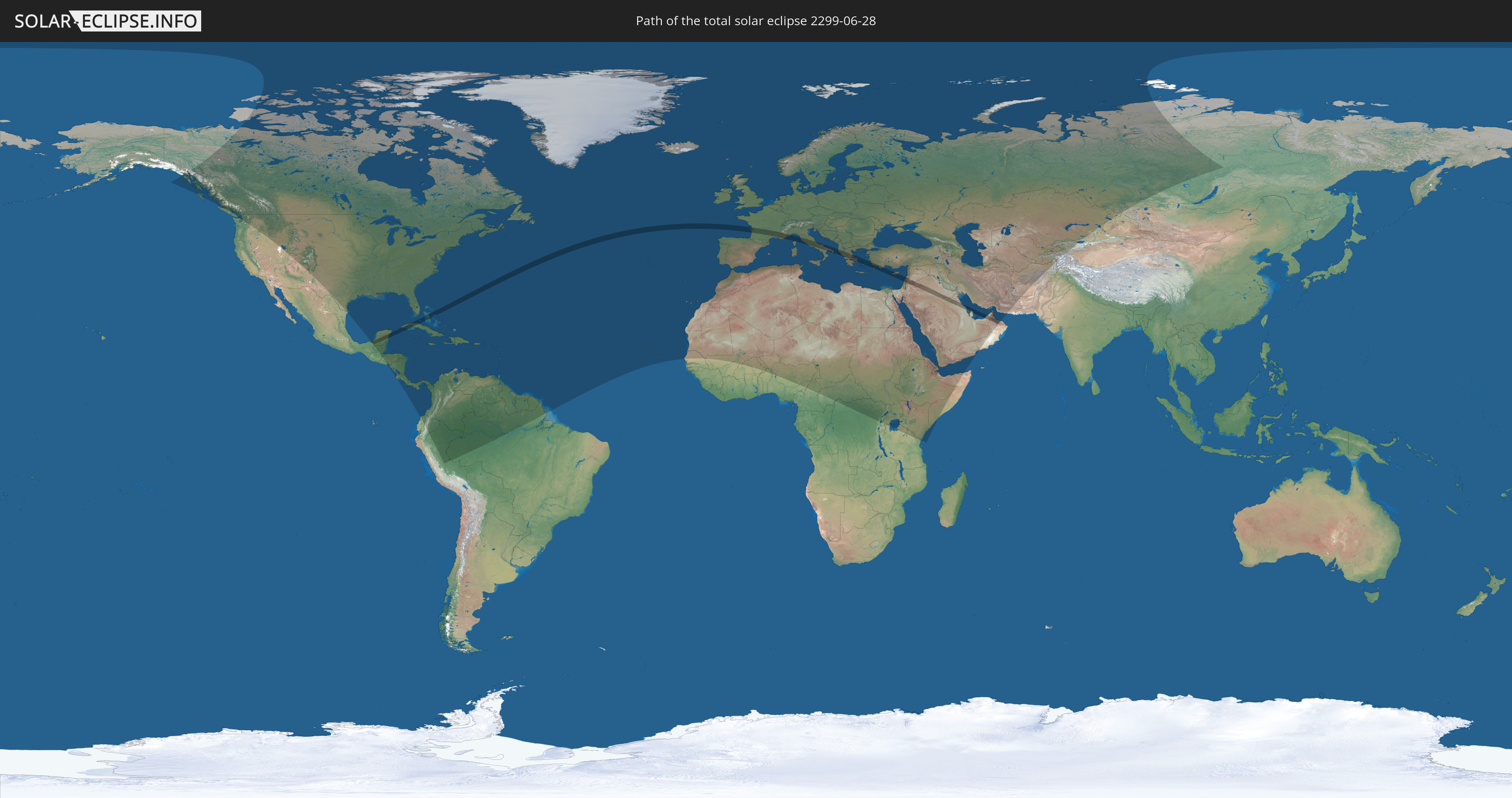
Total solar eclipse of 06/28/2299
| Day of week: | Wednesday |
| Maximum duration of eclipse: | 03m03s |
| Maximum width of eclipse path: | 133 km |
| Saros cycle: | 151 |
| Coverage: | 100% |
| Magnitude: | 1.0365 |
| Gamma: | 0.3846 |
Wo kann man die Sonnenfinsternis vom 06/28/2299 sehen?
Die Sonnenfinsternis am 06/28/2299 kann man in 150 Ländern als partielle Sonnenfinsternis beobachten.
Der Finsternispfad verläuft durch 21 Länder. Nur in diesen Ländern ist sie als total Sonnenfinsternis zu sehen.
In den folgenden Ländern ist die Sonnenfinsternis total zu sehen
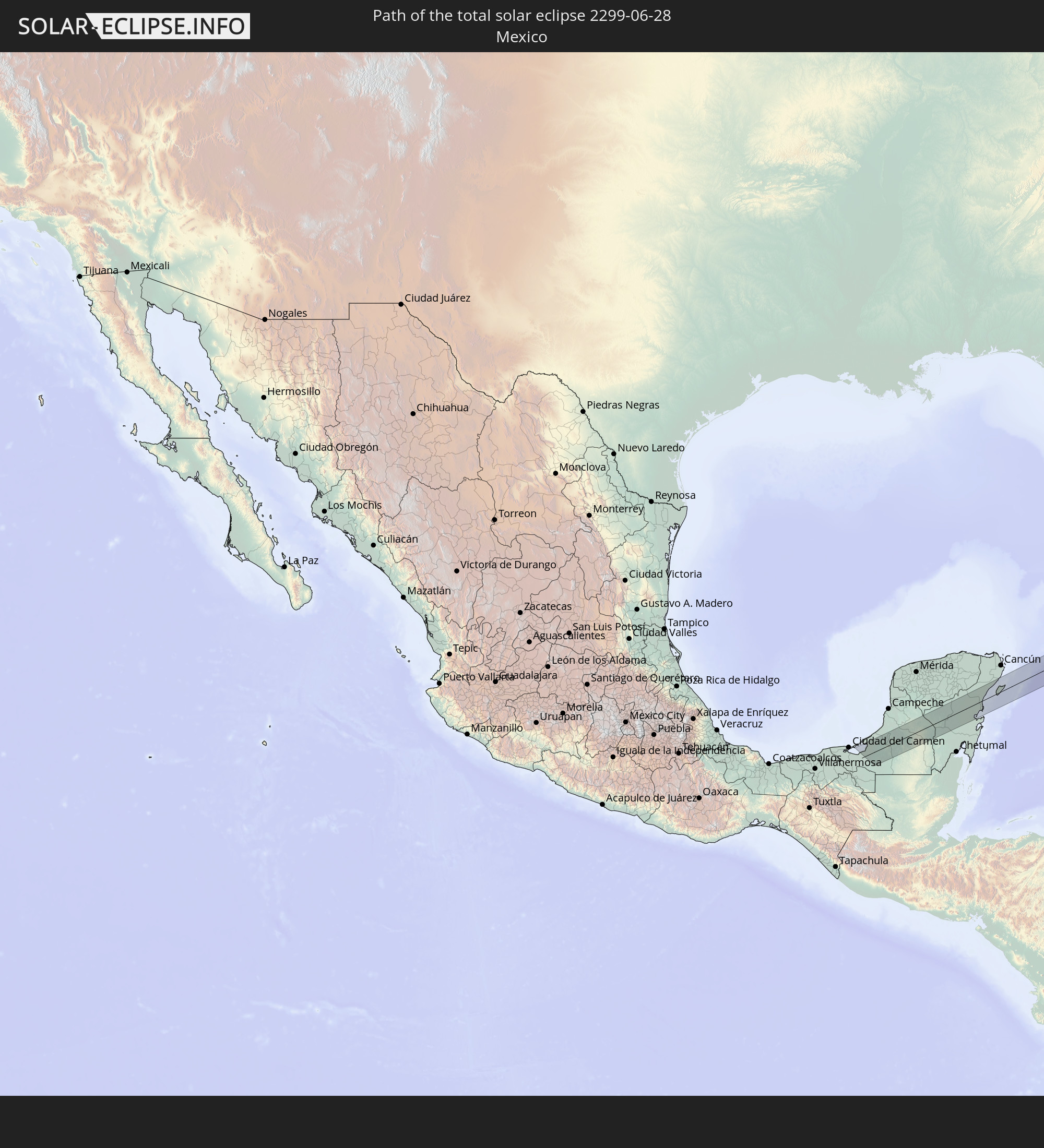 Mexico
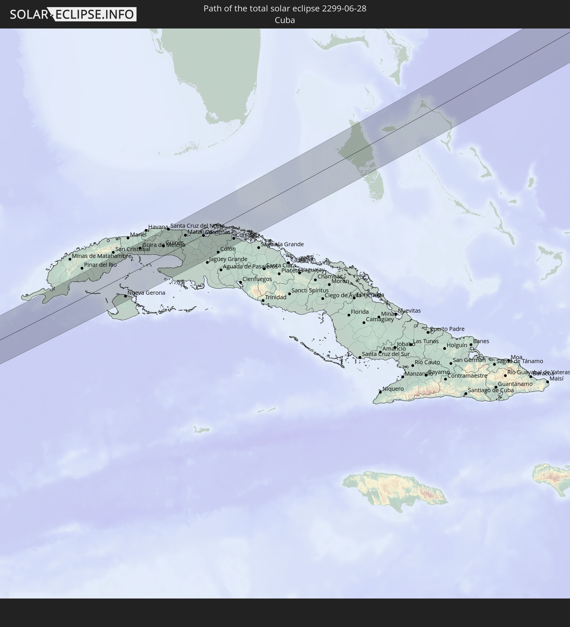 Cuba
Cuba
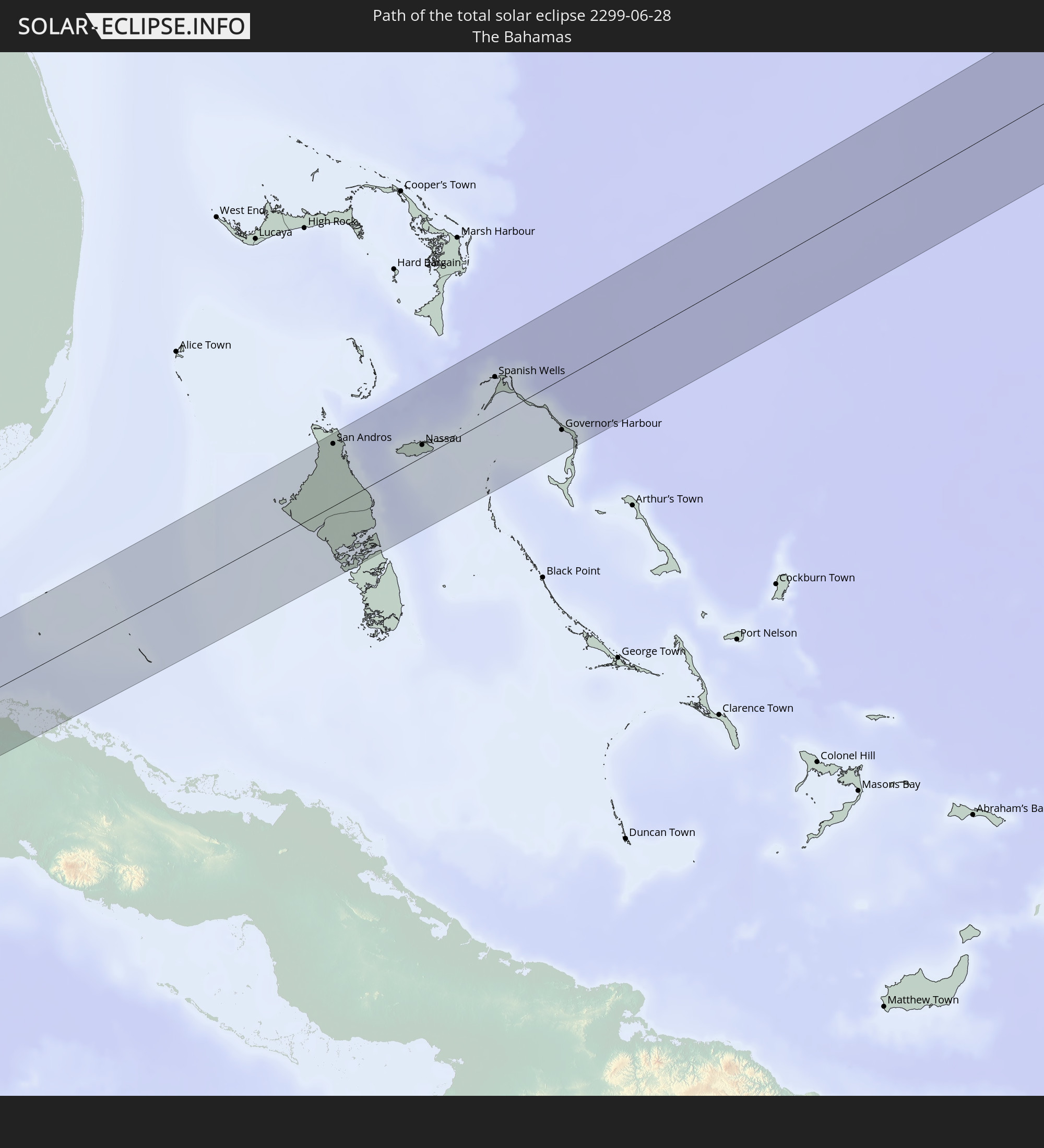 The Bahamas
 France
 Italy
Italy
 Monaco
 Vatican City
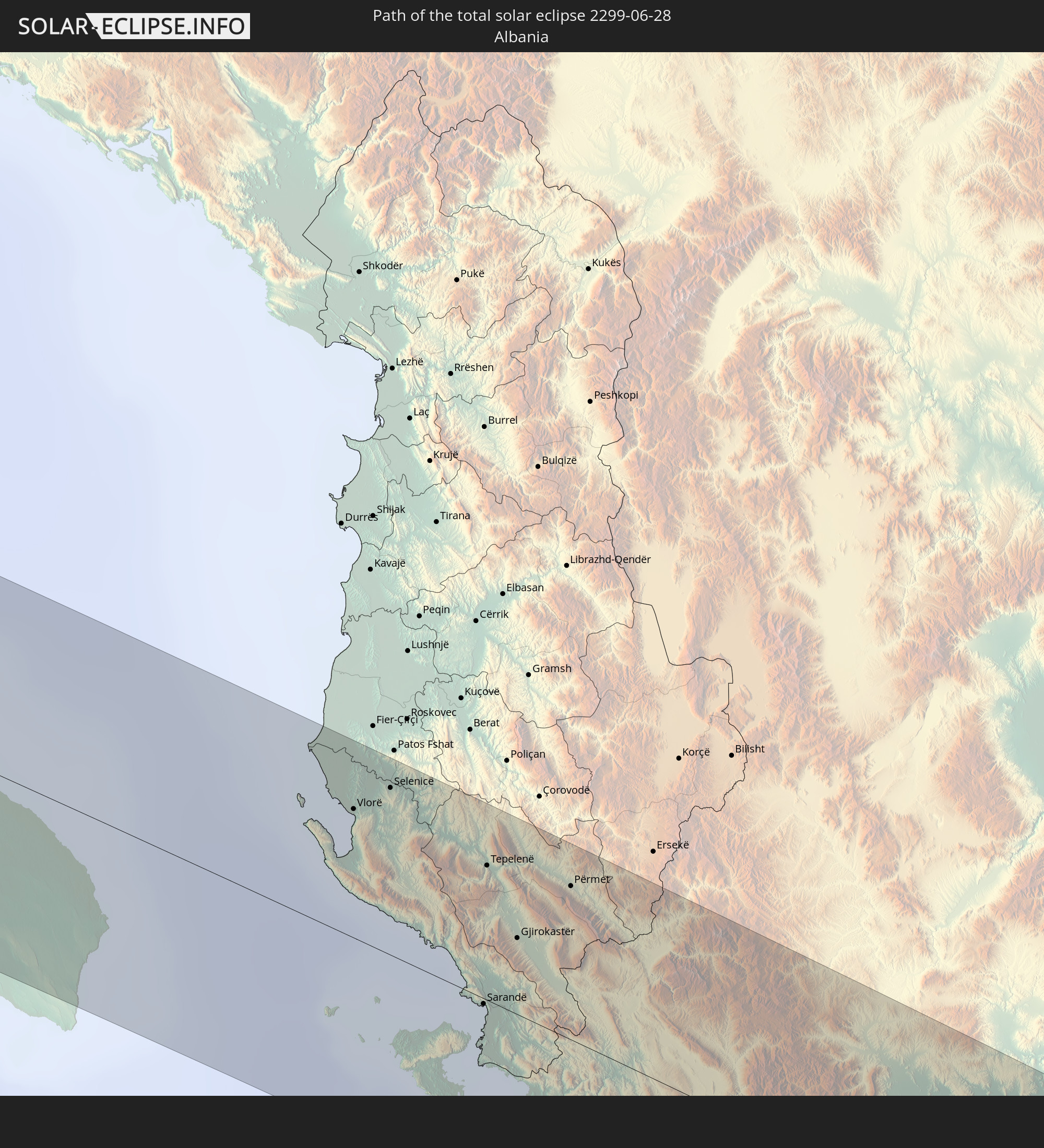 Albania
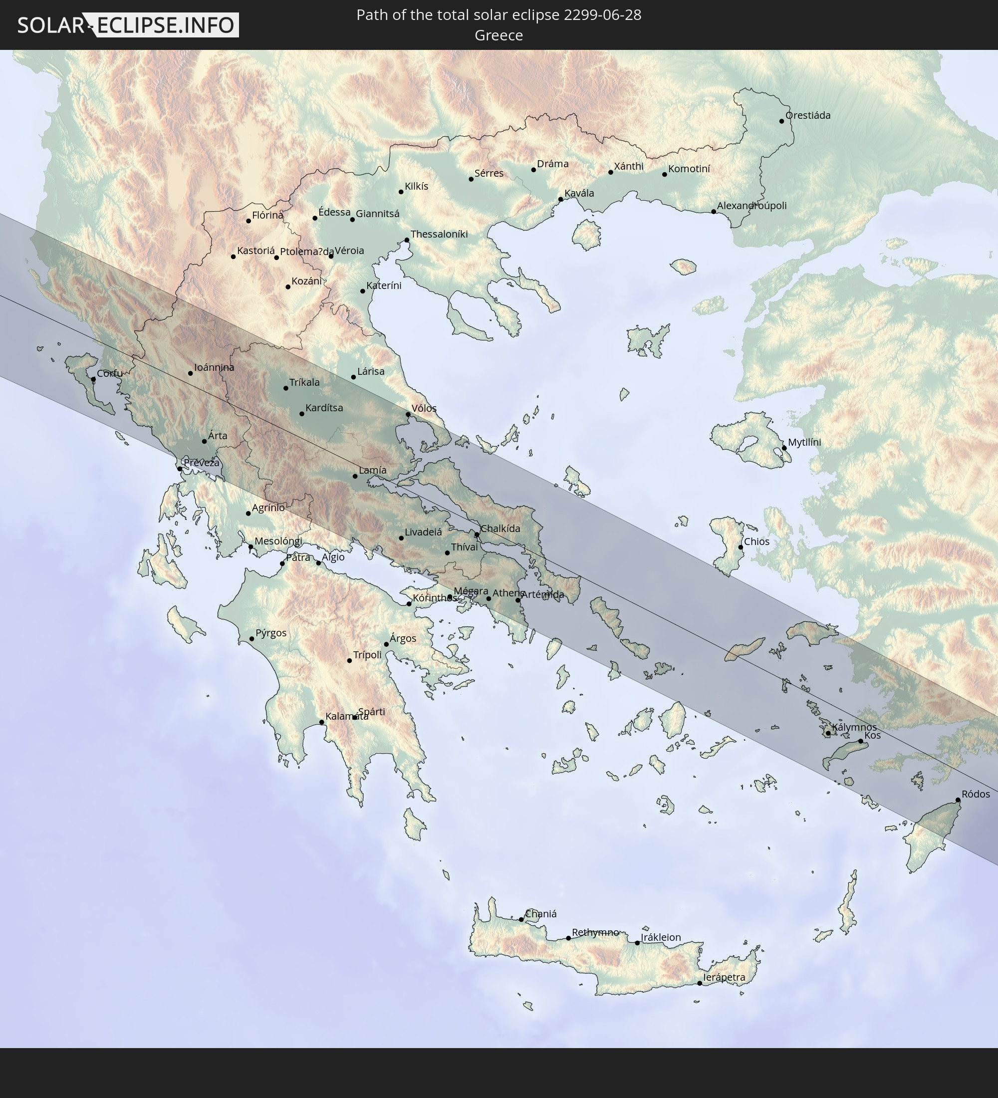 Greece
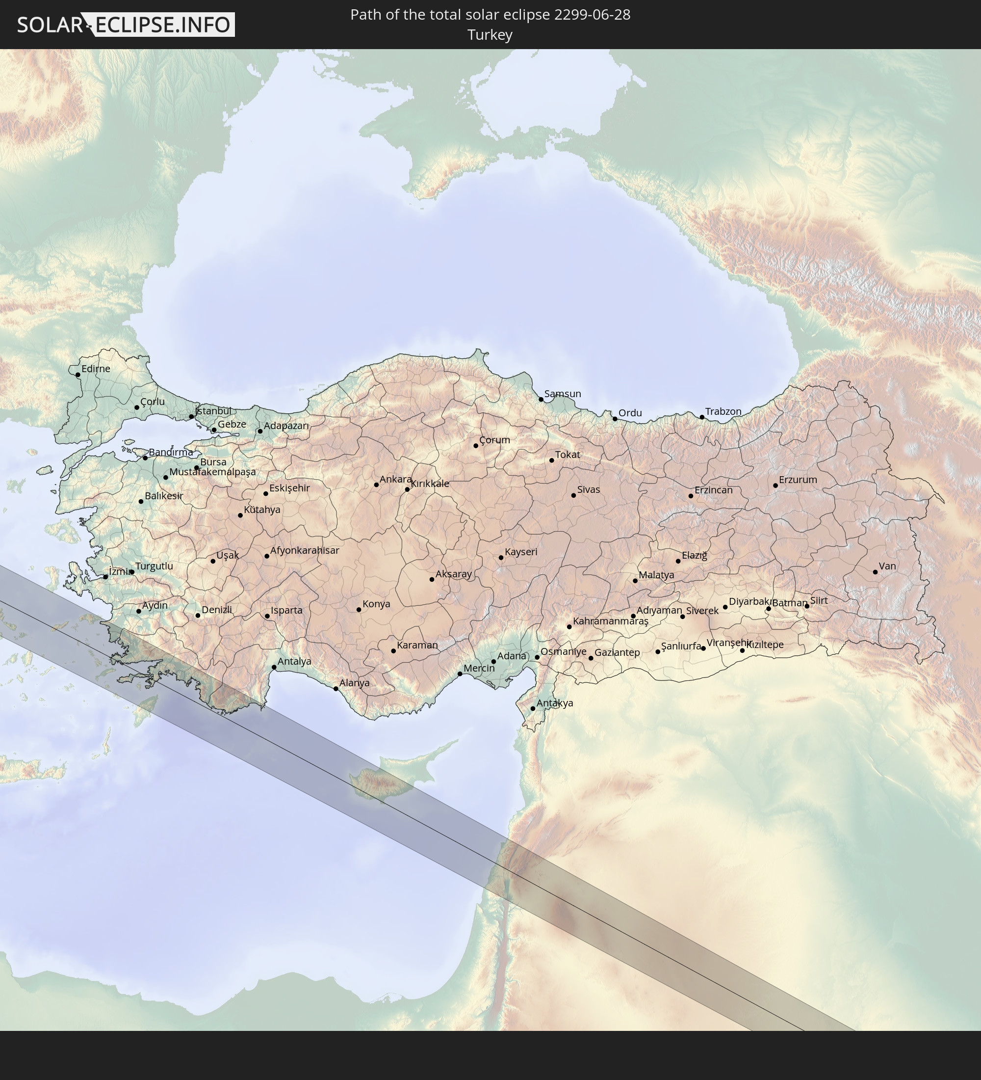 Turkey
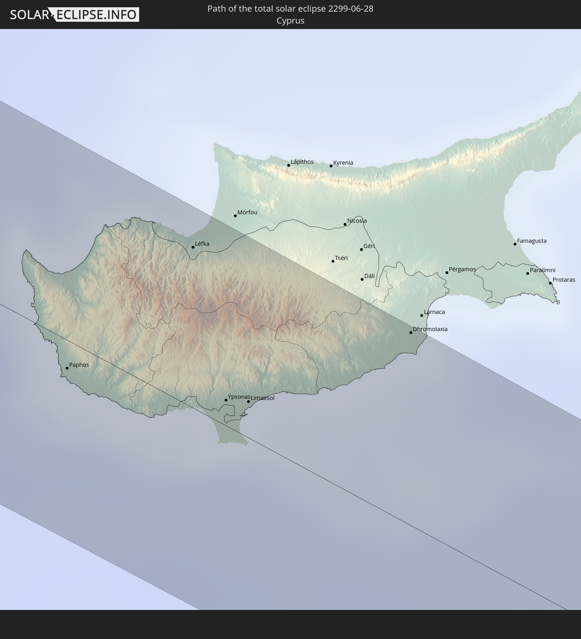 Cyprus
 Israel
 Saudi Arabia
 Jordan
 Lebanon
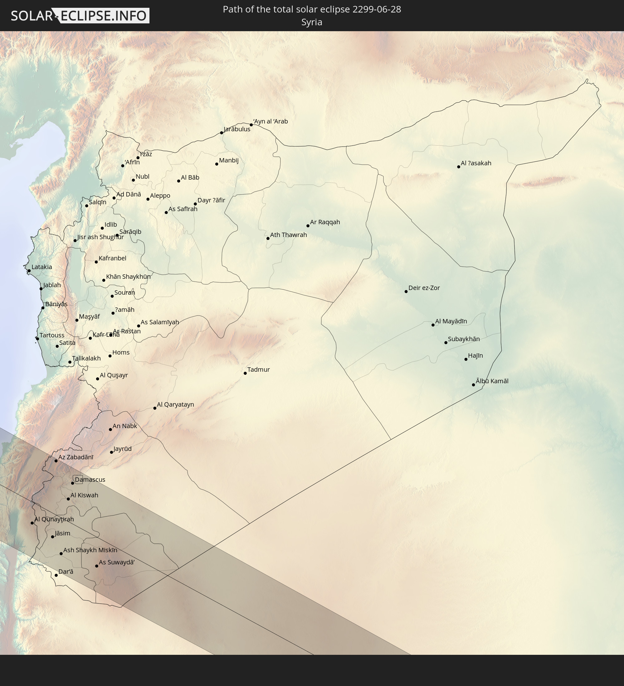 Syria
Syria
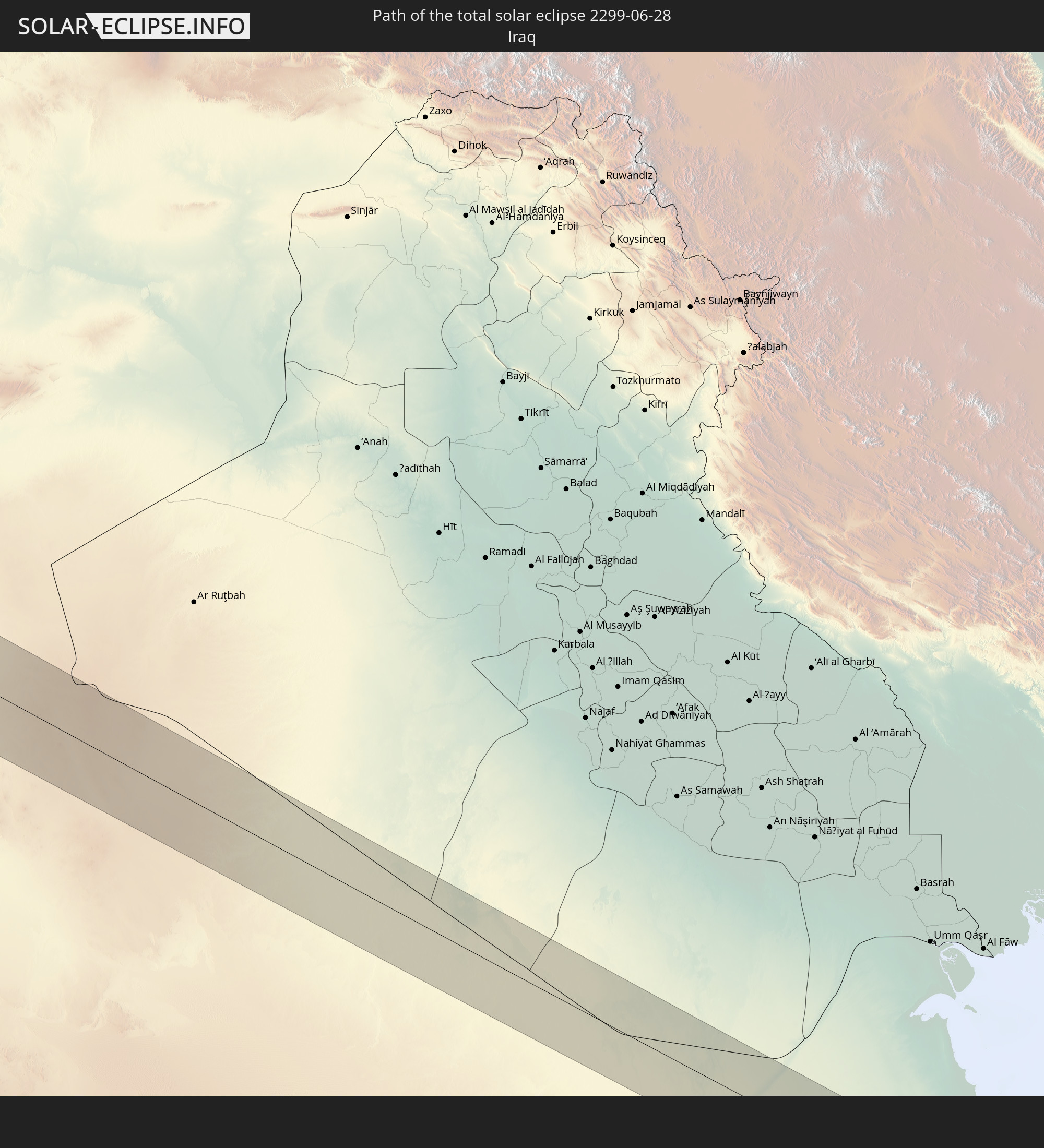 Iraq
Iraq
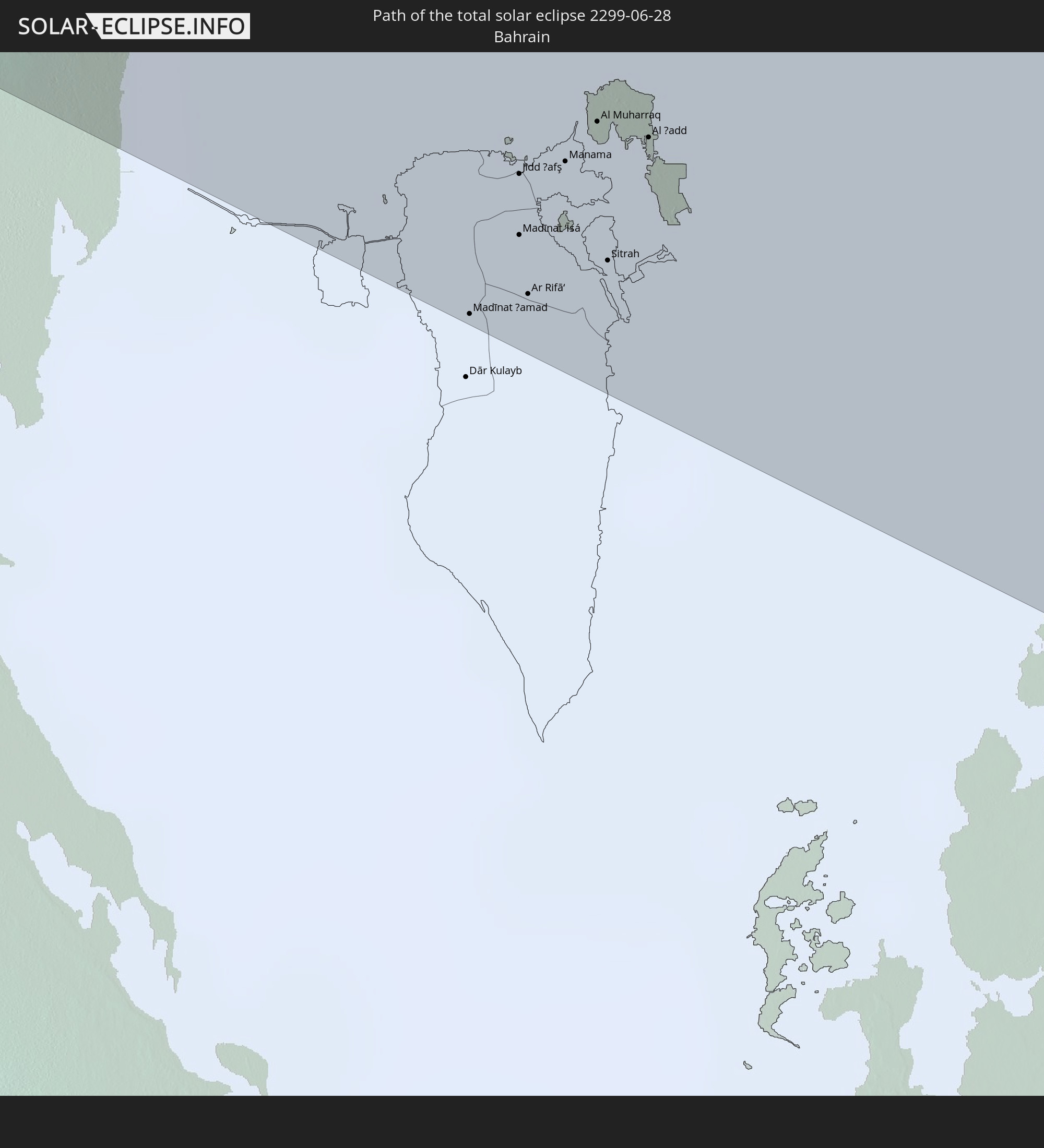 Bahrain
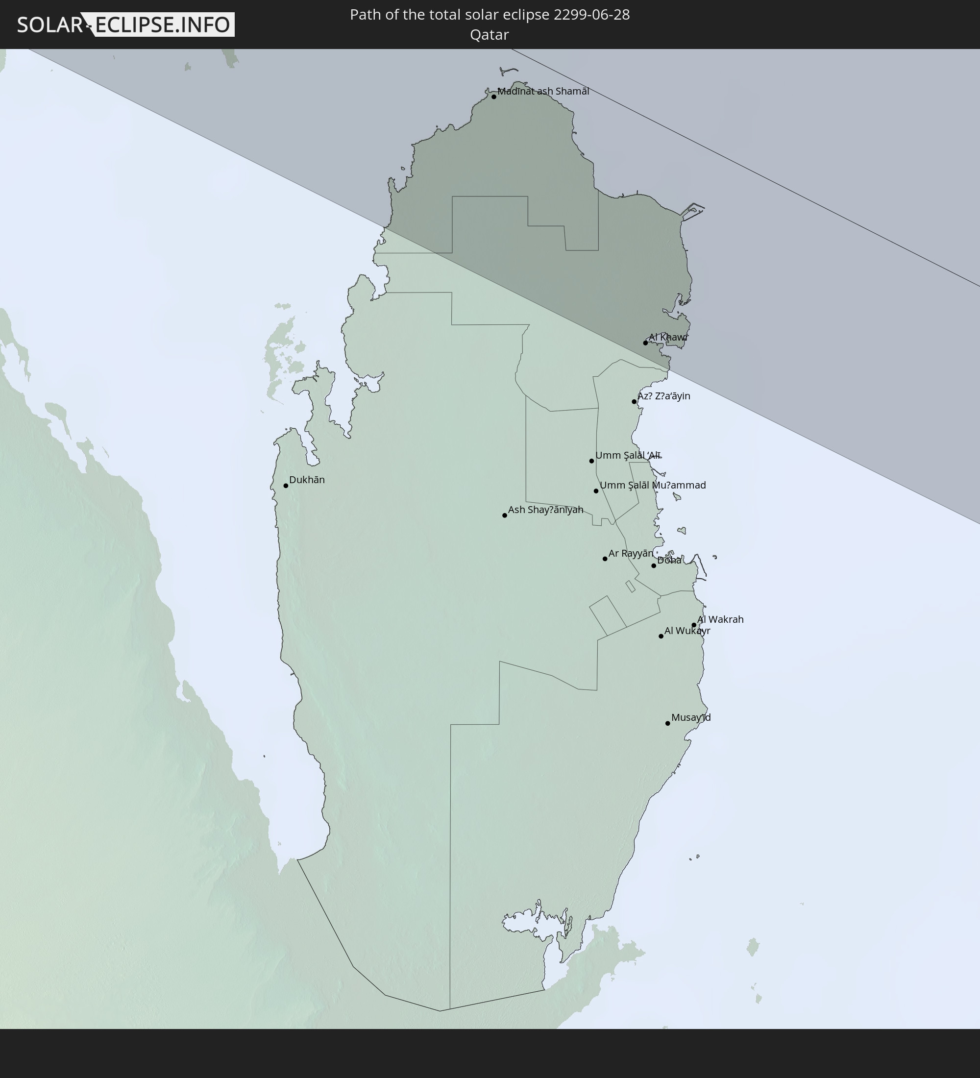 Qatar
Qatar
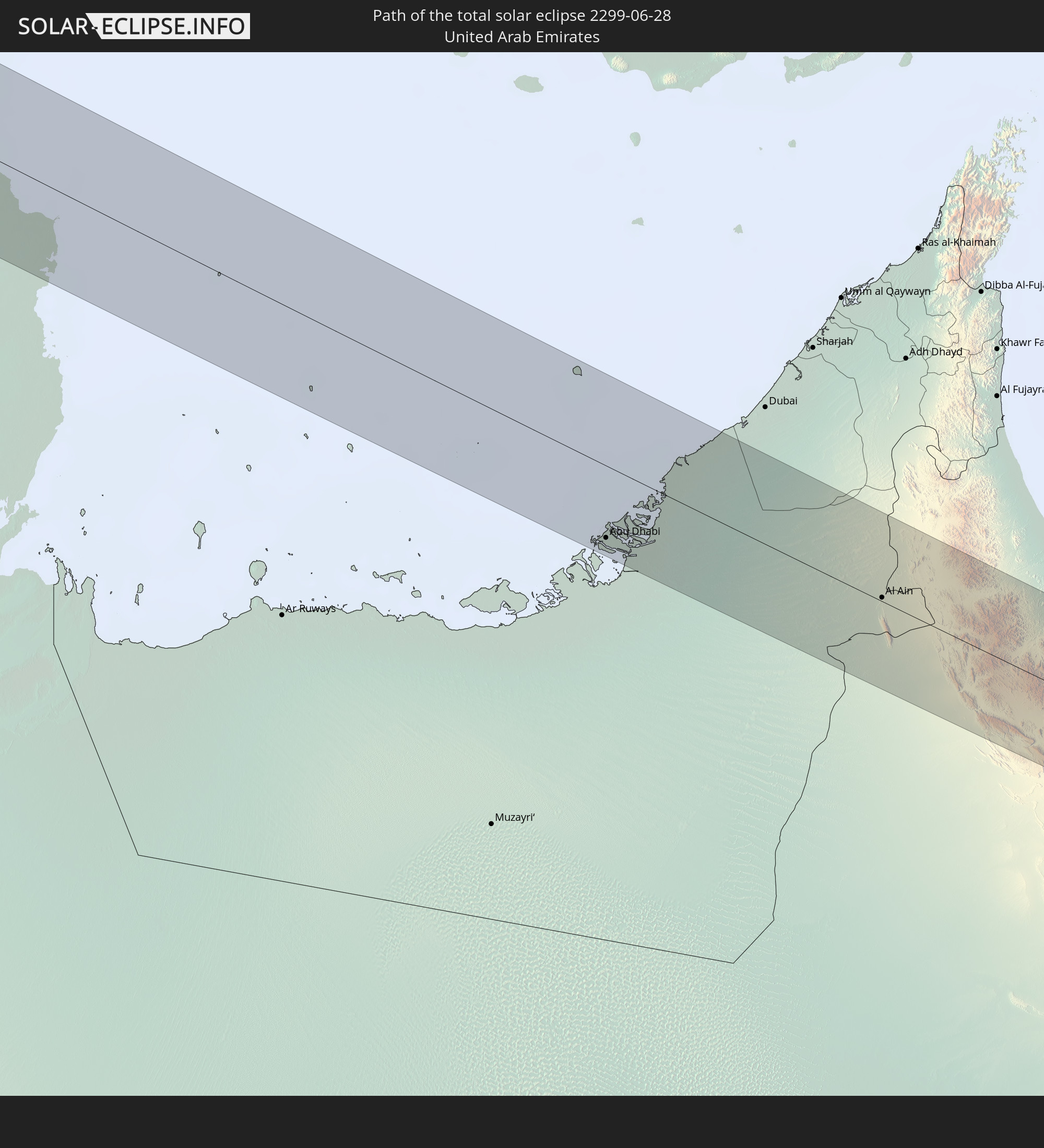 United Arab Emirates
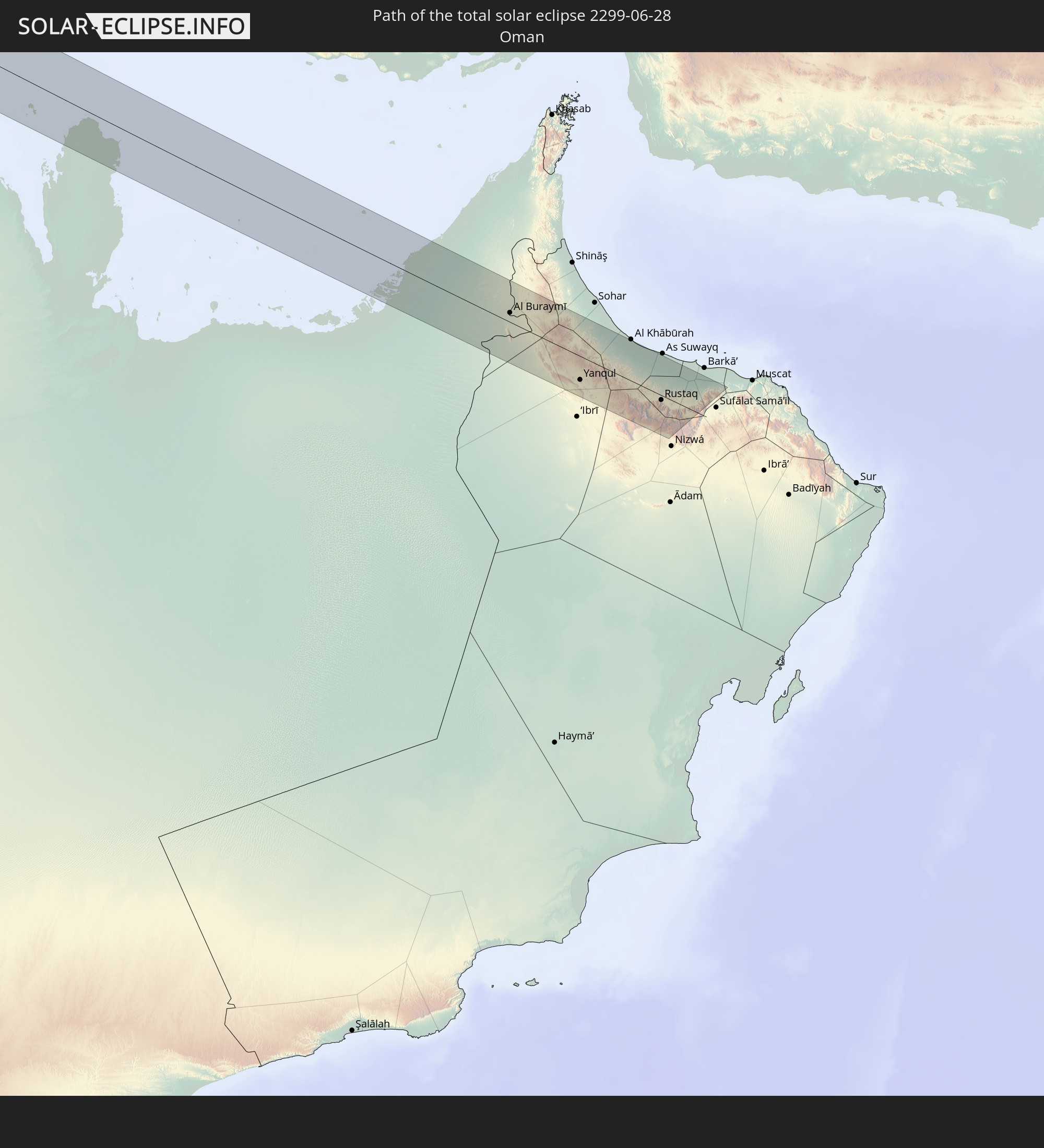 Oman
Oman
In den folgenden Ländern ist die Sonnenfinsternis partiell zu sehen
 Russia
 United States
 United States Minor Outlying Islands
 Canada
 Mexico
 Greenland
 Guatemala
 Ecuador
 El Salvador
 Honduras
 Belize
 Nicaragua
 Costa Rica
 Cuba
Cuba
 Panama
 Colombia
 Cayman Islands
 Peru
Peru
 The Bahamas
 Jamaica
 Haiti
Haiti
 Brazil
 Venezuela
 Turks and Caicos Islands
 Dominican Republic
 Aruba
Aruba
 Puerto Rico
 United States Virgin Islands
 Bermuda
 British Virgin Islands
 Anguilla
 Collectivity of Saint Martin
 Saint Barthélemy
 Saint Kitts and Nevis
 Antigua and Barbuda
 Montserrat
 Trinidad and Tobago
 Guadeloupe
 Grenada
 Dominica
 Saint Vincent and the Grenadines
 Guyana
 Martinique
 Saint Lucia
 Barbados
 Suriname
 Saint Pierre and Miquelon
 French Guiana
 Portugal
 Cabo Verde
 Iceland
 Spain
Spain
 Senegal
 Mauritania
 Morocco
 Mali
Mali
 Republic of Ireland
 Svalbard and Jan Mayen
 Algeria
 United Kingdom
 Faroe Islands
 Burkina Faso
 Gibraltar
 France
 Isle of Man
 Guernsey
 Jersey
 Niger
Niger
 Benin
Benin
 Andorra
 Belgium
 Nigeria
 Netherlands
 Norway
 Luxembourg
 Germany
 Switzerland
 Italy
Italy
 Monaco
 Tunisia
 Denmark
 Cameroon
 Libya
Libya
 Liechtenstein
 Austria
 Sweden
 Czechia
 Democratic Republic of the Congo
 San Marino
 Vatican City
 Slovenia
 Chad
Chad
 Croatia
 Poland
 Malta
Malta
 Central African Republic
 Bosnia and Herzegovina
 Hungary
 Slovakia
 Montenegro
 Serbia
 Albania
 Åland Islands
 Greece
 Romania
 Republic of Macedonia
 Finland
 Lithuania
 Latvia
 Estonia
 Sudan
Sudan
 Ukraine
 Bulgaria
 Belarus
 Egypt
Egypt
 Turkey
 Moldova
 Tanzania
 Uganda
 Cyprus
 Ethiopia
 Kenya
Kenya
 State of Palestine
 Israel
 Saudi Arabia
 Jordan
 Lebanon
 Syria
Syria
 Eritrea
 Iraq
Iraq
 Georgia
 Somalia
 Djibouti
 Yemen
Yemen
 Armenia
 Iran
Iran
 Azerbaijan
 Kazakhstan
 Kuwait
 Bahrain
 Qatar
Qatar
 United Arab Emirates
 Oman
Oman
 Turkmenistan
 Uzbekistan
 Afghanistan
 Pakistan
 Tajikistan
 Kyrgyzstan
 China
China
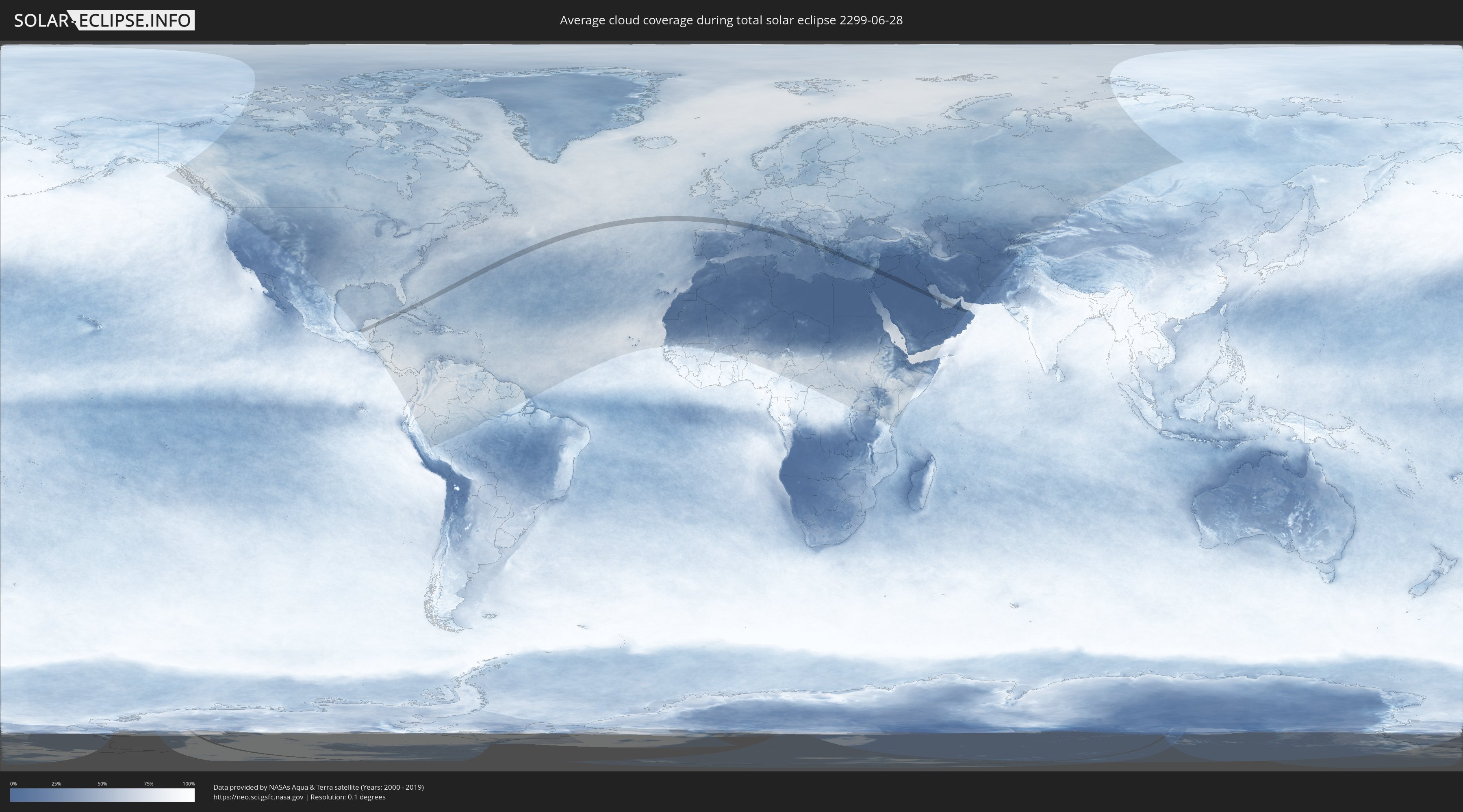
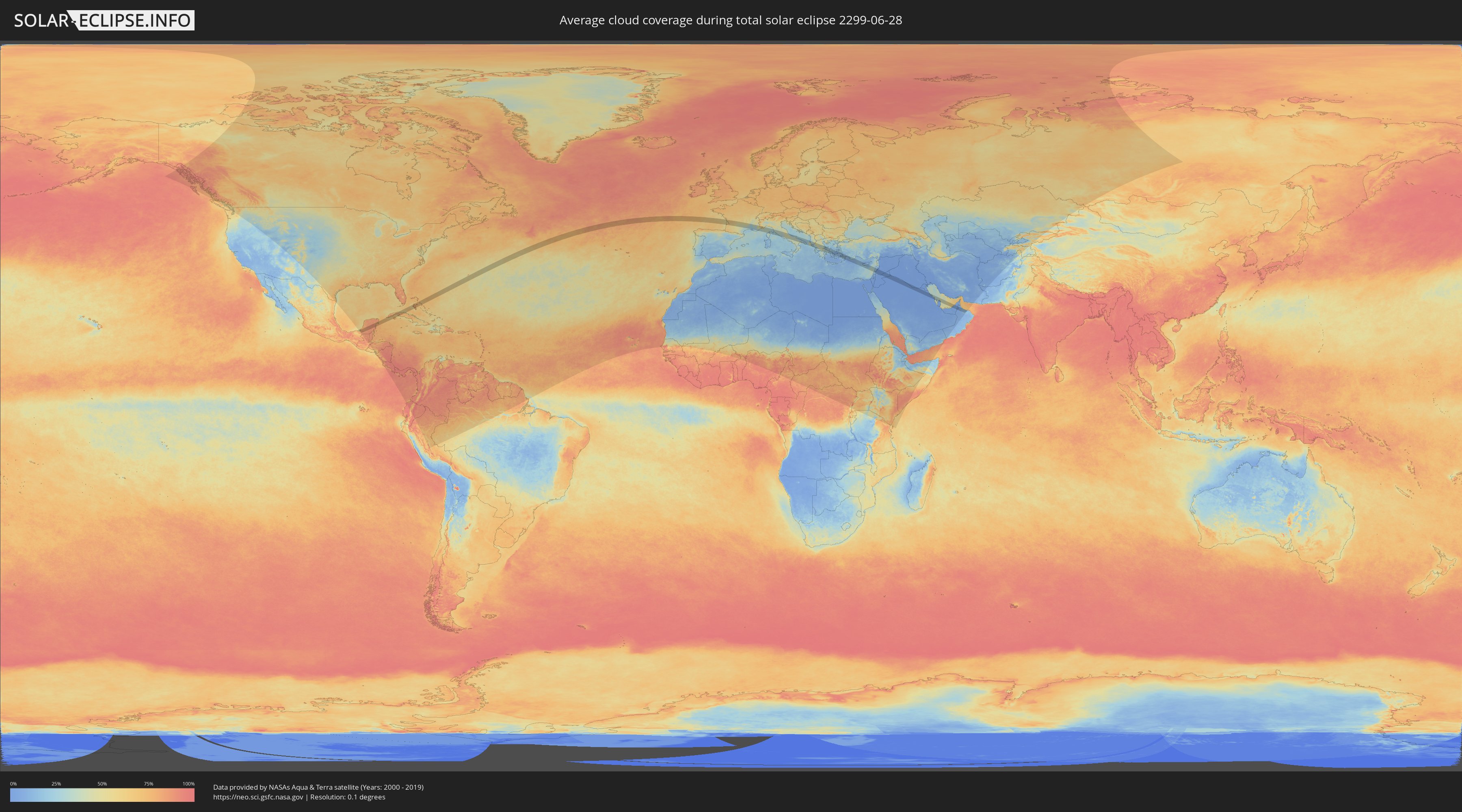
How will be the weather during the total solar eclipse on 06/28/2299?
Where is the best place to see the total solar eclipse of 06/28/2299?
The following maps show the average cloud coverage for the day of the total solar eclipse.
With the help of these maps, it is possible to find the place along the eclipse path, which has the best
chance of a cloudless sky.
Nevertheless, you should consider local circumstances and inform about the weather of your chosen
observation site.
The data is provided by NASAs satellites
AQUA and TERRA.
The cloud maps are averaged over a period of 19 years (2000 - 2019).
Detailed country maps
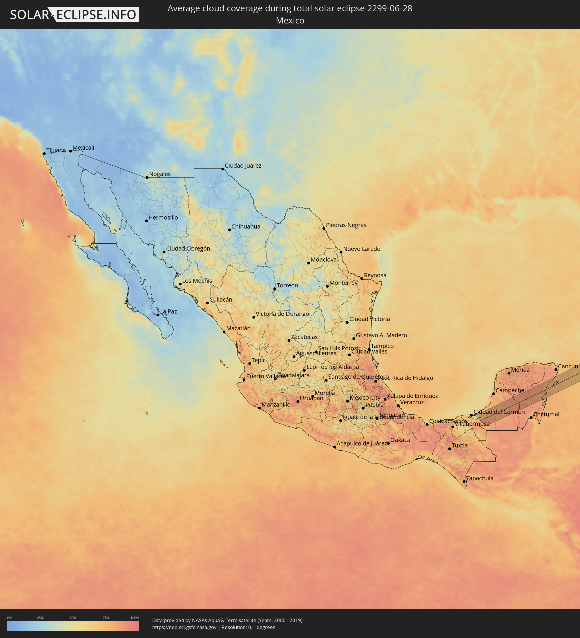 Mexico
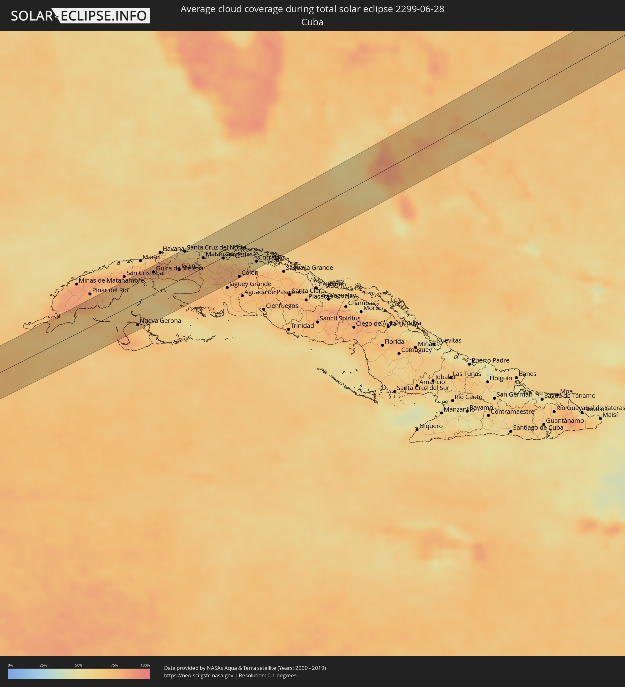 Cuba
Cuba
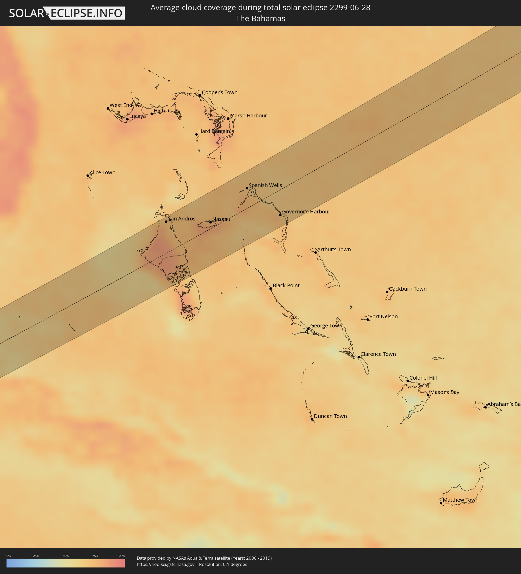 The Bahamas
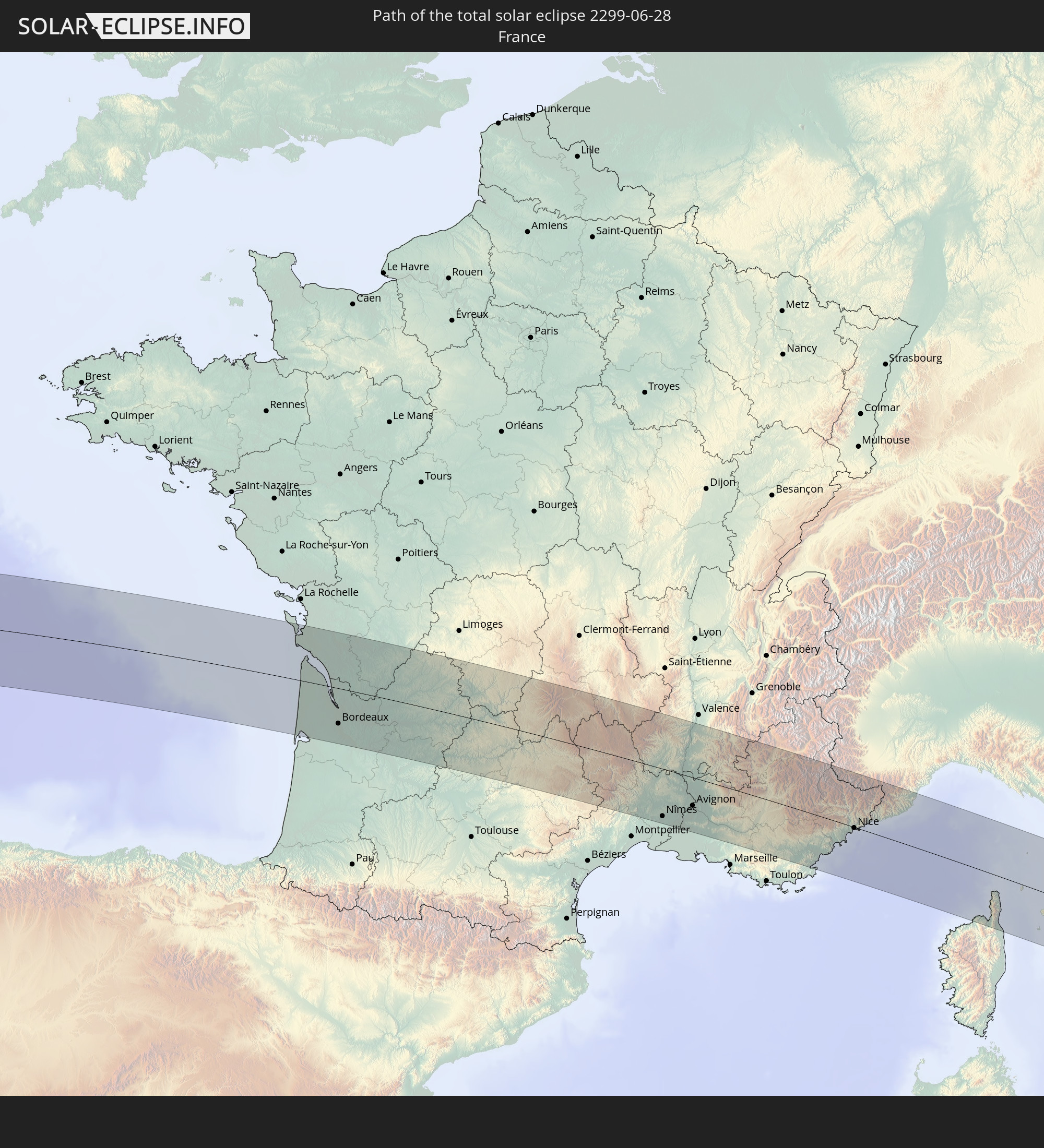
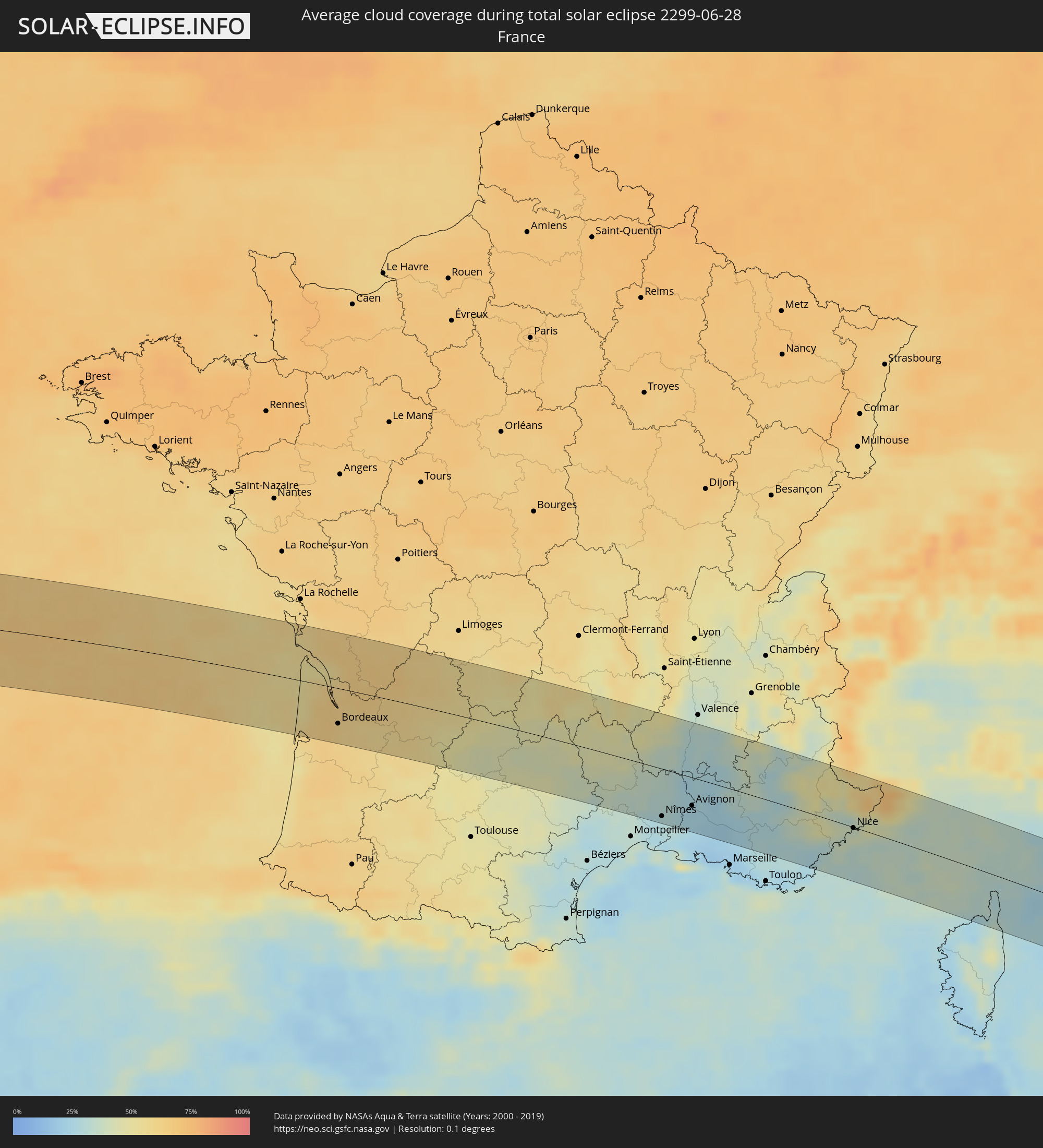 France
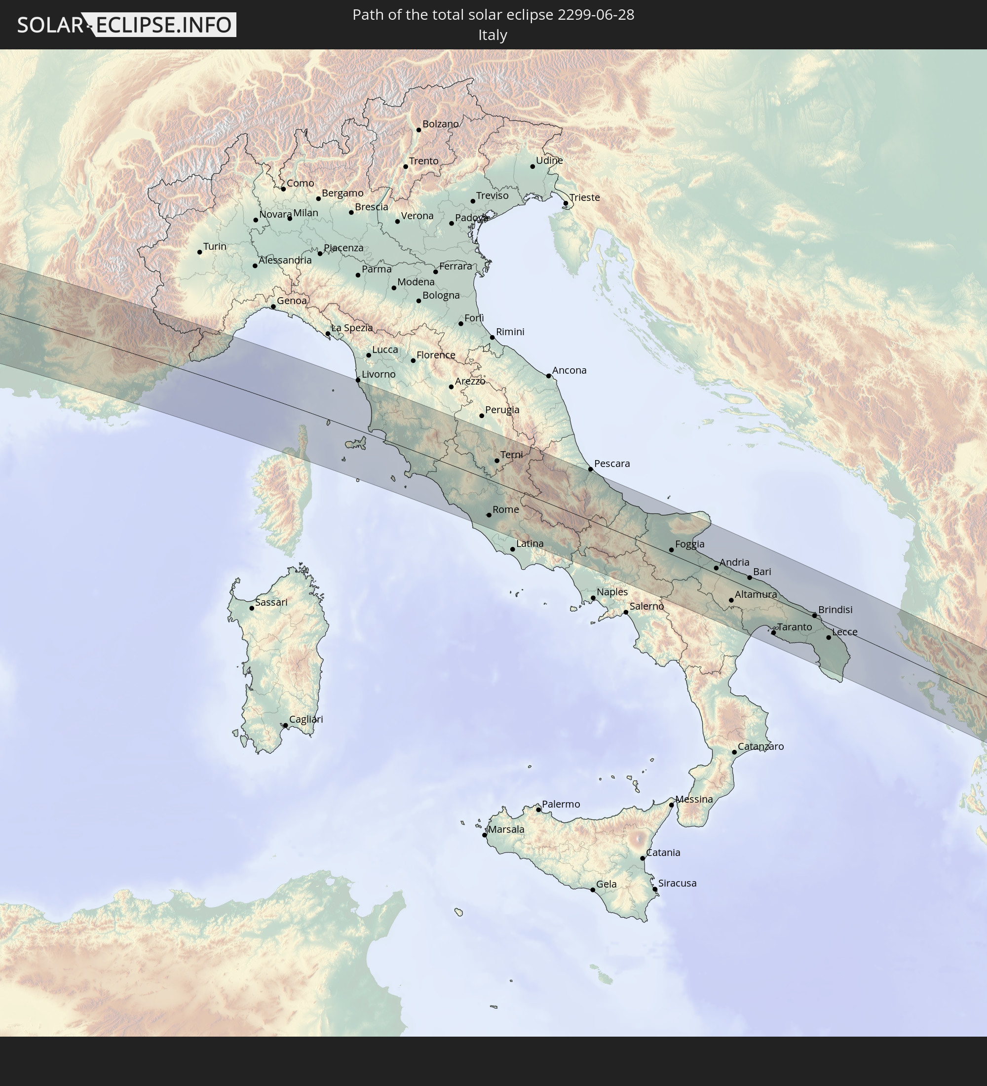
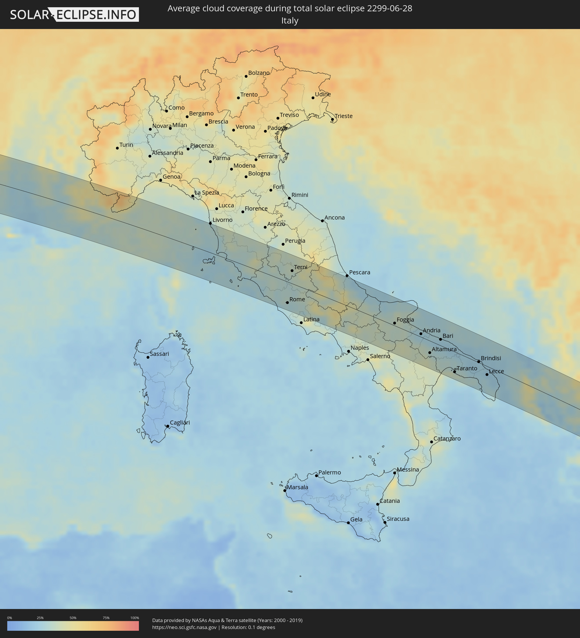 Italy
Italy
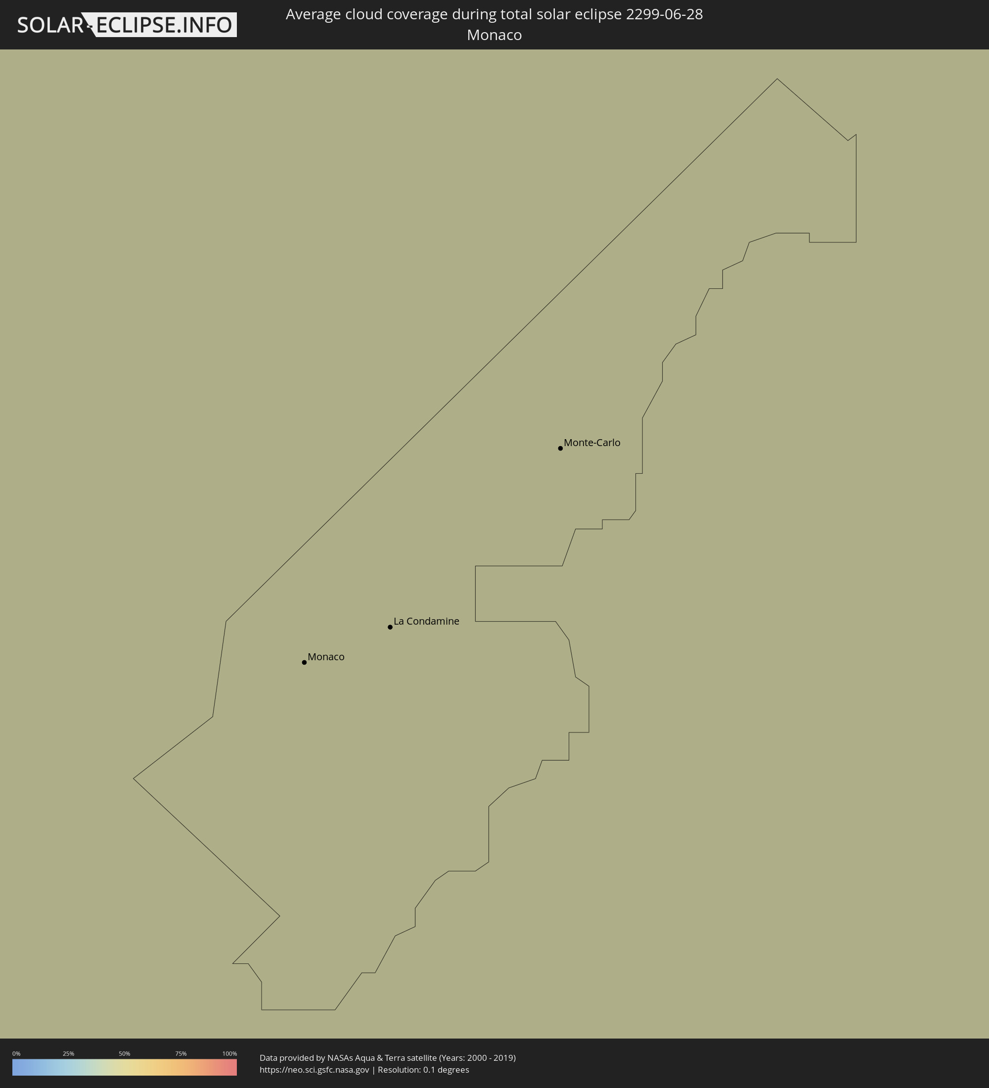 Monaco
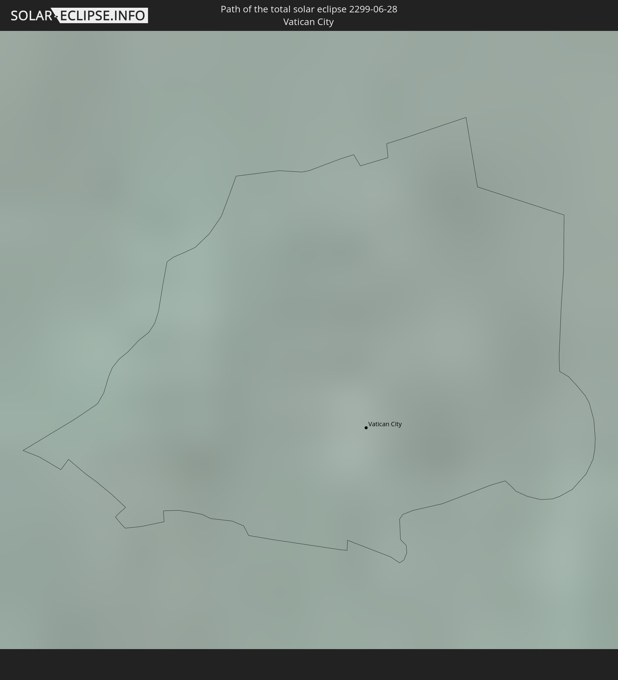
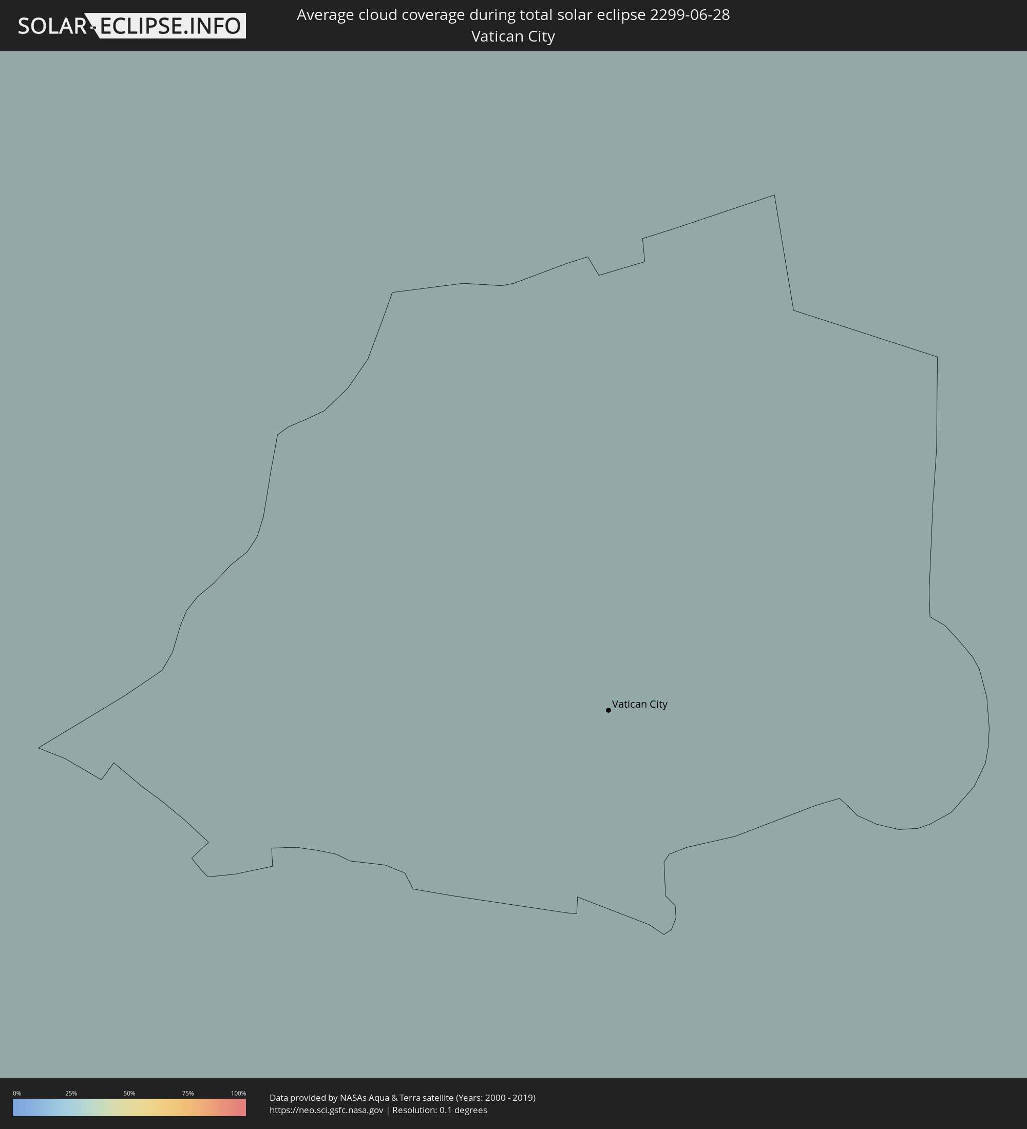 Vatican City
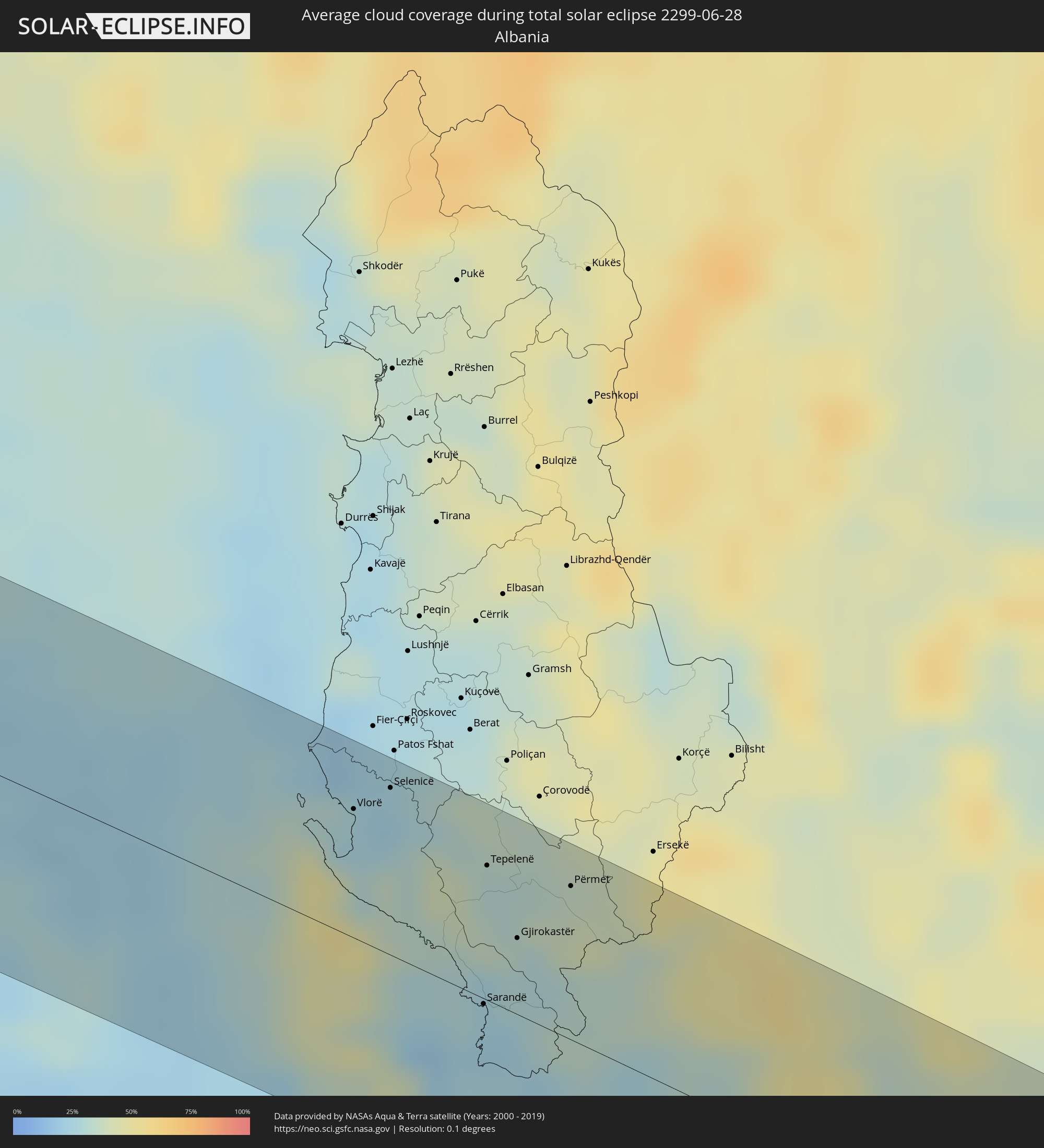 Albania
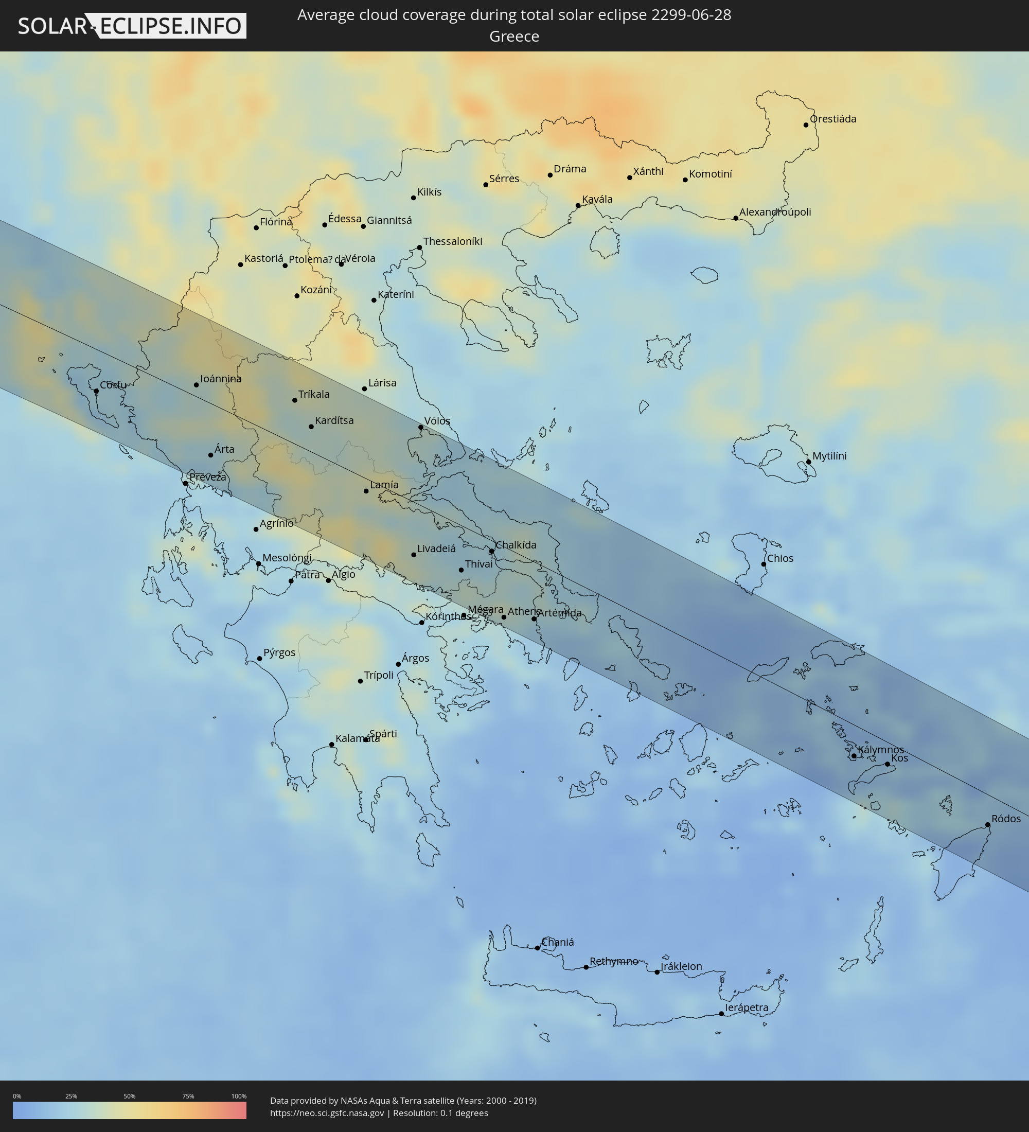 Greece
 Turkey
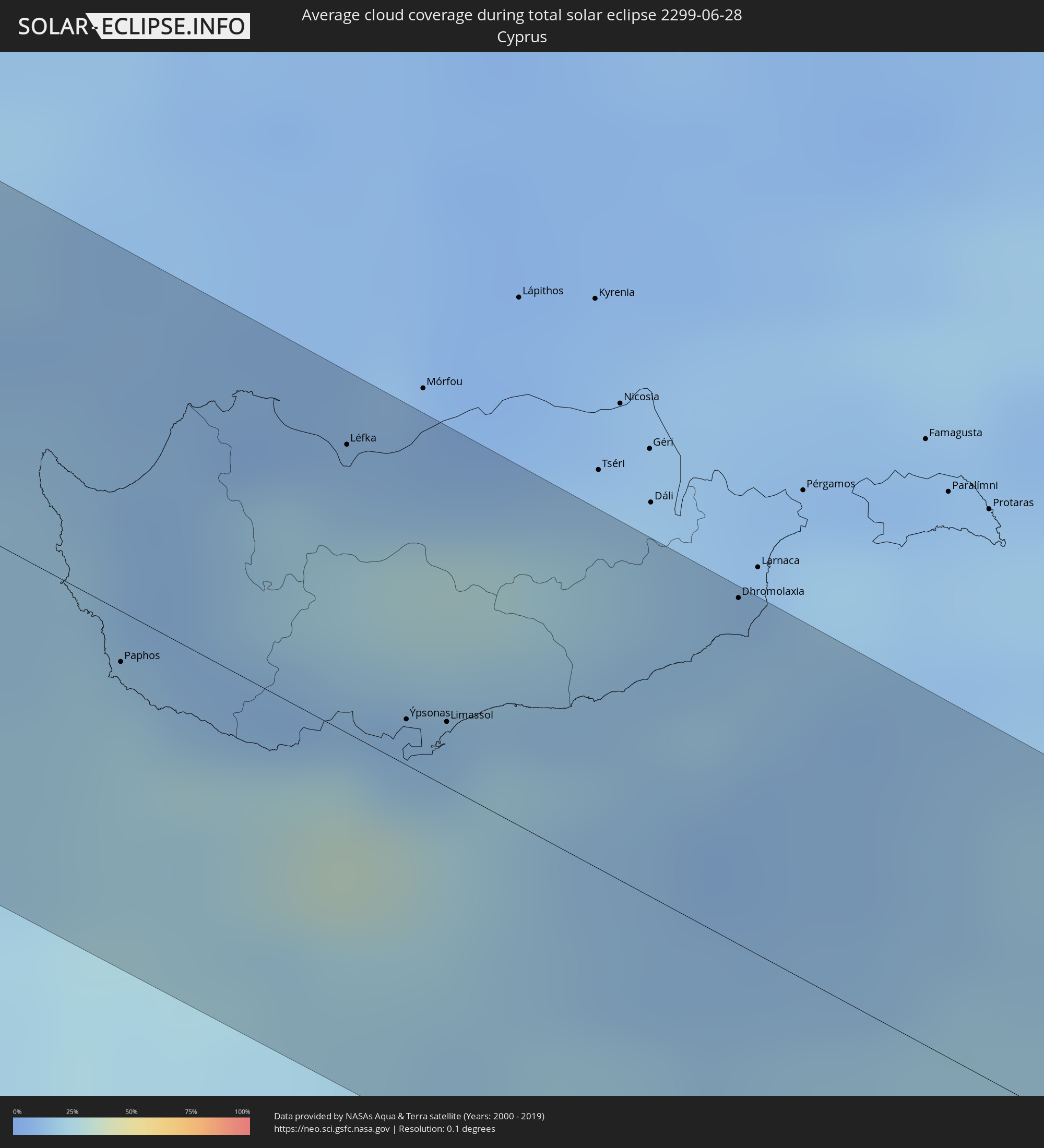 Cyprus
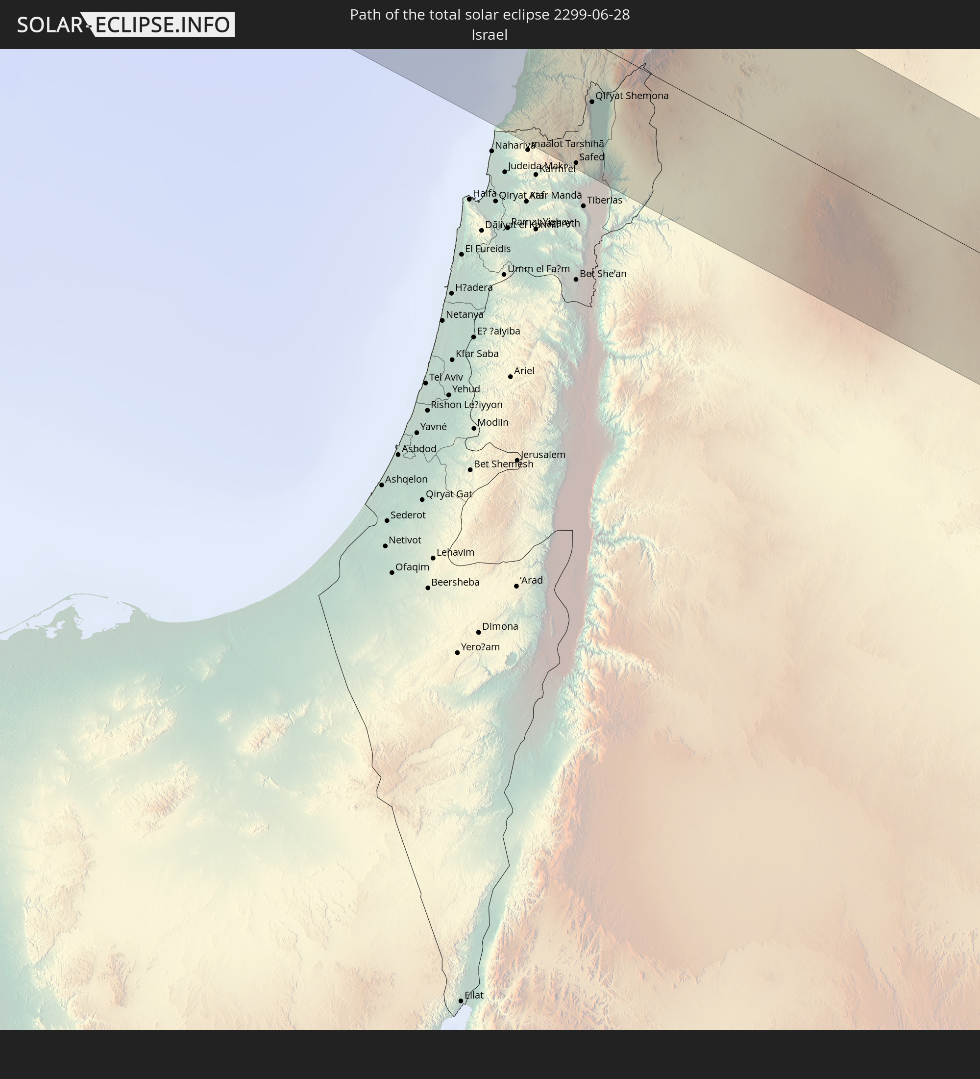
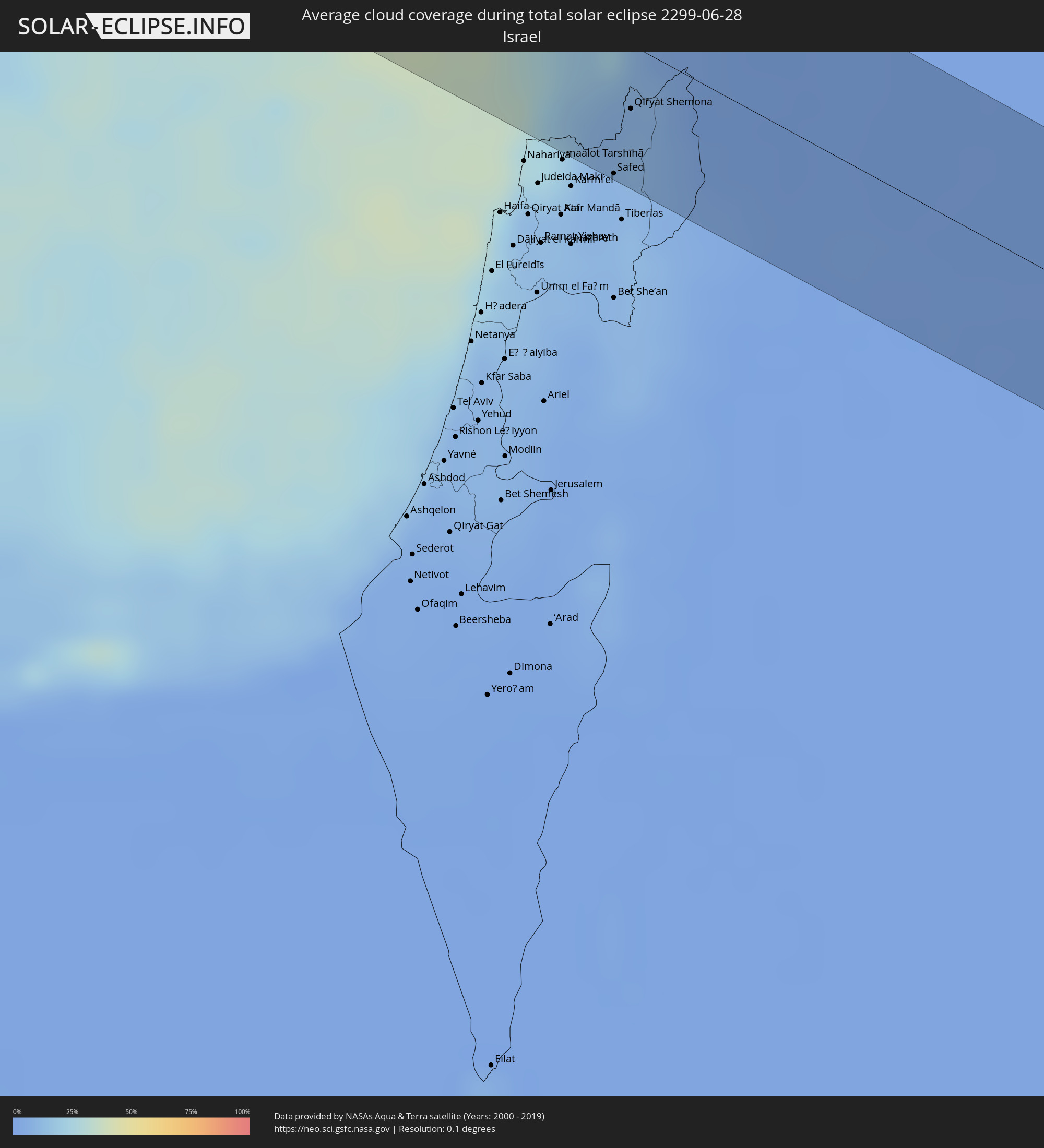 Israel
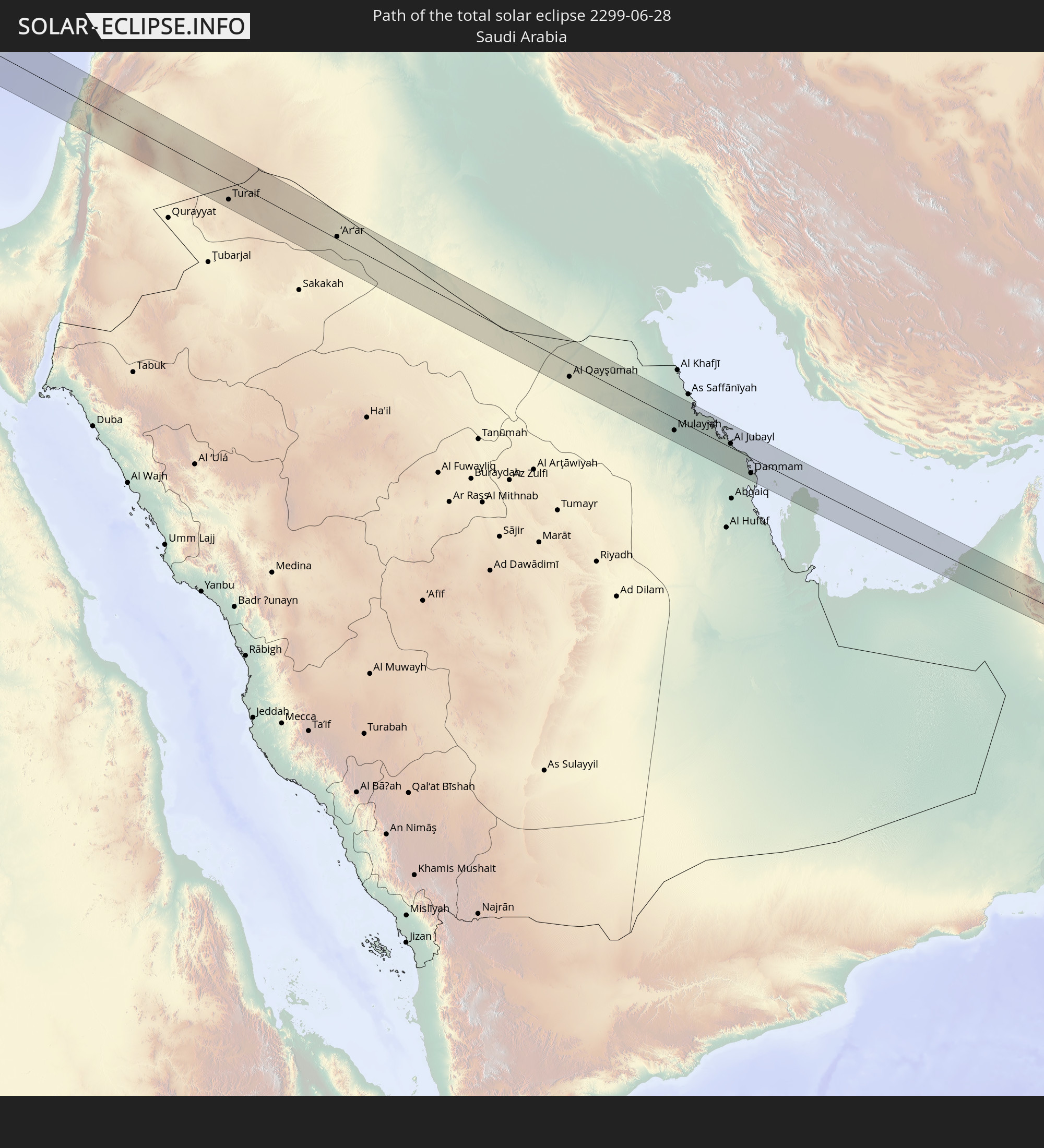
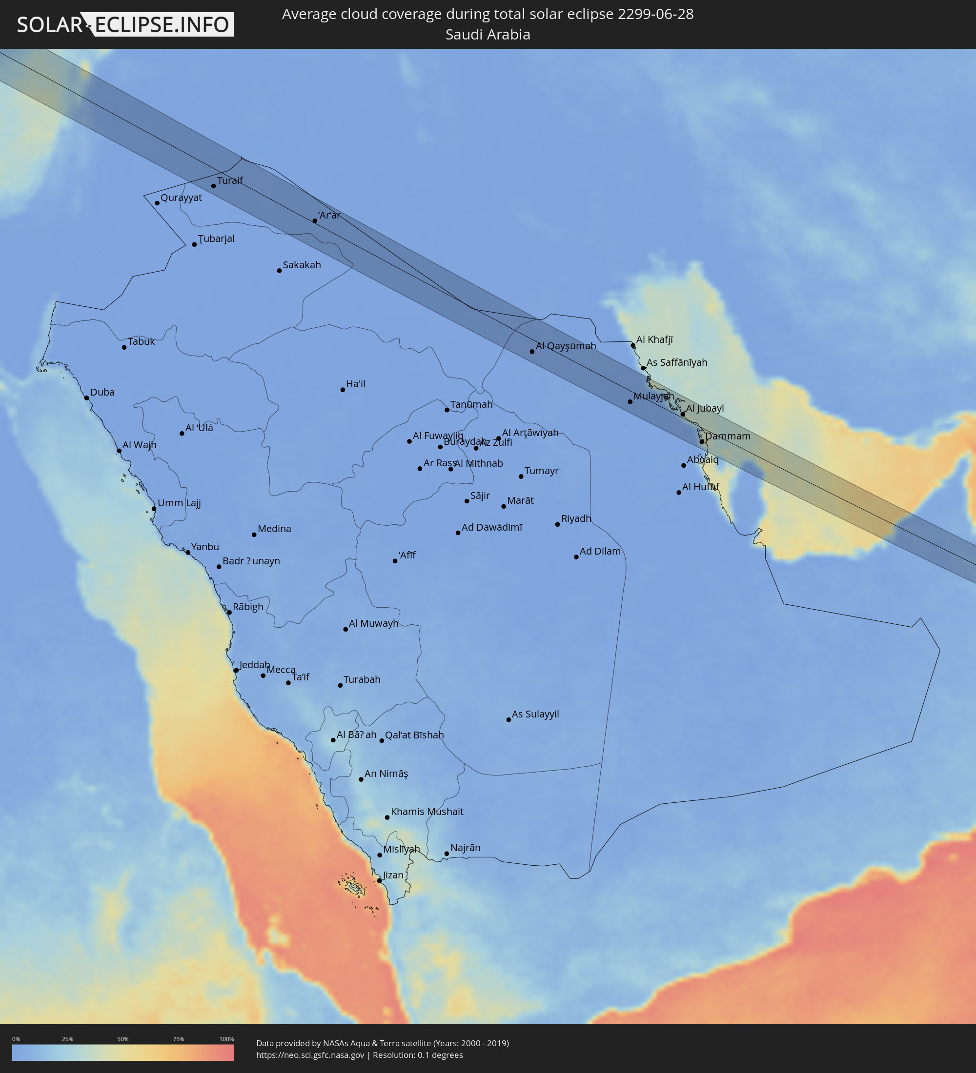 Saudi Arabia
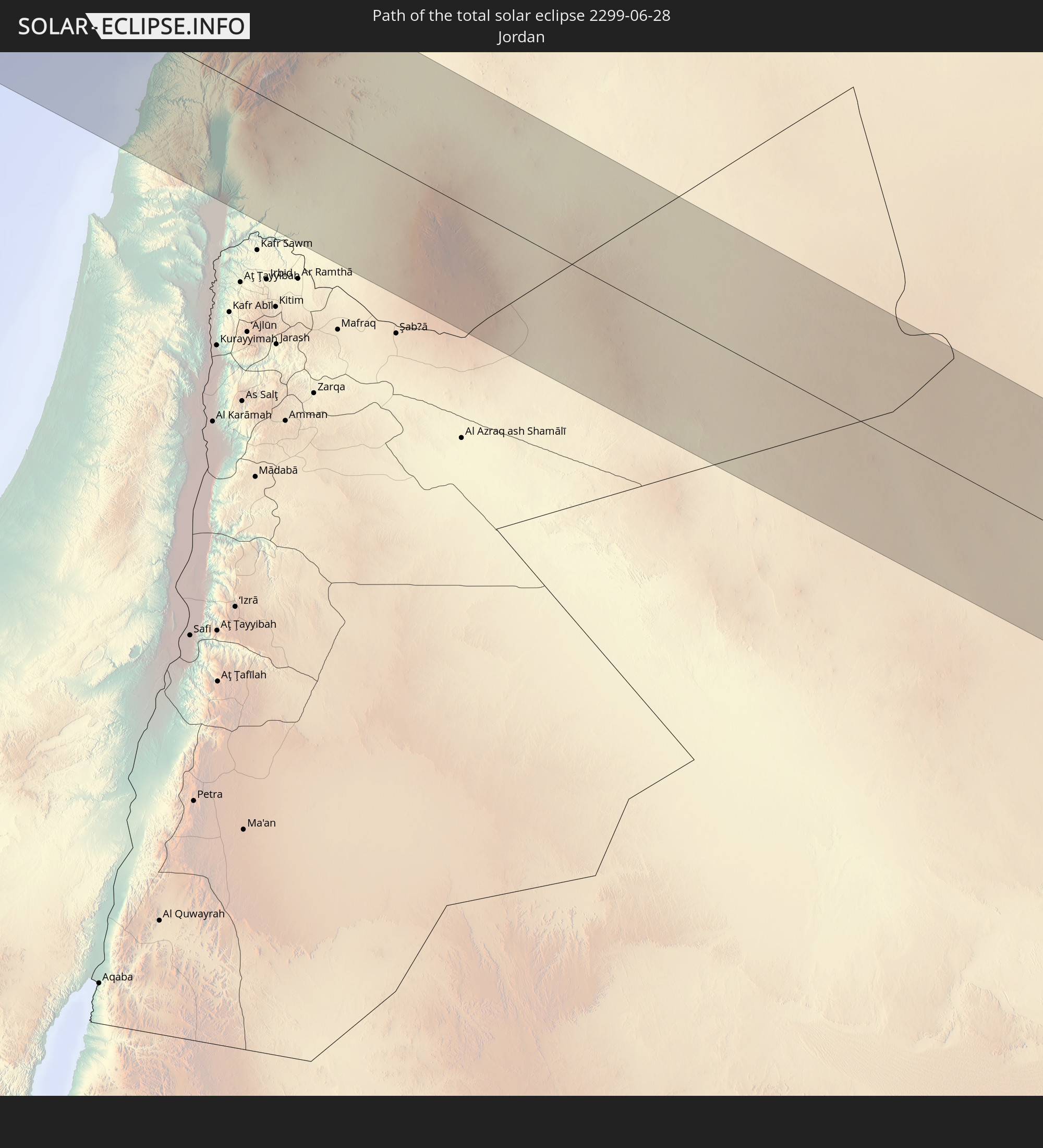
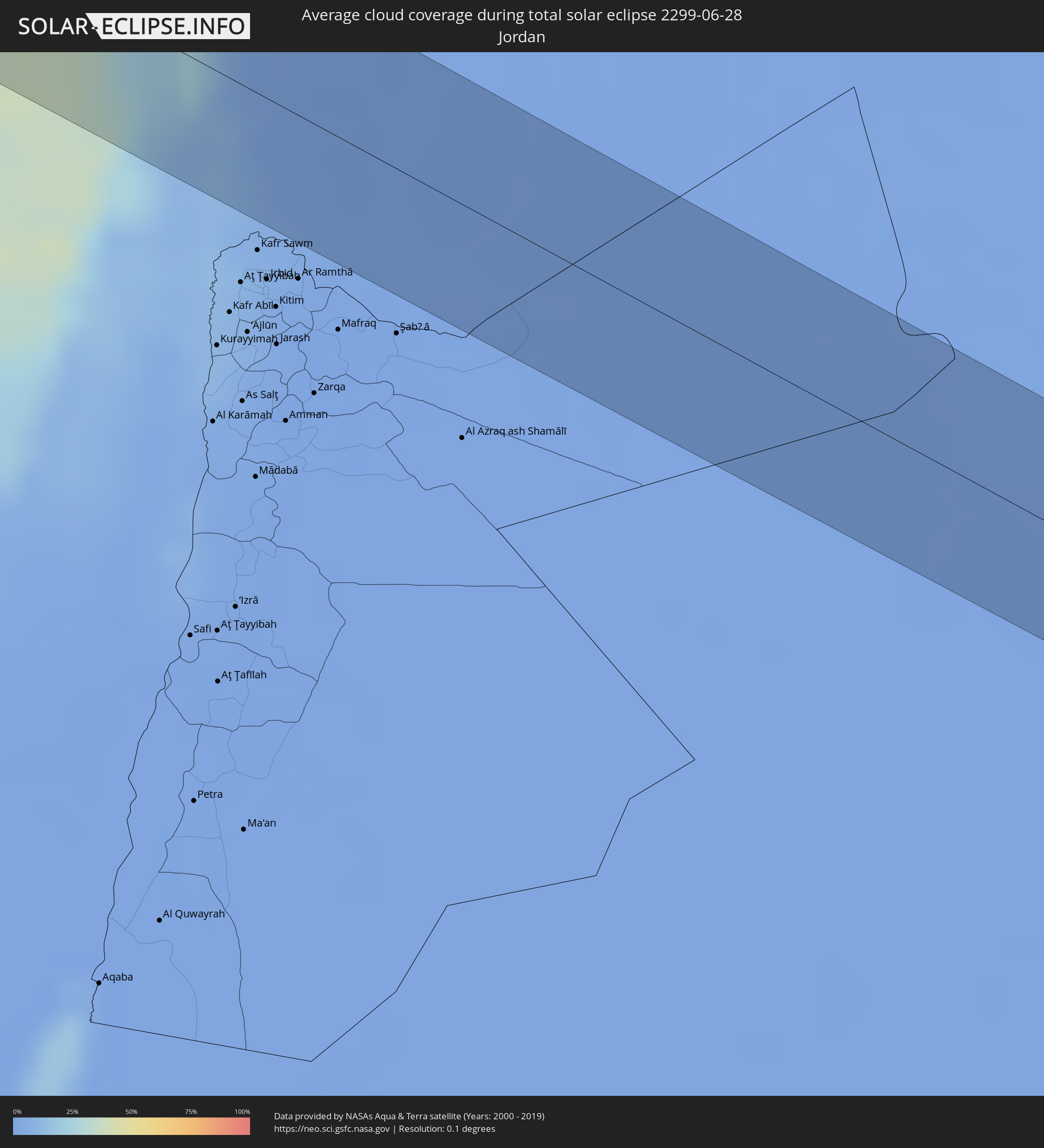 Jordan
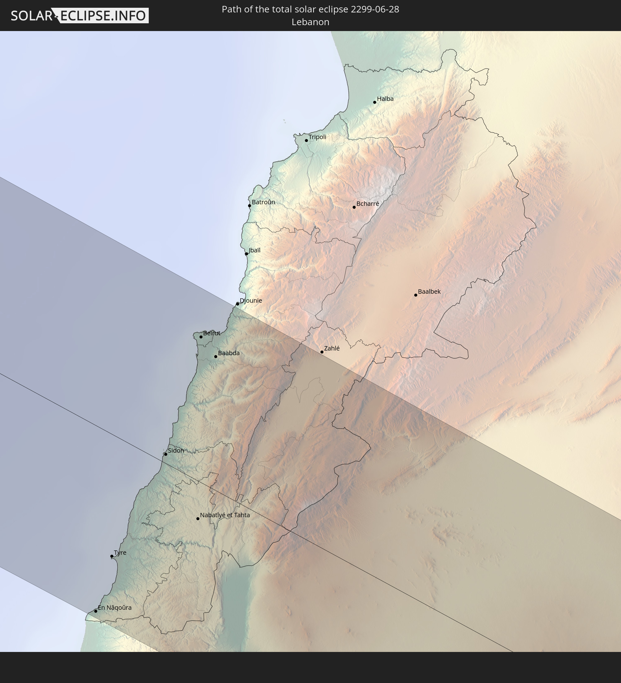
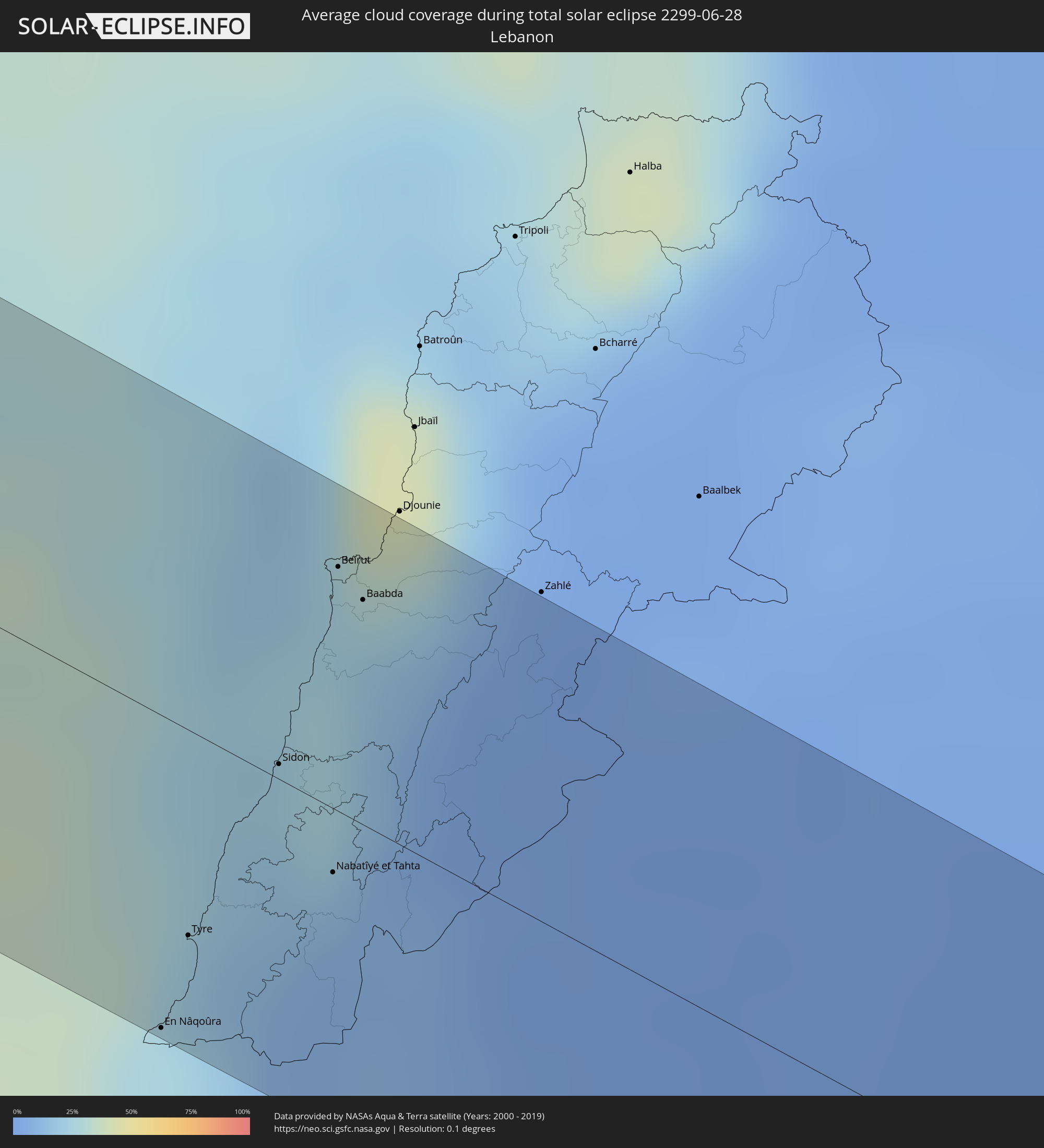 Lebanon
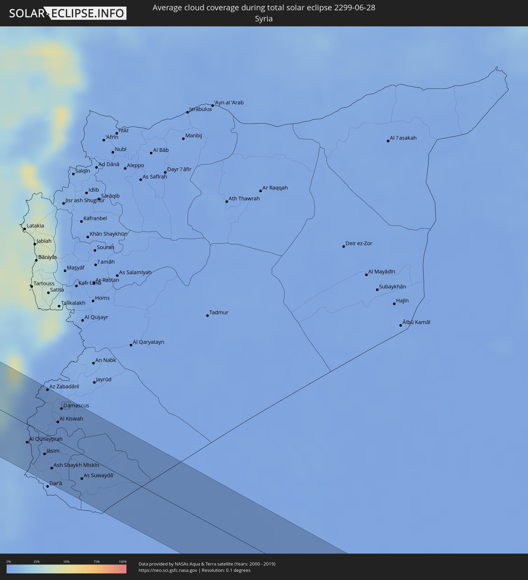 Syria
Syria
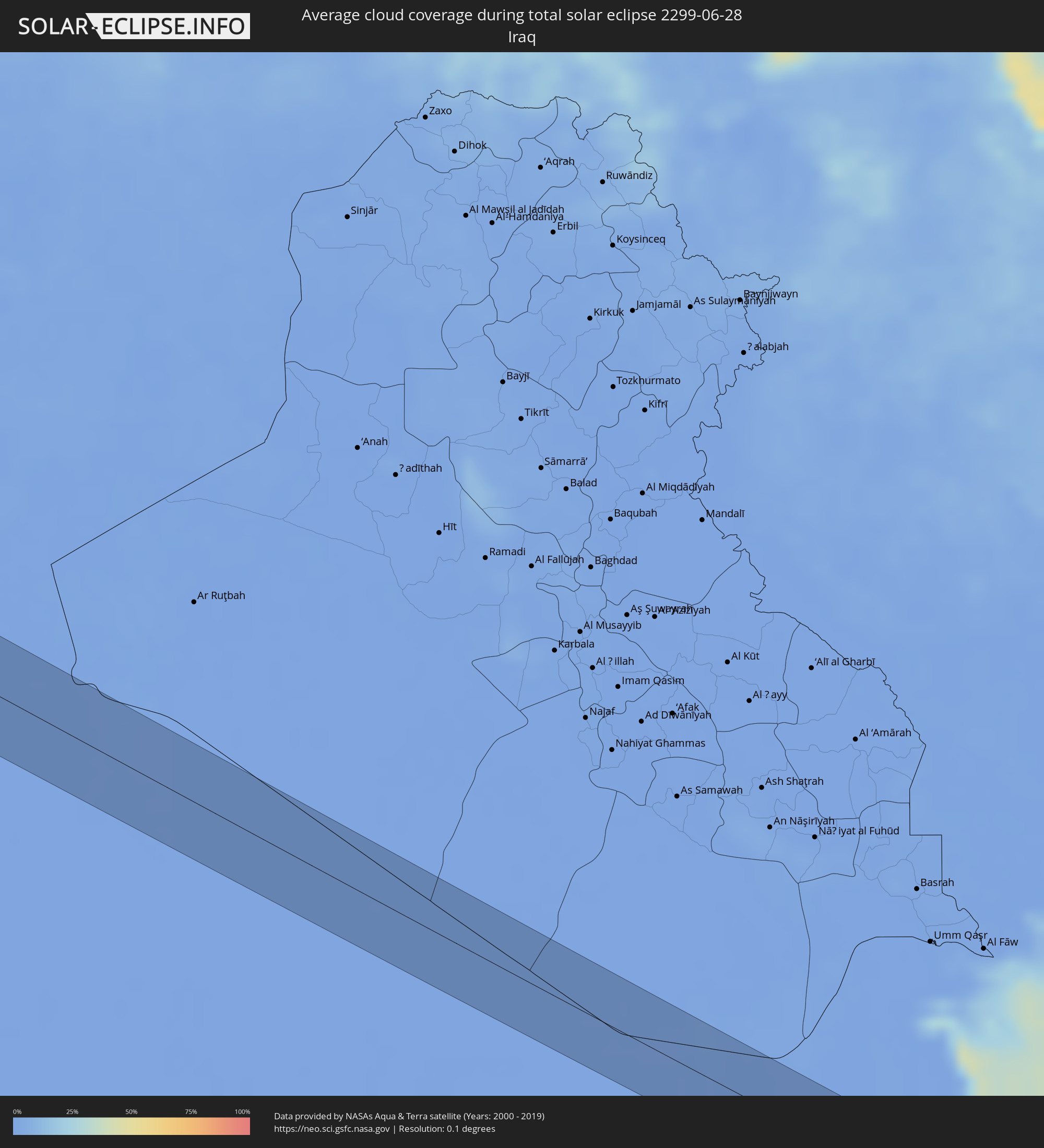 Iraq
Iraq
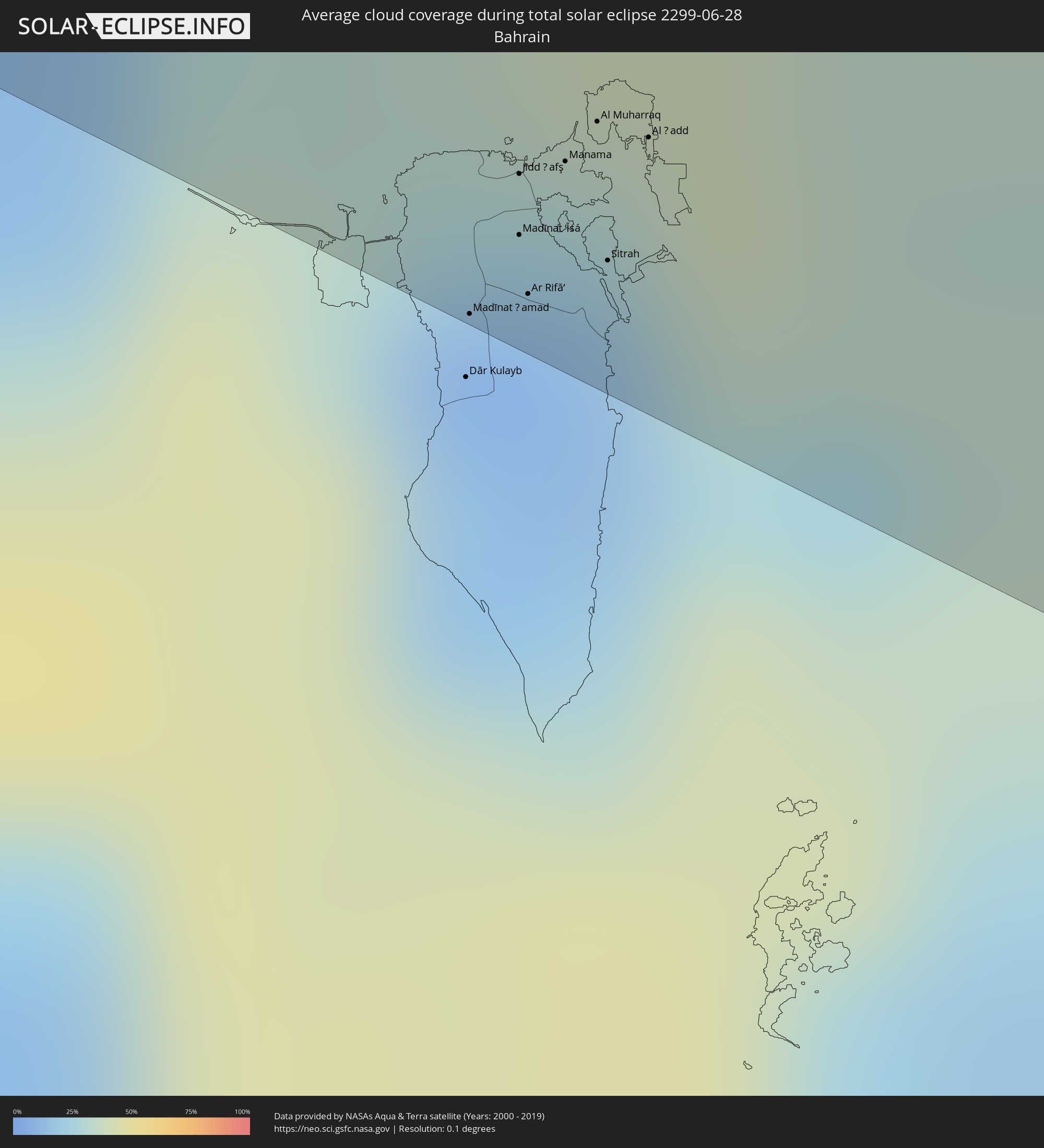 Bahrain
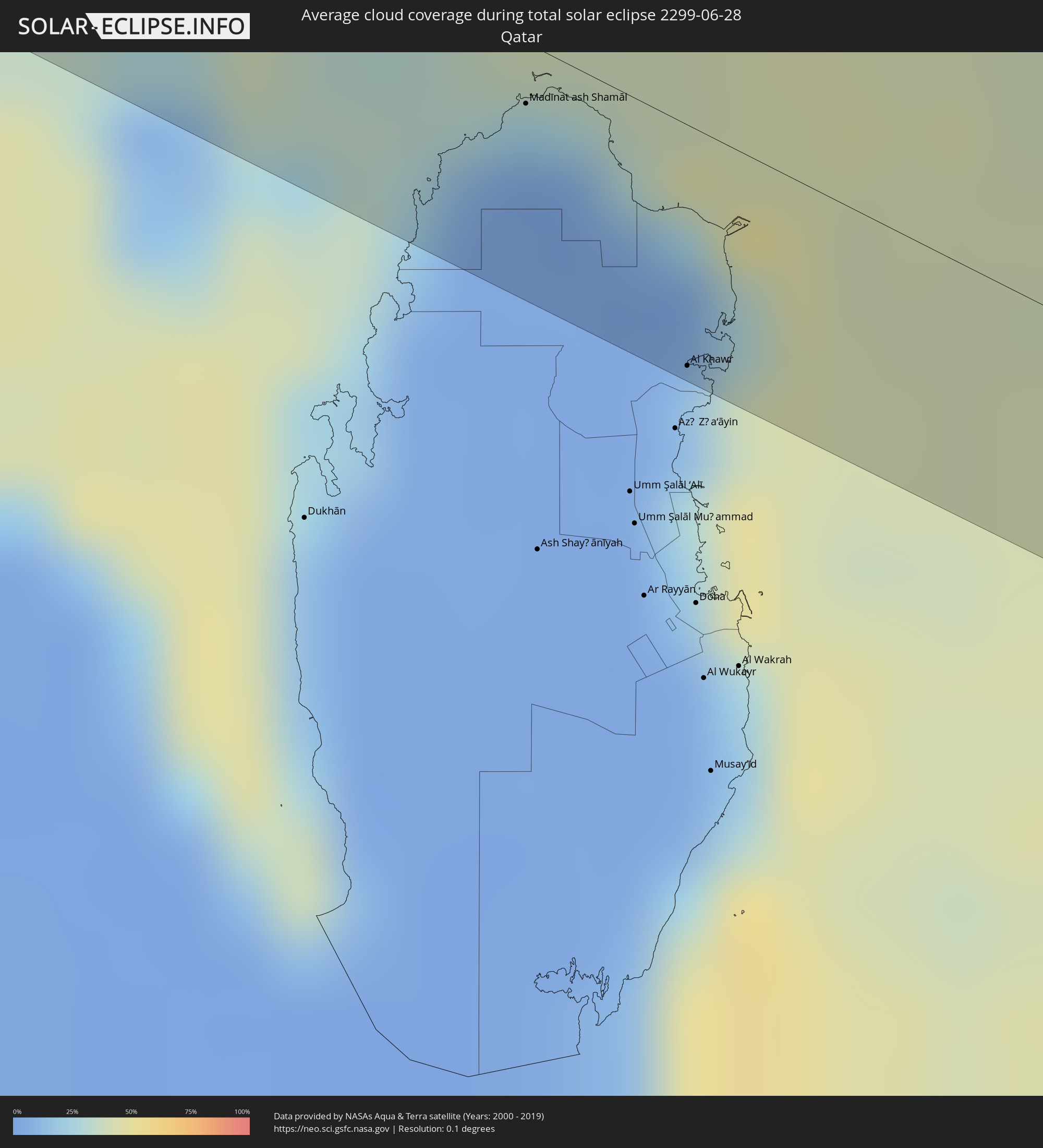 Qatar
Qatar
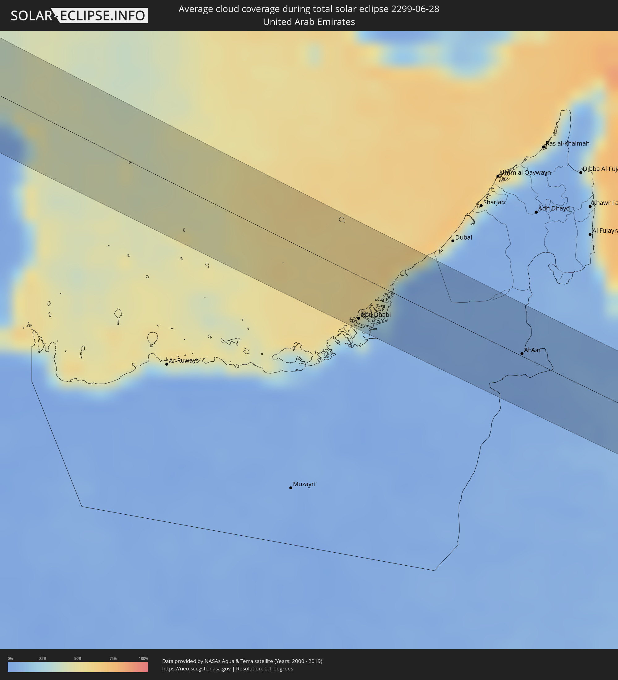 United Arab Emirates
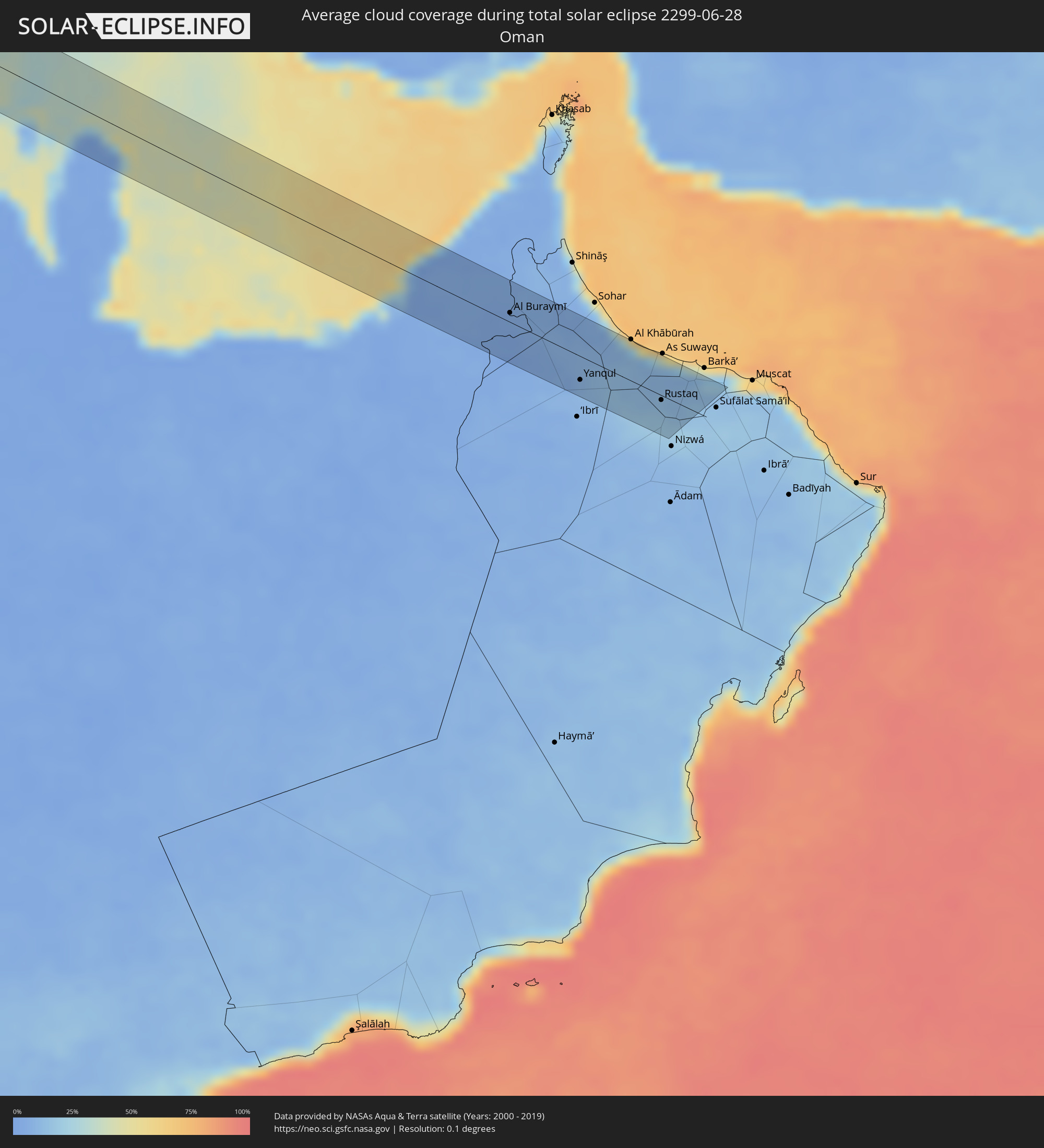 Oman
Oman
Cities inside the path of the eclipse
The following table shows all locations with a population of more than 5,000 inside the eclipse path. Cities which have more than 100,000 inhabitants are marked bold. A click at the locations opens a detailed map.
| City | Type | Eclipse duration | Local time of max. eclipse | Distance to central line | Ø Cloud coverage |
|
Escárcega, Campeche
|
total | - | 05:36:52 UTC-06:00 | 1 km | 84% |
|
Chunhuhub, Quintana Roo
|
total | - | 06:37:01 UTC-05:00 | 0 km | 85% |
|
Felipe Carrillo Puerto, Quintana Roo
|
total | - | 06:36:52 UTC-05:00 | 25 km | 87% |
|
Tulum, Quintana Roo
|
total | - | 06:37:17 UTC-05:00 | 12 km | 74% |
|
Playa del Carmen, Quintana Roo
|
total | - | 06:37:34 UTC-05:00 | 36 km | 77% |
|
San Miguel de Cozumel, Quintana Roo
|
total | - | 06:37:25 UTC-05:00 | 17 km | 79% |
|
Güira de Melena, Artemisa
|
total | - | 06:38:53 UTC-05:00 | 37 km | 76% |
|
Arroyo Naranjo, La Habana
|
total | - | 06:39:05 UTC-05:00 | 48 km | 79% |
|
San José de las Lajas, Mayabeque
|
total | - | 06:39:01 UTC-05:00 | 36 km | 77% |
|
Güines, Mayabeque
|
total | - | 06:38:53 UTC-05:00 | 18 km | 74% |
|
Madruga, Mayabeque
|
total | - | 06:38:56 UTC-05:00 | 17 km | 76% |
|
Matanzas, Matanzas
|
total | - | 06:39:03 UTC-05:00 | 16 km | 74% |
|
Unión de Reyes, Matanzas
|
total | - | 06:38:47 UTC-05:00 | 10 km | 75% |
|
Cárdenas, Matanzas
|
total | - | 06:39:01 UTC-05:00 | 2 km | 77% |
|
Jovellanos, Matanzas
|
total | - | 06:38:46 UTC-05:00 | 26 km | 79% |
|
Colón, Matanzas
|
total | - | 06:38:40 UTC-05:00 | 48 km | 78% |
|
Corralillo, Villa Clara
|
total | - | 06:38:55 UTC-05:00 | 37 km | 62% |
|
San Andros, North Andros
|
total | - | 06:41:11 UTC-05:00 | 44 km | 80% |
|
Nassau, New Providence
|
total | - | 06:41:12 UTC-05:00 | 8 km | 81% |
|
Spanish Wells, Spanish Wells
|
total | - | 06:41:49 UTC-05:00 | 27 km | 77% |
|
Governor’s Harbour, Central Eleuthera
|
total | - | 11:41:25 UTC+00:00 | 36 km | 75% |
|
Bordeaux, Nouvelle-Aquitaine
|
total | - | 14:51:34 UTC+01:00 | 41 km | 61% |
|
Angoulême, Nouvelle-Aquitaine
|
total | - | 14:52:04 UTC+01:00 | 59 km | 62% |
|
Brive-la-Gaillarde, Nouvelle-Aquitaine
|
total | - | 14:54:47 UTC+01:00 | 29 km | 53% |
|
Nîmes, Occitania
|
total | - | 15:00:36 UTC+01:00 | 55 km | 29% |
|
Avignon, Provence-Alpes-Côte d'Azur
|
total | - | 15:01:11 UTC+01:00 | 33 km | 25% |
|
Aix-en-Provence, Provence-Alpes-Côte d'Azur
|
total | - | 15:02:38 UTC+01:00 | 63 km | 20% |
|
Gap, Provence-Alpes-Côte d'Azur
|
total | - | 15:02:24 UTC+01:00 | 62 km | 32% |
|
Fréjus, Provence-Alpes-Côte d'Azur
|
total | - | 15:04:40 UTC+01:00 | 43 km | 30% |
|
Grasse, Provence-Alpes-Côte d'Azur
|
total | - | 15:04:40 UTC+01:00 | 13 km | 37% |
|
Antibes, Provence-Alpes-Côte d'Azur
|
total | - | 15:05:06 UTC+01:00 | 19 km | 39% |
|
Nice, Provence-Alpes-Côte d'Azur
|
total | - | 15:05:08 UTC+01:00 | 1 km | 41% |
|
Monaco
|
total | - | 15:05:19 UTC+01:00 | 6 km | 39% |
|
La Condamine
|
total | - | 15:05:19 UTC+01:00 | 6 km | 39% |
|
Monte-Carlo
|
total | - | 15:05:19 UTC+01:00 | 7 km | 39% |
|
Grosseto, Tuscany
|
total | - | 15:11:36 UTC+01:00 | 3 km | 26% |
|
Vatican City
|
total | - | 15:14:27 UTC+01:00 | 47 km | 29% |
|
Rome, Latium
|
total | - | 15:14:32 UTC+01:00 | 46 km | 29% |
|
Terni, Umbria
|
total | - | 15:13:49 UTC+01:00 | 28 km | 36% |
|
Guidonia Montecelio, Latium
|
total | - | 15:14:40 UTC+01:00 | 29 km | 29% |
|
Foggia, Apulia
|
total | - | 15:18:47 UTC+01:00 | 5 km | 34% |
|
Andria, Apulia
|
total | - | 15:19:56 UTC+01:00 | 7 km | 28% |
|
Altamura, Apulia
|
total | - | 15:20:46 UTC+01:00 | 26 km | 40% |
|
Bari, Apulia
|
total | - | 15:20:43 UTC+01:00 | 13 km | 23% |
|
Taranto, Apulia
|
total | - | 15:22:07 UTC+01:00 | 44 km | 36% |
|
Brindisi, Apulia
|
total | - | 15:22:32 UTC+01:00 | 1 km | 22% |
|
Lecce, Apulia
|
total | - | 15:23:10 UTC+01:00 | 19 km | 21% |
|
Vlorë, Vlorë
|
total | - | 15:24:21 UTC+01:00 | 39 km | 25% |
|
Selenicë, Vlorë
|
total | - | 15:24:24 UTC+01:00 | 51 km | 23% |
|
Corfu, Ionian Islands
|
total | - | 16:25:57 UTC+02:00 | 30 km | 20% |
|
Sarandë, Vlorë
|
total | - | 15:25:41 UTC+01:00 | 2 km | 25% |
|
Tepelenë, Gjirokastër
|
total | - | 15:25:06 UTC+01:00 | 41 km | 32% |
|
Gjirokastër, Gjirokastër
|
total | - | 15:25:32 UTC+01:00 | 23 km | 34% |
|
Përmet, Gjirokastër
|
total | - | 15:25:30 UTC+01:00 | 47 km | 40% |
|
Ioánnina, Epirus
|
total | - | 16:26:47 UTC+02:00 | 8 km | 32% |
|
Tríkala, Thessaly
|
total | - | 16:27:46 UTC+02:00 | 31 km | 33% |
|
Kardítsa, Thessaly
|
total | - | 16:28:11 UTC+02:00 | 18 km | 31% |
|
Lamía, Central Greece
|
total | - | 16:29:17 UTC+02:00 | 9 km | 34% |
|
Vólos, Thessaly
|
total | - | 16:29:04 UTC+02:00 | 56 km | 30% |
|
Thívai, Central Greece
|
total | - | 16:30:51 UTC+02:00 | 33 km | 32% |
|
Elefsína, Attica
|
total | - | 16:31:26 UTC+02:00 | 52 km | 27% |
|
Chalkída, Central Greece
|
total | - | 16:30:53 UTC+02:00 | 8 km | 24% |
|
Athens, Attica
|
total | - | 16:31:39 UTC+02:00 | 52 km | 28% |
|
Didim, Aydın
|
total | - | 17:35:07 UTC+03:00 | 31 km | 19% |
|
Turgutreis, Muğla
|
total | - | 17:35:39 UTC+03:00 | 5 km | 16% |
|
Bodrum, Muğla
|
total | - | 17:35:43 UTC+03:00 | 4 km | 22% |
|
Milas, Muğla
|
total | - | 17:35:34 UTC+03:00 | 46 km | 12% |
|
Ródos, South Aegean
|
total | - | 16:37:04 UTC+02:00 | 22 km | 10% |
|
Marmaris, Muğla
|
total | - | 17:36:31 UTC+03:00 | 20 km | 13% |
|
Sarigerme, Muğla
|
total | - | 17:36:59 UTC+03:00 | 25 km | 21% |
|
Ortaca, Muğla
|
total | - | 17:36:51 UTC+03:00 | 39 km | 8% |
|
Dalaman, Muğla
|
total | - | 17:36:59 UTC+03:00 | 34 km | 8% |
|
Fethiye, Muğla
|
total | - | 17:37:21 UTC+03:00 | 35 km | 15% |
|
Demre, Antalya
|
total | - | 17:38:22 UTC+03:00 | 33 km | 21% |
|
Beykonak, Antalya
|
total | - | 17:38:27 UTC+03:00 | 53 km | 21% |
|
Paphos, Pafos
|
total | - | 16:41:37 UTC+02:00 | 8 km | 22% |
|
Léfka, Nicosia
|
total | - | 16:41:22 UTC+02:00 | 44 km | 16% |
|
Ýpsonas, Limassol
|
total | - | 16:41:59 UTC+02:00 | 7 km | 16% |
|
Limassol, Limassol
|
total | - | 16:42:02 UTC+02:00 | 10 km | 16% |
|
Dhromolaxia, Larnaka
|
total | - | 16:42:01 UTC+02:00 | 53 km | 16% |
|
En Nâqoûra, South Governorate
|
total | - | 16:44:54 UTC+02:00 | 51 km | 27% |
|
Tyre, South Governorate
|
total | - | 16:44:44 UTC+02:00 | 34 km | 24% |
|
Ḥurfeish, Northern District
|
total | - | 16:45:07 UTC+02:00 | 52 km | 14% |
|
Sidon, South Governorate
|
total | - | 16:44:25 UTC+02:00 | 2 km | 21% |
|
Habboûch, Nabatîyé
|
total | - | 16:44:39 UTC+02:00 | 8 km | 14% |
|
Ra’s Bayrūt, Beyrouth
|
total | - | 16:44:01 UTC+02:00 | 40 km | 23% |
|
Nabatîyé et Tahta, Nabatîyé
|
total | - | 16:44:42 UTC+02:00 | 10 km | 14% |
|
Beirut, Beyrouth
|
total | - | 16:44:03 UTC+02:00 | 40 km | 23% |
|
Safed, Northern District
|
total | - | 16:45:14 UTC+02:00 | 51 km | 8% |
|
Baabda, Mont-Liban
|
total | - | 16:44:08 UTC+02:00 | 37 km | 24% |
|
Qiryat Shemona, Northern District
|
total | - | 16:44:57 UTC+02:00 | 23 km | 9% |
|
Al Qunayţirah, Quneitra
|
total | - | 16:45:08 UTC+02:00 | 20 km | 5% |
|
Jāsim, Daraa
|
total | - | 16:45:23 UTC+02:00 | 23 km | 2% |
|
Ţafas, Daraa
|
total | - | 16:45:42 UTC+02:00 | 47 km | 2% |
|
Az Zabadānī, Rif-dimashq
|
total | - | 16:44:28 UTC+02:00 | 51 km | 1% |
|
Inkhil, Daraa
|
total | - | 16:45:22 UTC+02:00 | 17 km | 2% |
|
Ash Shaykh Miskīn, Daraa
|
total | - | 16:45:37 UTC+02:00 | 34 km | 1% |
|
Aş Şanamayn, Daraa
|
total | - | 16:45:19 UTC+02:00 | 9 km | 1% |
|
Al Kiswah, Rif-dimashq
|
total | - | 16:44:59 UTC+02:00 | 21 km | 1% |
|
Damascus, Dimashq
|
total | - | 16:44:48 UTC+02:00 | 38 km | 0% |
|
Al Ḩarāk, Daraa
|
total | - | 16:45:46 UTC+02:00 | 35 km | 1% |
|
As Suwaydā’, As-Suwayda
|
total | - | 16:45:54 UTC+02:00 | 28 km | 2% |
|
Turaif, Northern Borders
|
total | - | 17:47:44 UTC+03:00 | 35 km | 0% |
|
‘Ar‘ar, Northern Borders
|
total | - | 17:49:01 UTC+03:00 | 4 km | 0% |
|
Al Qayşūmah, Eastern Province
|
total | - | 17:52:19 UTC+03:00 | 26 km | 1% |
|
Al Jubayl, Eastern Province
|
total | - | 17:53:22 UTC+03:00 | 7 km | 14% |
|
Umm as Sāhik, Eastern Province
|
total | - | 17:53:41 UTC+03:00 | 17 km | 2% |
|
Şafwá, Eastern Province
|
total | - | 17:53:41 UTC+03:00 | 15 km | 8% |
|
Tārūt, Eastern Province
|
total | - | 17:53:45 UTC+03:00 | 19 km | 8% |
|
Sayhāt, Eastern Province
|
total | - | 17:53:50 UTC+03:00 | 28 km | 3% |
|
Raḩīmah, Eastern Province
|
total | - | 17:53:37 UTC+03:00 | 5 km | 33% |
|
Dammam, Eastern Province
|
total | - | 17:53:53 UTC+03:00 | 30 km | 2% |
|
Khobar, Eastern Province
|
total | - | 17:54:01 UTC+03:00 | 40 km | 17% |
|
Madīnat Ḩamad, Central Governorate
|
total | - | 17:54:07 UTC+03:00 | 43 km | 15% |
|
Madīnat ‘Īsá, Southern Governorate
|
total | - | 17:54:04 UTC+03:00 | 35 km | 10% |
|
Jidd Ḩafş, Manama
|
total | - | 17:54:01 UTC+03:00 | 31 km | 10% |
|
Ar Rifā‘, Southern Governorate
|
total | - | 17:54:06 UTC+03:00 | 39 km | 13% |
|
Manama, Manama
|
total | - | 17:54:00 UTC+03:00 | 28 km | 14% |
|
Al Muharraq, Muharraq
|
total | - | 17:53:58 UTC+03:00 | 24 km | 28% |
|
Sitrah, Manama
|
total | - | 17:54:04 UTC+03:00 | 34 km | 14% |
|
Al Ḩadd, Muharraq
|
total | - | 17:53:58 UTC+03:00 | 24 km | 33% |
|
Madīnat ash Shamāl, Madīnat ash Shamāl
|
total | - | 17:53:59 UTC+03:00 | 10 km | 3% |
|
Al Khawr, Al Khawr
|
total | - | 17:54:21 UTC+03:00 | 41 km | 13% |
|
Abu Dhabi, Abu Dhabi
|
total | - | 18:54:48 UTC+04:00 | 33 km | 23% |
|
Al Ain, Abu Dhabi
|
total | - | 18:54:39 UTC+04:00 | 2 km | 3% |
|
Al Buraymī, Al Buraimi
|
total | - | 18:54:35 UTC+04:00 | 9 km | 4% |
|
Yanqul, Az̧ Z̧āhirah
|
total | - | 18:54:55 UTC+04:00 | 23 km | 11% |
|
Rustaq, Al Batinah South Governorate
|
total | - | 18:54:47 UTC+04:00 | 5 km | 16% |
|
Bayt al ‘Awābī, Al Batinah South Governorate
|
total | - | 18:54:49 UTC+04:00 | 9 km | 17% |