Total solar eclipse of 04/30/-0462
| Day of week: | Friday |
| Maximum duration of eclipse: | 05m13s |
| Maximum width of eclipse path: | 218 km |
| Saros cycle: | 50 |
| Coverage: | 100% |
| Magnitude: | 1.0624 |
| Gamma: | 0.3529 |
Wo kann man die Sonnenfinsternis vom 04/30/-0462 sehen?
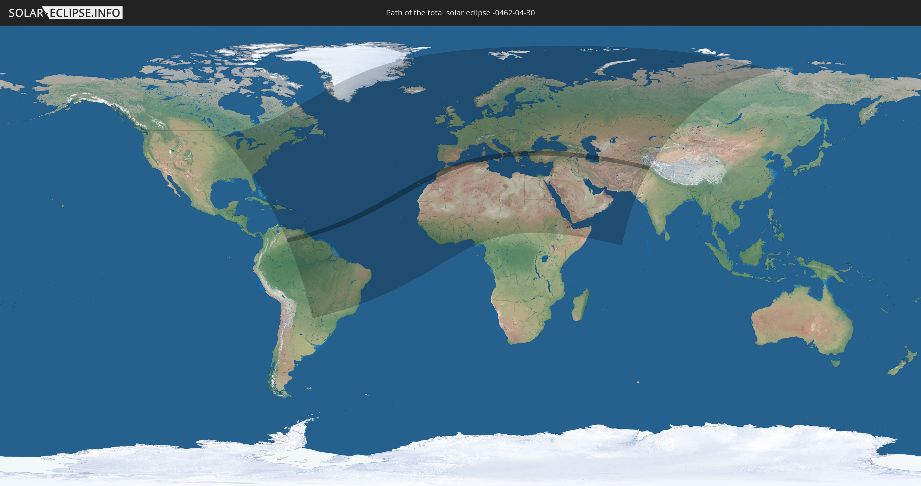
Die Sonnenfinsternis am 04/30/-0462 kann man in 144 Ländern als partielle Sonnenfinsternis beobachten.
Der Finsternispfad verläuft durch 18 Länder. Nur in diesen Ländern ist sie als total Sonnenfinsternis zu sehen.
In den folgenden Ländern ist die Sonnenfinsternis total zu sehen
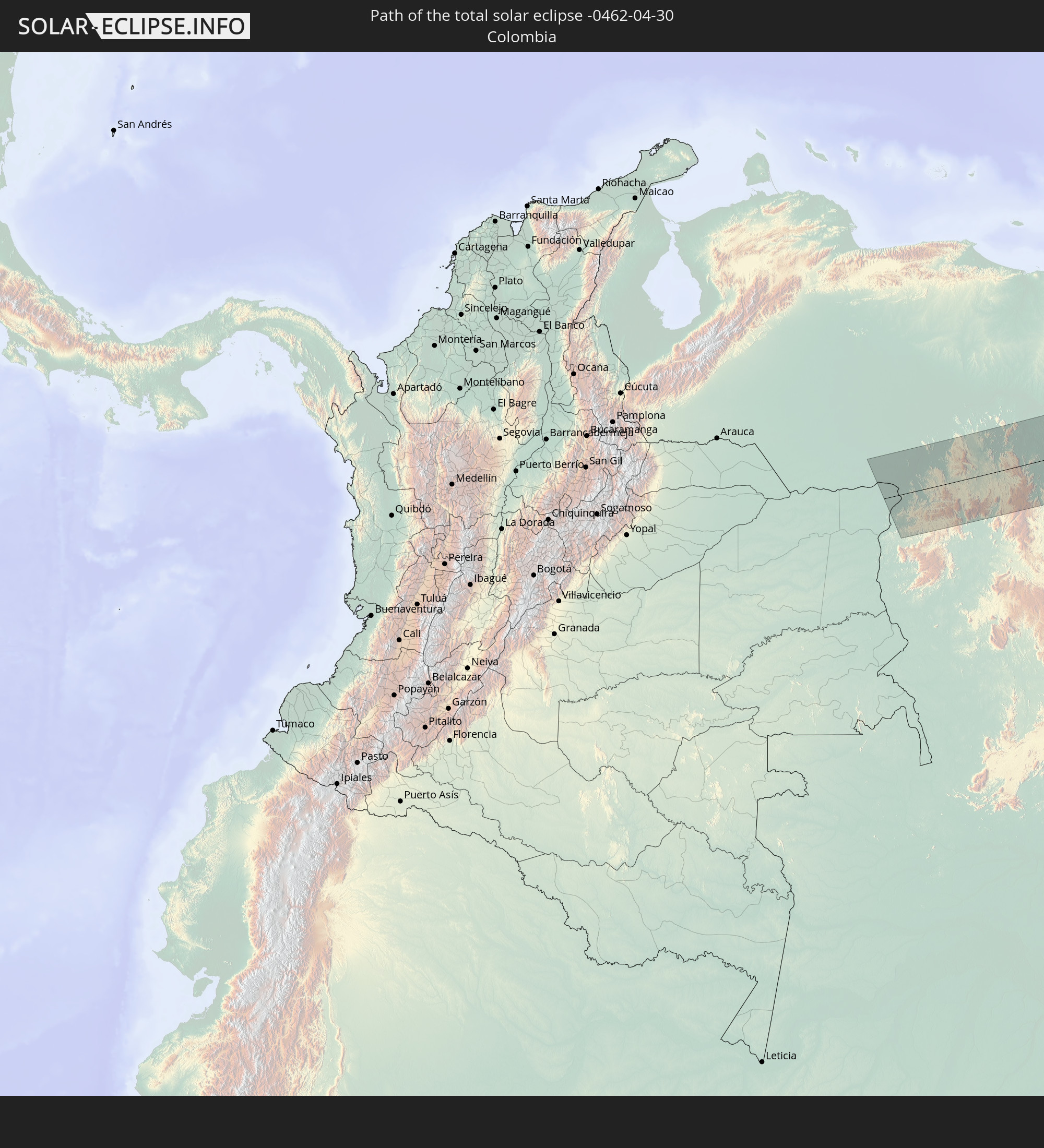 Colombia
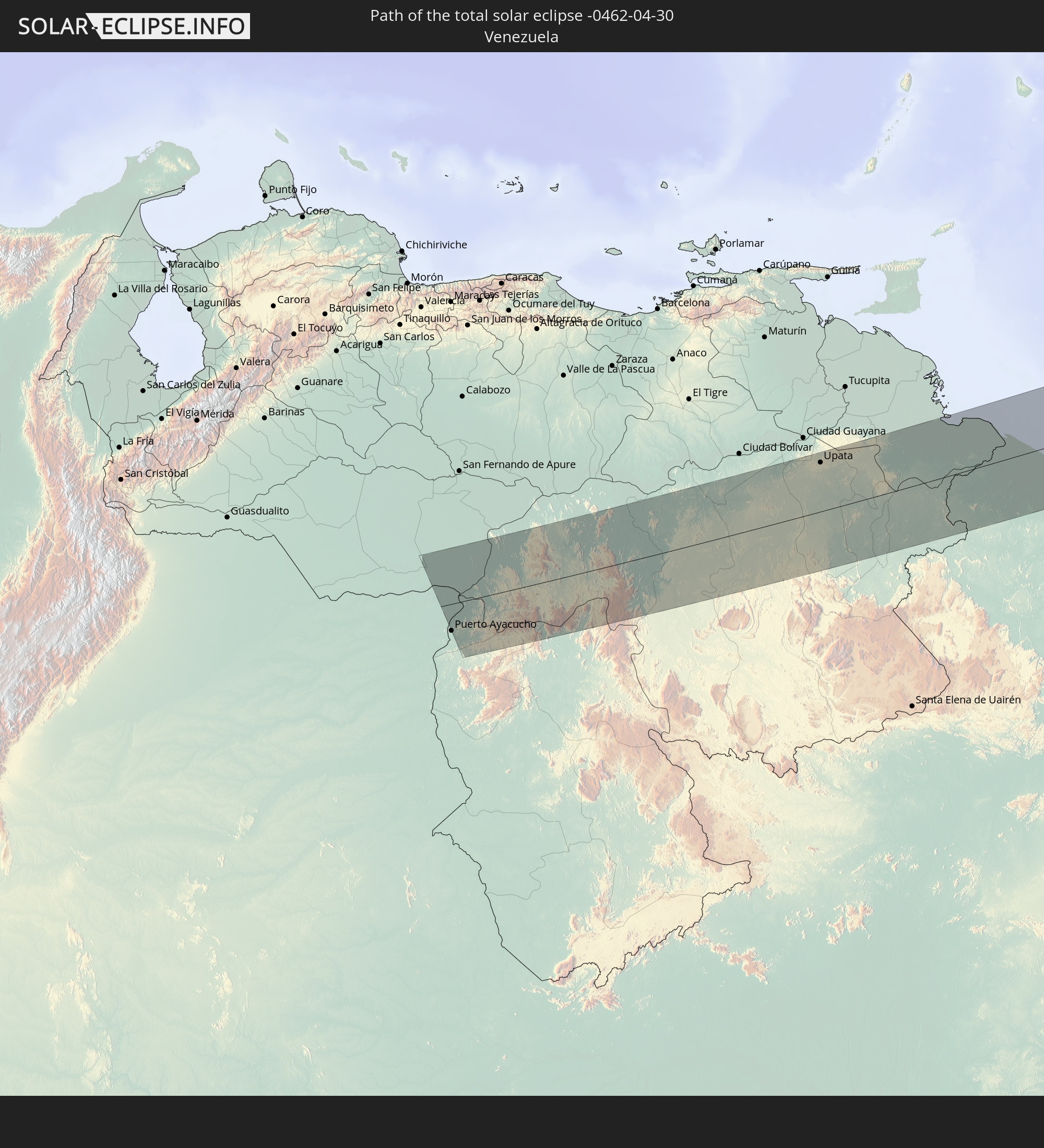 Venezuela
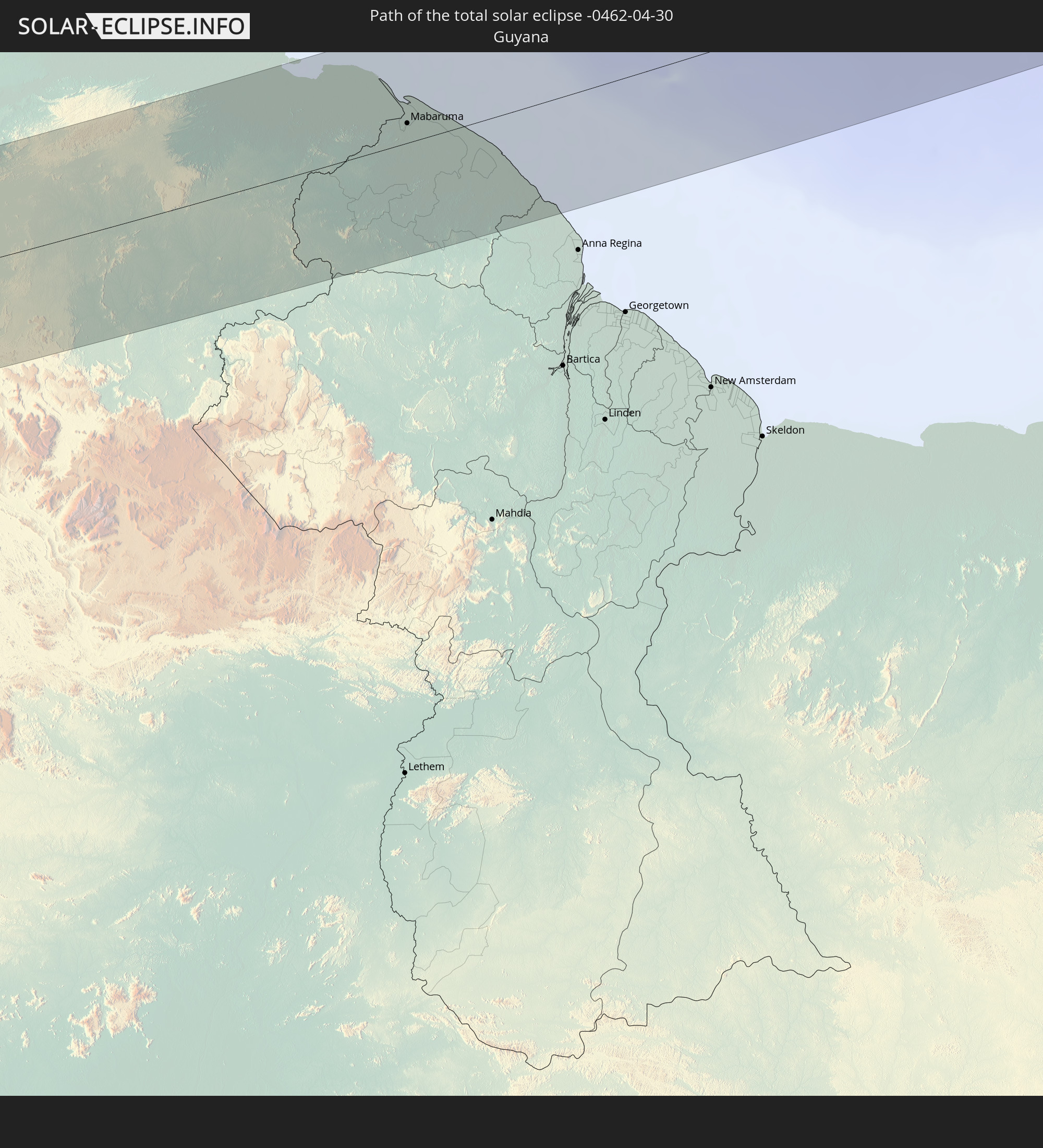 Guyana
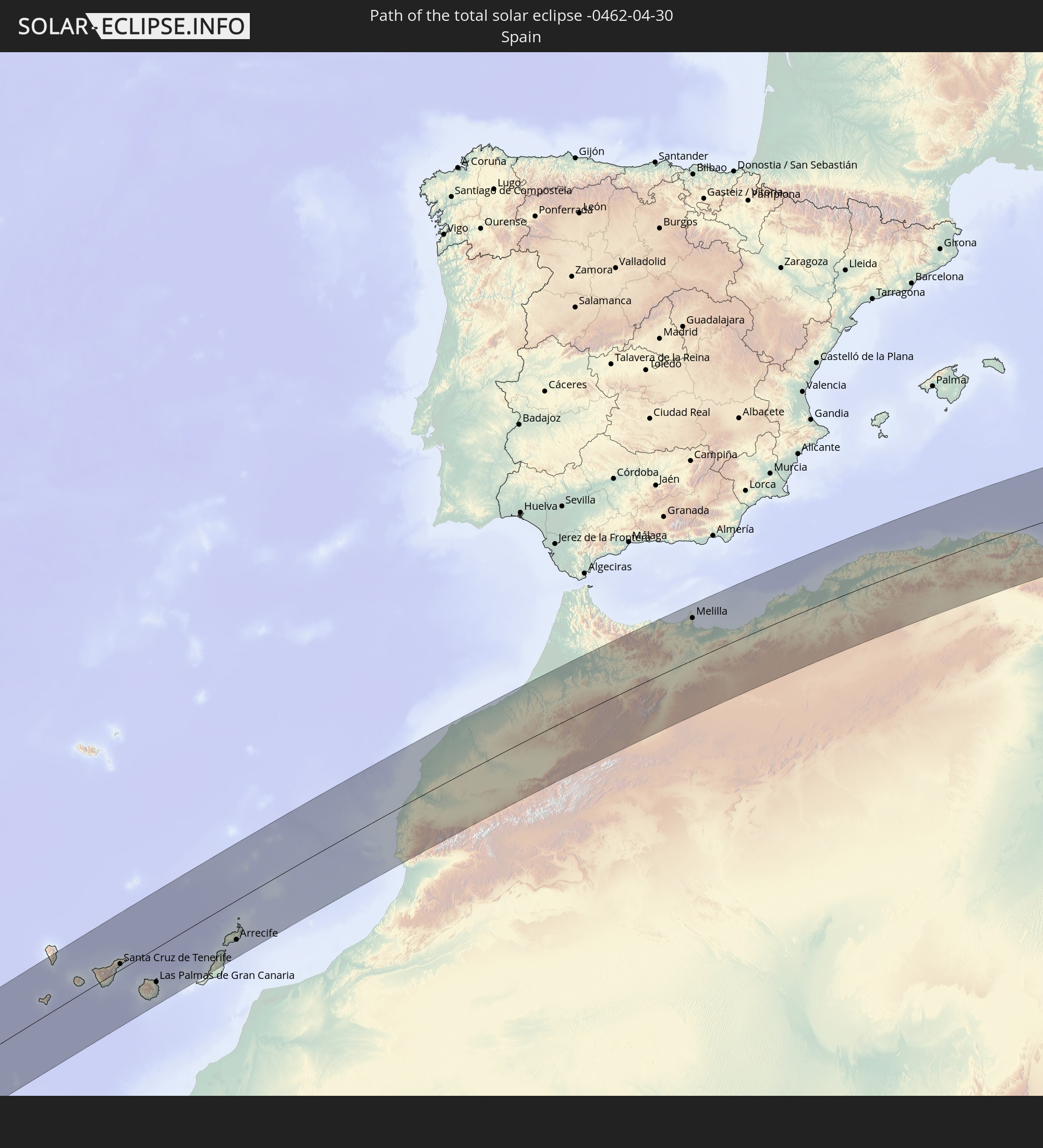 Spain
Spain
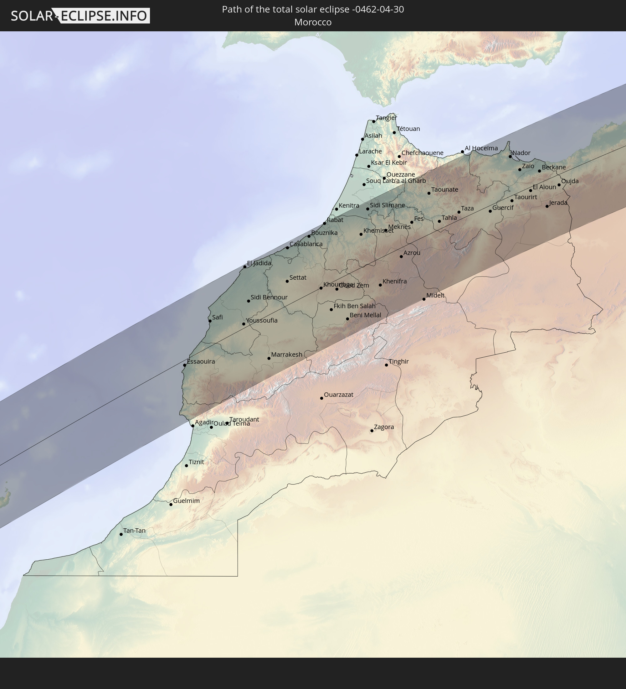 Morocco
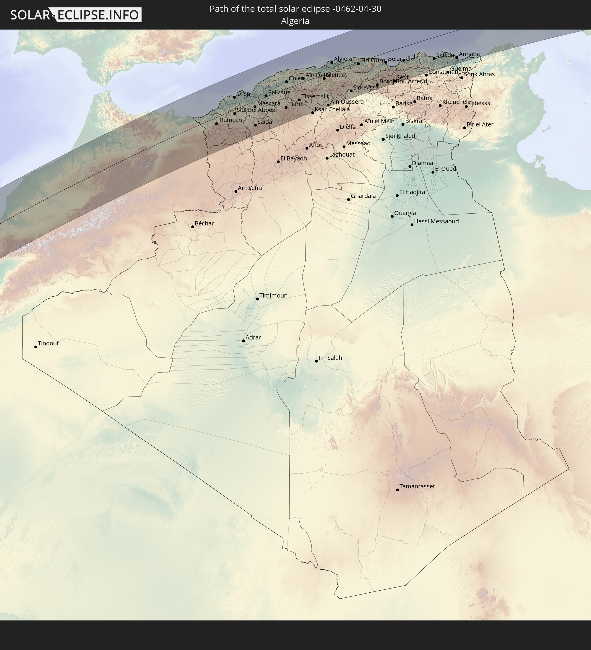 Algeria
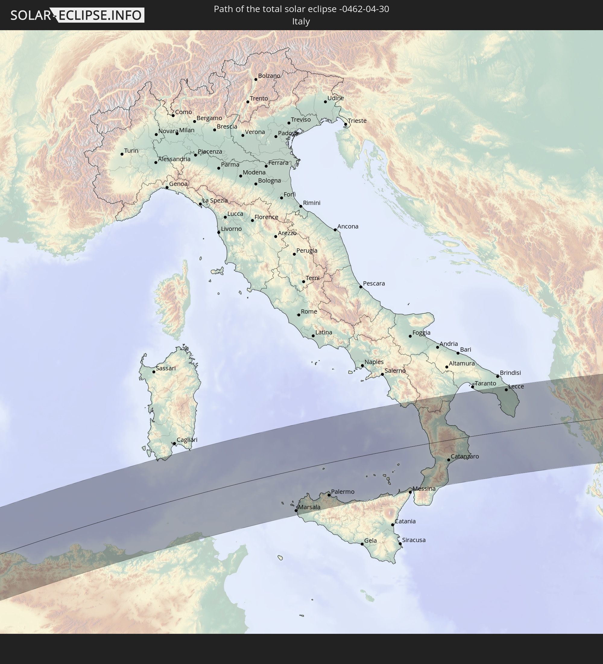 Italy
Italy
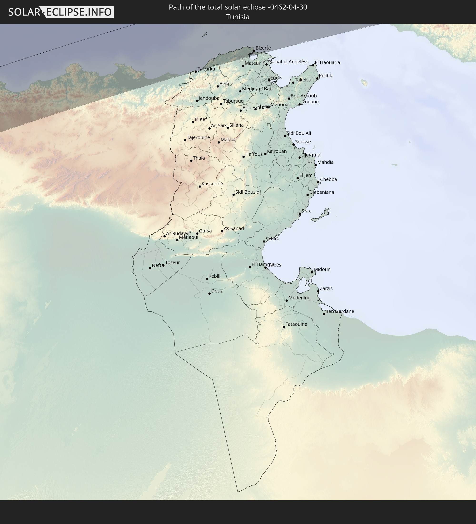 Tunisia
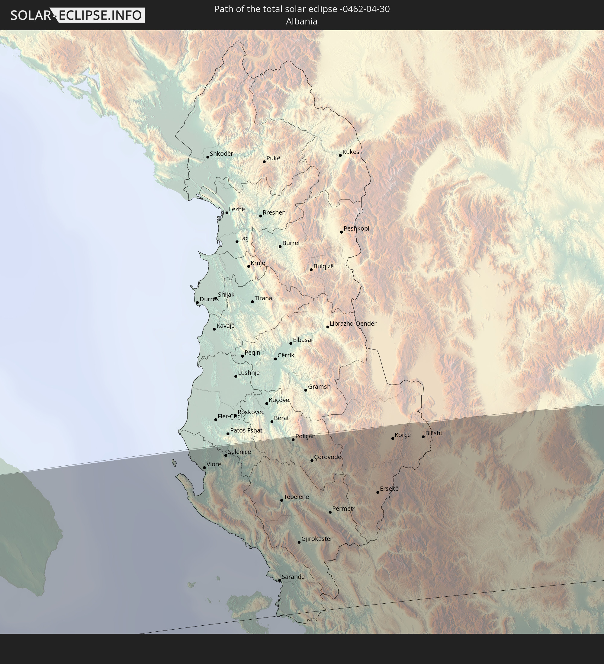 Albania
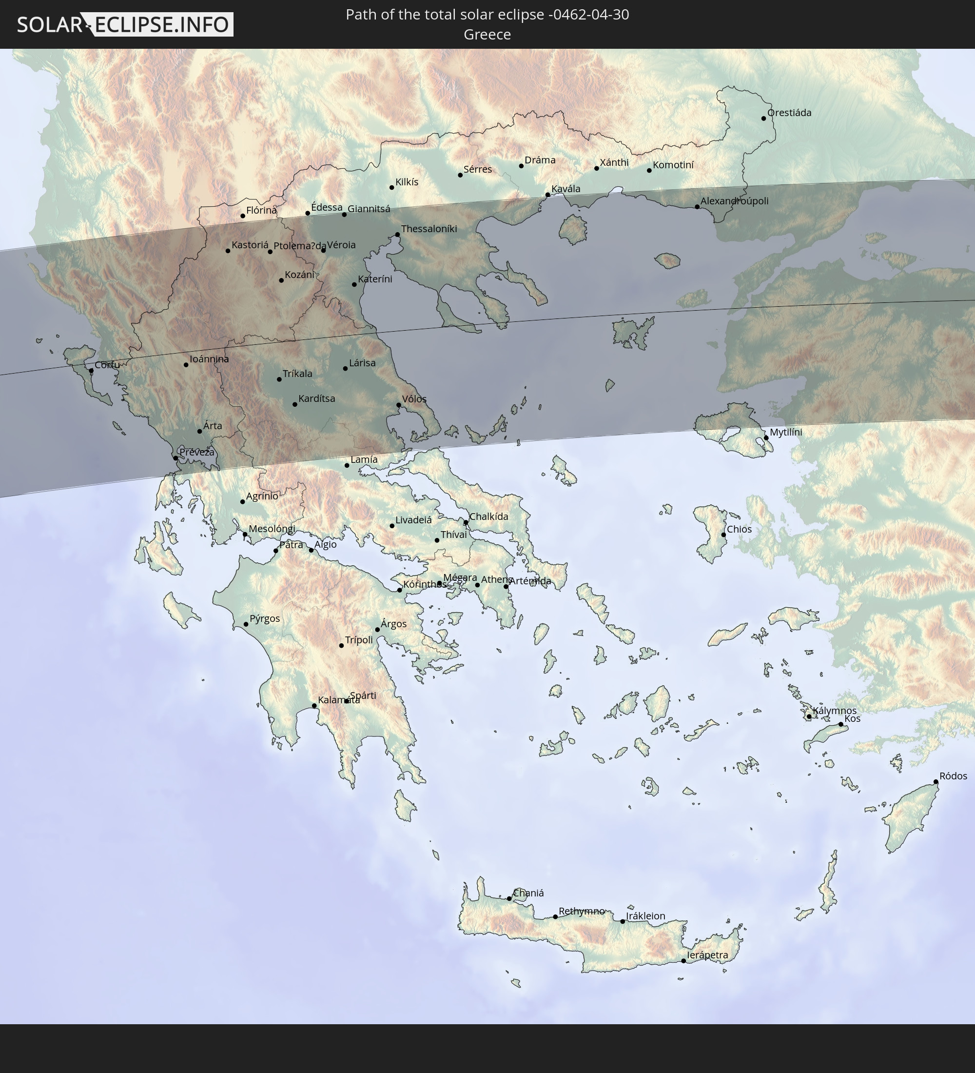 Greece
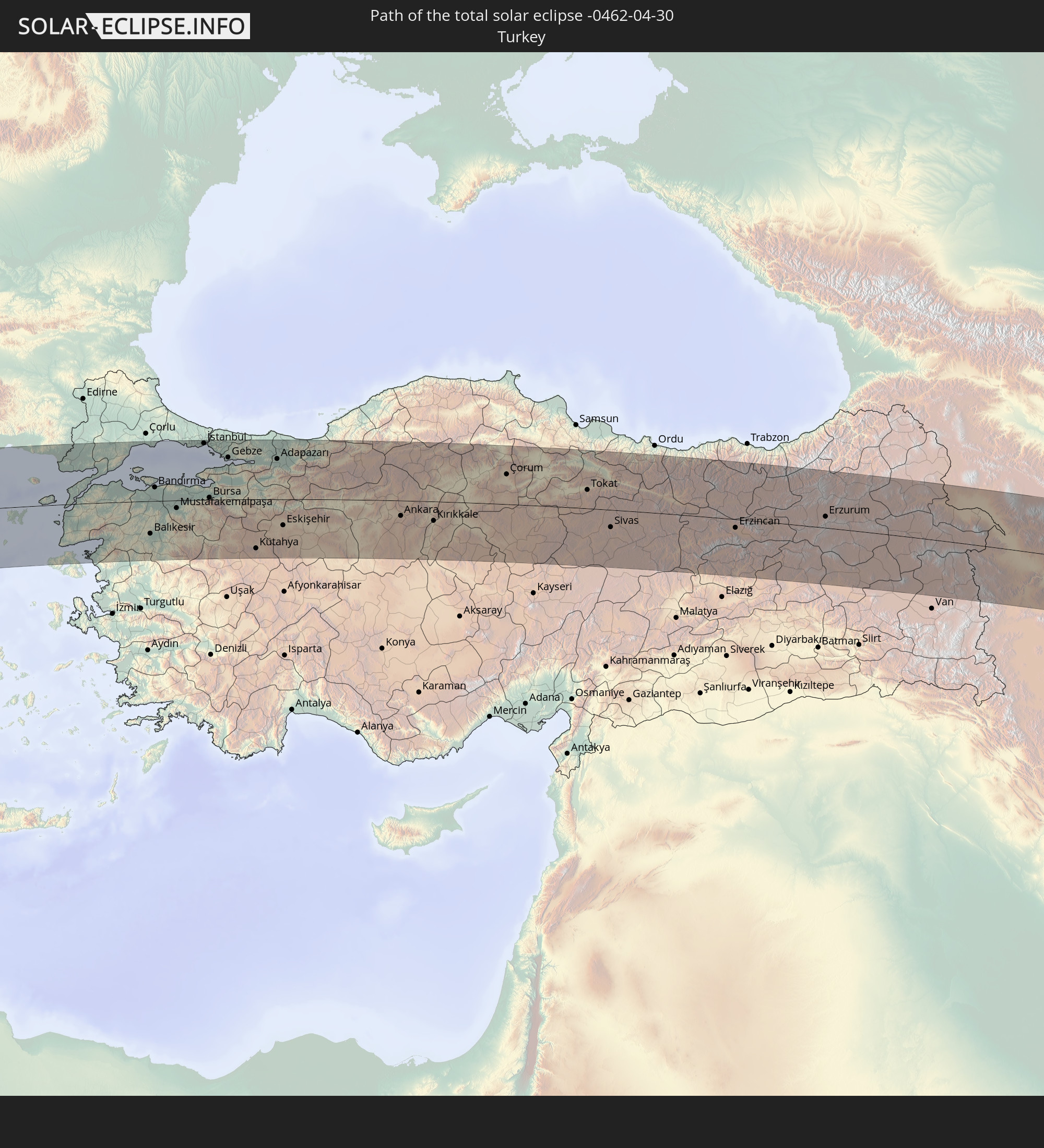 Turkey
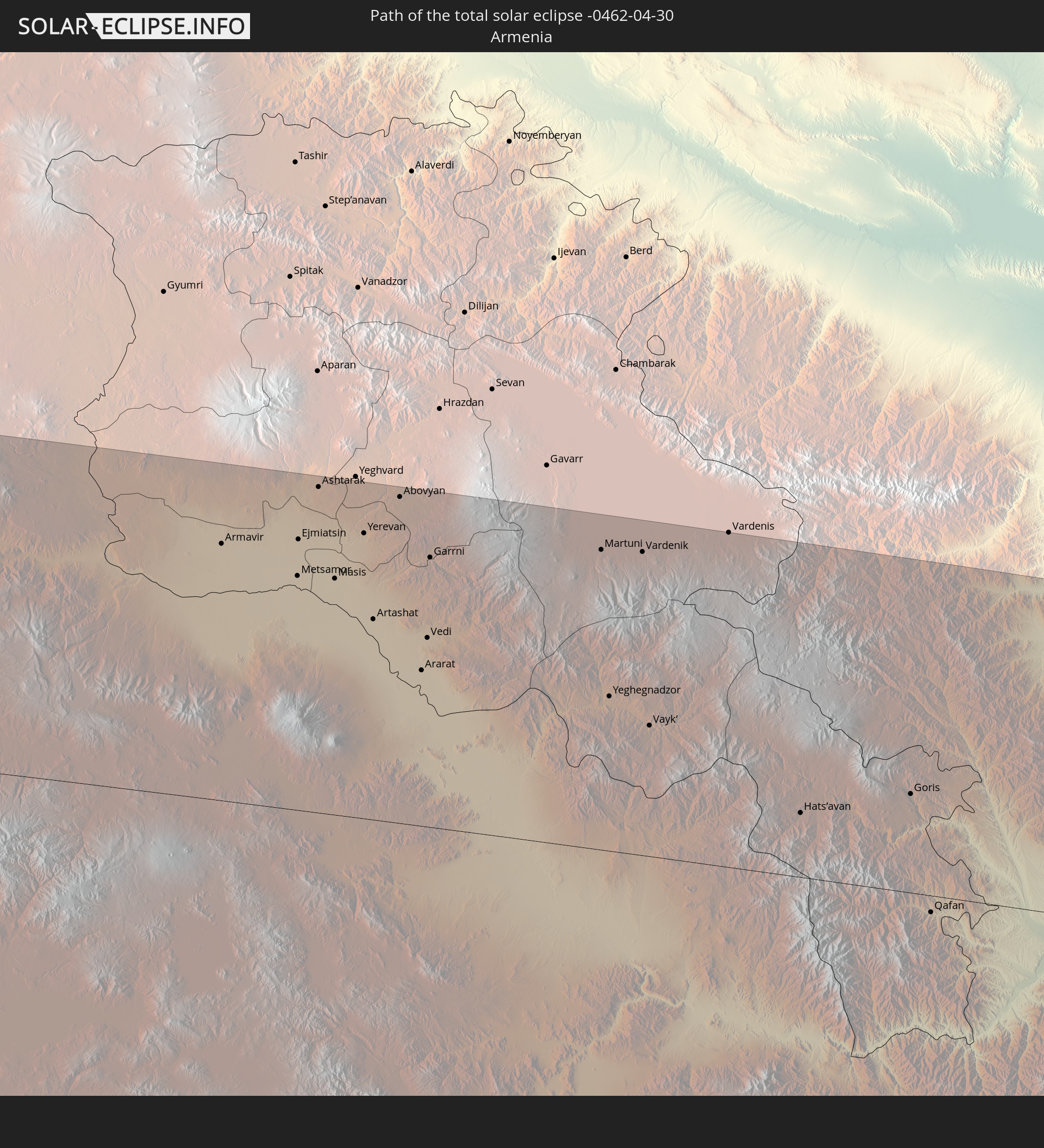 Armenia
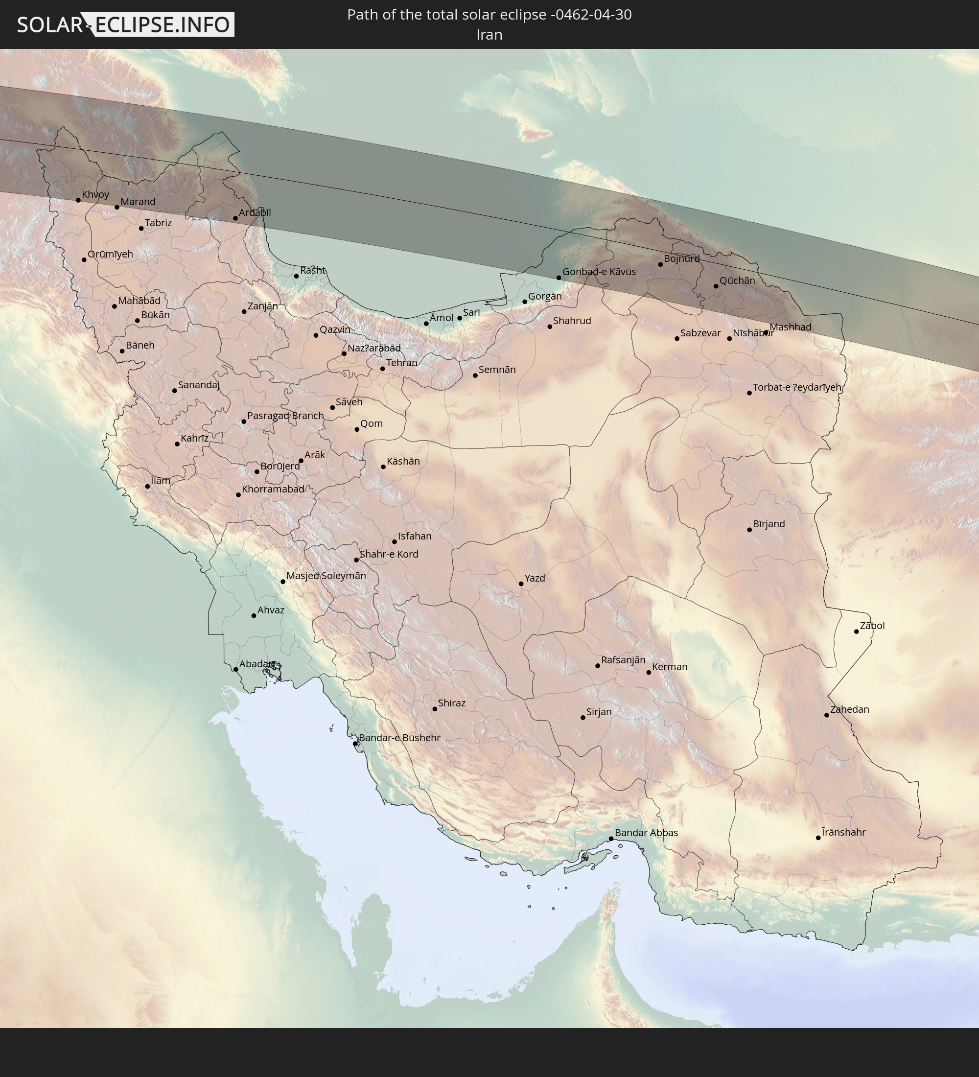 Iran
Iran
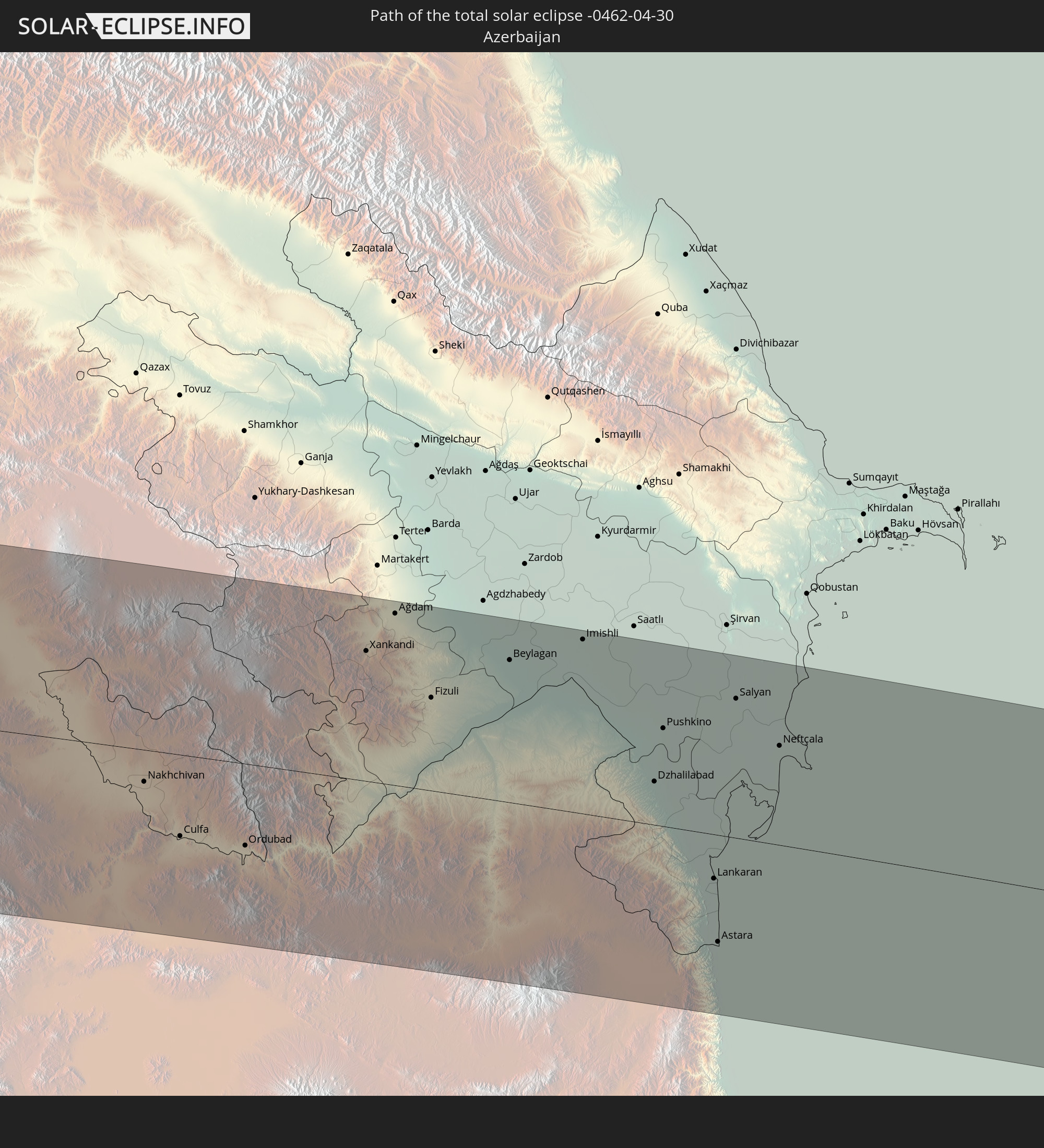 Azerbaijan
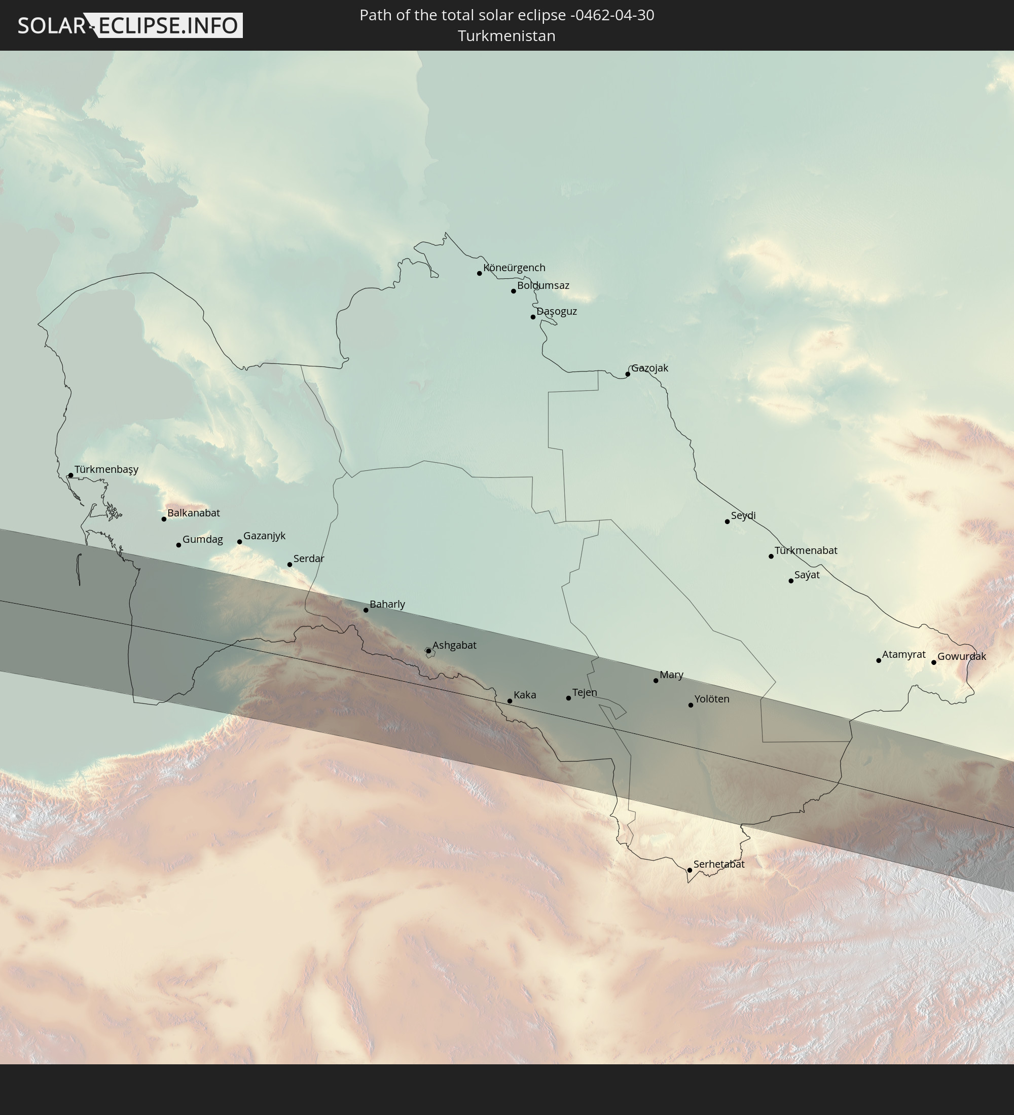 Turkmenistan
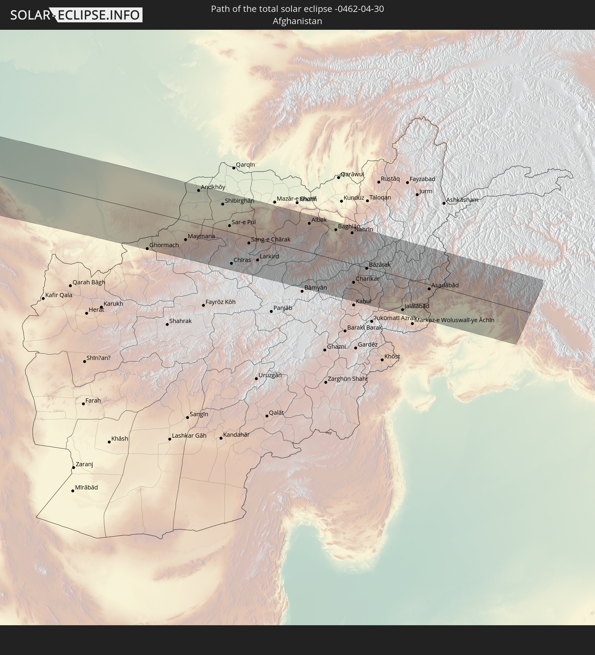 Afghanistan
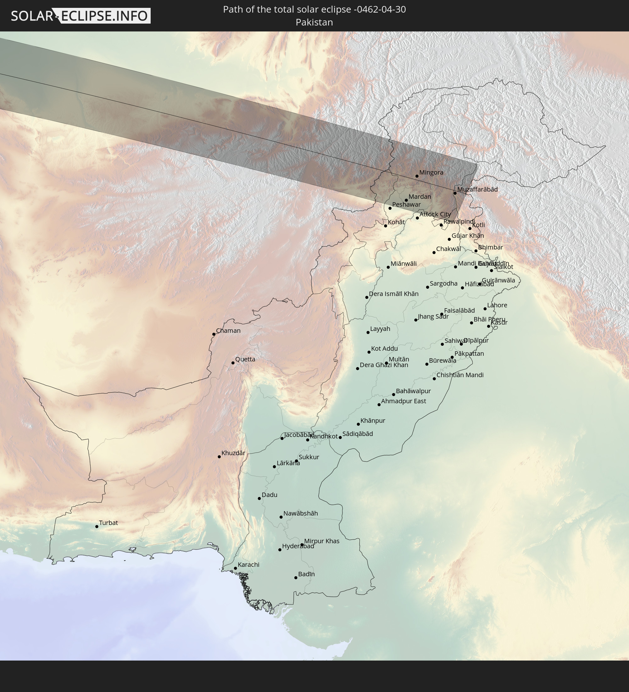 Pakistan
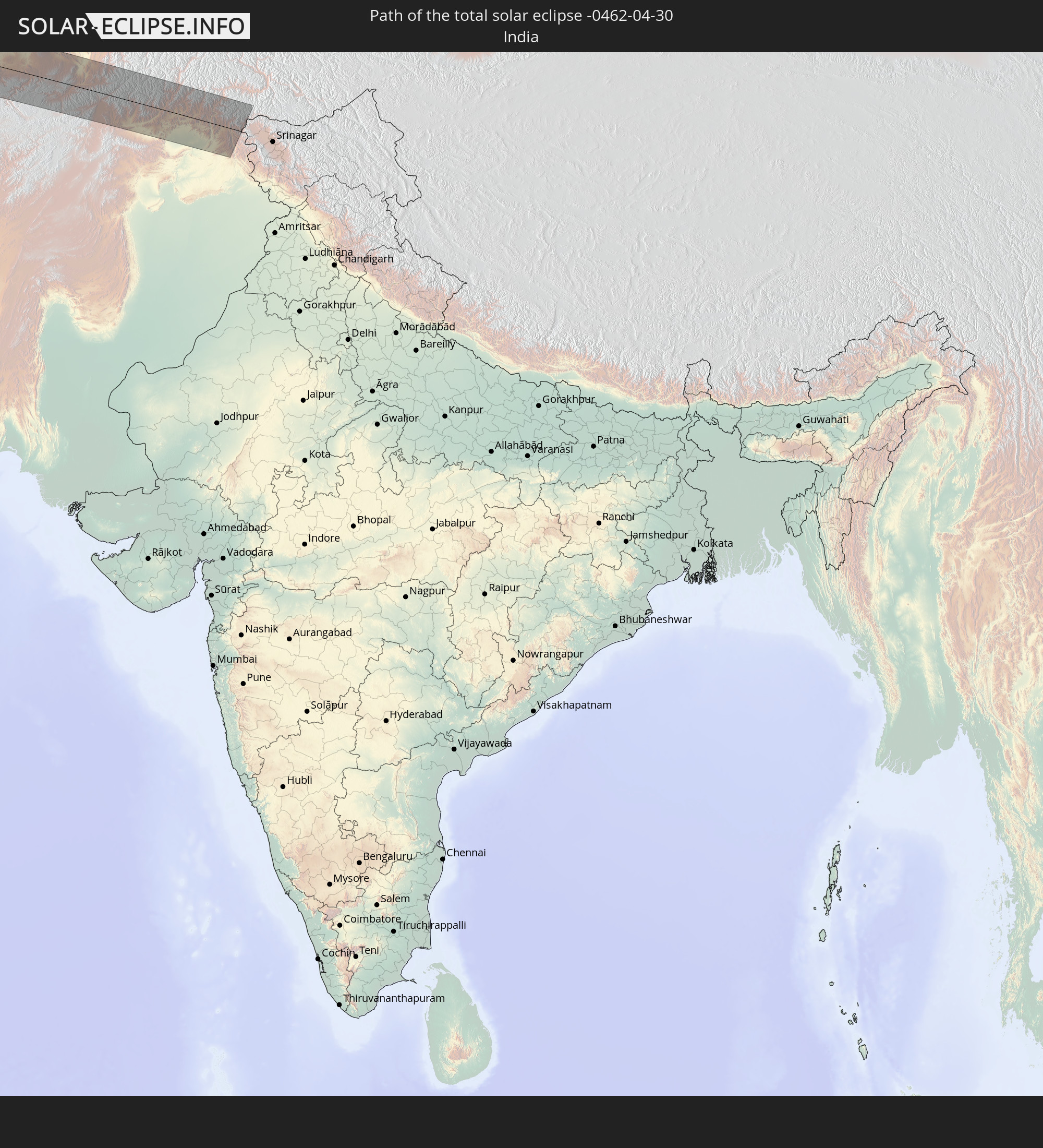 India
India
In den folgenden Ländern ist die Sonnenfinsternis partiell zu sehen
 Russia
 United States
 Canada
 Greenland
 Cuba
Cuba
 Colombia
 The Bahamas
 Haiti
Haiti
 Brazil
 Venezuela
 Turks and Caicos Islands
 Dominican Republic
 Aruba
Aruba
 Bolivia
 Puerto Rico
 United States Virgin Islands
 Bermuda
 British Virgin Islands
 Anguilla
 Collectivity of Saint Martin
 Saint Barthélemy
 Saint Kitts and Nevis
 Paraguay
 Antigua and Barbuda
 Montserrat
 Trinidad and Tobago
 Guadeloupe
 Grenada
 Dominica
 Saint Vincent and the Grenadines
 Guyana
 Martinique
 Saint Lucia
 Barbados
 Suriname
 Saint Pierre and Miquelon
 French Guiana
 Portugal
 Cabo Verde
 Iceland
 Spain
Spain
 Senegal
 Mauritania
 The Gambia
 Guinea-Bissau
 Guinea
 Sierra Leone
 Morocco
 Mali
Mali
 Liberia
 Republic of Ireland
 Svalbard and Jan Mayen
 Algeria
 United Kingdom
 Ivory Coast
 Faroe Islands
 Burkina Faso
 Gibraltar
 France
 Isle of Man
 Ghana
Ghana
 Guernsey
 Jersey
 Togo
Togo
 Niger
Niger
 Benin
Benin
 Andorra
 Belgium
 Nigeria
 Netherlands
 Norway
 Luxembourg
 Germany
 Switzerland
 Italy
Italy
 Monaco
 Tunisia
 Denmark
 Cameroon
 Libya
Libya
 Liechtenstein
 Austria
 Sweden
 Czechia
 San Marino
 Vatican City
 Slovenia
 Chad
Chad
 Croatia
 Poland
 Malta
Malta
 Central African Republic
 Bosnia and Herzegovina
 Hungary
 Slovakia
 Montenegro
 Serbia
 Albania
 Åland Islands
 Greece
 Romania
 Republic of Macedonia
 Finland
 Lithuania
 Latvia
 Estonia
 Sudan
Sudan
 Ukraine
 Bulgaria
 Belarus
 Egypt
Egypt
 Turkey
 Moldova
 Cyprus
 Ethiopia
 State of Palestine
 Israel
 Saudi Arabia
 Jordan
 Lebanon
 Syria
Syria
 Eritrea
 Iraq
Iraq
 Georgia
 Somalia
 Djibouti
 Yemen
Yemen
 Armenia
 Iran
Iran
 Azerbaijan
 Kazakhstan
 Kuwait
 Bahrain
 Qatar
Qatar
 United Arab Emirates
 Oman
Oman
 Turkmenistan
 Uzbekistan
 Afghanistan
 Pakistan
 Tajikistan
 India
India
 Kyrgyzstan
 China
China
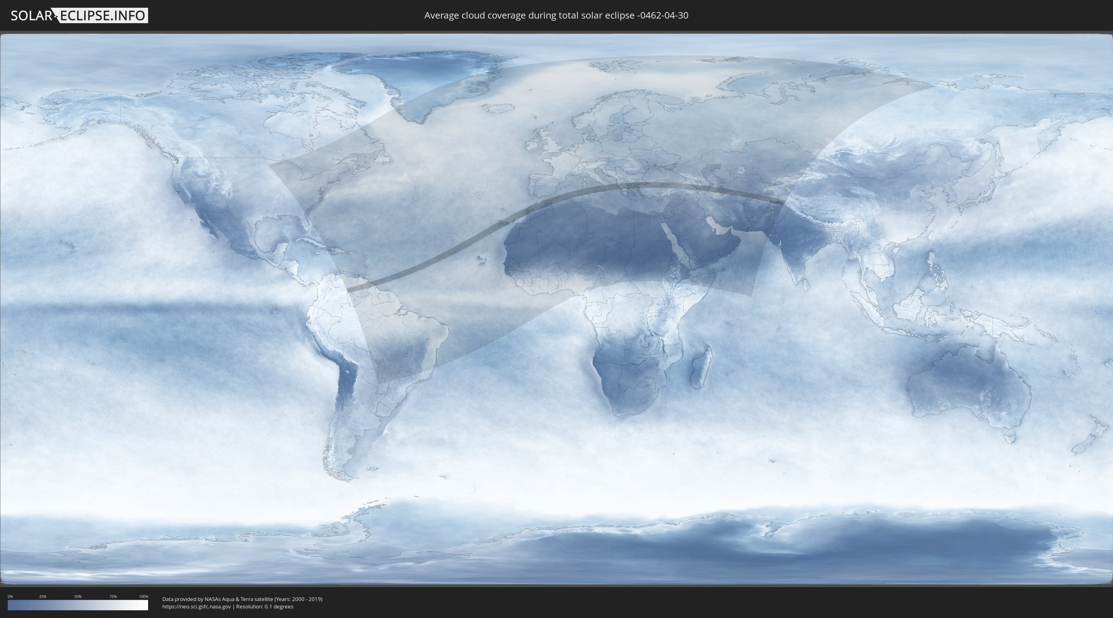
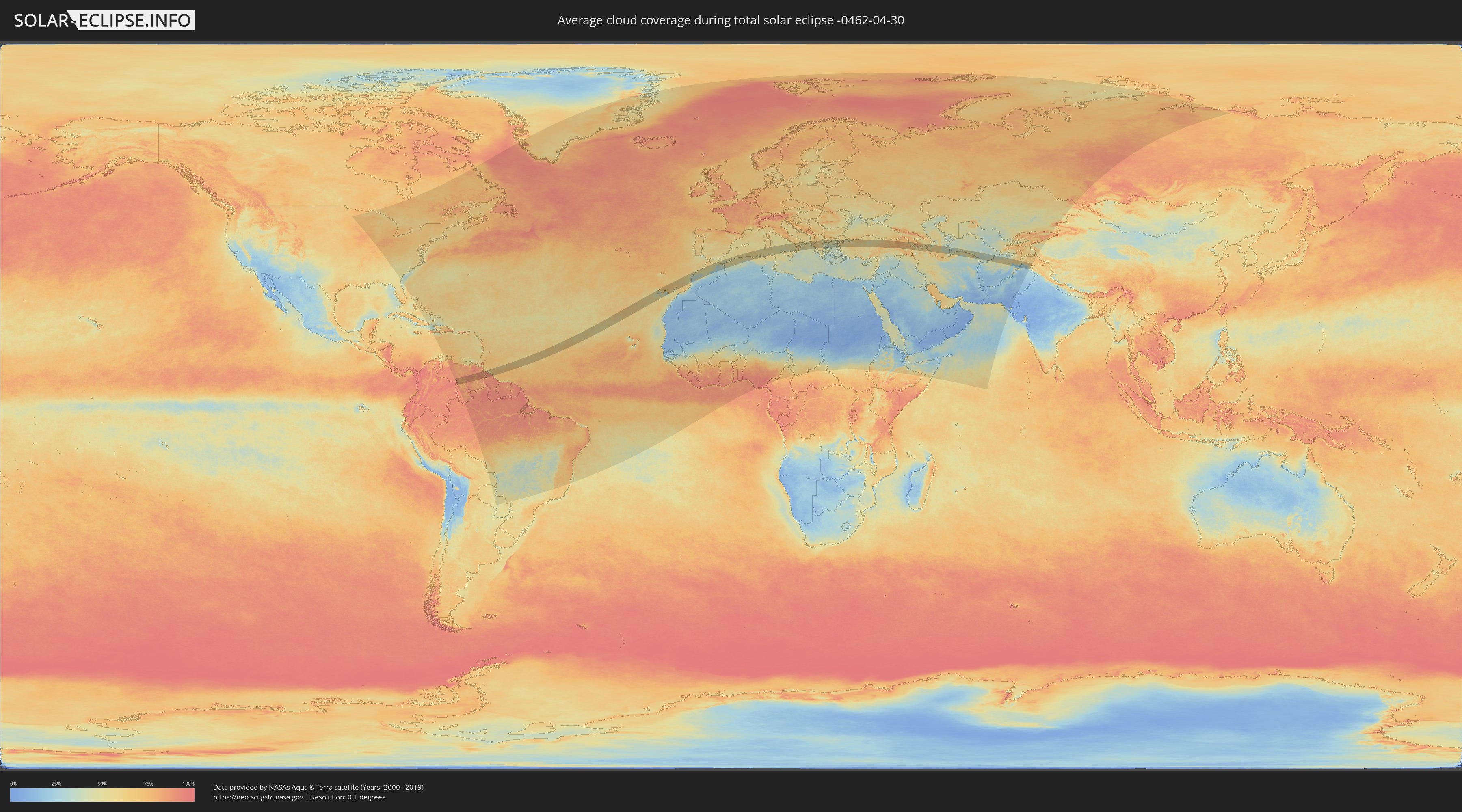
How will be the weather during the total solar eclipse on 04/30/-0462?
Where is the best place to see the total solar eclipse of 04/30/-0462?
The following maps show the average cloud coverage for the day of the total solar eclipse.
With the help of these maps, it is possible to find the place along the eclipse path, which has the best
chance of a cloudless sky.
Nevertheless, you should consider local circumstances and inform about the weather of your chosen
observation site.
The data is provided by NASAs satellites
AQUA and TERRA.
The cloud maps are averaged over a period of 19 years (2000 - 2019).
Detailed country maps
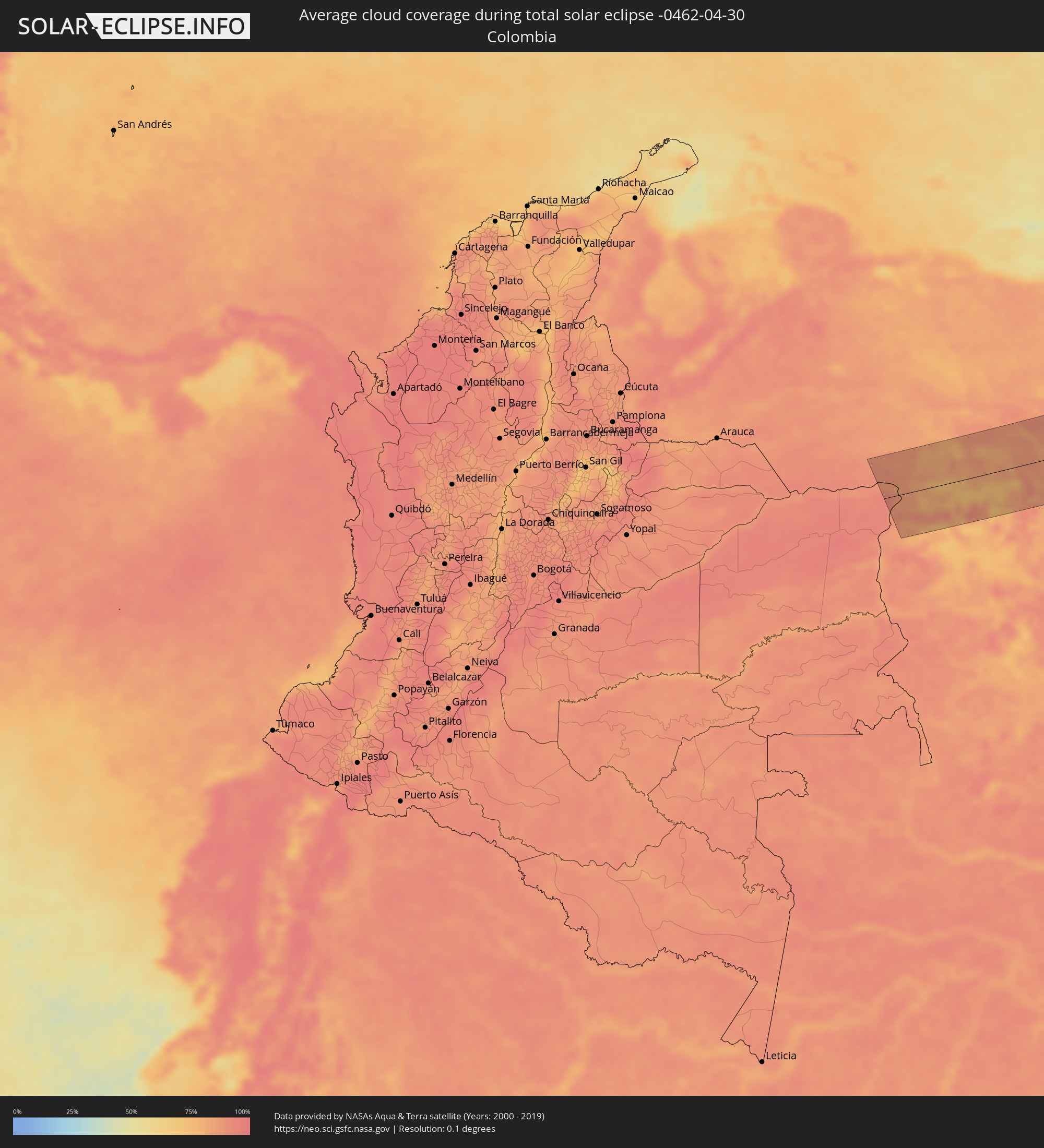 Colombia
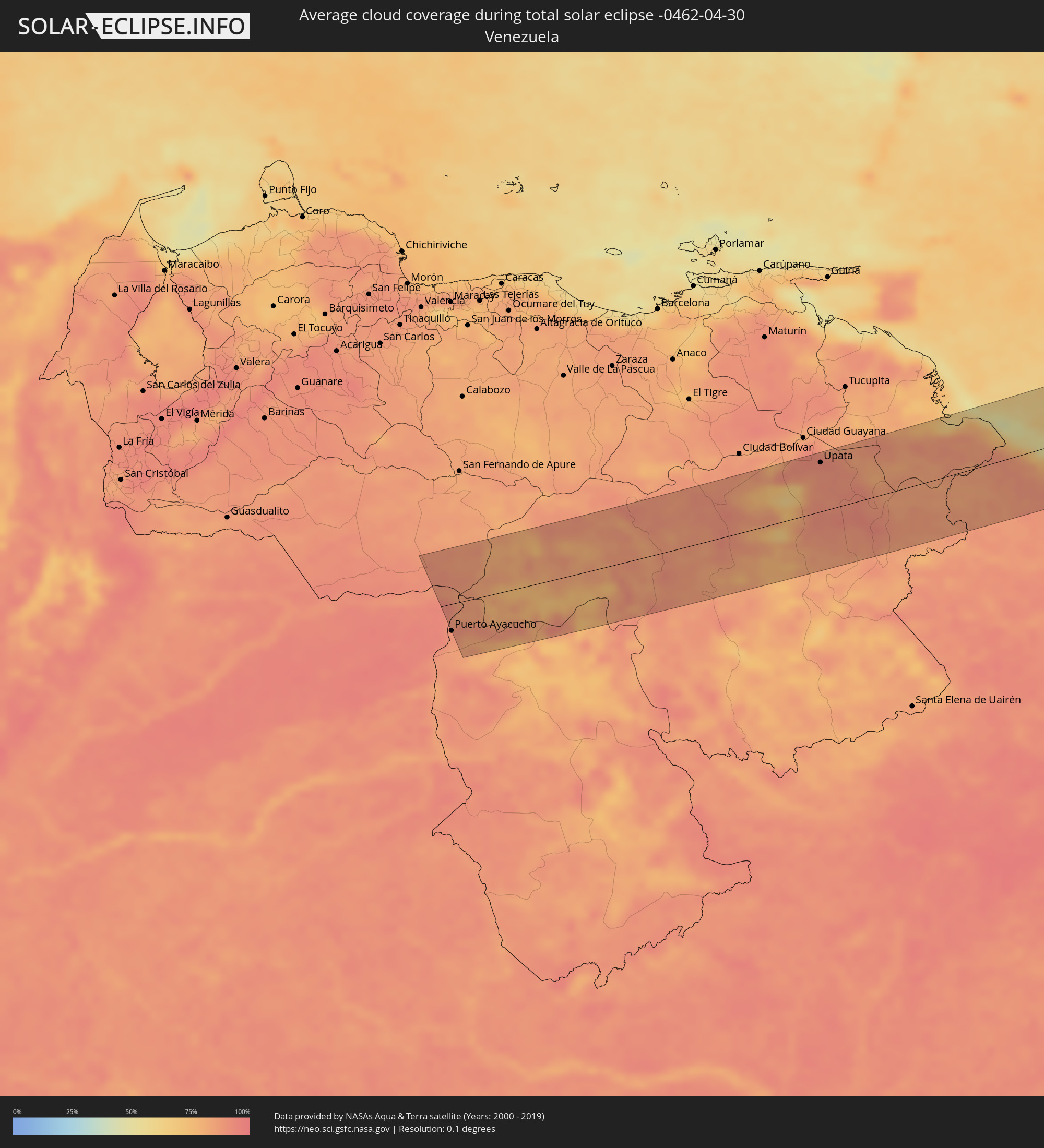 Venezuela
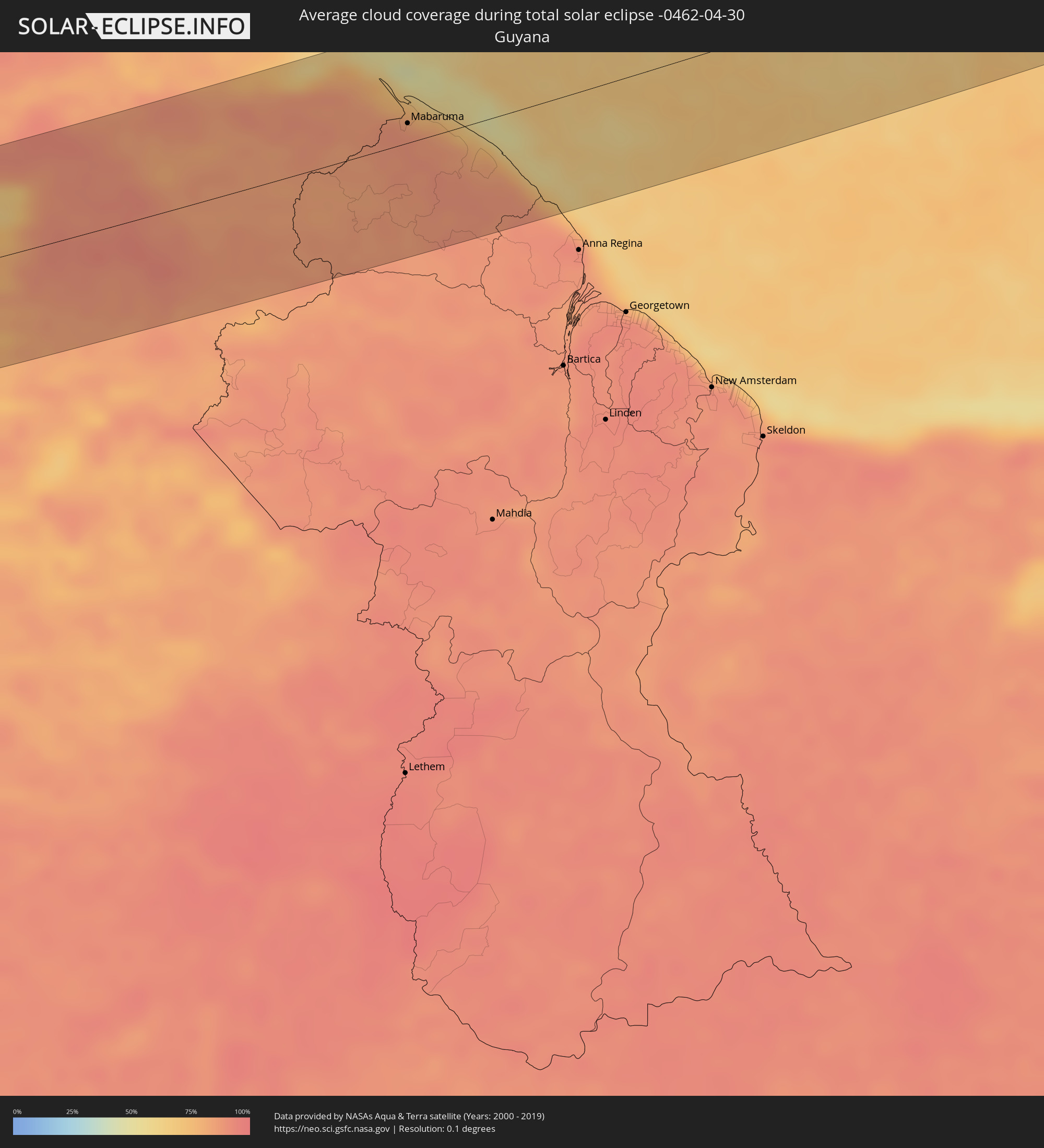 Guyana
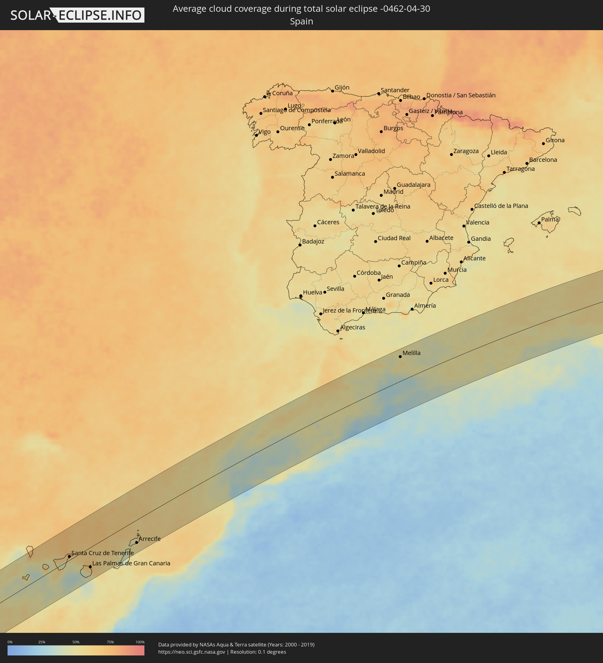 Spain
Spain
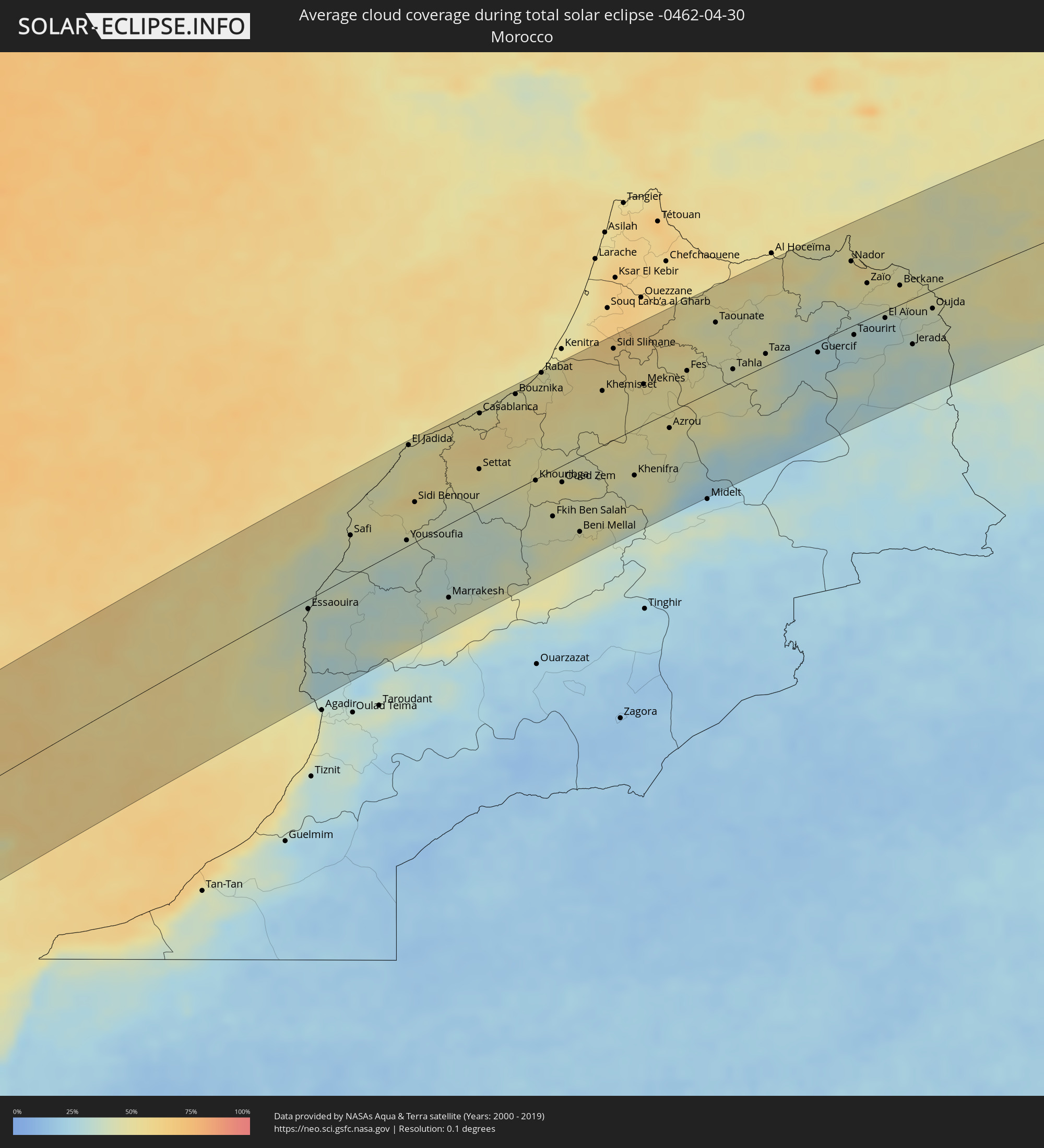 Morocco
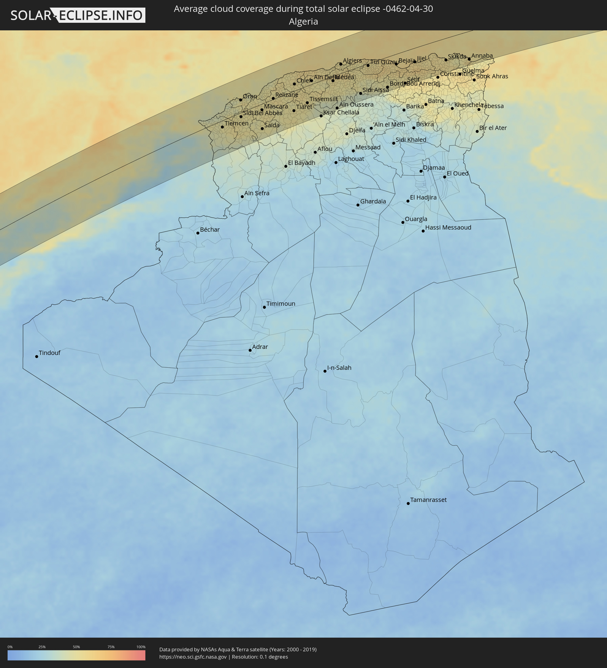 Algeria
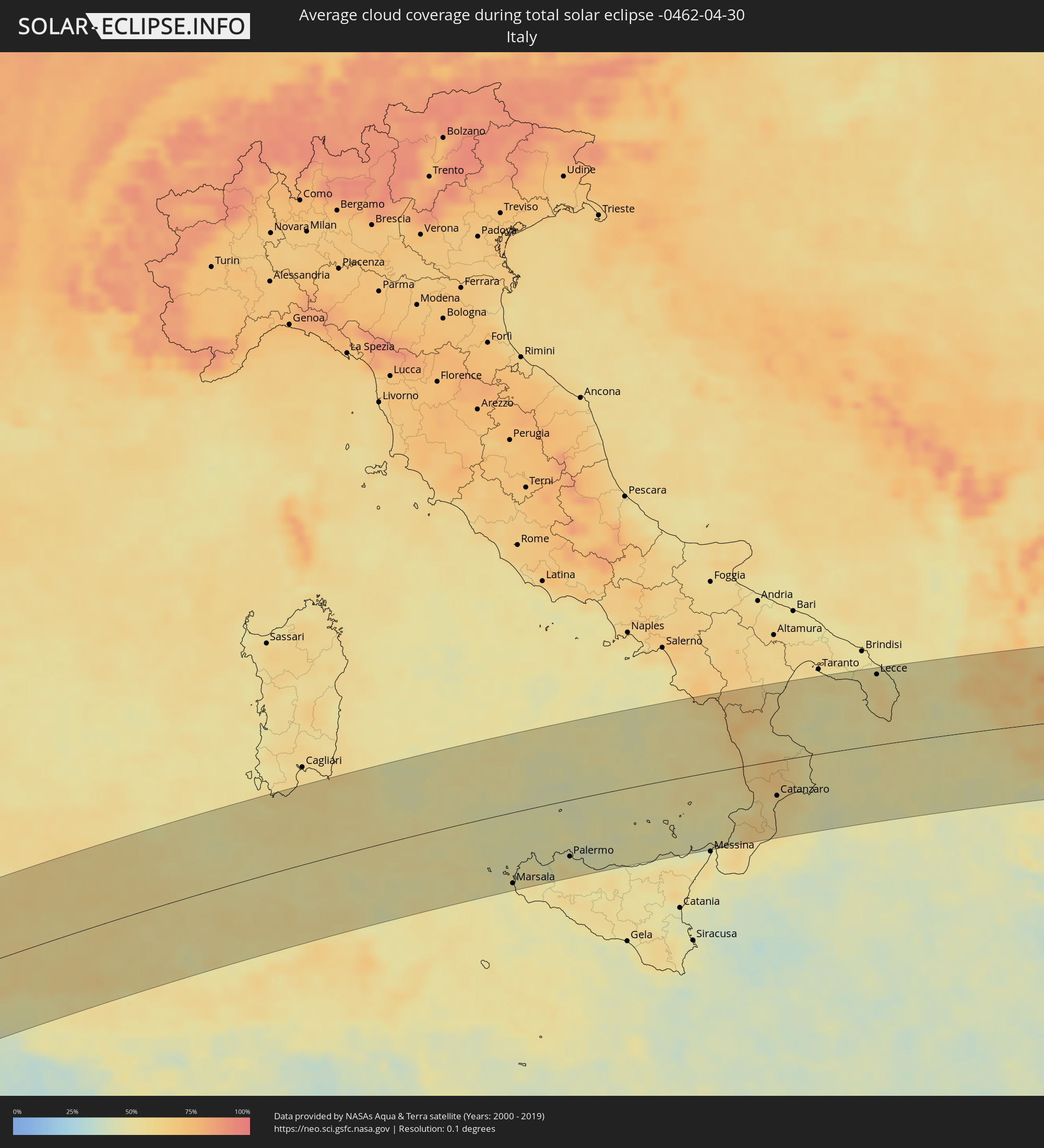 Italy
Italy
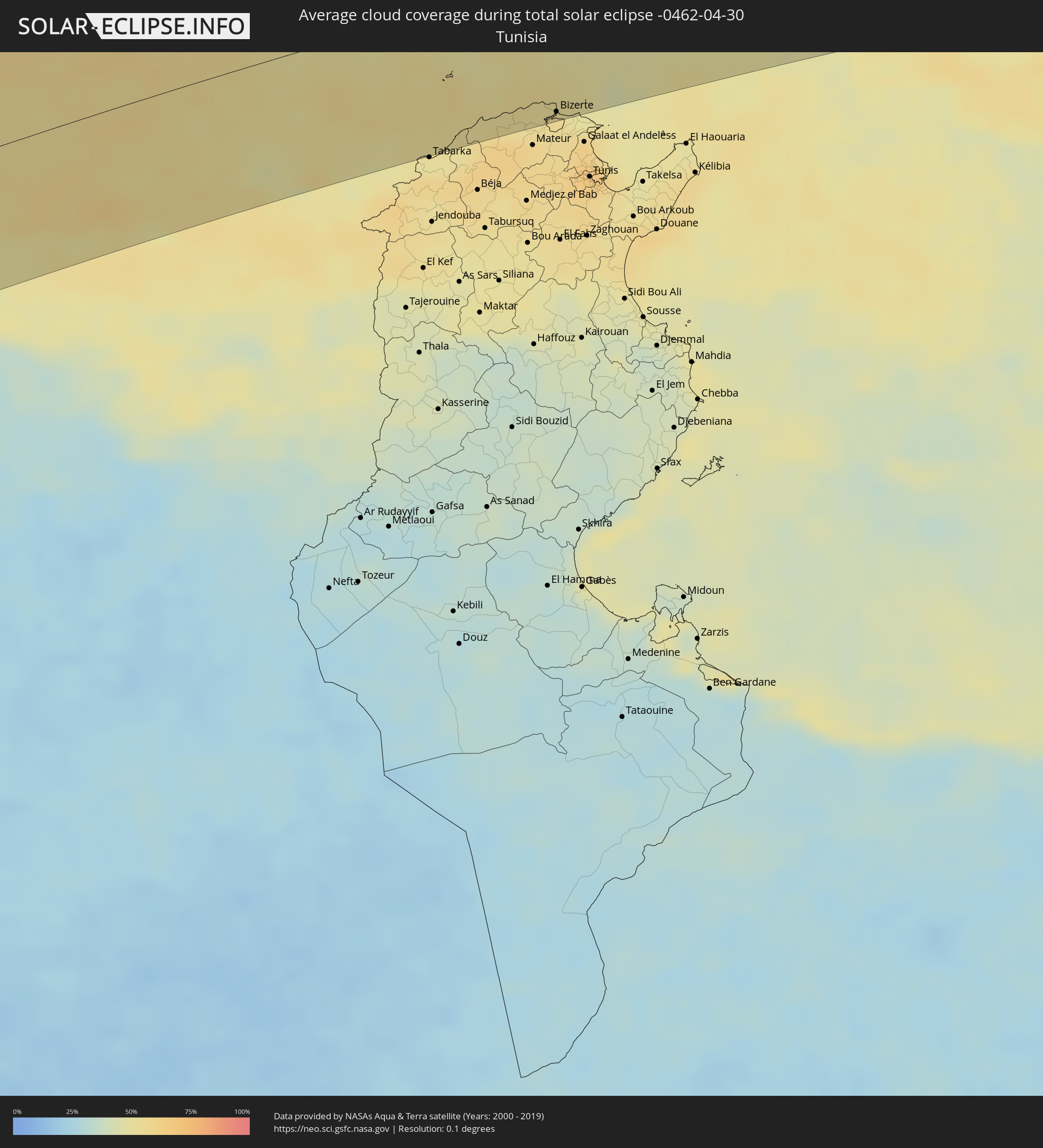 Tunisia
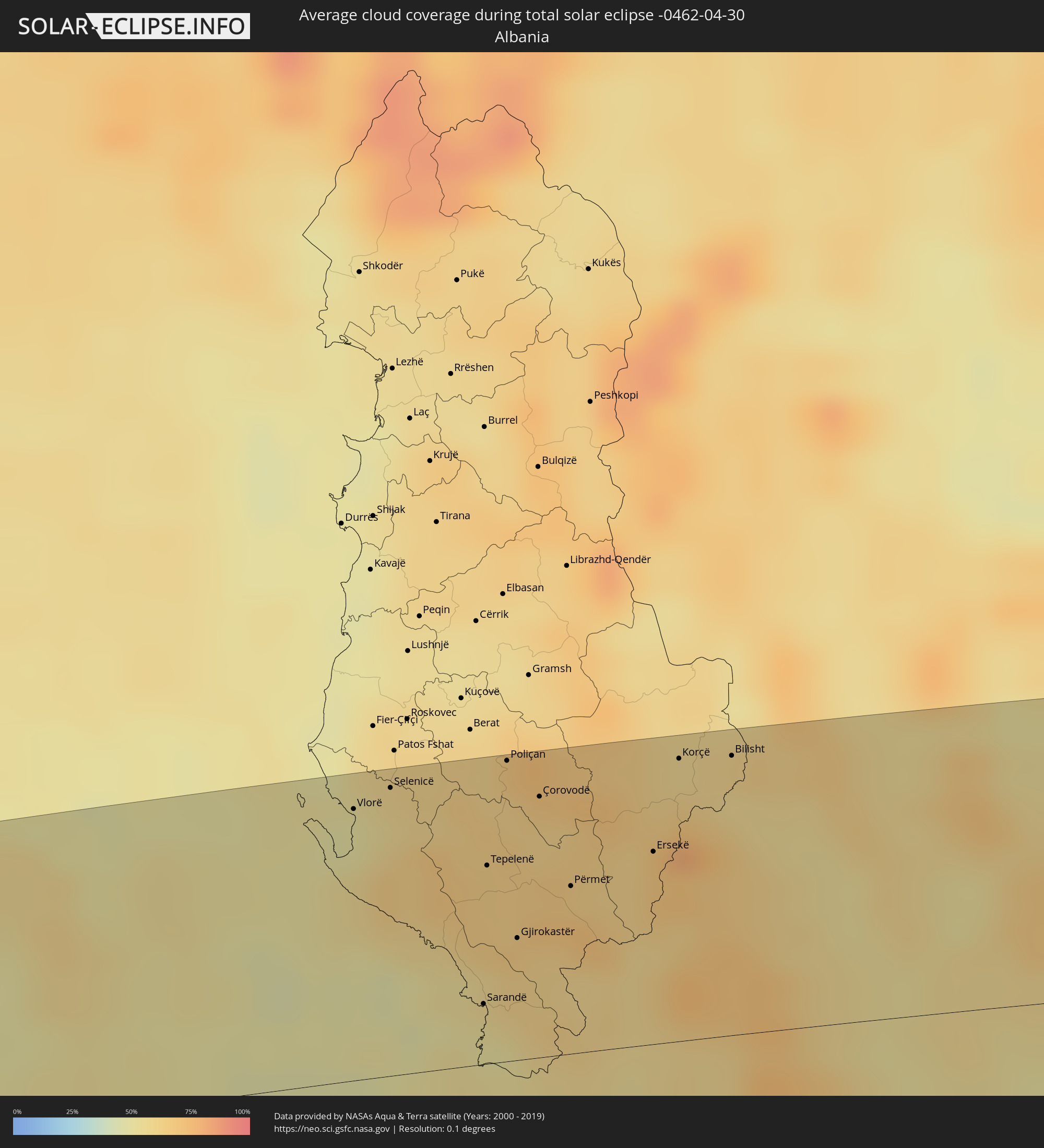 Albania
 Greece
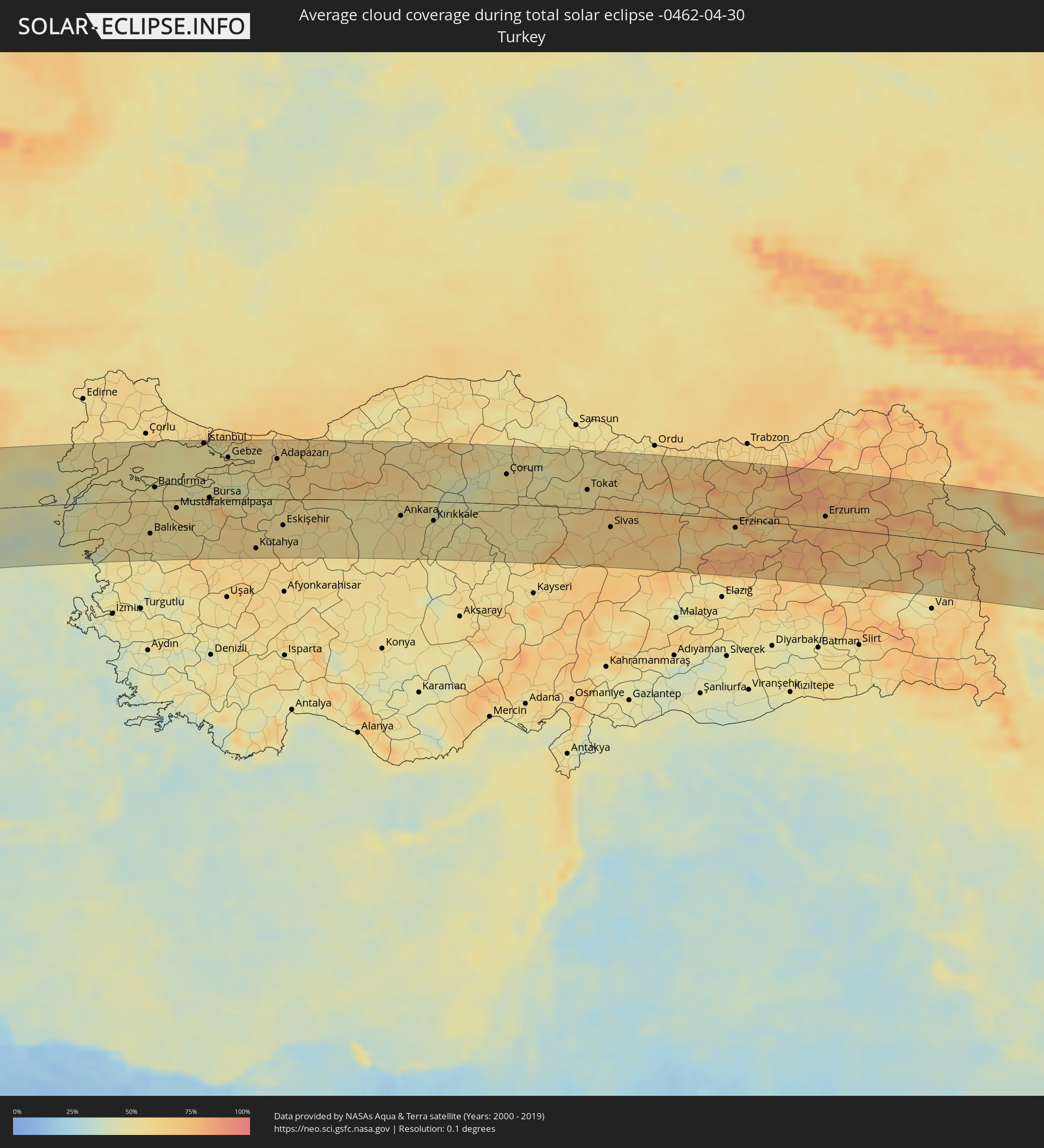 Turkey
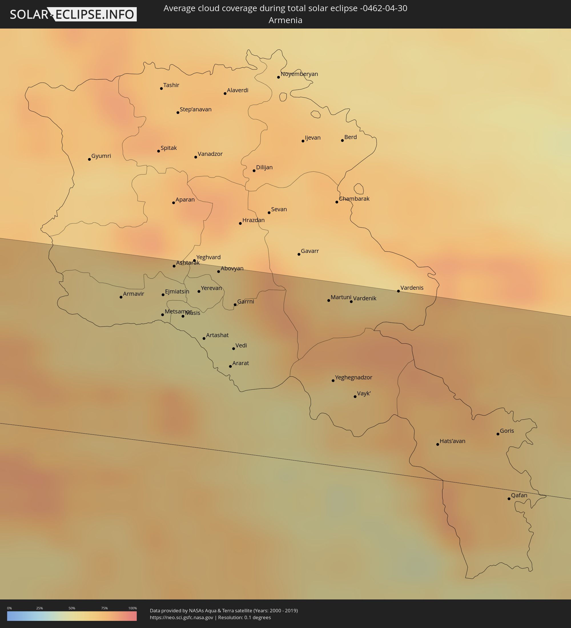 Armenia
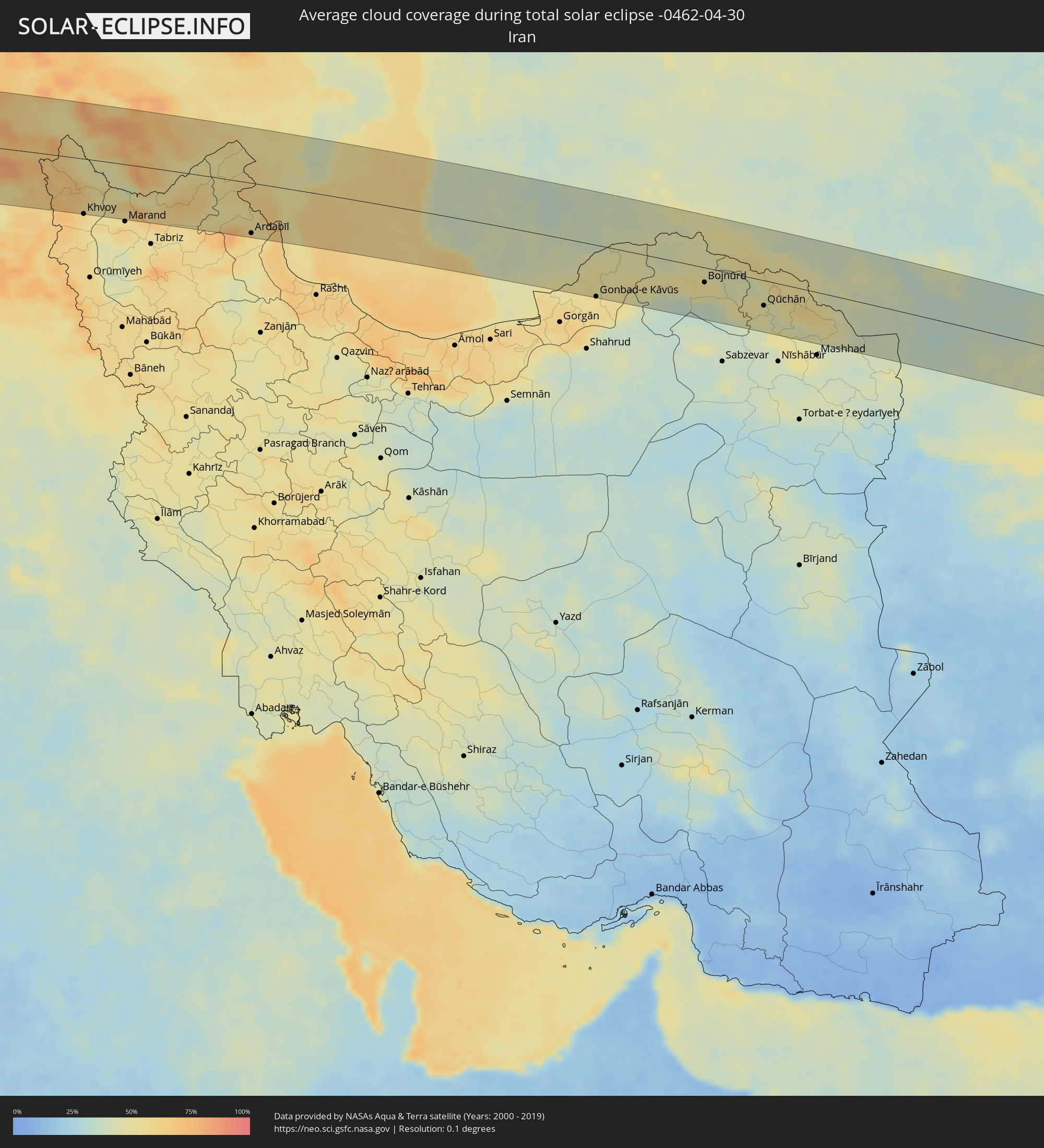 Iran
Iran
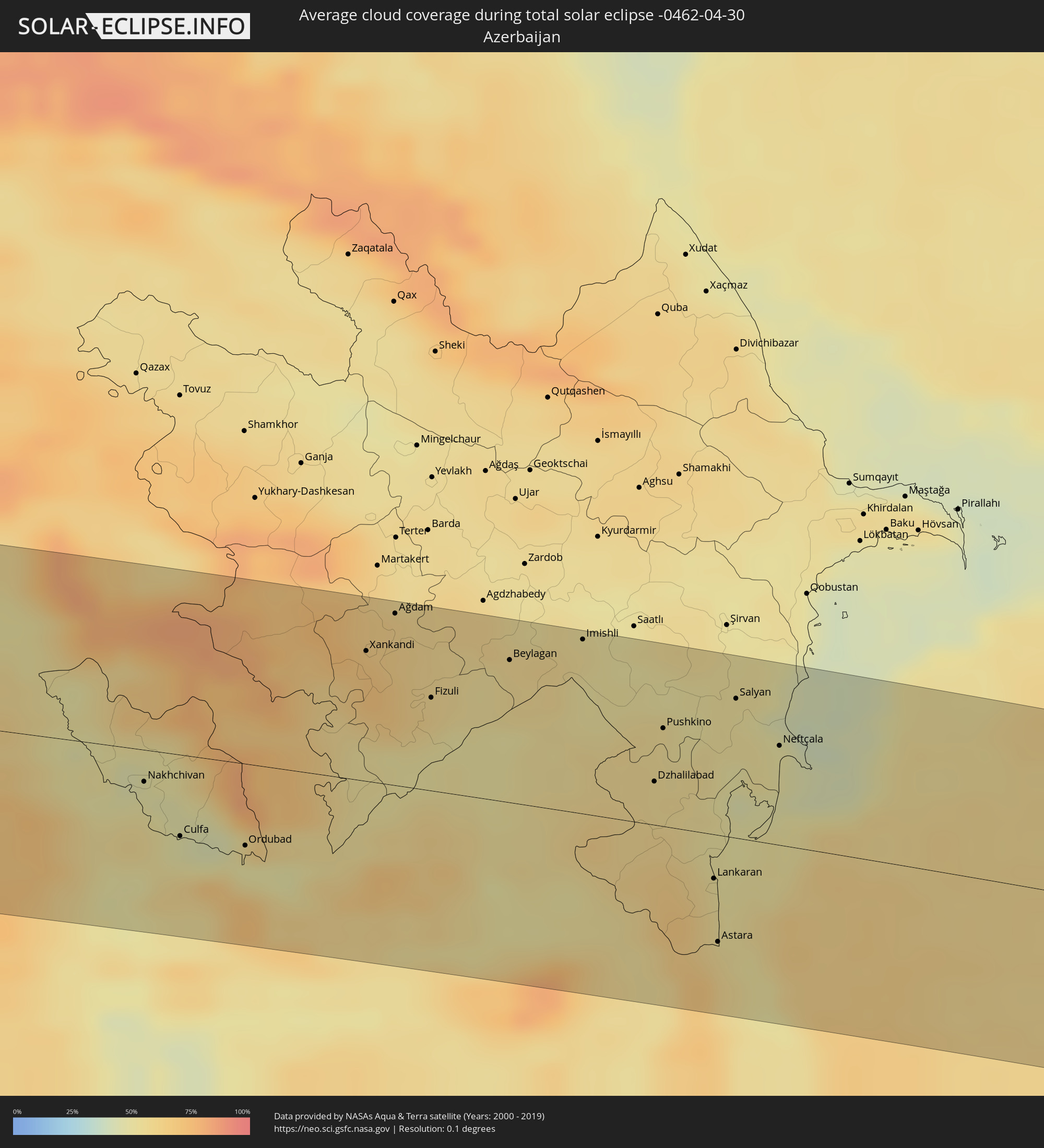 Azerbaijan
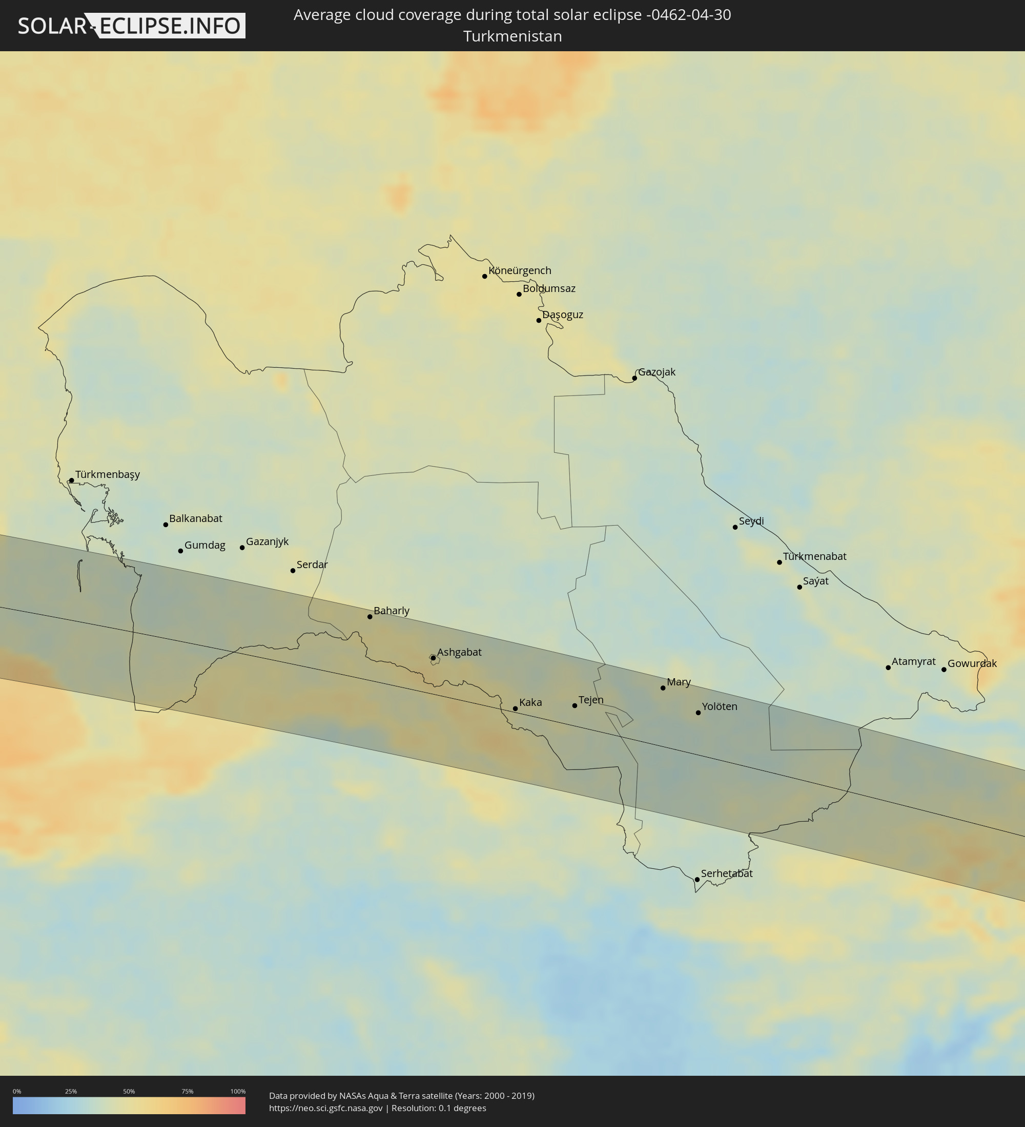 Turkmenistan
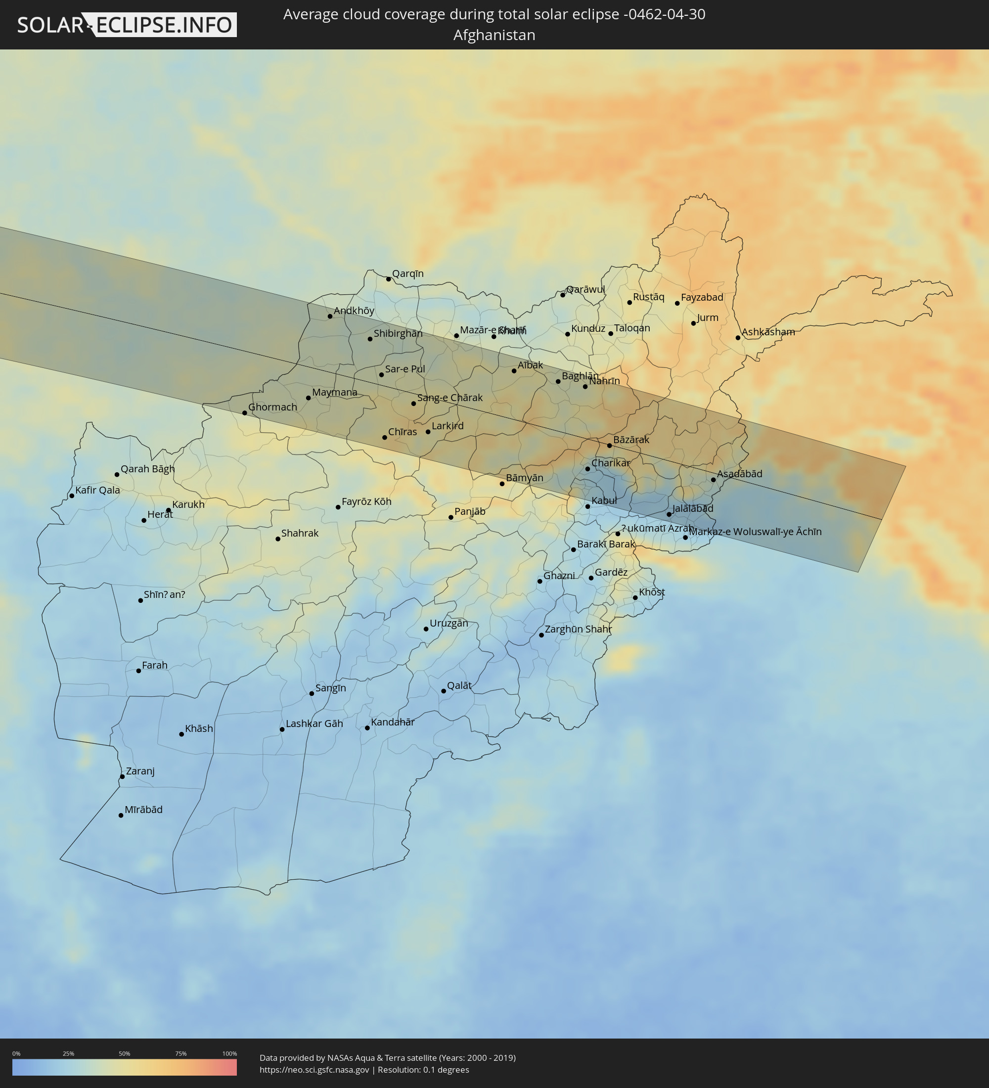 Afghanistan
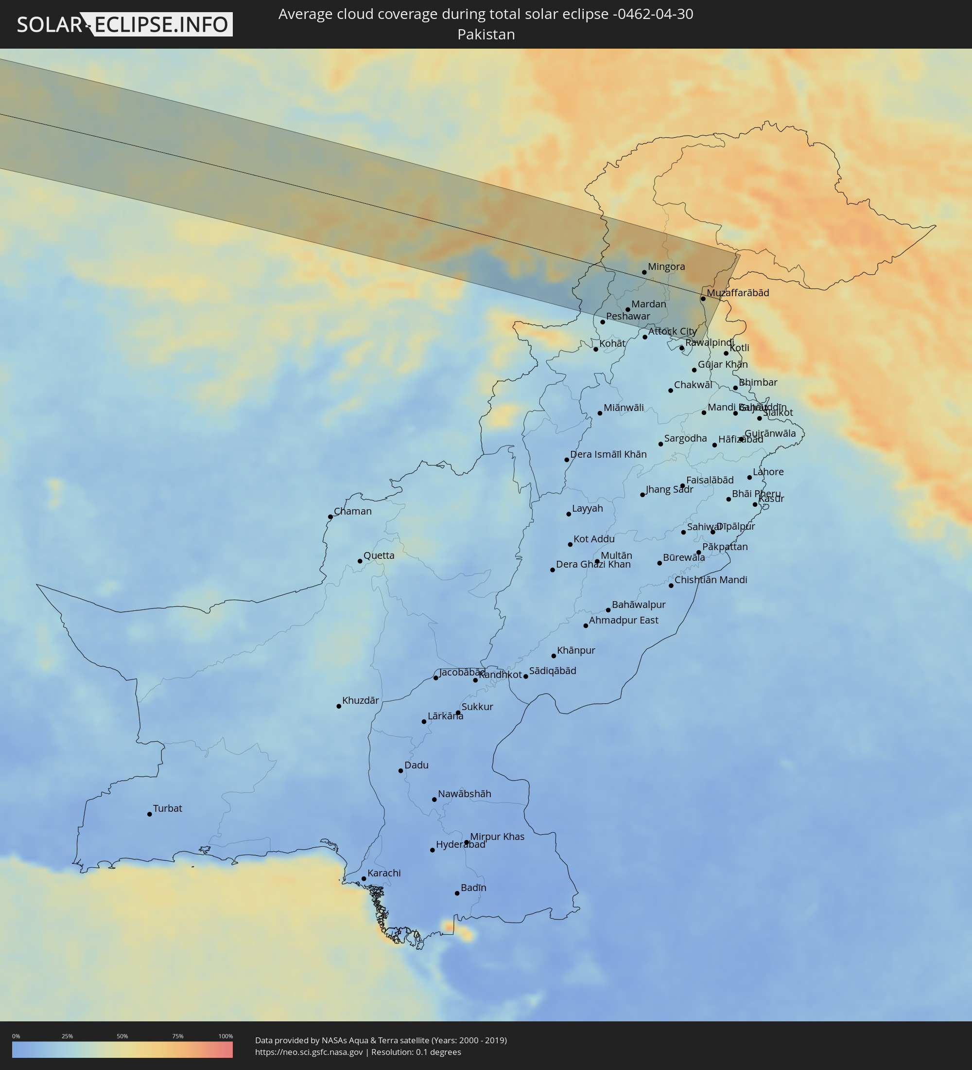 Pakistan
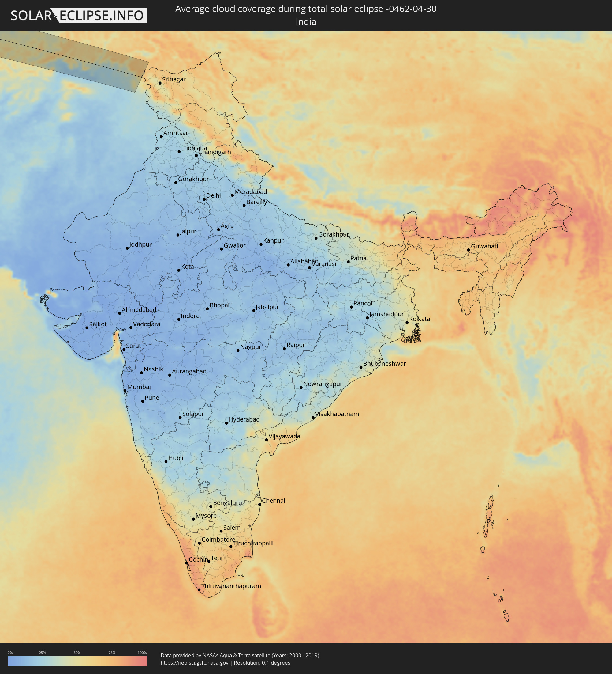 India
India
Cities inside the path of the eclipse
The following table shows all locations with a population of more than 5,000 inside the eclipse path. Cities which have more than 100,000 inhabitants are marked bold. A click at the locations opens a detailed map.
| City | Type | Eclipse duration | Local time of max. eclipse | Distance to central line | Ø Cloud coverage |
|
Puerto Ayacucho, Amazonas
|
total | - | 05:52:44 UTC-04:27 | 41 km | 89% |
|
Puerto Carreño, Vichada
|
total | - | 05:24:31 UTC-04:56 | 15 km | 85% |
|
Upata, Bolívar
|
total | - | 05:54:07 UTC-04:27 | 73 km | 89% |
|
Mabaruma, Barima-Waini
|
total | - | 06:29:21 UTC-03:52 | 16 km | 88% |
|
Icod de los Vinos, Canary Islands
|
total | - | 10:29:56 UTC-01:01 | 25 km | 65% |
|
Arona, Canary Islands
|
total | - | 10:29:34 UTC-01:01 | 2 km | 59% |
|
La Orotava, Canary Islands
|
total | - | 10:30:20 UTC-01:01 | 17 km | 62% |
|
Candelaria, Canary Islands
|
total | - | 10:30:34 UTC-01:01 | 6 km | 56% |
|
Santa Cruz de Tenerife, Canary Islands
|
total | - | 10:30:59 UTC-01:01 | 11 km | 56% |
|
Gáldar, Canary Islands
|
total | - | 10:31:39 UTC-01:01 | 50 km | 47% |
|
Maspalomas, Canary Islands
|
total | - | 10:31:11 UTC-01:01 | 90 km | 45% |
|
Santa Lucía, Canary Islands
|
total | - | 10:31:30 UTC-01:01 | 78 km | 41% |
|
Las Palmas de Gran Canaria, Canary Islands
|
total | - | 10:32:03 UTC-01:01 | 67 km | 63% |
|
Puerto del Rosario, Canary Islands
|
total | - | 10:35:48 UTC-01:01 | 106 km | 45% |
|
Arrecife, Canary Islands
|
total | - | 10:37:08 UTC-01:01 | 77 km | 56% |
|
Safi, Doukkala-Abda
|
total | - | 11:22:08 UTC-00:30 | 43 km | 40% |
|
El Jadida, Doukkala-Abda
|
total | - | 11:24:54 UTC-00:30 | 104 km | 46% |
|
Marrakesh, Marrakech-Tensift-Al Haouz
|
total | - | 11:23:54 UTC-00:30 | 77 km | 40% |
|
Casablanca, Grand Casablanca
|
total | - | 11:27:12 UTC-00:30 | 99 km | 51% |
|
Mohammedia, Grand Casablanca
|
total | - | 11:27:48 UTC-00:30 | 98 km | 50% |
|
Khouribga, Chaouia-Ouardigha
|
total | - | 11:27:49 UTC-00:30 | 2 km | 47% |
|
Rabat, Rabat-Salé-Zemmour-Zaër
|
total | - | 11:29:21 UTC-00:30 | 108 km | 50% |
|
Beni Mellal, Tadla-Azilal
|
total | - | 11:28:21 UTC-00:30 | 79 km | 46% |
|
Meknès, Meknès-Tafilalet
|
total | - | 11:31:56 UTC-00:30 | 43 km | 50% |
|
Fes, Fès-Boulemane
|
total | - | 11:33:15 UTC-00:30 | 34 km | 51% |
|
Taza, Taza-Al Hoceima-Taounate
|
total | - | 11:35:34 UTC-00:30 | 13 km | 44% |
|
Melilla, Melilla
|
total | - | 12:09:18 UTC+00:00 | 81 km | 53% |
|
Oujda, Oriental
|
total | - | 11:40:35 UTC-00:30 | 20 km | 40% |
|
Oran, Oran
|
total | - | 12:23:54 UTC+00:09 | 38 km | 54% |
|
Sidi Bel Abbès, Sidi Bel Abbès
|
total | - | 12:23:29 UTC+00:09 | 14 km | 51% |
|
Tiaret, Tiaret
|
total | - | 12:27:49 UTC+00:09 | 62 km | 51% |
|
Chlef, Chlef
|
total | - | 12:28:28 UTC+00:09 | 20 km | 51% |
|
Blida, Blida
|
total | - | 12:31:50 UTC+00:09 | 5 km | 57% |
|
Algiers, Algiers
|
total | - | 12:32:28 UTC+00:09 | 27 km | 52% |
|
Boumerdas, Boumerdes
|
total | - | 12:33:23 UTC+00:09 | 16 km | 51% |
|
Bordj Bou Arreridj, Bordj Bou Arréridj
|
total | - | 12:35:39 UTC+00:09 | 95 km | 46% |
|
Bejaïa, Béjaïa
|
total | - | 12:36:43 UTC+00:09 | 32 km | 55% |
|
Sétif, Sétif
|
total | - | 12:37:05 UTC+00:09 | 101 km | 51% |
|
Skikda, Skikda
|
total | - | 12:40:32 UTC+00:09 | 69 km | 54% |
|
Annaba, Annaba
|
total | - | 12:42:18 UTC+00:09 | 88 km | 55% |
|
Menzel Abderhaman, Banzart
|
total | - | 12:46:39 UTC+00:09 | 102 km | 53% |
|
Bizerte, Banzart
|
total | - | 12:46:41 UTC+00:09 | 98 km | 55% |
|
Menzel Jemil, Banzart
|
total | - | 12:46:45 UTC+00:09 | 103 km | 53% |
|
Marsala, Sicily
|
total | - | 13:42:27 UTC+01:00 | 95 km | 47% |
|
Trapani, Sicily
|
total | - | 13:42:40 UTC+01:00 | 74 km | 46% |
|
Alcamo, Sicily
|
total | - | 13:43:28 UTC+01:00 | 86 km | 46% |
|
Palermo, Sicily
|
total | - | 13:44:11 UTC+01:00 | 76 km | 54% |
|
Bagheria, Sicily
|
total | - | 13:44:31 UTC+01:00 | 85 km | 47% |
|
Milazzo, Sicily
|
total | - | 13:47:43 UTC+01:00 | 99 km | 47% |
|
Cosenza, Calabria
|
total | - | 13:49:28 UTC+01:00 | 4 km | 61% |
|
Lamezia Terme, Calabria
|
total | - | 13:49:36 UTC+01:00 | 34 km | 58% |
|
Catanzaro, Calabria
|
total | - | 13:50:07 UTC+01:00 | 47 km | 56% |
|
Crotone, Calabria
|
total | - | 13:51:01 UTC+01:00 | 33 km | 49% |
|
Nardò, Apulia
|
total | - | 13:52:23 UTC+01:00 | 76 km | 51% |
|
Lecce, Apulia
|
total | - | 13:52:35 UTC+01:00 | 94 km | 55% |
|
Vlorë, Vlorë
|
total | - | 14:14:01 UTC+01:19 | 91 km | 50% |
|
Selenicë, Vlorë
|
total | - | 14:14:14 UTC+01:19 | 97 km | 54% |
|
Sarandë, Vlorë
|
total | - | 14:15:00 UTC+01:19 | 20 km | 52% |
|
Tepelenë, Gjirokastër
|
total | - | 14:14:55 UTC+01:19 | 67 km | 64% |
|
Poliçan, Berat
|
total | - | 14:14:57 UTC+01:19 | 101 km | 62% |
|
Gjirokastër, Gjirokastër
|
total | - | 14:15:10 UTC+01:19 | 41 km | 66% |
|
Çorovodë, Berat
|
total | - | 14:15:11 UTC+01:19 | 88 km | 62% |
|
Përmet, Gjirokastër
|
total | - | 14:15:28 UTC+01:19 | 56 km | 71% |
|
Ersekë, Korçë
|
total | - | 14:15:57 UTC+01:19 | 65 km | 69% |
|
Korçë, Korçë
|
total | - | 14:16:01 UTC+01:19 | 95 km | 62% |
|
Ioánnina, Epirus
|
total | - | 14:31:57 UTC+01:34 | 11 km | 58% |
|
Bilisht, Korçë
|
total | - | 14:16:20 UTC+01:19 | 94 km | 57% |
|
Ptolemaḯda, West Macedonia
|
total | - | 14:32:58 UTC+01:34 | 75 km | 56% |
|
Tríkala, Thessaly
|
total | - | 14:33:26 UTC+01:34 | 32 km | 50% |
|
Kozáni, West Macedonia
|
total | - | 14:33:13 UTC+01:34 | 51 km | 54% |
|
Kardítsa, Thessaly
|
total | - | 14:33:44 UTC+01:34 | 54 km | 50% |
|
Véroia, Central Macedonia
|
total | - | 14:33:46 UTC+01:34 | 72 km | 59% |
|
Giannitsá, Central Macedonia
|
total | - | 14:33:58 UTC+01:34 | 100 km | 48% |
|
Lárisa, Thessaly
|
total | - | 14:34:25 UTC+01:34 | 28 km | 46% |
|
Kateríni, Central Macedonia
|
total | - | 14:34:19 UTC+01:34 | 41 km | 52% |
|
Thessaloníki, Central Macedonia
|
total | - | 14:34:49 UTC+01:34 | 80 km | 46% |
|
Vólos, Thessaly
|
total | - | 14:35:19 UTC+01:34 | 63 km | 47% |
|
Alexandroúpoli, East Macedonia and Thrace
|
total | - | 14:38:56 UTC+01:34 | 85 km | 48% |
|
Balıkesir, Balıkesir
|
total | - | 15:04:21 UTC+01:56 | 55 km | 56% |
|
Esenyurt, Istanbul
|
total | - | 15:04:36 UTC+01:56 | 97 km | 53% |
|
İstanbul, Istanbul
|
total | - | 15:04:58 UTC+01:56 | 95 km | 51% |
|
Bursa, Bursa
|
total | - | 15:05:35 UTC+01:56 | 4 km | 63% |
|
Maltepe, Istanbul
|
total | - | 15:05:16 UTC+01:56 | 86 km | 51% |
|
Gebze, Kocaeli
|
total | - | 15:05:41 UTC+01:56 | 71 km | 54% |
|
Adapazarı, Sakarya
|
total | - | 15:06:54 UTC+01:56 | 68 km | 62% |
|
Eskişehir, Eskişehir
|
total | - | 15:07:40 UTC+01:56 | 44 km | 57% |
|
Ankara, Ankara
|
total | - | 15:10:21 UTC+01:56 | 26 km | 58% |
|
Kırıkkale, Kırıkkale
|
total | - | 15:11:09 UTC+01:56 | 33 km | 52% |
|
Sivas, Sivas
|
total | - | 15:14:54 UTC+01:56 | 29 km | 64% |
|
Erzurum, Erzurum
|
total | - | 15:18:38 UTC+01:56 | 19 km | 78% |
|
Armavir, Armavir Province
|
total | - | 16:21:37 UTC+02:58 | 73 km | 56% |
|
Ejmiatsin, Armavir Province
|
total | - | 16:21:47 UTC+02:58 | 77 km | 52% |
|
Ashtarak, Aragatsotn Province
|
total | - | 16:21:43 UTC+02:58 | 92 km | 53% |
|
Masis, Ararat Province
|
total | - | 16:21:58 UTC+02:58 | 67 km | 50% |
|
Yerevan, Yerevan
|
total | - | 16:21:56 UTC+02:58 | 81 km | 51% |
|
Artashat, Ararat Province
|
total | - | 16:22:09 UTC+02:58 | 57 km | 51% |
|
Ararat, Ararat Province
|
total | - | 16:22:22 UTC+02:58 | 44 km | 52% |
|
Vedi, Ararat Province
|
total | - | 16:22:19 UTC+02:58 | 54 km | 51% |
|
Khvoy, Āz̄ārbāyjān-e Gharbī
|
total | - | 16:51:22 UTC+03:25 | 94 km | 55% |
|
Nakhchivan, Nakhichevan
|
total | - | 16:44:48 UTC+03:19 | 16 km | 48% |
|
Vardenis, Gegharkunik Province
|
total | - | 16:22:45 UTC+02:58 | 95 km | 66% |
|
Hats’avan, Syunik Province
|
total | - | 16:23:33 UTC+02:58 | 18 km | 66% |
|
Goris, Syunik Province
|
total | - | 16:23:44 UTC+02:58 | 28 km | 65% |
|
Qafan, Syunik Province
|
total | - | 16:24:03 UTC+02:58 | 5 km | 67% |
|
Xankandi, Xankǝndi
|
total | - | 16:45:08 UTC+03:19 | 67 km | 68% |
|
Ağdam, Ağdam
|
total | - | 16:45:05 UTC+03:19 | 88 km | 63% |
|
Ahar, East Azerbaijan
|
total | - | 16:52:50 UTC+03:25 | 77 km | 53% |
|
Fizuli, Füzuli
|
total | - | 16:45:34 UTC+03:19 | 48 km | 61% |
|
Beylagan, Beyləqan
|
total | - | 16:45:42 UTC+03:19 | 73 km | 57% |
|
Pārsābād, Ardabīl
|
total | - | 16:52:20 UTC+03:25 | 63 km | 54% |
|
Imishli, İmişli
|
total | - | 16:45:53 UTC+03:19 | 89 km | 54% |
|
Ardabīl, Ardabīl
|
total | - | 16:53:46 UTC+03:25 | 86 km | 54% |
|
Dzhalilabad, Jalilabad
|
total | - | 16:46:43 UTC+03:19 | 22 km | 55% |
|
Pushkino, Bilǝsuvar
|
total | - | 16:46:31 UTC+03:19 | 50 km | 55% |
|
Lankaran, Lənkəran
|
total | - | 16:47:19 UTC+03:19 | 23 km | 50% |
|
Āstārā, Gīlān
|
total | - | 16:53:57 UTC+03:25 | 58 km | 57% |
|
Astara, Astara
|
total | - | 16:47:36 UTC+03:19 | 55 km | 54% |
|
Salyan, Salyan
|
total | - | 16:46:39 UTC+03:19 | 72 km | 51% |
|
Neftçala, Neftçala
|
total | - | 16:46:59 UTC+03:19 | 51 km | 50% |
|
Gonbad-e Kāvūs, Golestān
|
total | - | 16:57:51 UTC+03:25 | 89 km | 53% |
|
Bojnūrd, Khorāsān-e Shomālī
|
total | - | 16:58:20 UTC+03:25 | 25 km | 51% |
|
Baharly, Ahal
|
total | - | 17:25:19 UTC+03:53 | 81 km | 46% |
|
Esfarāyen, Khorāsān-e Shomālī
|
total | - | 16:58:44 UTC+03:25 | 65 km | 38% |
|
Shīrvān, Khorāsān-e Shomālī
|
total | - | 16:58:34 UTC+03:25 | 23 km | 44% |
|
Abadan, Ahal
|
total | - | 17:25:52 UTC+03:53 | 54 km | 52% |
|
Ashgabat, Ahal
|
total | - | 17:26:00 UTC+03:53 | 46 km | 50% |
|
Qūchān, Razavi Khorasan
|
total | - | 16:58:58 UTC+03:25 | 43 km | 49% |
|
Annau, Ahal
|
total | - | 17:26:05 UTC+03:53 | 42 km | 51% |
|
Chenārān, Razavi Khorasan
|
total | - | 16:59:31 UTC+03:25 | 82 km | 46% |
|
Kaka, Ahal
|
total | - | 17:26:49 UTC+03:53 | 4 km | 44% |
|
Tejen, Ahal
|
total | - | 17:26:58 UTC+03:53 | 26 km | 41% |
|
Sarakhs, Razavi Khorasan
|
total | - | 17:00:00 UTC+03:25 | 52 km | 39% |
|
Mary, Mary
|
total | - | 17:27:00 UTC+03:53 | 75 km | 41% |
|
Murgab
|
total | - | 17:27:07 UTC+03:53 | 67 km | 38% |
|
Bayramaly, Mary
|
total | - | 17:27:02 UTC+03:53 | 85 km | 42% |
|
Yolöten, Mary
|
total | - | 17:27:20 UTC+03:53 | 54 km | 38% |
|
Ghormach, Badghis
|
total | - | 17:35:17 UTC+04:00 | 86 km | 46% |
|
Maymana, Faryab
|
total | - | 17:35:12 UTC+04:00 | 43 km | 43% |
|
Andkhōy, Faryab
|
total | - | 17:34:22 UTC+04:00 | 75 km | 40% |
|
Shibirghān, Jowzjan
|
total | - | 17:34:38 UTC+04:00 | 58 km | 39% |
|
Sar-e Pul, Sar-e Pol
|
total | - | 17:35:01 UTC+04:00 | 14 km | 44% |
|
Aībak, Samangan
|
total | - | 17:34:59 UTC+04:00 | 66 km | 46% |
|
Baghlān, Baghlan
|
total | - | 17:35:04 UTC+04:00 | 67 km | 44% |
|
Pul-e Khumrī, Baghlan
|
total | - | 17:35:13 UTC+04:00 | 47 km | 44% |
|
Charikar, Parwan
|
total | - | 17:35:56 UTC+04:00 | 42 km | 26% |
|
Bāzārak, Panjshir
|
total | - | 17:35:41 UTC+04:00 | 2 km | 38% |
|
Jalālābād, Nangarhar
|
total | - | 17:36:18 UTC+04:00 | 75 km | 25% |
|
Asadābād, Kunar
|
total | - | 17:35:53 UTC+04:00 | 10 km | 31% |
|
Shabqadar, Khyber Pakhtunkhwa
|
total | - | 18:04:32 UTC+04:28 | 71 km | 25% |
|
Chārsadda, Khyber Pakhtunkhwa
|
total | - | 18:04:34 UTC+04:28 | 74 km | 26% |
|
Bat Khela, Khyber Pakhtunkhwa
|
total | - | 18:04:11 UTC+04:28 | 18 km | 25% |
|
Risalpur Cantonment, Khyber Pakhtunkhwa
|
total | - | 18:04:36 UTC+04:28 | 77 km | 26% |
|
Mardan, Khyber Pakhtunkhwa
|
total | - | 18:04:29 UTC+04:28 | 60 km | 27% |
|
Mingora, Khyber Pakhtunkhwa
|
total | - | 18:04:01 UTC+04:28 | 9 km | 32% |
|
Swābi, Khyber Pakhtunkhwa
|
total | - | 18:04:30 UTC+04:28 | 59 km | 26% |
|
Topi, Khyber Pakhtunkhwa
|
total | - | 18:04:30 UTC+04:28 | 61 km | 26% |
|
Harīpur, Khyber Pakhtunkhwa
|
total | - | 18:04:31 UTC+04:28 | 60 km | 28% |
|
Mānsehra, Khyber Pakhtunkhwa
|
total | - | 18:04:13 UTC+04:28 | 18 km | 37% |
|
Abbottābād, Khyber Pakhtunkhwa
|
total | - | 18:04:22 UTC+04:28 | 38 km | 35% |
|
Muzaffarābād, Azad Kashmir
|
total | - | 18:04:09 UTC+04:28 | 8 km | 42% |