Total solar eclipse of 04/03/0265
| Day of week: | Monday |
| Maximum duration of eclipse: | 04m44s |
| Maximum width of eclipse path: | 189 km |
| Saros cycle: | 72 |
| Coverage: | 100% |
| Magnitude: | 1.054 |
| Gamma: | 0.3341 |
Wo kann man die Sonnenfinsternis vom 04/03/0265 sehen?
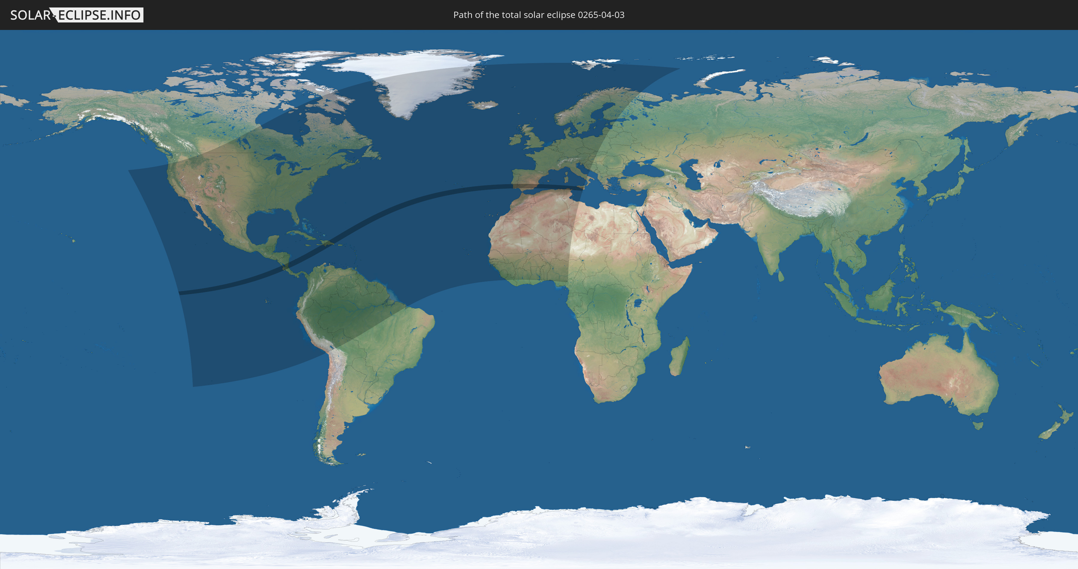
Die Sonnenfinsternis am 04/03/0265 kann man in 111 Ländern als partielle Sonnenfinsternis beobachten.
Der Finsternispfad verläuft durch 10 Länder. Nur in diesen Ländern ist sie als total Sonnenfinsternis zu sehen.
In den folgenden Ländern ist die Sonnenfinsternis total zu sehen
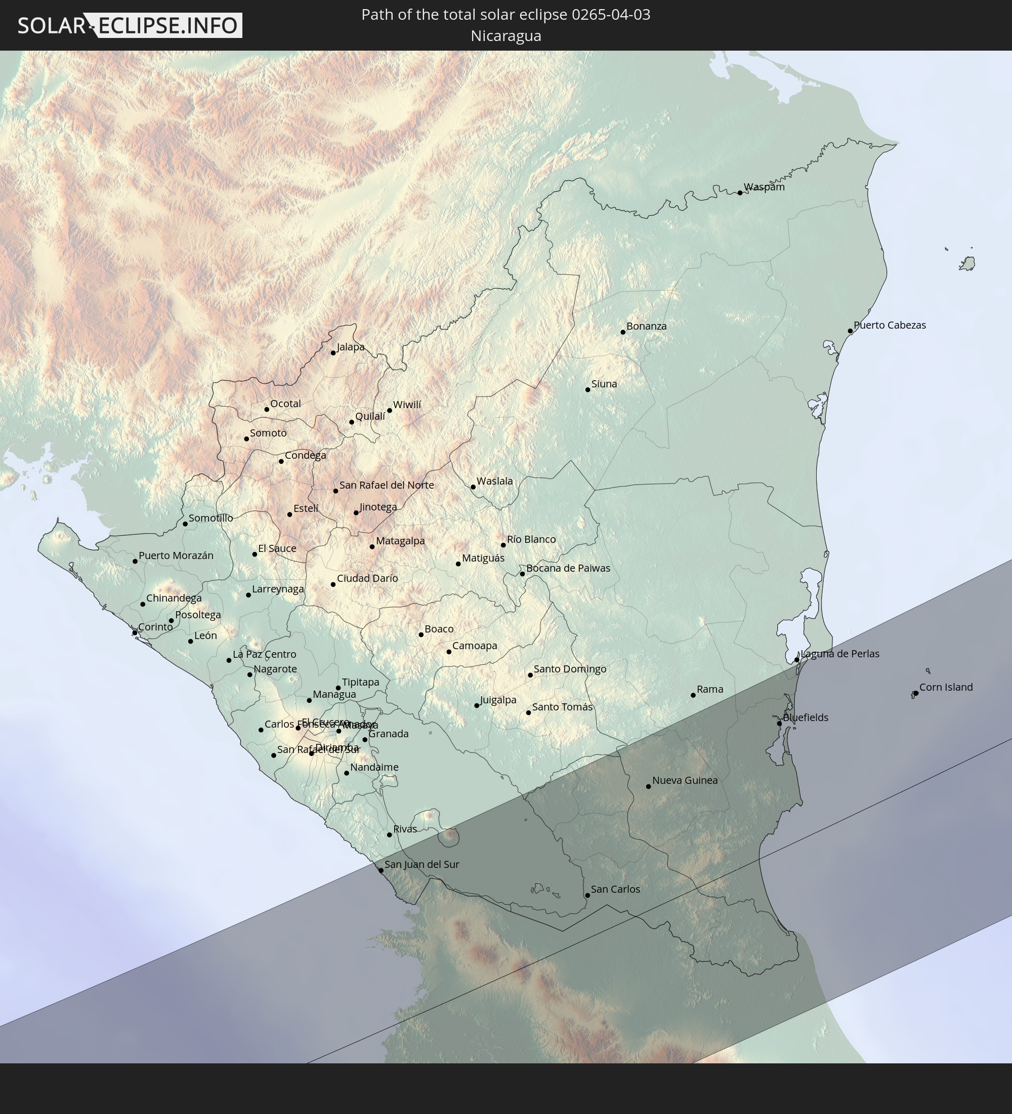 Nicaragua
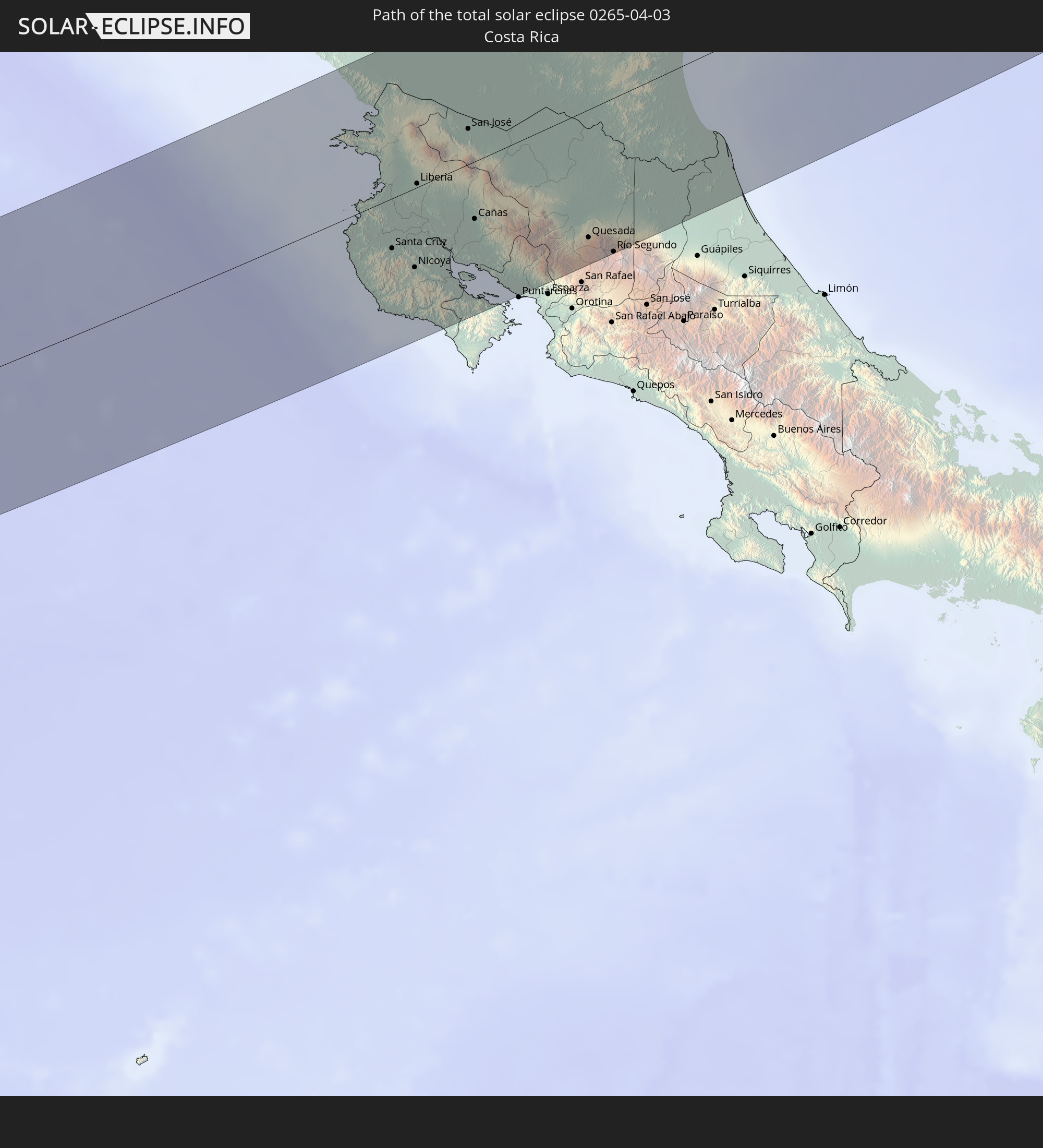 Costa Rica
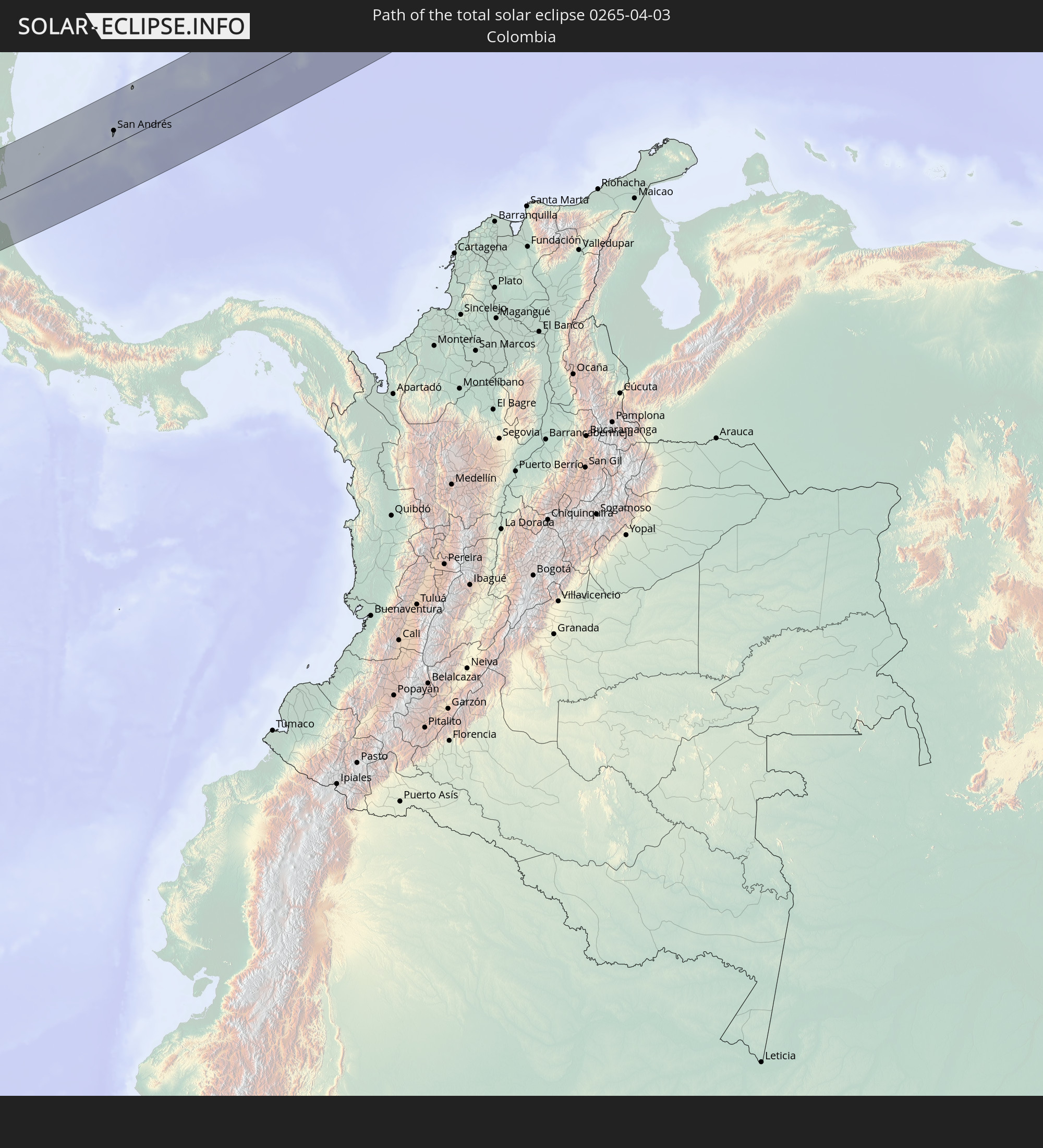 Colombia
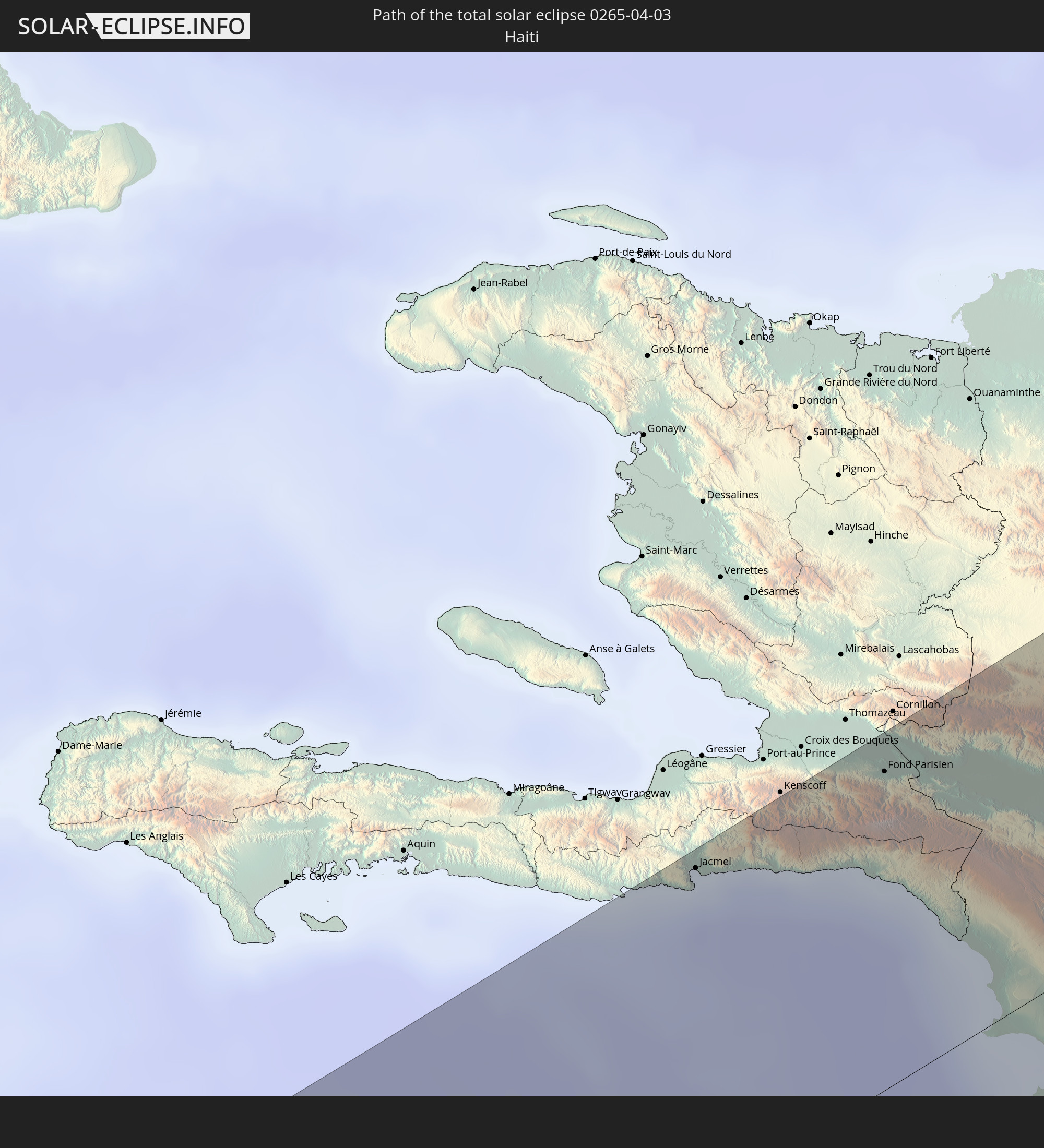 Haiti
Haiti
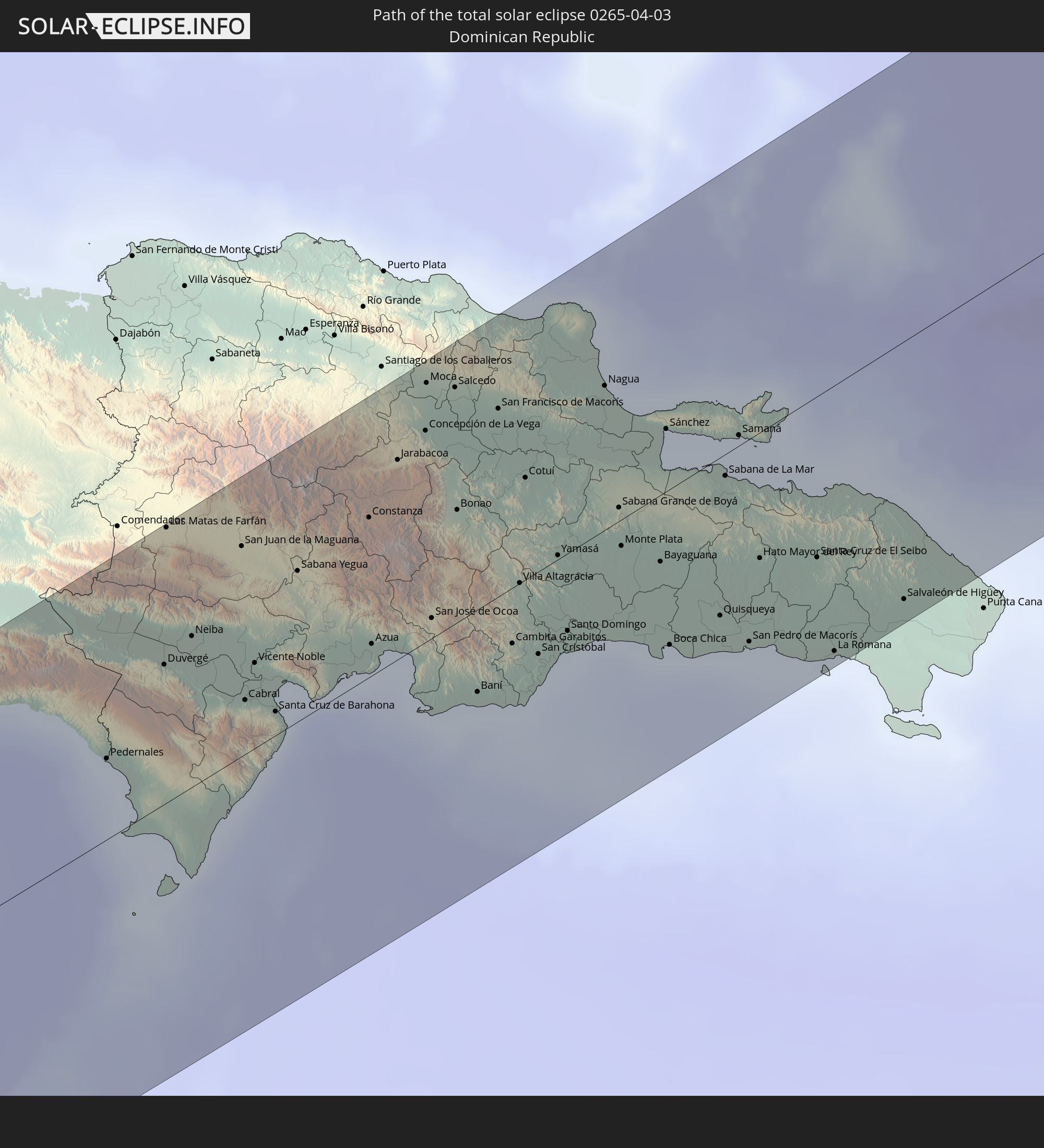 Dominican Republic
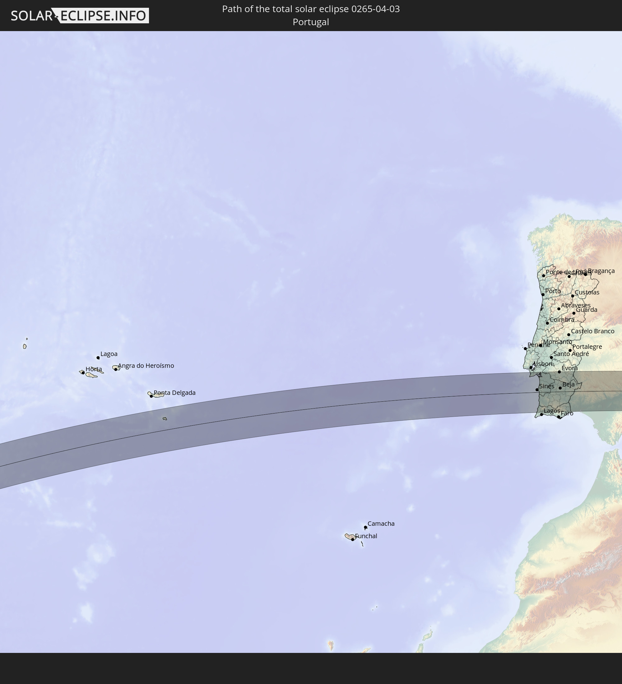 Portugal
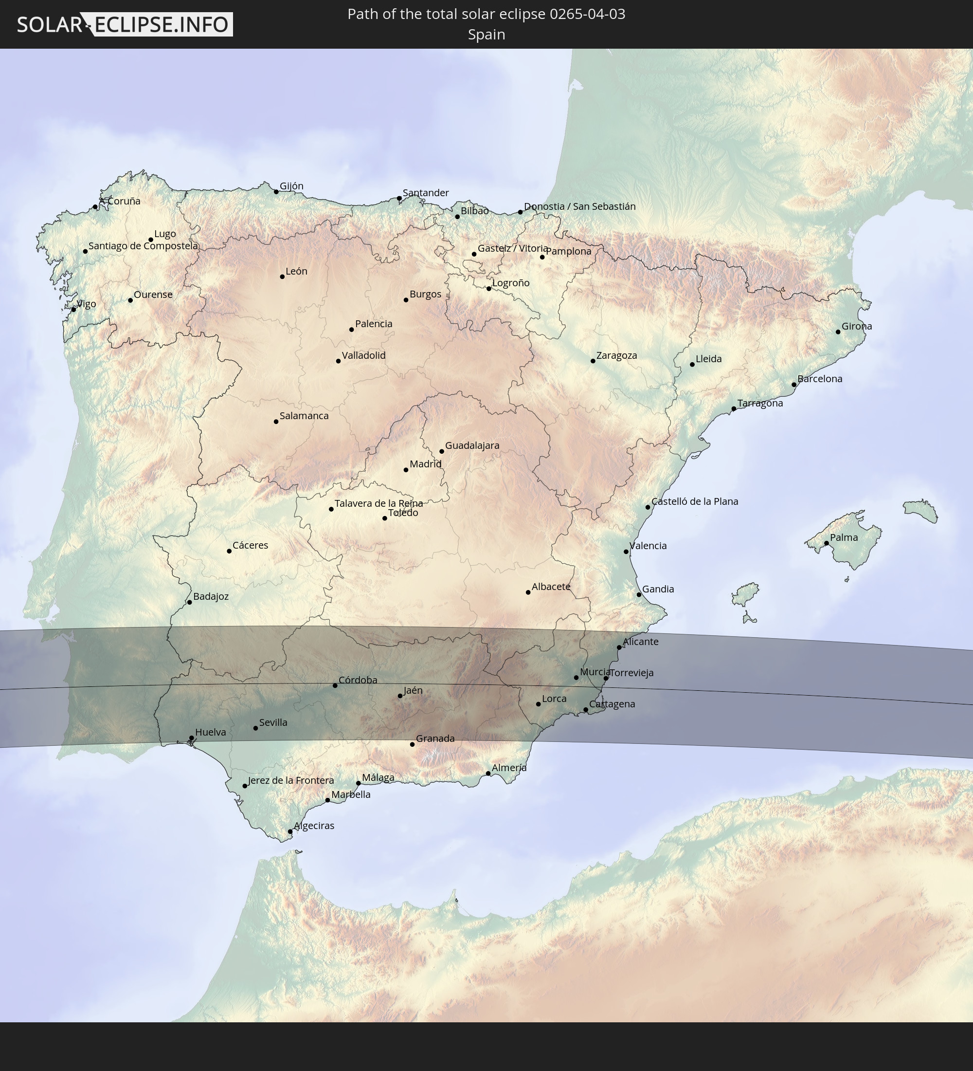 Spain
Spain
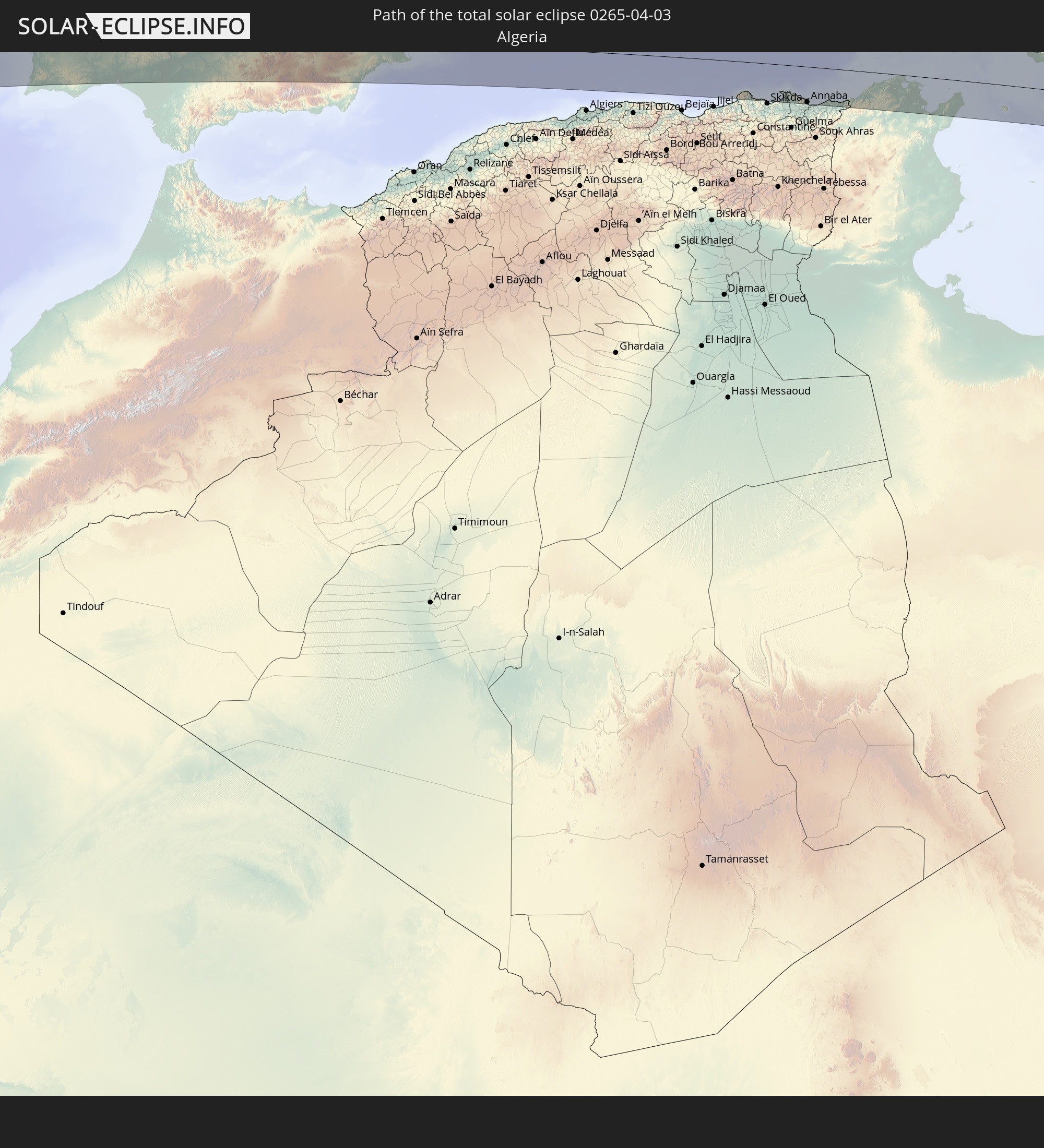 Algeria
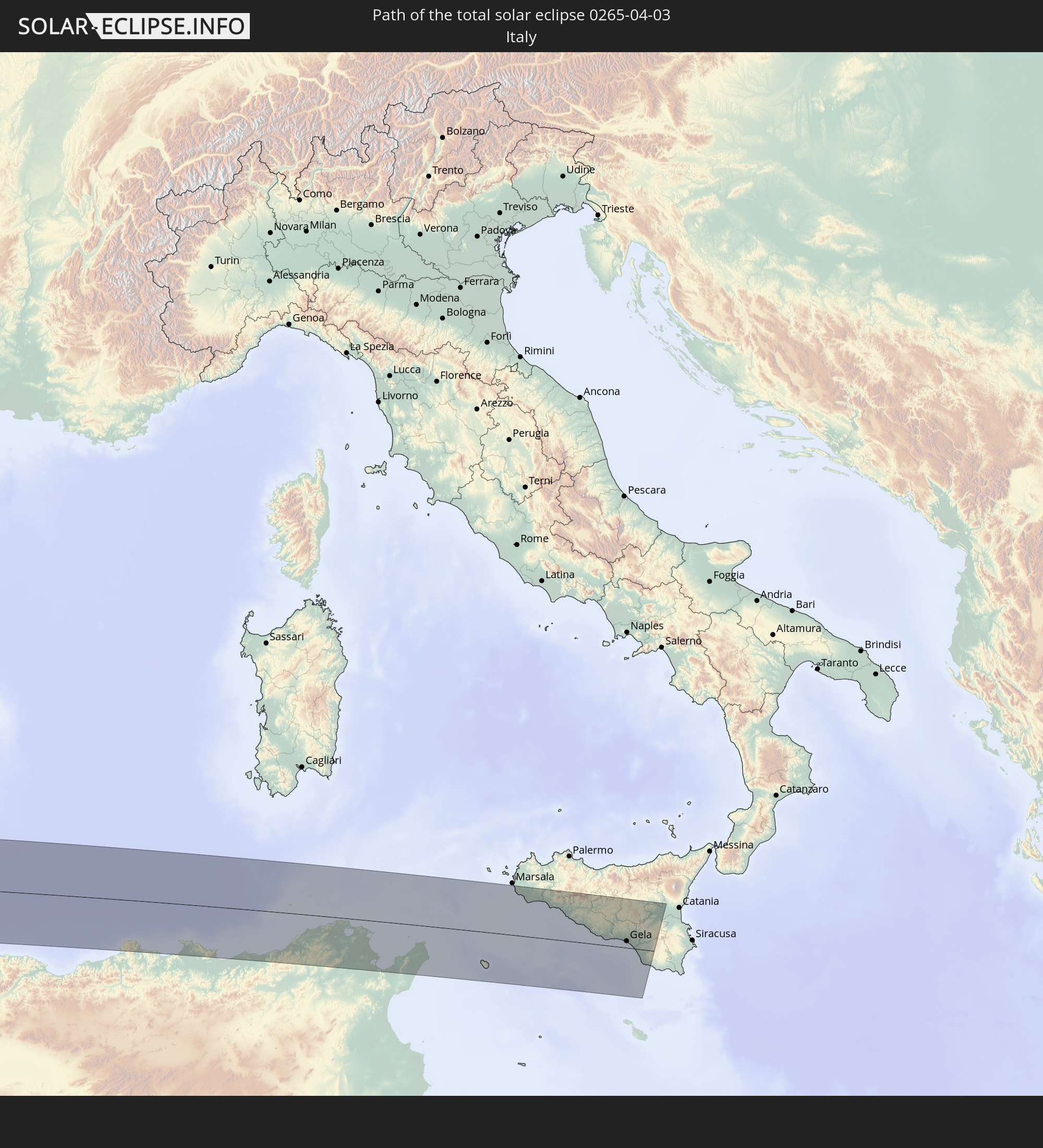 Italy
Italy
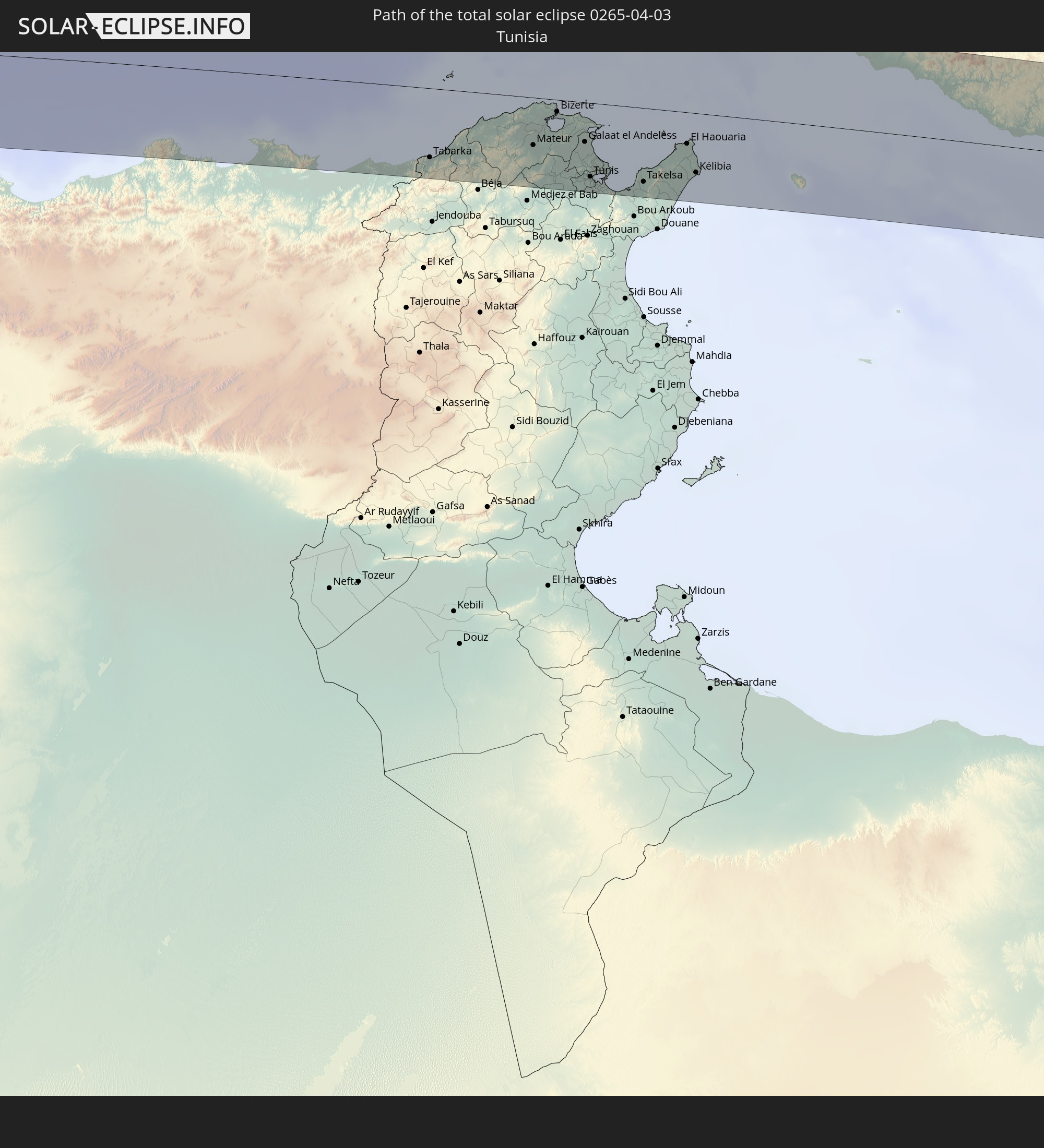 Tunisia
In den folgenden Ländern ist die Sonnenfinsternis partiell zu sehen
 Russia
 United States
 United States Minor Outlying Islands
 Canada
 Mexico
 Chile
Chile
 Greenland
 Guatemala
 Ecuador
 El Salvador
 Honduras
 Belize
 Nicaragua
 Costa Rica
 Cuba
Cuba
 Panama
 Colombia
 Cayman Islands
 Peru
Peru
 The Bahamas
 Jamaica
 Haiti
Haiti
 Brazil
 Venezuela
 Turks and Caicos Islands
 Dominican Republic
 Aruba
Aruba
 Bolivia
 Puerto Rico
 United States Virgin Islands
 Bermuda
 British Virgin Islands
 Anguilla
 Collectivity of Saint Martin
 Saint Barthélemy
 Saint Kitts and Nevis
 Antigua and Barbuda
 Montserrat
 Trinidad and Tobago
 Guadeloupe
 Grenada
 Dominica
 Saint Vincent and the Grenadines
 Guyana
 Martinique
 Saint Lucia
 Barbados
 Suriname
 Saint Pierre and Miquelon
 French Guiana
 Portugal
 Cabo Verde
 Iceland
 Spain
Spain
 Senegal
 Mauritania
 The Gambia
 Guinea-Bissau
 Guinea
 Sierra Leone
 Morocco
 Mali
Mali
 Liberia
 Republic of Ireland
 Svalbard and Jan Mayen
 Algeria
 United Kingdom
 Ivory Coast
 Faroe Islands
 Burkina Faso
 Gibraltar
 France
 Isle of Man
 Ghana
Ghana
 Guernsey
 Jersey
 Togo
Togo
 Niger
Niger
 Benin
Benin
 Andorra
 Belgium
 Nigeria
 Netherlands
 Norway
 Luxembourg
 Germany
 Switzerland
 Italy
Italy
 Monaco
 Tunisia
 Denmark
 Cameroon
 Libya
Libya
 Liechtenstein
 Austria
 Sweden
 Czechia
 San Marino
 Vatican City
 Slovenia
 Croatia
 Poland
 Malta
Malta
 Bosnia and Herzegovina
 Hungary
 Slovakia
 Åland Islands
 Finland
 Lithuania
 Latvia
 Estonia
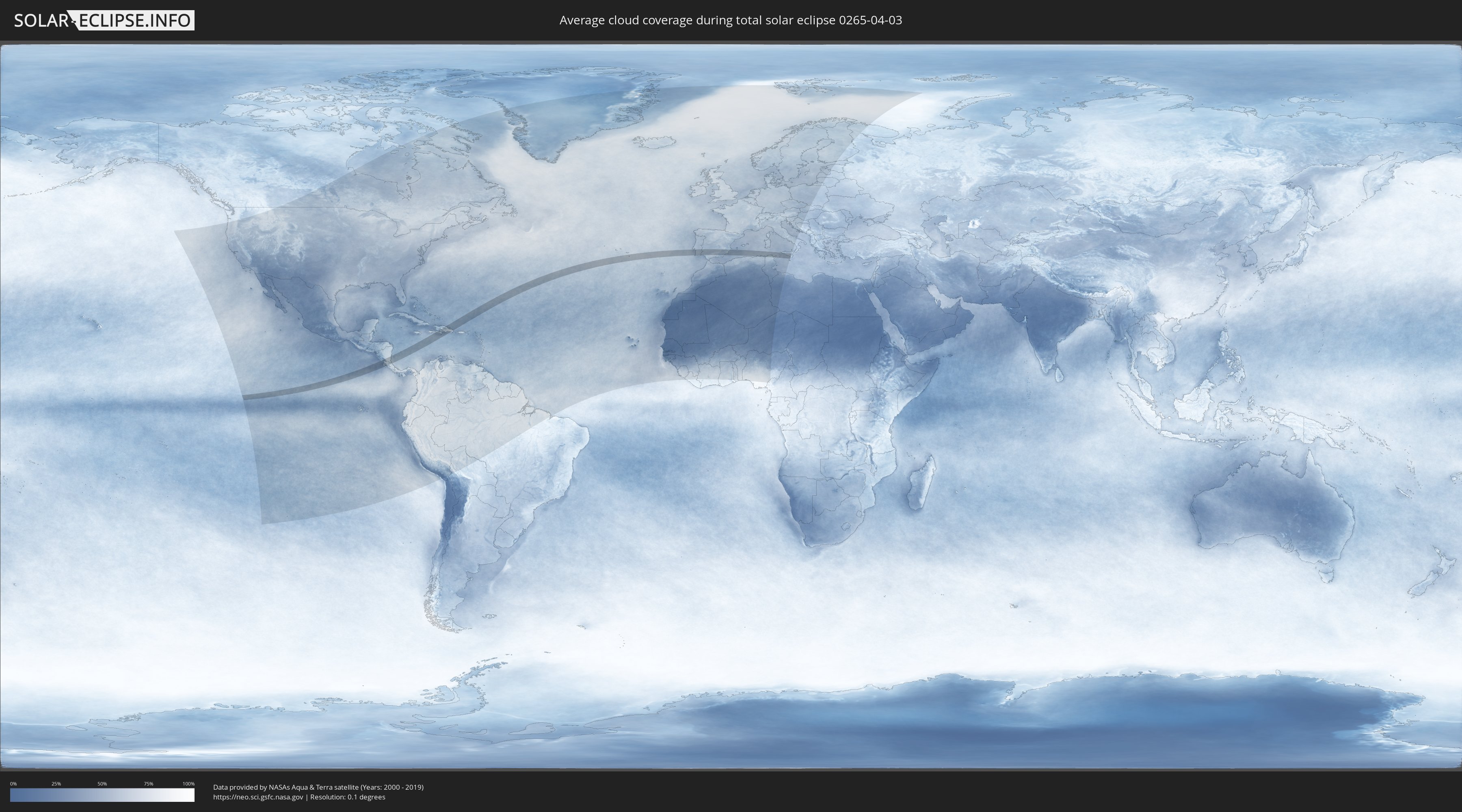
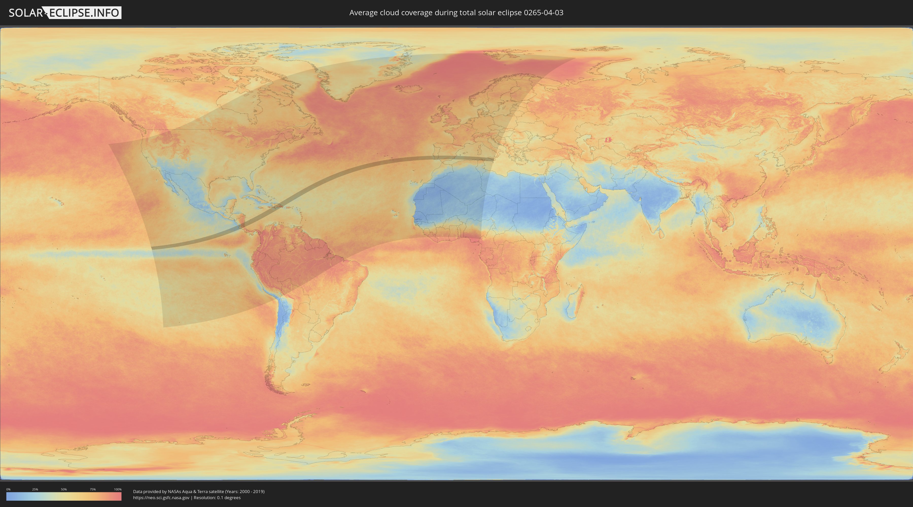
How will be the weather during the total solar eclipse on 04/03/0265?
Where is the best place to see the total solar eclipse of 04/03/0265?
The following maps show the average cloud coverage for the day of the total solar eclipse.
With the help of these maps, it is possible to find the place along the eclipse path, which has the best
chance of a cloudless sky.
Nevertheless, you should consider local circumstances and inform about the weather of your chosen
observation site.
The data is provided by NASAs satellites
AQUA and TERRA.
The cloud maps are averaged over a period of 19 years (2000 - 2019).
Detailed country maps
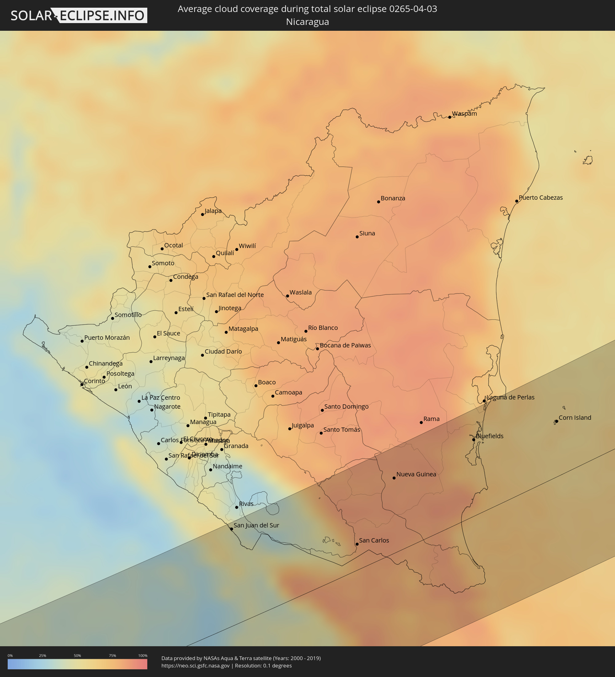 Nicaragua
 Costa Rica
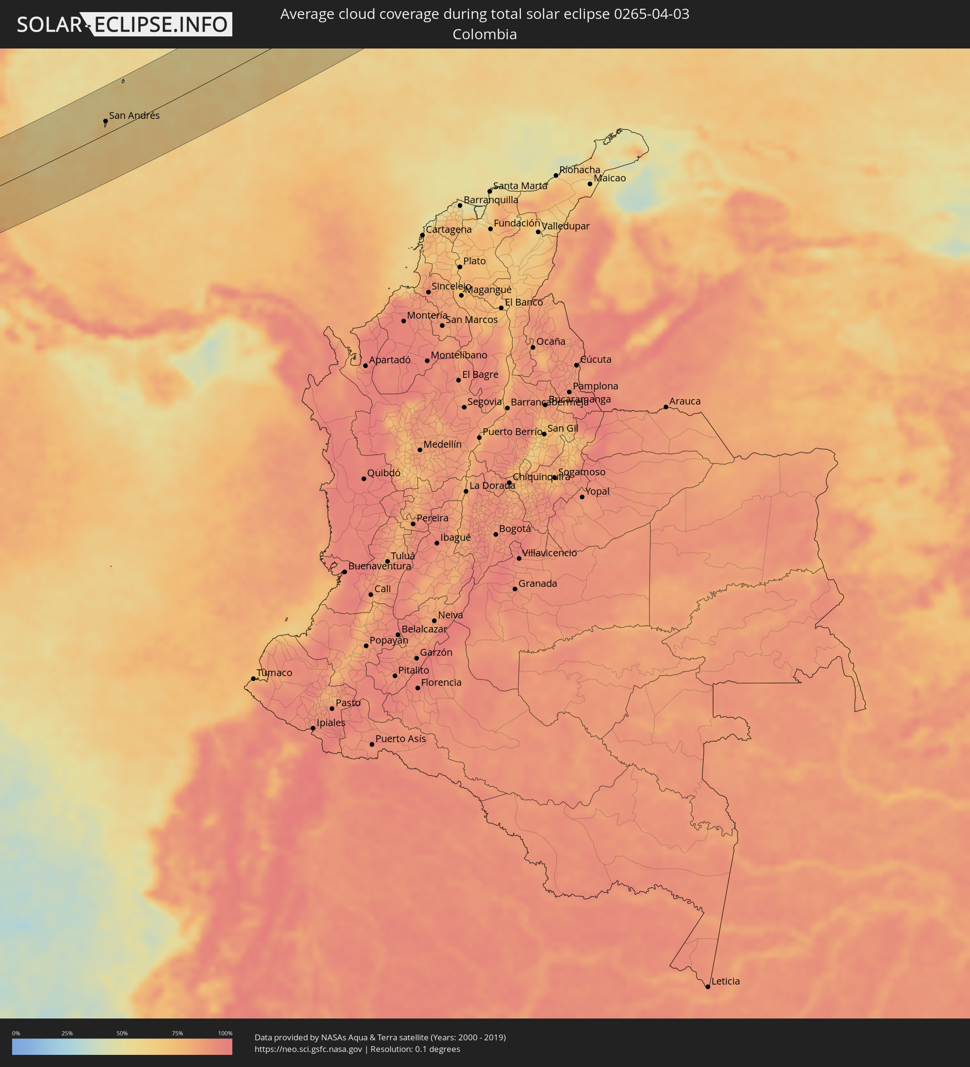 Colombia
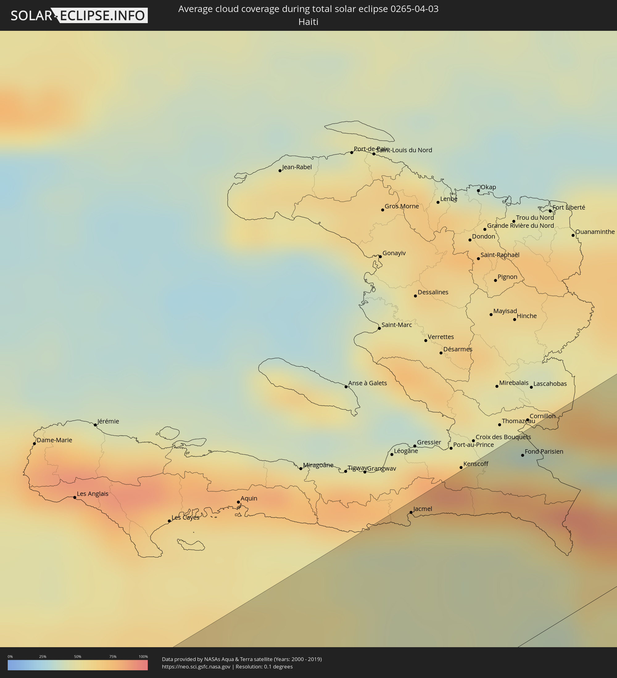 Haiti
Haiti
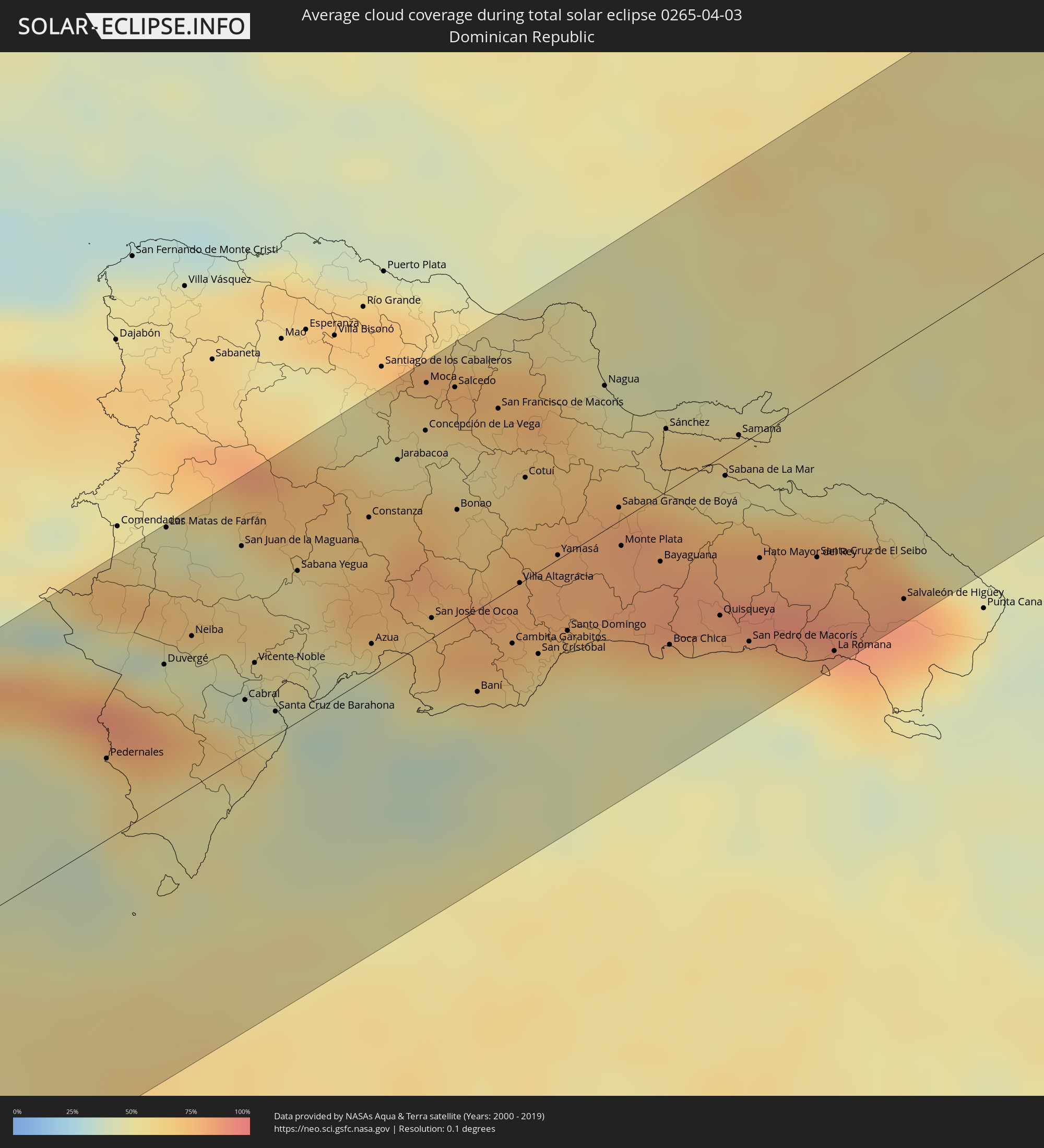 Dominican Republic
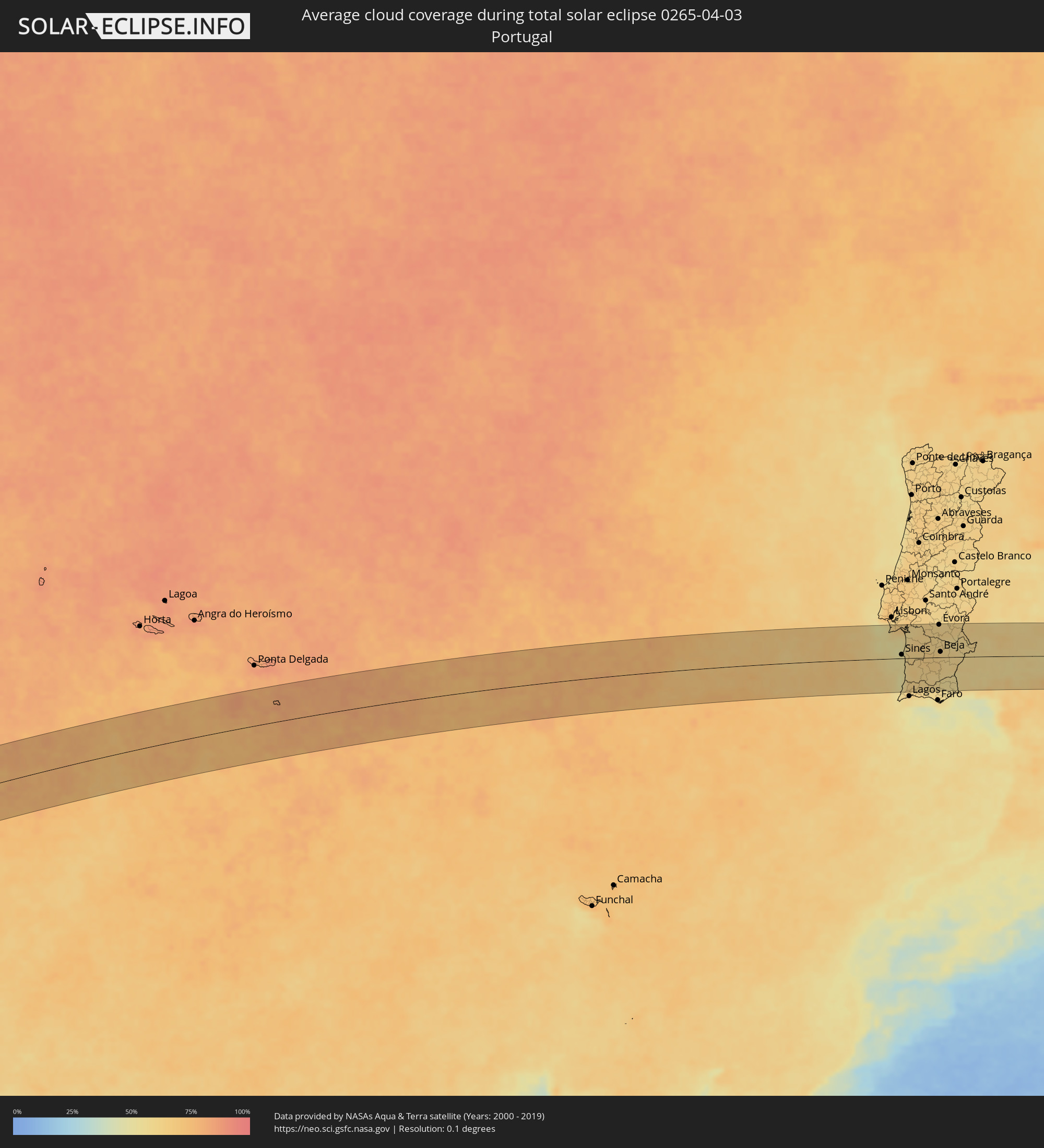 Portugal
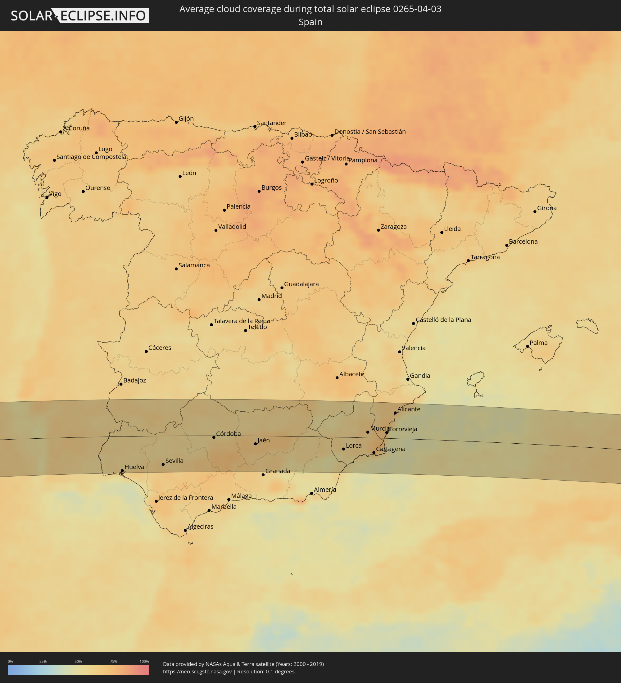 Spain
Spain
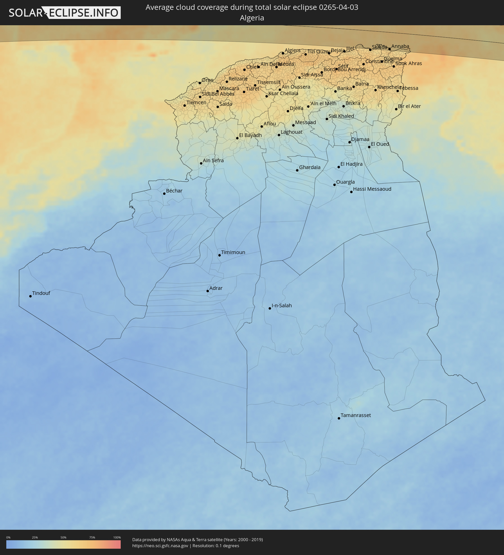 Algeria
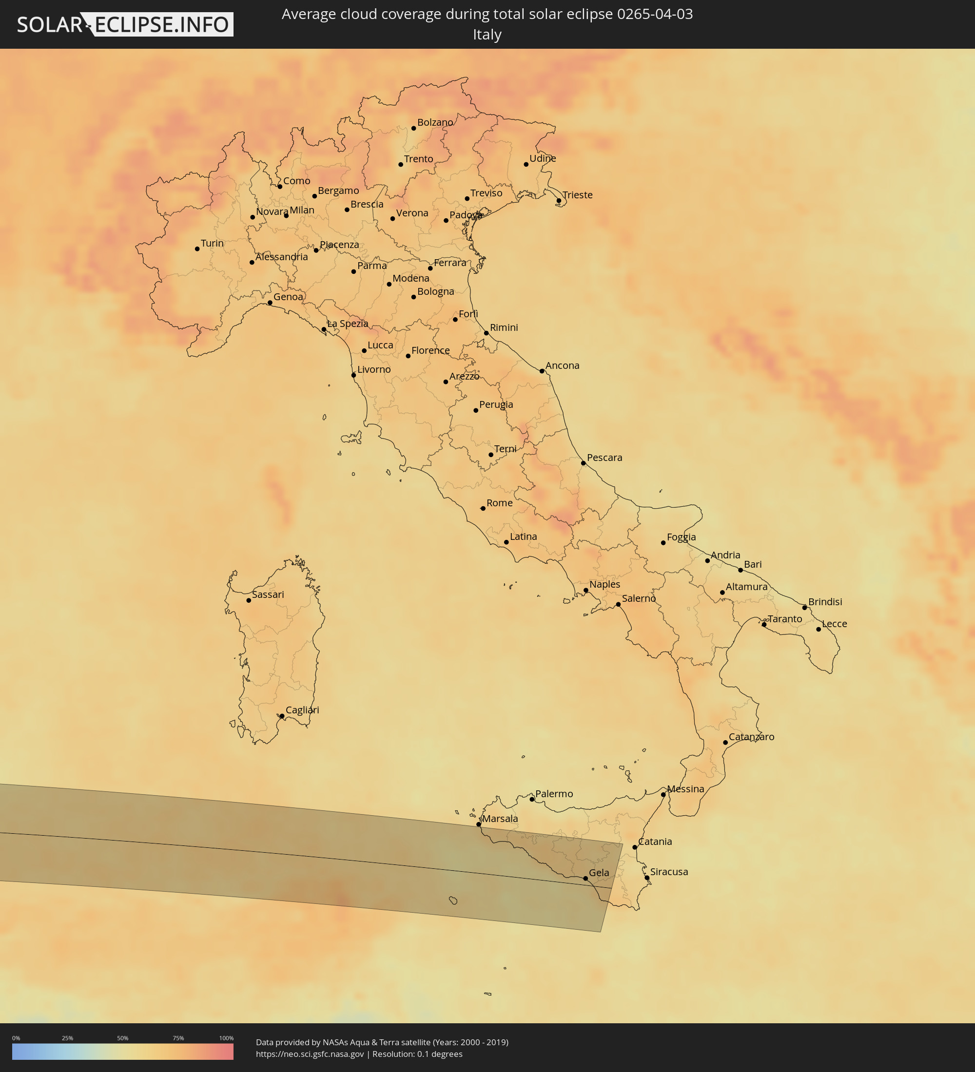 Italy
Italy
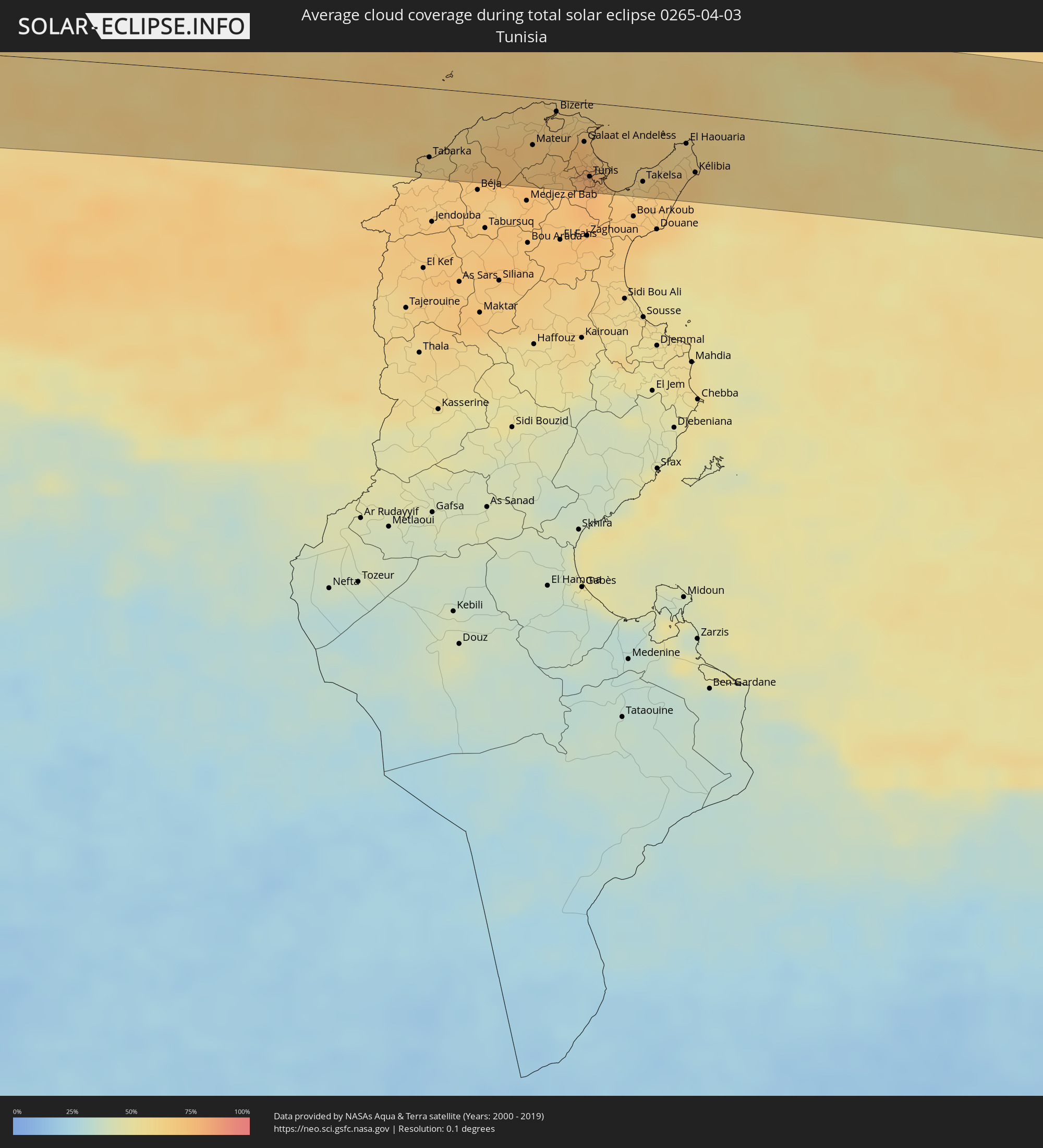 Tunisia
Cities inside the path of the eclipse
The following table shows all locations with a population of more than 5,000 inside the eclipse path. Cities which have more than 100,000 inhabitants are marked bold. A click at the locations opens a detailed map.
| City | Type | Eclipse duration | Local time of max. eclipse | Distance to central line | Ø Cloud coverage |
|
San Juan del Sur, Rivas
|
total | - | 08:47:58 UTC-05:45 | 84 km | 51% |
|
Santa Cruz, Guanacaste
|
total | - | 08:55:57 UTC-05:36 | 29 km | 43% |
|
Nicoya, Guanacaste
|
total | - | 08:55:59 UTC-05:36 | 47 km | 50% |
|
Liberia, Guanacaste
|
total | - | 08:56:41 UTC-05:36 | 2 km | 45% |
|
San José, Alajuela
|
total | - | 08:57:33 UTC-05:36 | 21 km | 79% |
|
Cañas, Guanacaste
|
total | - | 08:56:52 UTC-05:36 | 34 km | 45% |
|
Tilarán, Guanacaste
|
total | - | 08:57:06 UTC-05:36 | 36 km | 47% |
|
San Carlos, Río San Juan
|
total | - | 08:49:19 UTC-05:45 | 22 km | 76% |
|
Miramar, Puntarenas
|
total | - | 08:56:54 UTC-05:36 | 85 km | 52% |
|
Nueva Guinea, Atlántico Sur
|
total | - | 08:50:36 UTC-05:45 | 64 km | 85% |
|
Quesada, Alajuela
|
total | - | 08:57:40 UTC-05:36 | 75 km | 74% |
|
Río Segundo, Alajuela
|
total | - | 08:57:46 UTC-05:36 | 90 km | 66% |
|
Bluefields, Atlántico Sur
|
total | - | 08:52:06 UTC-05:45 | 65 km | 68% |
|
Corn Island, Atlántico Sur
|
total | - | 08:53:25 UTC-05:45 | 47 km | 56% |
|
San Andrés, Archipiélago de San Andrés, Providencia y Santa Catalina
|
total | - | 09:45:03 UTC-04:56 | 24 km | 63% |
|
Jacmel, Sud-Est
|
total | - | 10:18:09 UTC-04:49 | 90 km | 48% |
|
Fond Parisien, Ouest
|
total | - | 10:19:45 UTC-04:49 | 85 km | 57% |
|
San Juan de la Maguana, San Juan
|
total | - | 10:30:48 UTC-04:40 | 72 km | 51% |
|
Santa Cruz de Barahona, Barahona
|
total | - | 10:30:04 UTC-04:40 | 8 km | 48% |
|
Constanza, La Vega
|
total | - | 10:31:59 UTC-04:40 | 54 km | 68% |
|
Azua, Azua
|
total | - | 10:31:15 UTC-04:40 | 11 km | 57% |
|
Jarabacoa, La Vega
|
total | - | 10:32:34 UTC-04:40 | 68 km | 66% |
|
Concepción de La Vega, La Vega
|
total | - | 10:32:58 UTC-04:40 | 72 km | 55% |
|
Moca, Espaillat
|
total | - | 10:33:16 UTC-04:40 | 88 km | 60% |
|
Bonao, Monseñor Nouel
|
total | - | 10:32:45 UTC-04:40 | 38 km | 68% |
|
Baní, Peravia
|
total | - | 10:31:49 UTC-04:40 | 28 km | 54% |
|
San Francisco de Macorís, Duarte
|
total | - | 10:33:41 UTC-04:40 | 64 km | 59% |
|
Villa Altagracia, San Cristóbal
|
total | - | 10:32:49 UTC-04:40 | 0 km | 77% |
|
Cotuí, Sánchez Ramírez
|
total | - | 10:33:29 UTC-04:40 | 35 km | 72% |
|
Santo Domingo, Nacional
|
total | - | 10:32:55 UTC-04:40 | 26 km | 66% |
|
Nagua, María Trinidad Sánchez
|
total | - | 10:34:41 UTC-04:40 | 49 km | 51% |
|
Boca Chica, Santo Domingo
|
total | - | 10:33:39 UTC-04:40 | 53 km | 69% |
|
San Pedro de Macorís, San Pedro de Macorís
|
total | - | 10:34:20 UTC-04:40 | 69 km | 66% |
|
Hato Mayor del Rey, Hato Mayor
|
total | - | 10:34:55 UTC-04:40 | 43 km | 80% |
|
Santa Cruz de El Seibo, El Seíbo
|
total | - | 10:35:24 UTC-04:40 | 55 km | 82% |
|
La Romana, La Romana
|
total | - | 10:34:58 UTC-04:40 | 90 km | 67% |
|
Salvaleón de Higüey, La Altagracia
|
total | - | 10:35:52 UTC-04:40 | 87 km | 87% |
|
Sesimbra, Setúbal
|
total | - | 16:36:24 UTC-00:36 | 63 km | 56% |
|
Quinta do Anjo, Setúbal
|
total | - | 16:36:25 UTC-00:36 | 77 km | 65% |
|
Palmela, Setúbal
|
total | - | 16:36:27 UTC-00:36 | 77 km | 65% |
|
Setúbal, Setúbal
|
total | - | 16:36:29 UTC-00:36 | 72 km | 60% |
|
Sines, Setúbal
|
total | - | 16:36:51 UTC-00:36 | 8 km | 52% |
|
Santo André, Setúbal
|
total | - | 16:36:52 UTC-00:36 | 19 km | 53% |
|
Santiago do Cacém, Setúbal
|
total | - | 16:36:55 UTC-00:36 | 15 km | 60% |
|
Odemira, Beja
|
total | - | 16:37:13 UTC-00:36 | 32 km | 60% |
|
Grândola, Setúbal
|
total | - | 16:36:54 UTC-00:36 | 32 km | 62% |
|
Monchique, Faro
|
total | - | 16:37:26 UTC-00:36 | 63 km | 62% |
|
Alcácer do Sal, Setúbal
|
total | - | 16:36:48 UTC-00:36 | 54 km | 62% |
|
São Bartolomeu de Messines, Faro
|
total | - | 16:37:38 UTC-00:36 | 70 km | 60% |
|
Aljustrel, Beja
|
total | - | 16:37:19 UTC-00:36 | 2 km | 64% |
|
Évora, Évora
|
total | - | 16:37:02 UTC-00:36 | 74 km | 61% |
|
Beja, Beja
|
total | - | 16:37:25 UTC-00:36 | 13 km | 63% |
|
Serpa, Beja
|
total | - | 16:37:37 UTC-00:36 | 4 km | 59% |
|
Reguengos de Monsaraz, Évora
|
total | - | 16:37:20 UTC-00:36 | 58 km | 58% |
|
Moura, Beja
|
total | - | 16:37:34 UTC-00:36 | 26 km | 60% |
|
Huelva, Andalusia
|
total | - | 17:15:10 UTC+00:00 | 72 km | 59% |
|
Sevilla, Andalusia
|
total | - | 17:15:37 UTC+00:00 | 60 km | 64% |
|
Écija, Andalusia
|
total | - | 17:15:58 UTC+00:00 | 43 km | 67% |
|
Córdoba, Andalusia
|
total | - | 17:15:53 UTC+00:00 | 4 km | 62% |
|
Lucena, Andalusia
|
total | - | 17:16:20 UTC+00:00 | 58 km | 71% |
|
Andújar, Andalusia
|
total | - | 17:16:08 UTC+00:00 | 13 km | 65% |
|
Jaén, Andalusia
|
total | - | 17:16:25 UTC+00:00 | 17 km | 67% |
|
Linares, Andalusia
|
total | - | 17:16:17 UTC+00:00 | 19 km | 66% |
|
Úbeda, Andalusia
|
total | - | 17:16:27 UTC+00:00 | 10 km | 68% |
|
Campiña, Andalusia
|
total | - | 17:16:29 UTC+00:00 | 33 km | 63% |
|
Lorca, Murcia
|
total | - | 17:17:22 UTC+00:00 | 25 km | 56% |
|
Cieza, Murcia
|
total | - | 17:17:05 UTC+00:00 | 38 km | 59% |
|
Mazarrón, Murcia
|
total | - | 17:17:33 UTC+00:00 | 33 km | 56% |
|
Murcia, Murcia
|
total | - | 17:17:22 UTC+00:00 | 11 km | 62% |
|
Cartagena, Murcia
|
total | - | 17:17:41 UTC+00:00 | 31 km | 53% |
|
Orihuela, Valencia
|
total | - | 17:17:22 UTC+00:00 | 22 km | 69% |
|
Elda, Valencia
|
total | - | 17:17:09 UTC+00:00 | 66 km | 65% |
|
Elche, Valencia
|
total | - | 17:17:20 UTC+00:00 | 43 km | 69% |
|
Torrevieja, Valencia
|
total | - | 17:17:32 UTC+00:00 | 11 km | 61% |
|
Alicante, Valencia
|
total | - | 17:17:21 UTC+00:00 | 52 km | 57% |
|
Annaba, Annaba
|
total | - | 17:29:34 UTC+00:09 | 67 km | 64% |
|
El Kala, El Tarf
|
total | - | 17:29:39 UTC+00:09 | 62 km | 57% |
|
Tabarka, Jundūbah
|
total | - | 17:29:38 UTC+00:09 | 54 km | 61% |
|
Mateur, Banzart
|
total | - | 17:29:38 UTC+00:09 | 37 km | 69% |
|
Douar Tindja, Banzart
|
total | - | 17:29:34 UTC+00:09 | 22 km | 64% |
|
Menzel Bourguiba, Banzart
|
total | - | 17:29:34 UTC+00:09 | 23 km | 64% |
|
Menzel Abderhaman, Banzart
|
total | - | 17:29:31 UTC+00:09 | 13 km | 65% |
|
Bizerte, Banzart
|
total | - | 17:29:30 UTC+00:09 | 9 km | 65% |
|
Menzel Jemil, Banzart
|
total | - | 17:29:31 UTC+00:09 | 13 km | 65% |
|
El Alia, Banzart
|
total | - | 17:29:34 UTC+00:09 | 19 km | 68% |
|
Manouba, Manouba
|
total | - | 17:29:49 UTC+00:09 | 59 km | 77% |
|
Galaat el Andeless, Ariana
|
total | - | 17:29:39 UTC+00:09 | 31 km | 74% |
|
Tunis, Tūnis
|
total | - | 17:29:49 UTC+00:09 | 57 km | 77% |
|
Rafrāf, Banzart
|
total | - | 17:29:34 UTC+00:09 | 16 km | 65% |
|
Radès, Tūnis
|
total | - | 17:29:51 UTC+00:09 | 62 km | 72% |
|
Al Marsá, Tūnis
|
total | - | 17:29:47 UTC+00:09 | 49 km | 72% |
|
Carthage, Tūnis
|
total | - | 17:29:48 UTC+00:09 | 51 km | 72% |
|
Hammam-Lif, Tūnis
|
total | - | 17:29:53 UTC+00:09 | 66 km | 73% |
|
Mennzel Bou Zelfa, Nābul
|
total | - | 17:29:56 UTC+00:09 | 69 km | 68% |
|
Takelsa, Nābul
|
total | - | 17:29:52 UTC+00:09 | 57 km | 63% |
|
El Haouaria, Nābul
|
total | - | 17:29:42 UTC+00:09 | 24 km | 60% |
|
Kélibia, Nābul
|
total | - | 17:29:50 UTC+00:09 | 46 km | 66% |
|
Mazara del Vallo, Sicily
|
total | - | 18:19:57 UTC+01:00 | 57 km | 63% |
|
Castelvetrano, Sicily
|
total | - | 18:19:55 UTC+01:00 | 62 km | 61% |
|
Sciacca, Sicily
|
total | - | 18:20:02 UTC+01:00 | 45 km | 55% |
|
Ribera, Sicily
|
total | - | 18:20:02 UTC+01:00 | 46 km | 57% |
|
Agrigento, Sicily
|
total | - | 18:20:09 UTC+01:00 | 29 km | 56% |
|
Aragona, Sicily
|
total | - | 18:20:06 UTC+01:00 | 39 km | 64% |
|
Mussomeli, Sicily
|
total | - | 18:19:58 UTC+01:00 | 60 km | 63% |
|
Palma di Montechiaro, Sicily
|
total | - | 18:20:14 UTC+01:00 | 17 km | 59% |
|
Naro, Sicily
|
total | - | 18:20:10 UTC+01:00 | 29 km | 65% |
|
Canicattì, Sicily
|
total | - | 18:20:07 UTC+01:00 | 37 km | 64% |
|
Licata, Sicily
|
total | - | 18:20:17 UTC+01:00 | 9 km | 55% |
|
Caltanissetta, Sicily
|
total | - | 18:20:01 UTC+01:00 | 53 km | 65% |
|
Mazzarino, Sicily
|
total | - | 18:20:08 UTC+01:00 | 34 km | 64% |
|
Gela, Sicily
|
total | - | 18:20:17 UTC+01:00 | 9 km | 57% |
|
Enna, Sicily
|
total | - | 18:19:57 UTC+01:00 | 64 km | 62% |
|
Piazza Armerina, Sicily
|
total | - | 18:20:04 UTC+01:00 | 45 km | 60% |
|
Acate, Sicily
|
total | - | 18:20:18 UTC+01:00 | 6 km | 64% |
|
Caltagirone, Sicily
|
total | - | 18:20:10 UTC+01:00 | 30 km | 63% |
|
Vittoria, Sicily
|
total | - | 18:20:21 UTC+01:00 | 1 km | 64% |
|
Palagonia, Sicily
|
total | - | 18:20:05 UTC+01:00 | 43 km | 62% |