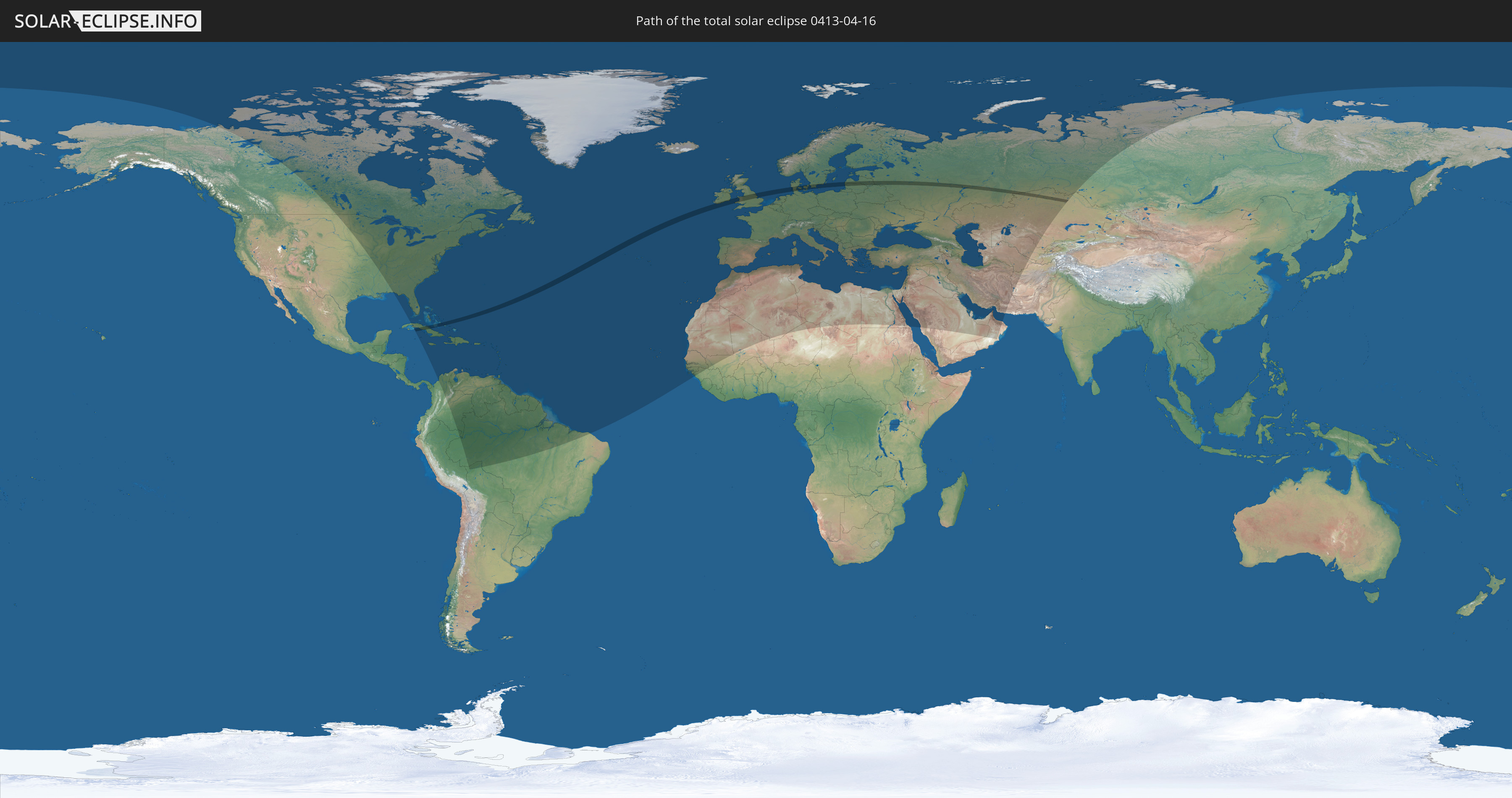
Total solar eclipse of 04/16/0413
| Day of week: | Tuesday |
| Maximum duration of eclipse: | 02m20s |
| Maximum width of eclipse path: | 124 km |
| Saros cycle: | 74 |
| Coverage: | 100% |
| Magnitude: | 1.0291 |
| Gamma: | 0.6075 |
Wo kann man die Sonnenfinsternis vom 04/16/0413 sehen?
Die Sonnenfinsternis am 04/16/0413 kann man in 128 Ländern als partielle Sonnenfinsternis beobachten.
Der Finsternispfad verläuft durch 12 Länder. Nur in diesen Ländern ist sie als total Sonnenfinsternis zu sehen.
In den folgenden Ländern ist die Sonnenfinsternis total zu sehen
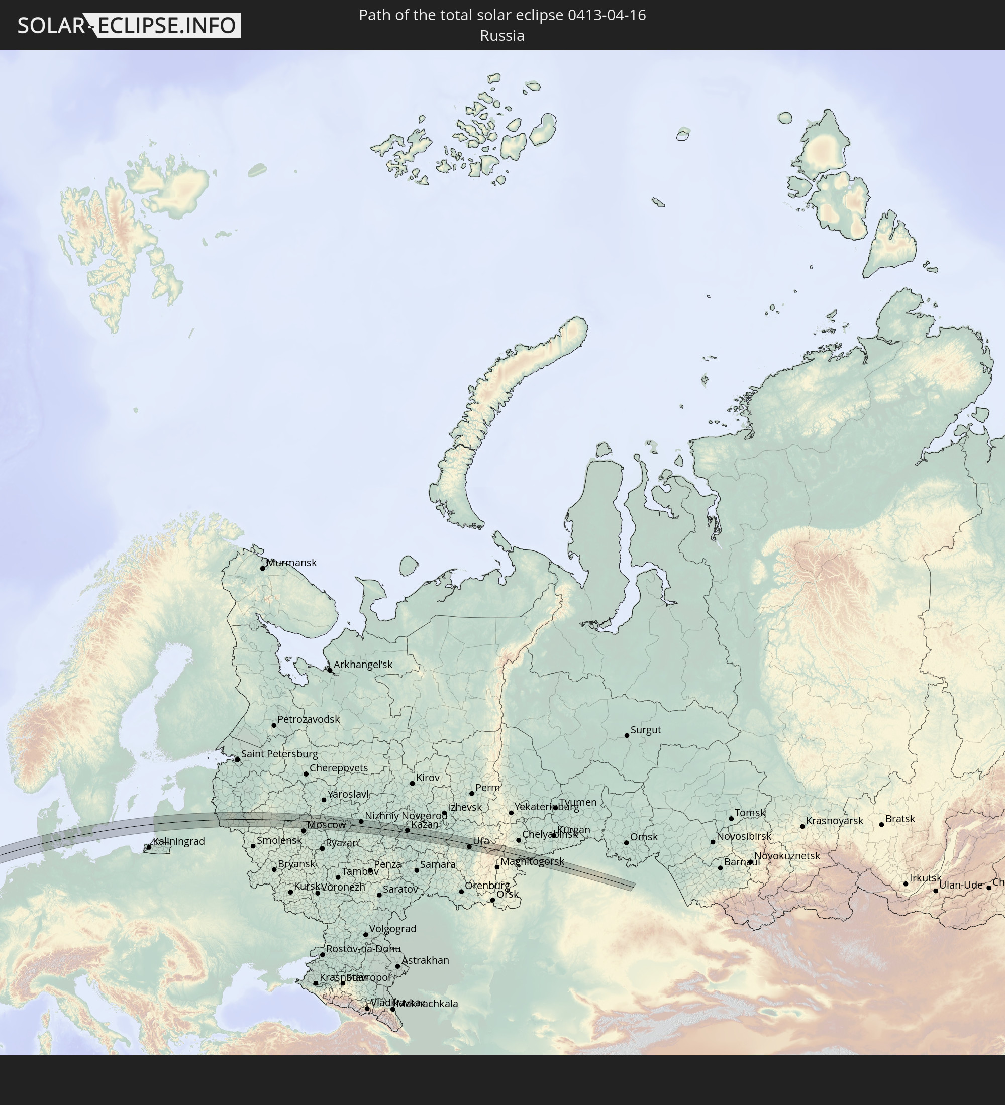 Russia
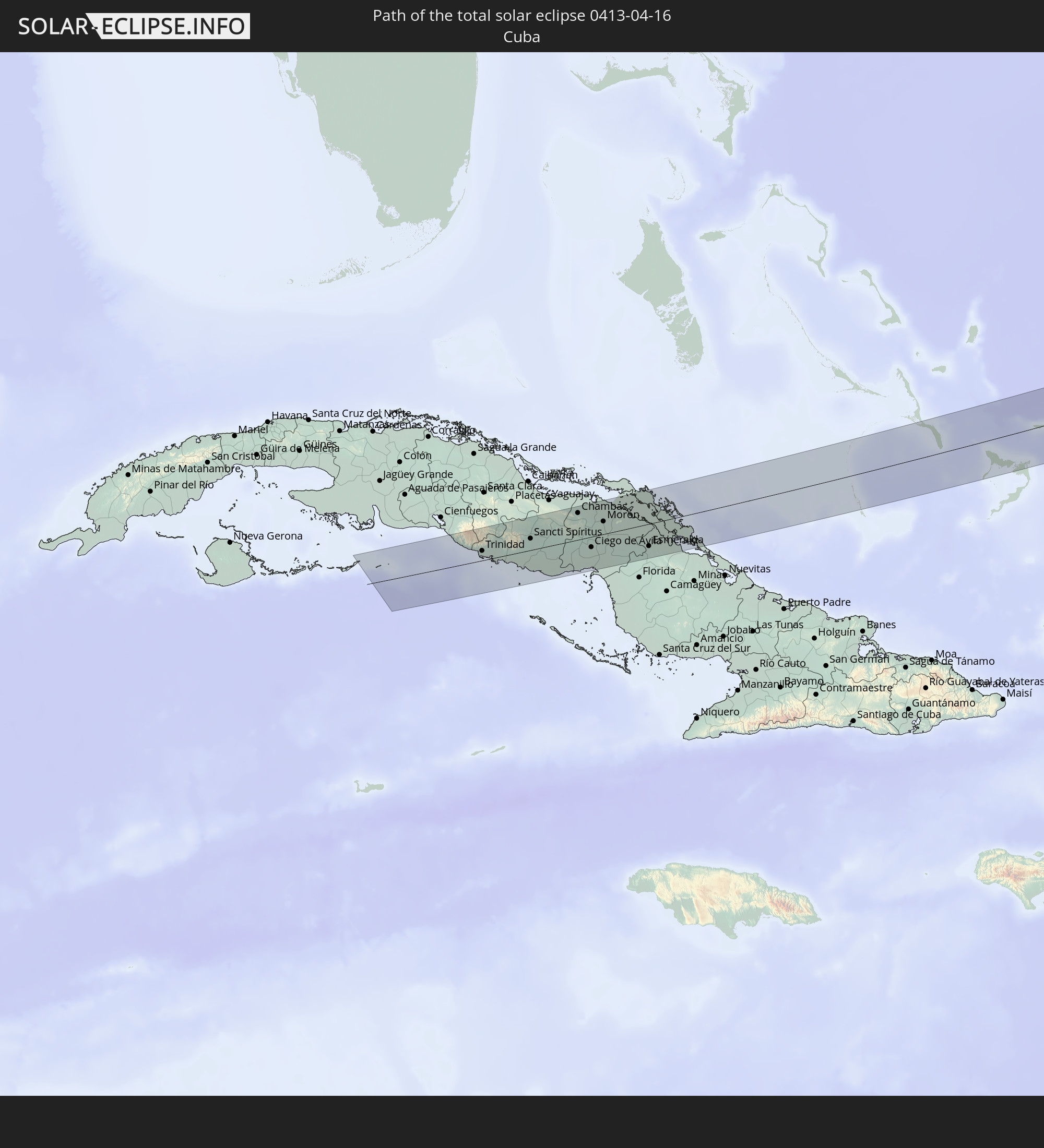 Cuba
Cuba
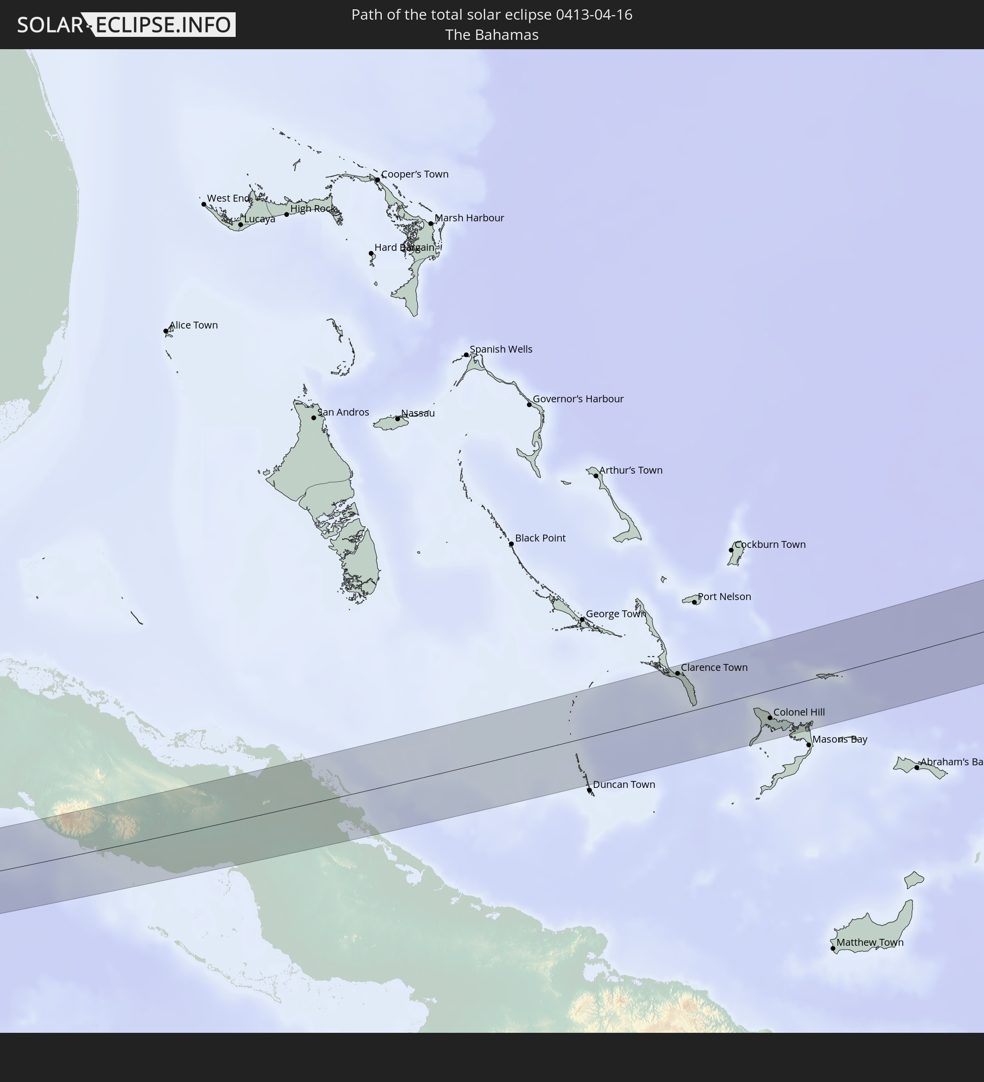 The Bahamas
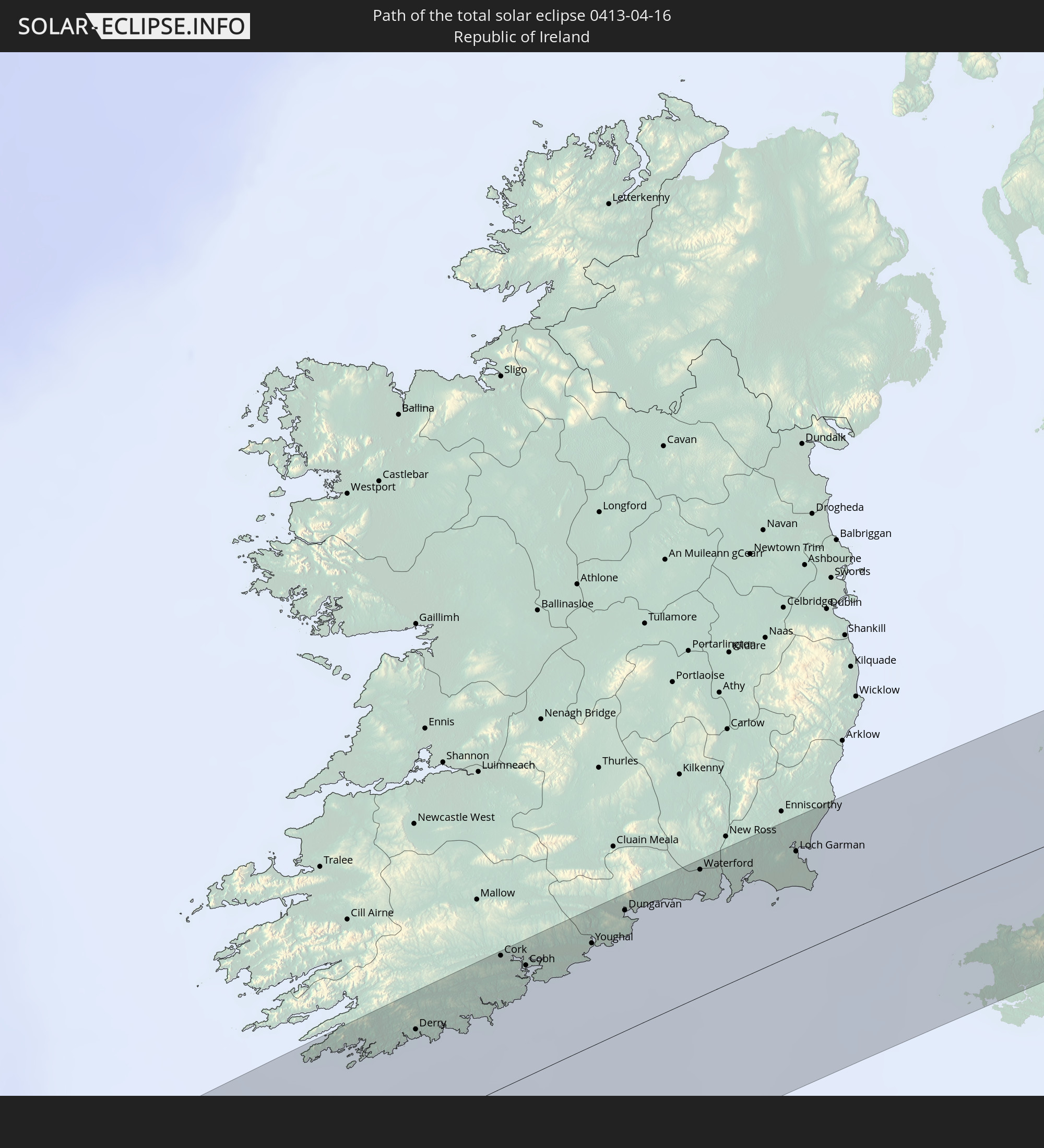 Republic of Ireland
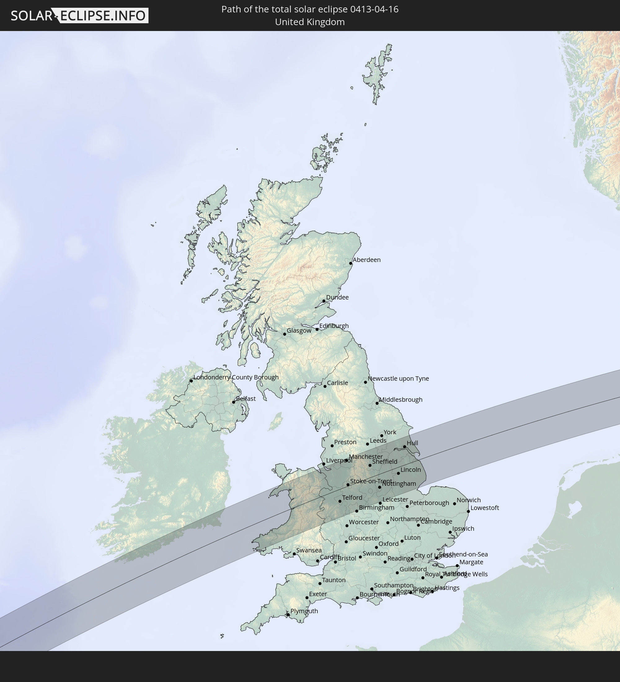 United Kingdom
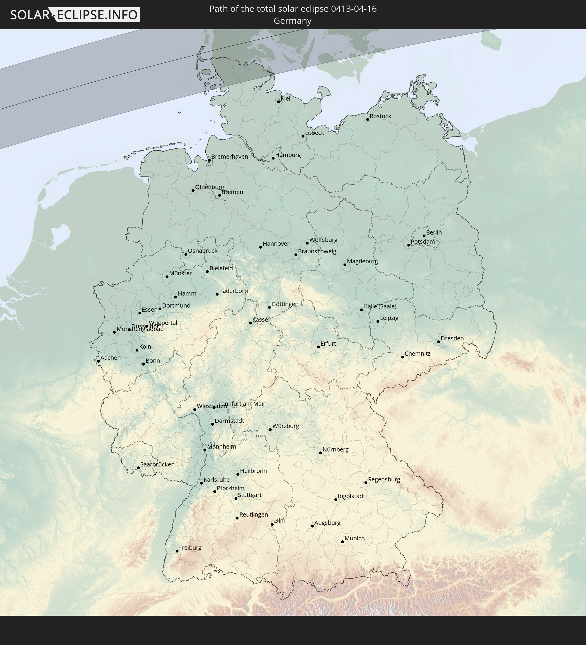 Germany
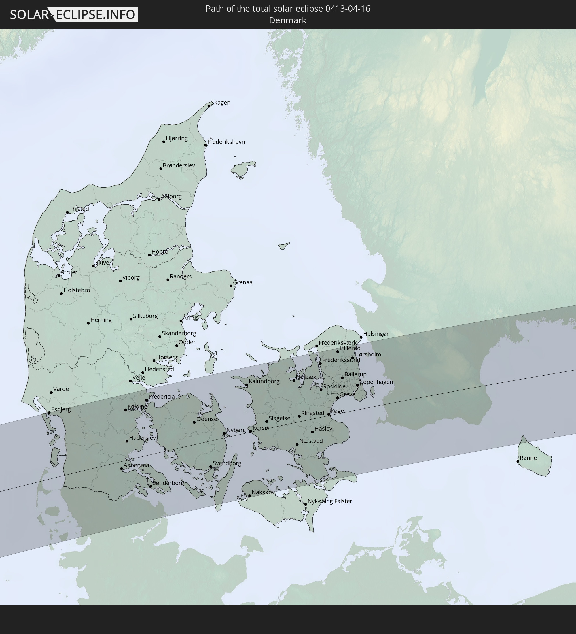 Denmark
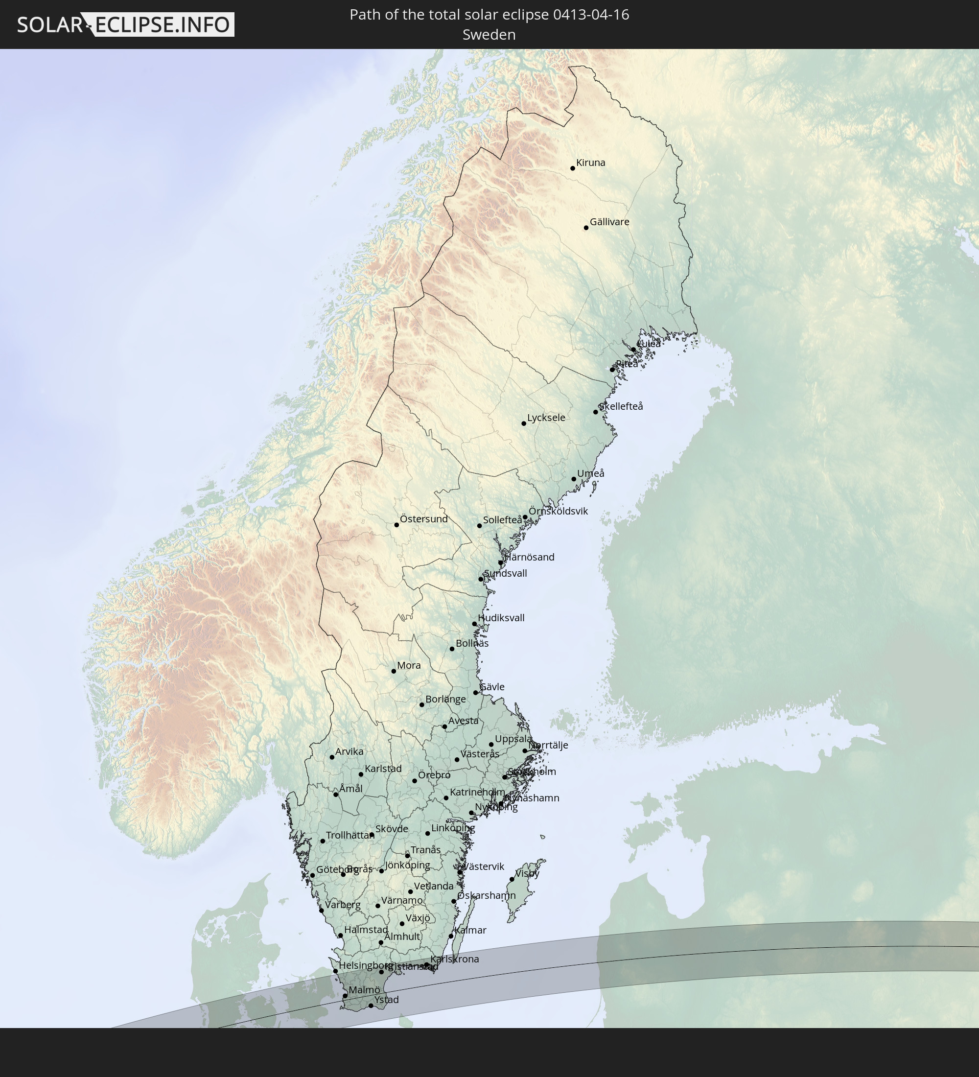 Sweden
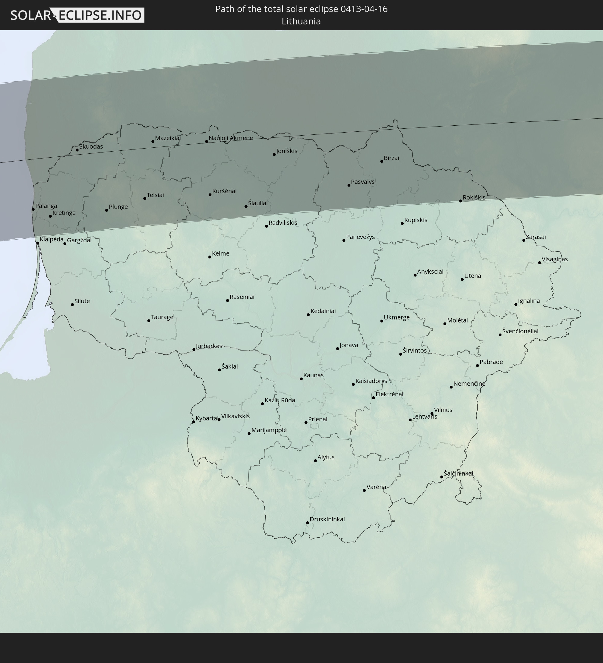 Lithuania
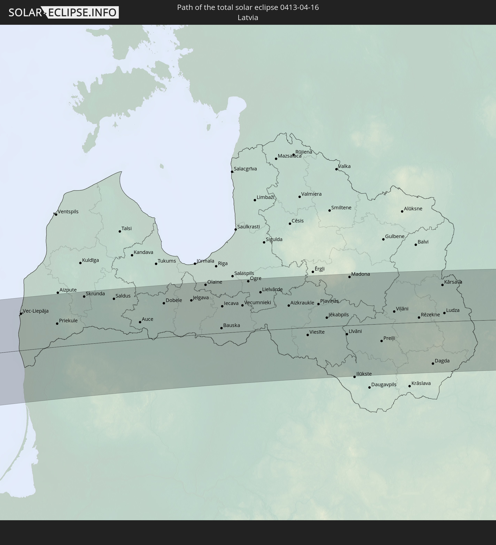 Latvia
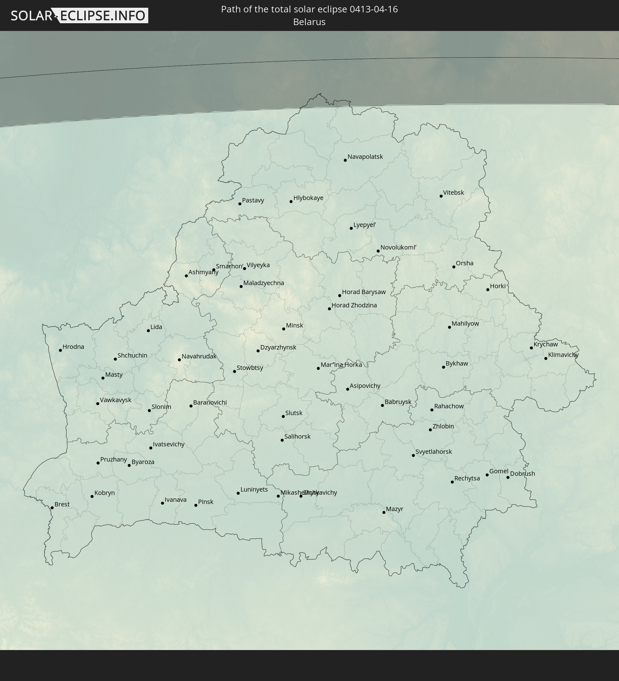 Belarus
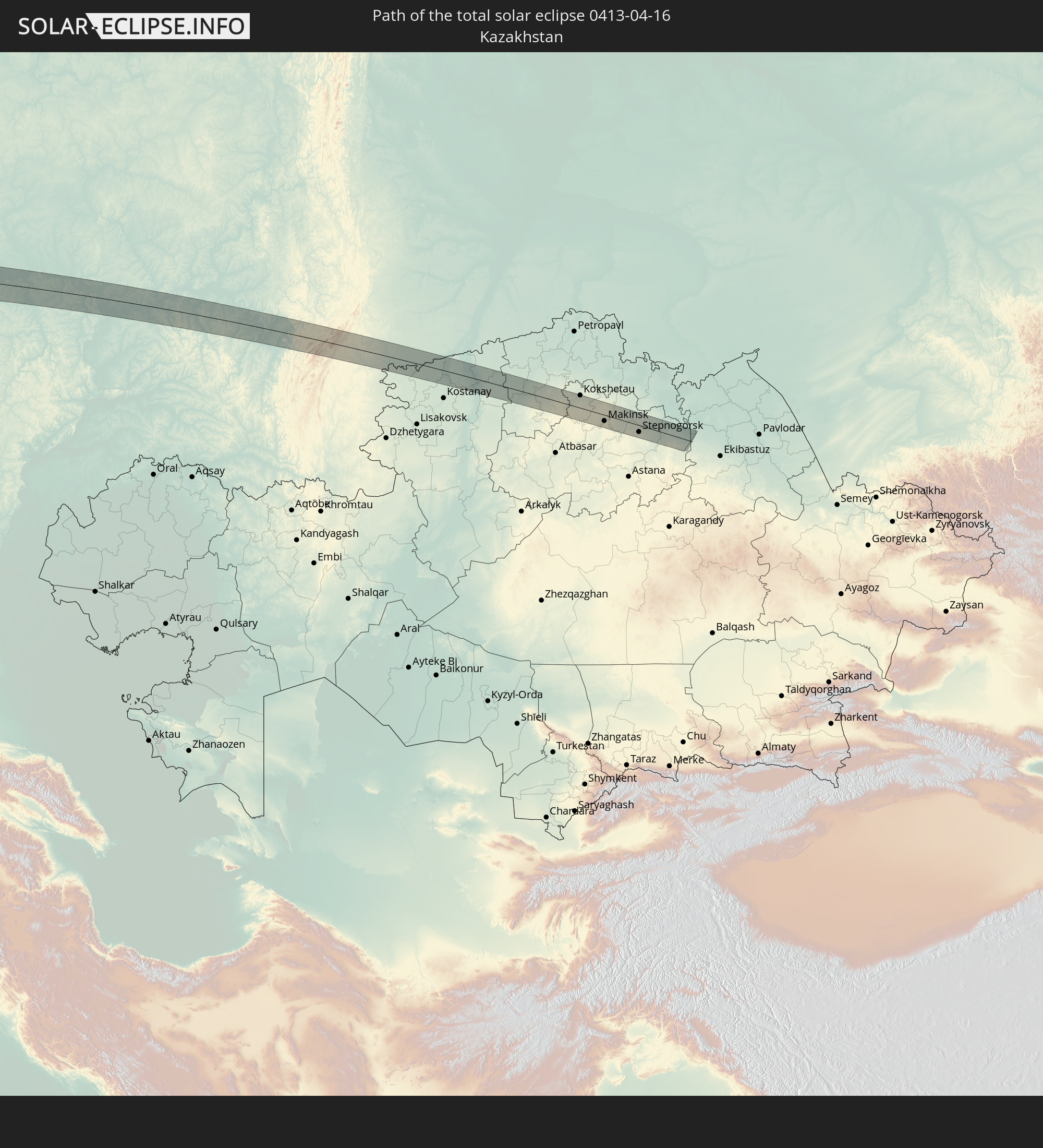 Kazakhstan
In den folgenden Ländern ist die Sonnenfinsternis partiell zu sehen
 Russia
 United States
 United States Minor Outlying Islands
 Canada
 Greenland
 Cuba
Cuba
 Colombia
 Cayman Islands
 Peru
Peru
 The Bahamas
 Jamaica
 Haiti
Haiti
 Brazil
 Venezuela
 Turks and Caicos Islands
 Dominican Republic
 Aruba
Aruba
 Bolivia
 Puerto Rico
 United States Virgin Islands
 Bermuda
 British Virgin Islands
 Anguilla
 Collectivity of Saint Martin
 Saint Barthélemy
 Saint Kitts and Nevis
 Antigua and Barbuda
 Montserrat
 Trinidad and Tobago
 Guadeloupe
 Grenada
 Dominica
 Saint Vincent and the Grenadines
 Guyana
 Martinique
 Saint Lucia
 Barbados
 Suriname
 Saint Pierre and Miquelon
 French Guiana
 Portugal
 Cabo Verde
 Iceland
 Spain
Spain
 Senegal
 Mauritania
 The Gambia
 Guinea-Bissau
 Guinea
 Morocco
 Mali
Mali
 Republic of Ireland
 Svalbard and Jan Mayen
 Algeria
 United Kingdom
 Faroe Islands
 Gibraltar
 France
 Isle of Man
 Guernsey
 Jersey
 Niger
Niger
 Andorra
 Belgium
 Netherlands
 Norway
 Luxembourg
 Germany
 Switzerland
 Italy
Italy
 Monaco
 Tunisia
 Denmark
 Libya
Libya
 Liechtenstein
 Austria
 Sweden
 Czechia
 San Marino
 Vatican City
 Slovenia
 Chad
Chad
 Croatia
 Poland
 Malta
Malta
 Bosnia and Herzegovina
 Hungary
 Slovakia
 Montenegro
 Serbia
 Albania
 Åland Islands
 Greece
 Romania
 Republic of Macedonia
 Finland
 Lithuania
 Latvia
 Estonia
 Sudan
Sudan
 Ukraine
 Bulgaria
 Belarus
 Egypt
Egypt
 Turkey
 Moldova
 Cyprus
 State of Palestine
 Israel
 Saudi Arabia
 Jordan
 Lebanon
 Syria
Syria
 Iraq
Iraq
 Georgia
 Armenia
 Iran
Iran
 Azerbaijan
 Kazakhstan
 Kuwait
 Bahrain
 Qatar
Qatar
 United Arab Emirates
 Oman
Oman
 Turkmenistan
 Uzbekistan
 Afghanistan
 Pakistan
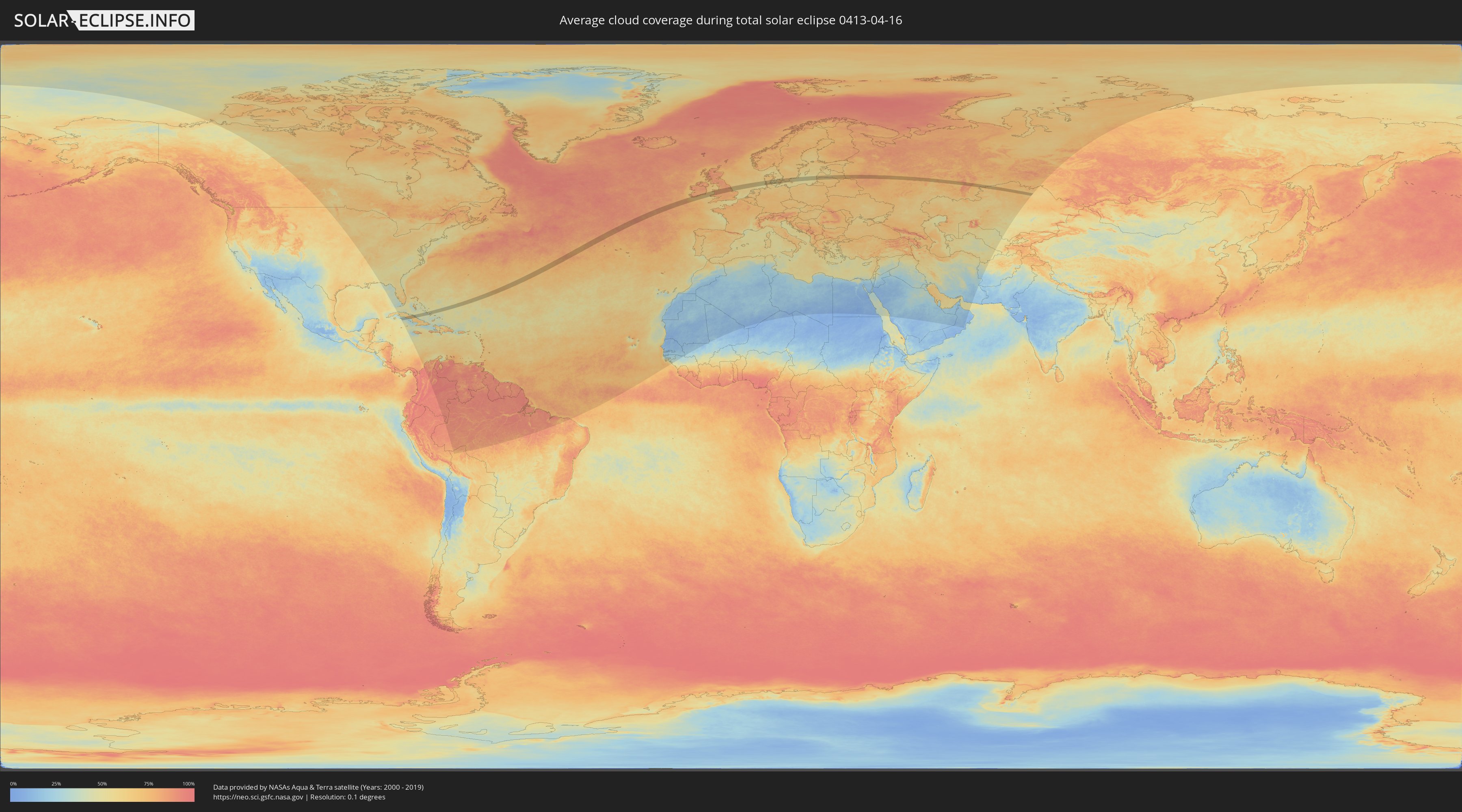
How will be the weather during the total solar eclipse on 04/16/0413?
Where is the best place to see the total solar eclipse of 04/16/0413?
The following maps show the average cloud coverage for the day of the total solar eclipse.
With the help of these maps, it is possible to find the place along the eclipse path, which has the best
chance of a cloudless sky.
Nevertheless, you should consider local circumstances and inform about the weather of your chosen
observation site.
The data is provided by NASAs satellites
AQUA and TERRA.
The cloud maps are averaged over a period of 19 years (2000 - 2019).

Detailed country maps
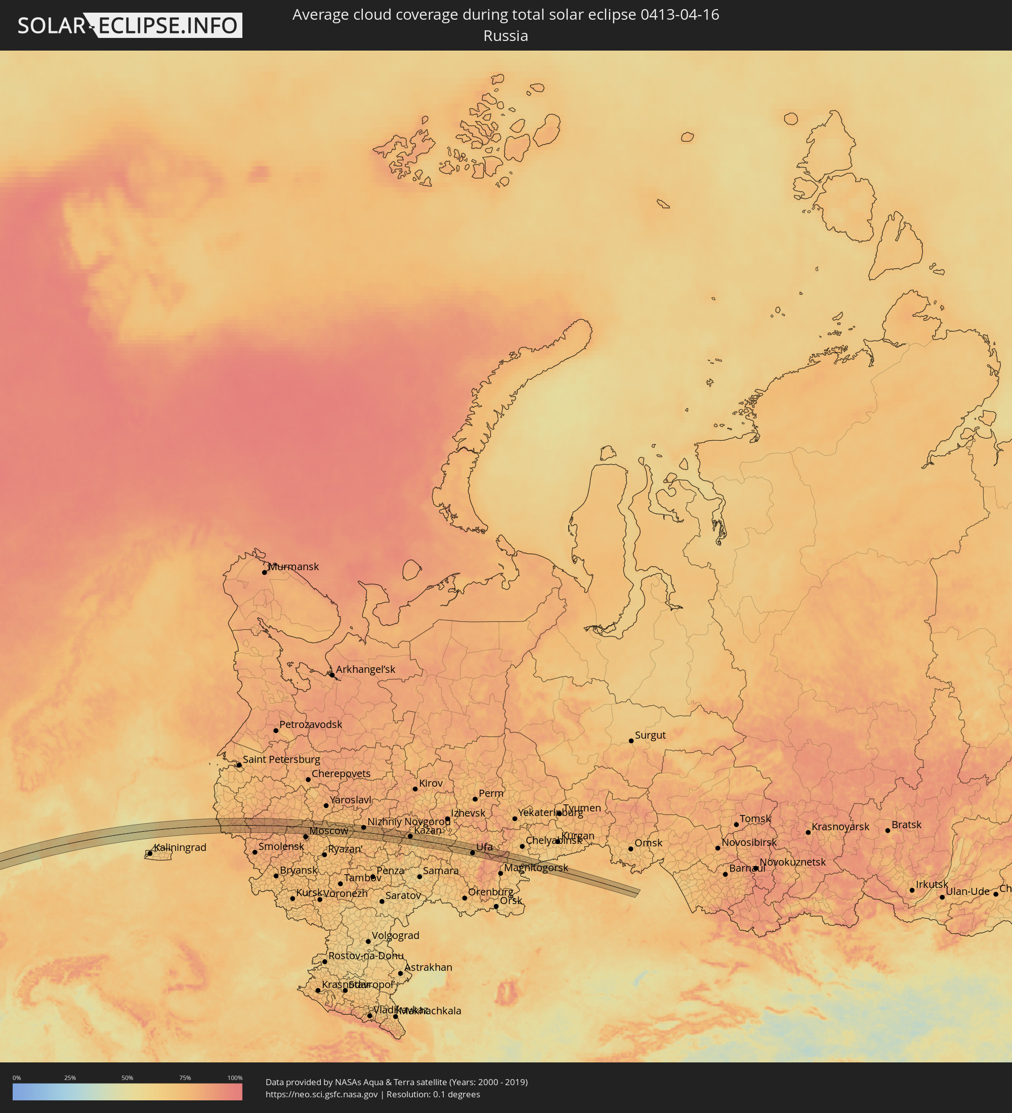 Russia
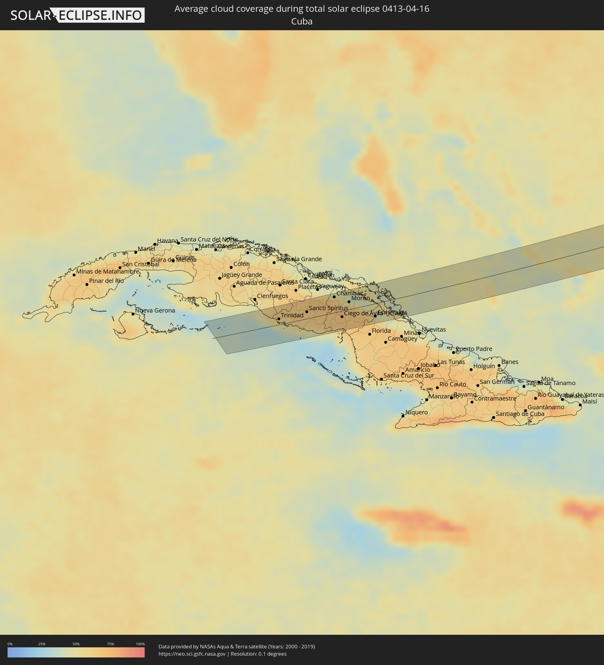 Cuba
Cuba
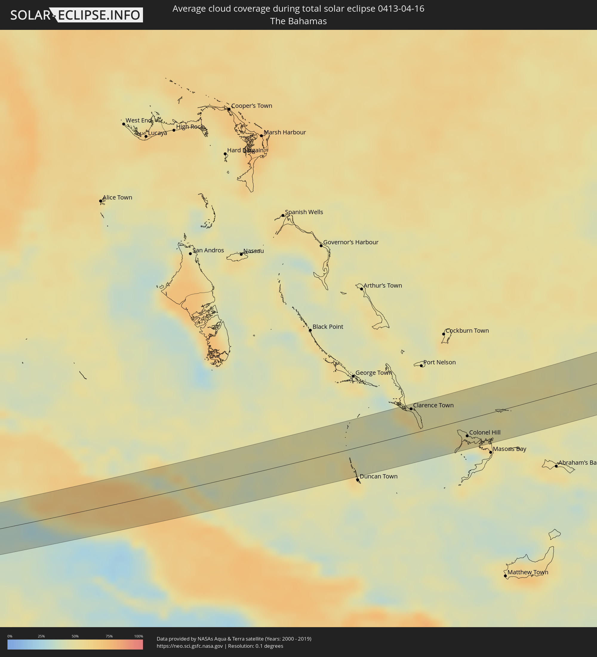 The Bahamas
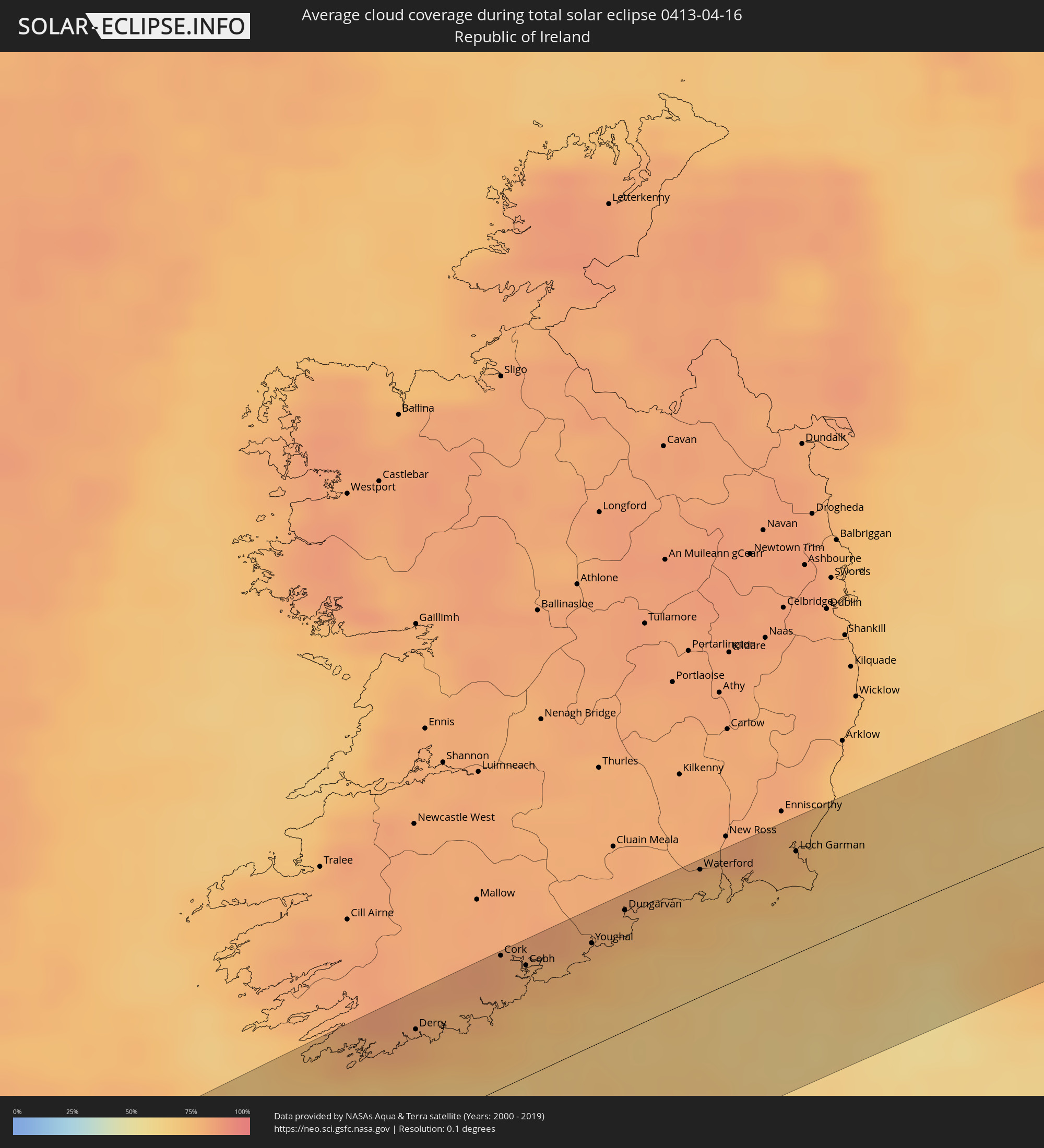 Republic of Ireland
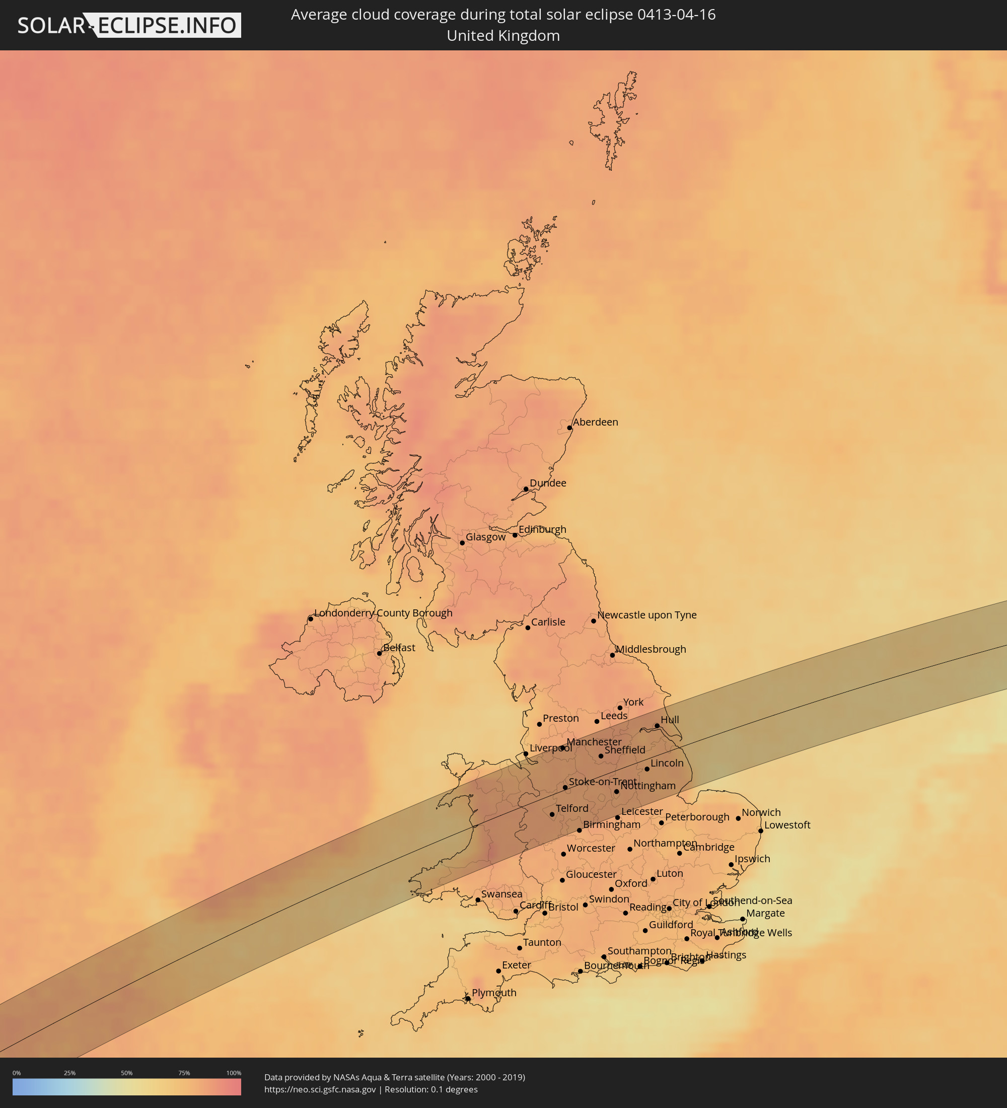 United Kingdom
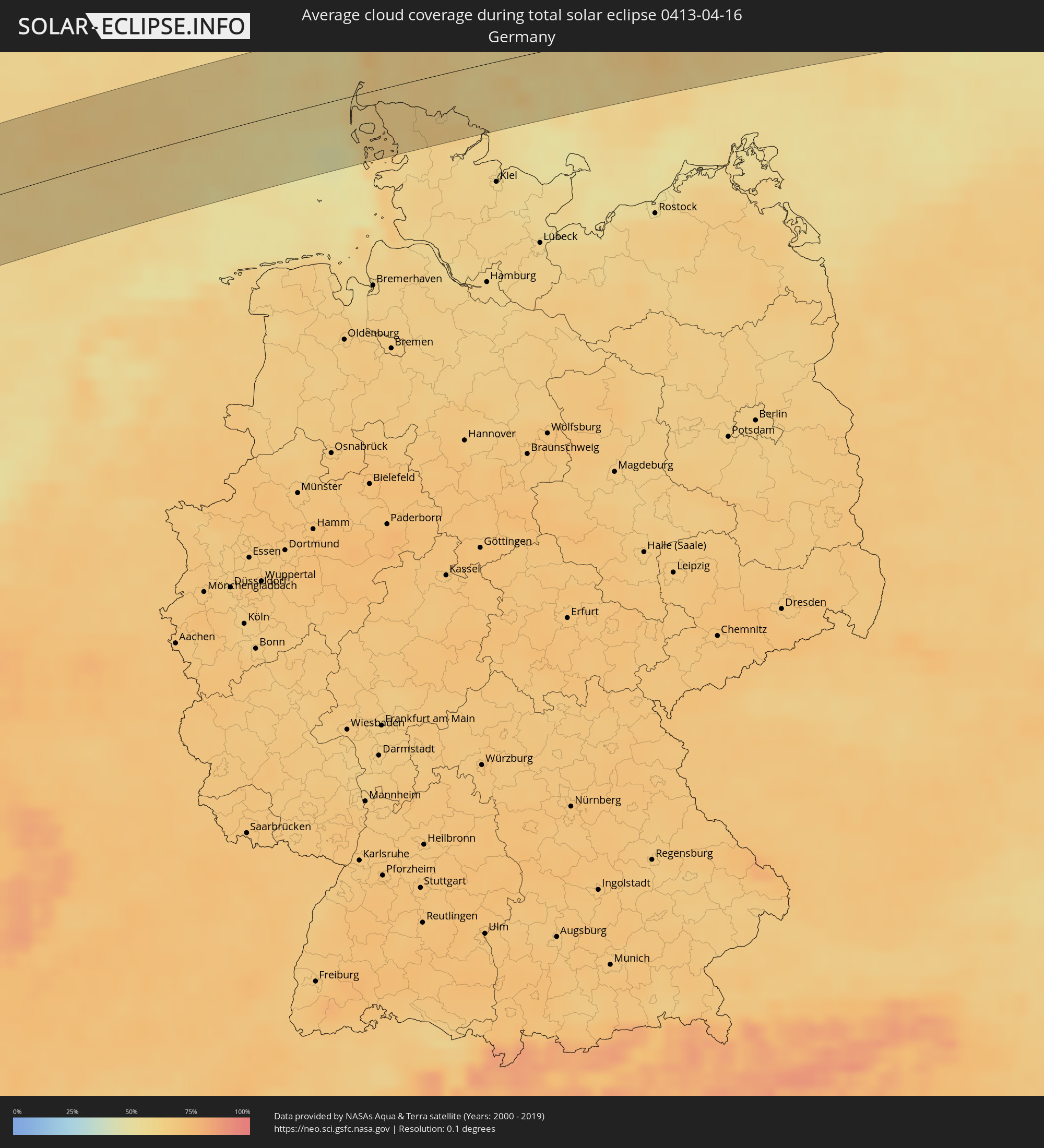 Germany
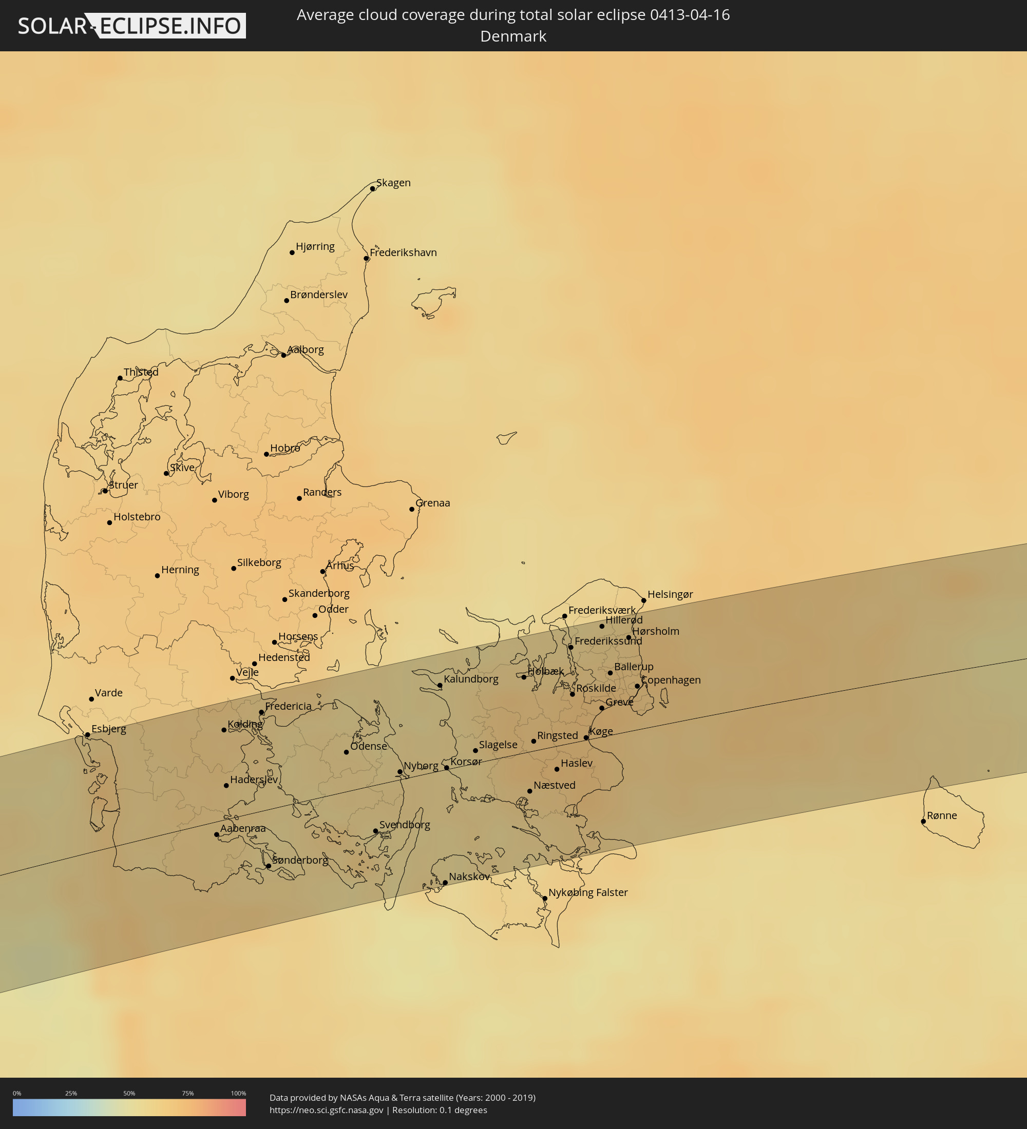 Denmark
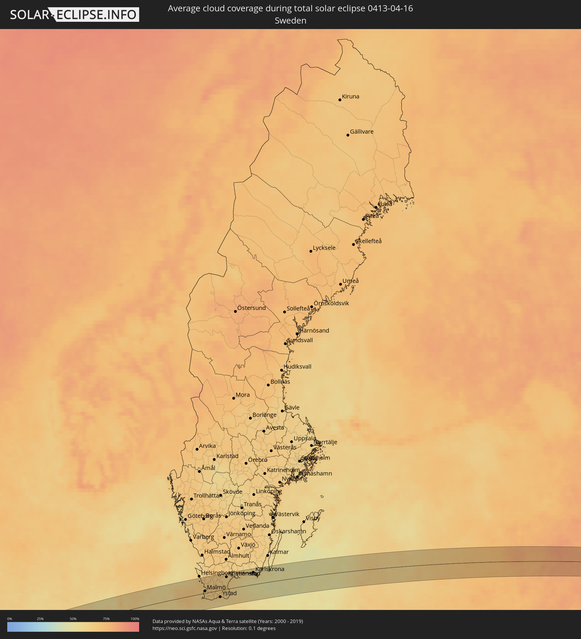 Sweden
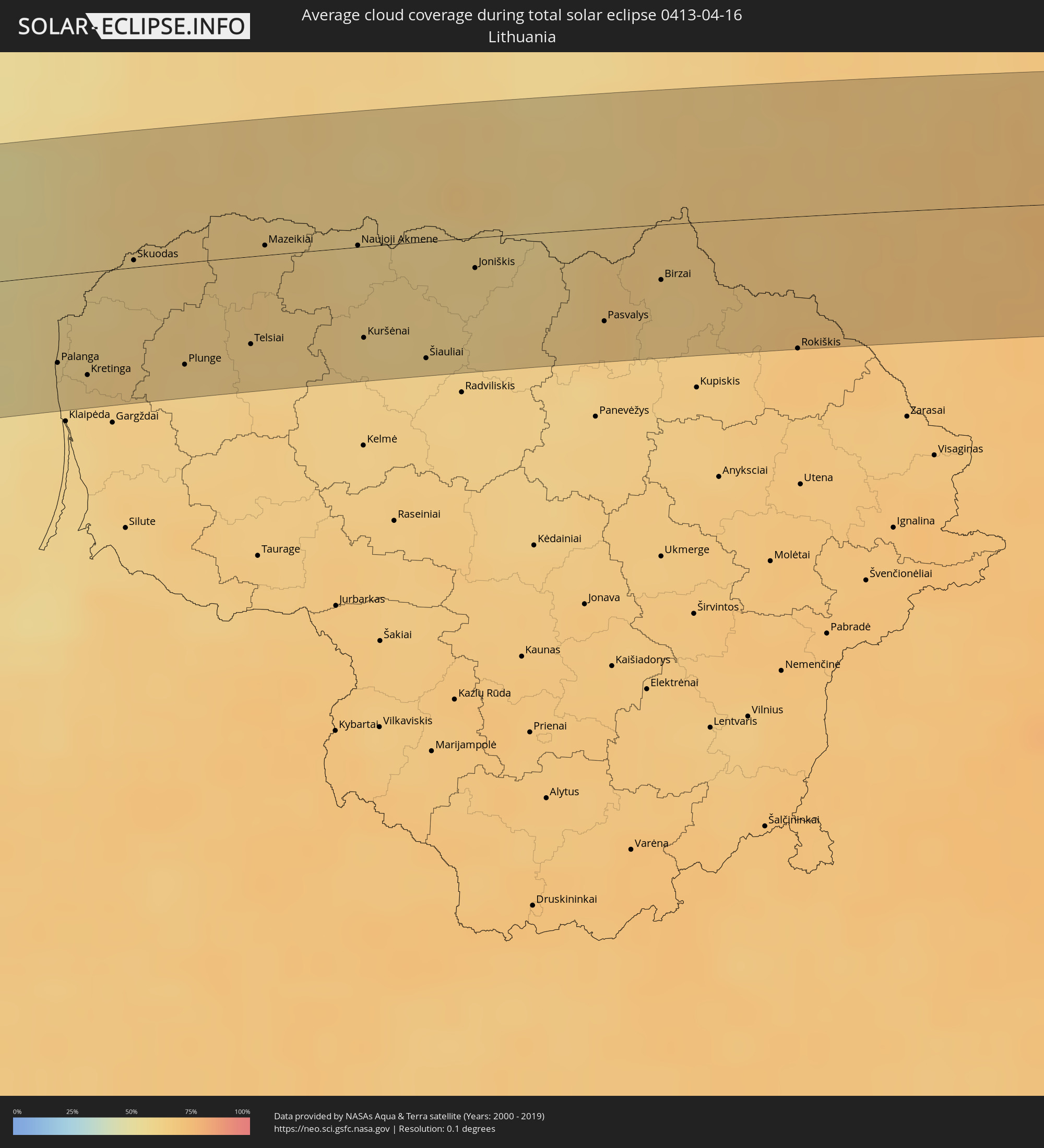 Lithuania
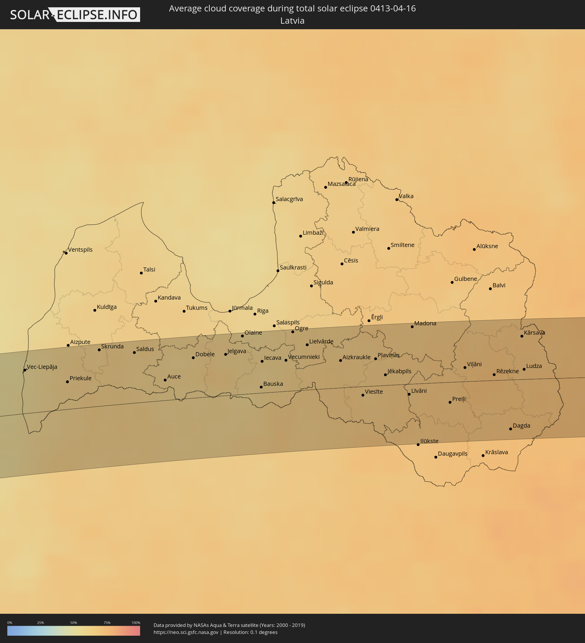 Latvia
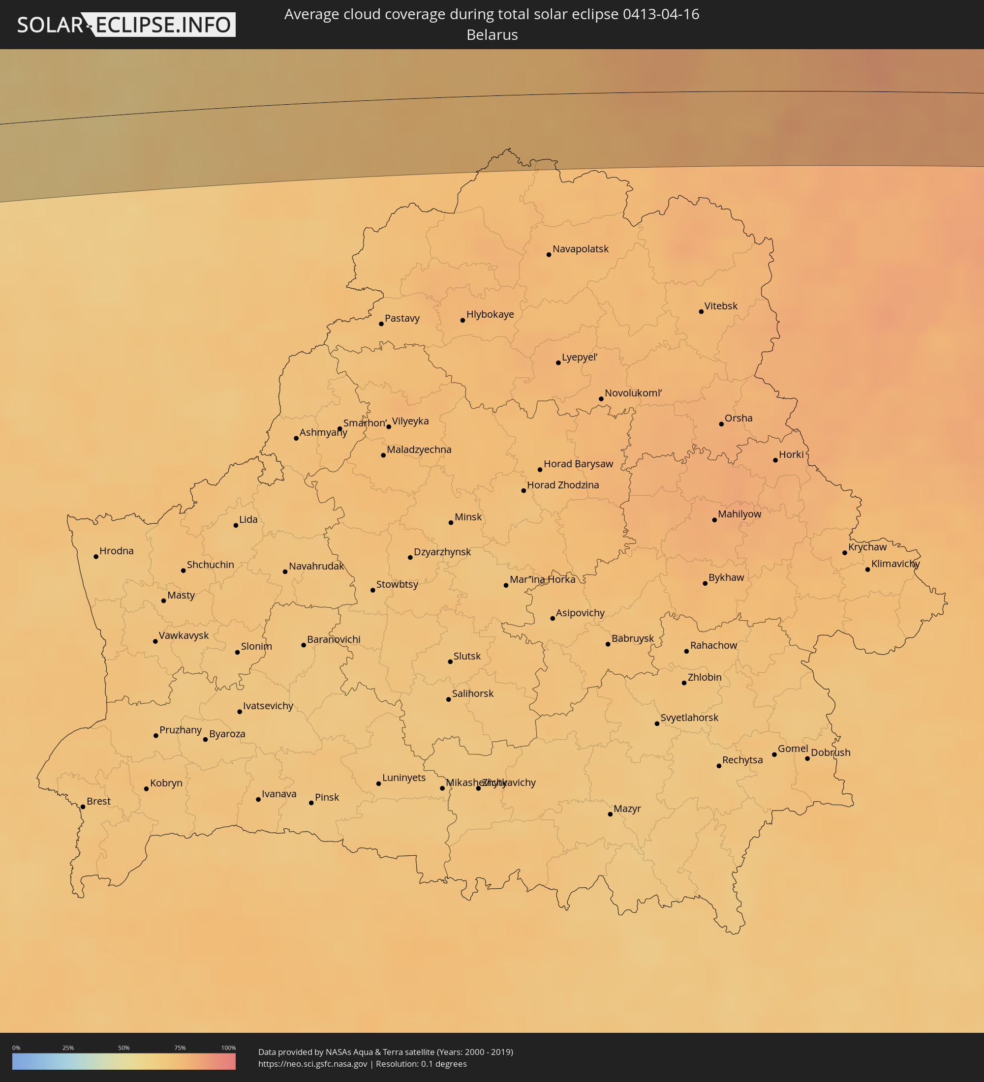 Belarus
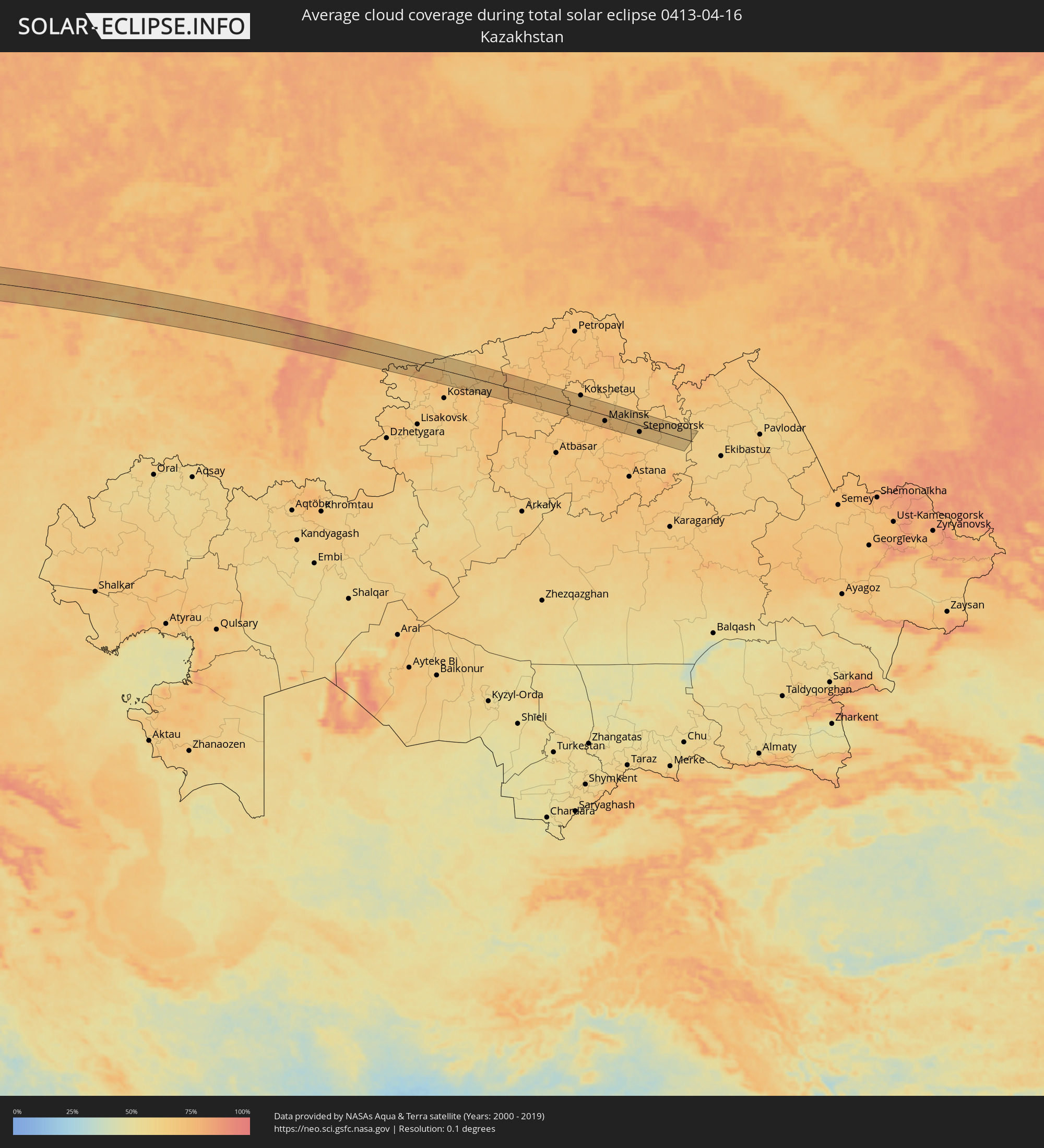 Kazakhstan
Cities inside the path of the eclipse
The following table shows all locations with a population of more than 5,000 inside the eclipse path. Cities which have more than 100,000 inhabitants are marked bold. A click at the locations opens a detailed map.
| City | Type | Eclipse duration | Local time of max. eclipse | Distance to central line | Ø Cloud coverage |
|
Topes de Collantes, Sancti Spíritus
|
total | - | 05:37:30 UTC-05:29 | 24 km | 57% |
|
Trinidad, Sancti Spíritus
|
total | - | 05:37:22 UTC-05:29 | 11 km | 49% |
|
Condado, Sancti Spíritus
|
total | - | 05:37:26 UTC-05:29 | 16 km | 58% |
|
Cabaiguán, Sancti Spíritus
|
total | - | 05:37:37 UTC-05:29 | 30 km | 65% |
|
Guayos, Sancti Spíritus
|
total | - | 05:37:34 UTC-05:29 | 26 km | 64% |
|
Sancti Spíritus, Sancti Spíritus
|
total | - | 05:37:25 UTC-05:29 | 13 km | 62% |
|
Zaza del Medio, Sancti Spíritus
|
total | - | 05:37:29 UTC-05:29 | 19 km | 62% |
|
La Sierpe, Sancti Spíritus
|
total | - | 05:37:13 UTC-05:29 | 8 km | 61% |
|
Jatibonico, Sancti Spíritus
|
total | - | 05:37:24 UTC-05:29 | 9 km | 66% |
|
Florencia, Ciego de Ávila
|
total | - | 05:37:36 UTC-05:29 | 26 km | 67% |
|
Chambas, Ciego de Ávila
|
total | - | 05:37:39 UTC-05:29 | 30 km | 67% |
|
Venezuela, Ciego de Ávila
|
total | - | 05:37:06 UTC-05:29 | 22 km | 57% |
|
Ciego de Ávila, Ciego de Ávila
|
total | - | 05:37:13 UTC-05:29 | 12 km | 65% |
|
Ciro Redondo, Ciego de Ávila
|
total | - | 05:37:25 UTC-05:29 | 6 km | 66% |
|
Morón, Ciego de Ávila
|
total | - | 05:37:31 UTC-05:29 | 14 km | 64% |
|
Baraguá, Ciego de Ávila
|
total | - | 05:37:00 UTC-05:29 | 32 km | 66% |
|
Primero de Enero, Ciego de Ávila
|
total | - | 05:37:17 UTC-05:29 | 8 km | 68% |
|
Esmeralda, Camagüey
|
total | - | 05:37:08 UTC-05:29 | 25 km | 61% |
|
Clarence Town, Long Island
|
total | - | 05:58:30 UTC-05:09 | 34 km | 58% |
|
Colonel Hill, Crooked Island and Long Cay
|
total | - | 05:58:02 UTC-05:09 | 24 km | 53% |
|
Derry, Munster
|
total | - | 12:32:08 UTC-00:25 | 42 km | 80% |
|
Bandon, Munster
|
total | - | 12:32:41 UTC-00:25 | 49 km | 78% |
|
Cork, Munster
|
total | - | 12:33:10 UTC-00:25 | 57 km | 83% |
|
Carrigaline, Munster
|
total | - | 12:33:13 UTC-00:25 | 46 km | 79% |
|
Cobh, Munster
|
total | - | 12:33:24 UTC-00:25 | 47 km | 79% |
|
Midleton, Munster
|
total | - | 12:33:36 UTC-00:25 | 50 km | 77% |
|
Youghal, Munster
|
total | - | 12:34:06 UTC-00:25 | 44 km | 78% |
|
Dungarvan, Munster
|
total | - | 12:34:30 UTC-00:25 | 51 km | 77% |
|
Trá Mhór, Munster
|
total | - | 12:35:14 UTC-00:25 | 45 km | 76% |
|
Waterford, Munster
|
total | - | 12:35:20 UTC-00:25 | 54 km | 77% |
|
Loch Garman, Leinster
|
total | - | 12:36:19 UTC-00:25 | 43 km | 76% |
|
Chester, England
|
total | - | 13:07:02 UTC+00:00 | 38 km | 81% |
|
Shrewsbury, England
|
total | - | 13:07:08 UTC+00:00 | 15 km | 82% |
|
Warrington, England
|
total | - | 13:07:30 UTC+00:00 | 52 km | 81% |
|
Telford, England
|
total | - | 13:07:34 UTC+00:00 | 26 km | 82% |
|
Crewe, England
|
total | - | 13:07:39 UTC+00:00 | 18 km | 80% |
|
Manchester, England
|
total | - | 13:07:59 UTC+00:00 | 52 km | 80% |
|
Stoke-on-Trent, England
|
total | - | 13:07:59 UTC+00:00 | 2 km | 80% |
|
Wolverhampton, England
|
total | - | 13:08:01 UTC+00:00 | 43 km | 79% |
|
High Peak, England
|
total | - | 13:08:31 UTC+00:00 | 31 km | 82% |
|
Sutton Coldfield, England
|
total | - | 13:08:27 UTC+00:00 | 53 km | 81% |
|
Wakefield, England
|
total | - | 13:09:02 UTC+00:00 | 56 km | 83% |
|
Derby, England
|
total | - | 13:08:59 UTC+00:00 | 24 km | 81% |
|
Sheffield, England
|
total | - | 13:09:03 UTC+00:00 | 24 km | 82% |
|
Chesterfield, England
|
total | - | 13:09:06 UTC+00:00 | 9 km | 83% |
|
Mansfield, England
|
total | - | 13:09:23 UTC+00:00 | 8 km | 82% |
|
Nottingham, England
|
total | - | 13:09:27 UTC+00:00 | 28 km | 79% |
|
Scunthorpe, England
|
total | - | 13:10:11 UTC+00:00 | 26 km | 80% |
|
Lincoln, England
|
total | - | 13:10:19 UTC+00:00 | 14 km | 80% |
|
Hull, England
|
total | - | 13:10:38 UTC+00:00 | 36 km | 80% |
|
Westerland, Schleswig-Holstein
|
total | - | 14:21:33 UTC+01:00 | 4 km | 61% |
|
Sylt-Ost, Schleswig-Holstein
|
total | - | 14:21:42 UTC+01:00 | 11 km | 59% |
|
Esbjerg, South Denmark
|
total | - | 14:21:30 UTC+01:00 | 54 km | 61% |
|
Niebüll, Schleswig-Holstein
|
total | - | 14:22:13 UTC+01:00 | 25 km | 62% |
|
Bredstedt, Schleswig-Holstein
|
total | - | 14:22:27 UTC+01:00 | 46 km | 60% |
|
Leck, Schleswig-Holstein
|
total | - | 14:22:25 UTC+01:00 | 30 km | 63% |
|
Handewitt, Schleswig-Holstein
|
total | - | 14:22:50 UTC+01:00 | 35 km | 64% |
|
Harrislee, Schleswig-Holstein
|
total | - | 14:22:53 UTC+01:00 | 32 km | 64% |
|
Tarp, Schleswig-Holstein
|
total | - | 14:22:57 UTC+01:00 | 47 km | 64% |
|
Aabenraa, South Denmark
|
total | - | 14:22:49 UTC+01:00 | 6 km | 60% |
|
Flensburg, Schleswig-Holstein
|
total | - | 14:22:57 UTC+01:00 | 35 km | 64% |
|
Kolding, South Denmark
|
total | - | 14:22:41 UTC+01:00 | 41 km | 62% |
|
Haderslev, South Denmark
|
total | - | 14:22:49 UTC+01:00 | 15 km | 61% |
|
Glücksburg, Schleswig-Holstein
|
total | - | 14:23:04 UTC+01:00 | 31 km | 64% |
|
Fredericia, South Denmark
|
total | - | 14:22:59 UTC+01:00 | 45 km | 59% |
|
Sønderborg, South Denmark
|
total | - | 14:23:20 UTC+01:00 | 27 km | 59% |
|
Odense, South Denmark
|
total | - | 14:23:47 UTC+01:00 | 18 km | 59% |
|
Svendborg, South Denmark
|
total | - | 14:24:12 UTC+01:00 | 22 km | 55% |
|
Kalundborg, Zealand
|
total | - | 14:24:27 UTC+01:00 | 39 km | 56% |
|
Slagelse, Zealand
|
total | - | 14:24:53 UTC+01:00 | 5 km | 59% |
|
Holbæk, Zealand
|
total | - | 14:25:08 UTC+01:00 | 35 km | 64% |
|
Næstved, Zealand
|
total | - | 14:25:26 UTC+01:00 | 19 km | 60% |
|
Ringsted, Zealand
|
total | - | 14:25:22 UTC+01:00 | 4 km | 68% |
|
Roskilde, Zealand
|
total | - | 14:25:35 UTC+01:00 | 22 km | 68% |
|
Køge, Zealand
|
total | - | 14:25:47 UTC+01:00 | 1 km | 67% |
|
Stenløse, Capital Region
|
total | - | 14:25:38 UTC+01:00 | 34 km | 62% |
|
Greve, Zealand
|
total | - | 14:25:51 UTC+01:00 | 13 km | 69% |
|
Hørsholm, Capital Region
|
total | - | 14:25:55 UTC+01:00 | 43 km | 63% |
|
Copenhagen, Capital Region
|
total | - | 14:26:06 UTC+01:00 | 20 km | 64% |
|
Landskrona, Skåne
|
total | - | 14:26:17 UTC+01:00 | 38 km | 66% |
|
Malmö, Skåne
|
total | - | 14:26:37 UTC+01:00 | 7 km | 63% |
|
Bjärred, Skåne
|
total | - | 14:26:34 UTC+01:00 | 19 km | 64% |
|
Lomma, Skåne
|
total | - | 14:26:39 UTC+01:00 | 13 km | 63% |
|
Arlöv, Skåne
|
total | - | 14:26:41 UTC+01:00 | 9 km | 63% |
|
Oxie, Skåne
|
total | - | 14:26:45 UTC+01:00 | 1 km | 63% |
|
Trelleborg, Skåne
|
total | - | 14:26:55 UTC+01:00 | 20 km | 62% |
|
Lund, Skåne
|
total | - | 14:26:46 UTC+01:00 | 15 km | 64% |
|
Svedala, Skåne
|
total | - | 14:26:56 UTC+01:00 | 7 km | 66% |
|
Eslöv, Skåne
|
total | - | 14:26:48 UTC+01:00 | 29 km | 63% |
|
Höör, Skåne
|
total | - | 14:27:00 UTC+01:00 | 36 km | 64% |
|
Ystad, Skåne
|
total | - | 14:27:37 UTC+01:00 | 22 km | 61% |
|
Kristianstad, Skåne
|
total | - | 14:27:36 UTC+01:00 | 40 km | 62% |
|
Åhus, Skåne
|
total | - | 14:27:49 UTC+01:00 | 26 km | 65% |
|
Bromölla, Skåne
|
total | - | 14:27:54 UTC+01:00 | 41 km | 63% |
|
Sölvesborg, Blekinge
|
total | - | 14:28:02 UTC+01:00 | 38 km | 61% |
|
Karlshamn, Blekinge
|
total | - | 14:28:15 UTC+01:00 | 48 km | 66% |
|
Ronneby, Blekinge
|
total | - | 14:28:39 UTC+01:00 | 48 km | 58% |
|
Karlskrona, Blekinge
|
total | - | 14:29:01 UTC+01:00 | 39 km | 57% |
|
Vec-Liepāja, Liepāja
|
total | - | 15:10:33 UTC+01:36 | 35 km | 54% |
|
Palanga, Klaipėda County
|
total | - | 14:58:33 UTC+01:24 | 33 km | 59% |
|
Kretinga, Klaipėda County
|
total | - | 14:58:45 UTC+01:24 | 39 km | 63% |
|
Skuodas, Klaipėda County
|
total | - | 14:58:40 UTC+01:24 | 3 km | 61% |
|
Plunge, Telšiai County
|
total | - | 14:59:16 UTC+01:24 | 38 km | 62% |
|
Telsiai, Telšiai County
|
total | - | 14:59:34 UTC+01:24 | 33 km | 63% |
|
Mazeikiai, Telšiai County
|
total | - | 14:59:21 UTC+01:24 | 4 km | 64% |
|
Saldus, Saldus Rajons
|
total | - | 15:11:44 UTC+01:36 | 41 km | 61% |
|
Naujoji Akmene
|
total | - | 14:59:51 UTC+01:24 | 1 km | 60% |
|
Auce, Auces Novads
|
total | - | 15:12:17 UTC+01:36 | 16 km | 61% |
|
Kuršėnai, Šiauliai County
|
total | - | 15:00:10 UTC+01:24 | 34 km | 62% |
|
Dobele, Dobeles Rajons
|
total | - | 15:12:27 UTC+01:36 | 33 km | 62% |
|
Šiauliai, Šiauliai County
|
total | - | 15:00:33 UTC+01:24 | 44 km | 62% |
|
Joniškis, Šiauliai County
|
total | - | 15:00:32 UTC+01:24 | 11 km | 60% |
|
Jelgava, Jelgava
|
total | - | 15:12:48 UTC+01:36 | 34 km | 61% |
|
Pakruojis, Šiauliai County
|
total | - | 15:01:00 UTC+01:24 | 43 km | 64% |
|
Olaine, Olaine
|
total | - | 15:12:52 UTC+01:36 | 48 km | 60% |
|
Bauska, Bauskas Rajons
|
total | - | 15:13:26 UTC+01:36 | 5 km | 61% |
|
Iecava, Lecava
|
total | - | 15:13:16 UTC+01:36 | 26 km | 59% |
|
Pasvalys, Panevėžys
|
total | - | 15:01:23 UTC+01:24 | 35 km | 66% |
|
Ogre, Ogre
|
total | - | 15:13:24 UTC+01:36 | 48 km | 62% |
|
Birzai, Panevėžys
|
total | - | 15:01:32 UTC+01:24 | 21 km | 63% |
|
Lielvārde, Lielvārde
|
total | - | 15:13:39 UTC+01:36 | 37 km | 63% |
|
Aizkraukle, Aizkraukles Rajons
|
total | - | 15:14:07 UTC+01:36 | 22 km | 65% |
|
Rokiškis, Panevėžys
|
total | - | 15:02:27 UTC+01:24 | 50 km | 70% |
|
Pļaviņas, Pļaviņu
|
total | - | 15:14:29 UTC+01:36 | 22 km | 66% |
|
Jēkabpils, Jēkabpils Municipality
|
total | - | 15:14:43 UTC+01:36 | 8 km | 68% |
|
Līvāni, Līvāni
|
total | - | 15:15:07 UTC+01:36 | 9 km | 68% |
|
Madona, Madonas Rajons
|
total | - | 15:14:39 UTC+01:36 | 47 km | 66% |
|
Preiļi, Preiļu Rajons
|
total | - | 15:15:37 UTC+01:36 | 17 km | 70% |
|
Viļāni, Vilanu
|
total | - | 15:15:30 UTC+01:36 | 11 km | 71% |
|
Rēzekne, Rēzekne
|
total | - | 15:15:52 UTC+01:36 | 4 km | 73% |
|
Ludza, Ludzas Rajons
|
total | - | 15:16:08 UTC+01:36 | 8 km | 71% |
|
Velikiye Luki, Pskov
|
total | - | 16:12:08 UTC+02:30 | 18 km | 76% |
|
Tver, Tverskaya
|
total | - | 16:14:56 UTC+02:30 | 47 km | 79% |
|
Klin, Moscow Oblast
|
total | - | 16:16:02 UTC+02:30 | 9 km | 80% |
|
Pushkino, Moscow Oblast
|
total | - | 16:17:02 UTC+02:30 | 40 km | 77% |
|
Sergiyev Posad, Moscow Oblast
|
total | - | 16:16:50 UTC+02:30 | 8 km | 78% |
|
Aleksandrov, Vladimir
|
total | - | 16:17:02 UTC+02:30 | 5 km | 74% |
|
Vladimir, Vladimir
|
total | - | 16:18:11 UTC+02:30 | 15 km | 72% |
|
Kovrov, Vladimir
|
total | - | 16:18:20 UTC+02:30 | 14 km | 74% |
|
Dzerzhinsk, Nizjnij Novgorod
|
total | - | 16:19:24 UTC+02:30 | 15 km | 74% |
|
Nizhniy Novgorod, Nizjnij Novgorod
|
total | - | 16:19:31 UTC+02:30 | 29 km | 76% |
|
Kstovo, Nizjnij Novgorod
|
total | - | 16:19:49 UTC+02:30 | 10 km | 74% |
|
Cheboksary, Chuvashia
|
total | - | 16:20:56 UTC+02:30 | 33 km | 79% |
|
Zelenodolsk, Tatarstan
|
total | - | 16:21:42 UTC+02:30 | 13 km | 74% |
|
Kazan, Tatarstan
|
total | - | 16:21:57 UTC+02:30 | 13 km | 72% |
|
Nizhnekamsk, Tatarstan
|
total | - | 16:22:51 UTC+02:30 | 24 km | 67% |
|
Yelabuga, Tatarstan
|
total | - | 16:22:44 UTC+02:30 | 41 km | 70% |
|
Naberezhnyye Chelny, Tatarstan
|
total | - | 16:22:52 UTC+02:30 | 41 km | 73% |
|
Ufa, Bashkortostan
|
total | - | 17:57:02 UTC+04:02 | 23 km | 67% |
|
Troitsk, Chelyabinsk
|
total | - | 17:58:19 UTC+04:02 | 13 km | 64% |
|
Borovskoy, Qostanay
|
total | - | 18:18:01 UTC+04:21 | 3 km | 66% |
|
Novoishimskiy, Soltüstik Qazaqstan
|
total | - | 18:18:37 UTC+04:21 | 23 km | 71% |
|
Kokshetau, Aqmola
|
total | - | 18:18:15 UTC+04:21 | 34 km | 67% |
|
Shchuchinsk, Aqmola
|
total | - | 18:18:33 UTC+04:21 | 11 km | 73% |
|
Būrabay, Soltüstik Qazaqstan
|
total | - | 18:18:22 UTC+04:21 | 30 km | 73% |
|
Makinsk, Aqmola
|
total | - | 18:18:53 UTC+04:21 | 17 km | 76% |
|
Stepnogorsk, Aqmola
|
total | - | 18:18:58 UTC+04:21 | 18 km | 68% |
|
Aksu, Aqmola
|
total | - | 18:18:51 UTC+04:21 | 7 km | 68% |
|
Zavodskoy, Aqmola
|
total | - | 18:18:48 UTC+04:21 | 3 km | 69% |
|
Bestobe, Aqmola
|
total | - | 18:18:35 UTC+04:21 | 21 km | 66% |