Total solar eclipse of 03/20/1140
| Day of week: | Wednesday |
| Maximum duration of eclipse: | 04m42s |
| Maximum width of eclipse path: | 251 km |
| Saros cycle: | 96 |
| Coverage: | 100% |
| Magnitude: | 1.0607 |
| Gamma: | 0.6143 |
Wo kann man die Sonnenfinsternis vom 03/20/1140 sehen?
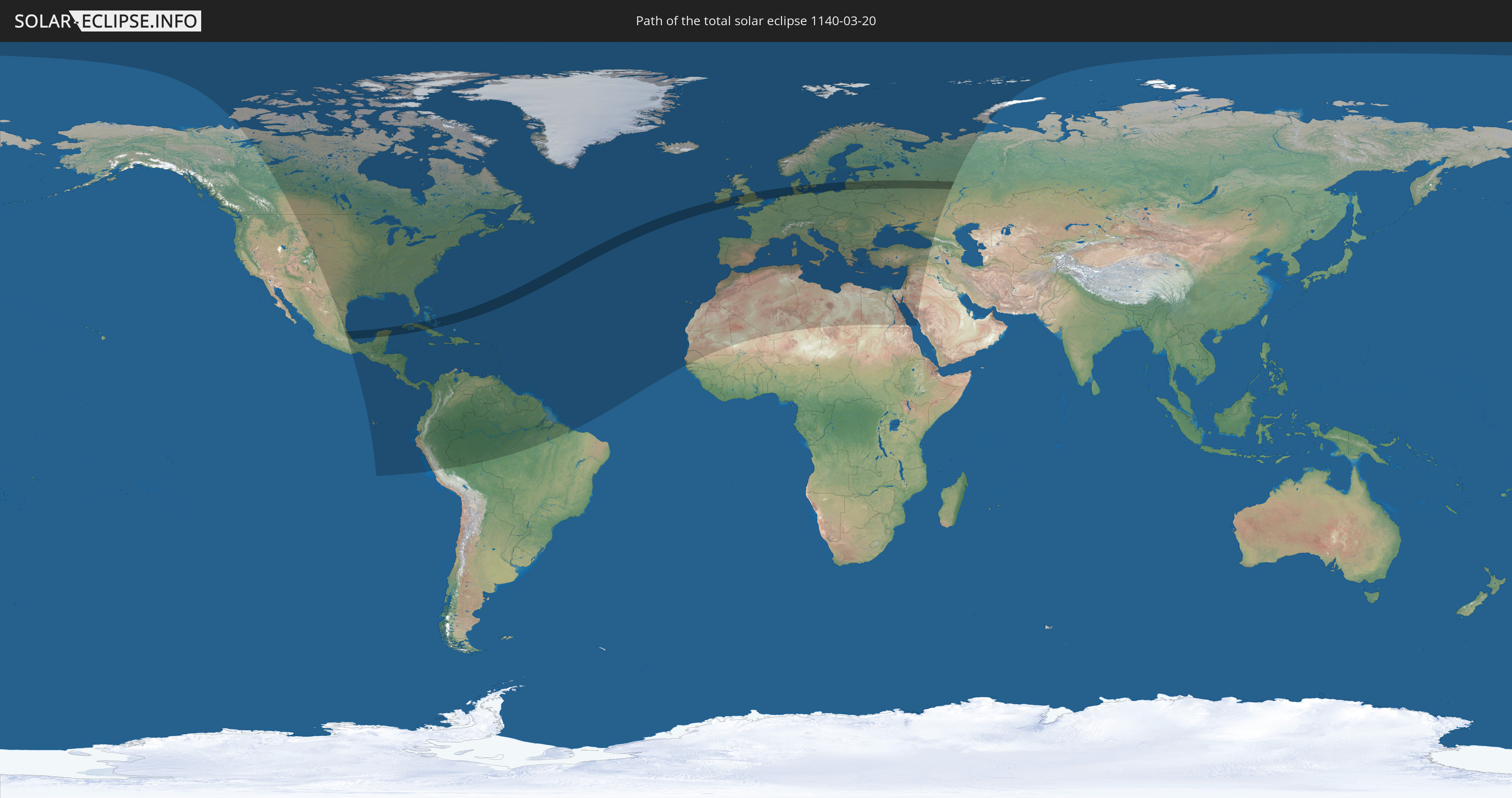
Die Sonnenfinsternis am 03/20/1140 kann man in 122 Ländern als partielle Sonnenfinsternis beobachten.
Der Finsternispfad verläuft durch 14 Länder. Nur in diesen Ländern ist sie als total Sonnenfinsternis zu sehen.
In den folgenden Ländern ist die Sonnenfinsternis total zu sehen
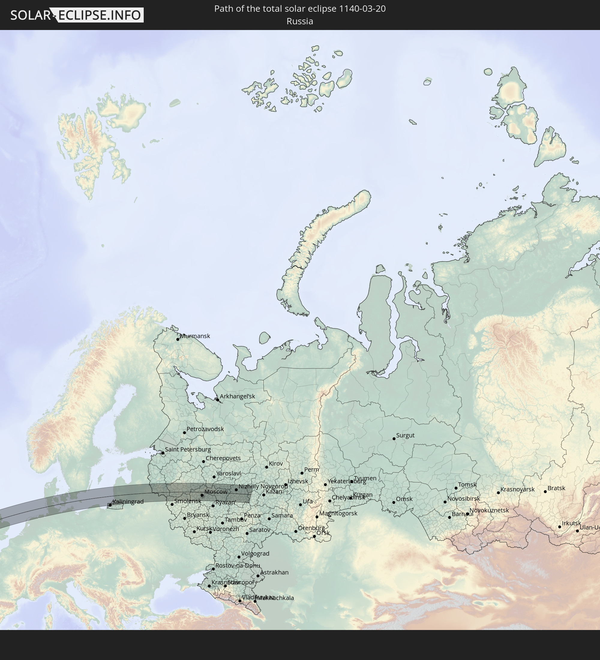 Russia
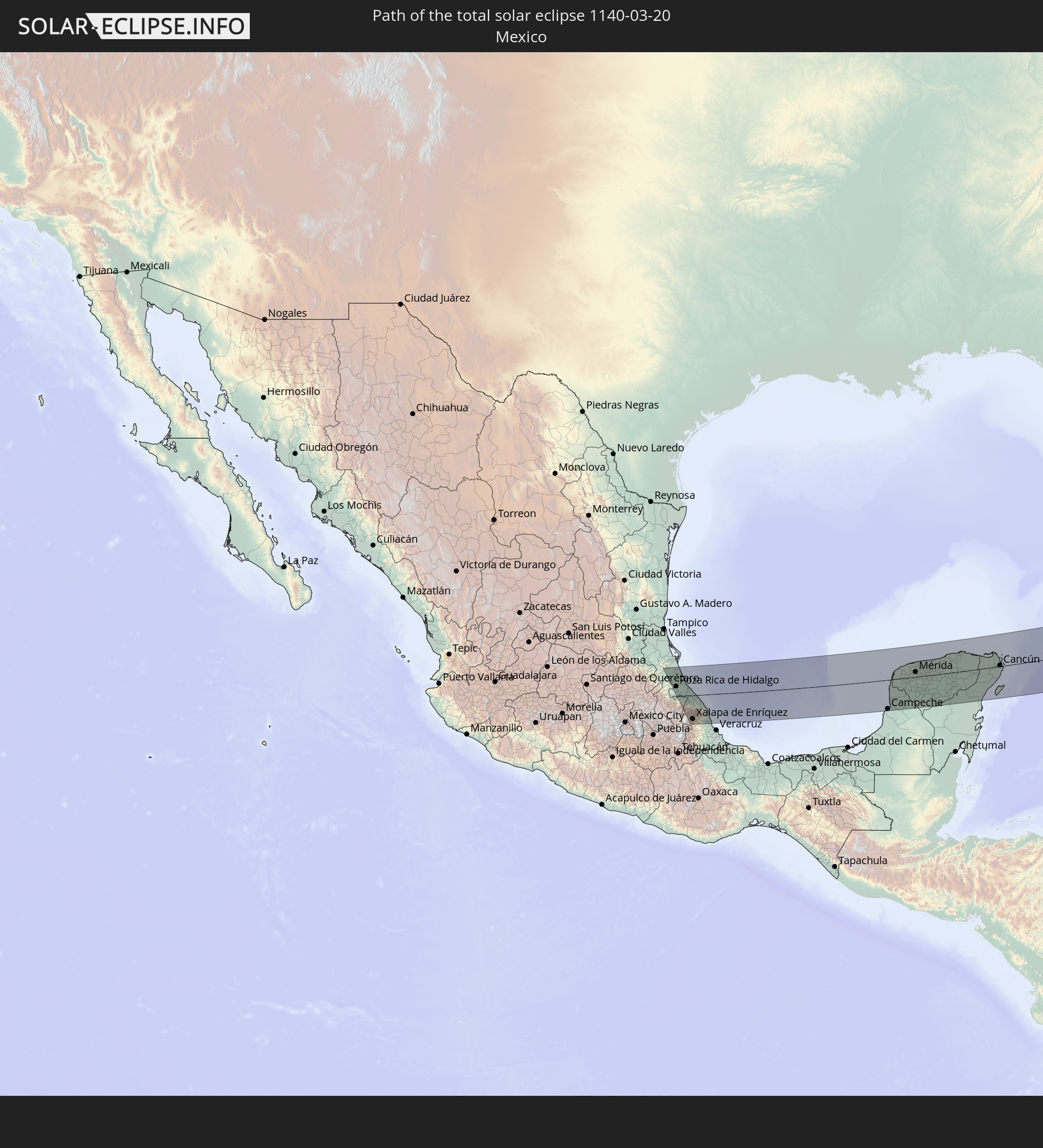 Mexico
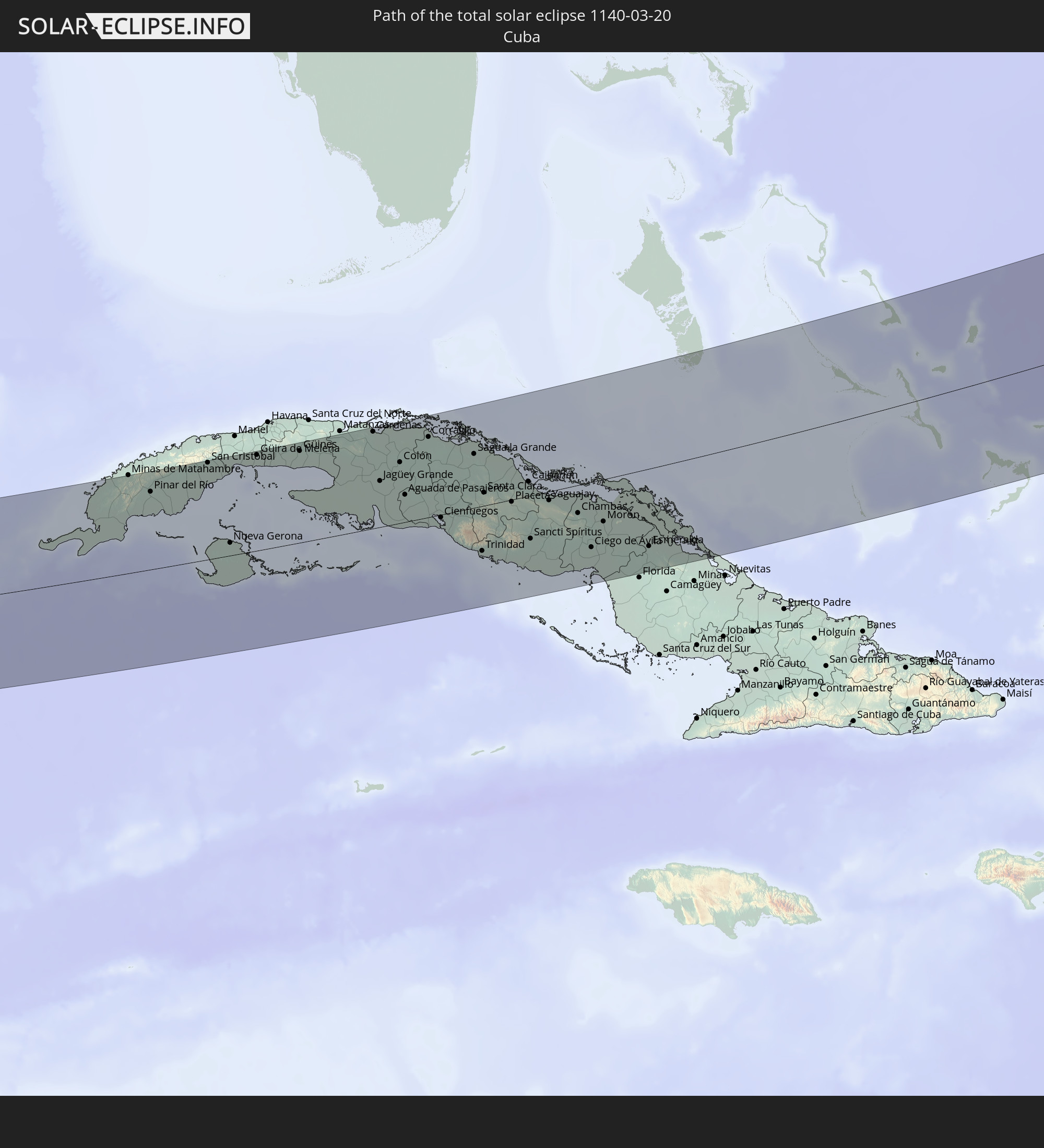 Cuba
Cuba
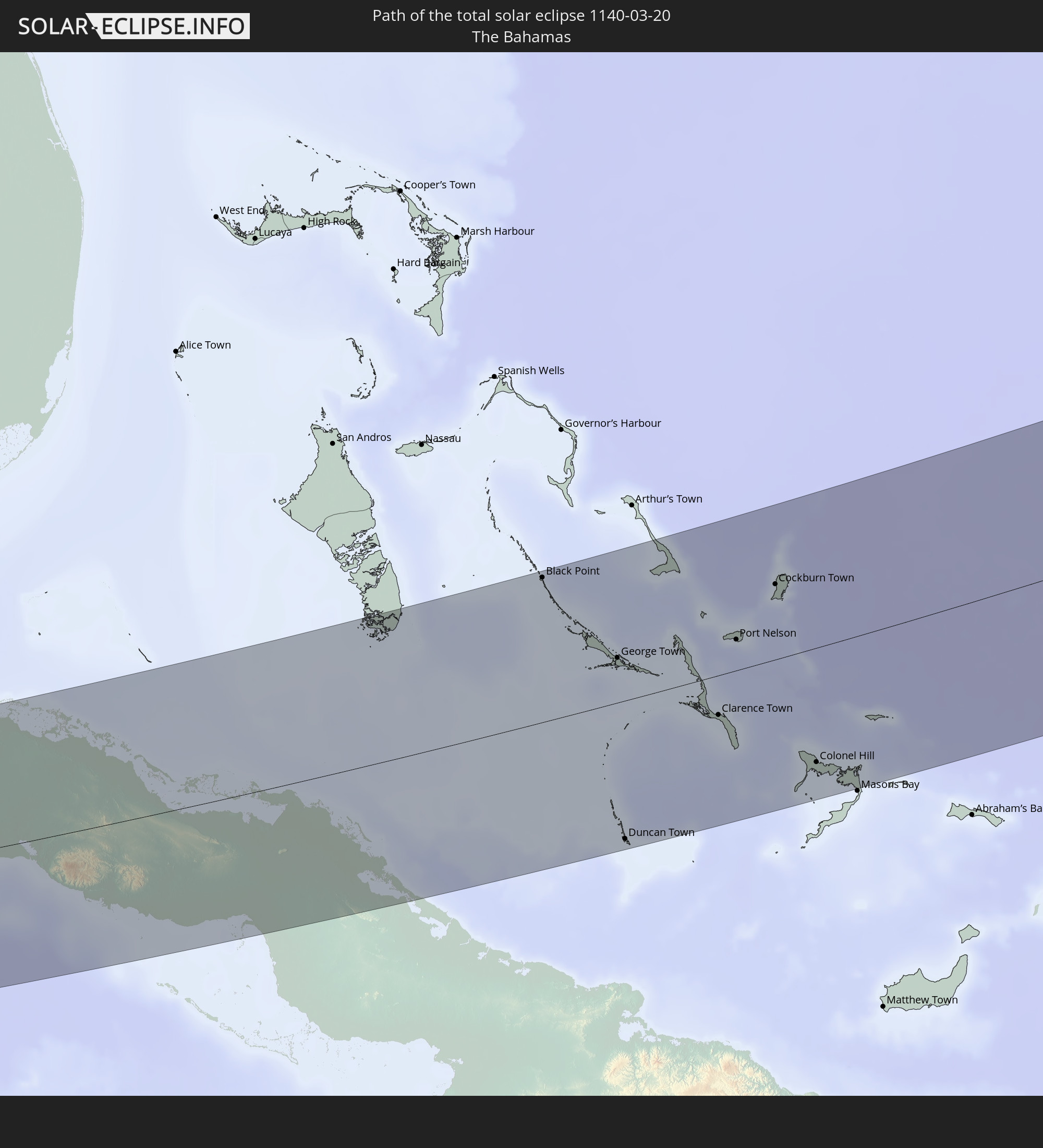 The Bahamas
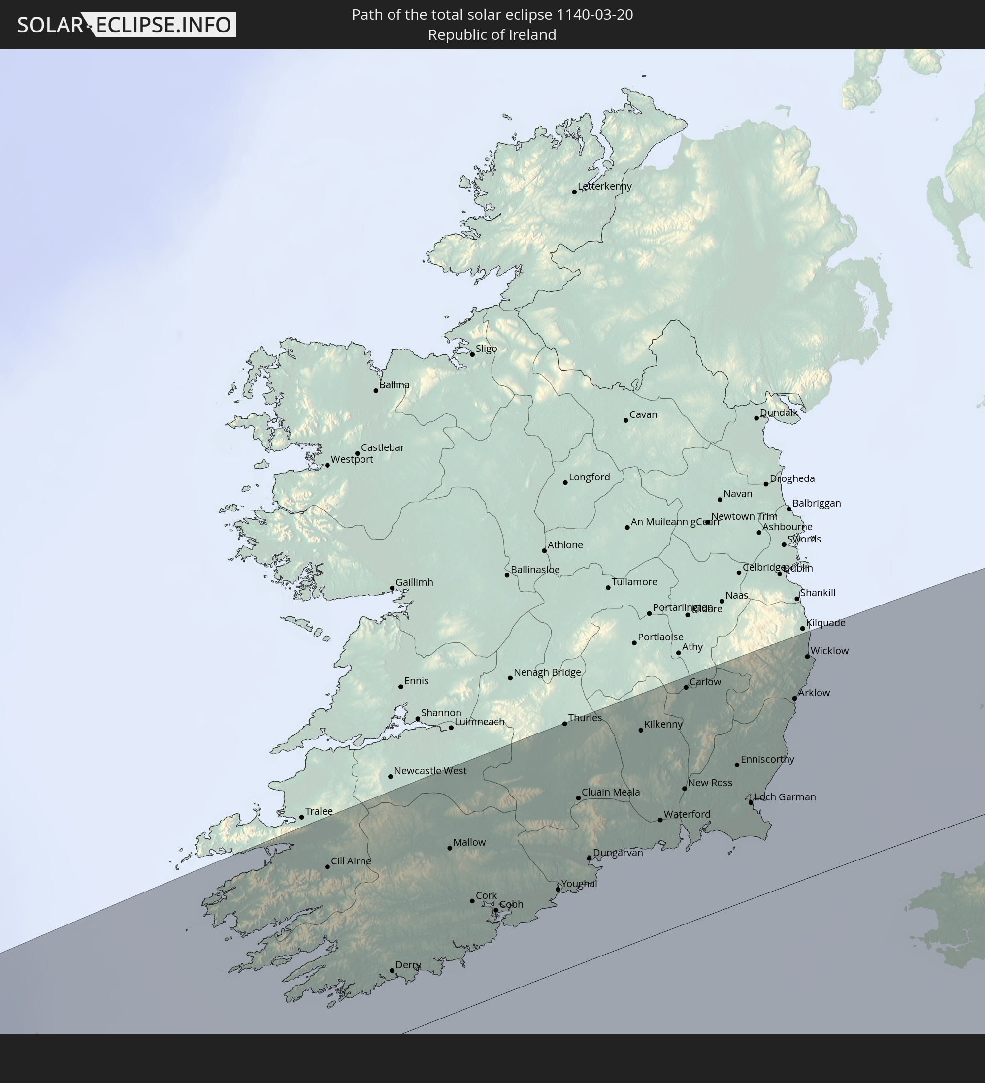 Republic of Ireland
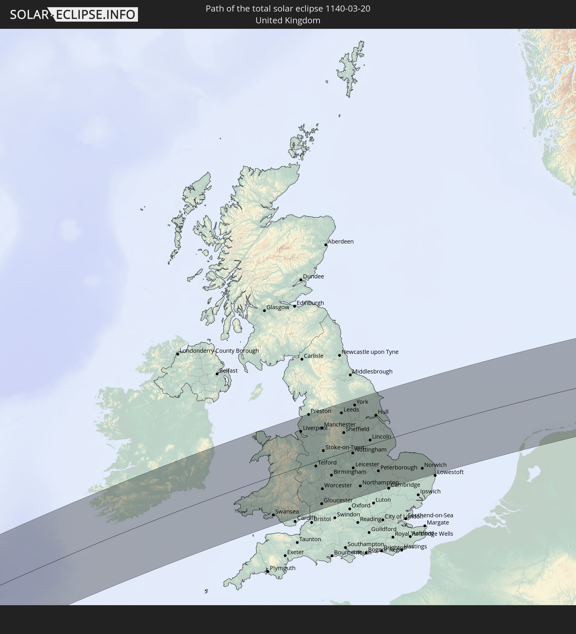 United Kingdom
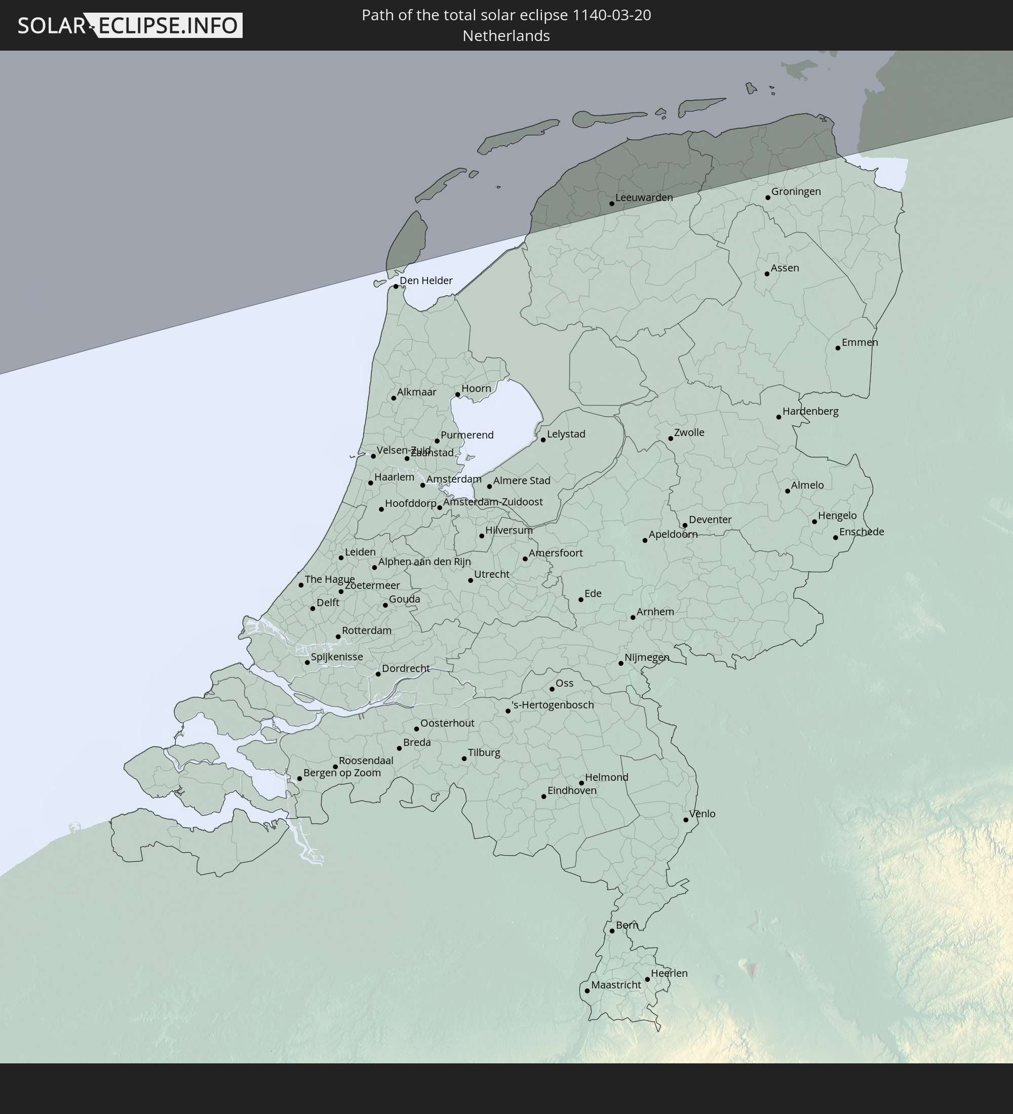 Netherlands
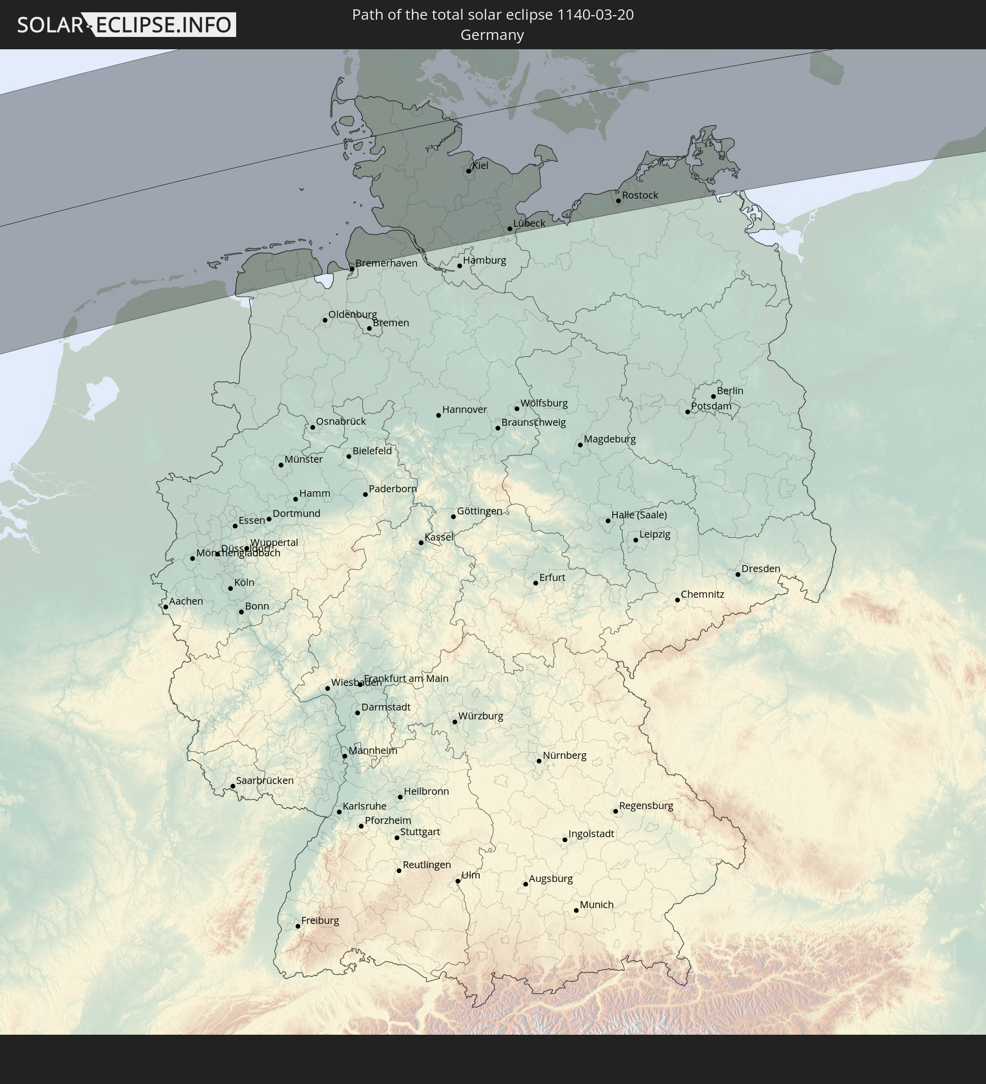 Germany
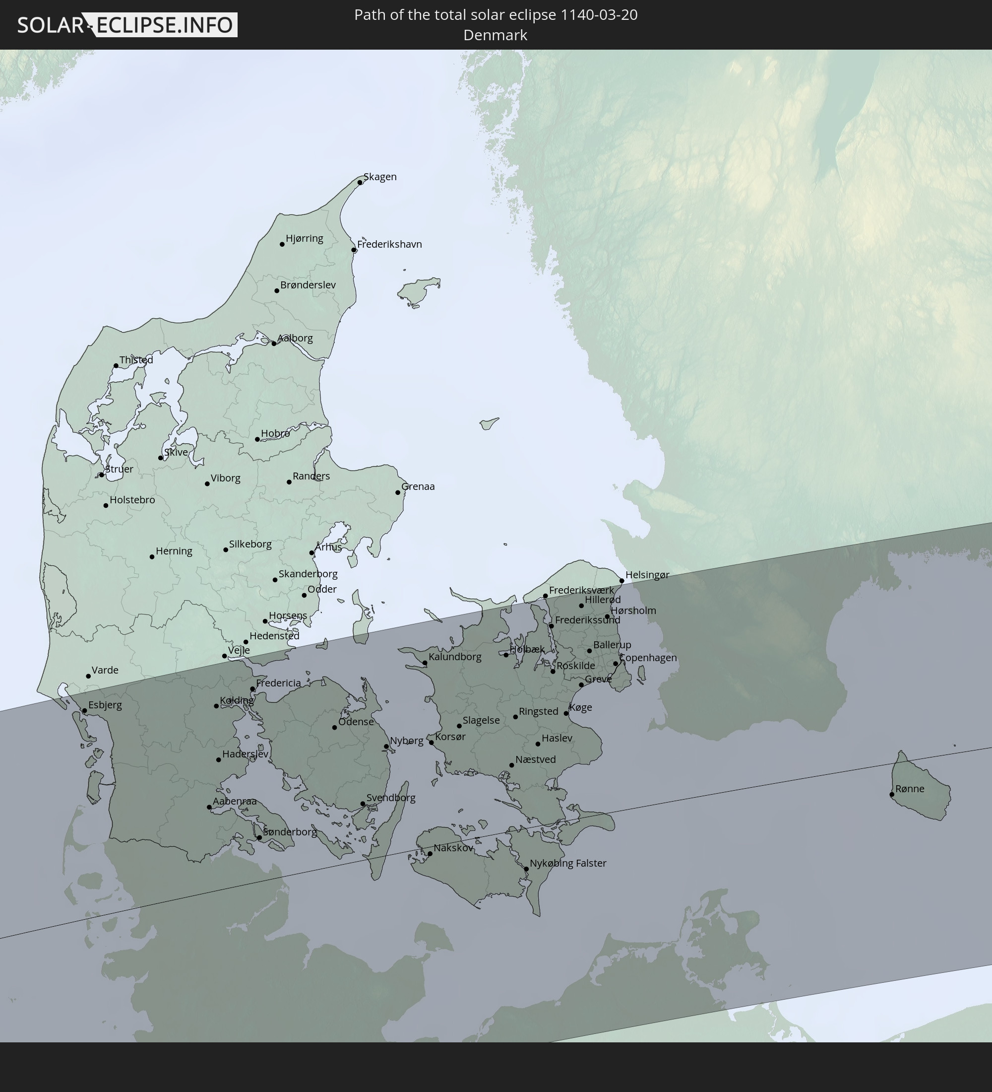 Denmark
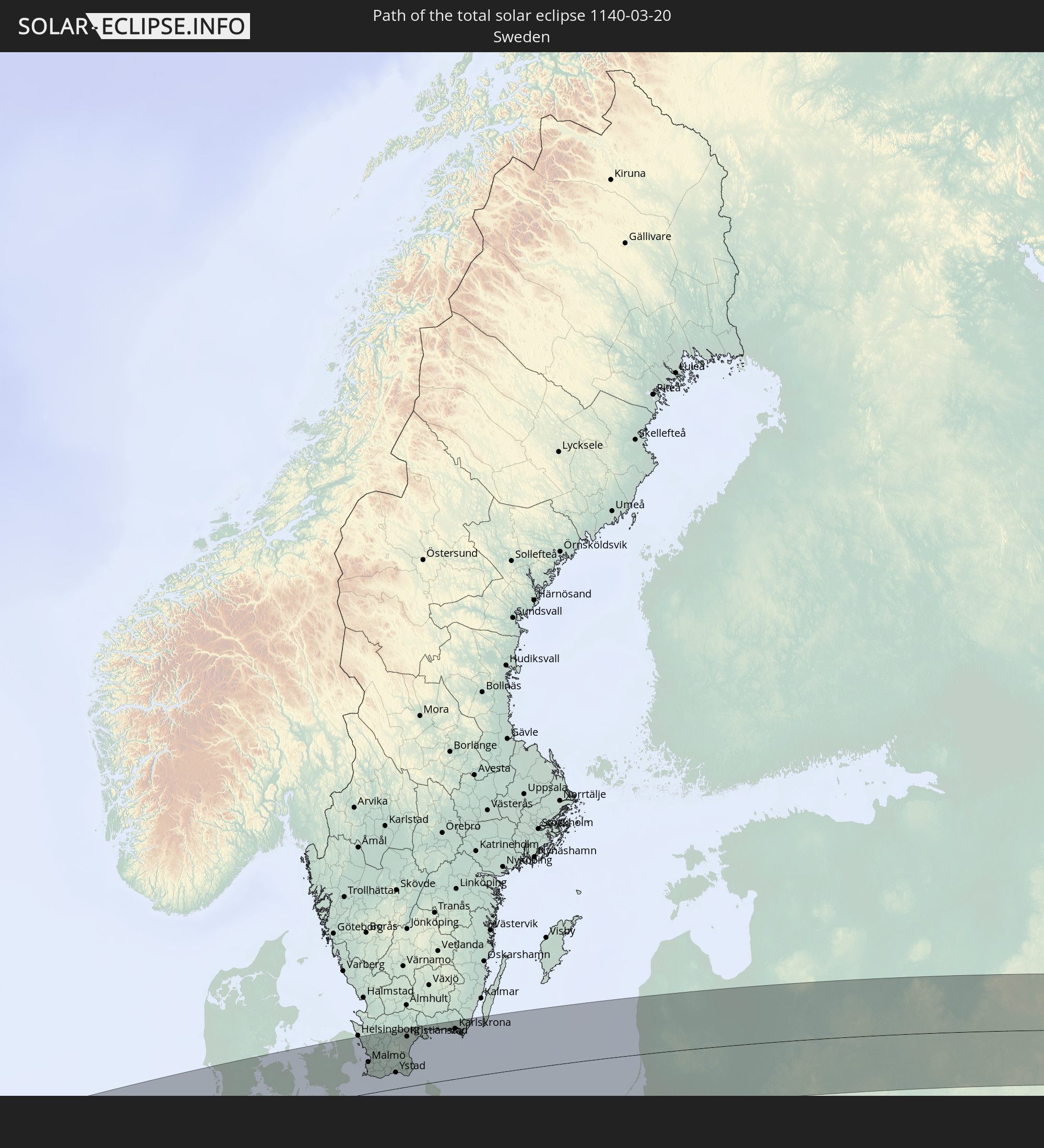 Sweden
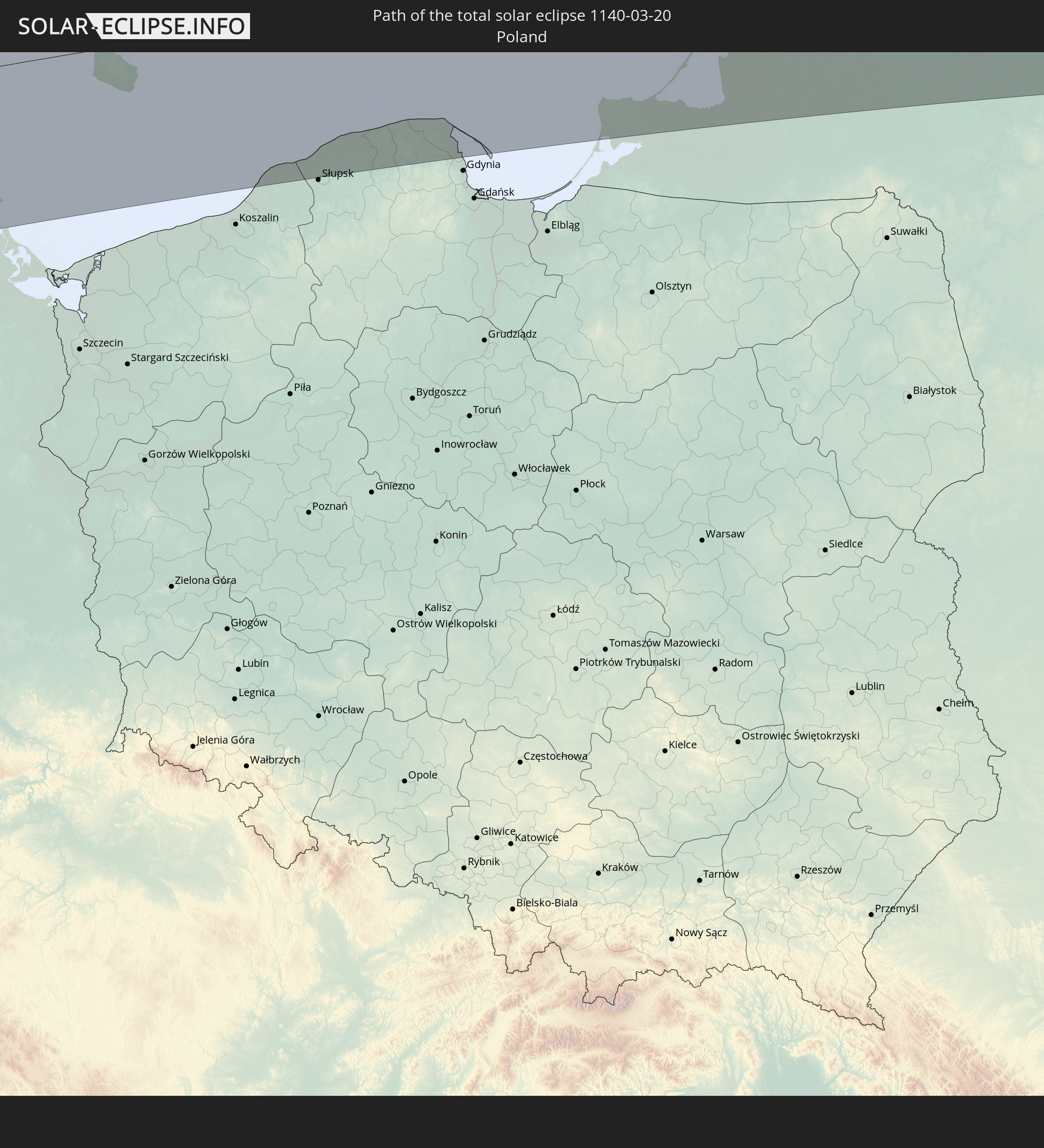 Poland
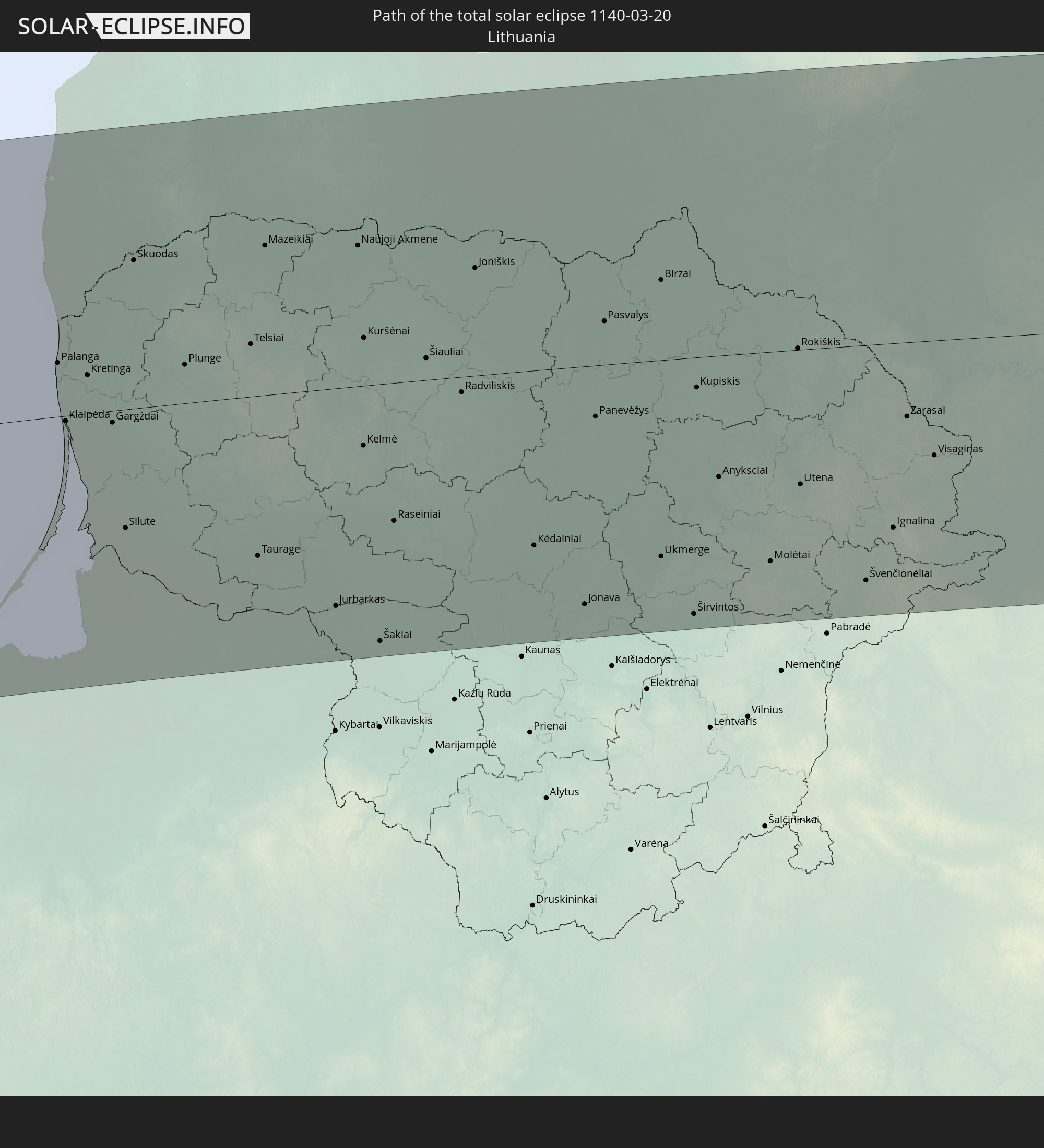 Lithuania
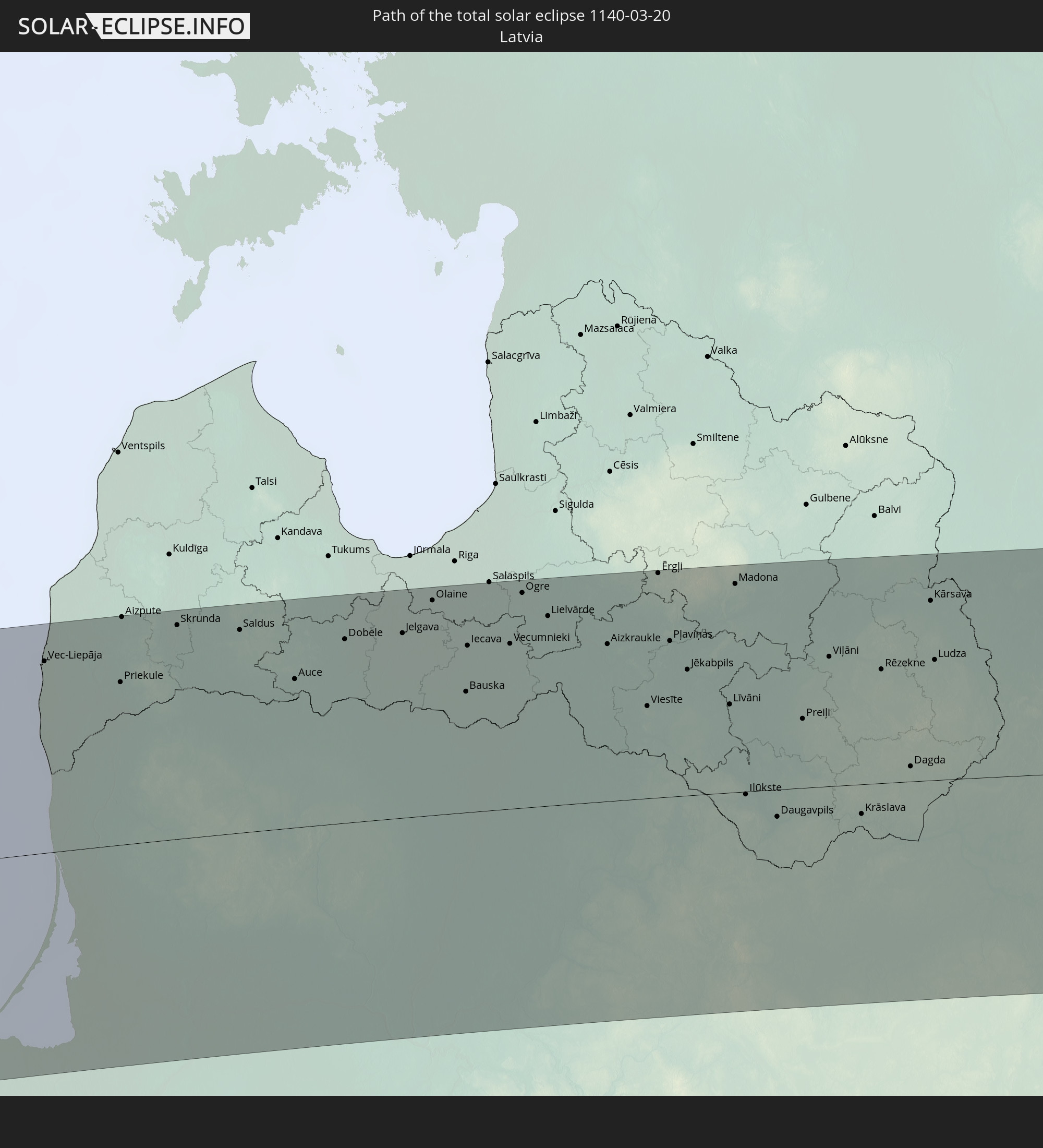 Latvia
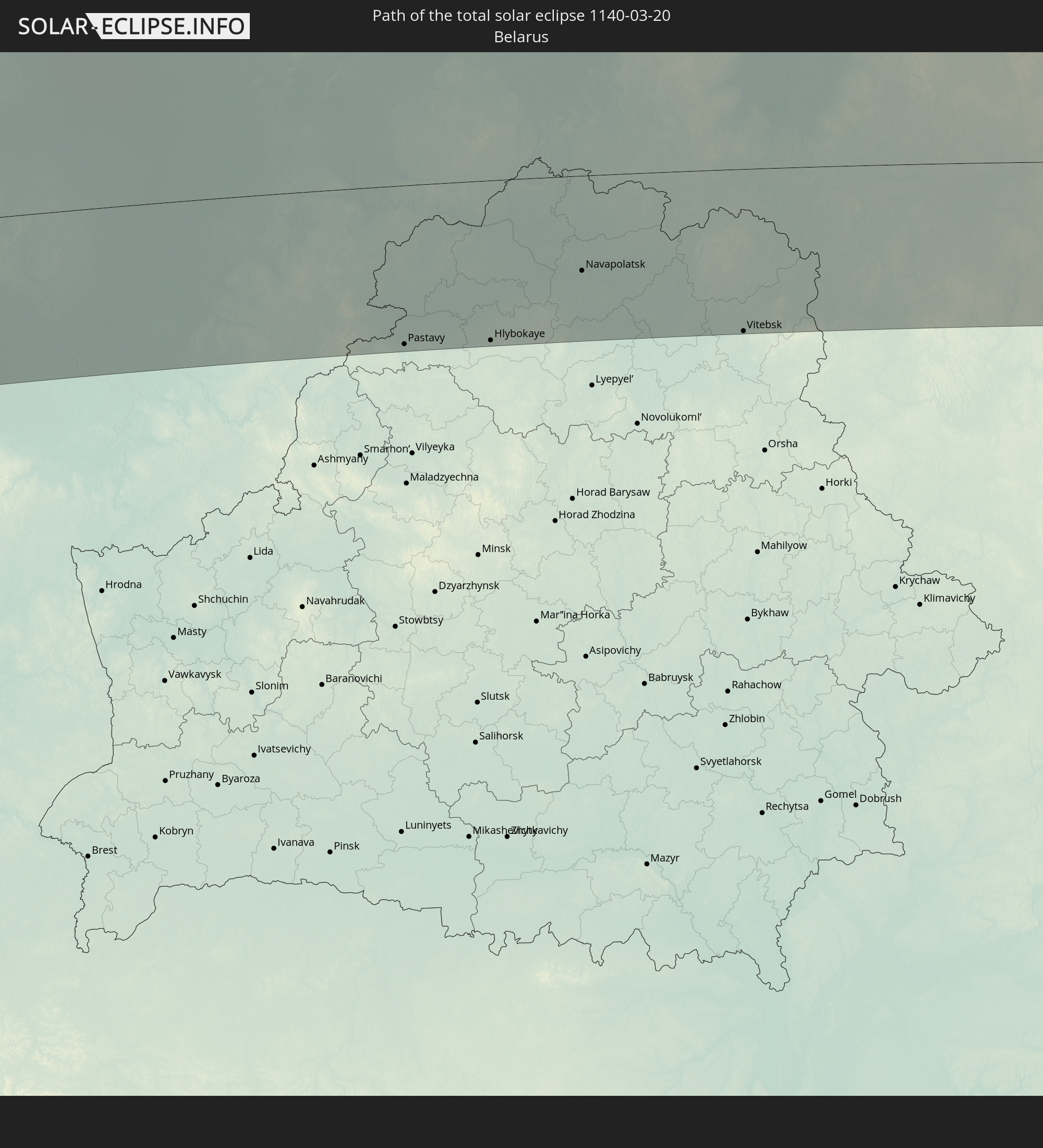 Belarus
In den folgenden Ländern ist die Sonnenfinsternis partiell zu sehen
 Russia
 United States
 United States Minor Outlying Islands
 Canada
 Mexico
 Greenland
 Guatemala
 Ecuador
 El Salvador
 Honduras
 Belize
 Nicaragua
 Costa Rica
 Cuba
Cuba
 Panama
 Colombia
 Cayman Islands
 Peru
Peru
 The Bahamas
 Jamaica
 Haiti
Haiti
 Brazil
 Venezuela
 Turks and Caicos Islands
 Dominican Republic
 Aruba
Aruba
 Bolivia
 Puerto Rico
 United States Virgin Islands
 Bermuda
 British Virgin Islands
 Anguilla
 Collectivity of Saint Martin
 Saint Barthélemy
 Saint Kitts and Nevis
 Antigua and Barbuda
 Montserrat
 Trinidad and Tobago
 Guadeloupe
 Grenada
 Dominica
 Saint Vincent and the Grenadines
 Guyana
 Martinique
 Saint Lucia
 Barbados
 Suriname
 Saint Pierre and Miquelon
 French Guiana
 Portugal
 Cabo Verde
 Iceland
 Spain
Spain
 Senegal
 Mauritania
 The Gambia
 Morocco
 Mali
Mali
 Republic of Ireland
 Svalbard and Jan Mayen
 Algeria
 United Kingdom
 Faroe Islands
 Gibraltar
 France
 Isle of Man
 Guernsey
 Jersey
 Niger
Niger
 Andorra
 Belgium
 Netherlands
 Norway
 Luxembourg
 Germany
 Switzerland
 Italy
Italy
 Monaco
 Tunisia
 Denmark
 Libya
Libya
 Liechtenstein
 Austria
 Sweden
 Czechia
 San Marino
 Vatican City
 Slovenia
 Chad
Chad
 Croatia
 Poland
 Malta
Malta
 Bosnia and Herzegovina
 Hungary
 Slovakia
 Montenegro
 Serbia
 Albania
 Åland Islands
 Greece
 Romania
 Republic of Macedonia
 Finland
 Lithuania
 Latvia
 Estonia
 Sudan
Sudan
 Ukraine
 Bulgaria
 Belarus
 Egypt
Egypt
 Turkey
 Moldova
 Cyprus
 State of Palestine
 Israel
 Saudi Arabia
 Jordan
 Lebanon
 Syria
Syria
 Iraq
Iraq
 Georgia
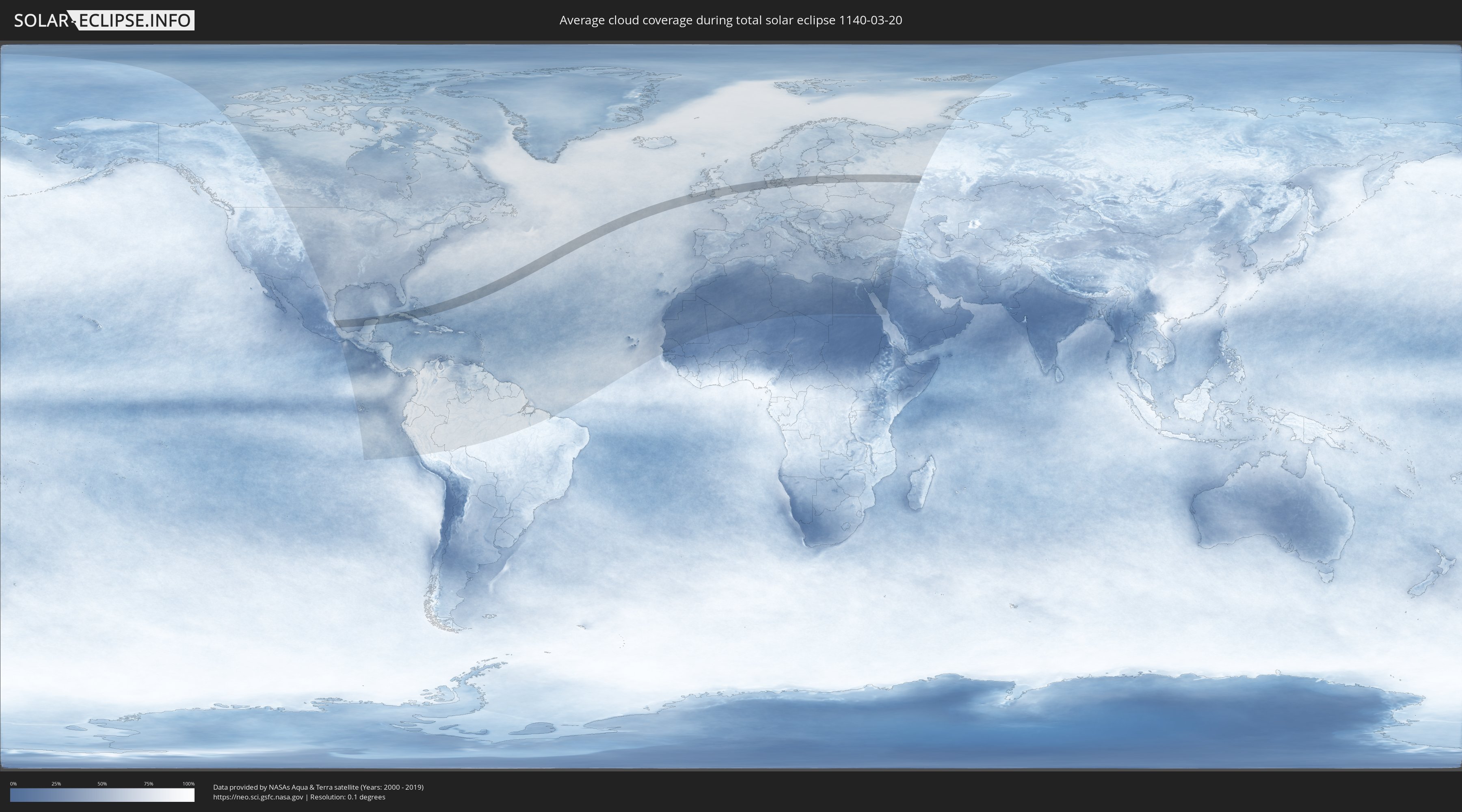
How will be the weather during the total solar eclipse on 03/20/1140?
Where is the best place to see the total solar eclipse of 03/20/1140?
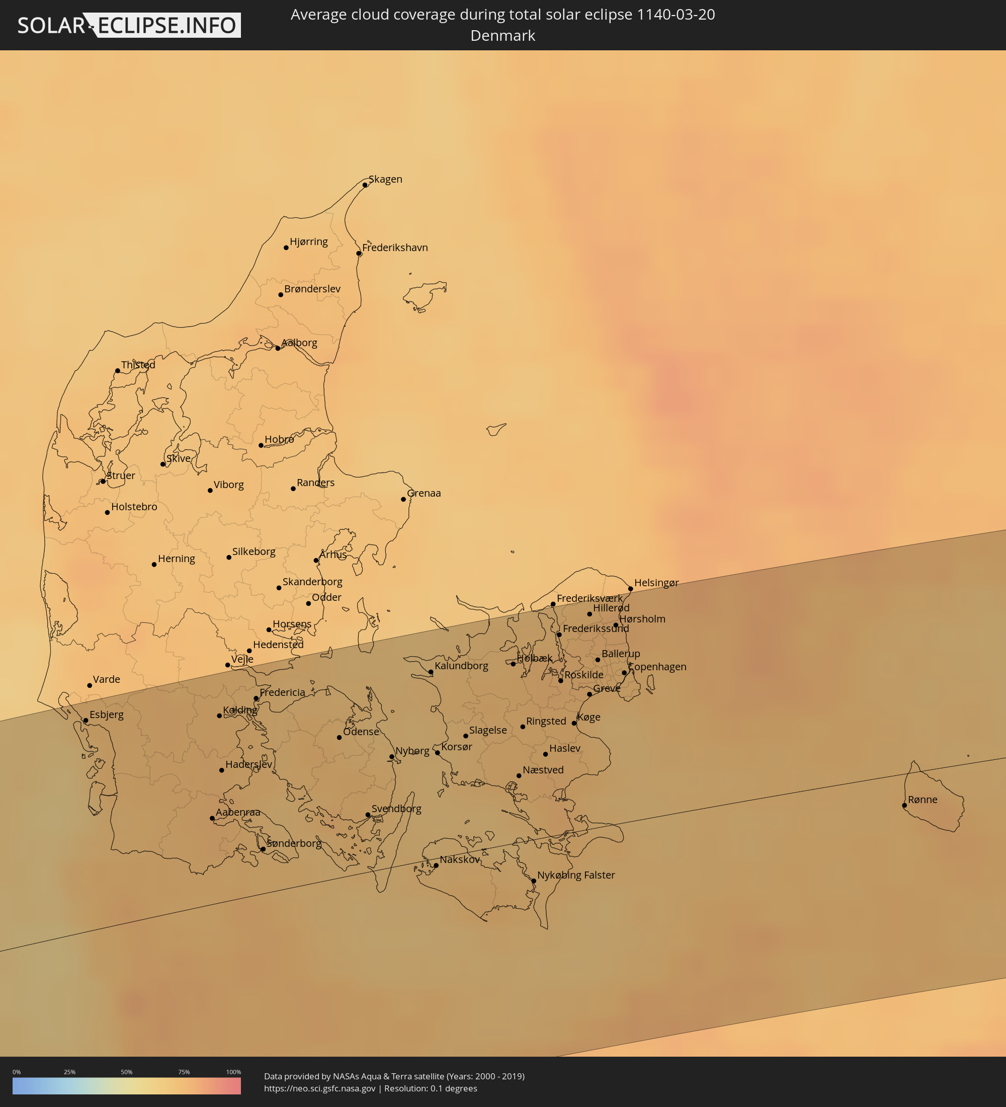
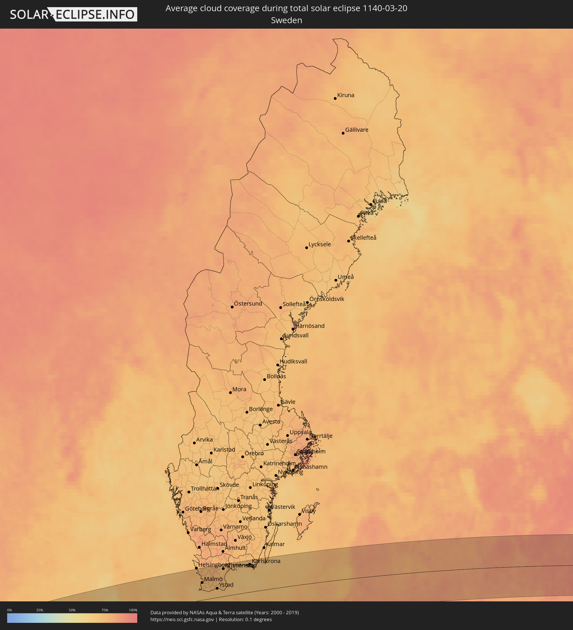
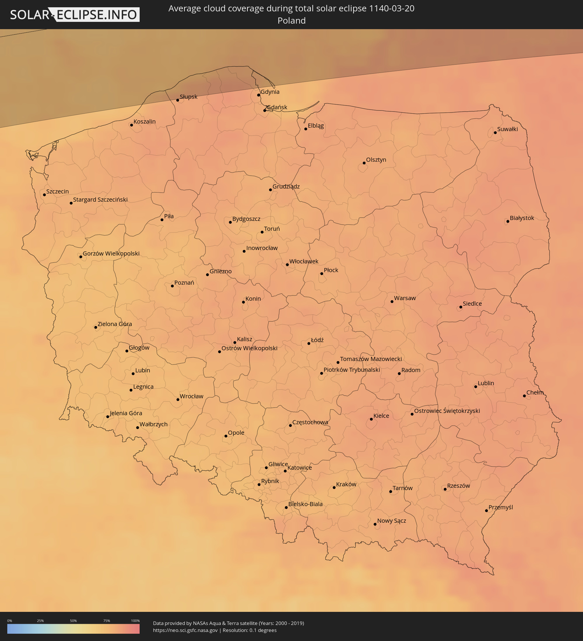
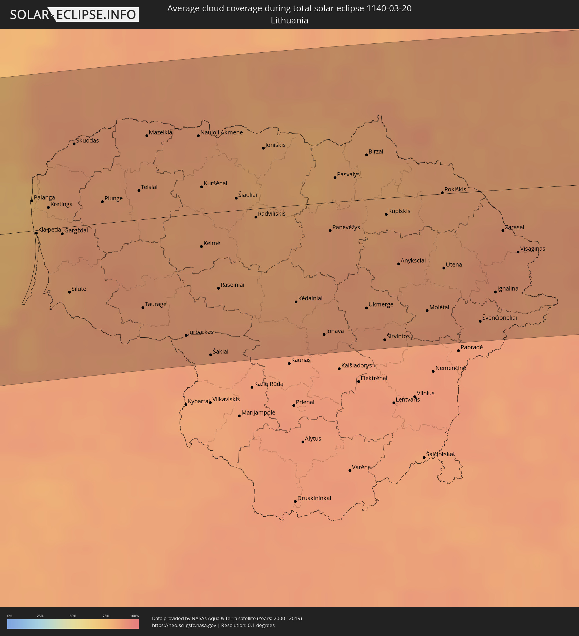
The following maps show the average cloud coverage for the day of the total solar eclipse.
With the help of these maps, it is possible to find the place along the eclipse path, which has the best
chance of a cloudless sky.
Nevertheless, you should consider local circumstances and inform about the weather of your chosen
observation site.
The data is provided by NASAs satellites
AQUA and TERRA.
The cloud maps are averaged over a period of 19 years (2000 - 2019).

Detailed country maps
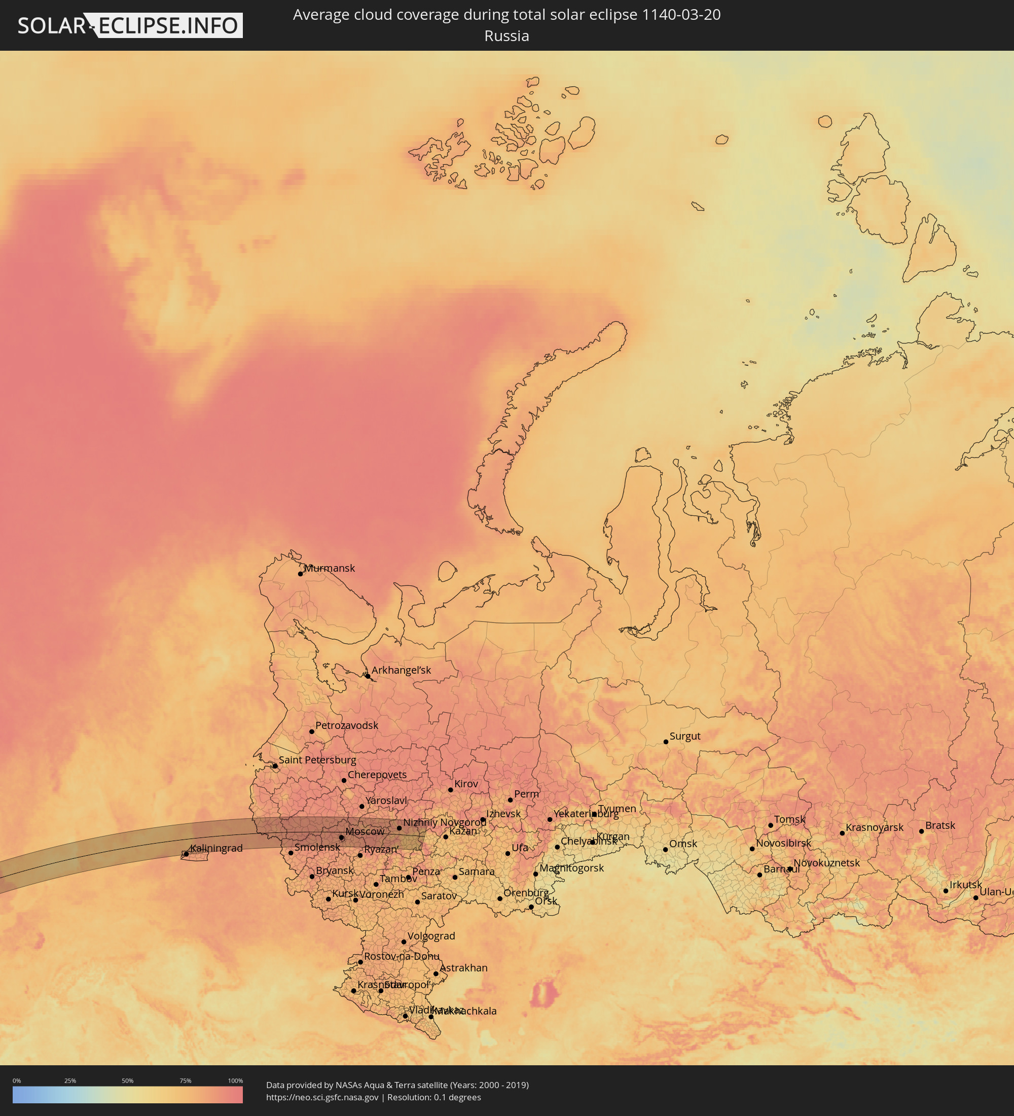 Russia
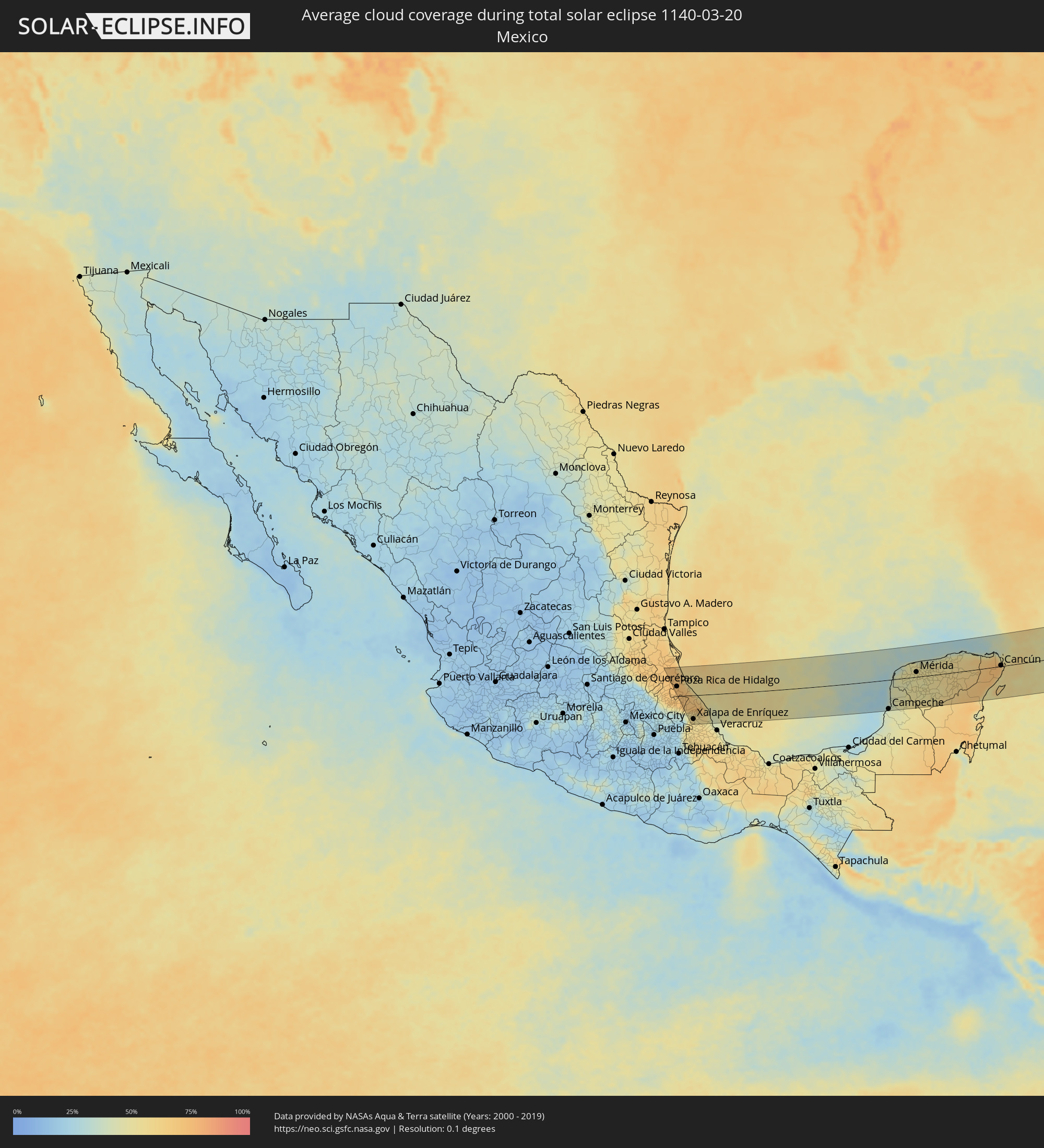 Mexico
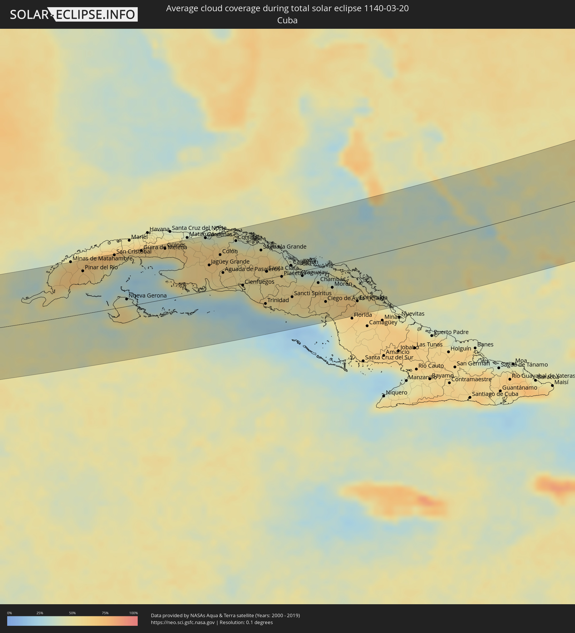 Cuba
Cuba
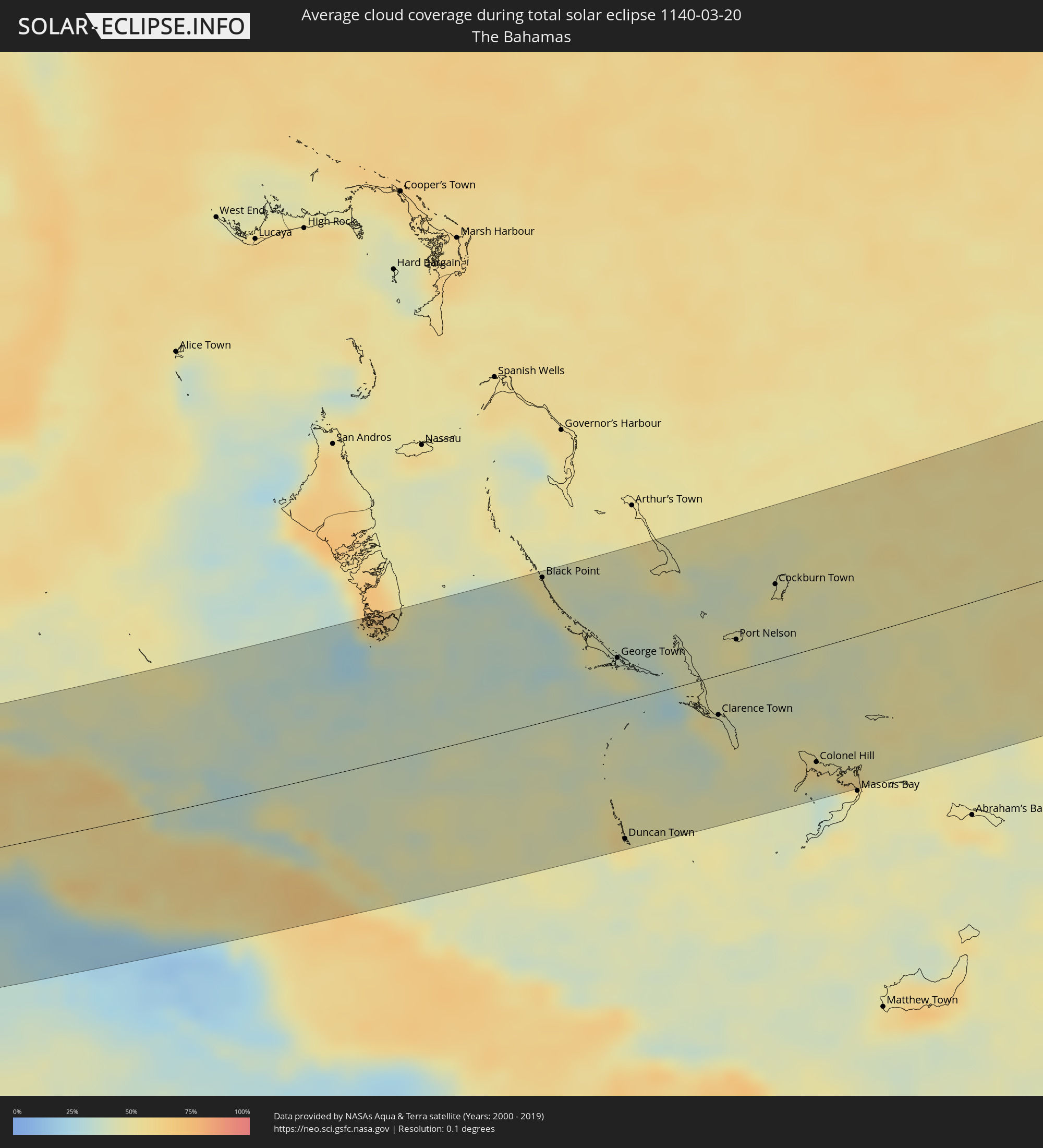 The Bahamas
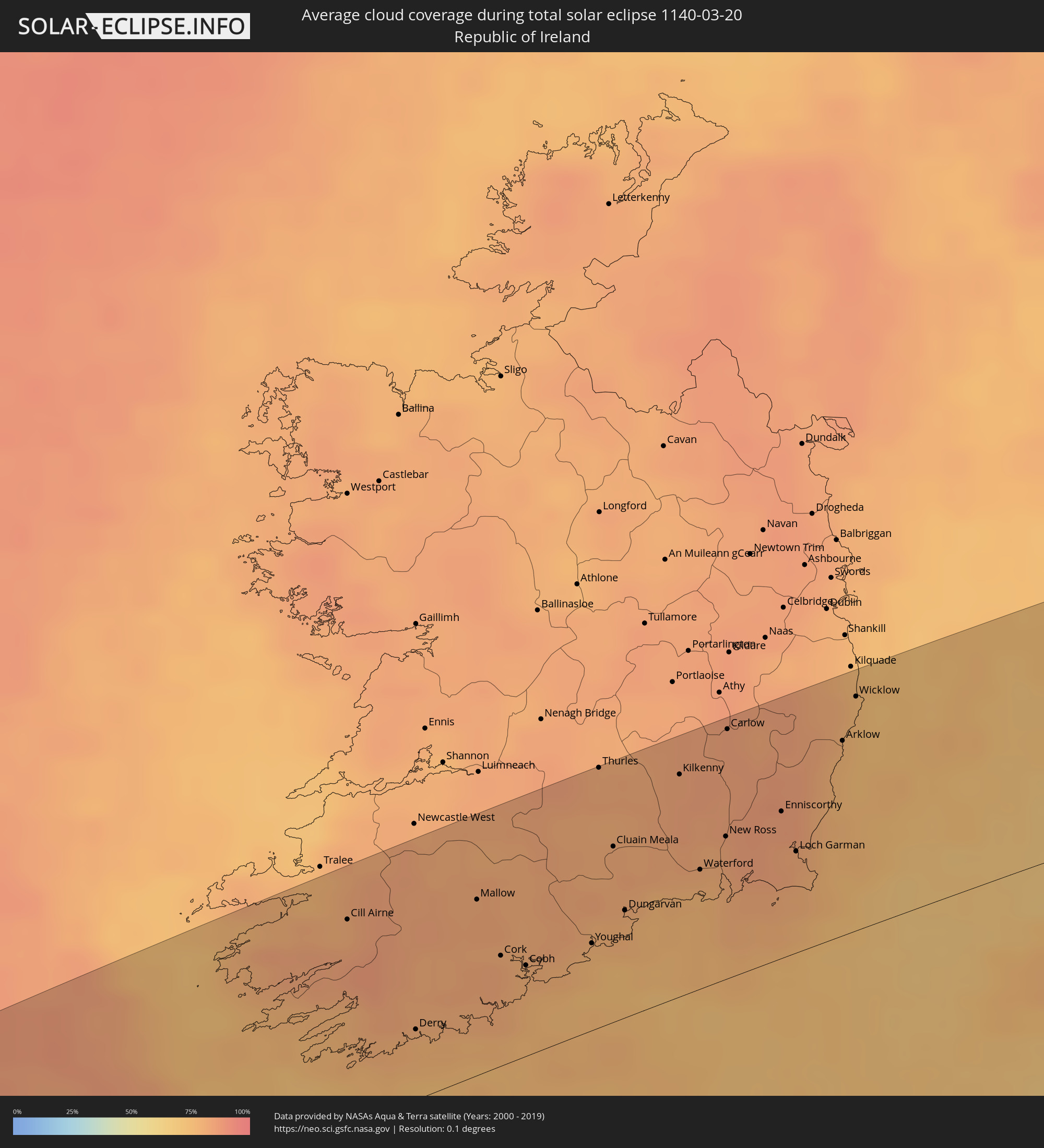 Republic of Ireland
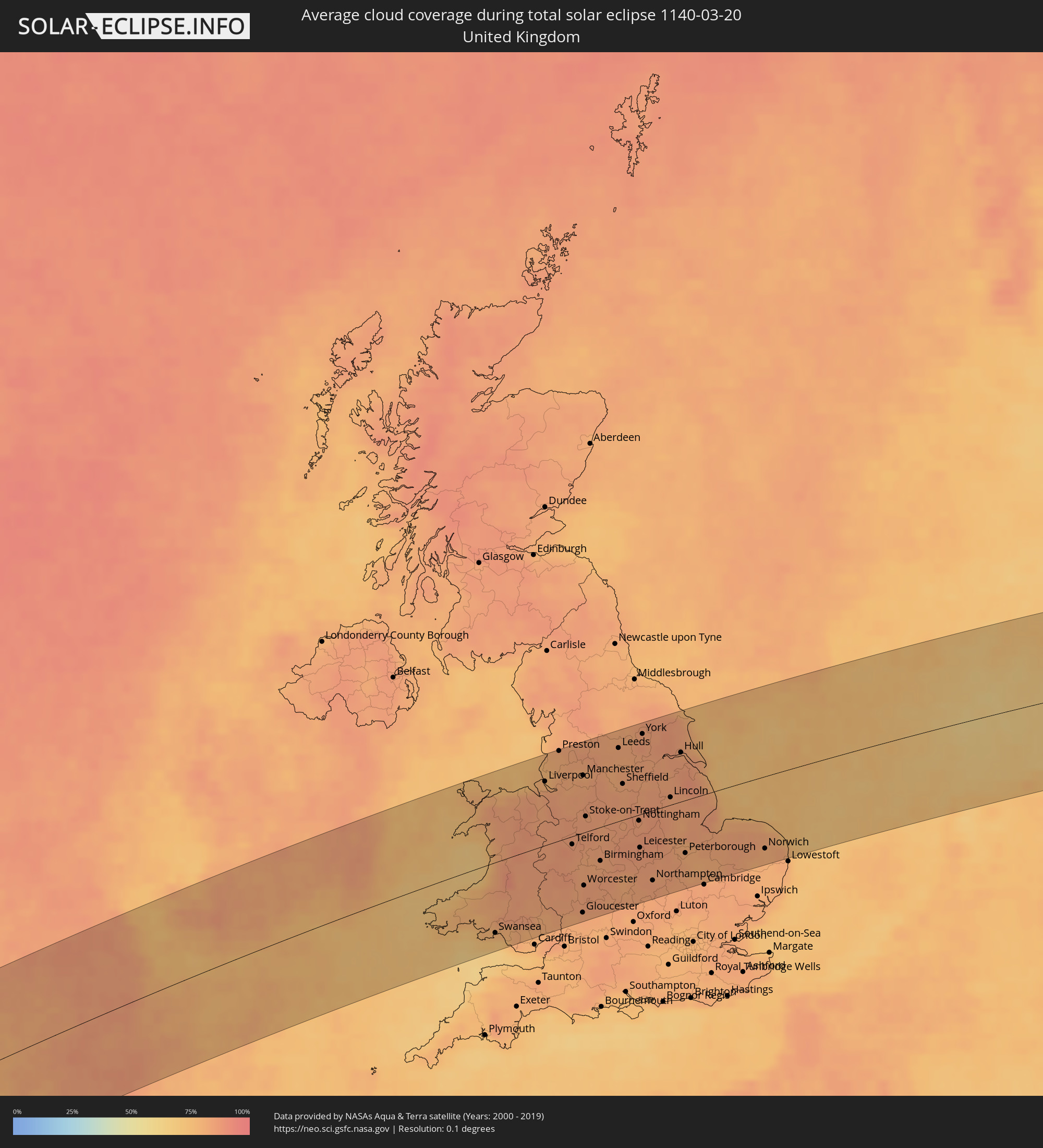 United Kingdom
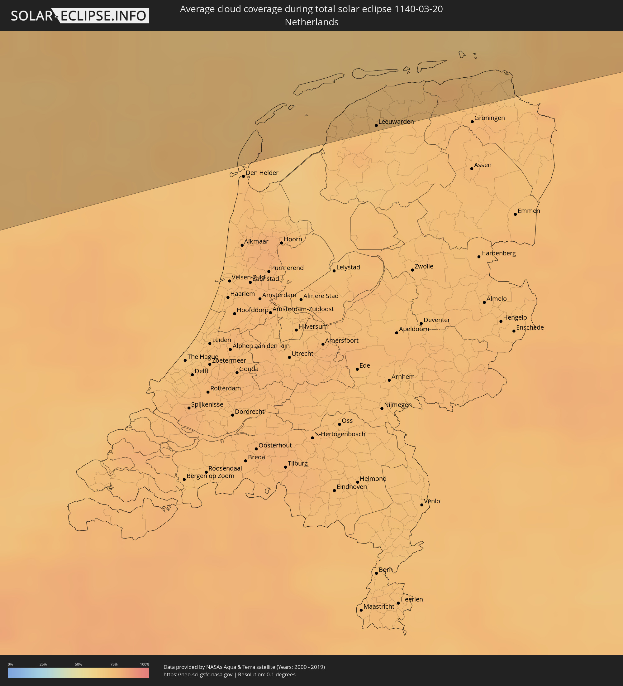 Netherlands
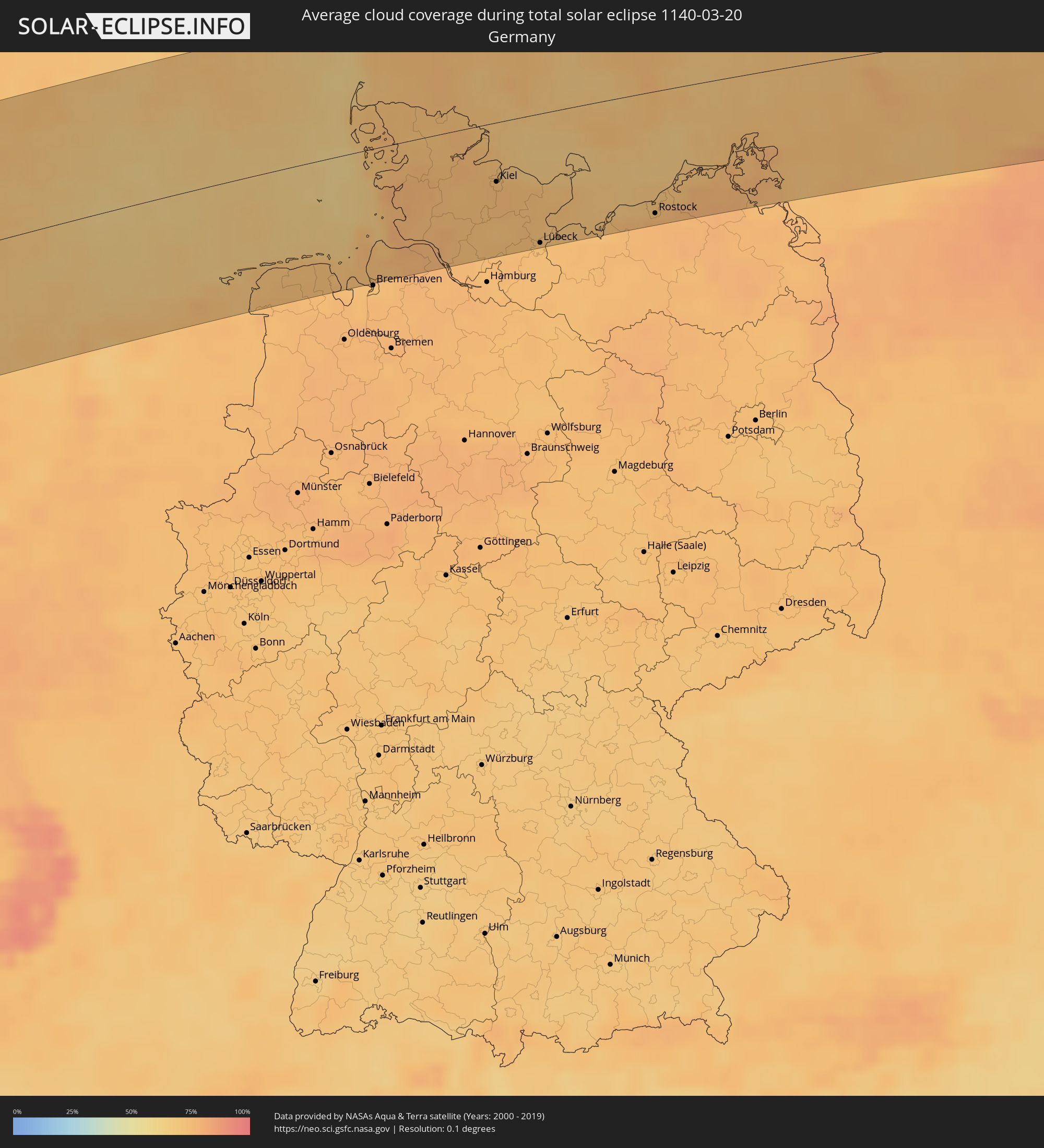 Germany
 Denmark
 Sweden
 Poland
 Lithuania
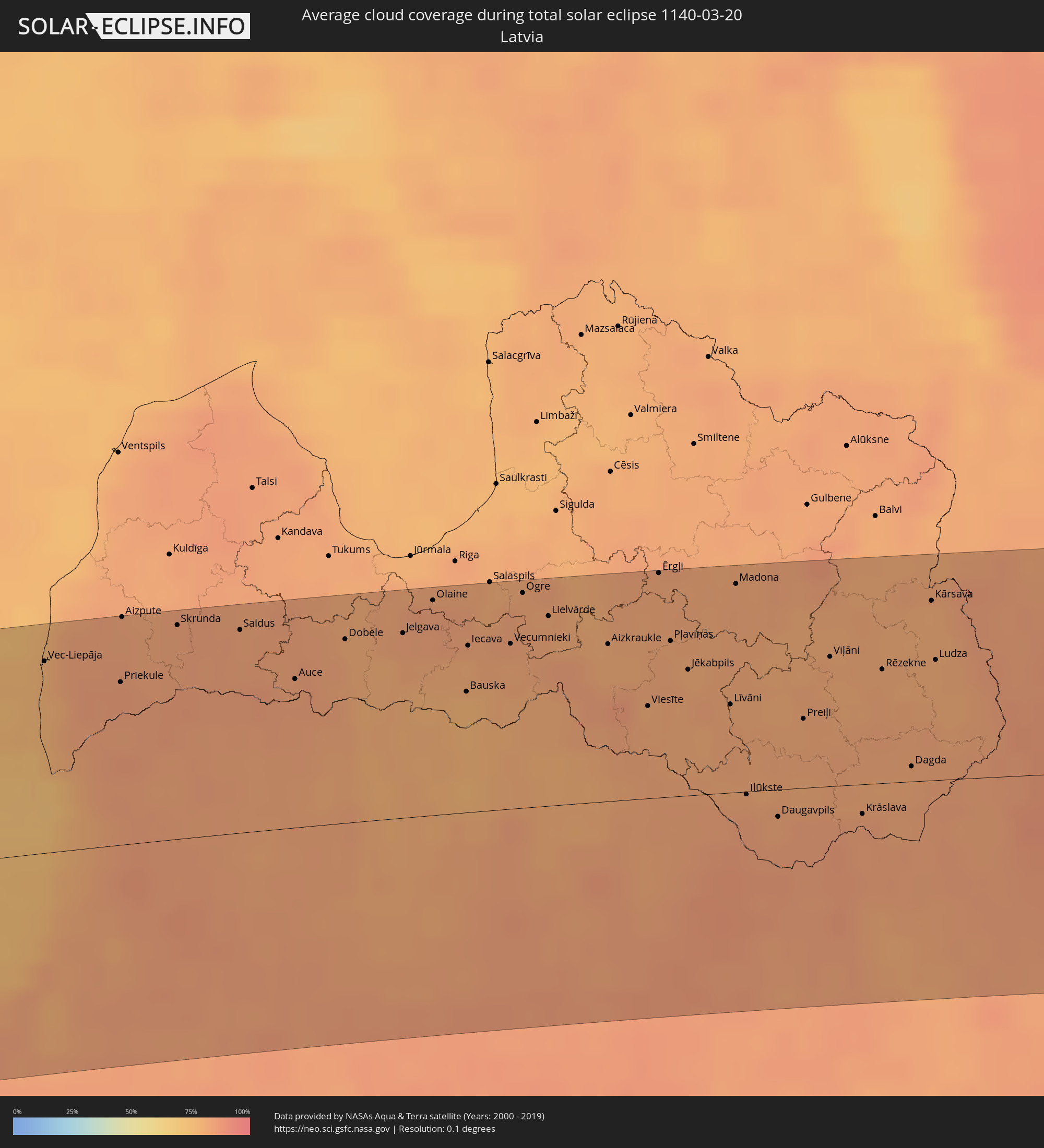 Latvia
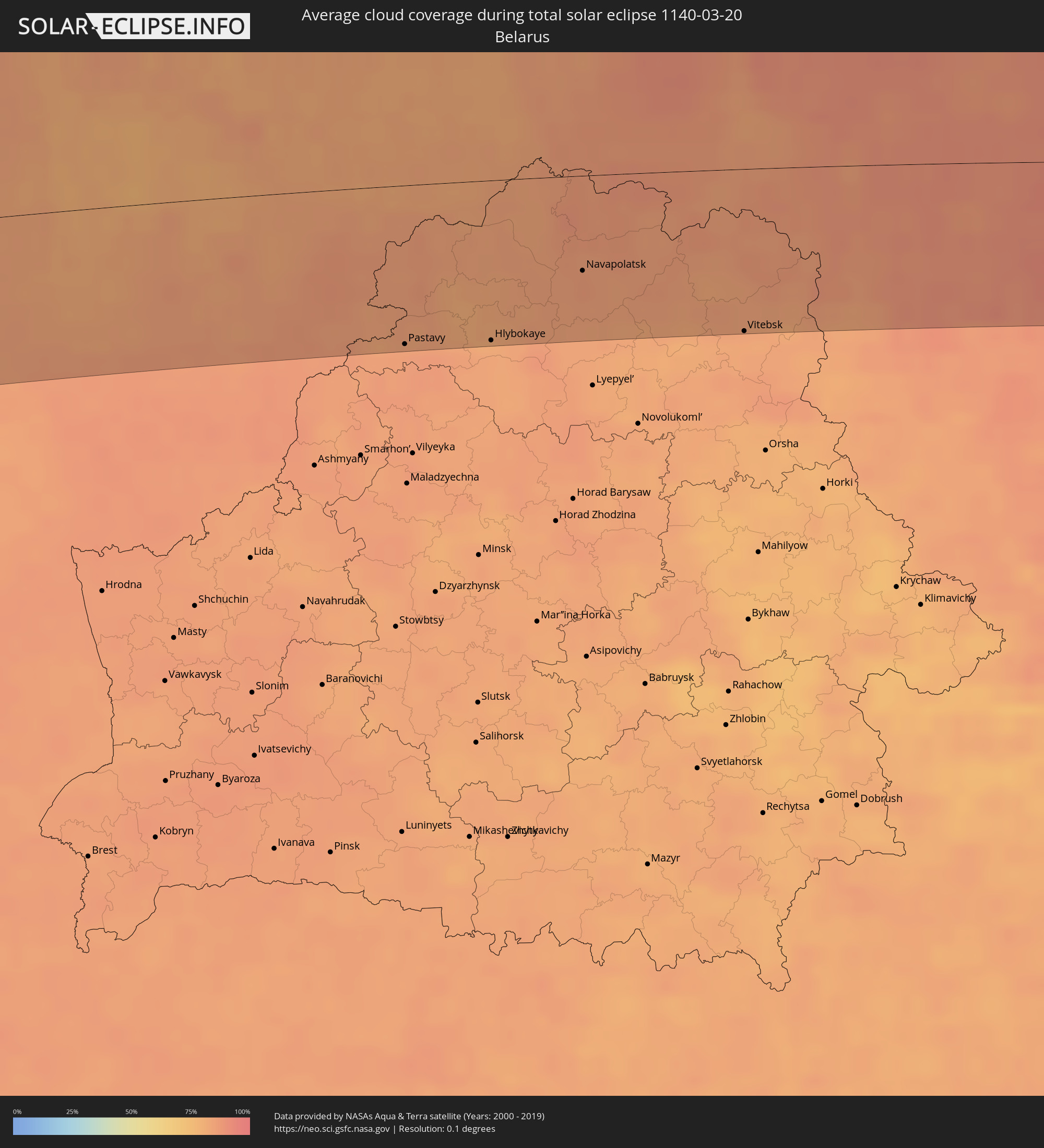 Belarus
Cities inside the path of the eclipse
The following table shows all locations with a population of more than 5,000 inside the eclipse path. Cities which have more than 100,000 inhabitants are marked bold. A click at the locations opens a detailed map.
| City | Type | Eclipse duration | Local time of max. eclipse | Distance to central line | Ø Cloud coverage |
|
Temapache, Veracruz
|
total | - | 05:56:34 UTC-06:36 | 93 km | 72% |
|
Poza Rica de Hidalgo, Veracruz
|
total | - | 05:55:58 UTC-06:36 | 34 km | 73% |
|
Tuxpan de Rodríguez Cano, Veracruz
|
total | - | 05:56:26 UTC-06:36 | 81 km | 67% |
|
Papantla de Olarte, Veracruz
|
total | - | 05:55:52 UTC-06:36 | 30 km | 72% |
|
Tlapacoyan, Veracruz
|
total | - | 05:55:19 UTC-06:36 | 32 km | 69% |
|
Martínez de la Torre, Veracruz
|
total | - | 05:55:26 UTC-06:36 | 21 km | 69% |
|
Xalapa de Enríquez, Veracruz
|
total | - | 05:54:50 UTC-06:36 | 81 km | 55% |
|
Campeche, Campeche
|
total | - | 05:55:31 UTC-06:36 | 99 km | 42% |
|
Progreso de Castro, Yucatán
|
total | - | 05:57:24 UTC-06:36 | 51 km | 45% |
|
Mérida, Yucatán
|
total | - | 05:57:01 UTC-06:36 | 16 km | 52% |
|
Valladolid, Yucatán
|
total | - | 05:56:58 UTC-06:36 | 33 km | 61% |
|
Tizimín, Yucatán
|
total | - | 05:57:32 UTC-06:36 | 17 km | 57% |
|
Playa del Carmen, Quintana Roo
|
total | - | 06:46:42 UTC-05:47 | 55 km | 53% |
|
San Miguel de Cozumel, Quintana Roo
|
total | - | 06:46:34 UTC-05:47 | 71 km | 60% |
|
Cancún, Quintana Roo
|
total | - | 06:47:26 UTC-05:47 | 2 km | 61% |
|
Pinar del Río, Pinar del Río
|
total | - | 07:07:34 UTC-05:29 | 89 km | 64% |
|
Consolación del Sur, Pinar del Río
|
total | - | 07:07:45 UTC-05:29 | 95 km | 64% |
|
San Cristobal, Artemisa
|
total | - | 07:08:13 UTC-05:29 | 110 km | 69% |
|
Güira de Melena, Artemisa
|
total | - | 07:08:34 UTC-05:29 | 109 km | 57% |
|
Güines, Mayabeque
|
total | - | 07:08:50 UTC-05:29 | 104 km | 56% |
|
Cárdenas, Matanzas
|
total | - | 07:09:30 UTC-05:29 | 109 km | 57% |
|
Colón, Matanzas
|
total | - | 07:09:13 UTC-05:29 | 69 km | 64% |
|
Cienfuegos, Cienfuegos
|
total | - | 07:08:39 UTC-05:29 | 3 km | 36% |
|
Sagua la Grande, Villa Clara
|
total | - | 07:09:45 UTC-05:29 | 61 km | 59% |
|
Trinidad, Sancti Spíritus
|
total | - | 07:08:25 UTC-05:29 | 51 km | 43% |
|
Santa Clara, Villa Clara
|
total | - | 07:09:15 UTC-05:29 | 15 km | 54% |
|
Placetas, Villa Clara
|
total | - | 07:09:17 UTC-05:29 | 2 km | 56% |
|
Sancti Spíritus, Sancti Spíritus
|
total | - | 07:08:53 UTC-05:29 | 48 km | 51% |
|
Ciego de Ávila, Ciego de Ávila
|
total | - | 07:09:08 UTC-05:29 | 73 km | 56% |
|
Morón, Ciego de Ávila
|
total | - | 07:09:34 UTC-05:29 | 47 km | 60% |
|
Black Point, Black Point
|
total | - | 12:43:23 UTC+00:00 | 114 km | 51% |
|
George Town, Exuma
|
total | - | 07:33:27 UTC-05:09 | 35 km | 46% |
|
Duncan Town, Ragged Island
|
total | - | 07:31:35 UTC-05:09 | 109 km | 51% |
|
Clarence Town, Long Island
|
total | - | 07:33:24 UTC-05:09 | 31 km | 50% |
|
Port Nelson, Rum Cay
|
total | - | 07:34:18 UTC-05:09 | 24 km | 45% |
|
Cockburn Town, San Salvador
|
total | - | 07:35:07 UTC-05:09 | 59 km | 50% |
|
Colonel Hill, Crooked Island and Long Cay
|
total | - | 07:33:28 UTC-05:09 | 89 km | 56% |
|
Derry, Munster
|
total | - | 14:24:09 UTC-00:25 | 31 km | 79% |
|
Mallow, Munster
|
total | - | 14:24:27 UTC-00:25 | 77 km | 82% |
|
Cork, Munster
|
total | - | 14:24:43 UTC-00:25 | 48 km | 82% |
|
Cobh, Munster
|
total | - | 14:24:55 UTC-00:25 | 40 km | 79% |
|
Midleton, Munster
|
total | - | 14:25:02 UTC-00:25 | 43 km | 80% |
|
Thurles, Munster
|
total | - | 14:25:10 UTC-00:25 | 113 km | 81% |
|
Cluain Meala, Munster
|
total | - | 14:25:24 UTC-00:25 | 77 km | 81% |
|
Kilkenny, Leinster
|
total | - | 14:25:46 UTC-00:25 | 97 km | 83% |
|
Trá Mhór, Munster
|
total | - | 14:26:04 UTC-00:25 | 43 km | 77% |
|
Waterford, Munster
|
total | - | 14:26:05 UTC-00:25 | 52 km | 80% |
|
Carlow, Leinster
|
total | - | 14:26:03 UTC-00:25 | 108 km | 84% |
|
Enniscorthy, Leinster
|
total | - | 14:26:35 UTC-00:25 | 64 km | 84% |
|
Loch Garman, Leinster
|
total | - | 14:26:45 UTC-00:25 | 44 km | 82% |
|
Arklow, Leinster
|
total | - | 14:26:54 UTC-00:25 | 85 km | 76% |
|
Wicklow, Leinster
|
total | - | 14:26:55 UTC-00:25 | 101 km | 75% |
|
Liverpool, England
|
total | - | 14:55:09 UTC+00:00 | 79 km | 82% |
|
Preston, England
|
total | - | 14:55:13 UTC+00:00 | 110 km | 80% |
|
Manchester, England
|
total | - | 14:55:49 UTC+00:00 | 71 km | 81% |
|
Stoke-on-Trent, England
|
total | - | 14:56:08 UTC+00:00 | 19 km | 85% |
|
Wolverhampton, England
|
total | - | 14:56:26 UTC+00:00 | 26 km | 81% |
|
Birmingham, England
|
total | - | 14:56:42 UTC+00:00 | 42 km | 82% |
|
Leeds, England
|
total | - | 14:56:17 UTC+00:00 | 90 km | 82% |
|
Coventry, England
|
total | - | 14:57:07 UTC+00:00 | 58 km | 81% |
|
Derby, England
|
total | - | 14:56:52 UTC+00:00 | 4 km | 85% |
|
Sheffield, England
|
total | - | 14:56:37 UTC+00:00 | 44 km | 82% |
|
Nottingham, England
|
total | - | 14:57:10 UTC+00:00 | 7 km | 84% |
|
Leicester, England
|
total | - | 14:57:22 UTC+00:00 | 41 km | 85% |
|
Northampton, England
|
total | - | 14:57:49 UTC+00:00 | 88 km | 84% |
|
Hull, England
|
total | - | 14:57:26 UTC+00:00 | 60 km | 84% |
|
Norwich, England
|
total | - | 14:59:38 UTC+00:00 | 90 km | 80% |
|
Den Burg, North Holland
|
total | - | 15:21:53 UTC+00:19 | 106 km | 74% |
|
Harlingen, Friesland
|
total | - | 15:22:18 UTC+00:19 | 103 km | 70% |
|
Franeker, Friesland
|
total | - | 15:22:24 UTC+00:19 | 104 km | 74% |
|
Stiens, Friesland
|
total | - | 15:22:30 UTC+00:19 | 99 km | 73% |
|
Bilgaard, Friesland
|
total | - | 15:22:34 UTC+00:19 | 105 km | 74% |
|
Leeuwarden, Friesland
|
total | - | 15:22:36 UTC+00:19 | 106 km | 74% |
|
Huizum, Friesland
|
total | - | 15:22:36 UTC+00:19 | 108 km | 74% |
|
Camminghaburen, Friesland
|
total | - | 15:22:37 UTC+00:19 | 106 km | 74% |
|
Dokkum, Friesland
|
total | - | 15:22:39 UTC+00:19 | 96 km | 72% |
|
Damwâld, Friesland
|
total | - | 15:22:41 UTC+00:19 | 100 km | 72% |
|
Buitenpost, Friesland
|
total | - | 15:22:49 UTC+00:19 | 106 km | 74% |
|
Kollum, Friesland
|
total | - | 15:22:49 UTC+00:19 | 104 km | 74% |
|
Ulrum, Groningen
|
total | - | 15:22:53 UTC+00:19 | 98 km | 73% |
|
Winsum, Groningen
|
total | - | 15:23:03 UTC+00:19 | 104 km | 75% |
|
Bedum, Groningen
|
total | - | 15:23:08 UTC+00:19 | 108 km | 75% |
|
Norden, Lower Saxony
|
total | - | 16:03:50 UTC+01:00 | 85 km | 72% |
|
Aurich, Lower Saxony
|
total | - | 16:04:09 UTC+01:00 | 103 km | 75% |
|
Wilhelmshaven, Lower Saxony
|
total | - | 16:04:34 UTC+01:00 | 106 km | 75% |
|
Esbjerg, South Denmark
|
total | - | 16:03:10 UTC+01:00 | 100 km | 74% |
|
Cuxhaven, Lower Saxony
|
total | - | 16:04:42 UTC+01:00 | 77 km | 72% |
|
Flensburg, Schleswig-Holstein
|
total | - | 16:04:27 UTC+01:00 | 12 km | 72% |
|
Kolding, South Denmark
|
total | - | 16:03:51 UTC+01:00 | 89 km | 74% |
|
Haderslev, South Denmark
|
total | - | 16:04:04 UTC+01:00 | 63 km | 74% |
|
Itzehoe, Schleswig-Holstein
|
total | - | 16:05:15 UTC+01:00 | 83 km | 75% |
|
Elmshorn, Schleswig-Holstein
|
total | - | 16:05:29 UTC+01:00 | 103 km | 75% |
|
Rendsburg, Schleswig-Holstein
|
total | - | 16:05:01 UTC+01:00 | 43 km | 73% |
|
Fredericia, South Denmark
|
total | - | 16:03:58 UTC+01:00 | 93 km | 71% |
|
Sønderborg, South Denmark
|
total | - | 16:04:35 UTC+01:00 | 21 km | 72% |
|
Henstedt-Ulzburg, Schleswig-Holstein
|
total | - | 16:05:41 UTC+01:00 | 103 km | 74% |
|
Neumünster, Schleswig-Holstein
|
total | - | 16:05:26 UTC+01:00 | 72 km | 73% |
|
Kiel, Schleswig-Holstein
|
total | - | 16:05:20 UTC+01:00 | 47 km | 75% |
|
Bad Oldesloe, Schleswig-Holstein
|
total | - | 16:05:56 UTC+01:00 | 106 km | 75% |
|
Odense, South Denmark
|
total | - | 16:04:32 UTC+01:00 | 67 km | 71% |
|
Svendborg, South Denmark
|
total | - | 16:04:59 UTC+01:00 | 27 km | 71% |
|
Lübeck, Schleswig-Holstein
|
total | - | 16:06:06 UTC+01:00 | 104 km | 74% |
|
Slagelse, Zealand
|
total | - | 16:05:09 UTC+01:00 | 55 km | 71% |
|
Holbæk, Zealand
|
total | - | 16:05:06 UTC+01:00 | 85 km | 73% |
|
Næstved, Zealand
|
total | - | 16:05:34 UTC+01:00 | 32 km | 72% |
|
Roskilde, Zealand
|
total | - | 16:05:23 UTC+01:00 | 73 km | 74% |
|
Rostock, Mecklenburg-Vorpommern
|
total | - | 16:06:51 UTC+01:00 | 98 km | 76% |
|
Køge, Zealand
|
total | - | 16:05:37 UTC+01:00 | 51 km | 73% |
|
Greve, Zealand
|
total | - | 16:05:35 UTC+01:00 | 64 km | 73% |
|
Hørsholm, Capital Region
|
total | - | 16:05:25 UTC+01:00 | 94 km | 76% |
|
Copenhagen, Capital Region
|
total | - | 16:05:39 UTC+01:00 | 71 km | 73% |
|
Landskrona, Skåne
|
total | - | 16:05:37 UTC+01:00 | 89 km | 74% |
|
Malmö, Skåne
|
total | - | 16:05:59 UTC+01:00 | 58 km | 73% |
|
Bjärred, Skåne
|
total | - | 16:05:53 UTC+01:00 | 70 km | 73% |
|
Stralsund, Mecklenburg-Vorpommern
|
total | - | 16:07:15 UTC+01:00 | 85 km | 76% |
|
Trelleborg, Skåne
|
total | - | 16:06:17 UTC+01:00 | 31 km | 71% |
|
Lund, Skåne
|
total | - | 16:06:00 UTC+01:00 | 67 km | 75% |
|
Svedala, Skåne
|
total | - | 16:06:13 UTC+01:00 | 45 km | 74% |
|
Eslöv, Skåne
|
total | - | 16:05:56 UTC+01:00 | 81 km | 75% |
|
Ystad, Skåne
|
total | - | 16:06:38 UTC+01:00 | 30 km | 71% |
|
Kristianstad, Skåne
|
total | - | 16:06:14 UTC+01:00 | 93 km | 74% |
|
Åhus, Skåne
|
total | - | 16:06:25 UTC+01:00 | 79 km | 74% |
|
Bromölla, Skåne
|
total | - | 16:06:22 UTC+01:00 | 94 km | 75% |
|
Sölvesborg, Blekinge
|
total | - | 16:06:27 UTC+01:00 | 90 km | 72% |
|
Karlshamn, Blekinge
|
total | - | 16:06:30 UTC+01:00 | 101 km | 75% |
|
Ronneby, Blekinge
|
total | - | 16:06:41 UTC+01:00 | 101 km | 72% |
|
Karlskrona, Blekinge
|
total | - | 16:06:54 UTC+01:00 | 92 km | 75% |
|
Ustka, Pomeranian Voivodeship
|
total | - | 16:33:09 UTC+01:24 | 94 km | 81% |
|
Gościcino, Pomeranian Voivodeship
|
total | - | 16:33:47 UTC+01:24 | 102 km | 85% |
|
Bolszewo, Pomeranian Voivodeship
|
total | - | 16:33:47 UTC+01:24 | 101 km | 85% |
|
Wejherowo, Pomeranian Voivodeship
|
total | - | 16:33:49 UTC+01:24 | 103 km | 85% |
|
Reda, Pomeranian Voivodeship
|
total | - | 16:33:53 UTC+01:24 | 104 km | 85% |
|
Władysławowo, Pomeranian Voivodeship
|
total | - | 16:33:43 UTC+01:24 | 84 km | 82% |
|
Puck, Pomeranian Voivodeship
|
total | - | 16:33:48 UTC+01:24 | 92 km | 83% |
|
Vec-Liepāja, Liepāja
|
total | - | 16:45:40 UTC+01:36 | 89 km | 79% |
|
Klaipėda, Klaipėda County
|
total | - | 16:34:01 UTC+01:24 | 2 km | 78% |
|
Kretinga, Klaipėda County
|
total | - | 16:33:54 UTC+01:24 | 15 km | 80% |
|
Silute, Klaipėda County
|
total | - | 16:34:33 UTC+01:24 | 45 km | 82% |
|
Plunge, Telšiai County
|
total | - | 16:34:06 UTC+01:24 | 15 km | 84% |
|
Telsiai, Telšiai County
|
total | - | 16:34:12 UTC+01:24 | 20 km | 83% |
|
Taurage, Tauragė County
|
total | - | 16:35:00 UTC+01:24 | 61 km | 84% |
|
Mazeikiai, Telšiai County
|
total | - | 16:33:52 UTC+01:24 | 56 km | 83% |
|
Saldus, Saldus Rajons
|
total | - | 16:46:07 UTC+01:36 | 94 km | 83% |
|
Dobele, Dobeles Rajons
|
total | - | 16:46:28 UTC+01:36 | 85 km | 81% |
|
Šiauliai, Šiauliai County
|
total | - | 16:34:40 UTC+01:24 | 8 km | 83% |
|
Radviliskis, Šiauliai County
|
total | - | 16:34:52 UTC+01:24 | 6 km | 81% |
|
Jelgava, Jelgava
|
total | - | 16:46:36 UTC+01:36 | 86 km | 83% |
|
Olaine, Olaine
|
total | - | 16:46:32 UTC+01:36 | 99 km | 84% |
|
Kėdainiai, Kaunas County
|
total | - | 16:35:37 UTC+01:24 | 67 km | 83% |
|
Bauska, Bauskas Rajons
|
total | - | 16:47:02 UTC+01:36 | 56 km | 77% |
|
Jonava, Kaunas County
|
total | - | 16:35:57 UTC+01:24 | 91 km | 85% |
|
Panevėžys, Panevėžys
|
total | - | 16:35:16 UTC+01:24 | 19 km | 83% |
|
Ogre, Ogre
|
total | - | 16:46:44 UTC+01:36 | 99 km | 82% |
|
Ukmerge, Vilnius County
|
total | - | 16:35:56 UTC+01:24 | 75 km | 84% |
|
Aizkraukle, Aizkraukles Rajons
|
total | - | 16:47:11 UTC+01:36 | 73 km | 80% |
|
Utena, Utena County
|
total | - | 16:35:57 UTC+01:24 | 51 km | 83% |
|
Jēkabpils, Jēkabpils Municipality
|
total | - | 16:47:30 UTC+01:36 | 58 km | 81% |
|
Līvāni, Līvāni
|
total | - | 16:47:46 UTC+01:36 | 41 km | 81% |
|
Madona, Madonas Rajons
|
total | - | 16:47:14 UTC+01:36 | 96 km | 82% |
|
Visaginas, Utena County
|
total | - | 16:36:07 UTC+01:24 | 44 km | 85% |
|
Daugavpils, Daugavpils municipality
|
total | - | 16:48:24 UTC+01:36 | 13 km | 82% |
|
Pastavy, Vitebsk
|
total | - | 17:02:47 UTC+01:50 | 99 km | 85% |
|
Braslaw, Vitebsk
|
total | - | 17:02:16 UTC+01:50 | 42 km | 85% |
|
Krāslava, Krāslavas Rajons
|
total | - | 16:48:35 UTC+01:36 | 14 km | 84% |
|
Rēzekne, Rēzekne
|
total | - | 16:47:58 UTC+01:36 | 53 km | 82% |
|
Sharkawshchyna, Vitebsk
|
total | - | 17:02:42 UTC+01:50 | 73 km | 80% |
|
Myory, Vitebsk
|
total | - | 17:02:28 UTC+01:50 | 46 km | 83% |
|
Hlybokaye, Vitebsk
|
total | - | 17:03:01 UTC+01:50 | 100 km | 82% |
|
Ludza, Ludzas Rajons
|
total | - | 16:48:02 UTC+01:36 | 56 km | 80% |
|
Vyerkhnyadzvinsk, Vitebsk
|
total | - | 17:02:23 UTC+01:50 | 30 km | 84% |
|
Navapolatsk, Vitebsk
|
total | - | 17:02:51 UTC+01:50 | 59 km | 86% |
|
Ushachy, Vitebsk
|
total | - | 17:03:14 UTC+01:50 | 98 km | 83% |
|
Polatsk, Vitebsk
|
total | - | 17:02:57 UTC+01:50 | 64 km | 84% |
|
Rasony, Vitebsk
|
total | - | 17:02:29 UTC+01:50 | 18 km | 85% |
|
Haradok, Vitebsk
|
total | - | 17:03:17 UTC+01:50 | 70 km | 83% |
|
Vitebsk, Vitebsk
|
total | - | 17:03:38 UTC+01:50 | 101 km | 82% |
|
Tver, Tverskaya
|
total | - | 17:43:07 UTC+02:30 | 80 km | 87% |
|
Zelenograd, Moscow
|
total | - | 17:44:17 UTC+02:30 | 17 km | 88% |
|
Odintsovo, Moscow Oblast
|
total | - | 17:44:38 UTC+02:30 | 51 km | 87% |
|
Khimki, Moscow Oblast
|
total | - | 17:44:24 UTC+02:30 | 26 km | 89% |
|
Yasenevo, Moscow
|
total | - | 17:44:45 UTC+02:30 | 58 km | 86% |
|
Podolsk, Moscow Oblast
|
total | - | 17:44:57 UTC+02:30 | 79 km | 85% |
|
Moscow, Moscow
|
total | - | 17:44:35 UTC+02:30 | 42 km | 92% |
|
Mytishchi, Moscow Oblast
|
total | - | 17:44:25 UTC+02:30 | 24 km | 91% |
|
Lyubertsy, Moscow Oblast
|
total | - | 17:44:42 UTC+02:30 | 50 km | 86% |
|
Balashikha, Moscow Oblast
|
total | - | 17:44:34 UTC+02:30 | 35 km | 85% |
|
Elektrostal’, Moscow Oblast
|
total | - | 17:44:38 UTC+02:30 | 37 km | 86% |
|
Vladimir, Vladimir
|
total | - | 17:44:23 UTC+02:30 | 6 km | 88% |
|
Kovrov, Vladimir
|
total | - | 17:44:10 UTC+02:30 | 33 km | 88% |
|
Dzerzhinsk, Nizjnij Novgorod
|
total | - | 17:44:21 UTC+02:30 | 27 km | 81% |
|
Nizhniy Novgorod, Nizjnij Novgorod
|
total | - | 17:44:15 UTC+02:30 | 39 km | 84% |