Total solar eclipse of 06/03/1239
| Day of week: | Friday |
| Maximum duration of eclipse: | 05m58s |
| Maximum width of eclipse path: | 263 km |
| Saros cycle: | 115 |
| Coverage: | 100% |
| Magnitude: | 1.0771 |
| Gamma: | 0.3157 |
Wo kann man die Sonnenfinsternis vom 06/03/1239 sehen?
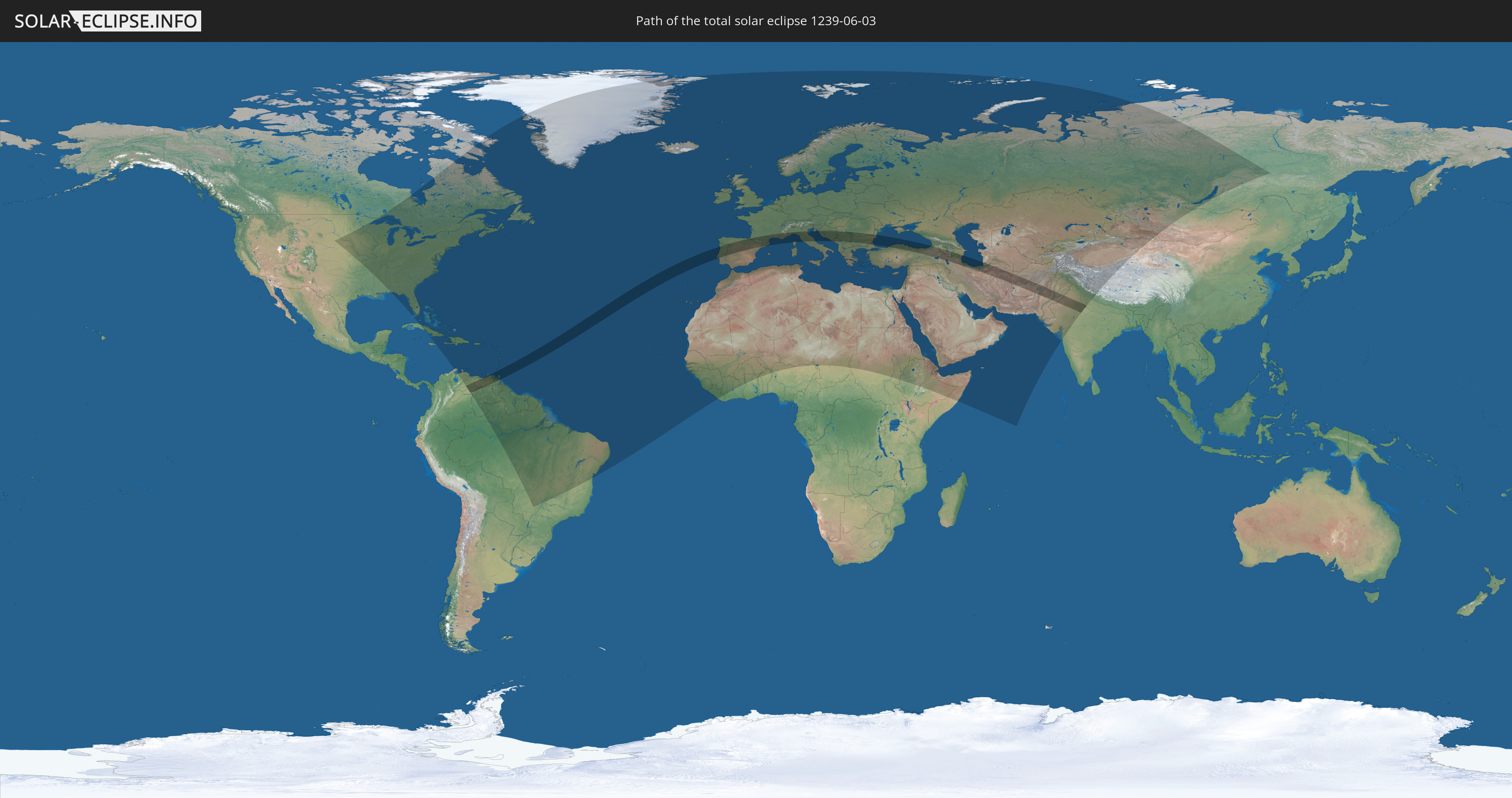
Die Sonnenfinsternis am 06/03/1239 kann man in 143 Ländern als partielle Sonnenfinsternis beobachten.
Der Finsternispfad verläuft durch 24 Länder. Nur in diesen Ländern ist sie als total Sonnenfinsternis zu sehen.
In den folgenden Ländern ist die Sonnenfinsternis total zu sehen
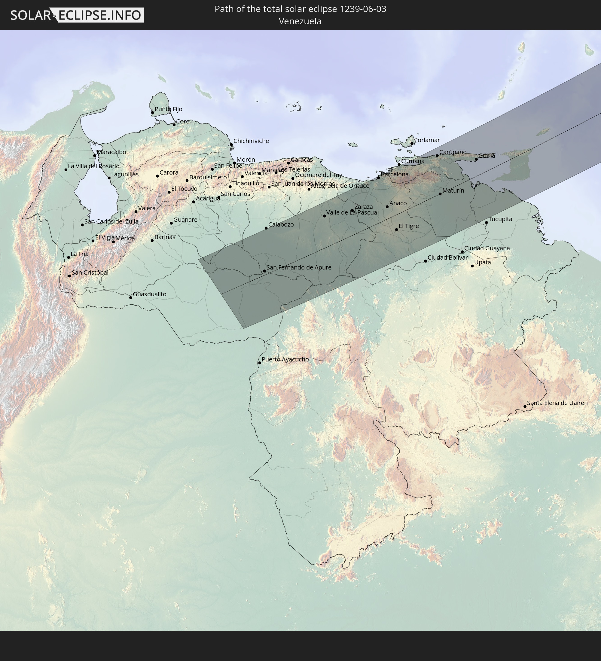 Venezuela
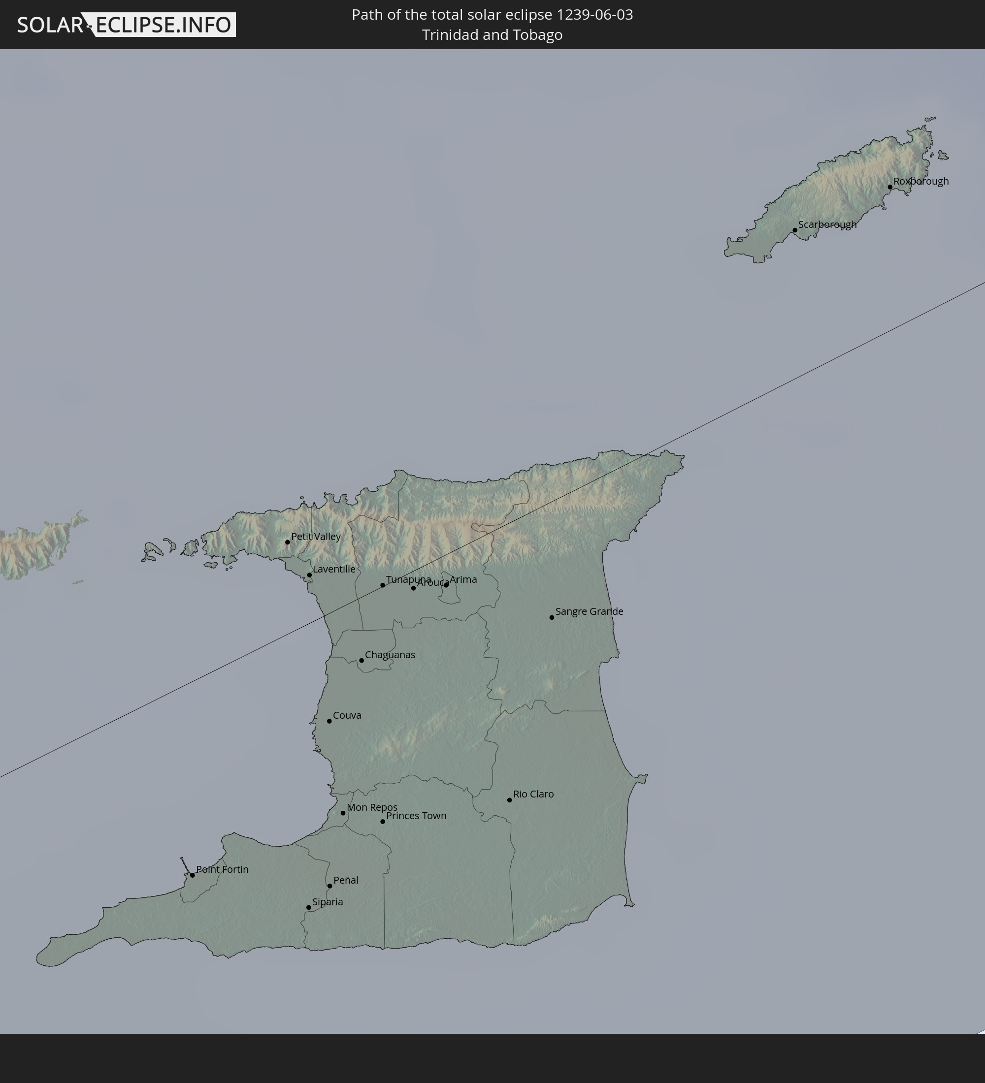 Trinidad and Tobago
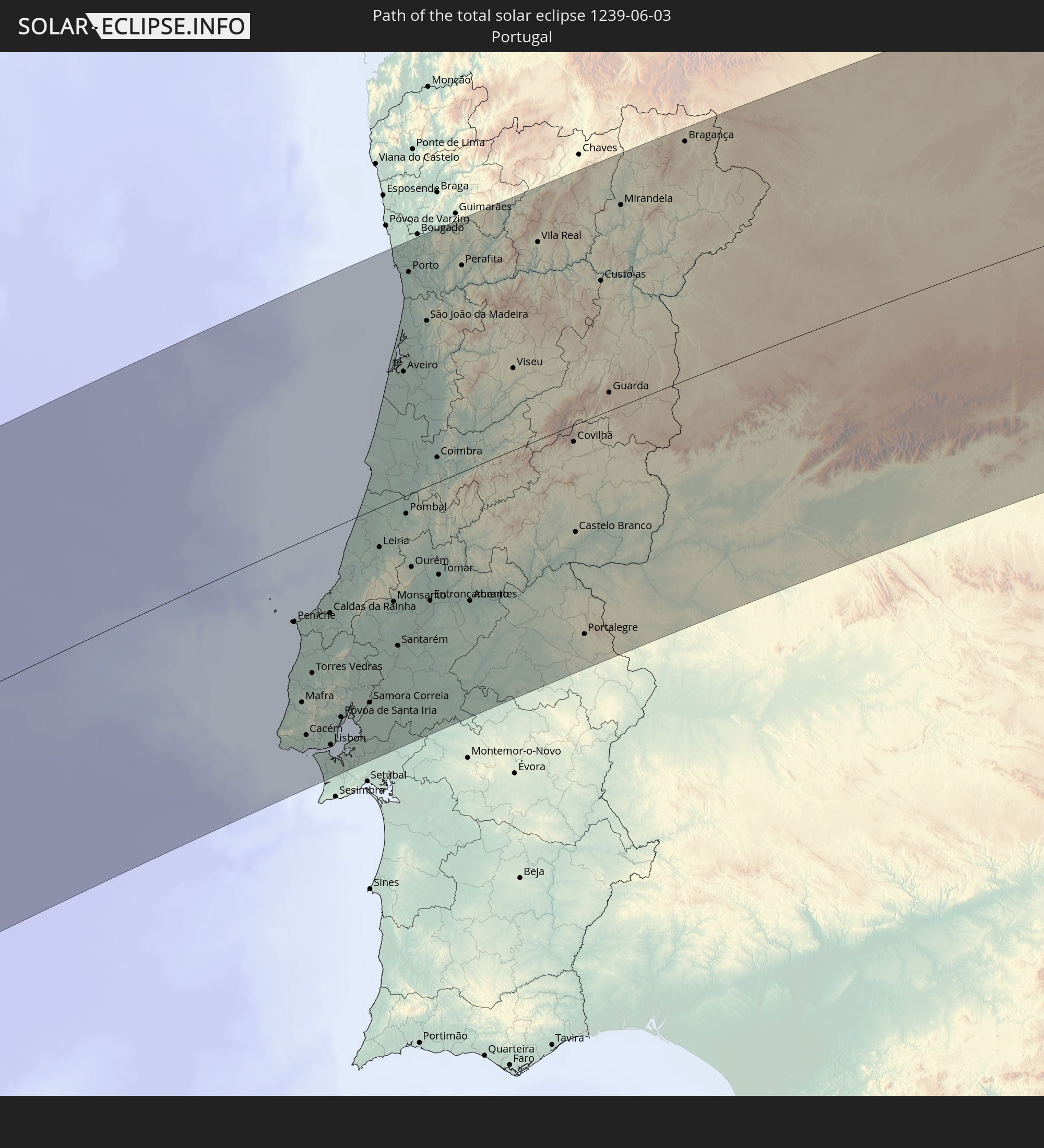 Portugal
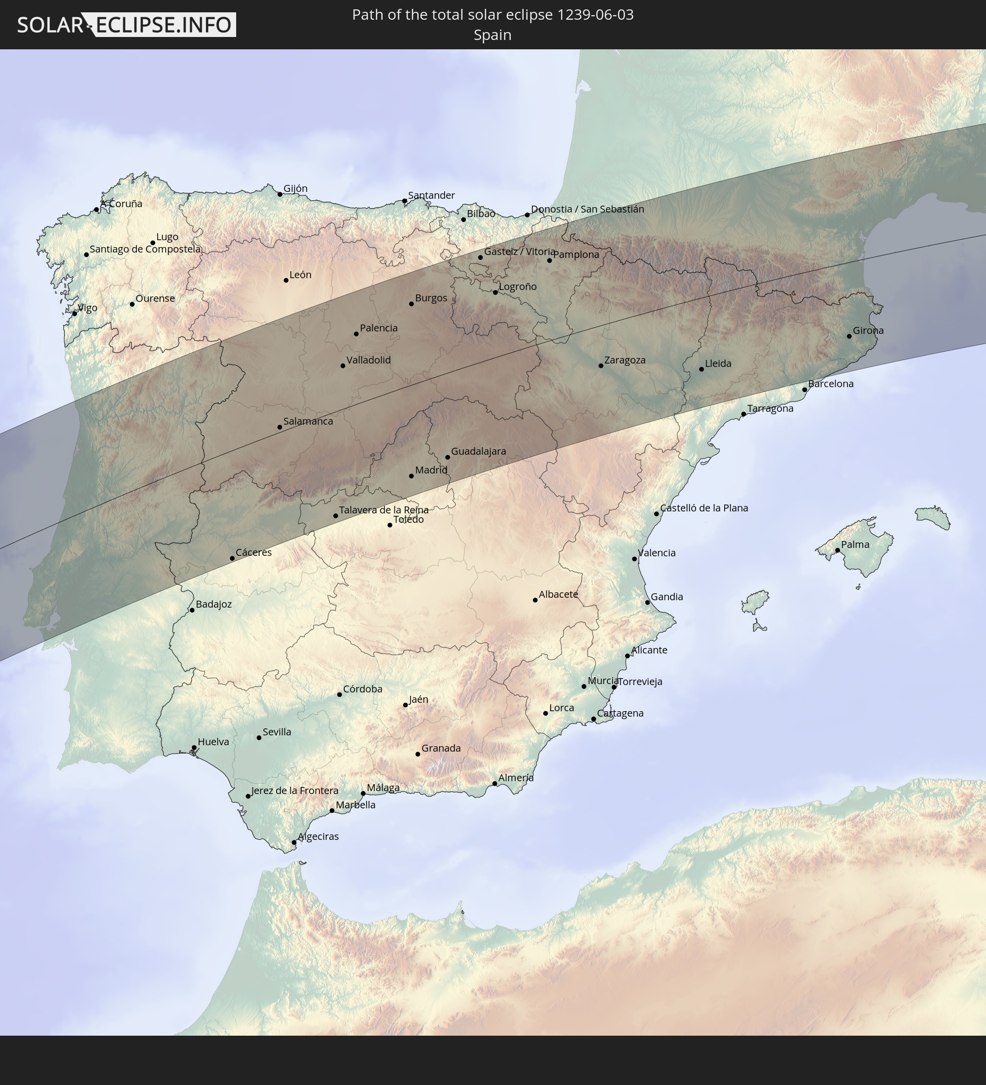 Spain
Spain
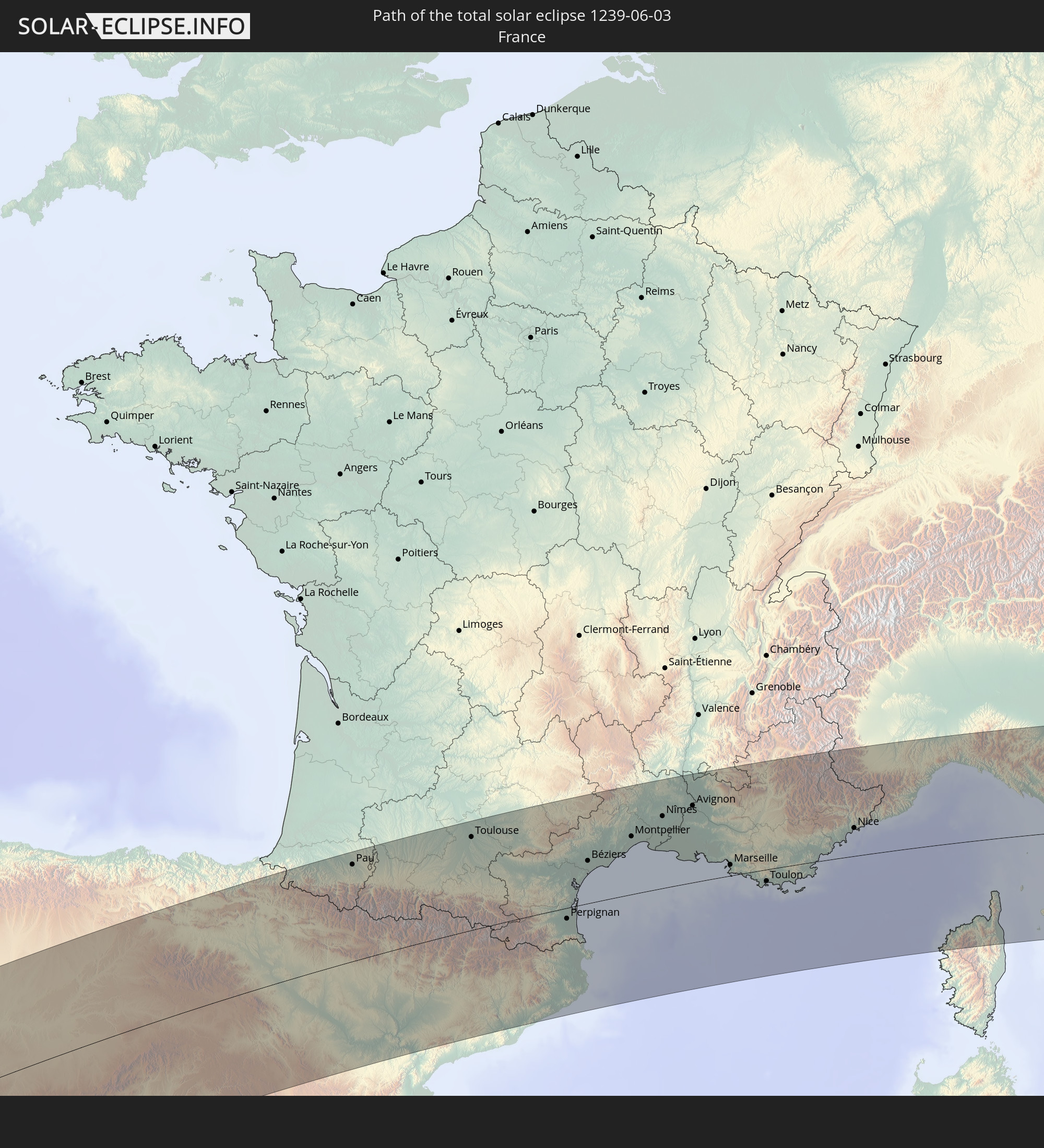 France
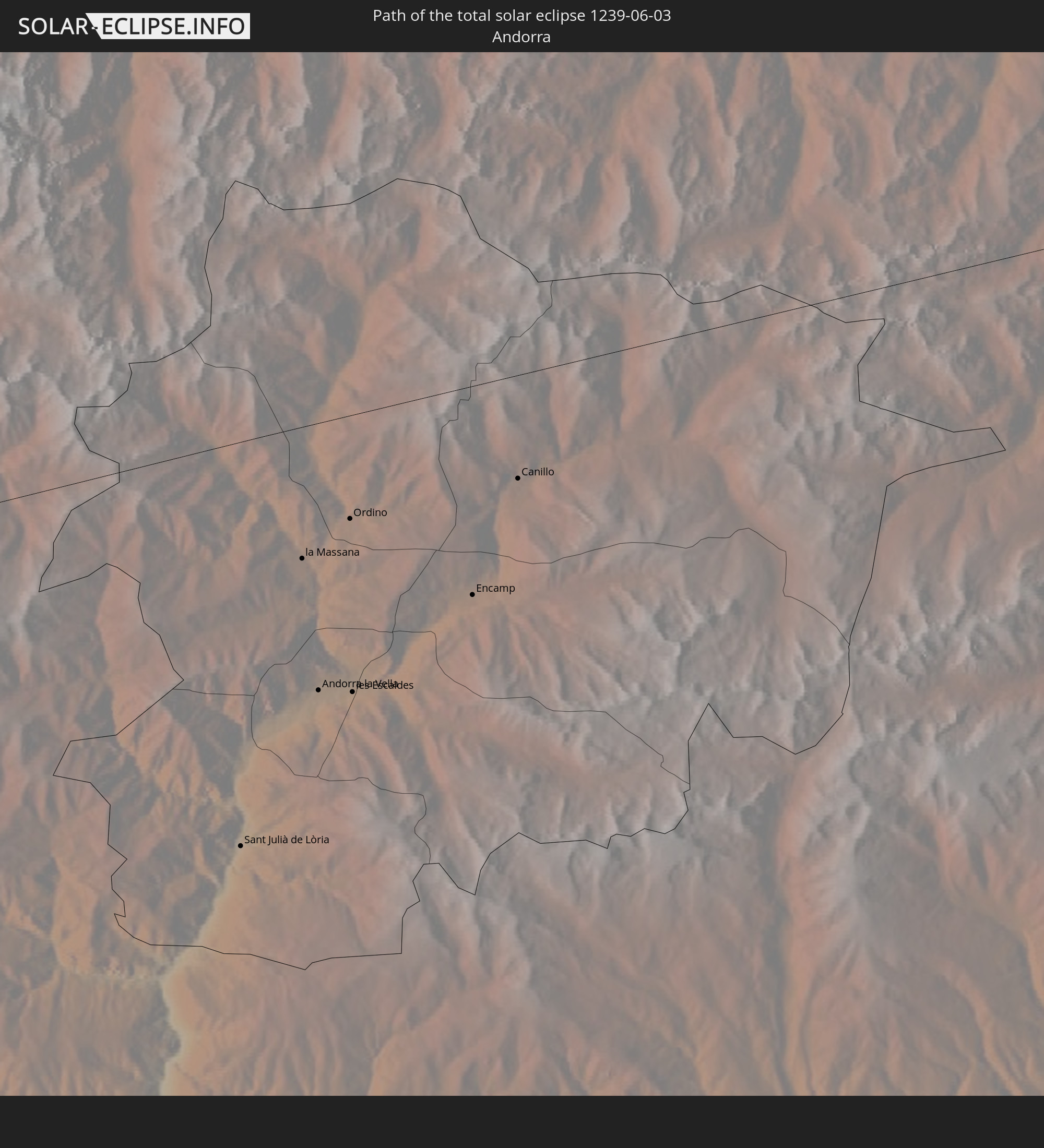 Andorra
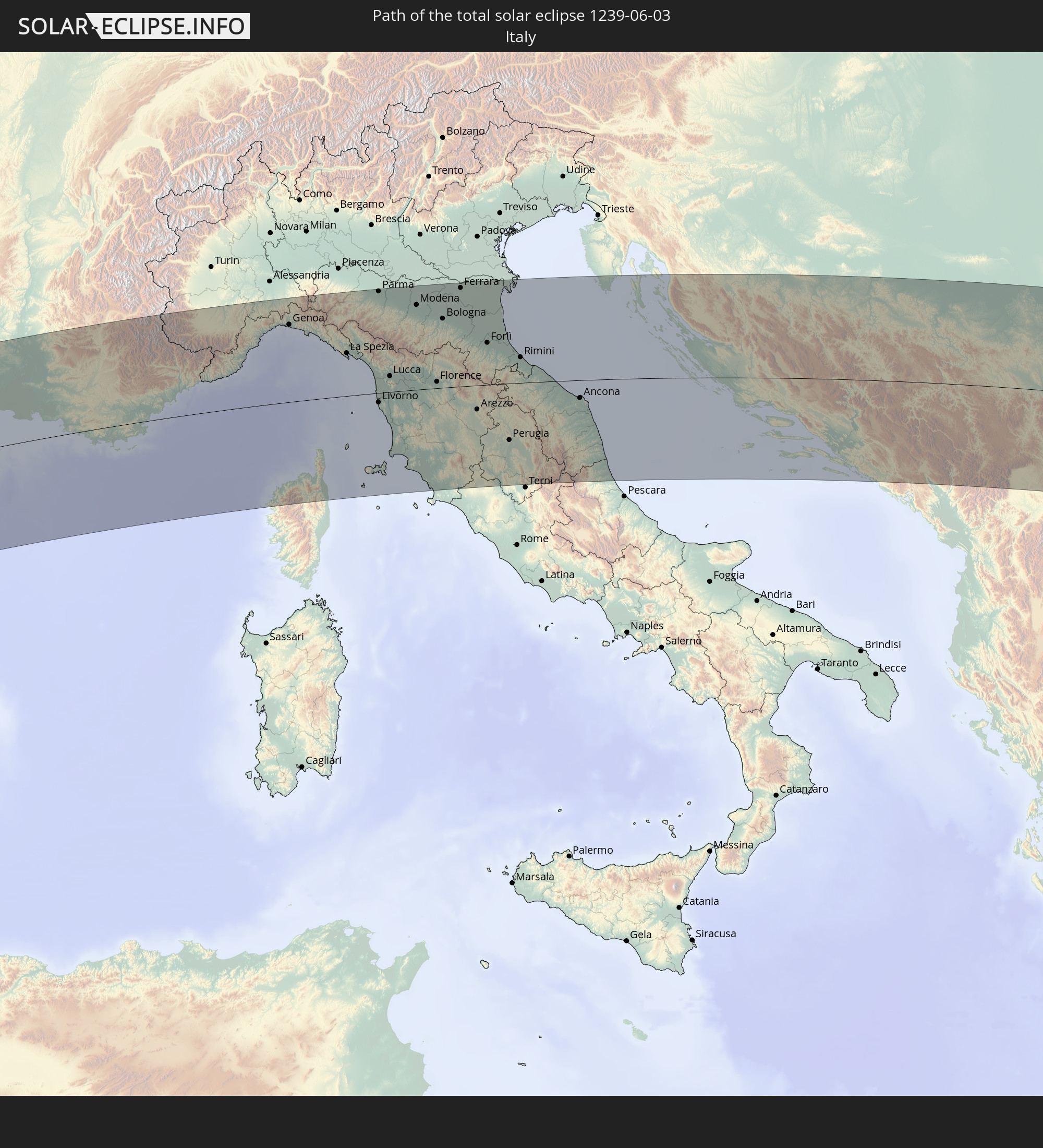 Italy
Italy
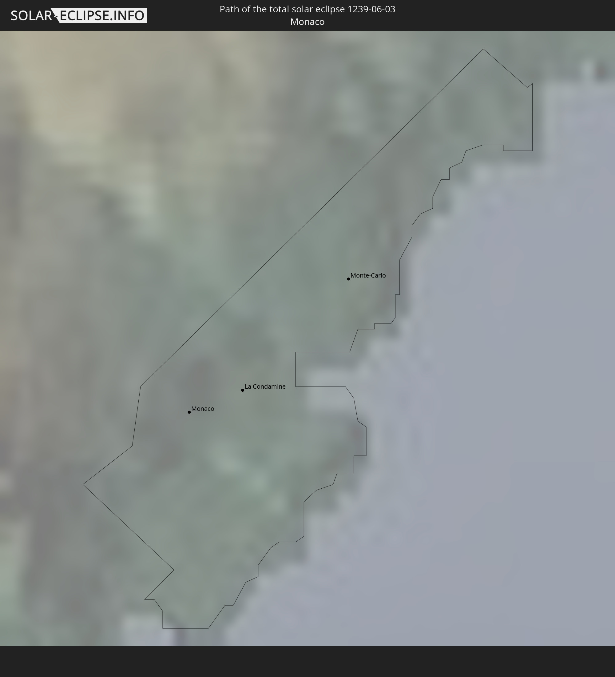 Monaco
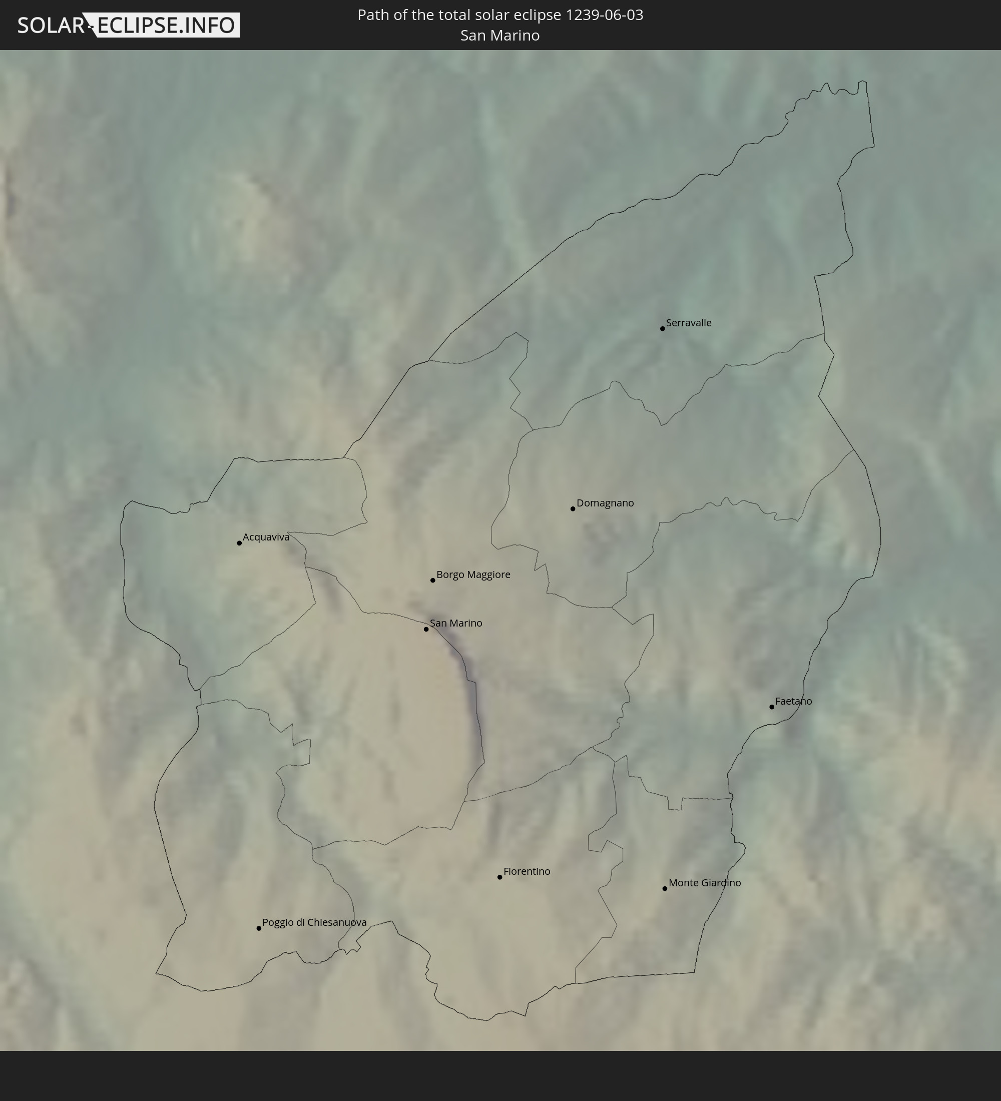 San Marino
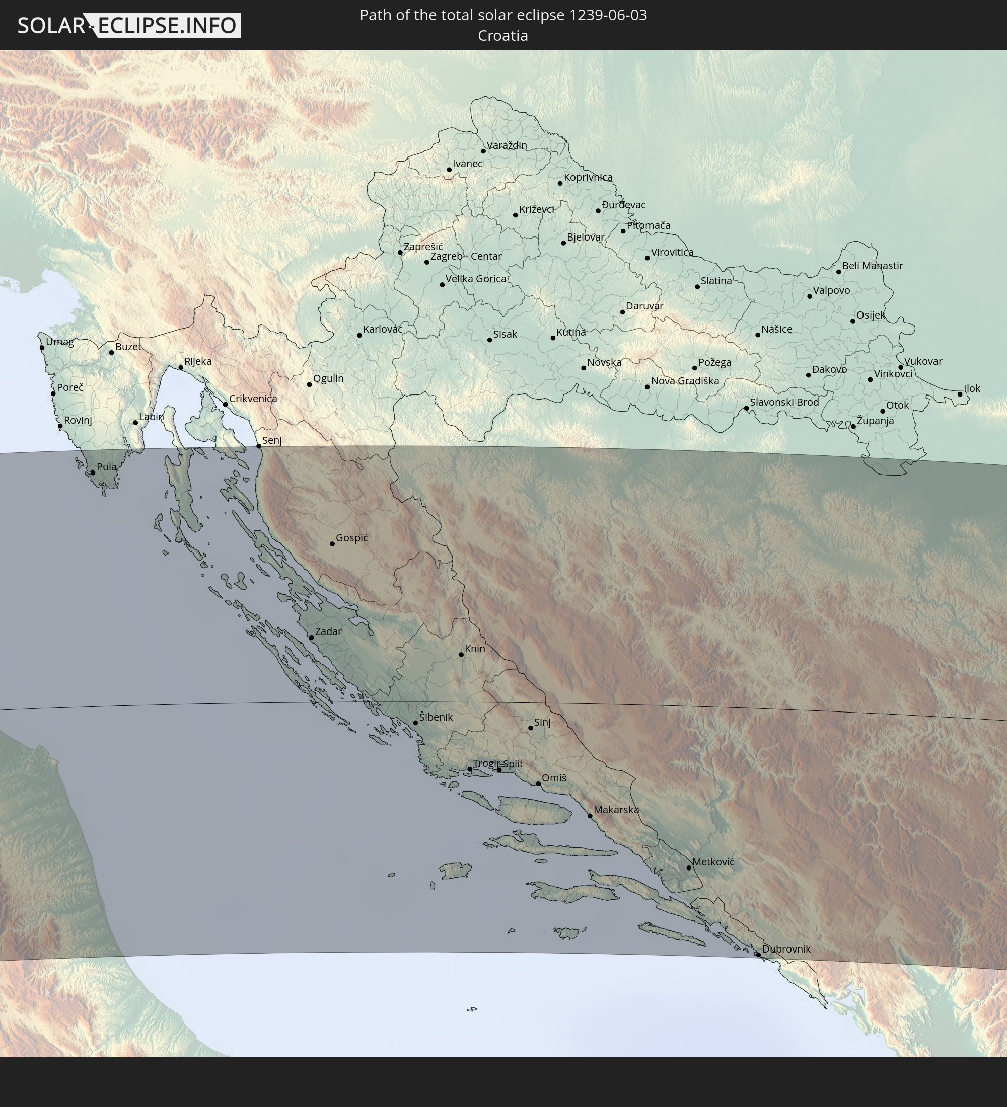 Croatia
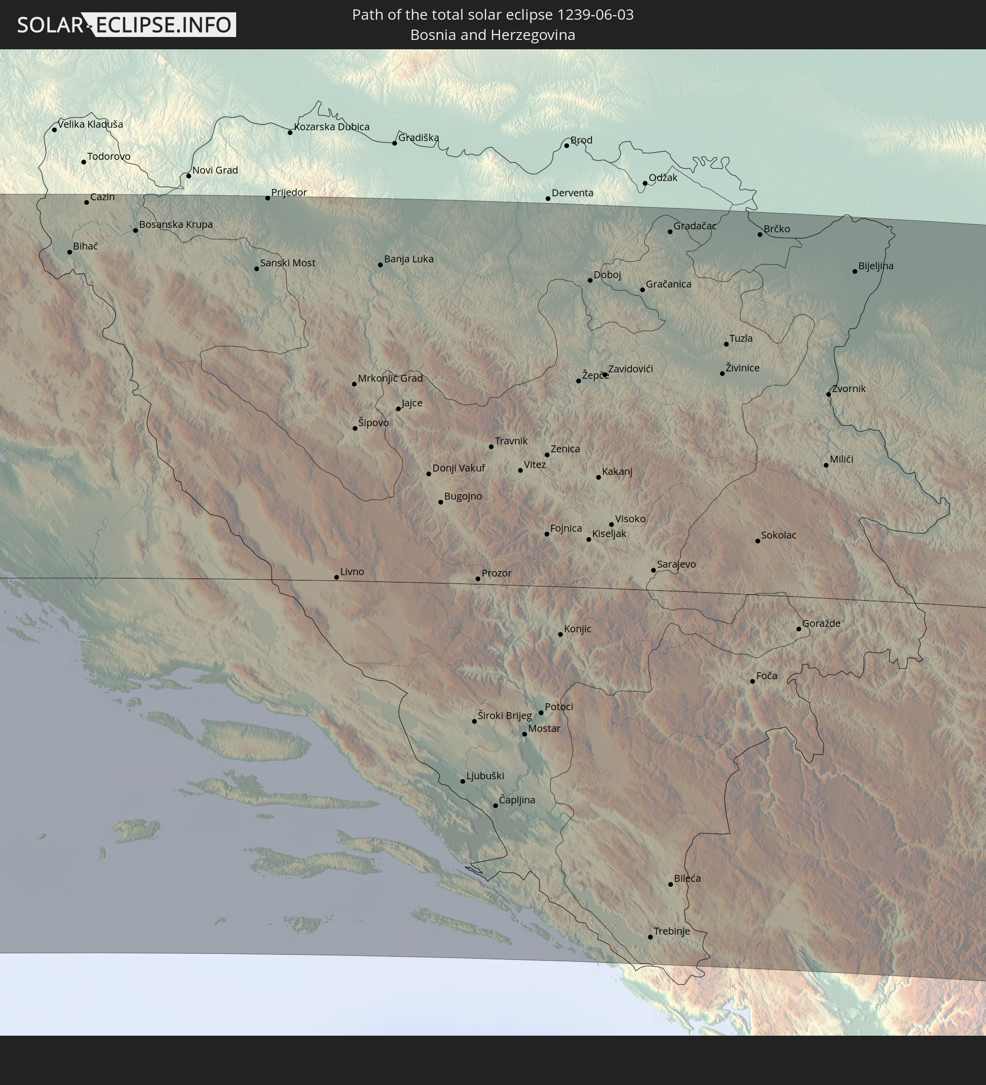 Bosnia and Herzegovina
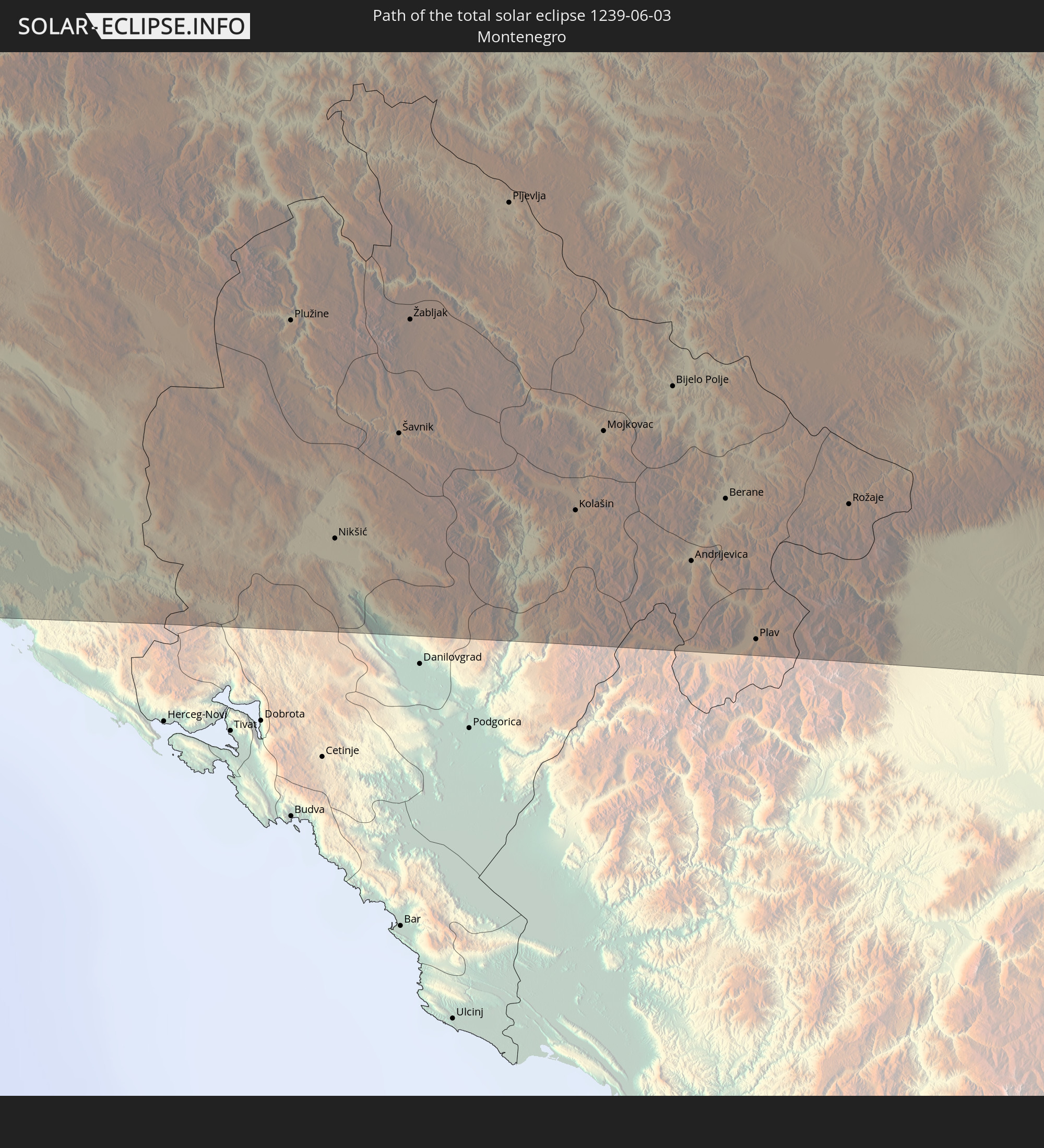 Montenegro
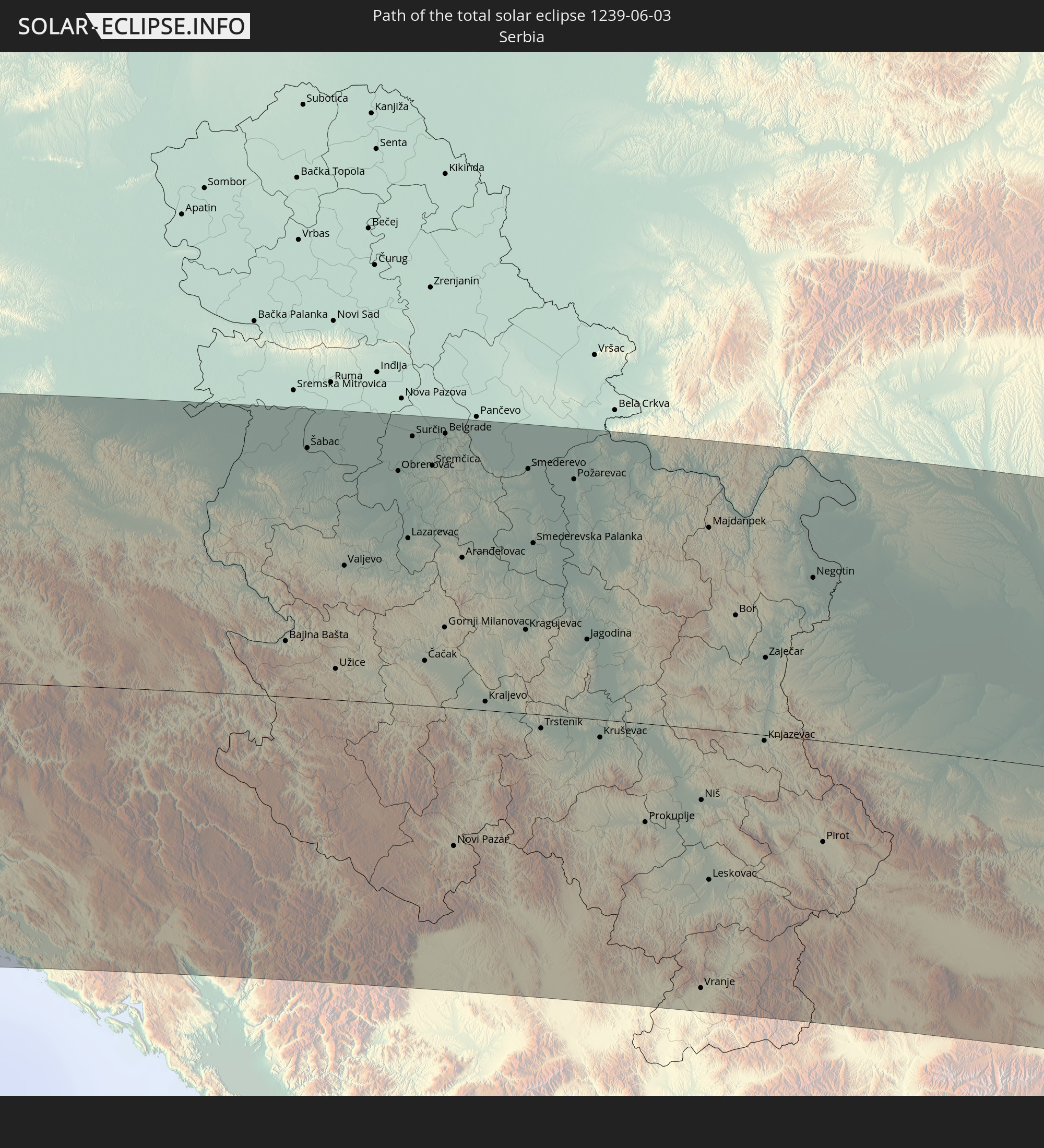 Serbia
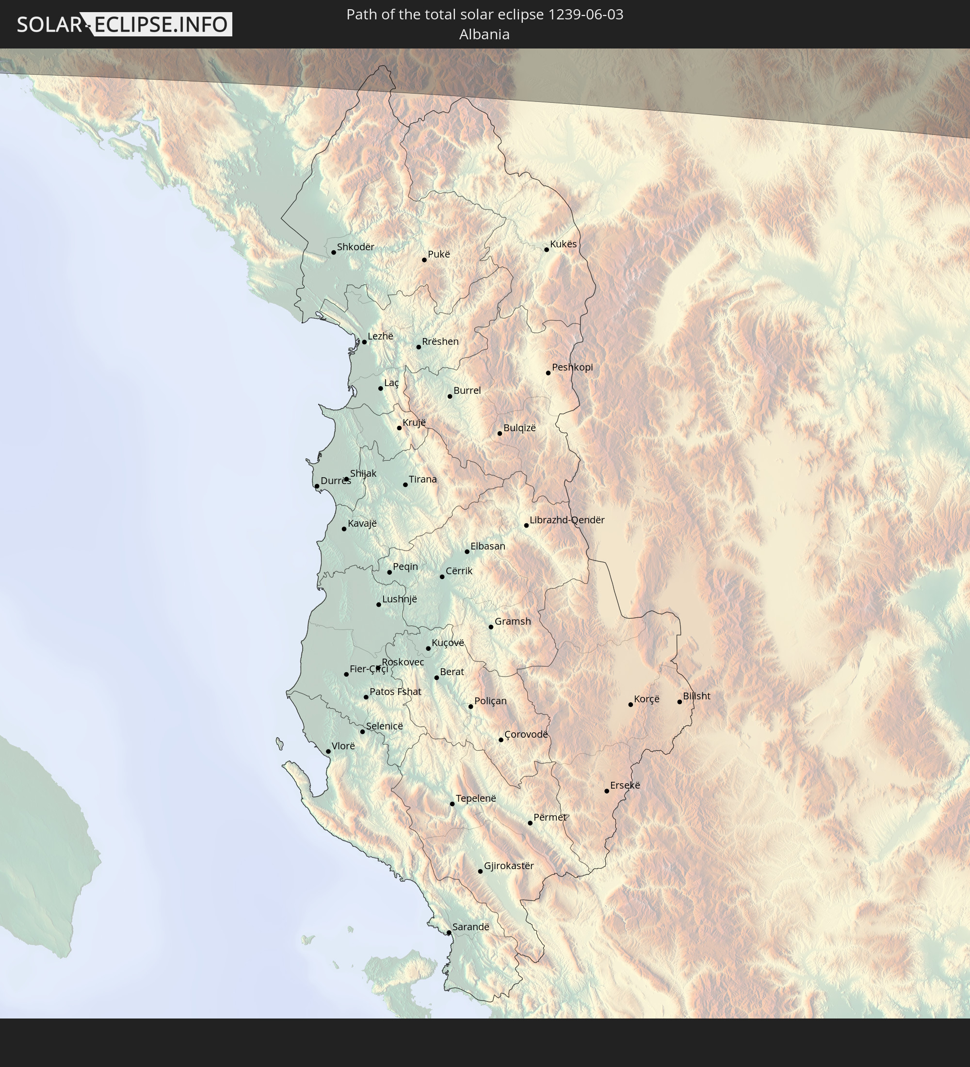 Albania
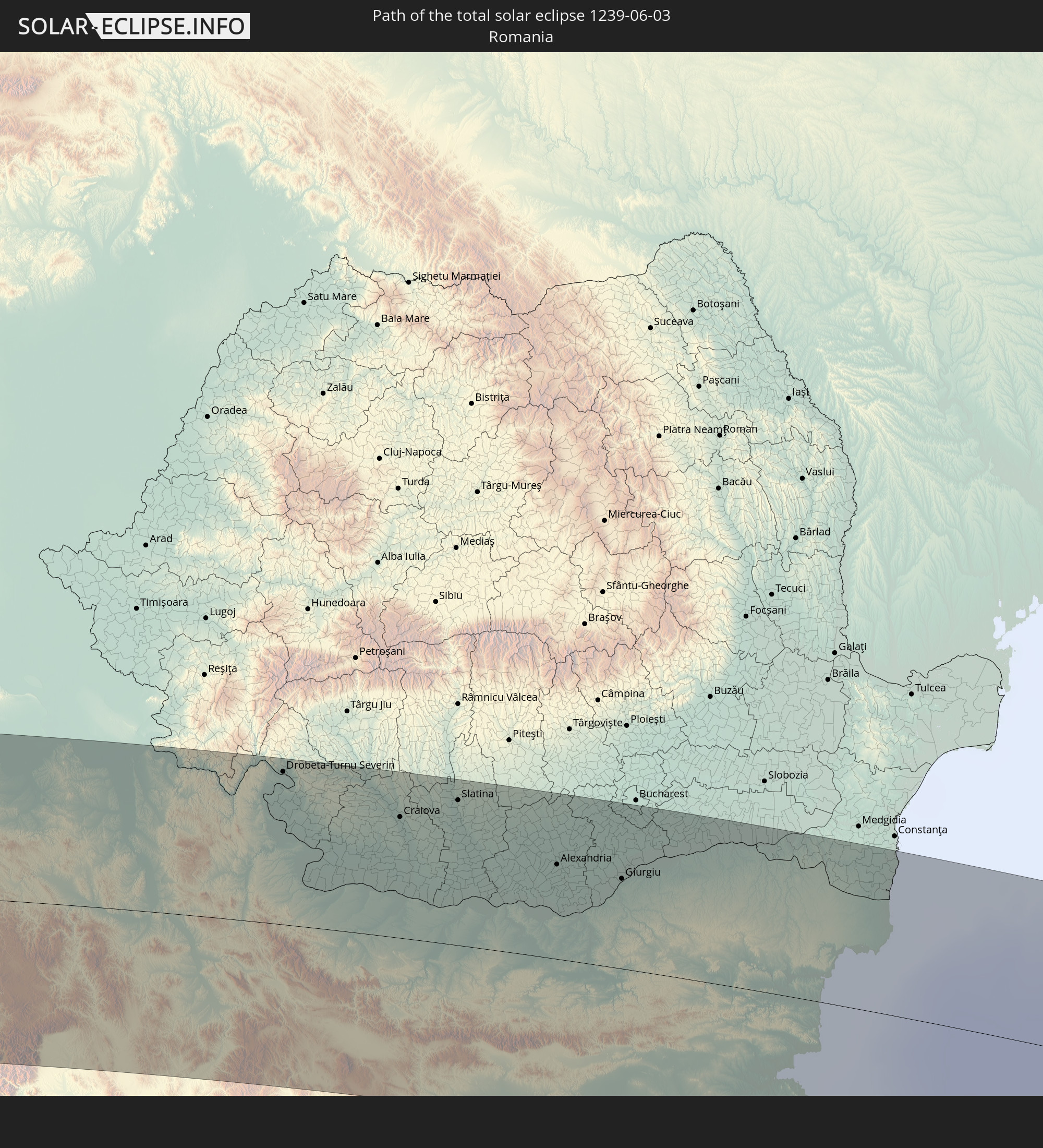 Romania
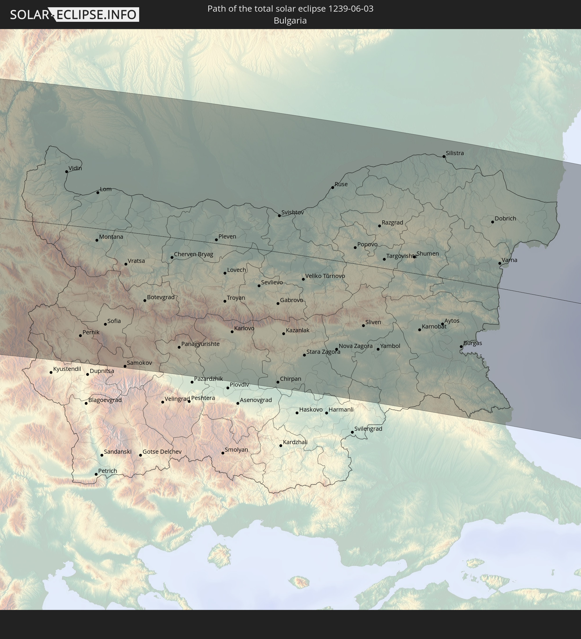 Bulgaria
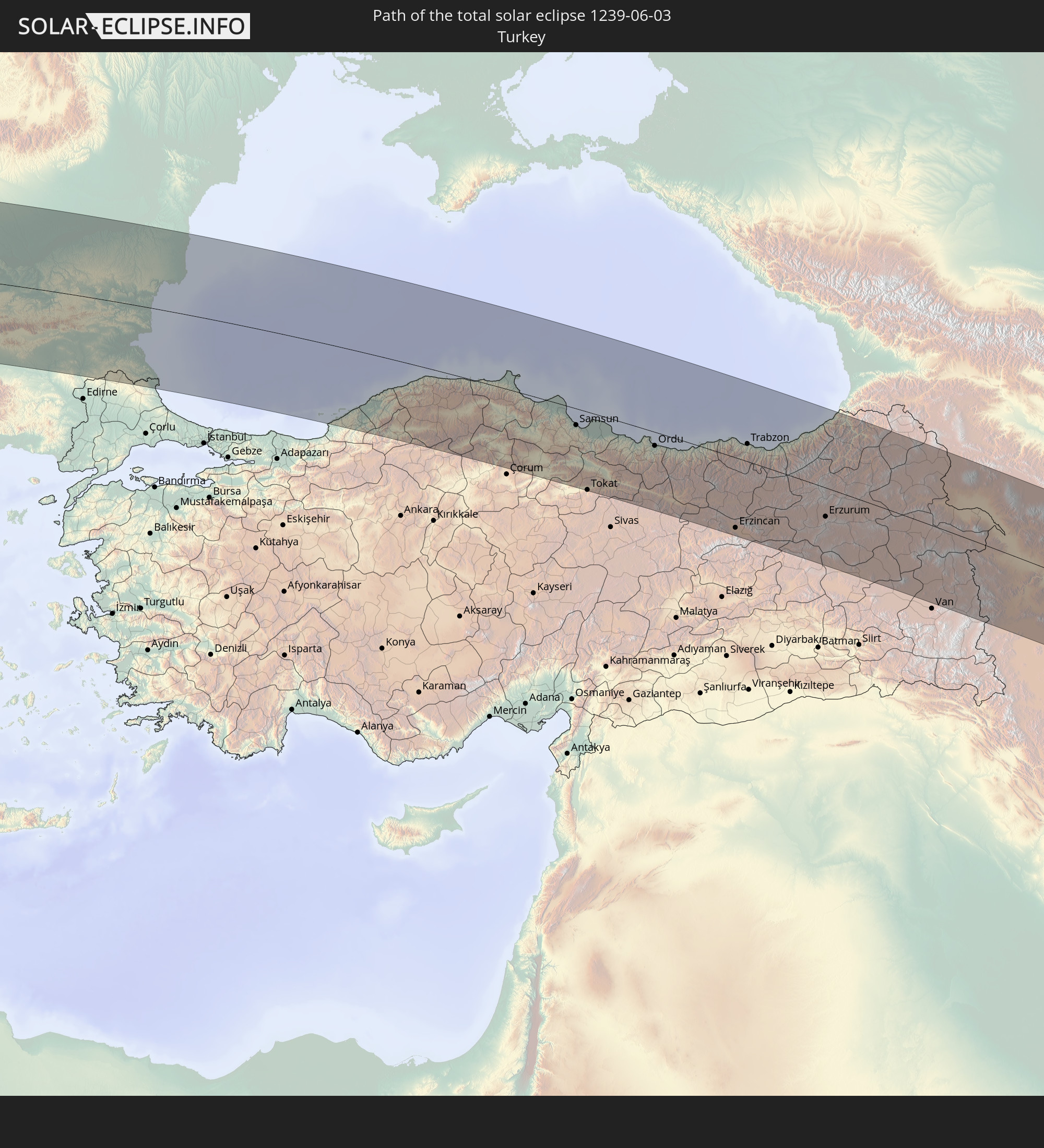 Turkey
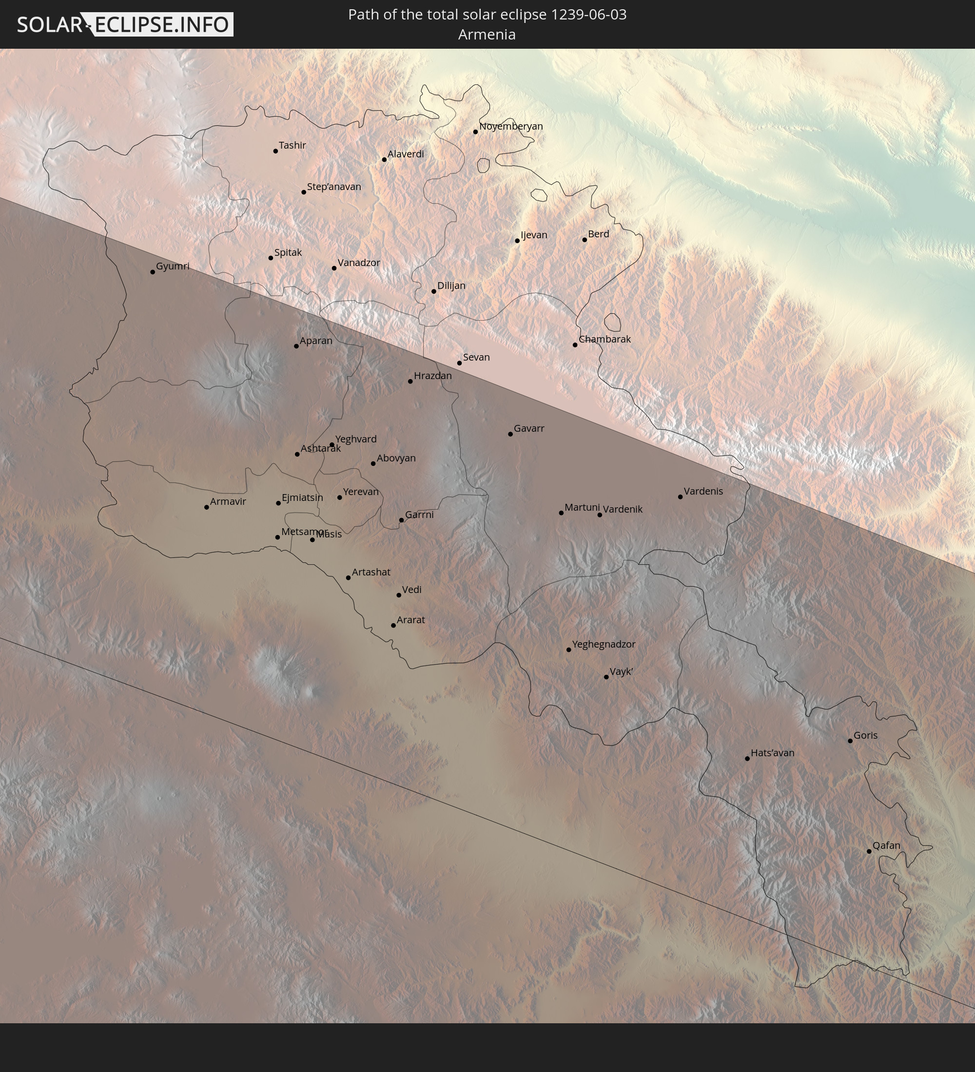 Armenia
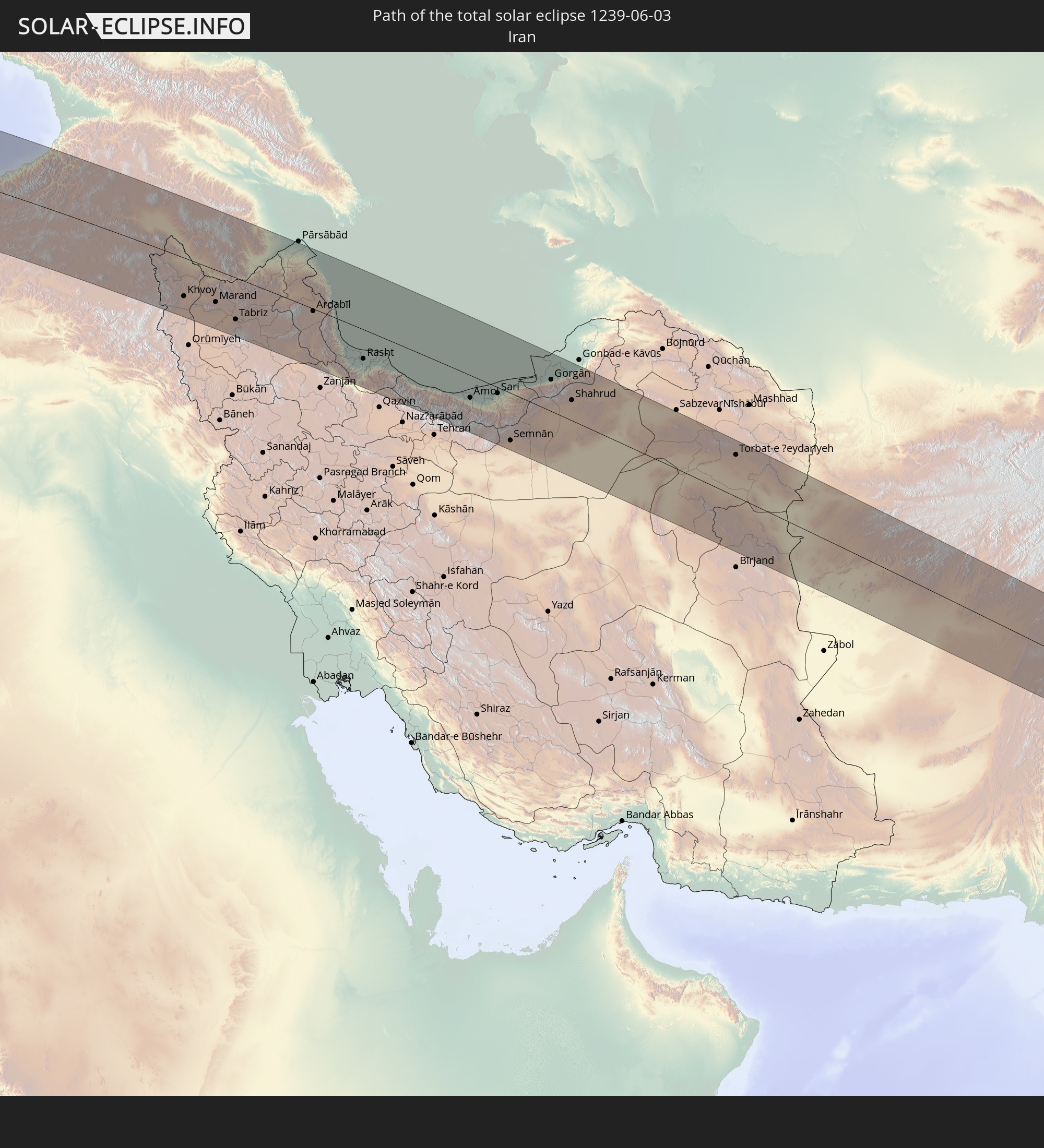 Iran
Iran
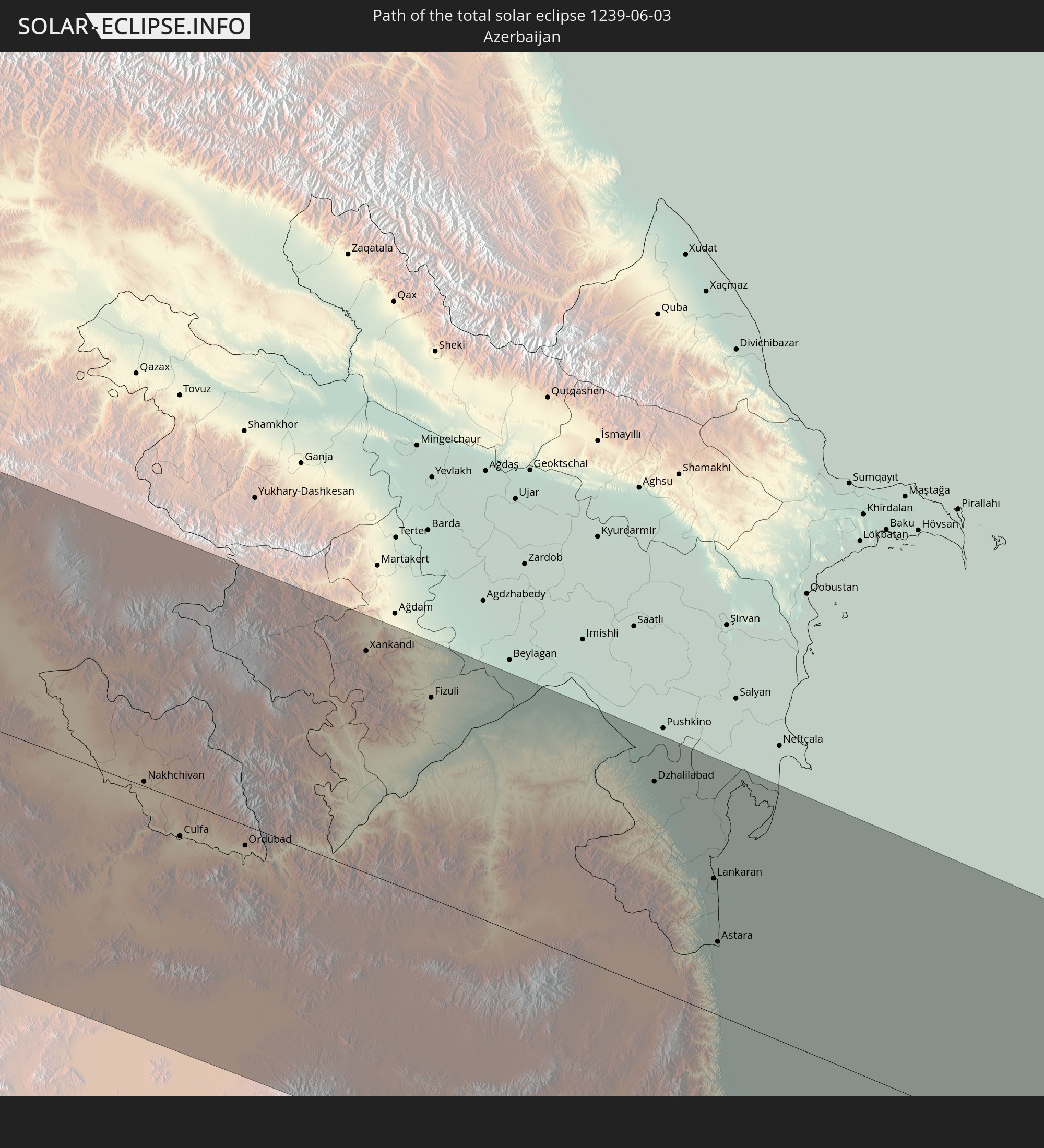 Azerbaijan
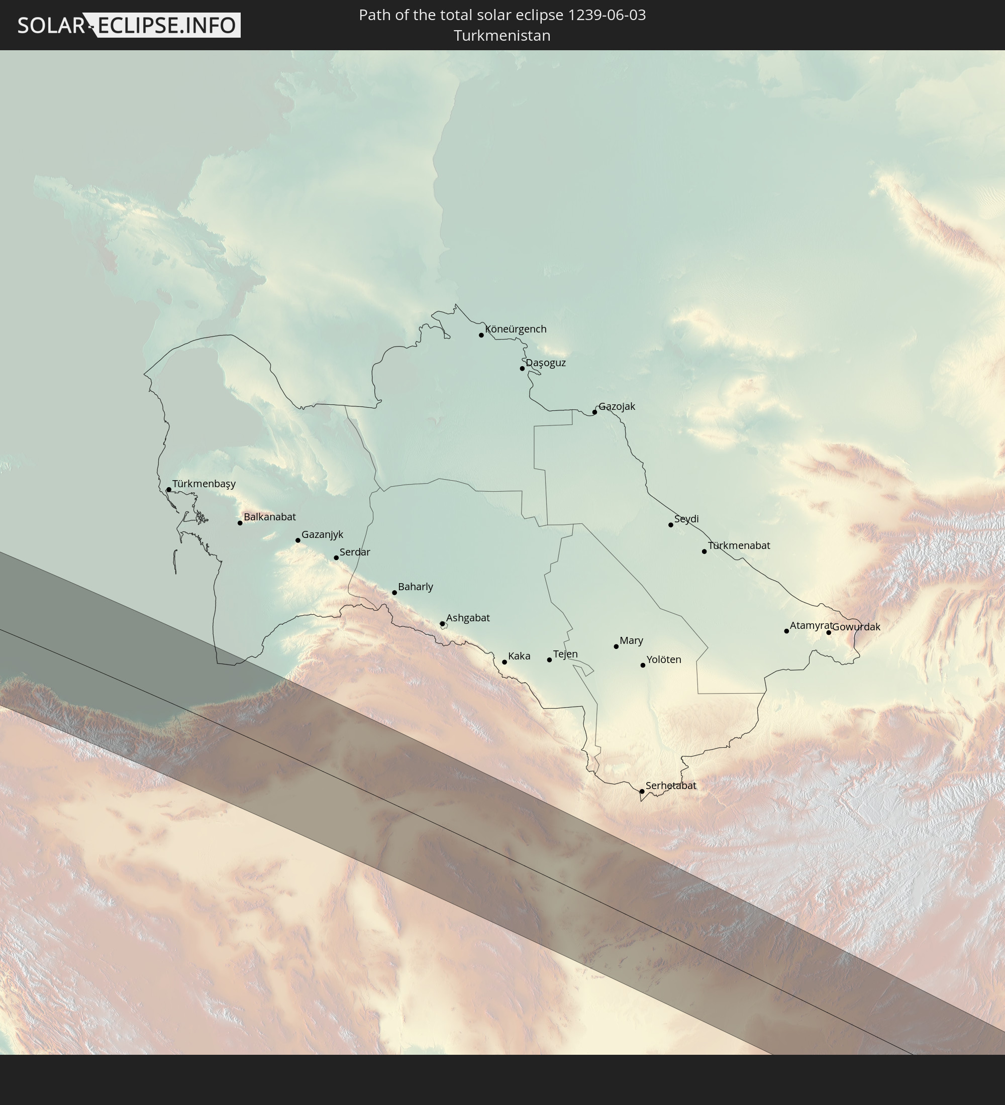 Turkmenistan
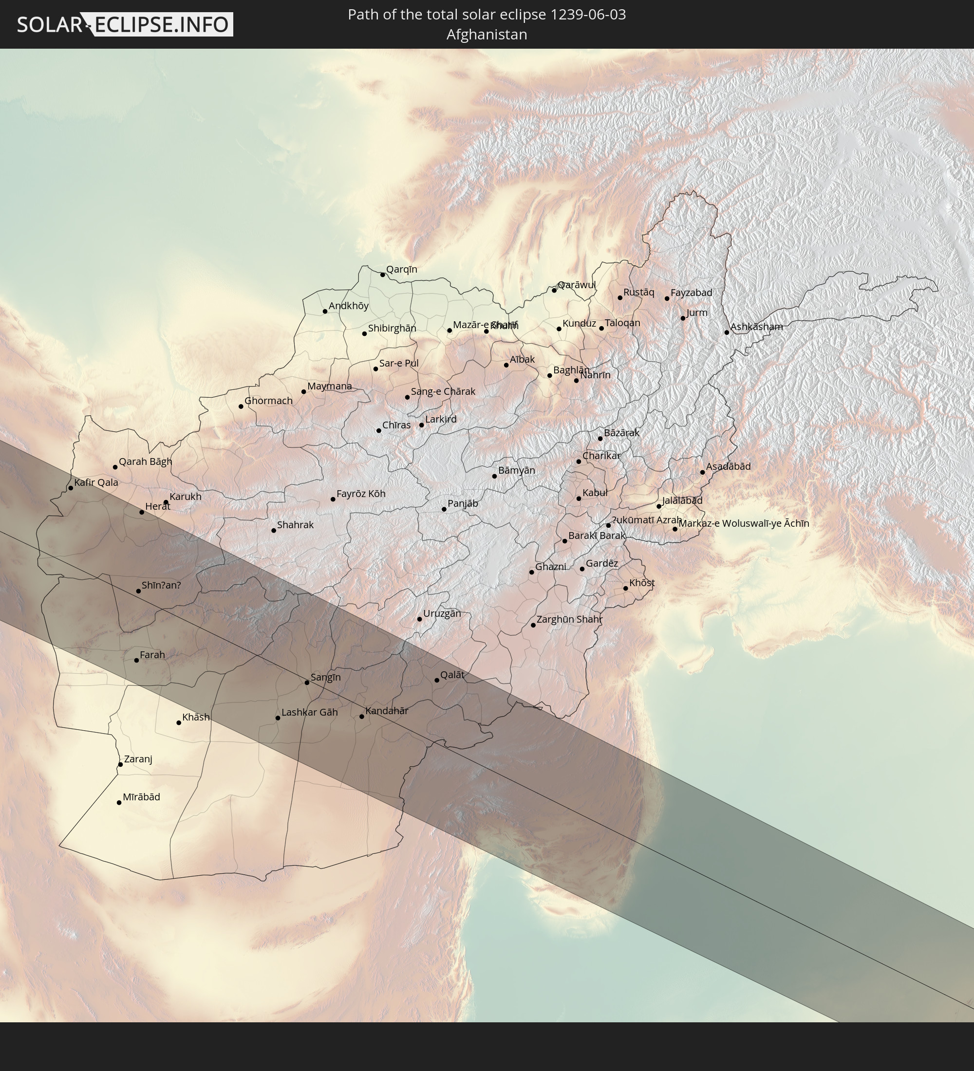 Afghanistan
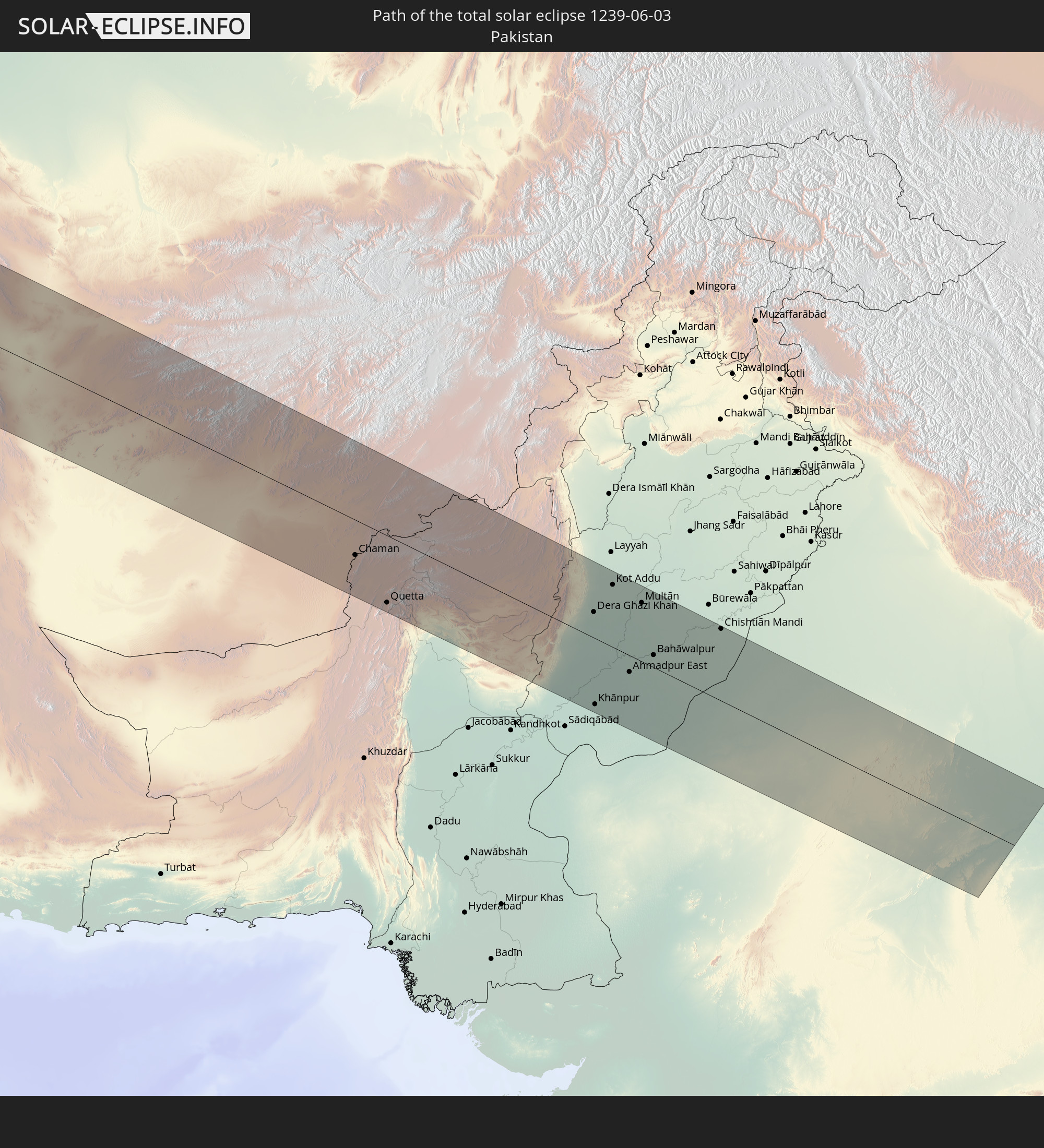 Pakistan
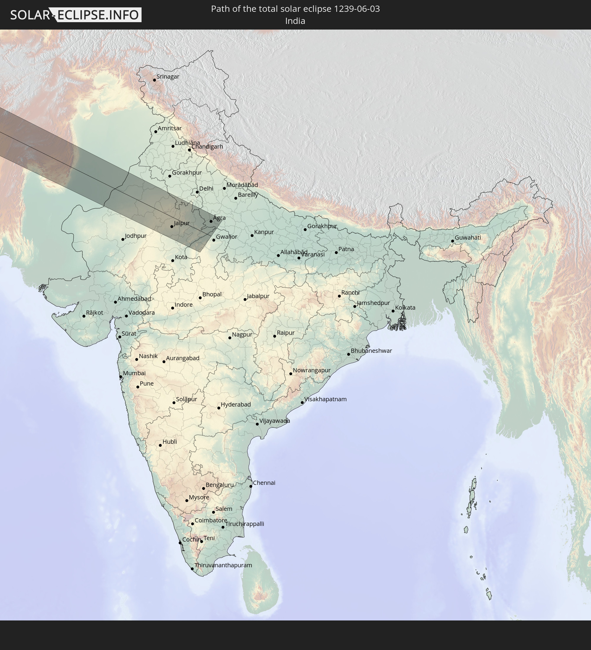 India
India
In den folgenden Ländern ist die Sonnenfinsternis partiell zu sehen
 Russia
 United States
 United States Minor Outlying Islands
 Canada
 Greenland
 Cuba
Cuba
 Colombia
 The Bahamas
 Haiti
Haiti
 Brazil
 Venezuela
 Turks and Caicos Islands
 Dominican Republic
 Aruba
Aruba
 Puerto Rico
 United States Virgin Islands
 Bermuda
 British Virgin Islands
 Anguilla
 Collectivity of Saint Martin
 Saint Barthélemy
 Saint Kitts and Nevis
 Antigua and Barbuda
 Montserrat
 Trinidad and Tobago
 Guadeloupe
 Grenada
 Dominica
 Saint Vincent and the Grenadines
 Guyana
 Martinique
 Saint Lucia
 Barbados
 Suriname
 Saint Pierre and Miquelon
 French Guiana
 Portugal
 Cabo Verde
 Iceland
 Spain
Spain
 Senegal
 Mauritania
 The Gambia
 Guinea-Bissau
 Guinea
 Sierra Leone
 Morocco
 Mali
Mali
 Liberia
 Republic of Ireland
 Svalbard and Jan Mayen
 Algeria
 United Kingdom
 Ivory Coast
 Faroe Islands
 Burkina Faso
 Gibraltar
 France
 Isle of Man
 Ghana
Ghana
 Guernsey
 Jersey
 Togo
Togo
 Niger
Niger
 Benin
Benin
 Andorra
 Belgium
 Nigeria
 Netherlands
 Norway
 Luxembourg
 Germany
 Switzerland
 Italy
Italy
 Monaco
 Tunisia
 Denmark
 Libya
Libya
 Liechtenstein
 Austria
 Sweden
 Czechia
 San Marino
 Vatican City
 Slovenia
 Chad
Chad
 Croatia
 Poland
 Malta
Malta
 Bosnia and Herzegovina
 Hungary
 Slovakia
 Montenegro
 Serbia
 Albania
 Åland Islands
 Greece
 Romania
 Republic of Macedonia
 Finland
 Lithuania
 Latvia
 Estonia
 Sudan
Sudan
 Ukraine
 Bulgaria
 Belarus
 Egypt
Egypt
 Turkey
 Moldova
 Cyprus
 Ethiopia
 State of Palestine
 Israel
 Saudi Arabia
 Jordan
 Lebanon
 Syria
Syria
 Eritrea
 Iraq
Iraq
 Georgia
 Somalia
 Djibouti
 Yemen
Yemen
 Armenia
 Iran
Iran
 Azerbaijan
 Kazakhstan
 Kuwait
 Bahrain
 Qatar
Qatar
 United Arab Emirates
 Oman
Oman
 Turkmenistan
 Uzbekistan
 Afghanistan
 Pakistan
 Tajikistan
 India
India
 Kyrgyzstan
 China
China
 Nepal
Nepal
 Mongolia
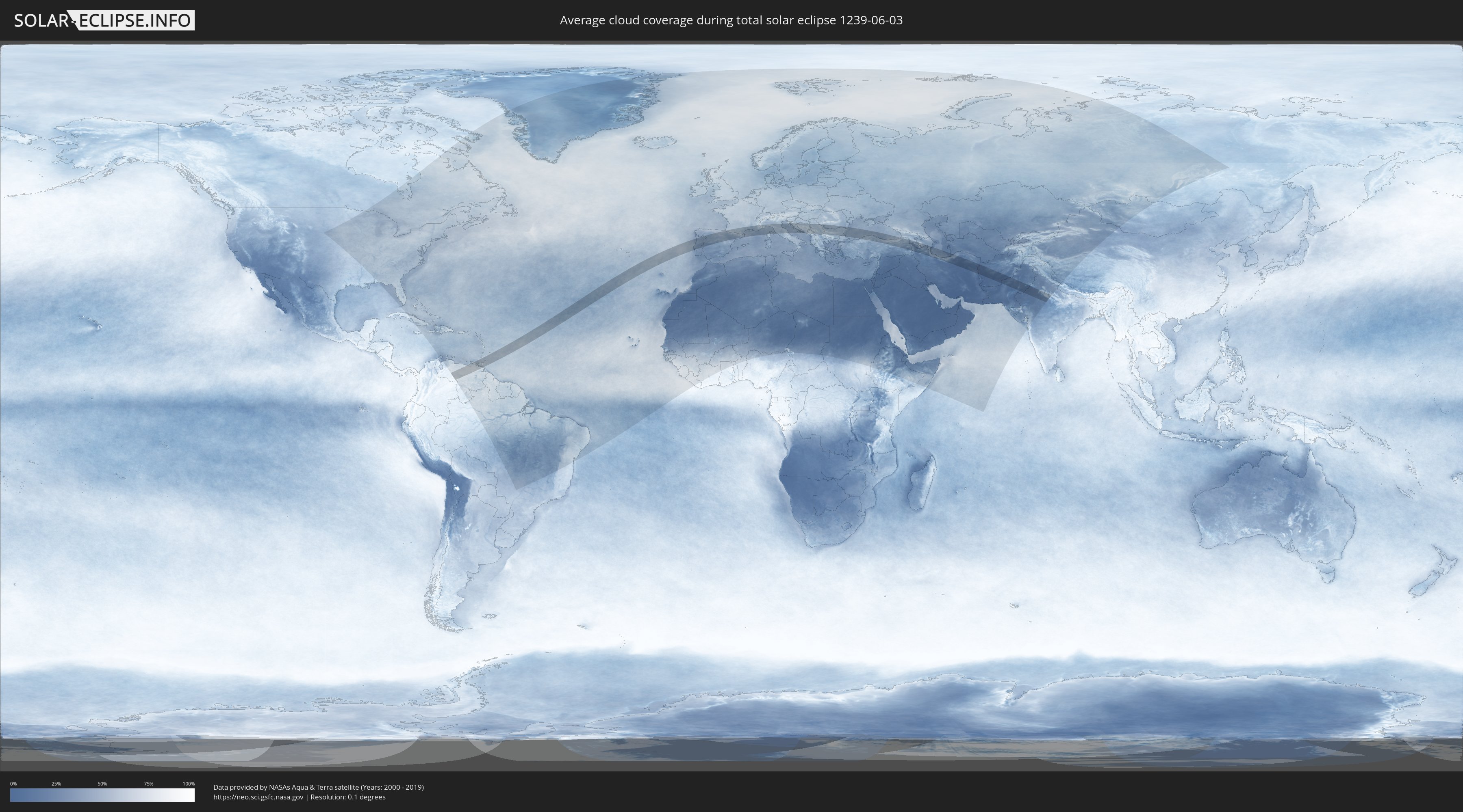
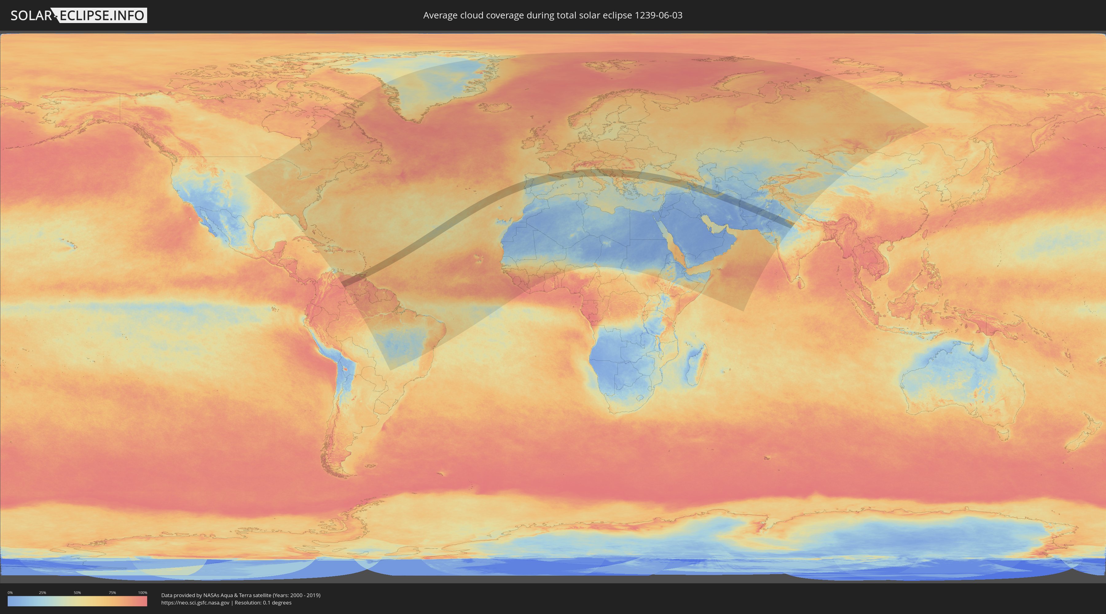
How will be the weather during the total solar eclipse on 06/03/1239?
Where is the best place to see the total solar eclipse of 06/03/1239?
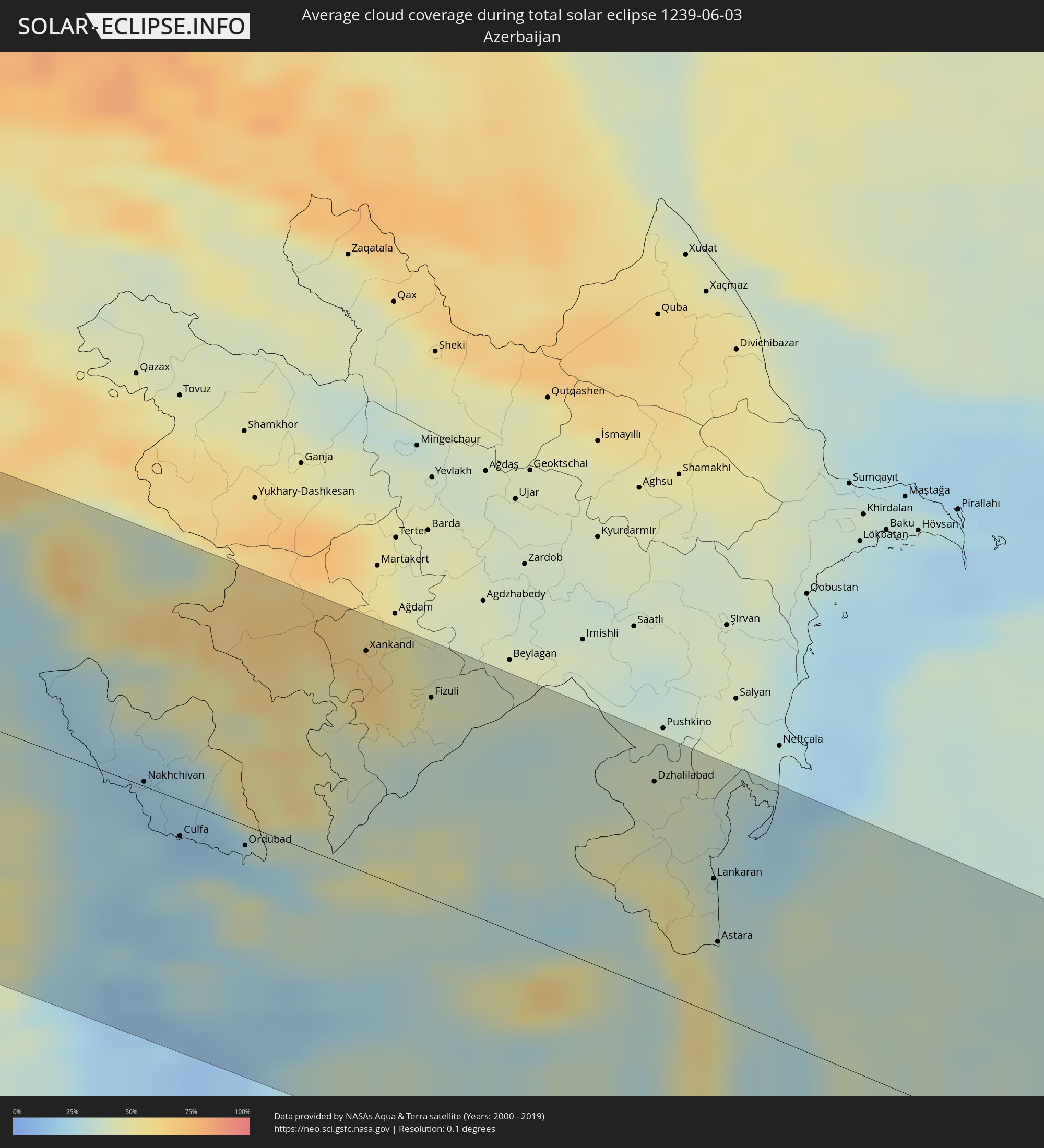
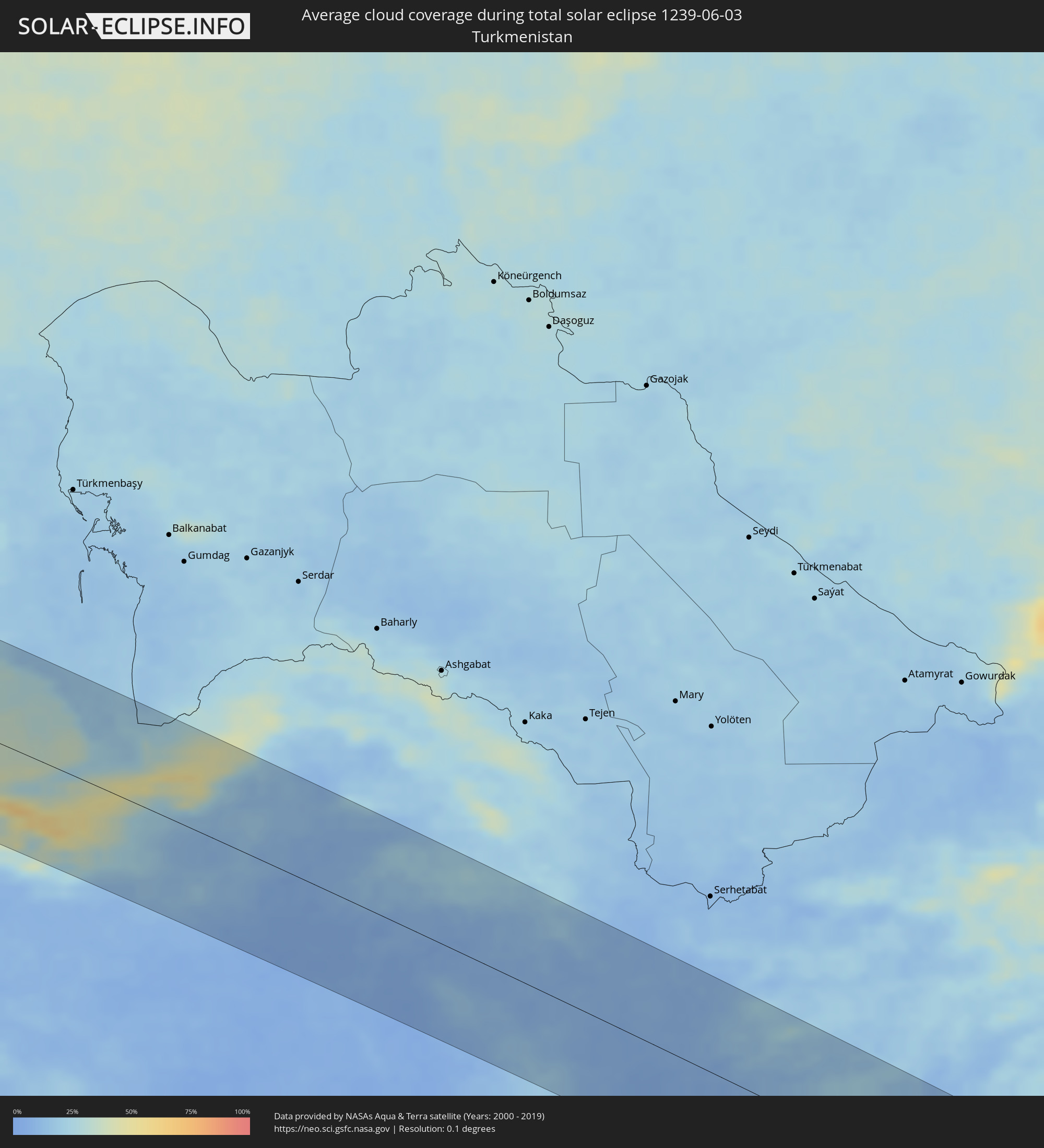
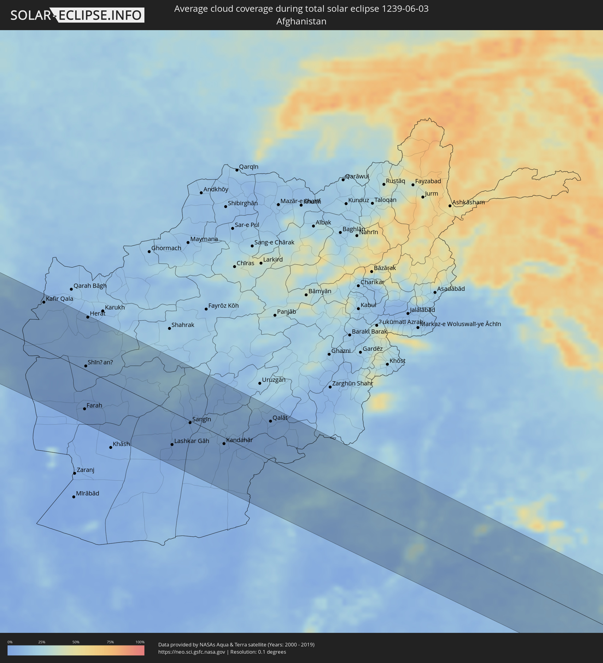
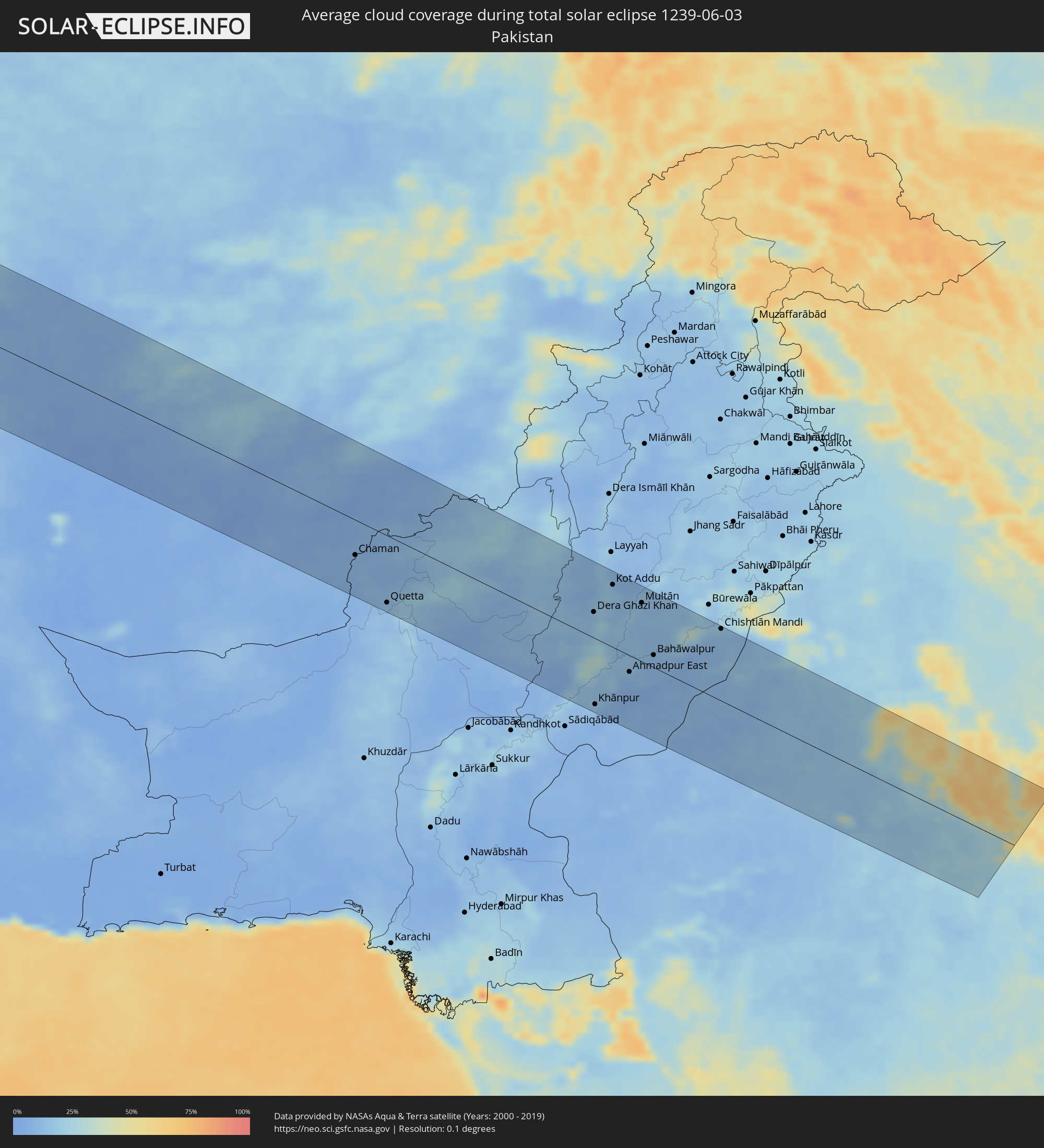
The following maps show the average cloud coverage for the day of the total solar eclipse.
With the help of these maps, it is possible to find the place along the eclipse path, which has the best
chance of a cloudless sky.
Nevertheless, you should consider local circumstances and inform about the weather of your chosen
observation site.
The data is provided by NASAs satellites
AQUA and TERRA.
The cloud maps are averaged over a period of 19 years (2000 - 2019).
Detailed country maps
 Venezuela
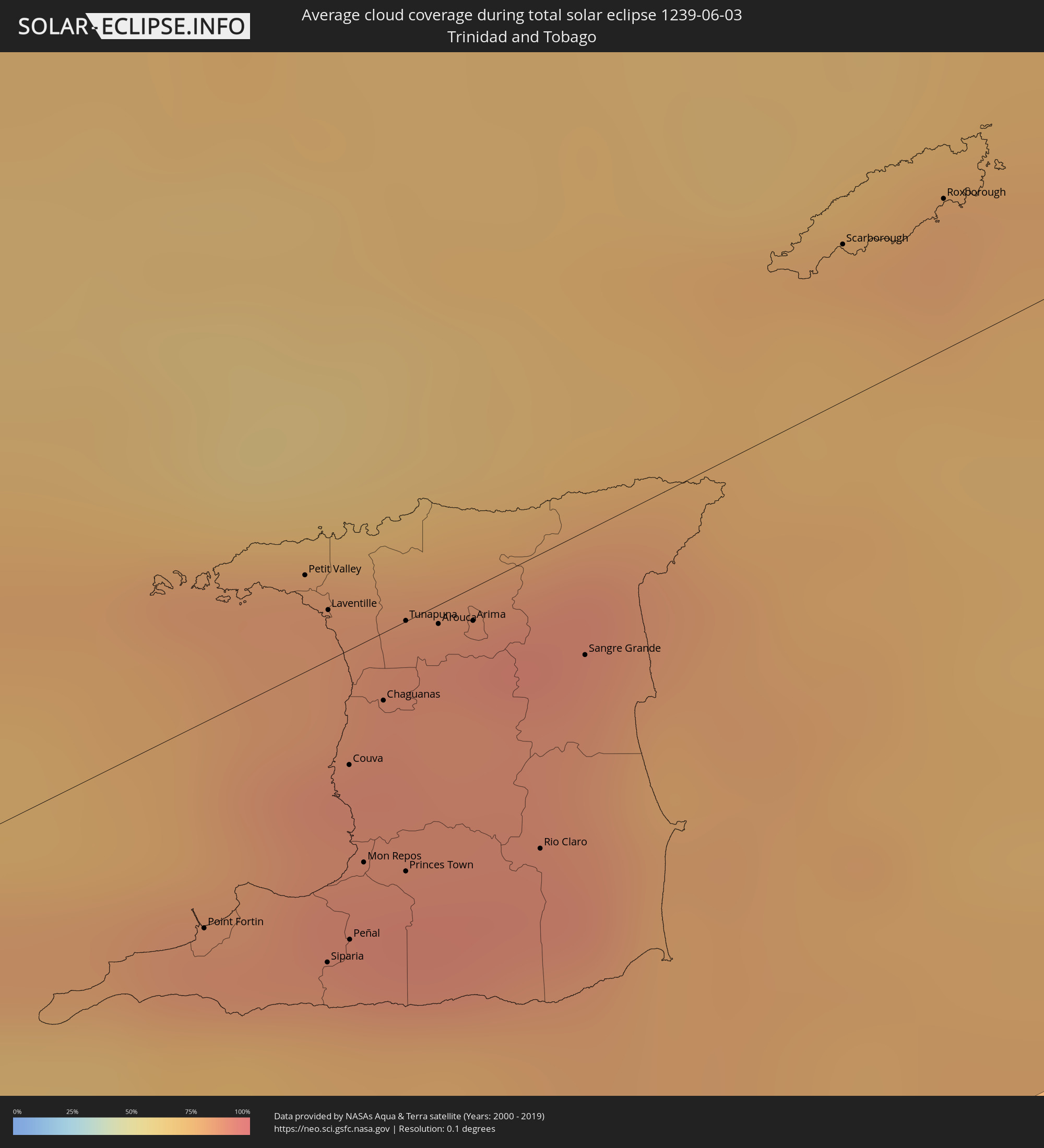 Trinidad and Tobago
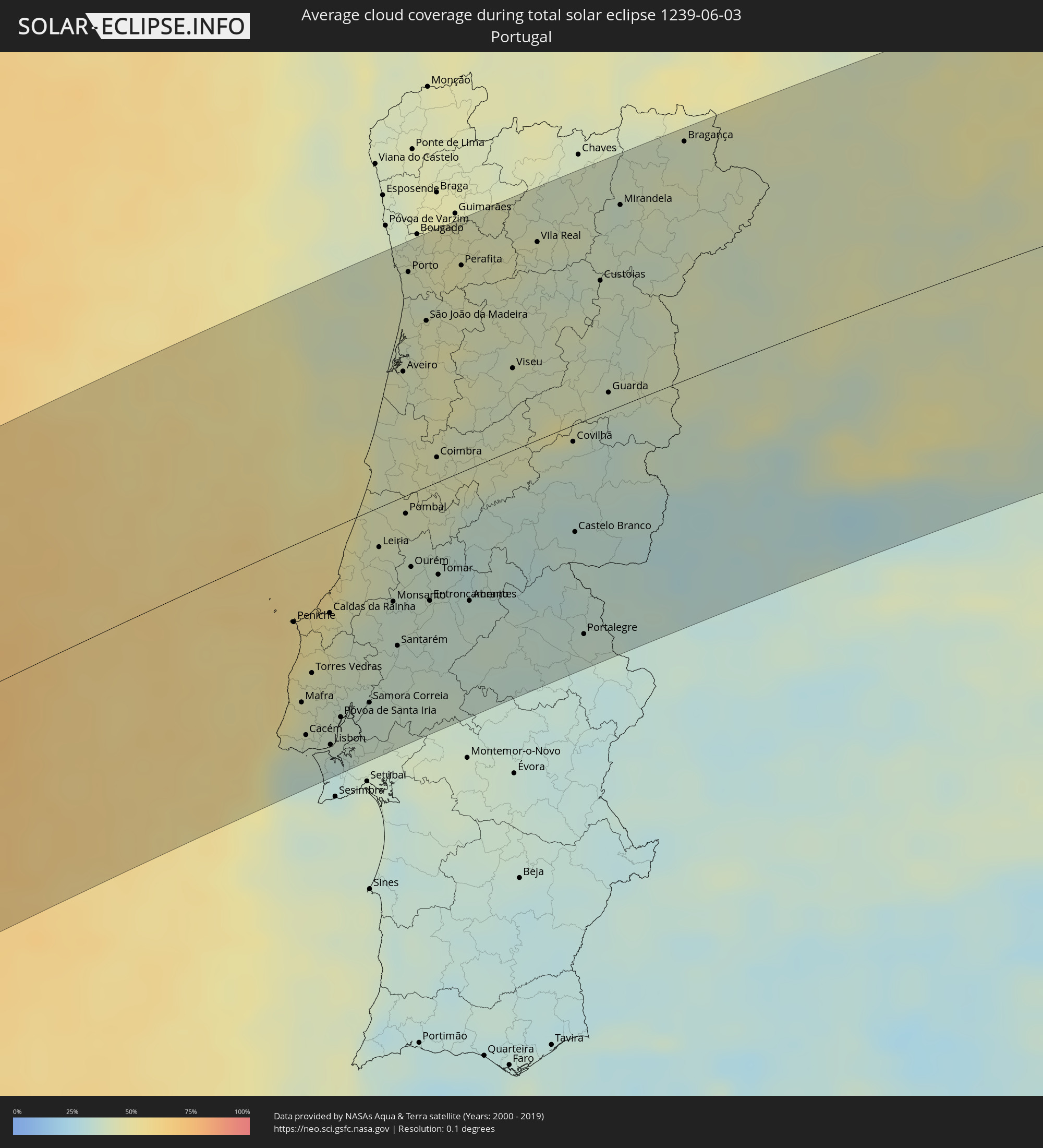 Portugal
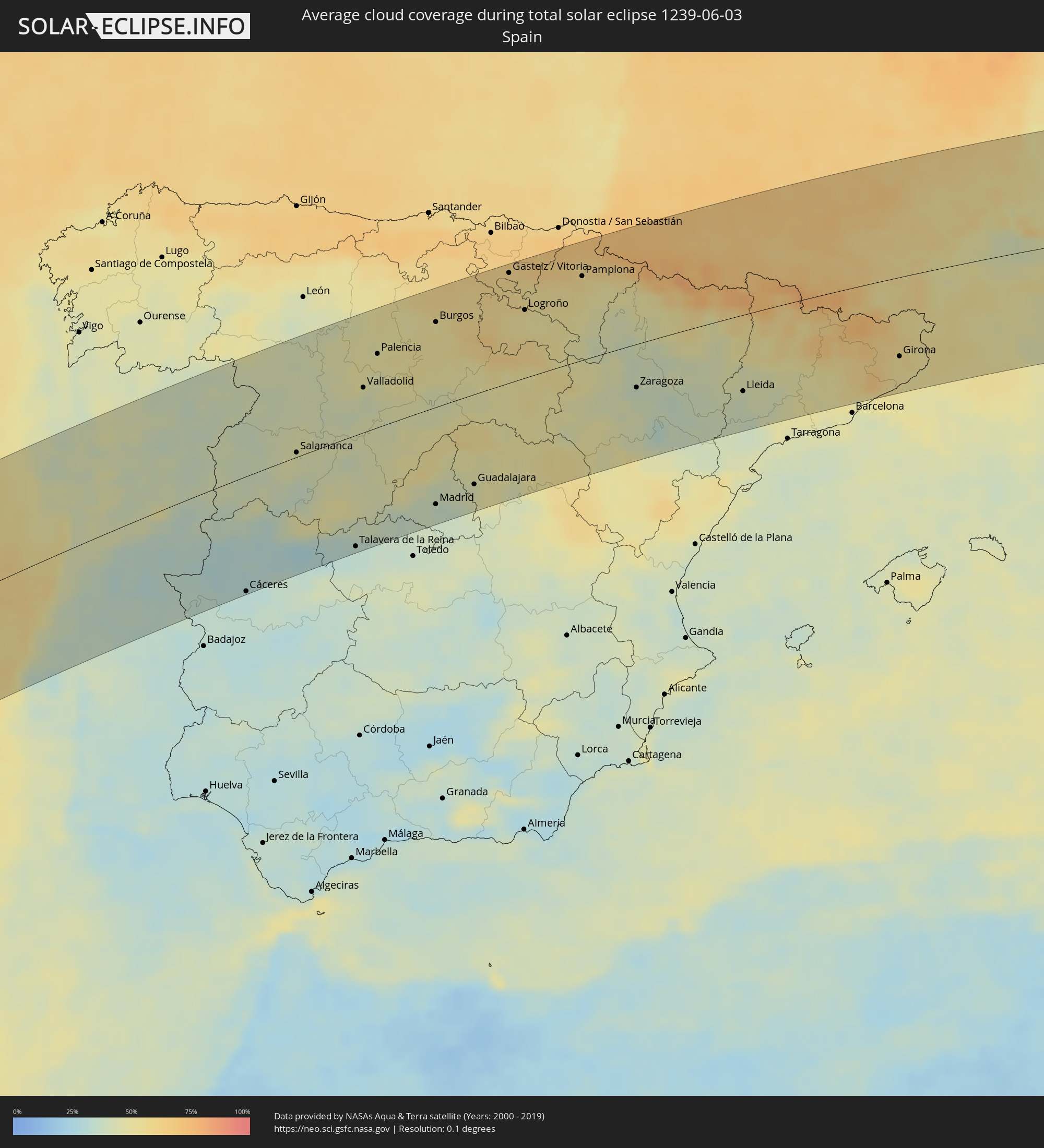 Spain
Spain
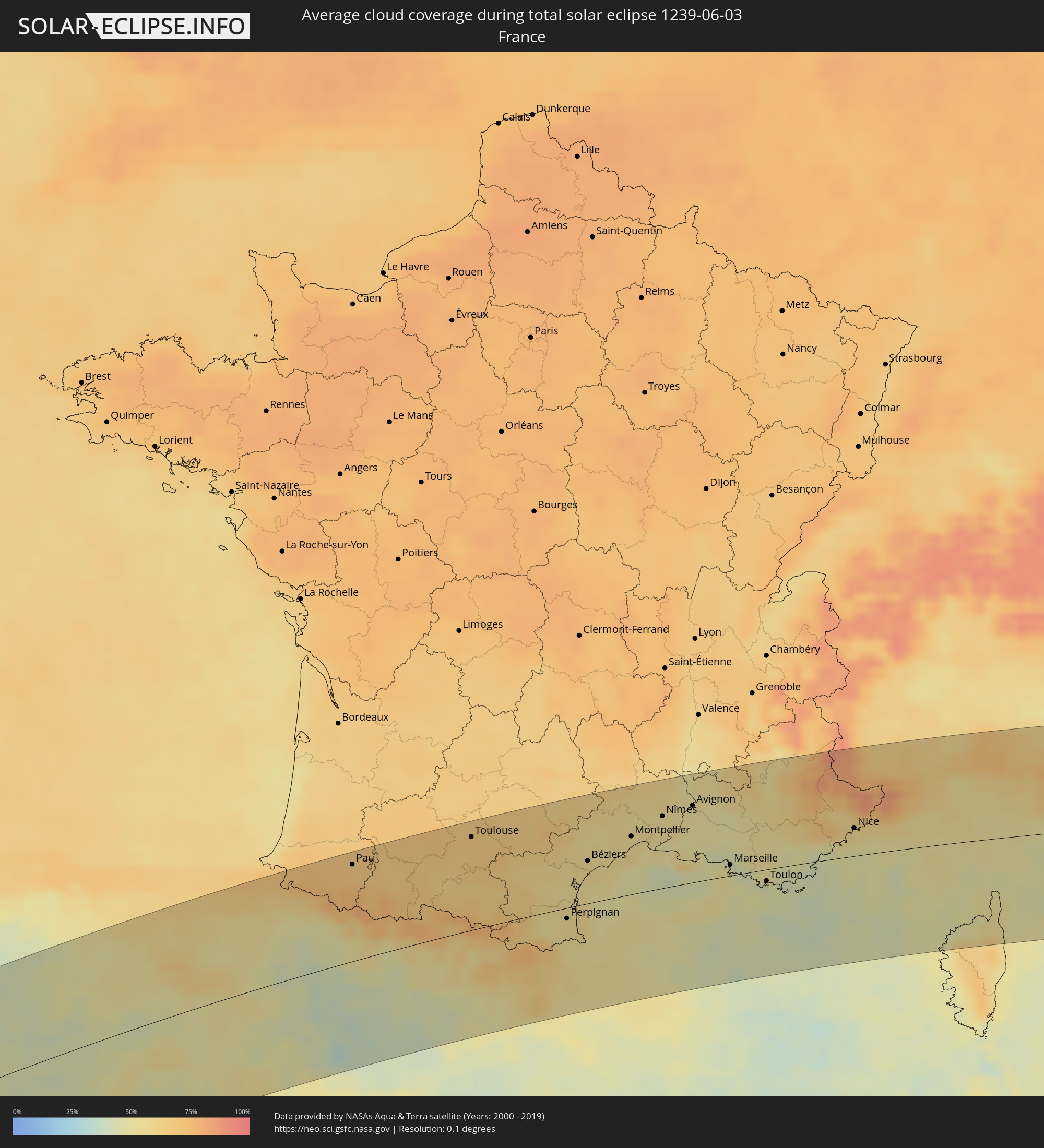 France
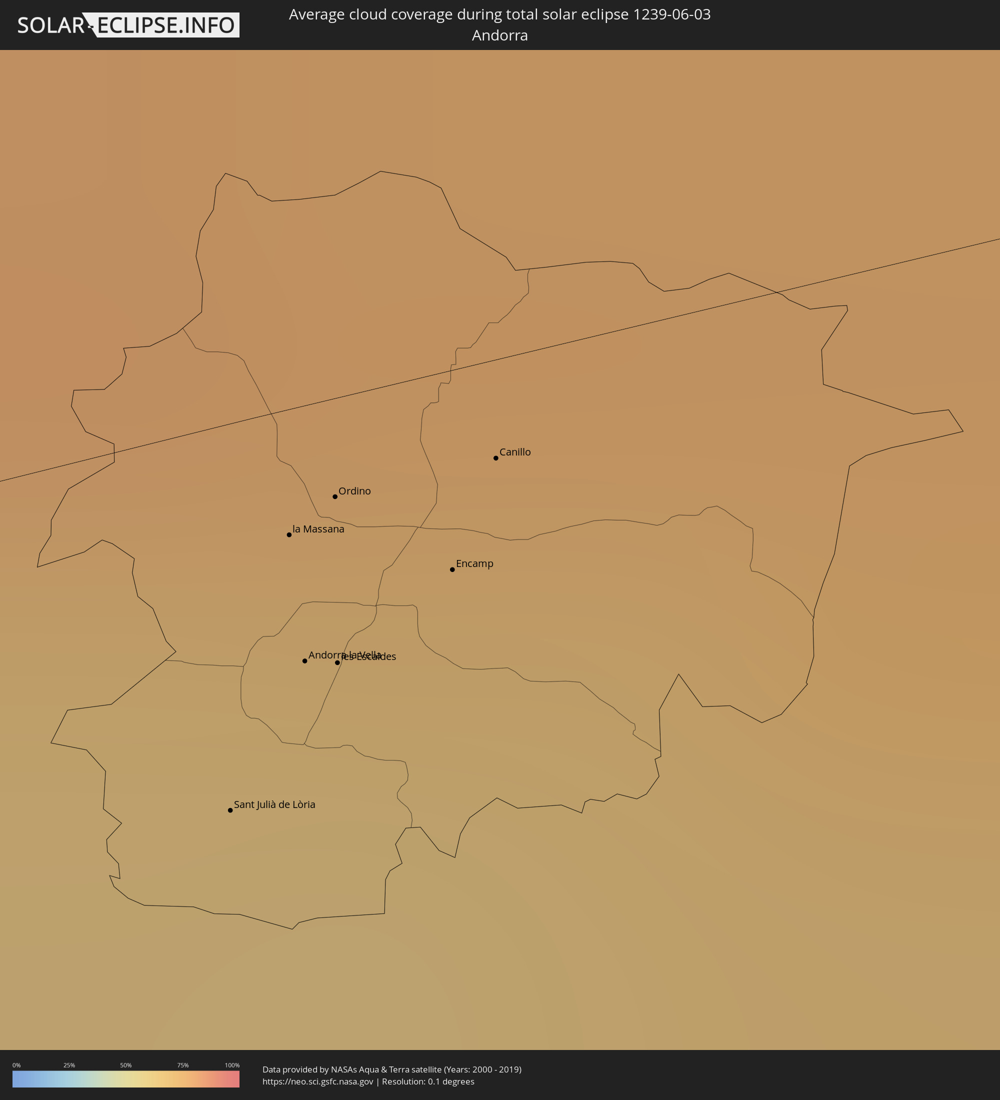 Andorra
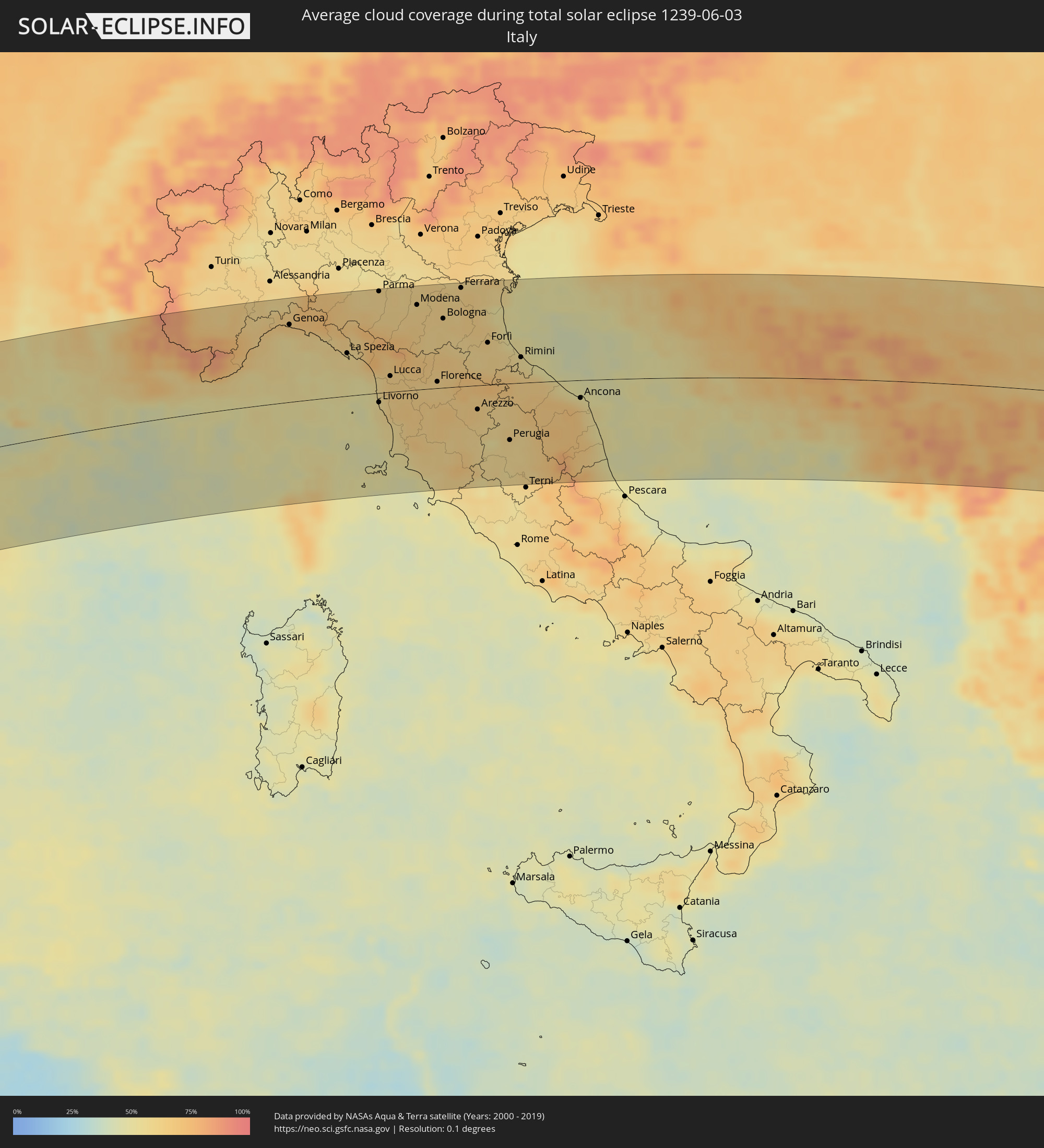 Italy
Italy
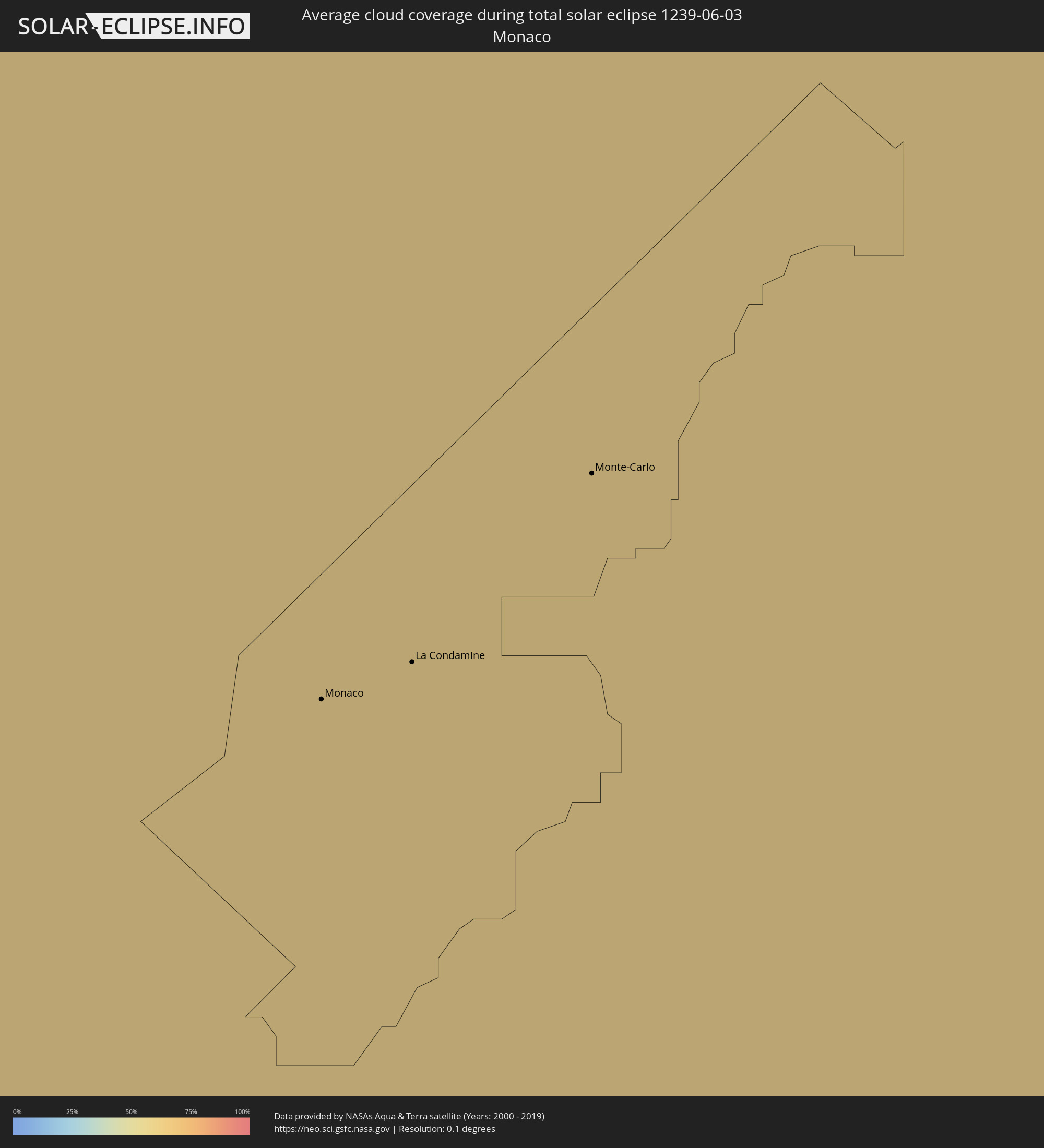 Monaco
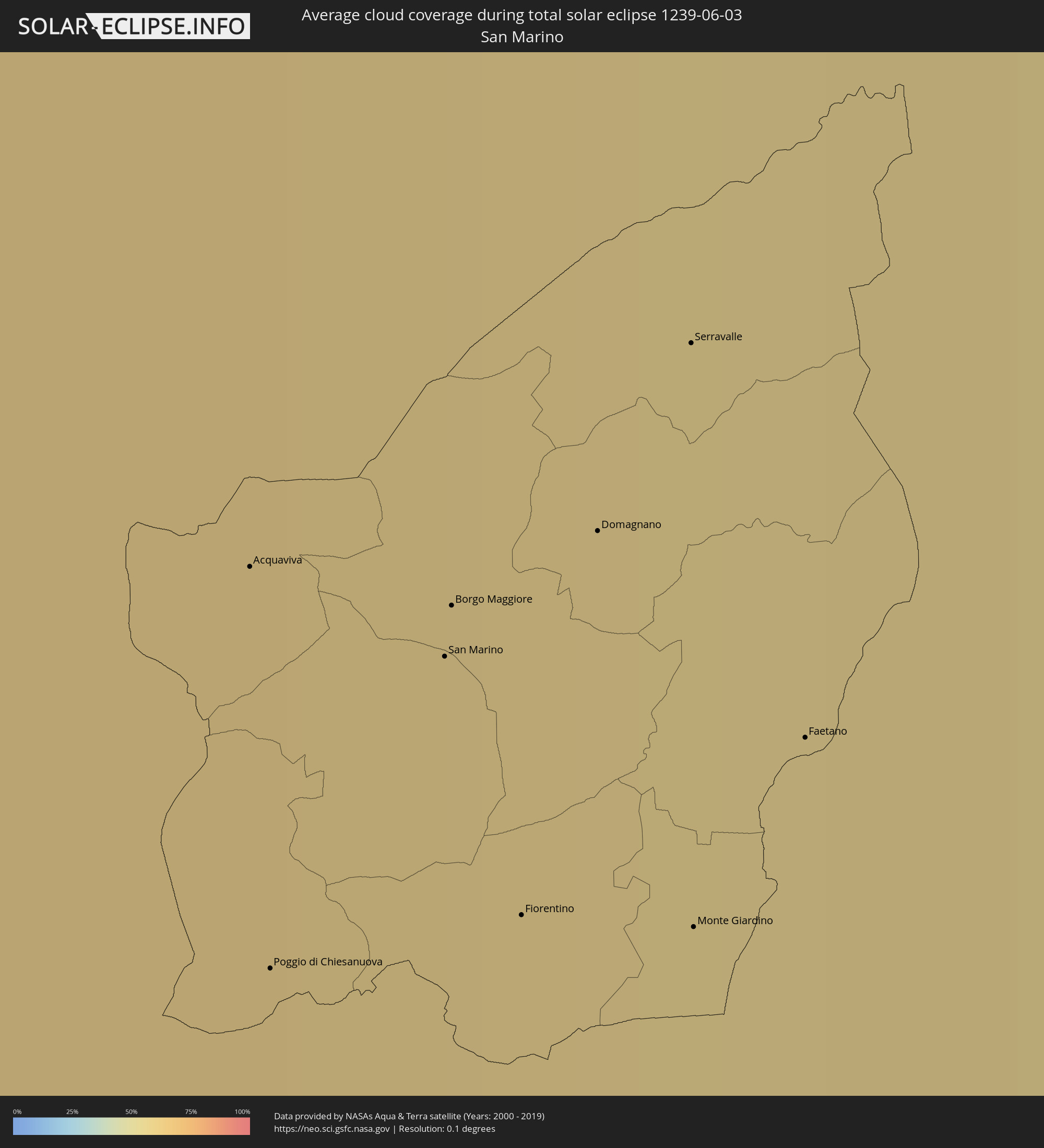 San Marino
 Croatia
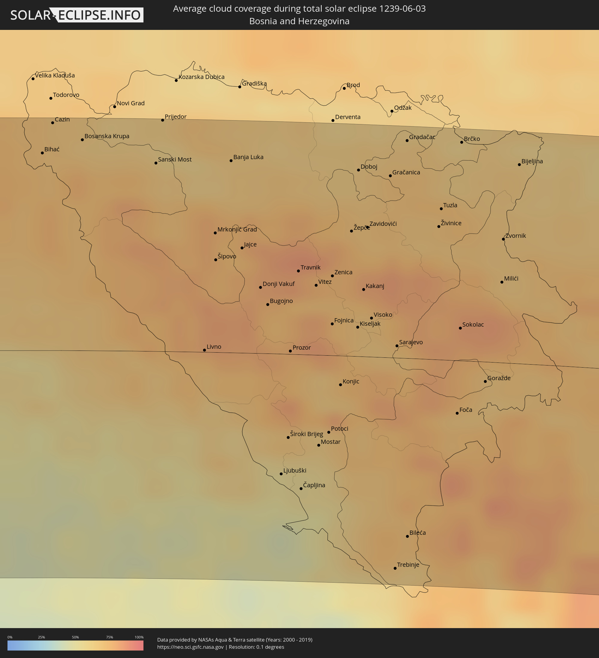 Bosnia and Herzegovina
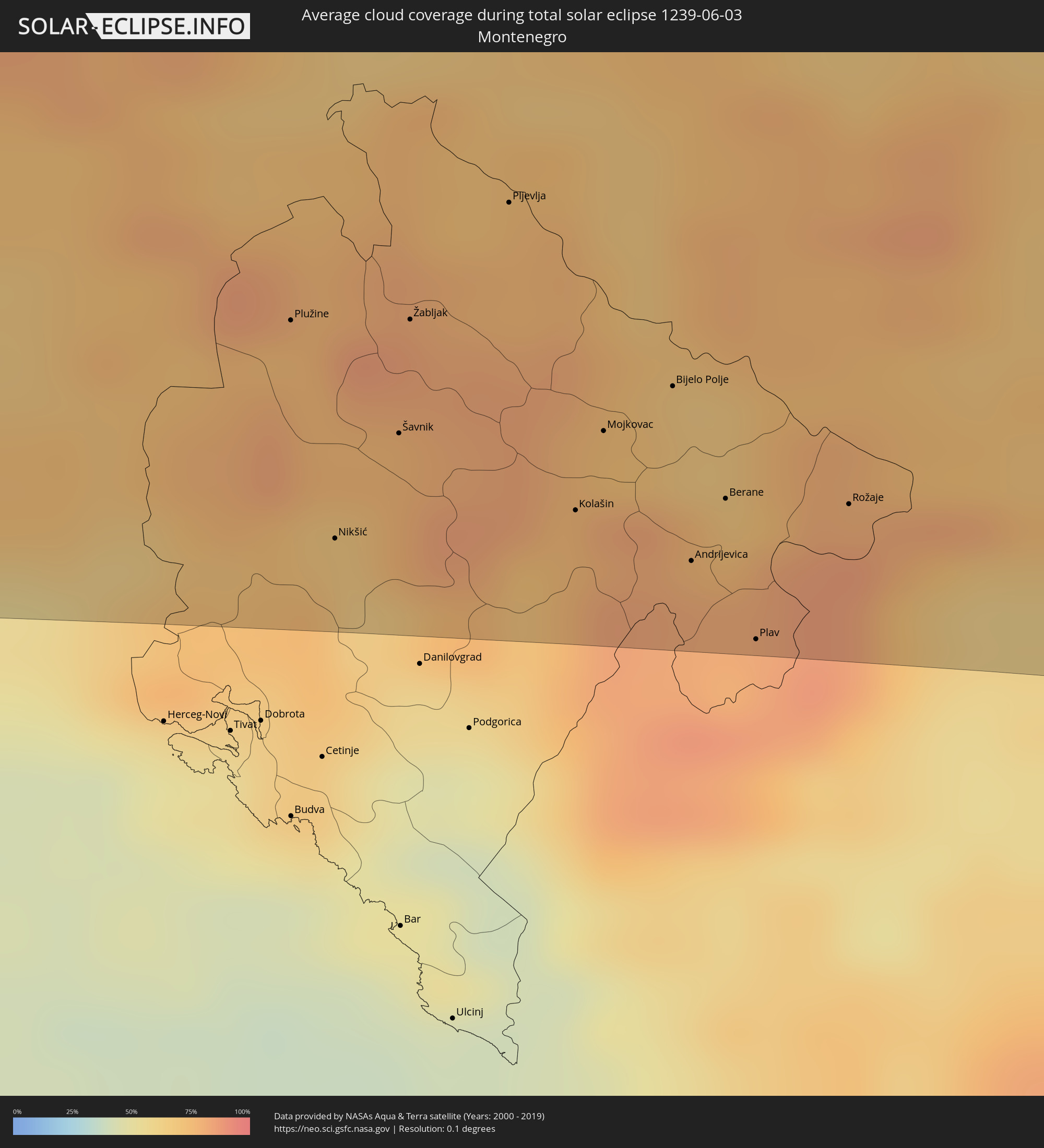 Montenegro
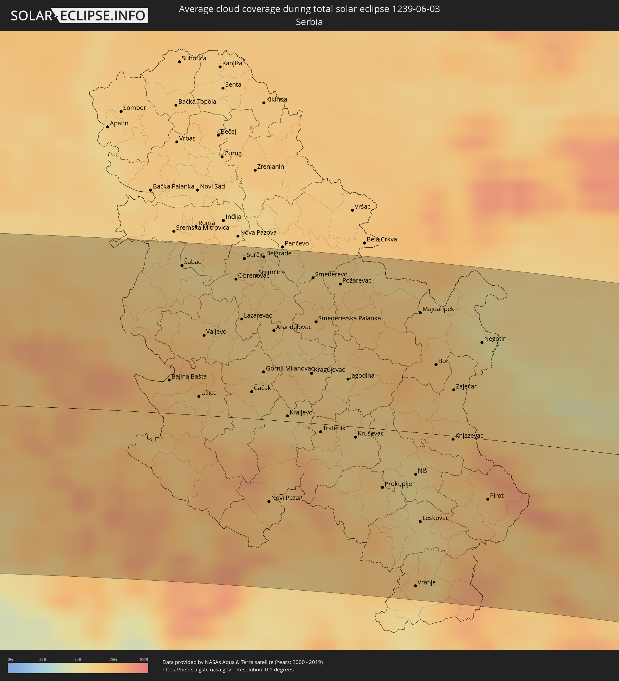 Serbia
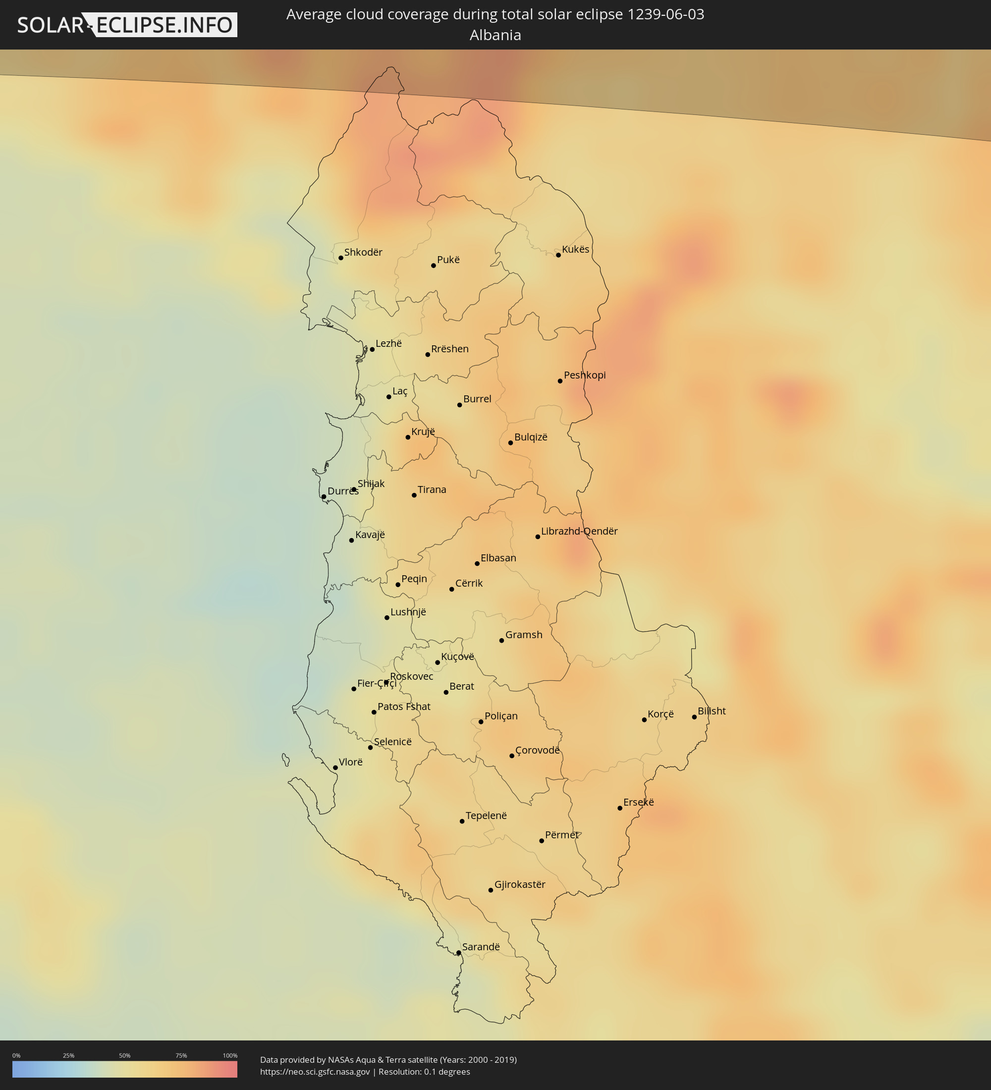 Albania
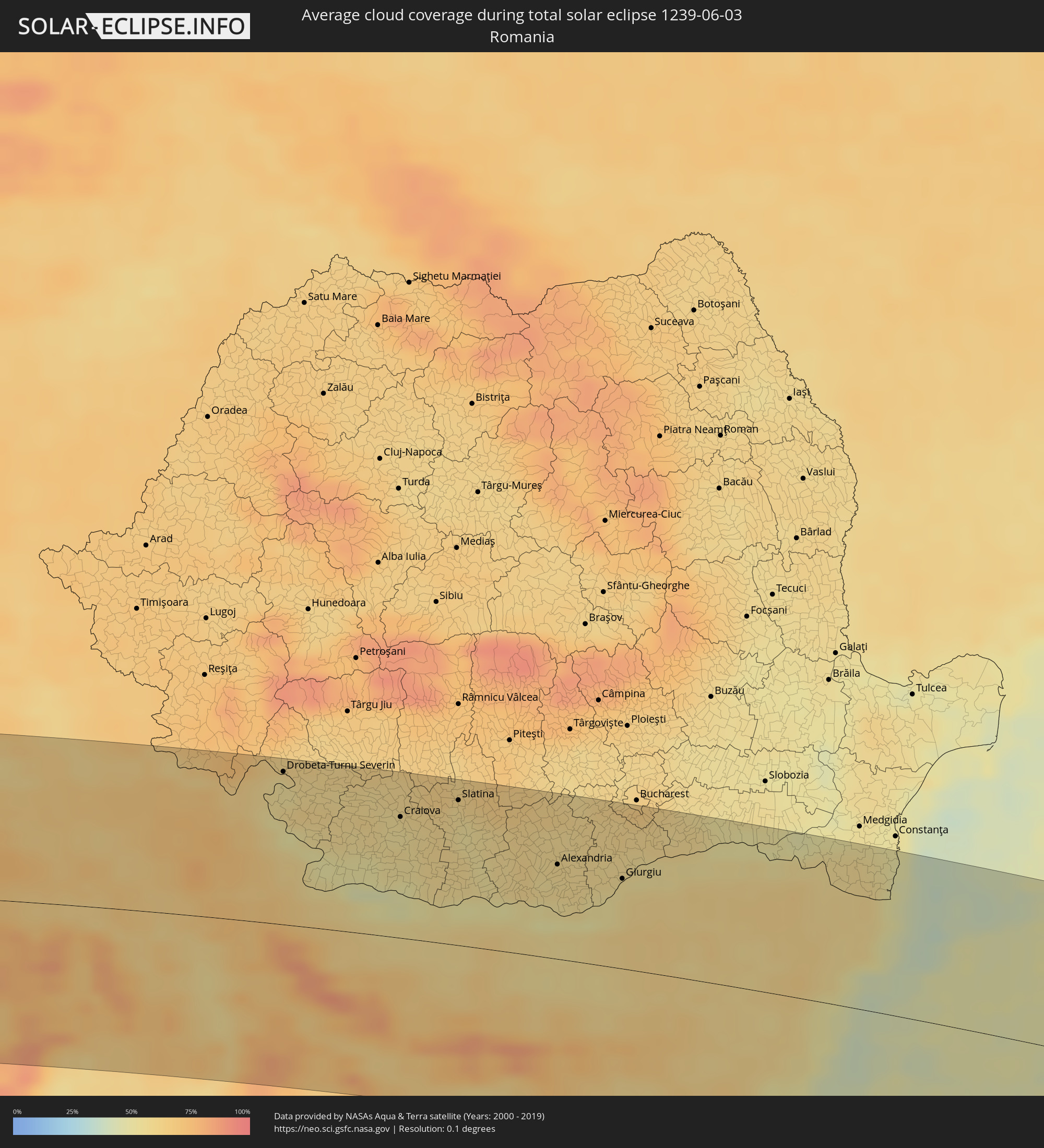 Romania
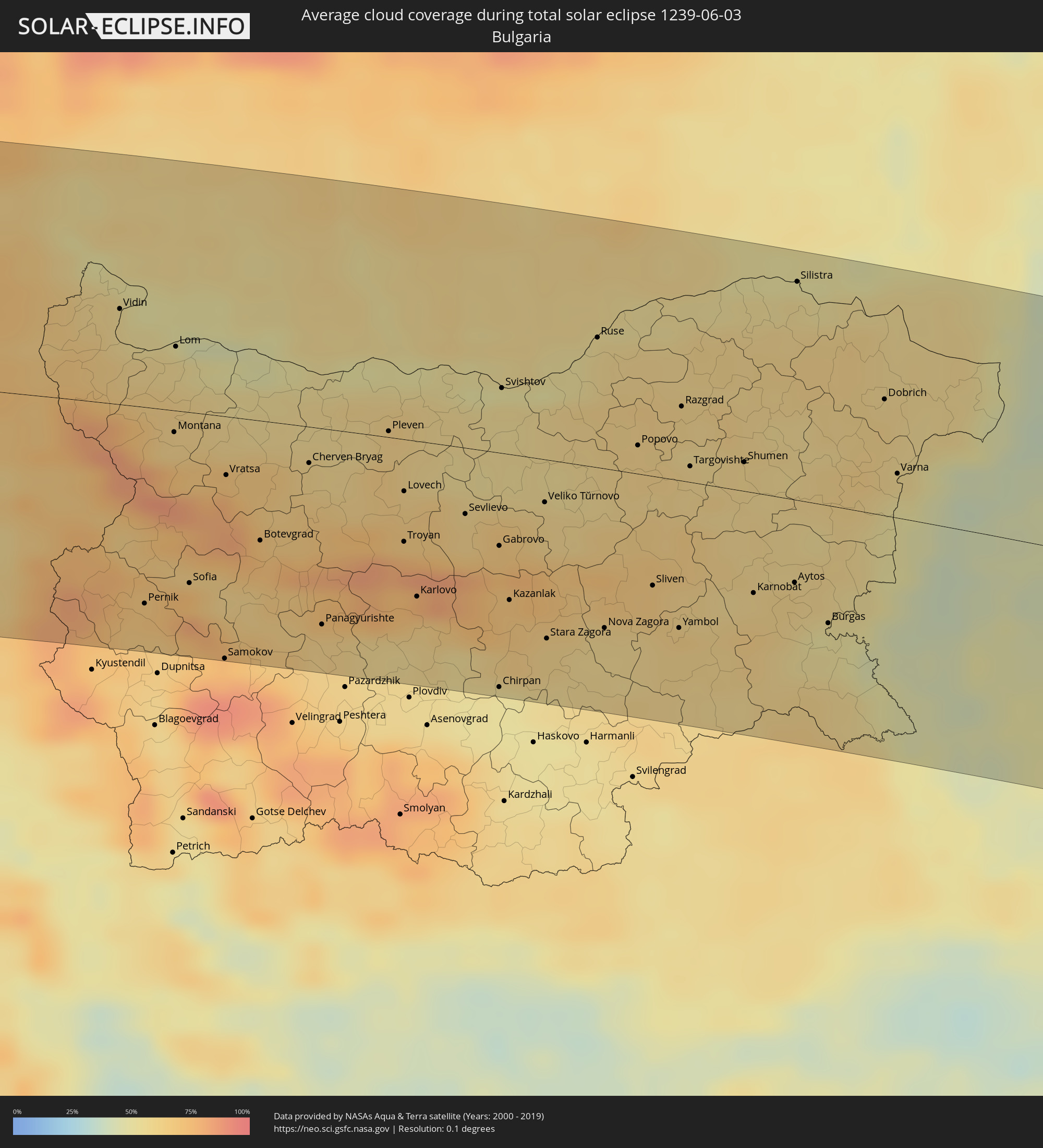 Bulgaria
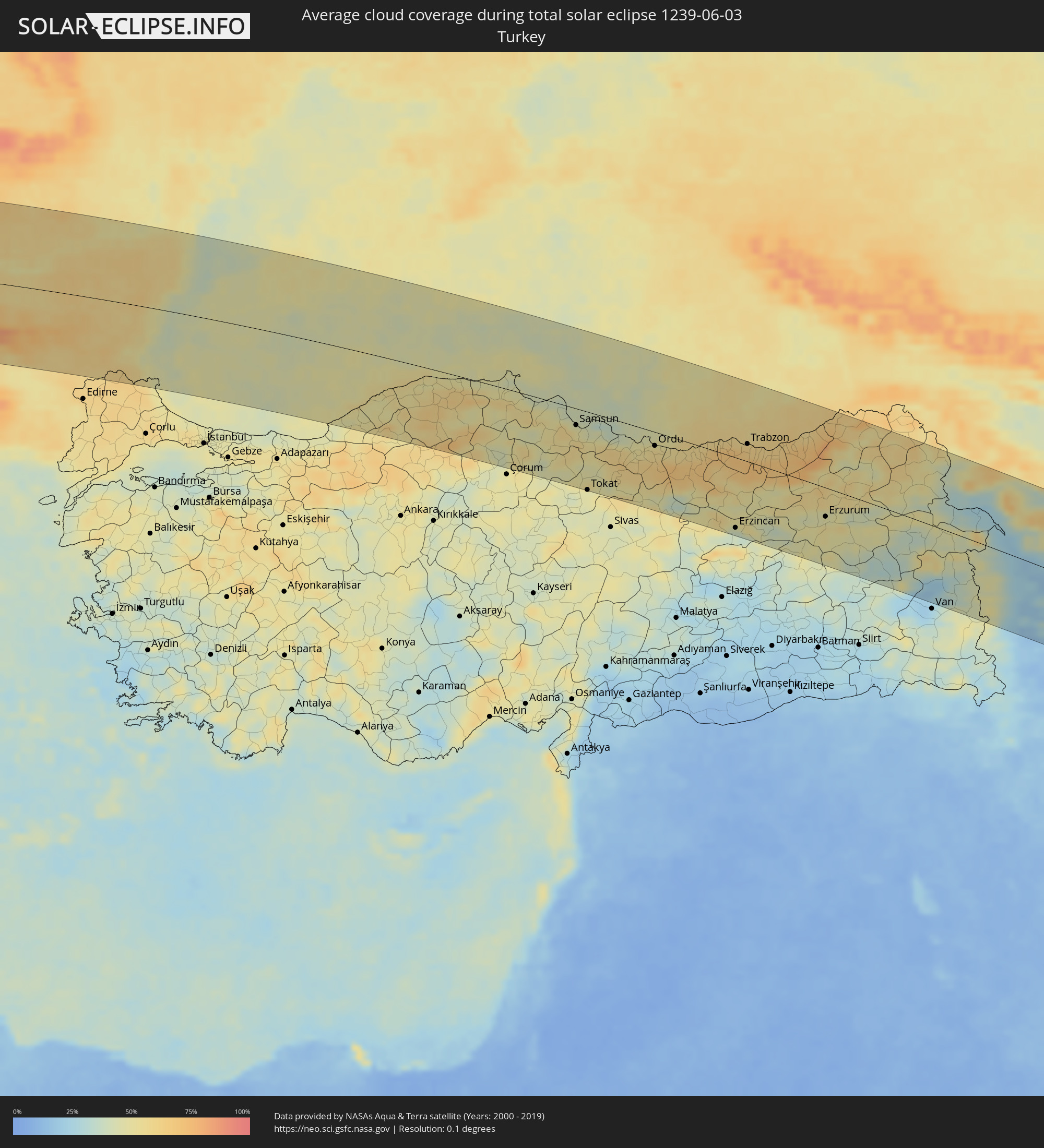 Turkey
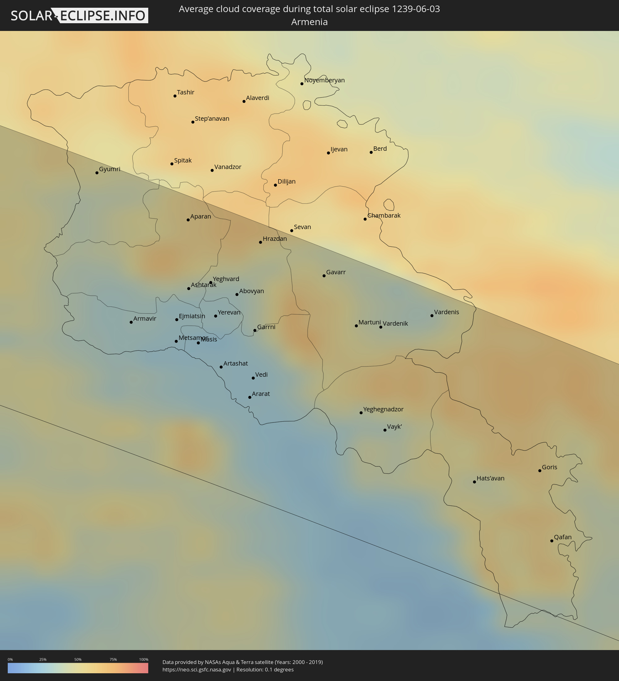 Armenia
 Iran
Iran
 Azerbaijan
 Turkmenistan
 Afghanistan
 Pakistan
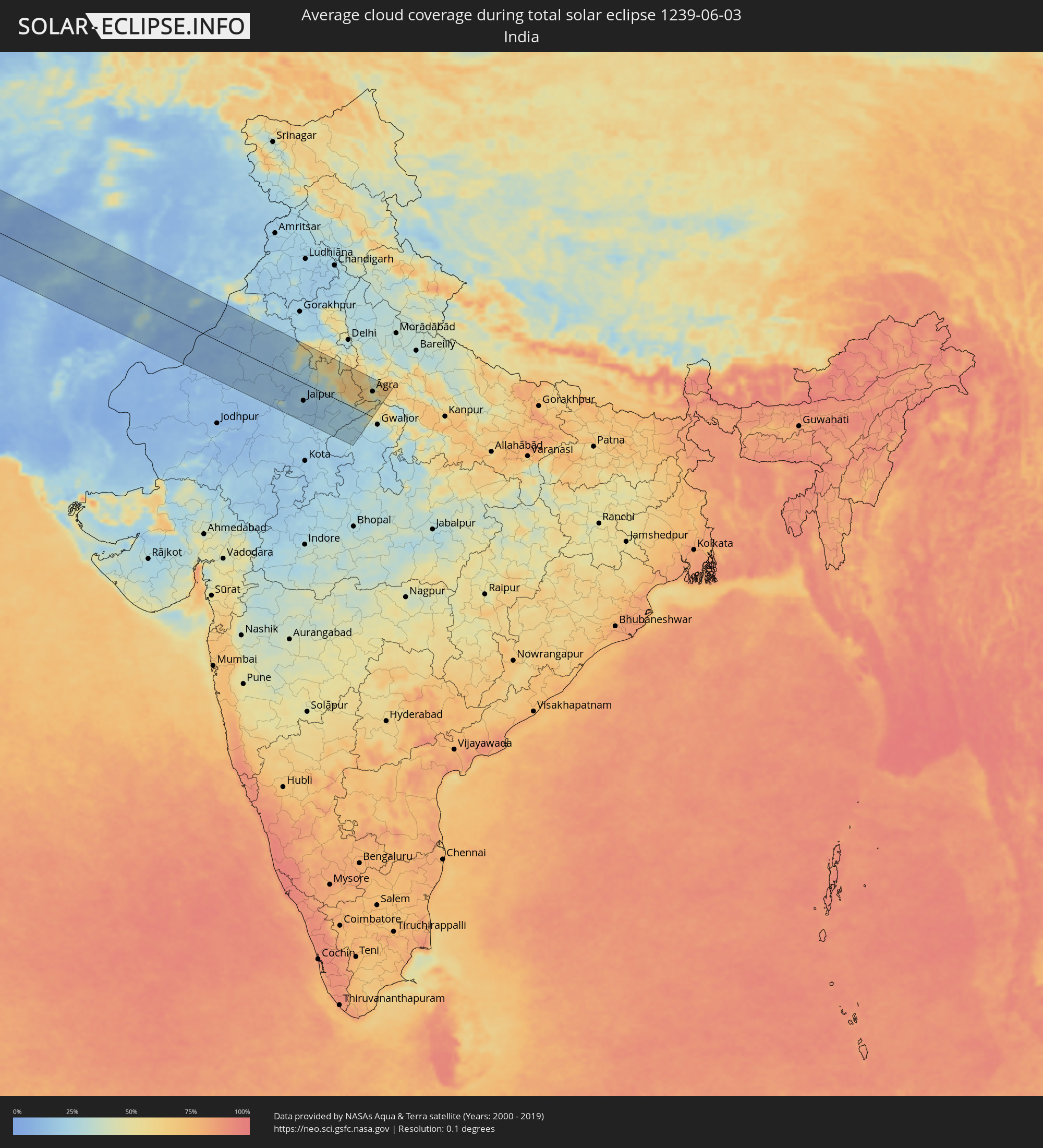 India
India
Cities inside the path of the eclipse
The following table shows all locations with a population of more than 5,000 inside the eclipse path. Cities which have more than 100,000 inhabitants are marked bold. A click at the locations opens a detailed map.
| City | Type | Eclipse duration | Local time of max. eclipse | Distance to central line | Ø Cloud coverage |
|
San Fernando de Apure, Apure
|
total | - | 05:51:36 UTC-04:27 | 9 km | 89% |
|
Valle de La Pascua, Guárico
|
total | - | 05:52:14 UTC-04:27 | 77 km | 88% |
|
Zaraza, Guárico
|
total | - | 05:52:11 UTC-04:27 | 59 km | 92% |
|
Barcelona, Anzoátegui
|
total | - | 05:52:41 UTC-04:27 | 109 km | 86% |
|
Anaco, Anzoátegui
|
total | - | 05:52:04 UTC-04:27 | 29 km | 91% |
|
El Tigre, Anzoátegui
|
total | - | 05:51:35 UTC-04:27 | 38 km | 93% |
|
San José de Guanipa, Anzoátegui
|
total | - | 05:51:34 UTC-04:27 | 41 km | 93% |
|
Carúpano, Sucre
|
total | - | 05:52:52 UTC-04:27 | 94 km | 82% |
|
Maturín, Monagas
|
total | - | 05:52:05 UTC-04:27 | 2 km | 90% |
|
Güiria, Sucre
|
total | - | 05:52:39 UTC-04:27 | 39 km | 72% |
|
Point Fortin, Point Fortin
|
total | - | 06:13:50 UTC-04:06 | 30 km | 84% |
|
Laventille, San Juan/Laventille
|
total | - | 06:14:12 UTC-04:06 | 7 km | 84% |
|
Peñal, Penal/Debe
|
total | - | 06:13:47 UTC-04:06 | 42 km | 86% |
|
Mon Repos, City of San Fernando
|
total | - | 06:13:53 UTC-04:06 | 32 km | 91% |
|
Chaguanas, Chaguanas
|
total | - | 06:14:05 UTC-04:06 | 10 km | 90% |
|
Paradise, Tunapuna/Piarco
|
total | - | 06:14:11 UTC-04:06 | 1 km | 87% |
|
Arima, Borough of Arima
|
total | - | 06:14:10 UTC-04:06 | 5 km | 87% |
|
Rio Claro, Mayaro
|
total | - | 06:13:52 UTC-04:06 | 43 km | 90% |
|
Sangre Grande, Sangre Grande
|
total | - | 06:14:06 UTC-04:06 | 18 km | 86% |
|
Scarborough, Tobago
|
total | - | 06:14:35 UTC-04:06 | 23 km | 75% |
|
Cacém, Lisbon
|
total | - | 11:07:54 UTC-00:36 | 103 km | 39% |
|
Lisbon, Lisbon
|
total | - | 11:08:09 UTC-00:36 | 114 km | 32% |
|
Leiria, Leiria
|
total | - | 11:09:55 UTC-00:36 | 21 km | 42% |
|
Monsanto, Santarém
|
total | - | 11:09:47 UTC-00:36 | 53 km | 35% |
|
Aveiro, Aveiro
|
total | - | 11:11:12 UTC-00:36 | 66 km | 42% |
|
Porto, Porto
|
total | - | 11:11:47 UTC-00:36 | 116 km | 41% |
|
Coimbra, Coimbra
|
total | - | 11:11:08 UTC-00:36 | 13 km | 44% |
|
Castelo Branco, Castelo Branco
|
total | - | 11:12:28 UTC-00:36 | 57 km | 34% |
|
Guarda, Guarda
|
total | - | 11:13:38 UTC-00:36 | 10 km | 36% |
|
Bragança, Bragança
|
total | - | 11:15:49 UTC-00:36 | 125 km | 42% |
|
Salamanca, Castille and León
|
total | - | 11:53:48 UTC+00:00 | 5 km | 45% |
|
Valladolid, Castille and León
|
total | - | 11:56:11 UTC+00:00 | 50 km | 43% |
|
Móstoles, Madrid
|
total | - | 11:56:41 UTC+00:00 | 114 km | 38% |
|
Madrid, Madrid
|
total | - | 11:57:05 UTC+00:00 | 109 km | 36% |
|
Burgos, Castille and León
|
total | - | 11:58:39 UTC+00:00 | 94 km | 52% |
|
Alcalá de Henares, Madrid
|
total | - | 11:57:48 UTC+00:00 | 111 km | 38% |
|
Gasteiz / Vitoria, Basque Country
|
total | - | 12:00:57 UTC+00:00 | 122 km | 58% |
|
Pamplona, Navarre
|
total | - | 12:02:50 UTC+00:00 | 93 km | 55% |
|
Zaragoza, Aragon
|
total | - | 12:03:31 UTC+00:00 | 49 km | 38% |
|
Pau, Nouvelle-Aquitaine
|
total | - | 12:14:52 UTC+00:09 | 116 km | 69% |
|
Toulouse, Occitania
|
total | - | 12:18:23 UTC+00:09 | 112 km | 66% |
|
Sant Julià de Lòria, Sant Julià de Loria
|
total | - | 12:08:33 UTC+00:00 | 12 km | 62% |
|
la Massana, La Massana
|
total | - | 12:08:39 UTC+00:00 | 4 km | 62% |
|
Andorra la Vella, Andorra la Vella
|
total | - | 12:08:38 UTC+00:00 | 8 km | 62% |
|
Ordino, Ordino
|
total | - | 12:08:41 UTC+00:00 | 3 km | 68% |
|
les Escaldes, Escaldes-Engordany
|
total | - | 12:08:40 UTC+00:00 | 8 km | 62% |
|
Encamp, Encamp
|
total | - | 12:08:46 UTC+00:00 | 6 km | 65% |
|
Canillo, Canillo
|
total | - | 12:08:49 UTC+00:00 | 3 km | 69% |
|
Terrassa, Catalonia
|
total | - | 12:09:07 UTC+00:00 | 120 km | 50% |
|
Perpignan, Occitania
|
total | - | 12:20:42 UTC+00:09 | 13 km | 56% |
|
Montpellier, Occitania
|
total | - | 12:22:54 UTC+00:09 | 70 km | 57% |
|
Nîmes, Occitania
|
total | - | 12:23:51 UTC+00:09 | 87 km | 55% |
|
Avignon, Provence-Alpes-Côte d'Azur
|
total | - | 12:24:44 UTC+00:09 | 93 km | 53% |
|
Marseille, Provence-Alpes-Côte d'Azur
|
total | - | 12:25:37 UTC+00:09 | 13 km | 48% |
|
Aix-en-Provence, Provence-Alpes-Côte d'Azur
|
total | - | 12:25:48 UTC+00:09 | 38 km | 44% |
|
Toulon, Provence-Alpes-Côte d'Azur
|
total | - | 12:26:36 UTC+00:09 | 14 km | 44% |
|
Nice, Provence-Alpes-Côte d'Azur
|
total | - | 12:29:12 UTC+00:09 | 34 km | 55% |
|
Monaco
|
total | - | 12:29:29 UTC+00:09 | 36 km | 53% |
|
La Condamine
|
total | - | 12:29:29 UTC+00:09 | 36 km | 53% |
|
Monte-Carlo
|
total | - | 12:29:30 UTC+00:09 | 36 km | 53% |
|
Genoa, Liguria
|
total | - | 13:22:55 UTC+01:00 | 97 km | 61% |
|
Livorno, Tuscany
|
total | - | 13:25:27 UTC+01:00 | 12 km | 54% |
|
Parma, Emilia-Romagna
|
total | - | 13:25:25 UTC+01:00 | 127 km | 60% |
|
Reggio nell'Emilia, Emilia-Romagna
|
total | - | 13:25:57 UTC+01:00 | 114 km | 60% |
|
Modena, Emilia-Romagna
|
total | - | 13:26:28 UTC+01:00 | 106 km | 61% |
|
Prato, Tuscany
|
total | - | 13:26:50 UTC+01:00 | 20 km | 65% |
|
Florence, Tuscany
|
total | - | 13:27:06 UTC+01:00 | 8 km | 62% |
|
Bologna, Emilia-Romagna
|
total | - | 13:27:13 UTC+01:00 | 87 km | 60% |
|
Perugia, Umbria
|
total | - | 13:29:14 UTC+01:00 | 72 km | 59% |
|
Acquaviva, Acquaviva
|
total | - | 13:29:10 UTC+01:00 | 21 km | 67% |
|
Poggio di Chiesanuova, Chiesanuova
|
total | - | 13:29:11 UTC+01:00 | 16 km | 67% |
|
San Marino, San Marino
|
total | - | 13:29:13 UTC+01:00 | 19 km | 67% |
|
Borgo Maggiore, Borgo Maggiore
|
total | - | 13:29:14 UTC+01:00 | 20 km | 67% |
|
Fiorentino, Fiorentino
|
total | - | 13:29:15 UTC+01:00 | 16 km | 66% |
|
Domagnano, Domagnano
|
total | - | 13:29:16 UTC+01:00 | 21 km | 66% |
|
Serravalle, Serravalle
|
total | - | 13:29:17 UTC+01:00 | 23 km | 59% |
|
Monte Giardino, Montegiardino
|
total | - | 13:29:17 UTC+01:00 | 16 km | 66% |
|
Faetano, Faetano
|
total | - | 13:29:19 UTC+01:00 | 18 km | 66% |
|
Rimini, Emilia-Romagna
|
total | - | 13:29:25 UTC+01:00 | 32 km | 54% |
|
Pula, Istarska
|
total | - | 13:31:28 UTC+01:00 | 118 km | 58% |
|
Zadar, Zadarska
|
total | - | 13:34:02 UTC+01:00 | 33 km | 53% |
|
Bihać, Federation of Bosnia and Herzegovina
|
total | - | 13:34:52 UTC+01:00 | 110 km | 70% |
|
Šibenik, Šibensko-Kniniska
|
total | - | 13:35:17 UTC+01:00 | 11 km | 59% |
|
Knin, Šibensko-Kniniska
|
total | - | 13:35:41 UTC+01:00 | 24 km | 66% |
|
Trogir, Splitsko-Dalmatinska
|
total | - | 13:35:57 UTC+01:00 | 35 km | 52% |
|
Split, Splitsko-Dalmatinska
|
total | - | 13:36:16 UTC+01:00 | 35 km | 54% |
|
Sinj, Splitsko-Dalmatinska
|
total | - | 13:36:33 UTC+01:00 | 13 km | 64% |
|
Prijedor, Republic of Srspka
|
total | - | 13:36:12 UTC+01:00 | 129 km | 60% |
|
Makarska, Splitsko-Dalmatinska
|
total | - | 13:37:20 UTC+01:00 | 58 km | 56% |
|
Banja Luka, Republic of Srspka
|
total | - | 13:37:03 UTC+01:00 | 107 km | 66% |
|
Bugojno, Federation of Bosnia and Herzegovina
|
total | - | 13:37:46 UTC+01:00 | 27 km | 72% |
|
Metković, Dubrovačko-Neretvanska
|
total | - | 13:38:30 UTC+01:00 | 84 km | 48% |
|
Mostar, Federation of Bosnia and Herzegovina
|
total | - | 13:38:39 UTC+01:00 | 51 km | 56% |
|
Zenica, Federation of Bosnia and Herzegovina
|
total | - | 13:38:27 UTC+01:00 | 45 km | 71% |
|
Dubrovnik, Dubrovačko-Neretvanska
|
total | - | 13:39:26 UTC+01:00 | 128 km | 48% |
|
Sarajevo, Federation of Bosnia and Herzegovina
|
total | - | 13:39:21 UTC+01:00 | 7 km | 73% |
|
Tuzla, Federation of Bosnia and Herzegovina
|
total | - | 13:39:32 UTC+01:00 | 84 km | 67% |
|
Brčko, Brčko
|
total | - | 13:39:36 UTC+01:00 | 122 km | 64% |
|
Plužine, Opština Plužine
|
total | - | 13:40:27 UTC+01:00 | 69 km | 75% |
|
Nikšić, Opština Nikšić
|
total | - | 13:40:49 UTC+01:00 | 111 km | 70% |
|
Žabljak, Opština Žabljak
|
total | - | 13:40:56 UTC+01:00 | 68 km | 84% |
|
Bijeljina, Republic of Srspka
|
total | - | 13:40:18 UTC+01:00 | 111 km | 65% |
|
Pljevlja, Pljevlja
|
total | - | 13:41:13 UTC+01:00 | 44 km | 75% |
|
Kolašin, Opština Kolašin
|
total | - | 13:41:44 UTC+01:00 | 103 km | 75% |
|
Mojkovac, Mojkovac
|
total | - | 13:41:47 UTC+01:00 | 87 km | 73% |
|
Bijelo Polje, Bijelo Polje
|
total | - | 13:42:01 UTC+01:00 | 78 km | 72% |
|
Užice, Central Serbia
|
total | - | 13:41:45 UTC+01:00 | 14 km | 69% |
|
Berane, Berane
|
total | - | 13:42:19 UTC+01:00 | 99 km | 75% |
|
Plav, Opština Plav
|
total | - | 13:42:34 UTC+01:00 | 126 km | 79% |
|
Rožaje, Opština Rožaje
|
total | - | 13:42:48 UTC+01:00 | 98 km | 85% |
|
Čačak, Central Serbia
|
total | - | 13:42:32 UTC+01:00 | 20 km | 66% |
|
Belgrade, Central Serbia
|
total | - | 13:42:13 UTC+01:00 | 122 km | 63% |
|
Novi Pazar, Central Serbia
|
total | - | 13:43:12 UTC+01:00 | 63 km | 70% |
|
Kraljevo, Central Serbia
|
total | - | 13:43:10 UTC+01:00 | 4 km | 64% |
|
Kragujevac, Central Serbia
|
total | - | 13:43:21 UTC+01:00 | 38 km | 66% |
|
Smederevo, Central Serbia
|
total | - | 13:43:00 UTC+01:00 | 109 km | 64% |
|
Kruševac, Central Serbia
|
total | - | 13:44:15 UTC+01:00 | 8 km | 63% |
|
Niš, Central Serbia
|
total | - | 13:45:18 UTC+01:00 | 32 km | 56% |
|
Leskovac, Central Serbia
|
total | - | 13:45:33 UTC+01:00 | 68 km | 59% |
|
Drobeta-Turnu Severin, Mehedinţi
|
total | - | 14:30:01 UTC+01:44 | 119 km | 54% |
|
Pernik, Pernik
|
total | - | 14:47:30 UTC+02:00 | 103 km | 70% |
|
Sofia, Sofia-Capital
|
total | - | 14:47:53 UTC+02:00 | 89 km | 72% |
|
Craiova, Dolj
|
total | - | 14:31:55 UTC+01:44 | 94 km | 54% |
|
Caracal, Olt County
|
total | - | 14:32:51 UTC+01:44 | 78 km | 58% |
|
Slatina, Olt County
|
total | - | 14:32:39 UTC+01:44 | 113 km | 55% |
|
Pleven, Pleven
|
total | - | 14:49:20 UTC+02:00 | 3 km | 62% |
|
Turnu Măgurele, Teleorman
|
total | - | 14:33:51 UTC+01:44 | 43 km | 52% |
|
Roșiorii de Vede, Teleorman
|
total | - | 14:33:45 UTC+01:44 | 84 km | 60% |
|
Alexandria, Teleorman
|
total | - | 14:34:21 UTC+01:44 | 74 km | 55% |
|
Stara Zagora, Stara Zagora
|
total | - | 14:51:33 UTC+02:00 | 94 km | 61% |
|
Giurgiu, Giurgiu
|
total | - | 14:35:19 UTC+01:44 | 70 km | 57% |
|
Ruse, Ruse
|
total | - | 14:50:57 UTC+02:00 | 67 km | 57% |
|
Sector 4, Bucureşti
|
total | - | 14:35:09 UTC+01:44 | 126 km | 63% |
|
Sliven, Sliven
|
total | - | 14:52:21 UTC+02:00 | 57 km | 67% |
|
Shumen, Shumen
|
total | - | 14:52:44 UTC+02:00 | 15 km | 60% |
|
Burgas, Burgas
|
total | - | 14:54:06 UTC+02:00 | 61 km | 51% |
|
Dobrich, Dobrich
|
total | - | 14:53:44 UTC+02:00 | 60 km | 59% |
|
Varna, Varna
|
total | - | 14:54:08 UTC+02:00 | 23 km | 52% |
|
Mangalia, Constanța
|
total | - | 14:38:56 UTC+01:44 | 97 km | 47% |
|
Zonguldak, Zonguldak
|
total | - | 14:57:41 UTC+01:56 | 105 km | 46% |
|
Karabük, Karabük
|
total | - | 14:58:57 UTC+01:56 | 115 km | 50% |
|
Bafra, Samsun
|
total | - | 15:02:22 UTC+01:56 | 6 km | 46% |
|
Samsun, Samsun
|
total | - | 15:03:07 UTC+01:56 | 26 km | 52% |
|
Tokat, Tokat
|
total | - | 15:04:21 UTC+01:56 | 125 km | 47% |
|
Ordu, Ordu
|
total | - | 15:05:04 UTC+01:56 | 22 km | 57% |
|
Giresun, Giresun
|
total | - | 15:05:38 UTC+01:56 | 16 km | 60% |
|
Erzincan, Erzincan
|
total | - | 15:07:57 UTC+01:56 | 112 km | 39% |
|
Trabzon, Trabzon
|
total | - | 15:06:50 UTC+01:56 | 28 km | 65% |
|
Erzurum, Erzurum
|
total | - | 15:09:26 UTC+01:56 | 46 km | 54% |
|
Gyumri, Shirak Province
|
total | - | 16:11:41 UTC+02:58 | 120 km | 40% |
|
Armavir, Armavir Province
|
total | - | 16:12:32 UTC+02:58 | 59 km | 30% |
|
Ejmiatsin, Armavir Province
|
total | - | 16:12:44 UTC+02:58 | 68 km | 26% |
|
Yerevan, Yerevan
|
total | - | 16:12:53 UTC+02:58 | 76 km | 23% |
|
Artashat, Ararat Province
|
total | - | 16:13:09 UTC+02:58 | 54 km | 27% |
|
Ararat, Ararat Province
|
total | - | 16:13:25 UTC+02:58 | 45 km | 25% |
|
Hrazdan, Kotayk Province
|
total | - | 16:12:43 UTC+02:58 | 117 km | 43% |
|
Khvoy, Āz̄ārbāyjān-e Gharbī
|
total | - | 16:42:45 UTC+03:25 | 81 km | 27% |
|
Gavarr, Gegharkunik Province
|
total | - | 16:13:09 UTC+02:58 | 112 km | 49% |
|
Nakhchivan, Nakhichevan
|
total | - | 16:36:02 UTC+03:19 | 2 km | 20% |
|
Culfa, Nakhichevan
|
total | - | 16:36:28 UTC+03:19 | 18 km | 18% |
|
Ordubad, Nakhichevan
|
total | - | 16:36:48 UTC+03:19 | 10 km | 20% |
|
Kerbakhiar, Kalbajar
|
total | - | 16:35:29 UTC+03:19 | 115 km | 63% |
|
Tabriz, East Azerbaijan
|
total | - | 16:44:14 UTC+03:25 | 87 km | 20% |
|
Goris, Syunik Province
|
total | - | 16:14:58 UTC+02:58 | 63 km | 53% |
|
Qafan, Syunik Province
|
total | - | 16:15:21 UTC+02:58 | 33 km | 58% |
|
Xankandi, Xankǝndi
|
total | - | 16:36:18 UTC+03:19 | 107 km | 60% |
|
Fizuli, Füzuli
|
total | - | 16:36:49 UTC+03:19 | 97 km | 47% |
|
Ardabīl, Ardabīl
|
total | - | 16:45:24 UTC+03:25 | 5 km | 34% |
|
Dzhalilabad, Jalilabad
|
total | - | 16:38:07 UTC+03:19 | 101 km | 41% |
|
Masally, Masally
|
total | - | 16:38:25 UTC+03:19 | 88 km | 40% |
|
Lankaran, Lənkəran
|
total | - | 16:38:51 UTC+03:19 | 66 km | 31% |
|
Astara, Astara
|
total | - | 16:39:12 UTC+03:19 | 36 km | 35% |
|
Rasht, Gīlān
|
total | - | 16:47:15 UTC+03:25 | 61 km | 46% |
|
Āmol, Māzandarān
|
total | - | 16:49:36 UTC+03:25 | 47 km | 45% |
|
Bābol, Māzandarān
|
total | - | 16:49:40 UTC+03:25 | 27 km | 37% |
|
Sari, Māzandarān
|
total | - | 16:49:50 UTC+03:25 | 12 km | 46% |
|
Gorgān, Golestān
|
total | - | 16:50:08 UTC+03:25 | 66 km | 53% |
|
Shahrud, Semnān
|
total | - | 16:50:48 UTC+03:25 | 43 km | 16% |
|
Torbat-e Ḩeydarīyeh, Razavi Khorasan
|
total | - | 16:53:22 UTC+03:25 | 89 km | 16% |
|
Kafir Qala, Herat
|
total | - | 17:28:40 UTC+04:00 | 102 km | 10% |
|
Kushk, Herat
|
total | - | 17:30:11 UTC+04:00 | 0 km | 7% |
|
Farah, Farah
|
total | - | 17:31:06 UTC+04:00 | 86 km | 4% |
|
Shīnḏanḏ, Herat
|
total | - | 17:30:13 UTC+04:00 | 8 km | 7% |
|
Herāt, Herat
|
total | - | 17:29:11 UTC+04:00 | 115 km | 11% |
|
Lashkar Gāh, Helmand
|
total | - | 17:32:05 UTC+04:00 | 72 km | 3% |
|
Gereshk, Helmand
|
total | - | 17:31:53 UTC+04:00 | 41 km | 4% |
|
Sangīn, Helmand
|
total | - | 17:31:40 UTC+04:00 | 5 km | 6% |
|
Kandahār, Kandahar
|
total | - | 17:32:08 UTC+04:00 | 14 km | 6% |
|
Qalāt, Zabul
|
total | - | 17:31:43 UTC+04:00 | 85 km | 6% |
|
Quetta, Balochistān
|
total | - | 18:01:37 UTC+04:28 | 101 km | 13% |
|
Dera Ghazi Khan, Punjab
|
total | - | 18:01:32 UTC+04:28 | 39 km | 12% |
|
Khānpur, Punjab
|
total | - | 18:02:41 UTC+04:28 | 101 km | 10% |
|
Kot Addu, Punjab
|
total | - | 18:01:09 UTC+04:28 | 94 km | 14% |
|
Muzaffargarh, Punjab
|
total | - | 18:01:27 UTC+04:28 | 65 km | 16% |
|
Ahmadpur East, Punjab
|
total | - | 18:02:13 UTC+04:28 | 25 km | 11% |
|
Multān, Punjab
|
total | - | 18:01:19 UTC+04:28 | 89 km | 13% |
|
Bahāwalpur, Punjab
|
total | - | 18:01:57 UTC+04:28 | 19 km | 11% |
|
Vihāri, Punjab
|
total | - | 18:01:20 UTC+04:28 | 111 km | 19% |
|
Chishtiān Mandi, Punjab
|
total | - | 18:01:27 UTC+04:28 | 110 km | 14% |
|
Bīkaner, Rajasthan
|
total | - | 18:55:45 UTC+05:21 | 49 km | 14% |
|
Sūjāngarh, Rajasthan
|
total | - | 18:55:46 UTC+05:21 | 30 km | 16% |
|
Sīkar, Rajasthan
|
total | - | 18:55:40 UTC+05:21 | 10 km | 15% |
|
Jaipur, Rajasthan
|
total | - | 18:56:02 UTC+05:21 | 51 km | 17% |
|
Alwar, Rajasthan
|
total | - | 18:55:20 UTC+05:21 | 50 km | 36% |
|
Bharatpur, Rajasthan
|
total | - | 18:55:21 UTC+05:21 | 54 km | 61% |
|
Mathura, Uttar Pradesh
|
total | - | 18:55:05 UTC+05:21 | 90 km | 58% |
|
Morena, Madhya Pradesh
|
total | - | 18:55:43 UTC+05:21 | 4 km | 42% |
|
Āgra, Uttar Pradesh
|
total | - | 18:55:13 UTC+05:21 | 73 km | 44% |
|
Fīrozābād, Uttar Pradesh
|
total | - | 18:55:08 UTC+05:21 | 87 km | 58% |