Total solar eclipse of 03/16/1485
| Day of week: | Monday |
| Maximum duration of eclipse: | 04m53s |
| Maximum width of eclipse path: | 213 km |
| Saros cycle: | 121 |
| Coverage: | 100% |
| Magnitude: | 1.0615 |
| Gamma: | 0.3345 |
Wo kann man die Sonnenfinsternis vom 03/16/1485 sehen?
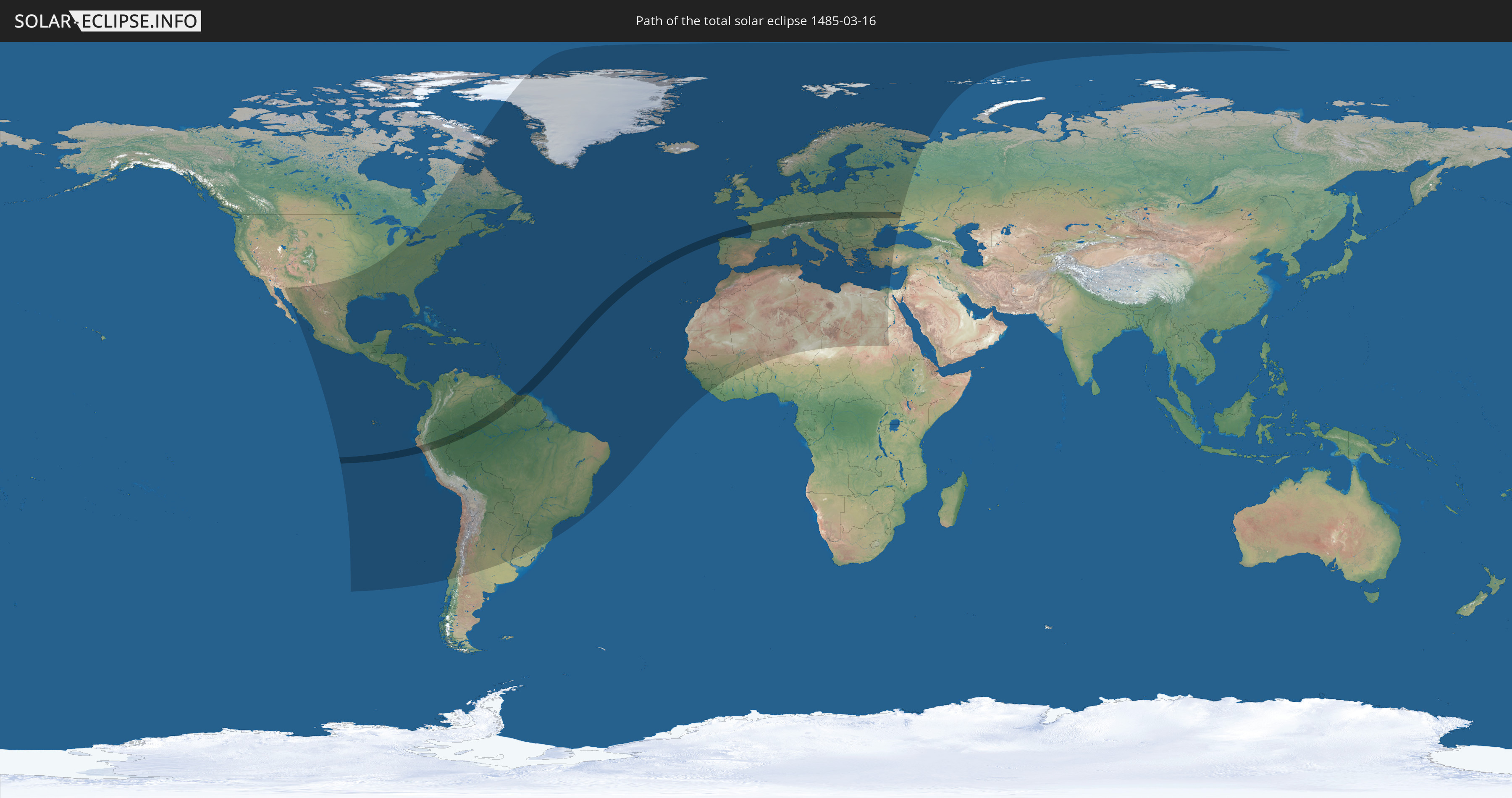
Die Sonnenfinsternis am 03/16/1485 kann man in 123 Ländern als partielle Sonnenfinsternis beobachten.
Der Finsternispfad verläuft durch 19 Länder. Nur in diesen Ländern ist sie als total Sonnenfinsternis zu sehen.
In den folgenden Ländern ist die Sonnenfinsternis total zu sehen
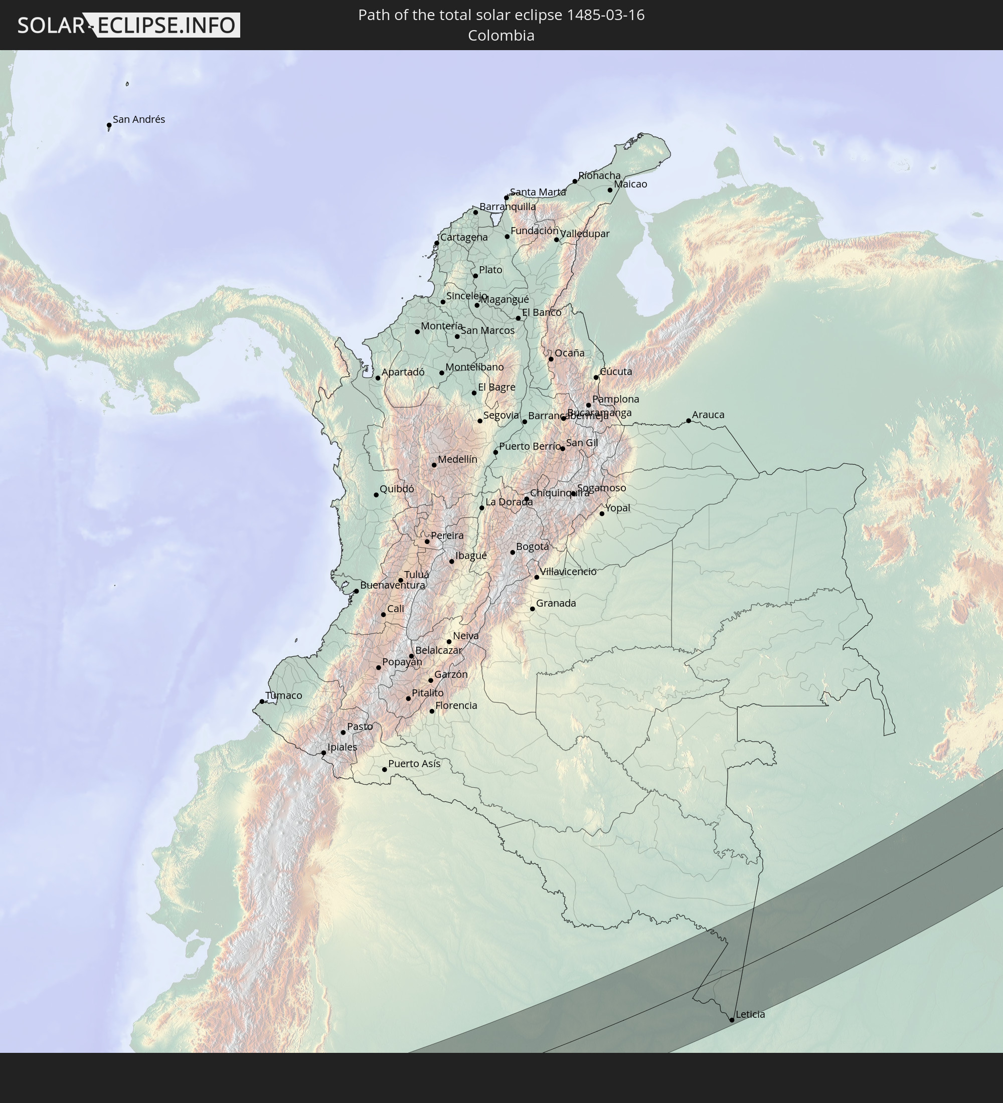 Colombia
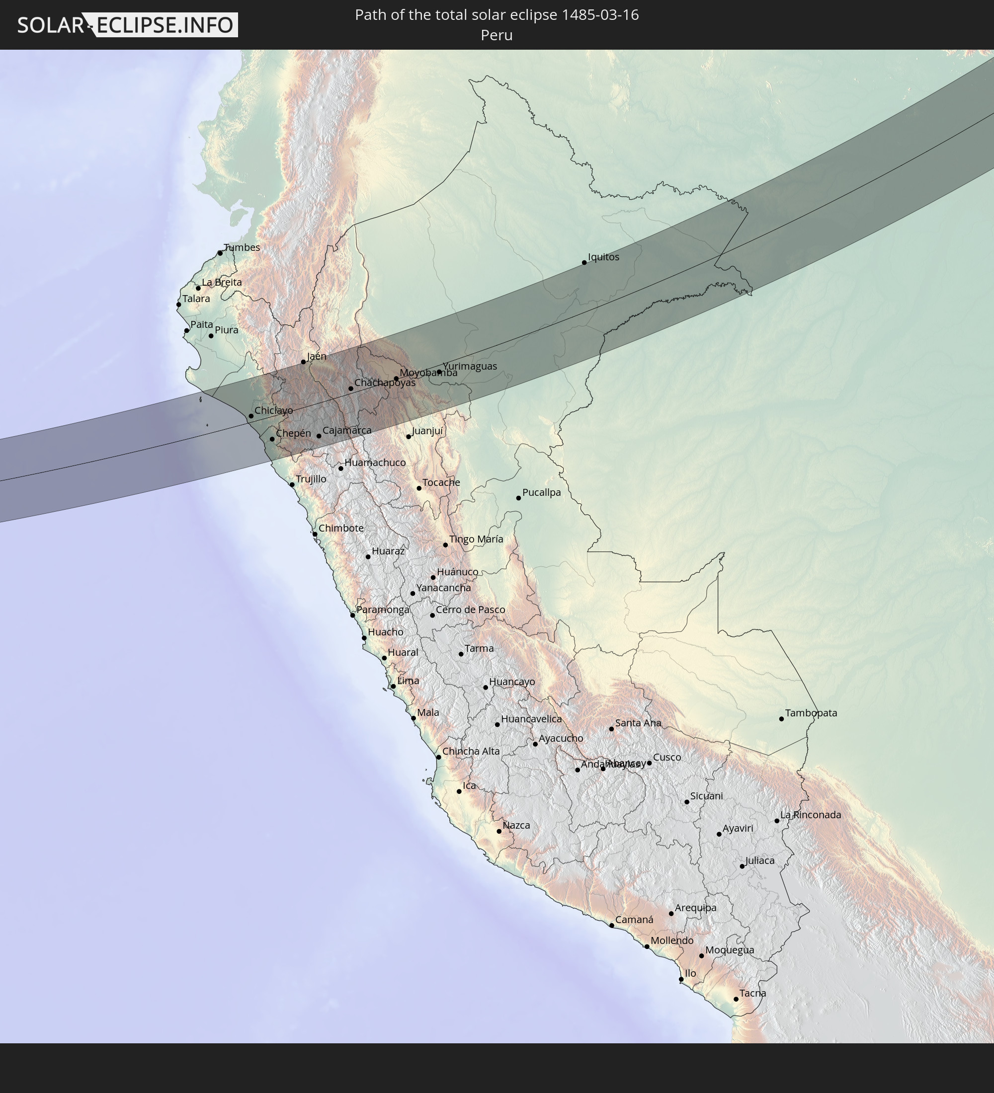 Peru
Peru
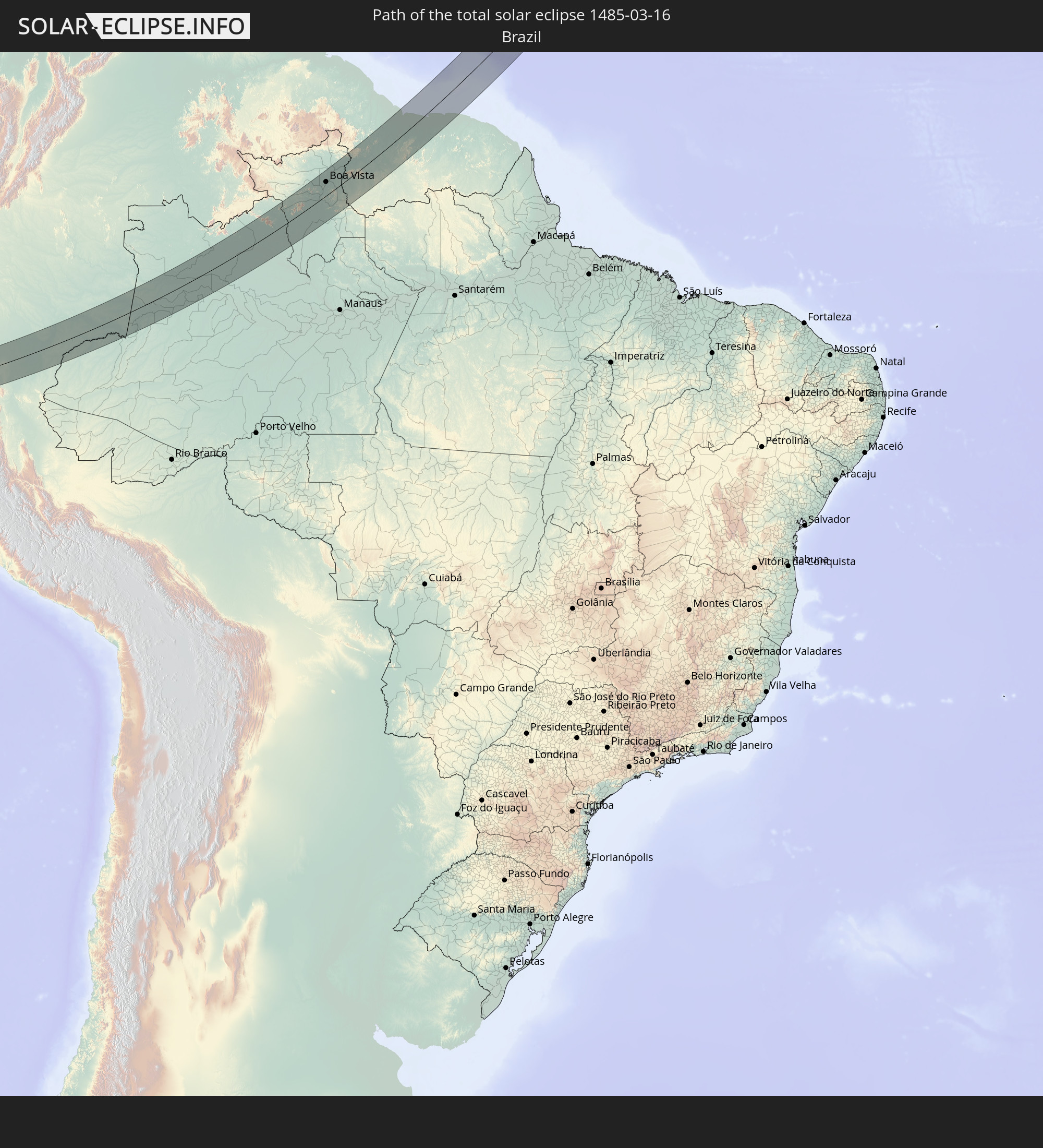 Brazil
 Guyana
 Suriname
 Portugal
 Spain
Spain
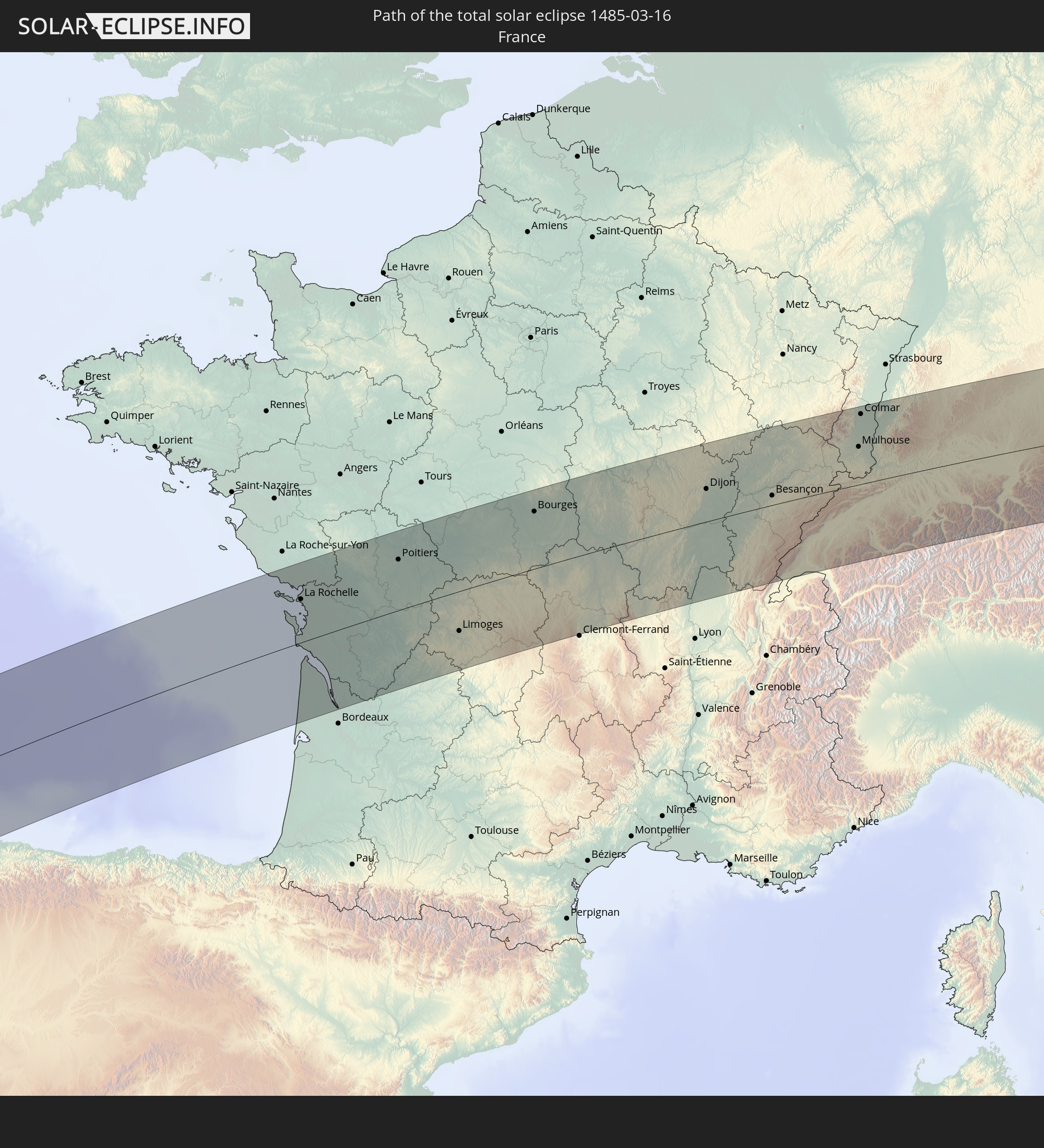 France
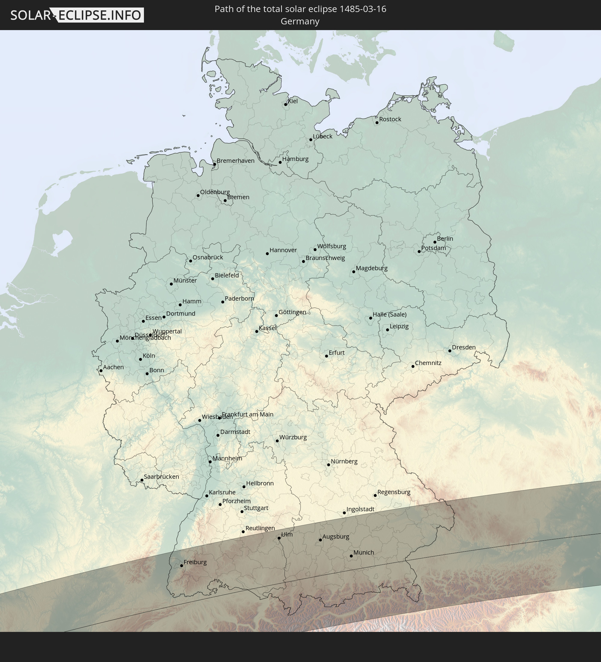 Germany
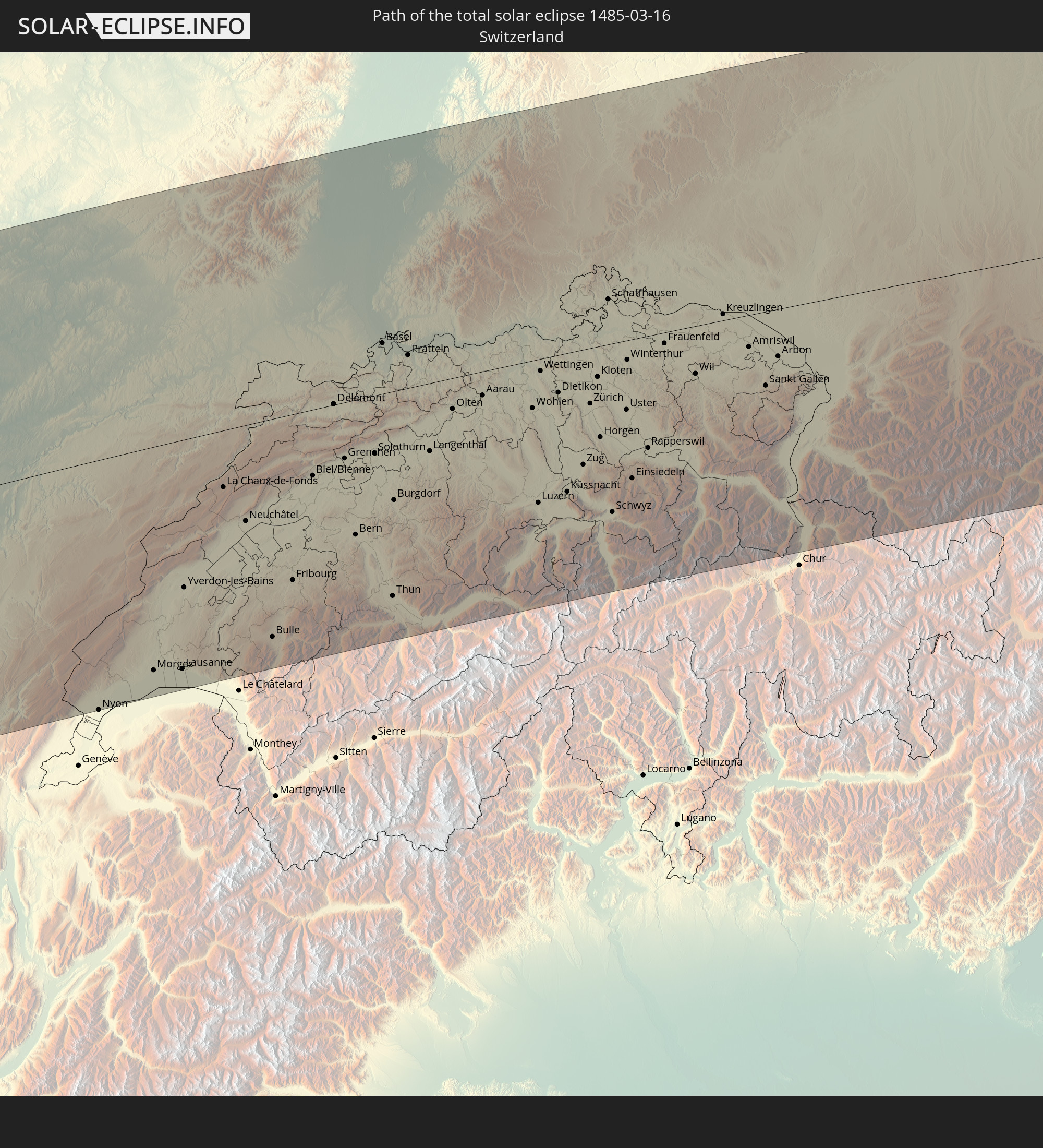 Switzerland
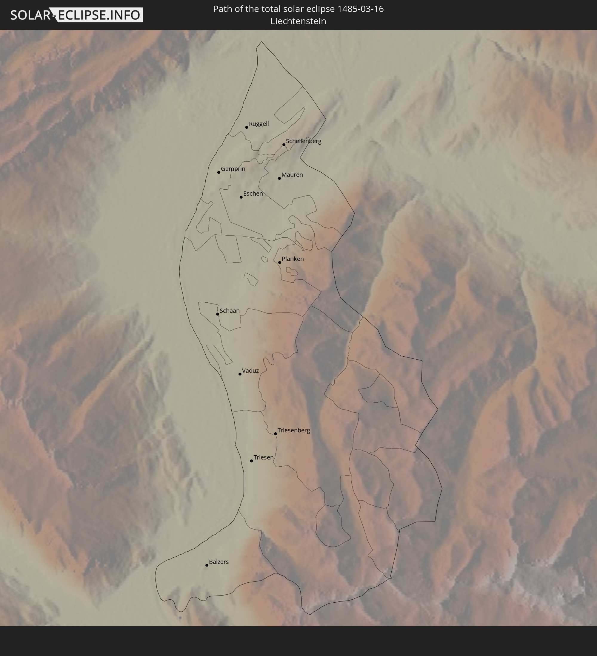 Liechtenstein
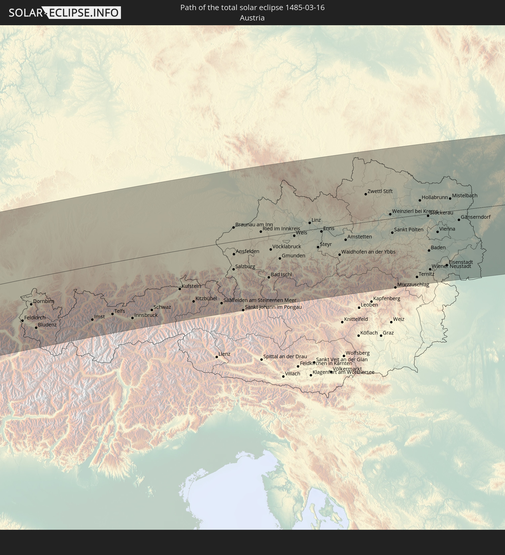 Austria
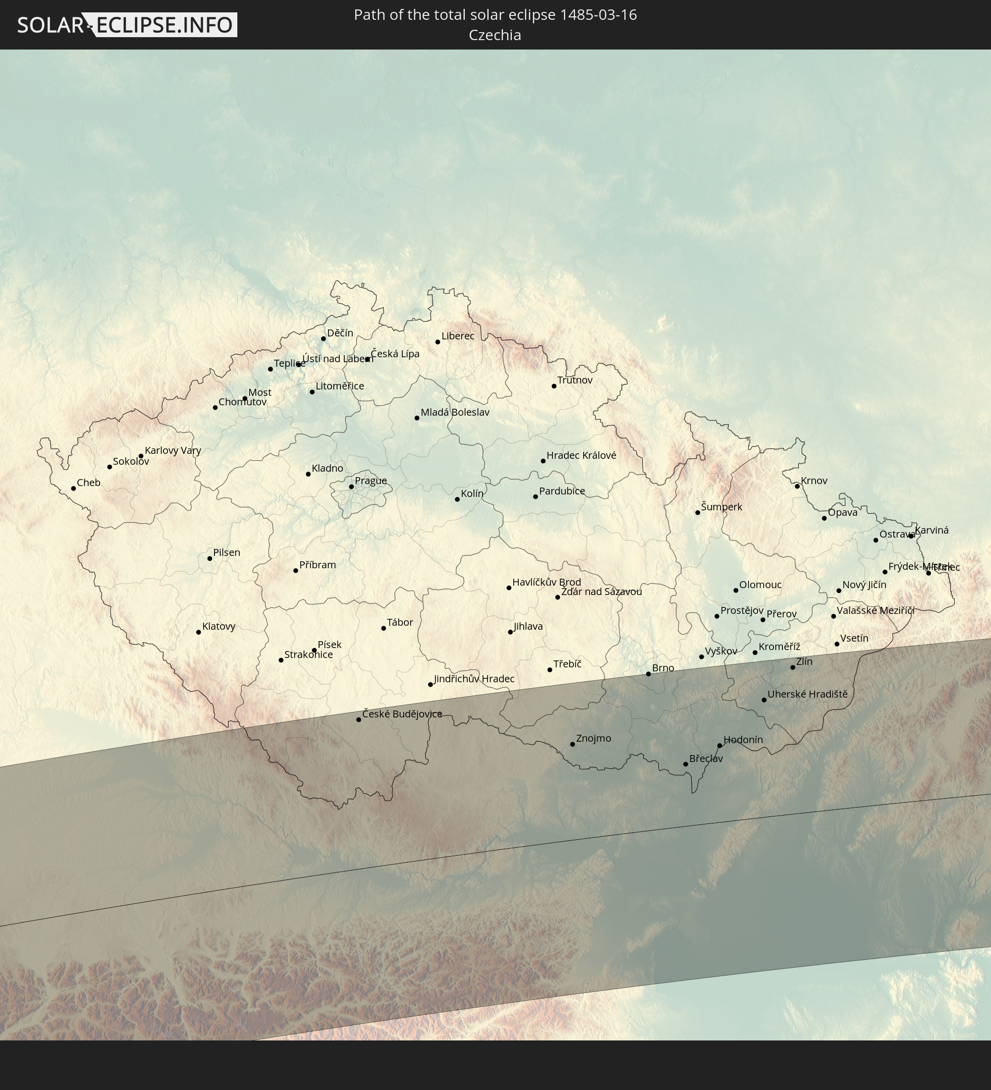 Czechia
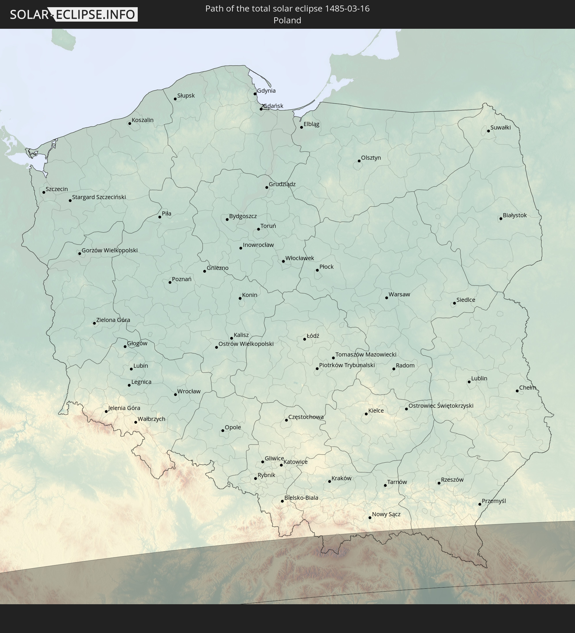 Poland
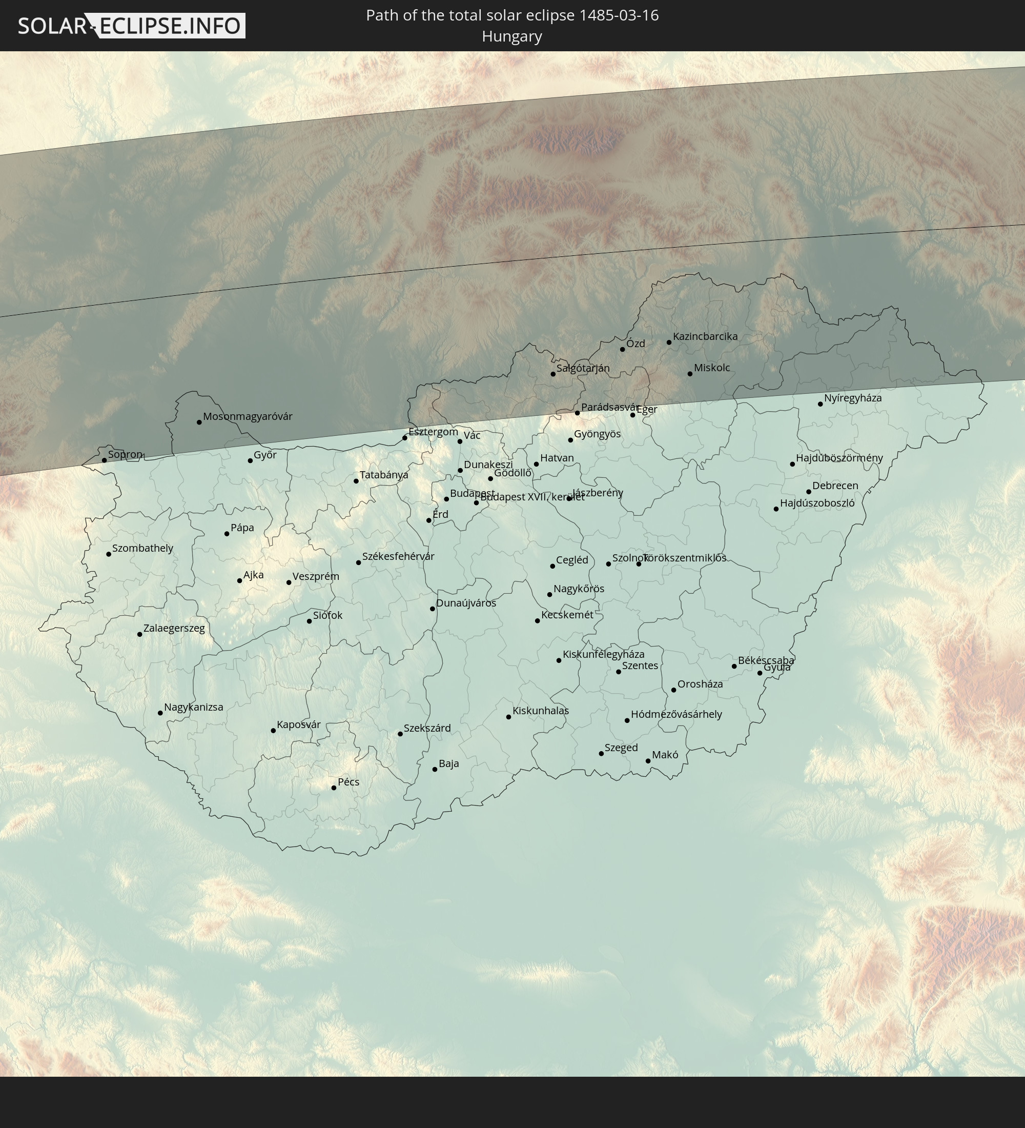 Hungary
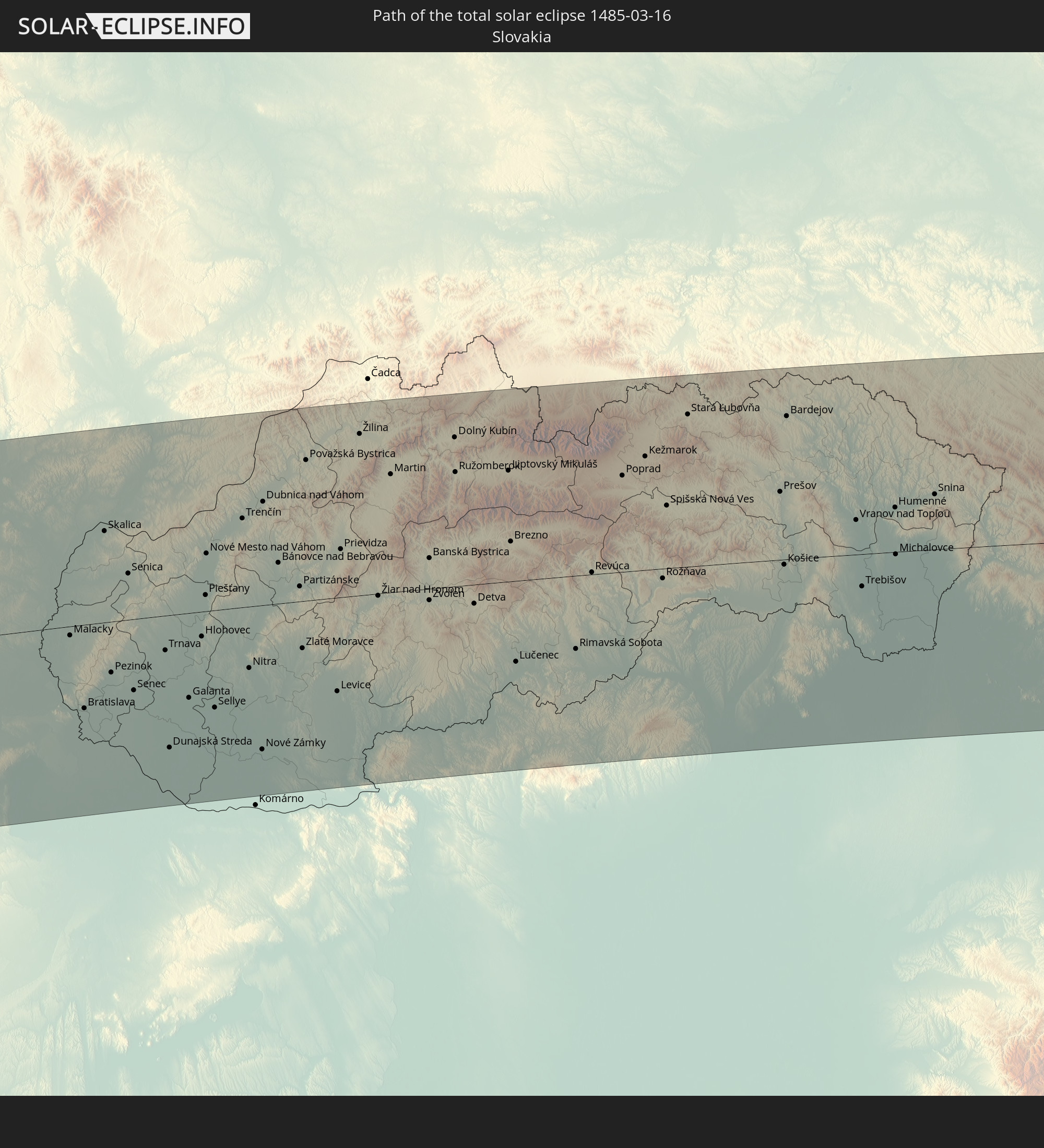 Slovakia
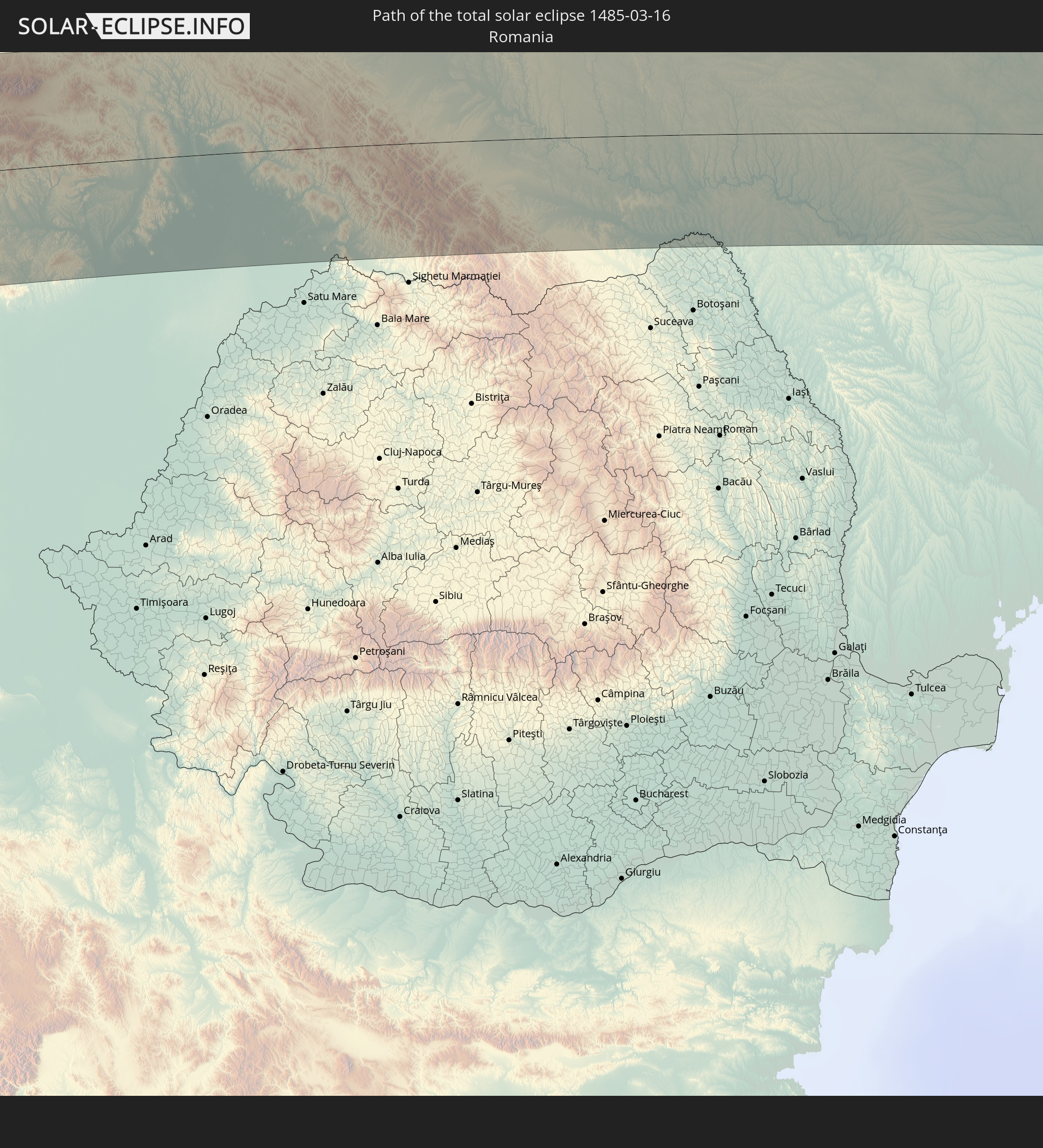 Romania
 Ukraine
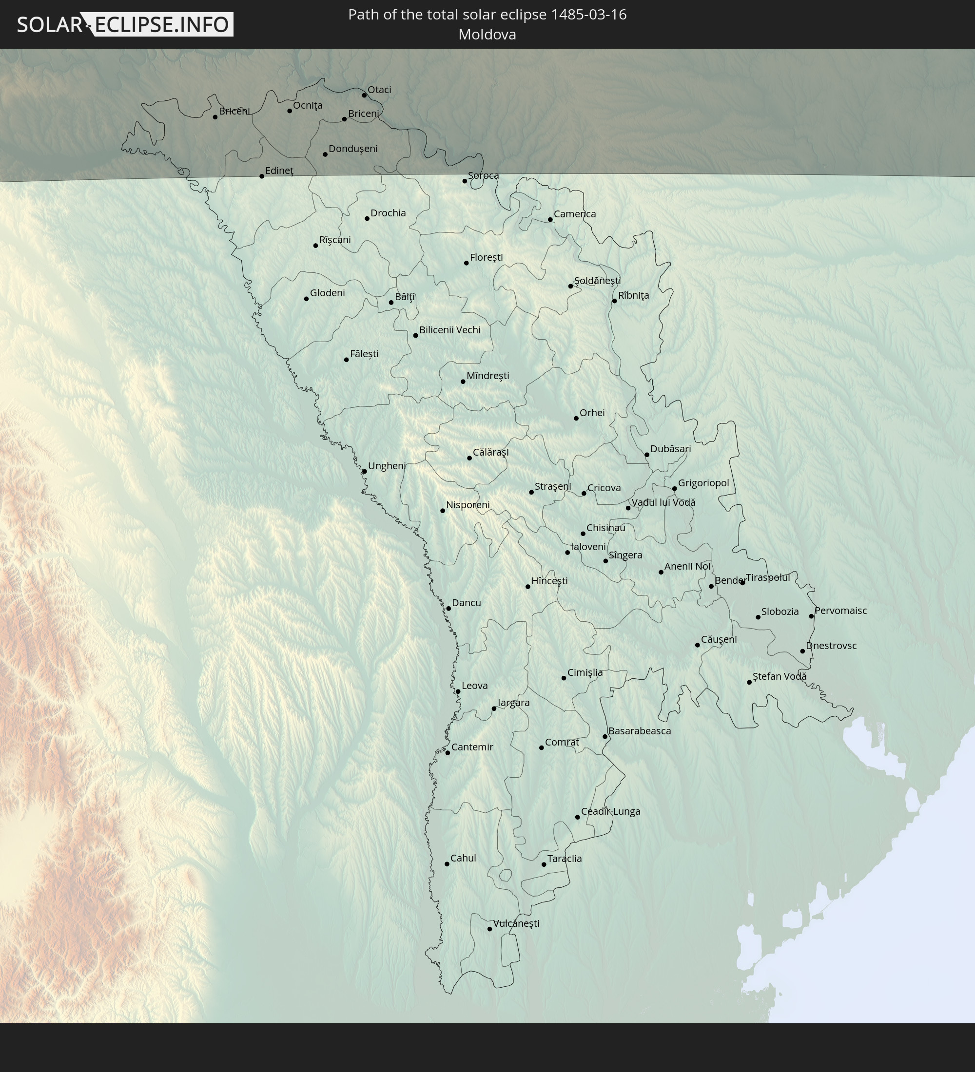 Moldova
In den folgenden Ländern ist die Sonnenfinsternis partiell zu sehen
 Russia
 United States
 United States Minor Outlying Islands
 Canada
 Mexico
 Chile
Chile
 Greenland
 Guatemala
 Ecuador
 El Salvador
 Honduras
 Belize
 Nicaragua
 Costa Rica
 Cuba
Cuba
 Panama
 Colombia
 Cayman Islands
 Peru
Peru
 The Bahamas
 Jamaica
 Haiti
Haiti
 Brazil
 Argentina
 Venezuela
 Turks and Caicos Islands
 Dominican Republic
 Aruba
Aruba
 Bolivia
 Puerto Rico
 United States Virgin Islands
 Bermuda
 British Virgin Islands
 Anguilla
 Collectivity of Saint Martin
 Saint Barthélemy
 Saint Kitts and Nevis
 Paraguay
 Antigua and Barbuda
 Montserrat
 Trinidad and Tobago
 Guadeloupe
 Grenada
 Dominica
 Saint Vincent and the Grenadines
 Guyana
 Martinique
 Saint Lucia
 Barbados
 Uruguay
 Suriname
 Saint Pierre and Miquelon
 French Guiana
 Portugal
 Cabo Verde
 Iceland
 Spain
Spain
 Senegal
 Mauritania
 The Gambia
 Guinea-Bissau
 Guinea
 Sierra Leone
 Morocco
 Mali
Mali
 Liberia
 Republic of Ireland
 Svalbard and Jan Mayen
 Algeria
 United Kingdom
 Ivory Coast
 Faroe Islands
 Burkina Faso
 Gibraltar
 France
 Isle of Man
 Guernsey
 Jersey
 Niger
Niger
 Andorra
 Belgium
 Netherlands
 Norway
 Luxembourg
 Germany
 Switzerland
 Italy
Italy
 Monaco
 Tunisia
 Denmark
 Libya
Libya
 Liechtenstein
 Austria
 Sweden
 Czechia
 San Marino
 Vatican City
 Slovenia
 Chad
Chad
 Croatia
 Poland
 Malta
Malta
 Bosnia and Herzegovina
 Hungary
 Slovakia
 Montenegro
 Serbia
 Albania
 Åland Islands
 Greece
 Romania
 Republic of Macedonia
 Finland
 Lithuania
 Latvia
 Estonia
 Sudan
Sudan
 Ukraine
 Bulgaria
 Belarus
 Egypt
Egypt
 Turkey
 Moldova
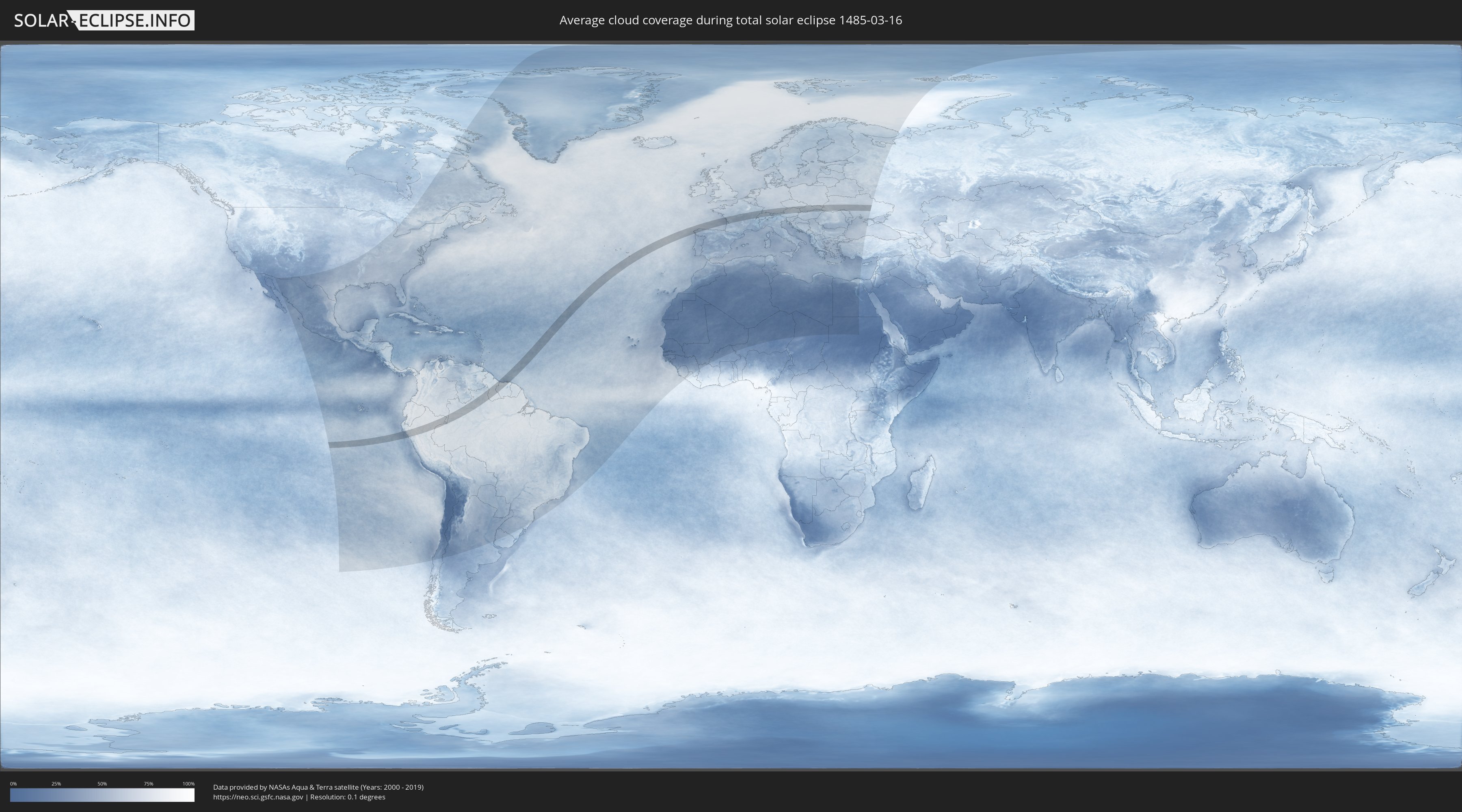
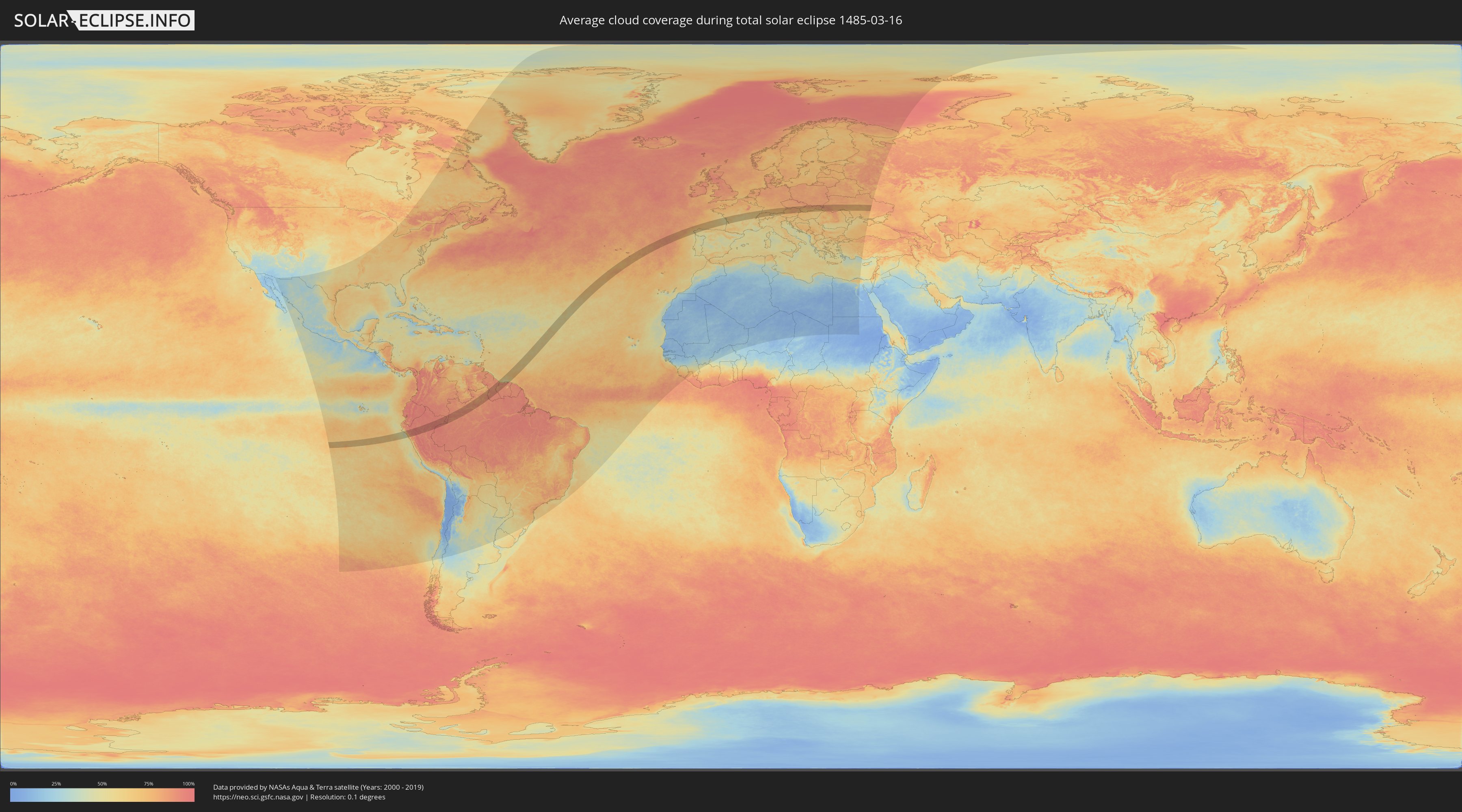
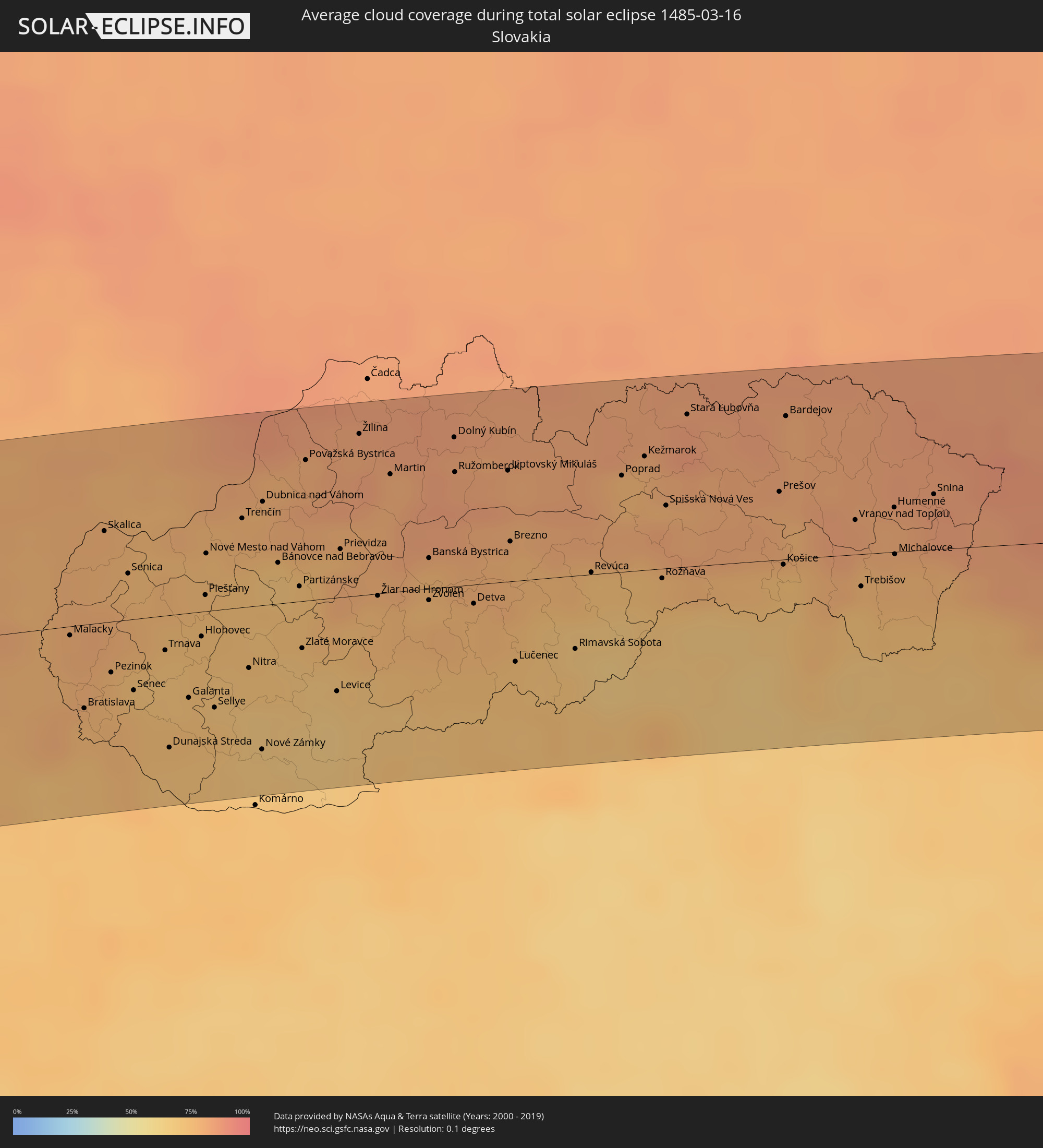
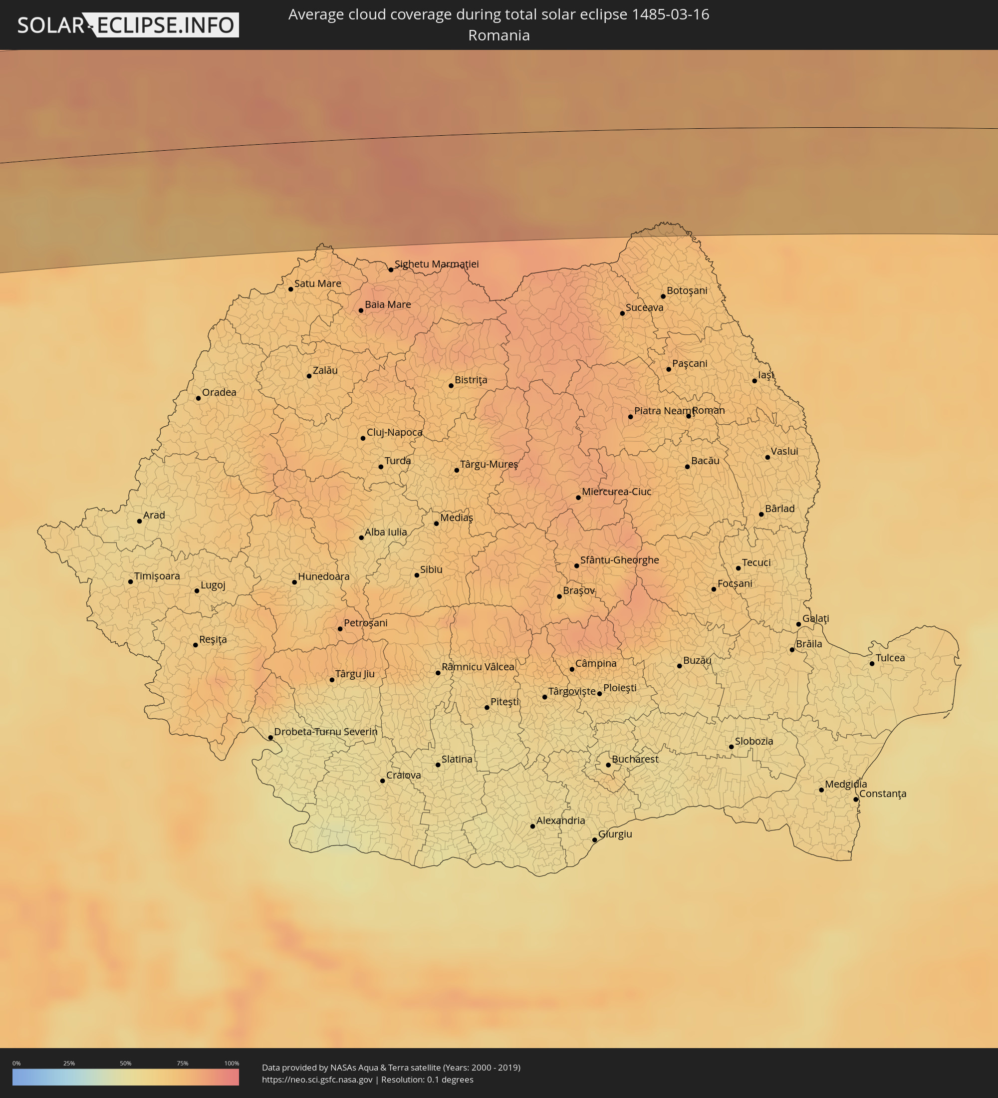
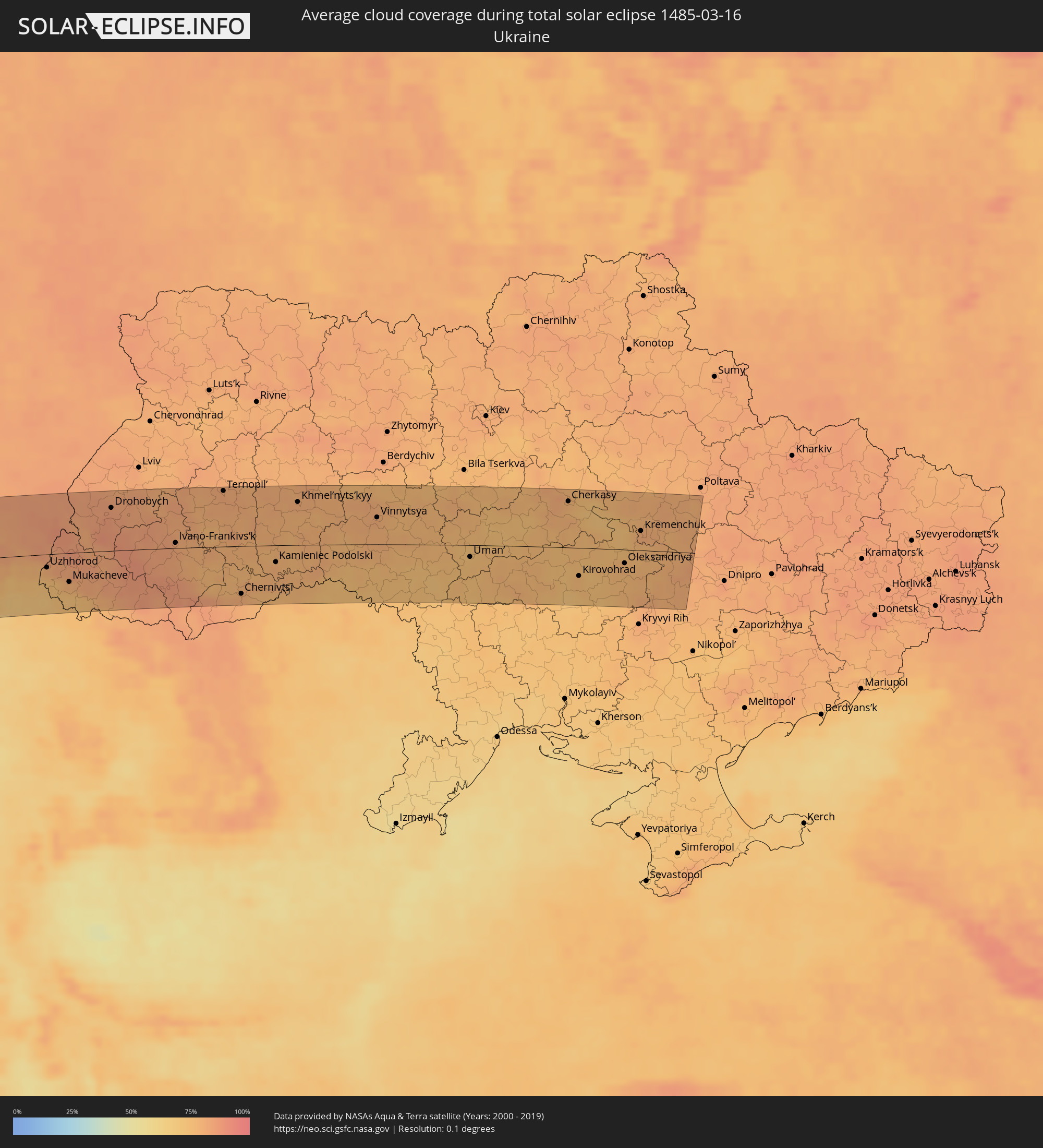
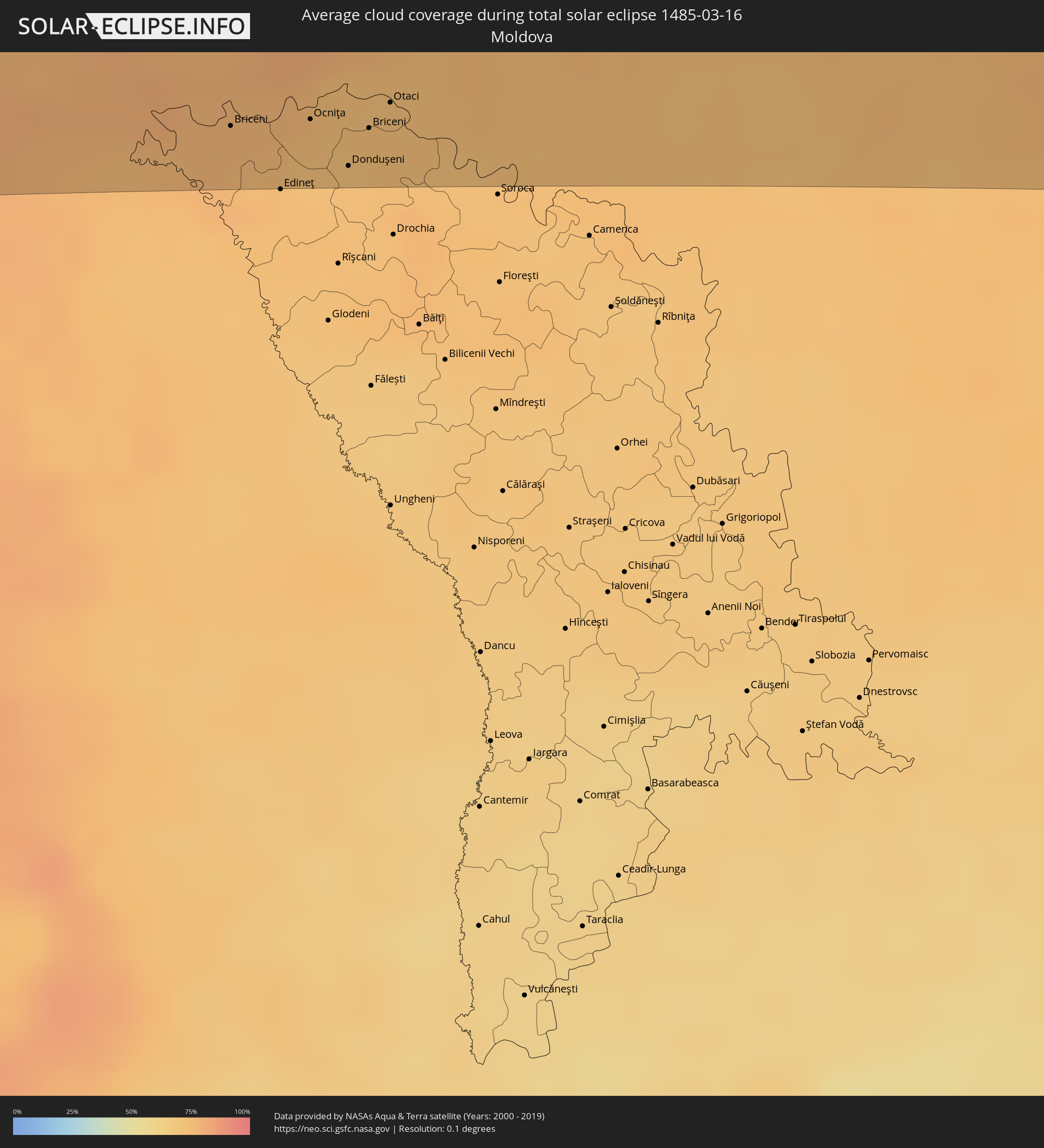
How will be the weather during the total solar eclipse on 03/16/1485?
Where is the best place to see the total solar eclipse of 03/16/1485?
The following maps show the average cloud coverage for the day of the total solar eclipse.
With the help of these maps, it is possible to find the place along the eclipse path, which has the best
chance of a cloudless sky.
Nevertheless, you should consider local circumstances and inform about the weather of your chosen
observation site.
The data is provided by NASAs satellites
AQUA and TERRA.
The cloud maps are averaged over a period of 19 years (2000 - 2019).
Detailed country maps
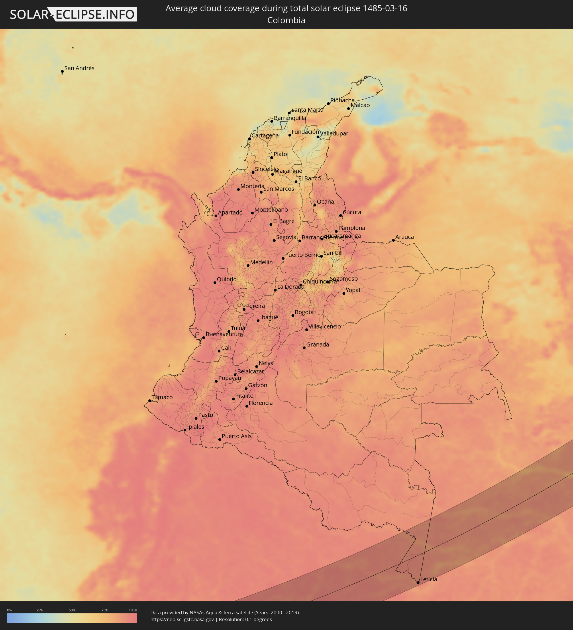 Colombia
 Peru
Peru
 Brazil
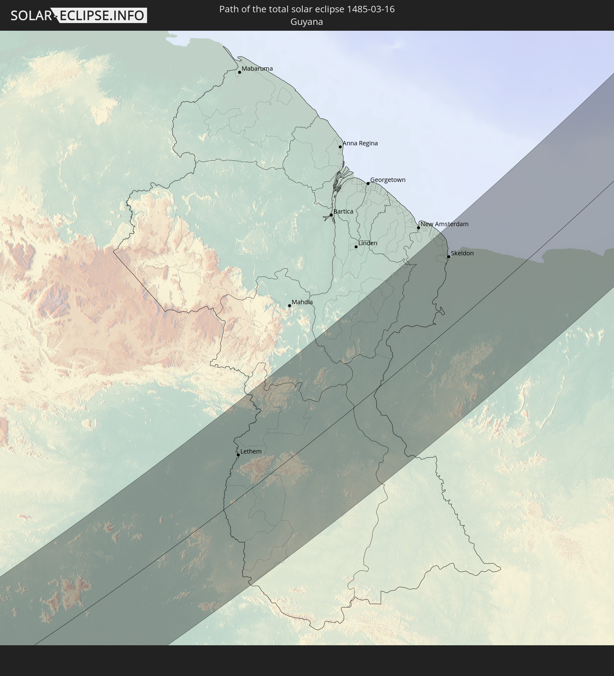
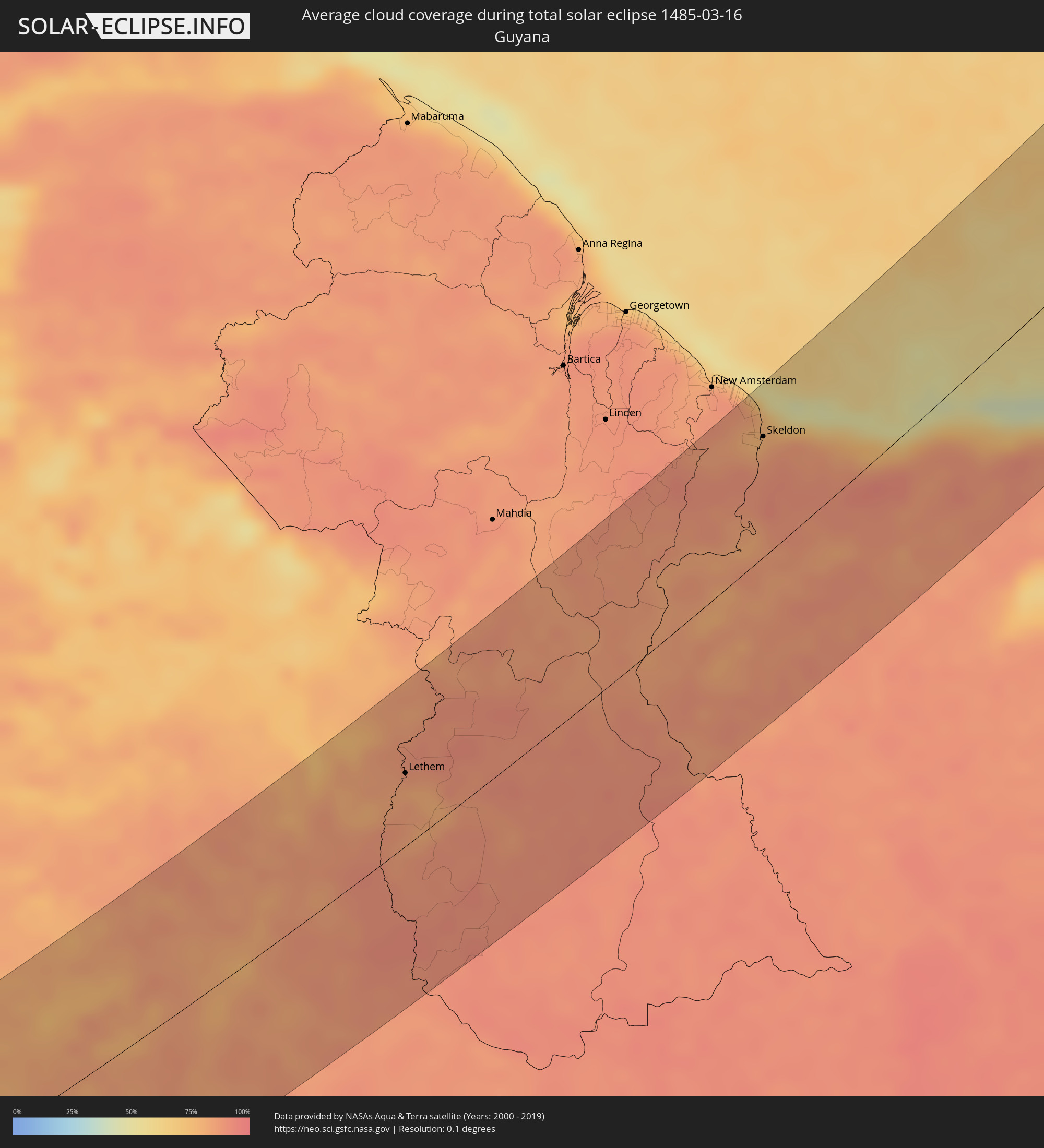 Guyana
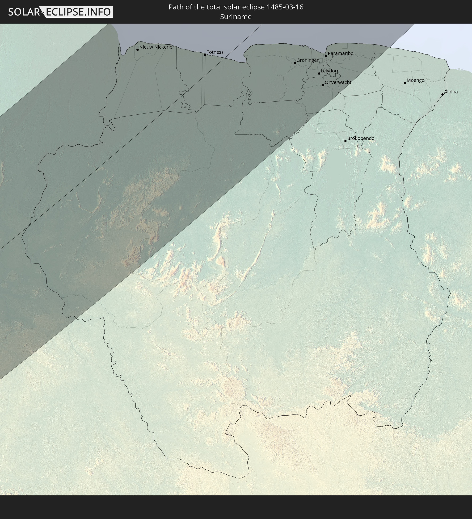
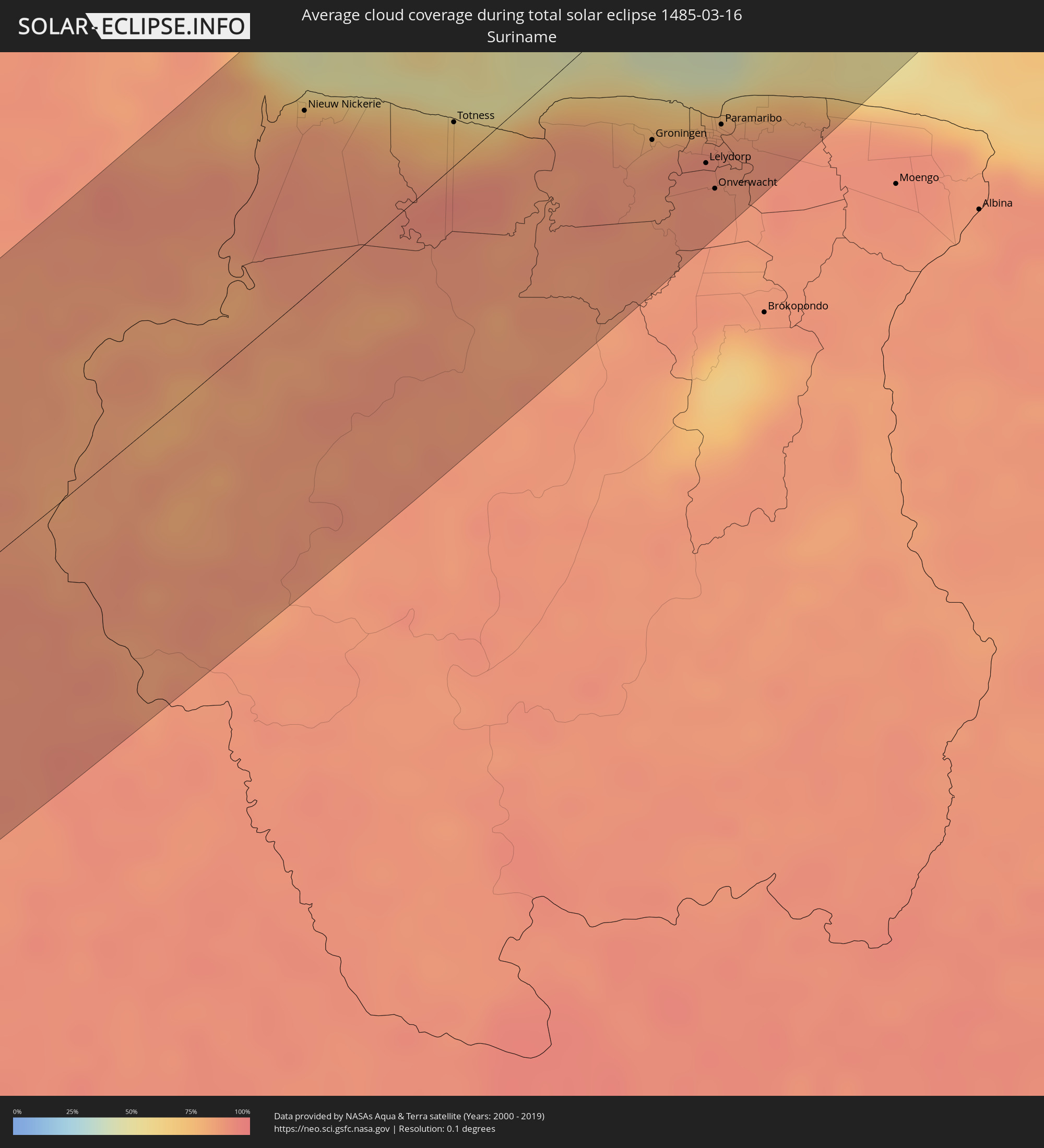 Suriname
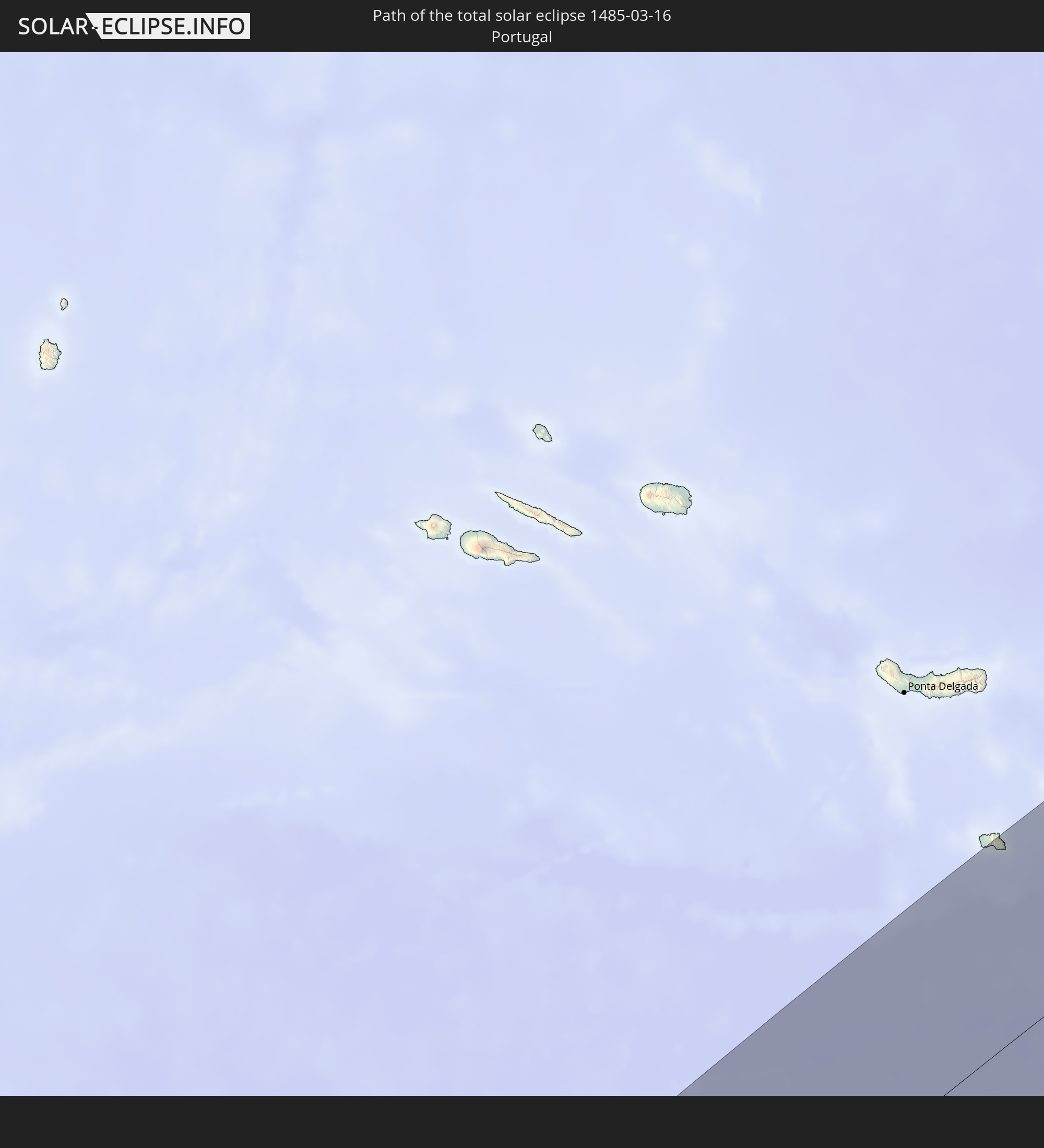
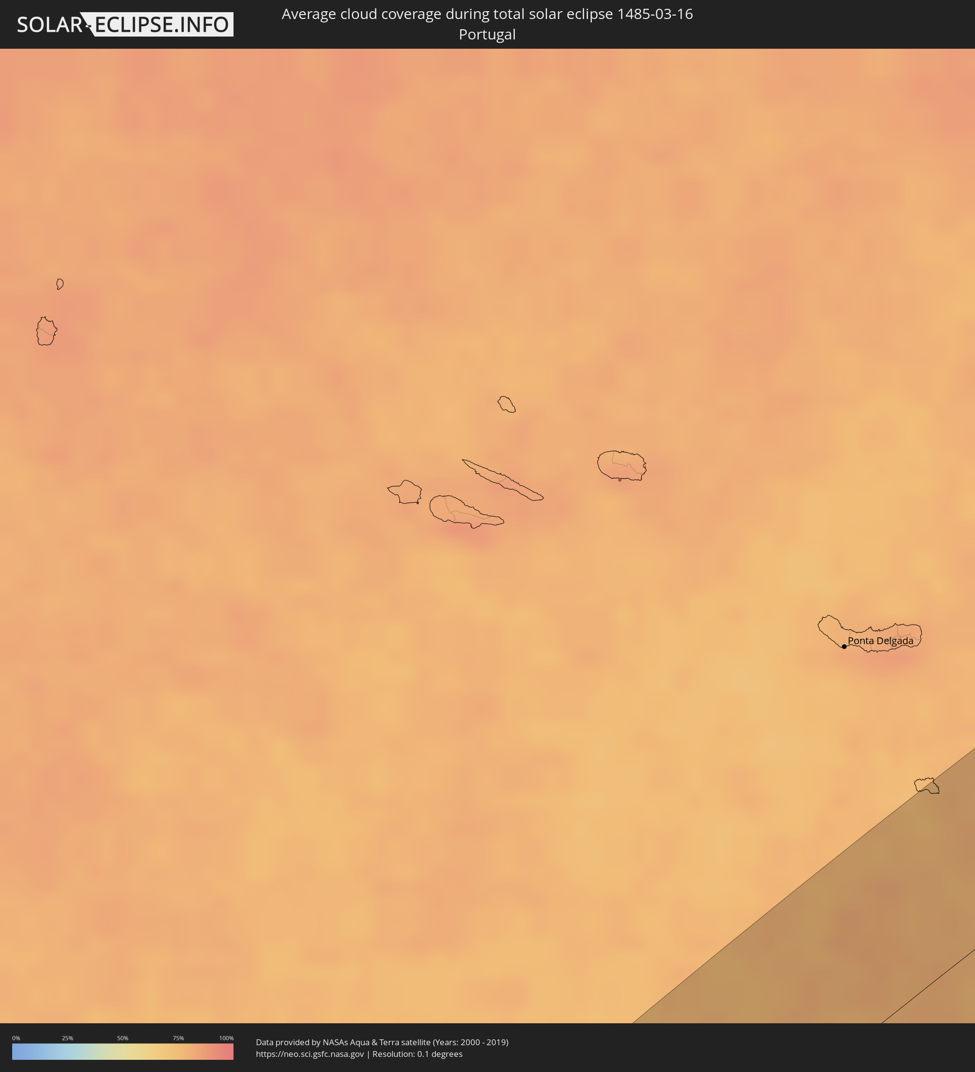 Portugal
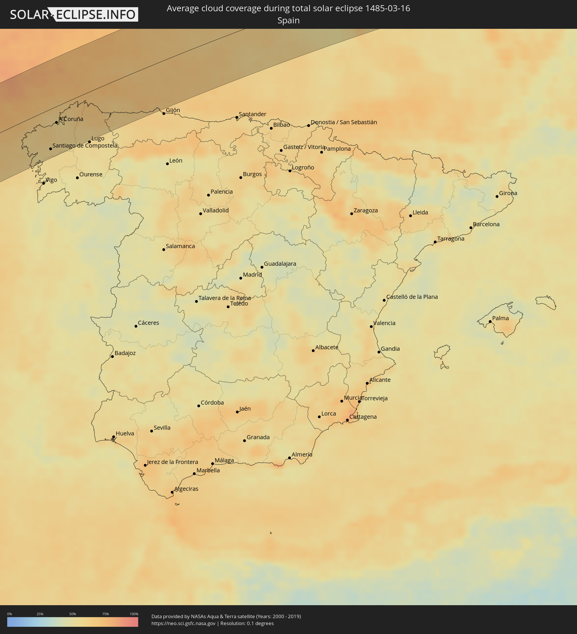 Spain
Spain
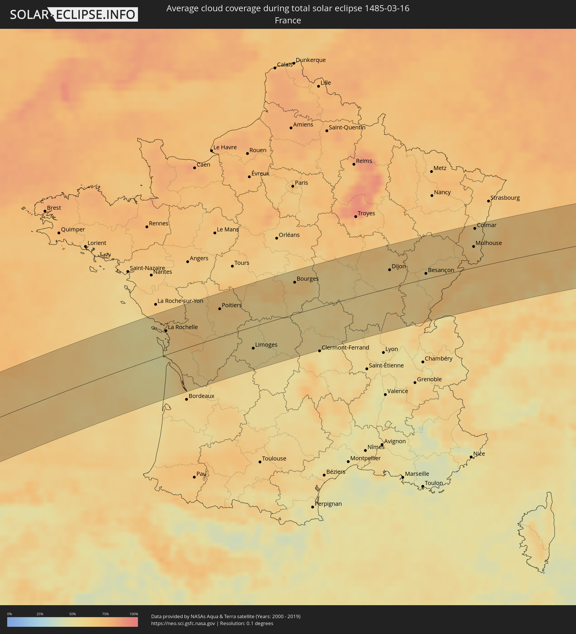 France
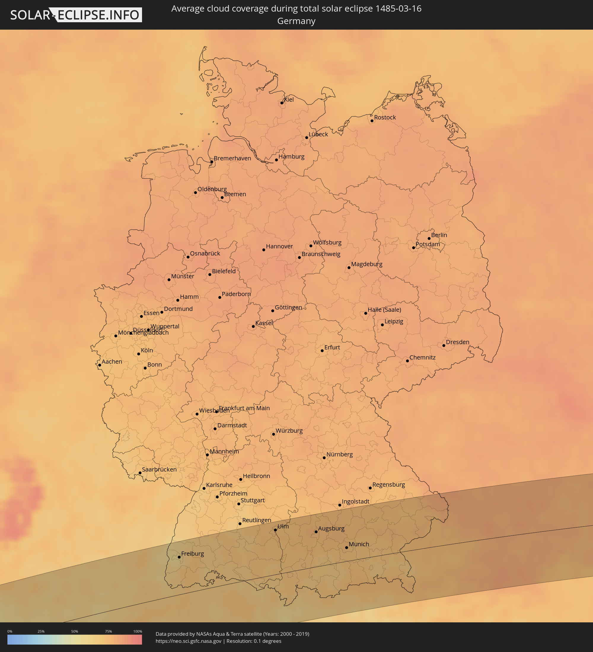 Germany
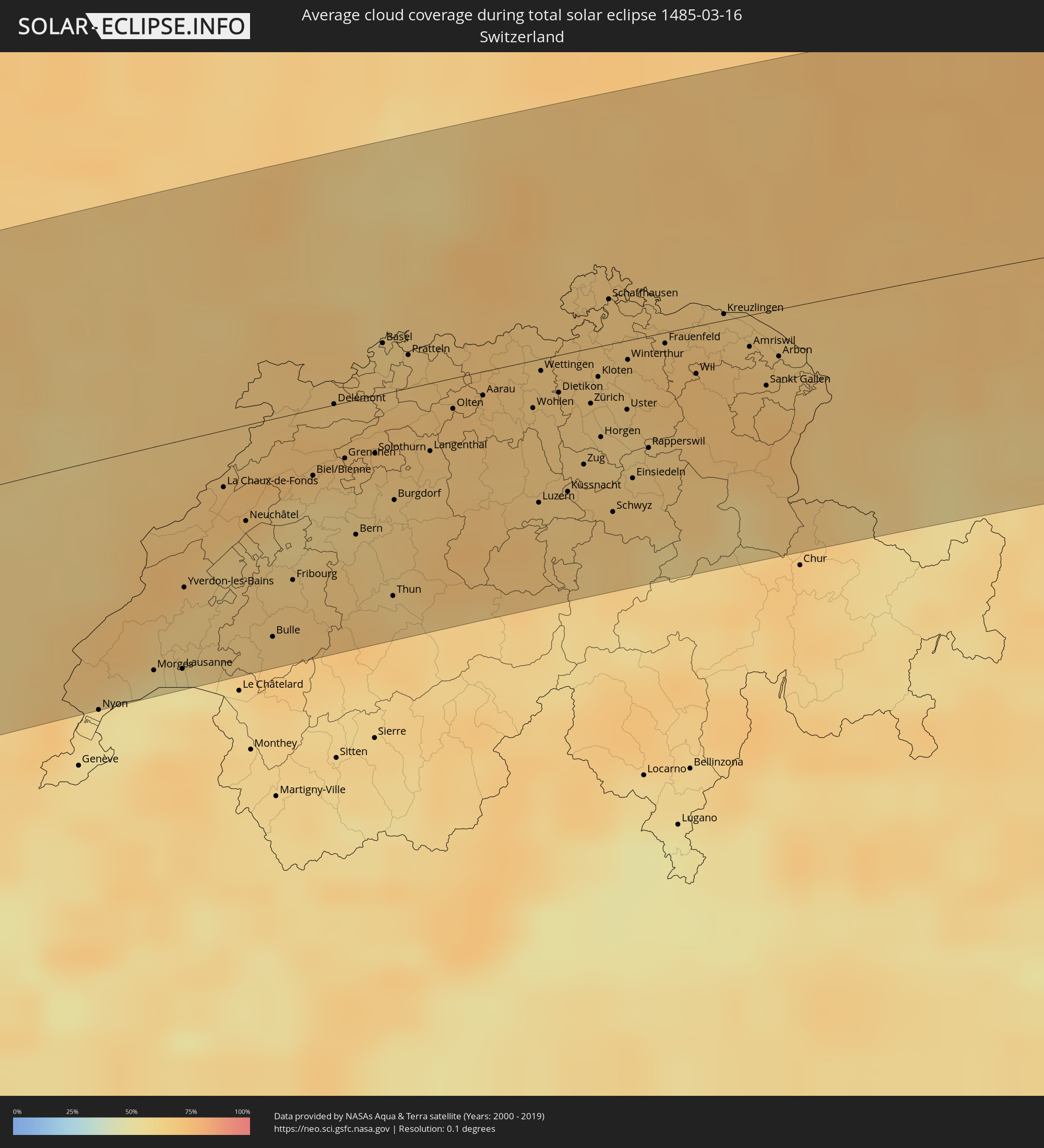 Switzerland
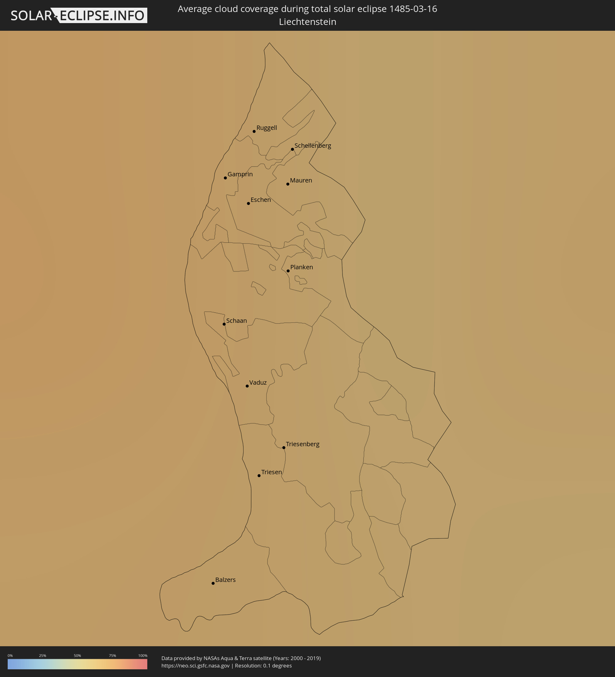 Liechtenstein
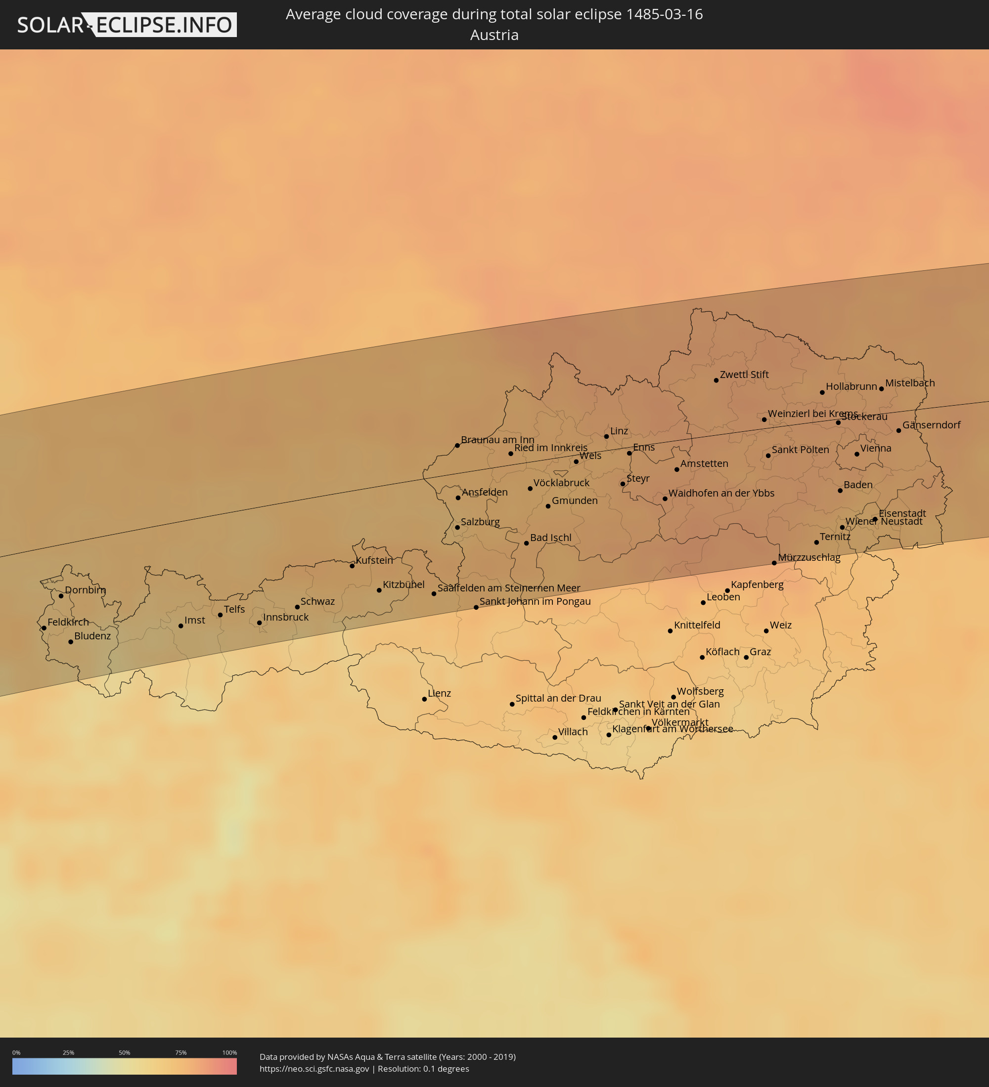 Austria
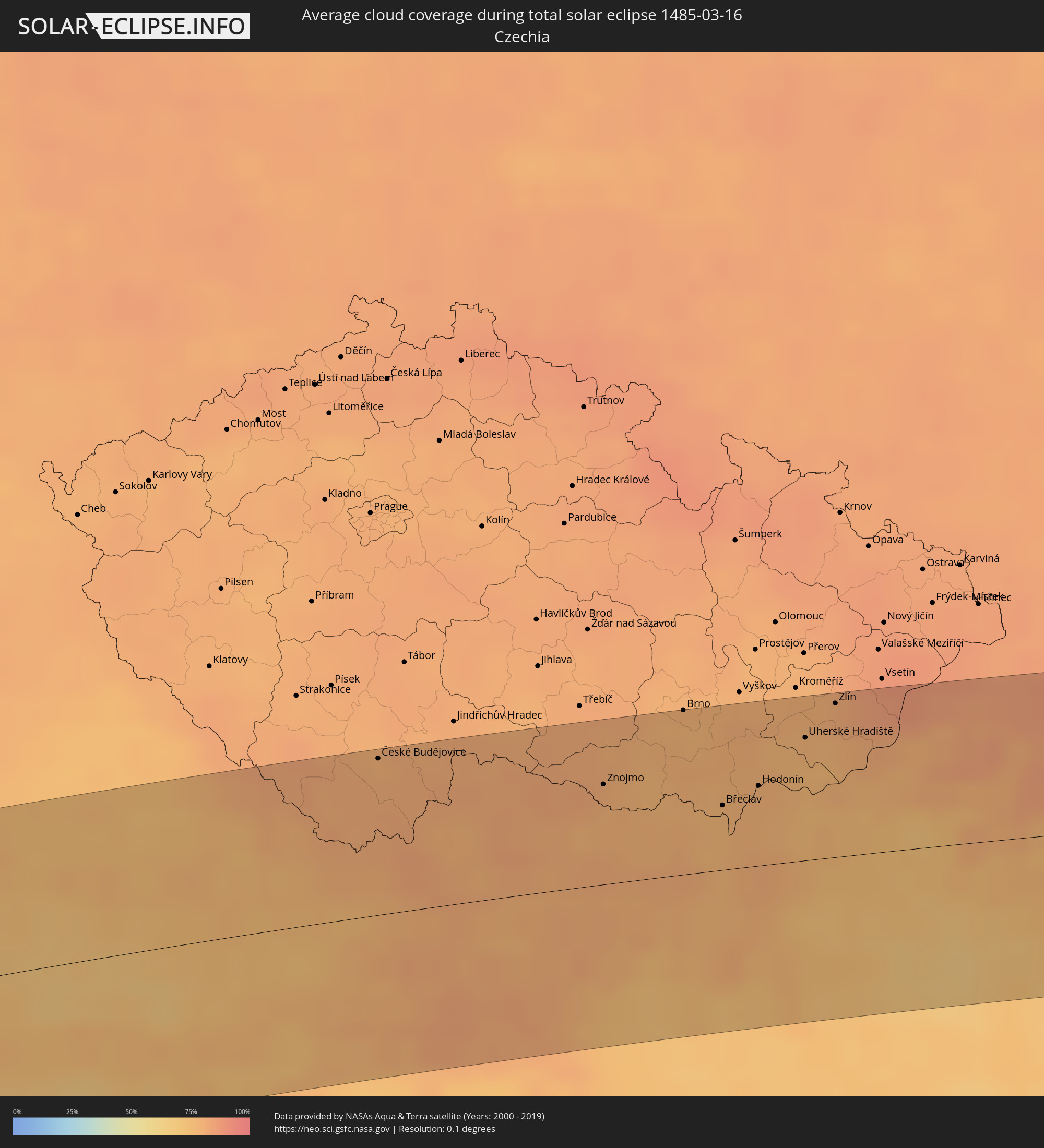 Czechia
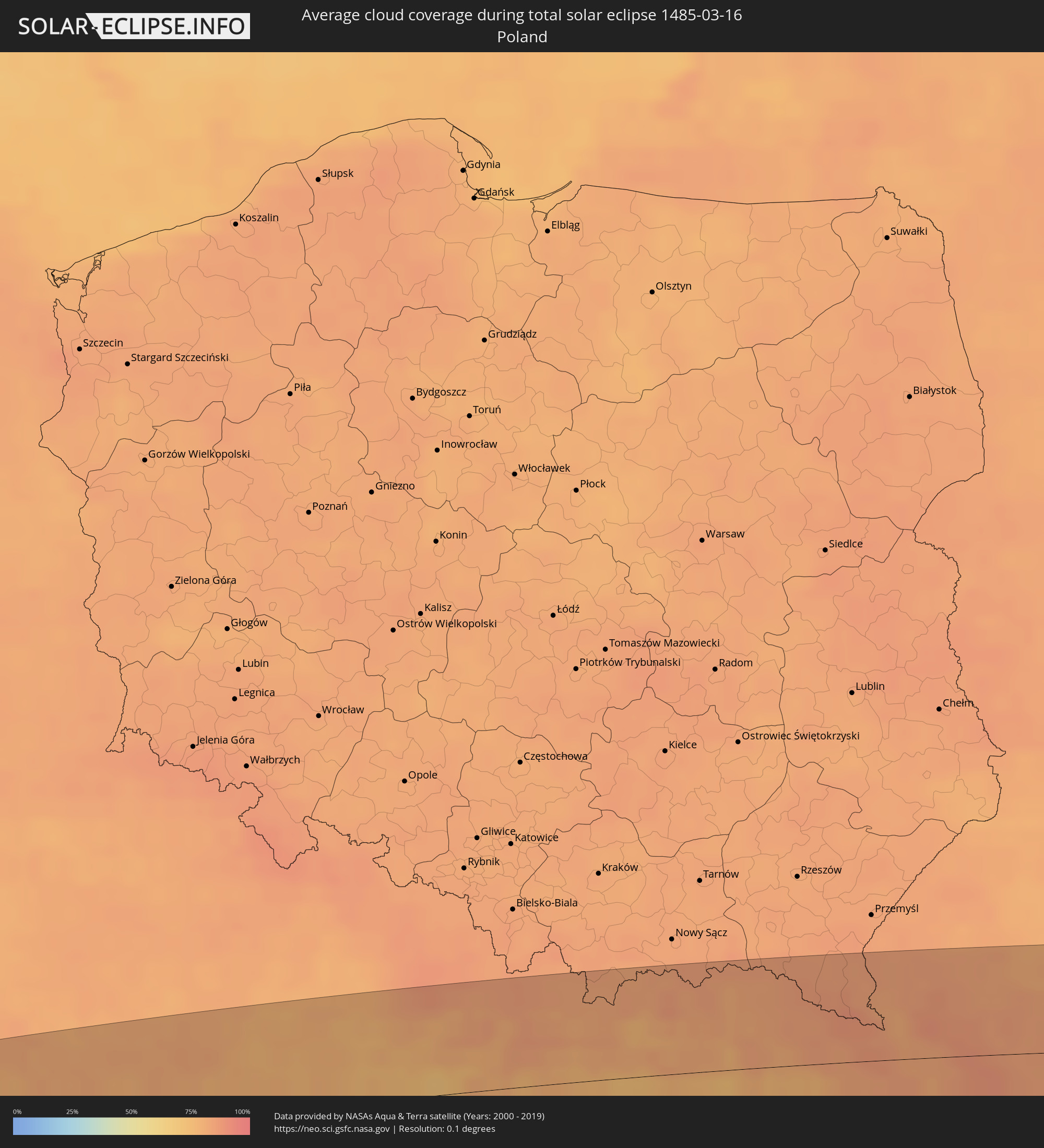 Poland
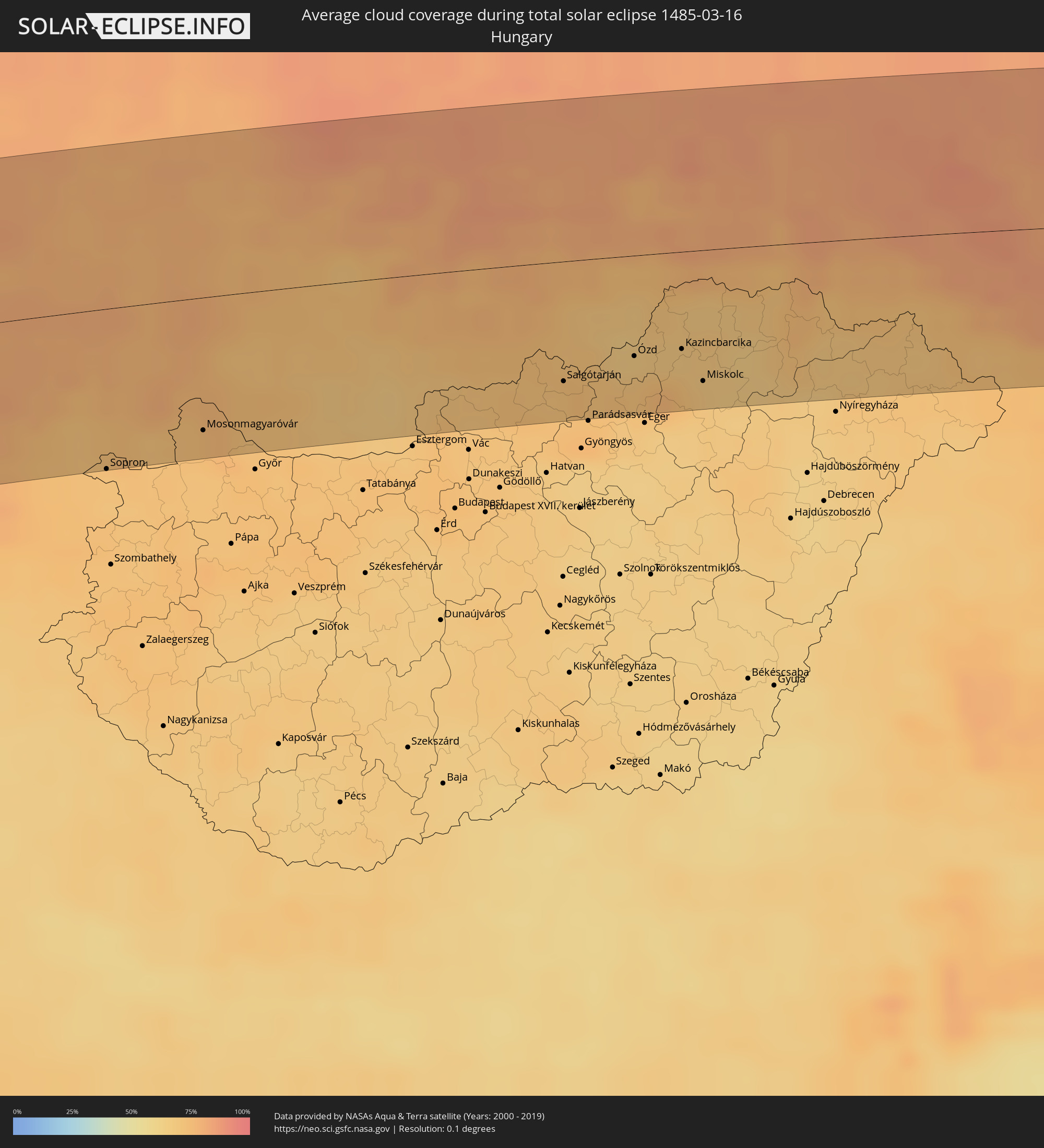 Hungary
 Slovakia
 Romania
 Ukraine
 Moldova
Cities inside the path of the eclipse
The following table shows all locations with a population of more than 5,000 inside the eclipse path. Cities which have more than 100,000 inhabitants are marked bold. A click at the locations opens a detailed map.
| City | Type | Eclipse duration | Local time of max. eclipse | Distance to central line | Ø Cloud coverage |
|
Chiclayo, Lambayeque
|
total | - | 07:42:34 UTC-05:08 | 11 km | 74% |
|
Ferreñafe, Lambayeque
|
total | - | 07:42:43 UTC-05:08 | 24 km | 84% |
|
Saña, Lambayeque
|
total | - | 07:42:34 UTC-05:08 | 12 km | 75% |
|
Pacasmayo, La Libertad
|
total | - | 07:42:06 UTC-05:08 | 64 km | 63% |
|
Chepén, La Libertad
|
total | - | 07:42:21 UTC-05:08 | 50 km | 79% |
|
Jaén, Cajamarca
|
total | - | 07:44:16 UTC-05:08 | 94 km | 88% |
|
Cajamarca, Cajamarca
|
total | - | 07:42:58 UTC-05:08 | 71 km | 84% |
|
Bagua Grande, Amazonas
|
total | - | 07:44:27 UTC-05:08 | 77 km | 93% |
|
La Peca, Amazonas
|
total | - | 07:44:36 UTC-05:08 | 93 km | 94% |
|
Rioja, San Martín
|
total | - | 07:44:58 UTC-05:08 | 4 km | 94% |
|
Moyobamba, San Martín
|
total | - | 07:45:07 UTC-05:08 | 1 km | 94% |
|
Yurimaguas, Loreto
|
total | - | 07:45:51 UTC-05:08 | 16 km | 88% |
|
Leticia, Amazonas
|
total | - | 08:58:50 UTC-04:02 | 93 km | 90% |
|
Tabatinga, Amazonas
|
total | - | 08:58:49 UTC-04:02 | 95 km | 90% |
|
São Paulo de Olivença, Amazonas
|
total | - | 09:00:56 UTC-04:02 | 60 km | 83% |
|
Santo Antônio do Içá, Amazonas
|
total | - | 09:02:14 UTC-04:02 | 79 km | 87% |
|
Boa Vista, Roraima
|
total | - | 09:19:51 UTC-04:02 | 57 km | 85% |
|
Lethem, Upper Takutu-Upper Essequibo
|
total | - | 09:31:59 UTC-03:52 | 48 km | 86% |
|
Skeldon, East Berbice-Corentyne
|
total | - | 09:40:13 UTC-03:52 | 75 km | 81% |
|
Nieuw Nickerie, Nickerie
|
total | - | 09:52:32 UTC-03:40 | 67 km | 84% |
|
Totness, Coronie
|
total | - | 09:53:22 UTC-03:40 | 16 km | 72% |
|
Groningen, Saramacca
|
total | - | 09:54:29 UTC-03:40 | 54 km | 83% |
|
Lelydorp, Wanica
|
total | - | 09:54:39 UTC-03:40 | 80 km | 91% |
|
Onverwacht, Para
|
total | - | 09:54:30 UTC-03:40 | 92 km | 89% |
|
Paramaribo, Paramaribo
|
total | - | 09:55:03 UTC-03:40 | 71 km | 81% |
|
Nieuw Amsterdam, Commewijne
|
total | - | 09:55:13 UTC-03:40 | 75 km | 84% |
|
Boiro, Galicia
|
total | - | 15:39:58 UTC+00:00 | 88 km | 58% |
|
Carballo, Galicia
|
total | - | 15:40:15 UTC+00:00 | 37 km | 62% |
|
Santiago de Compostela, Galicia
|
total | - | 15:40:20 UTC+00:00 | 75 km | 59% |
|
Teo, Galicia
|
total | - | 15:40:22 UTC+00:00 | 90 km | 56% |
|
Ordes, Galicia
|
total | - | 15:40:30 UTC+00:00 | 60 km | 59% |
|
A Coruña, Galicia
|
total | - | 15:40:33 UTC+00:00 | 31 km | 60% |
|
Ferrol, Galicia
|
total | - | 15:40:43 UTC+00:00 | 25 km | 59% |
|
Betanzos, Galicia
|
total | - | 15:40:43 UTC+00:00 | 46 km | 59% |
|
Vilalba, Galicia
|
total | - | 15:41:13 UTC+00:00 | 62 km | 59% |
|
Viveiro, Galicia
|
total | - | 15:41:20 UTC+00:00 | 28 km | 68% |
|
Mos, Galicia
|
total | - | 15:41:19 UTC+00:00 | 80 km | 58% |
|
Figueras, Asturias
|
total | - | 15:41:51 UTC+00:00 | 58 km | 63% |
|
La Rochelle, Nouvelle-Aquitaine
|
total | - | 15:55:56 UTC+00:09 | 48 km | 57% |
|
Niort, Nouvelle-Aquitaine
|
total | - | 15:56:25 UTC+00:09 | 48 km | 66% |
|
Angoulême, Nouvelle-Aquitaine
|
total | - | 15:56:59 UTC+00:09 | 38 km | 61% |
|
Poitiers, Nouvelle-Aquitaine
|
total | - | 15:56:55 UTC+00:09 | 57 km | 64% |
|
Limoges, Nouvelle-Aquitaine
|
total | - | 15:57:44 UTC+00:09 | 45 km | 57% |
|
Châteauroux, Centre
|
total | - | 15:57:48 UTC+00:09 | 50 km | 59% |
|
Bourges, Centre
|
total | - | 15:58:12 UTC+00:09 | 64 km | 66% |
|
Dijon, Bourgogne-Franche-Comté
|
total | - | 15:59:45 UTC+00:09 | 36 km | 63% |
|
Besançon, Bourgogne-Franche-Comté
|
total | - | 16:00:21 UTC+00:09 | 11 km | 60% |
|
Lausanne, Vaud
|
total | - | 16:51:36 UTC+01:00 | 80 km | 51% |
|
La Chaux-de-Fonds, Neuchâtel
|
total | - | 16:51:30 UTC+01:00 | 20 km | 71% |
|
Belfort, Bourgogne-Franche-Comté
|
total | - | 16:00:41 UTC+00:09 | 37 km | 66% |
|
Biel/Bienne, Bern
|
total | - | 16:51:43 UTC+01:00 | 23 km | 60% |
|
Mulhouse, Grand-Est
|
total | - | 16:00:53 UTC+00:09 | 42 km | 62% |
|
Colmar, Grand-Est
|
total | - | 16:00:47 UTC+00:09 | 78 km | 60% |
|
Bern, Bern
|
total | - | 16:51:54 UTC+01:00 | 47 km | 67% |
|
Basel, Basel-City
|
total | - | 16:51:44 UTC+01:00 | 17 km | 63% |
|
Thun, Bern
|
total | - | 16:52:04 UTC+01:00 | 71 km | 63% |
|
Freiburg, Baden-Württemberg
|
total | - | 16:51:43 UTC+01:00 | 60 km | 64% |
|
Luzern, Lucerne
|
total | - | 16:52:19 UTC+01:00 | 50 km | 66% |
|
Villingen-Schwenningen, Baden-Württemberg
|
total | - | 16:52:01 UTC+01:00 | 57 km | 69% |
|
Zürich, Zurich
|
total | - | 16:52:20 UTC+01:00 | 19 km | 64% |
|
Schaffhausen, Schaffhausen
|
total | - | 16:52:14 UTC+01:00 | 16 km | 66% |
|
Winterthur, Zurich
|
total | - | 16:52:22 UTC+01:00 | 7 km | 67% |
|
Rapperswil, Saint Gallen
|
total | - | 16:52:31 UTC+01:00 | 39 km | 67% |
|
Konstanz, Baden-Württemberg
|
total | - | 16:52:31 UTC+01:00 | 3 km | 65% |
|
Sankt Gallen, Saint Gallen
|
total | - | 16:52:43 UTC+01:00 | 26 km | 73% |
|
Friedrichshafen, Baden-Württemberg
|
total | - | 16:52:40 UTC+01:00 | 2 km | 66% |
|
Balzers, Balzers
|
total | - | 16:52:56 UTC+01:00 | 66 km | 67% |
|
Schaan, Schaan
|
total | - | 16:52:53 UTC+01:00 | 56 km | 68% |
|
Gamprin, Gamprin
|
total | - | 16:52:52 UTC+01:00 | 50 km | 68% |
|
Vaduz, Vaduz
|
total | - | 16:52:54 UTC+01:00 | 59 km | 67% |
|
Eschen, Eschen
|
total | - | 16:52:53 UTC+01:00 | 51 km | 68% |
|
Ruggell, Ruggell
|
total | - | 16:52:52 UTC+01:00 | 48 km | 68% |
|
Triesen, Triesen
|
total | - | 16:52:55 UTC+01:00 | 62 km | 67% |
|
Triesenberg, Triesenberg
|
total | - | 16:52:55 UTC+01:00 | 61 km | 67% |
|
Mauren, Mauren
|
total | - | 16:52:53 UTC+01:00 | 51 km | 68% |
|
Planken, Planken
|
total | - | 16:52:54 UTC+01:00 | 54 km | 68% |
|
Schellenberg, Schellenberg
|
total | - | 16:52:53 UTC+01:00 | 49 km | 68% |
|
Feldkirch, Vorarlberg
|
total | - | 16:52:54 UTC+01:00 | 50 km | 65% |
|
Ravensburg, Baden-Württemberg
|
total | - | 16:52:41 UTC+01:00 | 10 km | 70% |
|
Dornbirn, Vorarlberg
|
total | - | 16:52:54 UTC+01:00 | 32 km | 67% |
|
Ulm, Baden-Württemberg
|
total | - | 16:52:36 UTC+01:00 | 72 km | 73% |
|
Kempten (Allgäu), Bavaria
|
total | - | 16:53:03 UTC+01:00 | 6 km | 71% |
|
Augsburg, Bavaria
|
total | - | 16:53:02 UTC+01:00 | 56 km | 74% |
|
Innsbruck, Tyrol
|
total | - | 16:53:45 UTC+01:00 | 72 km | 66% |
|
Munich, Bavaria
|
total | - | 16:53:26 UTC+01:00 | 22 km | 71% |
|
Rosenheim, Bavaria
|
total | - | 16:53:48 UTC+01:00 | 16 km | 69% |
|
Landshut, Bavaria
|
total | - | 16:53:30 UTC+01:00 | 57 km | 75% |
|
Salzburg, Salzburg
|
total | - | 16:54:13 UTC+01:00 | 34 km | 71% |
|
Passau, Bavaria
|
total | - | 16:54:01 UTC+01:00 | 46 km | 76% |
|
Wels, Upper Austria
|
total | - | 16:54:26 UTC+01:00 | 5 km | 74% |
|
Linz, Upper Austria
|
total | - | 16:54:28 UTC+01:00 | 8 km | 75% |
|
Český Krumlov, Jihočeský
|
total | - | 16:54:13 UTC+01:00 | 63 km | 81% |
|
Steyr, Upper Austria
|
total | - | 16:54:39 UTC+01:00 | 22 km | 77% |
|
České Budějovice, Jihočeský
|
total | - | 16:54:12 UTC+01:00 | 80 km | 78% |
|
Třeboň, Jihočeský
|
total | - | 16:54:18 UTC+01:00 | 80 km | 80% |
|
Weinzierl bei Krems, Lower Austria
|
total | - | 16:54:54 UTC+01:00 | 5 km | 78% |
|
Sankt Pölten, Lower Austria
|
total | - | 16:55:01 UTC+01:00 | 17 km | 79% |
|
Moravské Budějovice, Vysočina
|
total | - | 16:54:38 UTC+01:00 | 75 km | 81% |
|
Znojmo, South Moravian
|
total | - | 16:54:49 UTC+01:00 | 51 km | 81% |
|
Baden, Lower Austria
|
total | - | 16:55:19 UTC+01:00 | 45 km | 75% |
|
Wiener Neustadt, Lower Austria
|
total | - | 16:55:26 UTC+01:00 | 67 km | 72% |
|
Vienna, Vienna
|
total | - | 16:55:16 UTC+01:00 | 23 km | 79% |
|
Ivančice, South Moravian
|
total | - | 16:54:48 UTC+01:00 | 75 km | 78% |
|
Sopron, Győr-Moson-Sopron
|
total | - | 16:55:36 UTC+01:00 | 83 km | 71% |
|
Brno, South Moravian
|
total | - | 16:54:49 UTC+01:00 | 84 km | 77% |
|
Břeclav, South Moravian
|
total | - | 16:55:09 UTC+01:00 | 33 km | 77% |
|
Bratislava, Bratislavský
|
total | - | 16:55:32 UTC+01:00 | 36 km | 76% |
|
Kyjov, South Moravian
|
total | - | 16:55:05 UTC+01:00 | 59 km | 78% |
|
Hodonín, South Moravian
|
total | - | 16:55:11 UTC+01:00 | 41 km | 78% |
|
Mosonmagyaróvár, Győr-Moson-Sopron
|
total | - | 16:55:44 UTC+01:00 | 69 km | 75% |
|
Uherské Hradiště, Zlín
|
total | - | 16:55:09 UTC+01:00 | 63 km | 78% |
|
Trnava, Trnavský
|
total | - | 16:55:34 UTC+01:00 | 15 km | 72% |
|
Zlín, Zlín
|
total | - | 16:55:08 UTC+01:00 | 78 km | 80% |
|
Trenčín, Trenčiansky
|
total | - | 16:55:26 UTC+01:00 | 39 km | 77% |
|
Nitra, Nitriansky
|
total | - | 16:55:46 UTC+01:00 | 27 km | 72% |
|
Prievidza, Nitriansky
|
total | - | 16:55:40 UTC+01:00 | 21 km | 75% |
|
Žilina, Žilinský
|
total | - | 16:55:27 UTC+01:00 | 70 km | 81% |
|
Martin, Žilinský
|
total | - | 16:55:35 UTC+01:00 | 51 km | 81% |
|
Zvolen, Banskobystrický
|
total | - | 16:55:56 UTC+01:00 | 5 km | 75% |
|
Banská Bystrica, Banskobystrický
|
total | - | 16:55:50 UTC+01:00 | 13 km | 76% |
|
Balassagyarmat, Nógrád
|
total | - | 16:56:14 UTC+01:00 | 62 km | 72% |
|
Pásztó, Nógrád
|
total | - | 16:56:26 UTC+01:00 | 81 km | 72% |
|
Salgótarján, Nógrád
|
total | - | 16:56:22 UTC+01:00 | 62 km | 72% |
|
Zakopane, Lesser Poland Voivodeship
|
total | - | 17:19:43 UTC+01:24 | 70 km | 82% |
|
Poprad, Prešovský
|
total | - | 16:55:57 UTC+01:00 | 42 km | 77% |
|
Ózd, Borsod-Abaúj-Zemplén
|
total | - | 16:56:26 UTC+01:00 | 52 km | 70% |
|
Szczawnica, Lesser Poland Voivodeship
|
total | - | 17:19:47 UTC+01:24 | 81 km | 83% |
|
Kazincbarcika, Borsod-Abaúj-Zemplén
|
total | - | 16:56:30 UTC+01:00 | 50 km | 68% |
|
Piwniczna-Zdrój, Lesser Poland Voivodeship
|
total | - | 17:19:50 UTC+01:24 | 81 km | 83% |
|
Miskolc, Borsod-Abaúj-Zemplén
|
total | - | 16:56:37 UTC+01:00 | 68 km | 68% |
|
Muszyna, Lesser Poland Voivodeship
|
total | - | 17:19:55 UTC+01:24 | 71 km | 85% |
|
Krynica-Zdrój, Lesser Poland Voivodeship
|
total | - | 17:19:54 UTC+01:24 | 78 km | 85% |
|
Szerencs, Borsod-Abaúj-Zemplén
|
total | - | 16:56:41 UTC+01:00 | 63 km | 66% |
|
Prešov, Prešovský
|
total | - | 16:56:13 UTC+01:00 | 29 km | 79% |
|
Košice, Košický
|
total | - | 16:56:23 UTC+01:00 | 2 km | 73% |
|
Sátoraljaújhely, Borsod-Abaúj-Zemplén
|
total | - | 16:56:39 UTC+01:00 | 40 km | 68% |
|
Kisvárda, Szabolcs-Szatmár-Bereg
|
total | - | 16:56:51 UTC+01:00 | 62 km | 70% |
|
Zagórz, Subcarpathian Voivodeship
|
total | - | 17:20:08 UTC+01:24 | 82 km | 84% |
|
Uzhhorod, Zakarpattia
|
total | - | 17:58:44 UTC+02:02 | 18 km | 75% |
|
Vásárosnamény, Szabolcs-Szatmár-Bereg
|
total | - | 16:56:57 UTC+01:00 | 73 km | 71% |
|
Lesko, Subcarpathian Voivodeship
|
total | - | 17:20:10 UTC+01:24 | 77 km | 84% |
|
Ustrzyki Dolne, Subcarpathian Voivodeship
|
total | - | 17:20:15 UTC+01:24 | 71 km | 84% |
|
Ivano-Frankivs’k, Ivano-Frankivsk
|
total | - | 17:59:00 UTC+02:02 | 7 km | 83% |
|
Ternopil’, Ternopil
|
total | - | 17:58:45 UTC+02:02 | 76 km | 82% |
|
Chernivtsi, Chernivtsi
|
total | - | 17:59:34 UTC+02:02 | 66 km | 81% |
|
Darabani, Botoşani
|
total | - | 17:42:03 UTC+01:44 | 79 km | 74% |
|
Kamieniec Podolski, Khmelnytskyi
|
total | - | 17:59:25 UTC+02:02 | 23 km | 79% |
|
Khmel’nyts’kyy, Khmelnytskyi
|
total | - | 17:59:01 UTC+02:02 | 59 km | 78% |
|
Briceni, Briceni
|
total | - | 17:52:36 UTC+01:55 | 59 km | 77% |
|
Ocniţa, Raionul Ocniţa
|
total | - | 17:52:38 UTC+01:55 | 57 km | 73% |
|
Donduşeni, Donduşeni
|
total | - | 17:52:44 UTC+01:55 | 73 km | 72% |
|
Briceni, Donduşeni
|
total | - | 17:52:41 UTC+01:55 | 61 km | 73% |
|
Otaci, Raionul Ocniţa
|
total | - | 17:52:39 UTC+01:55 | 52 km | 73% |
|
Vinnytsya, Vinnyts'ka
|
total | - | 17:59:17 UTC+02:02 | 37 km | 78% |
|
Uman’, Cherkasy
|
total | - | 17:59:43 UTC+02:02 | 16 km | 74% |
|
Cherkasy, Cherkasy
|
total | - | 17:59:21 UTC+02:02 | 63 km | 76% |
|
Kirovohrad, Kirovohrad
|
total | - | 17:59:56 UTC+02:02 | 39 km | 75% |
|
Oleksandriya, Kirovohrad
|
total | - | 17:59:51 UTC+02:02 | 19 km | 77% |
|
Kremenchuk, Poltava
|
total | - | 17:59:36 UTC+02:02 | 27 km | 79% |