Annular solar eclipse of 03/16/2295
| Day of week: | Saturday |
| Maximum duration of eclipse: | 07m29s |
| Maximum width of eclipse path: | 219 km |
| Saros cycle: | 144 |
| Coverage: | 94.1% |
| Magnitude: | 0.9409 |
| Gamma: | -0.0362 |
Wo kann man die Sonnenfinsternis vom 03/16/2295 sehen?
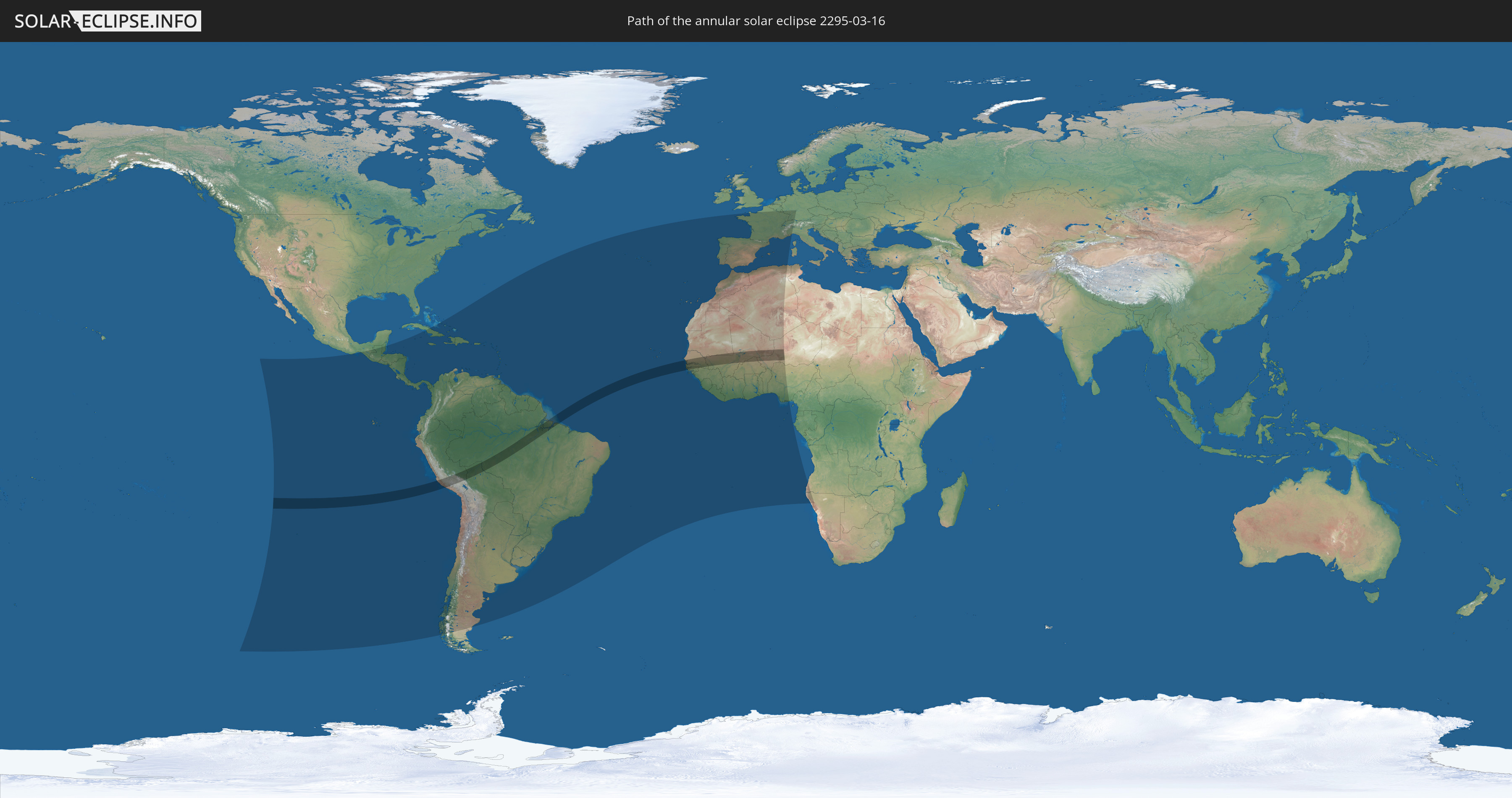
Die Sonnenfinsternis am 03/16/2295 kann man in 83 Ländern als partielle Sonnenfinsternis beobachten.
Der Finsternispfad verläuft durch 11 Länder. Nur in diesen Ländern ist sie als annular Sonnenfinsternis zu sehen.
In den folgenden Ländern ist die Sonnenfinsternis annular zu sehen
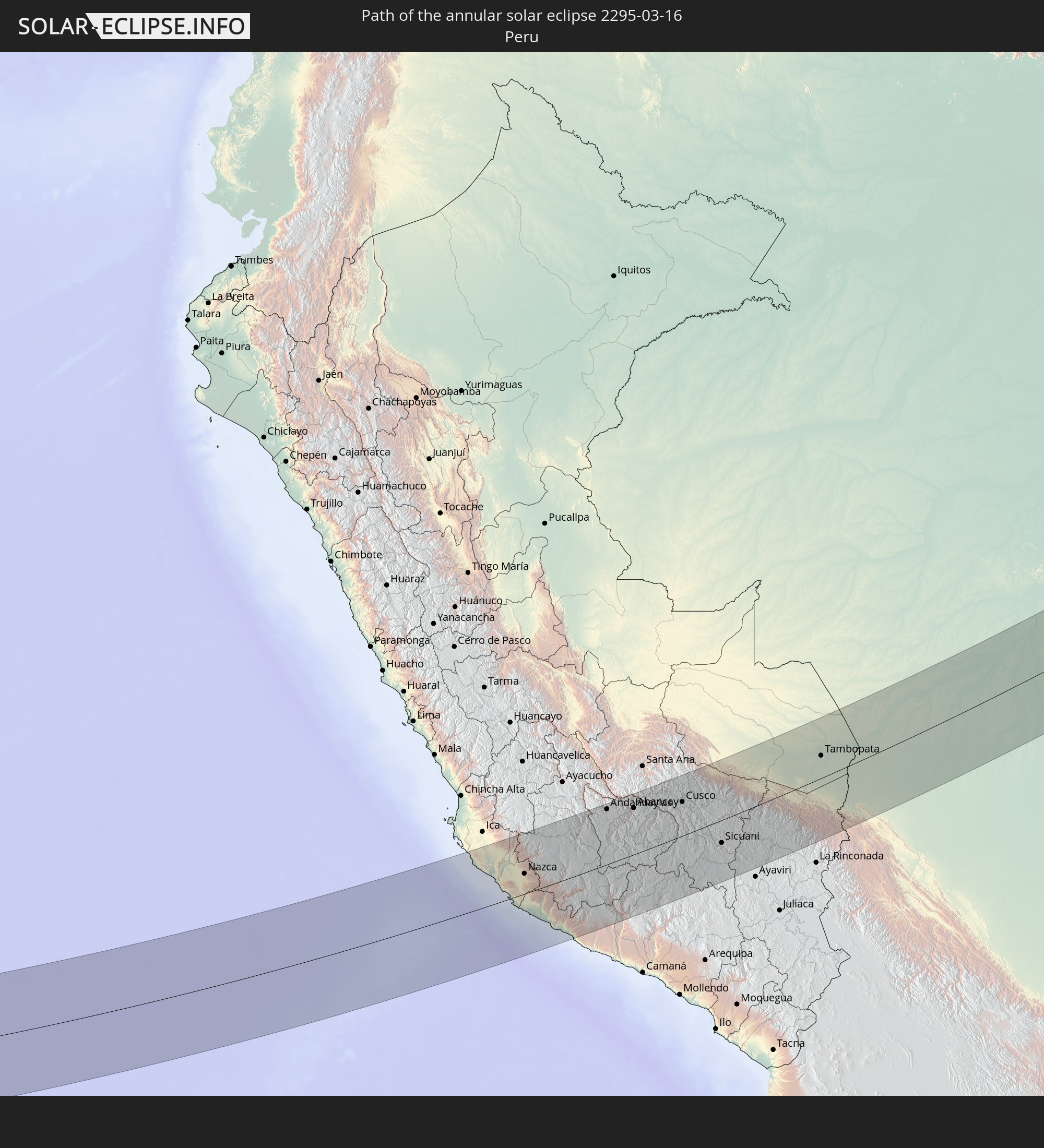 Peru
Peru
 Brazil
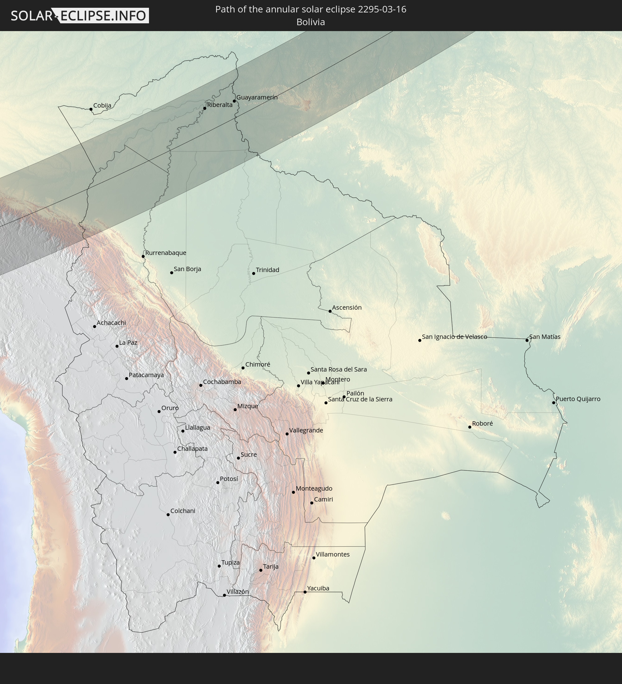 Bolivia
 Senegal
 Mauritania
 The Gambia
 Guinea-Bissau
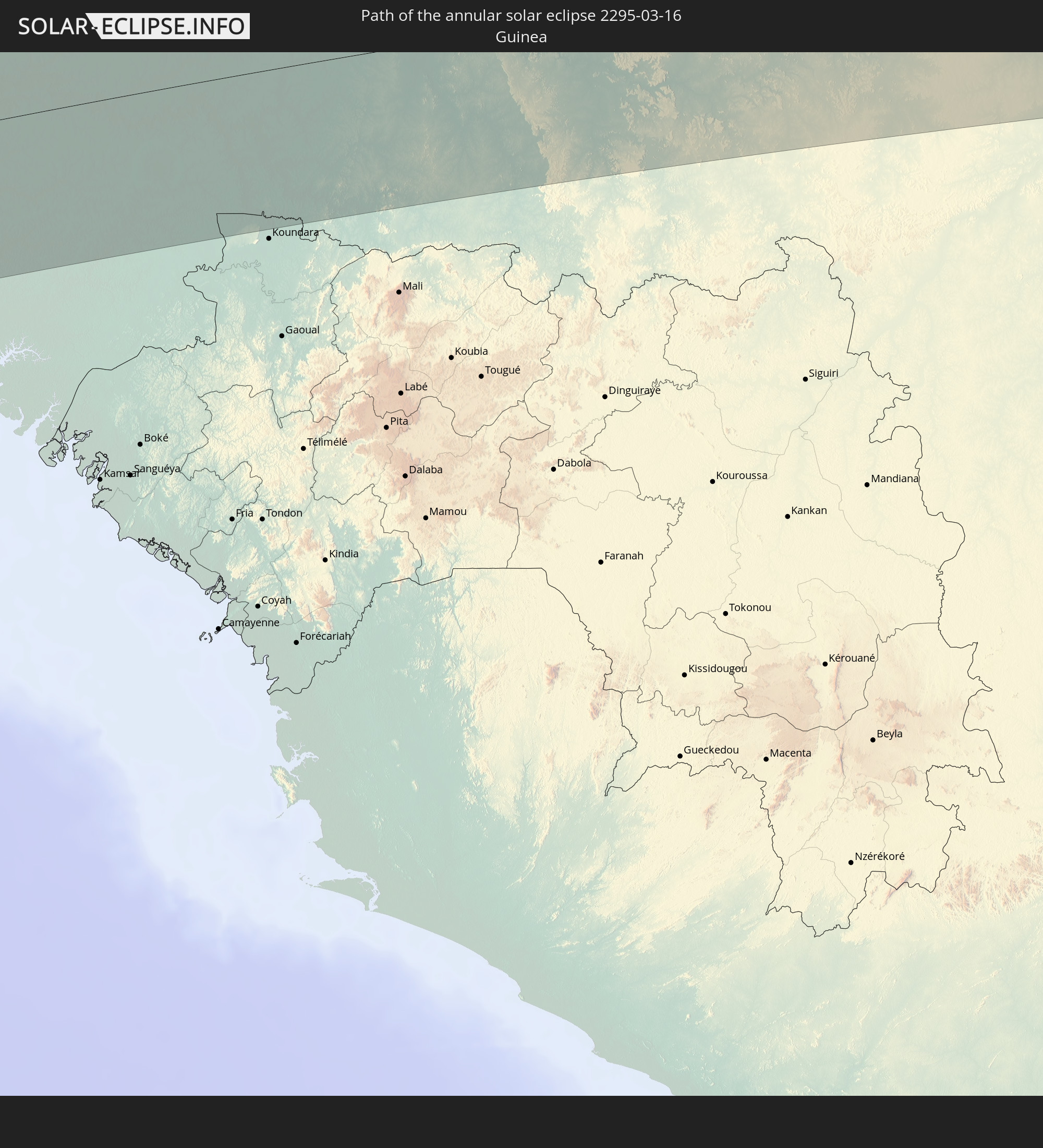 Guinea
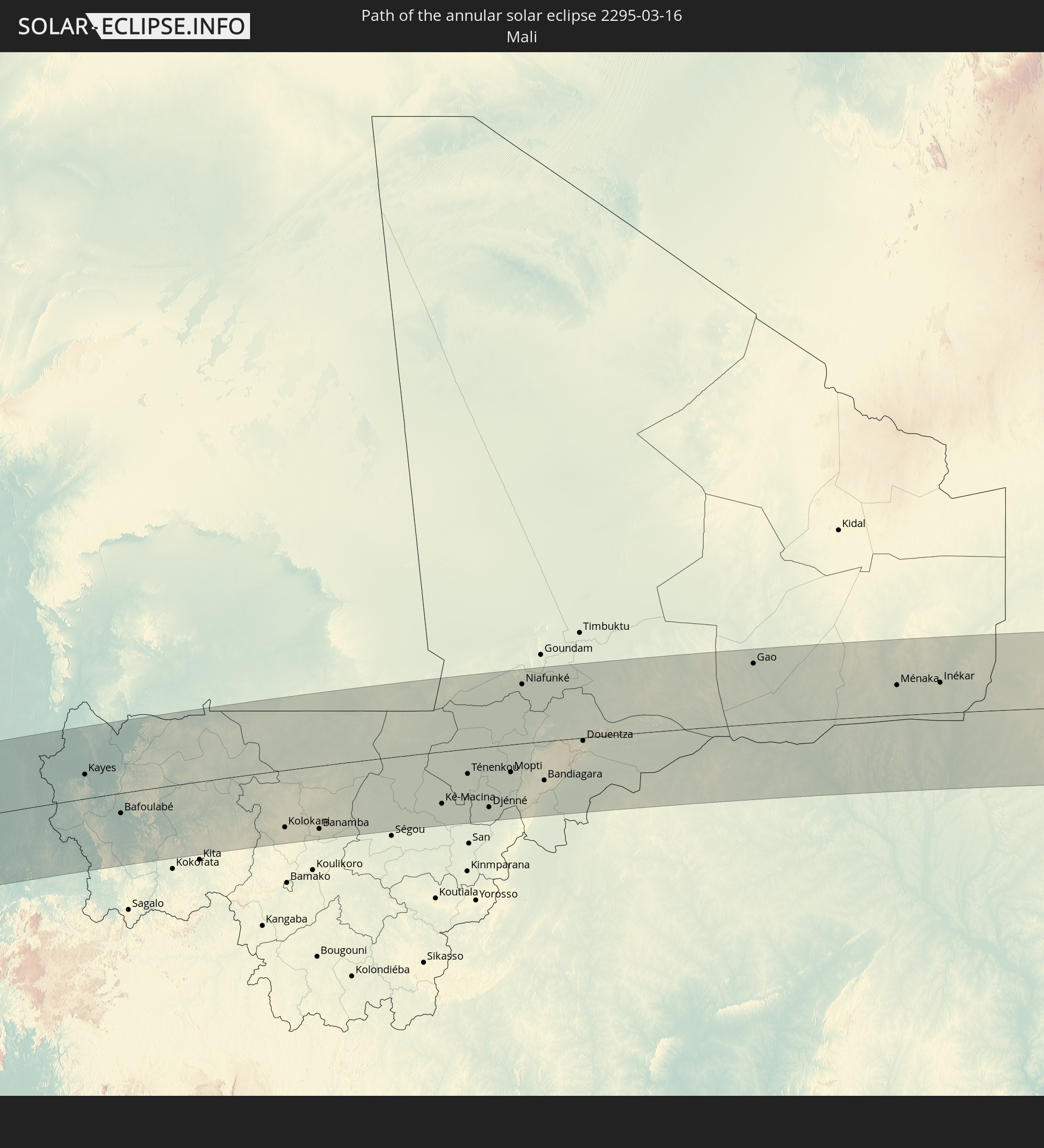 Mali
Mali
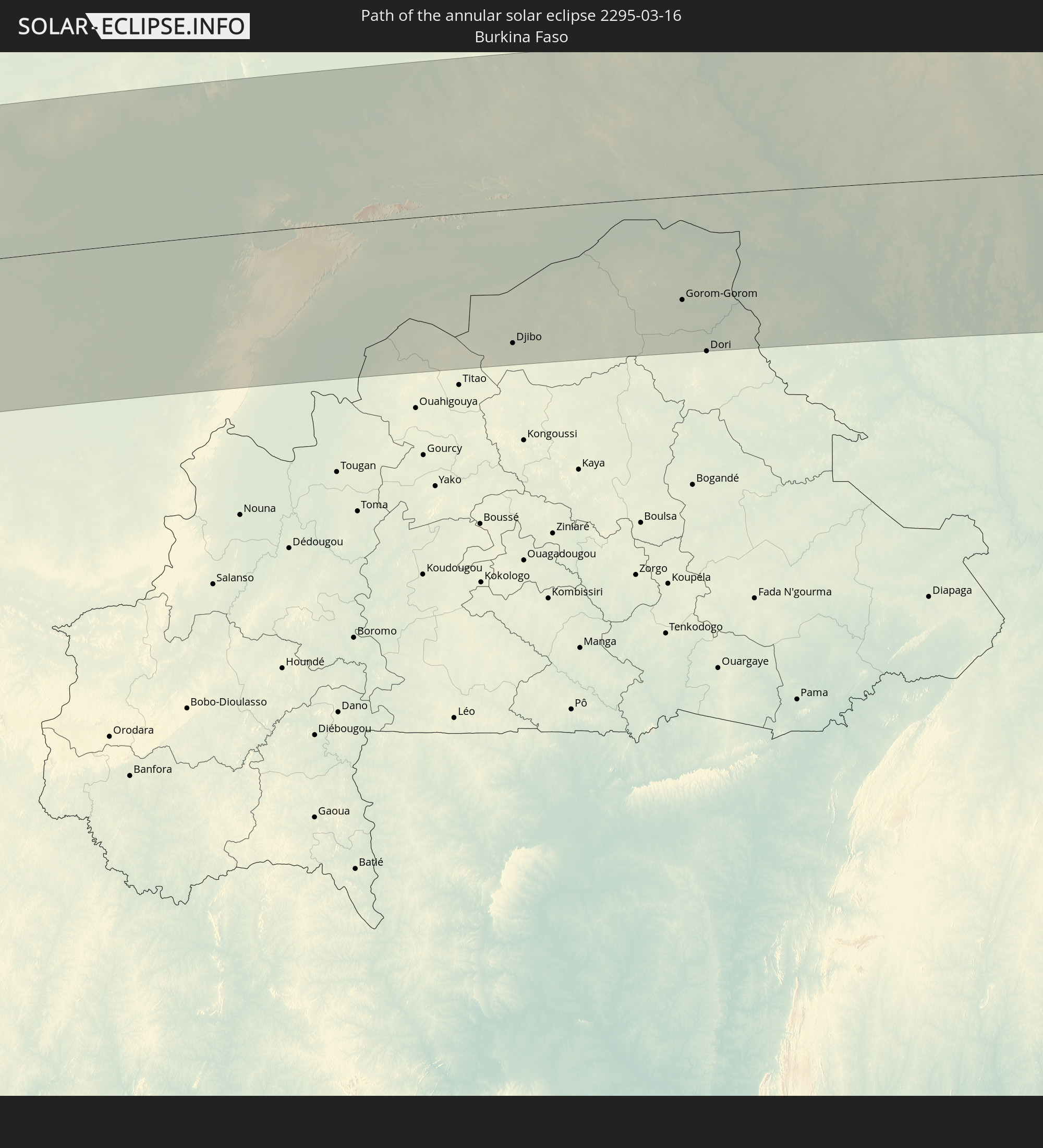 Burkina Faso
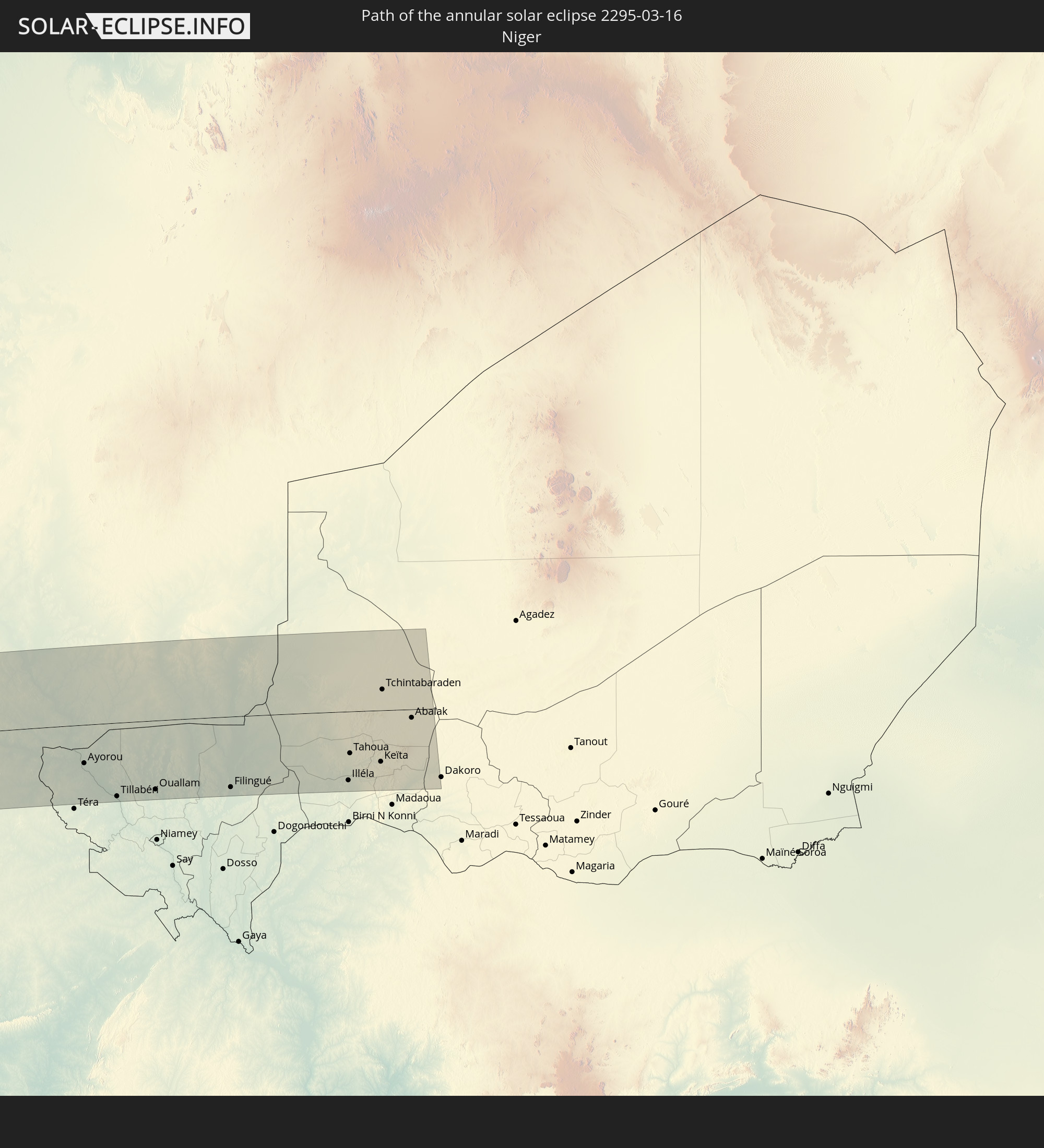 Niger
Niger
In den folgenden Ländern ist die Sonnenfinsternis partiell zu sehen
 United States Minor Outlying Islands
 Mexico
 Chile
Chile
 Guatemala
 Ecuador
 El Salvador
 Honduras
 Belize
 Nicaragua
 Costa Rica
 Cuba
Cuba
 Panama
 Colombia
 Cayman Islands
 Peru
Peru
 The Bahamas
 Jamaica
 Haiti
Haiti
 Brazil
 Argentina
 Venezuela
 Turks and Caicos Islands
 Dominican Republic
 Aruba
Aruba
 Bolivia
 Puerto Rico
 United States Virgin Islands
 British Virgin Islands
 Anguilla
 Collectivity of Saint Martin
 Saint Barthélemy
 Saint Kitts and Nevis
 Paraguay
 Antigua and Barbuda
 Montserrat
 Trinidad and Tobago
 Guadeloupe
 Grenada
 Dominica
 Saint Vincent and the Grenadines
 Guyana
 Martinique
 Saint Lucia
 Barbados
 Uruguay
 Suriname
 French Guiana
 Portugal
 Cabo Verde
 Spain
Spain
 Senegal
 Mauritania
 The Gambia
 Guinea-Bissau
 Guinea
 Saint Helena, Ascension and Tristan da Cunha
 Sierra Leone
 Morocco
 Mali
Mali
 Liberia
 Algeria
 Ivory Coast
 Burkina Faso
 Gibraltar
 France
 Ghana
Ghana
 Jersey
 Togo
Togo
 Niger
Niger
 Benin
Benin
 Andorra
 Belgium
 Nigeria
 Equatorial Guinea
 Luxembourg
 Germany
 Switzerland
 São Tomé and Príncipe
 Italy
Italy
 Monaco
 Gabon
Gabon
 Angola
 Namibia
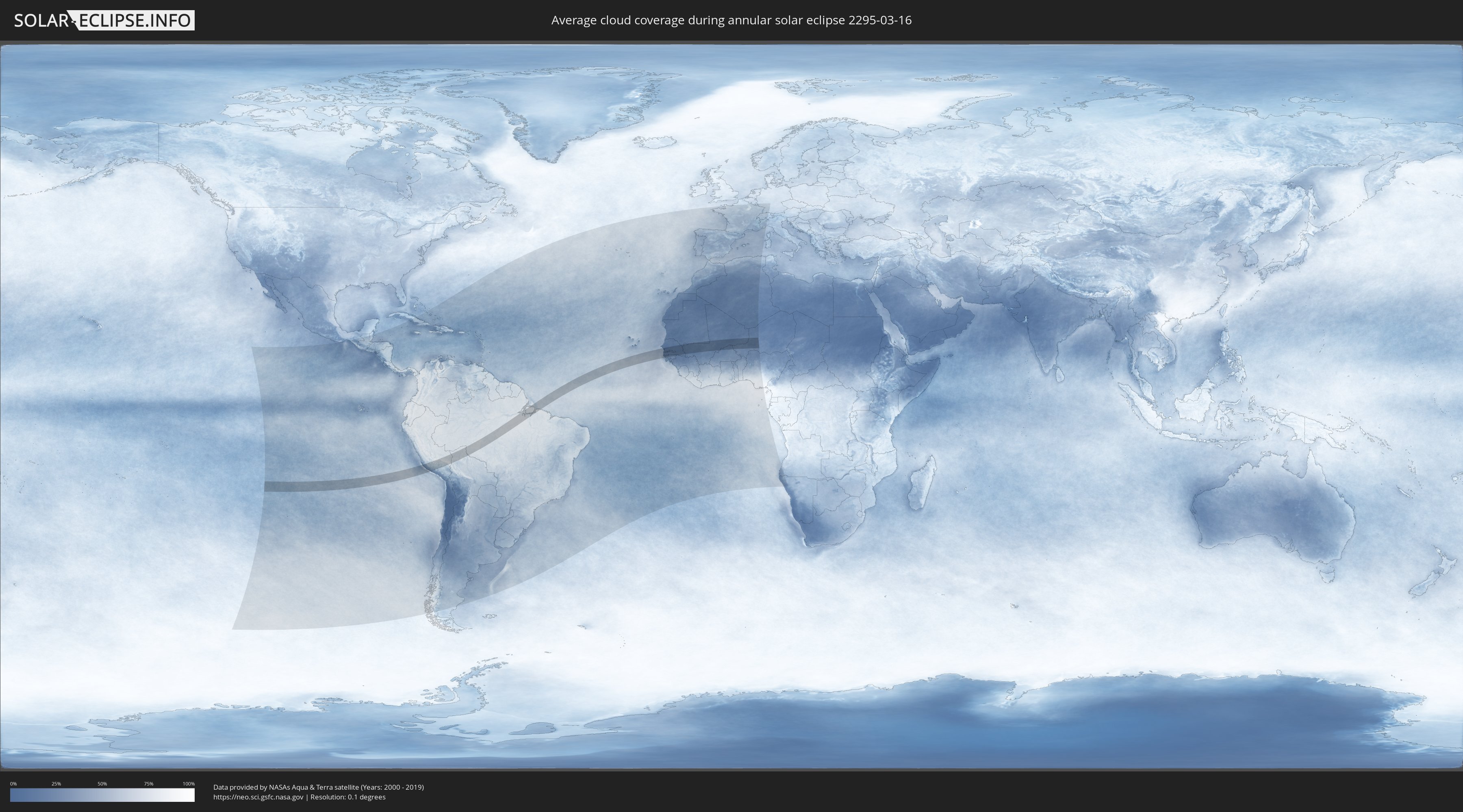
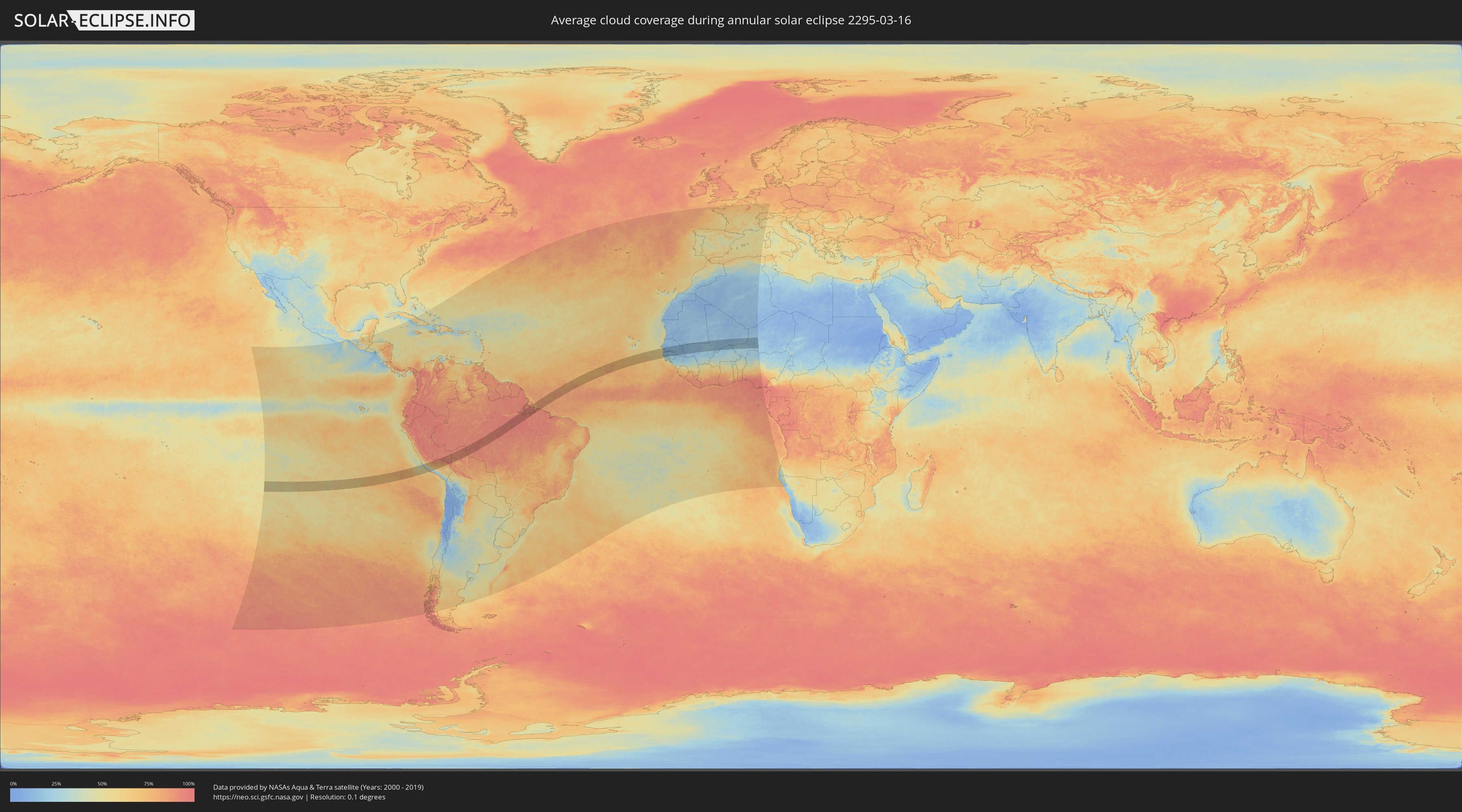
How will be the weather during the annular solar eclipse on 03/16/2295?
Where is the best place to see the annular solar eclipse of 03/16/2295?
The following maps show the average cloud coverage for the day of the annular solar eclipse.
With the help of these maps, it is possible to find the place along the eclipse path, which has the best
chance of a cloudless sky.
Nevertheless, you should consider local circumstances and inform about the weather of your chosen
observation site.
The data is provided by NASAs satellites
AQUA and TERRA.
The cloud maps are averaged over a period of 19 years (2000 - 2019).
Detailed country maps
 Peru
Peru
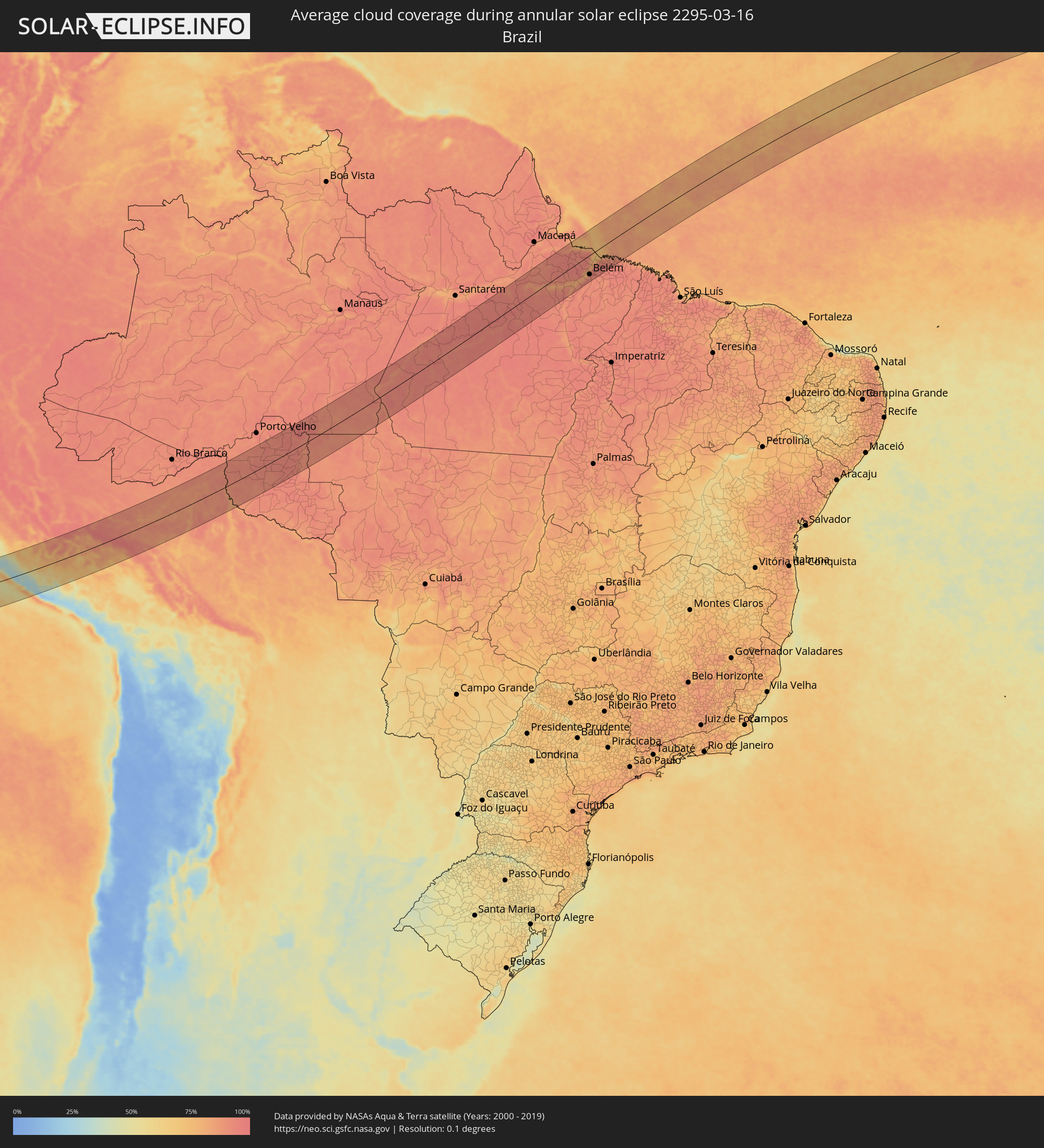 Brazil
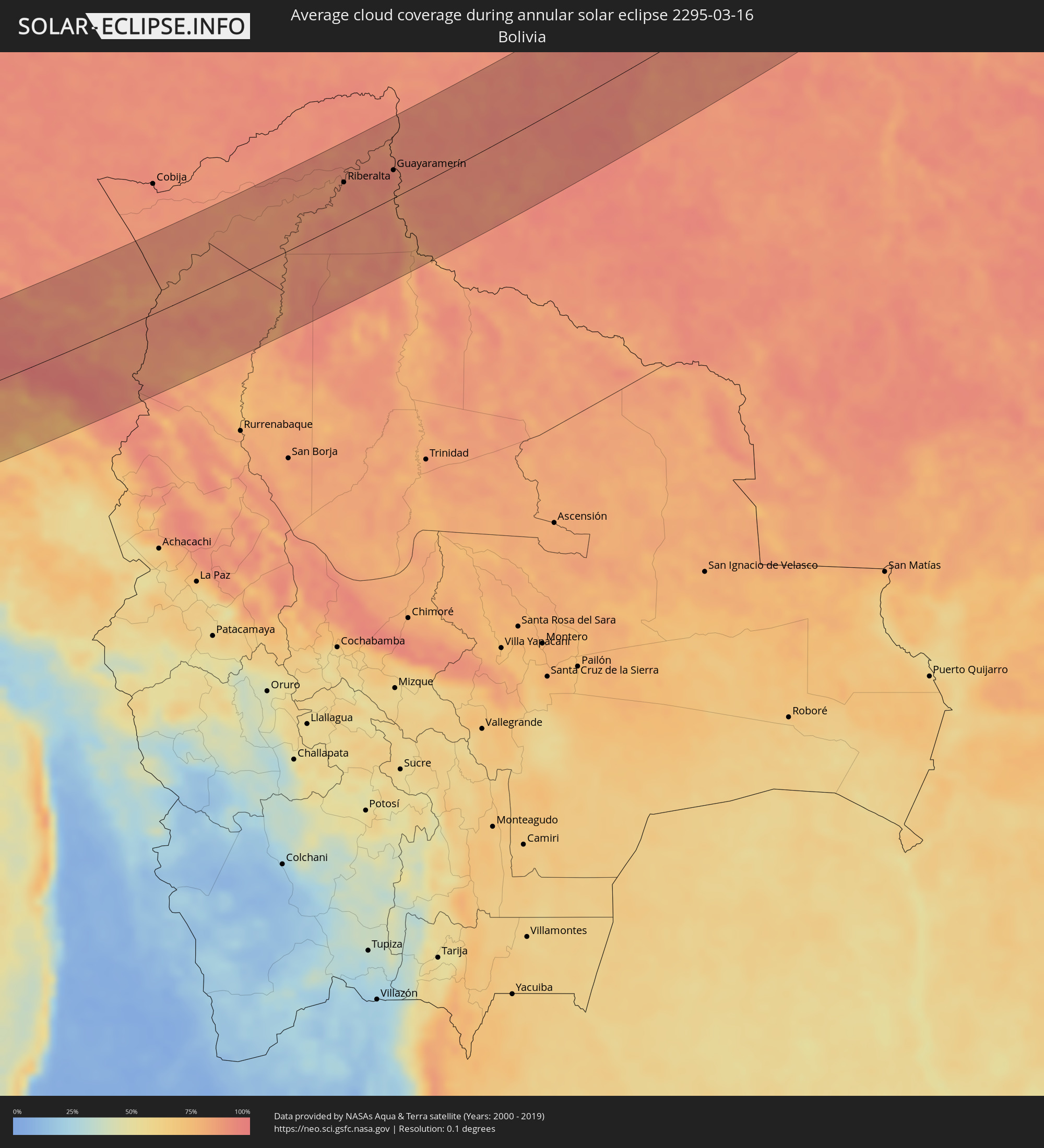 Bolivia
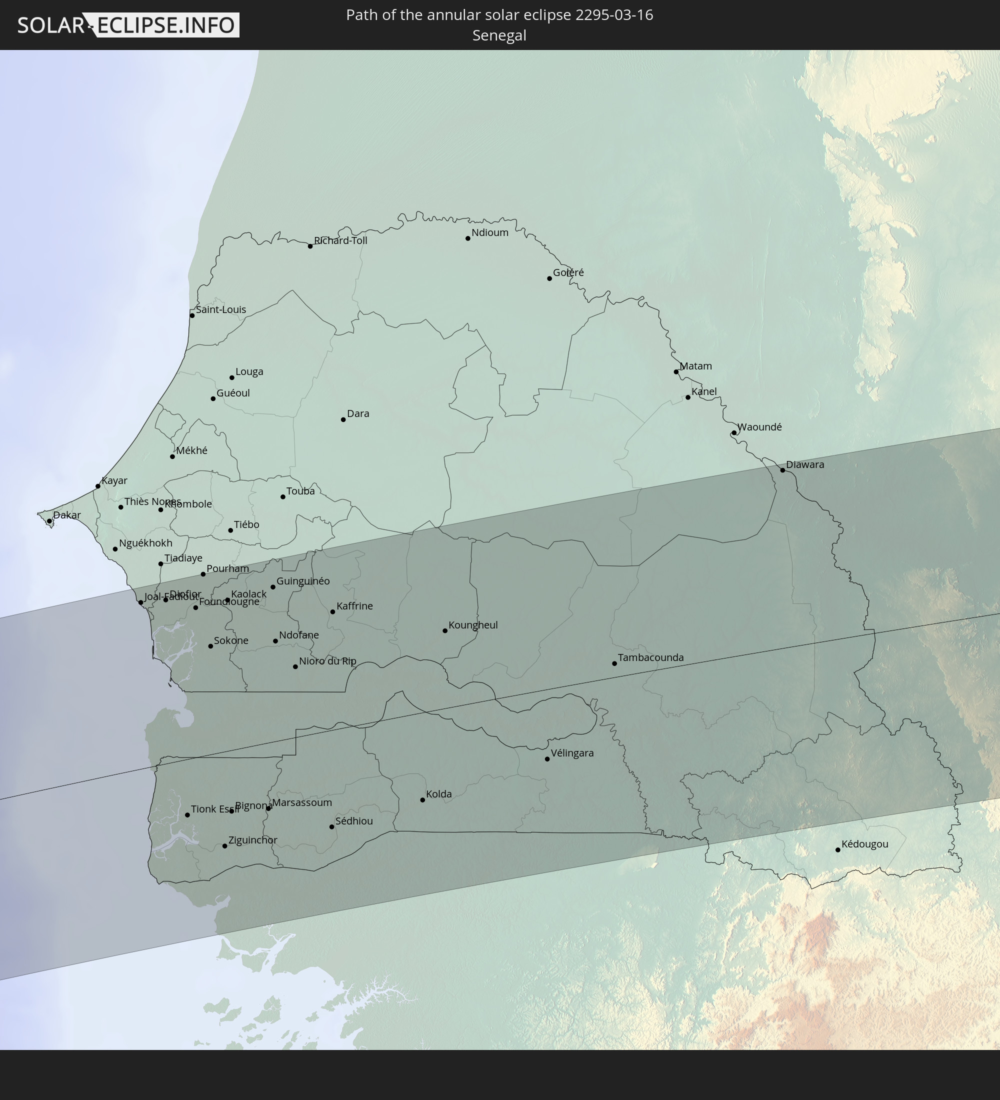
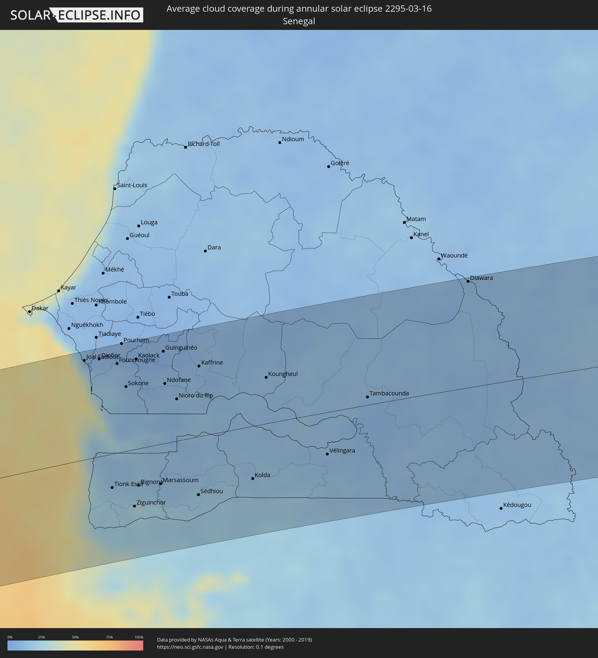 Senegal
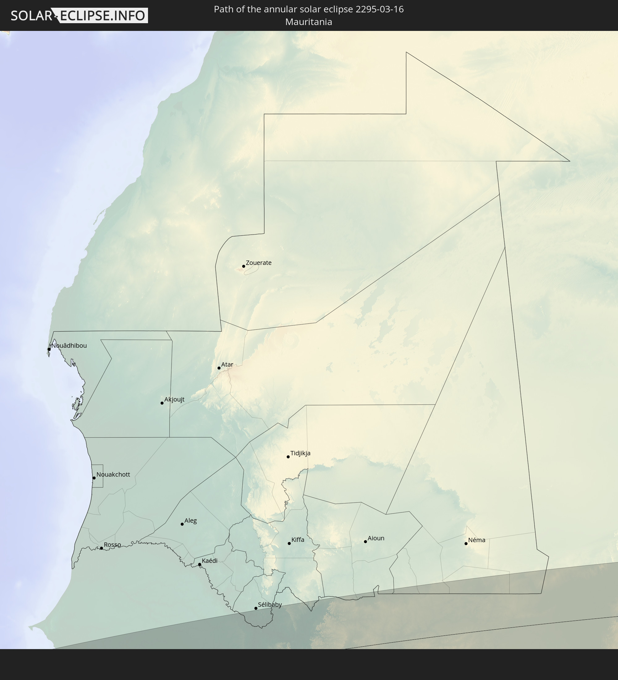
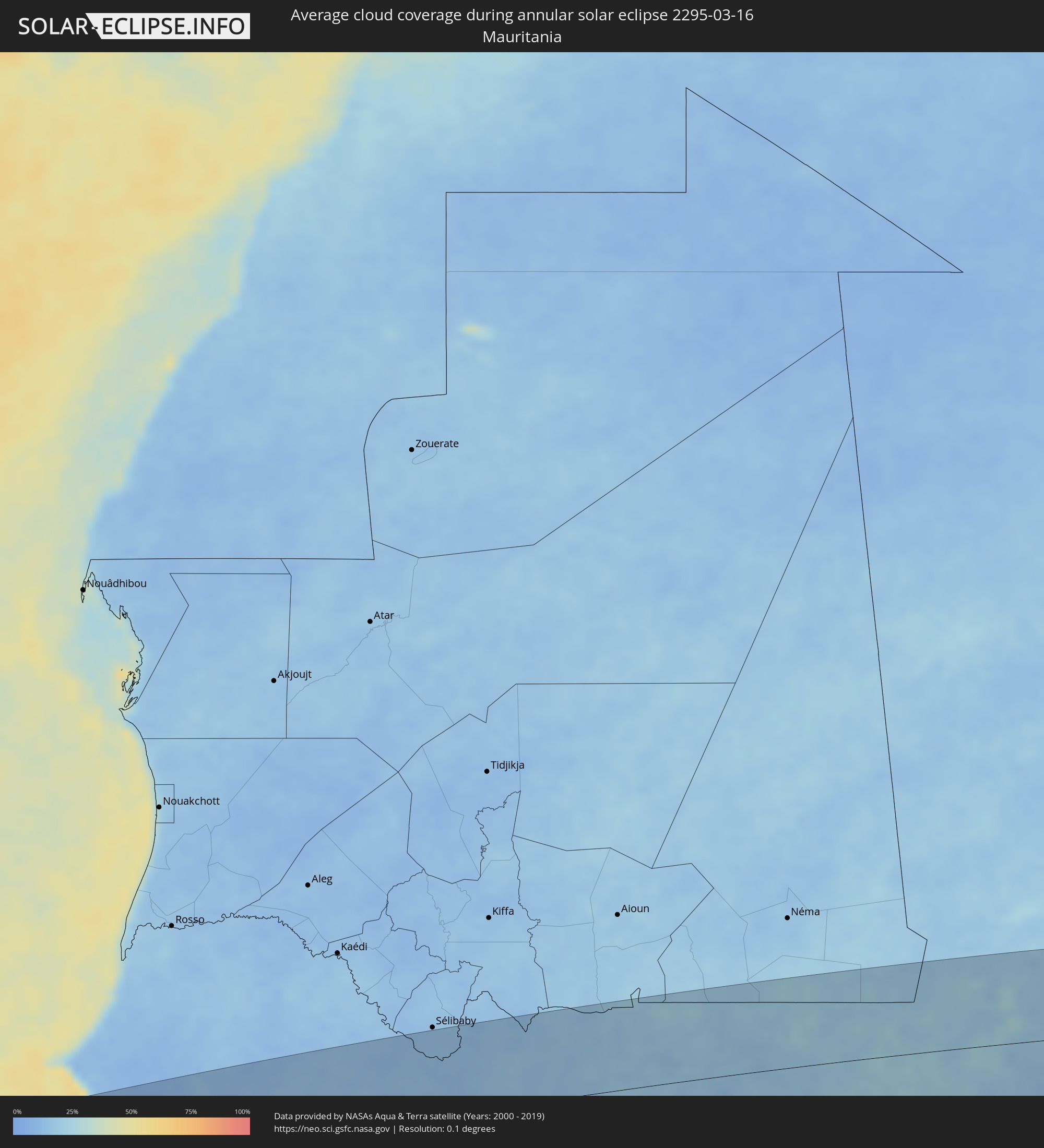 Mauritania
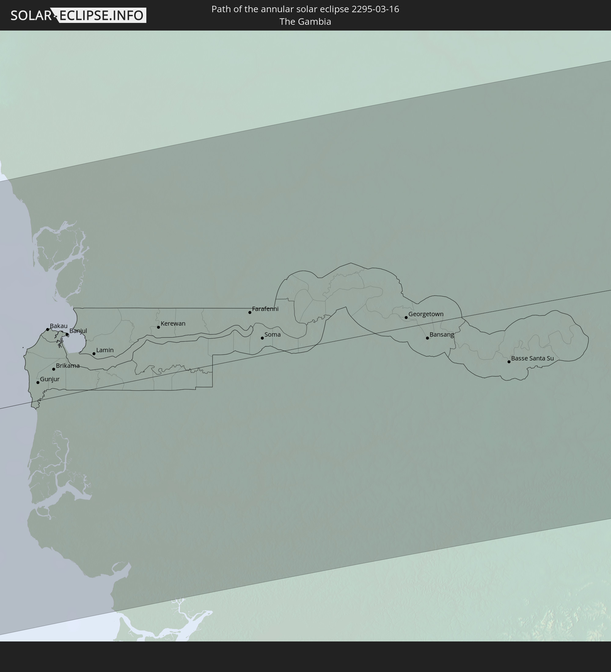
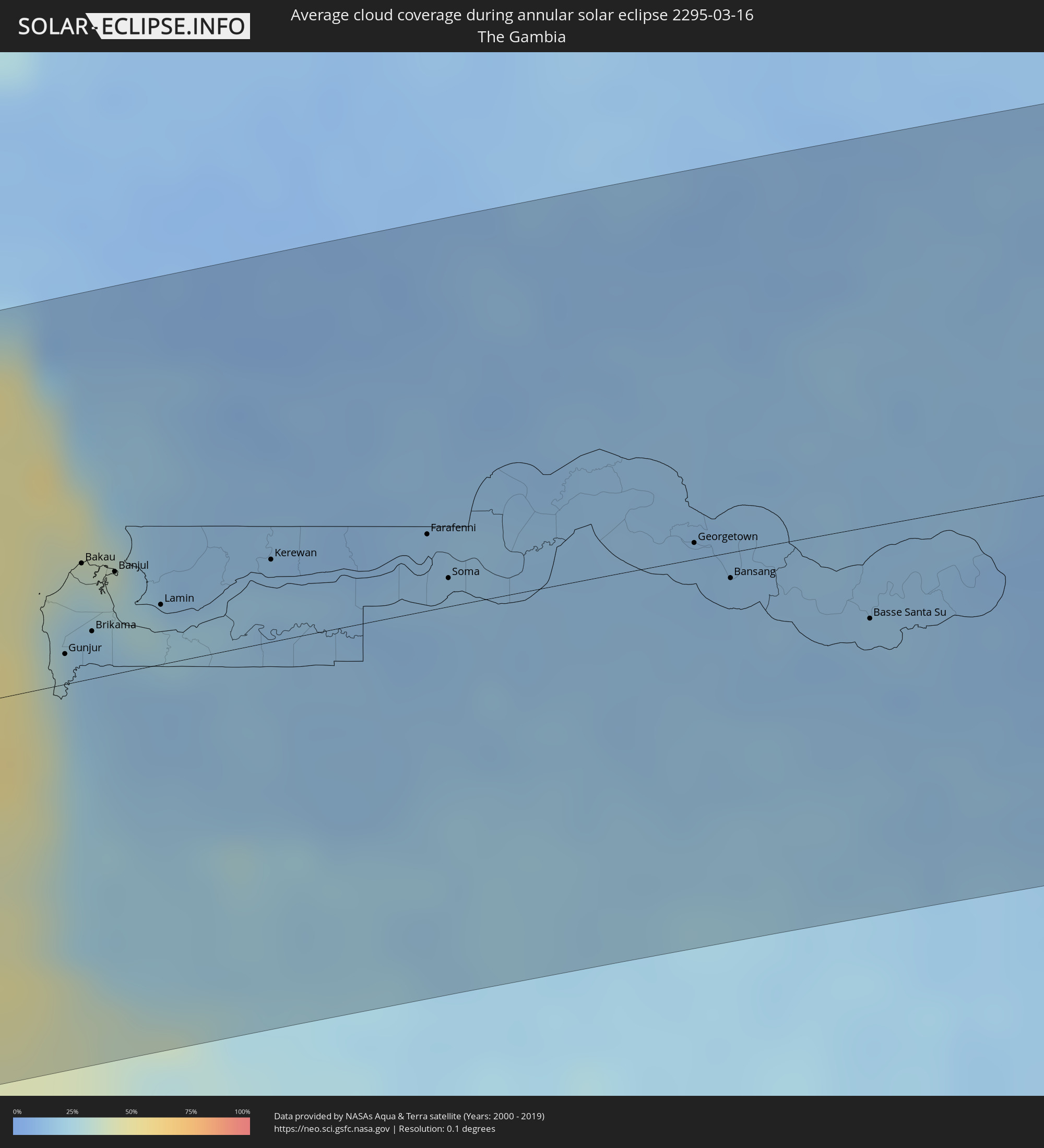 The Gambia
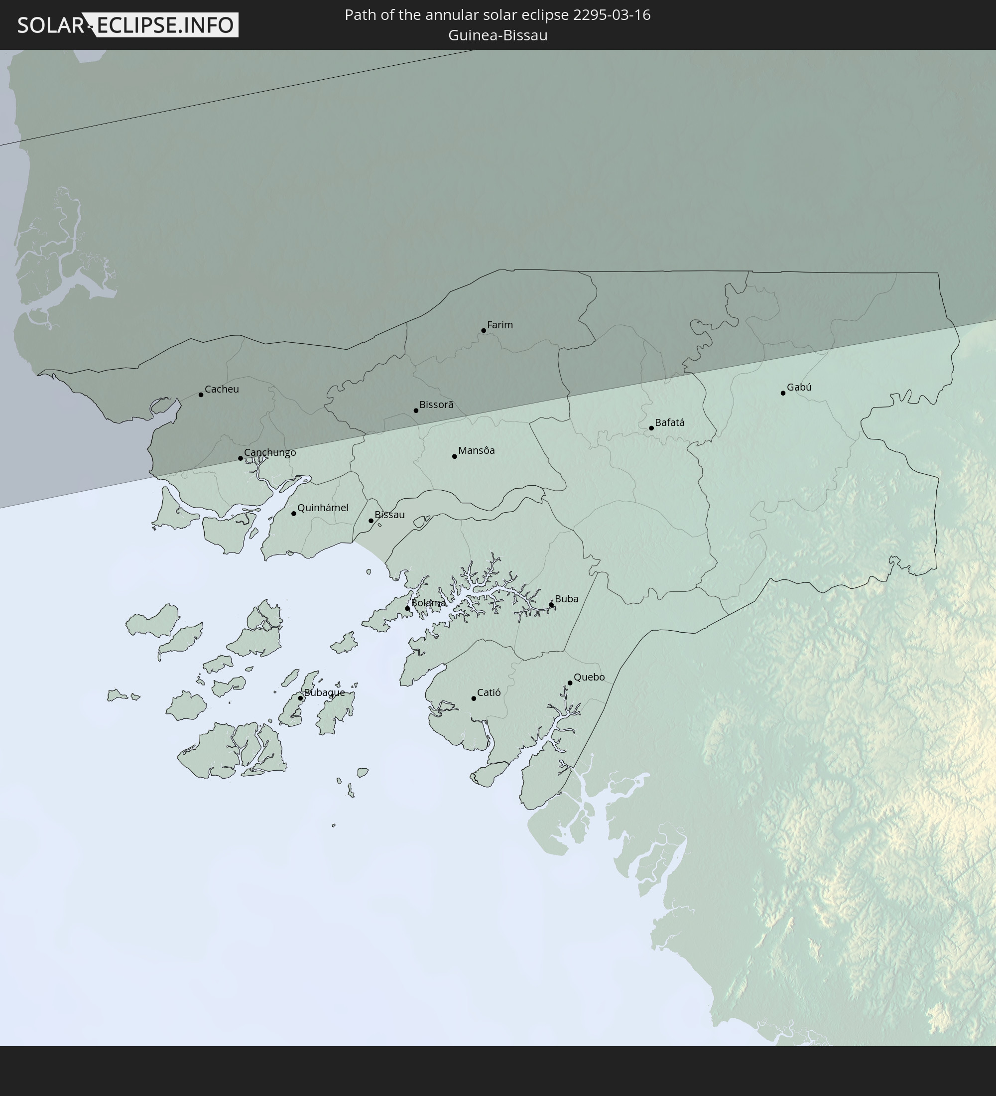
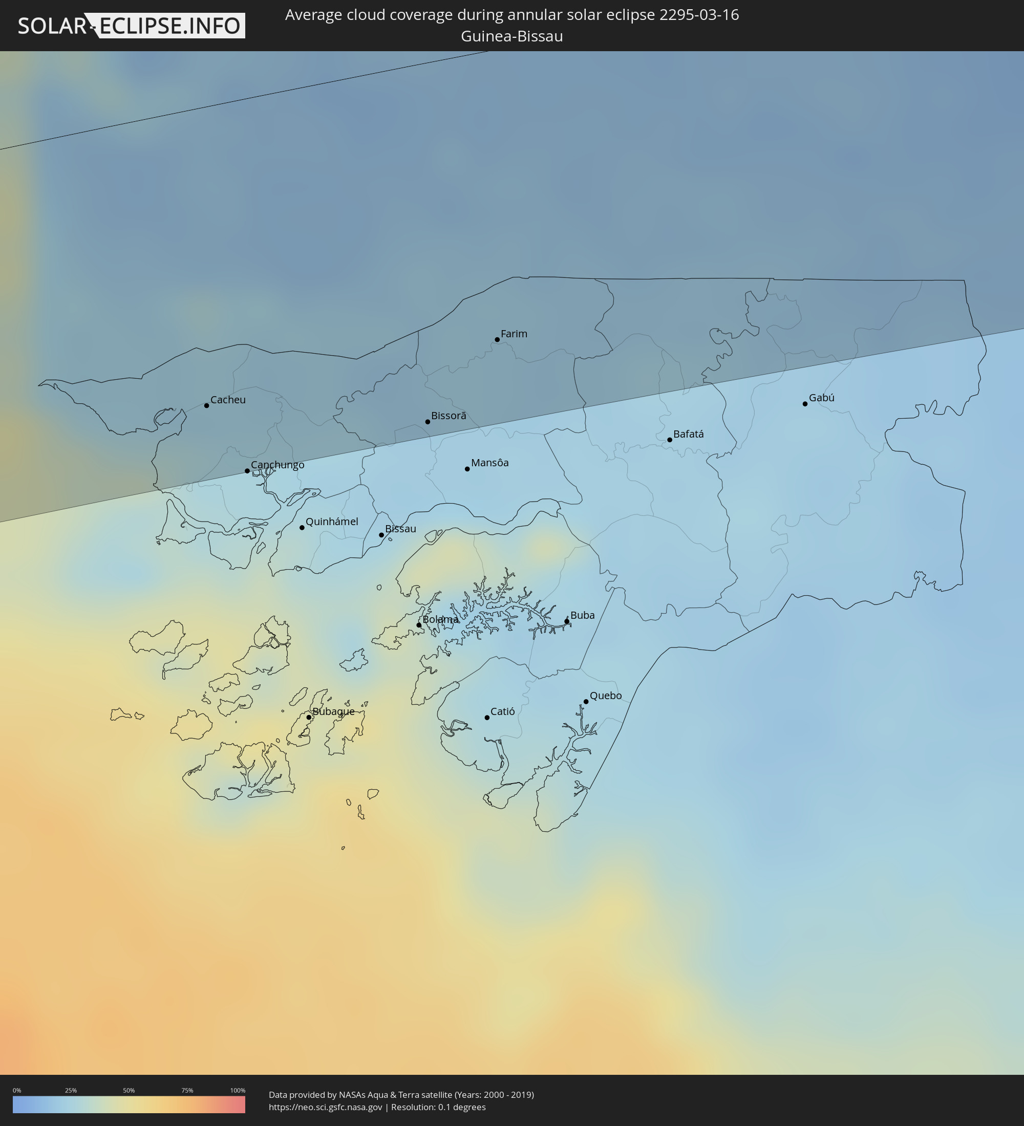 Guinea-Bissau
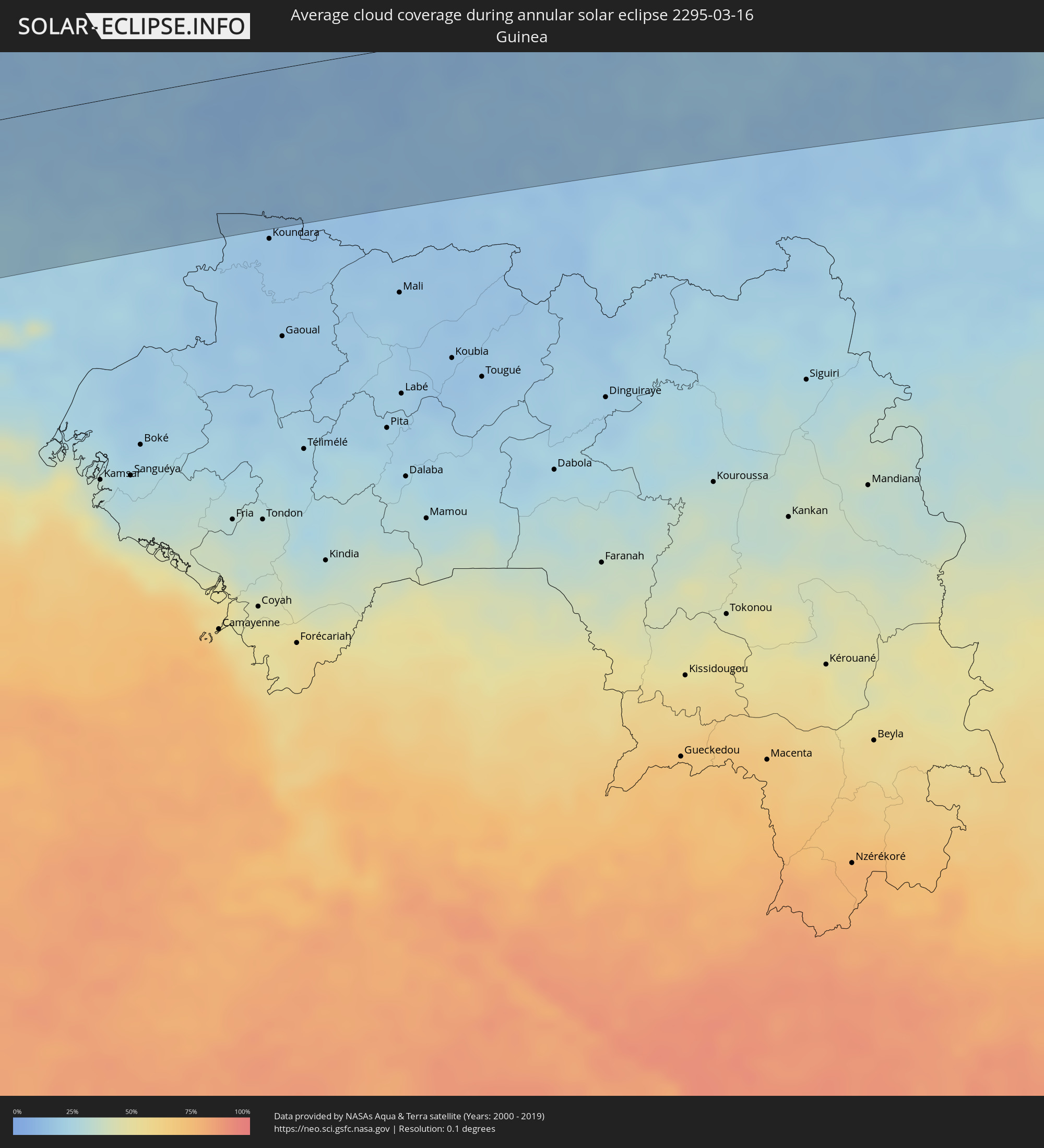 Guinea
 Mali
Mali
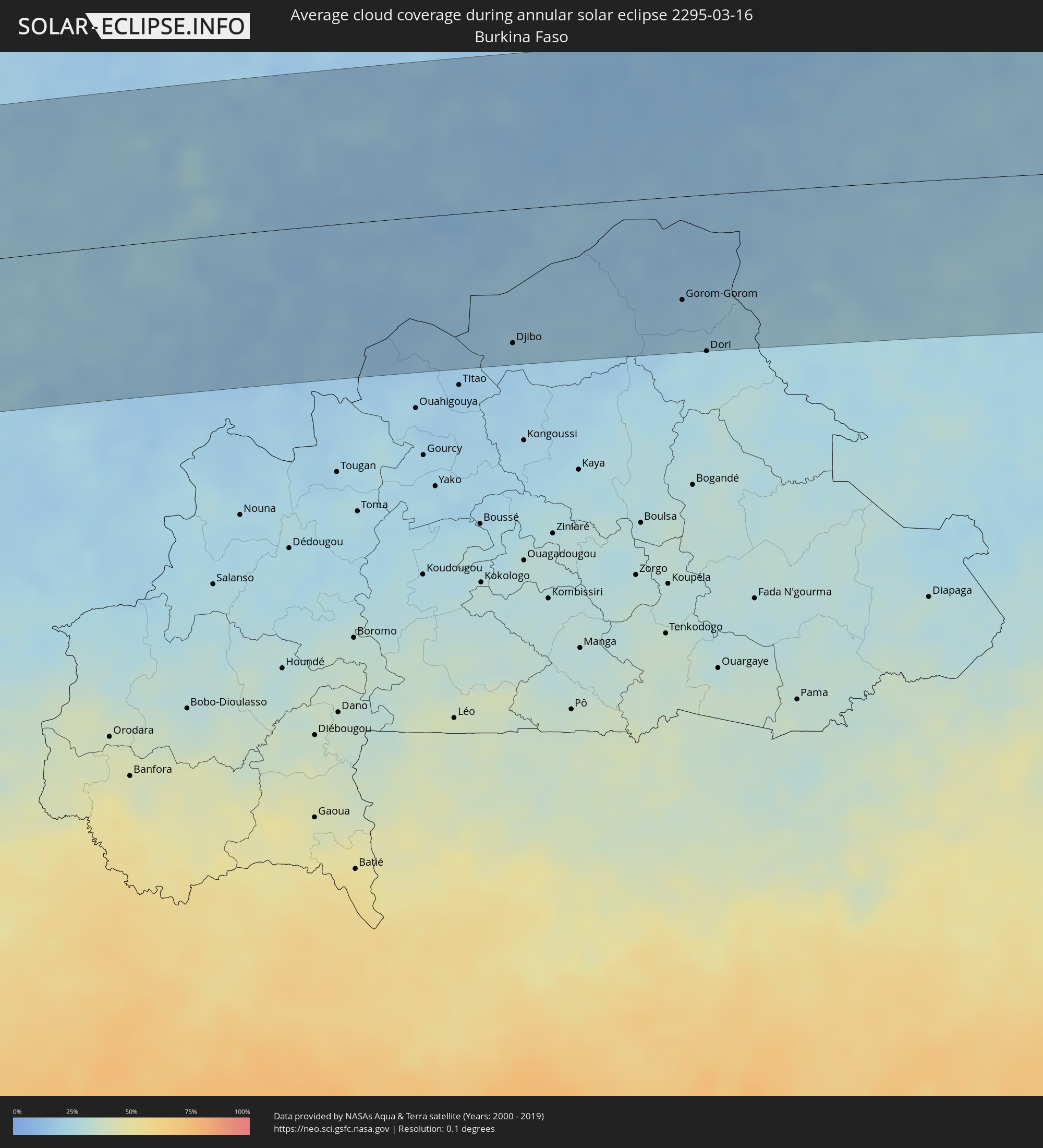 Burkina Faso
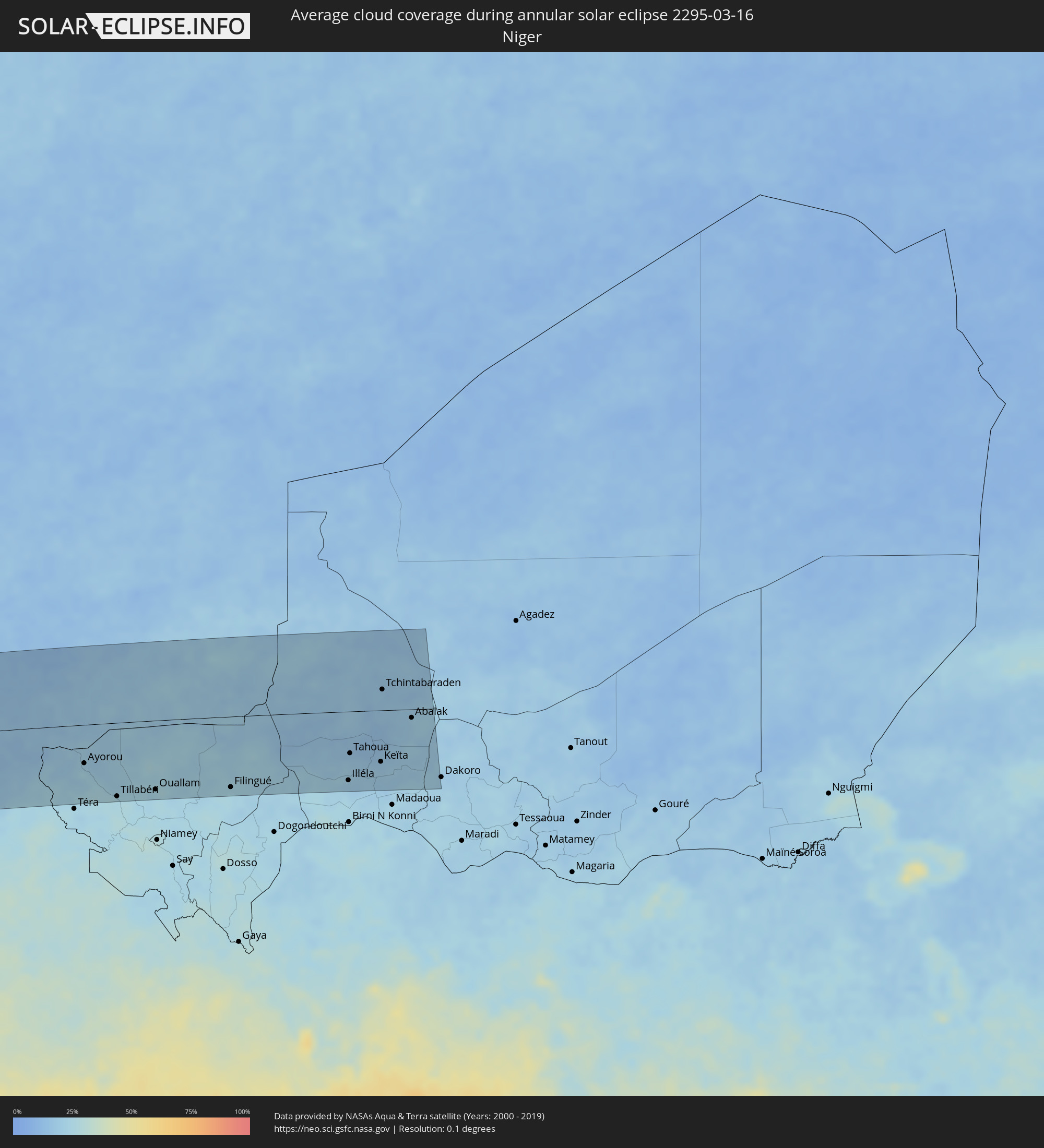 Niger
Niger
Cities inside the path of the eclipse
The following table shows all locations with a population of more than 5,000 inside the eclipse path. Cities which have more than 100,000 inhabitants are marked bold. A click at the locations opens a detailed map.
| City | Type | Eclipse duration | Local time of max. eclipse | Distance to central line | Ø Cloud coverage |
|
Palpa, Ica
|
annular | - | 09:23:38 UTC-05:00 | 78 km | 42% |
|
Minas de Marcona, Ica
|
annular | - | 09:23:11 UTC-05:00 | 4 km | 26% |
|
Nazca, Ica
|
annular | - | 09:23:53 UTC-05:00 | 38 km | 42% |
|
Puquio, Ayacucho
|
annular | - | 09:25:41 UTC-05:00 | 24 km | 63% |
|
Tambo, Ayacucho
|
annular | - | 09:26:03 UTC-05:00 | 6 km | 69% |
|
Coracora, Ayacucho
|
annular | - | 09:26:07 UTC-05:00 | 24 km | 58% |
|
Talavera, Apurímac
|
annular | - | 09:28:15 UTC-05:00 | 107 km | 89% |
|
Andahuaylas, Apurímac
|
annular | - | 09:28:20 UTC-05:00 | 105 km | 89% |
|
San Jerónimo, Apurímac
|
annular | - | 09:28:24 UTC-05:00 | 105 km | 89% |
|
Abancay, Apurímac
|
annular | - | 09:29:29 UTC-05:00 | 88 km | 86% |
|
Orcopampa, Arequipa
|
annular | - | 09:29:02 UTC-05:00 | 102 km | 62% |
|
Anta, Cusco
|
annular | - | 09:31:20 UTC-05:00 | 77 km | 86% |
|
Urubamba, Cusco
|
annular | - | 09:31:35 UTC-05:00 | 92 km | 80% |
|
Cusco, Cusco
|
annular | - | 09:31:41 UTC-05:00 | 64 km | 83% |
|
Calca, Cusco
|
annular | - | 09:31:56 UTC-05:00 | 83 km | 84% |
|
Urcos, Cusco
|
annular | - | 09:32:18 UTC-05:00 | 33 km | 84% |
|
Sicuani, Cusco
|
annular | - | 09:32:35 UTC-05:00 | 43 km | 81% |
|
Macusani, Puno
|
annular | - | 09:34:38 UTC-05:00 | 56 km | 82% |
|
Tambopata, Madre de Dios
|
annular | - | 09:38:56 UTC-05:00 | 42 km | 88% |
|
Puerto Maldonado, Madre de Dios
|
annular | - | 09:39:27 UTC-05:00 | 43 km | 83% |
|
Riberalta, El Beni
|
annular | - | 10:49:47 UTC-04:00 | 56 km | 88% |
|
Guayaramerín, El Beni
|
annular | - | 10:51:57 UTC-04:00 | 38 km | 93% |
|
Guajará Mirim, Rondônia
|
annular | - | 10:52:06 UTC-04:00 | 42 km | 88% |
|
Ariquemes, Rondônia
|
annular | - | 10:59:57 UTC-04:00 | 8 km | 95% |
|
Jaru, Rondônia
|
annular | - | 11:00:42 UTC-04:00 | 74 km | 94% |
|
Aripuanã, Mato Grosso
|
annular | - | 11:08:16 UTC-04:00 | 53 km | 90% |
|
Altamira, Pará
|
annular | - | 12:46:18 UTC-03:00 | 9 km | 95% |
|
Portel, Pará
|
annular | - | 12:53:20 UTC-03:00 | 20 km | 86% |
|
Breves, Pará
|
annular | - | 12:54:56 UTC-03:00 | 21 km | 87% |
|
Oeiras do Pará, Pará
|
annular | - | 12:56:11 UTC-03:00 | 47 km | 90% |
|
Cametá, Pará
|
annular | - | 12:56:47 UTC-03:00 | 92 km | 86% |
|
Igarapé Miri, Pará
|
annular | - | 12:59:00 UTC-03:00 | 101 km | 91% |
|
Abaetetuba, Pará
|
annular | - | 12:59:47 UTC-03:00 | 82 km | 92% |
|
Moju, Pará
|
annular | - | 12:59:47 UTC-03:00 | 105 km | 89% |
|
Barcarena, Pará
|
annular | - | 13:01:01 UTC-03:00 | 79 km | 91% |
|
Soure, Pará
|
annular | - | 13:02:59 UTC-03:00 | 13 km | 84% |
|
Belém, Pará
|
annular | - | 13:01:30 UTC-03:00 | 82 km | 89% |
|
Ananindeua, Pará
|
annular | - | 13:02:05 UTC-03:00 | 82 km | 93% |
|
Vigia, Pará
|
annular | - | 13:03:51 UTC-03:00 | 50 km | 93% |
|
Castanhal, Pará
|
annular | - | 13:03:36 UTC-03:00 | 103 km | 93% |
|
Curuçá, Pará
|
annular | - | 13:05:01 UTC-03:00 | 56 km | 92% |
|
Marapanim, Pará
|
annular | - | 13:05:30 UTC-03:00 | 64 km | 91% |
|
Igarapé Açu, Pará
|
annular | - | 13:04:53 UTC-03:00 | 107 km | 94% |
|
Maracanã, Pará
|
annular | - | 13:06:08 UTC-03:00 | 84 km | 92% |
|
Salinópolis, Pará
|
annular | - | 13:06:45 UTC-03:00 | 76 km | 90% |
|
Joal-Fadiout, Thiès
|
annular | - | 17:28:46 UTC+00:00 | 117 km | 24% |
|
Gunjur, Western
|
annular | - | 17:28:24 UTC+00:00 | 10 km | 19% |
|
Sukuta, Western
|
annular | - | 17:28:32 UTC+00:00 | 32 km | 19% |
|
Bakau, Banjul
|
annular | - | 17:28:35 UTC+00:00 | 39 km | 28% |
|
Diofior, Fatick
|
annular | - | 17:28:56 UTC+00:00 | 115 km | 16% |
|
Abuko, Western
|
annular | - | 17:28:35 UTC+00:00 | 30 km | 19% |
|
Brikama, Western
|
annular | - | 17:28:31 UTC+00:00 | 16 km | 18% |
|
Banjul, Banjul
|
annular | - | 17:28:41 UTC+00:00 | 34 km | 30% |
|
Barra, North Bank
|
annular | - | 17:28:43 UTC+00:00 | 36 km | 23% |
|
Essau, North Bank
|
annular | - | 17:28:44 UTC+00:00 | 36 km | 23% |
|
Tionk Essil, Ziguinchor
|
annular | - | 17:28:24 UTC+00:00 | 40 km | 19% |
|
Foundiougne, Fatick
|
annular | - | 17:29:06 UTC+00:00 | 106 km | 17% |
|
Lamin, North Bank
|
annular | - | 17:28:46 UTC+00:00 | 20 km | 22% |
|
Pourham, Fatick
|
annular | - | 17:29:15 UTC+00:00 | 128 km | 9% |
|
Sokone, Fatick
|
annular | - | 17:29:05 UTC+00:00 | 76 km | 17% |
|
Ziguinchor, Ziguinchor
|
annular | - | 17:28:33 UTC+00:00 | 68 km | 22% |
|
Gandiaye, Kaolack
|
annular | - | 17:29:21 UTC+00:00 | 112 km | 13% |
|
Passi, Fatick
|
annular | - | 17:29:14 UTC+00:00 | 85 km | 12% |
|
Kaolack, Kaolack
|
annular | - | 17:29:20 UTC+00:00 | 106 km | 13% |
|
Bignona, Ziguinchor
|
annular | - | 17:28:42 UTC+00:00 | 44 km | 18% |
|
Cacheu, Cacheu
|
annular | - | 17:28:29 UTC+00:00 | 104 km | 27% |
|
Kerewan, North Bank
|
annular | - | 17:29:10 UTC+00:00 | 27 km | 18% |
|
Canchungo, Cacheu
|
annular | - | 17:28:30 UTC+00:00 | 129 km | 26% |
|
Marsassoum, Kolda
|
annular | - | 17:28:57 UTC+00:00 | 47 km | 17% |
|
Guinguinéo, Fatick
|
annular | - | 17:29:40 UTC+00:00 | 109 km | 9% |
|
Ndofane, Kaolack
|
annular | - | 17:29:31 UTC+00:00 | 71 km | 12% |
|
Nioro du Rip, Kaolack
|
annular | - | 17:29:34 UTC+00:00 | 50 km | 12% |
|
Farafenni, North Bank
|
annular | - | 17:29:41 UTC+00:00 | 25 km | 16% |
|
Sédhiou, Sédhiou
|
annular | - | 17:29:18 UTC+00:00 | 69 km | 19% |
|
Kaffrine, Kaffrine
|
annular | - | 17:29:58 UTC+00:00 | 83 km | 13% |
|
Mansa Konko, Lower River
|
annular | - | 17:29:41 UTC+00:00 | 13 km | 16% |
|
Soma, Lower River
|
annular | - | 17:29:41 UTC+00:00 | 9 km | 14% |
|
Bissorã, Oio
|
annular | - | 17:29:10 UTC+00:00 | 125 km | 22% |
|
Farim, Oio
|
annular | - | 17:29:31 UTC+00:00 | 101 km | 21% |
|
Kolda, Kolda
|
annular | - | 17:29:58 UTC+00:00 | 63 km | 18% |
|
Koungheul, Kaffrine
|
annular | - | 17:30:36 UTC+00:00 | 55 km | 15% |
|
Georgetown, Central River
|
annular | - | 17:30:26 UTC+00:00 | 5 km | 13% |
|
Bansang, Central River
|
annular | - | 17:30:29 UTC+00:00 | 9 km | 14% |
|
Basse Santa Su, Upper River
|
annular | - | 17:30:49 UTC+00:00 | 31 km | 14% |
|
Sabi, Upper River
|
annular | - | 17:30:48 UTC+00:00 | 39 km | 14% |
|
Vélingara, Kolda
|
annular | - | 17:30:50 UTC+00:00 | 50 km | 12% |
|
Tambacounda, Tambacounda
|
annular | - | 17:31:29 UTC+00:00 | 9 km | 12% |
|
Diawara, Matam
|
annular | - | 17:32:52 UTC+00:00 | 126 km | 13% |
|
Kayes, Kayes
|
annular | - | 17:33:29 UTC+00:00 | 44 km | 16% |
|
Bafoulabé, Kayes
|
annular | - | 17:33:42 UTC+00:00 | 37 km | 15% |
|
Kolokani, Koulikoro
|
annular | - | 17:35:25 UTC+00:00 | 104 km | 18% |
|
Banamba, Koulikoro
|
annular | - | 17:35:44 UTC+00:00 | 115 km | 18% |
|
Markala, Ségou
|
annular | - | 17:36:30 UTC+00:00 | 116 km | 22% |
|
Ké-Macina, Ségou
|
annular | - | 17:36:55 UTC+00:00 | 95 km | 21% |
|
Ténenkou, Mopti
|
annular | - | 17:37:15 UTC+00:00 | 46 km | 21% |
|
Djénné, Mopti
|
annular | - | 17:37:15 UTC+00:00 | 111 km | 19% |
|
Mopti, Mopti
|
annular | - | 17:37:33 UTC+00:00 | 51 km | 19% |
|
Niafunké, Tombouctou
|
annular | - | 17:37:56 UTC+00:00 | 108 km | 20% |
|
Bandiagara, Mopti
|
annular | - | 17:37:45 UTC+00:00 | 71 km | 17% |
|
Douentza, Mopti
|
annular | - | 17:38:08 UTC+00:00 | 6 km | 15% |
|
Djibo, Sahel
|
annular | - | 17:38:22 UTC+00:00 | 118 km | 19% |
|
Gorom-Gorom, Sahel
|
annular | - | 17:38:50 UTC+00:00 | 91 km | 19% |
|
Gao, Gao
|
annular | - | 17:39:10 UTC+00:00 | 111 km | 14% |
|
Ayorou, Tillabéri
|
annular | - | 18:39:09 UTC+01:00 | 68 km | 25% |
|
Tillabéri, Tillabéri
|
annular | - | 18:39:09 UTC+01:00 | 129 km | 26% |
|
Ouallam, Tillabéri
|
annular | - | 18:39:17 UTC+01:00 | 121 km | 24% |
|
Ménaka, Gao
|
annular | - | 17:39:34 UTC+00:00 | 55 km | 22% |
|
Inékar, Gao
|
annular | - | 17:39:40 UTC+00:00 | 56 km | 19% |
|
Filingué, Tillabéri
|
annular | - | 18:39:28 UTC+01:00 | 124 km | 24% |
|
Illéla, Tahoua
|
annular | - | 18:39:39 UTC+01:00 | 121 km | 19% |
|
Tahoua, Tahoua
|
annular | - | 18:39:42 UTC+01:00 | 74 km | 19% |
|
Keïta, Tahoua
|
annular | - | 18:39:43 UTC+01:00 | 90 km | 18% |
|
Tchintabaraden, Tahoua
|
annular | - | 18:39:50 UTC+01:00 | 37 km | 18% |
|
Bouza, Tahoua
|
annular | - | 18:39:40 UTC+01:00 | 128 km | 22% |
|
Abalak, Tahoua
|
annular | - | 18:39:48 UTC+01:00 | 15 km | 20% |