Total solar eclipse of 06/20/2327
| Day of week: | Monday |
| Maximum duration of eclipse: | 06m21s |
| Maximum width of eclipse path: | 265 km |
| Saros cycle: | 142 |
| Coverage: | 100% |
| Magnitude: | 1.0795 |
| Gamma: | 0.2542 |
Wo kann man die Sonnenfinsternis vom 06/20/2327 sehen?
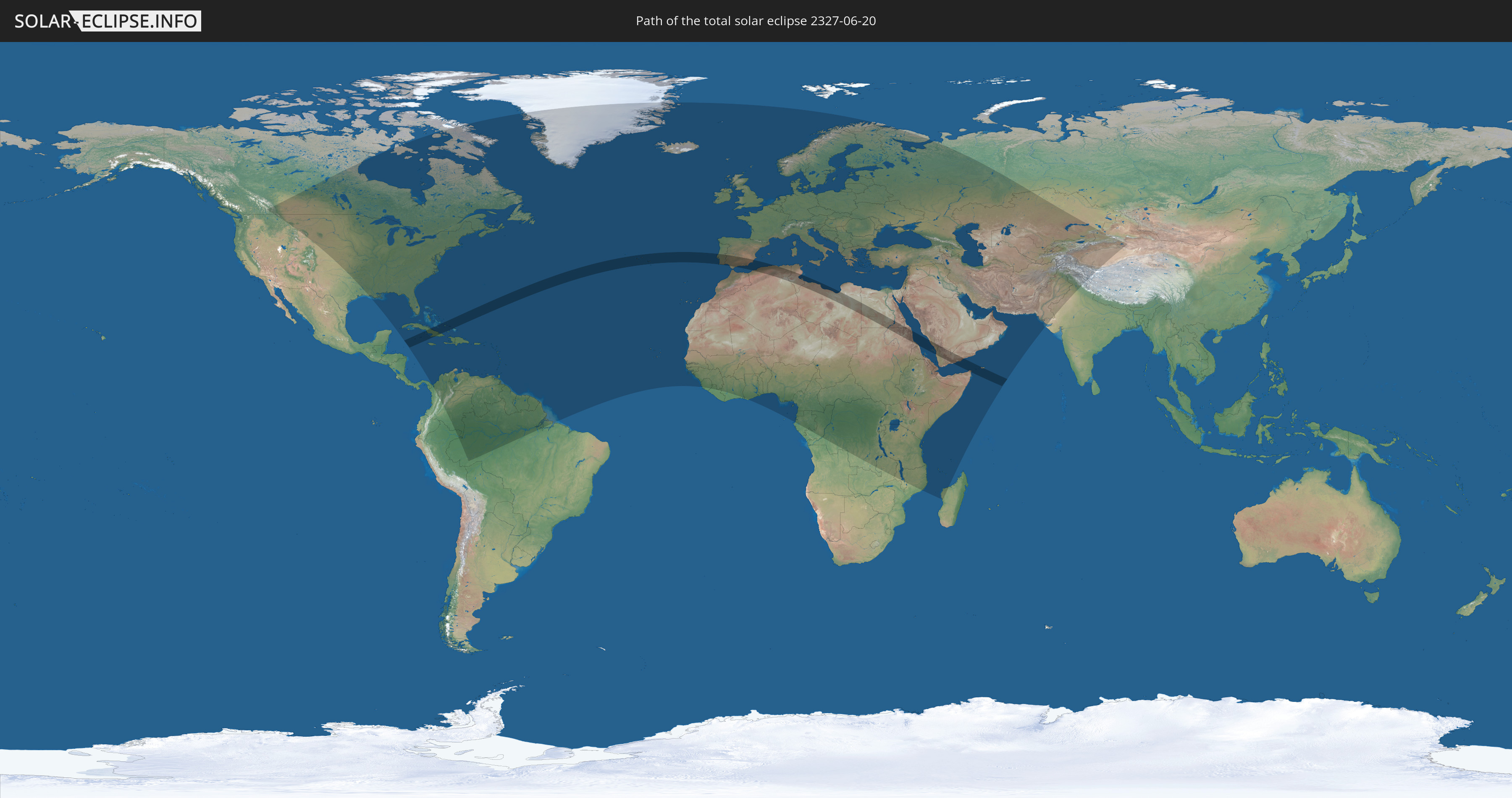
Die Sonnenfinsternis am 06/20/2327 kann man in 165 Ländern als partielle Sonnenfinsternis beobachten.
Der Finsternispfad verläuft durch 15 Länder. Nur in diesen Ländern ist sie als total Sonnenfinsternis zu sehen.
In den folgenden Ländern ist die Sonnenfinsternis total zu sehen
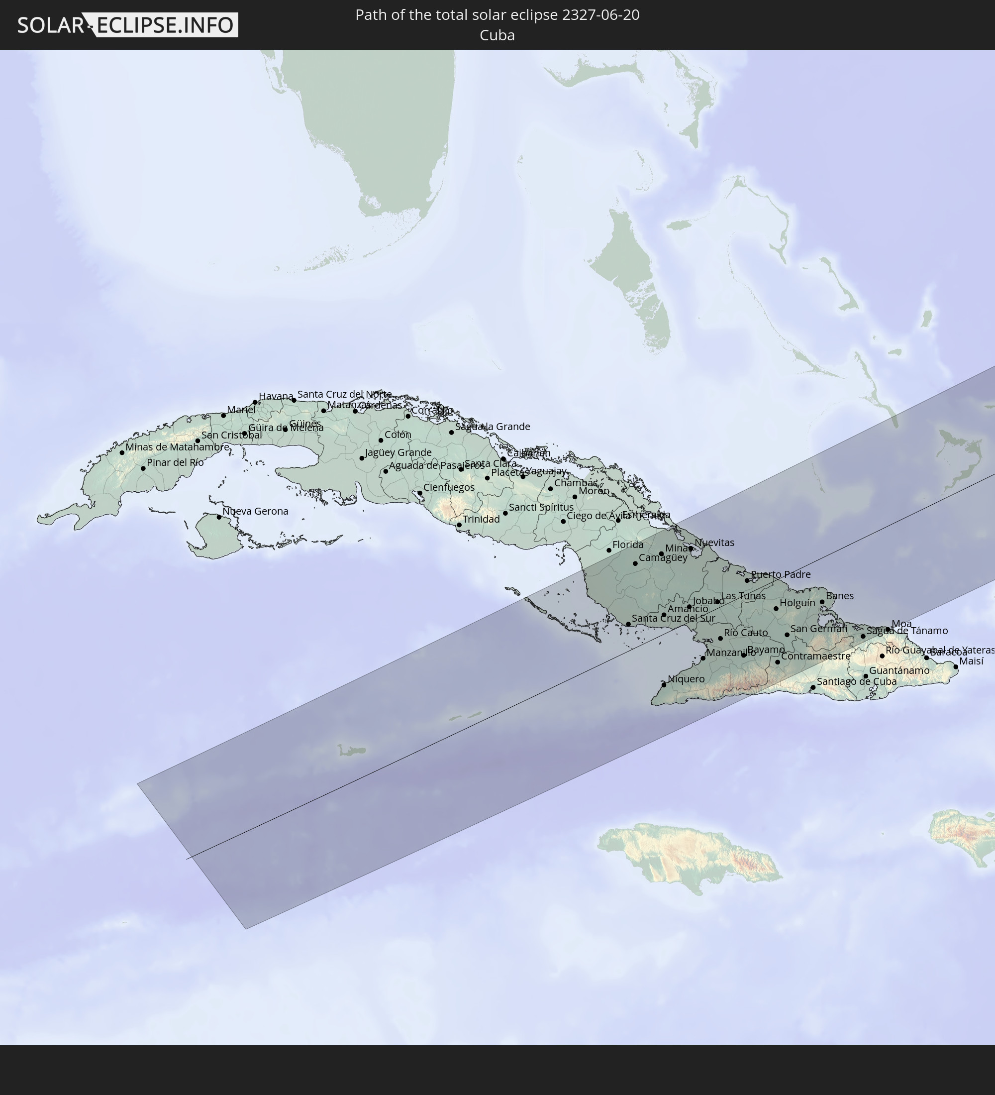 Cuba
Cuba
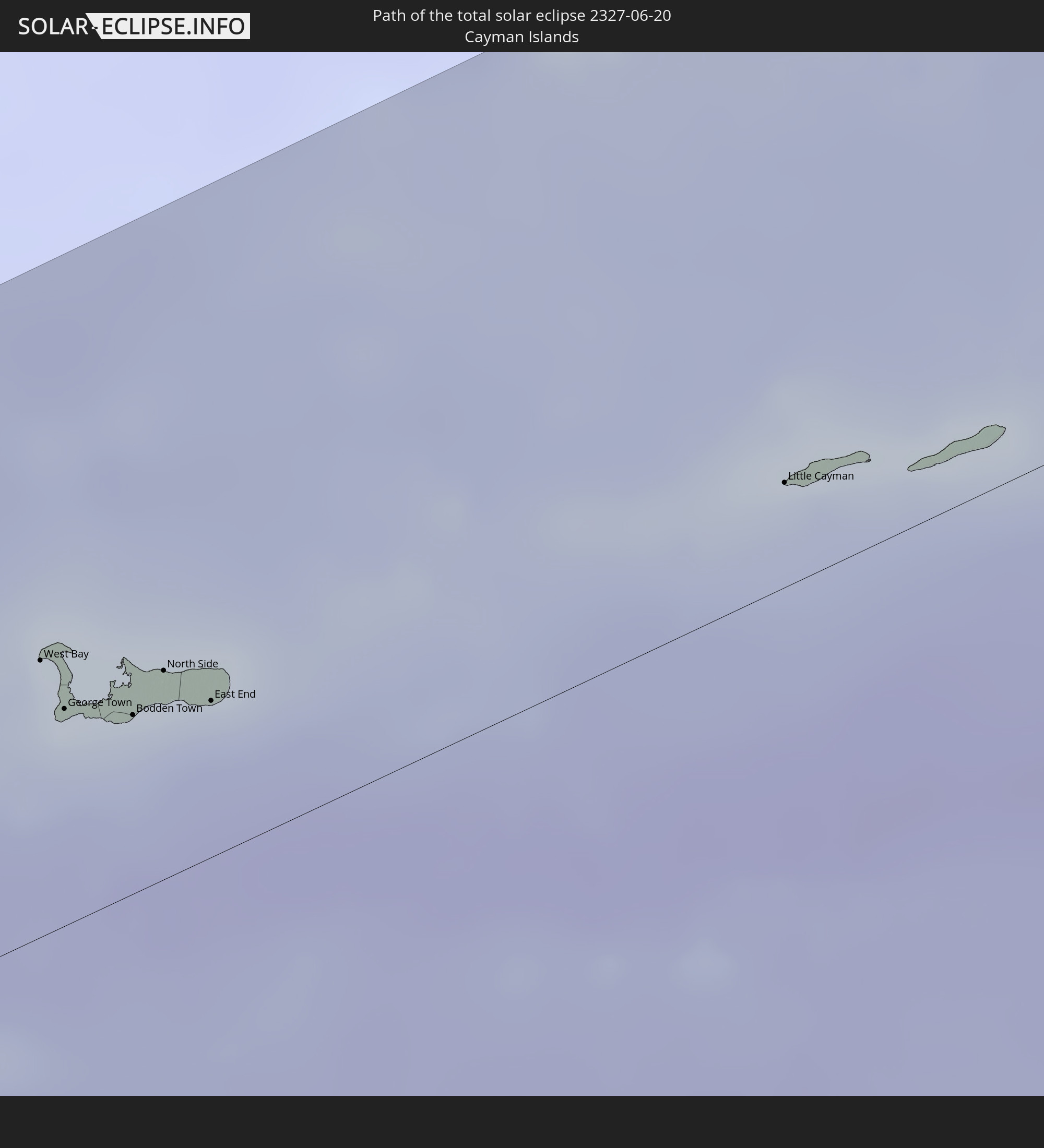 Cayman Islands
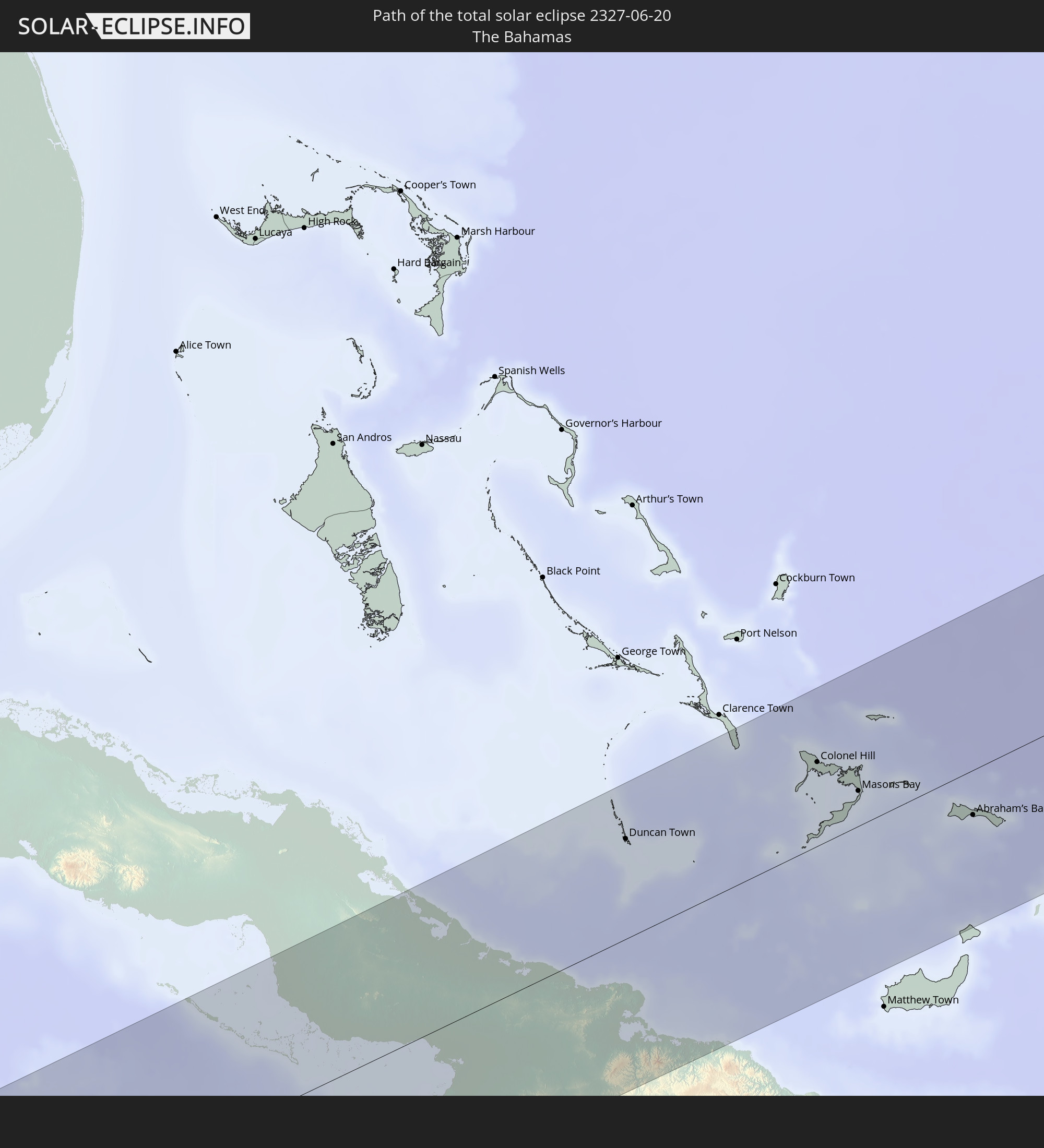 The Bahamas
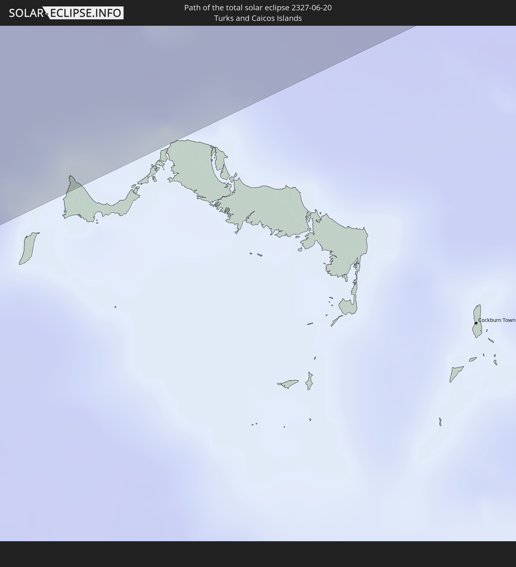 Turks and Caicos Islands
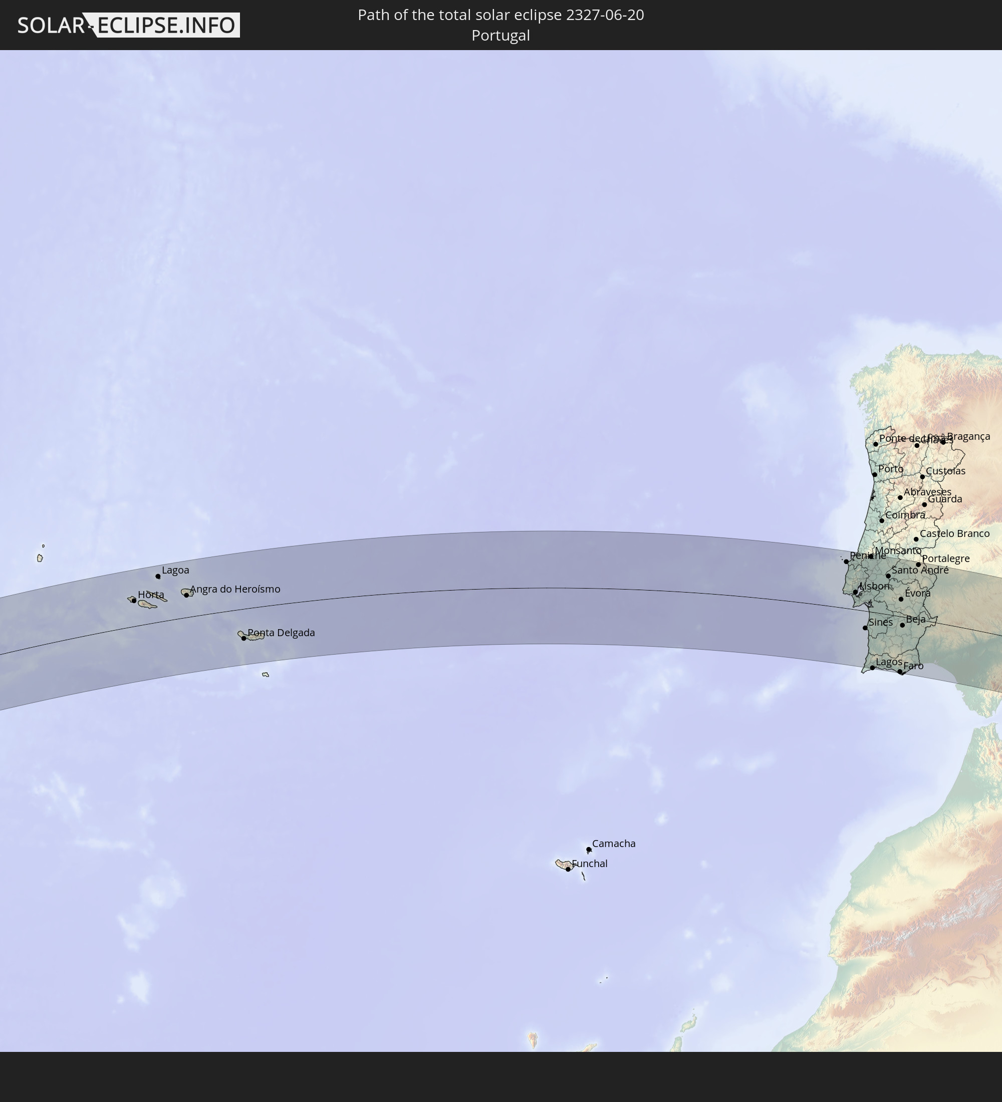 Portugal
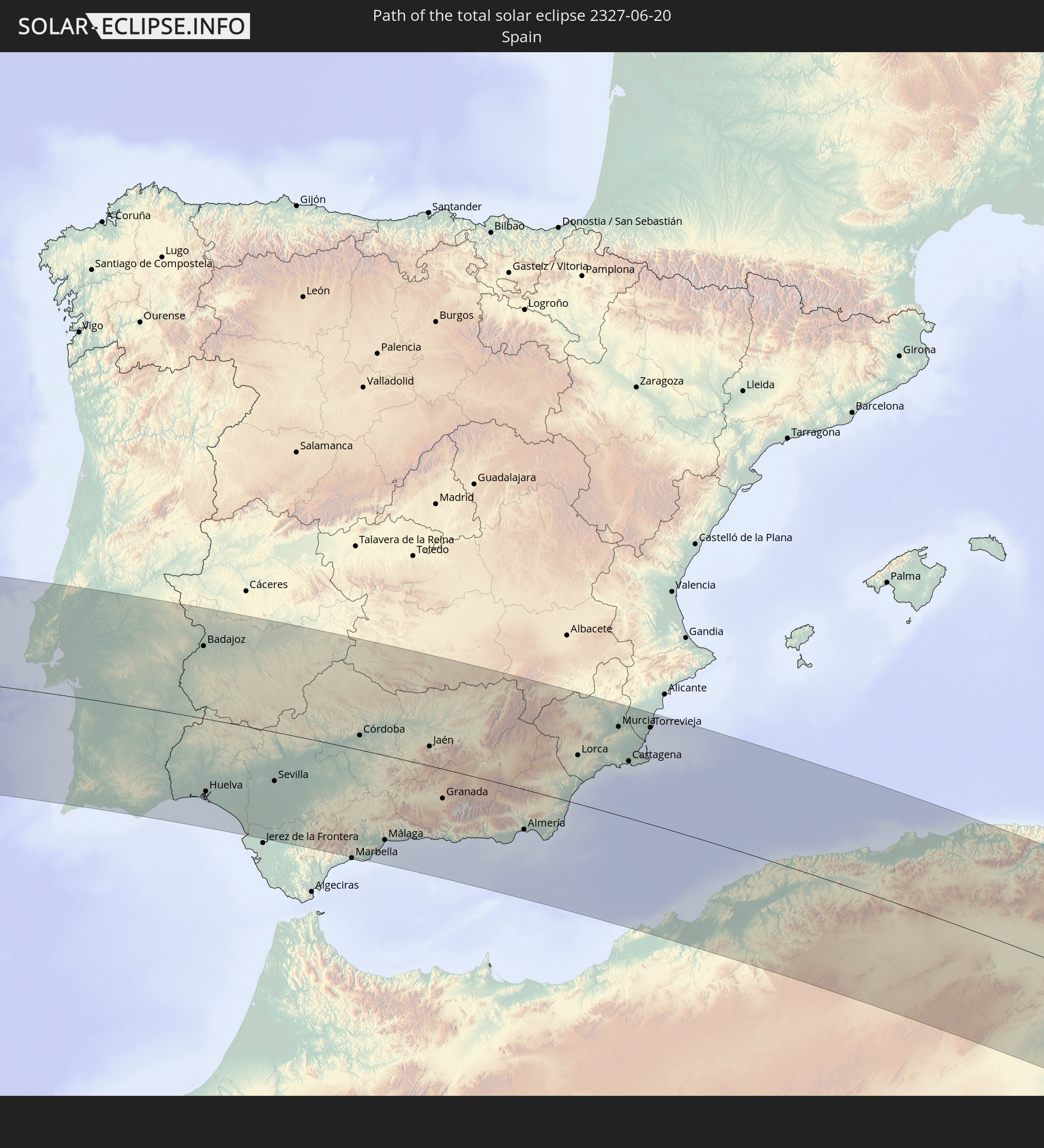 Spain
Spain
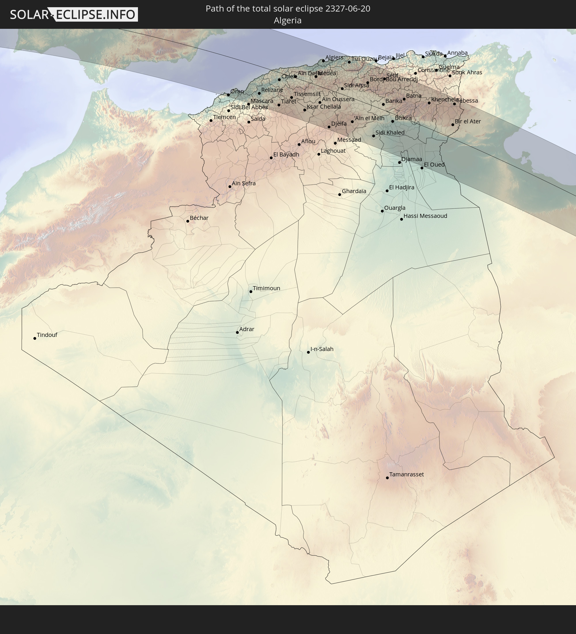 Algeria
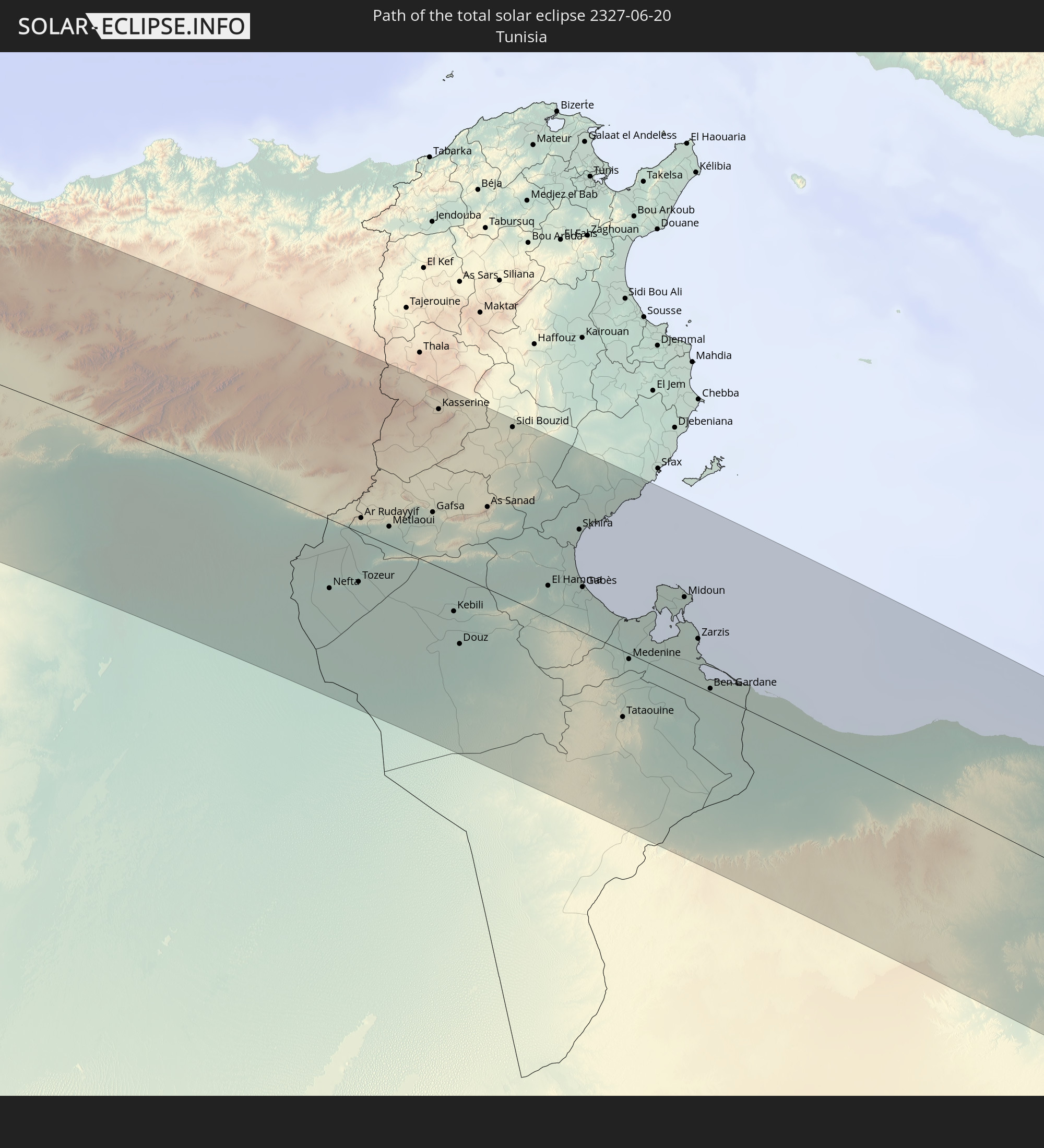 Tunisia
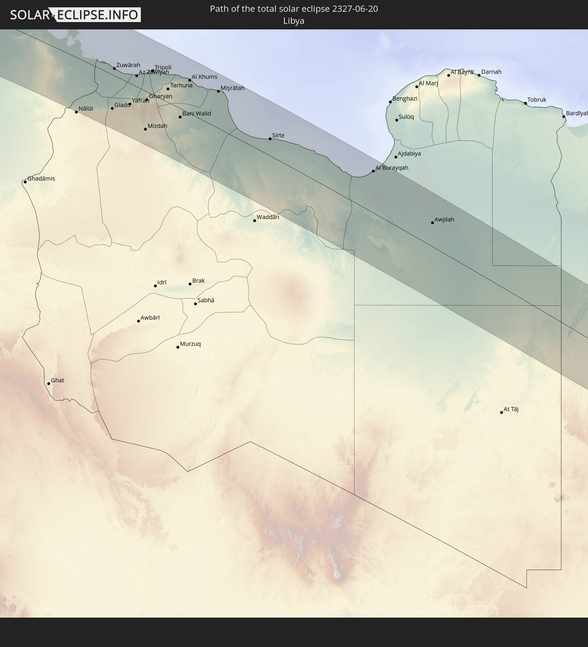 Libya
Libya
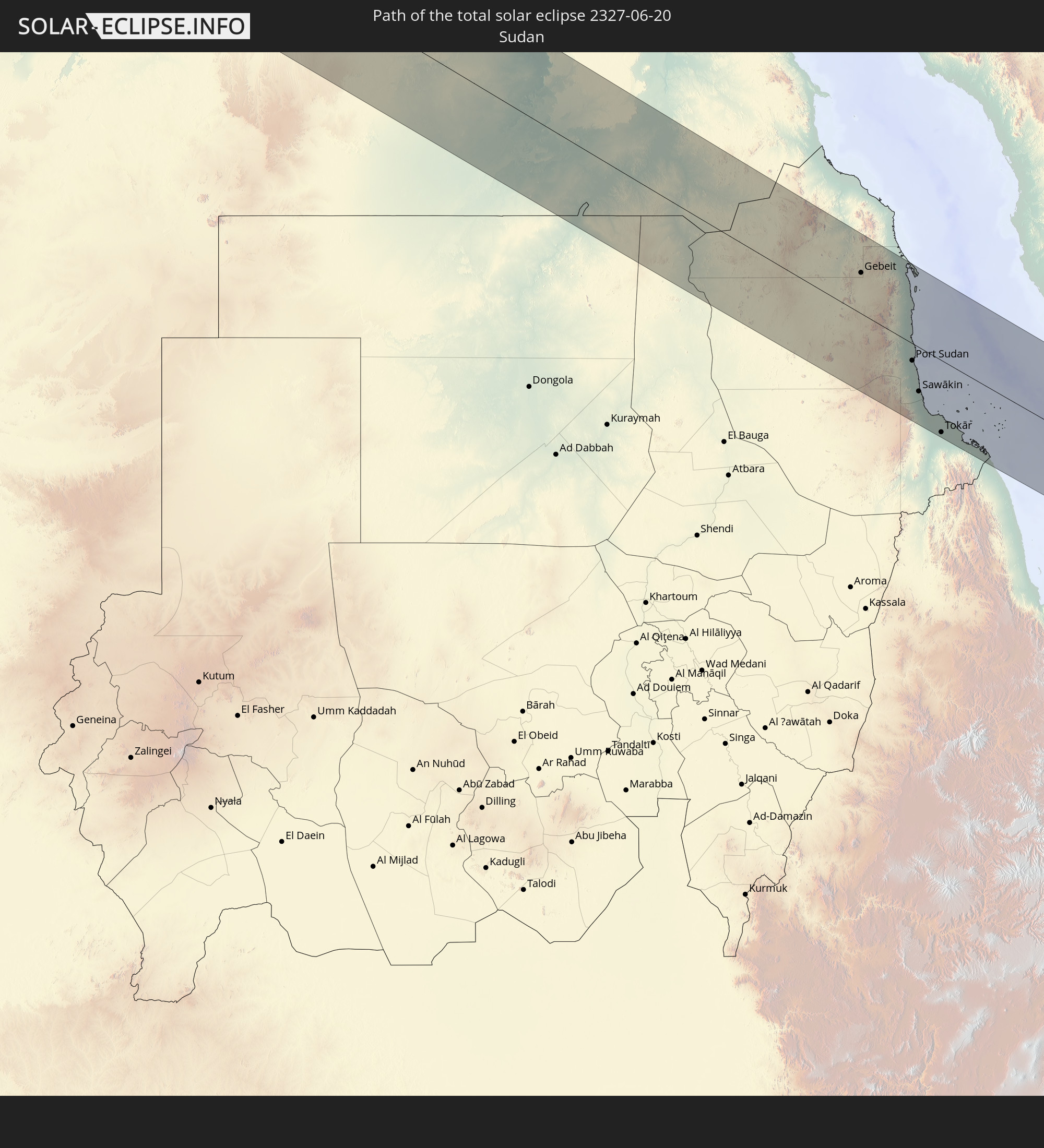 Sudan
Sudan
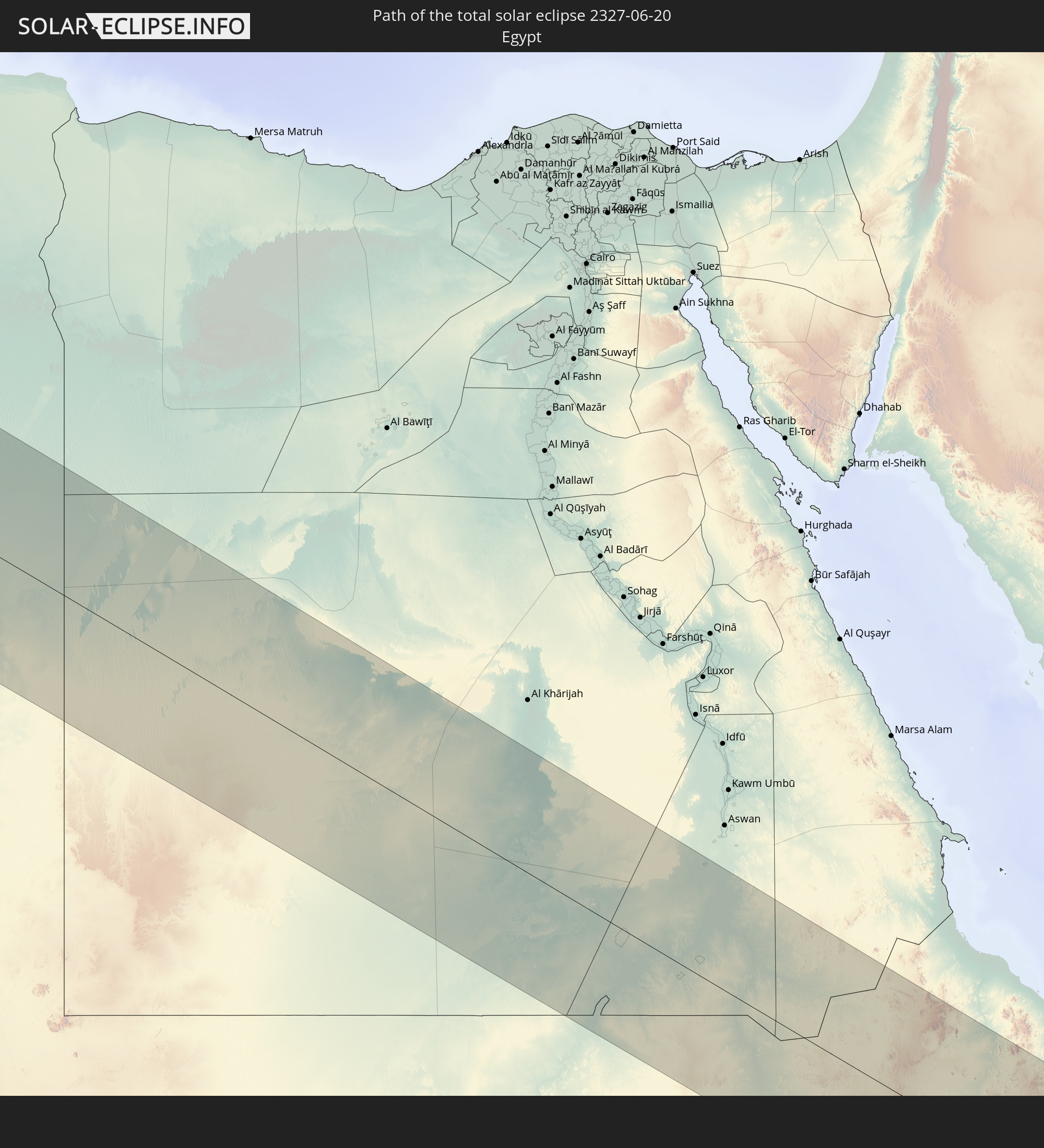 Egypt
Egypt
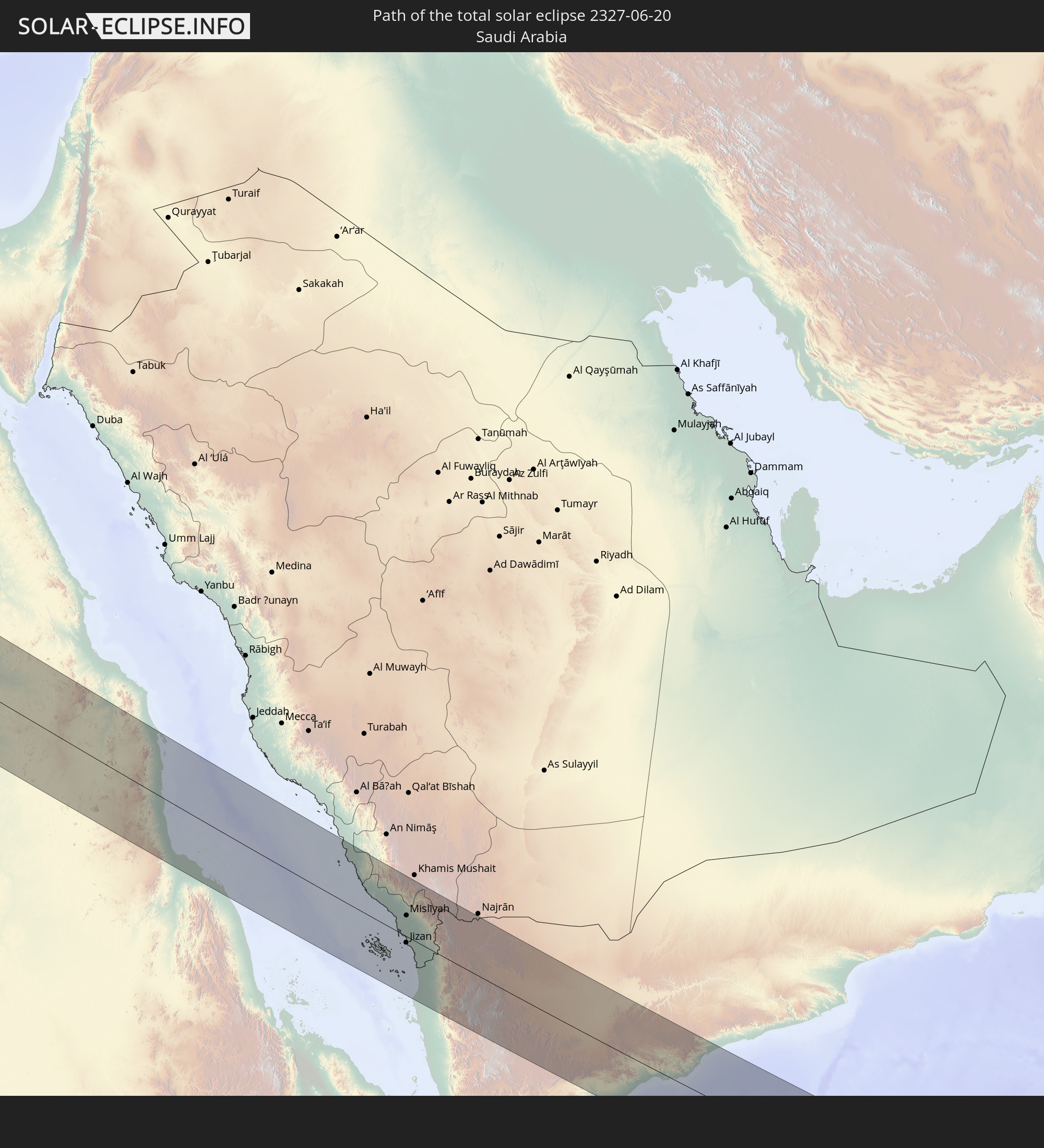 Saudi Arabia
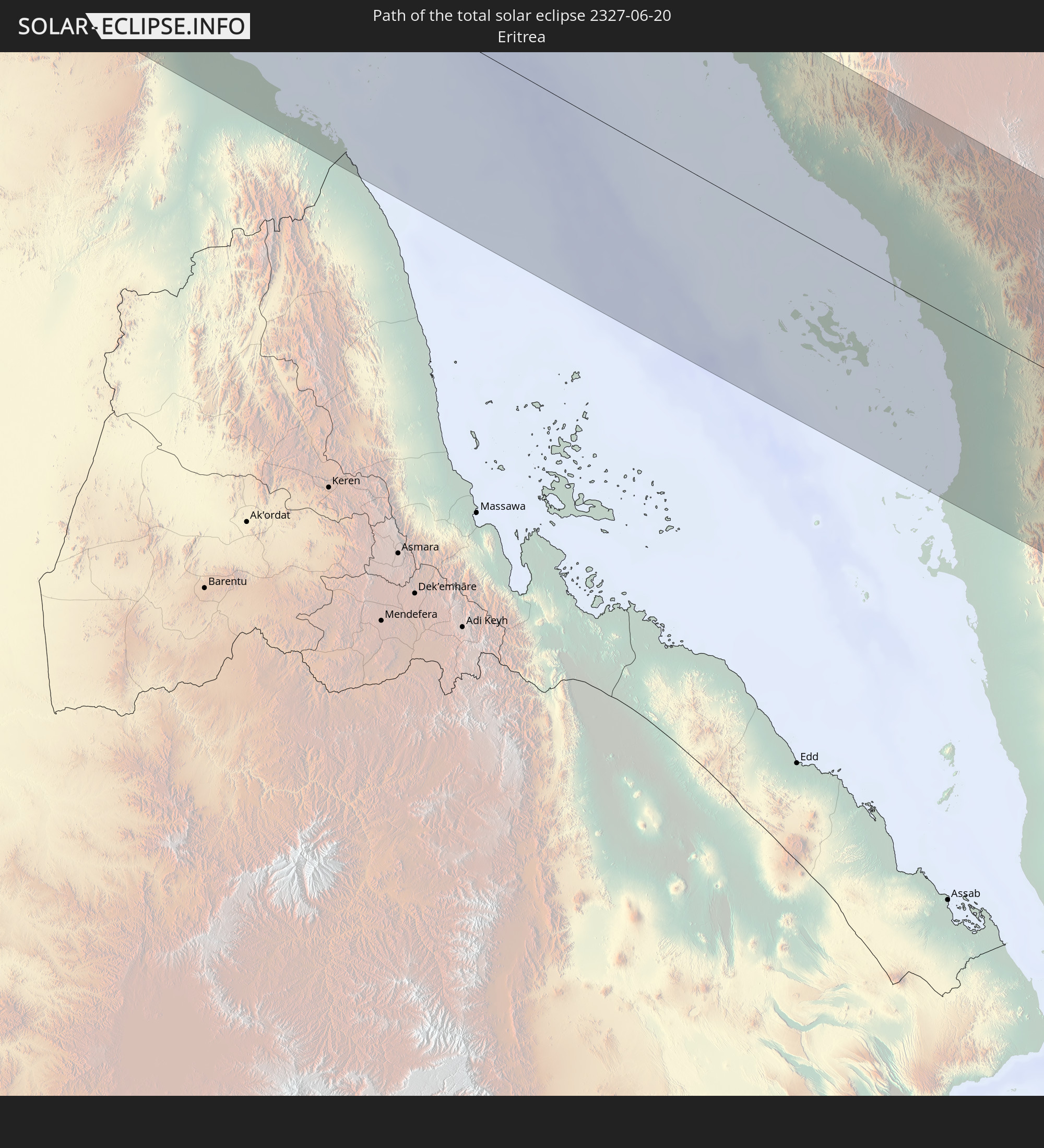 Eritrea
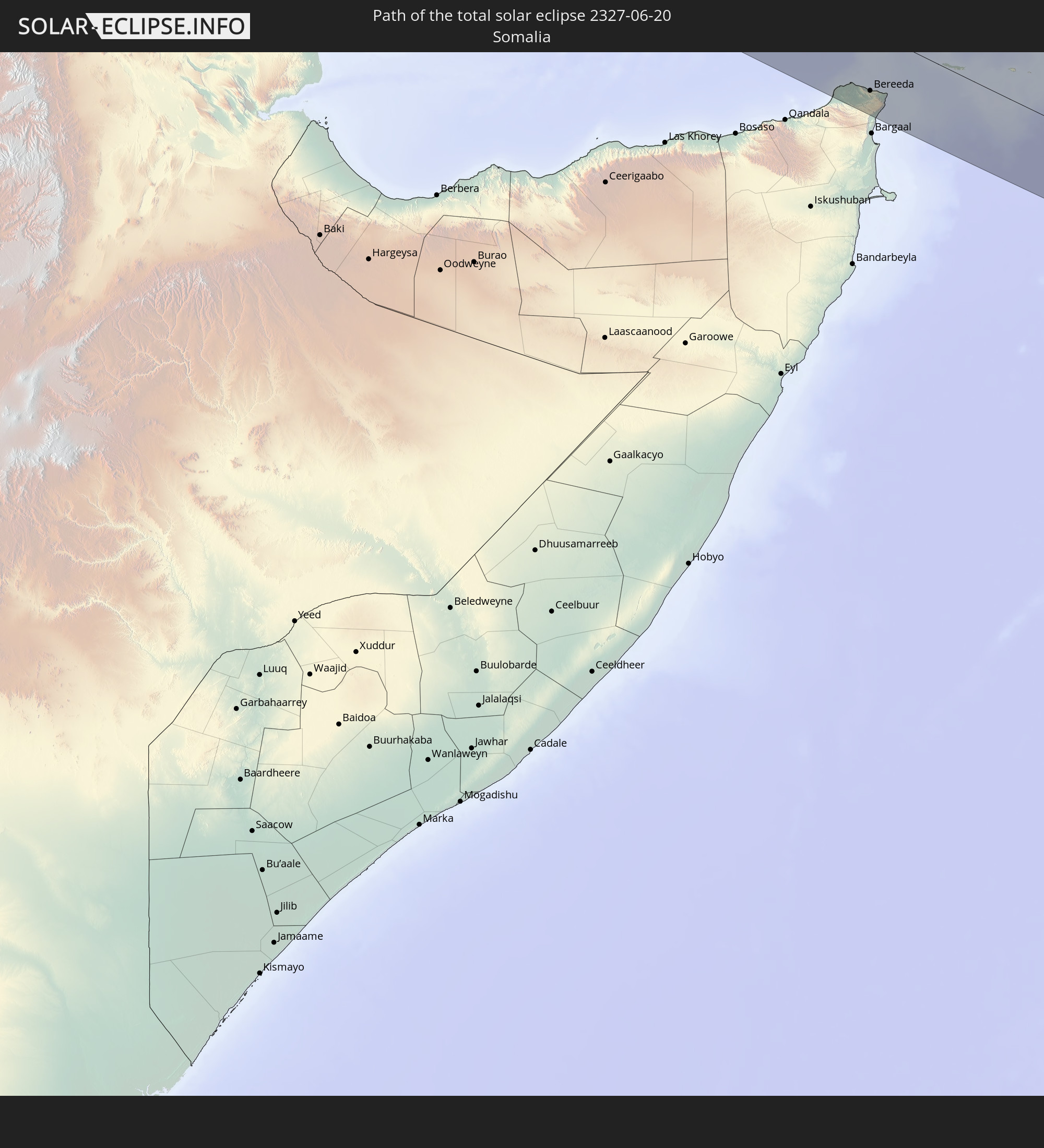 Somalia
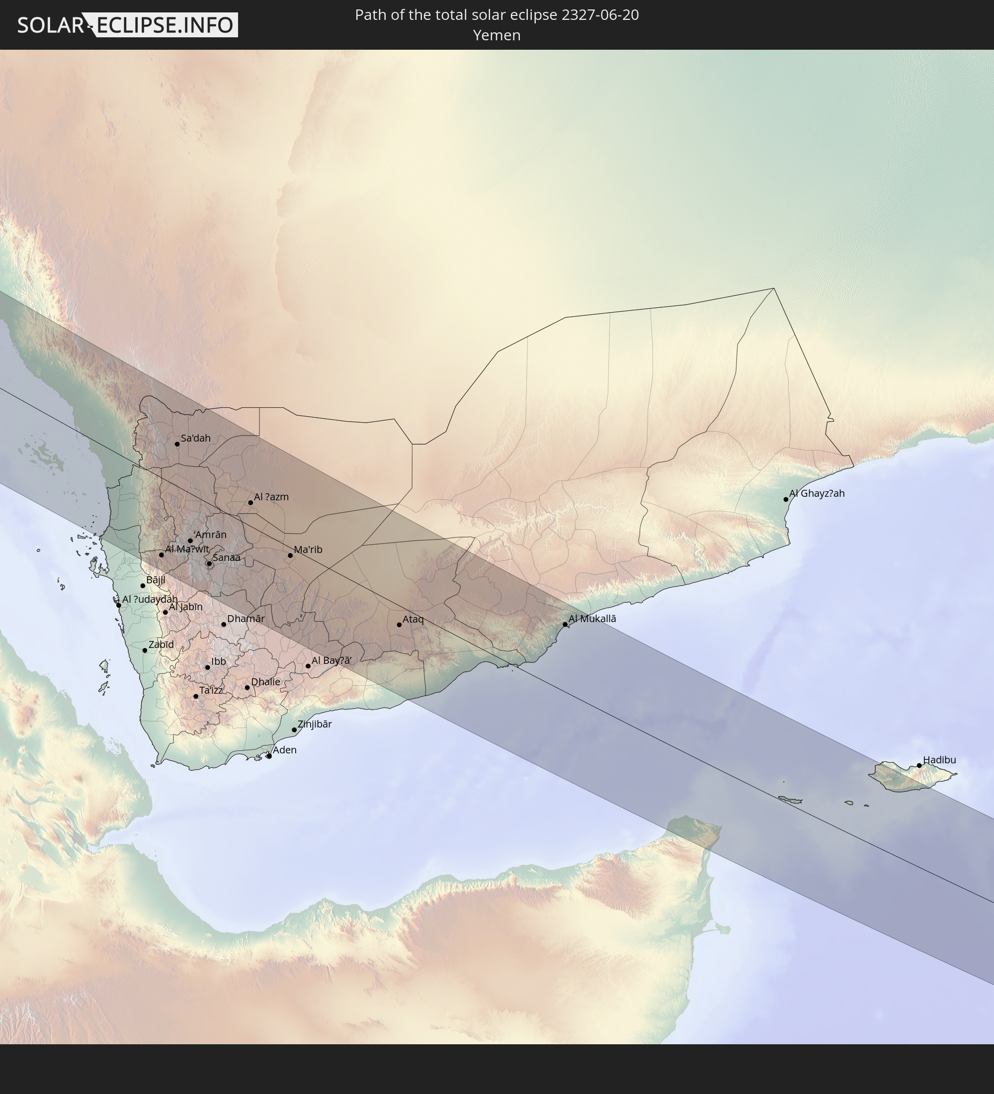 Yemen
Yemen
In den folgenden Ländern ist die Sonnenfinsternis partiell zu sehen
 Russia
 United States
 United States Minor Outlying Islands
 Canada
 Greenland
 Cuba
Cuba
 Colombia
 Cayman Islands
 Peru
Peru
 The Bahamas
 Jamaica
 Haiti
Haiti
 Brazil
 Venezuela
 Turks and Caicos Islands
 Dominican Republic
 Aruba
Aruba
 Puerto Rico
 United States Virgin Islands
 Bermuda
 British Virgin Islands
 Anguilla
 Collectivity of Saint Martin
 Saint Barthélemy
 Saint Kitts and Nevis
 Antigua and Barbuda
 Montserrat
 Trinidad and Tobago
 Guadeloupe
 Grenada
 Dominica
 Saint Vincent and the Grenadines
 Guyana
 Martinique
 Saint Lucia
 Barbados
 Suriname
 Saint Pierre and Miquelon
 French Guiana
 Portugal
 Cabo Verde
 Iceland
 Spain
Spain
 Senegal
 Mauritania
 The Gambia
 Guinea-Bissau
 Guinea
 Sierra Leone
 Morocco
 Mali
Mali
 Liberia
 Republic of Ireland
 Svalbard and Jan Mayen
 Algeria
 United Kingdom
 Ivory Coast
 Faroe Islands
 Burkina Faso
 Gibraltar
 France
 Isle of Man
 Ghana
Ghana
 Guernsey
 Jersey
 Togo
Togo
 Niger
Niger
 Benin
Benin
 Andorra
 Belgium
 Nigeria
 Netherlands
 Norway
 Equatorial Guinea
 Luxembourg
 Germany
 Switzerland
 São Tomé and Príncipe
 Italy
Italy
 Monaco
 Tunisia
 Denmark
 Cameroon
 Gabon
Gabon
 Libya
Libya
 Liechtenstein
 Austria
 Sweden
 Republic of the Congo
 Angola
 Czechia
 Democratic Republic of the Congo
 San Marino
 Vatican City
 Slovenia
 Chad
Chad
 Croatia
 Poland
 Malta
Malta
 Central African Republic
 Bosnia and Herzegovina
 Hungary
 Slovakia
 Montenegro
 Serbia
 Albania
 Åland Islands
 Greece
 Romania
 Republic of Macedonia
 Finland
 Lithuania
 Latvia
 Estonia
 Sudan
Sudan
 Zambia
 Ukraine
 Bulgaria
 Belarus
 Egypt
Egypt
 Turkey
 Moldova
 Rwanda
 Burundi
 Tanzania
 Uganda
 Mozambique
 Cyprus
 Malawi
 Ethiopia
 Kenya
Kenya
 State of Palestine
 Israel
 Saudi Arabia
 Jordan
 Lebanon
 Syria
Syria
 Eritrea
 Iraq
Iraq
 Georgia
 French Southern and Antarctic Lands
 Somalia
 Djibouti
 Yemen
Yemen
 Madagascar
 Comoros
 Armenia
 Iran
Iran
 Azerbaijan
 Mayotte
 Seychelles
 Kazakhstan
 Kuwait
 Bahrain
 Qatar
Qatar
 United Arab Emirates
 Oman
Oman
 Turkmenistan
 Uzbekistan
 Afghanistan
 Pakistan
 Tajikistan
 India
India
 Kyrgyzstan
 China
China
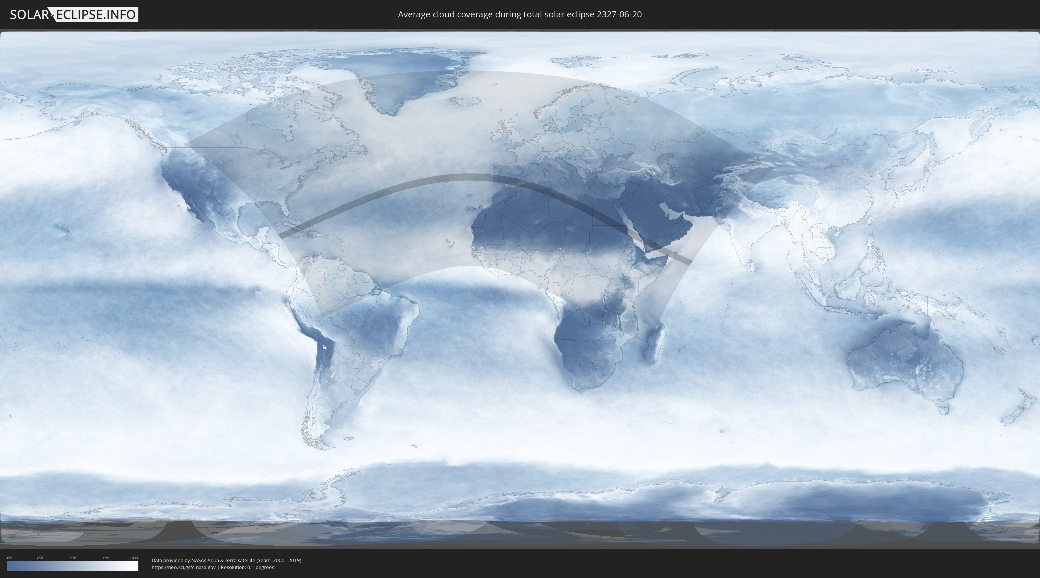
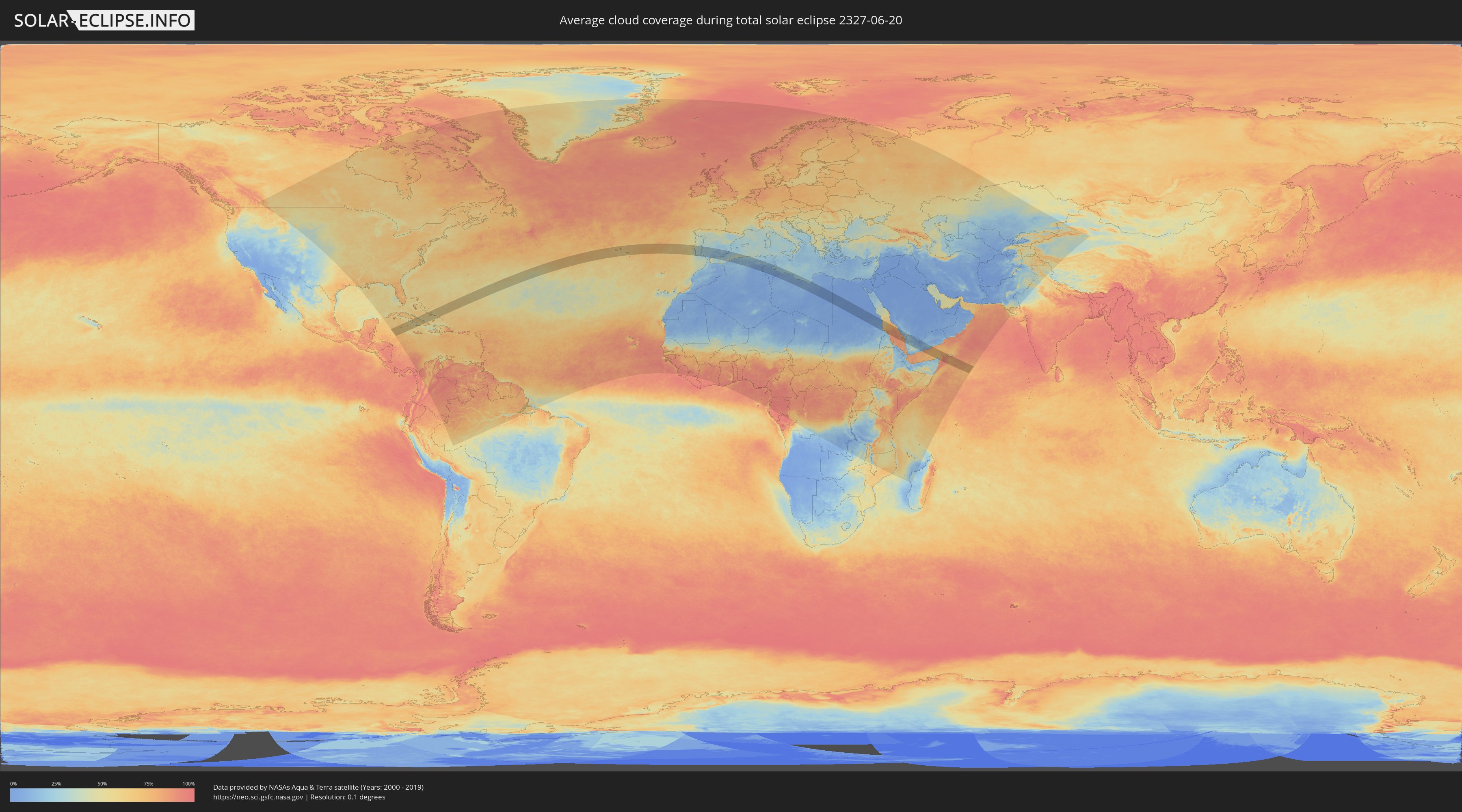
How will be the weather during the total solar eclipse on 06/20/2327?
Where is the best place to see the total solar eclipse of 06/20/2327?
The following maps show the average cloud coverage for the day of the total solar eclipse.
With the help of these maps, it is possible to find the place along the eclipse path, which has the best
chance of a cloudless sky.
Nevertheless, you should consider local circumstances and inform about the weather of your chosen
observation site.
The data is provided by NASAs satellites
AQUA and TERRA.
The cloud maps are averaged over a period of 19 years (2000 - 2019).
Detailed country maps
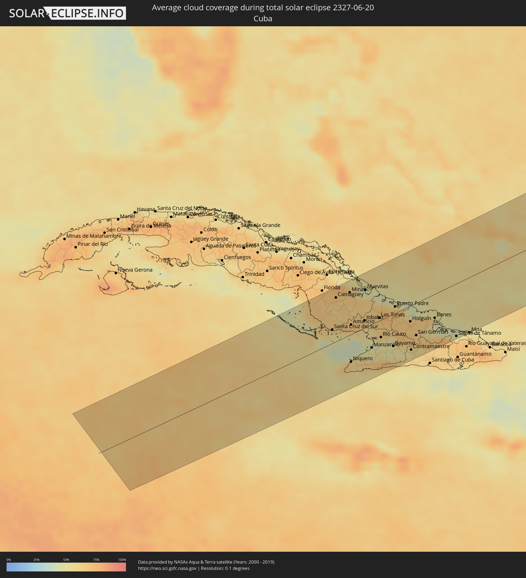 Cuba
Cuba
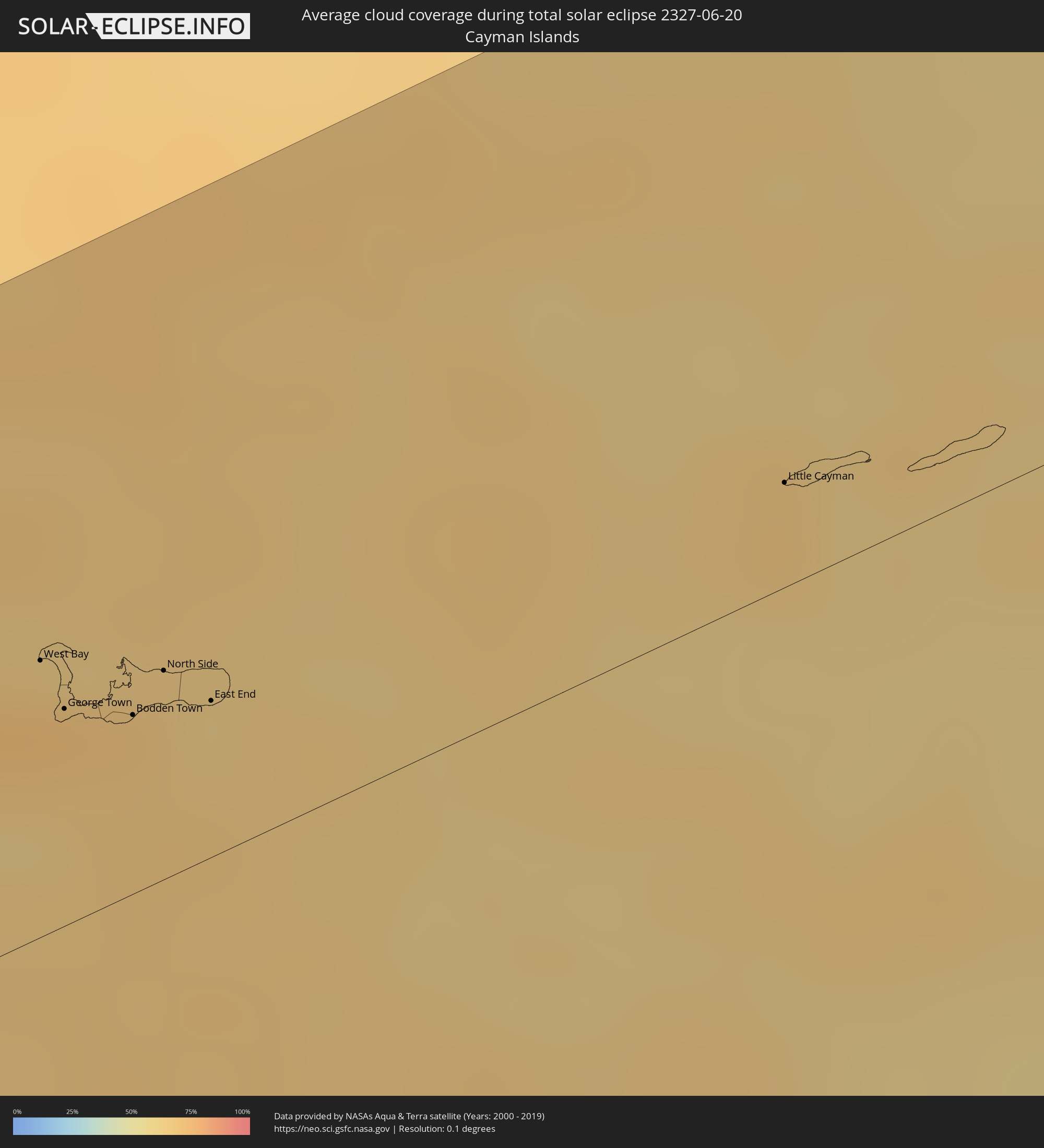 Cayman Islands
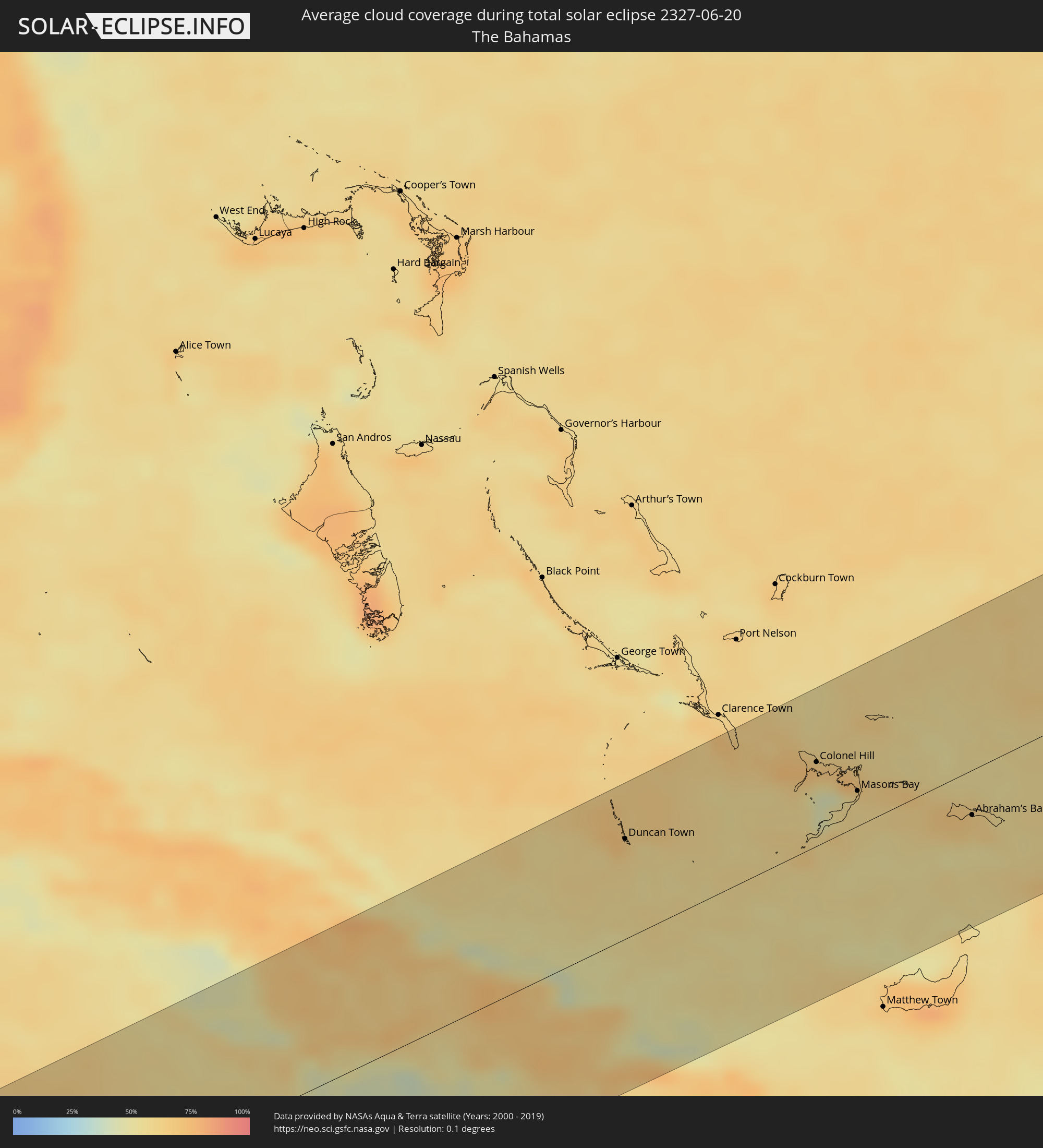 The Bahamas
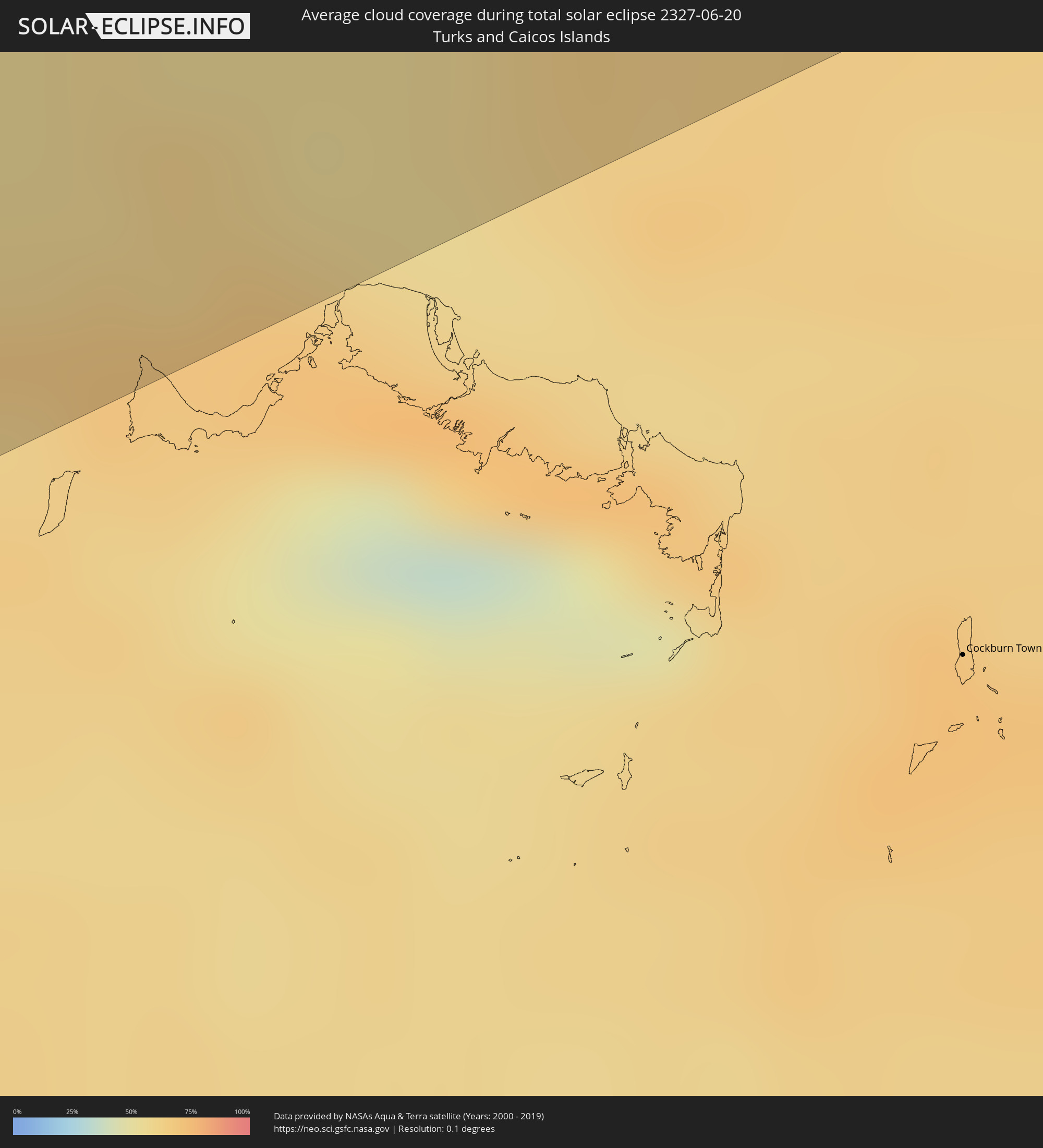 Turks and Caicos Islands
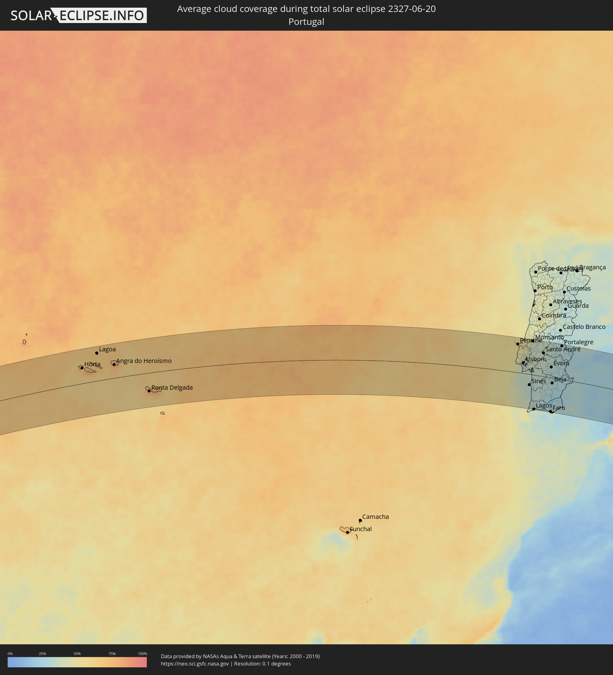 Portugal
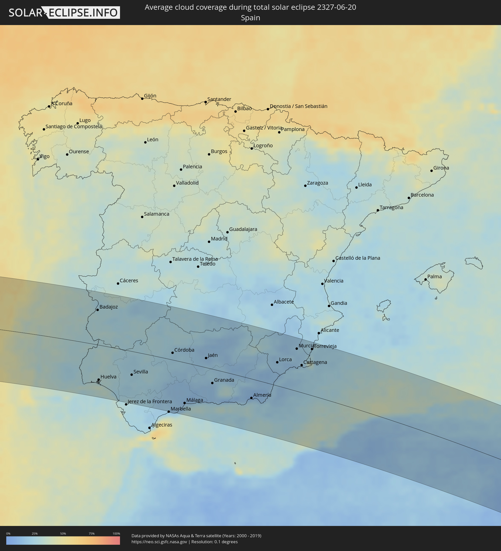 Spain
Spain
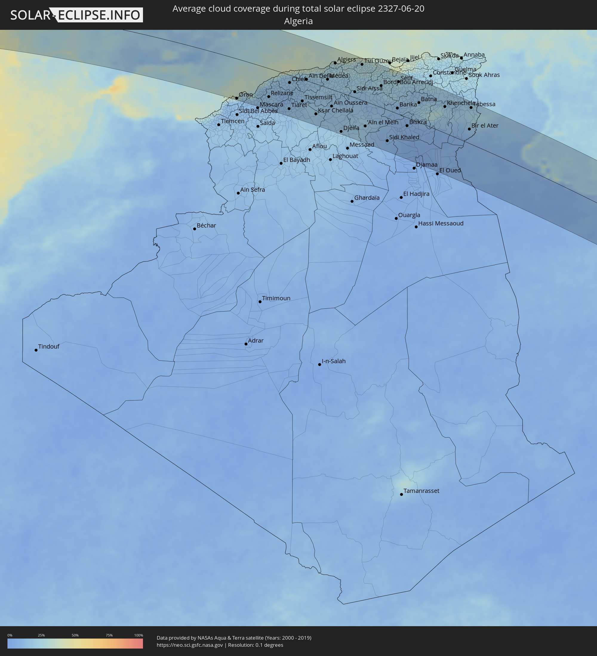 Algeria
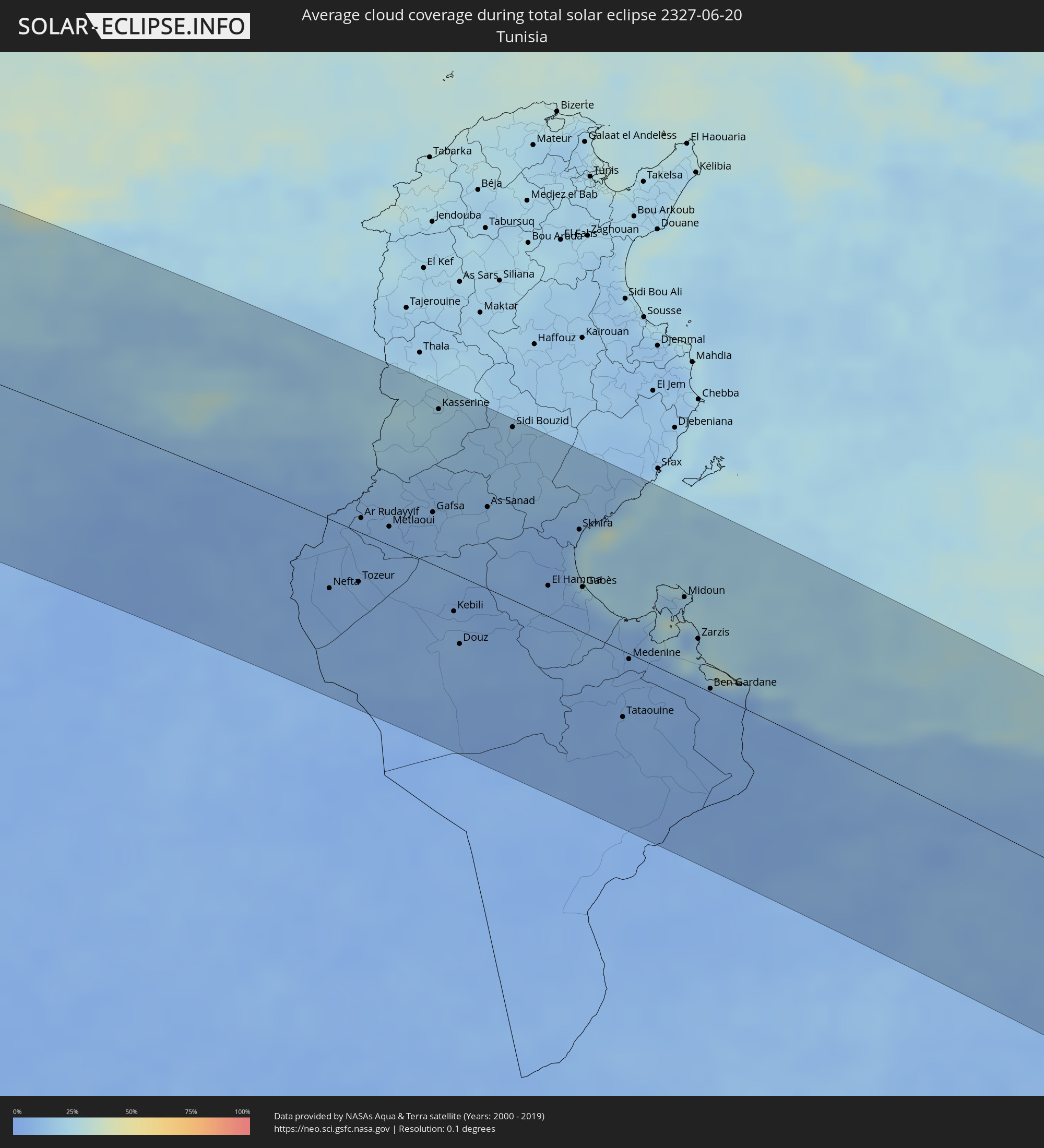 Tunisia
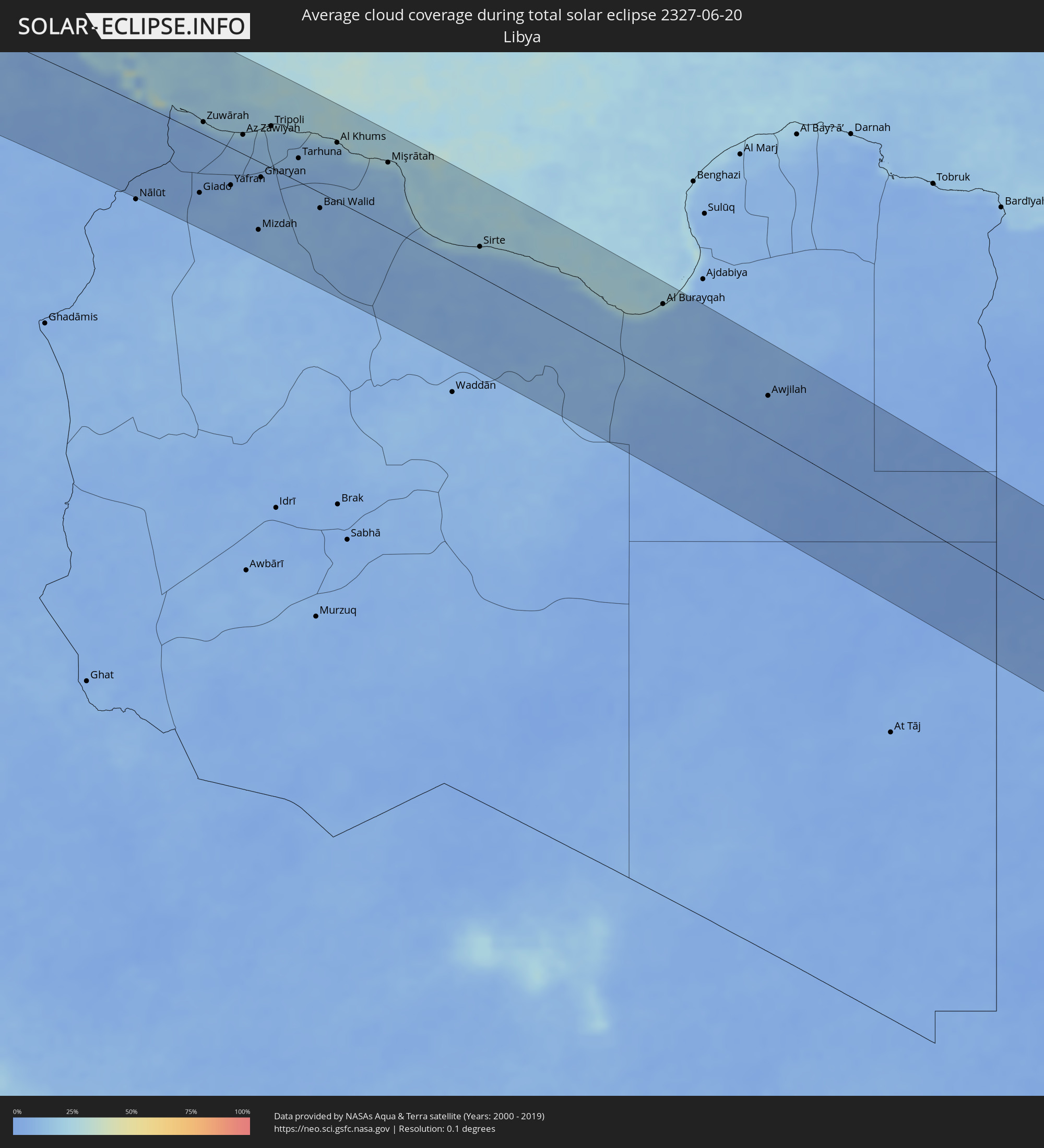 Libya
Libya
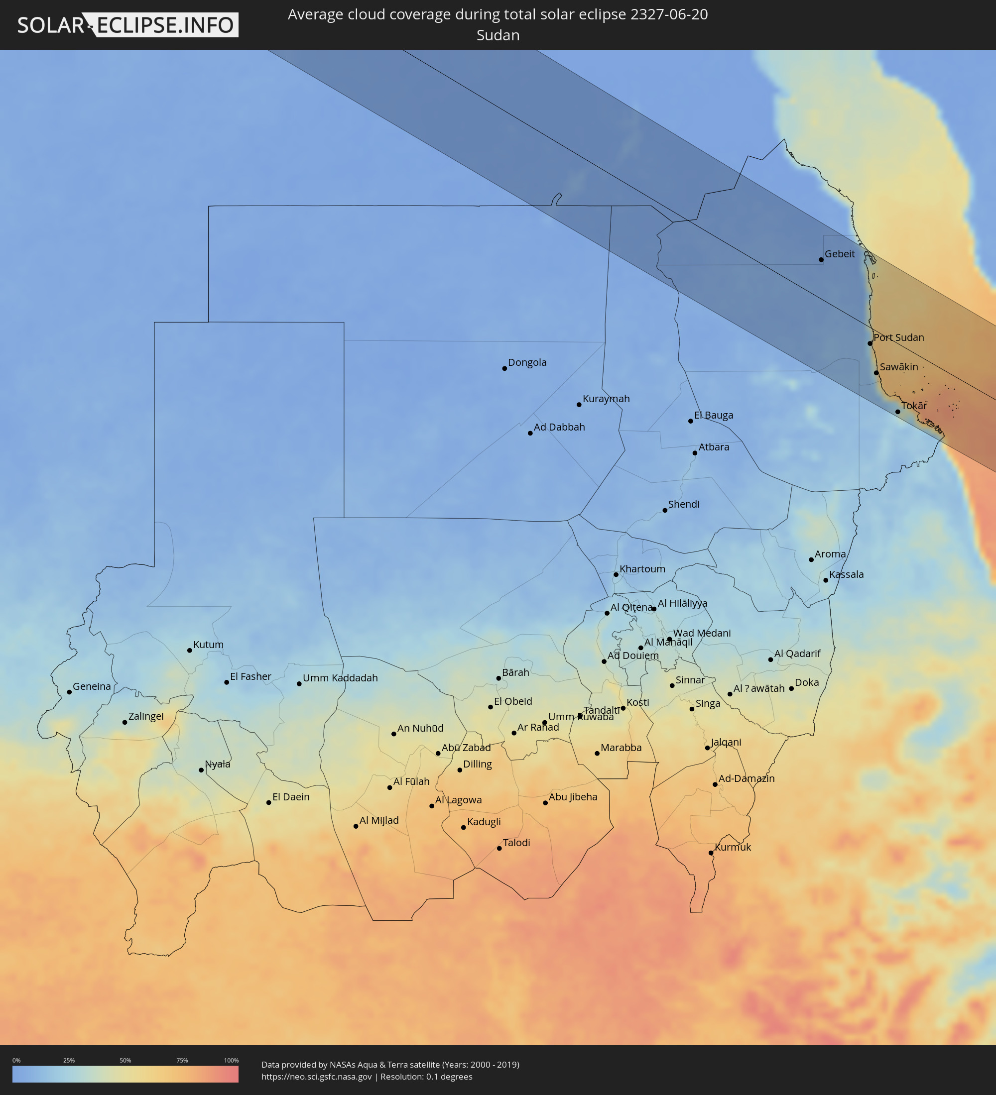 Sudan
Sudan
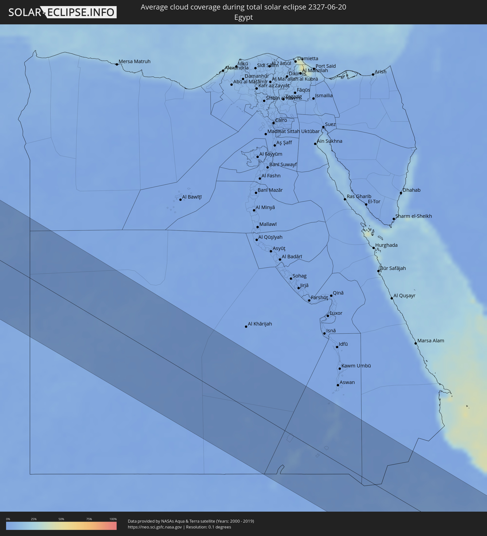 Egypt
Egypt
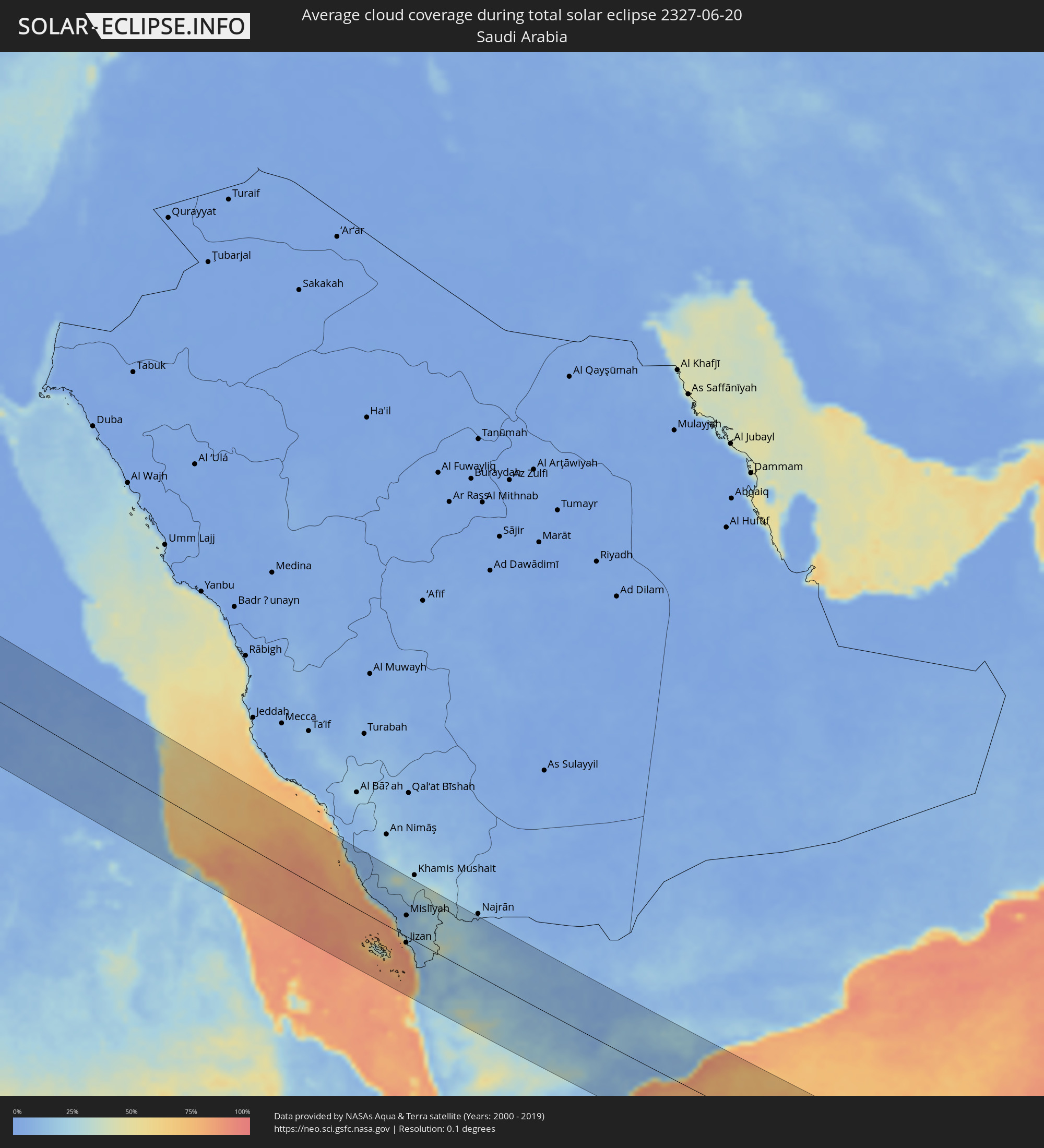 Saudi Arabia
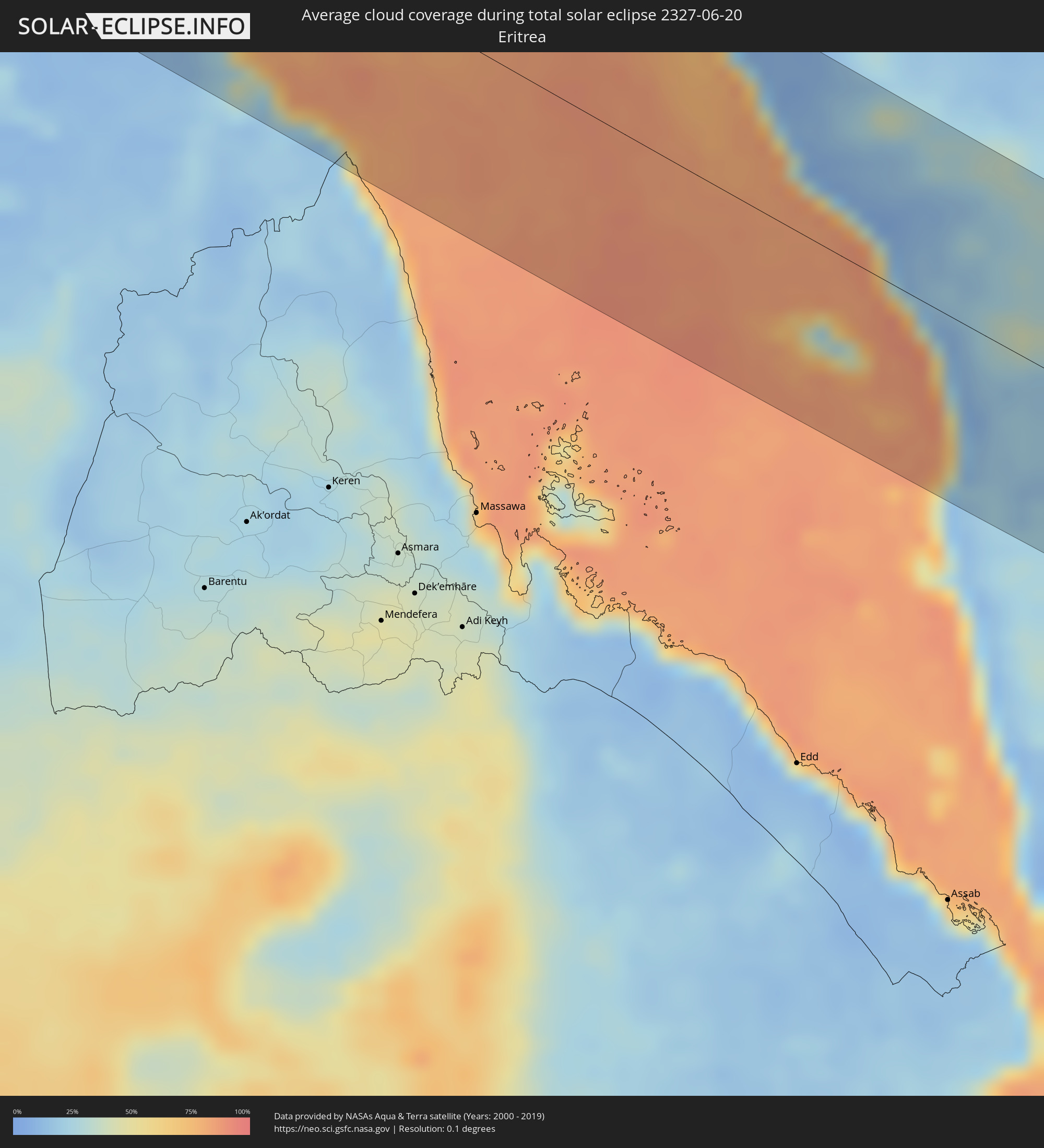 Eritrea
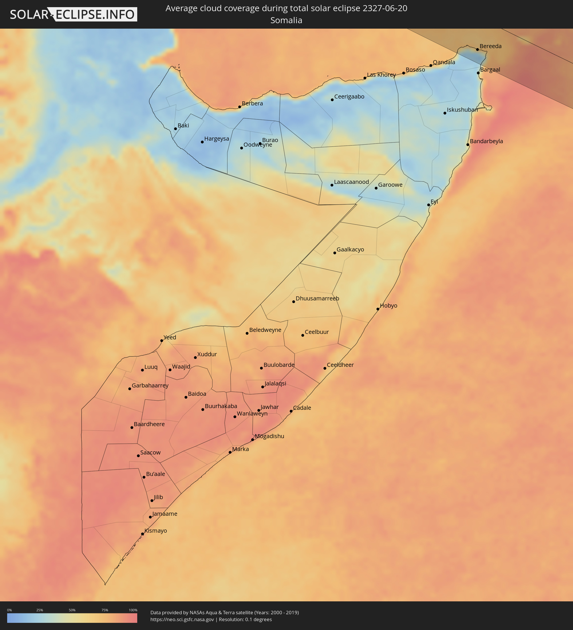 Somalia
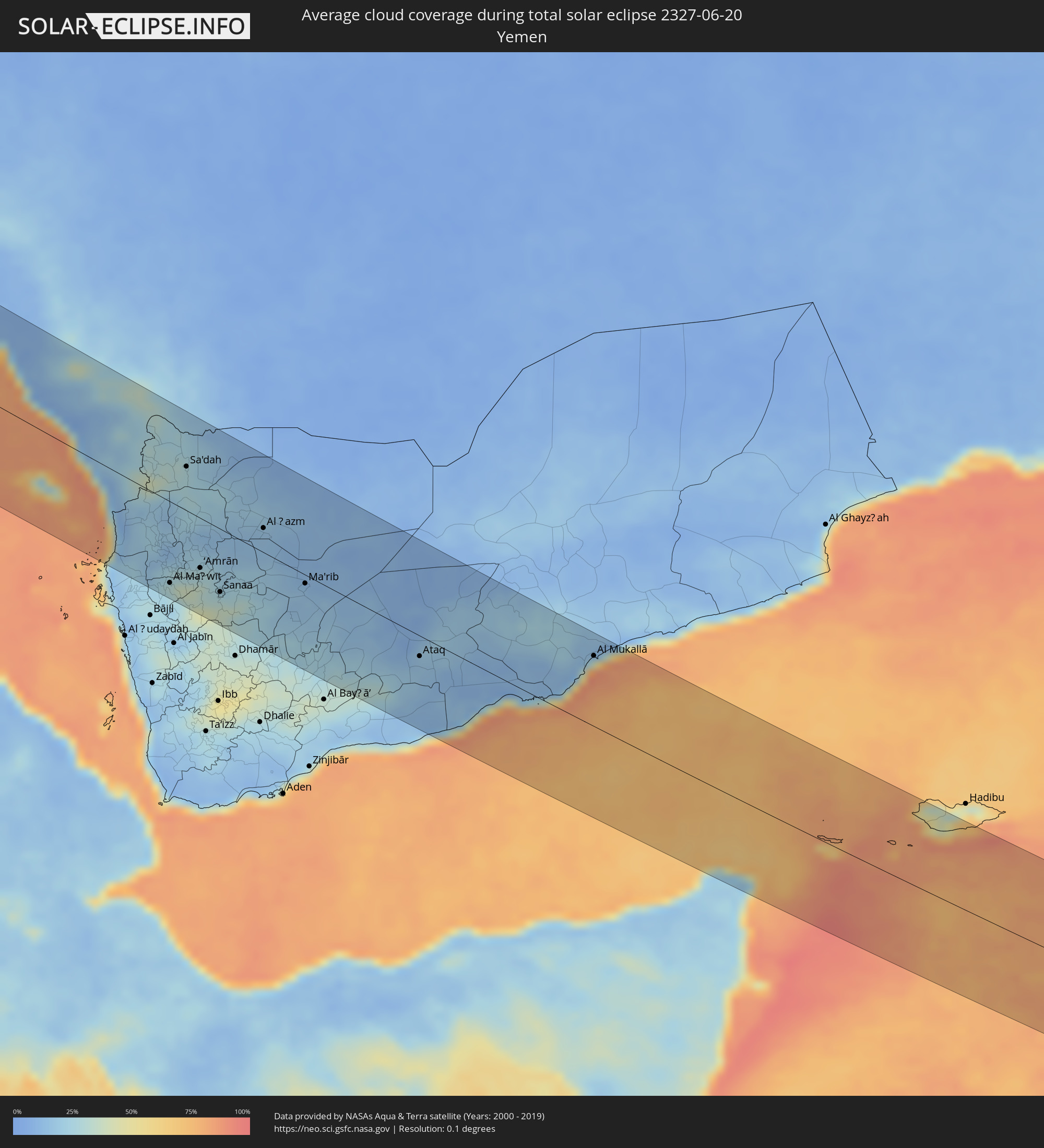 Yemen
Yemen
Cities inside the path of the eclipse
The following table shows all locations with a population of more than 5,000 inside the eclipse path. Cities which have more than 100,000 inhabitants are marked bold. A click at the locations opens a detailed map.
| City | Type | Eclipse duration | Local time of max. eclipse | Distance to central line | Ø Cloud coverage |
|
West Bay, West Bay
|
total | - | 06:02:43 UTC-05:00 | 46 km | 72% |
|
George Town, George Town
|
total | - | 06:02:39 UTC-05:00 | 36 km | 68% |
|
Bodden Town, Bodden Town
|
total | - | 06:02:37 UTC-05:00 | 30 km | 67% |
|
North Side, North Side
|
total | - | 06:02:39 UTC-05:00 | 35 km | 67% |
|
East End, East End
|
total | - | 06:02:36 UTC-05:00 | 26 km | 64% |
|
Little Cayman, Sister Island
|
total | - | 06:02:38 UTC-05:00 | 17 km | 66% |
|
Camagüey, Camagüey
|
total | - | 06:03:32 UTC-05:00 | 92 km | 69% |
|
Amancio, Las Tunas
|
total | - | 06:03:04 UTC-05:00 | 20 km | 62% |
|
Guáimaro, Camagüey
|
total | - | 06:03:13 UTC-05:00 | 33 km | 66% |
|
Jobabo, Las Tunas
|
total | - | 06:03:06 UTC-05:00 | 16 km | 57% |
|
Nuevitas, Camagüey
|
total | - | 06:03:35 UTC-05:00 | 79 km | 53% |
|
Manzanillo, Granma
|
total | - | 06:02:40 UTC-05:00 | 48 km | 51% |
|
Las Tunas, Las Tunas
|
total | - | 06:03:07 UTC-05:00 | 6 km | 62% |
|
Bartolomé Masó, Granma
|
total | - | 06:02:32 UTC-05:00 | 74 km | 61% |
|
Bayamo, Granma
|
total | - | 06:02:39 UTC-05:00 | 67 km | 53% |
|
Puerto Padre, Las Tunas
|
total | - | 06:03:15 UTC-05:00 | 14 km | 70% |
|
Jiguaní, Granma
|
total | - | 06:02:37 UTC-05:00 | 77 km | 51% |
|
Cacocum, Holguín
|
total | - | 06:02:53 UTC-05:00 | 45 km | 70% |
|
Holguín, Holguín
|
total | - | 06:03:00 UTC-05:00 | 32 km | 65% |
|
Contramaestre, Santiago de Cuba
|
total | - | 06:02:33 UTC-05:00 | 92 km | 55% |
|
San Germán, Holguín
|
total | - | 06:02:46 UTC-05:00 | 67 km | 65% |
|
Palma Soriano, Santiago de Cuba
|
total | - | 06:02:28 UTC-05:00 | 112 km | 54% |
|
Duncan Town, Ragged Island
|
total | - | 06:03:57 UTC-05:00 | 74 km | 59% |
|
Banes, Holguín
|
total | - | 06:03:00 UTC-05:00 | 49 km | 54% |
|
Colonel Hill, Crooked Island and Long Cay
|
total | - | 06:04:21 UTC-05:00 | 62 km | 68% |
|
Masons Bay, Acklins
|
total | - | 06:04:11 UTC-05:00 | 26 km | 57% |
|
Abraham’s Bay, Mayaguana
|
total | - | 06:04:03 UTC-05:00 | 33 km | 60% |
|
Ponta Delgada, Azores
|
total | - | 11:04:57 UTC-01:00 | 71 km | 66% |
|
Cacém, Lisbon
|
total | - | 12:39:14 UTC+00:00 | 43 km | 40% |
|
Torres Vedras, Lisbon
|
total | - | 12:39:12 UTC+00:00 | 79 km | 47% |
|
Caldas da Rainha, Leiria
|
total | - | 12:39:20 UTC+00:00 | 115 km | 50% |
|
Lisbon, Lisbon
|
total | - | 12:39:36 UTC+00:00 | 40 km | 35% |
|
Sesimbra, Setúbal
|
total | - | 12:39:46 UTC+00:00 | 10 km | 38% |
|
Póvoa de Santa Iria, Lisbon
|
total | - | 12:39:41 UTC+00:00 | 56 km | 42% |
|
Setúbal, Setúbal
|
total | - | 12:40:11 UTC+00:00 | 22 km | 39% |
|
Monsanto, Santarém
|
total | - | 12:40:12 UTC+00:00 | 127 km | 38% |
|
Santarém, Santarém
|
total | - | 12:40:21 UTC+00:00 | 102 km | 35% |
|
Portimão, Faro
|
total | - | 12:41:30 UTC+00:00 | 126 km | 37% |
|
Entroncamento, Santarém
|
total | - | 12:40:43 UTC+00:00 | 131 km | 38% |
|
Albufeira, Faro
|
total | - | 12:42:09 UTC+00:00 | 128 km | 35% |
|
Loulé, Faro
|
total | - | 12:42:39 UTC+00:00 | 119 km | 34% |
|
Faro, Faro
|
total | - | 12:42:53 UTC+00:00 | 131 km | 38% |
|
Évora, Évora
|
total | - | 12:42:16 UTC+00:00 | 39 km | 30% |
|
Beja, Beja
|
total | - | 12:42:36 UTC+00:00 | 21 km | 30% |
|
Badajoz, Extremadura
|
total | - | 13:44:05 UTC+01:00 | 87 km | 29% |
|
Huelva, Andalusia
|
total | - | 13:44:57 UTC+01:00 | 89 km | 28% |
|
Sevilla, Andalusia
|
total | - | 13:46:59 UTC+01:00 | 60 km | 23% |
|
Córdoba, Andalusia
|
total | - | 13:49:14 UTC+01:00 | 17 km | 21% |
|
Mijas, Andalusia
|
total | - | 13:50:21 UTC+01:00 | 121 km | 26% |
|
Málaga, Andalusia
|
total | - | 13:50:45 UTC+01:00 | 103 km | 26% |
|
Vélez-Málaga, Andalusia
|
total | - | 13:51:23 UTC+01:00 | 90 km | 24% |
|
Jaén, Andalusia
|
total | - | 13:51:23 UTC+01:00 | 23 km | 18% |
|
Granada, Andalusia
|
total | - | 13:52:10 UTC+01:00 | 36 km | 15% |
|
El Ejido, Andalusia
|
total | - | 13:54:08 UTC+01:00 | 63 km | 25% |
|
Roquetas de Mar, Andalusia
|
total | - | 13:54:34 UTC+01:00 | 60 km | 26% |
|
Almería, Andalusia
|
total | - | 13:54:50 UTC+01:00 | 49 km | 27% |
|
Lorca, Murcia
|
total | - | 13:55:46 UTC+01:00 | 58 km | 19% |
|
Murcia, Murcia
|
total | - | 13:56:40 UTC+01:00 | 106 km | 20% |
|
Cartagena, Murcia
|
total | - | 13:57:16 UTC+01:00 | 68 km | 25% |
|
Orihuela, Valencia
|
total | - | 13:56:58 UTC+01:00 | 121 km | 21% |
|
Torrevieja, Valencia
|
total | - | 13:57:34 UTC+01:00 | 116 km | 23% |
|
Oran, Oran
|
total | - | 13:59:36 UTC+01:00 | 128 km | 14% |
|
Mostaganem, Mostaganem
|
total | - | 14:00:55 UTC+01:00 | 83 km | 17% |
|
Relizane, Relizane
|
total | - | 14:02:03 UTC+01:00 | 91 km | 14% |
|
Tiaret, Tiaret
|
total | - | 14:03:58 UTC+01:00 | 109 km | 15% |
|
Chlef, Chlef
|
total | - | 14:03:14 UTC+01:00 | 25 km | 15% |
|
Médéa, Medea
|
total | - | 14:05:57 UTC+01:00 | 27 km | 20% |
|
Blida, Blida
|
total | - | 14:05:54 UTC+01:00 | 50 km | 25% |
|
Algiers, Algiers
|
total | - | 14:06:01 UTC+01:00 | 86 km | 27% |
|
Djelfa, Djelfa
|
total | - | 14:08:37 UTC+01:00 | 125 km | 20% |
|
Boumerdas, Boumerdes
|
total | - | 14:06:50 UTC+01:00 | 101 km | 29% |
|
Tizi Ouzou, Tizi Ouzou
|
total | - | 14:07:59 UTC+01:00 | 113 km | 28% |
|
Bordj Bou Arreridj, Bordj Bou Arréridj
|
total | - | 14:10:00 UTC+01:00 | 69 km | 23% |
|
Sétif, Sétif
|
total | - | 14:11:06 UTC+01:00 | 102 km | 23% |
|
El Eulma, Sétif
|
total | - | 14:11:39 UTC+01:00 | 107 km | 20% |
|
Biskra, Biskra
|
total | - | 14:13:12 UTC+01:00 | 26 km | 9% |
|
Batna, Batna
|
total | - | 14:13:13 UTC+01:00 | 62 km | 19% |
|
Nefta, Tawzar
|
total | - | 14:18:19 UTC+01:00 | 51 km | 7% |
|
Tébessa, Tébessa
|
total | - | 14:16:54 UTC+01:00 | 114 km | 22% |
|
Tozeur, Tawzar
|
total | - | 14:18:43 UTC+01:00 | 37 km | 7% |
|
Ar Rudayyif, Gafsa
|
total | - | 14:18:12 UTC+01:00 | 11 km | 7% |
|
Metlaoui, Gafsa
|
total | - | 14:18:43 UTC+01:00 | 14 km | 7% |
|
Gafsa, Gafsa
|
total | - | 14:19:15 UTC+01:00 | 38 km | 10% |
|
Kasserine, Al Qaşrayn
|
total | - | 14:18:26 UTC+01:00 | 116 km | 22% |
|
Kebili, Qibilī
|
total | - | 14:20:29 UTC+01:00 | 28 km | 8% |
|
Douz, Qibilī
|
total | - | 14:20:52 UTC+01:00 | 50 km | 9% |
|
Sidi Bouzid, Sīdī Bū Zayd
|
total | - | 14:19:43 UTC+01:00 | 127 km | 15% |
|
El Hamma, Qābis
|
total | - | 14:21:41 UTC+01:00 | 23 km | 8% |
|
Skhira, Şafāqis
|
total | - | 14:21:38 UTC+01:00 | 74 km | 25% |
|
Gabès, Qābis
|
total | - | 14:22:13 UTC+01:00 | 33 km | 12% |
|
Tataouine, Tataouine
|
total | - | 14:24:02 UTC+01:00 | 49 km | 6% |
|
Medenine, Madanīn
|
total | - | 14:23:35 UTC+01:00 | 4 km | 6% |
|
Midoun, Madanīn
|
total | - | 14:23:49 UTC+01:00 | 61 km | 24% |
|
Zarzis, Madanīn
|
total | - | 14:24:24 UTC+01:00 | 35 km | 23% |
|
Ben Gardane, Madanīn
|
total | - | 14:25:03 UTC+01:00 | 3 km | 7% |
|
Zuwārah, An Nuqāţ al Khams
|
total | - | 15:26:45 UTC+02:00 | 17 km | 7% |
|
Zintan, Jabal al Gharbi District
|
total | - | 15:28:21 UTC+02:00 | 76 km | 7% |
|
Şabrātah, Az Zāwiyah
|
total | - | 15:27:35 UTC+02:00 | 20 km | 11% |
|
Yafran, Jabal al Gharbi District
|
total | - | 15:28:37 UTC+02:00 | 51 km | 8% |
|
Şurmān, Az Zāwiyah
|
total | - | 15:27:46 UTC+02:00 | 20 km | 12% |
|
Az Zāwīyah, Az Zāwiyah
|
total | - | 15:28:01 UTC+02:00 | 26 km | 13% |
|
Mizdah, Jabal al Gharbi District
|
total | - | 15:30:10 UTC+02:00 | 94 km | 10% |
|
Gharyan, Jabal al Gharbi District
|
total | - | 15:29:16 UTC+02:00 | 20 km | 8% |
|
Tripoli, Tripoli
|
total | - | 15:28:35 UTC+02:00 | 57 km | 15% |
|
Tagiura, Tripoli
|
total | - | 15:28:50 UTC+02:00 | 65 km | 16% |
|
Tarhuna, Al Marqab
|
total | - | 15:29:53 UTC+02:00 | 32 km | 10% |
|
Bani Walid, Mişrātah
|
total | - | 15:31:21 UTC+02:00 | 21 km | 9% |
|
Masallātah, Al Marqab
|
total | - | 15:30:12 UTC+02:00 | 66 km | 12% |
|
Al Khums, Al Marqab
|
total | - | 15:30:34 UTC+02:00 | 80 km | 13% |
|
Zliten, Mişrātah
|
total | - | 15:31:16 UTC+02:00 | 76 km | 14% |
|
Mişrātah, Mişrātah
|
total | - | 15:32:11 UTC+02:00 | 89 km | 16% |
|
Sirte, Surt
|
total | - | 15:35:58 UTC+02:00 | 41 km | 12% |
|
Gebeit, Red Sea
|
total | - | 16:08:12 UTC+02:00 | 64 km | 3% |
|
Port Sudan, Red Sea
|
total | - | 16:10:17 UTC+02:00 | 27 km | 23% |
|
Sawākin, Red Sea
|
total | - | 16:10:55 UTC+02:00 | 71 km | 19% |
|
Tokār, Red Sea
|
total | - | 16:11:50 UTC+02:00 | 115 km | 26% |
|
Farasān, Jizan
|
total | - | 17:15:06 UTC+03:00 | 54 km | 44% |
|
Ad Darb, Jizan
|
total | - | 17:14:07 UTC+03:00 | 53 km | 6% |
|
Abha, 'Asir
|
total | - | 17:13:40 UTC+03:00 | 114 km | 31% |
|
Jizan, Jizan
|
total | - | 17:15:02 UTC+03:00 | 13 km | 41% |
|
Mislīyah, Jizan
|
total | - | 17:14:27 UTC+03:00 | 43 km | 13% |
|
Şabyā, Jizan
|
total | - | 17:14:47 UTC+03:00 | 16 km | 17% |
|
Mizhirah, Jizan
|
total | - | 17:15:08 UTC+03:00 | 10 km | 33% |
|
Abū ‘Arīsh, Jizan
|
total | - | 17:15:01 UTC+03:00 | 9 km | 17% |
|
Al Jarādīyah, Jizan
|
total | - | 17:15:25 UTC+03:00 | 25 km | 12% |
|
Şāmitah, Jizan
|
total | - | 17:15:25 UTC+03:00 | 21 km | 12% |
|
Al Maḩwīt, Al Maḩwīt
|
total | - | 17:16:38 UTC+03:00 | 101 km | 25% |
|
Ḩajjah, Ḩajjah
|
total | - | 17:16:26 UTC+03:00 | 76 km | 26% |
|
Sa'dah, Şa‘dah
|
total | - | 17:15:15 UTC+03:00 | 54 km | 27% |
|
‘Amrān, Omran
|
total | - | 17:16:32 UTC+03:00 | 62 km | 28% |
|
Sanaa, Sanaa
|
total | - | 17:16:52 UTC+03:00 | 78 km | 31% |
|
Saḩar, Sanaa
|
total | - | 17:16:55 UTC+03:00 | 77 km | 36% |
|
Sayyān, Sanaa
|
total | - | 17:17:03 UTC+03:00 | 90 km | 35% |
|
Al Ḩazm, Al Jawf
|
total | - | 17:16:11 UTC+03:00 | 30 km | 16% |
|
Ma'rib, Ma’rib
|
total | - | 17:16:56 UTC+03:00 | 11 km | 16% |
|
Ataq, Shabwah
|
total | - | 17:17:57 UTC+03:00 | 26 km | 16% |
|
Al Mukallā, Muḩāfaz̧at Ḩaḑramawt
|
total | - | 17:18:04 UTC+03:00 | 89 km | 77% |
|
Bereeda, Bari
|
total | - | 17:20:15 UTC+03:00 | 82 km | 32% |